The U.S. Air Force has been sued after confirmation of PFAS contamination at Lake Holloman, near the Holloman Air Force Base in New Mexico. Photo credit: J.M. Eddins Jr./U.S. Air Force
From the High Country News (Paige Blankenbuehler):
Polyfluoroalkyl chemicals exist in furniture, waterproof makeup and clothing, nonstick cookware, popcorn bags, the foam used to extinguish petroleum fires (which is different from the slurry used across the West to fight wildfires), and countless other items. Known collectively as PFAS, this class of chemicals contains more than 5,000 different compounds that are often called “forever chemicals” because they take so long to break down in the environment. PFAS chemicals are an omnipresent, if largely invisible, part of daily life.
Yet numerous studies have linked exposure to them to cancer, thyroid disease, weakened childhood immunity and other health problems, according to the Centers for Disease Control and Prevention. A 2007 study published in the journal Environmental Health Perspectives estimated that PFAS are in the blood of 98% of Americans.
Because the Environmental Protection Agency does not regulate PFAS chemicals, states are left not only to research and track them, but also to develop regulations to clean up already dangerous levels of pollution. And, according to recent data from the Social Science Environmental Health Research Institute at Northeastern University and the Environmental Working Group, the West isn’t doing a great job.
Bill Walker, with the Environmental Working Group, a nonprofit environmental advocacy organization, says that, by and large, Western states are lagging far behind, not only in PFAS regulations, but also in monitoring. “The scope of this problem is growing — not because our exposure to PFAS chemicals is growing, but because we’re finally becoming aware of the persistence of these compounds in our lives,” said Walker. “Because there is so little action from the EPA on this, addressing this crisis falls to the states.”
People can be exposed to PFAS chemicals through household cooking items, or simply by eating popcorn out of the bag after microwaving it. But the greatest source of concern involves military bases, fire departments and airports, where the chemicals are used for extinguishing petroleum fires. That leaves high levels of PFAS chemicals in close proximity to public drinking-water sources. According to recent data compiled by EWG and the Social Science Environmental Health Research Institute at Northeastern University, 610 areas in 43 states have confirmed PFAS contamination. The researchers estimate that the drinking water of approximately 19 million people is tainted.
In the West, PFAS contamination has been confirmed in water supplies in Alaska, Arizona, California, Colorado, Idaho, New Mexico, Oregon, Utah, Washington and Wyoming. But only Colorado, California, Oregon and Washington regulate the chemicals, and among those, only California requires that public water systems monitor their levels.
Most Western states are already facing the consequences of contamination: Municipal water managers are scrambling to address high PFAS levels in drinking water, even as communities experience their health impacts, such as higher rates of kidney and testicular cancers. Still, very few have passed laws that track or regulate dangerous PFAS levels. “Northeastern states are ahead of most other states in monitoring and tracking this contamination,” said Phil Brown, the project director of Northeastern University’s PFAS monitoring project. “But in reality, if you look for it, you’ll find it most everywhere.”
Industry representatives say that while they support more oversight, a “one-size-fits-all” regulation for the class of chemicals goes too far. On May 22, the Senate Committee on Environment and Public works held a hearing to discuss appropriate legislation for addressing PFAS contamination. PFAS “play a central role in American life and not all are dangerous to public health,” said Kimberly Wise White, a toxicologist for the American Chemistry Council, an industry trade group that advocates for manufacturers of PFAS chemicals. “All PFAS are different; they have different hazard profiles. Some are not water-soluble, for example. It is not scientifically appropriate to regulate as one class.”
Advocates for stronger regulations, however, say that the EPA isn’t doing nearly enough to monitor the problem. And many disagree with White’s suggestion that the chemicals should be regulated on an individual basis, which would allow manufacturers to continue to make money from potentially dangerous chemicals. “The EPA’s current guidelines do not include a commitment to set a drinking water standard, even for a subset of PFAS chemicals that even manufacturers agree are dangerous,” said Suzanne Novak, an attorney for Earthjustice, an environmental advocacy organization.
Meanwhile, ever more Western communities are discovering troubling levels of PFAS in their water. Last month, the water district for the town of Security, Colorado, and the local Pikes Peak Community Foundation filed a $17 million lawsuit against the U.S. Department of Defense for PFAS contamination from Peterson Air Force Base, near Colorado Springs, Colorado. Shortly after that, the Centers for Disease Control identified the area as part of an upcoming study on the impacts of long-term exposure to high levels of PFAS in drinking water, with research due to begin this fall. New Mexico’s attorney general, too, has sued the U.S. Air Force after confirming PFAS contamination at Lake Holloman, on the westernmost edge of White Sands National Monument.
“PFAS chemicals are one of the most complex groups of pollutants out there,” said Chris Higgins, a professor at the Colorado School of Mines, who is researching the effects of exposure in El Paso County. “Once they are in the groundwater, it’s really hard to stop the spread, and treating them is even more difficult.”
Paige Blankenbuehler is an assistant editor for High Country News. Email her at paigeb@hcn.org.
Click here to read the report. Here’s the vision section:
Governor Polis ran on a bold platform of achieving 100% Renewable Energy by 2040. This goal is motivated by the moral imperative to fight climate change and curb pollution of our air and water, as well as the opportunity to drive innovation and harness the consumer savings and economic bene- fits of leading the transition to a clean energy economy. This is our roadmap to achieve this goal.
This transition is already underway and shows no signs of slowing down. The two fastest-growing professions in the United States are solar photovoltaic installers and wind turbine service technicians. Fourteen Colorado towns and counties have already taken the initiative and adopted the goal of getting 100% of their electricity from clean renewable energy: Denver, Pueblo, Boulder, Fort Collins, Summit County, Frisco, Aspen, Glenwood Springs, Breckenridge, Longmont, Lafayette, Nederland to Golden. These diverse communities know that protecting Colorado’s way of life means doing our part to combat climate change, and that swiftly adopting renewable energy in our electricity sector and then extending the impact of that clean electricity across the economy will protect the health of our communities, create good paying jobs, strengthen our economy and keep rates low for customers.
The Polis Administration has taken a number of significant steps that make a down payment on our commitment to 100% renewable energy by 2040. By partnering with the Legislature, we’ve empowered the Public Utilities Commission (PUC) to facilitate a rapid transition to renewable energy across the state that includes working with our largest utility to invest in renewable energy and meet a goal of reducing greenhouse gas pollution 80% by 2030. We’re building a regulatory framework that will enable the PUC to work with our second largest utility to transition from coal-fired power to cheaper, cleaner sources of renewable energy. We are also making it easier for individual Coloradans to participate by expanding access to energy efficiency and community solar gardens. Additionally, the Legislature passed House Bill 1261, which sets economy-wide targets for reducing greenhouse gas pollution, with goals of 26% reduction by 2025 below 2005 levels, 50% reduction by 2030 and 90% reduction by 2050, and delegates authority to the Air Quality Control Commission to adopt rules to make progress towards those goals.
One of the most important parts of our transition to cleaner energy is electrifying transportation in Colorado. In order to meet the Governor’s goal of 940,000 zero emission vehicles on the road by 2030, state agencies have taken a number of steps, including allocating approximately $14 million to transit agencies across the state to deploy cleaner buses. The agencies are also expeditiously estab- lishing public-private partnerships to build 33 fast charging stations along major highways in the state. Working with the Legislature, we’ve also made it easier for utilities, with oversight from the PUC, to invest in electric vehicle infrastructure.
While we’ve already taken important strides towards our renewable energy vision, there’s much work to do. The policies adopted this legislative session provide the foundation for much higher levels of renewable energy integration, but additional strategies will be needed to get to 100% by 2040. It’s going to take the perspective, expertise, and commitment from diverse voices across the state to forge a renewable energy future that works for all of Colorado. Together, we can do our part to fight climate change, improve air quality and the health of our communities, diversify and strengthen our economy across the state, and ensure the good-paying jobs of the quickly growing green energy economy are created here in Colorado.
Click on a thumbnail graphic to view a gallery of U.S. Drought Monitor data.
Colorado Drought Monitor May 28, 2019.
US Drought Monitor May 28, 2019.
West Drought Monitor May 28, 2019.
Click here to go to the US Drought Monitor website. Here’s an excerpt:
This Week’s Drought Summary
During this U.S. Drought Monitor (USDM) week, a strong high pressure ridge was anchored over the southeastern contiguous U.S. (CONUS) while an upper-level trough dominated the West. This pattern set up a southwesterly flow across the central part of the country, which funneled moist and unstable air from the Gulf of Mexico into the Plains. Pacific weather systems moving in the jet stream flow plunged into the western trough, bringing precipitation and cooler-than-normal temperatures to much of the country from the Rockies westward. The weather systems intensified as they moved into the Plains, triggering another week of severe weather and heavy flooding rains. Two or more inches of precipitation occurred across the Plains to Midwest and in upslope areas of Montana and Wyoming, with locally 5 inches or more. Weekly precipitation was wetter than normal across much of the Southwest, and from much of the Great Plains to Great Lakes. Half an inch to locally 2 inches was observed from the central Appalachians to New England, but these amounts were mostly below normal. The week ended up drier than normal across western Washington, northern Idaho and northern Montana, southern Arizona, most of New Mexico, and central to southern Texas. The subtropical high kept the Southeast drier and warmer than normal, with record high temperatures reported. As a result of this weather pattern, drought contracted in Oregon, Wyoming, and the central Plains, but expanded in the northern Rockies, Texas, the Tennessee Valley, and the Southeast…
The central to northern Plains received 2 or more inches of precipitation across a large area from Kansas to Wyoming and southern Montana, with 5 or more inches measured in Kansas and Nebraska. An inch to 2 inches occurred to the north and in parts of Wyoming, with less than a half inch measured in southwest Wyoming and northwest North Dakota to north central Montana. The precipitation deleted D0 in southwest Nebraska and D1 in the Big Horn Mountains of Wyoming and shrank the surrounding D0. But D0 expanded across the northwest corner of North Dakota into northeast Montana where 90-day precipitation deficits were notable. Windy conditions and sparse rain have dried soils in Daniels and Sheridan Counties in Montana, with fire risk increasing. Soils were drying in northern North Dakota and some sloughs and ponds had low water levels. An inch or more of rain this week prevented the expansion of D0 and addition of D1 in northern North Dakota this week, but it may be considered for next week…
D0-D1 remained in parts of Arizona and New Mexico, and D0 remained in southern California, both reflecting long-term dryness which has built up over the last 5 to 6 years (and low reservoirs in southern California), and in Washington to northwest Oregon. Precipitation was above normal in southeast Oregon at most time scales, so the D0 there was deleted. But in western Washington to northwest Oregon, this week was dry and most of the last 1 to 2 years have been drier than normal, mountain snowpack was diminished from normal values for this time of year, and streamflow was much below normal to record low. D0-D1 here reflected these conditions for now, but D2 may be needed if conditions worsen. D0-D1 expanded in the Rockies of northeast Oregon, far northern Idaho, and northwest Montana where streamflow and precipitation and SPI values for the last 4 months were low…
Precipitation amounts in the South ranged from zero in parts of Texas, Louisiana, Mississippi, and Tennessee, to over 5 inches in northern Oklahoma. D0 expanded in central Tennessee where 90-day precipitation deficits were noteworthy, pockets of D0 expanded or were introduced in southern Texas along the Rio Grande or along the coast, and D1 was added to Zavala County in Texas where dryness was evident for the last 7 days to 6 months. According to USDA reports, 21% of the topsoil moisture in Tennessee was short or very short, up from 3% last week. The last couple weeks have been very dry, hot, and windy in southern Texas as the subtropical ridge continued to build and dry out the atmosphere. There have been reports of significant evaporation of Cameron County retention ponds with fields and lawns showing some browning. Some producers in Dimmit County, Texas were hauling water and supplemental feeding in some areas…
Looking Ahead
Next week (May 30-June 4), an upper-level weather system will move across the eastern CONUS while another takes up residence over the Southwest. The high pressure ridge over the Southeast gradually shifts to the Plains. During this process, fronts and low pressure systems will trigger heavy rains again across the Plains to Midwest, with 1 to locally over 3 inches progged from northern Texas to Illinois, and from Illinois to Pennsylvania. An inch or more of precipitation is expected over much of the Northeast. Little to no precipitation is forecasted for much of the Southeast, most of California, the western half of the 4 Corners States, western Oregon, much of Washington, the High Plains of Wyoming and Montana, most of North Dakota, and northern Minnesota. Above-normal temperatures will continue in the Southeast for much of this period, and spread from the Pacific Northwest into the northern and central Plains, while cooler-than-normal temperatures will linger in the Southwest and from the eastern Great Lakes to New England. For June 5-12, odds favor above-normal precipitation from the 4 Corners States to the southern Appalachians, eventually spreading across the Southeast; along most of the Mississippi River; and over the northern half of Alaska, including the panhandle. Statistical odds favor drier-than-normal weather over the Great Lakes to Northeast, from northern California to the northern High Plains, and over southwestern Alaska. Cooler-than-normal weather is expected across New Mexico to western Texas, over Washington State, from the Great Lakes to New England, and over central Alaska. There is a high probability for warmer-than-normal weather over the northern to central Plains stretching into California, over the Southeast stretching to the Gulf of Mexico coast and Mid-Atlantic coast, and over southern and northern Alaska.
River levels have barely budged this month as snow and rain — the city of Aspen Water Department has recorded 16 days of measurable precipitation so far in May — continue to lock in the substantial snowpack that will swell, at some point, the Roaring Fork, Fryingpan and Colorado rivers. Data from the U.S. Geological Survey show that the Roaring Fork below Maroon Creek this week has approached flows of 360 cubic feet per second before dropping down, as of Thursday, to about 280 cfs.
“It’s been an interesting start to the year,” said Vince Nichols, owner of Blazing Adventures, of the rafting season. “Hopefully, it’s putting that water in a savings account for us, and we can use it later. We’ll see how quickly that runoff comes at us.”
While this is far from the first snowy spring in the upper valley, “this one is certainly unique [and is] especially evident coming off a season like last year,” Nichols said of the severe drought that gripped much of Colorado until this winter.
He said his veteran staffers Thursday were leading swim drills for rookie guides in the Snowmass Hole near the Old Snowmass gas station.
But since the beginning of May, Blazing Adventures, Aspen Whitewater Rafting and other companies have been running trips on most stretches of the Fork — including Slaughterhouse, a 4.5-mile section that is perhaps the river’s most intense for rafters and kayakers.
Because most of the snowpack hasn’t melted, rafting firms plunging through Slaughterhouse and its waterfall are using 10-foot Mini Max crafts suitable for four guests and a guide, whereas when the water comes up, they’ll employ the more standard 13-foot rafts that can seat a couple more…
And once the runoff surge subsides, the above-average snowpack will still entail a long and successful rafting season, according to the Colorado River Outfitters Association.
“Some years Colorado has a great snow year, but then it warms up quick in April and May, and the snowmelt and runoff happens really early in the season,” said the association’s executive director, David Costlow, in a press release. “Years like this, when we have great snowfall and some of these late spring snows, it really helps both to keep early season flows steady and extend the season later into the summer months.”
CROA is predicting a slightly later start to this year’s rafting season, one that could run through mid-September…
[Jim Ingram] predicted that Slaughterhouse Falls will exceed 2,000 cfs at some point this summer, meaning his company will not run trips down it at that level for safety reasons. Regardless, he said he’s hopeful for a long rafting season on the Roaring Fork.
“The rivers haven’t even really started running yet,” he said. “There’s a ton of snow up there, and we’re going to have a wonderful season.”
“All across the state, I think this should be a very good year for rafting,” said David Costlow, executive director of the Colorado River Outfitters Association. “Will it be best year ever? I don’t know; 1993 was a whopping year, 1995 proved to be a very good year. It’s probably going to be the best in the last 20 years.”
Costlow said he expects snowmelt runoff to begin next week…
Outfitters across the state should benefit from above-average snowpack throughout the high country, including areas that suffered last summer because of drought. The Durango area was particularly hard hit then, but the outlook there is exciting. The snowpack in that area is way above normal.
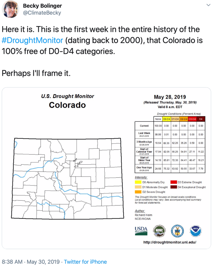
“If there is any doubt on any of our reservoirs, it would probably be Blue Mesa which is our biggest reservoir, and was also the hardest hit by the drought last year,” said Becky Bolinger, the assistant state climatologist at the Colorado Climate Center at Colorado State University.
The rest of the good news stems from what that record snowpack has done for our drought. Colorado entered the winter will the highest level of drought, and it was widespread across the state but significantly worse in the southwest.
Now this week, Colorado is 100% drought-free for the first time since the National Drought Monitor was developed 19 years ago. There are even no areas categorized as Abnormally Dry, sometimes referred to as D0 drought…
“We’ve replenished the deficits in our soil moisture, we’ve replenished the deficits that were in the rivers, and we’re on track for replenishing the deficits in our reservoirs,” said Bolinger.
It’s good news for Colorado’s wildfire threat. Governor Polis announced the state’s forecast for a less active wildfire season earlier this month.
It’s good news for outdoor recreation. Even though the rafting season is off to a slow start, the forecast is for an extended season lasting into the late summer. And we might be able to bring the campfires back to summer camping, a common complaint in 2018 as burn restrictions covered the entire state of Colorado.
And now for the bad news…
The first strong ridge of high pressure we’ve seen in a while is starting to build. That means lots of sunlight on that frozen reservoir during the next 6 or 7 days.
The fields of Sterling, Colo., in May are a dependable trio of colors: yellow with the dried remnants of last year’s harvest; the deep brown of freshly tilled earth; and green from new growth. Another hue mars this palette in places, an unwelcome one: white. The color of salt. To crops, it’s the color of death.
There aren’t many patches of dead land. But there are enough to worry farmers and water officials that the same fate that has felled civilizations could befall cities along the South Platte River: that the land will become too salty to support plant life.
“Salinity is always a concern in agriculture,” said Grady O’Brien, a Fort Collins-based hydrologist who has been tapped to lead a study of salinity along the South Platte this year. Colorado Corn, a group representing farmers in the state, is sponsoring the study, with a $39,000 grant from the Colorado Water Conservation Board.
It’s too soon to tell if salinity is a problem on the South Platte. Preliminary sampling by Colorado Corn in September showed worrying signs. Measures were taken at a dozen points along the river from above Denver to the Colorado state line. As the water flowed downstream, its purity dipped noticeably.
Salt is actually a catch-all term for total dissolved solids, or TDS. TDS can include a number of things other than what the general population knows as salt, sodium chloride. In the world of water, “salt” can be magnesium chloride, uranium, selenium — any minerals, salts, metals, and ions that have dissolved in the water.
In samples taken last year near Waterton Canyon, TDS was measured at 162 parts per trillion. Samples taken near Julesberg, much farther down the river on the Eastern Plains, came in at 1,310 parts per trillion, according to data provided by O’Brien.
“Once the testing got down around Sterling, it was pretty darn toxic in terms of salt,” said Mark Sponsler, chief executive officer of Colorado Corn. “Those numbers gave us enough of a concern to want to do a more in-depth look.”
Map via Water Education Colorado.
The full study will review historical datasets from a handful of organizations, including several water districts, the Colorado Department of Agriculture, and the U.S. Geological Survey. Decades of information should reveal if the South Platte has gotten saltier over time, identify seasonal variations, and uncover potential sources of increased salt.
Salinization is not a new problem; it is as old as civilization itself. What is today Iraq, sometimes called the Cradle of Civilization, was once known as the Fertile Crescent. Centuries of irrigation concentrated salts in the soil to such a degree that nothing would grow.
A study released in early 2018 by the Proceedings of the National Academy of Sciences found that 37 percent of drainage basins in the United States have been altered by salinity over the past century.
“The greatest threat to irrigated agriculture in the world is salinization,” said Timothy Gates, a professor of civil and environmental engineering at Colorado State University. Gates has worked on the Arkansas River, Colorado’s saltiest, for years.
All water, even rainwater, contains salt. When applied to crops (or urban lawns and gardens), plants absorb the water and leave the salts behind, which accumulate over time. In the modern world, agricultural runoff contributes to salinity, as does the increasing use of de-icing compounds on roads.
But it may be in part state water policies that are driving salinization on the South Platte. As drought-prone Colorado focuses on conservation, water is reused more and more. Each use adds a certain amount of salt to the water it pulls from upstream. And while water quality regulations exist for things like uranium, selenium and nitrogen, there are no guidelines for TDS and their effects on agriculture, O’Brien and Gates said.
When Denver gets its water from mountain snowpacks, it is almost as pure as it can be, O’Brien said, at about 100-200 parts per million of TDS. By the time the city pumps treated wastewater back into the South Platte, it’s closer to 500-600 ppm. (Denver Water and the Metro Wastewater Reclamation District declined to confirm TDS levels.)
Downstream of Denver, on its way to Nebraska, the South Platte winds its way past hundreds of miles of roads, farm fields, stockyards, and oil and gas wells. It passes near or through the towns of Brighton, Fort Lupton, Greeley, Fort Morgan, and Brush before it reaches the corn, bean and alfalfa fields of Sterling.
Each city, each wastewater treatment plant, each roadway “keeps adding to that salt load,” O’Brien said. “Salinity is increasing all the way through the basin.”
But Jim McQuarrie, director of strategy and innovation at Metro Wastewater, said wastewater treatment plants can and do improve the quality of the water they treat. For instance, the water Metro puts back into the South Platte has less magnesium and chloride than the water it takes in. “We actually net improve [those] salts.”
McQuarrie said discussions are ongoing about how to improve on all fronts when it comes to salinity: “Wherever there are opportunities for us to avoid unnecessary addition of TDS, we are working on that now.”
By some measures water coming from upstream has improved over the years, said Jim Yahn, manager of the North Sterling Irrigation District. In his region, nitrates from fertilizers used to cause algae and moss growth in rivers and reservoirs, but the problem has dissipated in recent years.
“With increased regulation on municipal effluent,” said Yahn, referencing the outflow that comes from upstream wastewater treatment plants, “the water quality is better in a lot of ways.”
And despite the few crusty patches of field surrounding Sterling, he said farmers aren’t yet worried, though they are looking forward to what the data has to say.
The study is scheduled to be completed in late October.
Fresh Water News is an independent, non-partisan news initiative of Water Education Colorado. WEco is funded by multiple donors. Our editorial policy and donor list can be viewed at wateredco.org.
The Colorado River at Horseshoe Bend, upstream of Glenwood Springs. Photo credit: Aspen Journalism/Brent Gardner-Smith
From Western Resource Advocates (Jamie Trafficanda):
Today, conservation and sportsmen groups across Colorado lauded the bipartisan passage of a bill that would raise funds to protect and conserve the state’s water from the tax proceeds on some forms of new sports betting. A portion of the revenue generated would go to a Water Plan Implementation Cash Fund governed by the Colorado Water Conservation Board and help support some of the water conservation, agricultural projects, river health, “smart” storage, and demand management needs for the state. The sports-betting measure must be approved by the voters this fall.
“Colorado leaders are making a safe bet to ensure a more resilient future for our thriving communities, agriculture, businesses, recreation and wildlife,” said Brian Jackson, Senior Manager, Western Water, at Environmental Defense Fund. “We are hopeful voters will recognize the urgent need to protect our most precious resource, water, and that this measure will be a slam dunk at the ballot box this fall.”
“As Colorado’s population continues to grow and climate change stresses our water supplies, Colorado’s Water Plan lays out a roadmap to secure our water future. But to make that plan a reality, we need to establish a dedicated funding source,” said Bart Miller, Healthy Rivers Program Director at Western Resource Advocates. “If approved by the voters, this measure would provide an important down payment and have an immediate impact on Colorado communities.”
“Passing this bill represents key progress toward protecting our rivers and clean drinking water today and into the future,” said Drew Peternell, Director of the Colorado Water Program at Trout Unlimited. “But the challenges our water supply faces are long term. We’ll need additional, long-term sources of funding to make sure we have enough water to sustain Colorado’s economy, especially in rural agriculturally-based areas.”
“This bill is an important step to a secure water future,” said Matt Rice, Colorado Basin Director at American Rivers “Now this effort will go to referendum to be considered by Colorado’s voters. If it’s passed, the revenue generated will support our rivers, secure clean, safe, reliable drinking water for our communities, and preserve our agricultural heritage.”
“The Colorado Water Conservation Board estimates that implementing Colorado’s Water Plan and safeguarding our water will require at least $100 million annually for the next 30 years,” said Melinda Kassen, Senior Counsel at the Theodore Roosevelt Conservation Partnership “If voters approve this bill through the referendum process, the revenue generated would be an important down payment that gets the ball rolling for multiple uses, including river protection and restoration. That said, the revenue from this bill won’t get us all the way there. As we use these funds to demonstrate value for fish and wildlife resources, we can build the case for the benefits to Colorado of taking the next step to find additional funds for this important work.”
If you’ve got early summer high-altitude hiking plans in Colorado, you’ll probably want to pack snow gear for your trek. Colorado’s snowpack is very high above the typical average around a majority of the state. This means that many high-altitude trails will remain snow-covered late into the summer season…
Thankfully, this deep snowpack will likely help Colorado when it comes to wildfire and drought. Unfortunately, it will likely impact your summer plans.
According to the Natural Resource Conservation Service, snowpack won’t melt off significantly at Colorado’s highest elevations until late-July or August. While snow shoes, traction spikes, and crampons can help you overcome this hurdle, mountain roads that allow access to many popular trailheads will also have late openings.
Popular roads including Trail Ridge Road, Independence Pass, Mount Evans Road, and Kebler Pass were all still closed through Memorial Day Weekend. The Maroon Bells Scenic Area will be closed until June 15, according to Aspen Times. Also in Aspen, the Conundrum Creek Trailhead will be closed as well – and there’s not an estimated date of opening for that one yet. Less popular roads that are at high-altitudes are also likely to prove problematic late into the summer…
Long story short – there will be snow on fourteeners late into summer this year. If you’re planning to bag some of Colorado’s 50-some 14,000-foot peaks and you don’t have plans to wait for dry trails, make sure you plan ahead. Bring the right gear to safely get up and down the mountain. Be aware of avalanche risks by visiting the CAIC website. Click here for a few tips regarding winter mountain climbing in Colorado.
The continental United States recently finished its soggiest 12 months in 124 years of modern recordkeeping. The results are visible in satellite measurements of fresh water.
From May 1, 2018, to April 30, 2019, the lower 48 states collectively averaged 36.20 inches (919.48 millimeters) of precipitation, a full 6.25 inches (158.75 mm) above the mean. The previous record (April 2015 to March 2016) was 35.95 inches. According to the National Centers for Environmental Information, ten U.S. states had their wettest 12 months, and three others were in the top three. Many of them were clustered in the Mid-Atlantic and Midwest regions.
According to the May 21 report from the U.S. Drought Monitor, just 2.72 percent of the contiguous U.S. was in drought, among the lowest levels in two decades of records. California is completely out of drought for the first time since 2011. As recently as February 2018, one-third of the United States was in drought.
The map above shows how groundwater has responded to the unusually wet year. The colors depict the wetness percentile; that is, how the amount of groundwater on May 13, 2019, compares to all Mays from 1948 to 2012. Blue areas have more abundant groundwater than usual for the time of year, and orange and red areas have less. The map is based on multiple types of meteorological data (precipitation, temperature, etc.) integrated within an advanced computer model developed by scientists at NASA’s Goddard Space Flight Center.
May 11 – 13, 2019
The second map shows soil moisture anomalies, or how much the water content near the land surface was above or below the norm on May 11–13, 2019. The measurements are derived from data collected by the Soil Moisture Active Passive (SMAP) mission, the first NASA satellite dedicated to measuring the water content of soils. SMAP’s radiometer can detect water in the top 5 centimeters (2 inches) of the ground. Scientists use that surface layer data in a hydrologic model to estimate how much water is present even deeper in the root zone, which is important for agriculture.
Much of the East and Midwest had an extremely damp autumn in 2018; land-falling category 5 hurricanes Michael and Florence dropped copious amounts of rainfall in the late summer; and California has been soaked by sporadic atmospheric river events and the effects of a mild El Niño. But there is no one explanation for the extreme precipitation of the past year. It does, however, fit with long-term increases in overall precipitation and with heavy rainfall events in our changing climate.
“I do not have an explanation for the weather systems that caused the heavy precipitation, but sea surface temperatures in the western Atlantic and Gulf of Mexico have been generally well above normal over the past year. This has surely added to the atmospheric water vapor content available to the precipitating weather systems,” said Ken Kunkel, a climatologist with the National Oceanic and Atmospheric Administration. “The pattern of precipitation over the past 12 months indicates general wetness over most parts of the U.S. but does not match projections of the future, which show increases mostly in the northern U.S. Thus, the recent wetness probably has explanations in addition to, or instead of, just anthropogenic forcing.”
In the Fourth National Climate Assessment, released by the U.S. Global Change Research Program in 2018, scientists reported: “a national average increase of 4 percent in annual precipitation since 1901 is mostly a result of large increases in the fall season. Heavy precipitation events in most parts of the United States have increased in both intensity and frequency since 1901…The frequency and intensity of heavy precipitation events are projected to continue to increase over the 21st century. Mesoscale convective systems (organized clusters of thunderstorms) in the central United States are expected to continue to increase in number and intensity in the future.”
Writing for The Washington Post, meteorologist Jason Samenow reflected on a record-setting year of rain in the nation’s capital: “The historic rainfall over the past year is somewhat of a random occurrence. It is mostly a result of weather patterns that have frequently arranged themselves, by chance, in an optimal way to squeeze water from the sky. Yet, at the same time, this record-wet year has occurred against a longer-term backdrop of climate warming and increasing precipitation extremes. In other words, climate change probably intensified the rain and increased the chance it would become a record breaker.”
NASA Earth Observatory images by Lauren Dauphin and Joshua Stevens using soil moisture data from the NASA-USDA SMAP team and using GRACE data from The National Drought Mitigation Center at the University of Nebraska-Lincoln, and rainfall data from The Iowa Environmental Mesonet The Iowa Environmental Mesonet (IEM). Story by Mike Carlowicz.
The Birds Are Back at Turquoise Lake It’s nice when a plan comes together, but it’s even nicer when that plan has sustainable success, season after season. Such is the case for the bird’s nest platform erected back in August 2016 near the May Queen Campground at the west end of Turquoise Lake located just…
When Greg Wetherbee sat in front of the microscope recently, he was looking for fragments of metals or coal, particles that might indicate the source of airborne nitrogen pollution in Rocky Mountain National Park. What caught his eye, though, were the plastics.
The U.S. Geological Survey researcher had collected rain samples from eight sites along Colorado’s Front Range. The sites are part of a national network for monitoring changes in the chemical composition of rain. Six of the sites are in the urban Boulder-to-Denver corridor. The other two are located in the mountains at higher elevation.
The monitoring network was designed to track nitrogen trends, and Wetherbee, a chemist, wanted to trace the path of airborne nitrogen that is deposited in the national park. The presence of metals or organic materials like coal particles could point to rural or urban sources of nitrogen.
He filtered the samples and then, in an inspired moment, placed the filters under a microscope, to look more closely at what else had accumulated. It was much more than he initially thought.
“It was a serendipitous result,” Wetherbee told Circle of Blue. “An opportune observation and finding.”
In 90 percent of the samples Wetherbee found a rainbow wheel of plastics, mostly fibers and mostly colored blue. Those could have been shed like crumbs from synthetic clothing. But he also found other shapes, like beads and shards. The plastics were tiny, needing magnification of 20 to 40 times to be visible and they were not dense enough to be weighed. More fibers were found in urban sites, but plastics were also spotted in samples from a site at elevation 10,300 feet in Rocky Mountain National Park.
The findings are detailed in a report published online on May 14.
The U.S. Drought Monitor on Thursday released its weekly “drought map” that showed, for the first time since the service was created in 2000, Colorado was free from all listings of drought, after a winter of heavy snow and a spring filled with precipitation lifted the state out of the red.
The Drought Monitor’s outlook prompted media reports and chatter on social media that Colorado’s long drought was over. But that conclusion is inaccurate and doesn’t tell the whole story of Colorado’s drying out in the face of climate change, according to several weather and climate experts who spoke to The Durango Herald this week.
The Drought Monitor’s weekly outlook is a snapshot of current conditions and doesn’t take into account long-term trends, said Richard Heim, a meteorologist for NOAA’s National Center for Environmental Information, who created last week’s drought map…
“Drought is a very interesting phenomenon because it’s not the presence or occurrence of something, it’s the lack of something,” Heim said. “And it takes a while for drought to develop and for people to notice it.”
The Drought Monitor listed Southwest Colorado in a drought in fall 2017 and, with a practically non-existent winter, put the region in the most extreme level of drought conditions in spring 2018 in what turned out to be the second lowest water year in recorded history.
And there Southwest Colorado remained until this winter put on its best Jekyll and Hyde, resulting in the third largest snowpack since 1986 to hit the San Juan Mountains. As a result, the Drought Monitor started to reduce the severity of drought over the past few months.
But one year of epic snowfall does not end or reverse the long-term trend of drought in Southwest Colorado and other parts of the state, said Taryn Finnessey, a senior climate change specialist with the Colorado Water Conservation Board.
“Just because we have one good year … doesn’t negate the realities we’re seeing with consistent warming trends,” she said.
Colorado’s average temperature has risen 2 degrees in the last 30 years and is expected to increase another 2 to 4 degrees by 2050, driven by climate change and fossil fuel emissions. And higher temperatures can increase the intensity and duration of droughts.
Southwest Colorado and the Colorado River basin are particularly vulnerable to these changes. It led to the Colorado River Research Group to assign a new word to explain the region’s new normal.
Reagan Waskom, director of Colorado State University’s Colorado Water Institute, said the term “drought” no longer explains what is taking place in the Colorado River basin.
The research group’s study emphasized that the Colorado River basin isn’t in a normal drought cycle that is expected to end. Instead, the region’s arid climate is only expected to further dry out, and with rising global temperatures, there doesn’t seem to be any reversal to that pattern in sight…
“The public will forget about drought pretty quickly,” Waskom said. “But we live in a dry land, where it is getting hotter and drier, and we should continually be in front of our thinking how we manage our water resources.”
Indeed, Finnessey said drought has lasting impacts, and it takes a long time to recover forest health and agriculture.
This year the run-off in Colorado is late. “The native water hasn’t started to flow yet,” said Roy Vaughan with the Bureau of Reclamation. Vaughn is part of the team that helps manage what stored and released from Lake Pueblo Reservoir.
Water released from the dam is currently much less than typical. “We’re releasing about 15 percent of what we normally do this time of year.” The number is a correlation with the amount of run-off flowing into the reservoir. Run-off is late this year. “We see it start and then the weather changes, it cools down and it slows up again. It’s about three weeks late.” For now, spillways are mostly dry.
Click on the graphic for the USGS Water Watch interactive map for Colorado.
In the city of Golden, Jennifer Hopwood teaches transportation department employees how to tell a bee from a wasp or a fly…
Hopwood is a specialist in pollinator conservation with the Xerces Society for Invertebrate Conservation. She says honeybees may have shaped the bee stereotype, but they’re actually newcomers to North America, arriving a few centuries ago with Europeans. Native bees often burrow nests in the ground, and some look like wasps or flies.
One fourth of Colorado’s bumblebee species are threatened and the western monarch butterfly isn’t doing well, either. Migrating populations recently reached a record low.
“CDOT’s identified — with federal highways — the potential to help improve pollinator habitat along our roadsides,” says Mike Banovich, a landscape architect with CDOT who organized the workshops. “Before that we were primarily focused on erosion control so our right-of-way consists of really aggresive grasses. But now the emphasis through our policy is to plant natives and then a step up is pollinator natives.”
Roadsides can’t fix the habitat fragmentation that is part of the problem for insects, says Hopwood.
“But they’re a natural asset,” she says. “It’s an important landscape feature that can provide connectivity and can support life cycles of different pollinators. And we have millions of acres of roadside, so it’s definitely an opportunity.”
She says less pesticides and more wildflowers and unmowed grass could help a lot. Next, Hopwood will make her way to the Western Slope to hold similar workshops there.
This story was produced by the Mountain West News Bureau, a collaboration between Wyoming Public Media, Boise State Public Radio in Idaho, KUER in Salt Lake City, KUNR in Nevada and KRCC and KUNC in Colorado.
Weather rolls into Arivaca, Arizona, with plenty of warning. The community’s 630 residents live in a desert valley with sweeping vistas, where gigantic cloud mosaics are constant and ever shifting with the wind.
For a long time, Arivaca has received outsiders looking to make it their own. It sits just 11 miles from the U.S.-Mexico border, on land that was once the territory of the Tohono O’odham. The area’s vast public lands are littered with defunct silver and gold mines. In the 1970s, hippies moved in, and later, a stream of retirees. “We have people that come to Arivaca just to get away from whatever they want to get away from,” says librarian Mary Kasulaitis, a local historian and fourth-generation rancher.
For a hideout, though, it’s pretty smack-dab in the middle of things. Almost everyone has a story about undocumented immigrants knocking on their door, desperate for water. Arivacans tell stories about bricks of pot dropped on their land to be carried north. Locals say smuggling has long been a tacit part of life here.
Yet Arivaca — a vibrant community of artists, families, ranchers and desert rats — tries not to let politics or the drug trade disrupt daily life. “Most people in Arivaca look at national and international politics as kind of a joke,” says longtime resident Alan Wallen, 50, the founder of the town’s cooperative internet provider. “Here’s the thing about Arivaca. More and more, it became tolerant of different viewpoints. It evolved into a really odd mix of really tolerant people.” As one Tucson newspaper put it, Arivaca is “a live-and-let-live kind of town.”
In his home office in Arivaca, Arizona Border Recon Founder Tim Foley looks at photos from his excursions into the desert mountains along the Mexican border. Photo credit: Andrew Cullen for High Country News
So it was significant when, in 2017, locals bristled at the arrival of an outsider. Tim Foley, a wiry, blue-eyed 59-year-old, moved to town from nearby Sasabe. Foley is the head of Arizona Border Recon, an armed group that tries to intercept immigrants and smugglers in the Borderlands, and also claims to provide “intelligence and security services” to the Border Patrol. He is a well-known figure in the right-wing militia world and, increasingly, in anti-immigrant conservative politics. Last September, Foley gave a speech outside the U.S. Capitol building, alongside several members of Congress and presidential advisor Kellyanne Conway.
Around the same time, other men appeared in Arivaca, either inspired by Foley or by President Donald Trump’s calls to “build the wall.” They used the town as a backdrop for online tirades against smuggling and immigration. Their presence irked those already uneasy with Foley, and set in motion an organizing effort among a small group of locals, who worried about the threat the visitors posed and wondered what to do about it.
Here’s the other thing about Arivaca: This wasn’t the first time people had come from away to expound on the evils of immigration. And last time it happened, things went badly for the community. Ever since a fateful night in 2009, many Arivacans say some things are not welcome here.
The murders of Raul Flores and his daughter, Brisenia, turned Arivaca upside down. Their house has been unoccupied since. Photo credit: Andrew Cullen for High Country News
ON THAT MAY NIGHT IN 2009, a woman and man banged on the door of a local home, wielding a handgun, revolver and a duct-taped shotgun. The woman was Shawna Forde, the leader of Minuteman American Defense, a militia that patrolled the Borderlands for migrants. Originally from a Seattle suburb, Forde was also interested in joining the drug trade. That night, posing as a member of the Border Patrol, she entered the home of the Flores family, looking for drugs and money. She and her male companion found neither. Still, they murdered Raul “Junior” Flores and his 9-year-old daughter, Brisenia, shooting Junior in the neck, throat and head, and Brisenia point-blank in the face. The killers were put behind bars, while Arivaca was left with the kind of wounds that never truly heal.
Clara Godfrey has organized community meetings to discuss the arrival of militia groups to Arivaca. Photo credit: Andrew Cullen for High Country News
When Tim Foley moved here in 2017, some locals thought Arizona Border Recon sounded a lot like Minuteman American Defense. In Sasabe, Foley had earned a reputation when he threatened to burn down his house after the rent was raised, according to a sheriff’s report. “We were warned from people in Sasabe,” says Clara Godfrey, a petite and charismatic 58-year-old, whose family has roots in Mexico, Greece and southern Arizona. “We didn’t give him much of a chance,” says Eli Buchanan, 36, who runs the recycling center. “As soon as we found out he was moving here, the town had a big candlelight vigil for Brisenia and made it clear he wasn’t welcome.”
But Foley stayed and continued patrolling the border. “I thrive on using my mind,” he told me during an interview at his home in Arivaca. As border security became a cornerstone issue for the Trump administration, Foley’s longtime anti-immigrant obsession took on new prominence. And in some online corners of the far-right world, so did Arivaca.
The second outsider was a tall redheaded conspiracy theorist named Michael Lewis Arthur Meyer, who often goes by Lewis Arthur. In early September, he started livestreaming from Arivaca’s main street to his Facebook followers, claiming that a local humanitarian aid group that helps migrants in need of food, water or medical attention was in cahoots with drug cartels.
“If you’re ever down here,” Arthur bellowed, “if you want to know who helps child traffickers, if you want to know who helps dope smugglers, if you want to know who helps ISIS — any of the bad guys. These people help them.” A woman in a long brown dress approached him. It was Megan Davern, 30, a local butcher and bartender. Davern had seen Arthur in the bar and realized he was a friend of Foley. As he livestreamed, she asked Arthur what he was up to, and if he was part of a larger group. “We’re only with God,” he replied.
Megan Davern, a butcher and bartender at La Gitana Cantina, has helped organize community meetings in response to a string of confrontations between residents and visiting right-wing activists. Photo credit: Andrew Cullen for High Country News
“I would appreciate it if you don’t come in again,” Davern told him.
“Understood,” he said, and continued his tirade.
A few days later, Arthur confronted another bartender downtown, demanding to know why an anti-militia sign had been posted on the door. When the bartender asked him to leave, he made a vague threat to mess with the town’s water supply. As he livestreamed, his Facebook followers encouraged him. Someone suggested burning down the bar.
So Arivacans started to organize. They created a phone tree and helped the bartenders close up at night. Godfrey called a community meeting to urge people to watch out for one another. What the heck was going on? they wondered. Would anyone actually try to burn down the bar — or worse? About 50 people packed the old schoolhouse, and a local cowboy named Huck sat outside to keep watch, in case someone came around with bad intentions.
“I have always been adamant in my belief, since what happened to us in 2009, that these people are nothing but no good,” Godfrey told me. “We have a tree planted for Brisenia. I’m at the point where I don’t need to plant a tree. We need to take a stand.”
Also around this time, Bryan Melchior of Sandy, Utah, arrived, talking about the need to fortify the border. Melchior, who ran a group called the Utah Gun Exchange, was famous for driving the country in an armored vehicle mounted with a machine-gun replica to intimidate gun control advocates at rallies. When he drove the vehicle through Arivaca, he set off a wave of new anxiety. He had been inspired by Trump’s calls for a border wall. “We’re in town because Trump is going to put the border at the top of the national priorities list again,” Melchior said, in a recording made by an anti-militia organizer. He wanted to lease land and start building the wall himself.
Davern was behind the bar when he showed up, carrying an open container of Mike’s Hard Lemonade. When Melchior said he sometimes worked with Foley, and started getting into arguments with the bar’s patrons, Davern asked him to leave. And then she called another town meeting.
La Gitana Cantina has adopted a no-militia policy. Photo credit: Andrew Cullen for High Country News
THIS TIME, THE TOWNSPEOPLE CALLED IN OUTSIDE SUPPORT: They invited Jess Campbell to the meeting. Campbell works for the nonprofit Rural Organizing Project in Oregon, which helps communities organize around issues ranging from defunded libraries to hate crimes and far-right extremism. In 15 years of this work, Campbell had never seen such an organized and self-directed community. “Arivaca was very special in that people weren’t so terrified of speaking to neighbors. They have a strong social fabric,” she said. But they wanted answers. “Folks felt their community might be a special kind of messed-up and were trying to understand why this happened to them,” Campbell told me.
At the meeting, she gave a presentation on how militia groups operate in rural areas, and suggested ways to stay safe in the face of threats. She helped Arivacans consider ways to collect and organize information about incidents like the recent confrontations at the bar. And she tried to help them figure out what the real threat was.
Campbell explained that militia groups tend to see themselves as above the law, which increases the risk of confrontation with law enforcement. For example, in 2015, a chapter of the Oath Keepers that had embedded in a rural county in southern Oregon for over two years ultimately led hundreds of supporters in an armed show of resistance to law enforcement at a mining claim.
As the town’s only bar, La Gitana’s clientele includes ranchers, a ski-industry avalanche consultant, marijuana home growers and nearly everyone else in town. Photo credit: Andrew Cullen for High Country News
But there was also a more diffuse threat. An armed militia in a small community can be polarizing, forcing people to choose sides. “If they can drive a wedge into the community, or people are very quiet because they’re nervous to speak out, that’s where we see (militia groups) get the strongest foothold and be able to rock and roll,” Campbell said. This happened in Burns, Oregon, during the 2016 armed occupation of the Malheur National Wildlife Refuge, she said. Militia groups “tried to twist the arms of whoever was in power there — the sheriff, the (county officials),” Campbell said. When the militia failed to gain support, it demonized local leadership and created divisions in the community.
“That’s the playbook,” Campbell said.
After Campbell left, Godfrey, Davern and others monitored social media and kept in touch, sharing information about threats and accusations on a community Facebook page. A woman named Ann Ayers collected internet videos on her computer — documentation for potential harassment claims. Arivacans pestered Facebook to shut down Arthur’s page, which the company eventually did.
Radio host Ben Bergquam livestreams from Arivaca’s downtown, responding to the local bar’s anti-militia policy. Photo credit: Ben Bergquam/Facebook Video Screen Capture
In their quest to understand why their sleepy downtown had drawn so many threatening outsiders, one common thread emerged: Tim Foley. In November, Ben Bergquam, a California talk radio host with over 100,000 Facebook followers, livestreamed outside the bar. “Good morning, y’all,” he began, donning a U.S. Immigration and Customs Enforcement hat. He trailed off, forgetting the name of the town he was in. Tim Foley stood in the background, smoking a cigarette.
Foley didn’t actively take credit for bringing the other men to town. He even distanced himself from Arthur after the man drew too much negative attention online. But Foley had become a magnet for MAGA activists looking for a like-minded tour guide to the Borderlands; Melchior and Bergquam both came in part to meet him.
“I got invited by the one and only Tim Foley … of Arizona Border Recon,” Bergquam said in his livestream. “If you’re coming through Arivaca and you’re a patriot, don’t go to that bar. Or do go to that bar.”
The downtown incidents weren’t the worst part. It was the uncertainty about who else might be watching online. Who would show up next, and with what intentions? “Things that were said in anger about our community weren’t just said to us,” Godfrey said, “but to the world.”
Tim Foley outside his home. Foley and a rotating group of volunteers he hosts patrol the desert for illegal migrant and drug activity. Photo credit: Andrew Cullen for High Country News
AT ITS CORE, ARIZONA BORDER RECON is a three-person organization composed of Foley, his girlfriend, Jan Fields, and a man named Lorenzo Murillo, who also lives in Arivaca. Foley started thinking about immigration issues when he was living in Phoenix in 2006. As the owner of a small construction company, Foley said undocumented immigrants undercut his bids. Then the mortgage crisis hit, and his house foreclosed. Frustrated and broke, he sold his three Harley Davidsons and moved to Sasabe, which straddles the international border. In 2010, he founded Arizona Border Recon.
Today, Foley and Fields host groups of people, mostly white men, for a week or two at a time to patrol the desert for illegal activity. In addition to intercepting migrants, Foley aims to disrupt drug-smuggling routes.
Foley also courts the media: He’s received coverage from Wired, Vice, USA Today, and many others. He usually charges news outlets $200 to tag along on his patrols. (High Country News interviewed Foley but did not pay for his time.) Cartel Land, a 2015 documentary film nominated for an Academy Award, compared Foley to the Mexican citizens taking an armed stand against the cartels inflicting horrific violence on their communities. It was great publicity.
Sugar Pine Mine, the other standoff via High Country News (click photo to read the article)
That same year, Foley began connecting with right-wing militia leaders. Montanan Ryan Payne and a California man named Gary Hunt recruited him to help establish an organization called Operation Mutual Defense, or OMD. The group dreamed about organizing militia actions across the country — from standing up for ranchers at odds with the federal government and breaking fellow patriot movement members out of jail, to intercepting buses of Muslim refugees in Montana and other states, and interrogating them. Hunt is a longtime rightwing thinker, who described Oklahoma City bomber Timothy McVeigh as “the first patriot of the second American revolution.” Payne was a primary militia leader involved in the Nevada standoff between rancher Cliven Bundy and the federal government in 2014. Lingering enthusiasm from the Bundy victory — or as Hunt called it, the great “unrustling” — fueled the creation of OMD.
Foley brought media savvy to the group. He encouraged members not to call themselves “freedom fighters,” since it sounded too aggressive. He recommended “concerned citizens” instead. “Image is everything, and you don’t want to portray that offense,” Foley said at the time. “You want to portray defense.” A series of conversations recorded between the OMD founders reveal that Foley planned to provide a place for people to train for future operations. The group saw Foley and the border as key to building a national militia network.
“That’s the beauty of the border,” Payne said “There’s an active, hot environment that we can conduct real-world operations, where we’re making a difference and at the same time, we’re building cohesion amongst ourselves.”
OMD’s founders also discussed using Lewis Arthur’s Tucson-based group, Veterans on Patrol, to provide tents and cooking facilities if they were to have “an operation like the Bundy Ranch” on the border. OMD discussed taking a stand against the government in Harney County, Oregon, where anti-federal sentiment eventually morphed into the 2016 armed occupation of Oregon’s Malheur National Wildlife Refuge. But Foley told me he ultimately wasn’t on board with the occupation because it came too close to a government overthrow. “When they started talking crazy, I said, ‘nope, I’m out.’ ” As the 41-day occupation unfolded and then unraveled when state police and FBI apprehended its leaders, Foley stayed home in Arizona, out of the fray.
Foley scoffs at some Arivacans’ fears that Arizona Border Recon or its associates would cause violence on par with the 2009 shootings. “Go into town and shoot people’s doors in? Are you out of your freakin’ mind?” he told me, in his tidy mobile home in Arivaca. And not everyone here minds his presence. Many people told me that if he wants to help Border Patrol stop illegal activity, more power to him. He’s just one more person living his dream.
But to Godfrey and her allies, his connections are troubling. They worry that Foley is becoming a local conduit for national angst, who will only bring more disruption the longer he stays.
Jo Rae Vass, Mary Kasulaitis and Clara Godfrey (sitting) and Dan Kelly and Megan Davern (standing) are some of the Arivaca, Arizona, residents who are working together to combat the militia presence in town. Photo credit: Daniel Tepper for High Country News
BORDER MILITIAS FIRST GAINED STEAM in the early and mid-2000s. Several made alliances with cattle ranchers who were fed up with migrant traffic across their land and smugglers cutting their fences. In 2000, a paramilitary group called Ranch Rescue formed to help Arizona cattlemen defend their property. After members of the group were arrested for imprisoning and pistol-whipping migrants, Ranch Rescue dissolved. Then, in 2008, a group called the Minutemen Civil Defense Corps set up operations from a ranch 30 miles north of Arivaca. The Corps was Shawna Forde’s first real introduction to unofficial border patrols; her Minuteman American Defense was a spinoff.
Today, some Arivaca ranchers are vehemently opposed to the militias. Local ranchers Jim and Sue Chilton had nothing to do with Shawna Forde, but they are vocal about their support for Foley and Arizona Border Recon. One of the Chiltons’ federal grazing allotments abuts the international border in a heavily trafficked smuggling area, Jim says. The Chiltons want Trump’s wall and more resources for Border Patrol. For now, though, they have people like Foley, who calls the couple his “biggest cheerleader” in Arivaca.
The Chiltons don’t view the 2009 murders as the result of rightwing extremism. “It wasn’t really a militia,” Sue Chilton said in a video the Utah Gun Exchange posted last fall. She argued that drug dealers orchestrated the killings. Indeed, in court documents, a judge described one of the three found guilty as a dealer who was “plotting to kill (Junior) Flores as a perceived rival in the drug trade.” That man was Clara Godfrey’s nephew, Albert Gaxiola, who waited outside the home while the first shots were fired.
And yet it’s also true that rightwing extremism was baked into the horrific deed. According to court documents, Forde got involved in the trade as a way to fund her Minuteman American Defense, which required transportation and firearms. Jason Bush of Wenatchee, Washington, the man who shot Flores and his daughter that night, was part of Forde’s group and a known white supremacist.
All of this makes it difficult to untangle the real threat in Arivaca. If the murders were the result of a drug feud, why not organize against smugglers? Some said that’s just not practical. “When you live near a border of any kind, there is smuggling,” Mary Kasulaitis told me. “It would happen if you were off the coast of Cornwall in England.” Smuggling is an economy as old as the border. People told me it’s just a fact of life.
“For the most part, Arivaca has been pretty stable and quiet because they don’t want to attract law enforcement,” according to David Neiwert, a national expert in right-wing movements and author of a book about Shawna Forde. Militia members, however, threw things off balance, he said. “(Militia) introduce an unstable element that’s capable of extreme violence,” Neiwert told me. He said militias can become tools for people who need muscle, whether it’s ranchers feuding with the government, like Cliven Bundy, or drug dealers. In Arivaca, Neiwert said, “Shawna was basically a lethal tool.”
By Neiwert’s logic, the late-2018 confrontations had disrupted Arivaca’s equilibrium once again. This time, though, there seemed to be little promise of resolution. There were no obvious repercussions, no arrests or court trials as there had been after 2009. Instead, there were lingering questions — and a persistent sense of unease.
Jim Chilton crawls under the U.S.-Mexico border fence along the edge of his grazing allotment, to demonstrate how easy it is for migrants or drug smugglers to cross. Photo credit: Tay Wiles/High Country News
AFTER THE START OF THE NEW YEAR, Arthur and Melchior faced charges elsewhere for criminal trespassing and guns and drug violations. If the Arivacans’ goal was to get people to stop making angry livestreams downtown, “maybe it did work,” Wallen said. “Maybe that’s what it takes. That each time there is a flare-up, people get together and let their voices be heard. But each time this border war escalates, people in our town get hurt. And we’re tired of that.”
Experts say border militias don’t just have a local impact, but a national one. “Extremely anti-immigrant ideas are now embedded in the White House and our policymaking system,” says Heidi Beirich, of the Southern Poverty Law Center, which tracks hate groups. Beirich says the mobilization of border militias in the mid-2000s helped elevate immigration issues and nativist rhetoric into mainstream politics. “It was picked up by the Tea Party, eventually made its way into the GOP, and we got Trump.” Now, the cycle is coming full circle, with the president fueling the ideas that motivate people like Arthur, Melchior and Foley. “They see themselves as a bulwark protecting Trump,” Beirich says of many far-right activists.
In January, Godfrey held another meeting at the historic schoolhouse, the fourth such gathering in the last five months. “We have to really be on guard,” she warned her fellow citizens. “Everybody can have different views, but when views become murder, then I don’t want to hear shit about your views.” The group planned to send a letter to the district attorney about the livestreamers and the town’s concerns about militia activity. Godfrey wanted the authorities to be aware, in case things went downhill. Word also got around that Foley was interested in buying a piece of land outside of town. In February, Eli Buchanan sold his tractor in order to purchase the land first. In early March, locals reported yet another armed group in town, this time a couple of men who reportedly called themselves anarchists and wanted to confront Foley. Wallen said he and another local man talked them down.
“There’s a feeling like we can’t let this rest until it’s done, and I don’t know what that means,” Ann Ayers told me. Ayers worries the threat to the town will persist as long as the president continues his inflammatory rhetoric. She still periodically plugs into the Facebook pages of right-wing activists, where the conversation never stops. “It’s a weird world,” she says. “A couple of weeks ago (I was) talking to some people, and they were like, ‘It’s all quiet now.’ And I’m like, ‘But is it?’ ”
Arivaca, Arizona, a dozen miles north of the Mexican border. Photo credit: Daniel Tepper for High Country News
Tay Wiles is a correspondent for High Country News and a freelance reporter. Email HCN at editor@hcn.org.
On May 1 state officials kicked off the summer boating season in Grand County with the opening of the Stillwater Boat Ramp on Lake Granby. Since then several other boat ramps across Grand County have been opened to the public. According to information from Elizabeth Brown, invasive species coordinator for Colorado Parks and Wildlife, the Grand Lake Boat Ramp was opened May 17 along with the Sunset Boat Ramp on Lake Granby and the Green Ridge Boat Ramp on Shadow Mountain Reservoir…
Historically boaters were able to launch boats onto the waters of Grand County any time of year, even when boat inspectors were not present. However, beginning in 2018, federal officials began requiring that all boat ramps leading onto the waters of Grand County remain locked whenever boat inspectors are not present.
The boat inspection program is part of an invasive species prevention program operated by Colorado Parks and Wildlife. The program is primarily focused on preventing the establishment of quagga and zebra mussels, both of which are invasive species, in the waters of Colorado. Brown confirmed that currently no waters in Colorado are infested with either of the small bivalves. In 2017 12 juvenile quagga mussels were found in Green Mountain Reservoir. According to Brown additional searches were conducted that year that revealed no additional mussels. Follow up testing of the reservoir over the past year has yielded no additional mussels.
A private business, Rocky Mountain Recreation, is contracted by the state each year to provide boat inspectors in Grand County. That contract alone, which does not include any personnel costs derived from state or federal employees, is $468,000. That tally includes the cost of inspections at Williams Fork Reservoir along with inspections on the Three Lakes. Statewide the total program is roughly $4.5 million…
According to Brown there were 3,084 inspections conducted on Grand Lake last year, 4,500 on Shadow Mountain Reservoir and 12,600 on Lake Granby. That figure includes boats that were inspected on their way into the lakes and on their way out as well.
Map via the Carbondale and Rural Fire Protection District.
From the Carbondale and Rural Fire Protection District via The Aspen Daily News:
Two community meetings in June will address the threat of runoff, flooding and debris flow in the area.
A news release from the Carbondale and Rural Fire Protection District states that the first gathering will be held from 6-7 p.m. June 5 at the Redstone Fire Station. It will focus on the threat of flooding from the Crystal River Valley due to heightened snowpack and the delay in runoff due to lower than normal spring temperatures.
The public will get the opportunity to ask questions about how to prepare for flooding and other incidents. Representatives of the fire district will be present, as will emergency officials from Pitkin County government and the Colorado Department of Transportation.
The release also says that a similar meeting is scheduled for June 10 starting at 6 p.m. at the Eagle County annex building, 20 Eagle County Drive in El Jebel. Officials plan to discuss the threat of runoff and debris flow in areas that were scarred by last summer’s Lake Christine Fire.
“Emergency officials are advising residents who live in and around the Lake Christine burn scar area to be aware of the high risk for flash flooding and mud and debris flows that could occur after heavy rainfall,” the release states. “The precipitation, coupled with the burn scar, warmer temperatures and above-average snowpack, is expected to produce a faster and heavier runoff period.”
Wildfires result in a loss of vegetation and leave the ground charred and unable to absorb water, according to the release, creating conditions for flooding.
“Even areas that are not traditionally flood-prone are at risk of flooding for up to several years after a wildfire. The prospect for a wetter-than-normal spring has emergency officials from Eagle, Pitkin and Garfield counties planning for mud and debris flows,” the release adds.
Following higher-than-normal snowfall, officials prepare for the likelihood of flooding that can occur in and around local creeks, rivers and reservoirs, the release says. The weather forecast through May indicates a higher chance of above-normal precipitation over western Colorado, including the central mountains, Aldis Strautins, a service hydrologist for the National Weather Service, said in a prepared statement.
“With the anticipated high water runoff, potential flooding and increased risk of debris flows, it is important that all of our public safety and support agencies work together to plan and coordinate our response before there is an emergent need. We also want to make sure our communities are aware of the above-average risk for these events and prepare for them this year,” Eagle County Sheriff James van Beek said.
Midvalley residents, regardless of whether they live in Eagle or Pitkin County, are encouraged to register for Pitkin alerts. When the weather service issues a flash flood warning in the Lake Christine burn areas, the alert system will send out notifications to users who are registered via pitkinalert.org. Registered users of EC Alert also will receive notifications.
Those who only want to receive information about the threat of flash floods, mudslides and debris flows from the Lake Christine burn scar are invited to text LCFLOOD to 888777, the release says.
“People should remember to use caution around fast-moving streams and rivers, especially in a high runoff year,” the release says. “Those who live near the Lake Christine burn scar should be prepared to quickly move to higher ground or evacuate if necessary.”
The ungated spillway at Ruedi Dam and Reservoir, which automatically spills water into the lower Fryingpan River should the reservoir ever fill beyond its holding capacity of 102,373 acre-feet.
Those who keep an eye on the lower Fryingpan River, below Ruedi Reservoir, may have noticed that the river’s flow increased this week in three distinct steps.
On Monday, the river was flowing steadily at just about 200 cubic feet per second.
On Tuesday, it stepped up to 250 cfs, and on Thursday, it took another 50 cfs jump, to 300 cfs.
And on Friday, the river jumped another 25 cfs, heading into the weekend flowing at about 325 cfs. (See USGS gage).
The increases in flow were directed by Tim Miller, a U.S. Bureau of Reclamation hydrologist who manages water levels in Ruedi and also manages water releases from the reservoir, which is about 14 miles above Basalt.
The water from the reservoir was being released through the dam’s outlet structures, as well as through the hydropower plant at the base the dam, into an area that’s popular with anglers, and large fish, and nicknamed the “Toilet Bowl,” due to its swirling waters.
Miller’s goal is to fill the reservoir by July 4, while avoiding overfilling the reservoir, which would cause water to flow over the dam’s spillway, which does not have a flow-controlling gate, as some spillways do.
The top of the ungated spillway at Ruedi Dam. Photo credit: Brent Gardner-Smith/Aspen Journalism
Balancing act
Miller is now balancing some factors beyond his control: the deep snowpack above Ruedi, lingering cold temperatures and varying flow levels in the transmountain diversions tunnels in the upper Fryingpan Basin.
On Friday, Ruedi was 64.6 percent full and holding 66,116 acre-feet of water, according to Reclamation. When full, the reservoir holds 102,373 acre-feet.
But, given the deep snowpack above Ruedi, Miller said “it’s very possible” the reservoir could spill, something that, to his knowledge, has only happened a few times since the reservoir and dam were completed in 1968.
The Ivanhoe snow-telemetry, or SnoTel, site above Ruedi, in the Ivanhoe Creek subbasin, is at 10,400 feet. The site shows there was still 54 inches of snow at that elevation Friday. That’s up from 42 inches a week ago but still below the March 14 peak of 90 inches.
“It just really depends on the weather,” Miller said of future releases into and out of Ruedi.
Peak runoff in the upper Colorado River basin within Colorado is now expected to arrive late, between June 15 and June 25, as more cool weather is in the forecast.
Once water reaches this point on the spillway on Ruedi Dam, it’s heading for the river some 285-feet below.
Not for flood control
Victor Lee, also a hydrologist with the Bureau of Reclamation, made a presentation on Ruedi and Green Mountain reservoirs Monday at the Colorado River Basin roundtable in Glenwood Springs.
He said he expected, because of the snowpack, to see above-average releases out of Ruedi as the reservoir fills and to see above-average diversions through the Boustead Tunnel, which sends water collected by the Fryingpan Arkansas Project diversion system under the Continental Divide to Turquoise Lake, near Leadville.
Since 1972, the Fry-Ark Project has diverted an average of 54,000 acre-feet a year through the Boustead Tunnel, but it’s expected to divert 84,000 acre-feet this year, according to Lee.
On Friday, the tunnel was sending east a relatively modest 38 cfs of water, but it had been sending about 300 cfs on May 17.
Lee also sounded a cautionary note about the rare prospect of Ruedi filling, spilling and sending at least 600 cfs of water down the lower Fryingpan.
“I have to stress that Ruedi is not a flood-control project, and if we get filled, there are no gates on the spillway to stop water from going,” Lee said. “And so, if we’re full, and we fill before peak runoff, there is always that chance that we would have excess flows beyond 600 cfs.”
Aspen Journalism covers rivers and water in collaboration with The Aspen Times. The Times published a version of this story on Saturday, May 25, 2019.
FromThe Vail Daily (Scott N. Miller) via The Aspen Times:
At the Eagle River Water & Sanitation District’s May 20 State of the River gathering, participants heard a presentation from Karl Wetlaufer, a hydrologist and assistant supervisor with the U.S. Department of Agriculture’s Natural Resources Conservation Service.
Wetlaufer talked about state and regional snowpack and provided some streamflow forecasts. The news was good on both topics.
It isn’t just the Eagle River drainage that’s had a good snow year. Across Colorado, the average “snow water equivalent” in the snowpack stands at 186 percent of the 30-year median. After the drought of 2018, that’s fantastic news.
According to Wetlaufer, Southern Colorado — the part of the state that most needed a big snow year — was the area where the snowpack is greatest. The snowpack in the San Juan, Dolores, Animas and San Juan River basins — closest to the Four Corners area — stood at 294 percent of the median on May 20.
Wetlaufer said that runoff so far has added about 200,000 acre feet of water to one of the state’s biggest reservoirs, Blue Mesa, near Gunnison. At the end of 2018, that reservoir was at its lowest level since 1984.
All the good news across the state is good news to local fishing guides and raft companies.
Sage Outdoor Adventures has a permit to raft Gore Creek through Vail. That didn’t happen last year. Cole Bangert of Sage said in an average year, the company can run raft trips through Vail for three or four weeks per season, mostly in June.
Bangert said he expects a longer season this year, due both to abundant snow and a slow melt so far.
[Bruce Becker] says with all the snow we’ve been getting, water flow in the state’s rivers could be the highest we’ve seen since 2011 or 2013…
Add to that the cool start we’ve gotten to the season and conditions are almost perfect for a long and fun season…
Whitewater rafting and kayaking outfitters across the state hope Becker is right because last year’s hot dry summer and winter really hurt business.
“Our other outfitters in southwest Colorado practically had no season. My season on Clear Creek which is my main run was cut a month short and when you only have three months, losing one month hurts.”
On Sunday, a man was in Becker’s office booking a trip for late July. With folks already booking their trips months in advance, he is optimistic this summer on the river will be a good one for everyone.
This month marks the 150th anniversary of John Wesley Powell’s expedition down the Green and Colorado rivers. The anniversary is a time to reflect on Powell’s forward-thinking ideas when it comes to water conservation and river management — especially in an era of climate change.
A stopover during Powell’s second expedition down the Colorado River. Note Powell’s chair at top center boat. Image: USGS
Follow us on Instagram as we track Powell’s journey over the next several months with National Geographic photographer Pete McBride.
One hundred fifty years ago this month, John Wesley Powell –scientist, explorer, and Union Civil War veteran (he lost his right arm at the Battle of Shiloh) – launched his wooden boat on the Green River in Wyoming in what would be the first scientific study and expedition down the Green and Colorado rivers.
John Wesley Powell
Powell and his men mapped and described the wild rivers and stunning landscapes. His journal entries chronicled the whitewater rapids and challenges in the Colorado River’s Grand Canyon. River runners today read his words aloud around evening campfires: “We have an unknown distance yet to run, and unknown river to explore.”
In some ways, Powell was clearly a man of his time. Like other explorers of the American West, his work ultimately caused tremendous harm to Native American communities, opening traditional lands to development and exploitation and supporting government efforts to exterminate traditional ways of life.
In other ways though, Powell was far ahead of his time, particularly when it came to water. In 1878, he delivered his Report on the Lands of the Arid Region to Congress, which presented his ideas on how to encourage settlement of the west while respecting and conserving scarce water supplies.
“Many droughts will occur; many seasons in a long series will be fruitless,” he warned.
Lake Mead, behind Hoover Dam, shows the effects of nearly two decades of drought. (Image: Bureau of Reclamation)
Powell didn’t just sound the alarm about the perils of destroying scarce water resources with unchecked development. He presented solutions that, today, are more relevant than ever. He advocated planning around watersheds – the natural basins through which water flows — as opposed to using traditional political boundaries. His ideas around local decision-making, scrapping government subsidies for big water projects, and the importance of living within our means when it comes to water should help inform water management today.
The Green and Colorado rivers, and the communities along their banks, have changed a lot in 150 years. And while climate change now poses serious threats to our rivers and water resources, there is cause for hope. Today, we have a new generation of explorers and pathfinders – one that, unlike Powell and his 19th century comrades, includes indigenous, Latinx and others who are blazing new trails toward equitable water solutions and a more sustainable future.
We’re also seeing unprecedented collaboration among states that share Colorado River water, to ensure the west will be a place of thriving cities, productive agriculture and a healthy environment for generations to come.
As we mark the anniversary of Powell’s exploration, we should amplify Powell’s calls for water sustainability and stewardship in the west and nationwide. We should also learn from the mistakes of the past by ensuring that historically marginalized communities and communities of color play a lead role in making critical decisions about rivers and water. When it comes to managing our most precious natural resource, water, for the next 150 years and beyond, we must chart this course together.
No photos were taken during John Wesley Powell’s pioneering 1869 expedition of the Colorado River. This photo, taken along the Green River in northern Colorado, dates from Powell’s 1871 expedition, which retraced the 1869 journey. Credit: National Park Service
FromEarth and Space Science News (Korena Di Roma Howley):
One hundred fifty years ago, the explorer and scientist argued that the West needed smart development. Now the fast-growing region is playing catch-up.
The American West, while steeped in mythology, is also a region that depends heavily on science for its long-term livability—and perhaps no one was quicker to realize that than John Wesley Powell. A Civil War veteran and an indefatigable explorer, Powell landed on the national stage in 1869, after an expedition he led became the first to navigate the Colorado River’s path through the Grand Canyon.
In the decades that followed, Powell would argue that careful, democratic management of water resources in the West must be a crucial component of its development and that a pattern of settlement and land cultivation based on the 19th century status quo would prove unsustainable.
He couldn’t have had a more unreceptive audience. Elected officials, industry titans, and even fellow scientists wanted a narrative that better supported the westward march of “progress,” narrowly defined.
Fast-forward 150 years, and Powell’s 19th century appeals are making modern headlines on the strength of their perception and foresight. Even while western states lead the nation in population and economic growth—Arizona, Colorado, Nevada, and Utah were among the top five states with the fastest growing gross domestic product between 2016 and 2017—drought conditions that have persisted for decades have left parched cities under constant threat of water emergencies.
On the Colorado River, the country’s two largest reservoirs—Lake Mead on the border between Nevada and Arizona and Lake Powell (so named for John Wesley) on the border between Arizona and Utah—are being drained faster than they can replenish. The effects of climate change are only adding to the pressure on limited water supplies.
In Powell’s account of his explorations, published in 1895 as Canyons of the Colorado, he describes the river’s waters emptying “as turbid floods into the Gulf of California.” Today, only in very wet years does the river reach the ocean. Meanwhile, communities that rely on the Colorado for water, including sprawling metropolitan areas like Phoenix, Denver, and Los Angeles, are facing the possibility of having their supply cut off or severely limited in a future that’s moving alarmingly nearer.
Unforeseen Potential
It’s tempting, then, to imagine how the West might have evolved had Powell’s vision for its development been implemented, rather than shunned, a century and a half ago.
What if Congress, undeterred by the siren song of American expansion, had listened to the call of the pragmatic?
Would L.A. be a backwater?
Would Tucson even appear on the map?
Would the Colorado still rush freely to the gulf from its headwaters in the Rocky Mountains?
Speculation about what might have been is complicated by society’s shifting priorities and values, as well as by technology. Powell, for his part, envisioned much smaller communities dispersed over the western landscape.
“One thing that he didn’t anticipate [was] the degree to which we would accumulate western society in big, urban complexes,” says Jack Schmidt, the Janet Quinney Lawson Chair in Colorado River Studies at Utah State University and former chief of the U.S. Geological Survey’s (USGS) Grand Canyon Monitoring and Research Center.
Powell, Schmidt says, might not have imagined that these urban complexes “would have these tentacles that extended way out into the distant landscape [or] the degree to which these big urban centers would be maintained by these really long canals…these really complicated electricity transmission systems that bring in power from distant coal-fired and nuclear and hydroelectric dam facilities.”
Although Powell’s vision of small communities was largely focused on irrigated agriculture, water management, he thought, would be developed at a more local scale. This would, among other benefits, help to hedge against the uncertainties of climate variation. When, for instance, the 1922 Colorado River Compact apportioned shares of Colorado River water to seven states, it was during a particularly wet period, leading to overestimated water allocations.
“One of the big things that would’ve happened if we’d listened to Powell is that we…would have responded earlier to the information about global climate change,” says John F. Ross, author of The Promise of the Grand Canyon: John Wesley Powell’s Perilous Journey and His Vision for the American West. “He was a great proponent of America’s potential; he just wanted to do it in a way that was sensible to what was on the ground.”
When the West Was Young
In 1869, as the post–Civil War United States was knitting itself back into a union, the sparsely settled expanse of states and territories that stretched between the 100th meridian and the Pacific coast was still a great unknown for many Americans. That year, Ulysses S. Grant was inaugurated as the 18th president of the United States, Wyoming became the first U.S. state or territory to grant women’s suffrage, and a spike driven at Promontory Summit in Utah connected the country’s first transcontinental railroad.
To many communities in the East and Midwest, the newly accessible West was brimming with possibility and scarcely tapped resources. John Wesley Powell, then a professor of geology at what is now Illinois State University, had identified an opportunity as he contemplated the last blank spot on the map of the continental United States: the Colorado Plateau. Today it’s an area made up of eight national parks—including Arches, Zion, and Grand Canyon—and nearly two dozen national monuments, historic sites, and recreation areas. In Utah alone, the region’s five national parks brought in 15.2 million visitors in 2017.
But in the late 19th century it was an altogether different story. When Powell undertook the 3-month descent of the Colorado River in the name of science, the journey was considered by some to be all but suicidal. Still, the Union Army major—who was wounded while fighting in the Battle of Shiloh—conquered the unpredictable 1,600-kilometer route with one arm, a small fleet of wooden rowboats, and a cobbled-together team of nine willing but inexperienced adventurers (all white men).
The expedition departed from Wyoming’s Green River City on 24 May 1869, with 10 months’ worth of supplies, an optimistic collection of scientific tools, and, among some of the men, hopes of finding a fortune. Four men would eventually abandon the expedition, one at the first opportunity and three others less than 2 days before the remaining team successfully emerged from the Grand Canyon. (Those three men were never seen or heard from again.)
lthough Powell’s scientific ambitions for the expedition were largely scuttled by the demands of survival, the widely heralded trip would help to launch his decades-long career as a geologic surveyor, shrewd political player, and government administrator. His recommendations to Congress would be instrumental in the creation of the U.S. Geological Survey, and he would later serve a dozen years as its director while also leading the Smithsonian’s Bureau of Ethnology and helping to found the Cosmos Club and the National Geographic Society.
But it was Powell’s unswaying advocacy for land and water management in the West that would prove to be one of his most remarkable legacies.
A Watershed Idea
It was the railroad that made it possible for Powell and his team to launch the expedition from the banks of the Green River. The conveniently located station at Green River City meant that Powell could easily bring his boats and supplies by train. But the technology that benefited Powell’s plans in 1869 would also facilitate the idealistic expansion that he would ultimately spend the latter part of his career warning against.
The completion of the transcontinental railroad was especially timely for a nation in pursuit of Manifest Destiny, which disregarded the realities of climate and the native peoples who occupied the land in favor of spreading American industrialism and progress from coast to coast. Politicians, speculators, and homesteaders were eager to exploit the promise of the West’s seemingly endless resources and would be quick to deny the hard truth that lives and livelihoods depended on one all-important ingredient: water.
In his 1879 Report on the Lands of the Arid Region of the United States, with a More Detailed Account of the Lands of Utah, with Maps, Powell foresaw the consequences of applying American optimism—and opportunism—in a part of the country where annual rainfall measured below 50 centimeters a year. He warned that there wasn’t enough water to support large-scale farming or the rapid settlement of federal lands stimulated by the Homestead Act of 1862. In addition, the costs of establishing effective irrigation systems threatened to keep control out of the hands of small farmers.
Certain conditions, Powell said, had to be met to develop the region successfully, including the identification of irrigable areas and local control of dam and irrigation projects.
It was a position Powell would refuse to abandon.
John Wesley Powell’s recommendation for political boundaries in the west by watershed
While testifying before a congressional committee in 1890, when he was head of the USGS, Powell deployed a unique visual aid: a map that divided the western states and territories into a series of drainage districts.
On first viewing, it’s a surprising example of 19th century cartography, made all the more striking with rich colors and irregular, organic-looking boundaries that contrast sharply with the boxy borders we’re familiar with today.
But the schematic didn’t hold water, so to speak, with a nation determined to grow and expand. The outlook of the nation was invested in myths that encouraged development and defied science, whereas Powell, Schmidt says, lacked the tolerance for pursuing such myths, including the widely held belief that “rain follows the plow.”
In 1902, the year Powell died, Congress passed the Reclamation Act to “reclaim” the arid region for agriculture and settlement.
“That set the stage for this really large-scale water development in the West that almost defied the functioning of the watershed from an ecological perspective,” says Sandra Postel, founder and director of the Global Water Policy Project and author of Replenish: The Virtuous Cycle of Water and Prosperity.
Today, “the river is really operated more according to needs for hydropower, flood control, irrigation, and water supply,” Postel says. “You couldn’t have cities like Las Vegas and Los Angeles and Phoenix and Tucson without this extra water.”
Although deeply unpopular at the time, today, it’s apparent that Powell’s insistence on viewing the West’s water problem with scientific objectivity was a forward-thinking approach. Now science is taking a leading role in helping to reclaim the region for the environment while facilitating ways for a growing population to live there sustainably.
Powell believed that “science is a process of continually improving the details of our understanding of natural processes, and he would be very proud of the role of science in informing river management and protection,” says Schmidt.
According to Ross, Powell set the stage for the type of conversation we should be having about our natural resources. “He introduced the idea that arid cultures either stood or fell…not on the absolute amount of water, but on how equitably—politically and economically—the system divided that resource,” he says.
And what lessons can be taken from Powell as the West moves forward?
Says Ross, “We’re seeing this kind of bioregionalism now, where decisions are made not by the federal government but on a more local, or regional, basis—[which is] really the only way to work out these very knotty issues.”
Postel says that successful restoration often involves collaboration, such as conservationists working with farmers to find solutions to water management issues.
“If we get smarter about using and managing water, we can do better with what we’ve got than we’re currently doing,” she says.
As the challenges and accomplishments of western settlement continue to ebb and flow, Powell’s influence still lingers.
Like Postel, Schmidt believes that the key to water management in the West is in working together as a watershed community. “In a sense, that’s an idea of Powell’s that still exists today. It’s just that the community that we call the watershed includes the entire Colorado River basin. It includes every one of the seven states, all sitting around the table together.”
—Korena Di Roma Howley (korenahowley@gmail.com), Freelance Journalist
A wet winter and spring rains mean this is the first week in 20 years in which there were no significant drought conditions in the lower 48 states, the United States Drought Monitor reported.
“The good news is that just like the rest of country, none of Arizona remains in a severe or exceptional drought,” Phoenix National Weather Service meteorologist Marvin Percha said. “It’s great news in short and medium terms of fire danger levels and water supplies.”
A recent tweet from NOAA’s National Centers for Environmental Information cites “wet conditions” as the source of this shift in the country’s drought levels.
According to Percha, much of the country has seen wetter than normal conditions over the last few years.
“Of course, here in Arizona, we had all the rain from the remains of Hurricane Rosa and Sergio, and a decently wet winter,” he said…
Even as the drought has eased across the Southwest, concerns remain that the region’s 19-year run of mostly dry years could continue, especially as global warming adds to strains on water supplies.
Earlier this month, a group of experts in a state advisory group recommended to Gov. Doug Ducey that a declaration of drought in Arizona should remain in effect.
Reservoirs on the Colorado River, which supplies about 40 percent of Arizona’s water, have declined dramatically in recent years. And one wet winter isn’t projected to be enough for Lake Mead and Lake Powell to recover.
The Colorado Climate Center says just .01 percent of the state is still classified as abnormally dry.
“Two pixels in Montezuma and Yuma Counties that are too small to even see on the map,” the center wrote on Facebook. “With more precipitation in the forecast, it’s possible the map will be wiped completely clean in next week’s map!”
It’s the lowest number since the U.S. Drought Monitor was established nearly 20 years ago.
Colorado Drought Monitor February 12, 2019.
The numbers are a stark turnaround from February when two-thirds of the state was classified at some degree of drought. Even in late March following a bomb cyclone and a historic avalanche cycle, nearly half the state was still in a drought.
Meteorologists say an active jet-stream pattern that set up over Colorado in mid-February set off the dramatic about-face. April and May continued the trend with predominantly wetter-than-usual and cooler-than-usual weather.
FromColorado Public Radio (Michael Elizabeth Sakas, Natalia Navarro and Kelley Griffin):
Drought is officially over in the state, for the first time in 19 years. Farmers can maintain crops and livestock. Colorado could get through this wildfire season without seeing massive fires like last year’s.
And Denver Water is pleased as reservoirs rise. Snowpack in the Colorado River basin is 145 percent of normal, while the South Platte is at 124 percent. Those mountain areas serve Denver Water’s 1.4 million customers on the front range, as well as other communities like Aurora and Littleton.
But as the snow melts, it takes a fine-tuned approach to manage the flowing water that rushes down mountainsides and through tunnels, into reservoirs and over spillways and along creeks and rivers.
Some mountain communities are bracing for it to go badly. Hinsdale County in southwestern Colorado is stocking up on sandbags while trying to head off the flooding that can result from raging streams clogged up by the debris churned up by avalanches.
The Best Case Scenario
Denver Water manager Nathan Elder said so far things are going well.
“The cool temperatures have really slowed runoff down and it’s occurring in a more controlled way, to contrast if we had a really hot, sunny spring where it all melts really quick,” which can cause flooding, Elder said.
He checks lots of data every week — snow pack of course, but also projected temperatures that affect the rate of snow melt; windy weather, which alters how much snow evaporates; and soil moisture, to calculate how much snowmelt will get soaked up by the ground and never make it to reservoirs.
After noting all that, Elder decides how much room to maintain in reservoirs including the one in Dillon so it won’t overflow.
“We’re currently holding Dillon Reservoir steady at 25 feet-down (from full) to prepare for that snowpack runoff,” Elder said…
People in the remote county, which sits east of Telluride in the Rio Grande and San Juan national forests, have seen more avalanches this winter than anyone can remember. Twelve slides were big enough to get names. The slides left massive debris fields, dotted with whole trees and large boulders, said Michael Davis, the public information officer for the Hotchkiss Fire District. Davis is helping coordinate the emergency planning in Hinsdale County.
Hinsdale is considered the most remote and roadless county in the lower 48 states. While most of those avalanches don’t directly affect residents, the trees and boulders pulled along in the slides do cause problems. All that debris jams up old earthen dams in the mountains designed to manage the flow of the Henson Creek. Now, officials are worried the dams could break.
“If that should happen, then we would end up with a large volume of water shooting down the Henson creek, carrying massive amounts of debris into Lake City,’ Davis said.
Experts from federal, state and county agencies are working to avert such a flood, but it isn’t easy. The remoteness of the county means there are few roads to deliver equipment into the areas where they need to clear debris.
Officials are blocking a couple of county roads that would normally open up Memorial Day weekend because they don’t want the public in canyons that could be swept by flooding.
Because officials are so closely monitoring on the creek, if the worst does happen, Davis said they’ll be able to give residents plenty of advance warning to get out,.
The county has also called for volunteers to fill sandbags.
With the latest report from the National Drought Mitigation Center, Colorado is free from drought, and has just 0.01 percent of the state in abnormally dry conditions.
At the start of the calendar year, two-thirds of the state was experiencing some level of drought, and only 18 percent was drought-free. Exceptional drought – the worst category – covered 11 percent of the state, while an additional 16 percent was under exceptional conditions. At its peak in late 2018, nearly half of the state was in the two worst categories.
The last time Colorado was nearly completely free from drought and abnormal dryness was nearly 10 years ago in late July and early August 2009. At that time, just 0.28 percent of the state was abnormally dry. Ninety-eight percent of the state was drought free in mid-August 2015…
Severe drought was eliminated in New Mexico this week, marking the first time in the history of the United States Drought Monitor that the continental U.S. had been free from severe, extreme, and exceptional drought. At the same time extreme drought made its first-ever appearance in Alaska.
Drought-free conditions have visited Colorado for the first time in nearly two years, and the state is in a better water position than it has been in the past two decades…
Greeley
For cities like Greeley, being out of the drought is good, but it’s not life-changing. Greeley draws water from four river basins, and has many high-mountain reservoirs for storage. Those redundancies help the city weather dry years, meaning Greeley doesn’t live by the snowpack every single year.
Still, a strong snowpack and a run of several wet years would allow Greeley to save more water in its reservoirs. It’s also allowing Greeley to sell more of its water to farmers and ditch companies…
Farmers and agriculture irrigation companies
Years with better snowpack and higher, longer river flows are great for both parties. There’s more water to go around for everybody. It’s called a “free river,” and it’s something that hasn’t happened very often in the past couple of decades. In dry times, only the senior-most water rights holders can draw from the river while others have to dry up their fields or ditches or reservoirs.
This year will likely feature more “free river,” meaning there’s no seniority-based call on the river, for a longer period of time, meaning ditches will run, reservoirs will fill and fields will soak up the riches.
When asked who the big winners were in wet years, Jim Yahn, the South Platte Basin Director for the Colorado Water Conservation Board, said it’s definitely agriculture. Then he kept adding other winners in.
“When you have good flows, wet lands, environmental and recreation uses — those are all winners,” he said.
Colorado River basin folks
For Yahn, the wet year adds momentum to a basin that’s gotten quite a bit of attention recently, including the recent signing of a drought contingency plan with the seven basin states and Mexico.
“That’s a good thing,” Yahn said. “A drought kind of makes people come together and look at a basin a little bit differerently and come up with ways to handle this across the board.”
That basin also supplies the Front Range via the Colorado-Big Thompson Project, which Northern Water manages.
City [of Aspen] officials are recommending that Aspen City Council lift water restrictions enacted a year ago when the area was experiencing drought conditions.
Things have changed and officials with the public works and utilities department feel that the restrictions, which limit outdoor irrigation and impose surcharges on large water users, are not necessary going into this summer.
From the Eagle River Water & Sanitation District (Diane Johnson) via The Vail Daily:
The federal snow measuring site on Vail Mountain received 2.2 inches of “snow water equivalent” in two days this week. Snow fell at about that rate in early March. Remember those pow days? The site has accumulated 3.7 inches of snow water equivalent since May 1. That’s how much it received between October 2018 and Thanksgiving — more than enough for Vail Mountain to open early with great conditions.
While May snow and cold temperatures have caused local rivers to slow down, we know the snow will eventually melt, which likely means some great whitewater. Beyond recreational pursuits, heavy May precipitation means lots of water has seeped into local soils. That’s a good thing for our forests and yards.
A big change from last year, when the Vail Mountain site “melted out” on May 15, summer rains failed to materialize, and soils quickly dried out, along with local waterways.
Historical perspective
It’s unusual to get this much snow water equivalent in May, but not unheard of. It happened in 2008, 2003, 1999, 1995, 1984, 1983 and 1979 — the first year the federal site operated on Vail Mountain (on the heels of sustained, multi-year drought).
In other years — notably 1981, 2002, 2012, 2015 and last year — snow was rapidly melting or gone by now. Each of those years but 2015 turned out to be a big drought year in Colorado.
These differences in May weather demonstrate the variability in local precipitation and why it’s important to plan your landscape for that variability.
The water you use to sustain the outdoor spaces at your home or business depends on an adequate water supply. If you have native plants adapted to Colorado’s semi-arid climate, you probably don’t worry much about whether it’s wet or dry. If supplemental water is necessary for your landscape to thrive, that water comes from Eagle River Water & Sanitation District or your local water provider, who relies on that same variable snowfall and rain to produce clean water for indoor and outdoor purposes.
In years such as 2018, when drought caused local waterways to drop to very low levels, we prioritized river water over customers’ use of water for outdoor purposes. Outdoor areas use much more water than indoor areas and landscape irrigation has a greater impact on streamflows than indoor water use. Our staff contacted hundreds of customers who were using excessive amounts of water that disproportionately impacted our community’s limited water resources.
Putting our waterways first
That scenario is unlikely this summer, but our priorities are the same. Healthy waterways are critical to our natural environment and recreation-based economy, so we strive to balance our customers’ water needs with the rivers’ needs.
Our commitment to efficient use of our community’s water resources is just as strong, so we urge our customers to modify landscapes to ones that use water efficiently. Over the years, we have worked with many customers who were wasting water and did not know it. Armed with some information about “normal” water use and irrigation system settings, many people have happily reduced their water use, saved money and still enjoy having a beautiful yard.
One way to know whether you’re using a sensible amount of water is to check the “usage tier” in which you are billed. Customers who use water in Tier 1 have low or normal water use and pay the lowest rate. Water used in higher tiers is progressively more expensive; use in Tiers 4 and 5 is considered excessive.
Another way to better understand, and control, the water used at your home or business, is to learn about, and sign up for, WaterSmart, which is a new online tool for our customers. Rather than waiting for a monthly water bill, WaterSmart will give you almost real-time information about your water use.
Sound interesting? We hope so. Your first opportunity to learn about it includes a free lunch. Just go to the town of Vail’s Lunch with the Locals program at noon on May 29 in Lionshead Village. You can hear about it, ask questions and learn how to take control of your water use.
Diane Johnson is the Communications & Public Affairs Manager for the Eagle River Water & Sanitation District. ERWSD provides efficient, effective, and reliable water and wastewater utility services in a manner that respects the natural environment. ERWSD’s water service area is Vail and Wolcott, while the wastewater service area is Vail to Wolcott. ERWSD also operates and maintains, by contract, the Upper Eagle Regional Water Authority public water system, which provides water service to Arrowhead, Avon, Bachelor Gulch, Beaver Creek, Berry Creek, Cordillera, EagleVail, and Edwards.
If you had a choice between a better, faster cell phone signal and an accurate weather forecast, which would you pick? That’s the question facing federal officials as they decide whether to auction off more of the wireless spectrum or heed meteorologists who say that such a move could throw U.S. weather forecasting into chaos.
On Capitol Hill Thursday, NOAA’s acting chief, Neil Jacobs, said that interference from 5G wireless phones could reduce the accuracy of forecasts by 30 percent. That’s equivalent, he said, to the quality of weather predictions four decades ago. “If you look back in time to see when our forecast scale was roughly 30 percent less than today, it was 1980,” Jacobs told the House Subcommittee on the Environment.
That reduction would give coastal residents two or three fewer days to prepare for a hurricane, and it could lead to incorrect predictions of the storms’ final path to land, Jacobs said. “This is really important,” he told ranking committee member Frank Lucas (R-Oklahoma).
In March, the FCC began auctioning off its 24-gigahertz frequency band to wireless carriers, despite the objections of scientists at NOAA, NASA, and the American Meteorological Society. This week, Senators Ron Wyden (D-Oregon) and Maria Cantwell (D-Washington) wrote to FCC chair Ajit Pai requesting the commission stop companies from using the 24-GHz band until a solution is found, and to delay any more of the auction.
Jordan Gerth, a research meteorologist at the University of Wisconsin, Madison, has been studying this issue as part of a group at the American Meteorological Society. He says that while the FCC can switch which regions of the spectrum it allocates to phone companies, forecasters are stuck. That’s because water vapor emits a faint signal in the atmosphere at a frequency (23.8 GHz) that is extremely close to the one sold for next-generation 5G wireless communications (24 GHz). Satellites like NOAA’s GOES-R and the European MetOp monitor this frequency to collect data that is fed into prediction models for upcoming storms and weather systems.
“We can’t move away from 23.8 or we would,” Gerth told WIRED. “As far as 5G is concerned, the administration has a priority to put 5G on the spectrum, and they thought this was an OK place to do it. It’s just close to where we are sensing the weather.” Gerth says that wireless carriers could turn down the power emitted by 5G cellphone transmitters so they don’t drown out the sensitive sensors on the satellite. NOAA and NASA want to limit the interference noise to a level closer to what is considered acceptable by the European Union and World Meteorological Organization.
NOAA’s Jacobs told the House committee that the number currently proposed by the FCC would result in a 77 percent data loss from the NOAA satellite’s passive microwave sounders. He also said that experts from the two agencies are trying to work out a compromise. “I’m optimistic we can come up with an elegant solution,” he told lawmakers Thursday.
In the meantime, Gerth says this issue probably won’t go away anytime soon. The FCC plans future 5G auctions for the radio frequency bands near ones used to detect rain and snow (36–37 GHz), atmospheric temperature (50.2–50.4 GHz), and clouds and ice (80–90 GHz). “This is not one and done,” Gerth added. “Today it’s 23.8, tomorrow it’s 36.”
The state department is negotiating with other nations over the interference level, which will be settled at a world radio conference in October. The FCC’s 5G auction has reaped nearly $2 billion from both small and large wireless providers and is still underway.
New plan aims to protect water supply across the Southwest after years of drought. The post States sign agreement to help boost Lake Powell and Lake Mead appeared first on News on TAP.
Holloman Lake 2008 via the New Mexico Environment Department
FromThe New Mexico Political Report (Laura Paskus):
New Mexico officials find themselves stonewalled by the United States military over water contamination from two U.S. Air Force bases in the state.
In early May, New Mexico Attorney General Hector Balderas and New Mexico Environment Department (NMED) Secretary James Kenney sent a letter to the U.S. Air Force over contamination, this time at Holloman Lake.
Previously, groundwater tests at Cannon Air Force Base in Clovis and Holloman Air Force Base in Alamogordo showed high concentrations of PFAS, or per and polyfluoroalkyl substances.
Even in small amounts, exposure to these toxic, human-manufactured chemicals increases the risk of testicular, kidney and thyroid cancer and problems like ulcerative colitis and pregnancy-induced hypertension. PFAS include perfluorooctanoic acid (PFOA) and perfluorooctane sulfonate (PFOS).
In response to the groundwater contamination, New Mexico issued notices of violation against the military in late 2018 and again earlier this year. The state also filed a complaint in federal district court, asking a judge to compel the Air Force to act on, and fund, cleanup at the two bases.
But New Mexico is also a defendant in a separate case. After NMED issued a notice of violation against Cannon, the Air Force sued New Mexico, challenging the agency’s authority to compel PFAS cleanup under its state permit…
Moving up the food chain
PFAS’s move through the groundwater, and they’re persistent, which means they stick around for a long time. They also move up the food chain, accumulating more and more within each species.
Scientists have found PFOS in fish-eating birds, even those in remote marine locations. And in Michigan—another state grappling with PFAS contamination from military bases—scientists found PFOS in the muscle of deer living near the former Wurtsmith Air Force Base. That state issued a “do not eat” advisory for deer harvested within that area.
Holloman Lake is also considered an important area for birds, including migrating ducks. According to the Audubon Society’s website, the lake is the most important area in the Tularosa Basin for shorebirds like Wilson’s phalarope and snowy plovers.
“The bottom line is that you’ve got a wetland complex that provides wintering and migratory bird habitat to thousands of shorebirds and waterfowl each year that is potentially contaminated by a bioaccumulating toxic chemical, that’s not a good thing,” said Jonathan Hayes, executive director of Audubon New Mexico. “Holloman Lakes is also one of a dozen or so sites in the state that are frequented by snowy plover, a species in drastic decline over much of its range and one that is likely to ingest toxic chemicals as they feed on aquatic invertebrates which make up the bulk of their diet.”
In addition to birdwatching, waterfowl hunting is allowed within certain areas at Holloman Lakes. Although the New Mexico Department of Fish and Game issues hunting permits and sets hunting season rules, the responsibility for closing the area to hunting would lie with Air Force officials.
Meanwhile, Balderas and Kenney are still waiting to hear back from the Air Force.
“We have not received a response to the letter sent by NMED and the Office of the Attorney General on May 9,” said NMED’s public information officer, Maddy Hayden. “We are also unaware of any actions the Air Force has taken in the interim to protect the public from exposure to PFAS at Lake Holloman.”
Video series showcases importance of the Colorado River and the challenges ahead. The post Stress on the Colorado River forces states to take action appeared first on News on TAP.
Here’s a report from Suyin Haynes that’s running in Time Magazine. Click through and read the whole thing. Here’s an excerpt:
Hundreds of thousands of students around the world walked out of their schools and colleges Friday in the latest in a series of strikes urging action to address the climate crisis. According to event organizers Fridays for Future, over 1664 cities across 125 countries registered strike actions, with more expected to report turnouts in the coming days.
The “School Strike for Climate” movement was first started by Swedish teenager Greta Thunberg, who began her strike outside the country’s parliament in Stockholm in August 2018 and has said that she will continue to strike until Sweden is aligned with the goals of the Paris Agreement. Since then, her singular action has spread into an international climate movement, organized by young people around the world. This strike followed the last co-ordinated event on March 15, which saw over 1.6 million people across 133 countries turn out at demonstrations according to organizers.
Thunberg was recently profiled on TIME’s global cover as a Next Generation Leader, along with nine other people shaping the world’s future. “This is not about truancy or civil disobedience, this is about the climate and the ecological crisis, and people need to understand that,” Thunberg told TIME in Stockholm, a couple of weeks ahead of the global strike.
The directors of the Colorado Water Conservation Board have consented to let staffers hold closed-door meetings of nine workgroups that would explore a water demand-management program and to let staffers require the participants to sign confidentiality agreements.
“Workgroup members will be expected to sign a confidentiality agreement to abstain from discussing outside of the workgroup forums any information that is deemed confidential or privileged per the terms of the agreement,” read a slide shown at the state agency’s most recent meeting, which took place here May 15.
In presenting the closed-meeting plan, Brent Newman, the chief of CWCB’s interstate, federal and water information section, told the agency’s 15 directors: “We need these groups to be able to candidly identify, discuss and examine important issues without undue attribution.”
Newman also stressed that any recommendations formed in the closed-door workgroups, expected to meet throughout the year, would be shared in a series of public workshops. He also said any decisions about whether, and how, the state sets up a demand-management program will be made by CWCB directors.
The closed-door meetings about demand management, also known as water-use reduction, are being slated just as the prospect of such a program in Colorado is increasing.
On Monday [May 20, 2019] at Hoover Dam, representatives of seven states and the federal government signed a set of drought contingency planning agreements to better manage falling water supplies in federal reservoirs, including Lake Powell and Lake Mead.
The DCP agreements outline a process for the four states in the upper Colorado River basin — Colorado, Utah, Wyoming and New Mexico — to each develop demand-management programs.
And the agreements also create a new regulatory pool to store, mainly in Lake Powell, up to 500,000 acre-feet of water, conserved through such water-use reduction programs.
Demand management also could get a financial boost this fall if voters approve a statewide ballot question legalizing sports betting in Colorado.
The betting question, now slated to be question “DD” on the ballot, includes a provision for the state to keep up to $29 million a year from a 10% tax on gambling revenue, most of which is to go to the CWCB to make grants tied to the state water plan.
A fiscal note prepared for the bill estimated tax revenue of between $9.7 million and $11.2 million for the first full year of the program, while a January study done for a race track near Aurora estimated $361 million in total revenue by 2023, which would produce $36.1 million in tax revenue.
But the tax revenue, according to [HB19-1327], which sets up the sports-betting program, can be used for more than water plan grants. It can also be used for “expenditures to ensure compliance with interstate water allocation compacts” and “to support projects and processes that may include compensation to water users for temporary and voluntary reductions in consumptive use.”
The primary compact in question is the 1922 Colorado River Compact, which requires the upper basin states to deliver a set amount of water to the lower-basin states: California, Arizona and Nevada.
Lake Powell, formed by Glen Canyon Dam on the Colorado River in Arizona, serves as the upper basin’s storage vessel to meet its requirements in dry years. Today, the giant reservoir is 41 percent full.
And while the reservoir’s water level is expected to rise with this spring’s healthy runoff, the Colorado River basin has been in a lingering drought since 2000 and there is a concern the reservoir could drop so low that the upper basin would fail to meet its compact obligations.
State Sen. Kerry Donovan, a Democrat representing District 5, which includes Pitkin County, was a sponsor of the sports-betting bill. She confirmed that the bill’s language about “temporary and voluntary reductions in consumptive use” refers to a potential demand-management program.
“It may fund demand management,” she said. “It could. It’s not a ‘shall.’”
She also pointed out that demand management is referenced in the state’s water plan.
Demand management in Colorado was also given additional momentum this year when the state legislature approved $10 million in revenue from the state’s general fund for the CWCB, with $1.7 million of that earmarked for both investigating the feasibility of demand management and for outreach and education about the potential program.
In November, the CWCB adopted a policy to guide the development of a demand management program. The policy said the agency would “investigate voluntary, temporary and compensated reductions in consumptive use of waters that otherwise would deplete the flow of the upper Colorado River system for the specific purpose of helping assure compact compliance.”
Such reductions are expected to come mainly by fallowing fields and crops or reducing water in urban areas on the Front Range, which rely heavily on water from the Colorado River system delivered via transmountain diversion systems, including at the headwaters of the Roaring Fork and Fryingpan river basins.
In addition to investigating voluntary curtailment though demand management, the state is studying how a mandatory curtailment program, if necessary, might be managed.
The nine closed-door workgroups are being set up by CWCB staff to explore aspects of demand management: law and policy; monitoring and verification; water-rights administration and accounting; environmental considerations; economic considerations; funding; education and outreach; agricultural impacts; and tribal interests.
Several veteran water managers in Colorado interviewed for this story said they couldn’t remember the CWCB inviting participants to serve on workgroups in closed-door settings and requiring confidentiality agreements.
Denver Water CEO Jim Lochhead served as CWCB director from 1983 to 1994 and as director of state’s Department of Natural Resources, where the CWCB is housed, from 1994 to 1998.
He said he has not seen the approach before, nor has he or anyone else at Denver Water yet been invited to serve on a workgroup.
“I’m just presuming that they want smaller groups that are going to have very candid and frank conversations with the state about how this can be implemented,” Lochhead said.
And he said any recommendations about any new policies or legislation must be made public eventually.
While some of the CWCB’s directors had clarifying questions for Newman about the staff’s recommended closed-door approach, none of the directors challenged it during last week’s meeting.
“I certainly support the idea of allowing these workgroups to operate in the right environment without a lot of public interference,” said director Steve Anderson, who represents the Gunnison River basin.
Anderson said he was comfortable with that closed-door approach because the product of those workgroup discussions would eventually be shared with the state’s nine river-basin roundtables.
In an interview Wednesday, Newman said the basin roundtables are already talking about demand management, and he sees the workgroups as engaging in “parallel conversations.”
For example, the Colorado Basin Roundtable, which meets monthly in Glenwood Springs, has set up a demand management workgroup, for example, and it has developed and circulated a draft list of questions and concerns it has about the program after holding several public meetings and phone calls.
Celene Hawkins, who represents that San Juan, Dolores and San Miguel river basins on the CWCB, asked Newman if CWCB directors could attend the closed workgroup meetings.
Newman said no, but that CWCB directors could attend the planned workshops about demand management, which would be open to the public.
“When you have a decision-making body like this board, having you all directly participate in some of the conversations of these working groups, it contravenes some open meeting requirements, and we don’t want to do that,” Newman told Hawkins and the other CWCB directors “The workgroups are kind of an extension of staff at this point, that’s how we’re seeing them. They’re here to help inform staff about these solutions from a more technically diverse perspective. And then we’re going to bring those solutions to you guys.”
Invitations to serve on the CWCB’s new workgroups are to be extended to various “subject-matter experts,” who will be told they need to sign confidentiality agreements.
Newman told the directors that people are not being invited based solely on their affiliation with different water organizations and that, generally, the invitees “are not already an active voice or in a leadership role in other forums and groups discussing demand management.”
And any professional consultants who want to serve on a workgroup are advised they should not do so if they plan on bidding on related state contracts in the future.
The final roster of workgroup participants will be posted on the CWCB’s website by the end of the month, Newman said.
The workgroup participants are expected to gather for an “all-hands” meeting in June, and then meet periodically through 2019 and beyond.
The development of a demand management program is seen as a large undertaking for the staff at CWCB. Rebecca Mitchell, the director of the CWCB, likened it in scale and intensity to the effort taken by CWCB staff to produce the state water plan in 2015.
“We all know that this is going to be heavy lift,” Mitchell said during the CWCB meeting in Gunnison. “Some of the folks that are involved in this were involved in Colorado’s water plan, and know what that effort took. And I think this is going to be a similar type effort.”
Aspen Journalism covers water and rivers in collaboration with The Aspen Times. The Times published a shorter version of this story on Friday, May 24, 2019.
New plan aims to protect water supply across the Southwest after years of drought. The post States sign agreement to help boost Lake Powell and Lake Mead appeared first on News on TAP.
This animated figure shows the seasonal cycle in global temperature anomalies for every month since 1880. Each line shows how much the global monthly temperature was above or below the annual global mean from 1980–2015. The column on the right lists each year when a new global temperature record was set. These seasonal anomalies are drawn from the Modern-Era Retrospective analysis for Research and Applications, version 2 (MERRA-2) model run by NASA’s Global Modeling and Assimilation Office. Credit; NASA Earth Observatory/Joshua Stevens
A new assessment of NASA’s record of global temperatures revealed that the agency’s estimate of Earth’s long-term temperature rise in recent decades is accurate to within less than a tenth of a degree Fahrenheit, providing confidence that past and future research is correctly capturing rising surface temperatures.
The most complete assessment ever of statistical uncertainty within the GISS Surface Temperature Analysis (GISTEMP) data product shows that the annual values are likely accurate to within 0.09 degrees Fahrenheit (0.05 degrees Celsius) in recent decades, and 0.27 degrees Fahrenheit (0.15 degrees C) at the beginning of the nearly 140-year record.
This data record, maintained by NASA’s Goddard Institute for Space Studies (GISS) in New York City, is one of a handful kept by major science institutions around the world that track Earth’s temperature and how it has risen in recent decades. This global temperature record has provided one of the most direct benchmarks of how our home planet’s climate has changed as greenhouse gas concentrations rise.
The study also confirms what researchers have been saying for some time now: that Earth’s global temperature increase since 1880 – about 2 degrees Fahrenheit, or a little more than 1 degree Celsius – cannot be explained by any uncertainty or error in the data. Going forward, this assessment will give scientists the tools to explain their results with greater confidence.
GISTEMP is a widely used index of global mean surface temperature anomaly — it shows how much warmer or cooler than normal Earth’s surface is in a given year. “Normal” is defined as the average during a baseline period of 1951-80.
NASA uses GISTEMP in its annual global temperature update, in partnership with the National Oceanic and Atmospheric Administration. (In 2019, NASA and NOAA found that 2018 was the fourth-warmest year on record, with 2016 holding the top spot.) The index includes land and sea surface temperature data back to 1880, and today incorporates measurements from 6,300 weather stations, research stations, ships and buoys around the world.
Previously, GISTEMP provided an estimate of uncertainty accounting for the spatial gaps between weather stations. Like other surface temperature records, GISTEMP estimates the temperatures between weather stations using data from the closest stations, a process called interpolation. Quantifying the statistical uncertainty present in those estimates helped researchers to be confident that the interpolation was accurate.
“Uncertainty is important to understand because we know that in the real world we don’t know everything perfectly,” said Gavin Schmidt, director of GISS and a co-author on the study. “All science is based on knowing the limitations of the numbers that you come up with, and those uncertainties can determine whether what you’re seeing is a shift or a change that is actually important.”
The study found that individual and systematic changes in measuring temperature over time were the most significant source of uncertainty. Also contributing was the degree of weather station coverage. Data interpolation between stations contributed some uncertainty, as did the process of standardizing data that was collected with different methods at different points in history.
After adding these components together, GISTEMP’s uncertainty value in recent years was still less than a tenth of a degree Fahrenheit, which is “very small,” Schmidt said.
The team used the updated model to reaffirm that 2016 was very probably the warmest year in the record, with an 86.2 percent likelihood. The next most likely candidate for warmest year on record was 2017, with a 12.5 percent probability.
“We’ve made the uncertainty quantification more rigorous, and the conclusion to come out of the study was that we can have confidence in the accuracy of our global temperature series,” said lead author Nathan Lenssen, a doctoral student at Columbia University. “We don’t have to restate any conclusions based on this analysis.”
Another recent study evaluated GISTEMP in a different way that also added confidence to its estimate of long-term warming. A paper published in March 2019, led by Joel Susskind of NASA’s Goddard Space Flight Center, compared GISTEMP data with that of the Atmospheric Infrared Sounder (AIRS), onboard NASA’s Aqua satellite.
GISTEMP uses air temperature recorded with thermometers slightly above the ground or sea, while AIRS uses infrared sensing to measure the temperature right at the Earth’s surface (or “skin temperature”) from space. The AIRS record of temperature change since 2003 (which begins when Aqua launched) closely matched the GISTEMP record.
Comparing two measurements that were similar but recorded in very different ways ensured that they were independent of each other, Schmidt said. One difference was that AIRS showed more warming in the northernmost latitudes.
“The Arctic is one of the places we already detected was warming the most. The AIRS data suggests that it’s warming even faster than we thought,” said Schmidt, who was also a co-author on the Susskind paper.
Taken together, Schmidt said, the two studies help establish GISTEMP as a reliable index for current and future climate research.
“Each of those is a way in which you can try and provide evidence that what you’re doing is real,” Schmidt said. “We’re testing the robustness of the method itself, the robustness of the assumptions, and of the final result against a totally independent data set.”
In all cases, he said, the resulting trends are more robust than what can be accounted for by any uncertainty in the data or methods.
As of Thursday’s official drought monitor update from the Department of Agriculture, the entire state of Colorado is out of drought conditions for the first time since the Aug. 28, 2017 update.
There is a tiny sliver of Colorado – 0.01% of the state’s total landmass – that is officially experiencing “abnormally dry” conditions. But, that tiny area is not considered to be in a drought.
In fact, according to Colorado Climate Center meteorologist Becky Bolinger, Colorado is now experiencing the lowest level of abnormally dry and drought conditions statewide since the drought monitor started nearly two decades ago.
This rapid recovery – more than half of Colorado was in a drought just a few months ago – is almost entirely the product of one of the biggest winters in Colorado’s recent memory, both in terms of mountain snowfall and abundant precipitation along the Front Range and throughout eastern Colorado…
After a horrendous 2018 summer and early fall wildfire season, along with depleted reservoirs in the mountains, the news is especially welcome for a wide range of recreational, tourism and agricultural interests.
Denver Water makes some of its land available for recreation, but please don’t feed the bears. The post 3 tips for minding your outdoor manners this summer appeared first on News on TAP.
Originally posted on March 18 in Adventure Journal. I tried to make it. I really did. But from the beginning, Telluride seemed too good to be true. Like that sexy, dangerous girlfriend your parents don’t approve of. The one they know you’ll come to your senses about, grow up and move on from. It a […]
Western Water Q&A: University of Colorado’s Charles Wilkinson on Powell, water and the American west
From Gary Pitzer writing for the Water Education Foundation (Click through for the photo gallery.)
Explorer John Wesley Powell and Paiute Chief Tau-Gu looking over the Virgin River in 1873. Photo credit: NPS
Powell scrawled those words in his journal as he and his expedition paddled their way into the deep walls of the Grand Canyon on a stretch of the Colorado River in August 1869. Three months earlier, the 10-man group had set out on their exploration of the iconic Southwest river by hauling their wooden boats into a major tributary of the Colorado, the Green River in Wyoming, for their trip into the “great unknown,” as Powell described it.
Powell’s trip down the Colorado River and his subsequent account are a staple of the history of the American West and a key moment in the understanding of the region’s geology and hydrology. One hundred and fifty years after Powell and his party began their trip on May 24, 1869, the magnitude of his accomplishment remains fascinating. After enduring a harrowing ride through pounding rapids while surviving on near-starvation rations, six exhausted men emerged from the 930-mile journey on Aug. 30, 1869. (One man quit after a month, while three others departed on Aug. 28, never to be seen again.) Powell would return in 1871 for a second trip.
University of Colorado Professor Emeritus Charles Wilkinson has written about Powell and his legacy, including the foreword to an upcoming book on Powell by a collection of contributors called “Vision & Place: John Wesley Powell & Reimagining the Colorado River Basin.” Wilkinson described the Western icon and one-armed Civil War veteran as a complex character, a larger-than-life person and an early visionary of wise water use in an arid West. Powell, the second director of the U.S. Geological Survey, “could be viewed as an early climate scientist,” according to USGS’ official biography, because of his belief that lands west of the 100th meridian were not generally suitable for agricultural development but for a small percentage. He advocated for organizing settlements around water and watersheds, which would encourage collaboration and local control and force water users to conserve.
“I tell you gentlemen you are piling up a heritage of conflict and litigation over water rights, for there is not enough water to supply the land,” Powell told an audience of farmers and developers in October 1893, a year before he resigned from the USGS.
Wilkinson spoke recently with Western Water about Powell and his legacy and how Powell might view the Colorado River today.
WW: How did you first become acquainted with Powell’s story?
CHARLES WILKINSON: A lot of people of my vintage give the same answer, which is Wallace Stegner’s book. (“Beyond the Hundredth Meridian: John Wesley Powell and the Second Opening of the West.”) I proceeded to read about half of Stegner’s other works in a month. Finally, I wrote him a letter. He said come down and we’ll talk, and we became close friends. [Former Secretary of the Interior] Bruce Babbitt said Stegner’s book was the “rock that came through the window” for him, and I think Powell is somebody you can look at that way. He opened so much for us. He was the Lewis and Clark of the Southwest. The country didn’t know about the region and Powell picked up so much information about it.
WW: What’s the context in which we view Powell and his journey today?
Route of Powell’s expedition with key locations noted via OARS Outfitters. Used with permission
WILKINSON: It’s the specifics of going down the canyon — the sense of daring, bravery, ambition and looking out into the future. Along the way, he’s meeting with Indian tribes, Hispanic communities, Mormon communities and so you are starting to get a sense of land-based people and diverse societies. Powell believed in cooperation in water policy and public land policy. On the public land side, he had ideas about homesteading. He favored it, but the problem in the mid-19th century was the big combines were the ones benefiting because they would find ways to buy up homestead land and make money out of it. Also, there was this notion that the U.S. wanted everyone to move west and there were a whole lot of people coming out saying, ‘there’s no rain out here through the summer’ and everything was brown instead of green. Powell favored a truth-in-lending approach toward homesteading so that potential homesteaders knew what they were in for.
WW: What did Powell contribute to our modern thinking about water in the West?
A stopover during Powell’s second expedition down the Colorado River. Note Powell’s chair at top center boat. Image: USGS
WILKINSON: David Getches [former dean of the University of Colorado Law School] wrote the best legal book about the Colorado River and he called for community governance, but he got that from Powell. The idea of the people of the watershed and the different large river tributaries being communities and being able to have their own values evidenced in land policy and water policy really dates to Powell. Would Powell be an environmentalist? Not exclusively in any way explicitly. He was kind of just before John Muir … and during his formative years … environmentalism in any modern sense hadn’t come about yet. He never would have argued for using every drop of the river, but he thought agriculture was the future of the West, the Jeffersonian ideal, and so he saw Western rivers and the Colorado River watershed as having a lot of diversions from it for agriculture.
WW: Does the attention paid to Powell’s story come at the expense of others?
John Wesley Powell
WILKINSON: When we talk about Powell, we talk about what he had to offer us. One was intellectual ambition. Powell came up with comprehensive plans for the settlement of the West that were beyond what anyone was thinking. He did think big. He thought big about going down the river in the first place. His policy proposals were easily the most important work done in the 19th century in terms of Western land. He was a man who refused to have any limitations to his intellect and there wasn’t any idea he didn’t want to take on. He wanted to take on the biggest and toughest ones he could find.
With Indians, it’s a big subject and as a starting point, I think you have to say Powell had a very unfortunate impact on Indian policy. He was the head of the Bureau of Ethnology and his ethnologies were very patronizing. He didn’t think of governance for tribes. Of course, today, tribes are known as sovereign. He has these immense proposals of different kinds for how to govern Western lands and paid a lot of attention to water rights generally, but he never proposed any right for tribes, so this is a black mark against him.
WW: How would he view the issues that exist on the Colorado River today?
WILKINSON: We had [with the Drought Contingency Plan] a partial approach toward reconciling Upper Basin and Lower Basin water interests and I think Powell would have liked that very much because it fits with his idea of local government and people of the watershed making decisions. He favored reclamation, and the Reclamation Act of 1902 was partly his work. But I can’t help but feel that the way it spun out of control with so much development on so many rivers, that he would have thought it was out of proportion. But who can say?
The best way to go about Powell is to recognize his general philosophical position and be inspired that somebody could do so much conceptualizing about what the West ought to be. It tells us that we should think big. His belief in science is something we should really respect. He was the person who started the use of public science in American natural resource management, and that’s an example of a person thinking big.
Reach Gary Pitzer: gpitzer@watereducation.org, Twitter: @gary_wef
Know someone else who wants to stay connected with water in the West? Encourage them to sign up for Western Water, and follow us on Facebook and Twitter.
Prior to mining, snowmelt and rain seep into natural cracks and fractures, eventually emerging as a freshwater spring (usually). Graphic credit: Jonathan Thompson
FromThe Associated Press (Dan Elliott) via The Denver Post:
The work includes dredging contaminated sediment from streams and ponds, diverting water away from tainted mine waste piles and covering contaminated soil at campgrounds.
The agency first outlined the plan last June and finalized it Thursday.
This summer’s work is aimed at reducing the volume of toxic heavy metals that escape from mining sites and into rivers while the EPA searches for a more comprehensive solution under the Superfund program…
The Gold King is not on the list of 23 sites chosen for this summer’s work. The EPA installed a temporary treatment plant below the Gold King two months after the spill, and it’s still cleaning up wastewater flowing from the mine.
Two of the 23 sites are campgrounds, and three are parking areas or places where people meet for tours. The EPA plans to cover contaminated rocks and soil at those sites with gravel or plant vegetation to reduce the chance of human exposure and keep contaminants from being kicked into the air.
Besides the dredging work, the EPA will dig ditches and berms to keep rain, melting snow and mine wastewater from reaching piles of contaminated waste rock and carrying pollutants into streams.
The initial project will cost about $10 million and take up to five years, the agency said.
The EPA said last year the initial cleanup would include 26 sites. But three mines were removed from the list because work will be done there later.
Like much of the rest of the world, Denver is currently not on track to achieve the dramatic greenhouse-gas emissions cuts that climate scientists say are necessary over the next decade and beyond. A group of environmental activists wants voters to help change that by passing a new tax to better fund the city’s efforts to fight climate change.
“We’re in a climate emergency,” says Ean Thomas Tafoya, spokesman for Resilient Denver, the group behind the initiative. “The Intergovernmental Panel on Climate Change continually tells us that we’re missing our goals. We know that we have good staff that are working [on climate change] in the city, but you have to put your money where your mouth is with the budget.”
If it makes the ballot and gets approved by voters, the Resilient Denver initiative would make Denver the first major city in the country to levy a carbon tax — sort of. The measure is technically an excise tax on electricity and natural gas consumption rather than a direct tax on emissions, and it’s much smaller in scale than many of the world’s most ambitious carbon-pricing schemes.
A new type of irrigation diversion structure that uses gates rather than solid walls to dam the river, has been installed on a stretch of the South Platte near Evans. The $3.3 million project modernized the diversion system, restored the river, created a fish passageway and provides future protection from flooding. May 22, 2019 Credit: Jerd Smith
On the Rocky Mountains’ eastern flank, just southwest of Evans, Colo., and along the banks of the South Platte River, mud-caked pickup trucks share the back roads with battered, dusty hybrid cars.
In many places, farmers and environmentalists often clash over rivers, but not on this stretch of the South Platte.
That’s because people like Jim Park, president of a 149-year-old irrigation ditch company, convinced his fellow farmers to collaborate with a new-era river coalition, helping replace a major irrigation diversion system, restore a segment of the Middle South Platte River for fish and canoes, and make the region safer in the event of future floods.
Evans Colorado September 2013 via TheDenverChannel.com
It all started after 2013, when Evans saw homes, roads and riverside parks wiped away by flood waters of historic proportions. When the the city began planning for its recovery, it knew that the Lower Latham Ditch Company would be a key player in the work.
The Lower Latham is one of the largest diverters of farm water on the Middle South Platte, which stretches some 20 miles and includes the river as it travels through Milliken, La Salle and Evans. The Lower Latham is a crucial economic force in a region that is heavily agricultural. Its primary dam and diversion structure, damaged during the flood, for decades had spanned nearly the width of the river, trapping tons of sediment and back-waters that inundated the lands immediately upstream during times of high flows.
The City of Evans, along with Jeff Crane, a river restoration consultant, and the Middle South Platte River Alliance (MSPRA), convinced the ditch company to join them in their quest to restore the river by modernizing its historical diversion structure. With the aid of $3.3 million in federal funds, they installed a new kind of dam, one that doesn’t rely on a tall concrete barrier, but which uses a set of highly flexible gates that can be remotely lowered, when the rivers’ waters are running dangerously high, or raised, when its flows are lower, so that farmers can still capture the water they need to irrigate.
They installed another structure that captures sediment before it enters the massive irrigation ditch, keeping the sediment in the river, where fish and other aquatic life need it, rather than clogging the irrigation system’s ditches.
They also created a fish passage that skirts the irrigation structure, one which recreation consultants believe will help restore aquatic life while also making it possible for canoers and kayakers to navigate the river.
And perhaps most importantly, it gives Evans and area farmers the flexibility they will need to protect themselves when the next massive flood comes, as it inevitably will.
The ditch and river restoration project is the largest to date in the river basin and the most expensive, according to Crane, who served as a technical consultant for the Colorado Department of Local Affairs (DOLA), helping plan and oversee the restoration work. DOLA served as the conduit and administrator for the federal money that funded the project.
“We consider this project the showcase,” said Crane, because of its scope but also because of its diverse set of beneficiaries.
After the 2013 flood, several new watershed groups, including the MSPRA, formed in the South Platte River Basin, serving as planners for the massive restoration work that needed to be done. The historic flood slammed Boulder, Weld and Larimer counties causing $4 billion in damage, wiping out thousands of homes and destroying hundreds of miles of roads.
Planners knew, in order to be successful, that the restoration effort would have to take a wholistic approach, one that included farmers, cities, as well as environmental and recreational interests.
But it wasn’t easy. Jim Park knew his fellow farmers well. They have one of the oldest water rights on the river — dating to 1869 — and can divert so much water that at times they dry up that reach of the Middle South Platte.
Park said the farmers were interested in updating their structure, but they were deeply wary of allowing the federal government into their operations.
“The big thing about this was that the government was going to give us the money to do it. That throws up a lot of red flags,” he said, with members worried there would be years of interference and delays, even lawsuits, if things went wrong.
Still, Park persisted. “Last November, when we were getting ready to start construction, we had a meeting in Kersey and about 50 people showed up. It went on for three hours. A couple of guys were really against it. But I thought it was an awfully good opportunity for us.”
Members of the Middle South Platte River Alliance believe the project, which was completed this month, could become a template for the South Platte River. It is perhaps the hardest-working waterway in the state, serving millions of city dwellers even as it irrigates Colorado’s largest farm economy.
The river faces major challenges due to the immense growth on the Northern Front Range. Since 2013, nearly 62,500 people have moved to the area, an 11 percent increase, according to the Colorado State Demography Office. But that pales in comparison to what is to come, with demographers estimating the region’s population will nearly double by 2050, surging past the 1.24 million mark, up from roughly 648,000 today.
Billy Mihelich is the engineer for the Greeley-based Central Colorado Water Conservancy District, a major player in the farm water world on the Eastern Plains. He too sees potential for these kinds of projects to gradually bring the river into a new era, where farmers increasingly will live side-by-side with urban residents who also consider the river an environmental and recreational asset.
“A lot of these structures were built 100 to 150 years ago,” Mihelich said. “They’ve been maintained, of course, but I think there will be pressure on these ditch companies to install environmentally friendly structures because so many people are moving into what have been historically agricultural areas.”
For Evans, the five and a half years since the flood have been transformative, according to Kalen Myers, a management analyst for the city who also serves as secretary of the MSPRA.
“The flood was devastating,” Myers said. “Riverside Park was completely decimated, two mobile home parks were completely wiped out, hundreds of homes were lost. Happily there was no loss of life [in Evans].”
But since then, Myers said, the city has been able to rebuild homes and the park and to begin envisioning a time when there will be trails along the river and when the park could serve as base camp for those who would like to take their canoes or kayaks to Fort Morgan.
Is it far-fetched to think of an old industrial, agricultural river becoming a haven for bird watchers and boaters?
River lovers don’t think so, although the work would be staggering, said Lauren Bond, founder of The River’s Path, a Longmont company that leads canoe trips on the St. Vrain River and who has studied the South Platte in hopes that eventually it will become passable. “There are hundreds of dams [that would have to be modernized], but we have to start somewhere,” she said.
Looking ahead, Jim Park believes such projects will become more common, because aging farm diversion structures will need to be replaced as time goes on, and the use of environmentally friendly structures will become more accepted.
“There was certainly some trepidation” Park said. “But it has worked out well for us.”
Jerd Smith is editor of Fresh Water News. She can be reached at 720-398-6474, via email at jerd@wateredco.org or @jerd_smith.
Click on a thumbnail graphic to view a gallery of drought data from the US Drought Monitor.
Colorado Drought Monitor May 21, 2019.
West Drought Monitor May 21, 2019.
US Drought Monitor May 21, 2019.
Click here to go to the US Drought Monitor website. Here’s an excerpt:
This Week’s Drought Summary
A series of Pacific upper-level weather systems, and their associated surface lows and fronts, moved across the contiguous U.S. (CONUS) during this U.S. Drought Monitor (USDM) week. These systems dropped half an inch or more of precipitation across much of the West, Plains, and Midwest, as well as parts of the Northeast. Heavy rains of 2 to 4 inches, or more, fell across parts of California, especially the upslope regions. The systems triggered severe weather in the Plains, with training thunderstorms dropping flooding rains. Two inches or more of precipitation was measured from northern Texas to Illinois, parts of the northern Plains, eastern Texas to Louisiana, and Upper Mississippi Valley to western Great Lakes. Parts of Oklahoma to southeast Kansas saw more than 5 inches of rain. Precipitation was sparse in southern Arizona and New Mexico, and across most of the Southeast where high pressure dominated, with less than a tenth of an inch observed. Most of the precipitation fell on areas that were drought-free. Drought and abnormal dryness contracted in parts of the Southwest, but expanded in areas that received below-normal precipitation this week, had continued and prolonged precipitation deficits, or were experiencing drought impacts. These included parts of southern Texas, the Pacific Northwest, the northern Plains, the Southeast, Hawaii, Puerto Rico, and the southern parts of the Alaskan panhandle. With the elimination of D2 from New Mexico, this week is the first time in the history of the USDM that the CONUS has been free of Severe to Exceptional Drought. However, it also marks the first time that Extreme Drought (D3) has been analyzed for Alaska…
Half an inch to over 2 inches of precipitation fell across much of the High Plains region this week. But there were some strips which received 0.25 inch or less, including parts of eastern Nebraska, northern North Dakota, southwestern Wyoming, and southeastern Colorado. D0 expanded in the northern counties of North Dakota. Soil moisture in northwest North Dakota was dry and planting has been slow, with the dry soils expected to delay planting further and delay germination; fire danger has also been high recently. Grasses in western North Dakota were showing stress. In central North Dakota, grass was brown and not growing even though the wetlands were filled with water and dugouts were at normal levels. In Colorado, on the other hand, recent precipitation, low evaporative demand in recent weeks, improving long-term moisture conditions, and hydrologic rebound from snowmelt prompted reduction of D0 in the remaining areas of the state…
It was a cooler- and wetter-than-normal week across most of the West. Precipitation amounts ranged from less than a tenth of an inch from inland southern California to southern New Mexico, and less than half an inch in the lee areas of the coastal, Sierra, and Great Basin ranges, to over 2 inches in California and parts of the Pacific Northwest. The areas receiving less than a tenth of an inch of precipitation were drier than normal, as were northwest Washington and parts of northern Idaho and northwest Montana. The precipitation that has occurred during this past wet season contracted drought across the West over the past several months, with just a few areas remaining. D0-D1 contracted in New Mexico, Arizona, and Utah, and the D2 in northwest New Mexico was eliminated. D0 contracted in southeast Oregon. But D0 expanded in southwest New Mexico and D1 expanded in northwest Oregon and northwest Washington. May 19th USDA reports indicated 50% of New Mexico was still experiencing short to very short topsoil moisture conditions, and 50% of California was still short of topsoil moisture. In southern California, where D0 remained, 5 of the reservoirs in San Diego County were at or below 50% of capacity. In spite of the precipitation this week, much of western Washington and northwest Oregon were drier than normal for the last 14 to 90 days, and even out to the last 12 months. Streamflow levels were low, with the streamflow on the Wilson River near Tillamook, Oregon near record low levels for this time of year…
Much of Oklahoma and parts of Texas to the Lower Mississippi Valley were wetter than normal this week, but southern and eastern portions of the region were drier than normal. Parts of north central Tennessee and western and southern Texas have been drier than normal for the last 60 to 90 days, but otherwise wet conditions dominate the region. Spots of D0 were added to western Texas along the Rio Grande River, southern Texas, and Mississippi and Tennessee where they connect to Alabama…
Looking Ahead
Next week (May 23-28) will largely see a repeat of this week’s weather pattern. A couple upper-level Pacific weather systems will move across the West, then roar out of the Southwest, across the Plains, to the Great Lakes, dropping several inches of rain across parts of the southern to central Plains and Midwest. Half an inch to locally 2 inches of precipitation are expected across much of the West, except little to no precipitation is forecast for southern portions of the Southwest and parts of the Pacific Northwest. The weather systems will keep western temperatures cooler than normal, while the North Atlantic High will keep temperatures warmer than normal across the southeastern third of the CONUS. Little to no precipitation is predicted for much of the southern Plains to Southeast, although the western Carolinas might see up to an inch. Over an inch of precipitation is expected for northern portions of the Northeast, while southern portions should receive half an inch or less. For May 29-June 5, more of the same. Odds favor cooler-than-normal temperatures from the Southwest to Great Lakes and southern coastal Alaska, while warmer-than-normal temperatures are expected for the Southern Plains to Mid-Atlantic region, the West Coast to northern Rockies, and much of Alaska. Odds favor below-normal precipitation for the Gulf of Mexico and Southeast coastal states, Washington and Oregon in the Pacific Northwest, parts of New Mexico, the North Dakota and Minnesota D0 areas, and southern Alaska panhandle. Odds favor wetter-than-normal conditions for the rest of Alaska, the rest of the West, and most of the Great Plains to Northeast.
The drought outlook in Colorado is the best it has been in at least 19 years, with the smallest area of the state being listed under some kind of dry status since June 5, 2001.
That’s according to nearly two decades of U.S. Drought Monitor data, which has been recorded since 2000.
“This is the lowest amount (of dryness) we’ve ever had since the Drought Monitor was put in place,” said Taryn Finnessey, a senior climate change specialist with Colorado’s Department of Natural Resources, who first pointed out the milestone. “I recognize there were certainly periods of time in the last 19 years where there have been areas of no drought. But in terms of the whole state, this is the least dry we have ever been.”
The U.S. Drought Monitor released a report Thursday showing that just roughly 8 square miles in Colorado are under abnormal dryness, or just 0.01% of the state. That little sliver could be just from a map-drawing error, according to Richard Heim, who drew the map and works for the National Centers for Environmental Information.
It’s all part of a dramatic turnaround since last summer when, at this same point, about 80% of the state was under some kind of dry status…
“This has been an incredible turnaround in, really, just six months,” Finnessey said, adding that she could not have expected such a swing during last year’s hot and dry summer…
With the state’s recent stretch of damp and wet weather, the drought outlook moving forward continues to appear bright.
“I think that we’re sitting pretty for a little while,” Finnessey said…
“I think we really have seen the best case scenario play out,” she added. “I will qualify that by saying we also need to dry out a little bit so producers can get things planted and we have a really well behaved runoff and don’t have flooding issue in burn scars.”
One week change map from the US Drought Monitor through May 21, 2019.
Several towns and counties in Colorado are preparing for flooding after a snowy winter and several spring snowstorms have led to the state’s best snowpack in eight years, which is now on the verge of melting into runoff…
Take the above-average snowpack, add in historic avalanches that deposited debris in Tenmile Creek, and the town of Frisco wants to be ready for potential spring flooding. That’s why they’re taking extra steps this year to prepare.
“Are we sounding the alarm at this point? No, but we’re preparing,” said Frisco’s communications director Vanessa Agee.
Aerial shots of the avalanche areas show full trees, branches, large rocks, sediment, and snow still covering the recreation path that runs along I-70 and partially in the creek. That waterway eventually flows right through downtown Frisco.
The Frisco Public Works Department is inspecting the creek’s street crossings twice a day to look out for and remove any debris built up in the creek, and the town has staged a construction backhoe along Main Street near Tenmile Creek in case any backups happen. Sandbags are also being offered to residents, as they are every year…
Summit County says they are prepared to respond to flooding if it happens. A statement from a spokesperson read in part: “In the case of a significant flooding event anywhere in Summit County, we will establish a fire-rescue and law-enforcement incident command to respond to and manage the event.”
[…]
Frisco residents can pick up sandbags at the Public Works building (102 School Road) Monday through Friday from 8 a.m. to 4 p.m. The first 100 bags per lot are free, and are 25 cents apiece beyond that.
But residents are asked to fill their own sandbags at three piles set up throughout the town: 6th Ave./Galena Street; Madison Ave./Sunset Dr. or the Public Works shop on School Road. Once residents are done using the bags, the town is asking people to return to the sand back to the piles…
Hinsdale County, in central Colorado, held community meetings earlier this week to discuss evacuation plans, with flooding expected to hit the county seat of Lake City in coming weeks.
Avalanches this winter and spring sent large amounts of trees, rocks and earth into Henson Creek and the Lake Fork River, which runs through town.
When [the log and ice jams] release it could cause extensive damage to the town and the local infrastructure,” the Mineral County Sheriff’s Office wrote on its Facebook page.
Combined with typical runoff that happens each year, the county says it expects flooding to occur as the waterways become backed up with water. Henson Creek Road and Lake Road are closed at certain points until further notice, the county said.
FromThe Durango Herald (Mary Shinn) via The Pine River Times:
While the region was blessed with a wet winter and spring, the town of Bayfield is investing in a plan to guide the town in dry times.
“Even though we’re getting dumped on right now, it’s not going to happen every single year,” Mayor Matt Salka said.
The Bayfield Board of Trustees unanimously agreed to spend $30,000 Tuesday on a plan that Wright Water Engineers will develop, Town Manager Chris La May said. Funding for the plan is coming from a Colorado Water Conservation Board grant.
The plan will assess the town’s vulnerability to drought and the best ways to respond in a worst-case scenario, he said.
“(The town) needs to have a plan that has a longer life than the election cycle or the term of the city manager,” he said.
The exceptional drought conditions last year especially demonstrated the need for a drought plan, which is expected to be completed in the next 8 to 10 months, La May said.
Bayfield relies on water from the Los Pinos Ditch, and by mid-summer there were questions about whether there would be enough water in the ditch to fulfill the town’s water rights because the rights are subject to the state’s priority water system.
When water is scarce, more senior water users have a right to the water before the town receives it.
The town owns water rights in Vallecito that can be called on when there is not enough water available for the town to draw from the Los Pinos Ditch.
Last year, the town’s leadership was constantly debating whether it was time to purchase more expensive water rights in Vallecito Reservoir, Salka said.
The plan would help determine the criteria for investing in more expensive water rights in the future, he said.
According to the Great Sand Dunes National Park and Preserve, Medano Creek is already flowing at 160% of the average. Medano Creek’s flow is now forecast to be over 160% of average in depth and duration for 2019. Due to very high snowpack and cold temperatures, this year’s peak flow is also not expected until early June rather than late May.
If you’re lucky enough to catch the Medano Creek while it’s still flowing, there are numerous outdoor activities for visitors to enjoy including surfing, wading, skimboarding, floating, sand castle building, and sand-sculpting.
Ventucci Farm pumpkin harvest back in the day. Photo credit: Facebook.com
Here’s a report from Tom Dart that’s running in The Guardian. Click through and read the whole thing. Here’s an excerpt:
In Colorado Springs, businesses are suing the military for perfluorinated compounds, which some are calling ‘Agent Orange 2.0’
Over the last 80 years, much of the land surrounding Venetucci Farm was sold to the US army to establish the base now known as Fort Carson, and today it is hemmed in by highways. Still, with its 200 acres of fields, farmhouse and big red barn, it is a beloved institution in Colorado Springs. As the only community urban farm left in the sprawling city, it is a valuable resource, educating thousands of children about agriculture, sustainability and healthy eating and known above all for its annual pumpkin giveaways.
The autumn pumpkin event has taken place for decades, and a local brewer still makes Venetucci Pumpkin Ale, but now the pumpkins are bought elsewhere. The produce is no longer available for public consumption because farming activities have stopped. In 2016, irrigation water was found to be contaminated with elevated levels of perfluorinated compounds (PFCs).
The foundation that runs the farm has joined forces with a local water district to sue the US air force, alleging that toxic chemicals used in firefighting foam at a nearby base have tainted the water, perhaps for decades, prompting health worries and causing economic losses.
Similar concerns have been raised about dozens of other bases across the country. But the problem is not limited to areas close to military installations.
PFCs and related human-made chemicals, more generally known as per- and polyfluoroalkyl substances (PFAS), have been virtually unregulated since at least the 1950s. As well as at industrial sites, airports and bases, PFAS have long been used in household products thanks to their grease- and stain-resistant properties. They are everywhere: from fast-food packaging to carpets and furniture, water-repellent clothing and non-stick cookware such as Teflon.
The extraordinary resilience that led to them being dubbed “forever chemicals” no longer seems such a boon. As more becomes known about their widespread presence in the environment and the potential health risks, activists are urging state and federal regulators take action to increase oversight and even ban PFAS outright.
The May 15th forecast for the April – July unregulated inflow volume to Blue Mesa Reservoir is 990,000 acre-feet. This is 147% of the 30 year average. Snowpack in the Upper Gunnison Basin peaked at 143% of average. Blue Mesa Reservoir current content is 457,000 acre-feet which is 55% of full. Current elevation is 7473.2 ft. Maximum content at Blue Mesa Reservoir is 829,500 acre-feet at an elevation of 7519.4 ft.
Based on the May forecasts, the Black Canyon Water Right and Aspinall Unit ROD peak flow targets are listed below:
Black Canyon Water Right
The peak flow target is equal to 7,158 cfs for a duration of 24 hours.
The shoulder flow target is 966 cfs, for the period between May 1 and July 25.
Aspinall Unit Operations ROD
The year type is currently classified as Moderately Wet.
The peak flow target will be 14,350 cfs and the duration target at this flow will be 10 days.
The half bankfull target will be 8,070 cfs and the duration target at this flow will be 20 days.
(The criteria have been met for the drought rule that allows half-bankfull flows to be reduced from 40 days to 20 days.)
Pursuant to the Aspinall Unit Operations ROD, releases from the Aspinall Unit will be made in an attempt to match the peak flow of the North Fork of the Gunnison River to maximize the potential of meeting the desired peak at the Whitewater gage, while simultaneously meeting the Black Canyon Water Right peak flow amount. The latest forecast for flows on the North Fork of the Gunnison River keeps river flows below their projected peak flow level for most of the 10 day forecast period. Warmer weather and higher flows are forecast to return by the first days of June.
Therefore ramp up for the spring peak operation will begin on Wednesday, May 22nd, with the intent of timing releases with this potential higher flow period on the North Fork of the Gunnison River. Releases from Crystal Dam will be ramped up according to the guidelines specified in the EIS, with 2 release changes per day, until Crystal begins to spill. The release schedule for Crystal Dam is:
Crystal Dam will be at full powerplant and bypass release on May 26th. Crystal Reservoir will begin spilling by May 27th and the peak release from Crystal Dam should be reached on May 30th or 31st. The flows in the Gunnison River after that date will be dependent on the timing of the spill and the level of tributary flow contribution. Estimates of those numbers will be determined in the upcoming days.
The current projection for spring peak operations shows flows in the Gunnison River through the Black Canyon between 7,000 cfs and 8,000 cfs for 10 days in order to achieve the desired peak flow and duration at Whitewater. Actual flows will be dependent on the downstream contribution of the North Fork of the Gunnison River and other tributaries. Higher tributary flows will lead to lower releases from the Aspinall Unit and vice versa.
Mammatus clouds, associated with strong convection, grace a sunset over Fort Collins, Colorado, home of the NOAA Cooperative Institute for Research in the Atmosphere at Colorado State University. Photo credit: Steve Miller/CIRA
Here’s the release from Colorado State University (Matthew Rogers):
One of the nation’s most influential atmospheric science-oriented research institutes, based at Colorado State University, has been awarded a new $128 million cooperative agreement with the National Oceanic and Atmospheric Administration.
The Cooperative Institute for Research in the Atmosphere, known as CIRA, supports a broad spectrum of NOAA research, including forecast model improvements, hurricane track and intensity forecasting, real-time satellite tools for the National Weather Service, and forecaster training on use of satellite observations.
First established in 1980 as a partnership between CSU and NOAA, CIRA is among just 16 cooperative institutes established at premier centers of research excellence across the country.
CIRA is a research center of CSU’s Walter Scott, Jr. College of Engineering. The institute is based on the foothills campus at Colorado State, with off-campus teams at NOAA labs in Boulder; Kansas City, Missouri; Washington, D.C.; and Miami, Florida.
CIRA is led by Christian Kummerow, a professor in CSU’s Department of Atmospheric Science.
“We’re very excited to reestablish this fruitful partnership between NOAA and CSU – one that’s lasted nearly four decades and stands on the shoulders of some of the preeminent scientists in our field,” said Steve Miller, CIRA acting director. “This award ensures that our satellite and model development expertise continues to improve NOAA’s regional and global weather forecasts while providing integrated weather information to meet growing needs of the operational weather forecaster.”
Meteorologists around the country rely upon NOAA satellite imagery and forecast models supported by CIRA on a daily basis. CIRA researchers make the connection between forecast models and real-time weather and climate observations, leading to better forecaster awareness and guidance to decision makers and the public.
Other partnerships
CIRA leverages partnerships with other agencies, including NASA, the National Park Service (for air quality research), the National Science Foundation, the World Meteorological Organization, and the U.S. Departments of Defense and Energy.
For example, CIRA plays a key role in data processing for NASA Earth science missions such as CloudSat, which probes the internal structure of clouds worldwide, and the forthcoming GeoCARB, which will measure global atmospheric carbon as it relates to climate change.
Among the recent contributions of CIRA to the NOAA enterprise:
Transforming massive volumes of satellite data into high-resolution imagery and tools for tracking hurricanes, wildfires, dust storms, and other high-impact weather events in real-time – informing decisions such as early evacuations during severe weather, helping to save lives.
Exploiting the new generation of NOAA’s satellite technology to characterize the nighttime environment in new ways, and at unprecedented quality.
Helping NOAA to develop, test, and deploy weather forecast models used operationally by the National Weather Service.
Supporting forecasters dedicated to the nation’s commercial aviation sector – providing safe and efficient routing for domestic and international flights.
The NOAA award is renewable for a second five-year period upon successful mid-term review.
Burned forests shed soot and burned debris that darken the snow surface and accerlerate snowmelt for years following fire. Photo credit: Nathan Chellman/DRI
From the Environmental Defense Fund (Brian Jackson):
The Colorado Legislature approved a bill [May 3, 2019] for a measure to legalize sports betting and dedicate a 10% tax on net profits to protect and conserve our state’s water. The measure will go to voters for approval this fall.
The bill enjoyed widespread, bipartisan support, clearing the House in a 58-6 vote and the Senate in a 27-8 vote. Environmental Defense Fund was a key member of a large, diverse coalition of supporters of the bill, including the Colorado Cattlemen’s Association, Colorado Municipal League, Colorado River District, Denver Metro Chamber of Commerce, Denver Water, Conservation Colorado and Western Resource Advocates.
Colorado is one of several states considering a sports betting tax since a Supreme Court decision last year gave states such authority.
“Colorado leaders are making a safe bet to ensure a more resilient future for our thriving communities, agriculture, businesses, recreation and wildlife. We are hopeful voters will recognize the urgent need to protect our most precious resource, water, and that this measure will be a slam dunk at the ballot box this fall.”
From the Environmental Defense Fund (Brian Jackson):
Here’s a pop quiz: What are two finite resources in the West?
If you answered money and water, you win. This is especially true when it comes to money for water in the state of Colorado, where hurdles for raising new funds are particularly high.
It’s a rare opportunity when new money bubbles up for water projects in the Centennial State. But that is exactly what is happening as a result of a bill approved this week with strong bipartisan support in the Legislature.
The bill, HB 1327, proposes to raise new money to protect and conserve water in Colorado by legalizing sports betting and imposing a 10% tax on its revenue. But legislative approval isn’t the final play. State legislators are handing off the measure to voters for a final decision at the ballot box this fall.
Down payment on much larger need
The measure could raise roughly $10 million to $20 million a year – a down payment on the $100 million that Colorado’s Water Plan is estimated to need annually for the next 30 years to secure the state’s water into the future. Colorado’s population is projected to double by 2050. But at current usage rates, the state’s water supply will not keep up unless Colorado establishes a dedicated public funding source to protect it.
Since the water plan was developed in 2015, Environmental Defense Fund and partners have been looking for creative ways to fund and implement it. Nearly a year ago, a Supreme Court ruling authorized states to legalize sports betting. Since then, 40 states and the District of Columbia have proposed or enacted laws to legalize, study or regulate sports betting, according to the National Conference of State Legislatures.
Deep bench
EDF has been a key player on a large, diverse team of supporters of the Colorado measure, including the Colorado Cattlemen’s Association, Colorado Municipal League, Colorado River District, Denver Metro Chamber of Commerce, Denver Water, Conservation Colorado and Western Resource Advocates.
Revenue would go to a Water Plan Implementation Cash Fund governed by the Colorado Water Conservation Board to support a variety of water projects, including conservation, river health, storage, water education and outreach.
Funds from the measure would make an immediate impact across the state. For instance, in Durango, $500,000 would fund the first phase of restoration of the watershed damaged in the 416 fire, which burned 54,000 acres of mostly Forest Service lands last year. Steamboat Springs could begin a $4 million floodplain restoration. Both projects would protect vulnerable water supplies.


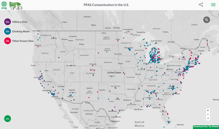

")