Stage 1 #drought restrictions still in effect — The #PagosaSprings Sun #SanJuanRiver #ColoradoRiver #COriver

From The Pagosa Springs Sun (Clayton Chaney):

According to a press release from the Pagosa Area Water and Sanitation District (PAWSD) Manager Justin Ramsey, the district remains in a Stage 1 drought per its drought management plan.

This marks the sixth week in a row that the district has been in a Stage 1 drought. The PAWSD board initially approved entering the stage on July 19.

Ramsey notes that the primary driver of this drought stage is the San Juan River flow in conjunction with the U.S. Drought Monitor, which indicates our area is in a severe to moderate drought…

Colorado Drought Monitor map August 31, 2021.

Drought report

The National Integrated Drought Information System (NIDIS) was updated on Aug. 24, re- porting the same numbers for the second consecutive week.

The NIDIS website indicates 94.84 percent of Archuleta County is abnormally dry and 67.46 per- cent of the county is in a moderate drought.

The NIDIS website also notes that 41.2 percent of the county is in a severe drought stage.

Additionally, the NIDIS website notes that 9.12 percent of the county remains in an extreme drought, mostly in the southwestern portion of the county.

The NIDIS website notes that under an extreme drought stage, large fires may develop and pasture conditions worsen.

No portion of the county is in an exceptional drought.

For more information and maps, visit: https://www.drought.gov/states/Colorado/county/Archuleta.

River report

According to the U.S. Geological Survey (USGS), the San Juan River was flowing at a rate of 39.7 cfs in Pagosa Springs as of 2 p.m. on Wednesday, Sept. 1.

Based on 85 years of water records at this site, the average flow rate for this date is 154 cfs.

The highest recorded rate for this date was in 2008 at 1,290 cfs. The lowest recorded rate was 8.66 cfs, recorded in 2002.

As of 2 p.m. on Wednesday, Sept. 1, the Piedra River near Arboles was flowing at a rate of 31.5 cfs.

Based on 50 years of water records at this site, the average flow rate for this date is 191 cfs.

The highest recorded rate for this date was 1,210 cfs in 2008. The lowest recorded rate was 5.42 cfs in 2002.

Fund to protect #YampaRiver exceeds endowment goal 2 years ahead of schedule — Steamboat Pilot & Today

The Yampa River Core Trail runs right through downtown Steamboat. Photo credit City of Steamboat Springs.

From The Steamboat Pilot & Today (Bryce Martin):

The fund set up to help protect the Yampa River has exceeded its endowment goal two years ahead of expectations, fund managers announced Wednesday.

Annual grants are awarded through the fund, which launched in 2019, for projects aimed at protecting the Yampa River, especially considering the hotter, drier climate and lower river flows. The fund’s total is now estimated to be $5.3 million by 2023, surpassing the original goal of $4.75 million.

The fund held its first grant cycle in February 2020. Over the past three years, more than 100 donors have contributed to the fund, including an anonymous donor who gave $1 million this summer. The fund has so far awarded $400,000 in grants to projects throughout the Yampa Valley, which have supported water releases during times of low flows, environmental restoration projects and agricultural infrastructure improvements…

A partnership of 21 public, private and nonprofit entities representing the entire Yampa River Basin collaborated to create the board that governs the Yampa River Fund.

#LakeMead August 7, 2000 v. August 9, 2021 #ColoradoRiver #COriver #aridification

Lake Mead August 7, 2000. Photo credit: NASA
Lake Mead August 9, 2021. Photo credit: NASA

#Coal is fading in northwest #Colorado. The region is betting its economic future on another natural resource — The #Colorado Sun #YampaRiver #GreenRiver #ColoradoRiver #COriver

The entrance to the popular Gates of Lodore stretch on the Green River. Photo credit: Brent Gardner-Smith/Aspen Journalism

From The Colorado Sun (Jason Blevins):

As coal mining fades, a diverse coalition of Moffat County residents and leaders is planning for the next chapter with a focus on protecting resources while managing recreation and tourism.

How can northwest Colorado entice and manage visitors, protect natural landscapes like the Green River’s stunning Gates of Lodore and prop up an economy girding for the looming departure of coal mining?

“As our coal leaves, what do we have left?” asks Jennifer Holloway, the executive director of the chamber of commerce in the town of Craig, where she grew up. “We have an amazing experience that can change lives. How can we share that, but also protect it?”

Three years ago, Moffat County “had some challenges with our identity,” Holloway says, describing how her father, when she was little, walked away from the family farm to work in the better-paying coal mines. “Not everyone had a coal job, but we focused on coal and neglected other things.”

Those other things — like tourism, agriculture and outdoor recreation — are no longer being neglected. It’s been a year since Tri-State Generation and Transmission and Xcel Energy announced they would be closing their coal-fired electrical plants and nearby coal mines starting in 2028. The closures will cost northwest Colorado as many as 800 jobs.

A community-based transition plan focuses on growing the region’s tourism and recreational amenities while protecting agricultural heritage and natural resources. The communities of Moffat County, downstream from the bustling resort of Steamboat Springs, are essentially a blank slate. They are taking cues from other Western Slope communities, hoping to glean lessons on what works and what does not. And the wheels are turning.

“Our community is on the cusp of doing great things, transformational things,” Holloway says.

Craig has applied for a $1.8 million federal grant for the roughly $2.7 million Yampa River Corridor Project, which hopes to revamp boat ramps and add a whitewater park as part of an effort to bolster the region’s appeal with river runners and paddlers. An additional phase of the plan would build a trail connecting Craig to the Yampa River…

First in line for state’s new rural assistance program

Nathan Fey, the head of Colorado’s Outdoor Recreation Industry Office has joined the Office of Economic Development and International Trade in recruiting students from the University of Colorado to map recreational assets in Moffat County as well as business infrastructure.

That case study will inform a larger project that will include local residents in shaping how northwest Colorado is presented to both visitors and outdoor recreation businesses. That larger project is part of Colorado’s new Rural Technical Assistance Program, or RTAP, which offers rural communities technical education that deploys online tools to help community leaders identify needs and build a plan for future growth. The second phase of the rural program involves technical assistance for planning and finally the state will help the community implement its strategic plan.

Moffat County is among the first communities to go through the new Rural Technical Assistance Program.

Say, for example, a snowmobile business or manufacturer approaches the state with an idea about relocating to Colorado. Fey can suggest Craig and Moffat County, offering maps of snow trail systems where the company can test designs as well as insights into supply chain management, broadband and commercial space. And residents in the community would already have expressed interest in welcoming that kind of business.

As he gazes up at massive sandstone cliffs above the Green River near its confluence with the Yampa River, [Andrew Grossman] riffs on what a shifting valuation for tourism economies might look like. Is it attracting wealthier visitors who leave more money in the community? But what if those high-rollers arrive on a private jet and emit that much more carbon than a less affluent visitor? One thing that is going away: the former yardstick for measuring success that was based solely on numbers of visitors.

“Maybe it’s time we apply a triple bottom line that considers resident sentiments, carbon footprints and economic benefit?” Grossmann says. “We have to reshift our value proposition.”

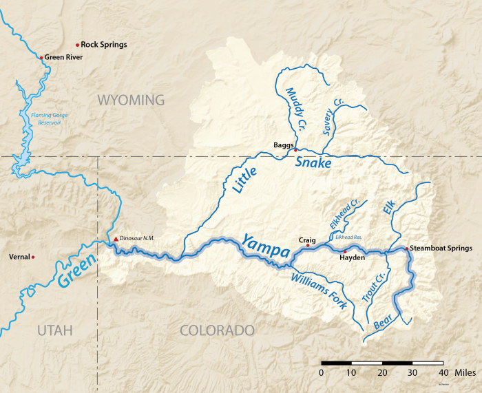
Yampa River Basin via Wikimedia.

EPA Announces First Validated Laboratory Method to Test for #PFAS in #Wastewater, Surface #Water, #Groundwater, Soils

PFAS contamination in the U.S. via ewg.org. [Click the map to go to the website.]

Here’s the release from the Environmental Protection Agency:

Today, the U.S. Environmental Protection Agency (EPA), in collaboration with the U.S. Department of Defense (DoD), published a draft of the first EPA-validated laboratory analytical method to test for per- and polyfluoroalkyl substances (PFAS) in eight different environmental media, including wastewater, surface water, groundwater, and soils. This method provides certainty and consistency and advances PFAS monitoring that is essential to protecting public health.

“This new testing method advances the science and our understanding of PFAS in the environment, so we can better protect people from exposure,” said EPA Administrator Michael S. Regan. “This illustrates the progress we can make when working with federal partners in an all of government approach. I want to thank the Department of Defense for its leadership on this issue and for working with us to achieve this important milestone.”

A partnership between EPA and the Department of Defense’s Strategic Environmental Research and Development Program has produced draft Method 1633, a single-laboratory validated method to test for 40 PFAS compounds in wastewater, surface water, groundwater, soil, biosolids, sediment, landfill leachate, and fish tissue. Until now, regulated entities and environmental laboratories relied upon modified EPA methods or in-house laboratory standard operating procedures to analyze PFAS in these settings. With the support of the agency’s Council on PFAS, EPA and DoD will continue to collaborate to complete a multi-laboratory validation study of the method in 2022.

“This is one of many examples of strong EPA – DoD Collaboration on issues of national importance. Currently the Department is working with EPA, other federal agencies, academic institutions, and industry on over 130 PFAS-related research efforts, and we expect further progress in the future,” said Deputy Assistant Secretary of Defense for Environment and Energy Resilience Richard Kidd.

This draft method can be used in various applications, including National Pollutant Discharge Elimination System (NPDES) permits. The method will support NPDES implementation by providing a consistent PFAS method that has been tested in a wide variety of wastewaters and contains all the required quality control procedures for a Clean Water Act (CWA) method. While the method is not nationally required for CWA compliance monitoring until EPA has promulgated it through rulemaking, it is recommended now for use in individual permits.

Draft Method 1633 complements existing validated methods to test for PFAS in drinking water and non-potable water.

For more information on CWA Analytical Methods for PFAS, visit:
https://www.epa.gov/cwa-methods/cwa-analytical-methods-and-polyfluorinated-alkyl-substances-pfas.

For Frequent Questions about PFAS Methods for NPDES Permits, visit:
https://www.epa.gov/cwa-methods/frequent-questions-about-pfas-methods-npdes-permits.

Background:

Draft Method 1633 complements existing Safe Drinking Water Act methods to test for 29 PFAS compounds in drinking water and a Resource Conservation and Recovery Act method for 24 PFAS compounds in non-potable water.

EPA publishes laboratory analytical methods (test procedures) that are used by industries, municipalities, researchers, regulatory authorities and other stakeholders to analyze the chemical, physical, and biological components of wastewater and other environmental samples. EPA regularly publishes methods for CWA compliance monitoring on its CWA Methods website. Doing so does not impose any national requirements to use the method. Only after EPA promulgates a CWA analytical method through rulemaking (at 40 CFR Part 136) does it become nationally required for use in NPDES permit applications and permits.

The work the agency is doing to provide new laboratory analytical methods reflects the work that the EPA Council on PFAS is undertaking to support federal, state, local, and Tribal efforts to protect all communities from the harmful impacts of PFAS contamination.

#Drought-Hit Blue Mesa Reservoir Losing 8 Feet Of Water To Save #LakePowell. A Western Slope Marina Feels The Pain — #Colorado Public Radio #GunnisonRiver #ColoradoRiver #COriver #aridification

A longer walk from the dock to the water is in store for boaters at the Elk Creek marina, Blue Mesa Reservoir. Blue Mesa is being drawn down to feed critically low Lake Powell, as continued dry weather and rising demand deplete the Colorado River.
(Courtesy photo/National Park Service) August 2021 via the Montrose Daily Press

From Colorado Public Radio (Michael Elizabeth Sakas):

Climate change is drying up Colorado’s water supply

Climate change is leading to less snowpack, and warmer temperatures mean less water is making it into the Colorado River. Blue Mesa is Colorado’s largest reservoir, and it hit its second-lowest level on record for the end of August.

Parks service officials issued the order because Elk Creek’s floating dock and marina are likely to hit the lake’s bottom. Eric Loken, the head of operations at the marina his family has managed for more than 30 years, said the early closure is cutting six weeks out of his five-month season…

A 20-year, climate change-fueled megadrought has dealt a double blow to Blue Mesa this summer. The dry conditions have led to lower levels directly, but the lake is also hurting from drought problems in other states.

For the first time, the federal government is taking emergency action by taking water from Blue Mesa to help out another reservoir — Lake Powell on the Utah-Arizona border. Loken said the withdrawals hurt more given Blue Mesa’s low water levels…

The states that share Colorado River water agreed to this plan in 2019. Low levels in Lake Powell would trigger an emergency release from three reservoirs upstream…

The water taken from Blue Mesa is being used to make sure hydroelectric power turbines at Lake Powell can keep spinning and generating electricity for millions of people in the West, including customers in Colorado.

John McClow, a lawyer for the Upper Gunnison River Conservancy District, said this scenario is what Blue Mesa and the other reservoirs were built for in the 1960s — drought emergencies, not recreation. It’s a bank of water that states can tap when they need to…

Although the water in Blue Mesa has always been earmarked for Lake Powell if Colorado needed help meeting its legal obligation to send more flow to downstream states, McClow said the timing of the release was unnecessarily disruptive. He wishes the U.S. Bureau of Reclamation would have waited to take the water until October when lake tourism starts slowing down.

Erik Knight, a Bureau of Reclamation hydrologist, said that while the timing of the water releases might have hurt the lake, it improved rafting and fishing downstream of Blue Mesa, including parts of the Gunnison River that were so low that commercial rafting was likely to have been canceled.