The Clear Creek Watershed Foundation will spend $536,000 to remove the waste and re-vegetate the area between April and August. David Holm, the foundation’s executive director, hopes the mitigation will begin to make the water less acidic, eventually allowing plants to grow along the creek’s banks and fish to live in its waters.
However, he doesn’t want to mislead people into thinking the creek will be perfect when the work is complete.
“So how will it look afterward?” Holm asked. “We hope the stream corridor is going to look pretty good. There’s not going to be mine waste in it. It is going to look like a natural stream, and it is going to have vegetation on both sides as far out as we can get it.”
Empire Mayor Wendy Koch lauded the effort, saying the stream does not currently support life of any kind.
Koch said an Empire resident once questioned why he could never find deer, elk or any wildlife in that area.
“Well, that’s why,” Koch said of the stream and its acidity level. “(The project) will support our various wildlife, everything from bears to birds and anything in between.”
The project will be paid for by Miller Coors, which gave $394,000; the watershed district; the Colorado Division of Reclamation Mining and Safety; and in-kind donations from the county, the Environmental Protection Agency, U.S. Forest Service and Trout Unlimited.
Holm said the stream has a pH of 3, compared to a neutral pH of 7.
“When you get down to pH 3, you’re into 10,000 times more acidic than what you’re really going for,” Holm said. “So acidity is a real problem in North Empire Creek. There are very high elevations of copper and zinc. Both of those are very toxic to aquatic life.”
Holm said the stream also has toxic levels of iron, aluminum and manganese…
Holm said the area has an interesting history, being one of the earliest mining sites in the state.
“Initially, they did hydraulic mining in this area, which involves high-pressure hoses that are used, essentially, to wash the unconsolidated soil and subsoil … which in this area had disseminated gold deposits,” Holm said. “But it is a brute-force, ugly kind of mining that results in the hill slopes really not having a growth medium when it is said and done.”
Jim Yahn, manager of North Sterling and Prewitt Reservoirs and the past chairman of the South Platte Basin Roundtable, will be speaking at the Morgan Conservation District’s Annual meeting on Thursday, Feb. 6.
Yahn will speak on the Past, Present and Future of Colorado’s Water.
This is a very important meeting to attend if you are concerned about your water rights.
Yahn is responsible for overseeing the diversion and distribution of water to farmers. He also serves as one of the two South Platte Basin Roundtable representatives Statewide Interbasin Compact Committee.
It is not too late to RSVP to Morgan Conservation District’s Annual meeting which will be held at the Country Steak-Out Restaurant in Fort Morgan at 5:30 p.m. Cost is $25.
Please RSVP to the conservation district office at 970-867-9659, x 3.
Young farmers Click here to read the newsletter. Here’s an excerpt:
To help improve and restore Colorado’s rivers and streams, and engage youth and families in the effort, GOCO is offering $250,000 in grants to fund habitat improvement projects along the state’s waterways. The Riparian Restoration Grant Program will require applicants to demonstrate they will use youth or volunteers in their projects, which may range from erosion mitigation to eradicating thirsty non-native plants and trees.
House Bill 14-1005 flew through the House this week; it was passed by the House Agriculture, Livestock and Natural Resources Committee on Monday, got approved on second reading by the House Wednesday and a final 61-2 bipartisan vote on Thursday. It now heads to the Senate for further action. The bill was sponsored by Rep. Jerry Sonnenberg (R-Sterling) and other members of a flood relief committee appointed by the Governor after September’s floods.
Under HB 1005, a water right owner can relocate a ditch headgate without going to Water Court, so long as the relocation doesn’t interfere with other water rights. “We can do what we need to do to recover from the floods by rebuilding headgates so agriculture and cities have access to the water they’re entitled to,” Sonnenberg told the committee Monday.
Representatives from the Colorado Municipal League and the Colorado Department of Natural Resources testified in favor of the bill. Bob Randall, deputy director of DNR, said the bill would help bring water structure back online.
Next week, Sen. Greg Brophy, (R-Wray) will look for support from the Senate Agriculture, Natural Resources and Energy Committee for a bill that may try to find some good from the September floods.
Brophy and Rep. Randy Fischer (D-Fort Collins) are the sponsors of Senate Bill 14-072, which deals with groundwater depletions.
SB 72 simply states that all “out of priority” groundwater depletions that occurred in parts of the South Platte River Basin prior to Sept. 12, 2013 were “fully replaced” by the flooding. The bill impacts Division One, districts one through seven; and district 64, which encompasses the area east of Fort Morgan. Districts one through seven cover the areas from Clear Creek County north to Larimer County and east to Weld County.
What that means: Since 1974, some groundwater pumping exceeded allowed amounts, causing injury to senior water rights. Water users have been “paying back” those depletions through court-approved plans to replace the overpumped water. These augmentation plans protect the rights of senior water users.
Brophy told this reporter that “Mother Nature provided a huge augmentation plan that wiped out past pumping depletions.” His bill would recognize that the September floods “paid back” those past depletions. The only question is how much, and on that point Brophy says he is willing to negotiate. While the bill says “all” depletions were refilled, Brophy acknowledged that in some parts of the Division, such as district 64, the floodwater may have replaced about 30 percent of the groundwater depletion. The flood acted the same as an augmentation plan, Brophy said.
From the Fort Collins Coloradoan (Ryan Maye Handy):
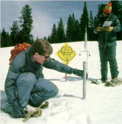
Since 1935, snow measurements have been taken off Cameron Pass. In that time, the pass has changed very little. When [Todd Boldt] and [John Fusaro] took their first measurements of the season Thursday, the pass was as it often has been — bitterly cold, windy and shrouded in a near white-out blizzard. The two men will return to Cameron Pass, along with four other sites, monthly to measure snow until April.
While Boldt, Fusaro and the snow are constants, the federal funding for the valuable program is not.
Looming budget cuts almost forced NRCS to cut 47 of its 72 snow-measuring sites in Colorado, and since 2011 the program has taken a 15 percent cut. Shutting down the “snow course” part of the program, which mixes machine measurements with manpower, would have meant an end to nearly a century of snow data. The Northern Colorado Water Conservancy District would have lost four of the 23 snow measuring sites that it relies on for snowpack indicators.
Fearful of losing snowpack measurements, a group of 100 water conservancy districts and farmers banded together at the end of last year to try to come up with a funding plan.
They were saved in December by some adjustments in NRCS staffing — which reduced its snow surveyors from 42 to 19 — that will fund the snow survey program through August 2014. But come August, the battle for funding will begin again…
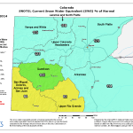
The snowpack off Cameron pass is above the 30-year average, at 102 percent. While that bodes well for the snowpack, the measurement is hardly something to get comfortable with — Colorado’s snowiest month is March, and the best indicators for drought and spring runoff are measured then.
Above average snowfall in January in Colorado Springs and heavy snow in the mountains is helping lessen the impacts of drought and has brought snowpack levels near normal.
Colorado Springs got 13.6 inches of snow in January, compared to the average snowfall for the month of 5.6 inches, according to the National Weather Service. That’s good news in a winter that brought below average snowfall and bitter cold in December. The 2.9 inches of snow that fell in December is about half the normal 5.7 inches, according to the weather service…
According to the weather service, the Jan. 4 snowfall record was broken when three inches of snow were reported at the Colorado Springs airport. The previous record for that date was 1.9 inches in 1983. The 101-year-old daily snowfall record for Jan. 31 was obliterated when Colorado Springs got 3.5 inches on Friday…
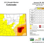
After two years of dreadfully dry conditions declared for most of Colorado, Lehermeier said the drought status was all but removed for the region. According to the U.S. Drought Monitor, 25 percent of the state is free of drought, while nearly 75 percent is abnormally dry – the least severe drought measure. With the exception of a portion of southeast Colorado that remains in severe to exceptional drought, Colorado managed to bounce back from a 100 percent drought status a year ago. Exceptional drought is the most severe level.
Meanwhile January was one of the warmest and driest on record around Durango. Here’s a report from Dale Rodebaugh writing for The Durango Herald. Here’s an excerpt:
The wind-driven rain and snow that pushed into the San Juan Mountains late Thursday to bring welcome relief to a January that ranks as one of the driest doesn’t alter the long-term outlook for Southwest Colorado, experts say.
January in Durango also was warmer than the historical average. National Weather Service records show that the average high temperature in Durango in January from 1894 to 2010 was 39 degrees. In the month just gone by, all but three days saw a maximum of at least 40 degrees, with nine days at 50 or more.
Subpar precipitation that dates to a year ago and the lack of any substantial moisture in the month that ended Friday have ranchers wringing their hands.
“I can’t remember any time that has been as dry,” said Pat Greer, a fourth-generation rancher who has hay and cattle on land homesteaded by his family in Marvel in 1907. “We got fair moisture back in September, but the wind came along and pulled it all out of the ground…
The essential element for the second annual Winter Festival at Mesa Verde National Park – snow – was missing, so the event – two Saturdays of outdoor activities – has been canceled.
The rain and snow that fell Thursday and Friday and the precipitation from a weaker front expected to arrive Monday and later this week, have been a pleasant change from the clear, sunny skies during most of January.
A high-pressure ridge that has sat off the Pacific Coast for a year is partially responsible for dry conditions in Southwest Colorado, said Jim Daniels, a forecaster at the National Weather Service in Grand Junction.
The high-pressure ridge blocks storms or shunts them to the north…
In spite of break-through storms, the long view of agencies that monitor weather and climate is that continued or increasing dryness will dog the southwest corner of Colorado for several months.
The Natural Resources Conservation Service report on snowpack and reservoir storage for December found the snowpack in the Animas, San Juan, Dolores and San Miguel drainage at 76 percent of normal…
A National Integrated Drought Information System map showed that from Jan. 1 to 26, La Plata County received 1/100th to 1/10th of an inch of precipitation. January’s historical average is 1.12 inches of moisture, as measured at Durango-La Plata County Airport. Durango typically receives more.
A map from the National Weather Service’s Climate Prediction Center shows southern La Plata County as an area where drought development is likely.
The Wednesday-Thursday storm dropped 8 inches of snow at Purgatory at Durango Mountain Resort, which had received only 9 inches through Jan. 29.
In contrast, a story in The Durango Herald almost a year ago about historic snowfall at Purgatory revealed that the 38-year average snowfall in January was 49 inches.
In Hesperus, where Pam Snyder has been measuring snow since 1999, January accumulations have declined since 2005, with the exception of two years.
The last four years, particularly, have seen scant snow in January. In 2011, Snyder recorded one-half inch; the next two years saw 7.2 and 7.25 inches, respectively. This year, she found ¼ inch in her gauge.
Aspen caught the Pineapple Express last week. Here’s a report from Karl Herchenroeder writing for The Aspen Times. Here’s an excerpt:
Aspen Skiing Co. reported 24 inches of snowfall in a 24-hour period Friday morning, and another 8 to 12 inches was expected by 5 a.m. today…
With above-average snowfall for every month this season, 2013-14 is far outpacing the city’s 151-inch yearly average. This storm alone dropped more snow than all of January 2013, when 18 inches were recorded. Longtime resident Jim Markalunas, who has records dating back to 1934, said this storm is “a biggie,” but it won’t be the biggest. The most memorable snowstorm, he said, took place in March 1965, when 38 inches fell in a two-day period and the Tompkins Hardware store collapsed. Another 22 inches fell a few days later, totaling 60 inches in a span of five days…
He said it’s important to note that the snow in this storm has a water content of 8 percent, which is much lighter than snowfall in March. Another memorable storm, he said, came in February 1936, when 72 inches fell in a two-day span.