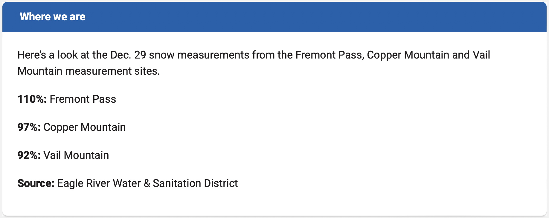
An example of lawn space free of non-native turf grass and filled with native plants that consumer far less water. Courtesy photo
Click the link to read the article on The Vail Daily website (David O. Williams). Here’s an excerpt:
March 15, 2026
Eagle County water officials are urging property owners to voluntarily scale back water usage in a big way this spring and summer, reducing outdoor watering of landscaping in order to avoid fines and to keep water providers from having to declare a water shortage. The idea is to keep people in tiers one and two for outdoor water use – 95% of which does not return to local streams and rivers — and that one of the best ways to do so is water-wise landscaping, or basically tearing up non-native turf grass and going with native plants that require far less outdoor watering…The Eagle County Conservation District runs a program called Beyond Lawn that will assess your yard, give you some ideas on how to minimize turf, how to go with water-wise native plants, reconfigure your irrigation system, find like-minded landscapers, and make sure fines and surcharges from your water provider aren’t part of your future this summer. Beyond Lawn’s wait list is available to join online. There is also a do-it-yourself workshop being held in conjunction with Walking Mountains and the Climate Action Collaborative at 5:30 p.m., Thursday, April 16…
If not exactly a turf war, water officials’ war on turf could gain significant new teeth as Eagle County reworks its land-use codes, according to Snyder, which currently allow for anywhere between 3,000 and 6,500 square feet of irrigated turf for new homes.
“We think that’s excessive,” Snyder said. “(So we’re) putting forward recommendations to narrow that down to 500 square feet, which is still a nice backyard. The hope would be that with new builds, the county and others would pursue land-use code changes that actually would say, ‘this is reasonable.’ And then it gets really hard to overwater 500 square feet.”
Old land-use codes that allowed up to 12,000 square feet of non-native turf have led to people using 60,000 gallons a month (extreme tier five). That kind of water use reduces the shared supply for everything from drinking water to fighting wildfires, and district officials say massively overwatered yards are not any more fire-resistant.
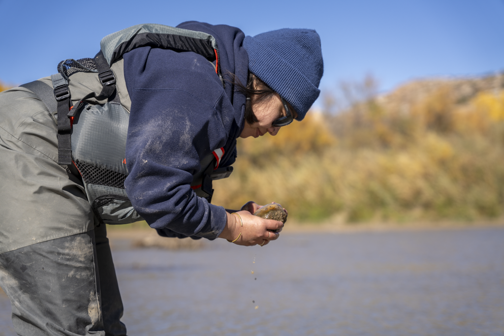
A Colorado Parks and Wildlife Aquatic Nuisance Species staff member looks for adult zebra mussels on a rock from the Colorado River on Oct. 29. That day, over 70 individuals from Parks and Wildlife and its partner agencies and groups searched Western Slope rivers for signs of zebra mussels. Colorado Parks and Wildlife/Courtesy Photo
GRAND JUNCTION, Colo. — On Oct. 29, over 70 people from multiple partner agencies and groups joined Colorado Parks and Wildlife (CPW) for a one-day sampling effort on the Colorado River. From the headwaters in Grand County to Westwater, Utah, volunteers from nine agencies spent the day floating the river in search of adult zebra mussels.
Similar surveys were conducted on the Eagle and Roaring Fork rivers, as well as the tail end of the Gunnison River near the confluence of the Colorado River.
The rivers were divided into smaller sections to simplify the identification of potential zebra mussel habitat and maximize the amount of surveying that could be done in each section. Stopping at points along the way, teams conducted shoreline surveys by inspecting rocks and other hard surfaces where zebra mussels may attach.
Staff and volunteers sampled approximately 200 locations, covering over 200 miles between the four rivers.
Through this sampling effort, CPW confirmed a single adult zebra mussel in the Colorado River near Rifle. During surveys following the large-scale effort, CPW Aquatic Nuisance Species (ANS) staff discovered additional adult zebra mussels within Glenwood Canyon.
With these new findings, the Colorado River is now considered infested from the confluence of the Eagle River down to the Colorado-Utah border.
“Although it is disappointing to have found additional zebra mussels in the Colorado River,” said Robert Walters, CPW’s Invasive Species Program Manager, “this survey achieved its primary objective of gaining a more comprehensive understanding of the extent of the zebra mussel population in western Colorado.”
To date, no zebra mussels — adult or veliger — have been found in the Colorado River upstream of the confluence with the Eagle River.
Mudsnails next to a coin. Adult mudsnails are about the size of a grain of rice. Photo credit: City of Boulder
As a result of the one-day sampling effort, CPW also confirmed the presence of New Zealand mudsnails in the Roaring Fork River. While New Zealand mudsnails have previously been identified in the Colorado, Gunnison and Eagle rivers, this is the first time they have been detected in the Roaring Fork River.
“We could not have pulled off such a massive effort without our partners. These partnerships are instrumental in the continued protection of Colorado’s aquatic resources and infrastructure from invasive mussels,” said Walters.
CPW would like to thank the following agencies and groups who also participated in the one-day sampling effort, in addition to our federal partners at the U.S. Fish and Wildlife Service and Bureau of Reclamation:
City of Grand Junction
Eagle County
Mesa County
Orchard Mesa Irrigation District
Roaring Fork Conservancy
Utah Department of Natural Resources
“It’s not just our federal, state and local partners that play a role in understanding the extent of zebra mussels in the Valley, but also the general public,” Walters continued. “That is why we are continuing to ask for the public’s help.”
If you own a pond or lake that utilizes water from the Colorado River or Grand Junction area canal systems, CPW would like to sample your body of water. You can request sampling of your body of water by CPW staff at Invasive.Species@state.co.us.
In addition to privately owned ponds and lakes, CPW also encourages those who use water pulled from the Colorado River and find any evidence of mussels or clams to send photos to the above email for identification. It is extremely important to accurately report the location in these reports for follow-up surveying.
CPW will continue sampling through Thanksgiving, focusing on smaller ponds in the Grand Valley.
Prevent the spread: Be a Pain in the ANS Simple actions like cleaning, draining and drying your motorized and hand-launched vessels — including paddleboards and kayaks — and angling gear after you leave the water can make a big difference to protect Colorado’s waters.
Learn more about how you can prevent the spread of aquatic nuisance species and tips to properly clean, drain and dry your boating and fishing gear by visiting our website. Tips for anglers and a map of CPW’s new gear and watercraft cleaning stations are available here.
The Colorado Basin Roundtable has awarded $20,000 to Rivers Edge West and the Desert Rivers Collaborative to support restoration planning and coordination in the Gunnison and Colorado river basins, according to a news release. De Beque received $50,000 for improvements it is making to its 24.4-acre River Park on the Colorado River. Rivers Edge West and the Desert Rivers Collaborative plan to use their money to help identify priority restoration sites, develop a geospatial database and story map, and contribute to regional initiatives including the Grand Valley River Corridor Initiative, supporting health riparian ecosystems in Mesa County, according to the release. De Beque received the $50,000 to support engineering and design work needed for riverbank stabilization. The park is going to include an amphitheater, pavilion, parking areas, boat ramp and arboretum…Other allocations approved by the roundtable are:
$15,000 for the Middle Colorado Watershed Council’s Grand Tunnel Ditch flume replacement project;
$30,600 for the Blue River Watershed Group’s Blue River water quality monitoring dashboard and GIS resources;
$30,000 for the Eagle River Coalition’s Homestake Valley stream crossings project;
$30,000 for the Center for Snow and Avalanche Studies, for dust-on-snow data collection and cosmic ray evaluation, with this funding being contingent on the project receiving similar support from the state’s eight other basin roundtables.
Click the link to read the article on The Denver Post website (Elise Schmelzer). Here’s an excerpt:
August 15, 2025
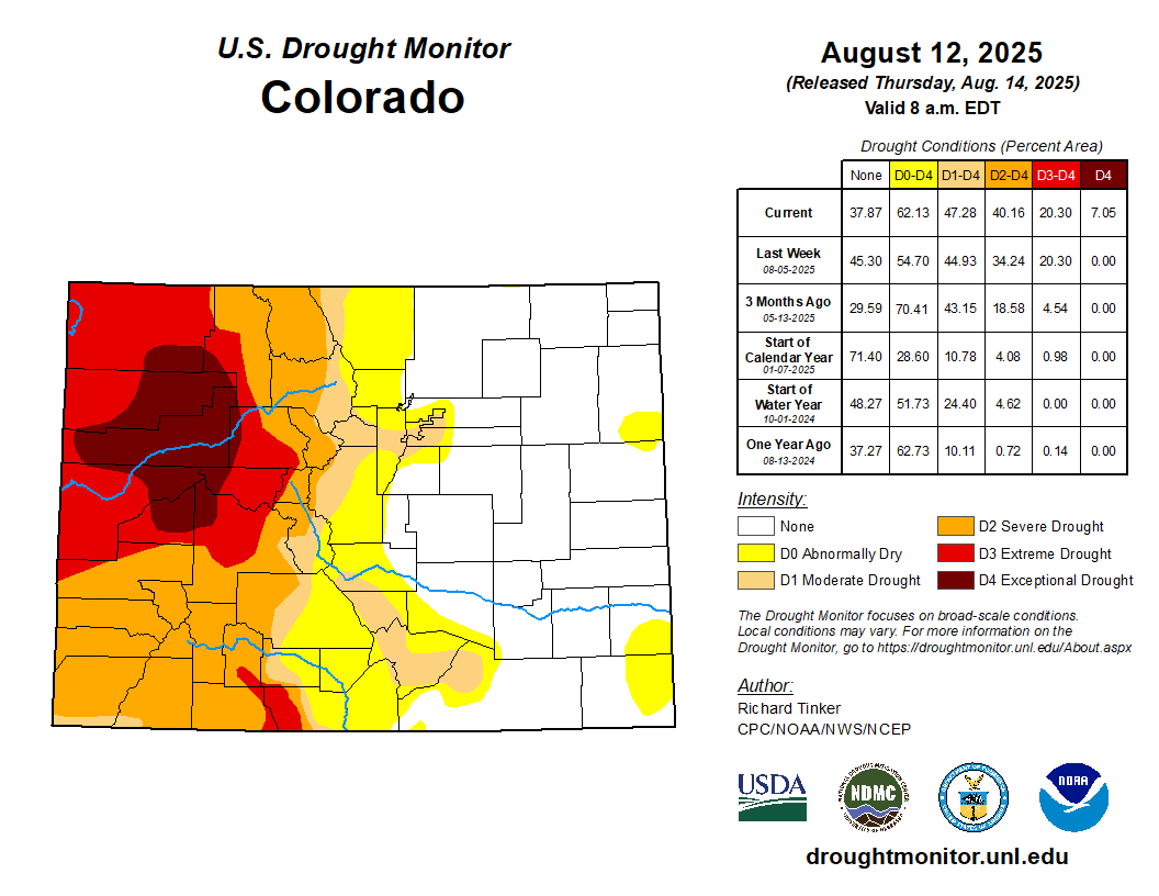
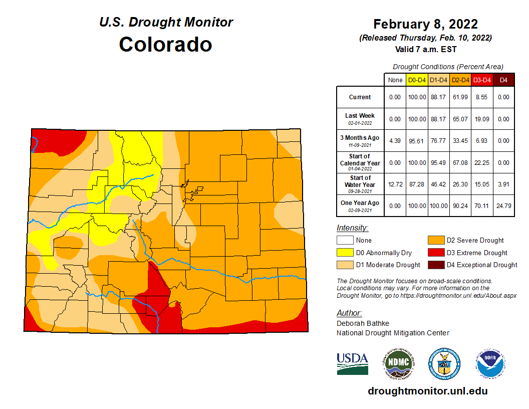
Drought and long, hot summer days are sucking Western Colorado’s rivers dry, parching farm fields and fueling the massive wildfires proliferating across the region. A chunk of northwestern Colorado in the last week plunged into exceptional drought — the most dire category recorded by the U.S. Drought Monitor. The swath of affected land represents 7% of the state and covers most of Garfield and Rio Blanco counties, as well as parts of Moffat, Mesa, Delta, Routt and Pitkin counties…Exceptional drought is expected to occur once every 50 years, [Russ] Schumacher said. So far this summer, the afternoon monsoon rains that provide relief have been largely absent from the Western Slope. The higher-than-normal temperatures and a lack of rain have sapped the rivers in the Western half of Colorado. Streamflows statewide are at only half of the median recorded between 1991 and 2020, according to National Water and Climate Center data. The lack of water has limited fishing and rafting opportunities, reduced agricultural irrigation and threatened river environments…Nearly half of Colorado is experiencing some level of drought, according to new data released Thursday by the U.S. Drought Monitor. More than 1.4 million people live in that drought-impacted area, which encompasses the entire western half of the state, parts of metro Denver and some areas of southern Colorado…
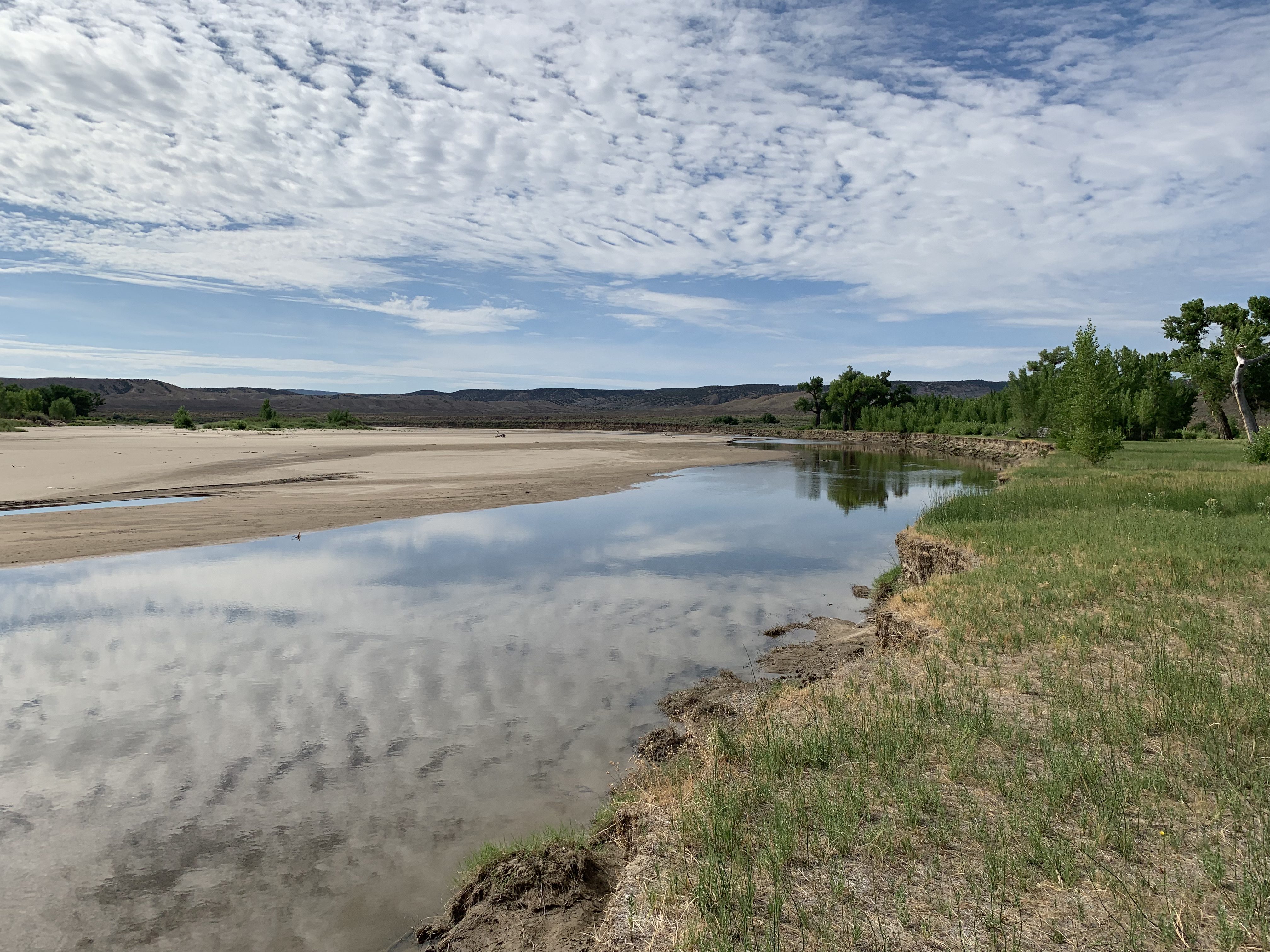
This summer has been one of the driest on record for the state’s critical Colorado River basin, similar to 2018 and 2021, said Calahan of the Colorado River District. Drought in those years made the Colorado River look more like a creek than a river and prompted a 120-mile-long fishing ban on its mainstem…Streamflow in the basin is worst on its western flank and best on its eastern side near the headwaters, he said…The [Colorado River] district is speaking weekly with irrigators across the region to best divvy up the water that remains. Low flows are being supplemented by releases from reservoirs…A lack of water in the Eagle River near Vail prompted local water authorities to warn of a potential coming water shortage. Flows on the river near Avon were about half of normal — and the third-lowest recorded on the stream gauge’s 26-year record, said Siri Roman, the general manager of the Eagle River Water and Sanitation District…Thirteen of the 14 stream gauges with historic data in the Upper San Juan basin were reporting flows below or extremely below normal on Wednesday. The Animas River in Durango was flowing at 153 cubic feet per second — a fraction of the median of 499 cfs for the day across 113 years of data, and close to the historic low for that date of 137 cfs…Several stream gauges in the basin were recording record daily lows, like the San Juan River in Pagosa Springs and on Vallecito Creek…On the opposite side of the state, the Yampa River basin, too, is struggling. The river above Stagecoach Reservoir was flowing at less than half of the 36-year median.
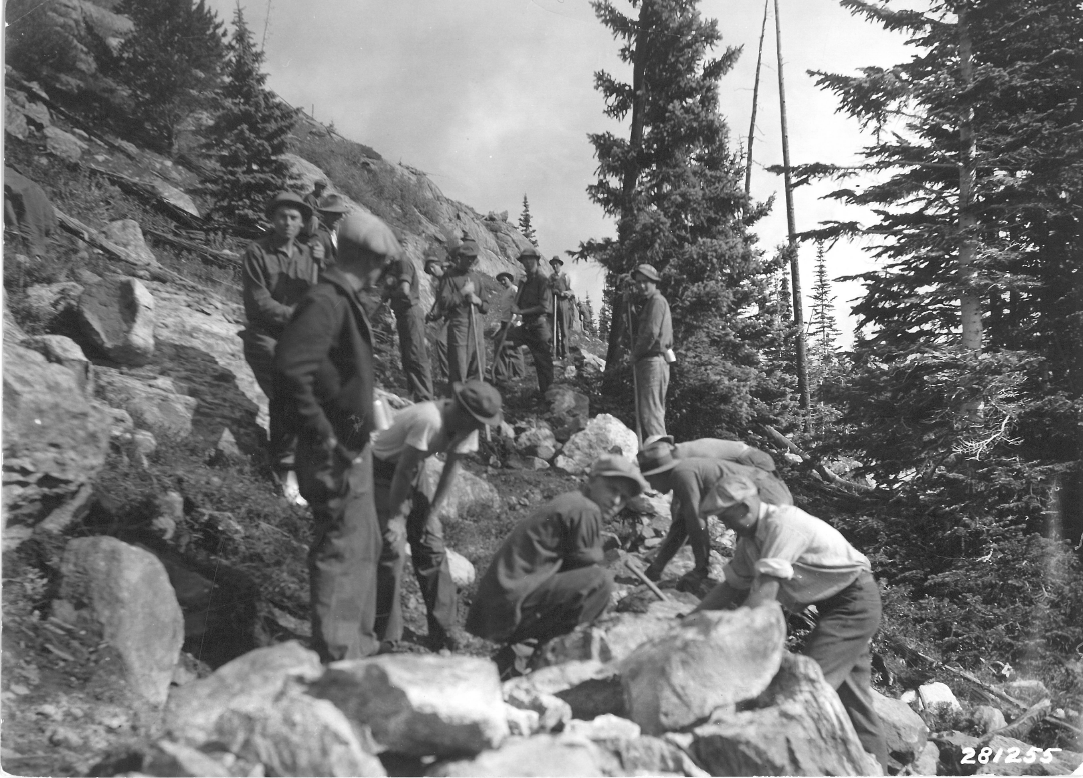
Trail building by the Civilian Conservation Corps on Notch Mountain, then a popular destination for its view of the Mount of the Holy Cross and the throngs of religious pilgrims who were drawn to the site in the early days of the Holy Cross National Forest, now part of the White River National Forest. CREDIT: U.S. FOREST SERVICE
Editor’s note: This story is the third of a three-part series examining the notion of public lands, both in the United States and in our region. Part one looked at the earliest expressions of the commons in territories that would become the United States. Parts two and three look at the history and legacy of what is now the White River National Forest.
The hunger for land was an insatiable draw to legions of the dispossessed who were on the march across America eager for land ownership. The Utes were simply in the way of an advance that could not or would not be stopped. The tragic story of these first inhabitants of the White River National Forest (WRNF) played out to a violent end amid a rush for land and resources in the Colorado Rockies that had 5,000 people per day pouring into the state by the 1870s.
Native inhabitants had been hunting and gathering here for more than 10,000 years. The Utes — the “People of the Shining Mountains,” according to the title of a book by Charles Marsh — ruled a vast and rugged empire of about 225,000 square miles that stretched from the Central Rockies west into Utah and Nevada, south into New Mexico and east onto the Great Plains where they hunted buffalo on horseback. The Utes were among the first Native Americans to acquire the horse from Spanish stock that, it was assumed, had been lost. Horses were key to Ute identity, and equestrian skills were a mark of manhood that provided rapid mobility and warrior status.
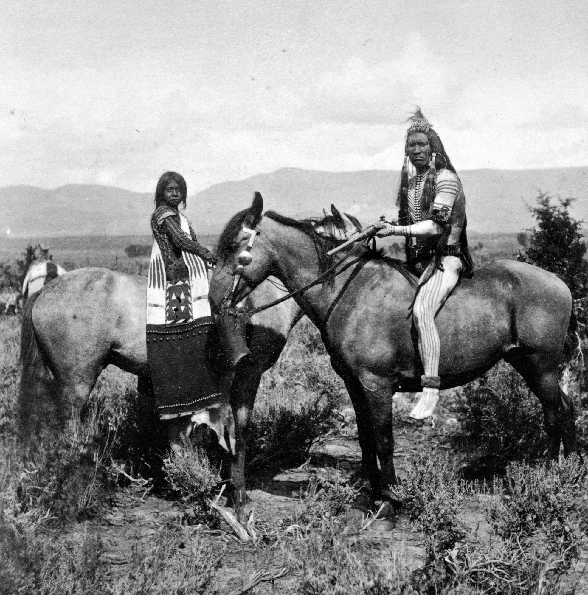
White River Ute warrior Gray Eagle and his young bride Honey Dew of the Mountains, on horseback on the western slope of the Wasatch Range in Utah, then roaming their vast territory west of the White River before the White River Agency was established. Circa 1871-1875. CREDIT: DENVER PUBLIC LIBRARY
Broken treaties and war
The advance of Europeans into Ute lands set up a tension that grew with every treaty violation and every trespass. As their domain was carved away, the U.S. government naively assumed the Utes could be transitioned from nomadic hunter-gatherers and cordoned off as sedentary farmers. Indian agents were hired to effect this transition, which, in the long run, proved futile and disastrous. There was no reasonable answer to “the Ute problem,” which was the terminology used by Frederick Pitkin, Colorado’s second governor from 1879-82, to refer to the cultural impasse.
The ensuing drama escalated at the White River Agency near today’s Meeker in 1879 when Indian agent Nathan Meeker, a naive and misguided minister, attempted to force the Utes’ compliance to “white man’s ways” by denying them their horses, rationing allotments and plowing over their racetrack to plant crops. Meeker and others believed that the Utes were in need of redemption for their spiritual welfare. The Utes, who found spiritual depth in the natural world around them, believed otherwise and clung to their sacred traditions.
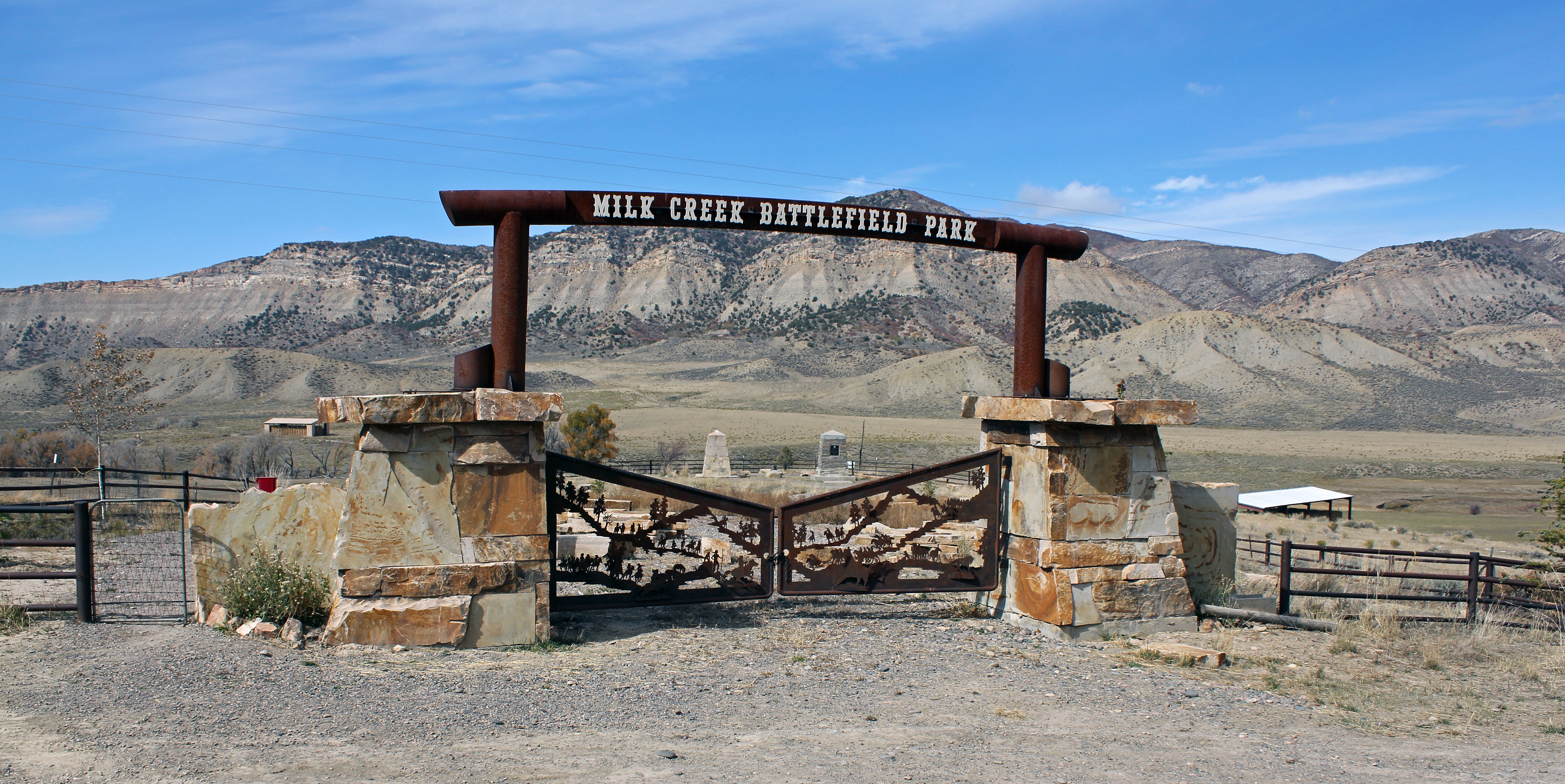
The conflict boiled over in the late summer of 1879 when Meeker had a violent altercation with a Ute sub chief. The frightened Meeker sent for the U.S. Army, which advanced from Wyoming and was met by a strong Ute force. When the detachment of 190 troops crossed into Ute territory on Sept. 29, shots rang out, kicking off a grueling six-day battle of attrition that saw 17 U.S. soldiers killed and wounded 44, while the Utes saw 24 killed, in what became known as the Battle of Milk Creek. As the battle raged 17 miles away, Utes also attacked the White River Agency, killing Meeker, 10 men under his employ, and kidnapped women and children, including Meeker’s wife and daughter.
All captives were later released from a Ute camp on Grand Mesa. But the violent outbreak provided ample pretext for the whites to pursue a campaign of ethnic cleansing. In 1881, Pitkin issued an edict stating that the Utes would either be removed to reservations in Utah and southern Colorado or exterminated. Many were marched out of their homelands near the Uncompahgre River at gunpoint, while remaining bands roamed northwest Colorado until an 1887 military campaign known as the Colorow War.
With that Pitkin proclamation, 12 million acres of western Colorado opened for settlement. The White River Timberland Reserve was later created on these former Ute lands, placing them under federal administration. The Utes were compensated about $22 per capita in a settlement for all that they were forced to surrender. However, draws from those payments were taken from Ute hands to fund pensions paid to families of soldiers and agency staff killed during the violence surrounding the Meeker incidents. So ended the empire of the Utes.
Milk Creek Battlefield Park, 18 miles northeast of Meeker, Colorado. Battle of Milk Creek, Sept. 29 through Oct.5, 1879, between the Utes and the U.S. troops, which triggered the Meeker incident. The battle persisted with the Utes surrounding the wagon-circled troops until military reinforcements arrived. Most sources tally 17 whites killed and 44 wounded, along with 24 Utes killed and unknown numbers wounded, while 127 horses and 183 mules of the U.S. troopers died. By Jeffrey Beall – Own work, CC BY-SA 3.0, https://commons.wikimedia.org/w/index.php?curid=70937831
Exploitation, waste and destruction
“One of the most pressing problems facing Colorado in the 1880s and 1890s,” wrote Justine Irwin, author of the 1990 manuscript “White River National Forest: A Centennial History,” “was the prevalent exploitation of its natural resources by westward moving pioneers … [who] accepted the waste and destruction that followed as a small price to pay for their dream of prosperity.”
The prevailing attitude of the day regarded “wilderness” as a wasteland ripe for the biblical mandate in the Book of Genesis: “Increase, multiply, replenish the earth and subdue it.” These newcomers to western Colorado, wrote Irwin, viewed the land with “utilitarian spectacles,” through which “trees became lumber, prairies became farms, and canyons became the sites of hydroelectric dams.”
A dramatic example of the settlers’ creed was the extermination of the native elk herd as meat hunters ignored sustainable yields and fecklessly shot and killed all the native elk in the region, selling their harvest to railroad builders and mine workers. So-called “market hunting” flourished only as long as the herds lasted, and the 6,000 to 8,000 elk estimated to have been in the WRNF region in 1879 were soon extirpated. Hunters took only the hindquarters of the animals, leaving the rest as waste. The selling price for meat was 7 cents a pound for deer, 9 cents for elk, 10 cents for bighorn sheep and bear, and 50 cents for grouse.
Meanwhile, the General Land Office, a real estate branch of the Department of Interior, was busy selling off the commons at $1.25 per acre. The Homestead Act gave land away to qualifying settlers in 160-acre allotments for each adult member of a family. Large families could acquire considerable acreage of public lands. The Timber Culture Act of 1873, the General Mining Act of 1872 and the Railroad Act of 1862 gave away huge swaths of the public domain, all to encourage monetizing the commons and capitalizing on the riches of the continental empire of the United States.
“Ranchers, loggers and others invaded railroad lands taking what they wished and giving no thought to the long-range future of the region,” wrote Irwin, who describes a ruthless lawlessness that discouraged any interference in this land-based free-for-all. But there was change in the air as lawmakers recognized that there were limits to the nation’s natural resources. The giveaways continued, but national parks and designated forests were proposed and gradually established to preserve legacy Western landscapes for future generations in a first glimmer of conservation. The philosophy behind this growing movement was shared by Henry David Thoreau, George Catlin, John James Audubon, John Muir and an influential cadre of preservationists who began to win over advocates in Washington, D.C. The conservation ethic is summed up by author Rod Nash in his “Wilderness and the American Mind” (1967), in which he wrote, “Doesn’t the present owe the future a chance to know the past?”
Environmental concerns for preserving intact ecosystems to protect valuable and irreplaceable watersheds played a utilitarian role in conservation efforts on Western lands. Forestry management entered the lexicon of policymakers when, in 1875, Section 6 of the Colorado Constitution called for “Preservation of Forests: The General Assembly shall enact laws in order to prevent the destruction of, and to keep in good preservation, the forests upon the lands of the state.”
Citizen involvement through civic forestry associations amplified the call to protect national assets and save something for the future. In 1889, a timber reserve was called for on the Western Slope of Colorado to safeguard against wildfires, overgrazing and irresponsible timber harvests — all of which were decimating irreplaceable landscapes. A similar approach to nature aesthetics was winning hearts and minds for preserving the inspiring vistas that were beginning to sensitize America to the natural treasures of which it had taken possession.
In 1891, a groundswell of support led President Benjamin Harrison to enact the General Revision Act, a sweeping mandate to protect Western lands that led Harrison to issue a proclamation establishing the White River Plateau Timber Land Reserve, the first binding federal protection for a large expanse of central and northwest Colorado and the second of its scale and scope in the United States, after a forest reserve designated near Yellowstone National Park. Supporters called it a great victory, but detractors — of which there were many — impugned the initiative as a “taking” of what they considered the entitlement of free land.
The account of a boasting pioneer quoted in “White River National Forest: A Centennial History” and who had unconscionably plundered the public domain is a grim tale of misuse without supervision and reasonable limits of what was perceived as an infinite cornucopia: “In the summer of ’89, I killed about 700 deer and pulled the hides off, just for the hides. That fall, I got 43 bear near Lost Park. I shipped the hides to Chicago and they netted me clear $1.50 apiece. Everybody killed game for the hides and made money that way. I’ll tell you a fact: In ’89 I could ride up anywhere and there would be 40 to 50 bucks lying in one bunch. You could ride up to within a few feet of them. I killed 23 bucks in one day and jerked the hides off.”
Such carnage became repugnant to many and shameful to a growing number of nature lovers who advocated protective legislation such as the Forest Management Act of 1897 that granted the secretary of the interior power to regulate “occupancy and use” of federal lands. Implementation was another thing as new and often-inexperienced forest rangers came up against hardened libertarians who were armed and militant — namely, loggers and ranchers. Threats against rangers, who lacked policing power, were said to “make your eyes swell shut and your nose bleed,” according to “A Centennial History.”
“A ranger must be able to take care of himself and his horses under very trying conditions; build trails and cabins; ride all day and all night; pack, shoot and fight without losing his head. All this requires a very rigorous constitution,” read one early Forest Service job posting. A group of White River National Forest rangers are shown here at a 1921 meeting. CREDIT: U.S. FOREST SERVICE
Forest rangers bring law to the wilderness
According to Irwin’s manuscript, “the forest ranger had to become not only a conservationist, a lands manager, a grazing expert, a timber expert, a watershed manager, a wildlife protector and jack-of-all-trades, he also had to become an expert in public relations with a keen understanding of community and national politics.” Few could match up to these requirements without rigorous training and a deep commitment to the role.
In 1898, Charles W. Ramer of Fort Collins was appointed the first supervisor of the White River Plateau Timber Land Reserve, headquartered in Meeker. Jack Dunn, Harry Gibler and Solon Ackley were the first rangers hired to patrol the reserve, which was divided into nine districts. The rangers were assigned to observe that loggers and ranchers kept to their assigned boundaries, to ensure that game regulations were followed and to put out brush fires.
These early rangers faced tremendous personal risks from unruly forest users, as described in an account by ranger William Kreutzer, who faced repeated threats from his efforts to enforce regulations. One night in the early 1900s, wrote Irwin, “as he was returning to his camp from a day patrolling, three men sprang suddenly from the aspen thickets and attacked him. Almost instantly he was struck on the head with something that rendered him unconscious. When he recovered, many hours later, he was lying beside the road, his head ached, his nose was bruised.”
Early forest rangers faced personal risks from unruly forest users. One account by ranger William Kreutzer, shown here, described facing beatings and attempted shootings from his efforts to enforce regulations.
Another incident from Irwin’s manuscript revealed that Kreutzer boldly confiscated tools from a group of timber cutters felling trees inside the protected reserve. “One day he was riding a trail and a bullet whizzed by close to his head. He rolled from his saddle and sought shelter behind a large tree. Four more bullets struck near him. The boom that followed each shot told him they had come from a large rifle fired from a spot some distance away. He had only his six-shooter, but ascertaining as best he could the spot whence the shots came, he elevated the barrel of his gun and fired every cartridge. The shots of his assailant ceased. He decided that someone had just tried to scare him a bit.”
Trophy hunters flocked to hunt in the White River Reserve, the most prestigious of whom was President Theodore Roosevelt whose special train passed through Glenwood Springs in 1901. The Roosevelt party hunted the Danforth Hills near Meeker, killing 14 mountain lions. Although Roosevelt championed conservation of wild lands, he withdrew substantial acreage from the reserve on the advice of his chief forester, Gifford Pinchot, in order to appease complaints from forest users of “locking up the land.”
Meanwhile, posted notices advertised the following: “Men Wanted!! A ranger must be able to take care of himself and his horses under very trying conditions; build trails and cabins; ride all day and all night; pack, shoot and fight without losing his head. All this requires a very rigorous constitution. It means the hardest kind of physical work from beginning to end. It is not a job for those seeking health or light outdoor work. Invalids need not apply.”
Requirements were incredibly demanding, but men equal to the challenge answered the call and were hired only after completing a grueling exam that included saddling a horse, riding a required distance, packing a horse or mule with tools and camping gear, pacing the pack animal over a designated trail, taking bearings with survey tools and more. The annual salary for the few who were able to pass the test was $900 to $1,500, but starting at a lower figure.
The staunchest objectors to enforcement were cattlemen whose livelihood required substantial range. Among them was Roaring Fork Valley rancher Fred Light, who protested the charging of range fees for grazing his stock. Light’s story traces a reluctant yet gradual progression from vehement protests to acceptance of the principles of forest management.
Trophy hunters around the turn of the 20th century flocked to the newly created White River Reserve, the most prestigious of whom was President Theodore Roosevelt whose special train passed through Glenwood Springs in 1901. The Roosevelt party hunted the Danforth Hills near Meeker, killing 14 mountain lions. CREDIT: U.S. FOREST SERVICE
Light of the Roaring Fork
Fred Light (1856-1931) came to the Roaring Fork Valley in 1880. He prospected before locating a homestead on East Sopris Creek where he cut and sold hay in Aspen to feed the many teams required for mining and camp life. Eventually, Light proved up on his land, expanded his operation, and raised cattle and horses. In 1885, he was elected to the Colorado legislature and served two terms. He was a prominent, well-respected rancher who had political savvy — and clout.
“We want no forest reserves,” Light announced to cheers and applause at a meeting of the Stockmen’s Association in 1907. “If we must have reserves, we want no grazing tax; if we must have reserves and the tax, the cattlemen claim the privilege of saying who will be placed in charge of the reserves.”
Light gained notoriety when, that same year, he allowed his cattle to drift into the newly formed White River Forest Reserve where grazing was prohibited. Light, like many early ranchers, was resistant to government control over a resource that he and many ranchers took possession of as an entitlement by simply being there first and assuming a right of ownership.
Light was cited, which started a grazing-trespass case with the U.S. Department of Forestry and which eventually reached the Supreme Court. Light lost his case, but he had made a bold statement of rugged individualism that animated the spirit and the myth upon which much of the American West was settled. The decision against him, however, verified the government’s legitimacy in charging grazing fees and regulating uses on reserve land. Light accepted the decision and thereafter paid the appropriate fees. He also agreed to the rules and regulations, and he even came to endorse them as he witnessed how competing forest users were beginning to negatively impact the land.
Light’s story is compelling, but there was a far more sensational and dire event in his colorful life in the Roaring Fork Valley that describes a sad, personal anecdote. The Aspen-Democrat Times reported a dramatic event: An electrical storm, proclaimed “the worst in the history of this locality,” killed one person and wounded others in the Capitol Creek area.
According to the July 14, 1909, news story, “Early last evening an electrical storm set in which surpassed in severity any before experienced in this locality and brought disaster to the household of Hon. Fred Light of Capitol Creek, one of the most prominent and highly respected families of Pitkin County.” That evening, a bolt of lightning struck a potato cultivator outside the home, jumped to the gable on the home’s roof and ran down to the basement, where Light’s five children were packing meat. Light’s son Ray, 18, was killed with four others rendered unconscious.
Light’s conversion to the ways of the forest was a sign of progress, but, unfortunately, it did nothing to ameliorate an even more vitriolic conflict. A range war erupted in the early 1900s that pitted cattlemen and sheepherders against one another in a blood feud that resulted in thousands of sheep being slaughtered and a number of men being beaten and killed. The Western tradition of “first in time, first in right” gave cattlemen the wherewithal to declare the range existed for cattle only. Sheepherders were not forbidden by law or permit, but they took their lives in their hands if they violated the cattlemen’s self-imposed privilege.
Chapman Dam in the Fryingpan River basin, shown here in 1940, was a Great Depression-era Civilian Conservation Corps project. CREDIT: WWW.WATERARCHIVES.ORG
Range wars
While the Glenwood Post became amenable to regulations in the White River Reserve by acknowledging the advantages of range protection, increased pasturage and peaceable possession for cattlemen, the advent of sheepherders lit the fuse of a conflict that blew up repeatedly. Irwin describes the George Woolley Sheep Massacre in Routt County when, in 1911, several hundred sheep were “rimrocked” in a stampede that drove them off a cliff. In 1913, many sheep were killed by strychnine poisoning. Finally, a full-on range battle ensued in 1913 in the Battle of Yellowjacket Pass, between Craig and Meeker, when warring sheepherders and cattlemen fired upon one another, necessitating the calling out of the Colorado State Militia.
Changes in the cattle industry — such as growing domestic hay for winter feed and breeding more efficient strands of range cattle — increased weight gain and reduced the desperate need for vast grazing acreage. Forest rangers also played a part as peacemakers and mediators who headed off range feuds. They also took on rapidly expanding responsibilities to regulate timber cutting and supervise road-building, water diversions, irrigation, reforestation, erosion control, trail-building, sign-postage, wild game and fish management, and many other tasks. When elk were reintroduced to the forest in 1912 — Fryingpan Valley rancher Nelson Downey reportedly killed the last bull elk of the original herd in 1895 — rangers monitored the habitat and protected the imported elk from over-hunting.
As a more peaceful era settled on the reserve (renamed the White River Forest Reserve in 1902 by Roosevelt), a new use with rapidly growing popularity became evident as people came to the reserve, not to graze animals or cut timber, but to simply enjoy the sublime natural beauty that is in such profusion here. Enter recreation and a new identity for the public commons.
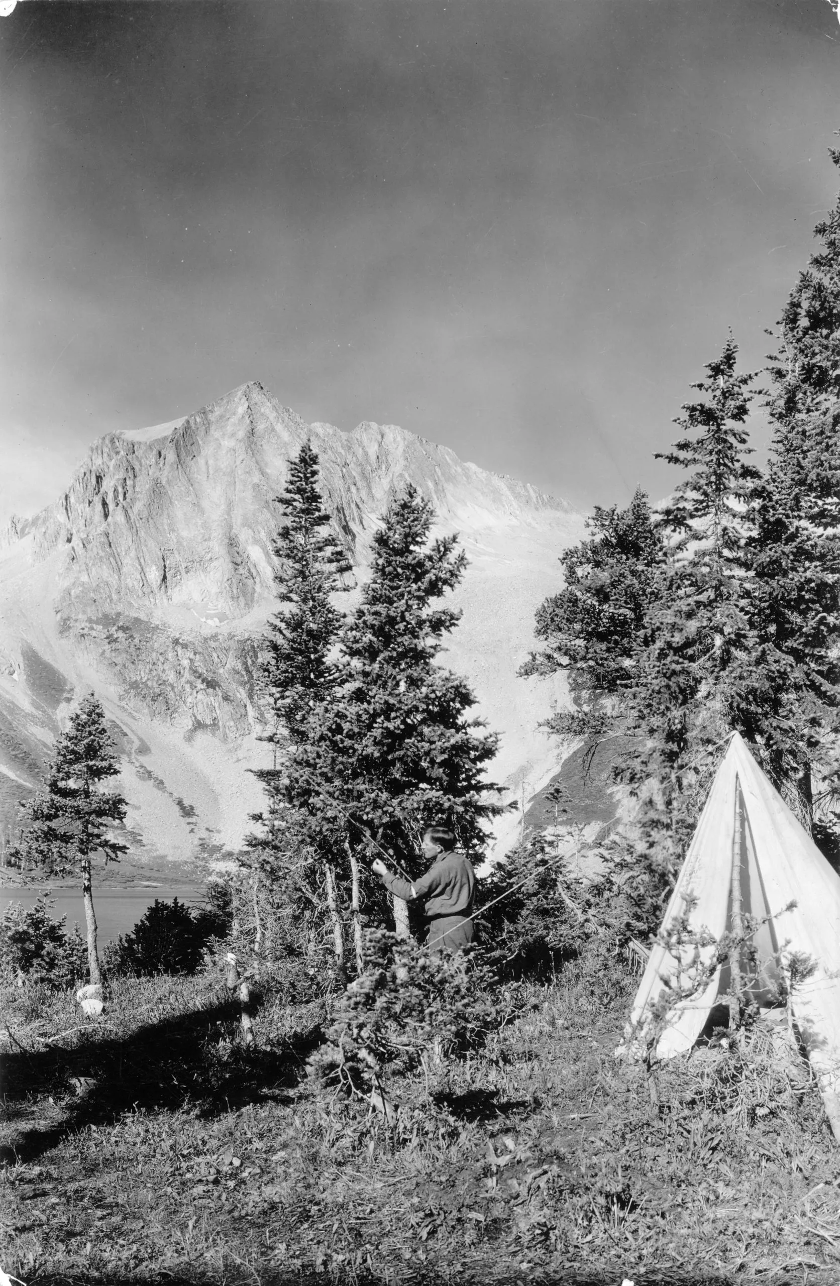
A U.S. Forest Service photo dated between 1910 and 1930 shows a man with a fishing pole near a tent at Snowmass Lake, with Snowmass Peak in the distance covered with snow. Recreation grew in popularity throughout the early 20th century, creating new priorities for the Forest Service. CREDIT: DENVER PUBLIC LIBRARY
For the love of nature
Pinchot, the chief forester, considered recreation to be only an “incidental use” until 1905, when hotels and sanitariums were introduced to the reserve for popular enjoyment and therapeutic healing. Gradually, roads and trails became part of the White River National Forest (Congress renamed it so in 1907) with the mandate to include all users. This brought commercial use into local cultural and economic equations and began a shift of management priorities.
An annual report on the forest in 1913 stated that natural resources would now be managed to reduce impacts from grazing and logging in order to “preserve the natural beauty of the location unmarred for the enjoyment of the public.” A potentially lucrative recreation economy spurred a tangential threat of privatizing public lands for commercial gain as stated in a letter to the U.S. Forest Service from the Denver Chamber of Commerce in 1913: “We deny that it is right or advisable for the federal government to retain title to and lease the public lands for any purpose whatsoever.”
The Forest Service was not alone in wariness of privatizing the commons for private development. In a major turnabout from only a decade before, Colorado stock growers shared the alarm: “We earnestly object to any action by Congress abolishing the national forests or transferring their control or administration from the national government, and we must respectfully urge our congressmen to oppose any measures materially changing the present method regulating grazing on the national forests.”
Even Light came to the forest’s defense as reflected in a report in the Glenwood Post in 1916: “Fred Light was even ready to kiss and forgive the forestry officials. … Mr. Light says he has learned to adapt himself to the forestry regulations and that the officials mean only good to the stockmen.”
Grazing and logging continued as fundamental to the forest economy, especially during World War I when resources were in great demand, and yet the clamor for private resorts and vacation cabins began exerting influence. Trappers Lake was a sought-after locale for a proposed lodge and several hundred cabins that threatened to commercialize a scenic focal point on this White River National Forest wilderness enclave. In 1919, Arthur Carhart, landscape architect for the U.S. Forest Service, made a survey of the area and later advocated for a new concept in public-lands management — wilderness — especially after a meeting with assistant forester Aldo Leopold, America’s first conservation biologist.
“How far shall the Forest Service carry or allow to be carried manmade improvement in scenic territories?” wrote Carhart. “The Forest Service is obliged to make the greatest return from the forests to the people of the nation that is possible.” Carhart acknowledged forest yields in economic terms, but then urged for a higher concept of land use. “There is a great wealth of recreational facilities and scenic values within the forests,” he opined. “There are portions of natural scenic beauty which are God-made and which of a right should be the property of all the people. There are a number of places with scenic values of such great worth that they are rightfully property of all people. They should be preserved for all time for the people of the nation and the world.”
With that statement, Carhart leaped beyond the utility of conversation via Pinchot into the notion of preservation along the aesthetic and spiritual lines of Muir and Leopold. Carhart concluded: “If Trappers Lake is in or anywhere near in the class of superlatives, it should not have any cabins or hotels intruding in the lake basin.” Trappers Lake was preserved, and Carhart’s memo became a strong endorsement of the Wilderness Act of 1964.
The mess tent at a Civilian Conservation Corps work project camp at Maroon Lake,1935. The CCC put the impoverished and the unemployed to work on federal lands to build roads, trails and facilities. CREDIT: ASPEN HISTORICAL SOCIETY
A Civilian Conservation Corps work project camp at Ashcroft, 1938. The workers at the camp were improving Castle Creek Road and building and repairing bridges. CREDIT: ASPEN HISTORICAL SOCIETY
The scenic WRNF and the CCC
There is a mountain in the distant West That, sun-defying, in its deep ravines Displays a cross of snow upon its side.
William Henry Jackson wrote that verse after photographing Mount of the Holy Cross (at 14,009 feet) during his wilderness sojourn in 1874 with the Ferdinand Hayden geologic survey team. Located in Eagle County, this dramatic peak became a religious icon in the 1920s when pilgrimages were made to nearby Notch Mountain for the spectacular view. Visitors came from around the world to see the sight, having either to hike there or to travel by horseback. President Herbert Hoover declared the peak a national monument in 1929. In 1950, that status was rescinded after the pilgrim era had tapered down to almost nothing.
Still, the religious influence of this remarkable mountain left an imprint in the American psyche that, for growing numbers, infused scenic lands with sacred status. A tide had turned when Western lands attained a divine countenance that glowed with ethereal majesty and touched the hearts, minds and imaginations of those who saw them. This love of the land became a national balm when, in 1929, the stock market crashed and America entered the Great Depression.
As many Americans suffered economic privation, the forests of the West became sanctuaries, places to escape the grit and grime of depressed cities and breathe fresh air. When Franklin D. Roosevelt was elected president in 1932, his socially progressive legislative agenda included the formation of a national service component called the Civilian Conservation Corps (CCC).
Federal dollars put the impoverished and the unemployed to work on federal lands to build roads, trails and facilities. CCC workers, each paid $30 per month, were mostly young men, from all walks and all corners of the nation, who spent weeks, months and sometimes years working in national forests, living in communal camps and recognizing the virtues of public lands.
During the 1930s, there were CCC camps in Woody Creek and at Norrie in the Upper Fryingpan. Gradually, forest access was opened to more users as land improvements mitigated erosion with the planting trees and shrubs, removing invasive or poisonous species, and making the forests prime recreation areas under the multiple-use mandate, which the Forest Service described as “inseparably interwoven into the social and economic future of forest communities.”
Maintaining the health of the range within the White River National Forest was a constant challenge made more practical by the Taylor Grazing Act of 1934, named for U.S. Rep. Edward Taylor, D-Colo., of Glenwood Springs. The act was designed specifically to prevent overgrazing and soil deterioration, and to provide for the orderly use and improvement of public lands, while also stabilizing the livestock industry dependent on the public range. Fundamentally, the act protected the health of the rangelands and the resources they provided.
Members of the 10th Mountain Division climb a slope during a winter training exercise where the troops skied from Leadville to Aspen. This image was likely captured near Mount Champion. After the war, many 10th Mountain veterans were among the legions of young skiers and mountaineers who established the Colorado ski industry that was soon to develop resorts on national forest land. CREDIT: 10TH MOUNTAIN DIVISION RESOURCE CENTER, DENVER PUBLIC LIBRARY
World War II and the 10th Mountain Division
America’s entering World War II with the Japanese attack on Pearl Harbor in 1941 raised demands for resources from the White River National Forest and reduced its workforce as all attention was focused on national defense. A different kind of attack, this one by the Engelmann spruce beetle, saw huge mortality rates throughout the forest, prompting foresters to implement the sustainable yield concept for renewable timber harvests, especially given the decimation from beetle-killed trees. This resulted in the passage, in 1944, of the Sustained Yield Forest Management Act, which found favor with the War Production Board and opened the forest to widespread logging. A deep cold snap in 1951 greatly reduced spruce beetle populations, restored forest health and obviated the need for insecticide applications that had been tested on Basalt Mountain.
The war brought a new user group to the forest when the 10th Mountain Division trained at Camp Hale, near Leadville. After the war, legions of young skiers and mountaineers were attracted to the state’s Rocky Mountains, where many established the Colorado ski industry that was soon to develop resorts on national forest land. Aspen became a focal point for Colorado’s identity with skiing, which brought Walter and Elizabeth Paepcke from Chicago to Aspen in 1945. Elizabeth Paepcke, who founded the Aspen Center for Environmental Studies (ACES), is described by Irwin as “an ardent conservationist trained by family friend, Gifford Pinchot,” and later by early wilderness advocate Enos Mills.
A Civilian Conservation Corps work project on Castle Creek Road,1937. Workers camped on public lands near Ashcroft improved Castle Creek Road and built and repaired bridges. CREDIT: ASPEN HISTORICAL SOCIETY
NEPA boosts environmental oversight
As recreation created mounting pressures for land development, the Forest Service recognized the need for greater environmental oversight, leading Congress in 1969 to pass the National Environmental Policy Act (NEPA). This groundbreaking legislation focused initially on the impacts of ski-area design and later became an overarching management tool for all public land uses.
Meanwhile, the White River National Forest became “the ski-area forest” as thousands of acres of public lands were permitted for ski runs and resort infrastructure. The town of Vail was incorporated in 1966, where by the end of the 1967-68 ski season, 1 million lift tickets were sold and revenues reached nearly $3 million. General forest visitation had also grown to 171,000 in 1947 from 96,000 in 1946. “For every two who pitched camp in our forests in 1948,” wrote a forester in 1950, “three or more did in 1949.” The recreation boom had begun.
By the mid-1950s, public demand for designated campgrounds created an ever-growing budget for facilities that could accommodate nature-seeking Americans. The role of the forests became focused on serving visitors in unprecedented numbers. The 1960 Multiple Use-Sustained Yield Act ushered in a new thrust for outdoor recreation as “multiple use” became the law of the land. Along with the explosion in tourism came ambitious water diversions as natural watersheds were impounded to fill dams and regulate flows for human benefit under the Bureau of Reclamation. Transmountain diversions and dams proliferated in the WRNF throughout the upper Fryingpan, Roaring Fork and Lincoln Gulch basins.
William Henry Jackson, who is credited with the image here, first photographed the cross of snow on the northeast face of the Mount of the Holy Cross in 1873, and the peak became one of the Rocky Mountains’ best known features. It was declared a national monument in 1929, but saw that status rescinded in 1950 as the number of religious pilgrims declined. The 14,009-foot peak has been protected by the Holy Cross WIlderness since 1980. CREDIT: DENVER PUBLIC LIBRARY
The wilderness idea
As human impacts threatened over-development of forest lands, a chorus of wilderness advocates called for a balance by establishing primitive and wilderness areas based on Carhart’s memo urging the preservation of Trappers Lake. The Wilderness Act of 1964 made possible the formation of the Maroon Bells-Snowmass Wilderness Area and many other mountain redoubts with roadless designations and pristine environments. Today, containing eight wilderness areas, the WRNF has 751,900 acres of statutory wilderness, the highest protected landscapes in the country, and 640,000 roadless acres.
The wilderness philosophy calls for preserving the nation’s legacy landscapes, where man is only a visitor. Although a mere 2% of the 48 contiguous states is protected with wilderness designation, these irreplaceable landscapes are sought after more and more frequently. They are fast becoming overcrowded, with many wilderness areas requiring permits merely to set foot in them. A deeper concept of nature has redefined recreation with access to quiet, peaceful settings where visitors may experience a spiritual balm and even a moral grounding for humanity. Lakota Sioux Luther Standing Bear said as much when he wrote at the turn of the 20th century: “The old Lakota was wise. He knew that a man’s heart away from nature becomes hard; he knew that lack of respect for growing, living things soon lead to a lack of respect for humans too.”
By the turn of the 21st century, the WRNF strained to manage for multiple uses of limited resources as competing users seek a balance among development, land conservation, wilderness preservation and environmental oversight. Management pressures are only growing, but under the current Trump administration’s Department of Government Efficiency (DOGE), many forest rangers and administrators have been dismissed, staffing is nearing a critical shortage, and the long-range management goals that have underpinned the health and resilience of the White River National Forest are under grave risks that are likely to impact the quality of our public lands.
A national forest mission statement describes what’s at stake: “The White River National Forest provides quality recreation experiences for visitors from around the world. Through strong environmental leadership we maintain a variety of ecosystems, producing benefits of local and national importance. Our success is due to active partnership with individuals, organizations and communities. Our strength is a diverse and highly skilled workforce.”
A current map of the White River National Forest, in green, which is Colorado’s largest, containing eight wilderness areas shaded dark green on this map.
The WRNF by the Numbers:
Total Acres of Land: 2.3 million
Wilderness Acres: 751,900
Roadless Acres: 640,000
Miles of System Trails: 2,500
Miles of System Road: 1,900
Miles of Streams: 4,000
Ski Resorts/Acres: 12 Resorts, 45,500 acres
Number of Campgrounds/ Picnic Areas: 85
Visitors per year: 9.2 million
This story, and Aspen Journalism’s ongoing coverage of challenges facing local public lands, is supported by a grant from the Fund for Investigative Journalism.
As the climate warms and the risk of drought grows, the Eagle River Water & Sanitation District is taking action to protect its most precious resource. In presentations at the 2025 Eagle River Valley State of the River on May 29 and to the Eagle River Water & Sanitation District board on May 22, David Norris, the district’s director of business operations and Allison Ebbets, the district’s water conservation manager, laid out the district’s plan for encouraging its most consumptive customers to lessen their use. The hard truth is that some homes in Eagle County are using way too much water. Nearly 600 individually metered residential accounts — single-family homes — used over 30,000 gallons of water for three or more months in 2024. One home used over 1 million gallons of water throughout the year, equivalent to the use of a large hotel.
“Water conservation is crucial,” Norris said at the State of the River. “We all need to be a part of this together.”
[…]
The Eagle River Water & Sanitation District has set a goal to reduce its customers’ overall water use by 400 acre feet by the end of 2026…Since the district began working on the project in 2023 through strategies that include a conservation-focused water rate redesign, an industry standard-focused rate redesign and increased public outreach, its total reduction has been 111 acre feet. That leaves 279 acre feet to reduce to reach the district’s goal.
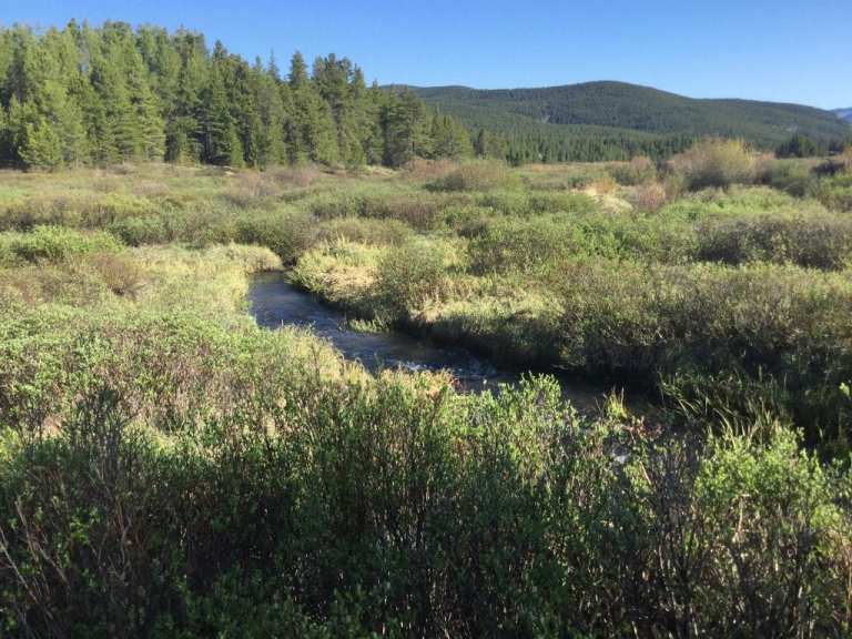
Homestake Creek is a tributary of the Eagle River. CREDIT: BRENT GARDNER-SMITH/ASPEN JOURNALISM
Click the link to read the article on the Vail Daily website (Zoe Goldstein). Here’s an excerpt:
May 8, 2025
Every year brings different water conditions in Eagle County. With climate change, the promise of full rivers in the summer may become even less certain. To prepare for future drought years, the Eagle River Water and Sanitation District and Upper Eagle Regional Water Authority have a new water shortage response plan.
“The goal of this plan is to provide water security, to ensure that we can provide our core services,” said Justin Hildreth, the district’s water resources engineer, when presenting the plan to the district board for approval on April 10. Among the core services included in the list are safe drinking water and water for structure fire suppression…According to the plan, “a water shortage occurs when the (district/authority) lacks the physical or legal water supplies needed” to provide their services and maintain required streamflow levels. This can happen when there are extended calls from older water rights, (like the Shoshone water rights on the Colorado River), when stream flows are low for long periods and when local reservoirs (Eagle Park Reservoir and the Black Lakes) have low supply. The district and authority boards approved the plan during their April 10 meetings after learning about the plan during Feb. 27 work sessions…
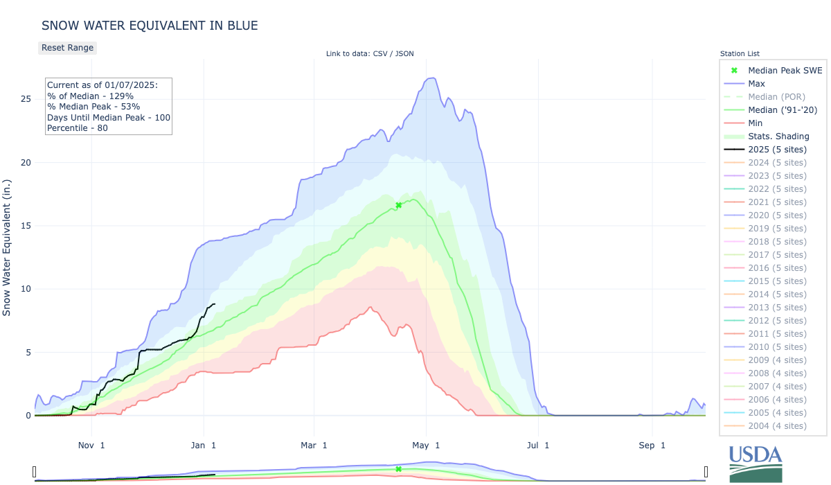
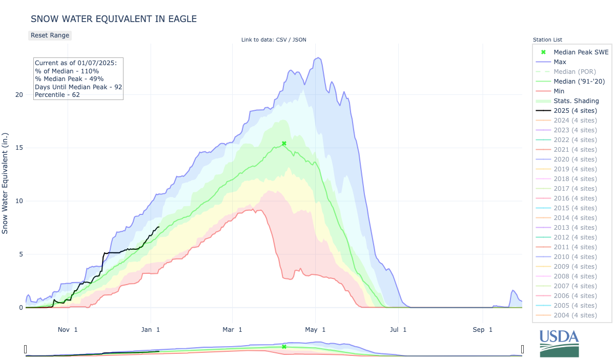
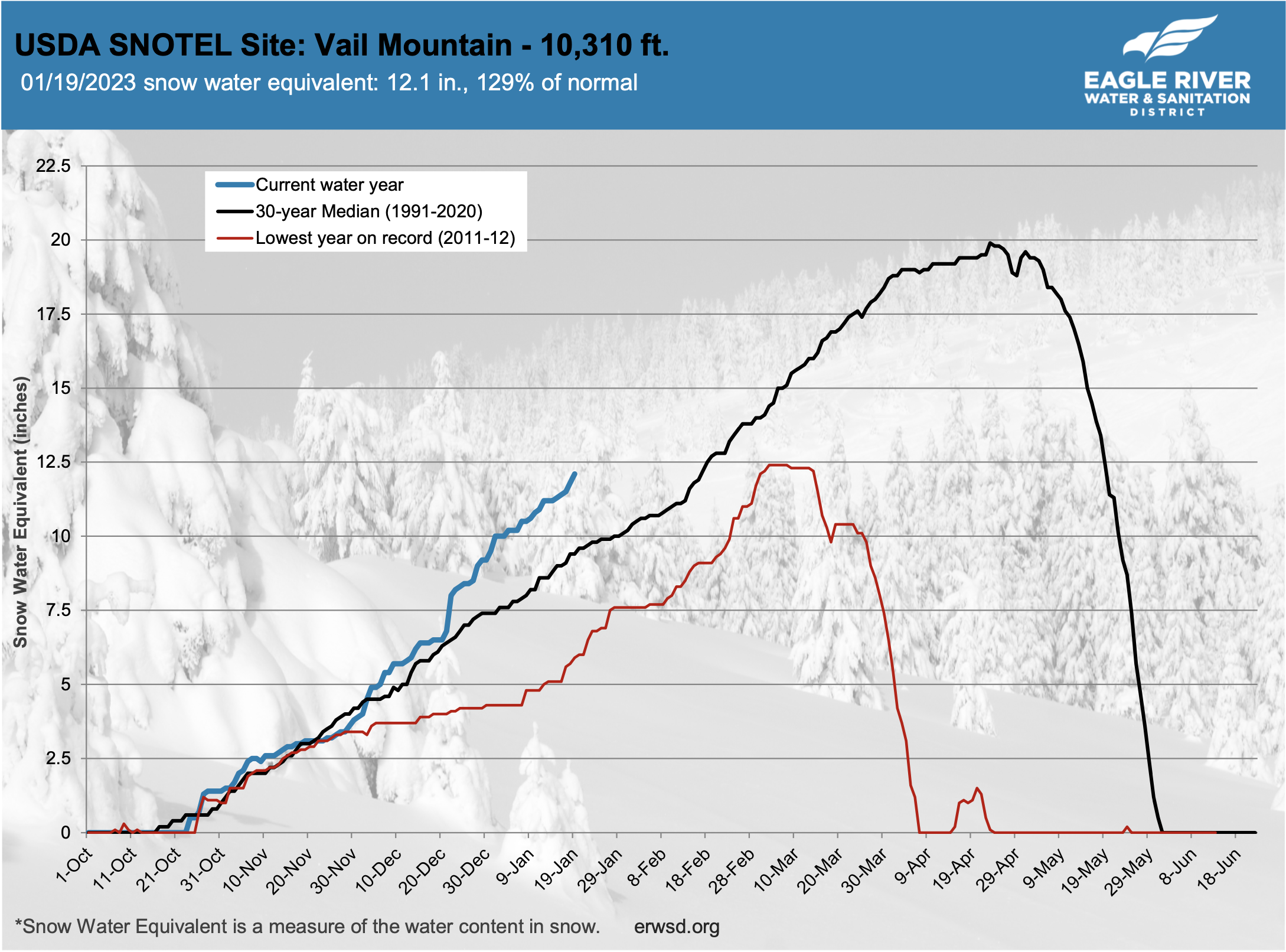
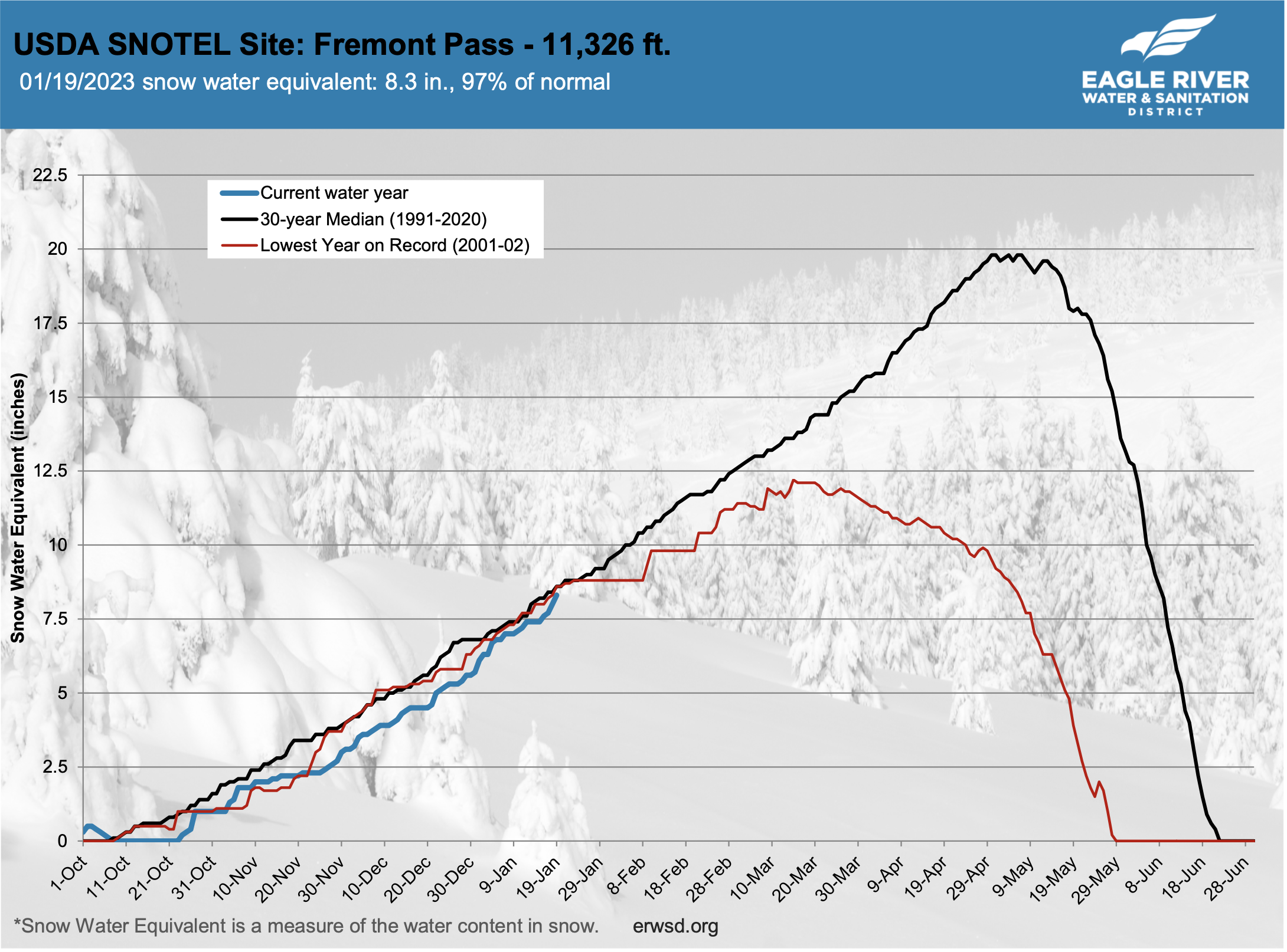
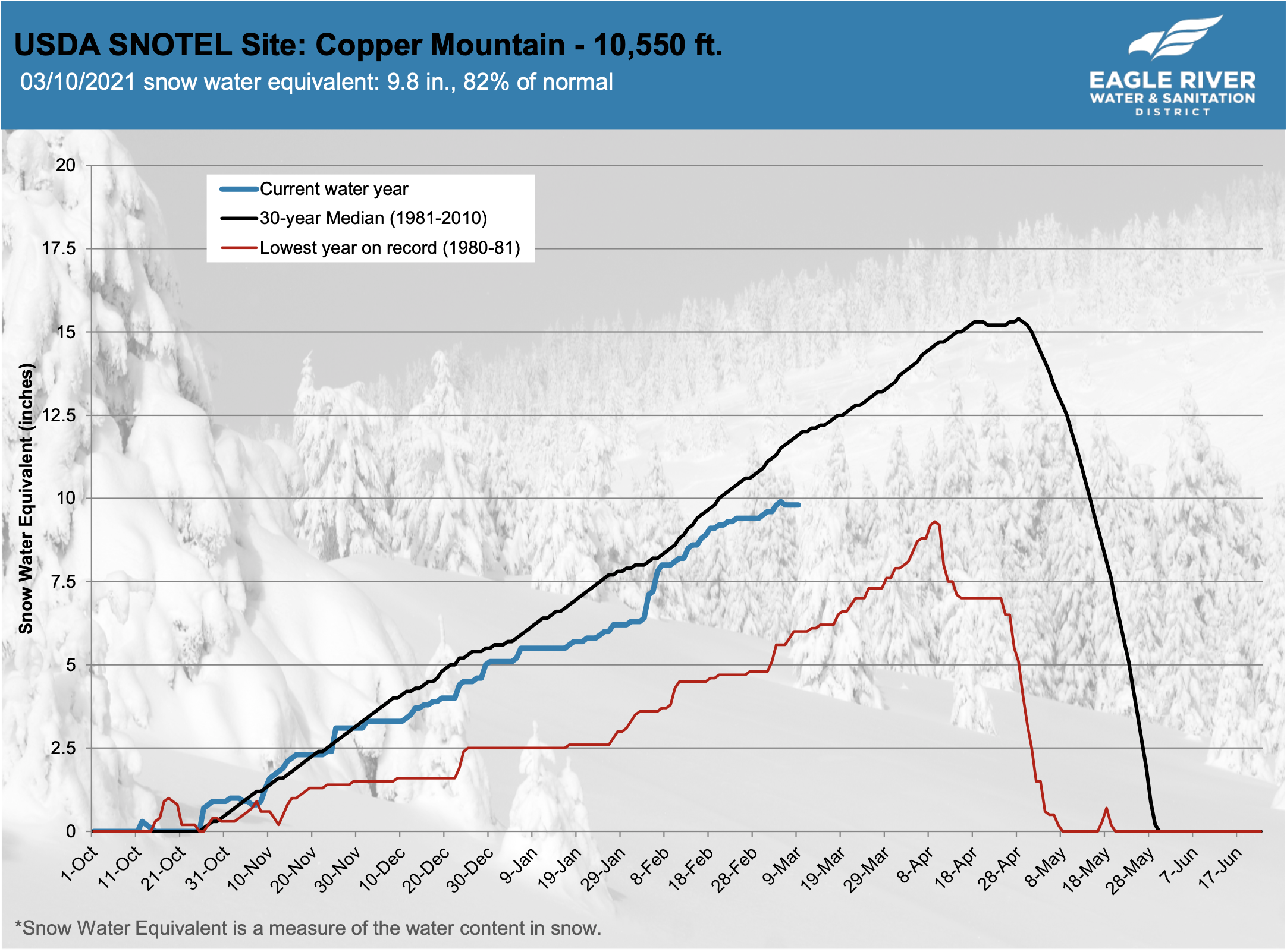
One of the best early predictors of a drought scenario is if the snow water equivalent measure has not reached an average of 15 inches across the Vail, Fremont Pass and Copper SNOTEL stations by April 1. “That directly relates to Eagle Park Reservoir, that relates to the flows in Gore Creek and the flows in the Eagle River,” Hildreth said. This year, the average was just shy of 16 inches across the three stations on April 1.
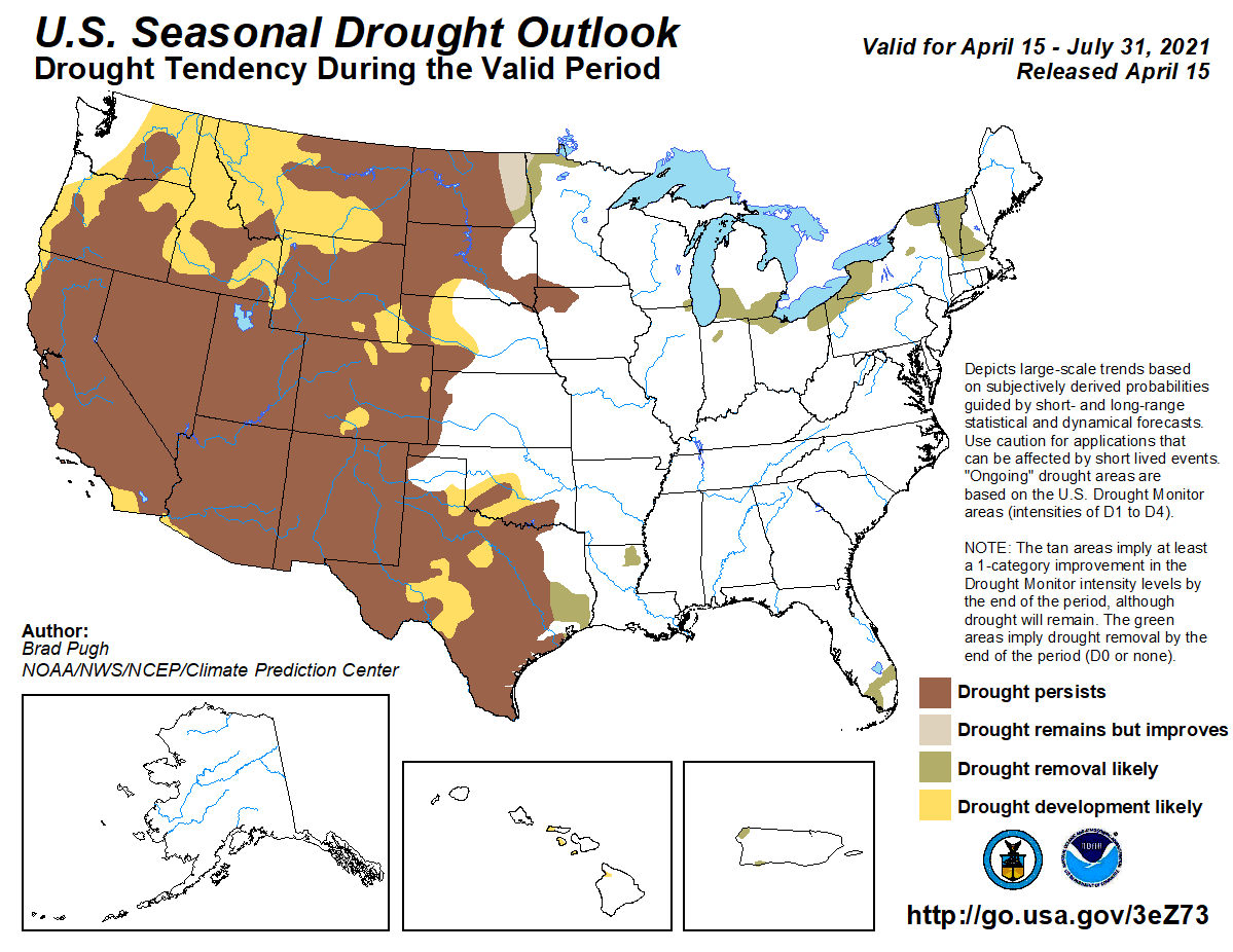
Snowfall in March has helped decrease the likelihood of drought developing this spring in Colorado’s northwest mountains. However, a warm and dry spring could still change the tide heading into summer. The National Weather Service, a division of the National Oceanic and Atmospheric Administration, released its latest seasonal drought outlook on Thursday, March 20. It showed that drought conditions are unlikely to develop in most of northwest Colorado through June…Brad Pugh, a forecaster with the National Oceanic and Atmospheric Administration’s climate prediction center, said these outlooks predominantly take into account the current conditions, climatology temperature and precipitation outlooks over the next three months.
“In northwestern Colorado at this time of year, you know going into the springtime, mountain snowpack is a critical factor,” Pugh said.
As of March 18, much of northwest Colorado was in line with, or just above, normal snowpack. This has continued to improve in the state’s north-central mountains since January. According to OpenSnow, as of Monday the snow totals and percentage of normal on the season so far were as follows:
Winter Park – 315 inches (117%)
Copper Mountain Resort – 303 inches (113%)
Vail Mountain – 292 inches (101%)
Breckenridge Ski Resort – 284 inches (107%)
Steamboat Resort – 279 inches (108%)
Aspen Highlands — 267 inches (88%)
Loveland Ski Area – 261 inches (108%)
Snowmass – 243 inches (83%)
Keystone Resort – 239 inches (107%)
Beaver Creek – 227 inches (108%)
Arapahoe Basin Ski Area – 225 inches (112%)
Aspen Mountain – 210 inches (92%)
Ski Cooper – 206 inches (106%)
Buttermilk – 147 inches (89%)
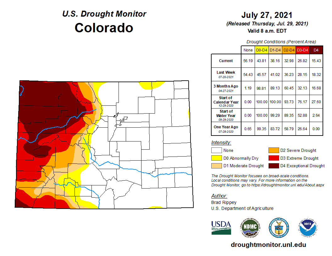
Colorado Drought Monitor map March 25, 2025.
The latest U.S. Drought Monitor for Colorado reported no drought in many of the northwest counties including Summit, Grand, Routt and Jackson counties as well as the eastern reaches of Eagle and Moffat counties. Heading west, the monitor shows abnormally dry conditions in Pitkin County and the eastern portions of Garfield and Rio Blanco counties. Conditions continue to get progressively drier the further west toward the border.
Colorado River. For over 50 years, stakeholders throughout the Colorado River basin have worked to address challenges caused by salinity. Photo credit: Abby Burk via Audubon Rockies
Click the link to read the article on the Summit Daily website (Ali Longwell). Here’s an excerpt:
February 6, 2024
Since 1974, the seven Colorado River basin states — Arizona, California, Colorado, Nevada, New Mexico, Utah and Wyoming — have coordinated efforts to implement salinity control in the waterway as part of the Colorado River Basin Salinity Control Forum. The forum was created by the U.S. Congress, flowing funding through the Bureau of Reclamation to reduce the salt load in the river and research the issue…While salinity is naturally occurring, there are a few reasons that states and river stakeholders have long kept an eye on it.A baseline amount of salinity is OK. Too much salinity can have adverse effects on drinking water, water infrastructure and treatment, appliance wear, aquatic life, the productivity of certain agricultural crops (including wine grapes, peaches and other salt-sensitive products) and more. The U.S. Bureau of Reclamation estimates that salinity causes between $500 and $750 million annually in damages and could exceed $1.5 billion per year if future increases are not controlled…
Much of the Upper Basin geology — specifically Mancus and Mesa Verde shale formations — was created when it was covered by an inland sea, [David] Robbins added. Therefore, they contain salt deposits that through natural erosion and runoff, make their way to the rivers and downstream. In Colorado, natural salinity sources include the geothermal hot springs in Glenwood Springs; shale cliffs and evaporating salt deposits in the Eagle and Roaring Fork valleys; and the salt domes in Paradox Valley in Montrose County along the Dolores River. Human activity can also exacerbate challenges by accelerating the release of compounds from these natural geologic materials and increasing the salt load in the river and tributaries, according to the 2009 U.S. Geological Survey report. This includes activities like mining, farming, petroleum exploration and urban development. For example, with some agricultural irrigation practices, by adding more water to the soil that naturally contains salts, “increases the rate of dissolution above the natural signal,” [Dave] Kanzer said. The use of road salts — solid and liquid — to clear snow and ice can also lead to increased salt loads as the salt dissolves and makes its way into snowmelt and streams.
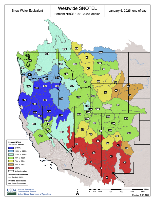
Westwide SNOTEL basin-filled map January 6, 2024 via the NRCS.
Click the link to read the article on the Summit Daily website (Kit Geary). Here’s an excerpt:
January 5, 2025
Summit and Eagle counties are poised to get a consistent dusting of powder nearly everyday this week heading into next weekend, according to National Weather Service meteorologists. Meteorologist Zach Hiris said there will be a “fairly active pattern across the mountains” on Monday, Jan. 6, and Tuesday, Jan. 7, which is likely bring a few inches of snow to the slopes. He said “a bunch of weak systems” could follow from Wednesday through Saturday and these are slated to bring a couple more inches. Summit’s mountains are anticipated see anywhere from 3-6 inches and its valley areas could see 1-3 inches of snow by Wednesday morning, Hiris said. Wednesday, Thursday and Friday could bring an inch or two each, but it will be more sporadic than the snowfall delivered by Monday and Tuesday’s storms, he said.
Hiris said the Blue River Basin is currently at 129% of its snowpack median.
According to the United States Department of Agriculture, the Colorado Headwaters river basin is currently at 104% of its median snowpack, the Eagle area is at 113% of its median snowpack and the Roaring Fork area is at 109% of its median snowpack.
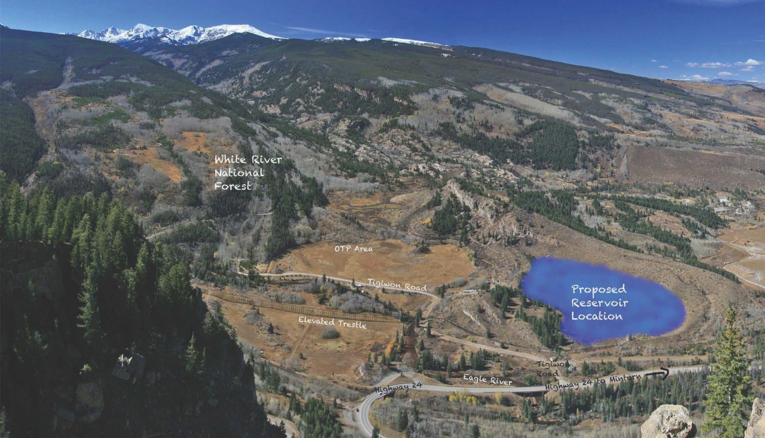
The project to create a reservoir on the Bolts Lake Reservoir site is moving forward as planned, with a tentative 2032 completion date for the potentially $100 million project. The reservoir will be located south of Minturn, on the site of the long-drained Bolts Lake. The Eagle River Water & Sanitation District and Upper Eagle Regional Water Authority boards received updates from the project leadership team during a joint meeting on Thursday, Aug. 22 and then again separately during their regular meetings on Thursday, Sept. 26. The construction engineering company Black and Veatch is serving as the project manager for the project, with Ben Johnson leading the team. Johnson presented to the boards in the August meeting…
When completed, the Bolts Lake Reservoir should hold up to 1,200 acre feet of water…to serve as additional water supply due to the risk of water supply shortage in the future. In 2020, the boards adopted a strategic reserve and system policy to guide water planning efforts and mitigate climate uncertainty.
“Our previous approach to water supply was, essentially, whatever we didn’t use in a 2002-type drought was available for new service commitments. That approach didn’t really take into account the impact of a warming climate on our available supply,” or a drought worse than 2002 or consecutive drought years, said Jason Cowles, director of engineering and water resources with the water district.
Little is known about the full impact of so-called ‘forever chemicals,’ and settlement would prevent participants from suing in the future
In the fall, the district and authority declined to participate in two PFAS-related settlements. Last month, district staff received information about a new settlement the district and authority could elect to participate in, with similar terms to those in the fall, and lower compensation. During their regular meetings on Thursday, July 25, the district and authority boards reviewed and declined the new settlement proposal, and authorized district staff to make decisions about similar settlements going forward…
The district and authority have conducted three studies to sample the water they provide for PFAS over the last five years. Data from the most recent study, conducted in 2023, shows that PFAS have been detected in five out of 11 of the two water providers’ sources, with four detections within the authority, and one in the district. All five detections were below the maximum contaminant level of four parts per trillion. For reference, one part per trillion is the equivalent of one drop of water in 20 Olympic-sized swimming pools…
Part of the challenge of sampling for PFAS is that technology has not caught up to the chemicals — though there are thousands of PFAS chemicals, only 29 can currently be detected. At the moment, not all labs in the United States can test for PFAS, and the testing is very expensive. The district and authority will next sample for PFAS in 2025.
The Eagle River, left, flows into the Colorado River near Dotsero. The Eagle River Coalition recently completed its community water plan, which outlines environmental flow deficits, but does not make recommendations on how to get more water into rivers. CREDIT: BETHANY BLITZ/ASPEN JOURNALISM
In an effort to elevate the needs of the environment in water management, the state of Colorado is convening a new committee that is scheduled to begin meeting this summer.
The Colorado Water Conservation Board and Boulder-based nonprofit River Network are creating a pilot program known as the Environmental Flows Cohort, which will assess how much water is needed to maintain healthy streams and how to meet these flow recommendations. The cohort will include not just environmental advocates, but agricultural and municipal water users, who may initially feel threatened by environmental flow recommendations.
The goal of the program is to address the barriers that lead to these recommendations being excluded from local stream management plans. The cohort was one of the recommendations in a January 2023 analysis of SMPs by the River Network.
“The idea is how can the environmental and recreation side of things better partner with the agricultural users on trying to find win-win projects for keeping more water in the stream,” said Brian Murphy, director of the healthy rivers program at the River Network. “An emphasis on making sure stream management plans identify and prioritize projects that include environmental flows, that’s been kind of a shortfall.”
An objective of Colorado’s 2015 Water Plan was to create SMPs for most of the state’s important streams by 2030. SMPs are meant to focus on water for the environment and recreation, which are “nonconsumptive” needs where “using” the water means that it stays in streams. The idea is that these flow targets could then result in projects designed to get that agreed-upon amount of water in streams.
SMPs were originally intended as a tool to legitimize and enhance the role of environmental and recreation groups in water management, but a 2022 report by the River Network found that focusing on water to maintain a healthy environment was inconsistent, problematic and unpopular among the stakeholders who were creating the SMPs. Just 6% of project recommendations at the time focused on environmental flow targets and only 1% focused on recreation flow targets, even though SMPs were supposed to have been a tool specifically for the benefit of nonconsumptive water uses.
In some cases, the SMPs broadened in scope and morphed into Integrated Water Management Plans that included an agricultural water needs assessment and ditch inventories.
“One of the big challenges, it was found, was just a lot of perceived negativity regarding flow recommendations,” said Andrea Harbin Monahan, a watershed scientist with CWCB. “There’s a perceived animosity between the recreation community versus agriculture, for example. Figuring out a way to get all those people into one room and start those conversations early and build trust early in the process are hopefully the outcomes of this environmental cohort.”
Under the bedrock principle of Colorado water law, the oldest water rights, which belong to agriculture and cities, get first use of rivers and other user groups have historically had trouble making inroads. The actions of the biggest irrigators often have an influence on how much water is left flowing in the stream, and there are few ways to guarantee there is enough for ecosystems and wildlife. The CWCB holds instream flow water rights intended to “preserve the natural environment to a reasonable degree.” But the oldest of these date to the 1970s — about a century younger than the most powerful agricultural water rights, which limits their effectiveness.
As climate change squeezes water supply and creates shortages for all users, it also ratchets up the tension between groups that take water out of the river and groups that want to leave it in.
Homestake Creek is a tributary of the Eagle River. The Eagle River Coalition recently completed its community water plan, which outlines environmental flow deficits, but does not make recommendations on how to get more water into rivers. CREDIT: BRENT GARDNER-SMITH/ASPEN JOURNALISM
Eagle River Community Water Plan
The Eagle River Coalition is an organization dedicated to advocating for the health of the Eagle River. After five years of community meetings and technical work, the group recently released the Eagle River Community Water Plan. The plan provides an assessment of current conditions on the Eagle and its tributaries, and what conditions may look like with future risks such as climate change, more municipal water demands and new reservoir projects that take more water to the Front Range.
“The main takeaway to me is that we’re going to see low flows and less water in the river, so we as a community have to figure out how are we going to prioritize keeping our river flowing,” said James Dilzell, executive director of the Eagle River Coalition. “Figuring out how to have more water in the river is going to be absolutely critical.”
The plan is meant, in part, to provide an understanding of environmental and recreational needs gaps and how they are affected by high and low flows and increasing demands for water in Eagle County and on the Front Range.
But although the plan includes a section about environmental flow deficits, which is the amount of water that would be needed to meet the CWCB’s instream flow water right during a typical year, it — like most SMPs — does not set a target amount for flows.
This map in the Eagle River Community Water Plan shows the environmental flow deficits on the Eagle River and its tributaries. The EDFs reflect the amount of water that would be needed to meet the Colorado Water Conservation Board Instream Flow water right in a typical year. CREDIT: EAGLE RIVER COMMUNITY WATER PLAN
Seth Mason, a hydrologist with Carbondale-based Lotic Hydrological, helped author the Eagle River plan and will be participating in the cohort. He said putting a number on exactly how much water the river needs at different times of year under different future climate and development scenarios is complicated. For example, it might be the case that the only way for a section of river to meet a certain flow target is to build a reservoir to control releases, but a new reservoir project could be at odds with what the community wants.
“What we didn’t do was develop a prescriptive flow regime,” Mason said. “And that, I think, is what a lot of people end up looking for. … I think providing the nuance necessary for people to do critical thinking about trade-offs is more valuable than drawing the perfect stream flow regime, which there is no such thing.”
Dilzell said he is interested in learning more about flow recommendations on the Eagle River and its tributaries, and the completion of the community water plan is just the first step in local watershed management.
Still, river flows can be a proxy for ecosystem health, and some say target recommendations are essential. Bart Miller, healthy rivers director with environmental group Western Resource Advocates, said stream flow recommendations are the bedrock for protecting the environment. WRA is helping to facilitate the cohort.
“Flow has an impact on water quality, temperature, habitat — everything from spawning cues for fish to just keeping them alive when flows are getting low at the end of the summer,” Miller said. “There’s a wide range of benefits from having a clear picture of what stream needs are and articulating recommendations on how to improve or protect what the flows look like.”
Although they are not required in order to get state funding for SMPs, CWCB officials would still like the groups that develop SMPs to come up with flow recommendations. Harbin Monahan said the cohort will be a way to work through barriers, understand the contentious nature of the topic and build trust among stakeholders so that more SMPS can have flow recommendations in the future.
“The entire idea behind stream management plans was to help support the environment and recreation community and help them meet the flow needs for specific uses,” she said. “It’s OK if stream management plans don’t come out with a flow recommendation. It’s not typically required, but it is a desired outcome.”
The River Network and CWCB are taking applications for the Environmental Flows Cohort and plan to choose 15 to 20 participants to begin meeting in July. The cohort plans to meet five times between July and next spring and will develop a training program for local watershed groups to follow when they create SMPs.
Click the link to read the article on the Vail Daily website (Scott Miller). Here’s an excerpt:
March 30, 2024
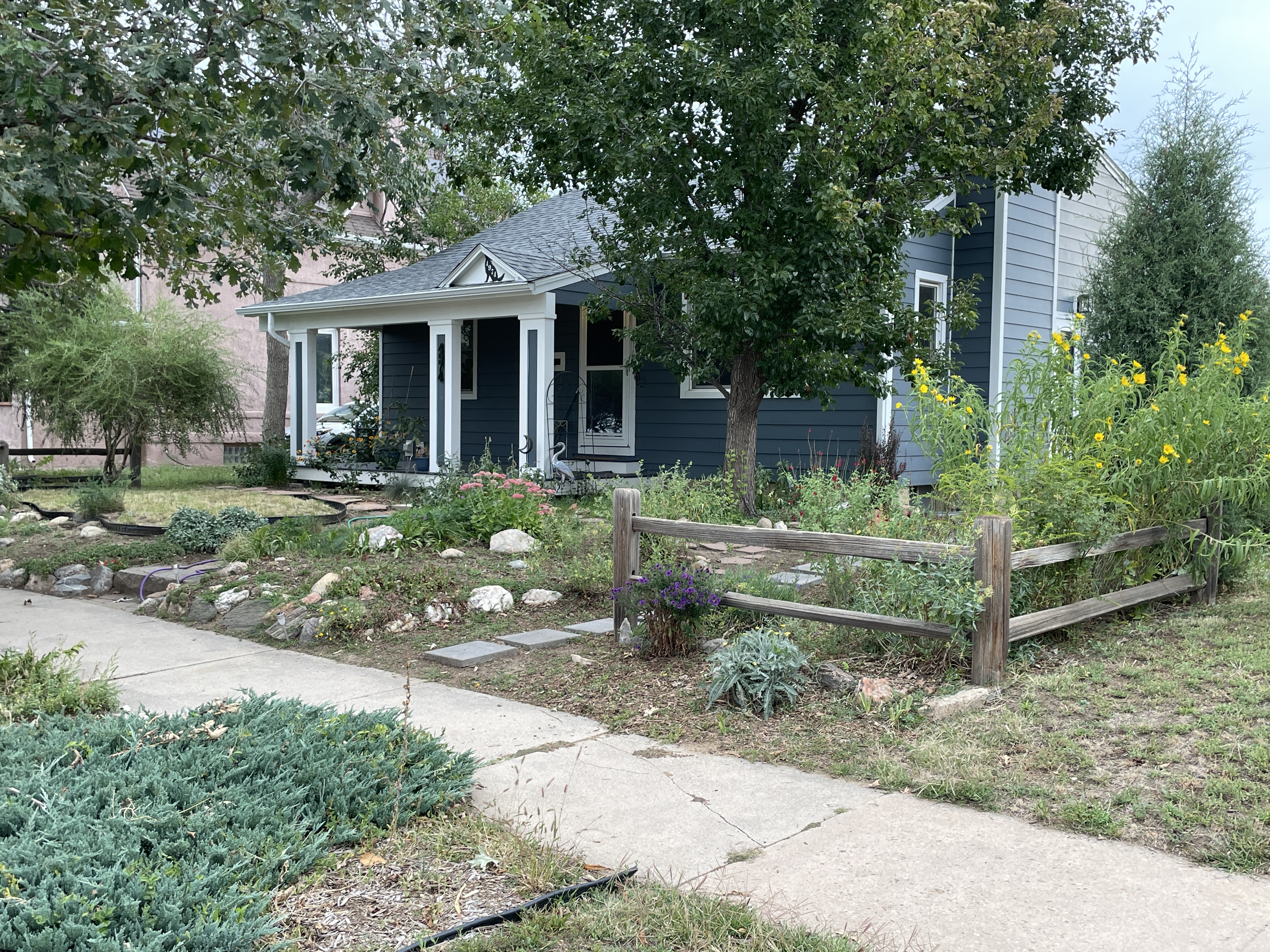
Lawns are nice. But they use a lot of water, can be expensive and often don’t make sense for many of us here in the high desert. The Beyond Lawn program wants to help. The program is a joint effort between the Eagle County Soil Conservation District, the local office of the Colorado State University Cooperative Extension Service and the Eagle River Coalition. The idea is to help residents responsibly replace their lawns with attractive, water-wise landscaping. Cooperative Extension will provide volunteers from the Master Gardener program to help put the right plants into the right soils. The Master Gardeners are also helping create demonstration gardens in Edwards, Eagle and Gypsum this spring.
The program will also offer turf conversion rebates to residents. Denyse Schrenker of the Cooperative Extension noted that the Eagle River Water & Sanitation District has had its own turf conversion program for a while now. The Beyond Lawn program will offer similar services to residents who aren’t customers of the water and sanitation district. To participate, residents can sign up for an evaluation through the Beyond Lawn website. Evaluations cost $100 and provide expert reports specific to a resident’s yard, including soil types and lists of plants that would work to replace turf grass in those yards…
Rose Sandell is the Eagle River Coalition’s Education and Outreach Coordinator. She said part of last year’s efforts included determining how to approach residents with what can be a big request.
“We’re trying to break down the scariness of it all … down to manageable pieces,” Sandell said. She said that a piece of a yard where it’s hard to keep grass growing could be a good place to start turf replacement.
With four locations within the Upper Eagle Regional Water Authority and one location with the Eagle River Water & Sanitation District showing elevated levels of the “forever” chemical PFAS, the two entities have decided to opt out of current lawsuits against PFAS producers 3M and Dupont in expectation of future developments on the topic.
Eagle River Water & Sanitation District/Courtesy image
Board members cited confusing language in the lawsuits, potential for significant future knowledge and regulation developments regarding PFAS
During a special joint meeting on Nov. 30, the Eagle River Water & Sanitation District and the Upper Eagle Regional Water Authority both decided to opt out of accepting settlements resulting from class action lawsuits between thousands of United States public water systems against 3M and a collective of companies including DuPont de Nemours, Inc., The Chemours Company, and Corteva, Inc. Eastern Eagle County’s drinking water entities began sampling for PFAS, the catch-all name for a collection of thousands of so-called “forever chemicals,” five years ago, at the request of the state of Colorado. Three studies have been conducted in the county, with the most recent study in 2023. The 2023 data shows that PFAS has been detected in five out of 11 sources throughout the county, with four detections within the Authority, and one in the District. All five detections were below the maximum contaminant level of four parts per trillion. For reference, one part per trillion is a single drop of water in 20 Olympic-sized swimming pools…
“The main reason I put this up is to emphasize that this is super limited data. We have three sampling events, and they are snapshots in time. We have no idea about variability, and we have no idea how this data is trending over time,” said Brad Zachman, District director of operations.
PFAS contamination in the U.S. October 18, 2021 via ewg.org.
Eagle River Water & Sanitation District General Manager Siri Roman. Photo credit: Allen Best/Big Pivots
Click the link to read the article on the Big Pivots website (Allen Best):
The Western Slope delivers 70% of the Colorado River water. So why do Aspen, Vail and other places want to replace thirsty turf?
This story, a collaboration of Big Pivots and Aspen Journalism, is part of a series that examines the intersection of water and urban landscapes in Colorado.
If you’ve ever slipped and spun your way across Vail Pass through a wet, heavy snowstorm, you can be excused for wondering how Eagle River Valley communities could ever have too little water.
Vail and its neighbors do have that problem, though. It has become evident in the growing frequency of drought years in the 21st century.
U.S. Drought Monitor July 23, 2002.
First came 2002. Water officials, verging on panic, restricted outdoor water use. The drought was believed to be the most severe in 500 years. Fine, thought water officials as rain and snow resumed, we’re off the hook for at least our lifetimes.
West Drought Monitor map October 12, 2021.
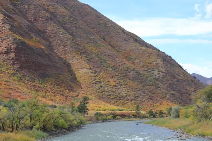
In 2012 came another drought, one nearly identical in severity. More bad years followed in 2018 and 2021. The Eagle River normally chatters its way down the valley through Avon and to a confluence with the Colorado River near Glenwood Canyon. In those bad, bad drought years, it sulked. The shallow water was hot enough to endanger fish.
“New plot using the nClimGrid data, which is a better source than PRISM for long-term trends. Of course, the combined reservoir contents increase from last year, but the increase is less than 2011 and looks puny compared to the ‘hole’ in the reservoirs. The blue Loess lines subtly change. Last year those lines ended pointing downwards. This year they end flat-ish. 2023 temps were still above the 20th century average, although close. Another interesting aspect is that the 20C Mean and 21C Mean lines on the individual plots really don’t change much. Finally, the 2023 Natural Flows are almost exactly equal to 2019. (17.678 maf vs 17.672 maf). For all the hoopla about how this was record-setting year, the fact is that this year was significantly less than 2011 (20.159 maf) and no different than 2019” — Brad Udall
Colorado River flows have declined 20% since 2000. Having water rights is not enough. And the future looks even hotter and, because of that heat, drier. Brad Udall, a senior scientist and scholar at Colorado State University, warns of up to 20% additional flow loss by midcentury.
Average temperatures in the Colorado River Basin are projected by the U.S. Bureau of Reclamation to rise 5 to 6 degrees Fahrenheit during the 21st century. The agency projects slightly greater increases in Colorado and other upper basin states.
Average temperatures in the Colorado River Basin are projected significantly, even in headwaters areas such as in Glewnood Springs, where this photo was taken after a rainstorm in September 2023. Photo/Allen Best Top photo: Siri Roman of Eagle River Water and Sanitation District. Courtesy photo.
In Vail, managers of the Eagle River Water and Sanitation District have decided they need more storage. They plan a 1,200-acre-foot reservoir near Minturn called Bolts Lake. That compares with the 257,034-acre-foot storage of Dillon Reservoir. At that capacity, this new reservoir will be the most cost-effective way to ensure resilience as the climate becomes more variable. With the reservoir, they hope to capture water during high-runoff years for use in the district’s service territory from Vail through Edwards.
Demand reduction will be another tool of growing importance in a hotter, sometimes drier climate. Managers hope to reduce water demand in the district 5% by 2026 even as new housing, especially more affordable units, gets built. That’s 400 acre-feet per year.
The most productive place to wring these savings will be in water used for outdoor landscapes. Only 25% — or even less — of water applied to lawns returns to streams and rivers compared with 95% of water used indoors.
Siri Roman, the district’s general manager, said short-term change, such as restricted lawn watering in drought years, can be a strategy. But her district wants to effect permanent change.
“It’s not about drought years,” she said. “It’s about a drying climate. We have to get people to shift their attitudes, to know that water is getting to be more scarce.”
Roman’s district, like other water utilities in Colorado, is targeting nonfunctional turf. Precise definitions vary, but nonfunctional generally refers to grasses that require large volumes of water to irrigate but rarely see human feet except when mowed. It is also described as aesthetic turf.
Three years ago, Eagle River Water began offering rebates of $1 per square foot to customers willing to replace thirsty lawns with landscapes that use less water. Using state aid, the district this year bumped up the incentive to $2.
“We are not saying it needs to be stone and look like Arizona,” Roman said.
Directors of the district in October also agreed to new tiered rates that will discourage high-volume consumption.
Other Western Slope communities have also set out to discourage thirsty landscape choices. Motivations vary, but for many, there is also acknowledgement of the need to walk the talk of water conservation expected of Front Range communities. “That is something I hear a lot from communities I am working with,” said Marjo Curgus, a consultant.
‘Lawn Begone’ in Durango
Almost a decade ago, Steve Harris, a water engineer in Durango, summoned the local news media to his house to watch him remove sod from his front yard. He also had bumper stickers produced: “Lawn Gone.” In an editorial, the Durango Herald offered an alternative: “Lawn Begone.”
Harris believed that Colorado needed to make clear that decorative lawns had less value than agriculture. He worked with his state legislators to draft a bill that would have limited transfers of agricultural water to cities if that water went to lawns. As for his own lawn, Harris thought that he and others on the Western Slope couldn’t just pay lip service to this idea.
At the Colorado Capitol, the bill introduced in 2014 by then-Sen. Ellen Roberts and then-Rep. Don Coram was quickly shelved. Local governments objected. So did ag producers who thought state legislators had no business blocking their abilities to sell water rights.
Instead, the idea was directed to an interim committee for further study. Bills sometimes get sent there to die. In this case, the conversation continued, as Roberts had intended.
Since then, legislators have adopted several laws. A bill that passed in 2022, House Bill 22-1151, does not institute a prohibition but instead allocated $2 million to the Colorado Water Conservation Board, $1.5 million of which went to local jurisdictions to spur voluntary replacement of irrigated turf.
The law asserts that for every 100 acres of turf converted to water-wise landscaping, up to 200 acre-feet of water can be conserved. The act defines water-wise landscaping as a water- and plant-management practice that emphasizes using plants with lower water needs.
Whether that much water gets saved also depends upon whether irrigation systems are changed to match the lesser water needs of the new landscapes. Grass that needs 12 inches of supplemental water per year need not continue to get 25.
All that funding has now been allocated. On the Western Slope, the municipalities of Cortez, Glenwood Springs and Frisco were awarded funds as was the Eagle County Conservation District. The state agency said 25% of turf-replacement funds were for Western Slope entities.
Rep. Marc Catlin of Montrose and then-Rep. Dylan Roberts of Frisco, two of the four prime sponsors, are from the Western Slope. Another prime sponsor, Sen. Cleave Simpson of Alamosa, now has a district that encompasses southwest Colorado, while Roberts has become a senator.
Without state funding, Montrose County approved grants for seven turf-replacement projects.
“From the start, I thought this initial effort might have more value from an education and outreach perspective than actual water savings,” said Justin Musser, the county’s natural resources manager.
Projects were chosen based on various objectives. For example, do the new landscapes provide energy savings or wildlife benefits? “We are not overly prescriptive,” said Musser. “If you have a good plan that references standards from the Colorado State University Extension or another reputable source, the application gets a higher ranking.”
Why would Montrose County be interested in yanking sod to save water?
“It’s important that we look at these types of things across the Colorado River basin,” Musser said. “We would want people in California and Arizona and Nevada to be looking at these types of programs, too. I think it makes sense for a place like Montrose County to be conserving water as much as we can, too.”
But, he added, this is “one part of a very complex issue.”
As this diagram (Snake Diagram) shows, native flows in the Arkansas River Basin are dwarfed by the amount of water in West Slope basins (created by the Colorado Water Conservation Board).
Droughts versus aridification
The Western Slope of Colorado produces 70% of the water in the Colorado River, according to the Colorado River Water Conservation District. Some of that water stays in Colorado. About half of the water for Front Range cities comes from the Western Slope. Yet more of the Colorado River gets diverted to farms in the South Platte and Arkansas river valleys.
And, of course, water from the Western Slope flows downstream to farms and cities in Arizona, California and Nevada.
The Colorado River has infamously been falling short of meeting all demands. The river first failed to reach the Sea of Cortez in the 1960s and, as diversions in Arizona and elsewhere expanded, has ceased to reach the sea altogether since the 1990s — save for an especially engineered pulse in 2014.
In 1922, when delegates of the seven states met to negotiate the Colorado River Compact, they assumed that flows of the early 20th century would be the norm, delivering more than 20 million acre-feet. As Eric Kuhn and John Fleck explain in their book, “Science Be Dammed: How Ignoring Inconvenient Science Drained the Colorado River,” it had been a wet period.
It didn’t stay that wet, and in the 21st century it has been delivering far less water, an average 13.2 million acre-feet through 2022. Andy Mueller, general manager of the Glenwood Springs-based Colorado River District, and others have warned that continued warming could depress flows to 9 million acre-feet during coming decades. Or even less.
Grand Junction has a maze of irrigation canals but the municipal water utility gets water from a creek that flows from the Grand Mesa. Photo/Allen Best
Grand Junction more recently adopted regulations curbing water needed for urban landscaping. The city has adopted sustainability goals, “and water plays a big part of that,” said Randi Kim, utilities director for the city of 69,000 people.
Cost savings enter into the city’s calculation as it prepares for a projected 91,000 residents by 2040. The municipal utility taps high-quality water from Kannah Creek, which originates on Grand Mesa. When that is insufficient to meet demands, as the city utility projects will be the case by 2040, the city will tap the Gunnison River but will need to pay more to treat the dirtier water.
Rising heat can also drive higher demand. Grand Junction in July reached 107 degrees, tying the record that had been set just two years before. The city’s 13 highest temperatures have occurred this century.
This is but one aspect of the changing and drying climate, a process that many — including Kim — describe as aridification. “I think people realize that we have to change the way we use and manage water, and it really affects every aspect of our lives,” she said.
Grand Junction’s new regulations apply to new developments. Turf that does not meet the city’s definition of “functional” cannot exceed 15% of landscaping. The new regulations also require low-water vegetation in traffic medians and some other common areas.
Steamboat Springs, although cooler and wetter than Grand Junction, faces similar challenges. It gets 24 inches of precipitation a year, compared with 10 inches for Grand Junction. Some years, the snow along streets of Steamboat gets piled higher than the head of a rim-rattling professional basketball player.
These prodigious snowfalls have not been yielding equally impressive runoffs in the Yampa River. Several times during the longer, hotter summers of the 21st century, the river slunk to such shallow depths that water officials decreed a temporary end to fishing. It almost happened again in July before temperatures cooled and rain arrived.
“We were one day from the river being shut down again,” said Madison Muxworthy of the Yampa Valley Sustainability Council, a nonprofit. “It was crazy.”
The Yampa River at Deerlodge Park July 24, 2021 downstream from the confluence with the Little Snake River. There was a ditch running in Maybell above this location. Irrigated hay looked good. Dryland hay not so much.
Muxworthy calls the Yampa River the “life beat of our community.” The description is apt. Kayakers paddle amid the waves during runoff months, and anglers drop lines every season. There are always people along the river banks.
In 2021, heeding local sentiment, the sustainability council launched a water-conservation program focused on outdoor use. Working with the city government and Mount Werner Water and Sanitation District, the group created a guidance document for landscapes called “Yampascaping.” Four educational workshops this year were well attended.
“Citizens are really interested in this because they see the impacts from climate change that we’re already having,” said Muxworthy, her organization’s soil moisture, water and snow program manager. “It’s really easy for them to make the connection and want to do something about it.”
The Mount Werner district, which serves the base of the city’s bigger ski area, offers rebates of $1 per square foot for turf removal.
Eighty miles south of Steamboat, at a 131-unit multifamily project along the Eagle River called The Reserve, turf-removal incentives of $2 per square foot have also helped the homeowners association replace a half-acre of thirsty grasses with native vegetation. The homeowners hope to replace another 60% of the more than 4 acres of common area.
Saving water is paramount in the mind of Deb Forsline, a director of the homeowners association. She sometimes lulls her grandchildren to sleep with the soothing sound at river’s edge and, at other times, accompanies her husband on fishing expeditions, knitting while he dangles lines. “It’s about saving water for the river, not the money,” she said of the efforts to reduce water for landscaping.
It’s all about saving water, says Deb Forsline, explaining the native grasses installed at The Reserve, a housing project at Edwards where she lives. Photo/Allen Best
Diane Johnson, communications and public affairs manager at Eagle River Water and Sanitation District, concurs. The $2 per square foot “helps move the thinking of people who have already been thinking about it,” she said.
Roman, the district’s general manager, points to the innate connection that most of her district’s 31,000 consumers have with the outdoors. “A lot of people who live here year-round know that it is irresponsible to overuse.”
A steeper staircase of water rates
After the 2002 drought, the Eagle River district adopted an inclining block rate structure. The more you use, the more you pay. The district got inconsistent results. Larger homes and those with more expansive and water-intense landscaping dropped their use in smaller percentages than smaller homes. The rate structure had been flawed, allowing larger homes to pay less per 1,000 gallons than smaller homes for the same volume of water. Different rates were needed to snag the attention of high-volume consumers.
Aspen had the same problem. It adopted tiered water rates in 2005. Managers thought the rates would discourage high volumes of consumption. But even in drought years, some properties continued stubbornly high volumes.
In 2017, Aspen adopted a new approach. The regulations require reduced water use in the landscape and irrigation plans for new and redeveloped projects. Such caps are called budgets. Like Denver and Boulder, Aspen has almost no new development of raw land. The law imposes a hard cap of 7.5 gallons per square foot of landscape. That’s about a foot of water, or roughly half of the supplemental water required in Colorado for Kentucky bluegrass. The law also requires so-called “smart” irrigation systems and alternative plants but leaves some flexibility in how developers and their consultants stay within the water budgets.
So far, 110 to 120 projects in Aspen have been reviewed, but only 15 to 20 have been executed – still too soon to discern clear results in water savings for the city, said Rob Gregor, utilities permit coordinator. Still, the city has leveled its water use and hopes to achieve even greater efficiencies in water devoted to residential and commercial landscapes. That could leave more water in Castle Creek and the Roaring Fork River, one of the goals of the program.
Durango, with 19,000 people and a projected population of 25,000 by 2035, has considered using rates to nudge high-volume users to less demanding landscapes. Justin Elkins, utilities manager, said the city hopes to encourage voluntary reductions in water use by allowing water users to monitor the volume of their use and compare it to consumption by their neighbors.
The Ute Water Conservancy District has successfully used rates to encourage water conservation. The Grand Junction-based district delivers water to rural and exurban areas of the Grand Valley from Cameo to the Utah border. Customers tend to be more responsive “when it hits them in the pocketbook,” said Andrea Lopez, the district’s external affairs manager. “As they use more water and enter into tiers that become steeper with the more they use, we usually see a reduction in use.”
That’s what Eagle River Water has done. Like Aspen, the Vail Valley has some wealthy homeowners. Under the old tier system, somebody in a smaller home paid more per gallon than somebody in a larger home, if they both used the same large volume.
Beginning in January, Roman was on the agenda of everybody from Rotary clubs to Eagle County commissioners. “Really, this is targeting our excessive users,” she told the Vail Town Council at a June meeting. “They’re the ones that are going to feel this.”
District directors in October approved the new tiered rates that intend to discourage high-volume consumption.
Linn Brooks uses about 7,000 gallons of water a month at her house in Avon after transitioning the yard to water-wise principles. Before, it used 15,000 to 25,000 gallons. Courtesy photo
In Wildridge, a neighborhood on the south-facing slopes of Avon, Linn Brooks has shown what is possible in landscape conversions. Fifteen years ago, before she started transitioning her landscape, her home used 15,000 to 25,000 gallons a month. Now, it uses, at most, 7,000 gallons a month and her landscape is commanding.
The takeaway, she said, is that communities can have vibrant landscapes and protect property values – and still use less water.
Next: How did bluegrass lawns in Colorado become the default? Some trace it to the castles of Europe. Half or more of Coloradans live in neighborhoods governed by homeowners associations. Some have started to curb thirsty bluegrass, but others needed a firm nudge this year from state legislators.
Allen Best, a longtime Colorado journalist, publishes Big Pivots, which tracks the energy and water transitions in Colorado and beyond. Aspen Journalism is a nonprofit, investigative news organization covering water, environment and community. This story is part of a five-part series produced in a collaboration between Big Pivots and Aspen Journalism. Find more at https://bigpivots.com and at https://aspenjournalism.org
Gore Creek is healthy as it emerges from the Eagles Nest Wilderness Area, but has problems soon after, via The Mountain Town News. All photos by Jack Affleck.
Click the link to read the article on the Vail Daily website (Ali Longwell). Here’s an excerpt:
Since 2012, the Colorado Department of Health and the Environment has listed Gore Creek as an impaired waterway due to low aquatic life. In the ensuing years, the town of Vail and the Eagle River Water and Sanitation District have been working to get the waterway off the list. Restore the Gore activities have included education efforts around pesticides and landscaping as well as the recent installations of gutter bins to reduce pollution flowing through its its stormwater drains. One of the main metrics the two entities use to track the progress of such efforts is the health of macroinvertebrate species in Gore Creek, Black Gore Creek, Red Sandstone Creek and Booth Creek. To track the abundance and diversity of these species, the water district conducts sampling at several sampling locations each September. This data has been collected since 2009 and includes eight sites on Gore Creek…
Pete Wadden, the town’s watershed health specialist, recently presented the full data from Eagle River Water and Sanitation District’s 2021 sampling as well as gave some insight into the 2022 results to the Town Council. Overall, samples from the last two years showed that the creek is “moving in the right direction, albeit at a modest pace,” Wadden said, later adding that the data shows an “upward trend over time, but it’s very gradual and still in most cases, in most years, pretty far from reaching what CDPHE defines as attainment.”
Anglers fish on the Colorado River near an idle Union Pacific freight train in western Grand County on June 12, 2023. (Chase Woodruff/Colorado Newsline)
Elected officials in Glenwood Springs are quite certain of two realities facing the largest town between the Denver metro area and Grand Junction on Union Pacific’s Central Corridor rail line: Freight rail, especially for fossil fuels, is king. And climate change is an everyday reality.
“Glenwood Springs is the poster child for climate change,” said former Glenwood mayor and current City Council member Jonathan Godes, an outspoken opponent of the proposed Uinta Basin Railway oil-train project in Utah. “Something that contributes 53 million metric tons of carbon a year … is absolutely something that our community and every other mountain community in Colorado that relies on it not being 100 degrees every day in the summer or 50 degrees in the winter should be fighting on its face.”
But the fact that the new 88-mile railroad in northeast Utah would send up to five fully loaded, two-mile-long oil trains a day through Glenwood and Denver on their way to Gulf Coast refineries has prompted the Colorado River city of 10,300 in Garfield County to support Eagle County’s litigation opposing federal approval of the project, and, more recently, to fire off letters to federal officials opposing tax-exempt funding for the railway and a Utah loading facility expansion.
On Aug. 3, Glenwood Mayor Ingrid Wussow wrote U.S. Transportation Secretary Pete Buttigieg urging him to “deny issuing funding through tax-exempt Private Activity Bonds (PABs) to the Uinta Basin Railway Project. The approval of and funding for the Railway carries grave implications for both the environmental health and economic stability of Glenwood Springs and other communities along the Railway’s corridor.”
Wussow added she’ll be in Washington, D.C., Sept. 18 to 20, with a delegation from the city and requested a meeting with Buttigieg to discuss the oil train project, which would travel along the climate-change endangered Colorado River for approximately 100 miles. In a separate letter dated Aug. 7, Wussow wrote Greg Sheehan, Utah state director of the U.S. Bureau of Land Management to request a full environmental impact statement for an oil truck and rail loading facility on BLM land in Utah rather than a less-intensive environmental assessment.
“Glenwood Springs is a world destination for outdoor recreation and the home for irreplaceable natural wonders,” Wussow wrote. “Given the magnitude of the Railway project, these risks to the natural environment are significant.”
Godes can doom scroll through a long list of climate calamities in Glenwood Springs he says are directly attributable to the burning of fossil fuels, rising temperatures and increased aridification of Colorado. He points to the Storm King Fire in 1994 that killed 14 wildland firefighters, the Coal Seam Fire in 2002 that burned down 29 Glenwood structures, and the Grizzly Creek Fire in 2020 that scoured Glenwood Canyon and shut down Interstate 70 for two weeks. The following summer, a 500-year rain event hit the burn scar and dumped mud and rock on the highway and train tracks below, shutting down I-70 for another two weeks.
“So climate change, it’s not just, ‘It’s hot in America right now,’” Godes said. “Climate change is something that threatens us in Glenwood Springs on a year-in and year-out basis. It’s ever-present. It is where our insurance rates are determined. It is where we allow houses to be built. It is where streets are contemplated for escape routes.”
One might think the environmental benefits of trains — up to 75% lower greenhouse gas emissions than moving freight by truck, according to the rail industry — would ease some of Glenwood’s concerns, but Godes argues that depends on the freight. The Uinta Basin oil should stay in the ground to begin with, he argues, while also scoffing at the notion of enhanced passenger trains as a potential tourism-boon side effect of increased rail traffic overall. [ed. emphasis mine]
“My mom comes from Iowa every year on the California’s Zephyr,” Godes said of the daily Amtrak service through Glenwood to Chicago and San Francisco. “She gets on near Burlington, Iowa, and then she comes out here, and it’s always four or five hours late. And most of the time it’s because somewhere in Colorado, and most likely between Denver and here, there was a train with a higher priority, whether it was oil or coal or other materials or commodities.”
In 2020, a billionaire New York real estate tycoon and owner of vast swaths of agricultural land in southeastern Colorado promised Pueblo-to-Minturn daily passenger service in his plan to revive the long-dormant Tennessee Pass rail line that connects to the Central Corridor at Dotsero, but he’s since pulled the plug on that concept.
“I’d love to have some kind of passenger rail like the California Zephyr be able to service the tourism industry to get tourists from the Front Range to Vail, from Pueblo, Colorado Springs, over Tennessee Pass,” Godes said. “That’s all fine and dandy. It’s a really nice, fun idea that could be helpful to our tourist economy. But if it comes with the risk of opening the door, even a crack, to regular freight rail on the Tennessee line, I think that is going to be incredibly — and it doesn’t affect me because we get that freight rail through Glenwood no matter what — but I think that is incredibly problematic for Eagle County, Chaffee County, for all the communities on that line.”
Fears about derailments
Eagle County Commissioner Kathy Chandler-Henry, whose government is the lead litigant in efforts to block the Uinta Basin project from sending oil trains through a corner of the county, was initially open to passenger rail but very leery of freight returning to the Tennessee Pass tracks along the Eagle River, which bisects the county before flowing into the Colorado River.
“If there’s going to be cargo trains and no passengers, then all we have is the impacts of noise and train crossings to deal with again,” Chandler-Henry said in 2020. “But if we also have people moving on those lines, I think this could be a great benefit to us.” A small segment of Union Pacific’s Tennessee Pass Line is currently leased by the scenic Royal Gorge Route.
Beginning in the 1950s, the United States government, at the behest of the auto and aviation industries, prioritized interstate highways and airports over passenger rail, relegating rail to primarily freight lines with little tolerance for passenger service. In 1997, the only other rail line through the Colorado Rockies — the Tennessee Pass Line — was mothballed in favor of the Central Corridor. But it had not seen passengers on its tracks since 1964.
Terry Armistead, the Minturn mayor pro tem and a member of the Minturn Railroad Committee, does not speak for the whole committee or the entire town council, but she does not want to see the revival of either freight or passenger service in the former rail and mining town off the back side of Vail Mountain.
“We’re not Europe. I just was there riding the trains, and it was incredible. But this mountain corridor is really problematic for commuter traffic and any kind of freight traffic,” Armistead said. “I have real fears about derailments, and Minturn is finally recovering from the disaster that was the Eagle Mine, with the river running orange. We can’t afford to do that again.”
“People have this romantic idea of it, but they don’t really quite understand the logistics of this rail line. I don’t think it will work for commuter traffic,” even for people who live in Leadville and work in Vail, Armistead said. “If you drove the Leadville 100 at 8 a.m. or 5 p.m. back up to Leadville, you’d understand. People aren’t giving up their cars to spend an extra hour on a train every day. I mean, people are not going to do it. They don’t have the time.”
Sal Pace, a former Pueblo County commissioner and state lawmaker who serves on the Front Range Passenger Rail board of directors, said in a previous interview that the primary focus of FRPR is passenger rail along the Front Range between Pueblo and Fort Collins, where more than 80% of the state’s population is located.
But Pace acknowledges his group has been, to a much lesser degree, exploring connectivity to the west, including the passenger trains already using Union Pacific’s Central Corridor through the Moffat Tunnel, but also by connecting to Amtrak’s Southwest Chief, which cuts through southeast Colorado on its route between Chicago and Los Angeles.
“We’re also going to explore other potential opportunities,” Pace said of currently active segments of the Tennessee Pass Line. “There’s already potential for connectivity from Pueblo to the Royal Gorge Route and it’s not out of the question that individuals could purchase a train ticket from Denver to the Royal Gorge after we build out Front Range Passenger Rail, where in Pueblo they’d change trains. The infrastructure is there, and it’s something that needs to be examined and explored.”
The Colorado Department of Transportation has identified the Tennessee Pass Line as a priority alternative to the Central Corridor line and in the past suggested the state should attempt to purchase the dormant line if it ever becomes available.
Click the link to read the article on the Vail Daily website (Ali Longwell). Here’s an excerpt:
Supported by a Colorado Department of Health and Environment Grant, Frog Creek Partners installed 278 new Gutter Bins throughout town
Last week, a crew from Frog Creek Partners traveled throughout Vail to install Gutter Bin stormwater filtration systems across a quarter of the town’s stormwater drains to capture debris and pollution before it reaches Gore Creek. Each year, these 278 Gutter Bins will stop approximately 27.8 tons (or 55,600 pounds) of pollution from reaching Gore Creek, according to Brian Deurloo, Frog Creek’s president and founder. Vail has a total of 1,100 stormwater inlets — the open grates in the street — that flow to about 550 outfalls in Gore Creek. These open grates are different from sanitary sewers, which take water from items like sinks, toilets and washing machines through a wastewater treatment process before being discharged to the creek…
What this equates to is “a lot of opportunities for pollution to be introduced into Gore Creek through our stormwater system,” said Pete Wadden, the town’s watershed health specialist.
This pollution comes both directly from people dumping things into the stormwater drains or indirectly from the pollutants that run off the roadways, Wadden said. The latter include road salt, sand, cinders, dust from brakes, leaked oil from cars, and more…
…for many years, the town has been seeking cheaper alternatives to capture pollutants. In 2018, Vail discovered Frog Creek Partners’ Gutter Bins and installed several at the public works site and at Stephens Park…
“We’ve been really happy with how they’ve performed. They’re capturing something like 40 to 80 pounds of sediment and trash every six months when we go out and empty them,” Wadden said.
Colorado Springs Utilities is fighting to keep conditional water rights tied to three small reservoirs in the headwaters of the Blue River. Photo credit: Denver Water.
A Front Range water provider is entering its eighth year of trying to keep water rights alive for three small reservoirs in the headwaters of the Blue River in Summit County to take more water from the Western Slope.
Colorado Springs Utilities has been mired in water court since 2015, fighting for its conditional water rights, which date to 1952 and are tied to three proposed reservoirs: Lower Blue Lake Reservoir, which would be built on Monte Cristo Creek with a 50-foot-tall dam and hold 1,006 acre-feet of water; Spruce Lake Reservoir, which would be built on Spruce Creek with an 80- to 90-foot-tall dam and hold 1,542 acre-feet; and Mayflower Reservoir, which would also be built on Spruce Creek with a 75- to 85-foot-tall dam and hold 618 acre-feet.
An acre-foot is the amount of water needed to cover an acre of land to a depth of 1 foot.
The water rights case has eight different opposers, including the town of Breckenridge; Summit County; the Colorado River Water Conservation District; agricultural and domestic water users in the Grand Valley; the Lower Arkansas Water Conservancy District; and a private landowner who has mining claims in the area. Most of the opposers say they own water rights in the area that may be adversely impacted if the Blue River project’s conditional rights are granted.
Representatives from the town of Breckenridge, Summit County and Colorado Springs Utilities all declined to comment on the case to Aspen Journalism.
The proposed reservoirs would feed into Colorado Springs’ Continental-Hoosier system, also known as the Blue River Project, which takes water from the headwaters of the Blue River between Breckenridge and Alma, to Colorado Springs via the Hoosier Tunnel, Montgomery Reservoir and Blue River Pipeline. It is the city’s first and oldest transmountain diversion project. The Hoosier Tunnel takes an average of about 8,000 acre-feet of water a year, according to state diversion records.
Colorado transmountain diversions via the State Engineer’s office
Each year, transmountain diversions take about 500,000 acre-feet from the Colorado River basin to the Front Range. Colorado Springs is a large part of this vast network of tunnels and conveyance systems that move water from the west side of the Continental Divide to the east side, where the state’s biggest cities are located.
Colorado Springs Utilities, which serves more than 600,000 customers in the Pikes Peak region, takes water from the headwaters of the Fryingpan, Roaring Fork, Eagle and Blue rivers — all tributaries of the Colorado River. Colorado Springs gets 50% of its raw water supply — about 50,000 acre-feet annually — from the Colorado River basin, according to Jennifer Jordan, public affairs specialist with Colorado Springs Utilities. The existing Blue River system represents about 9% of Colorado Springs’ total raw water supply, she said.
These wetlands, located on a 150-acre parcel in the Homestake Creek valley that Homestake Partners bought in 2018, would be inundated if Whitney Reservoir is constructed. The Forest Service received more than 500 comments, the majority in opposition to, test drilling associated with the project and the reservoir project itself. Photo credit: Heather Sackett/Aspen Journalism
CSU and the city of Aurora are working on another potential transmountain diversion project: a reservoir on lower Homestake Creek in the Eagle River basin that would hold between 6,850 acre-feet and 20,000 acre-feet.
The River District, which was formed in 1937, in part, to fight transmountain diversions that take water from the Western Slope, is opposing the Blue River water rights case.
“We are open to hear what the applicants have to say about the project, what their needs are and if they can provide meaningful compensation and mitigation of the impacts,” said Peter Fleming, River District general counsel. “At the end of the day, there might be a deal where the West Slope gets a result that hopefully makes sense.”
Proposee Blue River headwaters reservoirs. Credit: Colorado Springs Utilities via Laurine Lassalle/Aspen Journalism
A water rights place holder
In Colorado water law, the prior appropriation doctrine reigns supreme. Those with the oldest water rights get first use of the water, making the oldest rights the most valuable, or senior. Under the prior appropriation system, a water user has to simply put water to “beneficial use” — for example, irrigating land or using water in a home — to get a water right. The user can then ask a court to make it official, securing their place in line.
Conditional water rights are an exception to this rule, letting a water user, such as Colorado Springs Utilities, save their place in line in the prior appropriation system while they work to develop big, complicated, multiyear water projects. But they must file a “diligence” application with the water court every six years, proving that they have, in fact, been working toward developing the project and that they can and will eventually put the water to beneficial use. Hoarding water rights with no real plan to put them to beneficial use amounts to speculation and is not allowed.
In its 2015 diligence filing, CSU said during the previous six years that it had hired consultants — Wilson Water Group and its subcontractors — to do a water supply assessment; an engineering and geotechnical evaluation of each reservoir site; and an investigation of potential environmental effects of development of the reservoirs. CSU said it also acquired 28 undeveloped parcels of land to protect the project’s infrastructure and also performed maintenance work on other parts of the Blue River system that contributed to more than $4.2 million in spending on the overall Blue River Project.
Assistant Pitkin County Attorney Laura Makar is not involved in the Blue River case, but she is a legal expert in conditional water rights.
“The idea is that every six years, you address what the needs are, so you don’t have someone out there parking themselves in line for 100 years,” Makar said. “They must show that the project can and will be completed with diligence in a reasonable time and applied to the beneficial uses in the amounts they have claimed.”
The Wilson Water Group study concludes there is enough water physically and legally available to fill the reservoirs.
Declining snowpack will lead to more variable and unpredictable streamflow. Some of the snowmelt flowing in the Blue River as it joins the Colorado River near Kremmling, Colo., will reach the Lower Basin states. Dec. 3, 2019. Credit: Mitch Tobin, the Water Desk
Ancient fens and endangered species
According to the Wilson Water Group study, there are several environmental considerations. Soil samples indicate that at least a portion of the wetlands near the Lower Blue Lake Reservoir site contain fens, ancient and fragile groundwater-fed wetlands with organic peat soils.
“The presence of fen wetlands may result in permitting challenges,” the report reads.
The report also says the three reservoir sites may be home to endangered species, including Canada lynx and Greenback cutthroat trout. Construction access to the Spruce Lake Reservoir would be challenging and would require a new 2-mile-long road. A new 1.5-mile-long road would be needed for access to Mayflower Lake Reservoir.
The project would need permits from the U.S. Army Corps of Engineers, the Colorado Department of Public Health and Environment and the U.S. Forest Service, and a 1041 permit from Summit County.
Kendra Tully, executive director of the Blue River Watershed Group, said her organization’s main concern with the project is its potential impacts to the already-low flows in the Blue River.
“We do feel like there is an environmental concern already with how much water is allotted for environmental flows in the river, and if we remove anymore from the very, very top, we are just going to affect everything downstream,” she said.
Although the Blue River Watershed Group is not an opposer in the water court case, Tully said the group is encouraging Summit County to do its own environmental impact study of the project and to potentially use their 1041 powers, which allow local governments to regulate development. In 1994, Eagle County stopped Colorado Springs and Aurora from building the Homestake II reservoir project using its 1041 powers to deny permits.
“What we are asking (Summit County) to do is make sure they are really taking into consideration all the power they have with the 1041 permit, which is what CSU will need to actually develop any of their water right,” Tully said.
Timeline
But before permitting and construction of the reservoirs could begin, CSU first has to secure another six-year extension on its conditional storage rights. It has been eight years since CSU filed the diligence case — a lengthy but not totally unusual period of time, according to Makar. If CSU can’t work out agreements with each of the opposers with the help of a water referee, the case may go to a trial, which is not an ideal situation for any water user, Makar said.
“When you get on a trial track, then you are forced into discovery and a standard litigation posture, you’re taking depositions of everyone’s witnesses, and it tends to make people clam up,” she said. “It’s not a great model to allow for discussion and resolution of issues.”
The next status conference in the case is scheduled for April 13.
Aspen Journalism covers water and rivers in collaboration with The Aspen Times.
Homestake Reservoir circa 2010. Photo credit Aurora Water.
Click the link to read the article on The Denver Post website (Saja Hindi). Here’s an excerpt:
Aurora residents will have to decrease their lawn watering use by one day starting May 1 because of low water storage levels — the city is likely the first in Colorado to make such a decision so far this year. The reservoir levels are projected to get to about 48% capacity by mid-April, triggering the city’s Stage 1 drought restrictions. The City Council passed a declaration to move to “Stage 1 Water Availability” at a meeting earlier this month. Members also voted on first reading, 9-1, to implement a surcharge on lawn watering. A final vote is expected Monday, and the plan has received little opposition from members.
Residents will receive letters from the city’s water department alerting them to which days they can water their lawns, down from three to two — even-numbered home addresses will have different days than odd numbers and the department will advise residents to water within certain hours. Any properties that have watering variance allowances for irrigation will also have to reduce their consumption. Multifamily and commercial properties without irrigation variances will need to restrict watering to twice a week as well. City officials say that residents’ water bills should remain the same as their bills from last summer (when they could water three times a week) even with the surcharge in effect as long as they stick to watering their lawns twice a week. If they go beyond that, they could see higher costs that will make their bills go up…
The goal is to reduce outdoor water use by 20% citywide — officials hope the surcharge will incentivize lower use — and these restrictions would remain in effect until the City Council approves a change. If water conditions improve, city staff says the restrictions will be lifted.
As we keep seeing the lack of Western Water in the news, it’s time to start taking action to reduce outdoor water use. Eagle River Watershed Council is developing an outdoor water conservation program along with Eagle County Conservation District and we need your help. Through this survey, we will learn how our community wants to interact with programming and how we can help you make a measurable change in outdoor water use. Please take a few minutes to think about your outdoor water usage and take this survey. Those who take this survey will be entered into a drawing for a YETI Hopper soft cooler.
The biggest hurdle proponents of the Coal Basin methane project might face may not be the layers of bureaucracy they will have to navigate, but convincing Redstone residents that doing something is better than doing nothing. CREDIT: WILL SARDINSKY/ASPEN JOURNALISM
On a dark evening in early October, about 20 people gathered in a dimly lit room on the bottom floor of the Redstone Church. Many of the chairs were empty, but a smattering of locals from around the small, tightknit hamlet of Redstone had come to learn more about a project that could transform Coal Basin, a mountain valley just west of town.
For more than a century, invisible clouds of methane gas have been leaking out of several former coal mines that once operated in the basin. Although methane occurs naturally in coal deposits, ripping a hole in the mountain in the form of a coal mine releases the methane much faster. A potent greenhouse gas, methane is 25 times more powerful than carbon dioxide at trapping heat in the atmosphere over a 100-year time period. (Over a 20-year period, methane is 84 times more powerful.)
Standing in front of the audience, Chris Caskey, a Paonia-based scientist and architect of a proposal to deal with the methane leaks, pulled up a picture of one of the mine portals on a projector screen. The image was taken with an infrared camera, which made visible the methane billowing out from around the concrete header on the mine portal.
“These mines are doing $12 million of damage a year on society,” said Caskey, referring to the social cost of methane, a calculation that seeks to put a dollar figure on the total damages to society as a whole by emitting 1 ton of methane into the atmosphere. This includes, for instance, contributing to climate change, damaging public health and reducing the yield of agricultural ecosystems.
Not everyone was convinced. For many locals, the methane leaking out of the mine was less problematic than the potential changes to what they consider a treasured backyard wilderness, encompassing 6,000 mountainous acres of aspen groves, waterfalls and a new mountain-bike trail system.
The meeting was supposed to inform locals about the project — and ultimately win their support — but it also offered a window into a much deeper debate in the fight against climate change: How can the global benefits of a project that would reduce heat-trapping emissions be reconciled with the impacts the project would inevitably have on the local environment? For Caskey and the other proponents of the Coal Basin methane project, their biggest hurdle might not be the layers of bureaucracy they will have to navigate, but convincing Redstone residents that doing something is better than doing nothing.
Redstone residents Chuck Downey and Gentrye Houghton on Coal Basin Road on Dec. 8, 2022. The scenic valley just west of Redstone, once home to industrial coal mining, is a favorite local recreation destination. Both have expressed concern about the impact of a potential project to capture methane leaking form the shuttered mines.
CREDIT: WILL SARDINSKY/ASPEN JOURNALISM
Identify and authorize
The Coal Basin mines are among thousands of shuttered coal mines across the country currently leaking methane long after they have closed. So far, Caskey has identified 12 major leaks in Coal Basin, but there are probably more, which he hopes to find with a drone or by helicopter. Using a portable methane sensor, Caskey has measured methane from two of those leaks (the only two that are easy to measure) at a combined rate of 100 to 200 tons per year. Extrapolating that number using Environmental Protection Agency data, he believes the Coal Basin mines are, in total, emitting roughly 10,000 tons, or the equivalent of 248,040 tons of carbon dioxide, which is roughly half of Pitkin County’s total annual greenhouse gas emissions.
That situation is untenable to Caskey, a self-described “climate guy” who learned about the problem a few years ago and began thinking of solutions. Backed by almost $900,000 in funding from private companies such as Atlantic Aviation, nonprofits such as Community Office for Resource Efficiency (CORE) and Pitkin County, Caskey hopes he can find a way to deal with the methane leaks. He has proposed capturing the methane and either using it or destroying it, depending on which option proves most viable. The purpose of the meeting was to outline the next steps in the process to identify a project and get it authorized — and hopefully, gain more support from the Redstone community, which appears skeptical based on the sentiment expressed at the October meeting and in subsequent interviews.
Early this month, Caskey submitted clarifications for his proposal to the U.S. Forest Service asking for permission to run a “flow test” this spring or summer at the mines in Coal Basin. The test would deliver more precise information about the methane and other gases coming out of the mines, revealing the exact quantity and quality of the methane — and the best option for dealing with it. If the test reveals that the gas contains a minimum of 18% methane, the most viable project would be destroying the methane through flaring, or burning, it. If the test shows the emissions have more than 30% methane, then it would be possible to capture the methane and convert it to electricity — a much costlier and more environmentally invasive project, involving pumping stations and building a pipe (either above ground or below) to bring the gas down.
Doing nothing is also an option, Caskey said, but, given the urgency of the climate crisis, it was not one he favored.
Chris Caskey stands for a portrait during a hike to shuttered mines in Coal Basin, near Redstone, Colo., in September 2021. Caskey is leading an effort to investigate potential strategies to capture methane leaking from the shuttered mines.
CREDIT: LUNA ANNA ARCHEY/ASPEN JOURNALISM
Reading the room
As the meeting progressed, tensions in the room rose as Caskey described what the flow test would entail. The test requires having to haul up a large, heavy measuring device to the mine portals in Coal Basin. To do that, they would have to reopen the old road, building culverts over the stream crossings so that a truck could get through.
A woman in the audience asked, “Any other way to do this without dragging equipment up there?”
“Will this project kill our dwindling elk herd?” asked Gentrye Houghton, a Redstoneresident.
Caskey assured her that a project to deal with the methane would not kill the elk herd. Still, his affirmations that any project proposal would first undergo environmental impact studies under the National Environmental Policy Act seemed not to have much sway.
“That’s not what the residents want to see up there,” a man said. Another person asked how many diesel generators a methane electrification project would require.
Caskey tried to acknowledge the sentiments diplomatically: “I’m hearing that people have noise concerns,” he said.
Redstone residents Chuck Downey and Gentrye Houghton, pictured here on Dec. 8, 2022, are skeptical that the methane leaking from shuttered mines in Coal Basin, just west of town, is a big enough problem to justify the impacts of a potential project to capture the potent greenhouse gas.
CREDIT: WILL SARDINSKY/ASPEN JOURNALISM
Cost versus benefit
A month after the meeting, I met with Houghton at the Redstone General Store. Thirty-seven years old with short pink hair, Houghton is publisher and editor-in-chief of the Crystal Valley Echo, a local paper, and works as a massage therapist on the side. She moved to Redstone almost 10 years ago, after an internship with Rock and Ice, a now-defunct Carbondale magazine. In 2018, she bought a house — formerly the town laundromat and, at 430 square feet, “literally the smallest home in Redstone,” she said. Coal Basin is where Houghton taught herself to backcountry ski — on a hillside she later found out was not a natural slope but, rather, a mound of old coal tailings. These days, she estimates that she is up in the basin at least once a day to recreate, depending on the season.
Houghton first heard about Caskey’s methane project proposal while scrolling through the minutes from a Pitkin County commissioners meeting. The commissioners had allocated $200,000 to the project, which Houghton said helps illuminate some of her and other Redstone residents’ broader frustrations about the project. “The big sentiment is: Is this big money bulldozing us over?” she said. “Is this just a pet project for billionaires who don’t have to look at it in their backyard?”
Many residents, she said, remember Coal Basin’s reclamation process, a $4 million restoration effort that lasted until 2002 to clean up the environmental disaster left over from the mining operations. They fear that a methane project could undo those decades of progress. Houghton pushed back at the notion that Redstone residents were prioritizing their own interests over addressing climate change. The 10,000 tons produced annually by the Coal Basin mines are just a small fraction of the 570 million tons of methane emissions that occur globally. According to Houghton, many locals are unconvinced that the environmental impacts of the project are worth the benefits.
Chuck Downey, 84, another longtime Redstone resident, echoed those feelings. Growing up in the Fryingpan Valley, he saw how the Ruedi Dam construction in the 1960s forever changed the valley. Afterward, he vowed to fight if another project that would negatively affect his local ecosystem ever arose. Of particular concern to Downey was the electricity-generation option. Initially, Caskey had hoped that the flow-test results would support his idea to convert the methane leaking from the coal mines into electricity. However, based on the lessons learned from the nearby methane-to-electricity power plant at a mine in Somerset (one of only two such facilities in the country), Caskey said he now questions whether electricity generation from the Coal Basin methane will be viable. Downey would be more amenable to Caskey’s other proposal — flaring the methane — but he said he would still not endorse the plan, believing that the amount of methane leaking from the mines is too small to warrant the impacts to national forest land. “The way I see it,” he said, “what’s being proposed is indeed a really good idea, but it’s in the wrong place.”
Coal Creek flows into the Crystal River in Redstone.
CREDIT: WILL SARDINSKY/ASPEN JOURNALISM
Local responsibility
Caskey isn’t surprised that locals are wary of the project. “I run a for-profit company. Anytime one shows up in your town, you should be suspicious,” he said. Overall, he added, the reception to his proposal has been overwhelmingly positive, but the closer you get physically to where the project would occur, the more concerns there are.
At the meeting, proponents expressed how Coal Basin’s mining history and already-disturbed status make it an ideal location for a methane project. “It’s not a pristine mountain area,” a man said. “It’s not even fully restored.”
A lady in a puffy pink jacket objected to his assessment, saying that she hikes in Coal Basin regularly. “I know what I’m talking about,” she said tartly.
For Caskey, the local impacts aren’t the only questions relevant to the methane project. Wealthy Coloradans have benefited from resource exploitation, he said. “The more pertinent question is: ‘What responsibility do we have to clean up the mess related to that exploitation given that it hurts other people?’”
Another proponent reminded the room that Coal Basin’s minerals are owned by the Bureau of Land Management, which manages resources for all Americans, not just the few who live in Redstone. “What if this project could contribute to good?” the person added. “It could be a model for the rest of the world — opportunity for Redstone to rally around in a time when so much is wrong.”
“We need more studies,” said a man in a blue fleece.
“Oh, there will definitely be more studies,” said Caskey, flipping the projector to the next slide.
Editor’s note: Aspen Journalism is supported by the Catena Foundation, which is affiliated with the owner of the parcel home to the mountain-bike trail network referenced in the story. We are also supported by Pitkin County’s Healthy Community Fund. Aspen Journalism is solely responsible for its editorial coverage.
Two men fish the Eagle River just above its confluence with the Colorado River in Dotsero. Homestake Partners released 1,667 acre-feet of water down Homestake Creek and into the Eagle River in September 20210to test how a release would work in a compact call. CREDIT: BETHANY BLITZ/ASPEN JOURNALISM
From email from the Eagle River Water & Sanitation District (Diane Johnson):
The Upper Eagle Regional Water Authority and Eagle River Water & Sanitation District boards of directors will consider new and increased fees during their July 28 board meetings at 8:30 and 11:30 a.m., respectively.
he proposed new fees are for seven different labor-intensive one-time services provided directly to individual customers, such as transfer-of-service, account reactivation, and new construction applications. With no current fees, the direct and indirect costs associated with the work to review and process such requests is distributed across all customers, rather than the individual account requesting the service.
The proposed new fees cover services that customers need within a defined timeframe which causes staff to prioritize the work and leaves limited hours available to complete tasks that benefit all customers. Such work has required hiring additional staff, so fee revenue collected would recover associated costs and lessen the cost of added personnel.
The district and authority generally serve properties from East Vail through Cordillera (plus Minturn for wastewater services only). The proposed fees would apply to all accounts within the service areas and would only be assessed when such individual services are requested.
The boards will also consider increasing the cost of seven existing fees that have been the same since about 2018 to recoup associated costs. The proposed new and increased fees include:
The public hearings are the first item on the respective agenda for this week’s board meetings. The staff memo and proposed fee resolution are available online in the board packet for the authority and district. Both board meetings are held at the ERWSD office at 846 Forest Road in Vail and are open to the public.
If approved, the new and increased fees would be effective Aug. 1. All fees will be further reviewed as part of the annual budget process this fall. Any further changes would be proposed for the authority and district 2023 budgets to take effect next year.
For more information, visit http://www.erwsd.org or contact district customer service at 970-477-5451.
Location of proposed Bolts Reservoir at the south end of the town of Minturn. Photo credit: Eagle River Water & Sanitation District
From email from the Eagle River Water & Sanitation District (Diane Johnson):
The Eagle River Water & Sanitation District and Upper Eagle Regional Water Authority closed on the purchase of the Bolts Lake site, a 45-acre parcel at the south end of Minturn, an historic mining and railroad town, with the intent to develop a water supply reservoir up to 1,200 acre-feet in volume.
The district, the authority and the landowner, Battle North, last February reached an agreement for the district and authority to purchase the site and commenced a year-long due diligence period that recently concluded with the purchase.
“Bolts Lake will provide critical in-basin water storage to the district and authority’s portfolio of water resources. Once constructed, the reservoir will improve the resiliency of our community’s water supply as we adapt to the impacts of a changing climate, and it will provide a water supply for important community initiatives such as workforce housing.” says Jason Cowles, district director of engineering and water resources.
In addition to serving all existing district and authority customers, water stored in the reservoir will also be used to augment diversions of the town of Minturn and Battle North’s planned future development on the land surrounding the reservoir site. The Minturn Town Council approved an Intergovernmental Agreement with the district and authority on Feb. 2 that secured augmentation rights for Minturn in exchange for a simplified future reservoir permitting process and other considerations.
The reservoir development project is projected to take up to 10 years to complete. The construction of the reservoir will require deep excavation within the former lake footprint to roughly triple the volume of the original reservoir capacity. Based on a planned joint effort between the district, the authority and Battle North, the removed material will be used to cap the surrounding property on the Bolts site that furthers remediation of mining impacts on the property and improves downstream water quality in the Eagle River.
An additional community benefit will be that the district and authority have agreed to allow passive recreation on the reservoir, including non-motorized boating and fishing, so long as it doesn’t interfere with the reservoir’s main purpose of water supply.
The next step for development of the reservoir is federal, state, and local permitting; because the property is not located on public lands and was previously used as a reservoir, the permitting process will be streamlined compared to water projects that are proposed on public lands, Cowles explained.
Bolts Lake was originally constructed in the 1890s by Ben Bolt as a freshwater lake for recreational boating and fishing for the local homesteader and mining community. The lake and surrounding property were sold to the Empire Zinc Company in 1917 and areas surrounding the lake were used by the Eagle Mine operation as mine tailings repositories; there is no evidence that mine tailings were ever deposited in the lake. The mine closed in the early 1980s and the surrounding land was placed on the list of Superfund sites in 1986. However, the lake property is not included in the Superfund-regulated area. In the 1990s, the state deemed the dam unsafe and ordered it to be breached. Bolts Lake has remained empty since that time.
In the 1980s and ‘90s, the property surrounding the lake was remediated. The efforts last summer by Battle North with the support of the district and authority to clean up portions of the Eagle Mine Superfund Site surrounding the lake have been deemed completed, with the U.S. Environmental Protection Agency (EPA) and the Colorado Department of Public Health and Environment (CDPHE) approving the final completion report on Dec. 22, 2021.
Battle North representatives approached the district and authority in 2017 to determine if it made more sense for the water providers to take over the lake property and develop the reservoir. The site can accommodate a 1,200-acre foot reservoir on about 45 acres, with enough water storage to serve the potential Battle North development, the Town of Minturn and significant surplus storage that could benefit areas served by the district and authority. “The purchase of the reservoir site and the agreements that set us on the path to developing this important water supply reflect this community’s values around cooperation and water security,” says District and Authority chairmen Bill Simmons and George Gregory, respectively. “We are grateful to Battle North for recognizing the community need and bringing us this unique opportunity.”
“We are very much looking forward to continued collaboration with the district, the authority, the Town of Minturn, and the team that will be involved to complete reservoir construction,” says Tim McGuire, Battle North’s chief of operations. “Delivering water security to the Town of Minturn and greater portions of the Eagle River Valley is something to celebrate. All parties came to the table with the best of intent and flexibility to get this done.”
“The Town of Minturn supports the important undertaking by the Eagle River Water & Sanitation District and Upper Eagle Regional Water Authority to rebuild Bolts Lake,” says Minturn Mayor Earle Bidez. “Climate change will continue to result in unpredictable water supplies from the Eagle/Colorado River Basin well into the future. The construction of Bolts Lake Reservoir represents a significant project to address the water future of the upper valley communities.”
The current snowpack is running at just about normal levels in the highest elevations of the Eagle River watershed. But that isn’t great news.
The snowpack readings haven’t been bolstered by significant snow in some time, and there doesn’t seem to be much relief on the horizon.
According to Lucas Boyer, a meteorologist at the Grand Junction office of the National Weather Service, a ridge of high pressure over the Pacific Ocean just off the West Coast of the United States is keeping moisture from heading toward Colorado…
Meteorologists generally don’t predict with confidence past seven to 10 days. That’s the job of the U.S. Climate Prediction Center. There isn’t much good news coming from that office. That agency’s most recent prediction for the next three to four weeks calls for “equal chances” of either above- or below-average precipitation for all but the farthest northwest corner of the state. The Climate Prediction Center is also calling for a chance of above-average temperatures for the state…
Colorado Drought Monitor February 8, 2022.
A U.S. Drought Monitor report from Feb. 1 notes that much of the Intermountain West remains in some form of drought. In Colorado, 19% of the state is in “extreme” drought. Parts of Eagle and Summit counties are listed as being in a “severe” drought…
That’s bad news for streamflows during the spring and summer. A Feb. 3 report from the National Oceanographic and Atmospheric Administration indicates that the upper Colorado River will supply users with between 80% and 105% of normal supplies.
Diane Johnson, the communications and public affairs manager with the Eagle River Water & Sanitation District, said while snowpack is holding at near-normal levels, that could be due to cold temperatures — we’re in the middle of winter, after all — and the fact that the 30-year snowpack median is lower than it was five years ago.
Johnson said lower streamflows, especially given that dry soils will absorb melting snow before it hits local streams, are a continuing worry for the district.
Dry conditions are also a worry for local fire departments. Johnson said a proposal in Vail to require all buildings to have a 5-foot buffer can help. But, she added, more help could come from people changing the way they plant for outdoor landscaping.
Vail has begun methodically removing grass from its parks from areas that serve little purpose, partly with the goal of saving water. Buffehr Creek Park after xeriscaping. Photo: Town of Vail
Todd Oppenheimer has had a 33-year career in Vail, where he serves as the landscape architect and capital projects manager. Even 20 years ago, he was designing parks with turf. Now, he’s tearing it out.
“Maybe I’m making up for past sins here,” he said in a telephone interview after the town council approved his plans for partially de-turfing—it’s not a word yet, but maybe it will be someday—the second park in the municipality. The master list calls for removing what Oppenheimer calls “non-functional bluegrass” in eight parks.
The council OK’d ripping out 53% of the turf in the more south-facing and difficult-to-irrigate part of a small park called Ellefson.
Oppenheimer claims to have coined the saying that if the only person who walks on the grass is the person pushing a lawnmower, the grass shouldn’t be there. With that adage in mind, the town three years ago replaced 25% of the grass at the Buffehr Creek Park with less water-intensive plants. Included was the strip of grass between the sidewalk and the streets.
Vail has begun methodically removing grass from its parks from areas that serve little purpose, partly with the goal of saving water. Buffehr Creek Park before xeriscaping. Photo: Town of Vail
None of this is necessarily new. Denver Water decades ago created the word “xeriscape” to push the idea of vegetation appropriate to a semi-arid environment.
Xeriscaping has yet to become a mainstream thought in landscape architecture, but it’s gaining ground, says Oppenheimer.
“People are almost forced to,” he says, “because of climate change.”
If nestled in a valley at the headwaters of a Colorado River tributary, Vail has begun to see the effects of a warming climate. Dry years have been occurring more often, the temperatures have been rising. Oppenheimer says he sees no need to choose plants for warmer climates—yet. He does see an obligation to reduce water use appropriate to a drying climate.
About 95% of water used in homes and other buildings returns to streams after wastewater treatment. But of irrigation water, he says, only 25% does.
Oppenheimer insists he can only do his part as the landscape architect for one town, but in citing new policies in Las Vegas in a recent presentation to the Vail Town Council, he’s obviously aware of a much larger story in the Colorado River Basin.
Las Vegas has been ripping out turf for well more than a decade and has recently ratcheted up incentives even more. It has used both carrots and sticks. The Southern Nevada Water Authority estimates that unused grass in Las Vegas and its suburbs soaks up about 10% of Nevada’s entire allocation of water from the Colorado River—the main source of Southern Nevada’s drinking water.
A Nevada law prohibits Colorado River water from watering nonfunctional turf by 2027.
Tightening in Vegas continues in other ways. At the Colorado River Water Users Association conference in mid-December, Colby Pellegrino, deputy general manager for resources at Southern Nevada, described new proposals to trim water use at existing golf courses and ban water for new courses. Swimming pools will be cropped in size. Attention is being focused on the water use of evaporative cooling.
Local lore holds that March is our snowiest, wettest month. That isn’t so.
Recent data from the National Centers for Environmental Information that covers the period between 1991 and 2020 show that, at least in the town of Vail, February is actually the snowiest month, with average snowfall of more than 35 inches. April is actually the wettest month, with an average of just more than 2.4 inches of precipitation.
That actually isn’t much of a change from the previous measured period, from 1981 through 2010.
State Climatologist Russ Schumacher wrote in an email that the change in the numbers is mostly seen in the western part of Eagle County. The wettest months had been in the fall in those lower-elevation areas. That shift is consistent with data across much of northwestern Colorado.
While April is the wettest month in terms of precipitation, that doesn’t necessarily equate to snowfall.
Schumacher noted that spring snow tends to be heavier, because there’s more water in that snow. The snow in mid-winter tends to be lighter, which is better for skiing but not great for accumulating water in the snowpack.
The snow measurement site on Vail Mountain is about halfway toward its peak “snow water equivalent” level. Eagle River Water & Sanitation District/courtesy photo
At the moment, the snowfall measurement station on Vail mountain is right at halfway toward its average peak “snow water equivalent.” That number usually peaks in late April at right around 20 inches. The Jan. 17 measurement was 10.1 inches at that site, 111% of the 30-year average. The other main measurement sites, Copper Mountain, near the headwaters of Gore Creek, and Fremont Pass, near the headwaters of the Eagle River, are in that range.
Aside from the moisture content of snow, does it really matter when it comes?
Diane Johnson, the communications and public affairs manager for the Eagle River Water & Sanitation District, said there’s a lot to consider when pondering when snowfall comes.
Johnson wrote in an email that snowfall’s impact on streamflow — the source of most of the valley’s domestic water — depends on what form precipitation comes. Snow and rain have different impacts. If the snow stays high and temperatures stay low, the spring snowmelt slows, providing more consistent supplies.
“We’ve been seeing earlier melts,” Johnson wrote. That affects streamflows not only in the spring and early summer but through the rest of the season.
To say that Aurora has a prolific portfolio of water rights and reservoirs is apt. Spanning across three water basins, Aurora water is transported 180 miles through a vast and complicated system.
But it hasn’t always been that way…
Aurora was wholly served by the City and County of Denver until 1954, when Denver put into place a “blue line” no longer granting permits for new taps in the ever-growing metropolitan area, leaving parts of Aurora out of Denver’s service region.
In 1957, Aurora purchased the water rights to the Last Chance Ditch and diverted the water that ran through it to be stored near the Cherry Creek Dam.
The completion of phase one of the Homestake Reservoir, which the city shares with Colorado Springs, was in 1967 and with that, Aurora was able to become completely self-reliant when it came to supplying the wet stuff to its residents.
The next 20 years saw rapid growth of Aurora’s water rights acquisitions, including rights in the three major basins being Colorado, Arkansas and South Platte. The city has continued to purchase water rights in areas spanning from Park to Eagle counties.
While the water rights are large in number for Aurora, 95% of the municipality’s water comes from reusable water…
Prairie Waters schematic via Aurora Water.
This is where the Prairie Waters filtration system plays its vital role in supply for the city. Meeting approximately 10% of the demands of the city’s water, the system begins at the South Platte River in southern Weld County, and through a system of 23 wells, water is ushered through hundreds of feet of sand and gravel which serves as a filter to clean out impurities in the water. It is then pumped into basins where it goes through another level of filtration removing even more contaminants. The water is then sent to one of three different pump stations and finally to a purification facility.
UV pretreatment Peter D. Binney Purification Facility.
The Peter D. Binney Purification Facility uses what are some of the most advanced processes of purification in the country, through ultraviolet oxidation, water officials say. With the ability to treat 50 million gallons a day, it’s the largest facility in the nation to use this technology…
With Aurora’s acquired water rights and the Prairie Waters System, Aurora looks to be prepared for the city’s growth.
Aurora Water serves more than 91,000 accounts in a city of more than 386,000 people and that number is rapidly increasing. The population is expected to double in the next 30 to 40 years.
With a bevy of new housing developments popping up on the eastern plains, it’s imperative that Aurora has the water to serve the increasing population with the most recently announced development promising 5,000 new homes.
Aurora water managers have long said that the city is set to provide water to tens of thousands of additional residents for at least another half century. Projections have shown that the city could need more than 40 billion gallons of water a year by 2070, more than double the usage in 2015.
In order to accommodate that amount, there needs to be ample storage, and Aurora has plans for that, too. Aurora currently has 156,000 acre feet of water storage, and enough to provide water to the city for three years, were there not to be another drop.
With 12 current reservoirs along the front range and throughout the mountains, Aurora has plans for three more reservoirs throughout the next 50 years.
One such reservoir has a litany of hurdles to jump, and might even require an act of Congress.
This map shows the location of test holes Homestake Partners plans to drill as part of its geotechnical investigation into the feasibility of a dam site in the Homestake Creek valley. The Forest Service has received more than 500 comments, most of them in opposition to, the drilling and the overall reservoir project. Credit: USFS via Aspen Journalism
The proposed Whitney Reservoir on U.S Forest land in Eagle County would be shared with Colorado Springs. U.S. Forest Service District Ranger Leanne Veldhuis approved the plan this spring allowing the cities to test for possible sites…
With 95% of Aurora’s water being surface, or reusable water, there is always the risk of a low snow-pack, quick evaporation or plain-old drought. The new reservoirs will prevent Aurora having to sell or lease water resulting from not having enough storage.
Wild Horse Reservoir, which looks to be the next reservoir completed, hopefully by decades end, was planned with the purpose of not only providing adequate and better storage, but work in providing better management of exchanged water.
The good news is the local snowpack is starting to build. But what constitutes “normal” snowfall has changed.
The Dec. 29 snow measurement on Vail Mountain stands at 92% of the 30-year median. It’s a big jump in six days. The Dec. 23 number was 65% of normal.
Copper Mountain, the closest site to the headwaters of Gore Creek, stands at 97% of normal, while Fremont Pass, the closest site to the headwaters of the Eagle River, stands at 110% of normal.
But here are a couple of things to think about:
First, it’s still very early in the snow season — generally measured between the end of October and May of the following year. The snowpack on Vail Mountain — as measured in “snow water equivalent” — currently stands at roughly 32% of the median peak. That peak comes in late April.
As the past week shows, it’s fairly easy to make up snowpack deficits this early in the season.
The other thing to ponder is that the 30-year median has changed, and that number is lower than it once was.
he curent season’s snowpack on Vail Mountain, shown in blue, is just about at the 30-year median for snowfall at that site. Eagle River Water & Sanitation District/Courtesy image
Diane Johnson, the communications and public affairs manager for the Eagle River Water & Sanitation District, said the National Resources Conservation Service changes the 30-year median every 10 years, creating a literal “new normal.”
A lower median
The 30-year median now reflects the snow years between 1990 and the end of the 2020 snow year. That’s a big change from the 30-year median that included some monstrous snow years in the 1980s. The new 30-year median now includes some of the most snow-starved winters on record, including the all-time low year of 2011-12.
That change has already made a difference in this season’s numbers.
For instance, the Dec. 29 reading at Vail Mountain would have been 89% of the former 30-year median.
Again, the current snowy period is good. Again, though, the bar is set relatively low at this point in the season…
The U.S. Seasonal Drought Outlook through the end of March, 2022, from the U.S. Climate Prediction Center puts virtually all of the Mountain West into the “drought persists” category. On the other hand, the map valid through the end of December also showed the Mountain West in the “drought persists” category…
Down, down, down
The trend line of the 30-year snowpack median is headed inexorably down.
And, Johnson added, just “normal” snow years won’t be enough to break the grip of what’s now a yearslong drought cycle…
Given current shortages, it would take multiple big-snow seasons to restore streams and reservoirs in the region. That’s unlikely, Johnson said. Big years aren’t a reality any more, Johnson said.
“We’re just not going to get back to where all these (reservoirs) were full,” she said.
That means people need to change their behavior regarding water use, particularly outdoor water use, Johnson said.
“We need our customers to manage with us,” she said. “It’s about people living a little differently in their landscape.”
Westwide SNOTEL basin-filled map December 29, 2021 via the NRCS.
Ken Neubecker, formerly of American Rivers, gives a presentation about the Eagle River Memorandum of Understanding during a hike and public outreach event organized by the Eagle River Watershed Council. The 1998 MOU, which lays out the amounts of water the signatories are entitled to develop, may be based on hydrology that is outdated due to climate change impacts of the last 20 years. CREDIT: HEATHER SACKETT/ASPEN JOURNALISM
FromThe Current (Ken Neubecker) via The Vail Daily:
This is Part II of a three-part series.
In the previous column, we reviewed the history of water development in the Homestake Valley, as well as some of the key points contained in the Eagle River Memorandum of Understanding that was agreed to and signed by the principal parties in 1998. Of primary interest in this column is what is referred to as “Exhibit 2” in the MOU, and pertains to Homestake Creek-based alternatives.
As a reminder, the Eagle River Assembly and signatories of the MOU were Aurora and Colorado Springs (named the Cities in the memorandum), Colorado River Water Conservation District (River District), Climax Molybdenum Company (Climax) and the Vail Consortium, consisting of Vail Associates, the Eagle River Water and Sanitation District, and the Upper Eagle Regional Water Authority. The Vail Consortium and the River District together are known as the “Reservoir Company” in the MOU.
The primary objective of the MOU was to create a joint project from one of four options, which were explained in the previous column. The idea was to develop a water supply project that “minimizes environmental impacts, can be permitted by local, state and federal agencies, and provides sufficient yield to meet the water requirements of project participants…”
The baseline sharing of water would provide as much as 10,000 acre-feet (an acre foot is enough water to cover one acre — about a football field — one foot deep), on average, for the Eagle County participants, 20,000 acre-feet on average for the east slope participants and 3,000 acre-feet average for Climax. These amounts were based on a firm dry year yield, which means the maximum quantity of water which can be guaranteed during a critical dry period.
Ken Neubecker via LinkedIn
There are provisions in the MOU for the range of needs and timelines of the parties. Any party or parties wishing to build a project must seek the participation of all the other parties. If the other party or parties do not wish to participate at that time, then the initial parties may “proceed independently of the others…,” with additional caveats regarding money, infrastructure and “rights of refusal” to water, depending on the final size of a project.
If the proposed project is a joint project, the parties shall all apply for permits as co-applicants for federal, state and county permits. But, what happens if one or more of the parties decline to participate?
The MOU outlines the following: “To the extent that any party exercises its right not to participate… such party shall nevertheless support any application that is consistent with the terms of this MOU.” The non-participating parties will “provide favorable testimony and letters of support in any permit proceedings…” If any party or parties fail to support a proposed project than “the Cities shall have no obligation to subordinate their water rights…”
Such refusal of support would also jeopardize a specific exchange of water.
The MOU considers the need to study and mitigate potential environmental impacts. It is designed to focus primarily on compiling all information on existing wetlands, identifying and quantifying wetlands in the area, estimating mitigation costs and “identifying potential benefits for recreation, fish and wildlife in a qualitative sense.” This last comment is important and reflects a long history of resistance by Front Range water diverters to any quantification of flow needs for environmental protection or recreation.
If any flow rates, seasonal or otherwise, including any range of flows needed for the environment, fish, wildlife and recreation were provided, the diverters might be expected to provide for flows through depletions, or when their diversion is impacting local stream flows.
The MOU calls for an environmental analysis of the various alternatives to identify impacts to wetlands and concerns from inundation, or the flooding of the valley floor and surrounding landscapes. It specifically states that, “If it is found that there are less environmentally damaging practicable alternatives [any of these proposed projects] may prove difficult to permit.”
Now that’s an understatement.
The third column will explore some serious questions brought to mind by both the MOU and the assumptions underlying the work of the Eagle River Assembly. The significant cultural, hydrologic and climatic changes that have occurred since 1998 will also be investigated. The world and problems we face with water and rivers in the West in 2021 are not the same as those the Eagle River Assembly was trying to address in the early 1990s.
Ken Neubecker is a founder of and former board president for Eagle River Watershed Council and recently retired from his position as the Colorado Project Director at American Rivers. The Watershed Council has a mission to advocate for the health of the Upper Colorado and Eagle River basins through research, education and projects. Contact the Watershed Council at (970) 827-5406 or visit erwc.org.
Gore Creek is healthy as it emerges from the Eagles Nest Wilderness Area, but has problems soon after, via The Mountain Town News. All photos by Jack Affleck.
An algaecide that was toxic to fish entered Mill Creek this week, the Colorado Department of Public Health and Environment has learned based on discussions with Vail Resorts.
Colorado Parks and Wildlife recorded 120 dead fish Tuesday in Mill Creek and Gore Creek in Vail, where a spill was reported to the Colorado Department of Public Health and Environment by Vail Resorts…
The department said it is inspecting Mill and Gore creeks to determine if there were possible violations of the Colorado Water Quality Control Act, Nason said.
The department coordinated with Colorado Parks and Wildlife to provide the initial investigation Tuesday. Friday’s inspection was a follow-up to that effort, Nason said…
On Monday, Vail Resorts was contacted by the Eagle River Water and Sanitation District, which had noticed an abnormally high water demand in the core Vail area over the weekend.
The water and sanitation district had narrowed down the high use to a storage tank at Golden Peak. The major customer user from that tank is Vail Resorts for its snowmaking system, which, according to a memo from the town of Vail’s Environmental Sustainability Department, is not usually online until Oct. 1.
Vail Resorts, according to the memo, discovered that a few isolation valves on their snowmaking setup had been left open since March. Maintenance had been performed on the snowmaking system on Sept. 17, which required the drain line to be opened for repair work.
On Monday, the valves for the snowmaking setup were shut, which stopped the discharge of water to Mill Creek…
Copper Sulfate
The discharged water was blue-gray, and bugs, fish and algae had been killed in 1,500 feet of affected creek. Common algaecides contain copper sulfate, which is blue and can be toxic to fish.
“Based on discussions with Vail Resorts, we learned that the spilled water to the river is a combination of potable water and pond water with algaecide, which in this case was toxic to fish given the dead fish,” Nason said. “While events that lead to fish kills are an immediate concern, dead fish doesn’t always mean there is an urgent public health threat.”
The fish were surrounded by high levels of the spilled and contaminated water, Nason said.
But for people or dogs playing near or in this area, Nason said the risk of health impacts are expected to be low “because much of that spilled water has been washed away and diluted as it moves downstream — otherwise we would be seeing many more dead fish downstream.”
Contractors for Homestake Partners are drilling test holes for a geotechnical study near Homestake Creek. A proposed project could develop more water from Homestake Creek for Aurora and Colorado Springs, and could also benefit Western Slope entities. CREDIT: HEATHER SACKETT/ASPEN JOURNALISM
Click here to read the newsletter (Curtis Wackerle). Here’s an excerpt:
The Eagle River Watershed Council on Tuesday hosted a hike for the public in the Homestake Valley, an area receiving increased scrutiny because of a project that proposes to take more water from the Colorado River basin and bring it to the fast-growing Front Range.
The goal of the event — which included presentations from representatives from public-lands conservation group Wilderness Workshop, municipal water provider Aurora Water and other experts — was to provide a broad overview of a complicated issue, according to watershed council executive director Holly Loff.
“We know it’s going to be a long process, but we want to make sure people are engaged in the conversation and look to us as a resource,” Loff said. “We will continue to provide science-based, factual information.”
The watershed council advocates for the health of the upper Colorado and Eagle river watersheds through research, education and projects, according to its website.
These wetlands, located on a 150-acre parcel in the Homestake Creek valley that Homestake Partners bought in 2018, would be inundated if Whitney Reservoir is constructed. The Forest Service received more than 500 comments, the majority in opposition to, test drilling associated with the project and the reservoir project itself. Photo credit: Heather Sackett/Aspen Journalism
David O. Williams is a contributor to Writers on the Range. Photo credit: Writers on the Range
It was 1952 when the cities of Aurora and Colorado Springs first started gobbling up water rights in a remote, high mountain valley on the state’s Western Slope. The valley is called Homestake, and now, those same cities want even more of its pure water.
In western Colorado, where only about 20% of Colorado’s population lives, all water tries to flow toward the Pacific Ocean. On the east side, where most people live, water flows to the Atlantic. To bring the water from the west side to the east side of the Rockies requires lots of money and lots of pipelines.
But money isn’t much of a barrier when your population is exploding: Colorado Springs, with 478,961 residents, and Aurora, with 386,261, need more water. And they aim to get it even if it must cross under the Continental Divide and damage a fragile and ancient wetland called a “fen” in the process.
The new reservoir the two cities plan to build would be five miles downstream from their existing Homestake Reservoir, and called Whitney Reservoir after a creek that flows into Homestake Creek. There’s also a Whitney Park within the nearby Holy Cross Wilderness Area, which could lose some 500 acres if the new reservoir goes through.
The Holy Cross Wilderness Area near Vail, which could lose 500 acres under the new reservoir plan. (Photo Credit: John Fielder via Writers on the Range)
But protesters are already active, and conservation groups are threatening lawsuits. Meanwhile, the cities have already quietly begun test drilling at four possible dam sites on U.S. Forest Service land along Homestake Creek.
Obstacles, however, are popping up. The Forest Service says it won’t even consider a reservoir proposal that shrinks a wilderness area, and the cities would have to get that approval from both Congress and the White House.
The U.S. congressman for the district, rising Democratic star Joe Neguse, has also made it clear he doesn’t support shrinking a designated wilderness or damaging wetlands. Local leaders are also chiming in: “A Whitney Reservoir would irreparably change and harm our community,” said Minturn Mayor John Widerman and Red Cliff Mayor Duke Gerber, who co-wrote a letter to the Forest Service. Both represent small towns dependent on tourism and outdoor recreation.
State Sen. Kerry Donovan, a Democrat who grew up in the nearby ski town of Vail, also wrote the Forest Service to oppose the dam: “I cannot express how sternly the citizens of my district … oppose water diversion projects to Front Range communities.”
Another issue, and for some it’s the most critical, is the fate of valuable “fen” wetlands that would be destroyed by a dam and reservoir. “This is one of the finest wetlands we can find on our forest — it’s unbelievable,” White River National Forest Supervisor Scott Fitzwilliams told Aspen Journalism in 2019. “You can mitigate, but you can’t replace 10,000 years of work.”
etlands, which are havens of biodiversity, offer priceless ecological benefits. As wetlands are lost to development nationwide, critics of the dam project worry about its local impact. (Photo Credit: John Fielder via Writers on the Range)
Nor can you turn the clock back to 1952, when Colorado’s population was 1.36 million, compared to 5.7 million today, and the global land and ocean temperature was 1.52 degrees Fahrenheit cooler. Climate change, scientists say, will cause the Colorado River to lose up to 31% of its historical flow by 2052. That prediction was a factor in a recent, first-ever federal water shortage declaration.
“When Colorado Springs and Aurora got their water right, the [Holy Cross] wilderness wasn’t there and wetlands at that time were something we were just filling in,” said Jerry Mallett, president of the local conservation group Colorado Headwaters. “Since then (wetlands) have become an extremely valuable resource because of what they can do for groundwater recharge, addressing climate change — all kinds of things.”
Then there’s the issue of Kentucky bluegrass, Colorado’s landscaping groundcover of choice. Kentucky gets more than 50 inches of rain a year compared to the Front Range average of 17, so why pump western Colorado’s high-elevation water through the Rockies for lawns?
Colorado photographer and conservationist John Fielder, who says he’s been just about everywhere within the nearly 123,000-acre Holy Cross Wilderness Area, wants people to just look at his images of the fen wetlands along Homestake Creek, and then ask themselves these questions:
“Is anything more sublime and fertile and life-giving than a 10,000-or-more-year-old fen wetland? You can’t “mitigate” the loss of ancient wetlands by creating a manmade wet place somewhere else. No more water to the Front Range.”
David O. Williams is a contributor to Writers on the Range, writersontherange.org, a nonprofit dedicated to spurring lively conversation about the West. He is a freelance writer who lives near Vail, Colorado.
Location of proposed Bolts Reservoir at the south end of the town of Minturn. Photo credit: Eagle River Water & Sanitation District
Here’s the release Eagle River Water & Sanitation District:
Healing the Land: Collaborative partnership contributing to cleanup efforts
An important collaborative effort among community stakeholders has begun to clean up portions of the Eagle Mine Superfund site at the southern end of Minturn, Colo., an historic former mining and railroad town.
The Eagle River Water & Sanitation District, Upper Eagle Regional Water Authority, and landowner, Battle North LLC, are moving forward with a remedial work plan approved by the U.S. Environmental Protection Agency (EPA) and the Colorado Department of Public Health and Environment (CDPHE) earlier this year.
Battle North, which owns about 600 acres in the Maloit Park and Bolts Lake areas, has been working with the EPA and CDPHE since 2006, completing extensive testing and analysis of the site to understand which areas needed additional remediation to allow for future residential use.
The district and the authority are currently evaluating the Bolts Lake area, which was never part of the Superfund site, to confirm the feasibility of creating a water supply reservoir.
In February, the district, the authority, and Battle North reached an agreement for the district and authority to purchase the Bolts Lake site following a due diligence period. The district and authority would allow passive recreation on the reservoir, including non-motorized boating and fishing, so long as it doesn’t interfere with the reservoir’s main purpose of water supply.
In addition, the construction of the reservoir would require deep excavation within the former lake footprint to roughly triple the volume of the original reservoir capacity. The clean material excavated from the reservoir area would be used as cover material for areas in Operable Unit 3 of the Superfund site, pursuant to a remedial action work plan approved by the EPA and CDPHE, which furthers remediation efforts.
Operable Unit 3 of the Superfund site, which is adjacent to the proposed location of the new reservoir, was remediated in the 1990s but certain restrictions remain along Tigiwon Road and a portion of the iconic mining trestle where the current cleanup efforts are taking place. The plan to remove several hundred yards of contaminated soil, relocating it to an approved disposal facility, is expected to be completed by the end of this month.
Battle North will also submit additional work plans for future cleanup of other portions of the Superfund site to the EPA and CDPHE for their review and approval to allow for continued remediation efforts in the coming years.
Monitoring and operation and maintenance activities have been ongoing at the Superfund site since 2001.
Minturn Mayor John Widerman agreed and noted his excitement for the area cleanup, saying, “Historical preservation is very important to Minturnites, and so, too, is remediation of the areas that remain contaminated. We very much appreciate the efforts by the district, the authority, and the landowner to continue to clean up and make room for a much-needed water supply reservoir. This has been a collaborative effort from the beginning, and this remains a focal point of how we will continue to make progress on issues that affect more than just Minturn.”
The Bolts Lake area is planned to ultimately accommodate a 1,200-acre foot reservoir on about 45 acres, with enough water storage to secure service for customers of the district and authority for decades to come, as well as potential future development of the Bolts and Maloit Park areas.
Ken Neubecker, formerly of American Rivers, gives a presentation about the Eagle River Memorandum of Understanding during a hike and public outreach event organized by the Eagle River Watershed Council. The 1998 MOU, which lays out the amounts of water the signatories are entitled to develop, may be based on hydrology that is outdated due to climate change impacts of the last 20 years. CREDIT: HEATHER SACKETT/ASPEN JOURNALISM
The Eagle River Watershed Council on Tuesday hosted a hike for the public in the Homestake Valley, an area receiving increased scrutiny because of a project that proposes to take more water from the Colorado River basin and bring it to the fast-growing Front Range.
The goal of the event — which included presentations from representatives from public-lands conservation group Wilderness Workshop, municipal water provider Aurora Water and other experts — was to provide a broad overview of a complicated issue, according to watershed council executive director Holly Loff.
“We know it’s going to be a long process, but we want to make sure people are engaged in the conversation and look to us as a resource,” Loff said. “We will continue to provide science-based, factual information.”
The watershed council advocates for the health of the upper Colorado and Eagle river watersheds through research, education and projects, according to its website.
The cities of Colorado Springs and Aurora, which operate together as Homestake Partners, have water rights in the Homestake Valley and plan to use them to develop Whitney Reservoir. The project would be located near the Holy Cross Wilderness Area, which is 6 miles south of Red Cliff. Homestake Partners is currently doing geotechnical drilling to study whether the soil and bedrock in the area could support a dam and reservoir.
The proposed project would create a new reservoir on lower Homestake Creek, where water collected would be pumped up to the existing Homestake Reservoir, about 5 miles upstream. Then it would go through a tunnel under the Continental Divide to Turquoise Reservoir, near Leadville, and then to Aurora and Colorado Springs. Various configurations of four potential reservoir sites show it holding between 6,850 and 20,000 acre-feet of water.
Homestake Valley, in the upper Eagle River watershed near Red Cliff, is narrow and filled with aspen trees. A proposed water project could develop more water from the valley for the benefit of Front Range municipalities and Western Slope entities. CREDIT: HEATHER SACKETT/ASPEN JOURNALISM
Project opposition
Although it’s still early in the process and no application for the storage project has yet been filed, the proposal has already been met with opposition. Some iterations of the project would necessitate moving a section of the Holy Cross Wilderness boundary, which requires an act of Congress, and would inundate rare, groundwater-fed, peat wetlands, known as fens. The U.S. Forest Service received nearly 800 comments about the drilling study during its public scoping phase last year, and the majority of the remarks were against the reservoir project as a whole.
Some who attended the hike — which attracted about 20 people — questioned the concept of taking more water from the headwaters of the Colorado River over to thirsty and growing Front Range cities in the face of a climate change-fueled crisis.
“I’m just very concerned that if this is a typical year, is there enough water in the drainage to take 20,000 acre-feet out every year and how does that tie into the future curtailment call on the Colorado Compact?” said Tom Allender, who is board president of the watershed council, a former board member of Eagle River Water & Sanitation District and a retired planner for Vail Resorts.
The compact call to which Allender is referring could occur if the upper-basin states (Colorado, Wyoming, Utah and New Mexico) can’t deliver the 7.5 million acre-feet of water per year to the lower basin states (Arizona, California and Nevada), as required by a nearly century-old binding agreement. Water users in the upper basin would be forced to cut back, something known as “curtailment.”
A larger share of the state’s cutback obligations could fall to Front Range water providers since most of the water rights that let them divert water from the Colorado River basin over the Continental Divide are “junior” to the compact, meaning they date to after the 1922 agreement. If there was a compact call, Front Range diverters could potentially have to stop diverting and let the water flow downstream to Lake Powell.
“If the Homestake Valley is important to people and if they are interested in the impacts of a compact call and the impacts of climate change overall, then they should have an eye out for additional transmountain diversions,” Loff said. “That’s a bigger concern than a reservoir in general.”
Last year, Homestake Partners tested how they could get their stored water to the state line in the event of a compact call by releasing downstream about 1,700 acre-feet from Homestake Reservoir.
Contractors for Homestake Partners are drilling test holes for a geotechnical study near Homestake Creek. A proposed project could develop more water from Homestake Creek for Aurora and Colorado Springs, and could also benefit Western Slope entities. CREDIT: HEATHER SACKETT/ASPEN JOURNALISM
Eagle River MOU
Homestake Partners is not the only entity set to benefit from a new water-storage project. The Eagle River memorandum of understanding lays out a plan for both Front Range and Western Slope entities to develop water in the upper Eagle River basin. The agreement, signed in 1998, provides 20,000 acre-feet of water a year to Homestake Partners and 10,000 acre-feet a year to the Colorado River Water Conservation District, the Eagle River Water & Sanitation District, Upper Eagle Regional Water Authority, and Vail Resorts, known collectively in the MOU as the “Reservoir Company.”
Ken Neubecker, a retired Colorado project director at American Rivers and a former environmental representative on the Colorado Basin Roundtable, gave an overview of the MOU. He said the 23-year-old agreement is based on hydrology that is now outdated because of the worsening impacts of climate change. The models used to estimate streamflows are based on records from the 50 years between 1945 and 1994.
“Storage is an early-20th-century response to water-shortage problems and doesn’t really fit in the conditions we are facing now in the 21st century, and it’s based on laws established in the 19th century,” Neubecker said.
In their presentation, representatives from Aurora Water laid out the measures that the municipality is taking to conserve water, including offering rebates for high-efficiency toilets, water-wise landscaping and irrigation efficiency. Over 10 years, Aurora says it has conserved almost a half-billion gallons, or about 1,500 acre-feet.
That savings, however, does not translate into Aurora taking less water from the Western Slope. About 25,000 acre-feet of water a year is sent through Homestake Tunnel to the Front Range.
“We are a growing community,” said Greg Baker, manager of public relations for Aurora Water. “Our conservation program helps us meet that future need the development is going to place on our system. Does it reduce (transmountain diversions)? No. Does it mean we are using the water more efficiently? Yes.”
Baker said there are still a lot of uncertainties with the Whitney Reservoir project. The geotechnical drilling study will help determine whether it is even feasible to move ahead.
“We have not applied current climatological conditions to (the MOU) yet because we haven’t gotten that far,” he said. “Until we know exactly what comes out of that report, we can’t say what we would want to pursue. It’s way too early for us to even come up with that timeline.”
Aspen Journalism covers water and rivers in collaboration with The Vail Daily and other Swift Communications newspapers. For more, go to http://www.aspenjournalism.org.
Colorado transmountain diversions via the State Engineer’s office
These wetlands, located on a 150-acre parcel in the Homestake Creek valley that Homestake Partners bought in 2018, would be inundated if Whitney Reservoir is constructed. The Forest Service received more than 500 comments, the majority in opposition to, test drilling associated with the project and the reservoir project itself. Photo credit: Heather Sackett/Aspen Journalism
A group of Colorado residents demonstrated Saturday against the construction of a reservoir in the Homestake Valley, marching through the streets of Red Cliff and treating passing vehicles to a variety of colorful signs.
If you were headed south on Highway 24 on Saturday afternoon, you might have been able to read a clever statement like “Stop the whole dam thing,” and “They can’t ‘fen’ for themselves.”
Or you might have noticed a message or two that was more direct. Using an elongated trash picking tool to hoist her sign, Silverthorne resident Jan Goodwin wrote “CO Springs doesn’t need Red Cliff’s water.”
The group is opposed to building a new reservoir in the Homestake Valley 6 miles southeast of Red Cliff, which would be used by the people of Colorado Springs and Aurora, who hold water rights in the area, including the rights to the water in the existing Homestake Reservoir.
These wetlands in the Homestake Creek valley are near the site of the proposed Whitney Reservoir. The Forest Service is considering whether to issue a permit for drilling and a geotechnical study to test whether the site would support a dam. Photo credit: Heather Sackett/Aspen Journalism
But the nuances of the issue, including the sensitive wetlands known as “fens” and the study required for “the whole dam thing,” as referenced in the signs, was also discussed among the demonstrators. In order to construct a new dam and reservoir, the area will require some study, and the Forest Service has already approved that study, which will allow the cities to drill “10 bore samples up to 150-feet deep using a small, rubber-tracked drill rig as well as collect geophysical data using crews on foot,” according to the Forest Service, along with the construction of more than a half-mile of temporary roads to facilitate the work.
The effort could also impact up to 180 acres of wetlands on lower Homestake Creek, wetlands that include fens — groundwater-fed wetlands which began forming during the last ice age. A scientifically unproven idea to relocate the fens is being spearheaded and paid for by Aurora Water and the Board of Water Works of Pueblo…
A map prepared by Aurora Water that shows a potential 500-acre adjustment to the Holy Cross Wilderness boundary near the potential Whitney Reservoir on lower Homestake Creek. The map as current as of July 16, 2019.
[Charles] Fleming said he would like to see the people of Colorado Springs and Aurora make more of a good faith effort toward water conservation before seeking another reservoir in the Homestake Valley.
“I’d like to see them get rid of the green grass and focus more on xeriscaping first,” he said.
Parks said as a hotelier in Red Cliff, she sees the recreational appeal of the Homestake Valley as a wild space, not a space that would benefit from the creation of a National Recreation Area or reservoir.
One version of the reservoir envisions an encroachment into 500 acres of the Holy Cross Wilderness area of the White River National Forest, which would require an act of Congress.
Streamflows on the local Eagle River have certainly seen a spike the past few days thanks to the recent rain.
According to the Eagle River Water and Sanitation District, the Eagle River is experiencing flows 170% higher than normal near Minturn and 144% higher than normal in Avon. This is quite the difference from just four days ago, July 29, when the river level was 49% of the average streamflow for this time of year in Avon.
According to Diane Johnson, the communications and public affairs manager for the Eagle River Water and Sanitation District, there have only been seven days since April 1 where the river levels have exceeded the average…
It’s too early to tell whether this will have any impact on drought conditions. While Holly Loff, executive director of the Eagle River Watershed Council, is hopeful this unusual spike in streamflow will have a positive impact, she expects, as we return to hotter and dryer temperatures, “it’s not going to have a huge impact.”
Colorado Drought Monitor map July 27, 2021.
The area’s soil has seen the greatest impact of the drought conditions and with the fast and quick monsoon rains, the soil doesn’t get the chance to absorb the moisture and recover from the drought conditions.
The investigative drilling proposed along Homestake Creek in Eagle County, Colorado could dewater and destroy valuable wetlands. Photo by Marjorie Westermann.
Here’s the release from Wild Earth Guardians (Jen Pelz):
To safeguard irreplaceable wetlands and imperiled species in the headwaters of the Colorado River, a coalition of conservation groups today warned the U.S. Forest Service and U.S. Fish and Wildlife Service that they will file a lawsuit in federal court if the agencies do not complete a comprehensive analysis of the effects of the planned and permitted geotechnical investigation on the greenback cutthroat trout and Canada lynx.
The Forest Service issued a special use permit for the Whitney Creek Geotechnical project on March 22, 2021. The feasibility assessment is the first step by the Cities of Colorado Springs and Aurora to build another large dam and reservoir in the Homestake Valley in the White River National Forest for diversion out of the Colorado River Basin to the Front Range.
“Nature’s bank account is severely overdrawn due to climate change and unsustainable use,” said Jen Pelz, the Wild Rivers Program Director at WildEarth Guardians. “The solution is not to build a bigger bank, but to conserve water, protect land and wildlife, and start living within the river’s means.”
The letter sent by WildEarth Guardians, Colorado Headwaters, Holy Cross Wilderness Defense Fund, Save the Colorado, the Colorado Chapter of the Sierra Club, and Wilderness Workshop details how the agencies failed to consider the effects of the investigative drilling, as well as the forthcoming dam and reservoir project, on listed species in violation of the Endangered Species Act. Listed species identified that exist in or downstream of the project include the threatened Canada lynx, Greenback cutthroat trout, and Ute Ladies’-tresses orchid, and the endangered bonytail chub, Colorado pikeminnow, humpback chub, and razorback sucker.
“After reviewing the record it’s clear that the U.S. Forest Service and the U.S. Fish & Wildlife Service failed to comply with the Endangered Species Act. The real impacts to listed species, including lynx and cutthroat trout, haven’t been adequately considered or disclosed,” said Peter Hart, Staff Attorney at Wilderness Workshop. “Today’s letter puts the agencies on notice of the violations we’ve identified; they now have 60 days to respond. If the issues we’ve raised remain unresolved, we could pursue a legal challenge in federal court.”
In addition to the harm to imperiled species detailed in the notice letter, the investigative drilling proposed along Homestake Creek in Eagle County, Colorado could drain and destroy valuable wetlands. Further, the exploration will lay the foundation for a destructive reservoir that would inundate hundreds of acres in the Holy Cross Wilderness Area while stealing more water from the Colorado River to the thirsty front range for use by the Cities of Colorado Springs and Aurora.
The groups urge the Forest Service and the Fish and Wildlife Service to conduct a comprehensive analysis of the effects of the geotechnical investigation and related activities on threatened and endangered species as required by the Endangered Species Act before any investigatory drilling or other activities are undertaken in the Homestake Valley. If the agencies fail to do so, the groups will file a lawsuit in federal court after the 60-day notice period is complete.
“Colorado has not seen a transmountain diversion in 45 years. With climate change and the Colorado River losing 1% of flows each year, the Aurora and Colorado Springs’ Homestake project will never be built,” said Jerry Mallett, President of Colorado Headwaters…
“It is unfortunate that the U.S. Forest Service has chosen to facilitate the construction of a dam near a wilderness area in order to transfer yet more water from the West Slope to cities in the Front Range. The proposed dam and reservoir would drown wetlands and riparian habitat, which are naturally rare in the arid west comprising just 2 percent of the landscape,” explained Ramesh Bhatt, Chair, Conservation Committee of the Colorado Sierra Club. “Despite their rarity, wetland ecosystems are needed by greater than 80 percent of our native wildlife during some phase of their life cycle. Building this dam would be another devastating blow to Colorado’s biodiversity, which is already in crisis. This action by the Forest Service is not only contrary to its mandate to protect natural areas but is also illegal because the Service chose to cut corners to make its decision.”
“The proposed Whitney Creek project starting with destructive drilling of the irreplaceable Homestake Creek wetlands is an environmental atrocity and must be abandoned. The permit for drilling must be revoked. It is premised on several fallacies: that it will not damage the wetlands, that it will determine that there is no geologic reason not to build the proposed Whitney Creek Reservoir, and that the reservoir will be built. None of these things are true,” said Warren M. Hern, Chairman, of Holy Cross Wilderness Defense Fund. “The permit assumes that Congress will approve a loss of 500 acres from the Holy Cross Wilderness, which we will oppose, which the public will oppose, and which will not be approved by the Congress. Aside from irrevocable destruction of the Homestake Creek wetlands at and downstream from the proposed reservoir, the proposed reservoir is placed over a major geological fault, the Rio Grande Rift, which is a tectonic divergent plate boundary. Placing a reservoir at this site is pure madness and terminal stupidity. It would endanger the lives of those living downstream. We will oppose it by every legal means available.”
Homestake Creek flows from Homestake Reservoir near Red Cliff. A pilot reservoir release to test how to get water to the state line in the event of a Colorado River Compact Call proved hard to track for state engineers. CREDIT: BETHANY BLITZ/ASPEN JOURNALISM
This map shows the location of test holes Homestake Partners plans to drill as part of its geotechnical investigation into the feasibility of a dam site in the Homestake Creek valley. The Forest Service has received more than 500 comments, most of them in opposition to, the drilling and the overall reservoir project. Credit: USFS via Aspen Journalism
These wetlands in the Homestake Creek valley are near the site of the proposed Whitney Reservoir. The Forest Service is considering whether to issue a permit for drilling and a geotechnical study to test whether the site would support a dam. Photo credit: Heather Sackett/Aspen Journalism
These wetlands, located on a 150-acre parcel in the Homestake Creek valley that Homestake Partners bought in 2018, would be inundated if Whitney Reservoir is constructed. The Forest Service received more than 500 comments, the majority in opposition to, test drilling associated with the project and the reservoir project itself. Photo credit: Heather Sackett/Aspen Journalism
A map from Colorado Springs Utilities that shows how tunnels could bring water to Whitney Reservoir from Fall and Peterson creeks, and from the Eagle River. The map also shows the route of a pipeline to pump water from Whitney Reservoir to Homestake Reservoir.
A wetland area along Homestake Creek in an area that would be flooded by a potential Whitney Reservoir. The cities of Aurora and Colorado Springs are looking to develop additional water in Eagle County and divert it to the Front Range. Photo credit: Brent Gardner-Smith/Aspen Journalism
A map prepared by Aurora Water that shows a potential 500-acre adjustment to the Holy Cross Wilderness boundary near the potential Whitney Reservoir on lower Homestake Creek. The map as current as of July 16, 2019.
A view, from the Alternative A dam site, of the Homestake Creek valley. The triangle shape in the distance is the dam that forms Homestake Reservoir. Photo credit: Brent Gardner-Smith/Aspen Journalism
One of four potential dam sites on lower Homestake Creek, about four miles above U.S. 24, between Minturn and Leadville. From this location, the dam that forms Homestake Reservoir higher up the creek can be seen. Photo credit: Brent Gardner-Smith/Aspen Journalism
Homestake Creek, flowing toward the Eagle River, near the Alternative A dam site being studied by Aurora Water and Colorado Springs Utilities, about three miles up Homestake Road from U.S. 24. The photo was taken on July 13, 2019. Photo credit: Brent Gardner-Smith/Aspen Journalism
Water volumes along the Colorado River are 55% of average for the amount of volume that would normally be seen from April to July, according to Aldis Strautins, hydrologist for the National Weather Service in Grand Junction.
That’s due to drought conditions that have persisted over the last year.
The Eagle River’s water volume is also at 55% of the average, and the Roaring Fork River is at 51% of the normal average volume, Strautins said…
Paula Stepp, executive director for the Middle Colorado Watershed Council, said the drought will likely impact the Glenwood Springs area in many ways.
Stepp said there are concerns about how the drought and lower water volumes along the Colorado River will impact agriculture, recreation and aquatic habitat.
Water use by agricultural producers is already stressed by the drought, Stepp said…
Stepp said she’s already heard that there’s not a lot of water available and there’s a need to be conservative with water usage.
On the recreational side of things, Stepp said there could be a much shorter rafting season.
Possible reservoir a key element of [water] providers’ long-term plans
The Eagle River Water & Sanitation District and the Upper Eagle Regional Water Authority — separate entities that share offices — is looking at a possible plan to create a reservoir on the lake site just south of Minturn. The plan, if it comes to pass, could take 10 years to complete, at a still-unknown cost.
The water providers currently have a purchase contract for the lake site with the Battle North LLC, which owns the property, and has for some time envisioned housing near the site.
During the contract period — about 12 months — the district and authority will conduct feasibility studies for the lake.
District Director of Engineering and Water Resources Jason Cowles said that work will include soils testing and other evaluation. If the evaluation provides the right answers, the water providers will buy the site and get to work.
The current idea is to roughly triple the size of the old lake by digging down about 30 feet from the current empty lake bottom. That would keep the size of the new dam reasonable. The old dam was breached in the early 1990s for safety reasons. In addition, digging that much material would provide plenty of clean fill dirt to use for other purposes, including capping tailings from the Eagle Mine.
A near-perfect site
Eagle River Water & Sanitation District General Manager Linn Brooks said if the evaluation bears fruit, Bolts Lake is a nearly-perfect site for a reservoir.
The site is on private land, is the right size and is off the main channel of the Eagle River, Brooks said, adding that the environmental impacts would be minimal…
The upper valley’s water providers have long been looking for more water storage within the Eagle River basin. The providers get most of their water from streamflows…
Since the Bolts Lake reservoir wouldn’t take water directly from the river, Brooks said the reservoir would still keep streamflows whole. And, like the providers’ other reservoirs, the water would be used to augment streamflows in the river, which helps river health.
In an email, Tim McGuire of Battle North wrote that the company is excited to work with the water providers on the project.
Here’s the release from the Vail Recreation District via The Vail Daily:
The 2021 Eagle River Water & Sanitation District Vail Whitewater Race Series is almost here.
The Vail Recreation District offers five events on Gore Creek on Tuesdays from May 11 to June 8. This is a chance to test your paddling skills and compete against others. Register for individual races or the whole series.
For 2021, the Vail Recreation District is excited to introduce a new title sponsor for the series, the Eagle River Water & Sanitation District.
“The Vail Whitewater Race Series is a great example of how our community thrives on water. Whether it’s snow, our rivers, or the safe water we deliver to homes and businesses every day, clean water is vital to our quality of life,” said Eagle River Water & Sanitation District’s Diane Johnson. “As stewards of our rivers, we encourage everyone to reduce their impact on local streams by reducing their outdoor water use.”
The Vail Recreation District also partners with the Town of Vail and Alpine Quest Sports to put on these exciting races, held at the Vail Whitewater Park on Tuesday evenings beginning at 5:30 p.m. The first four races start at the Covered Bridge in Vail Village and end at International Bridge.
The last race on June 8 will start at the Ampitheater Bridge in Ford Park. Overall series prizes will be awarded following the final race.
The races will be divided between three categories including kayak (under 9-feet-6), two-person raft (R2) and stand-up paddleboard (SUP) with different course challenges every week. Open to paddlers ages 16 and up with intermediate to expert abilities, the skills to run Class III whitewater in your chosen craft are required. The two-round format will consist of an individual time trial with results determining the seeding for the second round, a head-to-head race.
Please note that for 2021 the Vail Recreation District has limited rafts for use, so the R2 category will be limited to 15 teams. Preregistration is highly encouraged.
An after-party will also be hosted in Vail Village each week with prizes awarded to the winners of all three categories. For the first race on Tuesday, the after-party will take place at the Altitude Bar & Grill. All race participants over 21 will receive free beer courtesy of New Belgium Brewing Company!
Registration is available at http://www.vailrec.com/register. Series registration for kayak and SUP participants is $60 and series registration for R2 participants is $80 per team.
Individual race registration for kayak and SUP participants is $15 preregistered or $20 day-of, and $20 preregistered or $30 day-of for R2 teams. Preregistration is highly encouraged and ends at 5 p.m. the day before each race. If space is still available, on-site, day-of registration will begin at 4:30 p.m. at the Vail Whitewater Park and all participants should be present at the safety talk at 5:15 p.m.
Every registered participant at each race will be entered to win a $1,000 gift certificate from Hala Gear that can be used towards a board and paddle package of their choice. The winner will be drawn after the final race so make sure you attend that last after-party!
The Vail Recreation District will be following all state and county COVID-19 guidelines for this upcoming race season.
For more information, visit vailrec.com, call the VRD Sports Department at 970-479-2280 or email sports@vailrec.com.
Two men fish the Eagle River just above its confluence with the Colorado River in Dotsero. Homestake Partners released 1,667 acre-feet of water down Homestake Creek and into the Eagle River in September to test how a release would work in a compact call. CREDIT: BETHANY BLITZ/ASPEN JOURNALISM
Getting water to state line would be key in compact call
In September, Front Range water providers released some water downstream — which they were storing in Homestake Reservoir — to test how they could get it to the state line in the event of a Colorado River Compact call.
But accurately tracking and measuring that water — from the high mountain reservoir in the Eagle River watershed all the way through the Colorado River at the end of the Grand Valley — turned out to be tricky, according to a recently released report from the Colorado Division of Water Resources.
From Sept. 23 through Sept. 29, Colorado Springs Utilities, Aurora Water and Pueblo Board of Water Works released a total of 1,667 acre-feet of water, which would have otherwise been diverted to the Front Range, from the reservoir into Homestake Creek, a tributary of the Eagle River. The release gradually ramped up from about 25 cubic feet per second to 175 cfs and then gradually back down over the seven days.
But officials were unable to put a number on how much of that water made it to the state line.
In their attempt to quantify the actual amount of reservoir release delivered to the state line, state engineers ran into challenges that caused uncertainty, they said in an email.
Although they couldn’t measure how many acre-feet officially made it, State Engineer Kevin Rein said that the exercise was still a success and that all the water, minus transit losses, crossed into Utah.
“We have heard this is a failure because not everything worked perfectly, but in my mind, this was an opportunity under non-stress conditions to find out what we need to do to ensure that things will work,” Rein said.
A goal of this project, known as the State Line Delivery Pilot Reservoir Release, was to see if the water could be “shepherded” downstream without senior water-rights holders diverting the extra water. This required Division 5 water commissioners to actively administer some headgates, especially on Homestake Creek and the Eagle River.
According to the report, the water took about 2½ days to make the journey from the reservoir to the gage on the Colorado River near Cameo — about 16 hours longer than predicted by the Colorado Basin River Forecast Center. Along the way, about 10% of the water either evaporated or was soaked up by thirsty streamside soils and vegetation — processes known collectively as transit loss.
Making sure water could get to the state line would be essential in the case of a compact call.
This scenario, the chances of which increase as climate change continues to reduce river flows, could occur if the upper-basin states (Colorado, Wyoming, Utah and New Mexico) can’t deliver the 7.5 million acre-feet of water per year to the lower-basin states (Arizona, California and Nevada), as required by a nearly century-old binding agreement.
A compact call could be especially problematic for Front Range water providers since most of their rights that let them divert water over the Continental Divide from the Western Slope date to after the 1922 Colorado River Compact. That means mandatory cutbacks in water use could fall more heavily on the post-compact water rights of Front Range water providers.
Colorado Springs Utilities and Aurora Water, operating together as Homestake Partners, said the problem was that the rate of release was too low. It was more a matter of flow volume than administration. Even in a dry year, a release of 175 cfs was not high enough to reliably track the water, especially when it reaches the Colorado River, which has a much higher volume of water than Homestake Creek or the Eagle River, and the reservoir release is a smaller fraction of its overall flow.
In an email to Aspen Journalism, Homestake Partners said: “A bigger pulse of water would overcome some of the issues that DWR had in tracking the release. This sort of result is exactly what we wanted to explore — it tells us that if we, or anyone else in the state, chooses to make a state line release in the future, a higher volume of water will probably need to be released to be reliably tracked.”
State engineers also had to deal with a river that was constantly in flux. Upstream reservoir releases and changes to irrigation diversions made for additional challenges.
State officials said it was hard to separate the reservoir release from the rest of the Colorado River’s flow at the state line because of numerous ungaged streams and return flows from irrigation that enter the river between Palisade and the state line.
“The ungaged inflows could not be subtracted from the total flow in the river, therefore the separated flows were too large and did not allow for the initial waves of the reservoir release to be identified,” officials said in an email.
The total flows at the state line at the time of the reservoir release’s arrival were around 2,500 cfs, according to DWR.
The total flows at the state line at the time of the reservoir release’s arrival were around 2,500 cfs, according to DWR.
River District concerns
The Glenwood Springs-based Colorado River Water Conservation District, which protects Western Slope water interests, had several concerns about the reservoir release.
“I think it’s important that the public and the state recognize that they released 1,600 acre-feet of water during an incredibly dry period and they couldn’t actually track it to the state line,” said River District general manager Andy Mueller.
But Mueller’s concerns go beyond the trouble with tracking. He said the state engineer did not reach out to Western Slope water users who had the potential to be injured by the release. He also doesn’t trust that the cities won’t just refill the hole created by the release with more Western Slope water.
The River District’s main concern is that in a water-collection system as complex as Homestake Partners — with several different transmountain diversions bringing water from the Western Slope to the Front Range — it’s hard for the state to make sure they won’t take more water to replace the pool they released.
“From our perspective, it’s very difficult for the state to verify that they haven’t just brought the water over from a different part of their diversion system,” Mueller said. “So it leaves us with a lot of skepticism, and we voiced that in several discussions.”
To address some of these concerns, the cities are required to submit a verification plan to the state to prove three things: that they had enough space available in reservoirs on the east side of the divide to store the water, and they weren’t just releasing water downstream they couldn’t use anyway; that they actually decreased water taken through the Homestake Tunnel by the same amount as the pilot release; and that they didn’t create additional space in Homestake Reservoir to allow for greater storage this year.
“In essence, we brought the ‘hole’ we created in our storage in Homestake Reservoir through to the East Slope when we operated the tunnel in February and March,” the Homestake Partners’ email reads. “This was accomplished by not drawing down Homestake Reservoir quite as much as we otherwise could have this winter in preparation for spring runoff.”
Homestake Creek flows from Homestake Reservoir near Red Cliff. A pilot reservoir release to test how to get water to the state line in the event of a Colorado River Compact Call proved hard to track for state engineers. CREDIT: BETHANY BLITZ/ASPEN JOURNALISM
Demand management
The reservoir release also could have implications for a potential demand-management program, the feasibility of which the state is currently investigating. At the heart of a demand- management program is a reduction in water use on a temporary, voluntary and compensated basis in an effort to send as much as 500,000 acre-feet of water downstream to Lake Powell to bolster water levels in the giant reservoir — which spans Utah and Arizona — and, indirectly, to meet Colorado River Compact obligations.
Under such a program, agricultural water users could get paid to temporarily fallow fields and leave more water in the river. Front Range water providers could participate by releasing water stored in Western Slope reservoirs.
Rein was careful to say that the Homestake pilot release was in no way connected to demand management. Still, the experiment may have revealed potential problem areas should a demand-management program become reality.
“The ability to track water that is conserved consumptive use all the way to the state line is really critical for the success of that program,” Mueller said. “And if you can’t track a slug of 1,600 acre-feet of water to the state line, how are you going to track the voluntary reduction in use of a small ditch on the West Slope that maybe they are saving 15 acre-feet?”
Aspen Journalism covers rivers and water in collaboration with the Vail Daily and The Aspen Times. This story ran in the April 16 edition of the Vail Daily and The Aspen Times.
Vail Mountain has seen quite a melt over the last two weeks, and snow telemetry data shows the area snow water equivalent to have peaked on March 31.
While there’s more moisture on the way, it’s unlikely to push the readings on the Vail Mountain snow telemetry site back over the March 31 recordings at Vail, said Eagle River Water and Sanitation District spokesperson Diane Johnson.
The Vail Mountain site is located at an elevation of 10,300 feet, and peaked March 31 at 14.6 inches of water within the snowpack, known as snow water equivalent.
The March 31 peak at 14.6 inches is 65% of normal peak SWE and 3.5 weeks ahead of the normal April 25 peak, Johnson said.
Johnson said while the rain and snow in the forecast is very welcome given the conditions, “it’s unlikely to affect the peak since Vail has already dropped so much.”
The April 12 reading on Vail Mountain is 11.5 inches, down 3.1 inches in two weeks…
Copper Mountain’s SWE peaked April 2, nearly four weeks ahead of its normal April 28 peak. The site recorded 12.4 inches of water within the snowpack, which is 80% of its normal peak. The Copper Mountain snow telemetry site is at 10,550 feet and is the closest official measurement site to the headwaters of Gore Creek, which runs through Vail Village.
At Fremont Pass, which is the site closest to the headwaters of the Eagle River, an April 5 reading shows 13.4 inches of water within the snowpack, which could be the peak, although it’s still too early to tell, Johnson said. The April 12 reading at Fremont Pass shows 13.2 inches…
The Eagle River Water and Sanitation District says the extreme drought which started in August 2020 is likely to continue into this summer.
These wetlands, located on a 150-acre parcel in the Homestake Creek valley that Homestake Partners bought in 2018, would be inundated if Whitney Reservoir is constructed. The Forest Service received more than 500 comments, the majority in opposition to, test drilling associated with the project and the reservoir project itself. Photo credit: Heather Sackett/Aspen Journalism
OK is first step toward dam and reservoir on Homestake Creek
The U.S. Forest Service on Monday approved an application from the cities of Aurora and Colorado Springs for geotechnical drilling in the Homestake Valley, one of the first steps toward building a new dam and reservoir on Homestake Creek.
The approval allows the cities, operating together as Homestake Partners, to drill 10 bore samples up to 150 feet deep and for crews on the ground to collect geophysical data. The goal of the work, which is expected to begin in late summer and last 50 to 60 days, is a “fatal flaw” feasibility study to determine whether the soil and bedrock could support a dam and reservoir.
The project, known as Whitney Reservoir, would be located near the Holy Cross Wilderness Area, which is six miles south of Red Cliff. Various configurations of the project show it holding between 6,850 and 20,000 acre-feet of water. The area is home to a rare kind of groundwater-fed wetland with peat soils known as a fen.
Eagle-Holy Cross District Ranger Leanne Veldhuis approved the project despite receiving a total of 775 comments on the drilling proposal during the scoping period. According to the public scoping comment summary, the most common topics commenters had concerns about included the potential loss of wilderness, the destruction of fens and wetlands, impacts to water quality and disturbance to wildlife.
But just 80 letters — about 10% — were individual comments that the Forest Service considered substantive and specific to the geotechnical investigation. Most comments were form-letter templates from organizations such as Carbondale-based conservation group Wilderness Workshop or pertained to concerns about the Whitney Reservoir project as a whole, not the geotechnical drilling.
“A lot of the public comments were pertaining to a reservoir, and the proposal is not for a reservoir; it’s for just those 10 geotechnical bore holes,” Veldhuis said.
Many commenters also said the level of analysis under the National Environmental Policy Act wasn’t appropriate and questioned why the proposal was granted a categorical exclusion, rather than undergoing the more rigorous Environmental Analysis typical of big projects on Forest Service land. Veldhuis said the geotechnical investigation, a common occurrence on public lands, didn’t rise to the level of an EA; that could come later with any reservoir proposal.
“If the future holds any additional sort of proposal, then that would trigger a brand-new analysis with additional rounds of public comments,” she said. “Any future proposals for anything more would undergo an even bigger environmental analysis than this underwent.”
Homestake Creek flows from Homestake Reservoir near Red Cliff. Starting Wednesday, Homestake Partners will be releasing water out of the reservoir to make sure that water can get to the state line as another option to fulfill the state’s upstream duties of delivering water to the lower basin states (Arizona, California and Nevada). Photo credit: Bethany Blitz/Aspen Journalism
Whitney Reservoir
The proposed Whitney Reservoir would pump water from lower Homestake Creek back to Homestake Reservoir, about five miles upstream. Then it would go through a tunnel under the Continental Divide to Turquoise Reservoir, near Leadville, and then to the cities of Aurora and Colorado Springs. The idea of expanding the intrastate plumbing system to take more water from the headwaters of the Colorado River over to thirsty and growing Front Range cities doesn’t sit well with many people and organizations.
Wilderness Workshop issued a news release saying it would oppose the reservoir project every step of the way. The organization also launched an online petition Monday to rally opposers, which had already garnered more than 200 signatures as of Monday evening.
“We would like to see the Forest Service change course,” said Juli Slivka, Wilderness Workshop’s conservation director. The decision was discouraging, she said, but Wilderness Workshop will continue pressuring the federal agency. “The idea of moving water from the Western Slope to the Front Range is not very appreciated out here.”
A map from Colorado Springs Utilities that shows how tunnels could bring water to Whitney Reservoir from Fall and Peterson creeks, and from the Eagle River. The map also shows the route of a pipeline to pump water from Whitney Reservoir to Homestake Reservoir.
Eagle River MOU
But Front Range municipalities are not the only ones set to benefit from a new water-storage project. The Eagle River Memorandum of Understanding lays out a plan for both Front Range and Western Slope entities to develop water in the upper Eagle River basin. The agreement, signed in 1998, provides 20,000 acre-feet of water a year to Homestake Partners and 10,000 acre-feet a year to the Colorado River Water Conservation District, the Eagle River Water and Sanitation District, Upper Eagle Regional Water Authority and Vail Resorts, known collectively in the MOU as the “Reservoir Company.”
The Reservoir Company is not an applicant in the drilling proposal and none of the Western Slope entities that are parties to the MOU submitted comments on the drilling proposal.
Diane Johnson, communications and public affairs manager for the Eagle River Water and Sanitation District, said the water provider supports Homestake Partners’ right to pursue an application for their water.
“We trust the permitting process to bring all impacts and benefits to light for the community to consider and weigh in total,” Johnson said in an email.
The Forest Service also determined that impacts to wetlands from the drilling are negligible. Homestake Partners plans to place temporary mats across wetland areas to protect vegetation and soils from the people and machinery crossing Homestake Creek. In a June letter, a representative from the U.S. Army Corps of Engineers said the work did not require a permit from that agency.
The Forest Service also conducted a biological assessment and found that the drilling would not impact endangered Canada lynx.
This story ran in the March 23 edition of The Vail Daily and The Aspen Times.
U.S. Forest Service District Ranger Leanne Veldhuis approved the cities’ plan Monday to drill into the high-alpine Homestake Valley and test whether the underlying geology could support a reservoir diverting water from the Colorado River to the growing municipalities.
It’s an early, key step in the effort to build the new reservoir, which would be called the Whitney Reservoir, in the National Forest about six miles southwest of the town of Red Cliff.
The cities have long held the water rights to build the new reservoir and divert the water, usually destined for the beleaguered Colorado River, to thirsty residents in Aurora and Colorado Springs.
With approval in tow, Aurora and Colorado Springs have the green light to test for several possible reservoir sites in the Homestake Valley.
Greg Baker, Aurora Water’s manager of public relations, told the Sentinel last year the reservoir could be built in about 25 years if the complicated approval process pans out. The new reservoir in the Homestake Valley could hold between 6,850 acre-feet and 20,000 acre-feet of water, according to the Forest Service…
Notably, the project requires environmental impact studies and possibly an act of Congress, according to Baker, to shave up to 500 acres from the popular Holy Cross Wilderness. However, he added that the plan is far from set in stone.
The plan has drawn scrutiny from conservation groups concerned about devastating the ancient wetland habitant that retains water — an increasingly scare commodity in the West. Various endangered fish species would be downriver from the dam.
The Colorado River itself has seen reduced flows in recent decades, in part because of human-induced climate change. Many environmentalists argue that as much water as possible should be left in the river, which multiple states and Mexico rely on…
Baker said in an email that the drilling study is “routine.”
“We value the collaborative process involved in exploring alternatives that minimize environmental impacts, are cost effective, can be permitted by local, state, and federal agencies, and which will meet the water requirements of the project partners,” he said.
Democratic state Sen. Kerry Donovan represents seven counties that include communities like Aspen and Crested Butte. In a letter opposing the project, Donovan wrote that, “she can’t express how sternly the people in her district dislike water diversion projects to the front range,” according to CPR.
This map shows the location of test holes Homestake Partners plans to drill as part of its geotechnical investigation into the feasibility of a dam site in the Homestake Creek valley. The Forest Service has received more than 500 comments, most of them in opposition to, the drilling and the overall reservoir project. Credit: USFS via Aspen Journalism
These wetlands in the Homestake Creek valley are near the site of the proposed Whitney Reservoir. The Forest Service is considering whether to issue a permit for drilling and a geotechnical study to test whether the site would support a dam. Photo credit: Heather Sackett/Aspen Journalism
These wetlands, located on a 150-acre parcel in the Homestake Creek valley that Homestake Partners bought in 2018, would be inundated if Whitney Reservoir is constructed. The Forest Service received more than 500 comments, the majority in opposition to, test drilling associated with the project and the reservoir project itself. Photo credit: Heather Sackett/Aspen Journalism
A map from Colorado Springs Utilities that shows how tunnels could bring water to Whitney Reservoir from Fall and Peterson creeks, and from the Eagle River. The map also shows the route of a pipeline to pump water from Whitney Reservoir to Homestake Reservoir.
A wetland area along Homestake Creek in an area that would be flooded by a potential Whitney Reservoir. The cities of Aurora and Colorado Springs are looking to develop additional water in Eagle County and divert it to the Front Range. Photo credit: Brent Gardner-Smith/Aspen Journalism
A map prepared by Aurora Water that shows a potential 500-acre adjustment to the Holy Cross Wilderness boundary near the potential Whitney Reservoir on lower Homestake Creek. The map as current as of July 16, 2019.
Homestake Reservoir, which is partially in Pitkin County, but mainly in Eagle County. Below the reservoir the Homestake Creek valley is visible, as well as short section of what’s known as Homestake Road. Water held in the potential Whitney Reservoir would be pumped up to Homestake Reservoir and then sent to the Front Range. Photo credit: Brent Gardner-Smith/Aspen Journalism
The dam in the Eagle River headwaters that forms Homestake Reservoir, which diverts water to the Front Range. If the wetlands in the Homestake Creek valley contain ancient peat bogs called fens, it could hinder the progress of the Whitney Reservoir project. Photo: Brent Gardner-Smith/Aspen Journailsm
FromThe Colorado Sun (Michael Booth and Jason Blevins):
The decision to let the Front Range water utilities move forward in taking more Western Slope water is only one of countless regulatory hurdles for a future Whitney Reservoir, but conservation groups say they are adamantly against any new water transfers to suburban water users across the Continental Divide and will oppose every approval step.
Colorado Headwaters, which opposes any new dams and water transfers, said it expected the approval but remains steadfast against any progress on the project. “We don’t think it will ever be built,” president Jerry Mallett said. “They haven’t done a transmountain diversion in 45 years. Water on the Colorado River is dropping from climate change. We don’t want to lose those natural resources.”
The decision from White River said the approval applies only to drilling 10 test bore holes the utilities applied for, and does not have bearing on any future decisions should the cities pursue the dam north of Camp Hale. The proposed reservoir would hold about 20,000 acre feet…
The cities partnered with Eagle County, the Colorado Water Conservation District, Vail Resorts and other Western Slope water users in 1998 in a deal that gave water rights to Eagle River communities and developed the 3,300 acre-foot Eagle Park Reservoir on the Climax Mine property.
The 1998 Eagle River Memorandum of Understanding included plans for possible reservoirs along Homestake Creek. The agreement — which brought together a diverse group of downstream users as “Homestake Partners” in the Eagle River Joint Use Water Project — also affirmed that no partner could object to a new reservoir plan if it met the memorandum’s agreement to “minimize environmental impacts” and could be permitted by local, state and federal agencies.
The proposed Whitney Reservoir project is not new and “represents our continued pursuit to develop water rights in existence for many years,” Colorado Springs Utilities spokeswoman Jennifer Kemp said.
Kemp said the cities have developed alternatives to building a new reservoir in the Homestake Creek drainage but those other options have not been proposed or discussed publicly. The results of the test boring and geotechnical work will help the two cities vet possible alternatives…
Environmental groups oppose new dams on Homestake in part because they would take water out of tributaries that feed the already-depleted Colorado River. But they are also focused on preserving complex wetlands called “fens” that develop over the long term and support diverse wildlife. They say fens cannot easily be recreated in any mitigation work that utilities traditionally include in dam proposals.
The headwaters group also questions why the Forest Service would encourage any steps when completion of a dam appears impossible. The utility proposals include shrinking the size of the Holy Cross Wilderness Area to create dam access, “which Congress will never approve,” Mallett said.
This map shows the location of test holes Homestake Partners plans to drill as part of its geotechnical investigation into the feasibility of a dam site in the Homestake Creek valley. The Forest Service has received more than 500 comments, most of them in opposition to, the drilling and the overall reservoir project. Credit: USFS via Aspen Journalism
FromColorado Public Radio (Michael Elizabeth Sakas):
Aurora and Colorado Springs want to bring more of that water to their growing cities, which are the state’s largest after Denver. To do that, they want to dam up Whitney Creek in Eagle County south of Minturn and create a reservoir that could supply water for thousands of new homes…
There are a few different spots along the creek that could be the home to the proposed Whitney Reservoir. The largest of the potential sites would hold about 20,000 acre-feet of water…
Tension between protecting wetlands and securing more water for growing cities
[Jerry] Mallett’s group works to restore and protect areas like this one — a wetland with fox and moose tracks in the snow.
Mallett has fought Aurora and Colorado Springs before. After these cities teamed up and built Homestake Reservoir in the 1960s, they tried to build the reservoir Homestake II. That project was shut down in the 1990s.
“We’re not saying you shouldn’t grow or that you’ve got to control the population, that’s your issue,” Mallett said. “Ours is protecting the natural resources for other values.”
Aurora and Colorado Springs are working together because they have the same problem: Planners don’t think they have enough water where they are to support the cities’ expected growth. If the cities get their way and dam up Homestake Creek, it would reduce the amount of water that ends up in the Colorado River — which the Front Range and some 40 million people have come to rely on over the decades…
That’s changed, Mallett said. West Slope communities now see water as a crucial part of keeping their economies alive and now fight for it to stay. Democratic state Sen. Kerry Donovan represents seven counties that include communities like Aspen and Crested Butte. In a letter opposing the project, Donovan wrote that, “she can’t express how sternly the people in her district dislike water diversion projects to the front range.
“West Slope is not in a position I think today where they’re going to roll over and say, ‘Fine, we’ll lose that water,’” Mallett said. “I think they’ve got the political clout now, it’s a new game.”
If Colorado Springs and Aurora secure permits to build the Whitney Reservoir, it would be the first major trans-mountain water diversion project in decades…
These wetlands, located on a 150-acre parcel in the Homestake Creek valley that Homestake Partners bought in 2018, would be inundated if Whitney Reservoir is constructed. The Forest Service received more than 500 comments, the majority in opposition to, test drilling associated with the project and the reservoir project itself. Photo credit: Heather Sackett/Aspen Journalism
Environmentalists are concerned about losing these wetlands, which are threatened by climate change. Delia Malone, an ecologist and wildlife chair of the Colorado Chapter of the Sierra Club, said most animals rely on wetlands…
Malone said the proposed reservoir locations could include areas that are home to fens, a type of wetland that is rare in the arid West and supports plant biodiversity. Fens have layers of peat, require thousands of years to develop and are replenished by groundwater. Fens also trap environmental carbon, improve water quality and store water…
Colorado and other states are obligated to send a certain amount of water downstream to states like California because of a century-old agreement. As the Colorado River dries with climate change, and more demand is put on the river, Udall said there’s higher risk for what’s called a “compact call,” a provision that gives downstream states like California authority to demand water from upstream states like Colorado for not sending enough water down the Colorado River.
If that happens, Udall said newer Colorado water projects — including the proposed Whitney Reservoir — could have to cut their usage to make sure enough water is sent downstream.
[Brad] Udall said the best available science is needed to answer the question: Is this water better left in the river or sent to Aurora and Colorado Springs?
Brad Udall: Here’s the latest version of my 4-Panel plot thru Water Year (Oct-Sep) of 2019 of the #coriver big reservoirs, natural flows, precipitation, and temperature. Data goes back or 1906 (or 1935 for reservoirs.) This updates previous work with @GreatLakesPeck
“The science really does need to be heard here,” Udall said. “It’s somewhat disturbing and is very different from the science that we used in the 20th century to assess the value and benefits of these kinds of projects.”
Officials in Colorado Springs and Aurora declined CPR News’ interview requests.
Before the cities can move towards building the reservoir, the U.S. Forest Service has to sign off on structural testing and surveying which requires drilling test holes in the wetlands. A decision is expected later this month on that permit, which has received more than 500 public comments, with most arguing against the drilling and the project as a whole.
The massive storm that hit Colorado’s Front Range over the weekend didn’t do much to aid the local snowpack. And that snowpack continues to lag behind the 30-year median.
According to the latest numbers from U.S. Department of Agriculture’s measurement sites at Vail, Copper Mountain and Fremont Pass, the snowpack, as measured in “snow water equivalent,” is 90% or less of the 30-year median. Copper Mountain is the closest measurement site to Vail Pass, and Fremont Pass is the closest measurement site to the headwaters of the Eagle River. Vail Mountain’s measurement is the lowest of the three, at 76% of the 30-year median…
This season’s accumulation at Vail has already passed the peak snowpack recorded in 2011-2012, the lowest year on record. Snowpack is near or past the peaks recorded in the lowest years on record at Copper Mountain and Fremont Pass…
More heat, more evaporation
Hannah Holm of the Ruth Powell Hutchins Water Center at Colorado Mesa University said early snowmelt also exposes bare ground, which heats up more easily than snow. More heat means more evaporation, which also means less water flowing into streams.
And those dry years have become more and more frequent. Diane Johnson, the communications and public affairs manager for the Eagle River Water & Sanitation District, noted that three of the four lowest snow years on record have come in the past decade.
“We’re not just responding to a one-year drought,” Johnson said, adding that people in the water supply business are calling this 20-year drought cycle a “millennium drought.”
Johnson added that simple snowpack measurements are only part of a fairly complex equation for water supplies.
As Holm noted, it’s important how quickly snow melts in the spring. Johnson said that one of the lowest snow years on record, 2001-2002, had the benefit of a cool spring to keep the limited snowpack on hillsides.
Here’s a guest column from the Eagle River Watershed Council (James Dilzell) that’s running in The Vail Daily:
In the final week of February, Eagle River Watershed Council had a snowshoe hike planned on a new trail at Brush Creek Valley Ranch & Open Space to teach residents about snow science basics. It’s a trail I came to love this fall and winter – a quick jaunt from town, plenty of parking and not busy with other visitors. It winds along a small creek, through fields of junipers and swaths of scrub oak. In the four times I had visited there since November, the creek had always been at least partially frozen, and the entire trail covered in a gorgeous layer of snow.
The day of our event, I arrived first and quickly noticed that the layer of snow had disappeared and exposed a bare-soil parking area. I took a few steps up the trail for a better view, hoping the drainage would have been protected from our intense sun and still covered in at least a small bit of snow for our snow science hike. Alas, the snowshoes filling up my Subaru wagon were entirely unnecessary, and our group simply walked up the exposed trail.
I may be repeating some things we already know as residents of the arid West, but our lack of consistent snowpack this year is truly concerning. Yes, February brought some good storms, and our water year precipitation to date is hovering around 84% — but what we aren’t getting are those daily refills that are critical to sustain healthy snowpack through the entire winter. When graphed, our snowpack data looks like a sin-wave, melting out before another refill, rather than a semi-consistent uptick.
The effect of this drought goes beyond a sub-par ski season. Stephen Jaouen and Maggie Guinta – both Natural Resources Conservation Service staff who joined our event – shared with the group that 80% of Colorado’s water comes from snowpack. This once-reliable reservoir of frozen matter melts out and sends water down the Eagle, into the Colorado River and on to 40 million users in seven states and Mexico. Reduced snowpack means reduced flows for recreation, drinking water and agriculture all the way down the line.
Using data points like snow density and depth, along with snow-water equivalent calculations, which are gathered from automated Snow Telemetry sites and boots-on-the-ground snow surveys, the NRCS is able to share monthly forecasts for basins throughout the West. For us in Eagle County, the February forecast was bleak. Even if we were to see the best snowfall in 30 years over the next two months, the Eagle River still won’t hit average flows from April through July.
There are other issues plaguing this water year, too. You might remember this fall, when the Eagle River flows were nearing 60% of average and almost our entire county was in D4 drought – the most severe. Our monsoon season was non-existent, and so we started off the snowy season with a deficit of soil moisture content.
Reduced snowpack means reduced flows, and Mother Nature will snag some of that water to recharge groundwater and soil moisture before releasing water into our rivers and streams. To use a financial metaphor: some of our paycheck will be gone before it even hits the bank.
While this seems like all doom and gloom, I’m not writing this article to be an alarmist. In fact, we’ve all heard these messages and warnings for years. Positive changes are being made, like new legislation allowing for the temporary donation of water rights and new water efficiency programs popping up around the state and in our community.
I am instead writing this article to inspire our community to take action and take water efficiency seriously.
We are not able to control the amount of water available in the mountains surrounding our towns, but we can choose to use our water wisely. In years like this, it’s up to all of us to prioritize those in-stream flows that fuel our recreation economy, keep fish and wildlife happy and allow us to thrive in this incredible place we call home.
As we begin the transition to spring and summer, consider creating an at-home water efficiency plan with your family or roommates. Take your car to a commercial car wash instead of washing it at home. Or perhaps change up your landscaping by removing water-thirsty turf grass, replacing it with native and drought-tolerant tall grasses, flowers and shrubs.
It’s going to take a village to collectively reduce our water use, and it’s about time we take better care of our river so that it can take better care of us. For more resources and actions to take, visit erwc.org/drought.
James Dilzell is the education and outreach coordinator for Eagle River Watershed Council. The Watershed Council has a mission to advocate for the health of the Upper Colorado and Eagle River basins through research, education and projects. Contact the Watershed Council at (970) 827-5406 or visit http://erwc.org.