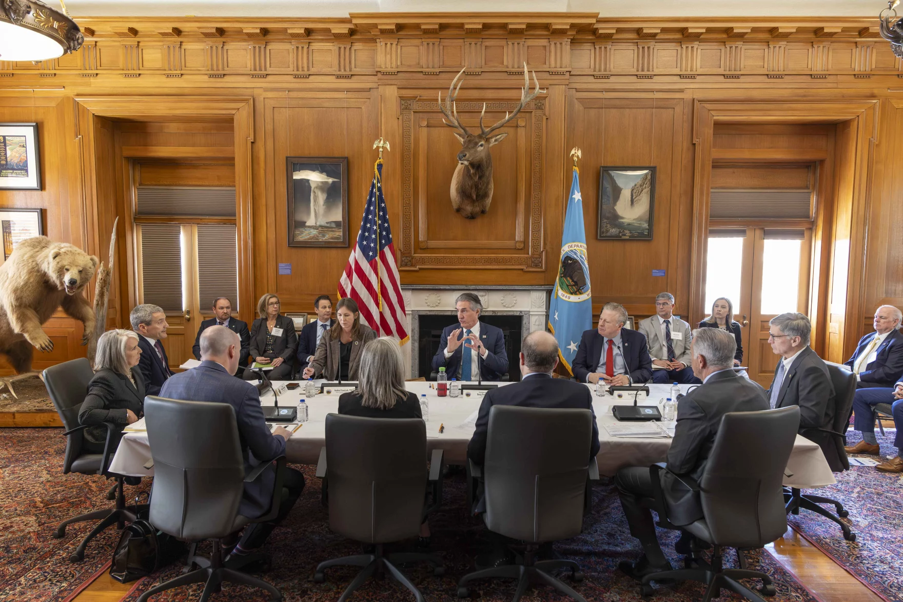
U.S. Interior Secretary Doug Burgum, center, speaks during a gathering with governors from six states in the Colorado River basin on Friday, Jan. 30, 2026. Photo credit: Lowell Whitman/Department Of Interior
Click the link to read the article on the Tuscon.com website (Tony Davis). Here’s an excerpt:
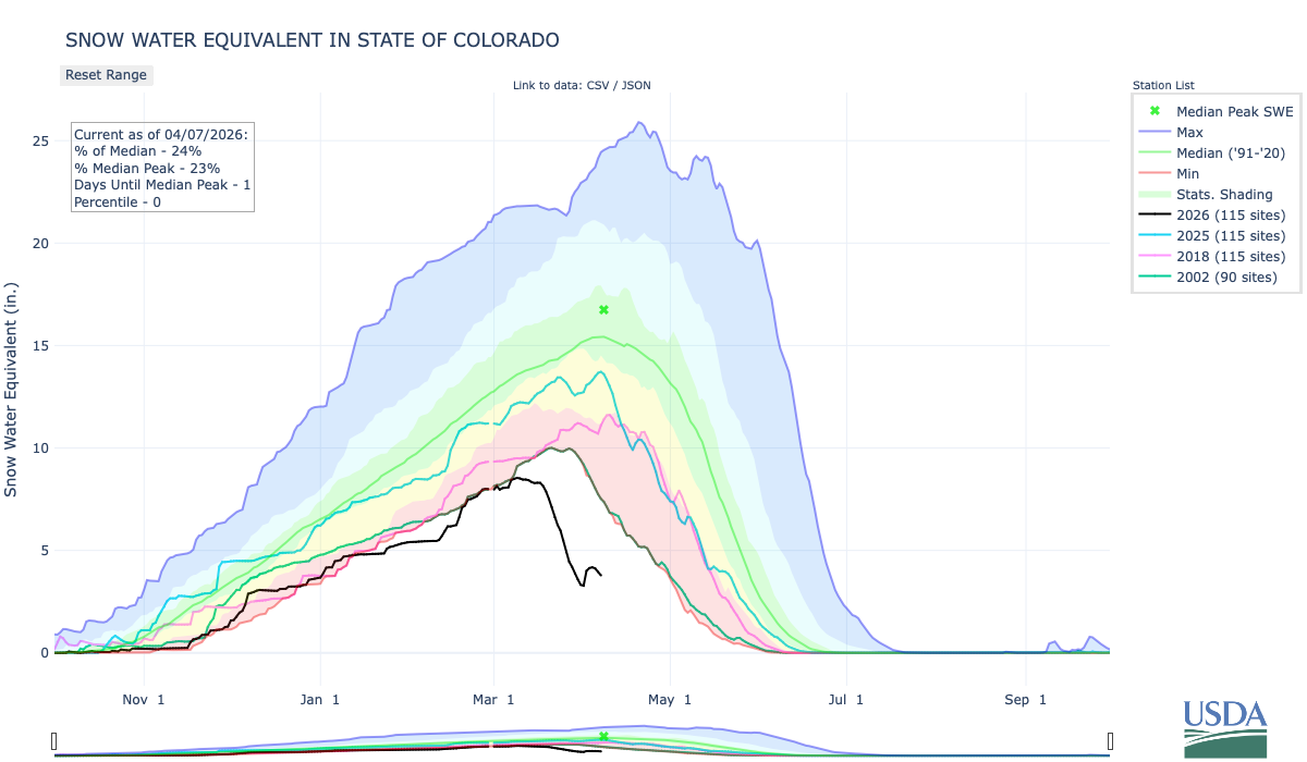
April 8, 2026
U.S. Interior Secretary Doug Burgum, pressed Monday to spell out how he’ll handle the Colorado River’s water crisis, wouldn’t get specific but said repeatedly that “nobody will be happy” with how his department will split a rapidly dwindling supply of river water among the seven states, including Arizona, that want a piece of it. Speaking at a roundtable in the Tucson area populated by a host of public lands industry leaders and University of Arizona President Suresh Garimella, Burgum pledged to hand down a decision this month on the first of two crucial, divisive issues his office is confronting regarding the river. That decision will be how much water the Interior Department’s Bureau of Reclamation will release from its upstream reservoirs in the four Upper Colorado River Basin states to head off a potential calamity in which Glen Canyon Dam, forming the boundary between the Upper and Lower Basins, would no longer receive enough water to continue generating electricity that serves customers in seven Western states.
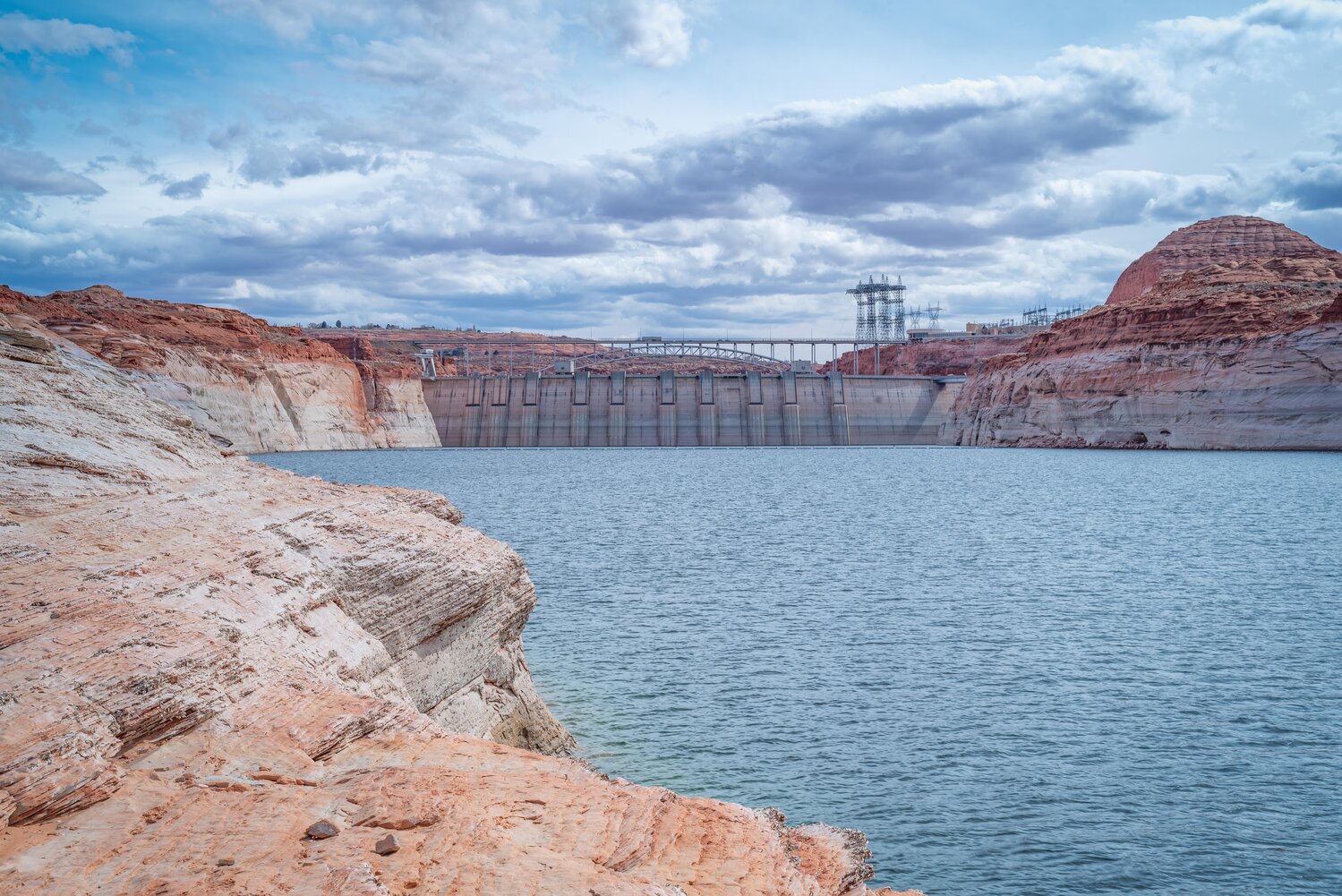
The white bathtub ring clinging to the sandstone walls of Glen Canyon is more than a marker of a receding lake; it is a physical manifestation of a century-old accounting error. PHOTO BY BOB HEMBREE (MARCH 2019)
The white bathtub ring clinging to the sandstone walls of Glen Canyon is more than a marker of a receding lake; it is a physical manifestation of a century-old accounting error. For decades, the conventional story of the Colorado River’s decline has been framed as a tragic stroke of bad luck. The narrative, popularized in modern classics like Cadillac Desert, suggests that the framers of the 1922 Colorado River Compact simply did their best with a limited record of “eighteen years of streamflow measurement” taken during an unusually wet “binge.”
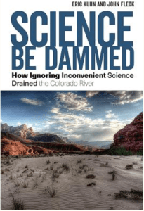
However, emerging historical research and systems analysis tell a more complicated and troubling story. In their definitive study, Science Be Dammed, authors Eric Kuhn and John Fleck argue that the crisis we face in 2026 was not an accident of nature but a predictable consequence of “selective science.” The decision-makers of 1922 were not victims of ignorance; they were sophisticated professionals who chose to ignore inconvenient data in favor of a political vision that required the river to be larger than it actually was.
Eugene Clyde LaRue measuring the flow in Nankoweap Creek, 1923. Photo credit: USGS
The Inconvenient Hydrologist
As the seven basin states gathered at Bishop’s Lodge in Santa Fe to carve up the river, they were joined by Eugene Clyde (E.C.) LaRue, a hydrologist for the U.S. Geological Survey. [Eric Kuhn responding to my X post, “Actually LaRue was never allowed to attend a Commission meeting. He asked, but Hoover said no.] LaRue presented the commissioners with a conclusion that threatened the very foundation of their negotiations. His data, which included early gauge records and historical flood markers, suggested that the river’s long-term average was approximately 15 million acre-feet (maf)
LaRue explicitly warned the commission that the period between 1905 and 1922 was a hydrological anomaly. Had the negotiators included the drier records from the late 1890s, the estimated annual flow would have dropped significantly. As Kuhn and Fleck note, the decision-makers had at their disposal a relatively thorough, almost modern picture of the river’s hydrology. They chose to ignore it because accepting LaRue’s science might have left them with a flow too low to reach the compromises necessary to develop the West.
Members of the Colorado River Commission, in Santa Fe in 1922, after signing the Colorado River Compact. From left, W. S. Norviel (Arizona), Delph E. Carpenter (Colorado), Herbert Hoover (Secretary of Commerce and Chairman of Commission), R. E. Caldwell (Utah), Clarence C. Stetson (Executive Secretary of Commission), Stephen B. Davis, Jr. (New Mexico), Frank C. Emerson (Wyoming), W. F. McClure (California), and James G. Scrugham (Nevada) CREDIT: COLORADO STATE UNIVERSITY WATER RESOURCES ARCHIVE via Aspen Journalism
Paper Water and the System Trap
By sidelining LaRue and enshrining a “paper water” figure of 16.4 million acre-feet into the Law of the River, the commissioners fell into a classic “system trap.” They created a legal stock of water rights that far exceeded the river’s physical flow. This inflated number was essential to the “reinforcing loop” of 20th-century growth. It provided the legal certainty needed to secure federal funding for massive infrastructure projects like the Hoover Dam and the Glen Canyon Dam.
This intentional overestimation created a massive “information delay.” For eighty years, the system appeared stable only because the Upper Basin states were slow to develop their shares, allowing their “unused” water to flow downstream. This masked the fundamental deficit, leading to a state of “overshoot” in which the regional economy came to depend on water that did not exist. Professor Rhett Larson describes the resulting legal framework as a system of “calling shotgun” that was excellent for settling a desert but is catastrophic for managing one in a time of scarcity.
The End of the Delay
Today, the “delay” has finally ended, and the “inconvenient science” of 1922 has become the undeniable reality of 2026. The river’s source is being further depleted by “aridification,” a process climate scientist Brad Udall describes as a “sponge above our head” that evaporates moisture before it can reach the streamflow. We are now witnessing the collision of a 100-year-old legal fiction with a 21st-century climate reality.
The current impasse between the Upper and Lower Basins is a symptom of “policy resistance,” where every actor is incentivized to protect their “paper” share even as the “wet” water disappears. As Professor Andrea Gerlak observes, if a system has 25 years to produce an agreement and fails, there is likely something fundamentally wrong with the system itself. Solving the crisis at Lake Powell will require more than engineering; it will require a paradigm shift that finally aligns our laws with the river’s actual physical limits.
March was…not helpful. NOAA CBRFC's April 1st (50% exceedance) forecast now has Lake Powell April-July inflows at 1400 KAF, 22% of average. Only 2002 (963 KAF) and 1977 (1208 KAF) ended up with lower inflows than that. If dry conditions continue through spring, 2026 could drop below 2002.
Click the link to read the article on the CU Boulder Today website (Lauren Lipuma and Yvaine Ye):
March 31. 2026
For the past weeks, temperatures in Colorado have surged 20 to 30 degrees above average for March, normally one of the state’s snowiest months.
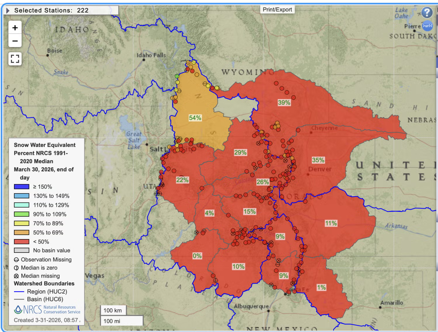
That’s on top of an unusually warm and dry winter for the American Southwest, a region already grappling with long-term water shortages since around 2000. In Colorado, snowpack sits at about 40% of normal levels, among the lowest since comprehensive modern records began roughly four decades ago.
In parts of the southern Colorado River Basin, a 250,000-square-mile watershed spanning seven states in the southwest, snowpack has dropped to less than one-third of normal. The basin provides water for 40 million people and 5.5 million acres of farmland.
Snowpack acts like frozen water towers, said Ben Livneh, associate professor in the department of Civil, Environmental and Architectural Engineering. As temperatures rise and the Southwest enters its typically hot and dry spring and summer months, melting snow provides about 80% of the water used by downstream communities in the Colorado River Basin.
In response to the snow drought, Denver’s water authority recently declared a Stage 1 drought, the first drought alert the city has issued since the summer of 2013. Other Front Range cities are considering similar measures.
“In Colorado, our peak snowpack happens around mid-April, so there is still a chance that we could get more snow,” said Livneh, who’s also the director of the Western Water Assessment (WWA) at the Cooperative Institute for Research in Environmental Sciences (CIRES). According to the National Weather Service, a storm is bringing precipitation to Colorado this week, with the potential for a few inches of accumulation in the mountains. “But at this point, it does look like we have a long way to go to catch up.”
CU Boulder Today sat down with Livneh to talk about the impact of a snow drought on Colorado communities, whether drought is the new normal and what individuals can do.
How dry is it?
Colorado lies in a mountainous region far from the ocean, so our climate naturally varies a lot. As a result, it’s not uncommon to see big swings between wet years and dry years.
Right now, we are in a very dry period, and the numbers are pretty stark. There’s barely any snow on mountains in lower elevations, and some snowpack could melt early because of the warm weather. When we look ahead to the amount of water expected to flow into our reservoirs, which would be the water people actually get to use, the current forecasts fall among the lowest we’ve seen since the early 1980s when the detailed snow measurements began.
Across Colorado, snowpack sits at below 50% of normal levels as of March 30, 2026. (Credit: National Weather Service)
How does this year compare with previous drought years?
There were some years that were drier, like 1977 and 1981. But those years weren’t as warm as this year. Over the past 40 years, since we’ve had continuous observation data, 2002 and 2012 were also warm with low precipitation, but they weren’t as dry as this year.
We have a lot of systems in place that were specifically designed to handle individual bad years, like these big, impressive reservoirs. But we’ve been in a dry period for the past 25 years, and every dry year puts additional stress on our infrastructure.
What could be causing this snow drought?
We’re currently in the warmest 25-year period on record, and warming is one of the clearest signals of recent climatic changes. When it’s warmer, the atmosphere can hold more moisture.
At the same time, the climate in our region naturally swings between wetter and drier decades. It’s almost like a pendulum that shifts every 20 or 30 years.
What may be happening now is that those two things— climate change and natural fluctuations— are overlapping, creating something of a perfect storm for this year.
What is the WWA doing to help?
WWA is working to support decision makers to best manage their water, based on what is actually available, as well as what is forecasted in the Colorado River Basin.
Much of our regional economy relies on water, from the ski industry to food growers and power generators. The stress from drought is widespread.
Our region’s planning and treaties in the past were based on assumptions about historical conditions. Now we’re trying to figure out whether these dry conditions are a drought or perhaps closer to the long-term normal conditions.
We are also trying to get a better sense of what mountain communities are experiencing and what types of information they need, because many of them rely on the snowpack and snow melt as their primary reservoir for water.
Should people be worried about water shortages right now?
This is really a large-scale phenomenon, so if anything, I would encourage people to get curious about the science and what we can say about the current conditions. Indoor water use doesn’t consume very much, and cities are not really at risk of running out of water. But people should be mindful not to waste water outdoors. Pay attention to city rules for outdoor water use, like when you can turn on your sprinklers and water your lawn.
Other than that, I encourage people to go outside. This is certainly a big departure from what we think Colorado winters should be like, but it also offers opportunities for people to bike to work more often, or spend more time outdoors doing things they might not otherwise be able to do.
The next Aspinall Unit Coordination Meeting for the Aspinall Unit & Gunnison River will be heldThursday, April 23rd, 2026 at 1:00 pm.
This meeting will be held virtually via Microsoft Teams. There will not be an in-person meeting location for this meeting. The link to the Teams meeting is below.
Reclamation conducts Public Operations Meeting three times per year to gather input for determining upcoming operations for the Aspinall Unit & Gunnison River. The meeting agenda will include updates on current snowpack, forecasts for spring runoff conditions and spring peak operations, the weather outlook, and planned operations for the remainder of the year.
Contact Andrew Limbach (alimbach@usbr.gov or 970-248-0644) for more information regarding Aspinall operations or the Operation Group meeting.
Denver Water crews use a special tube [Federal Sampler] to gather snow samples near Winter Park as part of pre-set snow courses. ASO uses these ground measurements to supplement data collected from the planes to determine how much water is in a watershed. Photo credit: Denver Water.
Metal signs mark the survey site in a patch of forest above the cabin. Once the team arrived, Mike Ardison, a hydrologic technician for the Colorado Snow Survey, unloaded a green trundle off his back, then unwrapped it to reveal sections of a hollow, aluminum tube. It extends to roughly eight feet long once he fits the pieces together…To measure the snow levels, Domonkos and Ardison work their way along the snow course, dropping the tube at a series of set points along the path. A column of snow captured inside reveals the height, then the pair hang the tube from a spring-powered milk scale to clock the weight. Digital scales might be more accurate, but Ardison said their batteries wouldn’t last long in normal winter temperatures…
Crouched over a notebook, [Brian] Domonkos punched a calculator to arrive at a figure for the site. He let out a sigh when he arrived at the final number: 2.2 inches of snow-water equivalent, less than half the previous record low measured on the same date in 1977…Other measurements taken at snow courses around April 1 were just as alarming. Out of the 64 sites in Colorado with at least 50 years of data, 60 reported either record-low snow levels or tied the lowest on record…Those results confirm 2026 as the worst year for Colorado snowpack in recorded history, said Russ Schumacher, a professor of atmospheric science at Colorado State University and Colorado’s state climatologist. A lack of historical precedent means it’s harder to fully predict the impact of such low water levels. Schumacher, however, expects reservoir levels to rapidly decline in the summer and fall. Fire risk is harder to predict, but he said major wildfires usually appear in years when the snowpack is lower and melts early.
“We’re maybe in one of these liminal spaces where you can see what’s coming, but it’s not here yet,” Schumacher said. “And, yeah, that’s a challenging situation.”