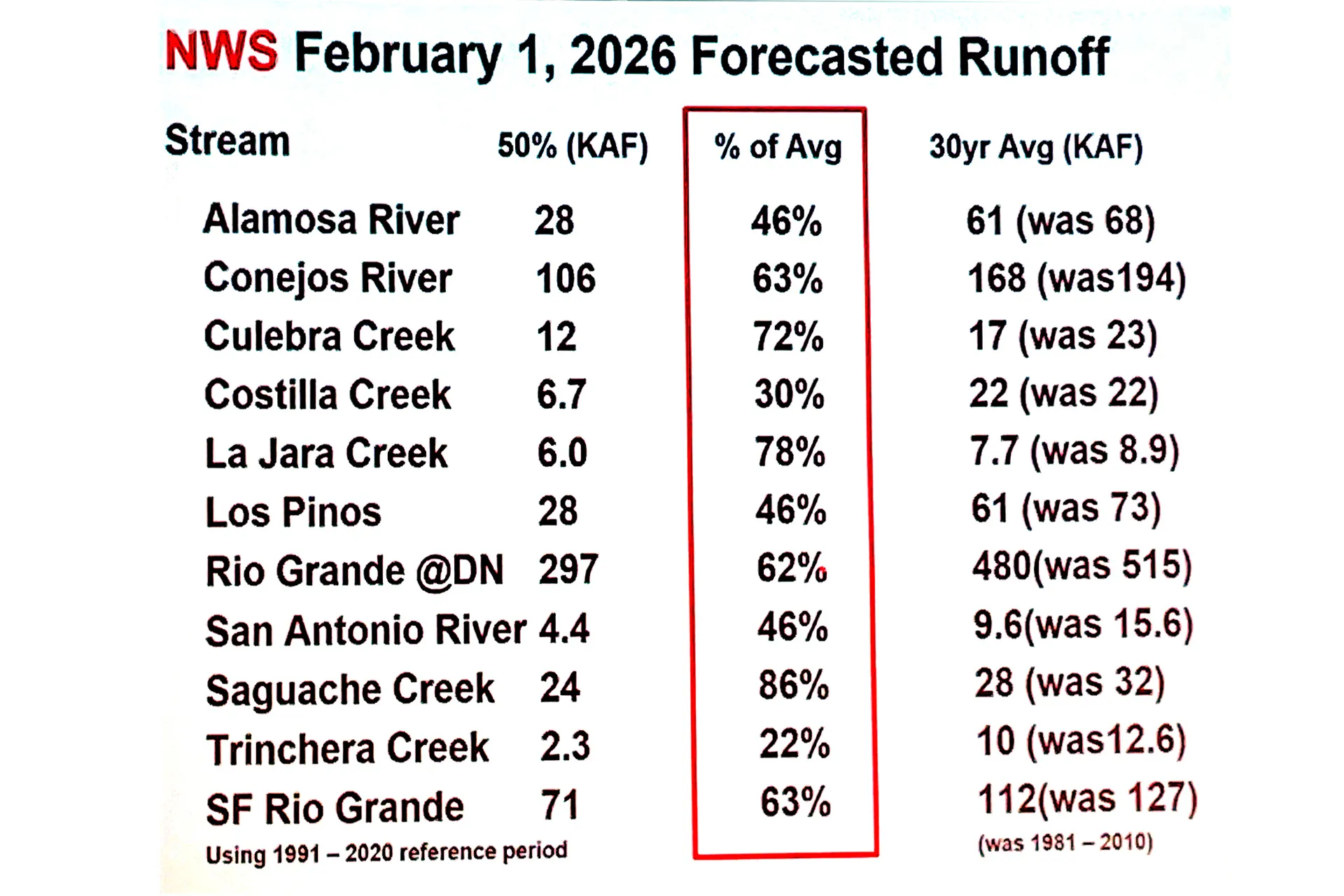
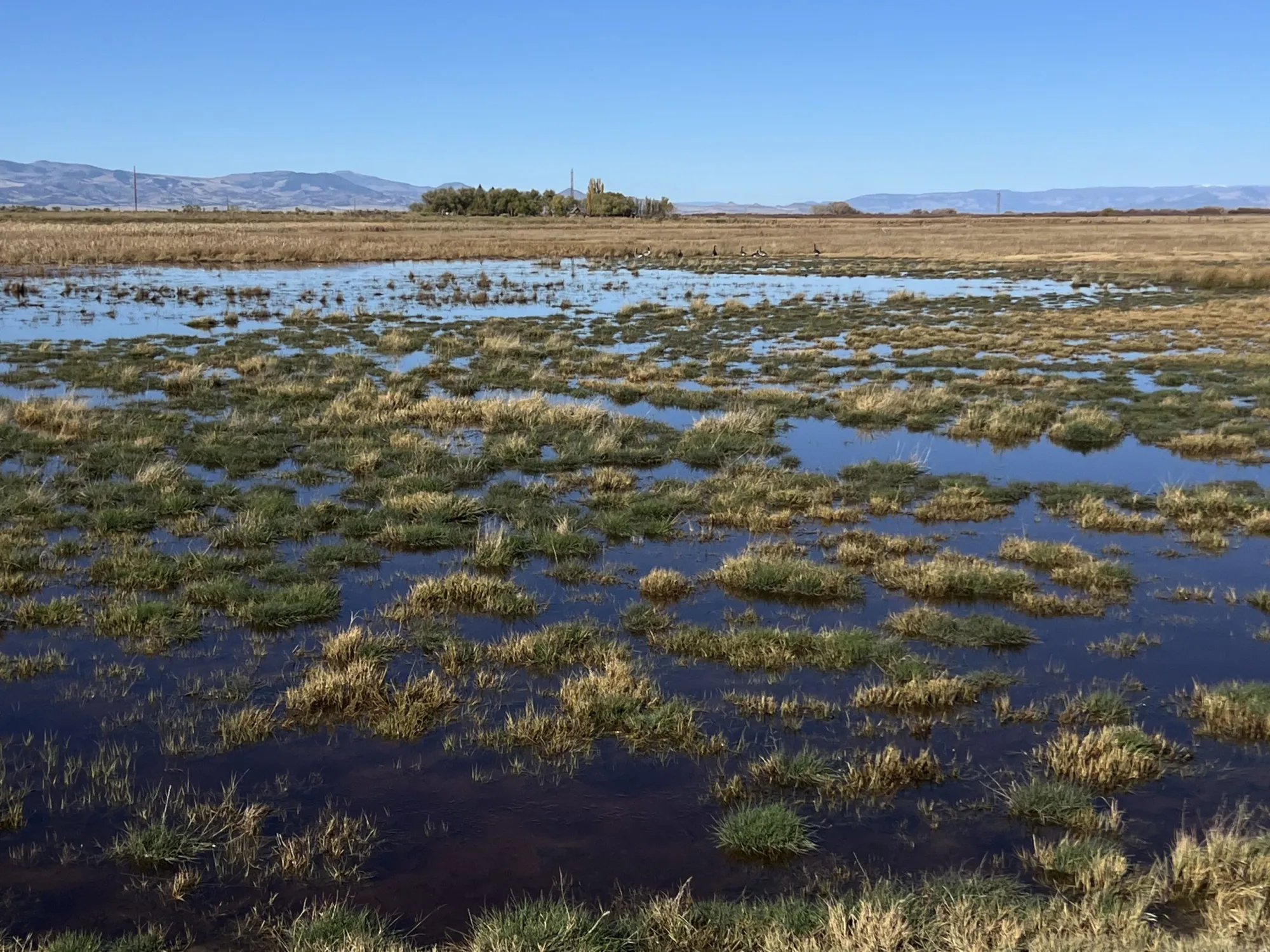
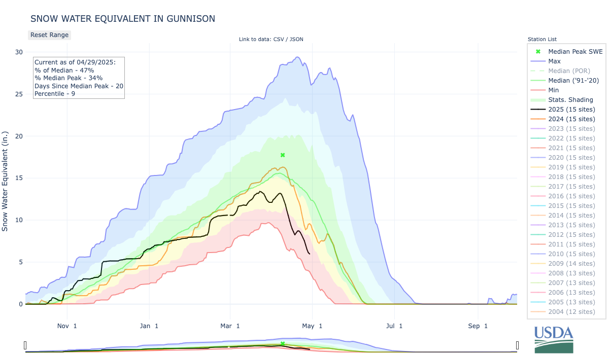
Water Managers anticipate flows in the San Luis Valley’s rivers and creeks will be very low in spring and summer 2026.
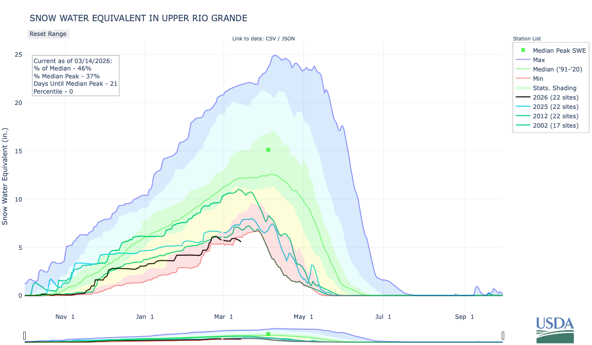
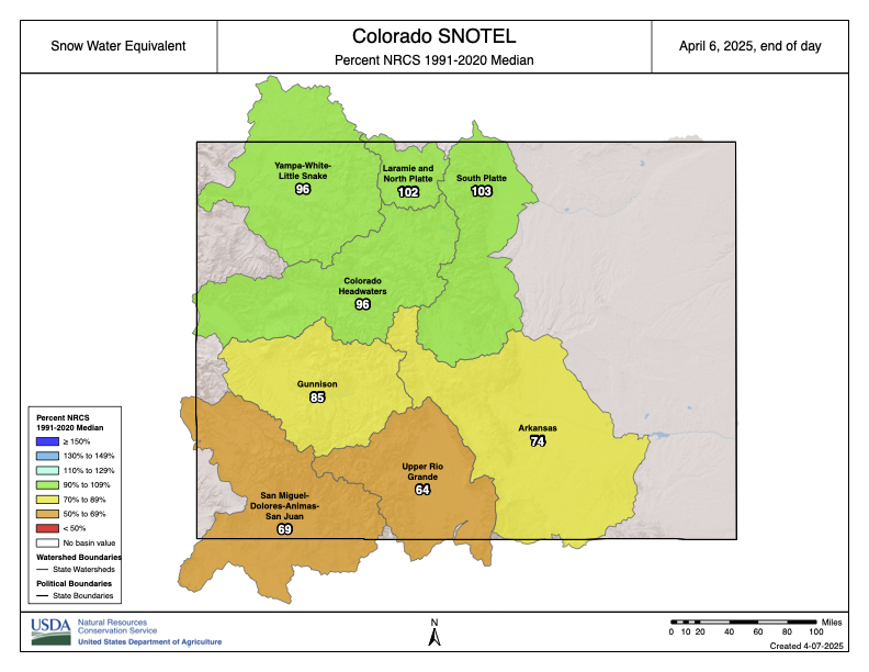
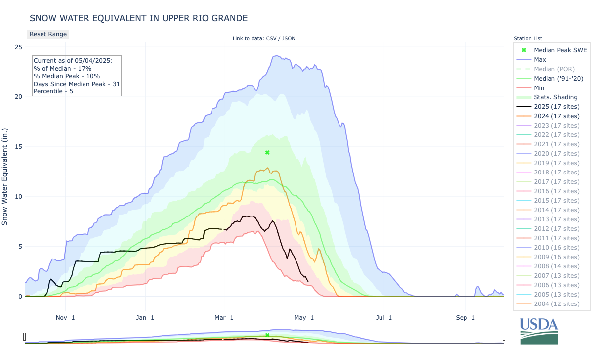
The Colorado Division of Water Resources Division 3 Engineer’s April 6 10-day report forecasted the total annual flow of the Rio Grande at the Del Norte gage will be 270,000 acre-feet, which is 42 percent of the long-term average. For reference, flows of the Rio Grande at Del Norte in 2018 totaled 280,400 acre-feet. The forecasted flow of the Conejos River system is 110,000 acre-feet, which is 37 percent of the long-term average. The snow water equivalent on April 9 for the Upper Rio Grande Basin was 12 percent of the median for 1991-2020.
The National Weather Service is forecasting hot temperatures along with below average precipitation into the summer. The irrigation season began on March 23 on the Rio Grande and March 16 on the Conejos River. As such, on-stream reservoirs are required to pass all inflows to satisfy the needs of downstream senior water rights holders. Given the low amount of snow, the exceptionally warm spring temperatures, and the anticipated summer drought conditions, it is possible that local rivers reached peak flow in March.
Rio Grande operations
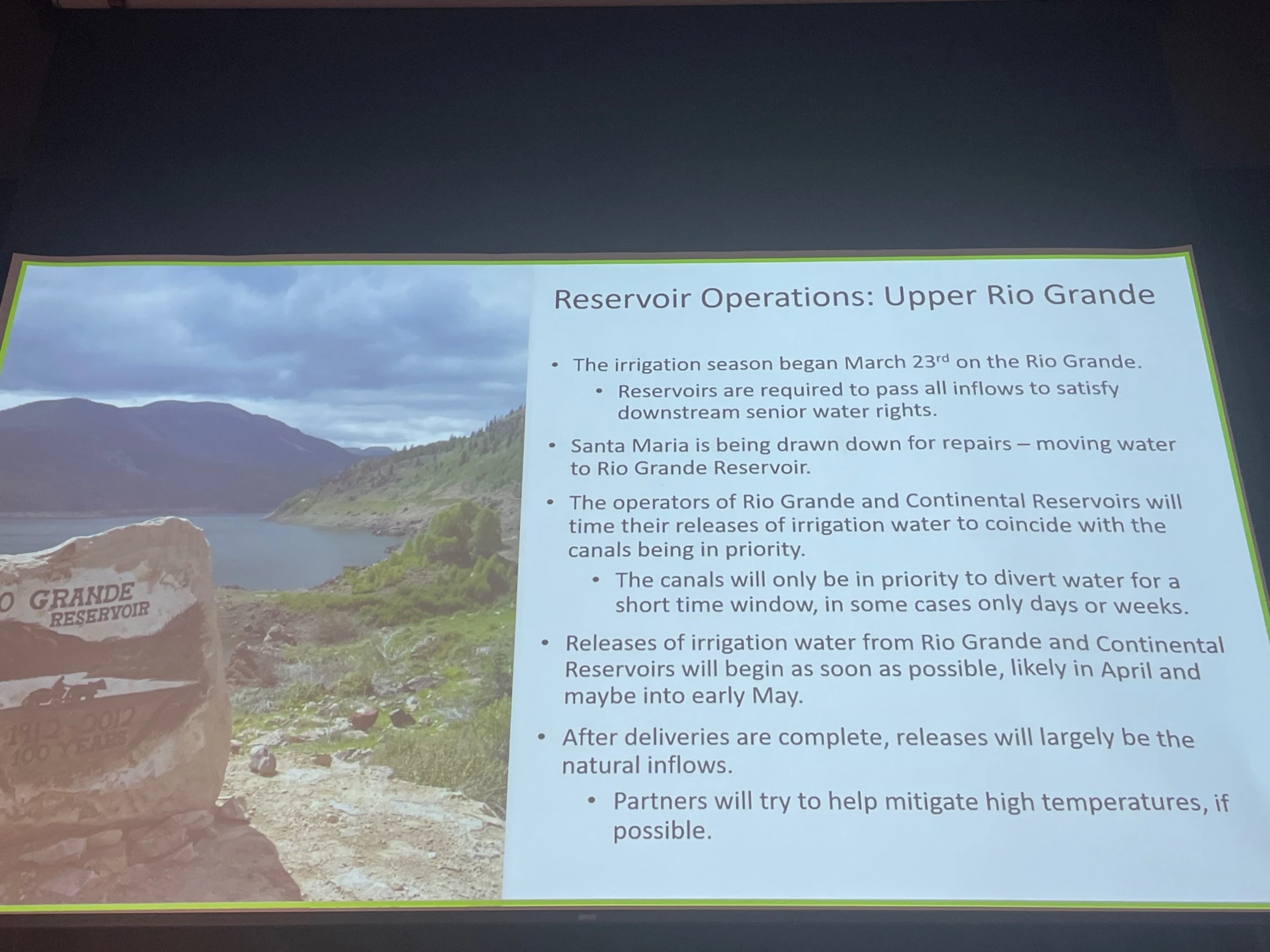
The operators of reservoirs on the Rio Grande will time their releases of irrigation water to coincide with the canals being in priority to allow water to reach farmers. It is anticipated that many of the canals will only be in priority to divert water for a short time window, in some cases only days or weeks. As such, releases of irrigation water will begin in the next week.
The Santa Maria Reservoir Company will begin releasing stored irrigation water into North Clear Creek on April 14 at a rate of 200-300 cfs for 10 days. Additional releases will continue as farmers call for water. Rio Grande Reservoir will also begin releasing stored irrigation water into the Rio Grande on April 14 for approximately 20 days. The rate of the release will start at 100-150 cfs and increase up to 350-450 cfs. After deliveries are complete, releases will be limited to the natural inflows. As such, boatable flows on the Rio Grande may diminish as early as mid-May.
Entities including Colorado Parks and Wildlife, the San Luis Valley Water Conservancy District, and the Rio Grande Water Conservation District store water in reservoirs in the Upper Rio Grande Basin and call for releases for their operations in accordance with their water rights decrees.
Where possible, releases by these organizations will be prioritized during hot periods to supplement the natural flow of the Rio Grande and the South Fork of the Rio Grande to reduce high water temperatures to protect the health of fish. Unfortunately, there may not be sufficient water to keep temperatures below thresholds for responsible fishing. As such, anglers are encouraged to check temperature gages and not engage in catch and release fishing if water temperatures reach exceed 70 degrees. Temperature is measured at the 30 Mile Bridge, Wagon Wheel Gap, Del Norte, and South Fork Gages and can be viewed at the Colorado Division of Water Resources’ website (dwr.state.co.us). [ed. emphasis mine]
Platoro Reservoir. Photo credit: Rio de la Vista
Conejos River operations
Platoro Reservoir is passing inflows, which were 10 times higher than average for much of March because of rapid snowmelt. The Conejos Water Conservancy District allocated 6,500 acre-feet of project water to the irrigators. Unfortunately, river flows are currently too low to carry that water to farmers’ headgates and water will not be released unless river flows improve. It is likely that the river will have dry up points below Highway 285. Anglers are encouraged to check temperature gages below Platoro Reservoir and near Mogote before engaging in catch and release fishing.
Links to Stream Gages with Temperature Measurements:
Heather Dutton is district manager for the San Luis Valley Water Conservancy District, which provides leadership to the San Luis Valley water community, a forum for learning and development, and the service of well augmentation in five counties in the San Luis Valley. More by Heather Dutton
The Colorado River at Las Colonias Park in Grand Junction was running at about 350 cfs Wednesday. Streamflows are expected to be way below normal this spring; some may have already hit their peak for the year. CREDIT: HEATHER SACKETT/ASPEN JOURNALISM
Water managers are planning for an extremely dry summer as Colorado wraps up winter 2026 with the worst snowpack on record for early April.
The Colorado River basin has seen slightly drier water years, but never a hotter one in the era of modern record keeping. A March heatwave that broke records statewide fueled an early peak of the snowpack, followed by rapid melting. This was the warmest March in 132 years of record-keeping for Colorado – three to four degrees Fahrenheit warmer than any other March, according to the Colorado Climate Center.
“Climate change definitely raises the probability of heat waves significantly,” said Peter Goble, assistant state climatologist at Colorado State University. “This heat wave was so far out of the range of what we’ve seen in March before that I don’t expect this to be the new normal, but it was certainly made to some degree more likely by climate change.”
The month of March decimated Colorado’s snowpack, which was thin to begin with, during a time when snowpack is usually still accumulating. The Colorado Basin River Forecast Center put the March 1 snowpack above Lake Powell at 52% of median. One month later, the April 1 numbers showed snowpack had declined dramatically to 23% of median.
“What snowpack was there was already among the lowest, if not the lowest on record, and it melted much more quickly than normal,” Goble said. “We saw melt rates more characteristic of May or June in March.”
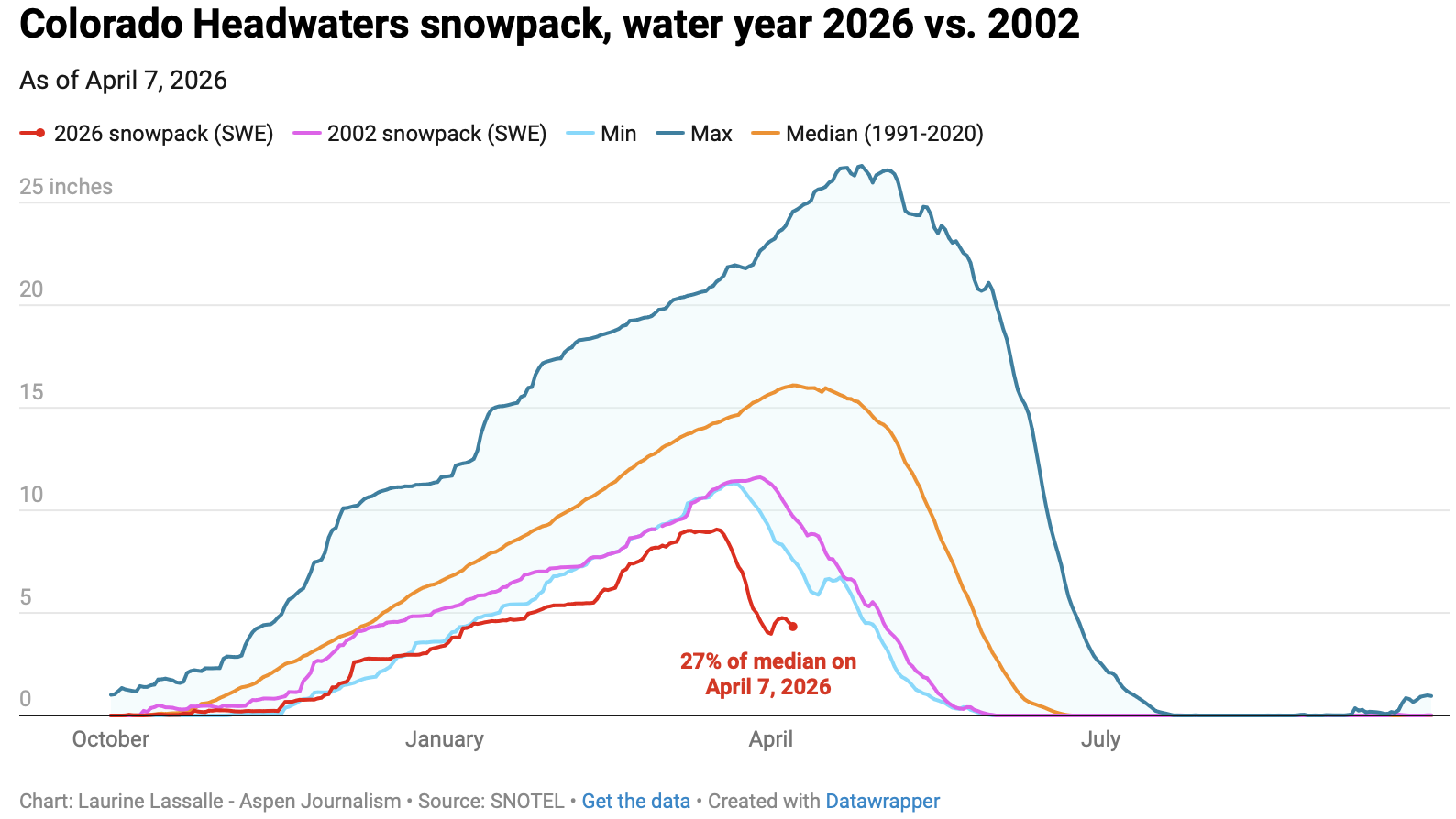
Early April status reports and forecasts are important because they provide a critical snapshot of assessing where things stand and how much water will be available for the summer. This week is typically when snowpack peaks for the year before it begins a gradual melt out. But snowpack in the Colorado River headwaters this year peaked nearly a month early on March 17 and now sits at just 27% of median. Snowpack in the Roaring Fork River basin is 26% of normal.
“We’ve never seen anything like this in memory,” said Raquel Flinker, director of interstate and regional water resources at the Colorado River District’s State of the River meeting in Grand Junction Tuesday. “If there’s anything in your memory about a dry year that you’ve seen, a warm year that you’ve seen, 2026 is beyond all of that. It’s far beyond 2002, which has been the year we normally think of as the worst year in hydrology.”
The big question is whether that record-low snowpack will turn into record-low runoff. Forty million people in the American Southwest depend on water from the Colorado River, which comes from the melting annual snowpack. Some streams may have already peaked for the year, something that normally occurs in early June for Western Slope streams.
“The streamflows are going to be much below normal,” Goble said. “But the lowest snowpack on record does not necessarily guarantee the lowest streamflow on record.
”In a Tuesday water supply briefing, hydrologist Cody Moser with the CBRFC said that the forecasted April through July inflow to Lake Powell this year is 1.4 million acre-feet, just 22% of normal and the third-worst on record. That’s down from the March forecast, which predicted 2.3 million acre-feet of inflow. The benchmark for low Powell inflows is 2002, which saw just 964,000 acre-feet of water flow into the reservoir.
The streamflow forecast for the Colorado mainstem in Colorado (known as Division 5 by state water managers) is 38% of normal, according to the National Resources Conservation Service. The Yampa is at 36% of normal; Gunnison is 34% and the San Juan basin in the southwest corner of the state is forecast to have just 26% of normal streamflows this year.
Yampa calls
Water managers around the state are preparing for an exceptionally dry summer. Some municipal water providers have already implemented outdoor watering restrictions, and the Colorado Division of Water Resources is alerting farmers and ranchers to the possibility of more calls this season.
The Yampa River basin is poised to be one of the hardest hit this year. Mosher said on Tuesday that streamflows on the Yampa are forecasted to be close to the minimum on record.
“This forecast declined by 40% in the past month and here you see that huge melt off with our snowpack conditions,” he said.
Yampa River Operations Coordinator for Division 6 Water Resources Brian Romig sent a March 28 email to all water users in the basin reminding them of how calls work. When an irrigator with a senior water right isn’t getting all the water they are entitled to, they can place a call with state officials, who will then shut off upstream water users with junior water rights so the senior right can get its full amount of water. Under the cornerstone of Colorado water law, the oldest water rights get first use of the river.
The Yampa River was among the last to develop in the sparsely populated northwest corner of the state and it had never had a call until 2018.
“Call administration is a reality of our future,” said Division Engineer Erin Light. “I think it’s very possible we are going to see calls and the sooner people start to understand what that looks like and become accustomed to it, the better.”
Light said she has been hearing from water users about how early they have had to turn their ditches on to irrigate their fields – some the weekend of March 21 – due to the meager snowpack and record-high temperatures.
Light predicted that some ranchers won’t be able to grow all of the hay their animals need to feed them through next winter.
“Ranchers are going to have some big decisions to make as far as: Will they buy hay or will they have to sell cows,” she said.
In recent years, the River District has leased water out of Elkhead Reservoir and released it during the irrigation season to boost flows for downstream ranchers and keep a call off the river. But Light says this approach doesn’t help water users adapt to a future with less water. Once people know what to expect and how calls are administered, it’s less of a big deal, she said. And as river flows continue to dwindle due to drought and climate change, learning how to manage inevitable scarcity has never been more important.
“I think it’s a good thing for our water users to manage their water in such a way that they know in late August, they could be shut off,” Light said. “But we’re not giving that opportunity to the people on the Yampa River by trying to always keep the calls off.”
Coloradans often hear that the Colorado River crisis is happening somewhere else. Headlines focus on Lake Mead, Lake Powell, and the Lower Basin, while Colorado is portrayed as a responsible headwaters state doing its part. Yet that narrative misses a deeper truth. The Colorado River crisis is not only about drought or downstream shortages. It is also about how the river is managed. In that sense, Colorado shares responsibility with every basin state.
Colorado’s water system is built on ‘prior appropriation’. The rule is simple: “first in time, first in right.” The earliest water users receive priority when supplies run low. This framework helped farmers, cities, and industries expand across the West during the nineteenth and twentieth centuries, creating stability in a region where water determines survival.
However, the system was designed for a different climate and a by-gone West. It also encouraged states and water users to claim more water than the river could supply, contributing to the overallocation of the Colorado River. Legal analyses of the Law of the River show that the basin was effectively overburdened by water claims decades before climate change began reducing flows.
Today, climate change is altering the river itself. Scientists estimate that warming temperatures have already reduced Colorado River flows by roughly 20 percent. Federal water managers warn that declines could continue as temperatures rise. In a river system that is already legally overcommitted, treating water rights as fixed privileges can deepen instability rather than prevent it.
Colorado sits at the center of this challenge. As the largest contributor of water in the Upper Basin, the state must balance many competing demands. Front Range cities continue to grow. Western Slope agriculture depends on reliable irrigation. Rivers and aquatic ecosystems are under stress. Yet much of Colorado’s water policy still assumes shortages are temporary and that legal priority alone will determine who receives water. That mindset often encourages defensive politics rather than shared problem-solving.
Conflicts between upstream and downstream states are often described as unavoidable. In reality, much of the tension stems from the priorities of management. Upper Basin states emphasize uncertainty about future river flows, while Lower Basin states focus on delivery obligations and infrastructure investments, according to recent reports on Colorado River governance. Each group is acting logically within the current system. The problem is that the system frequently rewards delay and legal conflict rather than cooperation, as researchers studying collaborative governance in the basin have found.
Colorado has an opportunity to change that pattern. One promising approach is collaborative adaptive management. This framework begins with a simple idea: uncertainty is normal in complex systems. Instead of assuming managers already know the right solution, adaptive management relies on monitoring conditions, learning from outcomes, and adjusting policies over time. With collaboration of states, tribes, farmers, cities, and environmental groups conflict can be reduced and management decisions can improve.
Some elements of this approach already exist in Colorado, including experimental reservoir operations and voluntary conservation programs. However, research on collaborative drought science planning in the Colorado River Basin shows that these efforts remain limited and politically fragile.
Equity must also be part of Colorado’s leadership. For decades, Tribal nations and many rural communities have carried the environmental costs of water development while urban growth captured much of the benefit, a pattern highlighted in research on environmental justice and Indigenous governance. Tribal nations, many of which hold some of the most senior water rights in the basin, remain underrepresented in major water decisions. Adaptive governance recognizes that whose knowledge it is that counts, matters. Incorporating Indigenous knowledge, local experience, and community-based monitoring can strengthen decisions and build trust in governance. Research shows that when affected communities help shape policies, those policies are more likely to be trusted, followed, and sustained over time.
Importantly, collaborative management does not mean abandoning Colorado water law or taking away private rights. Instead, it means updating water governance so users can share risk and adapt together as conditions change. The alternative – waiting for wetter years or relying on courts to resolve disputes – ignores both climate science and political reality. Climate projections from the Intergovernmental Panel on Climate Change indicate that the American Southwest will likely remain hotter and drier for decades. Planning for a return to twentieth-century river flows is increasingly unrealistic.
Critics argue that collaboration takes too long when the crisis is already severe. Colorado has already tried temporary agreements, emergency negotiations, and federal pressure. Those approaches have not produced lasting solutions. Short-term deals may stabilize reservoirs for a season, but they do little to address the deeper management problems driving the crisis. Without stronger cooperation, the basin risks repeating the same cycle of shortage and conflict.
Colorado has long prided itself on practical problem-solving and environmental leadership. The state now has an opportunity to apply those values to its most important river. Policymakers should strengthen collaborative water governance, ensure meaningful Tribal participation, and support conservation policies that reward flexibility rather than litigation.
Coloradans also have a role to play. Public participation in basin planning, engagement with watershed organizations, and pressure on elected officials can help shift water policy toward long-term climate adaptation rather than short-term crisis response.
The Colorado River begins in our mountains. Leadership today means recognizing that rules built for a wetter past may no longer work in a hotter future – and choosing cooperation before the river forces the decision for us.
Anderson, Patrick J., Jeanne E. Godaire, Daniel K. Jones, William J. Andrews, Alicia A. Torregrosa, Meghan T. Bell, JoAnn M. Holloway, et al. 2025. “Collaborative Drought Science Planning in the Colorado River Basin.” U.S. Geological Survey Open-File Report 2025-1041. https://doi.org/10.3133/ofr20251041.
Birnbaum, Simon. 2016. “Environmental Co-governance, Legitimacy, and the Quest for Compliance: When and Why Is Stakeholder Participation Desirable?”. Journal of Environmental Policy & Planning, 18, no. 3, 306–323.https://doi.org/10.1080/1523908X.2015.1077440
Hite, Kristen, Pervaze A. Sheikh, and Charles V. Stern. 2025. “Management of the Colorado River: Water Allocations, Drought, and the Federal Role”. Congressional Research Service Report R45546.https://www.congress.gov/crs-product/R45546.
Holling, C. S. 1978. Adaptive Environmental Assessment and Management. New York: Wiley.
Kuhn, Eric. 2024. “The Risks and Potential Impacts of a Colorado River Compact Curtailment on Colorado River In-Basin and Transmountain Water Rights Within Colorado.” Colorado Environmental Law Journal, 35.https://scholar.law.colorado.edu/celj/vol35/iss2/4.
Sullivan, Abigail, Dave D. White, and Michael Hanemann. 2019. “Designing Collaborative Governance: Insights from the Drought Contingency Planning Process for the Lower Colorado River Basin.” Environmental Science & Policy, 91: 39-49. https://doi.org/10.1016/j.envsci.2018.10.011.
David is a Colorado Certified Water Professional and environmental scientist dedicated to protecting aquatic systems through rigorous data analysis, public service, and responsible resource management. He holds a bachelors degree in Biology from Western Colorado University and will graduate soon from the University of Denver with a Masters Degree in Environmental Policy and Management.
Rio Grande levy near Alamosa, November 2024. Photo credit: The Alamosa Citizen
The theme this year was “Where Water Connects Us: Past Meets Present in the San Luis Valley”. Paul Formisano and the staff and volunteers from the Salazar Rio Grande del Norte Center delivered a varied, timely and interesting agenda!
San Luis People’s Ditch March 17, 2018. Photo credit: Greg Hobbs
Ken Salazar set the stage for the sessions, reminding attendees that, “Early settlers knew the only way to bring prosperity to the valley was to do it collectively as the early acequias did.”
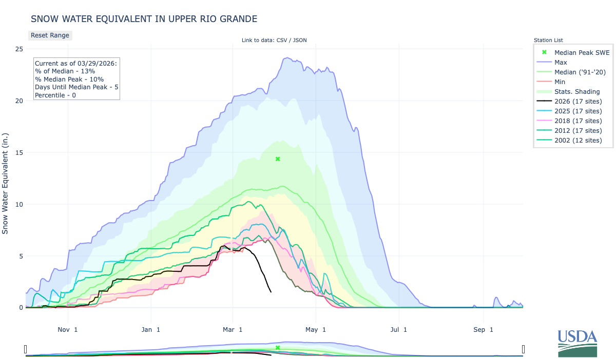
Upper Rio Grande snowpack March 29, 2026. Credit: NRCS
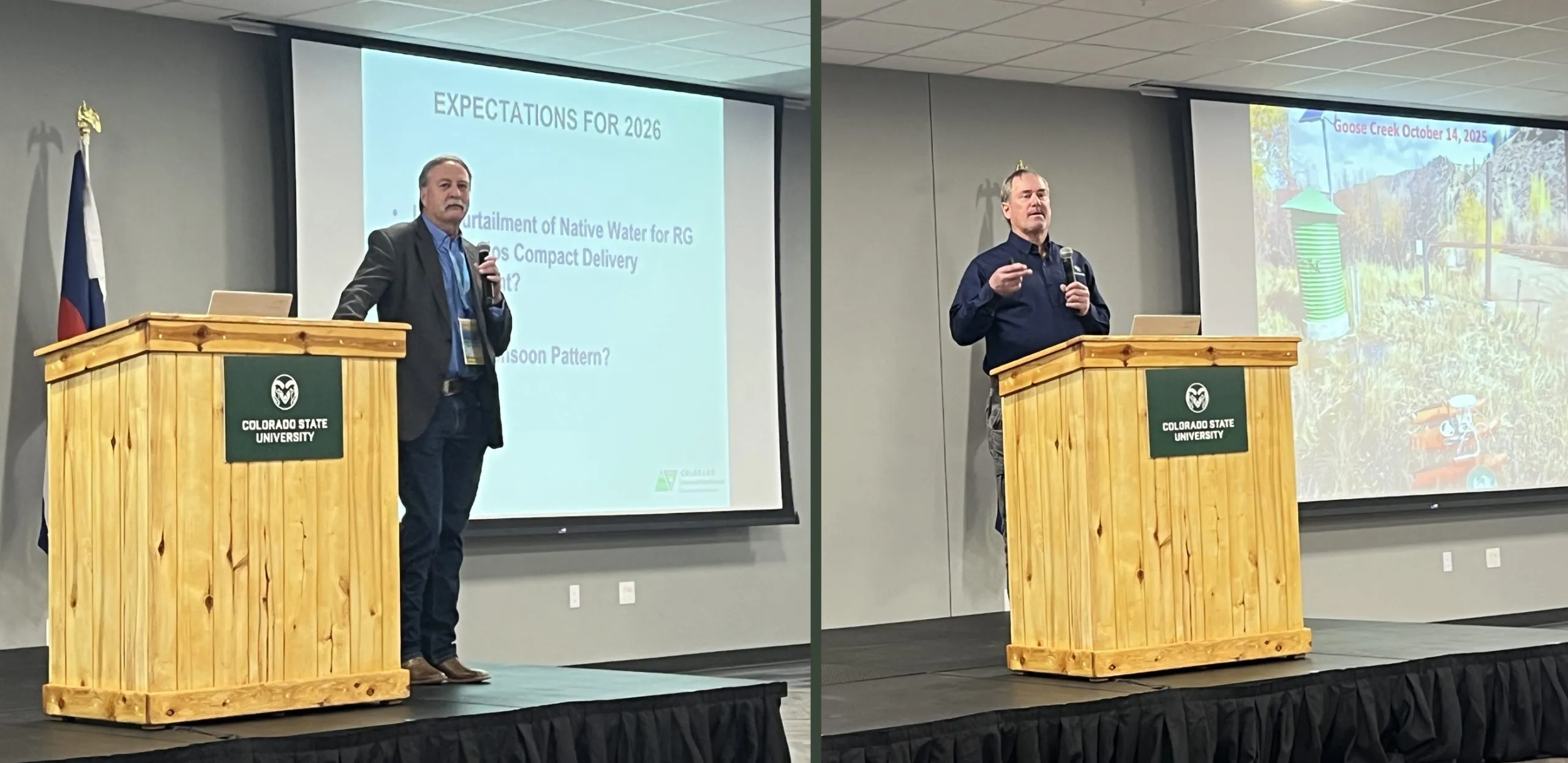
The first session was titled, “State of the Rio: The 2026 river outlook general basin and compact projections” and the general consensus from the speakers was, as Brad Udall recently said about the Upper Colorado River Basin, “There is no historical analog,” for these conditions. Snow drought is front and center in the San Luis Valley these days.
Upper Rio Grande accumulated precipitation March 29, 2026. Credit: NRCS
Precipitation in the basin started out the water year in great shape due to a big rain event in early October. Since then there have been modest accumulations but has flattened out since late February to date.
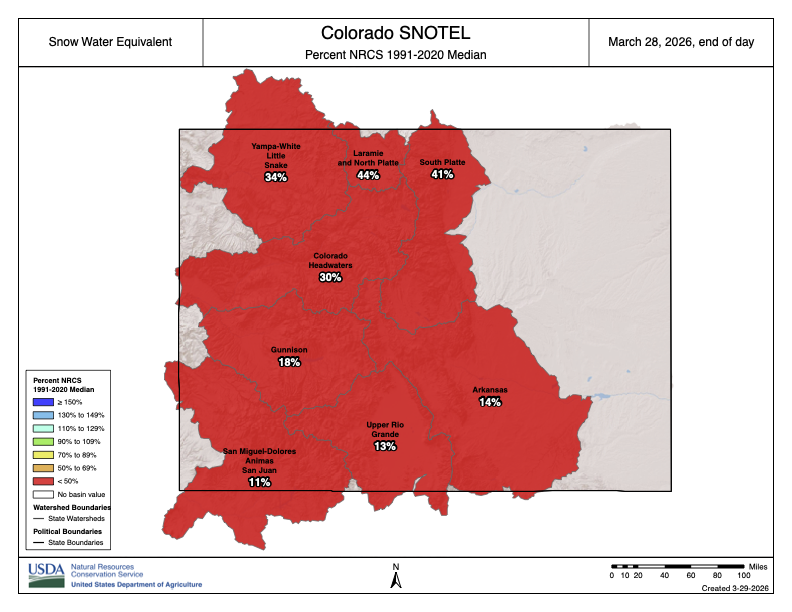
Colorado SNOTEL basin-filled snowpack map March 28, 2026. Credit: NRCS
Division Engineer Craig Cotten started off his presentation with the basin-filled snowpack map for Colorado. He joked that, “The good news is, the Rio Grande is not the worst in the state.” It is not a good year as far as #snowpack and many SNOTEL locations are already melted-out.
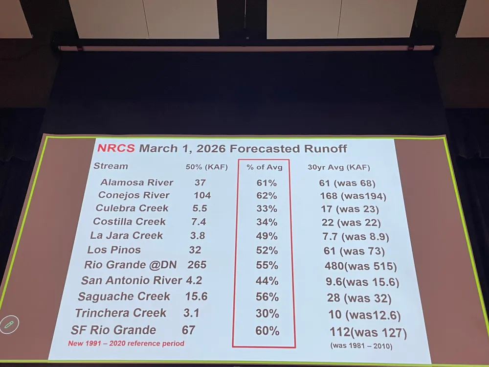
Slide credit: Craig Cotten
Projected streamflow is not looking good and the forecast will likely be worse when the April 1, 2026 numbers are released by the NRCS. However, streamflow right now is looking okay, there is a lot of water in the #RioGrande at this time for example. That means that the little snowpack in the basin is already coming off.
Slide credit: Craig Cotten
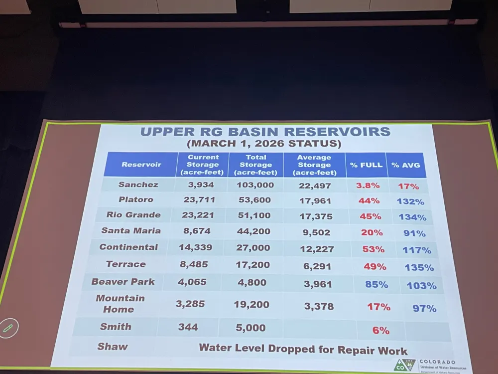
Reservoir storage is in good shape (as a percent of average) except Sanchez Reservoir which has been drawn down for maintenance and repairs.
Current compliance numbers for the Rio Grande Compact from Craig Cotten. Photo credit: Chris Lopez/Alamosa Citizen
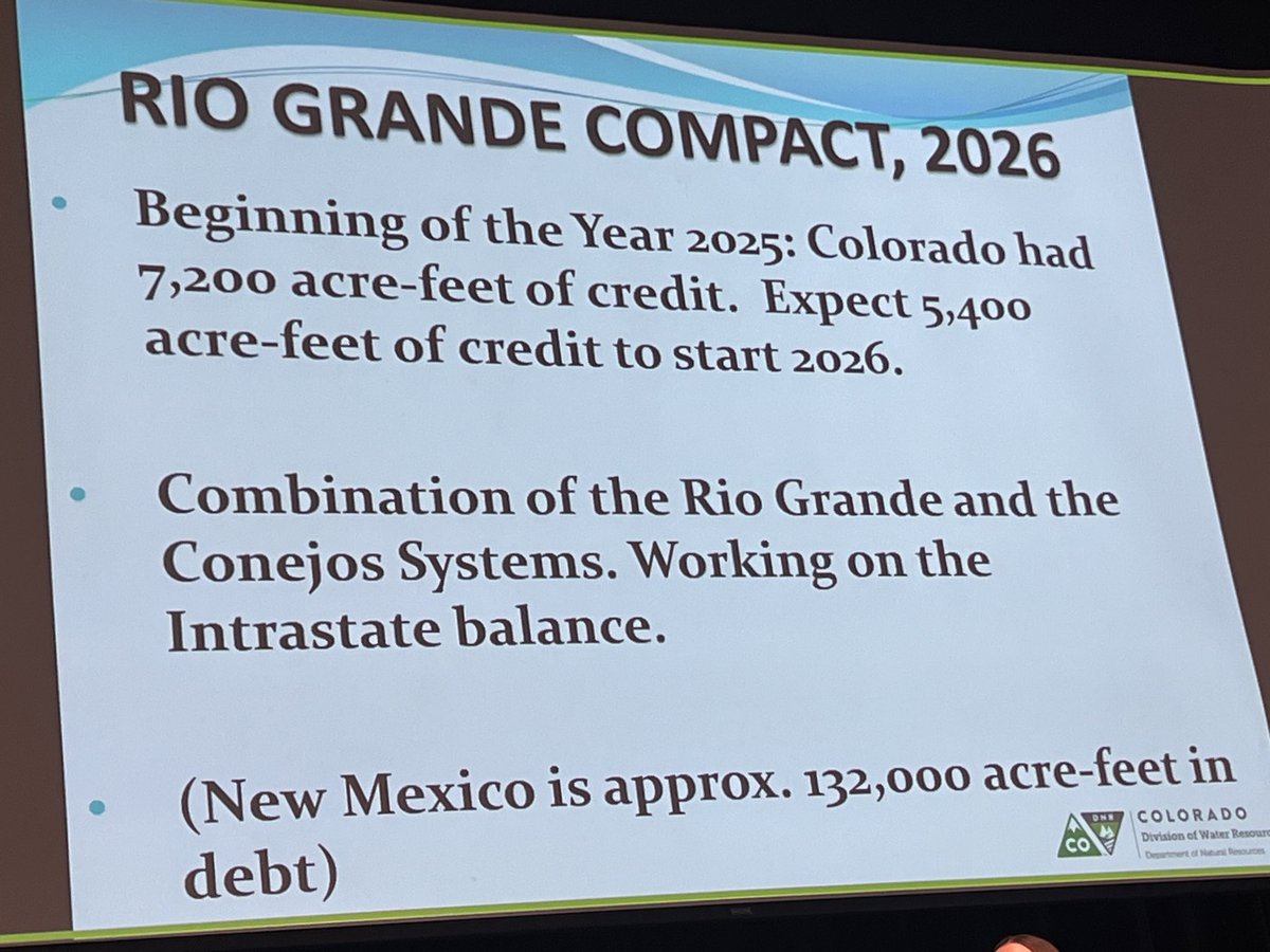
Colorado’s Rio Grande Compact compliance numbers heading into the scary diversion season are a positive. There is no debt owed to New Mexico and Texas. With the early onset to runoff season the State Engineer allowed irrigation to start on March 23, 2026. Current estimated streamflow for the Rio Grande at Del Norte (the compact USGS gage used for the river) is 305,000 acre-feet which carries a compact obligation of 76,000 acre-feet to New Mexico and Texas. For the Conejos River the estimated upper index annual flow is 165,000 acre-feet and the downstream obligation is 27,500 acre-feet. However, water levels are going to drop in the unconfined aquifer significantly this year due to low flows in the river. The situation in the aquifer is bad and it is going to get worse.
Cotten updated the attendees about the Rio Grande Compact lawsuit status. It is mostly a fight between Texas and New Mexico and the latest stipulated agreement has been approved by the Special Master. The U.S. Supreme Court is expected to approve the agreement.
Nathan Coombs, in keepting with the symposium theme said, “I believe we’re going to be alright this season we’re going to survive. People in the San Luis Valley are working together and we’re going to get through it.”
Slide credit: Heather Dutton
Heather Dutton gave an overview of reservoir operations for 2026. It is possible that all irrigation water will be released in April and May. She added, “If you’re going to fish the streams emphasize fishing in the morning and visit one of our valley breweries in the afternoon. It’s going to be tough year for all of us. Please keep the farmers in mind.”
Reclamation informed attendees about the current status of the Closed Basin Project. Project priorities are:
Colorado’s compact deliveries
Mitigation for construction and pumping
Eliminate Colorado’s Rio Grande Compact deficit
Other beneficial uses/irrigation
Slide from Amber Pacheco
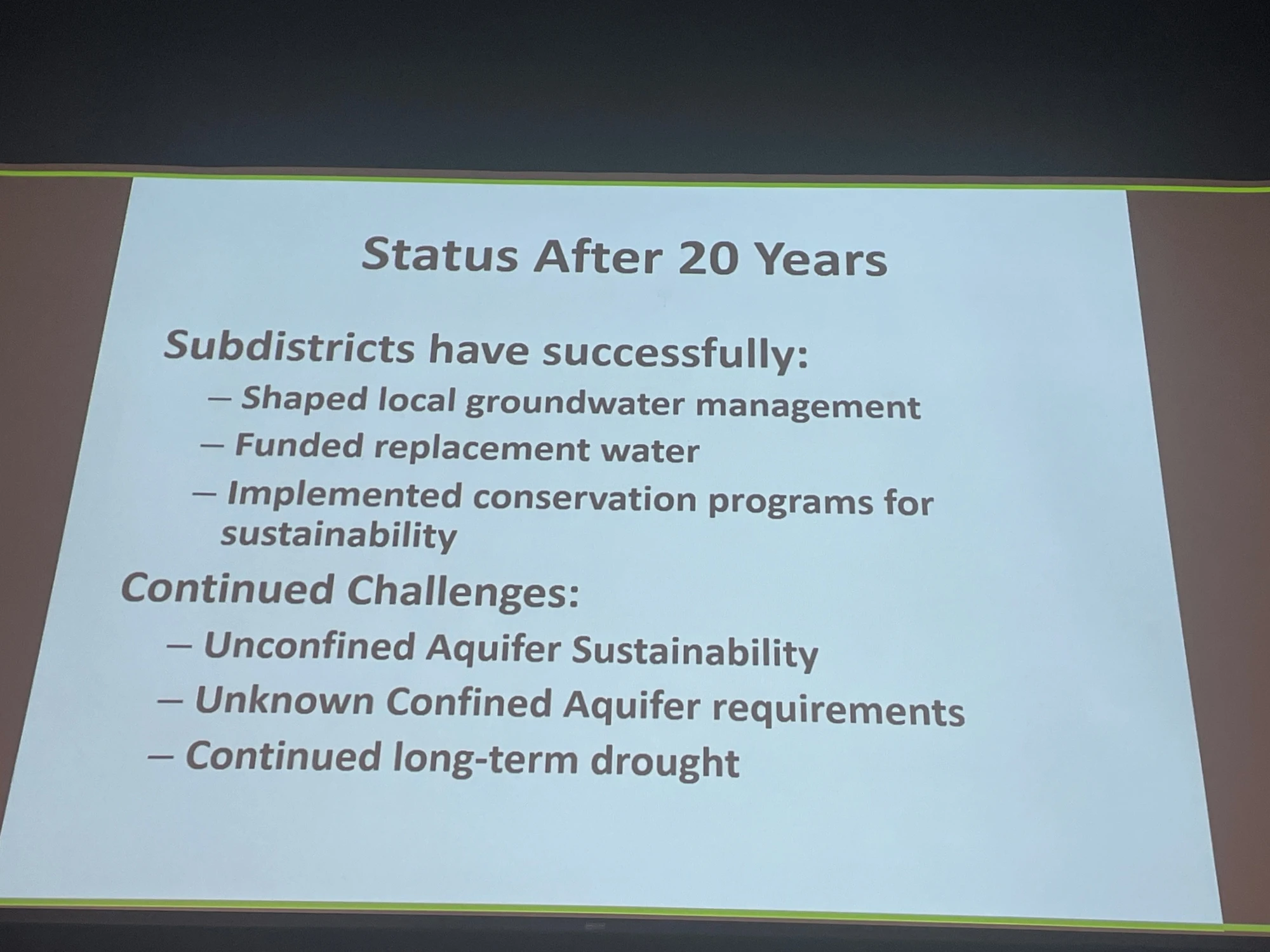
The session “Twenty years of subdistricts” illustrated how the well owners have been working together over the years to determine a solution to the declining unconfined aquifer. Because groundwater is not separate from surface water the lowered levels in the aquifer affect surface streamflow in the Rio Grande. Valley pumpers have formed several sub-districts fashioned around the different hydrology in areas of the aquifer and are retiring some wells and taking land out of production. Another strategy used has been o develop augmentation plans to offset pumping. All of the strategies involve fees to sub-district members. There is extensive coverage of the issue on Coyote Gulch if you are interested in taking a trip down memory lane.
Slide credit: Rachel James
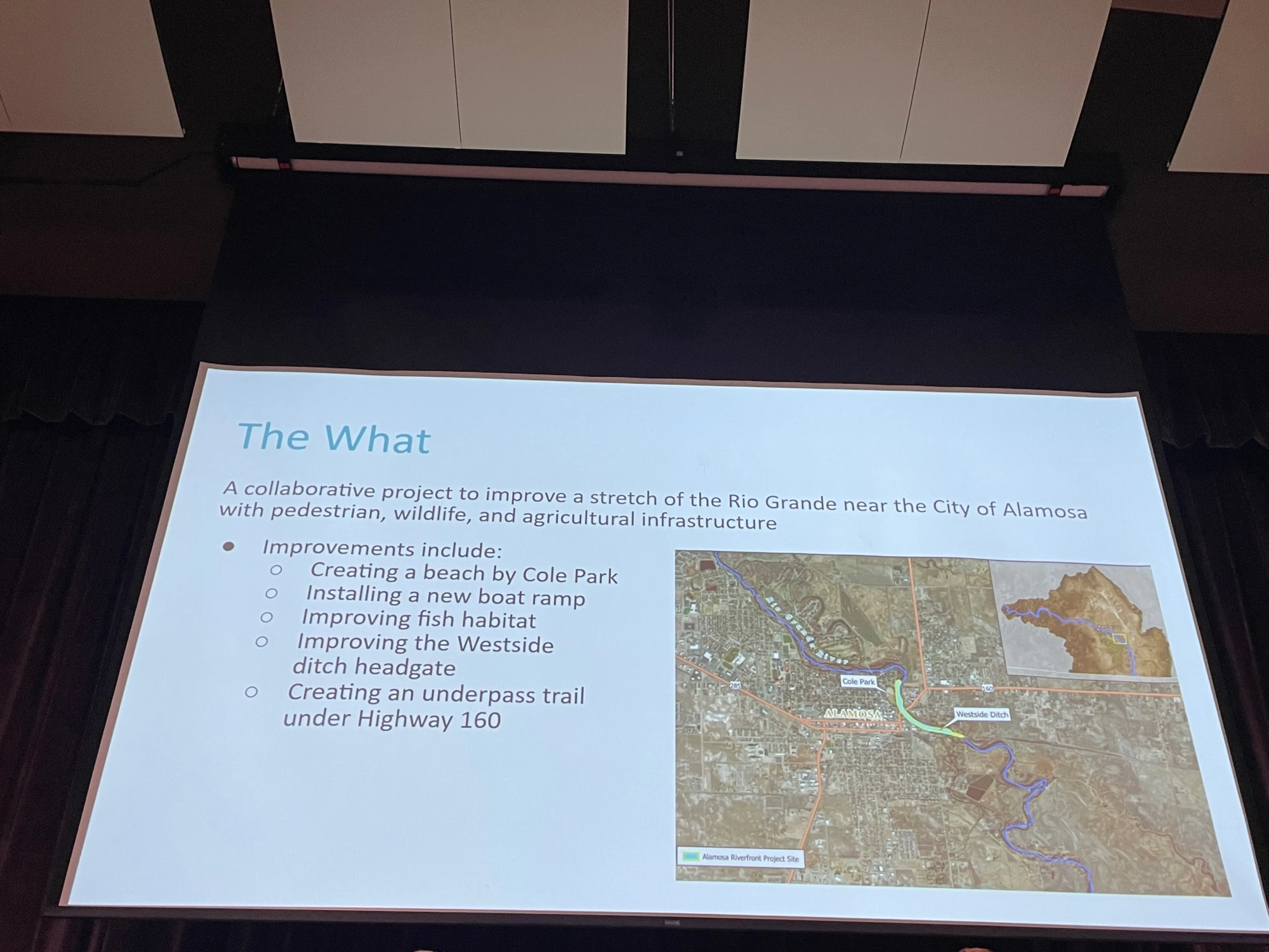
The session “Flowing together: Agriculture, rivers, and communities in partnership” was an overview of collaboration between the City of Alamosa, the West Side Ditch, and Rio Grande Headwaters Restoration Project on the river at the east side of Alamosa. It included a new headgate for the ditch company and will include a new levy orientation and access to the river from Cole Park. The speakers emphasized that it would not have happened without collaboration and the emphasis on creating a win for all stakeholders. For example, Bill Schoen credited the Rio Grande Headwaters Restoration Project for finding funding for the new headgate which is often a problem for mutual ditch companies. Daniel Boyes of the Restoration Project said that the new headgate helps fish and safety for boaters.
Rio Grande, Colorado | National Park Service
The final session before the keynote was “Perspectives on valley recreation” where access to public lands and the value of building a recreation economy to bolster valley opportunities were discussed. While 39% of Colorado’s agricultural output is from the valley economic activity is seasonal. The discussion centered around bringing tourism to the valley to improve the outlook for employment and economic growth.
The keynote speaker was Ben Golfarb and it was a real treat. I never tire of learning about “Nature’s Engineers” and the amazing effect this keystone species has on hydrology and habitat. Trapped extensively by fur traders to enable the fashion industry in the 19th century the species was nearly extirpated from the North American West. Along with a torrent of information and photographs, Goldfarb informed attendees that the native tribes did not participate in trapping because of their understanding of beaver’s role in the arid lands.
Rio Grande and Pecos River basins. Map credit: By Kmusser – Own work, Elevation data from SRTM, drainage basin from GTOPO [1], U.S. stream from the National Atlas [2], all other features from Vector Map., CC BY-SA 3.0, https://commons.wikimedia.org/w/index.php?curid=11218868
An early start to the irrigation season in the San Luis Valley is coinciding with the arrival of spring’s first heat wave.
Craig Cotten, Division 3 engineer for Colorado Division of Water Resources, announced a staged approach to opening the water year for producers in the Upper Rio Grande Basin.
The water season will begin on March 16 for surface and groundwater irrigators in the Conejos River area (Water District 22), the Culebra Creek area (Water District 24), the Trinchera Creek area (Water District 35) and the La Jara Creek area. The irrigation season will begin on March 23 for all surface and groundwater irrigation structures in the Rio Grande area (Water District 20).
“I decided to start the irrigation season earlier than the presumptive April 1 date for many valley areas due to the very warm, dry spring and the low current snowpack. We are already seeing an increase in streamflows due to the warmer weather, and it is beneficial for water rights holders to be able to use this water while it is available,” Cotten said in an email exchange with Alamosa Citizen. [ed. emphasis mine]
On the Conejos River and Rio Grande, another reason is that Colorado is projected to meet its compact obligation without needing to deliver water during the irrigation season, Cotten said.
“In order to avoid a significant over-delivery of water to the stateline, I have decided to begin the irrigation season on these rivers prior to April 1.”
The coming week of March 16 could see record-setting temperatures to the official start of spring. The forecast calls for midweek daytime highs in the low- to mid-70s. March has seen 21 of its 31 days establish new record high temperatures since 2004, a heating trend that accentuates the warming winters and spring months.
This March opened with back-to-back days of new daily high records. More heat records could fall in the coming week. The irrigation season can’t open soon enough.
Upper Rio Grande SWE March 14, 2026. Note the early melt-out.
Chart showing water use trends in US and Mexico. Credit: Overconsumption gravely threatens water security in the binational Rio Grande-Bravo basin. Map via Springer Nature.
Division engineer Craig Cotten, left, and Pat McDermott of the Colorado Division of Water Resources, deliver the state water resources report on the final day of the 2026 Southern Rocky Mountain Ag Conference. Credit: The Citizen
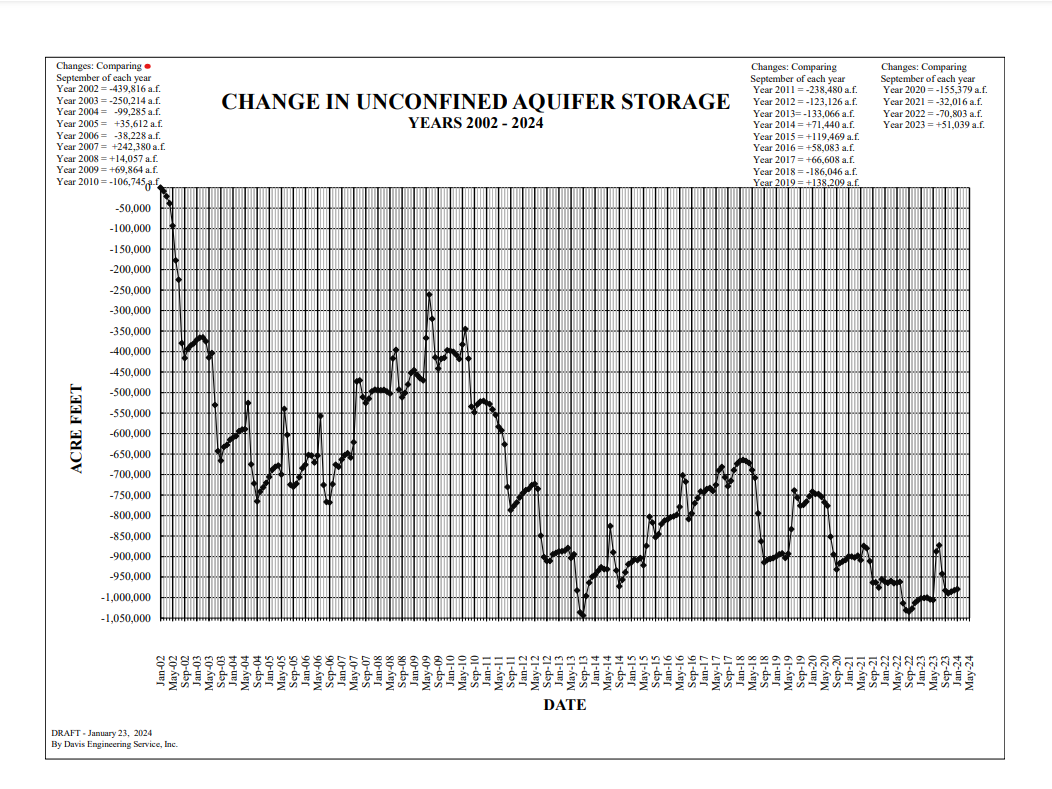
An unconfined aquifer that is getting “worse and worse,” not better.
Such is the reality of the situation for the Upper Rio Grande Basin and warnings given to the San Luis Valley farming and ranching community on the final day of the 2026 Southern Rocky Mountain Ag Conference.
If you’re a praying sort, it isn’t too early in 2026 to fold your hands together toward the heavens. If not, a good wish or two would be fine as well.
The outlook is that dire. Except for the hope that a changing weather pattern from La Niña to El Niño at some point this year will deliver the goods and avoid even more of a collapse.
“We do anticipate at this moment, at this date that it’s going to be a poor runoff in 2026,” said Pat McDermott of the Colorado Division of Water Resources. It is customary for him and state division engineer Craig Cotten to provide a look back at the recent water year and a look ahead to the next spring runoff.
McDermott typically attempts a positive spin for the large audience that fills the main conference room at the Outcalt Center of the Ski Hi Complex in anticipation of the state water resources report. He did his best by pointing to a rosier outlook in the 2026 Farmer’s Almanac, the last annual edition.
It is the state, after all, that governs groundwater pumping in the San Luis Valley and has metrics Valley farmers are required to meet to stay in business. One is the recovery of the unconfined aquifer through buy-and-dry and reduced groundwater pumping strategies.
“It just kind of gets worse and worse every year that we look at it,” said Cotten in referencing the storage levels of the Upper Rio Grande’s unconfined aquifer and the greater level of recovery efforts crop producers in Subdistrict 1 are facing as a result.
“Unfortunately it’s going in the wrong direction and it has been for quite some time here,” Cotten said in referencing the latest five-year average for storage.
THE NUMBERS
Rio Grande 2025
493,000 acre-feet – Annual index flow or 80 percent of long-term average past 30 years
125,000 acre-feet – Obligation to New Mexico and Texas under Rio Grande Compact
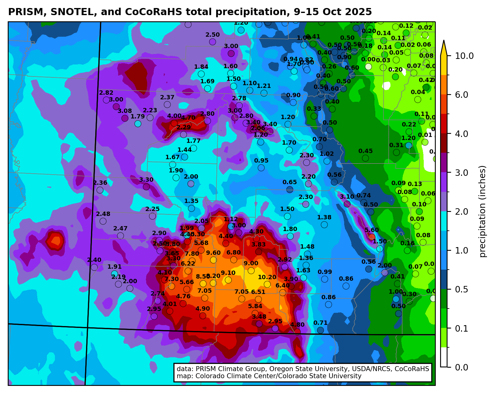
Rio Grande saw an increase of 95,000 acre-feet due to October 2025 rain.
Conejos River 2025
205,000 acre-feet – Annual index flow or 68 percent of the long-term average of 300,000 acre-feet
46,900 acre-feet – Obligation to New Mexico and Texas
Conejos River saw an increase of 15,000 acre-feet due to October 2025 rain.
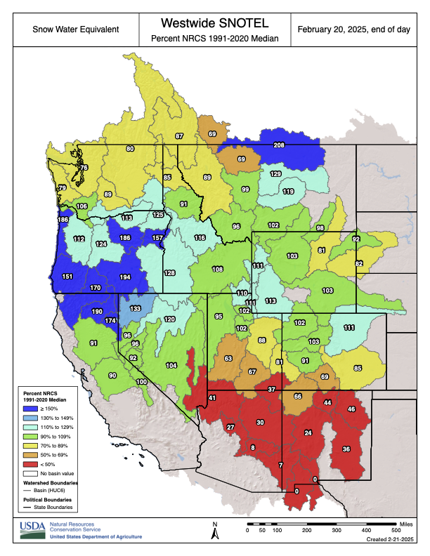
February’s current conditions
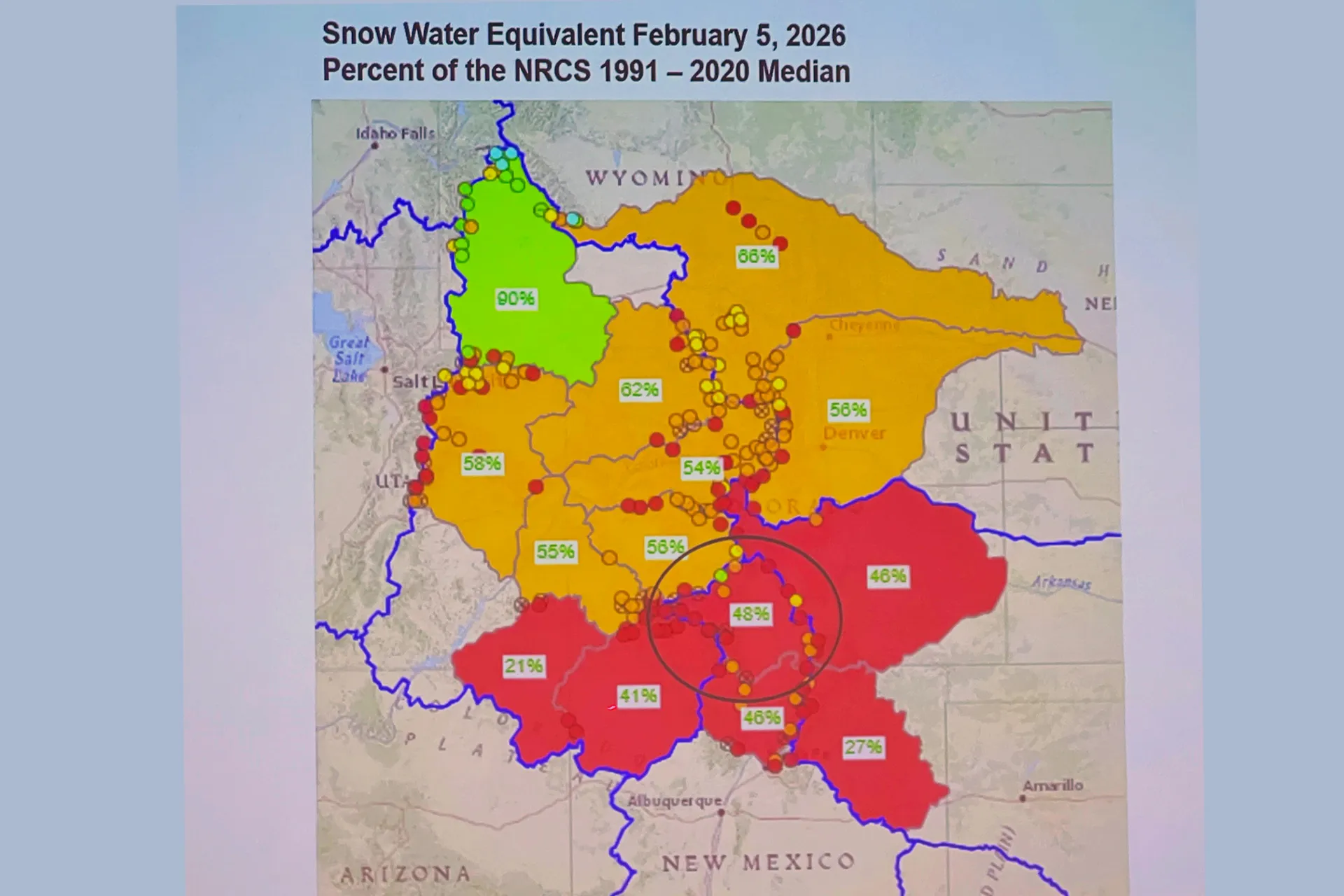
Statewide snowpack: 55 percent of median
Upper Rio Grande snowpack: 48 percent of median
Warmest December on record for nine western states based on 131 years of temperature data.
Nathan Coombs and Heather Dutton, both key players in the water conservation world locally and at the state level, gave further explanation on the changing weather patterns that are impacting the basin and the amount of water available for irrigation.
Coombs pointed to the problem of overnight temperatures in the late fall and winter months, and the fact the Valley just isn’t getting the sub-zero temperatures it used to.
Look at December 2025, which saw an average daily low for the month of 11 degrees – double digits overnight – when the normal low for December is 0.8 degrees. January of this year had an average daily low of 4 degrees instead of the -1 that is a normal overnight low temperature for the month. It would have been higher than 4 degrees were it not for sub-zero overnight lows in 5 of the last 7 nights of January.
“We’re not sunburning that much harder, we’re just losing the cold,” Coombs said to his fellow farmers.
The timing of when the moisture comes is off, too. Look at the past two water years – 2024 and 2025 – when heavy rains in October came through and added to the total overall amount of water in the Rio Grande and Conejos River systems.
Too late to help irrigators, but good enough to help the amount of water in the Rio Grande and Conejos River, overall.
“Look at how it’s changing,” Coombs said. “Useful water for irrigation is changing in more ways than just volumes. We’re seeing timing change. So that’s part of what this is. Mother Nature is playing a big role in this. We’ve got to figure that component out a little better. We don’t need to look across the fence at what our neighbors are or aren’t doing. Let’s figure out how we correct to that.”
Rio Grande and Pecos River basins. Map credit: By Kmusser – Own work, Elevation data from SRTM, drainage basin from GTOPO [1], U.S. stream from the National Atlas [2], all other features from Vector Map., CC BY-SA 3.0, https://commons.wikimedia.org/w/index.php?curid=11218868
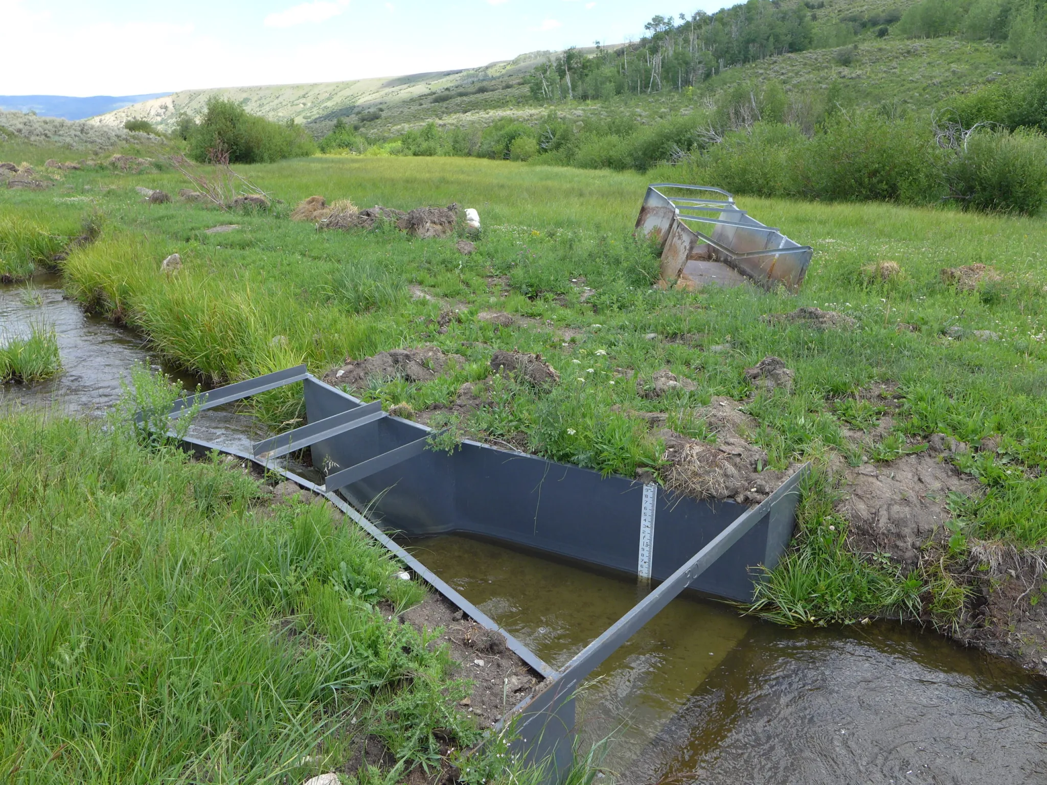
This Parshall flume measures the water in the Alfalfa Ditch on Surface Creek near Cedaredge. The Colorado Division of Water Resources estimates there are 2,800 diversions of more than 1 cfs without measuring devices across the Western Slope. CREDIT: HEATHER SACKETT/ASPEN JOURNALISM
The state of Colorado is ramping up an effort to measure water use on the Western Slope, developing rules and standards and rolling out a grant program to help water users pay for diversion measurement devices.
With input from water users, officials from the Colorado Division of Water Resources are creating technical guidance for each of the four major Western Slope river basins on how agricultural water users should measure the water they take from streams. The state is now doling out $7 million from the U.S. Bureau of Reclamation to eligible water users with faulty or missing devices to install structures such as flumes, weirs and pumps at their point of diversion.
Twenty-five percent of the funding is earmarked for each of the four river basins: Gunnison (Division 4); Colorado River mainstem (Division 5); Yampa-White-Green (Division 6); and San Juan-Dolores (Division 7). The first round of funding will go to Divisions 6 and 7, and applications close at the end of January. The goal is to have all the projects complete by 2029.
Measurement rules for Divisions 6 and 7 have been finalized and are in effect; rules for Division 4 are in the draft phase, and state officials are accepting comments until Dec. 19 on the draft rules in Division 5.
With thousands of diversions from small tributaries across rural, remote and mountainous areas, figuring out precisely how much water is used in Colorado has historically been challenging. According to state officials, there are about 2,800 diversions of more than 1 cubic foot per second from Western Slope rivers and streams that are not currently being measured. Historically, the state has required measuring devices on only diversions that have been involved in calls. When a downstream senior water rights holder is not getting the full amount of water they are entitled to, they can place a “call,” which forces junior upstream water users to cut back.
This Parshall flume measuring device is being installed on a ditch on Morrisania Mesa near Parachute. The state of Colorado has $7 million in federal funds to distribute to water users to install measuring devices on their diversions from waterways. CREDIT: HEATHER SACKETT/ASPEN JOURNALISM
Compact compliance
The push for more-accurate measurement comes at a time when there is increasing competition for dwindling water supplies, as well as growing pressure on the Colorado River’s Upper Basin states (Colorado, New Mexico, Utah and Wyoming) to conserve water. Whether through forced cuts under the terms of the 1922 Colorado River Compact or through a voluntary conservation program that pays water users to cut back, the state will almost certainly face future cuts to its water use.
According to Jason Ullmann, who is the state engineer and director of the division of water resources, accurate and consistent water measurement is a prerequisite for making basinwide cuts related to the compact.
“While we’ve always been in compliance with the [1922 Colorado River] compact, we haven’t had to do a West Slope-wide administration,” Ullmann said. “We just don’t want to be in the position of having to do that on an emergency basis. We want to be proactive and provide people consistent and reliable standards for what we expect and work with them to get to a point where we do have that more accurate measurement network before that happens.”
Although the Colorado River Compact splits the river’s water evenly between the Upper Basin and the Lower Basin (California, Arizona and Nevada) with 7.5 million acre-feet each annually, the agreement says nothing about what happens when there’s not enough water to meet these allocations. A “compact call” is a theoretical legal concept, whose definition is hotly debated among water managers.
One way it could play out is that the Upper Basin states would have to cut off some water users in order to send enough water downstream to meet their obligations to the Lower Basin. If that happens, Colorado would need a plan for who gets cut off first. Under the strict application water law known as prior appropriation, the oldest water rights get first use of rivers and junior water rights are the first to be cut.
Michael Cohen, a senior fellow at the Pacific Institute, where he has written about the uncertainties of water use and measurement in the Upper Basin, said collecting better data will help water managers figure out where cuts should come from.
“Moving forward, it looks more and more likely that there’s going to be some kind of compact call,” Cohen said. “Then the state of Colorado, as well as the other Upper Basin states, need to figure out how they’re going to enforce that kind of call.”
This Parshall flume was installed in the Yampa River basin in 2020 and replaced the old rusty flume seen in the background. The state of Colorado is working toward creating measurement rules and installing measurement devices across the Western Slope. CREDIT: HEATHER SACKETT/ASPEN JOURNALISM
Managing scarcity
But compact compliance is not the only reason that water measurement is needed. Scientists have shown that climate change has contributed to a 20% decline in flows from the 20th century average, and that every 1 degree Celsius of warming results in a 9% reduction in flows. The combination of climate change and a historic drought means that rivers that had never before experienced shortages or calls have started experiencing them in recent years. In the past few years, the Yampa and White rivers, in the northwest corner of the state, have had first-ever calls and have been designated “over-appropriated,” meaning there’s more water demand than supply at certain times.
“Even if you toss the compact situation out, it’s just the practical reality that we’re seeing less snowpack and we have more calls,” Ullmann said. “We’re just in need of improving that measurement accuracy because of the need for administration.”
John Cyran, an attorney who worked on developing the measurement rules for the South Platte River basin and is now a senior attorney with the Healthy Rivers department of Boulder-based environmental group Western Resource Advocates, uses the analogy of a pizza party with too-few pizzas where hungry partygoers are allowed only two slices each to illustrate how measurement is needed in times of scarcity.
“Just like sharing a shrinking pizza or Thanksgiving pie, our water supply is declining,” Cyran said. “The pie is getting smaller. So it is increasingly important to make sure that people don’t take more than their share. But we can’t manage what we don’t measure.”
Tightening up water measurement across the Western Slope could also help Upper Basin water managers as they grapple with a future conservation program that pays water users to cut back and then stores that water in a pool in Lake Powell. A criticism of past pilot programs was that the saved water was not tracked to Lake Powell. Water users downstream of a conservation project could pick up the extra water, with no guarantee that any of it reached the reservoir. Measurement rules and devices could help ensure that this conserved water is “shepherded” to Lake Powell.
Measurement is the first step toward management of a scarce public resource, Cyran said.
“The first step is measuring how much water is being diverted,” Cyran said. “The next step is management – making sure that folks only divert their share and that water we conserve stays in the stream and is not diverted by another user.”
Colorado River Basin map via the Babbit Center for Land and Water Policy/Lincoln Institute of Land Policy
January date scrapped in favor of June 29, 2026, after ‘key witness unavailability’ — four years after Fourth Amended Plan of Water Management was first approved by Subdistrict 1 and with the unconfined aquifer still in a historic decline
The San Luis Valley’s highly-anticipated district water court case — the water trial of this century if you will — originally scheduled to last five weeks beginning in January has been pushed back six months to the summer of 2026 due to the departure of a key witness in the fallout from a series of contentious October emails.
The Fourth Amended Plan of Water Management by Subdistrict 1 in the Rio Grande Water Conservation District has lived a precarious life without ever being implemented, going back to 2022 when it was originally crafted by subdistrict managers and January 2023 when it was adopted by Rio Grande Water Conservation District board.
Later came approval by the state engineer, and then after objections were filed against the new amended plan, Colorado Water Court Division 3 Judge Michael Gonzales set a trial date to commence on Jan. 5, 2026, and to last five weeks.
That is, until the week before Thanksgiving when Gonzales scrapped the January date in favor of June 29, 2026, some four years after the plan was first approved at the subdistrict level and the unconfined aquifer still in a historic decline. The judge did so after a series of emails sent by a key expert witness for the main objectors to the plan surfaced.
The effect is that a new plan to recover the Rio Grande’s unconfined aquifer, which has been approved at the local and state levels but still requires sign-off from district water court, remains in limbo.
Following filings by the Northeast Water Users Association and Sustainable Water Augmentation Group requesting a six-month continuance to the start of the trial, and the Rio Grande Water Conservation District and state Division of Water Resources objecting to the request, Gonzales ruled the two main objectors challenging the new aquifer recovery plan had good reason to ask for a six-month continuance after Taylor Adams, an environmental and water resources engineer for Hydros Consulting in Boulder, resigned from the case due to “personal and family circumstances.”
Adams was set to challenge the Subdistrict 1 water plan on a variety of engineering fronts until a series of emails he sent in October to State Engineer Jason Ullman and Senior Assistant Attorney General Preston Hartmann came to light. In one email, he tells Ullman, “Also, GFY.” In another, he emails that he is “no longer interested in anything other than publicly exploding the rampant corruption at DWR and the AG Office.”
And in an email sent Sunday, Oct. 19, to Attorney General Phil Weiser, Adams writes, “We haven’t met, but I understand that you’re running for governor of Colorado. You should know that if you continue this pursuit without addressing the persistent and laughable perjury that has been carried out in your name by Preston Hatman (sic) and Jason Ullman, you will be the subject of my attention throughout your campaign…”
The Rio Grande Water Conservation District asked Gonzales not to delay the water court proceedings due to the urgency to recover the unconfined aquifer and the lack of “credible evidence that demonstrates that Mr. Adams is unavailable. Rather, they now assert that he ‘should not be pressured into returning to the case at the risk of further harm to his mental health.’”
“In any event,” district water attorneys argued in their objection to a trial delay, “none of this changes the fact that the unconfined aquifer is still over 1.3 million acre-feet below the water levels measured in 1976, and more than 830,000 acre-feet below the water levels previously determined by this Court and the Colorado Supreme Court to be sustainable.”
State Engineer Jason Ullman, consultant Taylor Adams, Colorado Water Court Division 3 Judge Michael Gonzales
Subdistrict 1 is home to the San Luis Valley’s richest crops of potatoes, barley and alfalfa. Without recovery of the shallow aquifer, the state is threatening mass shut down of groundwater pumping wells and requires both a master plan and annual replacement plans to show recovery efforts.
The subdistrict’s proposed Fourth Plan of Water Management is its most drastic effort yet to meet the state’s orders. The new plan, crafted in 2022 and adopted by the Rio Grande Water Conservation District in January 2023, is designed to “match the amount of groundwater pumping to the amount of water coming into the subdistrict.”
It does this through a 1-to-1 augmentation, meaning for every acre-foot of water used, an acre-foot has to be returned to the unconfined aquifer through recharging ponds. The amended plan relies on covering any groundwater withdrawals with natural surface water or the purchase of surface water credits.
Farmers in the subdistrict have expressed support for the plan, which includes a $500 per acre-foot overpumping fee that farmers would pay if they exceed the amount of natural surface water tied to the property in their farming operations.
Objections are coming from farmers who do not have natural surface water coming into their property and around the steep fee for purchasing surface water credits from a neighboring operation to offset groundwater pumping irrigation. Both proponents and opponents of the plan say the $500 per acre-foot overpumping fee could put farmers who rely on groundwater pumping out of business.
The five-week water trial will sort through these issues in much more granular detail. With the trial date pushed back six months, any new strategy to recover the Valley’s ailing aquifer will shift into 2027 at the soonest.
San Luis Valley farm. Photo credit: Allen Best/Big Pivots
The October rains that changed this water year in the San Luis Valley came at a particularly critical time.
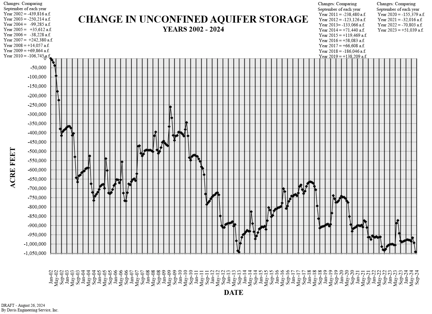
In September the closely-watched unconfined aquifer hit its lowest level ever recorded since monitoring of the troubled aquifer began in January 2002, according to the Davis Engineering report given at Tuesday’s quarterly meeting of the Rio Grande Water Conservation District.
Knowing that, now imagine the conversations that would be happening in the Valley’s farming and ranching community had there been diminished or no October rains. The year was shaping up to be among the worst for flows on the Upper Rio Grande and readings on the unconfined aquifer reinforced it.
Then October delivered heavy rains across the southwest, which resulted in historic fall seasonal flows on the San Juan and into the Rio Grande and Conejos River systems. The Rio Grande grew by 80,000 acre-feet and the Conejos River by 20,000 acre-feet as a result of the rains, said Craig Cotten, division engineer for the Colorado Division of Water Resources.
Colorado is now estimating a total annual flow of 470,000 acre-feet on the Upper Rio Grande, up from its earlier estimates for the year at 390,000 acre-feet. Still, the irrigation year on the Rio Grande will likely end on Nov. 1 as scheduled, said Cotten.
“That’s a big amount of water in just a short amount of time,” he said in noting the latest accounting for Rio Grande Compact purposes.
2026 budget hearing set
The Rio Grande Water Conservation District set a 2026 budget work session for Nov. 24; then a public hearing to adopt next year’s budget on Dec. 11. The water conservation agency is proposing a year-over-year increase to its mill levy. It is proposing a 1.75 mill levy property tax, up from 1.6 mills in 2025.
Rio Grande and Pecos River basins. Map credit: By Kmusser – Own work, Elevation data from SRTM, drainage basin from GTOPO [1], U.S. stream from the National Atlas [2], all other features from Vector Map., CC BY-SA 3.0, https://commons.wikimedia.org/w/index.php?curid=11218868
The reversal of fortunes this water year for San Luis Valley irrigators – going from one of the deadest rivers on record to a bountiful water year that sees full canals and increased reservoir storage – has been breathtaking.
The “water year” for Valley farmers technically ends Nov. 1, which means no more water in the fields. Now with the mid-October rains from the southwest and resulting historic fall river flows, the state is talking to farmers about extending the water season a bit into November, which would allow for another week of irrigating and another cut of hay.
“I’m working hard, but I’m not complaining,” said Greg Higel, whose Alamosa County cattle ranch and hay operation takes in surface water through the Centennial Ditch. It was private ditch operators like Higel who opened their head gates to begin diverting water off the Rio Grande.
“All of us who live along the river on the flat have water out in the meadows today,” said Higel.
That was not the case before Sunday, Oct. 12, when it became evident the Upper Rio Grande would be impacted by La Niña’s first seasonal storm.
Back in April at the start of the irrigation season, State Engineer Jason Ullmann warned Valley irrigators that the 2025 water year looked troubling given the lack of snow in the San Juan Mountains and expectation for another light spring runoff.
By August, the Rio Grande through Alamosa was disappearing before our eyes. Literally. The flow of the Rio Grande was 180 cfs at Del Norte, the Conejos at Mogote was running at 75 cfs, and downstream into New Mexico the Rio Grande had become a dry bed in Albuquerque.
The state is talking to farmers about extending the water season a bit into November, which would allow for another week of irrigating and another cut of hay. Credit: The Citizen
Then came the ocean storms over the Pacific and heavy rains through the southwest, and the rivers that are essential to the Valley and downstream into New Mexico sprang to life. The Upper Rio Grande at Del Norte hit 7,180 cfs, and unheard of flow this late into the water season. The Conejos River at Mogote hit its record high flow for the season, and farmers in the southern end of the Valley, like Higel on the west end, opened ditches to take water in.
“This helps us in the long run,” said Lawrence Crowder, president of the Commonwealth Ditch.
The Commonwealth had six ditch riders working the storm and diverting water into fields throughout the week. Now the expectation is the water will freeze in the fields and then thaw in the spring to give irrigators “a little extra head start.”
Total precipitation (inches) from 9-15 October 2025 with gridded data from the PRISM Climate Group and observations from the Community Collaborative Rain, Hail, and Snow (CoCoRaHS) network.
“It’s not going to dry out much between now and when the snow flies,” Crowder said.
The October moisture also turned around the calculations of the Colorado Division of Water Resources and its delivery of water to the New Mexico state line under the Rio Grande Compact. The weather event, according to initial estimates by the Colorado Division of Water Resources, added 20,000 to 25,000 acre-feet of water to the Rio Grande system itself, and around 10,000 to 15,000 acre-feet that was diverted into the private ditches like the Commonwealth and Centennial.
“All of us who live along the river on the flat have water out in the meadows today,” said rancher Greg Higel. Credit: The Citizen
With all the extra water, Colorado no longer thinks it overdelivered this year and instead likely owes in the neighborhood of 5,000 acre-feet to New Mexico.
At the upcoming Rio Grande Water Conservation District quarterly meeting on Oct. 21, Colorado Division of Water Resources officials will deliver a report that should provide final estimates on the amount of water the great storm of October delivered and the impact it had on the Upper Rio Grande Basin.
Needless to say, the reversal of fortunes on the Upper Rio Grande was dramatic. At least for 2025.
Rio Grande and Pecos River basins. Map credit: By Kmusser – Own work, Elevation data from SRTM, drainage basin from GTOPO [1], U.S. stream from the National Atlas [2], all other features from Vector Map., CC BY-SA 3.0, https://commons.wikimedia.org/w/index.php?curid=11218868
The dangerous high waters on the San Juan River and Upper Rio Grande are beginning to recede following the surge from heavy rains that created historic autumn peak streamflows on the San Luis Valley’s river system.
The high flows also came at the end of irrigation season for Valley farmers and the Colorado Division of Water Resources, which will now account for the extra water in its management of the Rio Grande Compact.
The Rio Grande itself peaked at 7,000 cfs from the bounty of rain that came through the southwest region here in mid-October. The Colorado Division of Water Resources is estimating that the out-of-character weather event added 20,000 to 25,000 acre-feet of water to the Rio Grande system itself and around 10,000 to 15,000 acre-feet that was diverted into the Valley’s canal system, according to staff engineer Pat McDermott.
That measuring of the water and accounting for how it fits into this year’s obligations under the Rio Grande Compact is underway. The irrigation season ends Nov. 1.
McDermott, in a report Tuesday to Rio Grande Basin Roundtable members, said not all of the water will be of beneficial use to the Valley and the Upper Rio Grande Basin. The middle Rio Grande could see about 5,000 acre-feet flow downstream, but with a largely dry riverbed in Albuquerque, benefits from the October storms likely won’t extend as far south as Elephant Butte.
“This is not a significant event in New Mexico,” McDermott said.
For the reservoirs on the western and southern end of the Valley, it has been. Rio Grande Reservoir, Platoro Reservoir and Terrace Reservoir all will increase storage, with the reservoirs all in priority during the irrigation season for the first time since 2019.
Rio Grande Reservoir will have somewhere between 2,000 and 4,000 acre-feet of storage, Platoro Reservoir has increased its storage and Terrace Reservoir has gone up about 2,000 acre-feet, McDermott said.
“This is kind of unusual to have this big a flow event,” McDermott said. “It doesn’t happen.”
McDermott noted the importance and effectiveness of the Valley’s canal ditch riders, who worked to push water into their ditches to help with the surges of streamflow.
The Empire Canal, Monte Vista, the Rio Grande Canal, the Farmers Union, San Luis Valley Canal all opened their ditches to take in water, McDermott said.
“We here have very, very cooperative owners that have opened up their ditches after several months of non-use. We want to thank all those ditch operators for getting out there and taking some of this available flow. It is a wonderful thing.
“This is a really good thing for our basin,” said McDermott. “It’s going to give us an opportunity to get some water back out into the ditches late in the season, which we don’t see very often.”
Much of Valley will now go into its offseason with moist soils. But as McDermott noted, areas like the critical Saguache Creek, Carnero Creek, and the east side of the Valley down south through Trinchera didn’t receive much benefit from the rains.
The next best thing would be a normal to above-normal snow season in the San Juan Mountains and Sangre de Cristo range.
La Niña is still looking weak. But as October has shown, weather can happen.
Rio Grande and Pecos River basins. Map credit: By Kmusser – Own work, Elevation data from SRTM, drainage basin from GTOPO [1], U.S. stream from the National Atlas [2], all other features from Vector Map., CC BY-SA 3.0, https://commons.wikimedia.org/w/index.php?curid=11218868
The San Luis Valley is running out of water and there’s no way around it.
In Saguache County specifically, the amount of water in Saguache Creek has consistently been going down, while the amount needed to irrigate remains the same. This lack of water due to climate change, drought and overuse affects every aspect of life. Impacts on water access and streamflow are making irrigation more complicated and unpredictable, and for a community that has been built around, and economically relies on, agriculture, this is concerning. Millions of dollars are being spent to try to find solutions and mitigate the impacts, but as these challenges persist, a broader discussion is opening up about the future of agriculture in the Valley.
The question at the heart of the issue: how do communities around the San Luis Valley, like Saguache, not only manage and survive this crisis, but sustainably adapt to a landscape with less water?
The answer is complicated.
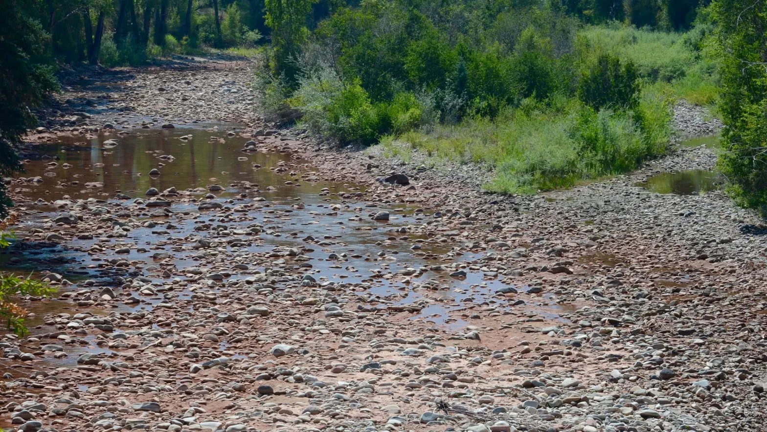
Saguache Creek in September, 2025. Credit: Ryan Michelle Scavo
Since 2002, the entire American southwest has been experiencing a severe drought. The San Luis Valley is at the center of this crisis, warming faster than any other region. Increased temperatures, inconsistent precipitation, and decreasing snowpack – alongside overpumping and overuse – has created a dire situation in which the amount of water available for use in Saguache County is rapidly decreasing.
There are two ways to access water in the Valley: pulling directly from surface water sources like creeks, rivers, and lakes, or pumping from wells that pull from the aquifer below. The water system is all connected, and the water level of the aquifer contributes to the streamflow of creeks and surface water through groundwater discharge and baseflow.
Currently, the unconfined aquifer is down over a million acre-feet of water, an amount equal to the size of the Blue Mesa Reservoir in Gunnison. The San Luis Valley has both an unconfined and confined aquifer, but the part that is under Saguache in the north end of the Valley is the confined artesian aquifer. With the structure of a confined aquifer, the loss of water, though concerning, does not prevent well users from accessing water.
It does, however, impact surface water. Unlike the aquifer, where there is still water to pull from even with losses, for surface water, significant losses to the water system mean lower streamflow and sometimes a nonexistent water source.
“If the water table drops 3 to 5 feet, suddenly it becomes disconnected from the creek and doesn’t support the streamflows. The streams just start sinking into the ground,” said Tom McCracken, a farmer and former Saguache creek surface water user. “Streamflows are down across the board. It’s really really getting bad, and it’s exacerbated by the fact that the aquifer is so low. The water is just soaking into the ground instead of running out into the Valley like it used to.”
San Luis Valley Groundwater
This means that when the wells are pumping from the aquifer, if the water level drops low enough, they’re inadvertently depleting the flow of the creek, which is water somebody has a right to divert. While this pumping impacts the aquifer as a whole, and is not localized specifically to Saguache County, streamflow of surface water around the Valley feels the impacts. These losses are considered injurious depletions, and they have been disproportionately impacting surface water rights holders, who rely on streamflow to irrigate.
This is especially problematic because water rights in the Valley operate on the concept of prior appropriation, where the longer a water right has existed, the more seniority it gets. In times of water shortage, older water rights have priority over newer water rights.
Saguache rancher George Whitten, owner of Blue Range Ranch and San Juan Ranch. Credit: Ryan Michelle Scavo
“On a creek system like this, there’s a longstanding history of struggles between one ranch and the other because the doctrine of prior appropriation kind of sets up a struggle for water rights right from the very beginning,” said George Whitten, a lifelong rancher in Saguache, who owns Blue Range Ranch and San Juan Ranch. “It’s not a system of sharing but a system of allocation. You have all the water until there’s enough for the next guy and on down. And that changes daily depending on the flow of the stream.”
Generally, in Saguache County, surface water rights are older, and considered senior, often holding numbers that rank priority within surface rights, and well water rights are newer and considered junior.
This has created a unique and challenging problem, spurring tensions in the community, as surface water users, used to having senior water rights, are finding themselves with decreasing water access because of low streamflow, while well water users are able to continue pumping from the aquifer.
“People with surface water rights that are from the 1870s are never happy with the idea that a well that was drilled in 1970 could be flowing when their water right is not there anymore,” said Whitten. “As the Valley starts to dry up, with climate change and a lack of snow fall, surface rights are less and less dependable. We’re set up in this epic struggle for how to deal with that.”
The solution to this problem might seem simple: people just need to pump less water. And while that is true to a degree, addressing this problem is a lot more complicated than that.
“Most people want to restore the aquifer, really, in their heart,” said McCracken. “But it’s like ‘I’m not going to do it if my neighbor’s not going to do it. Why should I be the one to suffer?’”
Under the current state Division of Water Resources model, established with the passing of Senate Bill 04-222, the state provides subdistricts with a maximum amount of predicted depletions for the area annually. Subdistricts then must find enough water to repair those depletions before the growing season starts, mapping it out in an annual replacement plan, which is approved by the state.
That means that for wells to continue operation, the injurious depletions must be remedied, by putting an amount equal to the amount of depletions back into the creek, so that surface water users also have access.
If enough water isn’t located and the plan isn’t approved, users won’t be granted access until it can be figured out. This means water shut off during the growing season. In 2021, Subdistrict 5’s replacement plan was rejected, resulting in about 230 wells being shut off from April 1 through the end of June, when a challenge to the rejection was finally approved, granting water access. Nearly half of the growing season was lost, yielding serious economic consequences.
In order to meet these goals, the Rio Grande Water Conservation District (RGWCD) has been leasing and buying properties and water rights around Saguache County, retiring them from agricultural production, and redirecting the water to repair depletions.
In early 2022, Subdistrict 5 was looking to be in a similar spot as 2021: without enough water to counter the depletions and unable to agree on how to get that water. The RGWCD bought its first big property, the Hazard Ranch, in May of 2022. The purchase consisted of 110 acres of property and 143 acres of water rights from the Hazard family, who had been ranching in the Valley since the 1870s. The water from the Hazard sale was enough to replenish the remaining depletions and got the annual replacement plan approved, allowing other water users to stay in operation. This last-minute purchase ultimately saved Subdistrict 5’s water from being shut down for a second year in a row.
The way the process works is that the subdistricts can purchase water rights and sometimes also the property that those water rights sit on, retiring the land from agricultural use. But finding the right properties and water rights can be tricky. There are limited water rights that are available to be used by the subdistricts, because existing conservation easements along the creek and other factors restrict the locations of potential surface water rights purchases. Each subdistrict also has its own criteria and valuations for what water rights are valuable, and only certain properties meet those criteria.
Currently, Subdistrict 5 is funding projects using loans from the Colorado Water Conservation Board. Right now it has two loans worth about $12 million.
Once purchases have been made, the subdistrict files a change of use form that switches the water’s usage designation from irrigation to augmentation. Because this process is usually happening quickly in order to meet depletion needs, this form is often filed as a temporary change of use. A permanent change requires a lengthy court process that can take up to 20 years. As long as the subdistrict has started the court process to get the designation changed, it can continue to operate under the new, temporarily changed designation, until that is officially changed, which allows for more immediate action.
After the change of use, using augmentation wells that pump water to the creek, the water that was previously irrigation and consumptive use (the amount being consumed by the crops) can be redirected and returned, offsetting depletions.
For Subdistrict 5, when it makes this switch to augmentation, it isn’t actually retiring the water rights. The water remains available to be pumped if the subdistrict needs more water to meet requirements in years with large depletions. It is still conserving water because it usually isn’t pumping, and when it is, it isn’t getting anywhere near the historical levels that were pumped when pumping was used for agriculture.
“We all need to pump significantly less or else everybody is going to be shut down. So if we shut down these quarters here, it will allow the other quarters to continue to operate versus everyone being shut down,” said Chris Ivers, program manager for Subdistrict 5. “It’s not that we want to retire productive agricultural land, it’s just that the rules limit how much we can sustainably pump – the rules of nature, I mean.”
Subdistricts must meet both sustainability mandates and injurious depletion mandates from the state. Currently, to meet sustainability goals, Subdistrict 5 must remain within the limits of the historical pumping that took place between 1978-2000 for a 10-year period. Because the district is well within this sustainable range, it has been able to focus on buying water rights without having to prioritize full retirement for sustainability reasons, which is the main focus of some other subdistricts.
“What we’re seeing in the state’s annual measurement under the groundwater rules is that the Saguache response area, the aquifer, is actually recovering in that area at a greater rate than anywhere else in the confined aquifer in the Valley,” said Amber Pacheco, deputy general manager of the Rio Grande Water Conservation District.
The district’s next big purchase will likely be more of North Star Farm, from whom it has been leasing and buying property for years. North Star, one of the largest water users in the Valley, runs around 30 circles in Subdistrict 5, growing alfalfa for large dairy operations in California. North Star only holds junior, groundwater rights, and its operation consists of a system that pumps water from wells and irrigates using water pivots at the center of every circle.
Farm land in Saguache. Credit: Ryan Michelle Scavo
For surface water users, this purchase is a step in the right direction, as North Star’s water usage has been a point of contention for many years.
“It’s a difficult thing to see a sprinkler running on North Star Farm when the number 10 water right is off in Saguache Creek,”said Whitten, who is vice president of the Subdistrict 5 board of managers. “Seeing them able to pump a full supply of water without any surface rights whatsoever, when the people on the creek, due to the lack of inflows, are sitting there drying up and watching that go on – it’s a hard spot in this community for sure,” said Whitten. “I totally get it. I have a lot of land that is not usable anymore because of North Star.”
This situation acts as a prime example of the cultural clash that exists in the Valley, not only between surface and well water rights holders, but also between a large corporate entity in a sea of family-owned and operated businesses.
But even though North Star is an out-of-state corporation, the situation is complicated because the locals who are employed by North Star are a part of the community as well.
“You know the people who work there, who manage that farm, they live in Sanford, but they have kids in school and they’re part of the community too. If you get too focused on Saguache Creek you lose your perspective,” Whitten said.
Drying up North Star has been a longtime goal of the RGWCD and other community members. They have embarked on several endeavors over the years with the goal of purchasing the whole property and all of its water rights, but the price has always been just out of reach. Ultimately people want the land dried up and revegetated, with all of that water being put back into the creek.
Today, the goal remains the same, but instead of all at once, it’s starting to happen in small pieces. Starting in 2021, Subdistrict 5 was leasing one to three groundwater irrigated sprinkler quarter sections from North Star, negotiating those leases annually. Each quarter contains about 120 acres of irrigated ground. In 2024, Subdistrict 5 purchased the water rights to those three leased quarters, and Subdistrict 2 purchased two quarters as well. Subdistrict 5 is planning to purchase four additional quarters in the upcoming year, using funding from a loan approved in January of this year.
Having recently made big purchases like the Hazard Ranch and parts of the North Star property, Subdistrict 5 has a large quantity of water available to be redirected.
Some wells that already exist work as augmentation wells, but sometimes new augmentation wells need to be built in more optimal locations in order to connect certain groundwater areas to the creek. This is a priority for the subdistrict right now.
“Our current problem isn’t the amount of water. [With recent purchases], we have enough water, but we don’t have enough ability to deliver that water,” said Ivers. “We’re really focused on finding locations for augmentation wells on Saguache Creek.”
While things are moving in a positive direction, the situation will likely only intensify in the upcoming years. When the state model gets updated, predicted depletions change based on the water situation from the prior decade. The new calculations that have come out, which would go into effect in 2026, show a drastic jump in the amount of depletions Subdistrict 5 will have to remedy.
“It’s a pretty significant increase for the subdistrict, which means it’s going to have a significant and kind of an immediate impact on those subdistrict members to try to recover enough groundwater that they can pay for these increased depletions,” said Pacheco. “It’s going to be a big, big challenge for Subdistrict 5 especially, to try to be able to meet those with the limited availability of what they can use in the area. They’re working on it already and I have faith that we’ll be able to do that successfully, but it will be a challenge for sure.”
While the subdistricts operate individually, 1, 4, and 5 all owe depletions to Saguache Creek, and are combining efforts and sharing resources when they can to make sure depletions and goals get met.
“Subdistricts 1, 4, and 5 have agreed to work together as best they can to solve the problem as one. It’s kind of a good opportunity for a more collaborative effort for Saguache Creek,” said Ivers.
While the purchasing and retirement of agricultural land has been regarded as one of the only sustainable solutions to the problem, the strategy has been met with some questions and concerns – both economic and environmental.
The establishment of the state model was controversial in some circles because it created an irrigation season and seasonal restrictions on water access for all water rights holders. It was met with backlash from certain parts of the community, particularly surface water users, who were used to irrigating when they felt it was necessary, even if it was outside of the usual growing season. Many still don’t love it, and a consistent point of frustration has been centered around the impacts of climate change, which is causing fluctuations in the timing of runoff and snowpack melt. Earlier flows, coming down before the start of the state’s irrigation season, means farmers have to watch water go by in the river that can’t be diverted, while struggling with a lack of water later in the season.
How the property retirement and dry-up will impact taxes is another area of concern.
“Saguache County’s tax base could be drastically affected by all this dry-up. The property tax base is based on agriculture mainly, and if we lose that, we gotta find alternative ways to finance the county’s operations. It really should be part of the negotiations to dry up a circle to maintain that tax base, but it’s not at the moment. So I’m really concerned about it,” said McCracken, who serves on the Saguache County Board of Commissioners.
Property taxes are calculated based on how productive the land is, so when it gets dried up and stops, it loses that productivity and therefore also the tax classification. Losing large properties to dry-up, while good for water, could mean a huge loss to county coffers. The Rio Grande Water Conservation District says that this is something it takes into consideration.
“If the RGWCD buys the land and actually controls the land, we do work with the counties to try to continue the tax base for that property, even though it’s now gone to a different taxable classification,” said Pacheco. “We try to keep their budgets as whole as we can when we buy properties, so we pay Alamosa County, we get bills from Saguache County, all to try to minimize the impact on those government services.”
Retiring agricultural land also creates a few environmental concerns. First, putting surface water back into the ground, while sustainable, endangers riparian zones on the creeks going up into the canyons, which are critical wildlife habitats and for regional tourism.
Diverting a property’s water without the proper plan, especially with a persistent drought, can also create the optimal conditions for a dust bowl. Changing weather, with decreasing precipitation and strong, unpredictable winds, alongside the removal of water and crops, causes the topsoil to dry up. With no roots or vegetation to hold the soil in place, the potential for it to blow away increases.
“You potentially have these huge dust storms where you lose an inch of top soil in the storm, and there’s traffic pile ups on Highway 17 and there’s drifts of soil up to the top of the fencelines. I mean it’s just out of control,” said McCracken. “Those circles, if they’re dried up, have to be revegetated. It’s just an absolute necessity.”
The RGWCD, along with other groups in the Valley, is working to make revegetation a priority. Whitten is part of a group, along with Patrick O’Neill and Madeline Wilson from CSU Extension, that has been discussing the best ways to go about revegetation in the area. The goal would be to improve soil health and restore nutrients that have been stripped during prior agricultural use, by bringing in native plant cover and potentially grazing livestock as well. Different plans allow for a few inches of water to be left on retired land to support revegetation efforts in the first few years.
Enforcing revegetation is a problem the RGWCD and county officials are still working to address. If the RGWCD doesn’t control the land, either because it only owns water rights, or because landowners had to dry up land they couldn’t afford to farm, but aren’t connected to a program, the RGWCD can’t force them to revegetate. These situations are complicated, because while people may want those properties to be revegetated for environmental and aesthetic reasons, it’s unclear who has the authority, and whose responsibility it is, to make those decisions or enforce rules.
Many also question whether or not the millions of dollars being spent buying properties could be better allocated toward other sustainability and conservation efforts that impact water. Instead of so much money being used to buy properties, a portion could be going to farmers to help them start practicing more sustainable methods, like sequestering carbon and improving soil health, which naturally help reduce water usage while also restoring the ecosystem.
A view of silos in Saguache. Credit: Ryan Michelle Scavo
This concern is rooted in the idea that, if industrial agriculture practices are going to continue running through water and harming the soil, eventually requiring more and more land to be bought up and retired – which some call a “Band-aid solution” – it might be productive to look into reworking the agricultural system into a more sustainable model.
“We have farmers in the Valley using sustainable farming methods that have reduced their water usage by like 40 to 50 percent. Why aren’t we doing that? Why aren’t we taking the resources we have and spending at least some of them to try to change, not just take land out of agriculture permanently,” said McCracken. “Change their way of farming and maybe change some of the crops and the number of rotations that they do. Maybe we can get that water back if we do this right. Maybe we can keep more people in business. Maybe it doesn’t have to be only the corporations that survive all of this.”
The efforts being made around the Valley by Rio Grande Water Conservation District and other organizations are an important part of the search for a solution to what could be considered an impossible problem, one that communities around the southwest continue to grapple with.
“I’m really proud of the San Luis Valley and the RGWCD and the people here who have tried to figure out a way to mitigate those impacts on surface rights by well pumping,” said Whitten. “I’ve spent most of my life involved in this struggle and we’re way ahead of most people in the West, I think, in dealing with these issues.”
It will likely only continue to get more complex, as climate change, drought, and water availability become more unpredictable. But, it is a Valley-wide and basin-wide issue that affects everyone, and it seems as though, despite certain disagreement points, the community can agree that attempting to adapt and find sustainable paths forward is the only solution.
“What we endeavored to do back in the day was to control the collapse of the agricultural empire that we’ve built here. We’re running out of water and there’s just no way around that,” said Whitten. “So do you let everybody just pump until the last guy who can drill the deepest well is the last one left? Or do you somehow try to control this collapse of our economy and somehow salvage it? The natural world is going to prevail in the end. How do we control this and try to become sustainable and resilient?”
These questions remain at the center of conversations in Saguache County.
1869 Map of San Luis Parc of Colorado and Northern New Mexico. “Sawatch Lake” at the east of the San Luis Valley is in the closed basin. The Blanca Wetlands are at the south end of the lake.
Colorado water officials announced Wednesday a rough plan to figure out how the state would handle an unwelcome specter in the Colorado River Basin: forced water cuts.
Mandatory water cuts are possible under a 103-year-old Colorado River Compact in certain circumstances, mainly if the river’s 10-year flow falls too low. It’s a possibility that is one or two “bad years” away, some experts say.
Colorado, however, does not have a clearly defined plan, or regulations, for how exactly it would handle such forced water cuts. It’s time to start preparing, according to state engineer Jason Ullmann, Colorado’s top water cop.
Over the years, Coloradans on both sides of the Continental Divide have asked about these “compact administration regulations,” Ullmann told state lawmakers during the Water Resources and Agriculture Review Committee hearing Wednesday in Steamboat Springs.
“We’ve heard those questions,” Ullmann, director of the Division of Water Resources, said as hundreds of water professionals listened at the Colorado Water Congress Summer Meeting.
If the river’s flow falls below a 10-year rolling average of about 82.5 million acre-feet, the Lower Basin states — Arizona, California and Nevada — could demand that the Upper Basin send more water downstream based on the 1922 Colorado River Compact. In the water world, this is often called a “compact call.”
The Upper Basin states — Colorado, New Mexico, Utah and Wyoming — argue that the trigger is actually 75 million acre-feet because of a difference in legal opinions about how the basin states should meet their obligations to share Colorado River water with Mexico.
That 10-year average flow was forecast to be about 82.8 million acre-feet by September 2026. If the flow falls below the tripwire, it would cause a legal mire that could take years to sort out.
State officials said Colorado is in compliance and expects to remain so in the future. If a compact call ever happened, it would be a historic first for the Colorado River Basin.
Colorado officials would need to be able to send more water downstream. But the state doesn’t have regulations to say who cuts back, where the water comes from, when cuts happen or how it would track the water to make sure it would end up where it needed to go.
State officials have debated whether they should even have these discussions in light of larger basin negotiations over water use. Some people wanted to focus the state’s resources on the negotiations. Others feared that finding water supplies that could be cut would weaken the state’s stance that it has no extra water to spare.
Based on Ullmann’s remarks, the state is shifting its next course of action: many, many feedback meetings with communities.
This is pretty big news, said state Sen. Dylan Roberts, a Frisco Democrat, asking for more details about the timeline.
This winter and spring, state officials will reach out to key water user groups to host small listening sessions to hear their thoughts on the need for compact administration regulations, Ullmann said.
After that, the state will hold broader public meetings to get more input.
“It’s not something that we intend on doing in a vacuum,” Ullmann said. “It’s important for everybody in the state of Colorado that this would be a very transparent question.”
The state has already started on another key task when it comes to managing mandatory water cuts: improving how the Western Slope measures its water diversions.
“You can’t manage what you can’t measure,” Ullmann said.
Western Slope water users do already measure their use, but the measurements are not as advanced or consistent as in other river basins where Coloradans already curtail their use to meet interstate water sharing obligations, he said.
The state has already made progress on improving measurement rules and requirements in northwestern Colorado, southwestern Colorado and the Gunnison River area. Water diversions along the Colorado River in western Colorado are next up, a process that will wrap up in November.
Colorado could also adapt to the prospect of forced cuts by creating a “conservation pool,” like a savings account that could be tapped in the event of a compact call, according to other water experts who spoke to lawmakers.
Some pinned their hopes on the state’s Colorado River negotiators who have been charged with reaching a seven-state agreement for how to manage the basin’s major reservoirs after the current operating rules expire in 2026.
“We’re not going to have a compromise unless they [the Lower Basin] waive compact compliance threats. We just can’t enter into any agreement with that,” said Andy Mueller, general manager of the Colorado River District.
Those negotiations have been stalled over fundamental issues like how to cut back on water in the basin’s driest water years.
Colorado’s Colorado River Commissioner, Becky Mitchell, told lawmakers Wednesday that the discussions continue to be challenging. Negotiators have until November to share more information about a seven-state agreement with the federal government.
“Whether or not we reach a seven-state consensus, all of us will be forced to deal with this reality in one way or another,” Mitchell said. “But today, what we’re hearing from our counterparts is they may be unwilling to reduce their uses in some dry years. It appears they believe that this gap should somehow be filled by the Upper Basin water, using any means necessary.”
The Shoshone hydro plant in Glenwood Canyon. The Shoshone hydropower plant in Glenwood Canyon. The CWCB will hold a hearing on the water rights associated with the plant in September. Credit: Heather Sackett/Aspen Journalism
Front Range asked for Colorado Water Conservation Board neutrality on historic use of Shoshone water rights
In an effort to head off concerns about the state’s role in a major Western Slope water deal, a Western Slope water district has offered up a compromise proposal to Front Range water providers.
In order to defuse what Colorado River Water Conservation District General Manager Andy Mueller called “an ugly contested hearing before the CWCB,” the River District is proposing that the state water board take a neutral position on the exact amount of water tied to the Shoshone hydropower plant water rights and let a water court determine a final number.
“Although we believe this would be an unusual process, the River District believes it would address the primary concern (i.e., avoiding the state agency’s formal endorsement of the River District’s preliminary historical use analysis) that we heard expressed by your representatives at the May 21, 2025 CWCB meeting regarding the Shoshone instream flow proposal,” Mueller wrote in an email to officials from the Front Range Water Council.
The River District worked with CWCB staff to draft the proposal, but it may not go far enough to address Front Range concerns.
The River District, which represents 15 counties on the Western Slope, is planning to purchase some of the oldest and largest non-consumptive water rights on the Colorado River from Xcel Energy for nearly $100 million. The water rights, which are tied to the Shoshone hydropower plant in Glenwood Canyon, are essential for downstream ecosystems, cities, endangered fish, and agricultural and recreational water users. As part of the deal, the River District is seeking to add an instream flow water right to benefit the environment to the hydropower water rights.
The effort has seen broad support across the Western Slope. The River District has raised $57 million toward the purchase from at least 26 local and regional partners. The project was awarded a $40 million Inflation Reduction Act grant in the waning days of the Biden administration, but those funds have been frozen by the Trump administration.
“These water rights are foundational to the Colorado River,” said Amy Moyer, chief of strategy at the River District. “It’s the number one project for the Western Slope. It’s the top priority to move forward.”
Critically, because its water rights are senior to many other water users — they date to 1902 — Shoshone can force upstream water users to cut back. The Shoshone call has the ability to command the flows of the Colorado River and its tributaries upstream all the way to the headwaters.
The twin turbines of Xcel Energy’s Shoshone hydroelectric power plant in Glenwood Canyon can generate 15 megawatts. The River District is proposing that the CWCB remain neutral on the issue of the plant’s historic water use. Credit: Heather Sackett/Aspen Journalism
Putting a precise amount on how much water the plant has historically used is a main point of contention between the River District and the Front Range Water Council, a group that includes some of Colorado’s biggest municipal water providers: Denver Water, Colorado Springs Utilities, Aurora Water and Northern Water. These entities take water that would normally flow west, and bring it to farms and cities on the east side of the Continental Divide through what are called transmountain diversions. About 500,000 acre-feet of water annually is taken from the headwaters of the Colorado River and its tributaries to the Front Range.
Estimates by the River District put the Shoshone hydro plant’s average annual use at 844,644 acre-feet using the period between 1975 and 2003 — before natural hazards in the narrow canyon began knocking the plant offline regularly in recent years.
But Front Range Water Council members say this estimate is flawed and could be an expansion of the historical use of the water right. They have requested a hearing at the September CWCB meeting to hash out their concerns.
“The preliminary analysis that has been presented appears to expand historic use and creates potential injury,” Abby Ortega, general manager of infrastructure and resource planning at Colorado Springs Utilities told the CWCB at its May meeting.
Determining past use of the Shoshone water rights is important because it will help set a limit for future use. While changing the use of a water right is allowed by going through the water court process, enlarging it is not. The amount pulled from and returned to the river must stay the same as it historically has been.
As part of the River District’s deal to buy the water rights, the CWCB — which is the only entity in the state allowed to hold an instream flow water right — must officially accept the water right and then sign on as a co-applicant in the water court change case.
But Front Range water providers said that doing so would amount to an endorsement of the River District’s historical use estimate, which would mean taking a side in the Front Range versus Western Slope disagreement.
“If you agree to accept the right and as I understand it, the instream flow agreement, you’re agreeing to be a co-applicant, which risks you accepting their analysis,” said Alexandra Davis, an assistant general manager with Aurora Water, at the CWCB’s May meeting.
Some members of the Front Range Water Council have asked that the CWCB remain neutral during the water court change case. In May 9 and June 9 letters to the CWCB from Marshall Brown, general manager of Aurora Water, he said the CWCB shouldrefrain from endorsing any specific methodology or volume of water.
“… [T]he CWCB should remain neutral in the water court proceedings and defer to the court’s determination of the appropriate methodology and volumetric quantification,” the May 9 letter reads.
The River District’s offer does just that: It proposes that the CWCB should not take a position regarding the determination of historical use of the Shoshone water rights.
“We heard the issues that are most front and center from these entities,” Moyer said. “And so we are trying to find a path forward that works for everyone.”
But even if Front Range Water Council members are in favor of the proposal, it is unlikely to result in a cancellation of the hearing. CWCB Executive Director Lauren Ris said in an email that under the board’s rules, they are required to hold a hearing. And Jeff Stahla, public information officer at Northern Water, said they will still be asking for the hearing to proceed.
Spokespeople from Colorado Springs Utilities, Aurora Water and Denver Water all declined to comment on the River District’s proposal because it was marked as confidential.
Some members of the Front Range Water Council have concerns beyond CWCB neutrality that could be addressed at the September hearing.
In a May 14 letter to the CWCB, Denver Water’s CEO Alan Salazar said the water provider also wants to carry over some provisions from existing agreements like the Shoshone Outage Protocol. This agreement has an exception in cases of extreme drought that allows Denver Water to keep taking water if its reservoirs fall below certain levels and streamflows are low. Denver Water added that by omitting the last two decades of Shoshone water use, the River District’s study period is skewed, and that using an upstream stream gauge to measure historical use is improper.
The hearing is scheduled for the next CWCB board meeting Sept. 16-18. The board can approve or disapprove the acquisition of the water rights, or make changes to the proposal and adopt the amended proposal. The board is required to take action at the September hearing unless the River District approves an extension. Pre-hearing statements are due by Aug. 4.
CWCB board members Brad Wind, who is general manager of Northern Water, and Greg Johnson, manager of resource planning at Denver Water, recused themselves from the July 17 CWCB board meeting discussion of the Shoshone water rights and plan to recuse themselves from future Shoshone discussions and decisions.
Map of the Colorado River drainage basin, created using USGS data. By Shannon1 Creative Commons Attribution-Share Alike 4.0
Center pivot in the San Luis Valley. Photo credit: Allen Best/Big Pivots
Click the link to read the article on the Big Pivots website (Allen Best):
July 20, 2025
Center, as its name implies, lies at the center of the San Luis Valley. The valley is among the nation’s two most prominent places for growing potatoes. Among the growers is a fourth-generation family operation, Aspen Produce LLC.
Jake Burris married into the family. In addition to spuds, the family grows barley and alfalfa on 3,500 acres. Some neighboring farmers also grow canola. Burris is president of the board of managers of one of six subdistricts in the San Luis Valley’s Rio Grande Water Conservation District. His subdistrict — called Subdistrict No. 1 — was formed in 2006 in response to a declining water table. What’s known as the unconfined aquifer supports this area, the most agriculturally productive in the San Luis Valley. With just seven inches of annual precipitation, irrigation in the San Luis Valley is everything. And in Subdistrict 1, much of that water comes from 3,617 wells..
Alfalfa grown is quite thirsty, but potatoes get grown on much larger areas of the Rio Grande Water Conservancy District. Photo credit: Allen Best/Big Pivots
Alfalfa is the thirstiest crop, using 24 to 36 inches of water to get three cuttings. The strong sunshine and cooler temperatures found above elevations of 7,000 feet produce a high-quality hay that draws orders from dairies as far as California. Alfalfa is grown on 21,100 acres in the district. Potatoes cover 51,100 acres. Barley is grown on 28,000 acres. Some have replaced barley with rye. Several thousand acres have together been devoted to canola, lettuce, and other crops. A recent census found about 25,000 acres had been fallowed.
The San Luis Valley has two primary aquifers. Lower in the ground, separated by relatively impermeable beds of clay from what lies above, is the confined aquifer. The first well into the confined aquifer was bored in 1887. Because of the pressures underground, it was an artesian well. No pumping was needed to bring water to the surface. Louis Carpenter, a professor at the Colorado Agriculture College (now Colorado State University), estimated the valley had 2,000 artesian wells when he visited in 1891.
The unconfined aquifer lies above the confined aquifer. The unconfined aquifer existed prior to major water development in the valley but water volumes rose greatly when farms began using Rio Grande water in the 1880s. Four ditches deliver Rio Grande water to the farms and hence to the aquifer. Introduction of high-capacity pumps in the 1950s and center-pivot sprinklers in the 1970s accelerated groundwater extraction. In 1972, the state engineer imposed a moratorium on new wells from the confined aquifer, followed in 1981 by a moratorium on new wells in the unconfined aquifer. These moratoria acknowledge that groundwater drafting had to be limited.
Then came 2002, hot and dry, escalating the challenge. Impact to the unconfined aquifer was drastic with rising temperatures causing growing water demand even as snowpack declined.
The unconfined aquifer “has been dropping overall since about 2002,” says Craig Cotten, the Colorado Division of Water Resources engineer for Division 3, which encompasses the San Luis Valley. “We just have not had a real good series of years as far as the surface water.”
In 2004, state legislators passed a law that sets the San Luis Valley’s aquifers apart from those of the Republican River and Denver Basin groundwater stories. That law, SB04-222, explicitly orders both the confined and unconfined aquifers in the San Luis Valley be managed for sustainability. The Colorado law governing the Denver Basin aquifers requires a “slow sip” but does not imagine sustainability. In the Republican River Basin, no law speaks to sustainability. There, only the interstate compact insists upon limits.
San Luis Valley Groundwater
Here’s another difference. Water from aquifers create the Republican River and its tributaries. In the south-metro area, surface streams cause little recharge to the Denver Basin aquifers. In the San Luis Valley, the Rio Grande as well as some surface streams coming off the San Juans contribute water to both the unconfined and confined aquifers. The hydrogeology is more complex.
This 2004 law also encouraged the formation of groundwater subdistricts within the Rio Grande Water Conservation District. The thinking was that very local groups of farmers could work together to figure out how to keep their portions of the aquifers sustainable. They could also be more effective in this pursuit by working together than doing so individually.
Six subdistricts have been created in the Rio Grande Water Conservation District and one in the Trinchera Water Conservancy District. Subdistrict No. 1 began operations in 2012 after the state approved its operating plan.
All these groundwater districts have the goal of reducing water consumption as necessary to replenish the aquifers or by introducing water into the aquifer from the Rio Grande or other sources.
Agriculture constitutes nearly the entire economy of the San Luis Valley. Photo credit: Allen Best/Big Pivots
Exactly how much restoration of the aquifers is needed? The state law specified a return to volumes that approximate those of 1976 to 2001 in the confined aquifer. But there’s some guesswork about how much water the confined aquifer had then. Detailed records on Subdistrict No. 1 were not kept until 1976.
In August 2024 the unconfined aquifer in Subdistrict 1 was estimated to have averaged almost 1.2 million acre-feet less water during the five preceding years than it had in 1976. The rules approved by the Colorado Supreme Court in 2011 in a document called the Plan for Water Management call for the unconfined aquifer recovery within 200,000 to 400,000 acre-feet of where it was in 1976. That would be deemed sustainable, as ordered by the 2004 law.
To achieve this, the state engineer said that Subdistrict No. 1 would need to recover 170,000 acre-feet each year between now and 2031. Initially, Subdistrict No. 1 aimed to take 40,000 acres out of irrigation per year, or about 80,000 acre-feet of annual groundwater pumping, to allow the unconfined aquifer to recover. That goal is unattainable, say water officials, and hence a rethink is needed. Success has occurred, though. In 2024, for example, roughly 176,000 acre-feet were pumped from the confined and unconfined aquifers in Subdistrict No. 1, the fewest since groundwater metering began in 2009. That’s about a 30% reduction.
More sustained success will be necessary. “You don’t recover that unconfined aquifer through single years of good runoff,” says Ullmann, the state engineer. “There are difficult decisions that have to be made in order to recover and restore the aquifers, but that’s what these subdistricts are trying to do.”
Unlike the Republican River Basin, the unconfined aquifer in the San Luis Valley is fed water diverted from the Rio Grande, seen here at Monte Vista, and into irrigation canals. Photo credit: Allen Best/Big Pivots
This success is at least partly due to efforts to modify irrigation practices and taking land out of production. Amber Pacheco, deputy general manager of the Rio Grande Water Conservation District, explains that it’s difficult to quantify the reductions.
“Some farmers, for example, have simply reduced the number of alfalfa cuttings (and hence the irrigation required), for example. Or they only irrigate when they need to do so. Others have changed the cover crops planted after a potato harvest to reduce the amount of water needed.”
As in the Republican River District, local efforts to take land out of production use the foundation of federal programs, particularly CREP, or Conservation Reserve Enhancement Program. The subdistrict provides 20% of funds and the federal government 80%.
As did the Republican district in 2022, the Rio Grande district got an additional $30 million allocation of federal money funneled through the state. That money allows $3,000 in payment per acre-foot of curtailed groundwater use.
More must be done to recover the aquifer. The current proposal assembled by Burris and other directors of Subdistrict No. 1, their fourth iteration, would require aquifer recharge as a condition of pumping on a one-to-one basis. Water for recharge would come from water secured from the Rio Grande or native flows into the unconfined aquifer. This new plan allows subdistrict members with surface water credits to pump from the aquifer, because they are resupplying it.
The pumping allowed under the plan would be cut drastically. The Rio Grande district does not have authority to shut down wells, but it does have authority to assess fees for over-pumping. That fee stands at $150 per acre-foot. The plan would elevate that to $500. And, if aquifer recovery is not achieved, it would rise to $1,000.
Ultimately, the state engineer has authority to curtail wells that do not provide replacement water pursuant to an approved groundwater management plan or some other augmentation plan.
Some farmers in the subdistrict disagree with this plan. Opponents banded together as the Sustainable Water Augmentation Group, or SWAG, and filed a lawsuit to block implementation of the plan. A five-week trial has been scheduled for early 2026. Nobody expects that court’s decision to be the end of it. Whoever loses might well appeal the decision to the Colorado Supreme Court, a process likely to continue into 2028.
Might the problem of the depleted unconfined aquifer be resolved by diverting more water from the Rio Grande? The river has long been over-appropriated. This year, for example, rights junior to 1880 were being curtailed in May. As with the Republican River, water must be allowed to flow downstream as required by the Rio Grande Compact.
For the unconfined aquifer to recover quickly, Mother Nature would need to quickly step up. “It would take multiple years of above-average flows [in the Rio Grande] to recover to the level that we need,” says Pacheco. In fact, 19 of the last 20 years have been sub-average as compared to 1970 to 2000. This year’s runoff in mid-May was forecast to be 61% of the average from 1890 through 2024.
Part IV: “It’s like the clock is ticking when it comes to sustainability,” said Rod Lenz, chair of the Republican River Water Conservation District, at a recent board meeting. This and other parting thoughts about the three groundwater basins examined in this story. Also, a study is underway to provide a better estimate of the groundwater remaining in Baca County.You can also download the entire story here in a magazine format.
against the state of Colorado to clear the way for construction of the Perkins County Canal, a contentious proposal to divert water from the South Platte River in Sedgwick County to a storage facility on the Nebraska side of the state line.
The lawsuit was filed in the U.S. Supreme Court on Wednesday and claims Colorado is threatening Nebraska’s water supply through “unlawful water diversions” that have deprived Nebraska’s farmers of water.
Nebraska’s Western Irrigation District, a beneficiary of the compact, was recently forced to shut off the majority of its surface water irrigation due to lack of supply from the South Platte River, according to the lawsuit.
“These breaches have harmed Nebraska and pose a significant, ongoing threat to Nebraska, from its agricultural economy to the water security of its major population centers,” the lawsuit said.
Perkins County Canal Project Area. Credit: Nebraska Department of Natural Resources
The complaint also alleges Colorado is obstructing Nebraska’s efforts to build the Perkins County Canal.
In February, landowners in Sedgwick County, where the river leaves Colorado and flows into Nebraska, received notices of condemnation, giving them 90 days to accept a buyout from the state of Nebraska or face eminent domain.
The letters escalated what was until then a simmering disputebetween the states over enforcement of the South Platte River Compact, an agreement ratified by the governors of Colorado and Nebraska in 1923.
The compact guarantees Nebraska a flow of 120 cubic feet per second from April 1 to Oct. 15 where the South Platte leaves Colorado just northeast of Julesburg. For the other half of the year, the compact allows Nebraska 500 cubic feet per second through a canal that would pull from the river near Ovid. Without a canal, Colorado gets first dibs on the South Platte’s winter flow.
Historically Colorado has sent significant winter water across the state line, but the state’s rapid development in recent years spooked officials in Nebraska.
The century-old compact permits Nebraska to use eminent domain to build the canal, but is unclear about whether eminent domain can be used in another state.
The lawsuit said the states are at an impasse about key terms in the compact.
Earlier this year, Attorney General Phil Weiser called the move onto Colorado soil “novel” and said that he was willing to challenge the move by Nebraska in court.
It appears he will get his chance.
In an emailed statement Wednesday, Weiser said that the lawsuit is “unfortunate and predictable given the misguided effort driving the proposed canal.”
“Nebraska has now set in motion what is likely to be decades of litigation. And if, after decades of litigation, the court allows Nebraska to move forward with its wasteful project, Nebraska’s actions will force Colorado water users to build additional new projects to lessen the impact of the proposed Perkins County Canal,” Weiser wrote.
At that point, Weiser started making trips to the northeastern corner of Colorado to brief people about the project, under the impression that it was unlikely to move forward based on the cost, the cross-border dealings and evaluations by a state water engineer.
“I also said I think this feels more like a political stunt. It doesn’t make sense,” Weiser told The Colorado Sun in February.
Nebraska hopes to complete the Perkins County Canal by 2032.
The Platte River is formed in western Nebraska east of the city of North Platte, Nebraska by the confluence of the North Platte and the South Platte Rivers, which both arise from snowmelt in the eastern Rockies east of the Continental Divide. Map via Wikimedia.
John Salazar, Governor Hickenlooper, and John Stulp at the 2012 DNR Drought Conference
From email from the Colorado Water Congress (Christine Arbogast):
The Colorado water family has lost a giant and a gentleman. To be able to stand by John’s side was an honor, as he exhibited such knowledge, integrity and humility in all he did.
A memorial service is pending for longtime Lamar resident John R. Stulp, Jr.
John was born on December 27, 1948 at Yuma, CO to John and Nina (Dunafon) Stulp Sr. and passed away on July 7, 2025 at the age of 76 at the Prowers Medical Center in Lamar with his family by his side.
John is survived by his wife Jane Stulp of the family home in Lamar; children John (Lyndsey) Stulp, III of Fort Collins, CO; Janea (Sunit) Bhalla of Fort Collins, CO; Jason (Megan) Stulp of Fruit Heights, UT; Jeremy (Christi) Stulp of Granada, CO; and Jensen (Annessa) Stulp of Lamar, CO; grandchildren Jackson, Cooper, and Eli Stulp; Brady, Kaitlyn, and Tyson Bhalla; Ethan, Nathan, and Addison Stulp; Mark and Brynn Stulp; and Zeke, Trenton, and Anneston Stulp.
He is also survived by his sisters, Clydette (Charles) DeGroot of Cabris, France and Patty Stulp of Denver, CO; his aunt Leta Smith of Joes, CO; his brothers-in-law Bill Ragsdale of Santa Clarita, CA; John Ragsdale of Santa Clarita, CA; and David Ragsdale of Fort Collins, CO; his sisters-in-law Cindy Stulp of Yuma, CO; Renel Ragsdale of Santa Clarita, CA; Judy (Gary) Barham of Halfway, MO; and Jean Ragsdale of Bolivar, MO; as well as many cherished nieces, nephews, cousins, and a host of friends.
He is preceded in death by his parents, his brothers D.V. Stulp and Tim Stulp, his parents-in-law Howard and Mary Ragsdale, and his brother-in-law Bob Ragsdale.
Snow Water Equivalent measurements as determined by ASO flights over the Upper Rio Grande (March 23), left, and Conejos River (April 28). Credit: Airborne Snow Observatory
There’s more snowmelt to come. At least from the eyes of ASO surveys and those measurements across the Upper Rio Grande Basin.
ASO flights – Airborne Snow Observatory – that were conducted in May show a higher level of snow runoff and corresponding water than earlier spring forecasts from the Natural Resources Conservation Service (NRCS) and National Weather Service. The surveys were conducted by Airborne Snow Observatories, Inc., and along with forecasts from NRCS and NWS, are used by the state to forecast a water season for local irrigators and to help Colorado determine the amount of water to deliver downstream for Rio Grande Compact purposes.
“This year it appears that between the pattern of snow accumulation and the early start to the melt season, the runoff forecasts reliant only on the SNOTEL observations have been lower than our snow and runoff estimates that incorporate the full-basin observations of the snowpack,” said Jeffrey Deems, co-founder and chief technology officer of Airborne Snow Observatories, in an email this week to Alamosa Citizen.
“There is of course plenty of runoff season left,” he said, “and always the potential for spring and summer rain (or snow), so how the season unfolds remains to be seen.”
The company was just completing its second flight over the Rio Grande at Del Norte the week of May 12 and had conducted two flights over the Conejos. Its turnaround time on measurements is about 72 hours, and Deems is confident the latest surveys will confirm earlier ones – that there’s more runoff in the high country than the SNOTEL sites could determine.
Gauging station near Mogote on the Conejos River. Credit: The Citizen
“In the Rio Grande basin, and especially in the Conejos watershed, the sparse SNOTEL network does not reflect the diversity of terrain and snow environments, and therefore can miss important changes in snowpack volume,” Deems said.
“This year it appears that between the pattern of snow accumulation and the early start to the melt season, the runoff forecasts reliant only on the SNOTEL observations have been lower than our snow and runoff estimates that incorporate the full-basin observations of the snowpack.”
State water division engineer Craig Cotten noted the differences in the ASO measurements compared to the NRCS and NWS when briefing members of the Rio Grande Basin Roundtable at their May meeting. The ASO flights were showing “significantly higher” levels of moisture than the other two sources and the state was “trying to figure out what’s going on with that and why their forecasts are so much higher.”
“We have been discussing our forecasts with the DNR and local water district folks in the Rio Grande and Conejos basins,” Deems said. “In contrast to the NRCS and NWS, our forecast model is informed by our airborne snow surveys which measure the snow water volume over the entire watershed(s), as opposed to only relying on the sparse network of SNOTEL stations that provide an index of snow conditions.”
Water managers through the years have complained of inaccurate readings of snow and there has been a push by the San Luis Valley Conservancy District and Rio Grande Water Conservation District to add more SNOTEL stations to fill in particular areas around Creede and Conejos County.
“Our forecasts start from an accurate snow water volume, and then forecast melt and runoff based on forecasts of future weather, “ Deems said of ASO data. “The NWS forecasts do something similar, but start from a simplified snowpack estimate derived from SNOTEL station measurements of precipitation. The NRCS forecasts use the SNOTEL snow measurements in comparison to a 30-year record as a statistical predictor of dry-season runoff volume.”
In a year when the month of February brought record high temperatures that caused an early melt to a light snow season, and then above-normal precipitation in April and snow in the high country and 1.5 inches of rain in early May, and the early spring predictions of a “dry year” look premature from the air.
“As it stands now, our forecasts are in line with the amount of snow water volume we have measured over our two flights in the Conejos,” Deems said. The next forecast updates from the ASO flight will be available in the coming week, data the state and local manager will be anxious to review.
Rio Grande and Pecos River basins. Map credit: By Kmusser – Own work, Elevation data from SRTM, drainage basin from GTOPO [1], U.S. stream from the National Atlas [2], all other features from Vector Map., CC BY-SA 3.0, https://commons.wikimedia.org/w/index.php?curid=11218868
The recently released Yampa River Scorecard Project grade of C-plus for the upper segment of the Yampa River shows a need for some improvements for overall river health in the stretch between Stillwater and Stagecoach reservoirs. Jenny Frithsen, environmental program manager at Friends of the Yampa, oversees the long-term river health monitoring and evaluation project. Frithsen said a major reason for the lower score is because that river segment is heavily utilized by agricultural water users but has less water coming in from smaller tributaries compared with downstream sections of the river.
“The first and foremost contributor to river health is water in the river, and the Upper Yampa and the Bear River are arguably the hardest-working and most heavily administered sections of river in the Yampa River system,” Frithsen said. “It probably is no surprise that the flow regime has lower scores for our ecological river health assessment. It is an altered flow regime.”
Frithsen presented a high-level overview of the 2024 river study segment during a South Routt Water Users meeting Monday evening at Soroco High School. The study looks at 45 indicators and nine characteristics of river health to determine and issue a score for combined flow and sediment regime, water quality, habitat and riverscape floodplain connectivity, riparian condition, river form, structural complexity and biotic community. On the positive side, the study team found the Upper Yampa stretch rated good in water quality, structural complexity, beaver activity, channel morphology and invasive weeds. The healthy beaver activity, especially on U.S. Forest Service land, showcases the natural engineering work of the large rodents to help mitigate the impacts of human water use and infrastructure. The beavers’ work maintains minimum flows in late summer and fall and provides a refuge for fish during low flows.
The Nutrient Farm store and greenhouse are located on Garfield County Road 335. Garfield County is considering a PUD application from Nutrient Farm to expand its operations into a restaurant, housing, lodging facilities, a music/entertainment area, campground, a health and wellness retreat, and other agricultural tourism-related operations. Credit: Heather Sackett/Aspen Journalism
The source of water — and whether there’s enough to go around — is at the heart of concerns about a proposed agritourism development for some local residents and Garfield County officials.
Nutrient Farm, an organic farm and ranch on the south side of the Colorado River between Glenwood Springs and New Castle, is seeking approval from Garfield County for a new planned unit development (PUD), which would include a restaurant, housing, lodging facilities, a music/entertainment area, campground, a health and wellness retreat, and other industrial and agricultural tourism-related operations on its 1,140 acres. Nutrient Farm would need water for its planned expansion of outdoor agricultural production including a “u-pick” orchard, nursery trees, pasture grass, hay, corn, vegetables, lawns and landscaping.
At the confluence of Canyon Creek and the Colorado River. Photo credit: Friends of Canyon Creek
Nutrient Farm is proposing that the main water supply would come from Canyon Creek, a tributary on the north side of the Colorado River. It would be taken out of the creek 1.5 miles upstream from its confluence with the Colorado River and conveyed across the river and Interstate 70 via the Vulcan Ditch.
According to Colorado Division of Water Resources records, the Nutrient Farm property has not used water from Canyon Creek or the Vulcan Ditch in more than two decades.
Water supply studies found that there may not be enough water in Canyon Creek for the Vulcan Ditch to take the full amount to which it is entitled during the late irrigation season in dry years, raising questions about the adequacy of the Canyon Creek water supply and the project’s impacts on the creek.
Concerned residents who live on Canyon Creek have formed Friends of Canyon Creek, a group dedicated to maintaining the ecological health of the stream. Six nearby property owners have hired a lawyer to oppose three water court cases related to Nutrient Farm’s water rights.
Sonia Linman lives along the creek and is an outspoken member of Friends of Canyon Creek. She is one of several residents who own property on the creek and don’t want to see the Vulcan Ditch reopened. Linman and others say the draw on the creek that Nutrient Farm is proposing could devastate wetlands, would harm the ecological values of properties that are protected by conservation easements between some landowners and the Aspen Valley Land Trust, and put the wildfire-prone valley at risk if the source of water to fight the frequent blazes is diminished.
“For me, I’d be losing a family member,” Linman said of the creek. “For most of us who believe nature is in an especially tenuous place right now, it would be reflective of a death of hope. We must do what’s right to protect something that is clearly, legally, morally, ethically deserving of that protection.”
Nutrient Farm’s proposal has been contentious, with the overwhelming majority of public comment and letters expressing concern about the project. Many took issue with impacts that the water use could have on Canyon Creek. After being continued twice — in January and March — the PUD application is scheduled to be revisited by the Garfield County Planning Commission on May 28.
AVLT has 12 conservation easements across eight properties in Canyon Creek, with the common goal to preserve and protect the ecological health of the creek and its habitat.
“Not only would [proposed water diversions] have a devastating impact on the ecology of Canyon Creek itself, it would also have extreme, irreversible and likely impermissible
impacts to the conservation values protected by AVLT’s conservation easements,” the letter reads.
But under Colorado water law, drawing a creek down to a trickle is not illegal, as long as the water is being put to beneficial use. And the state has no problem with someone using their water right — especially one that dates to before the 1922 Colorado River Compact — to the fullest extent possible.
Under Colorado’s arcane, century-old system of management, water usually belongs not to those who need it most, nor to the stream itself, but to the legacies of the European American settlers who got there first. Water is treated as both a natural resource that belongs to the public and a potentially valuable private property right. For some observers, Nutrient Farm’s plan highlights the system’s inherent imbalance and demonstrates how few options there are for protecting the health of streams in a warming and drying climate.
Canyon Creek water supply
The Vulcan Ditch snakes across the hillside on the west side of Canyon Creek, roughly parallel to County Road 137. It is filled with downed trees, boulders, marmot holes, and an overgrown tangle of bushes and weeds. Nutrient Farm plans to reconstruct and realign the ditch, and install a 24-inch pipe, work that would require at least a 15-foot-wide — in some places, a 30-feet-wide — construction corridor, according to its PUD application. Water would have to be conveyed south across I-70 and the Colorado River to get to the Nutrient Farm property.
Dave Temple is the only other current water user on the ditch, which he maintains just enough in certain places to get his .13 cubic feet per second of water through a narrow, plastic pipe running along the bottom of the ditch to his property, located north of I-70 and the river. He walks parts of the Vulcan Ditch every other day during irrigation season.
“The ditch is a disaster,” Temple said. “I’ve always done it by myself, and it’s always taken me at least two weeks to get everything cleaned up enough to where I could turn the water in. … It’s in bad shape and even though [Nutrient Farm is] going to put it in pipes, it’s still going to devastate the whole hillside here.”
Nutrient Farm holds two water rights on Canyon Creek: a larger right, from 1908, and a smaller right, from 1952. According to a water supply adequacy report from Glenwood Springs-based engineering firm SGM, in dry years in the late irrigation season (August through October), the available streamflow may be limited to the senior 1908 water right.
A revised version of the SGM report, from this past March, clarified that although Nutrient Farm has the legal right to divert its full Vulcan Ditch right of 8.93 cfs, it will not — and cannot — divert continuously, year-round. The amount of water allowed to be used by crops (known as consumptive use) is capped at 393 acre-feet per year, which limits how much can be taken from the stream. At its maximum diversion rate of 8.93 cfs, Nutrient Farm would be able to divert only 34 days a year.
The report says the legal and physical water supply from Canyon Creek is sufficient.
“Whether diverting at higher rate for fewer hours, or diverting at a lower continuous rate, the proposed diversions are limited and are well within the supply available from Canyon Creek even in a dry year,” the report reads.
At the request of Canyon Creek property owners, Wright Water Engineers reviewed the original report from 2020 and submitted a memo to Garfield County. The Wright engineers agreed that there would be limited water available in Canyon Creek at the Vulcan Ditch headgate during the late irrigation season of dry years. Further, they concluded when using 1977, the driest year on record in the Colorado River Basin, as a benchmark, that the streamflow available at the Vulcan Ditch headgate would be below the property’s average demand at that time.
“Therefore, the Canyon Creek physical and legal supply is not sufficient to provide for Nutrient Farm’s demands during the late irrigation season in dry years,” the memo reads.
During late summer and early fall is when many streams in Colorado experience dry-ups as natural seasonal streamflows dwindle but irrigation continues. Many streams in Colorado are overappropriated, meaning there are more water rights on paper than there is water in rivers, depending on the season, and it’s not uncommon for irrigators to experience shortages during these times.
Nutrient Farm is owned by Andy Bruno, who bought the property in 2018. He did not answer a list of specific questions sent by Aspen Journalism, but he provided a statement about the project’s intended use of Canyon Creek.
“There is a long-standing adjudicated right for the entire Nutrient Farm water supply,” Bruno wrote in an email. “There is more than ample water available in the Canyon Creek to address all needs and Nutrient Farm remains subject to Division of Water Resources oversight. Nutrient Farm owns senior water rights, has a water management plan and will use this resource responsibly.”
Canyon Creek resident Dave Temple at the headgate of the Vulcan Ditch on Canyon Creek. Besides Nutrient Farm, Temple is the only other water user on the ditch, with a .13 cfs water right. Credit: Heather Sackett/Aspen Journalism
Water for fish
In a comment letter to the Garfield County Planning Commission, leaders of the Colorado chapter of Trout Unlimited said that if Nutrient Farm’s water right — in full or in part — was diverted during fall and winter low-flow periods, it could be devastating to spawning fish.
In 2021, Trout Unlimited completed a $250,000 project to upgrade the culvert system that conveys Canyon Creek under I-70 to improve access for spawning fish from the Colorado River. Trout Unlimited representatives said Nutrient Farm should permanently use water from the Colorado River, and that Canyon Creek should be protected from additional diversions.
“TU is primarily concerned about the detrimental impacts of additional diversion from Canyon Creek on brown trout spawning and subsequent egg incubation and fry emergence,” the letter reads. “In a drier, hotter climate, aquatic systems like Canyon Creek should be given special consideration.”
But historically, the health of aquatic ecosystems have been given very little consideration in the laws that govern water use in Colorado. And the section of lower Canyon Creek where the Vulcan Ditch headgate is located lacks one of the only protections available to rivers in Colorado: a minimum instream-flow water right.
These rights are held by the Colorado Water Conservation Board and are designed to preserve the natural environment to a reasonable degree. They date to the 1970s or later, and under the Western water management system of prior appropriation, where the oldest rights get first use of the creek, they aren’t always effective at keeping water in streams because they are so much younger than many big irrigation rights.
An upper reach of Canyon Creek between the confluence with Johnson Creek and the headgate of the Baxter Ditch has a series of minimum instream-flow water rights, but lower Canyon Creek lacks this protection.
Several other ditches besides the Vulcan Ditch take water from Canyon Creek, including the Williams Canal, the Mings-Chenoweth, Wolverton and Johnson ditches.
DWR does not have a problem with a water user taking so much water that it dries up the creek as long as they are not taking more than legally allowed or increasing their overall consumptive use to more than what is allowed in their water court decrees.
“That’s called tough luck,” said Aaron Clay, a retired water attorney, water court referee and expert who teaches community courses about the basics of water law across the Western Slope. “That’s the way the law works and DWR has no control over that. … Unfortunately, the prior appropriation system does not recognize environmental concerns on creeks.”
The Vulcan Ditch, which takes water from Canyon Creek, is overgrown and hasn’t been used in more than two decades. Nutrient Farm plans to pipe the ditch and begin using it for a farm and agritourism business. Credit: Heather Sackett/Aspen Journalism
Vulcan Ditch history
According to Nutrient Farm’s project narrative, “the Vulcan Ditch has historically provided irrigation water to the property from Canyon Creek and will continue to do so.” Nutrient Farm plans to use the Canyon Creek water for potable indoor use, irrigating crops, livestock, landscaping, grass fields, open space and recreational ponds.
But although the Vulcan Ditch may have brought water to what is now the Nutrient Farm property decades ago, state diversion records indicate that hasn’t happened in the past 24 years. The year 2000 was the last year that the ditch took a large quantity of water, about 1,500 acre-feet. Records are spotty for the next decade with either a very small amount of water diverted or no diversions at all, until 2010, when diversions resumed, but at a much lower level than in the 20th century. These numbers reflect the diversions of the only other water user on the ditch: Temple, who uses a small pipe to get water from the headgate to his property downstream.
Under Colorado water law, water rights holders must use the water if they want to keep their legal right to it. If they don’t, the water right could be abandoned. Abandonment is the legal term for one of Colorado’s best-known water adages: Use it or lose it. Abandonment means that the right to use the water is canceled. The principle came about to discourage hoarding of water rights that weren’t being used and to make sure that someone who used water long ago — but then stopped — couldn’t suddenly begin diverting water again and disrupt the flows of a river that more current water users have come to depend on.
“We’re afraid that this kind of precedent is dangerous,” Linman said. “When water has not been used and a ditch has not been maintained, to have the power to reopen a clearly abandoned structure puts residents at risk across the entire West.”
The reason that Nutrient Farm’s water rights on the Vulcan Ditch haven’t been formally abandoned, despite the ditch itself not being used in more than two decades, is because the farm has been taking water from the Colorado River using what’s known as an alternate point of diversion.
But those records are spotty. Diversion records indicate that a small amount of water was taken from the Colorado River to the Nutrient Farm property using a pump in five years between 2006 and 2023. Assistant Division Engineer for Division 5 Caleb Foy said his office must evaluate how to best use its resources in pursuing abandonment cases, which are subject to a determination of the court. For a water right to be abandoned, the water user must intend to abandon it in addition to not having used it in the previous 10 years.
“The water court has typically applied a relatively low standard for users to show they did not intend to abandon their rights,” Foy said in an email. “As such, within Division 5, partial abandonment of rights diverted at structures with a record indicating some water use were generally not a priority… .”
There may be another reason the Vulcan Ditch and associated water rights have not ended up on the state abandonment list: For the past 25 years, the state of Colorado has also given an extra layer of protection to pre-Colorado River Compact water rights. The state engineer’s office has had a policy of keeping them off the abandonment list for the past two cycles.
Nutrient Farm, an organic farm between New Castle and Glenwood Springs, is planning to use water from Canyon Creek for its proposed expansion of outdoor agricultural operations. It would involve reopening the Vulcan Ditch, which hasn’t been used in almost 25 years. Credit: Heather Sackett/Aspen Journalism
Data gaps
Garfield County planning staff has also expressed its concerns with Nutrient Farm’s water plan, which they outlined in two recommended conditions of approval. The county land-use code requires that applications for land-use change permits have an adequate, reliable, physical, long-term and legal water supply. To ensure this, the county wants Nutrient Farm to use water from the Colorado River instead of Canyon Creek and to complete an additional water supply plan analysis, which includes an assessment of impacts on stream flows in Canyon Creek.
However, counties typically don’t have jurisdiction over water rights issues in Colorado. Normally, that is the responsibility of departments of state government such as the water courts, DWR and the CWCB.
In a written response to the county, Nutrient Farm attorney Danny Teodoru said both these conditions are far outside the proper scope of zoning review in Colorado.
“Nutrient Farm, and frankly any water owner in the state of Colorado or the American West, can in no way agree to tie their legal use of legally decreed water rights to a discretionary zoning review,” Teodoru wrote. “Such a notion is absolutely untenable and again flies in the face of long-established Colorado law on incredibly valuable water rights.”
He added that Nutrient Farm would participate in a collaborative stream study if other Canyon Creek water rights holders do.
A stream management plan for Canyon Creek would go a long way to fill what Kate Collins, executive director of the Middle Colorado Watershed Council, called an area with a lot of data gaps. Canyon Creek was not included in the 2021 Middle Colorado Integrated Water Management Plan and was left out of the 2024 Wildfire Ready Action Plan. In addition to having no minimum instream flow for the lower portion of the creek, stream gauge data has been spotty over the years, without a long, consistent record.
“We believe finding out more science and data to make good decisions is always a good idea when it comes to the watershed,” Collins said.
Signs have popped up in yards and along roads around New Castle and Glenwood Springs supporting Friends of Canyon Creek, a group dedicated to protecting the watershed. Nutrient Farm wants to resume using a ditch for its planned development that hasn’t been used in more than two decades. Credit: Heather Sackett/Aspen Journalism
Few options for protecting streams
The issue of who can use water on Canyon Creek gets at a central tension of Western water law: Is water a public resource or a private property right? The answer is both. There are other options for leaving water in streams during environmentally critical times of year, including nondiversion agreements or water leasing programs. But there’s no way to force it to happen without the willing participation of water users.
“It has to be a negotiated deal because it’s a property right and the property right says: ‘I have the right to dry up the stream,’” Clay said. “If the dispute is beyond the headgate, it’s no longer a water rights issue — it’s a private property issue. Those disputes are between private property owners, not DWR.”
The Friends of Canyon Creek have few options to protect their local stream. Linman said her group shouldn’t be responsible for funding an assessment of impacts when they want to leave the creek the way it is. Within the limited confines of the system, the water court process — which seeks to minimize harm to other water users — is the best opportunity to have a say in how Nutrient Farm uses water. Three cases related to Nutrient Farm’s water rights are still pending. However, none of the cases directly affects the project’s right to use water from the Vulcan Ditch.
“Our intention is to protect the creek and make sure that a new draw wouldn’t be pulled from an already threatened watershed that is significantly responsible for fire mitigation, ecological stability and community well-being,” Linman said.
Linman, Temple and others are frustrated by what they say is a lack of communication between them and Bruno and his representatives. Temple said he learned of Nutrient Farm’s plan to reopen and pipe the ditch when he talked with an employee of SGM who was surveying the Vulcan Ditch.
“I have not had any communication,” Temple said. “They have never ever come over here to talk to me. They should understand you can’t just be secretive; you have to communicate with your neighbors.”
Residents worry they will soon live next to a diminished stream, harming their quality of life and ability to fight wildfires. They are also concerned that the construction needed to clear the ditch of debris, repair the ditch and pipe the ditch will damage their property. They said they would be more likely to support Nutrient Farm’s development plan if it used water from the Colorado River, a much bigger water source than Canyon Creek and better able to handle the diversion.
According to SGM’s report, Canyon Creek should be the preferred source for Nutrient Farm’s water supply because it’s better quality than the notoriously silty Colorado. Last year, Nutrient Farm filed water court applications to renew water rights from 1983 that would allow the farm to take an additional 2 cfs from the Colorado River and for a 2,000 acre-foot reservoir in which to store this water.
Basalt attorney and JVAM partner Ryan Jarvis represents six property owners who are opposers in the three water court cases that Nutrient Farm filed last year related to its water use.
“Besides a decreed instream-flow water right, I don’t know of any other way, per se, to protect the flows in the creek for environmental concerns,” Jarvis said.
But residents are holding out hope that there is another potential way forward. They say Nutrient Farm could choose to be a good neighbor.
“There is an easy and achievable solution,” Jarvis said. “Take your water from the Colorado River and don’t unnecessarily harm Canyon Creek and its community. My clients are still here and willing to have conversations and find solutions.”
Following a day of testimony on May 6, Denver Water has been asked by U.S. District Court Judge Christine Arguello to provide the court with the utility’s final summary highlighting its position following the witness testimony and exhibits. There isn’t a specific timetable set for this yet.
The focus of the hearing was for the judge to determine if construction can safely stop while Denver Water moves forward on an additional permitting review as the court ruled on April 3. Here is Denver Water’s statement on the risk presented by delaying construction:
Denver Water has already started the appeal process with the 10th Circuit Court of Appeals. As part of this, the project has been allowed to continue (under a temporary stay) while legal proceedings are underway.
Roller-compacted concrete will be placed on top of the existing dam to raise it to a new height of 471 feet. A total of 118 new steps will make up the new dam. Image credit: Denver Water.
Click the link to read the article on the Alamosa Citizen website (Heather Dutton and Daniel Boyes):
May 2, 2025
San Luis Valley water managers have reviewed streamflow forecasts, available water stored in reservoirs, and anticipated reservoir operations for the 2025 spring, summer, and fall seasons, and determined that 2025 will likely be a year with early runoff, low flows in streams and rivers, and a short boating season.
The Colorado Division of Water Resources Division 3 Engineer’s March 31 10-day report forecasted the total annual flow at the Del Norte gage will be 390,000 acre-feet. For reference, the flows in 2020 totaled 377,000 acre-feet. The National Weather Service is forecasting hot and dry conditions into July, with chances of a normal monsoon season in late summer. The snow water equivalent for the Upper Rio Grande Basin was 25 percent of the median for the 1991-2020 time period on April 28, 2025. The irrigation season began on April 1 on the Rio Grande. As such, on-stream reservoirs are required to pass all inflows to satisfy the needs of downstream senior water rights holders.
Given the low amount of snow remaining in the mountains and the anticipated summer drought conditions, it is likely that local rivers and streams will reach their peak runoff in May. The reservoir operators at Rio Grande, Santa Maria, and Continental Reservoirs will begin releasing stored irrigation water to downstream farmers after the river peaks. The San Luis Valley Irrigation District (SLVID) will release water from Rio Grande Reservoir to the Farmers Union Canal as soon as their first direct flow priorities come into priority on the Rio Grande at anticipated rates of 150-400 cubic feet per second for up to 15 days.
Rio Grande. Photo Credit: The Citizen
This schedule will be updated through May as river conditions change.
The Santa Maria Reservoir Company anticipates beginning releases from Santa Maria and Continental Reservoirs to the Rio Grande Canal and Monte Vista Canal in late May or early June. The timing of the releases of water will depend on flow rates in the canals and when farmers order water. The natural river flows and releases of irrigation water will provide the highest rates of flow during the summer season. As such, boatable flows on the Rio Grande may diminish as early as mid to late June.
Entities including Colorado Parks and Wildlife (CPW), the San Luis Valley Water Conservancy District (SLVWCD), and the Rio Grande Water Conservation District (RGWCD) store water in reservoirs in the Upper Rio Grande Basin and call for releases for their operations in accordance with their water rights decrees. Where possible, releases by these organizations will be prioritized during hot periods to supplement the natural flow of the Rio Grande helping to reduce high water temperatures and low river flows, thereby protecting the health of fish. Generally, when water temperatures reach 68 degrees, fish become very stressed and voluntary fishing restrictions are enacted at 72 degrees. Stakeholders will watch temperatures on the Rio Grande and the South Fork of the Rio Grande carefully and take action to release water where possible.
The water managers and reservoir operators in the Rio Grande Basin are working in partnership to manage water in order to meet multiple needs. These efforts build off of many years of collaboration amongst water users on the Rio Grande. In order to better inform the local communities of water management operations, additional information will be compiled and shared via news outlets, social media, and email as reservoir releases are planned and executed.
The fickle “children of the Pacific Ocean,” El Niño and La Niña, have again dealt the Gunnison River Basin a bad hand. A weak La Niña winter sent the storm-bearing jet streams over the northwestern United States and southern Canada, leaving the Southwest, and southern half of Colorado, relatively dry for 2025, according to Bob Hurford, Colorado’s Division 4 (Gunnison Basin) Engineer. Hurford visited Gunnison on April 17 for an annual “State of the River” program, along with Andy Mueller, general manager of the Colorado River Water Conservation District, known as the “River District,” the program’s sponsor. Sonja Chavez, manager of the Upper Gunnison River Water Conservancy District, and Jesse Kruthaupt, Gunnison agent for Trout Unlimited’s Colorado Restoration Program spoke on the state of the Upper Gunnison River.
Hurford led with a discussion of what is unfolding locally in water year 2025 (Oct. 1, 2024 through Sept. 30, 2025). The Upper Gunnison Basin’s April 1 snowpack (usually at or near the maximum depth for the winter) contains only 59% of the 30-year average water content. It is projected at this point to yield through July about 540,000 acre-feet of runoff or less for the river — probably not enough to fill Blue Mesa Reservoir after downstream water rights are filled. An acre-foot of water is the amount it would take to cover the playing area of a football field to the depth of one foot. As the changing climate warms the planet, March is becoming the “new April.” This year’s snowpack peaked in mid-March. With the big melt usually beginning sooner nowadays, spring-like weather is causing trees and other plants to also begin “drinking” sooner…Increasing evaporation and plant transpiration also come with the changing climate. According to Mueller, for every additional degree Fahrenheit in the ambient temperatures, another 3-5% of water on the surface and in plants disappears as water vapor. These are changes to be anticipated for as long as we continue to warm the planet’s climate. Hurford concluded his presentation with a chart indicating that the decade beginning with 2020 is on track at this point to be the driest decade on record, including the droughts of the 1930s and 2000s.
State officials at the Division of Water Resources office in Steamboat Springs are predicting river flows and reservoir levels — which are key for agricultural, municipal and recreational uses — to land this year slightly below conditions of 2024. That means, based on current snowpack and water supply forecasts, the water season for 2025 should land about in the middle, or at median, of the past 34 years of record keeping of water flows down the Yampa River, said William Summers, water resources assistant division engineer in Steamboat…
Last year, Stillwater, Yamcolo, Stagecoach, Fish Creek and Elkhead reservoirs all filled to capacity. However this year, Stillwater, Yamcolo and Stagecoach reservoirs in southern Routt County “are a little uncertain, probably pretty close,” Summers said. The engineer noted Fish Creek Reservoir east of Steamboat Springs and Elkhead Reservoir on the border of Routt and Moffat counties “pretty much fill every year.”
[…]
SNOTEL stations for snow telemetry information record snow water equivalent amounts in the area for March 23, 2025. Credit: NRCS
The Yampa-White-Little Snake River basins currently sit at 101% of median snowpack water equivalent based on Natural Resources Conservation Service data from 1991 to 2020. The data is collected by eight area snow telemetry stations, or SNOTEL, that help forecast water supply and drought conditions. Looking more closely at individual SNOTEL stations on March 23, Dry Lake SNOTEL near Buffalo Pass registered 120% of median, while on the lower end Bear River SNOTEL by Stillwater Reservoir was at 95% of median.
Lake Powell at Wahweap Marina as seen in December 2021. Dwindling streamflows and falling reservoir levels have made it more likely that what some experts call a Colorado River Compact “tripwire” will be hit in 2027. Credit: Heather Sackett/Aspen Journalism
Time is ticking for states that share the shrinking Colorado River to negotiate a new set of governing rules. One major sticking point, which has the potential to thrust the parties into a protracted legal battle, hinges on differing interpretations of a few sentences in a century-old agreement.
In a recent letter, the river’s Lower Basin states – California, Nevada and Arizona – asked federal officials to analyze the effects of a hypothetical legal concept known as a “compact call.”
The problem? The 1922 Colorado River Compact says nothing about a compact call. And although the phrase often looms like a threat over Colorado River discussions, there is no agreed-upon definition of the term, what would trigger a compact call nor how one would play out. In fact, the Upper Basin states – Colorado, New Mexico, Utah and Wyoming – don’t believe the laws governing the river even contemplate it.
The February letter comes as water managers from all seven Colorado River Basin states are in the midst of deciding how Lake Powell and Lake Mead will be operated and cuts will be shared after 2026 when the current guidelines expire. In March 2024, each basin submitted competing proposals to the U.S. Bureau of Reclamation. In January, federal officials with the outgoing Biden administration released their analysis of five different potential ways forward and did not include either basin’s proposal, but a “basin hybrid” that incorporated elements from both.
In essence, the Lower Basin states have identified a potential opening with the Trump administration, and asked new leaders at the Interior Department to adopt the Lower Basin’s view on some of the most contentious and disagreed-about parts of Colorado River management.
“I believe that under the law, the compact requires delivery of 7.5 million acre-feet of water on a 10-year rolling average, plus one-half of the Mexico Treaty obligation to the Lower Basin,” said Tom Buschatzke, director of Arizona’s Department of Water Resources. “So we want to see Reclamation, as our request indicated, incorporate that outcome into the modeling for any alternative to look at. That includes how reductions in the Upper Basin states might have to occur.”
Members of the Colorado River Commission, in Santa Fe in 1922, after signing the Colorado River Compact. From left, W. S. Norviel (Arizona), Delph E. Carpenter (Colorado), Herbert Hoover (Secretary of Commerce and Chairman of Commission), R. E. Caldwell (Utah), Clarence C. Stetson (Executive Secretary of Commission), Stephen B. Davis, Jr. (New Mexico), Frank C. Emerson (Wyoming), W. F. McClure (California), and James G. Scrugham (Nevada)
CREDIT: COLORADO STATE UNIVERSITY WATER RESOURCES ARCHIVE via Aspen Journalism
Over a century ago, the compact split the river’s water evenly, with half (7.5 million acre-feet a year) going to the Upper Basin and half to the Lower Basin. Another 1.5 million acre-feet a year was later allocated to Mexico.
The crux of the dispute comes from how the Upper Basin states and the Lower Basin states each interpret a key phrase in the compact: “The States of the Upper Division will not cause the flow of the river at Lee Ferry to be depleted below an aggregate of 75,000,000 acre-feet for any period of ten consecutive years…”
To the Upper Basin states, “will not cause” means that their use won’t be the reason the Lower Basin doesn’t get its allocation. They see it as a “non-depletion” obligation.
According to Colorado officials, they’re not delivering water downstream, but rather they’re not causing the flows to be depleted.
“What this means is that if the flows were to drop below 75 million acre-feet over a ten-year period, there would be an inquiry into what caused that to occur,” Michael Elizabeth Sakas, Colorado River communications specialist with the Colorado Water Conservation Board said in a written response to questions from Aspen Journalism.
On the other hand, the Lower Basin states say they’re owed the water, with the Upper Basin states required to send the 75 million acre-feet over 10 years, plus half of the Mexico Treaty obligation (which works out to 82.5 million acre-feet every 10 years) downstream to the Lower Basin.
Compact “tripwire” threatens to complicate
Colorado River expert Eric Kuhn says that the latest report from the U.S. Bureau of Reclamation is a major caution sign for the basin. An anemic snowpack this past winter could be setting the basin on the road to a compact call (as defined by the Lower Basin). The most recent federal forecast predicts that in 2027, the 10-year cumulative flow at Lee Ferry could drop below 82.5 million acre-feet, a threshold Kuhn calls the first “tripwire” for a compact call.
“If flows were to go below 82.5 million, then that’s the first time, in theory, the lower division states could point to the Upper Basin and say, ‘You’re not complying with your compact obligations,’” Kuhn said. “This is not going to sneak up on us. I think most of the modeling shows that it’s almost inevitable we will drop below 82.5 in the next three or four years.”
But Upper Basin officials disagree. In their interpretation, this tripwire doesn’t exist. A compact call is a concept recognized only by the Lower Basin.
They also point out that calls for water apply to situations where there is a senior rights holder and a junior rights holder. Under the prior appropriation system, the oldest water rights get first use of the river, and senior rights can force junior rights to stop using water so seniors can get the full amount they are entitled to. But Upper Basin officials say there is no priority between the two basins; they are on equal standing. [ed. emphasis mine]
That may be true, but the three Lower Basin states are also home to the basin’s biggest water users and cities, with more political power than the sparsely populated Upper Basin states.
Navajo Bridge spans the Colorado River downstream from Lake Powell near Lee Ferry, the dividing line between the upper and lower basin. Some federal forecasts predict that in 2027, the flow at Lee Ferry could drop below a critical threshold that some experts call a “compact tripwire.”
River headed for “wildly uncharted territory”
So what would happen if and when the river shrinks enough to trigger the first compact tripwire?
In practice, a compact call could mean the Lower Basin states would sue the federal government to get them to send more water downstream from Lake Powell. (The U.S. Bureau of Reclamation is responsible for making releases from Lake Powell and Lake Mead.) The Lower Basin states could also demand that the Upper Basin states implement cuts to get more water into Lake Powell. But the Upper Basin states will almost certainly argue they are in compliance with the compact and don’t need to make cuts. The Supreme Court could then decide whether the Upper Basin states are in compliance with the compact.
“It’s wildly uncharted territory,” said Chuck Cullom, the executive director of the Upper Colorado River Commision. “It’s not a straightforward path to say: ‘We need you to release more water out of Glen Canyon Dam and curtail uses.’”
Udall/Overpeck 4-panel Figure Colorado River temperature/precipitation/natural flows with trend. Lake Mead and Lake Powell storage. Updated through Water Year 2024. Credit: Brad Udall
The Upper Basin’s argument hinges on what is causing the flows at Lee Ferry to drop. The four states say it’s not their fault, because they only use between 3.5 and 4.5 million acre-feet a year, far less than their allocation of 7.5 million acre-feet. The culprit, they say, is climate change, which according to scientists has contributed to a 20% decline in flows from the 20th century average. They have also shown that every 1 degree Celsius of warming results in a 9% reduction in flows.
With a fixed number for how the river is shared, and a slowly dwindling amount of water available, the Upper Basin has been bearing the brunt of the effects of climate change, a phenomenon that Kuhn calls the “Upper Basin squeeze.” But the climate change argument could open a can of worms.
“There are numerous other water compacts between states,” Kuhn said. “Are we reopening every one of those? It could mean that other states do not have to comply with their compact obligations.That would be a precedent decision that would affect every compact in the western United States.”
How would cuts work?
Water users on Colorado’s Western Slope are eager to know how cuts could play out and over the past few years they have asked state officials repeatedly for more clarity on this issue. One reason is because most of the big transmountain diversions that take water from the mountainous headwaters of the Colorado to Front Range cities date to after the 1922 compact, meaning they would likely be cut first. But as the population centers and economic engines of the state, it’s unlikely a plan to cut water use would include turning off the taps to Denver.
In a crisis situation where cuts are mandatory, the strict prior appropriation system would probably not hold.
“They’re going to have to make hard decisions, and they are going to primarily meet the human health and safety needs of people first,” Kuhn said. “It’s an open secret that the priority system works under normal conditions; it doesn’t work in emergencies.”
Western Slope water users also want to know the state’s plan for cuts, because some areas may be more at risk of forced cutbacks than others. The Yampa/White/Green River basin in the northwest corner of the state, for example, developed later than other places, with lots of more junior water rights. Would they be first on the chopping block?
“We believe that regardless of where things stand on the river, clarity can’t hurt water users,” said Peter Fleming, general counsel with the Colorado River Water Conservation District. “In the long run, clarity will help people to plan better.”
But state officials have been reluctant to provide clarity about how cuts could be implemented, saying now is not the time to plan for it and that the Upper Basin states have always been in compliance with the compact.
“Colorado is not at risk of any compact curtailment scenario in the near future,” Sakas said in a written response to Aspen Journalism. “For the last 20 years, the Upper Basin has been using half of what we are allowed to use under the 1922 Compact while our downstream neighbors use significantly more than their apportionment.”
Figuring out who would be the first to take cuts and tracking that water to the state line would not be an easy task, said Colorado River expert Jennifer Gimbel. Gimbel is the senior water policy scholar at the Colorado State University Water Center and is the former director of the Colorado Water Conservation Board.
“It would be a tremendous headache and a huge undertaking,” she said. “But I don’t know if that means we shouldn’t be doing it.”
The Colorado Division of Water Resources, in a first step, has been developing measurement rules and requiring measurement devices for water users across the Western Slope. According to state officials, the goal of this effort is to accurately measure diversions so that if necessary, Colorado sends downstream only the water that is required to maintain compact compliance and not a drop more.
From left, J.B. Hamby, chair of the Colorado River Board of California, Tom Buschatzke, Arizona Department of Water Resources; Becky Mitchell, Colorado representative to the Upper Colorado River Commission at the Colorado River Water Users Association Conference in 2023. Water managers from all seven Colorado River Basin states are in the midst of deciding how Lake Powell and Lake Mead will be operated and cuts will be shared after 2026Credit: Tom Yulsman/Water Desk, University of Colorado, Boulder
Trying to stay out of court
One thing most water managers agree on is that finding a seven-state consensus is better than the potentially protracted litigation possible under some kind of compact call scenario. Some are hoping for the best but preparing for the worst. The Arizona Department of Water Resources requested about $1 million last year for Colorado River litigation from the state budget. Buschatzke said the Upper Basin states might fare worse under a compact call than they would by adopting the Lower Basin proposal.
“Because there are a lot of moving parts, litigation — a compact call — is a possibility,” he said. “It’s not a possibility I want to see occur. But I’ll have to do what I have to do to protect the state of Arizona.”
If the states can come up with new guidelines that fairly share the river, the threat of a compact call, which has long hung over Colorado River management discussions, could evaporate like water from the surface of Lake Mead. Cullom said that in 2007 when the seven states implemented the soon-to-expire guidelines that are currently in place, they agreed that if the two basins made good on their commitments outlined in those guidelines, they would set aside the issue of compact compliance — at least until after 2026.
“If they can figure out a way to live within the means of the river in such a manner that both the Upper Basin and Lower Basin agree, hopefully addressing a compact call again won’t be needed because it’s been addressed,” Gimbel said.
This story was produced by Aspen Journalism, in partnership with The Water Desk at the University of Colorado’s Center for Environmental Journalism.
Map of the Colorado River drainage basin, created using USGS data. By Shannon1 Creative Commons Attribution-Share Alike 4.0
My friend Joe’s son and the Orr kids at the top of the Crack in the Wall trail to Coyote Gulch with Stevens Arch in the Background. Photo credit: Joe Ruffert
Kevin Fedarko was the keynote speaker at the symposium and he is as inspirational a speaker as you could ask for. It doesn’t hurt that the landscape that he spoke about is the Grand Canyon. He urged the attendees to, “Take your children out into these landscapes so that they can learn to love them.” He is advocating for the protection of the Grand Canyon in particular but really he is advocating for the protection all public lands.
Kevin Fedarko and Coyote Gulch at the Rio Grande State of the Basin Symposium hosted by the Salazar Rio Grande del Norte Center at Adams State University in Alamosa March 29, 2024.
What an inspirational talk from Kevin. I know what he is saying when he speaks about the time after dinner on the trail where the sunset lights up the canyon in different hues and where, he and Pete McBride, his partner on the Grand Canyon through hike, could hear the Colorado River hundreds of feet below them, continuing its work cutting and molding the rocks, because the silence in that landscape is so complete. He and I share the allure of the Colorado Plateau. Kevin was introduced to it through Collin Flectcher’s book The Man Who Walked Through Time, after he received a dog-eared copy from his father. They lived in Pittsburgh in a landscape that was industrialized but the book enabled Kevin to imagine places that were unspoiled.
My introduction to the Colorado Plateau came from an article in Outside magazine that included a panoramic photo of the Escalante River taken from the ledges above the river. Readers in the know can put 2 and 2 together from the name of this blog — Coyote Gulch — my homage to the canyons tributary to Glen Canyon and Lake Foul.
Stevens Arch viewed from Coyote Gulch. Photo via Joe Ruffert
Kevin’s keynote came at the end of the day on March 29th after a jam-packed schedule.
Early in the day Ken Salazar spoke about the future of the San Luis Valley saying, “Where is the sustainability of the valley going to come from.” Without agriculture this place would wither and die.” He is right, American Rivers and other organizations introduced a paper, The Economic Value of Water Resources in the San Luis Valley which was a response to yet another plan to export water out of the valley to the Front Range. (Currently on hold as Renewable Water Resources does not have a willing buyer. Thank you Colorado water law.)
Claire Sheridan informed attendees that their report sought to quantify all the economic benefits from each drop of water in the valley. “When you buy a bottle of water you know exactly what it costs. But what is the value of having the Sandhill cranes come here every year?”
Sandhill Cranes Dancing. Photo by: Arrow Myers courtesy Monte Vista Crane Festival
Russ Schumacher detailed the current state of the climate (snowpack at 63%) and folks from the Division of Water Resources expounded on the current state of aquifer recovery and obligations under the Rio Grande Compact.
The session about the Colorado Airborne Snow Measurement Program was fascinating. Nathan Coombs talked about the combination of SNOTEL, manual snow courses, Lidar, radar, and machine learning used to articulate a more complete picture of snowpack. “You can’t have enough tools in your toolbox,” he said.
Coombs detailed the difficulty of meeting the obligations under the Rio Grande Compact with insufficient knowledge of snowpack and therefore runoff volumes. Inaccurate information can lead to operational decisions that overestimate those volumes and then require severe curtailments in July and August just when farmers are finishing their crops. “When you make an error the correction is what kills you,” he said.
If you are going to learn about agriculture in the valley it is informative to understand the advances in soil health knowledge and the current state of adoption. That was the theme of the session “Building Healthy Soils”. John Rizza’s enthusiasm for the subject was obvious and had me thinking about what I can do for my city landscape.
Amber Pacheco described how the Rio Grande Basin Roundtable and other organizations reach out to as many folks in the valley as possible. Inclusivity is the engine driving collaboration.
March 7, 2025 — The Colorado State Engineer officially designated the White River Basin above the Taylor Draw Power Conduit at Taylor Draw Reservoir, in northwest Colorado, as over-appropriated. A stream system is considered over-appropriated when at some or all times of the year, there isn’t enough water available to satisfy all the water rights within the system. The change will be effective May 1, 2025.
Water rights owners in the White River, which is part of the Colorado River basin and flows through Division 6 (Yampa, White, Green, and North Platte River Basins), have expressed in multiple years that they were not receiving their decreed amount and requested that the Colorado Division of Water Resources (DWR) staff to curtail water usage, which is known as a “call.” In December 2022, there was a call on the White River upstream of Taylor Draw Power Conduit, and another in July 2023. These events led Erin Light, DWR Division 6 Engineer, along with her team, to evaluate the situation and formally recommend that the Colorado State Engineer and Director of the Colorado Division of Water Resources designate the basin as over-appropriated.
“Calls in the past few years have made it clear to me that the White River does not supply enough water to meet demands during part of the year, leading me to request this designation that will protect senior appropriators from future unreplaced well depletions,” said Light.
This designation means new, non-exempt well permits above the Taylor Draw Power Conduit will require an augmentation plan. An augmentation plan is a court-approved plan that would allow the water user to pump groundwater by replacing that water with an equivalent amount from another source.
“This designation is part of the unfortunate story we’re seeing play out across the Upper Colorado River Basin,” said Jason Ullmann, Colorado State Engineer and Director of the Colorado Division of Water Resources. “Extended drought and hotter temperatures, made worse by climate change, means there’s less water to go around. Even very senior water rights holders aren’t getting their full supply. Designating the White River as over-appropriated will help ensure senior water rights are protected and not harmed by additional groundwater pumping, which can impact surface water supplies.”
As the basin continues to develop, future water rights holders will develop water with an understanding that those rights will be administered in many or most years, depending on hydrology.
A link to the memo can be found here(opens in new window). The map below shows the newly designated areas as over-appropriated in yellow:
February snowstorms brought some relief to parched landscapes in the Colorado River Basin, but the river’s reservoirs are less than half full heading into a spring runoff season that is expected to be lower than normal, according to a briefing this week at the Upper Colorado River Commission.
The dry conditions underline water concerns in the drought-strapped river basin and come as high-stakes negotiations over new, post-2026 operating rules continue. If similar conditions occurred under any of the options for the new operating rules, it would mean deep cuts for Lower Basin states, which include Arizona, California and Nevada, officials said during the commission’s meeting Feb. 18.
It was a “stark” report, said Rebecca Mitchell, Colorado’s representative on the commission and the state’s lead negotiator on Colorado River issues.
“We have to acknowledge that cuts [in water use] are probable, possible and likely,” she said. “I want to reiterate: We are committed to working with the Lower Basin states toward that seven-state consensus.”
The Colorado River’s system of reservoirs store water to ensure critical supplies reach 40 million people across seven states, 30 tribal nations, and parts of Mexico.
As of Monday, the water stored in all of the basin’s reservoirs was 42% of the total capacity, according to a presentation during the commission meeting when the latest reservoir conditions were discussed.
Lake Powell, an immense reservoir on the Utah-Arizona border, was 35% full. And Blue Mesa, a federal reservoir and the largest reservoir in Colorado, was 62% full.
Westwide SNOTEL basin-filled map February 20, 2025 via the NRCS.
The reservoir levels will rise once the mountain snowpack melts in the spring. But the spring runoff forecast is low for all of the federal reservoirs in the Upper Basin, which includes Colorado, New Mexico, Utah and Wyoming. The runoff into Lake Powell is forecast to be 67% of average for April through July.
These conditions can change as more snow falls on the region, but the two-week outlook shows a return to dry conditions, according to the commission presentation.
In Colorado, the February snowstorms also helped boost the snowpack to 94% of the 30-year norm. The state’s snowpack typically peaks in early April.
“The snow brought us some positivity. I still like to remind folks, when we see Lake Powell at 35% full, that means it’s 65% empty,” Mitchell said. “That’s troubling.”
If any of those alternatives governed water in the basin right now, then the three Lower Basin states would need to cut their use by 1.8 million to 2.8 million acre-feet based on the conditions in February, said Chuck Cullom, the commission’s executive director. In the worst possible scenarios, the cuts would deepen to between 2.1 million and 3.2 million acre-feet.
How such cuts would play out among the four Upper Basin states, like Colorado, is less clear. Some options include cutting use by 200,000 acre-feet.
Each of the basins has the legal right to use about 7.5 million acre-feet of water per year. One acre-foot roughly equals the annual water use of two to three homes.
The post-2026 operating plans are not final, and negotiators from the seven basin states are still at odds over how cuts should be made in the river’s worst years.
Graphic credit: The Colorado River water crisis its origin and future Jock Schmidt, Eric Kuhn, Charles Yackulic.
Lower Basin officials have said everyone needs to cut back in dry years, and voluntary conservation does not provide enough certainty.
Upper Basin officials say their states should not have to make mandatory water cuts but could do voluntary conservation. The Lower Basin is using more than its legal share and should cut its water use first, Upper Basin officials have said.
“The opportunities for conservation and other activities in the Upper Basin is limited by water supply,” Cullom said. “You can’t conserve water that isn’t available.”
“Everyone is suffering”
Upper Basin water users already experience water shortages every year — and this must be acknowledged in how the river is managed in the future, officials said during this week’s meeting.
According to the commission’s analysis, water users in the Upper Basin end up using about 1.3 million acre-feet less than their full supply each year, based on data from 1991 to 2023.
The full supply is the maximum amount of water used. Across all four states, this maximum use typically totals about 5.18 million acre-feet per year. The commission says shortages happen when water users must use less than their normal maximum supply.
The Upper Basin hasn’t developed its full 7.5 million-acre–foot share because of the uncertain water supply, officials said.
Scott Hummer, former water commissioner for District 58 in the Yampa River basin, checks out a recently installed Parshall flume on an irrigation ditch in this August 2020 photo. Compliance with measuring device requirements has been moving more slowly than state engineers would like. CREDIT: HEATHER SACKETT/ASPEN JOURNALISM
To cut water use, ditch riders tell water users to shut their headgates, which control how much water runs from one river, stream or ditch to another. Farmers get two cuttings of hay instead of three, which reduces their profits. Ranchers, facing higher hay prices or hay production challenges, might end up raising smaller cattle herds, impacting beef and dairy production, officials said.
The impacts keep going from there: People hire fewer ranch hands. Cities tighten their summer watering restrictions. Local recreation economies take a hit — as do ecosystems that are overstressed by higher temperatures and drought.
Tensions rise between community members who need water for different reasons and are trying to share an uncertain supply, said Commissioner Brandon Gebhart of Wyoming.
“And trying to do that without completely destroying one or the other,” he said. “Oftentimes, this means that everyone is suffering.”
Alamosa never gets 16 inches of total precipitation in a year. Never. Ever. Except that it did in 2024.
Turns out, 2024 was among the wettest on record across the San Luis Valley going back to 1895, with all six counties registering historic levels of precipitation. Here are the precipitation totals by county, according to data from the NOAA National Centers for Environmental Information:
Alamosa County, 16.75 inches
Conejos County, 24.29 inches
Costilla County, 22.53 inches
Mineral County, 32.60 inches
Rio Grande County, 19.66 inches
Saguache County, 21.86 inches
The headscratching is how so much moisture was realized in a year when the unconfined aquifer of the Upper Rio Grande Basin dropped to near its lowest level, which became problematic for irrigators who are under orders by the state of Colorado to reduce their groundwater pumping to help recover the ailing aquifer.
“Two things,” said Cleave Simpson, general manager of the Rio Grande Water Conservation District and local hay grower. “We didn’t have continuous steady snowpack in the winter months that put us in a good position, and then the volume of snow we got was on top of drier conditions last fall where moisture, instead of showing up in a stream, ends up in the ground in soil conditions.
“So to that end, this year at my farm in October, I get an inch and a half of rain, in October. That never, ever happens. So the hope is then, that nice soil moisture that we got in October will set us up for success.”
Craig Cotten, division engineer for the Colorado Division of Water Resources, said the wet 2024 was a boon to local farmers and their efforts to recover the Valley’s aquifers. What it didn’t do was increase the amount of water stored in reservoirs.
“The reservoirs in the Rio Grande Basin in Colorado typically store water in winter when the senior priority ditches are shut off. The reservoirs can also store during the irrigation season, but only if there is a significant amount of water in the rivers to serve not only the irrigation ditches but the reservoirs as well,” said Cotten.
“This typically requires very high river flows, which did not occur in 2024 even with the rain events that were the primary reason for the high precipitation total in 2024. The significant rains in the Rio Grande Basin did increase the river flows, but not enough to get the reservoirs into priority. The increase in reservoir storage in 2024 was about typical of what occurs in an average year.”
Without the high levels of precipitation in 2024, the critical unconfined aquifer was in danger of falling to a level of storage nobody was expecting to see after years of irrigators working to reduce their groundwater pumping.
Colorado precipitation for the 12 months ending January 15, 2024. Credit: High Plains Regional Climate Center.
“The large amount of precipitation in the Rio Grande Basin during the summer of 2024 helped the unconfined aquifer in multiple ways,” said Cotten. “This precipitation increased the streamflow in the Rio Grande throughout the summer, allowing the ditches and canals to divert more water than they otherwise would have.
“This increased diversion in turn allowed delivery of a higher amount of water into recharge pits and the aquifer. The precipitation also helped to meet the irrigation needs of the crops, allowing the farmers to not pump their wells as much as they would otherwise.”
The hope among local farmers is that the wet fall months of 2024, when October and November delivered more than 11 inches of snow, will translate into an above-average spring runoff and give a boost to surface water coming into the Valley in 2025.
Rio Grande and Pecos River basins. Map credit: By Kmusser – Own work, Elevation data from SRTM, drainage basin from GTOPO [1], U.S. stream from the National Atlas [2], all other features from Vector Map., CC BY-SA 3.0, https://commons.wikimedia.org/w/index.php?curid=11218868
Potential property owners are often not asking enough questions about water, experts say — and it can end up being a costly mistake.
When someone buys a property in Colorado, they can find themselves thrust into the complicated world of Western water. People looking in towns and cities might need to learn about providers and rate changes. Those interested in empty lots, unincorporated areas of counties or rural areas of the state might need to study up on water rights, wells and irrigation.
If they’re prepared, buyers will reach out to experts, and even attorneys, to understand the ins-and-outs of their new water supply before signing a deal. If they’re not, they could end up in the middle of a fight or with an expensive liability.
“There have been neighborly confrontations over water,” said John Wells, a broker and owner of the Wells Group in Durango. “I’ve seen people turn other people’s ditches off, locking their headgates, unlocking their headgates. It doesn’t make for a good neighborly situation.”
Western water law is frequently confusing — even for experts and real estate agents. Interested buyers coming from out of state are often used to a completely different system of managing water. Urban residents looking to move into rural Colorado might have little experience with ditches, ponds or water law.
“Most brokers don’t understand it because it’s complicated and confusing, and it doesn’t really impact their client’s ability to purchase a house,” said Aaron Everitt, a Fort Collins-based broker and developer with The Group Real Estate.
But skipping past a thorough review of water assets can leave buyers with frustrating problems. They might face water bill increases, lead pipes, or leaky sprinklers. For more rural properties, a typo or missing signature in a water or land deed can take an extra month to fix. Ponds and reservoirs on a property might actually be illegal water storage — which could take a court process or big dollars to resolve, said Bill Wombacher, an attorney with Nazarenus, Stack & Wombacher, who teaches a water law class for real estate agents.
New property owners might be surprised to see a stranger in their backyard clearing out a ditch — or, as happened in 2022 in Kittredge, dozens of people using private property to access a popular creek running through private property, which prompted a local debate about public access.
It is easier to handle any water questions that come up before a deal is signed, and buyers might want to budget extra time in the purchase process for tasks like well inspections, said Amanda Snitker, chair of the market trends committee for Denver Metro Association of Realtors.
One piece of advice: “Be sure they’re being thorough. Don’t be afraid to ask questions, even though they might seem silly,” Wells said. “There’s no silly question when it comes to water.”
So what kind of questions should a buyer ask? [We] asked the experts to break it down.
I want to buy in an urban area. Where do I start?
People interested in buying a home, apartment or townhome in a more populated area — like a town, city, special district or planned development — should start by understanding their water supply and who provides it.
Is the property already connected to a main water system?
If so, it can save money for the buyer. Tap fees, the cost of adding a new connection, can be as low as $1,500 to $8,000, said Wells, who works in small towns and rural areas in southwestern Colorado. Or, the price of tapping into the local water system could be more like $50,000 in areas of the Front Range or $200,000 in some areas of the Western Slope where water supplies are tight, Wombacher said. Some water providers can also freeze adding new connections when their water system or supply is maxed out.
Who is the property’s water provider?
Some areas come with more established networks of pipes, canals, tunnels and reservoirs operated by a water provider. These water districts and utility providers are public entities, and buyers should know how functional or dysfunctional the organization is, Everitt said.
It’s also helpful to understand if the organization is planning to build new water infrastructure or has a backlog of needed repairs, Snitker said. The cost of water and related fees can vary depending on the water provider, and it’s good to know those details up front, she said.
Graphic credit: EPA
The experts also recommended learning about wastewater systems, water quality and any water-related expenses that could come up for new owners. Here are some questions they recommended asking:
Has the property ever had any issues with galvanized pipes? Does it have any lead pipes?
What is the quality of the water, and are there any contaminants?
If there is a septic system, how old is it and where is it located?
Outside of a service area? Here’s how to begin.
Not all properties lie within an established service area for a water provider, like homes in unincorporated areas, rural counties and some new developments.
Homes, ranches and land in rural areas also might come with water rights — a complicated part of how Coloradans access water.
When a buyer tours a property, they should keep an eye out for certain features to know what to ask: Look for wells, ponds, lakes, ditches, streams, irrigation systems and other outdoor water features, experts said.
This Parshall flume on Red Mountain measures the amount of water diverted by the Red Mountain Ditch. Pitkin County commissioners approved a roughly $48,000 grant to pipe the last 3,600 feet of the ditch in the Starwood neighborhood. CREDIT: HEATHER SACKETT/ASPEN JOURNALISM
What’s up with ditches
Colorado is covered with a decades-old network of ditches that help transfer water to farmers, ranchers and communities around the state. These are often earthen, straight and clearly human-made, but they can also be easy to miss.
For Wombacher, ditch easements are the single most-frequent source of frustration among his clients, he said.
They are tied to a complicated system of water rights, which means ditch users have legal rights to receive a certain amount of water at specific times and locations during the year.
Ditch managers and users can move up and down the channel, even on private property, to do maintenance and manage water supplies.
That means property owners might see water flowing, but it’s not theirs to use. They cannot disrupt the transfer of water, use ditch water or move the ditches (unless they go to water court). If that does happen? “It’s like an immediate lawsuit every single time,” Wombacher said.
Questions to ask:
Is it actively used?
How might this impact what I can and can’t do with the property?
If I’m not able to move the ditch, do I still want the property?
Who operates the ditch?
See a pond, get the papers
If a buyer sees a pond or lake on the property, they should ask for the water court decrees attached to the stored water.
This pond in Chaffee County near Salida is one of thousands in the Arkansas River Basin that is being evaluated by the Division 2 engineer’s office as part of a new pond management program. Engineers say ponds without decreed water rights could injure senior water rights holders. Photo credit: Colorado Division of Natural Resources via Aspen Journalism
“There are quite a few unlawful uses going on out there, particularly with ponds and reservoirs,” Wombacher said.
Property owners build water storage and sometimes do not go through the water court process to get a legal right to access, store and use the water.
“Just because a seller has been able to get away with something for a long time, doesn’t mean the buyer will,” Wombacher said. “Anytime there’s a water use going on on a property, you want to make sure as a buyer that it’s a lawful use.”
Typical water well
What does it mean if there’s a well?
The state of Colorado regulates wells, and well permits come with specifications about how much water can be used and what it can be used for.
Interested buyers should start by learning about water court decrees and permits related to the well. The state has databases that can provide more information about a well using its permit number.
Adding new wells can be expensive and come with limitations based on the location and characteristics of a property, like whether it is larger or smaller than 35 acres, experts said. Buyers will also want to ask about any water quality, contamination or pressure issues in advance.
Questions to ask:
If there is not a well — and a buyer might want one — what are the options for getting a well?
Can you provide a recent inspection report?
Does the well produce the amount of water stated in the permit? If not, the property might need a cistern.
“Just like you do a home inspection, you call someone and they do a well inspection,” Snitker said.
What do I need to know about water rights?
Many properties, especially in rural areas, come with irrigation water supplies — and therefore, water rights.
Water rights can add value to a property, but they also come with restrictions related to where, when and how much water can be used. These rights are legally tied to certain beneficial purposes, like farming, drinking, snowmaking, fire prevention and more.
“I think a lot of lay people, and it’s not their fault, think they can use water anytime they want,” Wells said.
Some water rights are also more valuable than others: Under Colorado water law, more recently established “junior” rights get cut off first when water is short so older and more valuable “senior” rights get their share.
Don’t need irrigation water? A property owner has to go to water court to change details of a water right. And a new owner can’t just own a water right and plan never to use the water for its intended purpose. If that happens, the state might analyze whether a right has been “abandoned,” which could dissolve the right.
Water rights are often transferred from one owner to another using a deed or a title. New buyers should check to make sure these documents are in good order, Wells said.
“Sometimes it’s prudent to hire a water attorney to make sure that what is in the deed matches what you’ll actually be sold,” he said.
Questions to ask:
How much water can I use, when, where and for what purpose?
What year is the water right, and how senior is it compared with others on the same stream or river?
What is the supply like in periods of drought?
Does the water right match what I’d like to use the water for, or could I have to go to water court to change it?
Are the ditches, canals and other infrastructure that deliver the water well-maintained?
On Sunday, Dec. 29, the daytime high of 57 degrees in Alamosa established a new record for the date, making December 2024 one of the warmest Decembers this century. | Credit: The Citizen
A mild December caps a year of unusual weather for Alamosa and the greater San Luis Valley. Or maybe it’s just the new normal in a century of changing climates and chaotic weather patterns.
The month of December brought 10 different 50-degree weather days, and an average temperature of 45 degrees – or 10 degrees above what’s been historically normal, according to figures from the National Weather Service.
On Sunday, Dec. 29, the daytime high of 57 degrees in Alamosa established a new record for the date, making December 2024 one of the warmest Decembers this century.
The summer and late fall were strange as well this year. Between May and August, the Valley floor received 6.14 inches of rain, making it one of the wettest four-month periods on record this century.
For perspective, the San Luis Valley typically experiences 7 inches of total precipitation and around 30 inches of measurable snow each year. In 2024, Alamosa experienced 11.36 inches of precipitation and 37 inches of snow.
Those late spring and summer rains came off a record amount of total snow in March when 14.5 inches fell, way above the 4 inches of snow that is typical for the month. Indeed, 2024 was a strange, wet weather year.
Yet, the Upper Rio Grande Basin continues to struggle and local irrigators remain under state pressure to reduce their groundwater pumping and retire more fields. In August alarm bells went off for water managers when readings of the unconfined aquifer storage levels shockingly showed the critical aquifer near its lowest measurable point.
“You’re always under pressure and the sense of urgency is always there,” said Cleave Simpson of the stress farmers and ranchers in the San Luis Valley face to recover the ailing aquifers of the Rio Grande. He works as general manager for the Rio Grande Water Conservation District and represents the Valley and most of southwestern Colorado as a state senator.
In his role as state legislator, Simpson sponsored legislation that resulted in $30 million committed to pay Valley irrigators to retire more groundwater wells to reduce their groundwater pumping. Over the past dozen years, payments made to either temporarily or permanently fallow agricultural fields and reduce the amount of groundwater pumped in the Valley have totaled $100 million, according to figures Simpson cited on this episode of The Valley Pod.
The podcast episode with Simpson looks back on the century and how the new millennium, now 25 years in, has been dominated by the effects of climate change.
U.S. Drought Monitor July 23, 2002.
“From climate, in particular, 2002 was this critical moment in time for us. That’s when the whole paradigm shifted for the San Luis Valley and Colorado and really the western U.S.,” said Simpson. “That was the worst drought in our recorded history. The Rio Grande had never seen those kinds of diminished flows, ever, since we started recording it.
“It’s basically since 2002 till today, that’s 22 years of this drying, this no snow pack, this change in how runoff occurs, and the timing and the volumes.”
Simpson and others who closely follow the weather patterns of the San Luis Valley say it’s no longer drought but aridification settling into the soil that the Valley will wrestle with as the 21st century proceeds.
We’ll see now what 2025 has in store.
Rio Grande and Pecos River basins. Map credit: By Kmusser – Own work, Elevation data from SRTM, drainage basin from GTOPO [1], U.S. stream from the National Atlas [2], all other features from Vector Map., CC BY-SA 3.0, https://commons.wikimedia.org/w/index.php?curid=11218868
Republican River in Colorado January 2023 near the Nebraska border. Photo credit: Allen Best/Big Pivots
Click the link to read the article on the Big Pivots website (Allen Best):
December 23, 2024
10,000 acres in the basin have now been retired from irrigation. But Colorado must remove 15,000 more acres before 2030.
Colorado has achieved a milestone, retiring 10,000 acres from irrigation in the Republican River Basin of northeastern Colorado.
But a much larger, more difficult challenge lies ahead. The state must retire 25,000 acres before 2030 in order to comply with the compact with Nebraska and Kansas governing water in the basin.
The Colorado Division of Water Resources announced on Dec. 20 that Nebraska and Kansas agreed that Colorado has taken the necessary actions to retire the minimum 10,000 acres based on executed contracts and aerial data collected in the summer of 2024.
The compact between the three states was ratified in 1942. Then came the widespread adoption of high-capacity wells followed by center-pivot sprinklers that permitted exploitation of the Ogallala and other aquifers. The aquifers feed into various forks of the Republic River.
Flows in the river subsequently declined. Kansas and Nebraska complained, rolling out the legal sabers. That resulted in formation of the Republican River Water Conservation District in 2004 to address the over-drafting of the aquifer. A resolution between Colorado and its neighbors in 2016 gave Colorado a specific target. It must figure out how to eliminate irrigation from 25,000 acres in the South Fork of the Republican River by the end of 2029.
Wells in the Republican River Basin in Colorado.
Dick Wolfe, then the state water engineer, was asked in September of 2016 how this would be accomplished. He paused a moment, then pretended to have a scissors in his hands, as if a barber, saying “Bit here, a bit there.” And that is what has been happening.
Irrigators in the district contribute to the district on a per-acre basis. The money is used to induce irrigators to end their diversions via the wells.
State legislators in 2023 allocated $30 million to supplement the district’s self-generated funds to sweeten the pot. The Colorado Water Conservation Board earlier this year added another $6 million.
The map below shows the location of wells in the district. It mostly lies between Interstates 70 and 76.
Some parts of the aquifer, mostly in the southern parts, ceased to have sufficient water for pumping. At a meeting this year in Wray, directors of the conservation district were told that even in the better areas along the North Fork of the River, in the Yuma and Wray areas, water levels have been dropping a foot and a half a year.
There is some agreement among directors that stepped-up action must be taken in order to meet the 2029 deadline for retirement. They will take up that discussion at a February meeting.
Colorado has officially reached the milestone of retiring more than 10,000 acres of farmland from irrigation in the southern Republican River basin. These efforts are necessary to stay in compliance with the Republican River Compact with Kansas and Nebraska.
Depleted groundwater in the Republican River Basin has impacted how much surface water flows east. To remedy this, the Republican River Compact Administration (“RRCA”) adopted a resolution in 2016 to retire 10,000 acres in this part of the basin by 2024.
An additional 15,000 acres need to be retired by December 31, 2029. Colorado is already well on its way to meeting this second milestone, with nearly 7,000 additional acres under contract for retirement.
“Agriculture is the economic driver for the northeastern counties of Colorado. This is a difficult situation for the producers,” said Jason Ullmann, State Engineer with the Colorado Division of Water Resources. “I know this work hasn’t been easy, and more must be done. I applaud the Republican River Water Conservation District for their major efforts to reach this deadline.”
Colorado provided Kansas and Nebraska with the executed contracts and aerial data collected in the summer of 2024. Kansas and Nebraska agreed that Colorado has taken the necessary actions to retire at least 10,000 acres.
“By working together with the State of Colorado, the Republican River Water Conservation District continues to make great strides in complying with the ongoing requirements imposed by the 2016 Republican River Compact Administration Resolution,” said Deb Daniel, general manager of the Republican River Water Conservation District. “The RRWCD continues, with financial support from Colorado, to provide funding to compensate well owners who are willing to voluntarily retire a portion of their irrigated acres to ensure that Colorado and the Republican Basin achieve and maintain compliance with the compact.”
Earlier this year, the Colorado Water Conservation Board approved $6 million to be included in the proposed 2025 CWCB projects bill to support efforts to retire additional acres in the Republican River basin. In 2022, the Colorado state legislature unanimously approved $30 million in the pursuit of retiring the required irrigated acres. The CWCB administers those funds, which were awarded through Senate Bill 22-028.
“Not a great year,” is how Colorado Division of Water Resources Division 3 Engineer Craig Cotten summed up the flows on Rio Grande and Conejos River systems this water year which ended Nov. 1.
The Rio Grande had an estimated annual flow of 485,000 acre-feet or 78 percent of the long-term average, while the Conejos River had 238,000 acre-feet or 79 percent of the long-term average, according to figures Cotten presented this week to Rio Grande Basin Roundtable members.
Under the Rio Grande Compact with New Mexico and Texas, Colorado will be obligated to deliver an estimated 122,500 acre-feet from the Rio Grande and 67,800 acre-feet from Conejos River downstream into New Mexico and its storage at Elephant Butte Reservoir.
“We are delivering all the water we have in the system to the state line,” Cotten said, noting that with the water year now ended there is 100 percent curtailment on the Rio Grande and Conejos River systems.
Platoro Reservoir. Photo credit: Rio de la Vista
Getting into the fine details of the Rio Grande Compact, Cotten said Colorado is not storing any water from this year at Platoro Reservoir in Conejos County due to Article 7 of the compact. Platoro Reservoir is a post-compact storage reservoir which Colorado can’t utilize this year because storage of a usable water supply at Elephant Butte and Caballo Reservoir in New Mexico has potentially dropped below 400,000 acre-feet.
“Article 7 of the Compact is in effect and that restricts our ability to store in post-compact reservoirs. So we are not currently storing additional water in Platoro Reservoir,” he said.
The irrigation or water season in the Valley typically runs from April 1 to Nov. 1 and is primarily reliant on snow runoffs in the springtime from the surrounding San Juan and Sangre de Cristo ranges. The runoffs feed into the creeks and streams that come together to form the Rio Grande.
A lack of consistency in snowfalls over the past two decades and the warming of the southern end of Colorado compared to the state’s northern frontiers has San Luis Valley irrigators constantly working to figure out how to farm and ranch in a climate of aridification.
“The forecast is for the northern areas to get more snow than the southern areas,” Cotten said in looking at the outlook for 2024-25 winter.
Above image shows a Parshall flume measurement structure, with additional telemetry to collect and transmit data, off the Bear River in South Routt County. Photo credit: CWCB
From email from the CWCB:
November 15, 2024
The Colorado Water Conservation Board and the Colorado Division of Water Resources are excited to announce $7 million in funding for Colorado water users within the Upper Colorado River Basin in need of a device to measure their water diversions.
The Upper Colorado River Commission approved the $7 million for Colorado on October 28. The funding comes from the Commission’s federal Bipartisan Infrastructure Law (BIL) Spend Plan. In total, the BIL provides $8.3 billion to the Bureau of Reclamation for western water infrastructure.
The funding comes at a time when the Colorado Division of Water Resources is working on implementing new water measurement rules in the Colorado River, including Divisions 4, 5, 6 and 7. Rules for Division 6, which includes the Yampa, White, and Green River basins, were signed on January 16, 2024. DWR is currently in the rulemaking process for Division 7, which includes the San Juan and upper Dolores River Basins. Division 4 covers the Gunnison River basin, San Miguel River basin, lower Dolores River basin, and the Little Dolores River basin. Division 5 covers the mainstem of the Colorado River.
The new rules provide clarity on what an acceptable water measurement device is and where they are needed. While Colorado statute gives the State and Division Engineers authority to require water users to install measuring devices, it does not include specifics on what are considered acceptable measuring methods.
“Accurate measurement of diversions is critical to protect Colorado’s entitlement to water, including under the Colorado River Compact, and to ensure we are maximizing the beneficial use of the public’s water resource,” said Jason Ullmann, State Engineer. “We appreciate this funding from the UCRC to help Colorado water users with the costs of installing a measurement device.”
The Colorado Water Conservation Board will manage the $7 million program and will hire an engineering consultant to assist with the administration. Details about program eligibility and applications will be announced in 2025.
“This new program is a testament to CWCB’s mission to conserve, develop, protect, and manage Colorado’s water resources for both present and future generations,”said Lauren Ris, CWCB Director. “Colorado is a longstanding leader in water measurement and administration, and we aim to extend these benefits to as many West Slope users as possible, ensuring sustainable water management for years to come.”
CWCB expects to roll out a competitive application process that will allow water users in the Upper Colorado River Basin who are in need of measurement devices, such as flumes and weirs, to apply for funding over the next several years.
Ralph Parshall squats next to the flume he designed at the Bellevue Hydrology Lab using water from the Cache la Poudre River. 1946. Photo Credit: Water Resource Archive, Colorado State University, via Legacy Water News.
This photo shows the newly-installed headgate stem wall at the Sheriff Reservoir dam in Routt County. The town is moving forward with repairs to the dam’s spillway after the Colorado Division of Water Resources placed restrictions on the 68-year-old structure in 2021.
Town of Oak Creek/Courtesy photo
On Tuesday, Oct. 15, the Colorado River District Board of Directors unanimously approved $366,655 in funding from the Community Funding Partnership program to support two critical water infrastructure and restoration projects. The Sheriff Reservoir Dam Rehabilitation Project and the Gunnison River Basin Drought Resiliency and Restoration Project aim to increase water security for agriculture, protect local drinking water supplies, and enhance environmental health on Colorado’s western slope. Including these recent approvals, the Community Funding Partnership has awarded a total of $3.3 million to 26 West Slope water projects in 2024.
“These projects are a perfect example of our mission in action—protecting critical drinking water supplies while also improving infrastructure and supporting productive agriculture,” said Melissa Wills, Community Funding Partnership program manager at the Colorado River District. “By investing in these efforts, we are also leveraging significant federal and state funds and delivering long-term benefits to communities throughout the region.”
The Sheriff Reservoir Dam Rehabilitation Construction Project, spanning Routt and Rio Blanco counties, aims to restore the dam’s safety and functionality, protect downstream communities, secure water supplies for the Town of Oak [Creek], and improve flows in both Trout Creek and Oak Creek. Additionally, the Gunnison River Basin Drought Resiliency and Restoration Project will enhance irrigation efficiency and restore riparian habitats along Kiser, Tomichi, and Cochetopa creeks. Led by Trout Unlimited, this effort will work to reconnect floodplains, reduce streambank erosion, lower water temperatures, and boost late-season stream flows in Delta, Gunnison, and Saguache Counties.
Since its establishment in 2021, the Colorado River District’s Community Funding Partnership has funded over 125 projects and leveraged more than $95 million in federal funding to benefit local communities across the West Slope. The program, supported by voters through ballot measure 7A in November 2020, focuses on five key areas: productive agriculture, infrastructure, healthy rivers, watershed health and water quality, and conservation and efficiency. By serving as a catalyst for securing matching funds from state, federal, and private sources, the program continues to play a vital role in advancing multi-purpose water projects in the region.
The two projects approved by the board on October 15th are listed below. Detailed project descriptions and staff recommendations are available in the public meeting packet HERE.
Sheriff Reservoir Dam Rehabilitation Construction Project
Applicant: Town of Oak Creek
Total Approved: up to $232,155.00
Location: Routt and Rio Blanco Counties
Gunnison River Basin Drought Resiliency and Restoration Project
Applicant: Trout Unlimited
Total Approved: $134,500
Location: Gunnison, Delta, and Saguache Counties
For more information on the Colorado River District and the Community Funding Partnership program, visit coloradoriverdistrict.org.
Lake Powell has been about a quarter-full. The snowpack looks strong now, but it’s anybody’s guess whether there will be enough runoff come April and May to substantially augment the reservoir. May 2022 photo/Allen Best
Click the link to read the article on the Big Pivots website (Allen Best):
October 24, 2024
Colorado River Basin states have scaled back their demands on the river. But agreement about solutions proportionate to the challenge remains distant as the 2025 deadline nears.
The story so far: Andy Mueller, the manager of the Colorado River District, the lead water policy body for 15 counties on the Western Slope of Colorado, used his organization’s annual seminar this year to call for the state to begin planning for potential curtailments of diversions. The river has delivered far less water in the 21st century than was assumed by delegates of the seven basin states when they drew up the Colorado River Compact in 1922. Might higher flows resume? Very unlikely, given what we know about climate change. See Part Iof the series and Part II.
“Having a state plan for compact curtailment has been on the table for what seems like forever, likely 2005 to 2007,” said Ken Neubecker. Now semi-retired, he has been carefully watching Colorado River affairs for several decades and has represented several organizations at different times.
Why hasn’t Colorado moved forward with this planning? When I called him to glean his insights, Neubecker shared that he believes it’s because such planning encounters a legal and political minefield.
“It’s not as simple as pre-1922 rights are protected and post-1922 rights are going to be subject to curtailment based on the existing prior appropriation system.”
Denver Water’s Moffat Tunnel diversion from the Fraser River to Boulder Creek. Most of water diverted to Colorado’s Front Range cities from Western Slope rivers and creeks have legal rights junior to the Colorado River compact. Photo/Allen Best
Front Range municipal water providers and many of Colorado’s agriculture diversions are post-1922 compact. And so are some agricultural rights on the Western Slope.
“I think everybody thinks that well, we’re on the slow-moving train and the cliff is getting closer but it’s not close enough – and there are other things that we can do to slow the train down.”
Taylor Hawes, Colorado River Program director for the Nature Conservancy via Water Education Colorado.
Taylor Hawes, who has been monitoring Colorado River affairs for 27 years, now on behalf of The Nature Conservancy, suspects that Colorado doesn’t want to show its legal hand or even admit the potential need to curtail water use in Colorado. She contends that planning will ultimately provide far more value.
“The first rule you learn in working with water is that users want certainty. Planning is something we do in every aspect of our lives, and planning is typically considered smart. It need not be scary,” she told Big Pivots. “We have all learned to plan for the worst and hope for the best.”
Colorado can start by creating a task force or some other extension of the state engineer’s office to begin exploring the mechanisms and pathways that will deliver the certainty.
“We don’t have to have all the answers now,” Hawes said. “And just because you start the process for exploring the mechanism to administer compact compliance rules doesn’t mean you implement them. It will give people an understanding of what to expect, how the state is thinking about it.”
Rio Grande near Monte Vista. Meeting Colorado’s commitments that are specified in the compact governing the Rio Grande requires constant juggling of diversions. Photo/Allen Best
Compacts have forced Colorado to curtail diversions in three other river basins: the Arkansas, Republican and Rio Grande. The Rio Grande offers a graphic example of curtailment of water use as necessary to meet compact obligations on a week-by-week basis.
The Republican River case is a more drawn-out process with a longer timeline and a 2030 deadline. In both places, farmers are being paid to remove their land from irrigation. The Colorado General Assembly this year awarded $30 million each to the two basins to bolster funding for compensation.
A study commissioned by the Nature Conservancy that involved interviews with water managers and others in those river basins had this takeaway message: “the longer (that) actions are delayed to address compact compliance, the less ability local water users have to tailor compliance-related measures to local conditions and needs and reduce their adverse impacts.”
In the Arkansas Basin, Colorado had to pay $30 million and water available to irrigators was reduced by one third.
“That’s the first lesson in how not to do compact compliance: do not wait to be sued because (then you lose) the flexibility to do stuff the right way,” said one unidentified water manager along the Arkansas River.
Neubecker points to another basin, the South Platte. Even in 1967, Colorado legislation recognized a connection between water drawn from wells along the river and flows within the river. The 2002 drought forced the issue, causing Hal Simpson, then the state engineer, to curtail well pumping, creating much anguish.
Ken Neubecker via LinkedIn
Creating a curtailment plan won’t be easy, Neubecker warns. “It could easily take 10 years. ’Look how long it took to create the Colorado Water Plan. It took a couple years and then we had an update five years later. And that was easy compared to this.”
All available evidence suggests the Colorado River Basin states are nowhere near agreement.
In August, Tom Wilmoth provided a perspective from Arizona in a guest opinion published by The Hill under the title of “Time is running out to solve the Colorado River crisis.” As an attorney he has worked for both the Arizona water agency and the Bureau of Reclamation before helping form a law firm in 2008.
“It has taken 24 years for the problem to crystalize, but less than 24 months remain to develop a solution,” he wrote. “Yet there appears to be little urgency in today’s discussion among the Colorado River Basin’s key players.”
Wilmoth said ”Deferring hard conversations today increases the risk of litigation later.” He, like all others, sees a reasonable chance it would end up before the Supreme Court – with the risk of the justices appointing a special master to adjudicate the conflict. “Its recent tendency has been to appoint individuals lacking in subject matter expertise, a troubling prospect given the complex issues at play.”
The area around Yuma, Ariz., and California’s Imperial Valley provide roughly 95% of the vegetables available at grocery stores in the United States during winter months. February 2017 photo/Allen Best
Monitoring the conversations from Southwest Colorado, Rod Proffitt sees Mueller trying to prepare people in the River District for the challenges ahead.
“I think he has tried to scare people. He is trying to get them prepared to make some sacrifices, and limiting growth is a sacrifice.”
A semi-retired water attorney, Proffitt is also a director of Big Pivots, a 501-c-3 non-profit.
Make no mistake, says Proffitt, more cuts in use must be made – and they need to be shared, both in the lower basin and in the upper basin. What those cuts need to be, he isn’t sure. Nor do they necessarily need to be the same.
For example, he can imagine cuts that are triggered by lowering reservoir levels. At a certain point, lower basins must reduce their use by X amount and upper basin states by Y amount.
The federal government has mostly offered carrots to the states to reduce consumption, a recognition of the river’s average 12.4 million acre-feet flows, far short of the flows assumed by the compact. It also has sticks, particularly regarding lower-basin use, but has mostly avoided using its authority. Instead, the lower-basin has reduced use voluntarily, if aided by the federal subsidies.
The Inflation Reduction Act and the Bipartisan Infrastructure Act, have yielded a river of money for projects in the West that broadly seek to improve resiliency in the face of drought and climate change. The seeds have been planted in many places. For example, a recent round of funding produced up to $233 million for the Gila River Indian Community in Arizona for water conservation efforts.
The federal government has also offered incentives to reduce consumption in the upper basin. The System Conservation Pilot Program ran from 2015 to 2018. The 2024 program was funded with $30 million through the Inflation Reduction Act and had hopes for conserving about 66,400 acre-feet.
The federal government, through the Bureau of Reclamation, has clear authority to declared water shortages in the lower basin. It has warned that three million acre-feet less water must be used. The lower-basin argues that the upper basin should share in some of this burden.
Grand Junction has a maze of irrigation canals but the municipal water utility gets water from a creek that flows from the Grand Mesa. Some diversions in Colordo are pre-compact, but many others occurred after 1922. This is a scene from Grand Junction. Photo/Allen Best
Should the federal government get out the stick?
“Nobody wants to apply vinegar this close to the November election,” said James Eklund when we talked in late September about the stalemate on the river.
Eklund has had a long association with the Colorado River. His own family homesteaded on the Western Slope near Colbran in the 1880s and the ranch is still in the family. He lives in Denver, though, and was an assistant attorney in the state attorney general’s office in 2009, when I wrote my first story. He later directed the Colorado Water Conservation Board, the lead agency for state policy.
For the last few years Eklund has been on his own, more or less, a water attorney now working for Sherman and Howard, a leading Denver firm, while trying to represent clients with diverse agriculture water rights.
“Litigation is a failure,” he said when I asked him about Mueller’s remarks in Grand Junction. He contends the upper basin must come to the table with more ideas about how to solve the structural imbalance between supplies and demands than it has so far. And this, he said, will involves some pain.
Creating compact curtailment will involve rule-making, though, and that will take time and effort. Echoing Denver Water’s position, he says it will divert Colorado from the more important and immediate work of helping negotiate solutions.
Eklund suspects an ulterior motive of the River District: to get the state to play its cards on what curtailment could look like so that it can begin jockeying for position.
On the other hand, he believes cutbacks should be premised on two bedrock principles: voluntary and compensated. But Eklund also says that if the situation becomes desperate enough, water will continue to find its way to cities. “The Front Range is not going to bend its knee to alfalfa plants. It’s not going to do it.”
And then, Colorado’s Constitution allows municipalities to take water. It requires compensation.
The Bureau of Reclamation has said the same thing in the lower basin. Las Vegas and other cities will not be allowed to dry up.
The Bureau of Reclamation has said that Las Vegas and other cities will not be cut off from water in the Colordo River. . Photo/Allen Best
But what if compact curtailment means making the hard decision about who doesn’t get water and does not get compensated – people like the farmers near Fort Morgan who, in 2002, had to cease pumping water?
Neubecker characterizes the position of Colorado as one of conflict avoidance. Look at where it got Neville Chamberlain, the British prime minster, in his negotiations with Hitler.
What Colorado must do is prepare for the worst-case scenario. “It’s a doomsday plan,” Neubecker says of compact curtailment. “Make the plan, involve all the people who are going to be effected by the plan, and put it on the shelf – but not too far back on the shelf, just in case you need it”
For now, water levels in the two big reservoirs are holding more or less steady.
Another winter like 2002 could trigger renewed clanging of alarm bells.
John Fleck at Morelos Dam, at start of pulse flow, used 4/4/14 as my new twitter avatar
In New Mexico, Fleck, the author, who also monitors Colorado River matters at his Inkstain blog, rejects the metaphor of the Titanic or the idea that conflict is inevitable. In 2002, California was still using 5.1 million acre-feet from the Colorado River, both for agriculture and to supply the metropolitan areas of Southern California. This was well above the state’s apportionment of 4.4 million acre-feet. “The rhetoric was that it will be a disaster to California’s economy” to return to the allocated flows.
California eventually did cut back and it has done just fine. “Everybody would prefer not to do the adaptation, but they have done it just fine. We see that over and over again in community responses to drought in the Western United States,” he said.
Lake Powell currently has filled to 40% of capacity, a marked improvement from February 2023, when the reservoir had fallen to 22% of capacity. Mead is at 36% of capacity. The situation is not as tense as it was two years ago. That could change in the blink of another hot, dry runoff like that in 2002.
Figure 2. Graph showing reservoir storage between 1 January 2023 and 15 October 2024, highlighting the amount of reservoir recovery during each snowmelt season and the amount of reservoir drawdown during intervening periods. Credit: Jack Schmidt/Center for Colorado River Studies
A new water conservancy district is taking shape on the western end of the San Luis Valley that will compete for groundwater purchases to keep farms in operation and add to the complicated efforts to restore the underground aquifers of the Upper Rio Grande Basin.
Winding its ways through Colorado Division 3 Water Court is an application from a group of Valley irrigators to form the Southern Colorado Water Conservancy District and Groundwater Management Subdistrict.
The farming operations that would belong to the new conservancy district would include 77 parcels of irrigated lands with an assessed valuation of $13.3 million, according to documents filed with the application. The parcels show up in Saguache, Rio Grande and Alamosa counties.
The application to form a new conservancy district comes from the same farm operators who formed the Sustainable Water Augmentation Group. Last year, SWAG filed for an alternative augmentation plan in state district water court in effort to avert a groundwater management plan approved by the Rio Grande Water Conservation District and its Subdistrict 1.
In essence, SCWCD has replaced SWAG in the fight for sustainability of farming and ranching in the western end of the Valley. The formation of a new conservancy district also signals a push away for these farm operations from the Rio Grande Water Conservation District and its strategies.
Once operational, Southern Colorado Water Conservancy District will find itself working with the Colorado Division of Water Resources to get its water management plans approved just as the Rio Grande Water Conservation District does for its members.
“Again, the primary objective of the SCWCD will be to obtain and operate a decreed plan or plans for augmentation, and/or a groundwater management plan, to allow landowners in the District to continue to operate their groundwater wells in accordance with Colorado law,” the group said in its application filed with Division 3 water court.
The next district water court hearing on the application is scheduled in November.
Asier Artaechevarria, Willie Myers and Les Alderete – all three of whom formed the SWAG board of directors – would be the initial board of directors steering the Southern Colorado Water Conservancy District, according to court filings.
SCWCD would impose a mill levy tax upon the farms operating within its boundaries to pay for operations and strategy to adhere to the state’s groundwater pumping rules. The conservancy district would include approximately 250 wells, and the group said it plans to invest another $40 million to obtain approximately another 6,000 acre-feet of water to “achieve and maintain a sustainable water supply.”
Colorado River headwaters-marker. Photo credit: Allen Best/Big Pivots
Click the link to read the article on the Big Pivots website (Allen Best):
October 20, 2024
Andy Mueller, the general manager of the Colorado River District, delivered a strong message at the organization’s annual seminar in September. It was time, he declared, for Colorado to plan for potential curtailment of Colorado River diversions as necessary to comply with the compact governing the river among the seven basin states.
Colorado transmountain diversions via the State Engineer’s office
Compact curtailment, sometimes described as a compact call, means that those with water rights junior to or filed since the Colorado River Compact of 1922 would be vulnerable to having no water. That could potentially include most of Colorado’s Front Range cities, which get roughly half of their water from the Colorado River and its tributaries. It could also include some towns and cities on the Western Slope and even some farmers and ranchers on the Western Slope as well as some ag users reliant upon transmountain diversions.
The precise trigger for such a call, reduced flows to lower-basin states, is open to argument. An ambiguous clause in the compact could be hotly debated, and likely will be, if river flows continue to decline. Mueller spoke of legal saber rattling by lower basin states.
This is not entirely a new subject. Colorado has been talking about the potential for compact curtailment for about 20 years but has not pursued it. The state government disputes the immediate need. What almost everyone can agree upon, however, is that it will be foolish to assume that the near-average or better river flows of the last two years will prevail.
Reservoir levels in the basin have been sagging for most of the 21st century. Most dramatic was the runoff in 2002 when the river yielded only 3.8 million acre-feet. Delegates of the seven basin states who had gathered near Santa Fe in 1922 to apportion the river assumed average flows of at least five times that much.
“New plot using the nClimGrid data, which is a better source than PRISM for long-term trends. Of course, the combined reservoir contents increase from last year, but the increase is less than 2011 and looks puny compared to the ‘hole’ in the reservoirs. The blue Loess lines subtly change. Last year those lines ended pointing downwards. This year they end flat-ish. 2023 temps were still above the 20th century average, although close. Another interesting aspect is that the 20C Mean and 21C Mean lines on the individual plots really don’t change much. Finally, the 2023 Natural Flows are almost exactly equal to 2019. (17.678 maf vs 17.672 maf). For all the hoopla about how this was record-setting year, the fact is that this year was significantly less than 2011 (20.159 maf) and no different than 2019” — Brad Udall
Flows in 2003 and 2004 were only marginally better. Slowly, there was acceptance of extended drought unknown in the 20th century. In 2017, a study by Brad Udall and Jonathon Overpeck identified warming temperatures as just as important as drought in explaining the declines. They called it aridification.
By May 2022, the situation looked grim at Powell, the reservoir that the upper basin uses to fulfill its commitment to lower basin states as specified by the compact to the lower-basin states. Water levels had receded so much that tracks laid into the canyon wall to construct Glen Canyon Dam emerged. They had been underwater since the reservoir began filling in the mid-1960s.
It might have worsened. Modeling evaluated the risk of Powell having too little water to generate electricity by the next year. Some talked about potential for the reservoir to have too little water to pass any downstream, what is called dead storage.
Snow fell in prodigious quantities in the winter of 2022-2023 in Steamboat Springs and some other locations along the headwaters of the Colorado River and its tributaries, temporarily averting crisis on the Colorado River. Photo/Allen Best
Instead of further decline, snow fell in prodigious quantities during the next winter of 2022-2023 across parts of Colorado, which is responsible for 55% of total flows in the river, as well as in Wyoming and other upstream locations. Stock fences were entirely buried in some places of the Yampa Valley.
The runoff that resulted was the third-best in the Colorado River in the 21st century. Five more consecutive runoffs of the same magnitude would fill Powell and all the other reservoirs in the Colorado River Basin, according to Utah State University’s Jack Schmidt.
What if, instead of epochal snows in the Rockies, pitiful runoffs parallel to those of 2002 to 2004 return?
“Let’s hope for the best and plan for the worst,” Mueller said at the seminar in Grand Junction held by the River District. The Glenwood Springs-based district — its official title is the Colorado River Water Conservation District — was created in 1938 to represent the interests of 15 of the 20 counties on the Colorado River drainage.
Several people who heard Mueller’s remarks applauded them. Colorado, they say, should not wait until the very last minute before devising a strategy. Curtailing water use will be a very difficult and lengthy process. Better to get on it now.
But there is also another level to the discussion, one of moral and ethical questions, according to one long-time Colorado Rive observer
“How do we, as a community of two nations, seven states and Mexico, and 30 sovereigns (Native American tribes) — how do we come together to recognize that this is a shared resource, and climate change is changing the resource. We need to understand how to collaboratively share the resource in a way that will be necessary to live in a climate-altered world,” says John Fleck, an Albuquerque-based author of several books, including “Water is for Fighting Over: And Other Myths about Water in the West.”
Colorado and other upper basin states, he observes, are saying it’s not their problem because they have met their commitments.
”That is morally wrong to me,” he said in an interview. As a practical matter, it’s also “seems really dumb” because in the political and legal system the upper basin states are unlikely to win that argument in a drier 21st century. “That just ain’t gonna work.”
The Colorado River Compact of 1922 apportions waters between the upper and lower basins. Lee Ferry, just a few miles below Glen Canyon, along the Utah-Arizona border, divides the two. Water from the river is also exported outside the basin to agricultureal areas of eastern Colorado and cities of the Front Range as well as southern California, Albuquerque and other places. Map credit: AGU
The 1922 compact apportioned 7.5 million acre-feet for the upper basin states – Colorado as well as New Mexico, Utah and Wyoming — and 7.5 million acre-feet for the three lower basin states of Arizona, California and Nevada. The compact assumed deliveries to Mexico would be required by a future compact, and they also realized significant evaporation. Altogether, they assumed more than 20 million acre-feet flows in the river. That has rarely happened.
The debated clause is called the “non-depletion obligation.” It says the upper basin states must allow river flows of 75 million acre-feet over a rolling 10-year average at Lee Ferry. Lee Ferry is in Arizona, just below Glen Canyon and a few miles above the Grand Canyon.
Colorado’s position is two-fold. It argues that the lower basin overuse remains the primary problem coupled with climate change. And Colorado and its siblings in the upper basin didn’t create either.
“We take the position that we are not the cause of trending lower flows over the past 20 years,” said Jason Ullman, the state water engineer in a statement from the Colorado Department of Water Resources in response to a query by Big Pivots. “Climate change and aridification impact snowpack and soil moisture, which in turn reduce flows into the Colorado.”
Colorado and other upper-basin states altogether use between 3.5 and 4.5 million acre-feet annually compared to roughly 10 million acre-feet by the lower-basin states.
Denver Water, which provides water for the city and many of its suburbs, warns that compact curtailment planning might distract Colorado from negotiations with other states. Photo/Allen Best
“This is why Colorado believes that the responsibility to bring the river back into balance primarily lies with the lower basin and the need to bring uses within their compact apportionment with a plan to use less during times of shortage,” Ullman said.
Mueller, in his remarks at Grand Junction, didn’t disagree with that stance. But he insisted that Colorado needs to prepare a backup plan if the state must releases more water downstream, forcing the curtailment of its diversions.
“I think the best thing our state can do is, while continuing to make a very good case that we’re not the cause of this and that climate change is causing it, we need to be prepared in the event it occurs,” said Mueller
River District directors had recently asked Ullmann to “please get moving with compact curtailment rules,” he said.
The state needs to come up with the “right funds, have the right personnel, and get moving with our compact curtailment rules,” said Mueller.
This, he added, should not be seen as a sign of weakness by Colorado in the interstate negotiations, but rather as a sign “that we’re smart, that we’re helping our water users and our communities plan for the future.”
Colorado and other basin states are in the midst of negotiating new guidelines that govern operation of the two big reservoirs, Mead and Powell. The first set of guidelines were adopted by the states and the Bureau of Reclamation in 2007.
The regulations were abetted by the drought contingency plan, which brought cuts in water use to the lower basin and new water management tools to the upper basin.
The 2007 guidelines expire at the end of 2026. The states must come up with a new agreement that recognizes the shifted realities by the end of 2025.
Lake Powell was at 22% of capacity in May 2022 when this photograph was taken, revealing a ledge near the dam that had been used to construct Glen Canyon Dam. Photo/Allen Best
Lake Powell was at 22% of capacity in May 2022 a few weeks prior, a track used in that construction emerged from the receding waters, the first time it had been above water since Powell filled in the 1960s. Photo/Allen Best
State government does not absolutely reject the need for compact compliance rules, but the statement attributed to Ullman cites these negotiations.
“It would be imprudent to undertake any rule-making for compact compliance without knowing the terms of any seven-state consensus regarding operating guidelines that includes releases from Powell. Therefore, it is the position of the state engineer that undertaking compact compliance rule-making now would be premature.”
That sounds like no. But there’s more.
The state engineer has the exclusive authority to make and enforce regulations that enable Colorado to meet its compact commitments.
“Colorado recognizes that the first critical step in being able to administer to the compact, if necessary, is the ability to accurately measure diversions,” said Ullman in the written statement. “The state engineer is pursuing measurement rules for diversions to establish accuracy standards and better define where measurement is necessary. The goals of this effort include increasing the consistency of water right measurement so that Colorado sends only what is required to maintain compact compliance and not more.”
How much Colorado might have to curtail would depend upon findings of the Upper Colorado River Commission, which is governed by a 1948 compact.
The state engineer has adopted rules for one of the four water divisions on the Western Slope, and work is progressing in a second district. The engineer plans to also adopt measurement rules in the other two districts.
What do the big Front Range diverters with post-compact water rights have to say?
Denver Water falls in line behind the state position. It has major diversions from the Colorado River tributaries in Grand and Summit counties.
“We recognize interest from some in rules for compact administration, but it’s very important that this effort be undertaken at the right time, with thoughtful collaboration among water interests statewide. We know that the State Engineer laid out a potential process a few years ago, with the first step being a focus on measurement rules. If and when it becomes necessary to take further action, we trust the State Engineer to so do. In the meantime, we think it’s critical that states, including Colorado, should keep their focus on the post-2026 guidelines being negotiated now, and not be distracted during a process of the greatest importance to Colorado’s future.”
Northern Water, operator of the Colorado Big-Thompson diversions from the Colorado River headwaters in Grand County, says it will defer to the state. “Northern Water looks to the State of Colorado as the leader on matters related to interstate water agreements,” said public information officer Jeff Stahla.
In the case of the Upper Rio Grande Basin, two conflicting conditions can both be true at once. On one hand, the year has brought much more rain than is typical. With more than an inch of rain over the weekend, the San Luis Valley has seen more than 10 inches of total precipitation so far in 2024, or 3 inches above what’s normal, according to the National Weather Service. On the other hand, low snowpack in the San Juans and Sangre de Cristos from a winter ago left Valley farmers with less than a normal water year for irrigation. On May 6, the Rio Grande Basin had half of the typical snowpack, according to the Colorado Climate Center, and we know the unconfined aquifer relied on by so many irrigators remains a major problem. The state currently has a five percent curtailment on groundwater wells in the San Luis Valley. In calculating its downstream water obligations to New Mexico under the Rio Grande Compact, Colorado is anticipating the Rio Grande to finish the irrigation season at 78 percent of what’s normal for flows and 80 percent on the Conejos River, according to Craig Cotten, division engineer for the Colorado Division of Water Resources.
San Luis Valley Groundwater
New conservancy district forms
Winding its way through Colorado Division 3 Water Court is an application from a group of Valley irrigators to form the Southern Colorado Water Conservancy District and Groundwater Management Subdistrict. The initial board of directors would be Art Artaechevarria, William Meyers, and Les Alderete, according to the application submitted to state water court in Alamosa. The formation of a new water conservancy district will allow the group of farmers to manage their own affairs when it comes to meeting Colorado’s rules governing groundwater pumping in the San Luis Valley. Like the Rio Grande Water Conservation District and its subdistrict formations, the new SOCO Water Conservancy District would impose a mill levy tax upon the farms operating within it to pay for its operations and strategy to adhere to the state’s groundwater pumping rules. The Southern Colorado Water Conservancy District has membership among farmers in Saguache, Rio Grande and Alamosa counties. The new water conservancy district will include approximately 250 wells, and in its application it tells the water court that the subdistrict plans to obtain approximately 6,000 acre-feet to augment depletions from wells and estimates it will cost $40 million to obtain the water. There’s a lot more to this developing water story. More in the coming week.
Rio Grande and Pecos River basins. Map credit: By Kmusser – Own work, Elevation data from SRTM, drainage basin from GTOPO [1], U.S. stream from the National Atlas [2], all other features from Vector Map., CC BY-SA 3.0, https://commons.wikimedia.org/w/index.php?curid=11218868
Hearing this week on Rio Grande Compact case
The decade-long Rio Grande Compact case of Texas v. New Mexico and Colorado will have a hearing before retired Chief Judge D. Brooks Smith on Wednesday, Oct. 23, in Denver. Smith, who retired as chief judge of the U.S. Third Circuit Court of Appeals in 2021, was appointed new Special Master in the case by the U.S. Supreme Court in July. The appointment came after the U.S. Supreme Court agreed with the U.S. Department of Interior and denied a consent decree that the states had negotiated which would have settled the case. Smith now takes over the case and is expected to set a course of action during the hearing this week.
The Rockford Ditch has the oldest water rights on the Crystal River. It irrigates some agricultural land as well as the lawns and gardens of the Colorado Rocky Mountain School and the Satank neighborhood of Carbondale.
CREDIT: HEATHER SACKETT/ASPEN JOURNALISM
The old water law adage doesn’t capture just how difficult it is to lose a water right. And state policy limits the pool of possibly abandoned water even further.
In December 2020, the Summit County Open Space and Trails Department bought a 15-acre property with a small pond, three ditches and a well.
Known as the Shane Gulch property, it was the only remaining private property north of Heeney Road between Green Mountain Reservoir and the Williams Fork Range. The land, just east of Colorado 9 and the Blue River, has stunning views of the snow-capped peaks that form the Continental Divide. Summit County purchased the property, which consists of three parcels of rolling hills and meadows, to preserve the unique scenic, wildlife and agricultural heritage values of the area.
The water on the property had historically been used for irrigation. But according to the state Division of Water Resources, the former owners of the property had not used the water rights on one of those ditches, the Culbreath Ditch, in the previous 10 years. The water rights were placed on the initial 2020 abandonment list, leaving them at risk of being lost.
Abandonment is the official term for one of Colorado’s best-known water adages: Use it or lose it. As the saying goes, a user must do something of value with their water (use it) or the state could take it away (lose it). Once abandoned, the right to use the water is canceled and goes back to the stream where someone else can claim it and put it to use.
Every 10 years, officials from the Colorado Division of Water Resources review every water right — through diversion records submitted by water users and site visits — to see whether it has been used at some point in the previous decade. If it has been dormant, it’s added to the preliminary abandonment list. But there’s a safety net. Not using the water is just one part of abandonment; a water user must also intend to abandon it.
The goal of abandonment is to preserve the water law system that the West relies upon. That legal framework, known as prior appropriation, is the bedrock of Colorado water law in which the oldest rights get first use of the river. If an upstream user with a senior water right resumes using it again after decades of letting it sit dormant, that’s not fair to downstream junior water users because it leaves less water for them. The abandonment process prevents people from locking up a resource they aren’t using.
The view from the Shane Gulch property, owned by Summit County, where the Blue River begins forming Green Mountain Reservoir. The county bought the property and water rights from the Culbreath Ditch in 2020. Credit: Courtesy of Summit County Open Space and Trails
Abandonment-process protections
Although the concept of abandonment may loom large in the minds of water users, only a tiny percentage of water rights ends up on the abandonment list every 10 years, and it’s rare for the state to formally abandon a water right.
In the last round of cancellations, in 2021, 3,439 water rights ended up on the final abandonment list out of 171,578 total water rights in the state, or 2%. On the Western Slope, 658 water rights out of about 75,000, or less than 1%, ended up on the final revised abandonment list.
Water users have two opportunities to fight an abandonment listing, and state policies have given an extra layer of protection from abandonment to the oldest water rights for the past 20 years. In most, if not all, cases, the water rights that were abandoned truly were not used in the previous decade.
In an example near Glenwood Springs, a ditch had been filled in and turned into a trail, and the land it had once irrigated was now home to a hotel and recreation center. And those who aren’t using their water because they are participating in state-approved conservation programs, such as the System Conservation Program currently happening in the Colorado River’s Upper Basin (Colorado, New Mexico, Utah, and Wyoming), are protected from abandonment.
“It’s a lot harder than people think to actually abandon water rights,” said Jason Ullmann, the top water engineer at the Colorado Division of Water Resources. “I think people feel like there’s this constant potential for their water right to be abandoned, but because it’s a personal property right to use the public’s resource, you don’t want it to be easy to come in and abandon that right.”
hen the state of Colorado created the Groundwater Compact Compliance Fund with $30 million earmarked for recovering the aquifers of the Upper Rio Grande Basin, there was an intention to steer a good portion of the money toward irrigators working in Subdistrict 1 of the Rio Grande Water Conservation District.
Whether the strategy will work is under question. Last month’s reading of the unconfined aquifer storage levels shockingly showed it at its lowest point, despite millions in tax dollars that have been spent to retire groundwater wells.
San Luis Valley Groundwater
The motivation behind Senate Bill 22-028 was to use state tax dollars to continue to dry out farming fields located in the most productive area of the San Luis Valley because that’s where the depleted unconfined aquifer of the Upper Rio Grande Basin runs through. For the past two decades the state Division of Water Resources has been working with Rio Grande Water Conservation District and the farmers and ranchers who operate in Subdistrict 1 to reduce the amount of groundwater they pump each growing season to help recover the struggling aquifer.
The 2022 state senate bill would bring new money into the effort. Of the $30 million allocated from Groundwater Compact Compliance Fund to the Upper Rio Grande Basin, nearly $14 million has been directed to retire 44 more groundwater wells in Subdistrict 1, with more money likely to come to further the strategy.
The state monitors the amount of groundwater pumped with flow meters tied to center pivot sprinklers which water the fields. The meter reading will tell the farm operator how many acre-feet of water they’ve used during the irrigation season, and each fall figures from those flow meters are reported to the state.
The assumption has been that by reducing the amount of groundwater pumped from the unconfined aquifer, the aquifer would recharge over time. Over the past decade, it appeared the strategy had validity with the aquifer at times showing a bounce back.
Then came the reading from this August which showed the unconfined aquifer storage near its lowest level, and state and local water managers found themselves scratching their heads in disbelief and frustration.
“It is disappointing to see that the aquifer has dropped lower this year. We had hoped to see an increase in aquifer levels, but another lower-than-average river flow year meant that less water was available to recharge the aquifers,” said Craig Cotten, the state division water engineer in the San Luis Valley.
The continued decline in unconfined aquifer levels is the reason the state engineer this year approved a new Groundwater Management Plan that is included in the Subdistrict 1 Fourth Amended Plan of Water Management. The plan was more than a year in the making and still needs approval from the state water court to go into effect. That won’t happen at the earliest until sometime in 2026.
Meanwhile, the clock is ticking.
“It is very concerning, especially given that Subdistrict #1, under its current plan, has just seven more years in which to recover the unconfined aquifer to a sustainable level. If the aquifer has not recovered by then, and if the subdistrict is still operating under its current Groundwater Management Plan, then the State Engineer will have no choice but to curtail all of the non-exempt wells in this area,” Cotten said.
There are several “ifs” in that scenario, all of which should get addressed when the state water court takes up the new Groundwater Management Plan for Subdistrict 1. But again, that’s not until 2026, and the clock, as Cotten mentions, is ticking.
Amber Pacheco, deputy general manager for the Rio Grande Water Conservation District, said there are 3,614 wells included in the Subdistrict 1 annual replacement plan. The idea that the state would come in and shut those down because farmers couldn’t recover the unconfined aquifer to a sustainable level is the constant worry Subdistrict 1 farm operators work under.
“There is no specific timeline in which the Subdistrict will meet its objective to reach a Sustainable Water Supply by reaching an Unconfined Aquifer Storage Level between 200,000 and 400,000 acre-feet below that storage level that was calculated to exist on January 1, 1976, but it may be 20 years or less depending on the hydrologic conditions following the period the new plan is implemented,” Pacheco said.
Take a drive down County Rd E or any of the other country roads that cross through Rio Grande and Alamosa counties and you’ll notice the Valley’s potato harvest in full swing. Take a bit closer look, and in the midst of the harvested fields is a growing amount of agricultural acreage once productive that is now intentionally dried out to save on the groundwater below.
The last days of the potato harvest. Photo credit: The Alamaosa Citizen
With the unconfined aquifer showing little to no bounce back after years of attempted recovery, the expectation is that the western and northern ends of the San Luis Valley will see more dry fields in the growing seasons to come. The money spent through the state’s Groundwater Compact Compliance Fund to retire more groundwater wells will begin to show up in the 2025, 2026 planting seasons and beyond.
As Cotten said, Subdistrict 1 is “one of the most productive irrigated farming areas in the state.”
Farming with a struggling aquifer is making it less so.
Colorado River headwaters tributary in Rocky Mountain National Park photo via Greg Hobbs.
Click the link to read the article on the Colorado Politics website (Marianne Goodland). Here’s an excerpt:
April 13, 2024
This month, lawmakers looked at the dueling approaches contained in two measures seeking to implement a way for the state to manage “dredge and fill discharge” permits tied to a recent U.S. Supreme Court decision [Sackett vs. EPA] that redefined how a body of water can be protected under the Environmental Protection Agency’s “Waters of the United States” rule…Supporters of the first bill, which gives the task to the Colorado Department of Public Health and Environment, insist it’s the proper venue because it already experience dealing with permitting and water quality issues. Supporters of the second measure, which hands the responsibility to the Colorado Department of Natural Resources, maintain that the Department of Natural Resources is better equipped, since it already deals with related disciplines, such as water resource management, water rights law and land management.
In any case, policymakers agree that Colorado residents, industries and the wetlands needs certainty…Alex Funk with the Theodore Roosevelt Conservation Partnership told a legislative committee last August that almost 90% of fish and wildlife in Colorado rely on the state’s wetlands at some point during their lifecycle. House Speaker McCluskie told the House agriculture committee on April 8 that since Sackett v. Environmental Protection Agency held that only permanent streams and rivers are protected under the federal Clean Water Act, those with a continuous surface connection to another permanent water body. That puts Colorado waters at risk, she said. Pitkin County Commissioner Greg Poschman also noted that the state’s headwaters are made up of small streams that do not have year-round flow because they are under snowpack half the year — suggesting Sackett would put those waters at risk.
Jason Ullmann is Colorado’s new state engineer and director of the Division of Water Resources. Governor Jared Polis and Dan Gibbs, Colorado Department of Natural Resources executive director made the announcement Thursday.
Ullmann replaces long-time state engineer Kevin Rein. Here’s our exit interview with Rein, where he reflects on his time serving as the state’s top water engineer.
“I congratulate Jason as he steps into this new role,” Gov. Polis said. “Jason brings years of experience in water management, from working with water users in the orchards and fields of the Western Slope to leading on interstate water issues like the Colorado River. At a time when the stakes are higher than ever before on water, I look forward to his contributions and leadership as our state engineer and know his expertise will help protect Colorado’s precious water resources.”
Ullmann has more than 20 years of experience in water resources engineering, 14 years of which have been at Colorado’s DWR as the deputy state engineer. Before his time with DWR, he gained experience in water resources management as a city engineer for Montrose and as a consulting engineer for ditch and reservoir companies throughout Colorado.
“The state engineer and director of the Division of Water Resources is charged with the difficult task of shepherding our state’s precious water to users within the state of Colorado and through our interstate compacts and decrees,” said Dan Gibbs, executive director of the Colorado Department of Natural Resources. “Jason is the right person at the right time as our next state engineer as he must ensure these uses while balancing the increasing needs of outdoor recreation, wildlife and managing for the impacts of climate change on our water supplies. I know Jason is up for the challenge and look forward to working with him as state engineer and director at the Division of Water Resources.”
The Division of Water Resources, within Colorado’s Department of Natural Resources, has more than 270 staff members working in every watershed in Colorado. Its charge is to administer the state’s water rights, issue water well permits, represent Colorado in interstate water compact matters, monitor streamflow and water use, approve construction and repair of dams and perform dam safety inspections, issue licenses for well drillers, and assure the safe and proper construction of water wells, and maintain numerous nation-leading databases of publicly available Colorado water information.
“As a teenager I developed an understanding of the importance of water in Colorado, both working to set irrigation on my grandparents’ farm and backpacking to beautiful remote lakes. This turned into a passion for water that led me to pursue a career in water resources engineering,” said Ullmann.
“Since the appointment of the first state engineer in 1881,” Ullmann continued, “the position has managed the staff in charge of directing the use of Colorado’s water resources based on the prior appropriation system and ensuring that Colorado meets its compact obligations to downstream states. Increasing demand, including to protect water in streams for environmental and recreational uses, paired with decreasing supply, has added to the complexity and challenges that DWR faces in fulfilling this role. It is an honor to be selected as the state engineer and director of the Division of Water Resources, and I look forward to leading our dedicated staff to tackle these challenges.”
Ullmann grew up in Fort Collins and attended Colorado State University, where he earned a Bachelor of Science in Civil Engineering. Jason has spent the past 17 years in Montrose, where he has spent his time in numerous volunteer roles and raising three kids with his wife, Jessica.
State Engineer’s Office Division boundaries. Division 1 in Greeley: South Platte, Laramie & Republican River Basins. Division 2 in Pueblo: Arkansas River Basin. Division 3 in Alamosa: Rio Grande River Basin. Division 4 in Montrose: Gunnison & San Miguel River Basins, & portions of the Dolores River. Division 5 in Glenwood Springs: Colorado River Basin (excluding the Gunnison River Basin). Division 6 in Steamboat Springs: Yampa, White and North Platte River Basins. Division 7 in Durango: San Juan River Basin and portions of the Dolores River.
The Crystal River flows past a stream gauge at the fish hatchery just south of Carbondale. This location has nearly dried up in late summer in recent years due to drought, climate change and senior water users’ upstream diversions. CREDIT: HEATHER SACKETT/ASPEN JOURNALISM
In 2012, one of the driest years in Colorado in recent memory, the Crystal River practically dried up.
Ken Neubecker, a now-retired Colorado projects director at environmental group American Rivers and former member of the Pitkin County Healthy Rivers board, recalls the stream conditions.
“I took a photo on the Thompson Road bridge, and it was running about 1 cubic foot per second, if that,” he said. “It was mostly dry rocks with some puddles in between.” (One cfs, which is equivalent to the amount of water to fill one basketball, is a common way to measure the flow of water.)
These extremely low-water conditions returned in the drought years of 2018, 2020 and 2021, with river flows near the fish hatchery just south of Carbondale hovering around 8 to 10 cfs — not enough to support aquatic life and nowhere near the 100 cfs that the state of Colorado says is the minimum needed to maintain a healthy stream.
Beginning high in the Elk Mountains, the Crystal River flows 40 miles through a canyon under the flanks of Mount Sopris and winds past the towns of Marble, Redstone and Carbondale before joining with the Roaring Fork River, a major tributary to the Colorado River. Along the way, its waters turn mesa hayfields, acres of alfalfa, and town parks and lawns a verdant green.
A historic drought driven by climate change and temperatures that creep ever higher are partly to blame. But the factors that lead to a dry river bed are many and include unique geology, ill-defined legal concepts, misunderstandings about the value of water, inefficient irrigation systems and vague state guidelines regarding waste that seem to be enforced only under specific circumstances.
These barriers to conservation are widespread across western Colorado. The Crystal River is one place where these complex issues converge, resulting in a chronic dry-up of stream sections in late summer most years. To Neubecker, the cause is water users taking more than they need and not leaving enough for downstream users — especially when the “user” is the river ecosystem itself.
“It just dries up a stretch of river and disconnects the upper part of the river from the lower part,” he said. “You have to be a good neighbor, and that concept has been totally thrown by the wayside.”
The Crystal is not unique. Rivers throughout the West face increasing pressure from chronic overuse, warming temperatures and prolonged dry spells. Persistent dry-ups that span weeks or months are a familiar feature of many so-called “working rivers” that supply water to the West’s sprawling farmlands and growing cities.
As scarcity has gripped the states that make up the headwaters of the Colorado River, a new level of scrutiny has fallen on water uses once considered insignificant, even small hayfields or grassy front yards. Communities throughout the West are now under pressure to justify their use of any amount, and make a case for continuing to do things the way they’ve always been done.
To better understand these issues plaguing the Crystal, Aspen Journalism examined the river’s biggest users to create the most complete picture possible of how water is used, why dry conditions persist and what can be done about it. We created a detailed analysis using publicly available information; state-of-the-art, satellite-based measurements; interviews with experts; and, where possible, site visits and ditch tours.
Understanding exactly how the West’s water is used — and perhaps where opportunities for efficiency improvements exist — will only become more crucial in a hotter, drier future with increasing scarcity across the Colorado River basin.
Crystal River Ditches. Credit: Laurine Lassalle/Aspen Journalism
Low ditch efficiencies
According to Aspen Journalism’s analysis, some of the Crystal’s biggest diverters have very low ditch efficiencies, meaning that the crops they grow are using just a small fraction of what they take from the river.
The low efficiencies pose the question: Does the small amount of water that is actually used by the crops justify the large amounts diverted from the Crystal, to the detriment of its ecosystem?
Of the 42 active ditches on the Crystal according to the Colorado Division of Water Resources (DWR) database, Aspen Journalism examined the top eight: those with the biggest and oldest water rights, the majority of which date to the 1880s. The analysis compared how much they were taking out of the stream based on diversion records maintained by DWR and how much water was absorbed by crops. Known as evapotranspiration, this is tracked by satellites through a publicly available platform called OpenET. Evapotranspiration is a measure of the amount of water used by crops, also called consumptive use.
Aspen Journalism’s analysis shows that Crystal River ditches that irrigate primarily agricultural land — the East Mesa, Lowline and Ella — have an average efficiency of between about 12% and 14%. That means the crops that are irrigated by these ditches use 12% to 14% of the water the ditch diverts. An outlier is the Sweet Jessup Canal, which irrigates Crystal River Ranch and whose crops use nearly 30% of the water it diverts, according to our analysis. Much of this ditch is lined or piped, making it more efficient.
For ditches that are used primarily for outdoor watering of residential lawns, gardens, ballfields and parks — ditches such as the Carbondale Ditch, the Weaver & Leonhardy, Bowles & Holland, and the Rockford, the latter of which also irrigates some agricultural land — our analysis showed lower efficiencies, ranging from less than 1% to about 9%. However, that analysis likely represents an undercount of the amount of water consumed on smaller parcels.
OpenET is becoming a widely used tool by water managers, including by the Upper Colorado River Commission, to calculate the water savings on individual fields that participate in its 2023 and 2024 System Conservation Program. Still, this technology has limitations. For example, the satellites work best on parcels that are at least .22 acres, so consumptive use tied to many residential lawns and gardens that are irrigated with water from these ditches is probably not included in these calculations. There is also no way to account for the amount of water a crop uses that comes from precipitation. Including that figure would result in lower ditch-efficiency percentages. For a complete explanation of how Aspen Journalism got these numbers, including all the caveats and limitations of the data, see our methodology breakdown.
The two ditches owned and operated by the town of Carbondale — the Carbondale Ditch and the Weaver Ditch — appear to be using a particularly small percentage of the overall water they take from the river. These ditches weave through the front yards, parks and alleyways of Carbondale, contributing to the charming, small-town feel and adding a riparian ribbon of green to an arid landscape. In general, these ditches that are used by residents to water their lawns and gardens have less-consumptive use than ditches that are all or nearly all agricultural use. However, since the OpenET does not pick up small lawns and gardens, it’s hard to know exactly how much water is being consumed from these ditches.
Kevin Schorzman, public works director for the town of Carbondale, said the town does not track ditch efficiencies, consumptive use or the number of homes that use ditch water for their lawns. He said the town has undertaken several projects over the past few years that should lead to improved efficiency in the ditch system, including lining portions of the Carbondale and Weaver ditches with concrete as well as piping sections of both ditches.
Officials have pointed to a river restoration project, which includes headgate modernization and automation on the Weaver Ditch as having benefits for the environment. But Schorzman said the project may or may not impact diversions from the river.
Colorado Division of Water Resources Division 5 and District 38. Credit: Laurine Lassalle/Aspen Journalism
Inefficiencies widespread
James Heath, DWR engineer for Division 5, agreed that Aspen Journalism’s ditch-efficiency numbers, while low, looked pretty reasonable. Additionally, a 2015 consumptive-use analysis of the Colorado River basin by Wilson Water Group put the overall system efficiency for the area that includes the Crystal’s watershed at 10%, which is in line with Aspen Journalism’s findings.
Very low ditch efficiencies seem to be common throughout Division 5, which contains the headwaters of the Colorado River. The 2015 Wilson Water Group study showed efficiencies in sub-basins ranged from 10% to 31%. Two other mountainous headwaters — the Blue River and Eagle River basins — had efficiencies of 14% and 16%, respectively.
Eric Kuhn, a Colorado River expert, author and former general manager of the Glenwood Springs-based Colorado River Water Conservation District, said the Crystal’s ditch efficiencies are in line with other places in western Colorado. He said irrigators in some basins are diverting 10 to 12 acre-feet for every acre-foot that their crops end up using.
“Those are the numbers we kind of got used to when people looked into them in detail,” Kuhn said.
It is common knowledge that ditches must take more water than only what is needed by crops, as pointed out by Joe White, director of finance at Colorado Rocky Mountain School. The private boarding school is the largest shareholder on the Rockford Ditch, which diverts from the Crystal.
“I don’t think that should surprise anyone,” White said. “Diversions are never going to equal consumptive use. Everyone knows it takes more diversion than consumptive use to deliver water to where it needs to be applied.”
White said Aspen Journalism’s numbers sound too low, but he did not provide his own consumptive-use numbers for the Rockford Ditch. White added that the Rockford needs to be kept full so that the lawn-watering irrigation pumps in the nearby neighborhood of Satank function properly.
“It’s challenging to regulate it as efficiently as we would like to,” he said.
Because the Crystal is not the only overtaxed stream in Colorado dealing with these issues, cities across the state are attempting to deal with water scarcity. That can be through strict conservation measures and, in particular, wringing water from nonfunctional, ornamental grass by banning its planting and incentivizing its removal.
But so far, widespread mandatory conservation measures — cracking down on waste and implementing efficiency standards — have not been aimed at agriculture, which is by far the biggest water-use sector and potentially has some of the lowest-hanging fruit to find water savings through irrigation improvements.
This parcel of land on Prince Creek Road is owned by Bailey Family Investment Company and is watered with Crystal River water via the Ella Ditch. The sprinkler gun system was installed in recent years. CREDIT: HEATHER SACKETT/ASPEN JOURNALISM
Reasons for low efficiencies
There could be several reasons why ditch efficiencies on the Crystal are low. The most basic is that flood irrigation is less efficient than sprinklers. About 58% of agricultural lands on the top eight ditches are flood irrigated, according to data from the state DWR. Many ditches were also built in the late 19th century and are not lined or piped, meaning that some of the diverted water is lost to leakage.
Some of the diverted water is lost to thin, rocky soils that water percolates through quickly. Irrigators often need to divert extra water, known as “push water,” to ensure that there’s enough pressure to get the water all the way to land at the end of the ditch, which is sometimes miles from the point of diversion. These transit losses are not considered part of consumptive use and are not measured by OpenET.
There is some evidence that soils in the area are especially rocky — the Crystal River was originally named Rock Creek — which may be contributing to low efficiency, allowing water to seep through the bottom and sides of ditches before reaching a farm field.
Heath, the division engineer, also found evidence of this from drill logs for water wells in the area.
“They are running into some pretty coarse materials at shallow depths that would cause a lot more ditch loss, a lot more deep percolation, which would increase the losses and cause the overall system efficiencies to go down,” Heath said. “So, I think it’s pretty reasonable, the numbers you’re coming up with.”
Much of the diverted water that the crops don’t use eventually seeps back to the river over days, weeks or months, a phenomenon known as “return flows.” If the Crystal River Valley’s geology really is as porous as evidence suggests, return flows probably make it back to the river quickly, without much being stored for late-season returns.
The problem with return flows is that they do not go back into the river at the same spot they are taken out and have a delayed return, contributing to seasonal dry-ups. And after percolating through the soil, return flows can be warm and laden with salt and other contaminants, impacting the river’s overall quality and the fish that depend on cold, clean water.
The Weaver Ditch, maintained by the Town of Carbondale, runs through downtown, turning parks and lawns green. A headgate modernization project may not result in less water diverted from the river, according to town officials. CREDIT: HEATHER SACKETT/ASPEN JOURNALISM
Is water being wasted?
Carbondale’s Schorzman said the town is adhering to state guidelines on waste and operating the ditch systems in a manner that is reasonably efficient. But pinpointing who might be wasting water in Colorado is difficult.
According to state guidelines on waste from 2017, which recently retired Colorado state engineer Kevin Rein said are still in effect, “a person shall not run through his or her ditch any greater quantity of water than is absolutely necessary for irrigation, domestic, and stock purposes to prevent the wasting and useless discharge and running away of water.”
The guidelines define waste as “diverting water when not needed for beneficial use, or running more water than is reasonably needed for application to beneficial use.” Beneficial use is defined as “the use of that amount of water that is reasonable and appropriate under reasonably efficient practices to accomplish without waste the purpose for which the appropriation is lawfully made.”
But “reasonably efficient” is not clearly defined. And how much more water ditches should take than what’s needed by crops is also unclear. Determining whether an irrigation practice is reasonable or wasteful is subjective.
Much like the famous Supreme Court test for obscenity, Rein said water commissioners have a good idea of what waste is when they see it. DWR has not done an efficiency analysis on the Crystal ditches, and Rein said he cannot identify a threshold for “reasonable” because every system is different.
“I don’t know whether it was intentional or not, but it’s important to our administration that it allows for judgment and for evaluation of myriad factors,” Rein said, referring to the subjective nature of the criteria.
The Rockford Ditch has the oldest water rights on the Crystal River. It irrigates some agricultural land as well as the lawns and gardens of the Colorado Rocky Mountain School and the Satank neighborhood of Carbondale. CREDIT: HEATHER SACKETT/ASPEN JOURNALISM
Divert it or lose it?
Another potential explanation for the low use numbers could be that some irrigators are overdiverting based on a misunderstanding of Colorado water law. The true value of a water right is tied to its historical consumptive use, which is how much water the crops use. However, there is an entrenched, incorrect belief that by maximizing the amount of water taken from a stream, one can increase the future value of a water right or protect it from abandonment. Many interpret Colorado’s famous “use it or lose it” doctrine as “divert it or lose it.”
“The reality of that is sometimes it can feel like you have something on paper and giving up something you have on paper feels like you’re losing something,” said Assistant Pitkin County Attorney Laura Makar.
According to a 2016 special report by DWR officials and experts at the Colorado Water Center at Colorado State University, “use it or lose it” is commonly seen as a barrier to implementing water-conservation measures and efficiency improvements.
Users are told to divert their whole amount, “in order to preserve the water right; that is, protect it from abandonment and/or lead to the maximum value of the water right in a water right change proceeding,” the report reads. “This conclusion is based on a misapplication of the law.”
In reality, there are two requirements for abandonment: A water right must sit dormant and unused for 10 years, and the owner must intend to abandon it. For the past 20 years, DWR has had a policy of not placing water rights that date to before the 1922 Colorado River Compact on the abandonment list, which is compiled every 10 years. This means pre-compact water rights (like many of those in the Crystal analysis) have an additional layer of protection from abandonment, even if they meet the two requirements.
Neubecker said taking more water than you can use violates one of the most sacred concepts at the heart of Colorado water law: the duty of water. The duty of water is the amount needed to grow a crop — not the maximum allowed by a decree — and varies depending on crop type and location.
“Technically, it is against the law to take more water than you actually need regardless of what your decree says,” Neubecker said. “It’s just that neither the lawyers nor the state engineer’s office are going to enforce it.”
The Bowles & Holland Ditch, named after two of Carbondale’s earliest white European settlers, used to grow crops like potatoes. Now it mostly irrigates the lawns and golf course of River Valley Ranch. CREDIT: HEATHER SACKETT/ASPEN JOURNALISM
Low efficiencies not a problem for state officials
DWR officials don’t have a problem with inefficient ditches as long as irrigators are not wasting water. Rein said that low efficiency doesn’t mean irrigation is being done improperly.
“I’m not aware that we have evidence of waste occurring on those systems,” Rein said.
There was, however, at least one documented instance of alleged water waste that occurred on the Crystal in recent years. In 2018, former water Commissioner Jake DeWolfe restricted how much water was flowing into the Lowine Ditch for taking more than it could put to beneficial use. Attorneys for one ditch user, Tom Bailey, complained in a letter to DWR, saying that the commissioner’s determination of waste was “ambiguous and erroneous,” and that the guidelines for waste are unlawful, claims that reflect the subjective nature of defining waste. DeWolfe declined to speak with Aspen Journalism for this story.
One of the ways water commissioners determine if waste is occurring is by looking at what is known as the “tail water,” which is where, after irrigating land, the ditch returns the water to the river. In 2018, DeWolfe said the large amount of tail water from the Lowline was an indication of waste.
The situation on the Crystal in 2018 is indicative of how state officials manage the river. The system is complaint-driven, meaning water commissioners will usually focus their efforts on streams where a water user has placed a call or where they have heard complaints of waste from water users. If a river is not on call, if no one is reporting their neighbors for taking too much or if there are no obvious indicators such as flooding, water commissioners probably won’t scrutinize ditches for waste. In most cases, tail water is not measured.
According to Heath, since 2018, no complaints about waste in the Crystal River basin have been received and waste has not been observed by water commissioners. Therefore, curtailment of structures within the Crystal River basin for waste issues has not occurred since 2018.
Heath said that as long as irrigators aren’t taking extra water to expand their historical irrigated acreage, his office doesn’t have an issue with low ditch efficiencies.
“As long as they continue to operate as they have historically operated, I don’t see that there is a problem with the diversions they are making,” he said. “They are operating their ditches and irrigating as they always have, and it just yields a low system efficiency.”
This section of the Lower Crystal River dried up during the late summer of 2012, a drought year. The dry stretches occurred again in 2018, 2020 and 2021, with the river hovering at around just 8 cfs. CREDIT: KEN NEUBECKER
When the river is harmed
In Colorado, inefficient or wasteful practices are only considered such if they deprive another senior user of water.
But what if the other water user being harmed is the river ecosystem itself? There are few ways to ensure that enough water stays in the river for the fish, plants and animals that depend on it.
The stretch of the Crystal River just south of Carbondale near the Colorado Parks and Wildlife fish hatchery has a tendency to dry up during the late irrigation season. The problem is worse in dry years, and the tool meant to address it is limited in what it can accomplish.
The Colorado Water Conservation Board holds instream flow water rights on the Crystal River, which are intended to preserve the natural environment to a reasonable degree. They date to 1975 and are some of the oldest instream flow rights in the state. Although the Crystal River was here long before any humans inhabited the valley, under the cornerstone of Colorado water law known as prior appropriation — where the oldest rights, which almost always belong to agriculture and cities, get first use of the river — the instream flow rights that protect the river itself might as well have been born yesterday.
The instream flow right is 100 cfs on the stretch of river between Avalanche Creek and its confluence with the Roaring Fork, but it is rarely met from August to October. The reason?
“It’s the senior uses in the area,” said Rob Viehl, chief of the Colorado Water Conservation Board’s stream and lake protection section. “There are a lot of large senior irrigation ditches right above the fish hatchery gauge that divert a lot of water. They are in priority, and they are legally senior to the instream flow.”
The dry stretch is immediately downstream from the diversion for the Carbondale Ditch, which can pull 42 cfs from the river.
“Carbondale definitely needs to do some ditch-efficiency work,” Neubecker said. “The town of Carbondale is the single-biggest water rights holder on the Crystal.”
Cold Mountain Rancher Bill Fales turns the headgate of the Lowline Ditch. Fales is participating in a non-diversion agreement with the Colorado Water Trust to keep more water in the Crystal River. CREDIT: HEATHER SACKETT/ASPEN JOURNALISM
Possible solutions
Much of western Colorado’s irrigation infrastructure is stuck in the 19th century. Upgrading ditches and headgates — and, in turn, making them more efficient — can be costly.
Matt Rice, southwest regional director for environmental group American Rivers, said Aspen Journalism’s analysis points to the need to upgrade that infrastructure. And with billions of dollars in federal funding available, now is a good time for these types of projects, he said.
“If you need that much nonconsumptive push water to get your 11 or 7 or 9%, my sense is that there is a lot of opportunity to do things better,” Rice said. “It seems to me that infrastructure modernization on the Crystal could be a key thing to investigate.”
Colorado River environmental groups — including American Rivers, Trout Unlimited, The Nature Conservancy, Pitkin County Healthy Rivers — have funded and worked on agricultural infrastructure improvement projects that claim to have multiple benefits for agriculture, the environment and recreation. The idea is that if a project makes an irrigation system more efficient, less water will need to be diverted from a river.
But although they may improve riparian habitat or create safer passage for boats, there’s no evidence these projects result in more water left in rivers. Of all the experts Aspen Journalism interviewed for this story, none could point to a ditch infrastructure improvement project that resulted in a measurable decrease in diversions, as reflected in diversion records maintained by DWR. Simply quantifying flow needs specifically for recreation and the environment through stream-management plans has been thwartedin recent years by agricultural interests.
The town of Carbondale and other groups have recently completed a headgate modernization project on the Weaver Ditch, which supporters say will benefit the environment. But Schorzman, Carbondale’s public works director, said in an email that the project “may or may not impact diversion amounts.”
Environmental groups say they must work with — and not against — agriculture since they are the biggest water-user sector and that building relationships is important. In that spirit, Pitkin County Healthy Rivers has earmarked tens of thousands of dollars (the exact amount the project will cost is still unclear) to fund a piping project for the East Mesa Ditch, which had a blowout from sinkholes in September. Healthy Rivers has not secured a commitment from ditch owners that there will be any benefit to river flows from the piping project, even though part of its mission is to maintain and improve the quantity of water in local streams.
“The question is: How can we stay true to our charter of maintaining streamflow while helping somebody divert water from the river?,” Pitkin County Attorney John Ely said at a September Healthy Rivers meeting. “You simply can’t preserve water in the river at all without someone you can work with and someone who holds a relatively senior water right. … You can’t solve the riddle of how to protect streamflow without working with agriculture.”
An often-heard refrain from water users is that if they leave the water in the river, it will just get picked up by the next downstream user, so they may as well divert it. That is true to a degree. But if all the water users on a system were to become more efficient, they might be able to each take less.
And a new state law allows water users to get paid to temporarily lease water to the state’s instream flow program for five out of 10 years. The loaned water is tracked by DWR officials so that it stays in the river through the stretch where it’s needed. So far, the program is little-used — just nine projects so far statewide — and no water users on the Crystal are currently doing this type of instream flow loan.
Crystal River rancher Bill Fales stands at the headgate for the Helms Ditch, with Mount Sopris in the background. As part of an agreement with the Colorado Water Trust, Fales could be paid to reduce his diversions from the ditch when the river is low. CREDIT: HEATHER SACKETT/ASPEN JOURNALISM
Carbondale ranchers Bill Fales and Marj Perry are participating in a slightly different program, a non-diversion agreement with the Colorado Water Trust designed to leave more water in the river. When river flows dwindle to less than 40 cfs, Fales will get paid to reduce his diversions from the Helms Ditch, which could result in an additional 6 cfs in the Crystal.
“Obviously we are like everybody else — we hate to see the river dry,” Fales told Aspen Journalism in 2022.
Colorado’s entrenched water law system protects those European American settlers who first put the water to beneficial use, growing crops and building cities. One hundred and forty years later, that system still reflects the values of the time that the concept of prior appropriation was invented and largely excludes water for the environment, recreation or tribal communities. But as water supplies continue to be squeezed across the Colorado River basin, that may one day change.
“Change is hard,” Makar said. “If we have a system that has been in place and working one way for a long time, it requires new education, new materials. … I think it’s worth it, and I think that the system is eventually going to require it. But that doesn’t mean it’s easy.”
This story was produced in partnership with The Water Desk, an independent initiative of the University of Colorado Boulder’s Center for Environmental Journalism.
This week, the Upper Division States of Colorado, New Mexico, Utah, and Wyoming submitted to the Bureau of Reclamation an Alternative for Post-2026 Operations of Lake Powell and Lake Mead. The UDS Alternative proposes operations for Lake Powel and Lake Mead designed to help provide water supply certainty and sustainability in the face of a drying and uncertain future.
The purpose of the Upper Division States Alternative is to provide a set of modeling assumptions and operating parameters to the Bureau of Reclamation for Post-2026 Operations of Lake Powell and Lake Mead as part of the review process required under the National Environmental Policy Act (NEPA).
Separate from this NEPA process, the Upper Division States (UDS) will also pursue Parallel Activities. Parallel Activities are other activities the Upper Division States might take under certain conditions. Examples include potential releases and recovery at the Colorado River Storage Project Act (CRSPA) Initial Units and voluntary water conservation programs that would help to protect the ability of Lake Powell to make releases.
The Upper Division States Alternative provides:
Management of the reservoirs to address the existing imbalance between water supply and demands in the Lower Basin;
● Operations based on actual conditions—instead of unreliable forecasts—to ensure that Lake Powell and Lake Mead are operated sustainably;
● Efforts to rebuild storage at Lake Powell to protect the reservoir’s ability to provide water to Lake Mead;
● Reliance on the best available science and information, including impacts caused by climate change;
● Consistency with the Law of the River;
● Accounting of Upper Basin’s hydrologic shortages, which average an estimated 1.2 million acre-feet each year; and
● Acknowledgement of the settled but undeveloped Tribal water rights in the Upper Basin.
“We can no longer accept the status quo of Colorado River operations,” said Becky Mitchell, Colorado’s Commissioner to the Upper Colorado River Commission. “If we want to protect the system and ensure certainty for the 40 million people who rely on this water source, then we need to address the existing imbalance between supply and demand. That means using the best available science to work within reality and the actual conditions of Lake Powell and Lake Mead. We must plan for the river we have – not the river we dream for.”
Estevan Lopez, New Mexico’s Commissioner, said, “The Colorado River Basin is at a critical juncture. The UDS Alternative seeks to acknowledge the Upper Basin’s realities, including hydrologic shortages, protect Upper Basin interests, and contribute towards future sustainability of the entire basin. We look forward to working with our sister Lower Basin States to resolve differences in approach and create a 7-state consensus alternative.”
“This is a pivotal moment for Utah and the entire Upper Basin,” said Gene Shawcroft, Utah’s Upper Colorado River Commissioner. “Our proposal represents a balanced approach, combining immediate action with long-term planning to ensure the sustainability of both Lake Powell and Lake Mead. It’s about adapting to the realities we face today and securing a water-resilient future for our region.”
Click the link to read the article on The Denver Post website (Elise Schmelzer). Here’s an excerpt:
March 3, 2024
For decades, farmers in the Republican River basin have pumped water from the underground Ogallala Aquifer to grow wheat, beans, corn, potatoes, and feed for cattle and hogs. But the water is running out. Flows in the Republican River system are shrinking as the aquifer depletes, making it harder for Colorado to send enough water downstream to the east to fulfill its agreements with Kansas and Nebraska. To meet its obligations, Colorado is legally required to stop irrigating 25,000 acres in the southern part of the basin by the end of 2029 — more than a quarter of all irrigated acreage in that area. If the mandate is not met, state water officials say they will turn off wells for all 540,000 irrigated acres in the broader swath of the state that’s in the river basin, a move that would devastate the region’s economy and way of life…
With wells cut off, farms wouldn’t be able to grow crucial crops that feed Colorado and the wider region. The companies that sell farming supplies, such as seed, tractors and sprinklers, would lose massive amounts of business…Less local income would mean fewer meals at local restaurants in the plains towns and trips to the movie theater or bowling alley. Tax revenue would fall, potentially impacting schools and emergency and social services. Without irrigation, land values would drop — giving farmers less collateral for the loans they depend on to begin each season.
“What’s frightening about it is that it’s really an existential issue for those living in that region,” said Jordan Suter, a Colorado State University professor tasked with examining the economic fallout from that scenario. “With good reason. If irrigated production goes away, the area can’t really support a large population.”
Groundwater from the aquifer makes irrigated farming possible across a large part of Colorado’s Eastern Plains that spans about 7,000 square miles across eight counties — an area the size of New Jersey. In 2022, the counties produced more than $2.6 billion worth of agricultural products, according to the U.S. Department of Agriculture’s farm census. The state has made some progress, but even if it meets the 25,000-acre goal, the aquifer’s water level is still declining.
Kansas Geological Survey at the University of Kansas is embarking on a two-year study of playas that hold water during wet periods in Scott County and elsewhere to better understand their role in recharge of the underground Ogallala aquifer. (Bill Johnson/Kansas Geological Survey)
Aerial view of irrigated and non-irrigated fields in eastern Colorado. Photo by Bill Cotton, Colorado State UniversityOgallala Aquifer. Credit: Big PivotsRepublican River Basin overlaying the Ogallala Aquifer. Graphic credit: Deb Daniel/RRWCDThe Ogallala aquifer, also referred to as the High Plains aquifer. Source: National Oceanic and Atmospheric AdminstrationCenter pivot sprinklers in the Arikaree River basin to irrigate corn. Each sprinkler is supplied by deep wells drilled into the High Plains (Ogallala) aquifer.Kansas Aqueduct route via Circle of BluePlots of land in Finney County, Kansas, utilize irrigation water from the High Plains Aquifer. Credit: NASA via the University of KansasHistoric photo of the High Plains in Haskell County, Kansas, showing a treeless semi-arid grassland and a buffalo wallow or circular depression in the level surface. (Photo by W.D. Johnson, 1897) High Plains in eastern Colorado. Photo credit Bob Berwyn.Republican River in Colorado January 2023 near the Nebraska border. Photo credit: Allen Best/Big PivotsThe Republican River basin. The North Fork, South Fork and Arikaree all flow through Yuma County before crossing state lines. Credit: USBR/DOIKansas River Basin including the Republican River watershed. Map credit: By Kmusser – Self-made, based on USGS data., CC BY-SA 3.0, https://commons.wikimedia.org/w/index.php?curid=4390886The Republican River’s South Fork near Hale, Colorado, with the region’s seemingly endless fields. Credit: Wikimedia Commons/Jeffrey BeallSouth Fork of the Republican RiverNorth Fork Republican River via the National Science Foundation.Republican River Basin by District
Hundreds of growers in Colorado’s San Luis Valley could see their water costs nearly quadruple under a new plan designed to slash agricultural water use in the drought-strapped region and deflect a potential legal crisis on the Rio Grande.
A new rule approved by the area’s largest irrigation district, known as Subdistrict 1, and the Alamosa-based Rio Grande Water Conservation District, sets fees charged to pump water from a severely depleted underground aquifer at $500 an acre-foot, up from $150 an acre-foot. The new program could begin as early as 2026 if the fees survive a court challenge.
“It’s draconian and it hurts,” said Sen. Cleave Simpson, a Republican from Alamosa who is also general manager of the Rio Grande water district.
The region, home to one of the nation’s largest potato economies, has relied for more than 70 years on water from an aquifer that is intimately tied to the Rio Grande. The river begins high in the San Juan mountains above the valley floor.
Both the river and the aquifer are supplied by melting mountain snows, but a relentless multi-year drought has shrunk annual snowpacks so much that neither the river nor the aquifer have been able to recover their once bountiful supplies.
And that’s a problem. Under the Rio Grande Compact of 1938, Colorado is required to deliver enough water downstream to satisfy New Mexico and Texas. If the aquifer falls too low, it will endanger the river’s supplies and push Colorado out of compliance. Such a situation could trigger lawsuits and cost the state tens of millions of dollars in legal fees.
Subdistrict 1 has set state-approved goals to comply with the compact. Within seven years, it must find a way to restore hundreds of thousands of acre-feet of water to the aquifer, a difficult task.
Rio Grande River, CO | Photo By Sinjin Eberle
An acre-foot equals nearly 326,000 gallons of water, or enough to cover an acre of land with water a foot deep.
The specter of an interstate water fight is creating enormous pressure to reorganize the valley’s farming communities in a way that will allow them to use less water, grow fewer potatoes, and still have a healthy economy.
For more than a decade, valley water users have been working to reduce water use and stabilize the aquifer. Many have already started experimenting with ways to grow potatoes with less water by improving soil health, and to find new crops, such as quinoa, that may also prove to be profitable.
But the pumping plans, considered innovative by water experts, haven’t been enough to stop the decline in aquifer levels. The Rio Grande Basin is consistently one of the driest in the state, generating too little water to make up for drought conditions and restore the aquifer after decades of over pumping.
With the new fees, the region will likely have some of the highest agricultural water costs in the state, said Craig Cotten, who oversees the Rio Grande River Basin for Colorado’s Division of Water Resources.
Perhaps not as high as water in the Colorado-Big Thompson Project on the northern Front Range, where cities and developers and some growers pay thousands of dollars to buy an acre-foot of water.
Still it is much higher than San Luis Valley growers and others have paid historically. Fees at one time were just $75 an acre-foot, eventually reaching $150 an acre-foot. The prospect of the fee skyrocketing to $500 is shocking.
“That is high,” said Brett Bovee, president of WestWater Research, a consulting firm specializing in water economics and valuations. Typically such fees across the state have been in the $50 to $100 range, he said.
But Bovee said the water district is taking constructive action while giving growers opportunities to find their own solutions to the water shortage. “It’s putting the decision-making power into the hands of growers and landowners, rather than saying ‘everybody take one-third of your land out of production.’”
Third hay cutting 2021 in Subdistrict 1 area of San Luis Valley. Photo credit: Chris Lopez
Subdistrict 1 is the oldest and largest of a group of irrigation districts in the valley, according to Cotten. Its $500 fee has triggered a lawsuit by some growers, who believe the district is applying the new fees unfairly.
“The responsibility for achieving a sustainable water supply is to be borne proportionately based on (growers’) past, present and future usage,” Brad Grasmick, a water attorney representing San Luis Valley growers in the Sustainable Water Augmentation Group and the Northeast Water Users Association, said, referring to state water laws. “But we believe the responsibility is being disproportionately applied to our wells.”
Those growers are now trying to create their own irrigation district and they are suing to stop the new fee.
“I think that more land retirement and more reduction in well pumping is needed and that is what my group is trying to do,” Grasmick said. “No one wants to see the aquifer diminish and continue to shrink. If everybody can do their part to cut back and make that happen, that is the way forward. My guys just want to see the proportionality adhered to.”
To date, tens of millions of dollars have been raised and spent to retire wells in the San Luis Valley, with Subdistrict 1 raising $70 million in the last decade, according to Simpson. And in 2022 state lawmakers approved another $30 million to retire more wells.
Lawmakers are closely monitoring these efforts to reduce water use while protecting growers.
Sen. Byron Pelton, a Republican from Sterling, said the combined money that is going to the Rio Grande and Republican basins is critical. But the potential for legal battles, he said, is concerning.
“Agriculture is key in our communities,” Pelton said. “But the biggest thing is that we have to stay within our compacts. Sometimes you’re backed into a corner and that is just the way it has to be. I hate it, but we have to stay in compliance.”
How much irrigated land will be lost as wells are retired isn’t clear yet. Simpson said growers who have access to surface supplies in the Rio Grande will still be able to irrigate even without as many wells or as much water, but the land will likely produce less and farms may become less profitable.
And it will take more than sky-high pumping fees to solve the problem, officials said. The Division of Water Resources has also created another water-saving rule in Subdistrict 1 that will force growers to replace one-for-one the water they take out of the aquifer, instead of allowing them to simply pay more to pump more.
Cotten said the hope is that the higher fees combined with the new one-for-one rule will reduce pumping enough to save the aquifer and the ag economy.
Valley growers are already shifting production and changing crops, said James Ehrlich, executive director of the Colorado Potato Administrative Committee in Monte Vista, an agency involved in overseeing and marketing the region’s potato crops.
“There are a lot of creative things going on down here,” Ehrlich said. “But we have to farm less and learn to survive as a community together. And Mother Nature has not helped us out. We’ve stabilized but we can’t gain back what (state and local water officials) want us to gain back. It is just not going to happen.”
More by Jerd SmithJerd Smith is editor of Fresh Water News. She can be reached at 720-398-6474, via email at jerd@wateredco.org or @jerd_smith.
Scott Hummer, former water commissioner for District 58 in the Yampa River basin, checks out a Parshall flume installed on an irrigation ditch in this August 2020 photo. CREDIT: HEATHER SACKETT/ASPEN JOURNALISM
From email from the Colorado Division of Water Resources (Michael Elizabeth Sakas):
January 26, 2024
The Colorado Division of Water Resources announced that as of January 16, 2024, new rules governing the measurement of surface and groundwater diversions and storage are now in effect for Division 6. The division includes the Yampa, White, Green and North Platte River basins.
“The Division 6 Measurement Rules are the first set of rules covering surface water measurement in the State of Colorado and are a significant milestone for the Division of Water Resources,” said Erin Light, Division 6 Engineer. “The adoption of the rules will provide the Division of Water Resources greater leverage in assuring that the diversion and use of water is administerable and properly measured and recorded.”
For background, Colorado statutes include a requirement that owners of ditches and reservoirs install headgates where water is taken from the natural stream. These statutes also give the state and division engineer the authority to require owners and users of water rights to install measuring devices.
“Accurate measurement of diversions is critical to protect Colorado’s entitlement to water, including under the Colorado River Compact, and to ensure we are maximizing the beneficial use of the public’s water resource for consumptive and environmental purposes,” said Jason Ullmann, Deputy State Engineer.
The statutes, however, do not include any specifics regarding what is considered an acceptable headgate or measuring device. Historically, it has been administered by the Division of Water Resources (DWR) through issuing orders to owners for the installation of headgates or measuring devices.
“Over several years, Division 6 has issued hundreds of orders for the installation of operable headgates and measuring devices with varying degrees of success,” said Division Engineer Light. “I believe that these rules will help water users in Division 6 by providing clarity regarding what structures require measurement and what is considered an acceptable level of accuracy for the required measurement methods.”
The rules describe two types of measurement methods: measuring devices, which are physical devices (flumes, weirs, etc) that are placed in a diversion for measurement. Then there are alternative measurement methods, which are typically indirect methods of measuring flow rates without a physical device.
Water users are provided the following time periods to comply with the rules:
Diversion structures with a capacity or water rights greater than or equal to 5.0 cfs – 12 months (January 16, 2025);
Diversion structures with a capacity or water rights greater than or equal to 2.0 cfs and less than 5.0 cfs – 18 months (July 16, 2025);
Diversion structures with a capacity or water rights less than 2.0 cfs – 24 months (January 16, 2026);
Reservoirs with a capacity or water rights greater than or equal to 5.0 AF – 12 months (January 16, 2025);
Reservoirs with a capacity or water rights less than 5.0 AF – 24 months (January 16 2026).
Water users unsure of their decreed water right or permitted well permit flow rates and volumes can use DWR’s online tools available through CDSS (https://dwr.state.co.us/Tools/) to find this information. Anyone who has questions regarding how these Rules apply to their diversion or how to install a measuring device on their system can contact the DWR’s Division 6 Lead Hydrographer at (970) 291-6551. The Rules are available on the DWR website as a Laserfiche imaged document.
Yampa River Basin via Wikimedia.
Map of the North Platte River drainage basin, a tributary of the Platte River, in the central US. Made using USGS National Map and NASA SRTM data. By Shannon1 – Own work, CC BY-SA 4.0, https://commons.wikimedia.org/w/index.php?curid=79266632