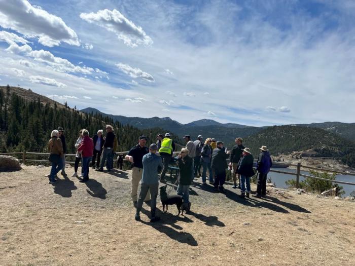
On Friday, May 22, 2026, Congressman Jeff Hurd announced the release of a $40 million award to the Colorado River District for the purchase and permanent protection of the Shoshone Water Rights. The final approval of $40 million award brings the total amount of funding secured to $97 million of the $99 million needed for the purchase. The process now moves into the contracting phase during which the River District will work with the Bureau of Reclamation to finalize the terms of the award.
Colorado River District General Manager Andy Mueller offered the following remarks regarding the broad, bi-partisan support of this project from our federal, state and local representatives:
“This award is a major breakthrough in our coalition’s effort to permanently secure historic flows on the Colorado River. This funding would not have been possible without the leadership of Representative Jeff Hurd. His unwavering advocacy within the Administration helped secure this once-in-a-generation investment in a project that is vital to the prosperity of rural communities, farmers and ranchers on the Western Slope.
Senator Michael Bennet demonstrated valuable foresight appropriating Inflation Reduction Act funding to address the growing water challenges facing the Colorado River Basin. His leadership helped deliver this historic investment in long-term water security and protect our state’s namesake river for generations to come.
As founders of the Colorado River Caucuses in both the Senate and House, Senator Hickenlooper and Representative Neguse fought for these dollars by developing and strengthening coalitions across divides – both geographical and political. By advocating for the Shoshone Water Rights Project in Colorado and Washington, they helped deliver a durable and permanent solution for the entire Colorado River system.
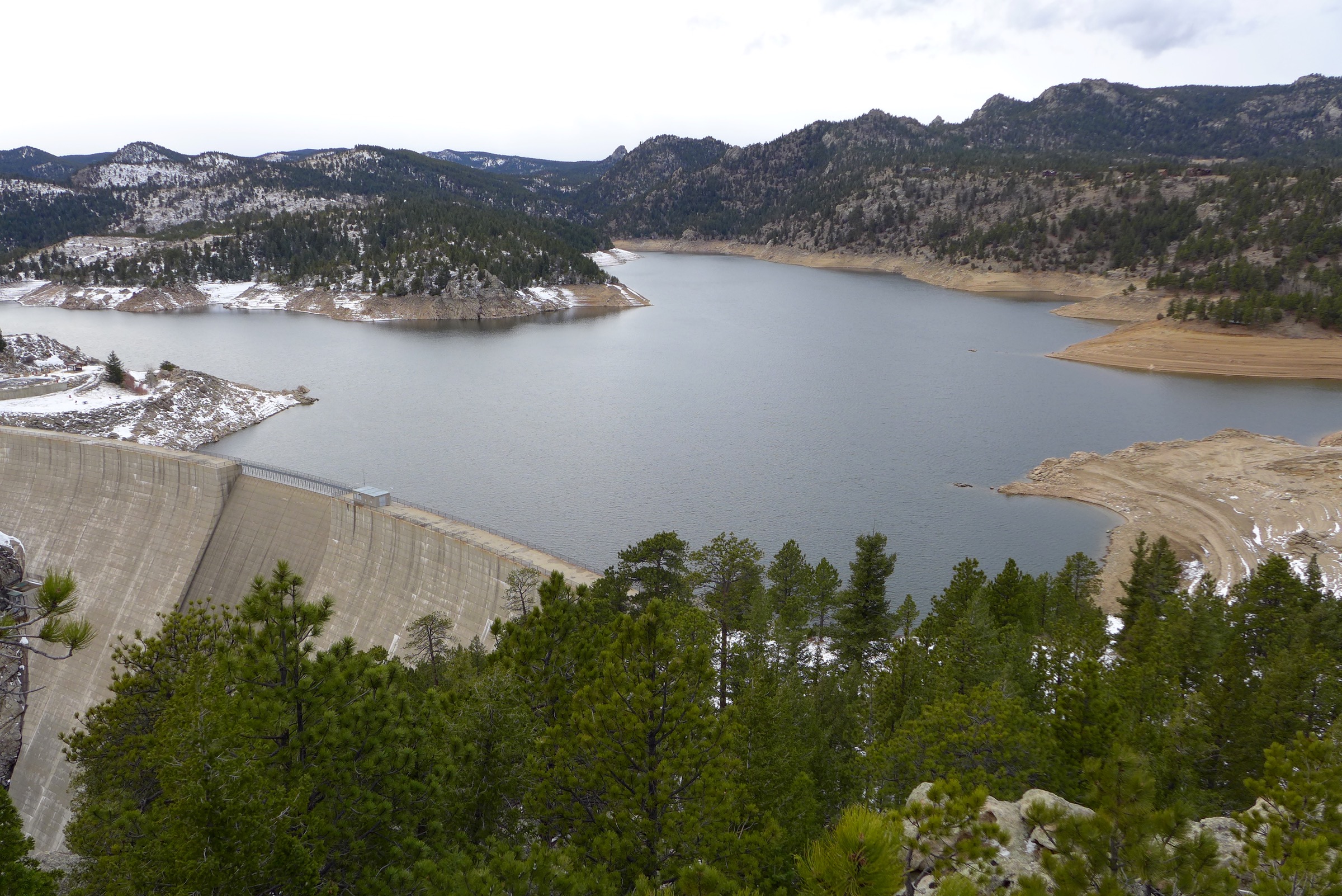
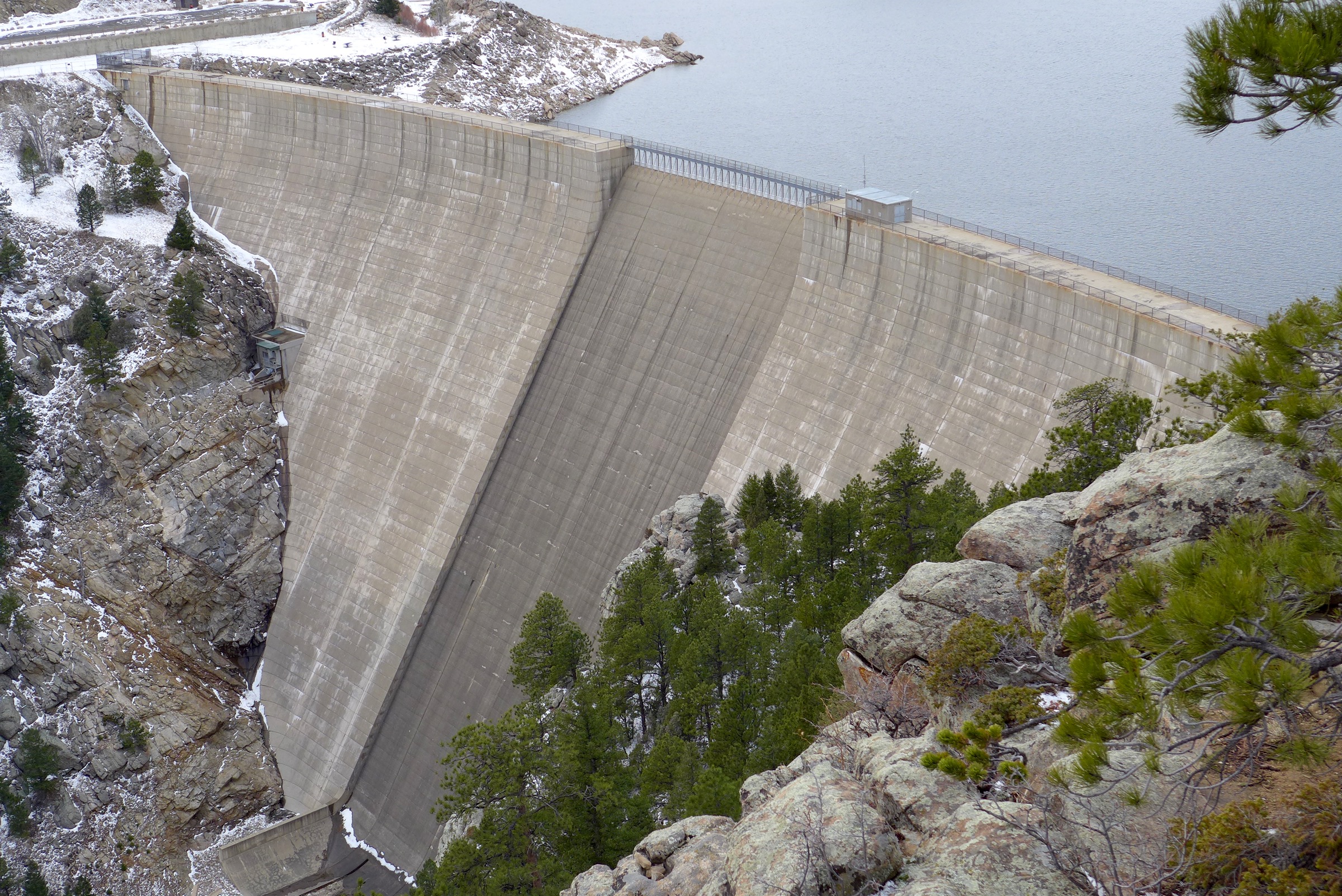
Shoshone Hydroelectric Plant back in the days before I-70 via Aspen Journalism
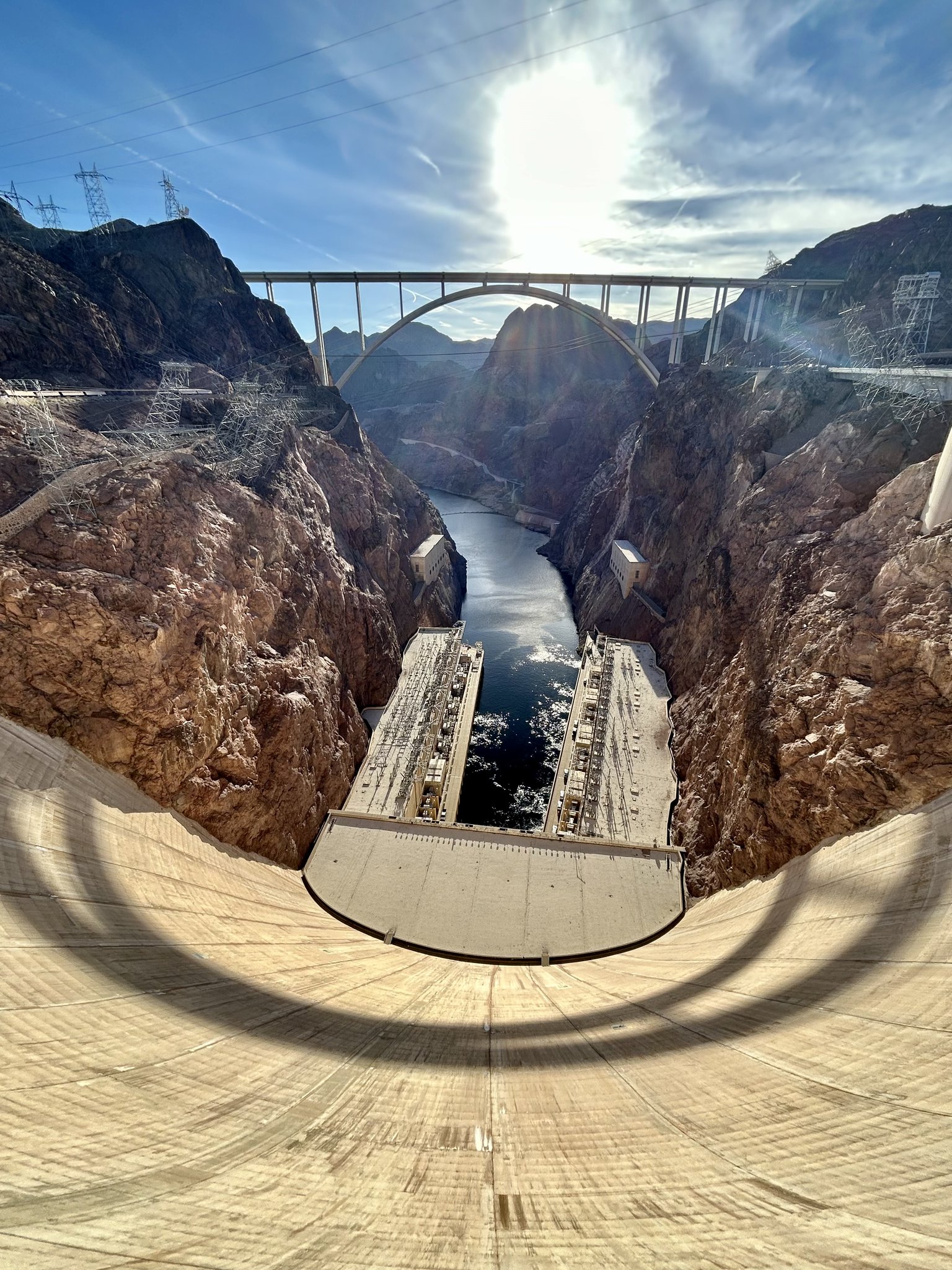
The Hoover Dam is a powerhouse! With an impressive output of about 3 billion kilowatt-hours of electricity annually, it provides enough energy to light up about 1 million households in Nevada, Arizona, and California, ensuring the lights stay on un the Southwest. Photo credit: USBR
Click the link to read the article on The Havasu News website (Alan Halaly). Here’s an excerpt:
May 1, 2026
In a Thursday joint statement, the Upper Colorado River Basin states of Colorado, Utah, New Mexico and Wyoming called for “immediate mediation” in the yearslong deadlock with the Lower Colorado River Basin states of Nevada, California and Arizona. They offered no details about who could fill that role or which entity would pay for the costs.
“Time is short, but structured negotiations through mediation offer a new path for authentic discussions,” New Mexico’s Upper Colorado River Commissioner Estevan López said in a statement. “Even at this late stage, we should pursue every opportunity to reach a workable agreement.”
[…]
Asked about how a mediator could differ from the federal government’s intervention or the appointment of a so-called “water master” at the U.S. Supreme Court, Entsminger said states are unlikely to view a mediator’s decision-making as binding.
“It’s certainly not litigation; it’s not even arbitration,” Entsminger said. “It’s more of a marriage counselor.”
[…]
Colorado River Board of California Chairman JB Hamby said in a Tuesday statement that his state proposed a mediation process last year. California officials see the need for both long- and short-term solutions, and mediation could push the Upper Basin toward “verifiable water contributions,” Hamby added.
“Effective mediation requires common ground, and the system cannot wait,” Hamby said. “Current conditions require immediate, measurable water reductions from every state.”
Map of the Colorado River drainage basin, created using USGS data. By Shannon1 Creative Commons Attribution-Share Alike 4.0
Click the link to read the paper on the Getches-Wilkinson Center website (Eric Kuhn, Anne Castle, Carlos de la Parra, John Fleck, Jack Schmidt, Kathryn Sorensen, Katherine Tara). Here’s the abstract:
March 26, 2026
Since 1945, the United States and Mexico have managed common interests on their two largest shared rivers systems, the Colorado and the Rio Bravo/Rio Grande, under the terms of the 1944 international treaty that was designed from the beginning with tools to adapt to changing hydrologic and societal conditions. A recent emergency agreement on the Rio Bravo/Rio Grande illustrates what is possible, and with old river management rules on the Colorado both within the United States and between the United States and Mexico about to expire, we are at a moment of opportunity for meaningful change. The core problem on the Colorado River, which we address in the analysis that follows, arose from decisions made in the first half of the 20th century to allocate fixed volumes of water. As usage patterns and hydrology change in the 21st century, fixed volumes no longer work. [ed. emphasis mine] A shift to a percentage-based split between the United States and Mexico on the Colorado River, based on the river’s actual natural flow, would provide a solid foundation for the two countries’ joint management of the Colorado in the decades to come.
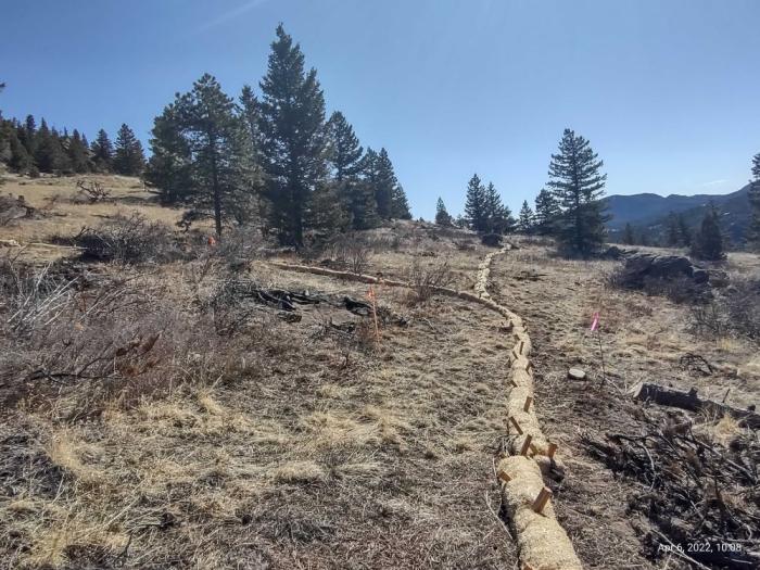
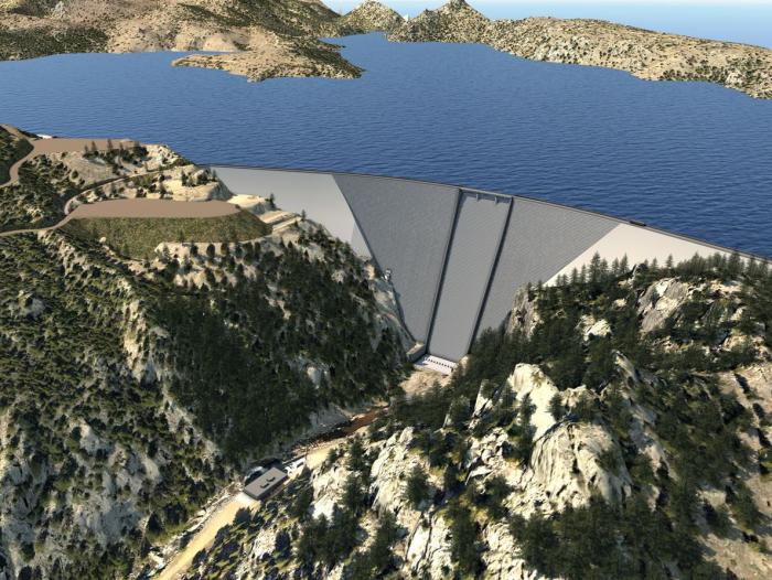
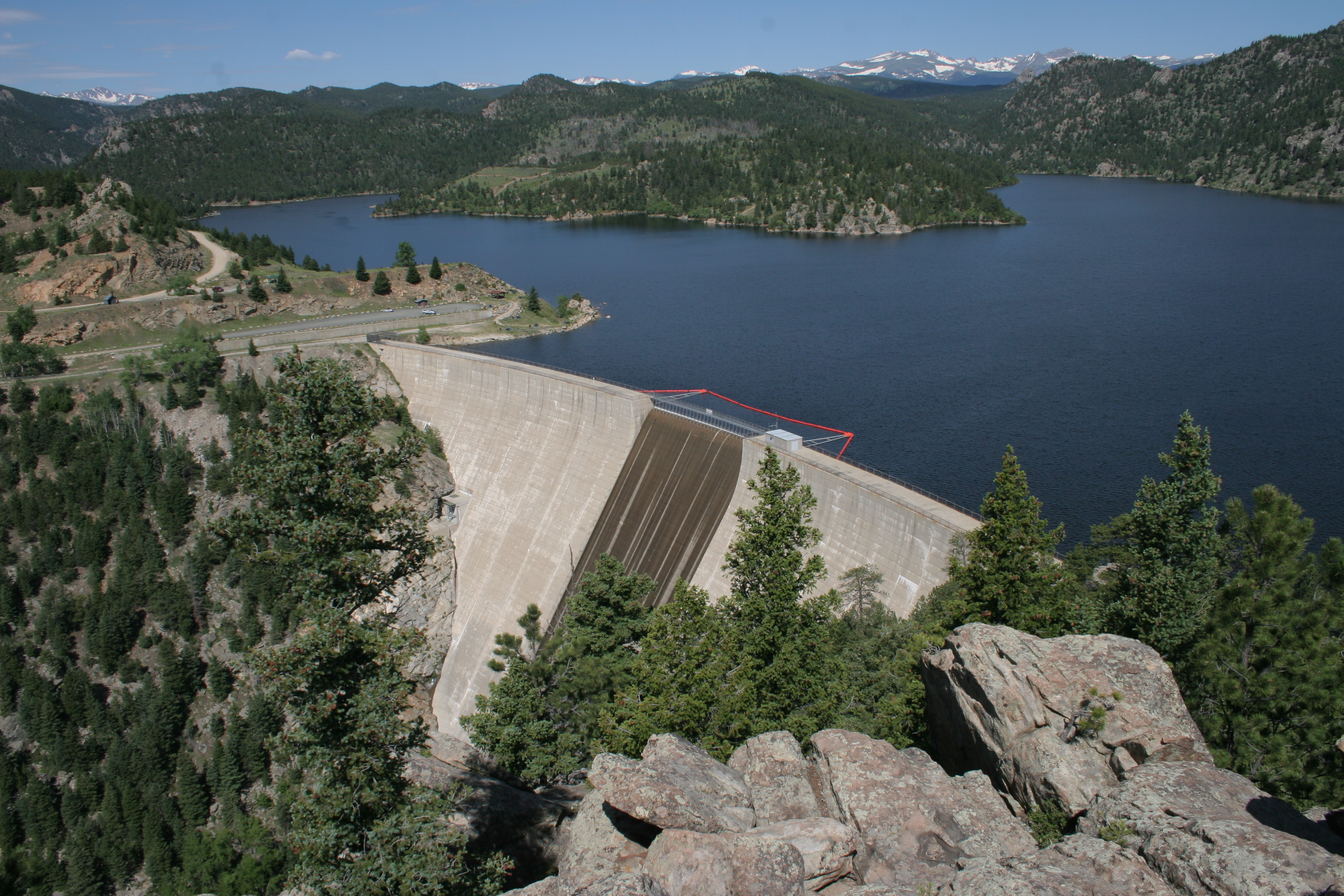
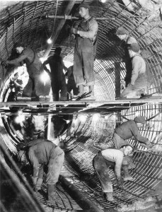
View of Shoshone Hydroelectric Plant construction in Glenwood Canyon (Garfield County) Colorado; shows the Colorado River, the dam, sheds, a footbridge, and the workmen’s camp. Creator: McClure, Louis Charles, 1867-1957. Credit: Denver Public Library Digital Collections
Click the link to read the article on the Aspen Times website (Ali Longwell). Here’s an excerpt:
September 20, 2025
The battle over one of the Colorado River’s oldest, non-consumptive water rights continued this week during a 14-hour Colorado Water Conservation Board hearing over whether the rights could be used for the environment. The Colorado River District is seeking to acquire the Shoshone water rights — tied to a hydropower plant on the Colorado River in Glenwood Canyon — from Xcel Energy for $99 million. The River District, a governmental entity representing 15 Western Slope counties, is proposing to add an instream flow agreement to the acquisition, which would allow a certain amount of water to remain in the river for environmental benefits. While the state’s water board — the only entity that can hold an instream flow water right in Colorado — was set to decide on the proposal this week, this was pushed to November after the parties agreed to take more time to reach a consensus on the proposal.
“The exercise of the Shoshone water rights impacts almost every Coloradan,”said Davis Wert, an attorney speaking on behalf of Northern Water.
Northern Water is contesting the instream flow agreement alongside Denver Water, Aurora Water, and Colorado SpringsUtilities. These providers rely on transmountain diversions from the Colorado River basin to supply water to their customers…While the hearing did include some back and forth, the entities west and east of the Continental Divide agreed on a few things during the hearing. First, adding an instream flow agreement to the Shoshone right will preserve and improve the natural environment. Second, they want to maintain the status quo on the Colorado River…Michael Gustafson, in-house counsel for Colorado Springs Utilities, said the provider did not oppose the change of the senior Shoshone water right for instream flow purposes “to provide for permanency of the historic Shoshone call and maintenance of the historical Colorado River flow regime…
With that, however, there were a few sticking points during the hearing: who should manage the instream flow agreement — and have the authority to make decisions on Shoshone calls — and how much water has historically been granted as part of the right. The historic flow regime has been highly contested between the parties but will ultimately be determined in the Colorado Water Court proceedings that will conclude the River District’s acquisition. Wert acknowledged this as the Front Range entities presented a historic use analysis that contrasted the preliminary analysis obtained by the River District…The Colorado River District’s proposed instream flow agreement includes a “co-management strategy,” while the contesting Front Range providers want the sole management authority to reside with the Colorado Water Conservation Board.
This historical photo shows the penstocks of the Shoshone power plant above the Colorado River. A coalition led by the Colorado River District is seeking to purchase the water rights associated with the plant. Credit: Library of Congress photo
State water officials debated a controversial proposal to use two powerful Colorado River water rights to help the environment, weighing competing interests from Front Range and Western Slope water managers.
Almost 100 water professionals gathered in Durango this week for a 14-hour hearing focused on the water rights tied to the Shoshone Power Plant, owned by an Xcel Energy subsidiary. Members of the Colorado Water Conservation Board were originally set to make their final decision on the proposal this week, but an eleventh-hour extension pushed their deadline to November.
Board members peppered presenters with questions during the hearing, weighing thorny issues like who has final authority to manage the environmental water right and how much water is involved.
Their decision could make a historic contribution to the state’s environmental water rights program and impact how Colorado River water will flow around the state long into the future.
“It’s pretty hard to anticipate all of the ways that ‘in perpetuity’ may play out,” said Greg Felt, who represents the Arkansas River on the board. “Building in representation for flexibility … is not a bad idea for an acquisition like this.”
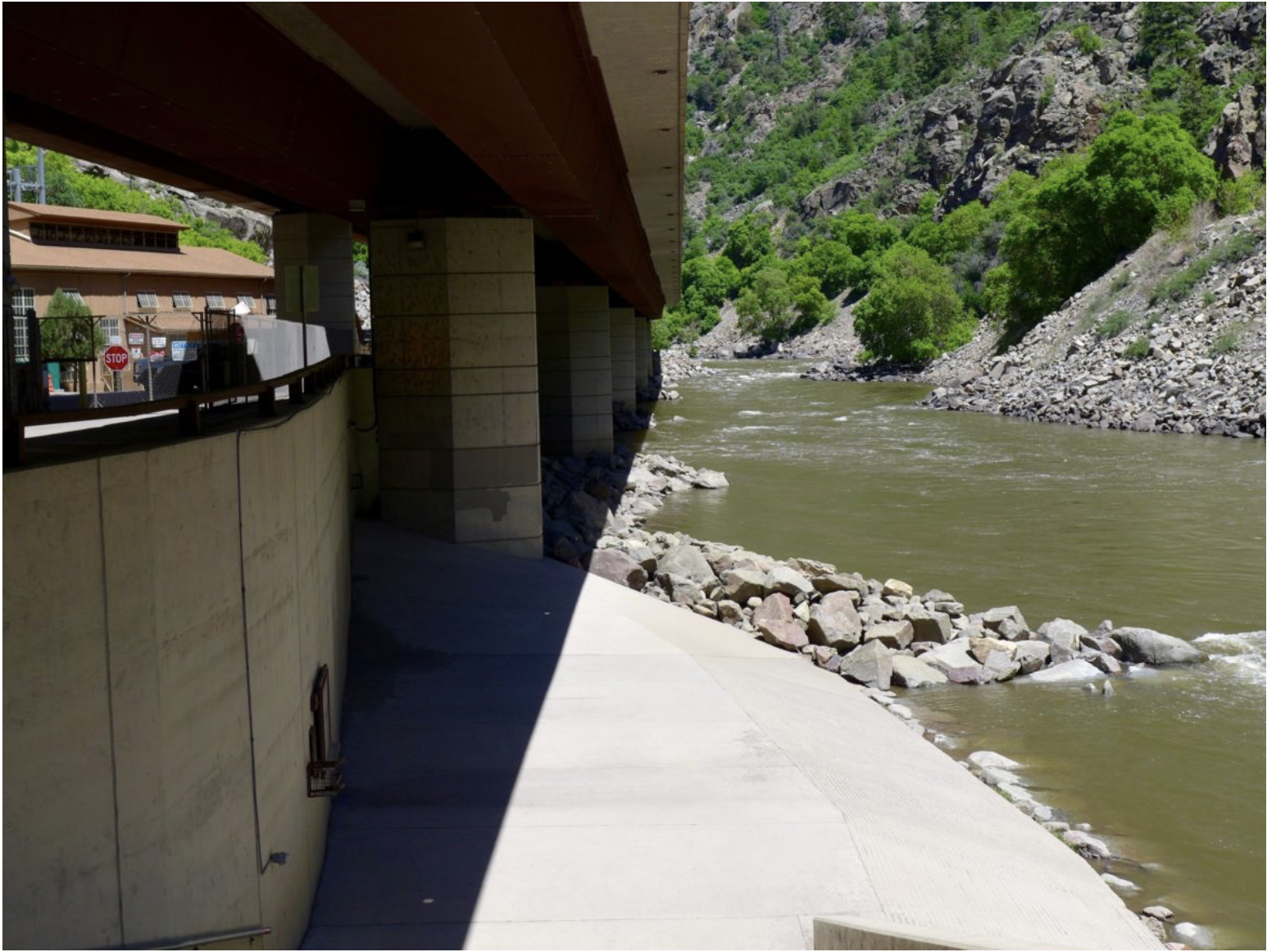
The Shoshone Power Plant, next to Interstate 70 east of Glenwood Springs, has used Colorado River water to generate electricity for over a century.
Graphic credit: Laurine Lassalle/Aspen Journalism
In May, the Colorado River District, representing 15 counties on the Western Slope, shared a proposal to add another use to the water rights: keeping water in the Colorado River channel to help the aquatic environment.
The change requires approval from the Colorado Water Conservation Board, which runs the state’s environmental water rights program, and other entities like water court and the state’s Public Utilities Commission.
The Colorado River District wants to add the environmental use as part of a larger plan to maintain the “status quo” flow of water past the power plant, regardless of how long the power plant remains in operation.
Western Slope communities, farms, ranches, endangered species programs and recreational industries have become dependent on those flows over the decades.
“What we’re presenting here today is an offer of a historic partnership,” Andy Mueller, Colorado River District general manager, said. “We believe that this sets the state up for a truly collaborative future on the Colorado River.”
But any change to Shoshone’s water rights could have ripple effects that would affect over 10,000 upstream water rights, including those held by Front Range water groups, like Denver Water, Northern Water, Colorado Springs Utilities and Aurora Water.
These water managers and providers are responsible for delivering reliable water to millions of people, businesses, farms and ranches across the Front Range.
They raised concerns in the hearings about how their water supply could be impacted by the Western Slope’s proposal.
For board member John McClow, who represents the Gunnison-Uncompahgre River, one key question came down to authority.
“I just want to make sure we have adequate legal justification for doing what you suggest we should do,” McClow told CWCB staff during the hearing.
When the Colorado River is too low to meet Shoshone’s needs, its owner, Public Service of Colorado, a subsidiary of Xcel Energy, can call on upstream water users with lower priority water rights to cut back on using their water so that Shoshone has enough.
Whoever manages this “call” impacts thousands of upstream users, including Front Range providers.
Under the proposal, the Colorado River District will own the water rights. The district has an agreement with Xcel to buy the rights for about $99 million.
Generally, the Colorado Water Conservation Board is supposed to be the sole manager of environmental water rights under state law.
The Colorado River District says it should have a say, giving examples of other agreements with similar arrangements between the water board and water rights owners.
Northern Water said the state should have exclusive authority. This is the most important issue for the conservation district, Kyle Whitaker, water rights manager for Northern Water, said Thursday.
If the state agency hands over any amount of control, then the district would push for the water court to approve a smaller amount of water available to Shoshone. That would send less water to Western Slope communities.
If the River District controlled the environmental right, they could conceivably max out the amount of water passing by the power plant year-round, which would impact upstream water rights.
“We have to protect our systems under all future potentialities,” Whitaker said. “This will have a chilling effect on collaboration and cooperation amongst all involved and is likely to result in an outcome that is not only less desirable but also less beneficial to the Colorado River.”
The River District has said it plans to maintain these flows without changing how other water users are impacted.
For board members, this question of authority is just one of many sticky legal and management issues they have to weigh as they make a decision about the Shoshone water rights while tasked with representing the interests of the entire state.
“As far as I’ve been able to understand it, I agree with you about what the statute and the rules say we may do,” Felt told CWCB staff. “I believe we’re here to determine what we should do.”
The Shoshone hydro plant in Glenwood Canyon. The Shoshone hydropower plant in Glenwood Canyon. The CWCB will hold a hearing on the water rights associated with the plant in September. Credit: Heather Sackett/Aspen Journalism
Front Range asked for Colorado Water Conservation Board neutrality on historic use of Shoshone water rights
In an effort to head off concerns about the state’s role in a major Western Slope water deal, a Western Slope water district has offered up a compromise proposal to Front Range water providers.
In order to defuse what Colorado River Water Conservation District General Manager Andy Mueller called “an ugly contested hearing before the CWCB,” the River District is proposing that the state water board take a neutral position on the exact amount of water tied to the Shoshone hydropower plant water rights and let a water court determine a final number.
“Although we believe this would be an unusual process, the River District believes it would address the primary concern (i.e., avoiding the state agency’s formal endorsement of the River District’s preliminary historical use analysis) that we heard expressed by your representatives at the May 21, 2025 CWCB meeting regarding the Shoshone instream flow proposal,” Mueller wrote in an email to officials from the Front Range Water Council.
The River District worked with CWCB staff to draft the proposal, but it may not go far enough to address Front Range concerns.
The River District, which represents 15 counties on the Western Slope, is planning to purchase some of the oldest and largest non-consumptive water rights on the Colorado River from Xcel Energy for nearly $100 million. The water rights, which are tied to the Shoshone hydropower plant in Glenwood Canyon, are essential for downstream ecosystems, cities, endangered fish, and agricultural and recreational water users. As part of the deal, the River District is seeking to add an instream flow water right to benefit the environment to the hydropower water rights.
The effort has seen broad support across the Western Slope. The River District has raised $57 million toward the purchase from at least 26 local and regional partners. The project was awarded a $40 million Inflation Reduction Act grant in the waning days of the Biden administration, but those funds have been frozen by the Trump administration.
“These water rights are foundational to the Colorado River,” said Amy Moyer, chief of strategy at the River District. “It’s the number one project for the Western Slope. It’s the top priority to move forward.”
Critically, because its water rights are senior to many other water users — they date to 1902 — Shoshone can force upstream water users to cut back. The Shoshone call has the ability to command the flows of the Colorado River and its tributaries upstream all the way to the headwaters.
The twin turbines of Xcel Energy’s Shoshone hydroelectric power plant in Glenwood Canyon can generate 15 megawatts. The River District is proposing that the CWCB remain neutral on the issue of the plant’s historic water use. Credit: Heather Sackett/Aspen Journalism
Putting a precise amount on how much water the plant has historically used is a main point of contention between the River District and the Front Range Water Council, a group that includes some of Colorado’s biggest municipal water providers: Denver Water, Colorado Springs Utilities, Aurora Water and Northern Water. These entities take water that would normally flow west, and bring it to farms and cities on the east side of the Continental Divide through what are called transmountain diversions. About 500,000 acre-feet of water annually is taken from the headwaters of the Colorado River and its tributaries to the Front Range.
Estimates by the River District put the Shoshone hydro plant’s average annual use at 844,644 acre-feet using the period between 1975 and 2003 — before natural hazards in the narrow canyon began knocking the plant offline regularly in recent years.
But Front Range Water Council members say this estimate is flawed and could be an expansion of the historical use of the water right. They have requested a hearing at the September CWCB meeting to hash out their concerns.
“The preliminary analysis that has been presented appears to expand historic use and creates potential injury,” Abby Ortega, general manager of infrastructure and resource planning at Colorado Springs Utilities told the CWCB at its May meeting.
Determining past use of the Shoshone water rights is important because it will help set a limit for future use. While changing the use of a water right is allowed by going through the water court process, enlarging it is not. The amount pulled from and returned to the river must stay the same as it historically has been.
As part of the River District’s deal to buy the water rights, the CWCB — which is the only entity in the state allowed to hold an instream flow water right — must officially accept the water right and then sign on as a co-applicant in the water court change case.
But Front Range water providers said that doing so would amount to an endorsement of the River District’s historical use estimate, which would mean taking a side in the Front Range versus Western Slope disagreement.
“If you agree to accept the right and as I understand it, the instream flow agreement, you’re agreeing to be a co-applicant, which risks you accepting their analysis,” said Alexandra Davis, an assistant general manager with Aurora Water, at the CWCB’s May meeting.
Some members of the Front Range Water Council have asked that the CWCB remain neutral during the water court change case. In May 9 and June 9 letters to the CWCB from Marshall Brown, general manager of Aurora Water, he said the CWCB shouldrefrain from endorsing any specific methodology or volume of water.
“… [T]he CWCB should remain neutral in the water court proceedings and defer to the court’s determination of the appropriate methodology and volumetric quantification,” the May 9 letter reads.
The River District’s offer does just that: It proposes that the CWCB should not take a position regarding the determination of historical use of the Shoshone water rights.
“We heard the issues that are most front and center from these entities,” Moyer said. “And so we are trying to find a path forward that works for everyone.”
But even if Front Range Water Council members are in favor of the proposal, it is unlikely to result in a cancellation of the hearing. CWCB Executive Director Lauren Ris said in an email that under the board’s rules, they are required to hold a hearing. And Jeff Stahla, public information officer at Northern Water, said they will still be asking for the hearing to proceed.
Spokespeople from Colorado Springs Utilities, Aurora Water and Denver Water all declined to comment on the River District’s proposal because it was marked as confidential.
Some members of the Front Range Water Council have concerns beyond CWCB neutrality that could be addressed at the September hearing.
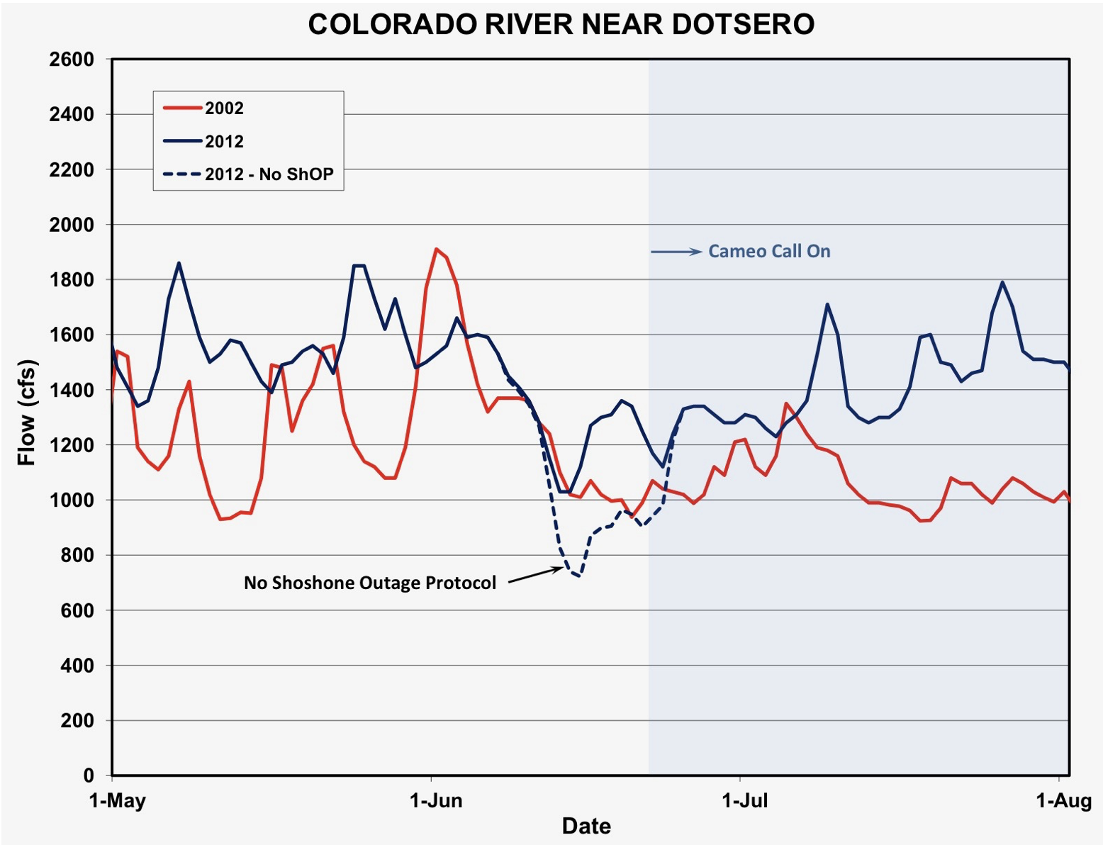
In a May 14 letter to the CWCB, Denver Water’s CEO Alan Salazar said the water provider also wants to carry over some provisions from existing agreements like the Shoshone Outage Protocol. This agreement has an exception in cases of extreme drought that allows Denver Water to keep taking water if its reservoirs fall below certain levels and streamflows are low. Denver Water added that by omitting the last two decades of Shoshone water use, the River District’s study period is skewed, and that using an upstream stream gauge to measure historical use is improper.
The hearing is scheduled for the next CWCB board meeting Sept. 16-18. The board can approve or disapprove the acquisition of the water rights, or make changes to the proposal and adopt the amended proposal. The board is required to take action at the September hearing unless the River District approves an extension. Pre-hearing statements are due by Aug. 4.
CWCB board members Brad Wind, who is general manager of Northern Water, and Greg Johnson, manager of resource planning at Denver Water, recused themselves from the July 17 CWCB board meeting discussion of the Shoshone water rights and plan to recuse themselves from future Shoshone discussions and decisions.
Map of the Colorado River drainage basin, created using USGS data. By Shannon1 Creative Commons Attribution-Share Alike 4.0
As Save the Colorado and Denver Water prepare to face off in a federal courtroom Tuesday, water officials across the state are watching the Gross Dam expansion case closely for its environmental impact and its affect on water projects across the West.
Kirk Klancke, a long-time Grand County environmentalist and president of the Colorado River Headwaters Chapter of Trout Unlimited, said a decision that shuts down the $531 million water project, could also shut down 12 years of work on the Fraser River and its tributaries.
Denver Water is one of 18 partners who signed the Colorado River Cooperative Agreement in 2013, ushering in a new era of cooperation between the utility and West Slope stakeholders, all with the vested interest in protecting watersheds in the Colorado River Basin. As part of that agreement, a process called “Learning by Doing” was created, which has helped the utility stay better connected on river conditions in Grand County. The partnership is a collection of East and West Slope water stakeholders who help identify and find solutions to water issues in Grand County. “Denver Water has been part of Grand County for over 100 years, and we understand the impact our diversions have on the rivers and streams,” said Rachel Badger, environmental planning manager at Denver Water. “Our goal is to manage our water resources as efficiently as possible and be good stewards of the water — and Learning By Doing helps us do that.”
Here’s why: Denver Water owns much of the Fraser with water rights dating back more than 100 years. And it is that water that has historically been piped through the Moffat Tunnel near Rollinsville to fill the existing Gross Reservoir. The new water for the expanded reservoir will come largely from that river as well.
After what’s known as the 2013 Colorado River Cooperative Agreement was signed, Denver Water agreed to conduct extensive restoration work on the river in exchange for being able to raise Gross Dam and bring more water from the Fraser River over to the Front Range.
Klancke said the heavily diverted, scenic waterway would suffer if the deal falls apart. “To dissolve that partnership will be the death of the Fraser River,” he said.
Under the terms of the Colorado River Cooperative Agreement, the work on the Fraser River can only be finalized if the Gross Dam expansion proceeds.
On the upside though, Klancke said, if a new environmental settlement were reached, it could mean more money and more work to restore South Boulder Creek on the other side of the Continental Divide. The creek carries that Fraser River water from the reservoir to Denver Water’s northern storage system.
“I would love to see Denver put a whole bunch of money into South Boulder Creek,” Klancke said.
Gary Wockner, the head of Save The Colorado, disputes the notion that the case could harm environmental work already underway in Grand County.
“We are not causing environmental damage,” he said. “If Denver Water chooses to stop, that’s their choice. That’s on their shoulders. Not ours.”
For its part, Denver says it hopes to continue the Grand County work, but that the terms of the Fraser River agreement are all based on the successful completion of the Gross Dam expansion.
The agency also says it has already set aside $30 million to help offset any environmental harm caused by the massive construction project, including providing 5,000 acre-feet of water to improve streamflows along a 17-mile stretch of South Boulder Creek. An acre-foot of water equals nearly 326,000 gallons, enough water to serve two to four urban households for one year.
Roller-compacted concrete will be placed on top of the existing dam to raise it to a new height of 471 feet. A total of 118 new steps will make up the new dam. Image credit: Denver Water.
Denver Water first moved to raise Gross Dam more than 20 years ago when it began designing the expansion and seeking the necessary federal and state permits.
After years of engineering, studies and federal and state analyses, construction began in 2022. It has involved taking apart a portion of the original dam, built in the 1950s, and raising its height by 131 feet to nearly triple the reservoir’s storage capacity to 119,000 acre-feet from 42,000 acre-feet.
Save The Colorado has launched several unsuccessful challenges to the project, but in 2022 it won an appeal that put the legal battle back in play. Despite months of settlement talks, no agreement was reached.
Then the case took center stage again April 3, when Senior U.S. District Court Judge Christine Arguello put a temporary halt to construction of the higher dam, at Save The Colorado’s request.
Almost immediately, Denver Water filed for temporary relief from the order, saying, in part, that it would be unsafe to stop work as the incomplete concrete walls towered above Gross Reservoir.
Arguello granted that request, too, allowing Denver to continue working on the dam.
Gross Dam case spurred $100 million settlement in a different lawsuit
What happens next is anyone’s guess. Jennifer Gimbel, a water policy scholar at Colorado State University who also serves on Northern Water’s board of directors, said the case has already had an impact on a $2 billion water project to deliver water to residents of fast-growing northern Colorado. The Northern Integrated Supply Project, as it is known, also faced a legal challenge from Save The Colorado, and ultimately the water agency opted to settle the case for $100 million. The cash will help restore the Cache la Poudre River with new diversion agreements and improved streamflows, among other benefits.
Gimbel said the Gross Reservoir case was a key factor in that settlement. “Because of Denver’s troubles with Save the Colorado, Northern Water decided to resolve their lawsuit because they were worried about their own permit getting stale and because as you delay construction costs increase.”
The Gross Dam case is also noteworthy because it has stopped a major construction project already underway and may significantly change it. Judge Arguello has ordered the U.S. Corps of Engineers, the major permitting agency, to redo its original permitting work.
Denver Water General Manager Alan Salazar has said his agency would take the case to the U.S. Supreme Court, if they lose in the lower courts.
As both sides prepare for Tuesday’s hearing, the 10th Circuit Court of Appeals panel has said it will wait to see what information emerges from the Tuesday hearing before it rules on Denver Water’s appeal before the 10th Circuit, according to Denver Water General Counsel Jessica Brody. That action seeks to permanently protect what Denver believes is its right to raise Gross Dam.
Denver Water has also raised national security concerns in the case because Save The Colorado has asked and been granted the right to review construction documents on the dam project, documents that would normally be kept from public view.
In response, the judge has told participants to expect the court to be closed periodically during the hearing to address those security concerns.
Northern Water Board Director Jennifer Gimbel, left, leads a panel at the Colorado River Water Users Association this month in Las Vegas. L to R: Jennifer Gimbel, Gene Shawcroft, Estevan López, and Brandon Gebhart. Photo credit: Northern Water
A member of the Northern Water Board of Directors played a large role at the annual gathering of Colorado River water officials this month in Las Vegas.
Jennifer Gimbel, who represents Larimer County on the Northern Water Board of Directors and is a senior water policy scholar at Colorado State University, moderated a pair of panel discussions at the Colorado River Water Users Association (CRWUA) annual conference about the current state of negotiations on new guidelines for the operations of Lake Powell and Lake Mead.
Gimbel helped negotiators from the Upper Basin states of Colorado, New Mexico, Utah and Wyoming outline their concerns, and in a second panel, did the same for negotiators for the Lower Basin states of Arizona, California and Nevada.
For the 1,000-plus attendees of the conference, it was an opportunity to learn more about what will guide future discussions about use of Colorado River water throughout the Southwestern United States.
Northern Water is a member of CRWUA and engages with other Colorado River users throughout the year.
In photo from second left: Gene Shawcroft of Utah, Estevan Lopez of New Mexico, Becky Mitchell of Colorado and Brandon Gebhart of Wyoming.
Colorado River headwaters-marker. Photo credit: Allen Best/Big Pivots
Click the link to read the article on the Big Pivots website (Allen Best):
May 23, 2024
Expert suggests “Law of the River” discussions about realigning demand with supplies are doomed to fall short
Before Jack Schmidt wrapped up his comments about the Colorado River in a recent webinar sponsored by the Sierra Club, he had David Brower rolling in his grave.
Brower, the leader of the Sierra Club in the 1950s and 1960s, had famously fought efforts to harness the Colorado River, drowning its fabulous canyons in the process.
The environmental community in the ‘50s and ‘60s had “simple, clear fights: stop dams, don’t drown spectacular canyons,” he said.
Brower and other environmentalists won the argument at Echo Park, in Dinosaur National Monument. They won the argument at Marble Canyon. Those who opposed Glen Canyon lost that battle.
“But it was a simple, clear fight,” said Schmidt.
The story has become far messier, the issues more complex. He cited the dilemma about fish.
When Lake Powell was full, water was withdrawn from the cold depths of the reservoir. Rafters at Lees Ferry, just downstream from Glen Canyon Dam and the waters of Powell, soon had ankles that tingled when rigging their boots. The water was cold.
Not now after 22 years of declining water levels in Powell. Water temperature at Lee Ferry reached 70 degrees Fahrenheit in September 2022.
Non-native fish in Powell now get swept through the dam where they swim to the Grand Canyon, threatening the native fish there.
Some environmental groups and the National Park Service have advocated that the best way to keep the water temperatures low and keep these fish out of the Grand Canyon is to preferentially keep Lake Powell higher, said Schmidt, a professor at Utah State University who directs the Center for Colorado River Studies. Others glory in seeing the canyons of the Colorado that few had ever seen.
Higher or lower water levels? Higher is better for downstream native fish. Lower levels allow the magnificence of long-submerged Glen Canyon to emerge.
Different questions, different equations have emerged. He suggested that looking beyond all the federal laws, the story of the Colorado River at this point can be simplified to a few basic questions: “What ecosystem conditions do we want? What values do we have?”
And he also asked his 26 listeners to ponder whether we — including the Sierra Club and other environmental groups — have been looking at the Colorado River in the most useful way.
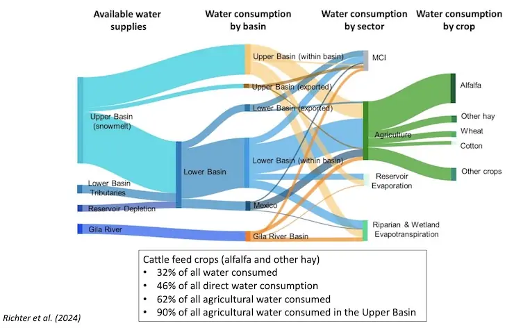
“Let’s celebrate the fact that we are a nation of laws, but let’s go past that,” he said. Instead of viewing the river through the legal lenses that we have used for the last century, we should look at it in terms of sectors. Among those sectors, agriculture uses by far the most water, and most of that ag water has been devoted to growing forage for animals.
Anne Castle had spoken first in the webinar, and she laid out those laws, agreements, and other legal processes now underway. She also shared the now familiar numbers that help explain why the Colorado River has become a national story.
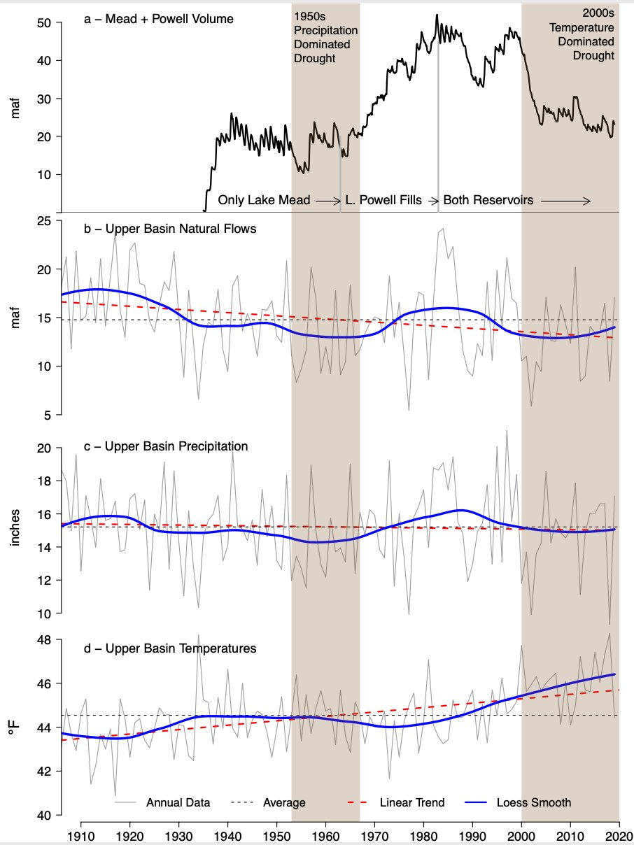
“New plot using the nClimGrid data, which is a better source than PRISM for long-term trends. Of course, the combined reservoir contents increase from last year, but the increase is less than 2011 and looks puny compared to the ‘hole’ in the reservoirs. The blue Loess lines subtly change. Last year those lines ended pointing downwards. This year they end flat-ish. 2023 temps were still above the 20th century average, although close. Another interesting aspect is that the 20C Mean and 21C Mean lines on the individual plots really don’t change much. Finally, the 2023 Natural Flows are almost exactly equal to 2019. (17.678 maf vs 17.672 maf). For all the hoopla about how this was record-setting year, the fact is that this year was significantly less than 2011 (20.159 maf) and no different than 2019” — Brad Udall
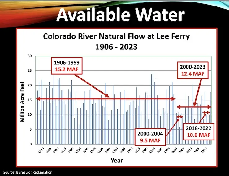
From 1906, when record-keeping began, until 1999, the Colorado River averaged flows of 15.2 million acre-feet. From 2002 to 2023, the river delivered 12.5 million acre-feet. And within that span, there were other years of yawn-inducting flows, including an average 10.6 million from 2018 to 2022.
“Climate change is the reason,” she said. “It’s hotter, it’s drier. And there are lesser flows.”
These numbers conflict dramatically with what was assumed in the Colorado River Compact of 1922: annual average flows of at least 17.5 million acre-feet.
“You can see we have a problem,” said Castle, a water attorney in Denver for 28 years before serving from 2009 to 2014 as assistant secretary for water and science in the U.S. Department of Interior. There she had responsibility for the Bureau of Reclamation and the U.S. Geological Survey. She is now on the Upper Colorado River Commission and a founding member of the Water Policy Group.
This inequation of supply and demand has many twists. The Colorado River Compact allocated 7.5 million acre-feet to the lower basin states – Arizona, California and Nevada, or those principally below Lee Ferry. A similar amount was awarded the upper basin, with an acknowledgement that something would have to be delivered to Mexico. (It ended up being 1.5 million acre-feet).
The upper-basin delivers nearly all the water in the Colorado River, and Colorado delivers the lion’s share: about 55%.
Now, get into the metaphoric frame of mind. Castle instructed listeners to imagine a checking account. Even though the upper basin was using only 3.5 to 4.5 million acre-feet per year and leaving any excess to flow into Lake Powell, Powell continue to be drawn down to meet demands from the lower basin and from Mexico. The annual deficit during the 21st century varied between 0.6 million acre feet and 3.6 million acre-feet.
“You can only draw your checking account so far,” she said. “You have to live within the means of the river, and that’s what we’re trying to do now.”
Castle then outlined the sequence of responses since the river’s flows plunged to an average 9.5 million acre-feet during 2002-2004 – and the reservoir levels shrank accordingly.
The first response, if a very tepid one, came in 2007. That agreement acknowledged shortages but provided no real response to the imbalance between supply and demand. Another response came in 2019. That was best seen as a temporary fix-it that fell short of the muscular responses needed. By then, many had begun to understand that “drought” was a less useful way to understand what was happening than “aridification.” Yes, drought was at work. That might change. Reduced flows caused by the human-induced warming temperatures — roughly 50% by one study released in 2017 — could not.
Even so, some warned that the 2019 agreement might not be enough should conditions intensify.
For several years, they did. By May 2022 a shelf in the wall of Glen Canyon created with railroad tracks emerged from the water. It had been submerged since shortly after completion of the dam in the 1960s.
Had 2023 been another bum snow year, the situation would have been dire indeed. Instead, 2023 was a bumper year for snow. Some in Colorado’s Yampa River Basin and its tributary, the Little Snake could remember nothing deeper. There was lots of snow. And, if not quite so much, a lot of runoff into Powell.
Which now leaves the reservoirs back to the levels they were in …. 2021.
Castle used the word “frantic” in describing the efforts to create solutions before the 2023 runoff created breathing room. With that small cushion, the Bureau of Reclamation, as manager for the two big reservoirs, Mead and Powell, issued a plan in March 2024 that was finalized on May 9. In this still-incomplete process, the federal agency adopted a proposal from the lower basin states as its preferred alternative for governing the river until 2026.
What happens then in 2026?
This is the work that some thought needed to be undertaken in 2017. Everybody with an interest has a proposal: the states, the 30 tribes that have 20% to 25% of water rights in the river (but have to a substantial extent not developed them), the major agriculture organizations, the major municipal providers, the environmental groups, and still others.
Castle described the ideas. The most important element of the proposal from the three lower-basin states, she said, is that if the reservoirs are at 23% to 38% full – where they are now and are likely to be under even the more optimistic scenarios – then reductions of 3.9 million acre-feet are to be shared between the upper and lower basins.
Not surprisingly, the upper basin sees the onus for reductions differently. Colorado along with Wyoming, Utah, and New Mexico have no big, big reservoirs. They have no big checking accounts. They have smaller reservoirs, Blue Mesa being the largest in Colorado, with 800,000 acre-feet in storage. Powell has more than 25 million acre-feet and Mead more than 30. The upper basin states are limited by what nature delivers in any given year or sequence of years. They live hand to mouth.
The tribes, meanwhile, are very concerned about impacts to their water rights. Castle did note the recent signing of an MOU among the four upper-basin states and the six upper-basin tribes. She called it a “significant milestone in the inclusion of tribal voices.”
Tribes have never really had a seat at the table. They had no representatives in Santa Fe in 1922 when the river was carved up, nor in the 1948 Upper Colorado River Basin Compact. Amazing to many, they have not even had a formal position in river proceedings in the 21st century until the MOU that Castle referenced.
Schmidt called for bigger shift in how we view the Colorado River. “Ann emphasized the nature of all these different proposals,” he said. “The upper basin says we’ll be damned if we’re going to cut a drop because we use less than half of what you guys use downstream. But on the other hand, of the 40 million people who use water from the Colorado River, half are in southern California. When we talk about equity, there’s a lot of different ways to define equity. And one of those ways is by the agreements set a 100 years ago of 7.5 (million acre-feet) used by each basin. But obviously, given the population distribution and the economic importance of the lower basin, you could argue the principle of equity in many different ways. That’s something worth thinking about.”
Topping Schmidt’s values – what he considers most important — is restoring water to the delta of the Colorado River. Not the full amount, because that is clearly impossible, but enough to create a semblance of the ecosystem that disappeared gradually over the last century.
“Ironically, the largest city that sits on the banks of the Colorado Rivers is not in the United States. It’s in Mexico. And that city is San Luis Rio Colorado. The river at that point is bone dry. That tells you all you need to know about the Colorado River. It is fully tapped. Not one drop of water makes it to the sea in most years. So when we talk about a declining supply in a river where nothing gets to the ocean already, then we have a problem.”
Almost no water has flows through the Colorado River Delta since the late 1990s and only sporadically before that after the 1970s. February 2017 photo at San Luis Rio Colorado/Allen Best
Lost at the delta, he said, was the “most biologically diverse ecosystem in North America.”
Where does Schmidt propose to get this water? He didn’t go into details. He only painted with broad brushes what those who know much about the Colorado River Basin already understand: agriculture uses half the water in the basin (higher in some states). And this isn’t necessarily for growing cantaloupes and cabbage — although, of course, the Imperial Valley and Yuma areas provide the great majority of vegetables consumed in the United States and Canada during winter, by some estimates around 90%.
Even during those months, though, much is going to livestock.
“A vast majority of the water in agriculture is used for livestock feed, either in the production of beef, in particular, but also in dairies. This is not what is being negotiated. This is important, I think, for every citizen to understand. I’m going to overstate this, because I’m that kind of guy – we’re trapped in a hundred years of thinking about this in a legal construct and we celebrate that we are a nation of laws. But the flip side is we’re using all this water in agriculture for heaven’s sakes. We’re using all this, a large part of this water for livestock feed. We’re not using this primarily in the big cities. And someday the negotiation about the future of the Colorado River inevitably will have to shift to a discussion about using water by economic sectors, not by using water in an upper or lower basin.”
Schmidt suggested that the legal framework was not the central issue that environmental groups should be talking about.
“We’re not talking about the big issue,” he said. “The big issue is what economic sectors are using water. As Marc Reisner, the author of Cadillac Desert, said long ago, the American West doesn’t have a water supply crisis. The American West has a water allocation crisis, but this is an issue that people won’t touch.”
Writer’s note: I have gone to dozens of water conferences over the years, and this two-hour session was by far the most productive use of time I’ve invested in the Colorado. To see the full two-plus-hour session (and see the PowerPoints that the speakers used), go to this address and then plug in this password. 6.!BFDW* These slides are used courtesy of the speakers.
From left, J.B. Hamby, chair of the Colorado River Board of California, Tom Buschatzke, Arizona Department of Water Resources; Becky Mitchell, Colorado representative to the Upper Colorado River Commission. Hamby and Buschatzke acknowledged during this panel at the Colorado River Water Users Association annual conference that the lower basin must own the structural deficit, something the upper basin has been pushing for for years. CREDIT: TOM YULSMAN/WATER DESK, UNIVERSITY OF COLORADO, BOULDER
Click the link to read the article on the AZCentral.com website (Brandon Loomis). Here’s an excerpt:
December 14, 2023
The seven states that share the Colorado River’s water celebrated some conservation wins at their annual meeting here this week but quickly began sparring over who will bear the brunt of future pain that they agree a drying climate will dole out. Talk of cutbacks has long focused on the three states collectively known as the Lower Basin — Arizona, California and Nevada — and on Wednesday, representatives of California water districts and tribes signed federally funded deals to leave more water in the river’s largest reservoir over the next two years. On Thursday, interstate rivalries re-emerged as officials from the Upper Basin made clear they expect the Lower Basin to cut back much further before coming after their water. Farmers and other users in the headwaters states of Wyoming, Utah, Colorado and New Mexico already go without in dry years because they don’t have a giant storage pool like the Southwest’s Lake Mead to augment nature…
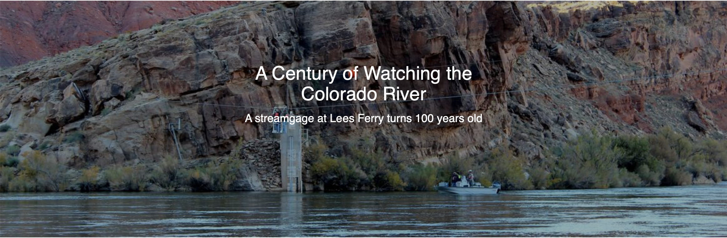
September 21, 1923, 9:00 a.m. — Colorado River at Lees Ferry. From right bank on line with Klohr’s house and gage house. Old “Dugway” or inclined gage shows to left of gage house. Gage height 11.05′, discharge 27,000 cfs. Lens 16, time =1/25, camera supported. Photo by G.C. Stevens of the USGS.
Source: 1921-1937 Surface Water Records File, Colorado R. @ Lees Ferry, Laguna Niguel Federal Records Center, Accession No. 57-78-0006, Box 2 of 2 , Location No. MB053635.
The upper and lower basins split just downstream of Lake Powell’s Glen Canyon Dam, at Lees Ferry in Arizona, though Lake Powell’s storage is primarily used to ensure the Upper Basin has enough water to fulfill its yearly obligations to the Lower Basin. The Upper Basin states use roughly half as much, and less in years when mountain streams dry up, and concerns over that disparity surfaced Thursday.
“We can’t accept something that continues to drain the system, that puts 40 million people at risk,” Colorado’s river commissioner, Becky Mitchell, told her interstate colleagues at the annual Colorado River Water Users Association conference…
“The one person that you cannot negotiate with is Mother Nature. She will win every time. She’s been telling us what to do,” Mitchell said. “I want an agreement that lessens the pain for all of us, not just some of us.”
“New plot using the nClimGrid data, which is a better source than PRISM for long-term trends. Of course, the combined reservoir contents increase from last year, but the increase is less than 2011 and looks puny compared to the ‘hole’ in the reservoirs. The blue Loess lines subtly change. Last year those lines ended pointing downwards. This year they end flat-ish. 2023 temps were still above the 20th century average, although close. Another interesting aspect is that the 20C Mean and 21C Mean lines on the individual plots really don’t change much. Finally, the 2023 Natural Flows are almost exactly equal to 2019. (17.678 maf vs 17.672 maf). For all the hoopla about how this was record-setting year, the fact is that this year was significantly less than 2011 (20.159 maf) and no different than 2019” — Brad Udall
Click the link to read the release on the AWWA website:
A collaborative agreement among several water partners will increase flows and improve the health of stretches of the Fraser River in Grand County, Colorado, popular for recreational activities.
Several years of discussion and analysis led to the agreement, which stipulates that Colorado Water Trust, a nonprofit organization, will pay Grand County Irrigated Land Company (GCILC) to release water from the Meadow Creek Reservoir to increase flows in a section of the Upper Fraser River. This 10-mile stretch, between the cities of Winter Park and Tabernash, is a popular spot for fly fishing and an area where brown trout spawn in the fall.
The water released from the reservoir will go to Denver Water’s Moffat Collection System. In exchange, Denver Water will divert about five cubic feet per second less water from the Jim Creek collection point. The Coca-Cola Company and Swire Coca-Cola (Coca-Cola’s distributor in the western United States) are funding the transaction.
The agreement is for one year, but all parties involved hope to extend the agreement as part of a long-term solution to increase Fraser River flows.
“Historically, the Upper Fraser River near Winter Park has seen low flows, particularly in August and September when resident trout are starting their fall spawning migration,” said Tony LaGreca, project manager for the Colorado Water Trust, in a press release. Since 2001, the nonprofit has restored nearly 21 billion gallons of water to 600 miles of Colorado’s rivers and streams by developing and implementing voluntary, water sharing agreements.
“Boosting flows at this time can help those fish have successful spawning runs and keep this valuable recreational fishery healthy,” LaGreca said. “We are fortunate to have an excellent partner in GCILC and we look forward to working with them long into the future to keep the Fraser River flowing strong.”
GCLIC, located in Granby, Colorado, operates an irrigation ditch that transports water to shareholders and leasing properties.
“By partnering with the Water Trust, GCILC hopes the releases of water from Meadow Creek Reservoir will, in a small way, help to mitigate the impacts to the watershed from the trans-mountain diversions, and be consistent with the Colorado River Cooperative Agreement,” said Mike Holmes, president of GCILC.
“Water in Colorado is complex, and this project has a lot of different entities involved to make sure Denver Water is kept whole in terms of water,” said Nathan Elder, manager of water supply at Denver Water. “Denver Water has the infrastructure to make it happen, Grand County Irrigators brought the water and Colorado Water Trust brought the money. All those made it work together.”
Colorado River Basin in Colorado via the Colorado Geological Survey
November 7, 2023: In what’s been described as “the largest aquatic habitat connectivity project ever undertaken in state history,” crews successfully tested the new Colorado River Connectivity Channel (CRCC) at the end of October. The new channel around Windy Gap Reservoir hydrologically and ecologically now reconnects two segments of the Colorado River for the first time in approximately 40 years.
Northern Water staff were joined by Grand County officials, Windy Gap Project Participant Representatives, Colorado Parks and Wildlife representatives and others to watch the first flows go through the long-awaited channel. This new video captures the historic day and includes comments from the project participants and stakeholders who were present to witness the occasion.
While water is now running through the new channel, there is still construction work to be done. Crews will continue putting the finishing touches on the project’s new dam embankment, diversion structure and other elements before winter weather brings activity to a stop in the upcoming weeks. Construction is expected to resume
next spring and wrap up later in 2024. Vegetation establishment along the channel will continue into 2025 and 2026, before the area is anticipated to open for public recreation in 2027.
The new channel will enable fish and other wildlife to move freely upstream and downstream around what is now a smaller Windy Gap Reservoir. Meanwhile, the reservoir will continue providing a diversion point on the Colorado River for the Windy Gap Project during the high flows of spring and early summer.
The CRCC is part of a package of environmental measures, valued at $90 million, associated with construction of Chimney Hollow Reservoir, which is ultimately where Windy Gap Project water will be stored once reservoir construction is completed.
Colorado fly fishing, whitewater and other water-related recreational pursuits contribute significantly to Colorado’s $34.8 billion recreational economy. Photo courtesy of the Winter Park Convention and Visitors Bureau
Coca-Cola, several Colorado nonprofits, as well as Denver Water, the Colorado River District, and a group of irrigators have launched a new instream flow effort to help keep the scenic headwaters of the Fraser River wetter in the fall, aiding fish and habitat in the stream near Winter Park.
The Colorado Water Trust is a nonprofit that works to match distressed streams with water right holders interested in selling, donating or leasing water that can be used to boost streamflows. It spearheaded the Fraser’s 10-year instream flow agreement. Participants also include Learning By Doing, an East Slope-West Slope partnership that works on local stream restoration projects
Coca-Cola Corporation, as well as one of its bottlers and distributors, Swire Coca-Cola, have pledged $24,000 annually to pay for the water and the restoration work, according to Tony LaGreca, Colorado Water Trust’s project manager for the Fraser program.
Erica Hansen, external communications manager for Swire, said the Coca-Cola companies have 35 environmental water projects across a 13-state region, including 10 in Colorado that are completed, underway or pending.
“We operate in several states that are high drought risk,” Hansen said. “Any drop we use we’re putting back into nature. The Fraser River project is one of the ways we do that.”
LaGreca said the new initiative represents an important step forward in restorative water management in Grand County and Colorado.
“There was a time,” he said, “when we did not have irrigation companies coming to us to find ways to put water into the river for fish. But more and more we are having successful partnerships to increase flows as part of a larger water management strategy.”
Map of the Colorado-Big Thompson Project via Northern Water
Grand County is home to the headwaters of the Colorado River and the Fraser River, one of its tributaries. Both waterways are heavily diverted to the Front Range to serve residents and farms from Denver up to Fort Collins and out to the Nebraska border.
Over the years, as droughts have become more common and climate change has sapped flows, Grand County’s rivers have become increasingly stressed.
To help solve the problems, two of the largest transmountain diverters, Denver Water and Northern Water, among others, signed on to the Colorado River Cooperative Agreement in 2013. The agreement gives the water agencies some leeway to develop new water supplies to which they have water rights, while also funding efforts to keep rivers and wetlands in the headwaters region healthier, and to ensure mountain tourist economies have enough water to thrive.
Mike Holmes is president of the Grand County Irrigated Land Company. As part of the restorative work underway, he and his shareholders agreed to sell a portion of their water stored in a small reservoir to benefit the river. Each year the program operates, the ranchers will deliver about 50 acre-feet of water. An acre-foot equals nearly 326,000 gallons of water, the amount used by two to three average households in a year. Holmes said the growers have been working to improve the efficiency of their irrigation systems, freeing up water for the river.
“This year, with the abundant snowpack, we had the water available, and so we worked with the water trust to execute a lease and then went through a review by the Colorado River District. It’s a pretty streamlined process,” Holmes said.
Though 50 acre-feet is not a lot of water, it should make a difference in the Upper Fraser, where Denver is allowed to divert even when the river’s fall flows are already shrinking, LaGreca said.
Denver Water’s role in the restoration effort is to allow the Colorado Water Trust to use the utility’s collection system to put water into distressed stream segments in the headwaters. In turn the irrigators give Denver Water access to water stored in Meadow Creek Reservoir, farther downstream, according to Nathan Elder, Denver Water’s water supply manager.
Work on the program for 2023 wrapped up earlier this month and will begin again next September.
Scott McCaulou is director of the corporate water stewardship program at Business for Water Stewardship. The Portland-based nonprofit is funded by the Bonneville Environmental Foundation and helps connects corporations to environmental water restoration initiatives.
“This first year of the agreement between the [irrigators] and the water trust is a small step but the hope is that it grows into a longer-term partnership and helps develop more flexible water management tools in the Upper Colorado,” McCaulou said. “We see it as a good contribution to something that could grow if it is successful this year.”
Colorado River “Beginnings”. Photo: Brent Gardner-Smith/Aspen Journalism
Denver Water CEO Jim Lochhead at the Hydro building on the new CSU Spur Campus at the National Western Stock Show complex in Denver in January. Courtesy: Denver Water
Veteran Colorado water attorney Jim Lochhead has been part of most of the history-making Colorado River deals crafted over the last 30 years including California’s landmark 2003 quantification settlement agreement, where the state famously agreed to cut back its overuse of the Colorado River. For decades, he advised state and local agencies on Colorado River issues. He also served as head of the Colorado Department of Natural Resources under Gov. Roy Romer from 1994 to 1998.
But in 2010 he moved into a decidedly different role: running Denver Water, a 1,200-employee agency that serves more than 1.5 million customers in the Denver metro area and which operates as an independent government agency.
Under his leadership, Denver Water launched a major capital investment program, which included a new, hyper-green operations complex. It built a new water treatment plant and battled on many fronts to launch a controversial expansion of Gross Reservoir. The agency also launched one of the largest lead pipe replacement programs in the country.
Lochhead, who announced he was leaving Denver Water in December, has a departure date of Aug. 7. Alan Salazar, chief of staff for the city of Denver, will take over as interim CEO for the next year, until a permanent hire is made.
But is Lochhead, 71, planning to retire? Not just yet. See what this high-profile water veteran has to say about the state of the Colorado River these days and what his future may hold.
The following interview has been edited for clarity and length.
Question: Why leave now, when issues on the Colorado River are just getting interesting?
Answer: I think as a CEO you need to realize what your shelf life is. I’ve accomplished what I was hired to do. When I came, Denver Water was right in the middle of negotiating the Colorado River Cooperative Agreement [a deal that resolved many, though not all, conflicts between West Slope Colorado River water users and those on the Front Range, including Denver.]
I was really brought in to move Denver Water forward in terms of being a trusted leader in the water industry and in serving customers, and to focus us on the sustainability of our water supply and the health of our watersheds. I’d like to leave Denver Water in a good place, and I feel like we’re in good a place.
Question: This summer critical negotiations begin on how to operate the Colorado River system and the two major reservoirs on the river, lakes Powell and Mead, in ways that stop overuse and allow the system to operate more efficiently. Have you heard any great ideas that you think would solve its problems?
From the 2018 Tribal Water Study, this graphic shows the location of the 29 federally-recognized tribes in the Colorado River Basin. Map credit: USBR
Answer: Unfortunately, no. What we need is a path forward that includes the tribes in the basin. We need a process that is not so onerous for participants so that we can collaborate and come to solutions. It’s going to require tremendous leadership.
Question: Lakes Powell and Mead operate under different agencies, in some cases use different calendars, and serve different regions. Some have suggested that the two lakes should be operated as one, to simplify management and improve operational efficiencies. Do you support this idea?
Answer: It’s worth exploring. We need to be looking at totally different ideas about how the system is managed.
Question: Others have suggested that any new reservoirs or dams should be stopped, that the seven-state Colorado River Basin should be closed to new water development. What are your thoughts on this?
Answer: I don’t even know how you would do that. There is no authority. In Colorado [and the other Upper Basin states of New Mexico, Utah and Wyoming] the prior appropriation system is self-limiting. [The system delivers water in times of scarcity based on which water right is the oldest. Any newly claimed water rights, in practicality, would never receive water.] All of our rivers are over-appropriated. If you are going to do something new you have to buy an existing water right. You would just be shifting use between sectors.
And in the Lower Basin [Arizona, California and Nevada] the amount of water that is taken is limited by contract and federal law to 4.4 million acre-feet in California, 2.8 million acre-feet in Arizona, 300,0000 in Nevada and 1.5 million acre-feet in Mexico. The big problem is that river [transit] losses and evaporation sit on top of all of that.
Question: Farms and ranches use as much as 80% of the water in the Colorado River Basin. What could be done to reduce agricultural water use while protecting the farm economies and food supplies?
Answer: The fundamental dilemma that we have is the conflict between the priority dates of long-established irrigation districts in the Lower Basin and the Upper Basin under the priority system, versus new development and growth that is occurring that is junior in priority.
If we strictly went by those priorities, you would literally be cutting off the Central Arizona Project, as well as Las Vegas, Denver and the Metropolitan Water District [of Southern California]. That’s just not going to happen. So how do we equitably manage through that dilemma, so that ag economies and the communities that have grown to depend on those priorities grow and can rely on that supply? And how do we have security of water for the 40 million people who live in this basin?
It is going to result in a shift of waters. The Lower Basin has asked for $1.2 billion to reduce demands. I don’t have a silver bullet, but to me that is the heart of the negotiation that is going to have to occur.
Question: A number of people have suggested that a new forum of some kind needs to be created to help solve the Colorado River’s problems now. You’ve said that you don’t plan to retire. If you were offered the opportunity to run that new entity, would you take it?
Answer: Going out to pasture is not my nature. I would have to think about it. I would love to stay involved.
Jerd Smith is editor of Fresh Water News. She can be reached at 720-398-6474, via email at jerd@wateredco.org or @jerd_smith.
Denver Water is one of 18 partners who signed the Colorado River Cooperative Agreement in 2013, ushering in a new era of cooperation between the utility and West Slope stakeholders, all with the vested interest in protecting watersheds in the Colorado River Basin.
As part of that agreement, a process called “Learning by Doing” was created, which has helped the utility stay better connected on river conditions in Grand County. The partnership is a collection of East and West Slope water stakeholders who help identify and find solutions to water issues in Grand County.
“Denver Water has been part of Grand County for over 100 years, and we understand the impact our diversions have on the rivers and streams,” said Rachel Badger, environmental planning manager at Denver Water.
“Our goal is to manage our water resources as efficiently as possible and be good stewards of the water — and Learning By Doing helps us do that.”
Unless you’ve been living in a media-free cave somewhere, you are probably aware that the Colorado River is again prominent in the news. What’s not really noticed, but ought to be, is the extent to which we find ourselves today almost exactly where we were 101 years ago this winter, with six of the Colorado River states in tension with the seventh state over basically the same topic: the appropriateness of appropriation law as theonly legal means for allotting use of the river’s water.
The line of conflict today is being drawn over the increasingly depleted state of the two big storage reservoirs on the Colorado River’s mainstream, Mead and Powell Reservoirs. The Bureau of Reclamation, the ever-optimistic manager of the river’s storage and distribution system, has finally acknowledged that its reservoirs are getting uncomfortably close to a ‘dead pool’ situation whereby it would not only be unable to generate electric power, but would even be unable to get any water at all downstream from the big dams for much of the year. So they have issued two moderately panicky mandates that the states have to cut their uses dramatically in order to save the system: two to four million acre-feet (maf) of cuts from a river currently running only around 12 maf a year on average under nature’s imposed burdens of aridification – cutting between a sixth and a third of current use.
Updated Colorado River 4-Panel plot thru Water Year 2022 showing reservoirs, flows, temperatures and precipitation. All trends are in the wrong direction. Since original 2017 plot, conditions have deteriorated significantly. Brad Udall via Twitter: https://twitter.com/bradudall/status/1593316262041436160
Part of the problem is probably a longer-than-usual dry spell in the natural order of fat and lean years. Another more permanent part of the problem is a warming climate that is depleting arid-land water supplies at a rate of around six percent for each additional degree Fahrenheit in average temperature. But a larger part of today’s problem is a century of increasingly bad management of the reservoirs, on the shaky infrastructure of a body of legislative acts, court decisions, environmental laws, and other interstate and intrastate agreements and contracts known as the Law of the River.
The Bureau has twice issued its mandate, first back in the summer of 2022 and again in December, saying that if the seven states cannot come up with a plan for such cuts, the Interior Department would do it for them. The states called its bluff the first time, but this second time – acknowledging the growing severity of the situation – six of the states came up with a plan for cutting usage by almost two million acre-feet. But a seventh state refused to sign on, and came up with its own plan. And it’s deja vu all over again.
Arizona, Colorado, Nevada, New Mexico, Utah and Wyoming submitted the six-state plan, proposing just under two million acre-feet in cuts, mostly through finally reducing usage by Lower Basin states to account for evaporation and other system losses from Lower Basin reservoirs and delivery canals and the Lower Basin’s share of the Mexico allotment. The Upper Basin would suffer no further cuts initially in the two million acre-foot reduction.
California refused to participate in that plan, instead offering a nine percent reduction in use but wanting its massive senior water rights given priority, with Arizona accepting the junior status for all Central Arizona Project (CAP) water, agreed to the 1968 enabling legislation in exchange for California’s support for the CAP.
In 1922, remember, those seven states had gathered to try to work out a perceived problem, the same six against California. All seven states allocated use of the waters of the river through the appropriation doctrine, which had evolved on local watersheds everywhere in the arid and semiarid lands of the West – the down-on-the-ground rules that enabled individuals to appropriate from the public commons both the land and essential irrigation water they needed in order to make a life and a living, with rights to use the water determined by priority of use: first come, first served – determinations often worked out vigorously in the early days at headgates, sometimes with deployment of shovels or shotguns.
This common law was evolved enough when territories became states, to enshrine it in state constitutions. But the ordering of prior appropriations became complicated as local watersheds had to fit their adjudications for priority of use with those of larger downstream confluences, with whole river basins eventually sorting out priorities that might result in senior users a hundred miles downstream placing calls on headwaters users who were seniors on their local stream but juniors on the larger river.
Southern Pacific passenger train crosses to Salton Sea, August 1906. Photo via USBR.
That situation was supercharged as free water and free land became a powerful engine for growth in the late 19th and early 20th centuries. All seven of the Colorado River states at least doubled their population in the first two decades of the 20th century – but California’s population quintupled in that same period. And all seven states also realized that the logic of the appropriations law meant that states sharing a river would have to acknowledge priority in each other’s appropriations – and one California development company, clear down by the delta, already had a 1901 decree for more than two million acre-feet of the river’s water for converting the barren Salton Sink into the Imperial Valley….
The other six states feared that, with no law governing the distribution of water use other than the appropriation law, California’s uncontrolled growth might tie up most of the use of the river while they were still just getting started on their own uncontrolled growth. At best, it would be a seven-state horse race to appropriate as much water as possible as quickly as possible, in a competition that would hardly assure orderly and truly beneficial use. At worst, the slower states would simply be cut out of any significant water for development.
I think of it as ‘Caliphobia’: fear and loathing (and maybe a little envy) of California, the state that always seems to be ahead of everyone else in everything. Caliphobia occasionally still re-emerges today, and not just among western states. What the six states wanted was some kind of a mutual but enforceable agreement that would divide the use of the river’s water equitably among the seven states, independently of the appropriation laws; they seemed to wanted appropriation law to apply at the state level, but maybe not always at the interstate level.
Delph Carpenter’s original map showing a reservoir at Glen Canyon and one at Black Canyon via Greg Hobbs
California had no fear of the other states, but they had a need of their own that prompted them to sit down with the other states to work out their problem. California needed the interstate river to be controlled by at least one large structure, capable of capturing and storing the river’s annual snowmelt flood and distributing the water more evenly through the rest of the year. The company developing the Salton Sink/Imperial Valley had been bankrupted by a rogue 1905 autumn flood that had managed to divert the entire river from the delta down into the Sink, turning part of it into the Salton Sea – the whole area was actually a segment of the Gulf of California that had been diked off by the debris moved by the river in grinding out the Grand Canyon; it had dried up leaving the Imperial Valley as much as 300 feet below sea (and river) level. An interesting irrigation challenge.
Upper Basin States vs. Lower Basin circa 1925 via CSU Water Resources Archives
So California wanted a big dam that only the federal government had the resources and interstate authority to build – and the Interior Department and Bureau of Reclamation were chomping at the bit to take on that challenge. But westerners in Congress made it clear that there would be no funding for such a project until the other basin states were assured that they would each have an equitable share of the controlled river’s water to develop. The states themselves wanted to maintain as much control over the water as possible, so they sought permission under the U.S. Constitution’s compact clause to form a compact to divide the use of the river among themselves. Congress gave them a year to do that, and they assembled in Washington in January 1922, seven commissioners with Secretary of Commerce Herbert Hoover as chair, to create a Colorado River Compact.
Their goal going into the compact meetings was to come up with a seven-way division of the consumptive use of the river’s water that would enable each state to grow to its full potential in its own good time. But that goal itself was basically impossible at that time. In the first place, they did not really know how much water the river had to divide; the guesstimates they had to work with varied between 13 and 17 million acre-feet per year.
And in the second place, and even worse: the only information about their own future needs they could bring to the table was their wild ambitious dreams; the sum of their estimates of each state’s irrigable land and the water needed to irrigate it added up to more than half again the Bureau of Reclamation’s always optimistic estimates of the river’s flow. They had nothing but vague rosy ideas of their potential industrial growth.
The Bureau had its own more objective estimates of how much water each state could probably use, fitted to its own optimistic estimates of the river’s volume, but the states were not interested in those numbers; they would only accept their own estimates of their own glorious futures (while criticizing everyone else’s).
Such a seven-way split could only have been done in a context of setting limits anyway, and that was against the spirit of the times. This was the Early Anthropocene: having discovered the apparently unlimited power of mineable carbon, and designing formerly unimaginable machines and systems fueled by those carbon fuels, the state engineers and the engineers in organizations like Interior’s Bureau of Reclamation were ready to go nose-to-nose with nature, impatient to teach natural forces like the rampaging Colorado River to stand in and push rather than cut and run. Welcome to the Early Anthropocene, when the sky was the limit only because no one was yet thinking about outer space. While six of the basin states feared California’s fast start and uncontrolled growth in developing the river’s water, what they basically all wanted was to be California in their own good time, experiencing uncontrolled growth and the resulting uncontained wealth.
The Compact’s Signers. Photo via InkStain
After a frustrating week of working on that seven-way split, they were on the verge of abandoning the whole effort; but they all did want to get the federal government involved in developing the river (on their terms, of course), so they had to come up with something that would satisfy Congress that Caliphobia had been addressed. After a spring and summer of letter-writing and phone calls, they reconvened in Santa Fe in November, a month and a half from their deadline, in a do-or-die push to come up with a feasible compact.
We’ve looked in previous posts here at difficulties the Compact commission tried to address in that final eleven-day effort, and also at the difficulties their ‘alternate solution’ imposed on the river and its users for the century following: the division of a desert river into two basins, separating the source of water from the main flow of the water; the bad guess on the volume of flow, resulting in an unequal division; and perhaps worst of all, making the Upper Basin responsible for delivering a relatively even and constant flow to the Lower Basin regardless of what desert-river vagaries the upper states were experiencing. Most of that could have been avoided if they had been able psychologically to submit to the limiting aspect of the seven-way split of the river’s use they thought they wanted, measured and administered by a balanced river commission of their own making. They were just not up to that; it was too early in the Anthropocene. Without going into specifics, it is hard to find anything in the subsequent agglomeration of legislative acts, court decisions, interstate and intrastate agreements, and other things bundled with the Compact as ‘The Law of the River’ that did much to relieve those difficulties, until the environmental laws of the 1970s began to corral some of the random growth driven by appropriation law.
All of which may have something to with why, today, 101 years later, we find ourselves in roughly the same situation: the six states in a stalemate with California over alternatives to straight appropriation from the commons. But at this point – couldn’t we start by finally doing the division of the river among the states (and Mexico) that couldn’t be done in 1922? Aren’t we what Hoover, in the 21st Santa Fe meeting, called ‘those men (and women now) who may come after us, possessed of a far greater fund of information’ and capable of making ‘a further division of the river’?
More specifically – after a century of developing the river for use, with the river’s use almost certainly over-appropriated – can’t we acknowledge that the seven-way division has actually been accomplished? The seven states all have what they have and there isn’t any more to appropriate. All we need do at this point is to acknowledge that fact and put numbers on it – the actual numbers of what the states are all using and reusing today, no Compact fictions. There are those in each state who will say, but, but, but what about…. But – really.
I will not pretend that this would be a simple matter, and it would require a largeness of spirit we may still not be capable of bringing to it. Without even looking at any numbers, we can state with certainty that the four states (including Mexico) below the canyons are getting the use of approximately twice what the four states above the canyons get. This is not equal, but might it be equitable? The lower river agriculture is considerably more productive than upper river agriculture, and the lower river and out-of-basin diversions have the vast majority of the 40 million people needing some of the river’s water. And speaking only for myself, that’s fine with me; I’d rather see the water going to where the people are than see the people coming to where the water is. [ed. emphasis mine]
What is not equitable, and would need to be changed (with a largeness of spirit), is a firm delivery for some users, with other equally worthy users bearing the brunt of both natural and cultural variability in flows. Once the numbers dividing our paltry 12 million acre-feet eight ways (including Mexico) are determined, they will need to be converted to percentages – the way the four upper states did in 1948, given their uncertainty about the available future flow. As the river loses water to rising temperature, the percentages could stay the same but the volume of water per state would drop accordingly.
All eight user-states would also have to take a share of the two million acre-feet of annual system losses, prorated by some no doubt complicated formula. And there would have to be a large-spirited agreement to leave some of the water from the occasional fat water years in the reservoirs, to build reserves for the probably abundant lean years as we move into our self-made future.
The alternative to that kind of process at this point is probably a decade in the courts with those who want to stick with the appropriation laws as is, as the foundation Law of the River, versus those who realize it is time to move on to more equitable ways of allocating a scarce resource to millions who have no opportunity to appropriate the water they need. Heaven knows what might happen with the river in that decade. It is instead time to do some version of what the Colorado River Compact commissioners knew needed to be done, but could not bring themselves to do, so caught up were they in the romance of the Early Anthropocene. We are now, as the song goes, sadder but wiser. Or so we should hope.
Expect some playing around with ideas for this in future posts. And I’d love to hear your thoughts on it: how should the river in the desert be distributed, respecting but beyond first come, first served?
Wetland on the west side of La Poudre Pass Colorado River Headwaters, July 2017. Photo credit: Greg Hobbs
Note that these #CORiver Tier 2a cuts for AZ, NV, MX are only slightly more than the current cuts under Tier 1: AZ: 592 kaf (+80 kaf vs Tier 1) NV: 25 kaf (+4 kaf) MX: 104 kaf (+24 kaf)
So that's 108 kaf of additional cuts to the Lower Basin under 2a.
These are just the previously agreed cuts under the Interim Guidelines and DCP. No additional cuts have been imposed yet. I would say feds have a month or two to unilaterally come up with numbers or do nothing at all. I don't see unilateral cuts coming in Dec without time to plan
NEWS: Colorado River Basin states fail to meet federal deadline to submit plans to get to 2-4 maf in conservation. Absent state agreement, the federal government is also not detailing how it plans to achieve that unprecedented level of conservation needed to protect reservoirs.
The feds talked tough about stepping in to save Lake Mead and Lake Powell if states could not agree to cuts. But was that just an empty threat? https://t.co/ltwHzg3eY8 via @azcentral
.@usbr wanted today's Tier 2 shortage declaration to look like they were coming down hard on the states. But they did not. This shortage was spelled out in agreements signed in 2007 and 2019. It was expected. For months.
Tier 2 shortage in Colorado River is important & a tough loss. But it's expected & agreed-upon under DCP. It doesn't tell us anything new, & it doesn't get us to BoR's 2-4 maf reduction. That will require new deals between water users & basin states or unilateral federal action.
Statement from ADWR Director Tom Buschatzke and CAP GM Ted Cooke in response to the U.S. Department of the Interior announcement of actions to protect the Colorado River system and 2023 Operating Conditions for Lake Powell and Lake Mead https://t.co/nqFK5hWH3R@CAPArizonapic.twitter.com/wegNoEF8vL
NEW: It's official, the federal government is issuing new mandatory water cutbacks.
The lower Colorado River basin will see its first-ever "tier 2a" shortage. The latest forecasts show Lake Mead will drop just below 1,048 ft. at the beginning of next year.
“Lake Mead will operate in its first-ever Level 2a shortage condition in CY 2023” California will not be required to water savings contributions under this operating condition….
If you're just tuning in to today's water news, you can get some background in this thread.
In June, the federal government told states to conserve a huge amount of water, and they only had 60 days to sort out a plan. That deadline is today.https://t.co/vGt47ZCm0y
"The Bureau’s latest forecast, while bleak, is no surprise. It confirms what we already know — without swift, responsible action, the Colorado River Basin is nearing a system-wide crash." Read Water for Colorado's statement on today's @usbr announcements: https://t.co/nGGHbpgExT
"The cuts are significant, but I think even more significant is the rapidity with which the reservoirs on the Colorado River are declining. And we have clear indications that these cuts won't be enough." @JnPitt@audubonsocietyhttps://t.co/hFGiO3ZuK1
“As these discussions continue, we urgently call on everyone who relies on #CoRiver water, including communities across #SoCal, to prepare for reduced supplies from this source, permanently. This is not simply a drought that will end," said GM @adelh2o. https://t.co/YNxiyuPkdjpic.twitter.com/SDJcikWQb1
Unfortunately, there was not a lot of “new or threatening actions” spelled out today… a lot of “let’s work it out together and a need to cooperate with Federal help. #corhttps://t.co/8am1hP2kmh
Nevada's water allotment will be cut by 8% next year as Lake Mead is set to operate in a Tier 2 shortage condition.
Still, water managers say the state is in "a relatively enviable position," as usage is already below that allotment. Via @s_golonka: https://t.co/8a9LWhtv1w
The @USBR says there's still time for "consensus" on Colorado River cuts. Looks like the basin states will have at least until the spring to negotiate an emergency deal. The move shows just how seriously federal officials take the threat of litigation by ag communities.
And here's an analysis of the errors. "Approximately 60% to 75% of all forecasts made between October and May of the year preceding the water year being forecast overestimated actual future inflows, and the range of inaccuracy in forecasts was approximately 7 maf." pic.twitter.com/3gNgfpY4D8
Thank you @POTUS ! The Inflation Reduction Act provides unprecedented resources to help @Interior@usbr meet unprecedented challenges associated with climate change and drought. https://t.co/0Pq11RT1Ky
Construction began April 1 on Denver Water’s five-year project to expand Gross Reservoir by raising the height of the dam.
The reservoir and dam, located in the foothills west of Boulder, were named after former Denver Water Chief Engineer Dwight Gross. The dam was completed in 1954 to store water from the West Slope for Denver’s growing population.
The dam was originally designed to be raised in the future when needed.
Now, Denver Water is raising the height of the dam by 131 feet to help ease a storage imbalance in the utilities’ water collection system. Once completed, Gross will be the tallest dam in Colorado.
The dam was originally designed to be raised in the future when needed. Now, Denver Water is raising the height of the dam by 131 feet to help ease a storage imbalance in the utilities’ water collection system. Once completed, Gross will be the tallest dam in Colorado.
“We’ve been busy bringing trucks, cranes and other heavy equipment to the site to prepare for construction,” said Doug Raitt, construction manager of the Gross Reservoir Expansion Project for Denver Water. “A lot has to be done just to prepare the site for all the work that has to happen.”
Crews navigate a winding road near the dam to bring a large crane to the construction site. Photo credit: Denver Water.
Early work involves blasting rock on the sides of the canyon to make way for the additional concrete that will be placed over the downstream face and above the existing dam.
A machine drills holes into the rock above the dam to place explosives for blasting operations. Photo credit: Denver Water.
Crews also are building a walkway on the upstream side, or reservoir side, of the dam to provide access for workers to walk from one side of the dam to the other.
Upcoming work includes hydroblasting 2 to 3 inches of concrete from the face of the dam so the new concrete will adhere to it. Part of the dam’s spillway will also be removed to prepare for the addition.
Early work involves installing walkways on the upstream side, or reservoir side, of the dam. The walkways are needed because the top of the dam will be removed to make way for the addition. Photo credit: Denver Water.
To raise the dam, crews will start at the bottom and extend the base of the dam out. Then they will build a series of steps up to the dam’s new height — similar to what you see on the sides of an Egyptian pyramid.
The Gross Reservoir Expansion Project involves raising the height of the existing dam by 131 feet. The dam will be built out and will have “steps” made of roller-compacted concrete to reach the new height. Image credit: Denver Water
“When it’s done, it will be the largest dam in Colorado and nearly triple the storage capacity of the existing reservoir,” said Jeff Martin, manager of the Gross Reservoir Expansion Project for Denver Water. “We’re really excited to begin construction on this important project.”
Doug Raitt, construction project manager for Denver Water, stands next to a 60-ton dump truck at the construction site on April 20, 2022. Photo credit: Denver Water.
Martin said that work conducted during 2022 and 2023 will be mostly site preparation for the on-site concrete production and foundation work on the rock on the sides of the dam and around the bottom.
At the height of construction there may be as many as 400 workers on site at a time, Raitt said.
“Raising a dam is often trickier than simply building a new one,” Raitt said. “We have to continue sending water through the dam during construction while transforming the dam into a new structure.”
Crews remove rock that has been blasted away on the north side of the dam. The area near the red machine at the top of the picture will be the new crest of the dam. Photo credit: Denver Water.
Throughout the project, safety will be the No. 1 priority at the site.
“Denver Water and our construction partners have an emphasis on safety for the public and our workers every day,” Raitt said. “We all go through safety training and will continue to evaluate our operations throughout the project.”
Workers take part in safety training with Kiewit-Barnard, the general contractor for the expansion project in April. At the peak of construction, up to 400 workers will be on-site at the dam during the day. Photo credit: Denver Water.
Protecting the environment and wildlife is another important part of the project. Denver Water worked with biologists to make sure there were no bird nests in the area before the start of construction and will continue to do so throughout the project.
Additional environmental mitigation efforts were put in place to protect South Boulder Creek and the reservoir from sediment and erosion washing in during the work. These efforts will continue throughout the project.
Erosion control measures are put up around construction areas to protect dirt and rocks from falling or washing into South Boulder Creek and Gross Reservoir. Photo credit: Denver Water.
Denver Water also is spending time updating community members around the reservoir.
“It’s important that we let them know what’s happening with the project,” Raitt said.
“For months, we’ve been doing outreach to the community with public meetings, newsletters and emails. We’ve received a lot of feedback from our neighbors letting us know what’s important to them and we’ll continue to work with them and update them throughout the project.”
Denver Water is hosting community meetings with residents who live around Gross Reservoir to update them on the project and answer questions. Photo credit: Denver Water.
Since its formation more than 100 years ago, Denver Water has always planned ahead when investing in the system that today supplies clean, safe drinking water every day to a quarter of Colorado’s population.
And with a variety of changes — from regulations to weather patterns — expected in the future, the utility and its 1,000 employees are continuing the work needed to maintain, repair, protect and upgrade its 4,000 square miles of watershed and 3,000 miles of pipe, plus its dams, pump stations and underground storage tanks and more.
Denver Water delivers safe, clean water to 1.5 million people every day, 25% of Colorado’s population. Photo credit: Denver Water.
While the global COVID-19 pandemic has added another layer of complexity, Denver Water has worked to keep rate increases for customers as small as possible.
On Oct. 27, the Denver Board of Water Commissioners adopted new water rates that will effective Jan. 1, 2022, to help pay for critical upgrades and projects to keep this system operating efficiently. How that rate increase will affect individual customer bills will vary depending on where the customer lives in Denver Water’s service area and how much water they use.
For typical single-family residential customers who receive a bill from Denver Water, if they use 104,000 gallons of water in 2022 as they did in 2021, the new rates will increase their monthly bill by a range of about 47 cents to $1.34 depending on where they live.
“Denver Water’s mission is to ensure that we deliver safe, clean water to the people who rely on us every day,” said CEO/Manager Jim Lochhead. “Over the next 10 years, we are forecasting an estimated investment of $2.6 billion into our system to increase its resiliency, reliability and sustainability in the face of changes we are anticipating. From more frequent droughts and wildfires to additional regulations we expect we will be asked to meet — we will be prepared.”
A helicopter collects water from Dillon Reservoir during efforts to contain the Ptarmigan Fire near Silverthorne, Colorado, in late September. Photo credit: John Baker, safety specialist at Denver Water.
A customer’s monthly bill is comprised of a fixed charge, which helps ensure Denver Water has a more stable revenue stream to continue the necessary water system upgrades to ensure reliable water service, and a volume rate for the amount of water used.
The fixed monthly charge — which is tied to the size of the meter — is increasing by 74 cents in 2022 for most single-family residential customers to ensure Denver Water is recovering 20% of its needed revenue from fixed charges.
After the fixed monthly charge, Denver Water’s rate structure has three tiers based on the amount of water used.
“Even with such large efforts in our future, it’s our goal to have slow and steady rate increases with even, annual adjustments that allow our customers to plan ahead and avoid rate shocks,” said Fletcher Davis, rates manager for Denver Water.
To keep water affordable, the first tier, which covers essential indoor water use for bathing, cooking and flushing toilets, is charged at the lowest rate.
The amount of water in this first tier is determined for each customer by averaging their monthly water use as listed on bills dated January through March each year. This is called their average winter consumption.
Water use above the average winter consumption — typically used for outdoor watering — is charged at a higher price. Efficient outdoor water use is charged in the second tier (middle rate), followed by additional outdoor water use in the third tier (highest rate).
Meet customers who used Garden In A Box, a Resource Central program supported by Denver Water, to beautify their landscapes with water-wise plants.
The difference in volume rates for customers who live inside Denver compared to those who live in the suburbs is due to the Denver City Charter, which was changed in 1959 to allow permanent leases of water to suburban water districts based on two conditions: 1) there always would be an adequate supply for the citizens of Denver, and 2) suburban customers pay the full cost of service, plus an additional amount.
Denver Water encourages customers to be efficient with their water use.
Using less water means more water can be kept in the mountain reservoirs, rivers and streams that fish live in, and Coloradans enjoy. And using less water also can lower your monthly water bills, saving money.
“We are continuing our work maintaining and replacing water mains in the street, building a new state-of-the-art treatment plant and water quality laboratory, preparing for the needed expansion of Gross Reservoir and replacing old, customer-owned lead service lines to protect our customers from the risk of lead in drinking water,” Lochhead said.
“At the same time, we use the tools available to us to help pay for the necessary investment in our system and keep our rates as low as possible.”
In addition to rates paid by customers, Denver Water relies on bond sales, cash reserves, hydropower sales and the fees paid when new homes and buildings are connected to the system.
The utility does not make a profit or receive tax dollars. It reinvests money from customer water bills to maintain and upgrade the water system.
More than two decades of drought in the Colorado River Basin have left Lake Mead, the nation’s largest reservoir, at just 34 percent of capacity. (Source: U.S. Bureau of Reclamation)
For years, scientists have warned that climate change would have significant ramifications for the Colorado River. But it took two back-to-back dry years and dramatic declines in Lake Mead to drive home the point: The Southwest needs to plan for a world where water scarcity is the reality.
What that planning process looks like — and exactly how it takes shape — was a primary topic of conversation at an annual Colorado River conference in Las Vegas over the past week. At Caesars Palace, water managers listened to speeches, milled about the hallways and convened closed-door side meetings. Their focus: how to move forward, what kind of future the region should prepare for, and how to overcome serious political challenges.
“The really bad conditions that we are seeing right now, the dramatic drops in the reservoirs, are forcing conversations that are extremely uncomfortable, but really important and useful,” said John Fleck, a University of New Mexico researcher and author of two books on the river.
In many ways, the Colorado River Water Users Association Conference is a microcosm of the global challenges and negotiations to reconcile science and policy in grappling with a changing climate, which has already left a major imprint on how water cycles through the environment.
Each year, the conference brings together water users from across the Colorado River Basin, which includes about 40 million people from seven Western states, more than two dozen tribes and the country of Mexico. The river, the region’s environmental lifeblood, is diverted for cities, farmers and industry, all sectors that send representatives to negotiate at the conference.
The watershed’s size and scope, even in years where there is far more water in the reservoirs, means the stakes for negotiations are always high. Those stakes are especially high now, with the river’s two largest reservoirs — Lake Mead and Lake Powell — at 32 percent of capacity.
Everyone at the conference has different interests and the representatives who attend must grapple with politics at home, leaving them with less negotiating power than it might appear. Moreover, the river’s governance is diffuse and decentralized, with different nodes at different parts of the basin. This fact has, in the past, shut certain water users out of the discussions.
In 2007, the last time the states negotiated guidelines for managing the basin’s reservoirs, tribal nations were not included, despite having rights to about one-fifth of the river. As states start to renegotiate those guidelines and work through the process of planning for a drier future, tribal leaders have stressed the importance of inclusion.
“You’ve heard it so many times,” said Maria Dadger, executive director of the Inter-Tribal Council of Arizona. “Historically, tribes have not been a part of the negotiations around the management of the Colorado River. And let’s just say that’s past history, because that is no longer the case.”
But even as many water managers see the need to plan for less, some are seeking to develop more. Today, nearly a century after states signed the Colorado River Compact, one of the river’s primary governing documents, there are proposals to divert more water from the river, including a pipeline that would move water from Lake Powell to the fast-growing area of southwest Utah.
Some water managers are pushing for the Lake Powell Pipeline to bring more water to southwest Utah, including St. George. (Ted Wood/The Water Desk)
For years, Brad Udall, a climate scientist at Colorado State University, has been a leading voice in communicating the ways in which a warming, aridifying landscape in the Southwest has altered the average flows of the river. On Wednesday, Udall laid out the scientific literature on the Colorado River and suggested reframing the conversation: The system is not stationary.
Brad Udall: Here’s the latest version of my 4-Panel plot thru Water Year (Oct-Sep) of 2021 of the Colorado River big reservoirs, natural flows, precipitation, and temperature. Data (PRISM) goes back or 1906 (or 1935 for reservoirs.) This updates previous work with @GreatLakesPeck.
“When I hear ‘new normal,’ I actually get a little frustrated,” Udall said during a presentation. “If you are going to call it anything, call it the ‘new abnormal.’”
People took note. What Udall said was not necessarily new, but his comments were echoed by water managers throughout the week, a recognition that climate change is already affecting the river.
Many water managers have seen it in real-time. Last year, snowpack was observed at around 85 percent of average, yet the amount of water that made it to the river was a near record-low — about 30 percent of average. In remarks on Wednesday, federal Bureau of Reclamation Commissioner Camille Calimlim Touton called the disparity a “staggering difference.”
Even so, planning for a “new abnormal,” acknowledging it in policies, is far more challenging than talking about it. In the past, water users have planned for a Colorado River that averages about 15 million acre-feet (an acre-foot is the amount of water that can fill one acre to a depth of one foot). As the climate changes, the question is what baseline water managers should use.
Last week, Las Vegas became one of the first regions to lay down a revised baseline of what kind of river to be planning for. Colby Pellegrino, a deputy general manager of the Southern Nevada Water Authority, said the agency is preparing for an 11 million acre-foot river. To achieve that, Pellegrino announced a slate of aggressive conservation and efficiency policies.
On Monday, the water authority board will consider two resolutions that, if local politicians sign off, would prohibit grass and evaporative cooling in new development. The goal is to bring down per capita daily water use significantly to not only meet future growth, but to also recognize that warmer temperatures are likely to increase water use on outdoor lawns and in cooling systems…
Lake Powell, upstream from Glen Canyon Dam. At the time of this photo in May, 2021, Lake Powell was 34% full. (Ted Wood/Water Desk)
There is not yet a consensus, however, on what baseline to use in climate change planning. For other states, the politics are more challenging. In many cases, planning for years when the Colorado River only has 11 million acre-feet of inflows would mean expensive and painful reductions in water use.
In planning for climate change, Nevada has a number of advantages over other states that make an aggressive benchmark more palatable. The state’s Colorado River apportionment is used almost entirely by Las Vegas. In other states, many sectors (agriculture, industrial, etc.) with varying interests and multiple layers of governance share a Colorado River apportionment.
Some water managers believe a number closer to 14 million acre-feet is a more realistic tool for planning. Others believe multiple scenarios should be used. Either way, establishing a baseline will be important as the states look to update the 2007 operating guidelines that currently govern the river’s management. Those guidelines expire in 2026.
Next year, the U.S. Bureau of Reclamation, which oversees the river’s reservoirs, plans to outline the process for renegotiating the guidelines. The bureau plans to initiate a formal environmental review process under the National Environmental Policy Act, better known as NEPA.
At a press conference Thursday, David Palumbo, a deputy commissioner for the bureau, said the NEPA process, which allows for public comment, will help the agency collect input on what climate change planning should look like…
For the past two years, as hydrology on the river worsened, water managers have engaged in short-term negotiations to stave off extreme conditions at Lake Mead and Lake Powell…
Modeling has continued to show Lake Mead dropping to severe elevations, the point at which there are increased risks for the water supply and operating the reservoir. As a result, officials from California, Arizona, Nevada and the federal government signed a memo on Wednesday, outlining the contours of a $200 million two-year plan to keep more water in the lake.
Lake Mead modeling for the next 24 months. (U.S. Bureau of Reclamation)
At the ceremony, the Colorado River Indian Tribes and the Gila River Indian Community also signed agreements with the United States to contribute water as part of the two-year plan, a recognition of the increasingly important role that tribal nations are playing in Colorado River management.
Even the signing was a change from 2019. Both tribal nations played a key role in the DCP, yet they were not official signatories. On Wednesday, the leaders of the Colorado River Indian Tribes and the Gila River Indian Community signed the agreements in front of a row of ceremonial flags, including the flags of tribal nations belonging to the Ten Tribes Partnership (the partnership consists of a coalition of Indigenous communities from across the basin).
Gila River Indian Community Governor Stephen Roe Lewis described the tribes as “a vital part” of the planning process. He added that “by bringing the parties together, fostering productive cooperative dialogue and providing much-needed critical resources, tribes, shouldering this sacred responsibility, this leadership, can and will help shape the future of the Colorado River.”
The plan to keep water in Lake Mead, while significant, is a temporary solution to a long-term problem unfolding on the Colorado River: A fundamental imbalance between supply and demand that has grown larger with climate change. The longer-term negotiations are beginning to unfold as the federal government considers how to structure the process for updating the river’s existing operating guidelines.
Tribal leaders said they want to ensure they have a seat at the table as the longer-term water negotiations unfold. Many Colorado River tribes, whose claims to water predate those of the states, are still working to quantify and use the water rights that belong to their communities.
But there remain concerns about whether a structure exists to ensure future management decisions are made in an equitable manner, given that many ideas are discussed informally and outside of public spaces.
At the Thursday press conference, Tanya Trujillo, an assistant secretary for water and science at the U.S. Department of Interior, said the agency was working to ensure that tribes had input in the process for updating the operating guidelines. The Bureau of Reclamation is part of the Interior Department.
Trujillo said Interior Secretary Deb Haaland recently wrote a letter to tribal leaders in the Colorado River Basin. The letter, Trujillo said, announced a listening session early next year and emphasized the need for government-to-government consultation…
Last weekend, Haaland attended a meeting at Springs Preserve in Las Vegas with Rep. Susie Lee (D-NV) and Rep. Dina Titus (D-NV). The water authority’s general manager, John Entsminger, was also at the meeting, which focused on drought and implementing the $1.2 trillion federal infrastructure package, which includes about $8.3 billion for water investments.
At a press conference, Haaland, the first Indigenous Interior Secretary and an enrolled member of the Pueblo of Laguna, emphasized the federal government’s relationship with tribal nations…
As water managers consider long-term commitments, conservationists are urging policymakers to also include the environmental community at the negotiating table.
Bart Miller, a director at Western Resource Advocates, said the upcoming round of negotiations should be holistic. He said, “this will have to be a different discussion and negotiation than it was 15 years ago.” Miller emphasized the need for transparency so that all water users can see what is being discussed.
When asked whether a structure to do that exists, he said “it remains to be seen.”
“There is a need for providing pathways for these other voices,” he said.
The tension is not only around how to reduce use and adapt to climate change. It is also in how to approach new efforts to develop Colorado River water that states claim a legal entitlement to use. This is a major source of controversy, mainly for the states upstream of Lake Powell. Some officials are eying expensive infrastructure projects to divert more water away from the river.
Miller said any project that would increase demand should be viewed skeptically.
The utility will pay millions to mitigate environmental concerns for Boulder County residents
The county received assurances Denver Water would pay to mitigate environmental damages expected from the work, but the deal still left Commissioner Matt Jones “heartsick.” He said commissioners fought for the best deal possible but he’s still concerned about the damage the project could do locally and for the millions of people who depend on the Colorado River…
Climate scientists and legal experts said they’re skeptical the parched Colorado River will provide enough water for Denver Water to fill an expanded Gross Reservoir. And even if the water’s there, the expansion and other projects like it will inevitably worsen water shortages on Colorado’s Western Slope and downstream, they said.
Utility officials, however, hailed the settlement and said that while they won’t be able to fill the reservoir every year — which they’ve known all along — years with above-average precipitation will provide more than enough water.
“We’re gonna fill the reservoir,” Denver Water Project Manager Jeff Martin said.
Climate change is trending in the wrong direction for such strong confidence, cautioned Mark Squillace, the Raphael J. Moses Professor of Natural Resource Law at the University of Colorado Law School.
“This just seems a bit insane to me that Denver Water is unwilling to acknowledge” that climate change is only likely to worsen water shortages on the Western Slope, Squillace said.
Martin said he still expects to break ground on the five-year, $464 million project by April…
Denver Water will pay $5 million to residents most impacted by the work and agreed to reduce noise and dust from the project using electric rather than diesel generators.
Denver Water’s drivers must complete bicycle awareness training, provide “truck free” days for cyclists and “leave Gross Dam Road in a better condition than before the project.”
Denver Water will pay $5.1 million to replace open space lands that would be flooded by the reservoir expansion and transfer 70 acres near Walker Ranch Open Space to Boulder County.
Denver Water will pay $1.5 million to reduce greenhouse gas emissions from the project and another $1 million to restore a stretch along South St. Vrain Creek.
Squillace said while those terms might benefit county residents, it’s still not enough and he was disappointed to hear commissioners agreed to settle.
“We were between a rock and a hard place,” Jones said. “We were pushed into this corner of knowing that and trying to figure out what we could get for Boulder County residents…
Martin said he and others at Denver Water expect to be able to fill the expanded reservoir in average and above-average years. South Boulder Creek, which is not part of the Colorado River system, also feeds into the reservoir and could supplement water in dry years on the Western Slope, he noted…
[David] Bahr suggested Denver Water could instead pipe in water from the Missouri River or other places in the Midwest that are expected to see more water in the coming years. While Martin said those types of ideas could be explored for the more distant future, Denver Water officials maintain that an expanded Gross Reservoir is the best course of action for now.
The project could still come to a halt, Squillace said. The more delays the work faces, the more climate data will be available, increasing political pressure for Denver Water to seek another way to secure its water supply.
“I’m still not so convinced that the project’s ever going to actually be built,” he said.
Brad Udall: Here’s the latest version of my 4-Panel plot thru Water Year (Oct-Sep) of 2021 of the Colorado River big reservoirs, natural flows, precipitation, and temperature. Data (PRISM) goes back or 1906 (or 1935 for reservoirs.) This updates previous work with @GreatLakesPeck.
After nearly 20 years of preparations, the expansion of Gross Reservoir in Boulder County is moving ahead.
Last week, Denver Water took the final step necessary to proceed with the project after striking an agreement with Boulder County to take additional actions to offset impacts of the project.
The accord with Boulder County means Denver Water can proceed with the long-awaited project that will raise the dam, triple the reservoir capacity and mean far more water security for 1.5 million people in an era of more intense droughts, heavier rain events and earlier snowmelt – all driven by climate change.
“Today is an historic occasion for Denver Water,” CEO/Manager Jim Lochhead told Denver’s Board of Water Commissioners on Nov. 3, upon acceptance of the Boulder County agreement.
“We bring to a conclusion the federal, state and local review processes that will allow us to begin construction of the expansion of Gross Reservoir.”
Expanding the reservoir requires raising the dam 131 feet by placing new concrete on the existing structure. Image credit: Denver Water.
Denver Water personnel will begin close coordination with Boulder County and others to prepare the area and local roadways for construction. Denver Water will continue to engage and communicate with project neighbors to ease impacts of the work.
“In the two decades Denver Water has spent preparing for the project, we have been driven by a singular value: the need to do this expansion the right way, by involving the community, by upholding the highest environmental standards and by protecting and managing the water and landscapes that define Colorado,” Lochhead said.
“Boulder County and its residents share these perspectives, and we look forward to continuing to work with them as the project moves ahead.”
Building the Gross Reservoir Dam in the 1950s. Photo credit: Denver Water.
Gross Dam was built in the 1950s and named after Dwight D. Gross, a former chief engineer at Denver Water. It was built to store water from the West Slope that travels through the Moffat Tunnel, as well as water from South Boulder Creek.
“The original engineers designed the dam so that it could be raised twice, if needed,” said Jeff Martin, Gross Reservoir project manager. “Based on our water supply projections and current system shortfalls, that need is here.”
Denver Water began the permitting process to raise the dam in 2003 and received approvals from the Colorado Department of Public Health and Environment in 2016 and the U.S. Army Corps of Engineers in 2017.
The plan cleared its final federal hurdle on July 16, 2020, when the Federal Energy Regulatory Commission gave its approval for the project and ordered Denver Water to proceed with design and construction.
The project has earned support from major environmental groups, business interests, water users on both sides of the Continental Divide and elected officials on both sides of the aisle, including the state’s last five governors.
Raising the dam will increase the reservoir’s storage capacity by 77,000 acre-feet of water and make Gross Reservoir the second-largest in Denver Water’s system. When complete, Gross Reservoir will be able to hold 119,000 acre-feet, second only to Dillon Reservoir in Summit County, which is capable of holding just north of 257,000 acre-feet.
The graphic shows the existing dam and water level and how high the new dam will rise above the current water level. Image credit: Denver Water.
Expanding Gross Reservoir is a major part of Denver Water’s long-term, multipronged approach to deliver safe, reliable water to more than 1.5 million people today and those who will call the Front Range home in the future. That approach includes increased water efficiency, recycling water and responsibly sourcing new storage.
The additional reservoir capacity will enable increased water capture in wet years to help avoid shortages during droughts. It will also help offset a current imbalance in Denver Water’s collection system that is a significant risk.
Denver Water has a water storage imbalance between its two collection systems with 90% of its reservoir storage located in the utility’s South System compared to 10% in its North System. This storage imbalance creates vulnerability if there is a drought, mechanical issue or emergency that affects the South System. The storage imbalance is one of the reasons Denver Water is expanding Gross Reservoir. Image credit: Denver Water.
“Right now, 90% of our water storage is on the south end of our water collection system, but just 10% of our storage is on the north end,” Martin said.
“By enlarging Gross Dam, we’ll be able to store more water in the north, which will improve our flexibility in the event there’s a problem on the south side that could come from any number of operational issues or threats, like wildfires.”
Once filled, the expansion at Gross will provide an additional 72,000 acre-feet of water storage, which is roughly the amount 288,000 residential households would use for one year.
In addition, 5,000 acre-feet of storage space in the expanded reservoir — known as the environmental pool — is reserved to support environmental needs as part of an agreement with the cities of Boulder and Lafayette. Water from the environmental pool will be used to provide beneficial stream flows along a 17-mile stretch of South Boulder Creek below the dam during dry periods to protect fish and aquatic insects.
Denver Water also has committed over $20 million to more than 60 environmental mitigation and enhancement projects on both sides of the Continental Divide as a result of the project. According to Colorado officials, those commitments will provide a net environmental benefit for the state’s water quality.
Denver Water will use its existing water rights to fill the reservoir when it is complete. Engineers expect it will take around five years to fill the newly expanded portion of the reservoir, depending on precipitation and water use from customers.
“In the end, this project won’t be judged by whether we raised the dam, but rather how we went about expanding the reservoir,” Lochhead said. “We will continue to seek community input and look forward to working with Boulder County as the project moves ahead.”
Denver Water is planning to expand Gross Reservoir in Boulder County. The additional storage capacity will create more balance in the utility’s storage and give water planners more flexibility in their operational strategy. Photo credit: Denver Water.
Boulder County and Denver Water could be nearing a settlement to resolve a simmering dispute over plans to expand the Gross Reservoir.
Denver Water in July sued Boulder County in federal court, claiming commissioners were taking too long to consider the utility’s request to expand the reservoir.
“The proposed settlement would require Denver Water to pay more than $10 million to mitigate the impacts of the project in Boulder County,” Boulder officials said in a Friday news release. “In exchange, Boulder County would not dispute Denver Water’s claim that the project is exempt from review.”
Boulder County’s Board of Commissioners will meet Tuesday to discuss the proposed settlement, while Denver Water’s board will meet the following day. A federal judge had set oral arguments in the lawsuit for Nov. 4, but those would be canceled if the agency and county government approve the settlement…
The proposed expansion would raise the existing Gross Dam by 131 feet and widen it by 800 feet, increasing the reservoir’s capacity from nearly 42,000 acre-feet to nearly 120,000 acre-feet.
But Denver Water can’t just do it on its own — it needs a permit from Boulder County, which will receive none of the water security and all of the construction, traffic and ecosystem effects. Those who live near the reservoir complain that the five years of construction would bring pollution, lights and noise, while environmental advocates say tens of thousands of trees would have to be cut down to complete the project…
Some of the money ($2.5 million) would be allocated to assist Boulder County residents directly impacted by the project, while $5.1 million would go to open space funding to replace land consumed by the larger reservoir, Boulder officials said. Other funds would address greenhouse gas emissions from the project and restoration efforts of the South Saint Vrain Creek.
Denver Water would also agree under the proposed settlement to transfer 70 acres of land near Walker Ranch Open Space to Boulder County, which would be added to the recreational land…
In its lawsuit this summer, Denver Water alleged that Boulder County was overstepping its authority and jeopardizing the water project.
A federal judge dismissed a separate lawsuit in March from a coalition of environmental organizations, which sued the U.S. Army Corps of Engineers in 2018 to block the project.
Here’s the release from the USGS (Elizabeth Goldbaum):
Right where the Colorado River flows into the mouth of the Grand Canyon, an inconspicuous 20-foot-high concrete tower rises from the riverbank.
Inside the tower is a U.S. Geological Survey streamgage that will mark its centennial year of monitoring the river on October 1, 2021. At a time when the Roaring Twenties were in full swing, the streamgage began collecting information about the water’s level and flow. USGS scientists chose the site in 1921 because it was readily accessible and strategically located to study the hydrology of the Colorado River drainage basin.
Now, seven states within the basin depend on the river for water supply and hydropower production. Natural resource managers look to the 100-year-old streamgage to make informed decisions while recreationists and trout seekers check the streamgage’s information before they set off in their boats and scientists use it to study region’s geology and ecology.
The gauge sits right across the river from Lees Ferry, named after John Doyle Lee. In a twist of fate, Lee started the ferry in the late 1800s after John Wesley Powell, the second USGS director, gifted him a boat while he was exploring the Grand Canyon.
Although its equipment has been updated over the last century, the streamgage is not that different from its initial installation a century ago.
“The gauge at Lees Ferry is among the most watched and accurate big-river monitoring locations in the country and is an excellent example of how consistent, long-term scientific information beneficially informs water-management decisions in a changing world,” Jim Leenhouts, the Director of the USGS Arizona Water Science Center, said.
September 21, 1923, 9:00 a.m. — Colorado River at Lees Ferry. From right bank on line with Klohr’s house and gage house. Old “Dugway” or inclined gage shows to left of gage house. Gage height 11.05′, discharge 27,000 cfs. Lens 16, time =1/25, camera supported. Photo by G.C. Stevens of the USGS. Source: 1921-1937 Surface Water Records File, Colorado R. @ Lees Ferry, Laguna Niguel Federal Records Center, Accession No. 57-78-0006, Box 2 of 2 , Location No. MB053635.
A basin splits into two
One year after the gauge was established, the seven states in the Colorado River Basin negotiated the 1922 Colorado River Compact that divided it into the Upper and Lower Basins. The Lees Ferry gauge as well as a streamgage on the Paria River are used as critical, continuous measurement points to determine how much water passes to the Lower Basin each year.
USGS scientists have collected various data at the site, from streamflow to water quality. The gauge’s longevity means scientists have been able to tease out long-term trends and note how dramatic changes impact the river.
Glen Canyon Dam as seen from an overlook on the south side, downstream of the dam in Page, Arizona. (Public domain.)
In 1963, the basin experienced a particularly dramatic change – the construction of the Glen Canyon Dam 15 miles (24 km) upstream of the streamgage. The gauge recorded the difference between unregulated water flow, prior to the construction of the dam, and regulated flow following the dam’s completion.
The U.S. Bureau of Reclamation constructed the dam to harness the power of the Colorado River and provide water to millions of people in the West. Glen Canyon Dam impounded 186 miles (300 km) of the Colorado River, creating Lake Powell.
The dam stores water for the Upper Colorado River Basin states of Utah, Colorado, Wyoming and New Mexico to ensure those states are able to access the river especially during droughts. Releases from the dam ensure that the Lower Basin states of California, Nevada and Arizona are able to access these essential water supplies from the Colorado Rivers.
“We built this streamgage in the Middle Ages of gauging,” Daniel Evans, a USGS scientist said. “And yet, it has consistently collected accurate information that accounts for how much water is released by the Glen Canyon Dam and enters the Grand Canyon on its way to Lake Mead,” Evans said.
“Per the 1922 Colorado River Compact, the states of the Upper Division must ensure the flow of the river at Lee Ferry doesn’t deplete below an aggregate of 75 million acre-feet for any period of 10 consecutive years,” said Reclamation’s Upper Colorado Basin hydraulic engineer Heather Patno. “Reclamation works closely with the USGS and utilizes the gauge at Lees Ferry to calculate the flow of the Colorado River at this important measuring point,” Patno said.
When in drought, check the streamgage
Since 2000, the Colorado River Basin has been in a historic drought. The combined water storage in Lake Powell and Lake Mead are at their lowest levels since Lake Powell initially began to fill in the 1960s.
On August 16, 2021, the Bureau of Reclamation announced the first-ever water shortage declaration for the Lower Basin. Downstream releases from both Glen Canyon Dam and Hoover Dam will be reduced in 2022. The streamgage at Lees Ferry, as well as other streamgages in the area, will be there to capture how changing dam operations affect streamflow.
“Like much of the West, and across our connected basins, the Colorado River is facing unprecedented and accelerating challenges,” said Assistant Secretary for Water and Science Tanya Trujillo in an August 2021 statement. “The only way to address these challenges and climate change is to utilize the best available science and to work cooperatively across the landscapes and communities that rely on the Colorado River.”
Lees Ferry streamgage and cableway downstream on the Colorado River, Arizona. (Public domain.)
Once upon a streamgage
The streamgage at Lees Ferry is one of over 8,000 that measure streamflow year-round in every state as well as the District of Columbia and the territories of Puerto Rico and Guam.
The gauges are often stored in waterproof boxes perched near flowing water. They contain instruments that measure and record the amount of water in a river or stream approximately every 15 minutes. If there’s a flood, the gauge will collect measurements more frequently.
The Grand Canyon survey party at Lees Ferry. Left to right: Leigh Lint, boatman; H.E. Blake, boatman; Frank Word, cook; C.H. Birdseye, expedition leader; R.C. Moore, geologist; R.W. Burchard, topographer; E.C. LaRue, hydraulic engineer; Lewis Freeman, boatman, and Emery Kolb, head boatman. Boatman Leigh Lint, “a beefy athlete who could tear the rowlocks off a boat…absolutely fearless,” later went to college and became an engineer for the USGS. The Grand Canyon survey party at Lees Ferry in 1923. (Public domain.)
Sometimes, as in the case of the streamgage at Lees Ferry, the only way to access the gauge is by boat or cableway. “With a cableway, we basically zipline across the river to the streamgage,” Kurt Schonauer, a USGS scientist, said.
Schonauer visits the gauge about 10 times a year to ensure it’s working properly, do any necessary repairs and soak in its majestic locale. “It may not have a whole lot of fancy instrumentation, but it produces high-quality data,” Schonauer said.
The streamgage at Lees Ferry measures water height using a stilling well. Water from the river enters and leaves the well through underwater pipes, allowing the water surface in the well to be at the same level as the water in the river. The water level is measured inside the well using a float and noted in an electronic data recorder.
To determine how fast the water is flowing, USGS hydrologists and hydrologic technicians take streamflow measurements on the river or stream. Then, they develop a mathematical relation between the streamflow measurement and the water height values that the streamgage regularly collects. They use that mathematical relation to compute streamflow information every 15 minutes.
Anglers on rafts departing the boat dock at Lees Ferry, AZ. v(Credit: Lucas Bair, USGS. )
“This streamgage is at a really beautiful site,” Schonauer said. It’s a popular spot for recreation and a renowned trout fishing area. “A lot of people who go on rafting trips down the Grand Canyon check the gauge to make sure conditions are safe on the river,” Schonauer said.
When he’s not gazing at the beautiful layers of geology, working on the streamgage, or taking a streamflow measurement, Schonauer likes to check in on the local wildlife. “We have a resident beaver that we see from time to time,” Schonauer said.
As scientists, decision makers, recreationalists, fishermen, and, possibly, a beaver or two, celebrate the streamgage’s 100th birthday, they also look forward to 100 more years of robust and reliable information.
Members of the Northern Water Municipal Subdistrict Board of Directors turn ground at the site of Chimney Hollow Reservoir on Friday, Aug. 6. From left are directors Don Magnuson, Sue Ellen Harrison, David Nettles, Todd Williams, Vice President Bill Emslie, President Dennis Yanchunas, Mike Applegate and Dale Trowbridge. Photo credit: Northern Water
Here’s the release from Northern Water (Jeff Stahla):
Northern Water’s Municipal Subdistrict celebrated the groundbreaking for Chimney Hollow Reservoir on Friday, culminating a 20-year permitting process to add resilience to the water supply for more than 500,000 northeastern Colorado residents.
The groundbreaking also triggers a host of environmental efforts that will occur in the headwaters of the Colorado River on the West Slope. Those include construction of the Colorado River Connectivity Channel to reconnect portions of the river located above and below Windy Gap Reservoir, wastewater treatment plant upgrades in the Fraser River Valley, environmental improvement projects through the Learning By Doing coalition, and other work providing water and storage that can be used for environmental purposes.
“Today marks a long-awaited milestone that required years of hard work and cooperation among many groups with diverse interests to achieve a project that has benefits for everyone in Colorado,” said Northern Water General Manager Brad Wind.
The addition of water storage is a key component of the Colorado Water Plan. Our population continues to grow as climate change brings higher temperatures and greater precipitation variability to the Colorado River headwaters. Construction of Chimney Hollow Reservoir gives the regional Windy Gap Firming Project participants a reliable water supply during dry years.
Since the Windy Gap Project was envisioned, water managers have recognized the need for additional storage specifically dedicated to storing Windy Gap water. Currently the Windy Gap Project depends on Lake Granby to store water when the project’s water rights are in priority. However, Lake Granby’s first priority is to store Colorado-Big Thompson Project water.
Chimney Hollow Reservoir is a key component for these Windy Gap Firming participants: Broomfield, Platte River Power Authority, Loveland, Greeley, Longmont, Erie, Little Thompson Water District, Superior, Louisville, Fort Lupton, Lafayette and Central Weld County Water District. Each of the reservoir project participants that provide residential water service has committed to reduce per capita water supply through water conservation.
Northern Water’s Municipal Subdistrict and Larimer County cooperated to purchase the Chimney Hollow property in 2004 from Hewlett-Packard. Chimney Hollow Reservoir will provide a much-needed outdoor recreational opportunity that can be enjoyed by everyone in Northern Colorado.
In recent weeks crews have been preparing the site for construction by bringing water and power to temporary administrative offices. In addition, the Western Area Power Administration relocated a high voltage power line from the footprint of the reservoir to a location up the hillside to the west.
Full dam construction activities are planned to begin Aug. 16. Barnard Construction Co. Inc. of Bozeman, Montana, is the general contractor for the four-year project. The cost of dam construction is estimated at $500 million, with the complete project including West Slope improvements at $650 million. The 12 project participants are paying its cost.
This graphic, provided by Northern Water, depicts Chimney Hollow Reservoir, located southwest of Loveland, after it is built.
When the dam is built, it will rise about 350 feet off the dry valley floor. The dam incorporates a technology common in Europe but less so in the United States. Its water-sealing core will consist of a ribbon of hydraulic asphalt instead of the clay that serves that purpose at the Carter Lake and Horsetooth Reservoir dams. Geologists discovered there wasn’t enough high-quality clay material within the footprint of Chimney Hollow Reservoir, and instead of bringing it in from elsewhere, the hydraulic asphalt core option was chosen. The dam’s rock-fill shoulders will use material mined from the reservoir footprint, which will reduce costs, pollution and increase storage capacity.
This new storage project allows us to supply clean water reliably, even in times of drought, to the people of northeastern Colorado from the existing Windy Gap Diversion. Starting construction on Chimney Hollow Reservoir is a major step to address water supply shortages for our growing population, much like our visionary predecessors did for us, while demonstrating that modern storage projects can also improve the environment.
More than 500,000 Coloradans across the Front Range can look forward to a more resilient water supply in the near future, after a groundbreaking Friday set in motion a $650 million project that will give water providers more reliable access to a vital resource that’s become increasingly scarce due to growing populations and climate change.
A crowd of about 200 gathered Friday morning for the groundbreaking of the Chimney Hollow Reservoir, a 90,000 acre-foot reservoir at least 20 years in the making. The reservoir will be located west of the Flatiron Reservoir in Larimer County.
A dozen municipalities, water providers and a power authority are participating in the Northern Water project, which boasts a price tag of $650 million, $500 million of which is for the dam construction. Other costs are going to environmental and water quality improvements in collaboration with affected communities. Adding in things like permitting costs, project manager Joe Donnelly said the total program costs were about $690 million.
Greeley is one of the participants, making up about 10% of the project. Other participants include Longmont, Fort Lupton, Central Weld County Water District, Broomfield and more. Greeley Water and Sewer director Sean Chambers said the city is putting about $57 million toward the construction…
The project had relied on Lake Granby to store water when the project’s water rights were in priority, but the lake’s first priority is to store Colorado-Big Thompson water. Over time, it became clear Front Range water providers would need a way to store Windy Gap water because the water wasn’t available when Front Range communities needed it the most…
Northern Water cooperated with Larimer County to purchase the Chimney Hollow property from Hewlett-Packard in 2004…
Drager and other speakers detailed numerous setbacks, including years of federal litigation after environmental groups filed a 2017 lawsuit. A judge in December dismissed the lawsuit, according to BizWest. The biggest setback, according to Drager, was needing to get a 1041 permit from Grand County. State officials also took issue when project officials hadn’t developed a mitigation plan with the state.
“We kind of argued a little bit, but we came to the conclusion that to really make this thing work, we would have to give something,” Drager said.
Restoring a river channel in the Upper Colorado Basin. Graphic credit: Northern Water
In a meeting with a Division of Wildlife official, they eventually settled on stream restoration for the Colorado River — one of many environmental considerations and concessions that helped pave the way for the partnerships that made the project possible…
Though some environmental work is being done at the site, most is at the headwaters of the Colorado River, according to Northern Water spokesman Jeff Stahla. The environmental mitigation and improvements will cost more than $90 million, including about $45 million to provide water for the river when it’s running low. Other improvements include helping the town of Fraser upgrade its wastewater treatment plant and stream restoration projects.
“These are things that wouldn’t have happened if this project doesn’t get built,” Stahla said. “By doing these things, it’s … mitigation and enhancement, because we’re not just mitigating for the effects of this project, but we’re enhancing what’s already there.”
The site will also serve as an outdoor recreational opportunity managed by Larimer County.
Map of the Colorado-Big Thompson Project via Northern Water
Settlement involving Windy Gap yields $15 million for science-based work
In the early 1980s, when a dam on the Colorado River near its headwaters was proposed and Andrew Miller was a writer for the Winter Park Manifest, he wrote an editorial called “Requiem for a Cottonwood Grove.”
The headline was premature because the dam at Windy Gap, where the Fraser River flows into the Colorado, had not yet been constructed. But it soon was, causing the cottonwood trees to be felled and allowing water from the new reservoir to be pumped uphill to Grand Lake. From there the water flows into diversion under the Continental Divide called the Alva Adams Tunnel to be distributed among cities and some farms in the northern Front Range.
But that story almost 40 years later continues, as news of a settlement suggests. The Grand Foundation will soon receive $15 million remediation for work in Grand County, where the Colorado River originates. The money will be used to try to create strategies for preserving trout and other aquatic life in the warming but ever-more shallow waters.
The big story here is of incremental depletions of the Colorado River at its headwaters by growing Front Range cities now colliding with the impact of the warming climate, hotter and drier. The two, each powerful, leave in doubt how long cold water-loving trout can survive.
“Trout need water temperatures below 70 degrees, and we are regularly bumping up against 70 degrees in our rivers,” says Miller, now a contractor and president of the Upper Colorado River Watershed Group.
The $15 million will come from the municipal subdistrict of the Northern Colorado Water Conservancy District responsible for this incremental diversion. The district built Windy Gap to divert the waters to the northern Front Range. A subsequent project spurred by the distressing drought of 2002 and those of later years yielded an expansion of the diversions at Windy Gap.
This graphic, provided by Northern Water, depicts Chimney Hollow Reservoir, located southwest of Loveland, after it is built.
The additional water will be stored, in part, at a new reservoir snuggled among the foothills rising from the Great Plain southwest of Loveland. The dam to create that 90,000-acre-foot reservoir, called Chimney Hollow, has not yet been constructed.
The political subdivision responsible for the new diversion consists primarily of towns and cities, from Broomfield, Superior and Fort Lupton on the south to Loveland and Greeley on the north.
Save the Colorado and the Sierra Club, among other groups, in 2017 had sued Northern, arguing that the process used to review the impacts was deficient in failing to adequate address cumulative impacts. In December 2020 a federal court ruled in favor of Northern, but the environmental groups appealed.
In April, a compromise was announced. The environmental groups dropped the lawsuit and Northern agreed to the $15 million settlement in what Northern described as a productive alternative to costly litigation.
The financial documents of the settlement agreement are to be signed by directors of Northern on Aug. 6 and by the Grand Foundation on Aug. 10. Because of delays in signing, Northern will transfer the first payment totaling $5 million immediately after the Grand Foundation signs, says Gary Wockner, of Save the Colorado and an allied group, Save the Poudre.
Administering the $15 million grant will be the Grand Foundation, which is to consist of three members from Miller’s organization, the Upper Colorado River Watershed Group. In addition to Miller, Dave Troutman the treasurer, and Geoff Elliott, the staff scientist, will be on the committee responsible for overseeing allocation of the grant. Northern Water has authority to name the three other members.
“Our charge over the next 10 years is to spend $15 million in ways that improve Grand County’s watershed in a collaborative process,” explained Miller. “In some ways, we are on opposite sides of the fence,” he said, referring to the Northern District’s appointment members. “But in many of the important ways we are on the same side. We both depend upon high-quality water, Northern almost more than us.”
Other measures in the agreement address water quality and provide more water for Western Slope users.
Restoring a river channel in the Upper Colorado Basin
Separately, Northern plans to create a new channel around Windy Gap Dam, to allow the Colorado River to flow without impoundment. The channel is intended to allow fish, macroinvertebrates, nutrients and sediment in the river to bypass the dam and reservoir. The project is called the Colorado River Connectivity Channel. The bypass channel will be the result of a settlement negotiated by Trout Unlimited and others, says Wockner. No draft environmental assessment has been released. “It remains to be seen if the channel will be permitted, funded or built,” he says.
Because of its proximity to the northern Front Range farms and cities and its relative plentitude of water-producing snow, Grand County has been the go-to place for trans-mountain diversions since the late 1880s. The two most significant are those accomplished by the 6.2-mile pioneer bore of the Moffat Tunnel, which allowed diversions from the Winter Park and Fraser area to begin in 1936; and the 13.1-mile Adams Tunnel, which began delivering water to the Estes Park area in 1947.
Miller sees pressing task of the foundation set up to administer the settlement funds will be to lay down a baseline of existing conditions. The existing data, says Miller “really aren’t that good.”
Beyond that, the challenge will be more difficult, perhaps impossible.
“Basically we need to figure out how to run a watershed when we only have 30% of the natural water, which is about all we have left after the diversions by the Front Range.”
In addition to the stepped-up diversions by Northern Water, Denver Water also wants to take additional water through the Moffat Tunnel for impoundment in an expanded Gross Reservoir.
By at least some estimates, 70% of the native water of eastern Grand County currently gets exported to the Front Range. With these new diversions, exports will increase to 80%.
When these incremental diversions were first conceived not quite 20 years ago, the science of global warming was firming up but the effects were not yet evident, at least not like now. Even a decade ago, after significant drought had begun and temperatures had clearly started rising, the big picture was more tentative.
Miller’s group contends no water remains available from the Grand County headwaters of the Colorado River for additional diversion.
“I don’t think anybody realized how persistent this drought would be,” says Miller. “It could be a forever thing. We have created a new climate, and we will never see the rainfalls and snow we have in the past.”
Downstream call placed on the reservoir for irrigation water rights
Green Mountain Reservoir, one of the biggest reservoirs in Summit County, located in Summit County, is low this summer, but it’s not as low as in previous drought years.
The reservoir is currently storing about 101,000 acre-feet of water — 32.9 billion gallons — James Heath, division engineer for the Colorado Division of Water Resources, said in an email. He noted that the reservoir is typically nearly full around this time of year. A full Green Mountain Reservoir is about 154,000 acre-feet of water, or approximately 50 billion gallons.
However, Heath said in previous drought years like 2002 and 2012, there was less water stored in the reservoir than there is this year.
Heath explained that the runoff from the Blue River this year was not enough to fill both Dillon Reservoir, which is upstream, and Green Mountain Reservoir, which is downstream…
Releases from Green Mountain Reservoir make their way to the Colorado River to appease those downstream with senior water rights. Heath said these releases replace upstream depletions from West Slope diversions and the Colorado Big Thompson project, which delivers the approximate volume of Dillon Reservoir to the South Platte Basin.
Heath noted that there has been a call for irrigation water rights downstream in the Grand Valley, which means senior water users have requested to restrict the use of water among junior water users because there is not enough water in the system to allow all water diversions. This requires Green Mountain Reservoir to stop storing, pass inflows and make releases.
While calls on Green Mountain Reservoir can restrict use for junior water users, there is a group of western Colorado water users that have historically benefited from releases out of Green Mountain Reservoir, called historic user pool beneficiaries, that are allowed to continue to divert after a call is placed on the river.
Since July 10, the reservoir water level has dropped about 7,000 acre-feet, or 2.2 billion gallons, according to the Colorado Division of Water Resources website. For most of July, Green Mountain Reservoir’s discharge to the Blue River was below the historic average.
Denver Water is planning to expand Gross Reservoir in Boulder County. The additional storage capacity will create more balance in the utility’s storage and give water planners more flexibility in their operational strategy. Photo credit: Denver Water.
Denver Water today [July 14, 2021] filed a lawsuit in U.S. District Court against Boulder County, asserting the county is overreaching its authority and jeopardizing a federally ordered reservoir expansion critical to a safe and secure water supply for one quarter of the state’s population while risking long-planned benefits for the West Slope environment.
BACKGROUND
For nearly two decades, Denver Water has conducted an exhaustive and comprehensive planning and permitting process at the direction and oversight of six federal and state regulatory agencies. That process culminated last year in a final order to commence expansion of Gross Reservoir from the Federal Energy Regulatory Commission, which has final authority over the expansion project because Gross Reservoir occupies federal lands specifically designated for hydropower production.
For years, Denver Water has also attempted good faith efforts to work with Boulder County to secure county permits, including through two attempts at an intergovernmental agreement, robust engagement with county staff and neighbors, and participation in a local land-use review known as the “1041 process.” Unfortunately, Boulder County has been unreceptive and is using the 1041 process to frustrate the project, extending and delaying its review to the point that it is now placing the entire project at risk.
DENVER WATER STATEMENT ON NEED FOR THE PROJECT
It is hard to overstate the importance of the expansion of Gross Reservoir to the future of the Denver region. It will offer crucial protection to the utility’s water supplies from the urgent threat of catastrophic wildfire and prolonged drought — the same forces that nearly 20 years ago combined to threaten Denver Water’s ability to ensure drinking water to its customers.
This risk to clean water supplies is even higher today, in an era of rapid climate change and increasing periods of extreme weather. Last year’s record wildfire fire season, which generated the three largest forest fires in Colorado history, only just missed triggering major impacts to Denver Water’s supplies. Water providers to the north haven’t been as lucky, unable to treat some supplies running black and brown with ash produced by the Cameron Peak fire. Denver Water must act now to mitigate these risks.
The Gross Reservoir expansion conforms in every way to benchmarks in Colorado’s Water Plan, a plan developed through statewide and bottom-up guidance from eight major river basins over two years and published in 2015. That plan calls for increasing the capacity of existing reservoirs as a key element in creating 400,000 acre-feet of additional storage in the state by 2050.
The State of Colorado, in comments to the U.S. Army Corps of Engineers, expressed its support for the Gross Reservoir expansion and has identified it specifically as fitting within the kind of project defined as necessary in Colorado’s Water Plan: “A significant portion of Colorado’s future needs will be met with the implementation of projects and planning processes that the local water providers are currently pursuing, including the Moffat Collection System Project” (aka Gross Reservoir expansion).
The reservoir expansion also addresses the significant need for additional supplies in the metro region, as referenced in the Water Plan’s 2019 technical update. That update projected metro Denver demand will increase by 134,000 acre-feet to 280,000 acre-feet by 2050 against a 2015 baseline and the area likely will experience a supply shortfall, even accounting for the Gross Reservoir expansion and other water projects, a drop in per-capita use, and further conservation and reuse.
DENVER WATER STATEMENT ON DEVELOPMENT OF THE PROJECT
Denver Water’s diligent and earnest work to build partnerships across the Continental Divide, conduct significant and ongoing environmental mitigation for the project and work closely with regulators since the early 2000s has earned the project the support of major environmental groups, Grand County and each of the last five governors of Colorado. The Colorado Department of Public Health and Environment concluded the project would result in net water quality improvement on both sides of the Continental Divide.
The dam, when built in the 1950s, was designed to be raised. In the 1980s, amid discussion of the Two Forks project southwest of Denver (later vetoed by the EPA) a coalition of environmental groups recommended the expansion of Gross Reservoir as a viable, environmentally stable project. “We feel that additional capacity at Gross Reservoir is an environmentally acceptable and cost-effective way of increasing the overall yield of the system,” the coalition wrote. It included representatives of the Sierra Club, the Environmental Defense Fund and Trout Unlimited, among several other groups.
Denver Water also worked industriously with local governments and citizen groups on the West Slope to address the impacts that putting more water in an expanded Gross Reservoir would have on streams in Grand County. Those talks, often intense, and spanning half a decade, resulted in the Colorado River Cooperative Agreement in 2013, an unprecedented cooperative effort involving 18 signatories and 40 partner organizations that began a new era of collaboration and conflict-resolution between Denver Water and the West Slope.
Expanding Gross Reservoir locks in a key component to that agreement: Denver Water would place a geographic limit on its service area, putting to rest fears the utility would continue to expand its reach to an ever-sprawling suburban ring. The utility also agreed to several measures that would provide more water to West Slope rivers, towns and ski areas and invest in improvements to aquatic habitat. The landmark concord also affirmed that with the Gross Reservoir expansion, Denver Water would benefit from more flexibility in its system, and it would use that flexibility to address stream flow and stream temperature concerns more nimbly and readily in Grand County.
Additionally, Denver Water worked with the cities of Boulder and Lafayette to establish an environmental pool in Gross Reservoir to provide additional water in South Boulder Creek during low-flow periods. Water in that pool would also supplement supplies for those two cities. Many of these commitments, however, depend on the project going forward and are therefore in jeopardy through Boulder County’s actions.
As planning for the expansion moved ahead, the utility undertook a proactive strategy to reduce demand. It deployed a water recycling facility to reduce its dependence on West Slope water supplies, embarked on a conservation program renown nationally for its success — cutting per capita water use by 22% between 2007 and 2016 — and has now undertaken direct efforts at water efficiency that pinpoint savings opportunities at the individual customer level. These are only a sample: The utility remains committed to innovation to drive further savings and expand water reuse as a core part of its strategy, work that will continue to be essential even with an increase in storage at Gross Reservoir.
In short, the effort to build civic and regulatory support for the Gross Reservoir expansion has been persistent, inspired and earnest. The future of the region, its access to clean, safe drinking water, protection of its urban tree canopy and environment, and its economic development rest in large part on the ability of Denver Water to protect water supplies from emerging threats, develop a climate-resilient system and remain prepared for the demands that will result from continued growth within its service area in metro Denver.
DENVER WATER STATEMENT ON BOULDER COUNTY’S PROCESS
Boulder County is endangering the project through delays, repeated and expanding requests for information — information demands that duplicate the already completed federal permitting process in which Boulder County participated — the potential for months of additional hearings and the fact that two of the county’s three commissioners have already publicly stated their opposition to, and desire to stop, the expansion project.
Further, the county’s land use director informed Denver Water on June 29 that the utility — despite over nine months of diligent and painstaking work to respond to Boulder County’s ever-expanding queries — failed to provide sufficient information to county agencies about the project, setting the project up for failure and rendering further involvement with the 1041 process futile.
These actions also put engineering and construction deadlines at risk, threaten to disrupt FERC-ordered timelines and risk other permits and actions necessary for successful completion of the project. A project of this size and complexity requires extensive preplanning, substantial resources and a highly skilled design and construction team. Delays resulting from Boulder County’s refusal to timely process the 1041 application add substantial costs and cause permitting, procurement and logistical issues that seriously disrupt Denver Water’s ability to execute the project.
In summary, the actions of a single local jurisdiction, Boulder County, threaten to derail and undermine a federally permitted and state supported project vital to a safe and secure water supply for one-quarter of Colorado’s population. This presents an unacceptable risk to a critical project spanning nearly 20 years and involving intensive review by environmental agencies at the federal and state levels and the engagement of dozens of organizations and communities across the metro area and the West Slope.
For that reason, Denver Water must seek relief in federal court. The complaint further details Denver Water’s attempts to work with Boulder County, the reasons that federal law preempts Boulder County’s claimed authority over the FERC-licensed expansion project, and the basis for Denver Water’s request that the court prevent Boulder County from further delaying and derailing the project.
Colorado Parks and Wildlife has asked anglers to voluntarily avoid fishing on the Colorado River between Kremmling and Rifle — and more voluntary closures could be coming.
The closure is in effect until further notice with a possibility of a mandatory emergency closure to all fishing if conditions worsen…
Heat, drought and low water levels are contributing to elevated water temperatures in much of Colorado, depleting oxygen levels and leaving trout vulnerable. Trout are cold-water fish that function best in 50-60 degree waters. When temperatures exceed 70 degrees, they often stop feeding and become more susceptible to disease.
As the aquatic biologist for CPW’s Hot Sulphur Springs office, Jon Ewert has seen already seen the local impact to the fishery firsthand. After a number of public reports of fish mortality along the Colorado River, he recently floated from Radium to Rancho del Rio to verify the issue. On that float, he counted 15 fish carcasses…
River flows have been exceptionally low this year.
The USGS gauge on the Colorado River at Catamount Bridge has been measuring 600-700 cfs, less than half what is historically expected there. The USGS gauge on the Colorado River near Dotsero is running at 1,250 cfs, down from an expected 3,000-4,000 cfs.
Mixed with high temperatures, these conditions spell disaster for the fishery. And it’s not just the Colorado River downstream from Kremmling.
According to Ewert, temperatures for other river sections in Grand are also edging toward dangerous levels for fish…
Ewert explained that these types of voluntary closures on rivers are not unheard of, but the extent of the closures might be…
Around 60% of Grand County’s water is diverted, mostly to the Front Range, with the Denver metro area receiving about 20% of its water from Grand.
In early June, temperatures were already spiking to 70 degrees on the Colorado River near Kremmling. Grand County coordinated with the Colorado River District, Denver Water, Northern Water and other partners to boost water levels where possible…
Denver Water estimated that by early July it will have voluntarily foregone collecting around 11,000 acre-feet of water from Grand County…
Northern Water said it has bypassed more than 6,000 acre-feet or about 2 billion gallons of water this year that has been sent downstream in the Colorado River…
Representatives of the Grand County Learning By Doing Cooperative Effort, the partnership of Front Range and West Slope water stakeholders, said that coordination is underway to release additional flows to mitigate temperatures.
While these voluntary efforts by those with water rights in Grand are helping, the sharp contrast in water use is hard to ignore for those invested in the health of the county’s rivers.
“Here’s what really breaks my heart: The Front Range water diverters filled their reservoirs … they continued to divert as much water as they did in a wet year,” [Kirk] Klanke said. “They don’t seem to feel they have any more wiggle room to leave a little more water in the river …
“Now we’re at the mercy of senior water right calls downstream. As I watch my guide friends become unemployed, I watch Kentucky bluegrass be watered on the Front Range. It’s hard to swallow.”
Denver Water cuts back on some of its West Slope supplies to help struggling streams.
The Colorado River is hurting.
The struggles of the river’s largest reservoirs, Lake Mead and Lake Powell, have been well documented over the last decade as drought has ravished the West.
The story, however, starts more than 500 miles upstream in Grand County, Colorado.
The county is filled with streams that make up the beginning of the mighty Colorado’s journey in the mountains north of Grand Lake. Around 60% of the water in Grand County is diverted from these streams and used for agricultural and municipal water supply, mostly on the Front Range.
That includes the Denver metro area, which receives about 20% of its water from Grand County, where Denver Water has water rights dating back to the 1920s. Most of the water is captured in rivers and streams around Winter Park when mountain snow melts in the spring.
Rivers and creeks in Grand County are part of Denver Water’s North Collection System. Water flows through the Moffat Tunnel, under the Continental Divide, to Gross and Ralston reservoirs. Image credit: Denver Water.
But, after a lackluster runoff season on the West Slope combined with dry soils from the past year, the hot, dry conditions in early June meant the high-country rivers and streams needed help.
Denver Water responded by voluntarily reducing diversions from several Grand County creeks and coordinating with the Colorado River District, Grand County, Northern Water and other Learning By Doing partners to adjust operations, where possible, to help boost water levels in some of the more troubled areas.
“While our primary responsibility is to make sure we’re supplying water to 1.5 million people in the metro area, we’re always looking for opportunities to help improve conditions on the rivers, to help the aquatic environment, recreation and communities they flow through,” said Nathan Elder, Denver Water’s manager of water supply.
By reducing diversions, Denver Water foregoes collecting a portion of water it is legally entitled to collect for its water supply in exchange for improving streams and tributaries along the Colorado River.
The Fraser River flows below a Denver Water diversion structure in Grand County in June 2021. Denver Water voluntarily released around 11,000 acre-feet of water from streams in the county from June 6 through early July in 2021 to improve aquatic habitat downstream. Photo credit: Denver Water.
It started with a plea for help
On June 5, the Colorado River District asked Denver Water for help after reporting extremely low water levels and critically high water temperatures on the Colorado River. The river district reported conditions were creating unhealthy habitat for fish and aquatic insects.
“When the email came in Saturday morning, we were in a position to quickly respond and reduce the amount of water we were pulling from several Grand County creeks,” Elder said.
Denver Water has continued making operational adjustments since that email.
The utility estimates that by early July it will have voluntarily foregone collecting around 11,000 acre-feet of water from Grand County to help keep more water in the Colorado and Fraser rivers. That’s roughly enough water to supply over 44,000 residences for one year.
“It has been helpful to hear directly from stakeholders in Grand County, including Trout Unlimited and ranchers along the river, on where we may be able to truly help the river, the community and the environment with our operational adjustments,” Elder said.
“With help from the West Slope, we’ve been able to target specific areas and send some beneficial water downstream.”
This includes adjusting water releases from Williams Fork Dam twice a day in a way that also benefits the Colorado River.
For example, when releasing water from the dam, Elder and his team try to time the flows, so the water reaches the river in Kremmling — an area prone to higher river temperatures — during hotter times of the day.
The higher water level helps to cool down the water, which is better for the aquatic environment.
Warm temperatures and low water levels create unhealthy conditions for fish in Colorado streams. Denver Water worked with the Colorado River District to send cooler water downstream in June to help lower temperatures on the Colorado River near Kremmling. Photo credit: Denver Water.
Position to help
The wet spring conditions along the Front Range boosted water supplies in Denver Water’s South Platte River collection system, which drastically reduced customers’ demand for water across the metro area — where Denver Water serves a quarter of the state’s population.
In fact, from January to May, Denver Water’s customer water use hit a 50-year low across the metro area, despite nearly 600,000 more people in its service area since 1970. That includes years in which the metro area was on mandatory drought restrictions.
“Some of the low use may be due to COVID-19 impacts on business and obviously a wet, cool spring helped,” said Greg Fisher, demand manager for Denver Water.
“It’s a great sign that our customers really understand efficient water use and let Mother Nature do the watering for them when possible.”
This wet spring on the Front Range also helped provide additional flexibility on how Denver Water collected and distributed water across its collection system during the spring snow runoff.
“We were able to turn off the Roberts Tunnel in April, which helped bring water levels up in Dillon Reservoir for boating,” Elder said.
“The conditions also enabled us to send more water down the Blue River below Dillon Dam to help improve fish habitat around Silverthorne instead of sending the water to the Front Range.”
Denver Water uses the Roberts Tunnel to bring water from Dillon — the utility’s largest reservoir — under the Continental Divide to the Front Range.
But flexibility like this is not always possible, especially with the myriad threats Denver’s water system is facing.
“Between the rising temperatures, changes to the timing of spring runoff, extreme fire behavior and half a million more people expected in the metro area by 2040, our ability for flexible operations is decreasing in a time when we need it the most,” said Elder.
“We must take an ‘all-in’ approach that includes conservation, water reuse and development of new water supplies so we can continue to maximize the benefits of a large system.”
Wet conditions in the metro area during the spring of 2021 reduced demand for water for irrigation. The lower demand gave Denver Water more flexibility to fill its reservoirs and provide additional water for environmental benefits on the West Slope. Photo credit: Denver Water.
More flexibility
According to Elder, hot, dry weather conditions highlight the benefits of having a large water collection system, as it provides the water planning team more flexibility in its operational playbook.
Denver Water relies on a network of reservoirs to collect and store water. The large collection area provides flexibility for collecting water as some areas receive different amounts of precipitation throughout the year. Image credit: Denver Water.
The vision for the Gross Reservoir Expansion Project, which is in its final steps of permitting, is an example of how additional water storage can really help streams in times of drought.
“As part of the Gross Reservoir Expansion, some of the voluntary things we’re doing this year — like leaving more water in the Grand County rivers — will become required annual operations for us,” said Elder.
Denver Water is planning to expand Gross Reservoir in Boulder County. The additional storage capacity will create more balance in the utility’s storage and give water planners more flexibility in their operational strategy. Photo credit: Denver Water.
That’s because Denver Water is one of 18 partners who signed the Colorado River Cooperative Agreement in 2013, ushering in a new era of cooperation between the utility and West Slope stakeholders, all with the vested interest in protecting watersheds in the Colorado River Basin.
As part of that agreement, a process called “Learning by Doing” was created, which has helped the utility stay better connected on river conditions in Grand County. The partnership is a collection of East and West Slope water stakeholders who help identify and find solutions to water issues in Grand County.
“Denver Water has been part of Grand County for over 100 years, and we understand the impact our diversions have on the rivers and streams,” said Rachel Badger, environmental planning manager at Denver Water.
“Our goal is to manage our water resources as efficiently as possible and be good stewards of the water — and Learning By Doing helps us do that.”
That’s because Denver Water is one of 18 partners who signed the Colorado River Cooperative Agreement in 2013, ushering in a new era of cooperation between the utility and West Slope stakeholders, all with the vested interest in protecting watersheds in the Colorado River Basin. As part of that agreement, a process called “Learning by Doing” was created, which has helped the utility stay better connected on river conditions in Grand County. The partnership is a collection of East and West Slope water stakeholders who help identify and find solutions to water issues in Grand County. “Denver Water has been part of Grand County for over 100 years, and we understand the impact our diversions have on the rivers and streams,” said Rachel Badger, environmental planning manager at Denver Water. “Our goal is to manage our water resources as efficiently as possible and be good stewards of the water — and Learning By Doing helps us do that.”
The dam that forms Windy Gap Reservoir on the Colorado River, just below its confluence with the Fraser River in Grand County. The River District board approved $1 million toward a project to build a connectivity channel aimed at improving deteriorated conditions caused by the dam and reservoir. Photo credit: Brent Gardner-Smith/Aspen Journalism
The Colorado River Water Conservation District at a board meeting [January 19, 2021] voted to give $1 million of their taxpayer-raised funds to help construct the Colorado River Connectivity Channel, which will improve deteriorated conditions at the headwaters of the Colorado River.
“When I look at this, it has benefits that are assisting our communities in the damage caused by transmountain diversions,” River District General Manager Andy Mueller said during the meeting.
The district’s vote is the first step in a final push to fund and build the long-awaited channel, which has been in the works since the early 2000s. The connectivity channel is the first project to which River District board members have allocated money as part of the organization’s new Project Partnership Funding Program.
Restoring a river channel in the Upper Colorado Basin
If built, the channel would mitigate much of the damage to the Colorado and Fraser rivers that has been caused by the Windy Gap reservoir in Grand County. While the channel itself has broad support, its fate is tangled in that of a more controversial project that will draw additional water from the Colorado River system.
The Berthoud-based Northern Colorado Water Conservancy District constructed the original Windy Gap Project in the 1980s to divert water from the Colorado River to customers across the Continental Divide.
“It’s an unchanneled reservoir, meaning that it’s just plopped right in the middle of the Colorado River,” said Mely Whiting, the legal counsel for Trout Unlimited. “It basically blocks the river all the way across, and that has serious consequences.”
The project cut off the river’s flow and led to large stretches of river that went dry. It caused sediment buildup and a documented decline in biodiversity below the reservoir, including a 38% loss of its aquatic insect species and declines in fish populations.
The connectivity channel, which is designed to undo some of this damage, would reconnect the Upper Colorado and Fraser rivers to the main stem of the Colorado by routing the river around the dam of the Windy Gap Reservoir, creating a path for fish, water and sediment to flow down the river.
Since the release of its original conceptual design in the early 2000s, the connectivity channel has seen its estimated costs grow from about $10 million to $23.5 million. The River District money would help close the remaining $7 million funding gap — but not completely. According to Mueller, the River District voted to give the money in hopes that it would entice other groups to do the same.
The project has been lauded as a rare example of collaboration in the world of water management. It carries support from an unusual coalition of environmental groups, local government and water-management groups on both sides of the Continental Divide. The River District is just one of 10 of the project’s financial backers, which include Northern Water, Grand County and the Natural Resources Conservation Service.
But the channel’s construction does come at a cost. Much of the funding for the project depends on the construction of the Windy Gap Firming Project — an expansion of the Windy Gap Project that would result in the construction of a 90,000-acre-foot reservoir in Larimer County.
To date, the Windy Gap’s junior water right has meant that the project’s managers have not been able to divert water in dry years and have not had a place to store water for their customers during wet years. The reservoir would give the project’s customers a consistent supply — or “firm yield,” as it’s called — of 30,000 acre-feet annually.
Drawing additional water from the beleaguered Colorado River was controversial, so to win support for their plan, Northern Water signed on with a battery of agreements with environmental groups and Western Slope municipalities and water managers.
Included in these agreements was $5 million for the connectivity channel, a guarantee to maintain a minimum streamflow below the dam, construction of water storage for Western Slope communities and a promise to open negotiations over other water rights that impact the Western Slope.
This graphic from Northern Water shows the lay out of the Windy Gap Firming Project. The River District has voted to spend $1 million on the Colorado River Connectivity Channel, an aspect of the project meant to mitigate impacts from the dam and reservoir.
Environmental mitigation
For many groups that traditionally oppose moving water from the Western Slope to the Front Range, the benefits from the project were enough to win them over. Additional supporters and sponsors of the project include Trout Unlimited and the Grand Board of County Commissioners.
“We have to look at this in a realistic light,” Mueller said of the compromise. “This won’t fix the original sin of placing the Windy Gap Reservoir right in the middle of the Colorado River channel, but it does mitigate it.”
Trout Unlimited has used the funds from Northern Water as leverage for attracting other funding and grants for the connectivity channel and other projects to improve the habitat quality on the river. These include plans to protect the river from some of the effects of climate change by narrowing parts of the river channel to lower stream temperatures and adding fire protection.
“Everything that we’re doing is to make the river more resilient,” Whiting said. “It’s not going to be what it would be naturally in terms of size and volume and flows, but it will function naturally and it will function as good habitat in spite of all those limitations.”
But while many have heralded the Windy Gap Firming Project as the beginning of a new era of cooperation in water management, not everyone agrees that mitigating environmental damage to the river is enough.
“We are past the point where we can do work around the margins,” said Jen Pelz, the Wild Rivers Program Director for the environmental group WildEarth Guardians. “There is a climate crisis, there’s a water crisis. These things are real, and they are not going away by us mitigating them around the edges.”
WildEarth Guardians is one of six environmental groups, including the Sierra Club and Save the Colorado, that filed a lawsuit against the Windy Gap Firming Project. The 2017 suit against the U.S. Bureau of Reclamation and U.S. Army Corps of Engineers alleged that the agencies violated the National Environmental Protection Act and the Clean Water Act by approving the permits for the Windy Gap Firming Project. Northern Water was not a defendant in the case.
In the lawsuit, the environmental groups argued that the agencies did not consider conserving water instead of building a diversion project as an alternative for providing water to Front Range communities.
The call for conservation came as a surprise to Northern Water, which used the state’s water-demand projections to justify the need for their project. Those projections already assume that municipalities will adopt a certain level of conservation measures.
“We’ve been pretty confident with our project that we addressed all the issues in our environmental work that they had questions about,” said Jeff Drager, Northern Water’s director of engineering. “And part of the reason they take so long is because the federal agencies are nervous about getting sued like this, and they want to make sure they check all their boxes and get things done.”
A federal judge dismissed the lawsuit in December. In his ruling, the judge did not analyze water conservation as an alternative. Instead, he noted that the agencies followed the procedural laid out in the law and that he was required to give deference to the agencies’ decisions.
While the plaintiffs weigh whether to appeal the case, Northern Water and the other supporters of the Windy Gap Firming Project have begun taking small steps toward constructing their projects. Barring another legal challenge, they will begin construction on the project’s reservoir as soon as this summer and on the connectivity channel in the fall.
For now, the supporters of the firming project are excited about what they see as a paradigm shift in water management: a move toward cooperation over competition for water resources. Those against the project also are hoping for an eventual shift, but their idea of what that looks like is something more dramatic.
“This just highlights for me that federal environmental laws aren’t really working anymore. When you have deference to the agency, it’s hard for someone else to come in and say that here are other ways that this can be done,” Pelz said. “I think one of the things that needs to happen, which is a radical thing, is that we need to actually live within the river means.”
Aspen Journalism covers water and rivers in collaboration with Swift Communications newspapers. Its water desk is supported by Sam Walton via the Catena Foundation. AJ was supported by the Walton Family Foundation from 2016 to 2018, and the foundation has also supported Trout Unlimited. This story ran in the Jan. 20 editions of The Aspen Times and The Vail Daily.
Gross Reservoir — The Gross Reservoir Expansion Project will raise the height of the existing dam by 131 feet, which will allow the capacity of the reservoir, pictured, to increase by 77,000 acre-feet. The additional water storage will help prevent future shortfalls during droughts and helps offset an imbalance in Denver Water’s collection system. With this project, Denver Water will provide water to current and future customers while providing environmental benefits to Colorado’s rivers and streams. Photo credit: Denver Water
The Boulder County Community Planning and Permitting Department’s review of a planned expansion of Gross Reservoir in western Boulder County is underway, officials announced Thursday.
This is the latest in a years-long dispute between Boulder County and Denver Water, who owns and operates the reservoir and dam. A Boulder District Court judge in December 2019 affirmed the county’s right to require that Denver Water go through its 1041 land use review process in order to expand the reservoir…
“Denver Water put in a request to determine if the expansion project would be exempt from our land use code,” Boulder County spokesperson Richard Hackett said.
However, the water utility company in July dismissed that appeal soon after the Federal Energy Regulatory Commission granted approval for Denver Water to continue with design and construction after the county told the company it would not conduct the review while the litigation was ongoing. The regulatory commission’s approval stipulates that project construction begin within two years. The project in 2017 received the other permit it needed from the U.S. Army Corps of Engineers…
No public meetings or hearings have been scheduled yet, but the county will announce them to its Gross Reservoir Expansion Project news list. People who want to receive emailed or text messaged notifications can sign up at here. Hackett said the agencies reviewing the application have until Oct. 14 to return initial comments, although the county has the right to extend that deadline due to extenuating circumstances caused by the coronavirus.
In the meantime, community members can submit questions or written comments to grossreservoir@bouldercounty.org. There is no deadline for doing so. Comments will be accepted until the Boulder County Board of Commissioners makes a decision.
Denver Water’s collection system via the USACE EIS
Members of Learning By Doing tour the Fraser Flats on Sept. 27, 2016. Photo credit: Denver Water
Here’s a guest column from Stacy Chesney that’s running in The Sky-Hi Daily News:
When it comes to collaboratively managing water supplies on the West Slope, Denver Water understands that we must walk the talk.
When talking about our new era of doing business, Denver Water’s CEO/Manager Jim Lochhead regularly cites that “instead of platitudes, politics or parochialism, you need to sit down and work together.”
And that is exactly what has happened since the signatories of the Colorado River Cooperative Agreement sat down on Sept. 26, 2013, to put the new framework into action that ultimately benefits water supply, water quality, recreation and the environment on both sides of the Continental Divide.
From it came the Learning By Doing cooperative effort to maintain and enhance the aquatic environment in Grand County, which has already seen huge successes in the Fraser Flats River Habitat work, stream sampling programs and the removal of 2,500 tons of traction sand from Highway 40 before it could impact water quality and trout habitat downstream in the Fraser River.
We’re also aware that dry and hot summers, like we saw in 2018 and are experiencing again this year, bring added stress to the fisheries, environment and ultimately the entire communities of Grand and Summit counties.
When the rivers are low, talking the talk also becomes imperative.
Water efficiency is always top of mind for the Denver metro area, and during times like this, conservation dominates our communication channels. If you live on the West Slope, you may not see Denver Water’s communications about efficiency, but we are focusing on conservation measures and fostering appreciation for our source water where it matters: our customers.
We know that using less water means more water can be kept in the reservoirs, rivers and streams that fish live in and Coloradans enjoy. And ultimately, Denver Water’s customers are answering that call despite enduring what is turning out to be one of the hottest and driest years on record.
Overall, residents of the Denver metro area are using less water than they did in other summers when it was similarly hot and dry. We see them being cautious and judicious with their water use and adjusting based on the weather. In fact, Denver Water customers cut their water use in half in a matter of days when it snowed earlier in September.
This is nothing new though. After the 2002 drought, Denver Water’s conservation campaign led to our per-person reduction goal of 22% from pre-drought levels — one that we’ve continued to maintain since 2016. We’ve taken that momentum and are now working directly with our customers, sending water use reports along with rebates and tips to inefficient users on how to better use water wisely.
We also continue to evolve everything we do, from leading the way with new water reuse solutions, to upgrading our Water Shortage Plan – developed with feedback from our partners at Trout Unlimited, Grand County and other Learning By Doing stakeholders.
Denverites value where their water comes from. We live in this great state because of communities like Grand and Summit counties that provide resources precious to all of us. This benefit was made even more valuable because of the pandemic this year – a reality that we don’t take for granted and continually stress to the 1.5 million people we serve.
Stacy Chesney is Denver Water’s director of public affairs.
Denver Water’s collection system via the USACE EIS
The Gross Reservoir Expansion Project will add 77,000 total acre feet — 72,000 for Denver Water use and 5,000 for an environmental pool that provides additional water for South Boulder Creek during low-flow periods — nearly tripling reservoir capacity.
Utility says Gross expansion needed for water security for 1.5 million people
Denver Water has been awarded its final federal permit for expansion of Gross Reservoir but may still need a permit from Boulder County.
A permit from the Federal Energy Regulatory Commission announced today wraps up all the federal permitting needed to raise the existing 340-foot-tall Gross Dam across South Boulder Creek by 131 feet.
The dam has a hydro plant with a capacity of producing up to 7.6 megawatts.
But the most difficult permit may be the one that it still lacks: a 1041 permit from Boulder County. The Boulder Daily Camera explains that a district court decision affirmed the county’s authority to review the project under a 1973 law. That law, commonly known by his legislative bill title, gives local governments land use authority to review major projects by other governments.
Eagle County used that same authority in 1991 to deny a permit sought by Aurora and Colorado Springs to conduct a major water diversion project from within the Holy Cross Wilderness Area near Minturn and Red Cliff. The two Front Range cities fought the denial but lost and ultimately participated in a collaborative process designed to produce a more acceptable solution. That process is ongoing, with many opposed to the lighter, gentler approach. But by any measure, the current proposal in the Homestake Valley would have much less impact upon the wilderness area .
This case of Gross Dam is different in that the water being diverted only passes through Boulder County. The water would come from Grand County via the Moffat Tunnel. The county itself signed off on the expansion after a lengthy collaborative process that was in many ways modeled after what was created in the wake of the Homestake II denial.
Denver Water in this case committed to a collaborative process called Learning by Doing. The intent is to allow Denver to use its water rights in the Fraser Valley and also in the adjoining Williams Fork Valley but in ways that avoid the harshest of impacts.
The process earned Denver the support of Trout Unlimited, and also some fierce Denver critics such as Kirk Klancke, a Fraser Valley resident.
But some Fraser Valley residents continue to oppose the project. “We don’t have any more water to send to Denver,” says Andy Miller, a Fraser town trustee, as elected members of the governing council are known. “With the water that is being diverted now, we are barely keeping the system alive.”
Miller said additional diversions would mean that at times the only water in the Fraser River will be the releases from the wastewater treatment plants in Winter Park and Fraser. “That’s not enough,” says Miller, a member of the Upper Colorado River Watershed Group.
Denver began pursuing the expansion of the dam after the drought of 2002 exposed the vulnerability of water delivery to Arvada and other suburbs in the northwest metropolitan area that contract with Denver Water for supplies. The next year, Denver began the federal environmental permitting process. Denver already received approvals from the Colorado Department of Public Health and Environment and the U.S. Army Corps of Engineers in 2016 and 2017.
Colorado’s largest water provider, Denver Water provides water not just for the city’s residents but a broad swath of the metropolitan area, a quarter of the state’s 5.8 million residents.
In a statement, Jim Lochhead, the chief executive of Denver Water, said the FERC permit—it’s technically called an order—brings a comprehensive 17-year federal and state permitting process to a close.
Lochhead also characterized the project as a necessary given the increasing weather variability in a warming climate.
“The project provides the system balance, additional storage and resiliency needed for our existing customers as well as a growing population. We are seeing extreme climate variability and that means we need more options to safeguard a reliable water supply for 1.5 million people in Denver Water’s service area,” he said.
Denver Water’s collection system via the USACE EIS
Denver Water announced Friday it earned its final federal approval to pursue the largest construction project in the history of Boulder County with its planned Gross Reservoir expansion.
If completed, the enlargement would help continue to serve a growing population in the water provider’s jurisdiction amid climate change that is clouding future supply with uncertainty, [Jim Lochhead] said…
An opening brief is due in August for the water agency’s appeal of a Boulder District Court decision that affirmed the county’s ability to review the project under what is known as local government 1041 power, which could result in its ultimate official disapproval by local leaders, or not, if they allow it to move forward…
Denver Water touted that the project has the support of environmental groups such as Colorado Trout Unlimited, The Greenway Foundation and Western Resource Advocates. It also said it has committed more than $20 million to more than 60 environmental mitigation and enhancement projects that will create new habitat and water flow protections for rivers and streams on both sides of the Continental Divide.
“We are committed to working closely with the Boulder County community to ensure safety, be considerate neighbors and retain open, two-way communication channels during this construction project,” Jeff Martin, program manager for the Gross Reservoir Expansion Project, stated in the news release. “We will continue to seek community input on topics such as traffic control plans, hauling traffic schedules, tree removal plans and other construction-related activities.”
The design phase for the Gross expansion is expected to finish by the middle of next year, followed by four years of construction, if approved. It will involve raising the existing 340-foot Gross Dam by an additional 131 feet, increasing reservoir capacity by 77,000 acre-feet, and it will include 5,000 acre-feet of storage dedicated to South Boulder Creek flows that will be managed by the Boulder and Lafayette city governments. Raising the capacity of Gross was a recommendation of environmentalists as an alternative to building a new dam, a proposal that would have created Two Forks Reservoir in the 1980s, the release said.
Even with federal approval, Boulder County still wants to conduct its own review under local government 1041 power, that could result in the project’s ultimate official disapproval by local leaders.
“We think that it was a well-reasoned decision from the district court and we have strong arguments in defense of the appeal,” County Deputy Attorney David Hughes said. “It’s not uncommon for local governments to use 1041 powers in review of major projects by other governments.”
Denver Water is expecting to appeal the county’s decision and provide an opening brief in August.
In 2018, some environmental groups sued three U.S. government agencies in an effort to stop the expansion. They argued that it would harm aquatic life and wildlife as well as hinder streamflows, adding that the Colorado River needs to be better protected…
Lochhead has said that Denver Water will only take extra water from tributaries during wet years, avoiding periods of drought.
It’s been a long road for the utility, which began the permitting process for the expansion seventeen years ago. Denver Water plans to finish the design next year, followed by four years of construction.
The Gross Reservoir Expansion Project will add 77,000 total acre feet — 72,000 for Denver Water use and 5,000 for an environmental pool that provides additional water for South Boulder Creek during low-flow periods — nearly tripling reservoir capacity.
[On July 17, 2020], the Federal Energy Regulatory Commission ordered Denver Water to proceed with design and construction to expand Gross Reservoir in Boulder County.
Seventeen years ago, Denver Water began the federal environmental permitting process that lead to approvals by the Colorado Department of Public Health and Environment and U.S. Army Corps of Engineers in 2016 and 2017.
“Obtaining the Federal Energy Regulatory Commission order to move forward with the Gross Reservoir Expansion Project brings a comprehensive 17-year federal and state permitting process — one that involved nearly 35 agencies and organizations — to a close,” said Denver Water CEO/Manager Jim Lochhead. “This order directs Denver Water to move ahead with construction to meet mandated milestones and timelines.”
“Expanding Gross Reservoir is a critical project to ensure a secure water supply for nearly a quarter of the state’s population. The project provides the system balance, additional storage and resiliency needed for our existing customers as well as a growing population. We are seeing extreme climate variability and that means we need more options to safeguard a reliable water supply for 1.5 million people in Denver Water’s service area,” Lochhead said.
The design phase of the Gross Reservoir Expansion Project is expected to wrap up by mid-2021 and will be followed by four years of construction. The project involves the raising of the existing 340-foot-tall Gross Dam by an additional 131 feet, which will increase the capacity of the reservoir by 77,000 acre-feet, and includes 5,000 acre-feet of storage dedicated to South Boulder Creek flows that will be managed by the cities of Boulder and Lafayette.
“We are committed to working closely with the Boulder County community to ensure safety, be considerate neighbors and retain open, two-way communication channels during this construction project,” said Jeff Martin, program manager for the Gross Reservoir Expansion Project. “We will continue to seek community input on topics such as traffic control plans, hauling traffic schedules, tree removal plans, and other construction-related activities.”
The FERC order, along with the permitting conditions put in place by CDPHE and the Corps, further commits Denver Water to implement environmental improvements by putting in place measures evaluated in the environmental assessment issued in February 2018.
The project relies on the expansion of an existing footprint — without the placement of a new dam, reservoir or diversion structure; it also benefits from an original design that anticipated eventual expansion. Increasing the capacity of Gross Reservoir was a specific and formal recommendation from the environmental community as an alternative to construction of the proposed Two Forks Reservoir in the 1980s.
Denver Water has committed more than $20 million to more than 60 different environmental mitigation and enhancement projects that create new habitat and flow protections to rivers and streams on both sides of the Continental Divide as a result of the Gross Reservoir Expansion Project. According to Colorado officials, those commitments will have a net environmental benefit for the state’s water quality.
This project has earned the support of major environmental groups including Colorado Trout Unlimited, The Greenway Foundation and Western Resource Advocates; local, state and federal elected officials (including Colorado’s last five Governors); and major business and economic development groups, among others.
An expanded Gross Reservoir is critical to Denver Water’s multi-pronged approach — including efficient water use, reuse and responsibly sourcing new storage — to improve system balance and resiliency while contributing to water security for the more than 1.5 million people in the Denver metro area.
The FERC regulates the production of hydropower in the United States. As a Federal Power Act project dating back to 1954, expanding Gross Reservoir required the FERC’s approval of Denver Water’s application to amend its hydropower license. This approval and order carry the force of law and are the final federal authority over the reservoir project.
Dillon Reservoir in Summit County is the largest reservoir in the Denver Water system, holding more than 257,000 acre-feet of water when it’s full. With two outlets — the Blue River and Roberts Tunnel — Denver Water officials say it’s complicated to operate. Photo credit: Denver Water via Aspen Journalism
Denver Water officials increased the release of water from Dillon Reservoir into the Blue River to about 400 cubic feet per second in the first week of May as inflow held steady at about 500 cfs through Monday, May 11. The latter number is expected to steadily rise as spring runoff picks up.
The current forecast from the National Oceanic and Atmospheric Administration’s Colorado River Basin Forecast Center estimates as of May 11 that there is 146,000 acre-feet of water — in the form of snowmelt — that will flow into Dillon Reservoir through July 31. There’s currently 17,500 acre-feet of space in the reservoir, according to Denver Water, so about 128,500 acre-feet will flow out of the reservoir either to the Blue River or Roberts Tunnel by July 31, with an estimated 13,000 acre-feet through the tunnel.
All of these complex calculations are the first steps in a delicate dance Denver Water performs each spring to balance public safety with Denver’s water needs, recreation, hydroelectric demands and obligations to downstream senior water-rights holders.
“Dillon is our biggest reservoir and one of our more complicated to operate,” said Nathan Elder, water resources manager for Denver Water. “Most of our other reservoirs only have one outlet, but Dillon’s got both the outlet to the Blue and the outlet to the Roberts Tunnel, which provides water to the East Slope and down the North Fork (of the South Platte River) to Strontia Springs Reservoir and then to our customers.”
The Roberts Tunnel, finished in 1962 about the same time the old town of Dillon was relocated to its current spot and the Dillon Dam was built, is a 23-mile concrete conduit that diverts water from the Blue River basin on the Western Slope to the South Platte Basin on the Front Range to supply more than 1.4 million Denver Water customers.
Colorado transmountain diversions via the State Engineer’s office
This system is what’s known as a transmountain diversion — one of many that bring water from the Colorado River basin on the west side of the Continental Divide to the state’s population center on the Front Range. What it’s not, Elder said, is a way to avoid dangerous spring-runoff flooding.
“We can’t use Roberts Tunnel as a flood-control option,” he said. “So we’re very careful about the amount of water we take from the West Slope over to the East Slope. And when we use the Roberts Tunnel, we can only take it over to the East Slope if it’s put towards the demand. We can’t just dump it over there to prevent flooding or high flows below Dillon.”
The 2014 Colorado River Cooperative Agreement places a 400,000 acre-foot limit on Blue River water stored in existing or future Denver Water storage facilities on the Front Range.
There are more than 1,000 properties in regulatory floodplains in Summit County, according to the Federal Emergency Management Agency, and quite a few of them are along the Blue as it makes its way northwest through Silverthorne and toward its confluence with the Colorado River near Kremmling.
The Blue River travels north-northwest through Dillon Reservoir to its confluence with the Colorado River near Kremmling. Each spring Denver Water performs a delicate balancing act to accommodate flows from snowpack runoff. Photo credit: Denver Water via Aspen Journalism
Snowpack melting
This time of year, as snowpack begins to melt into local tributaries — the Blue, Snake River and Tenmile Creek all feed Dillon Reservoir from the south — Elder and his team closely monitor snowmelt forecasts and weather reports to coordinate with local officials to prevent flooding.
“Denver Water has worked with the town over the years to release water from Dillon Reservoir at rates between 50 cfs and 1,800 cfs,” said Tom Daugherty, Silverthorne’s director of public works. “They have done a very good job of doing that. Denver Water attends our local meetings concerning snowmelt runoff and inform us of what they expect.”
FEMA designates 2,500 cfs as a 10-year flood level just below Dillon Dam, while 3,350 cfs there would be a 100-year flood level. The amount of runoff pouring into the reservoir varies widely, depending on weather conditions and snowpack, from a low inflow of 410 cfs in the drought year of 2012 to a high of 3,408 cfs in 1995.
The amount of snowpack on the Front Range and rate of melting due to high temperatures or rain events also impacts when Denver Water turns on the Roberts Tunnel and how much water it takes out of Dillon Reservoir. The Blue River Decree dictates that Denver Water needs to keep as much water on the Western Slope as possible and can take water only to meet demand.
“Last year was a good example of that,” Denver Water spokesman Todd Hartman said. “We had so much snowpack on the Front Range that we just didn’t need the Roberts Tunnel water and couldn’t take it because of that demand issue.”
That resulted in higher flows on the Blue below the dam last runoff season.
“It got up to around 1,900 cfs, and we didn’t actually turn on the Roberts Tunnel until the second week in August last year,” Elder said. “That’s after everything on the East Slope filled, and we started dipping into that storage and streamflow dropped off on the East Slope.”
This year, there’s a similarly healthy snowpack above the reservoir and also decent snowpack on the Front Range, but temperatures have been higher and the spring runoff season hasn’t been nearly as wet and cool as last year.
“We have a Snotel (snow telemetry) site on top of Hoosier Pass, which is extremely important for monitoring that basin and for forecasting, and it’s still at 121% of normal right now,” Natural Resources Conservation Service hydrologist Karl Wetlaufer said in early May. “It looks like it did actually have a net accumulation through April and is just really just starting to turn around and melt out now over the last few days with this warm weather.”
The Natural Resources Conservation Service produces snowmelt forecasts used by Denver Water, which also taps into the National Oceanic and Atmospheric Administration forecast center.
Based on information from Snotel sites, snowpack above Dillon Reservoir peaked at 127% of normal. The forecast center’s inflow outlook for Dillon Reservoir is 104% of average, and the forecast from the Natural Resources Conservation Service was 107% of average.
The first priority for Denver Water is to fill the reservoir to meet customer needs, but it also tries to minimize high flows out of the reservoir via the Blue River and maintain water levels so that the Frisco and Dillon marinas can operate from June through Labor Day. Elder said the minimum operating level for both Dillon and Frisco marinas is 9,012 feet in elevation.
The goal, Elder said, is to get the reservoir to that level or higher by June 12. On May 11, the surface level of the water in the reservoir was at 9,010 feet. The reservoir is full when the elevation of the water, as measured on the dam, is 9,017 feet, which is 257,304 acre-feet of water. At 9,010 feet, the reservoir is holding about 236,232 acre-feet of water.
Release too much and too early — to avoid high flows and flooding downstream — and Denver Water runs the risk of missing the chance to fill Dillon for use by its customers later in the summer season as well as keep the reservoir full for a long boating season. And then there are the downstream hydroelectric factors and calls by senior water-rights holders.
An inspection team leaving the 23-mile Roberts Tunnel east portal in Park County in 2016. The tunnel, which diverts water from the Blue River to the Front Range is inspected every five years. Photo credit: Denver Water via Aspen Journalism
Senior water rights
While the Blue River Decree does not have a volumetric limit on how much water Denver Water can take out of Dillon Reservoir through the Roberts Tunnel to meet its customer needs, the Roberts Tunnel right is from 1946 and is junior to Green Mountain Reservoir and Shoshone Power Plant rights, which limit the ability of Denver Water to divert. The Roberts Tunnel right is for 788 cfs, which is not a storage right but instead a direct-flow right.
So if Green Mountain gets toward the end of its fill season and hasn’t filled and Dillon has diverted, then Denver Water owes water to Green Mountain. Green Mountain Reservoir, located on the Blue River in northern Summit County, was created specifically to compensate the Western Slope for diversions to the Front Range as part of the Colorado-Big Thompson Project.
Then on the Colorado River in Glenwood Canyon, well downstream from where the Blue feeds the Colorado at Kremmling, there’s Xcel Energy’s Shoshone Generating Station hydroelectric plant — which has one of the most senior water rights on the main stem of the Colorado River. A 1902 right draws 1,250 cfs of water downstream to meet the plant’s needs. During dry times of the year, such as late summer, the power plant often places a “call” on the river, meaning junior diverters upstream — including Denver Water — must stop diverting so that Shoshone can get its full allocation of water.
Elder said Denver Water wants to fill Dillon Reservoir quickly enough each spring before any potential Shoshone call. If a call came before Dillon was full, Denver Water would have to release water from Williams Fork Reservoir in order to keep water in Dillon Reservoir. However, Williams Fork can hold only 96,000 acre-feet of water.
“We want (both reservoirs) to fill quick enough that we fill both before that Shoshone power plant call comes on and before the senior call comes on the river, but not too quick that we fill before peak runoff where we get in those high-flow situations,” Elder said. “So it’s a real balancing act there. You’re balancing elevations for marinas, downstream water rights, filling the reservoir safely and then also any potential releases you may need to make from Roberts Tunnel.”
Aspen Journalism, a 501(c)(3) nonprofit organization supported by its donors and funders, covers water and rivers in collaboration with the Summit Daily News and other Swift Communications newspapers. This story ran in the May 17 edition of the Summit Daily.
Water wonks, state and tribal officials, attorneys and irrigation district representatives hit the floor at Bally’s Las Vegas Hotel last week. Not to shake loose the slots. But to gamble on the future of the Colorado River.
During the annual meeting of the Colorado River Water Users Association (CRWUA), stakeholders from the seven US states that share the river’s water met to talk about everything from interagency cooperation to cloud seeding, forecasting to tribal water rights.
But even as the impacts of the Earth’s warming are increasingly clear, there’s still a political and practical disconnect between the cause of climate change—the burning of fossil fuels—and the challenges warming poses to water supplies in the western United States.
That decoupling was hammered home by US Department of the Interior Secretary David Bernhardt, who spoke at the CRWUA meeting. During his keynote speech, Bernhardt avoided mentioning climate change.
When pressed by reporters afterwards, he said he “certainly believe[s] the climate is changing.” But he cautioned that forecasting is speculative.
David Bernhardt answers a question about climate change from Luke Runyon, December 13, 2019, Colorado River Water Users Association Annual Conference.
And he praised the role energy development plays in states like New Mexico.
“The president was very clear when he ran for office on his position on energy; he’s for an all-of-the-above approach,” Bernhardt said. “In New Mexico last year, we sent $1.7 billion from federal lands to the state of New Mexico that went to schools and other things. So, when people tell me they want to stop oil and gas development on federal lands, I say ‘Call the governor of New Mexico.'”
Gov Michelle Lujan Grisham’s office could not answer SFR’s questions by deadline about Bernhardt’s claims related to revenues from drilling on federal land in New Mexico and balancing the disconnect between the state’s energy policies—which have spiked revenues—and emissions from that industry, which exacerbate the state’s water challenges.
The governor’s spokeswoman also could not provide a response to Bernhardt’s statements before deadline…
Brad Udall: “…latest version of my 4-Panel plot thru Water Year (Oct-Sep) of 2019 of the #coriver big reservoirs, natural flows, precipitation, and temperature. Data goes back or 1906 (or 1935 for reservoirs.) This updates previous work with @GreatLakesPeck
In 2017, a peer-reviewed study showed that warming was already causing flows on the Colorado River to decline. Between 2000 and 2014, flows averaged 19% below the 1906-1999 average, and scientists found that one-third of those losses were due to higher temperatures, rather than changes in precipitation. They also wrote that if warming continues, the Colorado River’s flows will drop even more—20 to 35% by 2050, and 30 to 55% by 2100.
A follow-up study in 2018 showed that even though annual precipitation in the Colorado River Basin increased slightly between 1916 and 2014, flows declined by 16.5 % during that same time period—due in large part to “unprecedented basin-wide warming.”
“Climate change is water change,” says Bradley Udall, one of the co-authors of both those studies. Udall is a senior water and climate research scientist at the Colorado Water Institute at Colorado State University.
In arid landscapes like the US Southwest, warming affects river flows, snowpack, soil moisture and even the amount of water crops and forests need to survive.
“In our case, [climate change] means these longer, hotter droughts that threaten the Rio Grande and the Colorado River system in ways that are unprecedented,” Udall tells SFR.
“If you’re going to reduce the risk of water shortages for humans and nature, you’ve got to solve the climate change problem.”
And, he says, solving the climate change problem means stopping fossil fuel production: “You can’t solve climate change if you’re going to continue to pursue fossil fuel production willy-nilly.”
And yet, drilling is booming across the world, including in New Mexico. And that development has consequences.
Per capita annual carbon dioxide emissions and cumulative country emissions. Data from the Global Carbon Project. Nature. Data from the Global Carbon Project
Earlier this year, the World Meteorological Organization showed that carbon emissions have continued to increase. According to a story in the BBC, “Using data from monitoring stations in the Arctic and all over the world, researchers say that in 2018 concentrations of CO2 reached 407.8 parts per million (ppm), up from 405.5ppm a year previously. This increase was above the average for the last 10 years and is 147% of the “pre-industrial” level in 1750.” Not only that, but methane emissions continue to rise, as well—and is now at 259 % what it was before the Industrial Revolution.
Meanwhile, global temperatures continue to ruse. The latest numbers from the National Oceanic and Atmospheric Administration show that the three-month season of September through November 2019 ranked second-warmest on record for the globe—with a global temperature of 1.69°F above average. Already, New Mexico’s average annual temperature has increased by 2°F—just since the 1970s.
Continued warming will have continued impacts across the US Southwest. And even after last winter’s robust snowpack, the basin’s reservoirs, system-wide, sit at just over half-full. The two largest reservoirs, Lake Powell and Lake Mead, are 52 % and 40 % full, respectively. A second year of good snowpack, Udall estimates, would put the system at perhaps 60 % full…
Asked to rectify that with the president’s statements about climate change as a “hoax” and his attacks on climate science, Bernhardt reiterated that Trump has been an “exceptional leader on western water issues.”
“I think it’s very hard to go back and find presidents who have given clear direction in memos to the secretaries, [that] say ‘Get on with it. Solve these situations,'” he said, referring to Trump’s 2018 presidential memorandum on reliable water supplies in the western US. In that memo, the White House directed federal agencies, including Interior, to “work together to minimize unnecessary regulatory burdens and foster more efficient decision-making so that water projects are better able to meet the demands of their authorized purposes.”
Bernhardt also directed the US Bureau of Reclamation to launch its review of the 2007 interim guidelines at the beginning of 2020.
Reclamation Commissioner Brenda Burman supports collaboration and cooperation between Basins within the confines of the Compact. (Source: Water Education Foundation)
FromThe Las Vegas Review Journal (Shea Johnson) via The Boulder City Review:
U.S. Bureau of Reclamation Commissioner Brenda Burman said Dec. 11 that Nevada has been a national leader in water conservation by reducing demand on the Colorado River and investing in infrastructure over the past two decades.
In Las Vegas for the Colorado River Water Users Association’s annual conference, Burman declined to say, however, whether she sees Nevada’s share of the river’s water increasing, even though it draws the least amount of water than any other state.
Instead she said Mexico and seven Southwestern states served by the river were focused on working within the existing rules and regulations, known as the “Law of the River.”
In an interview with the Review-Journal, Burman said that “desalination is going to be part of the answer” to reducing draws on the river, noting that California has already made major investments on that front, and talks between Mexico and lower basin states have questioned whether desalination is possible in that country.
“We all really need to be looking at an all-of-the-above approach,” she said about viable long-term solutions to river sustainability…
The three-day annual conference culminated with a tour of Hoover Dam with federal officials. It followed a keynote speech by Secretary of the Interior David Bernhardt.
The project will require significant construction over seven years to increase the reservoir’s holding capacity to 119,000 acre-feet of water.
When built, the dam will be the tallest in Colorado.
Denver Water says the additional space is needed to spread out capacity outside of Denver for the water utility used by 1.4 million people in the city and its surrounding suburbs.
The proposed construction project is not without opposition from neighbors and environmentalists who say they will endure years of construction on a water project that will never provide water to their taps.
“Boulder County is going to host this reservoir but gets no water from it. We derive no benefit from it. We only pay the price of having this thing in our county,” said Tim Guenthner, who lives just above the dam in a subdivision of about 1,000 people.
Denver7 decided to take a 360 look at this issue and gathered perspectives from five people connected to the proposed construction project…
Boulder County Commissioners have also taken a stance that Denver Water must get local permits before it can start the project.
Denver Water spokesman Travis Thompson said Denver Water doesn’t believe the law requires that and points out it has undergone numerous environmental studies and worked through the state permit process. This issue will likely be decided by another judge…
Denver Water’s Gross Dam project manager, Jeff Martin, acknowledges the project will cause noise for neighbors.
“Well we don’t hide from the fact there’s going to be some disruption from the noise, but we are looking at ways of minimizing that noise,” Martin said.
As an example, Denver Water decided to move the quarry needed to make cement to a portion of the lake that will be covered by water once more capacity is added. The original plan had the quarry on a portion of land jetting out into the lake.
Have an on-site quarry will also mean less truck traffic.
Martin said even with conservation efforts, Denver Water needs more capacity. He said experts have provided the water utility with data showing there will be 5 million more people in Colorado by 2050.
Denver water has 90% of its storage lakes west and south of the metro area, but only has 10% up north. This new dam project will add significantly more water storage north of the city.
“That’s important because if we have a catastrophic event or a drought in one of the systems, it leaves us depending on the other system,” he said. “What we want to do is create a little bit more balance and put more water in Gross Reservoir. This project is going to triple the size of the reservoir.”
[…]
Kirk Klanke is a member of Trout Unlimited, an environmental group seeking to protect and restore rivers across the country.
His perspective is one many wouldn’t expect from a member of the environmental group. He’s a supporter of the new dam.
“I think it’s extremely selfish to think we shouldn’t grow,” he said.
He says Denver Water has the legal right to build more capacity someplace. Gross Reservoir is the best option.
“Raising an existing dam has far less environmental damage than building a new one somewhere else,” Klanke said.
He says Denver Water has agreed to put significant effort into protecting the Colorado River. When it is hot out, river temperatures rise if there’s only a little water flowing.
Denver Water has agreed to keep water in the river during those periods and fill the lake during spring runoff. It will also draw water at different places in the river to minimize the impact to one area.
Gross Reservoir , in Boulder County, holds water diverted from the headwaters of the Colorado River on the West Slope. The reservoir is part of Denver Water’s storage system. Photo: Brent Gardner-Smith/Aspen Journalism
Raising the 55-year-old dam near Boulder is essential to keep a stable water supply in a changing climate, utility says. Residents insist conservation could be just as effective.
Denver Water — Colorado’s largest and oldest utility company — in July 2017 received one of the final permits needed to raise Gross Reservoir Dam by 131 feet to increase water storage capacity by 77,000 acre-feet, or an additional 25 billion gallons of Western Slope water…
The expansion, in the works for more than a decade, is part of the company’s long-term plan to help meet increasing water demands along the Front Range and buffer customers from future water-supply variability due to climate change…
Denver Water has been met with sustained opposition from Boulder County residents and a handful of environmental groups who say the utility can address its water needs through expanded water conservation efforts on the Front Range.
But with Colorado’s population growth showing no signs of slowing, water conservation may be inadequate to address projected shortages in the coming decades.
Other concerns raised by opponents include sustained disruption to surrounding residents, increased traffic, health concerns and environmental impacts to fish and wildlife.
Gross Reservoir is filled primarily from snowmelt that flows from the Fraser River, a tributary of the Colorado River. The water is transported underground from west of the Continental Divide to the east by a pipeline called the Moffat Water Tunnel.
The controversy over the Gross Reservoir expansion, estimated to cost $464 million, echoes an all-too-familiar story: a highly contentious discussion of tradeoffs that has rippled across the Western United States for decades.
As cities and states across the West grapple with swelling population alongside diminishing water supplies as a result of climate change, water-resource agencies such as Denver Water are faced with the delicate task of balancing the health of ecosystems with municipal, agricultural and recreational needs…
Jeff Martin, Denver Water’s project manager for the expansion project, doesn’t skirt around the controversy. He recognizes that the project is going to cause disruption and says that Denver Water has worked with the residents to find ways to minimize the project’s impact.
“This has been a process,” Martin said. “We started in 2004, it took 13 years to move through the environmental assessment and permitting process. And we’ve made a lot of changes and adjustments to our plans since the beginning.”
“No single solution is out there,” he said. “Our problem is rooted in demand and resiliency, and what I mean by resilience is that we have to make sure we have the water when we need it, and where.”
[…]
For Patty Limerick, director of the CU Boulder’s Center for the American West and former Colorado Historian, you can’t talk about water issues on the Front Range without first looking back in time.
When early white explorers arrived here, they deemed the Front Range unfit for settlement due to lack of water. Today, 1.4 million Denver residents have access to clean drinking water due in large part to Denver Water’s enormous infrastructure web that diverts water from the South Platte, Blue, Williams Fork and Fraser river watersheds to be stored in a network of reservoirs spread over eight counties, including Dillon, Strontia Springs and Cheesman.
“One thing that I find fascinating, and is important to talk about, is the incredible amount of engineering that had to occur to make any of this possible in the first place,” Limerick said.
“We, as a society, have to recognize the improbable comfort that was made possible by a taken-for-granted, but truly astonishing, water infrastructure that was put in place a hundred years ago.”
[…]
“The year 2018 was very similar to what we would expect to see under a climate change regime. And that was a very intense but short-term drought,” said Taryn Finnessey, senior climate change specialist with the Colorado Water Conservation Board.
“We saw some reservoirs in the state declined by 50 percent in a three- to four-month period. So that obviously could not be sustained multiple years in a row,” she said. “Water providers are increasingly integrating climate change models into their water supply projections. They know that what we’ve seen in the past might not fully represent what we might see in the future. Denver Water is one of the more advanced utilities when it comes to this.”
Finnessey says it’s not just about how much precipitation falls from year to year. It also has a lot to do with increasing temperatures, contributing to the long-term drying out of the West, a phenomenon scientists are referring to as aridification. As temperatures rise, more moisture is sucked up by the atmosphere through evapotranspiration, leaving less viable water for humans-use in the system.
“We are planning for infrastructure that will be built in the next 20 years, that is supposed to last for the following 100 years,” said Reagan Waskom, director of Colorado State University’s Colorado Water Institute. “Our world is changing significantly faster than that. And not in a linear way. How do we adapt to that?
“Water managers have to plan for extremes,” he added. “A year like this year is an argument for reservoirs. Even with climate change, you’re still gonna have some good years. And we need to be able to capture it and save it for the bad years, whether that’s in underground aquifers or in reservoirs.”
Denver Water’s collection system via the USACE EIS
The dam that forms Gross Reservoir. Photo: Brent Gardner-Smith/Aspen Journalism
From the editorial board (Quentin Young) of the Boulder Daily Camera:
Denver Water serves 1.4 million people in Denver and surrounding communities, and that figure will rise substantially in the coming decades. As more residents demand service, climate change increasingly will exert its own strain on the water supply. One of the primary ways the utility plans to meet this imminent challenge is by expanding one of its northern storage facilities, Gross Reservoir, in the foothills southwest of the city of Boulder.
The project has met with intractable opposition. It’s the subject of lawsuits and uncertain government reviews. Neighbors are scandalized by the prospect of years of disruptive construction, and some environmentalists contend the project won’t even be able to perform its intended purpose.
But a dispassionate consideration of the project leads to the conclusion that Denver Water’s plan to expand Gross Reservoir is a reasonable and responsible measure, provided the utility proceeds with the utmost sensitivity to the residents who would be impacted by construction and with the expectation that increased storage is no substitute for continued conservation efforts.
The roots of the project go back to the proposed Two Forks Dam. Denver Water had proposed storing water from the Colorado and Platte rivers by building a 615-foot dam southwest of Denver near Deckers. But a coalition of environmental groups successfully opposed the project, which the Environmental Protection Agency spiked in 1990. Environmentalists argued at the time that a better option would be for Denver Water to expand a storage facility it already operated: Gross Reservoir.
Gross Dam enlargement concept graphic via Denver Water
Now that the utility is following opponents’ former advice, environmentalists have changed their mind about Gross. The project would raise Gross Dam by 131 feet to 471 feet, roughly tripling the reservoir’s current capacity of 41,811 acre-feet (for comparison, Denver Water’s largest reservoir, Dillon, has a capacity of more than 257,000 acre-feet). Critics say the expansion would result in the state’s tallest dam, and much of the opposition focuses on the project’s substantial environmental impact. It would require years’ worth of noisy construction, traffic and the removal of about 650,000 trees. The reservoir pulls water from the headwaters of the Colorado River, and critics argue that the utility should refrain from further depleting that waterway, which runs all the way to the Gulf of California and is subject to the Colorado River Compact, an agreement that governs water allocation in seven states that rely on the river as an invaluable resource. Population growth in the Southwest has stressed the river, and climate change is expected to further compromise the river’s capacity to deliver water to users. Some Gross expansion opponents even assert that there won’t be enough water available from the Colorado River Basin to fill a bigger reservoir. And anyway, the opponents say, water needs can be met through conservation rather than dam-building.
Construction to expand Gross Reservoir would indeed bring acute hardship to nearby residents, and concern for local environmental damage should not be dismissed. But construction is temporary, and the environmental impact seems less intolerable than merely regrettable when weighed against the project’s purpose of ensuring for decades the delivery of a vital resource to thousands of people.
Utilities should be judicious in exercising their rights to Colorado River Basin water, but the volume associated with the proposed Gross expansion is relatively small. The entire Denver Water utility accounts for less than 2% of the state’s total water use, while it serves about 25% of the population. As part of planning for the expansion, Denver Water worked with West Slope communities in the Colorado River Basin to earn support for the project, efforts that in 2012 resulted in the Colorado River Cooperative Agreement. The CRCA, which depends on final approval of the Gross Reservoir expansion, calls for Denver Water to help restore habitats and maintain flows in the Fraser River, a Colorado River tributary in Grand County. Some West Slope officials so favor implementation of the CRCA that a Grand County commissioner in March warned of “a ton of litigation” were Boulder to block the Gross expansion.
Colorado River flows will almost certainly decrease due to climate change in future decades. A widely cited 2017 study suggests the river increasingly will be subject to droughts, and flows could drop more than 35% by the end of the century because of higher temperatures. But this doesn’t necessarily constitute an argument against expanding Gross. No one can claim with certainty that flows would drop such to render useless an expanded reservoir, but Denver Water would certainly be justified in viewing the threat of persistent droughts and lower flows as a reason to increase storage capacity, since there’s more incentive to collect water during the fewer occasions it’s available. The utility would be seen to have failed customers were it to find itself with nowhere to store precious water to which it had rights.
That Denver Water should do more to promote conservation gets no argument here. The utility’s customers have already demonstrated that they can get by splendidly with reduced volume — they’re using about 20 percent less water today than 15 years ago, according to Denver Water CEO Jim Lochhead — and there’s much room for further conservation. But conservation has limits, and Denver Water says it won’t be able to meet future demand solely by this method. In Denver alone, the current population of 729,000 is expected to swell by more than 20% in just 20 years. Besides, the project is meant not just to add yield to the utility’s system but also stability. The vast majority of Denver Water’s storage is in the south part of its system, and forest fires near those facilities, such as the Buffalo Creek Wildfire in 1996, have exposed a vulnerability that an expanded Gross would address.
The proposed expansion of Gross Reservoir has provoked waves of protest from Boulder County residents, and the county has asserted what it claims is its right to review the project. Known as a 1041 process, the move is contested by Denver Water. But though Denver Water doesn’t serve Boulder-area residents, water users throughout Boulder County every day enjoy the use of water pulled from the Colorado River, and water customers in such Boulder County communities as Longmont, Louisville, Lafayette, Erie and Superior are participants in the proposed Windy Gap Firming Project, which involves the construction of a whole new reservoir, not just an expansion, west of Carter Lake to store water from the Colorado River Basin. (That project similarly is tied up in litigation.)
Denver Water has already secured the bulk of required regulatory approvals for the expansion of Gross Reservoir. A final decision from the Federal Energy Regulatory Commission, whose staff has already recommended approval, is pending. Denver Water needs the FERC approval, because Gross also serves as a hydroelectric facility. Roadblocks include a lawsuit brought by a coalition of environmental groups that is led by Save the Colorado and Boulder County’s 1041 review.
Boulder County officials have a legitimate interest in reviewing what would be the largest construction project in county history, and they are encouraged to take an exhaustive look at Denver Water’s plans. Any objections to the expansion of Gross Reservoir, however, should be based on factors intrinsic to the proposal, not on a mere preference for Gross to be left alone.
Quentin Young, for the editorial board, quentin@dailycamera.com, @qpyoungnews
Denver Water’s collection system via the USACE EIS
FromThe Loveland Reporter-Herald (Sam Lounsberry) via The Denver Post:
An environmental group’s motion to intervene in a dispute between Denver Water and Boulder County over the proposed expansion of Gross Reservoir was granted by a judge on Tuesday.
Court documents show Boulder District Judge Andrew Ross Macdonald will allow the group, Save the Colorado, to enter the case as a party on behalf of Boulder County, the defendant in the suit.
Denver Water filed the complaint against the county after it decided the utility would have to subject its controversial proposed dam expansion — which would be the largest construction project in the county’s history — through the county development approval process.
The case is still moving through court, with Denver Water trying to avoid subjecting its project to county [1041 regulations].
The Shoshone hydropower plant on the Colorado River east of Glenwood Springs was not producing power for most of last week [April 7, 2019], but regional water managers went with the flow and — thanks to an “outage protocol” — honored the plant’s senior water rights anyway.
Plant operators with Xcel Energy notified state, federal and regional water managers April 5 that they needed to inspect a leak in a diversion tunnel adit, or access point. To do so, they would be slowly shutting the flow of water to the plant’s two 7.5 mega-watt (MW) turbines and taking the plant offline.
The facility’s two-mile-long tunnel runs through cliffs in Glenwood Canyon and moves water from behind a dam on the river to the penstocks above the plant, which is just upstream of the boat ramp for the Shoshone run. The plant, which Xcel began powering down April 5, was offline by April 8.
The plant stayed offline until Friday, when the leak in the tunnel was fixed and the plant began powering back up, according to Michelle Aguayo, a media-relations representative at Xcel.
The outage at what Xcel calls the Shoshone Generating Station did not affect local or regional power customers, because other electricity on the grid system made up for the loss of the plant’s capacity, Aguayo said.
Outage lifts call
The Shoshone plant and boat ramp on the Colorado River. Photo credit: Brent Gardner-Smith/Aspen Journalism
In response to the plant going offline, officials at the state division engineer’s office lifted the call on the river on April 8. If the hydro plant is not in operation, the water right tied to it is not being put to beneficial use and cannot be administered, or legally enforced.
The call for water that is tied to the Shoshone plant’s most senior water right from 1902 means junior upstream diverters have to forego storing or diverting enough water to keep 1,250 cubic feet per second of water available for the plant.
Without the call, and the outage protocol, more water could be diverted under the Continental Divide or kept in upstream reservoirs, and less would flow through Glenwood Springs.
Ruptured penstock
The blown-out penstock in 2007 at the Shoshone plant. Photo credit: Brent Gardner-Smith/Aspen Journalism
The outage protocol concept was prompted by the increase in outages at the Shoshone plant starting in 2004. It took on greater importance when a penstock at the plant ruptured in 2007.
The protocol was given a trial run in 2010, formalized in 2012 as part of the Colorado River Cooperative Agreement, and then signed as a stand-alone agreement in 2016.
Parties to the protocol include the Colorado River Water Conservation District, the Bureau of Reclamation, Denver Water, Northern Water, Aurora and other entities.
Protocol days
Number of days the Shoshone outage protocol, or ShOP, was in effect, and stages of the agreement.
According to Don Meyer — who is a senior water-resources engineer at the Colorado River District, which is based in Glenwood Springs — the protocol was in effect from April 8 until the call came back on the river on Sunday.
And he said it worked as intended, with the parties cooperating in an amiable manner.
“Without the outage protocol, the river probably would have been impacted,” Meyer said.
He also didn’t think most upstream operators changed how they were managing their water, because the protocol meant they were still working against a need to keep flows on the river at 1,250 cfs, even with the plant offline.
Fortuitous flows
The river rose, on its own, during the time the plant was out. But the outage protocol also helped boost flows.
The river’s level was also helped by a short warm spell that caused flows at the Dotsero gage, where the flow to Shoshone is measured, to rise above 1,250 cfs starting the day that the plant first started powering down on April 8.
By April 10, the river had risen to 1,750 cfs. But then cold weather dropped the river back under 1,250 cfs on Sunday, as forecast, just when the plant was powering back up and the call was coming back on.
If the plant had been down longer, and flows had stayed low due to cool mountain weather, the outage protocol could have mattered more to the flows in the river.
Meyer said that when the plant was offline for repairs in 2012, the outage protocol kept the river through Glenwood from falling below 1,000 cfs for about two weeks in late June of that notably dry year.
Editor’s note: Aspen Journalism covers rivers in collaboration with The Aspen Times, the Glenwood Springs Post Independent, the Vail Daily, the Summit Daily and the Steamboat Pilot. The Post Independent and The Times published this story on April 16, 2019.
Full disclosure, I have written articles for the magazine in the past.
Here’s a look at Denver Water’s Moffat Collection System Project and the Boulder County Commissioner’s hearing on 1041 jurisdiction from George Sibley that’s running in Colorado Central Magazine. Click through and read the whole article. Here’s an excerpt:
An interesting thing happened mid-March in Boulder which the media seem to have mostly missed. Commissioners from Grand County showed up at a noisy Boulder County commissioners’ hearing on a West Slope-to-East Slope transmountain water diversion project – to testify on behalf of the project. It is probably the first time ever, in the generally contentious history of Colorado water development, that the people in a basin of origin have supported a transmountain diversion project that people in the basin of destination oppose.
Although this is a story from just beyond our Central Colorado boundaries, it is a story of interest to anyone in the West who is wondering how, or even if, we are going to finally leave the 20th century and venture into the 21st and the Anthropocene Epoch we keep trying to pretend we haven’t brought on ourselves.
The report on the Boulder County hearing sounded like your usual 20th century public hearing on the kind of issue that seems almost structured to pit environmentalists against the developers of something or other – a hearing in which no one has to listen because everyone already knows what everyone else is going to say.
The issue in this case pits the usual Front Range environmental organizations against a public utility that everyone loved to hate through the 20th century, Denver Water (DW). DW wants to enlarge the Gross Dam and Reservoir it built in the 1950s in the foothills near Boulder, to hold some additional water it wants to import from the West Slope – its “Moffat Firming Project” which would bring a third more water on average through its Moffat Tunnel Project from the Fraser and Williams Fork Rivers in the Upper Colorado River watersheds…
For the West Slope and Grand County, DW is both funding and actively participating in planning and executing a Learning by Doing process – essentially, an adaptive management process of active experimentation in learning how to live with less water. Some of it is more conventional work providing funding and expertise to water treatment districts and irrigation districts needing to use less water more efficiently.
But some of it will actually be what strikes me as “creative environmentalism”: Actually reconstructing some streams to function ecologically with a permanent reduction of water – call it “downsizing” the stream to fit the unignorable realities of the future. Channels are narrowed and deepened to cool the waters, helping both the aquatic ecosystem and the human economy of floaters and fishermen; riparian vegetation is planted to shade the stream and stabilize banks; meanders are induced to give a healthy stability and resilience for the foreseeable diminished future. Half a mile of the Fraser near U.S. 40 has been so ‘remodeled’ and is open to public inspection (and fishing). DW has committed millions to this work. (The CRCA can be found online by browsing for the name in full.)
Thursday looms as an important day for both proponents and opponents of an expansion at Gross Reservoir, as Boulder County commissioners meet to hear Denver Water officials make the case that the massive project should not be subject to the county review process.
Denver Water, which serves about 1.4 million customers in the Denver metro area, but none in Boulder County, had hoped to start construction this year on a project to raise the Gross Reservoir Dam in southwestern Boulder County by 131 feet to a height of 471 feet and expend the reservoir’s capacity by 77,000 acre-feet.
The project is subject of a federal lawsuit filed by a half-dozen environmental groups, and still must also obtain a licensing amendment at the Federal Energy Regulatory Commission in order to go forward.
Boulder County Land Use Director Dale Case on Oct. 22 issued a finding that Denver Water’s plans were subject to the county’s so-called “1041” review process, a decision Denver Water asked without success for Case to reconsider, before finally appealing the question to the commissioners.
Commissioners will hear Denver Water’s appeal starting 4:30 p.m. Thursday in a public hearing expected to last at least four hours. It will take place in the commissioners’ third-floor hearing room at 1325 Pearl St. in Boulder.
In-person sign-ups to speak will be taken beginning an hour in advance of the hearing, and commissioners are expected to issue a decision that night.
Denver Water is seeking approvals from the U.S. Army Corps of Engineers, the U.S. Fish and Wildlife Service, and the state of Colorado to expand Gross Reservoir, which is southwest of Boulder. The 77,000 acre-foot expansion would help forestall shortages in Denver Water’s water system and offer flood and drought protection, according to Denver Water.
On Wednesday a collection of six environmental advocacy groups – Save the Colorado, the Environmental Group, Wildearth Guardians, Living Rivers, Waterkeeper Alliance Inc. and the Sierra Club – filed a lawsuit in Colorado’s federal district court against the proposed Gross Reservoir Expansion Project, alternately called the Moffat Firming Project…
The legal process surrounding Gross Reservoir has deep significance to Grand County. The county serves as the source for much of the water Denver Water relies upon, which is transported out of the county through the Moffat Tunnel near Winter Park Resort. The county is also party to a collaborative water management group called Learning By Doing. The group looks to improve river habitat in Grand County by conducting environmental water projects and through other means.
The lawsuit filed by the environmental groups does not name Denver Water and instead is directed at the US Army Corps of Engineers, the Department of the Interior and the US Fish and Wildlife Service. The 57-page complaint lays out 32 separate specific claims related to alleged violations of the National Environmental Policy Act, the Clean Water Act and the Endangered Species Act.
The alleged violations claimed by the environmental groups cover a wide range of technical issues related to the formal processes by which large construction projects, such as the Gross Reservoir Expansions, are approved by federal agencies. Many of the claims made by the environmental groups revolve around allegations that the Corps of Engineers, Interior Dept. and US Fish and Wildlife failed to exercise independent judgment related to claims made by Denver Water about the project.
“Denver Water’s proposal to build the largest dam in Colorado history will hurt the 40 million people in six states and two countries who depend on the Colorado River – a critical but disappearing, resource – for their water supply,” said Daniel E. Estrin, general counsel and advocacy director at Waterkeeper Alliance. “Waterkeeper Alliance stands united with our many Colorado River Basin Waterkeepers who are fighting to protect their waterways and their communities from this senseless and destructive water grab.”
For their part officials from Denver Water said the court filing did not surprise them.
“We expected it,” Jim Lochhead, CEO of Denver Water, said. “This is a really critical project for Denver Water. In the last 15 years we have come close to running out of water a couple of time at the north end of the system.”
Lochhead noted that those two incidents came in 2002 and 2013.
While Denver Water is not directly named in the lawsuit Lochhead said the organization will be entering the lawsuit to “provide our own perspective on the adequacy of the approvals.”
“We are confident the federal agencies follow regulations and federal law,” Lochhead said. “I think a court will uphold the findings by those agencies.”
When asked whether he believed Denver Water and the environmental groups who oppose the Gross Reservoir Expansion Project could reach some form of compromise agreement Lochhead answered, saying, “I think their position is pretty clear.”
In a fast-growing state that places greater demands on its water supply each day, a state that regularly faces withering droughts, Hickenlooper has spent his eight years in office navigating water issues and leading the development of a state water plan that Denver’s chief water official calls a “real act of political courage.”
But not everyone believes the governor has made all the right choices on water. Colorado still faces daunting water-supply challenges. Some say Hickenlooper should have done more to promote dams and reservoirs and there’s no clear way to pay for the ambitious state water plan he fostered.
Still, many give Hickenlooper credit for reshaping how Colorado deals with water.
“He was the first governor to put water at the forefront,” said veteran northern Colorado water manager Eric Wilkinson.
Hickenlooper’s legacy may depend on what is done with the water plan that he is leaving for his successor. Colorado Politics talked to members of Colorado’s water community to see what they think his legacy in water looks like – and the governor weighed in on that, too.
US Drought Monitor June 25, 2002.
The beginnings
When Hickenlooper became mayor of Denver in July 2003, the state was already entering the second year of a record-setting drought. Gov. Bill Owens, in his 2003 State of the State address six months earlier, claimed the 2002 drought was the worst in 350 years, with most of Colorado in what the U.S. Drought Monitor called “exceptional drought,” the worst stage in their rankings.
So water got into the future governor’s mind early on, although as mayor, his control was limited primarily to appointing commissioners to Denver Water, the state’s largest water utility.
But as he saw it, he wasn’t dealing with just Denver’s water. It was water that belonged to the entire state, he said.
At the time, state officials were also trying to figure out how to solve the water problem. In the midst of devastating drought, the General Assembly and Owens began working on several ideas that still hold water today, including a new assessment of Colorado’s water supply, known as the Statewide Water Supply Initiative (SWSI)…
In the 2005 session, the General Assembly approved a law setting up groups known as basin roundtables, which divided Colorado into nine regions, each representing a major river, plus one for Denver.
But the groups weren’t required to work with each other. There were differences among the regions, including claims from the Western Slope that the Denver area was seeking more “transmountain diversions” to channel water from the Colorado River and other western waters through the mountains to the Front Range. That claim still sticks today.
And there were long-standing hard feelings over what happened about 15 years earlier, when ski towns joined forces with environmentalists to help defeat a major Denver reservoir project…
Two Forks was a proposed dam on the South Platte River that would have created a million acre-feet reservoir, flooding 30 miles of canyon from Deckers south to the river’s confluence with its north fork.
Advocates said the project was vital to supplying growing metro Denver. But environmentalists sounded the trumpets, complaining of the potential drowning of much of Cheesman Canyon with its prime fishing, hiking and kayaking areas, and the Environmental Protection Agency vetoed a permit for the project in 1990.
Denver Water, which exhausted its appeals of the rejection in 1996, was forced to shift to conservation rather than looking for major new water supplies from storage.
That’s the environment that Hickenlooper walked into as mayor. And that’s when his water legacy started, says Eric Kuhn, who has spent 40 years working on the Colorado River, including as general manager of the Colorado River Water Conservation District.
It was then, he said, that the groundwork was laid with Denver Water board members to build cooperation with Western Slope water providers.
Knowing that Denver Water controlled a quarter of the state’s water supply, it meant new conversations with the Western Slope water community. Those discussions started in 2006 between Denver Water and 42 Western Slope partners, ranging from water providers to local governments to ski resorts.
That eventually became the groundbreaking Colorado River Cooperative Agreement, first reached in 2011 and signed by all parties by 2013. The agreement resolved at least some of the historic fights over the Colorado River. It focused on efforts to improve the river’s health and looked for ways to provide additional water supplies to Denver Water…
Hickenlooper got one other big advantage during his time as mayor: The Denver Water board selected a new general manager, Jim Lochhead, who would continue the agenda set forth by the board and with Hickenlooper’s vision in hand. That took place in 2010.
Hickenlooper “made very thoughtful appointments” to the Denver Water board, including people like Tom Gougeon, John Lucero and George Beardsley, Lochhead told Colorado Politics. They were “really strong leaders with the ethics for moving Denver Water forward but with having us take a far-sighted approach with the Western Slope,” he said.
Part of a strategic plan
Hickenlooper says he tackled water issues again shortly after being elected governor in November 2010. The state found itself in another multi-year drought starting in 2011, and that’s when Hickenlooper asked if drought would be the new normal and how Colorado would deal with it.
He talked to other governors to research the best practices they employed, and found that what Colorado lacked was a comprehensive water plan, which he called a “serious vacuum” in the state’s framework. It was a risky proposition, given that Coloradans were historically polarized around the issue of water, he said.
There were things – like boosting water conservation – that he knew would be difficult. He knew rural Colorado’s farmers and ranchers did not want to be told what to do. “We couldn’t deny people the right to sell their property,” he said, referring to water rights. But the plan would look at how to incentivize farmers to at least temporarily lease their water rather than sell.
With the traditional east-west divide over water evolving with the completion of the Colorado River agreement, the time to strike came early on in Hickenlooper’s first term. He began asking his cabinet about a water plan.
According to James Eklund, who first served as Hickenlooper’s senior deputy legal counsel and then as director of the Colorado Water Conservation Board (CWCB), the governor was asked if he was willing to spend his political capital by wading into the water wars.
“Some governors only touch (the issue) on a superficial level,” Eklund told Colorado Politics. Previous governors would go to the Colorado Water Congress (the state’s leading water advocacy organization), pound the table, say that water is the lifeblood of the West and then get out.”
After the discussions with the other governors, that wasn’t going to be Hickenlooper’s way. “We have no choice but to treat this as a serious discussion” and to engage in strategic planning, according to Eklund.
Hickenlooper – a former restaurateur – looks at everything through a business lens, Eklund said. That meant that if water is so important to Colorado’s bottom line and there isn’t a strategic plan, that’s not acceptable.
In May 2013, Hickenlooper announced he would task Eklund and the CWCB to come up with a state water plan…
In November 2015, the water plan was unveiled after more than 30,000 public comments from all over the state. “We wanted to make sure all the interests were represented, not just conservation,” Hickenlooper said. “We also put in water storage,” meaning reservoirs, but that also ruffled the feathers of environmentalists, he said.
Hickenlooper said he was most pleased with the ability of the basin roundtables – set up in that 2005 legislation – to take the long view, especially for groups historically polarized over water.
According to many in the water community, it’s the statewide water plan that most defines Hickenlooper’s water legacy…
‘Water at the forefront’
The water plan attempts to address what is now expected to be a 1 million acre-feet shortage of water in Colorado by 2050, based in part on projected population growth of another 3 to 5 million people on top of the state’s current population of 5.6 million.
It focuses on a number of strategic goals: 400,000 acre-feet of water to be gained through conservation, another 400,000 to be gained through new or enhanced storage (dams and reservoirs), and the rest from other steps, such as agricultural water sharing.
The plan has its detractors who have criticized it for lack of specific objectives in how to achieve those goals. And some lawmakers believe the General Assembly has been shut out of the process and that storage gets short shrift.
Senate President Pro Tem Jerry Sonnenberg of Sterling told Colorado Politics that he’s been frustrated with the plan’s lack of attention to storage and that there hasn’t been enough emphasis on how to avoid “buy and dry” – the practice of buying up agricultural land for its water rights and then draining the land dry…
Sonnenberg disagrees that the water plan is a positive legacy for Hickenlooper.
“He tried to put the plan together and it didn’t get a lot of attention other than from the environmental community that wants to make sure we leave more water in the rivers. If you want to be a water leader with a water legacy, you must support water storage that is paid for by the communities planning for growth,” Sonnenberg said, citing the Northern Integrated Supply Project (NISP), which plans two reservoirs – Glade, near Fort Collins and Galeton, east of Greeley.
Sonnenberg complained that the governor has not yet endorsed those projects, although Hickenlooper did endorse two other reservoir projects two years ago: Chimney Hollow, near Loveland, and expansion of Gross Reservoir, near Boulder.
But Eric Wilkinson, who recently retired as general manager of Northern Water, which runs NISP, does believe in Hickenlooper’s water legacy.
“He was the first governor to put water at the forefront,” Wilkinson told Colorado Politics. He was pleased with Hickenlooper’s endorsement of Chimney Hollow, a Denver Water reservoir project, which he said tells federal agencies that the project has cleared Colorado’s permitting and is ready to go forward. That was part of the state water plan, too, Wilkinson noted.
ilkinson also pointed to the people Hickenlooper put in charge of water issues as part of the legacy: Stulp, Eklund and Becky Mitchell, the current head of the CWCB; and both of his heads of the Department of Natural Resources, first Mike King and now Bob Randall.
In the water plan, the balance between conservation and new storage is a pragmatic solution for the state’s future, Wilkinson said. “We need to have a greater ability to manage the water resources, and to do that, conservation is first, but infrastructure is very much needed. The water plan calls that out.”
The timing was right and the leadership was right, Stulp told Colorado Politics.
Hickenlooper saw what had been taking place for the past seven to eight years, after the formation of the basin roundtables, which came up with projects for their own regions. The time was right to pull all that together, Stulp said.
Eklund, now with the law firm Squire Patton Boggs, is still involved in water issues, partly as Colorado’s representative on the Upper Colorado River Commission. He said Hickenlooper’s legacy isn’t only about the water plan; it’s also where he positioned Colorado internationally on water issues.
Colorado’s position as a headwater state that provides water to 18 downstream states and Mexico means “we punch above our weight on water policy,” Eklund said. The eyes of the water-stressed world are on the Southwest United States.
Colorado finally has a platform in that discussion by coming up with the water plan, which he called a “gold standard” for water planning. Other states and nations can look at what Colorado is doing and judge for themselves, he said.
Colorado now speaks with one voice on water, said Mitchell, who was in charge of water planning prior to becoming the CWCB’s latest director.
“The default starting point now on water talk is cooperation, not confrontation,” she told Colorado Politics.
The water plan shows what’s possible, she added, when people with polarized perspectives and faulty assumptions sit down together, listen and speak with civility and respect…
Hickenlooper told Colorado Politics he hopes the next governor recognizes the funding gap for implementing the plan. The General Assembly has so far devoted about $17 million over the past two budget cycles to funding projects in the water plan, but it’s a drop in the bucket compared to the need, which is estimated at around $20 billion.
Water providers are expected to shoulder most of that, but the state’s obligation is expected to be around $3 billion, at $100 million per year for 30 years, starting in 2020.
No one, including Hickenlooper, has come up with a solid plan for where that money is coming from. Lots of ideas have been floated, such as changes to the state’s severance tax structure on oil and gas operations – a no-go with Senate Republicans – bottle taxes, water tap fees and the like.
Hickenlooper said he believes funding for the water plan is sufficient for the next few years, but there is a gap, and at some point, the state will need to spend more money on water infrastructure…
That political courage, and part of the legacy, as Lochhead sees it, is that Hickenlooper opened the door for the next governor to come in and pick up where Hickenlooper ended and made it a little safer for a governor to jump into water issues.
So how does Hickenlooper view his legacy in water?
“If I was to look at the one thing that changed the most in my public life, it’s the collaborative approach,” the governor said. “This is everyone’s issue.”
At least seven major new reservoirs and water diversion projects are being planned in Colorado, which had a population of 5.6 million in 2017. Many would continue the controversial practice of diverting water across the Rocky Mountains from the state’s Western Slope, where the majority of Colorado’s precipitation falls, to its more arid Front Range, where people are flocking to Denver, Boulder, Fort Collins, Longmont and increasingly sprawling suburbs.
The water projects have been inspired partly by the Colorado Water Plan, an effort by Governor John Hickenlooper to solve a projected water deficit of 560,000 acre-feet by 2050, or enough to serve more than 1 million households. The plan calls for 400,000 acre-feet of new water storage and an equal amount of water conservation.
The plan is only two years old. But critics say it has prioritized gray infrastructure – new dams, pipelines and pumps – over green projects like water conservation and sustainable land use…
The state water plan does not recommend any specific water development projects. But Hickenlooper has personally endorsed several of them. He also appointed all the voting members of the Colorado Water Conservation Board, the entity that oversees the Water Plan and awards grants for water projects.
Greg Johnson, chief of water supply planning at the Water Conservation Board, said the state’s plan emphasizes conservation just as much as new water supply projects. But he said the latter may be more more pressing in some cases.
“Some of the bigger projects that are in permitting right now are helping meet really critical supply needs that a lot of those faster-growing northern Front Range suburbs have, where they’ve got new developments going up all over the place,” Johnson said. “They have maybe a 10- or 15-year horizon to get some of those things done.”
One of the water developments endorsed by the governor won a $90 million loan in 2017 from the Water Conservation Board – the largest loan in the board’s history. Known as the Windy Gap Firming Project, it proposes a new reservoir called the Chimney Hollow Reservoir near Longmont to store Colorado River water diverted through an existing tunnel under the Continental Divide.
The loan covers nearly one-fourth of total costs for the project, which is proposed by the Northern Colorado Water Conservancy District.
As its name implies, the project is intended to “firm up” existing Colorado River water rights held by a dozen Front Range cities. The cities already draw on these water rights, but can’t fully tap them in some years because of storage limitations. The new 90,000 acre-foot reservoir will solve this problem and allow them to divert the river almost every year.
The project would result in diverting 30,000 acre-feet more water out of the Colorado River every year than is currently diverted…
Other major projects in the works include the Moffat Collection System, a plan by Denver Water to expand Gross Reservoir to hold 77,000 acre-feet of additional diversions from Colorado River headwaters streams; and the White River Storage Project, a proposal for a new reservoir of up to 90,000 acre-feet in the northwest corner of the state, near the town of Rangely…
Greg Silkensen, a spokesman for the Northern Colorado Water Conservancy District, said the Windy Gap project is vital to many fast-growing Front Range communities that have lower-priority water rights.
“The Colorado economy is just crazy. Everybody and their brother is moving here,” Silkensen said. “There is a great deal of environmental mitigation that will go forward if the project is built. There’s going to be a lot of benefit to the Upper Colorado River if it does go through.”
Those projects include stream habitat restoration in the Colorado River and water quality improvements in Grand Lake, part of the existing Western Slope diversion system.
“The key with Lake Powell is that it is our river savings account,” Andy Mueller told a gathering of more than 200 people who packed into the Steamboat Springs Community Center Tuesday night for the Steamboat State of the River meeting, less than 50 feet from the banks of the Yampa River…
Less understood, Mueller said, is the Colorado River District’s stake in power generation at Glen Canyon Dam, where water levels are coming perilously close to dropping below the intakes for the power plant.
“It really starts with power generation at Lake Powell,” Mueller said. “That dam is a cash register for those of us on the river. It pays for the Colorado Endangered Fish Program, which allows all of us in Colorado to continue to divert water while the endangered fish are being protected.”
[…]
Mueller told his Steamboat audience that agricultural water rights continue to be of preeminent importance in the district.
“On the Western Slope, try to picture what it would look like without ag. It is a very different world if we don’t have irrigated agricultural land,” he said. “That’s where the water is. Eighty percent of the water consumed on the Western Slope is in ag. We have to protect this agriculture, and a lot of that has to do with agricultural water rights.”
[…]
The district represents about 28 percent of the physical land mass in Colorado but is home to just 500,000 of the 5 million people in the state. And 57 percent of the water produced statewide comes from the Colorado River District…
Lake Powell, backed up by Glen Canyon Dam, just above the Grand Canyon, is where the Rocky Mountain states, including Utah, Wyoming and the northern portions of Arizona and New Mexico store water to ensure they can meet their obligations to send water to the lower basins states including California, Nevada and southern New Mexico and Arizona.
As of 1999 the reservoir was almost full. But subsequent drought years, notably 2002, drew the reservoir down. It took until 2012 to slowly re-build storage in the vast reservoir, but snowpacks in the Colorado Basin have not been generous since.
As winters have grown milder, river flows are sapped and extended growing seasons are also resulting in plants absorbing more of the available water.
“We’re working on cloud seeding, but you have to have storm events in order to hit them with the silver iodide,” Mueller said.
Less water in the stream means less comes into large and critical impoundments such as Lake Powell, which Mueller said is already being “equalized” with Lake Mead. The latter is being drawn down by overuse, not just drought.
“They’ve been draining the savings account at Lake Mead for them (users), and, the way it works, they’ve also been draining Lake Powell,” Mueller said. “ … It isn’t the drought draining Lake Powell as much as it is the overuse and the lower supply of water going in.”
Colorado must be aware of that because of its requirements under the Colorado River Compact to deliver a set amount of water right below Glen Canyon Dam.
“There’s accounting that goes on. Every year, we know exactly how much water is delivered. At a point in time … we can see very clearly, we have a significant risk of not being able to deliver that water,” Mueller said. “When we can’t deliver that water, we will get a call, or a curtailment, coming up the river.”
He said it appeared as though most of those present Jan. 19 have pre-compact water, or senior rights, that are not obligated to be called out. Most municipalities have rights junior to the compact — but they also have the right of condemnation through an involuntarily “buy and dry” process.
“Those (municipal) fire hydrants and those faucets, my guess is, are going to get water in the time of curtailment. That’s the municipal preference in our state constitution,” Mueller said.
To-date, the state hasn’t actually had to determine how this consideration would be applied — in fact, mum’s the word at the state level, Mueller added.
“The reality is, many of the Front Range providers would have rights junior to the compact,” Mueller said. These providers divert about 650,000 acre-feet a year to the Front Range out of the Colorado River Basin, including, at times, the Upper Gunnison.
The Front Range is constantly on the lookout for additional supply, but that’s not the only thing to keep in mind, Mueller said. Front Range providers will continue to supply current municipal needs in that populous part of the state.
The question becomes: What happens in the event of a curtailment when municipalities have the right of condemnation?
“They have the right to come over and buy ag rights. They don’t even have to build a pump. They can just run the water down the stream into Lake Powell. They can dry up the agricultural — buy and dry involuntarily,” Mueller said.
Locals under the Uncompahgre Valley Water Users Association are not necessarily safe from condemnation just because the association is under a right held by the federal government, he said.
Although municipalities cannot condemn against federal property, it’s not certain whether the U.S. Secretary of the Interior would ultimately be comfortable with not delivering water to the lower basin, where the greater population provides a congressional delegation many times the size of the Western Slope’s, Mueller explained.
“The question really is, how do we prevent that from happening?” he said.
“We don’t have the answer yet, but we are studying a number of different mechanisms where we can use voluntary efforts by our agricultural producers on the Western Slope, combined with voluntary efforts of ag users who depend on transmountain diversions on the Eastern Slope; industrial providers on the East Slope, and municipal providers on the East and West Slope, to voluntarily curtail their uses ahead of time and bank that water somewhere and then be able to prevent a curtailment from ever occurring.”
These, Mueller explained, are “thoughts,” not absolutes.
Detailed Colorado River Basin map via the U.S. Bureau of Reclamation.
The Federal Energy Regulatory Commission is expected to rule early next year on what would be the biggest public works project in Boulder County history, exceeding the original construction of the Gross Reservoir Dam, which was completed in 1954.
The tree removal plan outlined in Denver Water’s FERC application states that all trees and their associated debris on about 430 acres along 12.5 miles of shoreline will have to be removed in the course of the expansion, which is envisioned as being completed by 2025.
Denver Water spokeswoman Stacy Chesney said the agency has estimated that “the density of the forest ranges from approximately 150 to 1,800 trees per acre. Based on these initial plans, we estimate up to 650,000 trees will need to be removed in the area surrounding Gross Reservoir.”
In a recent interview, Denver Water President Jim Lochhead vowed that every aspect of the project’s completion is being designed and executed with an eye toward mitigation of its impacts on the high country environment and those who depend on it for their recreation or call it home.
“We recognize that this is a major construction project and it has adverse impacts to the community,” said Lochhead, whose utility serves 1.4 million in Denver and many of its suburbs — but not Boulder County.
“We are trying to understand exactly what those impacts are, and see what the needs of the community are, and do everything we can to help address them.”
Referencing project manager Jeff Martin, Lochhead said, “Whether it’s traffic, hauling on the roads, whether it’s noise associated with the quarry, whether it’s the tree removal issues, it’s Jeff’s job to make sure it goes in a way that we’re doing the best that we can by the local community.”
Martin said: “We recognize the brutal aspects of the project. We don’t want to hide from those. That’s not our objective.”
Stressing that Denver Water intends to factor the concerns of reservoir neighbors into its planning of what’s officially known as the Moffat Collection System Project, Martin said, “We look forward to getting that feedback, seeing how we can make it into the most palatable project we can, and turn it into, maybe not reducing all the impacts, but for the greater good, reducing them as much as we can.”
[…]
A 48-page plan for the required tree removal prepared by Denver Water describes a mix of ponderosa pine, Douglas fir and Rocky Mountain juniper.
According to data the agency compiled in 2005, most of the trees at that time were 20 to 50 feet high, with a breast-high diameter ranging from 4 to 14 inches.
“Because of the topography, e.g., very steep slopes, rock outcrops, etc., several more complex tree removal (logging) systems will need to be used, and some temporary roads will need to be constructed to remove the trees,” the plan states.
It estimates that 50,000 tons of forest biomass are expected to be produced during the required clearing for the expansion of Gross Reservoir, which is to see its dam raised by 131 feet, expanding the reservoir’s capacity by 77,000 acre feet to a total storage capacity of 118,811 acre feet.
While noting that, “Traditionally, most of the slash would have been piled and burned in place,” the plan acknowledges that, “Today, burning large quantities of forest residue, in close proximity to residential areas, is problematic in the extreme.”
Allen Owen, Boulder District forester for the Colorado State Forest Service — a contracted forest resource management partner to Denver Water through the Forests to Faucets program — said he had been unaware of the number of trees Denver Water is planning to pull out of the Gross Reservoir area, or that it will involve the leveling of all growth on 430 acres of shoreline.
He doubts it would actually reach the 650,000 figure.
“That would mean 1,500 trees per acre over the entire 430-acre unit, and I know that’s not the case,” he said. “The stand densities vary all around the perimeter of the shoreline. There are areas that are nothing but solid rock, with no vegetation on it, to units that may have those number of trees. But there are not that many trees over the entire 430 acres. The number seems high.”
Owen expects state foresters will be involved in plotting how the trees’ removal proceeds.
“It’s something way beyond the ability of the Colorado State Forest Service,” he said. “I would consider that a big logging job, on very steep slopes, with very poor access. It is going to be very difficult, at best.”
Martin discussed three different potential scenarios, including removal by truck, burning and burial of felled lumber, or some combination of those strategies.
In cases where trees are located on small rock bluffs, Denver Water’s current removal plan notes, “the use of helicopter may be necessary.”
Denver Water believes new emerging technologies may pose options for removal that weren’t contemplated when its plan was authored.
“One of the things we’ve committed to is developing a process with public input … going out and getting some public input and some stakeholder input and that includes the U.S. Forest Service, the Colorado state forester and Boulder County, and developing some concepts … and then seeing what fits best for the community from there, and then moving forward with the plan,” Martin said…
Denver Water points to steps it is taking to mitigate the effects of construction wherever possible, and also emphasizes measures that it contends offers some in Boulder County a benefit. Lochhead and Martin touted the provision of a 5,000-square-foot environmental pool in the expanded reservoir, to be available for replenishing South Boulder Creek for the benefit of both Boulder and Lafayette at times when it is running dangerously low.
“That’s kind of a neat partnership there,” Lochhead said.
That does not mean that Boulder supports the Gross Reservoir expansion — but nor does it oppose it.
“Boulder has a neutral position on the overall expansion,” said Boulder’s source water administrator, Joanna Bloom.
“If the project somehow falls apart, then Boulder will continue to try to establish the streamflows on South Boulder Creek through other means,” Bloom said…
Boulder County’s stance on the expansion is more complicated.
The county filed extensive comments on both the draft and final environmental impact statements in the Army Corps of Engineers’ review process, and doesn’t agree that the EIS adequately addressed “the myriad of impacts” that would result for Boulder County and its citizens.
On March 23, the county filed an unopposed motion to intervene in the FERC approval process. One of the points the county addressed at length in that intervention relates to tree removal — and its arguments are based on the presumption of a far more modest, but still significant, removal of trees, at a total of 200,000.
“County roads (Flagstaff Road, Magnolia Road and others) are windy with low volume residential traffic and would be inappropriate for use by trucks hauling trees,” the county argued.
“In addition, it may not be possible to safely navigate SH 72 with trucks full of trees. These heavily laden trucks will cause damage to the roads and present safety concerns for road users.”
Moreover, the county contends Denver Water’s project must come through its land use review process, while the utility maintains that the county’s role is superseded by the FERC review process.
Until that conflict is resolved, the county is tempering its remarks, pro or con, on the Gross Reservoir project, so that it will not be seen as having prejudged any application Denver Water might make in the future through the county’s land review process.
Martin recalled that Denver Water worked extensively with Boulder County in 2012 exploring a potential intergovernmental agreement to facilitate the reservoir expansion.
While such a pact was ultimately rejected by Boulder County commissioners by a 3-0 vote, Martin said, “What we did receive was a lot of information from Boulder County and the public on how we need to shape the project in order to meet the needs of both the community and Boulder County.”
However, independent of the environmentalists’ planned federal lawsuit, there might be a need for another judge to sort out the critical question of whether Denver Water’s plans for tree removal and many other aspects of its reservoir expansion must pass through the county’s land use review process.
“I would say that it is likely that it will take litigation, because neither party is willing to give up its position,” said Conrad Lattes, assistant county attorney for Boulder County. “We need some neutral third party to decide this for us.”
However, on a warm and sunny day back before the chill of approaching winter descended on Colorado’s high country, Denver Water’s brass were flush with optimism.
Martin said that for Denver Water, it’s not just about getting the project done.
“We’re also looking at the social responsibility,” he said, “making sure that when it’s said and done, that we did it in the right way; that we could look back and say we did everything within reason and practicality to make this really the most environmentally, socially responsible project we can.”
Gross Dam enlargement concept graphic via Denver Water