Click the link to read the article on the Big Pivots website (Allen Best):
May 6, 2025
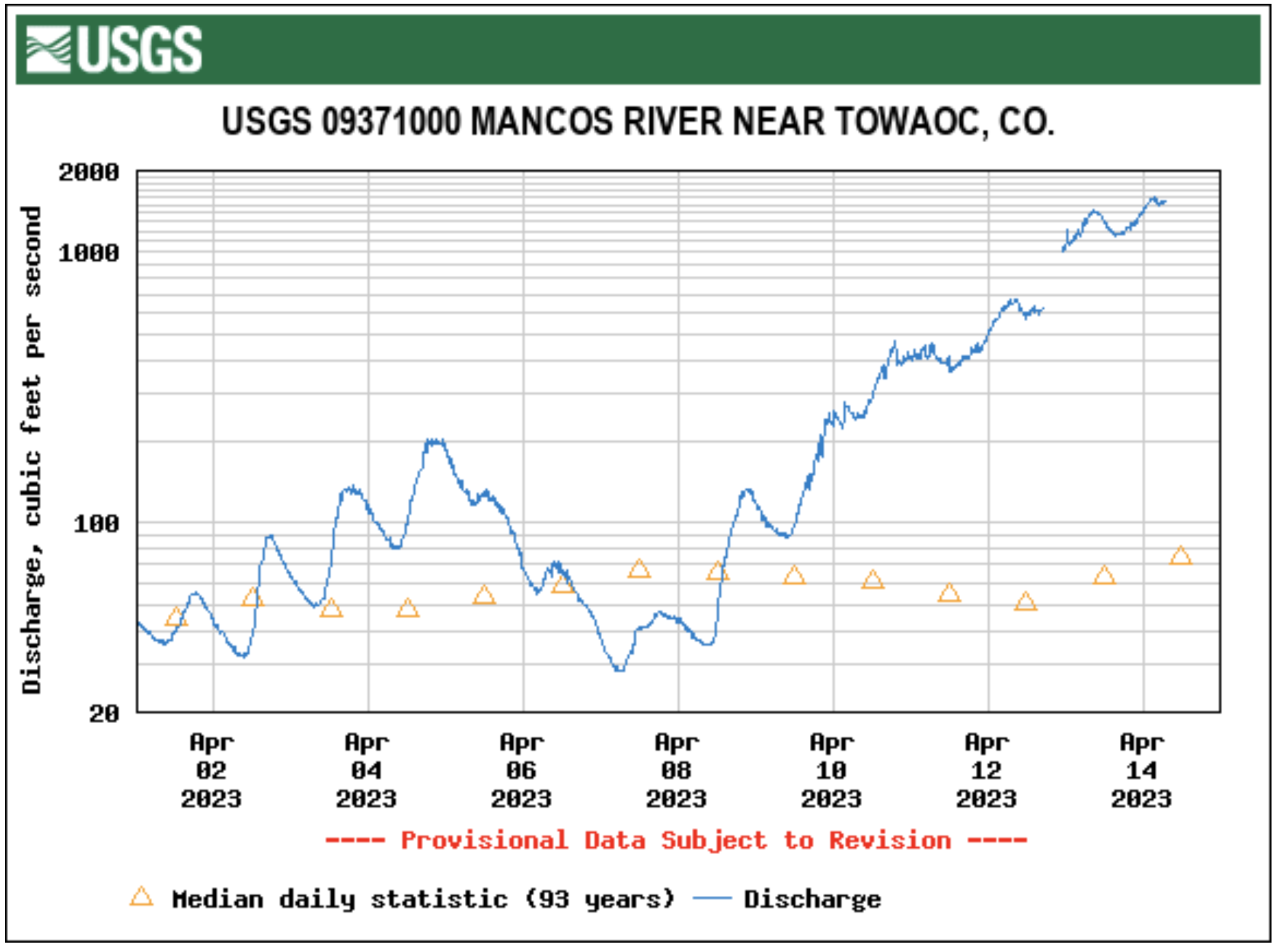
Colorado’s southern mountains had another miserable snowpack. This is not good for the Colorado or Rio Grande rivers. It fits in with a theme.
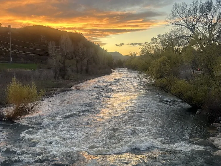
Louis Meyer awoke on Monday morning at his farm about 10 miles north of Durango to see Engineer and Red mountains wearing fresh blankets of snow. The two mountains had been scantily clad for much of the winter.
The spring snow was welcome news, he said, but unlikely to change the story of southwest Colorado. Runoff will be abysmal.
A resident of southwest Colorado for about eight years, Meyer has conferred with others with deeper local knowledge. Right now, it appears that those farmers and ranchers who might normally expect to get three or four cuttings of hay will get no more than two. And in La Plata County, they will be lucky to get one cutting of hay.
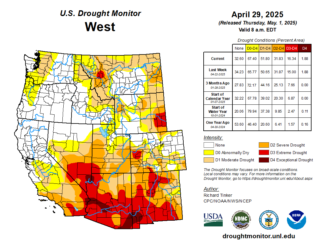
Snow contributing water to the Animas, San Juan and other rivers of southwestern Colorado have only 28% of median of snow-water equivalent, according to maps released on Monday by the Natural Resources Conservation Service, a federal agency.
East of Wolf Creek Pass, in the upper Rio Grande drainage, numbers were worse yet, 21% of median. Last week, before the fresh snow, they had been even less.
Water managers in the San Luis Valley warned in a May 1 posting on Facebook that they expect early runoff, low rivers flows, and a short boating season. Heather Dutton, manager of the San Luis Valley Water Conservancy District, said there had been high hopes several times of 16- to 18-inch snow dumps, even 36 inches. “It just never materialized for us.”
Snowpack in Colorado’s southern mountains always has been uneven. Some years are better, other years worse. But a trend has emerged of earlier springs and less moisture in the San Juan Mountains and Sangre de Cristo Range of Colorado, and this year’s snowpack and weather fits in with it.
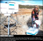
Russ Schumacher, the Colorado state climatologist, and associates at the Colorado Climate Center have analyzed data from the Snotel stations in Colorado going back to at least 1979. Their studies have focused on the volumes of peak snow-water equivalent in the snow and the dates of those readings.
Snotel stands for SNOwpack TELemetry, an automated system.
“In Colorado’s northern mountains, trends over the last 45 years are fairly modest overall, with some mixed signals,” he wrote in in an April 14 posting at Colorado Climate Center.
Many stations in the San Juans and Sangre de Cristo mountains showed levels below the 10th percentile of records, he said.
“But in the southern mountains, the data make a very clear statement: snowpack is declining, and the peak is happening earlier. At many of the stations in the San Juan and Sangre de Cristo mountains, the peak snow-water-equivalent has declined by 3% to 5% per decade, and the peak has shifted two to four weeks earlier.”
The 1980s were unusually wet, which makes the recent declines look even worse. Contributing to the declines have been dust-on-snow events and the rising temperatures.
During the 21st century, Colorado has had just one year of below-average annual temperatures when compared to the 1971-2000 average, according to a study commissioned by the state government. Seven of the top 10 hottest years on record have occurred since 2010.
Colorado’s northern mountains looked somewhat below average as of early April. But unseasonably warm temperatures caused the snowpack to sag as the month went on.
“It was clear by early April that it was going to be a bad year in southern Colorado,” Schumacher wrote to Big Pivots in an e -mail on April 29. “But with very little snow and a lot of sunshine in the last couple weeks, snowpack in the northern mountains has started declining early as well.”

Snow was notably absent in Colorado’s southern mountains this winter. It started out OK, then got warm and dry. By late January, the odds were for a very poor runoff.
A Snotel station near Wolf Creek Pass had the second lowest peak snow-water equivalent since the station was established in 1979. The lowest reading was in 2002. This was even less than in 2018, a year plagued by wildfires in southern Colorado.
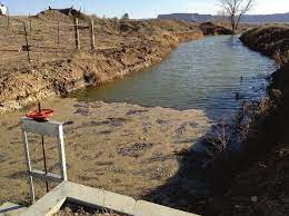
At his farm along the Animas River, Meyer first noticed a problem in February. The well that taps water for domestic purposes went dry. The water table had dropped 35 feet. He persuaded others on the ditch to begin diverting water from the Animas River through the ditch. This caused the groundwater level to rise. It worked, although he was out of water for a week to 10 days.
Meyer is relatively new to southwest Colorado but not to Colorado water issues. An engineer by training, he operated a Glenwood Springs-based water consulting business for 35 years before he retired. He then bought ranch property in southwest Colorado near the community of Mancos. After a drought in 2021, he resolved to get a property with better access to water.
The property north of Durango is where the San Juan Mountains begin to pinch the Animas River Valley. The farm he and his children tend has plentiful orchards: peaches, apples, and pears. They also grow cherries and plums along with raspberries, strawberries and blackberries.
Family members also like to raft, but on Sunday found too little water to do so.
At his office in Cortez, Ken Curtis, director of the Dolores Water Conservancy District, has been monitoring the snowpack numbers. In late April they suggested a runoff of 30% of average. Because his district owns more senior water rights, the farmers of alfalfa, pinto beans and other crops in his district will probably do better than that might suggest.
“It’s been a weird year,” he said. “We are definitely going to have a shortage.”
The good news he reported was the relative absence of dust-on-snow, a phenomenon that warms the snow more rapidly and causes faster melting.
This was the eighth or ninth year out of the last 15 that the runoff from the winter snowpack has been on the low side.
Cortez lies amid the remains of the Ancestral Pueblo, known colloquially as the Anasazi. Because of a multi-decade drought about 1200, they abandoned their cliff dwellings and took up homes along the Rio Grande to the east.
At least part of this drought is something different, the result of rising temperatures created by accumulating greenhouse gases. The process is called aridification, and scientists since about 2017 have conducted studies that convincingly demonstrate that it is responsible for roughly half of declined flows. Drought may go away, but human-caused aridification will not any time soon.
The Colorado River during the last 25 years has yielded significantly less water than the 20th century average — and even less than delegates from the seven basin states assumed when they drew up the Colorado River Compact in 1922.
The states, divided into the upper and lower basins, have been trying to come to grips with the new realities of the 21st century for most of the century. Results have been uneven.
First California and then Arizona gulped waters from the river with giant diversion projects. Colorado but especially other basin states were slower to put straws into the river and they have also been smaller straws.
Who should cut back given the clear evidence for need? At his farm near Durango, Meyer thinks that Colorado must recognize it needs to cut back somewhat in line with what Arizona and California have agreed to do.
Runoff into Lake Powell during March 2as 61% of average. The reservoir is 31.4% full, far better than in 2022, when capacity dipped to below 23% of capacity. Runoff in the last couple of years has been at least okay. This year’s runoff will be a stern reminder that new agreements must be hammered out.
On April 25, water journalist and author John Fleck and four collaborators – including Anne Castle and Eric Kuhn of Colorado – issued a short paper that outlined what they said are the seven essential pillars for post-2026 management of the Colorado River. The first calls for enforceable reductions in water use in both the Upper and Lower Basin.
The compact assumed far more water than occurred in the 20th century, but that faulty assumption was tolerable until the 1990s, when the Central Arizona Project withdrawals began. Then came the drought and aridification of the 21st century. The river that delivered 14.5 million acre-feet (unlike the 20 million acre-feet that was assumed) was in trouble.
Colorado, to a small extent, but Wyoming and Utah especially, had not been using the amount of water that was assumed by the compacts. California and Arizona had been – and then some.
In recent years, California and Arizona have cut back their use of the Colorado River dramatically. The argument made by Castle and Kuhn as well as the others is that there must be shared pain in reduced wager use. That runs counter to the official stance of Colorado and other basin states that it’s a lower-basin problem.
“Shared pain is also critical to inducing the various states not to litigate over the interpretation of the 1922 Compact,” they wrote. “Shared does not mean equal, either in amount, triggers or duration,” they added.
They also say that reductions in water use cannot be predicated on federal compensation, as was important in enabling Arizona and California to reduce their flows during the last few years.
Kuhn was the long-time general manager of the Colorado River Water Conservation District in Glenwood Springs, and Castle, an attorney who specialized in water, was undersecretary for Water and Science in the Interior Department during the Obama administration. She is now with the Getches-Wilkinson Center at the University of Colorado Law School.


![Rio Grande and Pecos River basins. Map credit: By Kmusser - Own work, Elevation data from SRTM, drainage basin from GTOPO [1], U.S. stream from the National Atlas [2], all other features from Vector Map., CC BY-SA 3.0, https://commons.wikimedia.org/w/index.php?curid=11218868](https://i0.wp.com/coyotegulch.blog/wp-content/uploads/2013/04/pecosriverriograndewatershedswiki.jpg?w=478&h=564&ssl=1 "pecosriverriograndewatershedswiki")