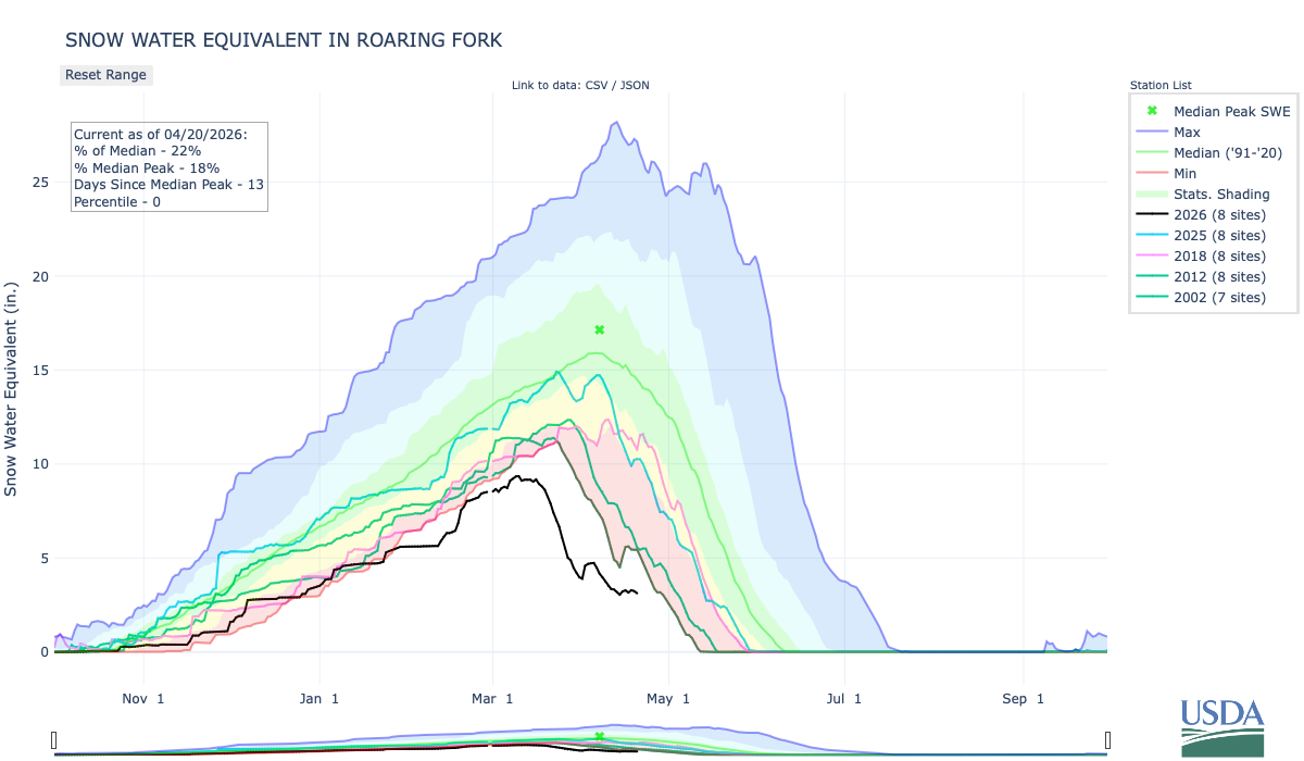
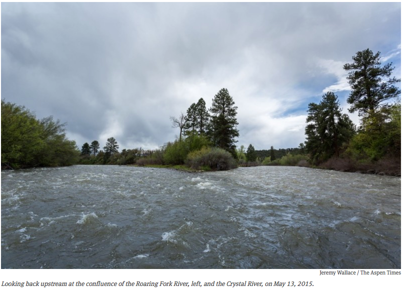
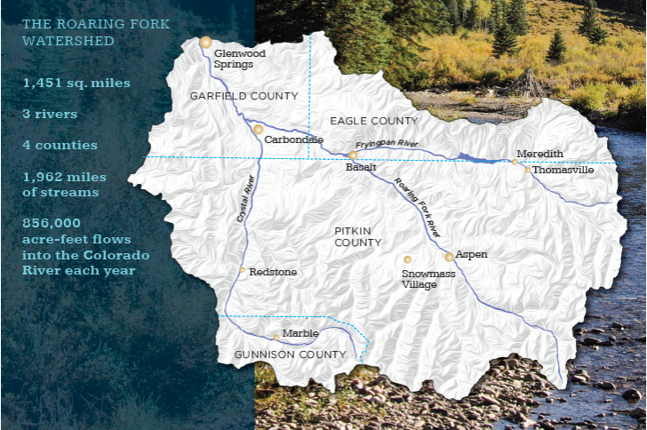
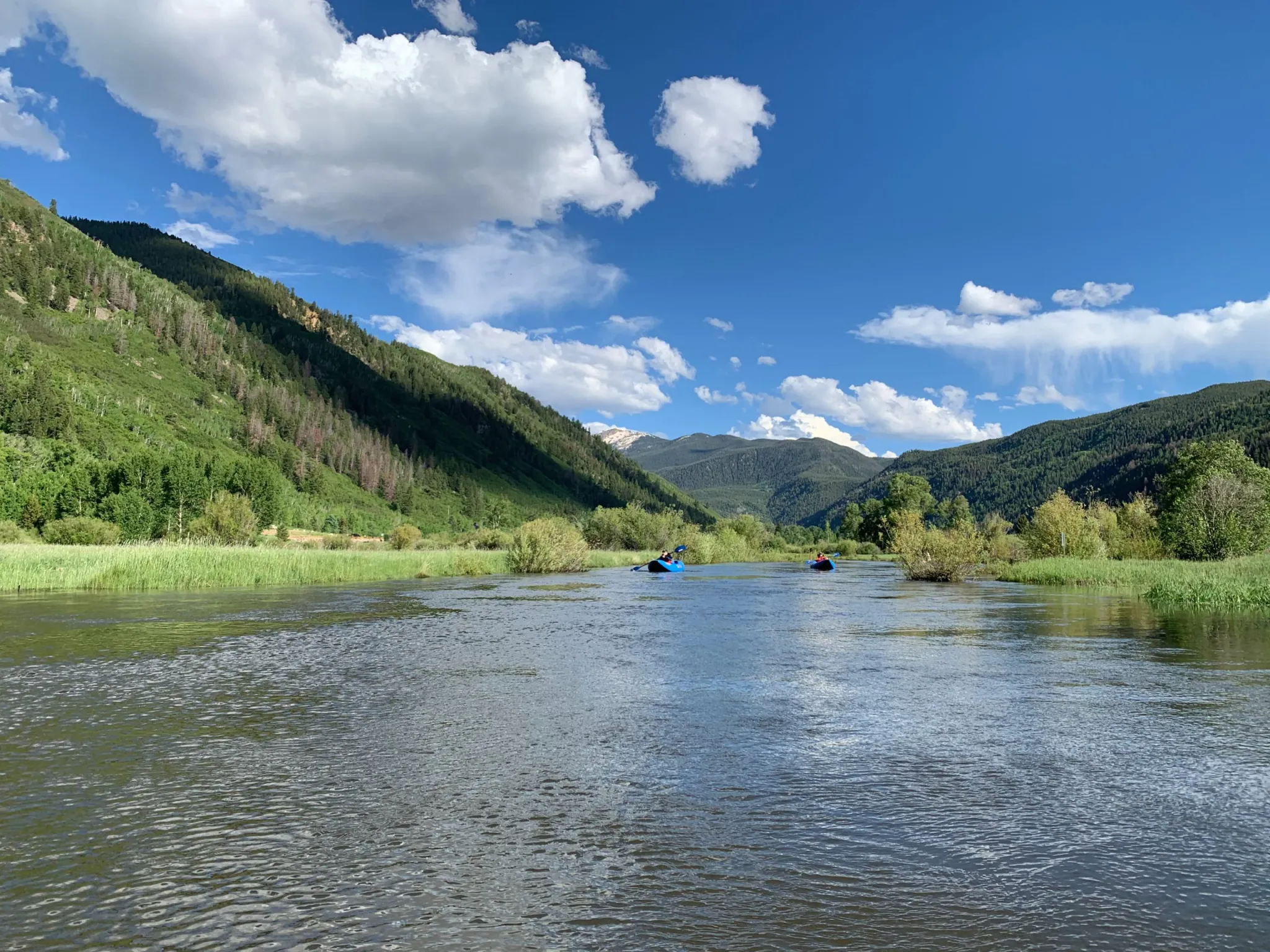
Ruedi Reservoir was 65% full as of Wednesday. Increased releases out of Ruedi could bump up flows in the Fryingpan River to as high as 700 cfs. Credit: Heather Sackett/Aspen Journalism
Residents and anglers can expect to see high flows in the Fryingpan River in the month of August as water managers increase releases out of Ruedi Reservoir in an attempt to relieve the worst drought conditions downstream.
The Colorado Water Trust plans to begin releasing from a 4,700-acre-foot pool it leases in Ruedi on Monday. The Glenwood Springs-based Colorado River Water Conservation District also plans to begin releases from its 10,500-acre-foot Ruedi pool next week. Flows in the Fryingpan River are expected to typically be between 300 and 500 cfs while the releases are happening, though they could climb higher. It’s unclear how long the increased releases will last; it will depend on weather and precipitation over the coming weeks.
Water managers say flooding on the Fryingpan begins to be a concern around 800 cfs; River District officials say water managers will aim to keep the river below 700 cfs.
“We do not want to cause any flooding; we are very aware of that,” said Brendon Langenhuizen, director of technical advocacy for the River District.
Langenhuizen laid out details of the planned releases at a remote Zoom meeting of local leaders and water managers on Wednesday.
Although flooding may not happen until 800 cfs, impacts to the Fryingpan’s famous Gold Medal trout fishery happen long before that. Anglers generally like flows to remain below 300 cfs, the level at which wading becomes difficult and potentially dangerous.
Aspen Mayor Rachel Richards noted the dire conditions downstream, but asked if flows could be kept in the 300 to 350 cfs range when possible.
“Additionally, it’s more about the warning to fishermen if the water releases are changing rapidly,” Richards said. “I think the notification on the Fryingpan is what’s really critical here.”
Rick Lofaro, executive director of the Basalt-based Roaring Fork Conservancy, said his organization has already started getting the word out.
“There is an organization called the Roaring Fork Fishing Guide Alliance, and we are in lockstep with them,” Lofaro said. “We have already started to alert people to these increased flows, and the fishing community will be notified by the Roaring Fork Conservancy, along with the greater community.”
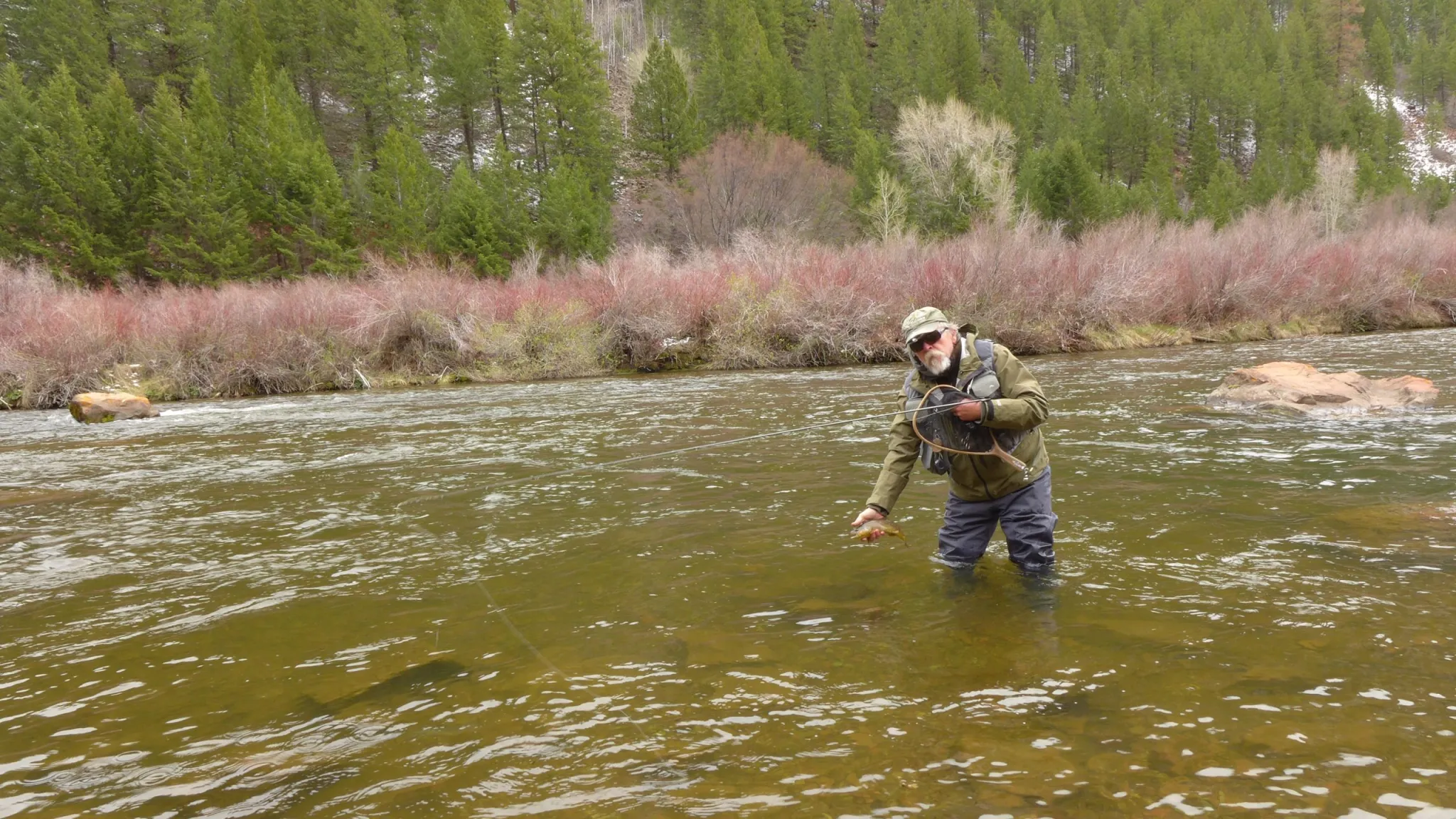
Bill Nein, of Salida, prepares to release a brown trout he caught back into the Fryingpan River. Anglers generally like flows to stay below 300 cfs for easy wading. CREDIT: HEATHER SACKETT/ASPEN JOURNALISM
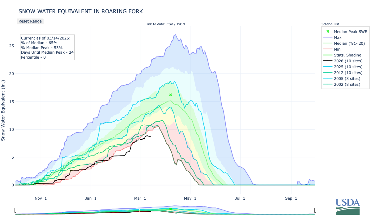
As of Wednesday, Ruedi was about 65% full. Tim Miller, a hydrologist with the U.S. Bureau of Reclamation, noted that this year’s reservoir operations are pacing about 10 days ahead of 2002, which was another year where drought conditions increased releases and lowered water levels at the reservoir. When asked by a U.S. Forest Service representative about when the water level would become too low for the boat ramp to operate, Miller said exactly when is unclear but that it would happen in the next month.
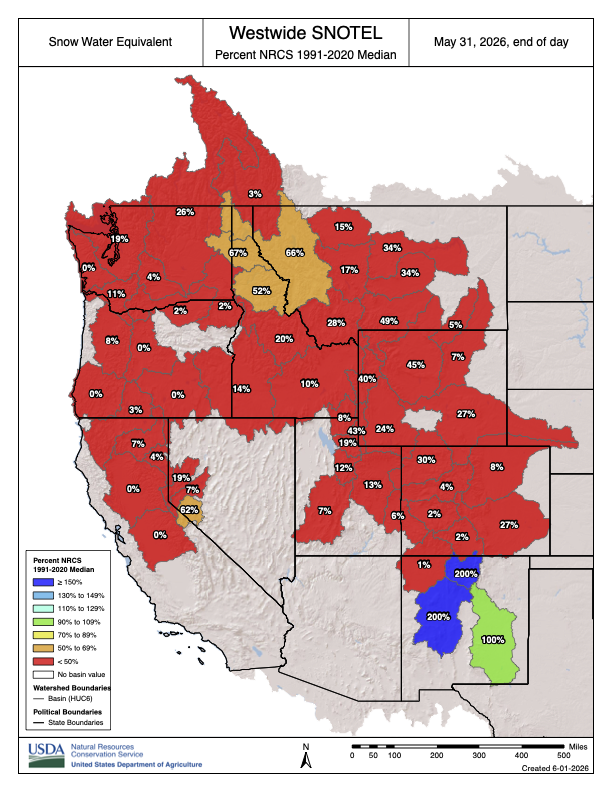
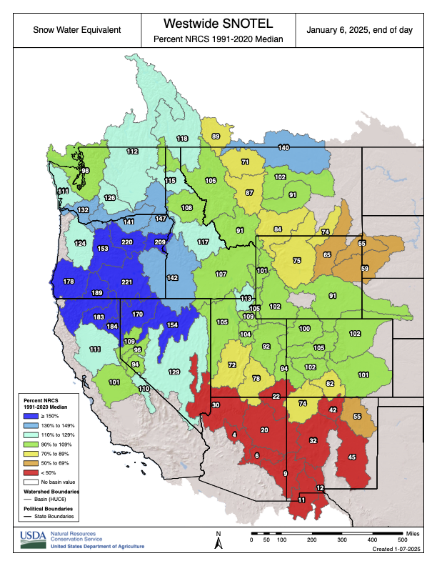
Westwide SNOTEL basin-filled map May 31, 2026.
The Ruedi releases are aimed at alleviating the impacts of the worst snow-drought on record in the upper Colorado River basin, which are being felt on local waterways, as well as farther downstream. Pitkin County has issued a mandatory closure of the Roaring Fork River through the North Star Nature Preserve – a popular stretch for paddleboards and kayaks – because of unprecedented low flows. And Colorado Parks and Wildlife has issued voluntary fishing closures on portions of the Roaring Fork, Crystal and Colorado rivers due to low flows and high water temperatures.
The effects of drought are also being felt in the Grand Valley, one of the big agricultural hubs on the Western Slope with some of the most senior water rights on the Colorado River. The water from Ruedi will flow down to be used by irrigators in this area, who are currently about 500 cfs short of the water they need, according to Langenhuizen.
“This has been a tough year for a lot of people from the bottom of the basin all the way to the top, and a lot of people have been pitching in to help us get through and share resources,” he said. “Everybody’s kind of taking a hit this year.”
The River District’s Ruedi releases are part of its 2026 drought response plan. They are meant to cushion the blow of shortages in a pool of water in Green Mountain Reservoir known as the Historic Users Pool. HUP water is released mainly to satisfy farmers and ranchers in the Grand Valley, whose group of senior water rights — known as the Cameo call — are the commanding force on the river.
When Cameo places a call for its water, it can force junior users all the way up to the headwaters to shut off. The HUP also protects other water users, known as HUP beneficiaries, because without the releases from Green Mountain, Cameo would place more frequent calls, forcing these users to cut back.
However, this year, the HUP did not fill, causing repercussions up and down the river.
“This is really driven because we don’t have HUP coverage, which has an impact on a lot of users in the Colorado River basin, both municipal and irrigators,” Langenhuizen told Aspen Journalism in a separate interview. “We really tried to look at this as wholesale, like how can we help as many people in the Colorado River basin as possible?”
Depending on water demands, the 4,700 acre-feet from the Water Trust could be used by irrigators in the Grand Valley, or it could be used for hydropower generation in the Grand Valley and then flow into the 15-mile reach, a chronically water-short stretch of the Colorado River that is critical habitat for endangered fish.
Bicycling the Colorado National Monument, Grand Valley in the distance via Colorado.com
To bolster the Colorado River’s flow downvalley through historic drought, water authorities will be increasing the flow out of the Ruedi Reservoir through August. That water will flow into the Fryingpan River…Water will then flow into the Roaring Fork River, then down the Western Slope, where populations in Grand Valley are in “dire need,” he said…
Green Mountain Reservoir (back in the day) is owned by the U.S. Bureau of Reclamation and located in Summit County north of Silverthorne along the Blue River. Photo credit: Denver Water.
Traditionally, the Western Slope relies heavily on the Green Mountain Reservoir — about 17 miles south of Kremmling — to sustain a steady Colorado River flow. But due to the state’s dry, warm winter, that reservoir struggled to fill over the spring. The administrators of Green Mountain Reservoir found that low water levels and fast releases were exacerbating a slow-moving landslide on its banks, so they limited how much water could be released out of the reservoir to half a foot a day…
Tim Miller, a hydrologist with the U.S. Bureau of Reclamation that manages the levels at Ruedi Reservoir, said the reservoir played a similar supplemental role in 2002, when Colorado saw another historic drought. This year’s use of the reservoir is about 10 days ahead of then, he said.
A few miles north of Mt. Sopris, down another dirt road that leads to the Roaring Fork River, Wenning stopped his car at a small brick building near the riverbank: The Roaring Fork Well House. Nearby are three wells that draw from the Roaring Fork River, providing another source of municipal water. After the call on the Crystal in 2018, Carbondale water managers decided to reduce the town’s reliance on Nettle Creek by leaning more heavily on the Roaring Fork River, where the town also has water rights. Carbondale currently has installed three wells — each of which produces roughly the same amount of water as the Nettle Creek plant (around 300 gallons per minute). But, the town has permits for seven more wells. Shifting Carbondale’s focus to the Roaring Fork River makes sense, said Wenning. Since the Roaring Fork is a bigger river, it’s less affected by a low-snow year. The wells are also 40 feet deep, allowing them to access groundwater…
The Roaring Fork Treatment Plant lies at the edge of the Carbondale Nature Park. Inside the barn-like building, a loud whirring sound echoes through the cavernous interior. The town recently installed new cartridge filter technology at the plant, expanding its capacity to treat water from 0.5 million gallons to 1.4 million gallons per day. According to Wenning, the town plans to expand the plant’s capacity further to treat up to 2.3 million gallons per day from the Roaring Fork River alone — more than enough to meet Carbondale’s peak summer demand, even when some of the water treatment equipment needs repair or servicing…
Beyond the shift to a more resilient water source, water experts see more opportunity to boost capacity through conservation. Maggie McHugh, an engineer with Roaring Fork Engineering, helps communities in the Roaring Fork Valley adapt to climate change.
“We can’t put any more water into the system, but we can take less out,” she said. “That will be the ultimate goal, especially in years like this.”
Ruedi Reservoir on the Fryingpan River is operated by the U.S. Bureau of Reclamation. Releases for the Colorado River Endangered Fish Recovery Program have boosted late summer and fall river flows in recent years. Credit: Heather Sackett/Aspen Journalism
Click the link to read the article on The Aspen Times website (River Stingray). Here’s an excerpt:
July 13, 2026
The city of Aspen’s Ruedi Hydroelectric Facility is anticipated to lose hydroelectric power in early August due to current U.S. Bureau of Reclamation reservoir forecasts and operating conditions. The updated reservoir data indicate that the timing has shifted later than previously anticipated, which the city’s Utilities Resource & Portfolio Manager Joshua Mattson confirmed to The Aspen Times. According to him, earlier planning projections that were provided by the U.S. Bureau of Reclamation indicated the reservoir could drop below the hydroelectric power pool threshold in mid- to late July.
“Updated reservoir elevations, inflow and outflow conditions, and U.S. Bureau of Reclamation operational forecasts now indicate the threshold is more likely to be reached in early to mid-August,” Mattson wrote in an email. “The shift reflects actual reservoir conditions improving relative to earlier projections and ongoing changes in reservoir operations and water demand. This remains a forecast and will continue to be evaluated as conditions evolve.”
The hydroelectric power pool represents the minimum reservoir elevation that is required in order to safely operate the hydroelectric turbine and associated equipment, according to an information update provided to Aspen City Council on Monday. When reservoir levels fall below this threshold, city staff will consequently take the Ruedi Hydroelectric Facility offline in order to protect equipment.
“This outage is not related to dam safety; rather, it is the result of hydrologic limitations associated with drought conditions,” the information update states. “The facility is expected to remain offline until reservoir levels recover above the minimum power pool elevation, which is anticipated to occur in spring 2027 as seasonal inflows increase.”
The Roaring Fork River in Aspen on July 8. Pitkin County Commissioners gave initial approval to buying more shares of Twin Lakes water to boost low flows on the Fork. CREDIT: HEATHER SACKETT/ASPEN JOURNALISM
Against the recommendation of an advisory board, Pitkin County commissioners on Wednesday gave preliminary approval to buy more water to boost flows in the often-depleted Roaring Fork River.
Commissioners approved on first reading a resolution and ordinance to spend $442,500 to buy 4.68 shares from the Twin Lakes Reservoir & Canal Co., which is about 3.5 acre-feet of water, according to a staff memo. The deal is in addition to the $6.5 million Pitkin County already agreed to spend earlier this year for about 71 acre-feet from Twin Lakes and another ditch company.
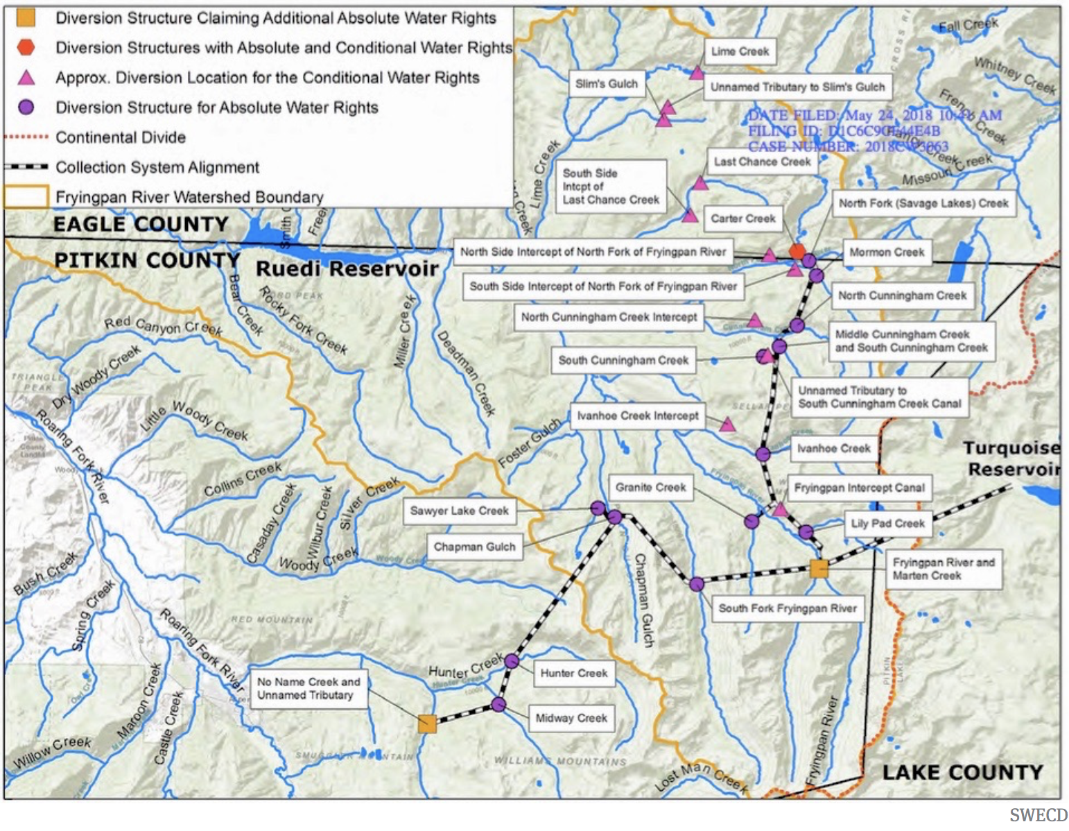
Twin Lakes collection system
The water is currently taken across the Continental Divide to the Arkansas River basin to be used by entities on the Front Range. The deal would allow the water to be released out of Grizzly Reservoir to Lincoln Creek and could help boost the Roaring Fork through Aspen and upstream, which suffers from low flows in dry years.
“I think it’s really critical that we purchase water rights when we can, and this is an opportunity that we can, and we should,” District 1 Commissioner Patti Clapper said.
Pitkin County has long had a goal of increasing the amount of water in the Roaring Fork, a river that has about 40% of its headwaters diverted to the eastern side of the state through the Independence Pass Transmountain Diversion System to be used by Colorado Springs, Pueblo and Aurora. These diversions can often contribute to the depletion of the Roaring Fork through Aspen, and purchasing Twin Lakes water represents a rare opportunity to return water to the Western Slope.
Commissioner Greg Poschman said he supports acquiring the water shares.
“I think it’s great that we are doing this,” he said. “I know it’s expensive; there are some raised eyebrows about that, but I think this is something we have to do.”
Poschman added that he was concerned that the Healthy Rivers board members recommended against buying more water and said he would like to fully understand their reasons. County staff said they were trying to schedule a joint meeting with the Board of County Commissioners and the Healthy Rivers board in August.
Members of the county’s Healthy Rivers board, which advises the BOCC, are concerned that the water will have a small impact on river health but a big impact on the program’s budget. The board held a special meeting June 25 to consider acquiring the shares and approved a motion saying the water yield would potentially be only 1 additional cubic feet per second for two days.
“Additionally, the deleterious effects of the purchase price on the long-term fund balance of the Healthy Rivers Fund will reduce the Healthy Rivers Program’s ability to support programs to address other ballot measure mandates, including water quality, ecological health, recreation opportunities, wildlife and riparian habitat, and promoting water conservation,” the motion reads.
The motion goes on to say that in the future, the county should implement a framework for evaluating the true value of water shares to the Roaring Fork.
At Wednesday’s meeting, County Budget Director Connie Baker told the BOCC that the Healthy Rivers board will have to trim or reallocate about $500,000 from next year’s budget to account for the combined impact of this year’s two water purchases.
Healthy Rivers board member Ned Andrews said he is against the purchase, citing the impact that it will have on the program’s budget.
“None of the analysis or details that would justify such a purchase or a strategy going forward has been done,” Andrews told Aspen Journalism. “I think before you commit essentially a quarter of your budget for the next 15 years, you’d want to have an analysis that shows you what could be accomplished. My gut feeling is that it wouldn’t really accomplish much.”
Andrews also opposed the earlier, larger water share purchase, although the rest of the Healthy Rivers board was supportive.
At their regular June meeting, Healthy Rivers board members went through the budget line by line and considered where they could trim, although those cuts have not yet been finalized.
Spending big bucks in an effort to rescue rivers is not new for Pitkin County, which has spent at least $3.5 million on the Roaring Fork River Park in Basalt, including a water court battle to secure the water right for recreation, several redesigns of problematic waves, and improvements to the riverbank and boat launch.
Grizzly Reservoir, a forebay that collects water to send through the Twin Lakes Tunnel to the Front Range, sits in the middle of the Lincoln Creek watershed and connects water users on both sides of the Continental Divide. Pitkin County commissioners gave initial approval to a deal that would allow more water to be released from Grizzly for the benefit of the Roaring Fork. CREDIT: HEATHER SACKETT/ASPEN JOURNALISM
Bond for original purchase approved
The BOCC at Wednesday’s meeting also approved issuing a bond for the original purchase of Twin Lakes shares. That deal cost the county $6.5 million, although only 45 of those acre-feet represent Western Slope water that is currently diverted to the Front Range. The county plans to sell or trade the other 26 acre-feet, which is owned by the Fountain Mutual Ditch Co. in El Paso County and decreed for use on the east side of the divide.
The 45 acre-feet of water can be released down the Roaring Fork during the irrigation season when flows are low, and it must be used by a downstream water user on the Colorado River before the town of DeBeque. Instream flow for the benefit of the environment is not a decreed use of the water.
This year, according to Colorado Water Resources Division 5 Engineer Tyler Benton, at least some of Pitkin County’s Twin Lakes water was released as part of the Colorado River Water Conservation District’s emergency substitute water supply plan, which the district enacted in response to this year’s historic drought. Benton said he expects the River District to provide a full accounting of how much Pitkin County water has been released Friday.
Grizzly Reservoir is currently drained for dam maintenance, which may have affected how much water could be released under the River District’s plan.
At a time when drought impacts are being acutely felt across the state and climate change continues to rob rivers of their flows, for some, the unique opportunity to put water back into a depleted stream is worth the cost.
“This is expensive water, but it’s the only water you can get up at the headwaters of the Roaring Fork,” said Pitkin County Deputy Attorney Anne Marie McPhee. “So that scarcity makes it more valuable.”
The issue is scheduled for a public hearing and second reading July 22.
The Crystal River flows through the Gunnison County town of Marble, seen here with Beaver Lake. A representative from the Town of Marble is expected to participate in a subcommittee focused on an intergovernmental agreement to protect the river. CREDIT: ECOFLIGHT
May 27, 2026
Five Colorado governments, including Pitkin County, and water entities have officially entered into a landmark intergovernmental agreement to protect the Crystal River from mainstem dams and out-of-basin water diversions.
The agreement comes at the recommendation of the Crystal River Wild and Scenic and Other Alternatives Steering Committee from March 2024, suggested as one of three potential long-term preservation measures, according to a press release. Along with Pitkin County, the Colorado River Water Conservation District, Gunnison County, town of Marble and West Divide Water Conservancy District formalized their shared commitment to oppose any new on-channel reservoirs on the mainstem of the Crystal River and any trans-basin diversions that would export water out of the watershed.
The city of Aspen will enter a stage 3 water shortage for the first time since the city adopted a formal drought mitigation plan in 2020. The new restrictions will limit residential watering schedules even further. The Aspen City Council voted to declare a stage 3 water shortage during a meeting on Tuesday night, nearly eight months after it entered stage 2 water restrictions. The city’s drought response committee recommended the new restrictions because, since a stage 2 water shortage was declared, “conditions within Aspen, the Maroon and Castle Creek drainages, and the Roaring Fork Valley have degraded significantly,” according to a memo sent to the city council ahead of Tuesday’s [May 12, 2026] meeting. Irrigation will be restricted to two days per week. Water users with even home addresses can irrigate on Tuesdays and Fridays, while those with odd home addresses can irrigate on Wednesdays and Saturdays. No outdoor water use will be allowed between 8 a.m. and 6 p.m. New turf from seed or sod can be watered for up to 21 consecutive days after it is planted. Other new plants are allowed to be watered on the day they are planted. Residential swimming pools and hot tubs, and other existing water features cannot be filled or refilled using city water.
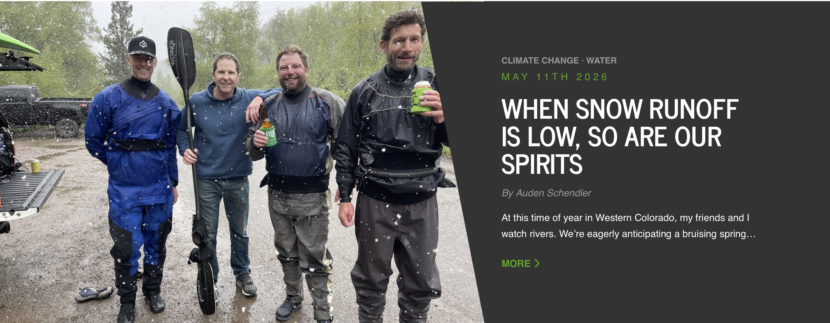
At this time of year in Western Colorado, my friends and I watch rivers. We’re eagerly anticipating a bruising spring runoff and the start of kayak season. When it arrives, many of us become obsessive, meeting daily after work to paddle.
Not this year. In one of the driest springs in Colorado history, our watershed’s snowpack was 26% of normal on April 1. The impact on fire danger, drought, agriculture, economy, and ecology is going to be profound.
Colorado statewide annual temperature anomaly (°F) with respect to the 1901-2000 average. Graphic credit: Colorado Climate Center
But this is the new normal in a climate-changed world. Colorado has warmed 2.3° F since only 1980. The Upper Colorado River Basin suffered close to record-low precipitation in March—normally our snowiest month—and record heat. Snowpack peaked at the earliest date and lowest amount ever. This collapsed the ski industry, and many resorts closed in what is typically their most profitable month.
A kayaker runs the 6-foot drop of Slaughterhouse Falls on the Roaring Fork River near Aspen in June 2021. Recreation proponents gave six recommendations to the CWCB to better elevate recreation in the update to Colorado’s Water Plan. CREDIT: BRENT GARDNER-SMITH/ASPEN JOURNALISM
The kayak run my friends and I like best is called, ominously, “Slaughterhouse.” It flows through an alpine forest at 7,000 feet, near the town of Woody Creek. Kayakers must navigate tight channels and churning holes, steering around boulders the size of VW buses.
Though many of us have kayaked this stretch hundreds of times, we never paddle the same river twice, to echo Heraclitus, because flows are always minutely different, as is the turbidity of the water, the quality of sun, or clouds. At the same time, there is a Zen to the repetitiveness: a remembered left turn below a spruce tree to hit an eddy; a crucial line that splits two rocks; the plant smells we recall from last year and the previous 30.
This friend group of men in their forties and fifties—a photographer, a paramedic, a ski mountain manager, a caterer—has become attuned to the river. We continuously observe snowpack and storm cycles throughout winter, with an eye to runoff. We know that when it reaches 500 cubic feet per second (cfs) we can float Slaughterhouse for the first time. 800 to 1000 cfs is juicy, a joyous party, and that level often holds steady for many weeks. The water gets pushy around 1300 cfs, and some of us stop paddling when it gets too scary. No need to worry this spring: Slaughterhouse, which can peak above 7,000 cfs, topped out at about 250 cfs.
We know each other like we do the river. Banter focuses on making fun of our paddling. One meme of an upside-down kayak shared on a group chat read: “Roses are red, violets are blue, I lied about having a solid roll…where are you?” If you do happen to swim out of your boat, the group instantly switches from a bunch of jerks to a coordinated rescue team. Expect to hear “Are you doing OK?” for the rest of the day.
Later, expect to be made fun of at that location for the rest of your life. When we gather at the takeout, we drink beer and reflect on our glories and failures, loitering past dinnertime.
To be a good kayaker, you have to be willing to suffer the consequences of a mistake. Typically, that means being upside down in cold water, unable to breathe or see. Boaters call this underwater experience “the white room,” or “being Maytagged.” You accept the fact of an inevitable frigid swim, because, as old kayakers say, “We’re all between swims.” This season, the mistake we must endure is a societal one.
In a sense, kayakers are prepared for the hot, smoky summer ahead: We’ve learned to endure some inevitable pain. Harder to manage will be the loss. We’ll have to forgo the camaraderie, ritual and traditions that come from decades of recreation tied to seasons, place and environment. The truth is, as the planet warms, we’re in danger of losing a sense of who we are.
Auden Schendler
The philosopher Glenn Albrecht coined a term for this: solastalgia, the distress caused by environmental change, creating a “homesickness you feel while still at home.”
It is widely understood that climate change will forever alter our physical world. Indeed, it already has. It’s less obvious that it’s also coming for our friendships, our identity and the spirit and rhythm of our lives.
Auden Schendler is a contributor to Writers on the Range, writersontherange.org, an independent nonprofit dedicated to spurring lively conversation about the West. He lives in Basalt, Colorado, and is the author of Terrible Beauty: Reckoning with Climate Complicity and Rediscovering Our Soul.
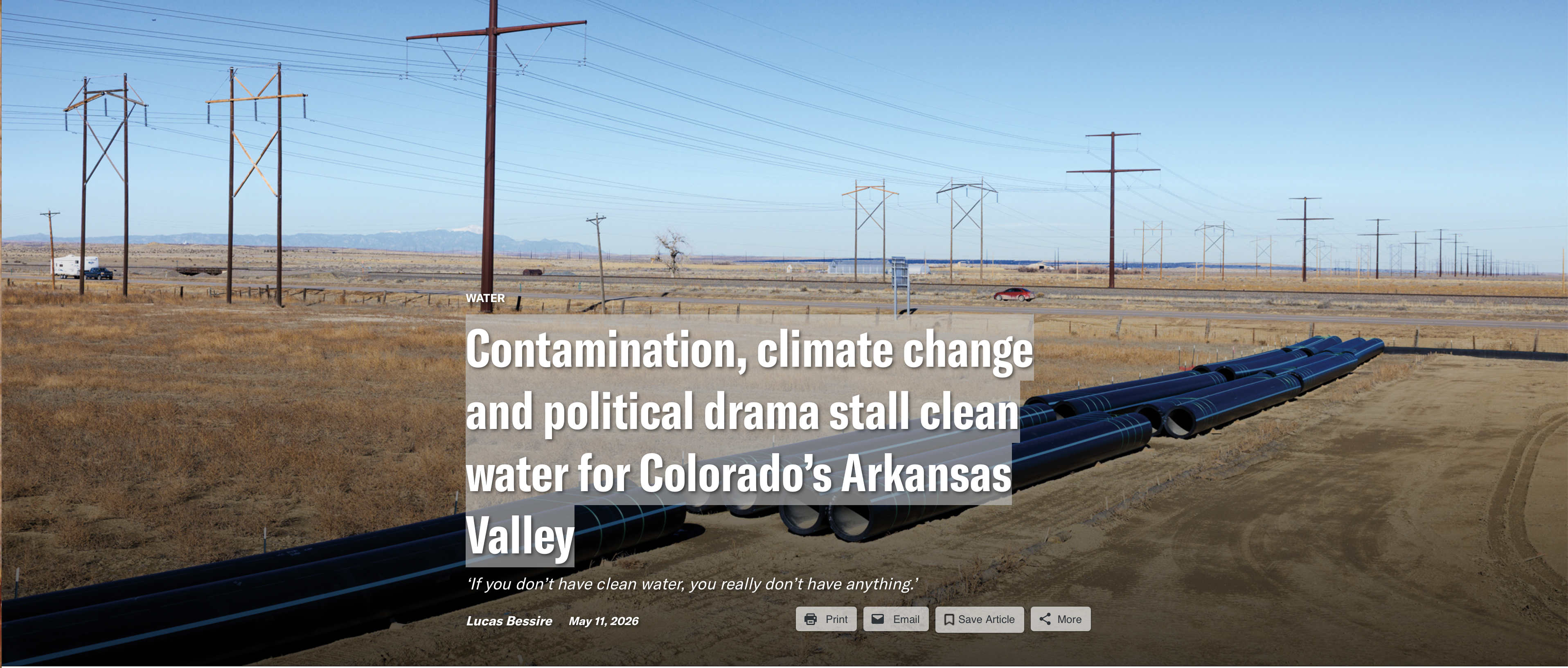
The western stretch of the Arkansas River, which flows from its headwaters in the Rocky Mountains across the plains of southeastern Colorado, is in trouble. That trouble is compounded by uncertainty about what, exactly, is polluting and drying the river, and how such problems can be fixed.
Overshadowed by the ongoing political brawl over the Colorado River, the Arkansas River Valley rarely appears in national news. But since Dec. 30, when President Donald Trump vetoed a bipartisan bill that would have secured favorable terms for funding to complete a $1.39 billion, 130-mile water pipeline, the region has become the stage for yet more drama about water in the Western U.S.
Arkansas Valley Conduit map via the Southeastern Colorado Water Conservancy District (Chris Woodka) June 2021.
The Arkansas Valley Conduit is part of a decades-long effort to replace the dwindling, contaminated water in this stretch of the Arkansas Valley with clean water from Colorado’s Western Slope and the Pueblo Reservoir. If completed, it will supply water to roughly 50,000 valley residents, many of whom can no longer count on municipal supplies for safe drinking water.
Pundits portrayed Trump’s veto as retaliation against Colorado politicians: Republican Rep. Lauren Boebert, who helped force the November vote for the release of the Epstein files, and Democratic Gov. Jared Polis, who has resisted pressure to pardon Tina Peters, a county clerk in western Colorado convicted of tampering with voting machines during the 2020 election. Sens. Michael Bennet and John Hickenlooper, both Democrats, condemned the administration for “putting personal and political grievances ahead of Americans.” The Salida-based Ark Valley Voice declared a “Reign of Retribution Punishing Deep Red Southeastern Colorado.” The New York Times, emphasizing the same irony, observed that “A Trump Veto Leaves Republicans in Colorado Parched and Bewildered.”
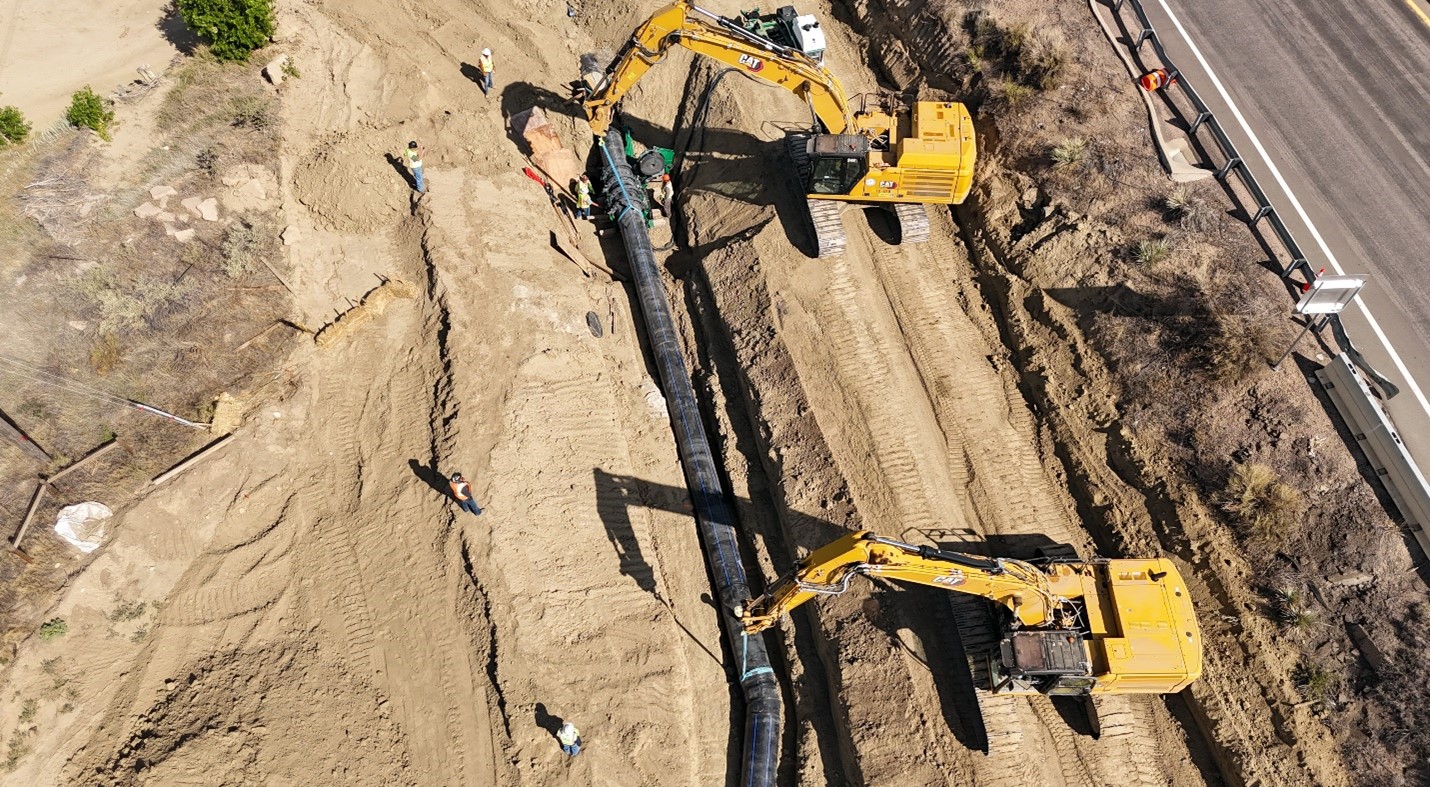
For those managing the project, the veto is a setback but not a showstopper. The first dozen miles of the conduit have already been completed, and enough capital is on hand for at least three more years of construction. “Some (coverage) has been saying it’s the end of the project, which is totally false,” said Chris Woodka, senior policy and issues manager of the Southeastern Colorado Water Conservancy District. “It’s still being built; the veto was not for any reason that had anything to do with the project, and we’re working in every way we can to make this affordable.”
For valley residents, the issue is personal. This rural region is more culturally aligned with western Kansas than with Front Range cities. Like people throughout the Great Plains, the local residents are grappling with eroding social services and the rising cost of living. The scarcity of safe water magnifies uncertainty. “If you don’t have clean water,” said Jack Goble, general manager of the Lower Arkansas Valley Water Conservancy District and a sixth-generation rancher, “you really don’t have anything.”
“HOW EASY IT IS,” wrote William Mills in his 1988 book The Arkansas, “to take a river for granted.”
The Arkansas Valley of Colorado is the ancestral homelands of the Plains Apache, Comanche, Kiowa, Cheyenne and Arapaho peoples. A geographical corridor across the Southern Plains, it was a route for incursions and ethnic cleansing by non-Native fur trappers, traders, military expeditions, hide hunters, railroad developers and settlers. Those settlers include my ancestors; I grew up in southwest Kansas, where generations of my family farmed and ranched along the dry Cimarron River. The Arkansas Valley, with its dwindling water and flatlands, feels like home.
Straight line diagram of the Lower Arkansas Valley ditches via Headwaters Magazine
By 1900, settlers had diverted the Arkansas into a maze of ditches. Irrigation and migrant labor supported sugar beet factories, vegetable cultivation and Rocky Ford’s famous melons. Such practices remade the riverbed, increased salinity, and reduced flow. As with the Colorado River, water rights were assigned partly on wishful thinking. Today, the Arkansas Valley is one of the region’s most over-appropriated basins, and the river’s annual flow has dramatically declined. A short distance past the Kansas line, the river is entirely dry.
The Arkansas is being drained in new ways. Climate change and a record-breaking snow drought are intensifying the scarcity. Over the last half-century, growing Front Range cities have purchased water rights from farmers in the valley. Exchange agreements allow cities to swap these rights for ones farther upstream, leaving the downstream flow diminished and dirtier. Between 1978 and 2022, nearly 44% of the irrigated farmland in the Lower Arkansas Valley Water Conservancy District was taken out of production.
Rocky Ford Melon Day 1893 via the Colorado Historical Society
Critics call it “buy-and-dry.” They say the removal of water has disastrous consequences for an agricultural region. “If you take all of that water out of an economy that completely depends on it,” Goble said, “it just breaks a community.” Faced with the prospect of litigation from local water districts, cities like Aurora claim to be developing more sustainable arrangements.
THE ARKANSAS’ WATER is changing, too. The river is diverted into dozens of canals and fields. What doesn’t evaporate or get absorbed returns as runoff or sinks through the alluvial gravels that connect to the riverbed. Each time a drop of water returns, it carries more dissolved minerals. As the river’s volume lessens, the concentration increases in what is left. By the time the river reaches the Kansas border, the water regularly contains 4,000 milligrams or more per liter — making it about eight times saltier than a typical sports drink and unsuitable for growing many crops.
Minerals are not the only problem. The river basin and alluvial gravels are also contaminated with radium and uranium. Last year, a study by the Colorado Geological Survey found that the levels of radioactivity in more than 60% of the private wells sampled in the valley exceeded federal standards.
The radionuclides are called “naturally occurring.” But natural uranium usually stays locked in rock. In the valley, irrigated agriculture sets it into motion. Uranium is mobilized by complex interactions between oxygen, sediments, water, microbes and nitrate. Nitrate is a common fertilizer. One study found that valley farmers had over-applied it for decades. This pulls out radionuclides, turns them loose, and flushes them into the river’s shallow aquifer. Levels rise as the river moves east through agricultural lands.
Contamination is not news in the valley. People have worked on cooperative solutions for decades. To meet safe water standards while the conduit is under construction, the towns of La Junta and Las Animas installed filtration systems. But cleaning the water creates hyper-contaminated wastewater, which is currently diluted and poured back into the river. “The only true solution,” said Bill Long, president of the Southeastern Colorado Water Conservancy District board, “is a new source.”
Aerial Photo of AVC Construction. Credit: Southeastern Colorado Water Conservancy District
THE CONDUIT WOULD PROVIDE safe water to a region too often disregarded. But the project also raises questions about what can truly be bypassed and what cannot, and about the fate of the river itself.
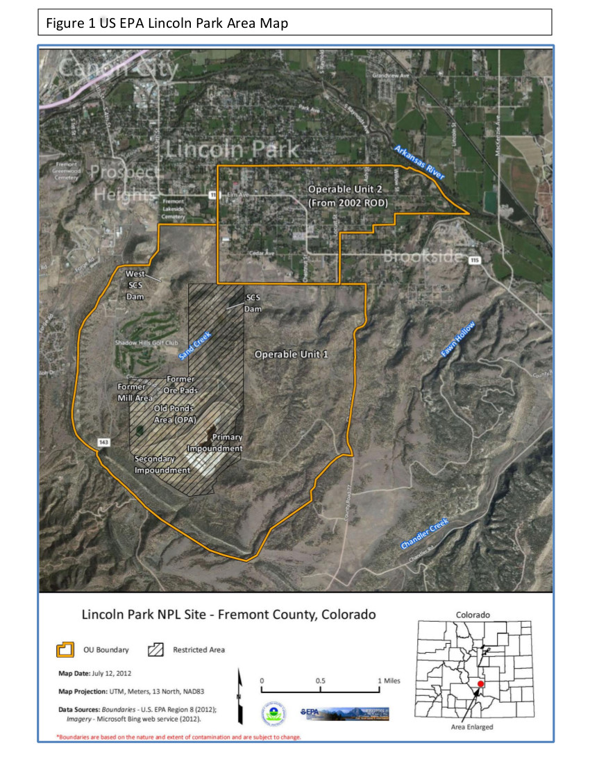
Lincoln Park/Cotter Mill superfund site via the Environmental Protection Agency
Near Cañon City, upstream from the conduit, the Lincoln Park/Cotter Superfund site contains a former uranium mill, millions of tons of radioactive waste, coal mineworks and tailing ponds. The site sits less than two miles from the Arkansas River. It is known to be contaminated with the same compounds — radionuclides, selenium, sulfates — that affect communities downstream.
Local residents have worked for decades to raise awareness and hold a revolving cast of agencies, regulators and owners accountable for the pollution. “It has taken us a lifetime,” said Jeri Fry, co-chair of Colorado Citizens Against Toxic Waste. “As the years have gone by, we have been the ones holding the memory.”
Without memory, they say, contamination is normalized as background, treated as an isolated issue, or denied. “We’ve been stonewalled on many of our legitimate concerns,” said Carol Dunn, vice-chairperson of the Lincoln Park/Cotter Community Advisory Group. She believes state regulators avoid testing for fear of uncovering inconvenient facts.
The most inconvenient would suggest connections between contamination in the valley and industrial pollution upstream, which affects not only Cañon City but the communities of Leadville, Pueblo and Fountain Creek. For Fry, all of the known and unknown pressures on the river point to the same fundamental problem. “We are not treating our water as though it is a sacred thing,” she said. “And it is. It’s got to be.”
…as the city gears up for an unprecedentedly dry summer, it will begin ramping up enforcement on water users who violate the stage 2 water restrictions. That will include issuing formal notices of violation and collecting fines for repeat violations.
“We are taking this year more seriously, given that it’s conditions we haven’t quite seen before,” Loughlin Molliconi said. “We want to make sure we can prioritize the most important uses of municipal water without having to degrade any environmental protections or streamflow.”
The city water department has issued 11 formal notices of water use violations in 2026, Loughlin Molliconi said. One notice was issued last week. Ten were issued on Wednesday. They were all first-time violations, which don’t come with fines…Aspen City Council declared a stage 2 water shortage last August after declaring a stage 1 water shortage in June. The declaration came after a lackluster monsoon season, and has remained in place because of unusually high winter temperatures that impacted snowfall accumulations and the snow water equivalent in the Roaring Fork watershed. Stage 2 water restrictions are mandatory. Watering of any lawn, garden, landscaped area, tree, shrub or other plant is prohibited from 9 a.m. to 6 p.m. Household watering schedules are also mandatory.
Meteorological records dating back 130 years show a handful of years with winters drier than the 2025-26 winter, said Rebecca Briesmoore, a water resources engineer with the Colorado River District.
“But it has been the warmest by far … that has really been the headline: It wasn’t the driest, but it was the warmest — and that is having a huge impact on hydrology and water resources,” Briesmoore said.
She spoke to a packed room of about 150 attendees at Thursday’s [May 21, 2026] Roaring Fork River: State of the River event hosted by the Colorado River District at the Pitkin County Library…“It’s important for people to know that this year is unprecedented . . . it’s like nothing we have ever seen before,” Briesmoore said. “Every single drop of water really, really matters. We have to think about how we are using it, and what we are going to do with very, very low water resources.”
To a room full of gasps, Briesmoore showed a graph with a star marking the 2026 winter — from October 2025 to March — high above the rest. While years including 1902, 1904, 1977, 2002 and 2018 recorded less precipitation, in terms of temperatures there’s no other year that even came close to 2026.
Roaring Fork Valley governments and fire and law enforcement agencies are gearing up for what is anticipated to be a much warmer and drier summer than normal. The Roaring Fork Valley is experiencing a “record breaking year” for drought, snowfall and snowpack, Erin Walter, a meteorologist with the National Weather Service, said during a press briefing Thursday with multiple local emergency management and fire leaders. The agencies are emphasizing both individual preparedness and cross-agency preparedness in hopes of mitigating wildfires or minimizing the damage of wildfires if they occur this summer.
“Wildfires are inevitable,” said Ali Hammond, director of wildfire resilience for Aspen Fire. “Wildfire disasters are preventable.”
Local leaders are encouraging individuals to make their own wildfire preparedness plans, like building a go-bag and establishing an evacuation plan. They’re also urging homeowners to harden their homes and ensure the first 5 feet around their homes is cleared of any vulnerable vegetation…Agencies across the valley are changing evacuation frameworks to “ready, set, go,” which they will use when notifying residents about wildfire risk in their area. They’re also trying to improve their messaging on wildfire risks, like red flag warnings and what different stages of a fire ban mean. Local officials are working to prevent wildfires from a number of angles. But it can be difficult under unprecedented circumstances. The city of Aspen is currently under stage two drought restrictions. Erin Loughlin-Molliconi, the city of Aspen’s utilities director, said the city is considering more stringent measures because of the persistent, dry conditions.
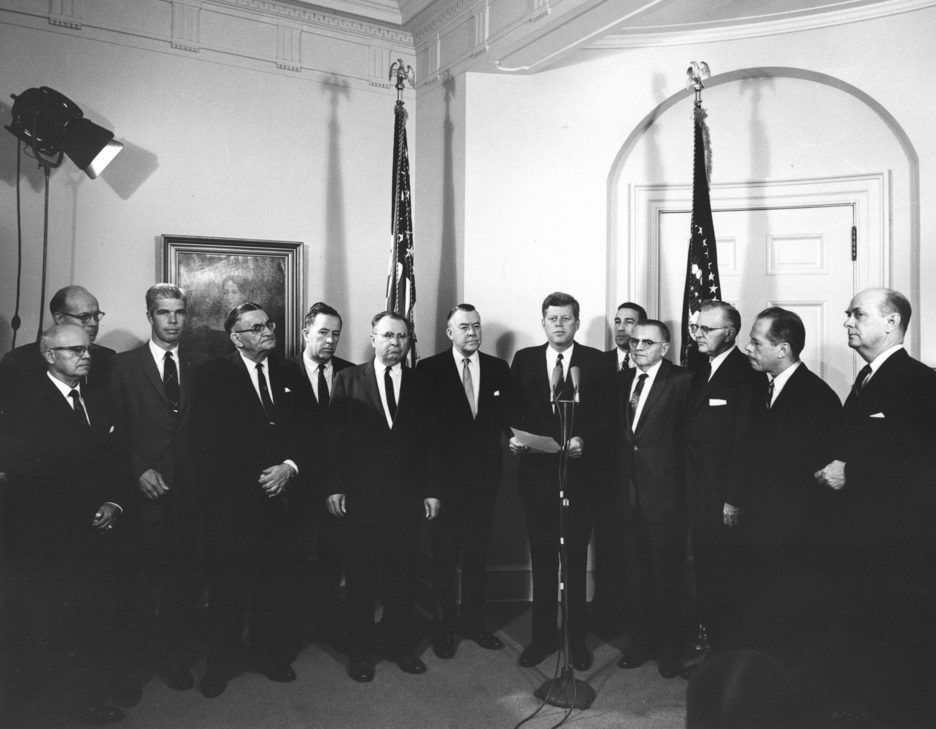
The AVC agreement stores water down-river in the Pueblo Reservoir, built after President John F. Kennedy signed legislation authorizing the Fry-Ark agreement in 1962. Photo courtesy of the City of Aurora.
In April and May of each year, the U.S. Bureau of Reclamation (which operates the Fry-Ark Project) and the Southeastern Colorado Water Conservancy District (SECWCD), which handle allotments of this water, make forecasts about the amount of water that can be imported through the Fry Ark Project. According to Chris Woodka, Senior Policy and Issues Manager, Southeastern Colorado Water Conservancy District (SECWCD), the 20-year average for imported water is 60,000 acre-feet per year. On April 1, the U.S. Bureau of Reclamation forecast importing barely ten percent of that, only 6,500 acre-feet in 2026. This is the least amount imported since the system became fully operational in the late 1970’s.
Also on April 1, the SECWCD projected allocating 4,600 acre-feet of those 6,500 acre-feet to water right holders. However, with the current snowpack, at this time it is not known if there will be any allocation this year. If not, the imported water will be held in storage in one of the Fry Ark Project’s reservoirs.
Fryingpan-Arkansas Project via the Southeastern Colorado Water Conservancy District (Click to enlarge)
The Colorado River at Las Colonias Park in Grand Junction was running at about 350 cfs Wednesday. Streamflows are expected to be way below normal this spring; some may have already hit their peak for the year. CREDIT: HEATHER SACKETT/ASPEN JOURNALISM
Water managers are planning for an extremely dry summer as Colorado wraps up winter 2026 with the worst snowpack on record for early April.
The Colorado River basin has seen slightly drier water years, but never a hotter one in the era of modern record keeping. A March heatwave that broke records statewide fueled an early peak of the snowpack, followed by rapid melting. This was the warmest March in 132 years of record-keeping for Colorado – three to four degrees Fahrenheit warmer than any other March, according to the Colorado Climate Center.
“Climate change definitely raises the probability of heat waves significantly,” said Peter Goble, assistant state climatologist at Colorado State University. “This heat wave was so far out of the range of what we’ve seen in March before that I don’t expect this to be the new normal, but it was certainly made to some degree more likely by climate change.”
The month of March decimated Colorado’s snowpack, which was thin to begin with, during a time when snowpack is usually still accumulating. The Colorado Basin River Forecast Center put the March 1 snowpack above Lake Powell at 52% of median. One month later, the April 1 numbers showed snowpack had declined dramatically to 23% of median.
“What snowpack was there was already among the lowest, if not the lowest on record, and it melted much more quickly than normal,” Goble said. “We saw melt rates more characteristic of May or June in March.”
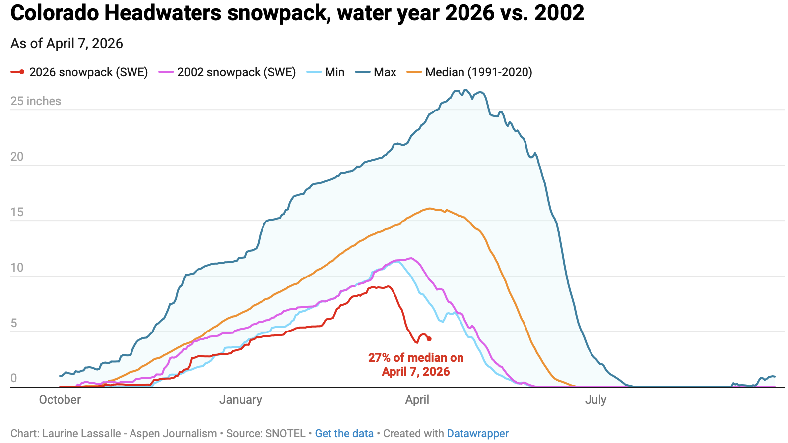
Early April status reports and forecasts are important because they provide a critical snapshot of assessing where things stand and how much water will be available for the summer. This week is typically when snowpack peaks for the year before it begins a gradual melt out. But snowpack in the Colorado River headwaters this year peaked nearly a month early on March 17 and now sits at just 27% of median. Snowpack in the Roaring Fork River basin is 26% of normal.
“We’ve never seen anything like this in memory,” said Raquel Flinker, director of interstate and regional water resources at the Colorado River District’s State of the River meeting in Grand Junction Tuesday. “If there’s anything in your memory about a dry year that you’ve seen, a warm year that you’ve seen, 2026 is beyond all of that. It’s far beyond 2002, which has been the year we normally think of as the worst year in hydrology.”
The big question is whether that record-low snowpack will turn into record-low runoff. Forty million people in the American Southwest depend on water from the Colorado River, which comes from the melting annual snowpack. Some streams may have already peaked for the year, something that normally occurs in early June for Western Slope streams.
“The streamflows are going to be much below normal,” Goble said. “But the lowest snowpack on record does not necessarily guarantee the lowest streamflow on record.
”In a Tuesday water supply briefing, hydrologist Cody Moser with the CBRFC said that the forecasted April through July inflow to Lake Powell this year is 1.4 million acre-feet, just 22% of normal and the third-worst on record. That’s down from the March forecast, which predicted 2.3 million acre-feet of inflow. The benchmark for low Powell inflows is 2002, which saw just 964,000 acre-feet of water flow into the reservoir.
The streamflow forecast for the Colorado mainstem in Colorado (known as Division 5 by state water managers) is 38% of normal, according to the National Resources Conservation Service. The Yampa is at 36% of normal; Gunnison is 34% and the San Juan basin in the southwest corner of the state is forecast to have just 26% of normal streamflows this year.
Yampa calls
Water managers around the state are preparing for an exceptionally dry summer. Some municipal water providers have already implemented outdoor watering restrictions, and the Colorado Division of Water Resources is alerting farmers and ranchers to the possibility of more calls this season.
The Yampa River basin is poised to be one of the hardest hit this year. Mosher said on Tuesday that streamflows on the Yampa are forecasted to be close to the minimum on record.
“This forecast declined by 40% in the past month and here you see that huge melt off with our snowpack conditions,” he said.
Yampa River Operations Coordinator for Division 6 Water Resources Brian Romig sent a March 28 email to all water users in the basin reminding them of how calls work. When an irrigator with a senior water right isn’t getting all the water they are entitled to, they can place a call with state officials, who will then shut off upstream water users with junior water rights so the senior right can get its full amount of water. Under the cornerstone of Colorado water law, the oldest water rights get first use of the river.
The Yampa River was among the last to develop in the sparsely populated northwest corner of the state and it had never had a call until 2018.
“Call administration is a reality of our future,” said Division Engineer Erin Light. “I think it’s very possible we are going to see calls and the sooner people start to understand what that looks like and become accustomed to it, the better.”
Light said she has been hearing from water users about how early they have had to turn their ditches on to irrigate their fields – some the weekend of March 21 – due to the meager snowpack and record-high temperatures.
Light predicted that some ranchers won’t be able to grow all of the hay their animals need to feed them through next winter.
“Ranchers are going to have some big decisions to make as far as: Will they buy hay or will they have to sell cows,” she said.
In recent years, the River District has leased water out of Elkhead Reservoir and released it during the irrigation season to boost flows for downstream ranchers and keep a call off the river. But Light says this approach doesn’t help water users adapt to a future with less water. Once people know what to expect and how calls are administered, it’s less of a big deal, she said. And as river flows continue to dwindle due to drought and climate change, learning how to manage inevitable scarcity has never been more important.
“I think it’s a good thing for our water users to manage their water in such a way that they know in late August, they could be shut off,” Light said. “But we’re not giving that opportunity to the people on the Yampa River by trying to always keep the calls off.”
The Pitkin County Board of County Commissioners moved forward Wednesday with an intergovernmental agreement that expresses commitment “to protect the Crystal River from on-channel dams and transmountain diversions.” The agreement will be between Pitkin County, Gunnison County, the town of Marble, the Colorado River Water Conservation District and the West Divide Water Conservancy District. This was an approval of the first of two readings. The Colorado River Water Conservation District have yet to bring this agreement to their boards but have previously expressed support for the initiative, according to the district’s staff. Gunnison County and the town of Marble will be considering it in upcoming meetings.
“It would be an agreement that all the parties would oppose or not support any new dams on the main stem of the Crystal River, or any new trans-basin diversions out of the Crystal River,” Pitkin County Deputy Attorney Anne Marie McPhee told commissioners on Wednesday. “It is trying to keep the water in the river as long as possible.”
[…]
Despite moving the agreement forward after first reading, Commissioner Greg Poschman acknowledged that there has been concern around the agreement’s lack of enforcement ability, due to the signing bodies’ ability to leave the agreement at will. Poschman referenced specific criticism vocalized by Bill Jochems, a Pitkin County Healthy Rivers and Streams Citizen Advisory board member and Crystal River advocate.
“The expression from Mr. Jochems is, ‘it’s a nothing burger,’ right?” Poschman said on Wednesday. “It’s the weakest of all possible protections for the Crystal. Is that what we want to do at this point?”
Commissioner Francie Jacober commented that, despite the potential weakness that Jochems and Poschman pointed out, it would still be symbolically important for the county to lend their support to the intergovernmental agreement…The county has been pursuing a Wild and Scenic River designation for a portion of the Crystal River since the U.S. Forest Service found 39 miles of it eligible for the designation in 2002, according to county documents supporting Wednesday’s intergovernmental agreement. A Wild and Scenic designation could help with future conservation and preservation efforts.
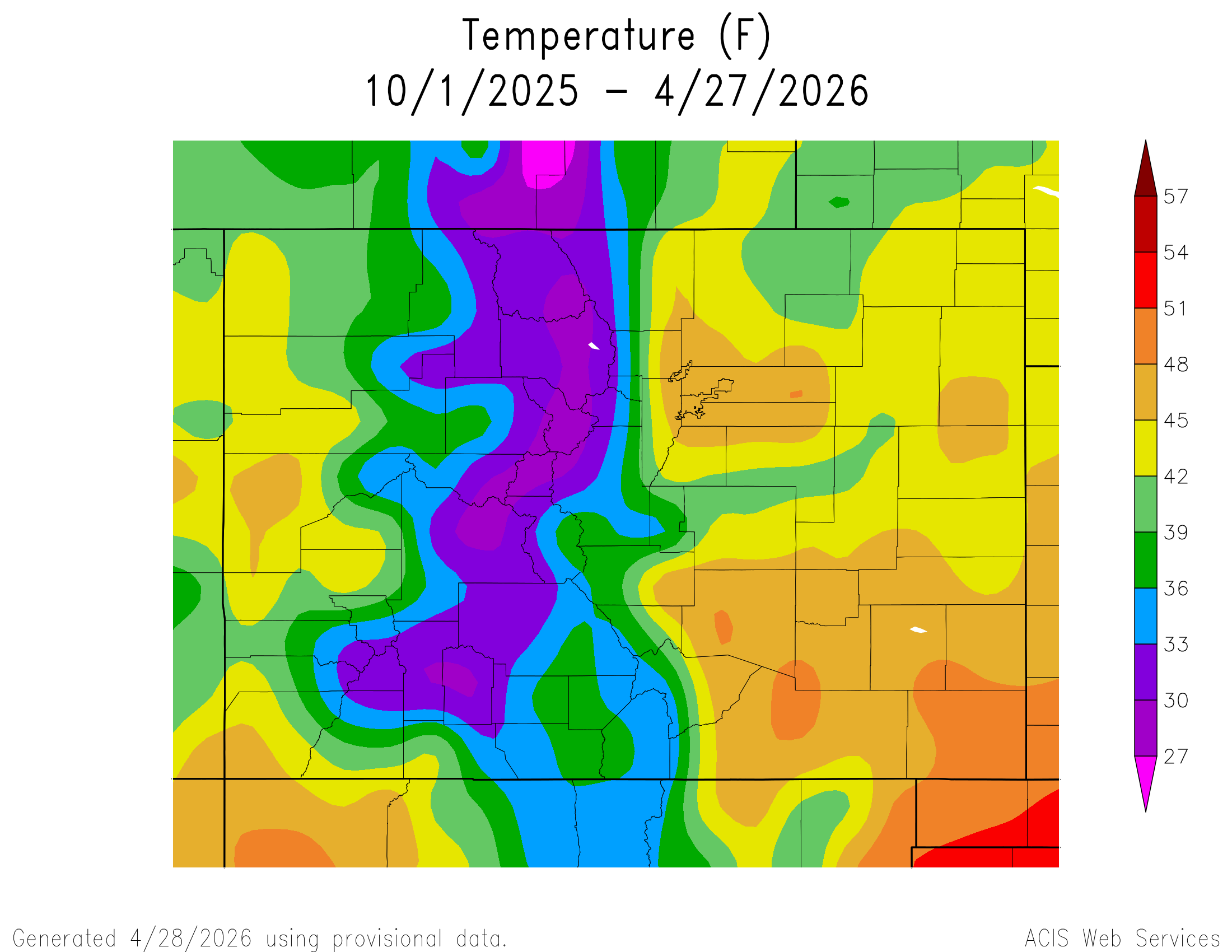
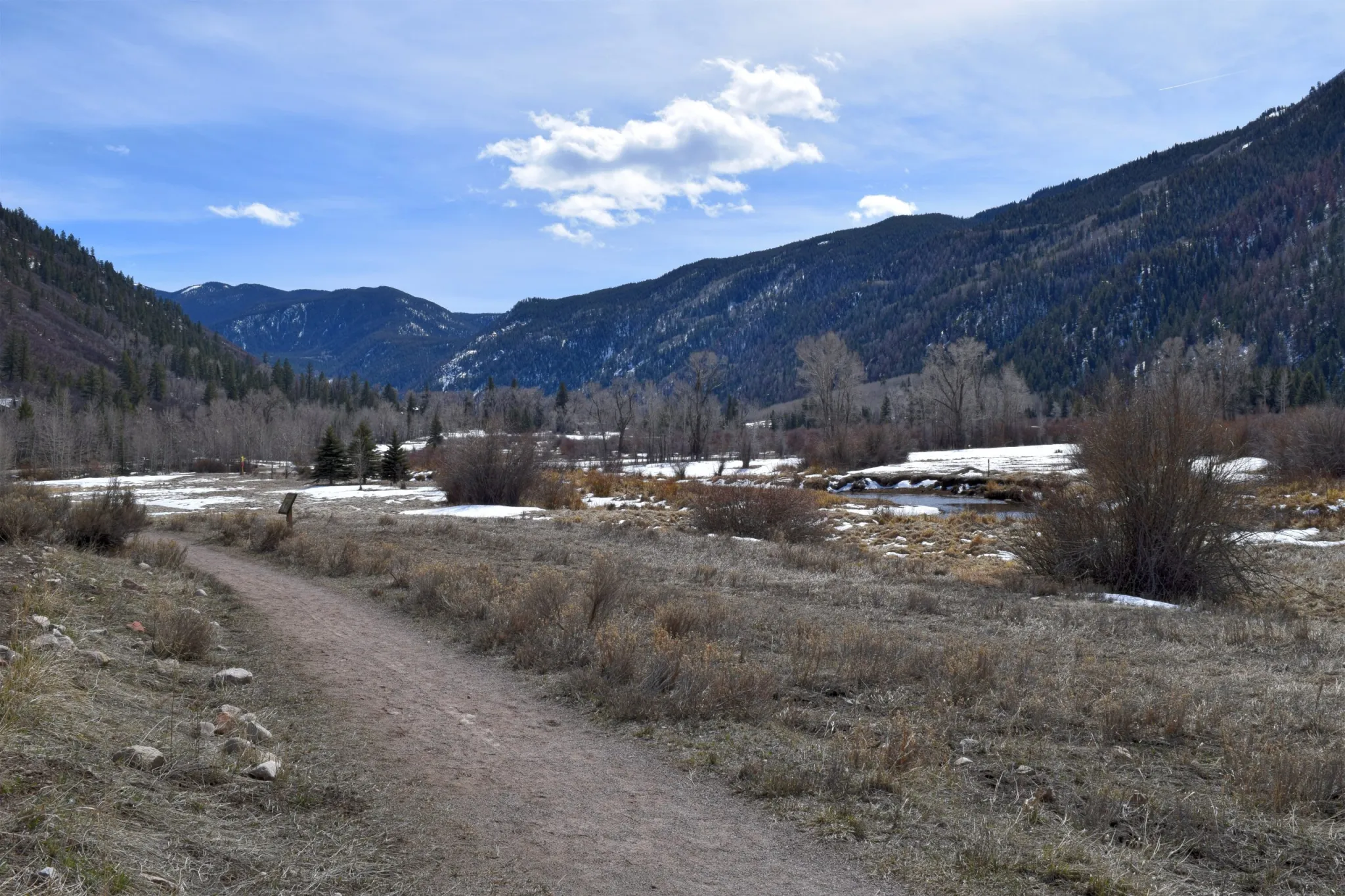
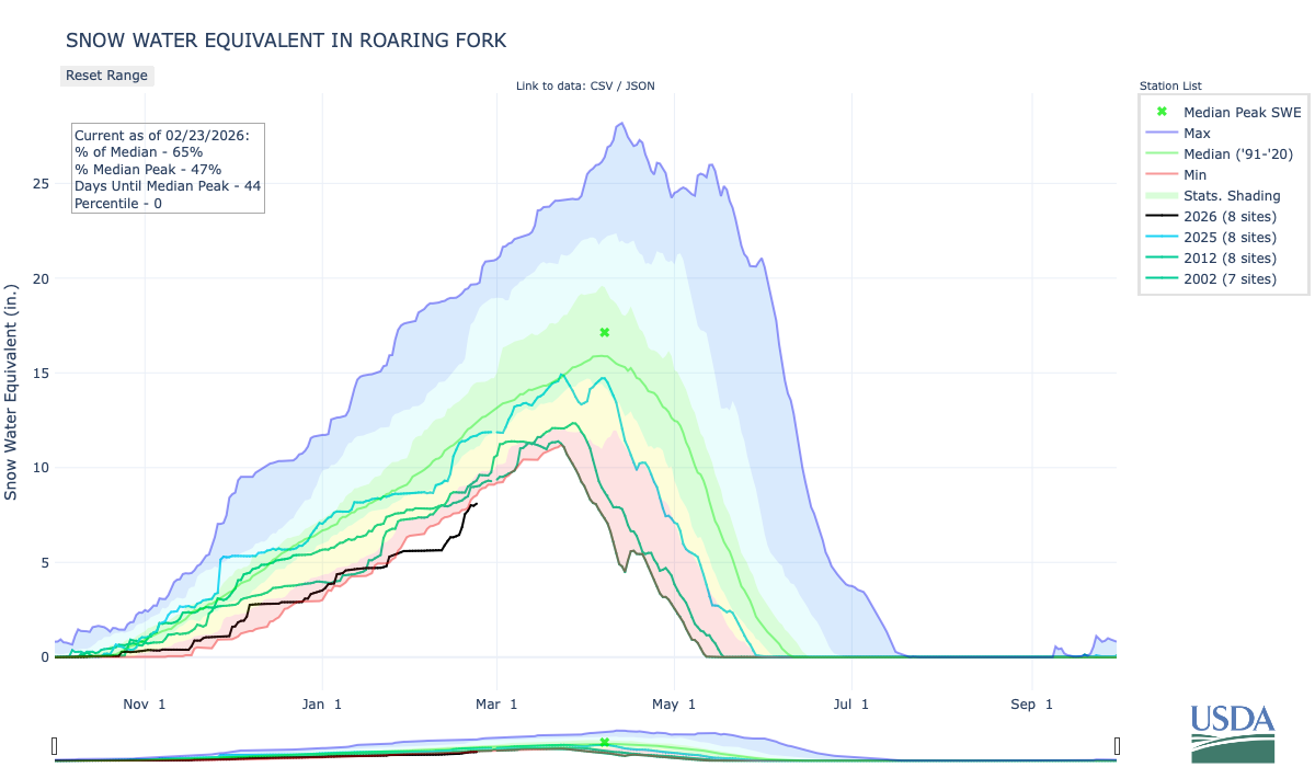
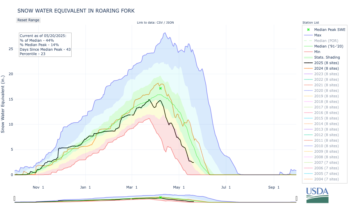
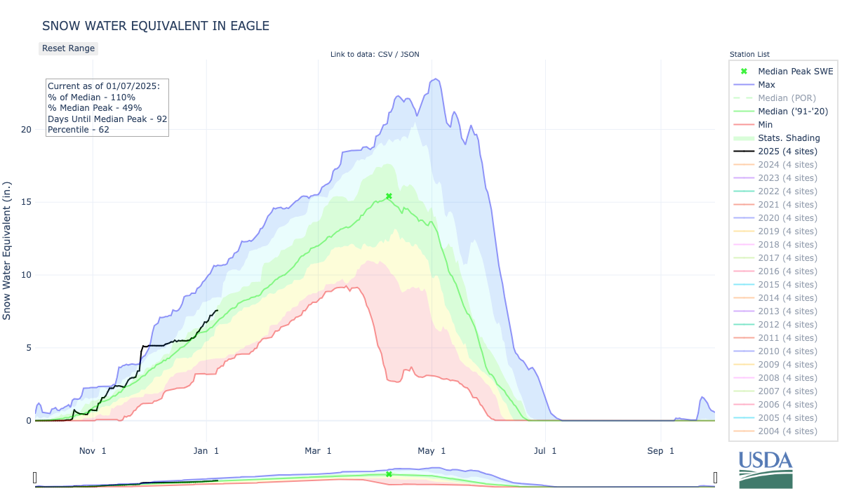
Snowpack in the Roaring Fork Valley basin is at 65% of normal as of March 13 — the lowest level recorded since the modern snowpack telemetric system started collecting data in 1981. The North Star Nature Preserve east of Aspen, typically snowcovered in March, was nearly bare on March 12. CREDIT: LAURINE LASSALLE/ASPEN JOURNALISM
Temperature and precipitation data in the Roaring Fork Valley shows that most of this winter has experienced above-average temperatures with below-average precipitation, making this season one of the hottest and driest on record.
“We notice [the lack of snow] because [it’s visible], but we keep on having these crazy-warm years, and at the end of the day, that’s what’s going to be the driver of change,” said Adam McCurdy, forest and climate director at Aspen Center for Environmental Studies (ACES). He predicts that big snow years will return, but that the long-term warming trend will continue in a way that’s “going to move spring runoff, it’s going to change water availability even if we, say, keep the same snowpack.”
According to NOAA’s Climate at a Glance tool, Pitkin County experienced its second warmest and 10th driest winter on record, with data going back as far as 1895, as average daily temperatures from November through February reached 26.9 degrees this winter, or four degrees above normal, behind the winter of 1906-07’s record high of 27.5 degrees. The county received 6.9 inches of precipitation, including rain and snow, behind 1903-04’s 3.55 inches, 1980-81’s 5.16 inches and 1976-77’s 5.21 inches.
February average temperatures at the Aspen-Pitkin County Airport reached a record high this year, at 31.6 degrees Fahrenheit, which is about six degrees above normal, according to data from the local National Oceanic and Atmospheric Administration (NOAA) station, which began collecting climate data in 1998.
Although this winter’s lack of snow is striking, with measured levels reaching record lows, rising temperatures might be cause of greater concern as part of a larger trend, impacting spring runoff and local forests. Experts hope that precipitation this spring and summer can still bring the necessary moisture to mitigate current drought conditions.
Snowpack in the Roaring Fork Valley basin is at 65% of normal as of March 13, according to SNOTEL, which is the U.S. Department of Agriculture’s automated mountain weather network, and Aspen Journalism’s snowpack dashboard. It’s the lowest level recorded since the modern snowpack telemetric system started collecting data in 1981. At Independence Pass, snowpack reached 56% of normal on March 13, but state climatologist Russ Schumacher told Summit Daily on March 4 that monthly hand measurements, which go back nearly a century, show that this year’s snowpack at Independence Pass was among the lowest 3% of the 88 years on record.
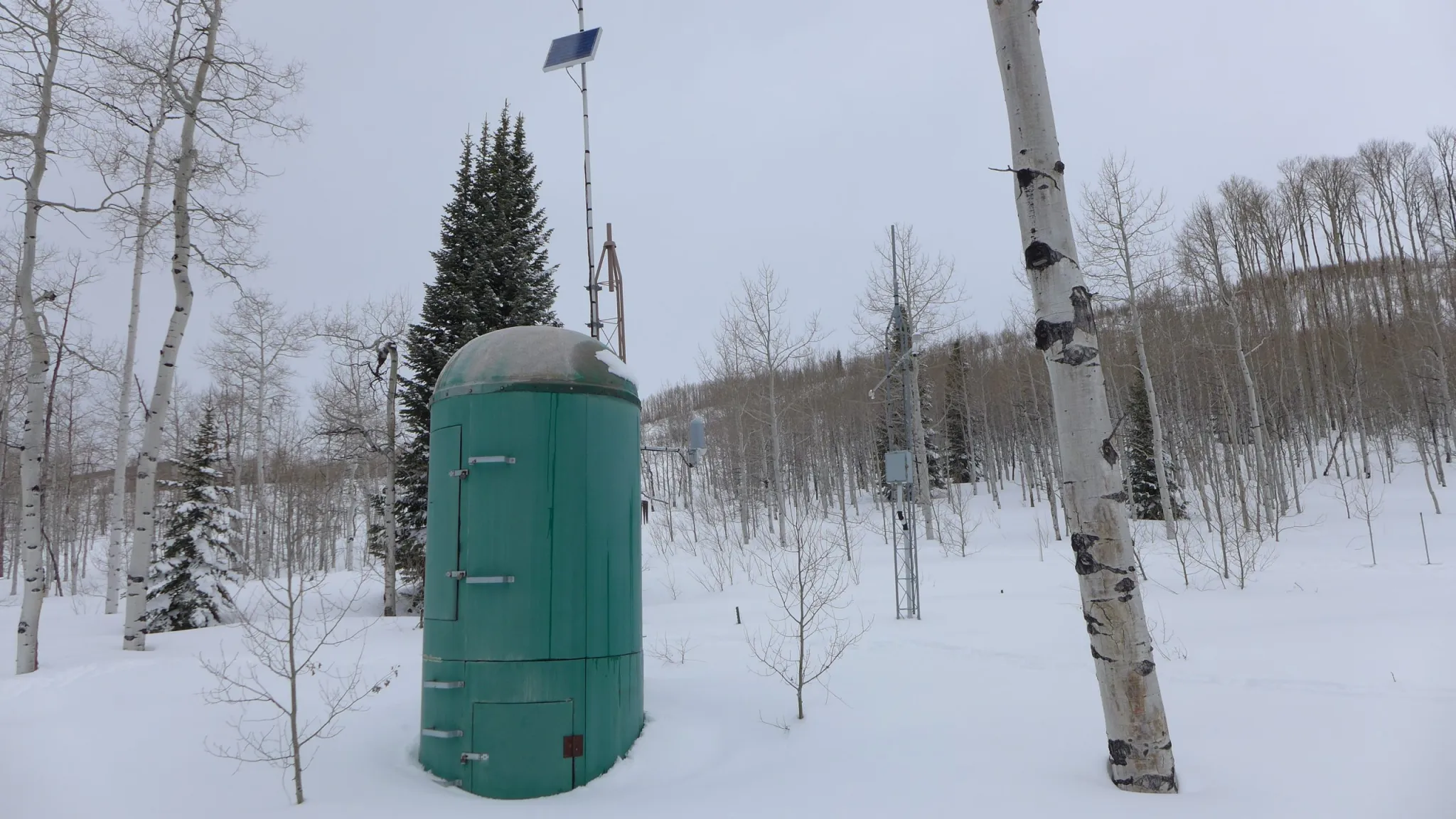
The SNOTEL station at McClure Pass in 2023, when snowpack held 23.6 inches of snow water equivalent on March 13, well above the 8.3 inches on March 13, 2026. CREDIT: HEATHER SACKETT/ASPEN JOURNALISM
According to a climate sensor located at the city of Aspen’s water department in the Castle Creek Valley, where snowfall, temperature and precipitation data has been tracked since 1934, a total of 71.5 inches of snow fell from November through February, making this winter the driest in the past 30 years and the 12th driest on record, behind the winter of 1976-77, which received 47.5 inches of snow from November through February, and the 1980-81 season, when city records recorded 40.9 inches of snow. It’s worth noting that the station at the city’s water plant has moved locations over the years and changed its equipment in the 1980s, so comparisons using data collected before those changes may be skewed.
A total of 6 inches of precipitation, including rain and snow, fell on the Roaring Fork Valley between November and February, according to Gridded Surface Meteorological (or gridMET) data that goes back to 1979. That’s below last year’s 8.5 inches and represents 55% of the 30-year average, making the 2025-26 winter season the second driest, after 1980-81. Although precipitation has been below average, McCurdy said wide variations in rain and snow totals year over year are expected. “While this is an exceptionally dry winter precipitationwise, it’s not outside of the range of historic variability,” McCurdy said. “What we’re seeing temperaturewise is … certainly where we’re heading and we’ve seen it again and again. So I think that’s not just one data point, it’s another data point in a long-term trend.”
While this winter’s lack of snow is striking, rising temperatures might be cause of greater concern as part of a larger trend, impacting spring runoff and local forests. CREDIT: LAURINE LASSALLE/ASPEN JOURNALISM
Above-average temperatures are becoming more common
NOAA’s 2018 modeling trend shows that average daily temperatures from November through February in Pitkin County have increased by 0.3 degrees every 10 years, mostly driven by rising low temperatures that have gone up by 0.5 degrees every decade. According to the 2024 Colorado Climate Change Report from the Colorado Climate Center, annual average temperatures across the state warmed by 2.3 degrees from 1980 to 2022 and are expected to keep rising due to climate change. By 2050, statewide annual temperatures are projected to increase by 2.5 to 5.5 degrees compared with 1971-2000, and between 1 degree and 4 degrees compared with 2022, under a medium-low emissions scenario.
Colorado statewide annual temperature anomaly (°F) with respect to the 1901-2000 average. Graphic credit: Colorado Climate Center
“Colorado has warmed at a faster rate than the global average and is expected to continue to warm,” Peter Goble, assistant state climatologist at Colorado State University’s Colorado Climate Center, told Aspen Journalism. “Having said that, not every winter going forward is going to be as warm as this winter. And, in fact, I think this winter was so unusual that I think this winter will be considered a much-warmer-than-normal winter for some time to come.”
The impact of this warm and dry winter will be seen in the spring runoff as a much-lower-than-average peak runoff is to be expected, but summer conditions are still uncertain as experts hope for spring and summer precipitation that would lessen drought conditions. CREDIT: LAURINE LASSALLE/ASPEN JOURNALISM
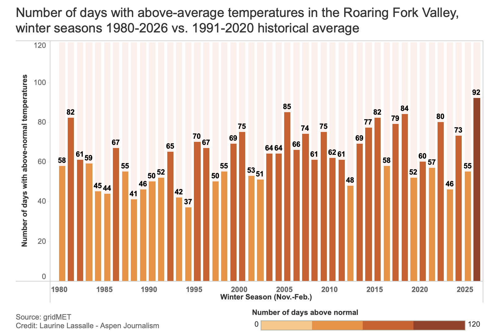
The NOAA sensor at ASE recorded 94 days with above-average minimum temperatures out of the 120 days from November to February, and 89 days with above-average maximum temperatures, for a total of 81 days with both above-average minimum and maximum temperatures. In other words, about three-fourths of the days were warmer than normal. In comparison, November 2024-February 2025 had 54 days with above-normal temperatures.
Looking at the Roaring Fork Valley as a whole, gridMET data shows that this winter counted 92 days with above-average daily temperatures, above 2005’s 85 days. The GridMET dataset from scientists at the University of California Merced combines data from weather stations in a given area and uses modeling to generate surface climate datasets instead of relying on one specific weather station.
The data also shows that warm winters have become more frequent since the mid-1990s. According to gridMET data, which goes back to 1979, winters in the dataset in prior years with the highest number of days with above-average temperatures include 2018 and 1981, but 1981 was followed by a decade of mostly cooler temperatures and above-average precipitation. “On the other hand, 2018 and 2026 are both part of consistently hotter-than-average winters and, more recently, drier starts to the season,” according to ACES.
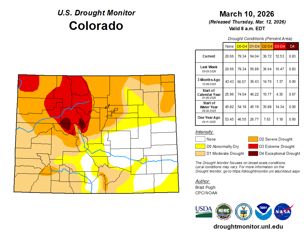
Although the entire state of Colorado is experiencing drought conditions, the upper Roaring Fork Valley has been experiencing “exceptional” drought conditions since Dec. 23, according to the U.S. Drought Monitor, with about 28% of Pitkin County and 19% of Eagle County experiencing such conditions as of March 10. (“Exceptional” is the most severe level.) The Roaring Fork watershed is one of the only two places throughout the entire West to experience this level of drought.
Colorado Drought Monitor map March 10, 2026.
“One of the main reasons that, when you look at the U.S. Drought Monitor, the Roaring Fork Valley stands out is because of the mix of both short- and long-term drought conditions in place,” Goble said, adding that the Roaring Fork Valley was very hot and dry last summer, while other areas around the Colorado Rockies received some decent moisture. “The Roaring Fork Valley was already en route [to drought] going into this winter season,” he said.
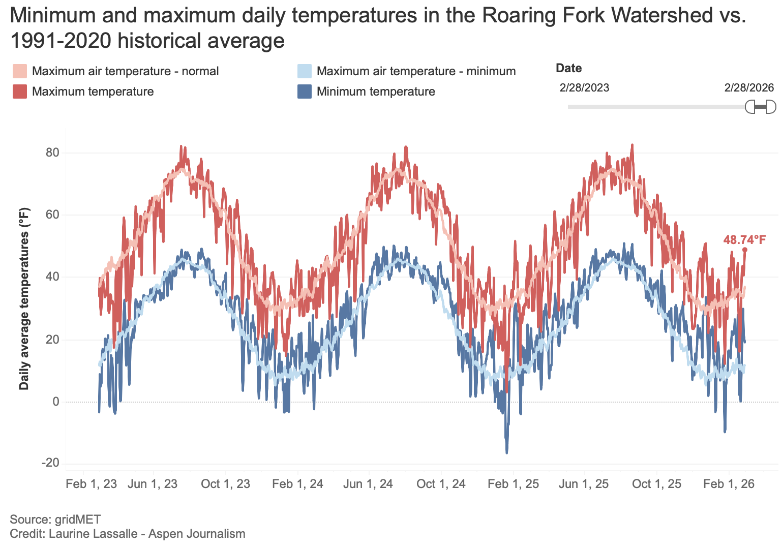
Average daily temperatures, or the average of high and low temperatures, in the Roaring Fork River watershed have been 5 degrees above 1991-2020 historical average this winter (November-February), surpassing the previous record year of 1981, when temperatures were 4 degrees above normal. For February, average temperatures for the Roaring Fork Valley were the fourth highest on record, at 27.6 degrees.
Maximum and minimum temperatures are getting closer
On average, maximum and minimum temperatures recorded at ASE have both been approximately 6 degrees higher than normal in February. From November through February, maximum and minimum temperatures have also been roughly 6 degrees above normal. Last winter, maximum and minimum temperatures were, on average, 1 degree below normal.
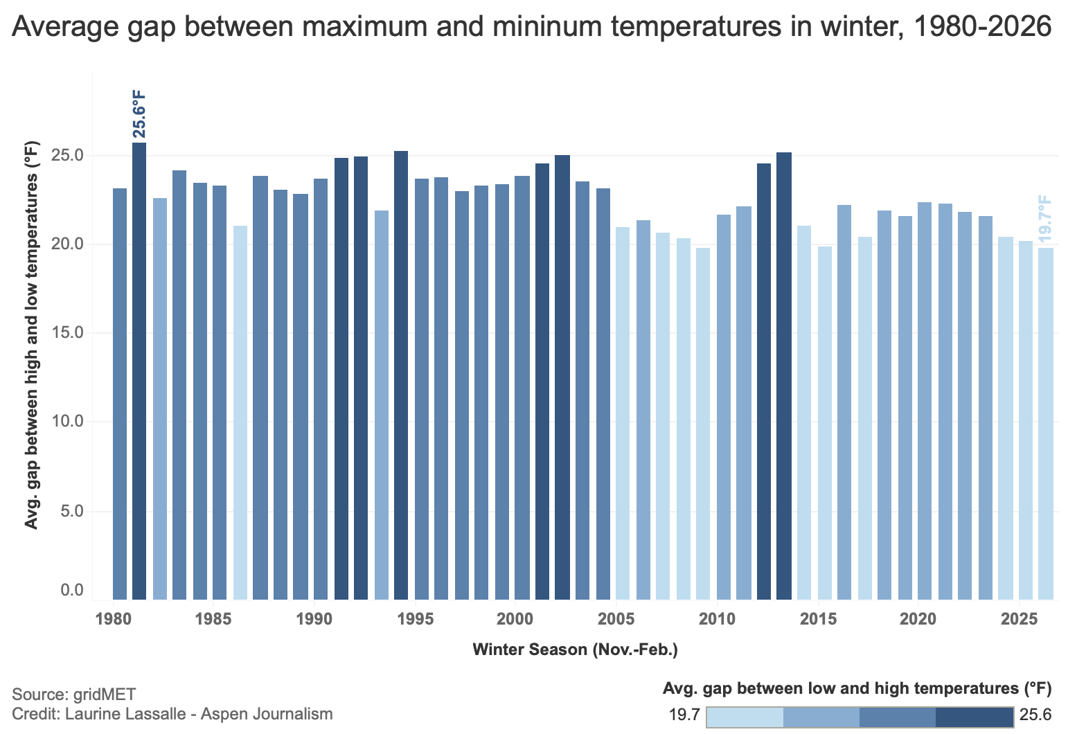
GridMET data shows that, on average, maximum and minimum temperatures are getting closer, a trend that has been particularly noticeable in the past five to six years. The gap for November through February reached an average of 19.7 degrees for the Roaring Fork Valley, the lowest reading on record.
Rising low temperatures can affect the ability to make snow at ski resorts, as reported byAspen Journalism in 2019 and The Sopris Sun in January, while the need to rely on snowmaking to compensate for the lack of snow increases.
McCurdy explained that snowpack maintains and accumulates “cold content” during the winter and that low nighttime temperatures allow this thermal buffer to form and keep snowpack colder longer, preventing it from melting too fast.
“Before the snow starts to rapidly melt, the snowpack needs to become isothermic; in other words, the entire [snowpack] column is about 0 degrees Celsius [32 degrees Fahrenheit] and ready to melt,” he said. “Because of the warm winter [and the rising low temperatures], the snowpack is entering spring closer to isothermic, which could result in a pretty rapid melt-off.”
Historically, the gap between high and low temperatures averages 22.6 degrees. According to NOAA, 25.5 degrees separate high temperatures from low temperatures at ASE for this winter, lower than last year’s 26 degrees but higher than the nearly 25 degrees recorded in the winters of 2023-24 and 2022-23.
Possible impacts
“The real impact of this warm, dry weather will be seen in the spring runoff,” McCurdy said, adding that a much-lower-than-average peak runoff is to be expected.
He said most trees are dormant during the winter until spring runoff, when they pull up a lot of water to use for the rest of the summer, but if their water supply is low, they’re not going to be able to grow as much or be able to produce resins and chemical defenses to fend off things such as bark beetles and other invasive insects.
“Trees have a long hydrologic memory,” he said. “One year isn’t as impactful to them as some other species where they’ll build up water. They have deep roots. They can pull up groundwater, but by the same token, multiple years of drought is a hard hole for them to get out of.”
McCurdy said the aspen population, for example, has declined and dry winters tend to negatively affect them. “Assuming we don’t get more precipitation, we could lose more aspens.”
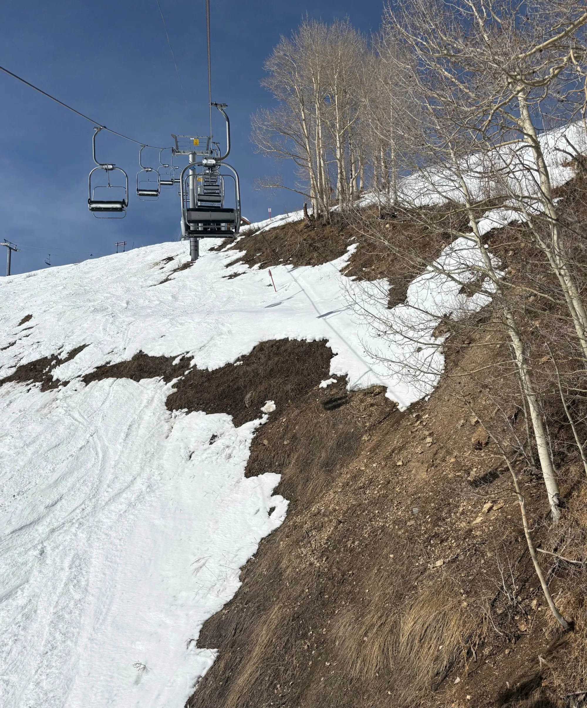
Pitkin County experienced its second warmest and 10th driest winter on record, with data going back as far as 1895, as average daily temperatures from November through February reached 26.9 degrees this winter. A sensor on Castle Creek recorded a total of 71.5 inches of snowfall from November through February, making this winter the driest in the past 30 years. While most of the terrain on Aspen Mountain is still covered enough for skiing, some slopes have begun to melt out. CREDIT: CURTIS WACKERLE/ASPEN JOURNALISM
Goble said the lack of snow will probably lead to below-normal water supplies and impact river recreation, and it could lead to higher fire danger. Major factors that contribute to a large wildfire season in Colorado are low snowpack, early snowmelt and a hot summer. As of early March, snowpack is certainly low and early spring runoff is expected, but the severity of summer conditions is still uncertain.
“Just because things have been dry recently doesn’t mean that we’ll continue to be dry in summer,” Goble said. “Large wildfires are not a guarantee yet at this point, but I do think that with the very low snowpack numbers that we have in place now, it’s a higher probability than a normal year.”
Although the entire state of Colorado is experiencing drought conditions, the upper Roaring Fork Valley has been experiencing “exceptional” drought conditions since Dec. 23. The Roaring Fork watershed is one of the only two places throughout the entire West to experience this level of drought. An almost snow-free south-facing hillside above the North Star Nature Preserve is shown here on March 12. CREDIT: LAURINE LASSALLE/ASPEN JOURNALISM
Although a change in the weather that would bring precipitation levels closer to average would not be unprecedented, it is also statistically unlikely.
“In our 47-year record, there is only a single year that had enough precipitation to dig us out of the hole we’re currently in. In 1995, from this point in February until the end of May, there were 22 inches of precipitation; that’s about double the average precipitation that normally falls over that period,” according to an ACES blog post. “Based on a model of total precipitation for this period, we have a roughly 1% chance of ending the year with a normal amount of precipitation.”
Goble agrees that the chances to get back to normal snowpack this year are slim. “We just don’t have enough winter left to make up the deficits that are already in place. It would take a record kind of mid-to-late March through April in order to get us back up to normal,” he said. “But that doesn’t mean that spring and summer precipitation isn’t important. If we have a wet spring or and we have a wet or cooler-than-normal summer, those types of things could mitigate some of the drought impact that we might otherwise see this summer.”
If drought conditions do not significantly improve by the end of the winter, the city of Aspen may enter a stage 3 water shortage for the first time. The city’s drought response committee is anticipating recommending a stage 3 water shortage declaration based on the latest snowpack, drought data and outlooks for Aspen and the Roaring Fork watershed, according to an informational memo sent to Aspen City Council this week. But the city is hoping for more precipitation to stave off more stringent water restrictions, Megan Killer, a plans review technician with the city’s water department, said.
“We are hoping to see more precipitation in the coming months and this memo serves to raise awareness that we are seeing record low snow accumulation and much higher than average temperatures, and if things do not significantly change, we might have to increase water restrictions,” Killer told the Aspen Daily News in an email.
If the city were to enact stage 3 water restrictions, it would use its drought mitigation response plan, which was adopted in July 2020. It outlines restrictions the city could enforce to conserve water under different stages of water shortages. The declaration indicates extreme drought. Under stage 3 water restrictions, irrigation of existing lawns could be limited to one day per week based on a customer’s address. Athletic fields, trees and golf course greens could be irrigated by a mandatory schedule or water budget only. Car washing and filling or refilling of water features and swimming pools may not be allowed. Under those conditions, the city would “work to sustain mature trees to the extent possible but recognizes that there may be a major loss of lawns, gardens, some trees and some shrubs,” the plan says. The city also may pursue supply-side response measures, including operating its physically available senior water rights to divert water, “even though they deplete the decreed instream flow,” according to the plan.
Like much of the West, Colorado’s water future will be shaped by a warming climate, population growth, and subsequently increasing competition for finite supplies. In conversations about managing our coveted Colorado River headwater resources, it is easy to assume the most influential voices belong to the well-represented on the population-dense Front Range or the well-funded interests far downstream. Yet some of the most consequential water decisions play out in small mountain valleys, often with limited staff, limited funding, and limited political clout.
It was in that context, despite the Great Recession of 2008, that voters approved the creation of Pitkin County Healthy Rivers that November, a sales tax-funded program with a simple but ambitious mandate: protect and enhance the rivers and streams of the Western Slope’s Roaring Fork Watershed on behalf of the people and the environment.
What few imagined at the time was that this small, locally funded program would become such an effective way to ensure the people and their cherished rivers had a seat at the table in complex, high-stakes water discussions. A “seat” that is not symbolic; it’s practical, persistent and sometimes uncomfortable. Because having local voices is not a luxury — it is essential.
The Power of Showing Up
Healthy Rivers’ influence begins with showing up. Showing up ready to listen and engage, recognize partners and advance and fiscally sponsor new alliances, all while emphasizing local knowledge, data, and community-backed priorities. In basin-wide planning efforts, feasibility studies, and project negotiations, Healthy Rivers represents local, place-based interests that might otherwise get overshadowed by far more powerful players, be they up or downstream.
This has meant actively seeking valuable connections, therefore knowledge, daresay wisdom, with hopes of earning a voice that ensures headwaters perspectives are considered at these tables. Think Colorado Basin Roundtable, U.S. Forest Service, Colorado Parks and Wildlife, the Colorado Water Conservation Board, local and nearby watershed groups, and other environmental non-profits. This outreach has led to critical partnerships and heightened transparency and inclusivity on many water matters. It has also meant supporting technical analyses and funding early-stage studies — most recently for water-quality monitoring on Lincoln Creek, a tributary to the Roaring Fork — so local conditions and risks are understood before decisions are made elsewhere.
And because our funding comes directly from local voters, Healthy Rivers advocates from the position of our constituents who overwhelmingly supported its creation. That matters in rooms where water is discussed in acre-feet and complex legal terms, often far removed from community-specific values. This has allowed Healthy Rivers to elevate community priorities in negotiations around watershed health, elevating environmental values like instream flows.
Small Programs, Real Influence
One misconception about many local programs is that they are too small to matter. In practice, Healthy Rivers has demonstrated that being nimble is an advantage. Healthy River’s contributions are rarely flashy, but they have been catalytic, having a role in everything from diversion arbitration, instream flow protections, riparian habitat restoration, and water-quality monitoring.
It has done this by supporting projects like technical studies, restoration efforts, and infrastructure improvements that likely wouldn’t have happened otherwise. And by convening unlikely partners, and stepping into conversations early, before positions harden and options narrow.
For example, Healthy Rivers helped support the pursuit of a Recreational In-Channel Diversion (RICD) on the Roaring Fork River, recognizing instream flow rights alongside recreation as legitimate, community-defining values worthy of legal protection. It is supporting a Wild & Scenic designation for the Crystal River, and investing in beaver-related studies in order to inform projects that restore wetlands, reconnect floodplains, and improve late-season flows.
Translating Complexity for Communities
Another core part of having a seat at the table is translation. Colorado water law, hydrology, and planning processes are famously complex. Without intentional effort, these processes can leave local communities feeling confused, disengaged, or shut out of decisions that directly shape their rivers.
Healthy Rivers sees its role as a bridge. It translates technical concepts into plain language, not to oversimplify, but to make participation possible. This has included helping residents understand what designations like “Wild & Scenic” actually do — and don’t — mean, or explaining how instream flow rights function alongside agricultural and municipal uses.
This two-way translation strengthens outcomes. Decision-makers gain local context. Communities gain confidence. And water decisions become more durable because they reflect shared understanding, not just legal compliance.
Collaboration Over Confrontation
A seat at the table does not guarantee agreement. Some of the most meaningful work Healthy Rivers does happens in moments of tension, usually when water supply, ecological health, recreation, and private property interests collide.
Our approach is rooted in collaboration, not advocacy for advocacy’s sake. That means listening carefully, acknowledging tradeoffs, and being honest about constraints. But it also means pushing back when local values are at risk of being overlooked. In projects like renovating the Sam Caudill State Wildlife Area, Healthy Rivers worked alongside CPW, Garfield County, and development partners to balance recreation access, public safety, and river protection, demonstrating how infrastructure investments can serve both people and rivers.
Lessons for Other Communities
This role requires patience. Water decisions typically move slowly, and progress often comes in inches rather than miles. And in a basin as complex as the Colorado River system, no one wins by going it alone. Our experience has reinforced a simple truth: collaboration works best when local voices are present early and consistently, not as an afterthought.
While not every community can replicate Pitkin County’s funding model, the underlying principles are transferable:
Local funding creates legitimacy. Voter-backed programs carry weight because they represent collective priorities.
Consistency builds trust. Showing up over time and building long term relationships matters.
Data and stories belong together. Technical rigor and real-world experience are stronger together than apart.
Early engagement saves time later. Investing upstream — literally and figuratively — reduces conflict downstream.
Healthy Rivers exists to ensure that when decisions are made about the Roaring Fork Watershed, the people who know and love these rivers are part of the conversation. That seat at the table does not guarantee outcomes, but it guarantees presence. And in water, as in so many things, presence is power.
A nearby stream gauge reported that the Roaring Fork River, shown here at Rio Grande Park in Aspen, was flowing at about 9 cfs when this photo was taken in August 2021. Pitkin County plans to buy shares of Twin Lakes water to boost flows in the Roaring Fork. CREDIT: CURTIS WACKERLE/ASPEN JOURNALISM
Pitkin County is making a historic deal to buy water currently used on the Front Range and put it back into the Roaring Fork.
The county plans to buy 60 shares of water from Twin Lakes Reservoir and Canal Co. and 34 shares from Fountain Mutual Ditch Co. For $6.5 million, Pitkin County will acquire about 71 acre-feet, although only 45 of those acre-feet represent Western Slope water that is currently diverted to the Front Range.
Pitkin County Commissioner Francie Jacober made the announcement at Wednesday’s board meeting of the Colorado River Water Conservation District.
“This is obviously going to help with the flows in the upper Roaring Fork,” Jacober said at the meeting. “It’s really exciting.”
The money for the purchase will ultimately come from the Pitkin County Healthy Rivers fund, which is supported by a 0.1% countywide sales tax. However, a portion of the funds for the purchase will initially come from the general fund, and the county will issue bonds before the end of the year that will be repaid using Healthy Rivers revenues.
According to a purchase and sale agreement related to the transaction that was posted online Friday, the Twin Lakes shares are being sold by Castle Concrete Co., while the Fountain shares are owned by Riverbend Industries, which is Castle Concrete’s parent company. Historically, the water involved has been used in the operation of a gravel pit and for gravel processing.
A memo outlining the deal noted that in order to purchase the Twin Lakes shares, the seller also required the county to buy the Fountain shares, which are estimated to yield about 26 acre-feet per year, but that water is not decreed for use on the west side of the Continental Divide.
“We are exploring options for disposing of these shares, either by trading for additional Twin Lakes shares or through sale, thereby offsetting a portion of the purchase price for the Twin Lakes shares,” the memo says.
Jacober told Aspen Journalism that the county worked with brokers West Water Research on the deal, which is set to close on April 2. Representatives from the company declined to comment on the pending transaction.
The Healthy Rivers board approved the expenditure in a 6-1 vote Jan. 15, and the Board of County Commissioners are set to consider the deal at the Jan. 28 regular meeting.
“I think the [Healthy Rivers] board is moved by the fact that water is really scarce in Colorado and there are not that many opportunities to own and control the timing of water, and that’s what we are excited about here,” said Healthy Rivers chair Kirstin Neff.
Pitkin County Deputy Attorney Anne Marie McPhee said the county heard that the shares were going to become available before they officially hit the market and officials approached the seller with an offer.
“That’s how we were able to get the shares,” McPhee said. “Because it’s very rare for these type of shares to come on the open market and usually the municipalities on the eastern slope are trying to get them as quickly as they can.”
Grizzly Reservoir is part of Twin Lakes’ transmountain diversion system at the headwaters of the Roaring Fork River. Pitkin County plans to buy shares of water from Twin Lakes that are currently used on the Front Range, and put it back into the Roaring Fork River. CREDIT: HEATHER SACKETT/ASPEN JOURNALISM
Twin Lakes system
The Twin Lakes system is a complex and highly engineered arrangement of reservoirs, tunnels and canals that takes water from the headwaters of the Roaring Fork near Independence Pass and delivers it to Front Range cities in what is known as a transmountain diversion. Across the state’s headwaters, transmountain diversions take about 500,000 acre-feet per year from the Colorado River basin to the Front Range.
Four municipalities own 95% of the shares of Twin Lakes water: Colorado Springs Utilities owns 55%; the Board of Water Works of Pueblo has 23%; Pueblo West Metropolitan District owns 12%; and the city of Aurora has 5%.
Twin Lakes collection system
The project is able to divert up to 46,000 acre-feet annually, or nearly 40% of the flows in the Roaring Fork headwaters, which can leave the Roaring Fork through Aspen depleted. Pitkin County’s purchase will return a small amount of that water to the Roaring Fork.
Twin Lakes President Alan Ward said the company is not directly involved in transactions between buyers and sellers of water shares. Twin Lakes must simply approve the transfer of certificates between the two.
County officials said they plan to release the water down the Roaring Fork during the irrigation season when flows are low, but not when the Cameo call is on, which already results in additional water in the Roaring Fork.
When irrigators in the Grand Valley place the Cameo call, which happens most summers, those with upstream junior water rights, such as Twin Lakes, have to stop diverting so that irrigators can get their share. When Twin Lakes shuts off, it boosts flows in the Roaring Fork.
McPhee said that although the deal is not cheap, it is a once-in-a-lifetime opportunity.
“You don’t get these opportunities to put physical water in the river anymore, particularly up at the headwaters,” she said. “So we are excited about this.”
Aspen Journalism is supported by a grant from the Pitkin County Healthy Community Fund.
Water officials and Colorado’s congressional reps are scrambling to find an affordable path forward for communities in the Lower Arkansas Valley who had hoped the federal government would help them lower their costs for a critical clean water pipeline.
President Trump vetoed the bipartisan Finish the Arkansas Valley Conduit Act on New Year’s Eve, and despite Colorado’s efforts, Congress failed to override the veto last week.
Construction on the $1.39 billion pipeline began in 2023. There’s enough money left from the $500 million appropriated by Congress to continue building for another three to five years, according to Bill Long, president of the board for the Pueblo-based Southeastern Water Conservancy District. The district operates the federal Fryingpan-Arkansas Project and is overseeing pipeline construction for the U.S. Bureau of Reclamation.
That means the pipeline should eventually reach Rocky Ford, a point roughly halfway between its start east of Pueblo Reservoir and its endpoint farther east, near Lamar. “It’s when we get to the second half of the project where it will be challenging to build and repay our portion of the debt,” Long said. “Without this legislation, there will be a point where we will have to stop.”
What comes next isn’t clear yet, though members of Colorado’s congressional delegation and water officials in the Lower Arkansas Valley said they are evaluating their options for taking another run at the issue in Congress.
“Obviously things are up in the air,” Long said.
“Sooner rather than later we may be looking at a new piece of legislation, but the question is, would this administration be amenable to a new piece of legislation. If we can’t find something, we may have to wait this administration out,” he said.
Pueblo Dam. Photo courtesy of Colorado Parks and Wildlife
Waiting for clean water in the Lower Arkansas Valley is nothing new.
First envisioned as part of the U.S. Bureau of Reclamation’s Fryingpan-Arkansas Project in 1962, the pipeline languished on paper for decades because of high costs. The 130-mile pipeline serves 39 communities.
The need for clean water in the Lower Arkansas Valley became apparent in the 1950s and earlier, by some accounts, when wells drilled near the Arkansas River were showing a range of toxic elements, including naturally occurring radium and selenium. Both can cause severe health problems, including bone cancer and lung issues if high amounts are consumed.
Without safe drinking water, towns in the region have either had to haul water or install expensive reverse osmosis plants to purify their contaminated well water.
Things changed on the stalled project in 2023, when Congress directed some $500 million toward the pipeline.
The legislation would have gone further, allowing the repayment terms on the loans from the federal government to be extended to 75 years, up from 50 years, and to cut interest rates in half, from 3.046% to 1.523%. The legislation also would have allowed the project to be classified as one of hardship, a move that may have allowed the U.S. Bureau of Reclamation to forgive some loan payments if a case for economic hardship could have been made.
The conduit project is also partially funded with grants and loans from state agencies, including the Colorado Water Resources and Power Development Authority.
“The act was an important step in making this project affordable,” said Keith McLaughlin, executive director of the Colorado Water Resources and Power Development Authority, one of the agencies helping fund the work.
“Obviously we’re disappointed,” he said.
Colorado politicos say they’re still working to push legislation through. The bipartisan act was sponsored by Colorado Republican U.S. Reps. Lauren Boebert and Jeff Hurd in the U.S. House and Democratic U.S. Sens. John Hickenlooper and Michael Bennet in the U.S. Senate.
Trump’s veto of the measure is widely seen as being the result of ongoing conflicts between his administration and Colorado Gov. Jared Polis, a Democrat, including a request to pardon former Mesa County Clerk Tina Peters, who is serving a nine-year prison term for orchestrating a data breach of the county’s elections equipment violating state elections. Polis so far has declined to intervene in that case, although he did describe the sentence as “harsh,” leading some to speculate that he might commute it. In a statement, Polis said he was hopeful that Congress would ultimately succeed in approving some form of aid to help complete the conduit.
Neither Boebert nor Hurd responded to a request for comment. But Hickenlooper said that all the congressional reps continue to work on a new path forward.
“The people of southeastern Colorado have waited 60 years for clean, safe drinking water. We’re continuing to work with our partners in the delegation to complete the Arkansas Valley Conduit and deliver on the federal government’s promise,” Hickenlooper said via email.
It doesn’t matter if you’re a full-time ski bum, a longtime resident, or a first time visitor — the ramifications of the distressing 2025-26 winter on the Western Slope impacts everyone. The combination of unseasonably warm temperatures and jarring lack of snow has created a perfect storm — or lack thereof — and will continue to impact agriculture, recreation, and potable water for over 30 million people long after the 2025-26 winter concludes. Brendon Langenhuizen, the Director of Technical Advocacy for the Colorado River Water Conservation District, compared the snowpack to a reservoir but said the extreme heat is detracting from the benefits of a natural reserve.
Westwide SNOTEL basin-filled map January 8, 2026.
“How warm it’s been has been a concern for me, because snowpack is really a big reservoir for us,” he said. “You can hold that water for the warmer times of the year and then it slowly runs off or melts into the deltas and then comes back into the rivers later in the summer when we need it for crops and water temperatures and recreation.
“If we have these really warm temps continuing, it just diminishes the snowpack and we can’t hold as much snow into the spring — making it so even if we had the moisture, we wouldn’t be able to hold it.”
[…]
According to a Colorado Climate Center graph, parts of Colorado experienced some temperatures exceeding averages by double digits during the first week of January. The graph shows all of Garfield County experienced average temperatures at least eight degrees hotter than average, with northern Garfield County facing average temperatures at least 12 degrees hotter than average. He continued to explain that there was already evidence of a fast runoff, using the Dotsero marker on the Colorado River as reference…Although the area has finally experienced some precipitation since the calendar flipped to 2026, the temperatures aren’t letting a solid base build in the higher alpines – further threatening the snowpack. Walter admitted that every little bit helps, but doesn’t think the recent storms were enough to move the needle, especially since the forecast dries out after Thursday night.
The city of Aspen’s drought response committee is recommending the city maintain a stage 2 water shortage that was declared in August. Monsoonal moisture and cooler temperatures that came since Aspen City Council activated the stage 2 restrictions have helped drought conditions, but not changed them, according to an information memo sent to city council this week. As of Nov. 6, Aspen and Pitkin County remained in severe and extreme drought categories, according to the U.S. Drought Monitor.
“Pitkin County has experienced its second driest year to date (January — September 2025) in 131 years of record with a precipitation deficit of 6.84 inches from normal,” the memo states.
Data collected from a National Weather Service station at the city’s water treatment facility recorded 1.52 inches of rain in August and 1.89 inches of rain in September. It brought the city’s precipitation deficit to 3.43 inches. Water demand typically decreases in Aspen during the winter when irrigation systems are turned off, but it is when streams are at their lowest point in the year, according to the memo. Councilman John Doyle, a staunch supporter of water conservation, said restrictions are especially important now as ski seasons get shorter and less snow falls…The stage 2 water shortage declaration came two months after the city declared a stage 1 water shortage with a goal to cut overall water consumption by 10% within city limits. Well below-average stream flows led the city to enact the second stage of water shortage, which represents severe drought conditions…The city relies primarily on streamflow from Castle and Maroon creeks for its water supply. It depends on consistent release of water from snowmelt. The city’s stage 2 water restrictions are mandatory. Watering of any lawn, garden, landscaped area, tree, shrub or other plant is prohibited from 9 a.m. to 6 p.m. Household watering schedules are also mandatory.
A Colorado Parks and Wildlife Aquatic Nuisance Species staff member looks for adult zebra mussels on a rock from the Colorado River on Oct. 29. That day, over 70 individuals from Parks and Wildlife and its partner agencies and groups searched Western Slope rivers for signs of zebra mussels. Colorado Parks and Wildlife/Courtesy Photo
GRAND JUNCTION, Colo. — On Oct. 29, over 70 people from multiple partner agencies and groups joined Colorado Parks and Wildlife (CPW) for a one-day sampling effort on the Colorado River. From the headwaters in Grand County to Westwater, Utah, volunteers from nine agencies spent the day floating the river in search of adult zebra mussels.
Similar surveys were conducted on the Eagle and Roaring Fork rivers, as well as the tail end of the Gunnison River near the confluence of the Colorado River.
The rivers were divided into smaller sections to simplify the identification of potential zebra mussel habitat and maximize the amount of surveying that could be done in each section. Stopping at points along the way, teams conducted shoreline surveys by inspecting rocks and other hard surfaces where zebra mussels may attach.
Staff and volunteers sampled approximately 200 locations, covering over 200 miles between the four rivers.
Through this sampling effort, CPW confirmed a single adult zebra mussel in the Colorado River near Rifle. During surveys following the large-scale effort, CPW Aquatic Nuisance Species (ANS) staff discovered additional adult zebra mussels within Glenwood Canyon.
With these new findings, the Colorado River is now considered infested from the confluence of the Eagle River down to the Colorado-Utah border.
“Although it is disappointing to have found additional zebra mussels in the Colorado River,” said Robert Walters, CPW’s Invasive Species Program Manager, “this survey achieved its primary objective of gaining a more comprehensive understanding of the extent of the zebra mussel population in western Colorado.”
To date, no zebra mussels — adult or veliger — have been found in the Colorado River upstream of the confluence with the Eagle River.
Mudsnails next to a coin. Adult mudsnails are about the size of a grain of rice. Photo credit: City of Boulder
As a result of the one-day sampling effort, CPW also confirmed the presence of New Zealand mudsnails in the Roaring Fork River. While New Zealand mudsnails have previously been identified in the Colorado, Gunnison and Eagle rivers, this is the first time they have been detected in the Roaring Fork River.
“We could not have pulled off such a massive effort without our partners. These partnerships are instrumental in the continued protection of Colorado’s aquatic resources and infrastructure from invasive mussels,” said Walters.
CPW would like to thank the following agencies and groups who also participated in the one-day sampling effort, in addition to our federal partners at the U.S. Fish and Wildlife Service and Bureau of Reclamation:
City of Grand Junction
Eagle County
Mesa County
Orchard Mesa Irrigation District
Roaring Fork Conservancy
Utah Department of Natural Resources
“It’s not just our federal, state and local partners that play a role in understanding the extent of zebra mussels in the Valley, but also the general public,” Walters continued. “That is why we are continuing to ask for the public’s help.”
If you own a pond or lake that utilizes water from the Colorado River or Grand Junction area canal systems, CPW would like to sample your body of water. You can request sampling of your body of water by CPW staff at Invasive.Species@state.co.us.
In addition to privately owned ponds and lakes, CPW also encourages those who use water pulled from the Colorado River and find any evidence of mussels or clams to send photos to the above email for identification. It is extremely important to accurately report the location in these reports for follow-up surveying.
CPW will continue sampling through Thanksgiving, focusing on smaller ponds in the Grand Valley.
Prevent the spread: Be a Pain in the ANS Simple actions like cleaning, draining and drying your motorized and hand-launched vessels — including paddleboards and kayaks — and angling gear after you leave the water can make a big difference to protect Colorado’s waters.
Learn more about how you can prevent the spread of aquatic nuisance species and tips to properly clean, drain and dry your boating and fishing gear by visiting our website. Tips for anglers and a map of CPW’s new gear and watercraft cleaning stations are available here.
“As a people, we value water,” says Lorelei Cloud. “We know that water is sacred. We also know that water is alive. It has a spirit.” Photo Credit: Hans Hollenbeck
“If we take care of that water, we know that water is going to take care of us,” stated Lorelei Cloud, who has spent a lifetime advocating for water conservation and access. Cloud, a former vice chairman of the Southern Ute tribe, was also the first tribal member on record to serve on the Colorado Water Conservation Board. On Thursday, Nov. 6, The Arts Campus at Willits (TACAW) hosted Cloud and a fellow trustee of The Nature Conservancy (TNC) Colorado, Johnny Le Coq, for a presentation on their respective backgrounds and water conservation work. The event, sponsored by Roaring Fork Conservancy and TNC, was a special installment of the Brooksher Watershed Institute. Lawyer Ramsey Kropf, who has decades of experience in representing Indian water rights cases in the Colorado and Klamath River basins, emceed.
After some brief introductions, Cloud opened the evening by sharing the history of her people. The Roaring Fork Valley is part of ancestral Ute territories. Though the Utes, who referred to themselves as “Nuche,” or “the people,” and called their home the “Shining Mountains,” were seasonally nomadic before the arrival of colonial miners, Cloud shared that her people do not have a traditional migration story as some Indigenous peoples do. What the Nuche have is a creation story that ties them intrinsically to the soaring peaks and waterways of the Colorado Rocky Mountains. Cloud explained that the seasonal nomadic moves of the Nuche were not considered to be migration but normal shifts, demonstrating respect and care for the ecosystems…
“We believe that we are one and the same with nature,” Cloud said, elaborating that other species and even elements like water are akin to souls.
Riparian ecologists David Cooper, left, and David Merritt take stock of the tree root crowns collected from the banks of the Crystal River the last week in October. They will take the trunks back to the lab in Fort Collins to study the tree rings, the first step in understanding how floods impact riparian vegetation. CREDIT: HEATHER SACKETT/ASPEN JOURNALISM
Over three sunny-but-cool October days, a team of scientists and volunteers dug up and hauled away the root crowns of trees along the Crystal River, a first step toward a potential strategy to protect flows on one of the last free-flowing rivers in Colorado.
David Cooper, a senior researcher on wetland and riparian ecology at Colorado State University, studies how spring floods affect riparian vegetation. His van was full of the tree samples that he would take back to the lab in Fort Collins to study their rings.
“We want to know the year the plant was established because once we know the year the plant was established, then we could relate that to the flow record that’s recorded by gauges,” Cooper said. “Then we can speak to the role of floods, which is important for the public to understand and for river managers to understand.”
The banks of the Crystal just upstream from Redstone are lined with narrowleaf cottonwood and blue spruce. Cottonwoods in particular need the rushing flows of spring runoff for their seeds to germinate and have evolved to disperse their seeds just after the high point of snowmelt each year. The seeds, carried along the wind by a bit of fluff, land in the bare, wet, mineral soil of streambanks where some of them take root.
Peter Brown with Rocky Mountain Tree Ring Research takes a core sample from a tree on the banks of the Crystal River. A type of instream flow water right that protects peak flows could help maintain spring floods, which are essential for growing new cottonwoods. CREDIT: HEATHER SACKETT/ASPEN JOURNALISM
Cooper’s work, which is estimated to cost $26,300, was commissioned by a subcommittee of the Crystal River Wild and Scenic and Other Alternatives Feasibility Steering Committee, which is looking at different tools that could be used to protect the river. The Crystal, which flows about 40 miles from its headwaters in the Maroon Bells-Snowmass Wilderness through the towns of Marble, Redstone and Carbondale before its confluence with the Roaring Fork, is one Colorado’s last undammed major rivers.
Environmental and recreation advocates and local municipalities, as well as many residents of the Crystal River Valley, have long sought to protect the river from future dams and diversions — infrastructure projects that have left many other Western Slope rivers depleted.
Those who want to protect the Crystal River have for the past few years been exploring the best ways to do that. Although proponents say a federal Wild and Scenic designation would do the best job of protecting the river, that has been met with resistance from some property owners, leading the steering committee to explore other options, in addition to pursuing Wild and Scenic.
Scientists dug up this root crown next to the Crystal River in order to study the tree rings and how they relate to flood years. The Crystal River Wild and Scenic Instream Flow Subcommittee is looking at how to protect spring peak flows in the river. CREDIT: HEATHER SACKETT/ASPEN JOURNALISM
Instream-flow subcommittee
After a year’s worth of meetings with a facilitator, the steering committee chose to pursue three potential ways forward: a “peaking” instream-flow water right; an intergovernmental agreement; and a federal Wild and Scenic designation. None of the methods would preclude the others; there could eventually be layers of protections for the Crystal.
The instream-flow subcommittee, which includes representatives from American Whitewater, and local governments and residents, is exploring how to keep water in the river by using the Colorado Water Conservation Board’s instream-flow program.
The CWCB is the only entity allowed to hold water rights that keep water in rivers and are designed to preserve the natural environment to a reasonable degree. A “peaking” instream-flow water right would keep in the stream all of the water not claimed by someone else during years with high spring runoff, thereby maintaining these periodic floods, which are essential for growing new cottonwoods.
The idea is that if these peak spring flows are already spoken for by the environment, they can’t be claimed by future reservoir projects, which also tend to capture water at the height of spring runoff and store it for use later in the year.
“If you want to be a little more objective about it, it’s an argument for or against floods and natural river processes,” said David Merritt, a riparian ecologist and former instream flow coordinator for the U.S. Forest Service who has worked on other instream-flow projects around the state. “The dam goes in, it’s going to interrupt that and you’ll end up with a different ecosystem.”
If there is less water available to develop, it could make a particular river less attractive for building a reservoir, said Laura Belanger, a senior policy adviser with Western Resource Advocates. The environmental nonprofit has worked on these types of peak instream-flow projects in the Gunnison River basin.
“Infrastructure is expensive, so you need to get a certain yield out of it,” Belanger said. “That could potentially make a project not be cost effective and not have sufficient yield to be pursued. … Around the state, so much water is already claimed, and so, for a lot of new reservoir projects, the peak is the only thing that’s available.”
So far, this tool for protecting the peak is little used, but there are three recent examples on streams that drain the Uncompahgre Plateau: Cottonwood Creek, Monitor Creek and Potter Creek. In 2024, these three creeks secured an instream-flow water right for their spring peak flows in years with high runoff. All three still allow for some amount of future water development.
“They don’t kick in every year; they’re definitely unique,” Belanger said. “It doesn’t kick in until you hit a certain high flow and then it protects the hydrograph all the way up and then back down to a certain value.”
Wetland and riparian ecologist David Cooper, left, and campaign director at Wilderness Workshop Michael Gorman look for the best place to cross the Crystal River. Scientists and volunteers collected tree root crowns from the riverbanks the last week of October, the first step in understanding how floods impact riparian vegetation. CREDIT: HEATHER SACKETT/ASPEN JOURNALISM
Subcommittee still looking at Wild and Scenic
The steering committee’s work, including the tree-ring study, is funded by Pitkin County Healthy Rivers, by the Mighty Arrow Family Foundation, and in-kind donations from Western Resource Advocates and American Whitewater. But the majority of the funding – $99,699 according to Hattie Johnson, southern Rockies restoration director with American Whitewater and member of the instream flow and Wild and Scenic subcommittees – is through the state’s Wild and Scenic Rivers Fund.
The CWCB generally advocates for using state mechanisms such as the instream-flow program to protect rivers because it would rather avoid a federal Wild and Scenic designation. With increasing competition for dwindling water supplies, the state has been reluctant to support Wild and Scenic designations, which could lock up water and prevent it from being developed in the future.
The U.S. Forest Service determined in the 1980s that portions of the Crystal River were eligible for designation under the Wild & Scenic River Act, which seeks to preserve, in a free-flowing condition, rivers with outstandingly remarkable scenic, recreational, geologic, fish and wildlife, historic, and cultural values. Wild and Scenic experts say the “teeth” of the designation comes from an outright prohibition on federal funding or licensing of any new Federal Energy Regulatory Commission-permitted dam. A designation would also require review of federally assisted water resource projects.
Any designation would take place upstream from the big agricultural diversions on the lower portion of the river near Carbondale.
The subcommittee that is still looking at a Wild and Scenic designation has hired a facilitator team from the Keystone Policy Center to help the group produce a report of its findings at a cost of about $45,000. And the instream-flow subcommittee has also hired Ecological Resource Consultants to do a sediment-impacts study, which is set to begin before winter and is estimated to cost about $30,000.
Wild and Scenic subcommittee chair Michael Gorman said members have taken a deep dive into policy and legislation, and have learned a lot from stakeholders along the river.
“We’ve got more work to do and we’re excited to have the skilled facilitators at Keystone to help us compile what we’ve learned about how Wild and Scenic legislation ties into our specific priorities on the Crystal River,” Gorman said in a prepared statement. “We look forward to having a report that we can share with our community and inform future discussions.”
The intake structure for the Snowmass Water and Sanitation District sits about 20 feet downstream of the Maroon Bells-Snowmass Wilderness Area boundary along East Snowmass Creek. The proximity to the wilderness area is beneficial for water quality but complicates wildfire planning efforts. Photo credit: Aspen Journalism
If Snowmass Village ran an ad for its tap water, it might feature snow-covered, pristine high peaks above the town. Winter snowflakes gather on Baldy and Willoughby mountains and trickle through alpine tundra and conifer forests into East Snowmass Creek, where icy clear water tumbles past the U.S. Forest Service Wilderness Area sign. Snow to the river to the village’s faucets. In real life, after the water is diverted from East Snowmass Creek — just about 20 feet downstream from the boundary of the Maroon Bells-Snowmass Wilderness area — it makes a quick detour through the town of Snowmass Village’s filtration systems at the water-treatment facility on Fanny Hill. (The ad might as well include smiling skiers.)
“We get our water basically from a super-pristine source, so we’re literally drinking out of the mountain stream,” said Darrell Smith, water resources manager for Snowmass Water and Sanitation.
There are clear benefits to having a water supply come directly from wilderness, especially in terms of water quality. But it also means that the town is limited in how it can mitigate risks arising in a protected landscape from natural disasters such as wildfire and postfire flooding, debris flows and erosion.
The Roaring Fork Valley Wildfire Collaborative is leading work on a Wildfire Ready Action Plan (WRAP) for the Roaring Fork watershed that can help local communities identify the risks of and prepare for these postfire hazards.
With a goal to make the Roaring Fork Valley more wildfire resilient, the collaborative is also undertaking several large-scale wildfire mitigation projects that aim to reduce the risk of wildfire near communities and critical infrastructure. The nonprofit recently secured a grant for $850,000 from the Colorado Division of Homeland Security and Emergency Management to complete wildfire-mitigation work in Snowmass Village.
The town of Snowmass Village and the wildfire collaborative hired Hussam Mahmoud, a wildfire risk expert, to complete advanced modeling work that will identify the homes and areas that are most at risk, how a fire might spread in the village and the most effective mitigation strategies.
The recent grant will enable work to begin on key projects as soon as the modeling work is completed, as soon as this spring, according to Angie Davlin, executive director of the Roaring Fork Valley Wildfire Collaborative.
Alongside such mitigation work aimed at preventing wildfire from reaching communities, the collaborative is working to ensure that if a fire occurs, there’s a proactive plan for recovery and reducing damage to infrastructure. That’s the focus of WRAP.
During a September tour of key sites in the watershed, engineers with Wright Water Engineers heard from local stakeholders about infrastructure systems and provided updates on data collection and highlighted some key areas — such as in Snowmass Village — that might be susceptible to postfire hazards.
“There are some quite vulnerable systems in the Roaring Fork Valley — Snowmass being at the very top of that list — that really need some advance planning,” said Natalie Collar, senior hydrologist with Wright Water Engineers and who is heading up the report.
Collar and engineer Madison Witterschein presented initial mapping results that illustrate postfire risks and hazards, and the message for Snowmass Water was clear.
“You need a plan prefire,” Witterschein told a group gathered at the Snowmass Water and Sanitation District’s office in Snowmass Village. “Especially with the wilderness area, if there was a fire, there’s not much you can do after. You have to have a plan before it starts.”
Darrell Smith, water resources manager for Snowmass Water and Sanitation, discusses Snowmass Village’s water infrastructure and vulnerabilities as part of the Roaring Fork Valley Wildfire Collaborative’s work to create a Wildfire Ready Action Plan for the valley. CREDIT: ELIZABETH STEWART-SEVERY/ASPEN JOURNALISM
One-source water supply in Snowmass
Kit Hamby, director of Snowmass Water and Sanitation, said about 96% of Snowmass Village’s water is gravity-fed from the roughly 6-square-mile watershed of East Snowmass Creek, which is nestled in the Maroon Bells-Snowmass Wilderness Area.
Such designated wilderness areas receive the highest protection under federal law, the 1964 Wilderness Act, which requires that land is managed for preservation, such that it “generally appears to have been affected primarily by the forces of nature, with the imprint of man’s work substantially unnoticeable.”
The water that comes from East Snowmass Creek is also primarily untouched by contaminants; the 2024 annual water-quality report shows contaminant levels far below limits set by the Environmental Protection Agency across the board.
“There’s not much above us other than elk and marmot, some bear,” Smith told the group assembled to discuss WRAP. “It doesn’t mean you want to drink out of the stream, for obvious reasons, but from an industrial or commercial standpoint, there’s nothing happening upstream from us.”
There is both a bubbling spring and a mountain stream in the East Snowmass Creek valley, and each contributes to turbidity — or suspended material — in the water supply. Much of the turbidity is caused by high oxygen content in the water and can be a challenge for the filtration system.
“In the summertime, during runoff, our filters are needing to be backwashed a lot, just because of entrained air in the water. Those bubbles become barriers to filtration in our water-treatment plant,” Smith said. “We have to take the water, reverse the flow, send it back through the filter, get the filters to kind of burp, essentially, and then it all settles back and we run again.”
A second intake system brings water from Snowmass Creek, which is below the confluence of East Snowmass Creek and the mainstem near the base of the Campground chairlift on Snowmass Ski Area. Because that diversion is downstream of the confluence of the streams, any pollutants from East Snowmass would also be present there, though somewhat diluted by the addition of Snowmass Creek.
That water is pumped up over a hill into Ziegler Reservoir, which holds about 82 million gallons of water and is primarily used for irrigation and snowmaking purposes.
Snowmass Water and Sanitation has three possible sources to provide water to Snowmass Village, but about 96 percent of the water comes from the East Snowmass Creek watershed, marked in blue. Water from Brush Creek, marked in purple, is high in turbidity and rarely used. Water pulled from Snowmass Creek can be pumped to either Ziegler Reservoir or to the water treatment facility on Fanny Hill. CREDIT: COURTESY OF DARRELL SMITH
There is an additional intake on Snowmass Ski Area; Snowmass Water and Sanitation can divert from the west fork of Brush Creek, but it isn’t often used because of poor quality due to the geography of the area. That stream comes down from the Cirque zone on the ski area and has high levels of sediment from the clay soils, according to Hamby.
Hamby, Smith and others at Snowmass Water have long known there are vulnerabilities for the system that relies so heavily on one drainage for its water. A wildfire in the East Snowmass Creek valley could raise myriad issues, some of which are reflected in challenges the utility has seen through other natural disasters and weather events.
Avalanches, including a large one that came down Garrett Peak in 2019, have left downed trees and lots of debris that has the potential to cause issues.
“I was concerned that it would change the water quality, though it didn’t,” Hamby said. “As some of the timber degrades and decomposes, it releases the heavy metals that are contained in the timber.”
This can also happen to downed timber after a wildfire.
Even large rain events can cause turbidity that is difficult for the system’s filtration systems to manage.
“That alone can deliver a slug of turbidity down the water course that means we have to turn off a particular intake and just draw from one of the others,” Smith said.
In these types of instances, Snowmass Water and Sanitation can turn to the storage in Ziegler Reservoir. Smith noted that it is rare that the water authority draws entirely from the reservoir because of taste and odor issues that can arise from algae growth in the hot summer months.
“We’re very fortunate to have Ziegler, and I personally believe it needs to be expanded,” Hamby said. “Ziegler is one of our strengths. Very few communities have 80 million gallons stored above the water treatment plan that could be gravity-fed to supply the town and also used to fight wildfire.”
The aftermath of a significant wildfire in the Snowmass area would present major challenges. The same filters that struggle to manage turbidity from sediment or oxygen bubbles after a heavy rain could be overcome by ash, runoff, pollutants or debris after a fire or rain following the burn.
“We don’t have a lot that we can do to prevent it,” Smith said.
If the utility were unable to use native streams, Smith said, Ziegler Reservoir could provide between three and six weeks of water to the town, a number that could probably be extended with water restrictions.
But still, Smith said, “It’s a short term tool, and a partial tool. I don’t think it’s really designed as an exclusive source. That’s not the goal.”
East Snowmass Creek runs through the Maroon Bells-Snowmass Wilderness Area; the creek provides the vast majority of Snowmass Village’s water supply. CREDIT: COURTESY OF DARRELL SMITH
Postfire debris-flow danger compounded by wilderness area
Although WRAP is still in the data-gathering phase, Wright Water Engineers has completed drafts of maps that show the likelihood of a postfire debris flow and the volume of debris that those might produce.
There are several drainages around the Roaring Fork watershed that show a high likelihood of postwildfire debris flows, given a hard rain that would happen, on average, every two years. That includes the lower basin of East Snowmass Creek, where Snowmass Water’s headgate sits.
“A debris flow from a side drainage could come in and impact your headgate, could destroy it,” Witterschein said. “If there was enough material, it could be completely demolished, or it could be blocked with material.”
Wright Water Engineers, which expects to complete the analysis work by the end of this year, recommends actions for predisaster planning and mitigation this spring. But it’s already clear to Collar that some best-practices to mitigate risk might be off the table for Snowmass Village.
“There is, at least for Snowmass, very little we can prescribe because they are so high up in the watershed,” Collar said, and because so much of the drainage area is wilderness.
The Colorado Water Conservation Board, which provides funding for Wildfire Ready Action Plans, lists several possible measures to help protect water infrastructure in the aftermath of a wildfire, such as setback levees, debris nets and planned overflow channels. Those interventions are typically spread out upstream from critical infrastructure, but in the case of Snowmass Water and Sanitation, everything upstream of the intake structure is in a wilderness area.
Such postfire projects would need to go through the Forest Service’s minimum requirements analysis to ensure that there are no other less-impactful actions that could be taken, according to former White River National Forest Supervisor Scott Fitzwilliams. He said temporary actions, like nets that stabilize a hillside for a few years until vegetation regrows, have a better chance of approval than permanent structures.
In planning for postfire impacts, Collar said the community may need to rely on steps to take outside the wilderness area.
“They might be stuck to installing a debris basin right before their intake, versus having more distributed best-management practices,” Collar said.
Past assessments of Snowmass Water’s infrastructure have yielded a recommendation that the utility upgrade its filter system, Hamby said. Such work would be costly, and Hamby estimated Snowmass Water might revisit the issue in five to 10 years.
Because of the location of Snowmass Village — up so high in the watershed, with one primary source — Collar said it’s particularly important to plan ahead.
“It’s not uncommon to have a population that is vulnerable to destruction of the water supply after a wildfire,” Collar said. “But it’s a bit unique to have someone positioned so high up in the watershed where it’s a long straw that you’d have to install to get to another source of water.”
In the event of an emergency, Snowmass Water and Sanitation does have some existing water rights on the Roaring Fork River, but no infrastructure in place to utilize that water, which would need to be pumped about 1,400 vertical feet and about 5 miles up the valley to reach the treatment facility.
Any kind of protective project would take time, from a filtration system to a debris catchment basin or a new water-supply line.
“Truly just from a time perspective,” Collar said, “thinking through these things and installing some of these projects before a wildfire occurs is the best way to get a project that’s designed well, that’s not installed in an emergency rush and that has adequate funding.”
No trespassing signs line a section of the Fryingpan River flowing through private property upstream of Basalt. The Fryingpan is a popular stream for anglers, though public access is limited. CREDIT: HEATHER SACKETT/ASPEN JOURNALISM
A group of recreation advocates are hoping Colorado lawmakers will settle the state’s legal gray area surrounding public river access. The Colorado Stream Access Coalition is fighting for the public’s right to use the state’s waterways for recreation, a right they say is guaranteed in the Colorado Constitution.
“Our position is that under the Colorado Constitution, it’s always been understood that there was a public easement,” said Mark Squillace, a law professor at the University of Colorado Boulder and an expert on water and natural resources policy. “And if there’s a public easement, even though it’s private property, the public gets to use it. We would like to see legislation that basically guarantees the right to both wade and float through private property.”
Squillace was referring to a clause in the state constitution that declares all unappropriated water in every natural stream to be the property of the public and dedicated to the use of the people of the state.
Kestrel Kunz, southern Rockies protection director at American Whitewater, testified at the Water Resources Committee in August, asking legislators to guarantee public access to rivers for all Coloradans, while respecting landowners’ property rights. Kunz said American Whitewater gets regular reports of conflicts between boaters and property owners.
American Whitewater is seeking legal public protections for boating on Colorado’s rivers, to portage around hazards and to scout when needed.
“Colorado offers no clarity, no protection and no certainty for landowners or the public,” Kunz said. “That lack of clarity is dangerous.”
The issue of stream access highlights a basic tension in Colorado’s laws and values: Are rivers just another category of property that can be privately owned and fenced off? Or are they so central to the state’s culture, identity and outdoor recreation economy that they should be considered public resources open to public use?
“There are a lot of very wealthy landowners in this state that are strongly opposed to the public having any rights in what they consider to be their rivers,” Squillace said. “And we don’t believe they own the rivers. We think those are public resources that should be held in common for all the people to use.”
Paddlers float through North Star Nature Preserve on the Roaring Fork River upstream of Aspen. Some river access advocates want the state to clarify the right of boaters to touch the beds and banks of streams, and the ability to portage and scout for safety. CREDIT: HEATHER SACKETT/ASPEN JOURNALISM
The public’s right to use waterways was codified in a 19thcentury U.S. Supreme Court decision that said states own the beds of “navigable” rivers, meaning rivers that were used for commerce at the time of statehood. But Colorado does not consider any of its rivers to be navigable, meaning the streambeds belong not to the state — and therefore the public — but to adjacent property owners. A 1979 Colorado Supreme Court decision in People v. Emmert ruled on the side of property owners, saying that the public could not float through private property.
A subsequent Colorado attorney general opinion said boaters can float through private property, and as long as they don’t touch the streambed or banks, they won’t be charged with criminal trespass. But stream-access supporters say this informal policy needs to be clarified into law and should also make allowances for boater safety.
Kent Vertrees, a board member and staffer for Friends of the Yampa, said any new law should make it OK for people to get out of their boats to scout hazards and rapids, and portage around obstacles without fear of getting in legal trouble or being harassed by landowners.
“If there is a new tree that’s fallen or something that’s blocking such as a fence, I believe I can get out of the river to safely get around,” he said. “All I’m doing is portaging for this safety element. And that’s the gray area that needs to be figured out.”
Vida Dillard, president of the Roaring Fork Kayak Club, agrees. Her organization is part of the coalition supporting clarity around stream-access laws. The club, which has 53 active memberships, focuses on improving access to the sport for everyone, especially beginners. She said situations such as helping a swimmer or scouting could cause tensions with landowners, and that uncertainty disproportionately affects newcomers to kayaking.
“We teach our students to scout hazards and make really conservative choices,” she said. “And if you’re afraid you’re going to be trespassing or have a confrontation, it might make you less likely to hike out or make choices on the river that you need to make to be safe.”
Private property signs line a section of the Fryingpan River upstream of Basalt. Some advocacy groups a pushing for more public river access for anglers. CREDIT: HEATHER SACKETT/ASPEN JOURNALISM
Wading into murky waters
According to Squillace, stream access is ripe for legislation because of the case of Roger Hill, a fly fisherman on the Arkansas River, which thrust the issue into the national spotlight.
Hill had baseball-size rocks thrown at him by a property owner and later sued the state on the basis that he believed the river was navigable when Colorado became a state in 1876, and therefore the streambed he was standing on while casting his line was public. But the Colorado Supreme Court ruled in June 2023 that Hill had no legal standing in the case.
“I think it reflects the controversial nature of this issue,” Squillace said. “I think maybe the court was trying to duck the hard question of finally declaring that maybe the Arkansas River is navigable, in fact, and so should be open to public access.”
Coalition members will have to address a widening schism in their membership: those who think any new legislation should include the right of anglers, such as Hill, to wade and those who think it should remain more narrowly focused on the right to float. Some see the right to wade as an additional, expanded use and is where some landowners draw the line.
American Whitewater recently left the coalition and together with Colorado Whitewater and the American Canoe Association, is pursuing legislation that would grant just the right to float. Vertrees said the right to float and the right to wade are two separate issues that shouldn’t be lumped together.
“I personally cannot support [the right to wade] because I believe it will tank the whole thing,” he said. “I just personally believe that it’s going to be hard to do them both at once.”
Anglers want to be able to walk up and down a streambed to fish, but only after entering the river through a public access point and not trespassing across private property to get there. This right to wade is particularly relevant to the Fryingpan River, which is a popular Gold Medal trout fishery where only about half of the river below Ruedi Reservoir is public and no trespassing signs line stretches of the waterway.
Bill Nein, of Salida, prepares to release a brown trout he caught back into the Fryingpan River. Some river access proponents want the state to clarify rules regarding public use of streambeds and banks for fishing. CREDIT: HEATHER SACKETT/ASPEN JOURNALISM
More education needed
Opponents of a law expanding access say that this is a private property issue and that landowners have the right to exclude others from their property. Garin Vorthmann testified on behalf of the Colorado Farm Bureau at the Water Resources Committee meeting in August. She said she was also working with a broad coalition of landowners, private businesses and real estate agents.
“Depriving a landowner of the right to exclude people from their private property without just compensation is considered a taking,” she told lawmakers. “Legislation that would change the ownership of the bed or bank to be public or owned by the state obligates the government to provide just compensation to the landowner and will embroil the state in expensive litigation.”
Other experts say addressing this issue through legislation might only make it worse. A report released in September by the conservative-leaning Common Sense Institute said that “the path to clarification is fraught with innumerable bad outcomes where both sides and ultimately the state of Colorado will be worse off than they are now” and that “attempts by either side to expand those rights at the expense of the other are likely to create more problems than they solve.”
Greg Walcher, former director of the Colorado Department of Natural Resources and co-author of the report, said a better approach would be a public education campaign so that boaters know exactly where they are allowed to float: through land that is already owned by the state or federal government and therefore public. The study notes the importance of rivers to Colorado’s outdoor recreation economy, and the millions that the Great Outdoors Colorado (GOCO) grant program has invested in stream access and conservation projects in recent years.
“The floating industry has become huge in Colorado, so we need to find a solution,” Walcher said. “And part of that is making sure people understand where they can and can’t float.”
Proponents of stream access agree that education is important, and to that end, Steamboat Springs-based advocacy organization and content studio Rig to Flip is releasing a short film by Cody Perry called “Common Waters,” which features the Hill case and outlines the issue as they see it: that Colorado is one of the worst states for providing public access to streams, and in a place that prides itself on an outdoor lifestyle, increased access and clarity on the rules are needed.
With proponents still hashing out differing options on what a policy proposal should call for, any new legislation for the 2026 session won’t be introduced by the Water Resources and Agricultural Review Committee, but there’s still a chance lawmakers could take it up. Coalition members say they are continuing to meet with stakeholders and figuring out the best way forward.
“At American Whitewater, we believe that people are really only going to protect the resource if they have the opportunity to explore that place and understand and experience a river,” Kunz said. “So our hope is that by allowing people to access these rivers in Colorado that we will ensure future generations of river stewards.”
Lincoln Creek, just above its confluence with the Roaring Fork River, on June 14, 2017. Passersby had left rock piles in the clear, warm, and shallow stream.
About 200 fish were found dead on Aug. 18 on the banks of Grizzly Reservoir, a popular fishing and camping site near Aspen. Colorado Parks and Wildlife officials determined that naturally occurring metals had become toxic for rainbow trout the agency had stocked in the reservoir. Kendall Bakich, an aquatic biologist with CPW, is part of a team measuring the concentration of metals in the reservoir. She said this new metal toxicity is part of a growing trend.
“I would probably say across the world, but certainly across North America, there’s rivers that are becoming more impacted by heavy metals from natural sources, due to climate change,” Bakich said.
Human-caused climate change has led to warming temperatures and drought, increasing the concentration of naturally occurring metals in bodies of water and creating deadly conditions for fish. Bakich said the main culprit in this case was copper, to which fish are especially sensitive. That copper comes from a body of heavy metals at the top of Lincoln Creek, which feeds into Grizzly Reservoir and eventually into the Roaring Fork River.
From left, Bryan Daugherty with Pitkin County Environmental Health, Matthew Anderson and Chad Rudow, both with the Roaring Fork Conservancy. The three spent Wednesday, Aug. 13 taking water quality samples at 14 sites from Lincoln Creek, the Ruby Mine outflow and the mineralized tributary. CREDIT: HEATHER SACKETT/ASPEN JOURNALISM
High above Aspen at 11,400 feet, past the ghost town of Ruby, at the end of a rough dirt road surrounded by willows and ramshackle cabins, Lincoln Creek runs clean and clear.
The mountain stream is barely more than a trickle at its headwaters, but it still supports fish that dart and hide in the cool shadows. But just a few hundred yards downstream, the creek begins to turn foul.
First by what appears to be a small tributary or groundwater that flows into the creek and leaves a white residue on the rocks, an indication of aluminum. Then comes the runoff from the abandoned Ruby Mine, which leaves a hardened orange crust on the ground where it joins the creek. Just downstream of the mine is the site where experts say the majority of the aluminum, copper, zinc and iron contamination is entering Lincoln Creek: the “mineralized tributary.”
Although it’s hard to pinpoint the exact source — the entire mountainside above the creek on the east side is stained orange, suggesting the widespread presence of metals — a group of scientists, government officials and local nonprofits are ramping up efforts to better understand the workings of the Lincoln Creek watershed and what can be done to improve its water quality.
On Wednesday [August 13, 2025], a team from the Roaring Fork Conservancy and Pitkin County spent the day collecting water quality samples from Lincoln Creek, the Ruby Mine discharge, the mineralized tributary and points downstream. It was the third time this summer scientists have collected water samples from the creek, and it is part of an overall effort with Colorado Parks and Wildlife and University of Colorado Boulder to test and monitor the area.
“I think one of our big goals is really to continue to fill in the data,” said Chad Rudow, water quality program manager with the Roaring Fork Conservancy. “As I like to tell people, science takes time. To even apply statistical analysis to it, you need to have a fair bit of data.”
Matthew Anderson, left, a water quality technician with the Roaring Fork Conservancy, and Bryan Daugherty with Pitkin County Environmental Health take samples from Lincoln Creek on Aug. 13, 2025. The creek has such high concentrations of some metals that it is toxic to aquatic life. CREDIT: HEATHER SACKETT/ASPEN JOURNALISM
Local residents, government agencies and environmental groups have long been concerned about Lincoln Creek, which, according to a report from the Environmental Protection Agency, is toxic to aquatic life. The tributary of the Roaring Fork River has been under increased scrutiny in recent years as fish kills and discoloration of the water downstream of Grizzly Reservoir have become more frequent.
“We’re worried about the aquatic health of the river,” said Bryan Daugherty, environmental health specialist with Pitkin County. “There certainly could be human impacts if it got really bad, but at this point it’s really the aquatic life that we’re concerned with.”
Since early 2024, the ad hoc Lincoln Creek Workgroup has been meeting to figure out what to do about the contaminated creek. Bolstered by a state grant of $100,000, the group is increasing water quality testing. The team of scientists has grown the number of testing sites this year from seven to 14 and are focusing current efforts on what’s happening above Grizzly Reservoir.
Pitkin County Healthy Rivers, whose mission is to maintain and improve water quality and quantity in the Roaring Fork River basin, is playing a crucial role by securing grant money and working with consultant LRE Water on phase II of the data collection and modeling project, which will cost $207,000. Colorado Parks and Wildlife staff have also set up conductivity loggers, which measure how well water conducts electricity, and trail cameras to take photos of Lincoln Creek.
“It’s definitely a team effort with a lot of different groups playing an important role in adding different pieces to the overall puzzle,” Rudow said.
The uppermost reaches of Lincoln Creek run clean and clear, and support aquatic life. Just a few hundred yards downstream, metals contamination begins to enter the creek. CREDIT: HEATHER SACKETT/ASPEN JOURNALISM
The outflow from the Ruby Mine produces an orange crust on the ground. The mine drainage flows into Lincoln Creek. CREDIT: HEATHER SACKETT/ASPEN JOURNALISM
Highly acidic concentrations
The process of metals leaching into streams can be both naturally occurring and caused by mining activities. In both cases, sulfide minerals in rock come into contact with oxygen and water, producing sulfuric acid. The acid can then leach the metals out of the rock and into a stream, a process known as acid rock drainage, which is happening in other mountainous regions of Colorado and around the West.
Prior to mining, snowmelt and rain seep into natural cracks and fractures, eventually emerging as a freshwater spring (usually). Graphic credit: Jonathan Thompson
The metals concentrations from acid rock drainage seems to be increasing in recent years and may be exacerbated by climate change as temperatures rise. But because the vast majority — 98.5% of the copper, according to the EPA report — of the contamination is from natural sources and not related to the Ruby Mine, the EPA is not authorized to clean it up. That leaves local and state agencies, and nonprofit organizations to fill the gap.
Wednesday’s testing revealed a pH of 7.29 on the upper reaches of Lincoln Creek (7 is considered neutral); 6.4 below the Ruby Mine and 3.2 below the confluence of the mineralized tributary. The pH scale is logarithmic, meaning a decrease of one whole number equals a 10-fold increase in acidity.
“The highly acidic concentrations that we’re seeing up here is part of the process that’s speeding up mobilizing the metals from the rock into the stream system,” Rudow said.
Scientists also collected data about dissolved oxygen, water temperature and salinity. The water samples are then shipped to a lab in Fort Collins, which tests for metals concentrations.
Rudow and others also used Wednesday’s trip to the high alpine as a chance to scout spots for an upcoming synoptic survey. At the request of LRE, scientists will pick a day this fall to take water quality samples and flow measurements at points along the entire length of the creek to better understand the sources of contamination. But only year-round tributaries — not seasonal snow-fed seeps — will be included.
“We’re pushing that into September because what we really want to focus on for that project is those year-round streams that are coming into Lincoln Creek,” Rudow said. “(LRE) is going to take all of this data and ultimately build a model to show what’s going on in the creek and how these different inputs are influencing the creek.”
Water quality sampling in 2024 focused on Grizzly Reservoir and points downstream to better understand the impacts of a dam repair project. Last summer the reservoir was drained for work on the dam, and a slug of sediment-laden, orange-colored water was released downstream, alarming Aspen residents.
Matthew Anderson, a water quality technician with the Roaring Fork Conservancy, takes a sample of water from the mineralized tributary on Aug. 13, 2025. Experts have determined this is a major source of the metals contamination on Lincoln Creek. CREDIT: HEATHER SACKETT/ASPEN JOURNALISM
Grizzly Reservoir, a forebay that collects water to send through the Twin Lakes Tunnel to the Front Range, sits in the middle of the Lincoln Creek watershed and connects water users on both sides of the Continental Divide. The reservoir was drained during the summer of 2024 so the dam could get a new face. CREDIT: HEATHER SACKETT/ASPEN JOURNALISM
Both sides of the divide
The water quality issues on Lincoln Creek bind together water users on both sides of the Continental Divide. Lincoln Creek feeds into the Twin Lakes Reservoir and Canal Company’s transmountain diversion system, in which Grizzly Reservoir is used as a collection pond before sending water through the Twin Lakes Tunnel to the Front Range, where it is used primarily in cities, including for drinking water. Colorado Springs Utilities owns about 55% of the water in the Twin Lakes system, while about 35% goes to the Pueblo area.
A map of the Independence Pass Transmountain Diversion System, as submitted to Div. 5 Water Court by Twin Lakes Reservoir and Canal Co.
Twin Lakes President Alan Ward, who also works as a water resources manager for Pueblo Water, is a member of the Lincoln Creek workgroup. Each organization contributed $5,000 toward the LRE Phase II work.
Ward said next summer Grizzly Reservoir will be drained again so Twin Lakes can work on the damaged outlet works that release water downstream to Lincoln Creek. To avoid another sediment release, the company will create a small basin with cofferdams where the last 10-12 acre-feet at the bottom of the reservoir can settle out before sending it downstream or through the Twin Lakes Tunnel.
Ward said impacts to drinking water aren’t much of a concern for the east side of the divide because the water from Lincoln Creek is diluted by the 141,000-acre-foot Twin Lakes Reservoir, which stores water from multiple sources.
“I think for us the concerns are more on Lincoln Creek itself because Grizzly Reservoir is right in the middle of it,” Ward said. “We just want to stay really engaged on this to figure out the water quality issues and how they impact Grizzly Reservoir itself and if there are ways to mitigate the problem.”
The Crystal River was running under 8 cfs on Aug. 24, 2025. This section of river is downstream of big agricultural diversions and ditches owned and maintained by the Town of Carbondale. CREDIT: HEATHER SACKETT/ASPEN JOURNALISM
Streamflows on the Western Slope have plummeted over the last month, sending water managers scrambling to boost flows for endangered fish and ranking it among the driest years in recent history.
According to the Natural Resources Conservation Service, the Roaring Fork River basin ended the month of July at 28% of average streamflows. The Colorado River headwaters was at 42% of average; the Gunnison River basin was at 34% of average and rivers in the White/Yampa/Green River basin in the northwest corner of the state were running at 24% of average. Prior to this week’s rains, the Crystal River near the Colorado Parks and Wildlife fish hatchery was running at 7.5 cfs, or 10% of average.
“We’ve been seeing pretty widespread well-below-normal flows across the entire upper Colorado River basin due to extremely dry conditions starting back in December,” said Cody Moser, a senior hydrologist with the Colorado Basin River Forecast Center.
For most of August, the Crystal River near fish hatchery was running at less than 15 cfs. These extremely low conditions plus water temperatures above 71 degrees Fahrenheit, prompted CPW to implement on Aug. 15 a full-day voluntary fishing closure on the Crystal from mile marker 64 on Highway 133 to the confluence with the Roaring Fork. This section of the Crystal is downstream from big agricultural diversions and ditches owned and operated by the town of Carbondale.
The upper Roaring Fork River and its tributaries are also suffering the consequences of low flows. On Aug. 25 the Colorado Water Conservation Board placed a call for the minimum instream flow on a seven-mile section of the Roaring Fork through Aspen, between Difficult and Maroon creeks. The call was released the next day after rain boosted flows above the 32 cfs minimum amount.
The CWCB is the only entity in the state allowed to hold instream flow water rights, which are intended to preserve the natural environment to a reasonable degree. It’s not uncommon for the CWCB to place calls for this stretch in late summer and it did so in other years, including 2012, 2018, 2020, 2021 and 2022.
Low flows have also affected recreation at the North Star Nature Preserve, a popular area for paddle boarders east of Aspen. On July 24, Pitkin County implemented a voluntary float closure — asking people to launch at South Gate instead of Wildwood — which occurs when the river falls below 60 cfs.
“At low water levels, users are at risk of touching bottom, which could damage the riparian habitat and would be considered trespassing,” a Pitkin County official said in an email.
Before this week’s rainfall, the Roaring Fork above Aspen hovered around 30 cfs.
Streamflows across the Western Slope are often at some of their lowest points of the year during the late summer and early fall when snowmelt has waned and irrigators are still drawing from streams. But this summer’s lack of precipitation and low soil moisture were the main drivers of dry streams. Much of the Western Slope is in extreme or exceptional drought, according to the U.S. Drought Monitor.
“The biggest factor is the dry spring conditions and layered on top of them a much drier than normal summer,” said Peter Goble, assistant state climatologist. “We will be watching those base flows but also soil moisture levels as we go into fall and early winter to see if those pick back up.”
Dry soils that suck up snowmelt before it makes it to streams can mean a normal snowpack translates into below-normal runoff.
This section of the Colorado River at the boat launch near Corn Lake dipped to around 150 cfs in lake August. Known as the 15-mile reach, this stretch of river should have at least 810 cfs to meet the needs of endangered fish. CREDIT: HEATHER SACKETT/ASPEN JOURNALISM
Stressed out fish
Another area hard hit by low flows is the 15-mile reach of the Colorado River between Palisade and the confluence with the Gunnison River. The chronically dry section is home to multiple endangered fish species and is downstream from some of the biggest agricultural diversions from the Colorado River in the state. Each year water managers work together to time voluntary releases from upstream reservoirs to boost late-season flows for the fish.
But even with many entities working with the Upper Colorado River Endangered Fish Recovery Program, a 2022 memo from the U.S. Fish and Wildlife Service found that during the irrigation season of dry years, flows did not meet the 810 cfs target 39% of the time.
This year, flows have not been above 810 cfs since July 9. And although flows in the 15-mile reach have been climbing since Aug. 23, — up to about 650 cfs on Aug. 27 — nearly all the water in the reach before this week’s rain was attributable to upstream reservoir releases specifically intended for endangered fish. Without releases for the recovery program, flows in the 15-mile reach could have dipped as low as 30 to 50 cfs.
“From my standpoint it’s amazing how a dry year just makes it really hard to get down even a third of that flow target,” said Bart Miller, healthy rivers director with Western Resource Advocates. “It’s a challenging time for water users, but a super challenging time for fish. For the fish it’s a huge stressor.”
This map shows the 15-mile reach of the Colorado River near Grand Junction, home to four species of endangered fish. Map credit: CWCB
This year there was about 29,175 acre-feet earmarked for endangered fish, according to a presentation by program staff. But by Sept. 1 nearly all this water was scheduled to be used up. The nonprofit Colorado Water Trust has stepped in to lease an additional 5,000 acre-feet out of Ruedi Reservoir. The water is owned by the town of Palisade, the Colorado River Water Conservation District and QB Energy. The releases of about 100 cfs are projected to begin Aug. 27 and continue through mid-October, said Danielle Snyder, a water resources specialist with the Colorado Water Trust.
“This particular stretch is very critical for the health of the ecosystem,” Snyder said. “We saw a lot of benefit for both the community and the environment and we thought this would be a great opportunity given we have the capacity and funds to provide water to that region.”
The CWCB will also lease an additional 2,350 acre-feet for fish flows.
Locally dwindling streamflows have big implications downstream. Projections released earlier this month from the U.S. Bureau of Reclamation show the nation’s two largest reservoirs — Lake Powell and Lake Mead — continuing to drop. Lake Powell could drop below the level needed to make hydropower by late 2026. As proof of how dry the month of July was across the basin, inflow to Lake Powell was just 12% of normal.
One bright spot in an otherwise bleak forecast is that parts of the Western Slope are finally seeing some relief from the hot and dry summer with rain this week. But it probably won’t be enough to make up for the months-long lack of precipitation.
“We have been dry for six-plus months so I don’t imagine it will have a significant impact long term, but it’s nice to finally see some precipitation in the forecast and observed over the last day or two,” Moser said.
Whether its potable water, agricultural needs, or recreation, seven different states between Colorado and the Pacific Ocean actively rely on the water that flows through Garfield County. Yet with consistently increasing yearly temperatures, decreasing yearly snowpacks, and constant threat of wildfires — the health of the legendary watershed has never been more important. The Colorado, Roaring Fork, Crystal, and Frying Pan Rivers all have individual and unique impacts that stretch from the local economy to produce and amenities…Following a “mixed” winter resulting in the lowest snowpack seen in 10 years, it was not unexpected that riverflows would fail to hit an 80-year median this summer season. But a dramatically dry summer took a bad situation and made it worse.
In 2025, the Colorado River peaked barely above 4,000 Cubic Feet per Second (CFS), measured by the United States Geological Survey near Dotsero. The 4,120 CFS peak on June 3 fell far short of the median of 6,200 CFS (1940-2025)…[Brendon] Langenhuizen said he was more concerned about the near-nonexistent monsoonal season this summer — and its implications for what future monsoon seasons could look like.
“The monsoons just aren’t really coming in like they were forecasted to three months ago,” he said.
He explained that the supplement of heavy rains in the higher alpine can both briefly reinvigorate the tributaries and provide much needed assistance to the ranching community.
“(The peak) means that it’s just a drier year,” Langenhuizen said. “I think that not getting those monsoons — which haven’t shown up yet — is really what has put us into this situation. We had average snowfall to lower yield, which put us into this dry category of year, and we haven’t had those monsoons that bolster those flows later throughout the late summer months.”
Monsoon storm near Tucson 2021. Image credit: Roberto (Bear) Guerra/High Country News
An undated historic photo shows the U.S. Forest Service ranger near the Mount of the Holy Cross. Before the turn of the 20th century, public lands lacked formal protection. “Nowhere has the strength and vitality of America been better reflected in the last 100 years than in the evolution of the National Forest System,” a forest official wrote in 1990. CREDIT: U.S. FOREST SERVICE
Editor’s note: This story is part two of a three-part series examining the notion of public lands, both in the United States and in our region. Part one looks at the earliest expressions of the commons in territories that would become the United States. Parts two and three look at the history and legacy of what is now the White River National Forest.
The evolution of the White River National Forest (WRNF) in just over a century mirrors the settlement of the American West — from an unregulated, free-for-all wilderness to strategically managed industrial tourism and sustainable, extractive industries. As the WRNF formed, it refined its management purview over user groups as they expanded from traditional timber and ranching to the ski areas, recreation sites and wilderness terrain that define the forest today.
Beginning with its original designation as a forest reserve in 1891, forest management was besieged by militant factions that argued against any management at all. This was an era when user groups included homestead farmers, fiercely independent ranchers and opportunistic loggers. Shrill denunciations and blatant noncompliance often occurred with these original land claimants who argued that public lands should be designated for those who came first and that its uses should be for what was best for them alone. Only as the forest adapted to changing times and needs did the multiuse mandate create opportunities and protections for all.
A prime example was Fred Light, a traditional rancher in the Roaring Fork Valley from the 1880s who at first resented the overlay of federal control over lands where he and other ranchers had grazed their cattle with no oversight and no fees. Light later came to appreciate the forest as it protected his interests from other users who threatened to overrun grazing lands, usurp water from the range or, in other ways, impinge on grazing entitlements. Light’s shift in temperament and his eventual willingness to follow forest regulations reflected a growing, if reluctant, acceptance that management principles are essential for all forest users to ensure equal access to the public commons.
Light’s transformation spread to other users as complexities arose around the need for sustainability. As a result, the forest mission grew into the broader interpretation of what is the best and highest use for all. This egalitarian approach required a deep and pragmatic exploration of values and resources that led to accommodating conflicting interests.
In the early days of the WRNF, however, forestry officials were immersed in countless disputes and occasional violent conflicts. Rangers were harassed, beaten and fired upon as they performed their duties according to the evolving directives of forest administrators. Juggling over the ensuing decades the utilitarian and esoteric aspects of this remarkably diverse topography of mountains, valleys, meadows, forests and rock-and-ice alpine splendor has required scientifically based and diplomatically advanced regulations to avoid the impacts of overgrazing, timber clear-cutting, mining, overcrowded recreation and other issues yet to surface.
Through it all, the WRNF remains public land — 2.3 million acres (3,593.75 square miles) of the most visited national forest in the United States, stewarded by rangers trained with the necessary skills of backwoodsmen, diplomats, defenders, peacemakers, resource managers and ecologists.
The story of the WRNF is therefore a weave of time and place, and of a people for whom the forest is both an economic lifeblood and a battleground for conservation and preservation. For many, the forest is a place of sacred, cherished, iconic and legacy landscapes in which any and all visitors may experience and celebrate the power and splendor of pristine nature.
The White River Plateau Timber Land Reserve, the second federal forest reserve to be created, came into existence in 1891 and has evolved into the White River National Forest we know today as the most visited national forest in the country. Its management purview reflects two centuries of tension between exploitation and preservation for the greater good. CREDIT: U.S. FOREST SERVICE
Snowmass Mountain is shown in a historic U.S. Forest Service photo. The architecture of the White River National Forest was determined by vast and nearly incomprehensible geologic forces that shaped the mountain landscapes we see today. CREDIT: U.S. FOREST SERVICE
Public lands with no protection
In a foreword to Justine Irwin’s unpublished manuscript “White River National Forest: A Centennial History,” Thomas Hoots, the WRNF supervisor in 1990, led off with a crucial observation: “Before the turn of the century, the public lands were without a protector.” The national commons was being plundered and exploited by whoever got there first. Such was the opportunism that was rampant during the fever of westward expansion marked by Manifest Destiny and a willful disregard to impose limits on human agency.
This land hunger was described the following way by Gifford Pinchot, chief of the U.S. Forest Service from 1898 to 1910 and one of America’s original wise use conservationists: “There is no hunger like land hunger, and no object for which men are more ready to use unfair and desperate means than the acquisition of land.”
Pinchot led a growing advocacy for conservation of national resources against great odds as they lobbied for protection of federal lands from the unbridled influences of capitalistic greed.
Richard A. Ballinger, secretary of the interior from 1909-11, clearly defined a prevailing view: “You chaps who are in favor of this conservation program are all wrong. In my opinion, the proper course to take with regard to [the public domain] is to divide it up among the big corporations and the people who know how to make money out of it.”
Thanks to those with clearer vision for a public lands legacy for America, the world and for future generations, Ballinger’s idea did not come to fruition. And yet such has been the message from the transactional Trump administration as the monetization of public lands offers yet again the potential for financial gain.
Thirty-five years ago, Hoots described a different ethic: “The nation’s leadership recognized this dilemma and so began the long climb towards public land and resource management as we know it today. Nowhere has the strength and vitality of America been better reflected in the last 100 years than in the evolution of the National Forest System.”
Gifford Pinchot portrait via the Forest History Society
The WRNF is an integral part of that system. It is also a stellar example of a forest that has withstood numerous threats and, despite many compromises toward achieving the multiple-use mandate, has retained the conservation principles that has made it one of the most successful stories of land management in the United States. “The strength of our nation,” concluded Hoots on the centennial of the WRNF, “demands nothing less of the stewards of these public resources.”
Federal forest management dates to 1876 when Congress created the office of special agent in the U.S. Department of Agriculture to assess the quality and conditions of forests in the United States. In 1881, the department expanded the office into the Division of Forestry. A decade later, Congress passed the Forest Reserve Act of 1891, authorizing the president to designate public lands in the West into what were then called “forest reserves.”
Enter what would become the White River National Forest, the preliminary boundaries of which were drawn on federal maps under the direction of administrators in Washington, D.C. These long-distance planners for a realm of national treasures gazed over mountainous regions whose value they could only speculate, but which they reasoned were valuable in ways other than extractive, fast-buck profits measured only in capital gains for the few.
Responsibility for these reserves fell under the Department of the Interior until 1905 when President Theodore Roosevelt transferred their care to the Department of Agriculture’s new division: the U.S. Forest Service. Pinchot led this agency as its first chief, charged with caring for the newly renamed public commons.
The WRNF was created as the White River Plateau Timber Land Reserve on Oct. 16, 1891, by President Benjamin Harrison. This reserve was the second oldest in the newly conceived forest system, after a reserve established east of Yellowstone National Park, which two decades earlier became the country’s first national park. The WRNF would become the largest forest in Colorado when, in 1945, it absorbed the Holy Cross National Forest, created as a reserve in 1905. This newly defined national forest was a priority because it was being exploited with unsustainable resource extraction. It soon earned a place of immeasurable importance in the mosaic of public lands designated across the rugged western United States.
A geologic map of Colorado, produced by the survey team led by Ferdinand Hayden in 1873-74, helped draw prospectors to the mountains. CREDIT: DENVER PUBLIC LIBRARY
Nature laid the foundation
The architecture of the WRNF was determined by vast and nearly incomprehensible geologic forces that shaped the mountain landscapes we see today. Precambrian granite is the bedrock that was heaved up, twisted, broken, eroded and later covered with beds of sandstone and, later still, covered with an inland seaway that stretched from Mexico to Canada.
That seaway propagated plant and marine life-forms that speak to a far-different climate and ecology than today and that would eventually, under enormous pressure, form into huge coal deposits. This Cretaceous Seaway then gave rise to new landscapes as several major uplifts shed the accumulated water into major river systems and began building the mountain peaks rising from the bedrock floor. The uplifting, some from magma upwelling, brought metals and minerals to the surface where they were dissolved in super-heated groundwater and conveyed in solution into bedrock faults and fissures where they precipitated out at concentration. This formed the veins that gold and silver miners would later extract through labyrinthine tunnels and shafts.
Glaciation sculpted the finishing touches on the landscape by paring mountains into ragged escarpments and precipitous arêtes, and gouging deep U-shaped valleys where glacial runoff cut deeper still in the V-shaped drainages that we see today. Nature’s work is never complete, and so the mountains and valleys continue to be formed by erosion and an almost immeasurable continued uplifting from energies emanating from Earth’s depths.
Then biology stepped in and established an overlay of life, the flora and fauna that we see today inhabiting the niches where they are genetically suited to proliferate and thrive. These are the desert scrublands, grassy meadows, mixed forests and lichen-covered alpine terrain comprising a half-dozen life zones and multiple ecosystems that give the WRNF the diversity that characterizes a healthy and vibrant ecology.
The forest is home to one of the largest mule deer herds and one of the largest elk herds in the nation, as well as bighorn sheep, mountain goats, black bears, mountain lions, snowshoe hare, marmot, porcupine, badger, marten, ground squirrels and chipmunks, hundreds of bird types, and thousands of plant species in a veritable Garden of Eden of biodiversity.
But the human stories are what capture our imaginations, as noted in Irwin’s WRNF Centennial History; the people of the forest have differed greatly in their relationship to it: “Some have loved her, some have abused her, some have hated her, but all have made her what she is today.”
A map shows the route of the 1776 Dominguez-Escalante expedition, led by two Spanish priests trying to find a way from Santa Fe to California. They reached Utah Lake before turning back, becoming the first Europeans to explore a vast portion of what would later become Colorado and Utah. CREDIT: WIKIMEDIA COMMONS
The first Europeans
The first Europeans to visit the region of the WRNF and enter the traditional homelands of the native Utes were Spanish Franciscan friars Fray Silvestre Velez de Escalante and Fray Francisco Atanasio Dominguez. The two explorers and their party left Santa Fe on an ambitious exploratory mission to find an overland route to the Roman Catholic mission in Monterey, in what later became California. They ventured into the Western wilderness in July 1776, the same year the American colonies declared independence from British rule.
After traversing what is now northern New Mexico and southwest Colorado, the party traveled north, eventually passing through the Paonia area and Muddy Creek. They met the Colorado River near Divide and Mamm creeks along the Grand Hogback, a diagonal sawtooth range near Silt and New Castle. With Ute guides, they crossed the White and Green rivers, making it as far as what is now known as Utah Lake along the Wasatch Front, where they encountered a thriving indigenous community. With winter approaching, the party turned back toward Santa Fe and faced starvation as they struggled to cross the Colorado River at a location now flooded by Lake Powell, but all made it back alive.
The Louisiana Purchase of 1803 opened the door to more exploration, this from the east where a few adventuresome parties reached Colorado’s Front Range. The towering Rockies were considered too severe an obstacle to pass through, except for freelancing traders and trappers who knew no bounds and no limits in their pursuit of trade and beaver pelts.
A French trapper, Antoine Robidoux, was perhaps the first Anglo to trap in the White River in 1825, harvesting beaver pelts from Trappers Lake on the north side of the Flat Tops. The Yampa Valley, to the north, became widely visited by mountain men such as Jim Bridger, Kit Carson and Jedediah Smith.
John Fremont, an Army officer and explorer, took part in an 1845 journey that crossed Tennessee Pass from the Arkansas River basin and then followed the White River into Utah. Credit: Wikimedia Commons
The seizing of Texas from Mexico in 1836 by Sam Houston stretched the promising Western U.S. boundaries, inviting more visitation as manifest destiny became a divine entitlement for Western settlement and provided a God-given mandate to force out native peoples and exploit the land and its many resources.
In 1845, John Fremont, guided by Carson, crossed Tennessee Pass from the Arkansas Valley and along the White River to Utah. With the announcement that gold had been discovered in California, streams of fortune-seekers flowed west through Colorado, many of whom recognized the grazing potential of verdant mountain valleys well-watered by rolling streams and rivers. After striking out on California gold, some returned to what would, in 1876, become Colorado to farm and raise cattle. The discovery of gold along Cherry Creek, near today’s Denver, made Colorado a hot new prospect in 1859, popularizing this mostly unmapped territory.
The next year, 1860, Capt. Richard Sopris, for whom Mount Sopris is named, prospected the Roaring Fork Valley with a party of 14. In journals, it was mentioned that they stopped to take in the soothing waters of Yampa Hot Springs at today’s Glenwood Springs. The Homestead Act was passed by Congress in 1862, encouraging more western migration and providing a relief valve for growing national tensions during the Civil War.
Official U.S. survey teams were sent west to report on resources and tribal relations. Foremost among them was John Wesley Powell, a Civil War veteran who had lost his right arm in the Battle of Shiloh, but it didn’t impede him from exploring the Green, Yampa, White and Colorado rivers. By the early 1870s, cattlemen began grazing their herds in Brown’s Park and the Meeker area in what would become northern Colorado.
As permanent settlements became established, some officials in the federal government became aware that Western lands had no protective management. They garnered congressional funding for a particularly seasoned survey team under the leadership of Ferdinand Vandeveer Hayden, who would later win acclaim for surveying Yellowstone. Hayden’s 1873-74 visits to the Gunnison Country, the Roaring Fork Valley and the White River produced maps that would later draw hordes of mining prospectors into Ute lands in the late 1870s.
The Hayden Survey produced detailed drawings of multiple mountainscapes across Colorado, including these depictions of Pikes Peak, the Sawatch Range and Elk Range. CREDIT: DENVER PUBLIC LIBRARY
Hayden and his “Rover Boys,” including renowned photographer and artist William Henry Jackson and geographer Henry Gannett, for whom the highest peak in Wyoming is named, summited, triangulated, mapped and named most of the major peaks that we know and climb today. The scientific acumen that this team provided was monumental in their understanding of geology, flora and fauna. Hayden correctly referred to the Elk Mountains as an example of an “eruptive range” and a “geologic jumble” for the upheavals he recognized. Described as “tall, slender, with soft brown hair and blue eyes,” Hayden, a consummate geologist, was given a nickname by the Utes that translated to “crazy man who runs around picking up rocks.”
A letter from Rover Boy J.T. Gardner to his daughter in New York state characterized what must have been a crowning moment in history to witness a pure wilderness: “We are in full tide of successful career camping almost every night at 11,000 or 12,000 feet and climbing peaks 14,000 feet and over, their tops overlooking crested ridges and grand rock-walled amphitheaters where old glaciers were born, I cannot tell you how I am enjoying this wonderful region. … What a sweet sight. … The terrible grandeur around me here where life is represented by the grim bears crawling along the edges of perpetual snow fields or the mountain sheep scaling the shattered crags.”
In a later letter, Gardner described the party’s discovery of Mount of the Holy Cross where a horizontal ridge and vertical couloir form a snow-filled cross. “We are undoubtedly the first who have ever reached this peak. I do not feel in the least over-fatigued and am very well and strong.” Enduring an early-winter storm, Gardner wrote: “On this climb I wore four heavy shirts and a thick buckskin coat. The snow blew so that I had to wear spectacles to protect the eyes.”
Hayden spent 20 days nursing a sick member of the party at the base of Mount Sopris while his party explored the Crystal River Valley, with Jackson photographing it all. Unfortunately for history, Jackson’s load-bearing mule stumbled and fell into the Crystal River, breaking the glass plate negatives. All photographic documentation from that portion of the survey was lost.
Nonetheless, Hayden’s Atlas of Colorado was published by the U.S. Department of the Interior in 1877, featuring six finely drawn resource maps identifying forests, pastures, croplands, and regions of coal, gold and silver. These geologic maps became a spur for treasure-seekers eager to flood into Ute lands. And there lay the age-old conflict between European trespass on the Western Slope of Colorado still controlled by the Utes under treaties, later broken, that were doomed at keeping the peace.
This story, and Aspen Journalism’s ongoing coverage of challenges facing local public lands, is supported by a grant from the Fund for Investigative Journalism.
Peak river flows have come and gone on the Western Slope, with most rivers seeing below normal peaks and currently running well below last year’s levels. According to Aspen Journalism’s real time local streamflow tracker, streams are flowing at 42-63% of normal in the Roaring Fork Watershed.
Streamflows peaked on June 3 or June 4 with the Roaring Fork River flowing as much as 3,050 cfs at Glenwood Springs, which was 87% of average peak flow, and the Colorado River running up to 11,400 cfs near the stateline the next day, which was 64% of normal.As of June 18, the Colorado River is running at about 4,370 cfs at Glenwood Springs, or 43% of average, down from 5,640 cfs last week and from last year’s 13,000 cfs, while the Colorado flowed at 5,360 cfs near the Colorado-Utah stateline, or 33% of average.For more river data, check out Aspen Journalism’s streamflow tracker.According to the National Resources Conservation Service’s June 1 Water Supply Outlook report, statewide snowmelt was tracking about 10 days earlier than average and the streamflow forecasts for all Western Slope basins were below average and down from the April forecasts.
The low streamflows are sure to affect reservoir levels. According to a June 11 update from Tim Miller, a hydrologist with the Bureau of Reclamation, Ruedi Reservoir on the Fryingpan River is no longer forecast to fill. The seasonal inflow forecast for June is 66% of average, a 34,000-acre-foot drop from the April forecast. Miller said the plan is to keep releases to a minimum until the third week in July when the Cameo call is expected to come on. The Aspen Yacht Club boat ramp should be useable through the end of August.
According to the June forecasts from Reclamation, spring runoff into Lake Powell is forecast to be 45% of average, down from April’s forecast of 67%. Lake Powell is currently about 33% full.
This land in Woody Creek is owned by the city of Aspen and is a potential site for a reservoir. On May 30, the city reaffirmed its plans to build water storage with two water court filings. CREDIT: HEATHER SACKETT/ASPEN JOURNALISM
The city of Aspen is reaffirming its plans to build reservoirs to store water from Castle and Maroon creeks — but where they might be built has still not been decided.
On May 30, attorneys for the city filed two applications in water court: a diligence application detailing the actions Aspen has taken toward developing the rights over the past six years and an application to change the original locations of the reservoirs. After a water court process, which saw 10 groups oppose the reservoirs, Aspen in 2019 agreed to modify the rights and move the proposed reservoirs out of Castle and Maroon valleys.
The city has previously identified five potential locations for reservoirs: on land the city owns in Woody Creek; Vagneur Gravel Quarry; and three underground sites — the Aspen Golf Course, Cozy Point Ranch and Zoline Open Space.
“I think the city would try and prioritize sites that we own already, or those that have larger and contiguous areas and focus on those, but I think a lot of it will come down to the feasibility and constructability, and those sites that might have the least impact as well,” said Erin Loughlin Molliconi, Aspen’s utilities director.
Aspen has what’s known as conditional storage rights for up to 8,500 acre-feet of water from Castle and Maroon creeks, which it could store in one or more locations. Conditional water rights allow a water rights owner to save their place in line while they work toward developing the rights.
Since first claiming the rights in 1965, the city every six years filed little-noticed diligence applications to maintain them. But the city’s 2016 diligence filing brought statements of opposition from 10 parties: the U.S. Forest Service, Pitkin County, American Rivers, Western Resource Advocates, Trout Unlimited, Wilderness Workshop and four private-property owners — two who owned land in the Maroon Creek Valley and two who owned land in the Castle Creek Valley.
The location of the potential Maroon Creek Reservoir. Photo credit: Brent Gardner-Smith/Aspen Journalism
The Maroon Creek Reservoir would have had a dam 155 feet tall and would have held 4,567 acre-feet of water in a pristine location in view of the Maroon Bells. The reservoir would have flooded 85 acres of U.S. Forest Service land, including some in the Maroon Bells-Snowmass Wilderness.
The Castle Creek Reservoir would have had a dam 170 feet tall and would have held 9,062 acre-feet of water. The reservoir would have flooded 120 acres on both private and USFS lands, including a small area in the wilderness.
After settling with the opposing parties, Aspen’s total storage rights were winnowed to 8,500 acre-feet, and the city is now required to find a new site or sites to build storage buckets.
Conditional water storage rights that have not yet been developed — such as Aspen’s — are held by many cities, water conservancy districts and fossil fuel companies across the Western Slope.
Five new potential reservoir sites
Besides the five previously identified sites where the city might want to move its potential water storage, officials had been seeking to add five new reservoir sites to the change case, but ultimately they did not include them. In a March 28 letter to opposersin the 2016 case, the city requested approval to include Thomas Reservoir, Marolt Open Space, Snowmass Reservoir, Ziegler Reservoir and Wildcat Reservoir in the list of potential locations.
According to the settlements with opposers, the city needs written approval from the opposers to add any new potential reservoir locations, other than the previously identified five (Woody Creek, Vagneur Gravel Quarry, Aspen Golf Course, Cozy Point Ranch and Zoline Open Space). Aspen did not get that approval from all of the opposers for all of the locations before the May 30 water court filing deadline.
“We can say that some parties did approve of sites,” Molliconi said. “We just didn’t get all parties to approve of all sites.”
Molliconi said the city chose the five additional sites because they already have existing reservoirs or ponds.
“It would be better to get either a partnership with an existing site or enlarge an existing site,” Molliconi said.
It is unclear if the city will pursue adding any of the five new sites to a future proposal. In an emailed statement, officials said they would “continue to respect and honor the stipulations and conditions of other stakeholders in this process.”
“The city intends to maintain site flexibility because we can’t perfectly predict future demands,” the statement said. “We feel it is our responsibility to continue analyses and stakeholder conversations for storage given the need for resource resiliency, storage and demand gaps, and other beneficial uses.”
Bill Hegberg is the association president of Wildcat Ranch, a residential subdivision outside of Snowmass Village. He said he had talked with city officials about including in their plans Wildcat Reservoir, a 1,100-acre-foot lake on Wildcat Creek, a tributary of Snowmass Creek.
“It doesn’t really work when we’ve got a lake that’s a recreation amenity,” Hegberg said. “We aren’t available for that.”
Aspen officials did not provide additional information on how reservoirs in the Brush Creek and Snowmass Creek drainages could be used to provide water to the city.
Environmental conservation organization American Rivers was one of the opposers Aspen settled with in 2019. Matt Rice, American Rivers’ southwest regional director, said the organization couldn’t sign off on the five additional new locations until Aspen provided more information.
“We can’t in good faith approve Aspen’s very vague plans,” Rice said. “But we are not trying to throw up unnecessary roadblocks. They just need to do a little bit more work on that and we can have this discussion in six years, especially if they provide us a longer timeline to get our approval.”
Every six years, holders of conditional water rights must file what’s known as a diligence application with the state’s water court, proving that they still have a need for the water, that they have taken substantial steps toward putting the water to use and that they “can and will” eventually use the water. They must essentially prove they are not speculating and hoarding water rights that they won’t soon use.
According to the water court filings, the city says the following things count as diligence over the past six years: It has spent about $310,000 to investigate the 10 potential reservoir locations; it has spent $300,000 on attorneys fees to “defend” its water rights; and it has continued to improve, operate and maintain its water systems that serve Aspen residents.
The Aspen municipal golf course, which sits between Castle and Maroon creeks. The golf course is one potential site the city of Aspen is considering for underground water storage. CREDIT: BRENT GARDNER-SMITH/ASPEN JOURNALISM
Storage is part of Aspen’s Integrated Water Resource Plan, which was completed in 2021and lays out options for meeting increasing water demands in a hotter and drier future. In addition to storage, the IWRP options include nonpotable reuse; groundwater wells; using Hunter Creek as a water source; enhanced water conservation; and drought restrictions.
“I think that [IWRP] is part of the reason why keeping these water rights alive was important, too, for the supply and demand,” Molliconi said.
According to the plan, which uses estimates of population growth and climate change to make projections 50 years into the future, the worst water shortages could occur in two consecutively dry years and be about 2,300 acre-feet total over the course of both years.
In recent years, Aspen has worked at reducing customers’ water use — especially outdoor water use — with increased public outreach, a landscape ordinance, automated metering and tiered water use rates. The city has also stepped up the monitoring of snowpack and streamflow by funding a new SNOTEL site at the headwaters of Castle Creek and Airborne Snow Observatory flights that measure snowpack from planes using light detection and ranging, or lidar.
Steve Hunter, Aspen’s utilities resource manager, said he plans to recommend to City Council on June 10 that the city move into a Stage 1 water shortage declaration, which aims to reduce water use by 10% through voluntary conservation.
Now that the applications are filed, anyone who might want to oppose the city’s plans has 60 days to file a statement of opposition. The 10 original opposers in the case agreed not to fight the city’s efforts to move the rights to the five alternative locations for 20 years.
If the city’s change case is approved, officials would still need land-use and permitting approval to build any eventual new water-storage reservoir and associated infrastructure.
Aspen Journalism is supported by a community nonprofit grant from the city of Aspen.
Aspen Journalism is a nonprofit, investigative news organization covering water, environment, social justice and more. Visit http://aspenjournalism.org.
The central mountains of Colorado, including Aspen, are currently experiencing a snowpack that is only 42% of the seasonal average, a dramatic shortfall that is already producing consequences for river flows, drought conditions, and fire risk across the region. Meteorologist Kris Sanders with the National Weather Service in Grand Junction confirmed the snowpack is not only low, but melting rapidly.
“We peaked at pretty close to normal — around 80% — but normally we see the snowpack last a little longer,” he said. “It has been melting quicker.”
The zero snow water equivalent, a measurement of the amount of water contained in snowpack, is projected by the end of May, Sanders said. In other words, there soon won’t be any water content left in the central mountains’ snowpack…Sanders noted that recent precipitation will offer only short-term relief. He said the Roaring Fork Valley received up to less than one inch of rain, and four to eight inches of snow in the higher elevations, with close to a foot at the highest…He added that the central mountains are forecasted to remain abnormally dry, with moderate drought conditions likely persisting through the summer…[Matthew Anderson]pointed to current Roaring Fork River flows at Glenwood Springs, which are around 900 cubic feet per second (cfs) due to recent cold. The Colorado Basin River Forecast Center expects peak flows to reach 2,000 cfs within 10 days, a steep drop from the usual 6,000 cfs typically seen in early June.
The Shoshone hydro plant in Glenwood Canyon. The River District has made a deal with Xcel Energy to buy the water rights associated with the plant to keep water flowing on the Western Slope. Credit: Heather Sackett/Aspen Journalism
Pitkin County on Wednesday joined 29 other Western Slope counties, cities and towns, irrigation districts and water providers in financially backing a plan to buy a critical Colorado River water right.
Pitkin County commissioners unanimously approved a resolution supporting the Shoshone Permanency Project and pledging $1 million toward the campaign to keep the water rights associated with the Shoshone hydropower plant in Glenwood Canyon on the Western Slope. Pitkin County’s Healthy Rivers Board recommended the $1 million contribution from its fund at its regular meeting April 17.
The Colorado River Water Conservation District plans to purchase the water rights from Xcel Energy for nearly $100 million. The water rights are some of the biggest and oldest non-consumptive water rights on the mainstem of the Colorado River, and ensure water keeps flowing west to the benefit of downstream cities, farms, recreation and the environment.
“From our perspective we view this as an opportunity to really create and enhance a partnership that should be incredibly functional in the future,” River District General Manager Andy Mueller told commissioners on Wednesday. “We’re committed to working with you to keep the upper Roaring Fork healthy and figuring out creating solutions to bring water into the watershed at the right times of year.”
About 40% of the headwaters of the Roaring Fork River is diverted across the Continental Divide for use in the Arkansas River basin. It’s long been Pitkin County’s goal to mitigate the effects this has on the health of the Roaring Fork.
In exchange for support of the Shoshone project, Pitkin County will be able to use some water from Grizzly Reservoir, owned by the city of Aspen and the River District, to boost flows in the upper Roaring Fork River.
“One of the most productive things to come out of this, in addition to the benefits you’ve already discussed with the Shoshone project itself … is going to be that the River District has agreed that Pitkin County can now have a voice in working with Aspen and the River District on that Grizzly water,” said Jennifer DiLalla, an attorney with Moses, Wittemyer, Harrison and Woodruff. DiLalla is the county’s outside counsel who works on water issues. “That is one of the only sources of water available upstream of you. It’s not going to be there all that often, but when it is, it’s a really great benefit for the upper Fork.”
The $1 million pledge may help the county and the River District repair their rocky relationship after years of being at odds over certain water issues. Pitkin County didn’t initially support the Shoshone campaign because of the complex interaction of the water rights with another big set of downstream irrigation water rights in the Grand Valley known as the Cameo call.
“We’ve come a long way because it used to be not too long ago that we were just going to oppose this, period,” said Pitkin County Commissioner and River District representative Francie Jacober. “I would say that we are on the road to a new era of cooperation with the River District.”
Pitkin County’s concern was that with Shoshone under new ownership — and the proposed addition of an instream flow use for the water along with hydropower — the call for the water through Glenwood Canyon might delay or reduce the need for the Cameo call. Aspenites like to see the Cameo call come on because it forces the Twin Lakes diversion to shut off, which means more water flowing down the Roaring Fork, typically during a time of year in late summer and early fall when streamflows are running low and river health is suffering.
North Star Nature Preserve on the Roaring Fork River just upstream of Aspen experienced high water in June of 2023. Pitkin County is supporting the River District’s campaign to buy the Shoshone water rights in exchange for help boosting flows in the upper Roaring Fork. Credit: Heather Sackett/Aspen Journalism
Some of the mistrust between the two local governments can be traced to water rights owned by the River District that would have kept alive huge reservoirs on the Crystal River near Redstone. The district eventually abandoned those rights, but not without first being challenged in water court by Pitkin County. Pitkin County also opposed the widely supported River District 2020 tax increase — ballot measure 7a — which funds water projects across the district’s 15-county area.
To secure the Shoshone water rights — which comprise a 1902 right for 1,250 cubic feet per second and another from 1929 for 158 cfs — the River District must add an instream flow use to the water rights in addition to their current use for hydropower. That requires working with the Colorado Water Conservation Board, which is the only entity in the state allowed to hold instream flow rights which preserve the environment, as well as getting a new water court decree to allow the change in use.
Despite the support and $1 million pledge, Pitkin County still may oppose the change case in water court. The county hired Golden-based engineering firm Martin and Wood Water Consultants to do an analysis of the Shoshone and Cameo call interaction to see if the Roaring Fork could be harmed. According to Tara Meininger, an engineer with Martin and Wood, there could potentially be an annual impact of 26 acre-feet on average to the upper Roaring Fork.
But a final report is still not complete, said Pitkin County Attorney Richard Neiley, which is why the county reserved the right to oppose the River District in water court.
“It’s an important goal to make sure that change does not result in injury to the Roaring Fork forever,” Neiley said. “We haven’t given anything away with respect to being able to argue or oppose the change case on that basis.”
With Pitkin County’s $1 million contribution, the River District has now raised $57 million from local and regional partners. In addition, the project was awarded $40 million in the final days of the Biden administration, but that funding has since been frozen, though River District officials are hopeful that the federal funding will still be realized.
The River District plans to present an agreement on the instream flow water rights to the Colorado Water Conservation Board at its regular meeting in May.
“We’re about to enter into a process with the Colorado Water Conservation Board where your support will be essential to a successful experience there and then on into water court,” Mueller told commissioners. “So we just want to say thank you very much.”
Colorado transmountain diversions via the State Engineer’s office
Snowfall in March has helped decrease the likelihood of drought developing this spring in Colorado’s northwest mountains. However, a warm and dry spring could still change the tide heading into summer. The National Weather Service, a division of the National Oceanic and Atmospheric Administration, released its latest seasonal drought outlook on Thursday, March 20. It showed that drought conditions are unlikely to develop in most of northwest Colorado through June…Brad Pugh, a forecaster with the National Oceanic and Atmospheric Administration’s climate prediction center, said these outlooks predominantly take into account the current conditions, climatology temperature and precipitation outlooks over the next three months.
“In northwestern Colorado at this time of year, you know going into the springtime, mountain snowpack is a critical factor,” Pugh said.
As of March 18, much of northwest Colorado was in line with, or just above, normal snowpack. This has continued to improve in the state’s north-central mountains since January. According to OpenSnow, as of Monday the snow totals and percentage of normal on the season so far were as follows:
Winter Park – 315 inches (117%)
Copper Mountain Resort – 303 inches (113%)
Vail Mountain – 292 inches (101%)
Breckenridge Ski Resort – 284 inches (107%)
Steamboat Resort – 279 inches (108%)
Aspen Highlands — 267 inches (88%)
Loveland Ski Area – 261 inches (108%)
Snowmass – 243 inches (83%)
Keystone Resort – 239 inches (107%)
Beaver Creek – 227 inches (108%)
Arapahoe Basin Ski Area – 225 inches (112%)
Aspen Mountain – 210 inches (92%)
Ski Cooper – 206 inches (106%)
Buttermilk – 147 inches (89%)
Colorado Drought Monitor map March 25, 2025.
The latest U.S. Drought Monitor for Colorado reported no drought in many of the northwest counties including Summit, Grand, Routt and Jackson counties as well as the eastern reaches of Eagle and Moffat counties. Heading west, the monitor shows abnormally dry conditions in Pitkin County and the eastern portions of Garfield and Rio Blanco counties. Conditions continue to get progressively drier the further west toward the border.
The Colorado River District’s State of the River meetings are a spring tradition in Western Colorado, bringing communities together to discuss the most pressing water issues facing our region. These free public events provide valuable insights into river forecasts, local water projects, and key challenges impacting West Slope water users.
Eleven meetings are planned across the Western Slope; see the list below. These events offer an opportunity to hear directly from water experts and better understand the factors shaping the future of our rivers. A complimentary light dinner will be provided, and all events include a Q&A session to address your questions and concerns.
While each program is tailored to reflect local water priorities, key topics at all events will include:
River flow forecasts
Updates on the Colorado River system
Local water projects and priorities
Current challenges facing Western Colorado water users
Shoshone Water Rights Preservation Project updates
If there are specific local issues or projects you would like to see highlighted, please include that information in your registration.
Registration is required, but attendance and dinner are free. We encourage all community members—whether deeply involved in water issues or just beginning to engage—to join us and participate in this important conversation.
Secure your spot today and be part of shaping the future of water in Western Colorado.
Click each event below to register!
Agendas will be posted for each meeting once they are finalized.
Colorado River. For over 50 years, stakeholders throughout the Colorado River basin have worked to address challenges caused by salinity. Photo credit: Abby Burk via Audubon Rockies
Click the link to read the article on the Summit Daily website (Ali Longwell). Here’s an excerpt:
February 6, 2024
Since 1974, the seven Colorado River basin states — Arizona, California, Colorado, Nevada, New Mexico, Utah and Wyoming — have coordinated efforts to implement salinity control in the waterway as part of the Colorado River Basin Salinity Control Forum. The forum was created by the U.S. Congress, flowing funding through the Bureau of Reclamation to reduce the salt load in the river and research the issue…While salinity is naturally occurring, there are a few reasons that states and river stakeholders have long kept an eye on it.A baseline amount of salinity is OK. Too much salinity can have adverse effects on drinking water, water infrastructure and treatment, appliance wear, aquatic life, the productivity of certain agricultural crops (including wine grapes, peaches and other salt-sensitive products) and more. The U.S. Bureau of Reclamation estimates that salinity causes between $500 and $750 million annually in damages and could exceed $1.5 billion per year if future increases are not controlled…
Much of the Upper Basin geology — specifically Mancus and Mesa Verde shale formations — was created when it was covered by an inland sea, [David] Robbins added. Therefore, they contain salt deposits that through natural erosion and runoff, make their way to the rivers and downstream. In Colorado, natural salinity sources include the geothermal hot springs in Glenwood Springs; shale cliffs and evaporating salt deposits in the Eagle and Roaring Fork valleys; and the salt domes in Paradox Valley in Montrose County along the Dolores River. Human activity can also exacerbate challenges by accelerating the release of compounds from these natural geologic materials and increasing the salt load in the river and tributaries, according to the 2009 U.S. Geological Survey report. This includes activities like mining, farming, petroleum exploration and urban development. For example, with some agricultural irrigation practices, by adding more water to the soil that naturally contains salts, “increases the rate of dissolution above the natural signal,” [Dave] Kanzer said. The use of road salts — solid and liquid — to clear snow and ice can also lead to increased salt loads as the salt dissolves and makes its way into snowmelt and streams.
Lincoln Creek was orange just downstream of the mineralized tributary in July 2024. A team of scientists from the University of Colorado Boulder found that a mineralized tributary is also contributing rare earth elements to Lincoln Creek, in addition to other metals like aluminum. Credit: HEATHER SACKETT/Aspen Journalis
Recent sampling shows that a high-alpine tributary of the Roaring Fork River, in addition to having high concentrations of certain metals, also contains rare earth elements. But what that means for human and aquatic health is unclear.
Scientists from the University of Colorado Boulder presented the preliminary results from water-quality sampling on Lincoln Creek over last summer at a public meeting hosted by the Roaring Fork Conservancy at the Basalt Regional Library on Thursday.
Occupying a lesser-known corner of the periodic table, rare earth elements (which, despite their name, are commonly occurring in Earth’s crust) are a set of 17 heavy metals that are used in making products such as cellphones, fiber-optic cables and computer monitors. With names such as yttrium, lanthanum and neodymium, they often turn up at sites in Colorado where there is acid rock drainage, such as upper Lincoln Creek.
“You get a phone’s worth of neodymium coming down the mineralized tributary about every 5½ minutes,” said Adam Odorisio, a graduate student and researcher at CU’s environmental engineering department. “This translates to 96,000 phones per year. And what I think is the most striking fact in this is that this is for one tributary. You multiply this across hundreds of acid mine sites in Colorado and potentially thousands across the Western U.S. and it’s very exciting for resource extraction.”
CU scientists are also monitoring other high alpine acid rock and mine drainage sites in Colorado, including the Snake River. Odorisio said the concentrations of rare earth elements in a mineralized tributary that feeds Lincoln Creek was in the middle of the pack when compared to other sites around the state.
Twin Lakes collection system
In addition to the potential for mining valuable rare earth metals, scientists are eager to learn more about their impacts to human health and aquatic environments. There are no state or federal water quality standards for rare earth elements. Lincoln Creek is a source of drinking water for Front Range cities, including Colorado Springs.
“This is just wide open as an unknown area,” said Diane McKnight, a professor at CU’s Institute of Arctic and Alpine Research. “It’s not clear that it’s something to worry about here. The water from (Lincoln Creek) that goes into the Twin Lakes system is highly diluted.”
Over nine days from June through October, the CU team collected 79 water samples from eight sites, took sediment core samples from the Grizzly Reservoir lakebed, and collected rock scrapings and bugs from the waterway. Early results also confirmed what the Environmental Protection Agency found in previous water-quality tests: The water is highly acidic, and concentrations of metals including zinc, copper and aluminum exceed standards for aquatic life. Scientists found that a groundwater source could also be adding metals to Lincoln Creek. They are still analyzing the data and plan to present more results at a spring meeting.
“For the greater scientific community, the fate of rare earth elements in aquatic systems is not well understood,” Odorisio said. “We are hoping to change that.”
The headwaters of Lincoln Creek upstream from the Ruby Mine and mineralized tributary. Recent water sampling by scientists from the University of Colorado Boulder found rare earth elements in the creek downstream, but implications for human health and aquatic impacts are unclear. Credit: HEATHER SACKETT/Aspen Journalism
The results may be of use to the Lincoln Creek workgroup, an ad hoc group – composed of officials from Pitkin County, Colorado Parks and Wildlife, the U.S. Forest Service, Colorado Department of Public Health and Environment, Independence Pass Foundation, Roaring Fork Conservancy and others – that is trying to understand how contaminants are impacting Lincoln Creek and the Roaring Fork River. The group has hired consultants LRE Water to compile water-quality data collected by several different agencies last summer and propose options to clean up the waterways.
“The rare earth metals is a group we haven’t really thought through,” said Kurt Dahl, Pitkin County’s environmental health manager. “That’s one of the things that we are talking through with the contractor, LRE Water.”
The water quality of Lincoln Creek has been under increased scrutiny in recent years as fish kills and discoloration of the water downstream of Grizzly Reservoir have become more frequent. In July, reservoir owner and operator Twin Lakes Reservoir & Canal Co. drained the reservoir for a planned dam-rehabilitation project, releasing an orange slug of sediment-laden water from the bottom of the reservoir downstream. Testing showed that the water had high levels of iron and aluminum, but not copper, which is toxic to fish.
An EPA report in 2023 determined that a “mineralized tributary,” which feeds into Lincoln Creek above the reservoir near the ghost town of Ruby, is the main source of the high concentrations of metals downstream.
Prior to mining, snowmelt and rain seep into natural cracks and fractures, eventually emerging as a freshwater spring (usually). Graphic credit: Jonathan Thompson
The process that causes metals leaching into streams can be both naturally occurring and caused by mining activities. In both cases, sulfide minerals in rock come into contact with oxygen and water, producing sulfuric acid. The acid can then leach the metals out of the rock and into a stream, a process known as acid rock drainage. The contamination from acid rock drainage seems to be increasing at other locations around Colorado and may be exacerbated by climate change as temperatures rise.
The recent water-quality-testing effort on Lincoln Creek is probably just the beginning of a long-term data-collection and monitoring program, Dahl said.
“I think there’s still a lot of energy around this,” Dahl said. “People are really invested in this, and it’s going to take a couple of years to get it characterized.”
Aspen Journalism, which is solely responsible for its editorial content, is supported by a grant from the Pitkin County Healthy Community Fund.
Beavers have constructed a network of dams and lodges on this Woody Creek property. Pitkin County funded a two-year beaver inventory in the headwaters of the Roaring Fork and its tributaries. Credit: HEATHER SACKETT/Aspen Journalism
Thanks to Pitkin County, local land managers now have more information about beavers and their habitat, which could eventually lead to projects aimed at improving stream conditions.
Over the summers of 2023 and 2024, technicians with the U.S. Forest Service covered roughly 353,000 acres of land throughout the headwaters of the Roaring Fork River and its tributaries, surveying 296 randomly chosen sites on 66 streams for beavers, their dams and lodges or other signs they had once been there like chewed sticks. The surveys, which were funded with $100,000 from Pitkin County Healthy Rivers, found that 17% of the sites were currently occupied by beaver, 34% of the sites had some signs of beaver and 37% of sites had evidence of past beaver occupation.
Clay Ramey, a fisheries biologist with the White River National Forest, presented the findings of the two-year inventory to the Healthy Rivers board at its regular meeting Thursday evening.
“It would seem that while beaver were once common there, the vegetation has shifted from aspen to conifer and therefore that area doesn’t appear to have a lot of potential for beaver in its current state,” the inventory report reads.
Another interesting finding from the inventory is that there is less willow found in areas where cattle graze. But what that means for beavers is unclear.
“The beavers are occupying grazed areas and ungrazed areas basically to the same extent,” Ramey said. “So there was nothing to suggest that beavers are avoiding or being excluded from grazed areas.”
Samantha Alford, right, and Stephanie Lewis, technicians with the U.S. Forest Service, measure the slope and width of Conundrum Creek in summer 2023. A two-year inventory of beavers in the headwaters of the Roaring Fork watershed recorded where beavers currently live and where they lived in the past. Credit: HEATHER SACKETT/Aspen Journalism
The information gleaned from the inventory will now help the Forest Service decide where to do prescribed burns and stream restoration projects in an effort to create more and better beaver habitat. Ramey said the Forest Service is undergoing a National Environmental Protection Act process for projects on Fourmile Creek and Middle Thompson Creek. Both creeks had evidence of extensive use by beavers in the past, but Fourmile in particular is currently under-utilized by the animals, with only 3% of sites currently occupied by beavers. Growing more willows may entice beavers back.
Pitkin County Healthy Rivers, whose mission includes improving water quality and quantity, has been working over the past few years to educate the public about the benefits to the ecosystem of having North America’s largest rodent on the landscape. Funding the Forest Service beaver inventory is part of the organization’s “Bring Back Beavers” campaign.
Prized for their pelts by early trappers and later seen as a nuisance to farmers and ranchers, beavers were killed in large numbers and their populations have still not fully recovered. But there has been a growing recognition in recent years that beavers play a crucial role in the health of ecosystems. By building dams that pool water, the engineers of the forest can transform channelized streams into sprawling, soggy floodplains that recharge groundwater, create habitat for other species, improve water quality, and create areas resistant to wildfires and climate change.
Healthy Rivers Board Chair Kirstin Neff said the ultimate driver of the organization’s commitment to bringing back beavers is an interest in the health of the Roaring Fork watershed.
“Our goal is to get good habitat work done on the ground,” Neff said. “The things we’re concerned about are water availability for wildlife and downstream users and things like wildfire risk.”
Aspen Journalism, which is solely responsible for its editorial content, is supported by a grant from the Pitkin County Healthy Community Fund.
This story is provided by Aspen Journalism, a nonprofit, investigative news organization covering water, environment, social justice and more. Visit aspenjournalism.org.
Reclamation Commissioner Camille Calimlim Touton greets several members of the Southeastern
District Board, from left, Bill Long, Kevin Karney, Howard “Bub” Miller, Andy Colosimo and Justin
DiSanti. Photo credit: Southeastern Colorado Water Conservancy District
January 8, 2025
Camille Calimlim Touton, Commissioner of the U.S. Bureau of Reclamation, traveled to Pueblo on Wednesday, January 8, to announce an additional $250 million for construction of the Arkansas Valley Conduit.
“We are proud to see the work underway because of President Biden’s Investing in America agenda,” Commissioner Touton said. “But there’s much more work to be done and we are again investing in this important project to bring safe drinking water to an estimated 50,000 people in 39 rural communities along the Arkansas River.”
The $250 million is funded through the Bipartisan Infrastructure Law and is part of a $514 package of water infrastructure investments throughout the western United States under the BIL.
The additional funding brings the total federal investment in the AVC to almost $590 million since 2020, along with state funding guarantees of $90 million in loans and $30 million in grants.
“After 25 years, I still almost can’t believe it’s happening, but I drive by and can see it with my own eyes,” Southeastern Water Conservancy District President Bill Long told Commissioner Touton. “There are so many people who have worked so hard who would be so proud to see it being built. This money will get us to the area that has seen the most problems.”
The Southeastern District is the sponsor for the AVC, which is part of the 1962 Fryingpan-Arkansas Project Act. The 130-mile pipeline to Lamar will bring water to 50,000 people being served by 39 water systems when complete.
Several Southeastern Board members attended Wednesday’s announcement.
“You and your team are the ones who have gotten this off the ground,” said Kevin Karney, a La Junta rancher, and at-large Board member.
“People said it would never get built, but now we’re getting it done,” said Howard “Bub” Miller, who represents Otero County on the Board.
The AVC will help 18 water systems that face enforcement action for naturally occurring radionuclides in their groundwater supplies, as well as communities struggling to meet drinking water and wastewater discharge standards.
Construction of the AVC began in 2023, and three major construction contracts have been awarded.
“This money really gets us further down the valley. It is very much appreciated,” Long said.
Hickenlooper, Bennet Welcome Additional $250 Million for Ark Valley Conduit
Funding awarded from the senators’ Bipartisan Infrastructure Law
In total, Hickenlooper and Bennet have helped secure $500 million in funding for the project
WASHINGTON – Today, Colorado U.S. Senators John Hickenlooper and Michael Bennet welcomed the Bureau of Reclamation (BOR)’s announcement of $250 million in new funding from the Bipartisan Infrastructure Law for continued construction of the Arkansas Valley Conduit (AVC).
“We passed the Bipartisan Infrastructure Law to finally deliver on promises to rural communities,” said Hickenlooper. “In Colorado that means finishing the long-awaited Ark Valley Conduit and bringing clean, reliable drinking water to 50,000 people.”
“For decades, I’ve worked to secure investments and pass legislation to ensure the federal government keeps its word and finishes the Arkansas Valley Conduit,” said Bennet. “This major Bipartisan Infrastructure Law investment will be critical to get this project across the finish line to provide safe, clean water to tens of thousands of Coloradans along the Arkansas River.”
John F. Kennedy at Commemoration of Fryingpan Arkansas Project in Pueblo, circa 1962.
The AVC is a planned 130-mile water-delivery system from the Pueblo Reservoir to communities throughout the Arkansas River Valley in Southeast Colorado. This funding will continue ongoing construction. The AVC is the final phase of the Fryingpan-Arkansas Project, which Congress authorized in 1962.
Hickenlooper and Bennet have consistently and successfully advocated for increased funding for the AVC. Last year, Hickenlooper and Bennet wrote to President Biden to urge him to prioritize funding for the AVC in his fiscal year 2025 budget. The senators also called on Senate Appropriations leaders to provide more funding for the project. In January 2023, Hickenlooper and Bennet urged BOR to allocate additional resources through annual appropriations and Bipartisan Infrastructure Law funding.
As a result of their efforts, the senators have helped deliver $500 million from the Bipartisan Infrastructure Law for the AVC, including $90 million in 2024, $100 million in 2023, and $60 million in 2022. They also secured an additional $10.1 million in fiscal year 2024 and $10.1 million in fiscal year 2023 through the annual government funding bills.
More information on the funding is available HERE.
Arkansas Valley Conduit map via the Southeastern Colorado Water Conservancy District (Chris Woodka) June 2021.
Westwide SNOTEL basin-filled map January 6, 2024 via the NRCS.
Click the link to read the article on the Summit Daily website (Kit Geary). Here’s an excerpt:
January 5, 2025
Summit and Eagle counties are poised to get a consistent dusting of powder nearly everyday this week heading into next weekend, according to National Weather Service meteorologists. Meteorologist Zach Hiris said there will be a “fairly active pattern across the mountains” on Monday, Jan. 6, and Tuesday, Jan. 7, which is likely bring a few inches of snow to the slopes. He said “a bunch of weak systems” could follow from Wednesday through Saturday and these are slated to bring a couple more inches. Summit’s mountains are anticipated see anywhere from 3-6 inches and its valley areas could see 1-3 inches of snow by Wednesday morning, Hiris said. Wednesday, Thursday and Friday could bring an inch or two each, but it will be more sporadic than the snowfall delivered by Monday and Tuesday’s storms, he said.
Hiris said the Blue River Basin is currently at 129% of its snowpack median.
According to the United States Department of Agriculture, the Colorado Headwaters river basin is currently at 104% of its median snowpack, the Eagle area is at 113% of its median snowpack and the Roaring Fork area is at 109% of its median snowpack.
Aspen City Council unanimously passed a first reading of an ordinance aimed at updating the city’s water service line requirements. Called Ordinance 19, it sets out to be in compliance with new federal and state lead and copper regulations…The primary goal of the ordinance is to align Aspen’s water system with the U.S. Environmental Protection Agency’s Lead and Copper Rule Revisions and Lead and Copper Rule Improvements, which were finalized in December 2021…These rules, which Aspen utilities staff had to meet by Oct. 16, impose stricter requirements for lead in drinking water, including mandatory service line inventories and replacement plans for all public water systems. In that inventory, Aspen’s Water Department showed that 98% of the city’s 4,121 accounts are free of lead, with the majority of pipes being copper or plastic.
Beaver Lake and the Crystal River in Marble seen from the air. Three subcommittees are continuing to work on exploring protections for the river. Credit: EcoFlight
Three subcommittees exploring ways to protect the Crystal River met in Marble on Monday to share their status and findings after six months of work.
The Crystal River Collaborative Steering Committee split into three subcommittees in March, each focused on evaluating a different method of river protection: a peaking instream flow; an intergovernmental agreement; and a federal Wild & Scenic designation.
Some Crystal Valley residents, along with Pitkin County, have pushed for a Wild & Scenic designation for years as the best way to prevent future dams and diversions. Others, wary of any federal involvement, have balked at the idea, instead proposing different types of protections. But nearly everyone involved agrees that some type of protection is necessary to ensure that one of Colorado’s last free-flowing rivers stays that way.
A peaking instream-flow water right could protect about 25,000 acre-feet of river flows during peak runoff so that that water could not be claimed by a new transbasin diversion or dam project. Committee member Andrew Steininger said the group has hired environmental consultant Brad Johnson to study the issue and write a report on the feasibility of a peaking instream-flow water right on the Crystal. The water right is designed to protect special riparian ecosystems, including plants that need annual floodwaters to survive, and it’s not clear how it would be adapted to the Crystal.
“We are anxiously awaiting Brad’s work, and I think that will really help inform what an avenue might look like,” Steininger said.
Gunnison County Commissioner Liz Smith gave an update on the intergovernmental agreement committee, or IGA. An IGA would include representatives from Gunnison County, Pitkin County, Marble, Colorado River Water Conservation District and West Divide Water Conservancy District. The IGA would have two main goals: Signatories would agree to not support any new reservoir or impoundment of water on the main stem of the Crystal and would agree to oppose in water court any water rights application that would remove water from the Crystal River basin.
Steering committee members agreed that Smith will work on a draft IGA with the local governments, which will be reviewed by the steering committee before the governments sign it.
The view looking upstream on the Crystal River below Avalanche Creek. Pitkin County and others wants to designate this section of the Crystal as Wild & Scenic. CREDIT: CURTIS WACKERLE/ASPEN JOURNALISM
Wild & Scenic
Members of the subcommittee dedicated to exploring a Wild & Scenic designation said the process is a lot more complicated than they initially thought it would be. The group provided 13 pages of information with many links to additional resources. Every white paper that the group reads and every expert that they talk to generates new questions, said committee member Hattie Johnson.
“One takeaway from this process is that we don’t have a draft to share, we don’t have a formal recommendation,” said committee member Lea Linse. “There is a lot more to this act than a lot of us starting this process realized.”
The U.S. Forest Service first determined in the 1980s that the Crystal River was eligible for designation under the Wild & Scenic Rivers Act, which seeks to preserve rivers with outstandingly remarkable scenic, recreational, geologic, fish and wildlife, historic and cultural values in a free-flowing condition. There are three categories under a designation: wild, which are sections that are inaccessible by trail, with shorelines that are primitive; scenic, with shorelines that are largely undeveloped, but are accessible by roads in some places; and recreational, which are readily accessible by road or railroad and have development along the shoreline.
The Crystal could include all three types of designation: wild in the upper reaches of the river’s wilderness headwaters, scenic in the middle stretches and recreational from the town of Marble to the Sweet Jessup canal headgate.
Each river with a Wild & Scenic designation has unique legislation written for it that can be customized to address local stakeholders’ values and concerns.
The teeth of the designation comes from an outright prohibition on federal funding or licensing of any new Federal Energy Regulatory Commission-permitted dam, on the mainstem of the river or its tributaries. A designation would also require review of federally assisted water resource projects.
According to section 7 of the Wild & Scenic Rivers Act, a project requires review when it meets both of the following criteria: it is proposed in the bed or banks of a designated river and it is proposed by a federal agency or it requires some type of federal assistance such as a permit, license, grant or loan. Projects on the bed or banks of a tributary of a designated river stretch also trigger a review when they are proposed by a federal agency or if they require some type of federal assistance such as a permit, license, grant or loan; and are likely to affect a designated river.
Subcommittee members said better understanding how that would play out in the Crystal River basin will require more work.
“The process where the broad and easy questions to answer have been covered, and now we are starting to get into tricky territory where additional facilitated conversations would be important to this group,” said committee member and Pitkin County Commissioner Kelly McNicholas-Kury. “Section 7 is always the sticking point. It’s always the area of the law where the negotiation and the learning and the clear understanding needs to be very intentional.”
Crystal River Valley resident and Wild & Scenic proponent Bill Argeros speaks at a steering committee meeting Monday at the Marble firehouse. Argeros said it’s time for the subcommittee to start drafting a proposal for legislation. Credit: HEATHER SACKETT/Aspen Journalism
There was some disagreement among the group about how fast they should move forward with a draft proposal for Wild & Scenic legislation. Crystal Valley resident Bill Argeros, who favors Wild & Scenic, said the committee’s task was very clear. The group’s charter says they are charged with creating a draft Wild & Scenic legislative proposal and map that protects the community-held values on the Crystal River, while addressing local concerns.
“Draft a proposal — that’s what we need to do, and I think that’s what everybody here is waiting for,” he said. “We need to work on that really hard and as quickly as we can.”
But others cautioned that pushing too fast would be a mistake and that there’s still a lot to learn. Carbondale rancher Bill Fales is familiar with these sometimes-messy community processes; he helped advocate to protect public land from new oil and gas leases in the Thompson Divide. Earlier this year, the Biden administration announced the 20-year withdrawal of nearly 222,000 acres from oil and gas development. The effort eventually paid off, but it took decades of work by ranchers and environmentalists.
“Look at Thompson Divide,” Fales said. “Eight months is premature. Don’t expect to do something this consequential in one year.”
All three subcommittees will continue working, and another meeting of the larger steering committee is scheduled for April.
Full parking lots, like those at the base of Smuggler Mountain on a recent fall morning, can contribute to a sense of crowding on the trail, according to researchers with Utah State University who are conducting recreational surveys for the Roaring Fork Outdoor Coalition. The coalition is working to develop plans that strike a balance between recreation and conservation at a regional level. Credit: Elizabeth Stewart-Severy/Aspen Journalism
There’s a certain whiplash that accompanies conversations about trails, crowding and conservation in the Roaring Fork Valley.
Sure, the parking lots are full, but does that mean that trails are crowded? Maybe your answer depends on how recently you tried to hike or bike somewhere else, east of the Continental Divide or farther west, or how long ago your core memories of that particular trail were imprinted.
More broadly, are we making the right recreational choices at the right time of year to protect wildlife and the landscapes that draw so many people to the Roaring Fork Valley?
The 3-year-old Roaring Fork Outdoor Coalition, headed up by Pitkin County Open Space and Trails, is looking for expert and community involvement to help answer those questions and establish a plan for natural resource conservation and recreation in the Roaring Fork Valley.
The coalition, which includes representatives from six local governments, two federal land management agencies and Colorado Parks and Wildlife, has entered the third and final phase of a five-year process with a $125,000 grant from the state. Representatives from Pitkin and Eagle counties, the cities of Aspen and Glenwood Springs, and the towns of Basalt and Snowmass Village are working with the state wildlife agency, the Bureau of Land Management and the U.S. Forest Service to identify regional priorities and possible projects, and map out a guide for future decisions involving recreation and conservation.
The coalition will also include a community advisory group and is asking for participation from experts and stakeholders, including conservation-focused organizations such as Wilderness Workshop and American Rivers, local fire and ambulance districts, recreation heavy-hitters such as Aspen Skiing Co., outfitters and guides, and more.
Some of these groups have given feedback on the first two phases of the project, which included listening sessions, gathering data and building a framework for the coalition’s work. In the final phase, land managers aim to create a plan that helps anticipate current and future trends while exploring the best strategies to harmonize recreation and conservation.
Although there are many documents that guide recreation and conservation decisions around the valley, “We haven’t worked at the valleywide scale before,” said Carly O’Connell, senior planner and landscape architect for Pitkin County Open Space and Trails. Even when trails cross several jurisdictions, such as the Rio Grande Trail, recreation and conservation management “happens ad hoc, as needed, and there’s not a ton of coordination.”
O’Connell said the regional effort is not meant to replace any existing plans.
“We want this to be a strategic and higher level vision for the planning of recreation and conservation in the valley,” she said.
Colorado Gov. Jared Polis signed an executive order in 2020 that called for the creation of regional planning groups such as the Roaring Fork Outdoor Coalition and for funding to support those efforts.
“The state is looking for actions and priority projects to fund that have widespread support,” O’Connell said, so part of the coalition’s goal is to identify those projects in this area.
Winter is a critical time for elk and deer, since food is scarce and the animals are more sensitive to disturbance from recreation. Research from the Colorado Natural Heritage Program identified the best habitat quality for elk and deer in the winter; the data will help inform conservation and recreation decisions as the Roaring Fork Outdoor Coalition works on a regional plan. Credit: Courtesy CNHP and Watershed Biodiversity Initiative
Watershed biodiversity report informs conservation values and needs
Recreation and conservation are both at the heart of Roaring Fork Valley community values, and are simultaneously in tension and deeply reliant on each other.
“The region’s growing popularity threatens to overwhelm the very attributes that make it special,” the Roaring Fork Outdoor Coalition’s March 2024 vision framework notes. “The surrounding White River National Forest is the most heavily used National Forest with more than 18 million annual visitors. Land managers in various agencies and organizations are at capacity responding to growing recreational pressure at portals within their respective jurisdictions.”
It is less clear if the lands and trails themselves are at or near capacity. Two recent studies have worked to unpack the realities involving both recreation and conservation in the area, and the coalition will work to bring the studies together to inform future planning.
Beginning in 2018, the Watershed Biodiversity Initiative set out to identify and map the biodiversity and habitat quality for both wide-ranging, large animals such as deer and elk and rare species in the Roaring Fork Valley. The local nonprofit hired scientists with Colorado State University’s Colorado Natural Heritage Program (CNHP) to produce the Roaring Fork Watershed Biodiversity and Connectivity Study, which includes detailed mapping and ranking of habitat by conservation and restoration value.
“What we saw is that the overall conservation health or conservation index for the Roaring Fork Valley is really quite healthy. It really has a lot of conservation value,” said Renee Rondeau, conservation planner and ecologist at CNHP and a lead scientist on the report. Rondeau will serve as a biodiversity expert for the Roaring Fork Outdoor Coalition.
There are areas that are heavily impacted by development, particularly along Highway 82 and Highway 133.
“Those highways have a huge impact on large wildlife, especially deer and elk,” Rondeau said. “As density goes up, it impacts biodiversity. As our footprint increases, it impacts biodiversity.”
Researchers at the Colorado Natural Heritage Program studied the habitat quality and conservation values across the Roaring Fork watershed to identify the areas that are most critical for conservation and those with potential for restoration to protect local biodiversity. Red and orange areas on the map show spots – many along highways 82 and 133 – where restoration work could improve habitat connectivity for elk and deer. Credit: Courtesy CNHP and Watershed Biodiversity
As both Colorado’s population and the popularity of recreation grow, Rondeau expects to see human impact on biodiversity and habitat increase as well. A main concern is conserving low-elevation lands where deer and elk spend winters, a critical time for the animals’ health.
“How can we make sure that people have a place to live and thrive and enjoy life, but also protect all those things that people came here for?” Rondeau said. “Biodiversity is at the forefront.”
Certainly, recreation is not the only stressor for biodiversity and wildlife, and the impact that recreation has is both species- and timing-specific. For example, recreation during summer months in many popular areas does not impact elk and deer, but recreation can be highly disruptive in the spring months during calving season or in the winter when the animals are trying to conserve energy.
The biodiversity and connectivity report gives a general overview of the conservation values across the watershed, and its advanced mapping tools also can provide highly specific details about when and why some areas are critical to protect.
“I’m going to help [the Roaring Fork Outdoor Coalition] make sure that people know how to unpack this and use it wisely,” Rondeau said.
Rondeau anticipates helping the coalition identify a series of questions that will guide decision-making and plans for conservation and recreation, something like a dichotomous key for planning. And she will be an advocate for conservation as a top priority, because once land is used for other purposes, it’s very difficult to go back.
“Restoration is super, super expensive,” Rondeau said. “Conserving the land, if it’s in good shape, is the cheapest thing you could possibly do.”
Rondeau also sees the value in recreation, alongside measures to protect the best remaining lands for biodiversity and habitat.
“Recreation is super important for lots of reasons, from economics to our well-being, our joy, our children. We can’t say no to recreation,” Rondeau said. “Most conservation biologists understand that there are some compromises that we have to make, even for the benefit of some animals. The more people who get out and observe them, the more likely they are to want to protect them.”
Responses from surveys at trailheads show that trail users, including hikers and mountain bikers, do not feel that local trails are too crowded. The Roaring Fork Outdoor Coalition will use data from the surveys and a biodiversity report to generate a regional plan for recreation and conservation. Credit: Elizabeth Stewart-Severy/Aspen Journalism
Trailhead surveys show limited concerns about crowding, even at recreational hotspots
A series of surveys paid for by the coalition and begun in 2022 and are ongoing look closely at the motivations and experiences of people recreating in the Roaring Fork Valley. The coalition will use the survey responses alongside the biodiversity report and mapping data, working to bring the reports together for the first time. O’Connell said such an inquiry will help answer key questions for the coalition.
“Are these portals for recreation in the right spot? Are we managing for the right experiences in the right places?” she asked. “Are there places that are seeing high levels of use that maybe shouldn’t be? And are there places in the valley that could accommodate higher levels of use where we could be prioritizing recreation?”
Recreation experts from Utah State University conducted a series of surveys at 14 trailheads in the Roaring Fork Valley that they labeled as primitive, semiprimitive, concentrated, or urban-proximate and developed. At each location, the researchers looked to understand the visitors’ demographics, motivations and perceptions of crowding, as well as the use patterns of each spot.
Christopher Monz, who is with Utah State’s Recreation Ecology Lab, headed up the research and will serve as a recreation expert for the Roaring Fork Outdoor Coalition. He said the information is meant to provide a baseline from the perspective of visitors to local trails, but it is not meant to dictate what management should be.
Instead, it reveals what drives people to visit certain trails and what their experiences are like once there.
The report reveals some commonalities in why people visit certain areas, including a desire for exercise and fitness at trails such as the Ute Trail in Aspen and Arbaney Kittle near Basalt, and more focus on nature and tranquility at more remote trailheads such as Capitol Creek and Snowmass Creek.
“Visitors come to those locations with very different motivations,” Monz said. “We need to know that to be able to provide a fulfilling experience.”
With more people than ever recreating in Colorado, crowding has been a concern.
Monz’s team asked visitors to rate statements such as “trailhead parking is adequate” and “other people affected my recreation experience” on a scale of 1-5. Monz notes that visitor demographics – their age, where they live, how long they’ve been recreating in a particular location – all affect perceptions of crowding. Most of the 1,212 surveys indicated that people do not feel that local trails are very crowded.
“In a very broad brush, we’re not seeing strong signals from this group that crowding is at some sort of critical level,” Monz said.
Asked to rate if other people affect their recreational experiences, survey respondents had a mean score that fell near 2 on the scale – “somewhat disagree” – across primitive, semiprimitive and concentrated sites. At urban-proximate trails such as the Ute Trail and Smuggler, the mean was closer to 2.5 – between “somewhat disagree” and “neither agree nor disagree.”
Asked if parking is adequate, the same respondents had a mean score between 3.4 and 4.2 – between “neither agree nor disagree” and “somewhat agree.”
“If you can obtain a parking spot at your desired destination with relative ease, there’s a perception that it’s not very crowded,” Monz said. “If you can’t, then there’s this sense that it is highly crowded, regardless of the experience you have when you get out on the trail.”
Survey respondents reported using different trails, visiting trails during less busy times of the day or year and avoiding places with difficult parking; Monz and his team call such adjustments “coping behavior” that shows adjustment to growing crowds.
Surveys given at trailheads such as this are inherently limited — not only because people don’t want to spend much time filling out a survey, but also because they do not reach the very people who feel most impacted by crowds. Those who opt out of hiking the Ute because it’s too crowded will not be filling out a survey at the base of the trail.
“Everybody wants to turn the clock back 30 years or 40 years, but that’s not the reality. What we can do is try to manage the current conditions with the best information possible,” Monz said. “We have some responsibility to the contemporary visitor.”
The Utah State team also collected vehicle traffic data from 50 trailheads, including more remote locations, around the Roaring Fork Valley this year, and O’Connell said she expects an analysis of that data early next year.
O’Connell said the coalition is also planning to conduct both a statistically valid and an online opt-in survey about recreational use that will target more households in the Roaring Fork Valley.
Aspen Journalism is supported by a grant from Pitkin County’s Healthy Community Fund. Aspen Journalism is solely responsible for its editorial content.
This photo shows the Thompson Creek drainage on the right as it flows into the Crystal River just south of Carbondale. A company with oil shale interests has voluntarily abandoned its conditional water rights for a reservoir on Thompson Creek. CREDIT: ECOFLIGHT
The Colorado Water Quality Control Commission on Aug. 21 unanimously designated roughly 385 miles of waterways across 15 rivers and streams in the upper and lower Colorado, Eagle, Yampa, and Roaring Fork River basins as Outstanding Waters. The Outstanding Waters designations are authorized by the Colorado Water Quality Control Act and the Clean Water Act…
“An Outstanding Waters designation is a protection that can be given to reaches of streams that offer water quality protection. It is the highest level of water quality protection that can be given by the state of Colorado,” Anderson said. “With the protection, future projects that may happen along these reaches have to ensure that the water quality will not be diminished.”
This designation can protect creeks and rivers from future developments and pollution. He noted that all existing industries, ranches, homes, and utilities along these sections of designations will be grandfathered in…For creeks, streams, and rivers to receive this designation, the water quality must already be of a high standard. Eleven respective criteria points must be met as it relates to water quality before this designation can be obtained.
Arkansas Valley water districts and Aurora plan to open talks as soon as December aimed at providing aid to the region to offset the impact of a controversial, large-scale water purchase by Aurora that will periodically dry up thousands of acres of farmland.
The talks are likely to include renegotiating a hard-fought, 21-year-old agreement among water providers, Aurora, Pueblo, Colorado Springs and the U.S. Bureau of Reclamation, and others.
A map filed as part of Southeastern’s diligence application that shows the extent of the Fry-Ark Project. On its southern end, it diverts water from creeks near Aspen. The conditional rights within the Holy Cross Wilderness are on its northern end.
The agreement is not set to expire until 2047, but Bill Long, president of the Southeastern Water Conservancy District, which manages the Fryingpan-Arkansas Project for the Bureau of Reclamation, said the districts and Aurora have agreed to reopen the pact early to find ways to compensate the valley for the new loss of farm water.
“We hope that this issue can be resolved in a way that’s beneficial to both parties,” Long said. “What that looks like at this point I am not sure. We strongly believe the agreement has been violated and appropriate mitigation, or them not taking the water out of the valley, needs to occur. In our minds, there is no gray area.”
Aurora declined an interview request, but spokesman Gregory Baker acknowledged via email that Aurora has agreed to the talks, though a firm date has not been set.
Baker also confirmed that the water rights have been placed in a special account and won’t be used for two years while negotiations are underway.
The original 2003 agreement helped settle a number of lawsuits and disputes with Aurora after it asked to use the federally owned Fryingpan-Arkansas Project and Pueblo Reservoir. The deal gave Aurora the right to use the federal system for moving farm water it owned at the time in exchange for $25 million in cash payments over the 40-year life of the deal, among other provisions. The contract with the federal government was finalized in 2007.
Catlin Ditch water serving the Arkansas Valley an Otero County Farm to be purchased by Aurora Water. The purchase allows for periodic water draws from the Arkansas River basin for Aurora, a unique water transfer proposal in Colorado, officials say. PHOTO COURTESY OF AURORA WATER
Southeastern’s board quickly voted unanimously in April to oppose the purchase, and others, such as Colorado Springs and the Lower Arkansas Valley Water Conservancy District in Rocky Ford, followed suit.
Jack Goble, general manager of the Lower Arkansas Valley district, said the planned talks should pave the way for ensuring the valley’s farmers and ranchers are better protected against urban water harvesting.
“This is a big deal,” Goble said.
Aurora facing growth pressures
While Lower Arkansas officials argue that the 2003 agreement prohibits future water exports by Aurora, city officials have said previously that the purchase does not violate the pact, in part, because it involves leasing the water temporarily, rather than permanently removing it from the valley.
Fast-growing Aurora, Colorado’s third largest city, has had a controversial role in the history of agricultural water in the Arkansas Valley. In the 1970s and 1980s, it purchased water in several counties, drying up the farms the water once irrigated, and moving it up to delivery and storage systems in the metro area.
The Fryingpan-Arkansas project was built in the 1950s to gather water from the Western Slope and the headwaters of the Arkansas River and deliver it to the cities and farms of the Arkansas Valley. Local residents, via property taxes, have repaid the federal government for most of the construction costs and continue to pay the maintenance and operation costs of the massive project, according to Southeastern’s Long.
Aurora isn’t the only city that has moved to tie up agricultural water in the Lower Arkansas Valley. Recently, Colorado Springs inked a deal with Bent County and Pueblo Water has purchased water in the historic Bessemer Ditch just east of Pueblo.
At the same time, irrigated farm and ranch lands, the backbone of the state’s $47 billion agricultural economy, have been disappearing across the state. A new analysis by Fresh Water News and The Colorado Sun shows that 32% of irrigated ag lands have been lost to drought and urban development, and to other states to satisfy legal obligations to deliver water.
Long said the pending talks are “a recognition by Aurora that when making deals to acquire ag water, they need to be responsible and make sure there are benefits for all the parties. When we get to the table they may play hard ball, but I truly do think they want to fix this issue. That is in the best interest of all of the parties.”
More by Jerd Smith. Jerd Smith is editor of Fresh Water News. She can be reached at 720-398-6474, via email at jerd@wateredco.org or @jerd_smith.
This new SNOTEL site near the headwaters of Castle Creek measures snowpack, temperature, soil moisture and other weather data. The city of Aspen will use the data to better understand its water supply. Credit: Heather Sackett/Aspen Journalism
Water managers at the city of Aspen have a new tool to help them better understand and plan for the city’s water supply.
Last week, after four years of planning and permitting, crews from the National Resources Conservation Service installed a new snow telemetry (SNOTEL) site in the headwaters of Castle Creek. Named Castle Peak, the new SNOTEL site is one of the highest in the state at 11,500 feet.
The SNOTEL network is a collection of over 900 automated remote sensing sites in high-elevation, mountainous watersheds across the West. The stations collect data about snowpack depth and water content, air temperature, wind, solar radiation, humidity, precipitation and soil moisture.
This publicly available data provides a real-time snapshot of conditions in Colorado’s high country. It can help avalanche forecast centers know how much new snow is in the backcountry after a storm; soil moisture data can help wildland firefighters know when forests are dangerously dry.
Perhaps most importantly, SNOTEL data helps scientists understand climate change impacts to water supply and predict how much water will be available come spring.
“In the western United States, about 80% of the annual water used in many basins comes from mountain snow,” said Brian Domonkos, NRCS Colorado snow survey supervisor. “That means it’s a resource we can monitor and get an idea of how much water we have in the snowpack and anticipate how much will be melting in the spring for use throughout the summer.”
The city of Aspen staff requested the site just below treeline off of Pearl Pass Road because the city gets the majority of its water from Castle Creek. NRCS agreed it would be a good spot to enhance their network of SNOTEL sites. Aspen paid the $45,000 cost of setting up the site, while NRCS will be responsible for maintaining it going forward.
“Most folks are pretty psyched that we have another piece of data and something that will be more representative of the basin than what we’ve had in the past,” said Steve Hunter, utilities resource manager with the city of Aspen.
Castle Creek flows downstream from the bridge on Midnight Mine Road, just above the city of Aspen’s diversion. Aspen is hoping to get a stream gauge on this stretch of river to better understand its water supply. Credit: Heather Sackett/Aspen Journalism
Site fills a data gap
Aspen water managers previously have used SNOTEL sites on Independence Pass, Schofield Pass, North Lost Trail, Upper Taylor in the Gunnison River basin and sites in the Fryingpan River basin to estimate how much water was in the Castle Creek drainage.
“There was really this big hole, a missing gap in this area,” Hunter said.
In many cases, SNOTEL data can help officials manage their reservoirs, releasing more water to make room for a big spring runoff or holding more back in years with a sparse snowpack. Aspen does not have a big storage bucket; the Leonard Thomas Reservoir it uses to store municipal water only holds about 10 acre-feet. Hunter said Aspen will use the SNOTEL data to make decisions about water conservation and when to enact outdoor watering restrictions.
“It gives us a way to quickly adapt, depending on what we’re seeing up there as far as snowpack,” he said. “I think that’s going to be super helpful.”
Aspen received several letters of support for the project when it was applying for a grant from the U.S. Bureau of Reclamation in 2020, including from Pitkin County, Colorado Water Conservation Board, Roaring Fork Conservancy and Aspen Global Change Institute. While the grant wasn’t funded, it demonstrated strong support for the new SNOTEL site.
“Since all data from these proposed stations will be public, these monitoring sites would benefit both the city of Aspen and other mountain towns and municipalities seeking to better understand potential climate change impacts on water supplies,” reads the letter from AGCI.
The Castle Peak SNOTEL is just one piece of Aspen’s effort to better understand its water supply availability. It’s 2020 Municipal Drought Mitigation and Response Plan says the city would benefit from a stream gauge on Castle Creek above its diversion point to improve monitoring and make drought declaration decisions. The city is still working on the Castle Creek stream gauge.
Along with other governments across the state, Aspen has also funded Airborne Snow Observatories, a company that measures snowpack from the air using LiDAR, a laser technology that can sense snowpack depth across a wide area. Aspen contributed $50,000 to ASO flights in the Roaring Fork watershed this year.
Real-time data from the new SNOTEL site can be found on the NRCS website. The site does not yet have “percent of normal” values since this is its first year of operation.
Pitkin County’s Healthy Rivers Board voted unanimously to approve a $28,000 grant request from the Roaring Fork Valley Wildfire Collaborative to fund a project that will produce a wildfire action plan for the valley’s watershed. The project will identify high-risk areas and potential post-fire hazards in the Roaring Fork Valley’s water systems to create an action plan in the event of a wildfire. Several town and city water sources come from single streams. In the event of a wildfire, ash could contaminate stream water, degrading the quality of the water system, and potentially making it undrinkable, said Roaring Fork Valley Wildfire Collaborative Executive Director Angie Davlyn during her Thursday presentation to the board in Basalt…
While the Roaring Fork Valley is at significant risk for wildfires, a state evaluation also noted the high susceptibility of the Roaring Fork Watershed’s water infrastructure in the event of a wildfire. This leaves residents, property, and natural resources vulnerable to this disaster but also to other post-wildfire hazards, like flooding and mudslides, Davlyn said…Davlyn also said that the region has been pro-active in performing wildfire mitigation tasks, but there is a lack of a data-driven approach to identify the most critical threats and most opportune areas for a wildfire…To bridge this gap, the Wildfire Collaborative applied for funding from several sources, including Pitkin County. Last week, Wildfire Collaborative signed a contract with the Colorado Water Conservation Board for $224,000 and more than $150,000 in technical assistance for this project, which Davlyn said is the first of its kind in this area. These funds, however, require a 25% match before work can begin. The Wildfire Collaborative will provide half of the match through staff time, but the organization needs Pitkin County’s $28,000 to complete the match. Fire Adapted Colorado also awarded $5,000, the town of Carbondale awarded $3,000, Roaring Fork Conservancy awarded $500, Holy Cross Energy awarded $3,000, and other municipalities, counties, and the Colorado River District awarded $5,000. These funds, along with Colorado Water Conservation Board’s $374,000 and Pitkin County’s $28,000, totals $446,500.