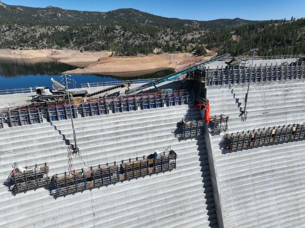
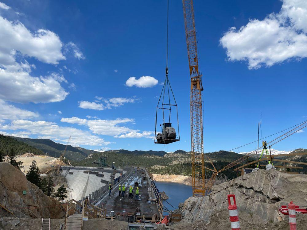
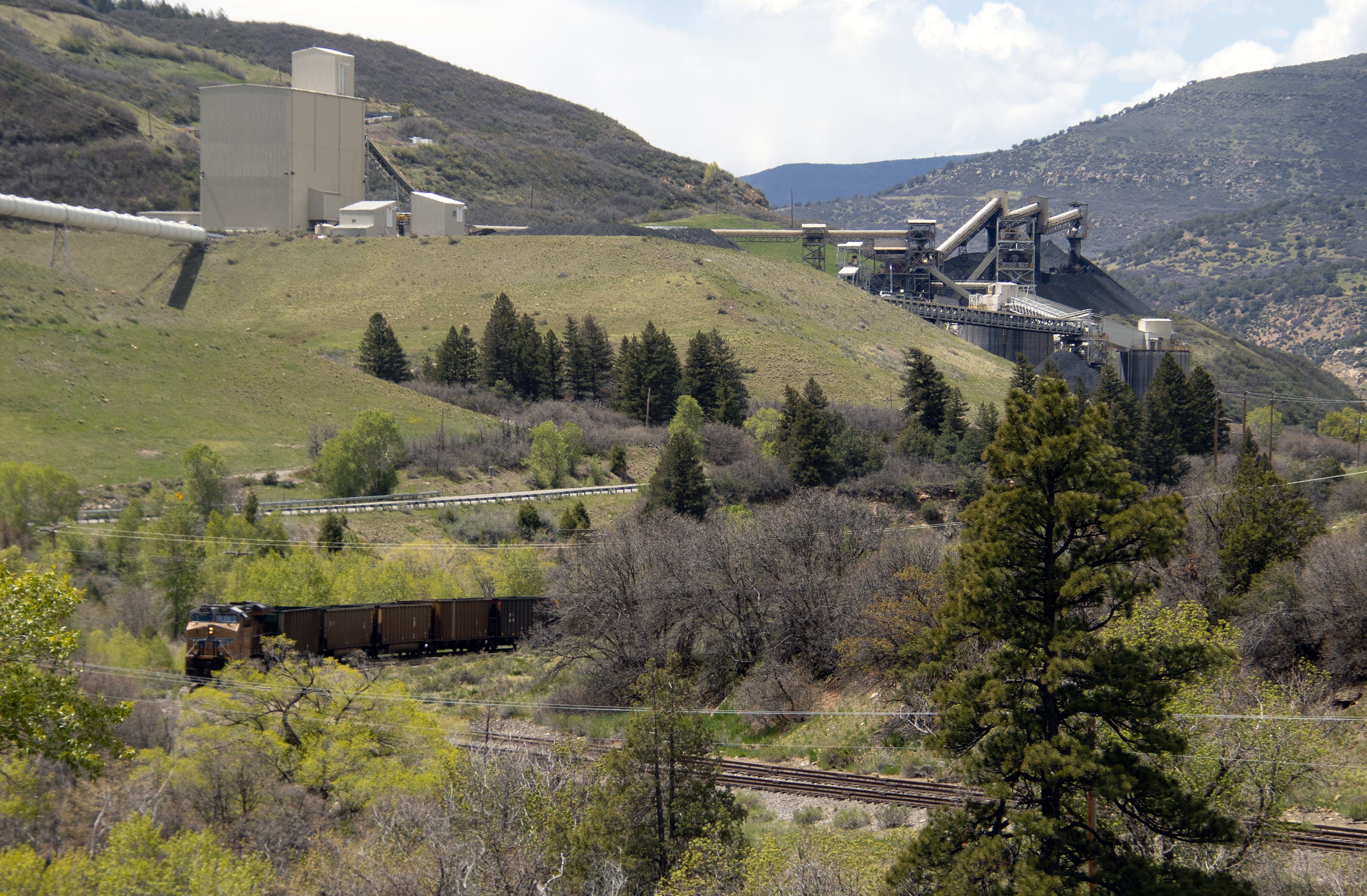
The new conveyor system moved concrete across the gap where the spillway channel will be to the far side of the dam. Photo credit: Denver Water.
Click the link to read the article on The Denver Post website (Elise Schmelzer). Here’s an excerpt:
June 14, 2026
…it remains unclear whether Denver Water will ever be able to fill the reservoir to its new full capacity as a yearslong court battle lumbers on between the utility and environmentalists. Months of mediation between the parties have failed. Denver Water is now asking a federal appeals court to reverse a lower court judge’s 2025 order barring the utility from filling the expanded reservoir and ordering the yearslong federal permitting process to be redone. A panel of three judges for the 10th U.S. Circuit Court of Appeals is scheduled to hear arguments in the case on July 31 in Santa Fe…
U.S. District Court Judge Christine Arguello in 2024 found that federal regulators violated environmental protection laws when they failed to properly analyze the environmental impact of the project or consider reasonable alternatives to the dam expansion that would be less harmful. She later issued the order against filling the reservoir. Environmental groups argued in court, and in their filings, that regulators failed to evaluate how siphoning more water from the drought-stricken Colorado River would impact the basin as a whole. And the groups charged that they failed to weigh other project options that wouldn’t require the clear-cutting of a half-million trees or risk damage to wetlands. The case has drawn the attention of other Front Range water providers, lawyers from across the county and the U.S. Chamber of Commerce — all of which have filed briefs in the appeals case…
While the dam structure itself is complete, at least a year of work remains to fully finish the project, Martin said. Construction crews must finish the spillway and place the final topper foot of concrete on the completed dam structure. Divers will place a gate between the reservoir’s water and the dam’s intake tubes. But the crews on site will diminish in the coming months, from up to 500 workers a day to closer to 100. On the morning of June 3, crane operators already worked to remove from the dam crest the heavy machinery that was necessary to build the main structure.
Roller-compacted concrete will be placed on top of the existing dam to raise it to a new height of 471 feet. A total of 118 new steps will make up the new dam. Image credit: Denver Water.
Ranchers are constantly adjusting to changing weather conditions and seasonal variations by nature. Jay Fetcher, of Fetcher Ranch in North Routt County, has documented snow melt dates for his hay meadows for each of the 75 years the ranch has been in the family, and said the variation is “incredible.” A year with low snowpack and a warm spring is just another condition to adjust to in the ranching world. This year, dryland hay broke dormancy early in Routt County, meaning cutting has already started, about two or three weeks earlier than usual. The low snowpack is not only generating concerns for ranchers with irrigated hay but water concerns for those with livestock. Despite these problems, the general consensus was that this year is expected to be below average, but not detrimental.
“People with dry land probably can expect some reduced yields, but I will say that the rains we’ve gotten over the last couple weeks have brought on grasses in dry land and pasture situation areas better than I would have anticipated,” said Todd Hagenbuch, the county director and agriculture agent for the Colorado State University Routt County Extension…
The second big concern from the lack of snowpack was water for cattle and other livestock. According to Hagenbuch, the snow runoff fills ponds and streams that the animals drink out of, but this year there’s simply no water in a lot of them. For ranchers whose ponds and streams are not filled, they have to haul water in for the livestock.
“That’s the big issue is adequate water for livestock, and it will be all summer,” said Mucklow. Mucklow is currently not needing to haul water on his ranch, but he personally knows several ranchers who are in that position.
Mucklow also said that there is a federal drought program conducted by the U.S Department of Agriculture that compensates ranchers who have to haul water.
Having drinking water for his cattle was also a primary concern for Fetcher earlier in the season. “It was on my mind as we had no snowpack, and the snow was gone,” said Fetcher. On his ranch, they rely on the streams and springs for the cows in the pastures. Fetcher said the recent rains gave him a significant amount of moisture that eased his worries considerably.
On June 2, the Pagosa Springs Town Council heard a presentation from Al Pfister, board president of the Upper San Juan Watershed Enhancement Partnership (WEP), about an application for the state-run Wildfire Ready Action Plan (WRAP) grant. The WRAP grant is a state of Colorado program, with its website describing the program as “locally-developed wildfire ready action plans (WRAP), refining the statewide susceptibility evaluations to reflect local values and community-scale data.” Pfister explained that the total project cost for WEP to do a watershed fire action plan for the Upper San Juan watershed would be about $400,000, and the grant would require a match of about $100,000. He noted the benefits of a WRAP would include identifying critical infrastructure that may be susceptible to risk and developing plans for roads and trails that may be impacted by post-wildfire effects. The fostering of collaboration between planners and emergency management agencies would also be a benefit to the community, he stated.
He explained what a WRAP actually does, saying it fosters stakeholder engagement, collects data and resources for the watershed, and organizes that data into a central database for use down the road. He added that the models could help predict how a watershed will behave in a post-wildfire situation and that the action plan would include both pre-and post-wildfire projects to mitigate damage to the watershed. He added that he was not at the meeting asking for funding at this time, but wanted to give the council a “heads up” that this was coming up.
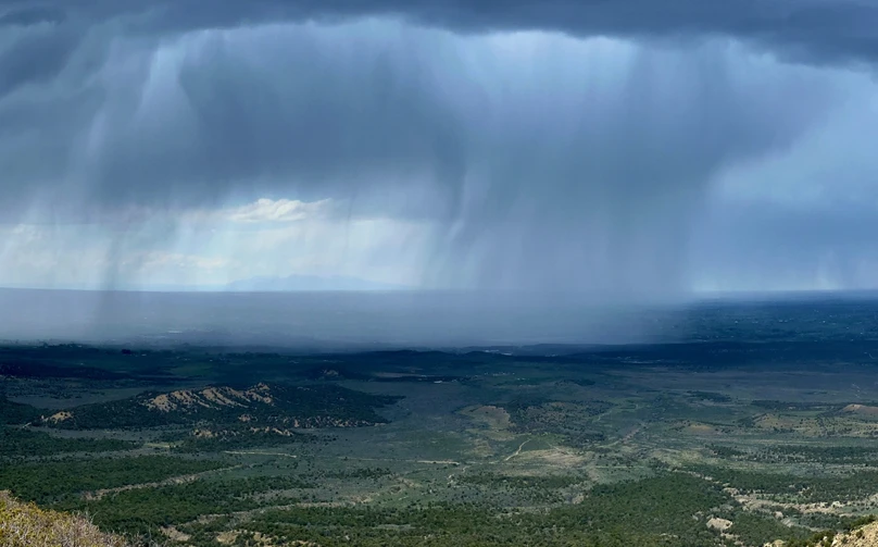
A rainstorm over southern Colorado. Photo: Abby Burk
Click the link to read the article on the Audubon website (Abby Burk):
May 7, 2026
Drought in Colorado isn’t abstract—it’s shaping decisions right now, from headwater streams to major reservoirs. And this year, the signals are hard to ignore. At the same time, conversations about water are tightening. There’s more concern and more sensitivity—especially around anything tied to water availability.
Snowpack across the Upper Basin has dropped to record or near-record lows. By early April, snow water equivalent in many areas fell to a fraction of normal, and snow cover reached the lowest levels observed in the satellite record. At the same time, this winter ranked among the warmest on record—reducing snow accumulation, accelerating melt, and increasing evaporative losses. These patterns are consistent with the impacts of climate change across the Colorado River Basin, where rising temperatures are diminishing snowpack reliability and reducing overall runoff efficiency.
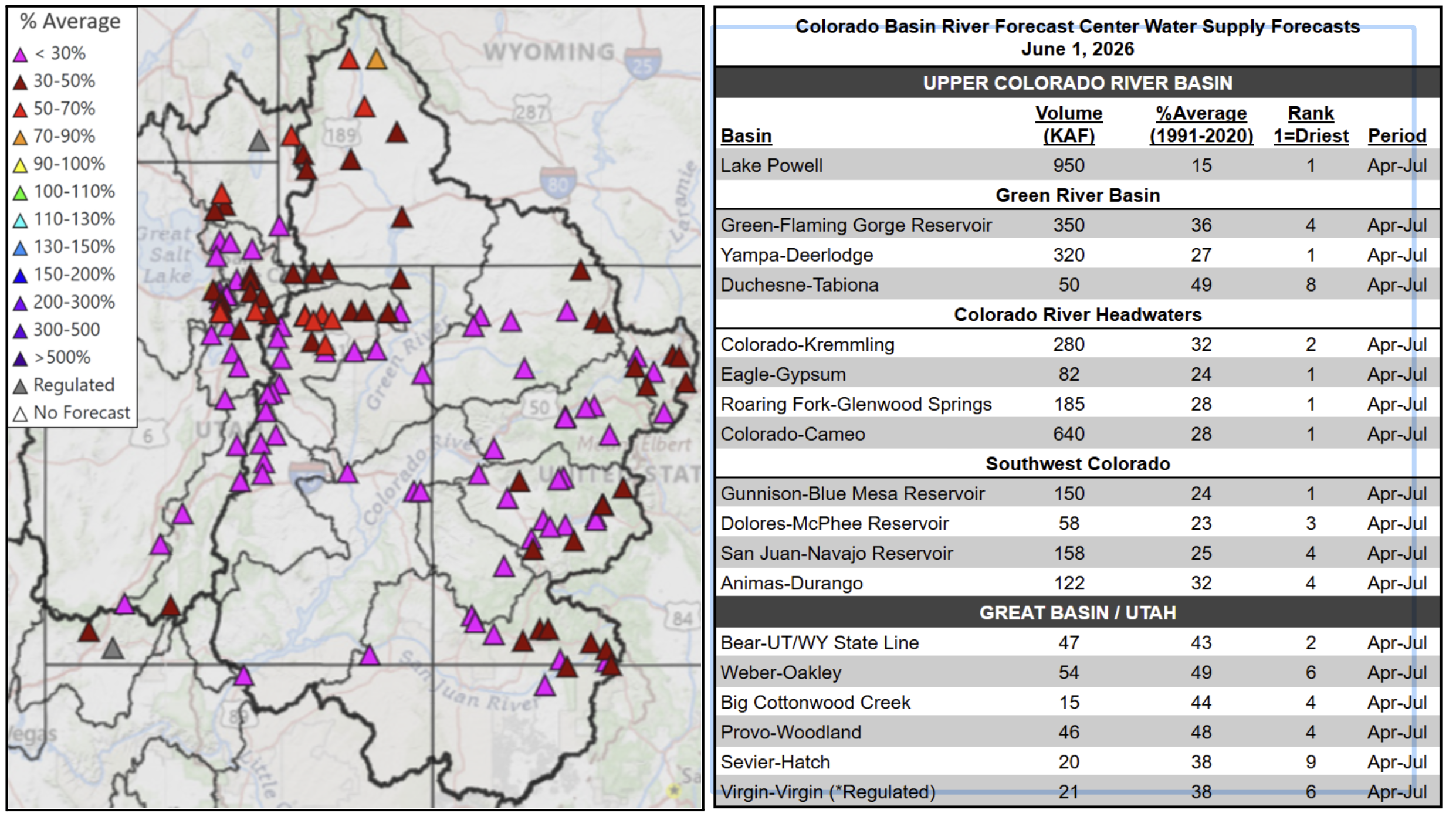
June 1, 2026 seasonal water supply forecast summary.
Those conditions are now reflected in forecasts. Runoff across the Upper Basin watersheds is expected to be among the lowest on record, with sharply reduced inflows into Lake Powell. Meanwhile, Lake Powell and Lake Meadcontinue to sit near historic lows—leaving very little buffer in the system.
Even where spring storms have brought some relief, the underlying deficitremains. Dry soils, warm temperatures, and reduced snowpack mean less water ultimately reaches rivers.
This is not just a dry year. It’s a system under compounding stress.
Why This Matters: Ecological Drought
Ecological drought helps explain what those conditions mean on the ground.
That definition matters because it expands how we think about drought.
It’s not just about precipitation. It’s about how drought moves through a system:
From snowpack to soil moisture
From soil moisture to vegetation and habitat
From ecosystems to the services people depend on
Modern droughts are also changing. They are becoming hotter, longer, and more widespread, with impacts amplified by both climate conditions and human water use.
And those impacts don’t stay contained.
Ecological drought is fundamentally about connected systems. When ecosystems cross critical thresholds—losing wetland function, shifting vegetation, or degrading habitat—those changes feed back into water supply, with wide-ranging implications to agriculture, wildfire risk, and community stability.
What it Looks Like Right Now
In Colorado, ecological drought is showing up as a shift in timing, duration, and connectivity.
Even with recent moisture:
Peak river flows are shorter and less effective
River baseflows drop earlier
Floodplains connect less often
Wetlands and side channels dry sooner
These aren’t always dramatic changes—but they compound, especially when they occur in back-to-back years, reducing recovery time.
That’s a critical shift. Drought is no longer just episodic. It’s increasingly persistent, with ecosystems spending less time in recovery and more time under stress.
Birds Are Early Indicators
For birds, these shifts are immediate.
Migratory species depend on wetlands that function like stepping stones across the landscape. When those wetlands shrink or disappear earlier, habitat becomes compressed.
Riparian birds like the Northern Yellow Warbler and Song Sparrow rely on dense, water-supported vegetation during breeding season. Earlier drying reduces both cover and food availability.
And beneath all of this, food webs shift. Aquatic insects emerge differently under drier conditions, creating mismatches with nesting cycles.
Birds are often the first to show us what’s changing—but they’re not the only ones affected.
People Are In This System, Too
Ecological drought makes one thing clear: this is a single, connected system responding together. The same processes that shape habitat also shape outcomes for people. Soil moisture influences forage conditions for agriculture. Water timing and availability affect the reliability of community supplies. River flows support recreation and local economies, while connected floodplains help reduce risk and support recovery after disturbance.
This is what we mean by ecosystem services—the benefits people receive from functioning natural systems. When those systems are strained or begin to break down, those benefits decline as well.
What This Means for the Basin
The science is pointing to something bigger than a single dry year.
The Colorado River Basin is increasingly operating in a warmer, drier regime, where snowpack is less reliable and variability is higher. Recent conditions mirror some of the most consequential low-flow years in recent history—and they are becoming more frequent.
At the same time, current operating guidelines are set to expire, and the decisions made now will shape how the system responds to these conditions going forward.
What’s needed is a shift—from reactive, year-to-year crisis management to more durable and flexible operations; from short-term fixes to sustained investment in long-term resilience; and from fragmented efforts to stronger alignment across states, Tribes, and water users.
There is growing recognition that solutions must include conservation, efficiency, infrastructure, and watershed health—including restoration that improves how water is stored and functions across the landscape. Without that kind of alignment, risks will continue to compound—ecologically, economically, and socially.
A Clearer Lens for What’s Ahead
Ecological drought is not a new agenda. It’s a way to understand how drought actually works in today’s world—how water shortages move through ecosystems, how impacts cascade, and how those impacts ultimately reach people.
It connects snowpack to rivers, rivers to habitat, and habitat to communities. And it underscores something essential: when ecosystems are pushed beyond their limits, the consequences don’t stay ecological—they become systemic.
That’s why this matters now. Because the question in front of us isn’t just how we respond to this year’s drought. It’s whether we’re building a system that can function—ecologically and socially—under the conditions we know are coming (or are here).
At the Yampa Town Board meeting last week, Andi Schaffner with the Bear River Reservoir Company presented plans and cost estimates for a Stillwater Reservoir project that would lead to removal of its storage restriction. The plan consists of two phases involving installation of a strain and a sand filter to alleviate seepage into the dam’s embankment, the primary concern that led to the storage restriction designation…Currently, the town of Yampa owns 112 shares in Stillwater Reservoir, or about 2% of the reservoir. Phase 1 of the project consists of a blanket drain and filter collar and is estimated to cost $730,717. Phase Two of the project will be stabilizing the channel and the removal of the culvert and the flume, at a total estimated cost $209,874. Schaffner said that the team at Bear River Reservoir Company has spent hours on engineering and studies at the reservoir in order to determine the best solution for the dam. “We finally opted for the least expensive fix, which is what we’re working on right now,” said Schaffner…The project has received a significant amount of grant funding despite higher than anticipated bids, including a $202,000 loan from the Colorado Water Conservation Board. This loan was the primary expected cost for the town of Yampa, and is expected to be approved with an increase to $404,000 ahead of the project’s notice to proceed with the contractor on July 13. The project is expected to be completed by the end of October. The Colorado Water Conservation Board loan is 30 years with 1.85% interest, or $3.40 per share per year. For the town of Yampa’s 100 or so shares, this amounts to $381 a year. Schaffner did not expect any more expenses besides an assessment of the shares which amounts to about $5.
Elkhead Reservoir is taking center stage following a winter of historically low snowfall, leaving water managers with hard decisions and water users with a high degree of uncertainty. Courtesy Photo/Colorado Parks & Wildlife
In response to extreme drought conditions throughout northwestern Colorado, the Colorado River District, in partnership with the Colorado Water Conservation Board (CWCB), is offering up to 420 acre-feet of supplemental agricultural water from Elkhead Reservoir for irrigators in the Yampa River Valley. Modeled on the successful joint CWCB-River District program implemented in 2021, this effort will provide additional supplies during critical times of agricultural production.
“The drought conditions this year have been exceptional and unpredictable,” said Colorado River District’s Director of Asset Management, Hunter Causey. “And it’s that kind of unpredictability that hits small family farms and ranches the hardest. The Yampa Valley, the western slope, and our entire region depend on local agriculture to drive economies, produce local food, and preserve landscapes. While a program like this cannot solve the drought problem at large, we can be strategic in how we use our available supplies and support our constituents wherever possible.”
“The challenges posed by this year’s drought call for creative solutions and strong partnerships,” said Lauren Ris, CWCB Director. “This project reflects what can happen when local water users and water management agencies work together to respond to emerging needs. We’re pleased to support this collaborative effort in the Yampa Valley and remain committed to working with communities across Colorado to explore creative, locally driven solutions that help address drought impacts and strengthen drought resilience.”
Program Structure:
Water will be allocated using a lottery with an initial round of allocations of up to 50 AF per applicant, totaling 420 AF.
Any water remaining after the lottery will be awarded equally to initial round applicants that expressed a need beyond 50 AF. If there is any remaining water, it will be available on a first-come, first-served basis and will need to be contracted at no cost with the District.
Successful participants in the lottery will need to enter into a no-cost contract with the River District for direct delivery and/or use of the District’s Elkhead water through administrative exchange.
In the event there is a mainstem Yampa River call and to the extent that lessees are out-of-priority, water will be released at the diversion rate plus transit losses.
Water will be available for delivery or exchange beginning on July 10, 2026.
At current agricultural water marketing rates, the total project will cost $18,375. On June 4, the Colorado River District Board of Directors agreed to make $4,594 available from the Board’s previously authorized CFP expenditures for the District’s 2026 Drought relief effort. The CWCB has committed to providing the remainder of the funds – approximately $13,781.
Applications are due by June 26th, and a lottery will be conducted for the initial round of contracts on July 1st. Available augmentation water is limited. Those interested in applying should contact the Colorado River District’s Director of Asset Management, Hunter Causey, at hcausey@crwcd.org or visit HERE for more information.
Heat-emitting Phoenix-area data centers next to already hot neighborhoods. Good thing a lot of those houses have swimming pools. They’ll need them. Source: Data Center Waste Heat as an Emerging Urban Thermal Hazard: First Field Measurements of Neighborhood-Scale Air Temperature Impacts, by David J. Sailor, Soroush Samareh Abolhassani, Eli P. Martin.
🤖 Data Center Watch 👾
Phoenix is hot, thanks to its location and elevation; it’s getting hotter, due to climate change, all that concrete and steel and glass and the urban heat island effect, and heat output from thousands of overworked air conditioning units; and it’s bound to get even hotter thanks to … data centers.
A team of Arizona State University researchers recently published a report on data center waste heat as an “emerging thermal hazard.” What they found will make folks who live near the facilities sweat, literally.
Data centers do a lot of work crunching information to stream movies, power AI queries, make those Tik Tok videos, and keep you doomscrolling, and work creates heat, meaning that data centers need constant cooling. As the paper’s authors put it, “virtually all electrical energy consumed by information technology equipment is ultimately converted to sensible heat,” and data centers consume huge amounts of electricity. More and more data centers, especially in arid areas, are using air cooling technology, which means taking that heat away from the equipment and putting it elsewhere — i.e. outside the facility, creating thermal plumes.
The researchers determined that these thermal plumes are migrating into adjacent neighborhoods and heating them up, with downwind air temperatures measuring up to .9° C warmer than upwind temperatures. The data centers’ excess heat was detected up to 500 meters, or about 1,600 feet, away from the facility. This is troubling given that many data centers are being constructed in or next to residential neighborhoods. The massive Cyrus One server farm complex in Chandler, Arizona, for example, is about 600 feet from single-family residences.
The authors write:
Keep in mind that this study only looked at the warming effect of on-grid facilities. Many of the new hyperscale data centers in the pipeline are planning to install power generation infrastructure, usually natural gas-fired, on-site, most likely radiating even more heat than the data centers alone. Putting your data center in Wyoming or Alaska rather than Phoenix or Las Vegas is making more and more sense.
⛈️ Wacky Weather Watch⚡️
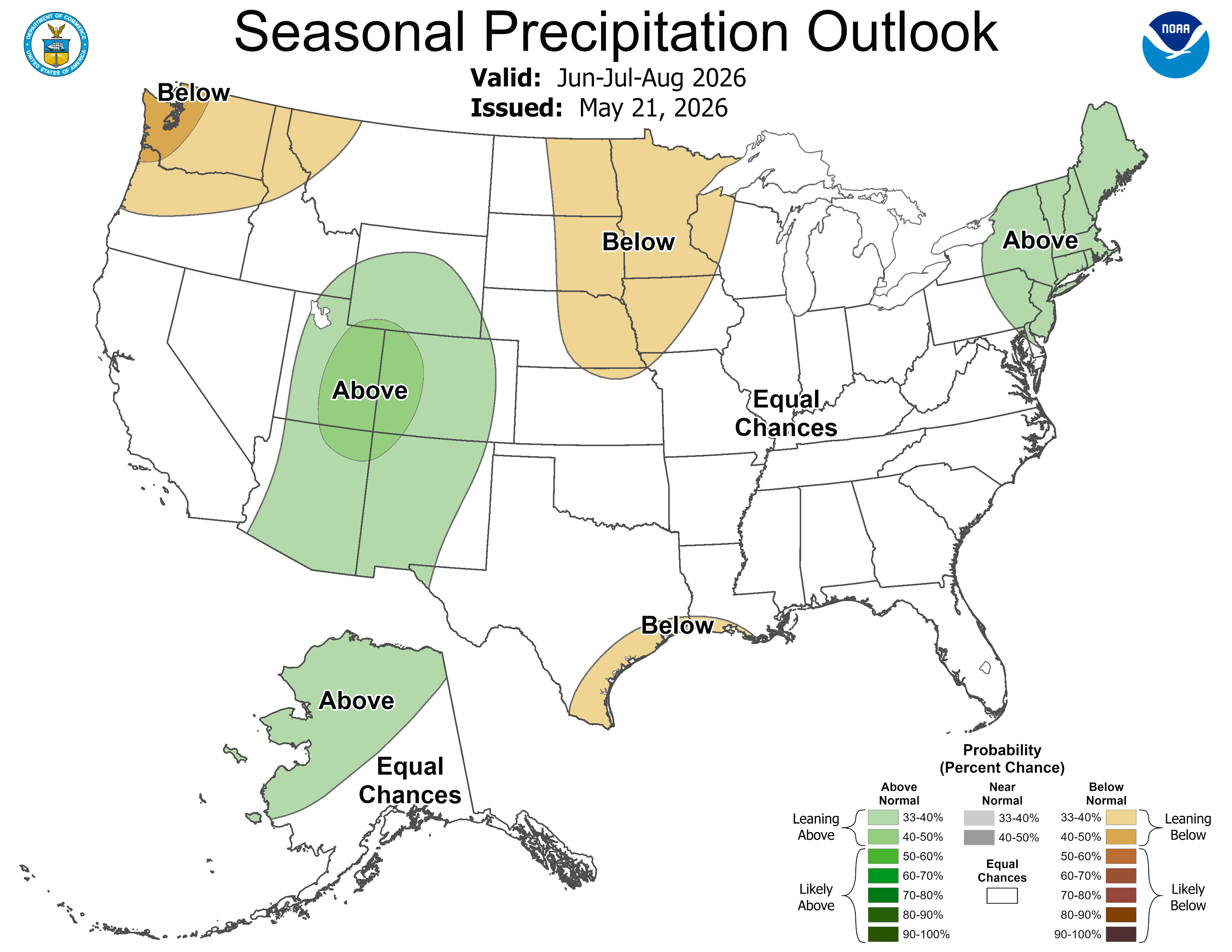
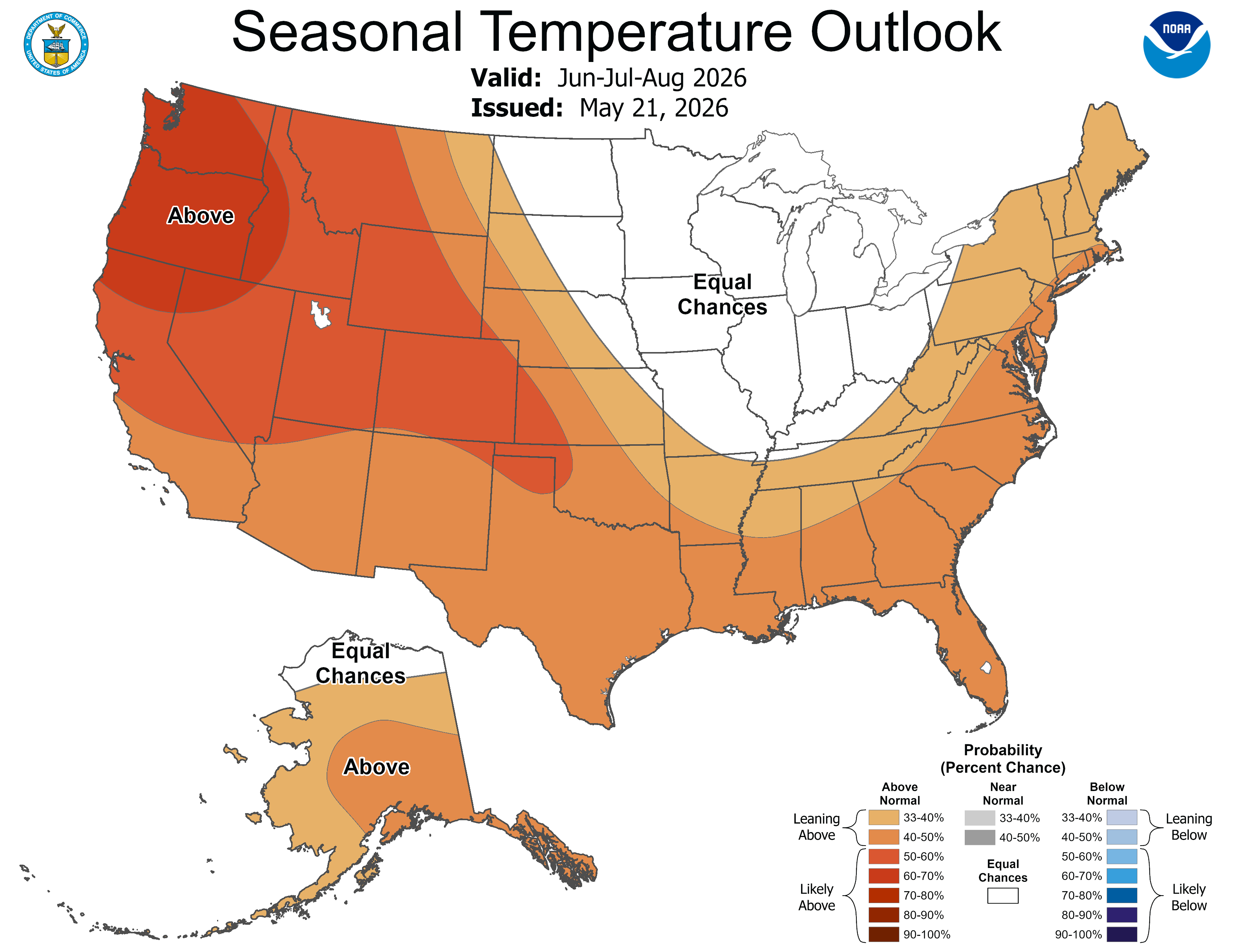
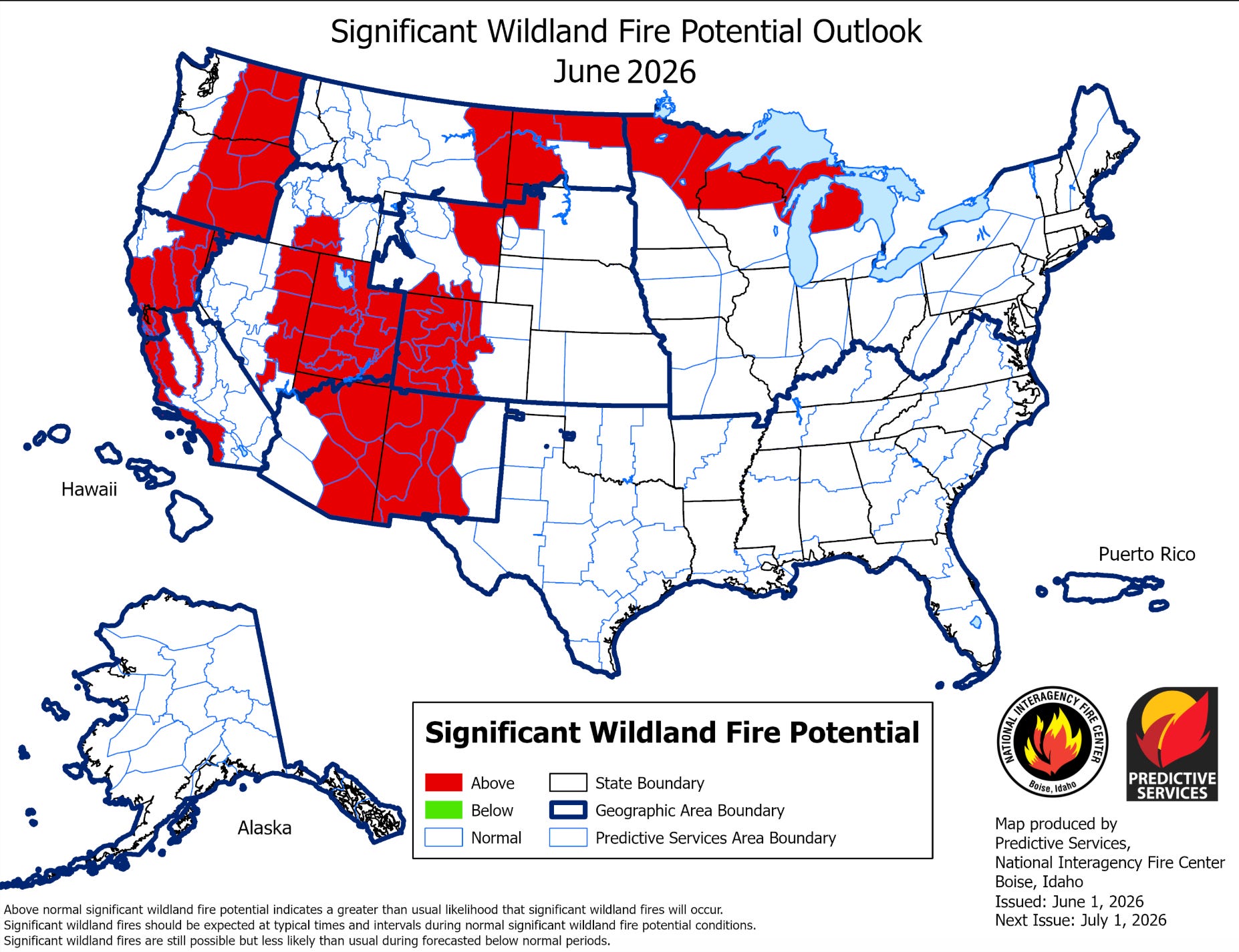
Will it be the Sultry Summer of 2026 for the Four Corners region? The long-range forecasts sure do look that way. The good news is that it’s looking more and more likely that the monsoon will be potent in the Southwest, with the National Weather Service predicting above average precipitation over the next three months. The bad news is they are also calling for higher-than-normal temperatures for the entire West during that time period, which could offset some of the benefits of the rain.
But whether it’s normally hot or abnormally so, the extra moisture will be especially welcome this year. Many an irrigation ditch is likely to go dry in the next month or so, thanks to extra-low streamflows, and regular afternoon downpours could help farmers get their crops to harvest, so long as the storms aren’t too severe and don’t produce softball-sized hail stones or whatever.
Once the monsoon arrives, it should help dampen wildfire hazard a bit (although the lightning that always comes with it will certainly spark many a blaze). In the meantime, however, big swaths of the West are expected to have above normal wildland fire potential for the next month or so.
And blazes are flaring up here and there, including a small conflagration atop Hermosa Mountain north of Durango that is eerily reminiscent of the 416 Fire in 2018: This winter’s snowpack resembled 2018’s, the 416 broke out on June 1, and the starting points are in the same general area.
The current fire is burning in a hard-to-reach area at higher elevation and was definitely not started by sparks from the railroad. It’s also growing relatively slowly, having reached just 18 acres as of the evening of June 4.
***
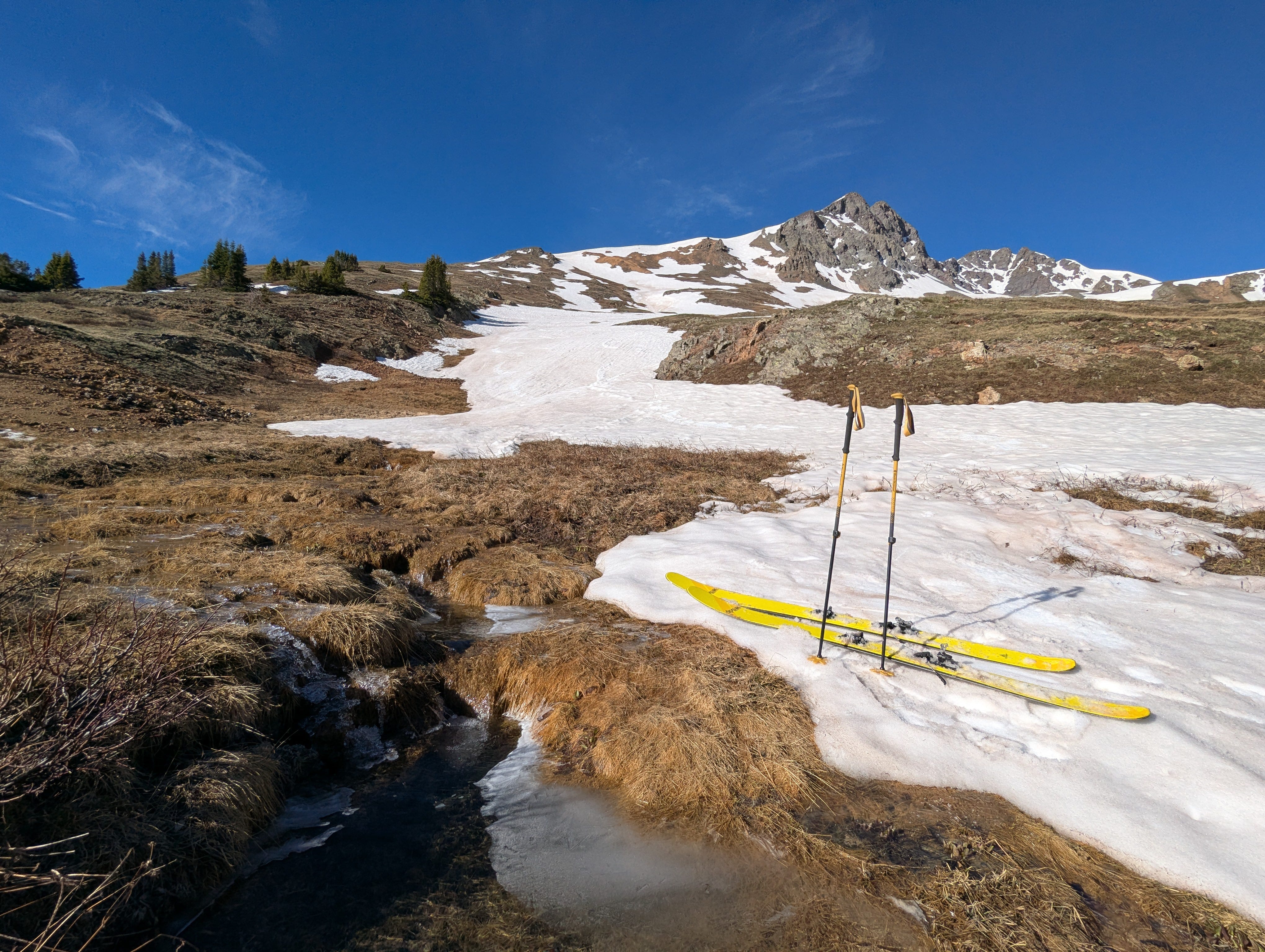
Emery Peak near Silverton, Colorado, on June 2, 2026. Andy Gleason photo.
I don’t know about y’all, but the crazy winter and spring has screwed up my perception of the water situation. When skiing-obsessed snow-nerd Andy Gleason sent me this photo, I was somewhat surprised to see that there was any snow at all left in the high country, especially enough to carve a few turns on. When I see that the Animas River is running above 800 cfs right now, I think: That’s not so bad! And when I see Lake Powell’s surface level inching upwards rather than downwards a temporary feeling of relief washes over me.
Then I remember: It’s the beginning of June. The north facing high mountains should be coated with several feet of snow, not a few inches. The Animas should be running at 3,000 cfs, at least, and in a good year still would be approaching its peak. And Lake Powell’s inflows should far exceed releases at this time of year, bringing the surface level up by several feet or more, without requiring Flaming Gorge to be drawn down to “devastating” levels.
That bout of summer-like weather at the end of March set my internal season clock a couple of months ahead, so that I expect the conditions to be like they typically would be in late July. So once that split second of disorientation, and accompanying optimism, passes, there’s a sort of letdown.
Because, yes, the conditions are grim. And it was one of the worst winters, in terms of snowpack, on record. But there are reasons not to despair. While the snow was dismal, precipitation accumulation for the water year so far has been far less so, keeping extreme drought at bay. Temperatures cooled after the March heat spell, a series of storms kept the forests from becoming kindling, and desert rains summoned the wildflowers. Patches of globe mallow, sego lily, primrose, and prince’s plume brightened up the burnished sands of Utah, and my friend and I rode our bikes through a purple-hued super bloom near Farmington.
The land may be dry, but it still offers beauty, solace, and refuge from these trying times. [ed. emphasis mine]
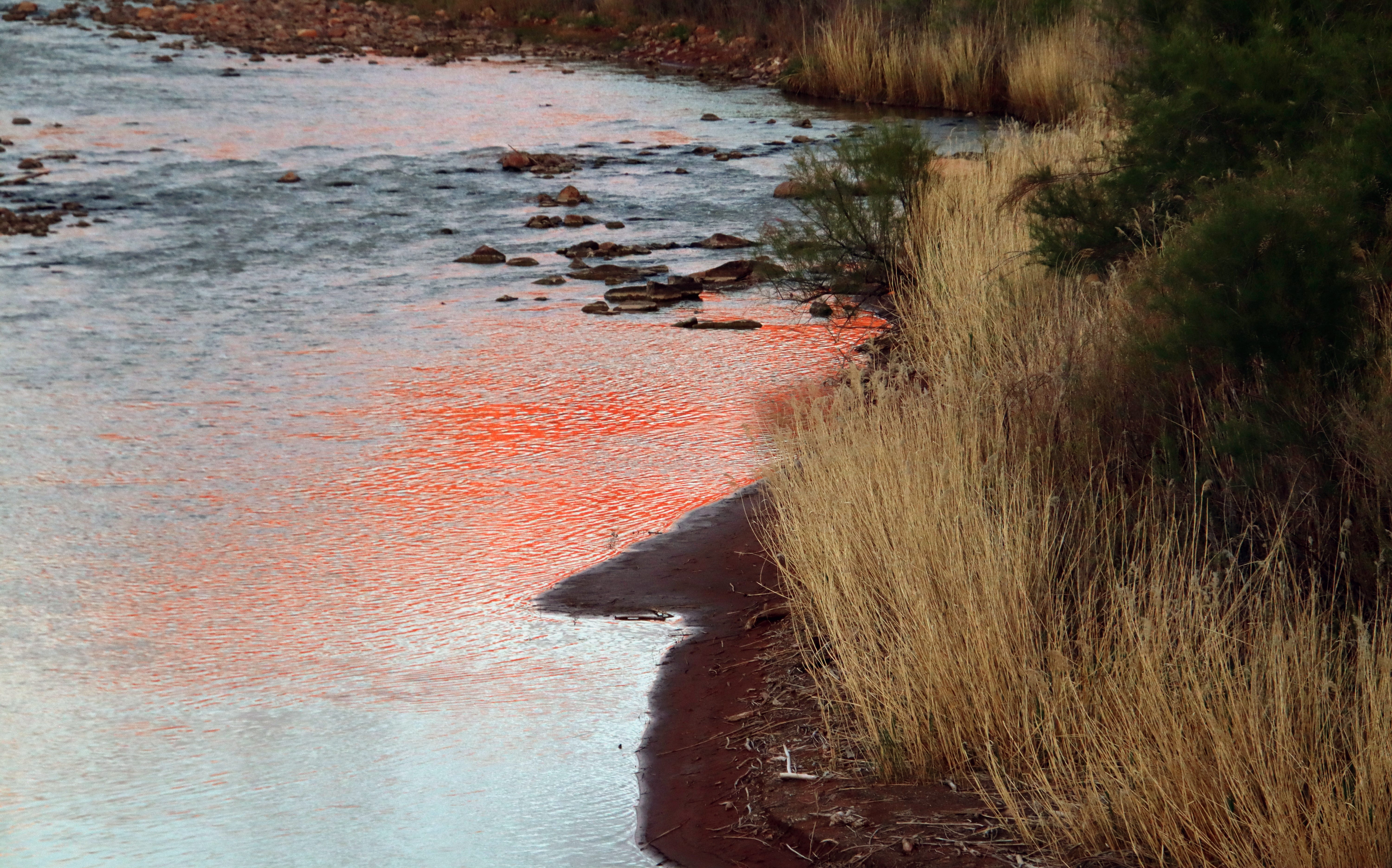
Redrock reflection on the Dolores River near Gateway, downstream from the confluence with the San Miguel. Jonathan P. Thompson photo.
Last month I wrote about the despair I felt as I witnessed the virtually dry Dolores River bed a mile or so above its confluence with the San Miguel River. Neither the dryness nor the despair are new, though they both came early this year.
For decades, the wild Dolores would swell up into a raging torrent during the spring runoff. Then, during the summer, Montezuma Valley irrigators would divert nearly all of the stream’s flow, reducing these lower reaches to little more than a trickle come late July and August.
McPhee Dam started holding back those spring flows in the early 1980s. Like any dam, this one robbed so much life from the river. Yet this one also promised to give some life back to the beleaguered river by mitigating the impacts of all of that irrigation. The idea was to capture enough of the runoff to fill up the reservoir in the spring. During summer, the storage could be drawn down to serve irrigators, while most or all of the river’s natural flow could be sent through the dam to the Lower Dolores. It was like putting the river’s manic-depressive flows on lithium.
It worked, for a while: The massive spring runoffs, known to hit upwards of 11,000 cfs, were tempered, but enough water still flowed downstream to scour beaches and preserve Snaggletooth’s whitewater snarl. And for the first time in a century the lower Dolores didn’t run dry in July. In fact, the year-round flows were enough to build and sustain a cold-water fishery for trout in the first dozen or so miles below the dam and a habitat for native fish below that. Meanwhile, the Dolores River water was able to reach far more irrigators, including the Ute Mountain Ute Tribe and former dryland farmers out Dove Creek way.
It appeared to be a win-win situation. Then, beginning in 2000, things went awry as a long-term drought gripped the region. More often than not, the dam’s operators held back almost all of the water running into the reservoir to allow them to continue delivering something to the irrigators. And even then the reservoir still isn’t full enough to deliver all of the water that’s allocated: This year the Ute Mountain Ute Tribe and irrigators outside of the Montezuma Valley Irrigation Company will receive just 13% of their allotted amount. The river below the dam, of course, is the biggest loser, receiving virtually nothing.
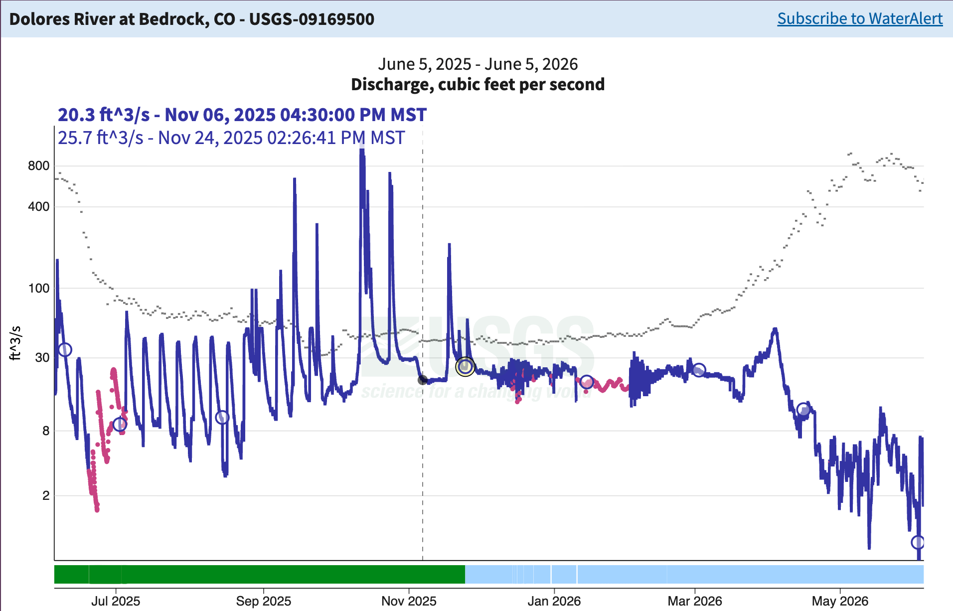
And yet, not all is lost. The Dolores River Boating Advocates recently put out a postdetailing the grim forecast for this year, but also reporting on a new Colorado Parks and Wildlife effort to help fish in the Lower Dolores: pulse flows. They tested the concept last year by holding water back behind the dam for a few days by reducing release flows to 24 cfs, then bumping up releases to 75 cfs create a slight surge of water to reconnect downstream pools, to induce enough current to keep the water cooler, and allow fish to move around again.
Graph showing the pulse flows last summer as they reached Bedrock. So far this spring flows there have been below a dismal 10 cfs. Source: USGS.
The Boating Advocates write:
Of course streams also need water, and it’s so scarce this year that the base flows will be just 5 cfs, or one-fifth of last year’s base flows. And so the sorrows continue for the poor Dolores River.
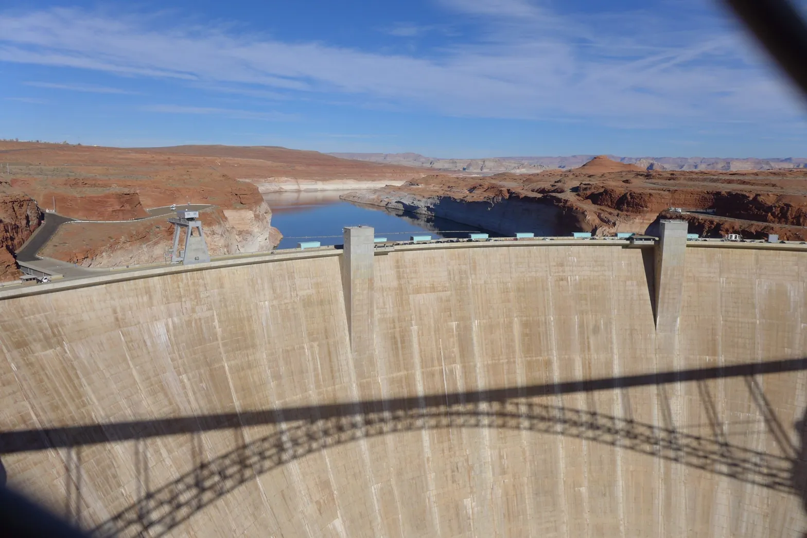
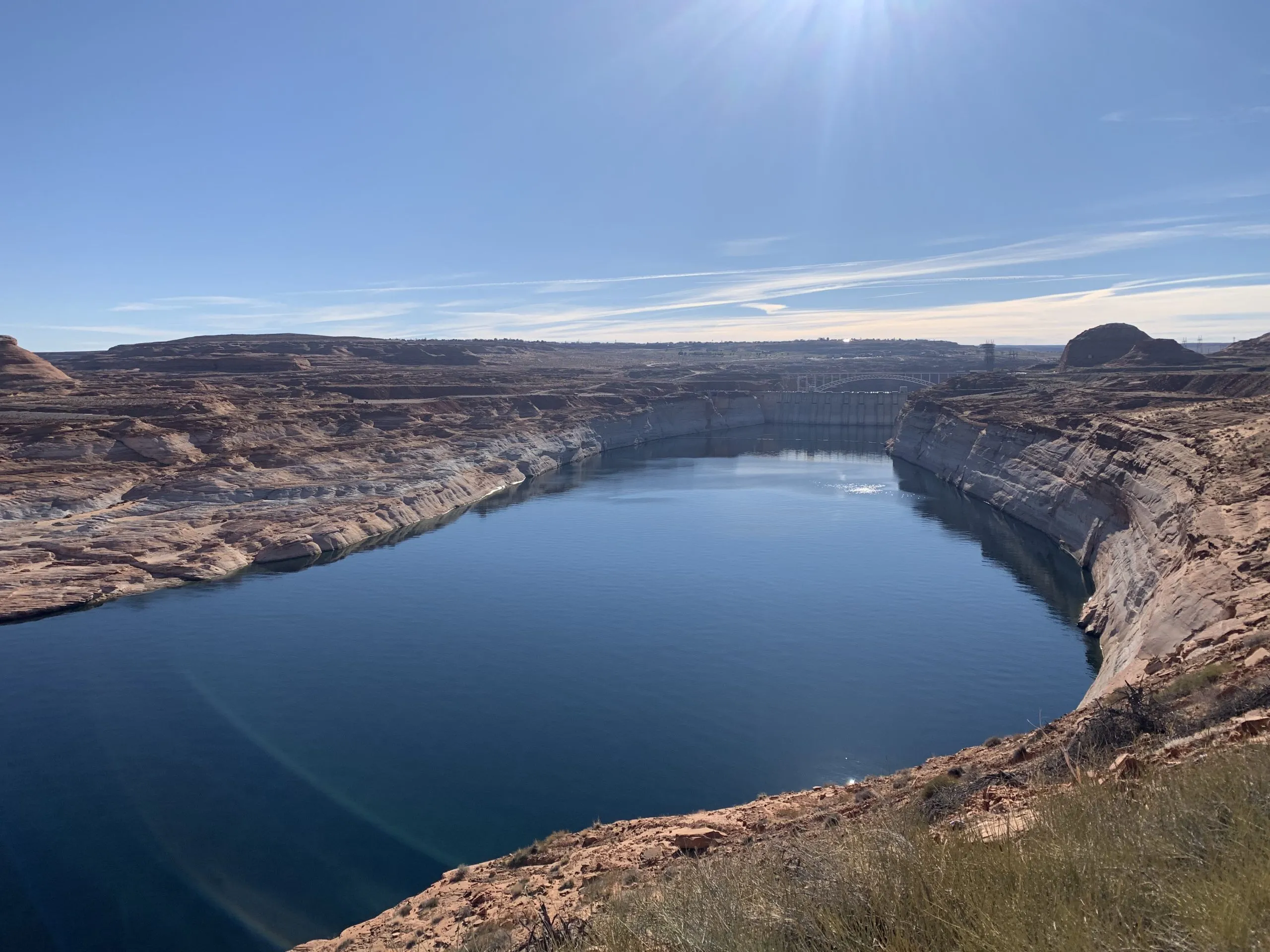
Glen Canyon Dam forms Lake Powell on the Colorado River near Page, Ariz. Officials from the U.S. Bureau of Reclamation are holding back water and releasing water from an upstream reservoir to prop up levels in Lake Powell. CREDIT: HEATHER SACKETT/ASPEN JOURNALISM
Federal officials announced on Thursday that they plan on using a shorter-term framework for future Colorado River management so they can be more responsive to changing conditions and reservoir levels.
Acting Commissioner of the U.S. Bureau of Reclamation Scott Cameron said at an annual conference on water policy that the agency will be using a 10-year framework, issuing new operational guidelines every two years. In the absence of a seven-state deal for sharing shortages and managing reservoirs, river management now falls to the federal government — an outcome nearly everyone had hoped to avoid.
“We would love to have a 20-year deal or a 30-year deal but, frankly, we haven’t even been able to get the seven states to agree on what a two-year deal would look like,” Cameron said. “Given the highly unusual hydrological situation in the basin … we think it makes sense to take a second look at decision making every couple of years.”
As part of the required process under the National Environmental Policy Act, Cameron said Reclamation will release a final Environmental Impact Statement with its “preferred alternative,” in mid-to-late summer. It will lay out a more detailed 10-year operations plan for the nation’s two largest reservoirs, Lake Powell and Lake Mead, and will include short-term operational guidelines for 2027 and 2028. He said the plan provides a stable, transparent and adaptable framework for river management.
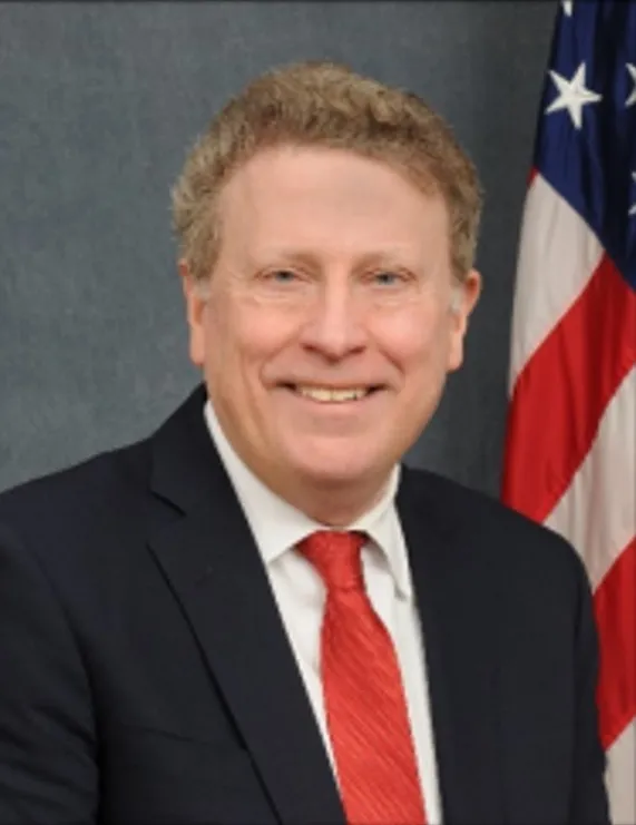
Scott Cameron is the acting commissioner of the U.S. Bureau of Reclamation. He announced Thursday the federal agency is planning to release a river management plan in mid-to-late summer that includes a 10-year framework, with new operational guidelines every two years. CREDIT: U.S. BUREAU OF RECLAMATION
“We want to pay more attention to what’s actually happening in the river and what’s happening in terms of the elevation of the reservoirs,” Cameron said. “We want to manage conservatively during low inflow periods and hopefully be able to transition to recovery as conditions improve across the basin to keep the system stable and resilient.”
Cameron left the door open for a return to future management by the states and added that if they eventually come to an agreement, it could supplant the federal plan.
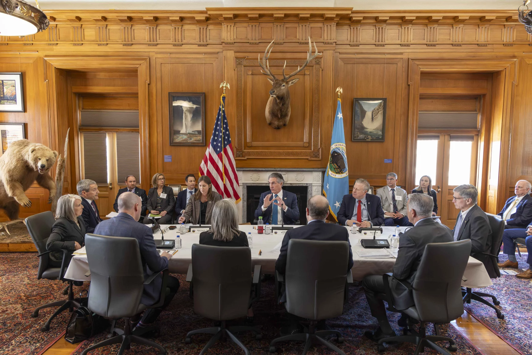
Cameron’s update came at the Colorado Law Conference on Natural Resources at the University of Colorado Boulder, hosted by the Getches-Wilkinson Center and the Water & Tribes Initiative. Water managers from around the basin gathered at the Wolf Law School in the midst of one of the worst droughts on record that threatens the water supply for about 40 million people in the American Southwest. Record hot temperatures and one of the worst snowpacks since measuring began resulted in streamflows that peaked much lower than normal and, in some reaches, a month early. Reclamation’s most recent projections put spring runoff into Lake Powell at just 800,000 acre-feet, which would be 13% percent of normal and the lowest on record.
On top of the abysmal hydrologic conditions, the basin is also in the midst of a management crisis. The Upper Basin states (Colorado, New Mexico, Utah and Wyoming) and Lower Basin states (California, Arizona and Nevada) after two years of negotiating have failed to reach a consensus on how they will share future cuts and have blown past deadlines to come up with a plan. The current guidelines, which have determined shortages and releases since 2007, expire at the end of the year. But for all intents and purposes, water managers need a new plan in place by the start of the new water year on Oct. 1.
Some of the problem still centers around the 1922 Colorado River Compact, which allocated half of the river’s flows (7.5 million acre-feet a year) to each basin. But this framework no longer applies under 21st century conditions, which has seen flows decline by 20% due to climate change. Despite indications a year ago that the states were moving to a supply-driven model based on each year’s snowpack and available water — rather than a fixed allocation of water — a new management framework the states can agree on has remained out of reach.
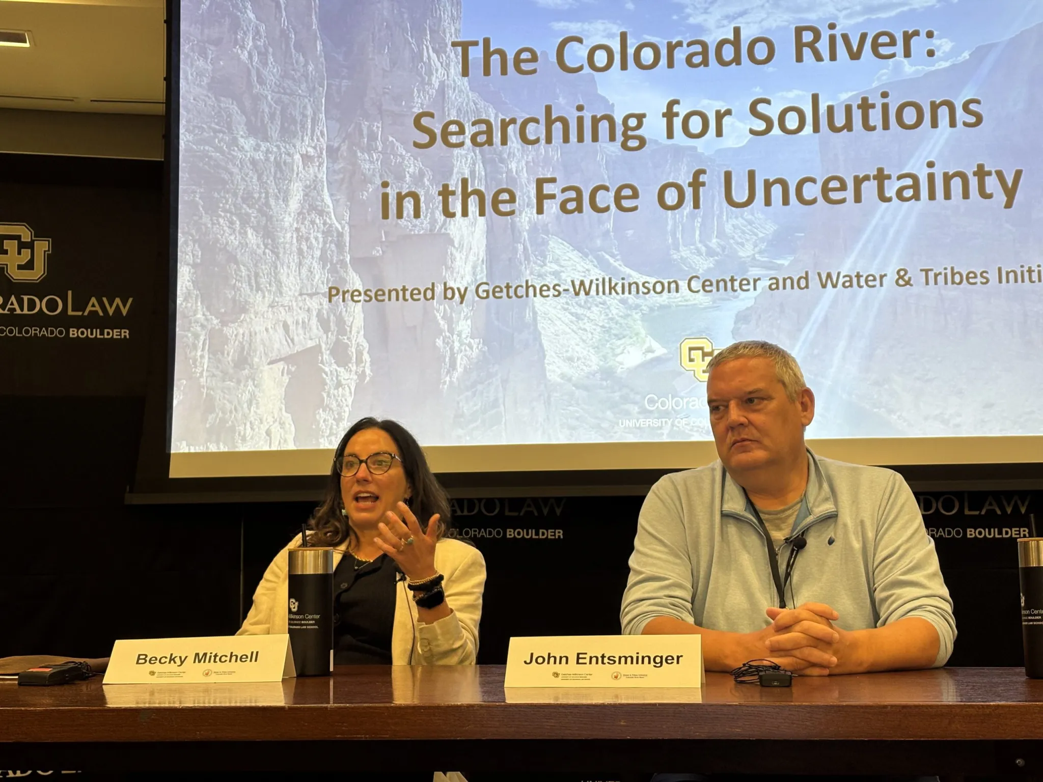
Colorado representative Becky Mitchell and Nevada representative John Entsminger speak at a conference on Colorado River policy in Boulder on Friday, June 5, 2026. The federal government is set to release a plan for future river management in mid-to-late summer. CREDIT: HEATHER SACKETT/ASPEN JOURNALISM
Beyond the band-aid
The feds’ operating plan for the first two years may be based on a proposal submitted by the Lower Basin states in early May, in which they propose to cut another 700,000 acre-feet of water per year through 2028, on top of the 1.5 million acre-feet they had already promised. California and Arizona will each take another 300,000 acre-feet of cuts and Nevada will take a cut of 100,000 acre-feet. The proposal does not include any mandatory conservation from the Upper Basin.
Federal officials responded in a May 28 letter with adjustments to make the proposal feasible, including the requirement that the Lower Basin states help pay for the 700,000 acre-feet of conservation. In the past, conservation programs have depended heavily on federal funding.
Becky Mitchell, who represents Colorado in the negotiations among the states, said during a Friday panel that the feds’ plan was a starting point but raises some concerns. Constantly renegotiating an operating plan every two years would be hard to fathom, she said.
“How do we fund and finance if we’re constantly renegotiating?” Mitchell said. “And how do we create the certainty that the 40 million people deserve?”
The feds have already stepped in this spring to prevent the worst consequences of the exceptionally dry winter and keep water levels at Lake Powell from falling below the threshold for making hydropower at Glen Canyon Dam. They are releasing up to 1 million acre-feet from Flaming Gorge Reservoir to prop up Powell and holding back Powell releases by about 1.5 million acre-feet. Cameron conceded, however, that these are temporary, stop-gap measures meant to address a critical situation.
“I think we succeeded in making everybody unhappy and everybody mad, which maybe means we’re doing the right thing in terms of Lake Powell,” Cameron said.
The Upper Basin states, including Colorado, are exploring ways to contribute water to a pool in Lake Powell as a means of maintaining higher water levels and an insurance policy against drastic cuts. But officials have not budged from their position that the Upper Basin is limited in what it can do and that cutting Lower Basin overuse is the primary solution to the Colorado River crisis.
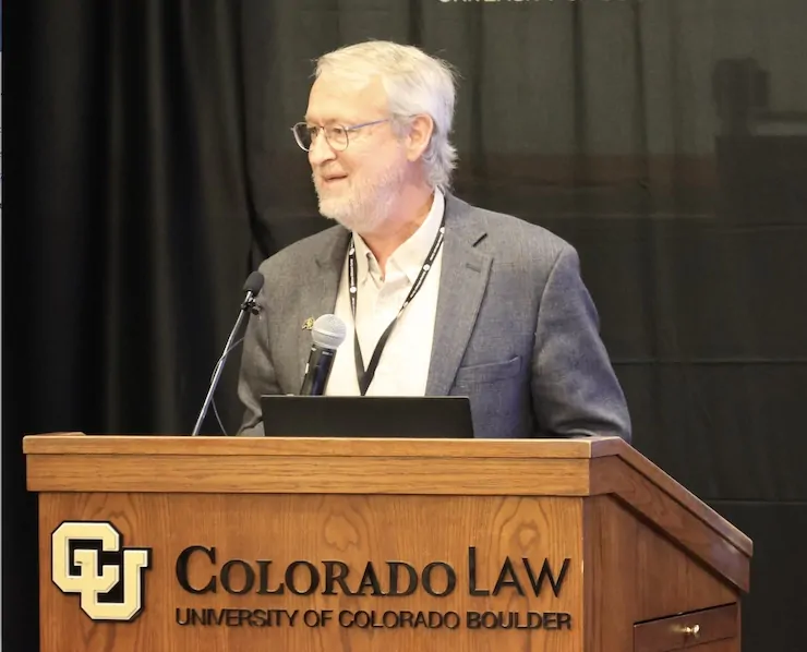
Brad Udall, a water and climate scientist at Colorado State University whose presentation kicked off the conference, asked water managers not to waste this unique opportunity to redo 100 years of law and policy around how to manage a critical resource. And he directed a plea at the Upper Basin, saying that they, too, are part of the problem.
“We need everybody with a shoulder to this wheel,” Udall said. “We understand that the Upper Basin is different. We understand that they don’t have (large upstream) reservoirs and that every year people suffer. But we need you to help. Please help us.”
Udall/Overpeck 4-panel Figure Colorado River temperature/precipitation/natural flows with trend. Lake Mead and Lake Powell storage. Updated through Water Year 2025. Note the tiny points on the annual data so that you can flyspeck the individual years. Credit: Brad Udall
Map of the Colorado River drainage basin, created using USGS data. By Shannon1 Creative Commons Attribution-Share Alike 4.0
Click the link to read the article on the InkStain website (John Fleck):
June 1, 2026
I’ve been on a “Colorado River sabbatical” of late, but I took a peek last week at Reclamation’s latest 24-month study. Holy moly things have gotten bad since the last time I looked!
Those not on sabbatical already know all of this, but to keep Lake Powell above a surface elevation of 3,500 feet, Reclamation is:
increasing releases out of Flaming Gorge on the Wyoming-Utah border
dropping releases out of Lake Powell to 6 million acre feet this year
Even with those two “hail Mary” moves, Lake Mead is projected in the “most probable” scenario to drop to elevation 1,020 by summer 2027. Under the “minimum probable” forecast, Mead drops all the way to elevation 1,008 in 2027.
We are on the brink, as a group of my colleagues explains in a new analysis out this morning (Monday June 1, 2026), of a system crash:
Even a wet year, my friends conclude, would only provide a short reprieve from the need to significantly reduce consumptive use.
Building on a similar analysis done last September (I was a co-author on that one), the authors attempt to overcome one of the shortcomings of the traditional Colorado River accounting systems, which is to treat any water above “dead pool” as usable storage. This is not the case, with clear do-not-cross lines in the reservoirs that are maintained for technical reasons well above the bottom, defined by my colleagues as…
One of the reasons for my “sabbatical” is, frankly, an agonized frustration with the abject failure of Colorado River governance at the basin scale, and a desire to turn my attention to the local level, which is where the problem solving responsibility seems to rest right now. Each community needs to be having a serious conversation right now about the specifics of its Colorado River water supply, and how it intends to go about using less. Blaming other people for using too much isn’t particularly useful at this point, we seem to have chosen to hand that set of questions (the rule-based part of “who is entitled to how much”) over to the courts, and who knows what that process holds. We know the answer for everyone is “use less water”, and each community needs to be getting on with that conversation.
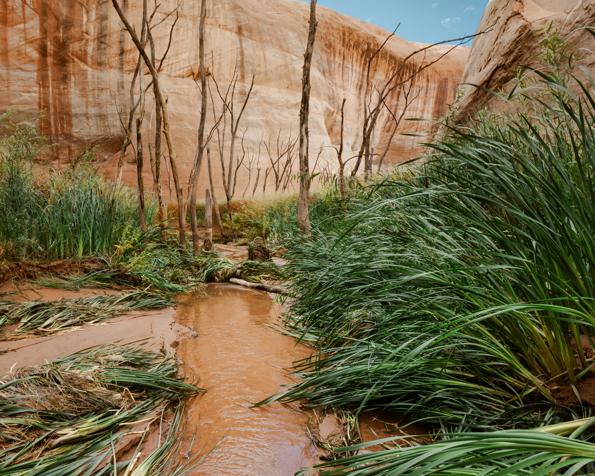
Underwater until recently, a biodiverse ecosystem has quickly re-established in this particular side-canyon of Glen Canyon. Along with a whole host of plant life, I’ve documented crayfish, otters, beavers, deer, coyotes and tracks of mountain lions and bobcats throughout Glen Canyon’s wet tributaries. Photo credit: Elliot Ross/Glen Canyon Institute (GlenCanyon.org)
Click the link to read the article on The Denver Post website (Elise Schmelzer). Here’s an excerpt:
June 7, 2026
The tops of trees, dead since Lake Powell’s levels rose decades ago, poked through mud and ooze at the silent mouth of Davis Gulch, where the side canyon met the reservoir’s still waters. But just around a few bends in the sandstone walls, life began to appear. First, a fuzz of inch-tall greenery. Then, knee-high cattails and primrose, followed shortly by small cottonwoods and willows, then by towering gambel oaks. The silence of the canyon mouth was replaced by the soft rush of a creek, bird songs, and the constant cacophony of dragonflies and gnats. Scattered throughout the canyon, an ecologist, bug scientists, birders and advocates for Glen Canyon were working to document the ecosystems emerging as Lake Powell’s water levels have dropped after decades of drought and water overuse.
“Hiking the side canyons is like going through ecological time travel,” said Eric Balken, the executive director of the Glen Canyon Institute, a nonprofit dedicated to restoring the canyons inundated by Lake Powell, as he hiked up Davis Gulch…
The falling water levels have also steadily revealed long-submerged canyonlands: red slot canyons, sandstone amphitheaters, waterfalls that tumble over slickrock cliffs. The reemerging landscapes provide a new opportunity to study life in Glen Canyon, which sits just upstream of the iconic Grand Canyon. Little scientific work was completed in Glen Canyon before the federal government flooded it — an event seen by environmentalists then, and now, as an unmitigated ecological disaster, a paradise lost…But for a new generation of advocates, regaining paradise seems possible as the reservoir’s shorelines recede, bringing more than 100,000 acres of rugged terrain out of the water. The Glen Canyon Institute and canyon activists for years have argued that Lake Powell should be drained and the Colorado River allowed to again flow freely through Glen Canyon. Now, their argument is also bolstered by the fact that Lake Powell is emptying — whether Colorado River managers like it or not. For those advocates, recent years have provided a rare chance to study life in the emerging canyonlands and to make their case to basin leaders who are contemplating the long-term future of Colorado River management…
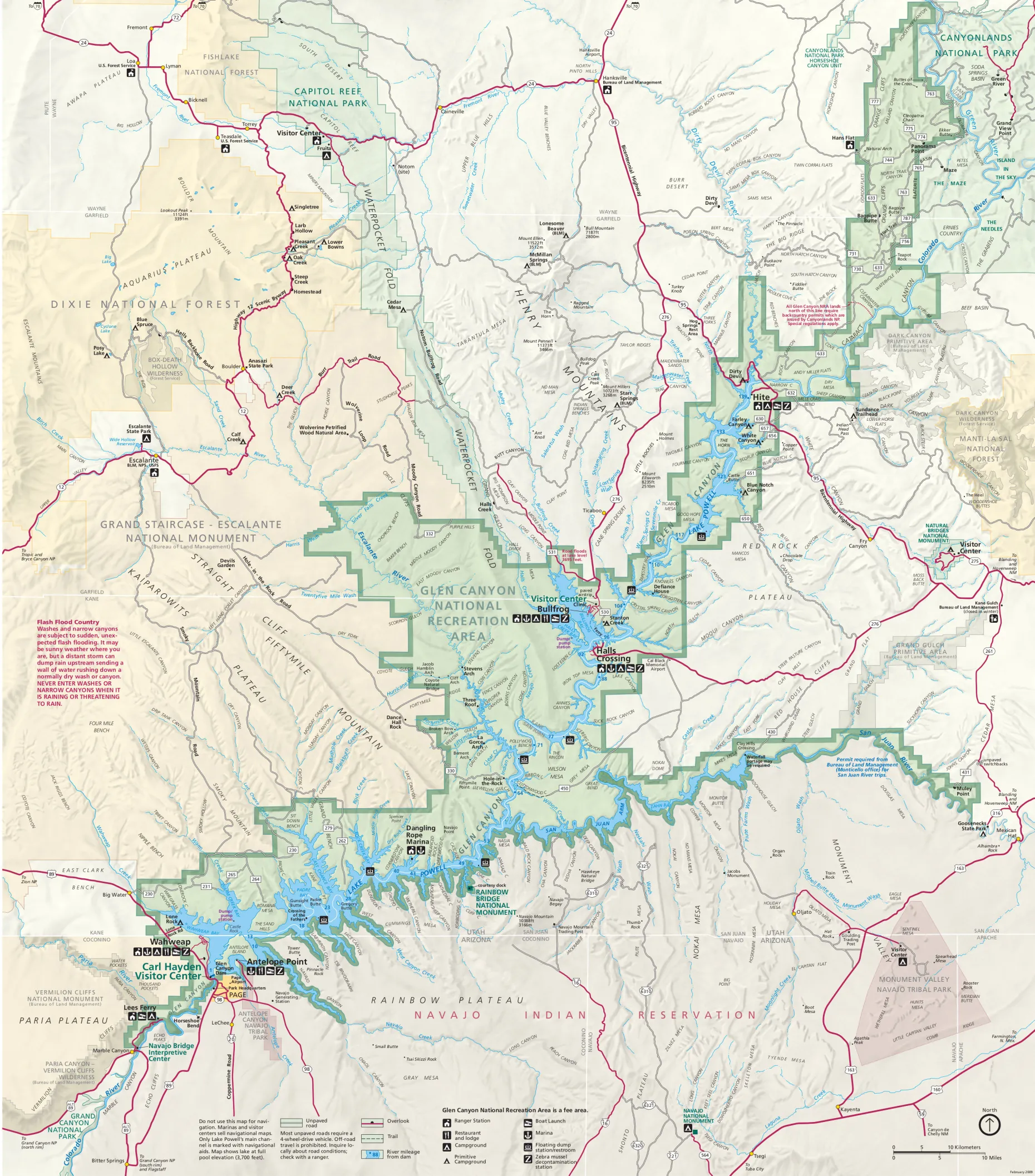
A map of Glen Canyon National Recreation Area produced by the U.S. National Park Service. The map shows the shoreline of Lake Powell as it was when it was full — the water level is now more than 170 feet lower. Click image to enlarge map. (National Park Service via Wikimedia Commons)
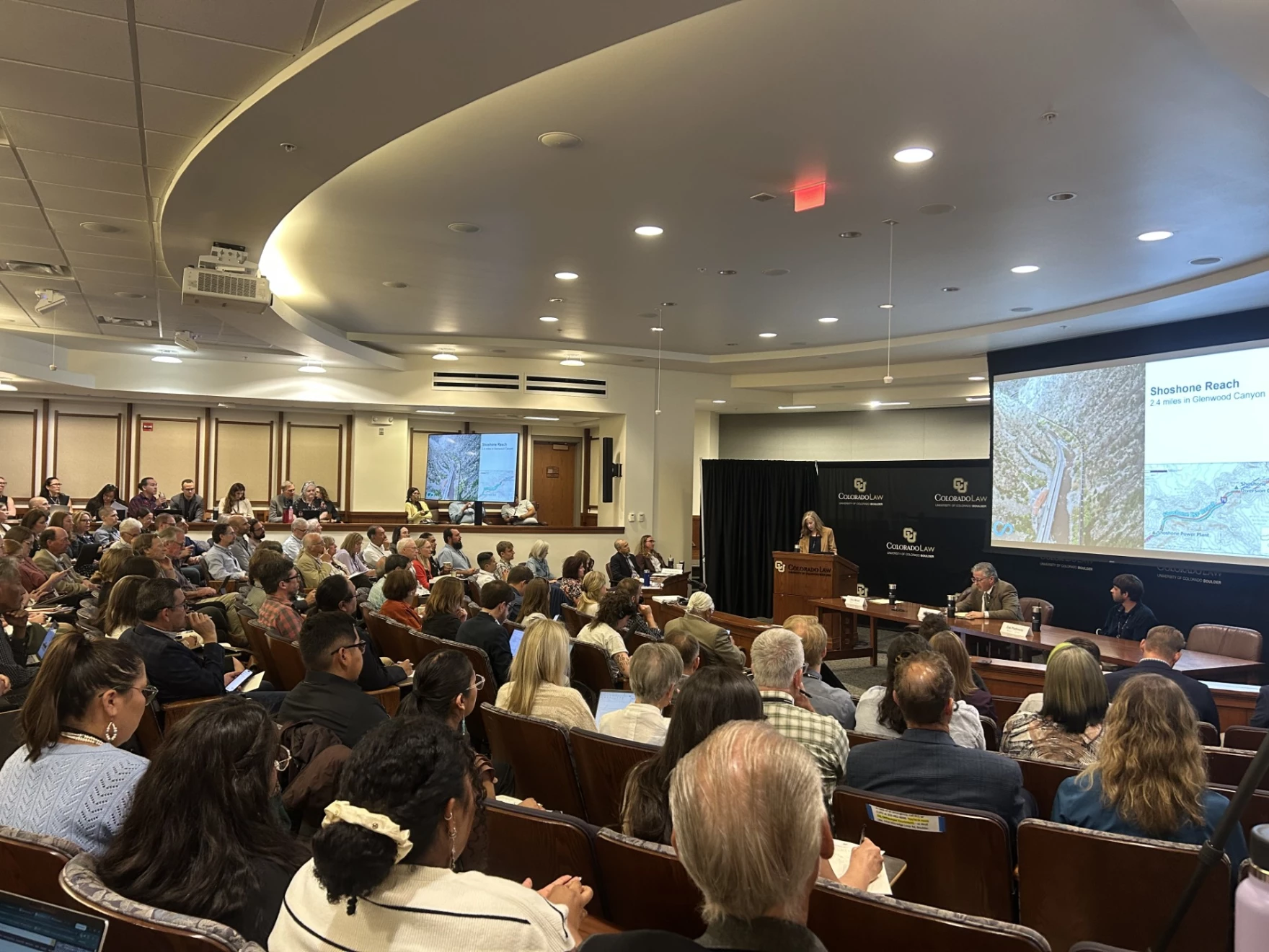
A large crowd listens to a presentation at the University of Colorado Boulder law school about securing powerful new water rights on Colorado’s West Slope to benefit the health of the Colorado River. Scott Franz/KUNC
June 5, 2026
This story is part of ongoing coverage of the Colorado River, produced by KUNC in Colorado and supported by the Walton Family Foundation. KUNC is solely responsible for its editorial coverage.
Water negotiators, river enthusiasts, Native tribes and lots of lawyers convened at the University of Colorado Law School on Thursday to take stock of the future of the dwindling Colorado River.
Here are five things KUNC’s water and environment reporter learned on the first day of the gathering.
There’s a thirst for treating the river as more than something to be consumed, and monetized and stretched out
Dale Sinquah, a tribal council member for Arizona’s Hopi tribe, is among a growing number of people who view the Colorado as a living being that should have the same rights as a person.
“If you look at it at that level and you allow it to, then it starts changing the ways in which you think about it, and maybe your actions,” he said.
Late last year, the Colorado River Indian Tribes of Arizona and California voted to give their namesake waterway the same legal rights as a person, saying the ‘living being’ deserves more protection while it’s being threatened by overuse and drought.
Sinquah said he had mixed reviews of the discussions at the water conference halfway through the first day.
“I’m kind of wondering if we’re stuck in that mode where you know personal interest (is winning) instead of how do we fix this as a whole, as a group,” he said. “It works better when you work together as a group.”
There’s still no finalized federal plan for the river yet, and the White House could have the final say…
Scott Cameron, the acting commissioner of the Bureau of Reclamation overseeing the operations of Lake Powell and Lake Mead, said the Interior Department is expecting to publish a short term operating plan for the reservoirs by “mid-summer.”
He said the plan would have to be renegotiated every two years and could be replaced at any time with one that the seven states can agree on.
“The good news is that the White House is very interested in what’s going on with the Colorado, so we’ll probably have to brief the White House on the (Secretary of the Interior’s) decision before it’s final,” Cameron said.
U.S. Interior Secretary Doug Burgum, center, speaks during a gathering with governors from six states in the Colorado River basin on Friday, Jan. 30, 2026. Photo credit: Lowell Whitman/Department Of Interior
River negotiations are ongoing, but details are scarce…
First governors from all seven states in the river basin were summoned to Washington, DC, ahead of the Feb. 14 deal deadline they missed.
Then, after that didn’t work, came the Microsoft Teams meeting.
Scott Cameron, the acting commissioner of the Bureau of Reclamation, said Interior Secretary Doug Burgum recently talked with the seven governors again on the virtual meeting platform.
“The fact that he is trying to wrangle his gubernatorial colleagues twice, I think, indicates how seriously Secretary Burgum takes what’s happening in the Colorado River,” Cameron said.
However, no deal has yet to materialize as the states remain at an impasse, and some in the upper basin have called for a different mediator to intervene.
June 1, 2026 seasonal water supply forecast summary.
One thing is clear.
Forecasts for the river have gotten worse in recent months. And there was an acknowledgement that the status quo is not sustainable.
Graphic via Holly McClelland/High Country News.
Could the feds get more involved in the management of upper basin reservoirs like Flaming Gorge? The answer is murky…
The audience asked Cameron, the Bureau of Reclamation official, about his thinking on how Interior should manage four large reservoirs in the upper basin that are collectively known as the upper initial units (they include Flaming Gorge on the Wyoming-Utah border).
Flaming Gorge is currently being partially drained so water can be sent down to Lake Powell so it doesn’t get so low that it stops producing hydropower.
Cameron said the Interior Secretary could exert more control over the reservoirs in the future in the event of an “emergency.”
“And what an emergency is, I think, is probably in the eyes of the beholder,” he said. “Now, you put four or five lawyers in a room. You’ll probably get nine answers on how much discretion the secretary has or doesn’t have in the upper initial units.”
Parts of the lake that have only recently been uncovered are full of old beer cans and other relics of boating escapades, including sunken boats.
But deeper down, Podmore shared photos of Native artifacts that have survived decades of being submerged.
New ecosystems are also taking shape.
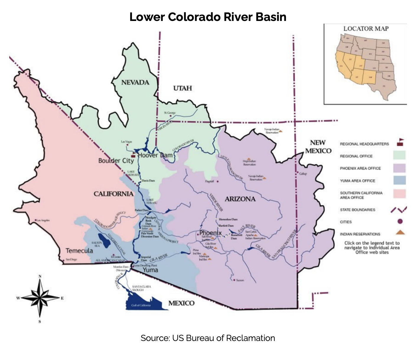
The Colorado River Basin spans seven U.S. states and part of Mexico. Lake Powell, upstream from the Grand Canyon, and Lake Mead, near Las Vegas, are the two principal reservoirs in the Colorado River water-supply system. (Bureau of Reclamation)
Doug Kenney at the Getches-Wilkinson Center 2026 Conference on the Colorado River June 5, 2026. Photo credit: Allen Best
Click the link to read the article on the Big Pivots website (Allen Best):
June 7, 2026
Doug Kenney, principal organizer of annual gathering in Boulder, talks about how the growing tensions among basin states pose challenges in setting the agenda
The Colorado River has always had a magnetic appeal to the public consciousness. John Wesley Powell and his crew were instant national heroes after they emerged from the Grand Canyon in 1869.
That interest continues to this day. Bathtub rings are an absorbing visual, an easy way to communicate declines in the two biggest reservoirs in the basin, Mead and Powell. The river is being hammered by a warming climate and archaic governance of the shared resource.
This provides much to chew on, and that discussion continued again on June 4-5 at the Colorado River Conference hosted by the Getches-Wilkinson Center at the University of Colorado Law School. Organizers reported 373 people were registered to attend in person and another 132 remotely, a record for both. This surpasses a record set last year.
Afterward, Big Pivots sat down with Doug Kenney, the principal organizer of the conference, to take stock of what had just transpired. He directs the Western Water Policy Program and chairs the Colorado River Research Group.
What year did this conference begin? What was the thinking that gave birth to it?
I believe 1983 was the first one. This was mostly a creation of Larry MacDonnell, (the first director of the Natural Resources Law Center, a position he held from 1983 to 1994).
Larry pursued a dual mandate of researching key issues but also of trying to involve the public and other constituencies. A conference was a natural thing to do. We are an educational institution.
I’ve done the last 30 or so of them, but Larry got it started,
It seems like two or three, maybe three years ago, the tribes became a major presence in attendance and on the agenda. How did this come about?
Mostly through our professional networks. We knew people who were associated with the (Colorado River Basin) Water and Tribes Initiative. They wanted to broaden their reach and their influence. At the same time, we’ve here always wanted to involve tribal interests in what we do, going back to the work of David Getches and Charles Wilkinson.
We decided we’d try co-hosting a conference. It’s a partnership, and like all partnerships, it grows over time. But it’s working pretty well, I think.
Am I wrong? Was I missing something? I didn’t notice much of tribal presence in the agenda or participation until just a few years ago.
We’d usually maybe have one tribal speaker sprinkled in the program somewhere, but it was pretty hit and miss, in part I think because you kind of need a critical mass of involvement from the tribal community for other tribes to feel like this is a place that they’d be taken seriously and that they’d be welcomed. It wasn’t a slow linear growth to where we’re at today. There was a pretty dramatic shift four or five years ago.
How new is the Water Tribal Initiative?
They’ve been around I think for about a decade. They’re co-managed by Matt McKinney, who wasn’t here, and Daryl Vigil.
Native America in the Colorado River Basin. Credit: USBR
It’s not a national thing, but the Colorado Basin has 30 different tribes. That’s a pretty big number of tribes to keep track of. It’s a network as much as it is anything, and every so often they try to get together. They consider this conference their big convening. They also get to get together at CRWUA (Colorado River Water Users Association, which holds an annual conference during December in Las Vegas).
They have also produced a few research reports. This week they talked about their report on tribal sovereignty. And they have particular initiatives within the Water and Tribes Initiative, such as universal access to clean water. They are pushing, mostly through federal legislation, to provide assurances that all tribes have access to clean water.
Do they have a strong benefactor?
I don’t think so, but they have a very broad base of funders and supporters. A lot of water agencies, a lot of people, and a lot of organizations that know tribes have been treated poorly and that tribes have legitimate interests in the basin but (know) that many tribes just don’t have the resources to do this without some assistance.
As I’ve attended most years since 2002, I have noticed some ebbs and flows. There were some empty seats this afternoon, but the seats were mostly occupied through the first day and a half, and that’s somewhat different than, say, 10 years ago. What explains the ebb and flow?
I attribute that mostly to two things: one is this partnership with the Water and Tribes Initiative. The other thing is the fact that we’re talking about the Colorado River, which by every measure is in a crisis. It’s easier to get people’s attention when you’re talking about a crisis than when you’re talking about something that’s still not that serious. That’s part of it.
We used to be in another building. This is clearly a better facility for audience and speakers alike. That helps us attract a larger audience. We’ve had good foundation support, good funders. It takes a lot of money to do this, but we’ve had funders that see value in it. That has allowed us to make this a bigger event.
The conference is always the first week of June, so when do you begin rough-drafting the agenda?
Usually January. In some years it’s easier than others. This year was the most difficult. It was the easiest year in terms of attracting an audience. The hardest year in terms of putting the program together.
Everyone’s mad at each other, and everyone is — I can’t tell you all the back stories. Becky Mitchell said something today about how it’s hard to negotiate and prepare for litigation at the same time. She’s right. And I was thinking to myself, it’s hard to bring people together to talk at a conference while acknowledging the fact that they’re all mad at each other, and some of them are about to sue each other, and some can’t be in the same room with each other because they’re that angry, and some will be deeply offended if someone else is there.
It’s one of these years that there’s just so many delicate issues and angry folks — and angry for legitimate reasons; I’m not discounting that. But it’s been a really challenging year.
Your answer anticipates my next question, but I’ll ask it nonetheless. If memory serves me, a few years ago you had representatives of all seven basin states at the same table. This year you had two. I guess it’s fair to say that agenda setting has become more politically sensitive.
Every year for the last four or five years we’ve given all seven principals, all seven states, an opportunity to sit at the same table and have a discussion. In every passing year it becomes more difficult to do that.
Commissioner to the Upper Colorado River Commission Becky Mitchell, center, speaks on a panel with representatives of each of the seven basin states at the annual Colorado River Water Users Association conference in Las Vegas Thursday, December 15, 2022. CREDIT: HEATHER SACKETT/ASPEN JOURNALISM
You have seen this at CRWUA as well. Some years they had to divide into two sessions, upper and lower basin sessions. For awhile we were thinking of just having a lower basin session. The lower basin folks were happy to do that, but the upper basin folks weren’t as comfortable. We (also) thought about a different part of the session or a different location.
Ultimately we came to the conclusion that everyone could agree if it would be a conversation, not a posturing or confrontational thing. (Having) one upper basin person and one lower basin person, that was a format that could work. That’s what we did (with Becky Mitchell from Colorado and John Entsminger of Nevada). Anything more elaborate than that I don’t think was viable this year. It’s a really delicate time.
In terms of conferences devoted to the Colorado River do you have rivals for what you’re doing? Are there other places in Arizona or California, for example, that are kind of like must-go sessions?
There are two must-attend Colorado River conferences each year, and this is one of them. CRWUA (in Las Vegas) is the other one.
We specifically try to be different than CRWUA. We’re the opposite end of the calendar, roughly six months away. CRWUA is in many respects much more of a social event. We try to be more academic and about policy, with serious talk about serious issues. CRWUA, just like us, ebbs and flows from year to year in terms of what it looks like. But we try to be a little more hard-hitting and less of a, you know, take-the-family-and-have-a-vacation sort of event. I don’t mean to sound like I’m negative on CRWUA. I think we’re the perfect compliment.
Aside from that, there are some meetings such as CLE, Continuing Legal Education. It always has a Colorado River event. This year was quite good. Many other years, it’s not as strong. For practicing attorneys, that’s something that they want to go to every year, because they can get some credits there.
Still another one in New Mexico that’s held each year kind of commemorates the signing of the compact.
How do you measure success? I’m sure you constantly ask that question of yourself.
You understand the challenge of it all. We can measure success by the size of the crowd and that they mostly seemed to have a good time. In that sense, that’s success.
The other side of that is that we’ve been focused just on the Colorado River issues for the last five or six of these, and things have only gotten worse on the river. Obviously, we don’t think we’re to blame for that. But clearly, there’s no great success story that we can lay credit to either.
So I think we’re successful in that we promote conversation and the exchange of ideas, and we shine a light on new and innovative ideas, and we give a voice to people who sometimes don’t have a voice. This is where the tribes come into play again.
Some elements I think are successful, but in the very big scope of things, the issues that we’ve been addressing in our conference aren’t getting any better. It does force me to think about (and question) whether there is a better way for us to make a difference. I don’t know what that would be, but I do think about that a lot.
Map of the Colorado River drainage basin, created using USGS data. By Shannon1 Creative Commons Attribution-Share Alike 4.0
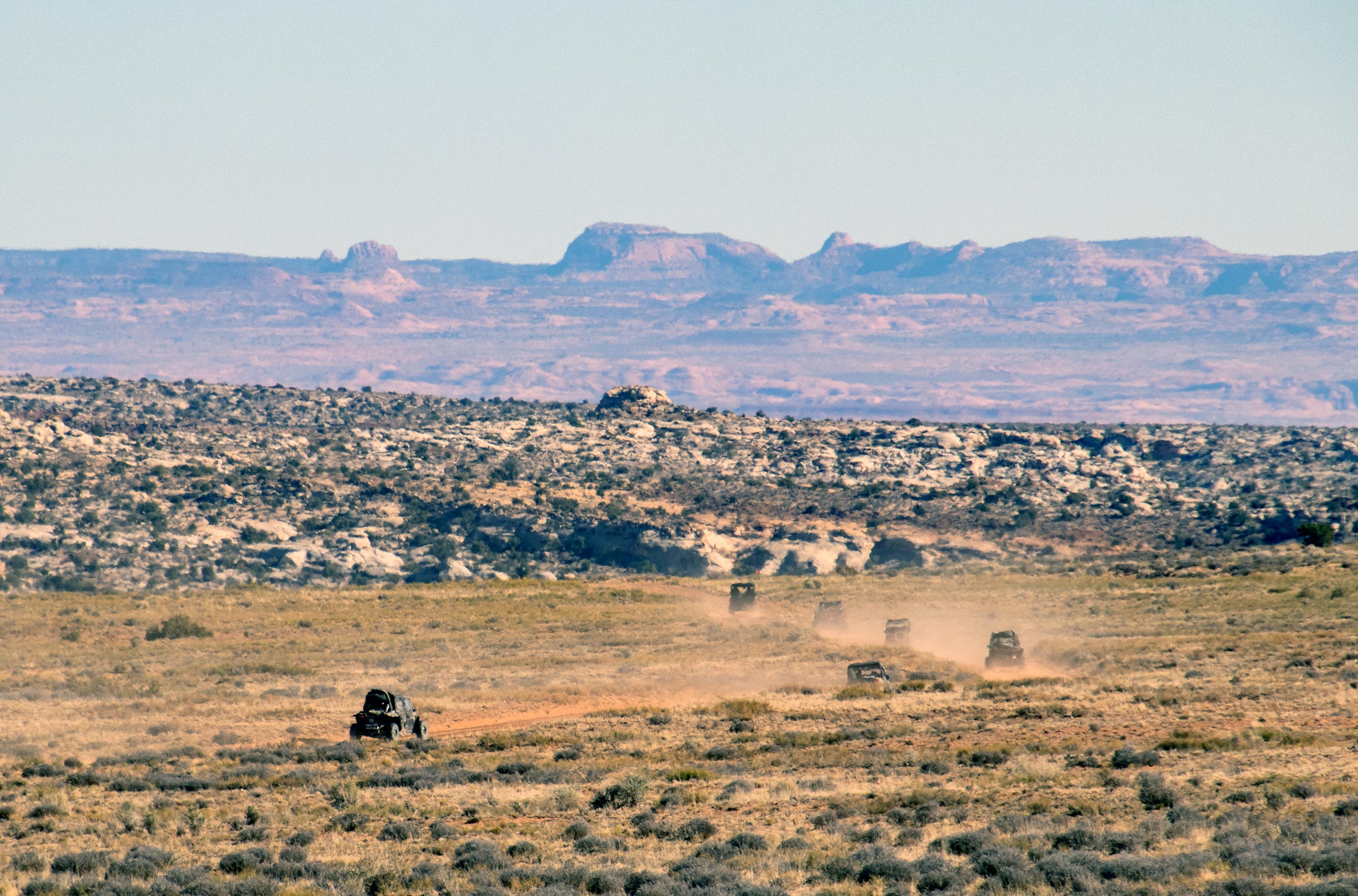
The Trump administration is attacking public lands again, this time in an apparent effort to open more special places to off-road vehicles. Late last Friday, Trump issued an executive order revoking a Nixon-era policy aimed at ensuring “that the use of off-road vehicles on public lands will be controlled and directed so as to protect the resources of those lands, to promote the safety of all users of those lands, and to minimize conflicts among the various uses of those lands.”
No, this does not mean unfettered swarms of ATVs will be kicking up dust on your favorite public lands next week. But it does bolster the off-road vehicle lobby’s effort to open up motorized access to federal lands, and takes away one of the long-term planning tools used by land management agencies to protect those places from off-road vehicle use and abuse.
In the nearer-term, Trump’s order could end or diminish the ban on OHVs in national parks, allowing the vehicles to travel backroads in, say, Capitol Reef National Park. This might not sound so bad: If a three-ton SUV can drive there, why not let a smaller side-by-side or four-wheeler on the same road?
The answer lies in the nature of the newer OHVs, namely “side-by-sides” or razors, which more closely resemble souped-up dune buggies than conventional SUVs. While some people use OHVs as mere modes of transportation, the vehicles are more commonly treated and utilized like recreational playthings — very powerful, fast, and noisy toys that tend to travel in herds. They therefore bring their own type of impacts.
Alpine Loop Backcountry Scenic Byway near Lake City, Ouray, Powderhorn, Ridgway, Silverton Credit: ColoradoDirectory.com
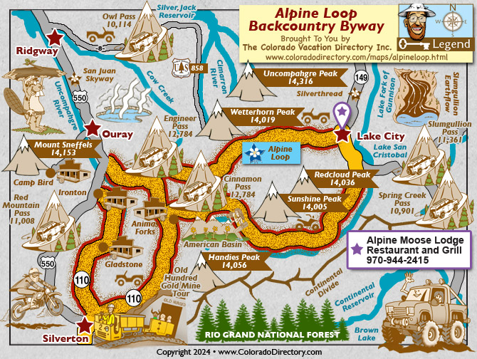
Anyone who has traveled on or hiked around the Alpine Loop in the San Juan Mountains of southwestern Colorado on a busy summer day has likely experienced these particular impacts first-hand. Those roads were first opened up to OHVs in the early 2000s. Since then Alpine Loop traffic numbers have exploded, with at least half of the motorized traffic made up of OHVs.
Law enforcement officers now spend a disproportionate amount of time and energy trying to keep the OHV drivers on designated routes and in compliance with traffic laws. OHV crashes, often resulting in serious injury, are not uncommon. And each summer several riders surrender to the temptation to illegally leave the road — these are off-road vehicles, after all — and rip across the tundra, causing irreversible damage. Unlike regular vehicles, OHVs tend to travel in herds, spewing exhaust and kicking up dust, their collective buzzing reaching far beyond the roads on which they travel. It has become almost impossible during the high season to completely escape the incessant din of OHVs on the Alpine Loop, even in wilderness study areas.
This same phenomenon could now be coming to a national park near you.
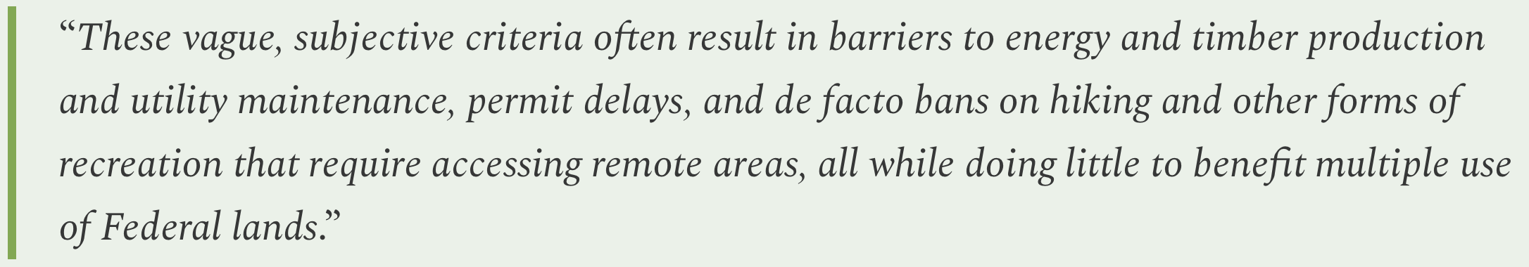
The administration claims it eliminated the policy because it was outdated, vague, and redundant, because Congress has since passed a host of other laws protecting public lands from OHVs and other uses. The order goes on to say:
This makes very little sense. Sure, the restrictions on OHVs could hamper energy or timber development if it required destructive off-road vehicle use, but you’re not going to haul a drill rig into the backcountry on a side-by-side. And the idea that a hiker might feel “banned” from a trail because they couldn’t ride get there on an OHV is just silly.
The dubious statement reeks of the rhetoric of the crowd that claims that motorized vehicle restrictions are locking folks out of public lands, and therefore are discriminating against the type of people who drive these vehicles. But the discrimination claim simply does not fly. Mountain bikes are banned from wilderness areas, from a majority of trails in national parks, from some trails on BLM land, and are not allowed to ride off-trail on all federal land. This has nothing to do with the people who ride the bikes, or even the funny clothes they tend to wear, and everything to do with the vehicles’ potential impacts.
Trump probably did this at the behest of the Blue Ribbon Coalition and the likes of Sen. Mike Lee, who has pushed legislation that would open up national parks to OHVs. Maybe he’s trying to garner support from somewhere, given his terrible favorability ratings. Or perhaps he’s trying to appease the motorized crowd, which is probably a bit miffed that their drug of choice — gasoline — is so damned expensive thanks to Donny’s dumb war. Maybe he’s even trying to increase national park entry fee revenues so he can funnel it to his ballroom/drone-port or his White House UFC fight.
Near Hite with the Henry Mountains. Jonathan P. Thompson photo.
🐟 Colorado River Chronicles 💧
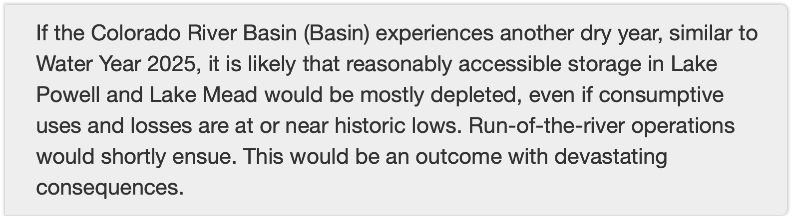
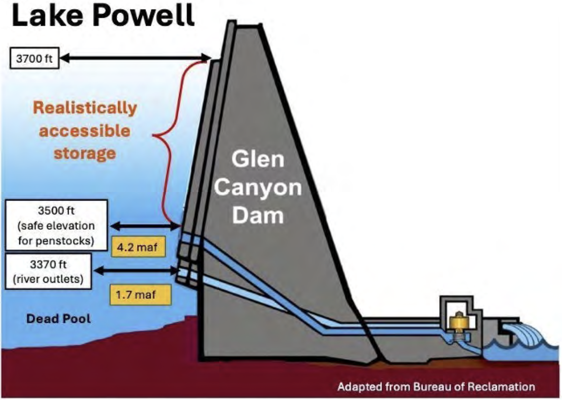
It pretty much goes without saying that if next winter is as bad as this past winter, in terms of mountain snowpack, then the collective users of the Colorado River and its infrastructure will be toast — at least figuratively (maybe literally, too?). Now, my favorite team of Colorado River wonks1 [Anne Castle, Jack Schmidt, Eric Kuhn, Kathryn Sorensen, Katherine Tara] have crunched the latest water numbers, and they’ve found that even a nearly “normal” winter won’t stop depletion of “reasonably accessible storage in Lake Powell and Lake Mead, leading to “devastating consequences.”
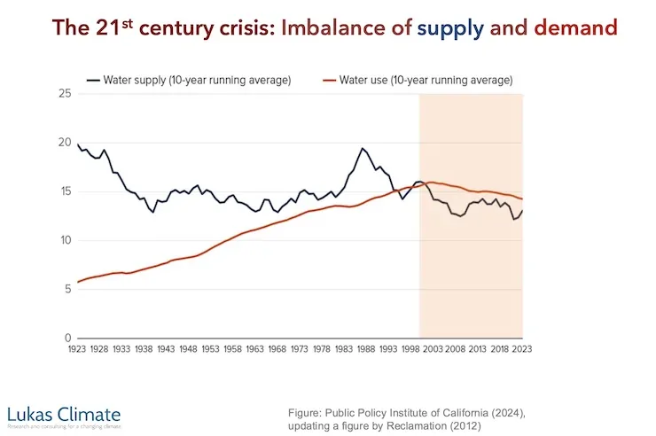
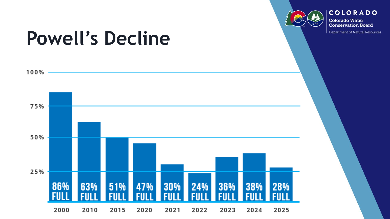
Back in 1999, the Colorado River’s storage system, which consists of Lake Powell, Lake Mead, and several other smaller reservoirs in the Upper and Lower basins, was almost full, holding about 60 million acre-feet of active, or available, storage. This provided a robust savings account that could be tapped during the inevitable dry spells on the notoriously fluctuating river system.
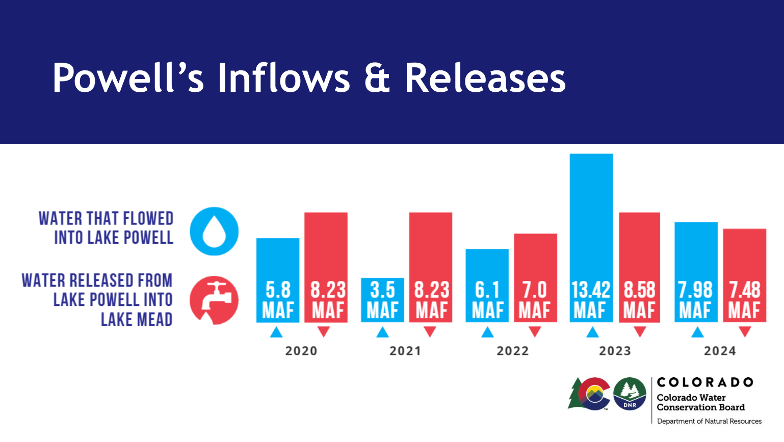
The reserve, however, was not adequate for the megadrought — or long-term aridification — that started in 2000 and continues today. Instead of following the usual up-down cycle, the Colorado River’s flows began a downward trend that is on track to hit its lowest point so far this water year, while consumptive use stayed more or less steady. Demand exceeded supply more years than not, drawing the savings account down significantly. That has forced the Bureau of Reclamation to take extraordinary measures, such as reducing downstream releases and tapping upstream reservoirs, to keep Lake Powell’s surface level from dropping below 3,500 feet, or what I call de facto dead pool 2.
Thanks in part to extra releases from Flaming Gorge Reservoir in May, Lake Powell’s surface level climbed slightly to 3,528 feet last month. Given that spring runoff in the Upper Basin has peaked and most tributary flows are decreasing, we can expect that number to start dropping, perhaps precipitously, at least until the monsoon arrives.
The wonks wanted an idea of how things might play out in the slightly longer-term, so they modeled two scenarios:
In the first scenario, they assume that the Colorado River’s natural flow, or the estimated amount of water in the river without human consumption or interference, will be similar to water year 2025, when the mountain snowpack was below average but not nearly as slim as this year. They also assume that consumptive uses will remain at the lowest levels in recent years.
Natural flow: 8.5 MAF at Lees Ferry + .70 MAF from Grand Canyon and Virgin River = 9.20 MAF Consumptive use: 3.56 MAF Upper Basin (includes evaporation and other losses) + 8.23 MAF Lower Basin + Mexico (incl. evap and other losses) = 11.79 MAF Deficit and resulting reservoir drawdown: 2.59 MAF Realistically accessible storage (RAS) remaining in Mead, Powell, and Flaming Gorge: 3.63 MAF
For the second, they plug in snowpack/flow numbers similar to those from water year 2023, which was a huge winter. Consumptive use would be about the same as in 2023.
Under the first scenario, the BoR will almost certainly have to go to a run-of-the-river situation on Glen Canyon Dam to defend 3,500 feet. That would mean releases would be approximately equal to inflows minus evaporation and seepage from the reservoir, and might drop to 3,000 to 4,000 cubic feet per-second or even lower. In the summer of 2002 inflows at times dropped below 1,000 cfs. This would turn the river through the Grand Canyon into a relative trickle, and cause a significant drawdown of Lake Mead.
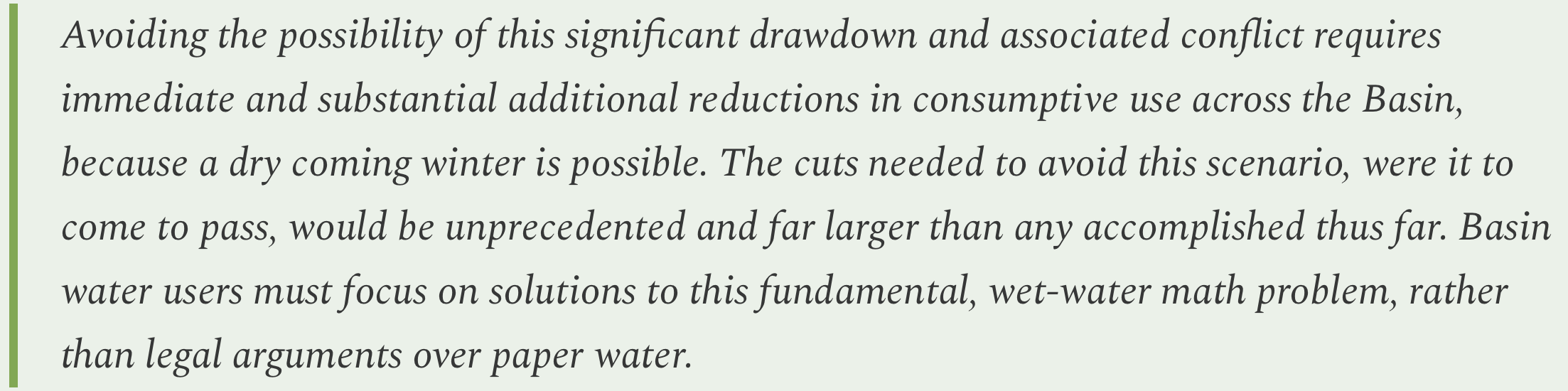
The second scenario would be far better, but is far from an enduring solution. At best it would buy a little time, perhaps enough for the feds to build bypass tunnels around Glen Canyon Dam to allow for sustained releases below 3,500 feet. If it were followed by another three or four 2023-like winters, then things would start to look pretty darned good.
But if it were followed by just one more dry year it would bring everything back to today’s rather dire situation.
Since there’s no way to bolster supplies, the only way out of this mess is to continue to slash demand. The paper’s authors write:
Oof.
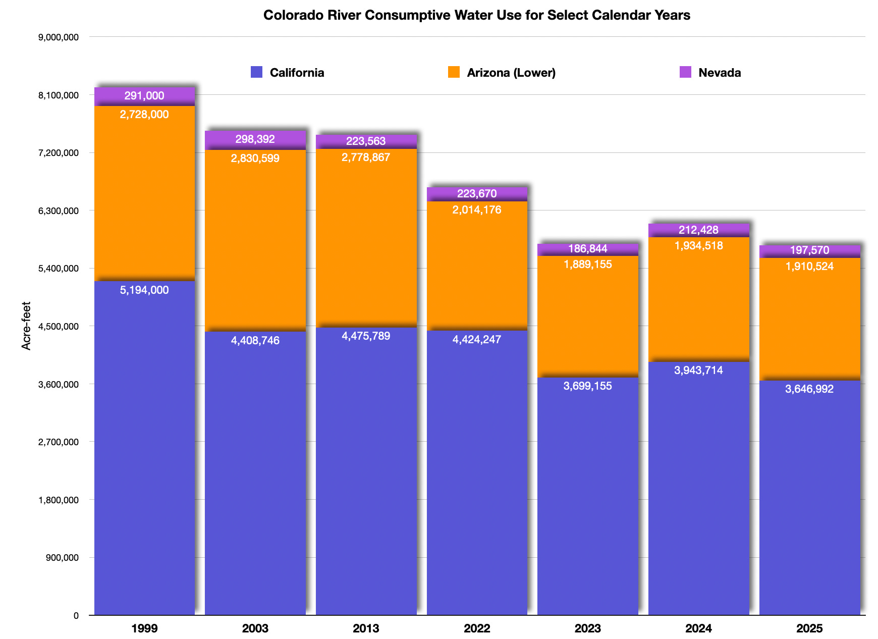
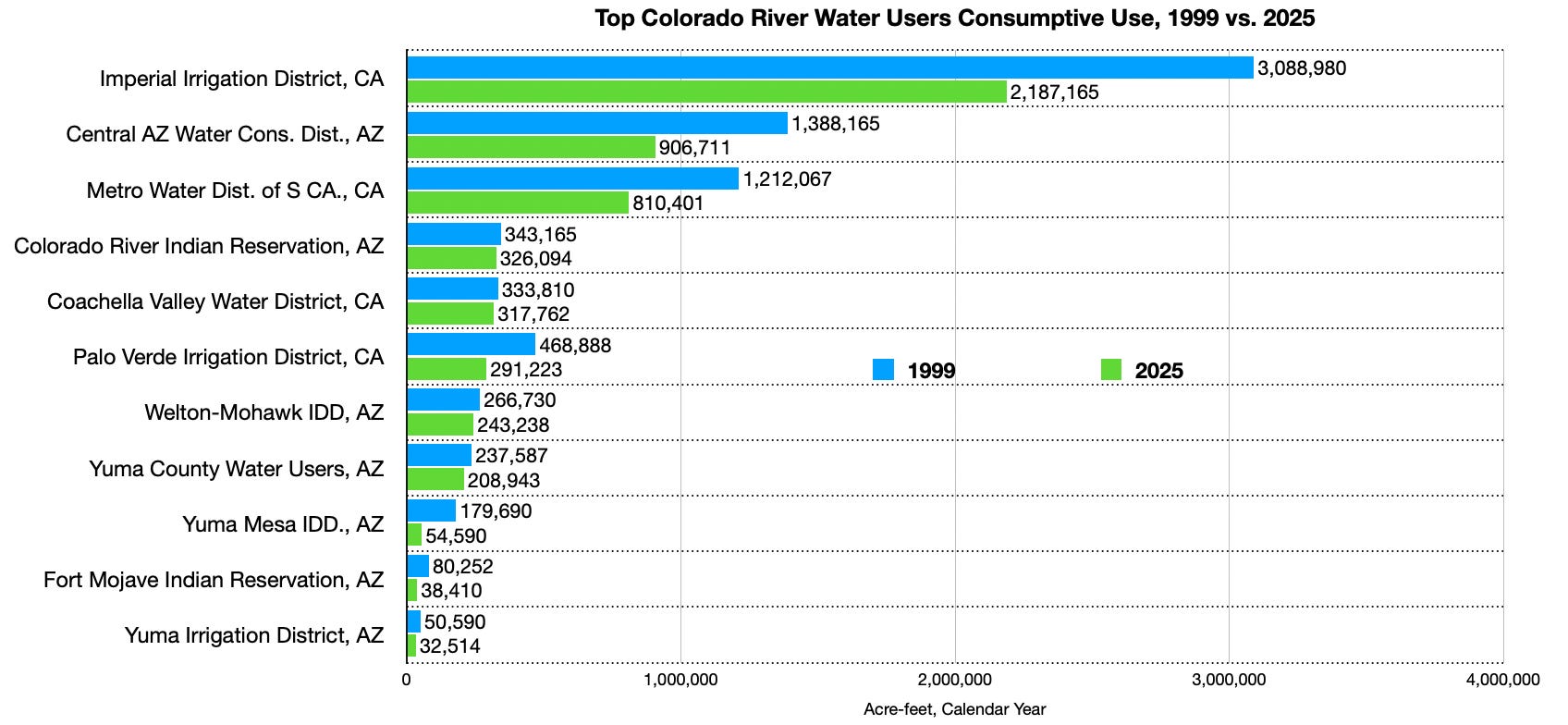
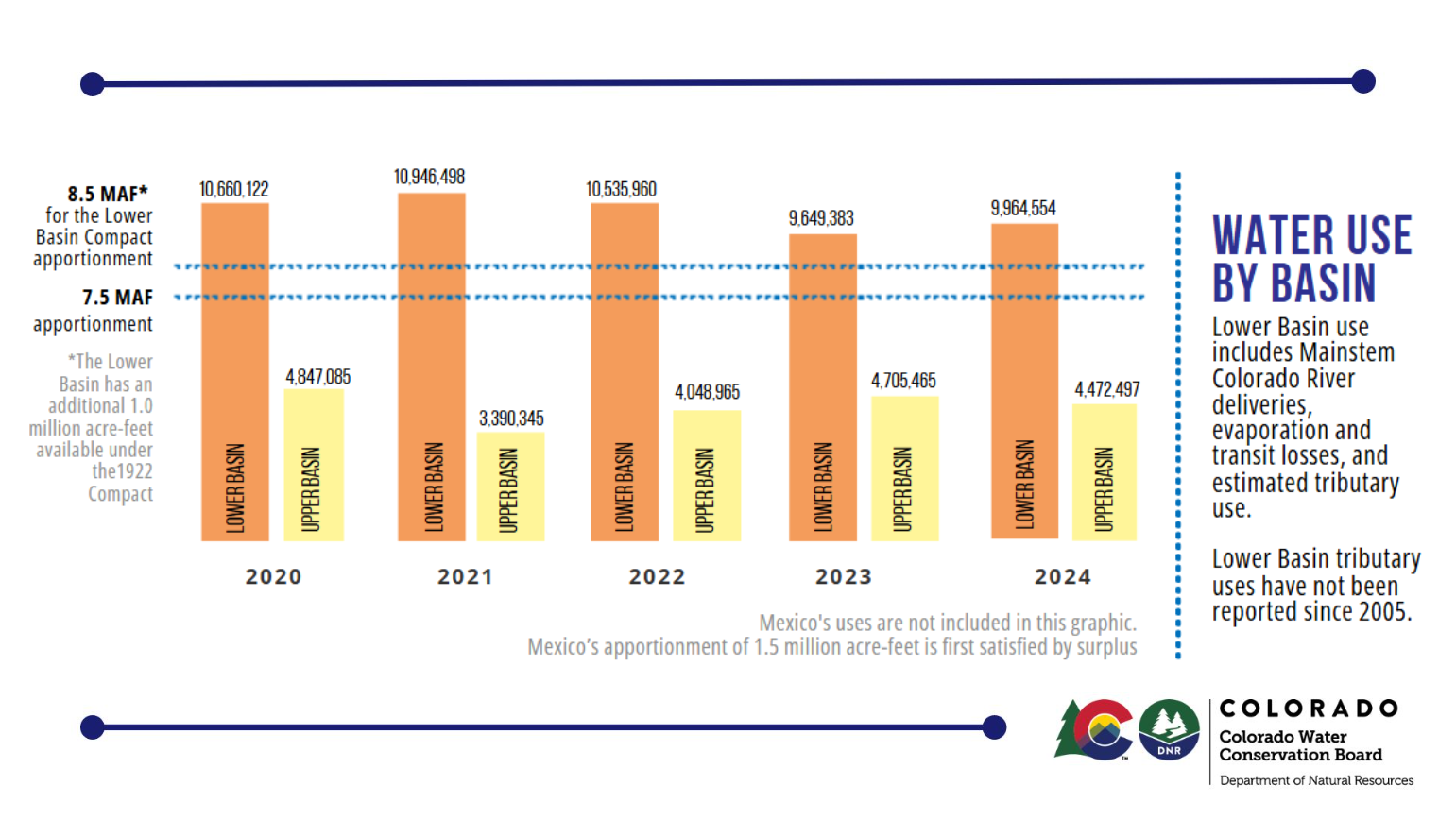
As long as we’re on the topic, the BoR recently released its Lower Basin accounting report for 2025, which tallies up consumptive uses in the basin. As you can see from the following graphs, which the Land Desk whipped up using the BoR data, the Lower Basin uses significantly less water now than it did in 1999, just before the current megadrought began. Upper Basin consumptive use figures for 2025 are not yet available. The following figures do not include reservoir evaporation, conveyance losses, or Mexico’s use.
All three Lower Basin states have substantially reduced Colorado River water consumption since 1999. However, more cuts will be needed if current climatic and streamflow trends continue. Data: USBR, Graphic: The Land Desk
🤖 Data Center Watch 👾
Has Enchant Energy finally found a raison d’être? The Farmington-based company was created in 2019 to try to save the San Juan coal-fired power plant from retirement by retrofitting it with carbon capture equipment. Enchant would then sell the carbon to oil producers in the Permian Basin, while also receiving generous federal tax credits. Basically they wanted to turn the power plant into a taxpayer subsidized carbon dioxide factory. It flopped for various reasons. Now the San Juan plant — and all of its pollution — are no more. We suspected Enchant Energy had met a similar fate.
But then I received a press release letting me know the not-so-up upstart is not dead, but has instead signed a letter of intent with Creekstone Energy to capture carbon from the tech firm’s proposed hyperscale Delta Gigasite data center in Delta, Utah. As is often the case, Creekstone touts all of the renewable energy it plans on building for its center, but the first phase will be powered by natural gas, which emits carbon dioxide.
Enchant hopes to capture the carbon from the gas plant and convert it into marketable fuel. The company has apparently given up on trying to give coal-burning a slightly more climate-friendly veneer (after all, Trump has declared coal to be “clean” and “beautiful”). Instead, it looks like they’re jumping on the data center bandwagon, along with wannabe nuclear reactor developers and the like.
Who knows, maybe this is the thing that finally gives Enchant some meaning. But we’re not holding our breath. After spending gobs of money on lobbying, pulling in some hefty federal grants, then failing spectacularly with the San Juan generating bid, Enchant partnered with another firm and tried to buy the Intermountain coal plant in Delta to use it to power its own data center. That didn’t work, either.
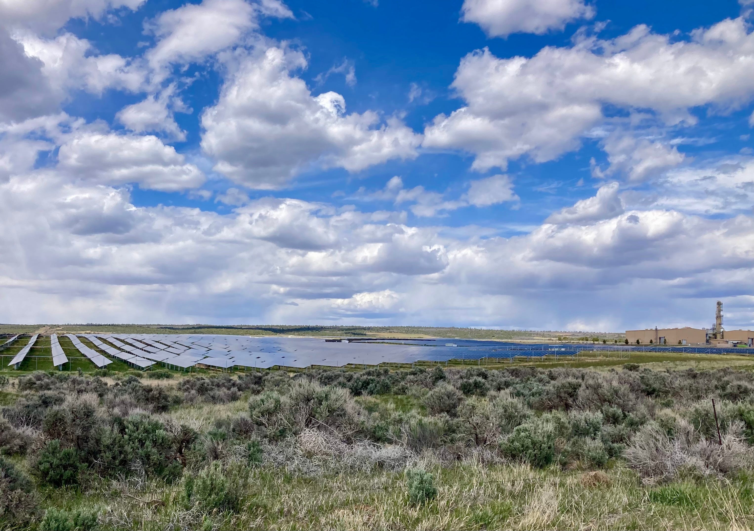
Dolores Canyon solar project outside of Cahone, Colorado, with Airproduct’s apparently defunct helium plant on the right. Jonathan P. Thompson photo.
🔋Notes from the Energy Transition 🔌
Yes, the energy transition may have run into some stumbling blocks, i.e. the Trump administration’s hatred for anything that might compete with coal and oil and gas, but it’s still quietly underway. For example, out by the aforementioned, defunct San Juan coal plant, DESRI recently broke ground on two utility-scale solar installations: the 170-megawatt Foxtail Flats solar-plus-battery storage array; and the 100-MW Four Mile Mesa solar-plus-storage project.
That’s some pretty serious generating capacity and adds to the existing San Juan solar facility nearby. Los Alamos County has signed on to purchase power from Foxtail Flats, and Meta will be drawing electricity Four Mile Mesa via PNM to power its data centers.
Both of the new facilities are under development on Ute Mountain Ute tribal land.
📸 Parting Shot 🎞️
In last week’s comments, ncoffey94 asked what kind of bike I ride. It’s a 2023 Niner RLT, with an aluminum frame, carbon fork, and SRAM Apex parts. It’s nothing fancy and isn’t super light. But I dig it for riding on the roads, dirt, and even singletrack. It’s got 40 mm tires, so isn’t so great in the sand, and with no suspension I don’t do big drops or super-cobbly stuff. But it sure is nice having just one bike for all uses.
Photo credit: Jonathan P. Thompson.
1Anne Castle, Jack Schmidt, Eric Kuhn, Kathryn Sorensen, and Katherine Tara.
2 Water can no longer be released through the penstocks and hydropower turbine below 3,500 feet, forcing dam operators to rely on the lower river outlets for all downstream water releases. Those outlets are not engineered for sustained, long-term use, however, and could be damaged. The feared scenario looks kind of like this: The penstocks are closed; the river outlets release water faster than reservoir inflows; the reservoir surface level drops down to, say, 3,450 feet; the river outlets get damaged so must be shut down altogether, trapping the remaining water behind the dam and halting all releases until the water climbs back up to 3,500 feet. This would effectively dry up the Grand Canyon and cause Lake Mead to start plummeting as well. Of course, no one wants this to happen, so BoR is doing all it can to defend 3,500 feet, making that level the effective dead pool, even though technically 3,370 feet (the river outlet elevation) is the actual dead pool.
Click the link to read the discussion on the CBRFC website:
The Colorado Basin River Forecast Center (CBRFC) geographic forecast area includes the Upper Colorado River Basin (UCRB), Lower Colorado River Basin (LCRB), and Eastern Great Basin (GB).
Water Supply Forecasts
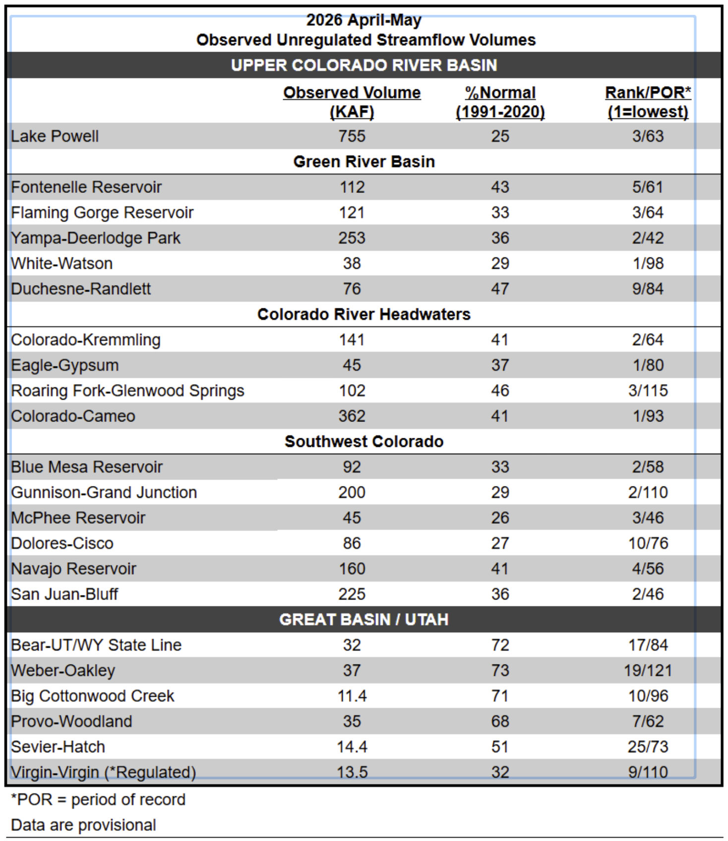
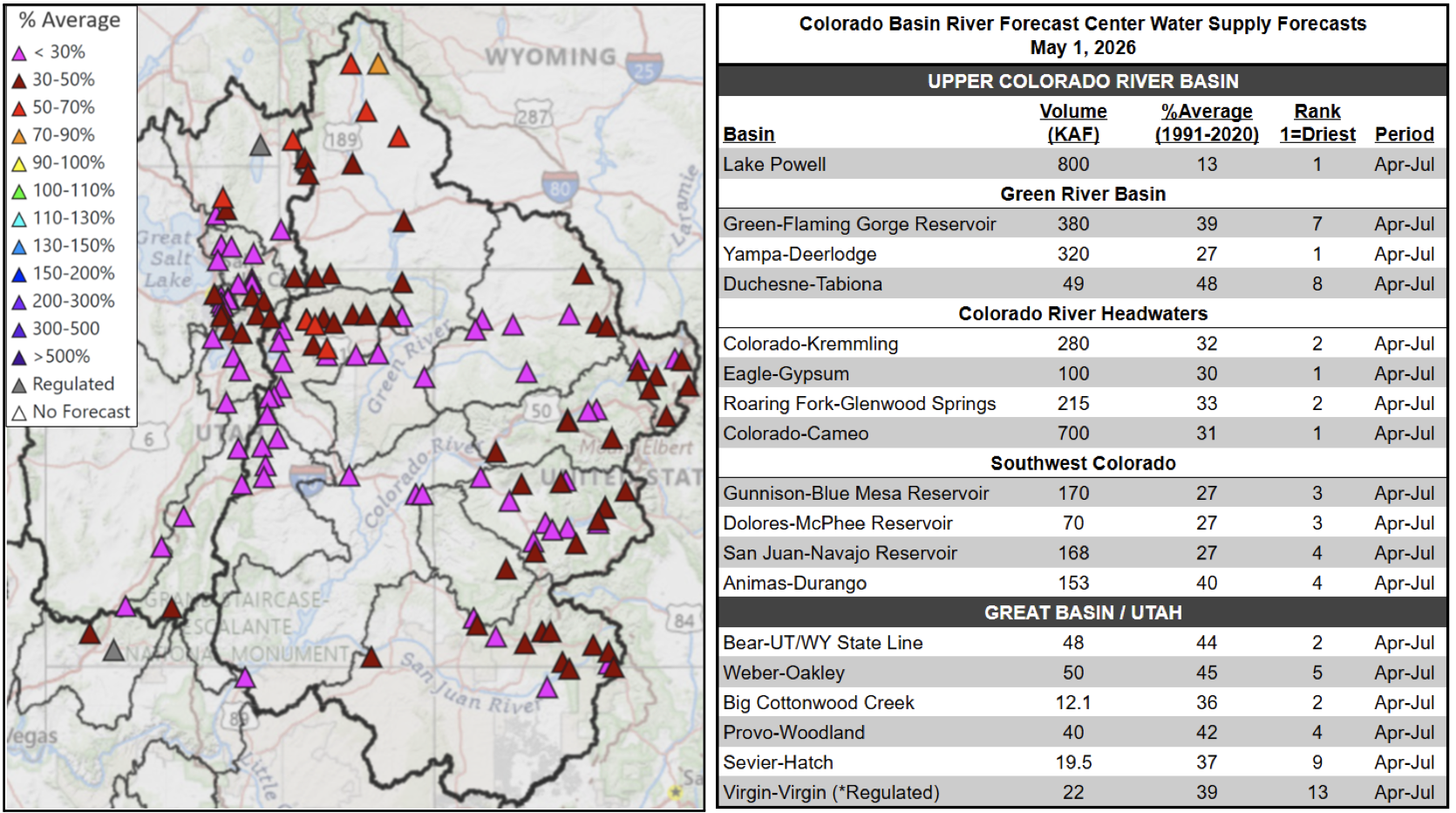
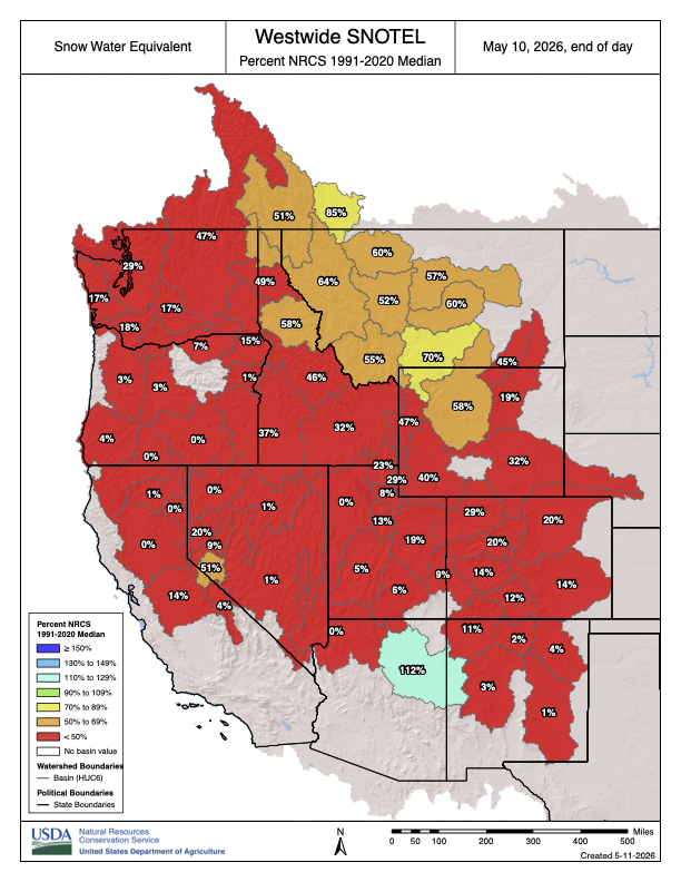
April-July volume forecasts are well below normal and rank in the driest five on record at many locations. Record low snowpack and poor soil moisture conditions are the primary hydrologic conditions impacting the water supply outlook, while future weather is a primary source of forecast uncertainty. June 1 water supply forecasts are summarized in the figure and table below.
June 1, 2026 seasonal water supply forecast summary.
Observed Streamflow (April-May)
Poor soil moisture and snowpack conditions have led to well below normal April-May observed unregulated streamflow volumes, which are summarized in the below table.
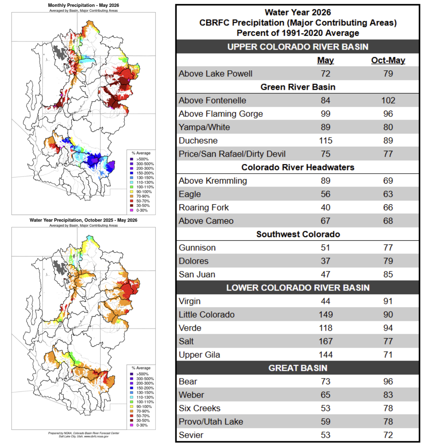
Much of the CBRFC area experienced its warmest and least snowy winter on record. Following this, an unprecedented heatwave in March initiated significant snowmelt in areas that would usually still be building a snowpack. April brought cooler and wetter weather, and May generally continued this trend, with temperatures remaining mostly near normal across the CBRFC area. Portions of the GB and UCRB experienced periods of snowfall accumulation through May, but above normal precipitation was limited to small areas within the Green River Basin and Colorado River headwaters. In the LCRB, central/eastern AZ into western NM ended the month with significantly above normal precipitation, but this is a function of the very dry climatology as most of the LCRB routinely receives near zero precipitation in the month of May.
Water year 2026 precipitation summary.
Snowpack Conditions
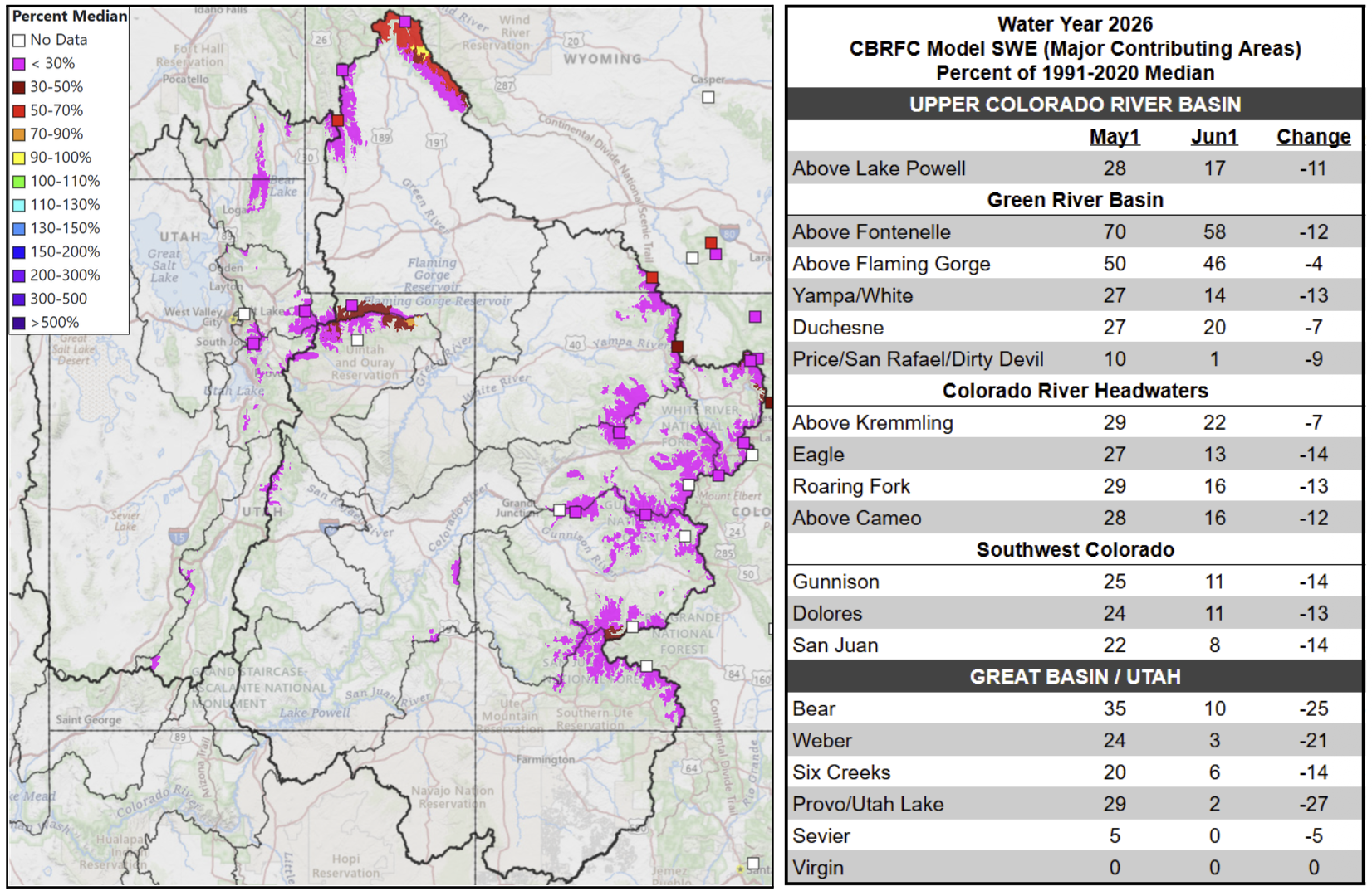
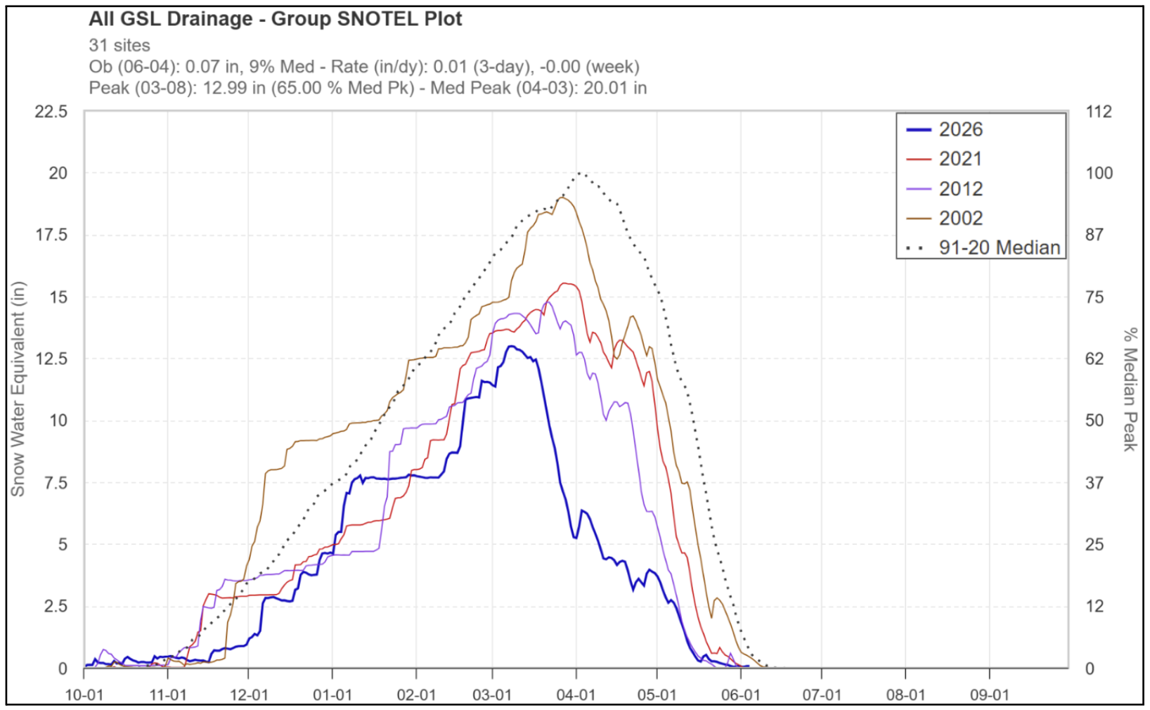
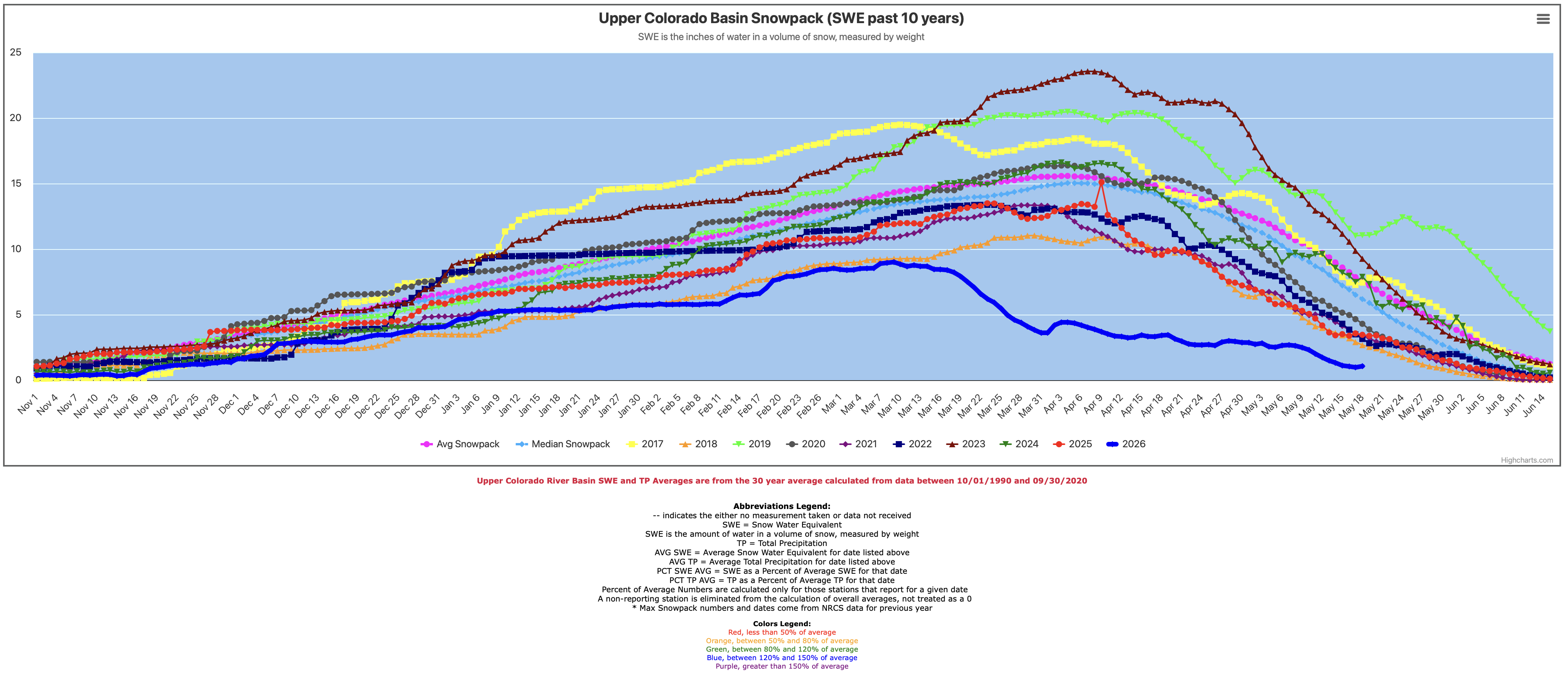
Snow water equivalent (SWE) has been at or below record low for most of the snow accumulation season. The significant heatwave during the last half of March led to historically low April 1 snow water equivalent conditions across the region. UCRB and GB SNOTEL SWE peaked around March 8, which is 3-4 weeks earlier than the 1991-2020 normal peak date. June 1 SWE across the UCRB and GB is generally less than 25% of normal, with more favorable conditions in the Upper Green River Basin. SWE conditions are summarized in the figures and table below.
Left: June 1, 2026 SWE – NRCS SNOTEL observed (squares) and CBRFC hydrologic model. Right: CBRFC hydrologic model SWE conditions summary.
UCRB SNOTEL SWE during historically dry winters: 2026, 2021, 2012, 2002.
GB SNOTEL SWE during historically dry winters: 2026, 2021, 2012, 2002.
Soil Moisture
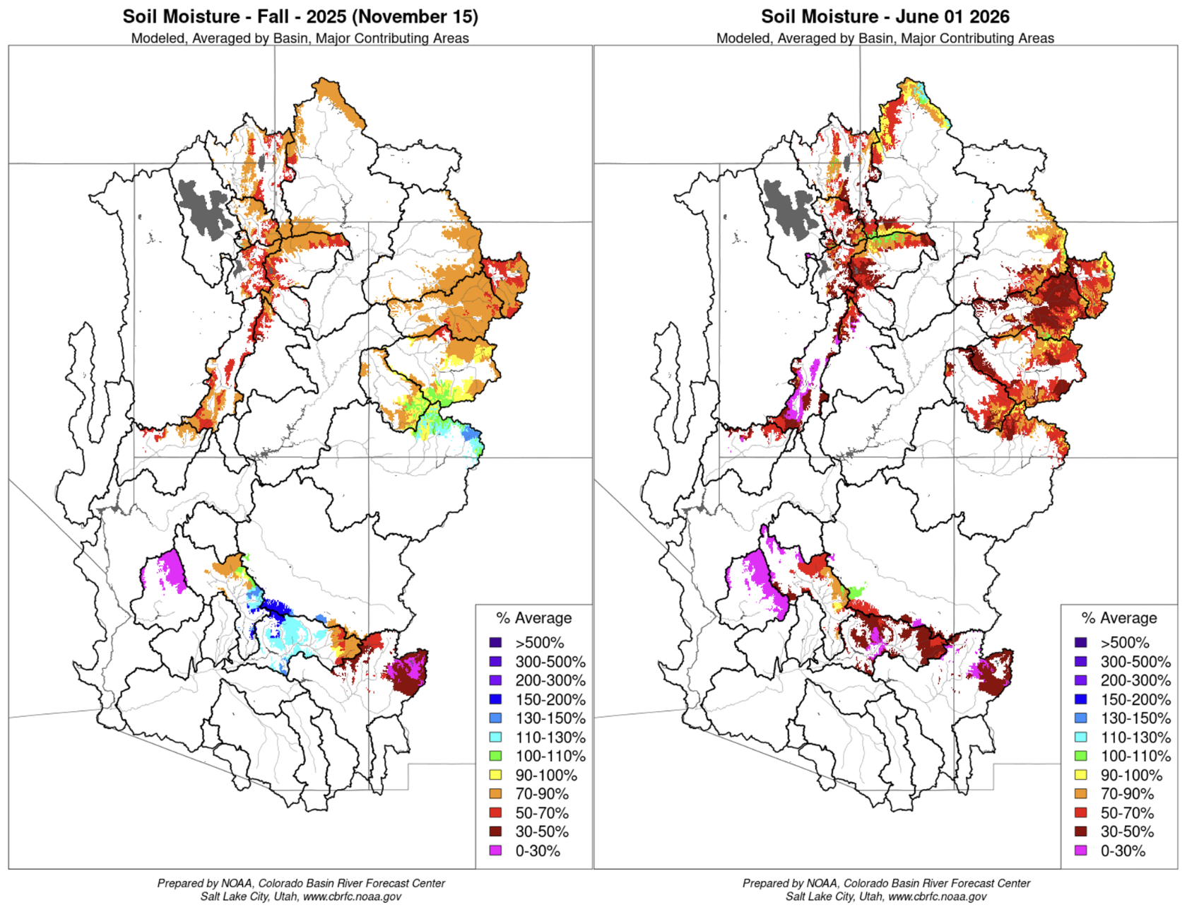
CBRFC hydrologic model soil moisture conditions impact water supply forecasts. Basins with above average soil moisture conditions can be expected to experience more efficient runoff from rainfall or snowmelt while basins with below average soil moisture conditions can be expected to have lower runoff efficiency until soil moisture deficits are fulfilled. The timing and magnitude of spring runoff is impacted by snowpack conditions, spring weather, and soil moisture conditions.
Mid-November 2025 soil moisture conditions were below average across most areas as a result of warmer and drier than normal weather during the 2025 water year. Early June soil moisture conditions are generally well below average across the region due to the lack of snow. CBRFC hydrologic model soil moisture conditions are shown in the figures below.
CBRFC hydrologic model soil moisture conditions as a percent of the 1991–2020 average – Mid-November 2025 (left) and early June 2026 (right).
Upcoming Weather
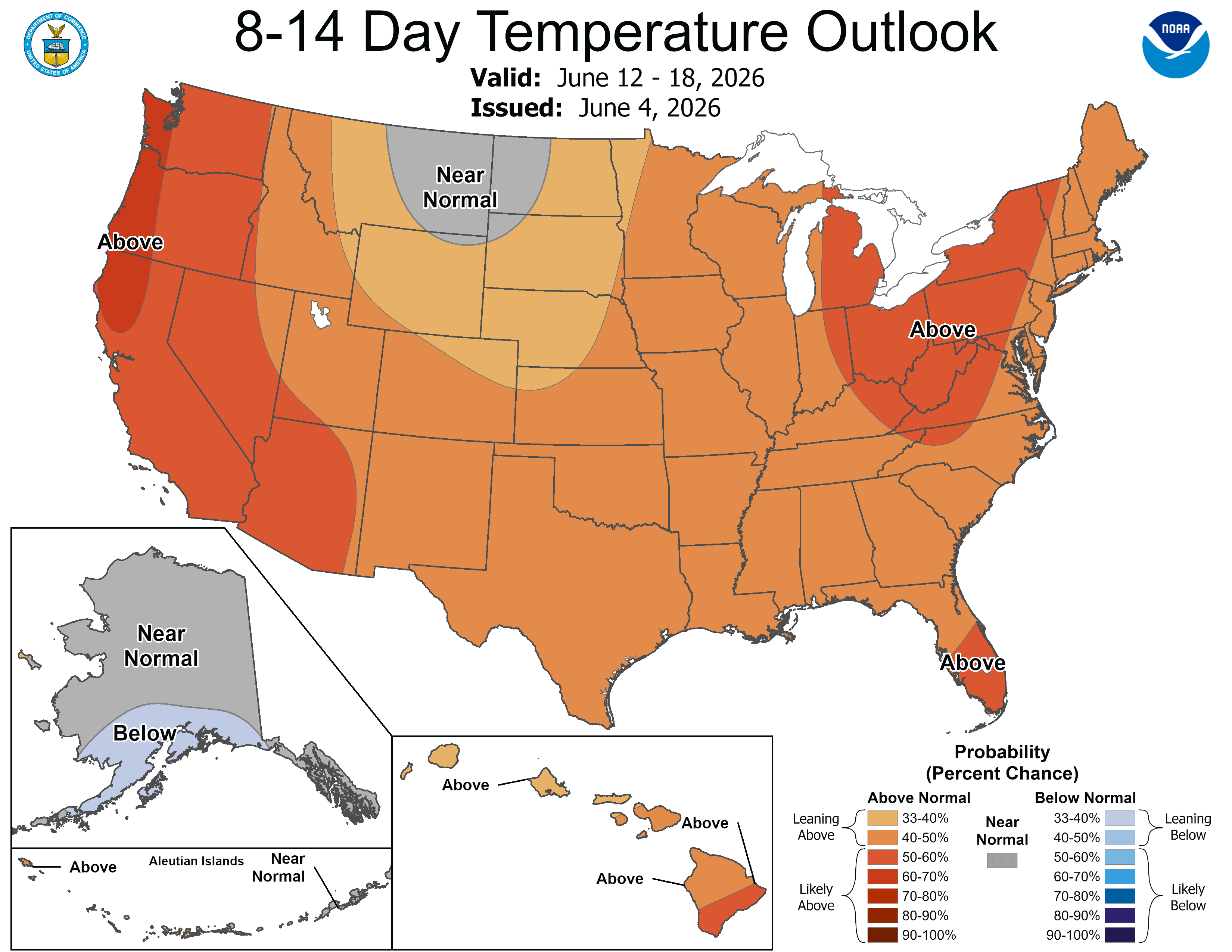
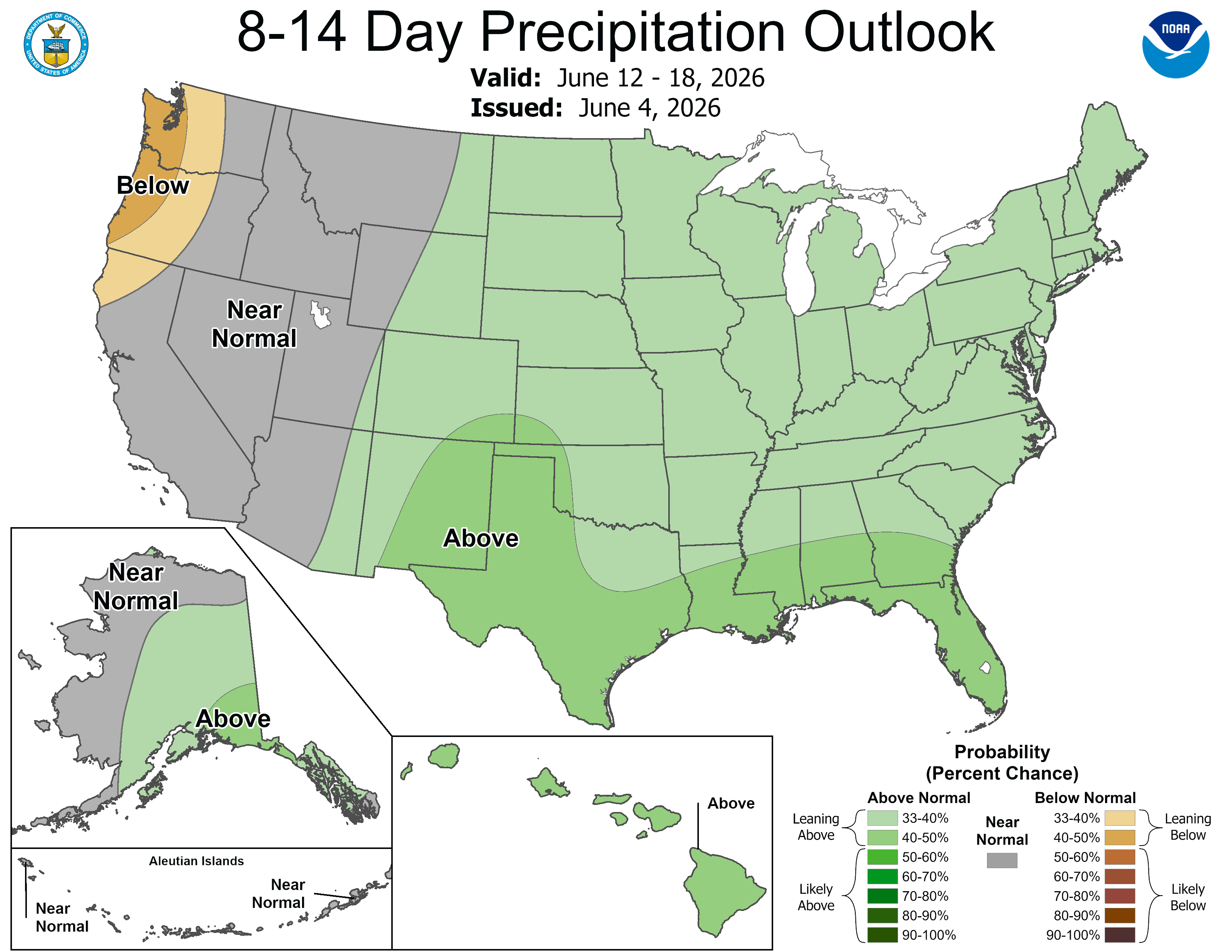
Temperatures are heating up across the CBRFC area as June begins. Precipitation chances in the near-term are limited to warm, convective showers and storms, mainly over eastern areas. The 7-day precipitation forecast and the Climate Prediction Center (CPC) 8–14 day temperature and precipitation outlooks are shown in the figures below.
7-day precipitation forecast for June 4–10, 2026.
Climate Prediction Center temperature probability forecast for June 12–18, 2026.
Climate Prediction Center precipitation probability forecast for June 12–18, 2026.
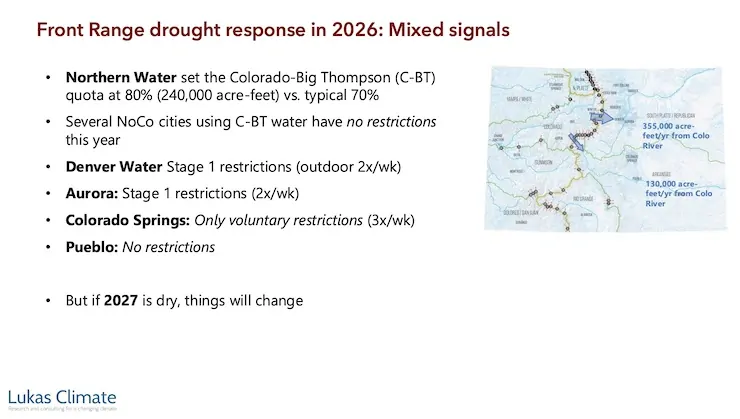
A reservoir built to serve nearly a million Northern Coloradans started filling this spring. But Chimney Hollow’s future is still murky weeks after the initial fill. Chimney Hollow will eventually pull water from the Colorado River near its headwaters in Grand County to serve a dozen fast growing cities on the Front Range from Broomfield to Greeley…Chimney Hollow is holding just 2% of its total volume today because there’s a problem. Northern Water discovered that some of the rocks it used to build the massive dam at the reservoir contained radioactive uranium. It was naturally occurring, but it set the project back at least a year. Northern Water is still coming up with a mitigation plan.
“Really, the best way to kind of move that uranium out is to draw down the water and force that out,” spokesperson Rachel Stevens said. “But before we make any of those decisions, we really want to see what the levels of uranium are.”
So every week, crews are taking water samples from the small pool and sending it to a lab to see how much radioactive material is really in the water. The results are expected soon. Northern Water has only been able to test how uranium leaches out of the rocks in a laboratory setting. Filling the reservoir just slightly will help reveal the extent of the problem.
Map from Northern Water via the Fort Collins Coloradan.
The Crystal River flows through the Gunnison County town of Marble, seen here with Beaver Lake. A representative from the Town of Marble is expected to participate in a subcommittee focused on an intergovernmental agreement to protect the river. CREDIT: ECOFLIGHT
May 27, 2026
Five Colorado governments, including Pitkin County, and water entities have officially entered into a landmark intergovernmental agreement to protect the Crystal River from mainstem dams and out-of-basin water diversions.
The agreement comes at the recommendation of the Crystal River Wild and Scenic and Other Alternatives Steering Committee from March 2024, suggested as one of three potential long-term preservation measures, according to a press release. Along with Pitkin County, the Colorado River Water Conservation District, Gunnison County, town of Marble and West Divide Water Conservancy District formalized their shared commitment to oppose any new on-channel reservoirs on the mainstem of the Crystal River and any trans-basin diversions that would export water out of the watershed.
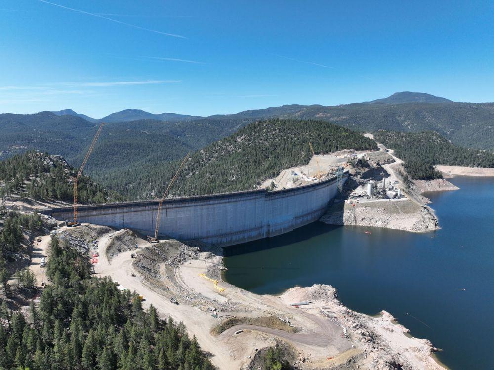
Each stage of a big construction project has its own challenges and puzzles to solve along the way. Raising Gross Dam is no different.
Denver Water is raising the height of the dam by 131 feet, with the final 22 feet going up this spring in two sections that are separated by a giant gap. The Gross Reservoir Expansion Project, which began construction in 2022, is designed to nearly triple the reservoir’s storage capacity. Major construction work resumed in April following a winter break.
And this year’s construction puzzles included:
How to move concrete across a 160-foot gap between where the concrete is made and where it’s placed?
And, how do you move construction vehicles across that same gap when work on the first section is finished?
“We are building the top of the dam in two sections because we need to leave a 160-foot gap in the middle of the dam for the spillway channel,” said Casey Dick, Denver Water’s deputy program manager for the Gross Reservoir Expansion Project.
Denver Water is building the last 22 feet of Gross Dam in two sections. The photo shows the left side at its new height. The right side’s last 22 feet will be finished in June. Photo credit: Denver Water.
Spillway channels are safety features on dams that allow water to safely flow out of a reservoir if needed due to flooding rains or exceptionally high and rapid snowmelt.
Raising the dam’s last two major sections, while leaving a 160-foot gap between them, meant coming up with a new way to move concrete across the construction site.
On the lower portion of the dam, crews worked on one continuous structure, which allowed trucks and equipment to easily move from one side of the dam to the other, and to move concrete from the batch plant down a large chute to where it was put into place.
However, with the final 22 feet going up in two sections, construction crews had to find a way to deliver concrete from the batch plant and across the 160-foot spillway gap as the first section went up.
The solution to this puzzle? A series of conveyors positioned in the middle of the dam that tilted higher as the first section rose higher.
“Building the new conveyor system is just another example of all the ingenuity we go through out here to build the dam,” Dick said. “With each new phase, there are new challenges that our team has to figure out.”
The new conveyor system moved concrete across the gap where the spillway channel will be to the far side of the dam. Photo credit: Denver Water.
Construction crews finished placing roller-compacted concrete on the dam’s left side on May 12.
But once that was done, crews faced the second challenge: How do you move the equipment off the finished, 22-foot higher section of the dam, across the spillway gap, down to where they are needed to complete the second section?
Short answer: If you can’t go over, go around.
Cranes lifted equipment off the higher section of the dam to the road, where the machines convoyed about 4.5 miles around to the other side using the dam’s access road.
A crane lifts a piece of equipment off the dam. Because of the new spillway gap, equipment was driven across the dam’s access road to get into position on the other side of the dam. Photo credit: Denver Water.
Construction on the final 22 feet of the second side of the dam began at the end of May and is expected to be completed in June.
Once the second section is done this summer, a year’s worth of remaining work includes: finishing the top of the dam, building safety walls; constructing the actual spillway; building a bridge over the spillway and completing the stilling basin at the bottom of the dam.
This view from the bottom of the dam shows the new baffle blocks on the bottom of the stilling basin. The baffle blocks reduce the energy of the water that flows down the spillway. Photo credit: Denver Water.
Full construction on the dam raising project is expected to wrap up in mid-2027.
“There are hundreds of logistical challenges throughout this project, but our team has been able to meet every one of them along the way,” Dick said. “We’re making good progress so far in 2026 and are looking forward to getting a lot of work done in the coming months.”
The Gross Reservoir Expansion Project involves raising the height of the existing dam by 131 feet. The dam will be built out and will have “steps” made of roller-compacted concrete to reach the new height. Image credit: Denver Water
The Clifton Water District announced Wednesday that it would join the list of utility providers implementing temporary drought rates, with a press release about the change calling for community members to take action with other drought mitigation efforts.
“The Clifton Water District urges all customers to take immediate steps to reduce water usage wherever possible,” the press release said. “Small changes — such as limiting outdoor watering, repairing leaks, and using water-efficient appliances — can collectively make a significant impact … By working together, Clifton residents can help ensure that safe and reliable water remains available for essential needs now and in the future.”
The change won’t alter billing for those using less than 3,000 gallons of water per month, much like similar rate restrictions recently announced by other providers. Clifton Water said it hoped to encourage prudent water usage with the higher rates. The district said the rates would remain in place “only until watershed conditions show meaningful improvement,” a stipulation that could mean Clifton Water customers are in for a long summer, with forecasts suggesting a historically dry year and winter snowpack widely observed at record-low levels.
Green Mountain Reservoir is owned by the U.S. Bureau of Reclamation and located in Summit County north of Silverthorne along the Blue River. Photo credit: Denver Water.
The state and the Colorado River Water Conservation District, a public water policy and planning agency on the Western Slope, have a new plan to protect mountain towns from losing their water supply during an unprecedented drought this summer. The District’s proposed emergency water supply plan was approved at the Colorado Water Conservation Board meeting on Wednesday, May 20, 2026…The emergency plan would protect certain water users on the main stem of the Colorado River by replacing water that would have historically come from Green Mountain Reservoir. This year forecasts say it won’t fill up for the first time in history…A portion of the reservoir is reserved for what’s called the “historic users pool,” which holds 66,000 acre-feet of water…It’s an important emergency water supply plan that protects approximately 250 municipal and domestic water entities across the Colorado River Basin from being called out due to senior water rights claims. It was created as part of the Colorado Big Thompson project, a massive water engineering project that created reservoirs and redirected Colorado River water to Front Range cities…After a drought in 1977, water managers set aside the historic user pool for agricultural and domestic users. It’s historically always been filled and available to protect those water rights from being usurped by more senior users…Every year, a group of agricultural and utility entities in the Grand Valley near Grand Junction makes what’s called the “Cameo call” to use water from it. It’s the largest and most senior call on the main stem of the river and demands that they get enough water for their needs. That includes the Grand Valley Water Users Association, Grand Valley Irrigation Company, Orchard Mesa Irrigation District, Palisade Irrigation District, and Mesa County Irrigation District. The call is made annually, generally between June and August. This year, the fear is that if that water demand is called early, there won’t be enough water for upstream towns and municipalities, including Silverthorne, Eagle River, and Grand, Garfield and Mesa counties…
The River District plans to borrow water from other reservoirs — the nearby Wolford Mountain and Ruedi reservoirs — to replace the water that would have come from Green Mountain and to prevent the Cameo call from being made…At the meeting, the board committed to support the move with $585,000, in addition to $342,000 the District committed last month.
“Instead of having to turn off all of these cities’ water rights up here and the farms and ranches up above the Grand Valley, the Green Mountain historic user pool would release water to meet the Cameo call and protect the West Slope users. It is a really appropriate use of that water,” Mueller told CPR News.
Colorado-Big Thompson Project map. Courtesy of Northern Water.
A mini-sandstorm partially obscures the Bullfrog Marina on Lake Powell. Dropping reservoir levels are forcing officials to move the marina to a deeper part of the lake. Jonathan P. Thompson photo.
Maybe sitting next to the wall of plate glass windows was not the smartest move, I thought, as a sienna-colored cloud of sand lifted up from the lakeside and made its way in my direction. I had just tucked into my $16 grilled chicken sandwich at the Anasazi Restaurant at Bullfrog Marina on Lake Powell when the wind kicked up, sandblasting the windows and causing a sizable milk crate to slide back and forth along the railings of the patio outside. It was an eerie scene. Had this been an apocalyptic cli-fi film set in a calamitously aridified West, this would have been the moment when a pterodactyl-like creature smashed through the window and plopped down all bloody and sandy in my plate of fries, an omen of the horrors to come.
It was not, however, a film. The dystopian scene was real as was the aridification, though it did not include any prehistoric creatures — only a handful of staff and other diners who, much to my dismay, seemed utterly unperturbed by the sandstorm and the havoc it was wreaking on a set of outdoor furniture. And, outside, a few ravens who seemed delighted to frolic in the gusts’ updrafts.
When we think of climate change’s effects, we might imagine communities inundated by rising seas, unhoused folks exposed to ever more severe heat waves, or entire towns wiped out by megafires. I was here at Bullfrog to see how a warmer and drier climate is affecting the communities, infrastructure, and economies that rose up around and depend upon Lake Powell-based recreation.
Bullfrog is the largest and most extensive marina on Lake Powell’s northern end. It has a 48-room hotel, the aforementioned restaurant, a gas station and convenience store, an RV park, and other lodging, along with its own school, which this year had four students in grades K-6. The population of some 50 to 100 consists mostly of employees of the National Park Service and Aramark, the private concessionaire that runs the reservoir’s marinas and other facilities. Nearby Ticaboo, which lies outside Glen Canyon National Recreation Area but also relies on Lake Powell recreation, has another 50 to 100 residents. The nearest incorporated town is Hanksville, some 67 miles to the north.
Bullfrog Creek along the southern end of the Burr Trail and Bullfrog Bay on Lake Powell in the distance. Jonathan P. Thompson photo.
Bullfrog lies at the end of the road on a bay at the mouth of Bullfrog Creek, where the water is shallower than on the main channel of the Colorado River, making the marina and its facilities more vulnerable to dropping water levels. While the main boat ramp is still being used, it will likely become unusable later this summer as the reservoir’s surface levels falls toward 3,500 feet. In coming weeks, the entire floating marina will be towed across the reservoir to deeper water adjacent to Halls Crossing Marina; Bullfrog’s fuel and boat rental docks have already been moved. The ferry between Bullfrog and Halls Crossing isn’t functional at low water levels, so is expected to be out of commission for the rest of this year, making for a 145-mile car trip between the facilities at Bullfrog and the boat ramps and marina at Halls Crossing.
I visited Bullfrog on a Sunday in mid-May. Because I needed to do some internet-related work early on Monday morning, I stayed in the hotel. I initially regretted not staying in the campground, since it was mostly empty and had a strong cell phone signal, but when the tent-shredding winds and skin blasting sands kicked up I was happy to be ensconced in more secure lodging, especially given the relatively reasonable price.
It was the high tourist season elsewhere in Canyon Country. The trailhead parking lots at Capitol Reef National Park were all full or overflowing that morning as I drove through, and Torrey had been busy during my stay there for a writing conference. As I slowly made my way down the Notom Road and Burr Trail, stopping frequently to gaze at the curves and crevices in the Waterpocket Fold and for a quick bike ride, I saw maybe a half-dozen other vehicles.
Waterpocket Fold. Jonathan P. Thompson photo.
Waterpocket Fold detail. Jonathan P. Thompson photo.
Bullfrog, meanwhile, was decidedly quiet. The hotel was nearly empty. Only a few sites in the RV park were occupied, and I later saw that most of the sites were out of order and closed. A couple of dozen cars, at the very most, were parked on the only operable boat ramp. The shelves on the little convenience store were sparsely stocked, and a box of Triscuits was going for $7.50 — though there was no cheese to accompany them — and gas was selling for $5.17. In May of 2000, the Bullfrog District received 33,000 visits, according to National Park Service statistics; in May 2025 only 10,886 visitors passed through the entrance gate. Current numbers aren’t yet available, but I imagine this year’s visitation will be far lower. And once the boat ramp ceases to function, I imagine the numbers will plummet further.
Boats, redrock, and snowy Henry Mountains at Bullfrog Marina. Jonathan P. Thompson photo.
The National Park Service is planning to build a new, deeper-water boat launch at Stanton Creek, a couple of miles from central Bullfrog, where the marina can be moved permanently. The project is expected to cost some $73 million, and won’t be completed this year. It’s a type of climate adaptation, I suppose, though one can’t help wonder how long the fix will last if the reservoir’s levels keep dropping.
Meanwhile, Bullfrog’s future is in doubt. A series of especially snowy winters in the high country might be enough to bring Bullfrog back from the edge of obsolescence. Maybe they won’t even need the Stanton Creek site. On the other hand, just one more below-average snowpack year could doom Lake Powell altogether. If Colorado River flows don’t increase substantially in the next year or two, the Bureau of Reclamation will have little choice but to build tunnels to bypass Glen Canyon Dam and effectively drain the reservoir in order to keep water running into the Grand Canyon and on to Lake Mead.
The question then would be whether Bullfrog could (or would even want to) adapt to a different sort of tourism.
The place might try to cater to hikers and small-watercraft users looking to check out newly revealed parts of Glen Canyon that have been inundated for the last several decades. And it could lure travelers exploring the greater region’s backcountry, though it’s not clear that type of visitor is going to be interested in the type of accommodations and services Bullfrog currently offers. Maybe it will just become a destination for disaster-tourist voyeurs looking to see the effects of climate change in real-time. Or, perhaps Bullfrog will become another Hite Marina, which the shrinking reservoir has left high and dry, its boat ramp separated from the lake by some six miles, the store and campground permanently shuttered and gated off.
Sightseers at Hite Overlook gazing down at the “Dominy Formation” of silt left behind by the receding waters of Lake Powell. Jonathan P. Thompson photo.
Hite Marina and boat ramp on what once was the northern end of Lake Powell. Jonathan P. Thompson photo.
The last time I visited Bullfrog was in the late 1980s. My dad, my brother, and I camped at Halls Crossing, then woke up and rode the ferry across the lake. From there we made an epic loop around and over the Henry Mountains along the then-unimproved Burr Trail and another gnarly road in our 1967 Pontiac Catalina. It took at least eight hours and involved some extensive road-building to keep the boat-like vehicle from bottoming out. Anyway, I remember Bullfrog as being a bustling resort with a sort of spring break party vibe, relative to the more bare-bones Halls Crossing. Of course, those were the glory days for Lake Powell, when the reservoir was full, and at the end of a bone-jarring drive across the desert one could stop at the Hite Marina for refreshments.
That night I listened to the sand batter the sliding glass door of my hotel room. The next morning, the reservoir’s placid waters reflected dawn’s first light, and the distant sandstone dunes seemed to glow from within. And to the north, a fresh coating of snow covered the craggy slopes of the Henry Mountains, promising a little bit of relief from these dry and trying times.
Henry Mountains. Jonathan P. Thompson photo.
📸 Parting Shots 🎞️
Early light, the Colorado River canyon, and the Henry Mountains from the White Canyon drainage. Jonathan P. Thompson photo.
Apache Plume and canyon in Utah. Jonathan P. Thompson photo.
Click the link to read the article on the Big Pivots website (Allen Best):
May 26, 2026
Dissonance exists between life-close-to-normal policies regarding urban water use and the growing crisis on the river
Casually surveying the urban landscapes in much of Colorado’s Front Range, you’d never know that the Colorado River — the source for roughly half the water of the cities — has deteriorated to its most pitiful shape of perhaps the last century.
Oh, yes, some utilities — notably Denver Water and Aurora Water, which together serve 1.9 million residents — have imposed rigorous stage-one drought watering restrictions. Outdoor irrigation is allowed twice per week and never during the heat of day. Other water utilities that tap Colorado River water, however, have asked only for voluntary cutbacks, if any at all.
Jeff Lukas via the Western Water Assessment.
Jeff Lukas, a water consultant with several decades invested in climate change work, says this seeming aloofness of some cities will not persist indefinitely. That is certainly true if the record heat and abnormal dryness of the past winter continues into 2027. They may have no choice.
“I think Front Range cities will be asked, whether nicely or not, to reduce their Colorado River diversions,” said Lukas in a May 11 webinar. “The mechanism for that is unclear, but I think it’s going to happen.”
Water rights of the Front Range cities — and many of those on the Western Slope, too — are junior to the Colorado River Compact. It was negotiated in 1922, making diversions more recent than that junior.
Problems in the basin were becoming apparent in the 1990s. The warming climate in this century has provoked changes. By all accounts, they have not been enough.
Lukas, as a dendrochronologist at the Institute of Alpine and Arctic Research in Boulder 20 years ago, was teasing out evidence from tree rings to understand the climates of the Colorado River Basin during the last 1,200 years.
Later, as a scientist with the Western Water Assessment, Lukas co-authored (with Liz Peyton) a 2020 report called Colorado River Basin Climate and Hydrology: State of the Science. That 500-page report integrated more than 800peer-reviewed studies to help water managers understand physical processes, climate risks, and forecasting tools across the basin.
In 2024, with the state climatologist, Russ Schumacher, and several others, Lukas turned out the 100-page volume called “Climate Change in Colorado.”
Based in Lafayette, Lukas now works as a consultant. At Lukas Climate Research and Consulting, he specializes in the overlapping areas of climate hazards, water resources, and ecosystems.
Lukas, in a presentation he titled “Running dry on the Colorado River: The roots of the crisis & its implications for the Front Range,” explained the big picture and Colorado’s Front Range part in it.
Defined by the Continental Divide, Colorado has an inverse relationship between its eastern and western slopes. About 90% of the state’s residents live to the east, nearly all at the foot of the Rocky Mountains, whereas 80% of the state’s precipitation originates on the west side, in the headwaters of the Colorado River and its tributaries.
Snow from the Gore Range and other “islands” of precipitation in Colorado provide 50% to 60% of the water in the Colorado River. Photo credit: Allen Best/Big Pivots
Colorado itself provides 50% to 60% of the water in the entire Colorado River, depending upon the year. This year has been a terrible year everywhere in the basin, Colorado included.
Lukas explained that “islands of moisture” provide nearly all the water in this 244,000-square-mile basin. The high mountains constitute these islands. Some places deliver more than others. Buffalo Pass, near Steamboat, famously has had prodigious volumes of snow. This snow, when melted, can produce 50 inches of water.
It takes 20 inches or more of precipitation in these mountain islands to produce meaningful runoff. Even then, it doesn’t all end up in the Colorado River. In Colorado and the three upper-basin states, he said, 16% of the rain and snow that falls becomes water in the Colorado River. In the hotter lower basin, the figure is 3%.
“The atmosphere takes back most of what it giveth, even in the wetter upper basin,” he said.
Evaporation and transpiration are the pickpockets of this water. Heat produces evaporation, and we’ve had plenty of that this year.
Temperatures during November through April were the warmest on record in Colorado for that span of months. March heat was exceptional. This produced runoff in the rivers that in most cases may surpass that of May or June, the traditional times for peak runoff. Peak runoff has been trending earlier by several weeks during the last few decades, but this was a leap of about two months.
Runoff for April through July — a time that normally accounts for 70% to 80% of annual streamflows — this year will likely deliver no better than 20% to 40%. In its May report, the Bureau of Reclamation said April flows into Lake Powell were 40% of the average during the last 30 years and it expects flows in May to sink to 9% of that average.
Can it get any worse? Count on it, said Lukas.
“We should expect not every year to look like 2026 from here on out, but more years in the future will look like 2026. And somewhere down the pipe, not as far in the future as we would like, there will be a year worse than 2026 for the Colorado River.”
Members of the Colorado River Commission, in Santa Fe in 1922, after signing the Colorado River Compact. From left, W. S. Norviel (Arizona), Delph E. Carpenter (Colorado), Herbert Hoover (Secretary of Commerce and Chairman of Commission), R. E. Caldwell (Utah), Clarence C. Stetson (Executive Secretary of Commission), Stephen B. Davis, Jr. (New Mexico), Frank C. Emerson (Wyoming), W. F. McClure (California), and James G. Scrugham (Nevada) CREDIT: COLORADO STATE UNIVERSITY WATER RESOURCES ARCHIVE via Aspen Journalism
This is so very different from what was assumed by the delegates from the seven basin states who gathered in 1922 in Santa Fe to apportion the Colorado River.
The role of reservoirs
Taking the big, long-term view, Lukas pointed out that the overall story of the Colorado River is one of modifications needed to suit human uses. “It’s all about smoothing out the natural variability in the availability of water over space and over time.”
Reservoirs are the primary means by which humans have been able to “smooth out the natural variability.”
The Colorado River Basin has 60 million acre-feet of storage. That’s four times the annual flow. Five-sixths of the storage capacity is found in the desert in two vessels: lakes Mead and Powell. The headwaters have many reservoirs but they are relatively small. The total storage capacity is 2,000 times more than the volume of Dillon Reservoir.
Illustration from the report, “Antique Plumbing & Leadership Postponed” from the Utah Rivers Council, Glen Canyon Institute and the Great Basin Water Network. Courtesy of Utah Rivers Council
Since 2000, stored water in those two big buckets, Mead and Powell, has declined from 49 million acre-feet to 16 million acre-feet as of May. Of that, 9 million lies at elevations below the lowest outlets. These are called dead pools.
Those delegates in 1922 who crafted the Colorado River Compact, the legal document that provided the basis for nearly all these dams and aqueducts subsequently built, assumed annual flows of 17 million to 18 million acre-feet. They were overly optimistic. The 20th century average was 15.2 million acre-feet.
Now comes the 21st century, and the average at Lee Ferry has dipped to 12.2 million acre-feet. This has implications for the Front Range cities but also farms. If Colorado must reduce its diversions to accord with the compact, those rights dated before 1922 will be exempt from reductions. The giant transmountain diversions have come more recently, as have many of the diversions for towns and cities on the Western Slope.
Accumulating evidence fingers human-caused climate change with large amounts of responsibility for declined flows. Lukas said his rule of thumb is that the role of greenhouse gases overall are responsible for two-thirds of lower flows.
Colorado statewide annual temperature anomaly (°F) with respect to the 1901-2000 average. Graphic credit: Colorado Climate Center
As for the mechanics of this shift, rising heat is one important “knob,” said Lukas. As the atmosphere warms, it reduces “runoff efficiency” even more, sending water into the atmosphere instead of into streams and then rivers. Accumulating evidence fingers human-caused climate change with responsibility for most and possibly all of increased temperatures.
Precipitation has declined about 5% since 2000, with a larger reduction in spring, an important time of year to get moisture. Here, the link to the warming climate is less clear. “It seems increasingly likely that climate change is changing the dynamics of storm tracks and the persistence of, say, high-pressure systems over the interior West,” said Lukas. “That is, at least in part, responsible for why we’ve had less precipitation since 2000.”
The Colorado River, though, had problems even before the warming climate began throwing sharp elbows in water volumes. The reservoirs of the Colorado River Basin were 92% full in 1999, a wet decade overall. Even then, however, the Colorado River had ceased to reach the Pacific Ocean. There were too many straws inserted.
Less than 12% of the river’s flow goes to urbanized and industrial uses. Lukas pointed out that cities have become more efficient in their use of water. The rule of thumb for Denver and other Western cities is that one acre-feet of water meets the needs of a three households on an annual basis. That compares with two households a few decades ago.
Mining of fossil fuels and minerals uses a small amount. Evaporation from reservoirs and rivers and other “system losses” accounts for about 15%.
That takes us to agriculture. It uses 75% of the river’s water in the Colorado River for irrigation on 5 million acres. Some of that land lies outside the basin itself. That includes the South Platte and Arkansas River valleys of eastern Colorado.
Over half of that water — about 9 million acre-feet — gets used to grow feed for livestock, mainly alfalfa and pasture grass.
Might cities want to cut deals with farmers to “share” the water? This discussion has been underway for at least 15 to 20 years. Some pilot projects in Colorado and elsewhere have been launched to see what this might look like. A strong proponent has been James Eklund, a water attorney in Denver. Others question how this is done and, for that matter, whether we want to do it. But certainly, water for urban uses has higher monetary value than growing hay to feed cattle.
Why the restraint of cities?
As for the Front Range cities, the big question is whether they are planning for a river that produces even less than it does now.
In 2024, Andy Mueller, the general manager of the Colorado River Water Conservation District, suggested the need to start planning for a river that may deliver less than 10 million acre-feet in coming decades. Some thought then that the state engineer, Jason Ullman, needed to start sorting through this matter of junior vs. senior rights. Jim Lochhead, a former water attorney on the Western Slope and later CEO of Denver Water, pushed back, saying it was premature given the huge amount of work that would be required. See: “Heading for the Colorado River Cliff,” Big Pivots, Oct. 20, 2024.
At the Zoom session on May 11, I asked Lukas about the modest watering restrictions by Front Range water providers. He had previously described mixed signals from the water utilities. If 2027 is dry again, expect more uniformity around drought restrictions. “But it’s pretty weird right now,” he said.
With the attention to the Colorado River in the news media, it seemed like a perfect opportunity for the water utilities to mount more aggressive campaigns. Any idea why they had not, I wondered.
The utilities, he said, are reluctant to deliver regulations that produce discomfort around outdoor water-use restrictions. They don’t want to do this unless absolutely necessary.
Part of this is because of experiences during the covid epidemic. A lesson to public servants during that time made them more reluctant to push the public to do things they don’t want to do. “You only want to exercise that authority, that public legal authority, sparingly and only when it’s clear that is what is really necessary.”
Revenue was another consideration. Water infrastructure is expensive, and the money to pay for it comes from charges for water use. By imposing limits, you reduce revenue and hence must charge more for water. The conundrum is that reducing use doesn’t necessarily mean you pay less. In some cases, less water may require more infrastructure. This is a hard message to convey.
“What you’re seeing is a dissonance between the circumstances and what’s happening, at least this year,” he said.
Or at least right now. We have had rainy weather in May. Some meteorologists think we may end up with healthy rainfall this summer. If instead the summer is like the winter, very hot and dry, I expect the utilities might pick up their game.
This USGS map shows the number of PFAS detected in tap water samples from select sites across the nation. The findings are based on a USGS study of samples taken between 2016 and 2021 from private and public supplies at 716 locations. The map does not represent the only locations in the U.S. with PFAS. Sources/Usage: Public Domain. Visit Media to see details.
EPA aims to end federal regulation of four PFAS in drinking water and give utilities more time to comply with existing rules.
FEMA reopens applications for a climate-resilient infrastructure grant program that the agency had cancelled.
Bureau of Reclamation announces $52 million for three new Hoover Dam turbines that will generate hydropower at lower Lake Mead levels.
A House FY27 budget bill will cut the federal government’s primary water infrastructure funds by 24 percent.
NOAA forecasts fewer Atlantic hurricanes this season.
EPA water office leader commits to investigate groundwater pollution in Georgia from Meta data center construction.
The Trump administration recommends that the U.S. Supreme Court take up Nebraska’s claim that Colorado has violated a river-sharing compact.
And lastly, the Bureau of Reclamation’s acting commissioner informs a House subcommittee about the status of Colorado River negotiations.
“Several weeks ago, I met with the 14 senators from the Colorado River basin and on a bipartisan basis, several of them said, ‘Look, we have a real crisis on the Colorado and we need to get things done and if there are any environmental statutes that are slowing things down, tell us what they are and maybe we can legislate to clear out some of the unhelpful bureaucratic paperwork.’” – Scott Cameron, acting Bureau of Reclamation commissioner, speaking at a House Natural Resources subcommittee hearing. Cameron said his office has not yet followed up on the offer but “looked forward” to conferring with the senators about “waiving or streamlining certain environmental statutes on the Colorado.”
Udall/Overpeck 4-panel Figure Colorado River temperature/precipitation/natural flows with trend. Lake Mead and Lake Powell storage. Updated through Water Year 2025. Note the tiny points on the annual data so that you can flyspeck the individual years. Credit: Brad Udall
As for the status of Colorado River negotiations, Cameron said, “Frankly, the seven states are not in a position where they could agree today, right now, to a four-year deal, let alone a 20-year deal, because of the uncertainties we’re dealing with.”
By the Numbers
$1 Billion: Funding now available from FEMA’s Building Resilient Infrastructure and Communities program, a grant opportunity to reduce risk from climate and weather hazards. A federal judge ordered the agency to reinstate the program, which the Trump administration had cancelled. Applications are due July 23.
$52 Million: Funding announced by the Bureau of Reclamation for three new low-head turbines at Hoover Dam. Only five of the dam’s 17 turbines are designed to operate when Lake Mead drops below elevation 1,035 feet, a threshold that the shrinking reservoir is fast approaching and could breach in the next 12 months, if not sooner.
Not So PFAS The EPA is proposing to repeal federal regulation of four PFAS in drinking water, partially undoing a Biden-era rule that set first-ever limits on six of the “forever chemicals.”
Three of the chemicals – PFHxS, PFNA, and Gen X – were regulated individually. Together with PFBS, they were also regulated as a mixture.
The EPA will retain standards for PFOA and PFOS, the two most-studied of the chemicals. However, in a separate rule-making, the agency is proposing to give water utilities more time to comply, extending the deadline by two years, until 2031. The agency says the move will “ease the implementation burden” financially and administratively for water systems and might allow for cheaper treatment technologies to come to market.
Water utilities must apply for an extension. One of the considerations is whether an extension would pose an “unreasonable risk to health.” The EPA is proposing that PFOA and PFOS levels below 12 parts per trillion would not be unreasonable. (The federal standard for both is 4 ppt.)
The EPA wants public comment on whether interim utility actions during a compliance extension – point-of-use treatment, filtration pitchers, education, alternative water sources – can mitigate health risks above 12 ppt.
Water Infrastructure Funding Cuts A House spending bill cuts the two main federal sources of water infrastructure funding by about 24 percent in fiscal year 2027. The bill passed out of subcommittee last week.
The bill provides $1.2 billion for the Clean Water State Revolving Fund (27 percent cut) and $911 million for the Drinking Water State Revolving Fund (19 percent cut).
Following a recent trend, about half of the appropriation comes in the form of earmarks. This money will go directly to specific projects and will not enter the revolving fund. Water industry advocates argue that continuing to take earmarks out of the revolving fund appropriation threatens the viability of the program.
Studies and Reports
The South Platte River Basin is shaded in yellow. Source: Tom Cech, One World One Water Center, Metropolitan State University of Denver.
Great Plains Water Fight The federal government’s top lawyer recommended that the U.S. Supreme Court take up one of Nebraska’s claims that Colorado is violating the South Platte River Compact, which divides the river’s water between the two states.
Nebraska argues that Colorado is breaking three articles of the compact. The U.S. solicitor general says that the high court, through a special master, should pursue only one of them: that Colorado is allowing irrigators to take too much water.
“A claim that one State has deprived another of water to which it is entitled under an interstate compact is a quintessential case for this Court’s original jurisdiction,” the brief states.
Atlantic Hurricanes NOAA is forecasting a less active Atlantic hurricane season. The agency estimates that one to three major hurricanes (Category 3 or higher) will form.
The category ratings can be misleading. They measure wind speed, not precipitation. Tropical storms and minor hurricanes can still inflict serious flood damage.
Air Conditioning Estimates The U.S. Census Bureau published data estimating how many homes use air conditioning.
States with the lowest air conditioning use are in New England and the West.
On the Radar
EPA on Data Centers and Household Wells Under oath at a House subcommittee oversight hearing, Jessica Kramer, head of the EPA Office of Water, committed to investigate impacts to drinking water quality from data center construction.
“Whatever type of construction it is, it’s a priority to ensure that water quality standards established by EPA are being met. So we’ll be looking into that certainly,” Kramer said.
Kramer’s commitment at the House Energy and Commerce hearing was prompted by Rep. Alexandria Ocasio-Cortez (D-NY) who asked about water pollution from data center construction.
Ocasio-Cortez visited Morgan County, Georgia, a few weeks ago. She returned with jars of brown water from household wells near the construction site of a Meta data center. She displayed those at the hearing.
“This is what the drinking water now looks like, next to that data center,” Ocasio-Cortez said.
“As soon as I get back to the office, I will be looking into exactly what you just talked about,” Kramer replied.
Army Corps Deauthorized Projects The Army Corps published a list of water projects that it intends to deauthorize.
These are projects that were authorized years ago but either haven’t ever received funding or haven’t recently received funding.
Public comment on the proposal runs through August 19. Submit comments at http://www.regulations.gov using docket number COE-2026-0034.
Federal Water Tap is a weekly digest spotting trends in U.S. government water policy. To get more water news, follow Circle of Blue on Twitter and sign up for our newsletter.
The cover of a new book I’ve just published, Storm in My Head, a collection of poetry written over the 60 years I’ve been living in the headwaters of the Colorado River, since 1966 — George Sibley
This is the cover of a new book I’ve just published, Storm in My Head, a collection of poetry written over the 60 years I’ve been living in the headwaters of the Colorado River, since 1966. My 60-year celebration. Those of you who prefer your literature in sprints and strolls over the marathon essays I impose on you might enjoy this book. I’m in the process of getting it distributed, and it may eventually be in a bookstore near you or on Amazon; but for the time being, if you are interested, an email to me, george@gard-sibley.org, will initiate a response on how to get a little money to me (10 bucks plus shipping) to get an inscribed copy wending its way to you.
End of advertisement – back to the river….
Romancing the River – Elephants in the River
The Colorado River situation is moving toward replacing the existing ‘Interim Guidelines’ for managing the river system with a new set of interim guidelines for managing the river system. This new set is devised mostly by the Bureau of Reclamation, which is growing a little desperate to avoid the embarrassment of having its river system cause the flow of the river to stop – ‘dead pool’ – behind one or another of its big dams, in a river management system built for a considerably larger Colorado River – now as mythic a river as the biblical four that flowed out of the Garden of Eden.
All this makes me think I’ll briefly abandon my historical update of Frederick Dellenbaugh’s Romance of the Colorado River, and try to sort through what has been happening recently in the present, most of which we’ve been reading or hearing about in the media.
Reports on the river’s flow after the Weirdest Winter Ever (at least in recorded time) have just gotten worse and worse; now the anticipated inflow to Powell Reservoir is 13 percent of the thirty-year average, from tributary runoffs that peaked as much as two months earlier than the usual early June. The Bureau of Reclamation’s 24-month projection indicates that, if last year’s releases from Powell were replicated this year, they might have to stop generating power by late summer to protect the power turbines – which in effect declares the remaining quarter of the reservoir’s potential storage ‘dead pool,’ since the only other way past Glen Canyon Dam is through four outflow tubes of questionable viability that the Bureau would like to use as little as possible.
The Bureau will address this with two emergency measures: first, by bringing a large quantity of stored water down the Green River from Flaming Gorge Reservoir, and second, by cutting releases from Powell Reservoir by close to two million acre-feet (maf) – which in turn will leave Mead Reservoir lower and diminish its power generation. This is an emergency plan that can nowise be considered long-range planning.
The Lower Basin states in turn have bumped up their willingness to take more shortages for the next couple years by roughly doubling shortages they have already agreed to accept – if the feds will pay them something for not using water that is not there. Their earlier cuts were basically just enough to finally start taking out of their individual allotments the system losses (mostly evaporation) they have been dismissing, with Bureau cooperation, as being met through ‘surplus flows’ that effectively disappeared when the Central Arizona Project came online in the 1990s.
The four Upper Basin states have responded by suggested that it might be time to bring in a facilitator or mediator to conduct the seven-state negotiations on future management planning. This launched an episode of fussing between the Lower and Upper Basins as to who first had that idea, with the other basin objecting to it. But no one seems to be totally opposed to the idea at this point, and it might happen.
Udall/Overpeck 4-panel Figure Colorado River temperature/precipitation/natural flows with trend. Lake Mead and Lake Powell storage. Updated through Water Year 2025. Note the tiny points on the annual data so that you can flyspeck the individual years. Credit: Brad Udall
But basically it all seems to be in reaction to an ‘emergency’ water year, with no advance on more long-range planning – and there is no reason to believe that this year in just a one-shot emergency like the 1977 water year. It is just the most extreme year in an extreme period – the past quarter century – that is probably the shape of the future in the Colorado River region, and there are no more Flaming Gorge reservoirs to draw down for the next emergency year….
It’s probably important to remember a distinction: there is a river, the Colorado River, and we have overlaid on that river a management systemfor managing the river’s water for its human uses, a system whose parts either store water or distribute stored water to users. But we do not directly ‘manage’ the river itself, which runs according larger ‘operators’ – to global climate factors that we can inadvertently change but do not directly control, to what is happening to precipitation that falls in the river’s watersheds, and to how much what lives on the land (including us) interacts with the flow both on and below the land surface.
That last point – the water ‘on and below the land surface’ – strikes me as very important but largely ignored in the stalemated negotiations. You remember the metaphor of ‘the elephant in the room’: a big thing that everyone in the room is trying to ignore because to acknowledge it is to open a can of worms? (Sorry, mixing metaphors here.)
Well, we have ‘elephants in the river’ – or rather maybe in the ‘box’ containing the sacred Law of the River, through which we try to manage to the river. That’s the box that we’re all supposed to be ‘thinking outside of.’ Beginning to work ‘outside the box’ on anything will open a can of worms, but… are we going to have any choice, further down the road when it will be even harder if the elephants in the river continue to be ignored?
Trying to think in an integrated way of the water under the land as well as that on the land is one of our elephants in the river. We need to keep in mind the distribution of the freshwater all land-based life depends on (basically a solar-distilled three percent of the ocean’s water). In our times more than half of the freshwater on the planet is ‘banked’ in mountain glaciers and the ice sheets of the polar regions and Greenland – although this fraction is gradually diminishing under the changing climate. Of the remaining 35-40 percent, most of it is groundwater – water that soaks into the land, nurturing nearly all of the plant life that is the foundational food, fuel and housing supply for the animal kingdom (including us). This leaves only a small fraction of the water on the surface – lakes, wetlands, streams and rivers – and this is also a diminishing fraction, as the warming climate increases sublimation and evaporation from all waters exposed to the sun’s increasing power.
Typical water well
Yet that is also the fraction of freshwater over which nearly all the human squabbling is happening. For a long time, until the last century-plus, that was all the water that most of the animal kingdom could access, but now we have – and use, not wisely – pumps that make the groundwater accessible too.
We also know that most of that small fraction of surface water is pretty intimately connected to the groundwater. A river is not just a drain for water that failed to soak into the ground; as a river runs through its low-elevation course in a watershed, it constantly interacts with the groundwater, gaining water when the land is wet and the ground is full of water, and giving water to the land, as gravity permits, when the land is dry.
Healthy mountain meadows and wetlands are characteristic of healthy headwater systems and provide a variety of ecosystem services, or benefits that humans, wildlife, rivers and surrounding ecosystems rely on. The complex of wetlands and connected floodplains found in intact headwater systems can slow runoff and attenuate flood flows, creating better downstream conditions, trapping sediment to improve downstream water quality, and allowing groundwater recharge. These systems can also serve as a fire break and refuge during wildfire, can sequester carbon in the floodplain, and provide essential habitat for wildlife. Graphic by Restoration Design Group, courtesy of American Rivers
This knowledge ought to drive us toward thinking of groundwater and surface water as a single water source – not just our awareness that pumping the land dry will also diminish the river, but also our awareness that irrigating the chronically dry lands from the streams and rivers not only grows more plants and animal foods that the dry land could – but some of that irrigation water also sinks below the root zone to recharge the groundwater. The city of Gunnison, where I live, bought a ranch adjacent to the city because the city leaders knew enough about alluvial water to know that their groundwater supply (several relatively shallow wells) depended on keeping that ranch under irrigation from the river — water mostly cleaned by the ground it passes through.
But back to the Colorado River, the fraction of the water that does not soak into the land is a larger fraction than you would find in gentler lands primarily because most of the water falls on mountains in winter as snow, which melts in a relatively short time period as the weather warms, too fast for all of it to sink into land that is often too steep or too rocky for absorbing it anyway. But even in that ‘runoff period,’ scientists are learning that a lot of the water in the stream in the ‘spring flood’ season is groundwater flowing in from saturated lands.
Despite knowing all this, however, we persist in fighting over the fraction of freshwater that flows in the river’s watersheds through the year in the Colorado River region (natural basin plus out-of-basin extensions), and pay little in a basin-wide way to the use and abuse of groundwater. Only Colorado – to the best of my knowledge – has tried statewide to legally integrate the use of surface waters and groundwater: since 1969 all groundwater users had to acquire water rights, in the same priority system with surface water users. And – before there was easy access to computers and spreadsheets – all groundwater uses going back almost a century were also integrated into that priority system, a massive ‘can of worms’ to negotiate.
What’s been happening in Colorado for 35 years then is the beginning of the intelligent management of an integrated surface-and-groundwater supply – apparently far too intelligent for the Trumpish agri-industrialists of the two largest Colorado River water users, Southern California and Arizona. Arizona was forced to develop a groundwater management plan (1970) for the areas of Arizona that would be served by the federal Central Arizona Project, in order to get Congress to pass the project; but the rest of the state has been pumping groundwater at prodigious rates, with surface subsidence as evidence of collapsing emptied aquifers that are lost forever. Most of California’s groundwater overpumping is up in the Central Valley, not ‘served’ by the Colorado River, but as Colorado River flows inexorably diminish in a warming world, there will be growing temptations to pump in the Imperial and Coachella Valleys.
I have not found figures for the amount of unregulated groundwater ‘mining’ that goes on in the Colorado river region, but the number and volume of aquifers that have collapsed and been lost due to water-mining would probably go a long way toward filling Mead and Powell Reservoirs. And if you pause for a second and think about it, storing water underground is probably better than storing it in open reservoirs under a desert sun.
That is not the only elephant in the Colorado River – and most of them lead back, one way or another to the Colorado River Compact. The ‘temporary’ two-basin division that has clearly become toxic. Acknowledgement that the compact commission’s original goal of a seven-state division is not just possible now, but has been realized, to everyone’s discontent, making the two-basin division nothing but a battleground. Acceptance of the fact that the diminished river will continue to diminish so long as we continue to put greenhouse gases into the atmosphere faster than the planet can absorb them. Acknowledgment of the fact that as the planet warms, surface storage in big desert reservoirs is a bad idea that will get worse. Acceptance of the fact that the reconvening of a compact commission is overdue, to formalize the seven-state division and its appropriative consequences. And maybe the biggest worm-can of all: are some reasonable, even moral, limits on the appropriation doctrine possible?
We’ll look at some of these other elephants in future posts here – which I think is where the ‘romance of the Colorado River’ is today. I also think we will never have a workable resolution to our current river-system problems until we take on the elephants and bump our own consciousness of water in the arid regions up a notch from the naive ‘conquest of the desert.’
Map of the Colorado River drainage basin, created using USGS data. By Shannon1 Creative Commons Attribution-Share Alike 4.0
Enforcement actions will be left up to local water providers, who urge Utahns to cut back on outdoor irrigation.
Following Utah’s winter of “no-pack,” Gov. Spencer Cox has declared a state of emergency over drought conditions. The governor and Utah water managers stood near the shores of Little Dell Reservoir in Salt Lake County to outline how dire conditions have become: the worst snowfall seen in generations. Record-breaking spring heat. Rural towns that will have practically no irrigation season this summer. Forestry managers bracing for a rough fire season. And the continued decline of the Great Salt Lake and Colorado River.
“We can’t bank on what Mother Nature might deliver next winter,” Cox said at a news conference Thursday [May 22, 2026]. “Precipitation isn’t promised, and conservation is a choice that we can all make, and must make at this time.”
Utah’s April 1 snowpack averaged 2.7 inches of snow water equivalent, the amount of water the snow releases when it melts. That’s the lowest since 1930, the governor said. The normal snow water equivalent is around 14 inches at the start of April. In 2023, which saw record snowfall, the state had an average of 28 inches in April. Snowmelt provides almost all of the water supplies across the state, and runoff is what helps the Great Salt Lake and reservoirs rise each spring. The governor’s emergency declaration does not contain any mandatory actions, though. It calls on Utahns to voluntarily take water-saving measures like fixing irrigation leaks, installing low-flow toilets and replacing unused grass with water-wise plants…The Utah Department of Agriculture and Food said the declaration opens up the Emergency Disaster Relief Loan program for farmers and ranchers across the state. The program offers seven-year loans of up to $100,000 at 0% interest for the first 2 years, and 2.75% interest thereafter. Those funds can only be used for declared disaster-related losses not covered by insurance, the department said.
Udall/Overpeck 4-panel Figure Colorado River temperature/precipitation/natural flows with trend. Lake Mead and Lake Powell storage. Updated through Water Year 2025. Note the tiny points on the annual data so that you can flyspeck the individual years. Credit: Brad Udall
Click the link to read the article on the KVNF website (Brody Wilson). Here’s an excerpt:
May 19, 2026
A special mid-year West Slope Water Summit brought together water managers and community leaders to address a dire water year. Projected inflows into Lake Powell are expected to be well below half of normal — and negotiations over the river’s future remain unresolved.
A special mid-year West Slope Water Summit convened this week in Montrose — called early because the situation couldn’t wait until November. Montrose County Commissioner Sue Hansen organized the gathering after attending the Colorado River District’s State of the River address. She told attendees it was time to step up the urgency.
“This year is the first year that I am not optimistic,” Hansen said. “This is unprecedented and perhaps sobering for all of us.”
[…]
“The Lower Basin has put out, maybe you guys have heard of this, bridge proposal a couple weeks ago that in my opinion is a joke,” she said.
Her frustration centers on the math. The proposal calls for reducing water use by 3 million acre-feet over two years. But Flinker says that’s nowhere near enough — the river needs cuts of at least that much every single year. At the heart of the standoff is a hard reality. There is currently much less water in the river than we have been using, and no one anticipates that changing any time soon.
As Flinker puts it, “Well, I can speak for myself and you probably have the same opinion. Who wants to reduce their water usage? Right? No one. And the Lower Basin has used over 10 million, close to 11 million, acre-feet out of this river every year, much above their allocation. They don’t want to use less – especially when it’s not a little less – it’s like half, right?”
We are excited to welcome indigenous scholar, filmmaker and founder of NativesOutdoors Len Necefer (Diné) to accompany the screening of the film in co-sponsorship with the Getches-Wilkinson Center and the American Indian Law Program at the University of Colorado Boulder School of Law, as well as with our colleagues at the Center for the Humanities and The Arts in the College of Arts and Sciences at CU Boulder.
Advance registration is encouraged. You can register HERE
We’re excited to invite you to view a screening of The American Southwest, a film about the Colorado River and the historical and current implications it's management has on the indigenous peoples of Colorado. 🎥The screening will take place on June 11th from 4:00 – 7:00pm at CSU… pic.twitter.com/gFL8TSuQfX
The Aspinall Unit spring peak operation has been scheduled for Wednesday, May 27th. The schedule for the ramped increase and decrease in releases is as follows:
The purpose of this release is to satisfy the Black Canyon Decree spring release. Due to the maintenance outage ending on May 20th and unseasonably early peak runoff of the North Fork, this spring peak release timing was chosen to coincide with equal or greater inflows to Blue Mesa Reservoir.
Contact Andrew Limbach (alimbach@usbr.gov or 970-248-0644) for more information regarding Aspinall operations or the Operation Group meeting.
On Friday, May 22, 2026, Congressman Jeff Hurd announced the release of a $40 million award to the Colorado River District for the purchase and permanent protection of the Shoshone Water Rights. The final approval of $40 million award brings the total amount of funding secured to $97 million of the $99 million needed for the purchase. The process now moves into the contracting phase during which the River District will work with the Bureau of Reclamation to finalize the terms of the award.
Colorado River District General Manager Andy Mueller offered the following remarks regarding the broad, bi-partisan support of this project from our federal, state and local representatives:
“This award is a major breakthrough in our coalition’s effort to permanently secure historic flows on the Colorado River. This funding would not have been possible without the leadership of Representative Jeff Hurd. His unwavering advocacy within the Administration helped secure this once-in-a-generation investment in a project that is vital to the prosperity of rural communities, farmers and ranchers on the Western Slope.
Senator Michael Bennet demonstrated valuable foresight appropriating Inflation Reduction Act funding to address the growing water challenges facing the Colorado River Basin. His leadership helped deliver this historic investment in long-term water security and protect our state’s namesake river for generations to come.
As founders of the Colorado River Caucuses in both the Senate and House, Senator Hickenlooper and Representative Neguse fought for these dollars by developing and strengthening coalitions across divides – both geographical and political. By advocating for the Shoshone Water Rights Project in Colorado and Washington, they helped deliver a durable and permanent solution for the entire Colorado River system.
Shoshone Hydroelectric Plant back in the days before I-70 via Aspen Journalism
A double rainbow arches over the Painted Wall in Black Canyon at Gunnison National Park. Photo Credit: Dave Showalter
From email from Reclamation (Andrew Limbach):
May 20, 2026
The Aspinall Unit spring peak operation has been tentatively scheduled for Wednesday, May 27th. A final notification of the release schedule will be sent out that will include time of day ramped releases.
Pursuant to the Black Canyon Decree section 31.5.2.1 for peak flows during a “dry” hydrologic year the Black Canyon will have a 24-hour peak flow of 730 cfs.
The purpose of this release is to satisfy the Black Canyon Decree spring release. Due to the maintenance outage ending on May 20th and unseasonably early peak runoff of the North Fork, this spring peak release timing was chosen to coincide with equal or greater inflows to Blue Mesa Reservoir.
Contact Andrew Limbach (alimbach@usbr.gov or 970-248-0644) for more information regarding Aspinall operations or the Operation Group meeting.
Lake Powell is formed by Glen Canyon Dam. In a concept pitched by a conservation organization, a flexible pool of water could be moved between Upper Basin reservoirs to wherever it’s needed most. CREDIT: HEATHER SACKETT/ASPEN JOURNALISM
An environmental organization is floating a concept that could help the Colorado River system during extremely dry years like this one and keep the nation’s two largest reservoirs above critical thresholds.
Boulder-based Western Resource Advocates has released a concept paper that explores the idea of a flexible pool of water that can be moved wherever it’s needed most among the basin’s biggest reservoirs.
Water users in the Lower Basin states — California, Arizona and Nevada — currently have about 3.2 million acre-feet stored in Lake Mead through voluntary conservation and efficiency measures. Water users bank water in this pool, known as the Intentionally Created Surplus, and can take this water back out again to use under certain circumstances.
The paper’s authors — John Berggren, a regional policy manager with Western Resource Advocates, and Kevin Wheeler, principal and engineer with Water Balance Consulting — used the ICS pool as an example to explore how the idea would work. They say that if the ICS pool could be moved from Lake Mead to Lake Powell, the U.S. Bureau of Reclamation could have a buffer to more easily protect Glen Canyon Dam infrastructure, minimize the need for large releases from upstream reservoirs and reduce the risk of litigation among the seven basin states that share the Colorado River.
“If you took a million or two million acre-feet out of Mead in the form of a conservation pool and moved it to Powell, then you could protect Powell without having to do all the DROA and the 6e releases,” Berggren said. “This is a perfect year where we would like to have the flexibility to move this water wherever it’s needed most, in this case in Powell.”
Berggren is referring to the actions that the federal government is taking this year: releasing up to 1 million acre-feet from Flaming Gorge Reservoir to prop up Powell, as well as reducing releases down to just 6 million acre-feet from Powell instead of the originally expected 7.48 million acre-feet. Projections from Reclamation show the reservoir falling below 3,500 feet by this summer if these actions aren’t taken, jeopardizing the ability to make hydropower at Glen Canyon Dam.
This is a pivotal moment for the Colorado River Basin’s 40 million water users, with a historically bad snowpack and streamflows pushing reservoir levels to new lows and management into crisis mode. The seven states that share the river have not been able to reach an agreement for how reservoirs will be operated and shortages will be shared after the current framework expires this year. The feds are poised to step in with their own management rules, but the actions they are allowed to legally take may not go far enough to keep the system from crashing.
Graphic credit: Aspen Journalism
An invisible pool
Berggren’s paper lays out a surplus pool that would be flexible and “operationally neutral,” and would be separate from the rest of the stored water in both reservoirs. That means it wouldn’t count toward calculations of how much water is in Lake Powell or Lake Mead for the purpose of determining how water shortages would be shared.
There isn’t a way to physically move water upstream, but according to WRA, water could be transferred between reservoirs through adjustments to dam releases and careful accounting. A pool could be “moved” from Mead to Powell by holding back water in Powell. It could be moved back to Mead by increasing releases from Powell.
The concept paper does not advocate for taking such actions this year, presenting them as a potential strategy to be used under a new river management framework that is being hashed out between the states that share the river and the federal government.
“There are a lot of concerns about operational neutrality, but we’re trying to show that it’s actually not that scary and can provide benefit with less risk than the current options,” Berggren said.
Reservoir levels in Mead currently determine how deep cuts to the Lower Basin states are; as Mead is drawn down, it triggers deeper cuts. Some water experts have said the ICS pool allows Lower Basin water users to game the system. By leaving their water in the ICS pool, it keeps reservoir levels artificially high and lets water users avoid taking deeper cuts. If the ICS pool had remained separate from the rest of Lake Mead, shortage triggers and mandatory conservation would have happened earlier.
Making this pool “operationally neutral,” or invisible to reservoir operations, fixes this issue.
In a proposal submitted to the federal government May 1, the Lower Basin states expressed support for this concept, but they did not lay out a plan to implement it.
“The goal is to achieve operational neutrality of ICS,” the submittal reads. “The Lower Division States will continue to determine when and how to convert ICS to operational neutrality at higher elevations in Lake Mead.”
They also said the long-term goal is to create an operationally neutral common pool of new water savings to be strategically deployed at low elevations to help delay and offset additional reductions to the Lower Basin.
Some experts say there are concerns and unanswered questions about these types of pools. The dividing line where water delivery is measured from the Upper Basin (Colorado, New Mexico, Utah and Wyoming) to the Lower Basin is Lee Ferry, just downstream of Lake Powell. Water measured at this location determines whether the Upper Basin remains in compliance with the 1922 Colorado River Compact. Moving water between reservoirs would have to deal with this issue.
“You would just have to agree on the rules of when is it considered a delivery at Lee Ferry and when isn’t it a delivery at Lee Ferry,” said Colorado River expert and author Eric Kuhn.
Another problem is that removing the ICS pool from reservoir accounting would leave a 3.2-million-acre-foot hole in Lake Mead that would need to be filled.
“It’s hard to get there because there isn’t a way to make ICS operationally neutral unless you impose the shortages that would occur if the ICS weren’t there,” said Kathryn Sorensen, director of research and professor of practice at the Kyl Center for Water Policy at Arizona State University. “I don’t know how else you can do it. You have to pay the piper.”
The infamous bathtub ring around Lake Mead can be seen in this photo of the intakes at Hoover Dam in December 2021. A conservation organization says flexible pools could be used to “move” water from Lake Mead to Lake Powell, where water levels could be critically low this year. CREDIT: HEATHER SACKETT/ASPEN JOURNALISM
Lower Basin proposal
Last week, the Lower Basin states submitted a proposal to Reclamation to operate the reservoirs through 2028 that includes more conservation. This short-term deal could provide a temporary fix while states continue to hammer out a long-term strategy to share the river.
The Lower Basin states are proposing to cut another 700,000 acre-feet of water per year through 2028, on top of the 1.5 million acre-feet they had already promised. California and Arizona will each take another 300,000 acre-feet of cuts and Nevada will take a cut of 100,000 acre-feet. The proposal does not include any mandatory conservation from the Upper Basin.
“It was a monumental undertaking in a very short time frame to come up with all of this,” said JB Hamby, California’s lead negotiator. “We need a bridge to the future, and we welcome and look forward to an opportunity for a full seven-state deal where all states are part of the solution.”
The Lower Basin proposal also says that this year’s release from Flaming Gorge to prop up Powell should be as close to the maximum amount of Reclamation’s rangeof 1 million acre-feet as possible. The proposal also calls for increasing releases from Lake Powell if hydrology and projected reservoir levels improve.
“The intent under improved hydrology is to share the benefits of improved hydrology between both basins,” the proposal reads.
Colorado’s negotiator, Becky Mitchell, said in a prepared statement that the Lower Basin’s proposal for water-use reductions is a good first step but they still call for too much water to be released out of Lake Powell and other Upper Basin reservoirs.
“The Lower Division States’ proposal would also drain the Upstream Initial Units with limited opportunities for recovery,” Mitchell’s statement reads. “Lake Powell should properly be viewed as a savings account for the Lower Basin: The Lower Basin’s own resiliency depends upon it. The entire Basin should support sustainable, supply-driven operations at Lake Powell that rebuild storage.”
Upper Basin officials have proposed a mediator to help move the needle on talks about future management to try to get to a seven-state deal.
Berggren said that although the concept of a flexible, floating pool doesn’t solve the basic supply-and-demand problem on the Colorado River, it’s still an important tool for future management.
“There are a bunch of other things needed, including Lower Basin users and Upper Basin users using less water overall,” Berggren said. “This is just one component. But it helps provide some benefit in dry years like this one.”
As the keynote speaker at the Arkansas River Basin Water Forum in Salida, Upper Colorado River Commissioner Rebecca Mitchell spoke about the Colorado River crisis and water-use negotiations among the seven Colorado River Basin states. Photo credit: Joe Stone/Heart of the Rockies Radio
As the keynote speaker at the Arkansas River Basin Water Forum in Salida, Upper Colorado River Commissioner Rebecca Mitchell spoke about the Colorado River crisis and water-use negotiations among the seven Colorado River Basin states.
Following a warm winter with the lowest snowfall on record, Colorado faces a dire water-resource challenge. Mitchell acknowledged these unprecedented conditions and repeatedly avowed hydrologic reality in the Colorado River Basin as the basis for administering water use.
The 1922 Colorado River Compact governs water allocations in the Colorado Basin and delineates Upper Basin states – Wyoming, Utah, Colorado and New Mexico – and Lower Basin States – Nevada, Arizona and California.
Negotiated during one of the Basin’s wettest known climate patterns, the Compact allocates 7.5 million acre-feet of Colorado River water to the Upper Basin states. The Lower Basin allocation is 7.5 million acre-feet from the Upper Basin plus a million acre-feet from Lower Basin tributaries.
“Let’s look at the numbers,” Mitchell said. “Even in the most recent years … with reservoirs near the brinks of collapse,” Lower Basin water use was almost 11 million acre-feet in 2021, 2.5 million acre-feet more than the Lower Basin’s allocation. That overuse is based on “a very flawed legal opinion,” not science.
By contrast, the Upper Basin states cut usage by almost a million acre-feet from the previous year, using less than 4 million acre-feet, or 3.5 million acre-feet less than their allocation.
Mitchell also compared annual water flows into Lake Powell with the amount of water that the U.S. Bureau of Reclamation released from Lake Powell. “Sixteen out of 20 years, more water left Lake Powell than came in. That mass balance equation simply doesn’t work.”
Those excessive water releases “were not tied to what was happening with hydrology,” she said. “They were tied purely to the reservoir elevations” established by the 2007 Interim Guidelines “and releases that were desired by the Lower Basin.”
Other numbers Mitchell cited include reservoir levels for recent years in which the Lower Basin states used more than their water allocations under the Compact.
In 2000, “you can see Powell is about 86% full. And you look at where we are in 2025, and we’re predicted to be in an even worse situation at the end of this year. … This didn’t work. You see a steady decline.”
The Interim Guidelines “incentivized pulling down Meade so more water would come from Lake Powell. That put us in the situation that we are in today,” Mitchell said. “These guidelines didn’t respond to real world hydrology. They incentivized use – unsustainable use … and they prioritized one basin over the other” – i.e., the Lower Basin over the Upper Basin.
As a result, “two countries are struggling. Forty million people are struggling. Thirty tribes haven’t been at the table before this, (and they) deserve to be. This wasn’t the way to get security for the Western United States.”
The solution, she emphasized, is having flexibility to adapt to changing conditions across the entire Colorado Basin by planning for variable operations. Colorado’s Prior Appropriation (Priority) System, embedded in the Colorado Constitution, requires that flexibility.
Colorado’s Priority System has produced a system of year-round real-time administration of water use based on legal priority.
“You all know the Priority System,” Mitchell said. “There is a priority system in the Lower Basin” that “has been used … yeah, zero times. …
“I think the truth is important, and facts are important. Science is important. … (The Lower Basin’s) overuse essentially put us in the situation that we are in today. … We’re in this together. But we have to pivot to that.
“And we have to engage the tribal nations and Mexico. We can’t do this the way that we have done it before. … One user is not more important than the other users, one side of the Basin is not more important than the other side of the Basin.”
Upper Basin states, led by Colorado, have proposed multiple collaborative, science-based approaches to resolving the Colorado River crisis, but “the Lower Basin is coming up with yet another one of their own plans that involve our resources. …
“They’re irresponsible. They’re not doing enough.” Their rhetoric “puts all of us at risk. And I think we have the responsibility to do better. … One of the things that we’ve always done is really look at what we can do based on the resources that we have – the systems that we already work under.”
Mitchell insisted that the Upper Basin states had put on the table “a generous rule curve of releases from Powell” as well as upstream reservoirs like Blue Mesa and Flaming Gorge.
“Now that we know a year like this is possible, we need to factor that in and be prepared for that. … We have to figure out how do we save in the good years so we can get through the years like this year? …
“I was just in Grand Junction. I had grown men come to me crying. They know this year is going to suck. Literally. And if we don’t acknowledge that as part of our path forward, then we’re really not acknowledging who we are, and we’re also not acknowledging what needs to be done.”
Udall/Overpeck 4-panel Figure Colorado River temperature/precipitation/natural flows with trend. Lake Mead and Lake Powell storage. Updated through Water Year 2025. Note the tiny points on the annual data so that you can flyspeck the individual years. Credit: Brad Udall
Reclamation announced on April 17 that it would release between 600-thousand and one million acre feet of water from Flaming Gorge Reservoir on the Wyoming-Utah state line over the course of the next year. In addition, Reclamation will reduce the amount of water it sends from Lake Powell through Glen Canyon Dam, decreasing flows downstream through the Grand Canyon and into Lake Mead. Through September 2026, the agency will reduce its annual release volume from about 7.5 million acre feet of water to just 6 million acre feet.
Upper Colorado River Basin Snow Water Equivalet and Total Percent Averages are from the 30 year average calculated from data between 10/01/1990 and 09/30/2020. Graphic credit: Water-Date.com
The drought contingency actions come in response to a water year that has been incredibly dire for the Western United States and the Colorado River Basin. Snowpack has been at record lows for much of the winter, which is bad news for a region that relies on snowmelt for much of its water use. The forecast for runoff into Lake Powell from the entire Upper Basin is forecast to be just 23% of normal. The agency estimates that these combined actions will boost Lake Powell’s elevation by 54 feet over the course of the year, bringing it to 3,500 feet in April 2027. Currently, Lake Powell’s elevation is about 3,528 feet. 3,490 feet is the elevation at which hydropower can no longer be produced at Glen Canyon Dam. Any lower, and water will not be able to enter the hydroelectric turbines. Instead, the water has to go through what’s called “river outlet works,” which are tunnels that bypass the turbines to get the water downstream to the Colorado River. Seth Arens, a hydrologist at the Western Water Assessment, said Glen Canyon Dam was not designed to have the river outlet works as the primary way to get water out of the reservoir.
The back of Glen Canyon Dam circa 1964, not long after the reservoir had begun filling up. Here the water level is above dead pool, meaning water can be released via the river outlets, but it is below minimum power pool, so water cannot yet enter the penstocks to generate electricity. Bureau of Reclamation photo. Annotations: Jonathan P. Thompson
“There’s not economic adjustments that the birds can make. A payout doesn’t help the birds that use those habitats.”––Jennifer Pitt, Colorado River program director for Audubon. Photo credit: Morgan Sjogren — https://wildwords.substack.com
A coalition of organizations, tribes, utilities and governments from across the Colorado River basin is asking the federal government for at least $2 billion to address the near-term impacts of the escalating drought and water supply crisis in the West.
“Water Year 2026 is unfolding as one of the most challenging hydrologic years in more than a century of recordkeeping, with exceptionally low snowpack and river runoff and continued stress on an already depleted reservoir system,” wrote the coalition. “Difficult decisions around water supplies will be needed to address the severe shortages and operational risks that threaten the basin and the stability of the entire system.”
The letter was signed by 70 groups that represent water users and interests in all seven states that comprise the Colorado River basin: Wyoming, Colorado, Utah, New Mexico, Arizona, California and Nevada. The river flows from its headwaters in Grand County down 1,450 miles to the Gulf of California in Mexico, providing water to nearly 40 million people across the seven states, two counties and the 30 tribal nations that fall within the basin. The newly-formed coalition asks Congress to find funding for additional resources to “sustain and scale” the U.S. Bureau of Reclamation’s existing drought mitigation investments needed to stabilize the system “in a manner that ensures the Basin will do more than simply endure from crisis to crisis.” It requests that the $2 billion be invested in tools that bolster conservation, efficiency and smart, targeted augmentation to develop new water supply sources.
The city of Aspen will enter a stage 3 water shortage for the first time since the city adopted a formal drought mitigation plan in 2020. The new restrictions will limit residential watering schedules even further. The Aspen City Council voted to declare a stage 3 water shortage during a meeting on Tuesday night, nearly eight months after it entered stage 2 water restrictions. The city’s drought response committee recommended the new restrictions because, since a stage 2 water shortage was declared, “conditions within Aspen, the Maroon and Castle Creek drainages, and the Roaring Fork Valley have degraded significantly,” according to a memo sent to the city council ahead of Tuesday’s [May 12, 2026] meeting. Irrigation will be restricted to two days per week. Water users with even home addresses can irrigate on Tuesdays and Fridays, while those with odd home addresses can irrigate on Wednesdays and Saturdays. No outdoor water use will be allowed between 8 a.m. and 6 p.m. New turf from seed or sod can be watered for up to 21 consecutive days after it is planted. Other new plants are allowed to be watered on the day they are planted. Residential swimming pools and hot tubs, and other existing water features cannot be filled or refilled using city water.
Udall/Overpeck 4-panel Figure Colorado River temperature/precipitation/natural flows with trend. Lake Mead and Lake Powell storage. Updated through Water Year 2025. Note the tiny points on the annual data so that you can flyspeck the individual years. Credit: Brad Udall
Click the link to read the article on the AZCentral website (Brandon Loomis). Here’s an excerpt:
May 14, 2026
Key Points
The U.S. Bureau of Reclamation is now seeking a 10-year water-sharing plan for the Colorado River states, adjusting cutbacks every two years.
A worst-case scenario being modeled could slash water shares for Arizona, California and Nevada by 40%.
The Lower Basin states have proposed their own conservation plan, which could cover the first two years of the new federal framework.
Unable to get Colorado River states to hash out a new 20-year deal to share in worsening water shortages, the U.S. Bureau of Reclamation has told them it’s now aiming for a 10-year plan with prescribed cutbacks to be reassessed every two years. Federal officials informed the seven states of their new preference late last week, and Arizona’s lead negotiator made it public on Wednesday, May 13, during a meeting of a committee representing the cities, tribes and other water users who meet to develop a unified state position.
The shift to what could effectively become five two-year plans carries both opportunities and risks for Arizona. On the one hand, state Water Resources Director Tom Buschatzke said, it means a proposal that the Lower Basin states — Arizona, California and Nevada — recently submitted to boost their conservation through 2028 could cover the first two-year term if federal officials agree. That would keep water moving through the Central Arizona Project Canal, an economic lifeline that is at risk under some other scenarios. On the other hand, a move to bite-size plans “has us in a room negotiating for the next 10 years,” Buschatzke said at a meeting of the Arizona Reconsultation Committee. “That’s not something that creates the certainty that we’ve heard some people desire.”
[…]
New rules are necessary because the shortage-sharing guidelines that covered the last 20 years expire this fall — and because the river keeps shrinking along with a paltry snowpack in the Rocky Mountains. A deepening shortage has increased the stakes, keeping a consensus deal out of reach…In pitching their new 10-year “framework,” federal officials also informed the states that they intend to at least model the potential effects of a 3 million acre-foot annual reduction to what the three Lower Basin states could pull from Lake Mead. That worst-case scenario would slash 40% from what the century-old Colorado River Compact promised those Lower Basin states, and it could dry up the CAP Canal. It’s nearly twice the reduction that those states offered in their recent proposal…A 10-year program with a broad menu of potential guidelines that update every two years allows flexibility to adapt to both the changing hydrology and the potential for a political breakthrough on a consensus deal, [Alex] Smith said.
Map of the Colorado River drainage basin, created using USGS data. By Shannon1 Creative Commons Attribution-Share Alike 4.0
In this special episode, SNWA General Manager John Entsminger joins City Cast Las Vegas Podcast host Jesse Merrick to discuss how the aging Law of the River is colliding with a modern climate. 🎧: https://t.co/uTIfvvnCKbpic.twitter.com/n6Jio3BBFD
— Southern Nevada Water Authority (@SNWA_H2O) May 13, 2026
At its quarterly board meeting in April, the Colorado River District Board of Directors approved $415,876 in Community Funding Partnership grants to support six irrigation companies and districts as part of the newly launched Irrigation Company Financial Sustainability Pilot Grant Opportunity. The pilot program is designed to help irrigation providers assess the condition and financial needs of their systems, prioritize capital improvements, and develop long-term financial plans that support ongoing maintenance and modernization with greater independence and less reliance on uncertain outside funding.
The six approved projects include:
Grand Tunnel Ditch Company, Garfield County: $14,246
Grand Valley Irrigation Company, Mesa County: $137,530
“These projects are great examples of the Community Funding Partnership’s goals of strengthening Western Slope communities by investing in the water infrastructure they depend on,” said Melissa Wills, Community Funding Partnership Program Manager for the Colorado River District. “By helping irrigation providers plan for long-term maintenance, modernization, and financial sustainability, we are supporting West Slope agriculture and local economies, ultimately helping communities prepare for a hotter, drier future.”
Together, the projects support irrigation companies across Delta, Garfield, Mesa, Moffat, and Montrose counties, and a range of ditch sizes, organizational structures, and agricultural communities. Each project will support the development of a capital improvement plan and rate study to help local water providers better understand infrastructure needs, project costs and sustainable funding options. Collectively, the six projects align with the Community Funding Partnership’s goals to support productive agriculture, improve water infrastructure, increase conservation and efficiency, and strengthen communities that rely on local water systems.
The six pilot grants awarded will serve as models for the Irrigation Company Financial Sustainability Pilot Grant Opportunity to collect lessons learned and develop a potential future program that meets the organizational sustainability needs for irrigation companies across the Western Slope. This pilot grant is the first program on the Western Slope to provide dedicated funding for irrigation companies’ infrastructure and financial planning.
Since launching in 2021, the Community Funding Partnership has invested over 32 million dollars in water projects across Western Colorado that support productive agriculture, healthy rivers, watershed health, water quality, infrastructure, conservation and efficiency.
The Colorado River Water Conservation District spans 15 Western Slope counties. Voters across the district are considering a mill-levy increase that would raise the River District’s budget by $5 million, funding a variety of water-related projects. Colorado River District/Courtesy image
A new concept paper from experts at Western Resource Advocates and Water Balance Consulting shows that flexible water conservation pools can help get the Colorado River through dry years like this one.
The Colorado River’s two major reservoirs are approaching historic lows, threatening the infrastructure that delivers water and hydropower to communities across the West. The current tools to address the problem are limited.
The guidelines for managing the river expire this year. There are several management alternatives being considered that incorporate new flexible conservation pools.
A new concept paper shows how these pools can protect the Colorado River Basin and minimize conflict in critically dry years.
Imagine that you’re about to overdraw your checking account. Would you transfer money from your savings to avoid overdraft fees? Cut back on your spending?
Water managers on the Colorado River are faced with a similar problem, and few people are happy with the options available.
The Colorado River Basin just experienced its warmest winter on record. Snow water equivalent, or the amount of water in snowpack, is on track to be one of the lowest on record. An unprecedented March heat wave quickly melted much of what little snow was available to feed the river. And the West is projected to continue getting hotter and drier in the coming years.
The Colorado River Basin isn’t dealing with a temporary water shortage, it’s bankrupt.
The river’s two major reservoirs — Lake Powell and Lake Mead — were constructed with a much bigger river in mind. Today, these reservoirs are approaching historic lows, threatening the infrastructure that delivers water and power to communities across the West. The Bureau of Reclamation forecasted that Lake Powell could drop below 3,500 feet, or the level needed to protect hydropower production, this summer if no actions were taken.
We are about to overdraw the account, resulting in significant consequences for the West.
Figure 2. Diagram showing schematic of Glen Canyon Dam elevations at which Lake Powell’s waters can be released downstream, and the volumes of water defined by these elevations. Active storage between 3370 and 3500 ft is not realistically accessible for continuous downstream release without risk to engineering infrastructure at the dam and powerplant. Hydroelectricity cannot be produced below 3490 ft, and 3500 ft has been established as a minimum safe level for intake through the penstocks.
Under current management guidelines, Reclamation only has two options to put more water in Lake Powell, and both come with drawbacks. The first is to release water from upstream reservoirs into Lake Powell. This is a stopgap measure — like drawing on your savings account to cover an unexpected expense. There are limits to how much water can be moved and how often. Upstream reservoirs must be allowed to refill after the water is transferred to Lake Powell.
The second option is to reduce Lake Powell releases. However, holding too much water in Lake Powell could trigger litigation from the Lower Basin states as soon as this fall, claiming that the Upper Basin is violating the Colorado River Compact.
Reclamation announced in late April that it will be using both options simultaneously keep water levels in Lake Powell from dropping below 3,500 feet. The agency plans to release between 660,000 and 1 million acre-feet of water from an upstream reservoir while reducing Lake Powell releases by 1.48 million acre-feet. While Reclamation is trying to protect the river with limited tools, the Basin states are not thrilled with the plan. The Upper Basin was quick to point out that increased releases from upstream reservoirs will have significant impacts on local economies and is not an action that can be taken year after year. Meanwhile, the Lower Basin says withholding additional water in Lake Powell could lead to the Upper Basin violating the Colorado River Compact.
The plan also might not work. It is expected to keep Lake Powell just above 3,500 feet — dangerously close to the hydropower intakes. This could potentially draw air into the intakes, damaging equipment and resulting in a complete loss of hydropower production.
The river’s current management guidelines are clearly no match for climate change. We are drawing down our savings in the hope of just barely making ends meet. It might not be enough, and it’s not something we can afford to do every year.
A NEW WAY FORWARD
The river is undergoing dramatic changes. What if we had a new management tool that allowed us to change with it?
WRA worked with Kevin Wheeler at Water Balance Consulting to find out.
We found that flexible water conservation pools can help maintain critical reservoir elevations and minimize the need to release large volumes of water from upstream reservoirs, while also not exasperating compact compliance issues.
We looked at the Intentionally Created Surplus (ICS) program — an existing water conservation program in the Lower Basin — to explore how this might work.
Currently, the ICS program allows water users in the Lower Basin to save water and store it in Lake Mead through actions like increasing irrigation efficiency or fallowing farmland. There is a little over 3 million acre-feet of ICS water currently being stored in Lake Mead.
This water has the potential to provide enormous benefit to Lake Powell as well, but there are institutional barriers to moving it. The water level in Lake Mead is currently used to determine how much water is released to the Lower Basin. Under the current guidelines, moving ICS water out of the reservoir would lower Lake Mead and impact Lower Basin shortages.
The key to solving this problem is creating a conservation pool that is “operationally neutral,” allowing saved water to be moved between reservoirs without impacting Lower Basin shortages or affecting compact compliance. This would allow ICS water to be stored in Lake Mead or Lake Powell — wherever it is needed to protect infrastructure and river health.
There is no infrastructure on the Colorado River to physically move water upstream; however, water can be transferred between reservoirs through adjustments to dam releases and careful accounting. For example, reservoir releases from Lake Powell could be physically reduced by 1 million acre-feet to “move” 1 million acre-feet of ICS water upstream from Lake Mead to Lake Powell. Releases from Lake Powell could later be increased by 1 million acre-feet to physically transfer the water downstream back to Lake Mead.
Because this water is operationally neutral, it would not be considered when calculating Lake Mead water levels and so moving it would not affect Lower Basin shortages. It also would not affect the 10-year Lee Ferry average. On paper, it would be as though there was no reduction in Lake Powell releases to “move” water upstream. This avoids exasperating compact compliance issues. This is in contrast to the operations Reclamation is undertaking this year, which will result in actual decreased Lake Powell releases, affect the 10-year Lee Ferry average, and bring compact implications as a result.
Our analysis shows that if a flexible conservation pool had been available this year, it could have significantly reduced the need to pull additional water from upstream reservoirs — helping to address concerns raised by the Upper Basin states. It also would have minimized compact compliance implications — helping to address issues raised by the Lower Basin.
The guidelines for managing the river expire this year, and there are several new management alternatives on the tablethat incorporate flexible conservation pools. Our analysis shows how these pools could work to protect the river and our communities in critically hot and dry years like this one.
Drawing down our savings isn’t going to work in the long term. We need sustainable solutions to ensure the infrastructure that delivers water and power to the West can function in dry years.
At this time of year in Western Colorado, my friends and I watch rivers. We’re eagerly anticipating a bruising spring runoff and the start of kayak season. When it arrives, many of us become obsessive, meeting daily after work to paddle.
Not this year. In one of the driest springs in Colorado history, our watershed’s snowpack was 26% of normal on April 1. The impact on fire danger, drought, agriculture, economy, and ecology is going to be profound.
Colorado statewide annual temperature anomaly (°F) with respect to the 1901-2000 average. Graphic credit: Colorado Climate Center
But this is the new normal in a climate-changed world. Colorado has warmed 2.3° F since only 1980. The Upper Colorado River Basin suffered close to record-low precipitation in March—normally our snowiest month—and record heat. Snowpack peaked at the earliest date and lowest amount ever. This collapsed the ski industry, and many resorts closed in what is typically their most profitable month.
A kayaker runs the 6-foot drop of Slaughterhouse Falls on the Roaring Fork River near Aspen in June 2021. Recreation proponents gave six recommendations to the CWCB to better elevate recreation in the update to Colorado’s Water Plan. CREDIT: BRENT GARDNER-SMITH/ASPEN JOURNALISM
The kayak run my friends and I like best is called, ominously, “Slaughterhouse.” It flows through an alpine forest at 7,000 feet, near the town of Woody Creek. Kayakers must navigate tight channels and churning holes, steering around boulders the size of VW buses.
Though many of us have kayaked this stretch hundreds of times, we never paddle the same river twice, to echo Heraclitus, because flows are always minutely different, as is the turbidity of the water, the quality of sun, or clouds. At the same time, there is a Zen to the repetitiveness: a remembered left turn below a spruce tree to hit an eddy; a crucial line that splits two rocks; the plant smells we recall from last year and the previous 30.
This friend group of men in their forties and fifties—a photographer, a paramedic, a ski mountain manager, a caterer—has become attuned to the river. We continuously observe snowpack and storm cycles throughout winter, with an eye to runoff. We know that when it reaches 500 cubic feet per second (cfs) we can float Slaughterhouse for the first time. 800 to 1000 cfs is juicy, a joyous party, and that level often holds steady for many weeks. The water gets pushy around 1300 cfs, and some of us stop paddling when it gets too scary. No need to worry this spring: Slaughterhouse, which can peak above 7,000 cfs, topped out at about 250 cfs.
We know each other like we do the river. Banter focuses on making fun of our paddling. One meme of an upside-down kayak shared on a group chat read: “Roses are red, violets are blue, I lied about having a solid roll…where are you?” If you do happen to swim out of your boat, the group instantly switches from a bunch of jerks to a coordinated rescue team. Expect to hear “Are you doing OK?” for the rest of the day.
Later, expect to be made fun of at that location for the rest of your life. When we gather at the takeout, we drink beer and reflect on our glories and failures, loitering past dinnertime.
To be a good kayaker, you have to be willing to suffer the consequences of a mistake. Typically, that means being upside down in cold water, unable to breathe or see. Boaters call this underwater experience “the white room,” or “being Maytagged.” You accept the fact of an inevitable frigid swim, because, as old kayakers say, “We’re all between swims.” This season, the mistake we must endure is a societal one.
In a sense, kayakers are prepared for the hot, smoky summer ahead: We’ve learned to endure some inevitable pain. Harder to manage will be the loss. We’ll have to forgo the camaraderie, ritual and traditions that come from decades of recreation tied to seasons, place and environment. The truth is, as the planet warms, we’re in danger of losing a sense of who we are.
Auden Schendler
The philosopher Glenn Albrecht coined a term for this: solastalgia, the distress caused by environmental change, creating a “homesickness you feel while still at home.”
It is widely understood that climate change will forever alter our physical world. Indeed, it already has. It’s less obvious that it’s also coming for our friendships, our identity and the spirit and rhythm of our lives.
Auden Schendler is a contributor to Writers on the Range, writersontherange.org, an independent nonprofit dedicated to spurring lively conversation about the West. He lives in Basalt, Colorado, and is the author of Terrible Beauty: Reckoning with Climate Complicity and Rediscovering Our Soul.
A person looks out over the Colorado River near Page, Arizona on November 2, 2022. The seven states that use its water are caught in a standoff about how to share the shrinking supply. They say they want to avoid a court battle, but some states are quietly preparing for that outcome. Alex Hager/KUNC
Click the link to read the article on the KUNC website (Scott Franz):
May 8, 2026
This story is part of ongoing coverage of the Colorado River, produced by KUNC in Colorado and supported by the Walton Family Foundation. KUNC is solely responsible for its editorial coverage.
A federal hydrologist appeared to be momentarily at a loss for words Thursday as he described how dire the latest forecast has gotten for how much water will flow through the Colorado River Basin this summer.
“Really no good news this winter,” Cody Moser with the Colorado Basin River Forecast Center said before taking a long pause on a webinar.
Moser went on to describe how just 800,000 acre-feet of water is projected to flow into Lake Powell, the upper basin’s largest reservoir, through July. That’s 13% of its average supply. It would also be the lowest summer inflow in the reservoir’s history. The projected flows into Powell have dramatically decreased over the last two months.
The worsening outlook is driven by record-low snowpack around the west and a March heat wave.
“We did see a cool down and a wetter April, but it pales in comparison to this five, six month stretch of just record warm and dry weather that we’ve seen,” he said.
Falling water levels at Lake Powell recently prompted the Interior Department to take emergency measures to prop it up. The goal is to stop it from getting so low that it can no longer produce hydroelectricity for several states in the west. Some forecasts have it reaching that level as soon as this summer.
The rescue plan involves taking a massive amount of water from the Flaming Gorge reservoir on the Wyoming-Utah border upstream and sending it down to Powell.
Meanwhile, there’s been some recent activity in the stalled negotiations involving how the water should be shared and conserved among the seven states depending on it.
The upper basin states have been at an impasse with the lower basin states over how much each basin should have to cut back its use.
Last week, Nevada, California and Arizona made a new short-term pitch for how to avert an ongoing crisis in water shortages.
The states said they would conserve as much as an additional one-million acre feet of water per year through 2028.
Colorado’s water negotiator gave the new pitch a tepid response Monday.
Becky Mitchell said in a statement that the proposal is a “good first step,” but it would be “unsustainable.”
“While the lower division states have made progress, more is needed to protect the Colorado River system now and into the future,” she said. “These differences highlight the urgent need to come back together with the help of a mediator.”
Map of the Colorado River drainage basin, created using USGS data. By Shannon1 Creative Commons Attribution-Share Alike 4.0
From the Rockies to the Cascades to the Sierra Nevada, mountainsides across the West are sparsely covered by the snow that usually blankets the high country well into the summer.
That snowpack is like a savings account that the West draws on when the hot, dry months arrive. It moistens the landscape as it melts, lessening the risk of severe wildfire. The runoff feeds into river basins, and the swelling waterways provide power to hydroelectric dams, irrigation to farmers and drinking water to cities.
This year, Western states are heading into the summer with a desperately low balance — threatening wildfires, drinking water, crops, electricity and more.
“This has been an extremely poor year,” said Sharon Megdal, director of the Water Resources Research Center, a research unit at the University of Arizona. “This has gotten a lot of people concerned and alarmed.”
While a late-season storm brought heavy snow to parts of the Rockies this month, the region remains in a deep snowpack deficit.
As warmer weather arrives, states are preparing for a dangerous wildfire season across the drought-stricken West. Farmers and cities are bracing for potential cutbacks in their water allocations from rivers that have less to give. Fisheries managers are watching for low river flows that could threaten vital salmon runs. And worsening conditions could threaten the supply of hydropower that provides cheap, clean electricity to many Western states.
A hot, dry winter
Across nearly the entire West, states spent the winter waiting for snow that rarely arrived. Ski resorts lost millions of visitors as they struggled to stay open. Then in March, a record-breaking heat wave settled across the region, shrinking the already paltry snowpack.
“It’s unheard of,” Megdal said. “Things were already looking bad in January, but if you follow the projections, they had to keep revising the numbers downward because the snow just never came and we had this hugely hot period in March.”
Westwide SNOTEL basin-filled map May 10, 2026.
The federal National Water and Climate Center produces a real-time map showing the snow water equivalent in river basins across the country — a measurement of how much moisture is being held in those mountaintop savings accounts.
The majority of the West is bright red, indicating that snowpack is at less than 50% of the median level for this time of year. Yellow and orange cover most of the remaining areas, showing regions that are still well below the median.
The most recent U.S. Drought Monitor map shows most of the country in abnormally dry or drought conditions, aside from the Great Lakes region and some other parts of the Midwest.
West Fork Fire June 20, 2013 photo the Pike Hot Shots Wildfire Today
Wildfire
For many Western states, the most imminent threat from the dry winter is the prospect of a dangerous wildfire season.
Already, wildfires in Nebraska have burned hundreds of thousands of acres, shattering records and setting the stage for a record wildfire year.
The wildland fire outlook maps produced by the National Interagency Fire Center show above-normal fire risk spreading across much of the West by June and July.
“There’s a lot of red on the map,” said Matthew Dehr, wildland fire meteorologist with the Washington state Department of Natural Resources.
Dave Upthegrove, Washington’s public lands commissioner, said his agency is preparing for fire season as normal but with a heightened awareness that this summer could be demanding. He’s focused on educating residents about the risks, noting that 90% of wildfires in Washington are caused by humans.
“What we’re likely to see are wildfires moving more quickly through forests,” he said. “When we do have a large fire event, it’s likely to move faster, be more significant.”
He also noted that this year is Washington’s fourth consecutive year of drought conditions, making trees more susceptible to diseases and pests and compounding wildfire risk.
Dehr said spring rains could provide a bit of a buffer before the heat of July and August, but a recent stretch of sunny weeks has yet to provide relief.
Upthegrove noted that the challenging conditions across much of the West could make it more difficult for states to send wildfire crews to each other’s aid, if many states are battling big blazes simultaneously.
“As the climate crisis pushes a forest health crisis pushes a wildfire crisis, it’s going to stress the whole system, not just in our state,” he said.
Low water supplies
Many Western states also rely on snowpack to feed rivers that provide irrigation for farming and the water supply for cities. In particular, the Colorado River provides water for tens of millions of people across seven states, a region that has grown even as the river’s supply has dwindled in recent decades. Reservoirs that were full at the turn of the century are now nearing critically low levels.
“There hasn’t been enough flow in the river to meet all these expected demands, even in the good years,” said Megdal, the water researcher. “We’ve used up our savings and storage, so now what do we do?”
Water allocations for states, tribes and farmers in the region are governed by a complicated and fiercely contested system known as the Colorado River Compact. In recent years, cutbacks due to the low supply reduced the water allocation for central Arizona, including all of the water for agricultural users.
“It’s turning out to be very hard to get the states to agree on how to slice up a much smaller pie,” Megdal said. “There are scenarios that are not zero probability that are catastrophic to the region.”
If the states are unable to reach an agreement, allocation for the river’s diminished water will be determined by federal regulators under the “law of the river.” Cutbacks imposed by the feds could fall heavily on central Arizona, Megdal said, cutting the supply for Phoenix, Tucson and some tribal nations.
Such uncertainty in the Colorado River basin and elsewhere “leaves farmers making planting decisions now without knowing whether sufficient water will be available to carry crops through harvest,” the American Farm Bureau Federation wrote in an April report.
The lack of water could force farmers to remove trees or vineyards, the Farm Bureau noted, or reduce cattle herds if the parched landscape does not supply enough forage.
Meanwhile, rivers running at a slow trickle could reduce the hydroelectric power produced by dams across the West. Across 13 Western states, hydropower accounts for nearly a quarter of electrical generation.
The Glen Canyon Dam in Arizona, which forms Lake Powell, produces about 5 billion kilowatt-hours of electricity each year, enough to power nearly half a million homes. But the lake level may soon fall below a threshold from which the dam can no longer generate power.
“Hydropower is so incredibly important because it has been the lowest-cost power for many in the West,” Megdal said. “There are big implications for the energy grid and the cost of electricity.”
This story was originally produced by Stateline, which is part of States Newsroom, a nonprofit news network which includes Utah News Dispatch, and is supported by grants and a coalition of donors as a 501c(3) public charity.
Created by Imgur user Fejetlenfej , a geographer and GIS analyst with a ‘lifelong passion for beautiful maps.’ It highlights the massive expanse of river basins across the country – in particular, those which feed the Mississippi River, in pink.
May 1, 2026 seasonal water supply forecast summary.
Click the link to read the article on The Aspen Times website (Ryan Spencer). Here’s an excerpt:
May 9, 2026
Colorado River Basin Forecast Center Hydrologist Cody Moser was frank on Thursday, May 7, as he gave his final update for the season on conditions across the basin that supplies water for 40 million people. Through a historically hot and dry winter, Moser said the National Oceanic and Atmospheric Administration’s models for how much water will flow through the Colorado River mostly trended in one direction: downward. The latest models now estimate inflows into Lake Powell — the nation’s second largest reservoir — to be just 800,000 acre-feet this year, which would be the lowest since the reservoir began to fill in 1963.
“So really, just no good news,” he said.
Across the West, there is a dearth of snow remaining in the mountains to melt into the Colorado River’s complex system of tributaries and reservoirs. Since the start of the “water year” in October, the Colorado River Basin above Lake Powell has seen just 79% of normal precipitation, according to the forecast center. The Colorado River Headwaters region, which includes much of northwest Colorado, has had among the lowest precipitation, with less than 70% of normal. The snowpack this past winter peaked about a month early and with snow measurement sites across nearly the entire basin showing record-low water content in the snow, Moser said. In the Colorado River Headwaters region, data show snow-water equivalent peaked 7 inches below normal. In March, an “extreme” heatwave sent temperatures surging 20-30 degrees above normal in many parts throughout the Colorado River Basin, rapidly melting much of the remaining snowpack, he said. With so little snow to melt off, streamflow volumes on the Colorado River near Eagle and Cameo are projected to be the worst on record, according to the forecast center. Meanwhile, streamflow volumes near Kremmling and Glenwood Springs are expected to be the second-worst on record. While some parts of the Colorado River Basin saw precipitation in April that was closer to normal or even slightly above normal, Moser said it remained below normal in the Colorado River Headwaters region. He noted, though, these drought-plagued parts of northwestern Colorado did pick up some more significant precipitation in the first week of May.
A train loads up at the West Elk coal mine near Somerset, Colorado. Like the rest of the coal industry, the West Elk’s days appeared to be numbered a decade ago. But growing power demand from data centers and the Trump administration’s fossil fuel-friendly policies are coming together to breathe new life into mines like this one. Jonathan P. Thompson photo.
🤖 Data Center Watch 👾
Yet another scene in the ongoing saga of the Big Data Center Buildup is playing out in Box Elder County, Utah, where the board of commissioners this week approved the proposed Stratos Project data center and energy generation complex, despite widespread and intense local opposition.
Enigmatic entities have forwarded so many proposals for ginormous new data centers in the West that I not only find myself overwhelmed, but I also suspect that many of them are just speculative pipe dreams that will never be built. Similarly, when I read about the inevitable backlash, I tend to think of it as an almost reflexive reaction — something folks have simply been conditioned to do when they hear the terms “AI,” “hyper scale,” and “data center” — that is not based in the actual effects these things will have.
This project — led by investor Kevin O’Leary of the tv-show Shark Tank — appears to be serious, as it comes with the backing of Utah’s Military Installation Development Authority, or MIDA, a state entity created to “further economic development across multiple jurisdictions.” Gov. Spencer Cox has said the state has an “obligation … to allow for these types of data centers to be built,” so it should slide through state permitting without a hitch.
Its potential impacts are not only real, but also scary: The project would ultimately cover about 40,000 acres just north of the Great Salt Lake, its on-site 9-gigawatt power plant would guzzle enormous amounts of natural gas and emit greenhouse gases, and the facility could even create its own extreme heat island. No wonder the pushback is so impassioned.
The scale of this thing is utterly mind-blowing, from its 62-square-mile footprint — equivalent to about 1,000 Walmart super centers — to the size of its gas-fired power plant. Nine gigawatts (or 9,000 megawatts) is enough to power multiple cities and millions of households; all of Utah’s coal, natural gas, and wind and solar facilities combined have a nameplate capacity of just 10.2 GW. While natural gas burns more cleanly than coal, it still emits significant levels of carbon dioxide and nitrogen oxides, and Project Stratos could increase state’s greenhouse gas emissions by as much as 50%. Natural gas drilling, processing, and transportation bring their own environmental impacts and emit methane — a potent greenhouse gas — as well as other harmful pollutants. The facility would be served by the Ruby Pipeline, which carries gas extracted from Wyoming fields.
The natural gas component fits the pattern of the Big Data Center Buildup. Developers often say they are going to run their centers on solar, wind, geothermal, or even nuclear power. When it comes down to it, however, most of them end up relying on gas, at least initially. The developer of the proposed Prometheus Hyperscale data center along the Natrona-Converse county line in Wyoming initially touted all of the renewable energy opportunities in the area. Now they plan to run entirely on natural gas. Even the ones that do build or buy some solar or wind still tend to use gas-turbines or even diesel generators for backup.
Energy Transfer is looking to build a dedicated natural gas pipeline to serve the giant and controversial Project Jupiter complex in southern New Mexico, and the Bureau of Land Management just issued a right-of-way for the 400 million-cubic-feet-per-day project under its accelerated review process. The developers reacted to vigorous opposition by switching from the planned conventional gas turbines to solid oxide fuel cells. However, the cells are also fueled by natural gas — thus the pipeline —and do have emissions, albeit fewer than conventional turbines.
While many of the largest new data centers plan to build dedicated, on-site power generation, most of the planned facilities and those coming online now will get all or most of their electricity from the power grid. All of this new and projected new demand has utility executives salivating over the prospect of selling more product and raking in more profit. It has also spurred many utilities to cancel plans to shutter dirty coal plants or to make plans to build more natural gas facilities. So even if all of the proposed data centers aren’t realized, their mere possibility could lock in more fossil fuel burning and more pollution for years to come.
The Stratos Project’s potential water use is less clear, but certainly relevant given that it would draw from the same hydrologic system as the Great Salt Lake, which is shrinking. Data centers generate an enormous amount of heat, so they must be cooled, which can consume large quantities of water (and power). The developer says it plans to use a closed-loop cooling system, which must be filled once and so consumes relatively little water. These systems, however, remain relatively uncommon in these facilities. Natural gas turbines can also require large volumes of water for steam generation and cooling, though consumption levels depend on the type of turbine.
In March, the nearby Bar H Ranch proposed transferring its rights to 1,900 acre-feet annually of irrigation water diverted from the Salt Wells Springs Stream for industrial use at the Stratos Project, a.k.a. “Wonder Valley.” The application noted that the water “will be used primarily for power generation. A portion of the water will also be used in connection with a data center that will operate as a closed-loop system.” Thousands of people protested the application, based on its potential impacts on the lake and neighboring wells.
For context, 1,900 acre-feet (or 619 million gallons) would be enough to grow about 1,400 tons of alfalfa, or to irrigate some 500 acres of Utah alfalfa fields for a full growing season. That may not be enough water, however, to serve the natural gas power plant if it runs full-time. A combined cycle natural gas turbine uses about 200 gallons per MWhr of generation. If you assume a 60% capacity factor, then the 9 GW1plant would produce about 130,000 MWhr per day, leading to an annual water use of about 9.5 billion gallons assuming it runs full-blast 24/7. This is in line with developers’ statements that they would eventually seek up to 13,000 acre-feet of water rights.
The firm withdrew the application this week, just two days after the protest period ended, saying it would submit a new application later (which would void all of the protests and force residents to re-submit their comments and pay the filing fee again).
“The people of Utah, especially those from Box Elder County, filed protests in record numbers because of their concerns about this project,” said Ben Abbott, BYU ecologist and executive director of Grow the Flow, a non-partisan organization dedicated to saving the Great Salt Lake. “For the developer to sidestep the public input process by withdrawing their application and resubmitting later is another breach of trust. I keep trying to give them the benefit of the doubt, but this has all the hallmarks of an out-of-state mega-project with little to no concern for the local community.”
Meanwhile, O’Leary, the project’s pusher, is responding to the opposition by dangling the dim possibility of incorporating other power generation technologies into the mix, and by accusing the ranchers, doctors, and Utah citizens protesting the proposal of being paid, out-of-state agitators. As tired, worn-out, and false the claim is, it does provide an indication that the developers behind this project really don’t care about its potential impacts — or the land, people, or waters it may affect.
The Big Data Center Buildup is increasing demand for all sorts of energy, especially generation fueled by natural gas. This, along with increased liquefied natural gas exports, could drive up methane prices and finally pull the industry out of its 17-year-long slump — at least that’s what the industry is hoping for. And the Trump administration is doing its darndest to clear the way for more oil and gas drilling.
The BLM is currently seeking public input on its plan to sell a whopping 276 oil and gas leases on 357,337 acres in Wyoming. That’s a lot of land that could be targeted for drilling. The administration has leased public land, and issued drilling permits, at an almost unprecedented rate since taking office last January.
The effort to tackle the affordable housing crisis in Western amenities community has met up with the public lands, but not in the way you might think. Dozens of low-income housing advocacy groups have come together with environmental groups to form Shared Ground, a new coalition that aims not only to increase access to affordable housing, but also to protect public lands — while also opening the door to selling some of those lands if strict criteria are followed.
The mission of the coalition is summed up in a recent document, noting:
The document criticizes Sen. Mike Lee’s push to sell public land to real estate developers, noting:
Furthermore, the coalition acknowledges that the affordable housing crisis is “fundamentally a policy and investment challenge—not the result of a simple shortage of land.”
Nevertheless, Shared Ground does leave the door open to selling public land for housing, as long as it meets the following criteria (this is from the coalition’s statement):
Demonstrated Public Interest and Community Benefit: Any proposal for the use or disposal of public lands for housing must carry binding, legally enforceable requirements that the land primarily serves affordable housing rather than market-rate and never fuels speculative development. Benefits must flow primarily to local, existing communities—not private developers—and projects should be limited to parcels near existing infrastructure and services.
Careful Inventory and Prioritization: Any such proposal must also require carefulinventory of the public lands under consideration for use or disposal and prioritize already-developed sites over undeveloped land.
Conservation, Cultural, Recreational, and Tribal Safeguards: Public Lands withsignificant conservation, wildlife, cultural, historic, Tribal, or recreational value must be excluded from any conveyance or development proposal. All proposals must include early, meaningful consultation with Tribal Nations, and transparent engagement with local communities, with clear public accountability throughout the process.
The Dolores River upstream of its confluence with the San Miguel River is heartbreakingly dry right now, as operators of McPhee Reservoir release 10 cubic feet per-second or less from the dam. After it joins the San Miguel, the river jumps to a meagre 84 cfs as it passes through Gateway. Forecasts are calling for warm temperatures in the coming week, which could raise the San Miguel’s level somewhat, but will also likely melt all the remaining snow in the mountains. Jonathan P. Thompson photo from May 3, 2026.
The Dolores River in Bedrock (in the Paradox Valley of western Colorado) is running at record low levels currently as dam operators hold back as much water as possible in McPhee Reservoir to ration out to irrigators this summer.
While I’m fairly certain the streams all hit peak runoff back in April, I’m not calling the contest yet. April and early May storms and more “normal” temperatures have kept a bit more of the snowpack around than expected, and forecasted heat in coming days will probably melt off what remains pretty quickly, possibly leading to a surge in streamflows. But by the end of next week, I’m predicting all but the highest monitoring stations will be snow-free, meaning spring runoff pretty much will be done and gone.
📸 Parting Shot 🎞️
A collared lizard basks in the early May sun between chasing butterflies and other insects near the Colorado-Utah state line. Jonathan P. Thompson photo.
1 The figures for the size of the power plant vary from place to place. The developer’s “fact sheet” lists 9 GW of Utah power generation, while the water right application said it was for 7.5 GW. Rob Davies’ analysis of the heat output of the facility assumes that the data center’s load will be 9 GW, which would require a 16 GW power facility operating at 55% efficiency.
Click the link to access the report on the University of Colorado website (Eric Kuhn,1 Anne Castle,2 Carlos de la Parra,3 John Fleck,4 Jack Schmidt,5 Kathryn Sorensen,6 Katherine Tara7). Here’s the abstract:
March 26, 2026
Since 1945, the United States and Mexico have managed common interests on their two largest shared rivers systems, the Colorado and the Rio Bravo/Rio Grande, under the terms of the 1944 international treaty that was designed from the beginning with tools to adapt to changing hydrologic and societal conditions.
A recent emergency agreement on the Rio Bravo/Rio Grande illustrates what is possible, and with old river management rules on the Colorado both within the United States and between the United States and Mexico about to expire, we are at a moment of opportunity for meaningful change.
The core problem on the Colorado River, which we address in the analysis that follows, arose from decisions made in the first half of the 20th century to allocate fixed volumes of water. As usage patterns and hydrology change in the 21st century, fixed volumes no longer work. A shift to a percentage-based split between the United States and Mexico on the Colorado River, based on the river’s actual natural flow, would provide a solid foundation for the two countries’ joint management of the Colorado in the decades to come.
1 Retired General Manager, Colorado River Water Conservation District.
2 Senior Fellow, Getches-Wilkinson Center, University of Colorado Law School; former US Commissioner, Upper Colorado River Commission; former Assistant Secretary for Water and Science, US Dept. of the Interior.
3 Founder and Managing Partner, Centro Luken de Estrategias en Agua y Medio Ambiente, Tijuana, Mexico.
4 Writer in Residence, Utton Transboundary Resources Center, University of New Mexico.
5 Director, Center for Colorado River Studies, Utah State University; former Chief, Grand Canyon Monitoring and Research Center.
6 Director of Research, Kyl Center for Water Policy, Arizona State University; former Director, Phoenix Water Services.
7 Staff Attorney, Utton Transboundary Resources Center, University of New Mexico.
Author note
This paper is intended to supplement and complement a series of related papers written in the last year by the authors (or subset of the authors) addressing the critical problems facing the Colorado River Basin, including:
• Eric Kuhn, Anne Castle, & John Fleck, Royce Tipton and the Hydrology of the 1944 Treaty with Mexico, (May 2025). Available at: Kuhn-et-al-2025-Royce-Tipton-Mexico-Hydrology.pdf.
• Anne Castle, John Fleck, Jack Schmidt, Kathryn Sorensen, and Katherine Tara, Essential Pillars for the Post-2026 Colorado River Guidelines, (April 2025). Available at: 2025-04-25 Principles.
• Jack Schmidt, Anne Castle, Eric Kuhn, John Fleck, Kathryn Sorensen, and Katherine Tara, Analysis of Colorado River Basin Storage Suggests Need for Immediate Action, (September 2025).
• Kathryn Sorensen, Sarah Porter, Anne Castle, John Fleck, Eric Kuhn, Jack Schmidt, and Katherine Tara, Consideration for Assigned Water after Expiration of the 2007 Guidelines
May 1, 2026 seasonal water supply forecast summary.
Click the link to read the article on the Tucson.com website (Tony Davis). Here’s an excerpt:
May 8, 2026
Very dry and warm weather in the winter and early spring means Colorado River flows into Lake Powell will hit record lows this summer, a new federal forecast says. The past winter brought record-low snowpack in the mountains of Colorado, Utah and Wyoming that feed the Colorado. March brought record heat that caused the snows that had fallen to melt prematurely. The result is that runoff from the melting snow into the river will bring April through July flows into Powell to only 13% of average, says the federal Colorado Basin River Forecast Center, a division of the National Oceanic and Atmospheric Administration. That would make the spring-summer runoff into Powell the lowest of its kind since Lake Powell was created in 1963 by the construction of Glen Canyon Dam. The total amount of water expected to reach Powell is 800,000 acre-feet from April through July.
Arizona is preparing for a legal battle over its rights to Colorado River water.
Following an extraordinarily dry winter along the river basin and what’s expected to be an exceptionally hot and dry spring across the West, where high temperatures in March have already blown past records, the pressure to maintain access to the state’s fair share of river water is growing.
The Colorado River is a vital source of drinking water for 40 million people in the seven basin states, Mexico and 30 Native American tribes, and provides water for farming operations and hydroelectricity.
Reaching a water usage agreement is imperative to the basin states as the river’s water supply continues to decline, as it has done for the past 25 years due to a persistent drought spurred on by climate change.
On Monday, the Arizona Governor’s Office announced that it had retained the law firm Sullivan & Cromwell to represent the state in possible litigation among the Colorado River Basin states and the federal government.
Sullivan & Cromwell is an international firm based in New York City that has represented big names like Microsoft, BP, Goldman Sachs and JPMorgan Chase. The state is using some of the $3 million it put into its Colorado River legal defense fund last year to retain the law firm.
The Governor’s Office doesn’t expect to take any legal action until June at the earliest, but wants to be prepared for the possibility, especially if the dispute ends up before the U.S. Supreme Court.
The Lower Basin states — Arizona, Nevada and California — and the Upper Basin states — Colorado, New Mexico, Utah, and Wyoming — have been negotiating an updated water usage agreement for more than two years.
But so far the states have blown past two deadlines to do so — one in November and one in February — and are quickly approaching October, when the existing usage agreement expires.
If the states can’t reach an agreement before that, the federal government will implement one of its draft plans, all of which would place an outsized burden on the Grand Canyon State.
That’s because the Central Arizona Project, a series of canals that supplies Colorado River water to the Valley and the Tucson area, is one of the newest users of the river water, making it legally one of the first to be cut.
But so far, the Upper Basin states have refused to agree to any federally mandated water usage cuts of their own. While the Lower Basin states insist that every state take their fair share, Upper Basin states have argued that they’ve never used their full allotment and already face regular cuts and shortages based on physical availability of water.
Arizona has offered to reduce its Colorado River allocation by 27%, California by 10%, and Nevada by nearly 17%.
Negotiators for Arizona also insist that the Upper Basin states be held to the original 1922 Colorado River Compact that requires them to release a 10-year rolling average of at least 75 million acre-feet of water to the Lower Basin, in addition to one-half of the annual allotment owed to Mexico, for a total of about 80.2 million acre-feet.
An acre-foot of water represents enough to cover an acre of land to a depth of one foot, or about 325,851 gallons. That’s enough to provide three homes in Arizona a year of water, on average.
So far, the Upper Basin states have held to the original release agreement. But as water levels in the two major reservoirs on the river, Lake Mead and Lake Powell, continue to decline, it’s expected that the Upper Basin states will be unable to meet that requirement as early as 2027.
When the states entered into the original Colorado River Compact in 1922, they allocated 7.5 million acre-feet of water each year to be shared by the Upper Basin states and another 7.5 million to be used among the Lower Basin states.
Since then, the states have updated their water usage guidelines several times, even though the apportionments remain the same. But Lower Basin states face cuts mandated by the federal government during times of drought and Upper Basin states do not. In 2025, for the fifth year in a row, the federal government imposed drought-based cuts, and Arizona’s amounted to a loss of 512,000 acre-feet of water for the year.
Under current allocations, Arizona has rights to 2.8 million acre feet of water per year, and has implemented 800,000 acre feet in reductions per year. In contrast, Colorado has rights to 3.8 million acre feet a year, although it uses an average of 1.9 million acre feet, annually.
However, Colorado doesn’t always get that full allotment, because it relies mostly on melted snowpack for its water, which varies from year to year. This year’s snowpack levels are historically low, forcing water providers in the Upper Basin to place restrictions on usage based on availability and state law.
Upper Basin states argue that they regularly deal with annual shortages based on physical availability and the state laws that govern how the Upper Basin water is shared, with average annual shortages of about 1.3 million acre feet.
The Lower Basin states have undertaken significant conservation efforts for Colorado River water since 2014 and have reduced their consumption from 7.4 million acre-feet in 2015 to just over 6 million in 2024.
The Upper Basin states have increased their usage in the past five years, from 3.9 million acre-feet in 2021 to 4.4 million in 2024. The federal government’s draft plans allow for the Upper Basin states to use even more water.
Gov. Katie Hobbs’s proposed budget for this year would put another $1 million toward the Colorado River Legal Defense fund, and lawmakers earlier this month gave preliminary approval to doing just that.
Even as Arizona prepares for a legal battle, the state plans to continue attempting to reach an agreement with the other river basin states, according to the Governor’s Office.
“Governor Hobbs is committed to working with the federal government and other Colorado River states to deliver a negotiated settlement that protects Arizona’s fair share of water and stabilizes the system,” spokesman for Hobbs Christian Slater said. “However, it’s critical that Arizona be prepared to defend ourselves in court if an agreement cannot be reached or the Law of the River is violated.”
Map of the Colorado River drainage basin, created using USGS data. By Shannon1 Creative Commons Attribution-Share Alike 4.0
This proposed pipeline divert water from the Atchafalaya River in Louisiana through Louisiana, Texas, New Mexico, Arizona and up to the Glen Canyon Dam. Credit: Don Siefkes
Click the link to read the article on the AZCentral website (Joan Meiners). Here’s an excerpt:
May 3, 2026
Key Points
The idea of building a pipeline to move water from eastern states to the dry West is frequently proposed to solve water shortages.
Experts argue a cross-country pipeline is technically feasible but prohibitively expensive, legally complex and environmentally risky.
Many officials and environmentalists believe more practical solutions involve local conservation, water storage and regional management.
…Kyle Roerink, executive director of the Great Basin Water Network, an organization that works to promote water conservation in the West and has opposed several water pipeline projects, says that “exporting water from the Mississippi Delta will never be a sensible or reasonable solution.” His list of explanations include the “astronomical cost” stemming from eminent domain, permitting, construction, energy management and staffing fees, and the intractability of managing healthful water quality over such vast distances with so many pollution inputs…The southeastern states may also not be as eager to get rid of their water as Arizonans might assume. Coastal erosion due to climate-worsened hurricanes, drilling and other factors mean the Mississippi Delta needs all the sediment transported downstream by its major rivers. The Mississippi’s flows play a role, too, in diluting agricultural chemicals causing hypoxic dead zones in the Gulf as the region navigates its own experiences with unpredictable drought. On top of these broad limitations — which entities across the aisle including the Goldwater Institute, a conservative policy think tank, have deemed “cost prohibitive” as well as practically and environmentally infeasible — there are complex legal water rights obstacles that likely run deeper than the Trump administration’s ability to override.
“The issue of water rights management would be a Byzantine nightmare for such a large scale project,” Roerink told The Republic. “The Mississippi isn’t adjudicated under one set of laws. It is governed under many doctrines in many states. Just as in the West, eastern states have differing state laws governing water allocations in their respective jurisdictions. There are mixes of riparian and appropriation doctrines governing use. The legal framework leads me to believe that the only thing this pipeline would be good for are lawyers who practice in the U.S. Supreme Court.”
[…]
None of this has stopped Arizona leaders, as reader Lisa Nelson asked about, from formally considering cross-country water pipeline proposals. In 2021, the Arizona Legislature voted to appropriate $160 million into a fund to consider importing water from as far as the Mississippi River. In late 2024, Chuck Podolak, director of the Water Infrastructure Finance Authority of Arizona told KUNC’s Alex Hager that the idea still deserves “serious attention.”
“We’re seeing things never seen before, in all the records that we’ve kept in the last 100 plus years,” Jones said. “I mean, we’ve not seen that here in the valley.”
He believes they’ve already seen high flows in the river back in March, when it usually happens in June. The city of Clifton primarily gets its water from the Colorado River, either pumped directly from the stream or fed through Grand Valley Irrigation. If the irrigation system runs out of water, Jones said residents may turn to treated drinking water for their lawns, which could put constraints on treatment plants.
“Our treatment plants can’t handle that demand if everybody starts wanting to water their lawns with our water,” he said.
In the Colorado River Basin, water year 2026 will go down in history…while also deepening the present crisis and casting a harsh light on the challenges of the future.
After yet another much drier- and warmer-than-normal month, NOAA CBRFC’s latest (May 1st) official 50% exceedance forecast for Lake Powell April-July inflows slid down to 800 KAF–an are-you-kidding-me 13% of average.
On my spaghetti plot for the past 36 years of Powell forecasted and observed inflows, the 2026 ‘most-probable’ forecast is now below the record-low volume in 2002 (963 KAF). It’s also below the April 1st 2026 70% exceedance forecast (950 KAF) that I said last month we should entertain as a more likely outcome, given the propensity and outlook for dry weather this spring.
If there’s any shine to put on this absolute turd of a water year, it’s that thanks to the extreme rain event in mid-October focused on the San Juan basin, and the early snowmelt, Lake Powell got 2200 KAF of inflow between October 1st and April 1st. That’s below normal, but not nearly as far below as the April-July flow will be.
And in the month of April, Powell got 366 KAF of inflow, which sets the absolute floor for the total April-July inflow volume–that is, the May 1st 50% forecast of 800 KAF includes that April inflow of 366 KAF. (As of May 5th, the observed inflow since April 1st is up to 403 KAF.)
So 2026 will end up as a very “front-loaded” water year, with most of the flow occurring outside of the April-July peak-runoff period, which typically accounts for ~80% of the water-year total. But even with that boost from the October storms, 2026 will end up rivaling, if not exceeding, 1977 and 2002 as the driest-ever water year.
Here’s the NOAA CBRFC Powell inflows forecast page and 2026 forecast evolution plot: https://lnkd.in/gCquGDEW
Udall/Overpeck 4-panel Figure Colorado River temperature/precipitation/natural flows with trend. Lake Mead and Lake Powell storage. Updated through Water Year 2025. Note the tiny points on the annual data so that you can flyspeck the individual years. Credit: Brad Udall