San Juan Mountains #snowpack yields healthier stream flows on #Rio #Grande and #ConejosRiver — @AlamosaCitizen

Click the link to read the article on the Alamosa Citizen website (Chris Lopez):

COLORADO is estimating 750,000 acre-feet on the Rio Grande and 405,000 acre-feet on the Conejos River, both dramatically up from a year ago thanks to healthy snowpack in the San Juan Mountains, State Engineer Kevin Rein told the Rio Grande Compact Commission on Friday.

“Forecasted river flows are much better this year, especially for the rivers starting in the San Juan Mountains,” Rein said. “Streamflows from the San Juan Mountains are estimated to be 130 to 250 percent of the last 30-year average.”

The Sangre de Cristo Mountains are at near average snowpack conditions, but still better than recent years, Rein said. 

Streamflows on the Trinchera, Culebra, and Crestone creeks are forecasted at 90 to 120 percent of the last 30-year average, he said.

In 2022, the Rio Grande had 442,000 acre-feet and the Conejos 266,000 acre-feet for a third straight year of below average stream flows.

Rein’s presentation to the Rio Grande Compact Commission, which manages water on the Rio Grande for the states of Colorado, New Mexico and Texas, included a report on the San Luis Valley’s subdistrict system and Colorado’s groundwater pumping rules that Valley irrigators have to follow.

Subdistrict 1, which is the biggest land subdivision in the San Luis Valley with 3,000 water wells and where farmers hold contracts with entities like Coors, Walmart and Safeway, has submitted a fourth plan of water management to Rein and the Colorado Division of Water Resources in its effort to meet the sustainability requirements for Upper Rio Grande’s unconfined aquifer.

“It is struggling with meeting its sustainability requirements in the unconfined aquifer,” Rein told the Rio Grande Compact Commission. 

The proposed fourth plan of water management by Subdistrict 1 would require irrigators to cover groundwater withdrawals with natural surface water or through the purchase of surface water credits. The plan calls for a 1-to-1 augmentation, meaning for every acre-foot of water used, an acre-foot has to be returned to the unconfined aquifer through recharging ponds.

In the San Luis Valley, well owners must replace their injurious river depletions by participating in a subdistrict or by getting a court-approved augmentation plan. The subdistricts, governed by the Rio Grande Water Conservation District, must get state approval for annual replacement plans that show how farmers and ranchers are covering their water depletions.

There are three upcoming state water court cases involving irrigators in Subdistrict 1 who filed their own augmentation plans in an effort to stay out of the subdistrict. 

The largest of the three cases involves the Sustainable Water Augmentation Group (SWAG), which consists of 17,000 irrigated acres in Subdistrict 1. That case is set for a five-week trial in July and will be closely watched to see how a proposed augmentation plan this large is reviewed by state water court.

JOIN US

Alamosa Citizen members get the Monday Briefing sent directly to their In boxes – plus a weekly newsletter on Thursdays that summarizes the top stories in the Valley. Member support keeps The Citizen free for all to read.

BECOME A MEMBER

Rio Grande Basin Roundtable: Five amazing projects completed in 2021 — The #Alamosa Citizen #RioGrande

Del Norte Riverfront Project. Photo credit: Rio Grande Basin Roundtable

From The Rio Grande Basin Roundtable via The Alamosa Citizen:

THE Rio Grande Basin Roundtable (RGBRT) began its water advocacy efforts in 2005 as a result of the Colorado Water for the 21st Century Act. This act created nine Roundtables across the state to represent the eight major river basins and the Denver metro area.

Rio Grande Basin Reservoir release. Photo credit: Rio Grande Basin Roundtable

Like all the state’s roundtables, the RGBRT is run by local stakeholders and is focused on local community values and water issues. Funding for roundtable project implementation comes from through the Colorado Water Conservation Board. With these state funds, each Roundtable can financially support local projects that further the goals laid out in the Colorado Water Plan and the respective Basin Implementation Plan.

Since its inception in 2005, the RGBRT has helped fund more than 50 projects, including Irrigation Infrastructure, Reservoir Improvements, River and Watershed Restoration, Conservation Easements, Water Education, Water Management and Water Research Projects. These projects addressed a variety of uses in every corner of the San Luis Valley.

This didn’t stop in 2021. Despite the pandemic, work continued – allowing five amazing projects to be completed. These projects demonstrate the power that can be garnered when groups come together and create projects that benefit many users, including irrigation, water administration, recreation, the environment, municipal needs and education. The projects and their purposes are listed below.

Del Norte Riverfront Project

The Del Norte Riverfront Project was a community-led effort to improve public access, create recreation infrastructure, and enhance aquatic and riparian habitat along the Rio Grande in Del Norte. The overall purpose of the project was to create connectivity between the communities and visitors of the SLV and the river that sustains it. The new Riverfront Park includes a whitewater playwave, boat ramp, fish habitat structures, pedestrian river access, parking area, an ADA accessible picnic shelter, and interpretive signage. The project has provided a significant positive benefit to the community of Del Norte and the San Luis Valley by creating a welcoming, safe space for community members, boaters, and anglers, while also improving river health. The Del Norte Riverfront Project was made possible through collaboration between the Rio Grande Headwaters Restoration Project (RGHRP), Town of Del Norte, Del Norte Trails Organization, Riverbend Engineering, Trout Unlimited, San Luis Valley Water Conservancy District, Colorado Parks and Wildlife (CPW), local businesses, and countless community members.

Rio Grande Cooperative Project

The Rio Grande Cooperative Project improved infrastructure and optimized management on the Rio Grande. Both Rio Grande and Beaver Creek Reservoirs were repaired to address seepage issues and improve outlet works. With upgraded infrastructure for the storage and release of water, stakeholders on these reservoirs came together to develop a management strategy that maximizes the benefits of timed reservoir releases, resulting in optimized flows that benefit aquatic habitat, irrigation supplies, augmentation demands, and Rio Grande Compact compliance. The project was a partnership between the San Luis Valley Irrigation District, CPW, and the Colorado Water Conservation Board.

Conejos Meadows Resilient Habitat Project

The Conejos Meadows Resilient Habitat project, which was identified in the Conejos River Stream Management Plan (SMP), enhanced habitat on 9,200 linear feet of the Conejos River below Platoro Reservoir, greatly improving connectivity and habitat complexity. During low flow time periods such as winter months and during droughts, the improved instream habitat provides a low flow channel to maximize available habitat and water delivery conveyance. Additionally, the project added rocks and large wood to existing deep pool habitat features in the area, providing increased winter and refuge habitat for the high value recreational fishery. The project is a partnership between Trout Unlimited, the Conejos Water Conservancy District (CWCD), CPW, the Rio Grande National Forest, and Riverbend Engineering. The project complements the Winter Flow Program led by Trout Unlimited and the CWCD, which is an effort to increase stream flows on this section of the Conejos River during the non-irrigation season.

Conejos River Partnership Project

The Conejos River Partnership Project (CRPP) was born out of the Conejos River Stream Management Plan (SMP) and has brought together the CWCD, RGHRP, CPW, Division of Water Resources, Bureau of Land Management, private landowners, and water users to address irrigation infrastructure and riparian and aquatic habitat degradation on the Conejos River. This multi-phased project helps meet aquatic habitat needs on the Conejos River through the rehabilitation of irrigation infrastructure, enhancement of aquatic habitat, and restoration of riparian and wetland habitats. The CRPP includes six sites along the Conejos River between Mogote and the confluence with the Rio Grande. In 2021, construction was completed at the Sabine Ditch to replace the diversion structure and headgate, revegetate and stabilize upstream streambanks, and reconnect the river with its floodplain. Construction will continue in 2022 at additional project sites.

Rio Grande Basin Conejos River Partnership Project Construction. Photo credit: Rio Grande Basin Roundtable

Alamosa River Water Delivery Improvement Project

The Alamosa River Water Delivery Improvement Project was a collaborative effort between the Terrace Irrigation Company and the Alamosa-La Jara Water Conservancy District. Many diversions along the Alamosa River are manually diverted with headgates that are out-of-date and deteriorated. This project resulted in the replacement of the headgate on the Main Canal, installation of automatic controllers on the Main and Creek Canal, and installation of satellite recording devices on 5 of the larger upstream diversion structures. As a result of this project, the Alamosa River will be administered more accurately for the benefit of all stakeholders involved, including the Alamosa River Keepers, Colorado Parks and Wildlife, Division of Water Resources, the Town of Jasper, Expo Inc., and other water users along the river.

The Rio Grande Basin Roundtable continues to work on collaborative and innovative solutions that will keep the Rio Grande Basin water here and working for our communities. We want to thank the Colorado Water Conservation Board and their incredibly dedicated staff, along with other project funders that include Foundations, Agencies, Organizations and contractors who all work passionately to help us create a sustainable water future. We wish you all a Happy New Year and invite you to join us at our monthly RGBRT meetings.

#SanLuisValley ranchers see dividends in #water for fish. Are they on to something? — @WaterEdCO #RioGrande

Nathan Coombs, left, and Kevin Terry at the Manassa gate on the Conejos River. Credit: Susan Moran

From Water Education Colorado (Susan Moran):

Nathan Coombs, a burly alfalfa farmer in the San Luis Valley, never imagined he would trust an environmentalist, much less partner with one to improve habitat for fish in the region’s rivers and streams. As manager of the Conejos Water Conservancy District, Coombs cares first and foremost about supporting the livelihoods of agricultural water users in the upper Rio Grande Basin. As such, he had figured that more water for fish meant less water for farmers and ranchers.

And that was unthinkable.

But things took a surprising turn about seven years ago when Coombs met Kevin Terry, a fish biologist at Trout Unlimited. Terry, who manages the organization’s efforts in the Rio Grande Basin, approached Coombs with what seemed like an outlandish idea, if only because it had never been suggested before, at least not here: shift the timing of some water deliveries from storage reservoirs to provide enough water for trout to survive the winter, while still meeting the requirements of the Rio Grande Compact. Even a small boost in streamflows can be enough to significantly help trout and other fish hang on until the late-spring snowmelt naturally improves their ability to reproduce.

For decades reservoirs in the basin have only released water for agricultural, the basin’s primary water users, during the April-through-October irrigation season. As a result, many streams and ditches run dry or slow to a trickle in the winter.

What kept Coombs, whose district operates the Platoro Reservoir on the Conejos River, from rejecting Terry as just another antagonizing environmentalist or silver-spoon fly-fisherman, as he might have previously, was that Terry didn’t pontificate or try to persuade. Rather, he asked Coombs and other board members and residents what they needed to support their farms and ranches.

Re-timing releases

Terry then suggested a way to help them: Pay irrigators to re-time reservoir releases, providing them with cash, while giving native and wild fish a leg up.

Over the course of many discussions with Terry and heated debates among district board members, Coombs became convinced that this did not need to be a zero-sum proposition. About two years later, in 2015, he joined Terry in creating the Rio Grande Winter Flow Program. That same year the district board voted unanimously to change a longstanding rule to allow for the re-timing of water released from reservoirs.

The program works like this: Trout Unlimited pays participating water users to shift the release of a portion of their water allocation from the growing season to the winter months. Those landowners then pay a fraction of what they receive from TU to their local water conservancy district to release that amount of water from their storage reservoir, and they can keep the difference.

Dennis Moeller, for instance, owns a 2,000-acre ranch near the town of Antonito that stretches to the Conejos River in the southern San Luis Valley. Some 80 head of cattle roam the ranch in the winter, and another 400 graze on public land in the mountains. Now, the Conejos district releases a portion of Moeller’s allocated water from Platoro Reservoir into his ditch through the winter. Not only does this help the trout upstream of Moeller’s ranch, but he no longer needs to truck in winter water for his cattle. Trout Unlimited pays him $10 per acre-foot. Moeller pays the Conejos district $4.50 per acre-foot and pockets the $5.50 difference. For a total of about 84 acre-feet, he netted $462. Hardly a 401(k) plan, but it’s easy money. He said he still comes out net positive even if he needs to buy extra water to irrigate his meadow grass and alfalfa hay during the growing season.

And the collaboration is paying off across the valley.

“I promise you, I was considered the most anti-environmentalist in the room a few years ago,” said Coombs. “And the attitude of the board in the beginning was ‘no and hell no.’ But we realized that the [winter flow] program could benefit operators in the district, and that fish were a footnote. And we came to recognize that it also helps fisheries and tourism broadly in the region. The genius of this [program] is getting enough people in the room who understand what the common goal is, and enough trust.”

A voluntary approach

Five storage reservoirs in the basin participate in the program: Platoro, Continental, Terrace, Beaver Creek and Rio Grande. They operate on the Conejos, Rio Grande and Alamosa rivers.

For the voluntary program with an annual budget of about $80,000, Trout Unlimited does not set firm goals, but Terry noted that any additional water in the winter helps fish and their habitat. “The more the better, but we consider the program a success if we get any additional acre-feet of water for instream flows,” he said.

Last year was Colorado’s second-driest year on record, making precious little water available for additional instream flows.

The situation is also made more complicated by the Rio Grande Compact. Under this agreement, formalized in 1938, water users in the valley must make sure that certain amounts of water are delivered across the state border en route to New Mexico and Texas every year.

And the winter flow program, which works cooperatively with the water users, is able to work within the constraints of the compact.

Although Terry said Trout Unlimited’s goal to raise streamflows in the basin is not specific, the Conejos district set a goal of adding at least three cubic feet per second (cfs) per day, a 43 percent increase from its minimum required release of 7 cfs, in the non-irrigation season, amounting to roughly 900 acre-feet total to the program.

Last winter the Conejos far exceeded its goal—releasing an additional 4,345 acre-feet during the winter months. Overall, the winter flow program generated more than 5,000 acre-feet, according to Terry. And although it was not the most productive year, it was a pleasant surprise.

“The message is that we made a small portion of the [Rio Grande] Compact water do more work while it was still in Colorado, by re-timing some of it so that Colorado’s streams benefitted and we still paid the bill,” Terry said.

Estevan Vigil is an aquatic biologist with Colorado Parks and Wildlife who has been researching fish populations and their habitat in the Conejos and Rio Grande rivers. He said the program has helped to restore and improve some trout and insect habitat, although low flows in the last two years especially have made it difficult to survey fish populations. Going forward, he said, climate change and drought will pose major slow-moving threats.

“Doing things like the winter flow program, where we’re keeping flows higher in rivers as often as we can, allows us to try to mitigate the impacts of those changes,” Vigil said.

Changing mindsets

Anecdotal evidence from fly-fishing outfitters suggests that the winter flows have helped bring more wild brown and other trout into local rivers and streams. Randy Keys, owner of Riffle Water LLC in Antonito, said the program has helped restore certain areas for fishing, drawing more anglers to the area. “It has made a huge difference,” he said. “For example, before the program the area right below the Platoro [Reservoir] was nothing but meadow water, with not a lot of holding places for trout. Now it’s great for fishing.”

As water in this region, and more broadly in the West, becomes increasingly scarce, the winter flow program may become one of many examples of how different water interests with seemingly competing priorities are reassessing their historic perspectives in order to figure out how to squeeze more out of every drop, for everyone.

“It’s one of those things where we’re just changing people’s mindsets,” said Craig Cotten, Division 3 engineer at the Division of Water Resources, which has been working with Trout Unlimited to administer water under the winter flow program. “We don’t have to do everything exactly like we did in the past. We can adjust it a bit to get multiple benefits.”

Susan Moran is a freelance journalist based in Boulder, Colo. She can be reached at susankmoran@gmail.com or @susan_moran.

This article was supported by a grant from The Water Desk, an independent journalism initiative based at the University of Colorado Boulder’s Center for Environmental Journalism.

#Drought news: Low-water stressing trout in Conejos River; CPW asks anglers to limit fishing activity

Here’s the release from Colorado Parks and Wildlife (Joe Lewandowski):

Due to extremely low flows and concerns about warm water temperatures, Colorado Parks and Wildlife is asking anglers to self-regulate their fishing activities. Effective immediately, CPW is placing a voluntary fishing closure on the Conejos River from noon through the remainder of the day.

This voluntary closure is in place for the section of the Conejos River from Platoro Reservoir down to Broyles Bridge. The voluntary closure will remain in effect until further notice, with a possibility
of an emergency closure to all fishing if conditions worsen. The river is located in the San Luis Valley in south-central Colorado.

“The Conejos River is one of Colorado’s most renowned trout streams,” said John Alves, senior aquatic biologist. “We know that anglers care deeply about this fishery and we need their help to conserve this resource.”

Because of the ongoing drought, the river is flowing far less than the historic flows. Normally at this time of year flows from the outlet at Platoro Reservoir are usually about 60 cubic feet per second. For the last few weeks flows have averaged about 10 cfs, only 19 percent of the historic average. Snowfall last winter of less than 50 percent of average in the Rio Grande basin is the primary reason the river is running so low.

Water temperature is also a concern. At times temperature of the river has risen to 70 degrees which is unhealthy for trout. The temperature of the river is highest from noon throughout the rest of the day. Water cools overnight, so fishing during the morning hours will help to minimize impacts to trout.

Many trout anglers practice catch and release. But in these conditions it is extremely stressful on fish when they are hooked and handled. They might look OK when they swim off quickly after they’re released, but they use a lot of energy when caught and recovery is difficult in low, warm water. With less water there is less habitat available to the fish and warming temperatures means there’s less oxygen available in the water. That can lead to increased trout mortality.

Brown trout, the predominant species in the river, spawn in the fall; so the current river conditions could impact spawning activities.

“This is the first time we’ve made this kind of voluntary-action request on the Conejos. It’s not something we like to do, but it’s the right thing to do and we hope anglers will join us in this conservation effort,” Alves said.

Low flows in the Arkansas River are also worrying. Here’s a report from Bill Folsom writing for KOAA.com. Here’s an excerpt:

Over the summer there has been a series of agreements to release water from reservoirs to maintain the river at a higher level for recreational activities like rafting and fishing. The agreements ended August 15th. “We knew that the river was going to drop,” said Arkansas River Headwaters Manager, Rob White. In days since the river has dropped so low in many spots the river bottom is showing.

Rafting companies are now strategic about what stretches they float. Aquatic Biologist with Colorado Parks and wildlife are monitoring trout in the river. “Kind of keep a watch on those temperatures. If temperatures get to 75, 76 degrees than you kind of need to be concerned,” said White. Currently tracking is happening at three locations. Higher up the river near Buena Vista the water is registering in the mid 60-degree range. At the lowest elevation near Canon City it hits 70 degrees, but still below numbers causing concern.

Days are getting shorter and nights cooler. It is countering the heat of the day.

Aquatic biologists say Brown Trout in the Arkansas spawn toward the end of September. It can actually benefit from the low flow.

From The Craig Daily Press (David Tan):

Additionally, [Elkhead] reservoir operations were modified to release more water to the Maybell gauge to supplement the flow for fish recovery efforts…

Yampa River levels have been critically low, Hinkemeyer said, though he added he believes there were problems with the Deer Lodge meter not measuring correctly.

The city maintains a 4,413 acre-foot pool at the reservoir, Hinkemeyer said, adding that he sees potential for the pool to be an asset for the city and possibly an income generator.

Mayor John Ponikvar said once new city manager Peter Brixius begins work in September, he might want to to revisit the city’s water situation and decide what direction should be taken.

Ranch on Conejos River conserved — The Valley Courier

Rainbow Trout Ranch photo credit DudeRanchcom.

From the Rio Grande Headwaters Land Trust via The Valley Courier:

Over a mile of the upper Conejos River is now protected forever, thanks to the commitment of the VanBerkum family. As of last week the beautiful Rainbow Trout Ranch was preserved in perpetuity through a conservation easement with the community’s Rio Grande Headwaters Land Trust (RiGHT).

“On behalf of Linda, David, Jane and myself, we would like to express our appreciation to RiGHT and to the many individuals who have helped us in our journey to preserve this beautiful stretch of the Conejos River,” said Doug Van Berkum. “We are blessed to live in the spectacular Conejos Canyon and are honored to share the traditional western lifestyle with our guests, and to know that the natural and unspoiled beauty will be preserved for generations to come.”

The 591-acre Rainbow Trout Ranch is a historic guest ranch that has been in operation for over 85 years. Largely surrounded by public lands, the entire ranch, including the impressive rock outcrops above the main lodge, can be seen from the scenic overlook on Highway 17 as it climbs the Cumbres/La Manga Pass. Highway 17 is designated as a Los Caminos Antigos Scenic and Historic Byway and the views of the Conejos Canyon and the ranch from the overlook are spectacular. With few privately owned parcels protected along the Conejos, the preservation of this historic and picturesque ranch is an important conservation accomplishment. “We are immensely grateful to the Van Berkum family for their dedication to this beautiful property and to the Conejos Canyon,” said Nancy Butler, RiGHT’s executive director. “As the owners of Rainbow Trout Ranch since the early ’90s, they share the ranch with over 700 guests every summer who come from across the United States and overseas to enjoy the beauty and serenity of the Conejos River valley. Protection of the ranch will help ensure that legacy continues far into the future and that the land and wildlife habitat will remain intact for all to enjoy.”

The conservation of Rainbow Trout Ranch was made possible through the generous support of Great Outdoors Colorado (GOCO), the Gates Family Foundation, the North American Wetlands Conservation Act and the Sangre de Cristo National Heritage Area. Rainbow Trout Ranch was featured by RiGHT in their 2014 “Save the Ranch” campaign, and a total of 57 individual donors also contributed to make this project a success. RiGHT would especially like to thank: Forrest Ketchin, Duane and Susan Larson, Chris and Christy Hayes, Michael and Andrea Banks’ Nature Fund, Jim Gilmore, Tom and Pat Gilmore, Barbara Relyea, Nancy Starling Ross and Wayne Ross, and Bonnie Orkow and many others for their generous contributions to this exceptional conservation effort.

“This project exemplifies the power of partner- ships,” said Katherine Brown, RiGHT’s development coordinator. “The support of these funders, from state and federal programs and private foundations, along with contributions from so many individuals and the Van Berkum family all came together to make this possible. We hope that everyone who drives up Forest Service Road 250 to the Platoro Reservoir or who stops at the Highway 17 overlook to take in the majestic view of the Conejos Canyon will appreciate the spectacular landscape that will remain open and connected through this conservation project.”

As part of RiGHT’s Rio Grande Initiative to protect the land and water along the Rio Grande and Conejos Rivers, Rainbow Trout Ranch is the first conservation easement on the upper reaches of the Conejos. Bordered by the Rio Grande National Forest on three sides and La Jara Reservoir State Land Trust land to the north, the permanent conservation of the property will enhance and maintain the overall landscape. This is vital for wildlife movement as well as the preservation of the scenic beauty of the area. The property features large intact areas of Douglas fir forest and extensive riparian habitats, both important wildlife resource areas for large mammals including the federally-threatened Canada Lynx, elk, and black bear as well as migratory birds that rely on high altitude river corridors and the important fisheries of the Conejos River.

Nearby landowner, former RiGHT board member, and renowned artist who draws great inspiration from the scenic beauty of the upper Conejos area, Jim Gilmore said of the completed easement, “I feel the Conejos Canyon is one of the most beautiful spots in Colorado. And the Rainbow Trout Ranch is one of the largest and most desirable properties along the river. It is great news that RIGHT and the Van Berkum family worked together to conserve this beautiful piece of land.”

Conservation of this historic guest ranch also protects the history of western recreation and the cultural importance of a natural playground that generations of guests have enjoyed. First known as the Rainbow Trout Lodge, the ranch opened to guests in 1927, mainly as a fishing retreat, with horseback riding, backcountry pack trips and hiking also offered. In 1993 the Van Berkum family converted it to a full-fledged guest ranch complete with youth programs, evening activities and recreational and fishing access to the beautiful Conejos Canyon. With an emphasis on the western traditions and lifestyle, the Rainbow Trout Ranch will continue to be a place for families to experience the beauty of nature far into the future.

For more information about the conservation work of RiGHT please visit www. riograndelandtrust.org or contact the land trust office in Del Norte at 719-657-0800 or info@riograndelandtrust.org.

#RioGrande Water Conservation District board meeting recap

Pond on the Garcia Ranch via Rio Grande Headwaters Land Trust

From The Valley Courier (Ruth Heide):

Although the liquid that attorneys argue about evaporates quickly, legal battles around water do not.

Rio Grande Water Conservation District Attorney David Robbins, who has been on the forefront of many of those battles over the years, updated the water district board this week on several ongoing cases of water litigation.

One of the most significant cases revolves around the groundwater rules promulgated by the state engineer about a year ago. About 30 responses were filed to the rules, some for them and some objecting to portions of the rules.

The Division of Water Resources staff has been trying to work with objectors to resolve their concerns short of trial. However, if the objections cannot be resolved, they will go to trial in January of 2018.

Colorado Division of Water Resources Division 3 Engineer Craig Cotten said, “We have met with all of the objectors at least once, most multiple times. We are working out stipulated agreements, getting closer on some of those. We will be continuing to work with those people and see if we can come up with agreements.”

Cotten said the goal is not to need the eight-week trial presently scheduled for early 2018. Robbins said the judge asked parties objecting to the rules to file notices stating specifically what they objected to, such as the model or data the rules rely upon. The parties have done that, he said, and now the state has the opportunity to respond.

Robbins said some objectors are working out stipulated agreements with the state, which will resolve their concerns short of trial. For example, water users with wells in the confined aquifer system in the Alamosa-La Jara and Conejos Response Areas, who objected to the sustainability criteria in the rules, are working out a stipulated agreement with the state. Robbins said he did not think the RGWCD would have any reason to object to the stipulation but he has asked for the documentation.

“The groundwater rules/regulations case is moving along. Judge Swift is doing a good job herding the cats. The state continues to work hard to try to resolve some of the objections so they can winnow it down to people who have concerns they want to pursue before the court,” Robbins said.

Robbins is also monitoring other ongoing cases such as:

• Bureau of Land Management augmentation plan for wells at the Blanca Habitat Area, which could potentially impact flows on the Rio Grande and Conejos Rivers and for which BLM must identify replacement sources for those impacts;

• A Saguache Creek area individual augmentation plan for which Robbins questions the sufficiency of replacements for depletions;

• The City of Alamosa change of water rights case related to the golf course, which is pending information review;

• A case south of the Rio Grande and west of Alamosa revolving around the question of whether recharge replacement can carry over from year to year;

• The Santa Maria Reservoir change case to provide reservoir water for replacement for plans of water management such as those set up in the RGWCD’s subdistricts , and for which a trial is scheduled in April 2017, with James Werner the sole objector remaining;

• Three cases proposing to move water around to provide replacements for well depletions , including one for the City of Alamosa;

• The Texas vs. New Mexico /Colorado compact compliance case, which is being overseen by a special master who has indicated he will deny a motion to dismiss the case;

• Center for Biodiversity’s suit against the U.S. Fish and Wildlife Service to list the Rio Grande Cutthroat Trout as endangered, a case in which the RGWCD has not become involved but is considering whether it should, favoring the opinion of the Fish and Wildlife Service that the trout is not endangered.

RGWCD Board Member Bill McClure cautioned against the district spending dollars and time on cases that were already well represented by other agencies. Robbins agreed and said that is why he had not recommended that the district become directly involved in the Rio Grande Cutthroat Trout suit, as the US Fish and Wildlife Services is already handling it.

From The Valley Courier (Ruth Heide):

Colorado will end the year with a credit in Rio Grande Compact accounting.

Colorado Division of Water Resources Division 3 Engineer Craig Cotten told the Rio Grande Water Conservation District board on Tuesday it appears both the Rio Grande and Conejos River systems will end 2016 on the plus side, with the Rio Grande reflecting about 7,000 acre feet credit at this point and the Conejos River system less than 1,000 acre feet credit.

“We try to over deliver just slightly so there’s no issue with downstream states,” Cotten said.

Colorado must deliver water to New Mexico and Texas according to the Rio Grande Compact. Cotten explained that the annual flow on the Rio Grande this year will be about 670,000 acre feet, which is not a bad water year, especially considering some of the previous dry years in the Rio Grande Basin.

He said that of the 670,000 acre feet, the Rio Grande would owe 190,800 acres feet or about 28 percent, to its downstream neighbors through the Rio Grande Compact . The river has met that obligation and then some, Cotten added. At this point, it appears the Rio Grande will have over-delivered about 7,000 acre feet.

There are currently zero curtailments on Rio Grande users and slight if any curtailments since the beginning of September.

The Conejos River system came closer to its obligation without sending too much extra downstream, according to Cotten.

The annual index flow on the Conejos system will be about 280,000 acre feet, of which about a third, or 95,400 acre feet, was obligated to downstream states.

“We will be close on the Compact delivery, within 1,000 acre feet,” Cotten told the Rio Grande Water Conservation District board on Tuesday. “We are close to where we want to be on the Conejos.”

From The Valley Courier (Ruth Heide):

Southern San Luis Valley water users took charge of their future on Tuesday as they became the third group to form a water management sub-district of the Rio Grande Water Conservation District.

The sponsoring district board unanimously accepted petitions for its latest subdistrict, which encompasses 141 wells covering 170 parcels of land in Conejos County.

The sub-districts are designed to provide an alternative to individual well regulation by grouping wells in geographic or hydrological areas of the San Luis Valley (Rio Grande Basin), which as a group replaces its injurious depletions to surface water rights. Sub-districts are also beginning to repair long-term depletions to the Valley’s aquifer system caused by well pumping.

Sub-district participants pay fees, which are used to buy water and/or provide incentives to reduce pumping. In the sub-district presented on Tuesday, participants will be assessed fees per well and per acre foot of water.

Rio Grande Water Conservation District (RGWCD) Program Manager Amber Pacheco presented to the sponsoring district board on Tuesday petitions representing 141 of a potential 198 wells in Sub-district #3. Nathan Coombs and LeRoy Salazar, who were part of the group that formed the subdistrict, were also present for the petition presentation to the RGWCD board.

Pacheco told the board staff and working group members had been working on this third sub-district for many months. Once they had information from the groundwater model, which determines depletions, the group was able to move forward.

Pacheco said the group was very successful in persuading well owners to join the sub-district , which is an “opt-in” sub-district. People had to choose to join. The first sub-district, on the other hand, was drawn up to cover a specific geographical area in the Valley’s closed basin region, and the work group then had to gather petitions from at least 51 percent of the landowners and 51 percent of the land.

Pacheco said efforts were made to contact every well owner in the Conejos subdistrict to give them the opportunity to join the subdistrict. Only one well owner, whose address was in Florida, did not respond at all, and another did not want to be involved. Both of those wells had not been used in a while.

Four other well owners opted out, not because they were against the sub-district but because they had other plans for their properties, and 21 wells belonging to governments such as towns or school districts indicated they would like to contract with the sub-district but could not participate directly, Pacheco explained.

She added a number of well owners decided to move their wells to exempt status so they would not fall under the groundwater rule process, for example downgrading them to stock or domestic wells, and a couple of well owners planned to seek abandonment of their wells.

All of the irrigation wells in the third sub-district are included, however, Pacheco said.

After receiving the petitions, RGWCD staff verified ownership and legal descriptions before presenting them to the board.

“It’s a massive undertaking,” said RGWCD General Manager Cleave Simpson who commended the staff who completed that process. He also commended the residents who have been working on this for some time.

“The people have been great to work with,” Pacheco added.

RGWCD Attorney David Robbins said the process now is to file the petitions with the district court in Conejos County (because that is where the land lies in this subdistrict) and seek the court’s approval for the sub-district’s formation. The court must hold a hearing no less than 60 days and no more than 90 days after receiving the petitions , he added. Individuals with questions or challenges against the sub-district formation may express those to the court.

“With our participation basically 100 percent, we would hope we wouldn’t see much of a protest to the formation of the sub-district ,” Pacheco said.

If there are no challenges, the court will enter an order forming the sub-district , and a board of managers can then be appointed and a plan of management prepared, Robbins explained.

That plan will be submitted to the state engineer’s officer for approval.

The first sub-district , which is one of the largest and most complicated, has been in operation for a few years now, and the second sub-district in the alluvium of the Rio Grande was officially formed in March of this year and is currently working on its plan of water management.

Pacheco said progress is also being made in sub-districts in the San Luis Creek, Saguache and Alamosa/La Jara areas. She said the goal is to have the remainder of the sub-districts in front of the court by early next year.

RGWCD staff has been meeting with entities such as the towns of La Jara and Saguache and the East Alamosa Water & Sanitation District to discuss their options for contracting with sub-districts. Discussions are also occurring with federal agencies.

San Luis Valley Groundwater

Many eyes are on the proposed expansion of the #RioGrande del Norte national monument

Rio Grande del Norte National Monument via the Bureau of Land Management

From the Valley Courier (Ruth Heide):

A proposed national monument expansion may not receive a ringing endorsement from the Rio Grande Water Conservation District, but the district is willing to keep an eye on the process.

The board for the district, which represents water interests throughout the San Luis Valley, discussed the proposed expansion of the Rio Grande del Norte National Monument on Tuesday and met with Ana Lee Varga, project coordinator for Conejos Clean Water, which is spearheading the expansion.

Varga is currently working with Tami Valentine, one of the opponents of the expansion , to bring people together to discuss the issue. Rio Grande Water Conservation District (RGWCD) General Manager Cleave Simpson said he was willing to represent the district’s water interests in this “stakeholder” group. “There is no change in their status, no draft proclamation ,” Simpson told the water board during their Tuesday meeting. “They are trying to put together a stakeholder meeting.”

Currently the monument, designated by President Barack Obama in 1993, covers 242,000 acres in New Mexico in the Rio Grande Gorge and Taos Plateau areas up to the Colorado state line. Conejos Clean Water and others have proposed to expand the monument into the San Luis Valley.

In meeting with the RGWCD board on Tuesday, Varga said Adams State University Professor Armando Valdez volunteered to help draft language as a starting point for the monument expansion, specifically detailing traditional uses that would be protected.

“This is a staring point, not a final draft,” Varga said.

Varga said Valdez included language recommended by RGWCD Attorney David Robbins protecting traditional uses such as grazing. Other traditional uses included in the draft are fishing, piñon wood and herb gathering.

RGWCD board member Lewis Entz said that while the group proposing the monument expansion is saying traditional uses like grazing and hunting would still be permitted, that has not always occurred under monument designations in the past. Some monuments restrict grazing, for example.

“Once you develop this into a monument, you don’t know what’s going to happen,” he said.

Varga said that’s why it is important to get the stakeholders together. She said the Conejos County commissioners are supportive of a stakeholder group to discuss issues around the monument expansion.

RGWCD board member Lawrence Gallegos, a Conejos County resident, said it is true that grazing has been limited on some national monuments but not all.

“There are several national monuments that grazing and traditional uses are still allowed ,” he said.

“At this point we just need to monitor where things are going,” he added.

Varga said half of the Conejos Clean Water’s board are ranchers, and they do not want to see cattle or other traditional uses eliminated on the proposed monument.

“When we started this initiative, we did not want to drive a wedge in the community in any way,” Varga said. “What we are trying to do is bring community members together.”

Varga said she hoped the stakeholder group could meet in the next few weeks. She and Valentine are currently trying to find a neutral facilitator to lead the discussion. Conejos Clean Water will not facilitate the gathering, she said, and neither she nor Conejos Clean Water Executive Director Justin Garoutte would sit at the table, but a board member would represent Conejos Clean Water at the meeting.

Other constituencies that would be represented would include the Farm Bureau, planning commission, ranchers and small business owners , Varga said.

Varga said since the group could not find a neutral facilitator to oversee the meeting pro bono, the proponents and opponents were going to split the cost of hiring someone.

Varga said so far the dialogue has been for or against, and she would like to see people talking together about it.

She said Conejos Clean Water and other supporters feel strongly that there would be positive impacts from the monument expansion, such as protecting sacred lands. National monument designation could also bring funding with it, she said.

Entz said he was concerned about the inclusion of the already designated Rio Grande Natural Area in the monument expansion and said a map of the proposed area seemed to overlap the two.

Varga said there was no official map yet, and the proponents were willing to exclude areas such as the Pikes Stockade, which has already been taken out of the equation.

RGWCD board member Dwight Martin, a Conejos County resident, said many people oppose the monument expansion. Groups that have publicly stated their opposition to it include the Conejos County Commissioners, Conejos Water Conservancy District, Conejos County segment of the Colorado Farm Bureau, San Luis Valley Cattlemen’s Association, Colorado Cattlemen’s Association “and a myriad of individuals.”

Martin said 300 letters and 832 signatures have been sent to Colorado congressmen in opposition to this designation, and at a meeting he attended, there was a room full of landowners, who probably represented 90 percent of the land owned in Conejos County “not one jumped up and said they were in agreement this monument should be in place.”

Gallegos said there were also groups, such as three or four municipalities, that publicly stated their support for the monument expansion. There are as many letters in support for it as in opposition, he added.

“I think there’s not a reason for us to move forward in either support or opposition to it at this point until we really know what direction it’s going to go,” Gallegos said. “I don’t feel like we need to antagonize half of the community by taking a stand one way or another.”

Martin said he was concerned about the water language that might be included in the monument designation. He said his main concern was the water issues and potential impacts the designation might have on water and specifically the Rio Grande Compact.

“I think that it’s probably a water grab,” he said.

He added he understood Forest Guardians were looking for water upstream of New Mexico, and he was concerned this might be an attempt to take some of the Valley’s water.

“If water has to be given up, it’s a threat to all of us,” he said.

Martin said the federal government could determine the water needs for the monument .

Robbins said congress has and can state in a monument designation what water rights the monument would be entitled to. Those rights can also be limited in a monument designation, he added.

Martin asked if a group like WildEarth Guardians could sue the federal government if it did not like the water language that was included in the monument designation. Robbins said that would depend on how the monument boundaries were drawn. He said if the boundaries did not include flowing rivers such as the Conejos River and the San Antonio, “the federal agencies would not have any more authority than they have today.”

If those rivers are included, however, “you want to pay more attention.”

That is why the water district is paying so close attention to this issue, to make sure the existing Rio Grande Natural Area is not negatively affected, Robbins explained.

“We want to make sure any proclamation by the president or ” congress would contain specific recognition of the existence of the natural area and specific statements it would not upset or change any management prerogatives of the management area or ” water resources in the Rio Grande,” Robbins said. “If the monument touched the Conejos or San Antonio, we would want to do the same thing there.”

Robbins said the best solution would be no overlap of the monument and the natural area. He reminded the board the natural area extends a quarter mile on either side of the center of the Rio Grande.

“I really believe there won’t be any rivers within the boundaries if everything is done properly,” Robbins said. He said he believed the congressional delegation was sensitive to the district’s and the Valley’s water issues.

Robbins also explained that if the area under consideration for monument expansion were included in the Rio Grande del Norte National Monument, it would still be under the jurisdiction of the Bureau of Land Management. One of the major differences in use, he added, would be that now the BLM land could be used for gas and mining leases but under monument designation could not. That is one of the reasons proponents are recommending the monument designation.

Robbins said the same restriction was tied to the Rio Grande Natural Area as well, no mineral development.

More coverage of the recent meeting of the Rio Grande Water Conservation Board from Ruth Heide writing for the Valley Courier:

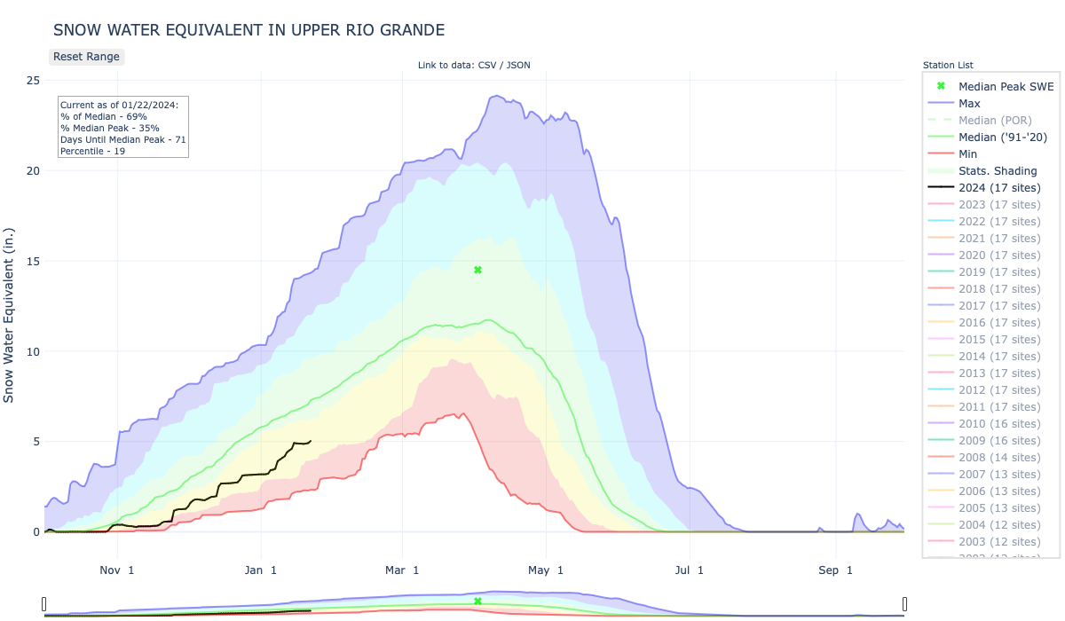
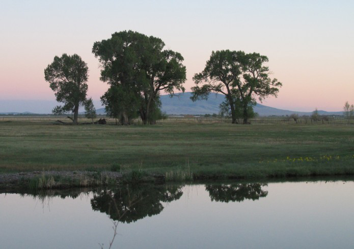
Although rain was a welcome sight during a Tuesday water meeting in Alamosa, it may not be a frequent occurrence as the year progresses.

Colorado Division of Water Resources Division 3 Engineer Craig Cotten on Tuesday shared the longterm precipitation forecast for this region, which calls for below average precipitation. He said the forecast for July through September calls for “equal chances” in this region but through November the weather service forecast calls for below average rainfall.

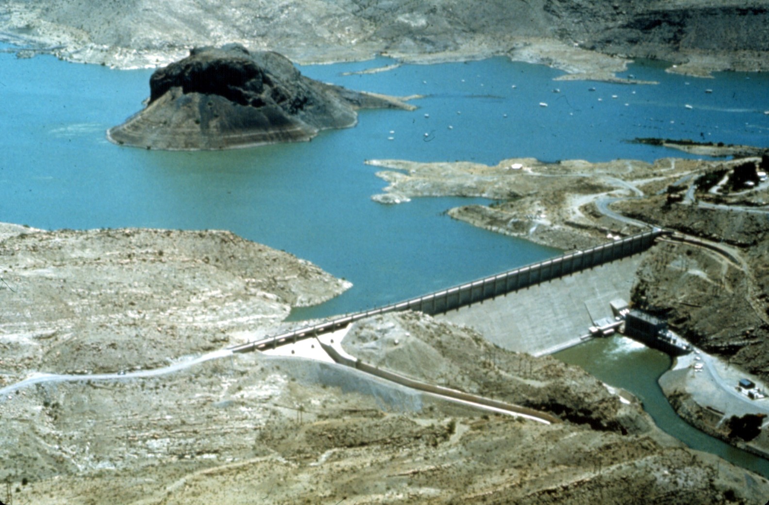
Water users on both the Rio Grande and Conejos River systems are currently under curtailment to meet Rio Grande Compact obligations , Cotten told members of the Rio Grande Water Conservation District board on Tuesday. The curtailment on the Rio Grande is currently about 9 percent and on the Conejos about 13 percent.

Cotten said the annual forecast for the Rio Grande is 690,000 acre feet, of which the obligation to downstream states through the Rio Grande Compact will be about 200,000 acre feet. From now through October the Rio Grande will have to deliver about 11,500 acre feet to meet that obligation, Cotten explained.

The forecast for the Conejos River system is 290,000 acre feet, of which 102,000 acre feet are obligated through the Rio Grande Compact.

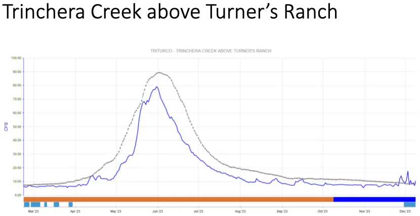
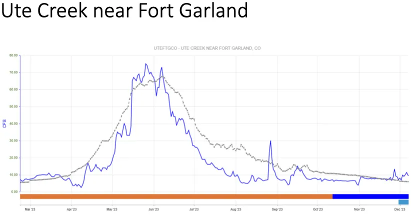
Cotten reported that the Conejos River was higher through June over last year’s flows during that time period but this month is a fair amount lower than last year and significantly lower than average.

The Rio Grande showed a similar pattern, he added, with fairly high flows in May, compared to last year, and higher than average. The first part of June was similar to last year, but after the peak the river dropped hard. The latter part of June the Rio Grande was below average and has continued to be below average this month.

Proposed bill would block expansion of Rio Grande del Norte National Monument — The Pueblo Chieftain

Rio Grande del Norte National Monument via the Bureau of Land Management

From The Pueblo Chieftain (Matt Hildner):

A $32 billion appropriations bill passed by the U.S. House of Representatives Thursday aims to block the expansion of a national monument into Conejos County.

The funding measure for the Department of Interior and U.S. Environmental Protection Agency includes a provision that would bar the use of any funds for a monument created by President Obama under the Antiquities Act.

Rep. Scott Tipton, R-Colo., voted in favor of the bill, which would block monument funding in five other Colorado counties and 41 counties in seven other states.

The Colorado counties are Chaffee, Dolores, Moffat, Montezuma, and Park…

Organizations Conejos Clean Water, based in Antonito, and the Conservation Lands Foundation of Durango have spent the last year trying to drum up support for the expansion of New Mexico’s Rio Grande del Norte National Monument onto 64,000 acres in Conejos County.

But their efforts have been met with opposition by ranchers in the county who fear a designation would hinder grazing on the targeted area, which is managed by the U.S. Bureau of Land Management.

Conejos Clean Water has argued that a potential designation would protect grazing, in addition to barring the area from oil and natural gas development.

The Antonito-based group joined 100 other groups earlier this month in urging the House to eliminate the monument provision, arguing that monument designations have been an economic boon to nearby communities.

“We do not support any bill that jeopardizes the ability to permanently protect our public lands,” Anna Lee Vargas, an outreach coordinator for Conejos Clean Water, said in an email.

The White House intends to veto the bill should it make it through the Senate for a host of reasons, including the monument provision. [ed. emphasis mine]

The administration’s formal statement said the measure would debilitate a program that’s successfully been used to protect the nation’s cultural and natural heritage.

#RioGrande basin: NCAR refining snowpack model for Conejos River watershed

Conejos River
Conejos River

From The Pueblo Chieftain (Matt Hildner):

The winter and spring snowpack that normally sits above this former mining town in the southeastern San Juan Mountains can be both a blessing and a curse.

It’s a blessing when there’s a lot of it — more runoff in the Conejos River basin in spring and summer is almost always a good thing.

But it can be a curse, especially for water managers trying to balance deliveries to local irrigators with the obligations of the Rio Grande Compact, because it’s difficult to measure, which, in turn, makes streamflows harder to forecast.

The Conejos Water Conservancy District, with the help of a host of federal and state agencies, has spent the last two years trying to change that.

The district is in the second year of a pilot project that’s prompted the installation of six new snow monitoring sites that can also measure soil moisture, humidity and temperature.

Another project component includes five new stream gauges in the upper reaches of the Conejos basin.

The project has also made use of a federal mobile radar and flights deploying a laser technology that precisely measured the watershed’s surface to get a better handle on the snowpack.

All of these steps result in data that are fed to scientists at the National Center for Atmospheric Research whom are refining a new forecasting model.

Nathan Coombs, manager of the Conejos district, knows a more accurate forecast model requires years of refinement but he’s encouraged by the project so far.

“We know we’re collecting better, usable data,” he said.

That’s a big improvement given that prior to the last two years, the 92-mile long Conejos had no snow gauges above its main stem and lacked stream flow gauges on many of its tributaries.

The lack of information can make it difficult for Colorado to predict its annual obligation under the Rio Grande Compact…

The Colorado Office of the State Engineer has traditionally used forecasts from the U.S. Natural Resources Conservation to project how big or small stream flows will be.

And the engineer’s office imposes curtailments on water users along both the Rio Grande and the Conejos to ensure delivery obligations are met.

Curtailments on the Conejos can often reach 30 percent and the timing of the restrictions can be exacerbated by an inaccurate forecast. “It’s headgates that are closed,” Coombs said. “It’s real, wet water that’s no longer available.”

Money for the project came from a wide range of funders.

The Colorado Water Conservation Board approved a $383,000 grant.

The U.S. Bureau of Reclamation and the National Oceanic and Atmospheric Administration also pitched in.

The Conejos district contributed $25,000, more than 10 percent of its annual budget.

But there are still some steps Coombs hopes to see happen that could further improve data collection for forecasting.

Right now the district’s highest snow gauge is at 10,500 feet in elevation, which excludes large swaths of the snowpack that run off in June.

“All of our late snow that throws our forecast completely out the window is above that,” Coombs said.

One solution to measuring that snowpack was a mobile radar unit stationed in Alamosa during the project’s first year that helped measure the intensity of late spring storms.

Coombs expects that unit to be back next year.

But a longer term solution may emerge from work with the U.S. Forest Service.

The district hopes to install snow gauges in the 161,000-acre South San Juan Wilderness, a move that would require forest service approval.

The wilderness area sits above the district’s gauges and is a monitoring blind spot.

It’s also home to a slew of important Conejos tributaries such as Elk Creek, and the South, Middle and Adams’ forks.

The end game of all the data collection and the work by federal scientists on the forecast model will give water managers a fuller picture of what’s coming downstream.

“Whether you have a compact or not, the priorities turn on and off because of what’s available,” Coombs said. “And if you know the why of what’s available, now you can start making management decisions.”

Proposal creates ‘monumental’ friction — the Valley Courier

Rio Grande del Norte National Monument via the Bureau of Land Management

From the Valley Courier (Ruth Heide):

Proponents of an expanded national monument met with water leaders and some resistance on Tuesday in Alamosa.

Rio Grande Water Conservation District (RGWCD) Board Member Dwight Martin , who lives in the southern part of the San Luis Valley where the proposed expansion would occur, was clear in his opposition to expanding the existing Rio Grande del Norte National Monument northward from New Mexico into the San Luis Valley.

“I am adamantly opposed to this monument designation ,” Martin said. “We really don’t need this monument in Conejos County. I really don’t see what it serves.”

He added that the Conejos County commissioners are also opposed to the monument expansion. Martin said about 90 percent of Conejos County residents at a meeting he attended on the monument were opposed to the expansion, and he questioned why the expansion was needed.

Anna Vargas, project coordinator for Conejos Clean Water, the organization promoting the monument expansion, responded that the meeting Martin attended was a meeting hosted by opponents .

“There has been interest in supporting the national monument, and there has been opposition that has been raised,” Vargas said. “We have tried to address all the concerns.”

Vargas told water board members on Tuesday that Conejos Clean Water had accepted language recommended by the water district to safeguard water rights within the monument, if it is expanded into the Valley. The language also recognizes the existing Rio Grande Natural Area, which lies in the proposed monument expansion.

“We are not trying to trump any of the work that’s been done on the natural area,” Vargas said.

Vargas recently completed the intensive water leadership course sponsored by several water groups including the Rio Grande Water Conservation District. She said the course gave her a better understanding of water issues and rights, such as the Rio Grande Compact. She said she had not viewed the monument expansion as affecting water rights but as more of a land protection issue . She said she now understood the potential problem implied water rights could generate.

“We don’t want national monument designation to have any implied water rights,” she said. The goal of the monument expansion, she said, is to preserve the land for traditional uses.

The Rio Grande del Norte National Monument, encompassing 242,500 acres, was designated by presidential proclamation in 2013. The expansion proposal would bring the monument north of the New Mexico state line into the southern part of the Valley and would encompass about 64,000 additional acres of Bureau of Land Management (BLM) land, Vargas explained.

She said the goal would be to preserve traditional uses such as piñon and wood gathering, hunting, fishing and other recreational uses. The monument would also prevent the land from being sold or leased for mining extraction. The turquoise mine would be “grandfathered in,” she said.

Vargas said proponents of the monument expansion want to be proactive in protecting the land from oil and gas activity.

“To us, that is a threat,” she said.

In 2007 that threat was real, she said, with four oil/gas sales involving 14,500 acres in the San Luis Hills and Flat Tops. The reason drilling did not occur, she added, was “basically because of a loophole” created because private landholders had not been notified of the sales.

“What we don’t want is a repeat of that,” she said. There might not be a loophole to prevent it in the future, she added.

Martin said, “This is really about oil and gas and not about protecting the land. All the monument will do is make it more restrictive for landowners.”

Vargas said that is why Conejos Clean Water is trying to get more community input and address these issues. She said there are rumors that the group is trying to prevent such uses as cattle grazing, but that is not the case. Such traditional uses are what the monument would protect, she said.

The land would continue to be BLM property, public lands, she said.

“We want it to stay publicly accessible.”

“Thank you for recognizing the concerns the district expressed,” RGWCD Attorney David Robbins told Vargas.

The district also sent a letter to the Department of the Interior and Colorado’s congressional delegation expressing the district’s concerns about the monument expansion without terms and conditions that would ensure water resources and the Rio Grande Natural Area are not adversely affected. The Rio Grande Natural Area, created through a federal, state and local partnership, integrates the management of federal and private properties along the Rio Grande between Alamosa and the state line to protect the riparian corridor for several purposes including Rio Grande Compact deliveries.

The district’s letter to congressmen regarding the monument expansion stated: “Every federal withdrawal or designation carries with it an implication that sufficient water will be made available to support the purposes of the designation unless specifically disavowed. The flows of the Rio Grande and the Conejos rivers in this area of the San Luis Valley are intimately tied to the economic and social health of the entire region, and reflect 150 years of water use practices that support the entirety of the San Luis Valley’s population as well as a water management structure designated to allow Colorado to freely utilize its share of the Rio Grande and its tributaries pursuant to the Rio Grande Compact. Any new federal land use designation that could impact or interfere with the water use practices in the San Luis Valley or Colorado’s ability to utilize the water resources to which it is entitled must be strenuously resisted by our elected federal representatives , as well as all of our state officials . This matter is of enormous importance.”

Representatives of the district also personally met with congressmen and Deputy Secretary of the Interior Mike Connor.

The district presented language protecting the Rio Grande Natural Area that it requested be included in the monument designation, were that to occur, and Conejos Clean Water has agreed to that language.

Robbins said the Valley’s congressmen and Department of Interior also assured the district they would not move forward with a monument expansion unless the district’s concerns were properly addressed.

Expand Rio Grande del Norte, National Monument?

Rio Grande del Norte National Monument via the Bureau of Land Management

From The Pueblo Chieftain (Matt Hildner):

President Barack Obama created the Rio Grande del Norte National Monument in 2013.

The 242,000-acre monument takes in the Rio Grande Gorge and spreads out across the sagebrush and grasslands of the Taos Plateau before stopping at the Colorado state line.

Now, a Conejos County group is saying he didn’t go far enough.

Conejos County Clean Water has begun a push to expand the monument into Colorado on the rolling hills and mesas that line the west bank of the Rio Grande.

Although the group faces concerns from the San Luis Valley’s water managers and outright opposition from a local commissioner, it believes the expansion would protect many of the land’s current uses and boost tourism.

“More people are inclined to see it and more inclined to visit,” said Michael Armenta, a project coordinator for the group.

Armenta said neighboring Taos County, N.M., did see an uptick in its lodging tax since the creation of the monument.

The monument, as it does in New Mexico, would exist only on lands managed by the U.S. Bureau of Land Management.

“All private lands would remain private,” Armenta said.

But the group hopes to see the monument take in the Punche Valley, the Pinon Hills and Flat Top Mesa.

And they hope to see similar allowances on this side of the state line that allow for hunting, grazing and the harvest of firewood and pinyon nuts.

If the same prohibitions on the monument are extended to the expansion, oil and gas development and mining would be barred from taking place.

Jim O’Donnell, a Pueblo native, lives in Taos and worked on the establishment of the monument in New Mexico.

He now works for the Friends of the Rio Grande del Norte and has explored much of the monument gathering information for the monument’s management plan.

He’s also banged around some of the areas targeted for expansion in Conejos County.

“The landscape is just an extension,” he said. “It’s so similar.”

Those similarities include large expanses of grasslands with pinyon and juniper forests on high points.

Likewise, both sides of the state line include important corridors for wildlife heading between the San Juan and Sangre de Cristo mountains.

And both sides of the state line include evidence of prehistoric use in the form of rock art, as well as use by the Hispanic land grant communities that nearly surround the monument.
But Conejos County Clean Water and its allies will have work to do to reach a designation.
Armenta said the group has gathered 350 letters of support, including the backing of three towns in the county.

It has yet to reach out to the state’s congressional delegation.

Moreover, the idea faces staunch opposition from at least one Conejos County commissioner.

“I am 100 percent against it,” Commissioner John Sandoval said.

Sandoval believes there are enough restrictions already on the county’s 501,000 acres of federal land.

He also is uneasy with the process leading to monument designation, noting that during the original push to create the monument, o™fficials at the Department of Interior failed to reach out to Conejos County even though it bordered the monument.

Water managers in the San Luis Valley have also taken notice of the push to expand the monument.
Although the presidential proclamation that established the monument in New Mexico specifically ruled out any reservation of water, valley o™cials are not taking for granted that it will be included in any expansion.

“If you declare a national monument, you carry with it the implication of a reservation of water sufficient to fulfill the monument,” David Robbins, an attorney with the Rio Grande Water Conservation District, said.

He addressed the district’s board Tuesday about a draft letter to the area’s congressional delegation regarding the proposed expansion.

Both Robbins and the district have played a significant role in preserving the primacy of local control over water in the establishment of the Baca National Wildlife Refuge and the creation of national park status for the Great Sand Dunes.

The district also pushed Congress to create the Rio Grande Natural Area, which lines a 33-mile stretch of the river that includes the area targeted for monument expansion.

Robbins suggested the district might be able to cooperate if any potential monument designation would pull back from the Rio Grande and the Conejos rivers, both of which carry requirements to deliver water downstream under the Rio Grande Compact.

But for the time being, the district will keep its concerns clear.

“I think we need to step up and say there are these problems if the monument is proposed to intersect or intertwine with either the Rio Grande or the Conejos, then the water interests in the valley should certainly be willing to oppose the monument in that form,” Robbins said.

Snowpack news: Upper Rio Grande Basin behind 2014

From the Valley Courier (Ruth Heide):

Similar to last year but not quite as good the moisture situation in the northern part of the Rio Grande Basin is better than in the southern end.

The current storm moved in from the south, however, so local forecasters were hopeful the southern part of the Valley would receive some moisture.

“We are below where we were last year,” Colorado Water Division 3 Assistant Division Engineer James Heath told attendees of the Rio Grande Roundtable meeting yesterday in Alamosa. “We didn’t get the early snow like we did last year.”

Heath said last year stream flows in Saguache Creek in the northern part of the basin ran better than average, the Rio Grande at Del Norte right at average and the Conejos River at Mogote 80 percent of average.

“We are in that same boat again this year,” he said.

Once again, the northern part of the basin seems to be receiving more moisture than the southern end, he explained.

Heath said the Natural Resources Conservation Service (NRCS) has released its first stream flow forecast for 2015, predicting 78 percent of average on the Rio Grande at Del Norte, 109 percent on Saguache Creek and 66 percent on the Conejos River.

“We are following in the same pattern as last year,” he said. “Hopefully we get some more storms.”

He said the National Oceanic and Atmospheric Administration is predicting higher than average precipitation for this region for the next three months, so he is hoping that turns out to be true.

When Roundtable member Travis Smith said, “you have to be very optimistic. You have some room for improvement ,” Heath said, “We have had 20 years of drought ” It can only get better from here.”

Smith said, “We are ever hopeful it’s going to be better .”

As of Tuesday, the Rio Grande Basin had the lowest snowpack in the state, according to NRCS snow measurement data. This basin stood at about 65 percent of average snowpack overall, with “runner up” lowest in the state being the San Miguel, Dolores, Animas and San Juan River Basins sitting at 73 percent of normal. All the other river basins in the state were either slightly under or over average snowpack on Tuesday, with the highest being the Arkansas and South Platte River Basins at 106 percent of average.

Colorado met its Rio Grande Compact obligations to downstream states in 2014, and the state engineer advisors are currently finalizing compact data. Conejos Water Conservancy District Manager Nathan Coombs is involved in a project to improve stream flow forecasting, particularly on the Conejos. He said meeting the compact obligation in 2014 was a significant task for water users on the Conejos River system where the initial forecast was off, so water users wound up owing a greater percentage of water during the irrigation season.

“We came out on the compact, but what it took was significant. It took 90 days of number-one’s being curtailed or shut off. It takes a lot to make that work,” Coombs said.

In better news, Rio Grande Water Conservation District General Manager Steve Vandiver reported yesterday the water reduction efforts of the water district’s first sub-district are making a difference in the basin’s aquifer. The unconfined aquifer storage, which has been measured since 1976 and has declined more than a million acre feet since that time, has recovered about 60,000 acre feet from its lowest point and is about 45,000 acre feet ahead of where it was last year, Vandiver said.

He added pumping over the last three years has decreased about 30 percent.

“There’s been significant savings and reduction of pumping, unlike some areas of the state where pumping actually increased,” Vandiver said.

“Mother Nature” needs to step up too, however, Vandiver explained. He said under current conditions it looks like it takes about 600,000 acre feet annual flow or above on the Rio Grande to make any significant gain.

“There has to be that level of diversion to support the well pumping that’s currently going on.”

The NRCS late-season forecasts for the Rio Grande in 2014 were 640,000 acre feet annual flow , or close to the long-term average.

More IBCC — basin roundtables coverage here.

Water strategies on the Conejos — the Valley Courier #COWaterPlan

Conejos River
Conejos River

From the Valley Courier (Nathan Coombs):

The Conejos River is the largest tributary to the Rio Grande River in Colorado. The Conejos and its tributaries Los Pinos and Rio San Antonio irrigate about 100,000 acres in the south end of the San Luis Valley and pay a significant portion of the Rio Grande Compact. With some of the oldest water rights in the state and basin, this water has been subject to many changed uses and modifications over time.

In 1928-38 when the Rio Grande Compact commission studied the flows of the rivers in order to calculate a compact arrangement with New Mexico, Texas, and Mexico, the system was already completely appropriated. The only method of irrigation at the time was flooding. Whether for the meadow, the vegetables or the grain and alfalfa fields, flooding was the only method used, or even contemplated.

With the unique physical properties of the Conejos basin, the flooding of fields filled the shallow aquifer with both run off and percolation. This building of the aquifer built a large amount of sub surface water that benefitted irrigators down gradient from where the earlier irrigation water was applied. These subsequent irrigators were able to apply less water to their crops, and gained the benefit of their crop’s roots being in contact with the ground water longer.

This method of irrigation also provided another benefit. The irrigation water diverted from the Conejos and filling the unconfined aquifer, caused return flows which also paid a large percentage of the Conejos’ portion of the compact. Irrigators used the water and paid compact with a large portion of this same water through return flows.

Over time, farm land was leveled, irrigation moved from flooding to sprinklers, and weather patterns trended towards drier winters diminishing sufficient supplies. As the efficiency of water application methods continued to improve, return flows decreased, so more water had to be left in the river channel to pay the compact. With this necessity of leaving pristine water in the channel, it became increasingly difficult for water users to depend on enough water for the entire season. Compounding this issue were years of significantly less than average snowfall. More adapting and changing were necessary.

In 1969 the Rio Grande Compact was being administered more strictly. This change in water management brought about the need for accurate accounting and measurement of the waters within the river. Water users were now experiencing curtailments to diversions in order to meet the compact. This curtailment meant that some water users were experiencing less water than historically available. Issues arose around how to make sure that those curtailed were in fact impacted to the least degree possible. This required a lot of time and effort from the DWR’s river commissioners. Also In 1991, The Conejos Water Conservancy District bought exclusive rights to the Operations and Maintenance to Platoro Reservoir. This change brought an opportunity to district water users to utilize the reservoir to store and re-release their water later in the growing season. With the opportunity to use reservoir water to offset some of the compact administra- tion issues, this development also brought the challenge of tracking this retimed water throughout the system.

In order to be proactive and solution minded, water users on the Conejos developed a strategy by first recognizing the issues they faced. First off, there was not an efficient way of tracking the different types of water in the river. It was very difficult to accurately and efficiently know where the different types of water were at all times, much less separate out the native from the reservoir from the Compact head gate by head gate. Secondly there were large inefficiencies with the infrastructure used for getting the water out of the river in priority, and allowing optimal use of both native and the reservoir water to diminish reliance on ground water. Finally, there needed to be a way to mitigate the effects of inaccurate forecasting of snowpack and insufficient stream flows . Water users felt that addressing these issues would help individual water users make better informed decisions on their farm’s water budget for a given year.

GAUGING

In 2012 to overcome some of the first of these challenges, 72 river diversions were fitted with a nearly live ability to “see” what was being diverted. Stilling wells were constructed and fitted with measurement and recording devices that transmitted wirelessly through an entirely new telemetry network that was built to transmit this information. The data is recorded, collected, and stored off site and available to administrators and water users through a secure password. This system also allowed the DWR river commissioners to be very specific with the use of their time and miles for regulating the diversions . With the new system, administrators are now able to make sure that the correct water amounts are being either diverted or passed through to the compact or other water users in priority.

AUTOMATING

The second proposal was to work in conjunction to the gauging/measurement of the diversions. Four of the largest water diversions on the Conejos System were automated. This effort regulates the water to the correct amount for each of these head gates. The automation was able to ensure that these diversions were able to both receive their correct amount of water and not “absorb” the diurnal effect of the river. By correcting the flows at these largest diversions water that should go down river to either another priority or the compact was available. The automation also saved countless hours of regulating and re-adjusting these head gates throughout the day. Because of the tremendous positive impacts of automation, the district is currently automating three more structures along the Conejos with plans for more being drawn up at this time.

PREDICTING

Finally , to help mitigate the “Mother Nature” component , the district is looking at bettering the methodology of both measurements and forecasting for the basin. Currently, the DWR uses reports from NRCS that are based on snotel sites, manual snow course measurements, and the NRCS’ own forecasting to predict total stream flows for both the Rio Grande and the Conejos. The input data are the foundation of the NRCS’ predictions. The problems however are that the number of measured sites is insufficient , their coverage is not complete, and in the case of the Conejos basin, they only represent about 35 percent of the watershed. With both winter inaccessibility to many areas for manual snow surveys, and USFS wilderness restrictions , a large portion of sub drainages simply are not measured.

With a partnership with CWCB, (Colorado Water Conservation Board) NCAR (National Center for Atmospheric Research) NOAA, (National Oceanic and Atmospheric Administration) NWS, (National Weather Service) and NSSL, (National Severe Storms Laboratory) the district has installed six additional “snotel lite” stations, flow gauges on tributary streams, and one radar truck!

The new measurement sites are placed on boundaries with the USFS wilderness areas and will ground truth what the radar truck is seeing . Since the radar has the ability to scan across both the wilderness and inaccessible areas of the basin, the concept is that water users will be able to refine the data used to predict actual snow levels down to the sub basin level.

The flow gauges on the tributaries will allow water administrators to calibrate how much of the system’s water is generated on the respective tributary’s sub basin. Then for an example; if a tributary is significantly higher or lower than the forecast pre supposed, immediate corrections to the compact curtailment can be made. This action will help refine the calculations necessary to administer the compact on a daily basis. This timely correction to compact administration will allow Valley water users to more fully use Colorado’s share of the water.

The Conejos Water Conservancy District does not have all the answers, and may not even yet have the right questions. The district does however, have a desire to place as many pieces in the water puzzle as it can.

Nathan Coombs is the director of the Conejos Water Conservancy District in Manassa.

More Conejos River coverage here and here.

Too much of a good thing — The Pueblo Chieftain #RioGrande

Rio Grande and Pecos River basins

From The Pueblo Chieftain (Matt Hildner):

Too much water has become a bad thing in the Rio Grande basin. That might seem like nonsense in a region that has seen below-average stream flows for most of the last 12 years, but inaccurate stream forecasts coupled with the demands of the Rio Grande Compact have put water managers and users in a pinch. The compact governs how much water Colorado must send downstream and includes separate delivery schedules for the Rio Grande and Conejos River.

Those deliveries run on a sliding scale with the highest demands in wet years and the lowest ones in dry times. Each spring, the state engineer’s office relies on stream forecasts from the Natural Resources Conservation Service to balance how much runoff can be diverted by irrigators with how much must go to New Mexico.

The service draws that forecast partly from the eight automated snow gauges and a string of manual snow survey sights in the basin. But this year’s projections were low by roughly 50,000 acre-feet on the Conejos and almost 150,000 acre-feet on the Rio Grande, Division Engineer Craig Cotten said. That has left Cotten and his staff in the position of curtailing or limiting the amount of water that irrigators would otherwise be entitled to according to their respective water rights.

“The most senior water rights on both rivers are being curtailed dramatically in order to meet the compact,” Steve Vandiver, director of the Rio Grande Water Conservancy District told the basin’s roundtable earlier this month.

Moreover, the service’s snow measurement and forecasting program may have an uncertain future. Last year, the service proposed eliminating 47 of the 110 manual snow survey sites in Colorado to meet agency budget cuts. While those sites were saved, the threat of future funding cuts along with the inaccuracies plaguing the forecast have led officials in the Rio Grande basin to look at other options.

The Conejos Water Conservancy District is in the middle of a $237,000 project that will install a temporary radar system, six weather stations and a string of new stream flow gauges. The aim is to get a more accurate forecast that will reduce curtailments for water users. In 2012, the Conejos district estimated that those curtailments cost water users in the basin up to $13,000 per day.

“We can’t realistically blame Craig because it’s the forecasting error,” said Nathan Coombs, the district’s manager. “We don’t have anything else that helps us.”

The Conejos basin is home to two of the automated snow gauges run by the service.

The radar, which will be located either at Antonito or Alamosa, will give officials a clearer picture of where storms are happening, while the six weather stations will allow them to determine how much the storms are depositing.

Moreover, the project will add flow gauges to key tributaries of the Conejos such as Elk Creek and the South Fork of the Conejos.

“If we can start measuring better what these tributaries are doing, that will give us an indication of what these sub-basins are looking at,” Coombs said.

The snowpack and stream flow data gathered by the district will be turned over to researchers at the National Center for Atmospheric Research and the National Severe Storms Laboratory. In turn, those researchers will try to use that data to create a forecasting model. Coombs said the district will stack up that end product with the service forecasts.

“If there’s enough discrepancy to pursue it, that’s how we’ll go,” he said.

The Colorado Water Conservation Board played a role in funding the Conejos project and also has pursued the use of satellite technology to help increase the accuracy of snowpack measurement.

“We’ve had this conversation a lot,” Travis Smith who represents the Rio Grande on the board, told The Chieftain. “Forecasting drives our compact decisions.” Smith, who has been heavily involved in fire recovery issues in the Rio Grande’s headwaters, said temporary radar near Wolf Creek Pass that’s been installed to warn of late summer and fall monsoon storms, may end up playing a role for winter snowstorms as well.

But moving state officials toward improved forecasting can be difficult given that two of the biggest water management organizations in the state — Denver Water and the Northern Colorado Water Conservancy District — do their own forecasting independent of the service.

Still, Smith sees a potential ally in the Arkansas River basin, where water managers are dependent on service forecasting for its voluntary flow management program and reservoir operations.

Mike Gibson is chair of the Rio Grande Basin Roundtable, which also divvies up state funds for water projects and funded a portion of the Conejos pilot project. He wants all options left on the table.

“I personally feel we need to pursue all avenues available until we come up with a better system than we have now,” he said.

More Rio Grande River Basin coverage here.

San Luis: Third Colorado Congreso de Acequias recap

San Luis People's Ditch via The Pueblo Chieftain
San Luis People’s Ditch via The Pueblo Chieftain

From The Conejos County Citizen (Sylvia Lobata):

A historic Spanish agricultural irrigation system of unlined water ditches that irrigate farmers’ fields, with water flows directed by the movement of tarps and dirt along each ditch, the unlined acequias are also believed to recharge the area’s shallow aquifers and support biodiversity.

Costilla County has 70 acequias covering 35,000 acres and serving 270 families, while Conejos’ 50 acequias, serve 45,000 acres and 100 families, linking the water users to their 16th century Spanish heritage, maintaining that culture across some nine generations in these isolated farmlands.

When heirs were being identified during the lengthy lawsuit to ensure access to the vast “Mountain Tract,” also known as the Taylor Ranch, the owners and heirs of many early homesteads, or varas, were identified by their connection with acequias. “Without water, there is no life,” says Norman Maestas, president of the San Luis-based Land Rights Council.

Many acequia properties were never officially incorporated, adding problems to use of the ancient ditches.

In 2009, largely at the urging of Costilla County water users, the Colorado legislature passed a bill “to promote and encourage the continued operations of acequias and the viabilities of historic communities that depend on those acequias.”

From the beginning, the congresos have drawn landowners and irrigators, agencies and officials, nonprofits, University of Colorado law students and others.

Law students have taken on the challenge of developing legal protection for the acequias.

Sangre de Cristo Acequia Association Program Director Sarah Parmar in a recent interview, said there is still much to be done about educating legislators and the public about acequias, while finding a place for the ancient systems in the state water plan.

This year’s congreso agenda provides knowledge heavily focused on acequia bylaws and conflicts to support the community in Colorado water conversations.

Parmar explained that, “we want everyone to understand what the purpose of bylaws are and that they can be used in a way to continue tradition. Bylaws are also a tool to help people coming into and returning to the community. More integration of bylaws into practice can prevent arguments.”

Those arguments come when water is scarce, she explained. Differing memories instead of bylaws are often recalled regarding the matter of sharing the resource.

The acequia association and the CU Law School partner through the Getches-Wilkinson Center to provide free or low cost legal assistance and educational materials to affected communities, helping establish their priority rights to water under Colorado law.

More Rio Grande River Basin coverage here.

“NRCS does their best, based on the SNOTELs they have” — Steve Vandiver #RioGrande

NRCS Streamflow Forecast June 1, 2014

From the Valley Courier (Ruth Heide):

Nobody’s crystal ball worked very well this year when it came to predicting river flows. In a Valley-wide water meeting yesterday, former long-time Division Engineer Steve Vandiver indicated the Natural Resources Conservation Service’s (NRCS) crystal ball might be cracked.

“NRCS does their best, based on the SNOTELs they have,” he said.

However, there are only about eight SNOTEL sites in the entire basin. SNOTEL is an automated system of snowpack sensors. Most of the SNOTEL sites in this basin provide information for the Rio Grande, with only two in the Conejos River system area. Vandiver said he was concerned about the apparent move by NRCS to rely on electronic data such as SNOTEL without confirming it through manual snow courses, a move that he believed would “lessen their ability to give us a good forecast.”

Vandiver added, “It’s vitally important we keep up with a forecasting system that means something.”

NRCS forecasts are the primary tool used by the Colorado Division of Water Resources Division 3 office to determine how much water the basin has to send downriver each calendar year and how much water irrigators will have available to them during the growing season. This year the NRCS forecasted annual stream flow for the Rio Grande at the beginning of the irrigation season was nearly 150,000 acre feet lower than the current forecast of 640,000 acre feet and the Conejos River system was almost 50,000 acre feet lower than the current forecast of 225,000 acre feet.

Because the earlier forecasts were off, the water division must send more water downriver now to make its annual obligation to the states of New Mexico and Texas as required by the Rio Grande Compact, Vandiver explained. That means an earlier cut off on the irrigation season on the Conejos River water users and greater curtailments on both the Rio Grande and Conejos River irrigators. Vandiver explained that because of the way the Rio Grande Compact was structured , the more water this basin receives, the higher percentage of it must be sent downriver, and the obligation percentage on the Conejos is already higher than the Rio Grande. In a big water year, which doesn’t happen very often , the Conejos system would have to send 70 percent of its water downstream, he said.

In normal water years, the basin has to send about a third of its water downstream to New Mexico and Texas.

“The delivery schedules dictate how much we can use,” Vandiver explained. Currently Conejos River system users are seeing a curtailment of more than 40 percent and the Rio Grande irrigators about 28 percent.

“On the Conejos system we are probably going to have to shut off early just to meet the compact,” Division 3 Engineer Craig Cotten said yesterday during the Rio Grande Roundtable meeting. He added the Rio Grande could probably make it to the first of November, the scheduled ending point for the irrigation season, but not extend past that point.

He said he will meet with Rio Grande irrigators before making the final decision on when to shut off the irrigation season this year. Vandiver, who held the division engineer position prior to Cotten and Mike Sullivan, described the headaches of managing water deliveries in the Rio Grande Basin (San Luis Valley) so that Rio Grande Compact deliveries are made and irrigators receive the water due them.

He said there are so many variables that affect runoff and stream flow every year from rain to dust on snow. He said NRCS has depended on various snow measurement sites around the basin through the years but has not had the funding and manpower recently to maintain, improve or increase those sites. When SNOTEL sites are not maintained, they are not able to provide accurate information for annual forecasts. For example, he said the SNOTEL site at Wolf Creek had problems ranging from large trees laying across it to a gopher hole in the middle of it that were not fixed before last winter, so the site did not work right, and it is one of the key sites in the SNOTEL system.

Conejos River irrigators are embarking on a $237,000 pilot project to use a portable radar system coupled with meteorological stations and river data collection sites to determine if there might be a better way to forecast runoff and stream flows in the basin, or at least to augment the information provided through NRCS. The Rio Grande Roundtable and state water board provided funding for that pilot project.

Nathan Coombs, manager for the Conejos Water Conservancy District that is spearheading this project, said it is not the group’s intention to influence or circumvent NRCS “We don’t need to pitch that aside and start over” but to collect data on a parallel track and see if it is useful for future forecasting efforts. Coombs said the best place for the radar truck to be set up would either be Antonito or at the airport in Alamosa. He added the radar coverage would provide information for both the Conejos and Rio Grande.

Cotten said his office is not mandated to use NRCS forecasts , “but there’s nothing else out there really.”

He added the weather service had started doing some forecasting.

“We are looking at their forecasts also.”

He said the NRCS and weather service forecasts were about 100,000 acre feet apart from each other this year, and it appeared the weather service’s forecast was closer to the truth this time, “which doesn’t always happen.”

Roundtable board member Cindy Medina suggested the roundtable or another group take the lead on presenting a package of basin snow measurement needs to legislators like Senator Michael Bennet who could work with NRCS to make sure funding is in place to meet those needs.

More Rio Grande River Basin coverage here.

A look at Rio Grande Compact administration this season #RioGrande

Rio Grande and Pecos River basins

From the Valley Courier (Ruth Heide):

After years of drought, more water in the San Luis Valley’s rivers is a welcome change, but it comes with a price.

With higher stream levels comes a higher obligation that must be paid to downstream states. Colorado Division of Water Resources Division Engineer for Division 3 Craig Cotten reminded Valley residents of that fact during his report on Tuesday to the Rio Grande Water Conservation District board.

When the forecasts increased for the Rio Grande and Conejos River systems, so did the curtailments on irrigators, he explained, because Colorado’s obligation to New Mexico and Texas also increased.

Cotten said the annual forecast for the Rio Grande has increased every month since May because more water is expected now than forecasters predicted this spring. The May forecast for the Rio Grande was 475,000 acre feet. In June the Natural Resources Conservation Service (NRCS) increased the projected annual index for the Rio Grande to 545,000 acre feet and this month bumped it up even higher to 590,000 acre feet.

“That’s up significantly from what we had projected earlier on in the season,” Cotten said. The obligation to downstream states from the Rio Grande is 158,400 acre feet from that new 590,000-acrefoot forecast. With the water that has already been delivered , estimated deliveries for this winter, and a contribution from the Closed Basin Project, the water resources division is projecting it must deliver about 22,000 acre feet during the remainder of the irrigation season. To reach that goal, the division is curtailing irrigators 25 percent, which is significantly higher than curtailments earlier in the irrigation season. Curtailments in April and May were 7-10 percent, with curtailments increasing to 15 percent in June, 21 percent by July 3 and 25 percent July 4th.

“That’s just because of the increased forecast amount and needing to deliver quite a bit more to the downstream states,” Cotten said.

“We are watching that pretty closely,” he added. “Depending on the monsoon season, if we do get a significant amount of rain and rain events, there’s a possibility we may have to go up a little higher than that.”

Curtailments on the Conejos River system are even higher. Since July 4, the curtailment on the Conejos has been 32 percent with only the #1 and #2 ditches in priority right now, according to Cotten . The curtailment on April 1 was 12 percent, decreasing to 6 percent by April 4 and 1 percent by May 7, but then increasing to 14 percent on June 7 and jumping to 27 percent by June 21.

“Curtailment of the ditches is indicative of raising the forecast every month,” he said. The projected annual index for the Conejos River system was 185,000 acre feet in May, 210,000 acre feet in June and is now estimated at 220,000 acre feet.

Of the 220,000 acre-foot annual flow , the Conejos River system owes 57,000 acre feet to New Mexico and Texas. To reach that goal, the Conejos will have to send about 8,000 acre feet downstream during the remainder of the irrigation season, according to Cotten.

Cotten shared the threemonth precipitation outlook from the National Oceanic and Atmospheric Administration for August, September and October.

“For the first time in quite a few years we are in the above-average range,” he said. “It’s looking like we are going to have a pretty good monsoon season.”

Temperatures during that three-month period will be another court case where the fine could top that.

“We are watching the well meter usage and metering and making sure everybody has active and accurate meters on their wells,” he said.

In his report to the Rio Grande Water Conservation District board on Tuesday, District Engineer Allen Davey said both the unconfined and confined aquifers had shown some improvement recently, but the basin has a long ways to go to re-establish the kind of aquifer levels the state legislature mandated, reflecting the levels of the period from 1978-2000 .

The confined aquifer, or deeper aquifer, has improved this last year by an overall total of about 2.66 feet in the wells included in Davey’s study. He said if the weather returned to a wetter cycle, with improved run off, irrigators would not need to pump as much, and the aquifers would naturally improve.

He added, “If we have bigger water years and the pumping stays the same, the aquifer will recover, and if the pumping is reduced, the aquifer will recover more.”

Since 1976 the unconfined aquifer, or shallow aquifer, in an area representative of the area now covered by the first groundwater management sub-district has declined a total of more than one million acre feet. Davey said the study area showed some improvement this spring with the aquifer level increasing by 105,000 acre feet during June, for example. “equal chances” of being in the average range.

Cotten said his office has had to file four or five court cases in the last month or so against well owners who did not comply with the well use rules, specifically not turning in well usage numbers or not having valid well meters in place. Fines could range from a few hundred dollars in simple cases to thousands of dollars. One irrigator is looking at a fine of more than $8,0000, Cotten said, and his office is currently working on He reminded the group that the target level required by legislators is -200 ,000 to -400 ,000 acre feet for a fiveyear running average.

“Right now it’s about 500,000 acre feet below that -400 ,000,” he said.

He said it’s like gas in a vehicle’s tank, and the more the vehicle uses, the lower the gas level is.

“What we need to do in order to recover is reduce the amount of ‘driving’ we are doing ,” Davey said. “Well users need to ‘drive’ less, pump less water, irrigate less land.”

More Rio Grande River Basin coverage here.

Rio Grande Headwaters Land Trust: Garcia Ranch Conservation Easement Completed!

Pond on the Garcia Ranch via Rio Grande Headwaters Land Trust

From the Rio Grande Headwaters Land Trust website:

The Rio Grande Headwaters Land Trust is proud to announce the completion of a conservation easement on the beautiful Garcia Ranch on the Conejos River. Thanks to the generosity of owners Dr. Reyes Garcia and his daughters Lana Kiana and Tania Paloma, their working ranch will remain intact with its senior water rights in perpetuity. In addition, RiGHT greatly appreciates the funding from the North American Wetlands Conservation Act, the Colorado Water Conservation Board, through the Rio Grande Basin Round Table, the Sangre de Cristo National Heritage Area and the San Luis Valley Habitat Partnership Program Committee which all made this wonderful conservation project possible.

Fulfilling the opportunity to conserve this exceptional property has been a labor of love for both the landowners and the land trust over the past two years, with roots that go back much, much further. As a retired professor of philosophy, environmental and indigenous studies, Reyes Garcia is deeply attuned to the legacy of his family’s land and the way of life it has provided for generations. With the Garcia family having originally settled in Conejos County in the 1850’s, he has a long history rooted in the special area between the Conejos and San Antonio Rivers.

In an article for RiGHT’s spring newsletter, Dr. Garcia wrote that he chose to conserve the land in honor of his older brother, Jose, who worked the land for 50 years until his recent passing. “Surely, a conservation easement agreement is a recommitment to a more original contract between humanity and the whole of the natural world …. as a sacred promise to cherish and safeguard one another. Surely, an easement agreement is a prism through which to envision a future much like the past many of us have known during our best years here in El Valle de San Luis – a future also much like the present in which we face so many of the challenges of a period of transition and big changes – a future that will continue as far as possible to be sustainable and wholesome.”

Conserving the land and water is a way “to make my own small contribution to preserving the family legacy of ranching and the land-based culture of the ranchero tradition,” Garcia wrote. “After my brother gave me the responsibility for irrigating in 1983, I came to understand this tradition includes putting into practice ecological values by virtue of an instinctual love of the land that engenders good stewardship and a deep respect for all life forms, the seasonal rotation of livestock and their humane treatment, the acequia irrigation system especially, the transmission of skills which make self-reliance possible, along with an emphasis on cooperation with neighbors and mutual aid.

“How can we not hope that another seven generations will lay up a treasure of similar experiences and memories? How can we not bring ourselves to do what is necessary to make this possible for those who come after us?” Garcia wrote.

“Conserving a spectacular property like the Garcia Ranch truly fulfills the core purpose of the Rio Grande Headwaters Land Trust,” said Rio de la Vista, Co-Coordinator of the trust’s Rio Grande Initiative. “The rare opportunity to protect such a beautiful confluence of working lands, important water rights and exceptional wildlife habitat is always fulfilling. And this easement is all the more special due to the long-lived legacy of the Garcia family in Conejos County. We are immensely grateful to them for working with RiGHT to provide this ‘gift to the future’, of intact land and water that can sustain life and livelihoods far into the future.”

For a short film about the Garcia Ranch by co-owner Lana Garcia, click this link.

More conservation easement coverage here and here.

‘In water, we never use the word fair. It is not part of the vocabulary’ — Nathan Coombs

Students pulling samples

From the Valley Courier (Lauren Krizansky):

Colorado youth are tomorrow’s water leaders, and in the Valley they are getting a head start. Natural resource education opportunities are abundant between the Sangre de Cristos and the San Juans, and teachers are connecting their students to one of the Valley’s most priceless resources – water – through Colorado Academic Standards approved lessons in nature’s classroom.

“Water, where it comes from affects us and what happens in our community,” explained Conejos Water Conservancy District Manager and Conejos County Conservation District Supervisor Nathan Coombs to a group of North Conejos School District students earlier this year. “And we have to measure water to know if it is going to the right places… the value of water is tremendous.”

After breaking down water management in the Conejos District to a few key vocabulary words – priority, compact, curtail, diversion, aquifer, ground water and surface water – Coombs brought it to life standing over the Conejos River on the Manassa Ditch No. 1 with the 65 middle school students, discussing the 97 diversions between the Platoro Reservoir and where they were standing. “In the river, it doesn’t matter where you are,” Coombs said. “It’s all about your number.”

He added, “In water, we never use the word fair. It is not part of the vocabulary.”

After detailing how the rivers in Colorado deliver water to seven states, Rio Grande Compact obligations and how it takes 44 hours in a raft to float on the Conejos River from the reservoir to Las Sauces, the students couldn’t stop asking questions and volunteering answers.

Water leaders like Coombs make these experiential lessons an option for Valley teachers with help from interested classroom teachers and environmental educators like the Rio Grande Water Conservation Education Initiative (RGWCEI) specialist Judy Lopez.

“This gives the students a real life connection,” said Conejos science teacher Andrew Shelton while watching his students turn on to their natural environment this fall. “This is a farming community , and it really hits home with them.”

RGWCEI works with the Valley’s conservation districts , school districts, community members and producers with a goal to create an educated populous that not only respects the Valley’s natural resources, but also understands the big part agriculture plays in conserving those resources, Lopez said.

“Not only are they getting lectures, but hands on experience that will ultimately build an intrinsic value system,” she said. “Science today tends to be taught within the context of labs and boxes. These experiences create problem solvers.”

About 85 percent of Valley students either stay here or return after college, she added, making natural resources lessons during younger years much more important .

“The youth are going to value the Valley more,” Lopez said. “They will be responsive to the natural resources as citizens, parents and families.” Students of all kinds Natural resource education in the Valley isn’t limited to the K-12 classroom. Last spring, the Rio Grande Leaders Course graduated a number of locals looking to understand and protect the Valley’s water. The Rio Grande Water Conservation District (RGWCD), San Luis Valley Water Conservancy District (SLVWCD), Rio Grande Headwaters Restoration Project (RGHRP) and RGWCEI sponsored course provided 25 community members the opportunity to engage in education and networking to prepare to take a future role in safeguarding , developing and managing the Valley’s water resources. It included information on Valley hydrology, water rights administration, notable court cases, current events and local partners and projects. Course attendees included young farmers, federal agency employees and other interested individuals , making for interesting dialogue and numerous perspectives on water use.

“It opened my eyes,” said Aliesha Carpenter, originally from La Jara and now married to a fourth generation Center potato farmer during the course’s closing ceremonies in March. “It wasn’t just about agriculture. It was about wildlife, the Sand Dunes and life for people. Without it, our agricultural economy would disintegrate. There needs to be a younger generation in agriculture.” Bureau of Land Management (BLM) assistant field manager Paul Tigan added, “I think the course helped with the understanding of the long term context of water management in the Valley. Federal employees have a tendency to come into a place, stay for a few years and then move on. This is a good opportunity to develop a context and to understand .”

RGWCEI is also reaching out to education professionals through its annual teachers workshop series. The series, now in its seventh year, offers educators from all backgrounds the opportunity to learn how to teach in the outdoors and from the outdoors. It includes a one-week experiential learning course annually over a three-year timeframe. The series is broken into three sectors: From Watershed to Cup Year One: Following Water Through the “Creekulum;” From Watershed to Sustainability Year Two: Building a “Stream” of Consciousness; and From Watershed to Table Year Three: Following Water Down the Food Chain. The series is based out of the Trinchera Ranch in Fort Garland, but uses the entire Valley as its classroom.

“It’s a way for teachers to reconnect,” Lopez said. “They learn how to teach in the outdoors, and it gives them a background. A teacher’s biggest fear is that they don’t know enough. They get to be on the ground with natural resource specialists and leave with hands on lessons , creating more confident educators.”

Completion results in three graduate credits, an extensive education in the Valley’s natural resources and their systems and the ability to build natural resources-based activities through the K-12 Project Wet curriculum, an outdoor environmental education tool. State supported initiative

In May 2010, the Colorado Kids Outdoors Grant Program Legislation, HB10-1131 was signed into law, recognizing the importance of the outdoor environment on the health of the state’s residents, especially youth.

It aims to prepare students to address present and future environmental challenges and innovations that impact quality of life, according to the Colorado Department of Education (CDE) Colorado Environmental Education Plan (CEEP) published in 2012. Colorado’s environment , economy and communities depend on informed citizens who can make decisions about air and water quality; the health of farms, ranches, forests and wildlife; how to meet energy and other resource needs; how to create and sustain healthy communities; and how to provide opportunities for residents to partake in the state’s natural beauty while protecting it for future generations.

In 2011, a partnership was born between CDE and the Colorado Department of Natural Resources (DNR) to write CEEP, and to foster awareness needed to promote, coordinate and sustain standards-based environmental education across the state.

The plan is designed to support implementation of the Colorado Academic Standards while developing students’ knowledge and skills related to the environment and getting students to spend more time outside, according to CEEP. The timing of this plan is advantageous as districts, schools and teachers are revising curricula and improving instructional practices to address the strategic imperative of developing all students’ postsecondary workforce readiness. Its strategies support teachers in addition to encouraging the integration of high quality environmental education opportunities and use of the outdoors in ways that are relevant, connected and meaningful for their students.

More education coverage here.

New series of articles from the Valley Courier will focus on Colorado’s supply gap

riograndebasin.jpg

Here is Part I of the The Valley Courier’s new series about Colorado’s water supply gap, written by Judy Lopez. Here’s an excerpt:

The Rio Grande Basin encompasses approximately 8,000 square miles, including the San Luis Valley. This high mountain valley extends approximately 100 miles from north to south and 50 miles from east to west.

Water in the Rio Grande Basin is currently over appropriated (and has been since the 1890s). All of the waters of the Rio Grande and Conejos River and their tributaries are subject to the terms of the Rio Grande Compact. This combined with the fact that the Valley’s groundwater resources have been over used and areas across the basin face groundwater depletions mean that the need for decision making is increasingly urgent. By 2050, a shortfall of 180,000 acre feet (AF) is expected, which includes the agricultural groundwater shortage which is being addressed by pending rules and regulations and fallowing farm land via the groundwater sub-district. The goal of each of these actions is to achieve sustainable aquifers through better management and reduction of groundwater pumping.

The whole case revolves around the fact that water is recognized as one of the most vital substances to sustain life. Then why is it one of the most undervalued resources in the world? Universally people do not understand the variety of services that water provides to sustain a nation’s economic development and the health of its population. Where would the manufacturing, electronics, or agriculture industries be without water?

Water helps to provides psychological benefits, too. In a report from the American Waterworks Association, “People derive pleasure from recreational activities and find comfort knowing that the water they drink is of the highest quality”. With this said, in developed countries, knowledge of water resources by the majority of the population is at best minimal.

Why? One reason could be that water utilities have been successful in providing high-quality water on demand. They are so good at in fact that the process of sanitizing and delivering water remains of little or no concern. So much so that most of the developed population is complacent about water resources, by valuing the outcomes and giving little regard to the inputs. One could predict that the misuse and abuse of water is the direct result of the perception that water has little or no value at all.

The real value of water is not the price or cost associated with its production – the real value of water is related to the services it provides. While water to sustain human life can be assigned a particular value; water used for environmental purposes, such as developing and maintaining wetlands, is assigned another value. The value is dependent upon a person’s background, belief system and interests.

More Rio Grande River Basin coverage here and here.

The Rio Grande Roundtable approves $237,000 streamflow forecasting pilot project

conejosriver.jpg

From the Valley Courier (Ruth Heide):

The state water board, Colorado Water Conservation Board (CWCB), is so interested in how the project will affect stream flow forecasts in the future it is willing to put $215,000 into it.

The local basin-wide water group, the Rio Grande Roundtable, on Tuesday unanimously approved the Conejos Water Conservancy’s $237,000 request for basin and statewide funding: $200,000 from statewide funds and $37,000 from basin-allocated funds. The conservancy district is taking the lead in sponsoring the project.

The total project cost is about half a million dollars with funds coming from state and local water grants, the CWCB match, local match and other grant funds.

Conejos Water Conservancy Manager Nathan Coombs and Roundtable Chairman Mike Gibson said this project would provide more information to the Colorado Division of Water Resources and others to more accurately predict stream flows. The project will ultimately assist area irrigators as well because it will improve management of the Valley’s river systems. If the project is successful here, it will likely be installed in other parts of the state.

Joe Busto, with the CWCB Watershed Protection & Flood Mitigation Program, said improved forecasting translates to real dollars for irrigators. Improved forecasts assist the state in better managing water resources, which is even more critical in times of drought. Busto said this type of project is a high priority for the state.

Currently there are gaps in this basin and others where snowfall data is lacking…

The project would use radar mounted by Red Mountain west of La Jara Reservoir to collect more information about snowfall and snowmelt. Busto said SNODAS (Snow Data Assimilation System) spatial modeling provides 100,000 data points in Colorado, with 4,000 of those in the Rio Grande Basin. The radar data will enhance those data points, he explained…

The pilot project will focus on the watershed in Conejos and integrate radar data with other forms of snowfall measurements and modeling systems. Complete coverage for the basin would require radar on the top of Bristol Head and in Center, Busto explained. That could be a long-term goal but would be more complicated to install. Busto said the Conejos watershed is simpler, so it is a good place to test this out.

The pilot will run seven months, he added, with the radar installed in November…

David Gochis, National Center for Atmospheric Research, said additional measurements are needed on the ground to verify how well the radar is working. If the radar is validated, it would prompt more confidence in applying the radar precipitation estimates elsewhere, Gochis said.

He said a SNOTEL site is currently located at Lily Pond, and the state has survey sites at Platoro and a couple more sites further west, but additional measurement instruments are needed to verify that the information the radar is providing is correct. One obstacle to installing more measurement instruments is the wilderness boundary, Gochis said, because instruments cannot be placed in the wilderness area. They could be clustered around Platoro, however, he said.

More Rio Grande River Basin coverage here and here.

Rio Grande Compact Commission meeting recap: ‘My mantra has been let’s try to solve and not fight’ — Scott Verhines

riograndebasin100thmeridianorg

From the Valley Courier (Ruth Heide):

Alamosa hosted the annual Rio Grande Compact Commission meeting, which rotates among the states of Colorado, New Mexico and Texas.

Although the states are currently involved in litigation over compact administration, pending lawsuits were hardly mentioned during the meeting, and state engineers said they hoped the states could resolve their differences.

In January, Texas filed suit against New Mexico over Rio Grande Compact disputes, with Colorado caught in the middle since it is part of the compact. The suit alleged New Mexico was not delivering to Texas the water owed that state under the compact.

“I am just hoping the three states and the commission continue to endeavor to work in a cooperative way,” said Dick Wolfe, compact commissioner for Colorado and the state water engineer.

Scott Verhines, Wolfe’s counterpart in New Mexico, said, “My mantra has been let’s try to solve and not fight … It behooves all of us to look for an opportunity to solve rather than fight.”

Pat Gordon, Texas’ compact commissioner and state engineer, said although he could not elaborate on all of the litigation issues, he agreed with Wolfe’s desire “that hopefully we can resolve all these issues.”

He said, “Water would solve a lot of issues.”

That seemed to be the consensus of all three states, which are entering yet another substandard water year.

“This is our fifth year in a row, consecutive year in a row, of below average conditions,” Commissioner Wolfe said. “We are seeing some pretty sustained below average conditions which certainly makes it difficult not only for users in Colorado but our downstream states as well.”

He said in the last 10-12 years, there have only been two or three years above the long-term average.

Wolfe reminded the water commissioners that 2012 experienced below average flows on the Rio Grande and Conejos River systems, with the Rio Grande producing 65 percent of average and the Conejos system 56 percent. He said 2013 will continue in a similar fashion but may be slightly better than last year. The March 1 forecast predicted 70 percent of average flows on the Rio Grande and 69 percent on the Conejos system, he reported.

More Rio Grande River Basin coverage here and here.

San Luis Valley water is safe from the USFWS and the southwestern willow fly-catcher

southwesternwillowflycatcher

From The Pueblo Chieftain (Matt Hildner):

A federal wildlife manager assured Colorado officials Thursday that the protection of habitat for an endangered bird would not lead to demands on the state to relinquish water.

In January, the U.S. Fish and Wildlife Service designated critical habitat for the southwestern willow flycatcher along 23 miles of the Rio Grande and a 2.9mile stretch of the Conejos River. “The designation itself does not affect water delivery or water users,” Wally Murphy, who oversees the U.S. Fish and Wildlife Service’s protection of endangered species in New Mexico, told the Rio Grande Compact Commission.

San Luis Valley water officials had been alarmed by the January designation after spending years working on a habitat conservation plan to protect the bird’s habitat on private land in the valley. The service excluded 114 miles of private stream bank along the Conejos and Rio Grande that were covered in the conservation plan.

But State Engineer Dick Wolfe, who represents Colorado on the commission, pressed Murphy on whether the operations of Platoro Reservoir or the Closed Basin Project might be impacted. “Habitat is ultimately driven by water to some extent so it seems like there is a nexus there,” Wolfe said.

Murphy said there would be no call for water. Platoro, which has a capacity of 59,000 acre-feet and sits near the Continental Divide, provides flood control and irrigation water for farmers and ranchers along the Conejos. The Closed Basin Project draws groundwater from the northeast corner of the valley and sends it downstream to assist with Colorado’s requirements under the compact.

More endangered/threatened species coverage here and here.

Colorado is being dragged into Rio Grande River Compact dispute between Texas and New Mexico

elephantbuttedamusbr.jpg

From the Valley Courier (Ruth Heide):

The suit, filed in U.S. Supreme Court on Tuesday, alleges New Mexico is not delivering to Texas the water owed that state under the compact, which also includes Colorado. [Colorado Division of Water Resources Division 3 Engineer Craig Cotten] had just learned of the suit Tuesday morning and said he was not exactly sure of the specifics. He said the main disagreement was between New Mexico and Texas, but since Colorado is part of the multi-state 1938 Rio Grande Compact, it was included.

“The State of Texas is requesting no action from the State of Colorado. They are included only because they are a signatory to the compact,” a January 8 release from the Texas Commission on Environmental Quality (TCEQ) stated.

TCEQ Commissioner Carlos Rubinstein said, “It is unfortunate that we have had to resort to legal action, but negotiations with New Mexico have been unsuccessful, and Texas is not getting the water that it is allocated and legally entitled to.”

Rubinstein alleged New Mexico was trying to circumvent and ignore the compact, and by filing suit against New Mexico, Texas was attempting to rectify alleged harm New Mexico had caused Texas water users…

Texas is alleging that New Mexico has allowed hundreds of thousands of acre-feet of water to be illegally diverted from the Rio Grande downstream of Elephant Butte Reservoir, the storage facility for the three-state Rio Grande Compact.

“Essentially, New Mexico is delivering water to Texas at Elephant Butte Reservoir and then re-diverting Texas’ water below the reservoir as it is being released to Texas,” TCEQ officials stated.

“The illegal diversion of this water is negatively impacting water flows in the river, taking water that is released for the Rio Grande Project beneficiaries, including the State of Texas … Grave and irreparable injury has occurred and will be suffered in the future by Texas and its citizens unless relief is afforded by the court to prevent New Mexico from using and withholding water which Texas is entitled to, and which New Mexico is obligated to deliver, under the Rio Grande Compact and Rio Grande Project Act.”

Cotten said the engineer advisors for each state are scheduled to meet on the compact in February, and the annual Rio Grande Compact Commission meeting will be held in Alamosa this year on March 21 at Adams State University.

As far as Colorado’s deliveries to downstream states in 2012, the state over-delivered its obligation by about 6,000 acre feet, Cotten explained. The over deliveries were all from the Conejos River system, which sent about 9,000 acre feet more than was required to downstream states. The Rio Grande under-delivered about 3,000 acre feet, so between the two rivers, the state ended up with a credit of about 6,000 acre feet.

Cotten said he hoped Colorado would be able to work with Texas to relinquish that credit water to Texas in exchange for the ability to store water up here. Since Elephant Butte Reservoir has been so low, Colorado has been prohibited from storing water in post-compact reservoirs in Colorado, according to provisions of the Rio Grande Compact.

More Rio Grande River Basin coverage here.

Drought news: Fall rainfall totals in the San Luis Valley disappoint

usdroughtmonitor10022012.jpg

From the Valley Courier (Ruth Heide):

The gauging station at Culebra Creek, outside of San Luis, has recorded water levels below 2002 drought levels for most of the summer…

Where the Rio Grande’s annual forecast was 415,000 acre feet last month, it is now 410,000 acre feet, Cotten reported to the Rio Grande Roundtable, which met in San Luis on Tuesday. Cotten said the forecast has gone down about every month this year. The 410,000-acre feet flow for the Rio Grande this year is 63 percent of the long-term average, Cotten added.

Although Colorado is still delivering some water downstream, its obligation on the Rio Grande is currently zero, so there are no curtailments on the irrigators along the Rio Grande.

The same is true for the Conejos River system, the other main contributor to the state’s Rio Grande Compact. The annual forecast on the Conejos River system is about 180,000 acre feet, or 55 percent of the long-term average, with zero curtailments made at this point and zero obligations required downstream…

Cotten also shared results of Allen Davey’s longitudinal unconfined aquifer study, which reflect a decrease of more than a million acre feet since 1976 to the present. Roundtable member Steve Vandiver said the latest figure is 1.2 million.

When asked if his office has been seeing a large number of applications for replacement wells because of the drought, Cotten said many people had already redrilled their domestic wells to deeper depths in 2002 and 2003 so his office is not seeing that many requests this year. He has had requests to redrill irrigation wells to deeper levels, which his office is objecting to, he said…

San Luis Valley groundwater sub-district plan garners nearly a hundred pages of objections from surface water users

conejosriver.jpg

From The Pueblo Chieftain (Matt Hildner):

…opponents have said the plan fails to show the work leading to its conclusions.

The filings argue that it lacks data and used a faulty methodology in producing a groundwater pumping estimate of 308,000 acrefeet for the upcoming season. Nor does the plan detail recent adjustments to a state computer model designed to project groundwater use and depletions to surface water. Moreover, the objectors request an explanation of how the projected injury to surface water users was reduced from 5,016 acre-feet in a draft of the plan to 4,706 acre-feet in the final version.

Opponents of the subdistrict also argued in a Friday filing that the standard of review adopted by the court requires the implementation of the subdistrict’s plan be delayed until objections are resolved.

Also, without a plan in operation, the objectors argue that groundwater wells that injure the rights of senior surface users must be curtailed, a move that would break with nearly a century of unregulated groundwater use in the valley.

A status conference in the case has been set for Tuesday at 9:30 a.m.

More San Luis Valley groundwater coverage here and here.

Colorado Water 2012: ‘There was and continues to be tension between the Western and Eastern Slopes’ — Mike Gibson

riograndebasin.jpg

Here’s the latest installment of the Valley Courier’s Water 2012 series. Mike Gibson describes the workings and role of the Rio Grande Basin Roundtable with respect to the IBCC and other basin roundtables. Here’s an excerpt:

There was and continues to be tension between the Western and Eastern Slopes as some feel water should be moved to the Front Range, and many on the Western Slope do not share these ideas. Similarly, these diverse opinions were held in other river basins…

Members of the [Rio Grande Roundtable] RGRT have participated in discussions to address the issues facing other basins and the state. It has been concluded that meeting the shortfall in municipal water (600,00 acre-feet by 2050) will be achieved by conservation, implementation of projects under construction or design, new projects in the future, such as new reservoirs, potential new sources of water, and transfers from the agricultural sector. While the latter may be the easiest way to meet the shortfall, there is general consensus that such transfers should be minimized to preserve the agricultural lifestyle and economy of the State. These deliberations also considered the necessary water for recreational use and maintenance of the natural environment…

The Water Supply Reserve Account has been funded to $41.8 million of which $4.8 million has come to the Rio Grande Basin. The process to obtain these funds is for the proponents to discuss their project with members of the roundtable and its chairman. If it is determined the applicant and their project will meet the necessary criteria for funding, a formal application is completed and presented to the roundtable for their endorsement. The request is subsequently reviewed by CWCB staff and finally presented to the CWCB for approval.

The WSRA funds that have come to the Rio Grande Basin have covered a variety of “water projects” across the Basin, including reservoir studies and rehabilitation; on-site improvements to diversion structures and head gates; repairs of water conveyance structures; river restoration; the conservation of agricultural land and its associated water; and outreach and education. Recipients have included irrigation and reservoir companies and non -profits involved with conservation and restoration. The projects have been geographically widespread, from Creede, to Fort Garland, to San Luis and have been completed on the Rio Grande, Alamosa, and Conejos rivers and their tributaries. Since WSRA funds have been available, the Valley has addressed many outstanding issues that were known but did not have a mechanism to be implemented.

More Colorado Water 2012 coverage here.

Rio Grande River basin: Groundwater Sub-district No. 1 fallowed acreage at 9,100 acres for this season

slvdischargerecharge.jpg

From the Valley Courier (Ruth Heide):

Rio Grande Water Conservation District Manager Steve Vandiver told the water board during their meeting in Alamosa on Tuesday that some of the irrigators who were going to fallow their land in the first sub-district area this year opted to go with prevented planting instead because it would pay them more than the sub-district.

Vandiver said the sub-district ended up with about 9,100 acres under contract for fallowing this year.

“It was higher than that, and as insurance programs kicked in for prevented planting, people started withdrawing their contracts,” Vandiver told the board. “A number of people withdrew their offers to fallow.”

Farmers could receive $500-600 per acre under prevented planting, while the sub-district was only paying $200-300 per acre, Vandiver explained.

He said at least 18,000 acres would be fallowed to some extent under the prevented planting program, and although that would not entail 100 percent dry up, “there’s a considerable amount of ground that’s going to have a lot less growing on it this year than it has before.”

More San Luis Valley groundwater coverage here and here.

CWCB: Funding approved for Terrace Reservoir spillway replacement and Conejos River stream gages

terracereservoir1

From The Pueblo Chieftain (Matt Hildner):

The Colorado Water Conservation Board approved a $407,000 grant to install gauging stations in the Conejos River basin and signed off on a $1 million loan and a $1.5 million grant to replace a spillway at Terrace Reservoir. Terrace Reservoir, which backs up the Alamosa River, has had the size of its storage pool restricted by the state since the 1980s due to the inadequate size and poor condition of the reservoir’s spillway…

The Terrace Irrigation Co. owns the reservoir and has 24 shareholders. It irrigates 9,300 acres in Conejos and Rio Grande counties. The restrictions required the storage pool to remain roughly 2,000 acre-feet below the reservoir’s 15,182 acre-foot capacity. The added capacity would accommodate a 2,000-acre foot instream flow water right that is being worked on by the CWCB and the Alamosa Riverkeepers…

Construction could begin this summer once the State Engineer’s office signs off on the spillway’s design, Reinhardt said. Terrace’s project also will benefit from $2 million in Natural Resource Damage funds, which came from fines assessed to the operators of the Summitville gold mine that has since been turned into a Superfund cleanup site.

The second project to earn funding from the state called for the installation of 72 river gauges and four remote-controlled headgates by the Conejos Water Conservancy District. The district, which has 86,000 acres of irrigable land in the southwestern corner of the valley, hopes the gauges will allow for a more accurate accounting of the Conejos River’s deliveries under the Rio Grande Compact.

More Rio Grande River basin coverage here and here.

Colorado Water 2012: ‘…about 10 of the oldest priority dates in the Rio Grande system belong to the Conejos River’ — Nathan Coombs

coloradowater2012

Here’s the current installment for the Colorado Water 2012 series from the Valley Courier written by Nathan Coombs the Manager of the Conejos Water Conservancy District. Click through and read the whole article for the history of the area. Here’s an excerpt:

In the 1850-70’s when the railroads were carving out rights-of-way through Northern New Mexico and the San Luis Valley, the US military was expatriating hostiles, and farmers and ranchers were focusing on water. This was the era of the canal building and ditch digging. Land was being cleared and the essential element- water was being acquired. In this high desert, the ranchers and farmers were quick to learn the importance of this life-giving substance.

Settlers to the Conejos River area, which rivals the San Luis area for antiquity of civilization and establishment, were not any different. These water users filed for and received their adjudicated decrees. In fact about 10 of the oldest priority dates in the Rio Grande system belong to the Conejos River. Early on these pioneer/settlers were legally and progressively seeking and putting to beneficial use water. With their shoulders bowed to the work they kept their vision focused on the future.

The southern end of the San Luis Valley has always had strong developmental ties to the rivers. The oldest communities in the area were established along the waterways and dependant on the rivers for their success. Ditches like the Guadalupe and the Headsmill (priorities 1&2 respectively) were developed for 1,000’s of acres of land and industry, with examples like the Finley Ranch and the Antonito grist mill and the Town of Antonito’s drinkable water supply developed from their priority on the Conejos River. Although these structures had to be hand built to divert the water, the area developed and progressed.

The people of the Conejos did not sit back and expect gravity to do the work. They looked up, up stream, 10,000 feet up in fact. In the early 1940’s The Conejos Water Conservancy District was formed to be the local vehicle that would seek partnership with the Bureau of Reclamation in building a reservoir. The San Luis Valley Project study identified the Platoro site at nearly 10,000 feet above sea level as the most feasible. As soon as WWII ended and funding became available construction began. This $3 million project was completed one year ahead of schedule and under budget. (Where have those days gone?)

More Colorado Water 2012 coverage here.

Rio Grande Roundtable meeting recap: Rio Grande compact requirements will likely prevent an increase in the pool at Platoro Reservoir

platororeservoir.jpg

From The Pueblo Chieftain (Matt Hildner):

Although compact requirements are a moving target throughout the year, Division 3 Water Engineer Craig Cotten said the amount of water moved past the state line in winter and early spring can limit curtailments on local irrigation ditches. “They really depend on how much water we get through the wintertime, especially in March,” he told a meeting of the Rio Grande Basin Roundtable Tuesday. “Our flows are going up so we’re getting a lot more through.”[…]

Irrigation ditches along the Rio Grande would face a 15 percent curtailment on all flows as of now. The state’s obligations under the compact, which governs the use of the Rio Grande between Colorado, New Mexico and Texas, vary according to streamflow…

The Conejos River, which runs through the southwestern corner of the San Luis Valley and shares in the state’s compact requirements, is expected to produce 265,000 acre-feet this year. The state must send 85,000 acre-feet downstream. Irrigation ditches there currently face a 20 percent requirement.

Water users in the Conejos Water Conservancy District will likely not have the luxury of increasing storage at Platoro Reservoir, a 59,000 acre-foot reservoir that sits at the river’s headwaters in the San Juan Mountains. Platoro can only increase its storage when there is 400,000 acre feet or more of usable water in Caballo and Elephant Butte reservoirs in New Mexico.

More IBCC — basin roundtables coverage here.

The Rio Grande Basin Roundtable ponies up $407,000 to increase SCADA installations along the Conejos River to facilitate streamflow monitoring

scada.jpg

From The Pueblo Chieftain (Matt Hildner):

While the move still requires approval of state water officials, the Conejos Water Conservancy District hopes the proposal will return some water to its users while allowing for a more accurate accounting of delivery requirements under the Rio Grande Compact. The district, which has 86,000 acres of irrigable land in the southwestern corner of the San Luis Valley, wants to add 72 electronic gauging stations and automate four of the most-used headgates in the river basin. The district and ditch companies inside its boundaries would put up $92,000 in matching funds.

The Conejos, like the Rio Grande, is subject to the Rio Grande Compact, which has fluctuating requirements for how much water must be sent downstream to New Mexico and Texas, depending on the amount of snowpack in a given year. As much as 70 percent of the river’s flow is allowed to head downstream in a wet year and as little as 25 percent in a dry year…

The added gauges may also help the district pin down return flows from diversions, a task that’s complicated by a jumble of river channels and irrigation ditches near the junction of the Conejos with the Rio Grande. The district also hopes the gauges would allow for a more accurate tracking of releases from Platoro Reservoir, which has a capacity of 59,000 acre-feet.

More IBCC — basin roundtables coverage here.

The long-range forecast for the San Juans is for slightly below average precipitation — blame La Niña

westsanjuansfromanasazicenterdolores.jpg

From The Telluride Daily Planet (Benjamin Preston):

According to the National Weather Service, La Niña, a condition where colder-than-average sea surface temperatures off the coast of Peru push the jet stream further north, usually dumps precipitation farther north. First hitting the Pacific Northwest, these systems tend to travel through the Northern Rockies before expiring over the Ohio River Valley.

“Colorado is the transition zone where the northern mountains get more snow than the southern mountains,” said Dennis Phillips, a meteorologist at the NWS station in Grand Junction. Droughts and fires across the Front Range and Southern Plains suggest that conditions this season will most likely resemble last year’s, although cold air masses in the Arctic could cause conditions in Colorado to change quickly. But although Arctic weather conditions can impact weather in the Rockies more rapidly than South American sea surface temperatures, forecasters are unable to predict its impact further than two weeks in advance…

Joe Ramey, another of NWS Grand Junction’s team of meteorologists, said that precipitation during the weeks leading up to the April ski area closure approached average levels. He compared this year to the 2000-2001 winter season, which produced La Niña weather patterns after a La Niña had occurred the year before.

“The 2000-2001 season gives us the best idea of what will happen this year,” he said, adding that he expected below average precipitation in the Southern San Juan Mountains. From Telluride north, he expects near average snowfall, especially toward the end of the season.

Rio Grande River basin: Conejos River irrigators will shut down on October 20 to meet Rio Grande Compact requirements

conejosriver.jpg

From the Valley Courier (Ruth Heide):

Because more water flowed through the Conejos River system this year than was originally forecasted, more must be delivered downstream to New Mexico and Texas to satisfy Rio Grande Compact obligations. To meet that compact obligation before the end of the year, irrigators must shut off their water early this year. The presumptive ending date for the irrigation season in the Rio Grande Basin (the Valley) is November 1. This year on the Conejos, the season will end on October 20…

[Colorado Division of Water Resources Division Engineer for Division 3 Craig Cotten] had recommended the early or middle part of next week for the shut-off time and said that would give his office time to notify the public. He said even if the irrigation season had ended yesterday, the compact obligation still might come up short this year. Cotten said the only alternative would be to end the year with a debt to downstream states, but the debt would have to be paid next year, and next year may not provide a more generous water supply than this year. He said going to debt is allowed but not recommended…

Cotten said the annual forecast on the Conejos River system is now 255,000 acre feet, up 5,000 acre feet from the month before. “We don’t know where the water is coming from sometimes,” he said…

Of the 255,000 projected annual index on the Conejos, 78,400 acre feet must be delivered downstream. From Oct. 8-31, 5,800 acre feet must be delivered, which would require an 85 percent curtailment on irrigators, Cotten explained. Irrigators have been under a 50-percent curtailment on the Conejos system since September 20…

Lawrence Gallegos, who owns water rights on one of the oldest ditches in the state, asked if the Valley’s aquifer was depleted further this year. Cotten said the Rio Grande Water Conservation District’s monitoring system in the central part of the Valley indicated a significant drop in the unconfined aquifer this year, in fact even slightly lower than the 2002 drought year levels. “Actually the aquifer is lower than it ever has been before,” Cotten said. He said if the aquifer dropped in the central part of the Valley, it undoubtedly dropped in the southern part of the Valley as well.

More Rio Grande River basin coverage here.

Rio Grande Roundtable recap: Runoff was up and down for the water year, mostly down

riograndebasin.jpg

From the Valley Courier (Ruth Heide):

Colorado Division of Water Resources Division Engineer for Division III Craig Cotten described the roller coaster ride to members of the basin-wide water group, the Rio Grande Roundtable, on Tuesday. “It was kind of a strange year, way below average, above average and then way below average again,” he said…

The annual index supply forecast for the Rio Grande at Del Norte varied up and down, with the latest preliminary annual flow sitting at 505,000 acre feet, quite a bit less than the average 650,000 acre feet, according to Cotten. Of that amount, the Rio Grande will have to supply 128,700 acre feet to downstream states to satisfy Rio Grande Compact obligations. Curtailment of irrigators on the Rio Grande is about 10 percent currently. Cotten said since ditches are not running in the wintertime, curtailment at that time was 100 percent, and when the ditches on the Rio Grande system began diversions on March 28, curtailments were 7 percent, dropping to 6 percent, then back up to 10 percent, 14 percent, 17 percent, 19 percent and a high of 22 percent, as predictions changed with varying runoff flows…

The Conejos had below average flows through half of June. “They were significantly below average, especially during the first part of May, way lower than what we usually have,” Cotten said. Then the Conejos system picked up to above average flows, which remained above average. The annual forecast on the Conejos River system is 245,000 acre feet, which is lower than the average 325,000-350,000 acre feet, according to Cotten. Of that total, the Conejos owes 72,000 acre feet to downstream states to complete its Rio Grande Compact obligation. To meet that compact obligation, irrigators are experiencing a 40-percent curtailment right now on the Conejos, Cotten said.

More Rio Grande River basin coverage here.

Rio Grande River basin: Revised runoff numbers trigger 22% and 46% curtailments on the Rio Grande and Conejos rivers repectively

conejosriver.jpg

From The Pueblo Chieftain (Matt Hildner):

The adjustment, which came in part because of a high-elevation snowpack that eluded runoff forecasts, means irrigation ditches on the Rio Grande and Conejos rivers will face increased curtailments. Between now and October, the state will have to send 24,000 acre-feet downstream on the Rio Grande and another 17,000 acre-feet will have to come from the Conejos, Division Engineer Craig Cotten said Tuesday. Irrigation ditches on the Rio Grande will face a 22 percent curtailment, a 16 percent increase from June 1. Ditches on the Conejos will have a 46 percent curtailment, up from 13 percent June 1.

This year differed from the prior two runoff seasons when stream flows fell sharply after peak runoff occurred. “It started dropping at about the time that we anticipated it dropping but it didn’t drop nearly as fast,” Cotten said…

While this year’s runoff remained below average, water managers were expecting even less water in the stream system and a smaller compact requirement. State water officials typically base their runoff on a number of factors, including the 10 snow gauges the Natural Resources Conservation Service has set up in the mountains above the Conejos and Rio Grande. This year’s snowpack included heavy pockets at elevations above those gauges, Cotten said.

More Rio Grande River basin coverage here.

Rio Grande River basin: Some ditches to start running early

A picture named riogranderiver.jpg

From the Valley Courier (Ruth Heide):

At the request of the majority of water users attending the Rio Grande Water Users Association meeting Wednesday afternoon, Colorado Division of Water Resources Division 3 Division Engineer Craig Cotten agreed to permit an early irrigation start date for irrigators on the Rio Grande main stem (District 20.) Irrigators in District 27 (La Garita Creek and Carnero Creek) will also be permitted to turn on their water on March 28, not quite a week before the normal start date. In keeping with a new irrigation policy, the presumptive irrigation season for the Rio Grande Basin (the San Luis Valley) is April 1 to November 1. However, the current dry, warm conditions in the Valley have prompted irrigators to seek an earlier irrigation season start date this year. The irrigation season for La Jara Creek drainage began on March 16. Saguache Creek irrigation season began a couple of days ago, and Schrader Creek has also been permitted to turn on…

Some farmers said a small amount of water immediately would make a big difference in their crop success, and they believed they would require less water later in the irrigation season if they could begin irrigating sooner, on this end of the season. On the other hand, every week irrigators wait to turn on their sprinklers and ditches means less curtailment during the irrigation season to meet Rio Grande Compact obligations to downstream states, Division of Water Resources staffer Patrick McDermott said. He estimated that each week the irrigators held off, the curtailment would drop by 1-2 percent. Cotten estimated curtailment to meet the compact at 11 percent but said return flows have been 4 percent, so he was looking at a 7-percent curtailment, if the irrigation season began April 1…

Cotten said as of Wednesday, the Rio Grande at Del Norte was only running 200 cubic feet per second (cfs). Taking reservoir water out of storage would only push the cfs up to 250, he added…

Cotten said this is the first year the new irrigation policy has been in effect, so it is a learning process for his office as well as irrigators. This is also the first year well users have to follow the same irrigation season as surface water users.

More Rio Grande River basin coverage here.

Rio Grande Roundtable recap

A picture named riograndebasin.jpg

From the Valley Courier (Ruth Heide):

Colorado Division of Water Resources Division III Division Engineer Craig Cotten told attendees at Tuesday’s Rio Grande Roundtable meeting that the dry appearance of the river, particularly in Alamosa, is a sign the state is current on its debt to downstream states so more water can be diverted to area irrigators without having to send it all down the river. “We are looking really good on the Rio Grande,” Cotten said. “We are meeting all of our obligation right now with return flows. That’s why the river is fairly dry through Alamosa, because we have got a little bit of water going to the West Side and Chicago Ditches and not a lot of water going through Alamosa.”

Cotten said 2010 turned out to be a less-than-average year with water flows on the Rio Grande. The annual forecast for the river is currently 540,000 acre feet. An average year would run 650,000 acre feet, “so we are a fair amount below average at this point in time,” Cotten said. The current forecast is even lower than the June 1 prediction of 575,000 acre feet on the Rio Grande, Cotten pointed out. Of the 540,000 acre feet flow on the Rio Grande for the year, 140,000 acre feet are obligated to New Mexico and Texas to meet Rio Grande Compact requirements. “We do have a fairly good obligation to downstream states, but we have already been able to deliver quite a bit of that water to the downstream states,” Cotten said. He said currently only about 5 percent of the state’s obligation on the Rio Grande is still owed, and that obligation is being met through return flows.

The Conejos River system is also meeting its obligation to downstream states, Cotten explained. That river system is also below average in total forecast flow, Cotten added. An average annual flow on the Conejos River system is 325,000 acre feet. This year’s adjusted forecast is 285,000 acre feet, which is down from the June 1 prediction of 315,000 acre feet. Of the total flow, the Conejos River system is obligated to send 99,000 acre feet downstream, “and currently we have delivered all the water we need to during the irrigation season,” Cotten said. During November and December the Conejos system will deliver more water downstream, and that will be sufficient to meet the Rio Grande Compact obligation, according to Cotten…

In addition to reporting on the status of the Rio Grande Compact and the Valley’s major rivers, Cotten reported to the Rio Grande Roundtable that groundwater rules are still under construction and the state engineer is hopeful they will be promulgated by the end of the year. Modeling work is currently being conducted for different areas of the San Luis Valley to determine how much impact wells have on rivers so adequate replacements for injurious depletions can be made. Cotten said that modeling work is nearly completed and he hoped it would be finished in the next month. With that completed, the advisory group that is working with the state engineer to develop groundwater regulations can finish up the sustainability portion of the regulations, Cotten explained…

Cotten also updated the group on the status of the first water management sub-district case. The sub-district of the Rio Grande Water Conservation District is designed to reduce irrigation in the closed basin area of the Valley to protect senior water rights, help meet Rio Grande Compact obligations and replenish Valley aquifers. The sub-district’s plan of management proceeded through the court, objections, trials and judicial ruling and is now pending a decision from the Colorado Supreme Court, which Cotten said might not occur until next spring.

More IBCC — basin roundtables coverage here.

Rio Grande Basin: Annual Rio Grande Compact Commission meeting recap

A picture named riogranderiver.jpg

From The Pueblo Chieftain (Matt Hildner):

Although last year’s spring runoff came earlier than usual, Colorado sent 299,300 acre-feet of water across the New Mexico state line. The state also accrued a 1,500-foot credit…

The compact, signed in 1938, uses a sliding scale that allows Colorado to keep much of its water in dry years while hiking delivery requirements in wet years. In a year with an above-average snowpack, flows in excess of 560,000 acre-feet on the Rio Grande must be sent downstream. On the Conejos River, which is managed by a similar sliding scale, flows in excess of 224,000 acre-feet must be delivered to New Mexico in an above-average year…

Colorado State Engineer Dick Wolfe, who serves as the state’s commissioner, said they would keep a close eye on the efforts of the other two states to deal with endangered species like the silvery minnow and the southwest willow flycatcher, which impact how the other two states manage the Rio Grande. Although Colorado is working on a habitat conservation plan for the flycatcher, a small bird, the management decisions the other two states have to make on the river for the species have not effected Colorado.

San Luis Valley water leaders Doug Shriver and Ray Wright died in a freak snow-slide accident a while back. The Compact Commissioners passed a resolution acknowledging their efforts. Here’s a report from Ruth Heide writing for the Valley Courier.

More Rio Grande Basin coverage here.

Rio Grande Basin: Water year recap

A picture named riograndebasin.jpg

From the Valley Courier (Ruth Heide):

[Chris Landry executive director of the Center for Snow & Avalanche Studies] and his team compared snow core samples to determine the number of dust events during a winter season. He reported an increase in dust events from 2008 to 2009 from 7 to 12 at the site studied in the Rio Grande Basin. The concentration of dust was heavier as well. In 2008 the concentration was 12 grams per meter while in 2009 it was 55 grams per meter. He said that is an enormous amount of material. “The San Juans in particular experienced the most dramatic advance in the state in snowmelt timing,” Landry said.

He said the reason for more dust might have simply been because this past winter was windier. He said not much data is available about the source of the dirt, presumably blowing in from the western desert. Landry said the dust layers on snow were fairly consistent statewide from Rabbit Ears Pass in the north to Wolf Creek Pass in the San Luis Valley.

The report from Division of Water Resources Division Engineer for Division III Craig Cotten bore out the fact that the snow melted off early this year. He told the water board the reasons for the early run off were probably dust on the snow and warmer temperatures in May. He showed graphs illustrating a dramatic decline in river flows in May. However, Cotten said irrigators were curtailed less than usual this year because of winter recharge and deliveries to downstream states. “We only had a month of curtailment on the Rio Grande this year,” he said.

On the Conejos system, curtailments were also zero during most of the run off period, from April 15 to July 9, Cotten said. The Conejos system went back to zero curtailment the end of August. He added, “We also had the entire suite of ditches in priority and diverting. The most junior priority on the Conejos system diverted for almost three months this year.”

Both river systems will likely over deliver the amount of water required by the Rio Grande Compact interstate agreement with downstream states. At this point Cotten is estimating an over delivery of 9,700 acre feet on the Rio Grande, about the same amount of water carried over in credit last year. He told the water board the ditches would be turned off October 31 under standard operating procedure but if the weather is warm the first part of November, water may run longer in order to recharge the Valley and reduce the amount of over delivered water downstream.

More Rio Grande Basin coverage here.

Platoro Reservoir: Dam safety upgrades

Platoro Reservoir

From The Pueblo Chieftain (Chris Woodka):

U.S. Rep. John Salazar, D-Colo., secured a request for $646,000 in the energy and water appropriations bill. Salazar sits on the Appropriations Energy and Water Subcommittee, which approved the funding. The bill must still gain House and Senate approval. Platoro Reservoir is used for flood control and for re-regulating the flows of the Conejos River for irrigation in the San Luis Valley Project of the Bureau of Reclamation. Flows are crucial to the Rio Grande Compact with Texas and New Mexico The reservoir is used by the Conejos Water Conservancy District as well as a large number of hunters, fishermen and recreational enthusiasts. Funds will go toward further inspection of deteriorating inflow pipes, and to install a system to carry increased bypass flows. “Platoro Reservoir, built in 1951, can no longer handle our wintertime by-pass flows creating a critical dam safety issue,” Salazar said. “This funding will help preserve the life and use of the reservoir for agriculture, flood-control and recreational use.”