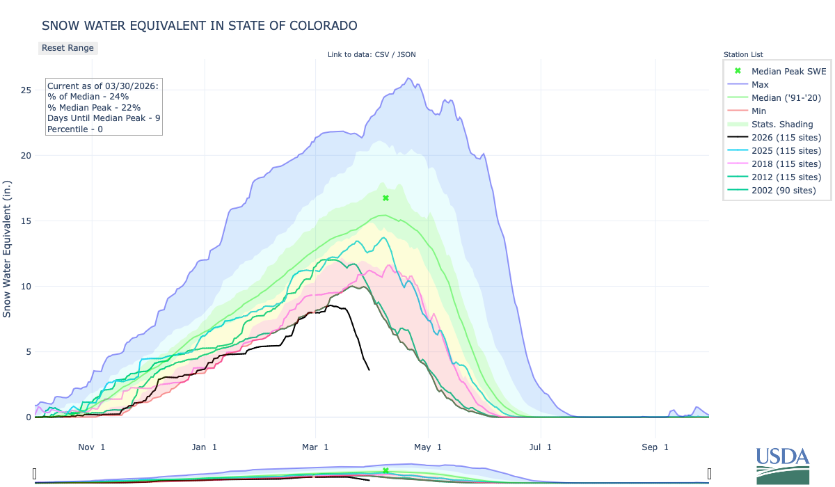
The full impact of this past winter’s record-low snowpack is rearing its ugly head in the form of:
Record-low spring stream flows.
Low reservoir storage levels.
An empty reservoir.
And one incredibly rare statistic.
On June 17, Denver Water’s reservoir system hit its peak storage level following a diminished spring runoff.
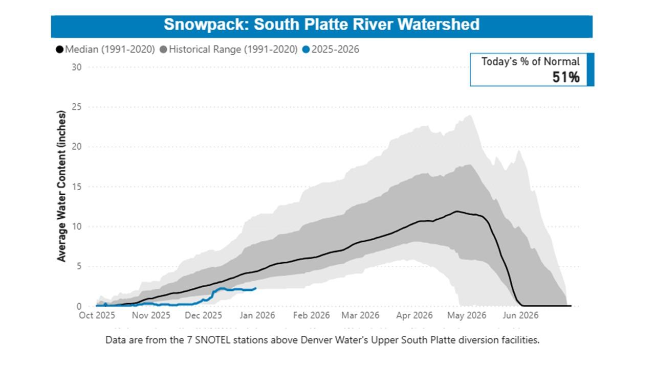
Water levels in the utility’s reservoirs collectively hit 81% of the system’s storage capacity — the second-lowest peak storage level on records dating back to 1983, considered the beginning of the modern Denver Water collection system.
“Peak storage” is the moment, or day, when the utility’s collection system holds the most water it will hold for the next year. It’s akin to topping off a swimming pool once a year in June to carry the pool through the next year of use.
Typically, the “peak storage” moment happens in mid-June, after the spring runoff.
But in 2026, due to the record-low winter snowpack and low spring runoff, Denver Water’s collection system held more water on Jan. 1 — 83% of capacity — than on June 17, as the runoff dwindled and storage levels inched to 81% of capacity.
There’s only one other year since 1983, when the Strontia Springs Dam was completed, that Denver Water’s storage was higher in the dead of winter than the dawn of summer — the drought year of 2002.
“Having our highest amount of water happen in January is incredibly rare. It speaks to how little snow we saw this winter and the impact of the record-setting warm weather,” said Nathan Elder, Denver Water’s manager of water supply.
“We’ve seen many records fall this year, and unfortunately, they were not good ones.”
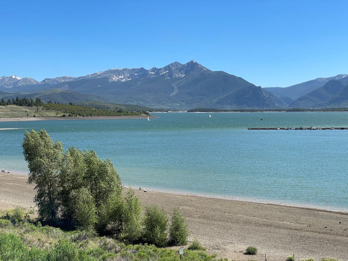
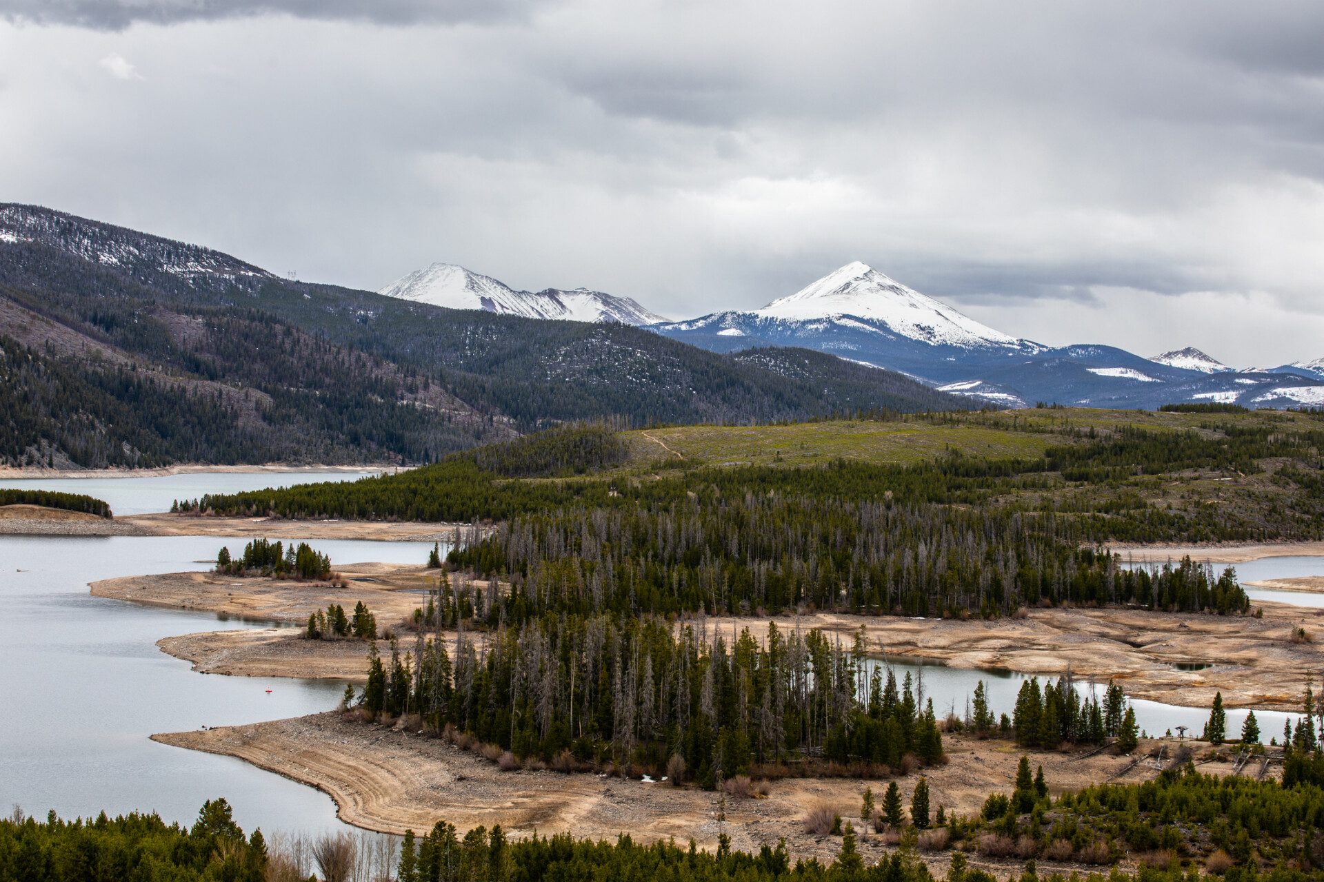
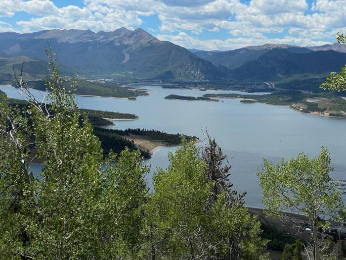
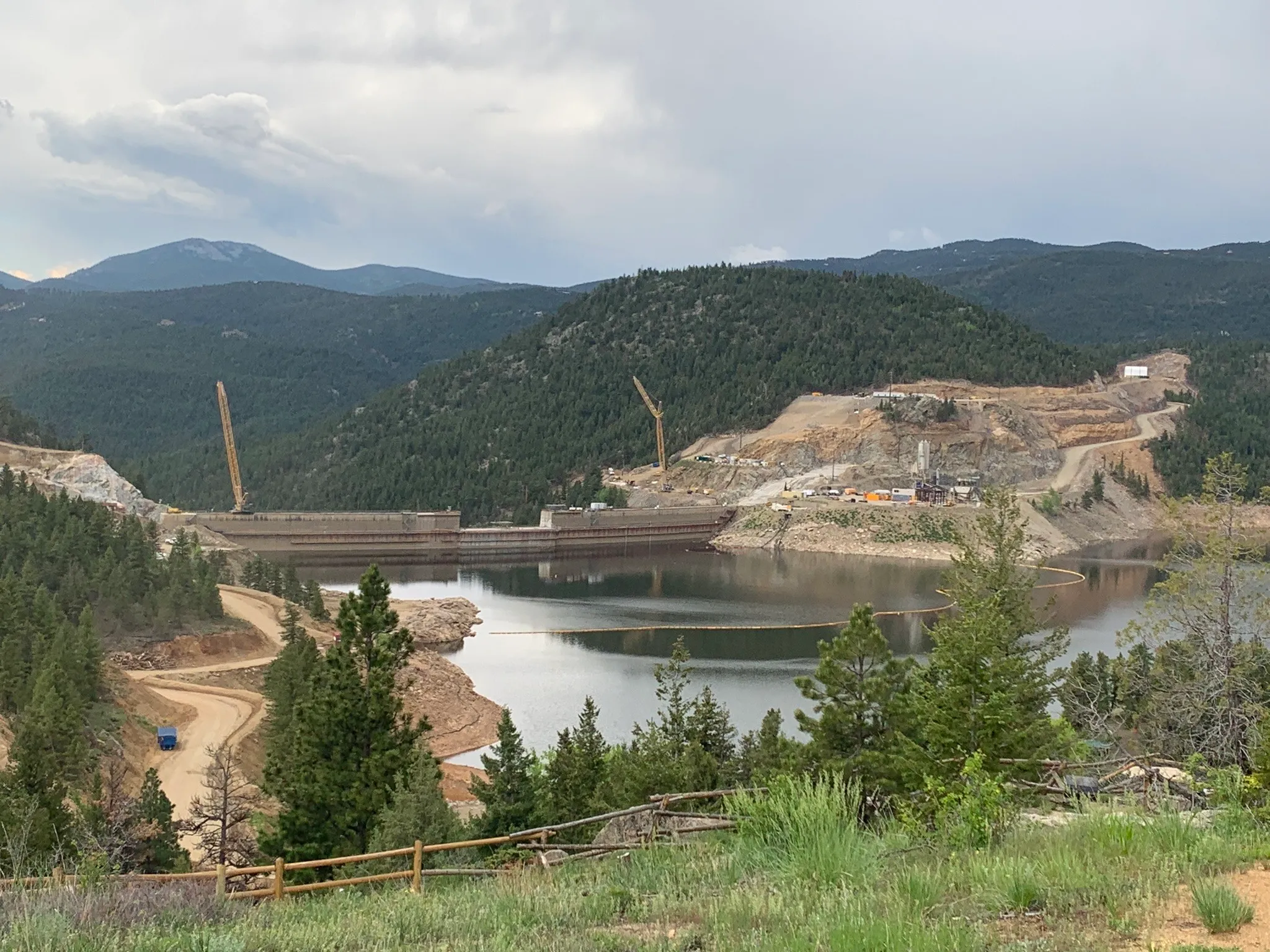
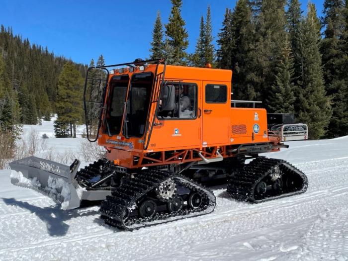
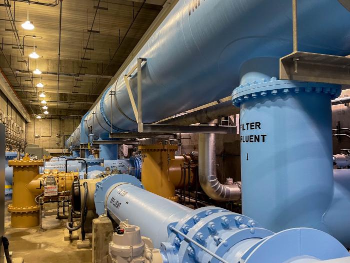
Dillon Reservoir reached 80% capacity on June 17, the highest elevation it is expected to see in 2026. Dillon is the largest reservoir in Denver Water’s collection system, storing roughly 38% of the utility’s water supply. Photo credit: Denver Water.
During the spring peak, the amount of water stored in Denver Water’s reservoirs typically hits an average of 97.5% of capacity.
And since 1983, the utility’s peak storage levels have hit at least 95% of capacity (considered sufficient for normal operating conditions) in all but six years.
“Ideally, we like to top off our mountain reservoirs during the spring runoff, but this year our storage levels came up well short,” Elder said.
Record low ‘paycheck’
Why do water managers focus on peak storage numbers?
The peak reservoir storage figure is critical to determining how much water is available until next year’s spring runoff. It’s comparable to a family determining how much money they have to pay the bills until the next paycheck comes through.
“The spring runoff is our annual paycheck from Mother Nature,” Elder said. “The water filling our reservoirs is the cash that fills our bank account. But in our case, that paycheck only comes once a year — and this year we didn’t get anywhere close to the normal amount.”
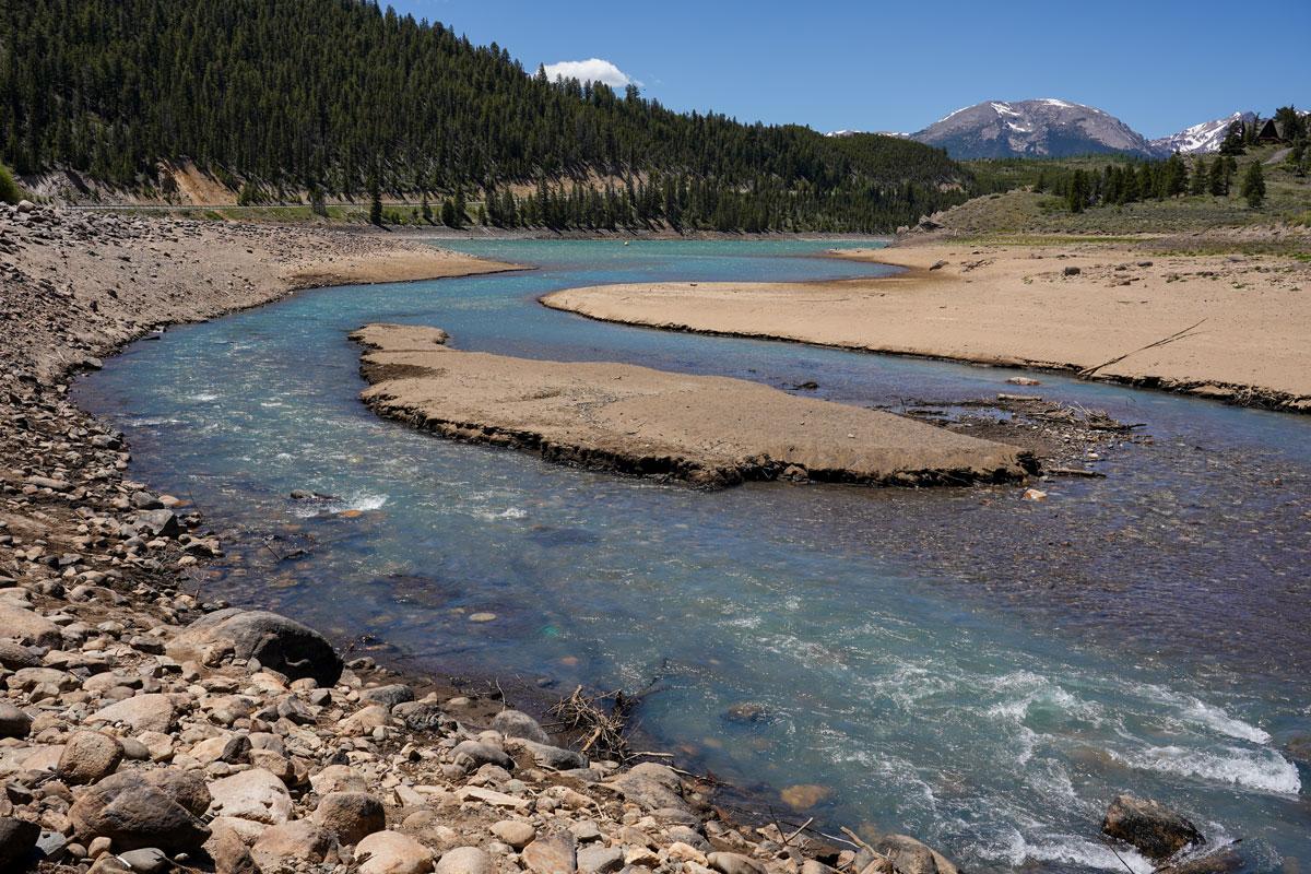
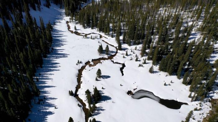
Tenmile Creek in Frisco, as it enters Dillon Reservoir on June 12. Denver Water saw record low flows into the reservoir in 2026. Photo credit: Denver Water.
This year’s meager paycheck was reflected in the record-low peak flows on the rivers and streams that feed Denver Water’s reservoirs.
Mountain snowmelt accounts for 90% of Denver Water’s supply, which provides water to 1.5 million people in metro Denver.
In Summit County, Denver Water recorded this year’s peak stream runoff into Dillon Reservoir at just 404 cubic feet per second, or cfs, on May 29. That’s a record-low “peak inflow” and less than a quarter of the normal peak inflow into the reservoir of 1,750 cfs, which typically happens on June 7.
In Park County, the South Fork of the South Platte River experienced a double-whammy, with record-low flows that occurred abnormally early in the season.
Flows on the South Fork peaked on March 25 at a record-low flow of just 18 cfs. That’s 15% of the normal peak flow of 120 cfs, which usually happens on June 10.
The South Fork of the South Platte River south of Fairplay on May 22. The river peaked at a record low flow of just 18 cfs in 2026. Photo credit: Denver Water.
“In a typical year, the rivers and streams start rising in late-April as the snow starts to melt, then they peak in early June, and then they start to ease back to normal flows throughout the summer,” Elder said.
“This year the runoff started about six weeks early in March, and the normal spring surge of water we usually see was basically nonexistent.”
Reservoir impact
The results of the record-low spring flows are having a significant impact on three of Denver Water’s most popular reservoirs.
Dillon Reservoir in Summit County topped off on June 17 at 80% of capacity, with water levels about 18 feet below normal for this time of year. Water levels are expected to drop over the next year until the 2027 spring runoff — hopefully more boisterous than this year’s meager flow — begins.
Dillon Reservoir in Summit County reached 80% capacity on June 17. This picture shows the low levels at the Snake Inlet on the southeast corner of the reservoir on June 12. Photo credit: Denver Water.
In Grand County, Williams Fork Reservoir topped off June 21 at merely 53% of capacity, about 35 feet below normal for this time of year and forcing the closure of the reservoir’s boat ramp.
At the Williams Fork Reservoir in Grand County, the boat ramp will be closed all summer due to low snowpack and record-low runoff. Photo credit: Denver Water.
Because of the low snowpack, Denver Water also dipped into its emergency water supply at Antero Reservoir in Park County.
Using water from Antero Reservoir is only done in extremely dry years. It’s comparable to someone having to dip into their 401(k) savings to pay bills until their next paycheck.
Denver Water moved water out of Antero this spring and sent it downstream to Cheesman Reservoir to avoid losing water in shallow Antero due to evaporation.
Denver Water moved water from Antero to Cheesman reservoir in 2026 to reduce losses from evaporation. The water in Antero Reservoir, pictured above, is only used in extreme dry years. Photo credit: Denver Water.
Early forecasts for the abysmal spring runoff and low peak storage were two factors that led Denver Water to issue a Stage 1 drought declaration in March.
The declaration, which calls on customers to reduce water use by 20% and includes mandatory watering restrictions of two assigned days per week, seeks to stretch existing water supplies until next spring’s paycheck is deposited in the reservoirs.
“While the reservoirs are low this year, they are doing what they were built for, which is to help us get us through a dry year,” Elder said.
“We hope customers notice the low reservoir levels and take steps to conserve water at home so we can stretch our water supplies over the coming months.”
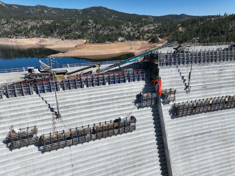
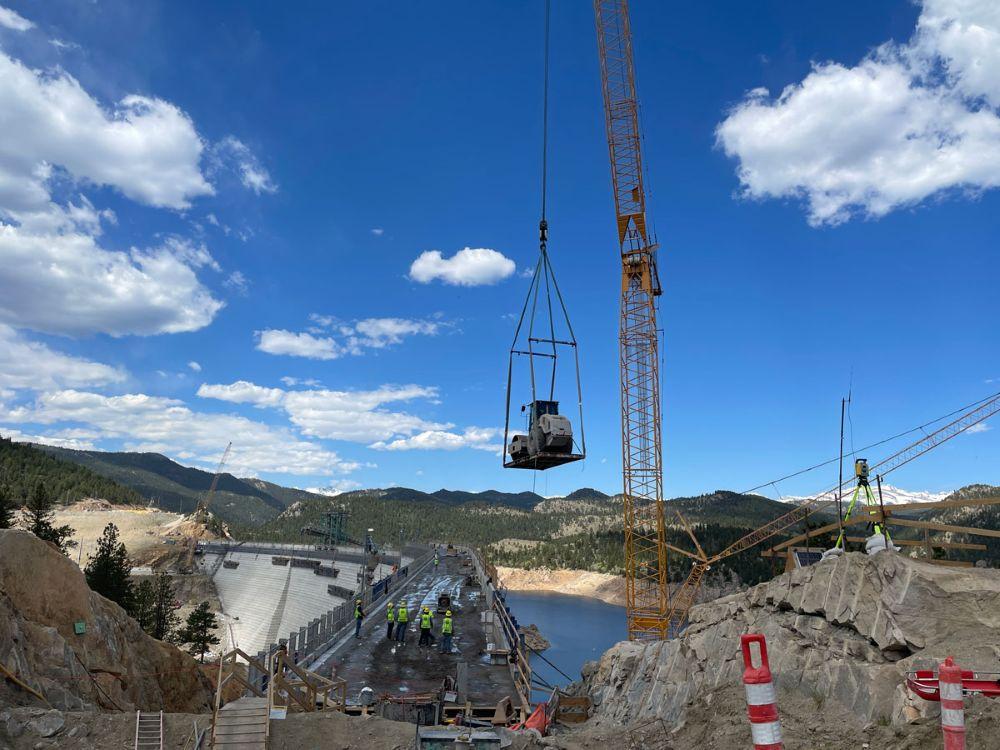
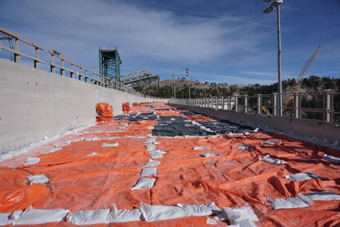
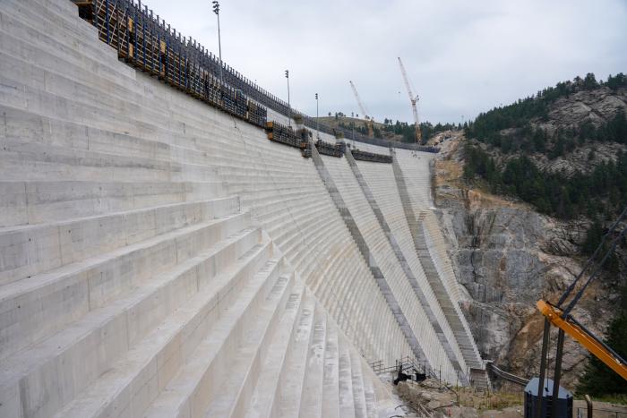
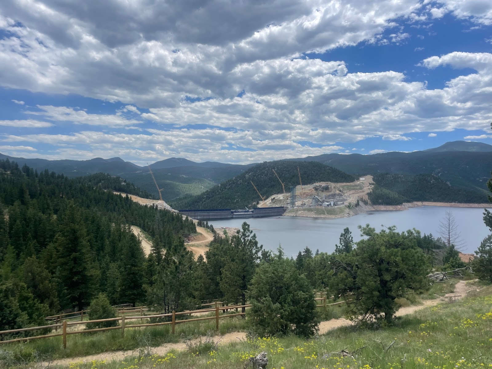
The new conveyor system moved concrete across the gap where the spillway channel will be to the far side of the dam. Photo credit: Denver Water.
Click the link to read the article on The Denver Post website (Elise Schmelzer). Here’s an excerpt:
June 14, 2026
…it remains unclear whether Denver Water will ever be able to fill the reservoir to its new full capacity as a yearslong court battle lumbers on between the utility and environmentalists. Months of mediation between the parties have failed. Denver Water is now asking a federal appeals court to reverse a lower court judge’s 2025 order barring the utility from filling the expanded reservoir and ordering the yearslong federal permitting process to be redone. A panel of three judges for the 10th U.S. Circuit Court of Appeals is scheduled to hear arguments in the case on July 31 in Santa Fe…
U.S. District Court Judge Christine Arguello in 2024 found that federal regulators violated environmental protection laws when they failed to properly analyze the environmental impact of the project or consider reasonable alternatives to the dam expansion that would be less harmful. She later issued the order against filling the reservoir. Environmental groups argued in court, and in their filings, that regulators failed to evaluate how siphoning more water from the drought-stricken Colorado River would impact the basin as a whole. And the groups charged that they failed to weigh other project options that wouldn’t require the clear-cutting of a half-million trees or risk damage to wetlands. The case has drawn the attention of other Front Range water providers, lawyers from across the county and the U.S. Chamber of Commerce — all of which have filed briefs in the appeals case…
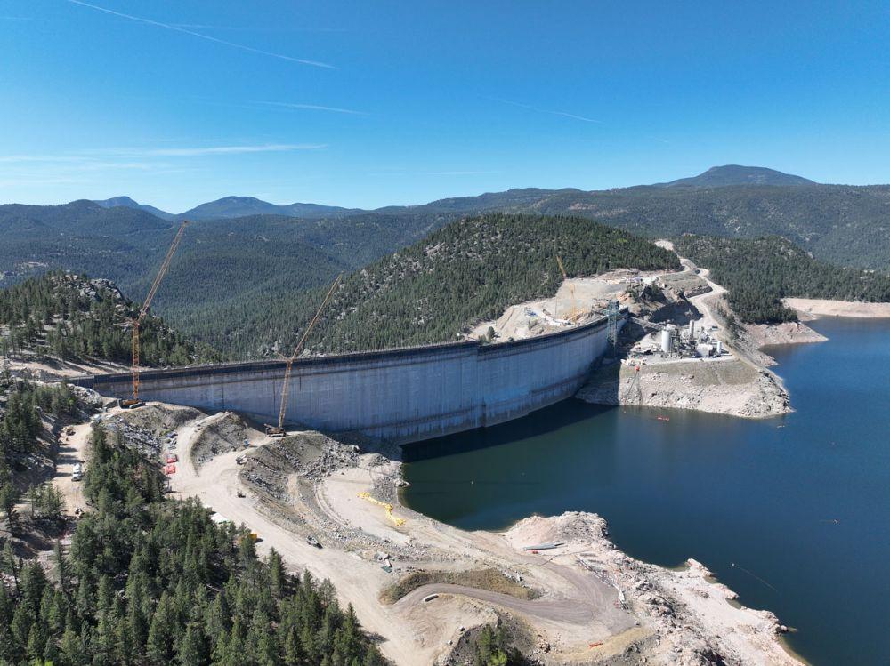
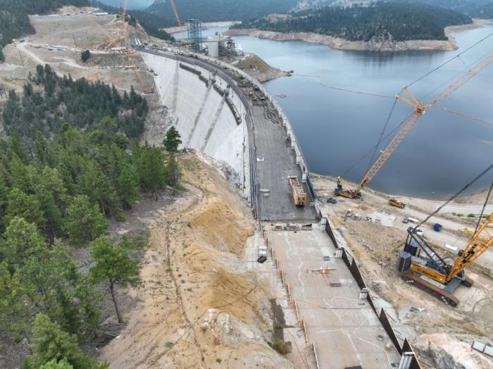
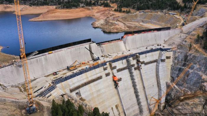
While the dam structure itself is complete, at least a year of work remains to fully finish the project, Martin said. Construction crews must finish the spillway and place the final topper foot of concrete on the completed dam structure. Divers will place a gate between the reservoir’s water and the dam’s intake tubes. But the crews on site will diminish in the coming months, from up to 500 workers a day to closer to 100. On the morning of June 3, crane operators already worked to remove from the dam crest the heavy machinery that was necessary to build the main structure.
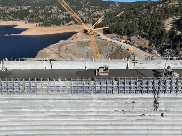
Roller-compacted concrete will be placed on top of the existing dam to raise it to a new height of 471 feet. A total of 118 new steps will make up the new dam. Image credit: Denver Water.
Each stage of a big construction project has its own challenges and puzzles to solve along the way. Raising Gross Dam is no different.
Denver Water is raising the height of the dam by 131 feet, with the final 22 feet going up this spring in two sections that are separated by a giant gap. The Gross Reservoir Expansion Project, which began construction in 2022, is designed to nearly triple the reservoir’s storage capacity. Major construction work resumed in April following a winter break.
And this year’s construction puzzles included:
How to move concrete across a 160-foot gap between where the concrete is made and where it’s placed?
And, how do you move construction vehicles across that same gap when work on the first section is finished?
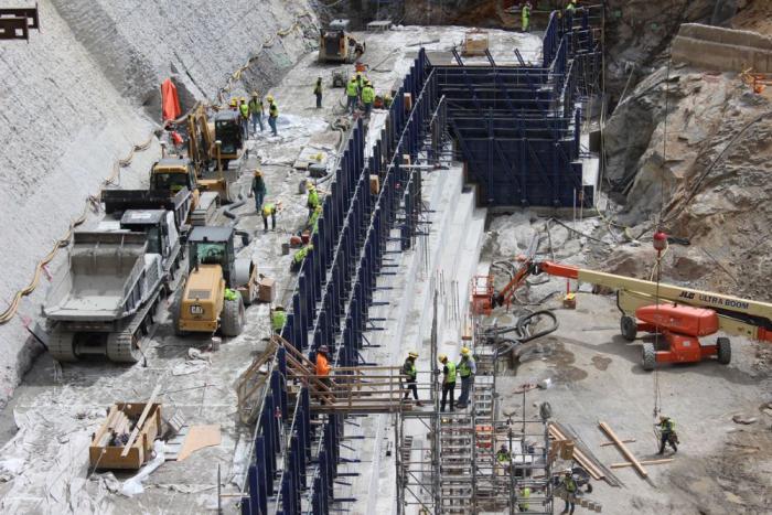
“We are building the top of the dam in two sections because we need to leave a 160-foot gap in the middle of the dam for the spillway channel,” said Casey Dick, Denver Water’s deputy program manager for the Gross Reservoir Expansion Project.
Denver Water is building the last 22 feet of Gross Dam in two sections. The photo shows the left side at its new height. The right side’s last 22 feet will be finished in June. Photo credit: Denver Water.
Spillway channels are safety features on dams that allow water to safely flow out of a reservoir if needed due to flooding rains or exceptionally high and rapid snowmelt.
Raising the dam’s last two major sections, while leaving a 160-foot gap between them, meant coming up with a new way to move concrete across the construction site.
On the lower portion of the dam, crews worked on one continuous structure, which allowed trucks and equipment to easily move from one side of the dam to the other, and to move concrete from the batch plant down a large chute to where it was put into place.
However, with the final 22 feet going up in two sections, construction crews had to find a way to deliver concrete from the batch plant and across the 160-foot spillway gap as the first section went up.
The solution to this puzzle? A series of conveyors positioned in the middle of the dam that tilted higher as the first section rose higher.
“Building the new conveyor system is just another example of all the ingenuity we go through out here to build the dam,” Dick said. “With each new phase, there are new challenges that our team has to figure out.”
The new conveyor system moved concrete across the gap where the spillway channel will be to the far side of the dam. Photo credit: Denver Water.
Construction crews finished placing roller-compacted concrete on the dam’s left side on May 12.
But once that was done, crews faced the second challenge: How do you move the equipment off the finished, 22-foot higher section of the dam, across the spillway gap, down to where they are needed to complete the second section?
Short answer: If you can’t go over, go around.
Cranes lifted equipment off the higher section of the dam to the road, where the machines convoyed about 4.5 miles around to the other side using the dam’s access road.
A crane lifts a piece of equipment off the dam. Because of the new spillway gap, equipment was driven across the dam’s access road to get into position on the other side of the dam. Photo credit: Denver Water.
Construction on the final 22 feet of the second side of the dam began at the end of May and is expected to be completed in June.
Once the second section is done this summer, a year’s worth of remaining work includes: finishing the top of the dam, building safety walls; constructing the actual spillway; building a bridge over the spillway and completing the stilling basin at the bottom of the dam.
This view from the bottom of the dam shows the new baffle blocks on the bottom of the stilling basin. The baffle blocks reduce the energy of the water that flows down the spillway. Photo credit: Denver Water.
Full construction on the dam raising project is expected to wrap up in mid-2027.
“There are hundreds of logistical challenges throughout this project, but our team has been able to meet every one of them along the way,” Dick said. “We’re making good progress so far in 2026 and are looking forward to getting a lot of work done in the coming months.”
The Gross Reservoir Expansion Project involves raising the height of the existing dam by 131 feet. The dam will be built out and will have “steps” made of roller-compacted concrete to reach the new height. Image credit: Denver Water
Denver Water customers have yet to embrace a strict water diet this year, cutting water use just 5% this month as the outdoor watering season begins.
The utility, which serves 1.5 million customers, has asked residents and businesses to slash water use by 20% this summer to combat extreme drought.
At the same time, reservoirs, unable to refill after melting snows evaporated early due to a surprising March heatwave, are dropping. The utility said its storage system is just 79% full, down from the 89% mark normally seen at this time of year.
Denver Water officials said they’re not disappointed with their customers, in part because they’re asking homeowners and businesses to adopt habits they haven’t had to use in years.
“We didn’t expect them to be saving 20% right away,” said Greg Fisher, Denver’s manager of water supply planning. “It’s been 13 years since we were under mandatory drought restrictions. It takes a few months to get up and running on this.”
Aurora homeowners and businesses have cut use 6.5%, Aurora Water spokesperson Shonnie Cline said. And the city’s reservoirs are similarly low, standing at just 56% full. This time last year they were 66% full.
At issue is Colorado’s drought emergency. Mountain snows, which provide the majority of the state’s water supplies, hit critical lows this year and then melted off in a March heat wave that also set records, with temperatures soaring into the 80-degree to 90-degree range.
In response, cities across the state imposed strict watering restrictions, pleading with customers to sharply limit water use so that water stored in reservoirs can be preserved as long as possible.
That reservoir levels are dropping in May is unprecedented, Fisher said. “Levels usually would be rising now,” he said. “But ours are dropping.”
Rains this month have helped. The most recent forecasts indicate that summer monsoons may be wetter than normal and a developing El Niño weather pattern later this year could deliver more liquid relief, according to Russ Schumacher, director of Colorado State University’s Colorado Climate Center.
Rains won’t necessarily help refill reservoirs, but they will help reduce the summer demand for water, meaning less needs to be released from the giant storage pools.
Utilities hope their customers will use the rains that may come as a good reason to turn off their sprinklers.
“We need to use Mother Nature as much as we can,” Fisher said. “You can literally just take a week off.”
Colorado Springs is one of the few cities that hasn’t imposed special water restrictions because its reservoirs, at the start of the watering season, were fairly full. Its normal watering schedule limits sprinkler use to three days a week, according to Colorado Springs Utilities spokesperson Jennifer Johnson. The utility actually saw water use rise slightly in May.
On Colorado’s Western Slope, the situation is also dire. This month the Colorado River District and the Colorado Water Conservation Board agreed to use water from special conservation pools in Ruedi and Wolford Mountain reservoirs to help small towns that are in danger of running out of water, and to provide some help to Western Slope farmers and the fish trying to survive in streams that are drying out.
Roughly half of the water that serves Denver and other Front Range communities comes from the Western Slope and the Colorado River. It is transferred through tunnels to the Front Range. Reductions in water use by Denver and other cities will take some of the stress off the Colorado River.
Lindsay DeFrates, deputy communications director for the Colorado River District, said the district is asking Western Slope towns to water just one day a week.
The district manages the Colorado River and represents 15 Western Slope counties. It has no authority to impose restrictions on mountain communities, but it is still pushing hard for a broad-based commitment to turn off the sprinklers.
“And obviously,” DeFrates said, “we’re hoping Front Range cities will do the same.”
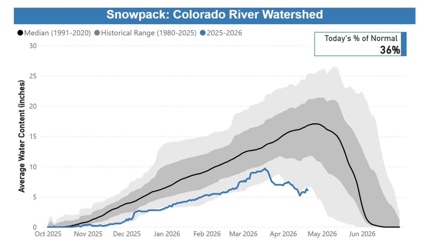
Denver Water’s collection and service areas continue to face severe drought conditions, with historically low snowpack. Denver Water depends on mountain snowpack for its water supply, which serves 1.5 million people in Denver and surrounding suburbs.
As a result, on March 25, 2026, the Denver Board of Water Commissioners declared a Stage 1 drought, seeking a 20% reduction in water use to preserve water levels and avoid even stricter mandatory restrictions later this summer. On April 8, 2026, the board approved the implementation of temporary drought pricing, starting with May water use and reflected in June bills, to signal the premium value of water during droughts and help incentivize customers to save water.
Customers are urged not to turn on automatic sprinkler systems until at least mid- to late-May, or later if possible. It is not necessary to water grass two days per week in April and the beginning of May; keeping automatic systems off will help save water. Occasional hand-watering may be necessary for trees and shrubs during this time. Keep an eye on the weather and let Mother Nature do the watering when she delivers spring rains.
Comment from Nathan Elder, Denver Water’s manager of water supply:
“The snow we saw last week brought marginal improvement to snowpack, but it’s still the worst on record, which is doubly concerning as this week is typically our spring peak when the snow levels are the highest. We need our customers to reduce their water use by 20% and help stretch the water we have stored in our reservoirs. Hopefully, working together, we can save water across our service area and avoid increasing restrictions later this summer.”
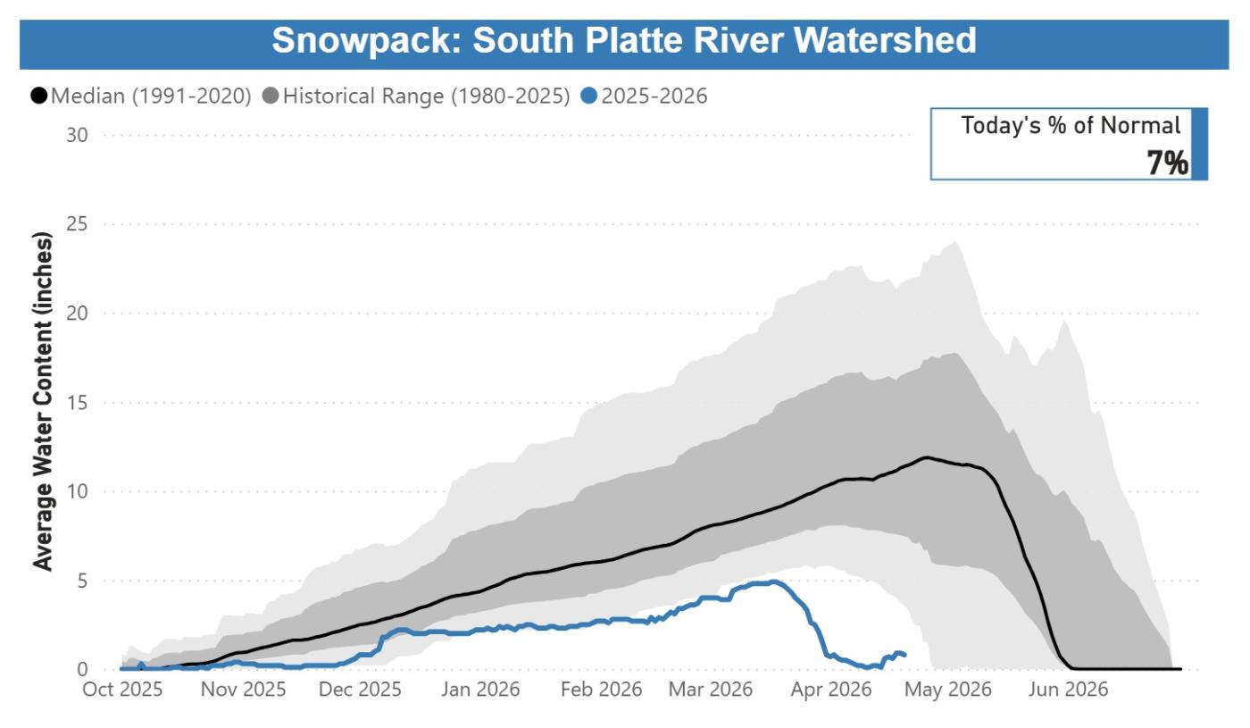
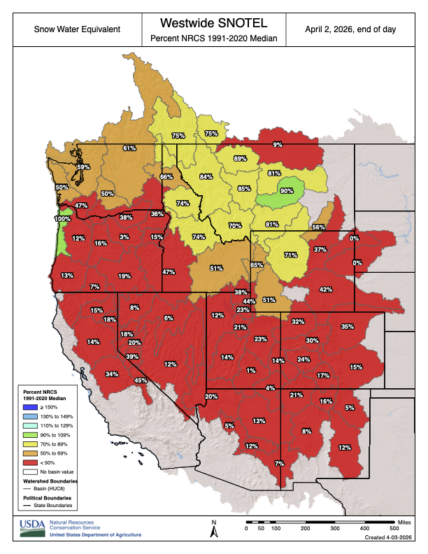
In Denver Water’s collection system, snowpack as of April 20, 2026, remained at the lowest levels observed in the past 40 years:
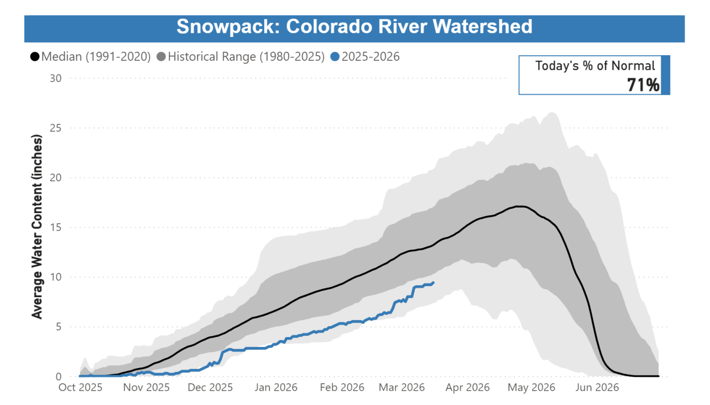
Colorado River Basin: 36% of normal, worst on record.
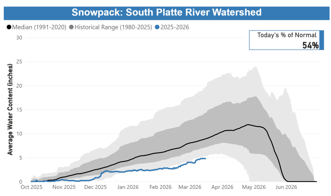
South Platte River Basin: 7% of normal, worst on record.
Snowpack and melting conditions are unprecedented, with accelerated melting seen since mid-March. Customers need to save water to protect the supply we have right now.
Streamflow forecasts are calling for runoff levels to be 10-40% of normal in 2026.
Reservoir storage conditions are below average; while in reasonably good shape for the time being, far less snowpack is available to help refill them. As of April 20, 2026, reservoirs were 80% full, versus an average of 85% full for this time.
Customers are urged not to turn on automatic sprinkler systems until at least mid- to late-May, or later if possible. When watering season begins, Denver Water will require customers in single-family residential properties to limit watering to no more than two days per week on a set schedule based on their address.
Addresses ending in even numbers: Sunday and Thursday.
Addresses ending in odd numbers: Wednesday and Saturday.
All other customers, including multifamily properties, commercial properties, homeowners associations and government properties, may water only on Tuesdays and Fridays.
Water only during cooler times of the day, between 6 p.m. and 10 a.m.
Do not allow water to pool in gutters, streets and alleys.
Do not waste water by letting it spray on concrete and asphalt.
Repair leaking sprinkler systems within 10 days.
Do not irrigate while it is raining or during high winds.
Use a hose nozzle with a shut-off valve when washing your car.
For its part, Denver Water has proactively reduced its spending, taking steps that include enacting a hiring freeze and reviewing maintenance and other projects to see which ones could be deferred. We are also looking into other ways to increase supply by activating agreements that allow us to capture additional water that is typically unavailable during normal conditions.
This year marks the fifth time since 2000 that Denver Water has issued a Stage 1 drought, and the first since 2013. Prior to 2013, the board declared a Stage 1 drought in 2002, 2003 and 2004.
Denver Water has many resources for homeowners looking for inspiration and information about landscapes that fit naturally into our dry climate. Click here for conservation and efficiency tips for outdoor irrigation and to get more details on ways to ColoradoScape your property, including through rebates for turf removal and a DIY guide for landscape changes, among many other potential water-saving steps.
Updates about Denver Water’s reservoir levels, customer water use and snowpack can be found in the Water Watch Report, which is updated weekly in the spring and summer.
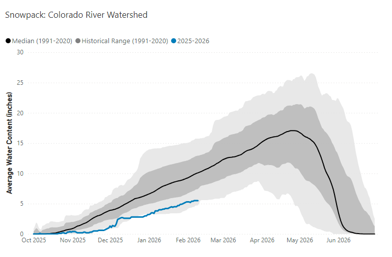
This chart shows the cumulative snowpack on April 20, 2026, in the area of the Colorado River Basin where Denver Water captures its water supply. The snowpack is 36% of normal, which ranks as the lowest on record for April 20. Image credit: Denver Water.
This chart shows the cumulative snowpack on April 20, 2026, in the area of the South Platte River Basin where Denver Water captures its water supply. The snowpack is 7% of normal, which ranks as the lowest on record for April 20. Image credit: Denver Water.
The back of Glen Canyon Dam circa 1964, not long after the reservoir had begun filling up. Here the water level is above dead pool, meaning water can be released via the river outlets, but it is below minimum power pool, so water cannot yet enter the penstocks to generate electricity. Bureau of Reclamation photo. Annotations: Jonathan P. Thompson
A bad year in the Colorado River Basin – barring a truly miraculous spring, probably the worst in recorded history. It is bad enough so the Bureau may have to stop creating power from the Glen Canyon powerplant by this coming fall. At that point, the only way to get water downriver from Glen Canyon Dam will be dribbling it through four outlet tubes that the Bureau is now wishing it had built differently (better) 65 years ago. And praying for enough precip to push the level back above the danger point for the turbines.
Meanwhile the negotiations between the seven basin states about the future distribution of the water remained at an impasse. One might think that a really bad year might generate some new thinking, but the two Basins are still debating Compact numbers like 7.5 million acre-feet for the Lower Basin with a river that might produce less than 5 maf this year, and maybe not much more than that more frequently in the future.
It should be obvious by now that any further negotiation between the states needs to have an independent facilitator guiding the discussion, pushing both factions to disassemble their own non-negotiables. A hard-ass facilitator speaking on behalf of river reality. [ed. emphasis mine]
It seems likely that we will go into the 2027 water year this fall with some new ‘interim plan’ for operating the river system for the water year that begins in October – probably some mix-and-match from the Bureau’s five alternatives proposed last year and ‘EISed’ while the seven states fiddled. The real purpose of the new interim plan will be to keep the infrastructure of the river system viable – dancing with the dead pool. This will probably impose serious delivery shortages on those below the Powell and Mead Reservoirs (meaning the Lower Basin), and also drop the Upper Basin’s rolling 10-year total closer to the 75 million acre-feet (maf) that will cause the ‘compact call’ threat to rear its ugly head.
Year-to-year might be the most honest approach now, anyway, getting a habit of feeling our way forward carefully, with our eyes wide open – woke, one might say. The managerial ‘need for certainty’ in projections may not be part of the future we’ve imposed on ourselves.
But that’s a good place to let the present sit and settle, and go back to the unfolding saga of the ‘Era of Conquest’ in this update of Fred Dellenbaugh’s Romance of the Colorado River. You may remember that in the last post here, I related that the Bureau of Reclamation, feeling much loved for the Boulder Canyon Project that watered, fed and powered a massive regional development in Southern California, came out of World War II ready to do the same for the Compact’s Upper Basin, in response to a mandate in the Boulder Canyon Project Act that a plan be developed for the development of the rest of the river.
There was, however, already quite a lot of development going on in the Upper Basin – at least in the state of Colorado, beginning in the 1930s, simultaneous with the Boulder Canyon Project.
Udall/Overpeck 4-panel Figure Colorado River temperature/precipitation/natural flows with trend. Lake Mead and Lake Powell storage. Updated through Water Year 2025. Note the tiny points on the annual data so that you can flyspeck the individual years. Credit: Brad Udall
To establish context – the whole Colorado River Basin was experiencing its first serious modern-times drought, even as the Great Depression was settling over the whole nation. After the ‘pluvial’ of water abundance in the first three decades of the 20th century, which convinced the water mavens that the river would deliver a dependable-enough flow of nearly 18 maf, the basin experienced its first 5 maf flow in 1933; by the end of the 1930s, there was reason to doubt that the river would ever again average 18 maf.
But Colorado had a special problem to resolve about Colorado River water distribution: the transdivide situation. I will not bore you again with my opinion of the imperial arrogance in randomly laying down straight line state boundaries in a region of great geographic and geological diversity. But what this created in the irrelevant rectangle called Colorado was like a blanket laid over a fence – the fence being the Continental Divide. West of the Divide, precipitation that fell (mostly snow in the winter) all ran off toward the Pacific Ocean in the Colorado River tributaries. East of the Divide, it all ran off toward the Atlantic in the Platte, Arkansas and Rio Grande Rivers. Because the weather mostly rode in on the prevailing westerlies, considerably more precipitation fell on the West Slope than fell on the East Slope. But the vagaries of cultural and economic development put most of the population and economic growth on the East Slope – ‘80 percent-20 percent’ is the rough ratio frequently used to describe the imbalance between water and population in the blanket dropped over the fence.
The distribution of water on both sides of the ‘blanket’ was governed by the appropriation doctrine as stated in the Colorado Constitution: all the water in the state belongs to the people of the state, subject to appropriation for individual use, and the right to divert ‘shall never be denied’ – with seniority among users determining the right to use the water in times of shortage. And by the turn of the century, challenges in water court had established the right to divert water from one basin to another.
As the drought of the 1930s settled in, farmers on the East Slope began to experience serious pressures on the water supply. And consistent with the optimism and technological advances of the early 20th century, this was not regarded as a fact of life to be acknowledged and adapted to, but as a problem to be addressed – in this situation, by moving water from the West Slope. A major task – but Franklin Roosevelt’s ‘New Deal’ efforts to alleviate the Great Depression offered the possibility of some help, through new agencies like the Reconstruction Finance Corporation and the Public Works Administration.
So when the Colorado General Assembly gathered early in 1933, two water project bills were in the hopper: one to divert an unspecified quantity from the Upper Colorado River in the Grand Lake area to the South Platte River basin, and one to divert an unspecified quantity from the Gunnison River to the Arkansas River basin.
Inhabitants of the West Slope, however, knew nothing about this until they read about it in the newspapers. And they were even more surprised that summer when construction actually began on two transdivide projects: the Denver Water Board began constructing a system of small canals high in the Fraser River headwaters (Upper Colorado tributary) to bring water to the Moffat railroad tunnel pilot bore, which the Water Board had leased from the railroad – an unused but already dug ‘pipe’ to the northern Denver area. And the sugar-beet industry led by Great Western Sugar was doing the same collection system in the headwaters of the Roaring Fork River above Aspen for diversion into a small tunnel to the Arkansas River basin. Both of those enterprises were self-funded.
All of this precipitated a regional West Slope meeting in Grand Junction of ‘water people’ – county commissioners and attorneys who were also all ranchers or farmers – at which a ‘Western Colorado Protective Association’ (WCPA) was formed, and a letter was drafted to the state engineer expressing concern that the proposed and in-process projects threatened the future development of the West Slope, and requesting inclusion in all future discussion of them.
The situation as the West Slope people saw it was not a ‘water grab.’ The leadership in the WCPA knew that the East Slope irrigators and city-builders were exercising a constitutional right in appropriating ‘the people’s water’ on the West Slope. They also knew that most of the Colorado River water left the state’s West Slope in an unmanageable snowmelt flood anyway, and it might as well go through a tunnel to the Front Range as through Grand Junction and on to – well, soon, on to enviable storage behind the great dam being built far downstream rather than its historical destiny of flowing on into the salty sea unused.
Storage! That was the key to the West Slope’s chief water problem, which was water available throughout the growing season for finishing as well as starting crops. West Slope engineers had been drafting up a number of reservoir-and-irrigation projects to present to the Bureau of Reclamation, but dams are expensive, and all of the proposed reservoirs served mountain-valley populations too small to pass the Bureau’s cost-benefit analyses.
So the concept of ‘compensatory storage’ for water lost through transdivide diversions became the WCPA’s central focus. And despite their small population, the WCPA had two good cards to play. One was the fact that New Deal federal funding distributed to the states had to be for projects approved by the entire state; the transdivide diversions that needed federal assistance needed for the basin of origin to be as happy as the basin of destination.
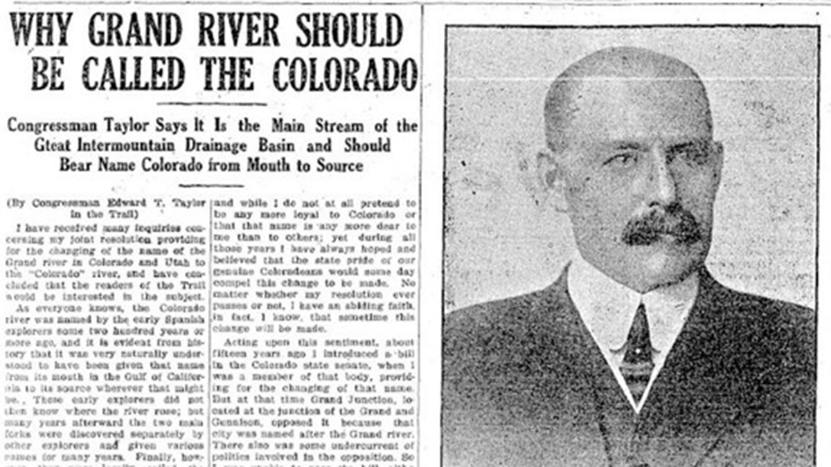
A image shows a guest column by Rep. Edward Taylor that appeared from the Steamboat Pilot in 1921. Graphic credit: Northern Water
The other card was a congressional representative, Edward Taylor, whom they had returned to Congress for 12 terms by 1933, and who had over that quarter-century ascended to chairmanship of the subcommittee that controlled the Interior Department budget in the powerful House Appropriation Committee. Congressman Taylor launched the WCPA’s ‘defensive offensive’ by saying that any project seeking federal assistance for a transdivide diversion would have to provide, as part of their project, an acre-foot of compensatory storage for the West Slope for every acre-foot to be diverted.
That was a large and very expensive demand. Taylor exempted Denver and its Moffat project from the mandate – because, he said, we all want to see ‘our capital city’ grow unrestricted. More likely, he knew that Denver could fund its own project and would at best just ignore him; he was not their congressman, and the Denver Water Board at that point was coming under the domination by their attorney, Glenn Saunders, a city-builder who envisioned a water supply for a ‘thousand-year city,’ most of which he thought would have to come from the West Slope. He just wanted the hicks to stay out of his way. (Not an exaggeration at all.)
Taylor could, however, impose his acre-foot-for-every-acre-foot demand on those seeking federal Public Works Administration funds or Bureau of Reclamation assistance. And that set up what is really an interesting story of people working out difficult problems they’ve imposed on themselves in draping a blanket over a fence and calling it a state, then adopting a wide-open appropriations doctrine for the distribution of a limited resource statewide. It’s a story with many moving parts that we don’t really have time for here in depth; I will note, however, that the whole story is told in my Water Wranglers book, the story of the development of Colorado’s share of the Colorado River. (Out of print, but copies supposedly in all Colorado libraries.)
The principal players in the story were the Western Colorado Protective Association (WCPA), led by Frank Delaney, a lawyer-rancher, and D.W. Aupperle, a Grand Junction lawyer and fruit grower; the South Platte Water Users Association (SPWUA), led by Charles Hansen, a newspaper editor in farm country and a couple lawyer-farmers; and of course the Bureau which wanted to do a big transdivide diversion to the South Platte River. And what turned out to be the ‘wild card,’ Congressman Taylor.
A seemingly endless series of meetings began between the WCPA and the SPWUA with the Bureau in attendance. There was fundamental agreement that, first, the East Slope had legal right to appropriate West Slope water, and second, that the East Slope owed the West Slope some compensation for diverting part of the West Slope’s base for future development. The challenge was arriving at the amount of compensation. The SPWUA wanted to divert more than 300,000 acre-feet from the Colorado River, for what became the Colorado-Big Thompson Project, but they did not see how (even if they could get some New Deal PWA financing) they could afford to also create that much West Slope storage. But the WCPA felt bound to support their congressman – without whom they really had no card to keep them in the game. Frustration and ire grew on both sides – compounded by having to travel back and forth either on the slow trains or drive on roads that were really ‘country’ (a major West Slope chronic complaint).
Finally, in the spring of 1936, Frank Delaney of the WCPA suggested a compromise. If the Bureau and SPWUA wanted to rush into construction, it would have to be Taylor’s acre-foot-for-an-acre-foot mandate. But if they could delay their project until the Bureau did a thorough study of what the loss of 300,000 af of free-flowing water (most of it annually leaving the state unused anyway) would be to the West Slope, and how much storage would actually compensate the West Slope users for that loss of spring runoff, the West Slope would accept that number (and work on getting Cong. Taylor to accept it).
The ‘Delaney Resolution’ broke the stalemate. The Bureau men spent months poring over existing rights and land maps (long before computers and spreadsheets), and came up with a need for 152,000 acre-feet of compensatory storage: 52,000 af to make sure that the Shoshone power plant water right above Glenwood Springs could be met year round (which would also ensure enough late season water for the Grand Valley farms and orchards), and 100,000 af for future irrigation and domestic water development.
That cut Taylor’s demand in two – and the Bureau planned to add a powerplant to the dam that would significantly reduce what the SPWUA would have to pay back. During this period, Taylor – an old man – was actually too sick to participate, and the Delaney Resolution was adopted for the Colorado-Big Thompson Project. (Taylor would die in office in 1941 – still believing that an acre-foot-for-every-acre-foot was what should be adhered to.)
Graphic credit: RogerWendell.com
The compromise process was codified as ‘Senate Document 80,’ part of the Colorado-Big Thompson Project Act passed in 1937. Senate Doc. 80 became part of all subsequent transdivide project planning – except where Denver was concerned; it wasn’t until the veto of Denver Water’s Two Forks Project half a century later that Denver Water finally conceded to take West Slope needs into account in its transdivide projects.
That process of working through a significant challenge to mutual benefit stands, in at least my mind, as one of the highlights of the Era of Conquest in the Colorado River region – a period not without occasional efforts measuring up to the often naive but high-minded vision driving the developers’ ‘romancing of the river’ – to bring deserts into bloom, to reshape unfriendly environments to accommodate individuals and their families willing to work at it. It is too easy to condemn that from this side where we reap the harvest of all the mistakes involved that they didn’t know about until they had made them.
Next post, we’ll look at what happened to that carefully forged intrastate resolution when serious Colorado River planning came to the Compact’s Upper Basin. Meanwhile – pray for monsoons, or just a good rainy spell.
Colorado transmountain diversions via the University of Colorado
Water from Antero Reservoir (pictured) will be moved to Cheesman Reservoir in 2026 to help with drought response. This measure was last taken in 2002. Photo credit: Denver Water.
In the coming weeks, Denver Water will begin moving water from Antero Reservoirto Cheesman Reservoir,as part of the utility’s drought response.
Antero Reservoir has the highest ratio of evaporation to storage of any of Denver Water’s reservoirs, and moving the water to Cheesman Reservoir will prevent about 5,000 acre-feet of water (about 25% of the reservoir’s storage capacity) from evaporating. One acre-foot of water equals the annual water use of about three to four single-family households a year.
“A lot of forethought and planning went into our collection system and reservoirs,” said Nathan Elder, manager of water supply for Denver Water. “Antero is a drought reservoir, designed to provide water to our customers during a severe drought. Consolidating this water into Cheesman will help us make the most of the water we have.”
Denver Water is working closely with Colorado Parks and Wildlife to minimize the loss of fish during this process and to allow the public to use the reservoir for a brief period before it eventually closes. Following the fish relocation process, there will be no recreation, including camping, allowed at Antero Reservoir in 2026. More details about this plan will be announced when it is finalized.
The decision also allows Denver Water to use more water from its South Platte River Basin supplies, reducing the need to pull as much water from sources west of the Continental Divide, which are also below normal levels following an abysmal snowpack and runoff season.
In a standard year, the water lost to evaporation is recovered by the next runoff season. Because of the historically low snowpack levels in 2026, the water lost this year would not have been recovered.
Drought conditions will determine when the reservoir can be refilled. The reservoir was also drained to assist with water management during the 2002 drought. There were plans to drain the reservoir as a drought response in 2013, though a series of late-season snowstorms allowed Denver Water to continue storing water in the reservoir. The last time Antero Reservoir was emptied was in 2015 for a dam rehabilitation project.
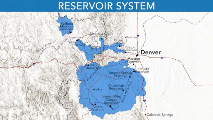
The South Platte River Basin is shaded in yellow. Source: Tom Cech, One World One Water Center, Metropolitan State University of Denver.
Denver Water’s collection and service areas continue to face severe drought conditions, with historically low snowpack and concerns about the diminished spring runoff that will be available to meet customer’s water needs in the future.
As a result, at its meeting today, the Denver Board of Water Commissioners adopted a resolution approving the implementation of temporary drought pricing on outdoor water use. The drought pricing will apply starting with May water use (reflected in June bills) and will be in effect through April 30, 2027, or until further action by the board.
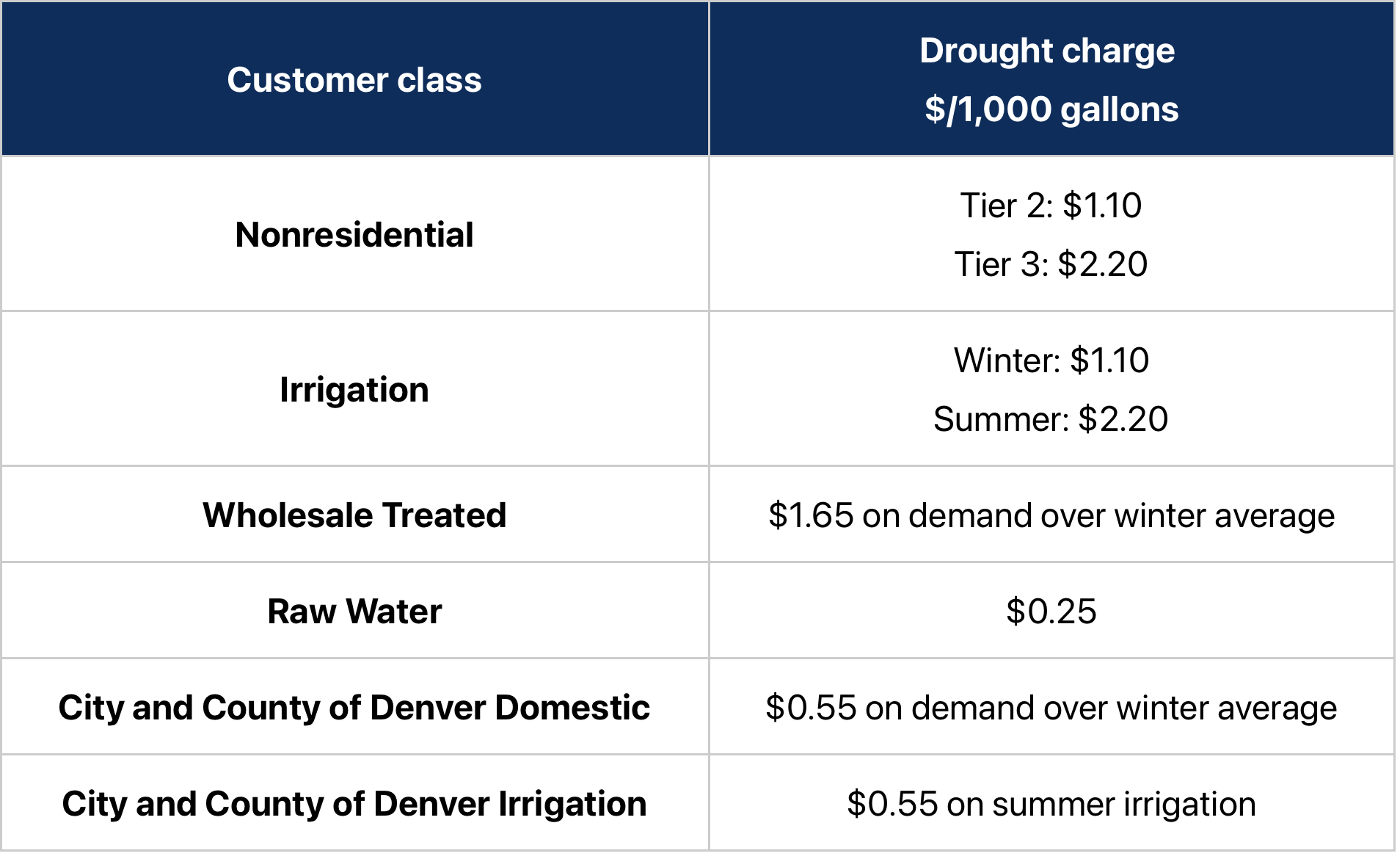
Under the temporary drought pricing, residential customers will see a drought charge on Tier 2 water use of $1.10 per 1,000 gallons. Tier 3 will have a drought charge of $2.20 per 1,000 gallons. The temporary drought charges will be added on top of the customer’s existing 2026 water rates.
Tier 1, which covers essential indoor water use, is exempt from drought pricing.
“Implementing temporary drought pricing is not a step we take lightly. It is one of many tools Denver Water has available — when needed — to respond to drought conditions, encourage customers to conserve our water supply, and ensure our ongoing ability to operate and maintain the system that delivers clean, safe water to 1.5 million people,” said Alan Salazar, Denver Water’s CEO/Manager.
“Drought charges signal to our customers the premium value of water in a drought, while exempting essential indoor water use. We haven’t needed to use this tool in more than 20 years — since the historic drought of 2002-04 — and conditions surrounding this year’s snowpack and potential runoff are shaping up to rival, and possibly be worse than, those years,” Salazar said.
Please keep sprinklers OFF until mid-to-late May, or later if it rains, to help stretch the water supplies we have. Hand water trees and shrubs if needed. It’s a drought. Use Only What You Need. Photo credit: Denver Water.
Under the temporary drought pricing approved by the board, for Denver Water residential customers in Denver and the suburbs:
e first tier will be exempt from the temporary drought charge. This tier is charged at the lowest rate and covers essential indoor water use for bathing, cooking and flushing toilets. Each customer has their individual first tier determined by the average of their monthly water use as listed on bills that arrive in January, February and March — when there is very little or no outdoor watering.
The second tier will have a temporary drought charge of $1.10 per 1,000 gallons added on top of their 2026 water rates. This tier is for water consumption, typically used for outdoor watering, that is above the customer’s first tier and up to 15,000 gallons of water per month. Water use in this tier is considered to be an efficient use of water outdoors.
The third tier will have a temporary drought charge of $2.20 per 1,000 gallons of water added on top of their 2026 water rates. Tier 3 is for water use above the second tier each month. It is priced at the highest level to signal potentially excessive water use and encourage conservation efforts by larger-lot customers.
The board’s decision to impose temporary drought charges on outdoor water use follows its March 25 declaration of Stage 1 drought. The declaration seeks a 20% reduction in water use effective immediately, with the goal of preserving water supplies and to help avoid the need for Denver Water to take further actions later this summer if conditions don’t improve. Read the March 25, 2026, drought declaration.
The snowpack, which supplies the water Denver Water captures, stores, treats and delivers to customers, is at historically low levels despite recent storms that brought some much-needed precipitation to the mountains and city last week.
It’s a drought. Image credit: Denver Water.
“We welcome the storms that do come, while knowing that this year’s snowpack is at historically low levels and hopes for a Miracle May snowstorm are dimming. And Denver Water has made a number of tools available to help customers reduce their water use — whether it’s a normal year or a drought year. We encourage our customers to take steps to conserve water for this drought and be better prepared to manage through future dry times,” Greg Fisher, Denver Water’s manager of demand planning and efficiency.
Denver Water’s temporary drought pricing charges a premium for outdoor water use and covers several classes of customers, including residential, large irrigation, wholesale and raw water customers. (See the chart at the bottom of this story for additional information on nonresidential customers.)
An individual residential customer’s monthly water bill will vary depending on where they live in Denver Water’s service area (in Denver or in one of the utility’s suburban distributor districts) and how much water they use. Drought charges are expected to incentivize customers to reduce outdoor water use.
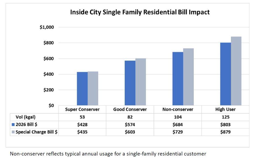
The following two charts illustrate the potential impact of the temporary drought charges on an annual water bill for residential customers living inside the city of Denver and, below that, in a Total Service suburban distributor district.
Examples of the impact of temporary drought charges on an annual water bill for Denver Water customers living inside Denver. In this example, “super conservers” will see their bills increase by roughly $7 annually. High users who do not conserve will see their bills increase by roughly $76 in one year. Individual bills will vary. Image credit: Denver Water.
In these charts, the categories are:
“Super conserver”: A customer who has very little outdoor water use, maybe only watering trees and shrubs throughout the year.
“Good conserver”: An average customer who reduces their annual water use by 20%, from 104,000 gallons (the average use by residential customers in an average year) to 82,000 gallons.
“Non-conserver”: An average Denver Water residential customer who uses 104,000 gallons of water over the course of the year (the average use by residential customers in an average year) and doesn’t respond to Denver Water’s call to reduce water use by 20%.
“High user”: A customer in the top 25% of residential water users.
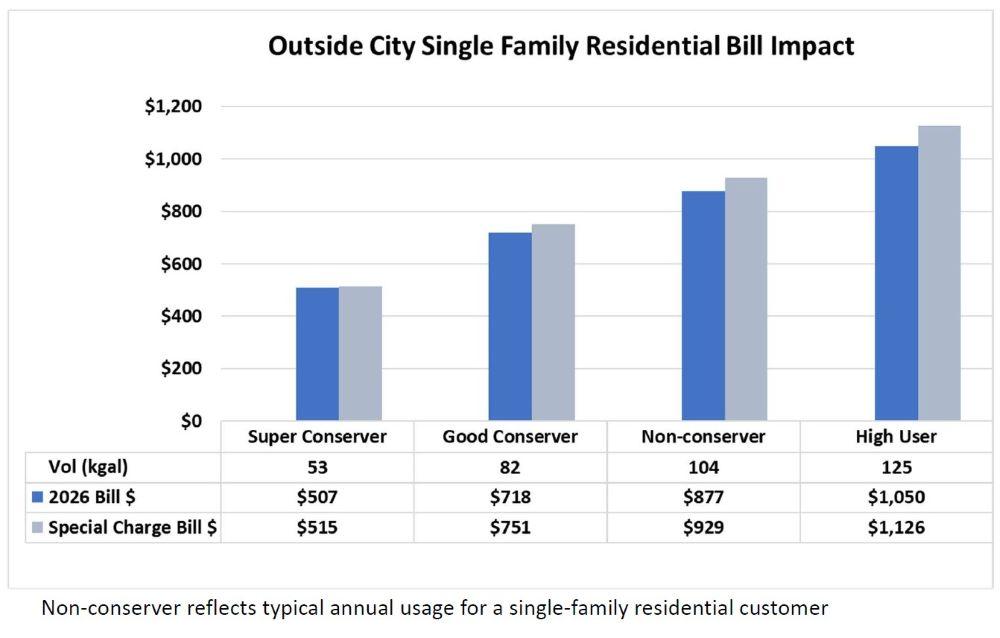
The following chart illustrates temporary drought charges impacts for residential customers who live in one of Denver Water’s Total Service distributor districts in the suburbs. (Learn more about Denver Water’s suburban customers.)
Examples of the impact of the temporary drought charges on an annual water bill for Denver Water customers living in one of Denver Water’s Total Service suburban distributor districts. “Super conservers” will see their bills increase by roughly $8 annually. High users who do not conserve will see their bills increase by roughly $76 in one year. Individual bills will vary. Image credit: Denver Water.
“This is not Denver Water’s first drought. We know our customers strive to be efficient in their water use, and we know we are asking them to use less to stretch the water supplies we have in this drought. We also know that success in reducing water use will result in reduced revenue for our organization. We have tools to address reduced revenue and ensure the organization maintains its financial foundation for when this drought is over,” said Angela Bricmont, Denver Water’s chief financial officer.
If customers comply with Denver Water’s request to reduce water use by 20%, the utility estimates 2026 revenue to fall by a commensurate amount. While drought pricing can offset a portion of that reduction, the utility will rely on cash reserves and budget reductions to cover the majority of the gap.
Denver Water has proactively reduced its spending, taking steps that include enacting a hiring freeze and reviewing maintenance and other projects to see which ones could be deferred.
Now is the time to replace non-native plants with with drought-tolerant plants. Photo credit: Denver Water
To help customers Use Only What They Need indoors and outdoors, Denver Water offers a range of tools, including:
Click the link to read the article on the Grist website (Tik Root):
March 31, 2026
In Park City, Utah, skiers could find patches of grass poking through the slopes for much of the winter — a striking sign of a season that never really arrived. Now, after one of the warmest winters on record, much of the West is entering spring with snowpack at historic lows and an early heat wave that pushed temperatures into triple digits.
These woes could be straight out of a climate fiction novel. But the West’s no good, very bad winter was alarmingly real. And, experts say, a worrisome combination of low snowpack and a devastating heat wave could create a summer ripe for climate disasters. “There is no analog,” Marianne Cowherd, a climate scientist at Montana State University, said of what’s happening. “There isn’t a year in the historical record we can look to for information … This limits our ability to look to the past for insight.”
Much of that uncertainty stems from what’s happening to the region’s snowpack, a cornerstone of its water system. Snow accounts for 60 to 70 percent of the Northwest’s water supply and is especially critical to the ever-thirsty Colorado River Basin, which supplies seven states. But much of the region has experienced the warmest winter on record. That has meant a higher proportion of water arrived as rain, and the snow that did fall melted more quickly than usual. Snowpack is critically low, according to the federal Colorado River Basin Forecasting Center, which utilizes the federal government’s Snow Telemetry network of monitoring stations that go back half a century.
“The majority of them have record-low or near-record-low snowpack conditions,” said hydrologist Cody Moser at the center’s monthly briefing in early March. At that time, he said the upper Colorado River basin, which covers the watershed north of Lake Powell on the Colorado-Arizona border, had about 40 percent of normal snow cover. That has since dropped to 25 to 30 percent.
While winter precipitation has actually been fairly average, how that water falls is important, too. Snow acts as a natural water-storage mechanism that spreads the delivery of water out over weeks or even months as it melts. This helps keep rivers and reservoirs flush for longer. Without snow, the moisture can be fleeting. “Even when we’re getting precipitation, we’re not storing it,” Cowherd said. “A lot of it actually just ends up evaporating or flowing out to the ocean, so it’s not necessarily in a place where we can still access it.”
Cowherd will be watching the snowmelt closely. On one hand, the warmer temperatures are priming the snow to liquify more quickly than normal. But the solar angle — the sun’s maximum height — is lower now than it would be later in the spring, which could impede the melting trend. “I’m really interested to see how those balance,” she said, adding that the answer could be critical to the region’s water supply. “We don’t have the reservoir capacity behind human-built dams to hold the amount of water that we need.”
If snowpack problems weren’t enough, a mid-March heat wave also wreaked havoc in the West. A heat dome brought temperatures as much as 35 degrees above normal, according to the research group Climate Central. More than 1,500 daily records were set across 11 states. Several saw temperatures above 100 degrees Fahrenheit, and the U.S set a national March record of 112 in four cities.
An analysis by the World Weather Attribution Initiative found that this heat wave would have been “virtually impossible” without climate change. “The role of climate change is clear,” said Clair Barnes, a researcher at the Imperial College London’s Centre for Environmental Policy who was part of the team behind the report. She added that extreme temperatures this early in the year “tend to be more dangerous for people because your body is not yet acclimatized.”
While the heat broke in many places after about a week, the impacts could last through the summer. July-like temperatures and dwindling snowpack jeopardize the West’s fragile water supply. The U.S. Bureau of Reclamation’s forecast shows that levels in Lake Powell could dip below the minimum needed to generate power as early as August, and most probably by December. Some Colorado residents are already facing the earliest restrictions on water use ever seen.
“This winter was unusually warm and did not deliver the snow we need,” Alan Salazar, CEO of Denver Water, the state’s largest water provider, said in a statement last week. The utility declared a Stage 1 emergency, which called for a 20 percent cut in usage and mandatory restrictions on outdoor watering. “This drought is also a reminder of the impacts of climate change on our water supply,” he said.
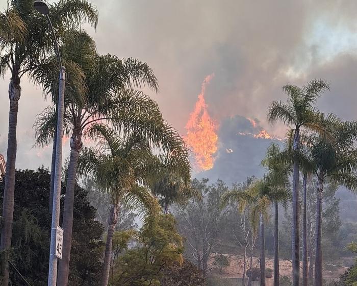
Such conditions heighten the risk of wildfires. Excessive runoff and high heat foster early growth of vegetation that can fuel them, and unseasonably warm weather turns all that greenery to kindling. “Record heat over the previous weeks has put us into early ‘green up’ for the year,” August Isernhagen, a division chief in the Truckee Meadows Fire Protection District, told the University of Nevada, Reno. “This, coupled with many other human impacts on the landscape, has created potential for unprecedented conditions this fire season.”
If these risk trajectories pan out, the impacts could be catastrophic. Low water supplies could upend agricultural operations that feed people across the country. Wildfires could threaten lives, displace thousands, and cause billions of dollars in damage. Still, a lot could change over the next few months.
Barnes said an early heat wave doesn’t necessarily mean there will be more of them later in the year. The weather between heat events also matters, and could go in many directions. A looming El Nino climate pattern could, for example, help alleviate a potential drought. The snowpack problem could even rebound, too.
“We could have a huge snow storm tomorrow and it would be great,” Cowherd said. But based on the current weather forecasts, she cautioned, “I don’t think this is likely to happen.”
Colorado is in a severe drought, and simple indoor water conservation measures can lead to big savings when everyone pitches in.
Free and easy
Turn the water off while brushing your teeth or washing your face.
Limit showers to 5 minutes (or try to shorten them by 1-2 minutes).
Only run your dishwasher and washing machine with a full load.
Turn off the kitchen faucet when handwashing dishes.
“A drought is a great time to teach kids, or anyone, about the importance of conserving water,” said Greg Fisher, Denver Water’s manager of demand planning. “Simple lifestyle changes can become lifelong habits.”
Fixing leaks
Across the U.S., Americans waste about 1 trillion gallons of water every year through water leaks and spend about 10% of their water bill on wasted water, according to the EPA.
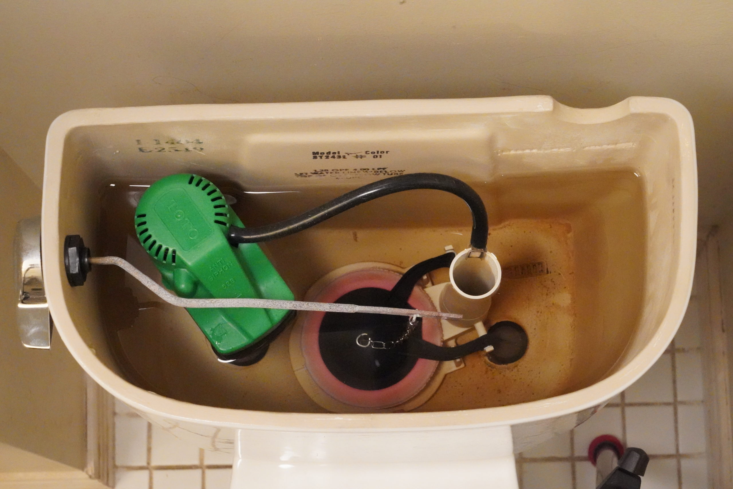
The biggest water waster in the home is the toilet. The EPA reports that an average leaking toilet can waste about 200 gallons of water every day.
This toilet has a small, almost undetectable leak through its pink, circular flapper on the bottom of the tank. Some leaks can be detected by listening to hear if water is coming into the tank after it’s done filling. Faulty flappers are a leading cause of toilet leaks. Photo credit: Denver Water. Photo credit: Denver Water.
In addition to checking for toilet leaks, inspect all water sources in your home, including faucets, showers, water supply lines for dishwashers, washing machines, swamp coolers and ice machines.
Small leaks can add up over days and weeks. A small leak of 10 drops per minute can waste 300 gallons of water per year. Not only can these leaks add to your water bill, but they can also damage your home.
Denver Water offers rebates to help customers replace old toilets with newer, more efficient models that can save thousands of gallons of water every year. Image credit: Denver Water.
When buying new appliances and fixtures, purchase products that carry an Energy Star or WaterSense label, an indication that the product uses less energy or water compared to products that don’t carry those labels.
Replacing faucet aerators is an easy way to save water. New aerators slightly reduce the flow of water without impacting the performance of the faucet. Photo credit: Denver Water.
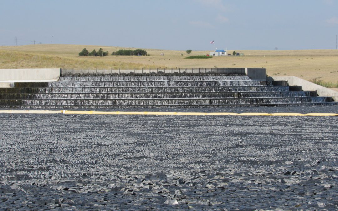
Wastewater is aerated as it flows over steps at Aurora’s Prairie Waters Project, which treats wastewater to drinking water standards. Credit: Jerd Smith
Colorado homeowners and businesses are already planning for a brutally dry summer. They should also be planning for an expensive one, as Denver and other cities prepare to impose drought fees to encourage conservation and to buffer their budgets against millions of dollars in lost water sales as customers cut back.
Denver Water, which announced Stage 1 drought restrictions last week, said its preliminary estimates suggest $30 million to $70 million may be lost as a result of restrictions. It has annual revenue of $488.5 million. Denver Water is Colorado’s largest water utility, serving more than 1.5 million people in the city of Denver and across the southern and western suburbs.
The agency said its surcharges will be designed to penalize high-volume outdoor water use, while keeping the price for drinking, cooking and bathing water unchanged.
ts surcharge prices, if approved by the board this month, will vary depending on how homeowners and businesses use water indoors and outside. A low surcharge for a conservation-minded homeowner who doesn’t do much, if any, outdoor watering might be just $7 per bill, according to the agency, but the drought fee could rise to $76 a month on a residential bill where outdoor water use is high.
Denver Water spokesperson Todd Hartman said via email that the agency will use a portion of its cash reserves to offset the lower water sales and other costs associated with the drought. It has also taken steps to reduce other costs, such as leaving job vacancies open longer.
Colorado experienced record-low mountain snows this year and a scorching hot spring, which has the thin snowpack melting sooner than normal. Reservoir storage is stable for this year, at roughly 80% of average across the state. But heavy water use could drain those reservoirs too quickly, potentially causing major shortages next year if this winter is as dry as last winter’s was, officials have said.
To protect reservoir storage, cities want customers to reduce water use by 10% to 20%.
They’re hoping the surcharges will help them reach those goals.
Chris Goemans, a professor in the agricultural and resource economics department at Colorado State University, said the drought fees are an important tool in water conservation, and can have a lasting impact on water use if they go on for a long period of time.
For several years after the deep drought Colorado experienced in 2002, for instance, water providers saw a lingering “drought shadow” where users continued to tighten their spigots, even after the drought fees were removed, according to research by Goemans, and others.
“They can promote lasting change,” he said.
Not every city will use the fees. Colorado Springs has permanent three-day-per-week watering rules and does not plan to impose a surcharge, at least not this year, spokesperson Jennifer Jordan said. She said the city’s drought plan allows surcharges only when reservoir storage is below 1.5 years on April 1. Right now, the system has three years of storage available.
And Aurora has only used them once before, in 2023, but took them off almost immediately when big rains came, according to Aurora Water spokesperson Shonnie Cline.
Cline said the severity of this drought is forcing the city to gear up for unprecedented times.
“We always thought that 2002 was the worst possible year, but we are expecting something worse this year,” she said.
Castle Rock will impose surcharges, if its council approves them in the coming weeks, but it is taking a different approach because its customers live with a water system based on what are known as water budgets, according to Mark Marlowe, director of Castle Rock Water.
Its customers already are limited every year in how much water they can use during the lawn-watering season, an amount that is based on home and lot size. A small home with a small yard is allocated less water each year and typically has a smaller bill than a large home with a large yard, which is given more water and pays a larger bill.
This year, Castle Rock will reduce everyone’s water budget. If homeowners exceed those lower budgets, they will be hit with a higher fee than normal.
To help offset that and keep its conservation message top of mind, Castle Rock envisions drought surcharges of $6.91 per thousand gallons initially and rising to $10.31 if the drought deepens, Marlowe said.
Is there any good news here? Maybe. City officials said if customers cut back as much as they are being asked to, say 10% to 20%, their bills might not change at all because they are using less water.
An Xcel truck outside the Shoshone hydropower plant in Glenwood Canyon. Denver Water has enacted with water rights owner Xcel to implement a call reduction agreement, which lets the Front Range water provider divert more water for a limited time. CREDIT: BRENT GARDNER-SMITH/ASPEN JOURNALISM
Facing an abysmal snowpack and spring runoff, the state’s largest Front Range water provider has enacted an agreement that lets it take more water from the Western Slope for a limited time.
On March 18, Denver Water put the Shoshone call reduction agreement into effect with water rights owner Xcel Energy, which allows Denver Water to divert more water from the headwaters of the Colorado River in an attempt to alleviate shortages. The agreement reduces the call at the Shoshone hydroelectric plant in Glenwood Canyon by half, from 1,408 cfs to 704 cfs.
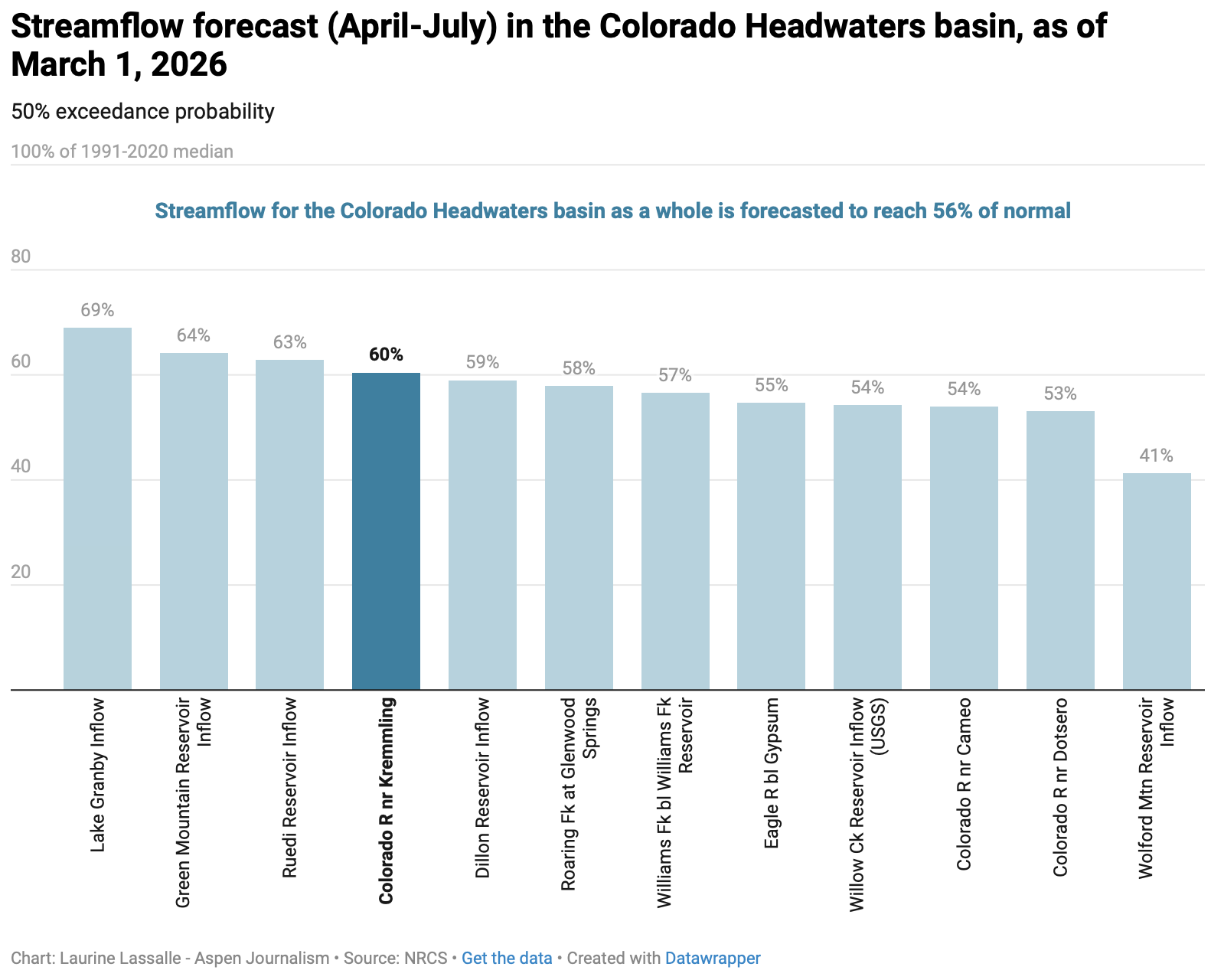
The call reduction can only be implemented when two drought conditions are met: an April to July streamflow forecast for the Colorado River measured at the Kremmling stream gauge must be at 85% or less than average and the forecasted storage for the 10 largest Denver Water reservoirs for July 1 must be at or below 80% full.
The March water supply outlook from the National Resources Conservation Service for the Colorado headwaters from Kremmling to Glenwood Springs was 56% of normal. Experts expect conditions to have worsened when the April forecast comes out next week.
This winter is shaping up to be one of the worst on record and since water supplies depend on snowmelt, municipal water providers have been quick to implement cutbacks this spring. Last week, Denver Water declared a Stage 1 Drought and will impose two-day-a-week outdoor watering restrictions this summer.
“In the wake of the worst snowpack conditions in some 50 years of records at Denver Water, we began exercising the Shoshone Relaxation Agreement with Xcel Energy starting March 18,” Denver Water’s Media Relations Coordinator Todd Hartman said in an email. “We have taken this step only one other time under the 2007 agreement with Xcel (2013) and we don’t do so lightly.”
According to the agreement, Denver Water will be able to divert additional water until May 20.
The water provider, which serves about 1.5 million people on the Front Range, gets roughly 50% of its supply from the Colorado River basin and brings it across the Continental Divide through a highly engineered system of tunnels and reservoirs that facilitate the so-called transmountain diversions.
The Shoshone water rights, which date to 1902, are some of the largest and most powerful on the mainstem of the Colorado River in the state. They can command the river’s flows all the way to its headwaters, ensuring water keeps flowing downstream on the Western Slope.
When the plant’s turbines are spinning, it can “call” for its full water right, effectively forcing upstream water users with junior rights – like Denver Water – to cut back. And because the water is returned to the river after it runs through the plant’s turbines, Shoshone benefits downstream cities, irrigators, recreators and the environment on the Western Slope.
Colorado River Basin in Colorado via the Colorado Geological Survey
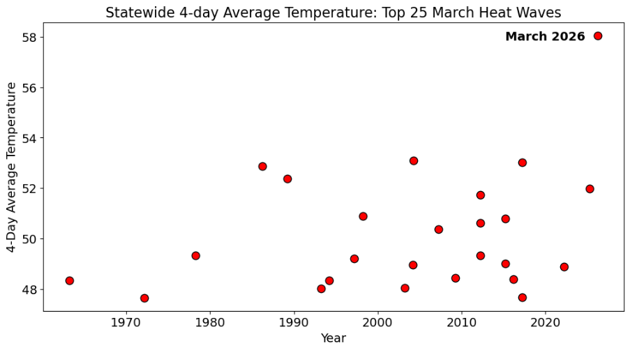
Colorado’s top-25 March heat waves since 1951, defined as 4-day averaged statewide temperatures. Colorado’s warmest heat wave (set last week, March 18-21) eclipsed its previous warmest heat wave (March 23-26, 2004) by nearly 5°F. Data from NCEI nclimgrid via the Colorado Climate Center
Click the link to read the article on the Big Pivots website (Allen Best):
March 30, 2026
It was weird, it was wacky. This string of summer days in Colorado that arrived around the first day of spring was extraordinary. Will it change us in some fundamental way?
It’s not like 9/11, the day we saw people jumping from the skyscrapers in New York City to escape an even more cruel death by fire. We knew instantly that the world was different and in a very big way.
But doesn’t this anomaly deserve more than a shrug of the shoulders? As summer arrived in the last days of winter, I heard several people say, “Well, enjoy this nice weather” as you passed through their doors. A well-intentioned pleasantry but detached from a vital truth. Nice weather for Arizona maybe, but this was Colorado.
Winter had altogether been very, very warm. November was the third warmest November on record across Colorado. December the warmest. February also broke records.
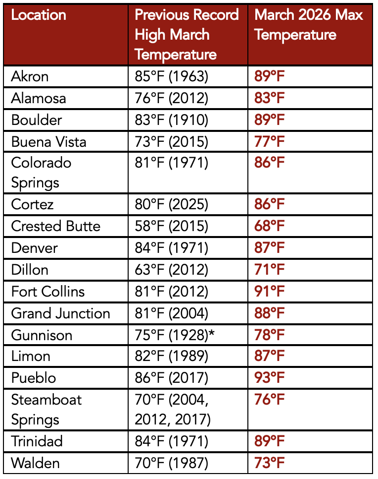
Then came March. Alamosa, a town at 7,543 feet in elevation in Colorado’s San Luis Valley, notched 11 record highs during March going into the last weekend. This included nine in a row from March 18-26. Of special note was the record high of 83 degrees recorded on March 21. It broke the old record by 7 degrees. It also was a higher temperature than has ever been recorded in Alamosa in April.
Crested Butte had a high temperature of 68, a full 10 degrees higher than the old record for that date.
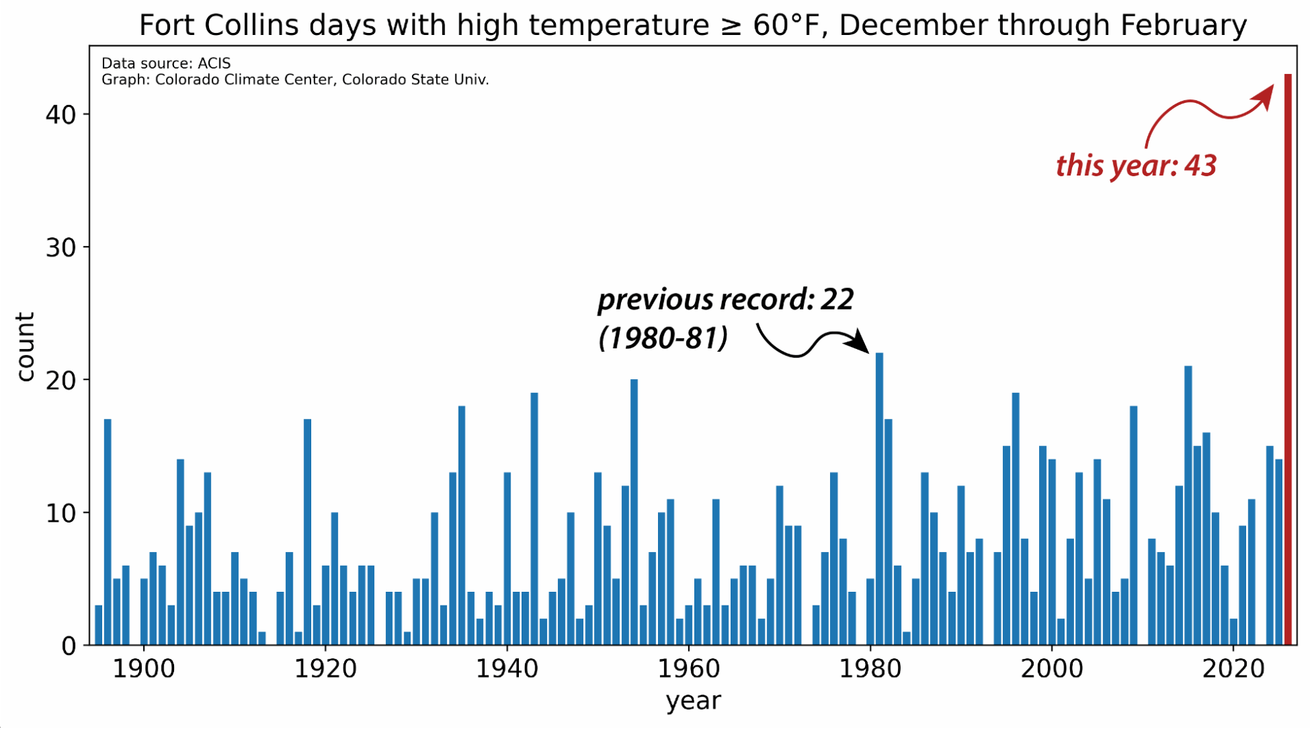
Dates of first 90°F or warmer day in Fort Collins from 1895-present. The blue dashed line shows the 1991-2020 mean 90°F or warmer day, which is June 9. Data from ACIS.
Fort Collins got to 91 degrees, also 10 degrees more than the old record for that date. It was the highest ever mark for March — but also higher than anything ever recorded in April, whose record remains 89 degrees. The average first day for 90 degrees in Fort Collins is June 15.
Allie Mazurek, of the Colorado Climate Center staff, posted a report on Thursday morning that defines in numbers what she calls an event “impossible to ignore.” Included in her presentation is the chart atop this essay that shows how anomalous this four-day streak of heat was compared to others in Colorado during March.
This heat was nearly uniform across Colorado. “There were far more stations in the state that broke all-time monthly high records for March than did not,” wrote Mazurek. “To see monthly records shattered by more than 5 degrees F across numerous stations is truly remarkable. The kind of heat that we saw last week across Colorado is more typical of June or even July.”
Remarkable about theheat in Colorado was not only its intensity but its longevity across four days (March 18-21). “Over that period, several locations set new monthly records every one of those days, with each day being warmer than the last.”
March maximum temperature records at various long-term weather stations throughout Colorado. Data from ACIS.
This heat comes at a particularly bad time. The thin snowpack was already melting. The deepest snowpack in Colorado’s mountains has traditionally occurred in early May, because of accumulations at higher elevations.
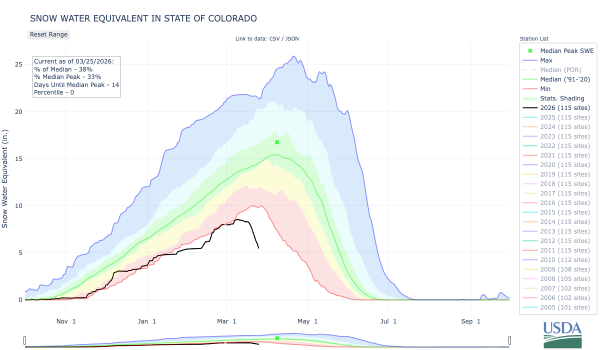
That assumes a normal of some sort — although it is questionable whether “normal” has any true meaning given how fast the climate is now changing. So take this for what it’s worth: the statewide snowpack this past week sat at 38% of the 1991-2020 median. And what must be noted here — as with the temperature records that were broken — is that we have had an exceptional increase of heat in Colorado in the last 25 years.
Notable in the lifetimes of baby boomers in Colorado were the winters of 1976-77 and 1980-81. This year’s meager runoff will almost certainly surpass those dry years. New is the heat.
High-pressure heat domes can be predicted but are notoriously challenging to forecast weeks or months in advance. They also remain rare, but the warming atmosphere makes them more likely.
“We do have high pressures every year across the West,” said Mark Wankowski, a meteorologist at the Pueblo office of the National Weather Service. “This one was extremely early.”
Writing from Colorado Springs last weekend in an essay in The Atlantic titled “There’s No Way the West Will Have a Normal Summer,” Rebecca Boyle explained that the heat wave was created by a “a bizarrely strong ridge of high pressure in Earth’s atmosphere.” This ridge suppressed cloud formation and brought in warmer air. “Such atmospheric ridges are more common in the summer, but this one would be unusually intense even for that season.
Kaitlyn Trudeau, a senior researcher at the science nonprofit Climate Central, told Boyle this was the strongest ridge ever observed in March. Climate Central has developed a prediction model that assesses how much a warming trend or record high can be attributed to human-caused climate change. According to this model, the western high temps were five times more likely because of elevated greenhouse gas emissions.
I feel rattled by this heat. You may remember the high-pressure cooker that broiled the Pacific Northwest in June 2021. Temperatures spiked to 116 degrees in Portland. People in apartments that were not air conditioned died from the heat. In Multnomah County, the location of Portland, 72 deaths were attributed to heat. Farther north, in British Columbia, the town of Lytton went up in flames after several days of intense heat, including a temperature that reached 121 degrees Fahrenheit.
After that heat, the Colorado Public Utilities Commission asked Xcel to assess how well it could respond to somewhat similar heat in Colorado. The company concluded it had the resources.
But this week, in the wake of the intense spring heat, the PUC commissioners were clearly worried, part of a growing concern about “resource adequacy.” Will Xcel be able to meet critical electrical needs if another heat dome arrives in Colorado this summer? The commissioners asked Xcel to return with strategies for reducing demand from big industrial customers if demand for cooling spikes.
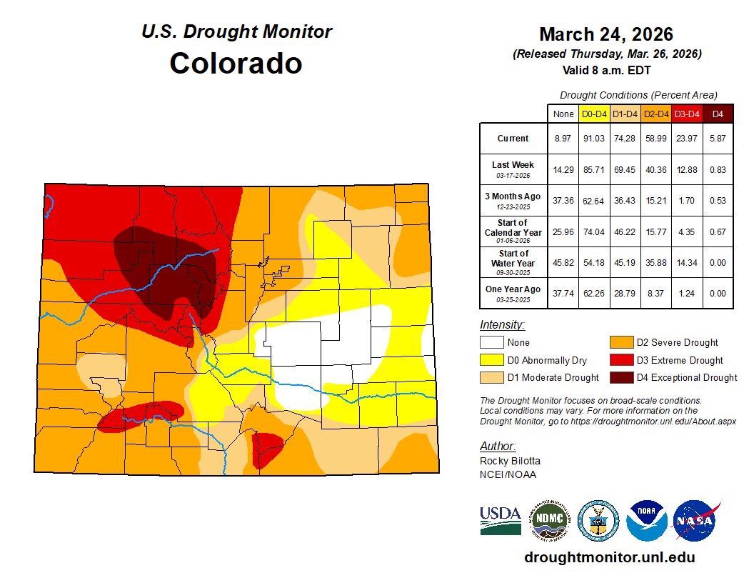
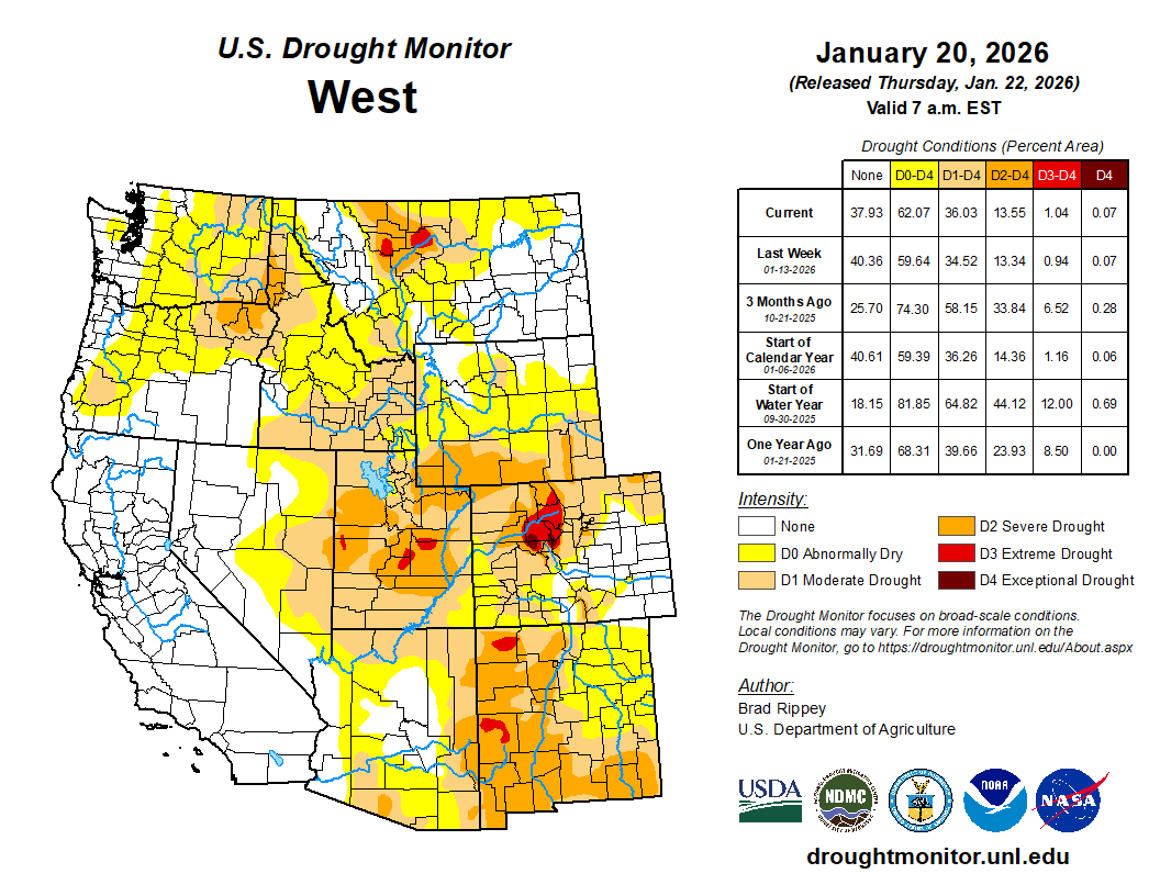
Colorado Drought Monitor map March 24, 2026.
Curious about an on-the-ground perspective from this heat and sparse snow, I called Paul Bonnifield in Yampa. A drought map colors that part of northwest Colorado mahogany, beyond extreme drought and in the realm of “exceptional.” What did exceptional drought look like to him?
Yampa lies at the headwaters of the Yampa River, between the Gore Range and the Flattops. It has a bucolic setting, a place of hay meadows and grazing cattle. Lying upstream are a couple of reservoirs on the edge of the Flattops.
It’s not uncommon for snow to remain on the ground at Yampa, elevation, 7,900 feet, in late March. Not this year. “The ground is hard, just dry, dry, dry,” said Bonnifield.
Bonnifield grew up a few miles away at Phippsburg, a railroad town, and he worked on the railroad himself in addition to spending time teaching and writing at a college in Oklahoma. He’s now in his late 80s and can put this year’s anomalous heat and drought into perspective.
“We are in serious trouble,” he said. “I’ve never seen it like this before.”
Less water will mean less hay production in Egeria Park, where this photo was taken about eight years ago. Photo/Allen Best
Unless a miracle arrives in the form of spring rain and snow, ranchers in Bonnifield’s area — called Egeria Park — will have to decide what to do with their cattle. There’s not enough water to grow grass. There will be wildfire smoke besotting the sky, dampening tourism. And as for river rafting downstream on the Yampa – not likely. Steamboat Spring has already imposed watering restrictions for lawns.
Denver Water this week adopted lawn-watering restrictions for its customers in Denver as well as those in surrounding jurisdictions. It has 1.5 million customers, directly and indirectly, in the metro area.
Nathan Elder, the utility’s manager of water supply, reported to board members on Wednesday that snowpack levels are at historic lows and melting earlier and more rapidly.
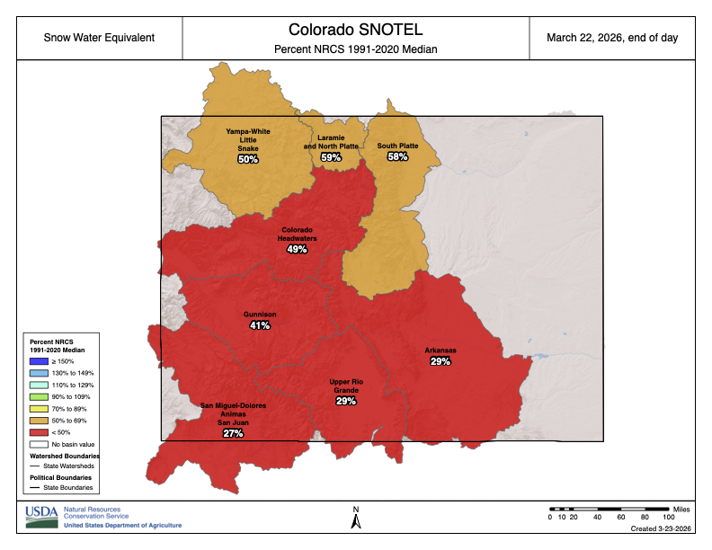
Denver Water diverts water from rivers and creeks on both sides of the Continental Divide. In Grand and Summit counties, at the headwaters of the Colorado River, the snowpack was 53% of normal and the lowest on record for the date, Elder said. The South Platte River has it even worse, just 40% of normal.
“These are really unprecedented snowpack conditions,” he said at the meeting on March 25. During the previous week — the week of the heat dome —Denver had lost 25% of its snowpack in the areas it collects water, he reported.
Denver Water is asking the 1.5 million households and businesses that get water from the utility to refrain from starting to irrigate lawns, including this one in southeast Denver, until mid-May. Photo credit: Allen Best/Big Pivots
Can it get worse? Well, yes, it could. “It’s well documented that, in part, due to climate change, the runoff generated from a given snowpack has declined when compared to the past,” said Elder. “So we can expect even less water from this already low snowpack.”
Might a miracle arrive? After the drought and heat of 2002, metro Denver was stressed. Then, on St. Patrick’s Day 2003, three feet of snow fell. In the San Luis Valley, monster rainfall last fall swelled the Rio Grande, leaving water in the soil that will help even now as farmers begin preparing their fields for early plantings.
NOAA projects continued likelihood of above normal temperatures and below-normal precipitation across Colorado, including Denver’s collection area, during April.
Denver aims to reduce water use 20% by its customers in Denver and in outlying suburbs. It will permit lawn watering two days per week and then after 6 p.m. or before 10 a.m. It is also urging customers to refrain from watering their lawns until mid-May. That’s not an easy ask when it feels like June in March. In April, Denver Water’s board members will be asked to approve “drought pricing.”
Russ Schumacher, the state climatologist in Colorado, is called upon frequently to give programs to water organizations and others. This past week he gave a presentation to the Fort Collins Chapter of the Colorado Renewable Energy Society.
“Wildfire certainly is top of mind,” he said while showing a time-lapse video of a wildfire called High Park Fire that occurred west of Fort Collins in 2012.
Dry and hot temperatures leave Russ Schumacher, the state climatologist, apprehensive about potential wildfires this year. Above photo is from the Longmont area in August 2020, a hot and smoky year when wildfires continued almost into November. Photo/Allen Best
Global warming is a simple proposition, he said.
“If you put a pot of water on your stove you’re not going to be able to predict all those individual bubbles or exactly when it’s going to start boiling,” he explained. “But you know that when you turn that heat on, the water’s going to get warmer and it’s going to continue to warm the more heat that you add. So the physics of climate change is actually rather similar in that regard.”
And, of course, adding greenhouse gases to the atmosphere traps heat, which heats the planet. “When you add heat to something, then it warms.”
Colorado has had outliers of heat before. The Dust Bowl during the mid-1930s was a time of heat and drought. More hot and dry arrived in the 1950s.
This chart shows snowpack in Colorado. The heat dome caused rapid melting of snow. In the San Luis Valley, heavy rains of last October may allow farmers to survive better than during 2002.
Dry has not changed. The hot has changed. What used to be an extremely hot year in Colorado is now a fairly average year or just slightly-above-average year, said Schumacher.
Citing NOAA data, Schumacher showed a sharp rise of almost 2.5 degrees Fahrenheit since 1980. The heat has been most acute in the summer and fall — although, obviously, recent months spoil that easy narrative.
With a moderate rate of emissions, we can expect another 2.5 to 3 degrees of warming by around 2050. That expectation comes with a disclaimer about uncertainty. It’s a best guess.
Precipitation has been more complicated than temperature in Colorado. As for the future, it remains a puzzle. Could be more, could be less. Either way, it will be impacted by temperatures.
“If it’s warmer, if it‘s windier, it’s less humid, the air is thirstier for water from the soils, crops, forests, reservoirs, wherever.” Schumacher said. “As it gets warmer, that evaporative demand goes up. The air is thirstier for water, and this has big implications for drought and water supply and water resources.”
Might warming occur more slowly? That’s possible, and a possibility tied strongly to whether global emissions of greenhouse gases can be abated. Given the current political climate in the United States, a key player in world politics, this low-emissions scenario looks highly unlikely. More likely are the heat domes.
Like the pot of water on the stove that Schumacher described, we’re certain to see more heat bubbles. Hard to tell where and when they will be, but there will be more of them. That leaves me distinctly uncomfortable. In Colorado I have felt 104 degrees. I cannot fathom the 118 degrees of Portland.
Colorado statewide annual temperature anomaly (°F) with respect to the 1901-2000 average. Graphic credit: Colorado Climate Center
Lake Dillon, a reservoir in Colorado’s Summit County, is owned and managed by Denver Water and supplies water to people living in Metro Denver. It is Denver Water’s largest reservoir and provides about 40% of Metro Denver water. A 23-mile-long trans-basin diversion pipeline, called the Harold D. Roberts Tunnel, carries water from the reservoir under the Continental Divide to Denver. Photo credit: Colorado State University
Each day during the winter and spring, one of the first things I look at is the U.S. Department of Agriculture’s website that shows the current status of the snowpack in Colorado’s mountains.
Maybe that sounds like the strange habit of a state climatologist, but I’m far from the only one. Why? Because the snow that falls in our state’s mountains will, when it melts in the spring and summer, become a large portion of the water supply for tens of millions of people.
Those people aren’t only here in Colorado, but are in other states, Tribal nations, and Mexico, drawing their water from the rivers that originate in Colorado. Mountain snow is essential for our winter recreation industry, for farms and ranches that grow our food, for drinking water, for ecosystem health, and much more.
It hasn’t been a pretty sight when I have opened that USDA website each morning this winter. In an average year, our mountains get a lot of snow: In places like the Park Range, the West Elk Mountains or the San Juans, a typical year brings hundreds of inches of snow, carrying more than 40 inches of liquid water. This year, we struggled to get half that. Now, after an unprecedented heat wave in March, the snow is already disappearing quickly.
Figure 1: Map of annual average precipitation over 1991-2020 in Colorado, with color scale matching the colors in the state flag. Data from the PRISM Climate Group. Credit: Colorado Climate Center
As of March 25, averaged across 115 stations in Colorado’s mountains, the snow water equivalent was just 38% of the 1991-2020 average. (The snow water equivalent is the amount of water stored in the snowpack.) This represents the lowest snowpack in more than 40 years – and possibly ever – in Colorado’s mountains. Conditions haven’t been any better along the Front Range and Eastern Plains, which have also lagged far behind the average amount of snowfall.
Figure 2: Statewide snow water equivalent from the SNOTEL network, as of March 25, 2026. The median over 1991-2020 is shown with the green line, the historical range is shown from red (low) to blue (high), and this year is shown in the black line. From USDA/NRCS.
There have been other major snow droughts in the past, notably the winters of 1976-1977 and 1980-1981, that threatened the ski industry and resulted in record-low streamflow on some of Colorado’s rivers. But this snow season has been unrivaled in its warmth. The first five months of the water year – from October through February – were Colorado’s warmest on record by a large margin. And it’s almost certain that we are in the midst of the warmest March on record as well.
The warmth has been remarkably persistent, as relentless ridges of high pressure have prevented the usual snowstorms from moving into the state. The Fort Collins weather station at Colorado State University recorded an astonishing 43 days with a high temperature of 60°F or above during climatological winter (December through February). The previous record, from records dating back to the late 19th century, was 22. Starting March 18, Fort Collins had temperatures higher than had ever been observed in March, four days in a row. This was capped by a high of 91°F on March 21; there had never previously been a 90-degree day in Fort Collins before May.
Figure 3: Number of winter days with high temperatures of 60°F or above at the official Fort Collins weather station on the CSU campus. Winter 2025-2026 had 43 days, far more than the previous record of 22 in 1980-1981. Credit: Colorado Climate Center
Records for March were smashed across the state and the western U.S., at both low and high elevations. One thing we do as state climatologists is put current conditions into historical context, as usually with some investigation, it’s possible to find a past analog to what we’re experiencing now. But the intense and prolonged heat has been unlike anything previously observed in March.
This, of course, is occurring in the context of a long-term trend toward warmer conditions, both globally and locally, largely attributable to increases in greenhouse gases. Per data from the National Oceanic and Atmospheric Administration, nine of the 11 warmest years in Colorado records have occurred since 2012, and Colorado has now warmed by 3°F since the 1890s. Droughts come and go, and they have always been a challenge in Colorado and the West. But warming is making them more likely and more intense. In other words, climate change is water change.
When above-average temperatures and precipitation deficits stack up over the course of months, we start to see drought conditions develop or worsen. The impacts of drought are wide-ranging and include economic and agricultural repercussions. Farmers and ranchers may face lower crop yields and higher costs of feeding livestock. A snow drought like this winter’s can reduce outdoor recreation opportunities and hurt the state’s tourism industry. Drought years also tend to be years with more and larger wildfires.
Drought impacts can be felt a long distance from where the precipitation deficits occur. For example, southeastern Colorado received decent precipitation this winter, but low snow in the mountains hundreds of miles away near Leadville means less water on the Arkansas River, an important source for farmers in southeastern Colorado.
As each winter progresses, even if the mountain snowpack isn’t looking great, we can always look ahead to March and April as the time when big storms are possible and the deficits can be made up. Unfortunately, this year has been just the opposite: Instead of much-needed snowstorms, we’re in an unprecedented March heat wave that is accelerating the melting of what little snow is there. The chances of getting back into the range of average have dwindled away, and if the weather pattern doesn’t turn around in April, we may be headed for uncharted territory for Colorado water.
Denver Water depends on mountain snowpack for 90% of its water supply, which serves 1.5 million people in Denver and surrounding suburbs.
Snowpack as of March 16, 2026, was at or near record lows: The Colorado River Basin within Denver Water’s collection system was at 71% of normal. The South Platte River Basin within Denver Water’s collection area was 54% of normal. In Denver Water’s decades of records for its watershed collection areas, as of March 16, Colorado River snowpack ranked the third-worst on record, and the South Platte River snowpack remains ranked at the worst.
No matter what, Denver Water’s annual summer watering rules will always be in place during the irrigation season. And, it is likely that we will need to implement additional drought response measures this year. Denver Water’s response to drought conditions uses a layered approach, including the potential for additional watering restrictions, in order to preserve water supplies. Denver Water is developing recommendations on a potential drought response for the Board of Water Commissioners to consider over the next several weeks.
Since 2000, Denver Water’s response to dry conditions in previous years included issuing a Drought Watch (voluntary restrictions) in 2002, 2003, 2004, 2012 and 2013. In some of those years (2002, 2003, 2004, 2013), Denver Water levied additional drought restrictions as part of declaring a Stage 1 level response, which required mandatory reductions in outdoor water use.
Denver Water snowpack update for March 16, 2026
Conditions remain highly concerning. Poor snowfall combined with warm temperatures have left us roughly 3 feet to 4 feet of snow short of where we’d prefer to be in the Denver Water collection area at this time. To reach the normal spring snowpack peak, which typically occurs in April, we need to see an additional 7 feet to 7.5 feet of snow this spring.
Reservoir storage conditions are below average, but in reasonably good shape: as of March 16, 2026, the reservoirs were 80% full versus an average of 85% full for this time. Those levels are also temporarily affected by the need to keep Gross Reservoir low during construction to raise the dam, a project designed to increase the storage capacity of the reservoir.
Denver Water has been here several times over roughly 50 years of reliable records. On the positive side, we have experienced years that started dry and conditions dramatically improved in March, April and May. This year, however, we are running out of time to build the snowpack.
No matter what, Denver Water’s annual summer watering rules will always be in place during the irrigation season. Additional drought restrictions, voluntary or mandatory, will depend in part on how the rest of the snow season shapes up and will be aimed at preserving water supplies in case this unusually dry stretch deepens into a multiyear drought.
Comment from Greg Fisher, Denver Water’s manager of demand planning:
“Another weekend snowstorm was welcome, though it mainly benefited lower elevations along the Front Range. Unfortunately, mountain regions didn’t receive significant snow. The good news is that moisture we get in the Denver region should give our yards and landscapes a good dose of moisture, limiting the need for any watering this week,” said Greg Fisher, Denver Water’s manager of demand planning.
“Overall, we’ve had an extremely dry winter, and that continues this week — the last week of winter — with unusually warm temperatures expected across the region. That could lead to snow melt even at high elevations and highlights the need to conserve water and limit the pull on our reservoir storage. We continue to emphasize the need to keep irrigation systems off until mid-to-late May at the earliest, and to be prepared for outdoor watering restrictions this spring.
“It’s a good time to consider landscape changes to your yard, with plants and grasses that require far less water and are far more adapted to Colorado’s dry stretches. Such landscapes, once established, can get through dry stretches like this far easier, and with far less water, and still give your yard a colorful and vibrant look.”
Denver Water has many resources for homeowners looking for inspiration and information about landscapes that fit naturally into our dry climate. Click here for conservation and efficiency tips for outdoor irrigation and to get more details on ways to ColoradoScape your property, including through rebates for turf removal and a DIY guide for landscape changes, among many other potential water-saving steps.
This chart shows the cumulative snowpack on March 16, 2026, in the area of the Colorado River Basin where Denver Water captures its water supply. The snowpack is 71% of normal, which ranks third-lowest on record for March 16. Image credit: Denver Water.
This chart shows the cumulative snowpack on March 16, 2026, in the area of the South Platte River Basin where Denver Water captures its water supply. The snowpack is 54% of normal, which ranks as the lowest on record for March 16. Image credit: Denver Water.
To learn more about the work Denver Water employees do to monitor the snowpack, read this TAP story about Denver Water employees snowshoeing into the forest near the top of Vail Pass in late February 2026 to conduct a monthly “snow survey.”
Additional information on Denver Water’s drought planning can be found here. Additional information on Denver Water reservoir levels, customer water use and snowpack can be found in the Water Watch Report, which is updated regularly during winter, spring and summer.
Novedades de Denver Water sobre el deshielo de la montaña y el suministro de agua
Novedades sobre el deshielo de la montaña del 16 de marzo de 2026 para el área de recolección de agua de Denver Water.
Denver Water depende del deshielo de la montaña para el 90 % de su suministro de agua, el cual da servicio a 1.5 millones de personas en Denver y en los suburbios de alrededor.
En 16 de marzo de 2026, el deshielo de la montaña se encontraba cerca de niveles históricamente bajos: La cuenca del río Colorado dentro del sistema de recolección de Denver Water estaba al 71 % de lo normal. La cuenca del río South Platte dentro del área de recolección de agua de Denver Water estaba al 54 % de lo normal. En las décadas de registros de Denver Water sobre sus cuencas hidrográficas de recolección, al 16 de marzo el deshielo de la montaña en la cuenca del río Colorado ocupaba el tercer peor lugar y el deshielo de la montaña en la cuenca del río South Platte ocupaba el peor de todos.
Pase lo que pase, las reglas anuales de riego en verano de Denver Water siempre estarán vigentes durante la temporada de riego. Además, es probable que este año sea necesario implementar medidas adicionales de respuesta ante una sequía. La respuesta de Denver Water a condiciones de sequía utiliza un enfoque por niveles, que incluye la posibilidad de aplicar restricciones adicionales de riego para preservar el suministro de agua.
Denver Water está preparando recomendaciones para la Junta de Comisionados del Agua de Denver sobre una posible respuesta a la sequía en las siguientes semanas.
Desde 2000, la respuesta de Denver Water a condiciones secas en años anteriores incluyó la emisión de una alerta de sequía (restricciones voluntarias) en 2002, 2003, 2004, 2012 y 2013. En algunos de esos años (2002, 2003, 2004 y 2013), Denver Water impuso restricciones adicionales por sequía como parte de la declaración de una respuesta de Nivel 1, la cual exigía reducciones obligatorias en el uso de agua en exteriores.
Novedades sobre el deshielo de la montaña de Denver Water al 16 de marzo de 2026
Las condiciones siguen siendo motivo de gran preocupación. Las escasas nevadas, combinadas con temperaturas cálidas, han dejado aproximadamente entre 3 y 4 pies de nieve por debajo de lo que sería deseable en el área de recolección de Denver Water para esta época. Para alcanzar el pico normal de deshielo de la montaña en primavera, que por lo general se produce en abril, necesitamos ver entre 7 y 7.5 pies adicionales de nieve esta primavera.
Las condiciones de almacenamiento en los embalses están por debajo del promedio, pero razonablemente en buen estado: al 16 de marzo de 2026, los embalses estaban llenos al 80 %, frente a un promedio del 85 % para esta época. Estos niveles también se ven afectados temporalmente por la necesidad de mantener bajo el nivel del embalse Gross durante la construcción para elevar la presa, un proyecto diseñado para aumentar la capacidad de almacenamiento del embalse.
Pase lo que pase, las reglas anuales de riego en verano de Denver Water siempre estarán vigentes durante la temporada de riego. Las restricciones adicionales por sequía, voluntarias u obligatorias, dependerán en parte de cómo evolucione el resto de la temporada de nieve y estarán orientadas a preservar el suministro de agua en caso de que este período inusualmente seco se convierta en una sequía de varios años.
Comentario de Greg Fisher, gerente de planificación de la demanda de Denver Water:
“Le dimos la bienvenida a otra tormenta invernal este pasado fin de semana, aunque solo beneficiaron áreas con elevación bajas en el Front Range. Desafortunadamente, las regiones montañosas no recibieron cantidades de nieve significativas. Las buenas noticias es que la humedad que recibimos en la región de Denver le dio a nuestros jardines y paisajismos una buena dosis de humedad y así limitar el riego esta semana.
“Hemos tenido un invierno muy seco y estas condiciones continuaran esta semana, la última semana de invierno, con temperaturas inusualmente altas anticipadas a través de la región. Continuamos enfatizando la importancia de mantener sus sistemas de riego apagados hasta mediados o finales de mayo y estar preparados para posibles restricciones de riego esta primavera.”
Denver Water cuenta con muchos recursos para propietarios de viviendas que buscan inspiración e información sobre paisajes que se integren de forma natural en nuestro clima seco. Haga clic aquí para obtener consejos de conservación y eficiencia para el riego exterior y conocer más detalles sobre maneras de aplicar ColoradoScapes en su propiedad, lo que incluye reembolsos por la eliminación de césped y una guía para realizar cambios en el paisajismo por cuenta propia, entre muchas otras medidas para ahorrar agua.
Puede encontrar información adicional sobre la planificación ante sequías de Denver Water aquí (en inglés). Puede encontrar información adicional sobre los niveles de los embalses de Denver Water, el uso de agua de los clientes y el deshielo de la montaña en el informe Water Watch Report (en inglés), que se actualiza con regularidad durante el invierno, la primavera y el verano.
Denver Water depends on mountain snowpack for 90% of its water supply, which serves 1.5 million people in Denver and surrounding suburbs.
Snowpack as of Feb. 9, 2026, was near record lows: The Colorado River Basin within Denver Water’s collection system was at 55% of normal. The South Platte River Basin within Denver Water’s collection area was 42% of normal. In Denver Water’s decades of records for its watershed collection areas, as of Feb. 9, the Colorado River snowpack ranked among the worst, and the South Platte River snowpack ranked the worst.
No matter what, Denver Water’s annual summer watering rules will always be in place during the irrigation season. And, it is possible that we will need to implement additional drought response measures this year. Denver Water’s response to drought conditions uses a tiered approach, including the potential for additional watering restrictions, in order to preserve water supplies. Denver Water will move closer to developing recommendations for its Board of Water Commissioners on a potential drought response over the next couple of months.
Since 2000, Denver Water’s response to dry conditions in previous years included issuing a Drought Watch (voluntary restrictions) in 2002, 2003, 2004, 2012 and 2013. In some of those years (2002, 2003, 2004, 2013), Denver Water levied additional drought restrictions as part of declaring a Stage 1 level response, which required mandatory reductions in outdoor water use.
Denver Water snowpack update for Feb. 9, 2026
Conditions remain highly concerning. Poor snowfall combined with warm temperatures have left us roughly 4 feet of snow short of where we’d prefer to be in the Denver Water collection area.
Reservoir storage conditions are below average, but in reasonably good shape: 81% full versus an average of 85% full for this time. Those levels are also artificially affected by the need to keep Gross Reservoir low during construction to raise the dam, a project designed to increase the storage capacity of the reservoir.
Denver Water has been here several times over roughly 50 years of reliable records. On the positive side, we have experienced years that started dry and conditions dramatically improved in March, April and May. This year, however, we are running out of time to build a healthy winter base.
No matter what, Denver Water’s annual summer watering rules will always be in place during the irrigation season. Additional drought restrictions, voluntary or mandatory, will depend in part on how the rest of the snow season shapes up and will be aimed at preserving water supplies in case this unusually dry stretch deepens into a multiyear drought.
Comment from Nathan Elder, Denver Water’s manager of water supply:
“We are running out of winter. Conditions are highly concerning, and as we continue to hope for relief in the spring months, we also are preparing recommendations for our drought response. We encourage customers to think about conservation even now, with smart indoor use and potential changes in landscapes that would reduce outdoor use in the irrigation season.
“Water is a precious resource that supports our way of life across Colorado, from the mountains to the ski resorts to our communities on both sides of the Continental Divide. We all have a role to play in using water responsibly.
“If you’ve been up skiing, you’ve likely seen the low snowpack firsthand, and — if conditions don’t improve — when that snow melts, it won’t be enough to completely fill our reservoirs this spring and summer.”
This chart shows the cumulative snowpack on Feb. 9, 2026, in the area of the Colorado River Basin where Denver Water captures its water supply. The snowpack is 55% of normal, which ranks among the lowest on record for Feb. 9. Image credit: U.S.D.A., Natural Resources Conservation Service.
This chart shows the cumulative snowpack on Feb. 9, 2026, in the area of the South Platte River Basin where Denver Water captures its water supply. The snowpack is 42% of normal, which ranks as the lowest on record for Feb. 9. Image credit: U.S.D.A., Natural Resources Conservation Service.
To learn more about the work Denver Water employees do to monitor the snowpack, read this TAP story about Denver Water employees snowshoeing into the forest near the top of Vail Pass in late January 2026 to conduct a monthly “snow survey.”
Additional information on Denver Water’s drought planning can be found here. Additional information on Denver Water reservoir levels, customer water use and snowpack can be found in the Water Watch Report, which is updated regularly during winter, spring and summer.
Colorado’s water storage reservoirs are about 85% full as the state faces a drought year that could be the worst in nearly a quarter century.
State officials are comparing this year with 2002, a year that would deliver one of the worst droughts on record. Whether this year will beat that mark isn’t clear yet.
Having water in storage is how Western states help offset the impacts of crippling droughts. This reservoir storage number, though below average, doesn’t worry water watchers too much right now, according to Nathan Elder, manager of water supply for Denver Water, the state’s largest water utility serving about 1.5 million people.
Denver’s storage system mirrors the statewide average at 82% full. But what worries Elder and others is what lies ahead. Snowpack and streamflow forecasts are so low that the utility is unlikely to be able to fill the reservoirs back up when snows melt this spring.
And that’s unusual. “We always fill,” he said.
In the American West, winter snows melt in the spring, filling reservoirs. Those storage pools help deliver water consistently through long summers and dry falls. Elder said Denver has enough water stored now to last roughly three years.
Northern Water’s storage reservoirs are similarly full, but that’s not causing much cheer. Northern provides water to hundreds of farms and nearly 1 million residents on the Front Range north of Denver.
“We’re in pretty good shape,” said Luke Shawcross, Northern’s water resources manager. “But the forecast is just dismal.”
At a meeting of the state’s Water Conditions Monitoring Committee meeting Thursday, Allie Mazurek, a climatologist with the Colorado Climate Center at CSU, reiterated what has dominated the headlines in recent weeks: December was the warmest on record.
There is little optimism that the state can shake off this record-breaking dry spell, according to Brian Domonkos, snow survey supervisor for the Natural Resources Conservation Services. The agency tracks snowpack in Colorado and other Western states.
Statewide snowpack sits at 57% of normal, Domonkos said. “It’s a record low.”
To get back to some level of normalcy the state would need to receive a series of snowstorms that would drop 145% of the state’s average amount of white flakes.
“And that is not likely,” he said.
Looking ahead, Denver Water and others have begun weekly “water shortage” meetings, with a decision likely in March about whether and what kind of new drought restrictions to impose, Elder said in an interview earlier this week.
“It’s not a good situation,” he said. “We’ve survived years like this in the past and made it through. But it’s a reminder that we live in an arid environment and we need to be conserving all the time.”
This weekend, more snow is expected, but it won’t be a drought-buster, said CSU’s Mazurek.
Still, she said, “at this point, I’ll take anything.”
Elder pointed to the team’s big win against the New York Giants on Oct. 19, 2025.
“I think most of us thought the Broncos were done in that game after going scoreless for three quarters, but then they had an amazing turnaround in the fourth quarter and came back to win at the last second,” said Nathan Elder, Denver Water’s manager of water supply.
“Let’s hope Mother Nature can do the same as Bo Nix and deliver a big comeback this winter.”
Snowmaking at Keystone Ski Resort on Dec. 31, 2025. Photo credit: Denver Water.
Record low start to the snowpack
Elder said the first three months of the 2025-26 snow season, from Oct. 1 to Dec. 31, 2025, ranked as the driest on record in Denver Water’s water collection area.
The records date back to the winter of 1979-80, when SNOTEL measuring gauges started being used to measure mountain snowpack.
Denver Water’s previous year-ending, record-low snowpack on Dec. 31 occurred during the winter of 1980-81.
This year, as of Dec. 31, 2025, the snowpack in the South Platte and Colorado river basins where Denver Water collects water stood at 51% and 49% of normal, respectively, according to SNOTEL measurements.
Snowpack in the South Platte River Basin at the end of December 2025 stood at 51% of normal. Image credit: U.S.D.A., Natural Resources Conservation Service.
Snowpack in the Colorado River Basin at the end of December 2025 stood at 49% of normal. Image credit: U.S.D.A., Natural Resources Conservation Service.
The lack of powder days is not only tough on Colorado’s ski resorts, but low snowpack also raises concerns about river levels and our water supply which comes primarily from mountain snow.
A skier navigates through early season conditions at Breckenridge on Dec. 23, 2025. Photo credit: Denver Water.
“We definitely prefer a snowier start to winter over a dry one,” Elder said.
“But we still have about four months left in the snow accumulation season. We will need a lot of snow to catch up to get back to normal.”
The first three months of the snow season typically account for about 20% of the annual snowpack. The good news is that the snowiest months of March and April are still ahead.
Loveland Pass in Summit County on Dec. 24, 2025. The lack of snow is clearly visible on the higher peaks. Photo credit: Denver Water.
Elder said that along with the low snowfall, strong winds and above-normal temperatures created windy and warm weather, which led to increased sublimation of the snowpack (think of sublimation like evaporation just for snow).
“In mid-December, we actually saw a noticeable drop in the snowpack in the South Platte River Basin, which is very rare for that time of year because it’s usually too cold for snow to melt,” Elder said.
What to expect in 2026?
While unfortunately there’s no crystal ball for snow forecasting, Elder pointed to other years that experienced similarly slow starts to the snowpack for a guess as to where this season could end up.
For Denver Water, snowpack typically peaks in mid-to-late April.
The lowest peak occurred during the winter of 2001-02, when snowpack peaked at just 56% of normal. The second-lowest peak was measured during the winter of 2011-12, when mountain snowpack peaked at 58% of normal.
Both of those seasons started slow and snowfall stayed below normal levels all winter long.
In contrast to those two dismal winters, Elder said the winter of 1999-2000 offers a glimmer of hope.
“That season started slow, but snow came on strong in April and May and we ended up right around normal in terms of peak snowpack by the end of the season,” he said.
Water managers also watch for a couple of big storms that could quickly bolster a lackluster snowpack.
Taking action
Denver Water’s reservoirs are currently at 83% of capacity, which is 4% below average for this time of year.
Dillon Reservoir in Summit County had open water on Dec. 24, 2025, due to warm conditions. The reservoir’s average “ice-in” date is Dec. 24. Photo credit: Denver Water.
Elder said that while the reservoir levels are expected to be in relatively good shape heading into summer, it’s too early to say if there will be any watering restrictions.
“We live in a dry climate with increasingly variable weather patterns, which means all of us need to pitch in to help conserve the precious water supplies that we have,” Elder said.
“Now is a good time to check your faucets and toilets for leaks, and fix any you find inside your home. It’s also a good time to start planning how to remodel your yard this summer to save water outside.”
Denver Water’s website has free tips, including a step-by-step DIY Guide that can help you replace thirsty Kentucky bluegrass with water-smart plants, available at denverwater.org/Conserve.
In 2026, the utility will again be offering customers a limited number of discounts on Resource Central’s popular, water-wise Garden In A Box kits and turf removal.
It’s important to water trees and plants during dry periods in the winter months. Soaker hoses are a great way to efficiently water a tree. Photo credit: Denver Water.
Workers raise dam 109 feet in 2025. Next year’s goal: Reaching the top.
The Denver Water team working on Gross Dam in Boulder County is celebrating a successful year after the dam raise is 95% complete.
“In 2025, we raised the height of the dam by 109 feet above the original structure,” said Jeff Martin, Denver Water’s program manager for the Gross Reservoir Expansion Project. “We have 22 feet left to go to reach the new height and we’re on track to reach that in 2026.”
The dam-raising aspect of the Gross Reservoir Expansion Project wrapped up for the season on Nov. 14, due to the drop in temperatures. The project is designed to nearly triple the water storage capacity of Gross Reservoir.
In 2025, workers raised the height of Gross Dam by 109 feet. The final 22 feet will be completed in 2026 to reach the dam’s new height of 471 feet. Photo credit: Denver Water.
“We have to stop placing roller-compacted concrete when the temperatures drop below freezing,” said Casey Dick, deputy program manager for the Gross Reservoir Expansion Project.
“To prepare for winter, we put blankets on top of the new concrete to keep it from getting too cold. That’s because if the concrete freezes while it is still curing, it can lead to a weakened final product.”
Work associated with the dam raise will resume in spring 2026, when the weather warms up enough to complete the final 22 feet.
Protective “blankets” were placed on top of the dam to insulate the new concrete, so it does not fully cure over the cold, winter months. Photo credit: Denver Water.
Once that work is complete, the dam will be 471 feet tall, which is 131 feet higher than the original. The completed dam also will be longer across its crest, or top. The original crest was 1,050 feet long; the higher dam will have a crest that stretches 2,040 feet from one side of the canyon to the other.
This year marked the second year of dam raising construction work at Gross.
As of December 2025, workers had placed more than 730,000 cubic yards of concrete. To put that in perspective, Empower Stadium at Mile High, where the Denver Broncos play their home football games, required just 29,000 cubic yards of concrete to build, about 4% of the concrete placed so far on Gross Dam.
Protective “blankets” were placed on top of the dam to insulate the new concrete, so it does not fully cure over the cold, winter months. Photo credit: Denver Water.
Roller-compacted concrete is a special mix of concrete that allows crews to place it on the dam and then spread it out. The concrete is firm enough to be able to drive machinery on top of it. The process is a fast and efficient method of raising the dam. During the construction work, crews raised the height of the dam by about 1 foot per day.
Construction crews use GPS technology and survey equipment to keep track of how high they’ve raised the dam.
“The way we keep track of the elevation gain is that the bulldozers are equipped with GPS-grade control technology, which ensures that each layer of concrete is spread to the correct thickness,” Dick said.
“Once the concrete is rolled and vibrated into place, each layer ends up being 1 foot thick. It’s then checked by surveyors with their equipment to verify the exact elevation.”
The bulldozers are equipped with GPS-grade control technology to monitor the height of the concrete as it is spread across the top of the dam and keep track of the elevation. Photo credit: Denver Water.
Work won’t completely stop over the winter.
Mechanical and pipe work will be done inside the dam, and crews will build a stilling basin at the base of the dam. The basin’s function is to slow the speed of water coming down the dam’s spillway and safely redirect the water into South Boulder Creek.
Work on the stilling basin at the base of the dam will continue over the winter. The stilling basin is designed to slow the flow of water coming down the spillway and channel it into the creek. Photo credit: Denver Water.
“This season was a huge success, and our team met a ton of challenges in raising Gross Dam,” Martin said. “We had legal challenges and adverse weather challenges. We also had wildfire safety operation challenges that shut down our power supply up here. Despite all those setbacks, the dedicated team of 500 men and women rose to the challenge. I’d just like to thank everybody who committed themselves to this project and helped us make 2025 a success.”
Jeff Martin, Denver Water’s program manager for the Gross Reservoir Expansion Project, stands at the south side of the dam. Once completed, the dam will reach up to white line on the rock wall. Photo credit: Denver Water.
Aerial view of the snowpack in the San Juan Mountains of southwest Colorado on Dec. 3, 2021. Scientists and water managers use a variety of methods to monitor the snowpack, which supplies most of the water flowing in many Western streams and rivers. Photo by Mitch Tobin/The Water Desk.
A controversial recent study highlights an old truth about the American West’s snowpack: it’s difficult to measure—and just as hard to forecast how much of its water will ultimately reach tens of millions of people and vast swaths of farmland.
Water managers have increasingly turned to aircraft that use lasers to gauge the snowpack across entire basins. But the Aug. 15 scientific paper argues for a less expensive strategy: focusing new monitoring efforts on a select number of locations known as “hotspots” that excel at predicting how much water will run off from the snowpack—a frozen reservoir that can change dramatically over short distances.
Snowfall rates vary widely with elevation, and the amount of water locked in falling snowflakes shifts from storm to storm.
On the ground, snow accumulation depends on the wind, the forest canopy overhead, the exposure to the sun and the amount of dust that lands on the snowpack. Even a homeowner armed with a ruler can find very different snow depths depending on where they poke in their backyard.
For water providers, knowing how much water is stored in the snowpack is essential. In much of the West, snowmelt supplies most of the runoff that flows through streams, rivers, reservoirs, irrigation canals and household faucets.
If water managers overestimate the snowpack, their customers can be left high and dry later in the year. But if analysts underestimate streamflows, reservoirs can fill faster than expected—raising the risk of disastrous flooding.
With climate change making the snowpack less reliable and redefining what “normal” means, the pressure on forecasters is intensifying in a rapidly growing region with a well-documented gap between water supply and demand. Even a perfect knowledge of the snowpack’s water content doesn’t guarantee accurate streamflow projections because factors such as soil moisture, groundwater levels and late-season weather cloud the picture.
Karl Wetlaufer (NRCS), explaining the use of a Federal Snow Sampler, SnowEx, February 17, 2017.
Scientists and water managers, aware of the high stakes, began formally measuring the snowpack to make water forecasts more than a century ago. They selected key locations in the high country, plunged hollow metal tubes into the snow and weighed the extracted cores to calculate the water content—a technique still used extensively today.
During the late 20th century, officials installed hundreds of automated stations across the West’s watersheds as part of the SNOTEL network. These sites use “snow pillows” to measure the weight of the overlying snow and estimate its water content. Forecasters then correlate these long-term snow records with historical streamflows to predict a basin’s water supply.
In the 21st century, airborne snow surveys have expanded rapidly. Aircraft equipped with lidar—a laser-based technology—precisely map the snow depth across entire watersheds while an onboard spectrometer scans the snowpack’s reflectivity. Snow depth is determined by subtracting lidar readings taken when snow is absent from those taken when snow is present. Scientists combine those measurements with estimates and observations of snow density to calculate the water content, known as the snow water equivalent.
Satellites also provide valuable data on the snowpack, especially its extent on the ground, but reliably measuring snow water equivalent from space remains elusive. Clouds and forests can also obscure or complicate a satellite’s view.
Four ways scientists monitor the snowpack. Clockwise from upper left: a manual snow-course survey (California Department of Water Resources); an automated SNOTEL station (Mitch Tobin/The Water Desk); an illustration of a satellite carrying the MODIS instrument (NASA); and airborne mapping (NASA).
While technologies that estimate an entire watershed’s snowpack are on the rise, the recent hotspots study argues that water forecasters could gain crucial insights by targeting future monitoring at a limited set of locations.
The authors say these 62-acre hotspots not only are strong predictors of how much water will run off in the spring and summer, but also could be more cost-effective than mapping the snowpack across a whole watershed using aircraft. That approach has become more common due to the work of Airborne Snow Observatories, Inc. (ASO), a company that spun out of research at NASA’s Jet Propulsion Laboratory.
“The greatest gains in water supply prediction come from leveraging existing stations and expanding snow measurements to the right places, rather than everywhere,” the authors write in Communications Earth & Environment.
But in the tight-knit world of Western snow science, the paper has sparked pushback from supporters of airborne snow monitoring.
Jeff Deems, a co-founder of ASO, said the paper is a “statistical curiosity” and criticized both its methodology and the conclusions it draws about snowpack monitoring.
“Our datasets have become the gold standard, the benchmark against which others are evaluated,” Deems said.
The Colorado Airborne Snow Measurement (CASM) program produced a strongly worded critique of the study, which used a proxy for the ASO data, rather than actual measurements from aircraft.
“Although this paper is published in a well-known journal, it makes unsupported, misleading and editorialized claims about the cost, value, and performance of airborne lidar for streamflow forecasting,” said the rebuttal from CASM, a group of stakeholders whose planning team includes ASO, water providers, the Colorado Water Conservation Board (CWCB) and other organizations. “The authors make a series of critical logic and analysis errors which when combined with their over-broad conclusions result in a very misleading paper.”
But study co-author Cam Wobus wrote in an email that the paper “might have struck a nerve” because “it showed that wall to wall measurement of snow may not be needed to create more accurate water supply forecasts, which ASO could have perceived as a threat to their business model.”
Despite the sharp differences among snow researchers, experts agree there’s no silver bullet for monitoring the snowpack or predicting streamflows. As warming temperatures and evolving storm patterns continue to transform the snowpack, both old-school methods and newer technologies will be needed to better manage the region’s scarce water resources.
“Snowpack estimation and streamflow forecasting is a vast and unsolved field of research,” the CWCB wrote in response to questions from The Water Desk.
Although CWCB’s logo was included at the bottom of CASM’s rebuttal, the agency said in an email that the document “should not be misconstrued as an official position statement” and that “CWCB has acted as a funding and coordination partner” to CASM.
An airborne survey created this map of snow depth for Colorado’s Maroon Bells on April 9, 2024. Source: ASO.
Searching for snowpack hotspots
The hotspots study set out to test an intuitive idea: in high-elevation watersheds, the snowpack in certain locations can be especially useful for predicting streamflow.
“There are places within drainage basins that, if you train your water-supply forecast on the snow record in those locations, you’ll have a better forecast than if you use the basin average,” said co-author Eric Small, a professor of geological sciences at the University of Colorado Boulder.
“If you think about a drainage basin, there’s going to be places in that drainage basin where there’s not a lot of snow, or there’s not much connection between the snowmelt and the runoff,” Small said. “There’s going to be other places in the basin where there is a lot of snow and a lot of connectivity between the snowmelt and the runoff. So it should not be a surprise that there’s locations within a basin that are more predictive of this seasonal water supply.”
In general, locations with the deepest, most persistent snow are more likely to be hotspots.
“Anyone who’s seen a basin in Colorado and sees the south-facing slopes that are bare of snow and the north-facing slopes that have snow three feet deep in the springtime recognizes that once you take an average across all of that, the stuff on the south-facing slopes isn’t going to matter at all,” said Wobus, a principal at CK Blueshift, LLC, a consulting firm that works on water and climate issues.
“It’s silly to fly an entire basin if 30% of that basin doesn’t have any snow on it, so that’s an easy fix right there,” Wobus said.
While hotspots typically accumulate lots of snow, what’s happening beneath the snowpack is just as important. “The hotspots are locations where there’s both a lot of water, and when it melts, a large fraction of that water would get into the stream,” Small said.
Hotspots tend to have shallow or relatively stable groundwater storage and soil moisture levels that don’t vary year to year.
“The hotspots are places where there’s either enough snow or minimal enough variations in storage that the water is getting to the stream and the water is getting to the stream at the right timescale,” Small said.
Each basin may have numerous hotspots. “The hotspots weren’t unicorns,” Small said. “There were many possible hotspots. We had an objective measure to choose the official hotspot in the paper, but you could have chosen many other locations that were also predictive.”
Once a hotspot is identified, the authors outline several potential ways to tap its predictive power. One option is to add a new SNOTEL station at the site, although that may not be feasible because of the terrain or land protections. Another possibility is to use remote sensing from a plane or a drone. The authors write that one or two flight paths that observe the hotspot could gather data “at a substantially lower cost than more conventional wall-to-wall basin coverage.”
Even recreationists could help gather data from snowpack hotspots. “You could use citizen science to do it. You could send a bunch of backcountry skiers out to your location for fun, give them an app,” Small said. “They’re probably already going there. If you saw where people were skiing, they would probably have mapped out the hotspots already.”
Map: Mitch Tobin/The Water Desk • Source: Natural Resources Conservation Service • Created with Datawrapper
A shortcut, or a statistical trap?
Critics of the hotspots paper agree that some parts of a watershed can carry more predictive weight for streamflows than others.
“It’s not a new concept, and it’s a very seductive one. It’s essentially the premise behind the SNOTEL network,” Deems said.
But to some scientists who dispute the study, hotspots can hide as much as they reveal—and potentially mislead water managers as the West’s climate evolves and as the hydrology of high-country landscapes is reshaped by disturbances, such as the increasing frequency of wildfires.
“Even if they did everything right—found these hotspots—the likelihood of them retaining the same statistical predictive power going forward is essentially nil,” Deems said.
The rebuttals to the paper have challenged both its analysis and the real-world implications the authors infer from their results.
Noah Molotch, a professor of geography at the University of Colorado Boulder and director of the Mountain Hydrology Group at the Institute of Arctic and Alpine Research, said “the study doesn’t accurately portray the direction that water managers have been moving for a couple of decades now.”
“My concern there is that it takes us further down the path of being blind to the spatial patterns that govern water supply and that can lead to surprises for water managers,” Molotch said.
Although the hotspots study has implications for airborne snowpack monitoring, the paper didn’t analyze data gathered by aircraft, which has been collected only in select watersheds and over a shorter time period than the authors examined.
Instead, one of the ways the researchers probed the snowpack in 390 basins in the West was to combine satellite data from 2001 to 2023 with historical weather data. The satellite images, collected by the MODIS instruments aboard two NASA spacecraft, show the fraction of each pixel covered by snow and the reflectivity of the snowpack, among other metrics. Each pixel is a square with 500-meter (1,640-foot) edges.
The authors argue that this type of data serves as a reasonable “proxy” for the basin-wide estimates that could be obtained from prospective satellite missions and current airborne monitoring. Small said five different datasets were examined, and all showed similar results.
But the CASM critique argues that the proxy dataset has “a demonstrated average error of 35% (ranging from 20-60%)” when compared to airborne lidar, and its much coarser resolution further limits its utility.
The paper’s authors “make the assertion that that dataset has been shown to be accurate and, in their language, therefore serves as a reliable proxy for airborne lidar,” Deems said. “That assertion is incorrect, and that undercuts the entire rest of the paper, sadly.”
Deems said the study used the date of snow disappearance to back-calculate how much snow was there while also “blending in an atmospheric model precipitation product, which is highly uncertain.”
By contrast, Deems said, ASO creates “a highly accurate map of snow depth throughout the watershed,” which is then paired with estimates of snow density informed by SNOTEL measurements and hand-dug snow pits. What emerges, he said, is a basin-scale estimate of snow water equivalent that’s within about 1% of the actual volume.
“That’s better than we can measure streamflow,” Deems said.
A video from Colorado’s Northern Water explains how the utility uses ASO data.
Clashes over the merits of datasets are grist for the academic mill, but critics raise a broader concern: the paper takes a retrospective look at snowpack-streamflow relationships in an age of extreme weather and shifting baselines.
Scientists have an awkward name for this pivotal issue: “stationarity.” In simple terms, it’s the assumption that the past is a reliable guide to the future. But just as mutual-fund disclaimers warn that past performance is no guarantee of future returns, climate change is making historical patterns less trustworthy.
Storm tracks are migrating. Warmer temperatures mean more winter rain and less snow. Rising evaporation rates are drying out soils. And both the timing and volume of runoff are in flux as the weather changes and high-elevation wildfires remake watersheds.
The hotspots strategy, according to the CASM rebuttal, “does not test whether those sites remain predictive under shifting climate conditions or extreme events” and “what looks like a hotspot in the historical record may fail under current or future conditions.”
What to do with hotspots?
On a practical level, the hotspots paper argues that snow researchers and water managers could mine these locations for essential data by installing additional SNOTEL stations or using remote sensing. But critics say several big hurdles stand in the way of implementation, many of which are acknowledged in the study.
First, a hotspot with 500-meter edges covers nearly 2.7 million square feet, but the snowpack may vary greatly within that footprint. Where in that area should a new SNOTEL monitoring station go? Cost is another concern. “Installing and maintaining a station is not cheap either—$100,000 easily between gear and personnel time and maintenance,” Deems said.
Second, terrain and land-use rules can make installation impractical or illegal. “In many cases, it’s going to be impossible to put a station there, either because it’s sloped and the snow pillows don’t work on slopes, or because it’s in the wilderness or in avalanche terrain or something like that,” Deems said. Drone flights—another potential monitoring tool—are also prohibited in federal wilderness and face their own logistical challenges.
Third, any new station only generates data going forward. It doesn’t provide the long historical record that water managers need to train their models and make streamflow predictions. “It’s not going to be useful until you probably get about 30 years of data,” Molotch said, “and then let’s think about how much the climate may have changed over those three decades.”
The components in a typical SNOTEL station. Source: Natural Resources Conservation Service.
At its core, the dispute over hotspots reflects a long-standing divide in hydrology. One camp relies on statistically based approaches, such as using a select number of “index” sites to measure the snowpack and predict streamflow based on historical records. Another paradigm favors physically based methods that employ the laws of physics to account for the coming and going of water molecules in a basin, such as using aircraft to map the snowpack.
“Historically, we’ve increasingly been moving toward physically based approaches in hydrology,” Molotch said. “At some point, we may have a complete passing of the baton toward physically based approaches. I don’t know if and when that will be in our future, but I think that that is the way that things are migrating over time.”
Small said that ASO data “will give you the total number of water molecules in a basin” if you accept their snow density model, but that’s only part of the story. To predict streamflow, forecasters must account for other factors, including how much water is lost to the atmosphere when it evaporates, transpires from plants or converts directly from ice to water vapor, a process known as sublimation. Soil moisture and groundwater levels also shape the hydrologic cycle.
“The total volume of water in the snowpack is not hugely predictive of streamflow compared to what you get from the hotspots, and that has to be the case,” Small said. “If you have any variations in the basin from evapotranspiration or soil moisture storage or groundwater storage—that has to be the outcome. And I think we probably should have said that in the first sentence of the paper.”
Using an “all of the above” approach
Denver Water describes the snowpack in the mountains west of the city as the utility’s biggest reservoir. To supply its 1.5 million customers, Denver Water uses a variety of techniques to track the snowpack, including manual measurements, automated SNOTEL stations, ASO flights above key watersheds and satellite data that is blended into reports that Molotch and colleagues generate at the University of Colorado Boulder.
“We take an all of the above approach,” said Taylor Winchell, climate change adaptation program lead at Denver Water. “We think that all of these systems really have their place and are all important in giving us the full picture of the snowpack that we’re hoping to gather to help us make confident decisions.”
Each type of snow monitoring has its benefits and limitations. “They each fill a gap that the other doesn’t,” Winchell said.
The SNOTEL system, for example, can provide hourly or daily readings of the snowpack and offers long historical records, but it only measures conditions at a single point. The stations also tend to sit in mid-elevation clearings that are easy to access, so they don’t necessarily reflect the diversity of the West’s terrain and overlying snowpack.
“We often don’t have measurements at those higher elevations, and it kind of leaves a blind spot in our understanding of the snowpack,” Winchell said.
Westwide SNOTEL basin-filled map December 28, 2025.
Like many water providers in the West, Denver Water has been grappling with a growing mismatch between snowpack levels and the amount of water that eventually reaches streams and rivers in the spring and summer.
“We just don’t quite expect the same amount of streamflow production nowadays as we would’ve historically with similar levels of snowpack,” Winchell said, noting the influence of soil moisture levels, evaporation and sublimation. “We can’t go off the same assumptions that we might’ve had in the past, and so every year it creates this kind of new and intensified challenge to understand how the snowpack is going to translate into streamflow.”
Denver Water has used ASO data since 2019 and spent an average of about $200,000 per year on the airborne surveys. That first year, ASO surveyed the watershed around Dillon Reservoir—a linchpin in the utility’s supply that collects runoff west of the Continental Divide so that it can be pumped through a 23-mile tunnel bored beneath the Rocky Mountains and reach the east side of the Divide, where most of Colorado’s population lives.
“With those flights, we saw kind of immediately the high value of this information for our decision-making processes,” Winchell said. ASO found the snowpack was bigger than what Denver Water expected, Winchell said, so the utility “immediately increased outflows from Dillon Reservoir so that we’d be able to capture that snowpack without flooding downstream of the reservoir.”
ASO’s high-resolution data is valuable for Denver Water because it “fills in the gaps between those station measurements,” Winchell said.
In the large watersheds that supply the utility, “you can have storms and snow patterns that are quite different from one side of the watershed to the other, and you might have different diversion systems in each part of that watershed,” Winchell said. “You might have had a forest fire in one part of the watershed that impacts the snowmelt within that sub-watershed. So really being able to have that detailed picture of the full watershed, we do find value in that.”
But the cost of airborne surveys remains a critical issue.
“It’s still been a struggle year over year to get the funding needed even to fly what we see as the baseline number of useful flights,” Winchell said. “There’s still a lot of room for both adding additional flights in watersheds that are already being flown, as well as conducting ASO flights in watersheds throughout the state that don’t currently have ASO flights.”
Costs versus benefits
In Colorado, CASM was formed in part to secure additional funding to expand ASO flights above the state. CASM’s annual budget in 2025 was $4.5 million, with state funding accounting for 52% and the rest from federal, local and other sources.
The U.S. House of Representatives recently passed bipartisan legislation that would reauthorize and update the federal Snow Water Supply Forecasting Program “to incorporate modern technologies, including LiDAR and satellite imagery, to improve the accuracy of snowpack and water-supply predictions,” according to sponsor Jeff Hurd, R-Colo.
Backers of airborne surveys acknowledge that flights aren’t cheap—two flights over a basin can cost a couple of hundred thousand dollars per year—but they say the data can generate far greater benefits. A more precise read on the snowpack can prevent flooding and allow water managers to devote excess supplies to groundwater recharge. Conversely, advance warning of shortages can help avoid disruptions for both agricultural and urban water users.
“The value of these data can be off the charts,” Deems said, with some case studies from California showing a return on investment between 50 and 200 to one.
In the headwaters of Northern California’s Feather River, which supplies the California State Water Project, Deems said ASO’s data improved water management. In 2021, the year before ASO’s flights began, water managers “thought they had a decent snowpack,” Deems said, but they had to dramatically scale back allocations, eventually to zero, “because the water just didn’t show up,” causing significant impacts to farmers and other water users.
“The following year, we started flying in the Feather River,” Deems said. “Our February flight showed that they had half the water they thought they had, so it looked like essentially a repeat of the prior year, except this time they knew about it in February, rather than finding out about it when the water didn’t show up at the stream gauge in July.”
Dillon Reservoir supplies water to Denver and releases water into the Blue River which feeds into the Colorado River.
The future of snowpack monitoring
Looking ahead, the stakes are only growing for snowpack monitoring and streamflow forecasting as the climate warms and the West continues to add new water users.
Despite their varying views, snow experts agree that a diversity of approaches will be needed in the foreseeable future. The hotspots study authors see value in the ASO flights, and backers of airborne surveys would like to see more SNOTEL stations.
“We are first in line to advocate for more observations, especially if they can be in environments that are different than the current set of observations covers,” Deems said.
The question, Wobus said, is “how do we use combinations of advanced monitoring technologies like lidar and satellite observations and things like that in a framework that will help you improve water supply forecasts without having to measure everything?”
“There’s a lot of room to improve the economics of snow monitoring,” Wobus said. “If we’re talking about the difference between flying every basin once a year and getting total coverage at a cost of, let’s say $10 million a year for the state of Colorado, versus adding a few more SNOTEL stations in a few places where you really need it—there’s a lot of real estate in between those two things.”
Left to right, Jack Hannaford, Robert Miller, Chief of the Snow Survey Office for the California Department of Water Resources and helicopter pilot Harry Rodgers conduct the monthly snow survey near Loon Lake reservoir in the Eldorado National Forest in El Dorado County. A helicopter was used to access the remote location in the Sierra Nevada Mountains. Photo taken March 9, 1960. Vince R. Arrant / California Department of Water Resources
When ASO maps the snowpack in an entire basin, its aircraft flies back and forth in a pattern often likened to mowing a lawn. Small and Wobus said that one way to save money would be to do more limited flights and use machine learning—a type of artificial intelligence—to extrapolate the results.
“If you fly one strip and combine that with a machine-learning model, you can get like 98% of the way there, and you can save a whole boatload of money,” Wobus said. “You could just fly a straight line across the state of Colorado and then turn around and fly back and get almost as much information as you’re getting by flying like a lawnmower back and forth across the basin.”
But some backers of airborne mapping are skeptical.
“That would be bringing a lack of confidence back into the system, and that’s a difficult thing to ask a water manager to accept, especially after we’ve shown what’s possible,” Deems said.
Drones have also become part of snow hydrologists’ toolbox. While the hotspots paper argues that using lidar technology mounted on drones would be less costly than flying large aircraft, that approach “does not reflect the logistical and financial realities of operating such a program in Colorado’s mountain environments,” according to CWCB.
“Drone-based lidar systems require extensive permitting, frequent flights due to limited range and battery life, and highly trained operators to meet accuracy standards comparable to crewed aircraft,” CWCB wrote. “No program currently exists with the resources, planning, or data management structure to deploy drone surveys at the basin scale needed for operational water forecasting.”
For many snow hydrologists, the holy grail would be to launch a dedicated satellite that could look down from space and estimate the water content of the snowpack around the planet using, for example, microwave sensors. But that’s literally a heavy lift.
“There’s lots in the works,” Deems said. “But the global solution is pretty elusive, and folks have been trying to do this for decades.”
The technology exists today to measure snow water equivalent with a satellite, “but not everywhere and not all the time,” Molotch said. One major obstacle is that satellite monitoring may not work when the snowpack is wet, which is especially vexing in the warmer, maritime snowpacks near the West Coast.
“Snowpack conditions in the Sierra Nevada of California can be wet at any time of year between storms when the sun’s out and it starts to warm up,” Molotch said. “As the climate warms, we would expect that snow wetness will be increasingly problematic for microwave remote-sensing techniques. But I think on the positive side, if we’re able to make snow water equivalent measurements in some locations, that helps us provide information for models that can fill in the gaps.”
In July, NASA and India’s space agency launched NISAR, a new radar satellite built to track how Earth’s surface is evolving. While not dedicated to monitoring the snowpack, the mission will measure changes in snow, glaciers, sea ice, ice sheets and permafrost. Operating day or night, NISAR’s signals can penetrate clouds, and the satellite will observe nearly the entire Earth’s surface twice every 12 days.
Illustration of the new NISAR satellite. Spacecraft hold promise for measuring the West’s snowpack but face challenges of their own. Source: NASA.
The NISAR mission “introduces a promising avenue for cost-effective, large-scale snow depth and snow water equivalent” estimates, according to a January study in Frontiers in Remote Sensing. A 2024 paper in Geophysical Research Letters concluded that NISAR offers a “promising path toward global snowpack monitoring.” While errors increase in forests with a denser canopy, the 2024 study said the satellite “may be feasible for snowpack monitoring in sparse to moderate forest cover.”
What research and data would deepen understanding of the snowpack in the future?
“Where to begin?” Winchell said with a laugh.
In addition to having more manual measurements, more SNOTEL stations, more ASO flights and even a citizen-science effort, Winchell said better knowledge of snowpack temperatures would be helpful to Denver Water because that “provides a really strong indication of when the snowpack is ready to melt.” Additional soil moisture data could also improve the utility’s forecasts of how the snowpack translates into streamflows.
“The field of snowpack research is just a crucial field with really lots of exciting work ahead, especially as these new, really high-value, high-accuracy datasets are coming into play,” Winchell said. “I think decades into the future we’ll wonder how people really went about managing the snowpack water supplies without this information.”
Aerial view of the Rocky Mountain snowpack over central Colorado on Dec. 3, 2024. Photo by Mitch Tobin/The Water Desk.
This story was produced and distributed by The Water Desk at the University of Colorado Boulder’s Center for Environmental Journalism.
Editor’s note: Two of the co-authors of the hotspots paper and one of the critics of the study are affiliated with the University of Colorado Boulder. The Water Desk is also based at the University of Colorado Boulder but operates as an editorially independent journalism initiativeand is solely responsible for its content.
River District General Manager Andy Mueller speaks to the Colorado Water Conservation Board in front of a packed house Wednesday. The board voted unanimously to accept water rights tied to the Shoshone hydropower plant to benefit the environment. CREDIT: HEATHER SACKETT/ASPEN JOURNALISM
In a historic move Wednesday evening, the state water board voted unanimously to accept water rights tied to the Shoshone hydropower plant, a major step toward securing those flows in perpetuity for the Western Slope.
The Colorado Water Conservation Board said the Shoshone water rights, which are some of the oldest and most powerful on the mainstem of the Colorado River, can be used to benefit the environment.
“The Shoshone acquisition makes a lot of sense to me, and I’m very proud to be a part of the work that everybody’s put into it,” said Mike Camblin, who represents the Yampa, White and Green river basins on the CWCB. “I hope that our children and our grandchildren look back and realize we made the right decision on this.”
The Glenwood Springs-based Colorado River Water Conservation District plans to purchase the Shoshone water rights for $99 million from Xcel Energy, but the district first needed the approval of the CWCB, which is the only entity in the state allowed to hold instream-flow water rights to benefit the environment. Because the water is returned to the river after it runs through the hydroplant’s turbines, downstream cities, irrigators, recreators and the environment all benefit.
River District General Manager Andy Mueller called it a fantastic day in Colorado history.
“I think that was the right decision for the Colorado River and the right decision for our whole state,” Mueller said. “I think the state for generations to come, centuries in the future will benefit from having that water in the Colorado River.”
Importantly, the instream-flow agreement approved by the board says that the Western Slope, along with the CWCB, will retain some control over exercising the rights. The River District and its constituents drew a hard line in the sand regarding this point and said they would walk away from the deal if they had to cede control solely to the CWCB.
Though not totally unprecedented, co-management is a departure from the norm, as the CWCB has never shared management of an instream-flow water right this large or this powerful with another entity.
In attendance at Wednesday’s CWCB meeting in Golden were representatives of ditch companies, elected officials and water managers from across the River District’s 15-county area. Some of the attendees said during their public comments that if the River District didn’t retain some control over the water rights, they would pull their funding and withdraw their support from the Shoshone campaign.
Mesa County Commissioner Bobbie Daniel said the joint-management proposal is a safeguard that ensures that Western Slope interests are not pushed aside. Mesa County has committed $1 million toward the purchase of the water rights.
“The Shoshone call is one of the great stabilizing forces on the river, a heartbeat that has kept our valley farms alive, our communities whole and our economy steady, even in lean years,” Daniel said. “If a joint management is not adopted, Mesa County will withdraw its support for this acquisition. It’s not out of anger or politics, but because anything less would fail the people that we serve.”
The Shoshone hydropower plant in Glenwood Canyon has some of the oldest and most powerful nonconsumptive water rights on the Colorado River. A broad coalition of Western Slope entities support the River District purchasing the rights. CREDIT: HEATHER SACKETT/ASPEN JOURNALISM
Blow to the Front Range
The CWCB’s decision was a blow to Front Range water providers, who objected to the River District’s having a say over how to manage the water rights, even though they supported the overall goal of protecting flows for the environment. Denver Water, Northern Water, Aurora Water and Colorado Springs Utilities argued that the CWCB has exclusive authority over the rights, according to state statute.
Critically, because the Shoshone plant’s water rights — one that dates to 1902 for 1,250 cubic feet per second and another that dates to 1929 for 158 cfs — are senior to many other water users, they have the ability to command the flows of the Colorado River and its tributaries upstream all the way to the headwaters. This means that the owners of the rights can “call out” junior Front Range water providers with younger water rights that take water across the Continental Divide via transmountain diversions and force them to cut back.
The fact that Front Range water providers take about 500,000 acre-feet annually from the headwaters of the Colorado River is a sore spot for many on the Western Slope, who feel the growth of Front Range cities has come at their expense. These transmountain diversions can leave Western Slope streams depleted.
The Shoshone call pulls water west much of the time. But the Front Range parties wanted assurances that during extreme droughts or emergency situations, the call would be “relaxed,” allowing them to take more water to their cities’ millions of customers.
Alex Davis, assistant general manager with Aurora Water, said the CWCB should retain the ability to relax the call as a “backstop” under extremely rare circumstances.
“It is asking that in those emergency situations, the board has the ability to step in and say: We’re going to do what we think is best for the state of Colorado,” Davis said.
The agreement approved by the board lays out a collaborative process to consider a call relaxation, with a stakeholder panel of water managers from both sides of the divide. The specific wording of this agreement was hashed out during Wednesday’s meeting, with lawyers representing the CWCB and River District conferencing to tweak language and make edits.
Colorado Water Conservation Board member representing the Arkansas River basin Greg Felt, left, talks with River District General Manager Andy Mueller Wednesday after the board voted to accept the Shoshone water rights for instream flow purposes. The move represents a major step toward securing those rights in perpetuity for the Western Slope. CREDIT: HEATHER SACKETT/ASPEN JOURNALISM
The CWCB had been set to decide on the Shoshone rights at its meeting in September, but the River District granted an eleventh-hour 60-day extension so they could address issues raised by the board and try to negotiate a consensus with the Front Range parties.
Despite all the detailed arguments laid out by the parties, thousands of pages of technical and legal documents, and hours of testimony and public comment over the September and November CWCB meetings, the board’s scope of decisionmaking remained narrow: Should the CWCB accept a perpetual interest in the Shoshone water rights and will these rights preserve the natural environment to a reasonable degree?
In the end, the board decided yes, and also determined that it did, in fact, have the authority to allow the River District to co-manage the Shoshone water rights alongside it.
“I really think it’s pretty incredible that there’s no objection to the environmental aspects of this flow and the purpose of this water right for environmental purposes,” said CWCB Director Taylor Hawes, who represents the mainstem of the Colorado River where the Shoshone plant is located. “(The River District is) donating that water right. It seems like they should have a say. And while I realize this case is unique, I don’t see anything in the statute or the rules that prohibits us from doing this.”
But the fight to keep Shoshone flowing west is not over for the River District. The CWCB, River District and the water rights’ current owner, Xcel, now plan to file a joint application in water court to make the deal official by adding the instream-flow use to the water rights.
The water court process will decide another contentious issue that is sure to again highlight disagreement between the Western Slope and Front Range as they compete for the state’s dwindling water resources: precisely how much water is associated with the water rights, a number based on the plant’s past use.
“I also very much understand the concerns of both sides of the divide in not wanting the other side to have a windfall,” Hawes said. “That has been kind of the heart of all of this. And I hope we can all trust that the water court’s process will give us a result where we don’t have to worry about that. Everyone’s concerns will be addressed in that process.”
View of Shoshone Hydroelectric Plant construction in Glenwood Canyon (Garfield County) Colorado; shows the Colorado River, the dam, sheds, a footbridge, and the workmen’s camp. Creator: McClure, Louis Charles, 1867-1957. Credit: Denver Public Library Digital Collections
In a momentous decision for the Western Slope, state water officials unanimously approved a controversial proposal to use two coveted Colorado River water rights to help the river itself.
Members of the Colorado Water Conservation Board voted to accept water rights tied to Shoshone Power Plant into its Instream Flow Program, which aims to keep water in streams to help the environment.
The decision Wednesday is a historic step forward in western Colorado’s yearslong effort to secure the $99 million rights permanently. But some Front Range water providers pushed back during the hearings, worried that the deal could hamper their ability to manage the water supply for millions of Colorado customers.
For the state, the two water rights will be a crown jewel in its five-decade environmental effort to help river ecosystems. It’s one of several steps in the agreement process, and it could take years before the river feels that environmental benefit.
“The Shoshone acquisition makes a lot of sense to me, and I’m very proud of the work that everybody’s put into it,” said Mike Camblin, who represents the Yampa and White river basins on the Colorado Water Conservation Board. “I hope that our children and our grandchildren look back at this and realize we made the right decision.”
Over 100 Colorado water professionals and community members gathered in Golden for a six-hour hearing about the environmental proposal, brought forward by the Colorado River District, which represents 15 counties on the Western Slope.
The small hydropower plant off Interstate 70 near Glenwood Springs has used Colorado River water to generate electricity for over a century. But the aging facility has a history of maintenance issues, and Western Slope water watchers have long worried about what happens to the rights if it were to shut down for good.
The Colorado River District wants to add the environmental use as part of a larger plan to maintain the “status quo” flow of water past the power plant, regardless of how long it remains in operation.
Western Slope communities, farms, ranches, endangered species programs and recreational industries have become dependent on those flows over the decades and broadly supported the district’s proposal.
From left, Hollie Velasquez Horvath, Kathy Chandler-Henry, and Andy Mueller, general manager of the River District, at the kickoff event Tuesday [December 19, 2023] for the Shoshone Water Right Preservation Campaign in Glenwood Springs. CREDIT: HEATHER SACKETT/ASPEN JOURNALISM
“I’m good. I’m much more relaxed now,” Andy Mueller, the district’s general manager, said after the vote Wednesday. “The reality is, we have set up our state, through this instream flow agreement, for success for centuries on the Colorado River.”
Some powerhouses in Colorado water support the general permanency effort but oppose parts of the agreement. Northern Water, Colorado Springs Utilities, Denver Water and Aurora Water said the proposal would give the Colorado River District too much sway in decisions that would impact them.
These water managers and providers are responsible for delivering reliable water to millions of people, businesses, farms and ranches across the Front Range. Any change to Shoshone’s water rights could have ripple effects that would affect over 10,000 upstream water rights, including some held by Front Range water groups.
The negotiations over the agreement continued throughout the meeting. Board members had about 24 hours to review a stack of documents marked with tweaked phrasing and proposed edits.
Both sides are concerned that the other could get a water windfall through the agreement, said Taylor Hawes, who represents the Colorado River on the board. Those concerns can be addressed in the next step of the process: Water Court.
“That has been the heart of all of this,” Hawes said. “I hope we can all trust that the water court’s process will give us a result where we don’t have to worry about that.”
Who will control the flow of water?
The Colorado Water Conservation Board was supposed to make its final ruling on the environmental use proposal in September. Then Public Service Company of Colorado, the Xcel subsidiary that owns the rights, and the Colorado River District filed an 11th-hour extension to delay until the meeting Wednesday.
That’s, in part, because they needed more time to address a central conflict in the agreement: Who makes the final decisions when managing the powerful rights?
Shoshone uses two rights to access the Colorado River: one for 1,250 cubic feet per second that dates back to 1905, and a right to 158 cubic feet per second that dates back to 1940.
They amount to a big chunk of water. Plus, these rights can be used year-round, and they supersede more recent, junior rights like several held by Front Range water providers.
Under the agreement, the water rights will be co-managed by the Colorado River District and the Colorado Water Conservation Board.
Western Slope parties were adamant about this. Several speakers said they would pull their funding, and there would be no agreement if the River District did not have a say in how the water rights would be used.
“If joint management is not adopted, Mesa County will withdraw its support for this acquisition,” Bobbie Daniel, Mesa County Commissioner, said. “It’s not out of anger or politics, but because anything less would fail the people that we serve.”
The Front Range groups said the state should make the final decision if Colorado River District staff and CWCB staff disagreed over how to manage the water rights. They argued the board has exclusive authority under state law.
Alex Davis with Aurora Water said her team was pushing for a “hammer” — an entity, preferably the state, that could force water providers on either side of the Continental Divide to come to the negotiating table or that could make the final decision, especially in times of crisis.
Aurora pulls about 25,000 acre-feet of water from the Western Slope, through mountain tunnels and into its water system each year, she said. (An acre-foot of water is about what two to three households use in a year.) But when Shoshone is using its 1905 water right to its fullest, nearly all of Aurora’s transmountain diversions are turned down or turned off.
The city might want to ask Shoshone to use less water to provide some relief in an emergency. The agreement seems to give the Colorado River District a veto, Davis said.
“By the River District having that decision-making power, it may lead to less incentive on the West Slope side in those emergency situations,” Davis said in an interview with The Sun. “That’s what we were worried about.”
Colorado Water Conservation Board members decided to continue with the co-management approach, saying they were not giving up authority or working outside of state statute by doing so.
Mueller said the agreement is a win for the river and the entire state. It will protect endangered fish and a critical 15-mile stretch of habitat near Grand Junction. It includes exceptions that will protect cities during multi-year droughts and emergency situations, he said.
“The CWCB and the River District can act together for the best interest of the state,” Mueller said in an interview. “We’ll have to earn some trust in that realm over the years, but I’m quite convinced we can do it.”
About that $99 million bill…
The Colorado River District has entered into a $99 million agreement with Xcel Energy to buy the Shoshone water rights.
The state’s decision to accept Shoshone’s water rights into its environmental program met one of four key closing conditions of that purchase agreement, Amy Moyer, chief of strategy for the Colorado River District, said.
The deal still needs approval by Colorado’s Public Utilities Commission. It’ll be weighed in Water Court, where Western Slope and Front Range representatives will wade through another thorny issue: What has Shoshone’s “status quo” water use been over the last century?
The Colorado River District and its Western Slope supporters need to pay up. Although they’ve pulled together over half the asking price, they’re still waiting to hear about whether a request for federal funding will be approved.
If the deal passes those hurdles, then the resulting purchase and instream flow agreement will go on indefinitely. It will provide more predictability for water users across the state, and it will continue to factor into how Colorado communities grow, officials said Wednesday. “We’re making some very far-reaching decisions here,” Nathan Coombs, the board’s Rio Grande Basin representative, said. “I still think this is the right choice right now with the information we have.”
Colorado is in its first year of responding to a zebra mussel infestation in a big river, the Colorado River. State staff say they have what they need to handle the high-priority needs — they just need their funding to stay off the chopping block.
The fast-reproducing mussels, or their microscopic stage called veligers, were first detected in Colorado in 2022. Since then, the state’s aquatic nuisance species team and its partners have been working to monitor water, decontaminate boats, and educate the public to keep the mussels from spreading. That effort logged a serious failure this summer when state staff detected adult zebra mussels in the Colorado River, where treatment options are limited.
CPW sampling on the Colorado River found zebra mussel veligers. The river is now considered “positive” for zebra mussels from its confluence with the Roaring Fork River to the Utah state line. CREDIT: PHOTO COURTESY OF COLORADO PARKS & WILDLIFE
“We’re continuing to sample the Colorado from below the Granby Dam all the way out to the [Utah-Colorado] state line,” said Robert Walters, who manages the invasive species program for Colorado Parks and Wildlife.
Adult zebra mussels, about the size of a thumbnail with a zebra-striped shell, reproduce quickly and can clog up pipes, valves and parts of dams, costing millions of dollars to remove. They also suck up nutrients, out-eating other native aquatic species, and their razor sharp shells cause headaches for beachgoers.
The state’s first adult zebra mussel showed up in Highline Reservoir near Grand Junction in 2022. But even after the lake was drained and treated, the mussels appeared again.
Colorado has been working to keep these invasive species out of its waters since 2007, when a task force was created to coordinate management efforts.
In 2008, Colorado approved a law that makes it illegal to possess, import, export, transport, release or cause an aquatic nuisance species to be released.
Now, the program completes over 450,000 inspections each year, according to Colorado Parks and Wildlife’s website. The teams have intercepted 281 boats with zebra or quagga mussels attached.
But their treatment options are limited on the Colorado River. CPW does not intend to treat the main stem of the Colorado River due to multiple factors, including risk to native fish populations and critical habitat, the length of the potential treatment area and complex canal systems, the agency said in a mid-September news release.
The goal continues to be educating the public — including lawmakers who are scheduled to hear an update on the zebra mussel issue during the Oct. 29 Water Resources and Agriculture Review Committee meeting.
“What I think that we really need to help us more effectively tackle this issue is a higher level of public awareness,” Walters said.
The first year of infestations
For invasive species teams, the first year involves a lot of monitoring, according to Heidi McMaster, the invasive species coordinator for the U.S. Bureau of Reclamation.
Quagga mussels were discovered in Lake Mead, Lake Mojave and Lake Havasu on the Colorado River in January 2007. The mussels were later confirmed in Lake Powell in 2013, according to the Bureau of Reclamation.
Hoover Dam with Lake Mead in the background December 3, 2024.
Colorado River water from Colorado’s mountains eventually collects in Lake Powell before flowing through the Grand Canyon to downstream states, Lake Mead and Mexico.
“I would think that the first response is probably panic, especially if people are not prepared for it,” McMaster said. “Once that initial panic wears off, it is tapping into the existing resources, the preparedness plans that state or managers have on how to deal with it.”
During the first year, specialists are looking at existing rapid response plans, vulnerability assessments and communication plans. They take samples and track life cycles to try to understand how the mussels reproduce, how environmental conditions impact breeding and what kinds of treatments might work to stop the spread.
In the Southwest and along the Colorado River, the temperature of the water allows invasive species to breed multiple times a year, McMaster said. Each one can produce a million larvae. Not all survive: There are turbulent waters, areas with fewer nutrients, and other threats, like predators. But if they grow to adulthood they can layer on top of each other on underwater surfaces.
If left unchecked, invasive mussels could clog up pipelines that carry cooling water to turbines used to generate hydroelectric power. Without the cooling effect of the water, the turbine would “burn up” and power generation would shut down, McMaster said.
The goal at the end of the first year is mainly to inform the public. That means repeating the “clean, drain, dry” refrain as often as possible to anyone moving watercraft from one body of water to another, she said.
After that, a successful first-year response will also include setting up inspection and decontamination stations. Then, specialists move onto treatment options, McMaster said.
At Hoover Dam and Lake Mead, on the Nevada-Arizona border, managers took an aggressive treatment approach to avoid damage to the dam, she said. They used UV lights to stun and temporarily paralyze the microscopic veligers so they cannot attach inside the dam.
“Prevention is still the No. 1 goal,” McMaster said.
It’s the cheapest and least risky option, she said. Once an invasive mussel species arrives in an area, however, the costs can ramp up exponentially into the millions of taxpayer dollars. The goal is always to keep them at bay as much as possible, she said.
“They might be in the state of Colorado,” McMaster said, “but if you look at the overall percentage of uninfested areas, that’s still a lot of maintenance that’s not having to happen.”
Pest control on a private lake
On July 3, Colorado Parks and Wildlife staff discovered adult zebra mussels in a privately owned lake in western Eagle County, according to a news release.
CPW also identified additional zebra mussel veligers in the Colorado River near New Castle, Highline Lake and Mack Mesa Lake at Highline Lake State Park, the release said.
There were too many mussels in the Eagle County lake to count, Walters said in late August. Any hard structure in the lake and any underwater rocks were relatively covered in adult mussels, he said.
An invasive species specialist said in July that they believed the lake was an upstream source of the mussels in the Colorado River, and that an outlet from the lake was bringing zebra-mussel-infested water into the Colorado River, according to news reports.
Walters said that has not been confirmed.
“We are just continuing to try to monitor,” Walters said during an interview Aug. 29. “What I can say is that, to the best of our knowledge, there currently is no connection from this privately owned body of water into any of the river systems of the state.”
The state’s team spent about eight hours on Aug. 25 treating the lake with a copper-based molluscicide, a substance used to kill mollusks, he said.
Staff also sampled the private lake’s water Aug. 27 to make sure the treatment’s concentration was at the right level and planned to continue monitoring and treating the water throughout September, Walters said.
No boats or other watercraft were entering or exiting the lake, he said.
“It’ll be a long time before we know if it was truly effective at eradicating the zebra mussels,” he said.
Zebra mussels. Photo credit: Colorado Parks & Wildlife
The state focuses its monitoring efforts on public waters, mainly those with high recreational use. Motorboats and other types of boats are the main way the mussels spread, he said.
However, that doesn’t mean the teams don’t survey private ponds and lakes, Walters said.
After the state discovered zebra mussel veligers in the Colorado River and Grand Junction area, they started asking landowners if they could survey private lakes, ponds, gravel pits and more near the river. They often survey privately owned recreational areas, like water skiing clubs, he said.
“We have been trying to work with those private landowners to allow us access to come out and sample them for invasive species,” Walters said.
We need to keep our existing funding
But with thousands of private and public water bodies in the state, CPW alone is never going to be able to monitor all of them as frequently as the high-risk water bodies, he said.
The staff normally work in teams of two to inspect reservoirs and lakes. They pull fine mesh nets through the water to try to find microscopic veligers. They do shoreline surveys to look for razor sharp shells and other signs of invasive species.
On a small pond, the process can take one to two hours. On a big reservoir like Blue Mesa, Colorado’s largest reservoir, it would take six to eight hours, he said.
“I don’t think that there is ever going to be capacity to monitor every public and private body of water in the state of Colorado. And I don’t think that that’s ever going to be our expectation,” Walters said.
The aquatic nuisance species program has more resources than ever, but there’s always room for more, Walters said.
“At this time, we feel like we do have a good amount of resources to be able to sample the waters that we consider to be the highest priority,” he said.
Formerly, the team was based in Denver. Now, the state has established a traveling team to cover the Western Slope and another focused on the Grand Junction area.
They don’t need more authority to monitor private water bodies, he said.
“What we need is to continue to receive the funding that we are receiving today, and hope that does not get threatened if there’s any sort of budget cuts that are considered,” Walters said.
Aquatic nuisance species stamp sales cover about $2.4 million, or 50%, of the program’s annual funding needs. All motorboats and sailboats must have this stamp before launching in state waters, according to the CPW website.
Colorado state law calls on federal agencies, like the Bureau of Reclamation and U.S. Forest Service, to cover the other half of the funding needs since many high-risk waters in Colorado are federally owned or managed.
How are other water providers responding?
Zebra mussels go with the flow. They naturally move downstream with the river’s current, but boats traveling from one lake to another can carry them upstream.
That has upstream water managers, like Northern Water and Denver Water, keeping a close eye on developments along the Colorado River.
The Northern Colorado Water Conservancy District works with the federal government to transfer Colorado River water on the Western Slope through a series of reservoirs, pump stations and tunnels — called the Colorado-Big Thompson Project — to farmland and over 1 million residents from Fort Collins across northeastern Colorado.
Horsetooth Reservoir looking west from Soldier Dam. Photo credit: Norther Water.
Zebra mussels are such prolific reproducers they can clog up water delivery pipelines, the main concern for a water manager like Northern Water, spokesman Jeff Stahla said.
The C-BT project is no stranger to invasive species. In 2008, quagga mussels showed up in several reservoirs, including Grand Lake, Lake Granby and Shadow Mountain Reservoir. Another reservoir, Green Mountain, was also positive for quagga mussels in 2017.
All of the lakes are mussel-free and delisted, Stahla said. Now they’re tightening up security.
“The biggest task we can right now is to inspect those boats going into the reservoirs to make sure that they’re not going to be causing the problem,” he said.
Dillon Reservoir in Summit County is Denver Water’s largest reservoir. Photo credit: Denver Water.
Denver Water, which serves 1.5 million people in Denver and nearby suburbs, is also focused on inspecting and decontaminating boats.
“It’s a little unnerving. That’s for sure,” Brandon Ransom, recreation manager for Denver Water, said. “It’s certainly not welcome news that anybody in the state wants to see.”
The water provider also transfers Colorado River water through mountain tunnels and ditches to Front Range communities. Not only are the invasive mussels a concern for gates, valves, pipes and tunnels, they also cause problems for recreation. The shells are sharp enough to cut feet and the decaying mussels and old shells “smell to all heck,” Ransom said.
They haven’t launched new prevention efforts in response to zebra mussels reports, but that’s because the provider and its partner agencies already had fairly controlled boat launch and inspection procedures, he said.
A view of part of Eleven Mile State Park in Park County, Colorado. The view shows the Eleven Mile Canyon Dam and part of the Eleven Mile Canyon Reservoir. By Jeffrey Beall – Own work, CC BY 4.0, https://commons.wikimedia.org/w/index.php?curid=154086653
They already intercepted adult zebra mussels on boats this year, he said. The latest catch was at Eleven Mile Reservoir in early October.
They’re trying to get the word out to people to make sure their boats and gear are clean, drained and dry. The zebra mussels like to hide in dark cavities, particularly around motors.
The good news is that Denver Water’s reservoirs, pipelines and tunnels on the Western Slope are upstream from the main infested areas, Ransom said.
“It doesn’t help me sleep at night, let’s put it that way,” he said. “We know that it’s closer and closer, and we’re trying to be extra vigilant when it comes to prevention in our waters.”
The snow season in Colorado’s high country is off to a slow start, but snowmaking at the ski resorts? That’s going gangbusters.
As October draws to a close, ski resorts are cranking out the snow due to a combination of the resorts’ annual race to opening day, this year’s unusually compressed window for the right meteorological conditions, and long-standing water supply agreements with Denver Water.
Snowmaking underway on the slopes at Breckenridge Ski Resort, one of six ski resorts in Denver Water’s watershed with agreements in place to use some of the utility’s water to make snow in the winter. Photo credit: Denver Water.
This year’s race to be the first ski resort to open ended over the weekend, when Keystone opened Saturday for three hours of afternoon skiing, followed by Arapahoe Basin, which opened for a full day of skiing on Sunday.
Denver Water collects water from across 4,000 square miles of mountain watershed, an area that’s also home to six major ski resorts: Arapahoe Basin, Breckenridge, Copper Mountain, Frisco Adventure Park, Keystone and Winter Park.
And stream gauges operated by Denver Water act as a proxy measure for snowmaking activity.
For example, the gauges monitoring streams affected by snowmaking at Winter Park and Keystone showed big overnight dips in recent days, as the resorts diverted water from the streams to their snowmaking equipment to get a head start on the ski season.
“The snow guns are blasting — and we can really see it reflected in those stream gauges,” said Nathan Elder, manager of water supply for Denver Water. “This appears to be one of the bigger starts to snow-making at the resorts as they gear up for opening day.”
The series of big drops in the amount of water flowing through the Moffat Tunnel last week indicates water being diverted to make snow at Winter Park Resort. Image credit: Colorado Water Conservation Board, Division of Water Resources.
It’s a reference to the impact of evaporative cooling in the dry Colorado air. In essence, the low humidity of the cold and dry air allows resorts to make snow even if the actual air temperature is above freezing.
“These ‘wet bulb’ conditions that are ideal for snowmaking have come later in the year than usual, so the resorts have had less time to make snow and are going strong now,” Elder said.
Water managers can see the activity in places like gauges on the Snake River, where overnight on Oct. 21, the stream that was flowing at 21 cubic feet of water per second plunged down to 6 cubic feet per second for several hours, then jumped back up to 32 cfs when the snowmaking at Keystone stopped the next day.
Importantly, the snowmaking machines couldn’t work their magic without the water the ski resorts are able to divert from high country streams. And the resorts can do that thanks to agreements with Denver Water that get the most use out of every drop of water.
Denver Water has very senior water rights in Grand and Summit counties, dating back to the 1920s and 1940s, before the ski resorts were open or made snow.
Agreements between Denver Water and the six ski resorts — Arapahoe Basin, Breckenridge, Cooper Mountain, Frisco Adventure Park, Keystone and Winter Park —allow the resorts to capture and use water for snowmaking, helping get the ski season off to an earlier start than they likely would be able to do otherwise.
The resorts use water that would otherwise get collected and stored in Denver Water reservoirs.
But it all evens out in the end. When the machine-made snow melts, it will flow downstream and wind up in the utility’s reservoirs on its way to customer taps next spring and summer.
Providing water for snowmaking is just one way Denver Water helps improve recreation in our collection system.
And those agreements are crucial this year, due to a late start to the snowfall season.
The average amount of snow measured at mountain tracking sites (called SNOTELs) as of Oct. 23 was 0 inches. There have only been seven other years, in the 46 years since SNOTELs began tracking data in 1979, when the average measurement was zero that late in October.
However, says Elder, do not despair.
A slow October roll-out does not automatically translate to a bad snow year overall.
“A slow start does not mean the peak snowpack in April will be low,” he said. “In some of those years the peak was well above average.”
And forecasts indicate that ‘wet-bulb’ temperatures are looking good for the remainder of this week, meaning more snowmaking will be underway.
So, if you haven’t already, get ready to break out those skis.
Denver Water relies on a network of reservoirs to collect and store water. The large collection area provides flexibility for collecting water as some areas receive different amounts of precipitation throughout the year. Image credit: Denver Water.
Denver Water and Save the Colorado must enter mediation at the end of the month to see if a deal is possible on the mid-project challenge to the water utility’s $531 million dam raising underway at Gross Reservoir in Boulder County, according to an order from the U.S. Court of Appeals.
A federal trial judge initially halted construction on the nearly finished dam, saying the U.S. Army Corps of Engineers permits for Denver Water violated U.S. environmental laws and that the water level at Gross could not be raised. Judge Christine Arguello later lifted the injunction on construction, for safety reasons, while Denver Water appealed the permit issues to the 10th Circuit Court of Appeals.
The 10th Circuit will take briefs from both sides of the dam dispute in November, and is now ordering a mediation session for Oct. 30. The conference is to “explore any possibilities for settlement” and lawyers for both sides are “expected to have consulted with their clients prior to the conference and have as much authority as feasible” on settlement questions, the court order says.
Construction has continued since the injunction was lifted, with Denver Water pouring thousands of tons of concrete to raise the existing dam structure on South Boulder Creek. Denver Water has argued it needs additional storage on the north end of its sprawling water delivery system for 1 million metro customers, to balance extensive southern storage employing water from the South Platte River basin.
Denver Water’s collection system via the USACE EIS
Save the Colorado and coplaintiffs the Sierra Club, WildEarth Guardians and others argue too much water has already been taken from the Colorado River basin on the west side of the Continental Divide, and that the forest-clearing and construction at Gross is further destructive to the environment. Gross Reservoir stores Fraser River rights that Denver Water owns and brings through a tunnel under the divide into South Boulder Creek.
“We look forward to having a constructive conversation with Denver Water to find a mutually agreeable path forward that addresses the significant environmental impacts of the project,” Save the Colorado founder Gary Wockner said.
When securing required project permits from Boulder County, Denver Water had previously agreed to environmental mitigation and enhancements for damages from Gross construction. But Save the Colorado and co-plaintiffs sued to stop the project at the federal level, and Arguello agreed that the Army Corps had failed to account for climate change, drought and other factors in writing the U.S. permits.
Denver Water declined comment Tuesday on the mediation order.
The halt and restart of the Gross Dam raising came in what has turned out to be a tumultuous year for major Colorado water diversion and storage projects.
While the Gross Dam decisions were underway, Wockner was finishing negotiations with Northern Water over $100 million in environmental mitigation funding to allow the $2.7 billion, two-dam Northern Integrated Supply Project to move forward. Once the 15 communities and water agencies subscribed to NISP water shares saw the increasing price tag, some began pulling out.
Northern Water reviewed the scale of NISP with engineers, then said it planned to move forward at the previously announced scale. The consortium’s board has asked all 15 initial members to indicate by Dec. 31 where they stand with the project and its price tag.
Roller-compacted concrete will be placed on top of the existing dam to raise it to a new height of 471 feet. A total of 118 new steps will make up the new dam. Image credit: Denver Water.
A core element of Denver Water’s mission is ensuring the large, complex system that collects, cleans and delivers drinking water for 1.5 million people is prepared to meet future challenges.
And with more than 100 years of operations under its belt, Colorado’s largest water provider, which serves about 25% of Colorado’s population, is in the biggest period of capital investment in its history. Denver Water expects to invest about $1.7 billion into the system during the next 10 years.
“The work we do provides the critical water supply that the community we serve needs to thrive and grow,” said Denver Water CEO/Manager Alan Salazar.
“Continuing to maintain and invest in the system that supports our water supply will ensure that we — Denver Water as well as our customers — are ready for what lies ahead, from a warming climate to the potential for new regulations, while keeping rates as low as good service will allow,” Salazar said.
Since 2022, Denver Water has replaced an average of 97,000 feet of water mains per year. Photo credit: Denver Water.
Responsibility to maintain and protect the state’s largest water system, along with a desire to encourage water conservation, keep essential indoor water use affordable and ensure the utility is financially stable, were incorporated into the Oct. 22 decision by Denver’s Board of Water Commissioners to approve new water rates for 2026.
Denver Water is protecting and preparing the complex system and its customers for the future in many ways, including:
The Lead Reduction Program, which started in 2020, is protecting customers from the risk of lead in their drinking water and to date has replaced more than 35,000 old, customer-owned lead service lines at no direct cost to customers.
The new Northwater Treatment Plant, which began operations in 2024, can clean up to 75 million gallons of water per day and can be expanded when needed to 150 million gallons per day.
The Gross Reservoir Expansion Project, which began construction in 2022, is designed to nearly triple the reservoir’s storage capacity.
The Landscape Transformation Program, which helps customers remodel landscapes dominated by water-intensive Kentucky bluegrass into water-wise, climate-resilient ColoradoScapes.
And ongoing work to replace aging water mains, upgrade infrastructure on the utility’s southern collection and treatment system, and reach a net-zero carbon emissions goal by 2030.
Overall, Denver Water expects to invest $1.7 billion over the next 10 years in projects that will maintain, repair, protect and upgrade the system, and make it more resilient and flexible in the future.
In addition to rates paid by customers, funding for Denver Water’s infrastructure projects, day-to-day operations and emergency expenses like water main breaks comes from bond sales, cash reserves, hydropower sales, grants, federal funding and fees paid when new homes and buildings are connected to the system.
The utility does not receive tax dollars or make a profit. It reinvests money from customer water bills and fees to maintain and upgrade the water system.
And the utility is committed to delivering a safe, clean and affordable water supply to its customers while managing the impacts of the larger economy, from inflation to supply chain issues.
How the 2026 water rates will affect individual customer bills will vary depending on where the customer lives (either in Denver or in one of the utility’s suburban distributor districts) and how much water they use.
And major credit rating agencies recently confirmed Denver Water’s triple-A credit rating, the highest possible, citing the utility’s track record of strong financial management.
Monthly bills for single-family residential customers are comprised of two factors: a fixed charge, which helps ensure Denver Water has a more stable revenue stream to continue the necessary water system upgrades to ensure reliable water service, and a volume rate for the amount of water used.
Combining both of those factors, a typical single-family residential customer who uses 104,000 gallons of water annually will see their monthly bill increase by an average of $2.45 to $3.30 over the course of the year, depending on where the customer lives (in Denver or in one of the utility’s suburban distributor districts) and the type of service the customer’s suburban distributor district receives from Denver Water.
(See the infographic below for information about Denver Water’s suburban distributor districts, types of service and rates.)
The monthly bill example above includes an increase to the fixed monthly charge, which is tied to the size of the meter. For most single-family residential customers with a 3/4-inch meter, the fixed charge will increase by $1.85 in 2026, to $20.91 per month.
The more you use, the more you pay
After the fixed monthly charge, Denver Water’s rate structure for residential single-family customers has three tiers based on the amount of water used. The tiers are designed to keep essential indoor water use affordable while encouraging water conservation outdoors. (See additional details about the 2026 rates for the three tiers in the infographic below.)
The first tier is charged at the lowest rate and covers essential indoor water use for bathing, cooking and flushing toilets. Each customer has their individual first tier determined by the average of their monthly water use as listed on bills that arrive in January, February and March — when there is very little or no outdoor watering.
The second tier is for water consumption, typically used for outdoor watering, that is above the customer’s first tier and up to 15,000 gallons of water per month. Water use in this tier is considered to be an efficient use of water outdoors.
The third tier is for water use of more than 15,000 gallons per month. It is priced at the highest level to signal potentially excessive water use and encourage conservation efforts by larger-lot customers.
Bills in the summer months can be higher if customers use water to irrigate their outdoor landscapes.
Need help?
Denver Water offers one-time payment assistance to customers who may qualify. The utility’s Customer Care representatives also can help customers navigate payment options and unique circumstances. Customers can reach them via denverwater.org/ContactForm or by calling 303-893-2444.
What customers can do to save water, money
Denver Water encourages all customers to conserve water where they can indoors and out.
Finding and plugging leaks inside the home can be done year-round, and the utility offers rebates for qualified water-saving toilets and sprinkler equipment.
To help customers remodel their lawns to create a more vibrant, diverse ColoradoScape, Denver Water in 2026 will again offer a limited number of customer discounts on Resource Central’s popular turf removal service and its water-wise Garden In A Box plant-by-number kits. Photo credit: Denver Water.
Outside, Denver Water encourages customers to conserve water by remodeling unused areas of water-intensive Kentucky bluegrass into more diverse, water-wise ColoradoScapes that fit naturally into our dry climate and are interesting to look at through all seasons. These drought-resistant and climate-resilient ColoradoScapes include tree canopies and plants that help maintain vibrant urban landscapes and benefit our communities, wildlife and the environment.
Using less water also means more water can be kept in the mountain reservoirs, rivers and streams that fish live in and Coloradans enjoy. It also can lower monthly water bills, saving money.
Note 1: An individual customer’s monthly water bill will vary depending on where they live in Denver Water’s service area (in Denver or in one of the utility’s suburban distributor districts), the types of service the suburban distributor district receives from Denver Water, and how much water the customer uses.
Note 2: The difference in volume rates (in the infographic above) for Denver Water customers who live inside Denver compared to those who live in the suburbs is due to the Denver City Charter (see Operating Rules), which allows permanent leases of water to suburban water districts based on two conditions: 1) there always would be an adequate supply for the citizens of Denver, and 2) suburban customers pay the full cost of service, plus an additional amount.
As of Sept. 5, crews had raised the dam by 60 feet. The project is designed to increase the water storage capacity of Gross Reservoir, which supplies water to 1.5 million people in the Denver metro area.
“Over the past two years, we’ve been working on the original dam to prepare it for the enlarged height and width,” said Casey Dick, Denver Water’s deputy program manager for the project.
“At the end of June, the concrete work reached the original crest, so now all the concrete placements are above the existing structure.”
A dump truck fills up with concrete at the top of Gross Dam. The trucks drive across the top of the dam and place the concrete in layers to raise the dam higher. Photo credit: Denver Water.
Once completed, Gross Dam will be 471 feet tall and around 2,000 feet wide.
As the dam has gone up, it has become easier to see some of the differences between the original dam, which was completed in the 1950s, and the newly renovated structure.
For instance, the original surface of the downstream side of the dam was smooth. Now, the downstream side of the dam is a series of stair steps. The steps were an integral part of the construction process and supported the trucks that deposited layers of concrete onto the original structure of the dam.
This picture was taken from roughly the crest of the original dam. The dam has been raised 60 feet as of Sept. 5. The new face of the dam features a stepped design, which was needed for the construction process. Photo credit: Denver Water.
The renovated dam will also take on a new shape.
“The original structure was built as a ’curved gravity’ dam,” Dick said. “Now, we’re taking advantage of that curved geometry in the middle portion of the dam to create what’s called a ‘thick arch’ dam in the center of the canyon.”
The middle section of the dam is arched to give the dam strength as water pushes up against the structure. Photo credit: Denver Water.
Arches are used in dam construction because the force of the water in the reservoir pushes up against the arch and into the canyon walls. This gives an arched dam more strength compared to a flat structure.
“We’ve also built what are called ’thrust blocks’ on the sides of the original dam,” Dick said. “These give the dam additional support by essentially extending the canyon walls upward to support the arch.”
The “thrust blocks,” highlighted in red, extend out from the canyon wall. The blocks provide additional strength where the arch of the dam meets the rock. Photo credit: Denver Water.
As work has risen above the original crest of the dam, workers have built formwork, or temporary molds, on both the upstream and downstream sides of the dam. The temporary structures hold the freshly placed concrete in the proper shape until it hardens and cures.
Workers build formwork, or temporary molds, on the top of the dam. The forms hold new concrete in place until it cures. Photo credit: Denver Water.
With the new added concrete added during the project, Gross Dam is now much steeper than the original structure. At the base, the dam is 300 feet thick, but it gets skinnier as it goes up. At the top, the dam will be just 25 feet thick. Crews have had to adjust to the smaller work area to maneuver their equipment as the project progressed.
Work to raise the dam will continue as late as possible into 2025, until weather conditions make it too cold to place concrete.
“We’d like to thank all the men and women out here from Kiewit-Barnard and the other contractors out here,” Dick said. “They are working around the clock and as fast as they can to complete this project.”
Roller-compacted concrete will be placed on top of the existing dam to raise it to a new height of 471 feet. A total of 118 new steps will make up the new dam. Image credit: Denver Water.
View of Shoshone Hydroelectric Plant construction in Glenwood Canyon (Garfield County) Colorado; shows the Colorado River, the dam, sheds, a footbridge, and the workmen’s camp. Creator: McClure, Louis Charles, 1867-1957. Credit: Denver Public Library Digital Collections
Click the link to read the article on the Aspen Times website (Ali Longwell). Here’s an excerpt:
September 20, 2025
The battle over one of the Colorado River’s oldest, non-consumptive water rights continued this week during a 14-hour Colorado Water Conservation Board hearing over whether the rights could be used for the environment. The Colorado River District is seeking to acquire the Shoshone water rights — tied to a hydropower plant on the Colorado River in Glenwood Canyon — from Xcel Energy for $99 million. The River District, a governmental entity representing 15 Western Slope counties, is proposing to add an instream flow agreement to the acquisition, which would allow a certain amount of water to remain in the river for environmental benefits. While the state’s water board — the only entity that can hold an instream flow water right in Colorado — was set to decide on the proposal this week, this was pushed to November after the parties agreed to take more time to reach a consensus on the proposal.
“The exercise of the Shoshone water rights impacts almost every Coloradan,”said Davis Wert, an attorney speaking on behalf of Northern Water.
Northern Water is contesting the instream flow agreement alongside Denver Water, Aurora Water, and Colorado SpringsUtilities. These providers rely on transmountain diversions from the Colorado River basin to supply water to their customers…While the hearing did include some back and forth, the entities west and east of the Continental Divide agreed on a few things during the hearing. First, adding an instream flow agreement to the Shoshone right will preserve and improve the natural environment. Second, they want to maintain the status quo on the Colorado River…Michael Gustafson, in-house counsel for Colorado Springs Utilities, said the provider did not oppose the change of the senior Shoshone water right for instream flow purposes “to provide for permanency of the historic Shoshone call and maintenance of the historical Colorado River flow regime…
With that, however, there were a few sticking points during the hearing: who should manage the instream flow agreement — and have the authority to make decisions on Shoshone calls — and how much water has historically been granted as part of the right. The historic flow regime has been highly contested between the parties but will ultimately be determined in the Colorado Water Court proceedings that will conclude the River District’s acquisition. Wert acknowledged this as the Front Range entities presented a historic use analysis that contrasted the preliminary analysis obtained by the River District…The Colorado River District’s proposed instream flow agreement includes a “co-management strategy,” while the contesting Front Range providers want the sole management authority to reside with the Colorado Water Conservation Board.
Up until late August, this summer has been particularly dry, both for the Denver region and for the West Slope, the source of half of Denver Water’s supply. And that combination has translated into a heavy workload for the utility’s largest reservoir, the 257,000-acre-foot Dillon Reservoir in Summit County.
Dillon Reservoir in Summit County is Denver Water’s largest reservoir. Photo credit: Denver Water.
A summer largely bereft of the monsoon rains (which bolster our water supply and reduce water use by our water-smart customers) combined with long stretches of days above 90 degrees pushed up demand among the 1.5 million people Denver Water serves.
The dry summer situation also triggered calls for more water from farmers and ranchers who have senior water rights that put them at the front of the line for receiving water from the South Platte River system. Denver Water’s supplies are also constrained on the north side of its system, as ongoing work on the Gross Reservoir Expansion Project requires the utility reduce the amount of water it stores in that reservoir during the project.
Dillon Reservoir provides Denver Water with a supplemental supply to use when the amount of water available from its south system source, the South Platte River, is not enough to meet demands.
That all combined to make Denver Water more heavily reliant on Dillon Reservoir than usual, forcing the utility to push higher volumes from Dillon through the Roberts Tunnel to the Front Range.
“A lot of factors combined to see us lean hard into our Dillon supplies this summer,” said Nathan Elder, manager of supply for Denver Water. “We know this impacts recreation, both what we release into the Blue River below the reservoir and the water levels for the marinas at Dillon Reservoir. We try very hard to maintain good conditions for recreation at Dillon, but this summer posed challenges.”
The Dillon Marina at Dillon Reservoir. Photo credit: Denver Water.
Overall, the amount of water flowing into Dillon was at just 70% of normal in the April-through-July stretch. July alone saw just 48% of typical flows into the reservoir — that’s 20,000 acre-feet below average, about the capacity of Antero Reservoir west of Fairplay.
The situation serves as a reminder for Denver Water customers to stay smart about water use.
Especially amid a hot, dry summer, customers should make sure to follow watering rules and skip irrigation during rainy periods. And they should consider landscape changes that replace thirsty turfgrass with plants that need less water.
Yet, despite relentless dry periods covering July and most of August, Denver Water customers did a good job managing irrigation. They used water at a rate of just about 2% above the five-year average, and just 1.6% above the longer term, 2000-2024 average.
These plants from Resource Central’s Garden In A Box program are water-wise and interesting throughout the year. Photo credit: Denver Water.
But even as Denver Water customers kept demands low by historical standards, the combination of conditions saw water levels in Dillon fall below levels optimal for the marinas at the reservoir by the end of August.
Typically, Denver Water tries to keep the surface of Dillon Reservoir at 9,012 feet in elevation through Labor Day. But this year, levels will fall a few feet below that.
And water volumes flowing out of Dillon into the Blue River — flows important to rafters and anglers — also fell significantly. Since late July, those outflows were about 100 cubic feet per second, about half of normal for this time of year. In August they dropped even further, to 75 cubic feet per second.
The overall picture began to improve slightly in late August, as the state benefited from a cooling trend and bursts of rainfall. The cooler, wetter weather in the metro area cut Denver Water customers’ demand for water in the Denver region, easing the need to pull as much water from Dillon.
Even so, the tough summer means Denver Water will likely enter the new, 12-month water year, which begins Oct. 1, with its reservoirs, including Dillon, at below-average elevations.
That puts the onus on the upcoming winter season to come through with a good snowpack, never a sure thing.
“We’ll hope to see water demands fall in September and then look to a good snowpack in the winter and spring,” Elder said.
“But we’ll be starting from behind. We hope we can make up the gap in reservoir storage with a wet winter and spring. And we’ll need our customers to help us with smart water practices.”
Cranes and construction equipment line the shore at Gross Reservoir on June 19, 2025 in Boulder County, Colorado. The construction is part of an expansion project that will supply water to Denver’s residents. (Cassie Sherwood/The Water Desk)
Pieter Strauss used to love hosting stargazing parties at his house in the Lakeshore Park neighborhood up Flagstaff Road southwest of Boulder. The hobbyist astronomer would fire up the barbecue and spend hours showing his neighbors the night sky through his observatory and telescopes.
Strauss’s house sits looking directly over Gross Reservoir, which provides water to Denver residents.
But when a project to significantly raise the reservoir’s dam began construction in 2022, those moments of neighborhood tranquility were lost for some residents. For Strauss the biggest impact was the bright construction lights used to keep work moving overnight.
“It became impossible to sit on the deck before sunrise and after sundown, astrophotography was impossible. They lit up the skies,” with powerful floodlights, Strauss said.
For over 20 years, residents and various environmental groups have protested the project, which suffered a series of legal blows this year. Construction on the massive dam ground to a halt in April amidst the courtroom wrangling, and subsequent decisions have cast a new level of uncertainty over large-scale water projects that propose to draw on the beleaguered Colorado River.
However, by the end of May, federal courts ruled that construction could continue due to concerns surrounding uncompleted construction and potential flooding possibilities, but that the reservoir could not be filled.
The Gross Reservoir Expansion Project involves raising the height of the existing dam by 131 feet. The dam will be built out and will have “steps” made of roller-compacted concrete to reach the new height. Image credit: Denver Water
Raising the dam
Gross Reservoir’s dam is owned and operated by Denver Water. The utility built it in the 1950s, with two other building phases planned to accommodate future water needs. The current dam expansion will raise the height of the dam 131 feet, tripling the current capacity of the reservoir, and providing more water for Denver Water customers.
The construction was spurred by “a combination of demands in our system, as well as concerns about climate and concerns about the needs for greater resilience in our system,” said Jessica Brody, general counsel for Denver Water.
The need for the expansion is similar to a bank savings account, Brody said. Tripling the capacity of the reservoir is a savings account that can be drawn on in circumstances of an emergency.
“If we have an extreme drought event, we want to have more water banks that we can help smooth the impacts to our customers,” Brody said.
When the utility initially announced plans to begin moving forward with a dam expansion, residents of the area were concerned. Environmental threats and the disruptions from the massive construction project topped the list of worries. They attended meetings at town halls with county commissioners. They organized with other residents in and around Coal Creek canyon.
While some residents fought the expansion, others anticipated it. When the dam was initially constructed, the utility planned to expand further down the line.
Since construction began in 2022, residents have experienced noise and light pollution. Five neighbors have moved from the Lakeshore Park neighborhood. Pieter Strauss, at whose house they once held stargazing gatherings, was among them.
Beverly Kurtz, member of TEG, on Pieter Strauss’s former porch overlooking Gross Reservoir on June 19, 2025. Once construction began, Strauss was no longer able to host neighborhood stargazing parties due to light pollution. (Cassie Sherwood/The Water Desk)
“The most valuable thing to all the people who have moved up here is that they had a quiet nature sanctuary. But then when you take that away, is it worth it?” said Anna McDermott, another resident of the area.
“We sleep with our windows open. Not one house has air conditioning, so you sleep with your windows open in the summer months,” she said. “You hear these giant backup beepers crashing, grinding all night long. Even with earplugs, I can’t sleep.”
The Environmental Group (TEG) is an organization of residents in the Lakeshore Park neighborhood and surrounding residents, focused on engaging the community in action when environmental issues arise. Along with Save the Colorado, The Sierra Club, and other environmental organizations, TEG has fought the expansion. Beverly Kurtz, former president of TEG, has worked to hold Denver Water and the companies working on the dam, Kiewit Corp. and Barnard Construction Company Inc., accountable during construction.
Heavy duty trucks are required to use a different road to access the dam rather than the paved road up Flagstaff Mountain due to fire concerns. Large semi-trucks have slid off the road due to the steep grade, which can cause traffic jams and road closures.
“At one point they had one of the two roads down this mountain closed for five months,” Kurtz said. “It wasn’t until we called the sheriff out here and he realized the safety concern that they opened the road back up.”
Legal snares slow construction
In October 2024, two years after construction began, Save the Colorado, along with other environmental groups, won a lawsuit against Denver Water. U.S. District Court judge Christine Arguello found the utility’s dam construction permit violated the Clean Water Act and the National Environmental Policy Act. At the time, construction was able to continue and Arguello ordered the groups to work out an agreement regarding damages.
In April 2025, the judge ordered a temporary halt on construction. The initial lawsuit argued that the U.S. Army Corps of Engineers, who provided the project permitting, did not fully consider climate change impacts when it approved the dam’s expansion.
A month later, Arguello ruled that Denver Water could finish construction on raising the dam, but that the reservoir could not be filled until the Army Corps reissued the permits.
“If you stop the construction of a dam when it is partially built, the dam doesn’t function as it was ultimately designed to function,” said Denver Water’s Brody. “That was a big concern of ours and the Federal Energy Regulatory Commission.”
The utility has also been ordered to not remove any additional trees surrounding the dam until the proper permits are obtained. The project proposes the removal of over 200,000 trees.
Arguello’s opinion also called into question the underlying water rights Denver Water would rely on to fill the newly enlarged reservoir when construction finished. Gross Reservoir is filled with water from the headwaters of the Colorado River, which has experienced steep declines in water supply amid a long-term warming and drying trend in the Rocky Mountains.
“The Environmental Impact Statement didn’t even look at the fact that the flows of the Colorado River are in decline. Most of the science suggests they will continue to decline further,” said Doug Kenney, Western Water Policy Program director at the University of Colorado Boulder’s Natural Resources Law Center. Acquiring new permits will require Denver Water to redefine the project’s purpose and evaluate the environmental damage, he said.
The case is more than a local water project. Diverting more water across the western slope of Colorado has created concerns for ecosystems throughout the overappropriated watershed and for communities downstream in California, Nevada and Arizona.
“It makes it more difficult to ensure that there’s sufficient flow downstream as a result,” Kenney said. “We have got to stop this practice of taking more and more water out of the upper reaches of the Colorado River because it just increases the stress on a river that is already under a tremendous amount of stress.”
By calling into question the project’s potential to have downstream impacts, the decision could add a new legal hurdle future water development infrastructure will have to clear.
“Historically, agencies in recent decades have not done enough to consider climate change in decisions,” Kenney said. Cases like this one need to happen in natural resource law more generally, he said, as they help establish precedents for future projects that could potentially put the environment at risk.
Denver Water is appealing the court decisions that bar the expansion. That could result in a reissue of the permits with a redefined purpose or a dismissal of the court rulings made earlier this year.
“We think that the district court made some misjudgements or misinterpretations when it found the Army Corps committed these errors,” Brody said.
Learning to live alongside it
Amid the stops and starts of Gross Reservoir construction, nearby residents are not ready to let go of what they used to have.
Kurtz and McDermott recall their old activities along the reservoir’s north shore. A handful of neighbors would walk their dogs everyday along the hiking trail that connected the reservoir to their neighborhood. The trail has since been widened significantly, to allow for excavating equipment. They would host Memorial Day parties along the water’s edge.
Beverly Kurtz and Anna McDermott, longtime residents of the Lakeshore Park neighborhood pose in front of Gross Reservoir on June 19, 2025. They are members of TEG, an environmental group involved in a lawsuit against Denver Water. (Cassie Sherwood/The Water Desk)
Now they minimize their excursions to the shore as much as they can. At this point they’re more than ready for construction to be completed, exhausted from the daily disruptions, explosions and drilling.
“Now clearly, when the work is done, the things which negatively impacted my life would go away. But I couldn’t last them out,” Strauss said. He recently relocated to the Boulder area. “It was just my bad luck that my golden years coincided with the worst effects of the project.”
Some residents found that the expansion project has renewed their sense of community in Lakeshore Park.
“In a weird way a lot of us have gotten even closer because we were in the battle together,” Kurtz said. “We feel like at this point we won the battle, but we’ve lost the war.”
“They will get the permits to eventually fill this reservoir following the expansion,” she said.
However, federal courts requiring the proper permits to continue construction is a win in her and TEG’s book, as it sets a precedent for any large construction processes that occur in the future. It will ensure that the proper environmental permits are obtained before construction can begin on a project.
“If nothing else, we hope that precedent still stands. Because it will help somebody else,” she said.
This story was produced by The Water Desk, an independent journalism initiative at the University of Colorado Boulder’s Center for Environmental Journalism.
The Shoshone hydro plant in Glenwood Canyon. The Shoshone hydropower plant in Glenwood Canyon. The CWCB will hold a hearing on the water rights associated with the plant in September. Credit: Heather Sackett/Aspen Journalism
Front Range asked for Colorado Water Conservation Board neutrality on historic use of Shoshone water rights
In an effort to head off concerns about the state’s role in a major Western Slope water deal, a Western Slope water district has offered up a compromise proposal to Front Range water providers.
In order to defuse what Colorado River Water Conservation District General Manager Andy Mueller called “an ugly contested hearing before the CWCB,” the River District is proposing that the state water board take a neutral position on the exact amount of water tied to the Shoshone hydropower plant water rights and let a water court determine a final number.
“Although we believe this would be an unusual process, the River District believes it would address the primary concern (i.e., avoiding the state agency’s formal endorsement of the River District’s preliminary historical use analysis) that we heard expressed by your representatives at the May 21, 2025 CWCB meeting regarding the Shoshone instream flow proposal,” Mueller wrote in an email to officials from the Front Range Water Council.
The River District worked with CWCB staff to draft the proposal, but it may not go far enough to address Front Range concerns.
The River District, which represents 15 counties on the Western Slope, is planning to purchase some of the oldest and largest non-consumptive water rights on the Colorado River from Xcel Energy for nearly $100 million. The water rights, which are tied to the Shoshone hydropower plant in Glenwood Canyon, are essential for downstream ecosystems, cities, endangered fish, and agricultural and recreational water users. As part of the deal, the River District is seeking to add an instream flow water right to benefit the environment to the hydropower water rights.
The effort has seen broad support across the Western Slope. The River District has raised $57 million toward the purchase from at least 26 local and regional partners. The project was awarded a $40 million Inflation Reduction Act grant in the waning days of the Biden administration, but those funds have been frozen by the Trump administration.
“These water rights are foundational to the Colorado River,” said Amy Moyer, chief of strategy at the River District. “It’s the number one project for the Western Slope. It’s the top priority to move forward.”
Critically, because its water rights are senior to many other water users — they date to 1902 — Shoshone can force upstream water users to cut back. The Shoshone call has the ability to command the flows of the Colorado River and its tributaries upstream all the way to the headwaters.
The twin turbines of Xcel Energy’s Shoshone hydroelectric power plant in Glenwood Canyon can generate 15 megawatts. The River District is proposing that the CWCB remain neutral on the issue of the plant’s historic water use. Credit: Heather Sackett/Aspen Journalism
Putting a precise amount on how much water the plant has historically used is a main point of contention between the River District and the Front Range Water Council, a group that includes some of Colorado’s biggest municipal water providers: Denver Water, Colorado Springs Utilities, Aurora Water and Northern Water. These entities take water that would normally flow west, and bring it to farms and cities on the east side of the Continental Divide through what are called transmountain diversions. About 500,000 acre-feet of water annually is taken from the headwaters of the Colorado River and its tributaries to the Front Range.
Estimates by the River District put the Shoshone hydro plant’s average annual use at 844,644 acre-feet using the period between 1975 and 2003 — before natural hazards in the narrow canyon began knocking the plant offline regularly in recent years.
But Front Range Water Council members say this estimate is flawed and could be an expansion of the historical use of the water right. They have requested a hearing at the September CWCB meeting to hash out their concerns.
“The preliminary analysis that has been presented appears to expand historic use and creates potential injury,” Abby Ortega, general manager of infrastructure and resource planning at Colorado Springs Utilities told the CWCB at its May meeting.
Determining past use of the Shoshone water rights is important because it will help set a limit for future use. While changing the use of a water right is allowed by going through the water court process, enlarging it is not. The amount pulled from and returned to the river must stay the same as it historically has been.
As part of the River District’s deal to buy the water rights, the CWCB — which is the only entity in the state allowed to hold an instream flow water right — must officially accept the water right and then sign on as a co-applicant in the water court change case.
But Front Range water providers said that doing so would amount to an endorsement of the River District’s historical use estimate, which would mean taking a side in the Front Range versus Western Slope disagreement.
“If you agree to accept the right and as I understand it, the instream flow agreement, you’re agreeing to be a co-applicant, which risks you accepting their analysis,” said Alexandra Davis, an assistant general manager with Aurora Water, at the CWCB’s May meeting.
Some members of the Front Range Water Council have asked that the CWCB remain neutral during the water court change case. In May 9 and June 9 letters to the CWCB from Marshall Brown, general manager of Aurora Water, he said the CWCB shouldrefrain from endorsing any specific methodology or volume of water.
“… [T]he CWCB should remain neutral in the water court proceedings and defer to the court’s determination of the appropriate methodology and volumetric quantification,” the May 9 letter reads.
The River District’s offer does just that: It proposes that the CWCB should not take a position regarding the determination of historical use of the Shoshone water rights.
“We heard the issues that are most front and center from these entities,” Moyer said. “And so we are trying to find a path forward that works for everyone.”
But even if Front Range Water Council members are in favor of the proposal, it is unlikely to result in a cancellation of the hearing. CWCB Executive Director Lauren Ris said in an email that under the board’s rules, they are required to hold a hearing. And Jeff Stahla, public information officer at Northern Water, said they will still be asking for the hearing to proceed.
Spokespeople from Colorado Springs Utilities, Aurora Water and Denver Water all declined to comment on the River District’s proposal because it was marked as confidential.
Some members of the Front Range Water Council have concerns beyond CWCB neutrality that could be addressed at the September hearing.
In a May 14 letter to the CWCB, Denver Water’s CEO Alan Salazar said the water provider also wants to carry over some provisions from existing agreements like the Shoshone Outage Protocol. This agreement has an exception in cases of extreme drought that allows Denver Water to keep taking water if its reservoirs fall below certain levels and streamflows are low. Denver Water added that by omitting the last two decades of Shoshone water use, the River District’s study period is skewed, and that using an upstream stream gauge to measure historical use is improper.
The hearing is scheduled for the next CWCB board meeting Sept. 16-18. The board can approve or disapprove the acquisition of the water rights, or make changes to the proposal and adopt the amended proposal. The board is required to take action at the September hearing unless the River District approves an extension. Pre-hearing statements are due by Aug. 4.
CWCB board members Brad Wind, who is general manager of Northern Water, and Greg Johnson, manager of resource planning at Denver Water, recused themselves from the July 17 CWCB board meeting discussion of the Shoshone water rights and plan to recuse themselves from future Shoshone discussions and decisions.
Map of the Colorado River drainage basin, created using USGS data. By Shannon1 Creative Commons Attribution-Share Alike 4.0
In early July, Denver Water’s reservoirs filled nearly to the brim, holding the most water they’ll hold this year.
Nearly full reservoirs are certainly good news for Denver Water and the 1.5 million people who rely on the water stored in them every day. But for the utility’s water watchers, 2025’s “peak storage” moment was a letdown — and even a warning of sorts.
Dillon Reservoir, Denver Water’s largest reservoir is a popular spot for recreation. Photo credit: Denver Water.
Why?
Initial forecasts had suggested more water might run downhill, enough to fill the reservoirs and also provide extra water that could spill and boost river flows. But dry conditions in Colorado’s high country during April, May and June sapped that extra runoff, as drier soils and warmer air soaked up the potential excess.
“We thought we were going to have some excess water to play with this year,” said Nathan Elder, Denver Water’s manager of water supply. “But as it turned out we just barely saw enough runoff to fill our reservoirs.”
This year’s quick turn from abundant supplies to just-enough-to-almost-fill is another reminder that even in years when overall snowpack is reasonably good, such as this past winter, we can’t take water supplies for granted. That’s even more apparent in an era of climate change, when warming temperatures and longer dry spells can quickly shrink projected water supplies.
And as the hot summer irrigation season begins on the Front Range, it’s a reminder to residents to be thoughtful with outdoor water use: Adhere to watering rules, turn off irrigation systems during wet stretches, and think about changes to your landscape that, over time, will reduce watering needs.
And, keep in mind, half of Denver Water’s supply comes from the West Slope, where a dry spring is making supplies tight.
“Back on April 1, we thought we were going to be ‘filling and spilling,’” Elder said. “But we saw streamflow forecasts really drop and even in the Colorado River Basin, where we had a solid snowpack, it did not translate into the supplies we expected.”
The Snake River as it flows through Keystone toward Dillon Reservoir. Photo credit: Denver Water.
At least one key reason for the swift turn from a forecast for “filling and spilling” to just enough runoff to fill Denver Water’s reservoirs was lack of precipitation — just 50% to 70% of normal — in April, May and June in the mountainous counties of Park, Grand and Summit where Denver Water collects supplies.
That dry spell helped drive runoff down, especially in the South Platte Basin. The amount of spring runoff flowing to Strontia Springs southwest of Denver has been only 46% of normal, below an already weak forecast of 60%. Inflows into Dillon have also been lower than expected, just 75% of normal after forecasts of 100%.
As a result, Denver Water’s supply reservoirs peaked July 1, at just 95% of capacity and are now being drawn down as summer watering season gets into full swing. (One caveat: The peak storage number would have been a bit higher, closer to 97%, but for a storage limitation at Gross Reservoir while construction activities continue on the expansion project there.)
Denver Water hopes to see its reservoirs hit 100% of their storage capacity every year. This year’s shortfall across the reservoir system was about 7,500 acre feet, enough water to supply more than 15,000 households for a year.
“We missed filling by a relatively small amount, but we never know if this is a short-term situation or the start of the next drought,” Elder said. “We have filled up those saving accounts and now our reservoirs only go down from here with the peak of the heat season. So, we ask customers to stick to our rules and water with care.”
In addition to the lower-then-expected peak storage numbers, Denver Water also faces another “substitution year” on the West Slope.
That is a technical way of saying Denver Water must release water from its West Slope reservoirs to make up for a shortage of water in the federally operated Green Mountain reservoir downstream from Dillon Reservoir. The water will serve downstream water users on the Colorado River.
Substitution years are uncommon, usually required once or twice per decade. But, at least in recent years, that’s changing, with such “water refunds” from Denver Water required in 2021, 2022 and now, 2025.
“That is another thing that, like the spring dry-up in the mountains, we didn’t expect this year,” Elder said.
But other aspects of the state’s weather in recent months have been more positive.
Big rains in the metro region in May and June kept water usage down and sent a lot of water down the South Platte River to farmers and communities. That supply boost helped reduce calls for Denver Water to bypass additional water, leaving it in the streams, to meet those downstream demands.
“Those storms really helped us out; we haven’t had to run big exchanges and send our reservoir water down to meet those needs,” Elder said.
The wet weather locally also cut down on outdoor watering, as customers paid attention to weather and shut off sprinklers. June water use in Denver Water’s service area was just 94% of average, a system-wide water savings of 1,600 acre feet compared to anticipated demands during June.
Finally, as water watchers do every year about this time, we look to the monsoon season to bring helpful afternoon rainstorms in July and August, which can also drive down water demand.
“The less we can draw on our reservoirs,” Elder said, “the better chance we can fill up again next season.”
Shoshone Falls hydroelectric generation station via USGenWeb
Click the link to read the article on The Denver Post website. (Elise Schmelzer). Here’s an excerpt:
July 2, 2025
Four major Front Range water providers — Denver Water, Aurora Water, Colorado Springs Utilities and Northern Water — will present their concerns about the purchase of the Shoshone Power Plant water rights by the Colorado River District during a hearing in September before the Colorado Water Conservation Board. The board during a special meeting Tuesday decided to hold the hearing to hash out the urban utilities’ concerns about how much water should be allocated to the right. The board must decide by September whether to approve the new use of the water right proposed by the district…The Colorado River District, a taxpayer-funded agency that works to protect Western Slope water, in 2023 announced a $99 million deal to buy the water rights from Xcel Energy, which owns the power plant. The purchase — a decades-long effort by the district — will ensure that water will continue to flow west past the plant tucked into Glenwood Canyon and downstream to the towns, farms and others who rely on the Colorado River even if the century-old power plant were decommissioned.
Each of the Front Range utilities have said they do not oppose the purchase itself. They do, however, question the river district’s calculations of how much water has been used historically under the rights. Under Colorado water law, that number will determine how much water must flow through the plant in the future. The district’s calculations are too high, the four utilities argue, and would leave them with less water from the Colorado River for their own uses. The river district has repeatedly said it plans to maintain the status quo and will not use more water than has been used in the past. Disputes about the amount of water historically used under a water right should be settled in water court, the district’s general manager Andy Mueller said Tuesday in a statement.
“We are deeply concerned that the Front Range entities requesting this contested hearing are asking the CWCB to encroach on the jurisdiction of water court,” Mueller said. “… We believe maintaining public trust relies on following the right path and avoiding political intrusion.”
Colorado transmountain diversions via the State Engineer’s office
Roller-compacted concrete will be placed on top of the existing dam to raise it to a new height of 471 feet. A total of 118 new steps will make up the new dam. Image credit: Denver Water.
Afederal judge will allow Denver Water to continue work on a $531 million project to raise a dam in Boulder County, dealing a blow to environmentalists who had hoped to stop the construction.
However, Senior U.S. District Judge Christine Arguello in her ruling May 29 prohibited Denver Water from filling Gross Reservoir until federal environmental permits can be rewritten by the Army Corps of Engineers.
“There is no evidence that there would be additional environmental injury resulting from completion of the dam construction. In fact, the opposite is true,” Arguello wrote. “There is a risk of environmental injury and loss of human life if dam construction is halted for another two years while Denver Water redesigns the structure of the dam and gets that re-design approved by” the Federal Energy Regulatory Commission.
FERC is involved because of the hydroelectric plant at the base of the dam.
Denver Water’s general counsel, Jessica Brody, said Friday her agency was pleased the judge recognized the safety issues in leaving the dam half-built.
“We’re relieved that the judge understood and appreciated the safety issues. We are relieved as well that she understood the impact to Denver Water’s customers,” Brody said.
The construction is expected to be completed this year, she said. In the meantime, she said, her agency will move forward in asking a federal appeals panel to rule on whether key environmental permits need to be rewritten, as Arguello has ordered.
If the permits are redone, it could mean that the U.S. Army Corps of Engineers will determine that the metro Denver water provider, which serves 1.5 million people, needs less water from the Fraser River to fill an expanded Gross Reservoir than the original permit authorized.
Save The Colorado, one of the plaintiffs in the case, said Friday morning that it will defend the portion of the Thursday ruling that could prevent or reduce additional diversions from the Fraser River, a key tributary in the Upper Colorado River system.
“Importantly,” said Save The Colorado’s Gary Wockner, “her original 86-page ruling still stands … so they can’t cut trees and they can’t put water in it until it is all resolved.”
Denver Water is helping ensure its future water security with the Gross Reservoir Expansion Project. When the project is complete, it will nearly triple the Boulder County reservoir’s capacity to 119,000 acre-feet. CREDIT: HEATHER SACKETT/ASPEN JOURNALISM
How the case progressed
In her April 3 ruling, Arguello said Denver Water had acted recklessly in proceeding with construction in 2022, knowing that important legal questions were being challenged by Save The Colorado, the Sierra Club and others.
The massive construction project to raise the dam 131 feet and triple the capacity of Gross Reservoir has sparked fierce opposition in Boulder County and prompted several legal challenges from Save The Colorado, a group that advocates on behalf of rivers. Though its early lawsuits failed, the group in 2022 won an appeal that put the legal battle back in play. Despite months of settlement talks, no agreement was reached.
Denver Water first moved to raise Gross Dam more than 20 years ago when the water provider began designing the expansion and seeking the necessary federal and state permits. Denver Water has said raising the dam and increasing capacity of the reservoir is necessary to ensure it has enough water throughout its delivery system and to help with future water supplies as climate change continues to reduce streamflows.
After years of engineering, environmental studies and federal and state analyses, Denver received a permit from the U.S. Army Corps of Engineers, and construction began in 2022.
Arguello’s April 3 ruling said, in part, that the Army Corps should have considered whether ongoing climate change and drought would leave the Colorado River and Western Slope waterways too depleted to safely allow transfer of Denver Water’s rights into a larger Gross Reservoir for Front Range water users.
At the same time, she ordered a permanent injunction prohibiting enlargement of the reservoir, including tree removal and water diversion, and impacts to wildlife.
Almost immediately, Denver Water filed for temporary relief from the order, saying, in part, that it would be unsafe to stop work as the incomplete concrete walls towered above Gross Reservoir.
Arguello granted that request, too, allowing Denver to continue work on the dam considered necessary for safety.
The Airborne Snow Observatories plane prepares for takeoff at the Eagle County Regional Airport in April 2023. Photo credit: Mark Schwab, Airborne Snow Observatories Inc.
If you want to know about the snow, the sky is the limit when it comes to collecting data about the mountain snowpack.
That’s why Denver Water, the Colorado Water Conservation Board and other water providers across the state are investing in a high-tech program to measure snowpack using lasers from a plane.
And in mid-May, Colorado Gov. Jared Polis signed a bill to formally incorporate the program into the Colorado Water Conservation Board. The board’s mission is to conserve, develop, protect and manage Colorado’s water for present and future generations.
Monitoring the mountain snowpack is critical for Denver Water because once the snow melts, it becomes the water supply for the 1.5 million people the utility serves in Denver and surrounding suburbs.
Traditionally, Denver Water has tracked the snowpack by sending crews to collect and measure snow samples on the ground and monitoring data from automated backcountry weather stations called SNOTELs.
In 2019, to help improve water supply forecasts, Denver Water began working with Airborne Snow Observatories Inc., or ASO for short, to gain a fuller picture of the snowpack. The company uses advanced technology developed at NASA to measure the snowpack that’s built up across entire watersheds.
“Getting this high-tech information about the snowpack from ASO before the snow starts to melt improves the accuracy of our spring runoff and water supply forecasts for the coming year,” said Nathan Elder, Denver Water’s manager of water supply.
“Having the ASO information in the spring helps us manage our water resources and gives us a better idea of if we’ll need to have watering restrictions for our customers in the summer. The data also gives us a very good idea of how the spring runoff in the rivers could impact aquatic habitat and recreation.”
Space age tech
ASO planes fly with two key pieces of technology and equipment onboard: a lidar and an imaging spectrometer.
The ASO plane uses lidar (the front laser beam under the wings) to measure the depth of the snow. The spectrometer (the rear beam near the tail) measures the amount of solar energy that is reflected by the snowpack. Image credit: Airborne Snow Observatories.
The spectrometer measures how much solar energy is reflected by the snow. This information is used to help determine how fast the snowpack will melt.
Lidar, which stands for light detection and ranging, uses beams of light to measure distance. To determine snow depth, the plane flies over a watershed in the summer and uses lidar to scan the earth’s surface when it’s free of snow.
Then in the spring, when the landscape is covered with snow, the ASO team flies over the same territory again and measures the distance from the plane to the snow surface below. By comparing the differences in elevation, the ASO team can accurately calculate the depth of the snow.
Digging it old school
To supplement the data collected from the plane, ASO also incorporates three “old-school” sources of data. It uses information collected by automated weather stations called SNOTELs, from snow samples collected and measured by crews at predetermined locations in watersheds, and data from samples collected by the ASO team or partners from snow pits dug in the same watersheds the plane flies over.
Denver Water crews use a special tube [Federal Sampler] to gather snow samples near Winter Park as part of pre-set snow courses. ASO uses these ground measurements to supplement data collected from the planes to determine how much water is in a watershed. Photo credit: Denver Water.
This ground-based data helps to verify the airborne snow-depth measurements. The ground data also provides snow density information, which is used to calculate the volume of water in the snowpack, called the snow water equivalent, or SWE.
“We’re able to use the traditional methods in combination with our next generation technology to measure the mountain snowpack to an accuracy that has never before been possible,” said Jeffrey Deems, ASO’s co-founder.
Cara Piske, an ASO operations scientist, collects a sample of snow from a pit dug in Mayflower Gulch near Copper Mountain in Summit County. The sample is weighed to determine its density, which is used to calculate the amount of water frozen in the snow, called the snow water equivalent. Photo credit: Denver Water.
Deems said the data from the ASO flights is incredibly valuable because the plane can accurately measure the snow across an entire watershed and at high elevations that don’t have automated weather stations and are inaccessible to people.
ASO snow depth measurements in the Blue River Basin above Dillon Reservoir in April 2021. Photo credit: Jeffrey Deems, Airborne Snow Observatories.
In 2023, ASO flew over eight regions in Colorado (including Denver Water’s watersheds in the Upper South Platte, Blue, Fraser and South Boulder Creek river basins.)
During the first set of flights in April, which aimed to capture the peak snowpack, the ASO team calculated that there was 108,000 acre-feet of water packed into the snow in the Upper South Platte Basin, 175,000 acre-feet of water in the Blue River Basin which feeds into Dillon Reservoir, and 104,000 acre-feet of water in Denver Water’s Moffat Collection System located in the Fraser River Basin.
A second round of flights were conducted in late May and early June to capture any new snow and to see how fast the snow melted.
Elder said the ASO snowpack estimates in 2023 turned out to be a very strong prediction of the actual streamflow during that year’s spring runoff.
The ASO plane flew over the Blue River Basin in Summit County in early May. Scanning the entire watershed takes three to six hours. Photo credit: Kat McNeal, Airborne Snow Observatories.
“Having ASO really helps reduce uncertainty and improve decision making for our water planning, and each flight uncovers new insight into the snowpack that is otherwise unmeasurable,” Elder said. “Our first charge is to ensure we have an adequate water supply for our customers, and the sooner we can make that determination the better.”
Having the additional data helps water planners because traditional snowmelt forecasts can have significant errors or wide ranges, which makes it more challenging to manage water supplies.
Building a statewide program
Recognizing the value of building a statewide ASO effort, in 2021, Denver Water helped coordinate and develop the Colorado Airborne Snow Measurement program or CASM.
The CASM program includes agricultural and municipal water providers such as Denver Water, as well as environmental groups and nonprofits with support from the Colorado Water Conservation Board and federal agencies.
In 2025, Colorado Gov. Jared Polis signed H.B. 1115 into law, which formally integrated the CASM program into the Colorado Water Conservation Board. The bill created a dedicated staff member to administer the program to help coordinate ASO flights, distribute data and manage funding statewide.
ASO flew over eight regions in 2023 as part of the Colorado Airborne Snow Measurement, or CASM, program. Two rounds of flights were conducted in April, May and June. Image credit: CASM.
“Having accurate water supply data helps all water users,” said Taylor Winchell, climate adaptation specialist at Denver Water. “Our goal with CASM has always been to create a sustainable statewide program, and this new legislation is a major step in making that goal a reality.”
The Colorado Water Conservation Board will formally coordinate CASM’s planning team, which includes Denver Water, Colorado River District, San Luis Valley Water Conservancy District, Northern Water, St. Vrain & Left Hand Water Conservancy District, Upper Gunnison Water Conservancy District, and the Dolores Water Conservancy District, along with ASO and LRE Water.
Benefits today and tomorrow
Winchell said one of the big benefits of the ASO flights is that the data is available within a few days of collecting it, so water managers have a better estimate of how much water supply they’ll have for the coming year — and when to expect the water to end up in mountain streams.
The other benefit is having a wealth of high-quality data covering thousands of square miles to monitor the effects of climate change.
“As our snowpack changes with the changing climate, being better able to measure that snowpack becomes more important as more snow falls as rain, as the timing of the spring melt changes and as snow falls at ever-higher elevations because of warming,” Winchell said.
“We can’t rely as much on historical snowpack datasets to understand the new snowpack reality.”
ASO, which also conducts data collection flights in California, Wyoming, Oregon and internationally, also continues to develop its technology and modeling to help water providers get the information they need.
“We’re really proud of what we’re doing,” Deems said. “We love the snow and feel like we’re making a difference in helping our society better understand our mountain snowpack reservoir.”
Members of the ASO team, (left to right) Jeffrey Deems, Kate Burchenal and Cara Piske, teamed up with Denver Water’s Taylor Winchell (in the black jacket) to dig a snow pit in Summit County. Photo credit: Denver Water.
On its surface, floating solar appears to conserve water while generating carbon-free electricity. River managers are cautious, but some say the West can’t afford to wait.
GILA RIVER INDIAN RESERVATION, Ariz.—About 33 miles south of Phoenix, Interstate 10 bisects a line of solar panels traversing the desert like an iridescent snake. The solar farm’s shape follows the path of a canal, with panels serving as awnings to shade the gently flowing water from the unforgiving heat and wind of the Sonoran Desert.
The panels began generating power last November for the Akimel O’otham and Pee Posh tribes—known together as the Gila River Indian Community, or GRIC—on their reservation in south-central Arizona, and they are the first of their kind in the U.S. The community is studying the effects of these panels on the water in the canal, hopeful that they will protect a precious resource from the desert’s unflinching sun and wind.
In September, GRIC is planning to break ground on another experimental effort to conserve water while generating electricity: floating solar. Between its canal canopies and the new project that would float photovoltaic panels on a reservoir it is building, GRIC hopes to one day power all of its canal and irrigation operations with solar electricity, transforming itself into one of the most innovative and closely-watched water users in the West in the process.
The community’s investments come at a critical time for the Colorado River, which supplies water to about 40 million people across seven Western states, Mexico and 30 tribes, including GRIC. Annual consumption from the river regularly exceeds its supply, and a decades-long drought, fueled in part by climate change, continues to leave water levels at Lake Powell and Lake Mead dangerously low.
Covering water with solar panels is not a new idea. But for some it represents an elegant mitigation of water shortages in the West. Doing so could reduce evaporation, generate more carbon-free electricity and require dams to run less frequently to produce power.
But, so far, the technology has not been included in the ongoing Colorado River negotiations between the Upper Basin states of Colorado, New Mexico, Utah and Wyoming, the Lower Basin states of Arizona, California and Nevada, tribes and Mexico. All are expected to eventually agree on cuts to the system’s water allocations to maintain the river’s ability to provide water and electricity for residents and farms, and keep its ecosystem alive.
“People in the U.S. don’t know about [floating solar] yet,” said Scott Young, a former policy analyst in the Nevada state legislature’s counsel bureau. “They’re not willing to look at it and try and factor it” into the negotiations.
Several Western water managers Inside Climate News contacted for this story said they were open to learning more about floating solar—Colorado has even studied the technology through pilot projects. But, outside of GRIC’s project, none knew of any plans to deploy floating solar anywhere in the basin. Some listed costly and unusual construction methods and potentially modest water savings as the primary obstacles to floating solar maturing in the U.S.
A Tantalizing Technology With Tradeoffs
A winery in Napa County, California, deployed the first floating solar panels in the U.S. on an irrigation pond in 2007. The country was still years away from passing federal legislation to combat the climate crisis, and the technology matured here haltingly. As recently as 2022, according to a Bloomberg analysis, most of the world’s 13 gigawatts of floating solar capacity had been built in Asia.
Unlike many Asian countries, the U.S. has an abundance of undeveloped land where solar could be constructed, said Prateek Joshi, a research engineer at the National Renewable Energy Laboratory (NREL) who has studied floating solar, among other forms of energy. “Even though [floating solar] may play a smaller role, I think it’s a critical role in just diversifying our energy mix and also reducing the burden of land use,” he said.
This February, NREL published a study that found floating solar on the reservoirs behind federally owned dams could provide enough electricity to power 100 million U.S. homes annually, but only if all the developable space on each reservoir were used.
Lake Powell could host almost 15 gigawatts of floating solar using about 23 percent of its surface area, and Lake Mead could generate over 17 gigawatts of power on 28 percent of its surface. Such large-scale development is “probably not going to be the case,” Joshi said, but even if a project used only a fraction of the developable area, “there’s a lot of power you could get from a relatively small percentage of these Colorado Basin reservoirs.”
The study did not measure how much water evaporation floating solar would prevent, but previous NREL research has shown that photovoltaic panels—sometimes called “floatovoltaics” when they are deployed on reservoirs—could also save water by changing the way hydropower is deployed.
Some of a dam’s energy could come from solar panels floating on its reservoir to prevent water from being released solely to generate electricity. As late as December, when a typical Western dam would be running low, lakes with floating solar could still have enough water to produce hydropower, reducing reliance on more expensive backup energy from gas-fired power plants.
Joshi has spoken with developers and water managers about floating solar before, and said there is “an eagerness to get this [technology] going.” The technology, however, is not flawless.
Hoover Dam with Lake Mead in the background December 3, 2024.
Paddling Powell. Photo by Jonathan P. Thompson.
Solar arrays can be around 20 percent more expensive to install on water than land, largely because of the added cost of buoys that keep the panels afloat, according to a 2021 NREL report. The water’s cooling effect can boost panel efficiency, but floating solar panels may produce slightly less energy than a similarly sized array on land because they can’t be tilted as directly toward the sun as land-based panels.
And while the panels likely reduce water loss from reservoirs, they may also increase a water body’s emissions of greenhouse gases, which in turn warm the climate and increase evaporation. This January, researchers at Cornell University found that floating solar covering more than 70 percent of a pond’s surface area increased the water’s CO2 and methane emissions. These kinds of impacts “should be considered not only for the waterbody in which [floating solar] is deployed but also in the broader context of trade-offs of shifting energy production from land to water,” the study’s authors wrote.
“Any energy technology has its tradeoffs,” Joshi said, and in the case of floating solar, some of its benefits—reduced evaporation and land use—may not be easy to express in dollars and cents.
Silver Buckshot
There is perhaps no bigger champion for floating solar in the West than Scott Young. Before he retired in 2016, he spent much of his 18 years working for the Nevada Legislature researching the effects of proposed legislation, especially in the energy sector.
On an overcast, blustery May day in southwest Wyoming near his home, Young said that in the past two years he has promoted the technology to Colorado River negotiators, members of Congress, environmental groups and other water managers from the seven basin states, all of whom he has implored to consider the virtues of floating solar arrays on Lake Powell and Lake Mead.
Young grew up in the San Francisco Bay area, about 40 miles, he estimated, from the pioneering floating solar panels in Napa. He stressed that he does not have any ties to industry; he is just a concerned Westerner who wants to diversify the region’s energy mix and save as much water as possible.
But so far, when he has been able to get someone’s attention, Young said his pitch has been met with tepid interest. “Usually the response is: ‘Eh, that’s kind of interesting,’” said Young, dressed in a black jacket, a maroon button-down shirt and a matching ball cap that framed his round, open face. “But there’s no follow-up.”
The Bureau of Reclamation “has not received any formal proposals for floating solar on its reservoirs,” said an agency spokesperson, who added that the bureau has been monitoring the technology.
In a 2021 paper published with NREL, Reclamation estimated that floating solar on its reservoirs could generate approximately 1.5 terawatts of electricity, enough to power about 100 million homes. But, in addition to potentially interfering with recreation, aquatic life and water safety, floating solar’s effect on evaporation proved difficult to model broadly.
So many environmental factors determine how water is lost or consumed in a reservoir—solar intensity, wind, humidity, lake circulation, water depth and temperature—that the study’s authors concluded Reclamation “should be wary of contractors’ claims of evaporation savings” without site-specific studies. Those same factors affect the panels’ efficiency, and in turn, how much hydropower would need to be generated from the reservoir they cover.
The report also showed the Colorado River was ripe with floating solar potential—more than any other basin in the West. That’s particularly true in the Upper Basin, where Young has been heartened by Colorado’s approach to the technology.
In 2023, the state passed a law requiring several agencies to study the use of floating solar. Last December, the Colorado Water Conservation Board published its findings, and estimated that the state could save up to 407,000 acre feet of water by deploying floating solar on certain reservoirs. An acre foot covers one acre with a foot of water, or 325,851 gallons, just about three year’s worth of water for a family of four.
When Young saw the Colorado study quantifying savings from floating solar, he felt hopeful. “407,000 acre feet from one state,” he said. “I was hoping that would catch people’s attention.”
Saving that much water would require using over 100,000 acres of surface water, said Cole Bedford, the Colorado Water Conservation Board’s chief operating officer, in an email. “On some of these reservoirs a [floating solar] system would diminish the recreational value such that it would not be appropriate,” he said. “On others, recreation, power generation, and water savings could be balanced.”
Colorado is not planning to develop another project in the wake of this study, and Bedford said that the technology is not a silver bullet solution for Colorado River negotiations.
“While floating solar is one tool in the toolkit for water conservation, the only true solution to the challenges facing the Colorado River Basin is a shift to supply-driven, sustainable uses and operations,” he said.
Denver Water’s sustainability operations include generating energy from solar power panels installed on the roof of its Administration Building, parking garage and over its visitor’s parking lot at its Operations Complex near downtown. Photo credit: Denver Water.
Some of the West’s largest and driest cities, like Phoenix and Denver, ferry Colorado River water to residents hundreds of miles away from the basin using a web of infrastructure that must reliably operate in unforgiving terrain. Like their counterparts at the state level, water managers in these cities have heard floatovoltaics floated before, but they say the technology is currently too immature and costly to be deployed in the U.S.
Lake Pleasant, which holds some of the Central Arizona Project’s Colorado River Water, is also a popular recreation space, complicating its floating solar potential. Credit: Jake Bolster/Inside Climate News
In Arizona, the Central Arizona Project (CAP) delivers much of the Colorado River water used by Phoenix, Tucson, tribes and other southern Arizona communities with a 336-mile canal running through the desert, and Lake Pleasant, the company’s 811,784-acre-foot reservoir.
Though CAP is following GRIC’s deployment of solar over canals, it has no immediate plans to build solar over its canal, or Lake Pleasant, according to Darrin Francom, CAP’s assistant general manager for operations, power, engineering and maintenance, in part because the city of Peoria technically owns the surface water.
Covering the whole canal with solar to save the 4,000 acre feet that evaporates from it could be prohibitively expensive for CAP. “The dollar cost per that acre foot [saved] is going to be in the tens of, you know, maybe even hundreds of thousands of dollars,” Francom said, mainly due to working with novel equipment and construction methods. “Ultimately,” he continued, “those costs are going to be borne by our ratepayers,” which gives CAP reason to pursue other lower-cost ways to save water, like conservation programs, or to seek new sources.
An intake tower moves water into and out of the dam at Lake Pleasant. Credit: Jake Bolster/Inside Climate News
The increased costs associated with building solar panels on water instead of on land has made such projects unpalatable to Denver Water, Colorado’s largest water utility, which moves water out of the Colorado River Basin and through the Rocky Mountains to customers on the Front Range. “Floating solar doesn’t pencil out for us for many reasons,” said Todd Hartman, a company spokesperson. “Were we to add more solar resources—which we are considering—we have abundant land-based options.”
GRIC spent about $5.6 million, financed with Inflation Reduction Act grants, to construct 3,000 feet of solar over a canal, according to David DeJong, project director for the community’s irrigation district.
Young is aware there is no single solution to the problems plaguing the Colorado River Basin, and he knows floating solar is not a perfect technology. Instead, he thinks of it as a “silver buckshot,” he said, borrowing a term from John Entsminger, general manager for the Southern Nevada Water Authority—a technology that can be deployed alongside a constellation of behavioral changes to help keep the Colorado River alive.
Given the duration and intensity of the drought in the West and the growing demand for water and clean energy, Young believes the U.S. needs to act now to embed this technology into the fabric of Western water management going forward.
As drought in the West intensifies, “I think more lawmakers are going to look at this,” he said. “If you can save water in two ways—why not?”
If all goes according to plan, GRIC’s West Side Reservoir will be finished and ready to store Colorado River water by the end of July. The community wants to cover just under 60 percent of the lake’s surface area with floating solar.
“Do we know for a fact that this is going to be 100 percent effective and foolproof? No,” said DeJong, GRIC’s project director for its irrigation district. “But we’re not going to know until we try.”
The Gila River Indian Community spent about $5.6 million, with the help of Inflation Reduction Act grants, to cover a canal with solar. Credit Jake Bolster/Inside Climate News
GRIC’s panels will have a few things going for them that projects on lakes Mead or Powell probably wouldn’t. West Side Reservoir will not be open to recreation, limiting the panels’ impacts on people. And the community already has the funds—Inflation Reduction Act grants and some of its own money—to pay for the project.
But GRIC’s solar ambitions may be threatened by the hostile posture toward solar and wind energy from the White House and congressional Republicans, and the project is vulnerable to an increasingly volatile economy. Since retaking office, President Donald Trump, aided by billionaire Elon Musk, has made deep cuts inrenewableenergy grants at the Environmental Protection Agency. It is unclear whether or to what extent the Bureau of Reclamation has slashed its grant programs.
“Under President Donald J. Trump’s leadership, the Department is working to cut bureaucratic waste and ensure taxpayer dollars are spent efficiently,” said a spokesperson for the Department of the Interior, which oversees Reclamation. “This includes ensuring Bureau of Reclamation projects that use funds from the Infrastructure Investments and Jobs Act and the Inflation Reduction Act align with administration priorities. Projects are being individually assessed by period of performance, criticality, and other criteria. Projects have been approved for obligation under this process so that critical work can continue.”
And Trump’s tariffs could cause costs to balloon beyond the community’s budget, which could either reduce the size of the array or cause delays in soliciting proposals, DeJong said.
While the community will study the panels over canals to understand the water’s effects on solar panel efficiency, it won’t do similar research on the panels on West Side Reservoir, though DeJong said they have been in touch with NREL about studying them. The enterprise will be part of the system that may one day offset all the electrical demand and carbon footprint of GRIC’s irrigation system.
“The community, they love these types of innovative projects. I love these innovative projects,” said GRIC Governor Stephen Roe Lewis, standing in front of the canals in April. Lewis had his dark hair pulled back in a long ponytail and wore a blue button down that matched the color of the sky.
“I know for a fact this is inspiring a whole new generation of water protectors—those that want to come back and they want to go into this cutting-edge technology,” he said. “I couldn’t be more proud of our team for getting this done.”
DeJong feels plenty of other water managers across the West could learn from what is happening at GRIC. In fact, the West Side Reservoir was intentionally constructed near Interstate 10 so that people driving by on the highway could one day see the floating solar the community intends to build there, DeJong said.
“It could be a paradigm shift in the Western United States,” he said. “We recognize all of the projects we’re doing are pilot projects. None of them are large scale. But it’s the beginning.”
This historical photo shows the penstocks of the Shoshone power plant above the Colorado River. A coalition led by the Colorado River District is seeking to purchase the water rights associated with the plant. Credit: Library of Congress photo
Denver, Aurora, Colorado Springs and Northern Water voiced opposition Wednesday to the Western Slope’s proposal to spend $99 million to buy historic water rights on the Colorado River.
The Colorado River Water Conservation District has been working for years to buy the water rights tied to Shoshone Power Plant, a small, easy-to-miss hydropower plant off Interstate 70 east of Glenwood Springs. The highly coveted water rights are some of the largest and oldest on the Colorado River in Colorado.
The Front Range providers are concerned that any change to the water rights could impact water supplies for millions of people in cities, farmers, industrial users and more. The Front Range providers publicly voiced their concerns, some for the first time, at a meeting of the Colorado Water Conservation Board, a state water policy agency.
The proposed purchase taps into a decades-old water conflict in Colorado: Most of the state’s water flows west of the Continental Divide; most of the population lives to the east; and water users are left to battle over how to share it.
“If this proposal were to go forward as presented in the application, it could harm our ability to provide water for essential use during severe or prolonged drought. I think it’s important for the board to understand that,” Jessica Brody, an attorney for Denver Water, told the 15-member board Wednesday.
Denver Water, the oldest and largest water provider in Colorado, delivers water to 1.5 million residents in the Denver area.
The Colorado River District, which represents 15 Colorado counties west of the Continental Divide, wants to keep the status quo permanently to support river-dependent Western Slope economies without harming other water users, district officials said.
The overstressed and drought-plagued river is a vital water source for about 40 million people across the West and northern Mexico.
“That right is so important to keeping the Colorado River alive,” Andy Mueller, Colorado River District general manager, said during the meeting’s public comment period. “This is a right that will save this river from now into eternity … and that’s why this is so important.”
Over 70 people, nearly twice the usual audience, attended the four-hour Shoshone discussion Wednesday, which involved 561 pages of documents, over 20 speakers and a public comment period.
The Western Slope aims to make history
The water rights in question, owned by Public Service Company of Colorado, a subsidiary of Xcel, are some of the most powerful on the Colorado River in Colorado.
Using the rights, the utility can take water out of the river, send it through hydropower turbines, and spit it back into the river about 2.4 miles downstream.
One right is old, dating back to 1905, which means it can cut off water to younger — or junior — upstream water users to ensure it gets its share of the river in times of shortage. Some of those junior water rights are owned by Denver Water, Aurora, Colorado Springs Utilities and Northern Water.
The rights are also tied to numerous, carefully negotiated agreements that dictate how water flows across both western and eastern Colorado.
Bicycling the Colorado National Monument, Grand Valley in the distance via Colorado.com
Over time, Western Slope communities have come to rely on Shoshone’s rights to pull water to their area to benefit farmers, ranchers, river companies, communities and more.
The Colorado River District wants to buy the rights to ensure that westward flow of water will continue even if Xcel shuts down Shoshone (which the utility has said, repeatedly, it has no plans to do).
They’ve gathered millions of dollars from a broad coalition of communities, irrigators and other water users. The state of Colorado plans to give $20 million to help fund the effort.
Supporters sent over 50 letters to the Colorado Water Conservation Board before Wednesday’s meeting.
“I wanted to just convey the excitement that the river district and our 30 partners have, here on the West Slope, to really do something that is available once in a generation,” Mueller said.
The Front Range water providers all said they, too, wanted to maintain those status quo flows. They just don’t want to see any changes to the timing, amount or location of where they get their supplies.
Under the district’s proposal, the state would be able to use Shoshone’s senior water rights to keep water in the Colorado River for ecosystem health when the power plant isn’t in use.
The Colorado Water Conservation Board is tasked with deciding whether it will accept the district’s proposal for an environmental use. The meeting Wednesday triggered a 120-day decision making process.
“Any change to the rights will have impacts both intended and unintended, and it is important for the board to understand those impacts to avoid harm to existing water users,” Brody said.
The water provider plans to contest the Colorado River District’s plan within that 120-day period.
How much water is at stake?
The Front Range providers voiced another concern: The River District’s proposal could be inflating Shoshone’s past water use.
Water rights come with upper limits on how much water can be used. It’s a key part of how water is managed in Colorado: Setting a limit ensures one person isn’t using too much water to the detriment of other users.
For those who have a stake in Shoshone’s water rights — which includes much of Colorado — it’s a number to fight over.
The River District did an initial historical analysis, which calculated that Shoshone used 844,644 acre-feet on average per year between 1975 and 2003. One acre-foot of water supplies two to three households for a year.
Denver Water said the analysis ignored the last 20 years of Shoshone operations. Colorado Springs, Northern Water and Aurora questioned the district’s math. Northern was the first provider to do so publicly in August.
“We think the instream flow is expanded from its original historic use by up to 36%,” said Alex Davis, Aurora Water’s assistant general manager of water supply and demand.
She requested the board do its own study of Shoshone’s historical water use instead of accepting the River District’s analysis — which would mean the state agency would side with one side of the state, the Western Slope, against the other, Davis said.
The River District emphasized that its analysis was preliminary. The final analysis will be decided during a multiyear water court process, which is the next step if the state decides to accept the instream flow application.
Water court can be contentious and costly, Davis said.
“This could be incredibly divisive if we have to battle it out in water court, and we don’t want to do that,” Davis said.
North Fork Snake River. Melted snow is the primary source of drinking water for the 1.5 million people who rely on Denver Water every day. Photo credit: Denver Water.
News headlines this spring offered a bleak picture of Colorado’s snowpack heading into the spring runoff season. But, as always with headlines, it is best to also read the story that follows.
Because the story for Denver Water isn’t quite so dour.
Snowpack woes hit Colorado’s southern half hard. For Denver Water, positioned farther north, the water supply looks better.
First, let’s do the numbers.
Denver Water had a weak showing in the South Platte River Basin, with peak snowpack hitting just 84% of normal and — most unhelpful of all — peaking on April 6, 19 days earlier than typical.
The news was far better in the Colorado River Basin (north of the South Platte River Basin), which accounts for the other half of Denver Water’s supply. There, peak snowpack clocked in at 109% on April 25, right on the mark for a typical peak date.
“Overall, not great, but not terrible either,” summed up Nathan Elder, water supply manager for the utility.
The best news for Denver Water: The utility is starting the runoff and reservoir-filling season with existing storage levels about 2% above average.
That’s a credit to its customers’ efforts to conserve water and translates into a good chance that Denver Water will be able to fill its storage reservoirs that help 1.5 million people get through the summer hot season.
But “fill” doesn’t mean “spill.” That is, there won’t be excess water to spill into rivers in what can make for dramatic visuals and provide an extra boost to river flows.
“We hope to fill our reservoirs right to the brim, but that’s where it stops,” Elder said.
Denver Water’s planners are concerned about a hot-and-dry trend taking hold in May, and emphasize the need for residents to adhere to the utility’s annual summer watering rules that allow irrigation only in the evening and morning hours (between 6 p.m. and 10 a.m.) and limit irrigation to no more than three days a week — preferably just one or two days when springtime temperatures are lower.
And watch the skies. When we do get a good rainstorm, turn your sprinkler dial to “off” for a few days.
The generally poor snowpack and early runoff in much of the state, including in the South Platte River Basin, also stokes concerns for a rough fire season, as 9News meteorologist Chris Bianchi pointed out in a May 13, 2025, story:
“This year’s snowpack levels resemble those recorded in 2018, 2012, 2002 and 1992. All of which were marked by intense wildfire activity. Three out of those four years saw large-scale fires, raising concerns that 2025 could follow a similar trajectory unless weather patterns shift dramatically.”
And, on a too-long-didn’t-read basis, here’s Bianchi’s tweet that summed up the story:
Denver Water’s watershed experts agree that conditions could increase wildfire risk.
“The risk of wildfire is relatively low when there is snow on the ground. When snowpack melts rapidly, vegetation can dry out quickly and become susceptible to wildfire ignitions,” said Madelene McDonald, a watershed scientist and wildfire specialist for Denver Water.
Though McDonald notes that experts anticipate “average” wildfire behavior in Colorado in 2025, that still means thousands of fires that could collectively affect more than 100,000 acres in the state.
“It’s important to stay vigilant and prepared to experience wildfire under any snowpack conditions or fire outlook scenarios,” she said.
An April pivot
The current outlook is a pivot from what had been looking like a normal year for snowpack as recently as April 1, Elder said.
“For Denver Water, April is typically a month where we build snow,” he said.
But that didn’t happen this year, and by mid-May the snowpack had shriveled to half its typical percentage.
The tepid spring in the South Platte River Basin also highlights the importance of Denver Water’s Gross Reservoir Expansion Project, which recently has been slowed in federal court. (Read Denver Water’s recent statement on a May 6 court hearing.)
That project will expand the reservoir and add roughly 80,000 acre-feet of water storage capacity in the utility’s north system, which gathers snowmelt from the Upper Colorado River Basin. That additional water storage will provide a buffer to protect the utility’s customers from the effects of years when the snowpack is weaker, like this year, in Denver Water’s separate and unconnected south system.
“Our system is robust but suffers from significant imbalance,” Elder said.
“We rely too heavily on our south system, on the South Platte, which accounts for 90% of our storage,” he said. “Increasing storage to the north will give Denver Water far more flexibility to handle these weaker snowpack years on the South Platte.”
And years marked by a weaker snowpack in the South Platte River Basin have become more common.
In four of the last five years, the South Platte snowpack above Denver Water’s collection system has peaked below normal. And in that fifth year — last year — it barely cleared the “normal” bar at 101%. All of which amplifies the need for the Gross Reservoir Expansion Project.
Raising Gross Dam, seen here on April 8, 2025, will nearly triple the water storage capacity of the reservoir behind it. The project has been in the permitting and review process for 23 years. Photo credit: Denver Water.
Now, as June approaches, water managers will turn their focus to runoff levels, temperatures and fire potential. And come summer, they will once again — as always — hope for a big dose of monsoonal moisture.
Those big rainstorms not only deliver a boost to rivers and reservoirs but prompt attentive customers to turn off their irrigation system and let their grass and plants drink up nature’s soaking bounty.
Remember, the less you pour, the more your water utility can store.
And it’s never a bad time to consider transforming your landscape, or even parts of it.
Denver Water has a new guide to help: the DIY Landscape Transformation Guide, and it includes ways to eradicate grass in the areas where you want to remodel your landscape with native plants and other changes.
Denver Water relies on a network of reservoirs to collect and store water. The large collection area provides flexibility for collecting water as some areas receive different amounts of precipitation throughout the year. Image credit: Denver Water.
Following a day of testimony on May 6, Denver Water has been asked by U.S. District Court Judge Christine Arguello to provide the court with the utility’s final summary highlighting its position following the witness testimony and exhibits. There isn’t a specific timetable set for this yet.
The focus of the hearing was for the judge to determine if construction can safely stop while Denver Water moves forward on an additional permitting review as the court ruled on April 3. Here is Denver Water’s statement on the risk presented by delaying construction:
Denver Water has already started the appeal process with the 10th Circuit Court of Appeals. As part of this, the project has been allowed to continue (under a temporary stay) while legal proceedings are underway.
Roller-compacted concrete will be placed on top of the existing dam to raise it to a new height of 471 feet. A total of 118 new steps will make up the new dam. Image credit: Denver Water.
The Palisades Fire, photographed here from Palisades Drive, ignited Jan. 7, 2025, in the Santa Monica Mountains of Los Angeles County. It spread rapidly because of hurricane-force Santa Ana winds, burning for 24 days, consuming more than 23,000 acres and destroying 6,837 structures. Photo credit: Ariam23, Wikimedia Commons, CC BY 4.0
One of the initial concerns during the series of tragic Los Angeles wildfires that burned in January 2025 was whether fire hydrants were ready to combat the inferno that left so much destruction in its wake.
To be clear, and as Denver7 highlighted in January, public water systems are designed to help firefighters battle urban fires.
For instance, Denver Water’s system includes built-in redundancies to ensure it can meet water demand, and the utility continually invests in the system to keep it that way.
Denver Water’s distribution system includes 31 treated water storage tanks across the metro area (many of which have been upgraded in recent years), more than 3,000 miles of pipe and 22,000 fire hydrants, along with dedicated mechanics who focus on maintaining those hydrants and keeping them in top condition.
During a fire in the Denver Water service area, its operators can analyze and adjust the operation of the distribution system so that firefighters have the water pressure they need to fight the blaze. The utility also will send experts to the scene to help maintain pressure.
The system of hydrants is not designed, however, to provide sufficient flows for a long enough period to effectively battle long-lasting, wind-driven, large-scale wildfires. Hydrants are pressurized and are crucial to fighting structure fires, but they can only do so much. And when many hydrants are in use in the same area at the same time, water pressure is going to weaken.
While Denver Water can store millions of gallons of drinking water in dozens of large water storage tanks around town to accommodate increases in demand, there are limits — like being able to provide enough water to fight a wildfire.
Fortunately, much of Denver Water’s service area is in a different environment compared to Los Angeles. But that doesn’t mean the area is immune, as there are portions that blend wildland environments with urban communities.
In fact, just last summer a string of wildfires ignited during the same week in the foothills along the Front Range. The fires required aggressive coordination from fire departments up and down the corridor, alongside state and federal agencies, to extinguish, with a focus on wildland firefighting. Wildland fire responders cleared fire lines and fought the fires from the air.
A plane pulls in water from Chatfield Reservoir to help fight the Quarry Fire, a wildfire that ignited in summer 2024 in Jefferson County, Colorado. The fire required a multi-jurisdictional effort to extinguish. Photo credit: Colorado Parks and Wildlife.
Urban fire hydrants were not the focus.
Ultimately, when a fire like the tragic blazes in Los Angeles occurs, it is always going to require a coordinated, multijurisdictional effort, often across city, state and even international lines.
So, what can be done?
Colorado Public Radio in January spoke with Colorado State Forest Service wildfire mitigation program specialist Chad Julian, who discussed the importance of focusing on the right topics when analyzing any fire.
“If we focus on increasing budgets, more water storage, more fire trucks, it’s not going to change the outcome of the next event. It would take the engagement of homeowners to really work on the resistance to ignition and hardening those buildings, the vegetation and the yards,” he said.
“Ninety-five percent of it was likely still caused by land use patterns, how we build, how we interact with the ecosystem, whether we adapt to it or not. And unfortunately, that’s not the focus at the moment,” he said.
But this was the focus in Colorado after the devastating Marshall Fire of 2021, leading to new legislation:
In Louisville, an ordinance took effect in December 2024 requiring implementation of wildfire-resistant measures in buildings. (Boulder is considering something similar.)
Many new construction sites in Denver include 5-foot vegetation barriers around new structures in their landscape planning.
The Wildfire Resilient Homes Grant Program, created by Colorado’s state legislature, encourages homeowners to make their properties more resistant to wildfire.
Julian says these are the types of changes that can make a real difference.
Denver Water has long focused on investing in the resiliency of its watersheds and system, and plans to invest about $1.8 billion over the next 10 years.
When customers pay their water bill, the money goes to building a reliable system, which includes regular infrastructure inspection and maintenance programs to ensure pipes, hydrants and storage tanks are ready to protect communities during urban fires.
Water bills also fund watershed resiliency projects that protect the lands and facilities that collect and store Denver’s drinking water.
The From Forests to Faucets partnership alone has committed more than $96 million to reduce wildfire risk in critical areas, from 2010 through planned work into 2027. Half of that money has come from Denver Water. The risk of wildfire in Denver Water’s watersheds remains the greatest risk to Denver’s water supply, making this investment crucial to the resilience of the system.
A Ponsse tree harvester works to thin a 40-acre section of forest in Breckenridge in August 2020, as part of the From Forests to Faucets partnership. Photo credit: Denver Water.
Denver Water’s 10-year investment plan also includes expanding Gross Reservoir in western Boulder County, which will improve water supplies on the north side of the metro area and make the system more balanced and resilient in the face of increasing impacts from climate change, drought and wildfire.
This improvement on the north side of the metro area will prove pivotal should wildfire inhibit resources that deliver water on the south side of the region, via the South Platte River, where wildfires have struck consistently over the past 20 years.
These are just a few examples of investments and partnerships already underway, but challenges lie ahead.
As Salazar noted in his column published in The Denver Post (which can also be found on Denver Water’s TAP news site), climate change continues to impact the environment and, as the wildland-urban interface continues to merge, even more investment and collaboration will be crucial.
Denver Water is helping ensure its future water security with the Gross Reservoir Expansion Project. When the project is complete, it will nearly triple the Boulder County reservoir’s capacity to 119,000 acre-feet. CREDIT: HEATHER SACKETT/ASPEN JOURNALISM
Adam engineer who designed a major expansion of Gross Reservoir Dam in Boulder County told a federal judge Tuesday that the raising of the dam, facing a potential halt due to an April federal court ruling, needs to proceed to protect public safety.
Mike Rogers, the civil engineer who designed the $531 million expansion of the dam, said bad weather could create flood conditions that would lead to a catastrophic failure similar to what occurred with the Oroville Dam failure in California in 2017.
But Stephen Rigbey, a Canadian dam safety expert testifying for Save The Colorado, said any issues with putting the construction project on hold, even in its partially-complete state, could be addressed, and that the risk of a catastrophic failure was “negligible.”
Workers from Denver Water and contractor Kiewit Barnard stand in front of Gross Dam in May 2024 to mark the start of the dam raise process. Photo credit: Denver Water.
Rogers’ and Rigbey’s testimony Tuesday came during a federal hearing in Denver, after which U.S. District Court Judge Christine Arguello will determine whether to allow construction to move forward on the Denver Water project or whether the construction will be paused until new federal reviews she has ordered are completed and legal questions are answered.
But at the end of Tuesday’s hearing, Arguello said the parties to the case had not provided enough information for her to make a decision and ordered them to submit more data later this month.
The massive construction project has raised fierce opposition in Boulder County and prompted several legal challenges from Save The Colorado, a group that advocates on behalf of rivers. Though its early lawsuits failed, in 2022 the river defenders won an appeal that put the legal battle back in play. Despite months of settlement talks, no agreement was reached.
Boulder County Commissioner Ashley Stolzmann was unmoved by Rogers’ testimony, saying she hopes the judge halts the work to prevent further environmental damage in Boulder County and to protect the Fraser River, a tributary to the Upper Colorado River. The Fraser has served as the source of water for Gross Reservoir since the 1950s, when it was built.
“It’s incredibly disappointing that Denver has chosen to move forward,” Stolzmann said. “With climate change, it really is a time for different entities to work together to repair the climate. I want to see Denver seek alternative solutions.”
Denver Water first moved to raise Gross Dam more than 20 years ago when the water provider began designing the expansion and seeking the necessary federal and state permits. Denver Water has said raising the dam and expanding the reservoir is necessary to ensure it has enough water throughout its delivery system and to help with future water supplies as climate change continues to reduce streamflows.
The Gross Reservoir Expansion Project involves raising the height of the existing dam by 131 feet. The dam will be built out and will have “steps” made of roller-compacted concrete to reach the new height. Image credit: Denver Water
After years of engineering, environmental studies and federal and state analyses, Denver received a permit from the U.S. Army Corps of Engineers and construction began in 2022. It has involved taking apart a portion of the original dam and raising its height by 131 feet to nearly triple the reservoir’s storage capacity to 119,000 acre-feet from 42,000 acre-feet.
The case took center stage again April 3, when Judge Arguello put a temporary halt to construction of the higher dam, at Save The Colorado’s request.
In that high-profile ruling, Arguello said, in part, that the Army Corps should have considered whether ongoing climate change and drought would leave the Colorado River and Western Slope waterways too depleted to safely allow transfer of Denver Water’s rights into a larger Gross Reservoir for Front Range water users.
At the same time, she ordered a permanent injunction prohibiting enlargement of the reservoir, including tree removal and water diversion, and impacts to wildlife.
Almost immediately, Denver Water filed for temporary relief from the order, saying, in part, that it would be unsafe to stop work as the incomplete concrete walls towered above Gross Reservoir.
Arguello granted that request, too, allowing Denver to continue work on the dam considered necessary for safety.
Denver Water has also filed an appeal with the U.S. 10th Circuit Court of appeals, seeking to permanently protect its right to continue building the dam. The appeals court is expected to wait for the lower court to rule, before considering Denver Water’s request.
Udall/Overpeck 4-panel Figure Colorado River temperature/precipitation/natural flows with trend. Lake Mead and Lake Powell storage. Updated through Water Year 2024. Credit: Brad Udall
Workers from Denver Water and contractor Kiewit Barnard stand in front of Gross Dam in May 2024 to mark the start of the dam raise process. Photo credit: Denver Water.
A federal judge on Tuesday ordered Denver Water to share information with the environmental groups who successfully challenged a reservoir expansion project in Boulder County, as both sides prepare for a hearing to determine how much additional construction is necessary to stabilize the structure…Days later, Arguello allowed for necessary construction to temporarily resume, and the U.S. Court of Appeals for the 10th Circuit has since extended that window while it reviews Arguello’s order. However, last Wednesday, the groups that challenged the project’s legality asked Arguello to intervene on another issue related to the upcoming hearing about how much stabilizing work is warranted…In response to the groups’ questions about risk management plans, spillway capacity and failure modes — plus a request for project documents — Denver Water told the petitioners that disclosure “poses Dam security risks.”
“The fact remains that Denver Water is the only party that currently has available to it extensive documentation that bears directly on the specific safety issues that this Court ordered all parties to address at the hearing,” the environmental groups added in their court filing.
The dam raise process begins at the bottom of the dam using roller-compacted concrete to build the new steps that will go up the face of the dam. Photo credit: Denver Water.
Denver Water vowed this week to take the high-stakes battle over a partially built dam in Boulder County to the U.S. Supreme Court if necessary to defend what it sees as its well-established right to continue construction and deliver water to its 1.5 million metro-area customers.
“It would be irresponsible not to do that,” Denver Water’s General Manager Alan Salazar said in an interview Tuesday as a tense month of legal maneuvering continued.
Senior U.S. District Court Judge Christine Arguello on April 3 put a halt to construction of the $531 million Gross Reservoir Dam raise nearly four months after Denver Water and the river-defending nonprofit Save the Colorado failed to negotiate a settlement that would add new environmental protections to the project. When settlement talks stalled, Save the Colorado asked for and was granted an injunction.
Almost immediately, Denver Water filed for temporary relief from the injunction, saying, in part, that it would be unsafe to stop work as the incomplete concrete walls towered above Gross Reservoir in western Boulder County.
Arguello granted that request, too.
Now the water agency, the largest utility in the Intermountain West, has filed an emergency request with the federal appeals court, seeking to permanently protect its right to continue construction as the legal battle continues.
A decision could come as early as this week as a 10th Circuit Court of Appeals panel considers Denver Water’s emergency request, according to environmental advocate Gary Wockner. Wockner leads Save The Colorado, a group that has financed and led litigation against Denver Water and many other agencies seeking new dams or river diversions. Wockner said he is ready to continue the fight as well.
“We are prepared to defend the district court’s decision,” Wockner said, referring to the construction halt.
Alan Salazar, who became Denver Water CEO/Manager in August 2023 Photo credit: Denver Water
The high-profile dispute erupted in Denver just weeks after Northern Water agreed to a $100 million settlement with Save The Colorado and its sister group, Save The Poudre, to allow construction of the Northern Integrated Supply Project, or NISP, to proceed.
The money will be used to help restore the Cache la Poudre River, including moving diversion points and crafting new agreements with diverters that will ultimately leave more water in the river. Northern Water, which operates the federally owned Colorado-Big Thompson Project for the U.S. Bureau of Reclamation, is overseeing the permitting and construction of NISP.
But two years of talks and negotiations between Save The Colorado and Denver Water failed to yield a similar environmental settlement over the Gross Reservoir Dam expansion project. It was after the talks failed that Federal District Court Judge Arguello agreed to halt construction on the dam.
Whether a new environmental deal will be forthcoming now isn’t clear. Both sides declined to comment on whether settlement talks had resumed.
Salazar also declined to discuss whether a deal similar to the $100 million NISP settlement would emerge over the Gross Reservoir lawsuit.
“I don’t want to get into the cost of a settlement,” Salazar said. “But the impact on ratepayers would be significant.”
Case sets the stage for future water projects in Colorado
Across the state, water officials are closely watching the case play out.
For fast-growing Parker Water and Sanitation, the preliminary injunction to stop construction, though temporary, is worrisome.
Its general manager, Ron Redd, said he wasn’t sure how his small district, which is planning a major new water project in northeastern Colorado, would cope with a similar injunction or a U.S. Supreme Court battle.
“In everything permitting-wise you need consistency in how you move projects forward,” Redd said. “To have that disrupted causes concern. Is this going to be the new normal going forward? That bothers me.”
Denver Water first moved to raise Gross Dam more than 20 years ago when it began designing the expansion and seeking the federal and state permits required by most water projects.
After years of engineering, studies and federal and state analyses, construction began in 2022. It has involved taking part of the original dam, built in the 1950s, and raising its height by 131 feet to nearly triple the reservoir’s storage capacity to 119,000 acre-feet from 42,000 acre-feet. An acre-foot of water equals 326,000 gallons, enough to serve up to four urban households each year.
The giant utility has said it needs the additional storage to secure future water supplies as climate change threatens stream flows in its water system, a key part of which lies in the Fraser River, a tributary to the Upper Colorado River in Grand County. The expansion was also necessary to strengthen its ability to distribute water from the northern end of its system, especially if problems emerged elsewhere in the southern part of its distribution area, as occurred during the 2002 drought.
And the judge agreed climate change is a factor but she said it’s not clear the water would ever even materialize as flows shrink. She overturned Denver Water’s permits because she said the Army Corps had not factored in Colorado River flow losses from climate change, and whether Denver would ever actually see the water it plans to store in an expanded Gross. Arguello also ruled the Army Corps had not spent enough time analyzing alternatives to the Gross Reservoir expansion.
Wockner said forcing Denver Water and the U.S. Army Corps of Engineers to re-analyze water projections under new climate change scenarios, as his group has asked, is critical to helping protect the broader Colorado River and stopping destructive dam projects.
Whether the questions the case raises about permitting and environmental protections ultimately make their way to the U.S. Supreme Court isn’t clear yet.
But James Eklund, a water attorney and former director of the Colorado Water Conservation Board, the state’s lead agency on water planning and funding, said Denver Water has the expertise and financial muscle to take it there.
“They have really sharp people over there,” he said. “I would say they are not only willing, they would have the facts to present a case they believe would be successful.”
The Gross Reservoir Expansion Project involves raising the height of the existing dam by 131 feet. The dam will be built out and will have “steps” made of roller-compacted concrete to reach the new height. Image credit: Denver Water
On a picture perfect, late-March bluebird day in the Colorado mountains, Rob Krueger and Jay Joslyn gear up for a unique job at Denver Water — venturing into the wilderness to measure snowpack.
Boots? Check. Gloves? Check. Hats? Check. Jackets? Check. Very special metal tube and a scale? Check, check. All of it is loaded into their winter travel vehicle, a snowcat.
Denver Water owns a snowcat that is used to access facilities and remote locations during the winter months in Grand County. Photo credit: Denver Water.
“We’re heading up to Vasquez Creek to one of our snow courses,” Krueger says as he fires up the Tucker 2000XL and starts rolling. “It’s around 10 miles up to our destination, and it takes about 30-40 minutes in the snowcat.”
The journey starts at Denver Water’s Grand County office just west of Fraser and heads into the Arapaho National Forest.
“The snowcat is kind of like a truck with tank-like tracks on it,” Krueger said. “We use it throughout the winter to reach our remote buildings and dams and to get to our snow courses.”
The journey would be impossible in a regular car or truck. But the snowcat, designed to tackle this type of terrain, easily powers over the snow.
“We’re a 24/7 operation so we need a vehicle like this in the winter,” he said. “Whether it’s snowing, sleeting, raining or we have 60-mile-per-hour winds and it’s negative 6 degrees out, we still have to get around. So that’s what makes the snowcat such an important piece of equipment for us.”
Rob Krueger drives the snowcat through a snow-covered road near Winter Park. Photo credit: Denver Water.
Krueger drives the snowcat through the trees on a snow-covered U.S. Forest Service road and into Denver Water’s collection system.
The collection system is the area where Denver Water captures melting snow during the spring runoff. The water then flows through creeks, canals, tunnels and reservoirs to treatment facilities on the Front Range where it’s cleaned for delivery to 1.5 million people in metro Denver.
After reaching their destination, Krueger and Joslyn get ready for their task of measuring the snowpack.
Snowshoes are strapped on and equipment, including a snow measuring tube, is assembled for the trek across Vasquez Creek to reach a “snow course.”
“A snow course is basically a preset path where we take samples to measure the snowpack,” Joslyn said. “We do these same courses four times over the winter.”
The courses are set up across Colorado’s mountains and managed by the U.S. Department of Agriculture’s National Resources Conservation Service, also known as the NRCS, to monitor snowpack. The data from these courses are used by cities, farmers, ranchers, water utilities and recreationists to help predict the amount of water that will flow down the mountains during the spring runoff.
Joslyn and Krueger snowshoe across Vasquez Creek to reach the snow course. Photo credit: Denver Water.
Denver Water partners with the NRCS to do snow courses in Grand, Park and Summit counties where the utility collects its water.
In Grand County, there are five locations where Denver Water samples snow.
The Vasquez snow course starts a few feet from the creek and is surrounded by a canopy of spruce and fir trees. On this trip, the snow on the course ranged from 4 to 5 feet deep.
Joslyn stabs the snow with the measuring tube to collect a snow sample. Photo credit: Denver Water.
Joslyn carries the measuring tube [Federal Snow Sampler], then stabs it into the snow and checks the reading. He calls out “53,” which is the depth of the snow in inches. Then he takes a closer look at the slots on the tube and calls out a second number; this one is the length of the snow core captured inside.
Next up, Joslyn uses a handheld scale to weigh the tube with the snow inside. “42,” he calls out. This time referring to the weight in ounces.
Krueger records this number, then subtracts the weight of the empty tube from the total, which gives the water content in inches of the snow core sample. They also calculate the density of the snow.
Joslyn weighs the tube with the snow inside. The process is used to determine the water content and density of the snowpack. Photo credit: Denver Water.
The pair does the same process 10 times at 25-foot intervals on the course. On this trip, the snowpack was in good shape, coming in at 118% of normal for the end of March 2025.
“Denver Water has a long history in this valley, and we’ve been doing snow courses in Grand County dating back to 1939,” Krueger said. “With decades worth of data, we can get a really good idea of how much water we’ll see during the spring runoff.”
The data is sent to Denver Water’s planning department and the NRCS. Planners combine the snow course information with data from SNOTEL sites and high-tech flights over the mountains to predict how much water will flow into the utility’s reservoirs where water is stored for customers.
“The information from the snow courses is critical to our planning, as it gives us boots-on-the-ground information about the snowpack,” said Nathan Elder, water supply manager at Denver Water. “Our crews in the mountains often have to brave a lot of harsh weather to get the data we need, so we’re thankful for their hard work.”
Working for Denver Water in Grand County involves a variety of jobs that change throughout the seasons, with the snow courses being one of the most unique.
“The snow courses are interesting and of course being out in the snow and driving the snowcat is pretty fun,” Krueger said. “Our work feels valuable to Denver Water as a whole to understand what kind of water resource we have to send to the city.”
The construction site at the bottom of Gross Dam with equipment used to place concrete and build the new steps. Photo credit: Denver Water.
Click the link to read the article on The Denver Post website (Elise Schmelzer). Here’s an excerpt:
April 7, 2025
The state’s largest water utility will have two weeks to complete any necessary work on its $531 million dam expansion project before a court-ordered construction halt takes effect, a federal judge ruled Sunday. The granting of a temporary window for construction follows an order late Thursday by U.S. District Court Judge Christine Arguello blocking Denver Water’s expansion of Gross Reservoir outside Nederland and barring further construction work to raise the height of the dam…In response to the order, Denver Water asked the judge to allow dam construction to continue while the utility appealed her decision.
“Denver Water faces enormous irreparable harm from the order stopping ongoing project construction, which may threaten the safety of the half-constructed dam; require Denver Water to quickly lay off hundreds of construction workers; impose millions in additional materials and equipment costs on Denver Water and its ratepayers; and increase the risk of water shortages,” lawyers for the utility wrote in their request.
Arguello denied the utility’s request to allow construction to continue during the appeal but granted the 14-day stay on her order blocking all construction. After a yet-to-be-scheduled hearing, she will decide exactly how much more construction to allow to make the existing dam structurally sound…Arguello in her Sunday order reiterated her criticism of Denver Water’s decision to start construction even though it faced challenges to the legality of the project.
“The financial concerns argued by Denver Water do not outweigh the irreparable injury of environmental harm,” the judge wrote. “Denver Water took a calculated risk when it decided to move forward with construction despite the lawsuit.”
Roller-compacted concrete will be placed on top of the existing dam to raise it to a new height of 471 feet. A total of 118 new steps will make up the new dam. Image credit: Denver Water.
From email from Denver Water:
April 4, 2025
Denver Water is gravely concerned about this ruling and its ramifications for the future of metro Denver and its water supply. We plan to appeal and seek an immediate stay of this order that leaves a critical project that is 60% complete on hold and puts at risk our ability to efficiently provide a safe, secure and reliable water supply to 1.5 million people. Denver Water will do everything in its power to see this project through to completion.
It’s impossible to reconcile the judge’s order with what is clearly in the broader public interest.
We view this decision as a radical remedy that should raise alarm bells with the public, not only because of its impacts to water security in an era of longer, deeper droughts, catastrophic wildfire and extreme weather, but because it serves as an egregious example of how difficult it has become to build critical infrastructure in the face of relentless litigation and a broken permitting process. In this case, the order is even more appalling with the project so deep into construction.
Denver Water will abide by the judge’s order and temporarily halt construction on the dam pending a hearing with the judge and will rapidly appeal the decision. Work for the spring season was scheduled to begin April 10, and the final part of the dam raise was to be completed this year. Leaving the project incomplete creates ongoing safety and water supply issues, as Denver Water cannot fill the reservoir to capacity during construction and, as we have testified to the judge, the original gravity dam has been deconstructed and its foundation excavated, exposing steep rock slopes that depend on bolts to temporarily shore them up. These are among the issues that we will address with the judge in an upcoming hearing.
This order is also exacting a significant human cost, as it comes just as Denver Water and its contractors were preparing for spring construction season. With an extended freeze on construction, hundreds of men and women will be thrown out of work, many with specific skillsets who relocated to the region to work on this specific project. It also required enormous effort over years from Denver Water and its contractors to build the workforce for this complex project. All of that now stands in jeopardy, causing immediate harm to our valued workers, their families, the dozens of business partners, and our local economy.
It’s crucial to understand that Denver Water was granted all required local, state and federal permits to move ahead with the project after a regulatory oversight process stretching over nearly two decades, dating to 2002. Further, Denver Water has committed more than $30 million to over 60 environmental mitigation and enhancement projects on the Front Range and West Slope. The utility proceeded with construction on the expansion in 2022, under an order from the Federal Energy Regulatory Commission to complete the project by 2027.
On top of that legally binding FERC order, Denver Water has an enormous sense of urgency surrounding the project, considering increasingly variable weather and water supply patterns, how close we have come to falling short of water on the north side of our system in years past, our harrowing experiences with the threats and impacts of wildfire in our collection area and the need for system flexibility to ensure we can provide a critical public resource under crisis conditions.
To be clear, these are not theoretical matters. Denver has seen the impact of drought and catastrophic wildfire before. The starkest example came in 2002, when extended drought and fast-moving wildfire struck the region in dramatic fashion. Denver Water came very close to being unable to provide our northern customers with safe, clean drinking water – an absolute human health and safety priority, and the responsibility of this utility, as the region’s water provider.
Denver Water is also missing opportunities to store additional, critical water supplies. Had the expansion been complete in 2013, for example, Denver Water could have easily filled Gross Reservoir, including storing additional storm water during the catastrophic flooding that year. In 2015, water flowed out of state because existing Denver Water reservoirs were full and there was no place to capture and store it. In the hot, dry 2018 summer, we would have been able to provide extra water to the Fraser River or Williams Fork River basin to help enhance the conditions of these dry rivers.
The expansion of Gross Reservoir is intended to protect the people who rely on us, now and in the future. The Gross Reservoir expansion reduces the significant pressure on our southern system, which delivers 80% of our water supply, depends heavily on the South Platte River and has seen a series of wildfires that threaten water delivery, water quality and water treatment. In both 1996 and 2002, sediment loads from deluges following the Buffalo Creek and Hayman fires created impacts to our southern system that challenged our ability to ensure water supply to our customers; we are still addressing these impacts to this very day.
Denver Water is responsible for providing a safe and secure water supply for 1.5 million people in Denver and portions of the surrounding metro area and has understood the urgency of the Gross Reservoir expansion since the 1990s, when the environmental community recommended expansion of the reservoir as part of a plan to address future supply and water security.
To repeat: The utility began working on permitting for this project in 2002, more than 20 years ago. The project has been analyzed and permitted in various forms by no fewer than seven state and federal environmental agencies, and Denver Water has consulted extensively with environmental organizations, nonprofits, the public and other stakeholders to identify efforts to enhance and reasonably restore resources on both the West Slope and Front Range. Denver Water is operating under a legally mandated deadline for project completion in 2027 from the Federal Energy Regulatory Commission, which is not part of this current lawsuit.
Throughout the permitting process, Denver Water has been driven by these values: the need to do this expansion the right way and the safe way, by involving the community; upholding the highest environmental standards; providing a sustainable, high-quality water supply to our customers; and protecting and managing the water and natural environment that define Colorado. In keeping with these values, Denver Water designed and implemented the project to provide a net environmental benefit to impacted local watersheds.
Denver Water looks forward to working with the agencies and the courts to move this critical project toward completion.
Chances are when you’ve watched your favorite weather person on the local news you may have seen them put up a map of Colorado that shows the statewide snowpack.
If you’re a curious person you may wonder: Why do they show the map? What is snowpack? And where do they get all that information?
We’re here to help answer these questions.
First off, snowpack is the amount of water stored in the snow that blankets the mountains across our state. It’s important to measure the snowpack because the snow is where Colorado gets about 80% of its water supply for household and agricultural uses.
So now to answer the final question: Where does information about the snowpack come from? The data comes from SNOTELs.
OK, so what’s a SNOTEL?
Well, SNOTEL is short for “snow telemetry.” Think of it as just a fancy way of describing an automated weather station in a remote location that beams information back to a database.
9News meteorologist Cory Reppenhagen talks about the statewide snowpack during an evening weathercast. Image credit: 9News.
“In Colorado, we have 117 SNOTEL sites, and there are over 900 sites across 13 western states,” said Brian Domonkos, a hydrologist with the U.S. Department of Agriculture’s Natural Resources Conservation Service. “These sites have been around since the late 1970s and provide critical information about the amount of water in the snowpack.”
SNOTELs use “snow pillows” to measure the water content.
Snow pillows are rubber bladders on the ground that are filled with water and ethanol (to prevent the water from freezing). The pillow then weighs the snow, like when you stand on a scale to get your weight.
This SNOTEL site is located on the top of Berthoud Pass in Grand County. The snow pillow is covered in snow in front of the shed. Photo credit: Denver Water.
The pressure on the pillow pushes an equal amount of the antifreeze liquid into a measurement tube, which converts the weight of the water contained in the snow into inches of water content. This measurement is the snowpack, which is technically called the Snow Water Equivalent, and also known as SWE.
A sensor reads the SWE from the tube and sends the data to the NRCS’s central database.
The same SNOTEL site at Berthoud Pass in the summer shows the gray snow pillows located in front of the shed. Photo credit: Natural Resources Conservation Service.
“Generally speaking, here in Colorado, 10 inches of snow melted down equals roughly about 1 inch of water,” Domonkos said. “The data is used to predict how much water will flow into rivers and streams when the snow melts in the spring.”
The information from the SNOTELs is used by farmers, ranchers, water utilities, environmental groups and recreationists. Communities also use the information to be aware of the potential for flooding during the spring runoff.
There are 16 SNOTELs in Denver Water’s collection area that are viewed daily by the utility’s water planning team.
“The SNOTEL network is the most important source of information we have to manage our water supply, and I honestly can’t image how we’d get by without them,” said Nathan Elder, Denver Water’s manager of water supply.
This chart uses SNOTEL data to determine the Snow Water Equivalent in the area of the Colorado River Basin where Denver Water collects its water. Note the left side that shows the inches of water content in the basin. Image credit: Denver Water.
This map shows the 16 SNOTEL sites located in areas where Denver Water collects water for 1.5 million people in the metro area. Image credit: Natural Resources Conservation Service.
Elder’s team uses the data to make informed decisions about reservoir management and whether any water restrictions for Denver Water customers may be needed in addition to the regular summer watering rules.
Denver Water also monitors 115 SNOTEL sites upstream of Lake Powell to keep an eye on conditions in the Upper Colorado River Basin. Denver Water collects half of its water supply from rivers and streams that feed into the Colorado River.
“We use the SNOTEL data to provide insight into potential water rights calls that may impact our operations,” Elder said. “The earlier we have information, the better decisions we can make with our water supply.”
Denver Water also relies on manual snowpack readings collected on snow courses and from data collected in the spring from an Airborne Snow Observatory. Learn about these methods in this TAP story.
This map shows snowpack information collected from SNOTEL sites in river basins across the western U.S. Image credit: National Resources Conservation Service.
Domonkos said the SNOTELs are also critical in monitoring long-term weather trends across the western U.S.
“When you’re watching the news, you’ll see the various river basins showing a certain percent of the normal amount of snowpack for that date,” Domonkos said. “We always like to see the snowpack in the 100% to 120% range so it’s not too high that could lead to flooding and not too low that could lead to water shortages.”
Along with measuring the snowpack, the SNOTEL sites also measure all other forms of precipitation like rain, hail and ice. They also measure air temperature, soil moisture and soil temperature.
Brian Domonkos checks out weather data at the Berthoud Pass SNOTEL site in Grand County. Photo credit: Denver Water.
“These sites are very important for not only day-to-day weather information, but also for comparing snowpack year to year so we can keep track of any emerging trends,” Domonkos said.
All of the information is available for free on the NRCS website, which has a variety of data from each SNOTEL site. The information can be found on the NRCS website.
More than a year after an environmental group sued to stop a $2 billion northern Colorado water project, whispers of a settlement are being heard as the case winds its way through U.S. District Court in Denver.
Last January, Save The Poudre sued to block the Northern Integrated Supply Project, a two-reservoir development designed to serve tens of thousands of people in northern Colorado. The suit alleged that the Army Corps of Engineers had not adequately weighed the environmental impacts and less harmful ecological alternatives to the project…
Colorado-Big Thompson Project map. Courtesy of Northern Water.
Northern Water, which operates the federally owned Colorado-Big Thompson Project for the U.S. Bureau of Reclamation, is overseeing the permitting and construction of NISP. The agency also declined to comment on any potential settlement. Northern Water serves more than 1 million Front Range residents and hundreds of growers in the South Platte River Basin.
“We’re still moving forward with what we need to do on the litigation,” Northern spokesman Jeff Stahla said.
Northern Water’s board discussed the litigation in a confidential executive session last week at a study retreat and it is scheduled to discuss it in another private executive session Feb. 13 at its formal board meeting, according to the agenda.
Sources told Fresh Water News and The Colorado Sun that those discussions are related to the potential multimillion-dollar settlement.
Key developments this past year
In October, a federal judge delivered a favorable ruling to Wockner’s Save the Colorado on a case involving Denver Water’s Gross Reservoir expansion project. Now [envisonmental groups] are seeking an injunction to force Denver Water to stop construction of the dam, which began in 2022.
Workers from Denver Water and contractor Kiewit Barnard stand in front of Gross Dam in May to mark the start of the dam raise process. Photo credit: Denver Water.
Raising the Boulder County dam by 131 feet will allow Denver Water to capture more water from the headwaters of the Upper Colorado River on the Western Slope. In its ruling, the federal court said the U.S. Army Corps of Engineers had failed to consider the impact of climate change on the flows in the Colorado River.
What impact that ruling may have on the NISP case isn’t clear, but [the environmental group that sued Denver Water] said they believe it will give his organization more leverage to push for changes in NISP.
In addition, the City of Fort Collins has dropped its formal opposition to NISP. And Stahla said Northern has continued to push forward with key parts of the development, including the design work needed to relocate a 7-mile stretch of U.S. 287 northwest of Fort Collins.
Fort Collins Mayor Jeni Arndt said the city changed its stance because most of its environmental concerns had been met through the 21-year federal permitting process.
“The EPA had signed off, and the Corps of Engineers had signed off,” she said. “It was obvious that this was not going to be another Two Forks,” referring to a massive dam proposed in the 1970s by Denver Water on the South Platte River near Deckers. It was rejected by the EPA due to environmental concerns.
Arndt said the city also planned to use a later review process, known as a 1041 review, to address other environmental concerns that might arise.
If NISP is ultimately built, and most believe it will be, it will provide water for 15 fast-growing communities and water districts along the Interstate 25 corridor, including the Fort Collins-Loveland Water District, Fort Morgan, Lafayette and Windsor.
The largest participant in the giant project is the Fort Collins-Loveland District. Board member Stephen Smith said he believes NISP will move forward one way or another and that it is critical to serving the water-short region.
“NISP is going to get built and it will provide water to Fort Collins by 2033,” he said.
The Northern Integrated Supply Project, currently estimated at $2 billion, would create two new reservoirs and a system of pipelines to capture more drinking water for 15 community water suppliers. An environmental group is now suing the Army Corps of Engineers over a key permit for Northern Water’s proposal. (Save the Poudre lawsuit, from Northern Water project pages)
Click the link to read the article on the Denver Water website (Cathy Proctor and Jay Adams):
October 23, 2024
Preparing a water system to meet future challenges means investing in a flexible, resilient operation that’s ready for just about anything — such as a warming climate, pandemics, population growth, periodic droughts, competition for water resources, security threats and changing regulatory environments.
From meeting day-to-day challenges to addressing long-range issues, Denver Water is building and maintaining just such a system, one that stretches from the mountains to homes and businesses across the Denver metro area.
The goal: Ensuring a clean, safe, reliable water supply for 1.5 million people, about 25% of Colorado’s population, now and in the future.
To continue meeting that goal, Denver Water expects to invest about $1.8 billion into its water system during the next 10 years, from large projects to regular inspection and maintenance programs designed to ensure the system is flexible, resilient and efficient.
In addition to rates paid by customers, funding for Denver Water’s infrastructure projects, day-to-day operations and emergency expenses, like water main breaks, comes from bond sales, cash reserves, hydropower sales, grants, federal funding and fees paid when new homes and buildings are connected to the system. The utility does not make a profit or receive tax dollars.
Here’s an overview of some of Denver Water’s recently completed and ongoing work:
Northwater Treatment Plant
Denver Water in 2024 celebrated the completion of the new, state-of-the-art Northwater Treatment Plant next to Ralston Reservoir north of Golden. The new treatment plant was completed on schedule and under budget.
The treatment plant can clean up to 75 million gallons of water per day and the plant’s design left room for the plant to be expanded to clean up to 150 million gallons of water per day in the future as needed.
A major feature of the site visible from Highway 93 is the round, concrete tops of two giant water storage tanks. Most of the two tanks are buried underground; each tank is capable of holding 10 million gallons of clean, safe drinking water.
The plant is a major part of Denver Water’s North System Renewal Project, a multi-year initiative that included building a new, 8.5-mile pipeline between the Northwater Treatment Plant and the Moffat Treatment Plant. The new pipe, completed in 2022, replaced one that dated from the 1930s.
The Moffat Treatment Plant, which also started operations in the 1930s, is still used a few months during the year and will eventually transition to a water storage facility.
Lead Reduction Program
The water Denver Water delivers to customers is lead-free, but lead can get into drinking water as the water passes through old lead service lines that carry water from the water main in the street into the home.
The Lead Reduction Program, which launched in January 2020, is the biggest public health campaign in the utility’s history and considered a leader in the effort to remove lead pipes from the nation’s drinking water infrastructure.
Denver Water crews dug up old lead service lines from customers’ homes for years of study that led to the utility’s Lead Reduction Program. Denver Water has replaced more than 28,000 old, customer-owned lead service lines at no direct cost to the customer. Photo credit: Denver Water. Photo credit: Denver Water.
The program reduces the risk of lead getting into drinking water by raising the pH of the water delivered and replacing the estimated 60,000 to 64,000 old, customer-owned lead service lines at no direct cost to the customer. Households enrolled in the program are communicated with regularly and provided with water pitchers and filters certified to remove lead to use for cooking, drinking and preparing infant formula until six months after their lead service line is replaced.
To date, Denver Water has replaced more than 28,000 customer-owned lead service lines at no direct cost to the customers. The program received $76 million in federal funding in 2022 to help accelerate the pace of replacement work in underserved communities, resulting in thousands of additional lines being replaced during 2023 and 2024.
Water storage
Work on the Gross Reservoir Expansion Project, the subject of more than 20 years of planning, got underway in April 2022. Expected to be complete in 2027, the project will raise the height of the existing dam by 131 feet.
The higher dam will nearly triple the amount of water that can be stored in Gross Reservoir, providing Denver Water with more flexibility to manage its water supply in the face of increasingly variable weather and snowpack patterns.
Check out the work done on Gross Dam during summer 2024:
After two years of preparation and foundation work, Gross Dam’s new look began to take shape in 2024 when workers began placing new, roller-compacted concrete at the base of the Boulder County dam in early May.
Raising the dam involves building 118 steps on the downstream side of the dam. Each step is 4 feet tall with a 2-foot setback.
At the height of construction, there will be as many as 400 workers on-site, and when complete the dam will be the tallest in Colorado.
Ongoing investments for the future
As the metro area grows and changes, it’s often an opportunity for Denver Water to upgrade older elements of its system.
Denver Water is continuing its investment in replacing about 80,000 feet of water mains under streets every year while also installing new water delivery pipe where needed. The utility has more than 3,000 miles of pipe in its system, enough to stretch from Seattle to Orlando.
In early 2025, Denver Water will wrap up a major project: replacing 5 miles of 130-year-old water pipe under East Colfax Avenue, from Broadway to Yosemite Street. The pipe replacement work was done in advance of the East Colfax Bus Rapid Transit project. That effort, led by the Denver Department of Transportation and Infrastructure, broke ground in early October.
In addition to replacing the water mains under Colfax, Denver Water crews are replacing any lead service lines they encounter during the project.
Changing our landscapes
In recognition of the drought in the Colorado River Basin, Denver Water and several large water providers across the basin in 2022 committed to substantially expanding existing efforts to conserve water.
Among the goals outlined in the agreement is the replacement of 30% of the nonfunctional, water-intensive Kentucky bluegrass in our communities — like the decorative expanses of turf grass in traffic medians — with more natural ColoradoScapes that include water-wise plants and cooling shade trees that offer more benefits for our climate, wildlife and the environment.
Denver Water supported a new state law passed in 2024 designed to halt the expansion of nonfunctional, water-thirsty grass by prohibiting the planting or installation of high-water-using turf in commercial, institutional, or industrial property or a transportation corridor. The bill takes effect Jan. 1, 2026. The new law doesn’t affect residential properties.
To help customers remodel their landscapes to create diverse, climate-resilient ColoradoScapes, Denver Water offered two workshops this year and is planning additional workshops in 2025. Photo credit: Denver Water.
Denver Water also is working with partners — including local governments, fellow water providers and experts in water use and landscapes — to develop programs that will help transform our landscapes and expand our indoor and outdoor conservation efforts.
The utility in 2024 held water-wise gardening workshops and offered a limited number of customer discounts on Resource Central’s popular Garden In A Box water-wise garden kits and turf removal services.
Get tips and information about rebates available for conserving water indoors and out at denverwater.org/Conserve.
The utility also has started work transforming its own landscapes, including about 12,000 square feet around its Einfeldt pump station near the University of Denver. It’s Youth Education program has helped Denver-area students remodel landscapes at their schools.
And it’s supporting partners, such as Denver’s Parks and Recreation Department, which is replacing 10 acres of water-intensive Kentucky bluegrass covering the traffic medians on Quebec Street south of Interstate 70. The project is replacing the homogenous expanse of turf with a closely managed, water-wise Colorado prairie meadow filled with grasses and wildflowers that provide habitat to pollinators.
These projects are examples of how Denver Water is planning for a warmer, drier future by partnering with our community. Together, we can build a system and a landscape that supports our customers and creates a thriving, vibrant community now and in the future.
Denver Water’s collection system via the USACE EIS
A “water year” with two troubling features — a slow start to winter’s mountain snowpack and a very hot, very dry summer — wound up in surprising ways.
In short, despite those two big factors, supplies for Denver Water remained strong and the 2023-24 water year, having opened with drama, closed as a quiet success.
Strontia Springs Dam, seen here about 6 miles up Waterton Canyon, received enough water to fill in 2024, with extra spilled into the South Platte River. Photo credit: Denver Water.
What’s a water year? It’s that span from Oct. 1 through Sept. 30 that water utilities, hydrologists and other experts use to track the flow of annual precipitation, from early snowfall through runoff and the months of water use on farm fields and in cities.
And the water year ending last month, on Sept. 30, 2024, clocked in as a good one for Denver Water.
After the slow start, snowpack improved over late winter and spring, reservoirs filled and spilled and customers mostly stuck to watering rules, even amid a scorching, low-rain summer in Denver Water’s service area.
Some high notes from the past 12 months:
It marked the first year since 2019 that peak snowpack in both of Denver Water’s key river basins was above normal: 101% in the South Platte River basin and 124% in the Colorado River basin.
Denver Water’s reservoirs hit capacity, always an important outcome. And a two of those — Cheesman and Strontia Springs — spilled with excess water for the first time since 2019. Two others, Dillon and Williams Fork, spilled for the second straight year.
Supplies were so strong on the Front Range that Denver Water kept Roberts Tunnel — the conveyance that brings water from Dillon Reservoir on the West Slope — turned off for six months, from January to mid-July. The Moffat Tunnel that brings water from the Fraser River to Gross Reservoir was offline for three weeks in June.
It marked a remarkable turnaround from some big obstacles earlier in the year.
By mid-January 2024, anemic snowpack was ranked among the five worst totals for that time of year on record.
After a slow start to the year, a series of snowstorms boosted the snowpack, supporting recreation on Denver Water’s reservoirs, including paddleboarding on Dillon Reservoir, throughout the summer. Photo credit: Denver Water.
And a tough summer awaited. Denver Water’s records put the summer of 2024 as the fifth-hottest in the region. And precipitation was weak, ranking fourth worst in the utility’s service area.
But after that slow start, the snowpack rallied. Big snows occurred in late January, followed by normal snows in February and a big March storm that pushed snowpack numbers up, especially in the North Fork of the South Platte River.
Then, in a big surprise, the storms kept coming. Not only in April but in May, also, weeks beyond the point snowpack typically stops building.
More good news followed. Spring soil moisture was in good shape, so water stayed in streams and filled reservoirs instead of soaking into bone-dry ground, a frequent problem in recent years.
Then, customers did their part, largely adhering to watering rules that kept water use stable even amid such a hot and dry summer.
Daily use in Denver Water’s service area never soared above average and total summer demand from customers hewed close to normal.
“Customers continue to understand the basics: Don’t water in the heat of the day, turn off your irrigation after rainstorms. Keep your watering to two or, at most, three days a week,” said Nathan Elder, Denver Water’s manager of water supplies.
More customers are remodeling their yards and replacing water-needy Kentucky bluegrass with water-wise ColoradoScapes like this one that thrives in our semi-arid climate. Photo credit: Denver Water.
For Elder, the success story of the 2024 water year was how well Denver Water was able to manage its system to maximize flows for recreation and the environment.
Healthy supplies meant more water releases from Dillon that bolstered rafting in the Blue River. Good supplies also helped support rafting on the North Fork for the annual BaileyFest event. It also kept reservoir elevations high for flatwater recreation, such as boating and paddleboarding.
It also allowed releases to help aquatic environments, such as keeping stream temperatures in a safe range for fish in the Fraser River and providing flushing flows to improve fish habitat on the South Platte.
Supplies also helped ensure Denver Water could provide water downstream on the Colorado River to support endangered fish above Grand Junction.
“After a nerve-wracking start, the water year improved in a hurry,” Elder said. “Full reservoirs and good runoff give us the flexibility to move water around in a way that helps a lot of interests while serving our customers.”
Now, as the new water year kicks off, the watch for precipitation begins.
And we enter the new water year with good news: Denver Water reservoirs begin the 2024-25 water year with good supplies. But a dry summer in the region has left dry, thirstier soils that could drink up melting snow next spring. That could make 2025 trickier.
The wait, and watch, is on.
With the 2023-24 water year now in the books, Denver Water’s planners are eyeing the weather patterns to see what the winter storms will bring. Mountain snowpack, captured and stored in mountain reservoirs such as Strontia Springs (pictured) supplies most of Denver’s water. Photo credit: Denver Water.