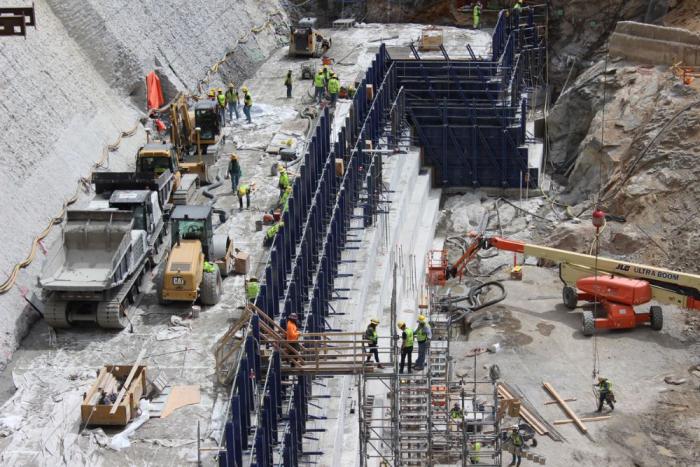
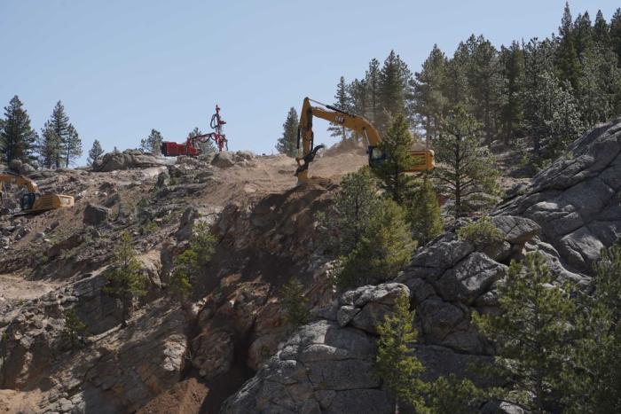
Each stage of a big construction project has its own challenges and puzzles to solve along the way. Raising Gross Dam is no different.
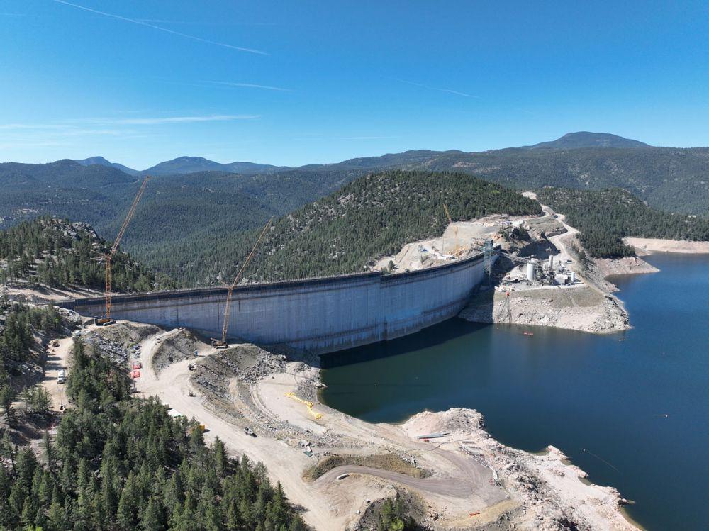
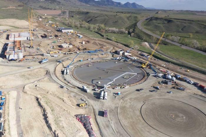
Denver Water is raising the height of the dam by 131 feet, with the final 22 feet going up this spring in two sections that are separated by a giant gap. The Gross Reservoir Expansion Project, which began construction in 2022, is designed to nearly triple the reservoir’s storage capacity. Major construction work resumed in April following a winter break.
And this year’s construction puzzles included:
How to move concrete across a 160-foot gap between where the concrete is made and where it’s placed?
And, how do you move construction vehicles across that same gap when work on the first section is finished?
“We are building the top of the dam in two sections because we need to leave a 160-foot gap in the middle of the dam for the spillway channel,” said Casey Dick, Denver Water’s deputy program manager for the Gross Reservoir Expansion Project.
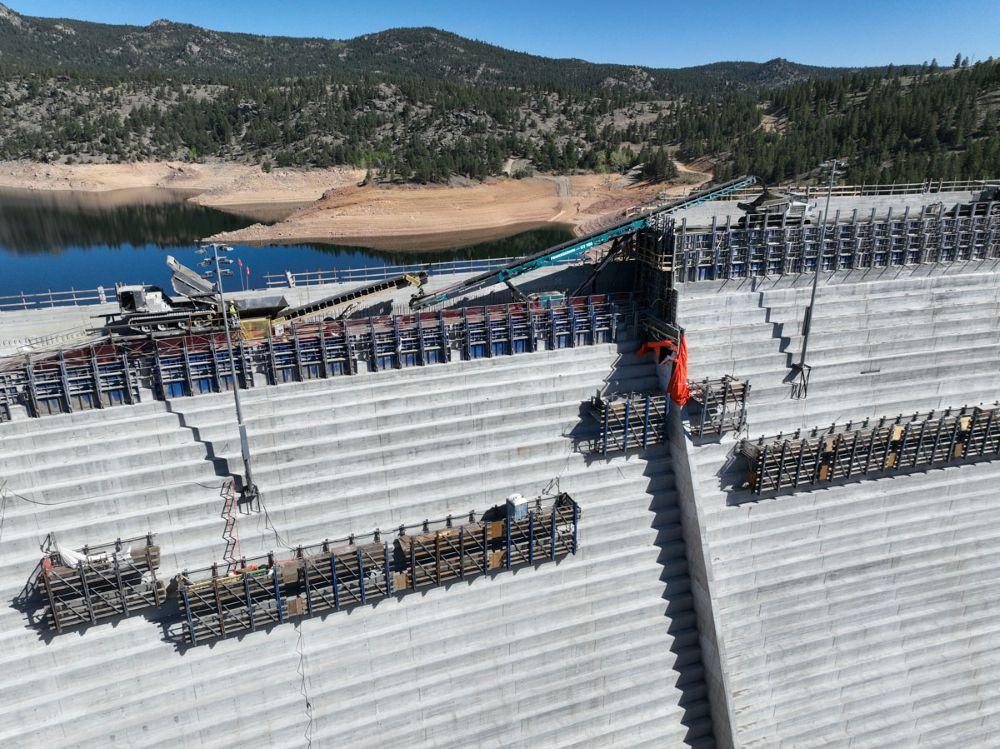
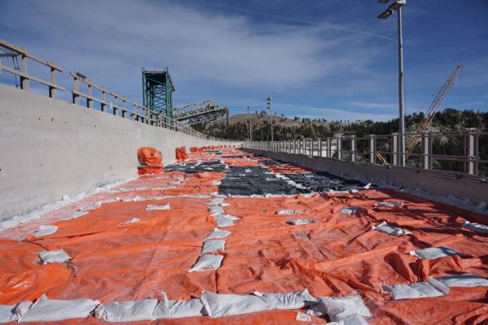
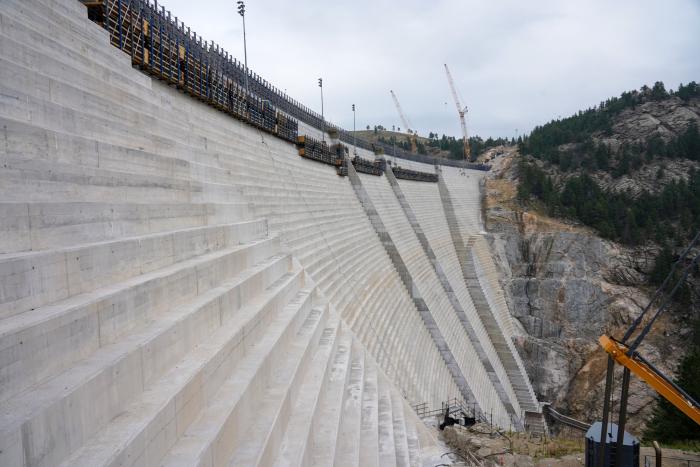
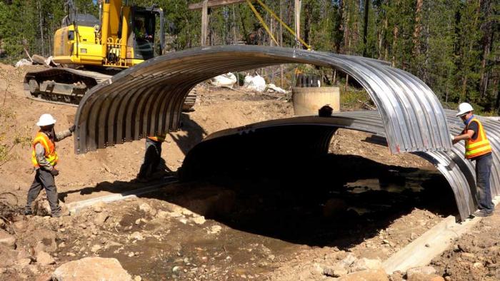
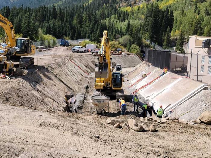
Denver Water is building the last 22 feet of Gross Dam in two sections. The photo shows the left side at its new height. The right side’s last 22 feet will be finished in June. Photo credit: Denver Water.
Spillway channels are safety features on dams that allow water to safely flow out of a reservoir if needed due to flooding rains or exceptionally high and rapid snowmelt.
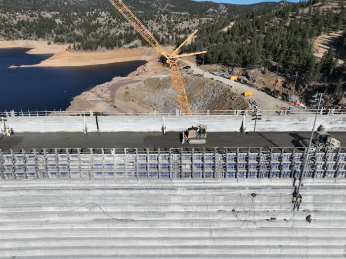
Raising the dam’s last two major sections, while leaving a 160-foot gap between them, meant coming up with a new way to move concrete across the construction site.
On the lower portion of the dam, crews worked on one continuous structure, which allowed trucks and equipment to easily move from one side of the dam to the other, and to move concrete from the batch plant down a large chute to where it was put into place.
However, with the final 22 feet going up in two sections, construction crews had to find a way to deliver concrete from the batch plant and across the 160-foot spillway gap as the first section went up.
The solution to this puzzle? A series of conveyors positioned in the middle of the dam that tilted higher as the first section rose higher.
“Building the new conveyor system is just another example of all the ingenuity we go through out here to build the dam,” Dick said. “With each new phase, there are new challenges that our team has to figure out.”
The new conveyor system moved concrete across the gap where the spillway channel will be to the far side of the dam. Photo credit: Denver Water.
Construction crews finished placing roller-compacted concrete on the dam’s left side on May 12.
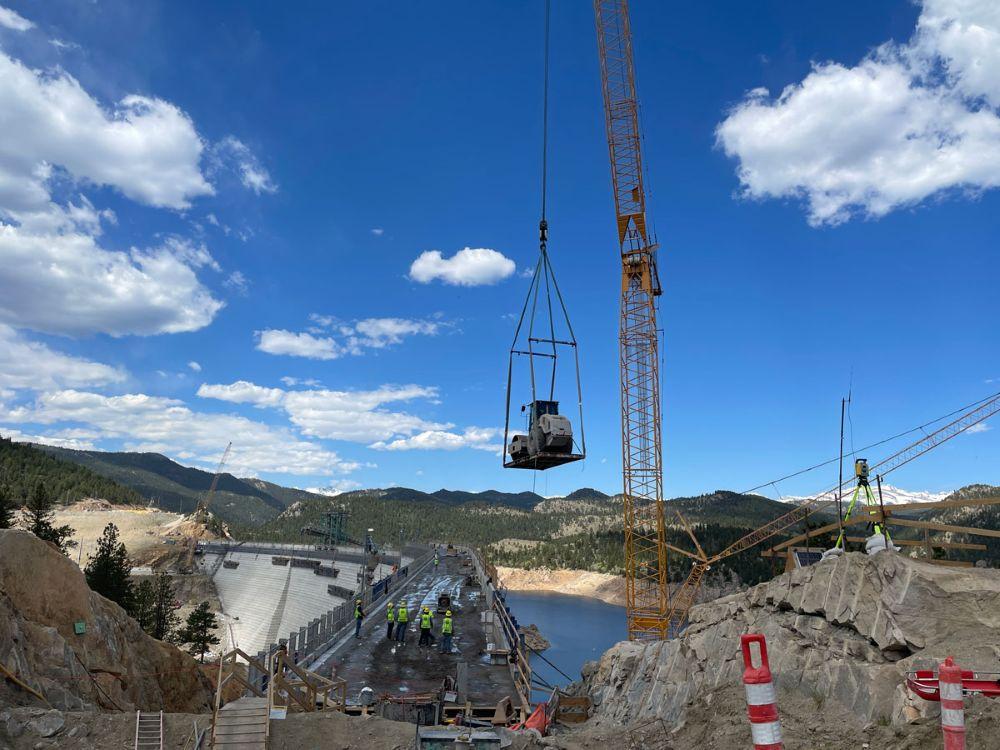
But once that was done, crews faced the second challenge: How do you move the equipment off the finished, 22-foot higher section of the dam, across the spillway gap, down to where they are needed to complete the second section?
Short answer: If you can’t go over, go around.
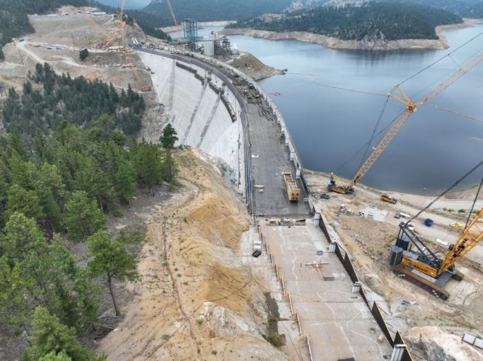
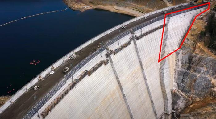
Cranes lifted equipment off the higher section of the dam to the road, where the machines convoyed about 4.5 miles around to the other side using the dam’s access road.
A crane lifts a piece of equipment off the dam. Because of the new spillway gap, equipment was driven across the dam’s access road to get into position on the other side of the dam. Photo credit: Denver Water.
Construction on the final 22 feet of the second side of the dam began at the end of May and is expected to be completed in June.
Once the second section is done this summer, a year’s worth of remaining work includes: finishing the top of the dam, building safety walls; constructing the actual spillway; building a bridge over the spillway and completing the stilling basin at the bottom of the dam.
This view from the bottom of the dam shows the new baffle blocks on the bottom of the stilling basin. The baffle blocks reduce the energy of the water that flows down the spillway. Photo credit: Denver Water.
Full construction on the dam raising project is expected to wrap up in mid-2027.
“There are hundreds of logistical challenges throughout this project, but our team has been able to meet every one of them along the way,” Dick said. “We’re making good progress so far in 2026 and are looking forward to getting a lot of work done in the coming months.”
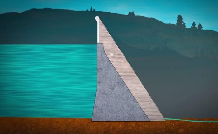
The Gross Reservoir Expansion Project involves raising the height of the existing dam by 131 feet. The dam will be built out and will have “steps” made of roller-compacted concrete to reach the new height. Image credit: Denver Water
Denver Water’s collection and service areas continue to face severe drought conditions, with historically low snowpack. Denver Water depends on mountain snowpack for its water supply, which serves 1.5 million people in Denver and surrounding suburbs.
As a result, on March 25, 2026, the Denver Board of Water Commissioners declared a Stage 1 drought, seeking a 20% reduction in water use to preserve water levels and avoid even stricter mandatory restrictions later this summer. On April 8, 2026, the board approved the implementation of temporary drought pricing, starting with May water use and reflected in June bills, to signal the premium value of water during droughts and help incentivize customers to save water.
Customers are urged not to turn on automatic sprinkler systems until at least mid- to late-May, or later if possible. It is not necessary to water grass two days per week in April and the beginning of May; keeping automatic systems off will help save water. Occasional hand-watering may be necessary for trees and shrubs during this time. Keep an eye on the weather and let Mother Nature do the watering when she delivers spring rains.
Comment from Nathan Elder, Denver Water’s manager of water supply:
“The snow we saw last week brought marginal improvement to snowpack, but it’s still the worst on record, which is doubly concerning as this week is typically our spring peak when the snow levels are the highest. We need our customers to reduce their water use by 20% and help stretch the water we have stored in our reservoirs. Hopefully, working together, we can save water across our service area and avoid increasing restrictions later this summer.”
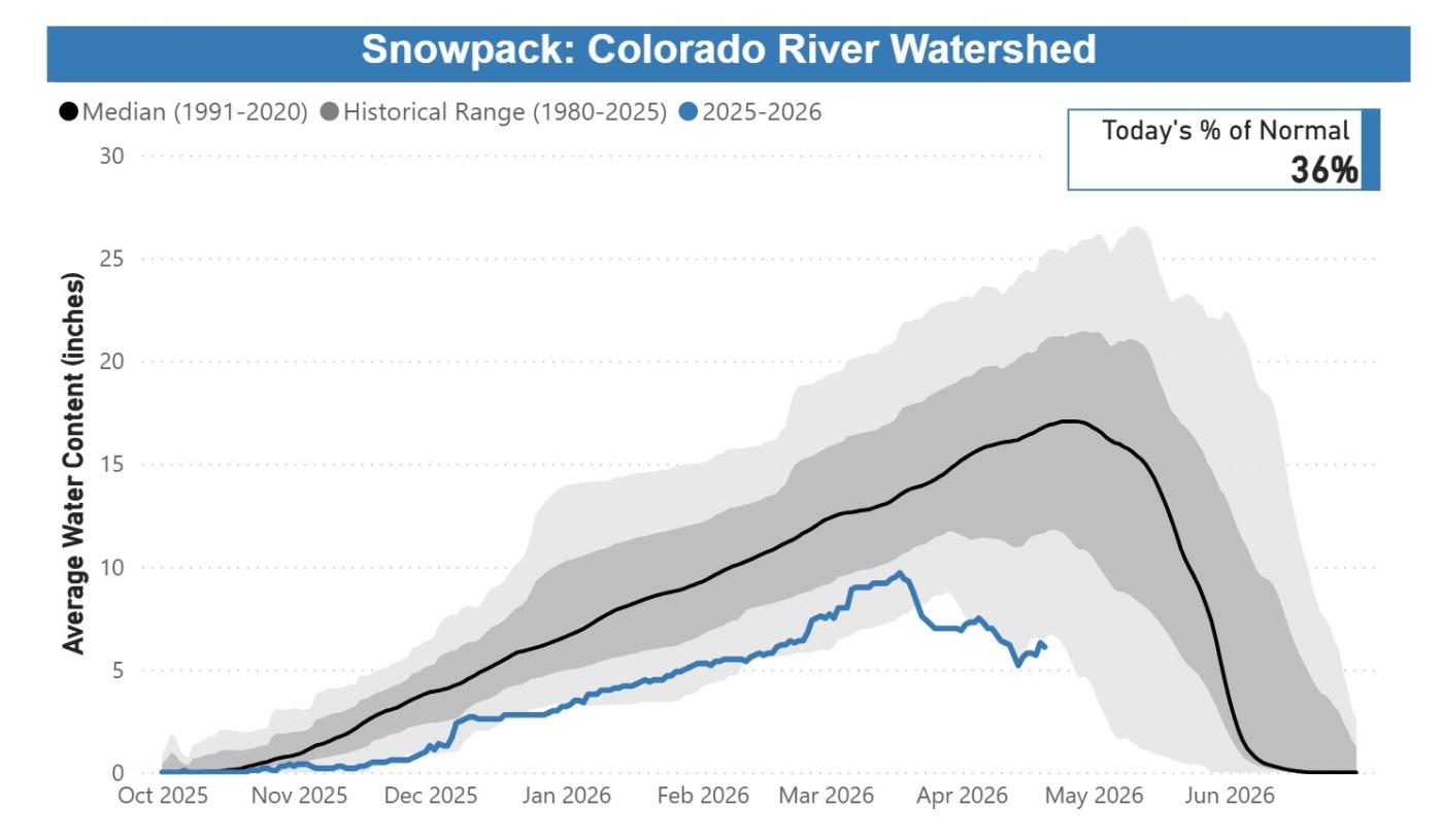
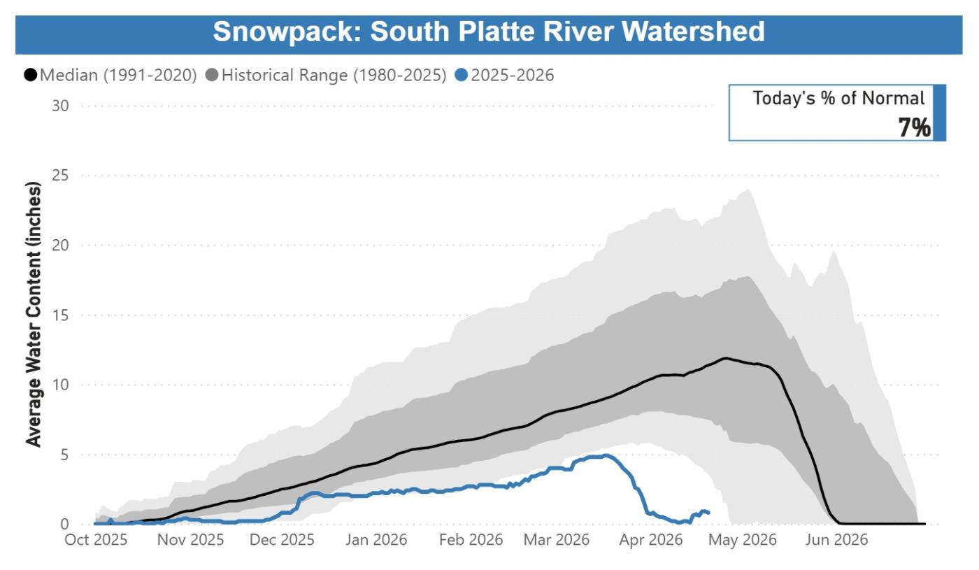
In Denver Water’s collection system, snowpack as of April 20, 2026, remained at the lowest levels observed in the past 40 years:
Colorado River Basin: 36% of normal, worst on record.
South Platte River Basin: 7% of normal, worst on record.
Snowpack and melting conditions are unprecedented, with accelerated melting seen since mid-March. Customers need to save water to protect the supply we have right now.
Streamflow forecasts are calling for runoff levels to be 10-40% of normal in 2026.
Reservoir storage conditions are below average; while in reasonably good shape for the time being, far less snowpack is available to help refill them. As of April 20, 2026, reservoirs were 80% full, versus an average of 85% full for this time.
Customers are urged not to turn on automatic sprinkler systems until at least mid- to late-May, or later if possible. When watering season begins, Denver Water will require customers in single-family residential properties to limit watering to no more than two days per week on a set schedule based on their address.
Addresses ending in even numbers: Sunday and Thursday.
Addresses ending in odd numbers: Wednesday and Saturday.
All other customers, including multifamily properties, commercial properties, homeowners associations and government properties, may water only on Tuesdays and Fridays.
Water only during cooler times of the day, between 6 p.m. and 10 a.m.
Do not allow water to pool in gutters, streets and alleys.
Do not waste water by letting it spray on concrete and asphalt.
Repair leaking sprinkler systems within 10 days.
Do not irrigate while it is raining or during high winds.
Use a hose nozzle with a shut-off valve when washing your car.
For its part, Denver Water has proactively reduced its spending, taking steps that include enacting a hiring freeze and reviewing maintenance and other projects to see which ones could be deferred. We are also looking into other ways to increase supply by activating agreements that allow us to capture additional water that is typically unavailable during normal conditions.
This year marks the fifth time since 2000 that Denver Water has issued a Stage 1 drought, and the first since 2013. Prior to 2013, the board declared a Stage 1 drought in 2002, 2003 and 2004.
Denver Water has many resources for homeowners looking for inspiration and information about landscapes that fit naturally into our dry climate. Click here for conservation and efficiency tips for outdoor irrigation and to get more details on ways to ColoradoScape your property, including through rebates for turf removal and a DIY guide for landscape changes, among many other potential water-saving steps.
Updates about Denver Water’s reservoir levels, customer water use and snowpack can be found in the Water Watch Report, which is updated weekly in the spring and summer.
This chart shows the cumulative snowpack on April 20, 2026, in the area of the Colorado River Basin where Denver Water captures its water supply. The snowpack is 36% of normal, which ranks as the lowest on record for April 20. Image credit: Denver Water.
This chart shows the cumulative snowpack on April 20, 2026, in the area of the South Platte River Basin where Denver Water captures its water supply. The snowpack is 7% of normal, which ranks as the lowest on record for April 20. Image credit: Denver Water.
Workers raise dam 109 feet in 2025. Next year’s goal: Reaching the top.
The Denver Water team working on Gross Dam in Boulder County is celebrating a successful year after the dam raise is 95% complete.
“In 2025, we raised the height of the dam by 109 feet above the original structure,” said Jeff Martin, Denver Water’s program manager for the Gross Reservoir Expansion Project. “We have 22 feet left to go to reach the new height and we’re on track to reach that in 2026.”
The dam-raising aspect of the Gross Reservoir Expansion Project wrapped up for the season on Nov. 14, due to the drop in temperatures. The project is designed to nearly triple the water storage capacity of Gross Reservoir.
In 2025, workers raised the height of Gross Dam by 109 feet. The final 22 feet will be completed in 2026 to reach the dam’s new height of 471 feet. Photo credit: Denver Water.
“We have to stop placing roller-compacted concrete when the temperatures drop below freezing,” said Casey Dick, deputy program manager for the Gross Reservoir Expansion Project.
“To prepare for winter, we put blankets on top of the new concrete to keep it from getting too cold. That’s because if the concrete freezes while it is still curing, it can lead to a weakened final product.”
Work associated with the dam raise will resume in spring 2026, when the weather warms up enough to complete the final 22 feet.
Protective “blankets” were placed on top of the dam to insulate the new concrete, so it does not fully cure over the cold, winter months. Photo credit: Denver Water.
Once that work is complete, the dam will be 471 feet tall, which is 131 feet higher than the original. The completed dam also will be longer across its crest, or top. The original crest was 1,050 feet long; the higher dam will have a crest that stretches 2,040 feet from one side of the canyon to the other.
This year marked the second year of dam raising construction work at Gross.
As of December 2025, workers had placed more than 730,000 cubic yards of concrete. To put that in perspective, Empower Stadium at Mile High, where the Denver Broncos play their home football games, required just 29,000 cubic yards of concrete to build, about 4% of the concrete placed so far on Gross Dam.
Protective “blankets” were placed on top of the dam to insulate the new concrete, so it does not fully cure over the cold, winter months. Photo credit: Denver Water.
Roller-compacted concrete is a special mix of concrete that allows crews to place it on the dam and then spread it out. The concrete is firm enough to be able to drive machinery on top of it. The process is a fast and efficient method of raising the dam. During the construction work, crews raised the height of the dam by about 1 foot per day.
Construction crews use GPS technology and survey equipment to keep track of how high they’ve raised the dam.
“The way we keep track of the elevation gain is that the bulldozers are equipped with GPS-grade control technology, which ensures that each layer of concrete is spread to the correct thickness,” Dick said.
“Once the concrete is rolled and vibrated into place, each layer ends up being 1 foot thick. It’s then checked by surveyors with their equipment to verify the exact elevation.”
The bulldozers are equipped with GPS-grade control technology to monitor the height of the concrete as it is spread across the top of the dam and keep track of the elevation. Photo credit: Denver Water.
Work won’t completely stop over the winter.
Mechanical and pipe work will be done inside the dam, and crews will build a stilling basin at the base of the dam. The basin’s function is to slow the speed of water coming down the dam’s spillway and safely redirect the water into South Boulder Creek.
Work on the stilling basin at the base of the dam will continue over the winter. The stilling basin is designed to slow the flow of water coming down the spillway and channel it into the creek. Photo credit: Denver Water.
“This season was a huge success, and our team met a ton of challenges in raising Gross Dam,” Martin said. “We had legal challenges and adverse weather challenges. We also had wildfire safety operation challenges that shut down our power supply up here. Despite all those setbacks, the dedicated team of 500 men and women rose to the challenge. I’d just like to thank everybody who committed themselves to this project and helped us make 2025 a success.”
Jeff Martin, Denver Water’s program manager for the Gross Reservoir Expansion Project, stands at the south side of the dam. Once completed, the dam will reach up to white line on the rock wall. Photo credit: Denver Water.
Denver Water and Save the Colorado must enter mediation at the end of the month to see if a deal is possible on the mid-project challenge to the water utility’s $531 million dam raising underway at Gross Reservoir in Boulder County, according to an order from the U.S. Court of Appeals.
A federal trial judge initially halted construction on the nearly finished dam, saying the U.S. Army Corps of Engineers permits for Denver Water violated U.S. environmental laws and that the water level at Gross could not be raised. Judge Christine Arguello later lifted the injunction on construction, for safety reasons, while Denver Water appealed the permit issues to the 10th Circuit Court of Appeals.
The 10th Circuit will take briefs from both sides of the dam dispute in November, and is now ordering a mediation session for Oct. 30. The conference is to “explore any possibilities for settlement” and lawyers for both sides are “expected to have consulted with their clients prior to the conference and have as much authority as feasible” on settlement questions, the court order says.
Construction has continued since the injunction was lifted, with Denver Water pouring thousands of tons of concrete to raise the existing dam structure on South Boulder Creek. Denver Water has argued it needs additional storage on the north end of its sprawling water delivery system for 1 million metro customers, to balance extensive southern storage employing water from the South Platte River basin.
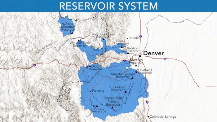
Denver Water’s collection system via the USACE EIS
Save the Colorado and coplaintiffs the Sierra Club, WildEarth Guardians and others argue too much water has already been taken from the Colorado River basin on the west side of the Continental Divide, and that the forest-clearing and construction at Gross is further destructive to the environment. Gross Reservoir stores Fraser River rights that Denver Water owns and brings through a tunnel under the divide into South Boulder Creek.
“We look forward to having a constructive conversation with Denver Water to find a mutually agreeable path forward that addresses the significant environmental impacts of the project,” Save the Colorado founder Gary Wockner said.
When securing required project permits from Boulder County, Denver Water had previously agreed to environmental mitigation and enhancements for damages from Gross construction. But Save the Colorado and co-plaintiffs sued to stop the project at the federal level, and Arguello agreed that the Army Corps had failed to account for climate change, drought and other factors in writing the U.S. permits.
Denver Water declined comment Tuesday on the mediation order.
The halt and restart of the Gross Dam raising came in what has turned out to be a tumultuous year for major Colorado water diversion and storage projects.
While the Gross Dam decisions were underway, Wockner was finishing negotiations with Northern Water over $100 million in environmental mitigation funding to allow the $2.7 billion, two-dam Northern Integrated Supply Project to move forward. Once the 15 communities and water agencies subscribed to NISP water shares saw the increasing price tag, some began pulling out.
Northern Water reviewed the scale of NISP with engineers, then said it planned to move forward at the previously announced scale. The consortium’s board has asked all 15 initial members to indicate by Dec. 31 where they stand with the project and its price tag.
Roller-compacted concrete will be placed on top of the existing dam to raise it to a new height of 471 feet. A total of 118 new steps will make up the new dam. Image credit: Denver Water.
Here’s the release from the Colorado Water Trust (Kate Ryan and Blake Mamich):
October 7, 2025
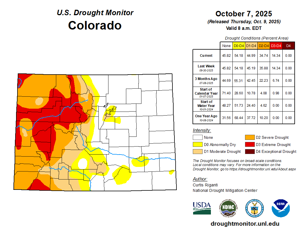
Colorado’s rivers are running on empty as drought grips the intermountain west. But a record-setting response from Colorado Water Trust is helping keep critical stretches of rivers around our state flowing for fish, farms, and communities alike.
This year, Colorado Water Trust is operating more projects across more rivers than at any point in its 24-year history—and restoring more water to streams than ever before. Across the state and on both sides of the Continental Divide, Colorado Water Trust is partnering with local irrigators, water districts, state agencies, and funders to release more than 16,000 acre-feet of water (over 5.2 billion gallons) back into rivers when it’s needed most. This unprecedented effort highlights how collaboration and creativity can sustain Colorado’s rivers through crisis, offering a model of resilience at a time when the state’s waterways face one of their toughest seasons yet.
Colorado is in the grip of a devastating drought. Nearly 45% of the state is currently experiencing at least moderate drought conditions, with significant portions in severe and extreme drought. Streams across the state are shrinking, water temperatures are rising, and ecosystems, farms, and communities are all feeling the strain. In many places, streamflow gauges are reporting flows in the lowest 10-25 percentile for this time of year. Rivers in some regions are hitting historically low levels far earlier in the season. This year marks the earliest call on the Yampa River in recorded history. The situation is dire, and without swift, creative intervention, stretches of Colorado’s treasured rivers could be left dry.
In response, Colorado Water Trust is rising to meet this challenge by running nearly all of its projects across the state, ensuring that water is returned to rivers when it is needed most. The scale of the response is unprecedented—this year is predicted to see more water restored to Colorado’s rivers through Colorado Water Trust’s work than in any other year since the organization was founded. Some of this year’s projects include:
This map shows the 15-mile reach of the Colorado River near Grand Junction, home to four species of endangered fish. Map credit: CWCB
Colorado River: On the Colorado River, Colorado Water Trust is again operating its project on the 15-Mile Reach, a stretch of river critical to the survival of four endangered and threatened fish species. Colorado Water Trust is expected to restore well over 1 billion gallons of water to this critical reach by releasing water from Ruedi Reservoir near Basalt which is then restored to the Fryingpan and Roaring Fork Rivers before it reaches the 15-Mile Reach of the Colorado River. Through innovative partnerships with the Grand Valley Water Users Association, Orchard Mesa Irrigation District, and the Upper Colorado Endangered Fish Recovery Program, water is being delivered at key times to support flows in this fragile habitat. Backed by generous support from corporate partners such as Niagara Cares, Coca-Cola, and Coors Seltzer, this project has become a model of collaboration and creativity.
Yampa River: Further north in the Yampa Valley, Colorado Water Trust is implementing our projects on the Upper and Lower Yampa River. Releases from Stagecoach Reservoir, made possible through collaboration with Upper Yampa Water Conservancy District and the Colorado Water Conservation Board, have been restoring significant volumes of water to the Upper Yampa as it passes through downtown Steamboat Springs since June. This water is vital for endangered fish within the reach, as well as the recreation economy downstream. Additionally, on the Lower Yampa, strategic releases out of Elkhead Reservoir in coordination with the Upper Colorado River Endangered Fish Recovery Program and the Colorado River District are sustaining critical habitat for endangered fish, as well as supporting the agricultural community downstream. These projects—already amounting to thousands of acre-feet—are keeping the Yampa River flowing through one of its most critical seasons. Without these boosts, irrigators, fish, and the communities of the valley would be facing even greater hardship. These projects are made possible thanks to generous funding from the Colorado Water Conservation Board, the Yampa River Fund, Colorado River District, and more.
Around the state: On smaller tributaries, Colorado Water Trust is also making a difference.The Slater Creek Project, in partnership with local ranchers and Western Resource Advocates, is improving conditions for an important headwater tributary to the Yampa River while supporting the local agricultural economy. So far, this project has restored over 100 million gallons of water to Slater Creek. On the Fraser River, Colorado Water Trust has teamed up with the Grand County Mutual Ditch and Reservoir Company to improve late-season flows through the Vail Ditch Project. This effort, which will return roughly 16 million gallons of water this year, helps cool the river and support critical trout spawning runs. In Boulder County in the Indian Peaks Wilderness by the Continental Divide, Colorado Water Trust’s project out of Jasper Reservoir released water and accounted for approximately 32% of flows in Middle Boulder Creek upstream of Barker Reservoir and 25% of flows in Boulder Creek in downtown Boulder. Across the state, permanent long-term projects are also running, steadily and reliably delivering water to rivers during the hottest, driest part of the year.
Taken together, these efforts represent the most ambitious season in Colorado Water Trust’s history. By weaving together partnerships with irrigation companies, conservancy districts, state and federal agencies, and local communities, and by drawing on the support of a diverse array of funders—Colorado Water Trust is delivering hope where it is needed most.
“These projects demonstrate the power of partnership to keep rivers flowing, even in the toughest years,” said Kate Ryan, Colorado Water Trust’s Executive Director. “It just goes to show how everyone—no matter who you are or where you live—cares about protecting Colorado’s rivers and the people who depend on them.”
While drought continues to tighten its grip on Colorado, these projects demonstrate that collaboration and innovation can keep rivers alive. In the face of crisis, Colorado Water Trust is proving that when partners and funders come together, rivers can be sustained for people, farms, fish, and communities alike. This year will mark the most flow ever restored to Colorado’s rivers through Colorado Water Trust’s work—a milestone born from collaboration, ingenuity, and urgent necessity.
“It’s a strange mix of pride and worry,” said Blake Mamich, Program Director for the Colorado Water Trust “On one hand, I’m thrilled to see so much water restored to rivers this year. On the other, I know that the only reason we can do this work at this scale is because it’s so needed: drought and climate stress are hitting us harder and harder. That’s a hard truth we carry with us every day.”
As Colorado enters one of its most critical water years in recent memory, Colorado Water Trust is committed to ensuring that, even in the face of historic drought, Colorado’s rivers will continue to flow.
About Colorado Water Trust
Colorado Water Trust is a statewide nonprofit organization with a mission to restore water to Colorado’s rivers. Since 2001, they’ve restored over 26 billion gallons of water to Colorado’s rivers and streams. ColoradoWaterTrust.org.
As of Sept. 5, crews had raised the dam by 60 feet. The project is designed to increase the water storage capacity of Gross Reservoir, which supplies water to 1.5 million people in the Denver metro area.
“Over the past two years, we’ve been working on the original dam to prepare it for the enlarged height and width,” said Casey Dick, Denver Water’s deputy program manager for the project.
“At the end of June, the concrete work reached the original crest, so now all the concrete placements are above the existing structure.”
A dump truck fills up with concrete at the top of Gross Dam. The trucks drive across the top of the dam and place the concrete in layers to raise the dam higher. Photo credit: Denver Water.
Once completed, Gross Dam will be 471 feet tall and around 2,000 feet wide.
As the dam has gone up, it has become easier to see some of the differences between the original dam, which was completed in the 1950s, and the newly renovated structure.
For instance, the original surface of the downstream side of the dam was smooth. Now, the downstream side of the dam is a series of stair steps. The steps were an integral part of the construction process and supported the trucks that deposited layers of concrete onto the original structure of the dam.
This picture was taken from roughly the crest of the original dam. The dam has been raised 60 feet as of Sept. 5. The new face of the dam features a stepped design, which was needed for the construction process. Photo credit: Denver Water.
The renovated dam will also take on a new shape.
“The original structure was built as a ’curved gravity’ dam,” Dick said. “Now, we’re taking advantage of that curved geometry in the middle portion of the dam to create what’s called a ‘thick arch’ dam in the center of the canyon.”
The middle section of the dam is arched to give the dam strength as water pushes up against the structure. Photo credit: Denver Water.
Arches are used in dam construction because the force of the water in the reservoir pushes up against the arch and into the canyon walls. This gives an arched dam more strength compared to a flat structure.
“We’ve also built what are called ’thrust blocks’ on the sides of the original dam,” Dick said. “These give the dam additional support by essentially extending the canyon walls upward to support the arch.”
The “thrust blocks,” highlighted in red, extend out from the canyon wall. The blocks provide additional strength where the arch of the dam meets the rock. Photo credit: Denver Water.
As work has risen above the original crest of the dam, workers have built formwork, or temporary molds, on both the upstream and downstream sides of the dam. The temporary structures hold the freshly placed concrete in the proper shape until it hardens and cures.
Workers build formwork, or temporary molds, on the top of the dam. The forms hold new concrete in place until it cures. Photo credit: Denver Water.
With the new added concrete added during the project, Gross Dam is now much steeper than the original structure. At the base, the dam is 300 feet thick, but it gets skinnier as it goes up. At the top, the dam will be just 25 feet thick. Crews have had to adjust to the smaller work area to maneuver their equipment as the project progressed.
Work to raise the dam will continue as late as possible into 2025, until weather conditions make it too cold to place concrete.
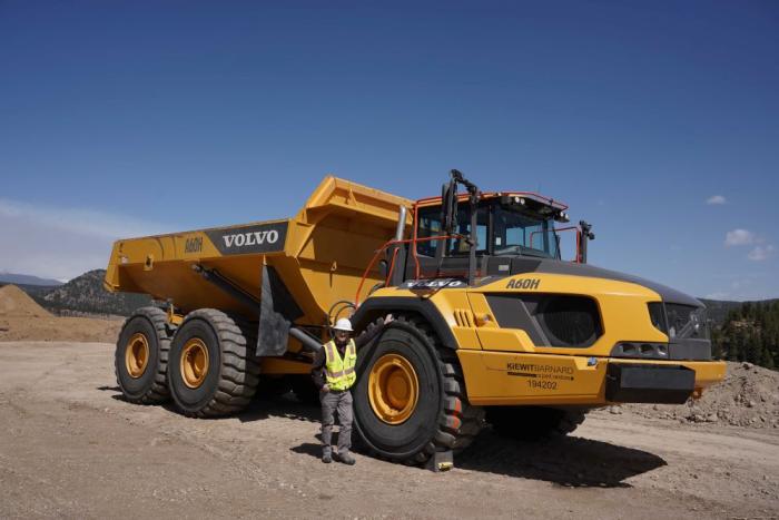
“We’d like to thank all the men and women out here from Kiewit-Barnard and the other contractors out here,” Dick said. “They are working around the clock and as fast as they can to complete this project.”
Roller-compacted concrete will be placed on top of the existing dam to raise it to a new height of 471 feet. A total of 118 new steps will make up the new dam. Image credit: Denver Water.
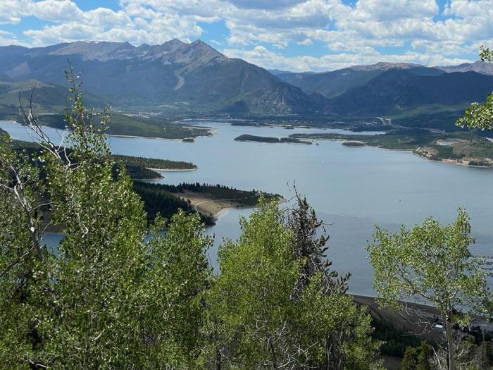
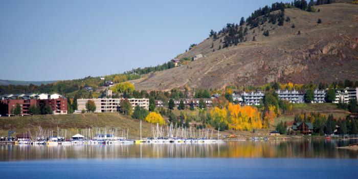
Up until late August, this summer has been particularly dry, both for the Denver region and for the West Slope, the source of half of Denver Water’s supply. And that combination has translated into a heavy workload for the utility’s largest reservoir, the 257,000-acre-foot Dillon Reservoir in Summit County.
Dillon Reservoir in Summit County is Denver Water’s largest reservoir. Photo credit: Denver Water.
A summer largely bereft of the monsoon rains (which bolster our water supply and reduce water use by our water-smart customers) combined with long stretches of days above 90 degrees pushed up demand among the 1.5 million people Denver Water serves.
The dry summer situation also triggered calls for more water from farmers and ranchers who have senior water rights that put them at the front of the line for receiving water from the South Platte River system. Denver Water’s supplies are also constrained on the north side of its system, as ongoing work on the Gross Reservoir Expansion Project requires the utility reduce the amount of water it stores in that reservoir during the project.
Dillon Reservoir provides Denver Water with a supplemental supply to use when the amount of water available from its south system source, the South Platte River, is not enough to meet demands.
That all combined to make Denver Water more heavily reliant on Dillon Reservoir than usual, forcing the utility to push higher volumes from Dillon through the Roberts Tunnel to the Front Range.
“A lot of factors combined to see us lean hard into our Dillon supplies this summer,” said Nathan Elder, manager of supply for Denver Water. “We know this impacts recreation, both what we release into the Blue River below the reservoir and the water levels for the marinas at Dillon Reservoir. We try very hard to maintain good conditions for recreation at Dillon, but this summer posed challenges.”
The Dillon Marina at Dillon Reservoir. Photo credit: Denver Water.
Overall, the amount of water flowing into Dillon was at just 70% of normal in the April-through-July stretch. July alone saw just 48% of typical flows into the reservoir — that’s 20,000 acre-feet below average, about the capacity of Antero Reservoir west of Fairplay.
The situation serves as a reminder for Denver Water customers to stay smart about water use.
Especially amid a hot, dry summer, customers should make sure to follow watering rules and skip irrigation during rainy periods. And they should consider landscape changes that replace thirsty turfgrass with plants that need less water.
Yet, despite relentless dry periods covering July and most of August, Denver Water customers did a good job managing irrigation. They used water at a rate of just about 2% above the five-year average, and just 1.6% above the longer term, 2000-2024 average.
These plants from Resource Central’s Garden In A Box program are water-wise and interesting throughout the year. Photo credit: Denver Water.
But even as Denver Water customers kept demands low by historical standards, the combination of conditions saw water levels in Dillon fall below levels optimal for the marinas at the reservoir by the end of August.
Typically, Denver Water tries to keep the surface of Dillon Reservoir at 9,012 feet in elevation through Labor Day. But this year, levels will fall a few feet below that.
And water volumes flowing out of Dillon into the Blue River — flows important to rafters and anglers — also fell significantly. Since late July, those outflows were about 100 cubic feet per second, about half of normal for this time of year. In August they dropped even further, to 75 cubic feet per second.
The overall picture began to improve slightly in late August, as the state benefited from a cooling trend and bursts of rainfall. The cooler, wetter weather in the metro area cut Denver Water customers’ demand for water in the Denver region, easing the need to pull as much water from Dillon.
Even so, the tough summer means Denver Water will likely enter the new, 12-month water year, which begins Oct. 1, with its reservoirs, including Dillon, at below-average elevations.
That puts the onus on the upcoming winter season to come through with a good snowpack, never a sure thing.
“We’ll hope to see water demands fall in September and then look to a good snowpack in the winter and spring,” Elder said.
“But we’ll be starting from behind. We hope we can make up the gap in reservoir storage with a wet winter and spring. And we’ll need our customers to help us with smart water practices.”
Following a day of testimony on May 6, Denver Water has been asked by U.S. District Court Judge Christine Arguello to provide the court with the utility’s final summary highlighting its position following the witness testimony and exhibits. There isn’t a specific timetable set for this yet.
The focus of the hearing was for the judge to determine if construction can safely stop while Denver Water moves forward on an additional permitting review as the court ruled on April 3. Here is Denver Water’s statement on the risk presented by delaying construction:
Denver Water has already started the appeal process with the 10th Circuit Court of Appeals. As part of this, the project has been allowed to continue (under a temporary stay) while legal proceedings are underway.
Roller-compacted concrete will be placed on top of the existing dam to raise it to a new height of 471 feet. A total of 118 new steps will make up the new dam. Image credit: Denver Water.
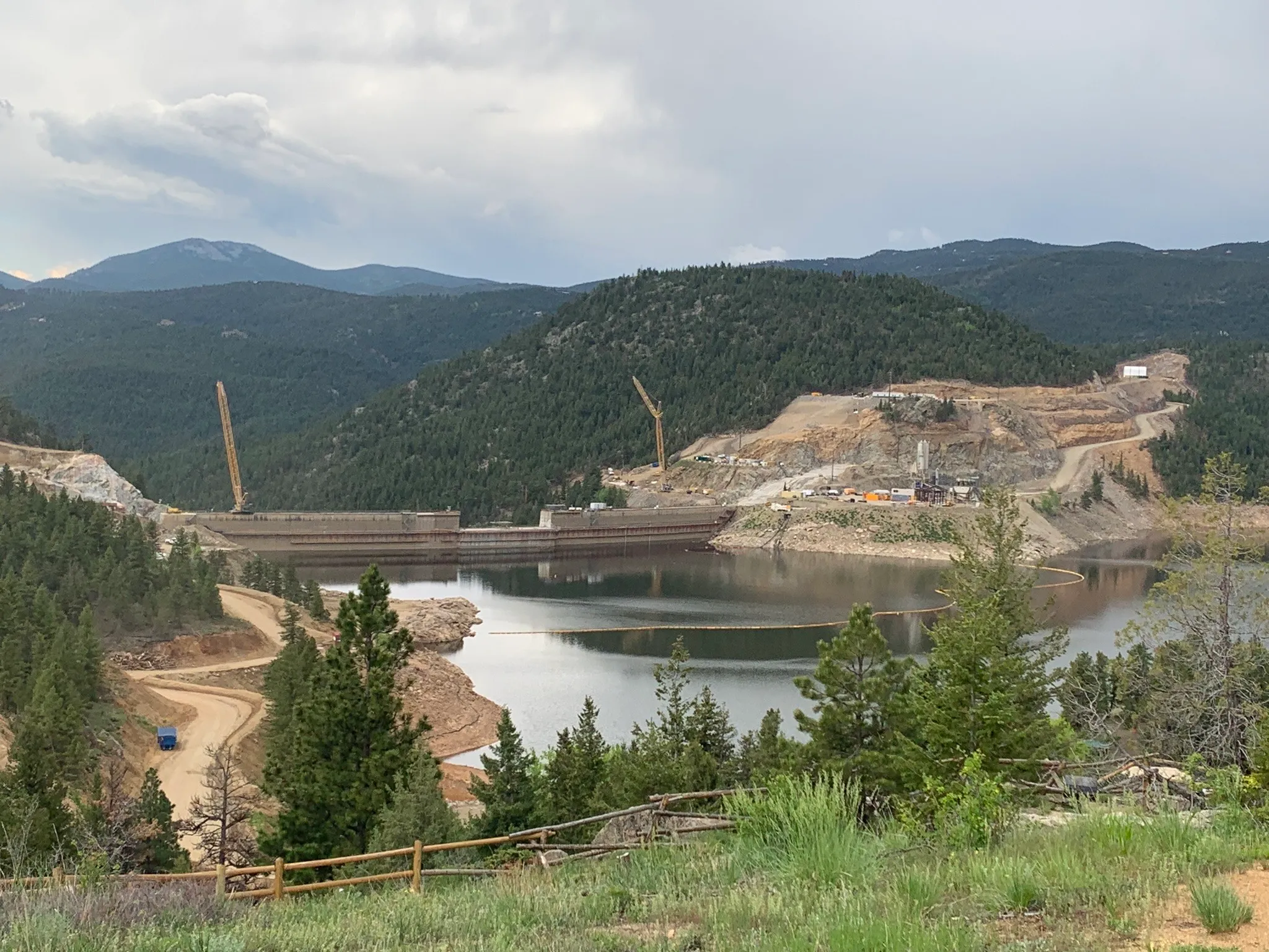
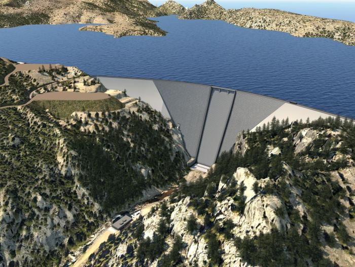
Denver Water is helping ensure its future water security with the Gross Reservoir Expansion Project. When the project is complete, it will nearly triple the Boulder County reservoir’s capacity to 119,000 acre-feet. CREDIT: HEATHER SACKETT/ASPEN JOURNALISM
Adam engineer who designed a major expansion of Gross Reservoir Dam in Boulder County told a federal judge Tuesday that the raising of the dam, facing a potential halt due to an April federal court ruling, needs to proceed to protect public safety.
Mike Rogers, the civil engineer who designed the $531 million expansion of the dam, said bad weather could create flood conditions that would lead to a catastrophic failure similar to what occurred with the Oroville Dam failure in California in 2017.
But Stephen Rigbey, a Canadian dam safety expert testifying for Save The Colorado, said any issues with putting the construction project on hold, even in its partially-complete state, could be addressed, and that the risk of a catastrophic failure was “negligible.”
Workers from Denver Water and contractor Kiewit Barnard stand in front of Gross Dam in May 2024 to mark the start of the dam raise process. Photo credit: Denver Water.
Rogers’ and Rigbey’s testimony Tuesday came during a federal hearing in Denver, after which U.S. District Court Judge Christine Arguello will determine whether to allow construction to move forward on the Denver Water project or whether the construction will be paused until new federal reviews she has ordered are completed and legal questions are answered.
But at the end of Tuesday’s hearing, Arguello said the parties to the case had not provided enough information for her to make a decision and ordered them to submit more data later this month.
The massive construction project has raised fierce opposition in Boulder County and prompted several legal challenges from Save The Colorado, a group that advocates on behalf of rivers. Though its early lawsuits failed, in 2022 the river defenders won an appeal that put the legal battle back in play. Despite months of settlement talks, no agreement was reached.
Boulder County Commissioner Ashley Stolzmann was unmoved by Rogers’ testimony, saying she hopes the judge halts the work to prevent further environmental damage in Boulder County and to protect the Fraser River, a tributary to the Upper Colorado River. The Fraser has served as the source of water for Gross Reservoir since the 1950s, when it was built.
“It’s incredibly disappointing that Denver has chosen to move forward,” Stolzmann said. “With climate change, it really is a time for different entities to work together to repair the climate. I want to see Denver seek alternative solutions.”
Denver Water first moved to raise Gross Dam more than 20 years ago when the water provider began designing the expansion and seeking the necessary federal and state permits. Denver Water has said raising the dam and expanding the reservoir is necessary to ensure it has enough water throughout its delivery system and to help with future water supplies as climate change continues to reduce streamflows.
The Gross Reservoir Expansion Project involves raising the height of the existing dam by 131 feet. The dam will be built out and will have “steps” made of roller-compacted concrete to reach the new height. Image credit: Denver Water
After years of engineering, environmental studies and federal and state analyses, Denver received a permit from the U.S. Army Corps of Engineers and construction began in 2022. It has involved taking apart a portion of the original dam and raising its height by 131 feet to nearly triple the reservoir’s storage capacity to 119,000 acre-feet from 42,000 acre-feet.
The case took center stage again April 3, when Judge Arguello put a temporary halt to construction of the higher dam, at Save The Colorado’s request.
In that high-profile ruling, Arguello said, in part, that the Army Corps should have considered whether ongoing climate change and drought would leave the Colorado River and Western Slope waterways too depleted to safely allow transfer of Denver Water’s rights into a larger Gross Reservoir for Front Range water users.
At the same time, she ordered a permanent injunction prohibiting enlargement of the reservoir, including tree removal and water diversion, and impacts to wildlife.
Almost immediately, Denver Water filed for temporary relief from the order, saying, in part, that it would be unsafe to stop work as the incomplete concrete walls towered above Gross Reservoir.
Arguello granted that request, too, allowing Denver to continue work on the dam considered necessary for safety.
Denver Water has also filed an appeal with the U.S. 10th Circuit Court of appeals, seeking to permanently protect its right to continue building the dam. The appeals court is expected to wait for the lower court to rule, before considering Denver Water’s request.
Udall/Overpeck 4-panel Figure Colorado River temperature/precipitation/natural flows with trend. Lake Mead and Lake Powell storage. Updated through Water Year 2024. Credit: Brad Udall
As Save the Colorado and Denver Water prepare to face off in a federal courtroom Tuesday, water officials across the state are watching the Gross Dam expansion case closely for its environmental impact and its affect on water projects across the West.
Kirk Klancke, a long-time Grand County environmentalist and president of the Colorado River Headwaters Chapter of Trout Unlimited, said a decision that shuts down the $531 million water project, could also shut down 12 years of work on the Fraser River and its tributaries.
Denver Water is one of 18 partners who signed the Colorado River Cooperative Agreement in 2013, ushering in a new era of cooperation between the utility and West Slope stakeholders, all with the vested interest in protecting watersheds in the Colorado River Basin. As part of that agreement, a process called “Learning by Doing” was created, which has helped the utility stay better connected on river conditions in Grand County. The partnership is a collection of East and West Slope water stakeholders who help identify and find solutions to water issues in Grand County. “Denver Water has been part of Grand County for over 100 years, and we understand the impact our diversions have on the rivers and streams,” said Rachel Badger, environmental planning manager at Denver Water. “Our goal is to manage our water resources as efficiently as possible and be good stewards of the water — and Learning By Doing helps us do that.”
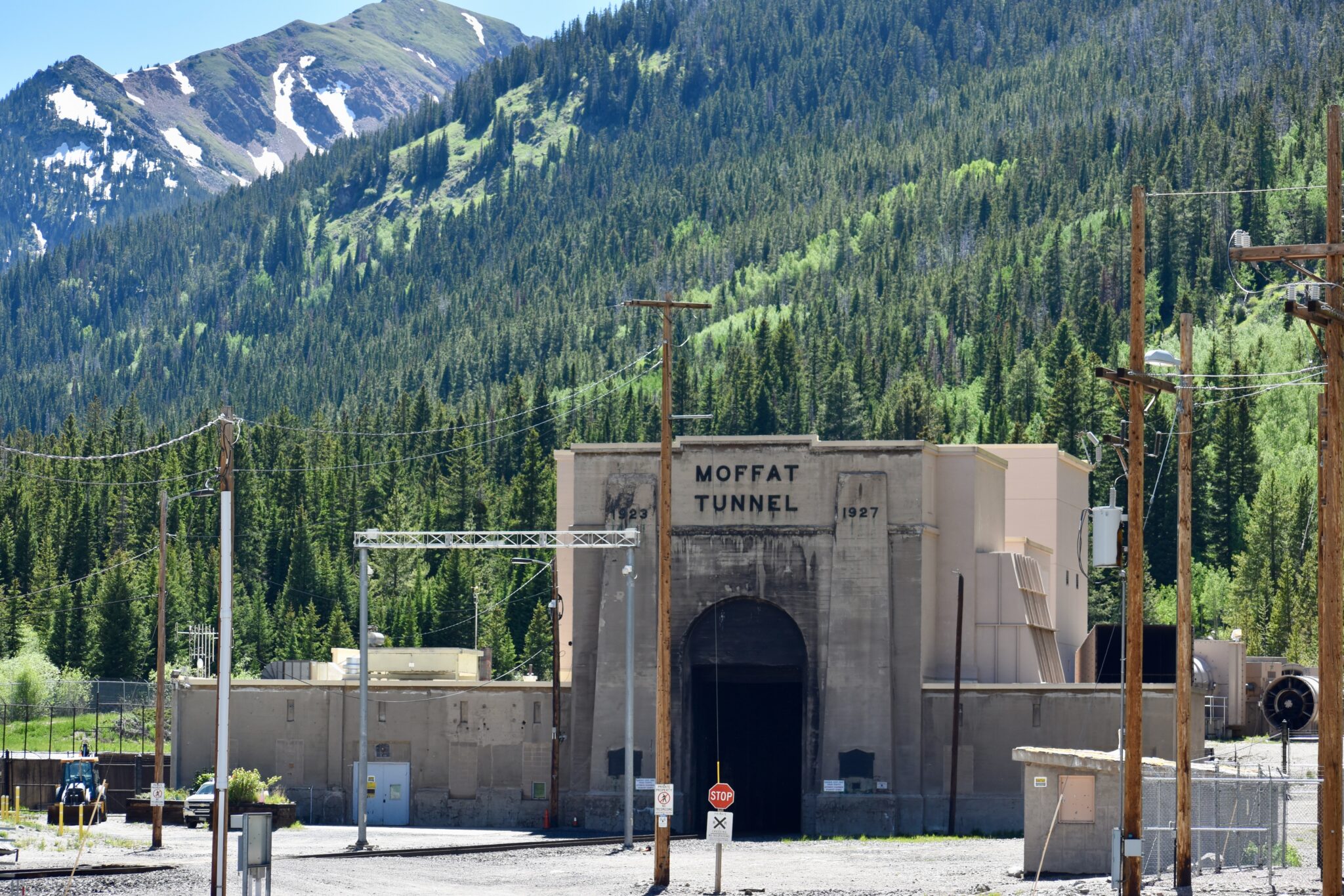
Here’s why: Denver Water owns much of the Fraser with water rights dating back more than 100 years. And it is that water that has historically been piped through the Moffat Tunnel near Rollinsville to fill the existing Gross Reservoir. The new water for the expanded reservoir will come largely from that river as well.
After what’s known as the 2013 Colorado River Cooperative Agreement was signed, Denver Water agreed to conduct extensive restoration work on the river in exchange for being able to raise Gross Dam and bring more water from the Fraser River over to the Front Range.
Klancke said the heavily diverted, scenic waterway would suffer if the deal falls apart. “To dissolve that partnership will be the death of the Fraser River,” he said.
Under the terms of the Colorado River Cooperative Agreement, the work on the Fraser River can only be finalized if the Gross Dam expansion proceeds.
On the upside though, Klancke said, if a new environmental settlement were reached, it could mean more money and more work to restore South Boulder Creek on the other side of the Continental Divide. The creek carries that Fraser River water from the reservoir to Denver Water’s northern storage system.
“I would love to see Denver put a whole bunch of money into South Boulder Creek,” Klancke said.
Gary Wockner, the head of Save The Colorado, disputes the notion that the case could harm environmental work already underway in Grand County.
“We are not causing environmental damage,” he said. “If Denver Water chooses to stop, that’s their choice. That’s on their shoulders. Not ours.”
For its part, Denver says it hopes to continue the Grand County work, but that the terms of the Fraser River agreement are all based on the successful completion of the Gross Dam expansion.
The agency also says it has already set aside $30 million to help offset any environmental harm caused by the massive construction project, including providing 5,000 acre-feet of water to improve streamflows along a 17-mile stretch of South Boulder Creek. An acre-foot of water equals nearly 326,000 gallons, enough water to serve two to four urban households for one year.
Roller-compacted concrete will be placed on top of the existing dam to raise it to a new height of 471 feet. A total of 118 new steps will make up the new dam. Image credit: Denver Water.
Denver Water first moved to raise Gross Dam more than 20 years ago when it began designing the expansion and seeking the necessary federal and state permits.
After years of engineering, studies and federal and state analyses, construction began in 2022. It has involved taking apart a portion of the original dam, built in the 1950s, and raising its height by 131 feet to nearly triple the reservoir’s storage capacity to 119,000 acre-feet from 42,000 acre-feet.
Save The Colorado has launched several unsuccessful challenges to the project, but in 2022 it won an appeal that put the legal battle back in play. Despite months of settlement talks, no agreement was reached.
Then the case took center stage again April 3, when Senior U.S. District Court Judge Christine Arguello put a temporary halt to construction of the higher dam, at Save The Colorado’s request.
Almost immediately, Denver Water filed for temporary relief from the order, saying, in part, that it would be unsafe to stop work as the incomplete concrete walls towered above Gross Reservoir.
Arguello granted that request, too, allowing Denver to continue working on the dam.
Gross Dam case spurred $100 million settlement in a different lawsuit
What happens next is anyone’s guess. Jennifer Gimbel, a water policy scholar at Colorado State University who also serves on Northern Water’s board of directors, said the case has already had an impact on a $2 billion water project to deliver water to residents of fast-growing northern Colorado. The Northern Integrated Supply Project, as it is known, also faced a legal challenge from Save The Colorado, and ultimately the water agency opted to settle the case for $100 million. The cash will help restore the Cache la Poudre River with new diversion agreements and improved streamflows, among other benefits.
Gimbel said the Gross Reservoir case was a key factor in that settlement. “Because of Denver’s troubles with Save the Colorado, Northern Water decided to resolve their lawsuit because they were worried about their own permit getting stale and because as you delay construction costs increase.”
The Gross Dam case is also noteworthy because it has stopped a major construction project already underway and may significantly change it. Judge Arguello has ordered the U.S. Corps of Engineers, the major permitting agency, to redo its original permitting work.
Denver Water General Manager Alan Salazar has said his agency would take the case to the U.S. Supreme Court, if they lose in the lower courts.
As both sides prepare for Tuesday’s hearing, the 10th Circuit Court of Appeals panel has said it will wait to see what information emerges from the Tuesday hearing before it rules on Denver Water’s appeal before the 10th Circuit, according to Denver Water General Counsel Jessica Brody. That action seeks to permanently protect what Denver believes is its right to raise Gross Dam.
Denver Water has also raised national security concerns in the case because Save The Colorado has asked and been granted the right to review construction documents on the dam project, documents that would normally be kept from public view.
In response, the judge has told participants to expect the court to be closed periodically during the hearing to address those security concerns.
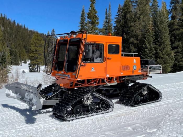
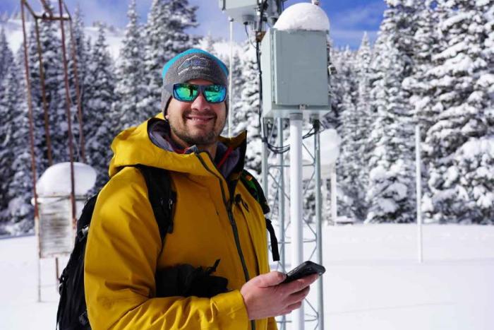
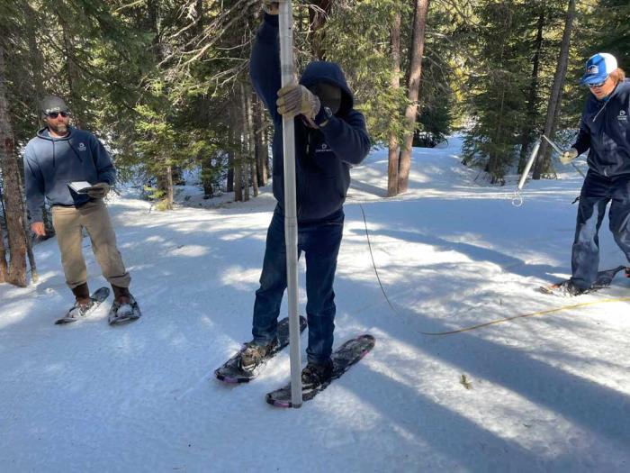
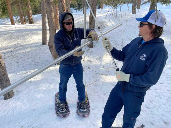
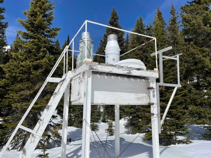
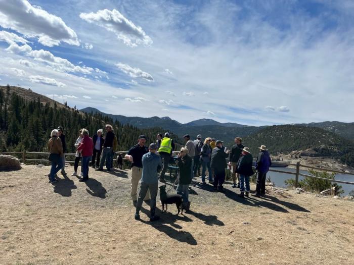
On a picture perfect, late-March bluebird day in the Colorado mountains, Rob Krueger and Jay Joslyn gear up for a unique job at Denver Water — venturing into the wilderness to measure snowpack.
Boots? Check. Gloves? Check. Hats? Check. Jackets? Check. Very special metal tube and a scale? Check, check. All of it is loaded into their winter travel vehicle, a snowcat.
Denver Water owns a snowcat that is used to access facilities and remote locations during the winter months in Grand County. Photo credit: Denver Water.
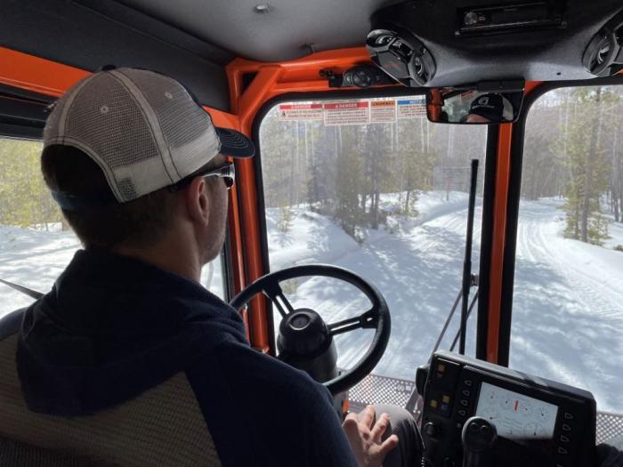
“We’re heading up to Vasquez Creek to one of our snow courses,” Krueger says as he fires up the Tucker 2000XL and starts rolling. “It’s around 10 miles up to our destination, and it takes about 30-40 minutes in the snowcat.”
The journey starts at Denver Water’s Grand County office just west of Fraser and heads into the Arapaho National Forest.
“The snowcat is kind of like a truck with tank-like tracks on it,” Krueger said. “We use it throughout the winter to reach our remote buildings and dams and to get to our snow courses.”
The journey would be impossible in a regular car or truck. But the snowcat, designed to tackle this type of terrain, easily powers over the snow.
“We’re a 24/7 operation so we need a vehicle like this in the winter,” he said. “Whether it’s snowing, sleeting, raining or we have 60-mile-per-hour winds and it’s negative 6 degrees out, we still have to get around. So that’s what makes the snowcat such an important piece of equipment for us.”
Rob Krueger drives the snowcat through a snow-covered road near Winter Park. Photo credit: Denver Water.
Krueger drives the snowcat through the trees on a snow-covered U.S. Forest Service road and into Denver Water’s collection system.
The collection system is the area where Denver Water captures melting snow during the spring runoff. The water then flows through creeks, canals, tunnels and reservoirs to treatment facilities on the Front Range where it’s cleaned for delivery to 1.5 million people in metro Denver.
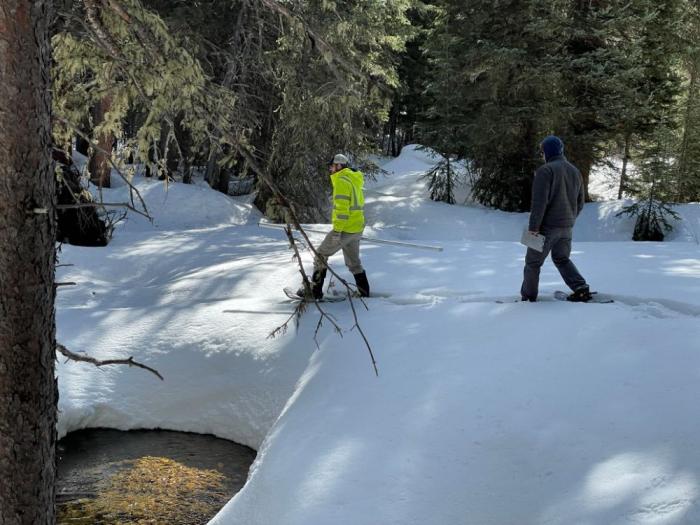
After reaching their destination, Krueger and Joslyn get ready for their task of measuring the snowpack.
Snowshoes are strapped on and equipment, including a snow measuring tube, is assembled for the trek across Vasquez Creek to reach a “snow course.”
“A snow course is basically a preset path where we take samples to measure the snowpack,” Joslyn said. “We do these same courses four times over the winter.”
The courses are set up across Colorado’s mountains and managed by the U.S. Department of Agriculture’s National Resources Conservation Service, also known as the NRCS, to monitor snowpack. The data from these courses are used by cities, farmers, ranchers, water utilities and recreationists to help predict the amount of water that will flow down the mountains during the spring runoff.
Joslyn and Krueger snowshoe across Vasquez Creek to reach the snow course. Photo credit: Denver Water.
Denver Water partners with the NRCS to do snow courses in Grand, Park and Summit counties where the utility collects its water.
In Grand County, there are five locations where Denver Water samples snow.
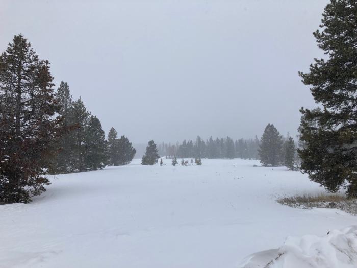
The Vasquez snow course starts a few feet from the creek and is surrounded by a canopy of spruce and fir trees. On this trip, the snow on the course ranged from 4 to 5 feet deep.
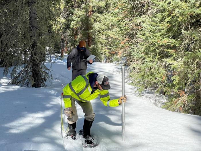
Joslyn stabs the snow with the measuring tube to collect a snow sample. Photo credit: Denver Water.
Joslyn carries the measuring tube [Federal Snow Sampler], then stabs it into the snow and checks the reading. He calls out “53,” which is the depth of the snow in inches. Then he takes a closer look at the slots on the tube and calls out a second number; this one is the length of the snow core captured inside.
Next up, Joslyn uses a handheld scale to weigh the tube with the snow inside. “42,” he calls out. This time referring to the weight in ounces.
Krueger records this number, then subtracts the weight of the empty tube from the total, which gives the water content in inches of the snow core sample. They also calculate the density of the snow.
Joslyn weighs the tube with the snow inside. The process is used to determine the water content and density of the snowpack. Photo credit: Denver Water.
The pair does the same process 10 times at 25-foot intervals on the course. On this trip, the snowpack was in good shape, coming in at 118% of normal for the end of March 2025.
“Denver Water has a long history in this valley, and we’ve been doing snow courses in Grand County dating back to 1939,” Krueger said. “With decades worth of data, we can get a really good idea of how much water we’ll see during the spring runoff.”
The data is sent to Denver Water’s planning department and the NRCS. Planners combine the snow course information with data from SNOTEL sites and high-tech flights over the mountains to predict how much water will flow into the utility’s reservoirs where water is stored for customers.
“The information from the snow courses is critical to our planning, as it gives us boots-on-the-ground information about the snowpack,” said Nathan Elder, water supply manager at Denver Water. “Our crews in the mountains often have to brave a lot of harsh weather to get the data we need, so we’re thankful for their hard work.”
Working for Denver Water in Grand County involves a variety of jobs that change throughout the seasons, with the snow courses being one of the most unique.
“The snow courses are interesting and of course being out in the snow and driving the snowcat is pretty fun,” Krueger said. “Our work feels valuable to Denver Water as a whole to understand what kind of water resource we have to send to the city.”
Workers from Denver Water and contractor Kiewit Barnard stand in front of Gross Dam in May 2024 to mark the start of the dam raise process. Photo credit: Denver Water.
Click the link to read the article on The Denver Post website (Elise Schmelzer). Here’s an excerpt:
April 4, 2025
Colorado’s largest water provider must stop construction on a $531 million dam expansion already underway in Boulder County after a federal judge found that assessments of how the project would impact the environment were flawed. U.S. District Court Judge Christine Arguello in an order late Thursday blocked Denver Water from enlarging Gross Reservoir east of Nederland until major federal environmental permitting processes are redone. The judge found that allowing the reservoir expansion to continue without redoing the permits would cause irreparable environmental damage that cannot be compensated for by monetary payments. That harm would outweigh any financial costs Denver Water would incur from halting construction, she wrote.
“Environmental injury is often the very definition of irreparable harm — often permanent or at least of long duration,” Arguello wrote. “All parties agree that there will be environmental harm resulting from completion of the Moffat Collection System Project, including the destruction of 500,000 trees, water diversion from several creeks, and impacts to wildlife by the sudden loss of land.”
She issued a preliminary injunction ordering Denver Water to halt construction on the dam until a further hearing when engineers can explain how much further construction is needed to make the partially built dam safe and structurally sound. Denver Water planned to raise the height of the dam by 131 feet, allowing the utility to store more water. She will then issue a permanent injunction on how much more construction will be allowed. The order is a huge victory for environmental groups that for years have opposed the controversial project. A coalition of environmental groups first filed suit in 2018 to stop the expansion of the reservoir, which they say would harm the health of the Colorado River system — where the reservoir’s water is sourced.
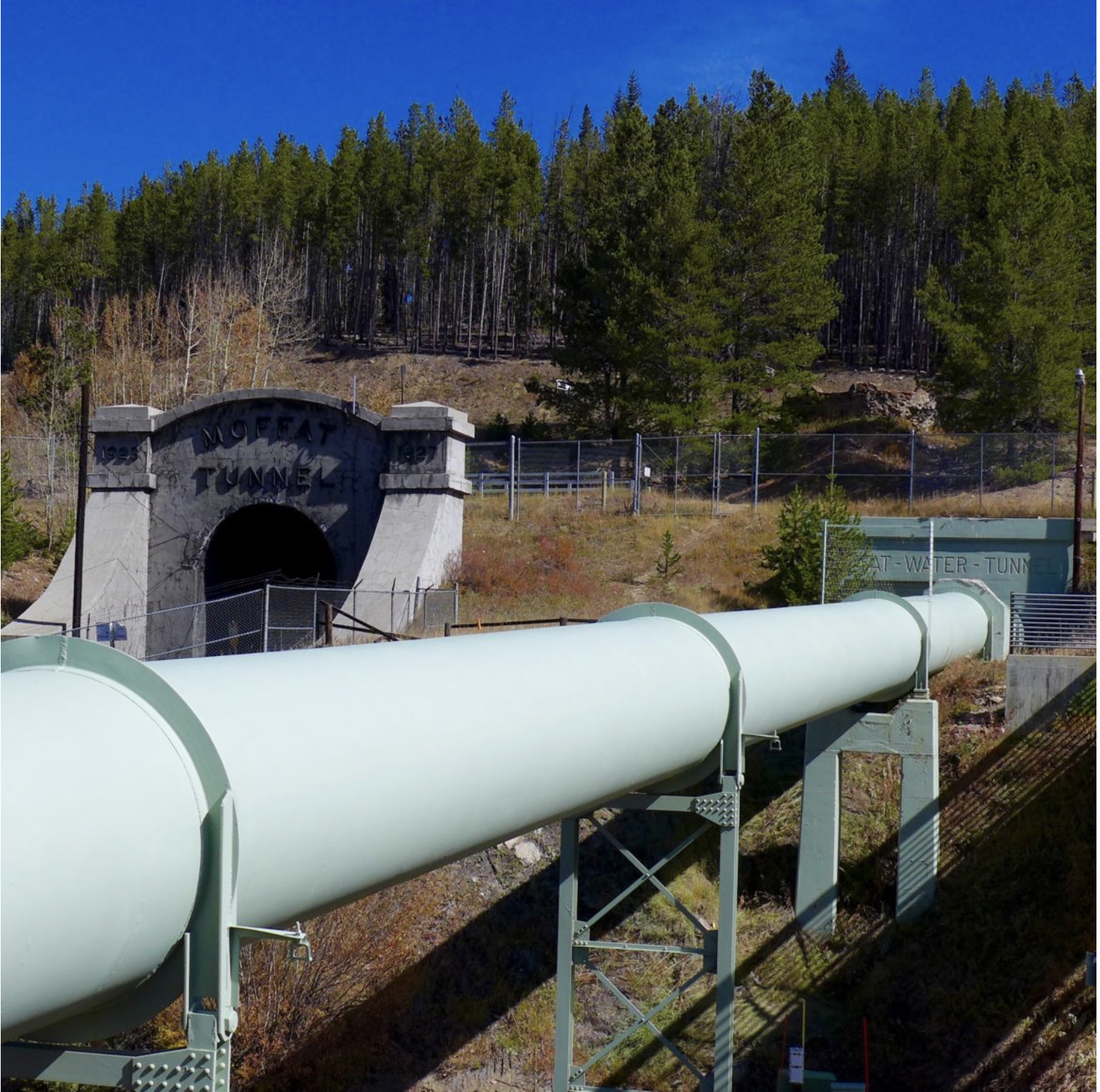
The pipeline, at the base of the Winter Park ski area, that moves water as part of the existing Moffat Collection System Project. The portal of the railroad tunnel is behind the pipeline, in this view. Photo credit: Brent Gardner-Smith/Aspen Journalism
According to Grand County Water Quality Manager Katherine Morris, polluted discharge from the Moffat Tunnel has adversely impacted the Fraser River. The Grand County water quality team recently wrote two letters to the Colorado Department of Public Health & Environment, outlining its concerns with violations by Union Pacific Railroad, which manages the tunnel. During a Grand County Board of Commissioners meeting March 11, 2025 Morris explained that polluted water from the tunnel enters the nearby Fraser River, which is a main tributary of the Colorado River. This ongoing problem began after the tunnel was completed, and Grand County government began advocating to fix the problem nearly two decades ago…
James Peak via ColoradoWildAreas.com
In the early 2000s, residents and governmental officials raised alarm about pollutants and increased turbidity (or clarity issues) in the Fraser River when water was discharged from the tunnel. The tunnel bores through James Peak. Groundwater from cracks in the mountain rock seeps into the tunnel, and that water needs a way out. Coal dust, heavy metals and other particulate matter can travel into the Fraser River through the runoff. At the time, a water treatment plant existed on the east portal of the tunnel but not on the west portal at Winter Park. People questioned why there was no treatment plant to protect Grand County, home to the headwaters of the Colorado River. Over the years, Union Pacific received fines and a cease-and-desist order. The railroad finally built a treatment plant in 2017, but issues have continued — even worsened in some cases, Morris said. A water centrifuge at the plant is designed to separate solids from the water, creating a sludge-like “centrifuge cake” that is put in a drum and disposed of in Utah. (This disposal has raised its own concerns.) The remaining water is discharged into the river.
Snowfall in March has helped decrease the likelihood of drought developing this spring in Colorado’s northwest mountains. However, a warm and dry spring could still change the tide heading into summer. The National Weather Service, a division of the National Oceanic and Atmospheric Administration, released its latest seasonal drought outlook on Thursday, March 20. It showed that drought conditions are unlikely to develop in most of northwest Colorado through June…Brad Pugh, a forecaster with the National Oceanic and Atmospheric Administration’s climate prediction center, said these outlooks predominantly take into account the current conditions, climatology temperature and precipitation outlooks over the next three months.
“In northwestern Colorado at this time of year, you know going into the springtime, mountain snowpack is a critical factor,” Pugh said.
As of March 18, much of northwest Colorado was in line with, or just above, normal snowpack. This has continued to improve in the state’s north-central mountains since January. According to OpenSnow, as of Monday the snow totals and percentage of normal on the season so far were as follows:
Winter Park – 315 inches (117%)
Copper Mountain Resort – 303 inches (113%)
Vail Mountain – 292 inches (101%)
Breckenridge Ski Resort – 284 inches (107%)
Steamboat Resort – 279 inches (108%)
Aspen Highlands — 267 inches (88%)
Loveland Ski Area – 261 inches (108%)
Snowmass – 243 inches (83%)
Keystone Resort – 239 inches (107%)
Beaver Creek – 227 inches (108%)
Arapahoe Basin Ski Area – 225 inches (112%)
Aspen Mountain – 210 inches (92%)
Ski Cooper – 206 inches (106%)
Buttermilk – 147 inches (89%)
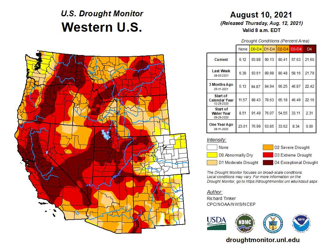
Colorado Drought Monitor map March 25, 2025.
The latest U.S. Drought Monitor for Colorado reported no drought in many of the northwest counties including Summit, Grand, Routt and Jackson counties as well as the eastern reaches of Eagle and Moffat counties. Heading west, the monitor shows abnormally dry conditions in Pitkin County and the eastern portions of Garfield and Rio Blanco counties. Conditions continue to get progressively drier the further west toward the border.
Mid-February’s weeklong series of storms that dropped 4-to-5 feet of snow in areas of Denver Water’s collection area could be termed a “Sweetheart Surprise,” followed by a dumping of “Presidents Day Powder” that just kept going.
“It was an impressive week of snow with a bullseye right on our collection area,” said Nathan Elder, Denver Water’s manager of water supply. “After a couple dry weeks to start out the year, it was nice to see stormy winter weather return to the mountains.”
Elder said mountain snowpack in the parts of the South Platte and Colorado River basins where Denver Water collects its water jumped significantly due to the storms.
From Feb. 14-21, snowpack in the Upper South Platte River Basin climbed from 84% of normal up to 108%. During the same time period in the Upper Colorado River Basin, the snowpack jumped from 105% of normal up to 120%.
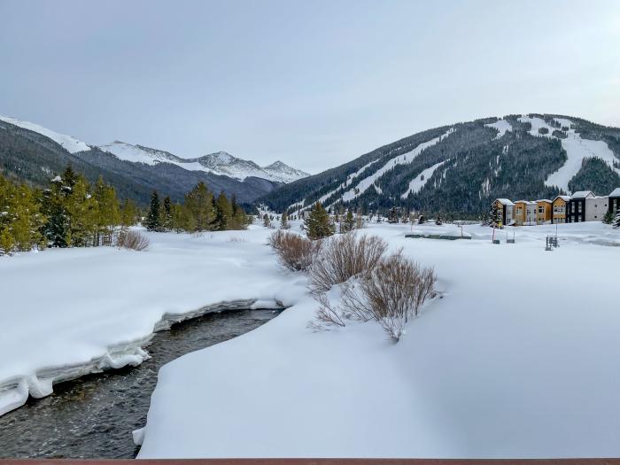
Snow piles up along the banks of Tenmile Creek near Copper Mountain in Summit County on Feb. 19. The creek is one of the main tributaries of Denver Water’s Dillon Reservoir. Photo credit: Denver Water.
However you look at it, all the snow in the second half of February has been great news for our water supply. And there’s an interesting trend happening during the 2024-25 snow season in Colorado: The major storms keep hitting on the holidays.
The February storm cycle started just in time for Valentine’s Day, Feb. 14, continued dumping through Presidents Day, Feb. 17, and then another storm delivered a bonus round of snow Feb. 20-21.
The snow is good news for Denver Water, which relies on mountain snow to supply water to 1.5 million people in the metro area.
Just take a look at the snow totals from the weeklong series of storms that spanned Feb. 14-21, as reported by the ski resorts located in Denver Water’s collection area:
Arapahoe Basin: 43”
Breckenridge: 47”
Copper Mountain: 45”
Keystone: 47”
Winter Park: 62”
A snowboarder enjoys fresh powder at Winter Park in Grand County. The ski resort reported 62” of snow between Feb. 14-21. Photo credit: Winter Park Ski Resort.
It’s been a great winter so far at Winter Park and Copper Mountain, which have seen 257” and 255” of snow respectively as of Feb. 21, making them the two snowiest ski resorts in the state.
Snowpack is a measurement of the amount of water in the snow if it were to melt. In general, about 10 inches of snow melts down to around 1 inch of water here in Colorado.
Elder said what’s been interesting this year is that the majority of snow has fallen right around holidays starting after Halloween, then before Thanksgiving, between Christmas and New Years, and now between Valentine’s Day and Presidents Day.
“We can see the snowpack looks like steps on our charts around all these holidays,” Elder said. “With the recent storms, we saw basically an entire month’s worth of snow in seven days.”
Elder said that having the snowpack above 100% heading into March is a good sign for our water supply in the coming year.
The Fraser River at the bottom of Berthoud Pass is covered in snow. The river is part of the Colorado River Basin where Denver Water captures snow for its water supply. Photo credit: Denver Water.
“March and April are typically our snowiest months of the year in Colorado. Those two months usually provide about one-third of our annual snowpack. That’s because the snow that falls in those months has a higher water content than snow that falls in the beginning and middle of winter,” he said.
Denver Water’s total reservoir supply stands at 82% full as of Feb. 21, which is about average for this time of year. Remember that reservoir levels fall over the winter and then go back up in the spring when the snow melts.
As for what to expect for the rest of the ski season, maybe consider heading to the hills on St. Patrick’s Day or Easter, and who knows possibly even Mother’s Day in May!
Chances are when you’ve watched your favorite weather person on the local news you may have seen them put up a map of Colorado that shows the statewide snowpack.
If you’re a curious person you may wonder: Why do they show the map? What is snowpack? And where do they get all that information?
We’re here to help answer these questions.
First off, snowpack is the amount of water stored in the snow that blankets the mountains across our state. It’s important to measure the snowpack because the snow is where Colorado gets about 80% of its water supply for household and agricultural uses.
So now to answer the final question: Where does information about the snowpack come from? The data comes from SNOTELs.
OK, so what’s a SNOTEL?
Well, SNOTEL is short for “snow telemetry.” Think of it as just a fancy way of describing an automated weather station in a remote location that beams information back to a database.
9News meteorologist Cory Reppenhagen talks about the statewide snowpack during an evening weathercast. Image credit: 9News.
“In Colorado, we have 117 SNOTEL sites, and there are over 900 sites across 13 western states,” said Brian Domonkos, a hydrologist with the U.S. Department of Agriculture’s Natural Resources Conservation Service. “These sites have been around since the late 1970s and provide critical information about the amount of water in the snowpack.”
SNOTELs use “snow pillows” to measure the water content.
Snow pillows are rubber bladders on the ground that are filled with water and ethanol (to prevent the water from freezing). The pillow then weighs the snow, like when you stand on a scale to get your weight.
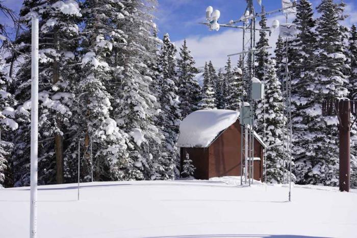
This SNOTEL site is located on the top of Berthoud Pass in Grand County. The snow pillow is covered in snow in front of the shed. Photo credit: Denver Water.
The pressure on the pillow pushes an equal amount of the antifreeze liquid into a measurement tube, which converts the weight of the water contained in the snow into inches of water content. This measurement is the snowpack, which is technically called the Snow Water Equivalent, and also known as SWE.
A sensor reads the SWE from the tube and sends the data to the NRCS’s central database.
The same SNOTEL site at Berthoud Pass in the summer shows the gray snow pillows located in front of the shed. Photo credit: Natural Resources Conservation Service.
“Generally speaking, here in Colorado, 10 inches of snow melted down equals roughly about 1 inch of water,” Domonkos said. “The data is used to predict how much water will flow into rivers and streams when the snow melts in the spring.”
The information from the SNOTELs is used by farmers, ranchers, water utilities, environmental groups and recreationists. Communities also use the information to be aware of the potential for flooding during the spring runoff.
There are 16 SNOTELs in Denver Water’s collection area that are viewed daily by the utility’s water planning team.
“The SNOTEL network is the most important source of information we have to manage our water supply, and I honestly can’t image how we’d get by without them,” said Nathan Elder, Denver Water’s manager of water supply.
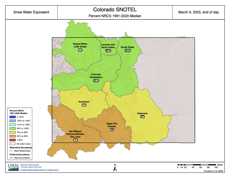
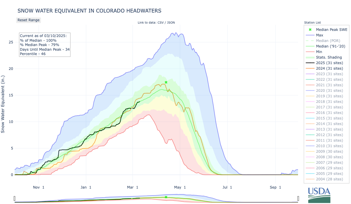
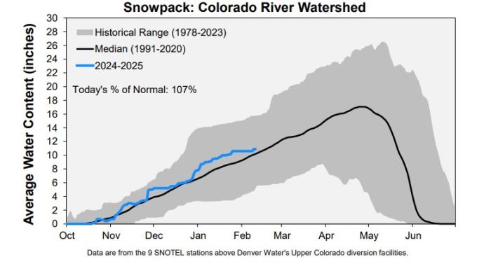
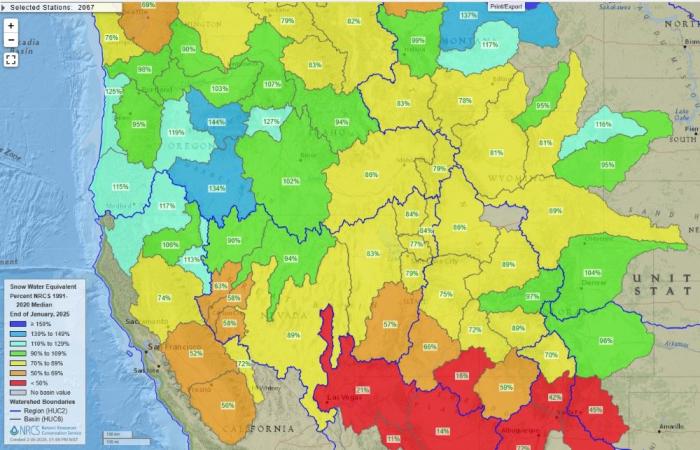
This chart uses SNOTEL data to determine the Snow Water Equivalent in the area of the Colorado River Basin where Denver Water collects its water. Note the left side that shows the inches of water content in the basin. Image credit: Denver Water.
This map shows the 16 SNOTEL sites located in areas where Denver Water collects water for 1.5 million people in the metro area. Image credit: Natural Resources Conservation Service.
Elder’s team uses the data to make informed decisions about reservoir management and whether any water restrictions for Denver Water customers may be needed in addition to the regular summer watering rules.
Denver Water also monitors 115 SNOTEL sites upstream of Lake Powell to keep an eye on conditions in the Upper Colorado River Basin. Denver Water collects half of its water supply from rivers and streams that feed into the Colorado River.
“We use the SNOTEL data to provide insight into potential water rights calls that may impact our operations,” Elder said. “The earlier we have information, the better decisions we can make with our water supply.”
Denver Water also relies on manual snowpack readings collected on snow courses and from data collected in the spring from an Airborne Snow Observatory. Learn about these methods in this TAP story.
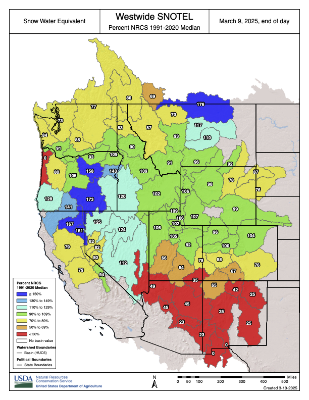
This map shows snowpack information collected from SNOTEL sites in river basins across the western U.S. Image credit: National Resources Conservation Service.
Domonkos said the SNOTELs are also critical in monitoring long-term weather trends across the western U.S.
“When you’re watching the news, you’ll see the various river basins showing a certain percent of the normal amount of snowpack for that date,” Domonkos said. “We always like to see the snowpack in the 100% to 120% range so it’s not too high that could lead to flooding and not too low that could lead to water shortages.”
Along with measuring the snowpack, the SNOTEL sites also measure all other forms of precipitation like rain, hail and ice. They also measure air temperature, soil moisture and soil temperature.
Brian Domonkos checks out weather data at the Berthoud Pass SNOTEL site in Grand County. Photo credit: Denver Water.
“These sites are very important for not only day-to-day weather information, but also for comparing snowpack year to year so we can keep track of any emerging trends,” Domonkos said.
All of the information is available for free on the NRCS website, which has a variety of data from each SNOTEL site. The information can be found on the NRCS website.
Lafayette, CO — Today, House Assistant Minority Leader Joe Neguse, Co-Chair of the Colorado River Caucus, announced $2.4 million from the Bipartisan Infrastructure Law for two projects in Colorado’s 2nd District aimed at restoring and improving the ecological conditions of local waterways and aquatic habitat near the communities of Granby and Boulder. These investments were allocated by the Bureau of Reclamation’s WaterSMART Environmental Water Resources Projects program.
“Local communities are instrumental in protecting and restoring Colorado’s rivers and streams. This important funding will support locally driven projects that enhance watershed health and resiliency, restore ecological conditions, and embody the spirit of ecological stewardship,” said Assistant Leader Neguse.
“Colorado is focused on protecting our vital water sources so that there is plenty of clean water for our communities and environment. I applaud Rep. Neguse’s leadership in Congress to pass federal legislation that is delivering for Colorado, and thank our State agencies and Coloradans carrying out these important projects,” said Governor Jared Polis.
Projects in Colorado’s 2nd Congressional District include the Upper Colorado River Ecosystem Enhancement Project, managed by the Grand County Learning By Doing Cooperative Effort (LBD), and the Boulder Creek Headwaters Resiliency Project, led by the Boulder Watershed Collective. Additional information on both can be found HERE and below:
$1,425,859 for the Upper Colorado River Ecosystem Enhancement Project, to restore two stream reaches on the Fraser River and Willow Creek near the community of Granby.
$954,204 for the Boulder Creek Headwaters Resiliency Project, to restore and improve the ecological condition of 181 acres of degraded aquatic and riparian habitat, and 2.8 miles of wet meadow streams throughout the Boulder Creek Watershed near Boulder.
“This is just another great example of the successful collaboration taking place in Grand County across a wide range of stakeholders that is resulting in very tangible improvements in the ecological health of the Colorado River headwaters,” according to a statement from the Grand County Learning By Doing Management Committee.
“The projects selected are working through a collaborative process to achieve nature-based solutions for the health of our watersheds and river ecosystems to increase drought resiliency,” said Reclamation Commissioner Camille Calimlim Touton. “This historic investment from the Bipartisan Infrastructure Law gives Reclamation the opportunity to continue to collaborate with our stakeholders to leverage funds for these multi-benefit projects.”
“Denver Water is proud to support ongoing stream improvement projects like those to be funded in this latest round of federal funding. Congratulations to Grand County Learning by Doing on this award. We look forward to working with our partners on the upcoming restoration work to Willow Creek and the Fraser River to benefit the Colorado River Basin,” said Rick Marsicek, Chief of Water Resource Strategy at Denver Water.
As co-founder and Co-Chair of the Congressional Colorado River Caucus, Neguse has brought together a bipartisan mix of lawmakers each representing a state along the Colorado River Basin. The group is working to build consensus on critical issues plaguing the river and support the work of the Colorado River Basin states on how best to address the worsening levels of drought in the Colorado River Basin.
Lake Powell has been about a quarter-full. The snowpack looks strong now, but it’s anybody’s guess whether there will be enough runoff come April and May to substantially augment the reservoir. May 2022 photo/Allen Best
Click the link to read the article on the Big Pivots website (Allen Best):
October 24, 2024
Colorado River Basin states have scaled back their demands on the river. But agreement about solutions proportionate to the challenge remains distant as the 2025 deadline nears.
The story so far: Andy Mueller, the manager of the Colorado River District, the lead water policy body for 15 counties on the Western Slope of Colorado, used his organization’s annual seminar this year to call for the state to begin planning for potential curtailments of diversions. The river has delivered far less water in the 21st century than was assumed by delegates of the seven basin states when they drew up the Colorado River Compact in 1922. Might higher flows resume? Very unlikely, given what we know about climate change. See Part Iof the series and Part II.
“Having a state plan for compact curtailment has been on the table for what seems like forever, likely 2005 to 2007,” said Ken Neubecker. Now semi-retired, he has been carefully watching Colorado River affairs for several decades and has represented several organizations at different times.
Why hasn’t Colorado moved forward with this planning? When I called him to glean his insights, Neubecker shared that he believes it’s because such planning encounters a legal and political minefield.
“It’s not as simple as pre-1922 rights are protected and post-1922 rights are going to be subject to curtailment based on the existing prior appropriation system.”
Denver Water’s Moffat Tunnel diversion from the Fraser River to Boulder Creek. Most of water diverted to Colorado’s Front Range cities from Western Slope rivers and creeks have legal rights junior to the Colorado River compact. Photo/Allen Best
Front Range municipal water providers and many of Colorado’s agriculture diversions are post-1922 compact. And so are some agricultural rights on the Western Slope.
“I think everybody thinks that well, we’re on the slow-moving train and the cliff is getting closer but it’s not close enough – and there are other things that we can do to slow the train down.”
Taylor Hawes, Colorado River Program director for the Nature Conservancy via Water Education Colorado.
Taylor Hawes, who has been monitoring Colorado River affairs for 27 years, now on behalf of The Nature Conservancy, suspects that Colorado doesn’t want to show its legal hand or even admit the potential need to curtail water use in Colorado. She contends that planning will ultimately provide far more value.
“The first rule you learn in working with water is that users want certainty. Planning is something we do in every aspect of our lives, and planning is typically considered smart. It need not be scary,” she told Big Pivots. “We have all learned to plan for the worst and hope for the best.”
Colorado can start by creating a task force or some other extension of the state engineer’s office to begin exploring the mechanisms and pathways that will deliver the certainty.
“We don’t have to have all the answers now,” Hawes said. “And just because you start the process for exploring the mechanism to administer compact compliance rules doesn’t mean you implement them. It will give people an understanding of what to expect, how the state is thinking about it.”
Rio Grande near Monte Vista. Meeting Colorado’s commitments that are specified in the compact governing the Rio Grande requires constant juggling of diversions. Photo/Allen Best
Compacts have forced Colorado to curtail diversions in three other river basins: the Arkansas, Republican and Rio Grande. The Rio Grande offers a graphic example of curtailment of water use as necessary to meet compact obligations on a week-by-week basis.
The Republican River case is a more drawn-out process with a longer timeline and a 2030 deadline. In both places, farmers are being paid to remove their land from irrigation. The Colorado General Assembly this year awarded $30 million each to the two basins to bolster funding for compensation.
A study commissioned by the Nature Conservancy that involved interviews with water managers and others in those river basins had this takeaway message: “the longer (that) actions are delayed to address compact compliance, the less ability local water users have to tailor compliance-related measures to local conditions and needs and reduce their adverse impacts.”
In the Arkansas Basin, Colorado had to pay $30 million and water available to irrigators was reduced by one third.
“That’s the first lesson in how not to do compact compliance: do not wait to be sued because (then you lose) the flexibility to do stuff the right way,” said one unidentified water manager along the Arkansas River.
Neubecker points to another basin, the South Platte. Even in 1967, Colorado legislation recognized a connection between water drawn from wells along the river and flows within the river. The 2002 drought forced the issue, causing Hal Simpson, then the state engineer, to curtail well pumping, creating much anguish.
Ken Neubecker via LinkedIn
Creating a curtailment plan won’t be easy, Neubecker warns. “It could easily take 10 years. ’Look how long it took to create the Colorado Water Plan. It took a couple years and then we had an update five years later. And that was easy compared to this.”
All available evidence suggests the Colorado River Basin states are nowhere near agreement.
In August, Tom Wilmoth provided a perspective from Arizona in a guest opinion published by The Hill under the title of “Time is running out to solve the Colorado River crisis.” As an attorney he has worked for both the Arizona water agency and the Bureau of Reclamation before helping form a law firm in 2008.
“It has taken 24 years for the problem to crystalize, but less than 24 months remain to develop a solution,” he wrote. “Yet there appears to be little urgency in today’s discussion among the Colorado River Basin’s key players.”
Wilmoth said ”Deferring hard conversations today increases the risk of litigation later.” He, like all others, sees a reasonable chance it would end up before the Supreme Court – with the risk of the justices appointing a special master to adjudicate the conflict. “Its recent tendency has been to appoint individuals lacking in subject matter expertise, a troubling prospect given the complex issues at play.”
The area around Yuma, Ariz., and California’s Imperial Valley provide roughly 95% of the vegetables available at grocery stores in the United States during winter months. February 2017 photo/Allen Best
Monitoring the conversations from Southwest Colorado, Rod Proffitt sees Mueller trying to prepare people in the River District for the challenges ahead.
“I think he has tried to scare people. He is trying to get them prepared to make some sacrifices, and limiting growth is a sacrifice.”
A semi-retired water attorney, Proffitt is also a director of Big Pivots, a 501-c-3 non-profit.
Make no mistake, says Proffitt, more cuts in use must be made – and they need to be shared, both in the lower basin and in the upper basin. What those cuts need to be, he isn’t sure. Nor do they necessarily need to be the same.
For example, he can imagine cuts that are triggered by lowering reservoir levels. At a certain point, lower basins must reduce their use by X amount and upper basin states by Y amount.
The federal government has mostly offered carrots to the states to reduce consumption, a recognition of the river’s average 12.4 million acre-feet flows, far short of the flows assumed by the compact. It also has sticks, particularly regarding lower-basin use, but has mostly avoided using its authority. Instead, the lower-basin has reduced use voluntarily, if aided by the federal subsidies.
The Inflation Reduction Act and the Bipartisan Infrastructure Act, have yielded a river of money for projects in the West that broadly seek to improve resiliency in the face of drought and climate change. The seeds have been planted in many places. For example, a recent round of funding produced up to $233 million for the Gila River Indian Community in Arizona for water conservation efforts.
The federal government has also offered incentives to reduce consumption in the upper basin. The System Conservation Pilot Program ran from 2015 to 2018. The 2024 program was funded with $30 million through the Inflation Reduction Act and had hopes for conserving about 66,400 acre-feet.
The federal government, through the Bureau of Reclamation, has clear authority to declared water shortages in the lower basin. It has warned that three million acre-feet less water must be used. The lower-basin argues that the upper basin should share in some of this burden.
Grand Junction has a maze of irrigation canals but the municipal water utility gets water from a creek that flows from the Grand Mesa. Some diversions in Colordo are pre-compact, but many others occurred after 1922. This is a scene from Grand Junction. Photo/Allen Best
Should the federal government get out the stick?
“Nobody wants to apply vinegar this close to the November election,” said James Eklund when we talked in late September about the stalemate on the river.
Eklund has had a long association with the Colorado River. His own family homesteaded on the Western Slope near Colbran in the 1880s and the ranch is still in the family. He lives in Denver, though, and was an assistant attorney in the state attorney general’s office in 2009, when I wrote my first story. He later directed the Colorado Water Conservation Board, the lead agency for state policy.
For the last few years Eklund has been on his own, more or less, a water attorney now working for Sherman and Howard, a leading Denver firm, while trying to represent clients with diverse agriculture water rights.
“Litigation is a failure,” he said when I asked him about Mueller’s remarks in Grand Junction. He contends the upper basin must come to the table with more ideas about how to solve the structural imbalance between supplies and demands than it has so far. And this, he said, will involves some pain.
Creating compact curtailment will involve rule-making, though, and that will take time and effort. Echoing Denver Water’s position, he says it will divert Colorado from the more important and immediate work of helping negotiate solutions.
Eklund suspects an ulterior motive of the River District: to get the state to play its cards on what curtailment could look like so that it can begin jockeying for position.
On the other hand, he believes cutbacks should be premised on two bedrock principles: voluntary and compensated. But Eklund also says that if the situation becomes desperate enough, water will continue to find its way to cities. “The Front Range is not going to bend its knee to alfalfa plants. It’s not going to do it.”
And then, Colorado’s Constitution allows municipalities to take water. It requires compensation.
The Bureau of Reclamation has said the same thing in the lower basin. Las Vegas and other cities will not be allowed to dry up.
The Bureau of Reclamation has said that Las Vegas and other cities will not be cut off from water in the Colordo River. . Photo/Allen Best
But what if compact curtailment means making the hard decision about who doesn’t get water and does not get compensated – people like the farmers near Fort Morgan who, in 2002, had to cease pumping water?
Neubecker characterizes the position of Colorado as one of conflict avoidance. Look at where it got Neville Chamberlain, the British prime minster, in his negotiations with Hitler.
What Colorado must do is prepare for the worst-case scenario. “It’s a doomsday plan,” Neubecker says of compact curtailment. “Make the plan, involve all the people who are going to be effected by the plan, and put it on the shelf – but not too far back on the shelf, just in case you need it”
For now, water levels in the two big reservoirs are holding more or less steady.
Another winter like 2002 could trigger renewed clanging of alarm bells.
John Fleck at Morelos Dam, at start of pulse flow, used 4/4/14 as my new twitter avatar
In New Mexico, Fleck, the author, who also monitors Colorado River matters at his Inkstain blog, rejects the metaphor of the Titanic or the idea that conflict is inevitable. In 2002, California was still using 5.1 million acre-feet from the Colorado River, both for agriculture and to supply the metropolitan areas of Southern California. This was well above the state’s apportionment of 4.4 million acre-feet. “The rhetoric was that it will be a disaster to California’s economy” to return to the allocated flows.
California eventually did cut back and it has done just fine. “Everybody would prefer not to do the adaptation, but they have done it just fine. We see that over and over again in community responses to drought in the Western United States,” he said.
Lake Powell currently has filled to 40% of capacity, a marked improvement from February 2023, when the reservoir had fallen to 22% of capacity. Mead is at 36% of capacity. The situation is not as tense as it was two years ago. That could change in the blink of another hot, dry runoff like that in 2002.
Figure 2. Graph showing reservoir storage between 1 January 2023 and 15 October 2024, highlighting the amount of reservoir recovery during each snowmelt season and the amount of reservoir drawdown during intervening periods. Credit: Jack Schmidt/Center for Colorado River Studies
Click the link to read the article on the Denver Water website (Cathy Proctor and Jay Adams):
October 23, 2024
Preparing a water system to meet future challenges means investing in a flexible, resilient operation that’s ready for just about anything — such as a warming climate, pandemics, population growth, periodic droughts, competition for water resources, security threats and changing regulatory environments.
From meeting day-to-day challenges to addressing long-range issues, Denver Water is building and maintaining just such a system, one that stretches from the mountains to homes and businesses across the Denver metro area.
The goal: Ensuring a clean, safe, reliable water supply for 1.5 million people, about 25% of Colorado’s population, now and in the future.
To continue meeting that goal, Denver Water expects to invest about $1.8 billion into its water system during the next 10 years, from large projects to regular inspection and maintenance programs designed to ensure the system is flexible, resilient and efficient.
In addition to rates paid by customers, funding for Denver Water’s infrastructure projects, day-to-day operations and emergency expenses, like water main breaks, comes from bond sales, cash reserves, hydropower sales, grants, federal funding and fees paid when new homes and buildings are connected to the system. The utility does not make a profit or receive tax dollars.
Here’s an overview of some of Denver Water’s recently completed and ongoing work:
Northwater Treatment Plant
Denver Water in 2024 celebrated the completion of the new, state-of-the-art Northwater Treatment Plant next to Ralston Reservoir north of Golden. The new treatment plant was completed on schedule and under budget.
The treatment plant can clean up to 75 million gallons of water per day and the plant’s design left room for the plant to be expanded to clean up to 150 million gallons of water per day in the future as needed.
A major feature of the site visible from Highway 93 is the round, concrete tops of two giant water storage tanks. Most of the two tanks are buried underground; each tank is capable of holding 10 million gallons of clean, safe drinking water.
The plant is a major part of Denver Water’s North System Renewal Project, a multi-year initiative that included building a new, 8.5-mile pipeline between the Northwater Treatment Plant and the Moffat Treatment Plant. The new pipe, completed in 2022, replaced one that dated from the 1930s.
The Moffat Treatment Plant, which also started operations in the 1930s, is still used a few months during the year and will eventually transition to a water storage facility.
Lead Reduction Program
The water Denver Water delivers to customers is lead-free, but lead can get into drinking water as the water passes through old lead service lines that carry water from the water main in the street into the home.
The Lead Reduction Program, which launched in January 2020, is the biggest public health campaign in the utility’s history and considered a leader in the effort to remove lead pipes from the nation’s drinking water infrastructure.
Denver Water crews dug up old lead service lines from customers’ homes for years of study that led to the utility’s Lead Reduction Program. Denver Water has replaced more than 28,000 old, customer-owned lead service lines at no direct cost to the customer. Photo credit: Denver Water. Photo credit: Denver Water.
The program reduces the risk of lead getting into drinking water by raising the pH of the water delivered and replacing the estimated 60,000 to 64,000 old, customer-owned lead service lines at no direct cost to the customer. Households enrolled in the program are communicated with regularly and provided with water pitchers and filters certified to remove lead to use for cooking, drinking and preparing infant formula until six months after their lead service line is replaced.
To date, Denver Water has replaced more than 28,000 customer-owned lead service lines at no direct cost to the customers. The program received $76 million in federal funding in 2022 to help accelerate the pace of replacement work in underserved communities, resulting in thousands of additional lines being replaced during 2023 and 2024.
Water storage
Work on the Gross Reservoir Expansion Project, the subject of more than 20 years of planning, got underway in April 2022. Expected to be complete in 2027, the project will raise the height of the existing dam by 131 feet.
The higher dam will nearly triple the amount of water that can be stored in Gross Reservoir, providing Denver Water with more flexibility to manage its water supply in the face of increasingly variable weather and snowpack patterns.
Check out the work done on Gross Dam during summer 2024:
After two years of preparation and foundation work, Gross Dam’s new look began to take shape in 2024 when workers began placing new, roller-compacted concrete at the base of the Boulder County dam in early May.
Raising the dam involves building 118 steps on the downstream side of the dam. Each step is 4 feet tall with a 2-foot setback.
At the height of construction, there will be as many as 400 workers on-site, and when complete the dam will be the tallest in Colorado.
Ongoing investments for the future
As the metro area grows and changes, it’s often an opportunity for Denver Water to upgrade older elements of its system.
Denver Water is continuing its investment in replacing about 80,000 feet of water mains under streets every year while also installing new water delivery pipe where needed. The utility has more than 3,000 miles of pipe in its system, enough to stretch from Seattle to Orlando.
In early 2025, Denver Water will wrap up a major project: replacing 5 miles of 130-year-old water pipe under East Colfax Avenue, from Broadway to Yosemite Street. The pipe replacement work was done in advance of the East Colfax Bus Rapid Transit project. That effort, led by the Denver Department of Transportation and Infrastructure, broke ground in early October.
In addition to replacing the water mains under Colfax, Denver Water crews are replacing any lead service lines they encounter during the project.
Changing our landscapes
In recognition of the drought in the Colorado River Basin, Denver Water and several large water providers across the basin in 2022 committed to substantially expanding existing efforts to conserve water.
Among the goals outlined in the agreement is the replacement of 30% of the nonfunctional, water-intensive Kentucky bluegrass in our communities — like the decorative expanses of turf grass in traffic medians — with more natural ColoradoScapes that include water-wise plants and cooling shade trees that offer more benefits for our climate, wildlife and the environment.
Denver Water supported a new state law passed in 2024 designed to halt the expansion of nonfunctional, water-thirsty grass by prohibiting the planting or installation of high-water-using turf in commercial, institutional, or industrial property or a transportation corridor. The bill takes effect Jan. 1, 2026. The new law doesn’t affect residential properties.
To help customers remodel their landscapes to create diverse, climate-resilient ColoradoScapes, Denver Water offered two workshops this year and is planning additional workshops in 2025. Photo credit: Denver Water.
Denver Water also is working with partners — including local governments, fellow water providers and experts in water use and landscapes — to develop programs that will help transform our landscapes and expand our indoor and outdoor conservation efforts.
The utility in 2024 held water-wise gardening workshops and offered a limited number of customer discounts on Resource Central’s popular Garden In A Box water-wise garden kits and turf removal services.
Get tips and information about rebates available for conserving water indoors and out at denverwater.org/Conserve.
The utility also has started work transforming its own landscapes, including about 12,000 square feet around its Einfeldt pump station near the University of Denver. It’s Youth Education program has helped Denver-area students remodel landscapes at their schools.
And it’s supporting partners, such as Denver’s Parks and Recreation Department, which is replacing 10 acres of water-intensive Kentucky bluegrass covering the traffic medians on Quebec Street south of Interstate 70. The project is replacing the homogenous expanse of turf with a closely managed, water-wise Colorado prairie meadow filled with grasses and wildflowers that provide habitat to pollinators.
These projects are examples of how Denver Water is planning for a warmer, drier future by partnering with our community. Together, we can build a system and a landscape that supports our customers and creates a thriving, vibrant community now and in the future.
Denver Water’s collection system via the USACE EIS
Take an animated tour of the unique construction process.
Raising the height of a dam involves many steps, literally and figuratively.
After two years of excavation and preparation work on the canyon around Gross Dam, workers in May began placing concrete, starting the three-year process of raising the height of the dam itself.
Denver Water is raising the height of Gross Dam by 131 feet as part of the Gross Reservoir Expansion Project. Once complete, the dam will be able to store nearly three times as much water in Gross Reservoir, which will add more resiliency and flexibility to Denver Water’s water storage system.
Workers from Denver Water and contractor Kiewit Barnard stand in front of Gross Dam in May to mark the start of the dam raise process. Photo credit: Denver Water.
Raising the dam is being done by building 118 steps made of roller-compacted concrete. Each step will be 4 feet wide with a 2-foot setback. The existing dam is 340 feet tall. The completed dam will be 471 feet tall.
Check out this animated video to see how the process works.
This animation shows how Denver Water plans to raise the height of Gross Dam in Boulder County, Colorado, as part of the Gross Reservoir Expansion Project. #grossreservoir#civilengineering#howtoraiseadam
The construction site at the bottom of Gross Dam with equipment used to place concrete and build the new steps. Photo credit: Denver Water.
It will take roughly three years to complete all the steps, with a final completion date set for 2027.
The dam raise process begins at the bottom of the dam using roller-compacted concrete to build the new steps that will go up the face of the dam. Photo credit: Denver Water.
Planning and permitting for the Gross Reservoir Expansion Project began in 2002. Take a look at this video to learn about the process and major accomplishments.
Denver Water is raising the height of Gross Dam in Boulder County, Colorado as part of the Gross Reservoir Expansion Project. This video looks at the history of the project and the work being done to raise the dam.
The snow that piled up in Denver Water’s collection system brought good numbers and big surprises this spring.
The numbers were strong: A peak at 100% of average in the South Platte River Basin and a peak at 124% in the Colorado River Basin.
The Continental Divide, shown here in Grand County, was buried in a wealth of snow this year (2024). Photo credit: Denver Water.
Those figures translate to a good snow year and a strong water supply for the warm months ahead.
The bigger surprise was how late into spring the snow stacked up.
In the portion of the Colorado River Basin where Denver Water collects its water, peak didn’t hit until May 15 — three weeks after the typical April 24 high point for snowpack.
Such a late peak is good news for water supplies.
Can you sing the summer watering rules? The Splashstreet Boys, with “I Water That Way.”
It means higher streamflows in the warmer months and reduces wildfire risk, among many other benefits. It often means a boost for recreation, too, with more water available for rafting season and elevated reservoirs deeper into the summer.
“Most importantly, it means water availability coincides with water demand,” said Nathan Elder, Denver Water’s manager of supply. “We don’t see big water demands from our customers in April and May, so if the snowpack peaks later and runs off later in June and July, it keeps our reservoirs stable, sustaining our savings account, so to speak.”
This year, May packed a big punch, delivering a whopping 10% of the snowpack in the Colorado River Basin portion of Denver Water’s system.
“That volume of May snowfall is rare,” Elder said. “We typically see snowpack losses in May and this year it gained.”
A good snowpack and a late runoff often boosts recreation on and downstream of storage reservoirs, like Dillon Reservoir above, during the summer months. Photo credit: Denver Water.
The season produced another quirk: snowpack peaked April 10 in Denver Water’s South Platte system, creating a 35-day stretch between peaks in the two basins.
That kind of gap has only occurred once in 44 years of data. That was in 1983, when the peaks were separated by 36 days (April 15/May 21).
Know before you go: Check denverwater.org/Recreation for updates and information about recreation on Denver Water reservoirs.
“This gap makes for a big deviation from the norm, which typically sees both basins hit peak within a couple of days of each other, in late April,” Elder said. “It’s another sign of how variable snowfall patterns can be in Colorado.”
Even so, both basins came in with strong snowpack numbers, bringing Denver Water a second straight year of healthy water supply.
The wealth of snow also means Denver Water will need to spill water from some of its reservoirs, an uncommon situation. The utility prefers to keep water in storage if it can, but a big runoff can force it to release water downstream to make room for more snowmelt coming off the high country.
In some years, a big snowpack can lead to Denver Water spilling some water from its storage reservoirs, like Strontia Springs in Waterton Canyon, to make way for the spring runoff. Photo credit: Denver Water.
Strontia Springs, located about 6 miles up Waterton Canyon southwest of Denver, along with Cheesman Reservoir further up the South Platte, began spilling in mid-May.
The healthy winter also means average reservoir storage was at 88% in early May.
That translates to a big splash of additional water — 35,000 acre-feet, greater than the capacity of Chatfield Reservoir south of Denver — above what is typically stored in Denver Water’s reservoirs at this point in the year.
Finally, a cool and wet spring have helped reduce customer demand for water. That, in turn, helps keep water in reservoirs and streams for later use.
“Our customers continue to watch the weather and be smart with their irrigation practices,” Elder said. “They play a big part in the water supply picture.”
You might call it the great economic riddle of our time: It sustains human life, lubricates the entire economy and has no known substitute, yet a month’s supply can be delivered to your home for less than the cost of cable TV or cell phone service. It belongs to the public but the right to use it is bought and sold, and changing that use requires a pricey court approval process. It supports kayakers and anglers, trout and sparrows, and all the ecosystems in between, yet those benefits are rarely reflected in its cost. It is cheap, and yet it is priceless. What is it?
If you’re reading [Headwaters] magazine, you already know that the answer is water, and you already know that water is invaluable. What you may not know is that water’s price, according to many economists, comes nowhere near to reflecting its true value, and that blunt economic fact has consequences for the long-term sustainability of both our water resources and our water systems.
Aligning water’s price with its value is much harder than it seems. That’s because water is traded and regulated in ways that reflect its unique and irreplaceable role in our economy. Depending on who you ask, water is a private commodity or a public good, an economic input or a human right.
These varying roles affect the accuracy of water prices, and the freedom—or lack thereof—of water markets. Some examples: In Colorado, many water utilities are prevented by their charters from charging more than they need to cover their costs. This keeps water rates affordable but also prevents providers from charging customers for the current market value of their water, also called the “scarcity value,” to encourage conservation. Legal restrictions on water transfers—in place to protect other water users—make those transfers complicated and expensive, slowing the flow of water from farms to cities and helping to preserve the gap between agricultural and municipal water prices. At the same time, many non-market costs of water transfers or appropriations—“externalities” like the open space, wildlife habitat and fishing grounds lost when farmers sell their water rights to a city or a new water right is appropriated, further depleting a stream—are not typically paid for by the buyer or the seller.
Ignoring the full cost of water—and the non-market values that water provides—saves money in the short term by keeping water rates low. In the long run, however, it could prove both financially and culturally expensive. Over time, wasteful use may hasten the need for costly new water projects, and public benefits like wildlife habitat and open space are less likely to be preserved if they aren’t factored into the price of water transfers. Given the stakes, how can we value water more accurately, while preserving the legal framework that protects water users and the environment?
Supply and demand, within limits
When utilities, ditch companies and irrigation districts buy water rights to serve their populations, the price of those rights is determined in part by the basic interplay of supply—what the water costs to deliver—and demand—what it’s worth to buyers. Brett Bovee, intermountain regional director for the consulting firm WestWater Research of Fort Collins, helps clients value water rights for purchase or sale. He considers factors like a water right’s source, location, current use, historical buyers and sellers, ease of storage, and seniority, since older rights are more dependably fulfilled than those appropriated more recently.
Bovee might compare a water right to a handful of others with similar characteristics to arrive at a reasonable price, or, if the water is agricultural, he might use a technique called the income approach, calculating the yields that a farmer could get irrigating with the water compared to dryland farming yields. (A slight variation is comparing the sale price of dry farm ground to that of irrigated land nearby, then using the difference to infer a water right’s value). A final technique, the replacement cost approach, involves calculating the cost of the next-most expensive water supply option and then advising clients to pay just less than that.
“Usually the replacement cost sets the ceiling, the income approach sets the floor, and the market price is somewhere between those two,” Bovee says. “The willing seller must make more off a water transaction than he would in farming, and the willing buyer is only going to buy water if it is cheaper than alternative sources.”
Brett Bovee. Photo credit: Westwater Research
Yet the economic playing field is not completely level where water is concerned, as evidenced by the vast and enduring price differences between agricultural and municipal water. As University of Arizona law professor Robert Glennon and his co-authors point out in the 2014 paper “Shopping for Water: How the Market Can Mitigate Water Shortages in the American West,” agricultural users in many parts of the West may pay just a few cents for a thousand gallons of water, while urban users pay $1 to $3 for the same amount. That’s partly because, in a strictly financial sense, urban users can earn more money with the water they consume: If you ignore the vital non-market values of agriculture like open space, wildlife habitat and food security, urban activities like manufacturing frequently generate more money per acre-foot of water than farming does. Used to grow lettuce in Yuma, Arizona, Glennon writes, an acre-foot of water might generate $6,000. Used to make microchips in California’s Silicon Valley, it would generate $13 million.
The price disparity between agricultural and municipal water is further explained by higher treatment and conveyance costs for urban water, from the chemicals that disinfect drinking water to the pumps that keep it pressurized and ready to flow from the tap. “If farmers needed really clean, pressurized water at their farm headgate on demand, the price between agricultural and municipal water may not be all that different,” Bovee says.
Grand River Ditch July 2016. Photo credit Greg Hobbs.
Agricultural water users who inherit their land also benefit from the investments their ancestors made in ditch and reservoir systems originally constructed to put the water to beneficial use. Today, they pay only the water assessments necessary to maintain or improve these systems or to make the occasional legal filings. When they sell their shares in their infrastructure or water rights, they earn the appreciated value of both, which can be substantial in areas like Colorado’s Front Range where a booming residential real estate market has kept water demand high.
First water through the Adams Tunnel. Photo credit Northern Water.
Finally, federally funded irrigation projects provided a subsidy to early agricultural water users: Many of the West’s large water diversions were paid for with federal dollars between the 1930s and the 1970s. Although those federal outlays were partly recouped through a combination of cost sharing from local governments and revenues from projects’ hydroelectric features, the federal government never required full reimbursement from water users. Examples include the Colorado-Big Thompson Project, authorized by Congress during the Great Depression to provide a supplementary source of water to farmers and cities in northern Colorado, as well as earlier Western Slope projects like the Uncompahgre Project and the Grand Valley Project. “Recipients of irrigation water from federal projects will have repaid, on average, about U.S. $0.10 on each dollar of construction cost,” writes University of California, Berkeley economist W.M. Hanemann In his 2005 paper “The Economic Conception of Water.” Today, federal funds are largely unavailable to help finance water supply infrastructure.
Although they remain much higher than agricultural water prices, municipal water rates are hardly exempt from market manipulation, and for good reasons. Because water is widely considered a basic necessity for human life and economic activity, many Colorado utilities are public entities whose rates are regulated by local governments or appointed boards, and even the rates of private, investor-owned utilities are limited by the Colorado Public Utility Commission. Many municipal utilities set their rates through “cost-of-service” pricing, which doesn’t account for the value of water itself but factors in only what it costs to run the utility—energy, water treatment chemicals, office staff—plus maintain financial reserves, make debt service payments, and repair aging pipes, tanks, reservoirs and other infrastructure. A growing number of utilities also employ “increasing block rate” pricing to keep everyday water use affordable while penalizing higher water users to encourage conservation. Yet their rates include little or no charge for water’s replacement cost or “scarcity value:” what it would cost to obtain their water on the open market today, or what they could earn by selling their water and using the proceeds to pay off debt or meet other obligations.
“For a farmer to keep a tractor, they have to be earning more by keeping it than they could make by selling it,” says Chris Goemans, an associate professor of economics at Colorado State University (CSU) who specializes in water issues. “For water rights portfolios, there is no charge to households to reflect the fact that the water could go somewhere else and earn more money for the utility.”
Failing to account for this opportunity cost encourages customers to use their water for purposes worth less to them than the cost of bringing that water to the tap, whether that’s watering the lawn or filling the swimming pool. That’s highly inefficient from an economist’s point of view. “You don’t want people using water that costs $10 per gallon to produce on applications for which they place a value of a dollar or two,” says Chuck Howe, a professor emeritus of economics at the University of Colorado, Boulder. “If the price to the consumer doesn’t cover all the costs of production, then individual customers will apply water to uses that are, at the margin, worth less than the costs imposed on society.”
Boulder’s Avery Brewing Company is one among 230-plus Colorado craft and micro breweries that have combined water with barley, hops and other specialty ingredients to establish a nationally recognized market for beer enthusiasts. Photo courtesy of Avery Brewing Company
Artificially cheap water saves customers money today, but in the long run will prove expensive as utilities are forced to meet growing demands by acquiring expensive new water rights or building new infrastructure. In a 2013 analysis, city staff in Westminster, Colorado, calculated that water rates would be 135 percent higher and water tap fees 99 percent higher if per-capita water demand in the city had not fallen by 21 percent since 1980. That declining consumption—driven by a combination of utility-sponsored conservation programs, conservation-oriented increasing block rate water pricing and stricter national plumbing codes—saved the city over $5.9 million on water and wastewater treatment, new water rights, and loan interest payments, which would have been passed along to residents in the form of higher rates and tap fees. Even though water rates have risen in Westminster since 1980, in part to compensate for declines in per-capita consumption, they have risen much less than they would have if per-capita consumption had stayed flat as the population grew.
Howe believes that charging customers for the scarcity value of their water could have a similarly virtuous effect on consumption—and thus on water rates—over the long haul. In an unpublished paper co-written with water attorney Peter Nichols of the Boulder firm Berg Hill Greenleaf Ruscitti LLP, Howe argues that utilities could encourage conservation by charging customers more for each 1,000 gallons of water they use, then refunding any resulting profits by reducing the fixed monthly service charges that appear on monthly water bills. By increasing the price of each 1,000 gallons of water by just $1.50, Howe and Nichols surmise, the City of Boulder could earn $20 million per year, a sum equivalent to 5 percent of its $400 million water rights portfolio. This would encourage conservation without harming ratepayers’ overall bottom lines, since higher volumetric usage fees would be offset by reductions in fixed service charges.
Love thy neighbor: Legal restrictions on water transfers
Despite the limits on what municipal utilities can charge, the gap between urban and agricultural water prices persists. That’s partly because significant legal barriers discourage those who get their water cheaply—farmers—from selling it to the cities who will pay dearly for it. Those barriers serve noble goals: Because water, unlike other commodities like land or electricity, is often used several times in succession within the same river basin, many users depend on the reliable timing and amount of return flows from their neighbors upstream. To protect those flows, legal restrictions, such as the “no harm to juniors” rule, prevent anyone who moves their water or changes its use from impacting other water users. Colorado water courts employ several other principles in regulating water trades: The beneficial use requirement is intended to discourage waste and requires water to be put to beneficial uses approved by the legislature or the courts or else abandoned, and the anti-speculation doctrine mandates that anyone changing their water use show precisely its new use, location and amount, to prevent speculators from buying water and simply holding it, unused, until prices rise.
Water courts also limit the salable portion of a water right to its “historical consumptive use,” the average amount actually absorbed by crops, retained by people and lawns, or used up by industrial processes over the water right’s history. This prevents farmers from harming other water users by selling water they no longer have to divert as a result of improving their irrigation efficiency, provided they leave irrigated acreage and consumptive use unchanged. Before the efficiency improvements, the unused portion of the water diverted and applied had served other users in the form of return flows, so Colorado law protects those historical return flows for appropriation by other users after efficiency improvements are made.
On July 7, 2020, we closed our headgate that takes water from the Little Cimarron for irrigation. The water in the above photo will now bypass our headgate and return to the river. Photo via the Colorado Water Trust.
Taken together, these restrictions discourage water from simply flowing to the highest bidder. They make the process of transferring water rights time consuming and expensive, since detailed engineering studies and costly legal filings are necessary to prevent other water users from being injured without compensation. And yet, examples abound of Colorado water law flexing to accommodate changing state priorities. The nonprofit Colorado Water Trust and the Colorado Water Conservation Board (CWCB)—the only entity in the state that can hold an instream flow water right—are now seeking water court approval for the state’s first permanent “split-season” water right on the Little Cimarron River in Gunnison County. The right, acquired by the Colorado Water Trust, will permit the same water to be used for agricultural irrigation in the early summer and then for instream flows that benefit fish in the fall. Another example: Under a state law passed in 2013, farmers and municipal water providers can now enter into so-called “interruptible supply agreements” three out of every 10 years without the approval of a water court. In this arrangement, farmers fallow some of their land or reduce irrigation and then, with the blessing of the State Engineer, convey the freed-up water to cities in exchange for short-term lease payments. One such arrangement, the Arkansas Valley Super Ditch, is partway through a three-year pilot project that began in spring 2015 when irrigators on the Catlin Canal east of Pueblo leased 500 acre-feet of water to the cities of Fowler, Fountain and Security.
“It went so smoothly the first year that I don’t think we want to mess it up by changing anything,” says John Schweizer, president of the Lower Arkansas Valley Super Ditch Company and the Catlin Canal Company. Because agricultural commodity prices were low in 2015, Schweizer says, the farmers who participated earned at least twice as much fallowing land and leasing water as they would have growing corn, wheat or alfalfa on the same acreage. And they still kept at least 70 percent of their water rights in agricultural production, as required by law. Even though there are two years left in the pilot project, Schweizer says, “The City of Fountain is already talking about coming back and negotiating a longer term lease, which could mean bringing more farmers into the program.”
Ideally, these alternative transfer methods (ATMs) could give cities reliable sources of water in dry years without requiring the “buy and dry” of agricultural lands. Yet short-term leases are a relatively new concept, and because urban water providers must plan for a reliable, long-term supply they often prefer to purchase agricultural water outright. Some urban utilities then lease the water back to farmers until they need it, giving them flexibility in deciding when to begin the sometimes long and arduous process of filing for a change of use in water court.
“If you are a water [utility] manager, when you provide a water tap to a developer you are promising them water. Short-term leases are just not reliable enough right now to fulfill that promise,” says Goemans, at least not for a city’s entire water supply.
Still, reducing regulatory barriers to water leasing is likely to make it more common over time. In the South Platte River Basin, where the Colorado-Big Thompson (C-BT) Project diverts water from the upper Colorado River, owners of contracts for C-BT water are only required to obtain the blessing of the Northern Colorado Water Conservancy District board, rather than a water court, before selling or leasing their water interests, and a robust leasing market has materialized there.
According to a 2016 WestWater Research report, leases have accounted for about 80 percent of all water trades in the South Platte Basin in recent years, and most transactions have involved farmers leasing their water to cities. The value of this streamlined process is also reflected in the sale price of C-BT units—unlike a lease, a sale gives a buyer rights to the unit in perpetuity. In 2015, C-BT units changed hands 67 times and fetched an average sale price of $36,300 per acre-foot—by the second quarter of 2016 the price was above $40,000. Meanwhile area ditch shares, whose transfer requires water court approval, were traded just 23 times for an average price of $13,800 per acre-foot.
Pricing the priceless: The non-market value of water
The market for C-BT units is a compelling example of what freer water trading might look like, yet several factors make it unlikely that such a market could be replicated across Colorado. Under a 1938 contract between Northern Water and the U.S. Bureau of Reclamation, all contracts for C-BT water must be exercised within the boundaries of Northern Water’s service area. Units of C-BT water can only be used once before being allowed to flow down the lower South Platte River between Greeley and the Nebraska border, for the benefit of irrigators there. And yet, irrigators on the lower river have no legal right to claim injury if the lease or sale of C-BT units affects the return flows they rely on, since the prior appropriation doctrine—including the no-harm-to-juniors rule—applies only to native flows within a river basin, not to transbasin diversion water. This minimizes objections when C-BT units are leased or sold.
Colorado-Big Thompson Project Map via Northern Water
Leaving aside these complicated machinations, there is a simpler reason why most of Colorado’s water sales and leases are still regulated by water courts: Legal safeguards like the no-harm-to-juniors rule play an important role in limiting harm to third parties or the environment when water is moved. They also highlight water’s role as both a private good and a public resource with important environmental and cultural values.
Economists have devised a suite of techniques to translate those “non-market” values into financial terms so that they can be factored into cost-benefit analyses of water projects. Perhaps the most prominent technique is “contingent valuation,” where economists survey water users to gauge their financial willingness to pay for environmental benefits or willingness to accept environmental harms.
Big Wood Falls photo via American Whitewater (2011)
People value water’s role in the environment for a wide variety of reasons: “Use value” reflects the benefit of using a waterway for kayaking, rafting or swimming; “existence value” measures the well-being gained from simply knowing that a river exists; and “bequest value” shows the worth of knowing that an environmental good will be preserved and passed down to future generations. There is also “intrinsic value”—the notion that other water-dependent species should be allowed to exist regardless of their value to humans.
Because some of these values have an emotional component, it can be tough to give them the same weight as purely financial considerations, and many cost-benefit analyses reflect this problem. In 2011, for instance, the Colorado Department of Public Health and the Environment was considering additional limits on releases of phosphorous and nitrogen from wastewater treatment plants to comply with enforcement of the federal Clean Water Act by the Environmental Protection Agency. A state-commissioned study by the consulting firm CDM Smith weighed the costs of those new regulations—new equipment and more intensive wastewater treatment and monitoring—against benefits like reduced spending on drinking water treatment, better-tasting and better-looking drinking water, improved ecological function in rivers and streams, and increased recreation. The study found that the regulations would yield just $0.79 worth of benefits for every $1.00 spent to implement them. Yet it relied on rough estimates—derived from previous economic studies—of the financial value that people place on environmental benefits. And it did not weigh qualitative benefits like existence and bequest value, despite the fact that these values often account for half of people’s willingness to pay for environmental benefits, according to CSU environmental economics professor John Loomis.
Colorado transmountain diversions via the State Engineer’s office
Those same omissions have characterized, and potentially marred, other studies. A 2009 study by the Front Range Water Council, a group of Front Range water providers that has advocated for new transbasin diversions from Colorado’s Western Slope, found that the Front Range withdraws 19.4 percent of the state’s water but generates 80 to 86 percent of the state’s economic activity, while western Colorado withdraws 41 percent of the state’s water but comprises just 10 percent of the state’s economy. By that logic, the Front Range produces about $132,268 in economic output per acre-foot of water used, compared to just $7,200 per acre-foot on the Western Slope. Yet those figures fail to account for the economic costs that diverting water to the Front Range imposes on the Western Slope, along with the financial benefits of things like tourism and recreation, which rely on keeping western Colorado water in the stream. The Northwest Colorado Council of Governments (NWCCOG), a coalition of Western Slope municipal governments whose members generally oppose new transbasin diversions, attempted to address these omissions with its own 2012 study: “Water and its Relationship to the Economies of the Headwaters Counties.”
“We have struggled to convey how important having water in the river is to the economy in the headwaters region, especially in the summer,” says Torie Jarvis, co-director of the Water Quality and Quantity Committee at NWCCOG. “That study was meant to point out that there were values that studies like the Front Range Water Council’s were not accounting for.”
Fraser River at gage below Winter Park ski area. Photo credit: Colorado Water Trust
Some of these values, and the economic implications of protecting them, are relatively easy to quantify: The town of Winter Park, for instance, is forced to treat its wastewater to a higher standard because 65 percent of the Fraser River that once flowed through town is diverted to the Front Range, making wastewater more difficult to dilute. “We have seen an impact on the cost of wastewater treatment year-round due to the lack of dilution flows,” says Bruce Hutchins, manager of the Grand County Water and Sanitation District 1. Faced with ongoing transbasin diversions, Winter Park town leaders have also opted to curtail the town’s development to keep at least 10 cubic feet per second of water in the Fraser River at all times. That has clear economic consequences: At buildout, the town could accommodate about 9,300 single-family housing units if officials were willing to dry up the river to provide them with water. Instead, the town has capped the number of water taps it will dispense to allow for just 8,300 single-family units in order to maintain river flows.
Colorado fly fishing, whitewater and other water-related recreational pursuits contribute significantly to Colorado’s $34.5 billion recreational economy. Photo courtesy of the Winter Park Convention and Visitors Bureau
“It’s a bit backwards from the way that other communities have done it,” says Winter Park community development director James Shockey. “We’ve put the river first, and then looked at how much we can develop from there.”
Other values compromised by transbasin diversions, like the potential effect of changes in water use on tourism, require non-market valuation in order to be expressed financially. In a March 2003 study, CSU economists Adam Orens and Andrew Seidl surveyed winter tourists in the towns of Gunnison and Crested Butte to see how changes in the area’s open space ranch landscape would affect their decision to vacation there. More than half of those surveyed said they would reconsider vacationing in the area if just 25 percent of the existing ranchland were converted to second homes or other uses. If all of the ranchland were converted, the researchers concluded that tourism in the area could drop by as much as 40 percent.
Contingent valuation surveys have also shed light on the value of water left in rivers for recreation, wildlife habitat and scenic views, which sometimes exceeds the economic benefit of diverting that same water to farms or cities. In a 2008 study, CSU Economist John Loomis surveyed a random sampling of Fort Collins residents and found that they were willing to pay an average of $352 per year to keep peak spring and summer flows in the Cache La Poudre River rather than letting agricultural and municipal users deplete them. “It appears the value of these instream flows to Fort Collins residents is of the same magnitude as the market value of the water in alternative uses,” like irrigation and municipal use, Loomis concluded. In Colorado today, there are two legal mechanisms that Fort Collins residents could use to keep that water in the stream, and both involve the prior appropriation system. In theory, they could convince local or state government to acquire a water right on the Poudre from a willing farmer or utility, then convert it to an instream flow right (held by the CWCB) or a recreational in-channel diversion right (held by a local government) to keep its recreational and wildlife benefits intact. Such benefits are protected in some states by the public trust doctrine, a legal concept which holds that certain resources should be held in trust by the government for public benefit. Yet that concept holds no legal sway in Colorado.
“We are not a public trust doctrine state,” says retired Colorado Supreme Court Justice Greg Hobbs. “We are a prior appropriation state with a market. The Constitution provides that the water is owned by the public and is dedicated to the use of the people of the state subject to appropriation. Therefore, the public values protected by the constitution consist of the beneficial uses made by water rights owners.”
The graphic shows the existing dam and water level and how high the new dam will rise above the current water level. Image credit: Denver Water.
Wading through no man’s land: Accounting for social costs
There are some good examples of water users paying for the public and private costs of their diversions. Under a 2012 pact called the Colorado River Cooperative Agreement between Denver Water and 17 Western Slope entities, the Front Range utility won support for its efforts to enlarge Gross Reservoir north of Boulder in exchange for helping to fund dozens of river improvements on the Western Slope. Among them: channel maintenance and habitat improvements on the Fraser River, a catchment basin that reduces sediment in the Fraser and cuts water treatment costs for Winter Park, and a whitewater park in the Colorado River at the mouth of Gore Canyon near Kremmling.
Yet some observers argue that there should be a more formalized way to charge for the public costs of diverting water. Aside from mitigation requirements imposed on water projects by state and federal environmental laws, the existing legal mechanisms for protecting public values—instream flow rights and recreational in-channel diversion (RICD) rights—were introduced into Colorado water law relatively recently. (The legislature authorized the first instream flows in 1973 and RICDs in 2001.) That means that many instream flow rights have junior priorities and cannot be exercised when more senior rights are diverting, which can render them ineffective during dry parts of the year. As an added way to safeguard water-related public goods, the CSU economist Chris Goemans floats the idea of a public fund—perhaps financed by a tax on the buy and dry of agricultural lands—dedicated to preserving water-related public goods like open space and wildlife habitat.
“There are social values of water use that are not factored into the transaction when a farmer sells their water to a city,” says Bovee. “A farmer cannot charge a developer twice as much simply because his water is irrigating nice open land that will dry up once the water is gone. The developer will not pay extra to compensate for the loss of that public good.”
In extreme cases, in the absence of state intervention, the social costs of water diversions can undercut the economy of an entire region. A well-known example of this is southeastern Colorado’s Crowley County, where droves of farmers sold their water rights to the growing cities of Aurora, Colorado Springs and Pueblo between the 1960s and the 1980s, then took the profits, packed up and moved away. Because few of the proceeds from those water sales were reinvested in the community and the region lacked an alternative economy to fall back on, widespread unemployment ensued that persists to this day.
Photo of Crowley County by Jennifer Goodland
“If you looked at this transaction from a statewide perspective, it was a net benefit,” Bovee points out. “The revenue from moving that water to the Denver Metro area was greater than the lost income from farming in the county. But there was a spatial problem—Crowley County did not have a second and third economy to rely upon, so it was economically devastating, and there was huge poverty and social fallout. Open markets see nothing wrong with that transaction. But the state has to look out for the health of its rural populations and mitigate the downside in some way.”
Click the link to read the release on the AWWA website:
A collaborative agreement among several water partners will increase flows and improve the health of stretches of the Fraser River in Grand County, Colorado, popular for recreational activities.
Several years of discussion and analysis led to the agreement, which stipulates that Colorado Water Trust, a nonprofit organization, will pay Grand County Irrigated Land Company (GCILC) to release water from the Meadow Creek Reservoir to increase flows in a section of the Upper Fraser River. This 10-mile stretch, between the cities of Winter Park and Tabernash, is a popular spot for fly fishing and an area where brown trout spawn in the fall.
The water released from the reservoir will go to Denver Water’s Moffat Collection System. In exchange, Denver Water will divert about five cubic feet per second less water from the Jim Creek collection point. The Coca-Cola Company and Swire Coca-Cola (Coca-Cola’s distributor in the western United States) are funding the transaction.
The agreement is for one year, but all parties involved hope to extend the agreement as part of a long-term solution to increase Fraser River flows.
“Historically, the Upper Fraser River near Winter Park has seen low flows, particularly in August and September when resident trout are starting their fall spawning migration,” said Tony LaGreca, project manager for the Colorado Water Trust, in a press release. Since 2001, the nonprofit has restored nearly 21 billion gallons of water to 600 miles of Colorado’s rivers and streams by developing and implementing voluntary, water sharing agreements.
“Boosting flows at this time can help those fish have successful spawning runs and keep this valuable recreational fishery healthy,” LaGreca said. “We are fortunate to have an excellent partner in GCILC and we look forward to working with them long into the future to keep the Fraser River flowing strong.”
GCLIC, located in Granby, Colorado, operates an irrigation ditch that transports water to shareholders and leasing properties.
“By partnering with the Water Trust, GCILC hopes the releases of water from Meadow Creek Reservoir will, in a small way, help to mitigate the impacts to the watershed from the trans-mountain diversions, and be consistent with the Colorado River Cooperative Agreement,” said Mike Holmes, president of GCILC.
“Water in Colorado is complex, and this project has a lot of different entities involved to make sure Denver Water is kept whole in terms of water,” said Nathan Elder, manager of water supply at Denver Water. “Denver Water has the infrastructure to make it happen, Grand County Irrigators brought the water and Colorado Water Trust brought the money. All those made it work together.”
Colorado River Basin in Colorado via the Colorado Geological Survey
Fraser River at gage below Winter Park ski area. Photo credit: Colorado Water Trust
Here’s the release from the Colorado Water Trust (Tony LaGreca and Mike Holmes):
Granby, Co., (Sept 18, 2023) – On September 18, 2023, the Grand County Irrigated Land Company (GCILC) started releasing water from Meadow Creek Reservoir to boost instream flows in the Upper Fraser River. Releases from the reservoir will be picked up by the Moffat Collection system and in exchange Denver Water will reduce diversions at the Jim Creek collection point. This will boost flows in the Upper Fraser River through the Town of Winter Park and on downstream. This project is part of a one-year agreement between GCILC and Colorado Water Trust (the Water Trust). Both parties hope it can be the first year of a longer-term solution to low flows of the Fraser River.
The added flow from the project, estimated at 3 cfs (cubic feet per second), is intended to support river health during times of low flow. The Water Trust analysis shows that flows in the reach of the Fraser River from Crooked Creek to the Town of Winter Park are regularly below the 8 cfs necessary to preserve the natural environment; and that low flows are most common in September.
To implement this project GCILC and the Water Trust obtained approval for a Water Conservation Program from the Colorado River District. This program allows GCILC to release the stored water for an environmental benefit without impacting the use records associated with those storage rights. GCILC worked with the Learning By Doing group to decide which stream reach would benefit from the project and with Denver Water to move the water through the Moffat collection system to the Upper Fraser.
“Historically the Upper Fraser River near Winter Park has seen low flows, particularly in August and September when resident trout are starting their fall spawning migration. Boosting flows at this time can help those fish have successful spawning runs and keep this valuable recreational fishery healthy. We are fortunate to have an excellent partner in GCILC and we look forward to working with them long into the future to keep the Fraser River flowing strong,” Tony LaGreca, Project Manager, Colorado Water Trust.
“By partnering with the Water Trust, GCILC hopes the releases of water from Meadow Creek Reservoir will, in a small way, help to mitigate the impacts to the watershed from the trans mountain diversions, and beconsistent with the Colorado River Cooperative Agreement,” Mike Holmes, Grand County Irrigated Land Company.
Under state statute, Water Conservation Programs can operate in 5 years out of a 10-year period. This is the first year of operation for this project. The parties plan on evaluating the success of this first year of operation before applying for future years of operation.
This is a true, broad collaboration between a local irrigation company (GCILC), a statewide Colorado nonprofit (The Water Trust), and international and national companies providing the funding to help make it all possible (The Coca-Cola Company and Swire Coca-Cola). Thanks to the financial support of the two companies, the Water Trust will reimburse the GCILC for the environmental flow releases.
ABOUT COLORADO WATER TRUST: Colorado Water Trust is a private, nonprofit organization that restores water to Colorado’s rivers by developing and implementing voluntary, water sharing agreements. Since 2001, the Water Trust has restored nearly 21 billion gallons of water to 600 miles of Colorado’s rivers and streams.
ABOUT THE COCA-COLA COMPANY: The Coca-Cola Company (NYSE: KO) is a total beverage company with products sold in more than 200 countries and territories. Our company’s purpose is to refresh the world and make a difference. We sell multiple billion-dollar brands across several beverage categories worldwide. Our portfolio of sparkling soft drink brands includes Coca-Cola, Sprite and Fanta. Our water, sports, coffee and tea brands include Dasani, Smartwater, vitaminwater, Topo Chico, BODYARMOR, Powerade, Costa, Georgia, Gold Peak and Ayataka. Our juice, value-added dairy and plant-based beverage brands include Minute Maid, Simply, Innocent, Del Valle, Fairlife and AdeS. We’re constantly transforming our portfolio, from reducing sugar in our drinks to bringing innovative new products to market. We seek to positively impact people’s lives, communities and the planet through water replenishment, packaging recycling, sustainable sourcing practices and carbon emissions reductions across our value chain. Together with our bottling partners, we employ more than 700,000 people, helping bring economic opportunity to local communities worldwide. Learn more at http://www.coca- colacompany.com and follow us on Instagram, Facebook and LinkedIn.
ABOUT SWIRE COCA-COLA: With revenues of $3 billion, Swire Coca-Cola, produces, sells and distributes Coca-Cola and other beverages in 13 states across the American West. The company’s territory includes parts of Arizona, California, Colorado, Idaho, Kansas, Nebraska, Nevada, New Mexico, Oregon, South Dakota, Utah, Washington, and Wyoming. Employing more than 7,200 associates the company’s headquarters is in Draper, Utah.
Meadow Creek Reservoir. Photo credit: Colorado Water Trust
Denver Water is one of 18 partners who signed the Colorado River Cooperative Agreement in 2013, ushering in a new era of cooperation between the utility and West Slope stakeholders, all with the vested interest in protecting watersheds in the Colorado River Basin.
As part of that agreement, a process called “Learning by Doing” was created, which has helped the utility stay better connected on river conditions in Grand County. The partnership is a collection of East and West Slope water stakeholders who help identify and find solutions to water issues in Grand County.
“Denver Water has been part of Grand County for over 100 years, and we understand the impact our diversions have on the rivers and streams,” said Rachel Badger, environmental planning manager at Denver Water.
“Our goal is to manage our water resources as efficiently as possible and be good stewards of the water — and Learning By Doing helps us do that.”
Click the link to read the article from the Colorado Basin Roundtable (Anna Drexler-Dreis) via the Sky-Hi News website:
The Grand County Stream Management Plan was created in 2010 and was the first of its kind in Colorado. Since the inception of the plan, changes have occurred throughout that warrant a necessary reexamination of the technical aspects of the stream management plan to better reflect current river conditions.
In addition, a significant amount of new data (macroinvertebrates, fish, sediment, stream temperature, stream flow and water quality) has been collected that supports a robust watershed assessment to improve characterization and prioritization of areas of concern. The plan update is focused on river health and needs, and the goal is to make general improvements to support stream health for aquatic habitat.
The Grand County Learning By Doing Cooperative Effort is a nonprofit made up of partner organizations from both sides of the Continental Divide in Colorado, and its overarching goal is to maintain, and when reasonable, possibly restore or enhance the aquatic environment in Grand County. For more information, check out the website at GrandCountyLearningByDoing.org
Learning By Doing’s focus is the Cooperative Effort Area, which includes over 100 river miles in Fraser and Williams Fork River basins upstream of the Colorado River’s confluence with the Blue River in Grand County. Since it was formed in 2013, it has made significant progress in establishing a long term scientific-based program to collaboratively monitor and address changes in the area.
Each year, it designs, funds and implements a plan for field data collection that achieves the goals of monitoring key aquatic metrics in Grand County streams and rivers consistent with the stream management plan. The intergovernmental agreements that founded Learning By Doing state that it is the task and responsibility of the cooperative to update the Grand County Stream Management Plan.
Updating the plan includes a robust stakeholder outreach program that allows Learning By Doing to engage with a broad diversity of interest groups to inform and support the plan’s update. Peak Facilitation Group, a professional public outreach facilitator, is organizing the stakeholder outreach program. The stakeholder outreach process consists of three groups: a stakeholder group, which has open membership; an advisory board of representatives, a smaller subset of the stakeholder group selected by stakeholders to represent the diverse field of interests involved in the update; and Learning By Doing working with all the groups as the project manager.
The first open house meeting was held in early May. At this open house, Grand County’s Manager Ed Moyer and Grand County Water Quality Specialist Kayli Foulk presented the history and background of the stream management plan, an overview of Learning By Doing and its role in managing the update to the plan. Then, Peak Facilitation Group presented the overall purpose and scope of the update. The meeting concluded with Northern Water’s Jen Stephenson and Trout Unlimited’s Katie Schneider presenting a high-level summary of the objectives and methods for completing a comprehensive watershed assessment of data collected within the Cooperative Effort Area.
The second open house meeting was held on July 18 at the Granby Library and was well attended by stakeholders. This meeting included a presentation by Seth Mason from Lotic Hydrological on the background chapter of the comprehensive watershed assessment. Samuel Wallace from Peak Facilitation presented an overview of the stakeholder survey results. The meeting ended with an exercise where the stakeholders were encouraged to share their vision on stream and aquatic health within the Cooperative Effort Area.
The next chance for public engagement will be at an open house in September. Please email grandcountysmpupdate@gmail.com for general information or to be added to the email distribution list to be involved in this stakeholder process.
For additional ways to support waterways in the Colorado River Basin, consider getting involved with the programs of the Public Education, Participation and Outreach (PEPO) Committee of the Colorado Basin Roundtable (CBRT). The roundtable is a group of water managers, users and stakeholders who work to solve water-related issues within the Colorado River Basin in the state of Colorado from its headwaters in Rocky Mountain National Park to the Utah state line. Their goals are to protect, conserve and develop water supplies within the Colorado Basin and the Western Slope of Colorado for future needs. For more information visit ColoradoBasinRoundTable.org.
At 88 miles long, with a projected capacity of up to 350,000 barrels per day, eastern Utah’s Uinta Basin Railway would rank among the most ambitious efforts to haul crude oil by rail ever undertaken in the United States.
But it’s not the largest ever considered.
That label belongs to a proposed 580-mile, dual-track railroad to the northern coast of Alaska studied by the U.S. Department of Transportation in the early 1970s. The route would have hauled as much as 2 million barrels per day from the oil fields of Prudhoe Bay, but in the end it was ditched in favor of what was deemed a safer and more efficient method of transport: the Trans-Alaska Pipeline, which instead pumped the oil 800 miles to the port of Valdez, where it could be loaded into tanker ships.
It was a solution that came with its own set of risks, and in the years leading up to the pipeline’s completion, the federal government and the consortium of oil companies that built it made a series of assurances about the safeguards that would be in place. Experienced harbor pilots would guide vessels through the length of Prince William Sound. An upgraded navigation system would further reduce the chances of a ship veering off course. Tankers would be double-hulled to lower the risks of spills, and robust contingency plans would spell out effective containment measures in the event that disaster did strike.
In short, facing widespread environmental concerns, the backers of the project promised that everything would be fine. For nearly 12 years, it was.
A 1972 federal government study evaluated options for transporting crude oil from Alaska’s Prudhoe Bay. The Trans-Alaska Pipeline, which shipped oil to the port of Valdez in Prince William Sound, was selected over other options that included a 580-mile railroad extension from Fairbanks. (U.S. Department of the Interior)
Gradually, however, many of the promised safety measures went unfulfilled, ebbed away or fell victim to cost-cutting. Pilotage requirements were eased at oil companies’ request. The region’s navigation system was downgraded to save money. The Coast Guard dropped its double-hull mandate in the face of industry opposition, and contingency plans were drawn up based on unrealistic assumptions.
As the risks mounted, and minor incidents and near-misses added up, environmental advocates issued increasingly urgent warnings about the tanker traffic in Prince William Sound. Long before a tanker named the Exxon Valdez left the port late on March 23, 1989, locals knew “the Big One” was coming. On the very night that the tanker departed, in fact, marine biologist Riki Ott spoke at a public meeting of concerned Valdez residents to warn officials of the potential consequences.
“When, not if, ‘the Big One’ does occur, and much or all of the income from a fishing season is lost, compensation for processors, support industries and local communities will be difficult if not impossible to obtain,” Ott said in remarks made just hours before the Exxon Valdez ran aground in the early-morning darkness on March 24.
Of the dozens of Colorado communities lying along the “downline” route of the Uinta Basin Railway’s oil trains, fears of a potential “Big One” may be highest in Grand County, where the Colorado River and several of its fragile tributaries flow through the high alpine meadows of Middle Park. Just like Ott and other concerned Alaskans in the 1980s, residents here speak about what happens when, not if, a train derails. They’ve grown especially apprehensive following a derailment and chemical spill involving a Norfolk Southern train in East Palestine, Ohio, in February.
“The chances of derailment in Colorado along these windy canyons goes way up,” said Kirk Klancke, president of the Colorado River Headwaters Chapter of conservation group Trout Unlimited. “East Palestine, Ohio, didn’t give us any confidence, either.”
An oil spill here, not far from where the Colorado River’s headwaters flow from the western side of the Continental Divide in Rocky Mountain National Park, could immediately threaten water supplies in towns that rely on it as their one and only source. Farther along, where the railroad finally parts ways with the Colorado and turns south to follow the Fraser River’s course instead, a spill could pollute water on both sides of the divide, since much of the Fraser’s water is diverted through several tunnels under the mountains to thirsty cities on the populous Front Range.
“Damaging the environment for a long period of time — I think that would have an impact all the way down, since we’re the headwaters,” Klancke said. “Especially considering how hard it is to clean this up.”
In East Palestine and other towns nearby, residents are bracing themselves for regulatory and court proceedings that could take years to unfold, amid lingering uncertainty about exposure levels and the long-term health risks posed by hazards like the toxic vinyl chloride that was burned in the aftermath of the derailment.
An aerial view of the aftermath of the train derailment and chemical fire in East Palestine, Ohio, in February 2023. (National Transportation Safety Board)
Hilary Flint, a resident of nearby Enon Valley, Pennsylvania, said she and many others have experienced health symptoms like rashes, burning eyes and respiratory issues in the months following the accident. A cancer survivor, Flint said she plans to move out of her fourth-generation family home and relocate out of state after testing showed elevated levels of vinyl chloride and ethylhexyl acrylate, another hazardous chemical that was spilled as a result of the crash.
Along with other members of a group called the Unity Council for the East Palestine Train Derailment Community, Flint is organizing residents to make demands of Norfolk Southern and advocate for regulations to limit the risk of similar incidents occurring in the future.
“For the people that are in a town with train tracks going right through, now is the time to check and see: What training is your fire department doing?” she said. “What type of emergency response plan exists?”
“What happened in East Palestine can happen anywhere,” Flint added. “If we’re not holding these large companies accountable, this is going to keep happening in small communities, and everyone needs to be prepared for what that could look like.”
Magnified risks
After completing the last of the sharp curves that snake through Byers Canyon, eastbound trains on the Union Pacific railroad emerge directly into the town of Hot Sulphur Springs, passing between the Colorado River and the resort that has drawn visitors here for more than 150 years.
Soon, as many as five fully loaded, two-mile long crude oil trains per day could pass just a hundred feet from the naturally heated pools of mineral spring water at the Hot Sulphur Springs Resort and Spa. As they pass through town, trains block the only entrance to the resort, a dirt road that intersects with the tracks at a so-called grade crossing — one of many such crossings across rural Colorado that lack the gate arms and warning lights that are required in more highly-trafficked areas.
“There are locations all over the state that don’t have the emergency arms over the railroad tracks,” Craig Hurst, manager of the Colorado Department of Transportation’s Freight Mobility and Safety Branch, said in an interview.
“You still see far too many rail and truck events, where the truck is centered on a rail line, and a locomotive, obviously, couldn’t stop that quickly,” Hurst said. “You can’t see very far in some of these locations — you can do everything right and still be in a bad spot.”
Though they’re one of the most common causes of train accidents, collisions with cars and trucks at grade crossings are just one of many reasons trains in Colorado derail. More than 480 accidents on “mainline” rail segments across the state have been reported to the Federal Railroad Administration since 2000, with causes ranging from broken or worn-out tracks and defective equipment to rockslides, heavy snowfall and other “extreme environmental conditions,” including floods and high winds.
Railroad tracks along the Colorado River in Byers Canyon on June 11, 2023. (Chase Woodruff/Colorado Newsline)
Though railroads are tight-lipped about the freight that travels on their rails, estimates from federal regulators and summary data released by local officials suggest the Uinta Basin Railway could more than quadruple the amount of freight rail traffic through central Colorado, and dramatically increase the percentage of that traffic that is made up of hazardous materials.
“When you are significantly increasing rail traffic in one area, then whatever risks there may be — and there are always risks — those simply are magnified,” Eagle County Commissioner Matt Scherr said in an interview. Eagle County has joined five environmental groups in suing to overturn the railway’s approval.
In its environmental review of the project, the federal Surface Transportation Board analyzed “downline” impacts like the increased risk of train accidents in Colorado, including a spill of up to 30,000 gallons of crude oil roughly once every five years.
But the STB’s analysis stopped there. It didn’t examine in detail the risks that such a spill could pose to communities and ecosystems in the downline area — an omission that Eagle County’s lawsuit called “arbitrary and capricious.”
With the STB’s approval and the granting by the U.S. Forest Service of a 12-mile right-of-way permit through a protected area in Utah’s Ashley National Forest, President Joe Biden’s administration is poised to greenlight the Uinta Basin Railway over objections from Colorado officials. The project still needs to secure billions of dollars in financing before construction can begin; backers have announced plans to seek tax-exempt Private Activity Bonds that must be approved by the U.S. Department of Transportation, drawing further protests from the railway’s opponents.
From left, Glenwood Springs Mayor Jonathan Godes, state Sen. Dylan Roberts, U.S. Rep. Joe Neguse, U.S. Sen. Michael Bennet and Colorado House Speaker Julie McCluskie participate in a press conference near Interstate 70 at the confluence of Grizzly Creek and the Colorado River to voice opposition to the Uinta Basin Railway project, April 7, 2023. (Chase Woodruff/Colorado Newsline)
Even without the increased oil-train traffic, Middle Park is a region where water supplies are under threat.
In Hot Sulphur Springs, where 100% of the town’s water comes from the Colorado River, residents this spring were under the latest in a series of water conservation orders that the Public Works Department has implemented since the 2020 East Troublesome Fire. Spring runoff flowing over ash and silt in the fire’s burn scar has increased the turbidity of the water that Hot Sulphur Springs draws from the river, slowing down the rate at which it can treat drinking water.
Like most crude oils, the waxy crude produced in the Uinta Basin is a toxic cocktail of hydrocarbons and other chemicals, from heavy metals to volatile organic compounds like benzene.
When 60,000 gallons of oil were spilled into Canada’s North Saskatchewan River by a leaky pipeline in 2016, three cities that drew drinking water from the river were forced to shut down their intakes for nearly two months while authorities evaluated health risks and treatment options. A temporary 18-mile pipeline was laid to provide potable water to residents in the meantime. Similar precautions were being taken this week by communities who rely on the Yellowstone River in Montana, where a bridge collapse caused a hazmat spill from a train operated by Montana Rail Link.
The cost to clean up the Saskatchewan spill — a release of about two tanker cars’ worth of oil — totaled at least $107 million.
“If you lose your water supply,” Klancke said, “it’s going to cost these towns a lot of money to get it back.”
‘An absolute disaster’
Heading east into Granby, trains on the Union Pacific’s Central Corridor travel along the southern edge of the Windy Gap Reservoir, a potent symbol of Grand County’s vulnerable water supplies and the risks that its rivers face in a hotter, drier climate.
Disasters like the East Troublesome Fire — an unprecedented fast-moving blaze that scorched more than 150,000 acres in the headwaters region over a two-day period in late October — have laid bare the stakes of climate change. But even before the worsening risks of drought and aridification are taken into account, Grand County’s rivers and streams rank as some of the most endangered waterways in the country.
“We only have 40% of our native flows, because 60% gets diverted to Front Range cities,” Klancke said. For years, his Trout Unlimited chapter has lobbied for projects to restore the health of riparian ecosystems in the region, like a $27 million diversion channel that will allow fish to bypass the Windy Gap dam.
Located at the confluence of the Colorado and Fraser rivers, the Windy Gap Reservoir collects tens of thousands of acre-feet of water per year, which is pumped six miles north to Lake Granby and then under the Continental Divide to the watershed of the Big Thompson River. It’s part of an extensive system of reservoirs and conduits that make up the Colorado-Big Thompson Project, which supplies drinking and irrigation water to 1 million people in 33 Front Range municipalities.
It’s only one of several “transbasin” diversion projects that impact watersheds in Grand County. And the reduced flows that result from the diversions are a big reason why residents and county officials are especially worried about the consequences of an oil spill here.
“They say the solution to pollution is dilution — if you’re able to get more water to come through, eventually it will clean out,” said Rich Cimino, a Grand County commissioner. “But our rivers are shrunk. We’re spending millions of dollars over decades to narrow and deepen and shade our streams. A lot of repair work has to happen so that these streams can be healthy again, with less water.”
“If there was some kind of a spill, these little streams would just be obliterated,” Cimino added. “It would be an absolute disaster, even worse than if we didn’t have the water diversions.”
Residents here accept the inevitability of the transbasin diversions; 80% of Colorado’s precipitation falls on the western side of the Continental Divide, but 90% of its population lives on the eastern side. But the arrangement means that much of the responsibility for mitigating risks to Front Range water supplies falls on a county with only a fraction of the Interstate 25 corridor’s population and financial resources.
Granby, two miles east of the Windy Gap dam, is the largest of Grand County’s municipalities, with a whopping 2,079 residents.
“Small counties like us — we ourselves aren’t capable of cleaning up (an oil spill),” said Klancke. “Yet we’re going to be the first responders.”
Evacuees leave Granby as the East Troublesome Fire burns in the distance, Oct. 22, 2020. (Chase Woodruff/Colorado Newsline)
Grand County is hardly a hotbed of tree-hugging, anti-fossil-fuel sentiment. It’s a world away from the liberal jet-set enclaves of Vail and Aspen, and all three members of its Board of County Commissioners are Republicans.
But after hearing from concerned residents and groups like Trout Unlimited, commissioners wrote in a February letter to Colorado Gov. Jared Polis that the county would be “formally opposing” the Uinta Basin Railway unless a series of safeguards were put in place. The requested contingency measures included an emergency response plan approved by state wildlife officials and the hiring of an experienced cleanup contractor on retainer.
“Grand County is very concerned with the capacity and response times of the specialized emergency services capable of containing a crude oil spill,” commissioners wrote. “Should a spill occur in Grand County, it will have reverberating impacts across the entire state of Colorado.”
Anne Junod, a researcher with the Urban Institute who has studied the risks and community perceptions of oil trains, said in an interview that her research shows a unique set of concerns on the part of residents who live along rail corridors outside of major metropolitan areas.
“What you see is, the emergency and first responders tend to be a lot more volunteer-based — they just have fewer resources, less emergency responder capacity, smaller tax bases to invest in those types of things than your larger metros,” she said.
In recent decades, most major train disasters have occurred in rural areas like East Palestine, where, compared to densely-populated cities, there are far more miles of track and fewer people and resources to properly inspect and maintain them.
“It really is just a numbers game — there’s over 140,000 miles of track in the U.S., and well over 100,000 of those are going through rural and tribal areas,” Junod said.
“You have these larger inspection regions, where for the most part it’s impossible to adequately spend the time you need to make sure that tracks and infrastructure are adequate quality,” she added. “What we’ve been seeing over the last 15 to 20 years — a lot of the catastrophic derailments we’ve seen, (National Transportation Safety Board) findings have shown that oftentimes, it’s due to inspection issues that just weren’t caught.”
So far, Grand County hasn’t received any of the assurances it asked for. Though its opposition to the railway came too late for it to join other Colorado city and county governments in supporting Eagle County’s lawsuit in an amicus brief earlier this year, Cimino, for his part, wishes the county had understood the risks sooner.
“I’m confident we would have (joined), if we had known everything at the right time,” he said. “Just up and down, it’s only negatives to us, no positives to us.”
Long-term fallout
In the winter, trains bound for Denver climb a tree-lined ridge a few miles south of the town of Fraser, then emerge into a clearing where they can find themselves in a race with skiers just a hundred feet to their right, making their way down a beginner’s slope that runs in parallel with the railroad to the base of the Winter Park Resort.
It’s the only ski resort in America served directly by passenger rail — not an insignificant selling point, at a time of widespread angst about wintertime traffic congestion on the Interstate 70 corridor. Like so many other parts of Colorado’s railroading legacy, the “Ski Train” was pioneered by the Denver & Rio Grande Railway in 1940, Winter Park’s first year in operation, and although the service has lapsed several times since then, Amtrak has run its weekend Winter Park Express line during the ski season since 2017.
Grand County’s population can double during the busiest periods of the winter and summer tourist seasons, leaving it heavily dependent on the economic activity generated by skiing, rafting, fishing and other outdoor activities.
The Winter Park Resort is the only ski area in the U.S. directly served by passenger rail. (Chase Woodruff/Colorado Newsline)
Colorado has over 9,000 miles of fishable trout streams, but only 325 of them are deemed “Gold Medal” waters, a certification from Colorado Parks and Wildlife that a river segment can consistently produce quality stock. Forty of those miles lie within Grand County. Advocates like Klancke are proud of the hard-won designation for such a vulnerable area — and fearful that all of that progress could be suddenly undone by an oil spill.
“It means a lot of dollars on a state level. For us, it’s in the tens of millions, just in our small community,” Klancke said. “It’s a huge part of our economy, so that would be the main loss from a financial point.”
Such concerns are why, in addition to contingency plans and response equipment, Grand County asked for funds to be placed in an escrow account to cover the costs of a potential oil spill caused by a Uinta Basin train. The county’s request didn’t specify an amount, but noted that the cleanup of a 2010 oil spill in the Kalamazoo River ran to $1.2 billion.
“A bond in place to guarantee payment for loss, rather than years of being in court — in a small county, these are the ways we have to think,” Klancke said. “We don’t have the money to incur the loss of funds for a long period of time.”
It’s a lesson that opponents of the Uinta Basin Railway are drawing from countless oil spills and other disasters over the decades, from the Exxon Valdez to East Palestine. Often, the immediate ecological damage and emergency response only represent the start of a disaster that can take years to fully unfold.
In Grand County and elsewhere, the deepest fears about the railway concern the unknown — the uncertain future that would await communities along the Colorado River in the event of a catastrophe that, in the words of 10 local governments in their March legal brief supporting Eagle County’s lawsuit, “could ruin this unique region for decades.”
Anglers fish on the Colorado River near an idle Union Pacific freight train in western Grand County on June 12, 2023. (Chase Woodruff/Colorado Newsline)
For coastal communities in Alaska, some of the most devastating effects of the Exxon Valdez spill were those that accumulated gradually in the years afterwards, as the long-term harm to fisheries became clear, a court battle over damages dragged on for almost two decades, and individuals and families suffered from what psychologists call collective or disaster trauma.
Nearly five months after the East Palestine derailment, residents are steeling themselves for what could prove to be a similar experience in the months and years ahead. As is often the case, divisions within the community are forming as environmental mitigation, legal proceedings and public-relations efforts by Norfolk Southern get underway.
“A lot of the communities are split — half of the people are sick, they’re pissed off, they’re trying to fight,” Flint said. “The other half are really just kind of acting like nothing’s wrong. They’re like, ‘Well, the EPA has told us everything’s fine. Norfolk Southern is giving us a $25 million park now. That’s great.’”
Community members have asked Ohio state officials and Norfolk Southern to fund independent environmental monitoring and health testing for impacted residents, as well as to cover temporary relocation and cleanup costs for those who may be at risk of continued exposure.
“We’re almost at five months, and there are people that have never gotten to leave their home, and never had their homes professionally cleaned, that have just been exposed continually, and that’s unacceptable,” Flint said. “There’s so much incomplete information going around that it’s made it very difficult for people to understand what we’re really dealing with.”
Junod noted widespread concerns about railroad liability insurance following a 2013 explosion caused by an oil-train derailment in Lac-Mégantic, Canada. Insurers at the time offered liability coverage of up to $1.5 billion for the largest rail operators; Norfolk Southern has said it’s insured for losses of up to $1.1 billion in the wake of the East Palestine accident. But even in rural areas, damages can far exceed those amounts.
“East Palestine is the most recent, it is not unique. Most of these are happening in towns about that size or even smaller,” Junod said. “We have a market failure that cannot cover, I’m not even going to say a worst-case scenario, (just) a bad-case scenario. It just will not address the magnitude of the potential impact — economic loss, and then, of course, human loss.”
The ‘short line to Zion’
Eastbound trains approach the curve at the base of Winter Park slowly. Past the bunny slopes and the resort’s bare-bones Amtrak stop, they cross a short bridge over the Fraser River and an access road.
Then they disappear into darkness.
Railroad tycoon David Moffat didn’t live to see the completion — or even the beginning — of the 6.2-mile tunnel under the Continental Divide that bears his name. He died nearly penniless in New York in 1911, having exhausted his fortune trying and failing to end a half-century of frustration by building a direct transcontinental route over the Rocky Mountains west of Denver.
Incorporated in 1902, the Denver, Northwestern & Pacific Railway, better known as the “Moffat Road,” was the final attempt to realize what had become a lifelong fixation for Moffat, who had previously surveyed potential routes across the Divide as president of the Denver & Rio Grande in the 1880s.
In 1902, railroad tycoon David Moffat promised to end decades of frustration in Denver and build a direct route to Salt Lake City over the Rocky Mountains, but like others before it, the effort ended in failure. (Colorado State Library)
The Moffat Road achieved a partial victory in 1904, when it built what was to be a temporary line across Rollins Pass, at an elevation of nearly 12,000 feet. But tracks were subsequently laid only as far as the Yampa River Valley, never reaching Salt Lake City to complete the “short line to Zion” that Moffat had promised, and the high costs of building and maintaining the railroad in the near-constant blizzard conditions atop the mountains bankrupted the company before work on a long-planned tunnel could begin.
It took more than a decade of effort following Moffat’s death, and a large public subsidy raised by a new tax district, for crews to finally start digging. The Moffat Tunnel’s construction was among the largest and most dangerous infrastructure projects in Colorado history, costing an estimated $410 million in 2022 dollars and resulting in the deaths of 28 workers. Today, the tunnel is still owned by the state, and rented out to Union Pacific on a 99-year lease that expires in 2025.
Alongside the main tunnel, a service shaft used by workers during construction today serves a different purpose: transporting up to 100,000 acre-feet of water annually from the Colorado River Basin to the Front Range to be used by the Denver Water system.
Moffat Water Tunnel
On the Western Slope, it takes eastbound trains more than 150 miles to gradually climb from 5,200 feet in elevation near Rifle to the west entrance of the Moffat Tunnel at 9,200 feet. But after exiting the tunnel on the other side of the Divide, trains reverse that gain in a 4,000-foot descent that takes fewer than 50 miles as they charge down the steep eastern face of the Front Range into Denver.
The East Portal of the Moffat Tunnel near Tolland is pictured on June 26, 2023. (Chase Woodruff/Colorado Newsline)
Much of that descent comes in the narrow gorges of the South Boulder Creek watershed, alongside flows that in large part are diverted into the creek by the Moffat service tunnel.
“Gross Reservoir is mostly Fraser River water, with some South Boulder Creek water,” Klancke said. “So a spill there — Denver could lose a large percentage of their water supply to the north end.”
Denver Water, which serves more than 1.5 million people in the city and surrounding suburbs, oversees a large system with three water treatment plants and reservoirs in multiple watersheds, giving it “some flexibility to pull water from different sources” in the event of a major spill, a spokesperson wrote in an email. But Jim Lochhead, the utility’s CEO, wrote to U.S. Transportation Secretary Pete Buttigieg earlier this year about mitigating the risks posed by the Uinta Basin Railway.
“We joined nearby counties, organizations, elected officials and coalitions to request that more be done to protect Colorado’s water if the project is approved, including analysis of rail safety practices, an assessment of the health of railroad infrastructure through this corridor, and assistance to local authorities in preparing for — and responding to — a spill, including response plans for each county,” said Denver Water’s Jimmy Luthye.
Klancke and others in Trout Unlimited’s Headwaters chapter like to say they’re “not a fishing club,” but an environmental organization “with members who like to fish.” In such a fragile environment, near the very source of a river that so many people across Colorado and the West depend on, that attitude is born out of necessity. From Grand County, it’s not possible to travel any further upstream; damage done here, whether by a catastrophic oil spill or the mounting drought and wildfire risks posed by climate change, could very well be permanent.
“Our chapter, we live at ground zero,” Klancke said. “And we feel if we can’t save these rivers, then all the rest of the rivers in Colorado on the Western Slope are lost, too.”
Denver Water is one of 18 partners who signed the Colorado River Cooperative Agreement in 2013, ushering in a new era of cooperation between the utility and West Slope stakeholders, all with the vested interest in protecting watersheds in the Colorado River Basin.
As part of that agreement, a process called “Learning by Doing” was created, which has helped the utility stay better connected on river conditions in Grand County. The partnership is a collection of East and West Slope water stakeholders who help identify and find solutions to water issues in Grand County.
“Denver Water has been part of Grand County for over 100 years, and we understand the impact our diversions have on the rivers and streams,” said Rachel Badger, environmental planning manager at Denver Water.
“Our goal is to manage our water resources as efficiently as possible and be good stewards of the water — and Learning By Doing helps us do that.”
The Fraser River south of Winter Park on April 29, 2022. The snowpack in the areas where Denver Water captures snowmelt peaked below average for the 2021-2022 winter season. Photo credit: Denver Water.
Click the link to read the article on the Sky-Hi News website (Meg Soyars). Here’s an excerpt:
In 2022, the town enlisted Merrick and Company to draft a water efficiency plan. Merrick is a engineering, architecture and surveying company. On March 15, Merrick and Company presented the draft of the plan to the Fraser Board of Trustees.
“This (plan) will help us get a grip on what’s currently happening in our water system, so we can really build forward with that data to better analyze what we need more from water supply,” said Town Manager Michael Brack.
If approved by the town and the public, the plan will be put into practice for the next five years. The town is currently reviewing the plan before they submit it to the public.
Fraser’s water comes from 11 groundwater wells near the Fraser River. The water originates as snowmelt from the mountains. The snowmelt flows into the Fraser Valley and collects underground, which the wells tap into. Fraser’s water rights are also some of the most senior in Colorado, offering a stable supply – albeit dependent on snowfall.
The plan addresses five key solutions to improve water sustainability:
– Meter replacement to get a better idea of water usage, with an estimated saving of 2,800,000 gallons over five years.
– Database improvements to identify service line leaks, faulty meters and more.
– Residential rate structure amendments to encourage water conservation.
– Leak reduction measures, with an estimated savings of 11,300,000 gallons over five years.
– Community outreach with the town’s largest water users to potentially reengineer aging systems.
A map of Fraser’s water system. Merrick and Company
There is a critical connection between clean drinking water and forests. For 80 percent of Coloradans, their water starts in the state’s forests before making its way downstream to their taps.
Given this connection, it is important for Colorado to protect its forested watersheds from the ever-present threat of wildfire to ensure residents and communities have water for drinking, agriculture and other uses. The Colorado Legislature recognizes this need and passed House Bill 22-1379 during the 2022 legislative session to fund projects that reduce wildfire fuels around high-priority watersheds and water infrastructure.
Today, the Colorado State Forest Service announces three projects funded through HB22-1379 that will reduce the risk wildfire poses to water supplies for more than a million Coloradans.
“We are excited to put these funds provided by the legislature to work in high-priority areas where an uncharacteristic wildfire could significantly impact water supplies and infrastructure,” said Weston Toll, watershed program specialist at the CSFS. “All three projects connect to prior fuels reduction work completed by the CSFS and our partners, so we can make an impact on a large scale in our forests.”
The CSFS received $3 million through HB22-1379 to fund forest management in critical watersheds and has allocated $1 million each to three projects in these locations:
Staunton State Park, Colorado. CSFS Photo.
Staunton State Park, Park and Jefferson counties
The project in Staunton State Park will build upon more than 800 acres of prior fuels treatments to reduce the impact a wildfire could have to water resources, communities, outdoor recreation areas and wildlife habitat. Creeks running through the park feed into the North Fork South Platte River, which flows into Strontia Springs Reservoir. Eighty percent of Denver Water’s water supply moves through Strontia Springs Reservoir.
This area, about 6 miles west of Conifer, is noted as a priority for action in assessments by the CSFS, Denver Water, Upper South Platte Partnership, Elk Creek Fire Protection District and in local Community Wildfire Protection Plans. It is also in a focus area for the Rocky Mountain Restoration Initiative.
“This project will allow us to get into areas of the park we haven’t been able to treat yet,” said Staunton State Park Manager Zach Taylor, “to reduce the risk of a wildfire spreading from the park to adjacent neighborhoods. The project also reduces wildfire risk to creeks in the park and the entirety of the drainage.”
Taylor said that the park has worked alongside neighbors in the area, including private landowners and the U.S. Forest Service, to address wildfire fuels since the park was acquired in the 1980s.
“Staunton State Park lies between all of these communities,” he said. “This project could set up the park for the next 5 to 10 years in helping us meet our goals for fuels reduction.”
Teller County, Colorado. CSFS photo.
North Slope of Pikes Peak, Teller County
The project on the North Slope of Pikes Peak will help protect essential drinking water and water infrastructure for the City of Colorado Springs. Reservoirs on the North Slope provide about 15 percent of the city’s drinking water supply. Work there will add to more than 3,500 acres of prior fuels treatments on Colorado Springs Utilities’ municipal lands and fill an important gap in treated areas around North Catamount Reservoir and the headwaters of North Catamount Creek. It will also help protect infrastructure that conveys water from the utility’s Blue River collection system to the reservoir.
The Pikes Peak Watershed is noted as a high priority area in plans by the CSFS, U.S. Forest Service and Colorado Springs Utilities. It is also in a focus area for the Rocky Mountain Restoration Initiative.
“Colorado Springs Utilities’ 34-year-long partnership with the Colorado State Forest Service has enabled many beneficial forest management activities that reduce the risks and impacts of wildfire in and adjacent to our watersheds,” said Jeremy Taylor, forest program manager with Colorado Springs Utilities. “Through the Pikes Peak Good Neighbor Authority (GNA), we’ve expanded this collaboration to include the U.S. Forest Service for cross-boundary work, and we’re now embarking on the Big Blue project on the North Slope of Pikes Peak. It’s a valued partnership that prioritizes working together to improve forest health and protect our water resources, public lands and neighboring private lands.”
Sheep Mountain, Grand County, Colorado. CSFS Photo.
Fraser Valley, Grand County
The project in the Fraser Valley will lower the risk of wildfire to water supplies for Denver and the towns of Fraser and Winter Park by reducing fuels on U.S. Forest Service, Denver Water and private lands. It connects to several prior treatment areas to establish a connected, large-scale fuel break that could allow firefighters to engage a wildfire in the event of a fire. During the William’s Fork Fire in 2020, the project area was identified as where a wildfire could spread into the densely populated Fraser Valley.
The Grand County Wildfire Council identified the project area as a high priority through planning efforts by the CSFS, USFS, Bureau of Land Management, Denver Water, Grand County and local fire departments.
“These projects are critical for watershed health and source water protection for Denver Water and our 1.5 million customers. Healthy forests equal healthy watersheds,” said Christina Burri, watershed scientist with Denver Water. “Denver Water is so grateful for the partnerships and collaboration that make these projects possible.”
The CSFS expects work on these projects to begin in 2023 and will monitor the project work in future years to evaluate its impact and efficacy. All three projects allow the CSFS and its partners to achieve goals and enact strategies identified in the 2020 Colorado Forest Action Plan and are in areas identified as priorities in the plan.
“Governor Polis and the Colorado legislature have made tremendous investments to protect our watersheds from the increasing threat of wildfires and the Colorado State Forest Service is at the forefront in moving these projects forward”, said Dan Gibbs, executive director of the Colorado Department of Natural Resources. “The three projects announced today build on existing efforts to increase resiliency and make impactful investments in key watersheds to create healthier forests and reduce the threat of future wildfires.”
“Thank you to the Colorado Legislature for making the $3 million available for this important work and to our many partners for working alongside the Colorado State Forest Service on these projects,” Toll said. “Together, we are making a landscape-level impact and leveraging our collective resources toward the goal of lowering wildfire risk to water supplies and protecting one of our state’s most precious resources.”
When it comes to supplying water to 1.5 million people, the spring runoff is the most important time of the year for Denver Water.
That’s why having good information about the snowpack is critical. Mountain snow is Denver Water’s primary source of water for its customers.
When the snow that piles up in the mountains over the winter starts to melt, the water flows into rivers and streams that fill storage reservoirs. The spring runoff typically starts at the end of April and wraps up in late June or early July.
But the work to count the snowflakes starts long before that.
“We keep track of the snowpack through measurements on the ground, from the sky and from automated sensors,” said Nathan Elder, water supply manager at Denver Water. “We monitor the snow all winter because it constitutes the majority of our water supply and has major impacts on how we operate.”
In 2022, the snowpack peaked below average in the areas where Denver Water catches the snowmelt. A below-average snowpack affects the amount of water available to capture and store in the spring.
Denver Water’s collection system via the USACE EIS
“We would like to completely fill our reservoir system every runoff season,” said Elder. “In the years when we don’t hit that mark, it makes following the utility’s annual summer watering rules even more critical for the Denver metro area.”
Watering two days a week should be enough for most landscapes for most of the summer. (Only water a third day, if needed, during periods of extreme heat or dryness.)
Following the summer watering rules will help keep reservoir levels higher, in case next winter’s snowpack is below average.
The Fraser River south of Winter Park on April 29, 2022. The snowpack in the areas where Denver Water captures snowmelt peaked below average for the 2021-2022 winter season. Photo credit: Denver Water.
The snowpack data, reservoir forecasts and customer water use are some of the key factors used to determine if Denver Water might need to impose additional watering restrictions beyond the regular summer watering rules, which run from May 1 through Oct. 1.
Here’s a closer look at the primary ways Denver Water’s planning team keeps track of Colorado’s snowpack.
Four times a year from January through April, Denver Water crews strap on boots and snowshoes and sometimes ride snowcats to trek into the forest to measure the snow in Grand, Park and Summit counties, the primary areas where the utility collects its water supply for customers in metro Denver.
Each journey follows a specific, predetermined route called a snow course.
Each snow course has 10 designated stops where workers jab a hollow tube into the snow to capture and weigh a sample of the snowpack.
At each stop, the crew conducts a four-step process:
Collect a sample by dropping the pole into the snow until it hits the ground.
Measure the depth of snow in the tube.
Get the weight of the snow by weighing the snow-filled tube and subtracting the weight of the empty tube.
Calculate the density of the snow using the depth and weight measurements.
Using these measurements, crews calculate the snow water equivalent, or SWE, to determine the water content.
For example, if 10 inches of snow has a density of 10%, the snow water equivalent — the amount of water left behind if those 10 inches of snow melted — is 1 inch of water.
Rob Krueger, facility supervisor for Denver Water, uses a specially designed hollow tube to collect a snow sample near Berthoud Pass. Photo credit: Denver Water.
Denver Water shares the data collected on each snow course with the National Resources Conservation Service, or NRCS. Denver Water is one of 15 agencies that sends people out to collect snow data at 95 locations across Colorado in partnership with the NRCS.
The information helps the agency develop water supply forecasts and monitor snowpack trends over time.
The NRCS’s forecasts are used by water provides, dam operators, farmers, ranchers, recreationists and communities to make important decisions about their water supply.
Denver Water’s Rob Krueger (left) and Adam Clark work out of the utility’s Moffat Collection System office in Winter Park. Here they are weighing a snow sample to calculate how much water it contains. Photo credit: Denver Water.
Silent sentries
Along with data collected by hand, Denver Water uses information from snow telemetry sites, or SNOTEL, sites during the winter.
SNOTELs, basically automated backcountry weather stations, were first installed in the 1970s and are operated by the NRCS. The federal agency currently has more than 900 SNOTEL sites collecting data in remote, high-elevation mountain watersheds across the western U.S.
At each site, a bladder about the size of a queen-sized waterbed and filled with antifreeze monitors and reports the weight of the snow falling on it, providing information about the water content frozen in the snow. SNOTEL sites send data multiple times per day, although some sensors report hourly.
Denver Water uses information from 13 SNOTELs located in its 4,000 square miles of watershed.
A SNOTEL site on Berthoud Pass in Grand County captures snow measurements throughout the winter. The National Resources Conservation Service manages the SNOTEL sites, which transmit information daily. There are over 900 automated SNOTEL sites across the western U.S. Photo credit: Denver Water.
From the air
Starting in 2019, Denver Water began getting data about the snowpack from the air, using Airborne Snow Observatory planes stuffed with high-tech equipment flying over the snow-covered mountains.
The plane uses beams of light to measure the depth of the snow fields below and capture reflections from the frozen surface. The equipment pings the snow’s surface at up to 10 locations every square meter, and powerful computers crunch reams of data.
The flights provide an assessment of the amount of water frozen in place in the snow across hundreds of square miles that is more accurate than anything Denver Water has ever had before.
“The data we get from the Airborne Snow Observatory flights quantifies all of the snowpack in river basin below, rather than trying to build a picture of the snowpack in basin using just a few selected point measurements we get from the SNOTELs and the snow courses,” said Nathan Elder, Denver Water’s manager of water supply. “Imagine trying to watch a high-definition TV that only has 10 of its thousands of pixels working; you just don’t get the whole picture.”
And in the face of increasingly variable weather patterns related to climate change, having better information and more accurate forecasts of the seasonal runoff will be more important in the future, he said.
The view from an Airborne Snow Observatory plane as it flies over a mountainous region to capture data on the snowpack. Photo credit: Airborne Snow Observatories Inc.
Putting it all together
Elder’s planning team uses data from the snow-measuring methods and combines it with other data such as soil conditions and weather forecasts to determine how much water the winter snowpack will send into Denver Water’s reservoirs.
“Having people hike into the forests to measure the snow by hand is very important for water planners because they give us the ‘boots-on-the-ground’ information we use to verify the data we get from the machines in the SNOTELs and the Airborne Snow Observatory flights,” Elder said.
The forecasts — in turn — help determine how Denver Water will manage the water stored in its reservoirs to meet customer demands in the city and determine if additional water restrictions are needed.
The water supply forecasts are also used to provide information to communities, businesses and other water managers about flooding concerns, water levels for boating on reservoirs, maximizing water rights and how to manage water supplies to benefit the environment.
“Managing water is a very complex business,” Elder said. “The more information and data we can get, the better decisions we can make.”
One of the City of Northglenn’s water diversions on Berthoud Pass that was vandalized the week of June 19. | City of Northglenn / Courtesy Photo Unknown-1
Click the link to read the article on the Sky-Hi News website (Tracy Ross). Here’s an excerpt:
The Grand County Sheriff’s Office reported last Friday that several water diversion gates on Berthoud Pass that deliver water to the city of Northglenn were intentionally damaged or destroyed, creating “monumental losses” for that city. Northglenn officials first contacted the sheriff’s office on June 22. They reported a theft of water and criminal mischief of the diversion gates on the Berthoud Pass Ditch in Current Creek Basin. Northglenn collects water from the ditch and diverts it into Clear Creek, said Andy Miller, president of the board of directors of the Upper Colorado River Watershed Group. On June 22, Northglenn staff reported “a sudden and significant decrease in water output routed for Northglenn” on the two days previous to their call. When Northglenn staff responded to the ditch, they found that several water diversion gates were intentionally damaged or destroyed…
Some are questioning whether the vandalism was sabotage by a water conservation group. Kirk Klancke, president of the Colorado River Headwaters chapter of Trout Unlimited, said a similar act happened at the same spot several years ago. In 2019, vandals caused an estimated $1 million worth of damage to the City of Northglenn’s collection system and disrupted both Northglenn and Golden water supplies…
Northglenn’s water right on Berthoud Pass is 600 acre feet of water per year, available between May 15 and October 15. Northglenn’s average annual water use is 6,000 acre feet, “so this is about one-tenth of our annual water supply,” said Moon. “It doesn’t seem like a lot, but on a good year, Berthoud Pass water is incredibly important to us. And now that we’re watching climate change change our weather patterns, and summer weather getting drier and drier, getting that water early in the season and being able to use it is one of the ways we can keep our residents from having water restrictions when we see our neighbors not the doing the same.”
Colorado transmountain diversions via the State Engineer’s office
If yes, then you’re familiar with Denver Water’s decadelong campaign, launched a few years after the 2002 drought, that urged customers to reduce the amount of water they used in their everyday lives.
Denver Water’s decadelong Use Only What You Need campaign found humor in conservation. Photo credit: Denver Water.
The occasionally cheeky campaign showcased images like a park bench with only room for one person, water from a broken sprinkler head cascading onto a giant billboard and suggestions for using less water — like showering with a friend.
And it worked. By the time the campaign — created by Denver’s Sukle Advertising & Design — ended in 2015, water use by Denver Water’s customers had dropped 22% compared to usage before the drought.
The “Use Only What You Need” campaign has been recognized repeatedly over the years for its effectiveness and memorability, and on May 17 the Out of Home Advertising Association of America inducted it into the OBIE Hall of Fame, a group dominated by advertising campaigns backed by national and international brand names.
“Denver Water’s signature orange box asking customers to ‘Use Only What You Need’ became advertising legend in the Denver metro area,” said Jim Lochhead, Denver Water CEO/Manager.
“In a light-hearted and at times outrageous way, the campaign led the charge for our conservation programing where we had a critical call to action: Reduce water use by 22%. Eight years after achieving that goal, Use Only What You Need has remained a one-of-a-kind catchphrase that has continued to help Coloradans embrace a culture of conservation, which is so vital in the arid West where water is such a precious resource.”
Tip for using less water? Showering with a friend was part of a conservation campaign that reduced water use among Denver Water customers by 22% compared to usage before 2002. Photo credit: Denver Water.
Out-of-home advertising is visual advertising outside of the home, such as billboards, indoor and outdoor signs, ads on bus shelters or benches, in airports or train stations, and in a stadium or movie theater.
Previous OBIE Hall of Fame winners include the insurance company Geico (2021), entertainment giants The Walt Disney Co. (2007) and Universal Studios (2019), brewer MillerCoors (2018) and technology company Apple Inc. (2005).
Competition for the 2022 Hall of Fame award put Denver Water up against international heavyweights — and household names — Google, Netflix, Procter & Gamble Co., Pepsi and Samsung.
In the 30-year history of the OBIE Hall of Fame awards, Denver Water’s award is only the second time a regional brand has won the judges’ nod. The first was the San Diego Zoo in 1995.
“This is one of the highest creative honors in our industry, and we are immensely proud to be recognized by OAAA and our peers,” said Mike Sukle, owner of Sukle Advertising & Design.
“Creating and managing the campaign for a decade shaped how we approach every campaign we create. It cemented our philosophy that work must be both smart and creative to generate exceptional results. And while mass media including out of home was critical, the campaign spread almost as much through word-of-mouth. Our audience became our media. That’s an important lesson for all brands. And if you can make people like you, they may also listen to you,” he said.
The campaign encouraged customers to take a hard look at how much water they — and their lawns — truly needed. Photo credit: Denver Water.
Anna Bager, president and CEO of the association, called Denver Water’s campaign “truly brilliant and entertaining.”
“Denver Water has achieved legendary out-of-home status with a sustained level of creative excellence over many years. Their commitment to the ‘Use Only What You Need’ headline came to life in a seemingly endless number of creative solutions,” she said.
And while Denver Water’s message that water is precious and should be used wisely hasn’t changed, the utility’s campaign around water has evolved into a simple main message: Water is everything.
Denver Water’s latest campaign focuses on what water brings to our lives under the tagline “Life Is Better With Water.” Image credit: Denver Water.
Using the tagline “Life Is Better With Water,” the utility’s current campaign with Denver advertising agency Pure Brand celebrates the importance of water as a precious resource in our everyday lives and one that plays a vital role in Colorado’s unique lifestyle.
“It’s about elevating the value of water in our daily lives. Together, we all can help create a ripple effect that ensures our Colorado lifestyle continues for generations to come,” said Kathie Dudas, manager of brand and marketing at Denver Water.
Click the link to read the article on the Circle of Blue website (Brett Walton). Here’s an excerpt:
The American West has been plumbed into a series of “mega-watersheds.”
Because basins are connected by pipelines and canals, drought in one region affects distant watersheds.
A big Southern California water agency plans to draw more water from the Colorado River this year because of inadequate moisture in the Sierra Nevada.
On a map that might grace the walls of a high school classroom, the watersheds of the American West are distinct geographical features, hemmed in by foreboding plateaus and towering mountain ridges. Look closer and those natural boundaries are less rigid. A sprawling network of pipelines and canals pierce mountains and cross deserts, linking many of the mighty rivers and smaller streams of the West. These “mega-watersheds” have redrawn the map, helping cities and farms to grow large and productive, but also becoming political flashpoints with steep environmental costs…
Upstream on the Colorado River, there are more links. Tributary streams in Colorado are diverted through the San Juan-Chama Project into New Mexico, where the water enters the Rio Grande system and supplies Albuquerque and Santa Fe. The Central Utah Project pulls Colorado River water into the orbit of the fast-growing Wasatch Front, which is not in the basin.
Colorado transmountain diversions via the State Engineer’s office
In the headwaters state of Colorado, 11 major interbasin transfers unite rivers on both sides of the Rockies. The Moffat and Adams tunnels cut through the Continental Divide, a feat of engineering that brings Colorado River water into the South Platte River basin, where it is gulped by Denver and other Front Range cities.
The Moffat Tunnel, heading east. Photo: Brent Gardner-Smith/Aspen Journalism
Entrance to the Colorado-Big Thompson project. Photo: Brent Gardner-Smith/Aspen Journalism
For all the water supply flexibility they provide, these diversions are not risk-free. They have depleted water for native fish. Many of them — from the Owens River in California to the West Slope of Colorado — contend with legacies of acrimony and mistrust, feelings that arose decades ago due to the political imbalance between rural areas where water was extracted and urban areas that benefitted.
Construction began April 1 on Denver Water’s five-year project to expand Gross Reservoir by raising the height of the dam.
The reservoir and dam, located in the foothills west of Boulder, were named after former Denver Water Chief Engineer Dwight Gross. The dam was completed in 1954 to store water from the West Slope for Denver’s growing population.
The dam was originally designed to be raised in the future when needed.
Now, Denver Water is raising the height of the dam by 131 feet to help ease a storage imbalance in the utilities’ water collection system. Once completed, Gross will be the tallest dam in Colorado.
The dam was originally designed to be raised in the future when needed. Now, Denver Water is raising the height of the dam by 131 feet to help ease a storage imbalance in the utilities’ water collection system. Once completed, Gross will be the tallest dam in Colorado.
“We’ve been busy bringing trucks, cranes and other heavy equipment to the site to prepare for construction,” said Doug Raitt, construction manager of the Gross Reservoir Expansion Project for Denver Water. “A lot has to be done just to prepare the site for all the work that has to happen.”
Crews navigate a winding road near the dam to bring a large crane to the construction site. Photo credit: Denver Water.
Early work involves blasting rock on the sides of the canyon to make way for the additional concrete that will be placed over the downstream face and above the existing dam.
A machine drills holes into the rock above the dam to place explosives for blasting operations. Photo credit: Denver Water.
Crews also are building a walkway on the upstream side, or reservoir side, of the dam to provide access for workers to walk from one side of the dam to the other.
Upcoming work includes hydroblasting 2 to 3 inches of concrete from the face of the dam so the new concrete will adhere to it. Part of the dam’s spillway will also be removed to prepare for the addition.
Early work involves installing walkways on the upstream side, or reservoir side, of the dam. The walkways are needed because the top of the dam will be removed to make way for the addition. Photo credit: Denver Water.
To raise the dam, crews will start at the bottom and extend the base of the dam out. Then they will build a series of steps up to the dam’s new height — similar to what you see on the sides of an Egyptian pyramid.
The Gross Reservoir Expansion Project involves raising the height of the existing dam by 131 feet. The dam will be built out and will have “steps” made of roller-compacted concrete to reach the new height. Image credit: Denver Water
“When it’s done, it will be the largest dam in Colorado and nearly triple the storage capacity of the existing reservoir,” said Jeff Martin, manager of the Gross Reservoir Expansion Project for Denver Water. “We’re really excited to begin construction on this important project.”
Doug Raitt, construction project manager for Denver Water, stands next to a 60-ton dump truck at the construction site on April 20, 2022. Photo credit: Denver Water.
Martin said that work conducted during 2022 and 2023 will be mostly site preparation for the on-site concrete production and foundation work on the rock on the sides of the dam and around the bottom.
At the height of construction there may be as many as 400 workers on site at a time, Raitt said.
“Raising a dam is often trickier than simply building a new one,” Raitt said. “We have to continue sending water through the dam during construction while transforming the dam into a new structure.”
Crews remove rock that has been blasted away on the north side of the dam. The area near the red machine at the top of the picture will be the new crest of the dam. Photo credit: Denver Water.
Throughout the project, safety will be the No. 1 priority at the site.
“Denver Water and our construction partners have an emphasis on safety for the public and our workers every day,” Raitt said. “We all go through safety training and will continue to evaluate our operations throughout the project.”
Workers take part in safety training with Kiewit-Barnard, the general contractor for the expansion project in April. At the peak of construction, up to 400 workers will be on-site at the dam during the day. Photo credit: Denver Water.
Protecting the environment and wildlife is another important part of the project. Denver Water worked with biologists to make sure there were no bird nests in the area before the start of construction and will continue to do so throughout the project.
Additional environmental mitigation efforts were put in place to protect South Boulder Creek and the reservoir from sediment and erosion washing in during the work. These efforts will continue throughout the project.
Erosion control measures are put up around construction areas to protect dirt and rocks from falling or washing into South Boulder Creek and Gross Reservoir. Photo credit: Denver Water.
Denver Water also is spending time updating community members around the reservoir.
“It’s important that we let them know what’s happening with the project,” Raitt said.
“For months, we’ve been doing outreach to the community with public meetings, newsletters and emails. We’ve received a lot of feedback from our neighbors letting us know what’s important to them and we’ll continue to work with them and update them throughout the project.”
Denver Water is hosting community meetings with residents who live around Gross Reservoir to update them on the project and answer questions. Photo credit: Denver Water.
Click the link to read the article on the News on Tap website (Todd Hartman):
With the 2021-22 snow season winding down, Denver Water is getting a clearer look at water supplies approaching the irrigation, gardening and summer recreation season.
In fact, as 9News meteorologist Cory Reppenhagen has pointed out, much of Colorado likely hit its peak snowpack in late March, meaning we’ve started the process of spring runoff, when the snowpack begins to melt and flow into streams, rivers and reservoirs.
(Caption: Watch Denver Water crews weigh the snow to find out how much water it contains.)
In Denver Water’s collection system, which includes parts of the South Platte River and Colorado River basins, it’s not fully certain we’ve hit our peak — the point when snowpack reaches its highest point before melting off.
But we’re surely close, as snowpack in Denver Water’s collection system typically peaks around April 20.
What’s it all mean for our water supply? It’s a mixed picture.
Snowpack is a bit below average, but soil moisture has improved compared to last year, meaning more melting snow will find its way to reservoirs and less will disappear into thirsty ground.
Denver Water’s reservoirs are 79% full, on average, which is normal for this period. And runoff is likely to push that number north of 90% when storage peaks midsummer.
A mid-April snowstorm delivered several inches of snow to Colorado’s high country. Photo credit: Denver Water.
“Overall, we’d like the numbers to be higher, but with better soil moisture we expect better runoff than in recent years with similar snowpack,” said Nathan Elder, manager of water supply for Denver Water.
“We have good carry-over storage going into the runoff season because of low winter water use,” he added. “That’s a reflection of good work from our customers in continuing to improve indoor efficiency and water use habits.”
It’s important those good habits extend into the watering season; customers with spring fever should try not to get ahead of things with outdoor irrigation.
Warning! April is too early to turn on hoses, sprinklers and irrigation systems.
A string of snowstorms this year has improved soil moisture in the Denver region. And more storms could still head our way in late April and early May. This time of year, the weather can be unpredictable, and you might think spring has sprung — only to have winter sweep back in for a last goodbye.
And planting ahead of Mother’s Day (May 8 this year) is always a gamble, as the potential overnight freezes still lurk into the early days of the month. Cold temperatures can put an early end to spring seedlings and damage irrigation systems if water inside the piping freezes.
As it stands in mid-April, snowpack is at 88% of average in Denver Water’s Colorado River collection system, and at 74% of average in its South Platte system, though that South Platte figure is affected by a single tracking location with poor snow that has pulled down the broader average; in the wider South Platte River basin, snowpack is currently 90% of normal.
Don’t turn on your sprinklers yet. Late spring snowstorms can easily damage irrigation systems. Photo credit: Denver Water.
And a big wet storm or two, still possible this time of year, would improve the outlook.
Additionally, planned Airborne Snow Observatories (ASO) flights, which measure high elevation snowpack with great precision, will bring additional insight into the snowpack, as well as adjustment to the runoff outlook.
In 2019, flights in the Blue River Basin above Dillon Reservoir revealed more snow than expected at elevations above traditional snow telemetry sites that provide most snowpack data.
“The ASO data gives us the most detailed and accurate insight into snowpack,” said Taylor Winchell, a climate change specialist at Denver Water. “We look forward to seeing what new information that tells us this spring and how it narrows the uncertainty of water supply forecasts.”
Expanding the reservoir requires raising the dam 131 feet by placing new concrete on the existing structure. Image credit: Denver Water.
Click the link to read the article from Denver Water (Todd Hartman):
After nearly two decades of planning and permitting, Denver Water’s work to expand Gross Reservoir northwest of Denver is set to kick off.
Over the coming weeks, residents living near the reservoir may notice early signs of construction activity, including limited tree removal, more heavy equipment on roadways and shifts in recreation access to the reservoir.
“We want residents and visitors to the area to be aware and informed; we are taking the initial steps on the project, including mobilization of equipment, in the weeks to come,” said Jeff Martin, the program manager for the expansion project.
“We want to be transparent about the work underway and we want to share information proactively while continuing to address questions and respond to concerns our neighbors have shared. Most importantly, we want to ensure everyone’s safety on the roadways.”
A consistent place to get up-to-date information on the expansion project will be through the project website http://grossreservoir.org as well as via a Google My Map.
The public also can contact Denver Water through email, a phone hotline and virtual office hours, as well as by signing up for email updates and following the utility’s social media channels. Those contact details also are available on the project website and at http://denverwater.org.
Denver Water also held public outreach sessions in February for residents living in the vicinity of the project. About 80 neighbors attended to learn more about what to expect as construction ramps up.
Raising the existing Gross Dam and expanding the reservoir will improve water reliability for more than 1.5 million people. Image credit: Denver Water.
Here are some key things to expect in the coming weeks and months. In many cases, specific start dates for work are still being developed. Those will be shared at http://grossreservoir.org as details are finalized.
Improvements to Gross Dam Road. To protect the safety of all drivers, Denver Water is widening the road in various sections to address tight curves as well as improving the intersection at State Highway 72 and Gross Dam Road. Signage and traffic control will be in place to help drivers safely navigate the affected areas.
Improving the intersection of State Highway 72 and Gross Dam Road will improve safety for all drivers. Image credit: Denver Water.
Limited tree removal. Some trees will be removed in areas planned for site development on the south side of the dam, at the future quarry location, in areas along Gross Dam Road and other areas where various construction activities are planned.
Equipment mobilization. Trucks and other heavy equipment will be spotted more frequently on Highway 72 and nearby roads as contractors position materials for upcoming work on roads and near the base of the dam.
Denver Water is committed to ensuring materials are delivered safely to the project site. Image credit: Denver Water.
Recreation changes. Access to recreation areas on the south side of the dam, including Windy Point, Osprey Point and Miramonte Picnic Area, will be closed in mid-March. Public boat launch access will be relocated from Osprey Point to the North Shore peninsula. This Google My Map is a good place to check for up-to-date information on recreation and access.
Access to the North Shore of the reservoir will also be limited temporarily this spring for construction of a temporary parking lot to help accommodate recreation shifts during the expansion project.
Recreation access will change during the expansion project, this Google My Map is a good place to check for up-to-date information. Image credit: Denver Water.
Construction activities will increase as the weather warms.
By this summer, truck trips in the canyon are expected to increase to nearly 20 trips per day and the workforce will grow to roughly 300 people, though a ridesharing program will help reduce traffic impacts. That intensity will drop off again as the weather cools.
“We recognize this project will have disruptions to the community near the project and within Coal Creek Canyon,” Martin said. “We are committed to clear, two-way communication with the public and keeping people fully informed as we move forward on this critical project.”
Managing water collected from the mountain snow’s spring runoff has plenty of challenges — and will become more complex in the future due to climate change.
“As water planners, we prefer to see predictable weather patterns,” said Nathan Elder, water supply manager at Denver Water. “Unfortunately, every year is different and with climate change we’re seeing more variability and that makes it tougher to manage our water supply.”
That challenge may be most acute during runoff season, that critical — and brief — window of time when snow melts, flows into streams and fills reservoirs. Climate change may lead to changes in runoff timing that, in turn, require more nimble reservoir operations.
What’s happening?
Since the 1960s, average temperatures in Colorado have increased 2.5 degrees, according to the Colorado Water Conservation Board. That change is manifesting in significant ways.
“We’re seeing more swings between wet and dry years, more variation in year-to-year stream runoff and earlier runoff,” said Laurna Kaatz, climate program manager at Denver Water. “We’re also expecting to see more extreme weather events like extreme heat and enhanced drought, but we could also see more intense rainstorms and flooding especially if heavy rain falls on top of a lot of snow.”
Timing is everything
The timing of the snow runoff in Summit County, which is home to Dillon Reservoir, provides an example of how climate change impacts not only water collection but also recreation and flooding.
Rapid snowmelts caused by rain falling on snow could lead to a greater risk of flooding below Dillon Dam.
During a gradual runoff, Denver Water can take steps to minimize the risk of flooding below the dam, however, if there are more instances of warm weather combined with rain falling on snow, large amounts of water can fill Dillon quickly and send water through the dam’s overflow spillway. This scenario can lead to high water levels on the Blue River through Silverthorne.
“We do our best to minimize high flows out of our reservoirs, but if there is a fast runoff, we can only do so much and there’s a greater chance for flooding downstream if there’s a major rain-on-snow event,” Elder said.
Changes in runoff and precipitation also impact when Dillon Reservoir fills — or doesn’t fill — which plays a role in boating season and water levels for the Dillon and Frisco marinas.
The timing of the runoff also impacts Denver Water’s ability to make the most of its water rights.
“Later runoff allows us to use our water rights to match higher customer demand during the summer watering season,” Elder said. “Early runoff means we have to let some water go downstream before we can put it to use on the Front Range. This also impacts how much water we can store for times of drought.”
When Dillon Reservoir is full, water flows down its overflow spillway into the Blue River. Photo credit: Denver Water.
Extreme weather events
Colorado has seen several big swings in weather over the last 20 years, suggesting the kind of uncertainty that may be more pronounced as climate change intensifies and the resulting complexity in managing the snow runoff.
Most recently, the winter of 2017-2018 was exceptionally dry across the state but was followed by above average snow in 2018-2019.
The years 2012 through mid-2013 were another period of drought, followed by record flooding in September 2013. Two wet years followed in 2014 and 2015.
The dramatic weather turnaround in 2002 and 2003 is another example of how extreme weather impacts Denver Water’s water supply and planning.
Those years marked a major period of drought. In 2003, Denver Water was preparing to have water restrictions and Dillon Reservoir was more than half empty and critically low. But in March 2003, the Front Range and central mountains got hit with a major snowstorm that filled Denver Water’s reservoirs.
“A drought could last one year or several and then be followed by big snow years,” Elder said.
“We could get most of our water for the year from one or two big storms, so we have to be prepared for these situations.”
Swings in weather patterns and extreme events could have Denver Water planning for drought conditions with watering restrictions for customers and end up with a surplus of water after a big storm.
Cheesman Reservoir during the 2002 drought. Photo credit: Denver Water.
Planning for climate uncertainty
Denver Water has relied primarily on historical weather patterns and data to plan for how much water it will collect from mountain streams. Now the utility is incorporating climate change into its long-range preparation through scenario planning.
“One component of scenario planning involves creating a variety of potential climate scenarios instead of simply assuming patterns will stay the same over the next 50 to 100 years,” said Jeff Bandy, a water resource manager at Denver Water. “This approach helps us plan for potential changes in climate and evaluate our system’s reliability.”
Denver Water takes data from global climate models and uses the information to create various outcomes on streamflow and precipitation in its water collection system.
The planning team develops scenarios that include variables such as warmer temperatures, more precipitation and shifts in timing of precipitation, all of which result in changes to volume and timing of runoff in Denver Water’s watersheds.
“We evaluate the scenarios and determine if future infrastructure projects or operational changes are needed,” Bandy said.
Denver Water collects water from 4,000 square miles in Colorado’s central mountains and foothills. With such a large area, getting accurate and timely information about weather and streamflow conditions is critical to water supply management.
“We use a lot of different data sources to manage and forecast water supply and a lot of these data sources are based off historical climate data,” Elder said. “With a changing climate, the current data sources are no longer as reliable as they used to be. This makes it more difficult to manage our reservoirs.”
In preparation for more weather extremes and variability, Denver Water has begun investing in new technology to get a more accurate picture of the snowpack above Dillon.
Looking to the south from a plane above Dillon Reservoir in June 2019, during an Airborne Snow Observatory flight to gather data on the snowpack above the reservoir for Denver Water. Photo credit: Quantum Spatial.
“In April 2019 we used NASA’s Airborne Snow Observatory, which uses a plane, to measure snowpack over the mountains in our watershed,” Elder said. “The more we know about the snow, water content and runoff, the better decisions we can make when it comes to managing our water supply for our customers and the communities where our reservoirs are located.”
Nathan Elder, Denver Water’s manager of water supply, tracks a variety of factors to keep tabs on the snowpack and water supply. Photo credit: Denver Water.
What can customers do?
The best way communities can be prepared for the impacts of climate change is to use water wisely.
“Our water supply is vulnerable to climate and our customers play a major role in how we manage our system,” Elder said. “That’s why we always ask our customers to be efficient with their water all year long and even in wet years.”
Water is a limited resource in Colorado so climate change will impact communities on both sides of the Continental Divide.
“Climate change means water change and that’s important to us all,” Kaatz said. “So, it’s our goal at Denver Water to make sure we’re thinking about it and actively preparing for the changes we’re going to experience.”
The utility will pay millions to mitigate environmental concerns for Boulder County residents
The county received assurances Denver Water would pay to mitigate environmental damages expected from the work, but the deal still left Commissioner Matt Jones “heartsick.” He said commissioners fought for the best deal possible but he’s still concerned about the damage the project could do locally and for the millions of people who depend on the Colorado River…
Climate scientists and legal experts said they’re skeptical the parched Colorado River will provide enough water for Denver Water to fill an expanded Gross Reservoir. And even if the water’s there, the expansion and other projects like it will inevitably worsen water shortages on Colorado’s Western Slope and downstream, they said.
Utility officials, however, hailed the settlement and said that while they won’t be able to fill the reservoir every year — which they’ve known all along — years with above-average precipitation will provide more than enough water.
“We’re gonna fill the reservoir,” Denver Water Project Manager Jeff Martin said.
Climate change is trending in the wrong direction for such strong confidence, cautioned Mark Squillace, the Raphael J. Moses Professor of Natural Resource Law at the University of Colorado Law School.
“This just seems a bit insane to me that Denver Water is unwilling to acknowledge” that climate change is only likely to worsen water shortages on the Western Slope, Squillace said.
Martin said he still expects to break ground on the five-year, $464 million project by April…
Denver Water will pay $5 million to residents most impacted by the work and agreed to reduce noise and dust from the project using electric rather than diesel generators.
Denver Water’s drivers must complete bicycle awareness training, provide “truck free” days for cyclists and “leave Gross Dam Road in a better condition than before the project.”
Denver Water will pay $5.1 million to replace open space lands that would be flooded by the reservoir expansion and transfer 70 acres near Walker Ranch Open Space to Boulder County.
Denver Water will pay $1.5 million to reduce greenhouse gas emissions from the project and another $1 million to restore a stretch along South St. Vrain Creek.
Squillace said while those terms might benefit county residents, it’s still not enough and he was disappointed to hear commissioners agreed to settle.
“We were between a rock and a hard place,” Jones said. “We were pushed into this corner of knowing that and trying to figure out what we could get for Boulder County residents…
Martin said he and others at Denver Water expect to be able to fill the expanded reservoir in average and above-average years. South Boulder Creek, which is not part of the Colorado River system, also feeds into the reservoir and could supplement water in dry years on the Western Slope, he noted…
[David] Bahr suggested Denver Water could instead pipe in water from the Missouri River or other places in the Midwest that are expected to see more water in the coming years. While Martin said those types of ideas could be explored for the more distant future, Denver Water officials maintain that an expanded Gross Reservoir is the best course of action for now.
The project could still come to a halt, Squillace said. The more delays the work faces, the more climate data will be available, increasing political pressure for Denver Water to seek another way to secure its water supply.
“I’m still not so convinced that the project’s ever going to actually be built,” he said.
Brad Udall: Here’s the latest version of my 4-Panel plot thru Water Year (Oct-Sep) of 2021 of the Colorado River big reservoirs, natural flows, precipitation, and temperature. Data (PRISM) goes back or 1906 (or 1935 for reservoirs.) This updates previous work with @GreatLakesPeck.
After nearly 20 years of preparations, the expansion of Gross Reservoir in Boulder County is moving ahead.
Last week, Denver Water took the final step necessary to proceed with the project after striking an agreement with Boulder County to take additional actions to offset impacts of the project.
The accord with Boulder County means Denver Water can proceed with the long-awaited project that will raise the dam, triple the reservoir capacity and mean far more water security for 1.5 million people in an era of more intense droughts, heavier rain events and earlier snowmelt – all driven by climate change.
“Today is an historic occasion for Denver Water,” CEO/Manager Jim Lochhead told Denver’s Board of Water Commissioners on Nov. 3, upon acceptance of the Boulder County agreement.
“We bring to a conclusion the federal, state and local review processes that will allow us to begin construction of the expansion of Gross Reservoir.”
Expanding the reservoir requires raising the dam 131 feet by placing new concrete on the existing structure. Image credit: Denver Water.
Denver Water personnel will begin close coordination with Boulder County and others to prepare the area and local roadways for construction. Denver Water will continue to engage and communicate with project neighbors to ease impacts of the work.
“In the two decades Denver Water has spent preparing for the project, we have been driven by a singular value: the need to do this expansion the right way, by involving the community, by upholding the highest environmental standards and by protecting and managing the water and landscapes that define Colorado,” Lochhead said.
“Boulder County and its residents share these perspectives, and we look forward to continuing to work with them as the project moves ahead.”
Building the Gross Reservoir Dam in the 1950s. Photo credit: Denver Water.
Gross Dam was built in the 1950s and named after Dwight D. Gross, a former chief engineer at Denver Water. It was built to store water from the West Slope that travels through the Moffat Tunnel, as well as water from South Boulder Creek.
“The original engineers designed the dam so that it could be raised twice, if needed,” said Jeff Martin, Gross Reservoir project manager. “Based on our water supply projections and current system shortfalls, that need is here.”
Denver Water began the permitting process to raise the dam in 2003 and received approvals from the Colorado Department of Public Health and Environment in 2016 and the U.S. Army Corps of Engineers in 2017.
The plan cleared its final federal hurdle on July 16, 2020, when the Federal Energy Regulatory Commission gave its approval for the project and ordered Denver Water to proceed with design and construction.
The project has earned support from major environmental groups, business interests, water users on both sides of the Continental Divide and elected officials on both sides of the aisle, including the state’s last five governors.
Raising the dam will increase the reservoir’s storage capacity by 77,000 acre-feet of water and make Gross Reservoir the second-largest in Denver Water’s system. When complete, Gross Reservoir will be able to hold 119,000 acre-feet, second only to Dillon Reservoir in Summit County, which is capable of holding just north of 257,000 acre-feet.
The graphic shows the existing dam and water level and how high the new dam will rise above the current water level. Image credit: Denver Water.
Expanding Gross Reservoir is a major part of Denver Water’s long-term, multipronged approach to deliver safe, reliable water to more than 1.5 million people today and those who will call the Front Range home in the future. That approach includes increased water efficiency, recycling water and responsibly sourcing new storage.
The additional reservoir capacity will enable increased water capture in wet years to help avoid shortages during droughts. It will also help offset a current imbalance in Denver Water’s collection system that is a significant risk.
Denver Water has a water storage imbalance between its two collection systems with 90% of its reservoir storage located in the utility’s South System compared to 10% in its North System. This storage imbalance creates vulnerability if there is a drought, mechanical issue or emergency that affects the South System. The storage imbalance is one of the reasons Denver Water is expanding Gross Reservoir. Image credit: Denver Water.
“Right now, 90% of our water storage is on the south end of our water collection system, but just 10% of our storage is on the north end,” Martin said.
“By enlarging Gross Dam, we’ll be able to store more water in the north, which will improve our flexibility in the event there’s a problem on the south side that could come from any number of operational issues or threats, like wildfires.”
Once filled, the expansion at Gross will provide an additional 72,000 acre-feet of water storage, which is roughly the amount 288,000 residential households would use for one year.
In addition, 5,000 acre-feet of storage space in the expanded reservoir — known as the environmental pool — is reserved to support environmental needs as part of an agreement with the cities of Boulder and Lafayette. Water from the environmental pool will be used to provide beneficial stream flows along a 17-mile stretch of South Boulder Creek below the dam during dry periods to protect fish and aquatic insects.
Denver Water also has committed over $20 million to more than 60 environmental mitigation and enhancement projects on both sides of the Continental Divide as a result of the project. According to Colorado officials, those commitments will provide a net environmental benefit for the state’s water quality.
Denver Water will use its existing water rights to fill the reservoir when it is complete. Engineers expect it will take around five years to fill the newly expanded portion of the reservoir, depending on precipitation and water use from customers.
“In the end, this project won’t be judged by whether we raised the dam, but rather how we went about expanding the reservoir,” Lochhead said. “We will continue to seek community input and look forward to working with Boulder County as the project moves ahead.”
From protecting customers from the risk posed by old lead service lines to preparing to meet the challenges of the future, Denver Water takes a long-term view when planning for the future.
And the utility has been recognized nationally for its work, by peer utilities as well as by federal officials.
Denver Water in early October was recognized — for the second time — by the Association of Metropolitan Water Agencies, a group representing the largest publicly owned drinking water suppliers in the United States.
At the association’s annual meeting, held in Denver this year, Denver Water received the group’s 2021 AMWA Sustainable Water Utility Management Award for its work to curb carbon emissions, increase its use of renewable energy and protect the environment and its communities.
Denver Water crews install a new culvert over Cabin Creek in Grand County in partnership with the U.S. Forest Service and Grand County Learning By Doing. The new culvert will improve habitat for native cutthroat trout in the stream. Photo credit: Denver Water.
Denver Water’s groundbreaking Lead Reduction Program was recognized by the national utility association and also was highlighted by leaders at the Environmental Protection Agency earlier this year for the jobs it created and its unique approach to diverse communities.
Replacing all the old, customer-owned lead service lines in Denver Water’s service area at no direct cost to the customer will take 15 years to complete, and it’s just one of the major undertakings that make up the utility’s 10-year forecast for an estimated $2.6 billion investment into the system that supports about 25% of the state’s population, including Colorado’s capital city.
About 90% of the forecast investment over the next decade is dedicated to large projects and regular annual inspection and maintenance programs that protect customers, position Denver Water for the future and continue regular monitoring programs for infrastructure already in place. The remaining investment focuses on maintenance and improving the resiliency of the system.
Gross Reservoir — The Gross Reservoir Expansion Project will raise the height of the existing dam by 131 feet, which will allow the capacity of the reservoir, pictured, to increase by 77,000 acre-feet. The additional water storage will help prevent future shortfalls during droughts and helps offset an imbalance in Denver Water’s collection system. With this project, Denver Water will provide water to current and future customers while providing environmental benefits to Colorado’s rivers and streams. Photo credit: Denver Water
Commissioners say they hate the project, but the odds of winning a lawsuit were poor. Denver Water upped the offer to help mitigate impacts of construction to $12.5 million.
The Boulder County Commissioners on Tuesday unanimously approved a settlement allowing Denver Water to expand the dam and pool at Gross Reservoir, despite vocal opposition from some residents, after a $10 million mitigation deal was sweetened by $2.5 million to soften construction impacts for neighbors.
Denver Water is likely to vote Wednesday to approve a total of $12.5 million in mitigation and open space donations for Boulder County, after last-minute talks raised the sum.
The commissioners said they were heartsick at the destruction the dam expansion will cause for neighbors and for revered county open lands. But, they added, county attorneys advised them that federal laws preempt their planning process because the existing dam includes a hydroelectric generator and is therefore controlled by federal laws.
The attorneys said Boulder County would lose a federal suit filed by Denver Water and that the agency would withdraw its mitigation offer if they delayed a vote.
Denver Water already has the federal approval it needs to raise the dam on South Boulder Creek by 131 feet, and inundate the surrounding forest for 77,000 more acre-feet of storage, nearly tripling capacity…
The commissioners wanted Denver Water to go through the county’s existing “1041” land use process, allowed under state law, before construction on the Gross Reservoir expansion begins. But in July, Denver Water sued, saying federal laws superseded Boulder County’s process and that its federal permit required the utility to begin construction by 2022. Boulder County was intentionally slowing down the project, Denver Water argued…
Denver Water Manager Jim Lochhead said in a statement after the vote, “I appreciate that this was a hard and emotional decision for the Boulder County Commissioners.
“We have tried for the last year to go through the County’s 1041 land use process, and only after delays were we forced to file litigation to prevent violation of the order by FERC for us to commence construction of the project. Denver Water continues to be committed to do everything in our power to mitigate local impacts of construction,” Lochhead said.
Construction would impact surrounding forests, trails, roads and neighbors, and also temporarily cut off access to popular open spaces in parts of the area. Commissioner Marta Loachamin said she toured areas around Gross Reservoir for the first time in June, and was struck by markings in the forest showing how many trees will have to be removed and how high the new water pool will rise in the canyon.
Conservation groups who have sued to stop the dam expansion can continue to negotiate with Denver Water for additional mitigation, deputy county attorney David Hughes told the commissioners. Denver Water has indicated they would continue to talk with the groups, he said…
The conservation groups are adamant Boulder County could have negotiated for more mitigation. Save the Colorado and PLAN-Boulder County said they had proposed $70 million in mitigation as a settlement, and that Boulder County stopped including them in talks last week.
Gross Dam enlargement concept graphic via Denver Water
The agreement with Denver Water now includes:
$5 million for the construction impacts on immediate neighbors of the reservoir.
$5.1 million to Boulder County open space funding to acquire new land or repair and maintain trails and facilities under extra strain from visitors who can’t use Gross Reservoir spaces.
$1.5 million to mitigate greenhouse gas emissions from construction.
$1 million for South St. Vrain Creek restoration.
A transfer of 70 acres of Denver Water land near Gross Reservoir to Boulder County to expand Walker Ranch Open Space.
Moving water from mountain reservoirs to household taps is never easy. For the next several months, Denver Water will be doing it with the equivalent of one hand tied behind its back.
A series of major maintenance and construction projects will require Denver Water to, essentially, shut down the entire north side of its collection, delivery and treatment system, and rely wholly on the southern end to supply 1.5 million people with water as the utility heads into the colder seasons.
The work has required a Colorado Ballet level of choreography to move water around the system months in advance in preparation for a rare set of circumstances.
This summer, divers spent several weeks installing a new, massive grate at the bottom of Gross Dam. The grate protects the outlet works from potential damage from large debris. Photo credit: Black & Veatch
“Shifting all that water here and there, it’s a lot to keep straight, a lot to think about, a lot to juggle,” said Nathan Elder, manager of water supply for Denver Water. “And it all comes on top of watching the weather to see what it might — or might not — bring us as far as precipitation.”
Rivers and creeks in Grand County are part of Denver Water’s North Collection System. Water flows through the Moffat Tunnel, under the Continental Divide, to Gross and Ralston reservoirs. Image credit: Denver Water.
Denver Water is conducting several projects that required the utility to turn off the spigot on its north side supply system late this summer. Those include:
Replacing a massive grate at the bottom of Gross Dam that prevents heavy debris from finding its way into the pipes and valves that calibrate water releases at the base of the dam. The project is so complex it requires specially trained diving crews working hundreds of feet under the reservoir surface.
Replacing concrete at the Moffat Canal near the east portal of the Moffat Tunnel. The freeze-thaw cycle at 9,200 feet has taken a toll and allowed for water to seep underneath concrete and create the potential for damaging erosion.
Repairing deteriorated concrete within the Moffat Tunnel caused by years of scour within the tunnel.
Replacing key structures at Ralston Reservoir along Highway 93 near Golden. The work to replace equipment that regulates the way water is carried through the dam will allow for safer operation of reservoir releases. Replacing that equipment requires draining the reservoir.
A project to connect the emerging Northwater Treatment Plant to Denver Water’s distribution system. This work, the overarching reason for shutting down north side flows, also requires taking the existing Moffat Treatment Plant offline for modifications related to the Northwater connections.
Ralston Reservoir, a key water supply bucket near Golden, has been drained to allow Denver Water to construct a new outlet works to release water from the base of the dam. Photo credit: Denver Water.
All that north side work means Denver Water will have to rely almost fully on supplies from its southern end that gather water from the South Platte River as well as from Dillon Reservoir in Summit County.
This north side shutdown is even more complicated than the maneuverings required in the summer of 2020, when Denver Water had to undertake big shifts in how it moved water through its system due to repair work that closed the Roberts Tunnel for two months, closing off access to water from Dillon Reservoir.
That orchestration was hard enough. Planning for the current shutdown began months ago when engineers decided to coordinate several projects to contain the treatment and delivery disruptions to a single fall and winter cycle.
“Doing it this way made the most sense,” explained Jennifer Gelmini, a senior engineer at Denver Water who is coordinating the projects. “We realized we were going to have a long outage for the work needed for the Northwater plant connections and Moffat modifications and looked at how we could take advantage of this big shutdown and what other projects could fit into that timeframe.”
Work started in August to replace concrete at the East Portal of the Moffat Tunnel near Rollinsville. Repairs were required on both the inside and outside of the portal area. Photo credit: Denver Water.
That plan made it critical to maintain as much water as possible in Dillon Reservoir to help with supplies in the late summer and fall, while also keeping levels high at Cheesman and Marston reservoirs so they can be relied on over the upcoming winter months.
Anglers and Sunday drivers may have noticed big flows in the North Fork of the South Platte River, too, in late summer, as the utility moved more water than usual from Dillon, through the Roberts Tunnel under the Continental Divide and into the North Fork. At times, late summer flows reached 450 cubic feet per second, compared to a more typical September flow of one-third that volume.
“We’ve been setting the stage on this for months,” Elder said. “Taking the north end out of the equation means we have to set up our southern end for all the heavy lifting for nearly an eight-month span. It’s a highly unusual and tricky undertaking.”
Ralston Reservoir near Golden must be drained completely to replace the outlet works at the base of the earthen dam. That reservoir holds nearly 11,000 acre-feet and will be out of commission until the beginning of runoff season in April 2022, creating a dramatic gap in Denver Water’s typical water delivery and treatment pattern.
Because the 84-year-old Moffat Treatment Plant also will be offline for that period, all the water treatment needs are pushed to the utility’s Marston and Foothills plants in the southwest side of the region.
Construction continues at the emerging Northwater Treatment Plant below Ralston Reservoir. Work this fall and winter will connect the facility to Denver Water’s distribution system. The plant is expected to be complete in 2024. Photo credit: Denver Water.
Further complicating such an extended dance: Denver Water this summer had to release large volumes of water from two West Slope reservoirs (Williams Fork and Wolford Mountain) to make up for a water debt it owed on the other side of the Continental Divide.
While those releases weren’t tied to the projects on the north end, it was another factor water managers had to keep in mind as they ensured Denver Water met all its many obligations, both to its customers and to agreements related to Colorado River flows.
“This year has been unusual,” Elder said. “No year is ever the same in water supply, but between a pretty dry winter, then a wet spring and early summer, followed by another dry stretch as we try to set the system up for these construction projects, there were a lot of details to sweat.”
The good news: Come spring, a lot of key projects will be wrapped up, and water managers will once again have more flexibility to manage water between its north and south systems.
Here’s the release from the Bureau of Reclamation (Patti Aaron and Becki Bryant):
The Bureau of Reclamation today released the Colorado River Basin August 2021 24-Month Study. This month’s study projections are used to set annual operations for Lake Powell and Lake Mead in 2022. Releases from these massive reservoirs are determined by anticipated reservoir elevations.
General map of the Colorado River Basin, depicting the Upper and Lower Basins, and the Grand Canyon ecoregion. Map credit: ResearchGate
Most of the flow of the Colorado River originates in the upper portions of the Colorado River Basin in the Rocky Mountains. The Upper Basin experienced an exceptionally dry spring in 2021, with April to July runoff into Lake Powell totaling just 26% of average despite near-average snowfall last winter. The projected water year 2021 unregulated inflow into Lake Powell—the amount that would have flowed to Lake Mead without the benefit of storage behind Glen Canyon Dam—is approximately 32% of average. Total Colorado River system storage today is 40% of capacity, down from 49% at this time last year.
Given ongoing historic drought and low runoff conditions in the Colorado River Basin, downstream releases from Glen Canyon Dam and Hoover Dam will be reduced in 2022 due to declining reservoir levels. In the Lower Basin the reductions represent the first “shortage” declaration—demonstrating the severity of the drought and low reservoir conditions.
“Like much of the West, and across our connected basins, the Colorado River is facing unprecedented and accelerating challenges,” said Assistant Secretary for Water and Science Tanya Trujillo. “The only way to address these challenges and climate change is to utilize the best available science and to work cooperatively across the landscapes and communities that rely on the Colorado River. That is precisely the focus of the White House Interagency Drought Working Group—a multi-agency partnership created to collaborate with States, Tribes, farmers and communities impacted by drought and climate change to build and enhance regional resilience.”
“Today’s announcement of a Level 1 Shortage Condition at Lake Mead underscores the value of the collaborative agreements we have in place with the seven basin states, Tribes, water users and Mexico in the management of water in the Colorado River Basin,” said Reclamation Deputy Commissioner Camille Touton. “While these agreements and actions have reduced the risk, we have not eliminated the potential for continued decline of these critically important reservoirs. Reclamation is committed to working with all of our partners in the basin and with Mexico in continuing to implement these agreements and the ongoing work ahead.”
Plans that have been developed over the past two decades lay out detailed operational rules for these critical Colorado River reservoirs:
Based on projections in the study, Lake Powell will operate in the Mid-Elevation Release Tier in water year 2022 (October 1, 2021 through September 30, 2022), and Lake Mead will operate in its first-ever Level 1 Shortage Condition in calendar year 2022 (January 1, 2022 through December 31, 2022).
Lake Powell Mid-Elevation Release Tier: The study projects Lake Powell’s January 1, 2022, elevation to be 3,535.40 feet – about 165 feet below full and about 45 feet above minimum power pool. Based on this projection, Lake Powell will operate in the Mid-Elevation Release Tier in water year 2022. Under this tier, Lake Powell will release 7.48 million acre-feet in water year 2022 without the potential for a mid-year adjustment in April 2022.
Lake Mead Level 1 Shortage Condition: The study projects Lake Mead’s January 1, 2022, elevation to be 1,065.85 feet – about 9 feet below the Lower Basin shortage determination trigger of 1,075 feet and about 24 feet below the drought contingency plan trigger of 1,090 feet. Based on this projection, Lake Mead will operate in a Level 1 Shortage Condition for the first time ever. The required shortage reductions and water savings contributions under the 2007 Colorado River Interim Guidelines for Lower Basin Shortages and Coordinated Operations of Lake Powell and Lake Mead, 2019 Lower Basin Drought Contingency Plan and Minute 323 to the 1944 Water Treaty with Mexico are:- Arizona: 512,000 acre-feet, which is approximately 18% of the state’s annual apportionment
– Nevada: 21,000 acre-feet, which is 7% of the state’s annual apportionment
– Mexico: 80,000 acre-feet, which is approximately 5% of the country’s annual allotment
In July 2021, drought operations to protect Lake Powell were implemented under the Upper Basin Drought Response Operations Agreement which project releasing up to an additional 181,000-acre feet of water from upstream initial units of the Colorado River Storage Project to Lake Powell.
Relying on the best available scientific information to guide operations, investing in water conservation actions, maximizing the efficient use of Colorado River water and being prepared to adopt further actions to protect the elevations of Lake Powell and Lake Mead remains Reclamation’s priority and focus.
Lake Mead. Photo: Chris Richards/Flickr (CC BY-NC-ND 2.0) via Audubon
The U.S. Bureau of Reclamation today announced that 2022 will bring unprecedented water shortages to Arizona, Nevada and the Republic of Mexico. The shortage determination follows release of a forecast of water supply in the Colorado River’s reservoirs, indicating that levels continue precipitous decline.
While last year’s snowpack was decent, extraordinarily warm temperatures through the spring meant that by the time the snow melted and flowed into Colorado River reservoirs much of it had evaporated, and the year’s water supply was only 32% of the 30-year average. Since 2000, the decline in Colorado River reservoir elevations has been dramatic, and scientists studying climate change tell us there is no end in sight.
As we watch climate change impacts unfold before our eyes, we worry about the birds and other wildlife that depend on Colorado River (and tributary) habitats. We worry about the communities that rely on Colorado River water supply. We also worry about how decision-makers will respond, because in a crisis, environmental resources will be at risk.
Graphic via Audubon
In recent years, the U.S. and Mexican federal governments and states that share the Colorado River have adopted shortage rules (2007 Interim Guidelines, Minute 323, Colorado River Drought Contingency Plans). That is important, because it allows water users to plan ahead for dry times with some predictability, even in extraordinary drought. Arizona, Nevada and Mexico all have known the 2021 shortage is coming. On a short-term basis, they have plans to mitigate the shortages. Arizona, which will take by far the biggest cuts, will employ diverse strategies including temporarily buying water from willing sellers (funded by Arizona taxpayers and philanthropies), increased water releases from in-state reservoirs, and increased groundwater pumping.
These are good strategies for the short-term, but what about 2023 and beyond? Historically, water management was based on the premise that drought would be followed by wet years. Climate change means we can no longer make that assumption. Good short-term solutions may not be sustainable: Will public and philanthropic funds remain available over the long term? Local reservoirs will need to be refilled with Colorado River water, so what happens once they are emptied? How long can water users rely on fossil groundwater before that resource is threatened as well?
A recent report from Audubon and conservation partners suggests that we need to start investing now in solutions for the long term, including improving forest health, wetlands restoration, and regenerative agriculture. These practices improve soil health such that over time more of the snowpack will translate into water supply as well as improved resilience of the entire watershed.
Good planning and robust investments can help minimize the pain of Colorado River water shortages, and are critical to maintaining reliable water supplies for people and nature alike. It is reassuring that the United States and Mexico have held fast to their commitments to provide a small volume of water to the Colorado River Delta, and the river has been flowing to the sea this summer.
The Colorado River is due for new operating rules in 2026, and Audubon will be working hard to ensure that the results are designed for the 21st century, starting with a process that includes all stakeholders, including Native American tribes with Colorado River water rights and environmental interests. Our goals include a new management framework that stabilizes reservoirs as the water supply declines, robust public investment in long-term strategies to improve the water supply and the basin’s resilience, measures that ensure tribes benefit from their water rights, and that decision-makers do not raid the last drops of water supporting habitats Colorado River habitats.
“deeper levels of shortage are likely in the next few years… additional reductions to CAP water users are likely to occur pursuant to the DCP. Such reductions would include impacts to CAP water currently available to some central AZ municipalities and tribes.” #AZWater#CORiverhttps://t.co/NFHTtB0cNp
Director Buschatzke of @azwater notes that another key trigger has been reached: Lake Mead is projected to hit 1030’. This requires AZ, CA and NV to reconvene to decide what additional steps they will take to keep Mead from falling below 1,020’. #CORiver#AZWater
Due to the low levels of water, the federal government has declared a Tier 1 water shortage in the Colorado River for the first time ever. This declaration reduces the amount of water that Arizona, Nevada and Mexico can claim from the river.
“The Tier 1 shortage declaration highlights the challenges facing the Colorado River Basin; however, this did not come as a surprise,” says Taylor Hawes, The Nature Conservancy’s Colorado River Program Director. “The Colorado River has witnessed a steady decline in flows since 2000 that impacts communities, agriculture, industry, and the health of our rivers in the region. Even as flows decreased, our demand reductions have not kept pace.”
The declaration not only reduces the amount of water available for cities, but it will likely restrict water supplies for farmers. Some farmers may be forced to sell cattle, switch to different crops, or use groundwater from wells.
Colorado River Hit Hard by Climate Change
The Colorado River provides drinking water for more than 40 million people, hydroelectric power to meet the needs of over 7 million people, and water for 30 Native American Tribes. It irrigates around 5 million acres of fields that supply vegetables to the entire world and supports a thriving $26-billion recreation and tourism economy, as well as a wide variety of wildlife.
But climate change is hitting the Colorado River hard. The West has been in the grip of a drought for over 20 years that scientists believe is the worst in a thousand years, and the river is starting to feel the pinch. Its flows are powered by snowmelt in the Rocky Mountains, and as precipitation declines across the region, the river’s supply has dwindled too. Higher year-round temperatures also mean that the water evaporates faster while water use increases. These challenges make it harder and harder to balance the needs of people and the fish and wildlife that depend on healthy, flowing rivers.
“The Colorado River can be a model for resiliency and sustainability but not without a concerted and significant effort by stakeholders in the region,” Says Hawes. “While stakeholders have been developing solutions and adapting to a drier future, we must all accelerate the pace. We need short term solutions to stabilize the system while also working on longer term solutions. These include reducing water use across sectors, modernizing infrastructure, improving forest health, enhancing natural infrastructure, using technology to bolster groundwater levels, and improving stream and river health.”
Already, water levels in Lake Powell and Lake Mead, the two major reservoirs that store the Colorado River’s water, are down to 34% of their capacity and may soon drop too low to spin the hydroelectric turbines in their dams. Some smaller reservoirs began emergency releases in summer 2021 to prop up water levels in these lakes.
The situation is serious, but there’s plenty we can do to improve it. We know that the West will continue to get hotter and drier due to climate change. By proactively working together and planning for this future, we can share the Colorado River’s water equitably among all those who need it, including nature. We can use water more efficiently in our homes and businesses, improve agricultural irrigation infrastructure, adopt innovative water sharing approaches, and plant crops that use less water. With proper planning, the river will have enough water for fish and animals as well as people.
“Water issues are complex and require partnership and collaboration,” says Hawes. “The Nature Conservancy has worked in the Colorado River Basin for 20 years and appreciates the critical importance of partnerships in charting a sustainable and resilient future. However, the river system has changed more quickly than we have adapted. We must accelerate our efforts and think more broadly and creatively than ever before to chart a sustainable course. We must work together, testing ideas, sharing knowledge and investing in both short-term and long-term solutions in order to have the greatest impact in a short amount of time. This approach is our best path forward to minimize more future shortages on the river.”
With our contacts in the region and our history of bringing diverse stakeholders together, TNC is ideally situated to broker agreements that keep the Colorado River healthy. In Colorado, we developed the Yampa River Fund, a compact in which downstream users pay to protect the health of their water supply near its source. In Arizona, we developed a groundwater recharge system and helped farmers switch to water-efficient crops. We helped Mexicali, Mexico, invest in wastewater treatment solutions to leave more water available for nature. We are supporting policies at local, regional, and national levels that safeguard water supplies in the arid West.
Las Vegas has reduced its water consumption even as its population has increased. (Source: Southern Nevada Water Authority)
Here’s a release from the Southern Nevada Water Association (Bronson Mack):
Low water levels in Lake Mead prompted the federal government today to issue a water shortage declaration on the Colorado River, which will reduce the amount of water Southern Nevada will be allowed to withdraw from Lake Mead beginning in January 2022.
Combined with existing water reductions outlined in the Drought Contingency Plan, the declared shortage will cut Southern Nevada’s annual water allocation of 300,000 acre-feet from Lake Mead—the source of 90 percent of the community’s supply—by a total of 21,000 acre-feet (nearly 7 billion gallons of water) in 2022.
“During the past two decades, Southern Nevada has taken significant steps to prepare for these cuts, including constructing Intake 3 and Low Lake Level Pumping Station and storing unused water in reserve for our community’s future use,” said Southern Nevada Water Authority (SNWA) General Manager John Entsminger. “But water conservation remains our most effective management tool, and now is the time for all of us to redouble our conservation efforts in order to remain ahead of the curve and continue protecting the investments we have all made in our community.”
Entsminger said Southern Nevada must continue to reduce outdoor water consumption—which accounts for about 60 percent of the region’s overall water use—by following mandatory seasonal watering restrictions, replacing unused grass landscapes with drip-irrigated trees and plants through the SNWA’s Water Smart Landscapes rebate program (WSL), and preventing and reporting water waste (water flowing off a property into the gutter) to local water utilities.
“Southern Nevada has the capability, the obligation, and the need to be the most water-efficient community in the nation,” Entsminger said. “We already safely treat, recycle and return indoor water use back to Lake Mead, so conserving the water we use outdoors will help us achieve that goal and ensure our long-term sustainability.”
While the shortage declaration is the first of its kind, it is not the first time Southern Nevada was required to reduce its water use in response to drought conditions and a hotter, drier climate. When the drought was first declared in 2002, Southern Nevada was using more than its legal entitlement of 300,000 acre-feet of Colorado River water. However, the community’s commitment to conservation led to a 23 percent decline in water use since 2002 despite the addition of nearly 800,000 new residents.
But conservation progress has stalled in recent years. As an example, only about half of single-family households comply with the year-round seasonal watering restrictions, which limits the number of days landscapes can be watered each season. If every water user diligently followed these restrictions each season, Southern Nevada could save more water than is being cut under the shortage conditions.
In addition, tens of millions of gallons go to waste each year as poor irrigation practices result in water flowing off properties. Reporting this waste to local water utilities helps educate property owners about the issue and gives them an opportunity to correct it. However, those that continue to waste water receive a violation and a water-waste fee.
“In the face of this unprecedented shortage, we must step-up our commitment to conservation,” Entsminger said. “These efforts are imperative to assure our community’s long-term economic success—and history has shown that they work.”
For information on what you can do to conserve water, including SNWA conservation programs, seasonal watering restrictions, and preventing and reporting water waste, visit http://snwa.com.
A longer walk from the dock to the water is in store for boaters at the Elk Creek marina, Blue Mesa Reservoir. Blue Mesa is being drawn down to feed critically low Lake Powell, as continued dry weather and rising demand deplete the Colorado River. (Courtesy photo/National Park Service) via the Montrose Daily Press
The federal government declared a water shortage on the Colorado River for the first time since a compact between seven river basin was inked a century ago, with major 2022 water delivery cutbacks for Arizona and a lesser amount for Nevada and the nation of Mexico.
But water resource experts warned Coloradans not to be smug about far-away troubles in Arizona, where central state farming methods and production will take a big hit. The duty of Upper Colorado River Basin states to continue delivering set quotas of water under the treaty is one of the next big climate change battles in the West, and it will force changes here at home.
“The announcement today is a recognition that the hydrology that was planned for years ago, that we hoped we would never see, is here today,” Camille Touton, deputy commissioner for the Bureau of Reclamation, said at a news conference bringing together officials from all the compact states.
“It’s really a threshold moment,” said Bart Miller, healthy rivers program director for the nonprofit Western Resource Advocates. “They are words a water manager doesn’t like hearing: unprecedented, never done this before. That short-term response is a good one, but the longer term response might be most interesting.”
At the news conference Monday, the U.S. Bureau of Reclamation officially announced what its previous reports had warned was coming: Drought and climate change have drained so much water from the Lower Basin compact states’ main pool, Lake Mead, that the most junior rights on the lower river must be suspended until supplies are restored.
“They will not be delivered the water,” said Tom Buschatzke, director of Arizona Department of Water Resources. “They will physically not have the water, and they will have to figure out how to deal with the ramifications of that outcome.”
Arizona, with primarily junior water rights for its Central Arizona Project canals that take farm water into the desert, will lose more than 500,000 acre-feet from its projected allotment for 2022. That’s about 18% of the state’s usual allotment from the Colorado River.
Nevada will lose 21,000 acre-feet, or about 7% of its planned 2022 allotment; Mexico, which has a treaty with the U.S. over Colorado River water, will lose 80,000 acre-feet, or about 5% of its annual total.
Though the 22-year drought in the West prompted years of contingency planning for the river that delivers water to 40 million people, failing snowpack and dry soils that drink up runoff have forced federal regulators to speed their efforts…
Earlier this summer, another contingency move triggered by the drops at Mead and Powell included partial draining of Blue Mesa Reservoir near Gunnison to help refill Powell and keep its pool above the minimum level needed for generating hydroelectric power. Federal regulators also moved water down to Powell from Flaming Gorge Reservoir on the Wyoming-Utah border, and Navajo Reservoir straddling the Colorado-New Mexico border.
All the compact states will have to contribute to solutions as the drought continues, federal and state officials warned.
“We also recognize the very real possibility that the hydrology that was planned for years ago may not be the worst that the basin may see in the future,” Touton said…
There are a few ways Colorado and federal water managers are working on to leave more water in the river, Miller said:
Improving the efficiency of agriculture — which uses 85% of the water available in Colorado — through fixing canals and ditches and moving to drip irrigation when possible. Capital costs could be funded in part by the infrastructure bill on the verge of passage by Congress, some of which was earmarked for water projects.
Changing crops to those that take less water. Arizona gets criticized for using Colorado River water to irrigate cotton, alfalfa and other high-water crops in an arid climate, but most of western agriculture takes place in a high desert. Colorado farmers could switch from alfalfa and other fodder to rye or other crops.
Letting water go through “demand management.” Cities have been drying up farms for their water rights for decades, raising the anger of rural Colorado. Demand management, by contrast, can rent the water from farmers for a set number of years in a given period, without drying up the land or the water rights entirely. Renting the water takes big money, though, another possible use of infrastructure stimulus.
City water conservation. Front Range cities have come a long way providing household water to millions of new residents without taking more water overall, Miller said, but those efficiency gains are slowing. Still, the cities could make additional trims: Las Vegas spends large amounts buying up lawn grass and paying homeowners to keep low-water or zero-water plantings.
“There’s still more there,” Miller said.
The Roaring Fork River (left) joins with the Colorado River in downtown Glenwood Springs. CREDIT: HEATHER SACKETT/ASPEN JOURNALISM
FromColorado Public Radio (Michael Elizabeth Sakas):
What does this water shortage mean for Colorado? Nothing, legally.
Lake Mead stores water for the states in the lower Colorado River basin — that’s Nevada, Arizona and California. Because Lake Mead has dropped below 1,075 feet, the U.S. Bureau of Reclamation can mandate water cuts in Arizona and Nevada…
Currently, Colorado and this group of states are complying with the water-sharing agreement. The upper basin is not legally at fault for the low levels in Lake Mead.
“When we hear a shortage declaration, that definitely causes angst,” said Becky Mitchell, director of the Colorado Water Conservation Board. “But I do feel like it’s a call to action both in the upper basin and the lower basin.”
Mitchell said all of the states in the Colorado River basin are working to manage “this very precious resource,” so that federal emergency actions like this are rare.
The official shortage declaration in the lower-basin states does add pressure to renegotiations of the Colorado River’s existing management guidelines, which are set to expire in 2026.
“It is much easier to make decisions in times of plenty,” [Rebecca] Mitchell said. “But the decisions are more important in times like now, and they have a greater impact.”
Aerial photo – Central Arizona Project. The Central Arizona Project is a massive infrastructural project that conveys water from the Colorado River to central and southern Arizona, and is central to many of the innovative partnerships and exchanges that the Gila River Indian Community has set up. Public Domain, https://commons.wikimedia.org/w/index.php?curid=326265
But additional cuts affecting more people may be coming more quickly than anticipated until now, officials said at a news conference called to make the formal announcement of the river’s first shortage declaration.
The shortage declaration by the bureau will reduce deliveries to the Central Arizona Project by roughly one-third, or 512,000 acre-feet.
Besides farmers, these cuts will also affect some Indian tribes, “excess water” deliveries to parties who normally buy water that other users don’t have contracts for and recharge of CAP water into various underground storage basins.
The cuts for Arizona, Nevada and Mexico together will be about 613,000 acre-feet, although California will have no cuts in 2022. An acre-foot is enough water to cover a football field one-foot deep with water. The cuts were all prescribed by the 2019 drought contingency plan, an agreement among the seven Colorado River Basin states including Arizona that sought to prop up Lakes Mead and Powell by gradually reducing the states’ take of that water when reservoirs declined to low enough elevations.
But Arizona’s water chief indicated at the news conference that to keep already ailing Lake Mead from falling too low, the three Lower Colorado River Basin states including Arizona will need to take additional water-saving actions beyond what’s already planned. That additional action is legally required under the three-state drought contingency plan, because the latest bureau forecast says it’s possible that Mead could drop to close to critically low levels by June 2023.
The state representatives have already started meeting to discuss possible future cuts, Tom Buschatzke, Arizona Department of Water Resources director, told the news conference without providing much more detail.
“The tools we have to achieve the goal are conserving more water in Lake Mead and reducing water use,” Buschatzke said. “This is a serious turn of events, not a crisis…
…at a separate news conference held after the one held by officials, a group of environmentalists and the head of a huge Southern California irrigation district blasted as grossly inadequate the efforts of federal and state officials to respond to declines in Colorado River flows that have drastically lowered its reservoirs’ water levels since 2000.
They said that despite the much-touted drought plan the basin states approved in 2019, the states and feds really don’t have a long-term plan to bring the river into balance between how much water people use and how much nature provides.
Spray irrigation on a field in the Imperial Valley in southern California. This type of irrigation is a lot better than the extremely water inefficient type of flood irrigation that is popular in this region. Still, in the high temperatures of this desert region a lot of the water evaporates, leaving the salts, that are dissolved in the colorado River water that is used, on the soil.
“This is not the time for small steps, this is a time for large ones,” said J.C. Hamby, director of the Imperial Irrigation District, headquartered in El Centro, California, near Yuma. “This is a tremendous problem that requires tremendous solutions, bold solutions, to respond to the continued drawdown on Powell and Mead.”
The drought contingency plan is only a plan to manage reservoir levels, not to truly adapt to long-term declines in river flows triggered by climate change and the accompanying warming weather, added Zachary Frankel, director of the Utah Rivers Council.
“There is not a climate plan for the Colorado River, it’s just the federal government and states watching the reservoir levels drop,” Frankel said.
The bureau’s CAP cuts for 2022 will take away about 60 percent of the Pinal farmers’ current CAP supplies of about 250,000 acre feet a year, said Paul Orme, a Phoenix attorney representing four Central Arizona irrigation districts. In 2023, the Pinal farmers’ share of CAP will shrink to zero, as prescribed by the 2019 drought plan, he said…
The latest bureau forecast for the end of 2022 is more dire still. The most likely lake level then will be barely above 1,050 feet, the bureau’s monthly 24-month study said. If Mead drops below 1,050 feet at the end of any calendar year, additional cuts kick in, affecting some Phoenix-area cities, Indian tribes and some industrial users, although Tucson wouldn’t be affected.
Arizona, Nevada and Mexico would lose a total of 613,000 acre-feet under that scenario, although California would lose no Colorado River water unless the lake drops below 1,045 feet…
But the bureau’s latest forecast also predicts that under the worst case climate scenario, Lake Mead could hit 1,030 feet by June 2023. If a forecast predicts the lake will fall that low within the next two years, the drought contingency plan requires the basin states to start meeting and find additional water use cuts to keep Mead.
The purpose of such cuts would be to keep Mead from dropping to 1,020 feet or below. The 1,020 foot level is five feet below the lowest level now planned for in the drought contingency plan, a level that would for the first time require cuts to Tucson’s CAP supply of 144,000 acre-feet…
The environmentalists and Hamby, however, said the reservoirs’ continued declines shows that it’s folly for Upper Basin states such as Utah and Wyoming to keep pushing to build more water diversion projects such as the Lake Powell pipeline. It would take 86,000 acre-feet a year of water — almost as much as Tucson Water customers use in a given year — from the lake to fast-growing St. George, Utah.
Lake Powell Pipeline map via the Washington County Water Conservancy District, October 25, 2020.
Cuts to Colorado River apportionments announced Monday by the U.S. Bureau of Reclamation triggered a new flood of protests against St. George’s Lake Powell Pipeline project, the largest proposed diversion of additional water from this river that serves the needs of 40 million people throughout the West.
“St. George is not going to get their pipeline,” said Robin Silver, a founder of the Center for Biological Diversity and a former Phoenix emergency-room physician, in a press conference hosted by environmental groups on Monday afternoon following the one held by the Bureau of Reclamation. “Whether they’re listening or not, they’re going to have no choice. But it’d be nice if they were listening so we could all figure out how to get out of this fix.”
The Lake Powell Pipeline is the Washington County Water Conservancy District’s (WCWCD) solution to the current rate of population growth outpacing its estimation of the local water supply. The project, which has been pursued by the state since the 1990s, would transport up to 28 billion gallons of water per year — enough to support around 150,000 households — from the Colorado River at Lake Powell 140 miles through the desert in a buried pipeline to Sand Hollow Reservoir for use by future St. George residents.
Despite the long history of the project and the $40 million the state of Utah has already spent on feasibility and environmental studies for it, however, the current megadrought has created a region-wide political climate where additional diversions from the Colorado River are becoming increasingly controversial.
Colorado River February 2020. Photo: Abby Burk via Audubon Rockies.
The declaration of a shortage by the U.S. Bureau of Reclamation has been anticipated for months and was triggered by the spiraling decline of Lake Mead, which stores water used by Arizona, Nevada, California and Mexico…
West Drought Monitor map August 10, 2021.
Federal water managers said the first shortage declaration shows how severe the drought has become and how climate change is having serious effects on the river…
“The Bureau of Reclamation cannot control the hydrology. And we also recognize the very real possibility that the hydrology that was planned for years ago may not be the worst that the basin may see in the future,” Touton said. “This may also mean that additional actions will likely be necessary in the very near future.”
[…]
The cuts will be the largest to date on the river, shrinking the flow of water through the 336-mile Central Arizona Project Canal, which for more than three decades has supplied Arizona’s growing desert cites and vast stretches of farmlands.
Farmers in part of central Arizona will face major cutbacks in water deliveries next year, and they’re preparing for the supplies to be entirely shut off in 2023. The reductions will force growers in Pinal County to leave some fields dry and unplanted, while the state is providing funds to help local irrigation districts drill wells to pump more groundwater.
“The cutbacks are happening. The water’s not there,” said Will Thelander, whose family has been farming in Arizona for three generations. “We’ll shrink as much as we can until we go away. That’s all the future basically is.”
[…]
The announcement from the Bureau of Reclamation, which is based on projected reservoir levels over the next two years, also shows that even bigger cuts are possible in 2023 and 2024, meaning some Arizona cities could begin to see their water deliveries slashed as well.
The level of Lake Mead is projected to end the year at an elevation of 1,065 feet, putting the river’s Lower Basin in what’s called a tier-one shortage. The government’s estimates show the reservoir is likely to continue to fall in subsequent years toward lower-level shortages that would bring larger cuts.
The reductions are taking effect under a 2019 agreement called the Drought Contingency Plan, which was aimed at reducing the risks of Lake Mead falling to critical lows. But as extreme heat and unrelenting drought have persisted across much of the watershed, the levels of the Colorado’s largest reservoirs have fallen faster than had been expected.
“There’s no doubt that climate change is real. We’re experiencing it every day in the Colorado River Basin and in other basins in the West,” Assistant Secretary for Water and Science Tanya Trujillo said. “I think the best strategy for planning is to think about a broad range of scenarios and a broad range of potential hydrology, and to work closely with our partners in the basin to try to think through all of those scenarios.”
The 2019 drought agreement included a backstop provision that called for the states to reconvene to consider additional measures, if necessary, to guard against the risk of Lake Mead falling to critically low levels below the elevation of 1,020 feet. Tom Buschatzke, director of the Arizona Department of Water Resources, said the state’s officials have begun to meet to discuss options with representatives of California and Nevada.
While they haven’t yet determined exactly what additional actions they may take, Buschatzke said, the possible steps include reducing the amounts taken from Lake Mead and conserving water in the reservoir…
Representatives of Nevada and California echoed that willingness to cooperate.
“We must adapt to the new reality of a warmer, drier future,” said John Entsminger of the Southern Nevada Water Authority. “While the future is sobering, we are in this together.”
[…]
With Lake Mead projected to continue dropping, water researchers have also warned that the cuts agreed to under the 2019 agreement now are insufficient to deal with the severity of the situation, and that the region will soon need bigger efforts to adapt.
“We’re in an all-hands-on-deck situation. And we have to figure out how we get along with less Colorado River water coming into the state,” said Sarah Porter, director of the Kyl Center for Water Policy at Arizona State University. “I would say that everything’s on the table. How do we continue to have our cities and our economy and quality of life and prosperity on significantly less Colorado River water?”
Porter said the rapid declines of the river’s reservoirs show that the 2019 drought deal won’t be enough and that Arizona and neighboring states need to “figure out strategies to make sure that the Colorado system can stay functional” over the next several years…
Growers in Pinal County have said they may have to stop irrigating about a third of the area’s farmlands, leaving them dry and fallow…
Growers in Pinal County have known for years that their supply of CAP water would eventually be cut off, with a 2004 settlement outlining a schedule of decreasing water deliveries between 2017 and 2030. But the 2019 shortage agreement and the deteriorating conditions at Lake Mead have meant that Pinal farmers will lose their supply of Colorado River water much sooner…
Brad Udall: Here’s the latest version of my 4-Panel plot thru Water Year (Oct-Sep) of 2019 of the #coriver big reservoirs, natural flows, precipitation, and temperature. Data goes back or 1906 (or 1935 for reservoirs.) This updates previous work with @GreatLakesPeck
Water’s retreat has accelerated
The Colorado River provides water for cities, tribal nations and about 4.5 million acres of farmland from Wyoming to the U.S.-Mexico border. About 70% of the water diverted from the river in the U.S. is used for agriculture, flowing to fields of hay and cotton, fruit orchards and farms that produce much of the country’s winter vegetables.
The watershed has been hit by one of the driest 22-year periods in centuries. Scientists describe the past two decades as a megadrought worsened by climate change, and say long-term “aridification” of the Colorado River Basin will require the region to adopt substantial changes to adapt to getting less water from the river.
In 2000, Lake Mead was nearly full. Since then, the water level in the reservoir has fallen about 147 feet, leaving a growing “bathtub ring” of minerals coating the rocky shores. The water’s retreat has accelerated over the past year during months of severe drought and extreme heat…
Arizona and Nevada took less water from the river in 2020 and 2021 under the agreement among Lower Basin states, and Mexico has been contributing water agreed under a separate accord to help the levels of Lake Mead.
California agreed to start taking cuts at a lower trigger point (1,045 feet) if the reservoir continues to fall — which the latest projections show could occur in 2024.
When the deal was signed, some of the states’ representatives described the agreement as a temporary “bridge” solution to lessen the risks of a crash and buy time through 2026, by which time new rules for sharing shortages will need to be negotiated and adopted.
Atmospheric CO2 at Mauna Loa Observatory August 7, 2021.
Climate change ‘is making us face this reality quicker’
The deal wasn’t intended to prevent a shortage, which managers of water agencies have been expecting for the past few years. But the shortage has arrived sooner than officials and observers had hoped.
“We are in unprecedented territory,” said Haley Paul, policy director for the National Audubon Society in Arizona…
“In the end, hydrology is catching up to us and climate change is here and we’re hitting this new threshold,” Paul said. “Climate change is making us face this reality quicker than we would have otherwise. And we have no other choice but to learn to live with this smaller river.”
Scientific research has shown that the Colorado River watershed is sensitive to the higher temperatures caused by climate change, which intensify dry conditions and evaporate more moisture from the landscape. In a 2018 study, researchers found the river’s flow since 2000 had dropped 19 percent below the average of the past century, and that about half of the trend of decreasing runoff was due to unprecedented warming in the river basin.
Paul said the shortage might spur more water-efficiency innovation on top of what’s already been done, or more cultivation of crops that require less water.
“Does this shift how we farm? Both in the crops and the traditional ways of farming?” Paul said. “I think that it’s an opportunity for sure.”
One such crop is guayule, a shrub that tire manufacturer Bridgestone has been paying some farmers to grow while researching the crop as a new source of natural rubber for tires. Thelander said he’s one of two growers in his area who are experimenting with guayule, which requires much less water than cotton or alfalfa.
Dixon said he thinks there’s still a future for agriculture in Arizona if farmers make water-saving changes, like switching to drip irrigation, planting less water-intensive crops and improving management of watersheds. Dixon said he already has drip irrigation installed on some of his cotton fields, which he leases to another farmer, and plans to convert the remaining 120 acres to a drip system to save more water.
A canal delivers water to Phoenix. Photo credit: Allen Best
Cities face no cutbacks for now
Under a shortage, Arizona faces the largest reductions of any state.
Arizona gets about 36% of its water from the Colorado River, while other sources include groundwater and rivers such as the Salt and Verde. The state next year will lose 18% of its supplies from the Colorado River.
Arizona’s plan for dealing with the shortages involves deliveries of “mitigation” water to help temporarily lessen the blow for some farmers and other entities, as well as payments for those that contribute water. The state and CAP officials approved more than $100 million for these payments, with much of the funds going to the Colorado River Indian Tribes and the Gila River Indian Community for water they contributed…
The river’s shrinking flows have coincided with warnings from experts about insufficient water supplies for some of Arizona’s growing cities and suburbs.
Porter and fellow ASU researcher Kathleen Ferris said in a recent report that Arizona doesn’t have adequate measures in place to sustain groundwater, and that the state’s existing laws have allowed for unsustainable over-pumping in many areas. They said state leaders should reform the groundwater rules to safeguard these finite water reserves.
The state’s water agencies have for years been storing some imported Colorado River water in underground aquifers with the aim of using these reserves in the future when needed. The water has flowed into a network of basins, where the water has soaked down to recharge aquifers. The reductions in deliveries through the CAP Canal, however, have eliminated water that would have been available for replenishing groundwater…
Managers of the Arizona Department of Water Resources have also sought to halt approvals for new development dependent on groundwater in Pinal County.
In 2019, the agency’s officials said their data showed the county doesn’t have enough groundwater to provide for all of its planned subdivisions over the coming decades. And during a meeting this June, Deputy Director Clint Chandler laid out the agency’s position: “The days of utilizing native groundwater for development in Pinal are over. It’s done.”
He said ADWR won’t approve new “assured water supply” applications for development reliant on groundwater in Pinal. Those who want to develop in Pinal, he said, “will need to bring their own, non-groundwater supplies.”
In Pinal and other areas, new subdivisions have often been built on former agricultural land. Porter said farmers in Pinal have been “waking up to the fact” that if they heavily draw down the groundwater in the years to come, that could lead to long-term declines in the value of their land…
A new approach to managing the river?
The sorts of struggles that farmers are facing in Pinal could soon spread to other parts of the Southwest.
Paul said dealing with the new reality on the Colorado River will require looking at a wide range of short-term and long-term approaches for adapting to less water, and also examining in detail how severe the shortages might become as negotiations move forward on plans for new rules after 2026…
And while this summer’s monsoon rains have brought flooding and a burst of green vegetation in the Arizona desert, much of the Colorado River watershed remains in an extreme drought.
To address the chronic water deficit on the Colorado River, managers of water agencies have been discussing a variety of other possible steps, such as investing in more wastewater recycling and desalination, and scaling up programs that pay farmers to temporarily leave some fields dry.
But critics have argued that the Colorado River needs to be managed differently as climate change and drought take a worsening toll on the watershed…
“You have this largest reservoir in the nation going empty. There is more water coming out than there is going in,” said J.B. Hamby, vice president of California’s Imperial Irrigation District, which holds the largest single water entitlement on the river.
“Things like continued sprawl, demands for new sources of water being taken from this declining stream, which is the Colorado River, does not make sense when we’re dealing with what could be potentially catastrophic,” Hamby said.
He said everyone needs to recognize the Colorado River is now in “an era of limits” that requires everyone along the river to understand that water use must be limited. He and others stressed that the water level at Lake Mead has been getting closer to 895 feet, a point called “dead pool” at which water would no longer pass at Hoover Dam.
Graphic via the Arizona Department of Water Resources and the Central Arizona Project
Here’s a release from the Arizona Department of Water Resources and the Central Arizona Project:
The Colorado River Basin continues to experience drought and the impacts of hotter and drier conditions. Based on the Jan. 1 projected level of Lake Mead at 1,065.85 feet above sea level, the U.S. Secretary of the Interior has declared the first-ever Tier 1 shortage for Colorado River operations in 2022.
This Tier 1 shortage will result in a substantial cut to Arizona’s share of the Colorado River – about 30% of Central Arizona Project’s normal supply; nearly 18% of Arizona’s total Colorado River supply; and less than 8% of Arizona’s total water use. Nearly all the reductions within Arizona will be borne by Central Arizona Project (CAP) water users. In 2022, reductions will be determined by Arizona’s priority system – the result will be less available Colorado River water for central Arizona agricultural users.
While Arizona will take the required mandatory reductions under a Tier 1 shortage, the reductions to CAP water users will be partially mitigated by resources that have been set aside in advance for this purpose.
“The 2019 Drought Contingency Plan put in place agreements and Arizona water users have taken collective action to mitigate reduced CAP water for affected municipalities, tribes and CAP agriculture,” said Ted Cooke, general manager, Central Arizona Project. “These DCP near-term actions will provide relief from reductions that will occur in 2022 as a result of a Tier 1 shortage.”
Given the recent intensification of the drought, deeper levels of shortage are likely in the next few years. As impacts of drought persist, additional reductions to CAP water users are likely to occur pursuant to the DCP. Such reductions would include impacts to CAP water currently available to some central Arizona municipalities and tribes.
The near-record low runoff in the Colorado River in 2021 significantly reduced storage in Lake Powell. The reduction in storage, combined with projections for future months, has triggered provisions of the 2019 Drought Contingency Plan designed to protect critical elevations in Lake Powell and Lake Mead through additional collective actions.
“ADWR and CAP are working collaboratively with Arizona stakeholders and the Basin States to deploy more adaptive measures consistent with the Drought Contingency Plan and associated agreements,” said Tom Buschatzke, director, Arizona Department of Water Resources. “At the same time, ADWR and CAP will continue to work with partners within Arizona and across the Basin to develop and implement longer-term solutions to the shared risks we all face on the Colorado River now and into the future.”
Buschatzke continued, “We in Arizona have acted and will continue to act to protect the water resources of our state and of the Colorado River system overall.”
Denver Water conveying stunningly scenic parcels to Forest Service as part of Gross Reservoir Expansion Project.
It’s been getting crowded on the trails, open spaces and forests along the Front Range, especially since COVID-19 sent lock-down weary residents bursting into the backcountry in an eager search for safe, socially distanced outdoor recreation.
That newfound enthusiasm for backcountry adventure isn’t expected to fade any time soon.
But now, thanks to an agreement between the U.S. Forest Service and Denver Water, explorers will have just a sliver of additional elbow room.
Open meadows and mixed forest are common among the parcels Denver Water is conveying to the U.S. Forest Service. Photo credit: Denver Water.
Denver Water is in the process of conveying 539 acres of wetlands, meadows and forests in Gilpin County to the Forest Service to be managed for public use.
The remote acreage, near the east portal of the Moffat Tunnel, protects ecologically precious lands near two wildly popular wilderness areas (Indian Peaks and James Peak) and the Arapaho and Roosevelt national forests. The land also complements a larger landscape protection effort in the region assembled by The Conservation Fund.
“Denver Water is thrilled to be a part of this landscape preservation effort,” said Jim Lochhead, the utility’s CEO/Manager. “This region near these precious wilderness areas is an environmental gem and one much loved by Coloradans, especially many within our service area.
“Ensuring its permanent protection is an outcome we are proud to be a part of, and we appreciate our partnership with the Forest Service and the Conservation Fund in putting this all together,” he said.
Denver Water agreed to provide the land for its ecological value and public use as part of a sweeping agreement with the Forest Service to offset environmental impacts associated with the expansion of Gross Reservoir to the east of the area.
It’s one of several steps Denver Water has already taken to complete so-called “mitigation” projects years ahead of the expansion work.
Seasonal creeks like this one funnel spring runoff into established waterways and lend the landscape a lush character. Photo credit: Denver Water.
The lands being conveyed are part of what’s known as the Toll Property, the name derived from a ranching family that owned the land for 120 years.
Denver Water’s contribution, scattered across 11 parcels, is part of a much larger agreement, according to reporting in the Boulder Daily Camera. A much larger area of 3,334 acres remains in the Toll family’s private ownership, but with a perpetual conservation easement to prevent development.
An additional 823 acres also were acquired by the Forest Service.
The entire land protection project creates a significant buffer, separating the adjacent James Peak Wilderness to the west from rural development and urban areas to the east, as described in a summary by The Conservation Fund.
These parcels in the Mammoth Gulch area look southwest toward the Continental Divide. Photo credit: Denver Water.
It also helps protect a four-mile stretch of the upper portion of South Boulder Creek, a key part of Denver Water’s supply.
The landscape is familiar not only to backpackers. Train aficionados know the area as part of the route taken by Amtrak’s California Zephyr, between Denver and San Francisco.
Denver Water cuts back on some of its West Slope supplies to help struggling streams.
The Colorado River is hurting.
The struggles of the river’s largest reservoirs, Lake Mead and Lake Powell, have been well documented over the last decade as drought has ravished the West.
The story, however, starts more than 500 miles upstream in Grand County, Colorado.
The county is filled with streams that make up the beginning of the mighty Colorado’s journey in the mountains north of Grand Lake. Around 60% of the water in Grand County is diverted from these streams and used for agricultural and municipal water supply, mostly on the Front Range.
That includes the Denver metro area, which receives about 20% of its water from Grand County, where Denver Water has water rights dating back to the 1920s. Most of the water is captured in rivers and streams around Winter Park when mountain snow melts in the spring.
Rivers and creeks in Grand County are part of Denver Water’s North Collection System. Water flows through the Moffat Tunnel, under the Continental Divide, to Gross and Ralston reservoirs. Image credit: Denver Water.
But, after a lackluster runoff season on the West Slope combined with dry soils from the past year, the hot, dry conditions in early June meant the high-country rivers and streams needed help.
Denver Water responded by voluntarily reducing diversions from several Grand County creeks and coordinating with the Colorado River District, Grand County, Northern Water and other Learning By Doing partners to adjust operations, where possible, to help boost water levels in some of the more troubled areas.
“While our primary responsibility is to make sure we’re supplying water to 1.5 million people in the metro area, we’re always looking for opportunities to help improve conditions on the rivers, to help the aquatic environment, recreation and communities they flow through,” said Nathan Elder, Denver Water’s manager of water supply.
By reducing diversions, Denver Water foregoes collecting a portion of water it is legally entitled to collect for its water supply in exchange for improving streams and tributaries along the Colorado River.
The Fraser River flows below a Denver Water diversion structure in Grand County in June 2021. Denver Water voluntarily released around 11,000 acre-feet of water from streams in the county from June 6 through early July in 2021 to improve aquatic habitat downstream. Photo credit: Denver Water.
It started with a plea for help
On June 5, the Colorado River District asked Denver Water for help after reporting extremely low water levels and critically high water temperatures on the Colorado River. The river district reported conditions were creating unhealthy habitat for fish and aquatic insects.
“When the email came in Saturday morning, we were in a position to quickly respond and reduce the amount of water we were pulling from several Grand County creeks,” Elder said.
Denver Water has continued making operational adjustments since that email.
The utility estimates that by early July it will have voluntarily foregone collecting around 11,000 acre-feet of water from Grand County to help keep more water in the Colorado and Fraser rivers. That’s roughly enough water to supply over 44,000 residences for one year.
“It has been helpful to hear directly from stakeholders in Grand County, including Trout Unlimited and ranchers along the river, on where we may be able to truly help the river, the community and the environment with our operational adjustments,” Elder said.
“With help from the West Slope, we’ve been able to target specific areas and send some beneficial water downstream.”
This includes adjusting water releases from Williams Fork Dam twice a day in a way that also benefits the Colorado River.
For example, when releasing water from the dam, Elder and his team try to time the flows, so the water reaches the river in Kremmling — an area prone to higher river temperatures — during hotter times of the day.
The higher water level helps to cool down the water, which is better for the aquatic environment.
Warm temperatures and low water levels create unhealthy conditions for fish in Colorado streams. Denver Water worked with the Colorado River District to send cooler water downstream in June to help lower temperatures on the Colorado River near Kremmling. Photo credit: Denver Water.
Position to help
The wet spring conditions along the Front Range boosted water supplies in Denver Water’s South Platte River collection system, which drastically reduced customers’ demand for water across the metro area — where Denver Water serves a quarter of the state’s population.
In fact, from January to May, Denver Water’s customer water use hit a 50-year low across the metro area, despite nearly 600,000 more people in its service area since 1970. That includes years in which the metro area was on mandatory drought restrictions.
“Some of the low use may be due to COVID-19 impacts on business and obviously a wet, cool spring helped,” said Greg Fisher, demand manager for Denver Water.
“It’s a great sign that our customers really understand efficient water use and let Mother Nature do the watering for them when possible.”
This wet spring on the Front Range also helped provide additional flexibility on how Denver Water collected and distributed water across its collection system during the spring snow runoff.
“We were able to turn off the Roberts Tunnel in April, which helped bring water levels up in Dillon Reservoir for boating,” Elder said.
“The conditions also enabled us to send more water down the Blue River below Dillon Dam to help improve fish habitat around Silverthorne instead of sending the water to the Front Range.”
Denver Water uses the Roberts Tunnel to bring water from Dillon — the utility’s largest reservoir — under the Continental Divide to the Front Range.
But flexibility like this is not always possible, especially with the myriad threats Denver’s water system is facing.
“Between the rising temperatures, changes to the timing of spring runoff, extreme fire behavior and half a million more people expected in the metro area by 2040, our ability for flexible operations is decreasing in a time when we need it the most,” said Elder.
“We must take an ‘all-in’ approach that includes conservation, water reuse and development of new water supplies so we can continue to maximize the benefits of a large system.”
Wet conditions in the metro area during the spring of 2021 reduced demand for water for irrigation. The lower demand gave Denver Water more flexibility to fill its reservoirs and provide additional water for environmental benefits on the West Slope. Photo credit: Denver Water.
More flexibility
According to Elder, hot, dry weather conditions highlight the benefits of having a large water collection system, as it provides the water planning team more flexibility in its operational playbook.
Denver Water relies on a network of reservoirs to collect and store water. The large collection area provides flexibility for collecting water as some areas receive different amounts of precipitation throughout the year. Image credit: Denver Water.
The vision for the Gross Reservoir Expansion Project, which is in its final steps of permitting, is an example of how additional water storage can really help streams in times of drought.
“As part of the Gross Reservoir Expansion, some of the voluntary things we’re doing this year — like leaving more water in the Grand County rivers — will become required annual operations for us,” said Elder.
Denver Water is planning to expand Gross Reservoir in Boulder County. The additional storage capacity will create more balance in the utility’s storage and give water planners more flexibility in their operational strategy. Photo credit: Denver Water.
That’s because Denver Water is one of 18 partners who signed the Colorado River Cooperative Agreement in 2013, ushering in a new era of cooperation between the utility and West Slope stakeholders, all with the vested interest in protecting watersheds in the Colorado River Basin.
As part of that agreement, a process called “Learning by Doing” was created, which has helped the utility stay better connected on river conditions in Grand County. The partnership is a collection of East and West Slope water stakeholders who help identify and find solutions to water issues in Grand County.
“Denver Water has been part of Grand County for over 100 years, and we understand the impact our diversions have on the rivers and streams,” said Rachel Badger, environmental planning manager at Denver Water.
“Our goal is to manage our water resources as efficiently as possible and be good stewards of the water — and Learning By Doing helps us do that.”
That’s because Denver Water is one of 18 partners who signed the Colorado River Cooperative Agreement in 2013, ushering in a new era of cooperation between the utility and West Slope stakeholders, all with the vested interest in protecting watersheds in the Colorado River Basin. As part of that agreement, a process called “Learning by Doing” was created, which has helped the utility stay better connected on river conditions in Grand County. The partnership is a collection of East and West Slope water stakeholders who help identify and find solutions to water issues in Grand County. “Denver Water has been part of Grand County for over 100 years, and we understand the impact our diversions have on the rivers and streams,” said Rachel Badger, environmental planning manager at Denver Water. “Our goal is to manage our water resources as efficiently as possible and be good stewards of the water — and Learning By Doing helps us do that.”
Storage tanks at Denver Water’s new, state-of-the-art water treatment plant taking shape.
The work started in the dark, at 2:30 a.m., continued through the dawn and lasted until noon on Friday, May 14.
Loaded concrete trucks trundled onto the site of the Northwater Treatment Plant, along Highway 93 north of Golden. A truck arrived every four minutes, delivering concrete that was pumped, then smoothed into place by an army of about 100 workers.
They shaped the round, concrete floor of what will be the first of the new treatment plant’s two water storage tanks. The tanks will hold clean, treated water to be delivered into Denver Water’s distribution system that sends safe drinking water 1.5 million people every day.
Placing the concrete floor for the first of two 10-million-gallon water storage tanks at the new Northwater Treatment Plant started at 2:30 a.m. on Friday, May 14, and continued through noon that day. Photo credit: Denver Water.
“It’s a big milestone day. Each tank can hold 10 million gallons of water — and to put that in perspective, that’s 15 Olympic-sized swimming pools,” said Bob Mahoney, Denver Water’s chief engineering officer.
“The project is going very well. It’s ahead of schedule and — in addition to pouring the floor of the new treated water reservoir — the overall project is about 38% complete.”
More than 100 concrete trucks were needed to deliver 1,400 cubic yards of concrete for the base of the storage tank. Photo credit: Denver Water.
A look at the numbers behind the work:
23 feet, the height of the storage tank when finished, although most of it will be buried underground.
300-plus feet, the diameter of the tank, longer than a football field.
1,400 cubic yards of concrete were needed for the floor of the tank.
145 concrete trucks delivered the concrete.
100 workers were involved with the concrete placement.
The first of two 10-million-gallon water storage tanks begins to take shape. Photo credit: Denver Water.
The new, state-of-the-art water treatment plant, being built next to the utility’s Ralston Reservoir, is expected to be complete in 2024 and will be capable of cleaning up to 75 million gallons of water per day. Concrete for the floor of the second water storage tank is expected to be put in place July 2, weather permitting.
The Northwater Treatment Plant is part of Denver Water’s $600 million North System Renewal effort, which includes a new pipeline to carry water from the new plant and upgrades at the old Moffat Treatment Plant built in Lakewood in the 1930s.
About 100 workers were involved in the project, getting the concrete into the forms and smoothing it out to dry. Photo credit: Denver Water
The concrete work in mid-May drew a steady stream of curious onlookers, including workers building the new plant — and those who will run it when it’s finished.
“I had to come out. I really wanted to see how they do this,” said Nicole Babyak, a water treatment plant supervisor at Denver Water.
“The team and I, we’ve been involved in this project for years. We’re going to be running the plant and have seen parts of the facility being built from the ground up, but I haven’t seen a large concrete pour like this yet. It’s so neat to be here while they’re pouring the first tank.
“It’s just so cool.”
Denver Water’s new, state-of-the-art Northwater Treatment Plant is being built between Ralston Reservoir, seen in the distance on the left, and Highway 93, seen on the right. Photo credit: Denver Water.
Gathered around the campfire one evening during a rafting trip many years ago, the conversation was about classroom education of river guides. I remember it well almost 40 years later because I cracked a joke that got a round of laughter.
To make the educational experience complete, I said, somebody should throw a pail of cold water over those assembled to make it like a real river trip.
That memory was provoked by a recent visit to the Headwaters River Journey, a water-focused exhibit-slash-museum that occupies the ground floor of the Headwaters Center in Winter Park. It doesn’t leave you shivering like you just fell into a cold mountain stream. It does intend for visitors to gain an appreciation for mountain water and the consequences of its loss, in the case of the Fraser Valley to the benefit of metropolitan Denver.
Colorado has 25 ditches, tunnels, and other conveyances that ferry water over and through the Continental Divide, from the Western Slope where 80% of water originates, mostly in the form of snow, to the Front Range cities and the farms beyond, where 85% of Coloradans live. No place has been dewatered so severely as the Fraser Valley, where Winter Park is located.
Diversions that began in 1936 have resulted in 60% of the water from the Fraser Valley being diverted to metropolitan Denver. That percentage will increase to more than 80% if a long-contemplated project by Denver Water gets realized.
Headwaters River Journey seeks to deliver an appreciation for the natural environment of the Fraser and other mountain valleys and the cost to these ecosystems. It does so with an abundance of hands-on experiences.
One exhibit allows a literal hands-on demonstration of depletion of Jim Creek, one of the sources of metropolitan Denver’s water, as levels rise in Moffat Tunnel pipeline. Photo/Headwaters Center via The Mountain Town News
The hands-on learning is literal in an exhibit about Denver Water’s diversion from Jim Creek. The creek originates on the flanks of James Peak, across from the Winter Park ski area, meandering through a glacial-carved valley to a confluence with the Fraser River. Or, what’s left of the creek.
The exhibit has you lay hands on an operating wheel that is used to raise or lower a headgate at a diversion point. As you crank the red wheel, as if to divert water into a diversion ditch, a screen on the left shows water levels in the creek dropping. More cranks yet reveal cobbles, a creek nearly without its water. A panel on the right shows corresponding water levels rising in the water pipe in the Moffat Tunnel used by Denver to deliver water to South Boulder Creek, just one relatively minor hump away from Denver’s suburbs.
This was not news to me. I once lived in that valley, proudly wearing a “Dam the Denver Water Board” (as the water agency was formerly called) bumper sticker on my car. Now, I live on the receiving end of that water, in the Denver suburb of Arvada. Here, 78% of water for this city/suburb of 120,000 people comes through the Moffat Tunnel from Jim Creek and myriad other creeks in the Fraser Valley. More yet comes from the adjacent but far more remote Williams Fork Valley, two more tunnels away.
The plumbing before the water arrives at my garden hose is vast, complex, and expensive. The legal system for administration of Colorado’s water may be more byzantine yet.
Headwaters doesn’t dive deep on the history, legal system, or the plumbing. It’s more like a chapter in Colorado Water 101. It is geared to someone who knows relatively little about water.
Still, someone like myself, who has written about Colorado water off and on for more than 40 years, the exhibits can fill in gaps. One of my gaps is biology. One exhibit showed the life stages of stoneflies, an important component of the aquatic ecosystem. Through an interactive exhibit, I swam along a river bottom somewhat like a trout might, looking for food.
Another interactive experience allowed me to flap my arms as if a condor, flying over the geography from Berthoud Pass northward to Longs Peak and west along the Rabbit Ears Range. If a museum can be this much fun for an older guy, I wonder what it would be like to be a 10-year-old.
My companion, Cathy, was most touched by two exhibits that triggered her memories of living for almost 30 years in a very small mountain town in a house above the confluence of a creek and river.
One was a line of the life to be found along a mountain creek, from the bugs to the four-legged critters. She says it was a lovely reminder of “all the friends that I miss” now that she lives, sometimes with regret, a citified life.
The other was a wall-sized video immersion at the beginning of the exhibit that shows the changing of the seasons from one vantage point of a mountain slope. As the snow fell, there was a whoosh of chilled air. As the snow melted, there was the sound of water drops falling.
Colorado’s population has grown rapidly since the early 20th century, as the Headwaters Center exhibit graphically points out. Photo/Allen Best
The exhibit is the creation of Bob and Suzanne Fanch, owners for the last 20 years of the 6,000-acre Devil’s Thumb Ranch, which is 7 or 8 miles down the valley —and, perhaps not incidentally, just below some of Denver Water’s diversions on Ranch Creek. It’s one of the nation’s most high-end cross-country ski destinations.
Kirk Klancke, a neighbor of the Fanches on Ranch Creek and an active member of Trout Unlimited and other water-related causes, describes himself as a technical advisor.
The Fanches, he explains, got the bug for interactive exhibits after visiting a museum in Iceland. “What a great educational tool, and the Fanches have always been interested in the future of the Fraser River,” he says.
The vision was distilled by Suzanne, he says, in a discussion. She took the message from a Trout Unlimited movie about the plight of the river that was called “Tapped Out.” A Boulder couple, Chip and Jill Isenhart, who have a company called ECOS Communications, designed the exhibits.
“We are natural history and environmental storytellers, and our team of content experts and designers has been doing this for more than 30 years in Colorado,” says Chip Isenhart.
“Our passion is partnering with mission-driven clients like the Fanches, and they have done an amazing job creating a world-class exhibit in Grand County.”
Isenhart says the primary task in creating the exhibit was to connect the dots between the Fraser River and the Front Range residential water use. To do this, he and his team needed to see the story through the eyes of the locals.
“We would go out on the river with Kirk Klancke, and folks from CPW, and meet frustrated anglers due to fishing closures at 1 p.m. due to river temperatures being so high from the lack of water,” says Isenhart. “And at the same time we also got to work closely with Front Range water interests to make sure our story was balanced. That was very, very important to ECOS and the Fanches and Trout Unlimited, as this issue is beyond complicated. It’s actually fairly easy to paint a picture that’s more sensational than accurate.”
Once ECOS had the essentials of the story figured out, they set out to create a variety of fun, changeable, and—they hoped—memorable interactive experiences to tell that story.
One of my memories is of the bathroom stall. No opportunity for educational storytelling was missed.
See Headwaters River Journey for hours and location. Photo credit: Allen Best/The Mountain Town News
The take-home message of Headwaters River Journey is about personal responsibility.
“It’s taking the knowledge you’ve learned and actually making a difference using that knowledge and being a participant, rather than a spectator,” says Klancke. “That is what this museum is designed to do.”
The ideal audience would be somebody who lives in metropolitan Denver, a beneficiary of the exported water, or more broadly somebody from the Front Range. As such, it might better be located in Golden, for example, or even along the Platte River near downtown Denver. It was located in Winter Park, at least in part, because the municipality provided the 6 acres of land. Plus, there is an additional benefit. Immediately outside the backdoor of the exhibit is an illustration of beavers, willows and a braided mountain river.
But Isenhart says the exhibit can have value for remote learning, especially for classrooms along the Front Range. “That’s hopefully one of the next steps,” he reports.
I had intended to visit the exhibit in March 2020, on the way back to Denver after a trip to Craig. I was a bit late, and hence the curtain of covid descended the next week. My trip was delayed by 13 months.
It was worth the wait, though. Headwaters River Journey exceeded my expectations. And I’d go back again for a refresher.
This is from Big Pivots, an e-journal that tracks the energy and water transitions in Colorado and beyond. To get copies, go to http://BigPivots.com.
Water pollution concerns have prompted the Colorado Department of Public Health and Environment to issue separate notices to two developers in Grand County.
In Kremmling, Blue Valley Ranch received notice dated April 13 for allegedly failing to submit monitor data for its wastewater treatment plant since December 2019. For that violation, Blue Valley Ranch faces a $3,000 fine.
At the Grand Park development in Fraser, a state representative inspected the Elk Creek Condos, the Meadows and a storage facility in early April and found the facilities were discharging “sediment-laden stormwater” into Elk Creek and the Fraser River.
In the report, the inspector noted there were no control measures around multiple locations at the Elk Creek Condos and the Meadows that allowed stormwater discharges or increased the potential for them…
Altogether, regulators found three sites they believed were operating in violation of the Colorado Water Quality Control Act, its regulations or a discharge permit.
In addition, based on inspections in September 2019 and August 2020, Elk Creek Condos and the Meadows were found to have incomplete stormwater management plans, multiple stormwater control measure concerns and incomplete inspection records. The storage facility on Old Victory Road is alleged to not have a discharge permit.
The notices alleged that “Grand Park Development failed to implement, select, design, install, and maintain control measures in accordance with good engineering, hydrologic, and pollution control practices to minimize the discharge of pollutants from all potential pollutant sources.”
[…]
The state also issued a notice of violation for the Mill Avenue apartments for starting construction without a discharge permit, but Lipscomb said state officials did so by mistake. The project had a permit under the Grand Park name before it was updated later with the Byers Peak Properties, according to permit documents provided by Grand Park.
Lipscomb said he expects that all of the notices will be addressed without consequence. Grand Park has 30 days from April 20, when the notices were issued, to respond to each alleged violation. A response has already been sent regarding the Mill Apartments.
If the state rejects the developer’s responses, the Colorado Department of Public Health and Environment could impose up to $10,000 per day in penalties. The state could also require Grand Park to hire a consultant to ensure compliance.
The notices state that the CDPHE investigation is ongoing and may supplement the notice with additional violations and required further actions.
CDPHE also issued a notice of violation to Blue Valley Ranch for failing to submit monitoring data for its wastewater treatment plant since December 2019, and the ranch is required to begin submitting the monitoring data for the treatment plant.
The notice received by Blue Valley Ranch adds that the CDPHE investigation is ongoing and may supplement the notice with further violations and required actions.
Like Grand Park, Blue Valley Ranch has 30 days to respond. Blue Valley Ranch representatives did not return the newspapers’ requests for comment.
Gross Reservoir — The Gross Reservoir Expansion Project will raise the height of the existing dam by 131 feet, which will allow the capacity of the reservoir, pictured, to increase by 77,000 acre-feet. The additional water storage will help prevent future shortfalls during droughts and helps offset an imbalance in Denver Water’s collection system. With this project, Denver Water will provide water to current and future customers while providing environmental benefits to Colorado’s rivers and streams. Photo credit: Denver Water
A federal judge has thrown out a legal action from multiple environmental organizations seeking to halt the expansion of a key Denver Water storage facility, citing no legal authority to address the challenge.
“This decision is an important step,” said Todd Hartman, a spokesperson for Denver Water. “We will continue working earnestly through Boulder’s land-use process and look forward to beginning work on a project critical to water security for 1½ million people and to our many partners on the West Slope and Front Range.”
The expansion of Gross Reservoir in Boulder County is intended to provide additional water storage and safeguard against future shortfalls during droughts. The utility currently serves customers in Denver, Jefferson, Arapahoe, Douglas and Adams counties. In July 2020, the Federal Energy Regulatory Commission gave its approval for the design and construction of the reservoir’s expansion. The project would add 77,000 acre-feet of water storage and 131 feet to the dam’s height for the utility’s “North System” of water delivery.
FERC’s approval was necessary because Denver Water has a hydropower license through the agency, and it provided the utility with a two-year window to start construction.
A coalition of environmental groups filed a petition in U.S. District Court for Colorado against the U.S. Army Corps of Engineers and the U.S. Fish and Wildlife Service, seeking to rescind those agencies’ previous authorizations for the project. They argued the agencies inadequately considered the environmental impact of expansion…
…Denver Water pointed out that under federal law, appellate courts, not district-level trial courts, are responsible for hearing challenges to FERC approvals. By challenging the environmental review process that led to the project’s go-ahead, the government argued, the environmental organizations raised issues “inescapably intertwined with FERC’s licensing process.”
On Wednesday, U.S. District Court Judge Christine M. Arguello agreed that the groups’ challenge was indeed wrapped up in the FERC approval.
“[W]here a party does not challenge a FERC order itself, but challenges another agency order that is inextricably linked to the FERC order, the FPA’s exclusive-jurisdiction provision applies and precludes this Court from exercising jurisdiction,” she wrote in dismissing the case.
The Daily Camera reports that Boulder County’s approval is the final step for the expansion project.
Amid dry soils and struggling snowpack in Denver Water’s collection area, longer-term Colorado River challenges also loom large.
Denver Water’s supply managers are closely attuned to the dry weather, lagging snowpack and poor soil moisture in its mountainous collection area that could mean heightened efforts to conserve water this summer.
At the same time, the utility is closely engaged with a more persistent and growing long-term challenge: a drying trend across the seven-state Colorado River Basin.
The Colorado River, which feeds into Lake Powell, begins its 1,450-mile journey in Rocky Mountain National Park near Grand Lake, Colorado. Denver Water gets half of its water from tributaries that feed into the Colorado River. Some of these tributaries include the Fraser River in Grand County and the Blue River in Summit County. Photo credit: Denver Water
The two issues go hand-in-hand.
While early snowpack has been underwhelming, a few recent storms brought us closer to average in the two nearby basins that matter most to Denver Water: The South Platte and the Colorado.
Even so, the long-running drought across the southwestern United States persists. And earlier this year, a new warning was triggered after updated projections from the U.S. Bureau of Reclamation suggested poor inflows to Lake Powell could put the reservoir at a level low enough to take new steps.
In short, the BOR said Lake Powell — the massive storage vessel that serves as the bank account for the upper basin states of Colorado, New Mexico, Wyoming and Utah — is at risk of falling below an elevation of 3,525 feet in 2022.
That’s important to Denver Water and many Colorado water users as a century-old law requires states in the upper basin to send a certain allotment out of Lake Powell each year to the lower basin states of Arizona, California and Nevada.
Under major agreements developed between the federal government and the seven states in 2019 called drought contingency plans, Reclamation’s projection initiates a planning process with water leaders across the upper basin states to address ways to avoid further elevation declines in Powell.
This is a trigger point to say, “Hey, it’s time to ramp up our monitoring and planning, to be ready to address the potential further decline in reservoir levels,” explained Rick Marsicek, planning manager for Denver Water. “This was a metric, developed to ensure the upper basin states focus harder on next steps should Lake Powell be at risk of hitting that level.”
Lake Powell ended the 2020 “water year” at an elevation of 3,596 feet above sea level. That is 104 feet below what is considered Powell’s full capacity. The “water year” is a term used by the U.S. Geological Survey to measure the 12-month hydrologic cycle between Oct. 1 and Sept. 30. The October start date is used to mark when snow begins to accumulate in the mountains. Photo credit: Denver Water
Planners focused on 3,525 feet as a trigger point, so as to have time to act before Lake Powell falls another 35 feet, which would threaten its ability to send enough water through turbines to generate hydropower, another important element of Powell’s operations. Hydroelectricity at the dam provides power to more than 5 million customers.
It’s an initial step toward drought contingency plans, which could be triggered as early as 2022 in the Upper Basin. The lower basin’s DCP was triggered last year, when projected shortages in Lake Mead, the other gargantuan Colorado River reservoir — a sister of sorts to Powell — required Arizona and Nevada to pull smaller amounts from supplies stored there.
Signing ceremony for the Colorado River upper and lower basin Drought Contingency Plans. Back Row Left to Right: James Eklund (CO), John D’Antonio (NM), Pat Tyrell (WY), Eric Melis (UT), Tom Buschatzke (AZ), Peter Nelson (CA), John Entsminger (NV), Front Row: Brenda Burman (US), and from DOI – Assistant Secretary of Water and Science Tim Petty. Photo credit: Colorado River Water Users Association
All of this movement comes amid other developments important to Denver Water and water interests throughout Colorado.
The state of Colorado is working with water providers and users across the state to gauge the potential of a “demand management” plan. Such a plan would compensate water users to temporarily and voluntarily conserve water that would flow instead to Lake Powell as a deposit in a sort of bank account. Such a “pool” of water would maintain critical water levels in Lake Powell and could later be released if necessary to assure Colorado River Compact compliance.
Water users kicked off a study related to demand management in 2020. Irrigators in the Kremmling area fallowed some parcels as part of a detailed study on how high-elevation farmland would respond should water be left off the land in some growing seasons.
At the same time, the basin states, in partnership with the federal government, are beginning to dig into a new set of guidelines to help manage river supplies that must be complete in 2026, when an existing set of interim guidelines is set to expire. These guidelines co-exist with the 1922 Colorado River Compact and numerous other agreements that make of the “law of the river,” which split the river between the two big basins and the country of Mexico.
Closer to home, Denver Water and other metro area and Front Range water providers are coordinating in preparation for a year when they may have to toughen summer watering restrictions to address a dry winter and spring. It’s too early yet to know for sure how supplies will look, but the meetings that kicked off this month are an effort to get ahead of the situation and see where watering and conservation messages can be aligned to help the public understand the potential need to reduce outdoor irrigation between May and October.
“There is a lot happening, and that’s a good thing,” Marsicek said. “Far better to overplan and overprepare than to simply hope for the best. We’ve had drought years before, and we have a long-term drought now in the Colorado River Basin. By working together and planning not just for a hot summer, but for a drier long-term future, we can meet this challenge with our eyes wide open.”