Six cities that would dry up and vanish without Colorado River water

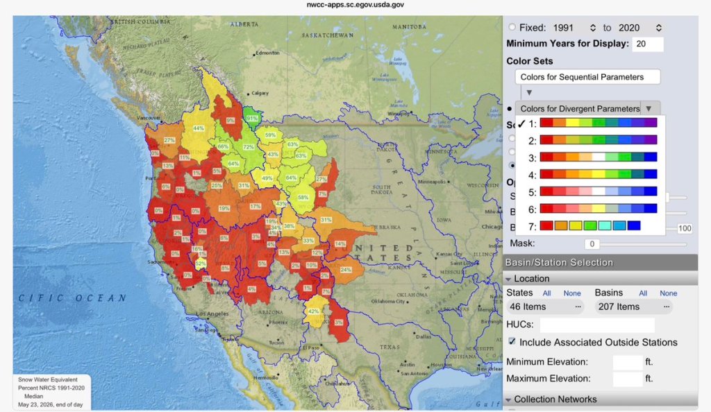
A skeleton wearing a life vest and swim shorts is water skiing on sand dunes, being pulled by a boat with people celebrating in the background.
AI generated image created by Google’s Nano Banana 2

by Robert Marcos, photojournalist

We’ve heard thousands of times (without sources being provided) that 40 million people are dependent upon Colorado River water. But which cities in the American Southwest are 100% dependent and would vanish without it?

YUMA ARIZONA

Yuma, Arizona, relies on the Colorado River for all of its municipal drinking water and is heavily tied to the river for its massive agricultural economy. Yuma has a population of 103,500 permanent residents which share a Colorado River water entitlement of 980,000 acre feet: 97% of which is used for agriculture and the remaining 3% is allocated for domestic, commercial, and military operations – such as those at the U.S. Army Yuma Proving Ground. Yuma conserves its water through high-tech agricultural irrigation, extensive canal automation, municipal restrictions, and wastewater recycling. Despite being a major agricultural hub, local farmers have reduced water usage by nearly 20% while doubling food production over the last three decades.

Municipal & City Efforts

The City of Yuma actively manages its municipal supply through strict conservation and drought response plans.2

Landscape Restrictions: The city encourages residents to adopt desert landscaping and transition away from water-heavy turf. Residents are advised to water only between 7 p.m. and 7 a.m. to prevent evaporation.

City Facilities: During declared water shortages, the city limits operations of water features, reduces winter grass overseeding, and limits facility water use.

Wastewater Recycling: The city recycles about 40% of its treated municipal water, which is safely discharged back into the environment to recharge the local aquifer and supply the Colorado River.

GREEN RIVER, WYOMING

As of 2026, the city of Green River, Wyoming had an estimated population of 11,307 people. The city itself does not hold an independent interstate water right; instead, its water use is governed by Wyoming’s state allocation within the broader “Law of the River” framework. Under the Upper Colorado River Basin Compact of 1948, the State of Wyoming is entitled to 14.00% of the total Upper Basin water allocation. This translates to a maximum full-supply entitlement of 1,043,000 acre-feet of water per year, the vast majority of which is sourced from the Green River basin.3

The city of Green River, Wyoming manages water conservation through modernized infrastructure, rigorous system auditing, and targeted wastewater recycling, operating in tandem with broader basin-wide conservation blueprints. Because Wyoming faces growing pressure to safeguard its Upper Colorado River Basin share, local municipal initiatives focus heavily on eliminating system losses and maximizing structural efficiency.4

LAKE HAVASU, ARIZONA

Lake Havasu, Arizona, has a permanent population of 59,871 and is entitled to 28,582 acre feet of Colorado River water, annually. The city employs a multi-faceted approach to water management:6

Advanced Wastewater Recycling: The city operates three wastewater treatment plants that produce A+ quality reclaimed water. This recycled water is used to irrigate local golf courses and parks instead of draining fresh drinking water supplies, and the surplus is safely returned to the Colorado River for downstream use.

Advanced Metering Infrastructure (AMI): Lake Havasu is replacing approximately 32,000 residential water meters with smart technology. This system provides near real-time usage data and leak detection alerts via the EyeOnWater Platform, allowing residents to quickly spot and fix running toilets or plumbing leaks.

Mandatory and Voluntary Measures: The city’s conservation plan includes guidelines that limit non-essential uses like irrigation and prevent water waste. Residents are encouraged to water early in the morning to reduce evaporation and use mulch to lock in soil moisture.

BULLHEAD CITY, ARIZONA

Bullhead City Arizona has a permanent population of 43,200 and an annual entitlement to 15,210 acre feet of Colorado River water. Bullhead City, Arizona, actively combats Colorado River water shortages through phased municipal codes. Key actions include:7

Phased Restrictions: The city’s code outlines voluntary rules for Tier 1 shortages (fixing leaks, taking shorter showers), which escalate to mandatory bans on misting systems, decorative fountains, and driveway washing during Tier 2 shortages.

Turf Reduction Programs: Bullhead City offers rebates for replacing high-water-use grass with desert landscaping. The city also partners with local HOAs, using state grants to fund large-scale grass removal and park revitalization projects.

Device Rebates: The city provides direct financial incentives for residents and businesses to install smart irrigation controllers, high-efficiency toilets, washing machines, and hot water recirculation systems.

Aquifer Injection: The city recovers effluent (reclaimed water) at the Section 10 Wastewater Treatment Plant, injecting it into the Colorado River aquifer to ensure it is returned to the Colorado River system as return flow.8

PARKER, ARIZONA

Parker, AZ, is almost completely dependent on the Colorado River for its water supply. The town relies on the river both as its direct municipal drinking source (via the Colorado River Indian Tribes water utilities) and to support its river-driven agricultural and recreational economy. 9

While many other Arizona cities rely on a mix of groundwater, reclaimed water, and imported river water delivered via the Central Arizona Project (CAP) canal system, Parker pulls its municipal water directly from the mainstem of the Colorado River. 10

Because the region is heavily tied to the river, changes in Colorado River Basin water management guidelines, drought conditions, and federally mandated supply cuts directly impact the community. However, Parker’s water is largely insulated from severe immediate shortages because the Colorado River Indian Tribes (CRIT) hold some of the most senior and legally untouchable water rights in the entire Lower Basin. 11

BLYTHE, CALIFORNIA

The city of Blythe, CA, relies entirely on the Colorado River for its municipal water supply. The city draws its water entirely from the river via local diversions managed by the Palo Verde Irrigation District (PVID). 12 The city has no alternative sources like deep groundwater basins, State Water Project aqueducts, or desalination. 13

The municipal water supply for the City of Blythe, California, relies entirely on groundwater pumped from deep wells ranging between 250 and 650 feet deep. This groundwater system is highly secure in terms of legal availability due to senior historic claims in the surrounding Palo Verde Valley, and it consistently complies with federal health-based drinking water standards managed by the Environmental Protection Agency. However, the local municipal supply faces ongoing challenges with aesthetic and physical qualities. The groundwater is naturally characterized by abnormally high levels of water hardness and elevated Total Dissolved Solids, which can cause cloudiness, scaling, and bitter tastes. These factors occasionally trigger secondary maximum contaminant level violations for color and taste, prompting local officials to promote strict household water conservation habits and water monitoring to preserve resource quality. 14
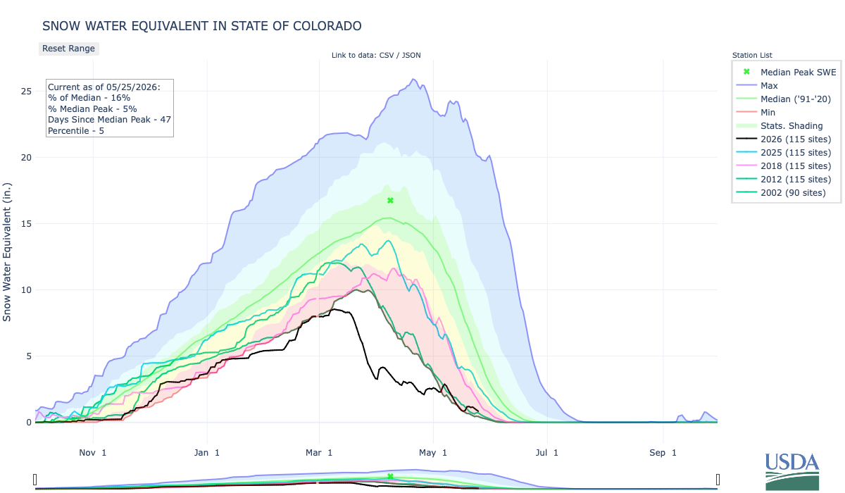
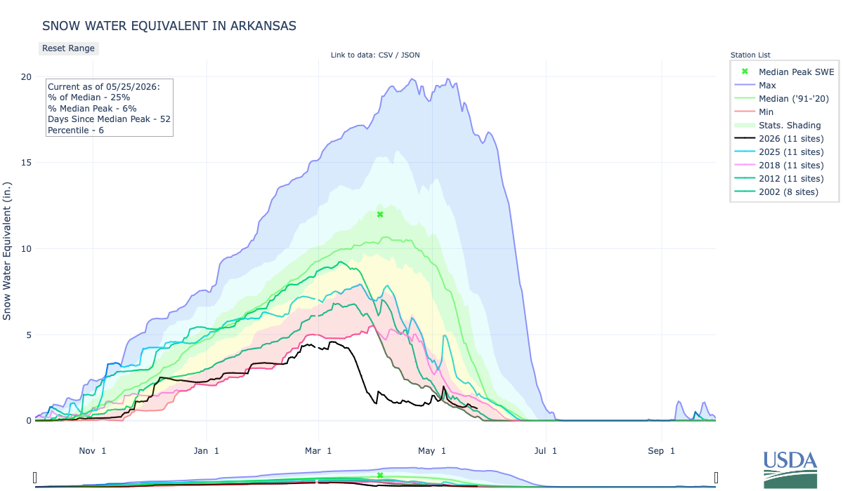
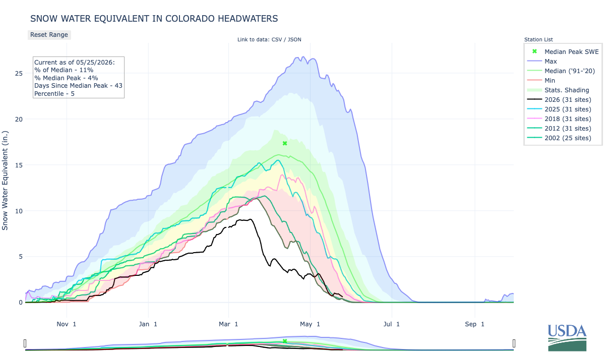
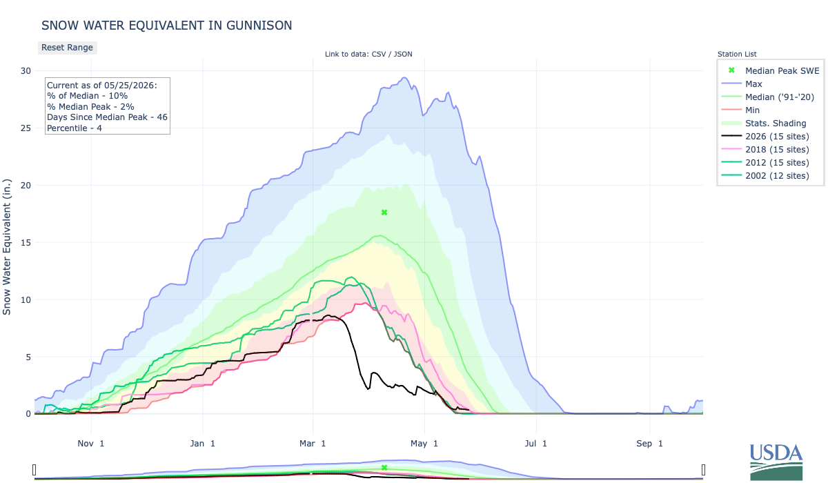
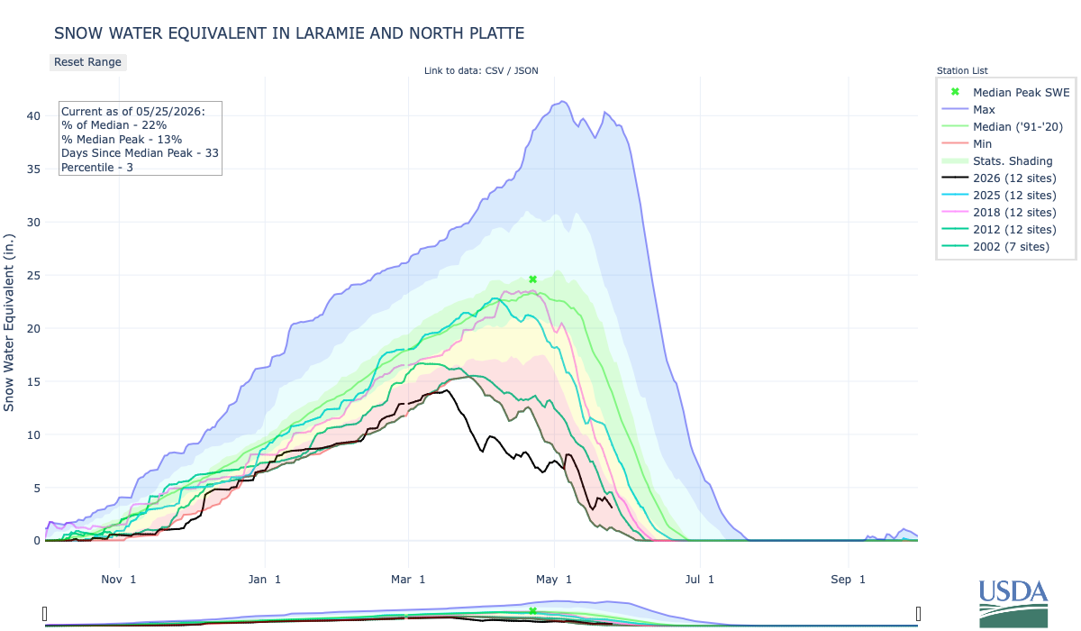
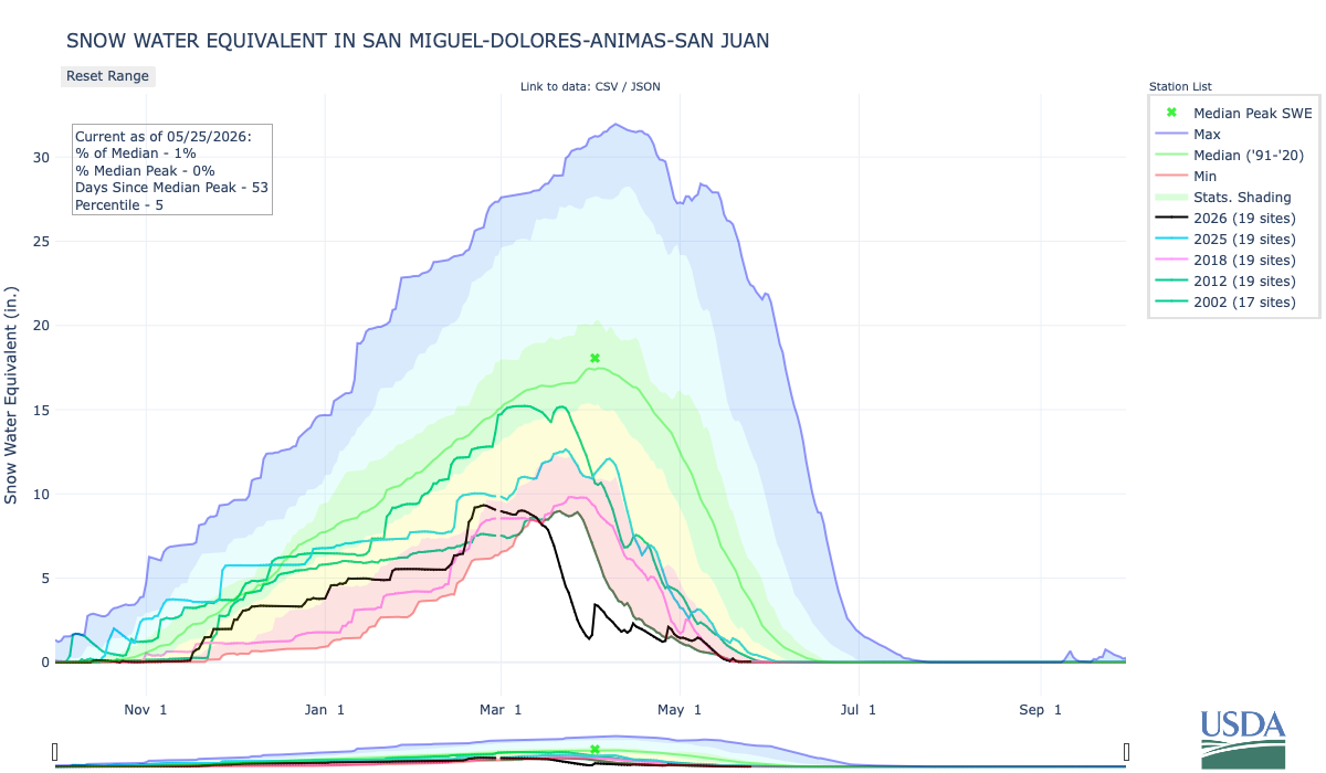
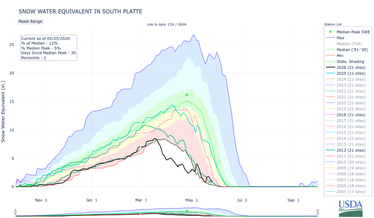
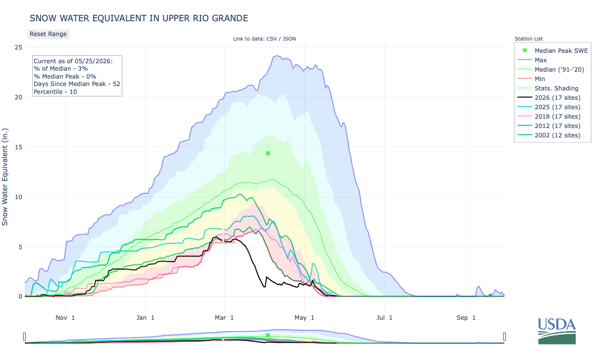
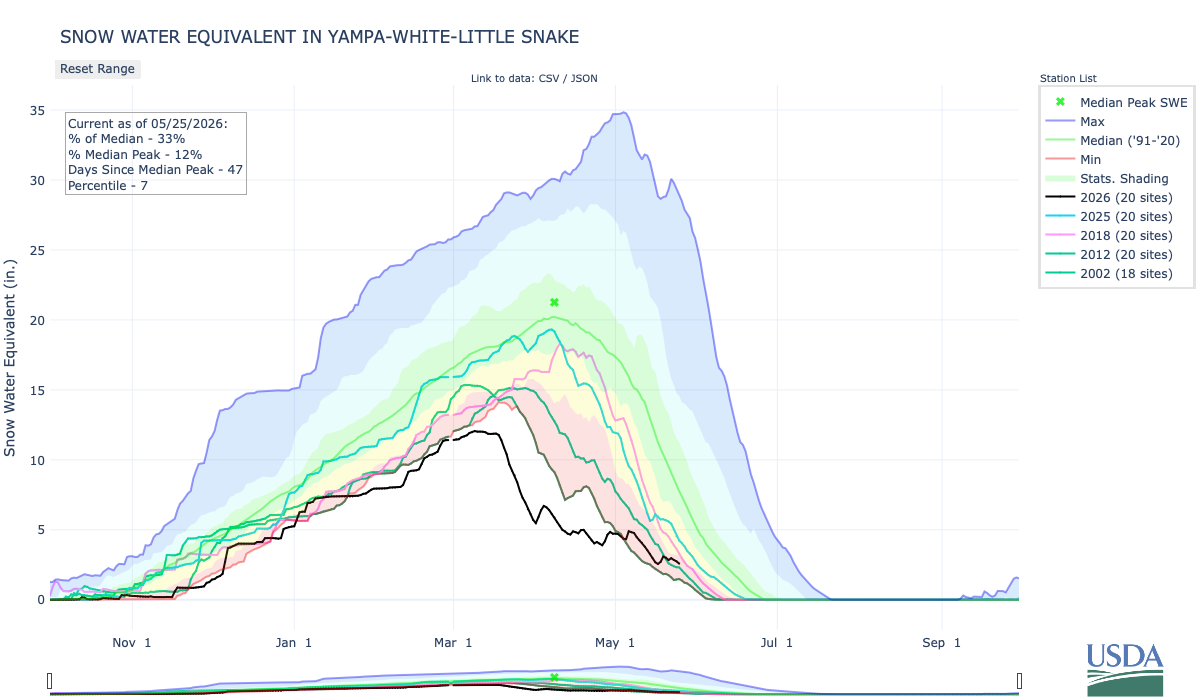
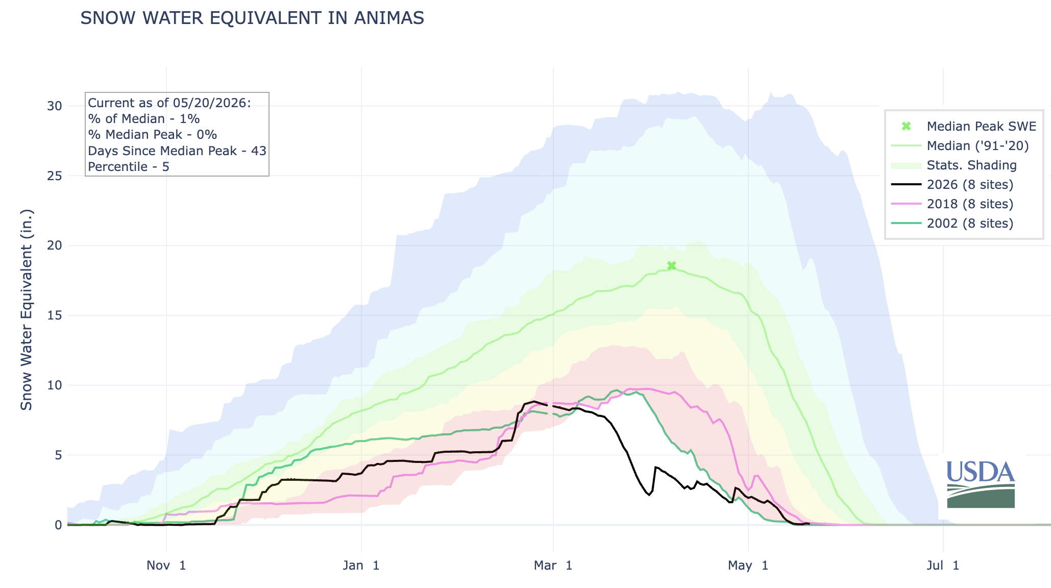
#Snowpack news May 25, 2026

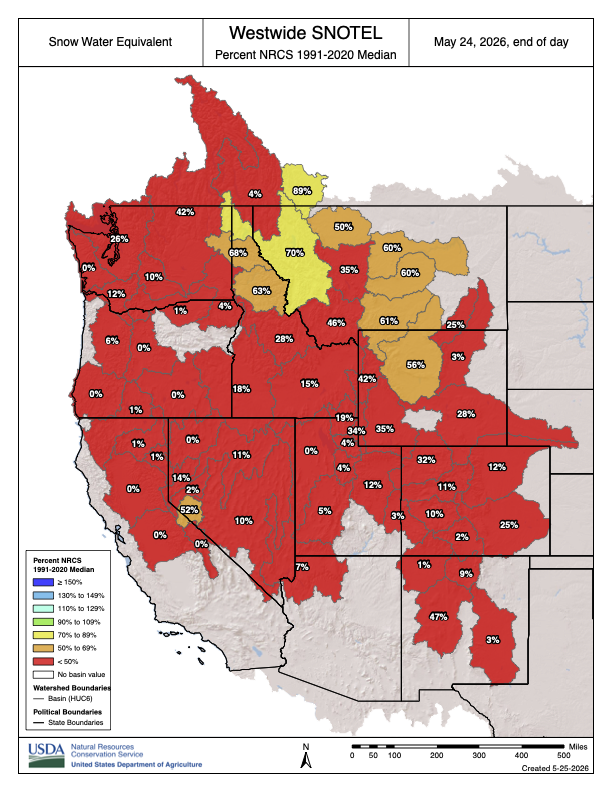
Westwide SNOTEL basin-filled map May 24, 2026.
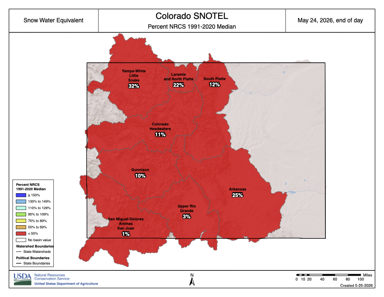
Colorado SNOTEL basin-filled map May 24, 2026.

Spring runoff has peaked! Also: Steve Pearce confirmed to lead Bureau of Livestock and Mining — Jonathan P. Thompson (LandDesk.org)

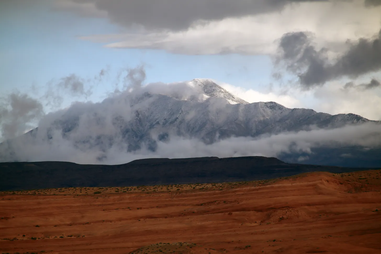
Fresh snow frosts the Henry Mountains in southern Utah on May 18, 2026, as seen from Bullfrog Marina on Lake Powell. A mid-May heat spell, when the mercury topped out at nearly 100° F in Bluff, Utah, finished off the high-mountain snowpack and caused many streams to hit peak runoff on May 15 and 16. But on May 17 and 18 a fast-moving storm moved through and dumped snow in some places and brought temperatures down considerably. While it wasn’t enough to appreciably boost streamflows, it did provide some nice relief and seemed to subdue the desert gnats, at least for a while. Jonathan P. Thompson photo.

Click the link to read the article on The Land Desk website (Jonathan P. Thompson):

May 20, 2026

🌨️🦦🚣🏽 Predict the Peak! 🌊

When the scorching late March heat wave came for what little was left of the meagre snowpack, I was almost certain that it would cause rivers to hit their peak spring runoff levels in early April. That would have been the earliest spring runoff on record and a grim omen for the rest of the summer. Most of the contestants in this year’s predict-the-peak contest apparently had the same idea.

Luckily, we were proven wrong, in most cases: A series of spring storms and successive cold spells in April and even May managed to slow the melt and push the peak to a more reasonable mid-May date. A later runoff means streamflows will subside later, stretching out the irrigating and reservoir-filling season just a little bit longer.

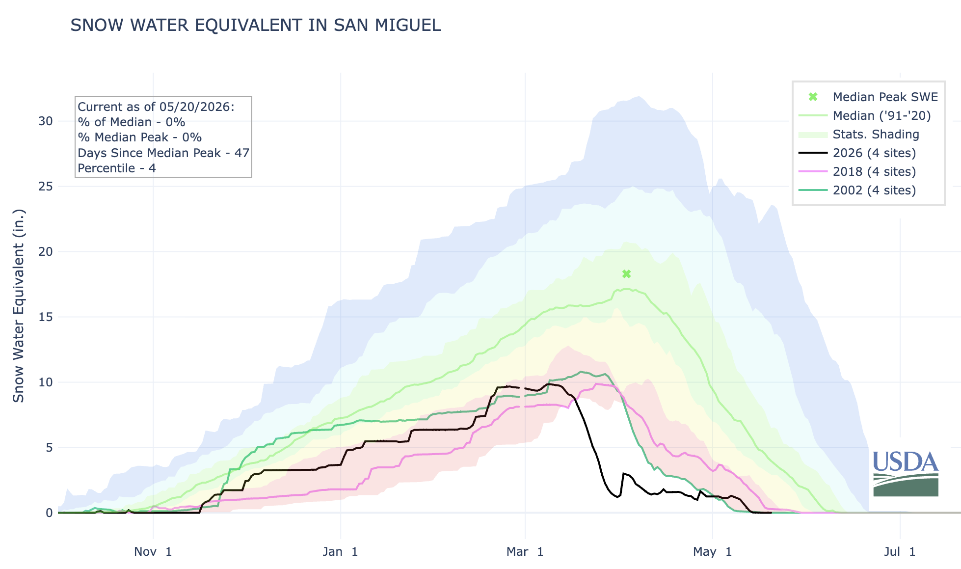
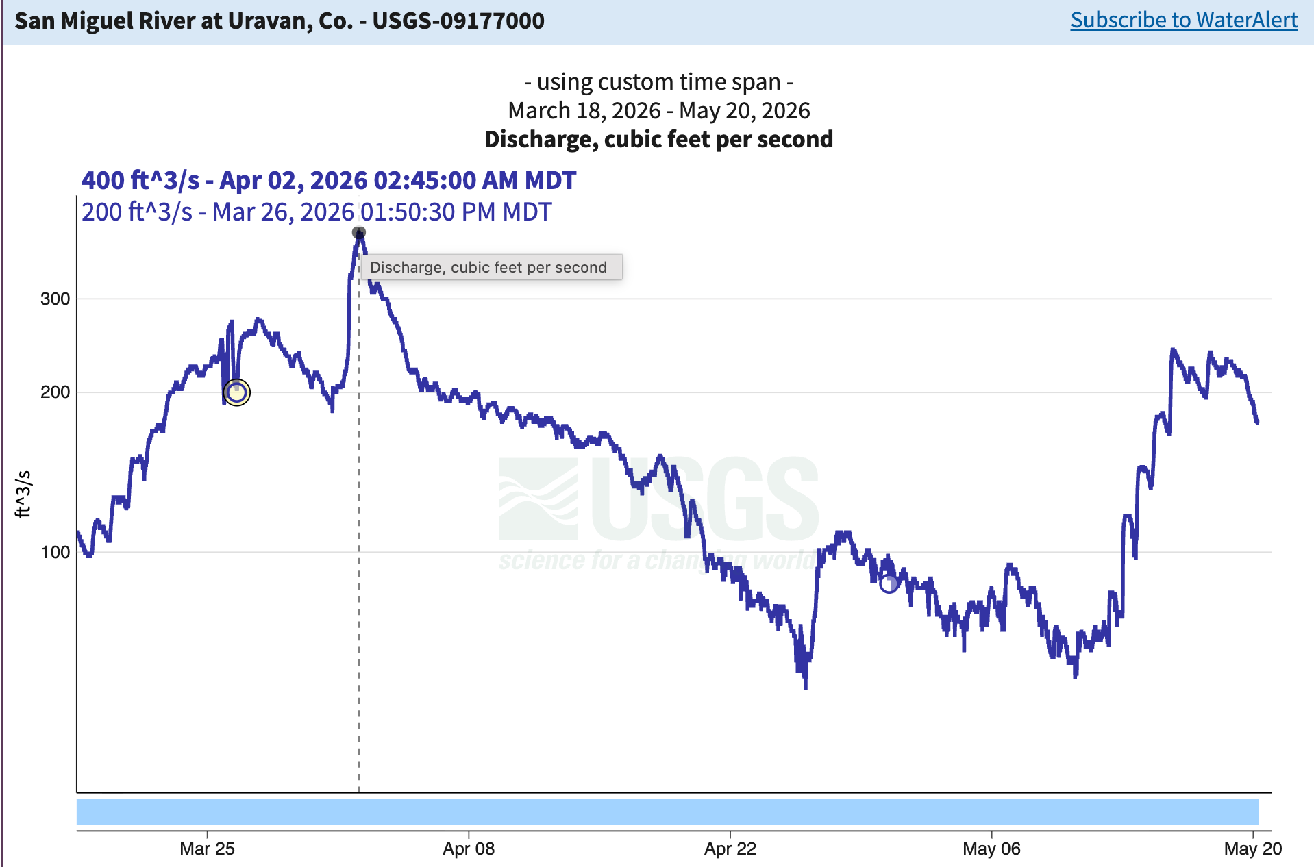
There were exceptions, including the San Miguel River, which hit its spring high flow on April 2. And the Dolores River, which peaked at an absurdly early date of March 26. These both drain the western side of the San Juan Mountains, which apparently bore the brunt of the crappy winter. Still, even those rivers had a sort of second run-off season. 

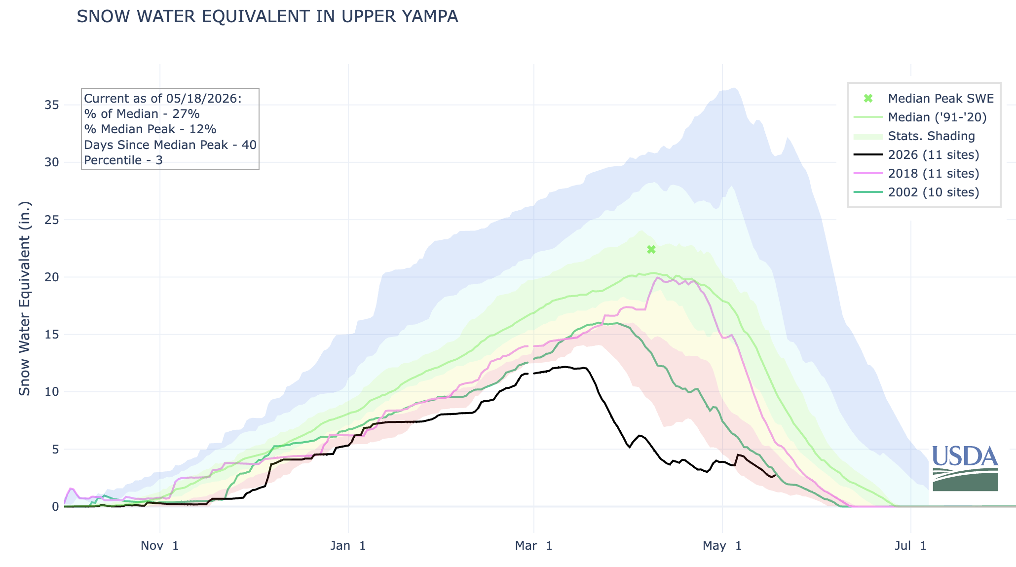
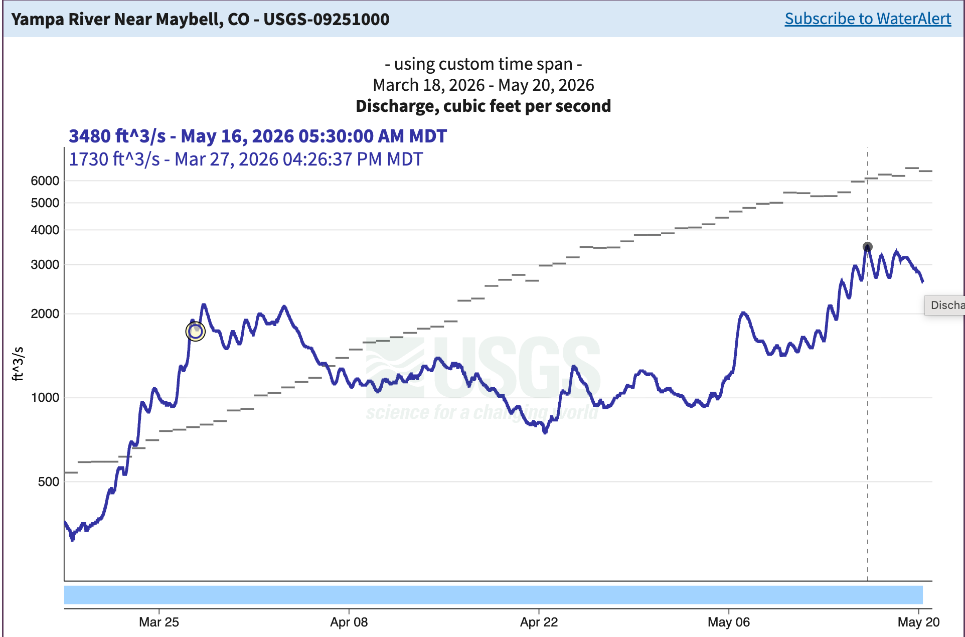
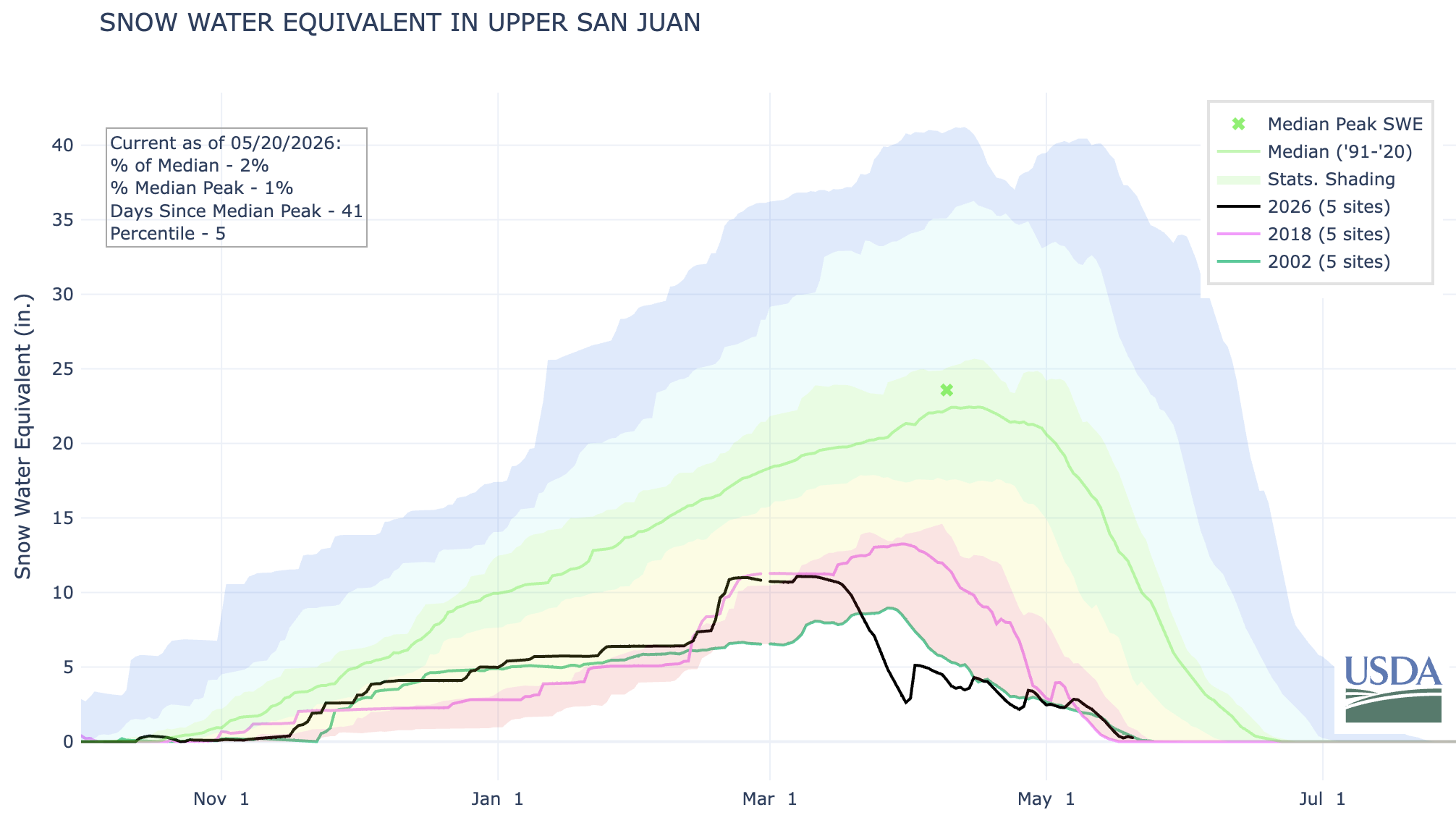
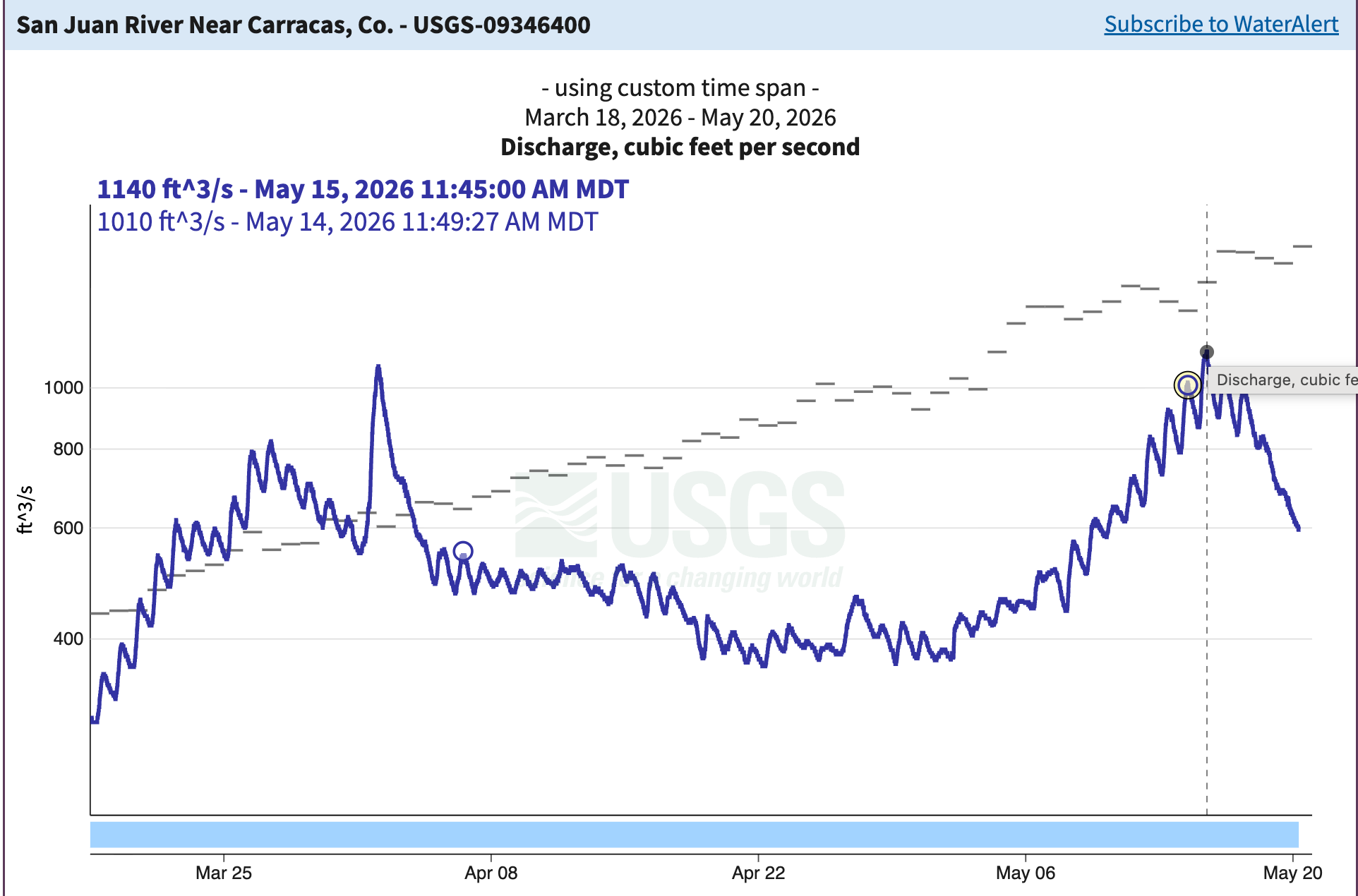
Here are the numbers for our contest rivers, followed by the streamflow and snowpack graphs:

  • The Animas River in Durango, Colorado: After topping out at 1,010 cubic feet per-second on March 27, the Animas came back and peaked on May 15 at 1,460 cfs.
  • The San Miguel River at Uravan, Colorado: The river hit 400 cfs on April 2, plummeted to just 63 cfs in late April, and then recovered for a second runoff and reaching 241 cfs on May 15.
  • The Yampa River near Maybell, Colorado: This river’s watershed got a bigger boost from the April storms than those further to the south, giving it a peak runoff of 3,480 cfs on May 16. This is the only river I’m hesitant to call, because the Upper Yampa watershed still has 2.8 inches of snow water equivalent, according to SNOTEL figures. If a temperature spike were to melt all of that at once, it could result in a larger peak.
  • San Juan River at Carracas, Colorado: The San Juan hit 1,090 cfs on April 2, which sure looked like the peak. But on May 15 it reached 1,140 cfs.

Nearly all of the contestants in the PtP contest chose April and even March dates for the peak, making the date part of the contest almost irrelevant. So I’m focusing on who was the closest on peak flows. And the winners are …

  • Animas (2 winners) 1. B Frank, with a guess of 1,468 cfs (wow! Only 8 cfs off) 2. Sharon Englehart, who guessed 1,500 cfs on June 1. While B Frank was closer in flow, Sharon was closer to the correct date.
  • San MiguelFlorence Paillard with a guess of 450 cfs
  • YampaB Frank again with 4,127 cfs
  • San JuanJ Harvey barely edges out B Frank with a guess of 850 cfs

So congratulations to B Frank, J Harvey, Florence Paillard, and Sharon Englehart! Please send your mailing address to landdesk@substack.com and I’ll send you your prizes.

🐟 Colorado River Chronicles 💧

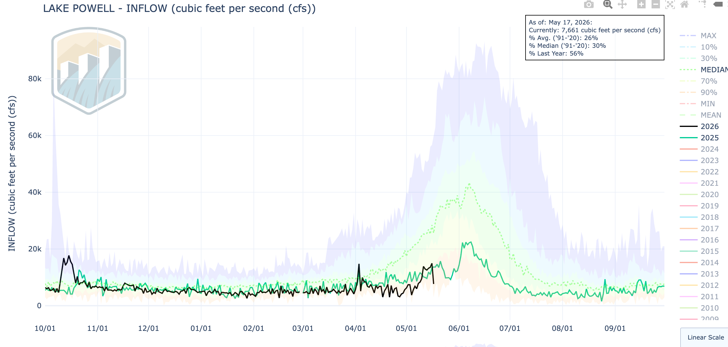
Peak runoff on the Colorado River’s tributaries naturally flows down to the mainstem, as well, so long as there’s not a dam or other diversion preventing it from doing so. Unfortunately, however, the mid-May streamflow surges were barely discernible in the Colorado and San Juan rivers by the time they reached Lake Powell. 

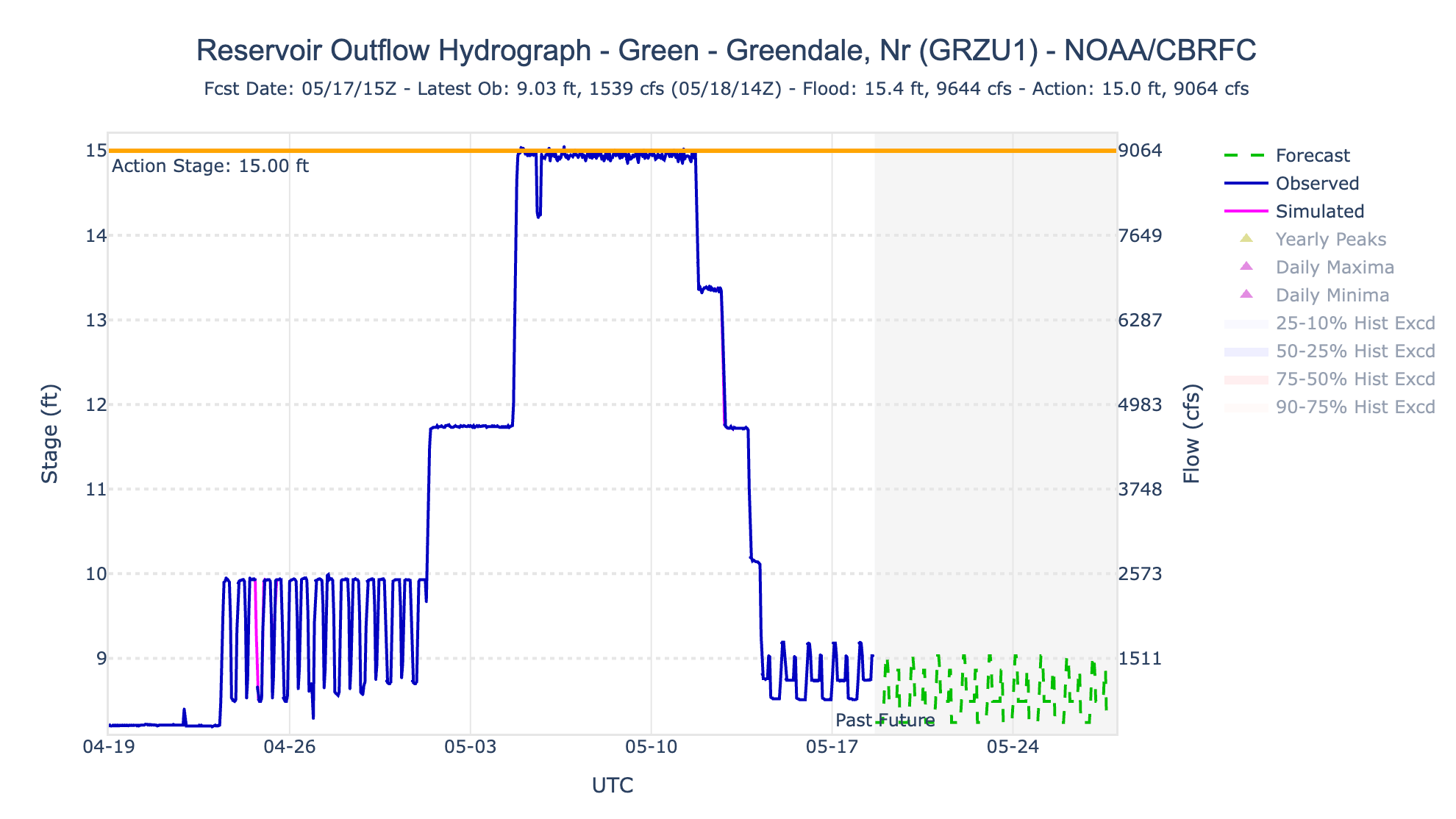
But Lake Powell did get a bit of a boost this month, only it wasn’t exactly “natural.” Lake Powell’s inflows jumped from as low as 3,500 cfs in late April to nearly 15,000 cfs on May 16. Yet more than 9,000 cfs of this can be attributed to extra releases from Flaming Gorge Reservoir on the Green River. That’s a lot of water coming down the river, and it did boost Lake Powell’s surface level by a whopping … half an inch or so. 

Yikes.

Graph showing Flaming Gorge releases jumped from about 2,000 cfs to 9,000 cfs for about a week before dropping back down to the 1,200 cfs range. This was done to bolster Lake Powell’s levels and to help endangered fish.
The Flaming Gorge releases combined with tributary runoff to bring Lake Powell inflows up to 2025 levels for the same time of year. However, it is still far below the median level for May and there almost certainly will be no June surge.
🌵 Public Lands 🌲

On Monday, the GOP-dominated U.S. Senate confirmed Steven Pearce to lead the Bureau of Land Management and oversee some 245 million acres of public lands. Pearce, a right-wing ideologue, former congressman from New Mexico, and a one-time executive of an oilfield services company has long been hostile to the very idea of public lands. 

Advocacy groups and Democratic lawmakers have responded to the move with outrage, shock, and dismay, and they have flooded my e-mailbox with claims that this confirmation represents an action that could “redefine public lands as we know them,” as one statement said, and will lead to the wholesale sell off of those same lands. 

To be sure, Pearce is a terrible choice for the position, and by confirming him the GOP reinforced the fact that they are willing to sacrifice Americans’ lands and waters to stay on Trump’s good side. But had they rejected Pearce, the administration would simply pick someone who is equally atrocious, although maybe a little bit less open about it. Or maybe they wouldn’t nominate anyone at all, and instead illegally assign a perpetually acting director, as was the case during Trump’s first term with William Perry Pendley.

And even if the administration did nominate a career bureaucrat or someone more reasonable than Pearce, the fact remains: They would either carry out the Trump/Doug Burgum mission, which is to bring the agency back to the days of the Bureau of Livestock and Mining, or they’d be canned. Interior Secretary Doug Burgum was widely considered to be a strong and reasonable choice for that position — even garnering the endorsement of REI’s board of directors — and he has turned out to be one of the most extraction-friendly Interior secretaries in history. Indeed, the administration has already been doing a fairly thorough job of executing their plan without a confirmed BLM director, so why would Pearce make any bit of difference? 

Trump’s election is what started redefining public lands. Pearce’s confirmation is just another step in the continued assault on the nation’s lands, air, water, and the communities that depend on them. 

Over the past 16 months, the administration has leased out hundreds of thousands of acres of land to oil and gas companies, handed out drilling permits like lollipops at a bank, fast-tracked uranium mine permits, cut the public out of environmental reviews, opened up millions of acres to energy development, and transferred public lands — all without an official BLM director. And in the weeks leading up to Pearce’s confirmation, at least nine BLM state and associate state directors accepted the administration’s deferred resignation and buyout program. In other words, they jumped ship voluntarily, perhaps because they could see that it was sinking.

So far, the administration hasn’t shrunk any national monuments or tried any large-scale land selloffs, with the exception of conveying 1.4 million acres of land in the Dalton Utility Corridor to the state of Alaska. This was a unique situation in that it was done under the 1959 Alaska Statehood Act, which authorized the transfer of 105 million acres of public land to the state for economic development purposes (which, in Alaska, usually translates to oil and gas drilling). As we saw during his first term, Trump doesn’t need Pearce — or any BLM director at all — to diminish national monuments or transfer lands. 

In other words, Pearce’s confirmation is just more of the same.

West SNOTEL map (May 23, 2026): “changed colour scale and set range 0-100%, so that not it’s not all red, allows you to see where the problem is most severe”– Daniel A. Walker

Click the link to view the interactive map from the NRCS.