Happy Mother’s Day

by Robert Marcos
As record-breaking heatwaves and droughts become more frequent, natural sources of water that insects and wildlife have historically depended upon are drying up. In response a growing number of homeowners are transforming their yards into life-saving “hydration hubs”. In addition to serving the needs of animals these simple actions help people to move from regret to action and then even pleasure as they watch deer, opossums, bees, and other wild animals obtain lifesaving water.1

Deer act as vital ecosystem engineers by managing plant growth and promoting biodiversity through their grazing habits. As they move across various habitats, they disperse seeds via their fur and waste, aiding in forest regeneration and the spread of native flora. Furthermore, they serve as a primary food source for large predators, while their carcasses provide essential nutrients to scavengers and the soil, maintaining a balanced and nutrient-rich food web.2

Opossums act as “nature’s sanitation workers” by providing essential pest control and waste removal services right in our backyards. As opportunistic scavengers, they keep neighborhoods clean by consuming overripe fruit, roadkill, and organic waste that might otherwise attract less desirable pests like rats or roaches. They also help maintain ecological balance by hunting common garden nuisances such as snails, slugs, and even venomous snakes, to which they have a natural immunity. Furthermore, their low body temperature makes them highly resistant to rabies, meaning they are far less likely to spread the disease than other urban wildlife.3

Pollinators like bees, butterflies, and bats are the silent backbone of our local ecosystems, facilitating the reproduction of nearly 80% of the world’s flowering plants and one out of every three bites of food we eat. By transferring pollen between blooms, they ensure the production of the fruits, seeds, and nuts that feed both humans and wildlife, while simultaneously maintaining the genetic diversity necessary for resilient landscapes. Beyond agriculture, their work supports the growth of oxygen-producing plants and provides the foundational habitat for countless other species, making their presence a direct indicator of a healthy, thriving environment.4
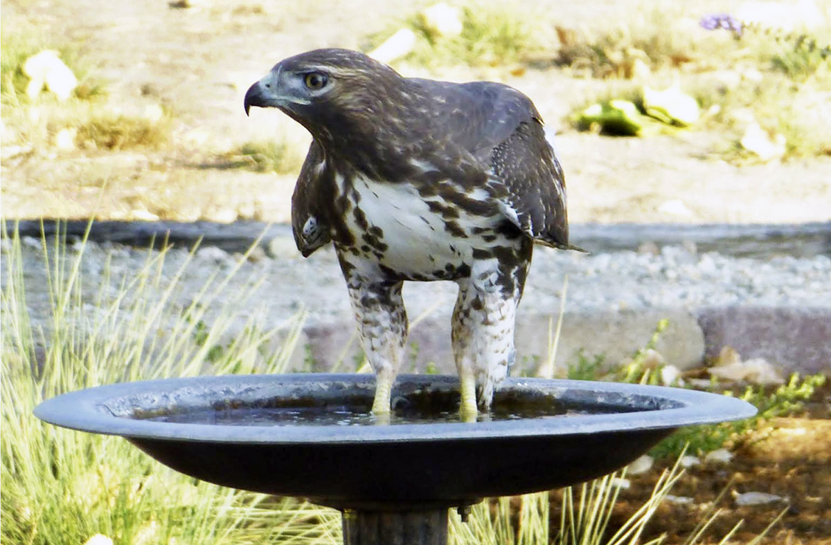
Red-tailed hawks are apex predators that maintain ecological balance by regulating the populations of small mammals, including rodents, rabbits, and squirrels. By controlling these populations, they provide free pest control for both urban environments and agricultural lands, which helps prevent overgrazing of vegetation and crop damage. Beyond their role as hunters, they are valuable indicator species; their presence and reproductive success reflect the overall health and biodiversity of the local ecosystem. Additionally, their large nests can provide secondary habitat for smaller bird species, such as house sparrows, while their opportunistic scavenging contributes to natural nutrient cycling.5
Click the link to read the article on The Land Desk website (Jonathan P. Thompson):
May 8, 2026
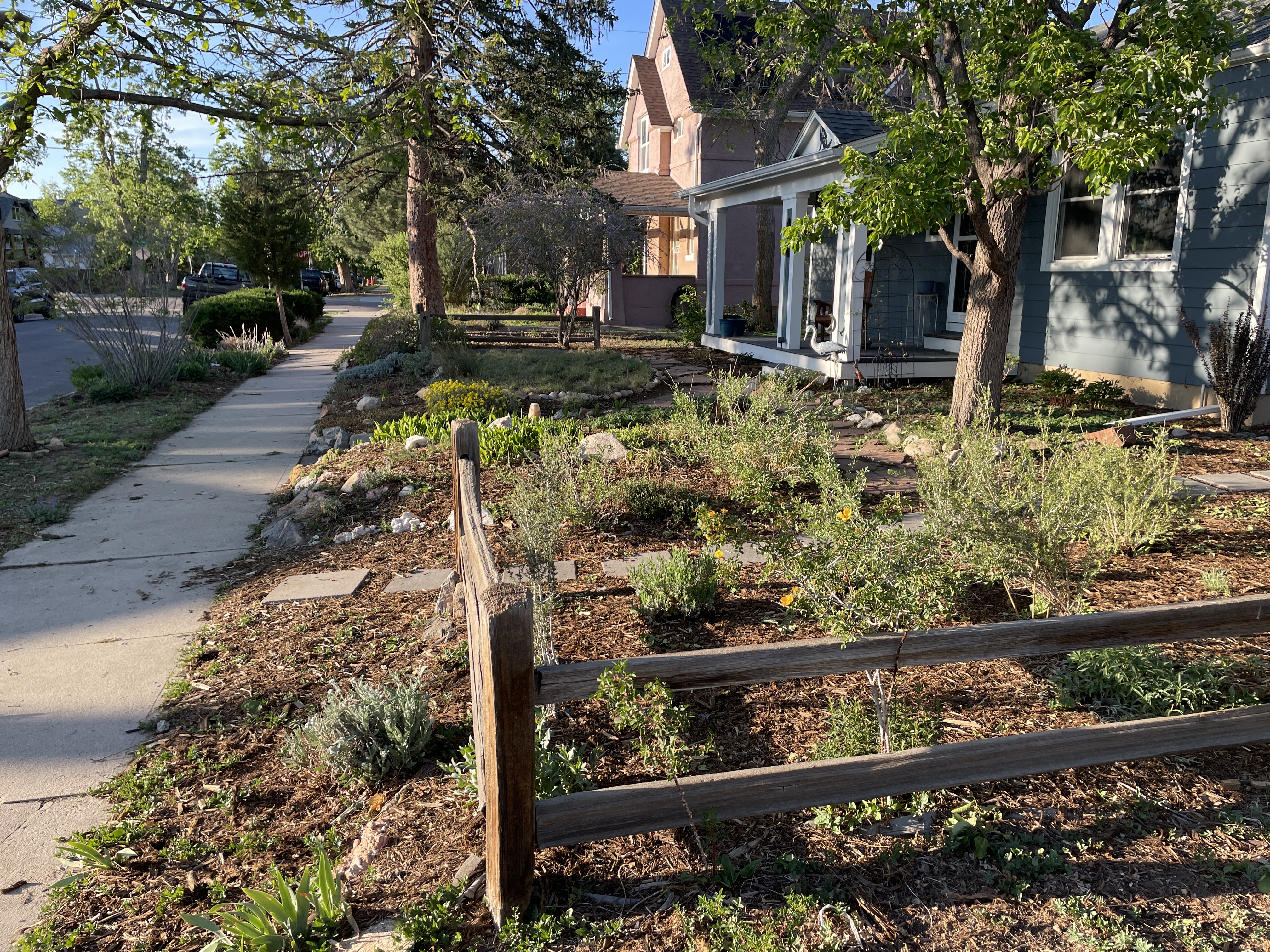
📸 Opening Shot 🎞️
🤖 Data Center Watch 👾
Yet another scene in the ongoing saga of the Big Data Center Buildup is playing out in Box Elder County, Utah, where the board of commissioners this week approved the proposed Stratos Project data center and energy generation complex, despite widespread and intense local opposition.
Enigmatic entities have forwarded so many proposals for ginormous new data centers in the West that I not only find myself overwhelmed, but I also suspect that many of them are just speculative pipe dreams that will never be built. Similarly, when I read about the inevitable backlash, I tend to think of it as an almost reflexive reaction — something folks have simply been conditioned to do when they hear the terms “AI,” “hyper scale,” and “data center” — that is not based in the actual effects these things will have.
This project — led by investor Kevin O’Leary of the tv-show Shark Tank — appears to be serious, as it comes with the backing of Utah’s Military Installation Development Authority, or MIDA, a state entity created to “further economic development across multiple jurisdictions.” Gov. Spencer Cox has said the state has an “obligation … to allow for these types of data centers to be built,” so it should slide through state permitting without a hitch.
Its potential impacts are not only real, but also scary: The project would ultimately cover about 40,000 acres just north of the Great Salt Lake, its on-site 9-gigawatt power plant would guzzle enormous amounts of natural gas and emit greenhouse gases, and the facility could even create its own extreme heat island. No wonder the pushback is so impassioned.
The scale of this thing is utterly mind-blowing, from its 62-square-mile footprint — equivalent to about 1,000 Walmart super centers — to the size of its gas-fired power plant. Nine gigawatts (or 9,000 megawatts) is enough to power multiple cities and millions of households; all of Utah’s coal, natural gas, and wind and solar facilities combined have a nameplate capacity of just 10.2 GW. While natural gas burns more cleanly than coal, it still emits significant levels of carbon dioxide and nitrogen oxides, and Project Stratos could increase state’s greenhouse gas emissions by as much as 50%. Natural gas drilling, processing, and transportation bring their own environmental impacts and emit methane — a potent greenhouse gas — as well as other harmful pollutants. The facility would be served by the Ruby Pipeline, which carries gas extracted from Wyoming fields.
The natural gas component fits the pattern of the Big Data Center Buildup. Developers often say they are going to run their centers on solar, wind, geothermal, or even nuclear power. When it comes down to it, however, most of them end up relying on gas, at least initially. The developer of the proposed Prometheus Hyperscale data center along the Natrona-Converse county line in Wyoming initially touted all of the renewable energy opportunities in the area. Now they plan to run entirely on natural gas. Even the ones that do build or buy some solar or wind still tend to use gas-turbines or even diesel generators for backup.
Energy Transfer is looking to build a dedicated natural gas pipeline to serve the giant and controversial Project Jupiter complex in southern New Mexico, and the Bureau of Land Management just issued a right-of-way for the 400 million-cubic-feet-per-day project under its accelerated review process. The developers reacted to vigorous opposition by switching from the planned conventional gas turbines to solid oxide fuel cells. However, the cells are also fueled by natural gas — thus the pipeline —and do have emissions, albeit fewer than conventional turbines.
While many of the largest new data centers plan to build dedicated, on-site power generation, most of the planned facilities and those coming online now will get all or most of their electricity from the power grid. All of this new and projected new demand has utility executives salivating over the prospect of selling more product and raking in more profit. It has also spurred many utilities to cancel plans to shutter dirty coal plants or to make plans to build more natural gas facilities. So even if all of the proposed data centers aren’t realized, their mere possibility could lock in more fossil fuel burning and more pollution for years to come.
The Stratos Project’s potential water use is less clear, but certainly relevant given that it would draw from the same hydrologic system as the Great Salt Lake, which is shrinking. Data centers generate an enormous amount of heat, so they must be cooled, which can consume large quantities of water (and power). The developer says it plans to use a closed-loop cooling system, which must be filled once and so consumes relatively little water. These systems, however, remain relatively uncommon in these facilities. Natural gas turbines can also require large volumes of water for steam generation and cooling, though consumption levels depend on the type of turbine.
In March, the nearby Bar H Ranch proposed transferring its rights to 1,900 acre-feet annually of irrigation water diverted from the Salt Wells Springs Stream for industrial use at the Stratos Project, a.k.a. “Wonder Valley.” The application noted that the water “will be used primarily for power generation. A portion of the water will also be used in connection with a data center that will operate as a closed-loop system.” Thousands of people protested the application, based on its potential impacts on the lake and neighboring wells.
For context, 1,900 acre-feet (or 619 million gallons) would be enough to grow about 1,400 tons of alfalfa, or to irrigate some 500 acres of Utah alfalfa fields for a full growing season. That may not be enough water, however, to serve the natural gas power plant if it runs full-time. A combined cycle natural gas turbine uses about 200 gallons per MWhr of generation. If you assume a 60% capacity factor, then the 9 GW1plant would produce about 130,000 MWhr per day, leading to an annual water use of about 9.5 billion gallons assuming it runs full-blast 24/7. This is in line with developers’ statements that they would eventually seek up to 13,000 acre-feet of water rights.
The firm withdrew the application this week, just two days after the protest period ended, saying it would submit a new application later (which would void all of the protests and force residents to re-submit their comments and pay the filing fee again).
“The people of Utah, especially those from Box Elder County, filed protests in record numbers because of their concerns about this project,” said Ben Abbott, BYU ecologist and executive director of Grow the Flow, a non-partisan organization dedicated to saving the Great Salt Lake. “For the developer to sidestep the public input process by withdrawing their application and resubmitting later is another breach of trust. I keep trying to give them the benefit of the doubt, but this has all the hallmarks of an out-of-state mega-project with little to no concern for the local community.”
Meanwhile, O’Leary, the project’s pusher, is responding to the opposition by dangling the dim possibility of incorporating other power generation technologies into the mix, and by accusing the ranchers, doctors, and Utah citizens protesting the proposal of being paid, out-of-state agitators. As tired, worn-out, and false the claim is, it does provide an indication that the developers behind this project really don’t care about its potential impacts — or the land, people, or waters it may affect.
Data Centers: The Big Buildup of the Digital Age — Jonathan P. Thompson
The Big Data Center Buildup is increasing demand for all sorts of energy, especially generation fueled by natural gas. This, along with increased liquefied natural gas exports, could drive up methane prices and finally pull the industry out of its 17-year-long slump — at least that’s what the industry is hoping for. And the Trump administration is doing its darndest to clear the way for more oil and gas drilling.
The BLM is currently seeking public input on its plan to sell a whopping 276 oil and gas leases on 357,337 acres in Wyoming. That’s a lot of land that could be targeted for drilling. The administration has leased public land, and issued drilling permits, at an almost unprecedented rate since taking office last January.
Data Dump: One year into the “energy emergency” — Jonathan P. Thompson
🌵 Public Lands 🌲 🏠 Random Real Estate Room 🤑
The effort to tackle the affordable housing crisis in Western amenities community has met up with the public lands, but not in the way you might think. Dozens of low-income housing advocacy groups have come together with environmental groups to form Shared Ground, a new coalition that aims not only to increase access to affordable housing, but also to protect public lands — while also opening the door to selling some of those lands if strict criteria are followed.
The mission of the coalition is summed up in a recent document, noting:

The document criticizes Sen. Mike Lee’s push to sell public land to real estate developers, noting:

Furthermore, the coalition acknowledges that the affordable housing crisis is “fundamentally a policy and investment challenge—not the result of a simple shortage of land.”
Nevertheless, Shared Ground does leave the door open to selling public land for housing, as long as it meets the following criteria (this is from the coalition’s statement):
- Demonstrated Public Interest and Community Benefit: Any proposal for the use or disposal of public lands for housing must carry binding, legally enforceable requirements that the land primarily serves affordable housing rather than market-rate and never fuels speculative development. Benefits must flow primarily to local, existing communities—not private developers—and projects should be limited to parcels near existing infrastructure and services.
- Careful Inventory and Prioritization: Any such proposal must also require carefulinventory of the public lands under consideration for use or disposal and prioritize already-developed sites over undeveloped land.
- Conservation, Cultural, Recreational, and Tribal Safeguards: Public Lands withsignificant conservation, wildlife, cultural, historic, Tribal, or recreational value must be excluded from any conveyance or development proposal. All proposals must include early, meaningful consultation with Tribal Nations, and transparent engagement with local communities, with clear public accountability throughout the process.
On the housing supply-side theory — Jonathan P. Thompson


While I’m fairly certain the streams all hit peak runoff back in April, I’m not calling the contest yet. April and early May storms and more “normal” temperatures have kept a bit more of the snowpack around than expected, and forecasted heat in coming days will probably melt off what remains pretty quickly, possibly leading to a surge in streamflows. But by the end of next week, I’m predicting all but the highest monitoring stations will be snow-free, meaning spring runoff pretty much will be done and gone.
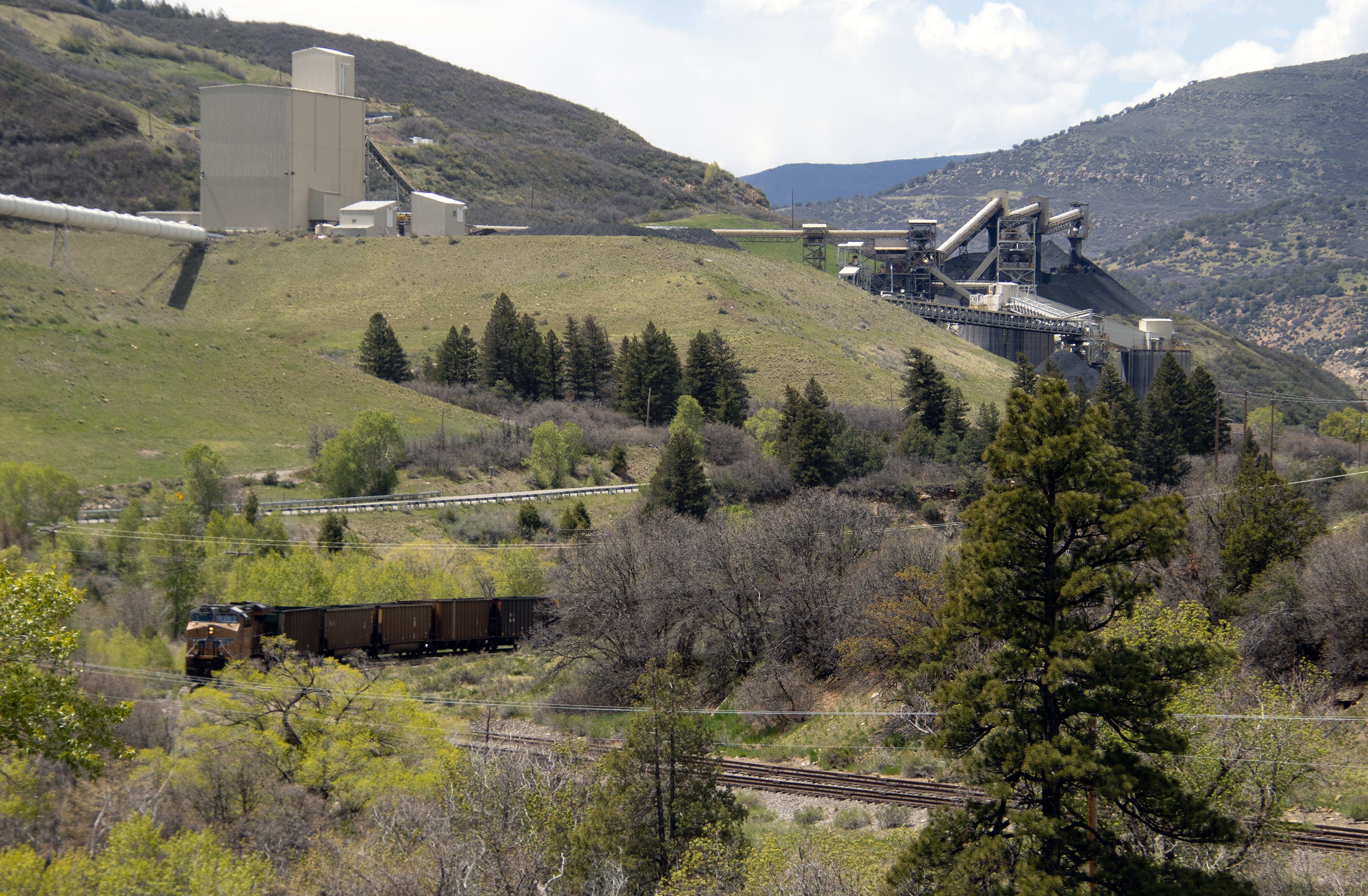
📸 Parting Shot 🎞️

1 The figures for the size of the power plant vary from place to place. The developer’s “fact sheet” lists 9 GW of Utah power generation, while the water right application said it was for 7.5 GW. Rob Davies’ analysis of the heat output of the facility assumes that the data center’s load will be 9 GW, which would require a 16 GW power facility operating at 55% efficiency.
Click the link to access the report on the University of Colorado website (Eric Kuhn,1 Anne Castle,2 Carlos de la Parra,3 John Fleck,4 Jack Schmidt,5 Kathryn Sorensen,6 Katherine Tara7). Here’s the abstract:
March 26, 2026
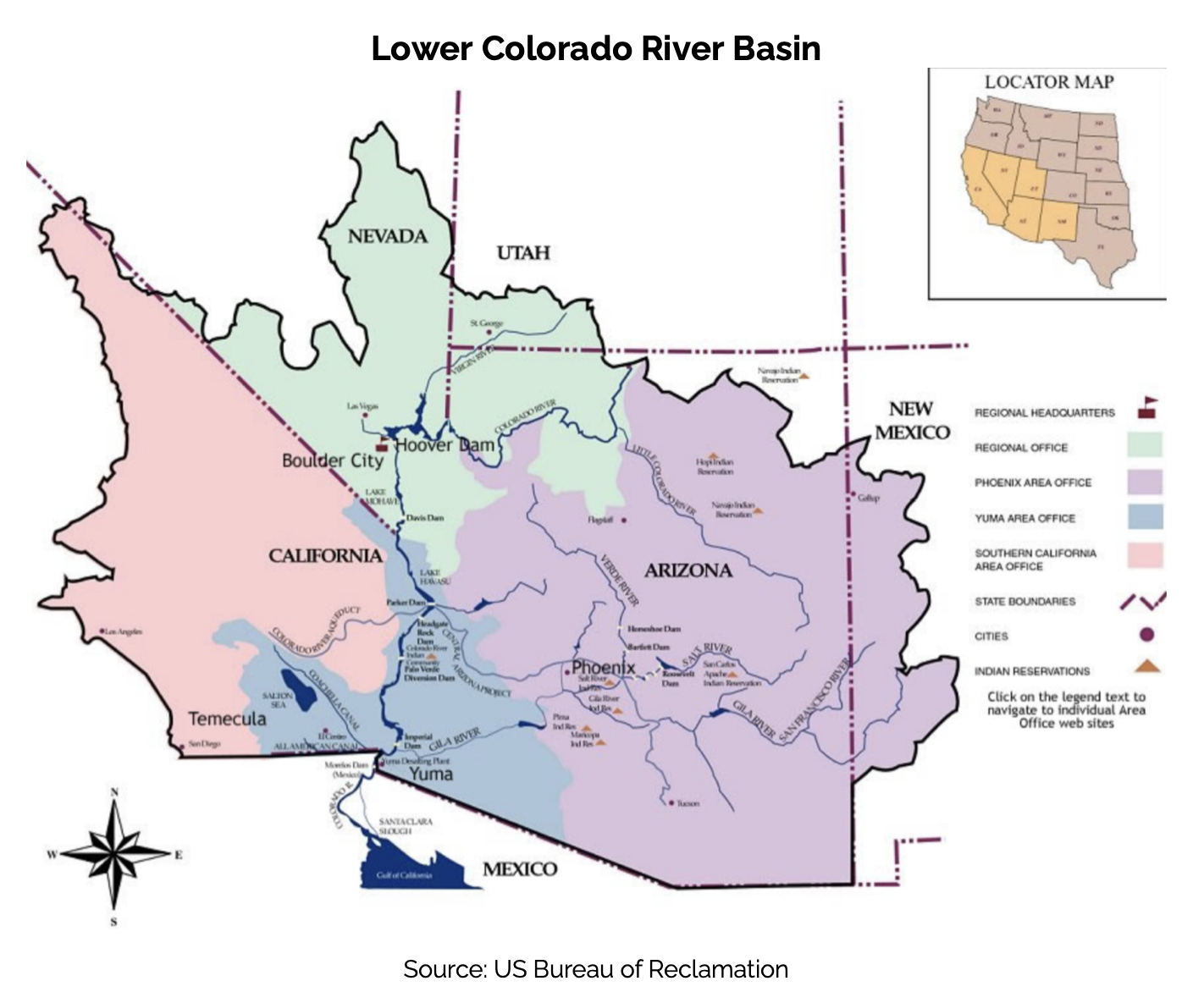
Since 1945, the United States and Mexico have managed common interests on their two largest shared rivers systems, the Colorado and the Rio Bravo/Rio Grande, under the terms of the 1944 international treaty that was designed from the beginning with tools to adapt to changing hydrologic and societal conditions.
A recent emergency agreement on the Rio Bravo/Rio Grande illustrates what is possible, and with old river management rules on the Colorado both within the United States and between the United States and Mexico about to expire, we are at a moment of opportunity for meaningful change.
The core problem on the Colorado River, which we address in the analysis that follows, arose from decisions made in the first half of the 20th century to allocate fixed volumes of water. As usage patterns and hydrology change in the 21st century, fixed volumes no longer work. A shift to a percentage-based split between the United States and Mexico on the Colorado River, based on the river’s actual natural flow, would provide a solid foundation for the two countries’ joint management of the Colorado in the decades to come.
1 Retired General Manager, Colorado River Water Conservation District.
2 Senior Fellow, Getches-Wilkinson Center, University of Colorado Law School; former US Commissioner, Upper Colorado River Commission; former Assistant Secretary for Water and Science, US Dept. of the Interior.
3 Founder and Managing Partner, Centro Luken de Estrategias en Agua y Medio Ambiente, Tijuana, Mexico.
4 Writer in Residence, Utton Transboundary Resources Center, University of New Mexico.
5 Director, Center for Colorado River Studies, Utah State University; former Chief, Grand Canyon Monitoring and Research Center.
6 Director of Research, Kyl Center for Water Policy, Arizona State University; former Director, Phoenix Water Services.
7 Staff Attorney, Utton Transboundary Resources Center, University of New Mexico.
Author note
This paper is intended to supplement and complement a series of related papers written in the last year by the authors (or subset of the authors) addressing the critical problems facing the Colorado River Basin, including:
• Eric Kuhn, Anne Castle, & John Fleck, Royce Tipton and the Hydrology of the 1944 Treaty with Mexico, (May 2025). Available at: Kuhn-et-al-2025-Royce-Tipton-Mexico-Hydrology.pdf.
• Anne Castle, John Fleck, Jack Schmidt, Kathryn Sorensen, and Katherine Tara, Essential Pillars for the Post-2026 Colorado River Guidelines, (April 2025). Available at: 2025-04-25 Principles.
• Jack Schmidt, Anne Castle, Eric Kuhn, John Fleck, Kathryn Sorensen, and Katherine Tara, Analysis of Colorado River Basin Storage Suggests Need for Immediate Action, (September 2025).
• Kathryn Sorensen, Sarah Porter, Anne Castle, John Fleck, Eric Kuhn, Jack Schmidt, and Katherine Tara, Consideration for Assigned Water after Expiration of the 2007 Guidelines
(January 2026). Available at: https://issuu.com/asuwattscollege/docs/full_considerations_for_assigned_water_.
Click the link to access the report on the NRCS website. (Click through to check out the exceedance forecasts in your favorite watershed.)


Click the link to read the release on the NRCS website:
May 8, 2026
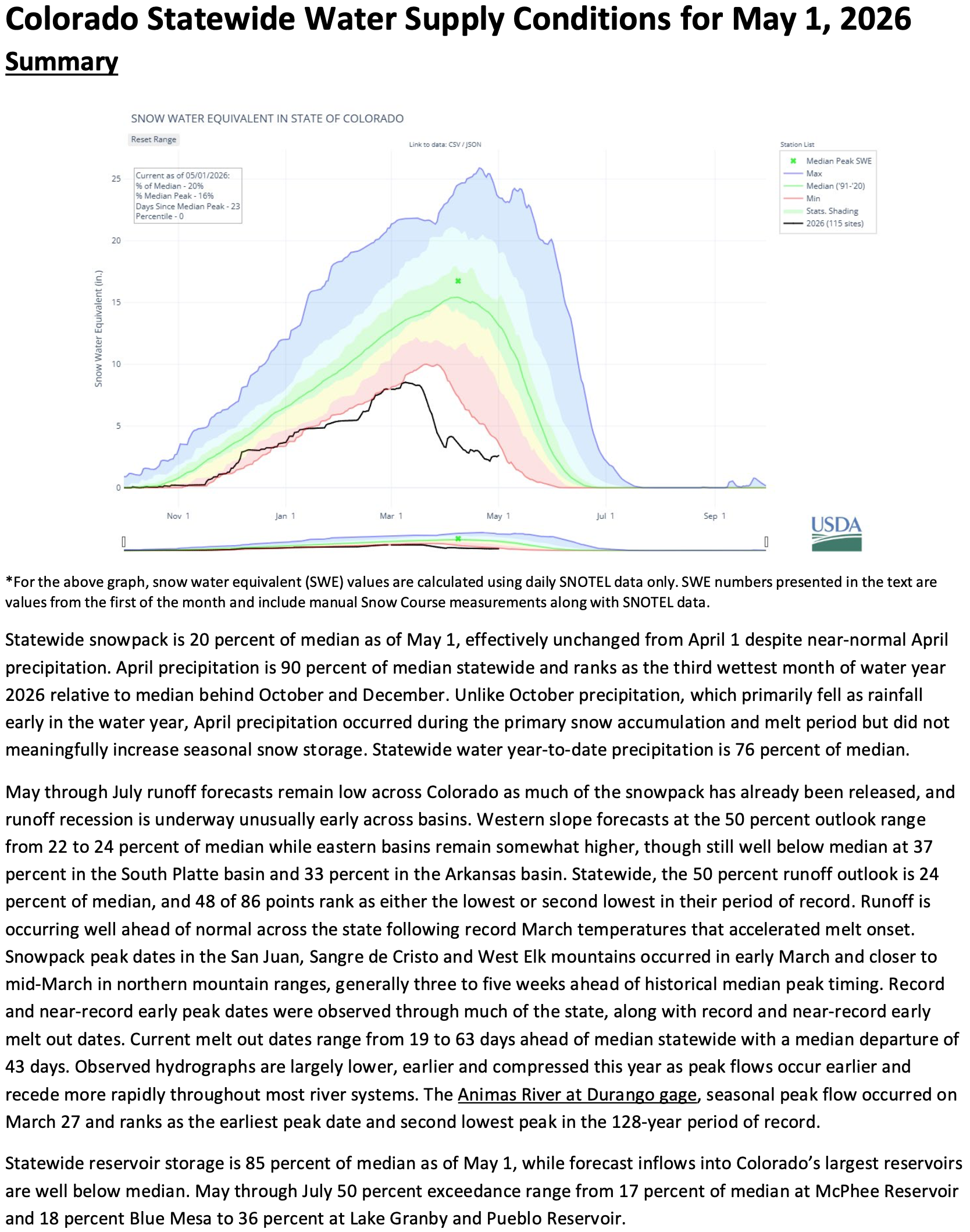
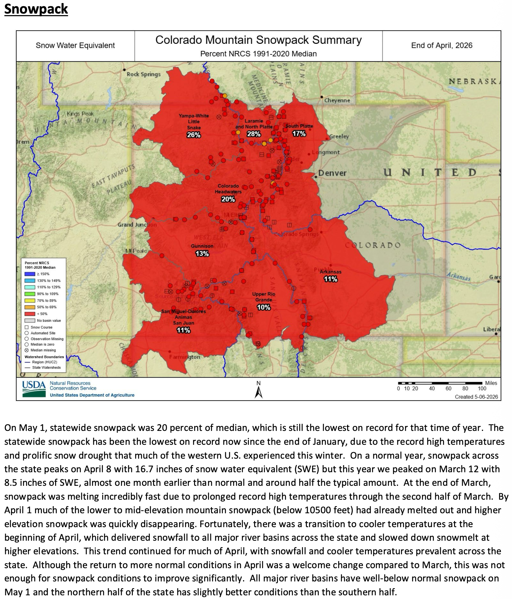
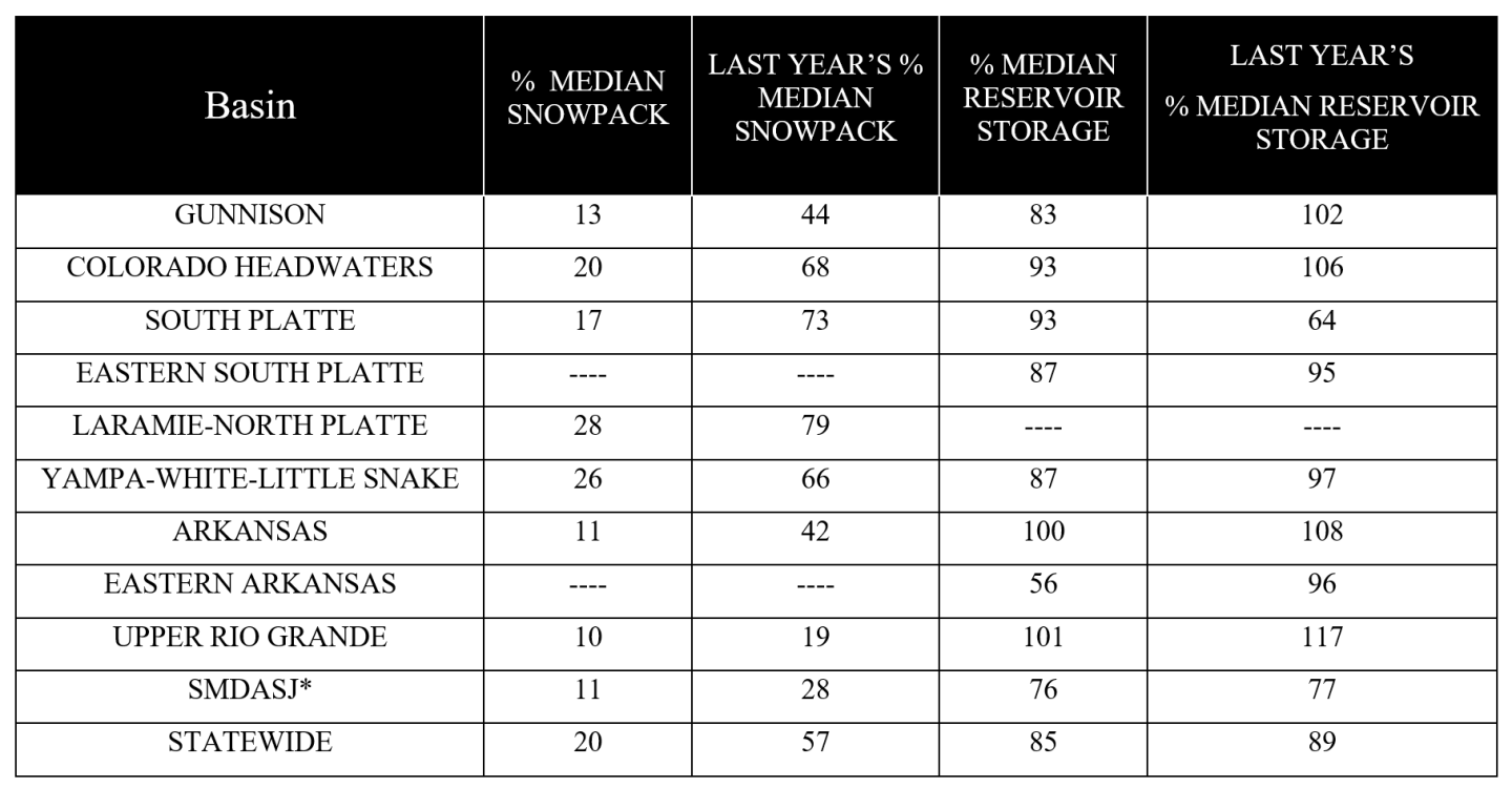
Colorado’s 2026 water year this far has been defined by records across nearly every metric: an anomalously early snowpack peak, rapid melt driven by record March temperatures, snowpack that tracked at-or-near the lowest values in the SNOTEL period of record from January through May 1, and near-record early season precipitation in the San Juan Mountains. Runoff has arrived weeks ahead of the historical median across river systems and recession is largely underway.
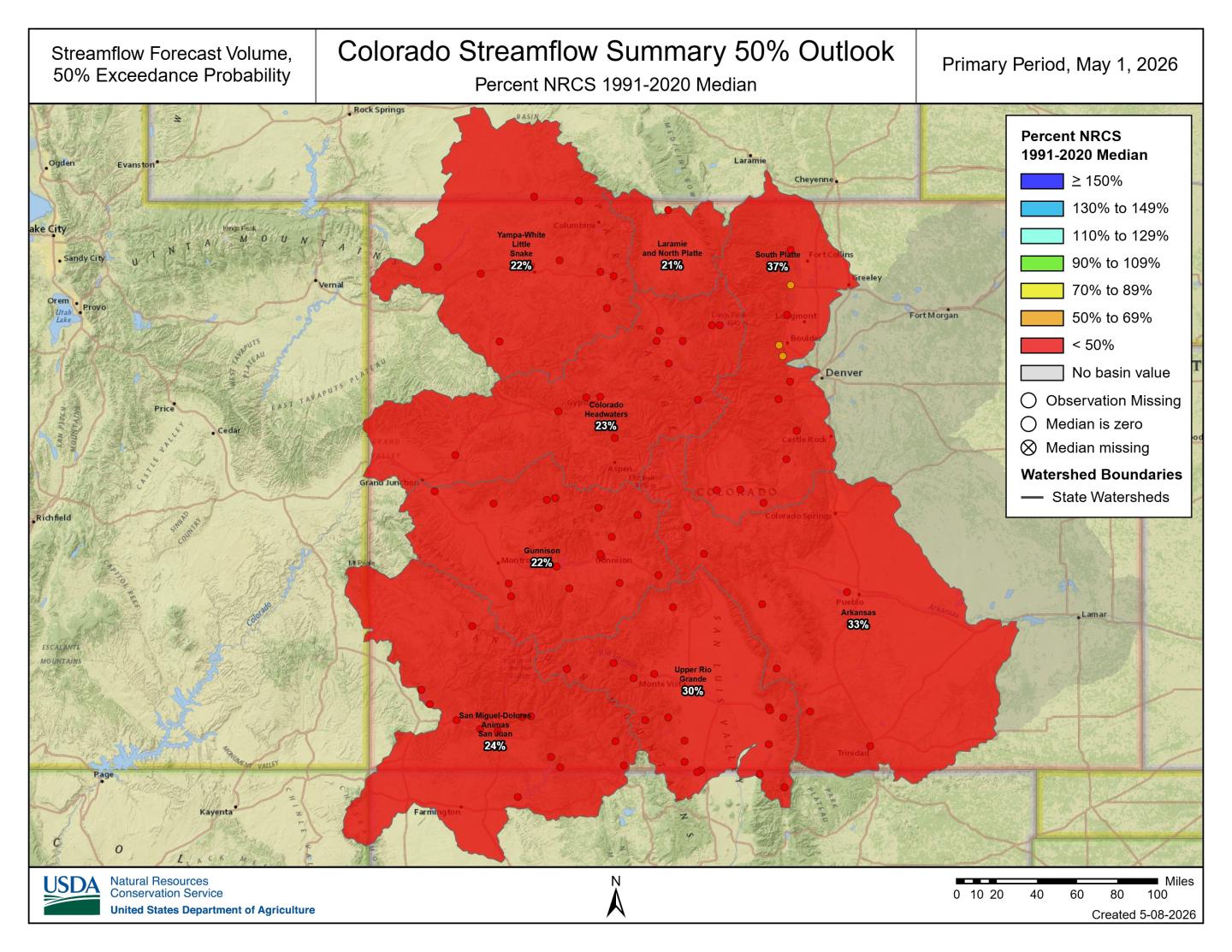
May through July runoff forecasts remain low across Colorado at 24 percent of median at the 50 percent exceedance forecast. Western slope forecasts range from 22 to 24 percent of median and eastern basins remain slightly higher at 37 percent in the South Platte basin and 33 percent in the Arkansas basin (Figure 1). The Upper Rio Grande basin is forecast 30 percent of median at the 50 percent exceedance. Forty-eight of 86 forecast points rank as either the lowest or second lowest in their period of record. All 86 forecast points rank at or below the 13th percentile with a median percentile rank of 2. Several Colorado Headwaters forecast points rank lowest on record, including Colorado River near Cameo forecast a departure of 1.49 million acre-feet (MAF), rank 1 of 73 years.
Statewide snowpack is 20 percent of median as of May 1, effectively unchanged from April 1 despite near-normal April precipitation. Snowpack peaked in early March in southern basins and mid-March in northern basins, three to five weeks ahead of historical median peak timing at half of median peak snow water equivalent (SWE). Early May storms have boosted statewide snowpack to 25 percent of median as of May 7, with sites in the Front Range east of the Continental Divide being particularly favored and receiving near 2 inches of SWE.
Many observed streamflow hydrographs are already entering recession unusually early. On the Yampa River near Maybell, seasonal peak flow occurred at the end of March and ranks as the earliest peak date and lowest peak in the 110-year period of record. Similar early and shortened hydrographs have developed in the Upper Colorado Region and in southern basins as accelerated spring melt caused much of the seasonal runoff to occur earlier than normal.
Statewide reservoir storage is 85 percent of median, while forecast inflows into Colorado’s largest reservoirs are well below median. Forecast inflows for the May-July 50 percent exceedance outlook range from 17 percent of median at McPhee Reservoir and 18 percent Blue Mesa to 36 percent at Lake Granby and Pueblo Reservoir.
April storms briefly stabilized snowpack conditions but did not offset the impacts of the record warm and dry winter and the late March heat wave that accelerated snowmelt and shifted runoff weeks ahead of normal. Future weather remains a source of uncertainty and the current 8-14 day outlooks favor above-normal precipitation alongside above-normal temperatures statewide.
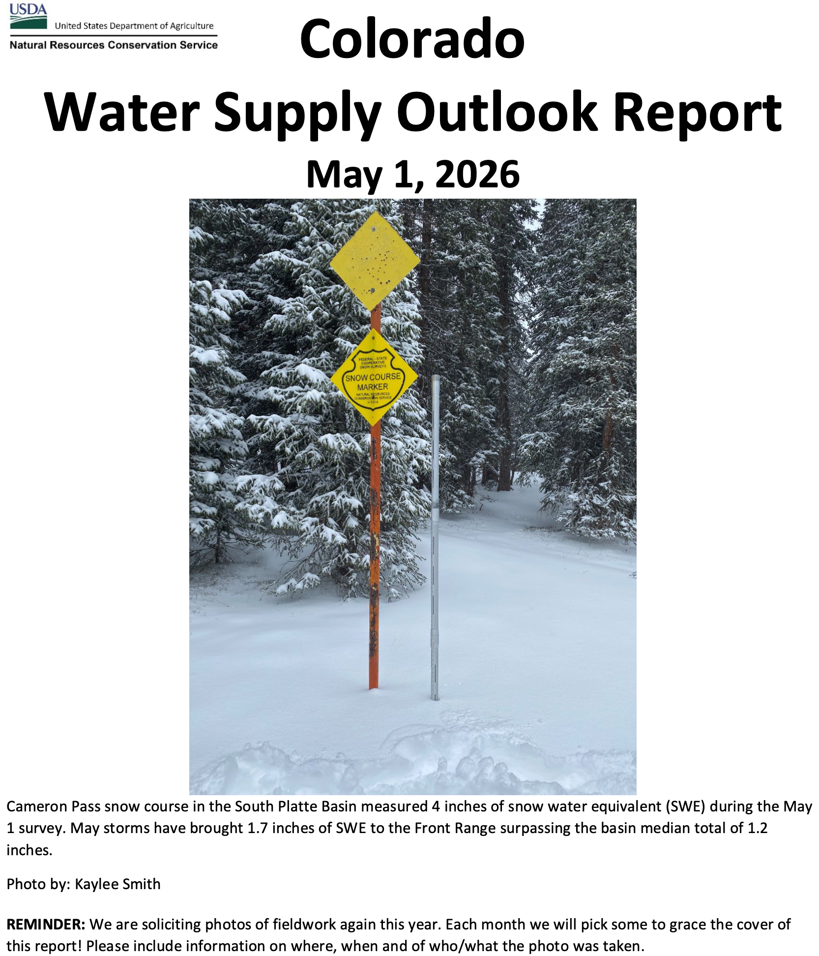
Colorado’s Snowpack and Reservoir Storage as of May 1, 2026
For more details see the May 1, 2026 Water Supply Outlook Report.