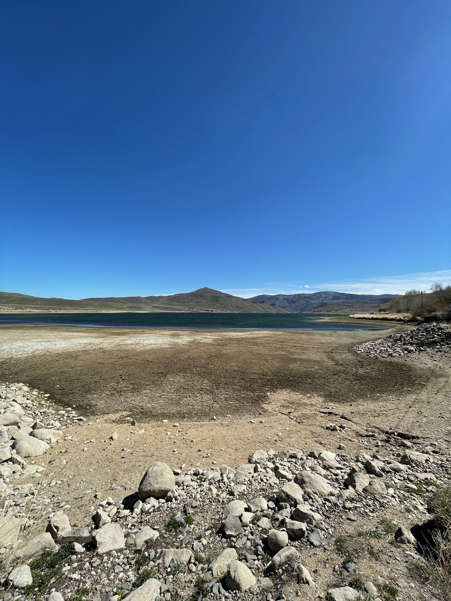
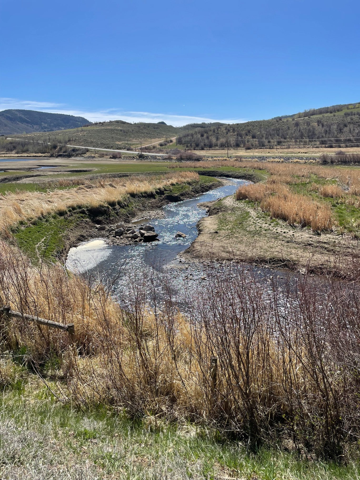
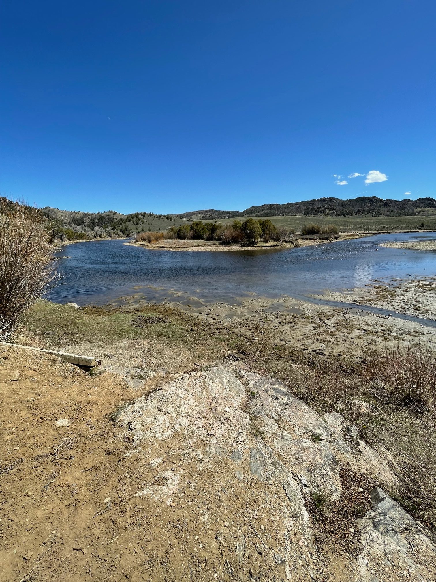
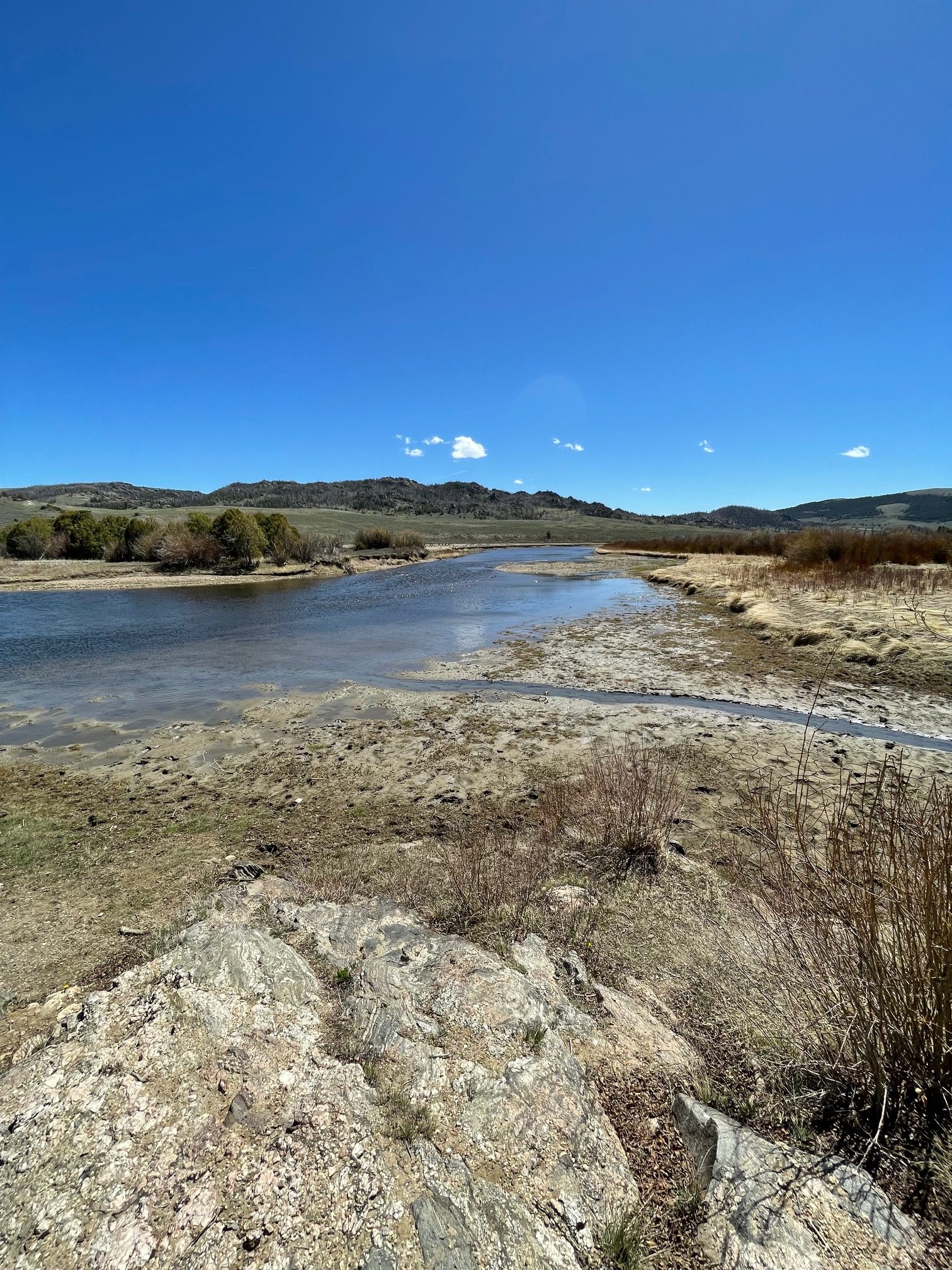
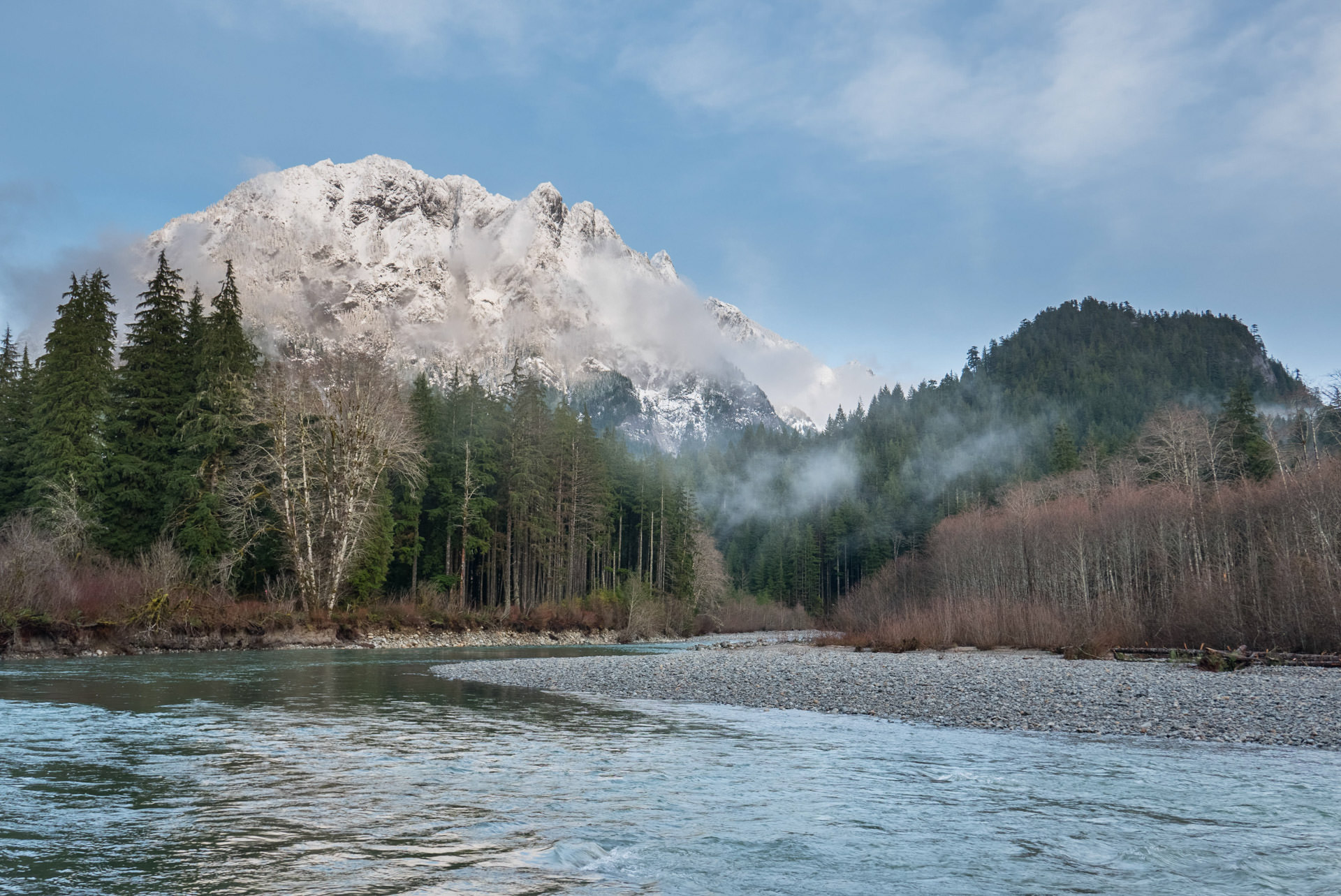
Scott Hummer worked for the Colorado Department of Water Resources for many years so he has witnessed many ups and downs for the rivers in northern Colorado. Here are some low flow photos from a recent road trip. First up Stagecoach Reservoir and the Yampa River.
The confluence of the Blue River (L) and Muddy Creek (R) April 22, 2026. Photo credit: Scott Hummer
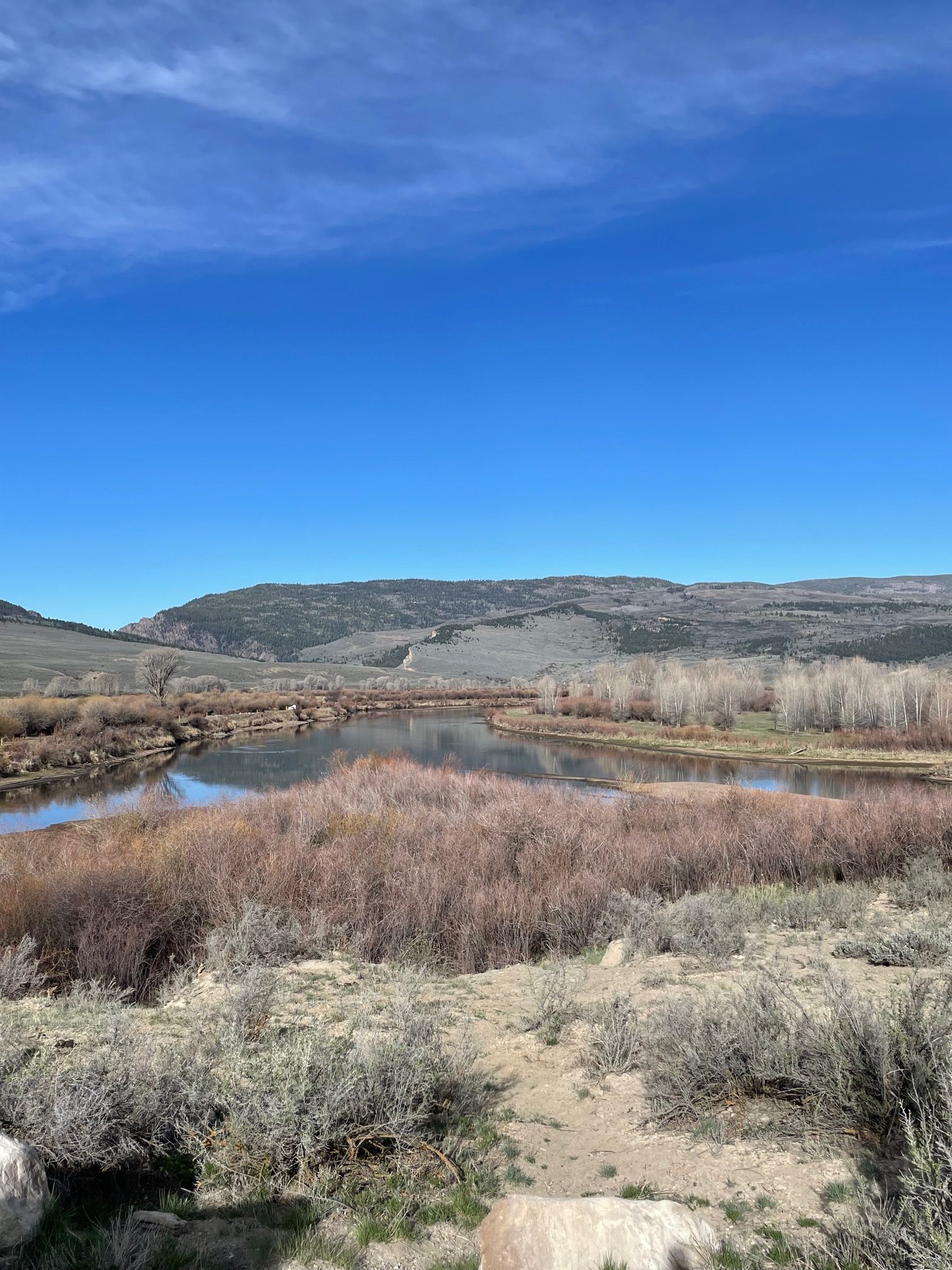
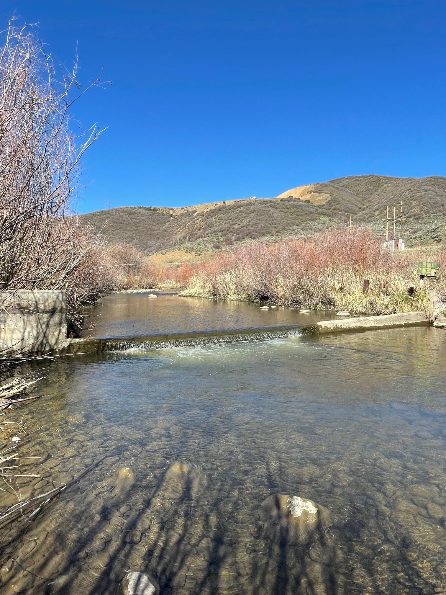
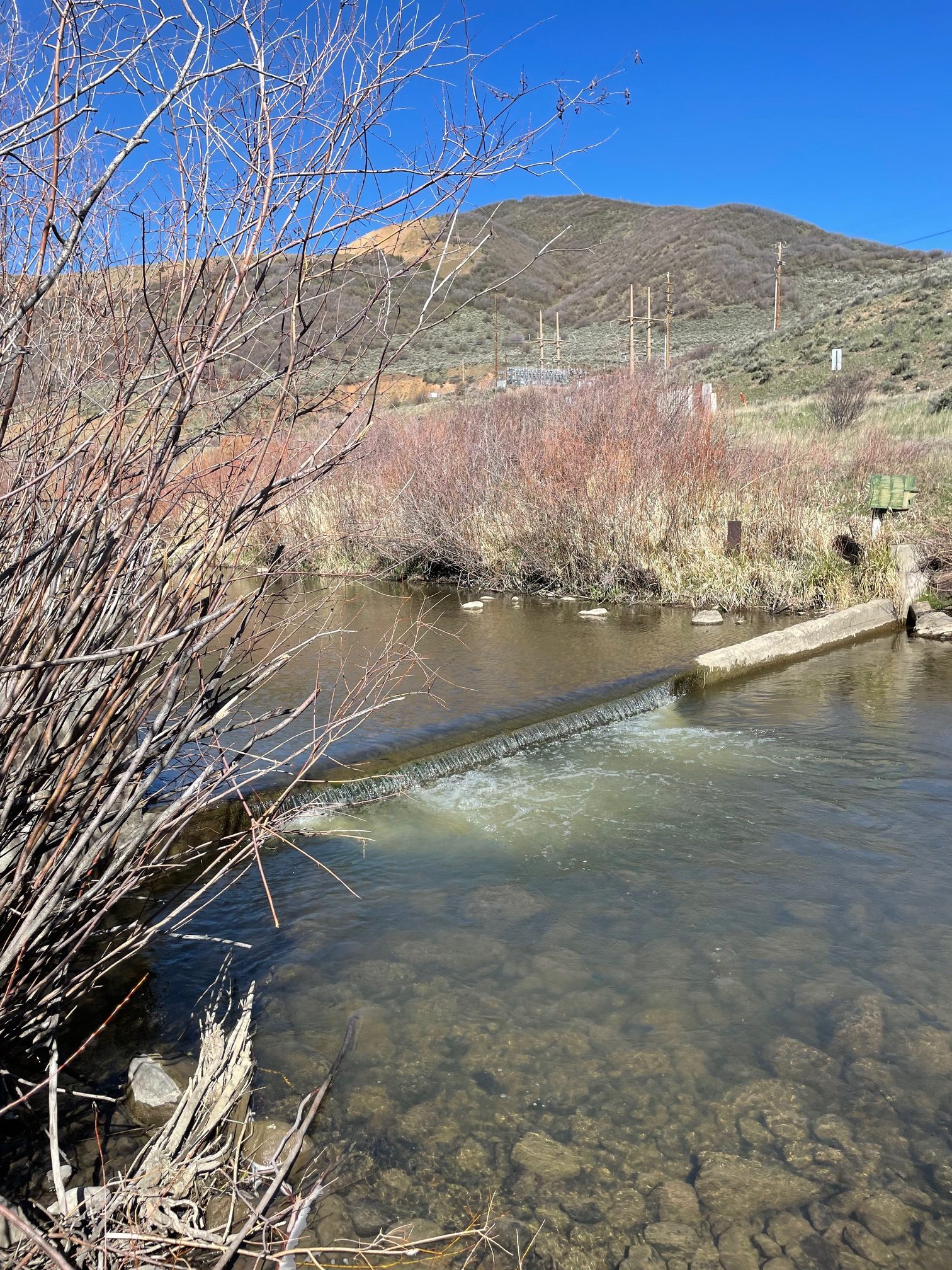
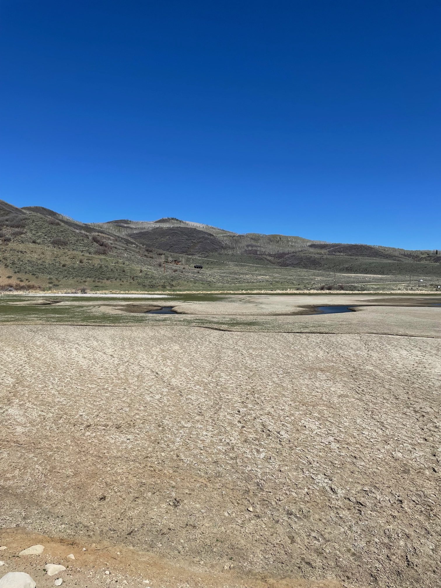
Streamgage above Stagecoach Reservoir April 22, 2026. Photo credit: Scott HummerStreamgage above Stagecoach Reservoir April 22, 2026. Photo credit: Scott HummerThe inlet to Stagecoach Reservoir April 22, 2026. Photo credit: Scott HummerStagecoach Reservoir April 22, 2026. Photo credit: Scott HummerYampa River inflow to Stagecoach Reservoir April 22, 2026. Photo credit: Scott Hummer
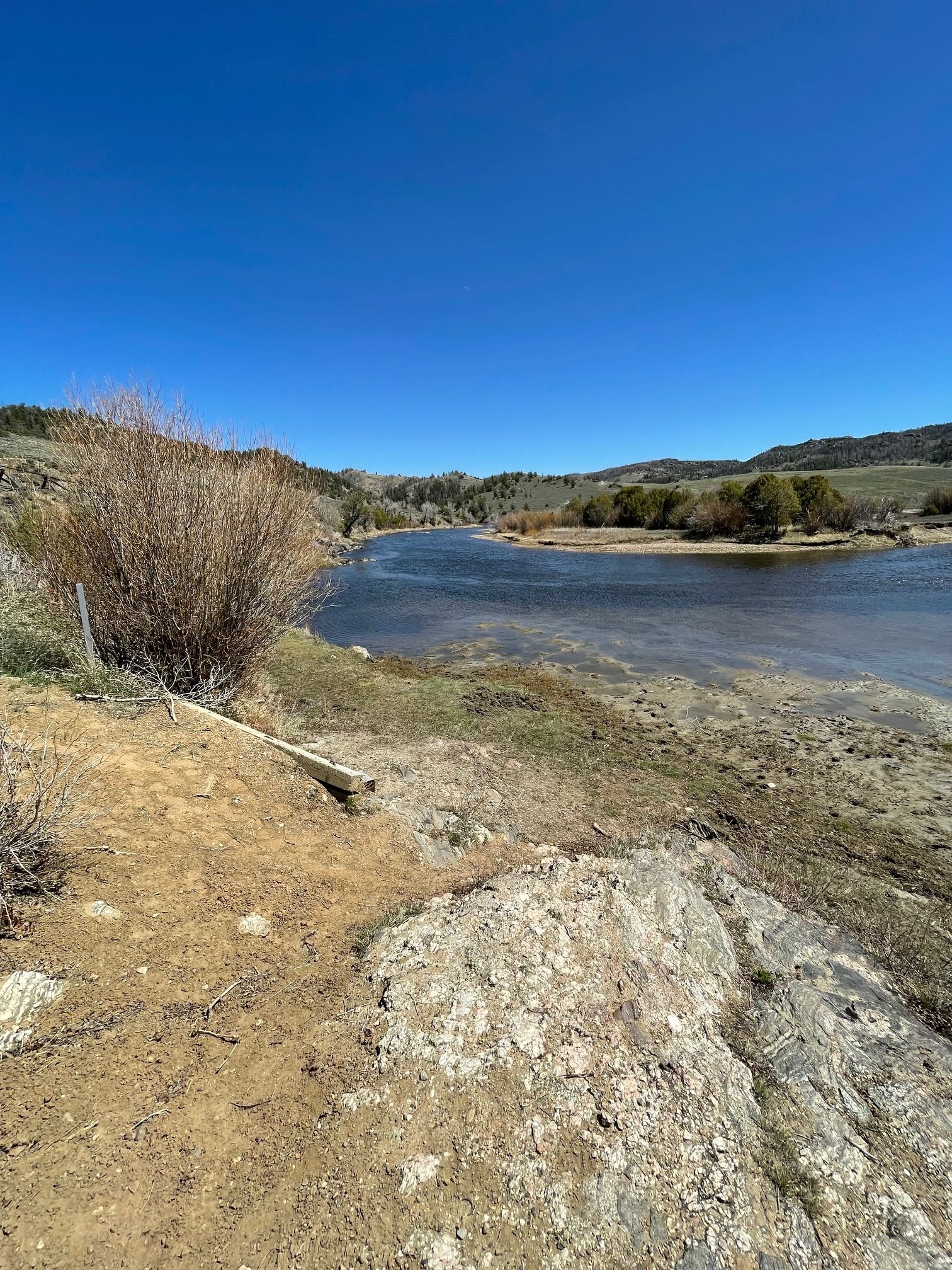
The North Platte River April 22, 2026. Photo credit: Scott Hummer
The North Platte River April 22, 2026. Photo credit: Scott HummerThe North Platte River April 22, 2026. Photo credit: Scott Hummer
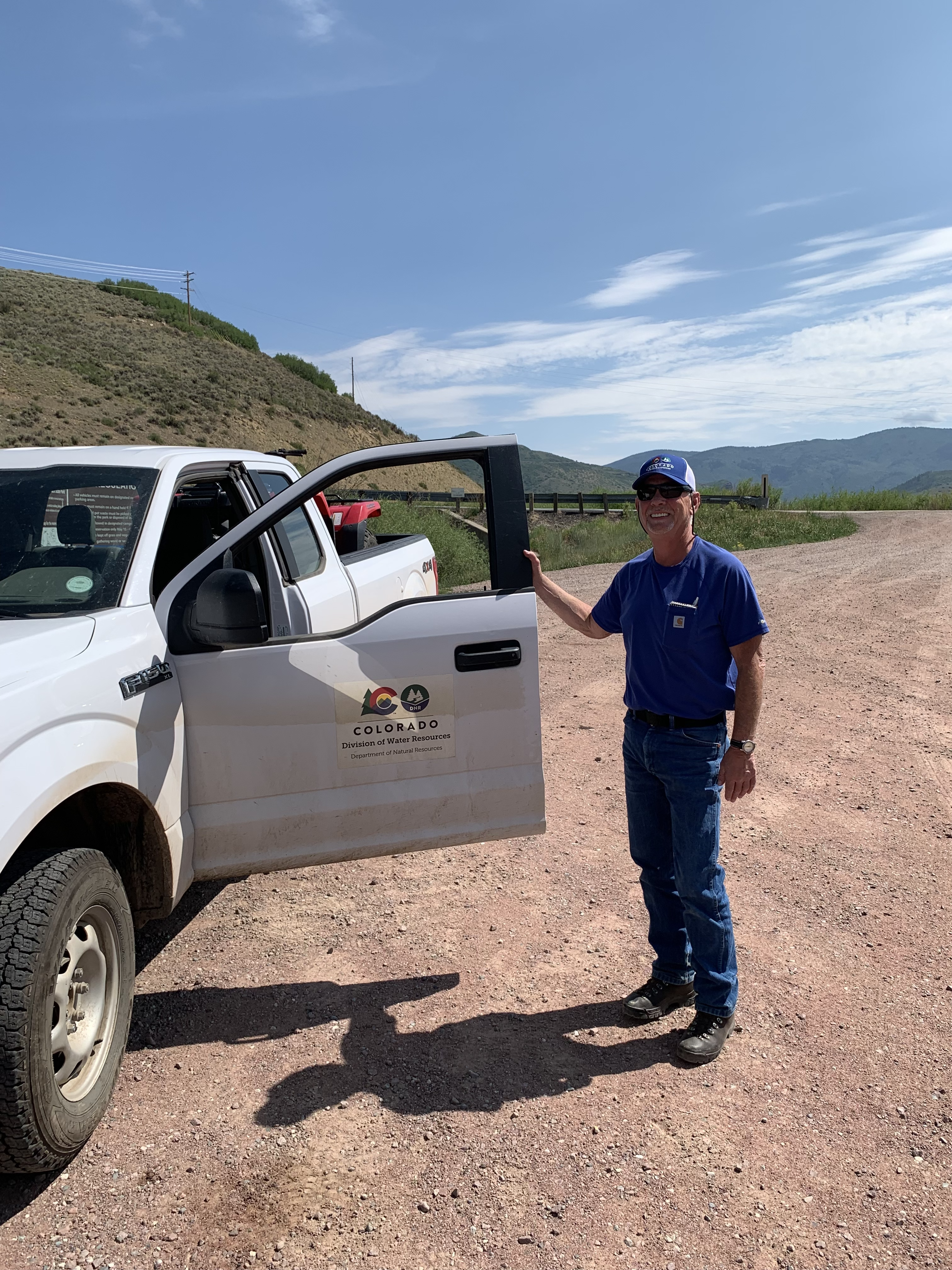
Scott Hummer at the inlet to Stagecoach Reservoir July 22, 2021 when I was bumming up and down the Yampa River.
Yampa River Basin via Wikimedia.
Map of the North Platte River drainage basin, a tributary of the Platte River, in the central US. Made using USGS National Map and NASA SRTM data. By Shannon1 – Own work, CC BY-SA 4.0, https://commons.wikimedia.org/w/index.php?curid=79266632
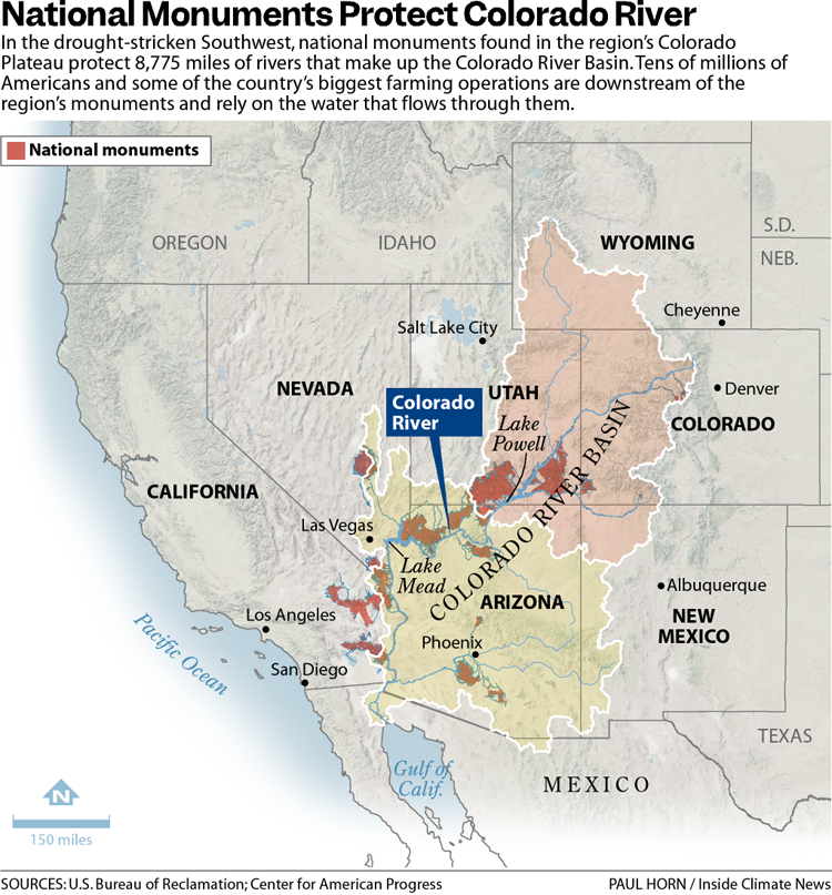
The 31 national monuments designated since the Clinton administration, which could be downsized as the Trump administration pushes to open more public lands to extractive industries, safeguard clean water for millions of Americans, according to a new analysis from the Center for American Progress.
Using geospatial data to quantify the miles of rivers and watersheds within the studied national monument boundaries, as well as the number of users who depend on that water, the report found that the water supplies for more than 13 million Americans are directly provided by watersheds within or downstream of these national monuments. About 83% of the water passing through these public lands has no other protection besides the monument designations, it found.
National monuments protect more than 21,000 miles of waterways across the U.S., nearly twice as much waterway mileage as the National Wild and Scenic Rivers System, the analysis also determined.
The report comes as the Trump administration weighs downsizing or revoking the designation of some national monuments.
In March, the Trump administration announced it would eliminate California’s Chuckwalla and Sáttítla Highlands national monuments before removing language from a White House fact sheet announcing that decision. The following month, The Washington Postreported that the administration was considering downsizing or eliminating six national monuments, and in June, the U.S. Department of Justice issued an opinion that the president has the power to rescind national monument designations, backtracking on a decades-old determination on the matter.
Stone and evening light, Bears Ears National Monument, Utah. Jonathan P. Thompson photo.
During Trump’s last term, Bears Ears and Grand Staircase-Escalante national monuments, established by the Obama and Clinton administrations, respectively, were shrunk to fractions of their original sizes, but they were restored by President Joe Biden after he took office.
If national monuments are downsized or eliminated, the areas surrounding a waterway will lose protections from extractive industries, including oil and gas drilling, mining and grazing. Contamination from those industries could seep into streams and, in turn, rivers. Those industries also use water, sometimes vast amounts in arid regions, further reducing the supply that flows to nearby communities. (In certain cases, some mining and grazing are already permitted on national monument lands, but the activities are limited in scale and more regulated than they are outside the monuments.)
“Landscapes and waterways go hand in hand,” said Drew McConville, a senior fellow for conservation policy at the Center for American Progress and a co-author of the report. “The clean water depends on what comes into them from natural lands … Just protecting the wet stuff itself doesn’t guarantee that you’re keeping [water] clean and durable.”
The portion of historically marginalized communities living within the watersheds of the national monuments is greater than the average for watersheds nationally, it found. Twenty-three of the monuments studied are also found in regions expected to face water shortages due to climate change in the coming decades, making the arid regions downstream even drier.
Grand Staircase-Escalante National Monument, for example, protects 2,517 miles of waterways, according to the analysis, and nearly 90% of the watersheds within the monument are expected to see declines in their water levels. The monument straddles the Upper and Lower Colorado River Basins, with the Paria and Escalante rivers flowing within its boundaries and Lake Powell, the nation’s second-largest reservoir, just to its south.
The monument is often thought of as a sparse, arid region, which it is, said Jackie Grant, the executive director of Grand Staircase Escalante Partners, a nonprofit focused on protecting the monument that has spent $11 million to protect the Escalante River watershed and all its tributaries. It remains vital to the Colorado River System, which millions of people in the Southwest rely on. Grand Staircase-Escalante helps slow water from the Paunsaugunt Plateau in Bryce Canyon National Park, much of which starts as snowpack in the park before melting and flowing downstream.
“People don’t think of water when they think of Grand Staircase-Escalante National Monument,” Grant said. “So when we can bring this view of water and how important it is to the protection of the monument, it helps us put another building block in our case for supporting the monument, because not only is it important for the animals, the native plants, the geology and the paleontology, water plays a huge role in the monument, and the monument protects the water itself.”
The Antiquities Act of 1906 was signed into law by Theodore Roosevelt, for “… the protection of objects of historic and scientific interest” through the designation of national monuments by the President and Congress. National monuments are one of the types of specially-designated areas that make up the BLM’s National Conservation Lands. Some of the earliest national monuments included Devils Tower, the Grand Canyon, and Death Valley. They were initially protected by the War Department, then later by the National Park Service. More recently, the BLM and other Federal agencies have retained stewardship responsibilities for national monuments on public lands. In fact, the BLM manages more acres of national monuments in the continental U. S. than any other agency. This includes the largest land-based national monument, the Grand Staircase-Escalante National Monument in Utah featured here. National monuments under the BLM’s stewardship have yielded numerous scientific discoveries, ranging from fossils of previously unknown dinosaurs to new theories about prehistoric cultures. They provide places to view some of America’s darkest night skies, most unique wildlife, and treasured archaeological resources. In total, twenty BLM-managed national monuments, covering over five million acres, are found throughout the western U. S. and offer endless opportunities for discovery. Photos and description by Bob Wick, BLM.
Stretching across 1.87 million acres of public land, Grand Staircase-Escalante National Monument is one of the country’s most expansive national monuments, protecting scores of wildlife as well as archeological resources in southern Utah. But a nine-billion-ton coal deposit is buried in the center of the monument along with deposits of minerals, including uranium and nickel. The Trump administration has long touted boosting the country’s coal production, and has established a pro-mining agenda this year.
“It’d be very easy to contaminate either one of those rivers if mining were to take place in the center section of the monument,” Grant said.
Margaret Walls, a senior fellow at Resources for the Future who has studied national monuments but was not part of this study, said national monuments are designated to protect cultural or historical landmarks, and it can be forgotten that they can also serve purposes like safeguarding water. Though she noted that even if monument protections are loosened, the areas remain federal lands, and their changes in status do not guarantee they will be developed.
“We don’t protect waterways the way we do land,” Walls said, “we’re going to get those water benefits by protecting the land.”
Created by Imgur user Fejetlenfej , a geographer and GIS analyst with a ‘lifelong passion for beautiful maps.’ It highlights the massive expanse of river basins across the country – in particular, those which feed the Mississippi River, in pink.
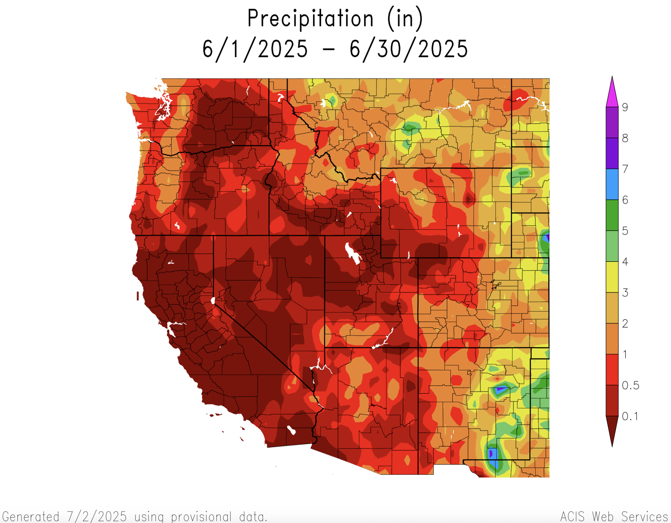
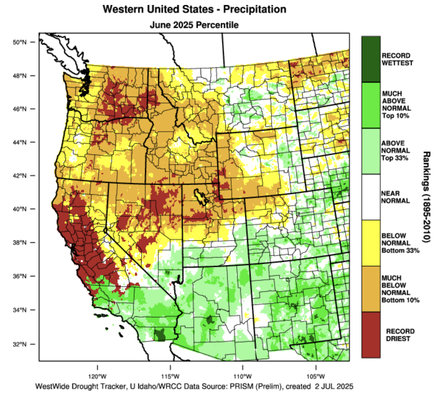
During June, much of the region experienced above average temperatures and below average precipitation. Record low precipitation fell across parts of northern Utah and southwestern Wyoming while much above average precipitation was observed in southern Utah and southwestern Colorado. As of July 1, seasonal snowmelt was completed with many mountain locations melting out 1-2 weeks earlier than average. Seasonal streamflow volume forecasts remained below to much below normal with the inflow to Lake Powell forecasted to be 42% of average. Regional coverage of drought expanded significantly from 53% in early June to 63% on July 1, driven largely by expansion of drought in Utah. Drought conditions are likely to persist or worsen as NOAA seasonal forecasts suggest above average regional temperatures and below average precipitation for Wyoming during July to September.
Above average June precipitation was observed in southern Utah, eastern Wyoming and the majority of Colorado. Much of Utah and Wyoming and northwestern Colorado received below average precipitation during June. Parts of southern Colorado and southern Utah received twice the average June rainfall while some locations in northern Utah and southwestern Wyoming observed record low June rainfall totals. Average June rainfall is typically low in the Intermountain West and areas of southern Utah and southwestern Colorado with 150-400% of average June rainfall observed total rainfall amounts of 1-2 inches.
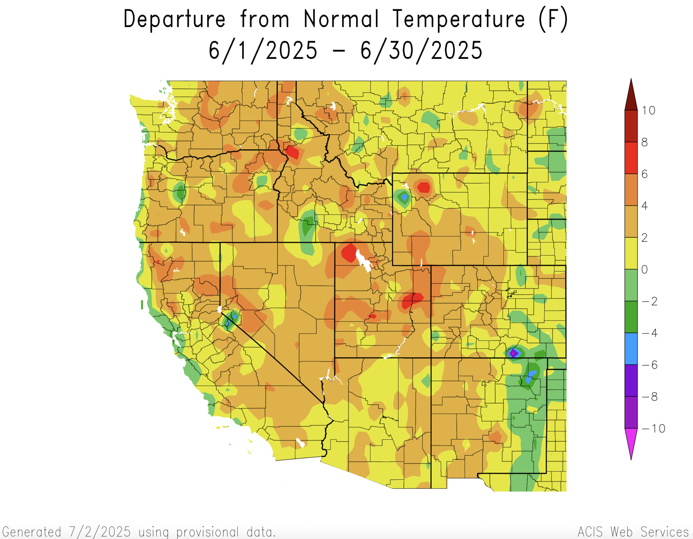
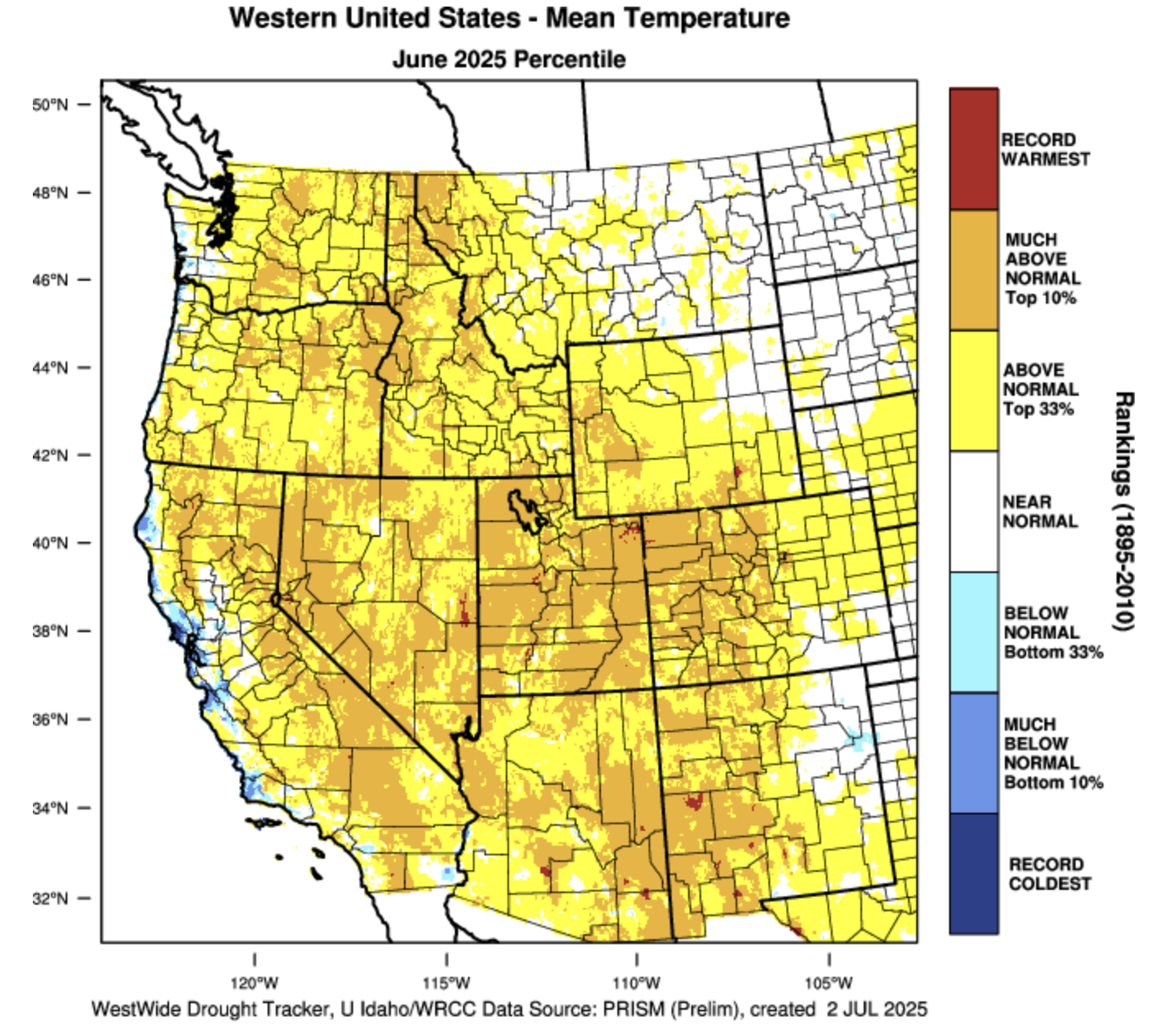
June temperatures were above average for much of Colorado, Utah and Wyoming, except for eastern Colorado and Wyoming where temperatures were up to two degrees below average. The warmest temperatures were observed in Utah, northwestern Colorado, and western Wyoming where June average temperatures were in the top 10% of all observations since 1895.
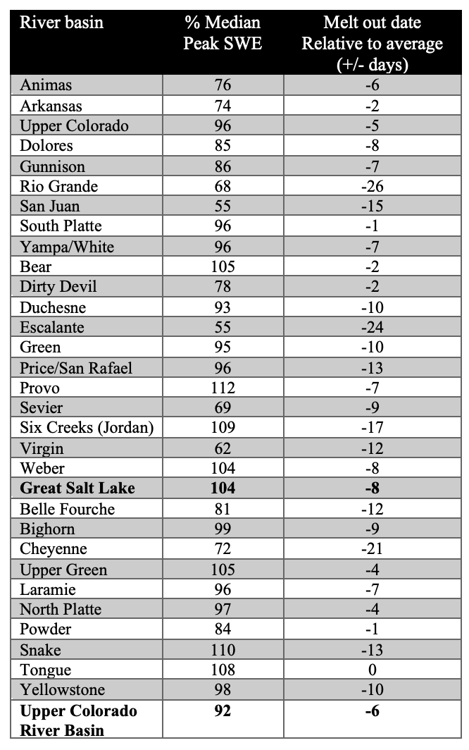
As of July 1st, snowpack was melted out across the region and snowmelt occurred earlier than average across all basins except the Tongue River Basin in northern Wyoming. In Colorado, snowmelt occurred only a few days early in the Arkansas and South Platte River Basins, around a week early in the Animas, Colorado Headwaters, Dolores, Gunnison and Yampa River Basins, two weeks early in the San Juan River Basin and nearly four weeks early in the Rio Grande River Basin. In Utah, snowmelt was only a few days early in the Bear River Basin, 1-2 weeks early in the northern Utah, Price, Sevier and Virgin River Basins and 24 days early in the Escalante River Basin. In Wyoming, snowmelt occurred earlier than average in all basins except the Tongue River Basin, with the Belle Fouche, Cheyenne and Snake River Basins melting out 2-3 weeks early.
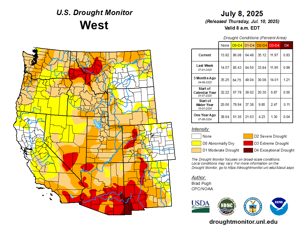
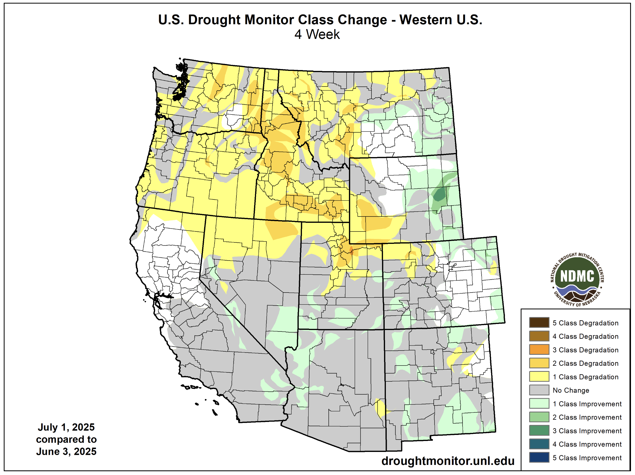
Regional drought coverage expanded from 53% in early June to 63% as of July 1 with all of Utah and about half of Colorado and Wyoming experiencing drought. Extreme (D3) drought conditions expanded in western Colorado but were removed from southwestern Utah and southeastern Wyoming where above average June precipitation was observed. Drought worsened by one to two classes in northern Utah and southwestern Wyoming, but drought conditions improved in portions of eastern and southern Colorado and southern Utah. In eastern Wyoming, drought conditions improved by one to three drought classes.
West Drought Monitor map July 8, 2025.
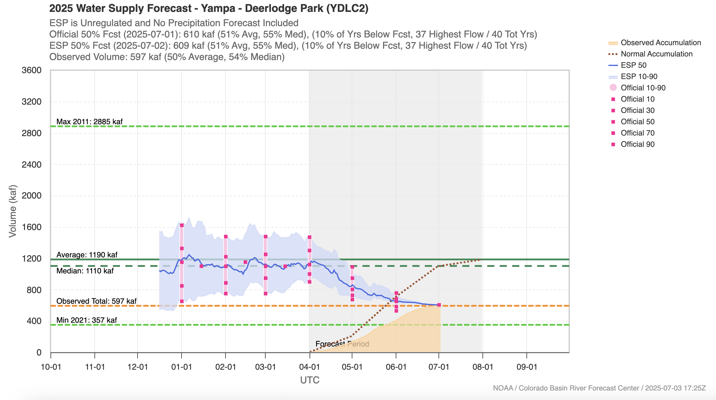
Seasonal streamflow volume forecasts remained below to much below average with the final forecasts of the year ranging from 33% of average for Utah’s Bear and Virgin River Basins to 86% of average in Wyoming’s Shoshone and Yellowstone River Basins. For nearly all regional river basins, streamflow volume forecasts significantly decreased from April 1 to June or July 1. The evolution of the Yampa River seasonal streamflow forecast exemplifies a pattern seen across the Intermountain West. After a near average winter snowpack, the April 1 forecast indicated an average seasonal streamflow volume, but by July 1, the Yampa River forecast declined to only 51% of average. Much below streamflow volume forecasts (<60% of average) were issued for the Colorado Headwaters, Dolores, San Juan and Yampa River Basins in Colorado, the Bear, Duchesne, Green, San Juan, Sevier, Virgin and Weber River Basins in Utah, and the Green, North Platte and Powder River Basins in Wyoming. The inflow forecast for Lake Powell was a paltry 42% of average on July 1.
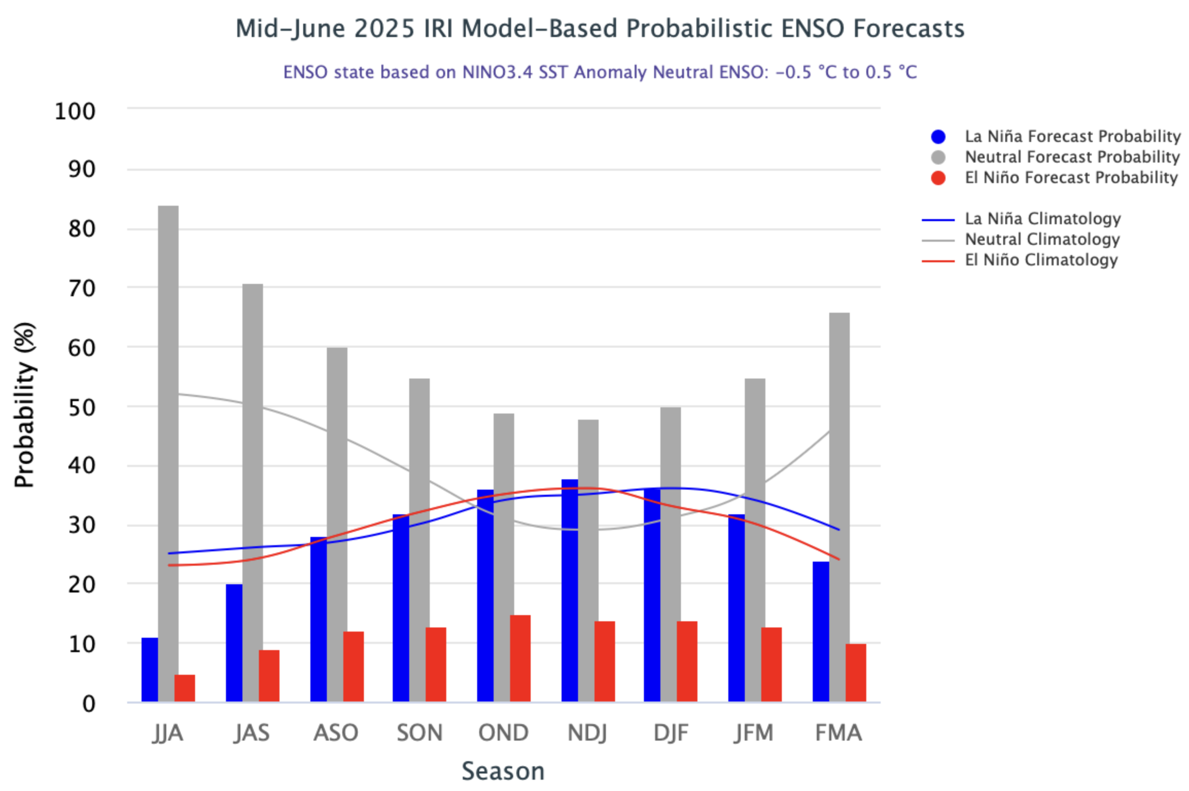
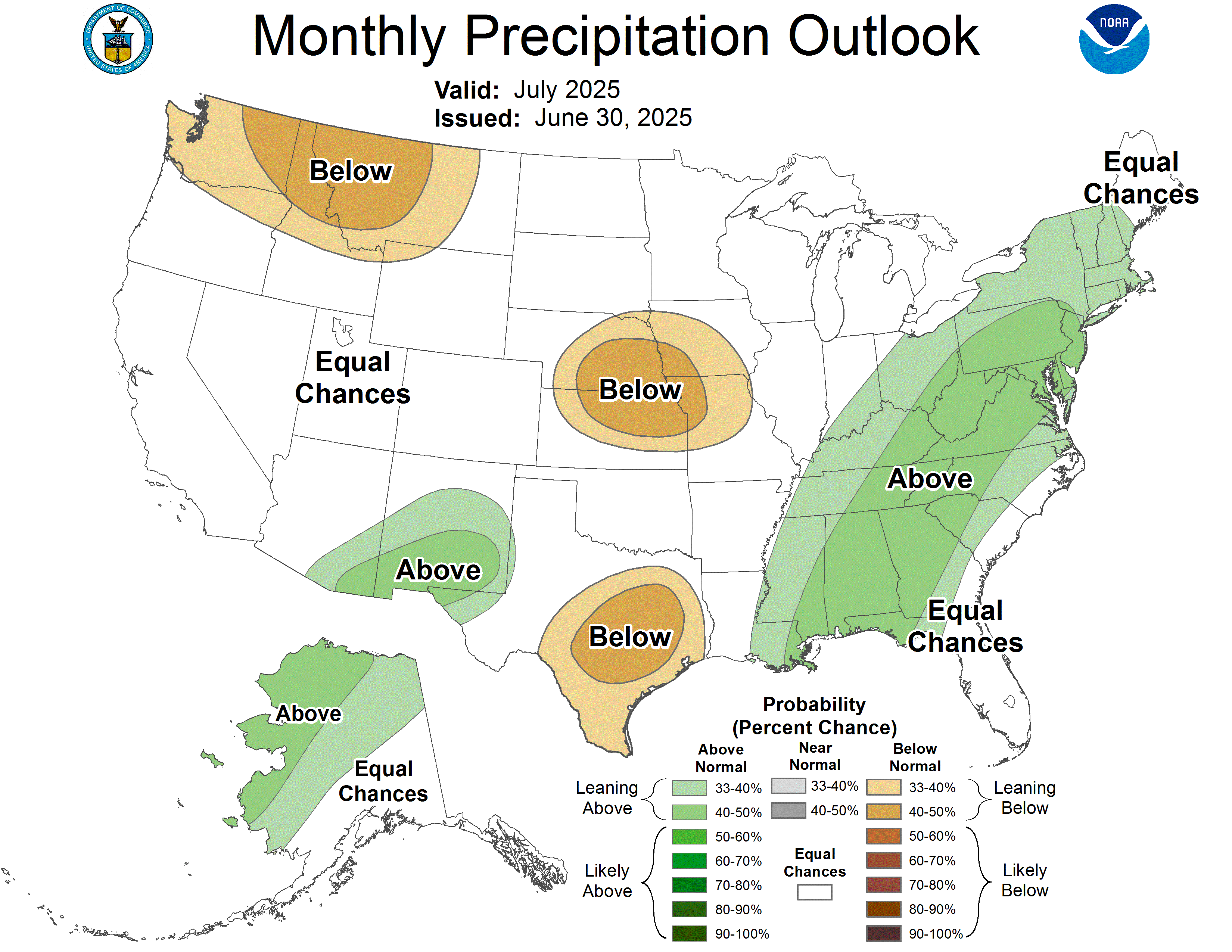
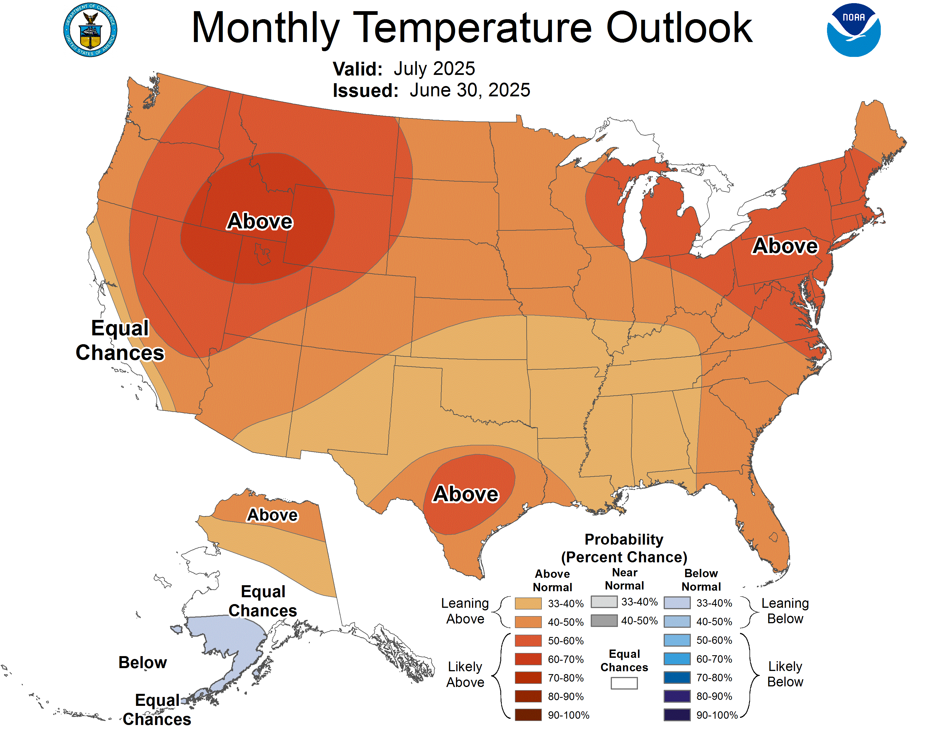
ENSO neutral conditions currently exist in the eastern Pacific Ocean and remain most likely throughout the forecast period. The NOAA seasonal precipitation forecast for July-September suggests an increased probability of below average precipitation for Wyoming and northeastern Colorado. The seasonal temperature forecast suggests a high probability of above average temperatures for the entire region.
Public lands are the birthright of every American. One of the great privileges of living in this country is the ability to access hundreds of millions of acres to enjoy the great outdoors — all for free.
People care about and use public lands for many reasons. From hunters and anglers to miners and ranchers, hikers and mountain bikers—there is something for almost everyone on public lands. But what if you live in a city and never set foot on public lands? Why care about them then?
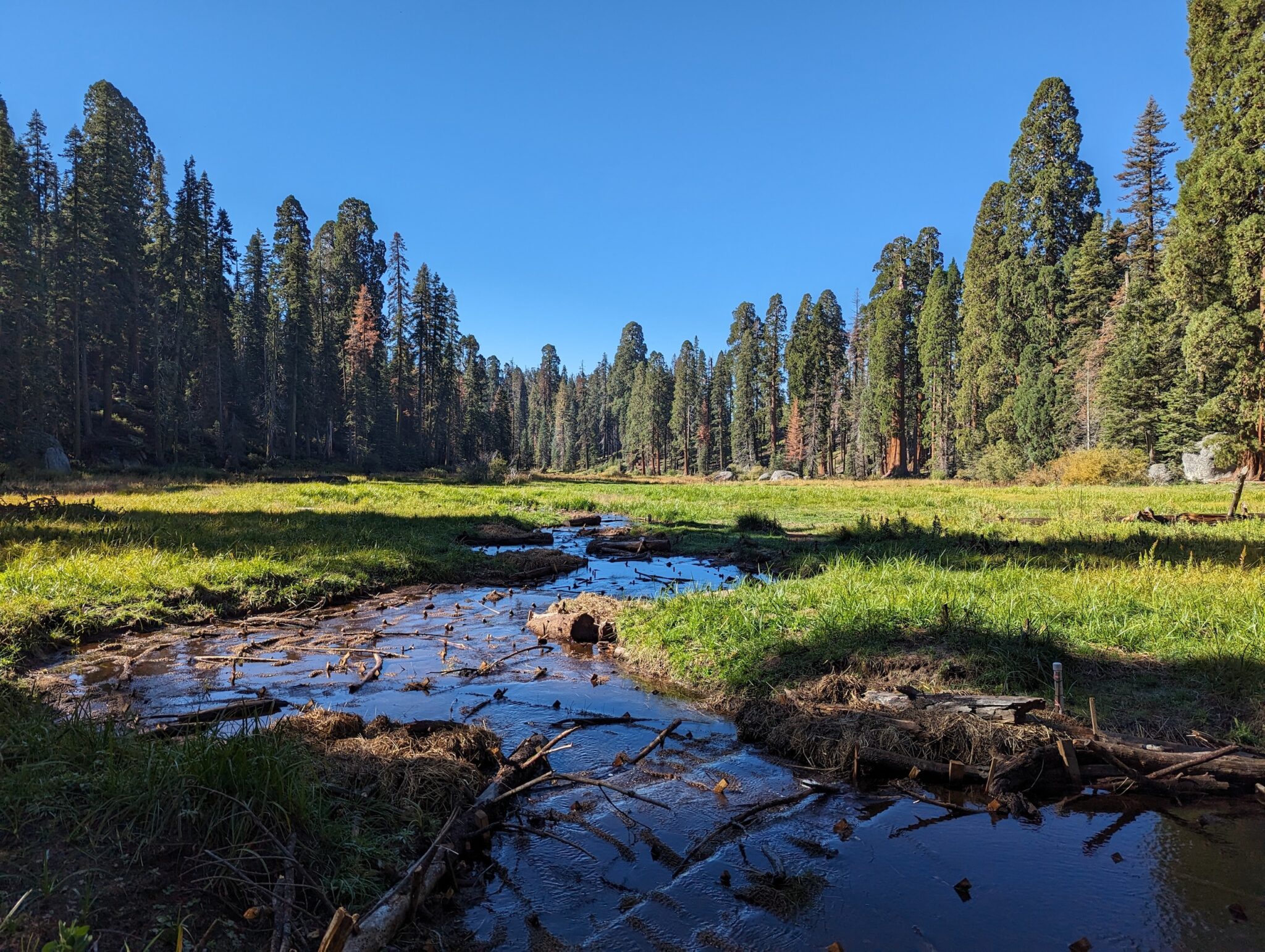
Log Meadow, California | Maiya Greenwood
Not everyone hunts, fishes, mines, ranches, hikes, or bikes; but everyone, truly everyone, depends on clean water. The big secret about public lands is that they are arguably the country’s single biggest clean water provider. According to the US Forest Service, National Forests are the largest source of municipal water supply in the nation, serving over 60 million people in 3,400 communities across 33 states. Many of the country’s largest urban areas, including Los Angeles, Portland, Denver, and Atlanta receive a significant portion of their water supply from national forests.
Healthy forests and grasslands perform many of the functions of traditional water infrastructure. They store water, filter pollutants, and transport clean water to downstream communities. And they do it naturally — essentially for free. When rivers are damaged from land uses on public lands, we all pay the price — literally; we all pay more in taxes and utility bills to clean up the water.
What happens on the public’s land also happens to the public’s water. The importance of managing public lands for the benefit of public water is so fundamental, it has been a pillar of public lands management agencies’ missions since their inception over a century ago. For example, The Organic Act of 1897[1] that created the US Forest Service stated:
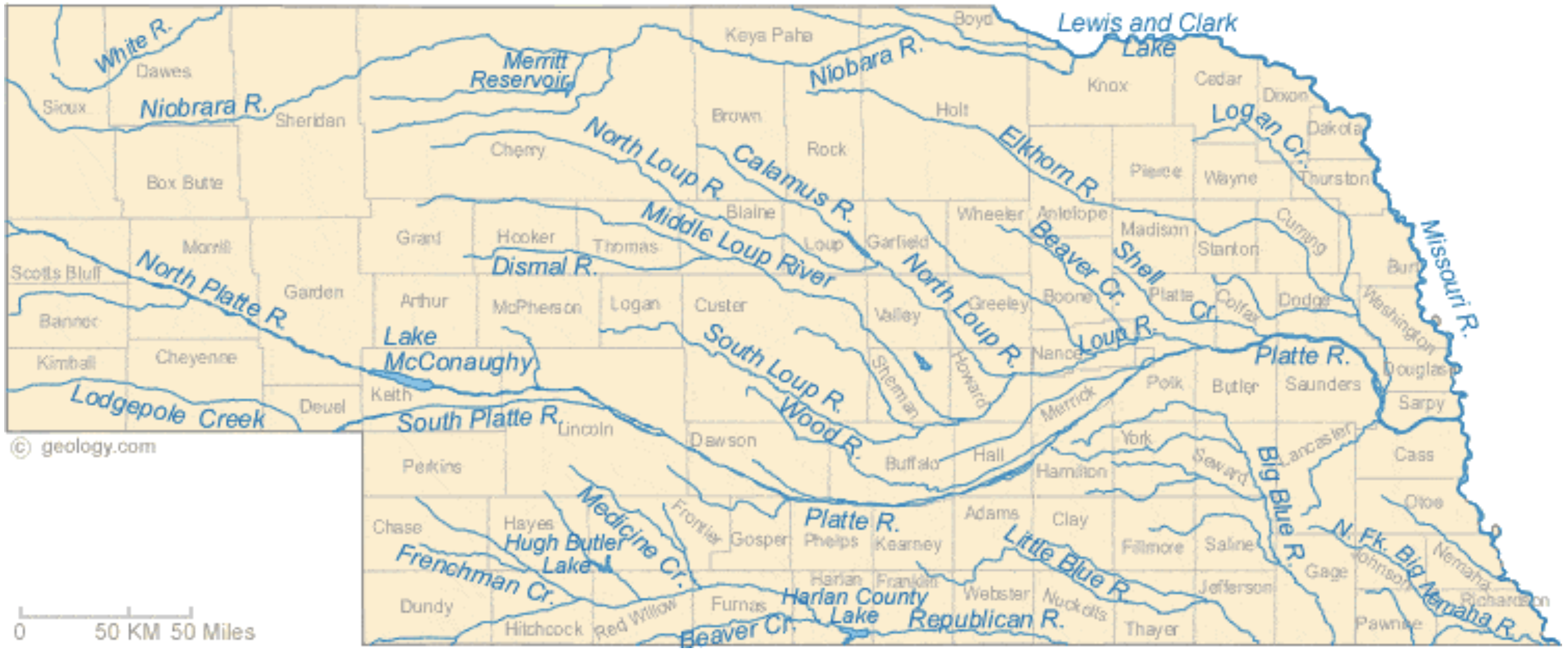
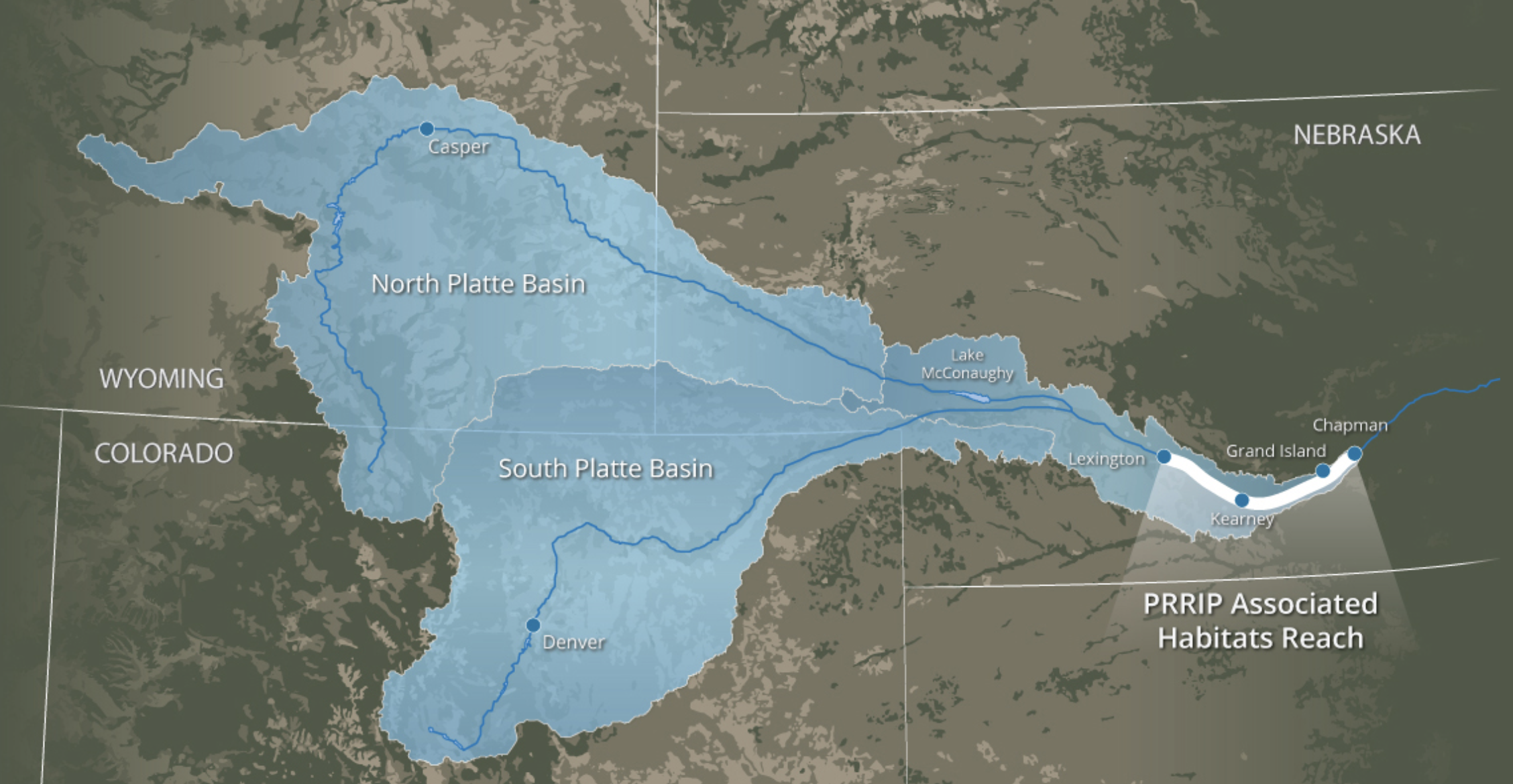
Nebraska Rivers Shown on the Map: Beaver Creek, Big Blue River, Calamus River, Dismal River, Elkhorn River, Frenchman Creek, Little Blue River, Lodgepole Creek, Logan Creek, Loup River, Medicine Creek, Middle Loup River, Missouri River, Niobrara River, North Fork Big Nemaha River, North Loup River, North Platte River, Platte River, Republican River, Shell Creek, South Loup River, South Platte River, White River and Wood River. Nebraska Lakes Shown on the Map: Harlan County Lake, Hugh Butler Lake, Lake McConaughy, Lewis and Clark Lake and Merritt Reservoir. Map credit: Geology.com
Leaders from Nebraska’s irrigation and natural resources districts cast the plan as a crucial step to preserve as much of the state’s water supply as possible. Republican Gov. Pete Ricketts identified it as a top priority, arguing that not moving forward would eventually cost Nebraska billions as farms, cities and other water users struggle with shortages…
Tom Riley, director of the Nebraska Department of Natural Resources, said cutbacks on the river would force water regulators to release more water from Lake McConaughy, a major reservoir of the North Platte River, which converges with the South Platte River to form the Platte River.
Riley said the reduced flows would also affect power generation in the state, force farmers to retire productive farmland and hurt municipal water supplies within the river basin. Nebraska also relies on the river at some of its public power stations, including a coal-powered facility that uses water for cooling…
Elizabeth Elliott, director of Lincoln’s Transportation and Utilities agency, said Lincoln relies on the Platte River to supplement the water it draws from wells. She said water from the South Platte River provides about 7% of the city’s water…
The South Platte River Basin is shaded in yellow. Source: Tom Cech, One World One Water Center, Metropolitan State University of Denver.
John Winkler, general manager of the Omaha-based Papio-Missouri River Natural Resources District, said reducing the river flows would cut into the water supply in his area, which is a part the Platte River basin. Winkler said construction costs will rise quickly with inflation the longer the state waits to approve the project…
Speaker of the Legislature Mike Hilgers, who introduced the bill on the governor’s behalf, said forging ahead with the canal could help Nebraska “put the strongest foot forward” in any negotiations. But he said the canal proposal wasn’t intended as a bargaining chip and argued the state ought to move forward with the project.
A controversial water dispute in Laramie County that got held up last year because of the pandemic will see its day in court June 9-11 in Cheyenne.
17 ranch families are pushing back on a permit application by three members of the Lerwick family to drill eight high-pressure wells north of Cheyenne. These wells would appropriate 1.6 billion gallons of ground water from the Ogallala Aquifer, a water source that’s already gone dry in several other Western states.
Attorney Reba Epler owns a ranch in the area and said this case is crucial for establishing a more modern approach to water management in Wyoming…
The wells would use 4700-acre feet of water or the equivalent used by a town of about 10,000 people. Epler said her dad remembers fishing on some creeks that no longer flow in the area. Most local creeks have gone dry.
Wyoming rivers map via Geology.com
“Horse Creek is probably the last flowing creek in Laramie County,” Epler said. “And that creek sustains so much agriculture and so much wildlife, so many birds and fish and it is quite a magnificent creek and it is sustained by the base flow of the groundwater from the Ogallala Aquifer.”
Epler said granting permits on these wells would endanger Horse Creek.
The Ogallala aquifer, also referred to as the High Plains aquifer. Source: National Oceanic and Atmospheric Adminstration
Here’s the release from Farmers.gov (Joanna Pope):
Nebraska isn’t known as a destination for celebrities, but for wildlife enthusiasts and birdwatchers, Nebraska had a visit from a few “A-list” celebrities recently – just in time for American Wetlands Month.
Haven for Migrating Birds
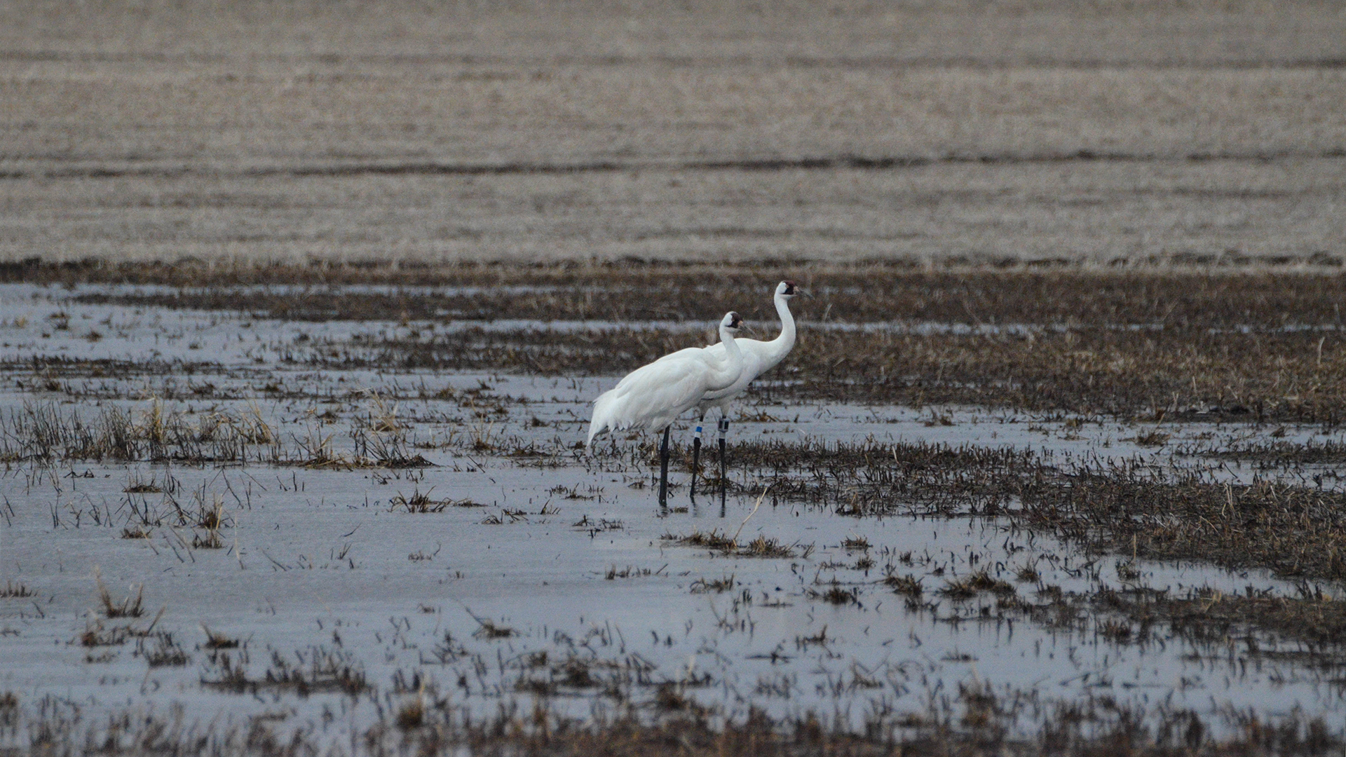
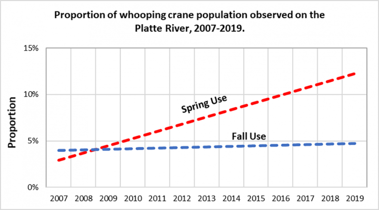
Trumbull Basin, a wetland located in Adams County in central Nebraska, was graced with the presence of four Whooping Cranes who stopped at the wetland during their migration north.
The Whooping Crane is one of the world’s most endangered species. There are currently just over 800 of these birds on earth.
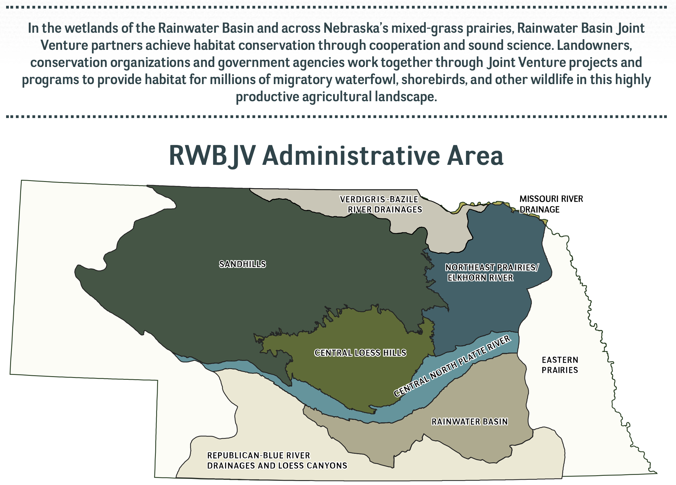
Trumbull Basin, the wetland where these rare birds called home for 11 days, is in the heart of a unique geographic area known as the Rainwater Basin.
Four Whooping Cranes recently stopped at Trumbull Basin during their migration north. Photo courtesy of David Baasch and the Crane Trust via Farmers.gov
The Rainwater Basin is a complex of wetlands covering portions of south-central Nebraska. The area is also part of the migration route known as the Central Flyway. In spring, birds that have wintered on the Gulf Coast and across Texas and Mexico funnel into this 150-mile-wide area over central Nebraska that contains thousands of wetlands.
The wetlands provide habitat for migrating birds. Despite being critical to migrating and local wildlife species, the Rainwater Basin wetlands have been greatly reduced from their historic numbers.
Restoring the Basin
USDA’s Natural Resources Conservation Service in Nebraska works closely with the Rainwater Basin Joint Venture, a non-government organization that works with landowners who voluntarily restore wetlands on their land. The Rainwater Basin Joint Venture, in cooperation with NRCS, helped restore the Trumbull Basin wetland.
“Seeing Whooping Cranes use one of the wetlands that a group of Nebraska landowners worked so hard to restore is extremely exciting and also really gratifying,” said Andy Bishop, coordinator for the Rainwater Basin Joint Venture.
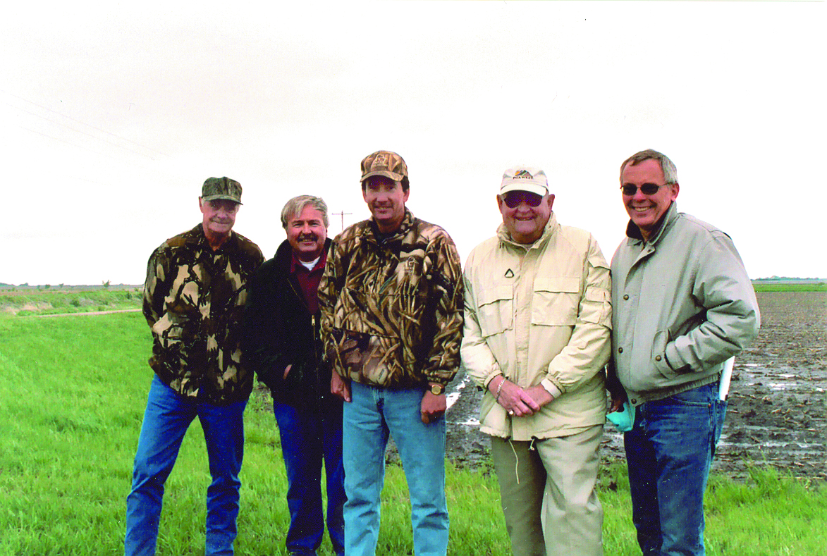
Landowners Frank Hill, Larry Rouse, Don Cox, and Leo Pavelka worked with NRCS Resource Conservationist Ken Franzen and other partner agencies to help restore the large wetland near Trumbull, Nebraska. Photo taken in 2004 by Joanna Pope, NRCS.
At 465 acres Trumbull Basin is one of the largest privately owned wetlands in the Rainwater Basin. This wetland was restored through the former Wetlands Reserve Program, a voluntary NRCS conservation program that helped landowners protect, restore, and enhance wetlands on their property. Landowners can do this now with Wetland Reserve Easements through the Agricultural Conservation Easement Program. Across the country, more than 5 million acres have been enrolled in easements.
When this project was initiated back in the late 1990s, there were five landowners who each owned a portion of Trumbull Basin. Initially this project started with the goal to better manage irrigation water to improve cropping potential, but the landowners soon realized there wasn’t much they could do to improve the area’s cropping capability. The alternative to farming such a wet area was to work with NRCS to restore the wetland through WRP.
“Our programs are a great tool for farmers to explore when a piece of their operation isn’t meeting their needs, and they want to find a different way to manage their land,” said Jeff Vander Wilt, acting state conservationist for NRCS in Nebraska. “In the case of Trumbull Basin, this resulted in converting poorly producing cropland into critical habitat for one of the world’s most endangered species.”
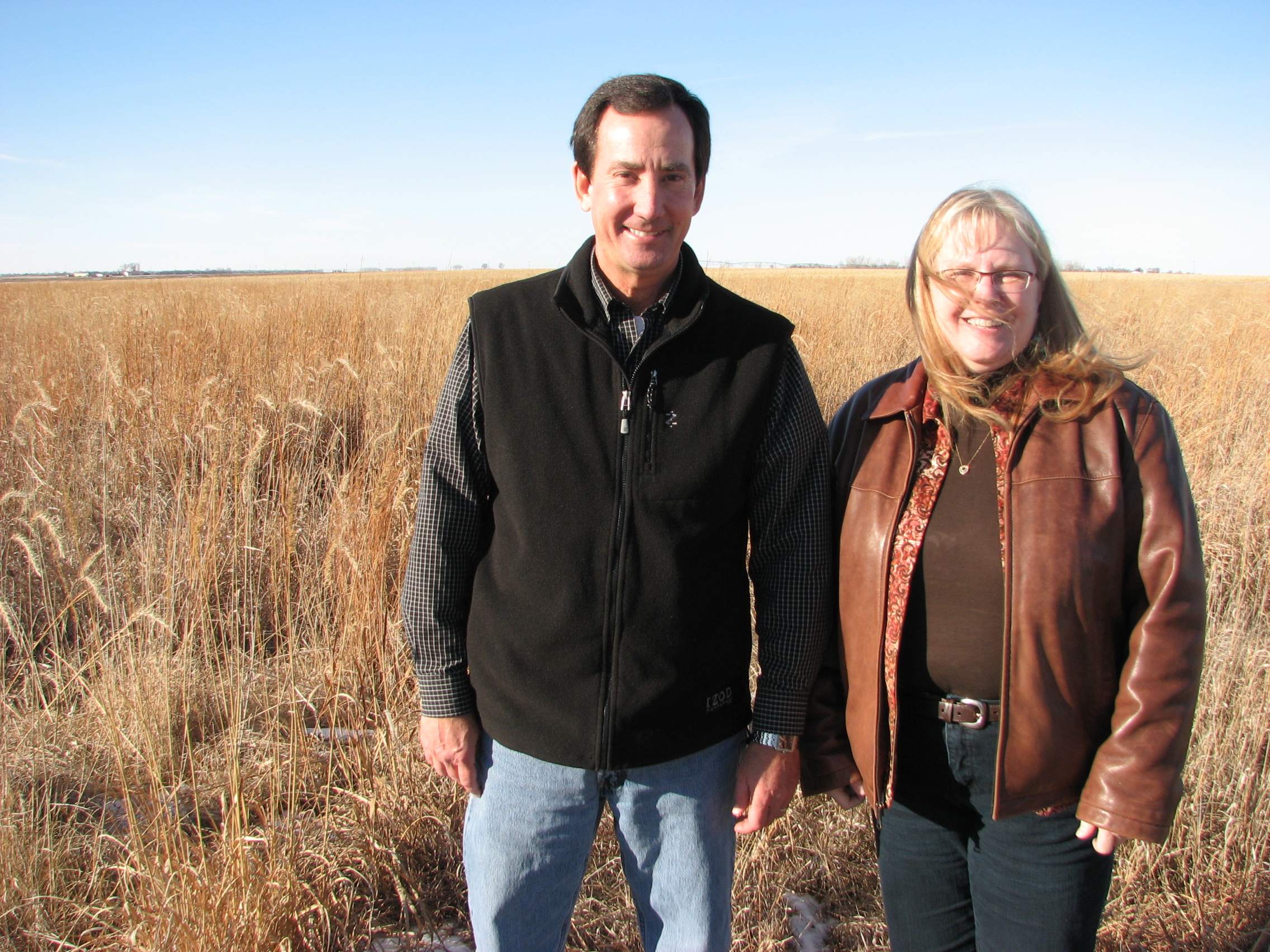
The Rainwater Basin Joint Venture worked with landowners Don and Shanda Cox on a large wetland restoration project just north of Hastings, Nebraska. Photo taken in 2011 by Joanna Pope, NRCS.
An Ideal Wetland Habitat
Restoration was an incremental process beginning in 1999, with the last tract enrolled into WRP in 2006. Thanks to the landowners working with conservation agencies, including NRCS, the Rainwater Basin Joint Venture, Nebraska Game and Parks, and the U.S. Fish and Wildlife Service, Trumbull Basin was restored.
The restoration required removing 66,000 cubic yards of sediment from the wetland, filling a large concentration pit, and removing nearly 1.5 miles of berms surrounding the wetland. This work restored how the wetland originally functioned in the landscape, by allowing water to flow back into the wetland where it could provide habitat, prevent flooding, improve water quality, and recharge ground water.
The continued management of Trumbull Basin has helped maintain this site as ideal wetland habitat for migrating birds. Photo courtesy of David Baasch and the Crane Trust.
Since the wetland was restored, additional steps have been taken to ensure it continues to function. A management plan was developed that included grazing, prescribed burns, herbicide treatments, and tree cutting. The continued management of Trumbull Basin has helped maintain this site as ideal wetland habitat.
“Seeing wildlife use this wetland 15 years after it was first restored is extremely rewarding,” said Andy. “It shows we’re doing something right by helping landowners create and manage the type of habitat these extremely rare animals need to make their long journey.”
Abstract
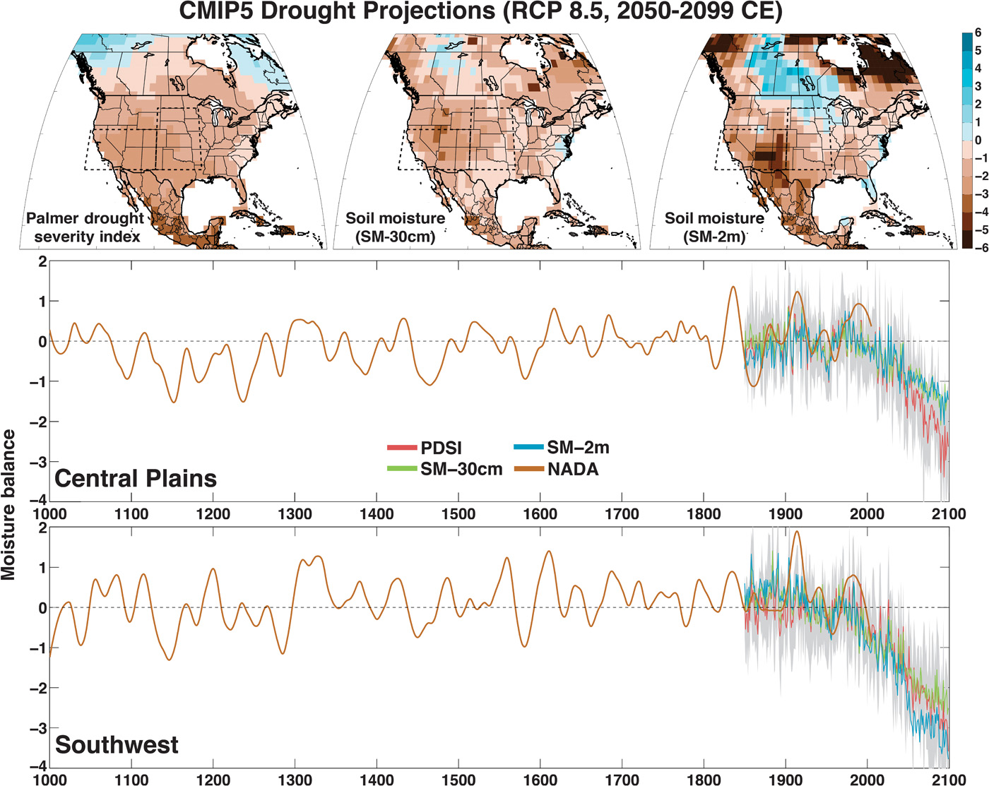
In the Southwest and Central Plains of Western North America, climate change is expected to increase drought severity in the coming decades. These regions nevertheless experienced extended Medieval-era droughts that were more persistent than any historical event, providing crucial targets in the paleoclimate record for benchmarking the severity of future drought risks. We use an empirical drought reconstruction and three soil moisture metrics from 17 state-of-the-art general circulation models to show that these models project significantly drier conditions in the later half of the 21st century compared to the 20th century and earlier paleoclimatic intervals. This desiccation is consistent across most of the models and moisture balance variables, indicating a coherent and robust drying response to warming despite the diversity of models and metrics analyzed. Notably, future drought risk will likely exceed even the driest centuries of the Medieval Climate Anomaly (1100–1300 CE) in both moderate (RCP 4.5) and high (RCP 8.5) future emissions scenarios, leading to unprecedented drought conditions during the last millennium.
INTRODUCTION
Millennial-length hydroclimate reconstructions over Western North America (1–4) feature notable periods of extensive and persistent Medieval-era droughts. Such “megadrought” events exceeded the duration of any drought observed during the historical record and had profound impacts on regional societies and ecosystems (2, 5, 6). These past droughts illustrate the relatively narrow view of hydroclimate variability captured by the observational record, even as recent extreme events (7–9) highlighted concerns that global warming may be contributing to contemporary droughts (10, 11) and will amplify drought severity in the future (11–15). A comprehensive understanding of global warming and 21st century drought therefore requires placing projected hydroclimate trends within the context of drought variability over much longer time scales (16, 17). This would also allow us to establish the potential risk (that is, likelihood of occurrence) of future conditions matching or exceeding the severest droughts of the last millennium.
Quantitatively comparing 21st century drought projections from general circulation models (GCMs) to the paleo-record is nevertheless a significant technical challenge. Most GCMs provide soil moisture diagnostics, but their land surface models often vary widely in terms of parameterizations and complexity (for example, soil layering and vegetation). There are few large-scale soil moisture measurements that can be easily compared to modeled soil moisture, and none for intervals longer than the satellite record. Instead, drought is typically monitored in the real world using offline models or indices that can be estimated from more widely measured data, such as temperature and precipitation.
One common metric is the Palmer Drought Severity Index (PDSI) (18), widely used for drought monitoring and as a target variable for proxy-based reconstructions (1, 2). PDSI is a locally normalized index of soil moisture availability, calculated from the balance of moisture supply (precipitation) and demand (evapotranspiration). Because PDSI is normalized on the basis of local average moisture conditions, it can be used to compare variability and trends in drought across regions. Average moisture conditions (relative to a defined baseline) are denoted by PDSI = 0; negative PDSI values indicate drier than average conditions (droughts), and positive PDSI values indicate wetter than normal conditions (pluvials). PDSI is easily calculated from GCMs using variables from the atmosphere portion of the model (for example, precipitation, temperature, and humidity) and can be compared directly to observations. However, whereas recent work has demonstrated that PDSI is able to accurately reflect the surface moisture balance in GCMs (19), other studies have highlighted concerns that PDSI may overestimate 21st century drying because of its relatively simple soil moisture accounting and lack of direct CO2 effects that are expected to reduce evaporative losses (12, 20, 21). We circumvent these concerns by using a more physically based version of PDSI (13) (based on the Penman-Monteith potential evapotranspiration formulation) in conjunction with soil moisture from the GCMs to demonstrate robust drought responses to climate change in the Central Plains (105°W–92°W, 32°N–46°N) and the Southwest (125°W–105°W, 32°N–41°N) regions of Western North America.
RESULTS
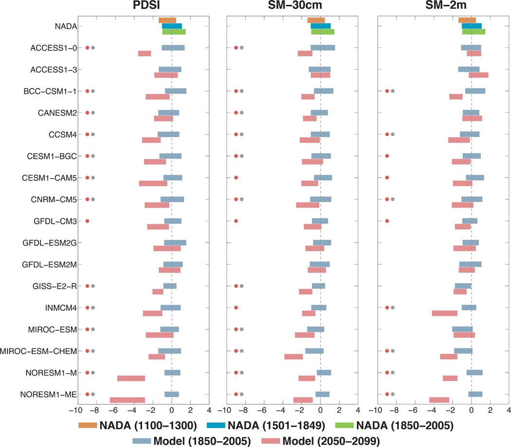
We calculate summer season [June-July-August (JJA)] PDSI and integrated soil moisture from the surface to ~30-cm (SM-30cm) and ~2- to 3-m (SM-2m) depths from 17 GCMs (tables S1 and S2) in phase 5 of the Coupled Model Intercomparison Project (CMIP5) database (22). We focus our analyses and presentation on the RCP 8.5 “business-as-usual” high emissions scenario, designed to yield an approximate top-of-atmosphere radiative imbalance of +8.5 W m−2 by 2100. We also conduct the same analyses for a more moderate emissions scenario (RCP 4.5).
Over the calibration interval (1931–1990), the PDSI distributions from the models are statistically indistinguishable from the North American Drought Atlas (NADA) (two-sided Kolmogorov-Smirnov test, p ≥ 0.05), although there are some significant deviations in some models during other historical intervals. North American drought variability during the historical period in both models and observations is driven primarily by ocean-atmosphere teleconnections, internal variability in the climate system that is likely to not be either consistent across models or congruent in time between the observations and models, and so such disagreements are unsurprising. In the multimodel mean, all three moisture balance metrics show markedly consistent drying during the later half of the 21st century (2050–2099) (Fig. 1; see figs. S1 to S4 for individual models). Drying in the Southwest is more severe (RCP 8.5: PDSI = −2.31, SM-30cm = −2.08, SM-2m = −2.98) than that over the Central Plains (RCP 8.5: PDSI = −1.89, SM-30cm = −1.20, SM-2m = −1.17). In both regions, the consistent cross-model drying trends are driven primarily by the forced response to increased greenhouse gas concentrations (13), rather than by any fundamental shift in ocean-atmosphere dynamics [indeed, there is a wide disparity across models regarding the strength and fidelity of the simulated teleconnections over North America (23)]. In the Southwest, this forcing manifests as both a reduction in cold season precipitation (24) and an increase in potential evapotranspiration (that is, evaporative demand increases in a warmer atmosphere) (13, 25) acting in concert to reduce soil moisture. Even though cold season precipitation is actually expected to increase over parts of California in our Southwest region (24, 26), the increase in evaporative demand is still sufficient to drive a net reduction in soil moisture. Over the Central Plains, precipitation responses during the spring and summer seasons (the main seasons of moisture supply) are less consistent across models, and the drying is driven primarily by the increased evaporative demand. Indeed, this increase in potential evapotranspiration is one of the dominant drivers of global drought trends in the late 21st century, and previous work with the CMIP5 archive demonstrated that the increased evaporative demand is likely to be sufficient to overcome precipitation increases in many regions (13). In the more moderate emissions scenario (RCP 4.5), both the Southwest (RCP 4.5: PDSI = −1.49, SM-30cm = −1.63, SM-2m = −2.39) and Central Plains (RCP 4.5: PDSI = −1.21, SM-30cm = −0.89, SM-2m = −1.17) still experience significant, although more modest, drying into the future, as expected (fig. S5).
Fig. 1 Top: Multimodel mean summer (JJA) PDSI and standardized soil moisture (SM-30cm and SM-2m) over North America for 2050–2099 from 17 CMIP5 model projections using the RCP 8.5 emissions scenario. SM-30cm and SM-2m are standardized to the same mean and variance as the model PDSI over the calibration interval fromthe associated historical scenario (1931–1990). Dashed boxes represent the regions of interest: the Central Plains (105°W–92°W, 32°N–46°N) and the Southwest (125°W–105°W, 32°N–41°N). Bottom: Regional average time series of the summer season moisture balance metrics from the NADA and CMIP5models. The observational NADA PDSI series (brown) is smoothed using a 50-year loess spline to emphasize the low-frequency variability in the paleo-record. Model time series (PDSI, SM-30cm, and SM-2m) are the multimodel means averaged across the 17 CMIP5models, and the gray shaded area is the multimodel interquartile range for model PDSI.
In both regions, the model-derived PDSI closely tracks the two soil moisture metrics (figs. S6 and S7), correlating significantly for most models and model intervals (figs. S8 and S9). Over the historical simulation, average model correlations (Pearson’s r) between PDSI and SM-30cm are +0.86 and +0.85 for the Central Plains and Southwest, respectively. Correlations weaken very slightly for PDSI and SM-2m: +0.84 (Central Plains) and +0.83 (Southwest). The correlations remain strong into the 21st century, even as PDSI and the soil moisture variables occasionally diverge in terms of long-term trends. There is no evidence, however, for systematic differences between the PDSI and modeled soil moisture across the model ensemble. For example, whereas the PDSI trends are drier than the soil moisture condition over the Southwest in the ACCESS1-0 model, PDSI is actually less dry than the soil moisture in the MIROC-ESM and NorESM1-M simulations over the same region (fig. S7). These outlier observations, showing no consistent bias, in conjunction with the fact that the overall comparison between PDSI and modeled soil moisture is markedly consistent, provide mutually consistent support for the characterization of surface moisture balance by these metrics in the model projections.
For estimates of observed drought variability over the last millennium (1000–2005), we use data from the NADA, a tree-ring based reconstruction of JJA PDSI. Comparisons between the NADA and model moisture are shown in the bottom panels of Fig. 1. In the NADA, both the Central Plains (Fig. 2) and Southwest (Fig. 3) are drier during the Medieval megadrought interval (1100–1300 CE) than either the Little Ice Age (1501–1849) or historical periods (1850–2005). For nearly all models, the 21st century projections under the RCP 8.5 scenario reveal dramatic shifts toward drier conditions. Most models (indicated with a red dot) are significantly drier (one-sided Kolmogorov-Smirnov test, p ≤ 0.05) in the latter part of the 21st century (2050–2099) than during their modeled historical intervals (1850–2005). Strikingly, shifts in projected drying are similarly significant in most models when measured against the driest and most extreme megadrought period of the NADA from 1100 to 1300 CE (gray dots). Results are similar for the more moderate RCP 4.5 emissions scenario (figs. S10 and S11), which still indicates widespread drying, albeit at a reduced magnitude for many models. Although there is some spread across the models and metrics, only two models project wetter conditions in RCP 8.5. In the Central Plains, SM-2m is wetter in ACCESS1-3, with little change in SM-30cm and slightly wetter conditions in PDSI. In the Southwest, CanESM2 projects markedly wetter SM-2m conditions; PDSI in the same model is slightly wetter, whereas SM-30cm is significantly drier.
Fig. 2 Interquartile range of PDSI and soil moisture from the NADA and CMIP5 GCMs, calculated over various time intervals for the Central Plains. The groups of three stacked bars at the top of each column are from the NADA PDSI: 1100–1300 (the time of the Medieval-era megadroughts, brown), 1501–1849 (the Little Ice Age, blue), and 1850–2005 (the historical period, green). Purple and red bars are for the modeled historical period (1850–2005) and late 21st century (2050–2099) period, respectively. Red dots indicate model 21st century drought projections that are significantly drier than the model simulated historical periods. Gray dots indicate model 21st century drought projections that are significantly drier than the Medieval-era megadrought period in the NADA.
When the RCP 8.5 multimodel ensemble is pooled together (Fig. 4), projected changes in the Central Plains and Southwest (2050–2099 CE) for all three moisture balance metrics are significantly drier compared to both the modern model interval (1850–2005 CE) and 1100–1300 CE in the NADA (one-sided Kolmogorov-Smirnov test, p ≤ 0.05). In the case of SM-2m in the Southwest, the density function is somewhat flattened, with an elongated right (wet) tail. This distortion arises from the disproportionate contribution to the density function from the wetting in the five CanESM2 ensemble members. Even with this contribution, however, the SM-2m drying in the multimodel ensemble is still significant. Results are nearly identical for the pooled RCP 4.5 multimodel ensemble (fig. S12), which still indicates a significantly drier late 21st century compared to either the historical interval or Medieval megadrought period.
Fig. 3 Same as Fig. 2, but for the Southwest.
Fig. 4 Kernel density functions of PDSI, SM-30cm, and SM-2m for the Central Plains and Southwest, calculated from the NADA and the GCMs. The NADA distribution (brown shading) is from 1100–1300 CE, the timing of the medieval megadroughts. Blue lines represent model distributions calculated from all years from all models pooled over the historical scenario (1850–2005 CE). Red lines are for all model years pooled from the RCP 8.5 scenario (2050–2099 CE).
With this shift in the full hydroclimate distribution, the risk of decadal or multidecadal drought occurrences increases substantially. We calculated the risk (17) of decadal or multidecadal drought occurrences for two periods in our multimodel ensemble: 1950–2000 and 2050–2099 (Fig. 5). During the historical period, the risk of a multidecadal megadrought is quite small: <12% for both regions and all moisture metrics. Under RCP 8.5, however, there is ≥80% chance of a multidecadal drought during 2050–2099 for PDSI and SM-30cm in the Central Plains and for all three moisture metrics in the Southwest. Drought risk is reduced slightly in RCP 4.5 (fig. S13), with largest reductions in multidecadal drought risk over the Central Plains. Ultimately, the consistency of our results suggests an exceptionally high risk of a multidecadal megadrought occurring over the Central Plains and Southwest regions during the late 21st century, a level of aridity exceeding even the persistent megadroughts that characterized the Medieval era.
Fig. 5 Risk (percent chance of occurrence) of decadal (11-year) andmultidecadal (35-year) drought, calculated from the multimodel ensemble for PDSI, SM-30cm, and SM-2m. Risk calculations are conducted for two separate model intervals: 1950–2000 (historical scenario) and 2050–2099 (RCP 8.5). Results for the Central Plains are in the top row, and those for the Southwest are in the bottom row.
DISCUSSION
Within the body of literature investigating North American hydroclimate, analyses of drought variability in the historical and paleoclimate records are often separate from discussions of global warming–induced changes in future hydroclimate. This disconnection has traditionally made it difficult to place future drought projections within the context of observed and reconstructed natural hydroclimate variability. Here, we have demonstrated that the mean state of drought in the late 21st century over the Central Plains and Southwest will likely exceed even the most severe megadrought periods of the Medieval era in both high and moderate future emissions scenarios, representing an unprecedented fundamental climate shift with respect to the last millennium. Notably, the drying in our assessment is robust across models and moisture balance metrics. Our analysis thus contrasts sharply with the recent emphasis on uncertainty about drought projections for these regions (21, 27), including the most recent Intergovernmental Panel on Climate Change assessment report (28).
Our results point to a remarkably drier future that falls far outside the contemporary experience of natural and human systems in Western North America, conditions that may present a substantial challenge to adaptation. Human populations in this region, and their associated water resources demands, have been increasing rapidly in recent decades, and these trends are expected to continue for years to come (29). Future droughts will occur in a significantly warmer world with higher temperatures than recent historical events, conditions that are likely to be a major added stress on both natural ecosystems (30) and agriculture (31). And, perhaps most importantly for adaptation, recent years have witnessed the widespread depletion of nonrenewable groundwater reservoirs (32, 33), resources that have allowed people to mitigate the impacts of naturally occurring droughts. In some cases, these losses have even exceeded the capacity of Lake Mead and Lake Powell, the two major surface reservoirs in the region (34, 35). Combined with the likelihood of a much drier future and increased demand, the loss of groundwater and higher temperatures will likely exacerbate the impacts of future droughts, presenting a major adaptation challenge for managing ecological and anthropogenic water needs in the region.
MATERIALS AND METHODS
Estimates of drought variability over the historical period and the last millennium used the latest version of the NADA (1), a tree ring–based reconstruction of summer season (JJA) PDSI. All statistics were based on regional PDSI averages over the Central Plains (105°W–92°W, 32°N–46°N) and the Southwest (125°W–105°W, 32°N–41°N). We restricted our analysis to 1000–2005 CE; before 1000 CE, the quality of the reconstruction in these regions declines.
The 21st century drought projections used output from GCM simulations in the CMIP5 database (22) (table S1). All models represent one or more continuous ensemble members from the historical (1850–2005 CE) and RCP 4.5 (15 models available) and 8.5 (17 models available) emissions scenarios (2006–2099 CE). We used the same methodology as in (13) to calculate model PDSI for the full interval (1850–2099 CE), using the Penman-Monteith formulation of potential evapotranspiration. The baseline period for calibrating and standardizing the model PDSI anomalies was 1931–1990 CE, the same baseline period as the NADA PDSI. Negative model PDSI values therefore indicate drier conditions than the average for 1931–1990.
To augment the model PDSI calculations and comparisons with observed drought variability in the NADA, we also calculated standardized soil moisture metrics from the GCMs for two depths: ~30 cm (SM-30cm) and ~2 to 3 m (SM-2m) (table S2). For these soil moisture metrics, the total soil moisture from the surface was integrated to these depths and averaged over JJA. At each grid cell, we then standardized SM-30cm and SM-2m to match the same mean and interannual SD for the model PDSI over 1931–1990. This allows for direct comparison of variability and trends between model PDSI and model soil moisture and between the model metrics (PDSI, SM-30cm, and SM-2m) and the NADA (PDSI) while still independently preserving any low-frequency variability or trends in the soil moisture that may be distinct from the PDSI calculation. The soil moisture standardization does not impose any artificial constraints that would force the three metrics to agree in terms of variability or future trends, allowing SM-30cm and SM-2m to be used as indicators of drought largely independent of PDSI.
Risk of decadal and multidecadal megadrought occurrence in the multimodel ensemble is estimated from 1000 Monte Carlo realizations of each moisture balance metric (PDSI, SM-30cm, and SM-2m), as in (17). This method entails estimating the mean and SD of a given drought index (for example, PDSI or soil moisture) over a reference period (1901–2000), then subtracting that mean and SD from the full record (1850–2100) to produce a modified z score. The differences between the reference mean and SD are then used to conduct (white noise) Monte Carlo simulations of the future (2050–2100) to emulate the statistics of that era. The fraction of Monte Carlo realizations exhibiting a decadal or multidecadal drought are then calculated from each Monte Carlo simulation of each experiment in both regions considered here. Finally, these risks from each model are averaged together to yield the overall risk estimates reported here. Additional details on the methodology can be found in (17).
UPPLEMENTARY MATERIALS
Supplementary material for this article is available at http://advances.sciencemag.org/cgi/ content/full/1/1/e1400082/DC1
Fig. S1. For the individual models, ensemble mean soil moisture balance (PDSI, SM-30cm, and SM-2m) for 2050–2099: ACCESS1.0, ACCESS1.3, BCC-CSM1.1, and CanESM2.
Fig. S2. Same as fig. S1, but for CCSM4, CESM1-BGC, CESM-CAM5, and CNRM-CM5.
Fig. S3. Same as fig. S1, but for GFDL-CM3, GFDL-ESM2G, GFDL-ESM2M, and GISS-E2-R.
Fig. S4. Same as fig. S1, but for INMCM4.0,MIROC-ESM, MIROC-ESM-CHEM, NorESM1-M, and NorESM1-ME models.
Fig. S5. Same as Fig. 1, but for the RCP 4.5 scenario.
Fig. S6. Regional average moisture balance time series (historical + RCP 8.5) from the first ensemble member of each model over the Central Plains.
Fig. S7. Same as fig. S6, but for the Southwest.
Fig. S8. Pearson’s correlation coefficients for three time intervals from the models over the Central Plains: PDSI versus SM-30cm, PDSI versus SM-2m, and SM-30cm versus SM-2m.
Fig. S9. Same as fig. S8, but for the Southwest.
Fig. S10. Same as Fig. 2, but for the RCP 4.5 scenario.
Fig. S11. Same as Fig. 3, but for the RCP 4.5 scenario.
Fig. S12. Same as Fig. 4, but for the RCP 4.5 scenario.
Fig. S13. Same as Fig. 5, but for the RCP 4.5 scenario.
Table S1. Continuous model ensembles from the CMIP5 experiments (1850–2099, historical + RCP8.5 scenario) used in this analysis, including the modeling center or group that supplied the output, the number of ensemble members, and the approximate spatial resolution.
Table S2. The number of soil layers integrated for our CMIP5 soil moisture metrics (SM-30cm and SM-2m), and the approximate depth of the bottom soil layer.
This is an open-access article distributed under the terms of the Creative Commons Attribution-NonCommercial license, which permits use, distribution, and reproduction in any medium, so long as the resultant use is not for commercial advantage and provided the original work is properly cited.
Audubon works to protect wildlife like birds and their habitats.
As part of an agreement between Nebraska, Colorado, and Kansas, this water transfer would help meet the state’s delivery obligations within the Republican River Compact.
But over the years, water from the Platte River has heavily been used by municipalities and agriculture.
This has led to the compact being short on water deliveries for quite some time.
The state also has an agreement with other neighboring states to balance this overused water supply through the Endangered Species Act, which began about 30 years after the river compact, and through the Platte River Recovery Implementation Program that aims to add water back to the river…
A diversion of the already short water supply to the Republican could create a ripple effect.
“Overall, taking water from one basin that is already water short and transferring it to another basin that’s water short.. that doesn’t really give us a long term solution. It doesn’t provide certainty for water users and it potentially has ecological impacts for both river basins,” said Mosier.
Taddicken said almost 70% of the water from the Platte River is gone before it even makes it to Nebraska and an interbasin transfer would heavily impact the its supply.
“This water removed from the Platte actually leaves the basin which is a real problem. Moving water around irrigation canals and things like that, eventually a lot of that water seeps back into the groundwater and back to the Platte River. This kind of a transfer takes it out completely,” said Taddicken.
He said farmers in the Platte River Valley should be really concerned if the transfer goes through…
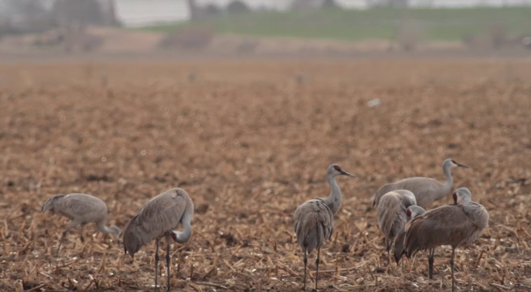
Streamflow also helps to create multiple channels and varying depths which attract many wildlife species, especially birds.
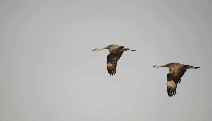
Sandhill Cranes in flight via Colorado Parks and Wildlife
“Sandhill cranes, whooping cranes, piping plovers and other birds.. they use those sand bars for protection. That’s where they like to nest and roost, so that’s really important. Stream flow makes that happen,” stated Mosier, “there’s also an important connection between streams on the Platte River and wetlands. Those wetlands are where a lot of birds and other wildlife find their protein sources.”
Taddicken said we’ve made a lot of compromises for wildlife already as the width of the Platte River has slowly declined and vegetation has taken over where the waters don’t extend.
The impact then extends its reach to the economy, with less sandhill cranes coming to the area that could impact tourists traveling to Central Nebraska.
Invasive species making their way into Kansas is also a concern.
Back in 2018, former Kansas Governor Jeff Colyer wrote a letter objecting to the transfer due to the risk of invasive species.
The Platte River is formed in western Nebraska east of the city of North Platte, Nebraska by the confluence of the North Platte and the South Platte Rivers, which both arise from snowmelt in the eastern Rockies east of the Continental Divide. Map via Wikimedia.
In June, a small team of PBT interns set out for the highest point in the Platte Basin watershed.
We had big intentions of catching 5-star media to fill in cracks for the Grays Peak scene in the upcoming PBT documentary featuring Mike and Pete’s 55-day, 1,300-mile journey across the watershed.
Grays and Torreys, Dillon Reservoir May 2017. Photo credit Greg Hobbs.
Grays Peak is the highest point in the Platte Basin watershed. The mountain, located west of Denver in the Front Range of Colorado, is ranked as the tenth-highest summit of the Rocky Mountains of North America. With the top reaching an elevation of 14,278 feet, it may be considered to some as quite a commitment to reach the top.
The beginning of the trip went as intended. We had the car loaded with all of our equipment and prepared a schedule that would allow us enough time to focus on what we needed to do, or so we thought.
After incidents of altitude sickness, a split hiking boot, bird invasions, and a major bear spray accident, we all accepted our humorous situation of what the trip turned into. We came back with quite the story for the rest of the PBT team. Nevertheless, we agreed the trip had been a successful one and after arriving back in Lincoln, made the best out of what we managed to capture.
The Platte River is formed in western Nebraska east of the city of North Platte, Nebraska by the confluence of the North Platte and the South Platte Rivers, which both arise from snowmelt in the eastern Rockies east of the Continental Divide. Map via Wikimedia.
A year after flooding battered the Missouri River’s levee system, inundating towns and farmland and causing multiple closures to the nation’s interstate highway system, early forecasts warn that more of the same could be on the way: above-normal rainfall, greater than normal spring runoff. A USA TODAY Network analysis delves into records of an aging system of nearly a thousand levees where nobody knows how many were damaged last year or how many were repaired…
The forecast is a veritable index of meteorological plagues: above-normal rainfall; greater than normal spring runoff; thoroughly saturated soils; and an aging system of nearly a thousand levees where nobody knows how many were damaged last year and in previous floods or how many were repaired.
The 855 levee systems throughout the Missouri River basin protect at least half a million people and more than $92 billion in property. Yet a USA TODAY Network analysis of Army Corps of Engineers’ records found at least 144 levee systems haven’t been fully repaired and that only 231 show an inspection date.
Of those, nearly half were rated “unacceptable,” which means something could prevent the levee from performing as intended or a serious deficiency was not corrected. Only 3.5% were deemed acceptable; the rest were found to be “minimally acceptable.”
U.S. levee systems map via the U.S. Army Corps of Engineers. Click on the map to go to the interactive website.
Only 231 of the levee systems show any inspection date. For 38, the most recent inspection date was more than five years ago.
In the Army Corps’ Kansas City district, for example, about 70 projects, spanning 119 levees that requested repair assistance, are eligible for funding, but that doesn’t mean they’ll be ready if the waters rise like they did last year.
“Some of them have been repaired, but from a total system perspective, I don’t think any of them are whole,” said Jud Kneuvean, the district’s chief of emergency management, who expects full levee rehabilitation and repair to take at least another year.
In the meantime, the extent and impacts of flooding will depend on when and where the rain falls…
The 2,300-mile Missouri River begins in southwestern Montana, where the Gallatin, Madison and Jefferson rivers converge near the community of Three Forks, before gathering water from 10 states and parts of two Canadian provinces to become the “Big Muddy,” North America’s longest river.
In recent years, more rainfall has been pouring into the Missouri River basin, raising questions about whether climate change is bringing worsening floods more often. Data from the National Oceanic and Atmospheric Administration dating back to 1895 shows record-setting rainfalls in the area occurring more often. Last year, for example, was the wettest on record in North Dakota, South Dakota and Minnesota.
All that water adds to the challenge faced by Corps policymakers, who juggle sometimes conflicting priorities that include maintaining navigation; managing the reservoir system to prevent flooding; providing farmers with irrigation and hydropower; protecting endangered species; and preserving recreational opportunities.
While the priority is protecting human life and safety, the Corps’ decision-making sometimes puts special interest groups at odds, and the agency remains embroiled in controversy over whether the engineering of the river exacerbates flooding.
Things came to a head last year when a bomb cyclone in March melted all the snow in Nebraska and Iowa at once and dumped tremendous rain, swelling not just the Missouri, but the Elkhorn, Platte, James and Big Sioux rivers.
The Niobrara River in Nebraska breached the Spencer Dam on March 14, sending a wall of water downstream and into the Gavins Point reservoir near Yankton, South Dakota. At the peak, water flowed into the reservoir at 180,000 cubic feet per second — nine times more than the normal average for March. Meanwhile water was coursing into the rivers downstream of the dam and the effects of all that water were felt in nearly every community downstream.
Two other big rain events occurred in May and September. When the Corps’ Kansas City district deactivated its emergency operations center in December, it had been open for 279 days, the longest period on record…
Construction of the higher levee is in the administrative and planning stages, with actual construction activity set for fall.
Most of the Missouri’s levees fall into one of two categories: either federally built and locally operated or locally built and operated. The Corps inspects — and helps pay to repair — only the levees maintained to federal standards that participate in the federal flood program.
That exception means no one has a full list of damaged levees still in need of repair.
The number of levees that aren’t regularly inspected doesn’t surprise Neal Grigg, an engineering professor at Colorado State University who chaired a Corps-appointed review panel after 2011 flooding.
In an ideal management system, every levee “would be under the responsibility of some authority that was responsible and had enough money and good management capability to do that,” Grigg said.
But that’s not realistic, he added, noting that the Corps has tried through a task force to get some organization to the levee systems along the river, but it’s problematic, in part, because there are so many conflicting interests.
A host of agencies are cooperating to repair levees, but the progress is slow, said Missouri farmer Morris Heitman, who serves on the Missouri River Flood Task Force Levee Repair Working Group.
In addition to the Corps, the Federal Emergency Management Agency, the state of Missouri, the USDA Natural Resources Conservation Service and a large number of local levee districts all work to repair levees.
“We’re trying to dance with different agencies,” Heitman told the University of Missouri Extension. “All these agencies have their own requirements and parameters, and we’re trying to coordinate those to build a secure system against the river.”
Fixes to the 144 levee systems listed in disrepair in the Corps’ Omaha and Kansas City districts are in various stages of completion, and some aren’t expected to be done for more than a year.
In the Omaha district that includes Nebraska and Iowa, “pretty much all of the levees were damaged in one way or another,” said the corps’ Matt Krajewski.
While almost all of the district’s levees that qualify for federal aid have been restored to pre-2019 flood heights, Krajewski said they don’t offer the same level of “risk reduction” because they need final touches such as sod cover and drainage structures to protect against erosion. The Corps hopes to complete those repairs this summer.
In the meantime, the Corps is working to prepare its flood storage capacity by releasing more water than normal from its dams.
“We’re being really aggressive with our releases and trying to maintain our full flood storage,” said Eileen Williamson, a Corps spokeswoman for the Northwestern region.
But the projections for spring runoff don’t look good and may limit how much the Corps can do.
In February, the runoff was twice the normal average, said Kevin Grode, with the Corps’ Missouri River Basin Water Management district.
The James River, a tributary that flows out of South Dakota, has experienced flooding since March 13 last year and that flooding is forecast to continue. Moderate flooding is expected along the Big and Little Sioux Rivers in South Dakota and Iowa, and possibly in Montana’s Milk River basin. A risk of minor to moderate flooding is forecast from Nebraska City to the river’s confluence with the Mississippi in St. Louis.
But it’s not just the spring runoff that’s a problem, Grode said. The forecast also calls for “above average runoff for every month in 2020.”
John Remus, chief of the Corps’ Missouri River Water Management Division, said during a March briefing that if those projections are realized, “the 2020 runoff will be the ninth highest runoff in 122 years of record keeping.”
In March, a three-man team with Montana’s Helena-Lewis and Clark National Forest set off on horseback for a 35-mile, five-day journey into the wild North Fork of the Sun River, a tributary of the Missouri River.
They rode horses for the first 12 miles. When they reached a foot of snow, they switched to skis and took turns breaking trail.
Greeted by a half inch of new snow each morning, higher and higher they skied, encountering snow depths of 19 inches, then 2 feet, 9 inches and finally, 3 feet, 3 inches.
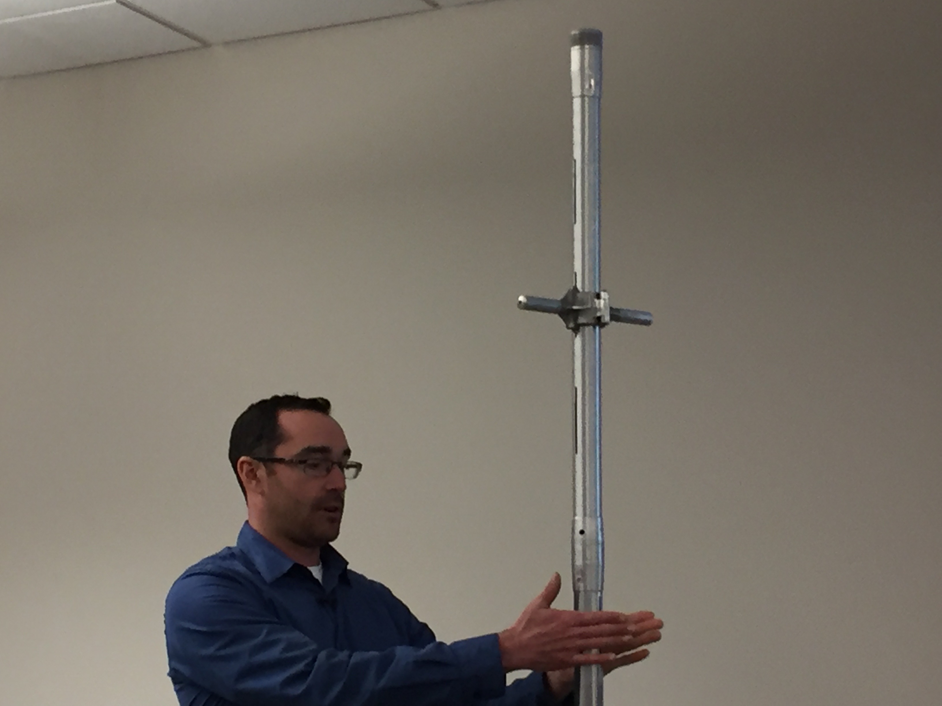
Karl Wetlaufer (NRCS), explaining the use of a Federal Snow Sampler, SnowEx, February 17, 2017.
At each elevation, aluminum tubes with non-stick coating were stuck into the snow to collect core samples used to measure the depth and water content of the snowpack.
“The numbers are used for everything from dam control along the Missouri River to regulating the locks on the barges of the Mississippi,” said Ian Bardwell, the forest’s wilderness and trails manager, who led the snow survey expedition. “It just depends on what level you are looking at it from.”
As of Wednesday, mountain snowpack in the Missouri River basin in Montana was 112% of normal, said Lucas Zukiewicz, a water supply specialist with the Department of Agriculture’s Natural Resources Conservation Service in Montana.
In 2018, Montana’s April snowpack was 150% of normal, then 7 to 9 inches of rain over six days drenched the Rocky Mountain Front, inundating communities in its shadow. The Corps was forced to release water from the Fort Peck Dam spillway, a rarity, as a result of surging flows. Had that same thing happened last year, flooding in states downstream would have been even worse.
“With the way things are changing with our climate,” said Arin Peters, a senior hydrologist for the National Weather Service in Great Falls, Montana, “it’s probably a matter of time before something combines to create a big catastrophe downstream.”
Yet for this year, there may be some good news downstream from the Montana snowpack, at the Gavins Point Dam in Yankton.
Gavins Point is what’s known as a reregulation dam, its purpose to even the Missouri’s flow from the reservoirs upstream. Because Gavins Point wasn’t designed to hold floodwater, its gates had to be opened last year, sending a surge downstream after Nebraska and parts of South Dakota were hit with rain and the bomb cyclone.
In November and December, Gavins Point was still releasing water at a rate of 80,000 cubic feet per second — more than five times the average flow, and something that had never happened before, said Tom Curran, the dam’s project manager.
The good news? Releasing all that water through the winter left the mainstem dam system drained to its multipurpose zone, where it has capacity to absorb runoff while also fulfilling its other functions, including recreation and downstream barge traffic.
Created by Imgur user Fejetlenfej , a geographer and GIS analyst with a ‘lifelong passion for beautiful maps,’ it highlights the massive expanse of river basins across the country – in particular, those which feed the Mississippi River, in pink.
Here’s the release from Colorado State University (Jennifer Dimas):
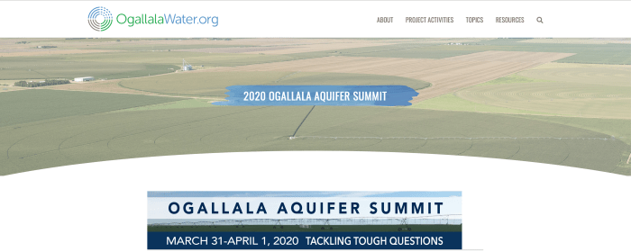
The 2020 Ogallala Aquifer Summit will take place in Amarillo, Texas, from March 31 to April 1, bringing together water management leaders from all eight Ogallala region states: Colorado, Kansas, New Mexico, Nebraska, Oklahoma, Texas, South Dakota and Wyoming. The dynamic, interactive event will focus on encouraging exchange among participants about innovative programs and effective approaches to addressing the region’s significant water-related challenges.
“Tackling Tough Question” is the theme of the event. Workshops and speakers will share and compare responses to questions such as: “What is the value of groundwater to current and future generations?” and “How do locally led actions aimed at addressing water challenges have larger-scale impact?”
“The summit provides a unique opportunity to strengthen collaborations among a diverse range of water-focused stakeholders,” said summit co-chair Meagan Schipanski, an associate professor in the Department of Soil and Crop Sciences at CSU. “Exploring where we have common vision and identifying innovative concepts or practices already being implemented can catalyze additional actions with potential to benefit the aquifer and Ogallala region communities over the short and long term.”
Schipanski co-directs the Ogallala Water Coordinated Agriculture Project (CAP) with Colorado Water Center director and summit co-chair Reagan Waskom, who is also a faculty member in Soil and Crop Sciences. The Ogallala Water CAP, supported by the U.S. Department of Agriculture’s National Institute of Food and Agriculture, has a multi-disciplinary team of 70 people based at 10 institutions in six Ogallala-region states. They are all engaged in collaborative research and outreach for sustaining agriculture and ecosystems in the region.
Some Ogallala Water CAP research and outreach results will be shared at the 2020 Ogallala Summit. The Ogallala Water CAP has led the coordination of the event, in partnership with colleagues at Texas A&M AgriLife, the Kansas Water Office, and the USDA-Agricultural Research Service-funded Ogallala Aquifer Program, with additional support provided by many individuals and organizations from the eight Ogallala states.
The 2020 Summit will highlight several activities and outcomes inspired by or expanded as a result of the 2018 Ogallala Summit. Participants will include producers; irrigation company and commodity group representatives; students and academics; local and state policy makers; groundwater management district leaders; crop consultants; agricultural lenders; state and federal agency staff; and others, including new and returning summit participants.
“Water conservation technologies are helpful, and we need more of them, but human decision-making is the real key to conserving the Ogallala,” said Brent Auvermann, center director at Texas A&M AgriLife Research – Amarillo. “The emergence of voluntary associations among agricultural water users to reduce groundwater use is an encouraging step, and we need to learn from those associations’ experiences with regard to what works, and what doesn’t, and what possibilities exist that don’t require expanding the regulatory state.”
The summit will take place over two half-days, starting at 11 a.m. Central Time (10 a.m. MDT) on Tuesday, March 31 and concluding the next day on Wednesday, April 1 at 2:30 p.m. The event includes a casual evening social on the evening of March 31 that will feature screening of a portion of the film “Rising Water,” by Nebraska filmmaker Becky McMillen, followed by a panel discussion on effective agricultural water-related communications.
Visit the 2020 Ogallala summit webpage to see a detailed agenda, lodging info, and to access online registration. Pre-registration is required, and space is limited. The registration deadline is Saturday, March 21 at midnight Central Time (11 p.m. MDT).
This event is open to credentialed members of the media. Please RSVP to Katie.ingels@kwo.ks.gov or amy.kremen@colostate.edu
The Ogallala aquifer, also referred to as the High Plains aquifer. Source: National Oceanic and Atmospheric Adminstration
Here’s the release from the Kansas Water Office (Katie Patterson-Ingels, Amy Kremen):
8-State Conversation to Highlight Actions & Programs Benefitting the Aquifer, Ag, and Ogallala communities
The 2020 Ogallala Aquifer Summit will take place in Amarillo, Texas, from March 31 to April 1, bringing together water management leaders from all eight Ogallala region states: Colorado, Kansas, New Mexico, Nebraska, Oklahoma, Texas, South Dakota and Wyoming. The dynamic, interactive event will focus on encouraging exchange among participants about innovative programs and effective approaches being implemented to address the region’s significant water-related challenges.
“Tackling Tough Questions,” is the theme of the event. Workshops and speakers share and compare responses to questions such as: “What is the value of groundwater to current and future generations” and “how do locally-led actions aimed at addressing water challenges have larger-scale impact?”
“The summit provides a unique opportunity to strengthen collaborations among a diverse range of water-focused stakeholders,” said summit co-chair Meagan Schipanski, an associate professor in the Department of Soil and Crop Sciences at CSU. “Exploring where we have common vision and identifying innovative concepts or practices already being implemented can catalyze additional actions with potential to benefit the aquifer and Ogallala region communities over the short- and long-term.”
Schipanski co-directs the Ogallala Water Coordinated Agriculture Project (CAP) with Colorado Water Center director and summit co-chair Reagan Waskom, who is also a faculty member in Soil and Crop Sciences. The Ogallala Water CAP, supported by the U.S. Department of Agriculture’s National Institute of Food and Agriculture, has a multi-disciplinary team of 70 people based at 10 institutions in 6 Ogallala-region states, engaged in collaborative research and outreach aimed at sustaining agriculture and ecosystems in the region.
Some Ogallala Water CAP research and outreach results will be shared at the 2020 Ogallala Summit. The Ogallala Water CAP has led the coordination of this event, in partnership with colleagues at Texas A&M AgriLife, the Kansas Water Office, and the USDA-Agricultural Research Service-funded Ogallala Aquifer Program, with additional support provided by many other individuals and organizations from the eight Ogallala states.
The 2020 Summit will highlight several activities and outcomes inspired by or expanded as a result of the 2018 Ogallala Summit. Participants will include producers, irrigation company and commodity group representatives, students and academics, local and state policy makers, groundwater management district leaders, crop consultants, agricultural lenders, state and federal agency staff, and others, including new and returning summit participants.
“Water conservation technologies are helpful, and we need more of them, but human decision-making is the real key to conserving the Ogallala,” said Brent Auvermann, Center Director at Texas A&M AgriLife Research – Amarillo. “The emergence of voluntary associations among agricultural water users to reduce ground water use is an encouraging step, and we need to learn from those associations’ experiences with regard to what works, and what doesn’t, and what possibilities exist that don’t require expanding the regulatory state.”
The summit will take place over two half-days, starting at 11:00 a.m. Central Time on Tuesday, March 31 and concluding the next day on Wednesday, April 1 at 2:30 p.m. The event includes a casual evening social on the evening of March 31 that will feature screening of a portion of the film “Rising Water,” by Nebraska filmmaker Becky McMillen, followed by a panel discussion on effective agricultural water-related communications.
Visit the 2020 Ogallala summit webpage to see a detailed agenda, lodging info, and to access online registration. Pre-registration is required, and space is limited. The registration deadline is Saturday, March 21 at midnight Central Time.
This event is open to credentialed members of the media. Please RSVP to Katie.ingels@kwo.ks.gov or amy.kremen@colostate.edu.
Ogallala Aquifer. This map shows changes in Ogallala water levels from the period before the aquifer was tapped to 2015. Declining levels appear in red and orange, and rising levels appear in shades of blue. The darker the color, the greater the change. Gray indicates no significant change. Although water levels have actually risen in some areas, especially Nebraska, water levels are mostly in decline, namely from Kansas southward. Image credit: National Climate Assessment 2018
Crops need water. And in the central United States, the increasing scarcity of water resources is becoming a threat to the nation’s food production.
Tsvetan Tsvetanov, assistant professor of economics at the University of Kansas, has analyzed a pilot program intended to conserve water in the agriculture-dependent region. His article “The Effectiveness of a Water Right Retirement Program at Conserving Water,” co-written with fellow KU economics professor Dietrich Earnhart, is published in the current issue of Land Economics.
“Residential water use is mostly problematic in California, and not so much here in Kansas. However, people don’t realize that residential use is tiny compared to agricultural use,” Tsvetanov said.
“I don’t want to discourage efforts to conserve water use among residential households. But if we want to really make a difference, it’s the agricultural sector that needs to change its practices.”
That’s the impetus behind the Kansas Water Right Transition Assistance Program (WTAP).
“If you’re a farmer, you need water to irrigate. If you don’t irrigate, you don’t get to sell your crops, and you lose money. So the state says if you reduce the amount of water you use, it’s actually going to pay you. So it’s essentially compensating you to irrigate less,” he said.
But this is not a day-to-day solution. The state recompenses farmers to permanently retire their water rights. The five-year pilot program that began in 2008 offers up to $2,000 for every acre-foot retired.
This benefits the High Plains Aquifer, the world’s largest freshwater aquifer system, which is located beneath much of the Great Plains. Around 21 million acre-feet of water is withdrawn from this system, primarily for agricultural purposes.
Tsvetanov and Earnhart’s work distinguishes the effectiveness between two target areas: creek sub-basins and high-priority areas. Their study (which is the first to directly estimate the effects of water right retirement) found WTAP resulted in no reduction of usage in the creek areas but substantial reduction in the high-priority areas.
“Our first thought was, ‘That’s not what we expected,’” Tsvetanov said.
“The creeks are the geographic majority of what’s being covered by the policy. The high-priority areas are called that for a reason — they’ve been struggling for many years. Our best guess is that farmers there were more primed to respond to the policy because there is awareness things are not looking good, and something needs to be done. So as soon as a policy became available which compensated them for the reduction of water use, they were quicker to take advantage of it.”
Of the eight states sitting atop the High Plains Aquifer, Texas is the worst in terms of water depletion volume. However, Kansas suffers from the fastest rate of depletion during the past half-century.
“Things are quite dire,” Tsvetanov said. “The western part of Kansas is more arid, so they don’t get as much precipitation as we do here in the east. Something needs to change in the long run, and this is just the first step.”
Tsvetanov initially was studying solar adoption while doing his postdoctoral work at Yale University in Connecticut. When visiting KU for a job interview, he assumed the sunny quality of the Wheat State would be a great fit for his research. He soon realized that few policies incentivized the adoption of solar.
“At that point, I thought, ‘I can’t really adapt solar research to the state of Kansas because there’s not much going on here.’ And then I started getting more interested in water scarcity because this truly is a big local issue,” he said.
A native of Bulgaria who was raised in India (as a member of a diplomat’s family), Tsvetanov is now in his fifth year at KU. He studies energy and environmental economics, specifically how individual household choices factor into energy efficiency and renewable resources.
The state of Kansas spent $2.9 million in the half decade that the WTAP pilot program ran. Roughly 6,000 acre-feet of water rights were permanently retired.
“Maybe it’s a start, but it’s not something you would expect to stabilize the depletion,” Tsvetanov said. “This is just a drop in the bucket. Essentially what we need is some alternative source of income for those people living out there, aside from irrigation-intensive agriculture.”
The U.S. Fish and Wildlife Service, in coordination with the Platte River Recovery Implementation Program, plans to release water from Lake McConaughy to benefit downstream habitat used by threatened and endangered species.
Releases will start Monday and may continue through March 15…
USFWS, PRRIP and Central Nebraska Public Power and Irrigation District staff will coordinate the releases, monitor weather and runoff conditions, and be prepared to scale back or end releases if required to minimize the risk of exceeding flood stage.
Current expectations include:
Environmental account water traveling down the North Platte channel below Lake McConaughy will be increased by approximately 300 cubic feet per second to 700 cfs.
– The river will remain well below the designated flood stage of 6 feet at the city of North Platte.
– Flows downstream of North Platte are expected to be significantly below flood stage.
– Flows at Grand Island should be approximately 700 cfs, or less than 6 inches higher than current flows.
– In the Overton to Grand Island stretch, the river stage is expected to be less than 1 foot above normal levels for this time of year.
Click here to download the paper. Here’s the executive summary:
The Northern High Plains aquifer underlies about 93,000 square miles of Colorado, Kansas, Nebraska, South Dakota, and Wyoming and is the largest subregion of the nationally important High Plains aquifer. Irrigation, primarily using groundwater, has supported agricultural production since before 1940, resulting in nearly $50 billion in sales in 2012. In 2010, the High Plains aquifer had the largest groundwater withdrawals of any major aquifer system in the United States. Nearly one-half of those withdrawals were from the Northern High Plains aquifer, which has little hydrologic interaction with parts of the aquifer farther south. Land-surface elevation ranges from more than 7,400 feet (ft) near the western edge to less than 1,100 ft near the eastern edge. Major stream primarily flow west to east and include the Big Blue River, Elkhorn River, Loup River, Niobrara River, Republican River and Platte River with its two forks—the North Platte River and South Platte River. Population in the Northern High Plain aquifer area is sparse with only 2 cities having a population greater than 30,000.
Droughts across much of the area from 2001 to 2007, combined with recent (2004–18) legislation, have heightened concerns regarding future groundwater availability and highlighted the need for science-based water-resource management. Groundwater models with the capability to provide forecasts of groundwater availability and related stream base flows from the Northern High Plains aquifer were published recently (2016) and were used to analyze groundwater availability. Stream base flows are generally the dominant component of total streamflow in the Northern High Plains aquifer, and total streamflows or shortages thereof define conjunctive management triggers, at least in Nebraska. Groundwater availability was evaluated through comparison of aquifer-scale water budgets compared for periods before and after major groundwater development and across selected future forecasts. Groundwater-level declines and the forecast amount of groundwater in storage in the aquifer also were examined.
Major Findings
Aquifer losses to irrigation withdrawals increased greatly from 1940 to 2009 and were the largest average 2000–9 outflow (49 percent of total).
Basin to basin groundwater flows were not a large part of basin water budgets.
Development of irrigated land and associated withdrawals were not uniform across the Northern High Plains aquifer, and different parts of the Northern High Plains aquifer responded differently to agricultural development.
For the Northern High Plains aquifer, areas with high recharge and low evapotranspiration had the most streamflow, and most streams only remove water from the aquifer.
Results of a baseline future forecast indicated that groundwater levels declined overall, indicating an overdraft of the aquifer when climate was about average and agricultural development was held at the same state as 2009.
Results of two human stresses future forecasts indicated that increases of 13 percent or 23 percent in agricultural development, mostly near areas of previous development, caused increases in groundwater pumping of 8 percent or 11 percent, and resulted in continued groundwater-level declines, at rates 0.3 or 0.5 million acre-feet per year larger than the baseline forecast.
Results of environmental stresses forecasts (generated from two downscalings of global climate model outputs) compared with the baseline forecast indicated that even though annual precipitation was nearly the same, differences in temperature and a redistribution of precipitation from the spring to the growing season (from about May 1 through September 30), created a large (12–15 percent) decrease in recharge to the aquifer.
For the two environmental stresses forecasts, temperature and precipitation were distributed about the same among basins of the Northern High Plains aquifer, but the amounts were different.
Citation
Peterson, S.M., Traylor, J.P., and Guira, M., 2020, Groundwater availability of the Northern High Plains aquifer in Colorado, Kansas, Nebraska, South Dakota, and Wyoming: U.S. Geological Survey Professional Paper 1864, 57 p., https://doi.org/10.3133/pp1864.
After a year of anxious waiting, scientists and researchers who’ve helped build one of the most successful species recovery programs in the nation have gotten a 13-year extension to finish their work.
The Platte River Recovery Implementation Program began operating in 2007 with the bi-partisan backing of Colorado, Wyoming, and Nebraska and the U.S. Department of the Interior. Since then it has created some 15,000 acres of new habitat for stressed birds and fish, and added nearly 120,000 acre-feet of new annual water to the Platte River in central Nebraska. An acre-foot equals nearly 326,000 gallons.
The region is critical because it serves as a major stopping point for migrating birds, including the whooping crane, the least tern and the piping plover.
In addition to helping fish, birds and the river, the program also allowed dozens of water agencies, irrigation districts and others to meet requirements under the Endangered Species Act, which can prevent them from building and sometimes operating reservoirs, dams and other diversions if the activity is deemed harmful to at-risk species.
Last year it wasn’t clear that three new governors, three state congressional delegations, and a fractious Congress could come together to re-authorize the program.
Jo Jo La, an endangered species expert who tracks the program for the Colorado Water Conservation Board, said everyone was grateful that politicians united to push the federal legislation, and the new operating agreement, through. It was signed by President Trump at the end of December.
“Our program was fortunate to have the leaders it had,” La said.
But it wasn’t just politicians who were responsible for the program’s extension, said Jason Farnsworth, executive director of the Kearney, Neb.-based program.
It was the diversity among the group’s members that was also key, he said. “Everyone from The Nature Conservancy to the Audubon Society to irrigation districts in the North Platte Basin supported this. You don’t often see an irrigation district sending a support letter for an endangered species recovery program. That’s how broad the support was.”
Of the $156 million allocated, Colorado is providing $24.9 million in cash and another $6.2 million in water, Wyoming is providing $3.1 million in cash and $12.5 million in water, Nebraska is providing $31.25 million in land and water, and the U.S. Department of Interior is providing $78 million in cash, according to PRRIP documents.
With their marching orders in hand, researchers and scientists can now focus on completing the program so that at the end of this 13-year extension it will become fully operational.
Early results have won accolades from Wyoming to Washington, D.C. The CWCB’s La said congressional testimony routinely described it as one of the “marquee” recovery programs in the nation, largely because, even though it isn’t finished, species are coming back in a major way.
In the 1980s and 1990s, the endangered whooping crane, least tern and pallid sturgeon, and the threatened piping plover, were in danger of becoming extinct, with the river’s channels and flows so altered by dams and diversions that it could no longer support the species’ nesting, breeding and migratory habitats.
Today the picture is much different.
The whooping crane spring migration has risen more than 12 percent since 2007, while the number of least tern and piping plover breeding pairs have more than doubled during that same time period, a major achievement in the species conservation world.
Still ahead is the work to acquire more water and land, and research to understand how to help the rare pallid sturgeon recover. Thus far it has not responded to recovery efforts, in part because it is extremely difficult to locate.
The idea is to ensure there is enough water and habitat to keep the birds and fish healthy once the program enters its long-term operating phase.
“The intent is to spend the next 13 years working on identifying the amount of water and land that is necessary to go into [the final operating phase]. The focus will be less on acquiring and learning, and more on operating and managing,” Farnsworth said.
Jerd Smith is editor of Fresh Water News. She can be reached at 720-398-6474, via email at jerd@wateredco.org or @jerd_smith.
Whooping crane adult and chick. Credit: USGS (public domain)
Least Tern. Photo credit Doug German via Audubon.
Piping plover
Pallid sturgeon
Platte River Recovery Implementation Program target species (L to R), Piping plover, Least tern, Whooping crane, Pallid sturgeon
Screenshot of the Platte Basin Timelapse “Year of the Flood” story map January 17, 2020.
Click here to view the story map from Platte Basin Timelapse. Here’s the preface:
The flood event of 2019 was historic and devastating for parts of Nebraska and the Midwest.
Platte Basin Timelapse team members Grant Reiner, Carlee Koehler, Ethan Freese, and Mariah Lundgren traveled to parts of the state to explore questions they had about this historic weather event. What happens to wildlife during these big weather events? How were people affected by the floodwaters? What does this mean for the birds that nest on the river? How many PBT cameras survived? These are our stories.
Platte River Recomery Implemtation Program area map.
Here’s the release from the Colorado Water Conservation Board:
A victory for wildlife and Colorado water, Secretary of the Interior David Bernhardt, Colorado Governor Jared Polis, and the Governors of Nebraska and Wyoming signed a Cooperative Agreement to extend the Platte River Recovery Implementation Program (Program) with $156 million.
The Colorado Water Conservation Board has played a major role in this Program’s creation and ongoing efforts, including policy and financial support.
“This collaborative program supports the recovery of four threatened and endangered species by improving and maintaining habitat in the Platte River in Nebraska while allowing for continued water use in Colorado,” said Colorado Water Conservation Board Director Rebecca Mitchell. “We look forward to continuing our role in the upcoming years of the Platte River Recovery Implementation Program.”
“The commitment by the states and the U.S. Department of the Interior to continue the program’s innovative approach to species recovery and Endangered Species Act compliance is a win-win for the future of Colorado’s citizens and the environment,” said Governor Polis.
The Program was set to expire at the end of 2019. However, with support from the Colorado Water Conservation Board; Colorado Parks and Wildlife; the Department of Natural Resources; and other state, federal, and non-governmental partners; a bill supported by the entire Congressional delegation from Colorado, Nebraska, and Wyoming was passed and signed by the President before the New Year.
Together with its water users, the Colorado Water Conservation Board is celebrating the Program’s more than a decade record of success. As the Program enters into its next 13 years, it has momentum to continue to recover threatened and endangered species, which provides assurance for future water use in Colorado.
Sandhill crane migration, Platte River via the Colorado Water Conservation Board.
The Colorado River Compact and water infrastructure projects will be among the items discussed at the annual Four States Irrigation Council meeting held Wednesday through Friday in Fort Collins.
the Four States Irrigation Council is a group of irrigators, irrigation and water districts, ditch companies and others looking to discuss water-delivery and irrigation-related issues affecting the Four States region, which encompasses Colorado, Kansas, Nebraska and Wyoming.
Exhibitors at the event will showcase some of the latest innovations and provide attendees with up-to-date information on new products and services. Awards will also be presented.
Membership in the Four States Irrigation Council is open to anyone and free of dues or fees. Someone can become a member by attending the annual meeting or visiting 4-states-irrigation.org and requesting to be added to mailing list.
More information about the meeting is also available on the website.
Platte River Recomery Implemtation Program area map.
Here’s the release from the Department of Interior (Brock Merrill):
Secretary of the Interior, along with Governors of Colorado, Nebraska and Wyoming, commit an additional $156 million for recovering threatened and endangered species in the Platte River Basin
U.S. Secretary of the Interior David Bernhardt signed an amendment to the Platte River Recovery Implementation Program Cooperative Agreement, along with the governors of Colorado, Nebraska and Wyoming, committing resources to extend the program through Dec. 31, 2032. The Platte River Recovery Implementation Program utilizes federal- and state-provided financial resources, water and scientific monitoring and research to support and protect four threatened and endangered species that inhabit areas of the Central and Lower Platte rivers in Nebraska while allowing for continued water and hydropower project operations in the Platte River basin.
“This program is truly an important partnership that has been successful because of the broad collaboration between federal and state representatives, water and power users and conservation groups,” said Secretary Bernhardt. “All of these stakeholders working together to help recover imperiled species is critical as new water and power projects are continued and developed in the Platte River Basin.”
The program provides compliance for four species under the Endangered Species Act (ESA) for new and existing water-related projects in the Platte River Basin. Examples of existing water related projects include the Bureau of Reclamation’s Colorado Big-Thompson Project on the South Platte River in Colorado and the North Platte Project in Wyoming and Nebraska.
“Programs like the Platte River Recovery Implementation Program are critical to ensuring that Reclamation is able to deliver water and power in an environmentally and economically sound manner,” said Bureau of Reclamation Commissioner Brenda Burman “This program is a true success story of how stakeholders and government from across state lines can work together for the common good.”
The program began in 2007 and is managed by a governance committee comprised of representatives from Colorado, Nebraska and Wyoming, water users, environmental groups and the Department of the Interior’s Bureau of Reclamation and U.S. Fish & Wildlife Service.
“The Platte River Recovery Implementation Program has brought together three states, environmental groups, water users, and two federal agencies to forge a common goal of balancing existing use with an eye towards recovery for four threatened and endangered species,” said Wyoming Governor Mark Gordon. “This program has ensured that Wyoming continues existing water uses in the South and North Platte River Basins while making measurable contributions to species recovery.”
“The signing of the Platte River Recovery Implementation Program Cooperative Agreement Amendment marks the celebration of more than a decade of success,” said Colorado Governor Jared Polis. “The commitment by the states and the U.S. Department of the Interior to continue the program’s innovative approach to species recovery and Endangered Species Act compliance is a win-win for the future of Colorado’s citizens and the environment. We look forward to the next 13 years working with our partners to lead in this national model of collaboration.”
“Agriculture is Nebraska’s number one industry. Extending the Platte River Recovery Implementation Program gives Nebraska’s ag producers certainty around water and land use in the coming years,” said Nebraska Governor Pete Ricketts. “We appreciate the collaboration we enjoy with the other states who are party to this agreement, and we look forward to working with them in the coming years.”
The estimated total value of federal and state contributions to the program during the first extension is $156 million. The U.S. Department of the Interior will provide one half of the funding necessary for the extension, which will be matched by states through contributions of non-federal funding and water from state-sponsored projects that is provided for the benefit of target threatened and endangered species.
The people of Colorado, Wyoming and Nebraska got an early Christmas present from the U.S. Senate on Thursday, and it has Don Ament breathing a sigh of relief.
Ament has said he was delighted to hear that the U.S. Senate passed a bipartisan bill Thursday to extend the Platte River Recovery Implementation Program as part of the year-end spending package. The bill was introduced by Colorado Senators Michael Bennet (D) and Cory Gardner (R). The bill was passed by the House of Representatives earlier this week and will now go to the president’s desk to be signed into law…
The first increment of the program is set to expire on at the end of this year; Senate Bill 990 extends the program by an additional 13 years. PRRIP is a cooperative agreement among the governors of Colorado, Wyoming, Nebraska, and the Secretary of the Interior to achieve Endangered Species Act compliance on the Platte River.
Ament, who represents Colorado’s governor on the four-entity board that oversees the program, has been concerned since April about whether PRRIP would be extended. That’s when Bennet and Gardner, along with U.S. Senators John Barrasso (R-Wyo.), Mike Enzi (R-Wyo.), Deb Fischer (R-Neb.), and Ben Sasse (R-Neb.), introduced the Platte River Recovery Implementation Program Extension Act.
Since then, however, Washington, D.C., has been somewhat distracted by political conflict between Republicans and Democrats, making any kind of bipartisanship seem to be impossible. That has had Ament concerned that funding for the program would lapse after Dec. 31, leaving the program’s future in doubt…
In addition to addressing protections under the federal Endangered Species Act, PRRIP has allowed the three states and the Department of Interior to avoid lengthy and expensive litigation involving the Endangered Species Act. According to a statement released by the U.S. Interior Department, “The program has provided a level of certainty to water users in the Platte River drainage that litigation would not have afforded.”
Whooping crane adult and chick. Credit: USGS (public domain)
Governor Mark Gordon has sent a letter to Secretary of Agriculture Sonny Perdue requesting a Disaster Designation for five Wyoming counties where agriculture producers were impacted by powerful early-season snowstorms.
The request covers Laramie, Goshen, Platte, Park and Big Horn counties. The scale, severity and timing of freezing and snow events that occurred in October were devastating to crops, particularly sugar beets. While producers did their best to maximize their harvest, damage from the storms was severe.
A copy of the Governor’s letter can be viewed here.
A wet 2019 delayed construction work throughout Nebraska, including a Platte River Recovery Implementation Program water project southwest of Elm Creek.
At Tuesday’s PRRIP Governance Committee meeting in Kearney, program civil engineer Kevin Werbylo said the completion date for the project on the south side of the Platte River was moved from May 1 to Aug. 1 to Oct. 15.
“Given the conditions the contractor had to deal with, they did a nice job and the engineers did a nice job,” Werbylo said.
The project fits program goals to reduce depletions to Central Platte target flows and to protect, restore or maintain land used as habitat by threatened and endangered species — least terns, piping plovers and whooping cranes.
The basinwide plan allows entities in Nebraska, Colorado and Wyoming with federal licenses, permits and/or funding to comply with the Endangered Species Act. The U.S. Department of Interior is the other major participant.
The Elm Creek project will help meet an immediate goal to reduce by 120,000 acre-feet the annual depletions to target river flows set by the U.S. Fish and Wildlife Service for the protected species. Water held in shallow detention cells on the broad-scale site will seep into the groundwater that eventually reaches the adjacent Platte River.
Platte water will be diverted into Central Nebraska Public Power and Irrigation District’s Phelps Canal at times when flows exceed targets. According to PRRIP 1995-2017 data, that most commonly occurs in December and January.
A new pipeline built as part of the project links the canal to the 416-acre site where earthen berms up to 6 feet tall create eight shallow cells to temporarily hold water at depths of 12 inches or less.
Werbylo said the project budget is $4.3 million and there is $480,000 left to pay.
Dirt work needs to settle and vegetation is being established, he said, so it will be late spring to mid-summer 2020 before any water deliveries are made to the broad-scale project site.
PRRIP Executive Director Jason Farnsworth told the Hub that even if the original construction schedule had allowed the project’s use this fall, there would have been no diversions because of already high groundwater.
Fort Laramie Irrigation Canal. This camera looks over a north flowing canal that provides irrigation water to surrounding fields. Agriculture in this part of the state is made possible in part by irrigation canals like this. Scotts Bluff National Monument is visible on the horizon. Photo credit: Platte Basin Time Lapse
Here’s the release from Governor Gordon’s office:
Governor Mark Gordon, members of the executive branch, and representatives from multiple state agencies are mobilizing in an effort to provide assistance to farmers affected by a catastrophic irrigation tunnel collapse in Goshen County.
The Governor signed an Executive Order for a Declaration of Emergency today, allowing him to deploy state resources to Goshen County as needed. The collapse occurred early in the morning of July 17 along the Fort Laramie-Gering irrigation canal west of Lingle and caused a large breach of the canal wall. The disaster inundated farmland near the breach and has left more than 100,000 acres of cropland in Wyoming and Nebraska without water during a critical period for growers. Goshen County Commissioners issued a Local Disaster Declaration earlier today.
“This is a serious emergency and we recognize addressing an issue of this magnitude will take coordination, especially because it affects so many Wyoming and Nebraska farmers,” Governor Mark Gordon said. “We are working with an understanding of the urgency of the situation, along with a need to proceed carefully. Wyoming is united in its effort to find the right way to help the Goshen Irrigation District get up and running.”
After visiting the site on Friday, the Governor and members of the executive branch met Monday morning to analyze ways to provide state support to Goshen County and the Goshen Irrigation District. The Governor’s office is assembling resources to engage federal partners and is working with the Wyoming Department of Agriculture, the Wyoming Office of Homeland Security and the State Engineer’s Office to explore potential options for resources and assistance.
State officials and representatives from Governor Gordon’s office will attend a stakeholder’s meeting organized by the Goshen Irrigation District scheduled for 2 pm Wednesday, July 24, at the Eastern Wyoming College auditorium. The meeting is open to the public and will include a discussion of the collapse and a possible timeline for repairs to the tunnel and ditch.
From the Goshen County Commissioners via The Torrington Telegram:
The Goshen County Board of Commissioners has officially declared the collapse of an irrigation tunnel along the Fort Laramie-Gering Irrigation Canal as a local disaster.
In a declaration issued Monday morning, July 22, the county stated that “extensive damage was caused to private property and the loss of irrigation water will result in an extensive loss of agricultural crops to the farmers of Goshen County within the disaster area.”
The declaration, signed by Chairman Wally Wolski, vowed to seek emergency funds from any and all sources.
“All locally available public and private resources available to mitigate and alleviate the effects of this disaster have been insufficient to meet the needs of the situation,” the declaration said. “The Chairman of the Goshen County Board of Commissioners has declared a State of Emergency on behalf of Goshen County, and will execute for and on behalf of Goshen County Commission the expenditure of emergency funds from all available sources, the invoking of mutual aid agreements, and the requesting of assistance from the State of Wyoming.”
The Goshen Irrigation District has organized a stakeholder’s meeting to discuss the Fort-Laramie Gering irrigation tunnel collapse, repairing the tunnel and the ditch, and the timeframe of the repairs. The meeting will be held Wednesday, July 24, 2 p.m. at the Eastern Wyoming College auditorium.
The GID issued a press release on Friday, July 19, to ask people to stay away from the collapse to allow the GID and various contractors space to make the necessary repairs. The collapse occurred in a remote section of the canal, with only a one-lane road to get in or out of the site.
“Goshen Irrigation District and Gering-Fort Laramie District are asking for all patrons to please observe all road closure signs near the tunnel and canal breach,” the release said. “There will be large equipment and contractors in and out of that site every day of the week and for extended hours. Please, for your safety, do not impede the work that needs to be done.”
Least Tern. Photo credit Doug German via Audubon. From Audubon Rockies (Daly Edmunds):
The Platte River Recovery Implementation Program (PRRIP) is a multi-state effort that began in 1997, when the governors of Colorado, Wyoming, and Nebraska joined with the U.S. Secretary of Interior to sign the “Cooperative Agreement for Platte River Research and Other Efforts Relating to Endangered Species Habitat along the Central Platte River, Nebraska.”
Based on the novel idea that a collaborative approach would prevent years of courtroom battles over limited water supplies and individual river species, the PRRIP works to accommodate the habitat needs of these threatened and endangered bird species by increasing stream flows in the central Platte River during relevant time periods. While these species require habitat in central Nebraska for survival, their habitat is created and maintained through a dynamic river system that begins with water from Colorado and Wyoming. The program also enhances, restores and protects habitat, and does so in a manner to accommodate new water-related activities. This is a good program but due to expire this year.
Wyoming Senator Barrasso (R) and Colorado Representative Neguse (D) each took leadership positions on this issue, sponsoring complementary bills in the Senate (S.990) and House (H.R. 3237), that propose to extend the program. Audubon Rockies and Audubon Nebraska thanked the entire Colorado Congressional Delegation for their unanimous, bipartisan support for these bills. Our offices also thanked Wyoming’s Senator Enzi for supporting the Senate bill, and Representative Cheney recently joined other western co-sponsors of the House bill. Additionally, all Colorado and Wyoming Audubon chapters sent letters thanking their respective congressional delegations for their unanimous, bipartisan of a strong stewardship program.
Least tern
Piping plover
Whooping crane adult and chick. Credit: USGS (public domain)
The Platte River is formed in western Nebraska east of the city of North Platte, Nebraska by the confluence of the North Platte and the South Platte Rivers, which both arise from snowmelt in the eastern Rockies east of the Continental Divide. Map via Wikimedia.
Meanwhile click here to enjoy the 2019 Audubon Photography Awards winners.
Birds make fascinating subjects, as the winners and honorable mentions of this year’s contest, our 10th, make clear. They’re at once beautiful and resilient, complex and comical. It’s no wonder why we love them so.
The images that won the 2019 Audubon Photography Awards, presented in association with Nature’s Best Photography, are as impressive as ever, but attentive readers might notice a few more images than usual. That’s because we’ve added two awards. The Plants for Birds category is inspired by Audubon’s Plants for Birds program, supported by Coleman and Susan Burke, which provides resources for choosing and finding plants native to zip codes in the United States. This category poses a new challenge to photographers: Don’t just capture an incredible moment—make sure it also features a bird and plant native to the location in which the photo was taken, in order to highlight the critical role native habitat plays in supporting bird life. And in the spirit of Kevin Fisher, Audubon’s longtime creative director who recently retired, the Fisher Prize recognizes a creative approach to photographing birds that blends originality with technical expertise. It honors a photograph selected from all of the submissions that pushes the bounds of traditional bird photography.
We want to extend a heartfelt thank you to all 2,253 entrants, hailing from all 50 U.S. states, Washington, D.C., and 10 Canadian provinces and territories. Your dedication to appreciating, celebrating, and sharing the wonder of birds and the landscapes they inhabit inspires us now and throughout the year.
From the Kansas News Service. (Ben Kuebrich) via the Hillsboro Free Press:
Great Canal of Kansas
Clayton Scott also uses the latest water technology on his farm in Big Bow. Yet he said that just using water carefully won’t be enough.
He thinks any pumping limits severe enough to preserve the aquifer would dramatically cut back the region’s harvest. That would push up local grain prices, and without cheap grain, livestock feed yards would close, and meatpacking plants would follow.
At its core, the western Kansas economy is built on irrigation.
A 2015 study calculated that losses in irrigation could cost some 240,000 Kansans their jobs and wipe out $18.3 billion of yearly economic activity, or about 10 percent of the state economy.
Scott and others in the region have their eyes on a more drastic solution to the water problem. Kansas could invest in a 360-mile series of canals and pumping stations to bring in water from the Missouri River.
He knows it sounds extreme, but Arizona has already built a similarly sized aqueduct. The Central Arizona Project diverts water from the Colorado River and there’s been extensive research into building a similar canal across Kansas.
“Arizona looked at their situation and decided, ‘We have no other choice,’ ” Scott said. “They estimate almost a trillion dollars of benefit to the economy of Arizona.”
Arizona’s aqueduct has always been controversial. The federally funded canal remains at the center of multi-state disputes of water usage.
Experts say that a generation later, the legal and regulatory hurdles of building a long-distance canal through Kansas only look more daunting.
Water from the Colorado River is channeled through Arizona, much the way some people think it should be diverted from the Missouri River across Kansas.
Pricey pipeline
Still, Kansas and surrounding states have been considering aqueducts for a long time. A 1982 study came up with a plan to bring water from the Missouri River to a reservoir near Utica, Kansas, but nothing ever came of it. At the time, though, losing the Ogallala seemed like a distant prospect.
In 2011, while western Kansas was in a drought and farmers struggled to pump enough water to keep their crops alive, the Missouri River was flooding. Scott says that sparked renewed interest in a canal.
“It’s a long-term solution,” Scott said. “We can harvest the high flows of water off of the eastern rivers and bring them out here into the western High Plains, offset the droughts … and bring things into more of a balance.”
In 2015, the Kansas Water Office and the U.S. Army Corps of Engineers re-assessed that 1982 study. The agencies estimated that, depending on the capacity of the canal, it would now cost between $5 billion and $20 billion to build.
Because the water would have to be pumped uphill as it goes west, it could take more than $500 million a year in energy costs alone, for the largest-capacity canal. With interest costs from construction, the yearly tab could exceed $1.5 billion.
At the time, the head of the water office said, “this thing we studied is unlikely to happen.” The costs would simply run too steep.
A canal project would have other barriers. Although the Missouri river sometimes floods, it also experiences lows, and levels would have to be maintained to permit barge traffic. There would also be challenges displacing people in the path of the aqueduct. While a highway can be redirected to avoid a town, a canal’s path is more constrained by topography.
At the same time, environmental issues could come both from taking water from the Missouri and in the path of any aqueduct. Upstream and downstream states on the waterway already tangle over how to manage the water. An effort to siphon away water would further complicate the situation.
Scott knows the project would be massive, and massively controversial, but that’s why he’s talking about it now—before the Ogallala runs dry.
An uncertain future
At a conference in April, Kansas Secretary of Agriculture Jackie McClaskey said public support for an aqueduct is unlikely unless farmers show first that there’s no other way to water their crops.
“Until we can show people that we are utilizing every drop of water in the best way possible, no one outside of this region is going to invest in a water transfer project,” McClaskey said.
Clayton Scott says he isn’t looking for the rest of Kansas to bail out the farmers out west.
Scott imagines the canal would be a federal project, similar to Arizona’s aqueduct. Water users would repay the costs of construction and maintenance through a water use fee.
He also contends that an aqueduct could help a broader region.
Scott says an aqueduct could extend out to Colorado’s Front Range to supply booming cities such as Denver and Colorado Springs that draw water off of the dwindling Colorado River. If they drank from Kansas’ aqueduct instead, that would leave more water to trickle down the Colorado, which extends out into water-starved southern California.
A canal, advocates contend, could supply water at a fraction of the price that southern California farmers pay now and help alleviate shortages in that region.
Scott’s interest in water transfer is common in southwest Kansas but far from universal. For example, Roth isn’t convinced.
“It’s impractical and it’s one heck of a distraction,” Roth said. “Right now we need to concentrate on local conservation with what we do have, what we can do right now.”
Ray Luhman, Northwest Water district manager, thinks the state should consider all options, including channeling water across the state.
“The conversation needs to be had,” Luhman said. “But to, let’s say, mortgage your future on a project maybe 20 to 30 years from completion? We also need to look to something in the interim.”
Ben Kuebrich reports for High Plains Public Radio in Garden City and the Kansas News Service, a collaboration of KMUW, Kansas Public Radio, KCUR and HPPR covering health, education and politics.
When early explorers Zebulon Pike and Francisco de Coronado came upon the High Plains, they described it as a desert — an impossible region to farm.
Irrigation changed that. It allowed residents to pull water from the Ogallala Aquifer, and grow crops nearly anywhere. The first irrigation wells in Kansas were drilled east of Garden City in 1908.
The Ogallala is a massive, underground sponge, spanning from South Dakota and Wyoming, down through the High Plains to west Texas and New Mexico. Over 27,000 of the total 35,000 wells with active water rights in Kansas overlie the Ogallala, with 87 percent used for irrigation.
But decades of pumping water out, with little return, has taken its toll.
After 110 years of drilling and draining, the world’s largest aquifer is drying up.
The Ogallala is the primary source of water for western Kansas farms, ranches and some communities, but projections indicate several areas that will go dry within 25 to 50 years at current usage rates. Some regions in Haskell County may have a decade or less…
The Ogallala Aquifer Summit was organized by Colorado State University’s Ogallala Water CAP Program — a coordinated agriculture project funded by the United States Department of Agriculture – National Institute of Food and Agriculture. The summit brought together scientists, government agents and producers from the eight states situated over the Ogallala to discuss shared challenges and current initiatives to preserve the aquifer.
Conversations between states had a rocky start, partly because they were spurred out of litigation regarding the Republican River basin along the Colorado, Nebraska and Kansas borders. The conflict led to monthly meetings of the Republican River Compact Administration — comprised of one member from each state — to change the approach and improve water management.
“No offense to those that are here, but I’m just excited to come to an interstate water conference that doesn’t have more lawyers than it does farmers and ranchers,” Kansas Secretary of Agriculture Jackie McClaskey said to applause from the summit crowd.
Nebraska Natural Resources Program Director Jesse Bradley and Colorado Commissioner of Agriculture Don Brown joined McClaskey for the first panel of the summit, discussing the cultivation of interstate conversations.
Brown joked that the whole problem was Nebraska’s fault — Nebraska native Frank Zybach invented center pivot irrigation while living in Colorado — and Bradley fired back that ‘you always blame the upstream state.’
She credits interstate conversations regarding the Republican River as a critical factor for changing the tone of the discussion. Instead of fighting over the water, the group is now working together to preserve water.
“The biggest way we learned this lesson is from the complete 180 we’ve done on the Republican River discussions,” McClaskey said. “In July 2014, we started meeting month-to-month and created a true, long-term agreement, and are using those lessons to expand to all the states.
“Now, I would call my colleagues from Nebraska and Colorado friends, which may not seem like a big deal, but it’s a lot easier to solve a problem with a friend than with an enemy.”
View of runoff, also called nonpoint source pollution, from a farm field in Iowa during a rain storm. Topsoil as well as farm fertilizers and other potential pollutants run off unprotected farm fields when heavy rains occur. (Credit: Lynn Betts/U.S. Department of Agriculture, Natural Resources Conservation Service/Wikimedia Commons)
Morgan Conservation District’s 62nd annual meeting will be held on February 9th.
It will be held at the Fort Morgan Home Plate Restaurant, 19873 U.S. Hwy. 34. Breakfast will be at 8 a.m. and the meeting will start at 9 a.m. The cost of the meeting will be $25 in advance, and that will cover the annual meeting, annual membership in Morgan Conservation District, and free breakfast that morning.
If you do not RSVP in advance, and show up on the day of the meeting, please be advised that the cost will be the same, however breakfast will not be free, due to our needing to order the food in advance. Our keynote speakers, Bill Hammerich and Andrew Neuhart.
Bill Hammerich has served as the CEO of Colorado Livestock Association (CLA) for the past fourteen years. He grew up on a cattle and farming operation in Western Colorado and he attended CSU where he graduated with a degree in Agricultural Economics. Following graduation, he began working with Monfort of Colorado, then Farr Feeders and was with the Sparks Companies before joining CLA in 2002.
His time spent in the cattle feeding industry provided him not only with an understanding of how to feed cattle, but also the importance of protecting and sustaining the environment in which one operates.
Bill and his wife Sabrina live in Severance, Colorado and have two grown children, Justin and Jessica, and four grandsons.
Andrew Neuhart completed both a B.S. in Natural Resource Management and an M.S. in Watershed Science at CSU. After spending two years assisting in precision farming studies in the San Luis Valley for the USDA Soil, Plant and Nutrient Research team, Andrew went to work for the State of Colorado’s Water Quality Control Division. For 9 years with the WQCD, Andrew led a Permitting Unit for discharge permits under the Clean Water Act, for both industrial and domestic wastewater treatment facilities. Working for Brown and Caldwell over the last 4 years, Andrew assists clients with regulatory issues under the Clean Water Act, and has been working with the Ag Task Force, part of the Colorado Monitoring Framework, to get the word out regarding nutrient regulations and their impacts to agricultural operations.
Mr. Hammerich and Mr. Neuhart will be speaking about Regulation 85.
Regulation 85 establishes requirements for organizations holding a NPDES permit and with the potential to discharge either nitrogen or phosphorus to begin planning for nutrient treatment based on treatment technology and monitoring both effluents and streams for nitrogen and phosphorus.
The data from these efforts is designed to better characterize nutrient sources, characterize nutrient conditions and effects around the state and to help inform future regulatory decisions regarding nutrients. Please come to the meeting and learn more from our very knowledgeable keynote speakers!
Please RSVP as soon as possible to Angela at morganconservationdistrict@gmail.com or call 970-427-3362. Space is limited.
The Platte River is formed in western Nebraska east of the city of North Platte, Nebraska by the confluence of the North Platte and the South Platte Rivers, which both arise from snowmelt in the eastern Rockies east of the Continental Divide. Map via Wikimedia.
Nebraska has a unique role among the four partners in the Platte River Recovery Implementation Program, according to Nebraska Department of Natural Resources Director Jeff Fassett.
“All the (protected) species and all the habitat are in Nebraska,” he said.
The Central Platte Valley is the target area for least terns, piping plovers and whooping cranes, while pallid sturgeon are in the Lower Platte River.
All the water options for a proposed program extension, which will focus on reducing river depletions by another 40,000 [acre-feet] or more, are in Nebraska to be as close as possible to the target habitat.
Fassett said that with a major reservoir project now off the table, new projects will include groundwater recharge, facilities to hold water for retimed releases and water leasing.
He noted Tuesday at the annual convention of the Nebraska State Irrigation and Nebraska Water Resources associations that initial water projects were completed by all three states toward meeting the program’s first-increment goal to reduce river depletions by 130,000-150,000 [acre-feet].
However, more recent projects and those being considered for the future are only in Nebraska. “There is hydrologic logic about that,” Fassett said, because projects hundreds of miles from the target habitat are not as effective.
Nebraska’s benefits include regulatory stability the program provides for the Platte Basin. Projects in Nebraska, Colorado and Wyoming that must comply with the federal Endangered Species Act can do so through the program instead of individually, he said.
Another issue for Nebraska is its own demands to enhance water in the river. Fassett said state laws for the overappropriated area of the Platte Basin west of Elm Creek require “moving the train backward” to mitigate new water uses since 2007.