The Claude “Bud” Lewis Carlsbad Desalination Plant in San Diego’s North County. Photo by Robert Marcos.
by Robert Marcos
Residents in the San Diego region currently pay between $3,707 and $5,179 per acre-foot of water1, making San Diego’s municipal water the fourth most expensive in America – after San Francisco, Seattle, and Portland.2
For years San Diego relied almost entirely on a single source of municipal water: the Metropolitan Water District of Southern California. However, a severe drought in the early 1990s exposed the region’s vulnerability. This crisis sparked a multi-decade strategy by the San Diego County Water Authority to diversify its portfolio, effectively trading lower costs for long-term supply reliability.3
To break its dependence on Los Angeles, San Diego secured its own water rights through massive, high-cost agreements. This included a historic 2003 deal with the Imperial Irrigation District in the Imperial Valley, where the city pays farmers to conserve water and send it west. This “ag-to-urban” transfer, combined with paying to line the All-American Canal to prevent seepage, provided a secure but significantly more expensive supply than traditional imported water.4
The region further increased costs by investing in “drought-proof” technology, most notably the Claude “Bud” Lewis Carlsbad Desalination Plant, which opened in 2015. While it provides about 10% of the region’s water, it is the most expensive source in the portfolio, costing roughly $2,700 per acre-foot—far higher than imported Colorado River water. San Diego is also currently building the multi-billion dollar Pure Water recycling system to turn wastewater into drinking water, adding another layer of heavy infrastructure debt to monthly bills.5
Paradoxically, San Diegans’ success in water conservation has also contributed to rising rates. Because the Water Authority built massive infrastructure based on much higher population and demand projections, it must now spread the fixed costs of those debts and maintenance across fewer gallons of water sold. When residents use less water, the price per gallon must increase to cover the billions in outstanding loans for dams, pipelines, and treatment plants.6
Today the cumulative effect of these investments has made San Diego’s water rates among the highest in the country, with total bills projected to rise over 60% by 2029. While other California cities face potential shortages during droughts, San Diego often has a surplus; however, the cost of that security is borne entirely by local ratepayers through a complex “chain reaction” of wholesale price hikes and debt service.7
Click the link to read the article on The Denver Post website (John Meyer). Here’s an excerpt:
April 13, 2026
Outfitters insist there will be a rafting season this year, but the same lack of snowfall that negatively affected ski resorts over the winter — forcing many to open late and close early — will also hurt rafting since there has been less snow to melt. That, along with ongoing drought, means the low-water conditions typically found in late summer may come much earlier than usual. To make it work, river guides plan to adjust in ways they hope will help them make the best of what they have.
“The water’s not going to get to be high, boat-flipping water,” said David Costlow, executive director of the Colorado River Outfitters Association. “Usually, we try to get to the middle of July before we start entering low water. It will probably be early this year. It could be the end of June, first of July, but it depends on the next few weeks…
The winter snowpack is currently well below average across the state; in fact, it is about a quarter of what Colorado usually has at this time of year, according to the USDA National Water and Climate Center. That’s the lowest since record-keeping began in 1941. Meanwhile, warm spring temperatures triggered a much earlier runoff than normal. Outfitters are hoping spring rains will improve the situation, but three-month weather projections from the Climate Prediction Center of the National Weather Service are calling for above-normal temperatures and below-normal moisture through June. March is normally Colorado’s snowiest month, so outfitters were hoping for a boost last month. It didn’t come.
Rafting on Clear Creek is almost entirely dependent on rainfall during the season, even in good snow years, because it’s situated in a relatively small drainage. Outfitters there are hoping Colorado’s monsoon season, typically mid-July through August, delivers this year…he Upper Colorado draws on runoff from a much larger basin that includes the west side of Rocky Mountain National Park and the Never Summer Range. Reservoirs in that drainage include Grand Lake, and flows are controlled by water managers. Rafting on the Upper Colorado is concentrated west of Kremmling…On the Poudre, Johnson said his company is focused on providing quality experiences for as long as there is enough water to do so.
Juniata Reservoir, located near Grand Mesa, is where the city of Grand Junction stores water coming off Grand Mesa in the Kannah Creek watershed. That water flows down Kannah Creek and eventually into the taps of Grand Junction residents. Photo courtesy of City of Grand Junction
Local water utilities are raising the alarm about the severe drought Mesa County is in and are asking users to voluntarily limit their usage now to conserve water. At a Thursday press conference in Palisade, representatives from the area’s water utilities and the National Weather Service described the situation in stark terms. Grand Junction Public Utilities Director Randi Kim said the winter snowpack is delivering far less water than normal and spring runoff began more than a month early.
“This year in March, our snow survey indicated that our snowpack across the city’s Kannah Creek watershed was at 41% measured as snow water equivalent over the 35-year historical average,” Kim said. “Due to warm weather conditions, runoff in Kannah Creek started on March 26, which is about five to six weeks earlier than normal.”
In response, Kim asked Grand Junction’s water users to help conserve water now. Representatives from Ute Water suggested limiting outdoor watering as an important step in conserving water.
“With Grand Junction currently in D3 extreme drought, the city is asking all of our customers to take actions to conserve water,” Kim said. “Participating now in water conservation actions will help preserve the city’s water supply should that drought persist through the summer and necessitate the city rely upon our stored water rather than direct flows from Kannah Creek.”
[…]
Kim said the city’s Grand Mesa reservoirs are full and it has 1.75 years of water in storage, so it is not facing the prospect of running out of water this year…Data on the Colorado River Basin goes back 130 years. Experts say 2026 will be worse than any of those, likely by a longshot…A perfect storm of factors are behind those concerns.
Erin Walter, service hydrologist for the National Weather Service, said at the Thursday press conference that the record low snowpack has combined with record warm weather to make for especially challenging conditions. In March alone, Walter said Grand Junction saw eight consecutive days of record warm temperatures. That warm weather is persisting into April, Walter said, and forecasts predict it will continue through June. Those conditions could result in the worst drought on record…n reservoirs essential to the Western Slope, that means less water to work with. Green Mountain Reservoir, which includes the Historic User Pool that helps supply numerous farmers, is not expected to fill this year, according to Flinker. Meanwhile Blue Mesa Reservoir, which requires 419,000 acre-feet to fill and supplies water to the Gunnison River before it joins the Colorado River in Grand Junction, is forecast to get only around 200,000 acre-feet this year.
Water Managers anticipate flows in the San Luis Valley’s rivers and creeks will be very low in spring and summer 2026.
The Colorado Division of Water Resources Division 3 Engineer’s April 6 10-day report forecasted the total annual flow of the Rio Grande at the Del Norte gage will be 270,000 acre-feet, which is 42 percent of the long-term average. For reference, flows of the Rio Grande at Del Norte in 2018 totaled 280,400 acre-feet. The forecasted flow of the Conejos River system is 110,000 acre-feet, which is 37 percent of the long-term average. The snow water equivalent on April 9 for the Upper Rio Grande Basin was 12 percent of the median for 1991-2020.
The National Weather Service is forecasting hot temperatures along with below average precipitation into the summer. The irrigation season began on March 23 on the Rio Grande and March 16 on the Conejos River. As such, on-stream reservoirs are required to pass all inflows to satisfy the needs of downstream senior water rights holders. Given the low amount of snow, the exceptionally warm spring temperatures, and the anticipated summer drought conditions, it is possible that local rivers reached peak flow in March.
Rio Grande operations
The operators of reservoirs on the Rio Grande will time their releases of irrigation water to coincide with the canals being in priority to allow water to reach farmers. It is anticipated that many of the canals will only be in priority to divert water for a short time window, in some cases only days or weeks. As such, releases of irrigation water will begin in the next week.
The Santa Maria Reservoir Company will begin releasing stored irrigation water into North Clear Creek on April 14 at a rate of 200-300 cfs for 10 days. Additional releases will continue as farmers call for water. Rio Grande Reservoir will also begin releasing stored irrigation water into the Rio Grande on April 14 for approximately 20 days. The rate of the release will start at 100-150 cfs and increase up to 350-450 cfs. After deliveries are complete, releases will be limited to the natural inflows. As such, boatable flows on the Rio Grande may diminish as early as mid-May.
Entities including Colorado Parks and Wildlife, the San Luis Valley Water Conservancy District, and the Rio Grande Water Conservation District store water in reservoirs in the Upper Rio Grande Basin and call for releases for their operations in accordance with their water rights decrees.
Where possible, releases by these organizations will be prioritized during hot periods to supplement the natural flow of the Rio Grande and the South Fork of the Rio Grande to reduce high water temperatures to protect the health of fish. Unfortunately, there may not be sufficient water to keep temperatures below thresholds for responsible fishing. As such, anglers are encouraged to check temperature gages and not engage in catch and release fishing if water temperatures reach exceed 70 degrees. Temperature is measured at the 30 Mile Bridge, Wagon Wheel Gap, Del Norte, and South Fork Gages and can be viewed at the Colorado Division of Water Resources’ website (dwr.state.co.us). [ed. emphasis mine]
Platoro Reservoir. Photo credit: Rio de la Vista
Conejos River operations
Platoro Reservoir is passing inflows, which were 10 times higher than average for much of March because of rapid snowmelt. The Conejos Water Conservancy District allocated 6,500 acre-feet of project water to the irrigators. Unfortunately, river flows are currently too low to carry that water to farmers’ headgates and water will not be released unless river flows improve. It is likely that the river will have dry up points below Highway 285. Anglers are encouraged to check temperature gages below Platoro Reservoir and near Mogote before engaging in catch and release fishing.
Links to Stream Gages with Temperature Measurements:
Heather Dutton is district manager for the San Luis Valley Water Conservancy District, which provides leadership to the San Luis Valley water community, a forum for learning and development, and the service of well augmentation in five counties in the San Luis Valley. More by Heather Dutton
Sunset from the western shore of Antelope Island State Park, Great Salt Lake, Utah, United States.. Sunset viewed from White Rock Bay, on the western shore of Antelope Island. Carrington Island is visible in the distance. By Ccmdav – Own work, Public Domain, https://commons.wikimedia.org/w/index.php?curid=2032320
Click the link to read the article on the NOAA website:
April 8, 2026
Key Takeaways:
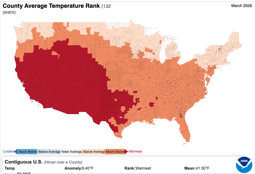
Warmest March: The contiguous U.S. (CONUS) average temperature was 9.4°F above the 20th-century average, making March 2026 the warmest March in the 132-year record.
Prolonged warmth: The April 2025–March 2026 period now stands as the warmest 12-month span ever recorded for the CONUS (since 1895).
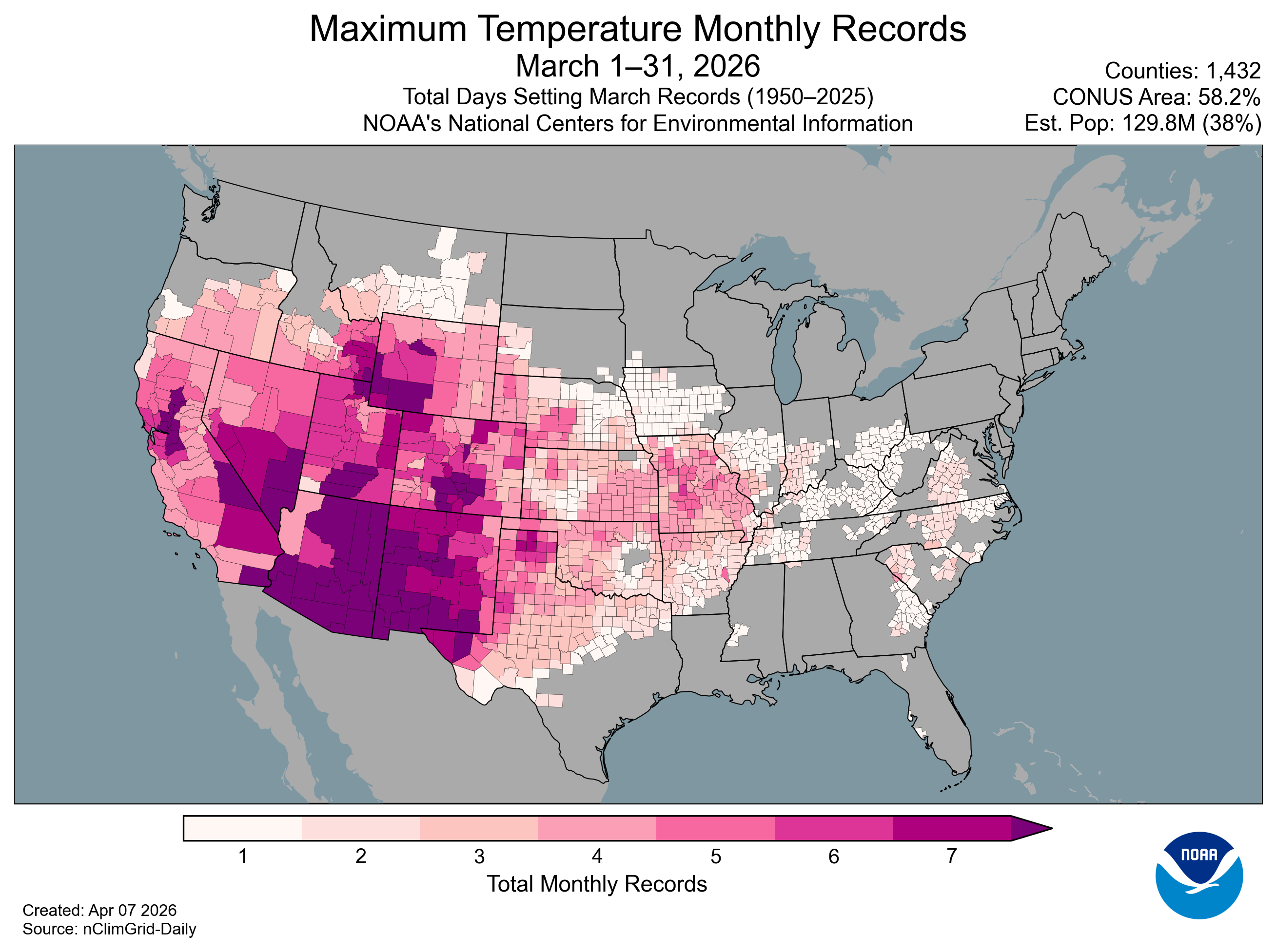
Record daily heat: 1,432 counties—over half the CONUS area and one-third of the population—observed their single warmest March day on record (1950–present).
Map of the U.S. Maximum Temperature Monthly Records in March 2026.
Record-dry year to date: The January–March period was the driest on record for the CONUS—less than 70% of average—breaking the previous record set in 1910.
Notable drought footprint: Dry conditions expanded drought to nearly 60 percent of the CONUS—the largest extent of drought since November 2022.
Cold in Alaska: Alaska had its fourth-coldest March on record (since 1925) and the coldest since 2007.
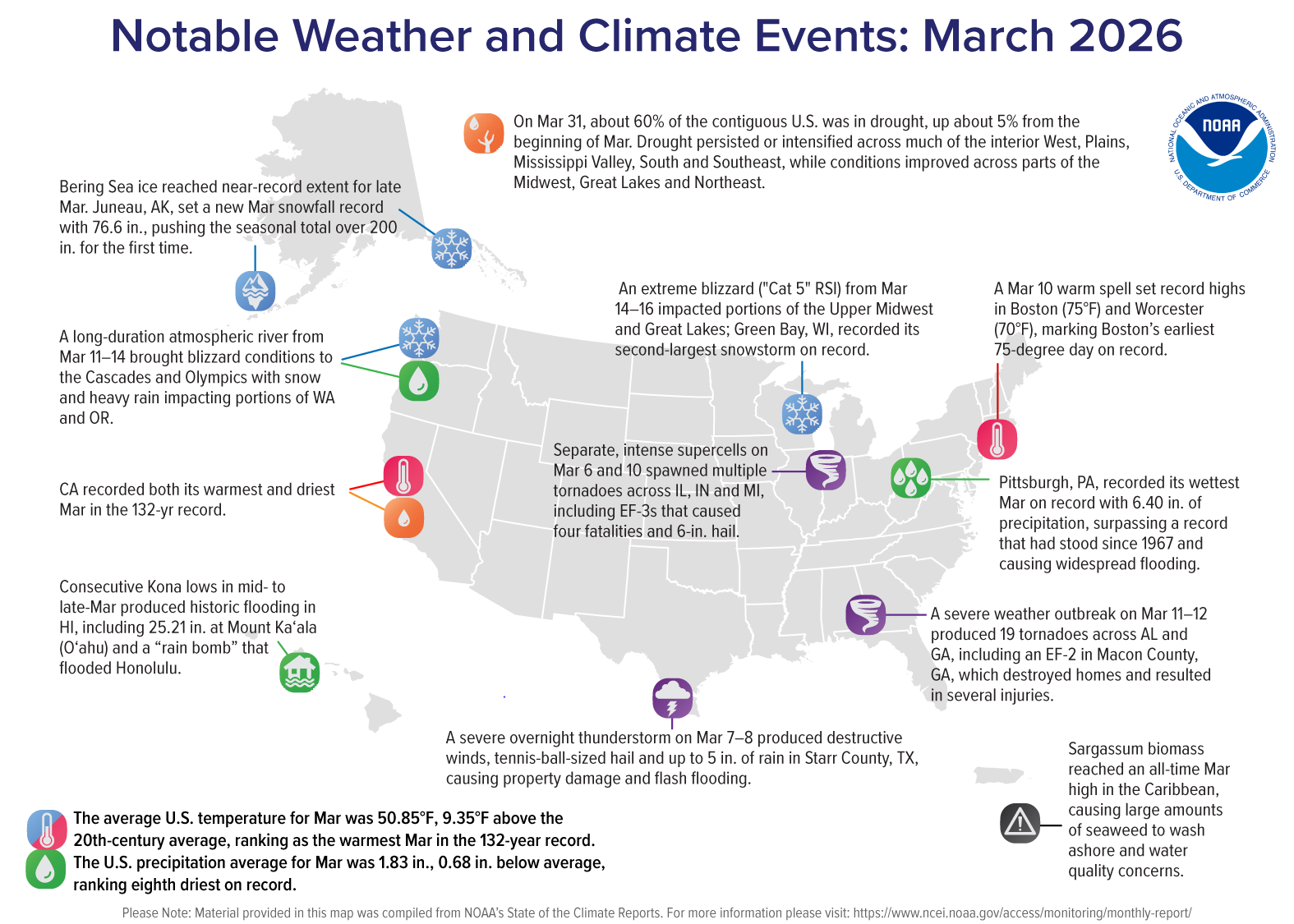
Map of the U.S. notable weather and climate events in March 2026.
Other Highlights:
Temperature
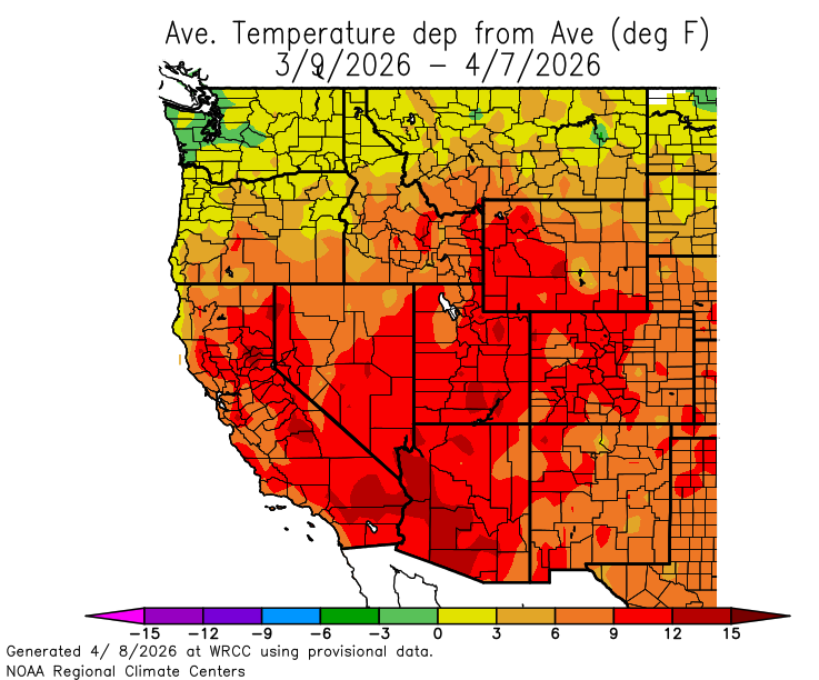
The CONUS average temperature in March was 50.85°F, 9.35°F above the 20th-century average, marking the first time any month’s average has exceeded 9°F above that baseline. Maximum daytime temperatures were especially high, averaging 11.4°F above the March average and 0.9°F above the April long-term average.
Much of the country south of the far northern tier, from the Pacific to the Atlantic, experienced much-above-average temperatures. A broad region spanning the central Pacific Coast, Great Basin, Southwest, and parts of the Rockies and southern Plains observed record warmth, highlighting the widespread extent of the month’s exceptional temperatures.
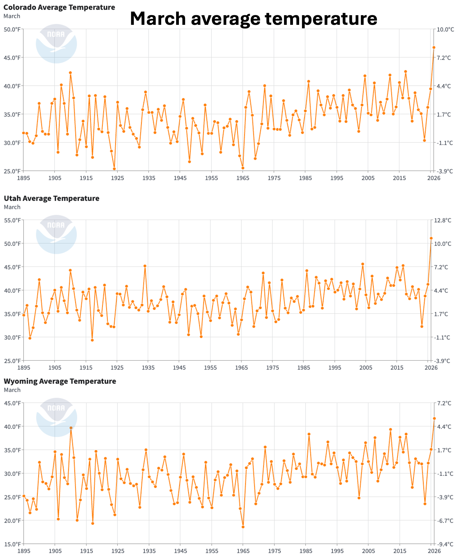
Ten states recorded their warmest March on record: Arizona, California, Colorado, Idaho, Nevada, New Mexico, Oklahoma, Texas, Utah and Wyoming. Across all of these states, average temperatures exceeded their respective April averages, with California also eclipsing its average May temperature by 0.7°F.
At the county level, more than 500 counties—covering over one-quarter of the CONUS and affecting an estimated 79 million people—recorded their warmest March on record, reflecting the broad geographic footprint of the month’s record warmth.
Hawai‘i’s statewide average temperature was 65.0°F, 1.5°F above the 1991–2020 average, ranking as the fifth-warmest March in the 36-year record. Daytime temperatures were near average, but statewide average minimum temperatures stood out at 59.2°F—the warmest March nighttime temperatures on record (1991–present), more than 1°F above the previous record set in 2006.
In contrast, Alaska’s statewide average temperature was 0.6°F, 10.2°F below the 1925–2000 average. While the North Slope remained near average, much of the state experienced much-below-average temperatures, with parts of the southeast interior, southern coast and panhandle recording record-cold conditions. Minimum temperatures were especially notable, ranking as the third-coldest March on record and the coldest since 1972.
Precipitation
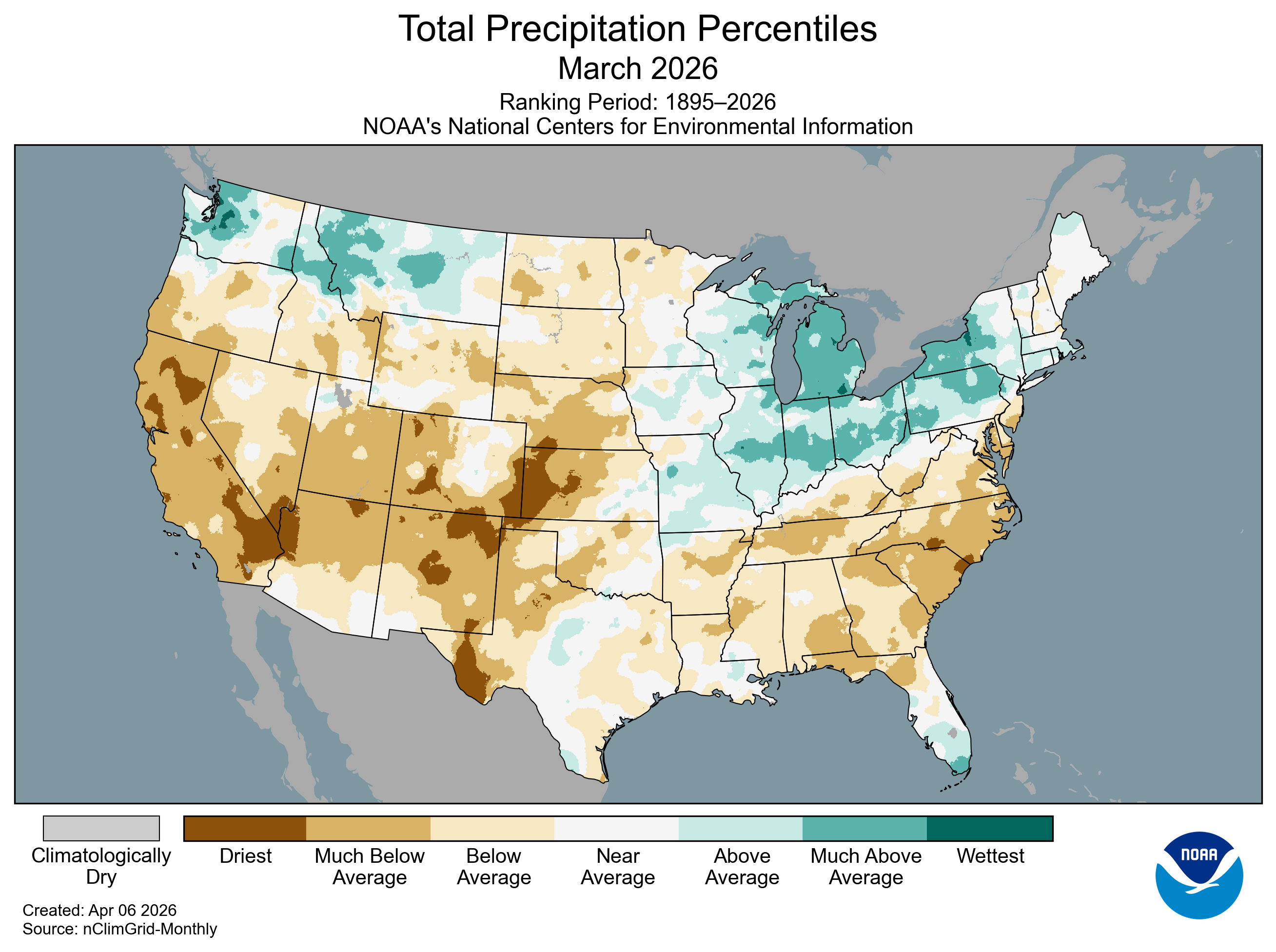
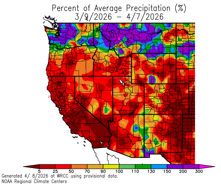
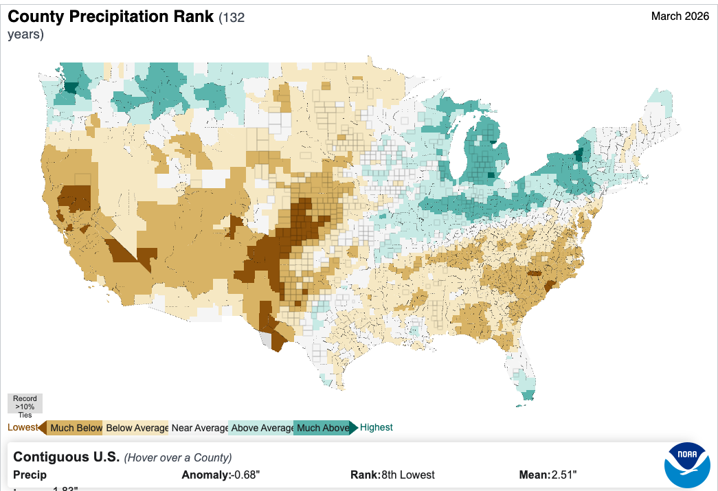
The average precipitation total for the CONUS in March was 1.83 inches, 0.68 inch below the 20th-century average, ranking as the eighth-driest March in the 132-year record. Combined with January and February deficits, this period marks the driest first three months of any year on record for the CONUS.
March 2026 U.S. Total Precipitation Percentiles.
March precipitation was much below average across much of the West, Southwest, portions of the Plains, Deep South and Southeast. In contrast, above-average precipitation totals fell across parts of the Northwest and northern Rockies, as well as across the Upper Midwest and Great Lakes region.
In total, nine states across the Lower-48 ranked among their 10-driest Marches. California received less than a quarter-inch of precipitation statewide—less than 10% of its 20th-century March average and the lowest March total in the 132-year record. Colorado and New Mexico each tied their second-driest March on record, while North and South Carolina each experienced one of their five-driest Marches. In contrast, Michigan received nearly twice its average March precipitation—its third-highest March total on record.
Simultaneously hot and dry conditions affected 12 states, where much-above-average temperatures occurred alongside much-below-average precipitation, with potential impacts on snowpack and water resources in the coming months. California exemplified these extremes, recording both its warmest and driest March on record.
Precipitation across Hawai‘i was much above average for the month, with many areas—including large portions of the Big Island, Maui, Moloka‘i and O‘ahu—experiencing their wettest March on record (since 1991). This exceptional wetness was driven by back-to-back Kona low systems mid-month that triggered widespread major flooding and landslides across the island chain.
Alaska’s statewide precipitation was much lower than average, especially over portions of the Southwest, the Alaska Peninsula and Aleutians. However, the cold air over mainland Alaska brought above-average snowfall to much of Southeast Alaska, with several locations recording their highest March totals in more than a decade.
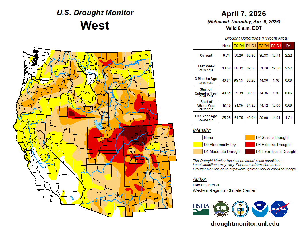
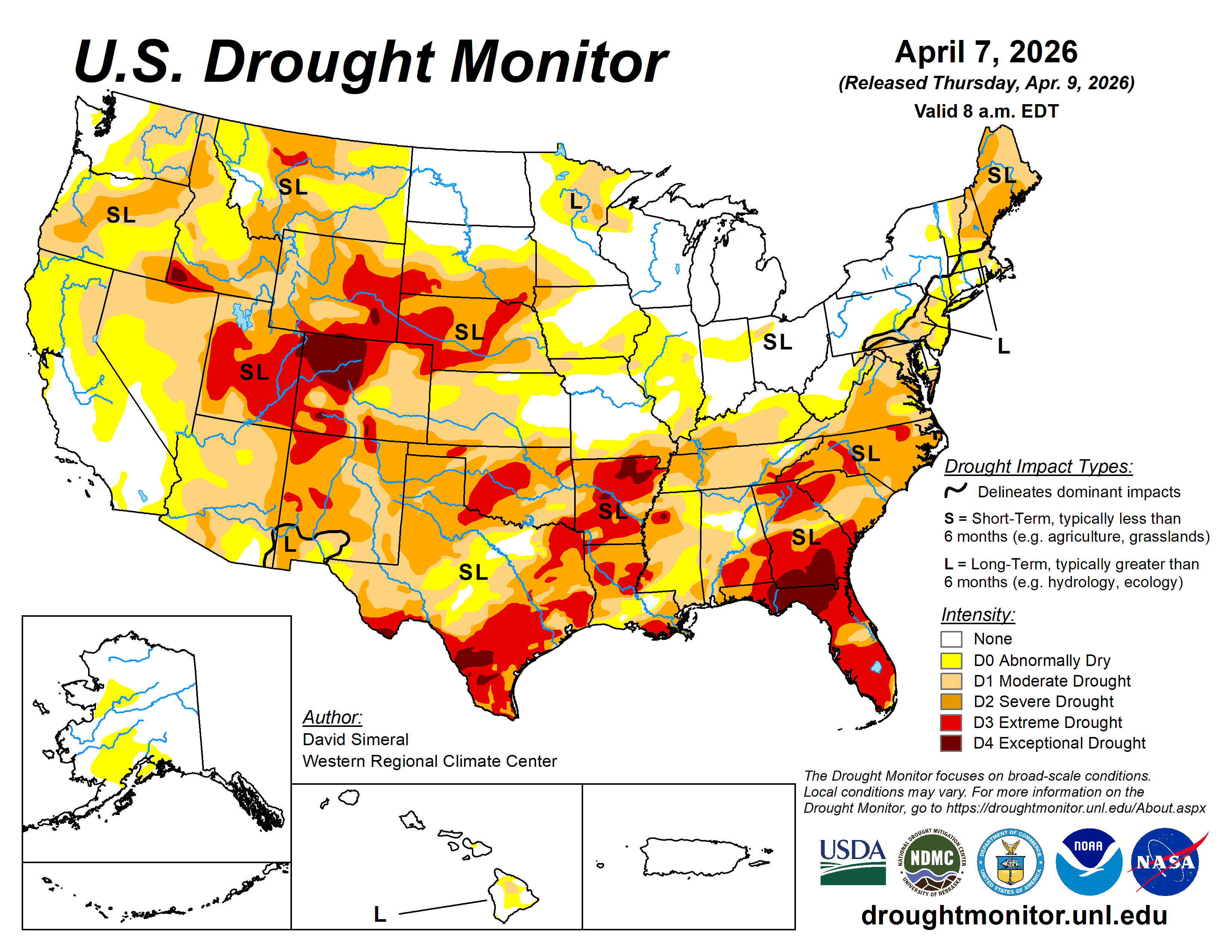
US Drought Monitor map April 7, 2026.
Drought
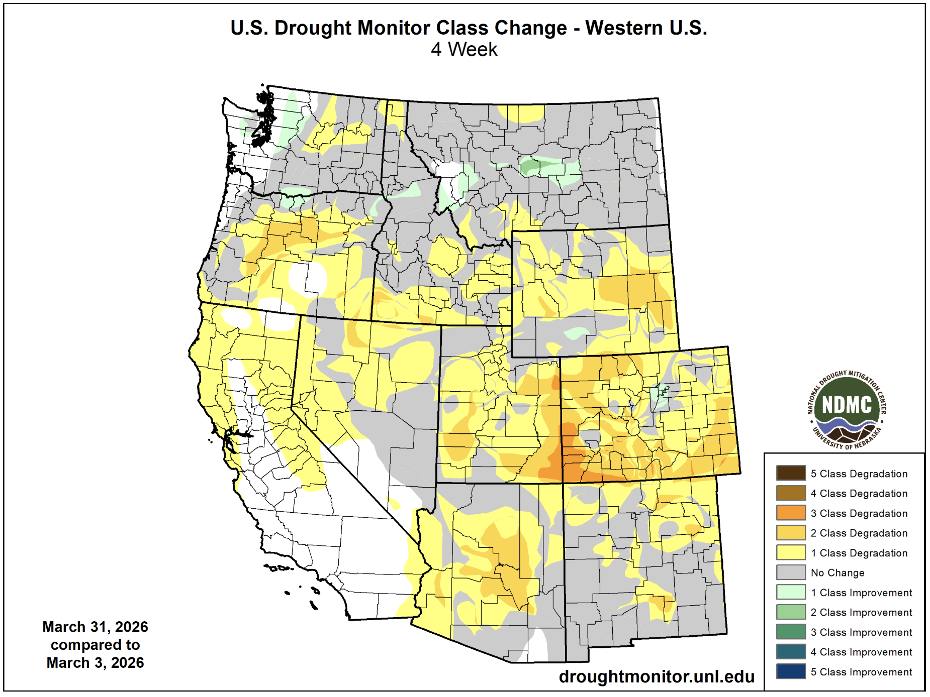
According to the March 31 U.S. Drought Monitor report, about 59.9% of the CONUS was in drought, an increase of about 5.0% from the beginning of the month. Drought conditions persisted or intensified across much of the interior West, the Plains, Mississippi Valley, South and Southeast, with notable degradation across the Rockies and central Plains. In contrast, drought contracted or eased across portions of the Midwest, Great Lakes and Northeast.
Monthly Outlook
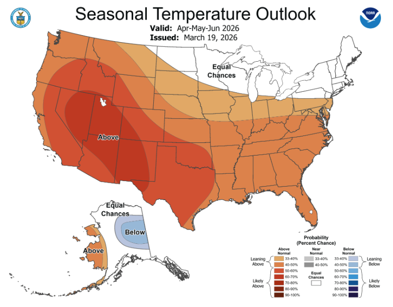
Above-average temperatures are favored across much of the CONUS for April, with the highest probabilities centered over the Great Basin, Four Corners region and parts of the Southeast. Above-average precipitation is favored for a corridor stretching from the southern Plains through the Mississippi Valley and Great Lakes into the Northeast, while drier-than-average conditions are forecast for the West and parts of the central Rockies and Southeast. Above-average temperatures and precipitation are indicated for northern and western parts of Alaska. Visit the Climate Prediction Center’s Official 30-Day Forecastsfor more details.
Drought is expected to persist and expand across much of the interior West, Southwest, Rockies and High Plains, as well as parts of the South, Southeast and Mid-Atlantic. However, some improvement or drought removal is forecast for parts of the southern Plains, Mississippi Valley and Northeast. Visit the U.S. Monthly Drought Outlook website for more details.
Significant wildland fire potential is above normal across portions of the Southwest, southern Plains and central High Plains and much of the Deep South and Southeast. For additional information on wildland fire potential, visit the National Interagency Fire Center’s One-Month Wildland Fire Outlook.
For more detailed climate information, check out our comprehensive March 2026 U.S. Climate Report scheduled for release on April 13, 2026. For additional information on the statistics provided here, visit the Climate at a Glance and National Maps webpages.
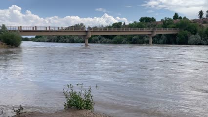
The Colorado River at Las Colonias Park in Grand Junction was running at about 350 cfs Wednesday. Streamflows are expected to be way below normal this spring; some may have already hit their peak for the year. CREDIT: HEATHER SACKETT/ASPEN JOURNALISM
Water managers are planning for an extremely dry summer as Colorado wraps up winter 2026 with the worst snowpack on record for early April.
The Colorado River basin has seen slightly drier water years, but never a hotter one in the era of modern record keeping. A March heatwave that broke records statewide fueled an early peak of the snowpack, followed by rapid melting. This was the warmest March in 132 years of record-keeping for Colorado – three to four degrees Fahrenheit warmer than any other March, according to the Colorado Climate Center.
“Climate change definitely raises the probability of heat waves significantly,” said Peter Goble, assistant state climatologist at Colorado State University. “This heat wave was so far out of the range of what we’ve seen in March before that I don’t expect this to be the new normal, but it was certainly made to some degree more likely by climate change.”
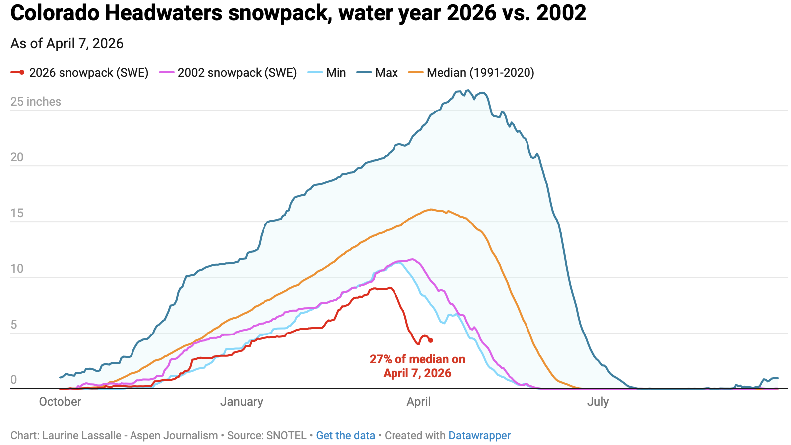
The month of March decimated Colorado’s snowpack, which was thin to begin with, during a time when snowpack is usually still accumulating. The Colorado Basin River Forecast Center put the March 1 snowpack above Lake Powell at 52% of median. One month later, the April 1 numbers showed snowpack had declined dramatically to 23% of median.
“What snowpack was there was already among the lowest, if not the lowest on record, and it melted much more quickly than normal,” Goble said. “We saw melt rates more characteristic of May or June in March.”
Early April status reports and forecasts are important because they provide a critical snapshot of assessing where things stand and how much water will be available for the summer. This week is typically when snowpack peaks for the year before it begins a gradual melt out. But snowpack in the Colorado River headwaters this year peaked nearly a month early on March 17 and now sits at just 27% of median. Snowpack in the Roaring Fork River basin is 26% of normal.
“We’ve never seen anything like this in memory,” said Raquel Flinker, director of interstate and regional water resources at the Colorado River District’s State of the River meeting in Grand Junction Tuesday. “If there’s anything in your memory about a dry year that you’ve seen, a warm year that you’ve seen, 2026 is beyond all of that. It’s far beyond 2002, which has been the year we normally think of as the worst year in hydrology.”
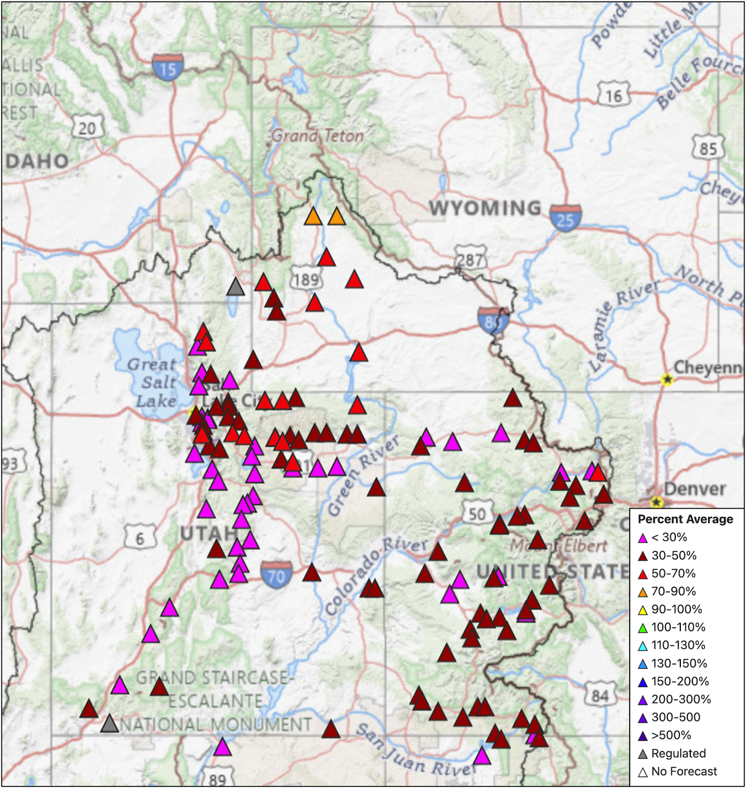
The big question is whether that record-low snowpack will turn into record-low runoff. Forty million people in the American Southwest depend on water from the Colorado River, which comes from the melting annual snowpack. Some streams may have already peaked for the year, something that normally occurs in early June for Western Slope streams.
“The streamflows are going to be much below normal,” Goble said. “But the lowest snowpack on record does not necessarily guarantee the lowest streamflow on record.
”In a Tuesday water supply briefing, hydrologist Cody Moser with the CBRFC said that the forecasted April through July inflow to Lake Powell this year is 1.4 million acre-feet, just 22% of normal and the third-worst on record. That’s down from the March forecast, which predicted 2.3 million acre-feet of inflow. The benchmark for low Powell inflows is 2002, which saw just 964,000 acre-feet of water flow into the reservoir.
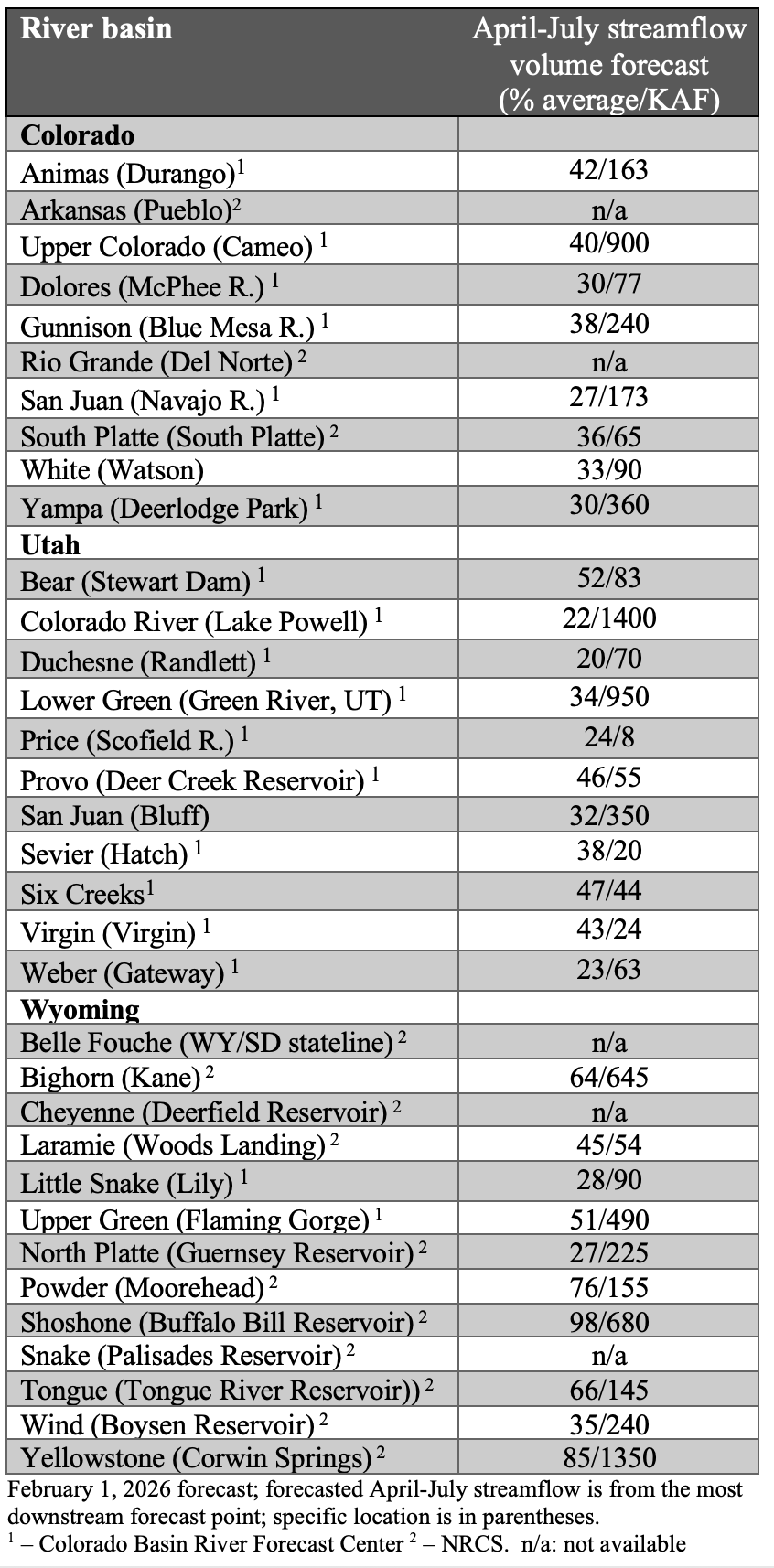
The streamflow forecast for the Colorado mainstem in Colorado (known as Division 5 by state water managers) is 38% of normal, according to the National Resources Conservation Service. The Yampa is at 36% of normal; Gunnison is 34% and the San Juan basin in the southwest corner of the state is forecast to have just 26% of normal streamflows this year.
Yampa calls
Water managers around the state are preparing for an exceptionally dry summer. Some municipal water providers have already implemented outdoor watering restrictions, and the Colorado Division of Water Resources is alerting farmers and ranchers to the possibility of more calls this season.
The Yampa River basin is poised to be one of the hardest hit this year. Mosher said on Tuesday that streamflows on the Yampa are forecasted to be close to the minimum on record.
“This forecast declined by 40% in the past month and here you see that huge melt off with our snowpack conditions,” he said.
Yampa River Operations Coordinator for Division 6 Water Resources Brian Romig sent a March 28 email to all water users in the basin reminding them of how calls work. When an irrigator with a senior water right isn’t getting all the water they are entitled to, they can place a call with state officials, who will then shut off upstream water users with junior water rights so the senior right can get its full amount of water. Under the cornerstone of Colorado water law, the oldest water rights get first use of the river.
The Yampa River was among the last to develop in the sparsely populated northwest corner of the state and it had never had a call until 2018.
“Call administration is a reality of our future,” said Division Engineer Erin Light. “I think it’s very possible we are going to see calls and the sooner people start to understand what that looks like and become accustomed to it, the better.”
Light said she has been hearing from water users about how early they have had to turn their ditches on to irrigate their fields – some the weekend of March 21 – due to the meager snowpack and record-high temperatures.
Light predicted that some ranchers won’t be able to grow all of the hay their animals need to feed them through next winter.
“Ranchers are going to have some big decisions to make as far as: Will they buy hay or will they have to sell cows,” she said.
In recent years, the River District has leased water out of Elkhead Reservoir and released it during the irrigation season to boost flows for downstream ranchers and keep a call off the river. But Light says this approach doesn’t help water users adapt to a future with less water. Once people know what to expect and how calls are administered, it’s less of a big deal, she said. And as river flows continue to dwindle due to drought and climate change, learning how to manage inevitable scarcity has never been more important.
“I think it’s a good thing for our water users to manage their water in such a way that they know in late August, they could be shut off,” Light said. “But we’re not giving that opportunity to the people on the Yampa River by trying to always keep the calls off.”
The Pitkin County Board of County Commissioners moved forward Wednesday with an intergovernmental agreement that expresses commitment “to protect the Crystal River from on-channel dams and transmountain diversions.” The agreement will be between Pitkin County, Gunnison County, the town of Marble, the Colorado River Water Conservation District and the West Divide Water Conservancy District. This was an approval of the first of two readings. The Colorado River Water Conservation District have yet to bring this agreement to their boards but have previously expressed support for the initiative, according to the district’s staff. Gunnison County and the town of Marble will be considering it in upcoming meetings.
“It would be an agreement that all the parties would oppose or not support any new dams on the main stem of the Crystal River, or any new trans-basin diversions out of the Crystal River,” Pitkin County Deputy Attorney Anne Marie McPhee told commissioners on Wednesday. “It is trying to keep the water in the river as long as possible.”
[…]
Despite moving the agreement forward after first reading, Commissioner Greg Poschman acknowledged that there has been concern around the agreement’s lack of enforcement ability, due to the signing bodies’ ability to leave the agreement at will. Poschman referenced specific criticism vocalized by Bill Jochems, a Pitkin County Healthy Rivers and Streams Citizen Advisory board member and Crystal River advocate.
“The expression from Mr. Jochems is, ‘it’s a nothing burger,’ right?” Poschman said on Wednesday. “It’s the weakest of all possible protections for the Crystal. Is that what we want to do at this point?”
Commissioner Francie Jacober commented that, despite the potential weakness that Jochems and Poschman pointed out, it would still be symbolically important for the county to lend their support to the intergovernmental agreement…The county has been pursuing a Wild and Scenic River designation for a portion of the Crystal River since the U.S. Forest Service found 39 miles of it eligible for the designation in 2002, according to county documents supporting Wednesday’s intergovernmental agreement. A Wild and Scenic designation could help with future conservation and preservation efforts.
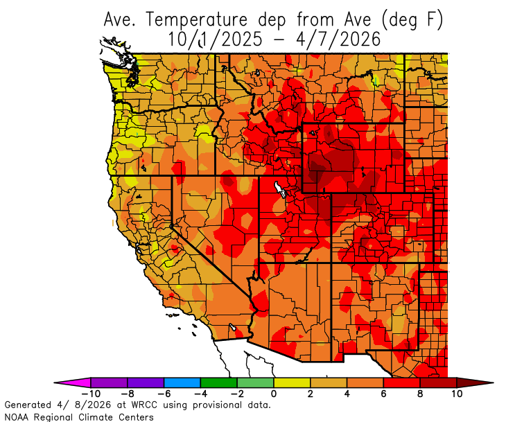
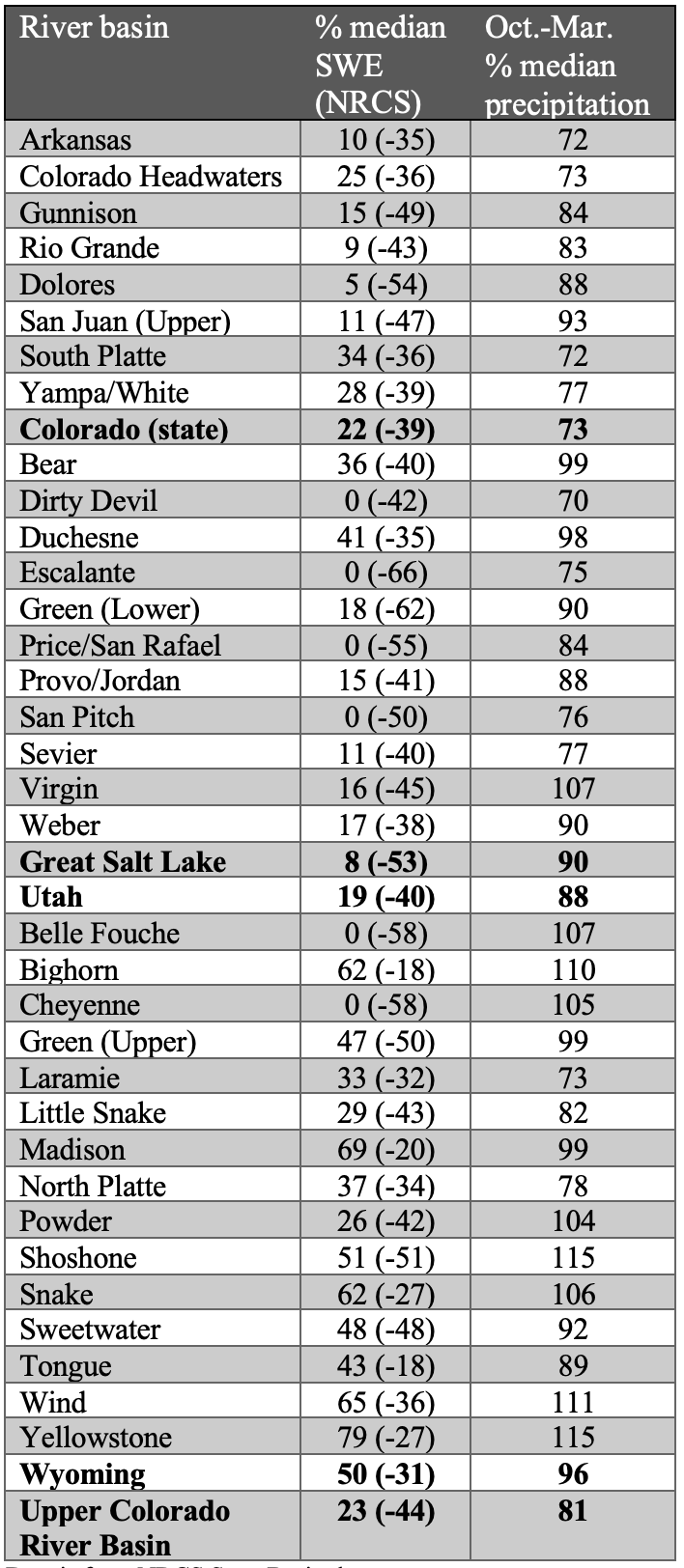
March weather conditions promoted rapid intensification of snow drought. Snowpack peaked three to nine weeks early and sits at record low levels at most locations in Colorado, Utah and much of Wyoming. Record low snowpack was driven by low March precipitation and record hot March temperatures. Consequently, drought conditions expanded to cover 93% of the region, and annual streamflow volume forecasts are much below normal with 22% of normal inflow forecasted for Lake Powell.
March precipitation was below average for nearly the entire region. Large areas of less than 50% of average March precipitation were observed in all three states with the least precipitation falling in eastern Colorado and eastern Wyoming. Record low March precipitation was observed in Baca, Bent, Gunnison, Hinsdale, Las Animas, Prowers, and San Juan Counties in Colorado. Water year precipitation varied with above average precipitation in northwestern Wyoming, southern Colorado and southern Utah, while much of the remainder of the region received 50-90% of average water year precipitation.
An extreme and widespread heat wave hit the region during March, and temperatures were 9-12 degrees above average for much of the region. Record high March temperatures were observed at the majority of locations in Colorado, Utah and Wyoming. All-time maximum March temperatures were set across the region with many locations recording higher temperatures than all-time April records.
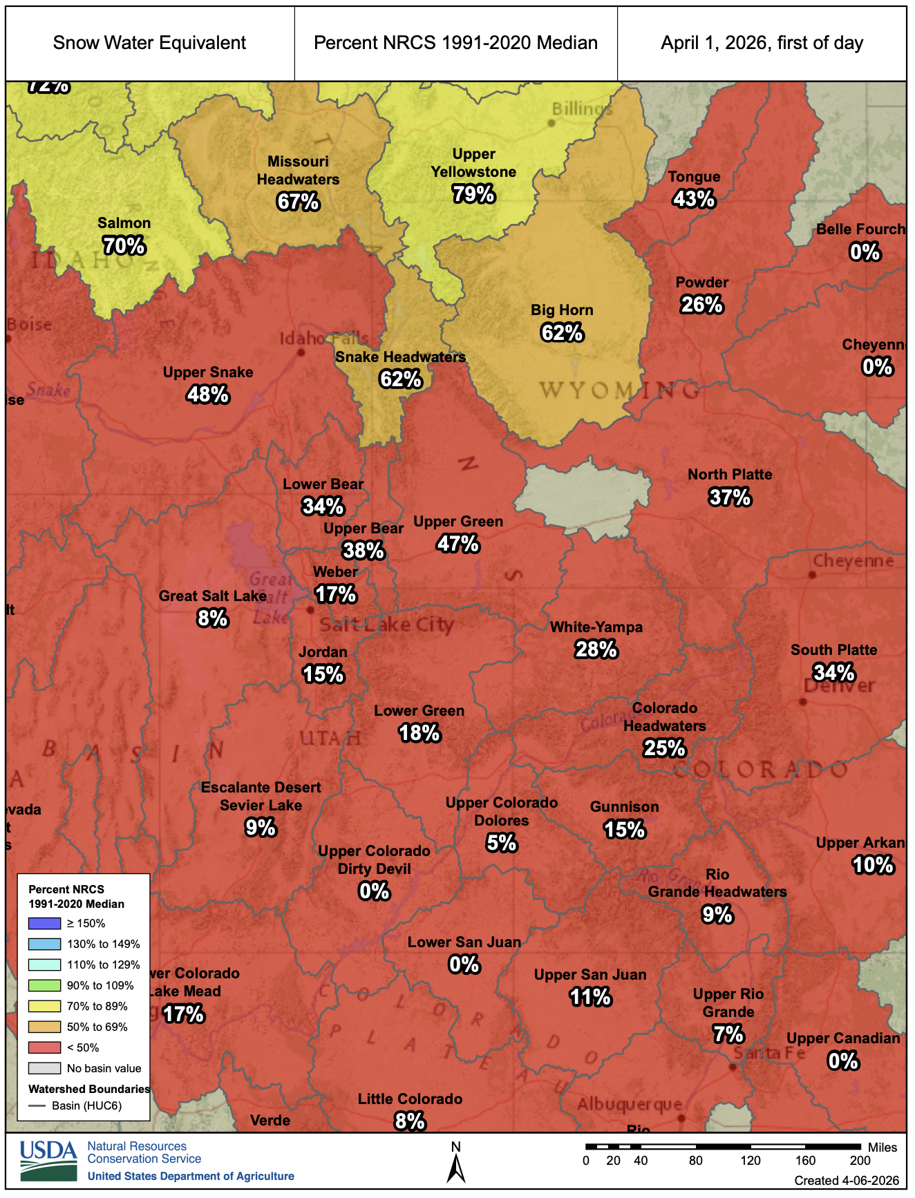
April 1 SWE conditions were record-low for all regional river basins, except those in northwestern Wyoming. On a statewide basis, record-low snowpack was observed in Colorado (24% median), Utah (22% median), and Wyoming (47% median). Snowpack in many southern Colorado and southern Utah watersheds has melted up to 65 days early, including the Upper Arkansas, Upper Dolores, and Upper Gunnison River basins in Colorado and the Dirty Devil, Escalante, Price, and San Pitch River basins in Utah. Record heat and low precipitation in March caused regional snowpack to peak nearly one month early. Typically, on April 1, only three of 213 Snotel sites in Colorado and two of 179 sites in Utah are melted out completely. On April 1, 2026, 36% of Snotel sites in Colorado, 60% of sites in Utah, and 28% of 196 sites in Wyoming were melted out. The snowpack in the Upper Colorado River basin peaked at a record low percent of median peak SWE and was 27% of median on April 1.
After low and early peak snowpack, annual streamflow volume forecasts were much below average on April 1. Annual streamflow volume forecasts ranged from 25-45% of average in Colorado, 20-55% of average in Utah and 25-100% of average in Wyoming. The inflow to Lake Powell is forecasted at 22% of average (1.4 million acre-feet). Regional streamflow forecasts were highest in the Snake and Missouri River basins of northern Wyoming where streamflow volume forecasts ranged from 65-100% of average.
Regional drought intensified during March, and 93% of the region is experiencing severe drought conditions. Extreme drought conditions developed across a broad swath of Utah, western Colorado and southeastern Wyoming, and now cover 45% of the region. Drought in western Colorado worsened by two to three categories, and exceptional drought developed in northwestern Colorado where exceptional drought conditions coincided with the 137,000-acre Lee Fire in August 2025.
West Drought Monitor map April 7, 2026.
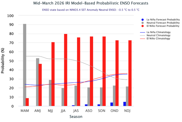
Pacific Ocean temperatures have warmed, and ENSO-neutral conditions (ocean temperatures are within 0.5ºC of average) now exist. Warming sea surface temperatures prompt an 80% probability of ENSO-neutral conditions during April-June, and NOAA issuing an El Niño Watch. ENSO forecasts predict a 60% chance of El Niño conditions developing by May-July and continuing through the end of 2026. There is a 25% chance of a very strong El Niño developing during the beginning of the 2027 water year. NOAA seasonal forecasts for April-June suggest an increased probability for below average precipitation and up to a 70% probability for above average temperatures.
Significant weather event: March heat wave. The heat wave during March 2026 was unprecedented in the western U.S. climate records since 1895. March 2026 average temperatures shattered records in Colorado (by 4.3ºF), Utah (by 5.5ºF), and Wyoming (by 2ºF). Amongst weather monitoring sites with at least 50 years of data, new March temperature records were set at 85% of sites in Colorado, 82% of sites in Utah and 60% of sites in Wyoming. In Utah, previous March temperature records were exceeded by 9.7ºF in Alta and 8.9ºF in Escalante. New all-time maximum March temperature records were set at 80-90% of weather sites in Colorado and Utah, and at 70% of sites in Wyoming. At many locations in Colorado and Utah, new March temperature records exceeded April maximum temperature records. Maximum March 2026 temperatures along the Front Range of Colorado reached the 90s with Burlington, CO recording 99ºF on March 26. Extremely high March temperatures were present across the majority of the West, and record statewide March temperatures were set in Arizona, California, Colorado, Idaho, Oklahoma, Nevada, New Mexico, Texas, Utah and Wyoming. A new record March temperature was also set for the contiguous U.S.