In 2022, University of California Davis published the results of a three-year study on covers crops, which was carried out on ten commercial farms and research sites in California’s Central Valley. The study examined the impact of winter cover cropping on soil health and water retention in irrigated agricultural systems with a focus on almond and tomato crops, which are two of the most common crops grown in the region.1
Three cover crop systems were included in the study and then compared with adjacent control fields that were left bare, at the same site. The systems included: 1) a cover crop in processing tomato fields; 2) a cover crop planted in between rows of almond trees; and 3) allowing whatever native vegetation was available to grow in between the almond tree rows. The planted cover crops were a mix of legumes, grasses, and brassicas.
The results were impressive. Researchers found that the cover crop fields had higher levels of soil organic matter, soil nitrogen, and microbial activity, indicating improved soil health. In addition, the cover crop fields had higher levels of water infiltration and retention, meaning that they were better able to hold onto water during periods of drought or water stress. The researchers found that the cover crops did not compete with cash crops for water, and that the same amount of water used in the control fields without cover crops was able to support the same amount of crop yield in the cover crop fields. In one case in Davis, there was heavy rainfall at one point during the study. The water loss via evapotranspiration was greater in the bare control plot, showing that use of cover crops improved water retention.
The study provided important evidence of the benefits of winter cover cropping in California’s Central Valley, particularly for improving soil health and reducing water usage in agricultural systems. The findings suggest that cover crops can help farmers make more efficient use of their water resources, potentially reducing the need for additional irrigation, and providing environmental benefits such as reduced erosion and improved water quality.
Top 5 Cover Crops for use in the Western US
For the Western United States – including the arid regions of California, Arizona, and Nevada, the best nitrogen-fixing cover crops are selected for their drought tolerance and ability to thrive in either high heat or mild winters.2
Cowpea: Best For: Summer heat in low-elevation deserts. Highly drought-tolerant with a taproot that can reach up to eight feet deep to access water. It thrives when temperatures exceed 100° F and can fix roughly 100–175 lbs of nitrogen per acre. The ‘Iron Clay’ variety is widely recommended for use in the Southwest.
Alfalfa: works best for long-term soil restoration. Often called the “queen of forages,” alfalfa is a perennial legume with deep roots that break up subsoil and reach nutrients deep in the earth. It is one of the most powerful nitrogen fixers, capable of producing 250–500 lbs of nitrogen per acre.
Crimson Clover: Used as winter cover in the Southwest or for spring cover in the north. A fast-growing annual that establishes quickly in the fall to provide winter protection. It is frequently used in mixtures with radish to improve soil structure while fixing roughly 70–150 lbs of nitrogen per acre.
Hairy Vetch: is excellent as a winter-hardy coverage and weed suppression. Why It Works: It grows slowly in the fall but resumes vigorous growth in the spring, creating a thick mat that smothers weeds. It is known for high nitrogen fixation (over 100 lbs per acre) and performs well in the cooler, non-agricultural environments of the West.
Lablab: works best during the summer-to-fall transition in Arizona. Lablab is specifically noted for its performance in the hot weather of central Arizona. It produces high biomass and can contribute 50–200 lbs of nitrogen per acre. Unlike some other summer legumes, it continues vegetative growth late into the year without flowering immediately, offering more flexible termination dates for growers.
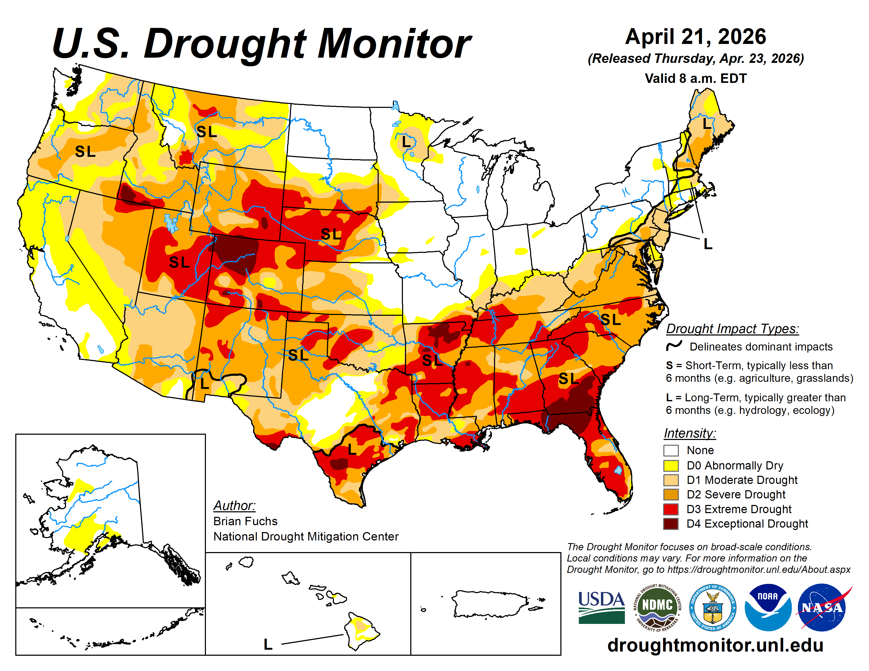
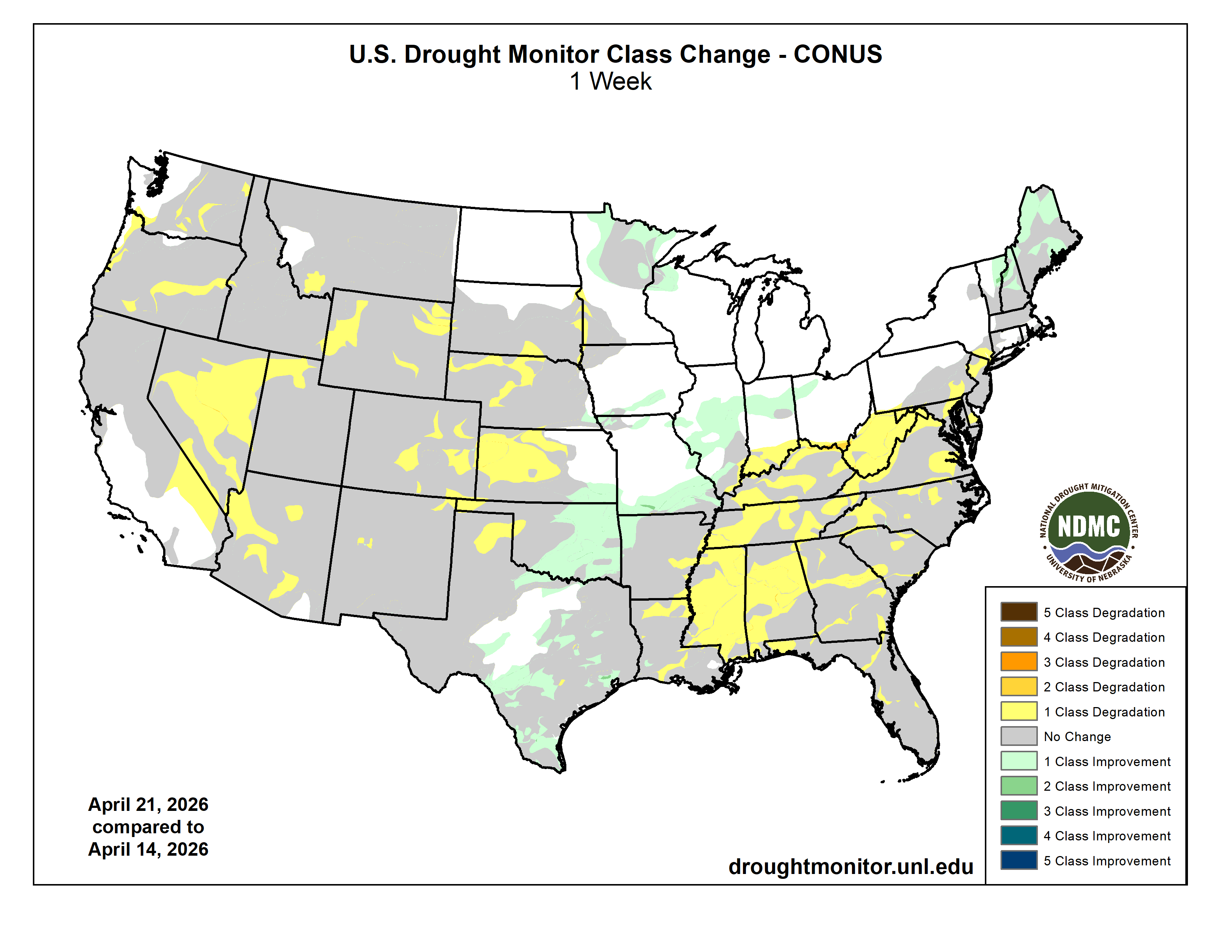
The week was highlighted by a band of above-normal precipitation extending from south Texas into eastern Oklahoma, Missouri, Illinois, Michigan, and southern Wisconsin. Many areas in this swath received greater than 150% of normal precipitation, with some locations exceeding 400% for the week. From the Ohio Valley south into the Southeast, conditions remained quite dry, with little to no precipitation recorded across most of the region.
The West was also largely dry, with only coastal areas of California and parts of the Pacific Northwest recording above-normal precipitation. Northern portions of the Northeast received rain, with areas from western New York into Maine recording 200% or more of normal precipitation.
Temperatures were near normal to slightly below normal across the West, with departures of up to 5°F below normal in some areas. Portions of the central Plains, Midwest, Northeast, and Mid-Atlantic experienced above-normal temperatures, with departures of 5–10°F above normal. Temperatures in the Southeast were near to slightly above normal, with cooler conditions in the Florida Panhandle…
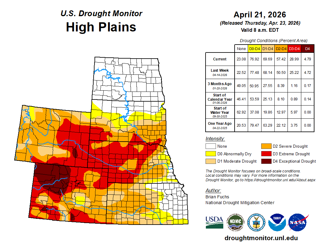
The region was mostly dry, with isolated rainfall in far southeast Nebraska, northern and southeast Kansas, and small areas of Colorado and North Dakota. Temperatures were generally above normal, with the warmest departures in southeast Nebraska and eastern Kansas.
Dryness and a warm spring led to widespread degradation. Extreme drought expanded across central and western Nebraska and into northwest Kansas. Severe drought expanded in central and southwest Kansas, with new extreme drought in far southwest Kansas.
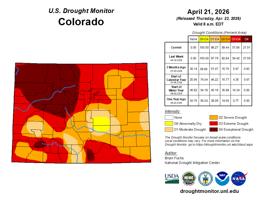
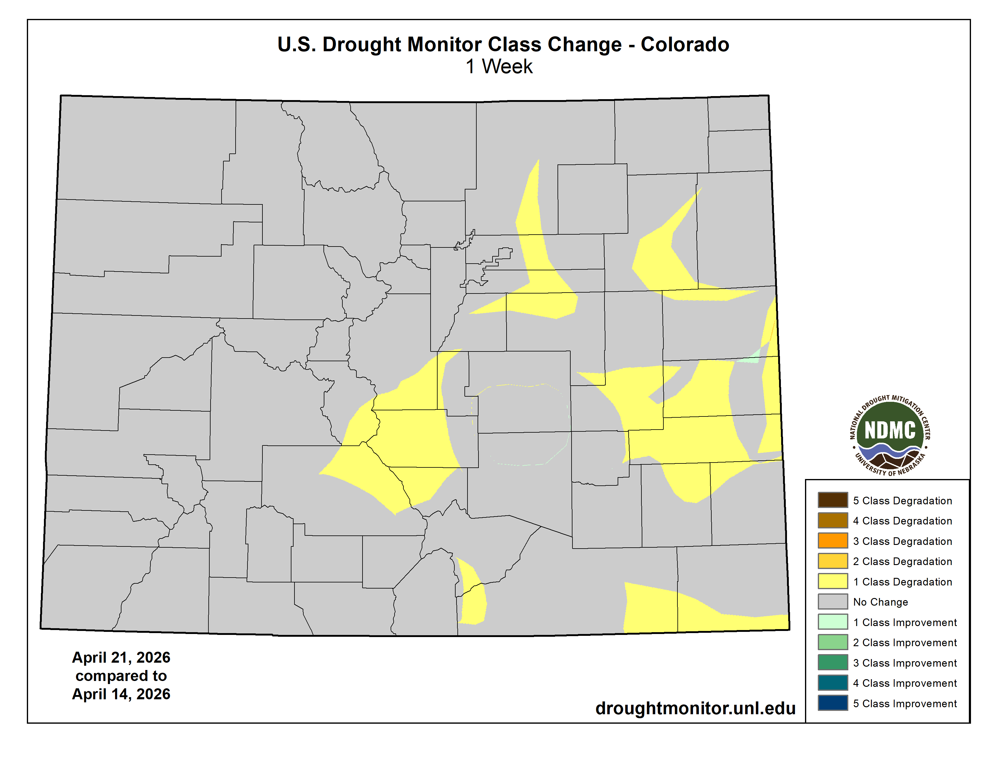
Degradation continued across the plains of Wyoming and Colorado, with expansion of moderate to extreme drought. Extreme drought was also introduced in southern South Dakota.
Some improvements occurred in southeast Kansas, where moderate drought and abnormally dry conditions were reduced due to recent rainfall…
Colorado Drought Monitor one week change map ending April 21, 2026.
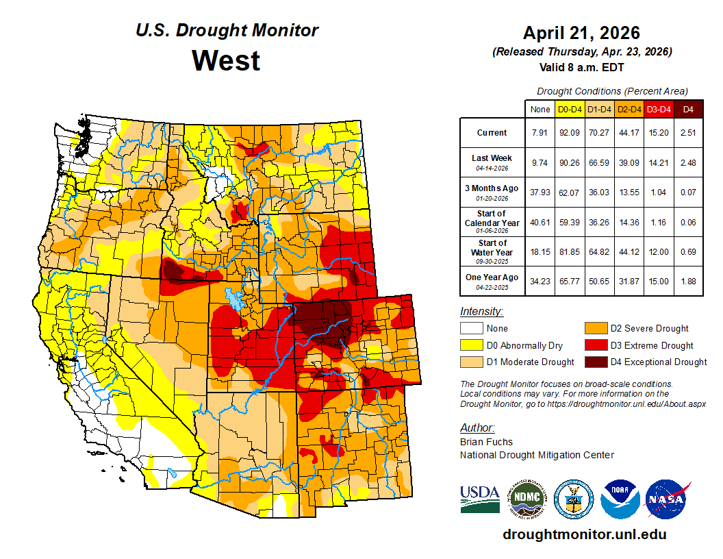
Precipitation was mixed. Parts of central to northern California, western Oregon and Washington, much of Idaho, and isolated areas in Montana, Utah, and Colorado recorded above-normal precipitation. However, most of the region remained drier than normal.
Temperatures were generally cooler than normal, with northern Nevada experiencing departures of up to 6°F below normal. Southern California and Arizona saw the warmest conditions, with temperatures up to 6°F above normal.
Drought conditions worsened across much of Nevada, with expansion of abnormal dryness to severe drought. Severe drought expanded into northwest Utah, while moderate to severe drought increased in western and southern Arizona. Severe drought also expanded in western Wyoming, and extreme drought was introduced in southwestern Montana.
Oregon and Washington saw slight expansion of abnormally dry to moderate drought, with a small increase in severe drought in southwest Oregon. Southern California also experienced expansion of abnormally dry conditions.
Impacts are becoming more evident as snowpack has largely melted, and early runoff may contribute to future water supply issues… [ed. emphasis mine]
Temperatures were above normal across northern and eastern areas, with departures of 2–6°F. Across Texas, temperatures transitioned to below normal in southern and western areas, with departures of 2–6°F below normal.
The heaviest rainfall occurred from central to southern Texas into central and eastern Oklahoma, where totals reached 150–400% of normal. Elsewhere, conditions were mostly dry, including the Texas and Oklahoma Panhandles, and much of Arkansas, Louisiana, Mississippi, and Tennessee.
Where rainfall was sufficient in Texas and Oklahoma, drought conditions improved or were removed. However, drought intensified across Mississippi, where nearly the entire state experienced a full category of degradation and is now 100% in drought.
Extreme drought expanded in eastern Arkansas and northern and southern Louisiana, with moderate drought increasing in southern Louisiana. Severe and extreme drought expanded across western Tennessee, while moderate drought increased in the east. Tennessee is now also fully in drought…
Looking Ahead
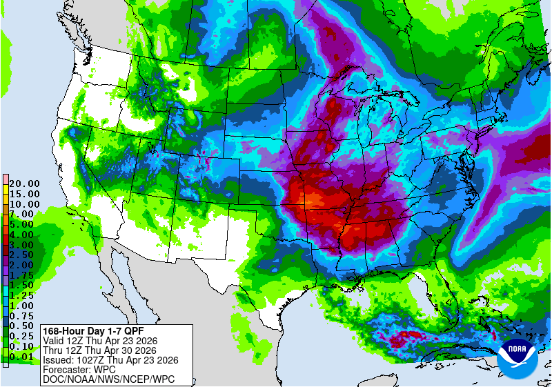
Over the next 5–7 days, the highest precipitation chances are expected from the central Plains into the South, Midwest and parts of the Mid-Atlantic. The Pacific Northwest and northern Rockies may also see widespread precipitation.
Temperatures are expected to be above normal across the southern Plains, South and Southeast, with departures of 9–11°F in north Texas and Oklahoma and 5–7°F elsewhere. Cooler-than-normal temperatures are forecast for the northern Plains, northern Rockies, and California, with departures of 9–12°F below normal in North Dakota and Montana and 6–9°F below normal in California.
The 6–10 day outlook shows the highest chances for cooler-than-normal temperatures across the Plains and Midwest, with the greatest potential over the High Plains and upper Midwest. The best chances for above-normal temperatures are in the Pacific Northwest and along the southern Gulf Coast. The greatest likelihood of above-normal precipitation is across much of the central and southern United States, with the highest chances in the Southwest. Meanwhile, the northern United States along the Canadian border is expected to have the best chances for below-normal precipitation.
US Drought Monitor one week change map ending April 21, 2026.
The Grand Canyon survey party at Lees Ferry. Left to right: Leigh Lint, boatman; H.E. Blake, boatman; Frank Word, cook; C.H. Birdseye, expedition leader; R.C. Moore, geologist; R.W. Burchard, topographer; E.C. LaRue, hydraulic engineer; Lewis Freeman, boatman, and Emery Kolb, head boatman. Boatman Leigh Lint, “a beefy athlete who could tear the rowlocks off a boat…absolutely fearless,” later went to college and became an engineer for the USGS. The Grand Canyon survey party at Lees Ferry in 1923. (Public domain.)
It’s been a record dry winter across the West — and it’s making an already bad situation on the Colorado River even worse. If water levels get any lower, Lake Powell and the dam that holds it back could be in dire straits. So now, the federal government is stepping in to prop up water levels. But, as KJZZ’s Alex Hager reports, it could be a Band-Aid solution to a much bigger problem. Hager joined The Show to explain.
LAUREN GILGER: Good to have you. So, what’s the situation on Lake Powell right now after this really dry winter? Kind of a worst-case scenario almost.
ALEX HAGER: Well, right now water levels there are forecast to drop to dangerously low levels as soon as this summer. And when I say dangerous, that means we would start to see some of the infrastructure in Glen Canyon Dam, which is up in Page, Arizona, start to fail. So water levels are on track right now to drop below the intakes for the hydropower turbines that sit inside the dam. That means it would become difficult or impossible to spin them and make electricity for 5 million people across seven states. If water drops a little bit further than that, it might not be able to pass through the dam at all. We are already looking at — you know, if it falls below that hydropower intake, it could only travel through this little-used set of backup pipes. We don’t know that it could carry enough water through. You start to have all of these problems. So we are seeing some actions to prevent that from happening now.
LAUREN GILGER: OK. So tell us about those actions. This is the federal government sort of taking control of at least this aspect of it. What are they going to do?
ALEX HAGER: That’s right. The federal government is stepping in. It is kicking into action something of an emergency backup plan. It’s been done before, but it is definitely a backup plan. And they’re going to shuffle some water around. There is another big reservoir up in Utah and Wyoming called Flaming Gorge, and they’re going to release extra water from Flaming Gorge, send it down the Colorado River to help fill up Lake Powell. At the same time, they’re going to start tightening the tap on Lake Powell, meaning that less water comes out of it. That water will — less of it will flow into the Grand Canyon downstream to Lake Mead and downstream to us.
Map of the Colorado River drainage basin, created using USGS data. By Shannon1 Creative Commons Attribution-Share Alike 4.0
The back of Glen Canyon Dam circa 1964, not long after the reservoir had begun filling up. Here the water level is above dead pool, meaning water can be released via the river outlets, but it is below minimum power pool, so water cannot yet enter the penstocks to generate electricity. Bureau of Reclamation photo. Annotations: Jonathan P. Thompson
A bad year in the Colorado River Basin – barring a truly miraculous spring, probably the worst in recorded history. It is bad enough so the Bureau may have to stop creating power from the Glen Canyon powerplant by this coming fall. At that point, the only way to get water downriver from Glen Canyon Dam will be dribbling it through four outlet tubes that the Bureau is now wishing it had built differently (better) 65 years ago. And praying for enough precip to push the level back above the danger point for the turbines.
Meanwhile the negotiations between the seven basin states about the future distribution of the water remained at an impasse. One might think that a really bad year might generate some new thinking, but the two Basins are still debating Compact numbers like 7.5 million acre-feet for the Lower Basin with a river that might produce less than 5 maf this year, and maybe not much more than that more frequently in the future.
It should be obvious by now that any further negotiation between the states needs to have an independent facilitator guiding the discussion, pushing both factions to disassemble their own non-negotiables. A hard-ass facilitator speaking on behalf of river reality. [ed. emphasis mine]
It seems likely that we will go into the 2027 water year this fall with some new ‘interim plan’ for operating the river system for the water year that begins in October – probably some mix-and-match from the Bureau’s five alternatives proposed last year and ‘EISed’ while the seven states fiddled. The real purpose of the new interim plan will be to keep the infrastructure of the river system viable – dancing with the dead pool. This will probably impose serious delivery shortages on those below the Powell and Mead Reservoirs (meaning the Lower Basin), and also drop the Upper Basin’s rolling 10-year total closer to the 75 million acre-feet (maf) that will cause the ‘compact call’ threat to rear its ugly head.
Year-to-year might be the most honest approach now, anyway, getting a habit of feeling our way forward carefully, with our eyes wide open – woke, one might say. The managerial ‘need for certainty’ in projections may not be part of the future we’ve imposed on ourselves.
But that’s a good place to let the present sit and settle, and go back to the unfolding saga of the ‘Era of Conquest’ in this update of Fred Dellenbaugh’s Romance of the Colorado River. You may remember that in the last post here, I related that the Bureau of Reclamation, feeling much loved for the Boulder Canyon Project that watered, fed and powered a massive regional development in Southern California, came out of World War II ready to do the same for the Compact’s Upper Basin, in response to a mandate in the Boulder Canyon Project Act that a plan be developed for the development of the rest of the river.
There was, however, already quite a lot of development going on in the Upper Basin – at least in the state of Colorado, beginning in the 1930s, simultaneous with the Boulder Canyon Project.
Udall/Overpeck 4-panel Figure Colorado River temperature/precipitation/natural flows with trend. Lake Mead and Lake Powell storage. Updated through Water Year 2025. Note the tiny points on the annual data so that you can flyspeck the individual years. Credit: Brad Udall
To establish context – the whole Colorado River Basin was experiencing its first serious modern-times drought, even as the Great Depression was settling over the whole nation. After the ‘pluvial’ of water abundance in the first three decades of the 20th century, which convinced the water mavens that the river would deliver a dependable-enough flow of nearly 18 maf, the basin experienced its first 5 maf flow in 1933; by the end of the 1930s, there was reason to doubt that the river would ever again average 18 maf.
But Colorado had a special problem to resolve about Colorado River water distribution: the transdivide situation. I will not bore you again with my opinion of the imperial arrogance in randomly laying down straight line state boundaries in a region of great geographic and geological diversity. But what this created in the irrelevant rectangle called Colorado was like a blanket laid over a fence – the fence being the Continental Divide. West of the Divide, precipitation that fell (mostly snow in the winter) all ran off toward the Pacific Ocean in the Colorado River tributaries. East of the Divide, it all ran off toward the Atlantic in the Platte, Arkansas and Rio Grande Rivers. Because the weather mostly rode in on the prevailing westerlies, considerably more precipitation fell on the West Slope than fell on the East Slope. But the vagaries of cultural and economic development put most of the population and economic growth on the East Slope – ‘80 percent-20 percent’ is the rough ratio frequently used to describe the imbalance between water and population in the blanket dropped over the fence.
The distribution of water on both sides of the ‘blanket’ was governed by the appropriation doctrine as stated in the Colorado Constitution: all the water in the state belongs to the people of the state, subject to appropriation for individual use, and the right to divert ‘shall never be denied’ – with seniority among users determining the right to use the water in times of shortage. And by the turn of the century, challenges in water court had established the right to divert water from one basin to another.
As the drought of the 1930s settled in, farmers on the East Slope began to experience serious pressures on the water supply. And consistent with the optimism and technological advances of the early 20th century, this was not regarded as a fact of life to be acknowledged and adapted to, but as a problem to be addressed – in this situation, by moving water from the West Slope. A major task – but Franklin Roosevelt’s ‘New Deal’ efforts to alleviate the Great Depression offered the possibility of some help, through new agencies like the Reconstruction Finance Corporation and the Public Works Administration.
So when the Colorado General Assembly gathered early in 1933, two water project bills were in the hopper: one to divert an unspecified quantity from the Upper Colorado River in the Grand Lake area to the South Platte River basin, and one to divert an unspecified quantity from the Gunnison River to the Arkansas River basin.
Inhabitants of the West Slope, however, knew nothing about this until they read about it in the newspapers. And they were even more surprised that summer when construction actually began on two transdivide projects: the Denver Water Board began constructing a system of small canals high in the Fraser River headwaters (Upper Colorado tributary) to bring water to the Moffat railroad tunnel pilot bore, which the Water Board had leased from the railroad – an unused but already dug ‘pipe’ to the northern Denver area. And the sugar-beet industry led by Great Western Sugar was doing the same collection system in the headwaters of the Roaring Fork River above Aspen for diversion into a small tunnel to the Arkansas River basin. Both of those enterprises were self-funded.
All of this precipitated a regional West Slope meeting in Grand Junction of ‘water people’ – county commissioners and attorneys who were also all ranchers or farmers – at which a ‘Western Colorado Protective Association’ (WCPA) was formed, and a letter was drafted to the state engineer expressing concern that the proposed and in-process projects threatened the future development of the West Slope, and requesting inclusion in all future discussion of them.
The situation as the West Slope people saw it was not a ‘water grab.’ The leadership in the WCPA knew that the East Slope irrigators and city-builders were exercising a constitutional right in appropriating ‘the people’s water’ on the West Slope. They also knew that most of the Colorado River water left the state’s West Slope in an unmanageable snowmelt flood anyway, and it might as well go through a tunnel to the Front Range as through Grand Junction and on to – well, soon, on to enviable storage behind the great dam being built far downstream rather than its historical destiny of flowing on into the salty sea unused.
Storage! That was the key to the West Slope’s chief water problem, which was water available throughout the growing season for finishing as well as starting crops. West Slope engineers had been drafting up a number of reservoir-and-irrigation projects to present to the Bureau of Reclamation, but dams are expensive, and all of the proposed reservoirs served mountain-valley populations too small to pass the Bureau’s cost-benefit analyses.
So the concept of ‘compensatory storage’ for water lost through transdivide diversions became the WCPA’s central focus. And despite their small population, the WCPA had two good cards to play. One was the fact that New Deal federal funding distributed to the states had to be for projects approved by the entire state; the transdivide diversions that needed federal assistance needed for the basin of origin to be as happy as the basin of destination.
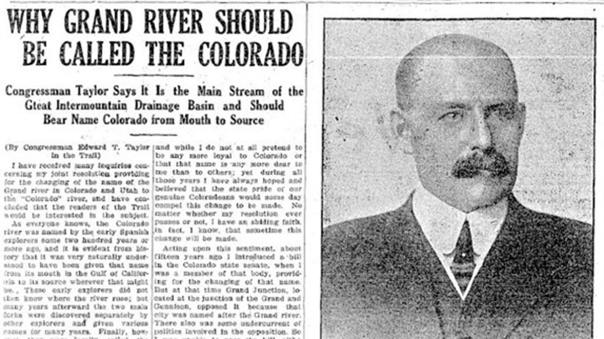
A image shows a guest column by Rep. Edward Taylor that appeared from the Steamboat Pilot in 1921. Graphic credit: Northern Water
The other card was a congressional representative, Edward Taylor, whom they had returned to Congress for 12 terms by 1933, and who had over that quarter-century ascended to chairmanship of the subcommittee that controlled the Interior Department budget in the powerful House Appropriation Committee. Congressman Taylor launched the WCPA’s ‘defensive offensive’ by saying that any project seeking federal assistance for a transdivide diversion would have to provide, as part of their project, an acre-foot of compensatory storage for the West Slope for every acre-foot to be diverted.
That was a large and very expensive demand. Taylor exempted Denver and its Moffat project from the mandate – because, he said, we all want to see ‘our capital city’ grow unrestricted. More likely, he knew that Denver could fund its own project and would at best just ignore him; he was not their congressman, and the Denver Water Board at that point was coming under the domination by their attorney, Glenn Saunders, a city-builder who envisioned a water supply for a ‘thousand-year city,’ most of which he thought would have to come from the West Slope. He just wanted the hicks to stay out of his way. (Not an exaggeration at all.)
Taylor could, however, impose his acre-foot-for-every-acre-foot demand on those seeking federal Public Works Administration funds or Bureau of Reclamation assistance. And that set up what is really an interesting story of people working out difficult problems they’ve imposed on themselves in draping a blanket over a fence and calling it a state, then adopting a wide-open appropriations doctrine for the distribution of a limited resource statewide. It’s a story with many moving parts that we don’t really have time for here in depth; I will note, however, that the whole story is told in my Water Wranglers book, the story of the development of Colorado’s share of the Colorado River. (Out of print, but copies supposedly in all Colorado libraries.)
The principal players in the story were the Western Colorado Protective Association (WCPA), led by Frank Delaney, a lawyer-rancher, and D.W. Aupperle, a Grand Junction lawyer and fruit grower; the South Platte Water Users Association (SPWUA), led by Charles Hansen, a newspaper editor in farm country and a couple lawyer-farmers; and of course the Bureau which wanted to do a big transdivide diversion to the South Platte River. And what turned out to be the ‘wild card,’ Congressman Taylor.
A seemingly endless series of meetings began between the WCPA and the SPWUA with the Bureau in attendance. There was fundamental agreement that, first, the East Slope had legal right to appropriate West Slope water, and second, that the East Slope owed the West Slope some compensation for diverting part of the West Slope’s base for future development. The challenge was arriving at the amount of compensation. The SPWUA wanted to divert more than 300,000 acre-feet from the Colorado River, for what became the Colorado-Big Thompson Project, but they did not see how (even if they could get some New Deal PWA financing) they could afford to also create that much West Slope storage. But the WCPA felt bound to support their congressman – without whom they really had no card to keep them in the game. Frustration and ire grew on both sides – compounded by having to travel back and forth either on the slow trains or drive on roads that were really ‘country’ (a major West Slope chronic complaint).
Finally, in the spring of 1936, Frank Delaney of the WCPA suggested a compromise. If the Bureau and SPWUA wanted to rush into construction, it would have to be Taylor’s acre-foot-for-an-acre-foot mandate. But if they could delay their project until the Bureau did a thorough study of what the loss of 300,000 af of free-flowing water (most of it annually leaving the state unused anyway) would be to the West Slope, and how much storage would actually compensate the West Slope users for that loss of spring runoff, the West Slope would accept that number (and work on getting Cong. Taylor to accept it).
The ‘Delaney Resolution’ broke the stalemate. The Bureau men spent months poring over existing rights and land maps (long before computers and spreadsheets), and came up with a need for 152,000 acre-feet of compensatory storage: 52,000 af to make sure that the Shoshone power plant water right above Glenwood Springs could be met year round (which would also ensure enough late season water for the Grand Valley farms and orchards), and 100,000 af for future irrigation and domestic water development.
That cut Taylor’s demand in two – and the Bureau planned to add a powerplant to the dam that would significantly reduce what the SPWUA would have to pay back. During this period, Taylor – an old man – was actually too sick to participate, and the Delaney Resolution was adopted for the Colorado-Big Thompson Project. (Taylor would die in office in 1941 – still believing that an acre-foot-for-every-acre-foot was what should be adhered to.)
Graphic credit: RogerWendell.com
The compromise process was codified as ‘Senate Document 80,’ part of the Colorado-Big Thompson Project Act passed in 1937. Senate Doc. 80 became part of all subsequent transdivide project planning – except where Denver was concerned; it wasn’t until the veto of Denver Water’s Two Forks Project half a century later that Denver Water finally conceded to take West Slope needs into account in its transdivide projects.
That process of working through a significant challenge to mutual benefit stands, in at least my mind, as one of the highlights of the Era of Conquest in the Colorado River region – a period not without occasional efforts measuring up to the often naive but high-minded vision driving the developers’ ‘romancing of the river’ – to bring deserts into bloom, to reshape unfriendly environments to accommodate individuals and their families willing to work at it. It is too easy to condemn that from this side where we reap the harvest of all the mistakes involved that they didn’t know about until they had made them.
Next post, we’ll look at what happened to that carefully forged intrastate resolution when serious Colorado River planning came to the Compact’s Upper Basin. Meanwhile – pray for monsoons, or just a good rainy spell.
Colorado transmountain diversions via the University of Colorado