my latest books cartoon for @theguardian.com
— Tom Gauld (@tomgauld.bsky.social) 2026-04-19T09:44:41.044Z
Day: April 24, 2026
Although cloud seeding couldn’t save #Colorado from a historically bad #snowpack, the dry winter sparked more interest in it — Sky-Hi News
Click the link to read the article on the Sky-Hi News website (Ryan Spencer). Here’s an excerpt:
April 21, 2026
At least nine states conduct cloud seeding operations, including California, Nevada, Idaho, Utah, Wyoming, New Mexico, Texas and North Dakota
Colorado’s weather modification program is seeing an increased interest in cloud-seeding technology after the record-low snowpack this past winter. In the past couple of weeks, Weather Modification Program Manager Andrew Rickert said he’s received inquiries from two major ski resorts hoping to learn more about cloud seeding, which can increase the amount of snowfall a storm drops…
The Colorado Water Conservation Board administers the state’s weather-modification program, which issues permits to contractors who operate seven permitted winter cloud-seeding projects, all of which are located on the Western Slope…Rickert said he believes that dry years like this “are one of the reasons why we need to look into cloud seeding as a measure to get more snow, to get more moisture out of a system.” But he noted that the technology can only do so much when natural snowfall is low.
“Cloud seeding can’t create storms,” he said. “We need storms to be present with the right characteristics — wind speed, wind direction and the presence of super-cooled liquid water — and when all those things are there, then we can seed the storm to get a little bit more out of it.”
The ability of cloud seeding to add to Colorado’s snowpack was limited this year compared to past years due in large part to the lack of suitable storms that rolled through the state, Rickert said. He noted, however, that the technology still likely added small amounts of extra precipitation to the storms it did seed. In Colorado, he said all seven wintertime cloud-seeding programs use ground-based generator systems and operate from Nov. 1 to April 15, with contractors able to get an extension to the end of April if conditions allow…Two of the state’s cloud seeding projects — the Central Colorado Mountains River Basins project, which targets the region from about Winter Park to Aspen, and the San Juan Mountains project — are run by Western Weather Consultants, a Durango-based company. Western Weather Consultants Lead Forecaster and Assistant Manager Mike Hjermstad said that the regions where both of those projects operate saw far fewer storms suitable for cloud seeding this year. In the central mountains, where there are usually 30 to 40 storms that are suitable for cloud seeding, there were only 20 this season, Hjermstad said. In the San Juan Mountains, there were even fewer storms that were suitable to be seeded. Only about 12 storms rolled through all winter long that could be seeded, he said.

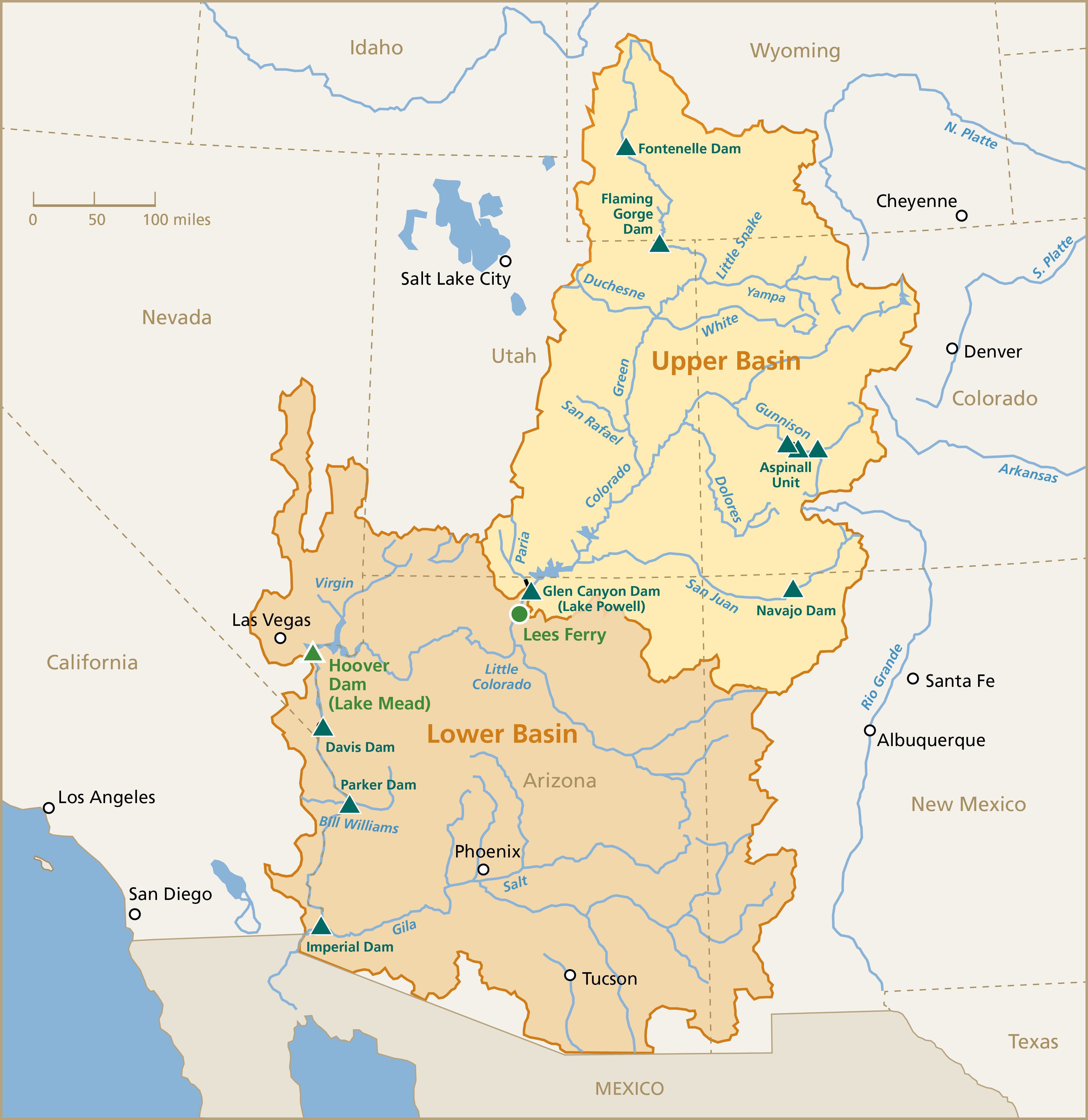
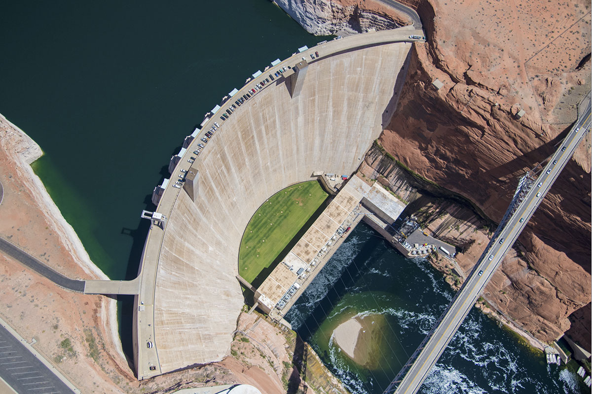
Severe #ColoradoRiver #drought leads to water releases from Upper Basin reservoirs and reduced flows from #LakePowell — #Aspen Public Radio #COriver #aridification

Glen Canyon Institute and the Great Basin Water Network. Courtesy of Utah Rivers Council
Click the link to read the article on the Aspen Public Radio website (Caroline Llanes). Here’s an excerpt:
April 21, 2026
The agency announced on April 17 that it would release between 600-thousand and one million acre feet of water from Flaming Gorge Reservoir on the Wyoming-Utah state line over the course of the next year. In addition, Reclamation will reduce the amount of water it sends from Lake Powell through Glen Canyon Dam, decreasing flows downstream through the Grand Canyon and into Lake Mead. Through September 2026, the agency will reduce its annual release volume from about 7.5 million acre feet of water to just 6 million acre feet.
The drought contingency actions come in response to a water year that has been incredibly dire for the Western United States and the Colorado River Basin. Snowpack has been at record lows for much of the winter, which is bad news for a region that relies on snowmelt for much of its water use. The forecast for runoff into Lake Powell from the entire Upper Basin is forecast to be just 23% of normal. The agency estimates that these combined actions will boost Lake Powell’s elevation by 54 feet over the course of the year, bringing it to 3,500 feet in April 2027. Currently, Lake Powell’s elevation is about 3,528 feet. 3,490 feet is the elevation at which hydropower can no longer be produced at Glen Canyon Dam. Any lower, and water will not be able to enter the hydroelectric turbines. Instead, the water has to go through what’s called “river outlet works,” which are tunnels that bypass the turbines to get the water downstream to the Colorado River.

Seth Arens, a hydrologist at the Western Water Assessment, said Glen Canyon Dam was not designed to have the river outlet works as the primary way to get water out of the reservoir.
“When the Bureau of Reclamation has used those river outlet tubes, most of the times they’ve used them, there’ve been some damage to those tubes,” he said. “They’ve had to repair damages after relatively short uses, you know, a scale of weeks dumping water out of those.”
Environmental attorney Chris Winter said it’s clear Reclamation has to take emergency actions to protect its own infrastructure. But, he said the plan leaves a lot of uncertainty and unanswered questions.
“We’re not going to be able to release a whole bunch of water from Flaming Gorge Reservoir (next year) because that water will have been released this year, and it’s not going to refill if we get another dry year,” he said. “Releases of water from Upper Basin storage units, that’s like a one-time thing, unless we happen to get some wet years in the future.”

Flaming Gorge is currently about 82% full. Reclamation estimates that its plan will bring the reservoir down to about 59% of its full capacity over the next year. Other Upper Basin reservoirs are not part of the plan at the moment, due to poor forecasted inflows and low water levels. Blue Mesa Reservoir in Western Colorado is currently 47% full and Navajo Lake on the Colorado-New Mexico state line is 63% full. Winter said reducing flows out of Glen Canyon Dam could also lead to legal issues. The Upper Basin states of Colorado, Utah, Wyoming, and New Mexico have not reached a deal with the Lower Basin states of Arizona, California, and Nevada on how to allocate water—and take cuts to usage in the midst of a changing climate—over the next 20 years. On top of that, reducing flows this year would mark a fulcrum point: the first year that the amount of water at Lees Ferry, just below Glen Canyon Dam, falls below the averages set by the Colorado River Compact of 1922.

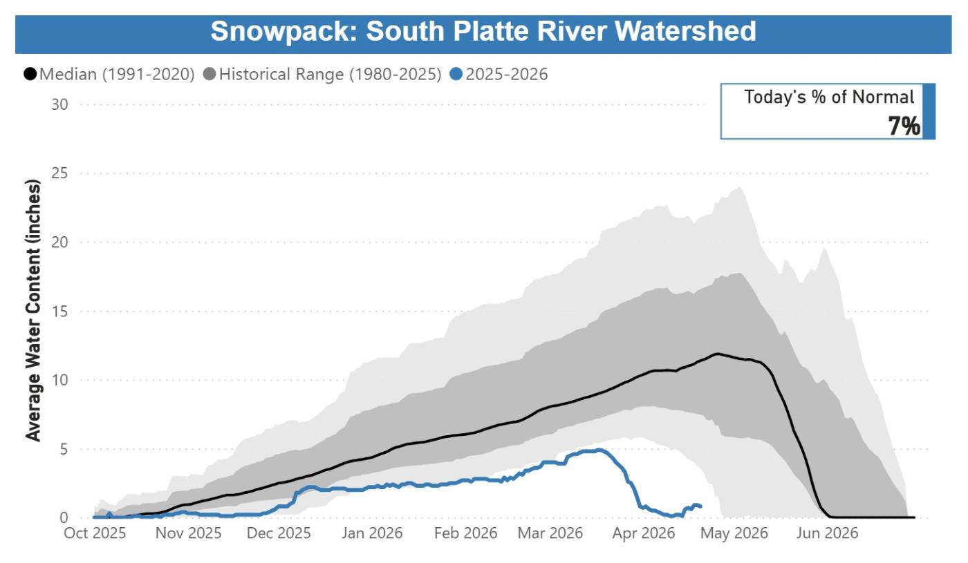
April 20, 2026, water supply and water use update for Denver Water’s system — DenverWater.org #snowpack #runoff
Click the link to read the article on the Denver Water website:
April 20, 2026
Denver Water’s collection and service areas continue to face severe drought conditions, with historically low snowpack. Denver Water depends on mountain snowpack for its water supply, which serves 1.5 million people in Denver and surrounding suburbs.
As a result, on March 25, 2026, the Denver Board of Water Commissioners declared a Stage 1 drought, seeking a 20% reduction in water use to preserve water levels and avoid even stricter mandatory restrictions later this summer. On April 8, 2026, the board approved the implementation of temporary drought pricing, starting with May water use and reflected in June bills, to signal the premium value of water during droughts and help incentivize customers to save water.
Customers are urged not to turn on automatic sprinkler systems until at least mid- to late-May, or later if possible. It is not necessary to water grass two days per week in April and the beginning of May; keeping automatic systems off will help save water. Occasional hand-watering may be necessary for trees and shrubs during this time. Keep an eye on the weather and let Mother Nature do the watering when she delivers spring rains.

Snowpack and water supply update
- Comment from Nathan Elder, Denver Water’s manager of water supply:
“The snow we saw last week brought marginal improvement to snowpack, but it’s still the worst on record, which is doubly concerning as this week is typically our spring peak when the snow levels are the highest. We need our customers to reduce their water use by 20% and help stretch the water we have stored in our reservoirs. Hopefully, working together, we can save water across our service area and avoid increasing restrictions later this summer.”
- In Denver Water’s collection system, snowpack as of April 20, 2026, remained at the lowest levels observed in the past 40 years:
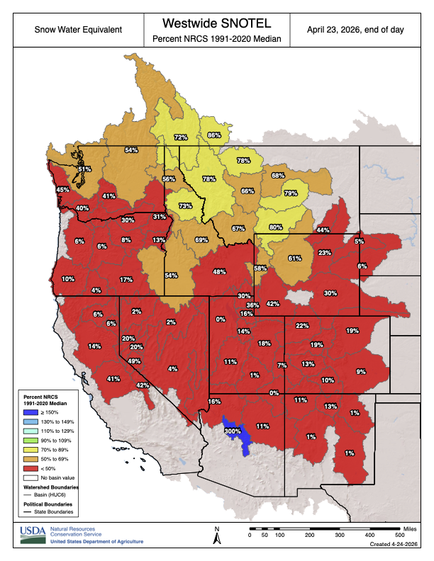
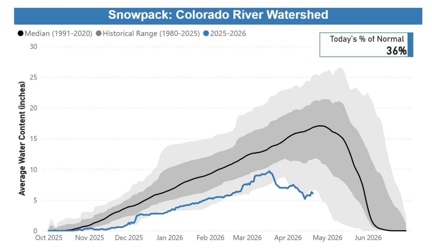
- Colorado River Basin: 36% of normal, worst on record.
- South Platte River Basin: 7% of normal, worst on record.
- Snowpack and melting conditions are unprecedented, with accelerated melting seen since mid-March. Customers need to save water to protect the supply we have right now.
- Streamflow forecasts are calling for runoff levels to be 10-40% of normal in 2026.
- Reservoir storage conditions are below average; while in reasonably good shape for the time being, far less snowpack is available to help refill them. As of April 20, 2026, reservoirs were 80% full, versus an average of 85% full for this time.
Water use and conservation update
- Customers can do their part by making water-efficient upgrades, inside and outside, including rethinking their yards. These steps preserve water supplies and create more adaptable and drought-resilient landscapes that fit naturally into our climate. Read on TAP: Simple strategies to save water at home.
- Customers are urged not to turn on automatic sprinkler systems until at least mid- to late-May, or later if possible. When watering season begins, Denver Water will require customers in single-family residential properties to limit watering to no more than two days per week on a set schedule based on their address.
- Addresses ending in even numbers: Sunday and Thursday.
- Addresses ending in odd numbers: Wednesday and Saturday.
- All other customers, including multifamily properties, commercial properties, homeowners associations and government properties, may water only on Tuesdays and Fridays.
- In addition, customers will be required to follow Denver Water’s annual summer watering rules:
- Water only during cooler times of the day, between 6 p.m. and 10 a.m.
- Do not allow water to pool in gutters, streets and alleys.
- Do not waste water by letting it spray on concrete and asphalt.
- Repair leaking sprinkler systems within 10 days.
- Do not irrigate while it is raining or during high winds.
- Use a hose nozzle with a shut-off valve when washing your car.
For its part, Denver Water has proactively reduced its spending, taking steps that include enacting a hiring freeze and reviewing maintenance and other projects to see which ones could be deferred. We are also looking into other ways to increase supply by activating agreements that allow us to capture additional water that is typically unavailable during normal conditions.
This year marks the fifth time since 2000 that Denver Water has issued a Stage 1 drought, and the first since 2013. Prior to 2013, the board declared a Stage 1 drought in 2002, 2003 and 2004.
Denver Water has many resources for homeowners looking for inspiration and information about landscapes that fit naturally into our dry climate. Click here for conservation and efficiency tips for outdoor irrigation and to get more details on ways to ColoradoScape your property, including through rebates for turf removal and a DIY guide for landscape changes, among many other potential water-saving steps.
Updates about Denver Water’s reservoir levels, customer water use and snowpack can be found in the Water Watch Report, which is updated weekly in the spring and summer.
New Mexico’s Time-Honored Irrigation Canals Face Existential Threat: As the #RioGrande dries out months early, water managers look to blessings, prayers and groundwater to save the acequias — Tina Deines (InsideClimateNews.org)
Click the link to read the article on the Inside Climate News website (Tina Deines):
April 21, 2026
As the Rio Grande dries out months early, water managers look to blessings, prayers and groundwater to save the acequias that have spread water, history and culture to farmers and families since the 16th century.
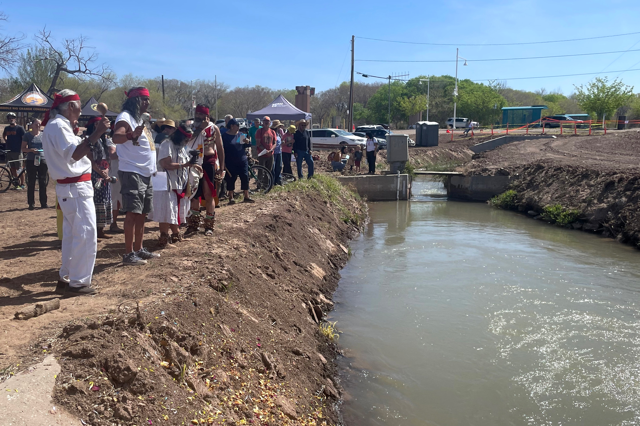
On a sunny spring morning at the end of March, a woman raised her little girl above an irrigation ditch that runs just west of the Rio Grande in Albuquerque’s South Valley. The toddler, with a braided head piece crowning her long, brown hair and artificial flowers around her neck, enthusiastically tossed an assortment of colored petals into the water below as a small crowd cheered.
It was part of a blessing ceremony at the headwaters of the Atrisco Acequia Madre (Atrisco Mother Ditch)—considered to be the oldest and most important of these irrigation canals in the area—during “Primera Agua,” an annual celebration that commemorates the first water flow of the season.
The day, sponsored by the Center for Social Sustainable Systems (CESSOS), a local advocacy group, was filled with traditional dances, songs, chants, blessings and speeches about community. But it also included acknowledgments of the water challenges that New Mexico faces.
This year, New Mexicans are confronting record-low snowpack, which is essential for supplying an even flow of water into acequia systems. Record heat isn’t helping, as it accelerates evaporation throughout New Mexico waterways and has contributed to an early melt off of the already thin snowpack.
At the March 29 Primera Agua event, temperatures were 14 degrees Fahrenheit above average in Albuquerque, and about a week earlier, the city set a record for the earliest 90-degree day of the year. Like much of the West, the city also experienced its warmest winter on record.
“Every year seems like it’s a new bar in terms of the record low,” Paul Tashjian, director of freshwater conservation for Audubon Southwest, said of the low water levels that were already hitting the state in late March. “But this year is almost like that on steroids…It’s not a pretty picture.”

“It’s in Your Blood”
New Mexico’s acequias date back to the late 16th century, when the Spanish colonized the region. By 1700, what would become New Mexico had around 60 of these community-managed irrigation ditches. Today, there are more than 700 active acequias in the state, many of them concentrated in Northern New Mexico.
The man-made, gravity-fed earthen canals transport snowmelt and river water to fields for flood irrigation. They each have a governing body called a “mayordomo” or “ditch boss” and elected commissioners who oversee maintenance, water distribution and conflict resolution.
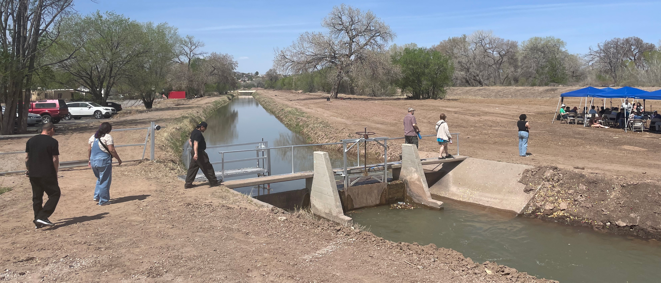
Some areas have seen traditional acequias absorbed into larger water conservancy districts. The Middle Rio Grande Conservancy District (MRGCD), for instance, covers a 150-mile stretch of the Rio Grande from Cochiti to Bosque del Apache. Here, MRGCD diverts water from the river to the agency’s irrigation system, which delivers it to acequia headgates, where local groups take over.
Most acequias across the state, however, still operate as individual political subdivisions.
Dawn Nieto Gouy grew up in Albuquerque’s historic Los Duranes, a neighborhood where acequias such as the Duranes Lateral run alongside homes and agricultural fields.
“It’s in your blood. It’s in your soul,” Nieto Gouy said, describing the cultural significance of these waterways. She recalled playing with her best friend alongside an acequia near her home as a child.
“It was like I would spend almost a lifetime in a day getting from our house to the end, meeting at the acequia, running around barefoot and playing and bathing, doing whatever we did there,” she said. “And then the days would just run away from us.”
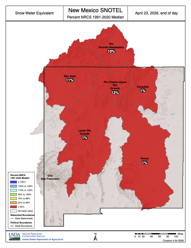
Despite their long history and cultural importance, acequias—and the people who depend on them—face an urgent threat from climate change. This year, New Mexico’s snowpack hit historic lows in early spring, dropping to around 20 percent of normal as of April 20. That record-low snow collided with warmer-than-usual temperatures—the state experienced its hottest March in recorded history, surpassing the old record by 4.4 degrees Fahrenheit—to produce this outcome.
In Northern New Mexico, water rights holders—known as parciantes—expressed concern that the meager snowpack wouldn’t sustain the many acequias that weave through the region. One Santa Fe New Mexican reportdescribed the dire situation in the village of Truchas, where acequias were already running low at the start of the irrigation season.
Further south, MRGCD announced in late March that there may not be enough water this year to meet the needs of its 11,000 irrigators, including acequia parciantes. And as of March 27, the Rio Grande showed early signs of drying at the San Acacia reach, an area that typically begins to diminish in early summer.
“Historically, we used to talk about May as being a very early time to see that happen,” said Anne Marken, river operations manager for MRGCD, which oversees irrigation, drainage and river control for around 60,000-70,000 acres of farmland. “Last year it happened in April and we were all very shocked by that, but this year it happened in March.”
Praying for Rain
During times of water scarcity, acequia communities have long relied on sharing practices. Users may be assigned specific days or hours when they can access water, for instance. Similarly, MRGCD utilizes rotating water deliveries within its district—delivering water to different irrigators at different times, depending on availability—and is implementing that management strategy this year.
“Water users are strongly encouraged to take water when it is available, future opportunities may be uncertain,” the agency said in a press release.
Other than that, water managers and acequia parciantes across the state are praying for rain to help replenish the system and water fields.
“There’s not a ton of tools in our toolbox right now from a water management perspective,” Marken conceded, explaining her department is currently working in a run-of-the-river system, meaning that the only available water is what is in the river.

#LakePowell will get a short-term boost amid #ColoradoRiver #drought — Alex Hager (KJZZ.org) #COriver #aridification
Click the link to read the article on the KJZZ website (Alex Hager). Here’s an excerpt:
April 21, 2026
The nation’s second-largest reservoir will get a boost to keep water levels from dropping too low, but the fix won’t last long…The Bureau of Reclamation will take water from Flaming Gorge Reservoir in Utah and Wyoming and send it downstream to Lake Powell. The agency, which manages major dams and reservoirs across the Western U.S., will also ratchet back the amount of water released from Lake Powell. The efforts are mainly focused at keeping Glen Canyon Dam running smoothly. If water levels drop much further, Lake Powell’s surface will fall below the intakes that pull water into hydropower generators within the dam…Water levels had been forecast to drop below the hydropower intakes level as soon as this summer…
Glen Canyon Institute and the Great Basin Water Network. Courtesy of Utah Rivers Council
Reclamation’s plan will likely stave off catastrophe at Glen Canyon Dam, but it will do little to solve the problem that imperiled it in the first place. Climate change has left the river with less supply, and humans have not been able to adequately rein in demand.
“This action that’s being taken is a band-aid solution for a gaping wound,” said Eric Balken, executive director of the nonprofit Glen Canyon Institute. “It’s a short-term measure that does not get at the root of the problem, which is over consumption of water.”