Current drought conditions across the state of Colorado, with San Miguel County outlined in black, as of Aug. 26. The Town of Telluride implemented outdoor water restrictions on Monday, Aug. 25, due to ongoing drought conditions and limited water availability locally. (Map courtesy of the U.S. Drought Monitor)
The Town of Telluride implemented outdoor water restrictions beginning Monday, Aug. 25, due to ongoing drought conditions and limited water availability locally. All water utility customers for the Town of Telluride, including Lawson Hill, Hillside and Sunnyside, are required to follow an irrigation schedule, with outdoor watering only permitted on Mondays, Wednesdays and Fridays. Watering must take place between 7 p.m. and 8 a.m. Irrigation systems should be set to 70-75% of normal water use, and all exterior water features must be turned off. No users are permitted to truck in additional water…Additionally, restaurants and businesses should serve water only upon request, and people are requested to fix any leaks immediately. Water audits and monitoring of water bills for excessive use can also help people regulate their use. Property owners who have landscaping that has been installed since spring 2024 can apply for additional permission to water. The public works department will review variances for new or modified landscaping on a case-by-case basis…
Although monsoonal rains have recently brought some moisture to the local area, it is still very dry. On the Western Slope, drought conditions remain dire, with several zones in northwestern Colorado in the category of ‘exceptional’ drought. Exceptional is the most severe category of drought and is often linked to hydrologic and agricultural issues.
“The ongoing lack of precipitation has been to blame for that, and it was very hot last week,” Allie Mazurek, engagement climatologist at the Colorado Climate Center, told the Daily Planet. “We have an elevated wildfire risk.”
[…]
Over 7% of Colorado remains under exceptional drought, and 1.86 million people are experiencing some type of drought, according to the most recent data from the U.S. Drought Monitor, published on Aug. 28. Exceptional drought typically happens about once every 50 years, although parts of Colorado also experienced exceptional drought in 2023. San Miguel County is faring slightly better than much of the Western Slope, although all of the county is under at least severe drought, and the eastern edge is under extreme drought…
Locally, the San Miguel River, measured at the Placerville gauge, ended up at 62% of normal total streamflow volume for the April through July period, and the Uncompahgre River at Ridgway Reservoir was at 66%. The Animas at Durango was also at 62% of median, and the Dolores was at 52%. Some of these streamflows are historical lows…This year’s observed streamflow for the Dolores and Animas is only in the ninth percentile out of more than 100 years of observation…For the most current information on Telluride’s Water Conservation Program, visit bit.ly/totwater or follow @townoftelluride on social media.
The Lisbon Valley copper mine in southeastern Utah is looking to expand, and now the Trump administration has moved to expedite its permits. Jonathan P. Thompson photo.
A little while back I wrote about Trump’s executive order aimed at making it easier to mine on federal lands. Now it’s becoming a little clearer how that might play out on the ground. The U.S. Permitting Council last week released a list of the first wave of mining projects the administration plans to fast track through the permitting process.
The projects include a few that the Land Desk has covered or mentioned in the past, such as:
The announcement promised there are “many more projects on the way” to the expedited list, though it does not elaborate on what fast-tracking might look like, exactly. The council says it will publish permitting timetables for the projects by May 2. Stay tuned to the Land Desk for updates.
😀 Good News Corner 😎
Prizes, folks. There are prizes for the winners of the Land Desk’s Predict the (spring) Peak Super Contest! Why super? Because it’s not just for one stream, but for five. And that means there could be five winners, and each gets to choose one of these prizes from our merch selection.
Is that enticing, or what? But there is a bit of a catch: Only paid Land Desk subscribers will be eligible to enter the contest, meaning only they can win the prizes. But don’t fear: Sign up now and get 20% off the regular annual subscription price, and get the privilege of entering the Predict the Peak contest.
The idea is to accurately predict the spring runoff peak streamflow (in cubic feet per second) and the date of the peak for any or all of these five stream gages:
So an entry for the Animas might look like this: Animas River, May 17, 2,950 cubic-feet per-second. The winning entry would be the closest streamflow reading to the actual peak, with the date being a tie-breaker if needed. So if someone gets the cfs right, but the date wrong, they would beat out someone with the right date but wrong flow.
Entries will only be eligible if they are entered into the comment section below this post. Don’t email me your entries! They won’t count! (If you are a paid subscriber but are having problems commenting, let me know at landdesk@substack.com). And they must be entered before Friday, May 16, to be eligible. Winners will be determined after spring runoff has peaked on all of the rivers, which will likely be in late June or early July (or perhaps earlier if spring remains warm).
I’ve prepared the following graphs to help you out. They show this year’s April 22 snowpack level, along with the snowpack curve and peak flows and dates for 2021 and 2023. Good luck!
Streamflow readings are for the Animas River gage in Durango. Source: NRCS, USGS.
Streamflow readings are for the North Fork gage in Lazear. Source: NRCS, USGS.
Streamflow readings are for the Rio Grande gage at Otowi Bridge. Source: NRCS, USGS.
Streamflow readings are for the San Miguel River gage at Uravan. Source: NRCS, USGS.
Streamflow readings are for the Colorado River gage at the Utah-Colorado state line. Source: NRCS, USGS.
Streamflow readings are for the Colorado River gage at the Utah-Colorado state line. Source: NRCS, USGS.
Although Telluride is in the depths of winter, states are still negotiating a new agreement for the Colorado River basin. About 85% of the Colorado River begins as snow in Colorado and Wyoming’s mountains. The 1,450-mile river provides water to about 40 million people in the U.S. and Mexico and is key to the $5 billion annual agriculture economy. Across the state, snowpack is at 97% of the median. Locally, in the San Miguel-Dolores-Animas-San Juan River Basin, snow water equivalent is at 75% of median.
Map of the Colorado River drainage basin, created using USGS data. By Shannon1 Creative Commons Attribution-Share Alike 4.0
Colorado’s Western Slope river basins are essential to the health of the whole basin as well the economy and natural environment. Regional water managers often compete for water demands for agriculture, environmental flows and downstream deliveries to Lake Powell and Lake Mead, which store much of the region’s water. The current operational guidelines for the Colorado River will expire at the end of 2026. Drought in the Western Slope can significantly impact both local water use and deliveries to Lake Powell, and drought is likely to become more prevalent with climate change…A recent study, published in Nov. 2024, analyzed local drought vulnerability in Western Slope and the consequences for the region, going into the Colorado River basin. “Streamflow declines driven by an optimistic climate change scenario can transition the system to a drier regime and increase drought impacts,” the study’s authors write. The study developed a model to create streamflow scenarios and the potential impacts of drought in the region. The model showed elevated drought risks to downstream water users, agriculture and the environment…
The San Miguel Watershed Coalition recently released a new planning document for the whole watershed, including floodplain reconnection and beaver-based restoration projects. Much of this work involves federal land managers because more than 50% of the watershed is federally owned…Other important research includes how to better predict how snowpack is transformed into snowmelt and runoff into watersheds, collaborating with Airborne Snow Observatories (ASO), which provides basin-wide measurements of snow water equivalent and forecasts of snowmelt runoff.
The view from an Airborne Snow Observatory plane as it flies over a mountainous region to capture data on the snowpack. Photo credit: Airborne Snow Observatories Inc.
October snows above Ouray, Colorado. The Red Mountain Pass SNOTEL showed the snowpack to be 103% of normal as of Jan. 2, 2025. Jonathan P. Thompson photo.
Click the link to read the article on the Land Desk website (Jonatan P. Thompson):
January 3, 2025
🥵 Aridification Watch 🐫
Happy New Year! The Land Desk had a very mellow and relaxing couple of weeks off, and I must admit that I’m struggling to get back into the old routine. And I sure as heck haven’t gotten used to writing “2025” yet. Oy.
But no matter what the calendar may say, we’re one-fourth of the way through the 2025 water year, and one-third of the way through meteorological winter. That means it’s time for a little snowpack update.
Snowpack levels in the watersheds that feed Lake Powell are just about normal for this time of year, thanks to some late-December storms across the region. But as you can see from 2023 (the purple line), there’s plenty of time left for it to be a huge snow year — or a downright crappy one if the precipitation suddenly stops. Source: NRCS.
This snow season got off to a rip-roaring start in much of the West, with some substantial high-country snowfall back in October and November. Then, as is often the case, someone turned off the big sky spigot, the clouds cleared, temperatures warmed, and the early season bounty became mid-winter middling to meager. Meanwhile, the high-mountain snow, while not necessarily melting, began “rotting.” That is, it embarked on the metamorphosis from strong, well-bonded snow, to weak, faceted, depth hoar1.
That’s a problem, because when another layer of snow falls on top of it, the weak layer is prone to failure, resulting in an avalanche. Sadly, avalanches have taken the lives of four people so far this season, all during the last couple of weeks in December. Two of the fatalities occurred in Utah and one in Nevada, all following a late December storm atop a deep, weak layer. The other one was in Idaho on Dec. 15. Two of the victims were on motorized snowbikes, one was a solo split-boarder, and another was on foot or snowshoes. Last season there were 16 avalanche-related fatalities across the West, all occurring after the first of the year.
Southwestern Colorado got some good dumps in October and November, pushing the snowpack far above average and into the 90th percentile. But a dry December brought snowpack levels down below “normal” for the 1991-2020 period. Still, this year’s levels almost mirror 2023’s, when snow season didn’t get going until January. Source: NRCS.
Meanwhile, further south, the Sonoran Avalanche Center hasn’t had much action this season, at least not of the snowy kind. Most of the Southwest has been plagued by a dearth of snowfall — and precipitation in general — following a couple good storms in October and November. Temperatures have also been well above average in the southern lowlands. Phoenix set four daily high-temperature records in December, and the average for the month was a whopping seven degrees above normal; Flagstaff was also far warmer than normal and received nary a drop of rain or snow during all of December. And Las Vegas hasn’t received measurable rainfall since it got a bit damp (.08 inches) in mid-July.
The Salt River watershed in central Arizona has received hardly any snow so far this year and continues to lag far behind the 2023 and 2024 water years. The lack of moisture and unusually high temperatures in December don’t bode well for the region’s runoff. Source: NRCS.
The Rio Grande’s headwaters also started out strong, but have dropped below normal.
Things were looking pretty grim in western Wyoming’s Upper Green River watershed until December snows pushed the snowpack almost up to normal for this time of year. The entire state was quite dry last year and it’s looking like the drought will persist there.
This does not bode well for spring streamflows, particularly in the Salt and Gila Rivers. The mountains feeding the Rio Grande also are in need of some good storms to keep that river from going dry this summer.
We can take comfort in the fact that in many places in the West, snow-season doesn’t really arrive until February or March. So this could turn out to be a whopper of a winter yet.
The drought situation a year ago (left) and now (right). While drought has subsided in New Mexico and the Four Corners area, it has intensified dramatically in Wyoming, Montana, parts of Idaho and a swath that follows the lower Colorado River and includes Las Vegas, which has only received .08” of precipitation since April of last year. Source: U.S. Drought Monitor.
For now it looks like there’s no relief in sight for the Southwest or the Northern Rockies.
🌵 Public Lands 🌲
Biden’s getting busy as he prepares to vacate the White House. The Los Angeles Times reports that he plans to designate the Chuckwalla National Monument on 644,000 acres of federal land in southern California, and the Sáttítla National Monument on 200,000 acres in the northern part of the state near the Oregon border. That’s what I’m talkin’ about, Joe! Now do the lower Dolores!
🦫 Wildlife Watch 🦅
The soon-to-be Chuckwalla National Monument lies south of and adjacent to Joshua Tree National Park, an area often targeted by utility-scale solar developers. That’s the sort of development that will now be banned there. Not only will cultural sites be protected, but also wildlife. A new study found that some of the Southwest’s best sites for solar overlap critical habitat for vulnerable species, including in most of southern California.
***
The U.S. Fish and Wildlife Service is seeking any information on the killing of a gray wolf in Grand County, Colorado, in summer of 2024. The wolf, 2309-OR, was part of the Copper Creek pack that was captured by wildlife officials in August, after members of the pack had made a meal out of local ranchers’ livestock. 2309-OR was in bad condition and perished in captivity; a subsequent investigation found that he died of a gunshot wound. It’s illegal to kill wolves in Colorado, not to mention immoral and just a horrible thing to do. The Center for Biological Diversity and other conservation organizations are offering a $65,000 reward for information leading to the arrest and conviction of the shooter.
📸 Parting Shot 🎞️
San Francisco Peaks near Flagstaff, Arizona, in mid-November. They had a bit of snow from earlier storms, but haven’t received much since. The Snowslide Canyon SNOTEL site at 9,744 feet in elevation is recording 65% of normal snow water equivalent. Jonathan P. Thompson photo.
1 Andy Gleason, snow nerd extraordinaire, explained it like this after record-high avalanche fatalities during the relatively scant 2021 snow year :
The News:Western Colorado’s Mesa and Montrose counties propose a 30,000-acre national conservation area for the Lower Dolores River corridor as an alternative to the proposed 400,000-acre national monument. While this may look like a peace offering or compromise of sorts from counties that have opposed protections of any kind, it is just as likely an attempt to block any sort of designation and will probably only further fan the flames of controversy. It’s the latest volley in a half-century-long battle over the fate of the beleaguered river.
The Context:The current controversy over the Dolores River takes me back to when I was a youngster in the early ‘80s. McPhee Dam was under construction on the Dolores River, its proponents having vanquished a movement that sought to block the dam and keep the river free. My parents had been on the losing side of the fight, and I can distinctly remember my father blaming the defeat, at least in part, on outsider environmentalists — including Ed Abbey — deriding the pro-dam contingent as a bunch of “local yokels.
I’m sure my dad took it personally. He was a fourth-generation rural Coloradan, had graduated from Dolores High School, and his mom and sisters still lived in Dolores — apparently making him a “yokel,” even though he opposed the dam. But also he saw it as a major strategic misstep. Not only were these people insulting locals, but they were falling into the pro-dam contingent’s trap, bolstering the dam-building effort in the process.
More often than not, these land protection fights are framed as well-heeled elitist outsiders and Washington D.C. bureaucrats imposing their values on and wrecking the livelihoods of rural, salt-of-the-earth local ranchers and miners. And in almost every case it is a gross oversimplification, at best, and at worst is an inaccurate portrayal and a cynical attempt to disempower locals — and anyone else — who favor land protection. So when those anti-dam folks caricatured the pro-dam contingent as local yokels, they were not only alienating locals who may have been on their side, but also validating the false depiction of the situation.
Fresh snow on Bears Ears. Photo credit: Jonathan P. Thompson/The Land Desk
We saw this play out in the battle over the Bears Ears National Monument designation and Trump’s shrinkage of it in a gross way. The anti-monument contingent insisted that all “locals” were opposed to the monument — and the media largely bought into it — never mind the fact that effort to establish a monument in the first place was driven by local Navajo Nation and Ute Mountain Ute citizens, and was taken up by tribal nations who have inhabited the landscape in question since time immemorial. Never mind that the anti-monument “locals” were backed by mining corporations, right-wing think tanks, and conservative politicians from all over (including a Manhattan real estate magnate and reality TV personality who became President). Utah’s congressional delegation even had the gaul to attempt to disenfranchise and silence the voices of tribal leaders because they happened to be based on the other side of a state or county line that was arbitrarily drawn based on arbitrary grids by dudes in Washington D.C.
The movement to protect the Dolores River has been portrayed in much the same way over the last several decades. It has its roots in 1968, when U.S. Rep. Wayne Aspinall, a Democrat from Colorado’s Western Slope, pushed through the Colorado River Basin Project Act, authorizing the construction of five Western water projects. One of them was the Animas-La Plata Project, a byzantine tangle of dams — including one on the Animas River above Silverton — along with canals, tunnels, and even power plants. Another was the Dolores Project, which included building McPhee Dam several miles downstream of the town of Dolores, which would impound water to lengthen the irrigation season for the Montezuma Valley and allow water to be sent, via canal, to the dryland bean farmers around Dove Creek.
The Dolores River, below Slickrock, and above Bedrock. The Dolores River Canyon is included in a proposed National Conservation Area. Photo: Brent Gardner-Smith/Aspen Journalism.
The prospect of another river being stilled by another giant monolith sparked a movement to block the dam and to designate the Lower Dolores River corridor as a Wild and Scenic River, which would have prohibited mining and oil and gas leasing, while also ensuring enough water would be left in the stream to keep the river “wild and scenic,” which is to say a lot more water than zero, which was the lower river’s flow from mid-summer into fall due to irrigation diversions.
Local farmers were generally in favor of the dam — and against Wild & Scenic designation, since it would likely deprive them of some irrigation water during dry times. But their cause was also backed by powerful agricultural interests on the state level, the pugnacious Durango attorney Sam Maynes, Sen. Gary Hart, the Colorado Democrat, and, probably most importantly, the Ute Mountain Ute Tribe, which would receive a portion of the vast amounts of water to which they were entitled from the Dolores Project. The project was ultimately authorized (though I doubt the local yokel comment had all that much to do with it, really). Construction of McPhee Dam began in 1979 and the reservoir began filling in 1983.
La Plata Mountains from the Great Sage Plain with historical Montezuma County apple orchard in the foreground.
No matter how one feels about dams, you have to admit it had some benefits. In 1978 the federally funded Dolores Archaeological Program was launched to survey, excavate, and study the rich cultural sites that were spread out across the area to be inundated by the reservoir. It was a huge project that brought a slew of researchers to the area, significantly advanced scientific knowledge of the Ancestral Puebloan people who inhabited the region for centuries, and provided the seeds for future archaeological work and organizations, including the Crow Canyon Archaeological Center.
And, contrary to opponents’ fears, the dam didn’t kill the river. Rather it was like putting the river’s manic-depressive flows on lithium. The massive spring runoffs were tempered, but water managers released enough water in most years to scour beaches and preserve Snaggletooth’s whitewater snarl. And for the first time in a century the lower Dolores didn’t run dry in July. In fact, the year-round flows were enough to build and sustain a cold-water fishery for trout in the first dozen or so miles below the dam and a habitat for native fish below that. The Ute Mountain Ute Tribe got both drinking water from the project as well as enough to irrigate a major agricultural enterprise near the toe of Ute Mountain, providing much needed economic development. The Town of Dove Creek receives water from the project as do the formerly dryland farmers, allowing them to diversify their crops. The dam’s completion happened to coincide with the demise of the domestic uranium mining industry, meaning that threat mostly went away as well, along with the need for added protections.
The Dolores River at its confluence with the San Miguel River. Jonathan P. Thompson photo.
Unfortunately, drier times set in and the current megadrought, now going on a quarter century, has depleted the river’s flows and reservoir levels. In order to keep the irrigation ditches flowing as deep into the summer as possible, dam managers have released almost no water during 14 of the last 24 years, essentially desiccating the stream bed below the dam and throwing the riparian ecology out of whack. In the midst of it all the uranium industry made a short-lived comeback between 2006 and 2012. Now it seems to be emerging from its zombified state once again and is targeting numerous sites along the Dolores River. The river runs through the Paradox Formation, as well, meaning it could be targeted by lithium and potash miners. Meanwhile, visitation to the Lower Dolores River has ramped up — along with the impacts — as social media posts reveal the canyons to more people and as the Moab crowd seeks new places to play.
Dolores River watershed
All of that spawned new Wild & Scenic campaigns for the Lower Dolores, but after it became clear they couldn’t get past political hurdles, stakeholders came together to work on a compromise, resulting in a proposal to create a national conservation area on 60 miles of river corridor below the dam, which would withdraw the land from new mining claims and oil and gas leases, bring more attention to the plight of this sorrowful and spectacular river, and possibly more funding to river restoration efforts. But it would leave another 100 miles of the Lower Dolores unprotected, in part because Mesa and Montrose Counties withdrew their support for the plan. Thus the proposal for President Biden to designate 400,000 acres as a national monument.
That proposal, perhaps predictably, has sparked a backlash and an anti-national monument campaign partly fueled by disinformation. And, just as predictably, it’s being falsely framed as a fight pitting locals vs. outsiders. It’s true that a survey commissioned by Mesa County of about 1,200 registered voters in Mesa, Montrose, and San Miguel Counties found that 57% of respondents oppose the national monument proposal. That shows that more locals oppose it, but that quite a few support the initiative, as well. And Center for Western Priorities director Aaron Weiss found that the survey may be biased since its creators consulted with national monument opponents, but not proponents, about which questions to ask and how to word them. And it shows.
For example, the survey precedes one set of questions with: “Currently, uranium mining in the Dolores River Canyon area in the west end of Montrose County impacts the local economy by providing tax dollars and jobs. The current national monument proposal would allow some but not all existing permit holders to continue to operate, but it has not been decided if the proposal would allow new permits or permit renewals in the future.” But this is misleading, because the uranium mining industry remains virtually dead, so the economic impact is zero to negligible. Furthermore, a national monument grandfathers in all existing valid mining claims and has no effect on patented (private) claims. So even if there were operating mines, a monument wouldn’t hamper operations. [ed. emphasis mine] Other questions were similarly misleading by implying that a national monument designation would remove management from the BLM or Forest Service.
Tellingly, the survey also found that 72% of respondents support existing national monument designations “such as Browns Canyon, Chimney Rock, and Colorado National Monument.” Why? Because they value conservation and they’ve seen that national monuments don’t hurt the economy or agriculture or significantly restrict access. That they are less sure about a new national monument might have something to do with the opponents’ simplistic and unfounded argument against it, which is that it could “impose severe economic hardships,” without explaining how.
Nevertheless, Mesa County used the survey to justify a resolution opposing the national monument and supporting its proposal for a vastly scaled down national conservation area. Again, this tactic is an echo of ones used by Bears Ears National Monument opponents. National Conservation Areas don’t inherently offer more or less protections or restrictions than national monuments, but they do need to be passed by Congress. Given how dysfunctional our Congress is, that could take years or even decades.
Yet the Lower Dolores River needs help now. No, a national monument won’t solve all its problems; it may not help the river, itself, at all. Already the fight over the proposal has shone a spotlight on a remote, largely unknown area, which will surely draw more visitors and more damage. A national monument designation at least would provide the possibility of protection against future development and burgeoning crowds.
The Dolores River between Rico and Dolores in southwestern Colorado on Memorial Day 2009. Photo credit: Allen Best/Big Pivots
Sources/Usage: Public Domain. View Media Details
The Dolores River, CO. (Olivia Miller, USGS).The historic flume hanging from a cliff above the Dolores River in western Colorado. This stretch would likely be included in a proposed national monument. Jonathan P. Thompson photo.Dolores River skeleton plant (Lygodesmia doloresensis). Photo by Peggy Lyon via Colorado Natural Heritage ProgramNathan Fey, seen here paddling the Lower Dolores River. The lower Dolores River depends on a deep snowpack for boating releases from McPhee Reservoir. (Photo courtesy Nathan Fey)A view of the Dolores River below Slickrock.The Dolores River in southwestern Colorado on Memorial Day in 2009. Photo/Allen BestPonderosa Gorge, Dolores River. Boating is popular on the Lower Dolores River, which is being considered as a National Conservation Area. Photo credit RiverSearch.com.St Louis Tunnel Ponds June 29, 2010 – view south towards Rico. Photo via the EPA.The Dolores River shows us what’s at stake in the fight to protect the American West — Conservation ColoradoPhoto via the Sheep Mountain AllianceLone Cone from the Dolores RiverDolores River south of Lizard Head PassDolores River above DoloresWestern San Juans with McPhee Reservoir in the foregroundDolores RiverDolores River near BedrockDolores River Canyon near Paradox
Southwestern Colorado is left with 6% of its peak snowpack earlier than usual this season in part because of a rare, sudden and large melt in late April.
Snow that gathers in Colorado’s mountains is a key water source for the state, and a fast, early spring runoff can mean less water for farmers, ranchers, ecosystems and others in late summer. While the snow in northern Colorado is just starting to melt, southern river basins saw their largest, early snowpack drop-off this season, compared to historical data.
For Ken Curtis, the only reason irrigators in Dolores and Montezuma counties haven’t been short on water for their farms and ranches is because the area’s reservoir, McPhee Reservoir, had water supplies left over from the above-average year in 2023.
“Because of the carryover, the impacts aren’t quite that crazy bad,” said Curtis, general manager of the Dolores Water Conservancy District. “If we hadn’t had that carryover, it would have been a terrible year.”
A terrible year like 2021, he added, when many irrigators who depend on water from McPhee only received 10% of their normal water supply.
The snowpack in the southwestern San Miguel-Dolores-Animas-San Juan combined basin peaked at about 18 inches April 2, then plummeted by 8 inches during the last half of April. It was the largest 14-day loss of snowpack before the end of April in this basin since the start of data collection in the 1980s, according to the Colorado Climate Center at Colorado State University.
The basin still held onto 1.1 inches of snow-water equivalent, the amount of liquid water in snow, as of Wednesday. Typically, the snowpack is about twice as high in late May, according to the Natural Resources Conservation Service.
“The Rio Grande and the southwest basins, the snow is pretty much gone, and it’s going to be gone within days to a week at this point,” said Russ Schumacher, the state climatologist and CSU professor.
The Upper Rio Grande Basin, which spans the central-southern part of the state including the San Luis Valley, had 0.1 inch of snow-water equivalent as of Wednesday, much less than its norm for late May, which is about 1.5 inches.
Eastern and northern basins, like the South Platte Basin which includes parts of Denver, have held onto their snowpack for slightly longer than usual. These basins have above-average snowpack for late May, ranging from 119% to 162% of the historic norm, as of Wednesday [May 29, 2024].
The April decline in the southwest was caused by warm and dry conditions and sublimation, when snow and ice change into water vapor in the atmosphere without first melting into liquid water. Dust that darkens snow and speeds snowmelt also played a role, Schumacher said.
The spring runoff is a little faster than usual in the southern basins, but it’s within the realm of normal, said Brian Domonkos, snow survey supervisor for the Natural Resources Conservation Service, which manages snow-measurement stations around the state.
“What we’re seeing right now is not something that I would be alarmed about,” Domonkos said.
Spring snowfall, storms and cooler temperatures have slowed the speed of snowmelt in some areas as well, he said.
In Durango, the Animas River’s flows were around 2,000 cubic feet per second Wednesday, lower than the late-May norm of 2,990 cfs.
When it comes to recreation, the lower flows might actually be a boon, said Ashleigh Tucker, who is planning a river sports event, Animas River Days, scheduled for June 1 and 2. Some races require participants to pass through hanging gates, moving both upstream and downstream through a whitewater park, she said.
“If the water’s super high, it makes it a lot harder to do. So as far as our events go, it’s a good level,” she said. “But there’s not much snow left, so that means we won’t really have much left for the rest of the year, which is kind of a bummer.”
She doesn’t expect the river’s slightly lower flows to impact attendance either: Only years with really low flows, about 1,000 cfs, have discouraged people from floating the Animas, she said.
Warm and dry conditions are likely to continue through June, then weather watchers will turn their gaze to the sky in July to watch for the monsoon season.
In the meantime, Curtis is watching inflow forecasts for McPhee Reservoir. The runoff has been lower than average so far, even after an average snowpack season, he said.
That means there might not be as much water left to carry over into 2025.
“The monsoons will have the next impact,” he said. “If you see everyone going on fire restrictions, you know the monsoons haven’t shown up.”
A second atmospheric river of moisture in a matter of days is further bolstering Colorado snowpack levels that have continued to lag a bit behind normal…An initial atmospheric river storm system that wound down over the weekend dumped as much as three feet of snow in parts of the mountains, with the Colorado Avalanche Information Center saying the Ruby and Ragged ranges west of Crested Butte and south of Marble were particularly hard-hit. The Mesa Lakes area on Grand Mesa got about 15 inches of snow in that storm and Park Reservoir saw about a foot of snow fall, while another measuring site on Grand Mesa got only about 4 inches, said Dennis Phillips, a meteorologist for the National Weather Service in Grand Junction. The second atmospheric river that arrived this week is expected to be a stronger system, he said…
The federal Natural Resources Conservation Service on Tuesday said that statewide snowpack in Colorado stood at 93% of normal for Feb. 6. It has seen little growth since the middle of last month or so, after increasingly sharply from below 70% of normal at the start of January.
Snowpack in the Colorado headwaters basin on Tuesday stood at 96% of normal for Feb. 6. The Yampa-White-Little Snake basins were at 95% of normal, as was the Gunnison River Basin, and the Arkansas River Basin was at 91%.
Southwest Colorado is drier, with the combined San Miguel-Dolores-Animas-San Juan basins at 84% of normal and Upper Rio Grande River Basin at 80%. On Grand Mesa, snowpack levels at NRCS sites Tuesday ranged from 93% at Mesa Lakes to 74% at Overland Reservoir. Mountain snowpack is relied upon to bolster streamflows, reservoirs and agricultural and municipal supplies when that snow melts and runs off.
Colorado Drought Monitor map February 6, 2024.
Most of Southwest Colorado is in varying levels of drought, with moderate drought stretching into western and southern Mesa County, according to the U.S. Drought Monitor.
Heavy snows came to Pagosa Country this week, causing Archuleta School District to call snow days on Jan. 17 and 18, among other disruptions. Sites in Archuleta County received between 22.4 and 35.6 inches of snow in the storms be- tween Saturday Jan. 11 and Jan. 18, according to the Community Collaborative Rain Hail and Snow Network website. Snowfall totals varied throughout the county, with the highest amount reported near Village Lake. A report from Wolf Creek Ski Area indicates that Wolf Creek had received 16 inches of snow in the previous 24 hours and 52 inches from the latest storm as of approxi- mately 6 a.m. Jan. 18, bringing the midway snow depth to 106 inches and the year-to-date snowfall total to 219 inches.
According to the U.S. Depart- ment of Agriculture National Water and Climate Center’s snowpack report, the Wolf Creek summit, at 11,000 feet of elevation, had 22.2 inches of snow water equivalent as of 11 a.m. on Wednesday, Jan. 18.
The Wolf Creek summit was at 131 percent of the Jan. 18 snowpack median.
The San Miguel, Dolores, Animas and San Juan river basins were at 152 percent of the Jan. 18 median in terms of snowpack.
It’s one of those days when the clouds pile up in the azure blue, their shadows gliding across the sandstone and sage, offering a bit of relief from the late June heat. They also promise rain, but I have my doubts. This is the Paradox Valley, after all, which lives up to its name in more way than one, a place of beauty and brutality.
The Uravan Mineral Belt, which roughly follows the lower Dolores River in western Colorado, slices perpendicularly across the Paradox Valley just like the river, giving it its name. The mineral belt, meanwhile, got its name from the elements that lie within: vanadium and uranium. The belt was the center of the radium boom from the early 1900s into the 1920s and was ravaged for uranium from the 1940s into the 1980s. Vanadium was mined here in between.
Dolores River watershed
Jennifer Thurston, the executive director of the Colorado mining watchdog group INFORM, tells me there are 1,300 mining sites, abandoned and otherwise, in the Dolores and San Miguel River Basins, making it among the most heavily mined sites in the West. And it shows.
I’m here with Thurston and Soren Jespersen to take a look at myriad wounds inflicted by the mining industry, most still gaping and oozing with uncovered waste rock, rusty equipment, and other detritus decades after they were last active. But this is more than a journey into the past, it’s also a look at what might happen again in the not-so-distant future. A renewed interest in nuclear energy as a low-carbon power source and a desire to source reactor fuel domestically could wake the U.S. uranium industry from its long dormancy and rouse some of the mineral belt mines back into action.
“Here we go again,” Jespersen, of Colorado Wildlands Project, said earlier in the day, as we examined what looked a tombstone-looking monument marking the internment site of nearly 1 million tons of radioactive tailings from the Naturita Mill. “Are we going to stumble blindly down the same path?” Thurston and Jespersen are both working, in their own way, to prevent that from happening.
Abandoned car and uranium mine in the Uravan Mineral Belt. Jonathan P. Thompson photo.
The U.S. uranium industry has been on a downward slide since the eighties. First the 1979 Three Mile Island incident gave Americans the nuclear power jitters (Chernobyl, in ’86, didn’t help matters). Then the Cold War ended, allowing the fissionable material in dismantled nuclear warheads to be downgraded to a concentration that could be used as reactor fuel, and opening up Russian and former Soviet republic markets to the world. Uranium prices dropped significantly, gutting the domestic mining industry. Now at least 95% of all of the uranium used to fuel American reactors is imported from Kazakhstan, Canada, Australia, Russia, and other countries.
After the Fukushima disaster it seemed as if nuclear power would gradually fade away, at least in the U.S. New conventional reactors are simply too expensive to build and low natural gas prices and a flood of new renewables on the power grid threatened to make the existing, aging nuclear fleet obsolete. But as the effects of climate change become more and more apparent, and the sense of urgency around the need to decarbonize the power sector intensifies, climate hawks are giving nuclear power a new look.
The Diablo Canyon nuclear plant outside San Luis Obispo, California, for example, is scheduled to shut down in 2025, but now California Gov. Gavin Newsom is leading a push to keep it open longer. His reasoning: The state’s grid doesn’t have the renewable generation capacity yet to replace the big plant, meaning if it were to close now grid operators would have to rely on carbon-emitting natural gas-fired generation.
Meanwhile, a Bill Gates-backed firm called TerraPower is working to build an advanced nuclear reactor in Kemmerer, Wyoming, and Oregon startup NuScale is looking to install a battery of small modular reactors at the Idaho National Laboratory and sell power to small, Western utilities.
Any of these initiatives, on their own, can’t revive the U.S. uranium industry. But this mild resurgence in nuclear power, paired with the fallout (only figurative, we hope) of Russia’s invasion of Ukraine, has caused the price of uranium to double over the last couple of years. If that trend continues—and if the federal government pitches in subsidies for the industry—it might be enough to make U.S. uranium mining economically feasible and spark renewed interest in the Uravan Mineral Belt.
The JD-7 open pit mine in the Paradox Valley. The landscape was torn apart to remove the overburden, but the mine never produced any ore. Jonathan P. Thompson photo.
“Mining has to be part of this energy solution,” Thurston says. “The problem is, mining is not just about siting, but also bringing regulations into modern times and the future. It’s about convincing the government it’s not 1872 anymore.”
Thurston has tirelessly worked to bring regulations and regulators out of the 19th century, sometimes by dragging them into court. She was instrumental in the fight to block a proposal to build a uranium mill in the Paradox Valley several years ago and more recently has forced regulators to revoke long-idled mines’ “temporary cessation” status, clearing the way for them to be cleaned up. (For more on her efforts, check out this Land Deskdispatch from March.
Jespersen is taking a different tack, he explains as we stand next to the confluence of the San Miguel and Dolores Rivers, swatting away pesky horse flies. His organization was formed with the aim of achieving landscape level protection for Bureau of Land Management lands on the Colorado Plateau. In this case, they are looking at the Dolores River watershed, specifically the lower, northern end, which manages to be spectacular, remote, and industrialized by uranium mining, all at once.
A piece of that is moving forward. In July, Sen. Michael Bennett introduced a bill that would establish a National Conservation Area along the Dolores River from McPhee Dam to the San Miguel County line, just upstream from Bedrock and the Paradox Valley. That would add a layer of protections to a 76-mile stretch of the river corridor, including prohibiting new mining claims. However, it would not stop mining on existing claims or Department of Energy leases, both of which are abundant.
Looking down the Dolores River from its confluence with the San Miguel. Jonathan P. Thompson photo.
But, thanks to local political opposition, Bennett’s bill leaves out the lower 100 river miles—along with serpentine canyons, slickrock expanses, isolated mesas, and the western edge of the Uncompahgre Plateau. Jespersen and Colorado Wildlands Project are looking to up protections on that remaining section, specifically the area from the Dolores River’s confluence with the San Miguel River downstream. During uranium mining times, much of that section of river was dead, thanks to tailings and other waste dumped into the river from the mills and mines. But still other areas remain relatively unmarred and even qualify for wilderness designation.
We drive along the Dolores River, stop for lunch at the Bedrock recreation area, which was once a well-tended and crowded takeout zone for Dolores River rafters. But since McPhee Dam’s operators have released little more than a trickle into the river due to aridification, the picnic area no longer serves much of a purpose and is sad-feeling and overgrown. Thurston tells us mining speculation has picked up in the area, but not much else. And then she explains a sort of ore pre-processing technique called ablation that some mining companies are hoping to use to save costs and maybe get around regulations.
Jennifer Thurston walks near the head frame of the JD-5 mine above the Paradox Valley. Jonathan P. Thompson photo.
Then we drive into the heart of the wreckage on a nearby mesa. From there we see the JD-7, a big, open pit mine in the Paradox Valley that never even produced ore. Now it sits idle and unreclaimed. We peer down into the darkness of a mine shaft and poke around in a dilapidated building where packrats have taken up residence among old equipment. This is one of the mines that INFORM won a cleanup case against, but regulators haven’t approved a reclamation plan, so nothing’s happened. “This whole formation is basically Swiss cheese,” Thurston says as we ponder yet another abandoned site, replete with a couple of ancient cars with “straight eights” under the hoods. And we go out to a point where we can look out on the landscape and see the web of roads scraped through the piñon, juniper, and sagebrush decades ago to give prospectors access to every inch of this vast space.
It’s heartbreaking to see, but hopeful, too, as the land is slowly healing. Yet it’s infuriating to think that the wounds may one day be torn open again.
Sylvie’s Seat and the La Sal Mountains. Jonathan P. Thompson photo.
Well how about that. You may remember our story last month about the Horseshoe-Gallup oil field and about how a determined group of activists and land protectors were trying to bring regulators’ attention to the blight there. Not only did they get the Bureau of Land Management’s attention, but they got their boss—Interior Secretary Deb Haaland—to come out and see one of the worst sites. Haaland also announced $25 million in federal funding to plug and reclaim orphaned oil and gas wells in New Mexico during her visit.
"Prior to the event the delegation toured the Chuza oil and gas wells…"
Water forecasts remain below average, but above last year’s troubling lows – a positive sign for water managers adapting to sustained drought in the region. Yet, much will depend on the impact of recent dust events and summer monsoons.
According to SNOTEL data from the U.S. Department of Agriculture’s National Resources Conservation Service, a little more than half of the snowpack in the San Miguel, Dolores, Animas and San Juan basins has melted so far. Snowpack is measured using the metric of snow water equivalent, or the water content of the snow.
The Animas River was flowing at 669 cubic feet per second in Durango on Wednesday afternoon, the Dolores River at 556 cfs in Dolores and the San Juan River at 895 cfs, according to Colorado Basin River Forecast Center data. Southwest Colorado’s rivers have slowed since Friday, but the Colorado Basin River Forecast Center predicts that flows will again increase over the next week and a half. Forecasts show the Animas River will peak at 3,100 cfs in late May or early June, slightly above last year’s peak of 2,910 cfs on June 7. Forecasts project peaks of 1,500 cfs for the Dolores River and 1,600 cfs for the San Juan River also in late May and early June…
Snow is melting earlier than average this year, according to the SNOTEL data, a trend that Wolff and other water managers have noted. Typically, snowpack would peak around April 1 and runoff would last from April through May and even into June, Wolff said…While runoff is happening earlier this year, water supply forecasts suggest more optimism. The Animas, Dolores and San Juan rivers are hovering just above 70% of average, according to Colorado Basin River Forecast Center forecasts…
Ken Curtis, general manager for the Dolores Water Conservancy District, told Wolff the district was hoping to get at least 70% of its average water.
Suncor refinery Commerce City. Photo credit: Allen Best/Big Pivots
Click the link to read the article on the Big Pivots website (Allen Best):
San Miguel County and Boulder lawsuits against two oil companies will be heard in Colorado. That helps. But these cases will still have an uphill struggle to prove damages that might seem obvious.
Colorado has abundant evidence of destruction caused by the warming, and more volatile, climate. Wildfires, ever larger and more destructive, now happen year-round, including the ghastly Marshall Fire of late December and the much smaller fires of recent weeks. Rising temperatures have robbed flows from the Colorado River, from which Boulder and Boulder County get substantial amounts of water. Air conditioning has become more necessity than luxury.
But can Boulder and other jurisdictions show harm from burning of fossil fuels — the primary cause of warming — in their climate liability lawsuits against oil companies?
Marshall Fire December 30, 2021. Photo credit: Boulder County
In 2018, Boulder (both the city and the county) as well as San Miguel County sued two oil giants, ExxonMobil and Suncor. These Colorado cases are among more than 20 climate lawsuits now in courts from Hawaii to Massachusetts. They’re the only cases from an inland state claiming actual damages from climate change — and after a recent legal victory, they could be among the first where substantive arguments are heard in court. (Only Honolulu’s case is on a faster track.)
Despite all the evidence of climate destruction, the legal case will be challenging, according to Pat Parenteau, a professor of environmental law at Vermont Law School.
“In a court of law, you have to prove by the preponderance of evidence and you have to convince the jury, all 12 of them,” says Parenteau, who has advised some parties who filed similar lawsuits, but is not currently involved directly in the litigation.
He points to the difficulty of pinning health impacts on tobacco companies in the 1990s. “Cigarettes kill people. Global warming, per se, kills people: Heat waves kill people. High tides kill people.”
Proving responsibility in a courtroom will be the tricky part. “There are multiple links in the causal change that you have to prove with climate change,” Parenteau says. “It was difficult enough to prove with tobacco. It never was proven [in court]. It was just settled. Just imagine how difficult it is for climate change.”
Suncor operates a refinery in Commerce City northeast of downtown Denver that processes 98,000 barrels of oil daily. “We purchase crude oil from the Denver-Julesburg Basin, process it in Commerce City, and sell nearly 95% of our products within the state,” Suncor’s website says.
Exxon’s private prediction of the future growth of carbon dioxide levels (left axis) and global temperature relative to 1982 (right axis). Elsewhere in its report, Exxon noted that the most widely accepted science at the time indicated that doubling carbon dioxide levels would cause a global warming of 3°C. Illustration: 1982 Exxon internal briefing document
Exxon has no refinery in Colorado, but it does sell fuel in the state.
“They are the two most consequential oil companies in Colorado, given their local operations,” says Marco Simons, the lead attorney with EarthRights International, the organization representing the three jurisdictions in Colorado.
So far, the arguments in the Colorado cases (and others) have been about process, namely where the cases should be tried.
In legal cases, as in basketball, home court matters. This is likely why Exxon and Suncor wanted lawsuits filed against them by Boulder and San Miguel heard in federal courts instead of Colorado district courts.
“Basically, their argument was that you can’t let state law allow these people to seek remedy before climate change injury when federal law doesn’t provide that remedy,” Simons explains.
The oil companies lost that round. The U.S. Court of Appeals for the 10th Circuit ruled on Feb. 8 that the two lawsuits should be heard in Colorado. The court then ordered, on March 2, for that mandate to take effect.
“The court is basically saying there’s nothing wrong with using ordinary state law to hold oil companies accountable to their contribution to climate change,’” says Simons. “That does not in any way violate federal law. It’s not something inappropriate for states to do.”
arenteau agrees there is value to the climate cases being heard in state courts. The empirical evidence is clear: “Where do the states and cities find the best success? It’s in their own courts. The faster these cases get back to state courts from federal courts, the better.”
Colorado’s cases, originally filed as one, have been separated. San Miguel County’s case is to be heard in Denver District Court, and the Boulder and Boulder County case in Boulder County District Court.
Telluride. San Miguel County alleges damages to its skiing economy at Telluride. The case will be heard in Denver District Court.
Home-court advantage goes only so far. Attorneys for EarthRights International must now prove that the fossil fuels sold by Suncor and ExxonMobil in Colorado have produced damages from a changing climate to the local jurisdictions.
While many legal analysts say that will be difficult to prove, some observers think the Colorado lawsuits could be successful, even short of total courtroom victories.
One of those making that case is Cara Horowitz, co-executive director of the Emmett Institute on Climate Change & the Environment, a program embedded in the law school at the University of California Los Angeles. She has coordinated with counsel for several jurisdictions in California that filed climate change lawsuits in 2017, but is no longer involved in those other climate liability cases.
“On an even more deep level, one goal that the plaintiffs have across the set of cases is undermining the social license of the corporations to do what they have been doing for decades,” says Horowitz. “They just need one good victory to hang their hats on.”
That could help supporters of these suits win verdicts in the court of public opinion.
Neither Suncor nor Exxon responded to requests for comment, but the premise of the fossil fuel companies is that they have been doing nothing wrong by peddling gasoline, diesel and other fossil fuel products.
Climate change-related lawsuits have been filed since the mid-1980s. Early lawsuits generally sought to force actions by state governments and federal agencies. The most notable such case is Massachusetts v. EPA, which resulted in the Supreme Court’s landmark 2007 decision that gave the U.S. Environmental Protection Agency authority to regulate carbon pollution under the Clean Air Act. Other lawsuits, such as Connecticut vs. American Electric Power in 2011, targeted energy companies. For complex legal reasons, these cases using federal courts have struggled to go forward.
Investigative reports in 2015 by Inside Climate News and independent work by the Los Angeles Times about ExxonMobil, the world’s largest oil and gas company, were important in triggering the wave of lawsuits of the last five years. The journalists showed that the oil giant misled the public about what it knew about climate change and the risks posed by fossil fuel emissions decades ago. The investigative series were based largely on the company’s internal records.
Since then have come a wave of lawsuits by state and local governments.
California jurisdictions — first Marin and San Mateo counties along with the city of Imperial Beach in July 2017, followed by Oakland and San Francisco that September — were at the forefront of suits by state and local governments. Currently pending are lawsuits filed by seven states and the District of Columbia and 19 by cities and counties, according to the Center for Climate Integrity.
These lawsuits fall into primarily two overlapping buckets. The two cases in Colorado fall into both.
In one bucket of lawsuits are claims of fraud and deception by oil companies, primarily by Exxon. The second bucket consists of suits alleging the oil companies have created “nuisances” that have caused damages. In the Colorado cases, local governments have suffered harm as a result, the lawsuits say.
“It’s about fundamental principles of tort law that basically boil down to, ‘If you harm someone, you have to pay for it,’” explains Simons, the EarthRights attorney.
Brad Udall: Here’s the latest version of my 4-Panel plot thru Water Year (Oct-Sep) of 2021 of the Colorado River big reservoirs, natural flows, precipitation, and temperature. Data (PRISM) goes back or 1906 (or 1935 for reservoirs.) This updates previous work with @GreatLakesPeck.
The 2018 lawsuits for the Colorado jurisdictions cite many climate impacts from fossil fuels. Rising temperatures will affect water supplies. Emergency management services will have to be ramped up because of increased wildfires, heavy rainfall and other extreme weather events. Warmer temperatures will worsen the already problematic ground-level ozone in Boulder County.
This car in Superior was among the victims of the Marshall Fire in late December 2021 that burned 1,084 homes and caused 30,000 residents of Superior and Louisville to flee. Photo/Allen Best
Some increased costs have already occurred, the lawsuit filed by the three Colorado jurisdictions in 2018 says. It points to the West Nile virus spread by mosquitoes amid rising temperatures. Prior to 2002, Boulder had no mosquito control program. That was the year the virus first appeared in Colorado. After that, costs of mosquito abatement grew steadily. By 2018 mosquito management nicked the city budget roughly $250,000. In Boulder County, the cost approached $400,000.
Buildings will have to be modified, the lawsuit says. “Due to the expected continued heat rise in Boulder County, a place that historically rarely saw days above 95 degrees, Boulder County and the City of Boulder are expected to see increased public health heat risks, such as heat stroke, and their associated costs,” the lawsuit filed in 2018 says.
This increasing heat, the lawsuit continues, will drive up costs, such as that of cooling infrastructure for buildings. “Cooling centers that are available during heat waves, and/or assisting with home air-conditioning installation, could cost Boulder County and the City of Boulder millions of dollars by mid-century.”
The lawsuit cites the $37.7 million of a $575.5 school construction bond for the Boulder Valley School District used for air-conditioning and better ventilation.
How the Colorado cases are different
Colorado’s lawsuits were the first filed in an interior state. Even now, the only other states without coastlines to have filed climate change lawsuits against oil companies are Minnesota and Vermont. They claim fraud. That makes the Colorado cases the only ones claiming damages.
This duality, an inland state claiming actual damages from climate change, sets Colorado’s cases apart from all others.
“It’s easy to imagine a city like Miami or other coastal cities being imperiled by climate change,” says Horowitz, the UCLA law professor. “The Boulder case is helping to illustrate that even inland cities, cities in the middle of America, are being harmed by climate change.”
One long-sought goal of the litigation is getting to what in courts is called the discovery phase. That’s the stage where documents, emails, other correspondence and information related to the suits could reach the public and prove devastating to the company. (That is essentially what happened to the tobacco industry, with the release of memos and documents in discovery.)
Horowitz, the law professor in Los Angeles, expects the filings and rulings to accelerate. “You will start to get state court decisions sooner rather than later, by which I mean probably in the next year,” she says. Appeals will follow, but these Colorado cases — and those similarly proceeding in other states — will move along.
“I wouldn’t think it will take five to 10 years,” she says.
And the fact that Colorado has no beach-front property could spur other similar cases. Sea level rise is not imminently threatening Boulder the way it is in Imperial Beach, a city of 26,000 people near San Diego that has also filed a climate change lawsuit.
“I wouldn’t be surprised if more jurisdictions realize they will need help in funding climate change adaptation,” Horowitz says, “and the fossil fuel companies are logical places to look as sources for that funding.”
This story was prepared in collaboration with the Boulder Reporting Lab, whose editing and suggestions enormously improved the story.
Local leaders are celebrating a win this week, after learning last Friday that the Norwood area was awarded a $110,000 grant for water. The Wright’s Mesa Water Planning and Prioritization Project (WMWPPP) partners are the recipients, and they were supported in the application process by the West End Economic Development Corporation (WEEDC)…
WMWPPP is a group that includes the Town of Norwood, San Miguel County, WEEDC, Norwood Water Commission, Farmers Water Development, the Lone Cone Ditch Company, the Norwood Fire Protection District, and the San Miguel Watershed Coalition.
The idea to go for funding came together in the summer of 2021, when Norwood Town Trustee Candy Meehan and District 3 Commissioner Holstrom were both students in Water Education Colorado’s program “Water Fluency.” One session in Water Fluency was focused on funding, and learning about the availability of funds for just the type of infrastructure needed in the local region “lit a fire” for Meehan and Holstrom. Meehan spearheaded the grant application effort, and she and Holstrom worked with Deanna Sheriff, of WEEDC, and April Montgomery, of the Telluride Foundation, to flesh out their idea of looking for ways to get some of the $80 million in monies available for known water projects identified by the Southwest Basin Roundtable…
With funding secured, an engineering firm will be chosen to conduct a collaborative water infrastructure planning and prioritization analysis for all of Wright’s Mesa…
Though this winter appears to be looking good regarding snowpack, the local region is still classified in drought — with a changing climate, the need for housing and development, and the critical need for repairing and updating the town’s current water infrastructure…
The Colorado Water Conservation Board made its decision to fund Norwood during its March 15 meeting and announced the decision on March 18.
According to the U.S. Department of Agriculture (USDA) National Water and Climate Center’s snow pack report, the Wolf Creek summit, at 11,000 feet of elevation, had 9.6 inches of snow water equivalent as of 11 a.m. on Wednesday, Dec. 22.
That amount is 75 percent of that date’s median snow water equivalent.
The San Miguel, Dolores, Animas and San Juan river basins were at 72 percent of the Dec. 22 median in terms of snow pack.
Note: It looks like the gage may be icing up.
River report
According to the U.S. Geological Survey (USGS), the San Juan River was flowing at a rate of 40.6 cubic feet per second (cfs) in Pagosa Springs as of 11 a.m. Wednesday, Dec. 22.
Based on 86 years of water records at this site, the lowest recorded flow rate for this date is 23 cfs, recorded in 1990.
The highest recorded rate for this date was in 1987 at 132 cfs. The average flow rate for this date is 62 cfs.
An instantaneous reading was not available as of 11 a.m. on Wednesday, Dec. 22, for the Piedra River near Arboles.
District 3 San Miguel County Commissioner Kris Holstrom and Norwood Mayor Pro-Tem Candy Meehan are working together to make sure Norwood has water in the future.
Currently, Holstrom with the West End Economic Development Corporation (WEEDC) and April Montgomery are collaborating to bring groups together, including the Lone Cone Ditch Company, Farmers Water Development, Norwood Water Commission, Norwood Fire Protection District, the Town of Norwood and San Miguel Watershed Coalition.
In a grant application that is due Dec. 1 to the Colorado Water Conservation Board (CWCB), the collaboration, with WEEDC as the fiscal agent, is going after a 75-25 percent match of what could be millions of dollars.
Holstrom and Meehan said the grant is for bringing a third-party engineer to Wright’s Mesa to examine major water projects, layer them and “plan and prioritize” for sustainable water for the region. Holstrom said it can help with water supply and storage.
Holstrom said the engineer won’t be hired to come and take over water on Wright’s Mesa. She said each organization can still go after its own grants. She said “buckets of money” are soon going to be available in the near future, though, and the grantors want to see collaboration.
For a region in extreme drought, Meehan said it only makes sense to do this work…
Should the collaborators on Wright’s Mesa be awarded — and they just might considering officials at CWCB were described as being “very enthusiastic” regarding the incoming grant application — the organizations who’ve contributed then become stakeholders. Only then would a regional partnership be established. Next, a regional comprehensive water plan could also be done…
Holstrom said Monday that she’s pleased various organizations on Wright’s Mesa are agreeing to go for the collaborative grant. She said the “yesses and nods” are an indication that it’s time to look into getting the funding to sustain water in the Norwood area.
Few in the American West have been spared the effects of the region’s long-standing drought, but on the frontlines of the sere conditions are those who work most closely with the land — farmers, ranchers and other agricultural producers. San Miguel County created a program, Payment for Ecosystem Services (PES) that compensates landowners for implementing practices in “drought resilience and other soil health improvement projects,” according to the county’s Parks and Open Spaces page n the county website. The Board of County Commissioners (BOCC) got an update from the department’s director, Janet Kask, and contractor Chris Hazen, on their efforts to enlist landowners in the forward-thinking program.
The county was awarded a grant from the Colorado Water Conservation Board to enhance the PES program, Kask explained…
The pilot program is seeking six partners and is currently in earnest talks with several interested landowners. Hazen, an independent contractor with The Terra Firm, is spearheading the administration of the CWCB grant in order to “continue with our soil health initiative,” Kask said…
While talks with landowners are ongoing, Kask and Hazen reported there have been delays.
“We’re disappointed that we haven’t had the landowner commitments that we initially set out to have,” Kask told the commissioners Wednesday. “We were looking at a total of six this year, but just based on active conversations Chris has had with certain landowners, some of them are on hold and hesitant to join and we do have somebody who’s almost ready to go, but waiting for their USDA number. There are some criteria that the landowners need to meet and adhere to on our end.”
Norwood farmers Tony and Barclay Daranyi of Indian Ridge Farm are closest to qualifying as of Wednesday. Other participants close to being green-lighted are the owners of Laid Back Ranch and of Lizard Head Wilderness Ranch, Hazen said…
Some of the practices the county is looking for in property being proposed for participation includes cover crops, intensive till to no-till or strip till, improved fertilizer management, conservation cover /cropland conversion, forage and biomass planting/convert cropland to grass/legume/biomass, convert cropland to permanent grass/legume cover, windbreaks, nutrient management, and other practices as called out by the Natural Resource Conservation Service…
Some hiccups in meeting the goal of six participants include delays in submitting a USDA number, mapping challenges, the pandemic and other delays.
The CWCB grant totals $34,646, with the county matching at $34,646 for a total of $69,293.
For more information, contact Hazen at The Terra Firm 970-708-1221, with questions or to schedule a meeting to identify partnership opportunities.
When the CC Ditch washed out on June 8 outside of Nucla, West End water shareholders did what they’ve been doing for more than a century in rallying together to do what needed to be done.
Stan Galley, the Colorado Cooperative Company Ditch board president, told The Norwood Post that upon investigation, the ditch appeared to have been leaking through the bank for some time and then ended up washing out about 175 feet of the waterway, leaving the area without its source of raw water.
The oldest water right on the San Miguel River and established in the late 1800s, the ditch runs 17 miles from the old site of Pinion and made the town of Nucla, otherwise a desert, possible.
Not having water in early June sounded an alarm for shareholders who have animals, crops, gardens, fruit trees and fields.
“We didn’t have any water on the morning of June 9,” Galley said.
As a result, Dean Naslund, who is the ditch superintendent, went to see what the issue was and found water running across the road below the head gate.
“We basically started work that afternoon-evening to start getting it fixed,” Galley said.
And that work took a few weeks to accomplish.
Shareholders had to dig about 15 feet back into the hillside to set the ditch back. There was no bank left. Then, they poured a concrete floor, and next a wall.
“You could see where they stacked rock and filled dirt,” Galley said. “It had been there 120 years before it gave out.”
[…]
The CC Ditch board hired Monty Spor, since he had the right size excavator. He and Chas Burbridge dug the hillside out.
“I was pretty impressed by that,” Galley said. “Monty got the machine out there and started digging at 2:30 p.m., and then by the next day had it to grade. … By the weekend, they started forming the grade and got the floor all ready.”
Galley’s family has been using CC ditchwater since its inception. His grandmother’s step-dad, a Bowen, was involved in constructing the ditch. A farmer and rancher, Galley said not having water in Nucla was difficult. For him, his corn suffered, and things got pretty dry. He’d already started haying, though, so he went ahead and cut hay and tried to be ready for when the water came back on…
Last week, Galley reported that the ditch was not back “at a full head” at that point. He said Naslund wanted to make sure the fix worked properly, like they wanted it to, before they started using water like they normally do.
Norwood – four horse stage used on Placerville-Norwood route, east of Norwood, Colorado. Credit: Denver Public Library Special Collections, creator Beam, George L. (George Lytle), 1868-1935. Date: 1910?
Norwood Public Works Director Lippert has said the water situation is questionable this year, as many people already know. On Monday, he told The Norwood Post that it didn’t look good.
“We are in extreme drought, and it’s serious,” he said. “It could change in a heartbeat, but today it’s pretty serious. It’s going to affect a lot of people in a lot of ways, from ag to those who want to move here.”
At the town board meeting two weeks ago, Lippert gave an update on the raw water status. Last Monday, the raw water system was turned on, and tap holders who have rights to water lawns and gardens are now able to do so. Raw water is projected to run for 30 days at this point, though Lippert said that may change depending on the weather.
Monsoons, which typically bring summer rains to the Wright’s Mesa area, could help the situation, though the last few years the monsoon season has not produced much precipitation, which is disappointing for raw water customers (and of course those who work as farmers and ranchers.)…
And, Norwood’s first water education day is June 5 from 10 a.m. to 2 p.m. Organized by town trustee Candy Meehan, the event aims to educate the locals about the water situation currently, but also teach the history too.
Many water organizations will come together, including Farmers Water, the Norwood Water Commission, the Lone Cone Ditch Company and others.
Meehan hopes the water day is informative for the public, but also helps with being proactive, rather than reactive, regarding the water issue in Norwood.
Click here to read the newsletter. Here’s an excerpt:
Southwestern Water Conservation District Hires New General Manager
Steven W. Wolff. Photo credit: The Water Information Program
Southwestern Water Conservation District (SWCD) is pleased to announce the hiring of its newest General Manager, Steven W. Wolff.
Board President Jenny Russell expressed the board’s enthusiasm in naming Wolff as General Manager for the Southwestern District. “Steve immediately stood out in an impressive pool of candidates for the GM position,” said Russell.
Wolff is currently Administrator of the Interstate Streams Division within Wyoming’s State Engineer’s Office in Cheyenne. The Interstate Streams Division oversees Wyoming’s rights and responsibilities outlined in the seven interstate water compacts and three interstate water decrees the state is signatory to. Wolff is also responsible for the development of technical and policy recommendations on inter- and intra-state water issues. The Southwestern board was also pleased and impressed with Wolff’s work with river basin planning efforts of the Wyoming Water Development Commission for each of Wyoming’s seven major river basins. He will be winding down his representation of Wyoming over the next month.
Wolff’s interstate experience will be invaluable to the Southwestern District in its involvement in complex interstate negotiations on the Colorado River, state and federal water policy advocacy, local water planning efforts, water education, and other critical, water-related matters.
“I am honored to be offered this opportunity to contribute to the District’s leadership on West Slope water issues and look forward to becoming an active part of the Southwestern community. I thank the board for their confidence in me,” Wolff said. “We are undoubtedly entering a critical period in providing a reliable water supply for all uses, and no place is more significant than the Colorado River basin. Water management is challenging at a local, regional, and national scale. I look forward to working with the Southwestern District board and the many stakeholders to define and implement a vision for sustainable water resources in southwest Colorado,” added Wolff.
Wolff currently serves as gubernatorial appointee representing Wyoming to the Western States Water Council, the Colorado River Basin Salinity Control Forum, and the Glen Canyon Dam Adaptive Management Program. He also currently serves as chair of the Upper Colorado River Commission’s Engineering Committee and the Upper Colorado River Endangered Fish Recovery Program’s Management Committee.
“We look forward to Steve’s long and productive leadership with the Southwestern District,” concluded Russell.
The Southwestern Water Conservation District was created by the Colorado legislature 80 years ago to protect, conserve, and develop the water resources of the San Juan and Dolores River basins and to safeguard for all of Colorado the waters of the Colorado River basin to which the state is entitled.
In 1888, local farmers and ranchers got together to start a formal ditch company. For this, there would have to be an official survey. The original survey map that was made in July through August of 1888 was measured by hand with 100-foot links of chain. Once completed, the Lone Cone Ditch Company was formed on Wright’s Mesa for irrigation purposes on July 30, 1889.
Shortly after that, on Oct. 29, 1889, the State of Colorado awarded its certificate of incorporation. The original eight owners of the Lone Cone Ditch Company were Roger Williams, Charles Hotchkiss, Charles Traux, Jeremiah Foster, R.A. Peers, J.W. Winkleman, L.W. White and J.W. Fraser.
Approximately 12 to 13 years later, land was donated for a reservoir. The company took the opportunity to grow, and the Lone Cone Ditch Company then became the Lone Cone Ditch and Reservoir Company on June 21, 1902. The reservoir was excavated using a Fresno machine pulled by horses. The reservoir floor was compacted after excavation by running a sheep herd back and forth through it. It was built to hold 1,800-acre feet of water…
Every year, the size of the water shares depends on Mother Nature. Snowmelt, rain, wind and heat all contribute to the factors of water dispersed to each shareholder annually. Lone Cone Ditch does not have a ditch rider. Given that there are approximately 14 miles of upper ditch and 32 miles of lower ditch, water shares are taken on an honor system with divider boxes made and placed by each shareholder. This ditch system is not an “on call” system. It is “all on” or “all off.”
According to Colorado SNOTEL Snowpack Update report for Jan. 24, the Lone Cone is at 6.1 inches of water and 64 percent of it median. These numbers are low and could be an indicator of what our water circumstances could be for the upcoming irrigation season. Conservation practices can become highly effective habits.
The Lone Cone Ditch and Reservoir Company is currently working on the mechanics of the dam structure that is in need of maintenance and repairs. Their engineer is diligently completing his assessment and report. The existing water outlet has held strong and true for many, many years. But, like with all things, it is in need of replacement. At that time, regular maintenance will be performed to ensure that it is functioning to capacity. Once the assessment is complete, grant funding will be the next step.
One of the most profound statements I have ever heard before was from a Wright’s Mesa farmer and rancher: “Gold runs clear.”
Nathan Fey, seen here paddling the Lower Dolores River. The lower Dolores River depends on a deep snowpack for boating releases from McPhee Reservoir. (Photo courtesy Nathan Fey)
FromThe Cortez Journal (Jim Mimiaga) via The Durango Herald:
Sorry skiers, ranchers and kayakers: Weather observers see no relief in sight for a persistent drought that has gripped the Four Corners.
A strong La Niña weather pattern has helped shift the jet stream farther north, which keeps storms from reaching the Four Corners, officials said.
“It’s the strongest La Niña in 10 years,” said Jim Andrus, a weather observer for the National Weather Service. “Even when we do get storms that dip down our way, they are weak at most.”
[…]
The long-term forecast for the Four Corners is below-normal precipitation and above-normal temperatures, said Norv Larson, a meteorologist with the National Weather Service.
High pressure and a dry air mass are generally blocking storms from reaching and forming in the area, he said…
Colorado snowpack basin-filled map December 9, 2020 via the NRCS.
Snowpack is well below average in Southwest Colorado.
Snotel stations in the mountains that measure snowfall, show the Dolores and San Miguel river basins are 48% of normal as of Dec. 7.
The Animas River Basin is at 38% of normal, and the Gunnison River Basin is at 53% of normal.
The Telluride Ski Resort reports a 21-inch base, and Purgatory Resort has a 16-inch base.
As of Dec. 3, Southwest Colorado and most of the Western Slope were in “exceptional” drought, the worst level out of five, according to the U.S. Drought Monitor. Most of Utah and Arizona also were in exceptional drought.
A river rechanneling and tailings recap project on the west end of the Valley Floor has been put in motion this week after a year’s delay.
Originally green-lighted by Telluride Town Council last year, the project was put on hold when abundant winter snowpack made for what town project manager Lance McDonald called “abnormally high flows in June and July.” But this year, conditions are ideal and the project’s first phase — the creation of an access road off the Spur west of Eider Creek — kicked off Tuesday. The ambitious plan includes capping the tailings on the northwest end of the Valley Floor and rerouting the river where it runs near those tailings.
The tailings pile (the Society Turn Tailings Pile No. 1) spans 23 acres and sits south of the abandoned railroad grade on either side of the river. It is subject to a cleanup agreement between Idarado Mining Company and the State of Colorado that calls for capping and revegetating the contaminated area in place. The Remedial Action Plan allows the landowner — the town — to offer an alternative plan, which the town has done….
“It’s very large, on a landscape scale,” [Lance] McDonald said. “It’s not like building a building. It’s working across an entire landscape.”
Remediating the tailings area has long been in the town’s sights, McDonald said.
“It’s been in the works for 25 years,” he said. “It’s great to see it happening now.”
The final BLM plan for managing multiple uses on federal land in the Uncompahgre Plateau unveiled earlier this month did not limit oil and gas development in the North Fork Valley.
For nearly a decade, a group of farmers in the North Fork Valley joined with local tourism businesses and conservation groups to craft a resource management plan that could help the Bureau of Land Management shepherd the multiple uses of the valley’s public lands for the next 20 years.
More than 600 mining jobs disappeared in that decade of planning as the coal industry contracted and mines closed. Entrepreneurs in the lush communities around Paonia and Hotchkiss helped diversify the local economy from reliance on a single, extractive industry to an eclectic mix of organic agritourism and outdoor recreation.
The group’s North Fork Alternative Plan proposed energy development on 25% of the valley’s public lands, with increased protections for water and recreational attractions in the region.
“We put a lot of effort into negotiating with the BLM with what we thought was a pretty constructive way to share our values and how they should consider those values in managing the lands here,” said Mark Waltermire, whose Thistle Whistle farm is among 140 members in the North Fork’s Valley Organic Growers Association.
The final BLM plan for managing multiple uses on federal land in the Uncompahgre Plateau unveiled earlier this month did not limit oil and gas development in the North Fork Valley. And it did not weigh the state’s concerns over energy projects injuring wildlife, habitat and air quality. But as the first resource management plan released under the Trump Administration, it did represent the president’s pivot toward “energy dominance” by reducing regulations and greenlighting exponentially more coal mining.
“I feel betrayed by the system,” said Waltermire this week after spending the day fixing a tractor on his Delta County farm. “Most definitely this is a step backward. Really it’s even worse. We have lived with coal for 100 years and coal has proven to be compatible with the agriculture we practice here. But gas and the oil development is a different beast. It is a much more substantial threat to our economy, with increased traffic and the potential for spills. That could destroy our reputation that we have built for our valley. It could change everything.”
[…]
Earlier this month the agency released the final plan for managing the vast swath of the Western Slope, which is an update to the region’s 1989 RMP. Many of the wildlife, habitat and environment-focused objections to the Trump Administration’s “energy dominance” push to loosen regulations around domestic energy production — including those from Gov. Jared Polis, Colorado Parks & Wildlife, county commissioners, conservation groups and local residents — were dismissed.
As Colorado’s local BLM officials honed the preferred alternative — Alternative D — for the RMP last fall, the agency’s higher-ups crafted a new alternative. Alternative E identified energy and mineral development as key planning issues, and promoted access and a reduced regulatory burden alongside economic development as top priorities.
The BLM said the RMP would contribute $2.5 billion in economic activity into the region and support 950 jobs a year for the next 20 years.
The Alternative E plan:
Increased coal available for leasing by 189%, to 371,250 acres from 144,790 acres.
Added 13,020 acres to the region’s 840,440 acres open for mineral development.
Removed more than 30,000 [acres] from development in areas previously identified for leasing.
Cut acres the BLM could sell from 9,850 to 1,930.
Added six special recreation management areas and three extensive recreation management areas, setting aside 186,920 acres for recreation management.
The final draft of the proposed RMP conflicted with new state laws protecting wildlife, recreation access and improving air quality, so Polis last year sent a letter to the BLM’s Colorado director expressing his concerns as part of a consistency review that makes sure the agency’s plan aligned with state policies.
Oil and gas leasing sites near Paonia. Courtesy of EcoFlight via The High Country News.
Specifically the state wanted the agency to limit the density of development — including oil and gas facilities — to one structure for every square mile to help protect wildlife corridors. It also asked the agency to develop a comprehensive plan to protect and conserve the Gunnison sage grouse and its habitat. Polis noted that the BLM plan allowed an increase in greenhouse gas emissions from oil and gas development that conflicted with last year’s House Bill 1261, which aims to cut those emissions by 90%. The BLM plan also conflicted with Senate Bill 181, which allows the state to consider public health and the environment when regulating oil and gas development.
The BLM’s final plan released this month did not include the state’s push for limiting the density of development or creating a region-wide wildlife and sage grouse conservation plan. But it did agree to protect 33,000 acres of riparian habitat from surface development and initiate a future statewide planning effort to study density on BLM land. The agency also agreed to coordinate with the state over potential development in sage grouse habitat.
“Our issue is that we worked on the preferred alternative, Alternative D and we sent that to Washington for approval. Alternative E was never contemplated and that’s what came back from D.C. We were not able to weigh in on that option,” said Department of Natural Resources director Dan Gibbs, who joined Polis in the only process available for commenting on the final proposal: a protest letter to the BLM over its proposed RMP.
Gibbs said he was happy the agency heard a portion of the state’s protests and the final decision included plans to work more closely with the state on a border-to-border plan for limiting development density…
The Public Employees for Environmental Responsibility group uncovered a BLM document summarizing an October 2018 meeting where the agency’s Washington D.C. leaders told Uncompahgre Field Office managers that their preferred alternative “misses the mark” and was “not in line with the administration’s direction to decrease the regulatory burden and increase access.”
[…]
Aerial view of the San Miguel River. Photo credit: The Montrose Daily Press
San Miguel County, for example, asked the BLM to expand areas of critical concerns in the San Miguel River watershed and remove those riparian areas from mineral leasing. The final plan reduced the size of those areas and kept them open for mineral leasing. Montrose County asked for some areas inside Camelback, Dry Creek and Roc Creek to be managed for wilderness protection, but the final plan did not set aside any land in the county for wilderness protection.
San Miguel County commissioner Hilary Cooper said that while the plan is slightly improved by the promise to work with Parks and Wildlife on a density-limiting plan, “it still feels like the BLM is not a willing partner in the management of our land.”
This month he blasted the plan as “completely inadequate.”
[…]
“You see what happened today?” he said this week, after the price of a barrel of oil collapsed to below $0 for the first time as a stalled nation sits at home and oil stockpiles swell.
“That is really good news. I bet they are not going to look to develop new rigs for 10 years now,” Schwartz said. “We seem to have bought ourselves some time. Gas and oil are looking to survive right now. And if they look to fracking in our valley, they know we will fight them tooth and nail every step of the way. They don’t want that.
“And really, who knows what will happen in the future,” he said. “We will have a new administration in a year or four years and this whole thing could change. Either way, we are coming out the end of this solid and safe.”
Each year, the board votes on a new chairperson that is from either location; a town member is appointed to lead on odd years, and a rural member is appointed on even years. The opposite happens for the vice chairperson.
For 2020, the board voted Jim Jensen, who represents the surrounding rural area, as chair. He replaces Finn Kjome, who lives in town limits. Kjome was appointed as the new vice chair at last week’s meeting.
Other water commission board members are Mike Grafmyer, Jim Wells, Ron Gabbett and John Owens.
Tim Lippert, the town’s public works director and operator, gave the board several updates. The first item was the repair work needed on a town vehicle and the possibility of purchasing a new vehicle as a replacement. Lippert said the repairs would cost approximately $1,000.
He also presented new raw water data to the board, as they’d requested information on how the new system was impacting the town’s reserves. However, the water data is based on only the first year of operation and study for Norwood’s new system. The board agreed that additional data over several years is needed to ensure data collected on the raw water system is accurate.
Lippert informed the board of a state program, which is offering free testing of municipal water for the chemical Teflon, a substance dangerous to drinking water and frequently found in fire-fighting foam.
Lippert told the board that the testing is not mandatory, but could possibly be in the future.
Teflon testing has been occurring across the nation since 2013 and has recently started in Colorado. The test looks for Teflon in amounts as small as 70 parts per trillion.
Norwood’s board expressed willingness to do the Teflon testing if the tests are paid for by the state program. Board members said they don’t want to have to pay for the testing with the town’s money.
Currently, the state has roughly $500,000 in funding for the free testing. Lippert said on Monday the Town of Norwood did apply for funds and will know in the near future if the test will be conducted locally.
At the same time, board members also said they don’t believe that the chemical will be found in Norwood’s water, because of the lack of forest fires that have occurred on the Lone Cone. Still, they said they are open to running the test to be certain.
Frank Kugel. Photo credit: Upper Gunnison River Conservancy District
Kugel was the General Manager of the Upper Gunnison River Water Conservancy District for almost 13 years, and is a registered Professional Engineer with a Civil Engineering degree from the University of Colorado – Denver. Frank was involved in construction engineering in the Denver area before joining the Colorado Division of Water Resources as a Dam Safety Engineer. He served in the Denver and Durango offices of DWR before moving to Montrose where he ultimately became Division 4 Engineer for the Gunnison, San Miguel and lower Dolores Basins. Frank joined the UGRWCD upon leaving DWR in 2006. He was a member of the Gunnison Basin Roundtable since its inception and chair of its Basin Implementation Planning Subcommittee.
WIP had a brief chat with Frank to give you a bit more information. Here are a few questions and answers from our conversation.
WIP: What experience and knowledge do you bring to the District?
Frank: I have been the General Manager of the Upper Gunnison River Water Conservancy District for the past 13 years. During that time I worked on local and statewide water issues and reported to an 11-member board. Prior to that, I was Division Engineer for Water Division 4, encompassing the Gunnison, San Miguel and lower Dolores River basins. As Division Engineer, I frequently attended SWCD board meetings and the SW seminar. Before that, I lived in Durango for 11 years while inspecting dams for the Colorado Division of Water Resources.
WIP: As the new Executive Director of SWCD, what is your vision for the district?
Frank: My vision as Executive Director is to build upon the many successes accomplished by the Southwestern Water Conservation District. I intend to work closely with the board of directors in developing policies that will help guide the district. Instream flows and drought contingency planning are two of the areas that could benefit from policy guidance.
WIP: What are some of your top priorities with/or within the district?
Frank: A top priority for me is to reach out to the local communities. I plan to attend a county commissioner meeting in each of the nine counties within my first year at the district. Working on Colorado River issues will also be a high priority.
WIP: What do you foresee being challenges?
Frank: Facing a future with reduced water supplies due to climate change, coupled with increasing population, is a challenge for all of Colorado. The Southwest District can play a lead role in educating our constituents about this pending gap between water supply and demand and how the District can mitigate its impact.
We welcome Frank Kugel to SWCD and wish him all the best in his new position!
Southwestern Water Conservation District Area Map. Credit: SWCD
One the region’s foremost water experts is being offered another job in the industry that would take him back to Durango. Frank Kugel, general manager of the Upper Gunnison River Conservancy District, is in negotiations with the Southwestern Water Conservation District for the top job.
According to the SWCD website, “on July 15, pursuant to C.R.S. § 24-6-402(3.5), the Board of Directors of the Southwestern Water Conservation District selected Frank J. Kugel as the finalist under consideration for the position of Executive Director.” The SWCD board plans to approve a conditional offer employment at its August 6 meeting and formally make the offer on August 7.
Kugel confirmed the situation and said if all goes well and the SWCD board accepts the terms of employment, he would begin the new position on September 3.
Kugel has led the UGRWCD for almost 13 years. “The Southwestern Water Conservation District serves all of nine counties, as opposed to three with the UGRWCD, so it is a higher profile position for me,” Kugel explained in an email this week. “I have worked with the SWCD for 18 years, 11 of which were while inspecting dams while living in Durango. The other seven years were while I was Division 4 Engineer in Montrose and dealing with water administration in the San Miguel and lower Dolores River basins.
“The Southwestern District shares a number of common challenges with UGRWCD, namely Colorado River issues and drought contingency planning and demand management,” Kugel continued. “They also face a challenge of having nine separate river basins, most of which individually flow out of the state.”
[…]
The SWCD board unanimously chose Kugel as the top finalist for the executive director job as the previous executive director had retired in April. Board president Robert Wolff explained there is a two-week public notice period before a formal job offer is made, so that will happen after the August meeting.
“For me personally, several things about Frank stood out,” Wolff said. “He is fluent with all the Western Slope water issues we are dealing with, and he lived in Durango back in the 1990s. He is well thought of in the water community as a whole and he seems to know how to manage a district.”
Kugel said he is fortunate to have this new opportunity and also lucky to have been in the Gunnison Valley for a dozen years. “I have been blessed with a supportive board and top-notch staff over these past 13 years,” he said. “We have done great things to develop and protect the quality and quantity of our precious water resources. The Upper Gunnison basin is a very special place and I will always hold it, and its people, near and dear to my heart.”
Karen Guglielmone, the Town of Telluride’s environment and engineering division manager, presented the yearly water audit to Town Council in a Tuesday work session, which emphasized the importance of conservation, despite the town’s abundant water supply.
“We are a steward to our water resources,” she told council. “We are stewards for what we need now and into the future.”
The annual report has been produced since 2014, when the town adopted a Water Efficiency Plan, which was subsequently approved by the Colorado Water Conservation Board (CWCB) late that year. The annual report reveals figures such as overall municipal water use — and losses — and indicates trends that can help officials modify the plan.
Water losses are attributed to a number of factors including leaks, unauthorized consumption, faulty metering and data errors.
Leaks, Guglielmone explained, are common in municipal water systems as they age. One such leak occurred under East Columbia Avenue in 2018, which officials then said had likely been a progressive event due to pressure from a rock. Directly on the waterline. There are more of those, Guglielmone said.
“We can expect a slow increase of leaks over time,” she said. “We have others we can’t locate precisely.”
Despite the challenges of controlling losses, in 2018 the loss rate dipped by 13.5 percent when compared to the last five years of collecting data. Last year’s losses were calculated to be 26 million gallons, down from 2017’s 37 million gallons. Telluride’s losses are still high compared to other municipalities.
“We’re high on our water loss,” she said. “Fifteen percent is the goal, though 25-30 percent is more the reality,”
Residential water use is holding steady, according to the report. The fact that it stayed about the same (118 million gallons) is “pretty cool,” Guglielmone said…
Town Attorney Kevin Geiger noted that overall the town is in good shape as far as its supply is concerned.
“Our water portfolio is robust,” he said. “(Blue Lake) is a very large reservoir for our town. It is the envy of municipalities in Colorado.”
Telluride’s water rights are also strong…
Incorporating the Blue Lake reservoir and the Pandora water treatment plant became necessary when the town’s growth overtook what Mill Creek could provide, Geiger explained. Past water usage reports, which reflected peak days such as those that occur during the Telluride Bluegrass Festival, necessitated the work to bring Blue Lake into the fold…
Council member Geneva Shaunette said she liked the idea of the stricter irrigation practices that the town imposed during last year’s parched summer.
“I’m a fan of every other day irrigation,” she said. “Maybe grass isn’t the best thing.”
Unfortunately, even though low maintenance buffalo grass uses half the water, many landscapers’ clients prefer water-hungry Kentucky bluegrass, Guglielmone said. “We can’t police everything.”
t’s been about 35 years since the mill at Uravan closed and about 33 since the former West End town was designated a Superfund site, eventually to be bulldozed, burned and buried. But roughly 2 miles away is the Ballpark at Historic Uravan, Colorado, which was never contaminated by uranium and vanadium mining — and the one place people who grew up there still have to gather and remember.
The ballpark, with its primitive camping, has also attracted its share of hobbyist gold miners who access the San Miguel River from there. But when some began showing up with machinery, locals sounded the alarm and on Thursday, Montrose County passed an ordinance prohibiting unauthorized, mechanized mining along the river acreage it owns there. The ordinance can go into effect May 28…
A problem reared its head, though, when she discovered a video on the Facebook page of a hobbyist prospecting group. Thompson said the video showed compressors and a hose that was pumping the river — plus the site was promoting the location to other hobbyists, as was a prospecting book, which has since delisted the location.
“There was a big group that was going to come. They were all going to bring their machinery and have a big weekend there. We decided we probably better let the county know what was happening,” Thompson said.
Although it’s one thing to pan for gold in the river, or put up a small sluice box — that’s still allowed under the new ordinance — mechanized mining imperils the river and the habitat it provides.
“We contacted the group and told them … it belongs to the county. We lease it to the historical society. They have spent many countless hours down there and have turned that into a beautiful little park we encourage people to use. We don’t want it destroyed,” said Montrose County Commissioner Roger Rash, a former Uravan resident.
The county also put up a sign barring machinery in the river.
“But we needed to have some teeth,” Rash said. “We don’t want mechanized mining going on in our park.”
The new ordinance allows panning within the river channel, as long as it occurs at least 2 feet from the bank. Among other provisions, the ordinance prohibits motorized mining activities, including motorized suction dredging.
It also bars activity that undercuts or excavates banks and the ordinance further restricts access to the channel to existing roads and trails.
People cannot disturb more than 1 cubic yard of soil per day and anything that cannot be removed by hand must remain undisturbed.
All digging has to be filled in and the work area must be cleaned up before departure.
Violations are treated as a petty offense, which carry fines between $100 on first occurrence and up to $1,000 for repeat offenses.
If the county property, river or surrounding area sustains damages in excess of $100, violators can be charged with a class-2 misdemeanor punishable by stiffer fines and up to a year in county jail.
Thompson said she and other Rimrockers didn’t understand why anyone would be mining the river with machinery to begin with. The park is open to the public — although it relies upon donations to sustain the picnic structures and fire pits former residents paid for — and has had only minor vandalism issues prior to the mechanized mining.
FromThe Norwood Post (April 19, 2018) by Regan Tuttle:
For decades, town officials have wondered if a raw water system might be possible. Now — after three years of study, group collaboration, grant applications and awards, engineering, numerous public meetings, and more — Norwood will complete its raw water system by end of summer. That means next spring, many people (those that purchased raw water taps for their residences) will be running a sprinkler, watering a garden, planting vegetable patches and growing flowers. And the system, officials say, also has other benefits…
Experts say that for farming and gardening, raw water is ideal. Raw water attracts pollinators, like bees and butterflies, and plants and flowers flourish quite well with the microbes and other naturally occurring particles present in it.
“Putting treated water on a plant, we take out the ingredients that a plant likes, the things that are good for them,” Norwood’s Public Works Director Tim Lippert said. “Using treated water on plants and vegetation isn’t a good thing. Raw water already has the nutrients in it.”
Because it doesn’t go through the treatment process, it’s a cheaper utility to deliver than potable water. Lippert said that in addition to being affordable, raw water is easy to manage, because no regulation of it is needed (other than making the pipe it comes out of purple, to distinguish it from treated water). Raw water is a seasonal product, available only during the growing season…
HOW NORWOOD’S SYSTEM CAME TOGETHER
It’s taken a community of people and organizations coming together to make Norwood’s raw water system possible. From the beginning, officials in the Norwood Water Commission and the Public Works Department had wondered if the town could make the project plausible. Lippert said the town explored the idea some 20 years ago, but citizens weren’t ready for it then.
He said that in the last few years, officials began to revisit the idea and wondered if the town’s existing water shares could be put to use as a raw water utility service for residents. The town does own 119 shares of Gurley water (managed by Farmer’s Water Development).
In 2015, town officials reopened the conversation with members of the Norwood Water Commission, Farmers Water and other regional water groups.
The first step included the Colorado Water Board Conservancy awarding a $47,000 grant to the Town of Norwood in 2016 to support a feasibility study on the project. (SGM, of Durango, did the study and continued with the engineering work.)
Along the way, the Norwood Lawn and Garden Group, spearheaded by Clay Wadman, who owns a home in Norwood and who wanted to see the project succeed, worked on education and outreach in town. The garden group worked to help the town sell residential raw water taps and supported Norwood in the fundraising process.
Soon, grants began rolling in from the Southwest Water Conservation District ($175,000), San Miguel Water Conservancy ($5,000), the Telluride Foundation ($5,000) and San Miguel County ($25,000). In 2017, the Department of Local Affairs made a decision to give Norwood’s project around $690,000 in a matching grant to make raw water in Norwood a reality.
The Town of Norwood also put money in — around $68,000 for final engineering — from the town’s reserves to move the project along. In 2017, town officials also budgeted $25,000 for the project; they’ve earmarked another $200,000 from the capital improvement fund if those funds are needed.
Norwood’s Town Administrator Patti Grafmyer said seeing the raw water system come to fruition is quite an accomplishment for the town.
“The idea of a raw water system has been discussed for many years, but with the help of a grant from CWCB, Norwood was able to complete a feasibility study. From the feasibility study came the grassroots Norwood Lawn and Garden Group, which became the public outreach group that assisted the Town of Norwood and Norwood Water Commission in this project,” she said. “There are so many people who were key players in this project. This project is the product of teamwork. So many people have shown their support for the raw water system.”
OTHER BENEFITS OF UNTREATED WATER
While it’s true that utilizing raw water makes flower and vegetable gardening possible, officials say it offers additional benefits, such as helping to increase property values.
The Kurtex Management Company, which owns Norwood’s Cottonwood Creek Estates, purchased 31 residential taps for raw water. Wadman has said the system there will no doubt transform the look of the neighborhood: rocky areas that comprise the lots can be replaced with landscaping, and raw water at each residence will sustain the lawns. At the same time, Cottonwood Creek Estates’ residents will have the option of gardening and producing their own food.
FromColorado Public Radio (Nathan Heffel). Click through to listen to the interview:
A new book puts the Gold King Mine spill within the long history of mining and pollution in Southwest Colorado.
Jonathan Thompson will be at the Book Bar tonight. I wonder if Denver is a bit of a shock to his system even though he’s a sixth-generation Coloradan?
I am so happy to finally get to finally meet Jonathan. His new book, River of Lost Souls, is an important read. Understanding the industrialization of our state over the years will help us chart a less destructive course.
I loved the passages where Jonathan reminisces about spending time around the Four Corners and in the San Juans. He transports you to those times in your life spent next to the river or exploring what sights the land has to offer. He connects you to the Four Corners in a way that only a son of the San Juans could.
Cement Creek aerial photo — Jonathan Thompson via Twitter
Gugliemone explained that the price tag is a “conservative” (aka “likely high”) estimate, and the engineering team is looking into alternative wastewater-treatment technologies that could possibly cut the cost by $20 million. (“That would be nice,” she said about the possible price reduction during her presentation.)
Stantec Inc. — a design and consulting company headquartered in Edmonton, Alberta — is the engineer under contract, Gugliemone said. The company’s slogan is “We design with community in mind,” according to its official website (stantec.com).
Gugliemone added that the towns of Telluride and Mountain Village recently tabbed Financial Consulting Services to complete a financial analysis, along with a Financial Analysis Task Force and the town councils. The analysis will “lay out how the community might best meet the financial obligations before us,” she said.
Water and wastewater projects are covered through separate enterprise funds, which use taxes and service fees to raise capital. At a June 2017 wastewater treatment plant update, Telluride Councilman Todd Brown theorized there most likely would be a utility rate increase to help with project costs.
At Monday’s meeting, Mountain Village Mayor Laila Benitez pondered whether setting up a special taxing district for the treatment plant would be another funding option. Gugliemone said the financial consulting company is looking into that, but nothing has been suggested — let alone decided — yet.
The current wastewater treatment plant at Society Turn serves the communities of Telluride, Mountain Village, Eider Creek, Sunset Ridge, Aldasoro and Lawson Hill.
The plant is reaching its originally designed capacity, officials have explained. Plus, Department of Public Health and Environment regulations through the Colorado Discharge Permit System have been altered over the years. (Colorado Water Quality Control Division stipulations regarding acceptable metal levels in the water also changed in 2017.)
Those variables, in conjunction with an increased waste stream and new treatment options, make updating and eventually expanding the current plant paramount within the next decade. (A 1.5-percent annual population growth has been used to calculate increased wastewater loads until 2047. Basically, if the plant isn’t expanded, the San Miguel River would run with waste, which is a disgusting, vile thought.)
The storm on [January 10, 2018 provided a badly needed thin blanket of snow at Telluride. After a ski season of virtually no snow, the resort received 23 inches in five days. Photo/ Telluride Ski & Golf
Making lemonade in Telluride during a winter of very little natural snow
It finally snowed during the last week in Telluride, 23 inches in five days, enough to whiten the landscape and cloak some of the grass. At least for a bit, the lab experiment is on hold.
That unwitting experiment being tested at Telluride and a good many other resorts this winter has been whether a ski resort can operate and have great success without snow falling from the heavens?
Snow surveys conducted last week in the San Juan Mountains of southwestern Colorado found snow depths 22 percent of normal. To the north in Colorado, they were reported to be 65 percent of normal. Aspen got nine inches over the weekend, hardly worth mentioning in most years. This year it’s the equivalent of a man biting a dog.
In Telluride, the chief executive of the community’s promotional arm reports no grim hits to the community tourism economy—not yet at least. “It’s not all about snow,” says Michael Martelon, of VisitTelluride. “But if we had it, it would make everything else better.”
Martelon is quick to note that Telluride differs from resorts close to cities in that its customers mostly come from long distances. Denver is six hours away, Phoenix eight. Snow is somewhat less important to its visitors than weekend skiing customers on Colorado’s I-70 corridor or those from Utah’s Wasatch Front.
Telluride still has skiing, thanks in part to $15 million in snowmaking investments in the last six years. But for many visitors, skiing is not the end all, be all. There are galleries, restaurants, and even the Jud Wiebe Trail. Located on the south-facing slopes above Telluride, it was still accessible even after the first storm in the recent sequence.
Christmas was strong, and the only repercussion so far has been a softening in bookings for spring break. Lodges require 45-day advance payment, he notes. But for the moment, bookings are pacing to be ahead of last year.
Martelon sees lemonade when others, especially locals accustomed to daily blasts of powder, see lemons. “It might be a blessing in disguise,” he says. “Taking care of the guest becomes the absolute priority, because the snow isn’t doing it for you.”
That said, he suggested checking back in May, to see if his optimism was fully justified.
Elsewhere in the West’s ski towns, Ketchum and Sun Valley reported a lucrative holiday season, better in most cases than the year before. Before, there was powder to ski in the morning. This year, there was little compelling reason to arise, so people stay out at night, explained the Idaho Mountain Express.
At the foot of the ski area, the Ketchum Ranger Station had no measurable snow on the ground on Jan. 1. That’s a first since record-keeping began in 1938, according to the National Weather Service.
But on Wednesday, the Mountain Express proclaimed that the valley “finally looks like winter.”
In Aspen, there was optimism that snowmaking—helped by cold nights—will save the day for the X Games Aspen on Jan. 25-28.
“It really is impressive what the snowmaking and grooming teams have been able to do,” Jeff Hanle, spokesman for the company, told the Aspen Daily News.
In California, an early January snow survey near the entrance to the Sierra-at-Tahoe ski area revealed an average depth of 1.3 inches of snow. The water in that snow is 3 percent of the long-term average for the location, at about 6,640 feet (2,020 meters) in elevation, reported Lake Tahoe News.
Will this change? “There is still a lot of winter left,” Frank Gehrke, who conducts the survey, said. “January, February and into March are frequently productive.”
That said, there are concerns about whether the warming Arctic could in coming decades produce changes in the Pacific Ocean that will more frequently create the high-pressure ridges that have plagued California in recent years. This same high-pressure ridge was blamed for the lack of snow across the West until this past week. See Dec. 7 story in Mountain Town News.
The San Miguel and Dolores rivers are both southwestern Colorado waterways that begin high in the San Juan Mountains.
Both carve through narrow, red sandstone canyons. Eventually, the two rivers become one when the San Miguel merges into the Dolores and the Dolores with the Colorado River in eastern Utah.
But there is one major difference: The Dolores is dammed at McPhee Reservoir near the town of Dolores, while the San Miguel is one of the last free-flowing rivers in the West.
A study of plant traits on these two rivers may provide clues about how riparian habitats will respond to climate change, not just in southwestern Colorado, but across the state and the West.
Measuring traits
Researchers from Colorado State University recently completed a two-year study on the Dolores and San Miguel rivers, the results of which were presented at the Upper Colorado River Basin Forum in Grand Junction in November.
The study compared two sites on the Dolores (Rico and Bedrock) with two sites on the San Miguel (Placerville and Uravan) by documenting different plant traits at each of the four sites. A “trait” is simply a measureable feature of a plant, such as leaf area, root depth, and height. The more diverse these traits are, the higher something called “functional diversity.”
For both of the upstream sites, Placerville and Rico, functional diversity was higher than it was at the downstream sites, which scientists expected because the downstream sites receive less rainfall. But the Bedrock site, downstream from McPhee Reservoir, had a much lower functional diversity than its sister site of Uravan. This is likely due to the changes in the river’s flow as a result of the dam. With lower functional diversity comes a decreased resistance to invasive species or climate change.
“Dams really do have a huge impact on the downstream ecosystem, and it’s not always talked about,” said Erin Cubley, one of the researchers on the project and a Ph.D. candidate in ecology at Colorado State University. “Dams hold sediments and seeds, they change the flow; they change the processes that are essential in maintaining these ecosystems.”
The dam across the Dolores River that forms McPhee Reservoir is downstream from the small town of Dolores. It forms the fifth biggest reservoir in the state and holds back about 381,000 acre-feet of water. McPhee Reservoir supplies the agricultural irrigation needs of farmers and ranchers south of the Dolores River Basin. The resulting decreased flow below the dam has big impacts on the downstream ecology, Cubley said. A smaller river channel cuts deeper, not wider, and this lowers the groundwater that riparian plants depend upon for survival.
“Riparian species have a big taproot and can access water a few feet down, but if they can’t access groundwater, they die,” Cubley said. “That is what we are seeing at Bedrock.”
Spring runoff
By measuring traits and functional diversity instead of specific plant species (which may vary depending on the river and location in the watershed), the study has implications for many of the state’s rivers.
“By using traits, we can look at how similar their traits are and put them into groups and say, ‘OK, we can transfer our findings across rivers that have different species compositions,’” Cubley said.
Another way dams alter the natural flow of the river has to do with spring runoff. Many dams are managed solely with maximum storage capacity in mind, said David M. Merritt, a riparian ecologist with the U.S. Forest Service National Stream and Aquatic Ecology Center. There are easy tweaks water managers can make that will not compromise the power or storage needs of the dam that can also improve the ecological functioning downstream.
For example, one of the most important components of river health is peak flows and flooding with spring runoff. Some species, such as the cottonwood tree, time the release of their seeds to coincide with peak flows. The fluffy white fibers use the river to carry them downstream to hopefully take root in the riverbank. But when dams control the river and don’t allow for this peak flow to happen, it can have a negative effect on cottonwoods, as well as the whole downstream ecosystem.
“If you are a dam operator, it might be easy for you to time a spike that coincides with that historic timing,” Merritt said. “The timing of peak flow is reliant on temperatures with a little variability annually. A dam operator would have tremendous flexibility on when that would occur.”
A view of the Dolores River below Slickrock.
Effects of climate change
Assuming that the future of the American West will be warmer and drier than it currently is, the research team can model what a future ecosystem might look like: At what point will more drought-resistant plants move in? If you change the flows of a river, then how will the vegetation respond? What would happen if water managers changed dam operations?
“What if climate change is twice as bad or what if it’s not as bad?” Merritt said. “We are scientists who predict change. … We will be able to show predictions of what the vegetation will look like. It’s a model and a technique that can be used on any river anywhere.”
Editor’s note: Aspen Journalism is collaborating with the Vail Daily, the Summit Daily, The Aspen Times, and the Glenwood Springs Post Independent on coverage of rivers and water. The Vail Daily published this story on Jan. 2, 2017. The Summit Daily published it on Jan. 3.
Council members and several town officials visited their Mountain Village neighbors to the north in order to discuss the proposed Telluride Regional Wastewater Treatment Master Plan. The plan has not been formally finalized, but it’s not likely to change drastically, Public Works Director Paul Ruud said.
The two-hour work session included a presentation highlighting immediate, short-term and long-term goals over the next 10 years…
The current wastewater treatment plant at Society Turn serves the communities of Telluride, Mountain Village, Eider Creek, Sunset Ridge, Aldasoro and Lawson Hill.
The plant is reaching its originally designed capacity, officials explained. Plus, Department of Public Health and Environment regulations through the Colorado Discharge Permit System have been altered over the years. (Colorado Water Quality Control Division stipulations regarding acceptable metals levels in the water also changed beginning this year.)
Those variables, in conjunction with an increased waste stream and new treatment options, make updating and eventually expanding the current plant paramount within the next decade…
Immediate focuses include talking with commercial wastewater dischargers about pre-treatment agreements, seasonal restrictions on septage hauling to the plant and a receiving station for storage of septage, among other items.
Ruud called the more immediate objectives “stepping stones.”
The long-term plan, outlined until 2027, includes plant expansion to meet possible new state nutrient regulations.
The San Miguel Valley Corporation owns the land immediately around the current plant. Ruud said there have been “very preliminary” talks with corporation officials about possibly acquiring more land.
The total cost of all proposed master plan improvements would be in the $30-$40 million range. Telluride officials explained addressing future wastewater plans in annual budgets would help with the planning process. (Telluride had a specific focus on water and wastewater projects when sculpting its 2017 budget.)
The recently opened, $22 million Fruita wastewater plant was used as an example of what is possible, but Ruud explained Telluride’s wastewater flow is higher than Fruita’s, which calls for larger improvements.
Telluride Town Manager Greg Clifton said none of the master plan objectives are necessarily “set in stone” just yet…
The city continues to replace outdated water lines, update treatment plant technology, and develop better ways to store and treat water and wastewater.
Water and wastewater projects are covered through separate enterprise funds, which use taxes and service fees to raise capital.//
For 2017, projected Telluride Water Fund revenues are $2.6 million, while projected expenditures are $3.5 million.
Plans to replace more pipes around town and the Bridal Veil Basin are in the works for this year, including repairs to pipes that carry water through the Lewis and Blue lakes areas. The Mill Creek Water Treatment Plant is in need of equipment and holding tank updates, which are projected to be $278,500, according to town officials.
Clifton added that exploring alternative, outside funding options will be a hot topic at future meetings.
From email from the Colorado Foundation for Water Education:
The itinerary for this year’s annual river basin tour in Colorado’s Southwest is full of exciting site visits and informative speakers!
We’ll be covering a wide range of local municipal, recreational, industrial, agricultural and ecological projects and priorities. This is an opportunity you don’t want to miss.
But hurry, the tour is next week and there are just eight seats left, including one scholarship spot!
Get on the bus for this year’s Southwest Basin Tour, hosted in Colorado’s beautiful San Juan mountains June 13-14. Share a unique educational experience with other tour participants, including the Colorado legislative Interim Water Resources Review Committee, and get an in-depth look at how the Southwest Basin Implementation Plan is being put into action in the San Miguel and Dolores watersheds. Review the draft agenda here, find some highlights below, and register now to reserve your spot.
On Day 1, we’ll make exciting stops at sites along the lower San Miguel watershed and part of the Dolores, hearing from agency reps, nonprofits, and civic leaders about topics such as:
Blending a local ag and recreational economy, and balancing the needs of multiple users
Using instream flow appropriations as a tool to protect Wild and Scenic Outstandingly Remarkable Values plus alternative Wild and Scenic stakeholder processes
Native fish restoration and the Dolores River Dialogue
A local municipal raw water project
Other Southwest Basin Implementation plan priorities
Plus tour the Paradox Salinity Unit and Indian Ridge Farm
On Day 2, we’ll concentrate on the upper San Miguel and explore topics including:
Ski industry concerns in the face of climate change and unpredictable snowpack
Regional cloud-seeding efforts to stimulate precipitation
Creative and collaborative municipal water management in conjunction with local mining and power supply
The evolution of watershed planning and incorporation of stream management plans
Plus tour the Valley Floor Project restoration site and view a special showing of the film that debuted at the Telluride Mountain Film Festival
BONUS: Participants now have the option to add on an optional whitewater rafting trip at the end of the tour and will receive a 40% discount off of normal rates. Find out more here.
*Interested in a scholarship? Email Jennie@yourwatercolorado.org to let us know what you do and why you need a scholarship to attend.
Board President John Porter and Vice President Steve Fearn, representatives of Montezuma and San Juan counties, respectively, were voted off the board by commissioners in their respective counties.
Fearn, a prominent longtime coordinator of the Animas River Stakeholders Group, has represented San Juan County on the water conservation board since 1990 and served as vice president since 2007.
But San Juan County commissioners said Fearn’s representation no longer reflects county values, which have changed significantly since Silverton’s mining days to include more recreational interests with respect to water, county attorney Paul Sunderland said…
Commissioners voted to appoint Charlie Smith, part-time Silverton resident and eight-year general manager of the Lake Durango Water Authority, as Fearn’s replacement.
“Commissioners thought Charlie Smith would better represent San Juan County,” Sunderland said. “He has a lot of water expertise, and he’s probably more in tune with the wants of the current board. Historically, San Juan County has been largely dominated by mining interests, and Steve Fearn is very much associated with those interests, but the board’s interests have shifted more toward recreation.”
The fact that the state of New Mexico named Fearn in a lawsuit as a “potentially responsible party” for mine pollution in the Gladstone area was noted in the county’s decision, Sunderland said.
“It’s definitely something we’re aware of, given his ownership interests around Gladstone,” he said…
The board consists of nine members representing Archuleta, Dolores, Hinsdale, La Plata, Mineral, Montezuma, Montrose, San Juan and San Miguel counties. Board directors can serve an unlimited number of three-year terms.
“I want to make sure the county’s views are represented,” Smith told The Durango Herald. “I have an understanding of their water rights, and a lot of work needs to be done to secure those rights and make sure the uses align with what the county envisions.”
Montezuma County commissioners selected Don Schwindt to replace Porter, who was general manager of the Dolores Water Conservancy District for 22 years and a Southwestern board director for 26.
Schwindt is a director on the Dolores Water Conservancy District board and a critic of the Dolores National Conservation Area, a controversial proposal in Montezuma County to congressionally protect land and water along the lower Dolores…
Porter thinks the proposal, criticized by Montezuma County commissioners, influenced his removal. Under Porter’s leadership, Southwestern Water Conservation District contributed funds to hire a water attorney to rewrite draft National Conservation Area legislation, which Porter thinks was perceived as support for the bill.
“I perceived the funding as an effort so everyone involved knew all the problems, the facts on both sides and could intelligently make a decision,” Porter said. “I think Southwestern’s involvement was perceived by others that we were very much in favor of the NCA legislation. That had something to do with it, and the fact that I’m 80-plus, and my 26 years on the board.”
Montezuma County Commissioner Larry Suckla said the commission chose Schwindt because of his water knowledge, and the conservation area proposal did not play a part in the decision.
“Don has shown ways that he would save water and retain water for farmers and ranchers,” Suckla said. “John Porter is an icon for Montezuma County. He was involved in the management of the lake (McPhee Reservoir), and all the benefits the county has received from that is because of the work he did, but it felt like it was time for new eyes.”
When Porter joined the board in 1990, he said water storage and dam construction were the district’s primary focus, including such projects as Lake Nighthorse. But gradually, the focus broadened to consider recreational water use and water quality.
Porter refers to his tenure as a career highlight, and said the importance of inter-basin relations and dialogue will only increase as time goes on, water supply dwindles and population grows.
“You’re asking someone who’s biased, but I’ve always felt that the Southwestern board tried its very best to represent all interests,” Porter said. “True, the majority of the members, including myself, were and still are agriculture-oriented. Yet to me, as Colorado’s population grows, it’s inevitable that our water supply will be drying up agriculture. And that’s not in our best interest, but I don’t see a way of satisfying municipal needs that we’re going to have without drying up some ag use. Irrigation takes a lot of water, and just that amount converted to municipal use will take care of a lot of families in an urban situation.”
Thanks to the Valley Floor River Restoration Project, the San Miguel River on the west side of Telluride finally was reunited on Sunday with its natural meandering ways.
The plan for the “new” river route was based on aerial photography taken before the channelization had taken place. This helped project officials in finding the general area where the river had once been. They then were able to accurately locate the original alignment by studying the prominence of gravel layers in the area.
In the words of Gary Hickcox, former chair of the Open Space Commission and former director of the San Miguel Conservation Fund, “The river will be able to do what rivers do.” It will be able to flood when necessary, foster riparian habitat and overall “be a much healthier river system,” he said.
Once confined to the southern side of the Valley Floor, the river will now run lazily through the space and work its magic on land that had been devoid of the water source for more than 100 years. To recreate the meandering nature of the river, an additional 1,300 feet of length was introduced.
It is hoped that ecologically, the area eventually will return to something close to its original state. As David Blauch, project designer with Ecological Resource Consultants, put it, “ Five years from now, we are hoping that nobody knows this is a new channel.”
According to Hilary Cooper, program manager for Valley Floor Preservation Partners, “They set up the project to have minimal human engineering and to have the river do the engineering.”
Although there will be some human-led interventions, including planting a seed mix based on studies of plants native to the area as well as continuous monitoring, it is believed that the river — and as some said, the beavers — will take care of the rest.
If the river is able to flood naturally again, it will be able to “deposit sediment in a way that naturally encourages vegetation,” Cooper said.
Hickcox added that for nature enthusiasts, the river restoration was a good move “not only from an environmental standpoint, but also visually it will be much more attractive.”
For Cooper, and for many others invested in the project, Sunday was momentous. “It is important in so many ways ecologically, but emotionally right now it feels really good to resolve something that was a mistake. Trying to control a river and channelize it for the human population is never a good idea,” Cooper said.
So what happens next? According to town Program Manager Lance McDonald, the commission now will start planning new trails. But he added, “We will wait to see how the landscape functions prior to making any decisions.”
McDonald said remaining work should be completed before the end of this month, and the area will be open to the public sometime in November for all to enjoy.
The 2017 General Fund budget is approximately $200,000 more than the current year’s amended budget, with the biggest difference being indirect project costs.
Areas of focus next year will be water and wastewater projects as the city continues to replace outdated water lines, update treatment plant technology, and develop better ways to store and treat water and wastewater.
Water and wastewater projects are covered through separate enterprise funds, which use taxes and service fees to raise capital.
“People don’t want to talk about pipes. It’s just not sexy,” Town Manager Greg Clifton said of the current pipe-replacement project. “But when water doesn’t come out of the faucet, our phones will ring.
“There’s so much work behind the scenes just to make sure water comes out of the faucet.”
For 2017, projected Water Fund revenues are $2.6 million, while projected expenditures are $3.5 million.
The town currently is replacing a 60-year-old pipe along East Colorado Avenue as part of a comprehensive project to revamp the infrastructure.
Plans to replace more pipes around town and the Bridal Veil Basin are in the works for next year, including repairs to pipes that carry water through the Lewis and Blue lakes areas.
“We’re chipping away on these things,” Clifton said. “(Colorado Avenue) was our worst pipe.”
Efforts to improve the water system have been ongoing for some time now, Clifton explained, including construction of the Pandora Water Treatment Plant in 2014.
The Mill Creek Water Treatment Plant is in need of equipment and holding tank updates, which are projected to be $278,500, according to city officials.
A new computer-monitored control panel will be installed to help regulate the lines, and one of the two holding tanks will be relined.
Telluride Public Works Director Paul Ruud explained that water lines need almost constant maintenance.
“I think we’re doing pretty good in that regard, but we do have some differed maintenance,” Ruud said.
Karen Guglielmone, environmental and engineering division manager for the town, explained during a recent budget workshop session that replacing pipes and fixing leaks in the Bridal Veil Basin and surrounding areas is difficult given the potentially treacherous location.
“It’s a hodgepodge of various pipe types. Much of it still has to be replaced,” Guglielmone said. “It’s very dangerous to get up there during avalanche season.”
The projected Wastewater Fund revenues for 2017 are just under $2.3 million, while projected expenditures are $2.8 million.
Treatments to remove chemicals from wastewater will be an area of focus in an effort to comply with new state regulations regarding wastewater care, Clifton said.
The water-line replacement project along East Colorado Avenue should be finished within the next two weeks, according to Town Engineer Drew Lloyd.
He cautioned that work this time of year is dependent on good weather. A turn in the weather could push back paving of the road after the subsurface tasks are completed.
Businesses and residents along the stretch from Willow to Maple streets are tied-in to the new water line…
Lloyd was on hand as water pressure in the new pipe was tested Wednesday afternoon. Karen Guglielmone, environmental and engineering division manager for the town also observed the test. Norwood’s Williams Construction is performing the work.
The new line passed the water-pressure test. “The next step is to chlorinate the line for disinfection,” Lloyd said. “After that we’ll be doing our service tie-ins, which will be tying in all these businesses and residents to the new water line. That’s going to take a few days.”
[…]
The project is replacing a 60-year-old, six-inch pipe that is no longer functional in its current capacity with a 10-inch ductile iron pipe…
The total amount of the project is $600,000 with half of the funds coming from a Colorado Department of Local Affairs matching grant and the other half covered by the town.
The project to bring raw water irrigation to the town of Norwood is gaining traction with a recently approved grant awarded by the Hermitage Fund, a philanthropic fund advised by the Telluride Foundation.
The $10,000 grant is the first won by The Norwood Lawn & Garden group, community raw water advocates who have been in charge of advocacy efforts and community surveying for the project.
Not to be confused with grey water, raw water is untreated [surface water or groundwater] — in this case from the Gurley Reservoir — that can be used for agricultural and home irrigation.
The raw water project has been on the radar of the town of Norwood for many years but did not become a tangible project until a grant issued to the town by the Colorado Water Conservation Board was used to conduct a $47,000 feasibility study.
After the feasibility study was presented in February, the Norwood Lawn & Garden group was formed and started distributing surveys to the community to see how many residents would be ready to give a tap commitment — a $2,500 fee for installing a tap to access the new water source — which also helps offset the initial costs of the project.
Led by Clay Wadman, the group of volunteers consists of members of the Norwood Water Commission, the Norwood Board of Trustees, the Colorado Water [Conservation] Board and community citizens that want to see raw water from the nearby Gurley Reservoir be directed to the town of Norwood for lawn and garden irrigation purposes.
This grant is one of three that is being solicited in order to see the raw water project come to fruition. A second grant from the Southwestern Water Conservation District for $175,000 will be submitted on Friday, and a third grant will be requested from the state Department of Local Affairs in late fall of 2016.
“Our hope is that this grant from the Hermitage Fund helps spearhead additional fundraising and grant efforts for the project,” April Montgomery, programs director of the Telluride Foundation said.
According to Montgomery, the grant provided by the Hermitage Fund will be split between two areas of concentration: for a senior citizen scholarship fund, which will provide senior citizens on fixed incomes with subsidized or free taps to access the new water source, and for administrative costs associated with running the project including marketing, community outreach and grant-writing initiatives.
The Hermitage Fund was created in memory of Reverend Sylvester Schoening and gives funds to organizations “which promote the preservation and restoration of land, water, natural resources and wildlife habitat in the San Miguel region of Colorado,” according to the Telluride Foundation.
According to Wadman, 107 people have already said they would be interested in the taps (up from 80 in July) and if they could get that number to 150 and win the other two grants the project will have enough funding to begin the first phase of construction in the summer of 2017. The project needs to raise $1.1 million dollars to reach that goal.
Wadman said that for residents, the tap commitments are “a big bullet to bite” but that in the long run it will be worth it. “(People are) going to save money on water bills, water is going to be much cheaper, it is going to make their properties more valuable, and going to make their rentals more rentable.”
If Norwood were to complete the project, it would join the ranks of other Colorado towns that have adapted to a raw water system including Carbondale, Nucla, Dove Creek and Grand Junction.
For Wadman, the raw water project is an extension of the growing agricultural movement taking place in Norwood.
“Norwood is defining itself as food centric. It is gardening, it is food based … raw water supports that,” he said.
Wadman will be presenting at the Norwood Board of Trustees meeting this Wednesday where the presale of taps will be up for discussion.
How an ambitious tamarisk removal project on the San Miguel River set the precedent for future restoration work.
TAMARISK: A THREAT TO THE RIVER
The free-flowing San Miguel River extends for 80 miles from high-alpine headwaters above Telluride, to a desert confluence with the Dolores River near the Utah border. The area is marked by Cottonwood forests with understory of willows and skunkbrush sumac and supports an array of wildlife such as great blue heron, American dipper, black swift, river otter, beaver, black bear, and mountain lion.
In 2005, a watershed-scale conservation plan developed by the Conservancy and partners identified the invasion of non-native species specifically tamarisk, Russian olive, and Chinese elm as the highest threat to the riparian vegetation along the San Miguel River.
Tamarisk replaces native vegetation, and accumulates high concentrations of salts in the soil, threatening plant and animal species and local economy dependent on the river and riparian systems. Removing tamarisk and other nonnative woody plants from riparian corridors improves water quantity and quality, and restores the health of native vegetation.
AN AMBITIOUS GOAL
In response to this, the Conservancy designed a restoration plan and set an ambitious goal of making the San Miguel the first tamarisk-free river system in the Western United States, something that had never been tried before. Working with community members, landowners, the Bureau of Land Management and local government officials, the Conservancy educated stakeholders on the benefits of the project for the river ecosystem and garnered support from almost everyone in the watershed.
Starting in 2007, the project took seven years to complete. While not reaching the goal of a fully tamarisk-free river system, the woody invasive species abundance is drastically reduced in all of the areas that were treated. Analysis done in 2014 has shown that the removal work was a success and minimal continued management is needed.
A MODEL FOR RIPARIAN RESTORATION
“This comprehensive project was a first of its kind in the western United States and has become a model for large scale riparian restoration,” said Terri Schulz, director of landscape science and management for The Nature Conservancy in Colorado.
Efforts have expanded to projects on the Dolores River and prompted the establishment and expansion of groups such as the Tamarisk Coalition. By thinking about this work in the context of the whole watershed, the Conservancy was able to reach out to a wide variety of partners to provide leadership and manpower to the project and to grow the capacity for this work moving beyond the San Miguel watershed.
As the Conservancy plans for future restoration efforts, the tamarisk removal project on the San Miguel River provides an outline for how to successfully work together with communities, landowners and the government to complete projects and reach largescale conservation goals.
Telluride’s early days, survival depended dearly on water. The enterprises that built the region — farming, ranching and mining — required irrigation from rivers, and lots of it. Of course, water becomes scarcer the farther one moves from the mountains or from the San Miguel River.
For the pioneers, creating an infrastructure that could sustain them in the short term and withstand the march of progress was no easy task. Suffering cold conditions, subsisting on biscuits and beans, laboring with shovels, axes and other hand tools, pioneers worked to channel water from its source to where they needed it.
Back then, this was legal. Just decades ago, as the old-timers established our local towns, “Water could be diverted from the stream, and ditches built across public and private land to convey water to its place of beneficial use,” the Colorado Foundation for Water Education reported.
“In a dry and thirsty land it is necessary to divert the waters of the streams from their natural channels,” Colorado Chief Justice Moses Hallet said in the late 1800s.
Telluride
During Telluride’s early days, water was hauled from the San Miguel River and from springs on the east side of town. Wilson Rockwell said in his book “Uncompahgre Country” that a man named Dutch George in the late 1800s delivered five-gallon buckets of water from the spring at Cornet Creek to saloons and businesses on what is now Colorado Avenue for 10 cents each, two buckets at a time, balanced by a yoke around his neck.
When attorney L.L. Nunn needed water for his commercial bathhouse on the east end, he ran a garden hose from Cornet Falls. Later, in 1886, H. H. Corbin constructed a 370-foot vertical pipeline that transported water from Cornet Creek into town.
Though people then said it couldn’t be done, high pressure water was flumed from Trout Lake to help establish the Ames power plant, and later the Ilium plant, that would put Telluride on the map as the first city in the world to be powered by alternating electric current. Of course, the purpose was to support the mining industry.
Nucla
For some, creating access to water was more difficult. The Town of Nucla, formerly Tabeguache Park, was founded by a socialist organization whose members wanted to escape their greedy landlords in Denver. By accident, they discovered the location that provided everything they desired: mild winters, ample sunlight, virgin soil — but no water.
Called the Colorado Cooperative Company, the members, or comrades, set up camp in the late 1800s in what became the second largest city in Montrose County to bring water to the homesteads for which they’d filed claims.
They were told their task was impossible.
“I believe [that] actually helped build the ditch. When you are told you can’t, you’ll bust a tug to do it,” Leonard F. Zatterstrom said in a memoir published in Marie Templeton’s book “The Visionaries.”
The Colorado Cooperative Company constructed a 17-mile-long wooden flume, called the CC Ditch, built along the wall of the San Miguel River canyon. David Lavender in “One Man’s West” writes that those who worked on the ditch were compensated by “credit at the commissary for food and supplies, plus water credits toward the purchase of ditch rights. The canal succeeded, and several prosperous farms sprang up.”
People like Zatterstrom worked eight-hour days building the flume, sleeping in the bunkhouse, buying their food through the company store and receiving rations of milk from the cooperative’s dairy cows.
Nucla was born when the project was completed in 1904, and “Piñon became a ghost town practically overnight,” Zatterstrom said.
But the hard work didn’t pay off for everyone. Mary Rogers was a 9-year old girl during the CC Ditch project. Because both her parents died, she went to live with her grandmother and uncles, the Heinemans, who worked on the CC Ditch. Like others, the German family came to Piñon in search of a better life, and hoped to one day own a farm.
“My mother worked in the garden and did dishes,” Norma McKeever, now 88, said. According to her, the conditions were not pleasant, especially in the winter. Rogers said the food was terrible, just biscuits and beans at the camp’s boardinghouse in the cold season. But it was worth it to the family. They’d filed a homestead claim with hopes that when the CC Ditch was done, they’d have irrigation water and could build a life.
Rogers was in her teens by the time the CC Ditch was completed. But the water didn’t reach the Heineman’s farm in 1904. The majority of the CC Ditch workers had accomplished what they’d needed for their own homesteads, and they weren’t willing to extend the project. What can you do with a farm that has no water?
Grandmother Heineman went to work as a washerwoman and housekeeper for those who owned prosperous farms. Mary Rogers got a job at the Western Hotel in Norwood. One of her uncles moved to Nevada and never came back.
McKeever said the Heinemans, buried in the pauper site at Nucla Cemetery, weren’t the only ones to feel cheated out of their homestead dreams.
Though socialism failed, the town has not. Water still serves Nucla to this day, though the wooden flume has mostly been replaced by more practical means. The town celebrates the water victory every July with their Water Days celebration.
Norwood
Wilson Barrett of Redvale is the ditch rider — the patroller or inspector — for the waterway that is the lifeblood of Norwood, the Gurley Ditch. He is the only employee of Farmer’s Water Development, the stock company that “owns” the Gurley and divides its shares of water. But nobody really owns the water in Colorado, he said, just the rights to use it. According to him, life in Norwood wouldn’t be possible for anyone if the old-timers hadn’t dug the ditch.
In the late 1800s, when pioneers began settling Wrights Mesa, Rockwell said Ed Joseph — of the Joseph family, one of the first to settle the area — began construction of a reservoir east of the Lone Cone in the high country.
Some people disagree as to who later built the Gurley Ditch and finished the reservoir above it. Barrett said it was Naturita Land and Cattle Company. Regardless, whatever company worked on the project went bankrupt. One of the owners in that outfit was named Charles Gorley. Over time, the spelling of “Gorley” evolved into “Gurley,” which is used today.
To avoid losing the rights to use their water, local farmers and ranchers on the mesa decided to purchase the floundering company, buying it out of bankruptcy, and then established Farmer’s Water Development.
Now irrigation water runs from the dam through Beaver Park and to Wrights Mesa, mostly for agricultural purposes, but a small percentage is used for domestic water in town.
Barrett’s great uncle, Gordon Barrett, was one of the first workers to help dig the Gurley.
“They came in 1914, and they worked on the ditch in the fall. If you worked in the fall, you could get shares in the company,” Barrett said. “He was nominated to work on the ditch as part of the family so they could get more water.”
Recently, going through old paperwork, Barrett found one of the original invoices for equipment. He discovered a purchase order, sandwiched between old papers, for picks, boxes of dynamite, shovels and other tools that made the Gurley.
Without the ditch, Barrett said, Norwood would not have survived.
Ridgway
Most people probably don’t know that Ridgway almost didn’t survive. Years ago, in the 1960s, there were plans for a dam to be constructed just north of where Ridgway now sits. Had the original plans been executed, Ridgway would now be under water.
Some refer to it as “the town that refused to die,” and Ridgway lucked out when officials in the 1970s decided to move the dam farther north. Now, the Ridgway Reservoir, constructed in the late ‘80s, covers what was the old ghost town of Dallas.
Though Ridgway is situated on the Uncompahgre River, that stream is not the town’s source of water. Sometimes running yellow or orange, the Uncompahgre is known as a “dirty river” due to the minerals it contains. The town of Ridgway sourced its water in the late 1800s from Hartwell Lake, now Lake Otonowanda, below Mount Sneffels.
Ridgway completed a major expansion of its reservoir last summer.
Today
Today, being on town water is a luxury most people probably don’t think much about. While just 100 years ago we were hauling water and digging ditches through the local mountains, most folks now just turn on the tap. Our pioneers have made it possible for us to have access to water even in places where water didn’t naturally occur.
Those who live further out in the country have other water issues, and real estate in many parts of Colorado becomes complicated when water rights enter the picture. Sometimes water rights are a part of landownership; sometimes they’re not. Water is overseen by water commissions and boards in various regions.
These days, one cannot simply dig a diversion ditch from an existing stream or take water from a manmade ditch. Now, water projects involve planning, permits, engineering work and financing. The Colorado Doctrine, a set of laws pertaining to water use and landownership, has been in place since the 1860s.
Some producers, especially the new farmers without water rights, have trouble wrapping their heads around the laws.
Last July Leila Seraphin, formerly of California, bought a property in Norwood that the Gurley Ditch runs through. She said she wishes she could use some of that water for her own farming and gardening, but she knows it’s against the law.
“We were told right when we moved here water was a big issue and taking from the Gurley was not allowed, and that all the water was owned,” she said.
Building a life as a new producer on Wrights Mesa, she has learned a lot about where her water comes from.
“It’s hard to imagine water being free to use, as every drop has a price tag,” she said.
Barrett said people living in this region should be grateful for their water.
“The water we have — 99 percent of it was done with a shovel and a pick. Without the pioneers, there would be nobody here,” he said.
He believes that is especially true for Wrights Mesa, as he said that before the Gurley ditch, life didn’t exist in Norwood.
“The early homesteaders had to go clear into the San Miguel River or into Naturita Creek with wagons and barrels to haul it to have any water at all,” he said. “I’d say for most people [this] is new information.”
San Juan River from Wolf Creek Pass FromThe Pine River Times (Carole McWilliams):
Land use choices and water use are connected. So how come water people and land use planners don’t work together as water supply becomes more at risk and state population keeps growing?
That was the focus of a water and land use forum on Oct. 23 at the La Plata County Administration Building. It was organized by the Durango-based Water Information Program (WIP).
Denise Rue-Pastin, the director of the program, cited predictions that global population will reach 10 billion by 2050.
“Some of the information being presented is kind of a downer,” she warned. “Hopefully you (participants) will be armed with the information you need to make really good decisions.” She showed maps of global water shortage areas, including in the U.S., areas of growing food demand, and regions where wars are being fought over water…
She cited the Colorado Water Plan aimed at addressing water supply gaps as state population grows to a predicted 10 million.
The final plan must be presented to the governor by Dec. 10. She cited the familiar statistic that 80 percent of state population is on the Front Range while 80 percent of the water is on the West Slope, and 80 percent of water use in Colorado is for agriculture…
The Colorado Water Plan “doesn’t say a lot about what we should be doing,” although it lists ideas such as development that does not increase water demand, referred to as net zero, [Drew] Beckwith said. “The divide between water planners and land use planners is sometimes a challenge.” There are efforts to come up with estimates of how increased density might affect water use, he said.
The Water Plan will tout a goal to have 75 percent of state population living in communities that have incorporated water saving actions, Beckwith said. He asked for comments…
Beckwith said, “The challenge I see is for you in the southwest (part of the state) to say we don’t want any more trans-mountain (water) diversions, you need to lead by example.”
Shepard cited subdivision covenants and homeowner associations that require outside landscaping, and the HOA will sue for non-compliance.
That’s illegal under a state law passed a couple years ago, Beckwith responded.
Rue-Pastin raised another issue. “I know of a water utility that got rid of their water conservation because one of their directors said, ‘If we don’t use it, we’ll lose it.'”
Beckwith added that some utilities depend on the income from selling more water, but, “When you need more supply and conservation is the cheapest alternative, it makes sense.”[…]
Green and Beckwith listed ways to link water and land use:
. a system to allocate water taps
. impact fees on building permits
. use of state authorized 1041 powers to protect water supplies from diversions
. comprehensive/ master plans that encourage denser development and water conservation
. landscaping codes
. more development restrictions in areas with less groundwater
. prohibitions on outside water use, as in Summit County
. requirements for water efficient appliances.
Green cited the need to go beyond “aspirational” master plans to implementation in land use regulations.
Beckwith said, “At the end of the day, it depends on what your community cares about.”
Here’s an opportunity to get outdoors, meet people, and help the environment. On Saturday, October 24, from 10:00 a.m. to 2:00 p.m., join SMA as we clean up the confluence of the San Miguel and Dolores Rivers just west of Uravan, Colorado.
We’ll team up with members of the San Miguel Watershed Coalition and others. Email Leigh Robertson leigh@sheepmountainalliance.org if you’d like more information or if you’d like to sign up.
From the Montrose Daily Press (Katharhynn Heidelberg):
Montrose County on Thursday nabbed a significant award from the Colorado Water Conservation Board, which unanimously approved a combined total of $300,000.
The money from the state’s Water Supply Reserve Account will be used to help fund a feasibility study of up to four possible reservoir sites on the West End. The county will spend $966,000 on the study, which was included in its annual budget.
The conservation board, as part of its Montrose meeting, awarded approval of the funds on the condition that some of the money be spent to assess the effect each proposed site will have on recreational uses, especially rafting, on the San Miguel River.
The county is glad to comply with the condition, and would have noted that on its application had the form allowed for it, Marc Catlin, Montrose County’s water rights manager, told the board.
“If there’s going to be a future on the West End, those people are going to need water,” Catlin said.
The county needs to determine where and how reservoirs would be built to impound the water it secured under a 2012 water rights decree.
“It’s the result of two and a half years of hard work and paying attention to detail, wanting to do the right thing,” Montrose County Commissioner Ron Henderson said later on Thursday.
“It’s finally starting to pay off. It’s just a really nice thing for the West End of Montrose County, actually, the whole county, but most especially the West End.”
Montrose County in a controversial move previously filed for water rights on a 17.4 stretch of the San Miguel. Under settlements reached, the county agreed to a volumetric use limitation of 3,200 acre-feet. An acre-foot is roughly the amount of water it would take to cover a football field at a depth of 1 foot.
Conditions of the water right decree include a means of capturing and impounding the water. The county, which is considering four possible sites for a reservoir, needs to know the best place to site it and therefore applied for funding to offset feasibility study costs.
It sought $50,000 from the Southwest Water Board and $250,000 from statewide accounts, both to be approved by the conservation board.
April Montgomery, a conservation board member representing the San Juan and San Miguel basins, on Thursday commended the county and Catlin for having been proactive.
“I think it’s setting an example,” she said, referring to the county’s feasibility study. The county showed forethought in looking at multiple uses, Montgomery said.
Fellow member Patricia Wells, representing the City and County of Denver, called Montrose County’s approach commendable.
“It’s simply a very good approach,” she said.
“Storage is part of the answer for the future,” Catlin later told the Daily Press. “The state’s moving toward multiple use. I think this is the first project that is investigating multi-use at the feasibility stage.
“It’s a good thing for the community.”
Ouray County also won funding, $50,000, from the board. The money will help fund the upper Uncompahgre Basin water supply protection and enhancement project.
A call on water in 2012 served as a wakeup call, Ouray County Attorney Marti Whitmore told the board. That dry year brought to the forefront the need to plan for accommodating needs, while also sustaining agriculture and tourism, industries that are part of Ouray County’s economic backbone, she indicated.
Whitmore said she anticipates that Ouray’s study will show a need for additional water storage.
The board awarded 15 Water Supply Reserve Account grants Thursday.
“We passed all the grant applications. There was about $5.5 million, total, in grant applications we approved,” said James Eklund, Colorado Water Conservation Board director.
The San Miguel River near its headwaters in Telluride, Colorado. @bberwyn photo.
The Hanging Flume back in the day
Hanging Flume
Aerial view of the San Miguel River. Photo credit: The Montrose Daily Press
For years, Idarado, which owns much of the land and water rights in the upper basins around Blue Lake, and the town of Telluride have argued — occasionally in a courtroom — over water. Now, the two entities are working together to achieve the mutual benefit the pipeline project will bring.
“This project is necessary because it’s a historic pipeline that existed many, many years ago, installed by miners. Since it’s very old, and it’s in very extreme conditions in terms of climate and geology, it has sprung a lot of leaks,” Telluride Environmental and Engineering Division Manager Karen Guglielmone said. “Over the last several years, we’ve been in a bit of a drought and [the amount of water stored in Blue Lake] has dropped by many feet. It has become quite obvious that additional water from the next drainage is important to maintaining that water storage.”[…]
The new pipeline connects Lewis Lake and Blue Lake. Lewis Lake is at a slightly higher elevation than Blue Lake, which means gravity can facilitate the transfer of water from the higher lake to the lower. The water then is transported to the Bridal Veil Falls power station and eventually to the Pandora water treatment plant.
The vast majority of the new pipe, made of high-density polypropylene, is being installed on the flatter stretches between the two lakes by EarthTech West out of Norwood. The work to install the flatter, simpler sections of pipe has been moving relatively quickly in comparison to the highly technical — and laborious — work required in order to install the 160-foot section of pipe on the cliff.
That’s the job of Access in Motion, the rope access experts, a company based in Telluride and led by owner/contractor Juju Jullien. The crew, a half-dozen (depending on the day) expert welders and machine specialists used to dangling off the sides of cliffs and buildings, work six, 10-hour days while living at the camp, with two days off in between.
“You have to drive for almost an hour, and the road is very dangerous. Driving it after 10 hours of work on a daily basis is not something you want everyone to do, so the camp made sense,” Jullien said. “You can have the best technicians, but they also have to be mountain people, and people that can get along. Six 10-hour days at that altitude with heavy equipment… it’s fun and we love it, but it’s not a job that you start by running, because that job will outrun you.”
That sentiment, combined with the highly technical work involved with securing the steel pipe to the cliff, means it’s hard for Jullien to estimate when they might be done, though a natural deadline would be the first snowfall, which is fast approaching at 12,000 feet. Guglielmone said initial estimates were that the project would take between six and 10 weeks and would be completed by mid-September. Jullien’s team was not able to visit the site for the first time until July 13 due to late spring snow and rain.
To secure the pipe to the cliff, Jullien’s team will drill nine one-inch stainless rods 15 inches into the rock, seal them and then weld them to the pipe. Each anchor will be stress-tested at 8,000 pounds for five minutes before the pipe can be secured.
“It’s all custom work, hard to predict, and all on ropes,” Jullien said. “Each support for the pipe, they’re all different because the rock is not a concrete wall. You cannot have one design that you multiply. It’s a slow process.”
More important than the speed necessary to install the pipe before the winter snows arrive is safety, Jullien said.
“There’s a notion of distance and isolation up here,” he said. “A little accident up here is serious. If you’re in town, you’re next to the medical center. That’s easy.”
“As far as natural hazards like lightning, rain, snow, and cold [go], even the sun is a hazard at 12,000 feet,” Jullien continued.
To manage safety concerns at the site, the Access in Motion and EarthTech West teams have a joint safety meeting each morning. Additionally, Jullien said, his team’s experience working in the oil and gas industry, where safety regulations are incredibly thorough, means they are taking even more safety precautions than prescribed by their own industry regulations.
“It’s a very industrial approach to safety,” Jullien said.
“You can’t have any failure. That’s what we’ve learned on the big fields.”
Because the project is mostly on Idarado’s land and is overseen by the Federal Energy Regulatory Commission, San Miguel County has limited oversight of the project. But, the county gave Idarado development permits and county staff visited the site.
“In general the county supports clean energy, and we think the hydroelectric plant does that,” county planning director Mike Rozycki said. “We look at it as an essential regional facility.”
At the site, reminders of the miners who once inhabited the basin below Blue Lake remain, in the form of dilapidated wooden structures and rusted pipes half-buried in the ground. Those miners are ever-present in the minds of those who now inhabit the flat, grassy campsite.
“We’re surrounded by historical flumes, and when we have to work around them and are not allowed to move them, we respect that because we understand how long they took to build,” Jullien said. “I love to see those old pieces of steel.”
Guglielmone has a more practical respect for the memory of the miners. She said that the fact that they built the pipe in the first place is reason enough to reconstruct it.
“Think about the miners living in those kinds of conditions. Would they really have built it if they didn’t believe that water was necessary in Blue Lake?” she asked. “They weren’t frivolous. They didn’t build infrastructure unless they felt strongly that they needed it.”
The CWCB initially decided in 2011 to protect a 17-mile stretch of the San Miguel River stretching from Calamity Draw down to the confluence with the Dolores River in order to prevent water levels from dropping too low for three fish species — the flannelmouth sucker, bluehead sucker and the roundtail chub — to survive and thrive.
All three are classified by the U.S. Forest Service Rocky Mountain Division as sensitive species, with human water diversion listed as the main reason for their precarious situation.
“Fundamentally what this case is about is that environmental water rights are going to be treated just the same as other water rights,” said Rob Harris, a staff attorney for conservation group Western Resource Advocates, which filed a supporting brief in the case.
“It’s a model for the West to follow on how to provide that local voice while also creating concrete, substantive protections that keep water in rivers for generations to come,” Harris continued…
Officials at the Bureau of Land Management and the Colorado Department of Wildlife requested the instream flow protections in 2008. A district water board upheld the 2011 CWCB vote and that was that, until the Farmers Water Development Company objected. The group said that the CWCB’s actions were quasi-judicial in practice and in violation of the Constitution.
The Colorado Supreme Court disagreed and, in a decision authored by Justice Allison H. Eid, upheld the water board decision by affirming that the CWCB was acting in a quasi-legislative capacity granted it by the state legislature.
“We’re very, very pleased with the ruling,” said Linda Bassi, the chief of the CWCB Stream and Lake Protection Section. “It was an important decision for our agency.”
State lawmakers empowered the CWCB in 1973 to use instream flow water rights to protect the environment of streams, rivers and lakes in order to assist imperiled fish and other species and to protect nearby vegetation.
“It’s a big deal for us because the court affirmed that the process my board uses is correct,” Bassi added. “It strengthens our whole program.”
The Colorado high court’s ruling is particularly important for the board in 2015, as several of its proposed instream flow protections have already been challenged. One of the sections in question is along the Dolores River in Montrose and Mesa Counties.
Aerial view of the San Miguel River. Photo credit: The Montrose Daily Press
San Miguel River Canyon from CO 141
San Miguel River Canyon
FromThe Grand Junction Daily Sentinel (Dennis Webb):
A Colorado Supreme Court ruling this week that upheld an instream flow water right in the San Miguel River in Montrose County also is being praised as an important one for the state’s instream flow program as a whole.
The court Monday ruled in favor of the Colorado Water Conservation Board in connection with its process for pursuing the water right for a 17-mile reach of the river. The board sought the right at the urging of the U.S. Bureau of Land Management and what is now Colorado Parks and Wildlife to preserve habitat for three sensitive fish species — the flannelmouth sucker, bluehead sucker and roundtail chub — and for “globally imperiled riparian communities.” A water court approved an instream flow protection of up to 325 cubic feet per second.
The Farmers Water Development Company had argued to the Supreme Court that the CWCB’s action was quasi-judicial, and as a result its notice and comment period failed to follow procedural due process. The high court found instead that the instream flow process is a quasi-legislative one that “concerns the rights of the people of Colorado, with a prospective policy focus on protecting the environment.”
The court’s opinion, written by Justice Allison H. Eid, said the legislature vested the CWCB with the exclusive authority to appropriate instream flows on behalf of state residents, and such an action is a policy determination within the agency’s discretion. The opinion also pointed out that the agency doesn’t decree instream flow rights, but decides whether to seek such a right from water court.
The Western Resource Advocates conservation group, which was a party to the case, called the ruling a landmark decision that will have a bearing on other instream flow applications by the CWCB.
“This is more than just a technicality. It’s about the very nature and strength of the instream flow program,” said WRA staff attorney Rob Harris.
CWCB director James Eklund said the decision affirms the agency’s instream flow program process. Had the court determined that the process is quasi-judicial, the agency would have to follow rigidly spelled-out proceedings involving legal pleadings and procedures, rather than its current system involving a hearing process involving a board, he said.
“Our board gets to ask the kind of questions they want to ask. There’s not as much in the way of getting them to the meat of the issue,” Eklund said. A quasi-judicial process would be more difficult for the agency to follow, he said.
Christopher Cummins, the attorney representing Farmers Water Development Co., could not be reached for comment.
Eklund said the ruling is important because the instream flow program “is the most robust tool that we have as a state to protect streamflows for the environment.”
“It does double duty for us,” he said, because it also protects flows at the state or local level, as opposed to the federal government doing so through Wild and Scenic River designations.
Western Resource Advocates said that, if not for instream flow protections, the fish to be protected in the San Miguel River might require protection under the Endangered Species Act.
Instream flow rights are nonconsumptive, aimed at maintaining minimum flows between points on a stream, or certain levels in natural lakes. According to the CWCB, since 1973 it has appropriated instream rights on more than 1,500 stream segments covering more than 8,500 miles of stream, and 477 lakes.
Eklund said the court ruling provides certainty to everyone involved in the instream flow rights process, including opponents to proposals. “You want to know the rules of the game when you get into it and this opinion helps provide some clarity on that,” he said.
Harris said the ruling will have some bearing on some big fights coming up this year on instream flow proposals, including one that ExxonMobil is challenging involving Yellow Creek in Rio Blanco County.
He noted that when it comes to allocation of water, instream flow rights are junior to rights already in existence before they were decreed. But he said some entities are seeking “carve-outs” that would give priority over instream rights to other water uses that haven’t even been come up with yet, and he objects to making instream rights second-class rights.
“Water rights for instream flows, they deserve a seat at the table like any other water right,” he said.
Aerial view of the San Miguel River. Photo credit: The Montrose Daily Press
San Miguel River Canyon from CO 141
San Miguel River Canyon
From Western Resource Advocates (Rob Harris/Joan Clayburgh):
Today the Colorado Supreme Court rendered a landmark decision upholding the “instream” water right for the breathtaking San Miguel River.
The court deemed that a senior water rights holder, Farmers Water Development Company, is unaffected by the State of Colorado’s instream water rights on the San Miguel river and affirms that state water rights are a legitimate and essential tool to protect Colorado’s fish and wildlife.
“We’re ecstatic that the Colorado Supreme Court upheld permanent protection for this scenic river in Colorado’s Red Rock Canyon country,” said Rob Harris, Staff Attorney at Western Resource Advocates (WRA) and WRA’s lead defender before the Supreme Court. “Healthy rivers are important for wildlife and recreation. This case will long be remembered for preserving healthy rivers throughout Colorado as a legacy for future generations. Fishermen, boaters, and wildlife need these sorts of instream water right protections secure water for their needs.”
In 2013, the Water Court in Montrose ruled in favor of the Colorado Water Conservation Board’s application for “instream flow” protection that permanently safeguards water flowing in the San Miguel River for fish. This will also benefit recreational users. The San Miguel River is one of the last relatively free-flowing rivers in Colorado. The Water Court approved an instream flow protection of up to 325 cubic feet per second, enough to support the vulnerable native fish in the San Miguel.
Farmers Water Development Company challenged this decision, claiming their water right would be negatively impacted, which today the Supreme Court found to be incorrect.
“We are proud of the part we’ve played legally defending this instream flow water right,” said Rob Harris. “We believe this ruling not only protects the distinctive San Miguel, but ensures we have a vital tool to leave a legacy of healthy rivers throughout Colorado. We thank the Colorado Water Conservation Board, Colorado Parks and Wildlife, the Bureau of Land Management and our tireless partners in the conservation community who helped make today’s victory possible.”
The San Miguel River is unique, rising in the San Juan Mountains southeast of Telluride and flowing through San Miguel and Norwood canyons, then past Placerville and Nucla – joining the Dolores River in Montrose County. This river is renowned for exciting whitewater boating and tremendous trout fishing.

This visually stunning river flows through Colorado’s red sandstone canyon country and is also home to three native fish that are struggling to survive.
Without dedicated instream flows in the San Miguel and elsewhere, these fish could require protective action under the federal Endangered Species Act. Colorado’s Instream Flow Program allows for a fair, collaborative process where local stakeholders have a voice in protecting Colorado’s rivers and streams, and the San Miguel water rights reflect that approach.
Instream water rights help keep water in a river or lake. The rights dedicate minimum water flows between specific points to preserve or improve the natural environment. These can be used to protect fisheries, waterfowl, frogs/salamanders, unique geologic or hydrologic features and habitat for threatened or endangered fish. The rights can be monitored and enforced, thereby insuring long-term protections.
The legal challenge by Farmers Water Development Company would have threatened the continued vitality of Colorado’s Instream Flow Program, and today’s decision allows all current and future in- stream flow protection efforts to continue.
Photo via TellurideValleyFloor.org FromThe Telluride Daily Planet:
One of the biggest human impacts on the Valley Floor was the channelization of the once-meandering San Miguel River approximately 125 years ago, pushing the waterway into an unnatural straight line on the western edge of the valley. That crime against nature could be reversed in a $1.6 million plan presented to Telluride Town Council on Tuesday.
The ambitious engineering project would focus on a section of the river from the sewer lagoons near Entrada to Boomerang Road, restoring the flow to the historic route of the river — a pathway that can be seen in old photographs and is hinted at in the current topography of the 570-acre green space.
“What we’re doing in this situation is we’re actually moving the flow path of the San Miguel River,” said Dave Blauch, a senior ecologist for Ecological Resource Consultants, Inc., a group that is assisting in the river restoration project. “The concept has been to pull it out on the Valley Floor to function more naturally.”
Blauch told council members of the many environmental benefits that the project would create: the restoration of approximately 5,000 linear feet of aquatic and riparian habitat, the elimination of a highly unnatural water channel, the restoration of natural flood cycles and the improvement of the natural habitat.
The new — but really quite old — river channel would be cut with excavation equipment and the project would be a disruptive sight to see on the protected land while underway.
Hilary Cooper, a member of the committee focused on the river restoration project, told council members that the benefits of the project would far outweigh one season of construction disruption.

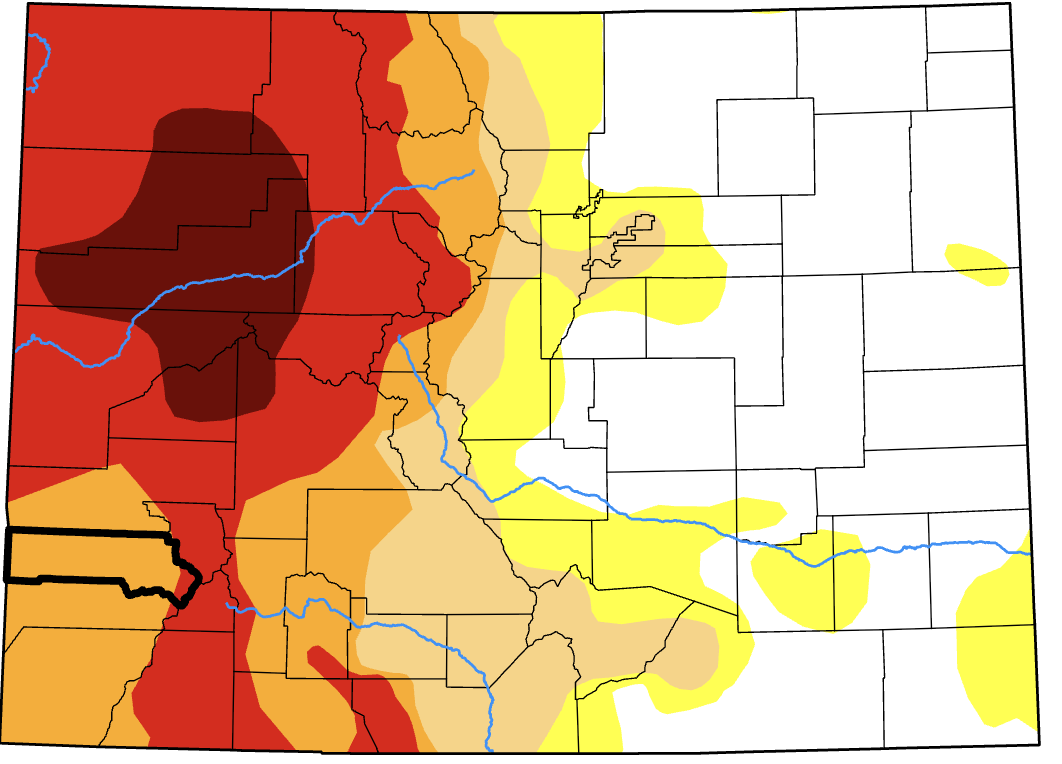


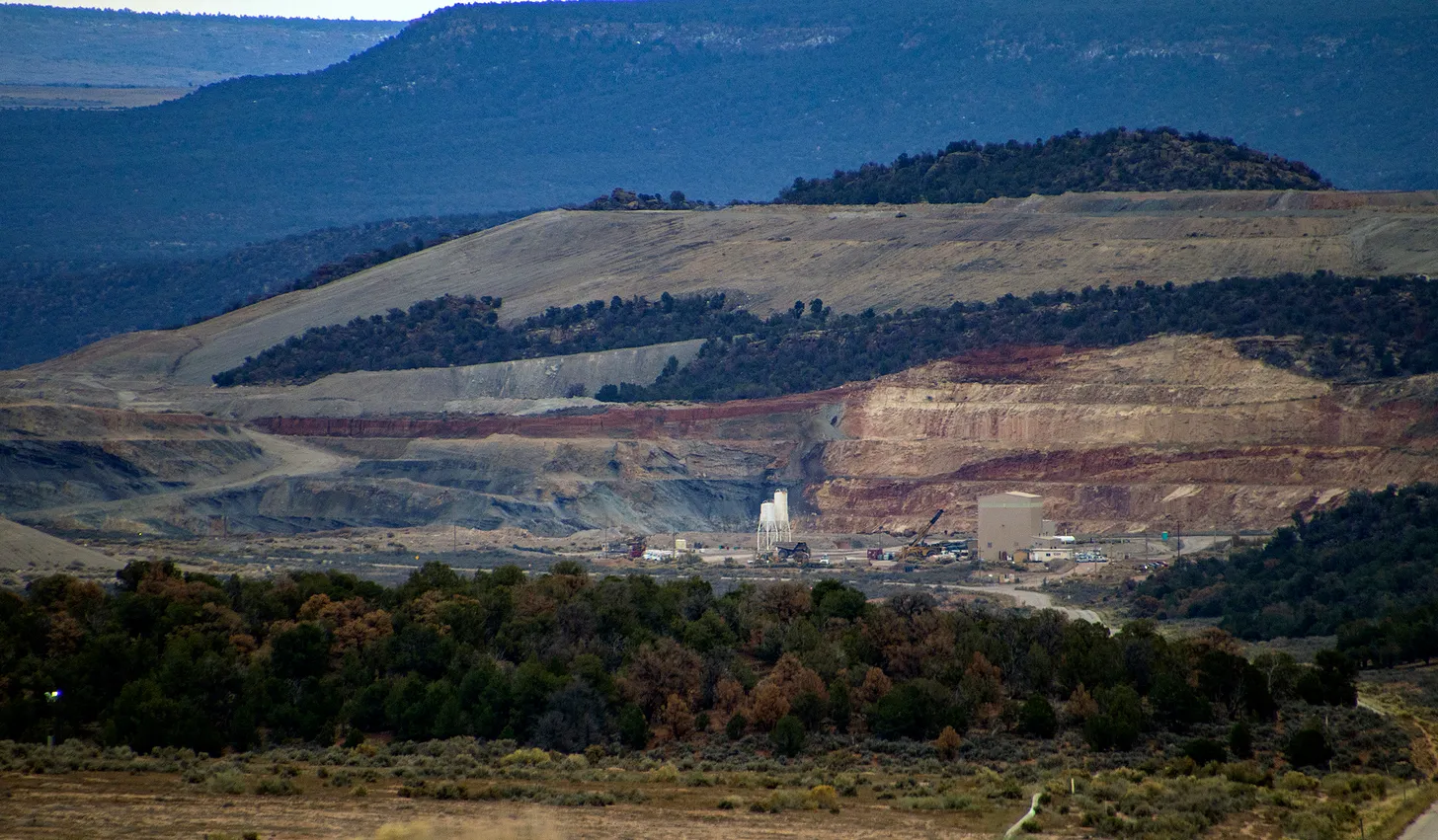


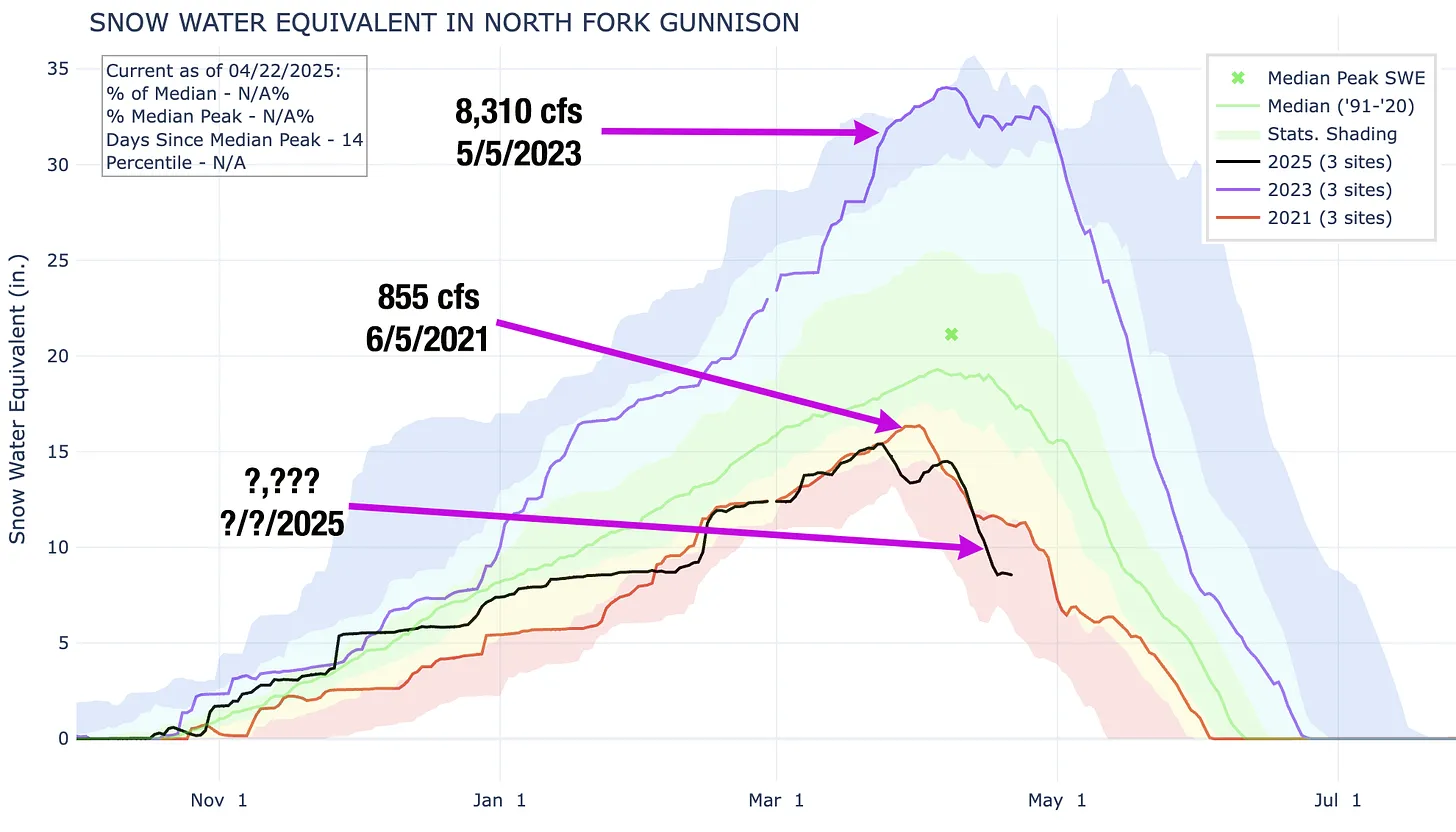
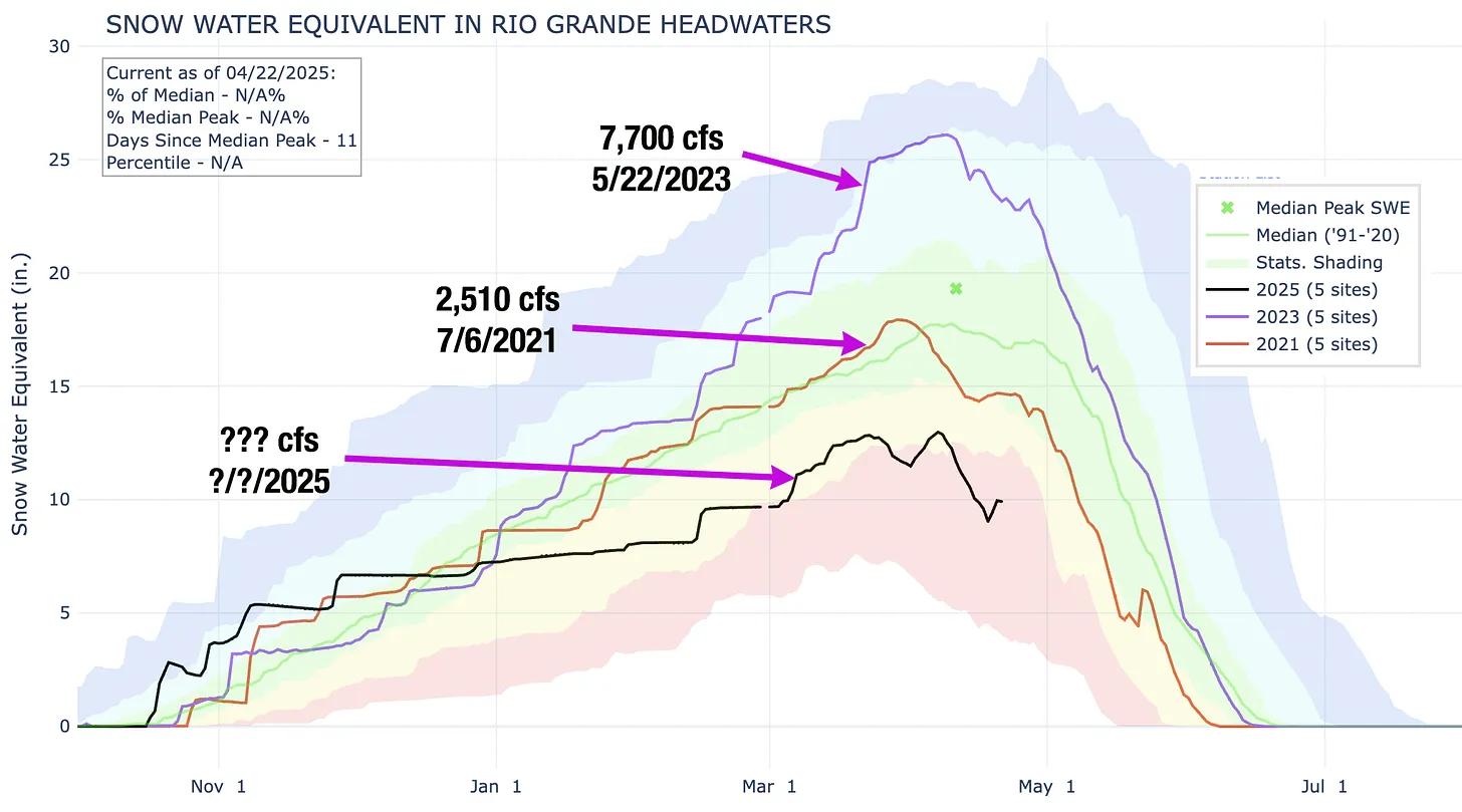

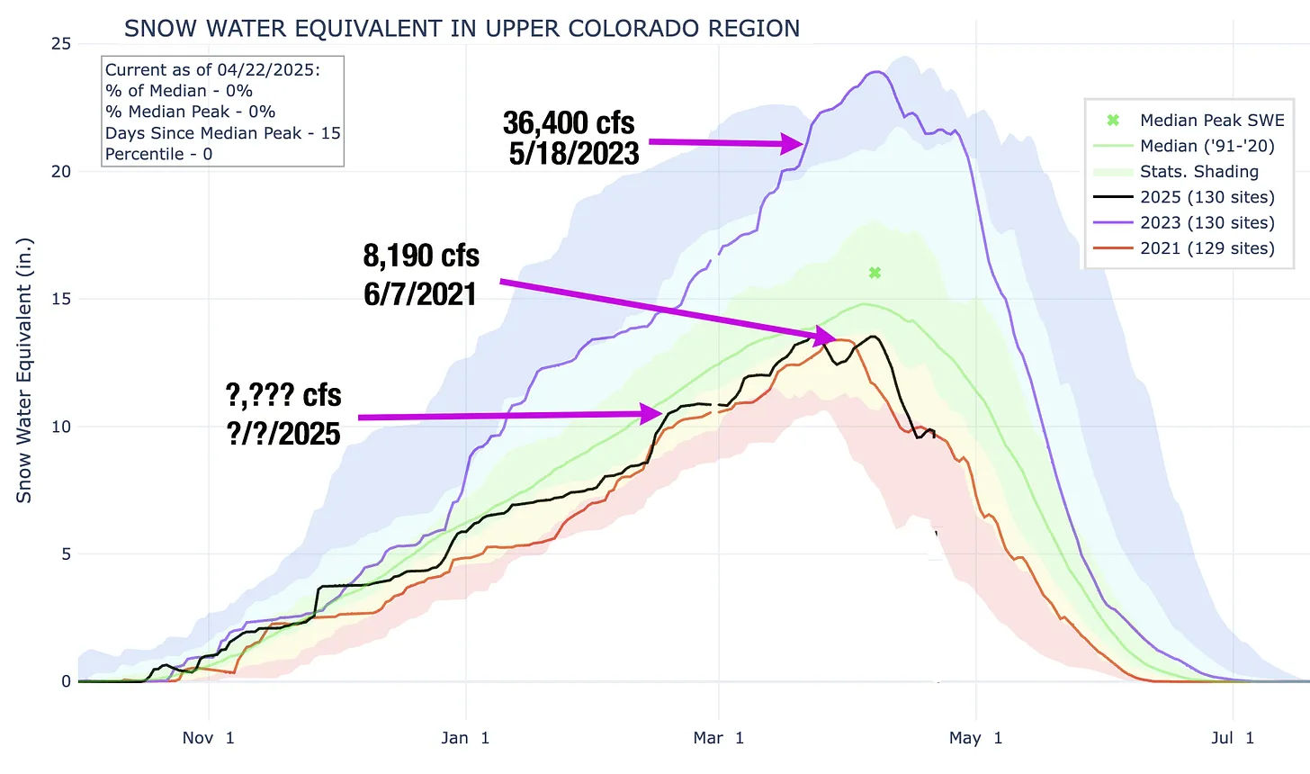


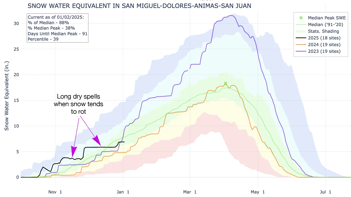
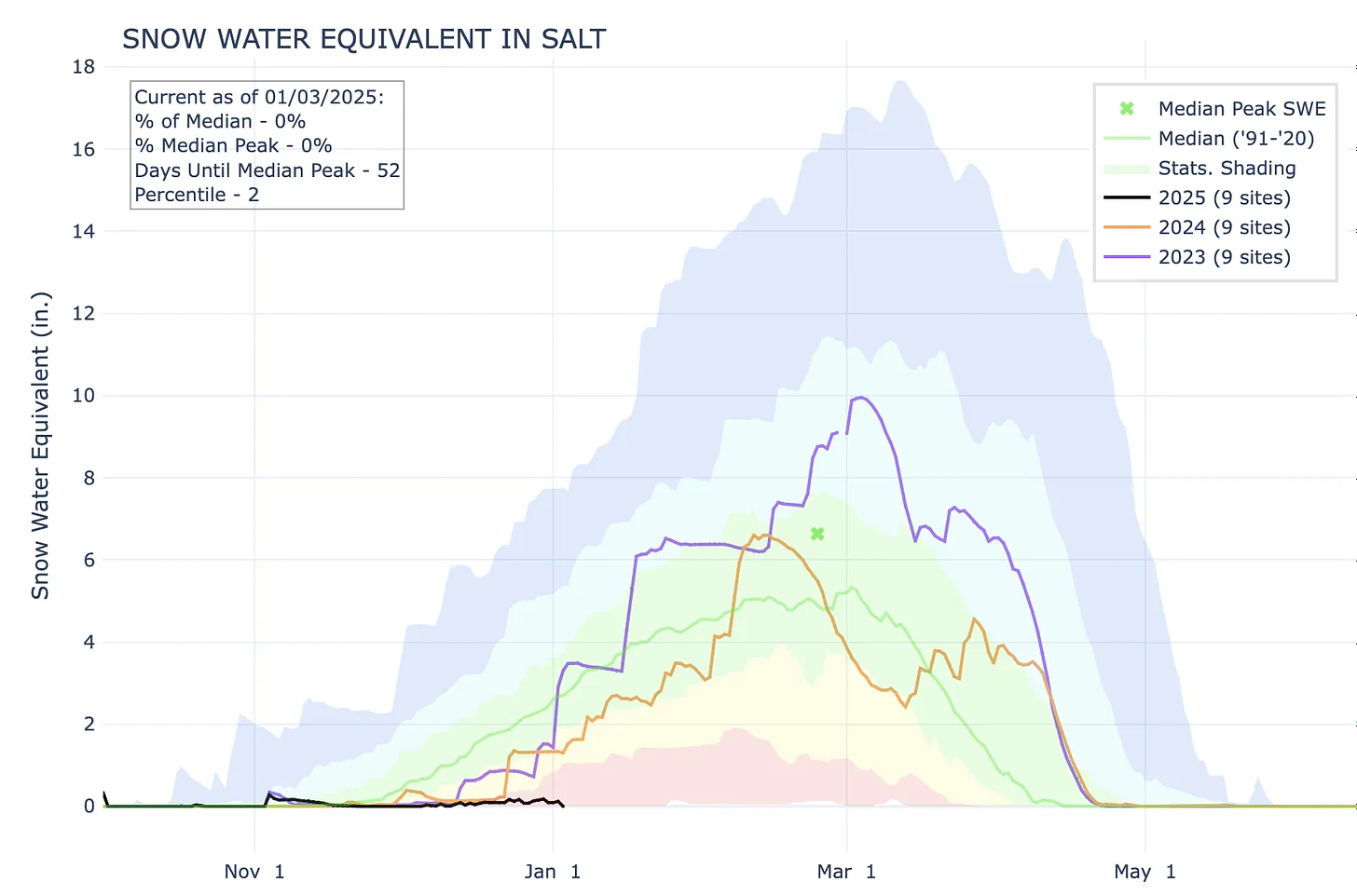


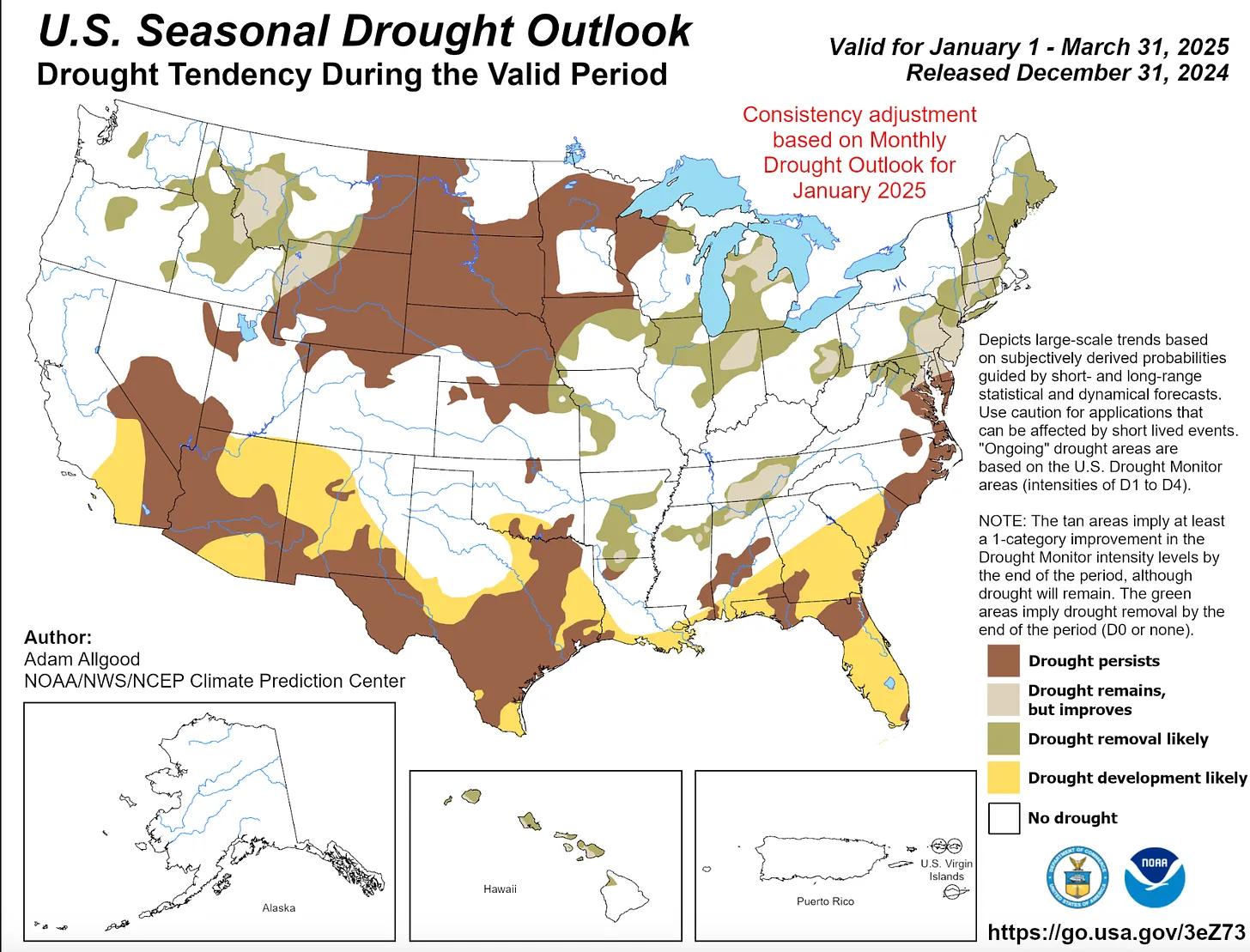
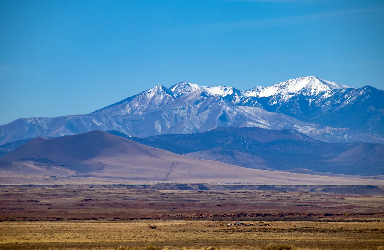

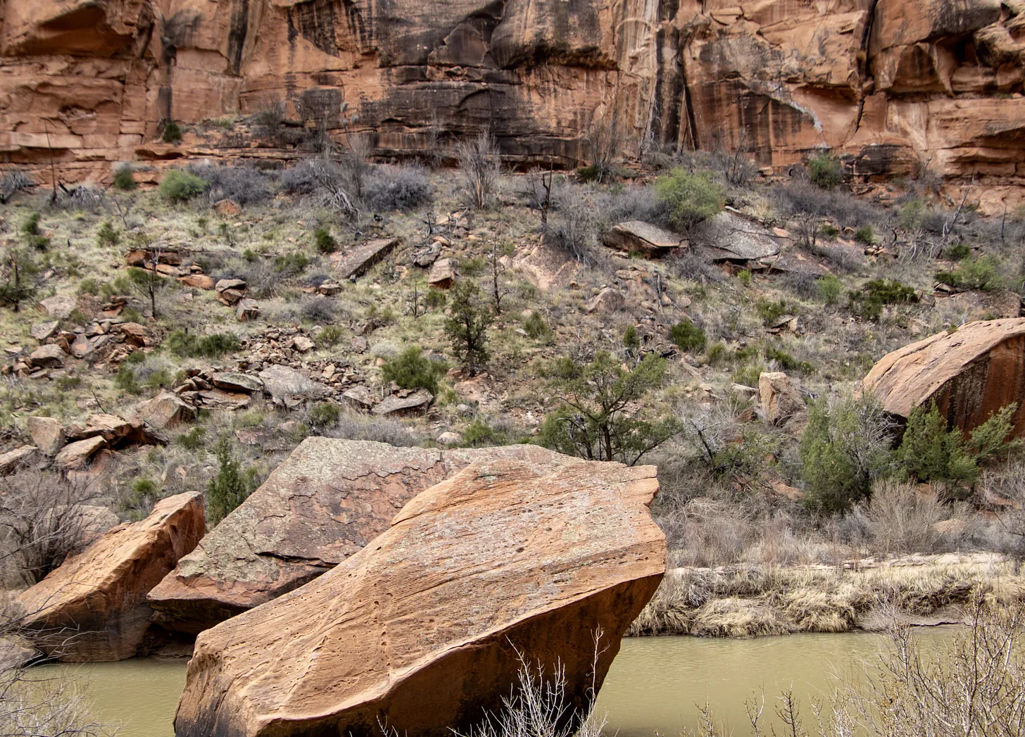


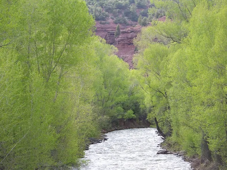


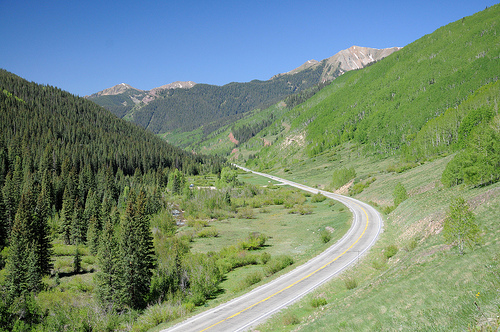


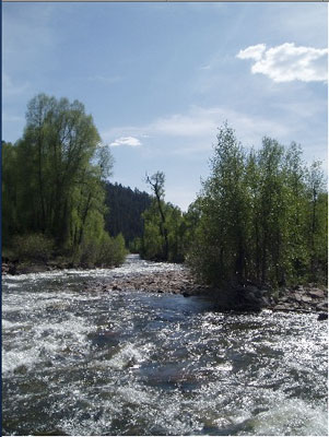


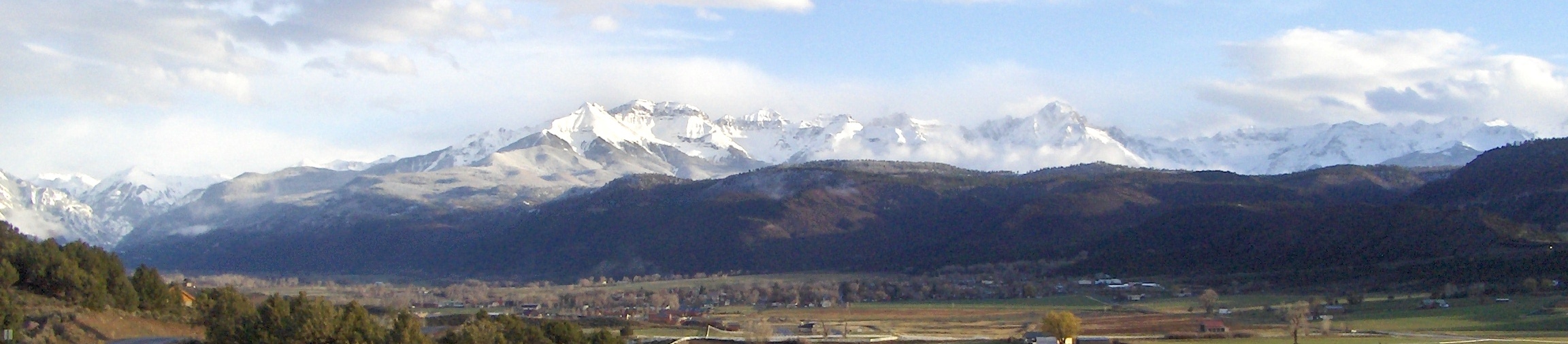
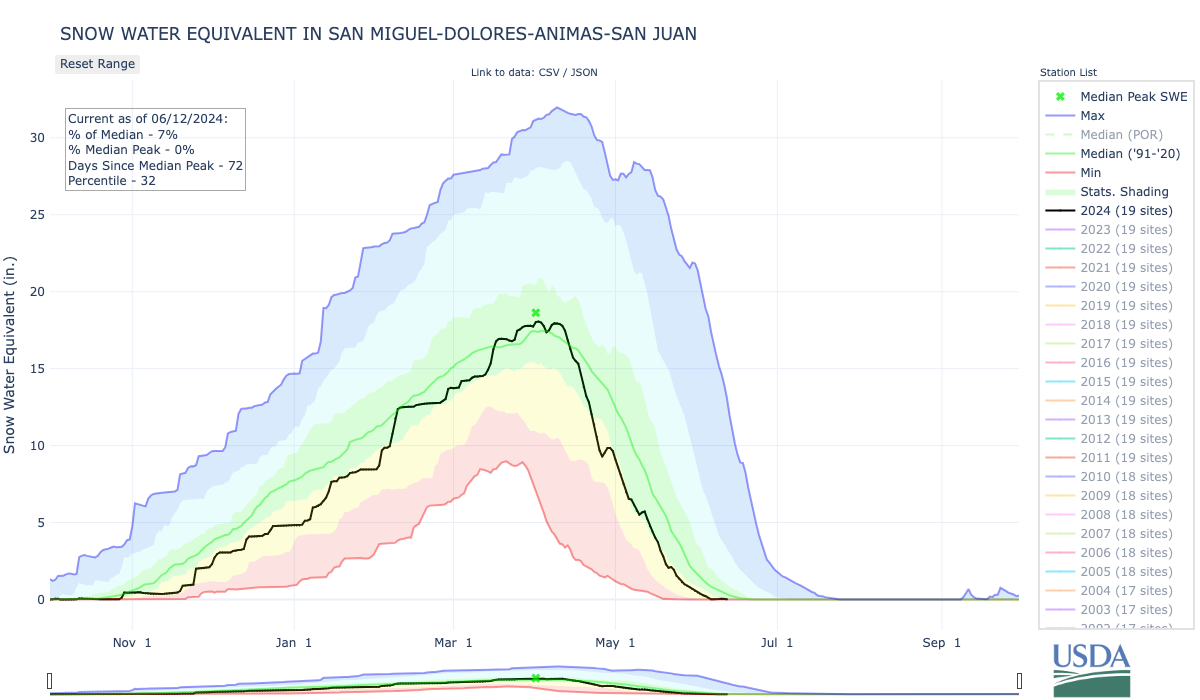


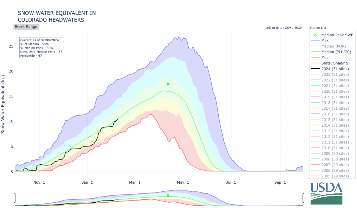
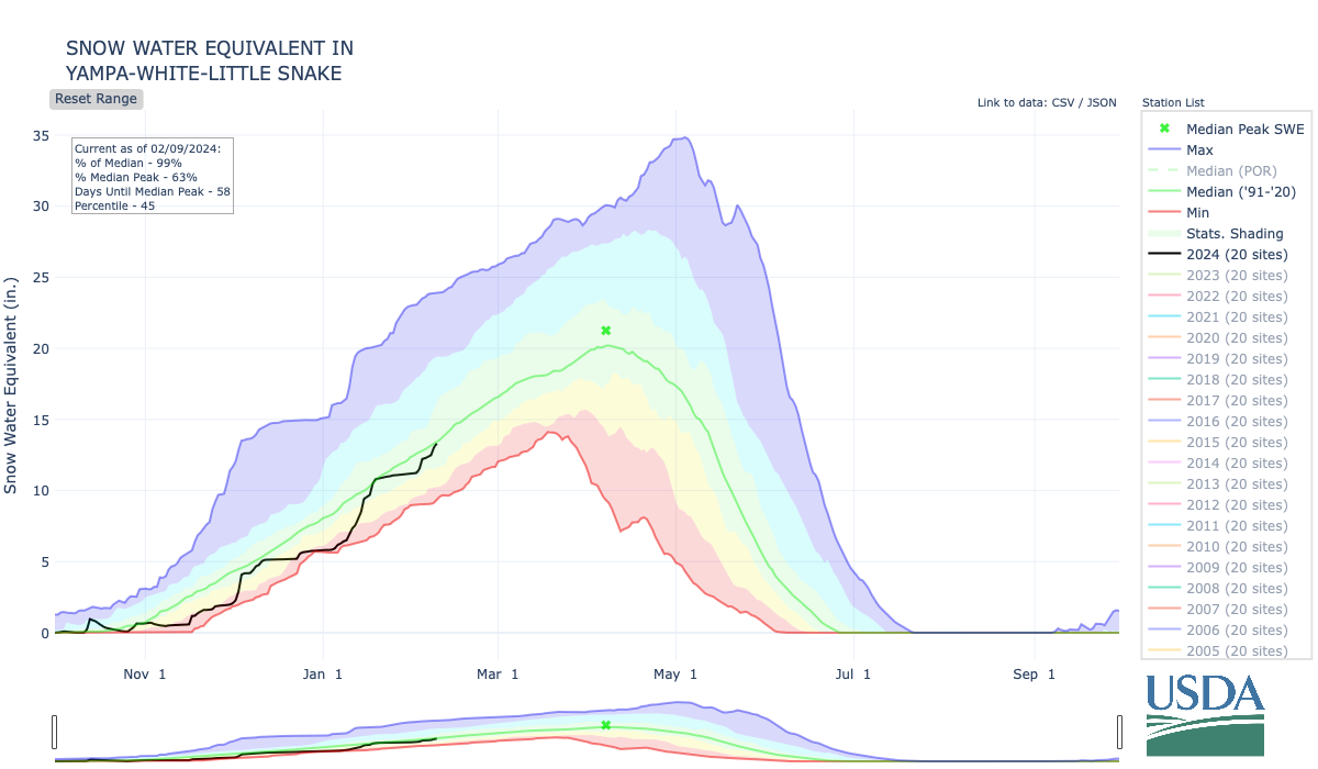
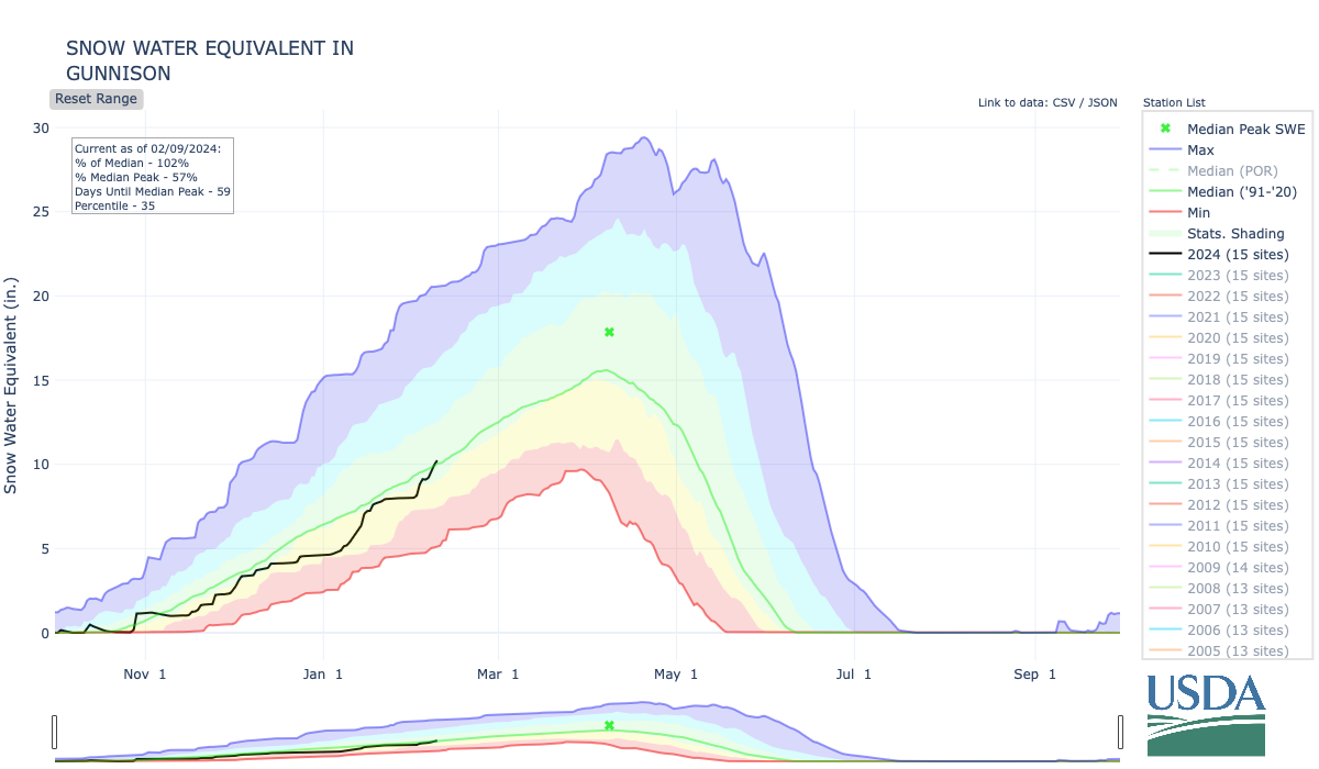
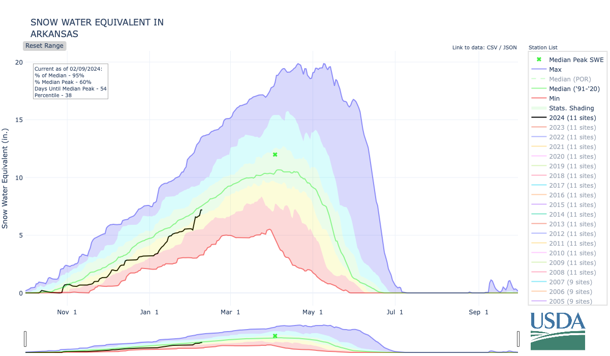

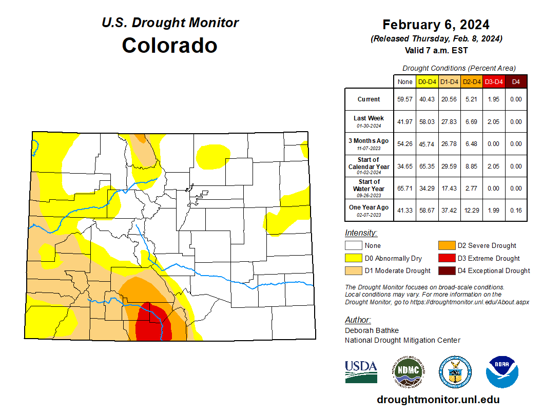

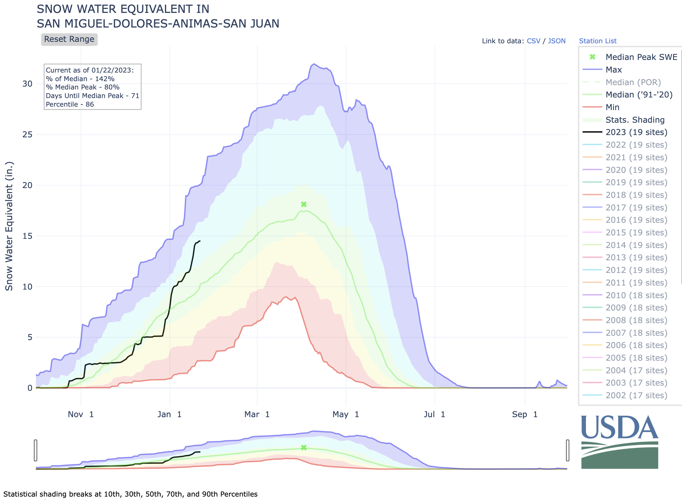


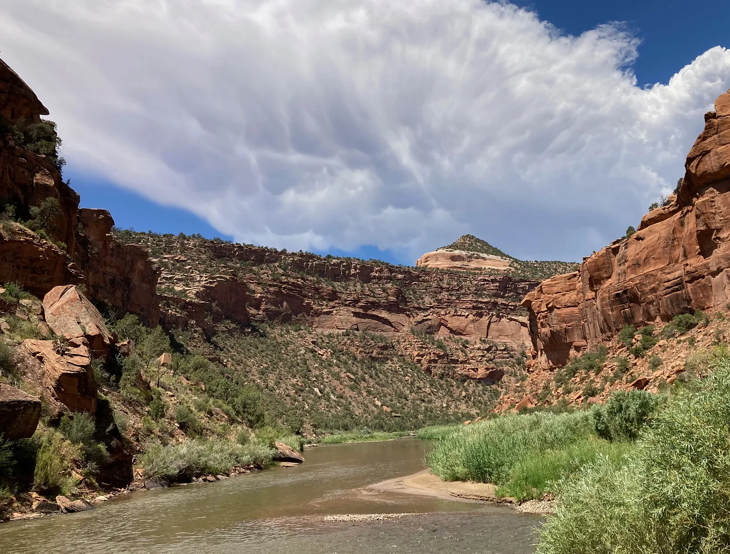


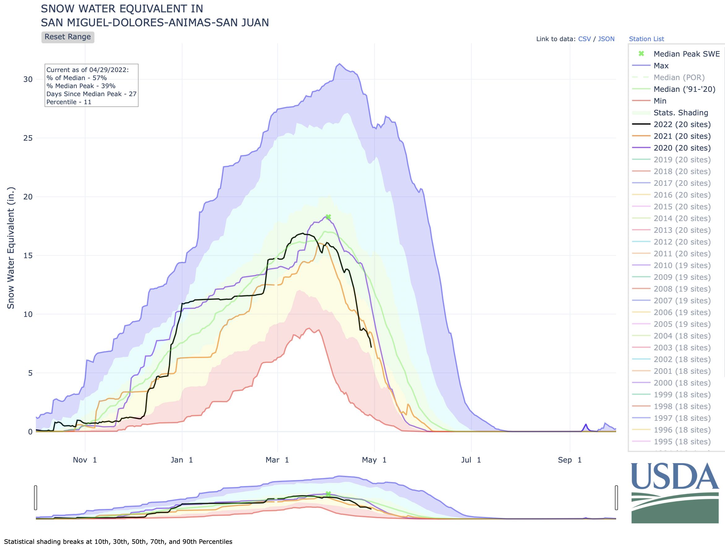
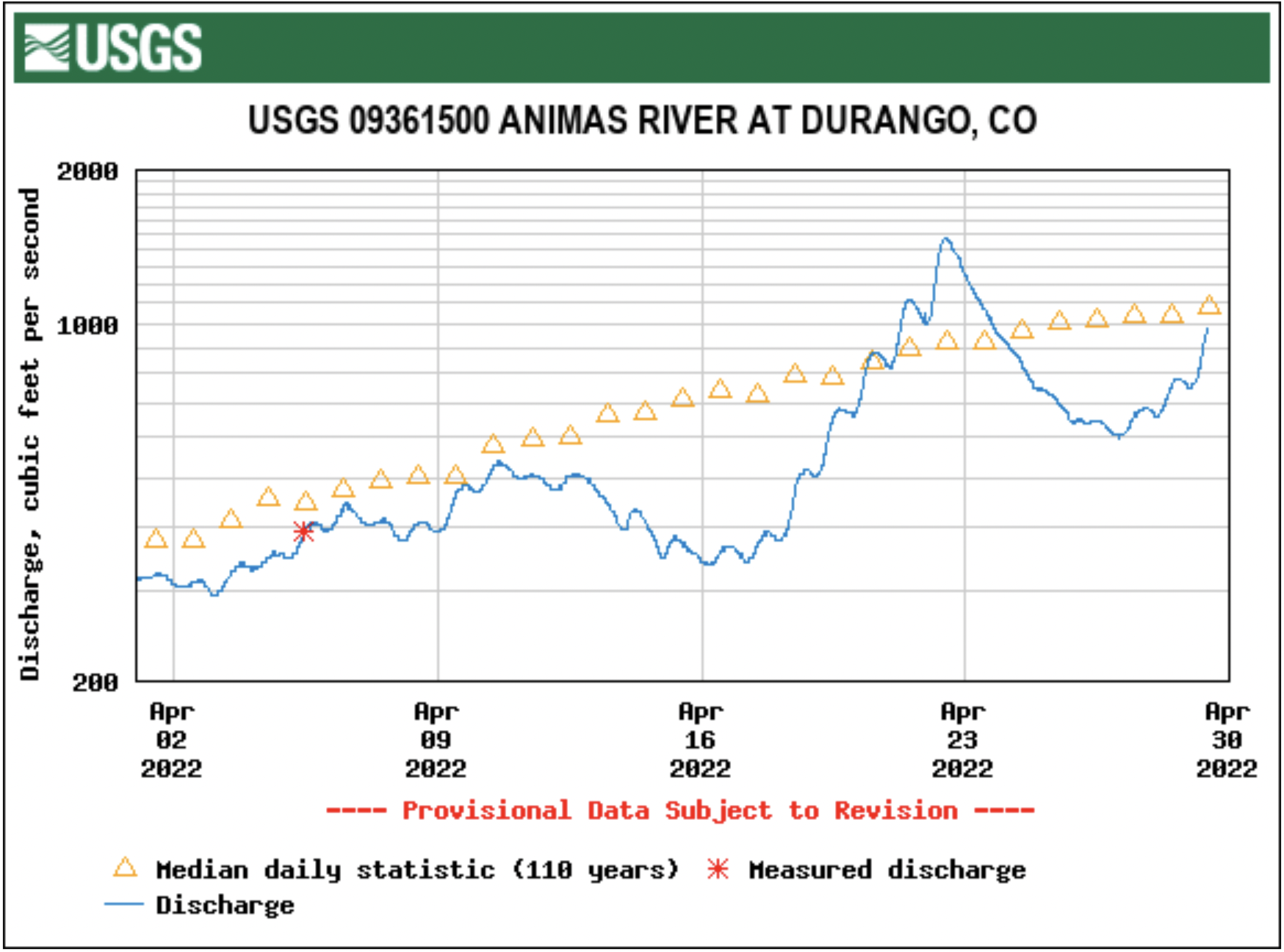

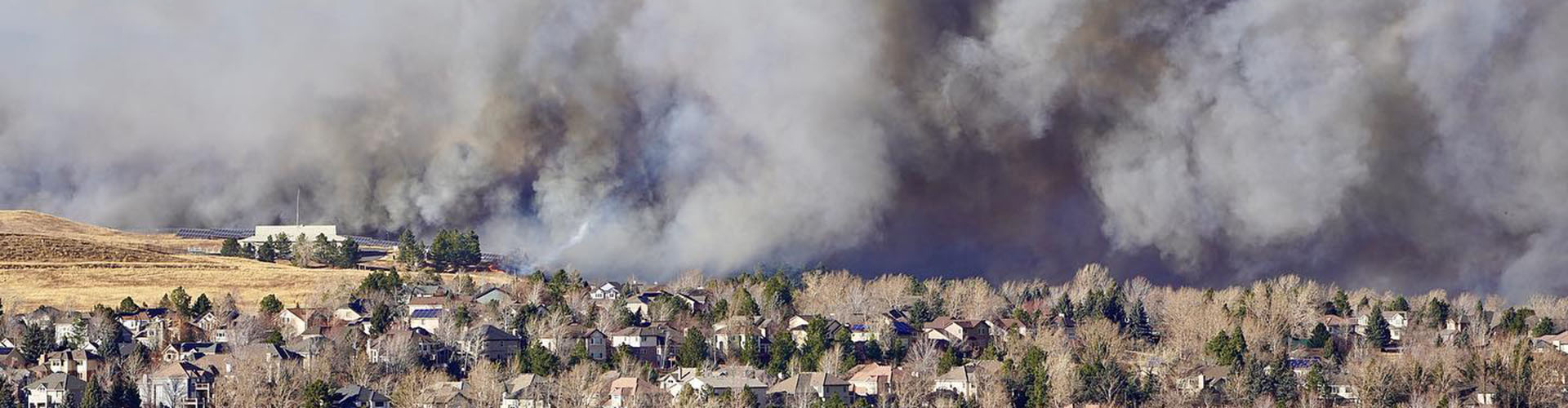


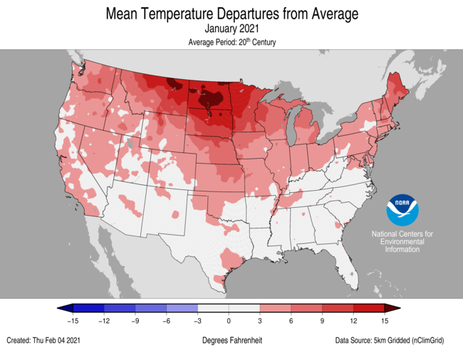
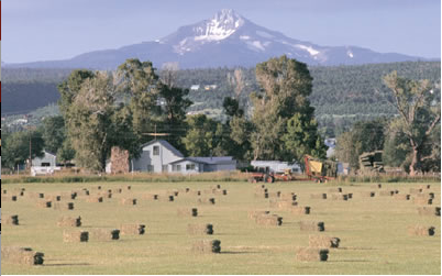

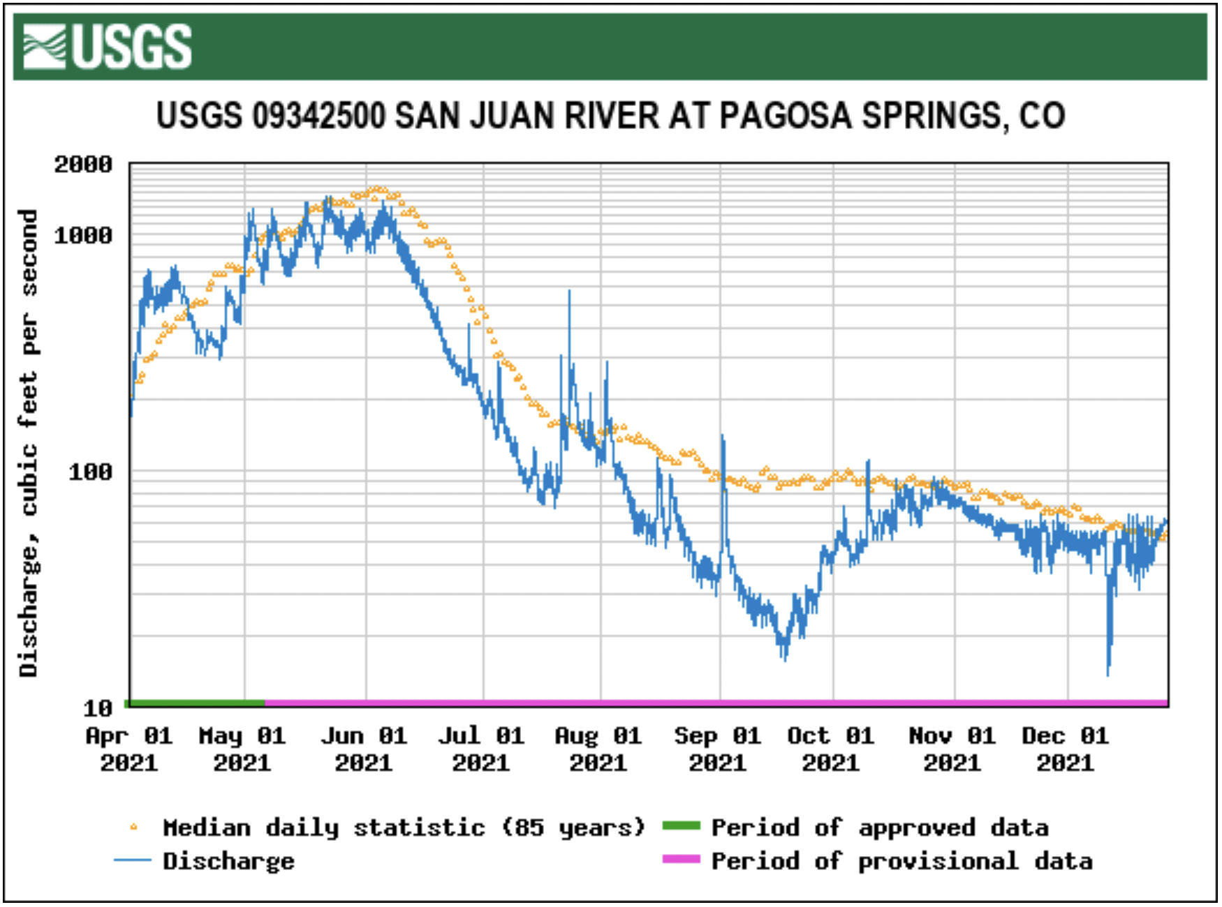
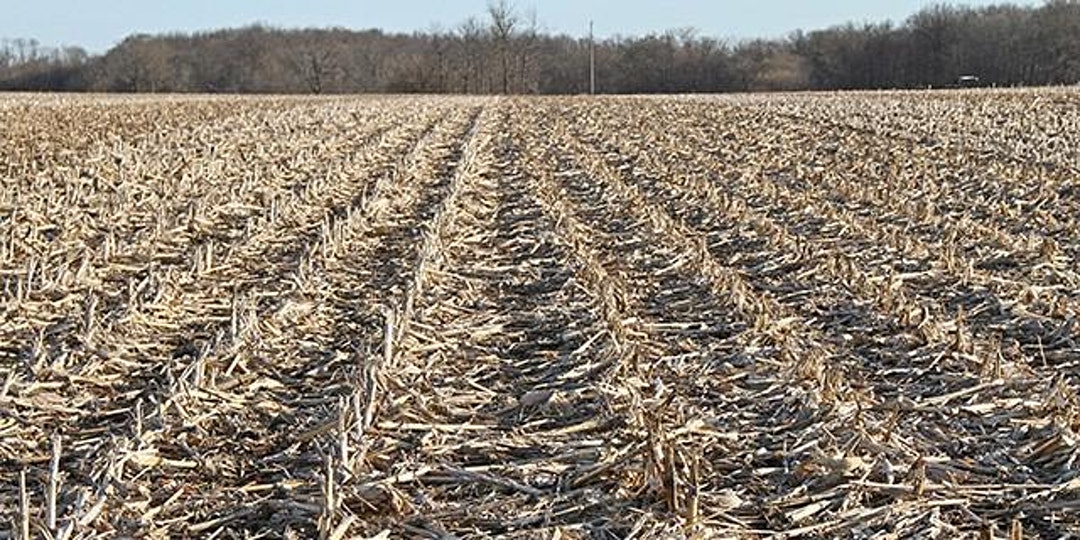
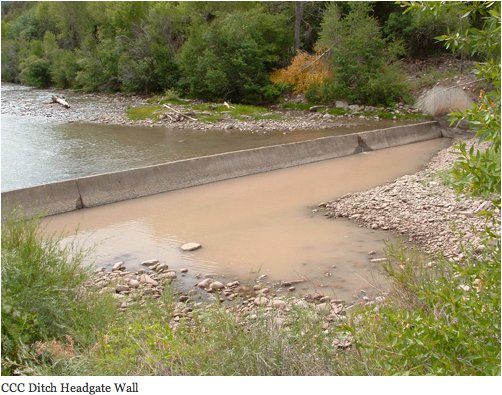


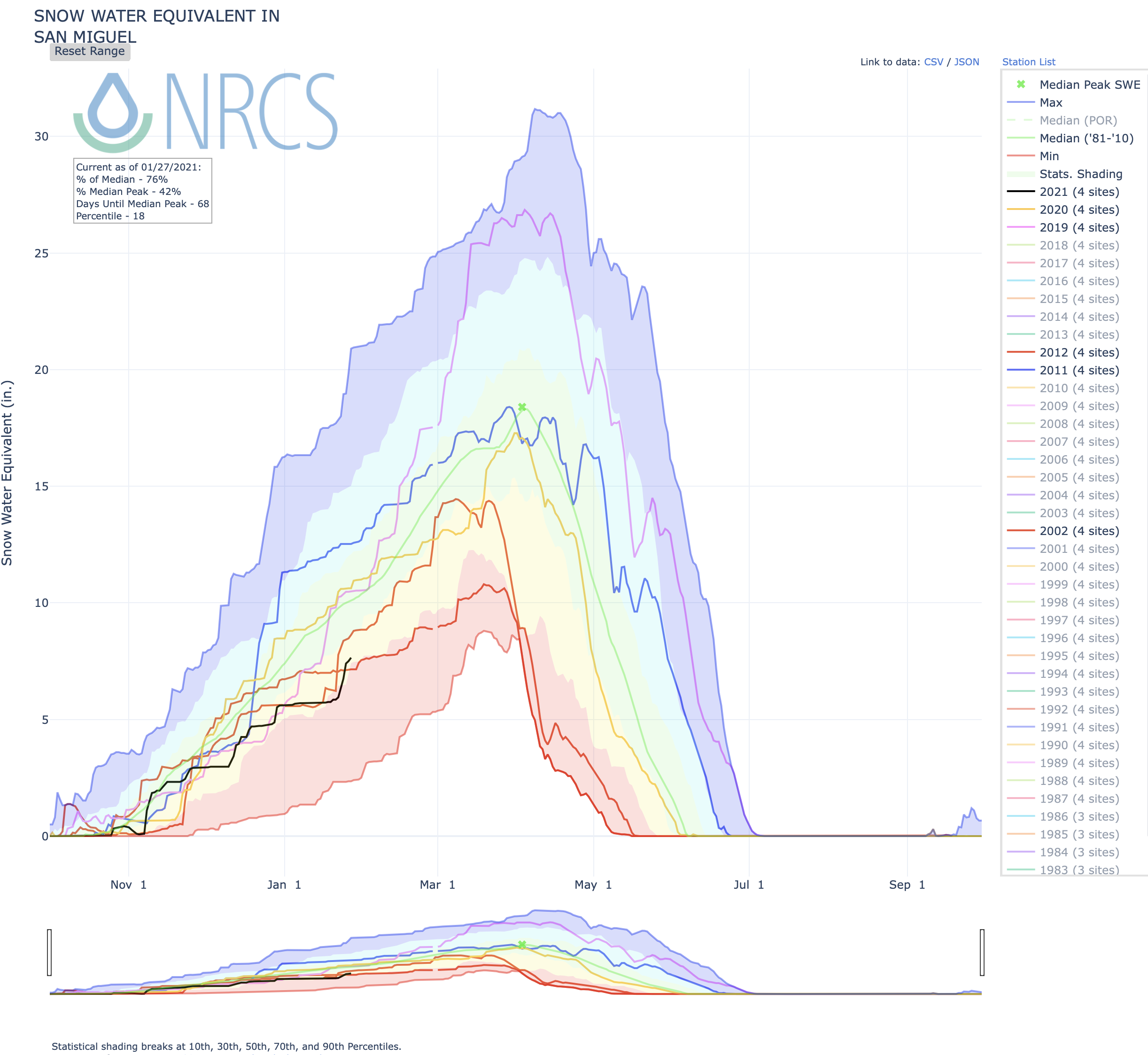


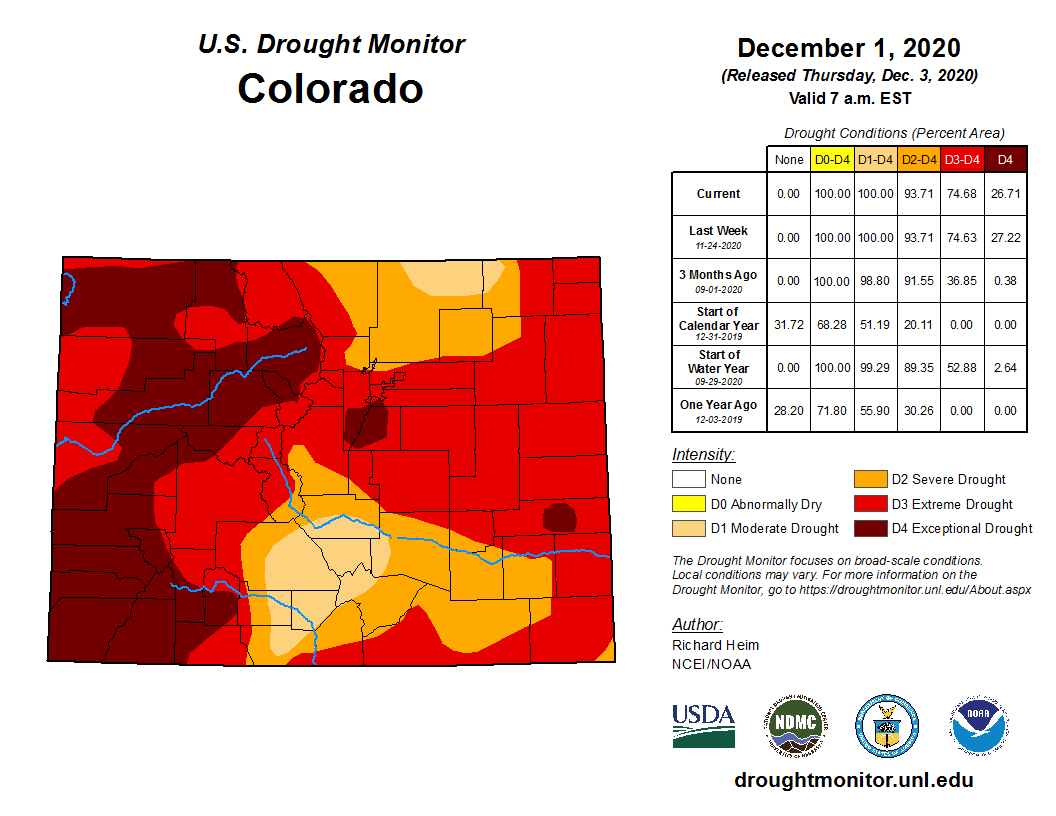
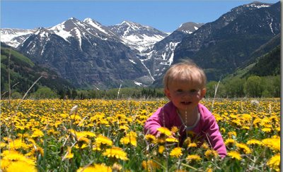

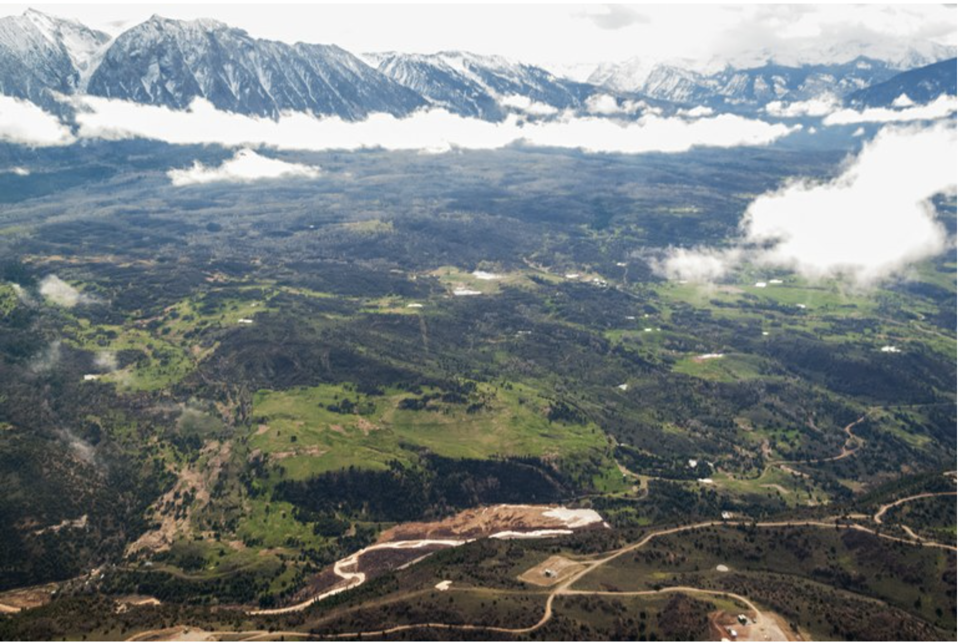

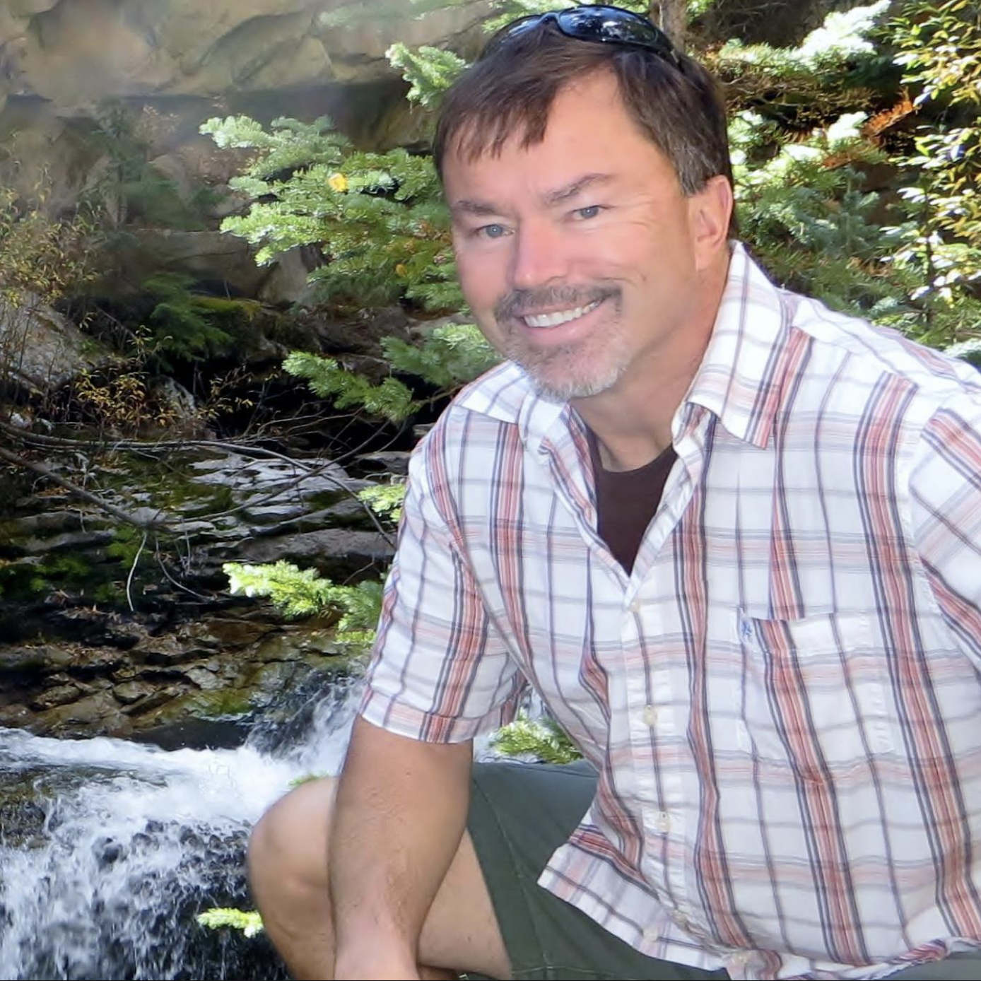
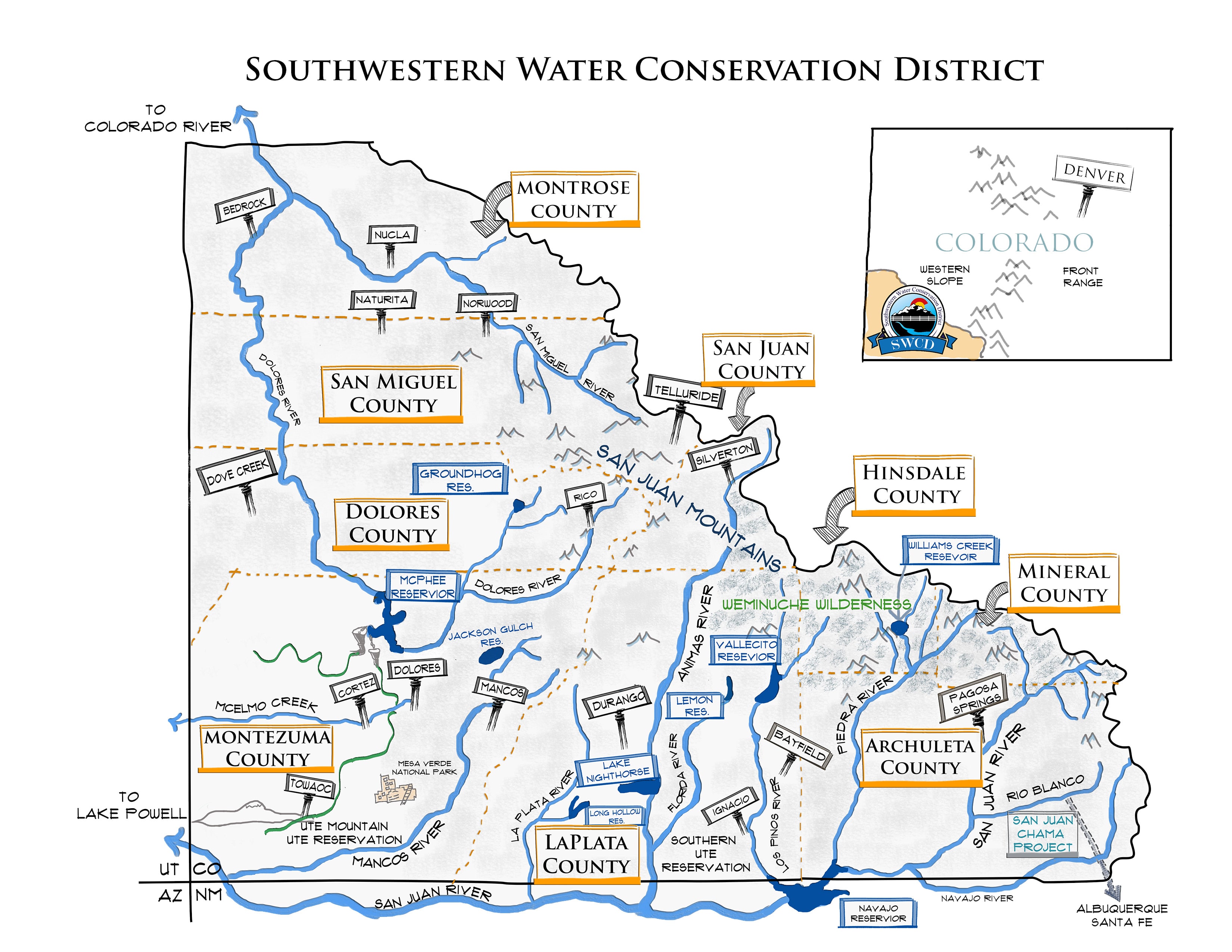
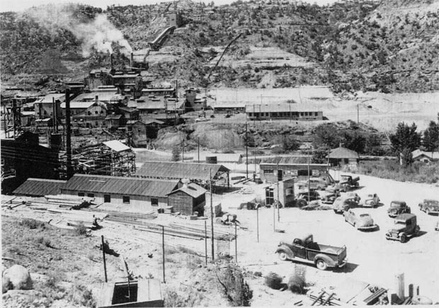


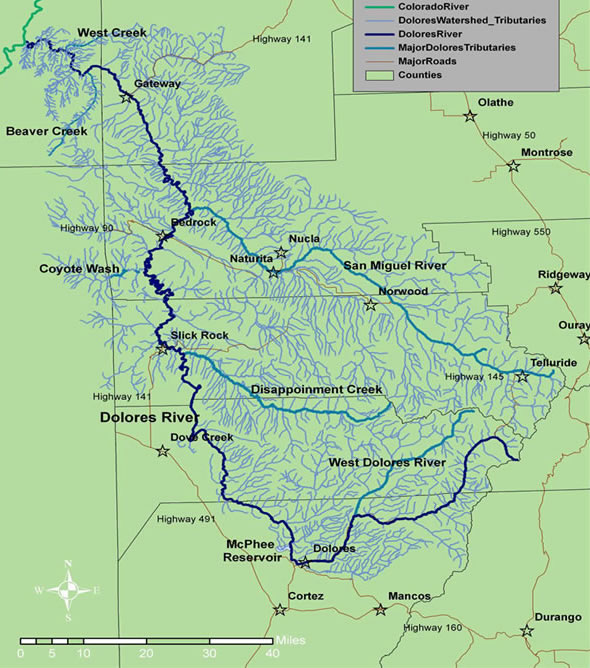


