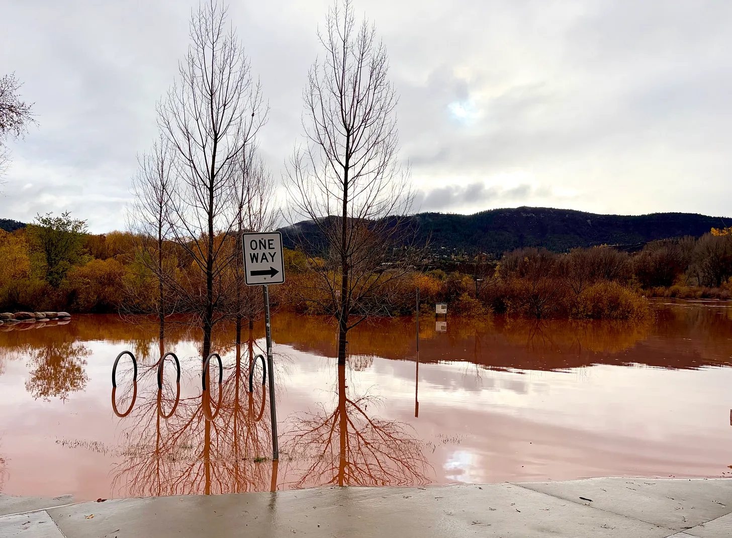
The 2026 Deluge: Aftermath; Day of the Dead Flood moves into third biggest on record on the #AnimasRiver in #Durango — Jonathan P. Thompson (LandDesk.org) #SanJuanRiver

The Animas River at Oxbow Park in north Durango on Nov. 2. Jonathan P. Thompson photo.

Click the link to read the article on The Land Desk website (Jonathan P. Thompson):

November 4, 2026

Oh, Water, you give and take away. Following one of the driest years on record, the water once again came pouring out of the sky and raging through the streams and rivers, setting new high-water records, bringing new life to the parched earth, and wreaking havoc and destruction wherever waterways and humanity intersected.

The rains stopped two days ago, but streams in southwestern Colorado continue to run at levels that would have been considered abnormally high a month ago. North of Durango, a tree careening down Hermosa Creek got wedged underneath the railroad bridge, creating a dam of sorts and forcing the muddy waters to jump the bank and run through a trailer park and neighborhoods, forcing more evacuations and closing Highway 550. Several other Durango area roads remain closed due to washouts or debris.

Junction Creek in Durango on the morning of Nov. 2, 2026. Jonathan P. Thompson photo.

Other roads remain closed throughout the region. Highway 160 between Bayfield and Pagosa is shut down because the Piedra River — which exceeded 17,000 cfs yet again — washed out the highway bridge. Hwy 151 from Chimney Rock to Arboles remains closed after being wrecked by the previous flood. Hwy 160 over Wolf Creek Pass is shut, as is Hwy 17 over Cumbres Pass between Chama and Antonito. These closures have basically marooned Pagosa, which suffered serious damage during this round of flooding.

In Utah, State Road 162 north of Montezuma Creek remains closed — this is one of the stretches of road that was totally overhauled over the last couple of years. And Hwy 163 between Mexican Hat and Bluff is shut down after Comb Wash took a big bite out of the highway bridge.

Meanwhile, hundreds of affected residents are just beginning the long ordeal of cleaning up and attempting to cope with this disaster.

Having lived through a flood that filled my home with nine feet of water, I can imagine what these people have gone through, and the difficult journey they face ahead of them. It’s heartbreaking to consider, and pains me even to write it down, yet it seems necessary. (It’s equally heartening to see the communities come together to rescue and support those most affected).

After the sheer panic that hits when you realize the water is rising in your front yard; the adrenalin that sets in as you try to gather up loved ones, pets, important documents, and the phone and the laptop and wade through thigh-deep water in the yard; the elation that follows your escape and survival, comes the devastation of returning to your home, walking inside, and seeing furniture and appliances and books and possessions strewn about as if a mischievous god had picked up the house and shook it. If your home is still there, that is.

Every surface that was under water will be blanketed with fine, dense, tenacious mud. It will coat clothing. In many cases the mud itself will be tainted with sewage or other waste, and as the waters subside, a fecund odor infuses everything. Particle wood rots, drywall deteriorates, hardwoods warp, mold grows. When the mud dries it becomes quasi-sandstone that can be near impossible to remove; break it up and it turns to fine dust that is hazardous to inhale. For months or even years after the cleanup and renovations are done, people who were flooded will find the mud embedded in items or clothing.

Floods don’t discriminate, and are as likely to damage multi-million dollar homes as they are to inundate trailer parks. But the financial burden of recovery and cleanup weighs far heavier on low- and even middle-income folks. Many standard homeowners insurance policies do not include flood insurance, and your average homeowner or renter is likely to forego supplemental flood coverage because it’s very expensive, especially for homes in historic floodplains or near waterways.

I’d like to believe this was an anomaly, something we can look back on as a sort of freak occurrence that, eventually, will be so unusual that it will feel as if it were unreal, something that became exaggerated by the passing of time. The 1911 Flood feels that way to me sometimes. How is it possible that the Animas River carried nearly twice the flows we saw on Nov. 2? Surely that could never happen again. Right?

And yet, we know this was not an anomaly because the early November deluge was the fifth abnormally high precipitation event of the previous six weeks, which was capped off by two record-breaking, catastrophic flooding events. On the one hand this is historic, unprecedented, a once-in-a-century event; on the other hand it could become nearly routine in our rapidly changing climate.

Either way, if my experience is any indication, one thing is almost certain: The people affected by these floods will feel a tinge of anxiety every time the weather forecast calls for heavy rain.
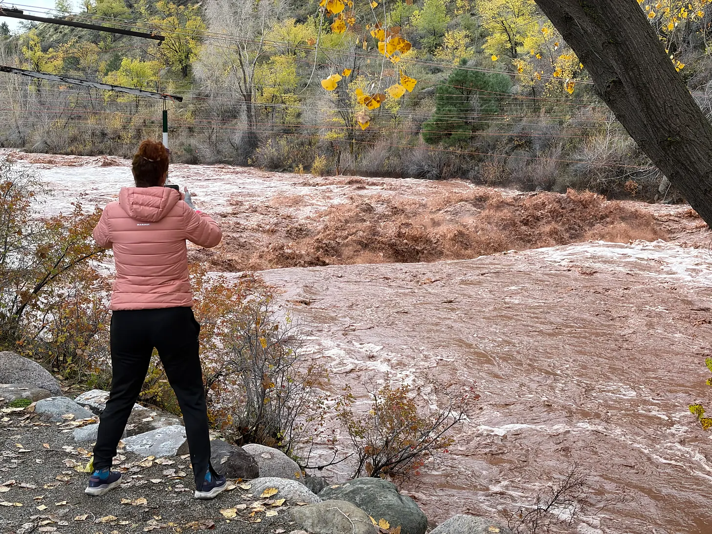
The Animas River at Santa Rita Park on Nov. 2, 2026, when it was running at about 12,100 cfs. Jonathan P. Thompson photo.

The second flood of 2026 (and water year 2027) was the third largest on record at the USGS streamflow gage on the Animas River in Durango, with a peak flow of 13,000 cubic feet per second. That puts it ahead of both 1949 and 1970, but still well behind both 1911 (water year 1912) and 1927.
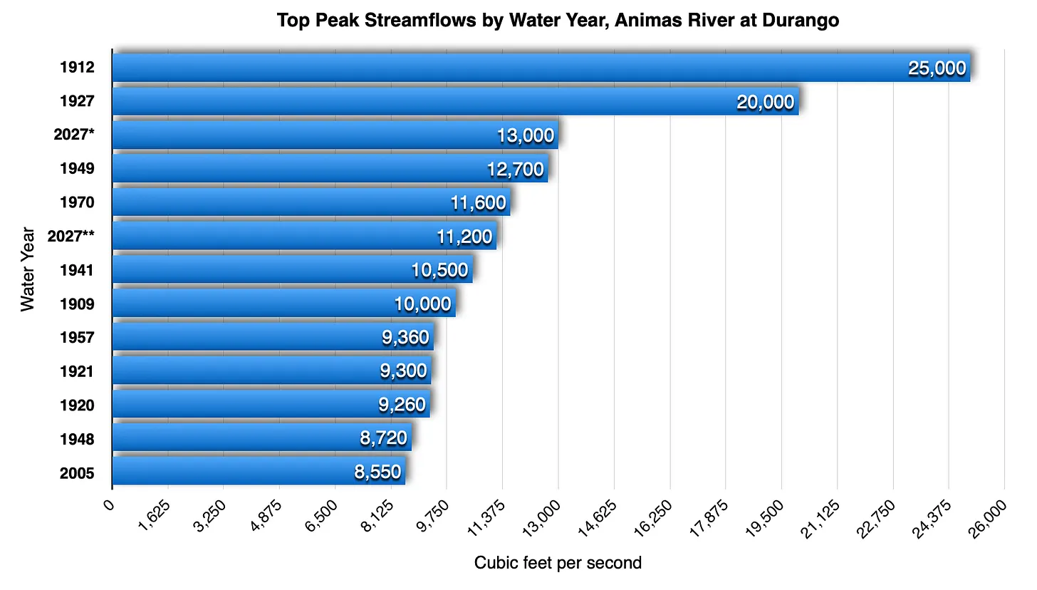
†Peak flow on Nov. 2, 2026. ††Peak flow on Oct. 23, 2026. This is listed as 2027 because it occurred during the 2027 Water Year, which goes from Oct. 1, 2026, to Sept. 30, 2027.

It’s interesting to see how the Animas River’s streamflows change over the course of the 45 miles or so between the Durango gage and the Farmington one. On Nov. 2, the Animas appears to have gained about 6,900 cfs over that stretch of river, while on Oct. 23 it only gained 800 cfs. A lot of this came from the two major tributaries — Lightner Creek and the Florida River — joining the Animas downstream from the Durango gage, along with numerous washes and arroyos adding their load.

Meanwhile, back in 1970 the peak streamflow in Farmington was 700 cfs lower than it was in Durango. I’m not sure how to explain that one.

Here’s some video and commentary I made at Santa Rita Park in Durango when the river was around 12,100 cfs. It would still gain another 900 cfs before peaking later that day: https://www.landdesk.org/p/live-with-jonathan-p-thompson

Is Silverton ready for a cleanup? — The Durango Herald

Bonita Mine acid mine drainage

From The Durango Herald (Chase Olivarius-Mcallister):

The stream of heavy-metal pollutants gushing out of Silverton’s mines and into its waterways has grown so toxic that between 2005 and 2010, three out of the four trout species living in the Upper Animas River south of Silverton have disappeared.

Yet for two decades, vocal Silverton residents have torpedoed the Environmental Protection Agency’s many attempts to designate Silverton’s worst mines as Superfund sites, which would allow the agency to clean up the pollution and make any parties it deems responsible pay for it.

Though the environmental catastrophe has, if anything, worsened, Silverton residents long have argued against Superfund, saying federal intervention would sully the town’s reputation, deter mining companies and appall tourists.

Until now, that is.

Even three years ago, it was impossible to imagine, let alone hear, a Silverton resident publicly clamoring for federal intervention in Cement Creek, said Mark Esper, editor of The Silverton Standard. Yet in the last year, he said, there have been signs that locals’ hostility to Superfund is softening.

[Last February], Skinner said a Superfund listing would “raise property values here, provide great jobs that people here can do, bring new people in and get more kids in the school.”

Silverton resident John Poole said, “Many people, including myself, think Superfund, frankly, is the best thing that could happen to Silverton. It’s certain to open up jobs. In Leadville, Superfund certainly didn’t hurt tourism.”

There’s still local animosity toward Superfund. In 2014, at meetings of the Animas River Stakeholders Group (ARSG) and the San Juan County Commission, residents such as Steve Fearn, co-coordinator of the ARSG, warned a Superfund designation would hamper, if not ruin, Silverton’s economy.

Poole said he thought the notion of Silverton’s overwhelming opposition to Superfund was “grossly overblown.”

“As far as I’m concerned, all the opposition is coming from a few people with conflicts of interest, who oppose the EPA because they profit financially from keeping the myth of mining – the idea that mining will come back to Silverton – alive,” Poole said.

More water pollution coverage here.

Animas River trout in decline — The Durango Herald

Tubing the Animas River via  Flipkey.com
Tubing the Animas River via Flipkey.com

From The Durango Herald (Mary Shinn):

The number of brown and rainbow trout in the Animas River swimming through Durango has declined, according to an ongoing study.

In particular, a decline has been noted in fish from 32nd Street to the Lightner Creek confluence with the Animas, said Jim White an aquatic biologist with Colorado Parks and Wildlife, who worked on the fish survey.

The section of the Animas classified as Gold Medal, from Lightner Creek to Rivera Crossing Bridge (behind Home Depot), also saw a decline, but it was not as dramatic. The area maintained its classification as a prime fishing destination, but the researchers found a decline in large fish.

This is the first time the area hasn’t met the Gold Medal standard for large fish since 1996, White said.

Colorado Parks and Wildlife stocks the Animas with both kinds of trout, and the stocking practices have not changed in about 20 years.

However, the most recent survey in September revealed a worrisome decline in both young and large brown trout compared with prior years, White said.

“We’re concerned over the absence of these young brown trout,” he said.

White plans to start monitoring brown trout specifically and tracking their population fluctuation. He completes fish surveys along this stretch of the Animas every two years.

No clear reason has been identified as to why the fish populations may be declining, but there are many circumstances that might be playing a role…

Zinc and cadmium from the mines near Silverton have had an adverse effect on the fish and the environment upstream of Bakers Bridge, said Peter Butler, coordinator of the Animas River Stakeholders Group.

Some other negative factors could include warmer water in the summer, sediment levels, low water levels and other possible factors.

An insect-population study done this fall may reveal more information about river health next year.

The Ecosphere Environmental Services study focused on the food supply for fish, and it will be compared to a similar study completed 10 years ago. The results will be released in the spring, Skillen said.

Anecdotally anglers have noticed a decline in caddisflies, pale morning duns, midges and blue-winged olives, he said.

Some of these insect populations may be affected by sediment flowing into the river because it fills in areas where they live, White said.

More Animas River coverage here.

Restoration: Contractors inspect Boston Mine erosion control project near Durango

perinspeak.jpg

From The Durango Herald (Dale Rodebaugh):

State Division of Reclamation, Mining and Safety officials on Thursday visited the site north of Twin Buttes off U.S. Highway 160 with seven potential bidders interested in restoring and revegetating 5 acres of steep hillside. The target is the Boston Mine, also known as Perin’s Peak No. 1, which operated from 1901 to 1926. The site produced more than 1 million tons of coal and left behind about 4,000 cubic yards of coal waste…

The mine is within the Perins Peak Wildlife Area, which comprises 12,000 acres of Colorado Parks and Wildlife and Bureau of Land Management holdings. The area is closed to the public Nov. 15 to July 15 as a winter haven for deer, elk, turkeys and snoozing black bears and in the spring for nesting peregrine falcons. The western half opens April 1 because no peregrines nest there…

Efforts to clean up the Boston Mine site, which at one time leaked 20 gallons a minute of toxic iron, copper, manganese and zinc into Lightner Creek, aren’t new. In 1992, grants from the Office of Surface Mining and the Bureau of Mines funded construction of wetland retention ponds to treat seepage and to assess the effectiveness of certain work.

“We stopped the leaks with the wetlands and by closing a collapsed spot that was allowing water to fill the mine workings and create seepage elsewhere,” Brown said. No seepage is seen today, she said.

The restoration will include closing a shaft, contouring a hillside, redirecting a ditch to carry runoff to one of the old retention ponds and seeding, mulching and applying 8 inches of compost and biochar – woody material reduced to charcoal through anaerobic processing – that retains a lot of water.

More restoration/reclamation coverage here.

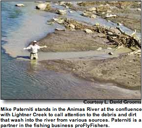
Animas River watershed: Lightner Creek sediment is fouling the river

A picture named lightnercreekconfluenceanimasriver.jpg

Here’s a call to action from Buck Skillen writing in The Durango Herald. From the article:

Why is this sort of turbidity – what I choose to call the Lightner Creek problem – happening at this time of year? One possible cause of the current problem is a substantial rain event back on Sept. 13 that dumped upwards of an inch of water on Durango and the Perin’s Peak area.

The Perin’s Peak geology is predominately Mancos shale, which is easily eroded. This area drains into Lightner Creek predominantly through Perin’s Canyon, where there is a 4-foot-diameter culvert delivering the canyon’s flow into Lightner Creek.

The storm on Sept. 13 delivered a huge volume of sediment to the creek, damaging the culvert and depositing a substantial amount of sediment in the creek bed. Since that time, and especially after the more recent storms, we are seeing the slightest amount of current in Lightner Creek pick up the fine sediment and transport it to the Animas River.

Why should we care? The Animas River is the city of Durango’s crown jewel. It’s a playground for all of us, visitors and locals, both in the water and walking along the River Trail, and a source of revenue from recreation. A good portion of our drinking water comes from the intake structure downstream of Lightner Creek and just above Smelter Rapids, although I am told this is not a big concern for the water treatment plant.

More Animas River watershed coverage here.

Durango: Study of sediment sources in Lightner Creek underway

A picture named lightnercreekconfluenceanimasriver.jpg

From The Durango Herald (Dale Rodebaugh):

A coalition of public agencies has acquired funding for a three-phase hydrological study to answer questions that have stumped observers for years: Where does the sediment that Lightner Creek periodically dumps into the Animas River come from, and why? Field work on the study, begun this week, could be done by the end of the year and lead to answers to an environmental problem seen as a potential source of harm to renowned fishing waters. “Sediment comes and goes, but no one knows whether it’s natural or human-induced,” Meghan Maloney, river campaign director at the San Juan Citizens Alliance, said recently. “The reason for concern is that Lightner Creek runs into the Animas at the head of a trout fishery that the Colorado Division of Wildlife gives its highest rating – gold medal.”[…]

Three organizations put up funding for a study – Trout Unlimited $1,000, the Colorado Water Conservation Board $5,000 and the Southwestern Water Conservation District $2,600 – to hire Mark Oliver of Basin Hydrology. Oliver started his field work this week. “I started at the mouth where Lightner Creek runs into the Animas and I’m working my way upstream,” Oliver said. “I’m looking at the channel and flood plain for sediment sources that could come from bank erosion or land-use modification. “The Tech Center watershed and Perins Canyon seem likely sources of silt,” Oliver said. “But my study will confirm whether the deposition is coming from there.” At certain points, Oliver will do sieve analysis – measuring the size of sediment particles. Along with a cross-section analysis of the channel – width, depth and slope – he can determine the movement of sediment. “I’ll focus on sediment sources and the mechanics of how sediment gets to the mouth,” Oliver said. “Then I’ll try to determine if the sediment is natural or caused by people – for example, the landfill above the Tech Center.”

More Animas River watershed coverage here and here.