Click the link to read the article on The Denver Post website (Elise Schmelzer). Here’s an excerpt:
July 15, 2026
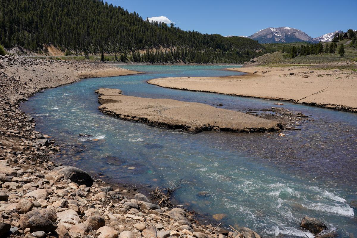
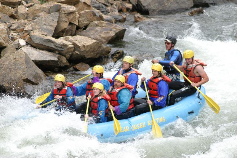
Even in the driest of years — like this one — powerful Western Slope water rights on the mainstem of the Colorado River draw water downstream, making boating on the state’s major water artery possible.
“For mainstem floating, we should still have pretty darn good flows for the rest of the season for as long as people want to be boating,” said Sam Calahan, a water resources specialist for the Colorado River District. The taxpayer-funded agency is based in Glenwood Springs and works to protect Western Slope water…
On Wednesday, Browns Canyon — a popular section of the Arkansas River near Buena Vista — was flowing at the lowest level in 55 years of data and at 16% of its median flow for that date. Clear Creek near Idaho Springs was flowing at 61 cubic feet per second on Wednesday, also a record low for the date in 72 years of data. The median flow for the date is 347 cfs, or more than five times as much water…But flows on much of the Colorado River were high enough for rafts and kayaks this week. Flows on a popular section near Kremmling were near normal, as were water levels farther downstream in Glenwood Canyon. Two major factors keep water flowing down the Colorado River during drought: large senior water rights owned by farmers in Mesa County’s Grand Valley and the water rights connected to the Shoshone Power Plant, a hydroelectric facility in Glenwood Canyon owned by Xcel Energy. Irrigators and power plant operators can call water to their facilities from upstream reservoirs, like Green Mountain Reservoir, which is on the Blue River — a tributary of the Colorado River — north of Silverthorne. This year, the irrigators began calling down water on July 1, boosting flows in the Colorado River.
The Northern Water Board of Directors has unanimously approved a change to Colorado-Big Thompson Project accounting procedures concerning C-BT water tracking.
During a rule-making hearing at the June 11 Board meeting, Directors heard about the changes to the rules surrounding the tracking of water from the Project. The new accounting procedures will require accounting of tracking data to be provided in a manner to allow for the administration of C-BT Project water return flows, which will help Northern Water protect them as described in the District’s Repayment Contract with the Bureau of Reclamation, the Water Conservancy Act and contracts with allottees.
The modifications affect only domestic and municipal users, and Northern Water staff met or contacted 26 municipalities, water districts and treatment plants in the months before the rule change was approved.
Map of the Colorado-Big Thompson Project via Northern Water
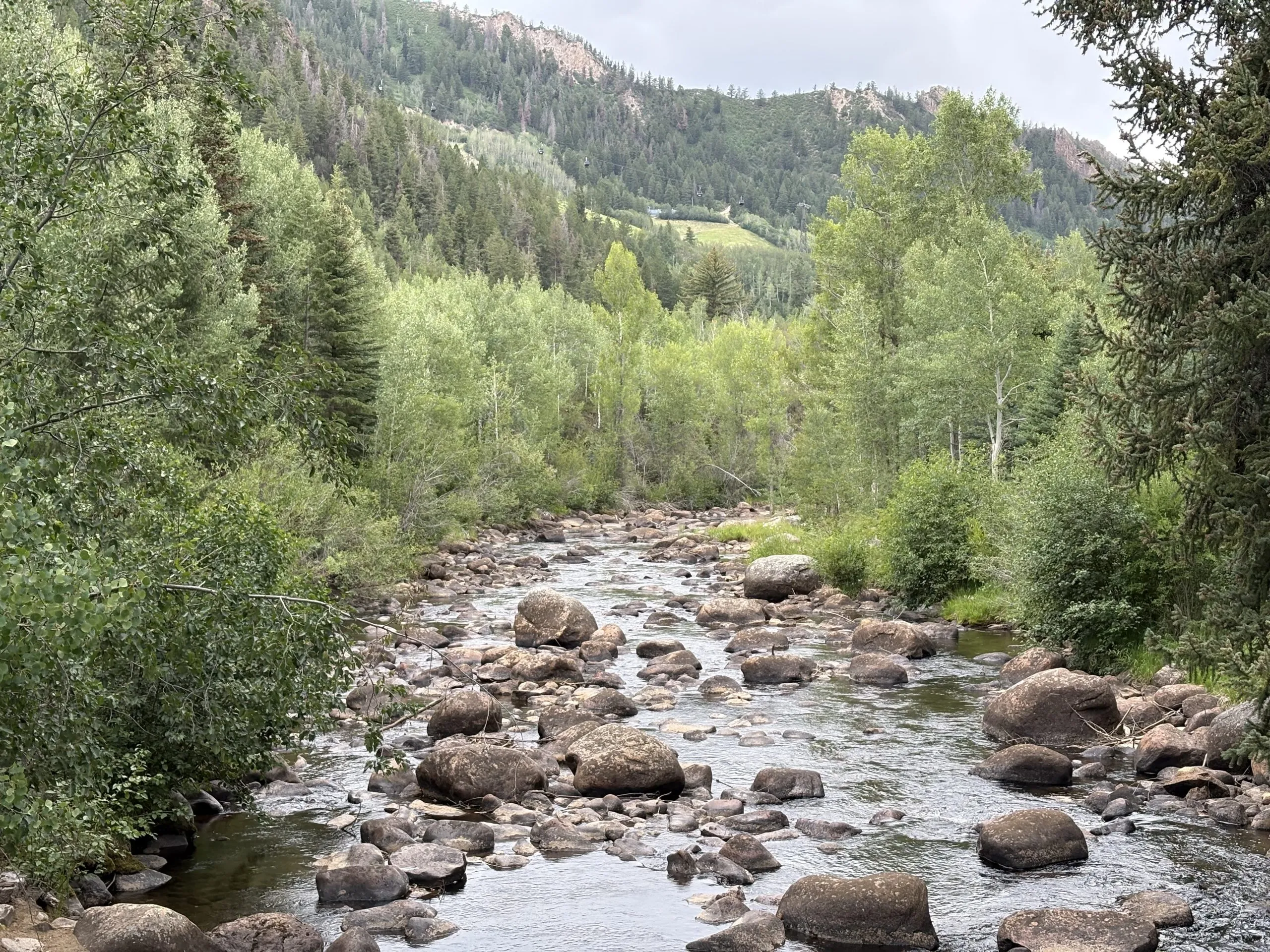
The Roaring Fork River in Aspen on July 8. Pitkin County Commissioners gave initial approval to buying more shares of Twin Lakes water to boost low flows on the Fork. CREDIT: HEATHER SACKETT/ASPEN JOURNALISM
Against the recommendation of an advisory board, Pitkin County commissioners on Wednesday gave preliminary approval to buy more water to boost flows in the often-depleted Roaring Fork River.
Commissioners approved on first reading a resolution and ordinance to spend $442,500 to buy 4.68 shares from the Twin Lakes Reservoir & Canal Co., which is about 3.5 acre-feet of water, according to a staff memo. The deal is in addition to the $6.5 million Pitkin County already agreed to spend earlier this year for about 71 acre-feet from Twin Lakes and another ditch company.
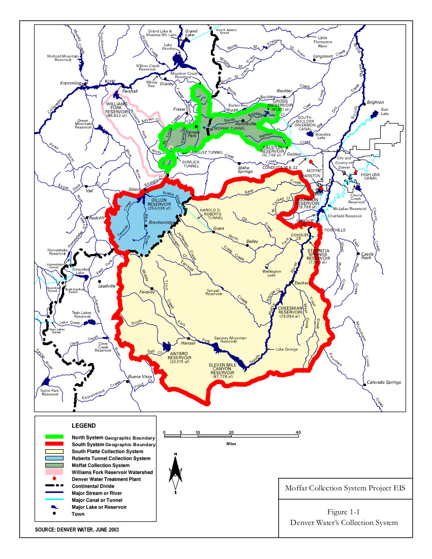
Twin Lakes collection system
The water is currently taken across the Continental Divide to the Arkansas River basin to be used by entities on the Front Range. The deal would allow the water to be released out of Grizzly Reservoir to Lincoln Creek and could help boost the Roaring Fork through Aspen and upstream, which suffers from low flows in dry years.
“I think it’s really critical that we purchase water rights when we can, and this is an opportunity that we can, and we should,” District 1 Commissioner Patti Clapper said.
Pitkin County has long had a goal of increasing the amount of water in the Roaring Fork, a river that has about 40% of its headwaters diverted to the eastern side of the state through the Independence Pass Transmountain Diversion System to be used by Colorado Springs, Pueblo and Aurora. These diversions can often contribute to the depletion of the Roaring Fork through Aspen, and purchasing Twin Lakes water represents a rare opportunity to return water to the Western Slope.
Commissioner Greg Poschman said he supports acquiring the water shares.
“I think it’s great that we are doing this,” he said. “I know it’s expensive; there are some raised eyebrows about that, but I think this is something we have to do.”
Poschman added that he was concerned that the Healthy Rivers board members recommended against buying more water and said he would like to fully understand their reasons. County staff said they were trying to schedule a joint meeting with the Board of County Commissioners and the Healthy Rivers board in August.
Members of the county’s Healthy Rivers board, which advises the BOCC, are concerned that the water will have a small impact on river health but a big impact on the program’s budget. The board held a special meeting June 25 to consider acquiring the shares and approved a motion saying the water yield would potentially be only 1 additional cubic feet per second for two days.
“Additionally, the deleterious effects of the purchase price on the long-term fund balance of the Healthy Rivers Fund will reduce the Healthy Rivers Program’s ability to support programs to address other ballot measure mandates, including water quality, ecological health, recreation opportunities, wildlife and riparian habitat, and promoting water conservation,” the motion reads.
The motion goes on to say that in the future, the county should implement a framework for evaluating the true value of water shares to the Roaring Fork.
At Wednesday’s meeting, County Budget Director Connie Baker told the BOCC that the Healthy Rivers board will have to trim or reallocate about $500,000 from next year’s budget to account for the combined impact of this year’s two water purchases.
Healthy Rivers board member Ned Andrews said he is against the purchase, citing the impact that it will have on the program’s budget.
“None of the analysis or details that would justify such a purchase or a strategy going forward has been done,” Andrews told Aspen Journalism. “I think before you commit essentially a quarter of your budget for the next 15 years, you’d want to have an analysis that shows you what could be accomplished. My gut feeling is that it wouldn’t really accomplish much.”
Andrews also opposed the earlier, larger water share purchase, although the rest of the Healthy Rivers board was supportive.
At their regular June meeting, Healthy Rivers board members went through the budget line by line and considered where they could trim, although those cuts have not yet been finalized.
Spending big bucks in an effort to rescue rivers is not new for Pitkin County, which has spent at least $3.5 million on the Roaring Fork River Park in Basalt, including a water court battle to secure the water right for recreation, several redesigns of problematic waves, and improvements to the riverbank and boat launch.
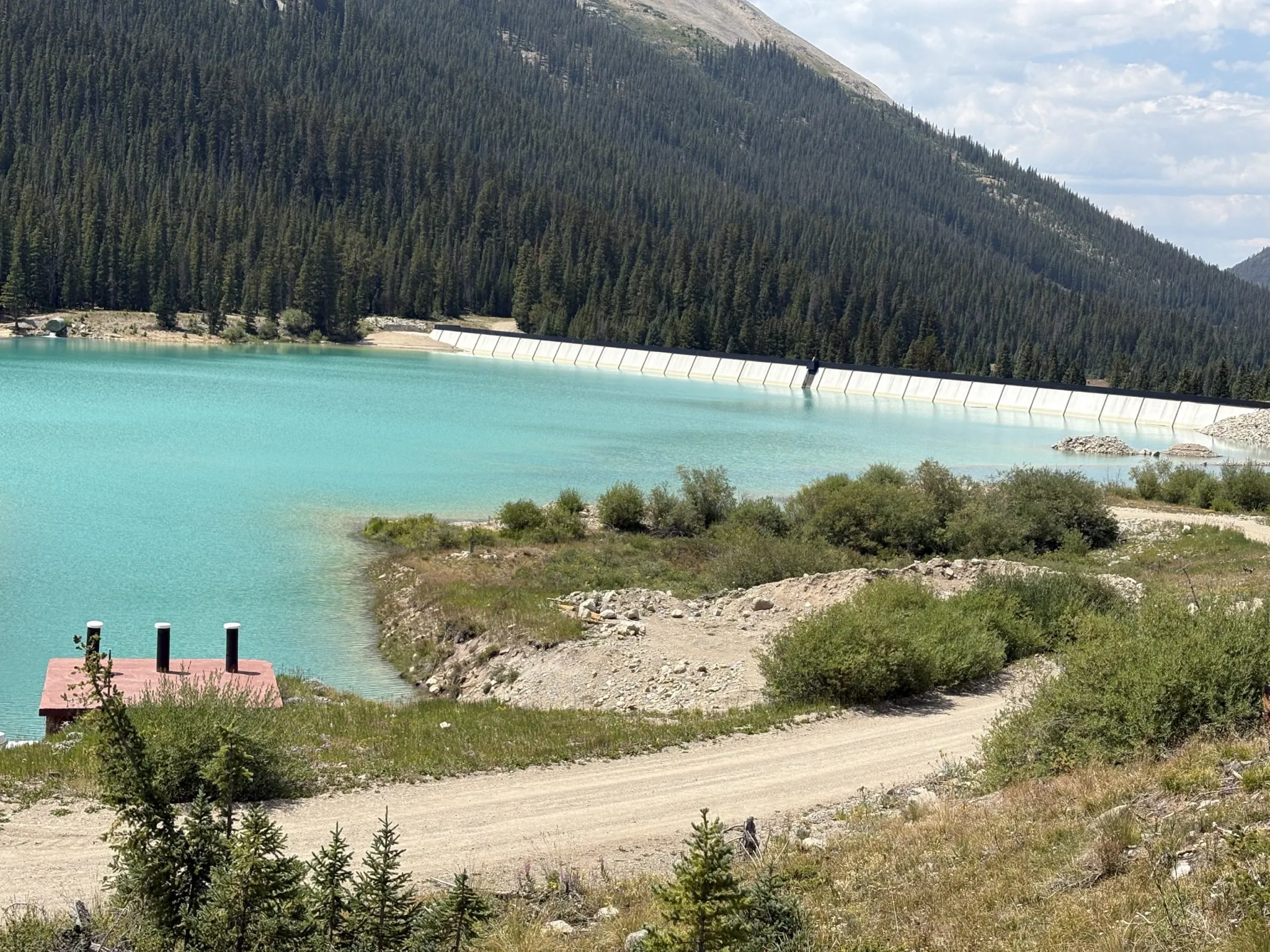
Grizzly Reservoir, a forebay that collects water to send through the Twin Lakes Tunnel to the Front Range, sits in the middle of the Lincoln Creek watershed and connects water users on both sides of the Continental Divide. Pitkin County commissioners gave initial approval to a deal that would allow more water to be released from Grizzly for the benefit of the Roaring Fork. CREDIT: HEATHER SACKETT/ASPEN JOURNALISM
Bond for original purchase approved
The BOCC at Wednesday’s meeting also approved issuing a bond for the original purchase of Twin Lakes shares. That deal cost the county $6.5 million, although only 45 of those acre-feet represent Western Slope water that is currently diverted to the Front Range. The county plans to sell or trade the other 26 acre-feet, which is owned by the Fountain Mutual Ditch Co. in El Paso County and decreed for use on the east side of the divide.
The 45 acre-feet of water can be released down the Roaring Fork during the irrigation season when flows are low, and it must be used by a downstream water user on the Colorado River before the town of DeBeque. Instream flow for the benefit of the environment is not a decreed use of the water.
This year, according to Colorado Water Resources Division 5 Engineer Tyler Benton, at least some of Pitkin County’s Twin Lakes water was released as part of the Colorado River Water Conservation District’s emergency substitute water supply plan, which the district enacted in response to this year’s historic drought. Benton said he expects the River District to provide a full accounting of how much Pitkin County water has been released Friday.
Grizzly Reservoir is currently drained for dam maintenance, which may have affected how much water could be released under the River District’s plan.
At a time when drought impacts are being acutely felt across the state and climate change continues to rob rivers of their flows, for some, the unique opportunity to put water back into a depleted stream is worth the cost.
“This is expensive water, but it’s the only water you can get up at the headwaters of the Roaring Fork,” said Pitkin County Deputy Attorney Anne Marie McPhee. “So that scarcity makes it more valuable.”
The issue is scheduled for a public hearing and second reading July 22.
The full impact of this past winter’s record-low snowpack is rearing its ugly head in the form of:
Record-low spring stream flows.
Low reservoir storage levels.
An empty reservoir.
And one incredibly rare statistic.
On June 17, Denver Water’s reservoir system hit its peak storage level following a diminished spring runoff.
Water levels in the utility’s reservoirs collectively hit 81% of the system’s storage capacity — the second-lowest peak storage level on records dating back to 1983, considered the beginning of the modern Denver Water collection system.
“Peak storage” is the moment, or day, when the utility’s collection system holds the most water it will hold for the next year. It’s akin to topping off a swimming pool once a year in June to carry the pool through the next year of use.
Typically, the “peak storage” moment happens in mid-June, after the spring runoff.
But in 2026, due to the record-low winter snowpack and low spring runoff, Denver Water’s collection system held more water on Jan. 1 — 83% of capacity — than on June 17, as the runoff dwindled and storage levels inched to 81% of capacity.
There’s only one other year since 1983, when the Strontia Springs Dam was completed, that Denver Water’s storage was higher in the dead of winter than the dawn of summer — the drought year of 2002.
“Having our highest amount of water happen in January is incredibly rare. It speaks to how little snow we saw this winter and the impact of the record-setting warm weather,” said Nathan Elder, Denver Water’s manager of water supply.
“We’ve seen many records fall this year, and unfortunately, they were not good ones.”
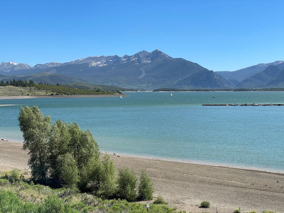
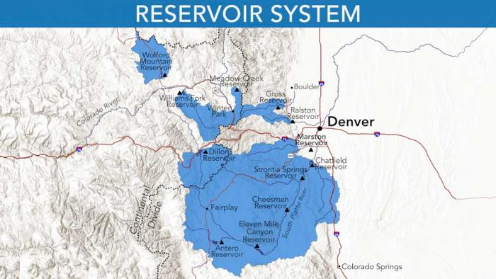
Dillon Reservoir reached 80% capacity on June 17, the highest elevation it is expected to see in 2026. Dillon is the largest reservoir in Denver Water’s collection system, storing roughly 38% of the utility’s water supply. Photo credit: Denver Water.
During the spring peak, the amount of water stored in Denver Water’s reservoirs typically hits an average of 97.5% of capacity.
And since 1983, the utility’s peak storage levels have hit at least 95% of capacity (considered sufficient for normal operating conditions) in all but six years.
“Ideally, we like to top off our mountain reservoirs during the spring runoff, but this year our storage levels came up well short,” Elder said.
Record low ‘paycheck’
Why do water managers focus on peak storage numbers?
The peak reservoir storage figure is critical to determining how much water is available until next year’s spring runoff. It’s comparable to a family determining how much money they have to pay the bills until the next paycheck comes through.
“The spring runoff is our annual paycheck from Mother Nature,” Elder said. “The water filling our reservoirs is the cash that fills our bank account. But in our case, that paycheck only comes once a year — and this year we didn’t get anywhere close to the normal amount.”
Tenmile Creek in Frisco, as it enters Dillon Reservoir on June 12. Denver Water saw record low flows into the reservoir in 2026. Photo credit: Denver Water.
This year’s meager paycheck was reflected in the record-low peak flows on the rivers and streams that feed Denver Water’s reservoirs.
Mountain snowmelt accounts for 90% of Denver Water’s supply, which provides water to 1.5 million people in metro Denver.
In Summit County, Denver Water recorded this year’s peak stream runoff into Dillon Reservoir at just 404 cubic feet per second, or cfs, on May 29. That’s a record-low “peak inflow” and less than a quarter of the normal peak inflow into the reservoir of 1,750 cfs, which typically happens on June 7.
In Park County, the South Fork of the South Platte River experienced a double-whammy, with record-low flows that occurred abnormally early in the season.
Flows on the South Fork peaked on March 25 at a record-low flow of just 18 cfs. That’s 15% of the normal peak flow of 120 cfs, which usually happens on June 10.
The South Fork of the South Platte River south of Fairplay on May 22. The river peaked at a record low flow of just 18 cfs in 2026. Photo credit: Denver Water.
“In a typical year, the rivers and streams start rising in late-April as the snow starts to melt, then they peak in early June, and then they start to ease back to normal flows throughout the summer,” Elder said.
“This year the runoff started about six weeks early in March, and the normal spring surge of water we usually see was basically nonexistent.”
Reservoir impact
The results of the record-low spring flows are having a significant impact on three of Denver Water’s most popular reservoirs.
Dillon Reservoir in Summit County topped off on June 17 at 80% of capacity, with water levels about 18 feet below normal for this time of year. Water levels are expected to drop over the next year until the 2027 spring runoff — hopefully more boisterous than this year’s meager flow — begins.
Dillon Reservoir in Summit County reached 80% capacity on June 17. This picture shows the low levels at the Snake Inlet on the southeast corner of the reservoir on June 12. Photo credit: Denver Water.
In Grand County, Williams Fork Reservoir topped off June 21 at merely 53% of capacity, about 35 feet below normal for this time of year and forcing the closure of the reservoir’s boat ramp.
At the Williams Fork Reservoir in Grand County, the boat ramp will be closed all summer due to low snowpack and record-low runoff. Photo credit: Denver Water.
Because of the low snowpack, Denver Water also dipped into its emergency water supply at Antero Reservoir in Park County.
Using water from Antero Reservoir is only done in extremely dry years. It’s comparable to someone having to dip into their 401(k) savings to pay bills until their next paycheck.
Denver Water moved water out of Antero this spring and sent it downstream to Cheesman Reservoir to avoid losing water in shallow Antero due to evaporation.
Denver Water moved water from Antero to Cheesman reservoir in 2026 to reduce losses from evaporation. The water in Antero Reservoir, pictured above, is only used in extreme dry years. Photo credit: Denver Water.
Early forecasts for the abysmal spring runoff and low peak storage were two factors that led Denver Water to issue a Stage 1 drought declaration in March.
The declaration, which calls on customers to reduce water use by 20% and includes mandatory watering restrictions of two assigned days per week, seeks to stretch existing water supplies until next spring’s paycheck is deposited in the reservoirs.
“While the reservoirs are low this year, they are doing what they were built for, which is to help us get us through a dry year,” Elder said.
“We hope customers notice the low reservoir levels and take steps to conserve water at home so we can stretch our water supplies over the coming months.”
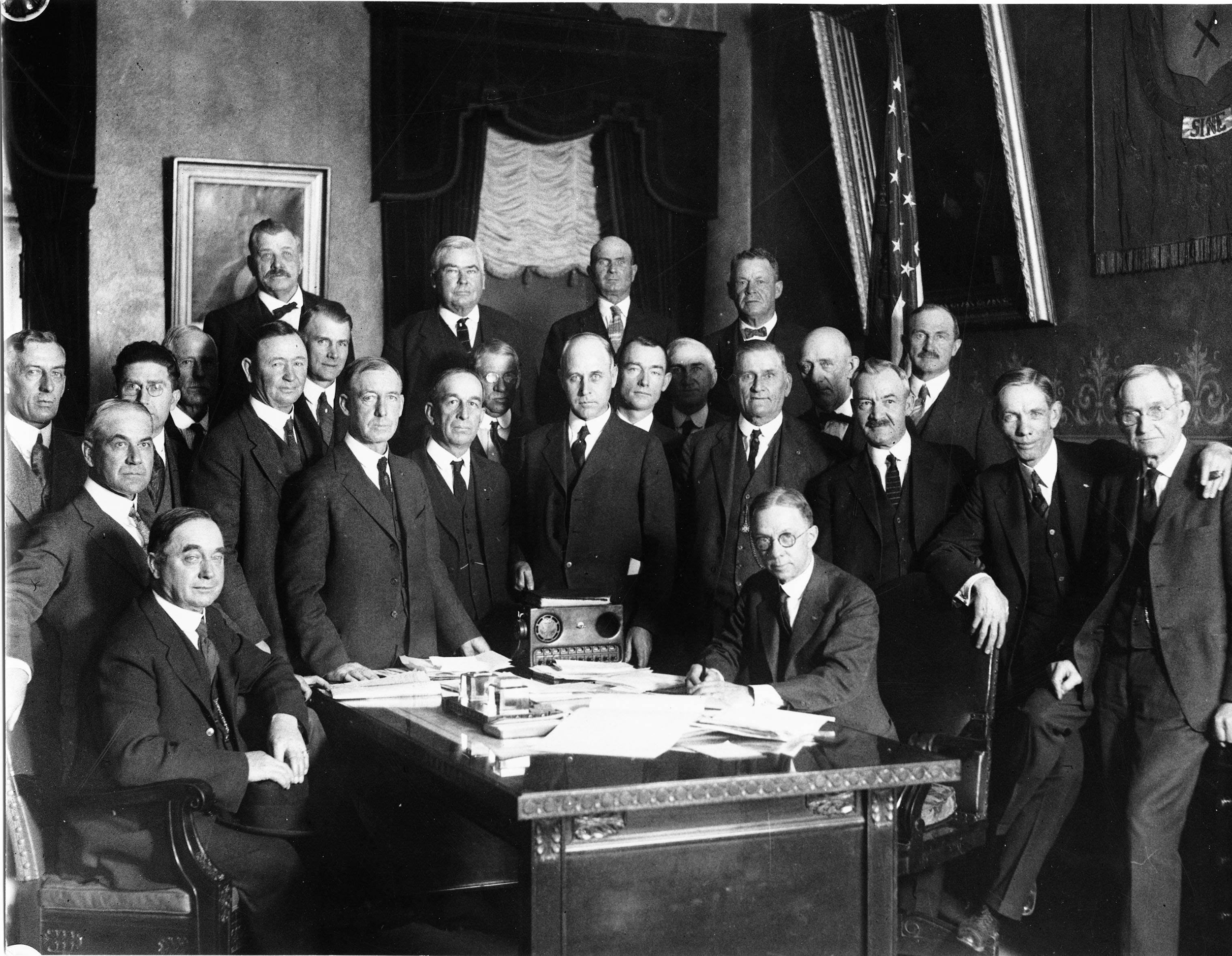
Governor Clarence J. Morley signing Colorado River compact and South Platte River compact bills, Delph Carpenter standing center. Unidentified photographer. Date 1925. From the CSU Water Archives
Click the link to read the article on The Denver Post website (Elise Schmelzer). Here’s an excerpt:
June 29, 2026
The U.S. Supreme Court will weigh in on a legal battle over one of Colorado’s critical water sources as a neighboring state seeks to use more water from the South Platte River. The nation’s highest court on Monday announced it would hear the case, in which Nebraska officials claim Colorado water administrators are violating a century-old water compact by failing to send enough of the river’s water across the border. They also say Colorado officials are interfering in the neighboring state’s efforts to build a canal that would allow it to take more of the river’s water. Colorado Attorney General Phil Weiser on Monday denied Nebraska officials’ allegations that the Centennial State was violating the 1923 South Platte River Compact.
“Colorado is complying with the South Platte River Compact and not interfering with Nebraska’s efforts to build the Perkins County Canal,” Weiser said in a statement. “Today’s court decision merely opens the door for Nebraska to bring its claims against Colorado. Nebraska’s burden to prove those claims is incredibly high and we will vigorously defend Colorado’s full entitlements under the compact.”
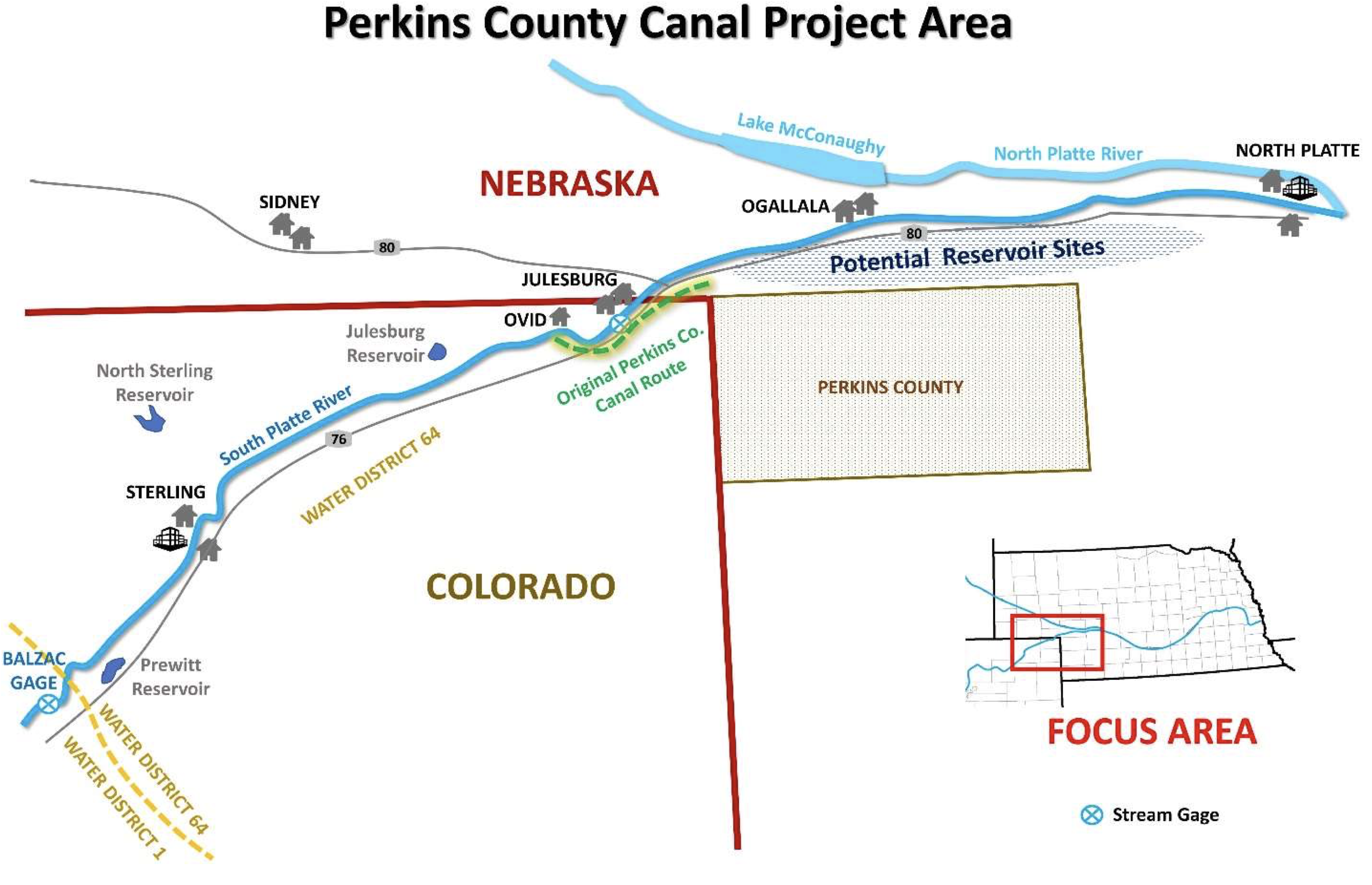
Perkins County Canal Project Area. Credit: Nebraska Department of Natural Resources
Nebraska officials last year surprised Colorado leaders by taking their allegations to the Supreme Court. The two states had been meeting for months to discuss the proposed canal project. The Supreme Court asked the Office of the Solicitor General to weigh in on whether it should take the case. In May, the federal office — tasked with representing federal interests at the Supreme Court — argued that the court should decide Nebraska’s claim that Colorado is not sending enough water over the state border, but deny consideration of Nebraska’s other issues…Controversy over compact-obligated water deliveries between two states is a “quintessential” Supreme Court question, the brief states. The solicitor general’s office suggested appointing a special master — a subject-matter expert outside of the nine justices — to handle the issue. The solicitor general’s brief argues that the Supreme Court should not hear Nebraska’s arguments that Colorado is obstructing its efforts to build the Perkins County Canal because, the office said, Nebraska has not identified any actions by Colorado officials that have substantially interfered in the project. Other potential canal-related problems identified by Nebraska are hypothetical, the solicitor general said, as the state has just begun the permitting process and, therefore, is not ready for Supreme Court consideration. It’s unclear which issues the Supreme Court will consider as it hears the case. The order Monday allows Nebraska to file its complaint against Colorado.
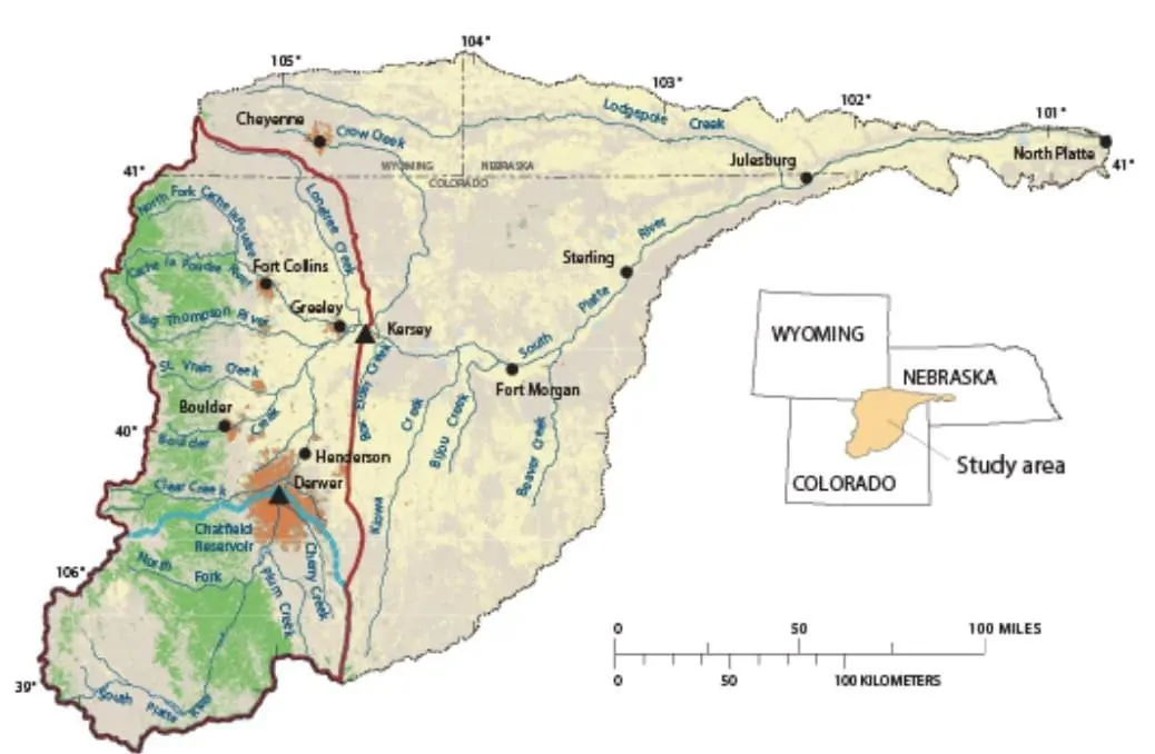
The South Platte River Basin is shaded in yellow. Source: Tom Cech, One World One Water Center, Metropolitan State University of Denver.
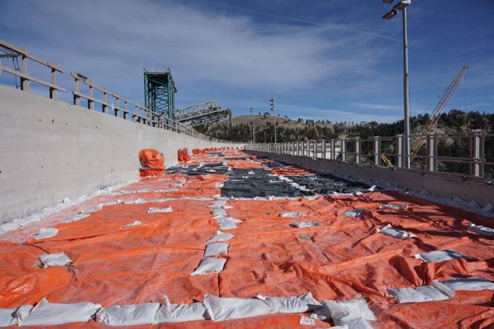
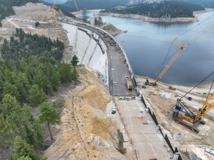
The new conveyor system moved concrete across the gap where the spillway channel will be to the far side of the dam. Photo credit: Denver Water.
Click the link to read the article on The Denver Post website (Elise Schmelzer). Here’s an excerpt:
June 14, 2026
…it remains unclear whether Denver Water will ever be able to fill the reservoir to its new full capacity as a yearslong court battle lumbers on between the utility and environmentalists. Months of mediation between the parties have failed. Denver Water is now asking a federal appeals court to reverse a lower court judge’s 2025 order barring the utility from filling the expanded reservoir and ordering the yearslong federal permitting process to be redone. A panel of three judges for the 10th U.S. Circuit Court of Appeals is scheduled to hear arguments in the case on July 31 in Santa Fe…
U.S. District Court Judge Christine Arguello in 2024 found that federal regulators violated environmental protection laws when they failed to properly analyze the environmental impact of the project or consider reasonable alternatives to the dam expansion that would be less harmful. She later issued the order against filling the reservoir. Environmental groups argued in court, and in their filings, that regulators failed to evaluate how siphoning more water from the drought-stricken Colorado River would impact the basin as a whole. And the groups charged that they failed to weigh other project options that wouldn’t require the clear-cutting of a half-million trees or risk damage to wetlands. The case has drawn the attention of other Front Range water providers, lawyers from across the county and the U.S. Chamber of Commerce — all of which have filed briefs in the appeals case…
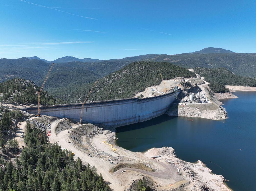
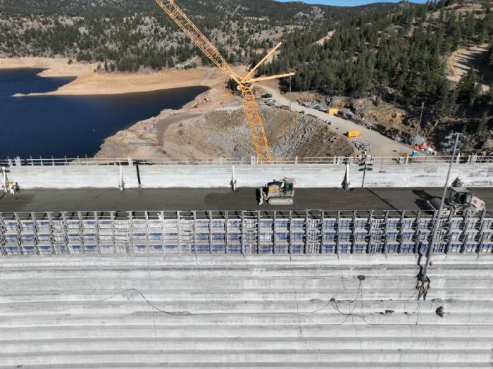
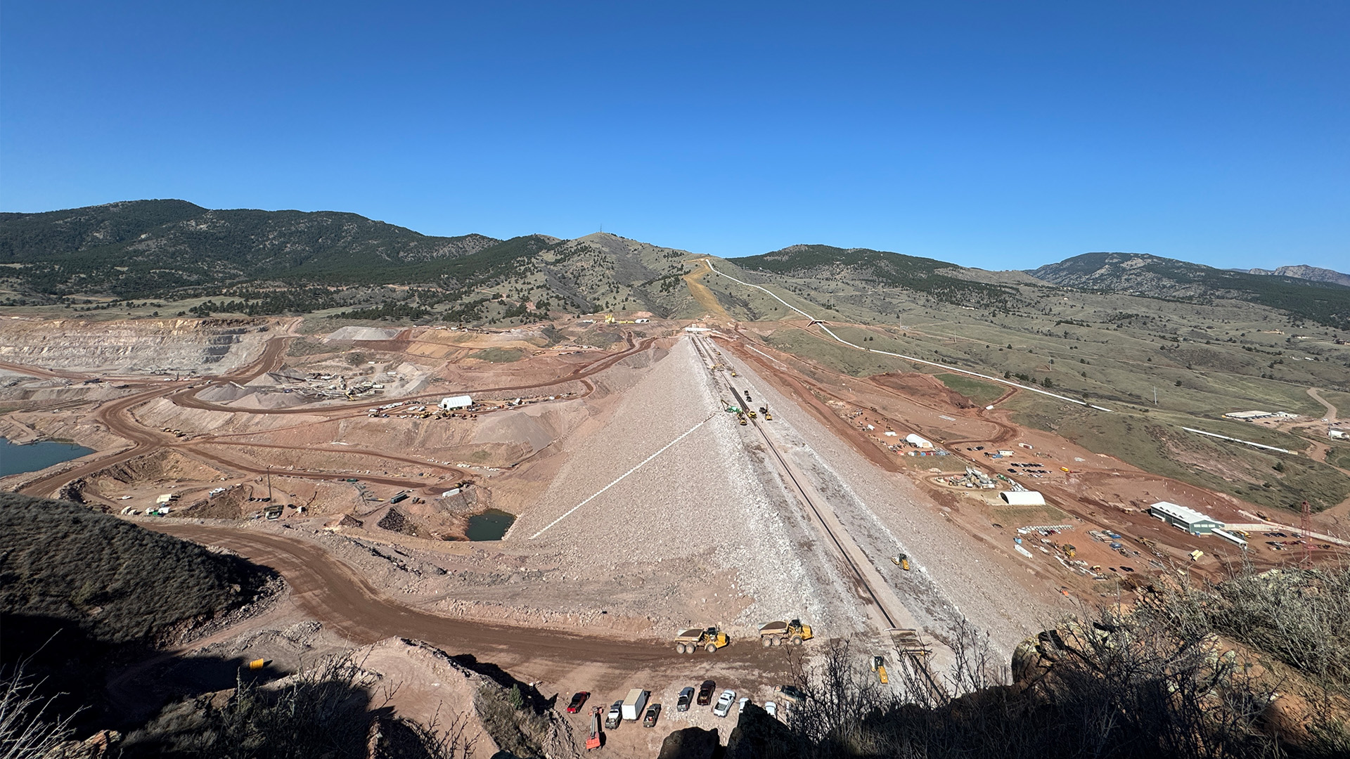
While the dam structure itself is complete, at least a year of work remains to fully finish the project, Martin said. Construction crews must finish the spillway and place the final topper foot of concrete on the completed dam structure. Divers will place a gate between the reservoir’s water and the dam’s intake tubes. But the crews on site will diminish in the coming months, from up to 500 workers a day to closer to 100. On the morning of June 3, crane operators already worked to remove from the dam crest the heavy machinery that was necessary to build the main structure.
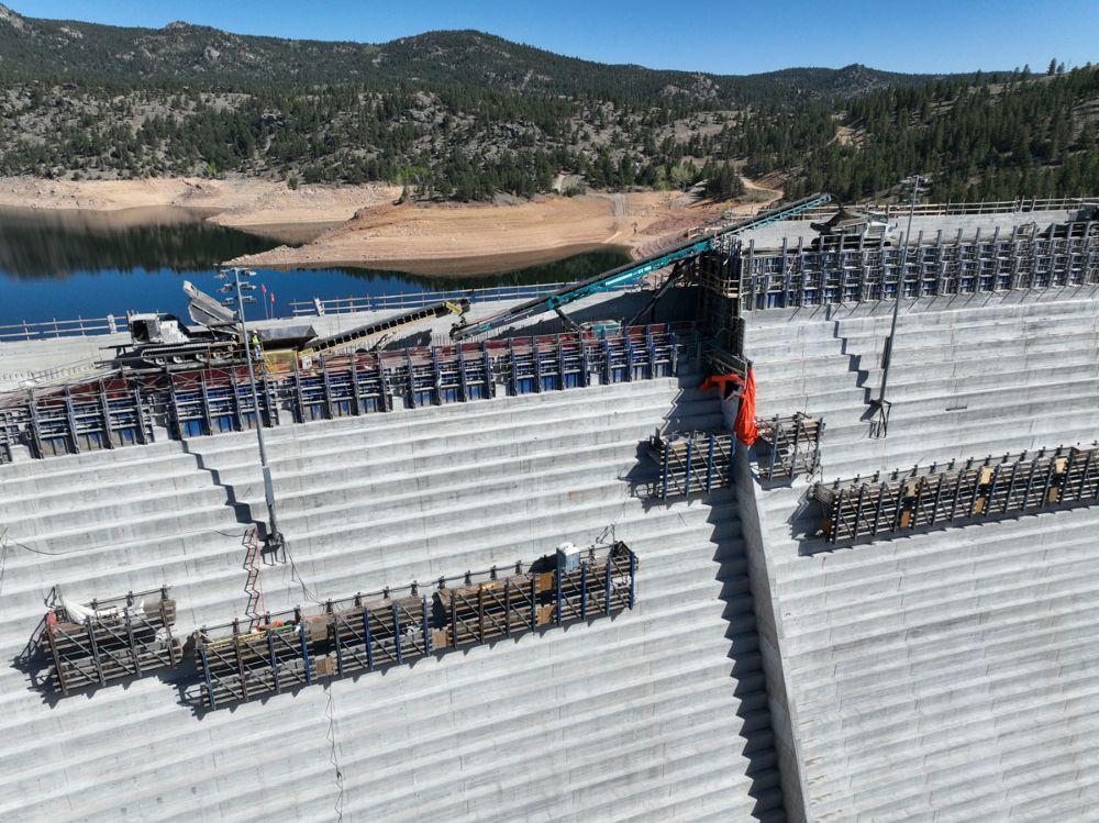
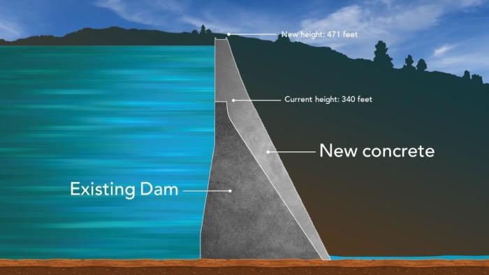
Roller-compacted concrete will be placed on top of the existing dam to raise it to a new height of 471 feet. A total of 118 new steps will make up the new dam. Image credit: Denver Water.
A reservoir built to serve nearly a million Northern Coloradans started filling this spring. But Chimney Hollow’s future is still murky weeks after the initial fill. Chimney Hollow will eventually pull water from the Colorado River near its headwaters in Grand County to serve a dozen fast growing cities on the Front Range from Broomfield to Greeley…Chimney Hollow is holding just 2% of its total volume today because there’s a problem. Northern Water discovered that some of the rocks it used to build the massive dam at the reservoir contained radioactive uranium. It was naturally occurring, but it set the project back at least a year. Northern Water is still coming up with a mitigation plan.
“Really, the best way to kind of move that uranium out is to draw down the water and force that out,” spokesperson Rachel Stevens said. “But before we make any of those decisions, we really want to see what the levels of uranium are.”
So every week, crews are taking water samples from the small pool and sending it to a lab to see how much radioactive material is really in the water. The results are expected soon. Northern Water has only been able to test how uranium leaches out of the rocks in a laboratory setting. Filling the reservoir just slightly will help reveal the extent of the problem.
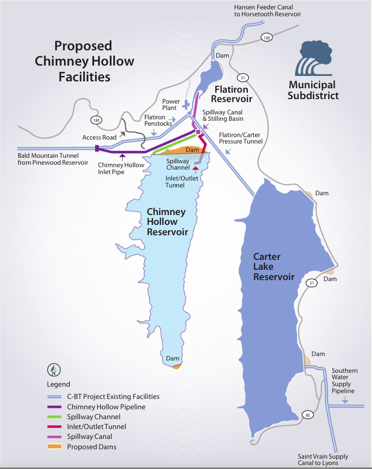
Map from Northern Water via the Fort Collins Coloradan.
Each stage of a big construction project has its own challenges and puzzles to solve along the way. Raising Gross Dam is no different.
Denver Water is raising the height of the dam by 131 feet, with the final 22 feet going up this spring in two sections that are separated by a giant gap. The Gross Reservoir Expansion Project, which began construction in 2022, is designed to nearly triple the reservoir’s storage capacity. Major construction work resumed in April following a winter break.
And this year’s construction puzzles included:
How to move concrete across a 160-foot gap between where the concrete is made and where it’s placed?
And, how do you move construction vehicles across that same gap when work on the first section is finished?
“We are building the top of the dam in two sections because we need to leave a 160-foot gap in the middle of the dam for the spillway channel,” said Casey Dick, Denver Water’s deputy program manager for the Gross Reservoir Expansion Project.
Denver Water is building the last 22 feet of Gross Dam in two sections. The photo shows the left side at its new height. The right side’s last 22 feet will be finished in June. Photo credit: Denver Water.
Spillway channels are safety features on dams that allow water to safely flow out of a reservoir if needed due to flooding rains or exceptionally high and rapid snowmelt.
Raising the dam’s last two major sections, while leaving a 160-foot gap between them, meant coming up with a new way to move concrete across the construction site.
On the lower portion of the dam, crews worked on one continuous structure, which allowed trucks and equipment to easily move from one side of the dam to the other, and to move concrete from the batch plant down a large chute to where it was put into place.
However, with the final 22 feet going up in two sections, construction crews had to find a way to deliver concrete from the batch plant and across the 160-foot spillway gap as the first section went up.
The solution to this puzzle? A series of conveyors positioned in the middle of the dam that tilted higher as the first section rose higher.
“Building the new conveyor system is just another example of all the ingenuity we go through out here to build the dam,” Dick said. “With each new phase, there are new challenges that our team has to figure out.”
The new conveyor system moved concrete across the gap where the spillway channel will be to the far side of the dam. Photo credit: Denver Water.
Construction crews finished placing roller-compacted concrete on the dam’s left side on May 12.
But once that was done, crews faced the second challenge: How do you move the equipment off the finished, 22-foot higher section of the dam, across the spillway gap, down to where they are needed to complete the second section?
Short answer: If you can’t go over, go around.
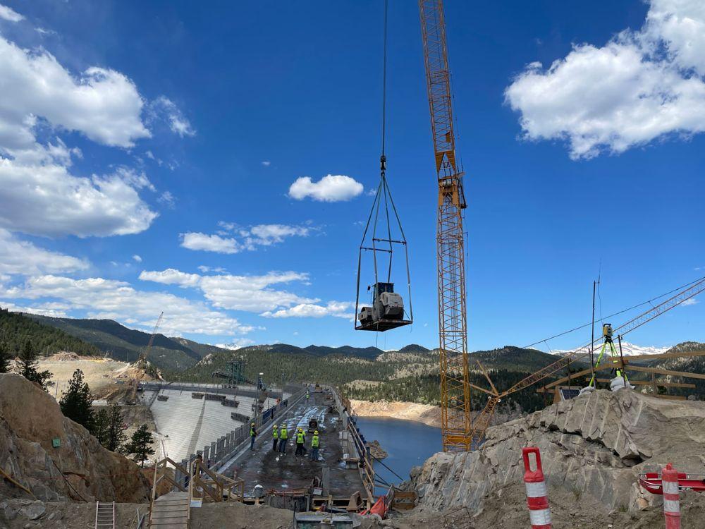
Cranes lifted equipment off the higher section of the dam to the road, where the machines convoyed about 4.5 miles around to the other side using the dam’s access road.
A crane lifts a piece of equipment off the dam. Because of the new spillway gap, equipment was driven across the dam’s access road to get into position on the other side of the dam. Photo credit: Denver Water.
Construction on the final 22 feet of the second side of the dam began at the end of May and is expected to be completed in June.
Once the second section is done this summer, a year’s worth of remaining work includes: finishing the top of the dam, building safety walls; constructing the actual spillway; building a bridge over the spillway and completing the stilling basin at the bottom of the dam.
This view from the bottom of the dam shows the new baffle blocks on the bottom of the stilling basin. The baffle blocks reduce the energy of the water that flows down the spillway. Photo credit: Denver Water.
Full construction on the dam raising project is expected to wrap up in mid-2027.
“There are hundreds of logistical challenges throughout this project, but our team has been able to meet every one of them along the way,” Dick said. “We’re making good progress so far in 2026 and are looking forward to getting a lot of work done in the coming months.”
The Gross Reservoir Expansion Project involves raising the height of the existing dam by 131 feet. The dam will be built out and will have “steps” made of roller-compacted concrete to reach the new height. Image credit: Denver Water
This USGS map shows the number of PFAS detected in tap water samples from select sites across the nation. The findings are based on a USGS study of samples taken between 2016 and 2021 from private and public supplies at 716 locations. The map does not represent the only locations in the U.S. with PFAS. Sources/Usage: Public Domain. Visit Media to see details.
EPA aims to end federal regulation of four PFAS in drinking water and give utilities more time to comply with existing rules.
FEMA reopens applications for a climate-resilient infrastructure grant program that the agency had cancelled.
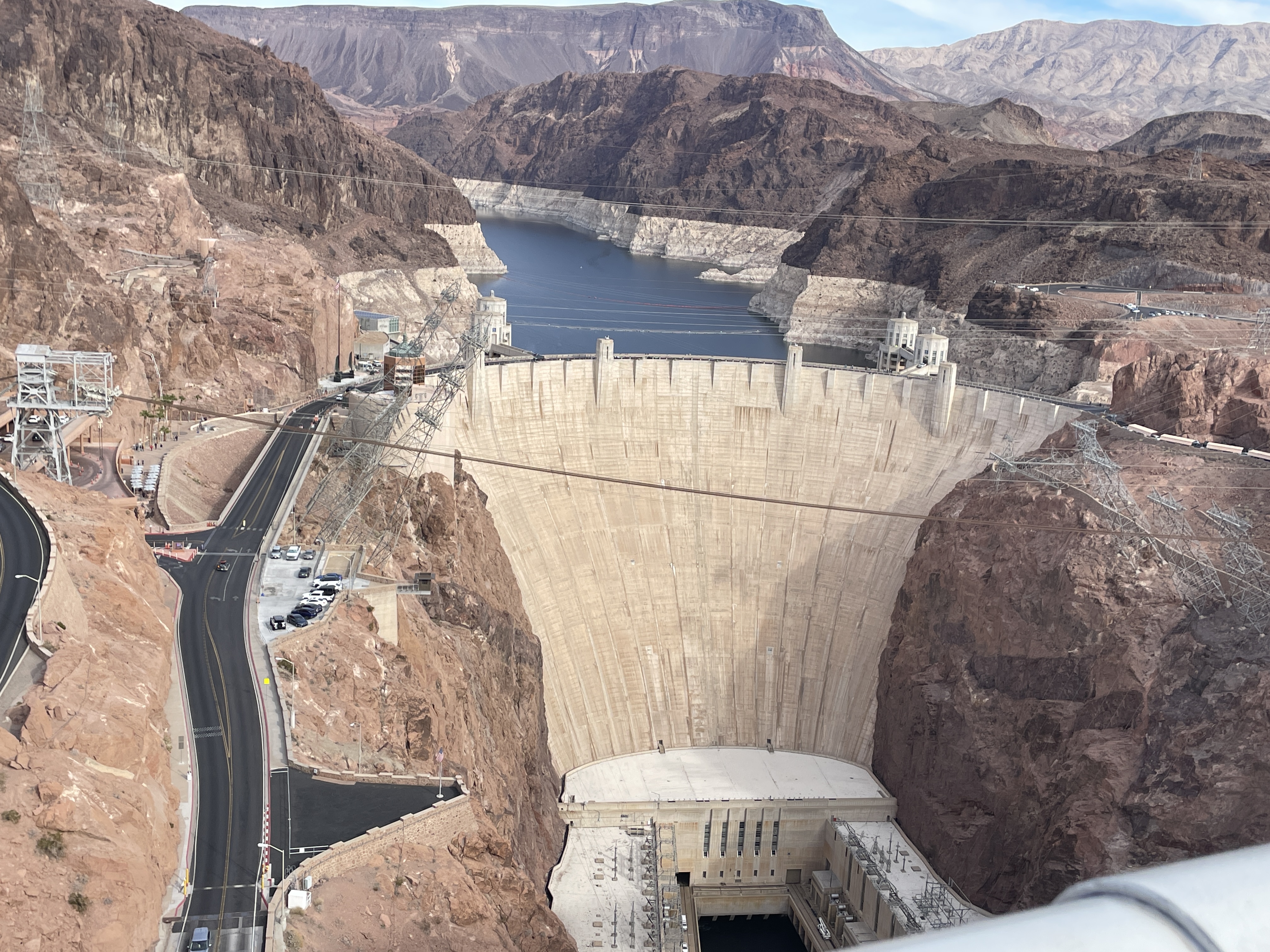
Bureau of Reclamation announces $52 million for three new Hoover Dam turbines that will generate hydropower at lower Lake Mead levels.
A House FY27 budget bill will cut the federal government’s primary water infrastructure funds by 24 percent.
NOAA forecasts fewer Atlantic hurricanes this season.
EPA water office leader commits to investigate groundwater pollution in Georgia from Meta data center construction.
The Trump administration recommends that the U.S. Supreme Court take up Nebraska’s claim that Colorado has violated a river-sharing compact.
And lastly, the Bureau of Reclamation’s acting commissioner informs a House subcommittee about the status of Colorado River negotiations.
“Several weeks ago, I met with the 14 senators from the Colorado River basin and on a bipartisan basis, several of them said, ‘Look, we have a real crisis on the Colorado and we need to get things done and if there are any environmental statutes that are slowing things down, tell us what they are and maybe we can legislate to clear out some of the unhelpful bureaucratic paperwork.’” – Scott Cameron, acting Bureau of Reclamation commissioner, speaking at a House Natural Resources subcommittee hearing. Cameron said his office has not yet followed up on the offer but “looked forward” to conferring with the senators about “waiving or streamlining certain environmental statutes on the Colorado.”
Udall/Overpeck 4-panel Figure Colorado River temperature/precipitation/natural flows with trend. Lake Mead and Lake Powell storage. Updated through Water Year 2025. Note the tiny points on the annual data so that you can flyspeck the individual years. Credit: Brad Udall
As for the status of Colorado River negotiations, Cameron said, “Frankly, the seven states are not in a position where they could agree today, right now, to a four-year deal, let alone a 20-year deal, because of the uncertainties we’re dealing with.”
By the Numbers
$1 Billion: Funding now available from FEMA’s Building Resilient Infrastructure and Communities program, a grant opportunity to reduce risk from climate and weather hazards. A federal judge ordered the agency to reinstate the program, which the Trump administration had cancelled. Applications are due July 23.
$52 Million: Funding announced by the Bureau of Reclamation for three new low-head turbines at Hoover Dam. Only five of the dam’s 17 turbines are designed to operate when Lake Mead drops below elevation 1,035 feet, a threshold that the shrinking reservoir is fast approaching and could breach in the next 12 months, if not sooner.
Not So PFAS The EPA is proposing to repeal federal regulation of four PFAS in drinking water, partially undoing a Biden-era rule that set first-ever limits on six of the “forever chemicals.”
Three of the chemicals – PFHxS, PFNA, and Gen X – were regulated individually. Together with PFBS, they were also regulated as a mixture.
The EPA will retain standards for PFOA and PFOS, the two most-studied of the chemicals. However, in a separate rule-making, the agency is proposing to give water utilities more time to comply, extending the deadline by two years, until 2031. The agency says the move will “ease the implementation burden” financially and administratively for water systems and might allow for cheaper treatment technologies to come to market.
Water utilities must apply for an extension. One of the considerations is whether an extension would pose an “unreasonable risk to health.” The EPA is proposing that PFOA and PFOS levels below 12 parts per trillion would not be unreasonable. (The federal standard for both is 4 ppt.)
The EPA wants public comment on whether interim utility actions during a compliance extension – point-of-use treatment, filtration pitchers, education, alternative water sources – can mitigate health risks above 12 ppt.
Water Infrastructure Funding Cuts A House spending bill cuts the two main federal sources of water infrastructure funding by about 24 percent in fiscal year 2027. The bill passed out of subcommittee last week.
The bill provides $1.2 billion for the Clean Water State Revolving Fund (27 percent cut) and $911 million for the Drinking Water State Revolving Fund (19 percent cut).
Following a recent trend, about half of the appropriation comes in the form of earmarks. This money will go directly to specific projects and will not enter the revolving fund. Water industry advocates argue that continuing to take earmarks out of the revolving fund appropriation threatens the viability of the program.
Studies and Reports
The South Platte River Basin is shaded in yellow. Source: Tom Cech, One World One Water Center, Metropolitan State University of Denver.
Great Plains Water Fight The federal government’s top lawyer recommended that the U.S. Supreme Court take up one of Nebraska’s claims that Colorado is violating the South Platte River Compact, which divides the river’s water between the two states.
Nebraska argues that Colorado is breaking three articles of the compact. The U.S. solicitor general says that the high court, through a special master, should pursue only one of them: that Colorado is allowing irrigators to take too much water.
“A claim that one State has deprived another of water to which it is entitled under an interstate compact is a quintessential case for this Court’s original jurisdiction,” the brief states.
Atlantic Hurricanes NOAA is forecasting a less active Atlantic hurricane season. The agency estimates that one to three major hurricanes (Category 3 or higher) will form.
The category ratings can be misleading. They measure wind speed, not precipitation. Tropical storms and minor hurricanes can still inflict serious flood damage.
Air Conditioning Estimates The U.S. Census Bureau published data estimating how many homes use air conditioning.
States with the lowest air conditioning use are in New England and the West.
On the Radar
EPA on Data Centers and Household Wells Under oath at a House subcommittee oversight hearing, Jessica Kramer, head of the EPA Office of Water, committed to investigate impacts to drinking water quality from data center construction.
“Whatever type of construction it is, it’s a priority to ensure that water quality standards established by EPA are being met. So we’ll be looking into that certainly,” Kramer said.
Kramer’s commitment at the House Energy and Commerce hearing was prompted by Rep. Alexandria Ocasio-Cortez (D-NY) who asked about water pollution from data center construction.
Ocasio-Cortez visited Morgan County, Georgia, a few weeks ago. She returned with jars of brown water from household wells near the construction site of a Meta data center. She displayed those at the hearing.
“This is what the drinking water now looks like, next to that data center,” Ocasio-Cortez said.
“As soon as I get back to the office, I will be looking into exactly what you just talked about,” Kramer replied.
Army Corps Deauthorized Projects The Army Corps published a list of water projects that it intends to deauthorize.
These are projects that were authorized years ago but either haven’t ever received funding or haven’t recently received funding.
Public comment on the proposal runs through August 19. Submit comments at http://www.regulations.gov using docket number COE-2026-0034.
Federal Water Tap is a weekly digest spotting trends in U.S. government water policy. To get more water news, follow Circle of Blue on Twitter and sign up for our newsletter.
Here’s the release from the St. Vrain and Left Hand Water Conservancy District (Sean Cronin):
April 20, 2026
Agreement affirms no new on-river dam while preserving valuable water rights for communitybenefit
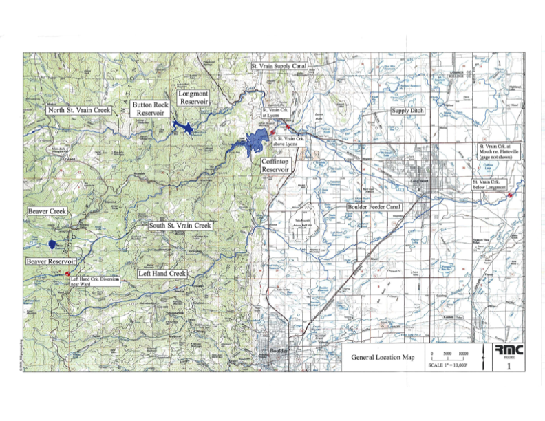
The St. Vrain and Left Hand Water Conservancy District has reached an agreement with Save the World’s Rivers that reaffirms a new path forward for its Coffintop Reservoir water rights—one that does not include construction of a large on-river dam.
The District was created in 1971, in part, to build Coffintop Reservoir on South St. Vrain Creek west of Longmont and upstream of Lyons, through a planned partnership with the U.S. Bureau of Reclamation. While the reservoir itself was never built, two water storage rights associated with the Coffintop Reservoir project remain legally valid today.
As a governmental entity, the District holds the Coffintop Reservoir water rights not for its own benefit but for the community’s. In 2024, as required under Colorado water law, the District filed a routine six-year diligence application in water court to maintain those rights. The filing prompted an environmental group, Save the World’s Rivers, to submit a statement of opposition, opening discussions between the two organizations about the future use of the Coffintop water rights.
“The Water Court process is complex, and at the onset we were uncertain what Save the World’s Rivers hoped to achieve through it,” said Sean Cronin, the District’s Executive Director.
“We are always watching proponents of dams,” said Gary Wockner, Executive Director of Save the World’s Rivers. “At the appropriate time, we seek to identify ways proponents can achieve their mission while not creating a new dam. We were generally aware of the good work being done by the District, but concerned about their plan to build Coffintop Reservoir and dam.”
Through dialogue, the District and Save the World’s Rivers found common ground. Cronin noted, “I met with Gary several times, and I gained respect for his organization’s objectives, and I appreciated his willingness to come to the table and talk through complicated issues.” Save the World’s Rivers learned that the District had been working for more than 10 years with the City of Longmont, Town of Lyons, Boulder County Parks and Open Space, local environmental organizations, and food producers to develop a strategy to best utilize the Coffintop Reservoir water rights – without building the actual reservoir.
The District and Save the World’s Rivers reached an agreement through the court process, under which the District agreed to forgo using the Coffintop Reservoir water rights for any new on-river reservoir, including Coffintop Reservoir, and for the expansion of any existing on-river reservoir. Instead, the District will return to water court with plans to use the water rights at alternative locations and in ways that align with community needs, and environmental and water management goals.
“It became clear through discussions that the District shared values around avoiding a new on-river dam while still meeting its mission,” said Wockner. “That made an agreement possible,” Wockner said.
District leaders emphasized that the water rights are held for public benefit and that the original Coffintop Reservoir concept no longer reflects the highest and best use of the resource.
“This is something we and our communities have contemplated for decades,” said Christopher Smith, President of the District’s Board of Directors. “The Coffintop project, as envisioned more than 50 years ago, no longer fits today’s needs or values.”
For more than a decade, the District has worked with community partners to explore alternatives that could use the Coffintop water rights, while also supporting increased stream flows during low-flow periods. The District’s development and implementation of these alternatives is moving forward with engagement from important partners, including the Town of Lyons and City of Longmont.
Town of Lyons Mayor Hollie Rogan welcomed the agreement. “St. Vrain Creek is the lifeblood of our town, and a large dam upstream was never embraced by our community,” she said. “We’re pleased the District will not pursue Coffintop Reservoir and look forward to continued collaboration.”
Longmont Director of Water and Waste Service Chris Huffer noted the long history between the City and the District. “The challenges around water have only grown more complex over the last 50 years,” he said. “The District has a solid water plan, and the City is an eager partner in realizing the greatest potential of these water rights.”
The South Platte River Basin is shaded in yellow. Source: Tom Cech, One World One Water Center, Metropolitan State University of Denver.
The initial fill of Chimney Hollow Reservoir has concluded, and the reservoir currently has about 1,500 acre-feet of water—less than 2 percent of the reservoir's full capacity of 90,000 acre-feet. Read more about the initial fill at https://t.co/WaxdbfiFWz. pic.twitter.com/ndlN3Y6zoV
— Chimney Hollow Reservoir (@ChimneyHollow) May 5, 2026
“By taking voluntary measures now to reduce water use, Utilities customers can actively help lower the chance of mandatory water restrictions if conditions worsen,” the news release stated.
Fort Collins Utilities and East Larimer County Water District, or ELCO, which are two of the city’s three major water providers, are asking customers to:
Limit lawn watering to no more than two days per week.
Avoid watering between 10 a.m. and 6 p.m.
The West Fort Collins Water District is required to follow city-issued water rationing and restrictions, according to its website. Sunset Water District is managed by ELCO.
When Donald Trump was elected president for the second time, we all knew what was coming to the nation’s public lands: The administration would favor extractive uses by eviscerating environmental protections, rolling back regulations, and leasing out as much land as possible while handing out drilling permits like Shriners throwing candy at a parade.
Yet there was one realm where I figured the administration couldn’t bestow any more deregulatory gifts, namely public lands grazing. It’s not that I thought Trump would clamp down on the destructive practice, it’s just that I figured the status quo was about as permissive as it could get. Past administrations, be they Democratic or Republican, have generally shied away from updating or reforming public lands grazing policies out of fear of inflaming the West’s cowboy culture — even if it is based largely on myth.
But Trump, his Interior Secretary Doug Burgum, and Agriculture Secretary Brooke Rollins are intrepidly going where previous administrations did not dare: grazing reform. Well, sort of, though maybe not in the way public lands lovers might have hoped. In fact, they are doing their best to make grazing policy even more lax with a goal of getting more cattle out there to trample public lands, cryptobiotic soils, and cultural sites.
Last month, Burgum and Rollins announced an MOU between the two agencies designed to “boost the supply of American born, raised, and harvested beef” by cutting “bureaucratic red tape” and giving the livestock industry more control. The MOU has a goal of “maintaining grazing capacity wherever possible, including no net loss of Animal Unit Months within allotments,” even if those allotments are degraded or in poor health. In Burgum’s words, one goal is to “preserve America’s ranching heritage for generations to come.” Forgive me for getting anxious whenever I see “heritage” used in conjunction with public lands.
“Today’s signing sends a clear message: the Trump administration is putting America’s farmers and ranchers first,” said Secretary of Agriculture Brooke Rollins. Which brings up the question of what message the administration was sending in February when Trump signed an executive order to quadruple beef imports from Argentina in an effort to keep Big Macs affordable.
🗺️ Messing with Maps 🧭
To help it carry out its mission, the Bureau of Land Management has released an interactive map aimed at putting more cattle and sheep back on public lands. The “federal grazing lands potentially available” map shows allotments that have been vacated, often as a result of deals brokered by environmentalists, with the intent of peddling the tracts to livestock operators. While there’s no guarantee that the BLM would lease out all of the vacant tracts, the presence on the map of the ones vacated for environmental purposes is enough to set off alarm bells.
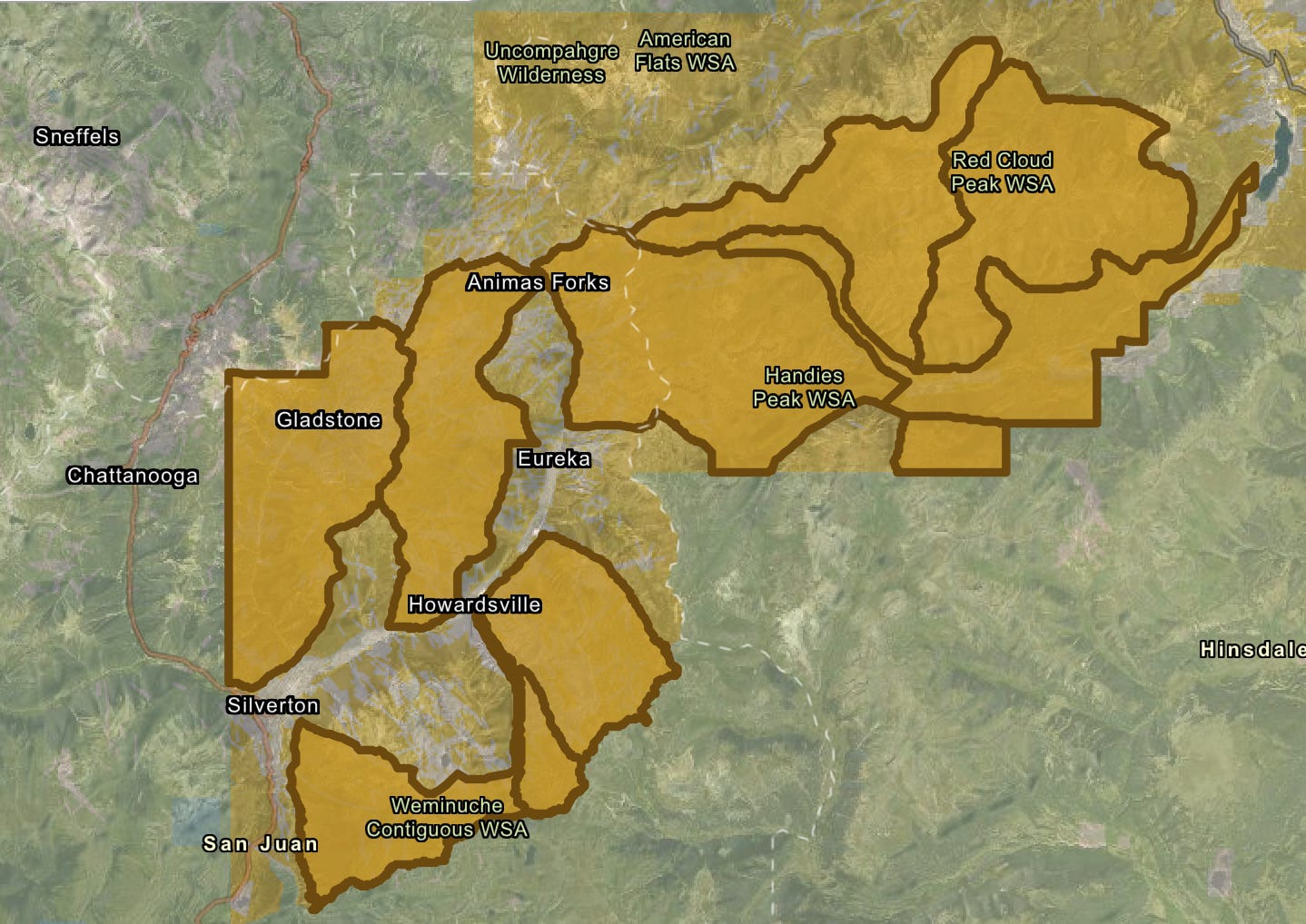
Grazing allotments listed as “potentially available” for leasing on the BLM’s new map. The five parcels closest to Silverton were retired in 2023 to protect bighorn sheep. Source: BLM
For example, the map includes 10 allotments in the high country around Silverton, Colorado, totaling about 70,000 acres. In 2023, the National Wildlife Federation paid the Etchart Sheep Ranch to vacate five of these allotments in an effort to give Rocky Mountain bighorn sheep more breathing room and protect them from diseases transmitted by domestic sheep. The deal was made with the hope that the leases would be retired permanently. Yet the inclusion on the map indicates they could see domestic sheep once again, emphasizing the need for legislation that would make such retirements perpetual.
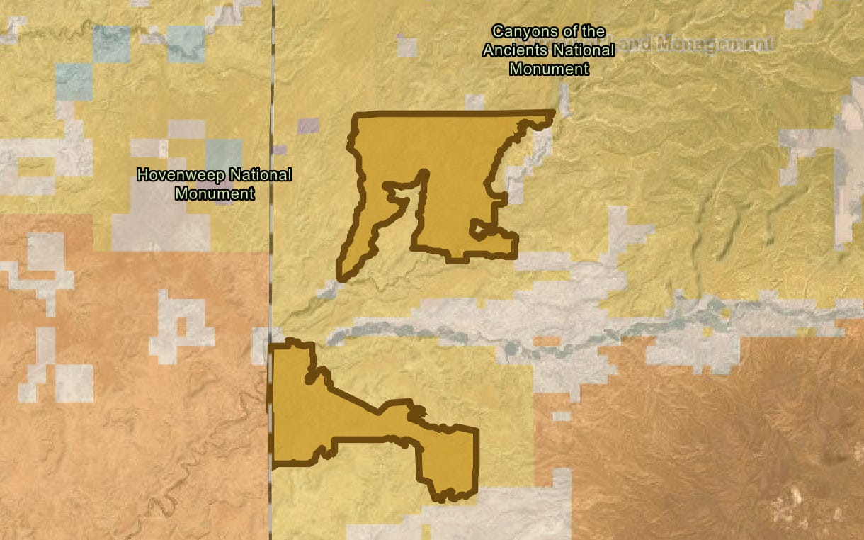
Also on the map are the Flodine Park and Yellowjacket allotments in Canyon of the Ancients National Monument near the Colorado-Utah border. In 2005, a rancher gave up the allotments, north and south of McElmo Canyon, respectively, and sold 4,500 acres of adjacent private land to the BLM to add to the national monument. Both allotments and the private land contain a number of intermittent streams, shallow canyons, and numerous cultural sites. They had been grazed relentlessly for decades prior, and showed the wear and tear—much of the cryptobiotic soil had long before been trampled and destroyed and invasive cheat grass had infiltrated the grazed areas. An archaeological assessment conducted later found grazing had damaged dozens of sensitive and cultural sites in the areas.
The Yellowjacket and Flodine Park allotments in Canyons of the Ancients National Monument. They have been vacant since 2005, and a previous effort to lease them out again was halted. Now it looks like they may be back on the block. Source: BLM
In 2010, the BLM, which manages the monument, issued a new resource management plan, which allowed for continued grazing, but also opened the door to permanently retiring vacant grazing allotments if they fail to meet BLM rangeland health standards or when grazing is negatively impacting cultural sites. Five of the 28 allotments in the most heavily visited areas—including Sand Canyon—were cancelled, but not the Flodine Park and Yellow Jacket allotments, which were still in retirement at the time.
Instead, the local county commissioners and a group of ranchers pressured the BLM to reauthorize grazing on both allotments—to bring them out of retirement, if you will. The BLM acquiesced, but environmentalists and tribes with roots in the area fought back, forcing the agency to do a more thorough environmental analysis of the proposal. The opposition was enough to prompt the agency at least to delay issuing any leases, and the allotments remain in limbo.
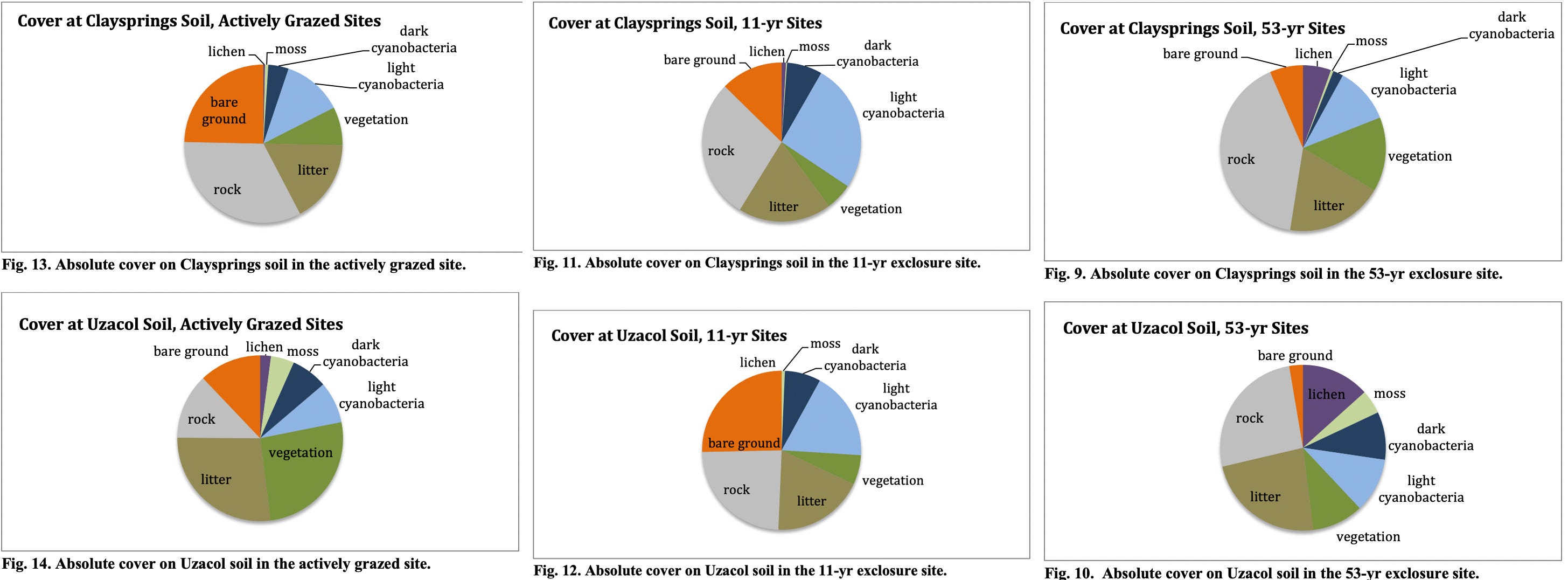
Meanwhile, a team of scientists assessed the healing process on the Flodine Park and Yellow Jacket allotments, which by then had been cow-free for 11 years (though feral horses had grazed there). They compared biocrusts on those allotments to a fenced enclosure that hadn’t seen grazing for 53 years and a plot that was being actively grazed. What they found was both predictable and remarkable: The longer a plot went without cows, the healthier it was, as summed up by these graphs.
Source: Grazing, Rest, and Biological Soil Crust in Canyons of the Ancients National Monument Marc Coles-Ritchie, Lior Gross and Mary O’Brien, Grand Canyon Trust.
While the natural landscape can eventually heal itself, livestock’s damage to the cultural landscape is irreversible. BLM surveys identified 266 cultural sites on the two allotments, including 35 with “standing architecture.” At least 43% of those had been damaged by livestock.
Now what’s left may be in danger, too, at least if those allotments’ presence on the new map is any indication. And guess what? Packing these allotments isn’t going to make that steak any cheaper. Only about 1% of American beef is grazed on public lands.
Mt. Blue Sky at 14,130 feet in elevation on April 22, 2026. Jonathan P. Thompson photo.
⛈️ Wacky Weather Watch ⚡️
If you were to get all of your information about the West’s climate from daily weather reports and road condition websites, you might think that April snow showers and deep freezes had ended the snow drought and would lead to big May streamflows. After all, it snowed enough in Colorado to turn roads to slip-and-slides and causing a 75-car pileup on I-70 near the Eisenhower Tunnel. The temperatures dropped low enough to wipe out most of the fruit blossoms the March heat wave tricked into blooming early. Only the farmers who used extraordinary measures — starting fires or smudge pots in the orchards, running wind machines, etc. — could save some of their summer harvest.
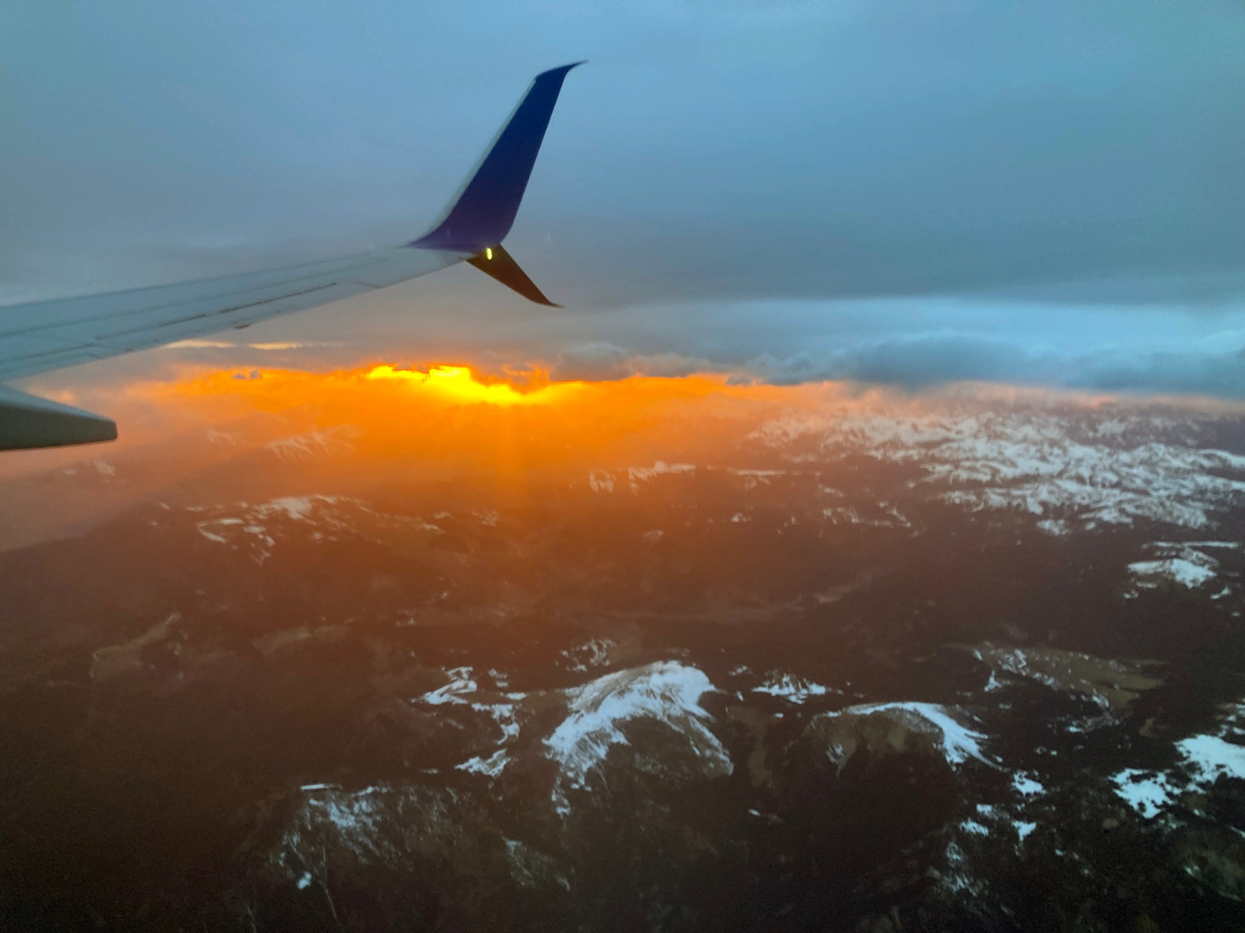
Sunset over the San Juans. Jonathan P. Thompson photo.
Sure, the snow that did fall in April helped, but only enough to elevate snowpack levels to, well, the lowest on record (only by a slightly smaller margin than before). And the freeze was deep, which helped extend the spring runoff in the few areas where there was any snow left. But even there, I suspect that peak runoff has already come and gone (though I’m not calling the Predict the Peak contest yet!).
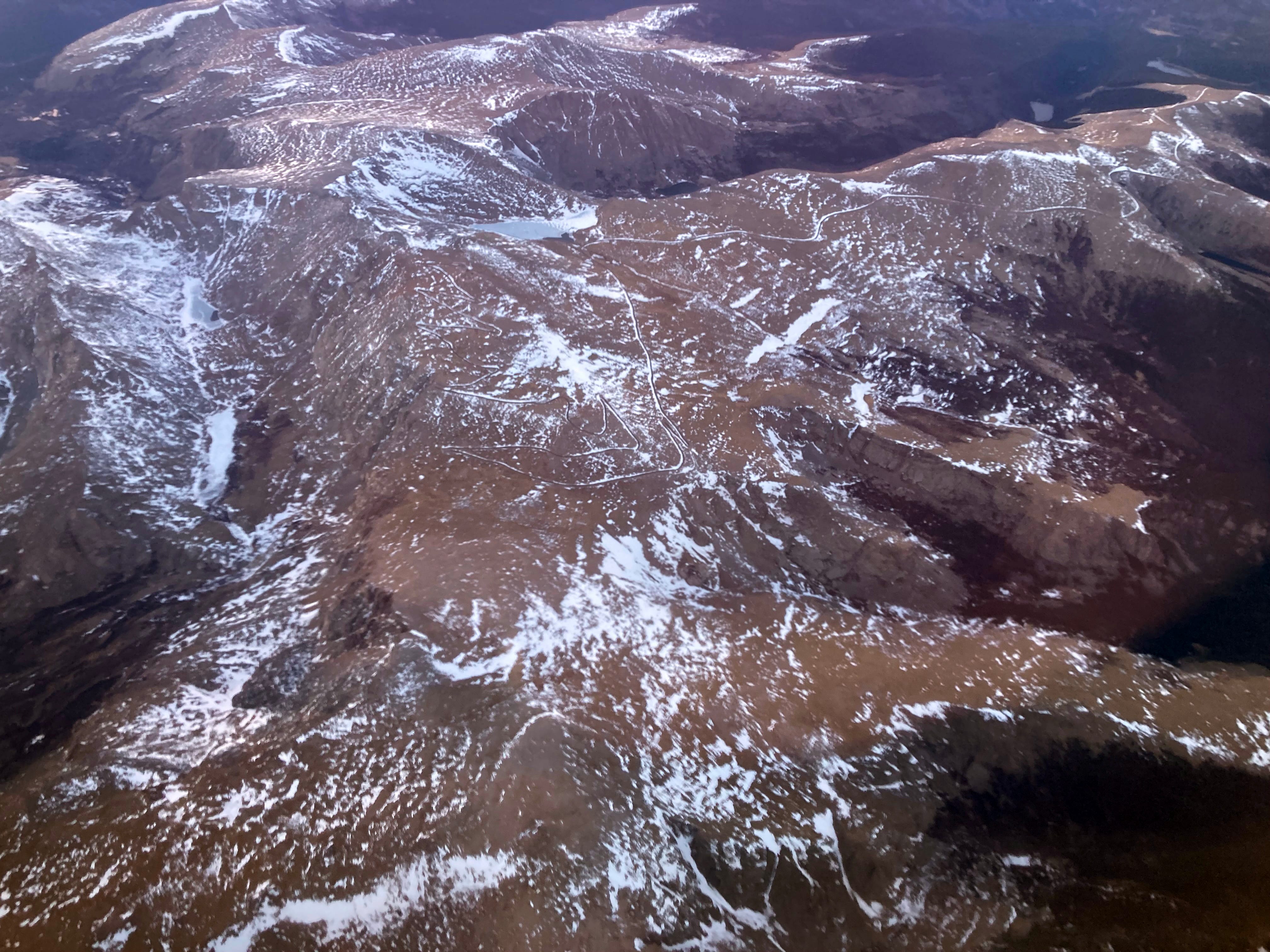
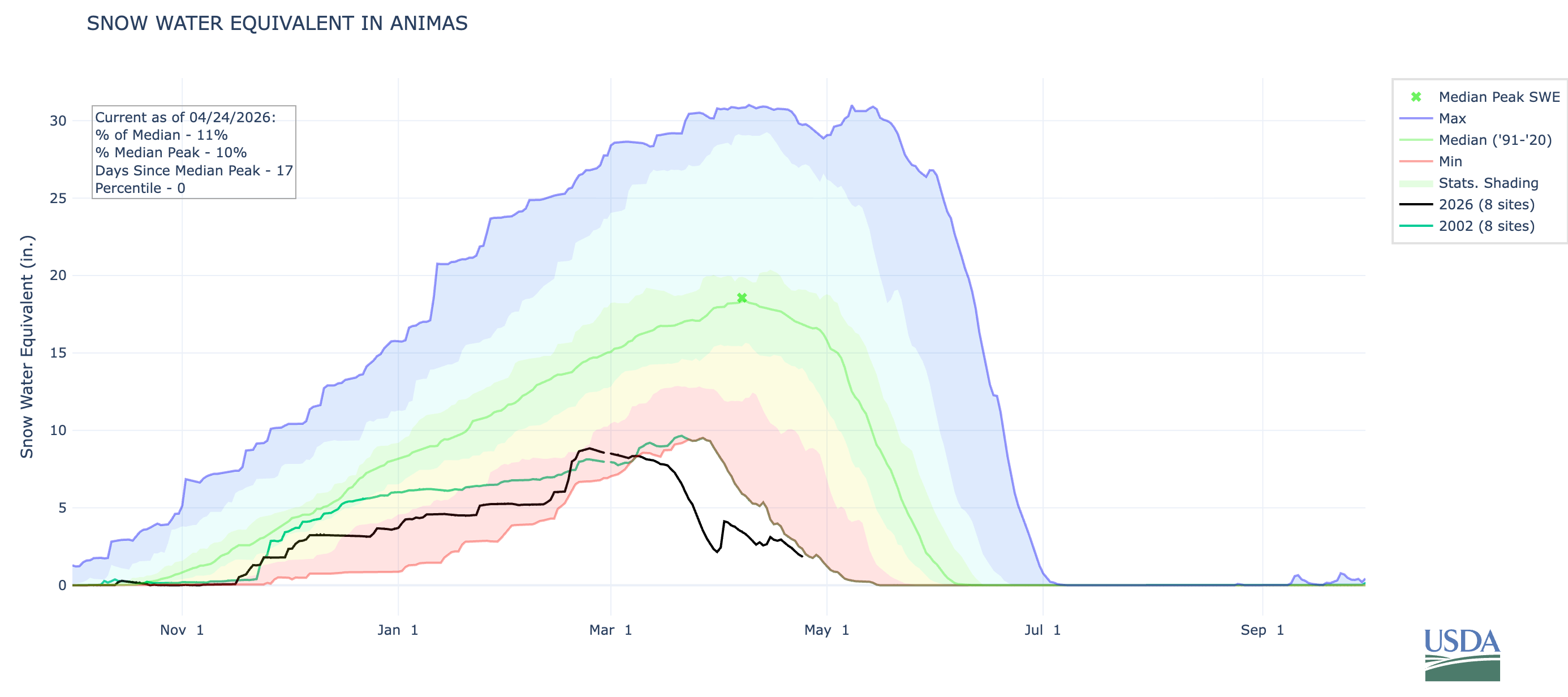
I flew over Colorado’s mountains the other day and was rather shocked at the dearth of snow, even on the highest peaks. Mt. Blue Sky, formerly Mt. Evans, had only a few patches of white left — at 14,130 feet in elevation. Everything below 10,000 feet appeared to be snowless. While the San Juan Mountains appeared to be in slightly better shape, it was still looking pretty dry. The Animas River watershed’s snowpack remains lower than it was on 2002 on this date.
Water starts to fill Chimney Hollow Reservoir in Larimer County on Tuesday, April 21. Scott Franz/KUNC
Click the link to read the article on the KUNC website (Scott Franz):
April 22, 2026
At 8 a.m. Tuesday, there was only silence and the occasional crunch of rocks as a dozen people in orange vests waited in a moonlike landscape beneath a 350-foot-tall dam near Loveland.
“Ninetey seconds,” a worker called out.
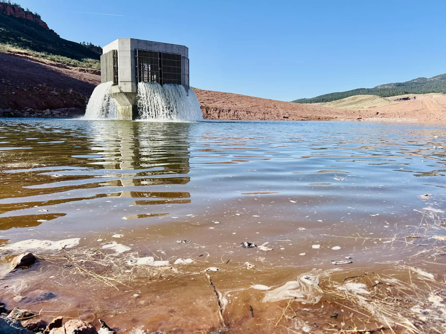
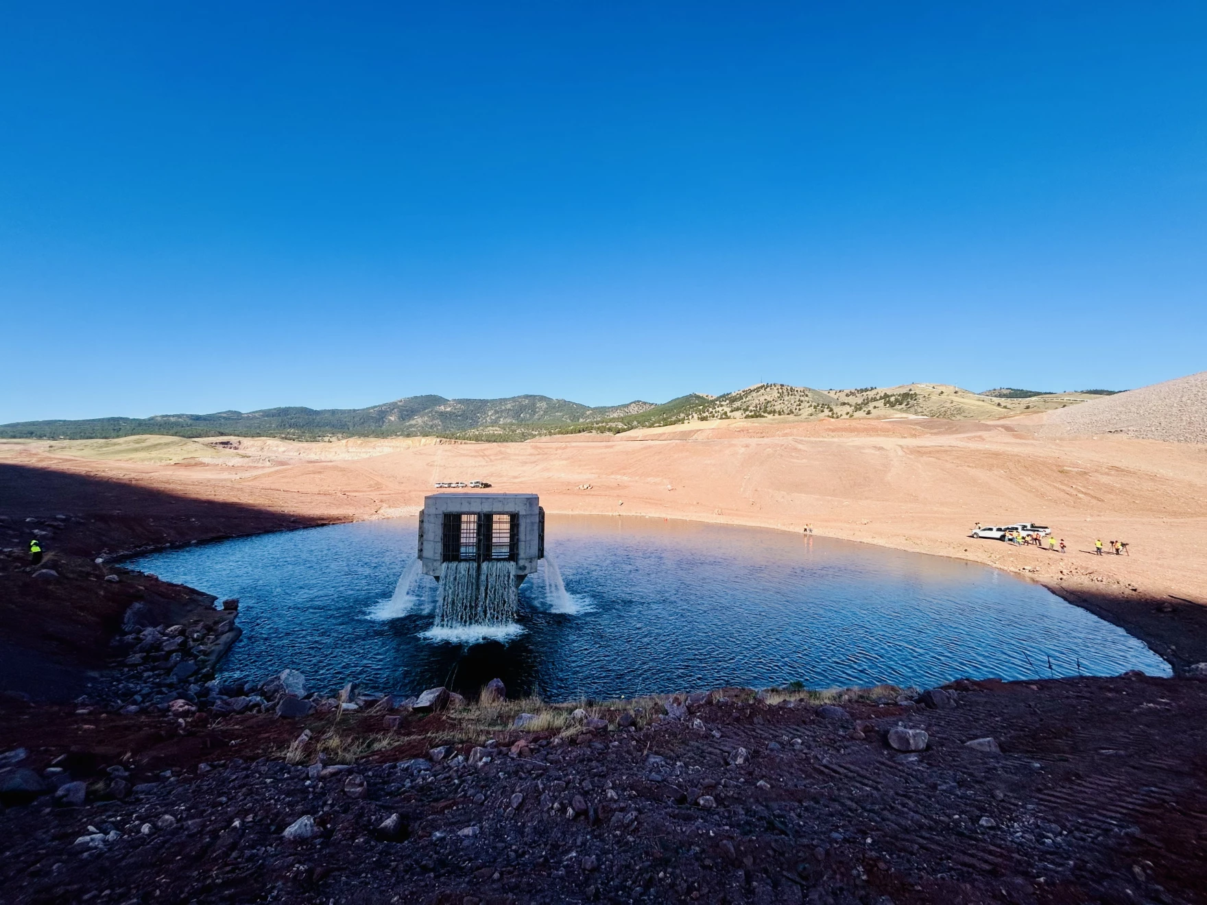
Moments later, it sounded like a waterfall suddenly roared to life as Northern Water started filling Colorado’s newest reservoir, Chimney Hollow.
“It’s pretty cool, I mean it’s something we’ve been working on for a long time, so just to see it for real, it’s pretty cool,” Chris Manley, a water quality specialist with Northern Water, said as he watched water gush from a 40-foot-tall concrete tower at the bottom of the reservoir.
By the end of the week, the initial release of 1,500-acre feet of water will rise about 30 feet above the spot Manley and a gaggle of journalists were standing on Tuesday morning.
Engineers will make sure the pipes that will funnel Colorado River water to the reservoir are functioning correctly. It will also give Northern Water a chance to study an issue with the water supply.
The reservoir’s future became murky last year after officials announced that naturally occurring uranium was found in the rock used to build the dam for the reservoir.
Manley said the uranium discovery has set the project back roughly a year. But he said it is an issue Northern Water can manage long term.
Water from Chimney Hollow Reservoir is projected to serve almost a million people on the Front Range. Scott Franz/KUNC
“But we’ve got to really understand the situation a lot better before we can move forward,” he said.
This week’s initial fill will provide Northern Water with a real-world test of the water quality that was only previously done in laboratories.
None of the water coming into the reservoir will be released to taps at this point. The reservoir is only being filled to about 2% of its total capacity in the coming days.
“We’ll be measuring it actually pretty frequently, to see just what is (the water) picking up as it goes up and touches the dam and starts to move some of the sediments around here,” Northern Water spokesperson Jeff Stahla said.
Northern Water officials could not provide a timeline for when water will begin reaching the dozen water suppliers who have signed up to receive it.
Map from Northern Water
The reservoir project cost an estimated $500 million and has been in the planning stages for more than two decades.
Conservation groups have raised concerns about the reservoir.
“You can have a bunch of buckets, and you can build more buckets to put water on the front range,” Pelz said. “But the reality is, if the projected climate change impacts come to fruition — which all indications are, they’re coming to fruition quicker than we even thought — there’s going to be no water to fill those buckets.”
The reservoir is seeing its initial fill during historic drought conditions in the Colorado River basin.
“It’s definitely very ironic that we’re filling the reservoir in these historic drought conditions, but we’re fortunate that we had a little bit of supply left from last year,” Northern Water Operations Director Jerry Gibbens said. “It really showcases why storage is so important for our region.
Northern Water officials say the reservoir is a way to boost water security on the Front Range.
“As we’ve seen this year, water storage is such a key element of our overall water supply in northern Colorado, and this just adds another increment of that supply to a region where our water demands continue to grow,” Stahla said.
The South Platte River Basin is shaded in yellow. Source: Tom Cech, One World One Water Center, Metropolitan State University of Denver.
Denver Water’s collection and service areas continue to face severe drought conditions, with historically low snowpack. Denver Water depends on mountain snowpack for its water supply, which serves 1.5 million people in Denver and surrounding suburbs.
As a result, on March 25, 2026, the Denver Board of Water Commissioners declared a Stage 1 drought, seeking a 20% reduction in water use to preserve water levels and avoid even stricter mandatory restrictions later this summer. On April 8, 2026, the board approved the implementation of temporary drought pricing, starting with May water use and reflected in June bills, to signal the premium value of water during droughts and help incentivize customers to save water.
Customers are urged not to turn on automatic sprinkler systems until at least mid- to late-May, or later if possible. It is not necessary to water grass two days per week in April and the beginning of May; keeping automatic systems off will help save water. Occasional hand-watering may be necessary for trees and shrubs during this time. Keep an eye on the weather and let Mother Nature do the watering when she delivers spring rains.
Comment from Nathan Elder, Denver Water’s manager of water supply:
“The snow we saw last week brought marginal improvement to snowpack, but it’s still the worst on record, which is doubly concerning as this week is typically our spring peak when the snow levels are the highest. We need our customers to reduce their water use by 20% and help stretch the water we have stored in our reservoirs. Hopefully, working together, we can save water across our service area and avoid increasing restrictions later this summer.”
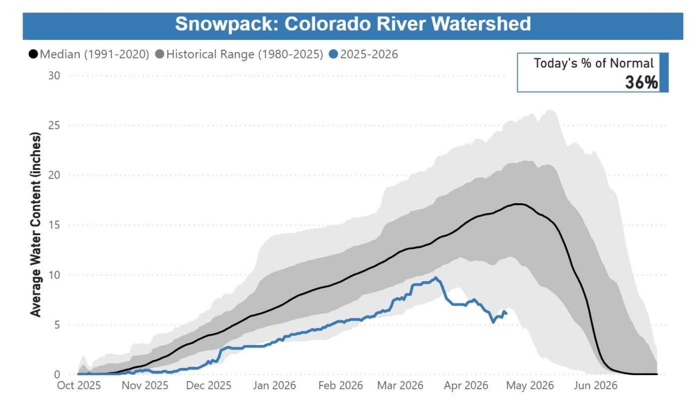
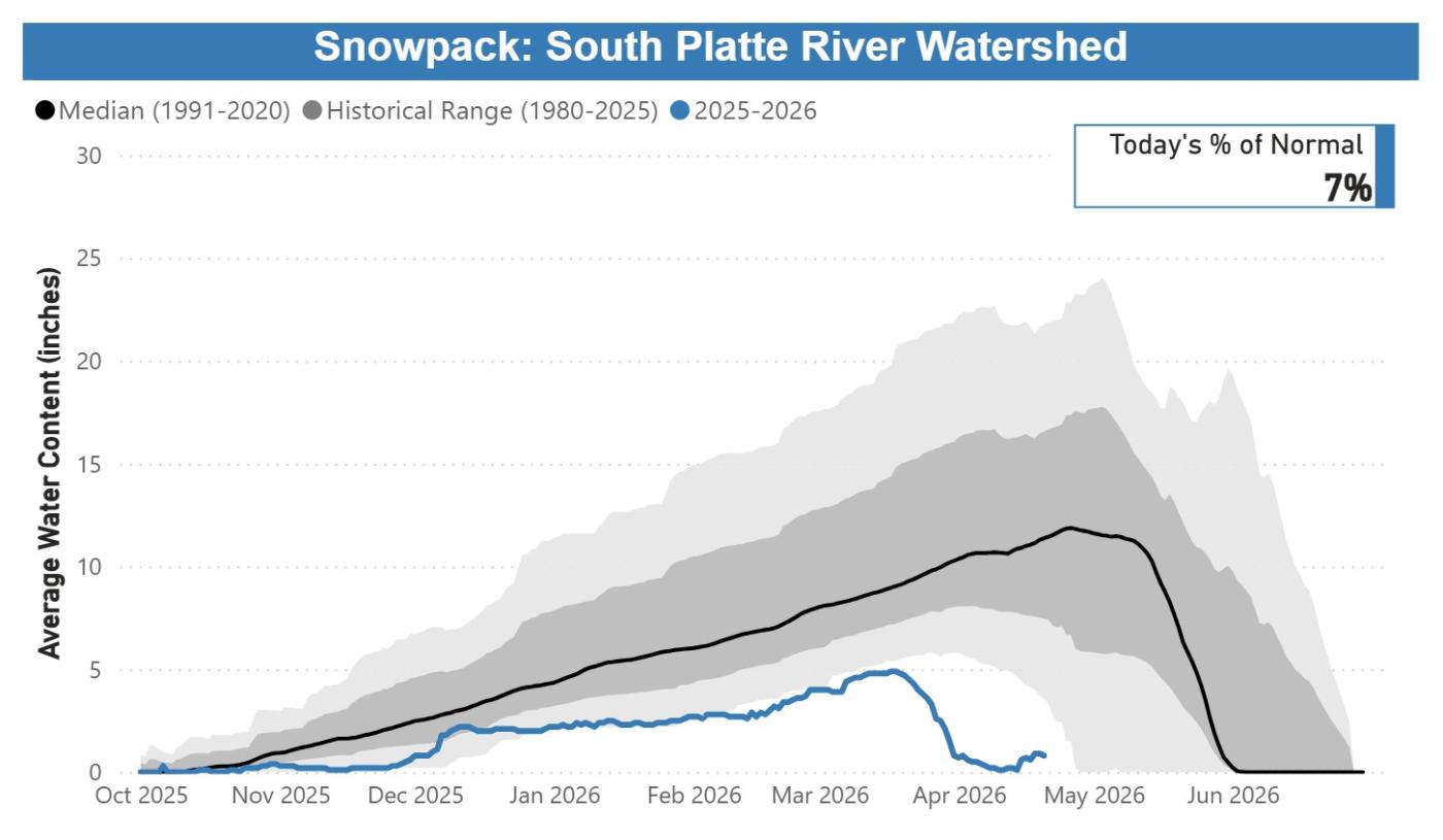
In Denver Water’s collection system, snowpack as of April 20, 2026, remained at the lowest levels observed in the past 40 years:
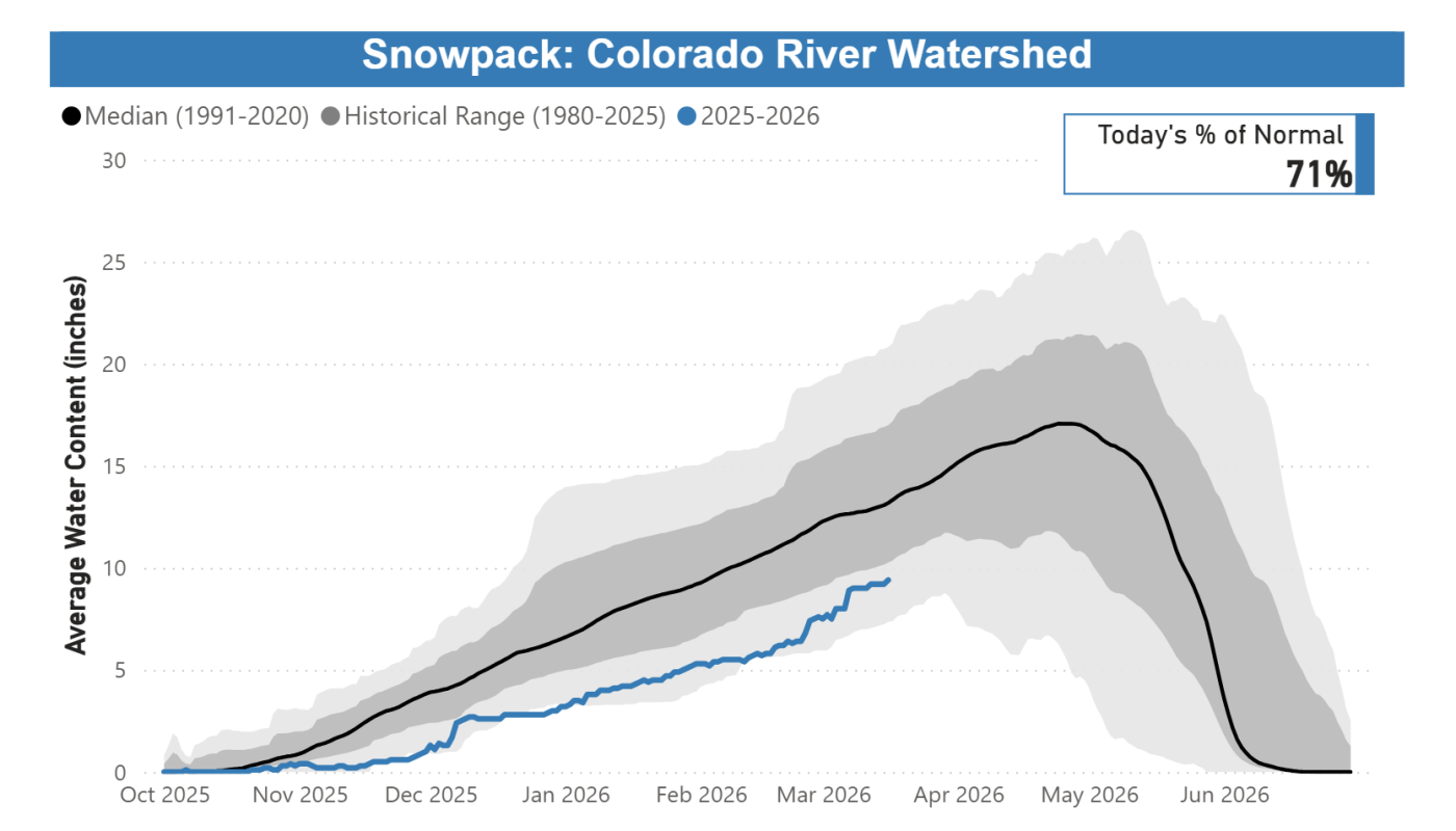
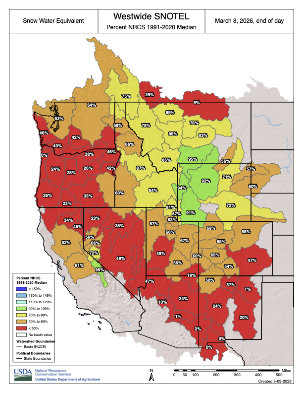
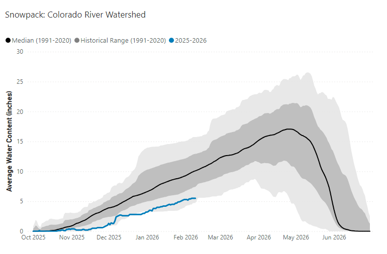
Colorado River Basin: 36% of normal, worst on record.
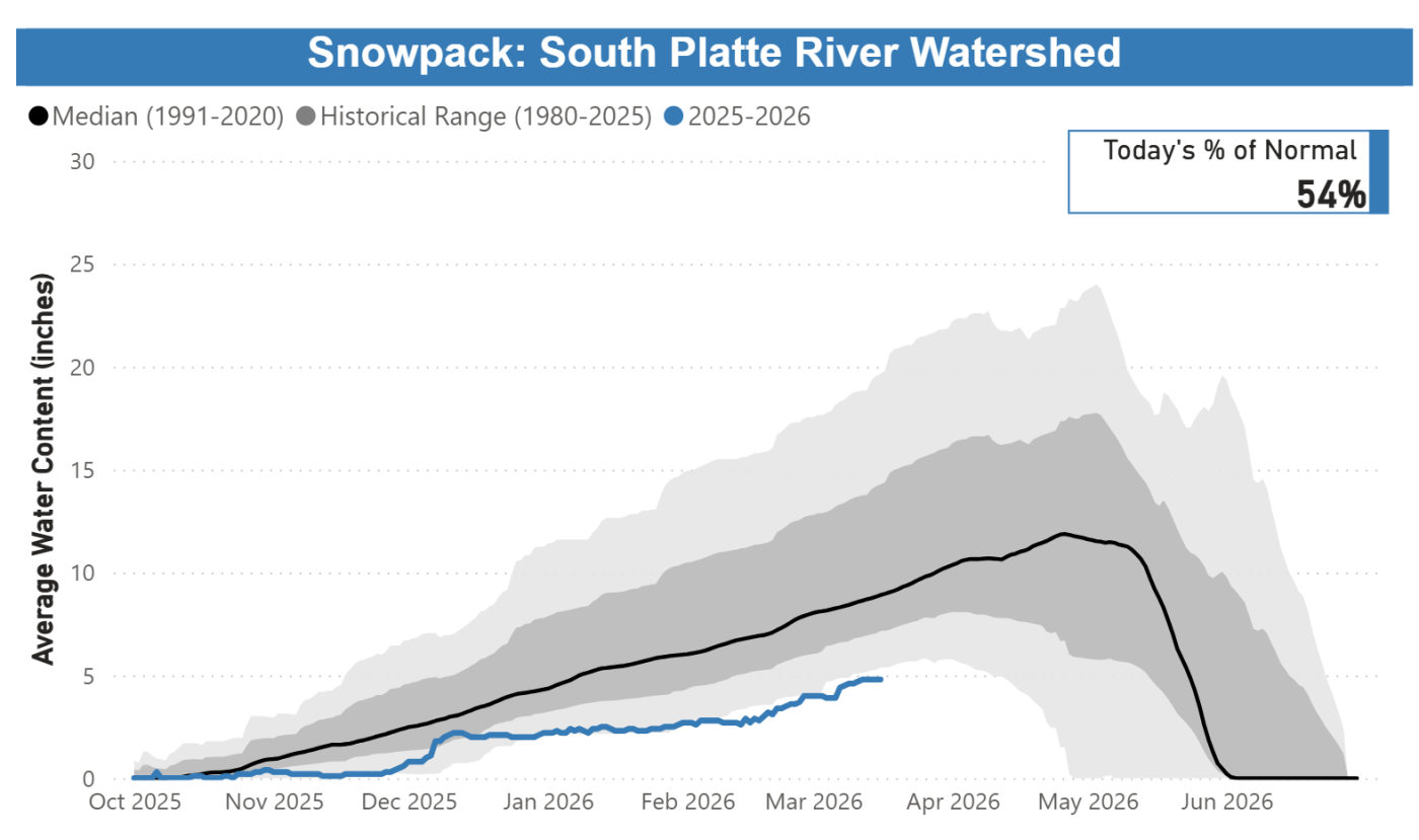
South Platte River Basin: 7% of normal, worst on record.
Snowpack and melting conditions are unprecedented, with accelerated melting seen since mid-March. Customers need to save water to protect the supply we have right now.
Streamflow forecasts are calling for runoff levels to be 10-40% of normal in 2026.
Reservoir storage conditions are below average; while in reasonably good shape for the time being, far less snowpack is available to help refill them. As of April 20, 2026, reservoirs were 80% full, versus an average of 85% full for this time.
Customers are urged not to turn on automatic sprinkler systems until at least mid- to late-May, or later if possible. When watering season begins, Denver Water will require customers in single-family residential properties to limit watering to no more than two days per week on a set schedule based on their address.
Addresses ending in even numbers: Sunday and Thursday.
Addresses ending in odd numbers: Wednesday and Saturday.
All other customers, including multifamily properties, commercial properties, homeowners associations and government properties, may water only on Tuesdays and Fridays.
Water only during cooler times of the day, between 6 p.m. and 10 a.m.
Do not allow water to pool in gutters, streets and alleys.
Do not waste water by letting it spray on concrete and asphalt.
Repair leaking sprinkler systems within 10 days.
Do not irrigate while it is raining or during high winds.
Use a hose nozzle with a shut-off valve when washing your car.
For its part, Denver Water has proactively reduced its spending, taking steps that include enacting a hiring freeze and reviewing maintenance and other projects to see which ones could be deferred. We are also looking into other ways to increase supply by activating agreements that allow us to capture additional water that is typically unavailable during normal conditions.
This year marks the fifth time since 2000 that Denver Water has issued a Stage 1 drought, and the first since 2013. Prior to 2013, the board declared a Stage 1 drought in 2002, 2003 and 2004.
Denver Water has many resources for homeowners looking for inspiration and information about landscapes that fit naturally into our dry climate. Click here for conservation and efficiency tips for outdoor irrigation and to get more details on ways to ColoradoScape your property, including through rebates for turf removal and a DIY guide for landscape changes, among many other potential water-saving steps.
Updates about Denver Water’s reservoir levels, customer water use and snowpack can be found in the Water Watch Report, which is updated weekly in the spring and summer.
This chart shows the cumulative snowpack on April 20, 2026, in the area of the Colorado River Basin where Denver Water captures its water supply. The snowpack is 36% of normal, which ranks as the lowest on record for April 20. Image credit: Denver Water.
This chart shows the cumulative snowpack on April 20, 2026, in the area of the South Platte River Basin where Denver Water captures its water supply. The snowpack is 7% of normal, which ranks as the lowest on record for April 20. Image credit: Denver Water.
Water from Antero Reservoir (pictured) will be moved to Cheesman Reservoir in 2026 to help with drought response. This measure was last taken in 2002. Photo credit: Denver Water.
In the coming weeks, Denver Water will begin moving water from Antero Reservoirto Cheesman Reservoir,as part of the utility’s drought response.
Antero Reservoir has the highest ratio of evaporation to storage of any of Denver Water’s reservoirs, and moving the water to Cheesman Reservoir will prevent about 5,000 acre-feet of water (about 25% of the reservoir’s storage capacity) from evaporating. One acre-foot of water equals the annual water use of about three to four single-family households a year.
“A lot of forethought and planning went into our collection system and reservoirs,” said Nathan Elder, manager of water supply for Denver Water. “Antero is a drought reservoir, designed to provide water to our customers during a severe drought. Consolidating this water into Cheesman will help us make the most of the water we have.”
Denver Water is working closely with Colorado Parks and Wildlife to minimize the loss of fish during this process and to allow the public to use the reservoir for a brief period before it eventually closes. Following the fish relocation process, there will be no recreation, including camping, allowed at Antero Reservoir in 2026. More details about this plan will be announced when it is finalized.
The decision also allows Denver Water to use more water from its South Platte River Basin supplies, reducing the need to pull as much water from sources west of the Continental Divide, which are also below normal levels following an abysmal snowpack and runoff season.
In a standard year, the water lost to evaporation is recovered by the next runoff season. Because of the historically low snowpack levels in 2026, the water lost this year would not have been recovered.
Drought conditions will determine when the reservoir can be refilled. The reservoir was also drained to assist with water management during the 2002 drought. There were plans to drain the reservoir as a drought response in 2013, though a series of late-season snowstorms allowed Denver Water to continue storing water in the reservoir. The last time Antero Reservoir was emptied was in 2015 for a dam rehabilitation project.
The South Platte River Basin is shaded in yellow. Source: Tom Cech, One World One Water Center, Metropolitan State University of Denver.
Denver Water’s collection and service areas continue to face severe drought conditions, with historically low snowpack and concerns about the diminished spring runoff that will be available to meet customer’s water needs in the future.
As a result, at its meeting today, the Denver Board of Water Commissioners adopted a resolution approving the implementation of temporary drought pricing on outdoor water use. The drought pricing will apply starting with May water use (reflected in June bills) and will be in effect through April 30, 2027, or until further action by the board.
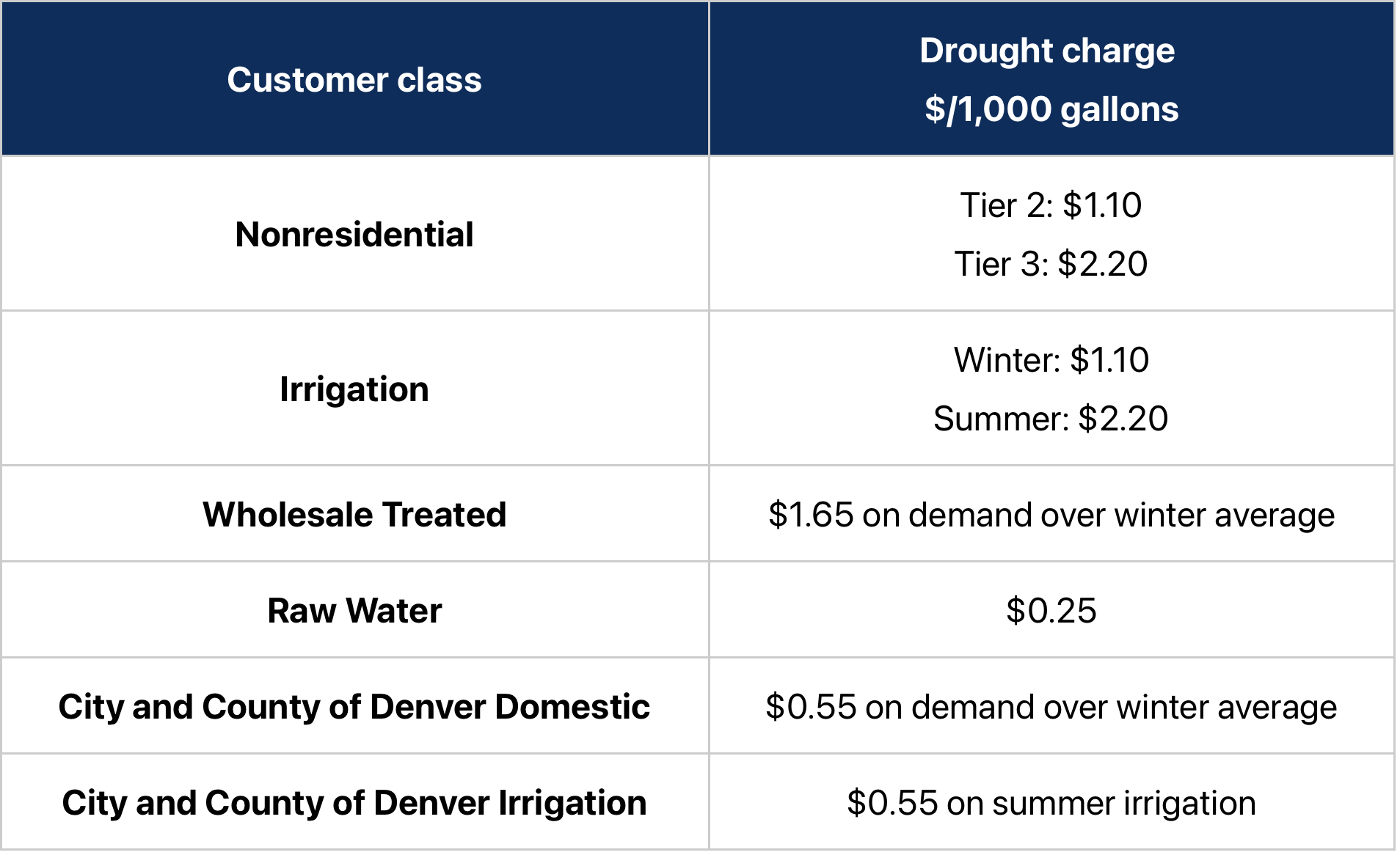
Under the temporary drought pricing, residential customers will see a drought charge on Tier 2 water use of $1.10 per 1,000 gallons. Tier 3 will have a drought charge of $2.20 per 1,000 gallons. The temporary drought charges will be added on top of the customer’s existing 2026 water rates.
Tier 1, which covers essential indoor water use, is exempt from drought pricing.
“Implementing temporary drought pricing is not a step we take lightly. It is one of many tools Denver Water has available — when needed — to respond to drought conditions, encourage customers to conserve our water supply, and ensure our ongoing ability to operate and maintain the system that delivers clean, safe water to 1.5 million people,” said Alan Salazar, Denver Water’s CEO/Manager.
“Drought charges signal to our customers the premium value of water in a drought, while exempting essential indoor water use. We haven’t needed to use this tool in more than 20 years — since the historic drought of 2002-04 — and conditions surrounding this year’s snowpack and potential runoff are shaping up to rival, and possibly be worse than, those years,” Salazar said.
Please keep sprinklers OFF until mid-to-late May, or later if it rains, to help stretch the water supplies we have. Hand water trees and shrubs if needed. It’s a drought. Use Only What You Need. Photo credit: Denver Water.
Under the temporary drought pricing approved by the board, for Denver Water residential customers in Denver and the suburbs:
e first tier will be exempt from the temporary drought charge. This tier is charged at the lowest rate and covers essential indoor water use for bathing, cooking and flushing toilets. Each customer has their individual first tier determined by the average of their monthly water use as listed on bills that arrive in January, February and March — when there is very little or no outdoor watering.
The second tier will have a temporary drought charge of $1.10 per 1,000 gallons added on top of their 2026 water rates. This tier is for water consumption, typically used for outdoor watering, that is above the customer’s first tier and up to 15,000 gallons of water per month. Water use in this tier is considered to be an efficient use of water outdoors.
The third tier will have a temporary drought charge of $2.20 per 1,000 gallons of water added on top of their 2026 water rates. Tier 3 is for water use above the second tier each month. It is priced at the highest level to signal potentially excessive water use and encourage conservation efforts by larger-lot customers.
The board’s decision to impose temporary drought charges on outdoor water use follows its March 25 declaration of Stage 1 drought. The declaration seeks a 20% reduction in water use effective immediately, with the goal of preserving water supplies and to help avoid the need for Denver Water to take further actions later this summer if conditions don’t improve. Read the March 25, 2026, drought declaration.
The snowpack, which supplies the water Denver Water captures, stores, treats and delivers to customers, is at historically low levels despite recent storms that brought some much-needed precipitation to the mountains and city last week.
It’s a drought. Image credit: Denver Water.
“We welcome the storms that do come, while knowing that this year’s snowpack is at historically low levels and hopes for a Miracle May snowstorm are dimming. And Denver Water has made a number of tools available to help customers reduce their water use — whether it’s a normal year or a drought year. We encourage our customers to take steps to conserve water for this drought and be better prepared to manage through future dry times,” Greg Fisher, Denver Water’s manager of demand planning and efficiency.
Denver Water’s temporary drought pricing charges a premium for outdoor water use and covers several classes of customers, including residential, large irrigation, wholesale and raw water customers. (See the chart at the bottom of this story for additional information on nonresidential customers.)
An individual residential customer’s monthly water bill will vary depending on where they live in Denver Water’s service area (in Denver or in one of the utility’s suburban distributor districts) and how much water they use. Drought charges are expected to incentivize customers to reduce outdoor water use.
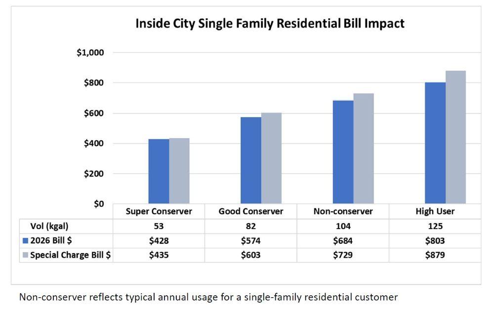
The following two charts illustrate the potential impact of the temporary drought charges on an annual water bill for residential customers living inside the city of Denver and, below that, in a Total Service suburban distributor district.
Examples of the impact of temporary drought charges on an annual water bill for Denver Water customers living inside Denver. In this example, “super conservers” will see their bills increase by roughly $7 annually. High users who do not conserve will see their bills increase by roughly $76 in one year. Individual bills will vary. Image credit: Denver Water.
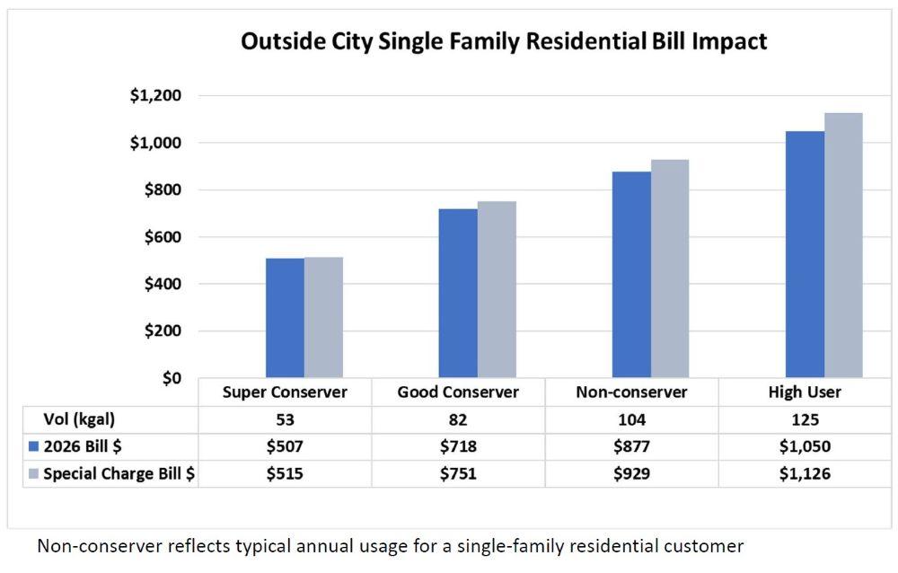
In these charts, the categories are:
“Super conserver”: A customer who has very little outdoor water use, maybe only watering trees and shrubs throughout the year.
“Good conserver”: An average customer who reduces their annual water use by 20%, from 104,000 gallons (the average use by residential customers in an average year) to 82,000 gallons.
“Non-conserver”: An average Denver Water residential customer who uses 104,000 gallons of water over the course of the year (the average use by residential customers in an average year) and doesn’t respond to Denver Water’s call to reduce water use by 20%.
“High user”: A customer in the top 25% of residential water users.
The following chart illustrates temporary drought charges impacts for residential customers who live in one of Denver Water’s Total Service distributor districts in the suburbs. (Learn more about Denver Water’s suburban customers.)
Examples of the impact of the temporary drought charges on an annual water bill for Denver Water customers living in one of Denver Water’s Total Service suburban distributor districts. “Super conservers” will see their bills increase by roughly $8 annually. High users who do not conserve will see their bills increase by roughly $76 in one year. Individual bills will vary. Image credit: Denver Water.
“This is not Denver Water’s first drought. We know our customers strive to be efficient in their water use, and we know we are asking them to use less to stretch the water supplies we have in this drought. We also know that success in reducing water use will result in reduced revenue for our organization. We have tools to address reduced revenue and ensure the organization maintains its financial foundation for when this drought is over,” said Angela Bricmont, Denver Water’s chief financial officer.
If customers comply with Denver Water’s request to reduce water use by 20%, the utility estimates 2026 revenue to fall by a commensurate amount. While drought pricing can offset a portion of that reduction, the utility will rely on cash reserves and budget reductions to cover the majority of the gap.
Denver Water has proactively reduced its spending, taking steps that include enacting a hiring freeze and reviewing maintenance and other projects to see which ones could be deferred.
Now is the time to replace non-native plants with with drought-tolerant plants. Photo credit: Denver Water
To help customers Use Only What They Need indoors and outdoors, Denver Water offers a range of tools, including:
Watering restrictions take effect on April 15. Courtesy of City of Arvada
Click the link to read the article on the Arvada Press website (Rylee Dunn). Here’s an excerpt:
April 7, 2026
After one of the driest winters on record in Colorado, the City of Arvada has declared a Stage 1 drought and will begin implementing mandatory watering restrictions on April 15. Starting April 15, all Arvada water customers — including residents, businesses and city-managed properties — will have to start following a mandatory two-day per week watering schedule. Outdoor watering is prohibited from 10 a.m. to 6 p.m. Amy Willhite, Arvada’s Water Resources Administrator, said the watering restrictions will help Arvada preserve its water supply amid rising temperatures and historically low snowpack levels.
“Maintaining a reliable water supply is a public health and safety priority for the City of Arvada,” Willhite said. “Restricting outdoor watering ensures we can continue to have the supply needed for drinking, cooking, cleaning, and other essential needs this year and in the future.
“These conservation measures protect our water supply through the current drought, and unknown future conditions,” Willhite continued. “In a significant drought, it becomes the responsibility of our entire community to conserve water.”
The city’s goal with the restrictions is to reduce water use across the city by 20%. Once the restrictions take effect, single-family residential homes with even-numbered addresses will be permitted to water on Sundays and Thursdays. Homes with odd-numbered addresses will be allowed to water on Wednesdays and Saturdays. Apartment buildings and commercial buildings will be permitted to water on Tuesdays and Fridays unless otherwise instructed. Trees, shrubs, vegetable gardens, and flowers can be watered using a handheld hose or drip irrigation outside of 10 a.m. to 6 p.m.
The record-breaking hot and dry winter and early spring has continued through March in Colorado’s mountains and plains. Snow gauges and weather stations throughout Northern Water’s collection and distribution areas have collected data showing the lack of precipitation in the region this year.
On April 9, the Northern Water Board of Directors will use the data collected this year and more to determine the annual quota for allottees of Colorado-Big Thompson Project water. Unlike many irrigation systems, the C-BT Project is designed to provide water to supplement the native supplies available in a given year, using water collected in previous seasons. If there is a bright spot this season, it’s that C-BT Project reserves are above their average levels over the life of the project for this time of year.
If you would like to provide comment on the quota send an email to quota@northernwater.org or offer a comment at the April 9 Board meeting.
Colorado-Big Thompson Project map. Courtesy of Northern Water.
Today, Governor Polis and Colorado Parks and Wildlife (CPW) announced the first round of wildlife and habitat projects funded through Senate Bill 24-230, which created new production fees on oil and gas development to mitigate the adverse impacts of oil and gas operations on wildlife and habitats.
CPW’s initial allocation of SB24-230 revenue will fund seven wildlife and habitat initiatives designed to address the impacts of habitat fragmentation, climate change and ecosystem degradation.
“Colorado is known for our iconic outdoor spaces, recreation, and wildlife viewing. Greenhouse gas emissions have a direct impact on our environment and all who call Colorado home. By investing in protecting habitats for Colorado’s wildlife, we are decreasing our carbon footprint, protecting native species, and keeping Colorado beautiful for generations to come,” said Governor Polis.
“SB24-230 provides an important new tool to invest directly in the health of Colorado’s wildlife and habitat,” said CPW Director Laura Clellan. “These initial projects demonstrate how funding generated from oil and gas operations can help restore habitat, improve ecosystem resilience and support wildlife across the state.”
Senate Bill 24-230 established two fees on oil and gas production in Colorado. One fee is administered by the Clean Transit Enterprise, and the other by Colorado Parks and Wildlife to support wildlife and land remediation.
The legislation recognizes that oil and gas development is a significant source of greenhouse gas emissions and habitat degradation, and it directs new investments toward mitigating those impacts and strengthening wildlife and ecosystem resilience.
Under the law, the CPW Director is authorized to set production fees within statutory ranges based on quarterly oil and gas spot prices published by the Colorado Energy and Carbon Management Commission.
The initial CPW production fee was established in October 2025 and generated $5,477,765 in revenue from oil and gas production between July 1 and Sept. 30, 2025.
To put the new revenue to work immediately in order to mitigate the impacts of oil and gas operations, CPW’s Executive Management Team identified seven projects and programs for early investment during fiscal year 2026.
The first round of funding will support:
Barr Lake State Park Habitat Enhancements ($1,500,000)
Beaver Restoration Program Implementation – Initial Phase ($1,174,111)
Operating Increase for Park Pollinator Gardens ($300,000)
Operating Increase for Wildlife Movement Coordination ($100,000)
Wildlife TRACKER Hosting and Maintenance ($125,000)
Together, these projects provide remediation services, including habitat restoration, wildlife monitoring, species conservation and strategic land and water protection efforts across Colorado.
CPW will continue to work closely with industry partners, conservation organizations and local communities to ensure that funds generated through SB24-230 are invested in projects that deliver measurable remediation services that mitigate the impacts of oil and gas operations.
“As Coloradans, we all value the outdoors and the wildlife that makes our state so special. When responsible oil and natural gas production can help support these kinds of projects, protecting the wildlife and habitat we all care about, that’s a huge win for all of Colorado,” said Dan Haley, Executive Director, Coloradans for Responsible Energy Development.
“The science is clear that climate change is negatively impacting Colorado’s wildlife and the ecosystems on which they rely,” said Tarn Udall, senior attorney at Western Resource Advocates. “That’s why the state created the oil and gas production fee in 2024, requiring the industry to partially cover the cost of its emissions and impacts through habitat protection and restoration. It’s rewarding to see Colorado Parks and Wildlife put the first tranche of those dollars to good use, and the agency is just getting started.”
Additional projects funded through the program will be evaluated and announced as future revenue is collected.
American beaver, he was happily sitting back and munching on something. and munching, and munching. By Steve from washington, dc, usa – American Beaver, CC BY-SA 2.0, https://commons.wikimedia.org/w/index.php?curid=3963858
Colorado is in a severe drought, and simple indoor water conservation measures can lead to big savings when everyone pitches in.
Free and easy
Turn the water off while brushing your teeth or washing your face.
Limit showers to 5 minutes (or try to shorten them by 1-2 minutes).
Only run your dishwasher and washing machine with a full load.
Turn off the kitchen faucet when handwashing dishes.
“A drought is a great time to teach kids, or anyone, about the importance of conserving water,” said Greg Fisher, Denver Water’s manager of demand planning. “Simple lifestyle changes can become lifelong habits.”
Fixing leaks
Across the U.S., Americans waste about 1 trillion gallons of water every year through water leaks and spend about 10% of their water bill on wasted water, according to the EPA.
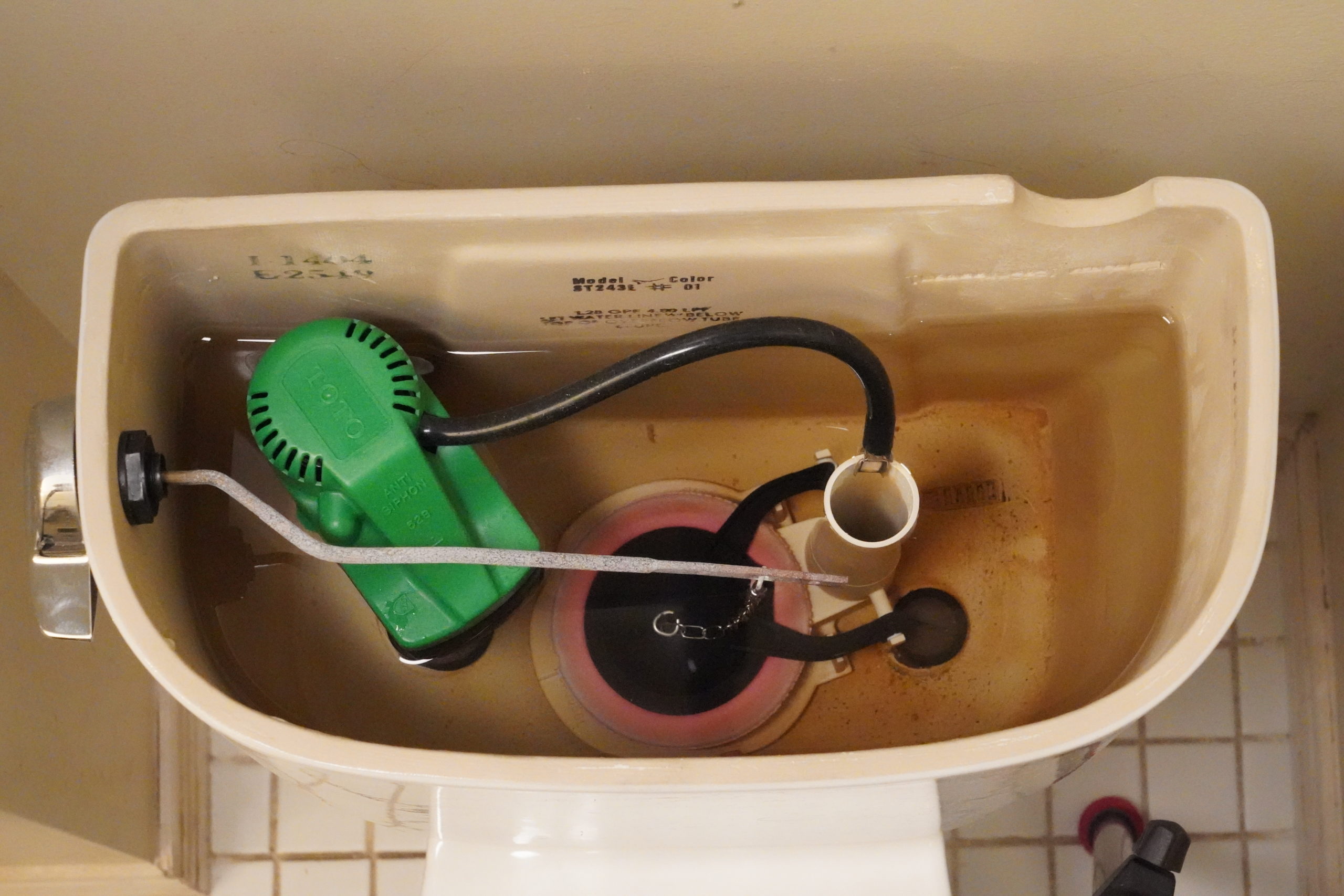
The biggest water waster in the home is the toilet. The EPA reports that an average leaking toilet can waste about 200 gallons of water every day.
This toilet has a small, almost undetectable leak through its pink, circular flapper on the bottom of the tank. Some leaks can be detected by listening to hear if water is coming into the tank after it’s done filling. Faulty flappers are a leading cause of toilet leaks. Photo credit: Denver Water. Photo credit: Denver Water.
In addition to checking for toilet leaks, inspect all water sources in your home, including faucets, showers, water supply lines for dishwashers, washing machines, swamp coolers and ice machines.
Small leaks can add up over days and weeks. A small leak of 10 drops per minute can waste 300 gallons of water per year. Not only can these leaks add to your water bill, but they can also damage your home.
Denver Water offers rebates to help customers replace old toilets with newer, more efficient models that can save thousands of gallons of water every year. Image credit: Denver Water.
When buying new appliances and fixtures, purchase products that carry an Energy Star or WaterSense label, an indication that the product uses less energy or water compared to products that don’t carry those labels.
Replacing faucet aerators is an easy way to save water. New aerators slightly reduce the flow of water without impacting the performance of the faucet. Photo credit: Denver Water.
Wastewater is aerated as it flows over steps at Aurora’s Prairie Waters Project, which treats wastewater to drinking water standards. Credit: Jerd Smith
Colorado homeowners and businesses are already planning for a brutally dry summer. They should also be planning for an expensive one, as Denver and other cities prepare to impose drought fees to encourage conservation and to buffer their budgets against millions of dollars in lost water sales as customers cut back.
Denver Water, which announced Stage 1 drought restrictions last week, said its preliminary estimates suggest $30 million to $70 million may be lost as a result of restrictions. It has annual revenue of $488.5 million. Denver Water is Colorado’s largest water utility, serving more than 1.5 million people in the city of Denver and across the southern and western suburbs.
The agency said its surcharges will be designed to penalize high-volume outdoor water use, while keeping the price for drinking, cooking and bathing water unchanged.
ts surcharge prices, if approved by the board this month, will vary depending on how homeowners and businesses use water indoors and outside. A low surcharge for a conservation-minded homeowner who doesn’t do much, if any, outdoor watering might be just $7 per bill, according to the agency, but the drought fee could rise to $76 a month on a residential bill where outdoor water use is high.
Denver Water spokesperson Todd Hartman said via email that the agency will use a portion of its cash reserves to offset the lower water sales and other costs associated with the drought. It has also taken steps to reduce other costs, such as leaving job vacancies open longer.
Colorado experienced record-low mountain snows this year and a scorching hot spring, which has the thin snowpack melting sooner than normal. Reservoir storage is stable for this year, at roughly 80% of average across the state. But heavy water use could drain those reservoirs too quickly, potentially causing major shortages next year if this winter is as dry as last winter’s was, officials have said.
To protect reservoir storage, cities want customers to reduce water use by 10% to 20%.
They’re hoping the surcharges will help them reach those goals.
Chris Goemans, a professor in the agricultural and resource economics department at Colorado State University, said the drought fees are an important tool in water conservation, and can have a lasting impact on water use if they go on for a long period of time.
For several years after the deep drought Colorado experienced in 2002, for instance, water providers saw a lingering “drought shadow” where users continued to tighten their spigots, even after the drought fees were removed, according to research by Goemans, and others.
“They can promote lasting change,” he said.
Not every city will use the fees. Colorado Springs has permanent three-day-per-week watering rules and does not plan to impose a surcharge, at least not this year, spokesperson Jennifer Jordan said. She said the city’s drought plan allows surcharges only when reservoir storage is below 1.5 years on April 1. Right now, the system has three years of storage available.
And Aurora has only used them once before, in 2023, but took them off almost immediately when big rains came, according to Aurora Water spokesperson Shonnie Cline.
Cline said the severity of this drought is forcing the city to gear up for unprecedented times.
“We always thought that 2002 was the worst possible year, but we are expecting something worse this year,” she said.
Castle Rock will impose surcharges, if its council approves them in the coming weeks, but it is taking a different approach because its customers live with a water system based on what are known as water budgets, according to Mark Marlowe, director of Castle Rock Water.
Its customers already are limited every year in how much water they can use during the lawn-watering season, an amount that is based on home and lot size. A small home with a small yard is allocated less water each year and typically has a smaller bill than a large home with a large yard, which is given more water and pays a larger bill.
This year, Castle Rock will reduce everyone’s water budget. If homeowners exceed those lower budgets, they will be hit with a higher fee than normal.
To help offset that and keep its conservation message top of mind, Castle Rock envisions drought surcharges of $6.91 per thousand gallons initially and rising to $10.31 if the drought deepens, Marlowe said.
Is there any good news here? Maybe. City officials said if customers cut back as much as they are being asked to, say 10% to 20%, their bills might not change at all because they are using less water.
Colorado’s top-25 March heat waves since 1951, defined as 4-day averaged statewide temperatures. Colorado’s warmest heat wave (set last week, March 18-21) eclipsed its previous warmest heat wave (March 23-26, 2004) by nearly 5°F. Data from NCEI nclimgrid via the Colorado Climate Center
Click the link to read the article on the Big Pivots website (Allen Best):
March 30, 2026
It was weird, it was wacky. This string of summer days in Colorado that arrived around the first day of spring was extraordinary. Will it change us in some fundamental way?
It’s not like 9/11, the day we saw people jumping from the skyscrapers in New York City to escape an even more cruel death by fire. We knew instantly that the world was different and in a very big way.
But doesn’t this anomaly deserve more than a shrug of the shoulders? As summer arrived in the last days of winter, I heard several people say, “Well, enjoy this nice weather” as you passed through their doors. A well-intentioned pleasantry but detached from a vital truth. Nice weather for Arizona maybe, but this was Colorado.
Winter had altogether been very, very warm. November was the third warmest November on record across Colorado. December the warmest. February also broke records.
Then came March. Alamosa, a town at 7,543 feet in elevation in Colorado’s San Luis Valley, notched 11 record highs during March going into the last weekend. This included nine in a row from March 18-26. Of special note was the record high of 83 degrees recorded on March 21. It broke the old record by 7 degrees. It also was a higher temperature than has ever been recorded in Alamosa in April.
Crested Butte had a high temperature of 68, a full 10 degrees higher than the old record for that date.
Dates of first 90°F or warmer day in Fort Collins from 1895-present. The blue dashed line shows the 1991-2020 mean 90°F or warmer day, which is June 9. Data from ACIS.
Fort Collins got to 91 degrees, also 10 degrees more than the old record for that date. It was the highest ever mark for March — but also higher than anything ever recorded in April, whose record remains 89 degrees. The average first day for 90 degrees in Fort Collins is June 15.
Allie Mazurek, of the Colorado Climate Center staff, posted a report on Thursday morning that defines in numbers what she calls an event “impossible to ignore.” Included in her presentation is the chart atop this essay that shows how anomalous this four-day streak of heat was compared to others in Colorado during March.
This heat was nearly uniform across Colorado. “There were far more stations in the state that broke all-time monthly high records for March than did not,” wrote Mazurek. “To see monthly records shattered by more than 5 degrees F across numerous stations is truly remarkable. The kind of heat that we saw last week across Colorado is more typical of June or even July.”
Remarkable about theheat in Colorado was not only its intensity but its longevity across four days (March 18-21). “Over that period, several locations set new monthly records every one of those days, with each day being warmer than the last.”
March maximum temperature records at various long-term weather stations throughout Colorado. Data from ACIS.
This heat comes at a particularly bad time. The thin snowpack was already melting. The deepest snowpack in Colorado’s mountains has traditionally occurred in early May, because of accumulations at higher elevations.
That assumes a normal of some sort — although it is questionable whether “normal” has any true meaning given how fast the climate is now changing. So take this for what it’s worth: the statewide snowpack this past week sat at 38% of the 1991-2020 median. And what must be noted here — as with the temperature records that were broken — is that we have had an exceptional increase of heat in Colorado in the last 25 years.
Notable in the lifetimes of baby boomers in Colorado were the winters of 1976-77 and 1980-81. This year’s meager runoff will almost certainly surpass those dry years. New is the heat.
High-pressure heat domes can be predicted but are notoriously challenging to forecast weeks or months in advance. They also remain rare, but the warming atmosphere makes them more likely.
“We do have high pressures every year across the West,” said Mark Wankowski, a meteorologist at the Pueblo office of the National Weather Service. “This one was extremely early.”
Writing from Colorado Springs last weekend in an essay in The Atlantic titled “There’s No Way the West Will Have a Normal Summer,” Rebecca Boyle explained that the heat wave was created by a “a bizarrely strong ridge of high pressure in Earth’s atmosphere.” This ridge suppressed cloud formation and brought in warmer air. “Such atmospheric ridges are more common in the summer, but this one would be unusually intense even for that season.
Kaitlyn Trudeau, a senior researcher at the science nonprofit Climate Central, told Boyle this was the strongest ridge ever observed in March. Climate Central has developed a prediction model that assesses how much a warming trend or record high can be attributed to human-caused climate change. According to this model, the western high temps were five times more likely because of elevated greenhouse gas emissions.
I feel rattled by this heat. You may remember the high-pressure cooker that broiled the Pacific Northwest in June 2021. Temperatures spiked to 116 degrees in Portland. People in apartments that were not air conditioned died from the heat. In Multnomah County, the location of Portland, 72 deaths were attributed to heat. Farther north, in British Columbia, the town of Lytton went up in flames after several days of intense heat, including a temperature that reached 121 degrees Fahrenheit.
After that heat, the Colorado Public Utilities Commission asked Xcel to assess how well it could respond to somewhat similar heat in Colorado. The company concluded it had the resources.
But this week, in the wake of the intense spring heat, the PUC commissioners were clearly worried, part of a growing concern about “resource adequacy.” Will Xcel be able to meet critical electrical needs if another heat dome arrives in Colorado this summer? The commissioners asked Xcel to return with strategies for reducing demand from big industrial customers if demand for cooling spikes.
Colorado Drought Monitor map March 24, 2026.
Curious about an on-the-ground perspective from this heat and sparse snow, I called Paul Bonnifield in Yampa. A drought map colors that part of northwest Colorado mahogany, beyond extreme drought and in the realm of “exceptional.” What did exceptional drought look like to him?
Yampa lies at the headwaters of the Yampa River, between the Gore Range and the Flattops. It has a bucolic setting, a place of hay meadows and grazing cattle. Lying upstream are a couple of reservoirs on the edge of the Flattops.
It’s not uncommon for snow to remain on the ground at Yampa, elevation, 7,900 feet, in late March. Not this year. “The ground is hard, just dry, dry, dry,” said Bonnifield.
Bonnifield grew up a few miles away at Phippsburg, a railroad town, and he worked on the railroad himself in addition to spending time teaching and writing at a college in Oklahoma. He’s now in his late 80s and can put this year’s anomalous heat and drought into perspective.
“We are in serious trouble,” he said. “I’ve never seen it like this before.”
Less water will mean less hay production in Egeria Park, where this photo was taken about eight years ago. Photo/Allen Best
Unless a miracle arrives in the form of spring rain and snow, ranchers in Bonnifield’s area — called Egeria Park — will have to decide what to do with their cattle. There’s not enough water to grow grass. There will be wildfire smoke besotting the sky, dampening tourism. And as for river rafting downstream on the Yampa – not likely. Steamboat Spring has already imposed watering restrictions for lawns.
Denver Water this week adopted lawn-watering restrictions for its customers in Denver as well as those in surrounding jurisdictions. It has 1.5 million customers, directly and indirectly, in the metro area.
Nathan Elder, the utility’s manager of water supply, reported to board members on Wednesday that snowpack levels are at historic lows and melting earlier and more rapidly.
Denver Water diverts water from rivers and creeks on both sides of the Continental Divide. In Grand and Summit counties, at the headwaters of the Colorado River, the snowpack was 53% of normal and the lowest on record for the date, Elder said. The South Platte River has it even worse, just 40% of normal.
“These are really unprecedented snowpack conditions,” he said at the meeting on March 25. During the previous week — the week of the heat dome —Denver had lost 25% of its snowpack in the areas it collects water, he reported.
Denver Water is asking the 1.5 million households and businesses that get water from the utility to refrain from starting to irrigate lawns, including this one in southeast Denver, until mid-May. Photo credit: Allen Best/Big Pivots
Can it get worse? Well, yes, it could. “It’s well documented that, in part, due to climate change, the runoff generated from a given snowpack has declined when compared to the past,” said Elder. “So we can expect even less water from this already low snowpack.”
Might a miracle arrive? After the drought and heat of 2002, metro Denver was stressed. Then, on St. Patrick’s Day 2003, three feet of snow fell. In the San Luis Valley, monster rainfall last fall swelled the Rio Grande, leaving water in the soil that will help even now as farmers begin preparing their fields for early plantings.
NOAA projects continued likelihood of above normal temperatures and below-normal precipitation across Colorado, including Denver’s collection area, during April.
Denver aims to reduce water use 20% by its customers in Denver and in outlying suburbs. It will permit lawn watering two days per week and then after 6 p.m. or before 10 a.m. It is also urging customers to refrain from watering their lawns until mid-May. That’s not an easy ask when it feels like June in March. In April, Denver Water’s board members will be asked to approve “drought pricing.”
Russ Schumacher, the state climatologist in Colorado, is called upon frequently to give programs to water organizations and others. This past week he gave a presentation to the Fort Collins Chapter of the Colorado Renewable Energy Society.
“Wildfire certainly is top of mind,” he said while showing a time-lapse video of a wildfire called High Park Fire that occurred west of Fort Collins in 2012.
Dry and hot temperatures leave Russ Schumacher, the state climatologist, apprehensive about potential wildfires this year. Above photo is from the Longmont area in August 2020, a hot and smoky year when wildfires continued almost into November. Photo/Allen Best
Global warming is a simple proposition, he said.
“If you put a pot of water on your stove you’re not going to be able to predict all those individual bubbles or exactly when it’s going to start boiling,” he explained. “But you know that when you turn that heat on, the water’s going to get warmer and it’s going to continue to warm the more heat that you add. So the physics of climate change is actually rather similar in that regard.”
And, of course, adding greenhouse gases to the atmosphere traps heat, which heats the planet. “When you add heat to something, then it warms.”
Colorado has had outliers of heat before. The Dust Bowl during the mid-1930s was a time of heat and drought. More hot and dry arrived in the 1950s.
This chart shows snowpack in Colorado. The heat dome caused rapid melting of snow. In the San Luis Valley, heavy rains of last October may allow farmers to survive better than during 2002.
Dry has not changed. The hot has changed. What used to be an extremely hot year in Colorado is now a fairly average year or just slightly-above-average year, said Schumacher.
Citing NOAA data, Schumacher showed a sharp rise of almost 2.5 degrees Fahrenheit since 1980. The heat has been most acute in the summer and fall — although, obviously, recent months spoil that easy narrative.
With a moderate rate of emissions, we can expect another 2.5 to 3 degrees of warming by around 2050. That expectation comes with a disclaimer about uncertainty. It’s a best guess.
Precipitation has been more complicated than temperature in Colorado. As for the future, it remains a puzzle. Could be more, could be less. Either way, it will be impacted by temperatures.
“If it’s warmer, if it‘s windier, it’s less humid, the air is thirstier for water from the soils, crops, forests, reservoirs, wherever.” Schumacher said. “As it gets warmer, that evaporative demand goes up. The air is thirstier for water, and this has big implications for drought and water supply and water resources.”
Might warming occur more slowly? That’s possible, and a possibility tied strongly to whether global emissions of greenhouse gases can be abated. Given the current political climate in the United States, a key player in world politics, this low-emissions scenario looks highly unlikely. More likely are the heat domes.
Like the pot of water on the stove that Schumacher described, we’re certain to see more heat bubbles. Hard to tell where and when they will be, but there will be more of them. That leaves me distinctly uncomfortable. In Colorado I have felt 104 degrees. I cannot fathom the 118 degrees of Portland.
Colorado statewide annual temperature anomaly (°F) with respect to the 1901-2000 average. Graphic credit: Colorado Climate Center
Lake Dillon, a reservoir in Colorado’s Summit County, is owned and managed by Denver Water and supplies water to people living in Metro Denver. It is Denver Water’s largest reservoir and provides about 40% of Metro Denver water. A 23-mile-long trans-basin diversion pipeline, called the Harold D. Roberts Tunnel, carries water from the reservoir under the Continental Divide to Denver. Photo credit: Colorado State University
Each day during the winter and spring, one of the first things I look at is the U.S. Department of Agriculture’s website that shows the current status of the snowpack in Colorado’s mountains.
Maybe that sounds like the strange habit of a state climatologist, but I’m far from the only one. Why? Because the snow that falls in our state’s mountains will, when it melts in the spring and summer, become a large portion of the water supply for tens of millions of people.
Those people aren’t only here in Colorado, but are in other states, Tribal nations, and Mexico, drawing their water from the rivers that originate in Colorado. Mountain snow is essential for our winter recreation industry, for farms and ranches that grow our food, for drinking water, for ecosystem health, and much more.
It hasn’t been a pretty sight when I have opened that USDA website each morning this winter. In an average year, our mountains get a lot of snow: In places like the Park Range, the West Elk Mountains or the San Juans, a typical year brings hundreds of inches of snow, carrying more than 40 inches of liquid water. This year, we struggled to get half that. Now, after an unprecedented heat wave in March, the snow is already disappearing quickly.
Figure 1: Map of annual average precipitation over 1991-2020 in Colorado, with color scale matching the colors in the state flag. Data from the PRISM Climate Group. Credit: Colorado Climate Center
As of March 25, averaged across 115 stations in Colorado’s mountains, the snow water equivalent was just 38% of the 1991-2020 average. (The snow water equivalent is the amount of water stored in the snowpack.) This represents the lowest snowpack in more than 40 years – and possibly ever – in Colorado’s mountains. Conditions haven’t been any better along the Front Range and Eastern Plains, which have also lagged far behind the average amount of snowfall.
Figure 2: Statewide snow water equivalent from the SNOTEL network, as of March 25, 2026. The median over 1991-2020 is shown with the green line, the historical range is shown from red (low) to blue (high), and this year is shown in the black line. From USDA/NRCS.
There have been other major snow droughts in the past, notably the winters of 1976-1977 and 1980-1981, that threatened the ski industry and resulted in record-low streamflow on some of Colorado’s rivers. But this snow season has been unrivaled in its warmth. The first five months of the water year – from October through February – were Colorado’s warmest on record by a large margin. And it’s almost certain that we are in the midst of the warmest March on record as well.
The warmth has been remarkably persistent, as relentless ridges of high pressure have prevented the usual snowstorms from moving into the state. The Fort Collins weather station at Colorado State University recorded an astonishing 43 days with a high temperature of 60°F or above during climatological winter (December through February). The previous record, from records dating back to the late 19th century, was 22. Starting March 18, Fort Collins had temperatures higher than had ever been observed in March, four days in a row. This was capped by a high of 91°F on March 21; there had never previously been a 90-degree day in Fort Collins before May.
Figure 3: Number of winter days with high temperatures of 60°F or above at the official Fort Collins weather station on the CSU campus. Winter 2025-2026 had 43 days, far more than the previous record of 22 in 1980-1981. Credit: Colorado Climate Center
Records for March were smashed across the state and the western U.S., at both low and high elevations. One thing we do as state climatologists is put current conditions into historical context, as usually with some investigation, it’s possible to find a past analog to what we’re experiencing now. But the intense and prolonged heat has been unlike anything previously observed in March.
This, of course, is occurring in the context of a long-term trend toward warmer conditions, both globally and locally, largely attributable to increases in greenhouse gases. Per data from the National Oceanic and Atmospheric Administration, nine of the 11 warmest years in Colorado records have occurred since 2012, and Colorado has now warmed by 3°F since the 1890s. Droughts come and go, and they have always been a challenge in Colorado and the West. But warming is making them more likely and more intense. In other words, climate change is water change.
When above-average temperatures and precipitation deficits stack up over the course of months, we start to see drought conditions develop or worsen. The impacts of drought are wide-ranging and include economic and agricultural repercussions. Farmers and ranchers may face lower crop yields and higher costs of feeding livestock. A snow drought like this winter’s can reduce outdoor recreation opportunities and hurt the state’s tourism industry. Drought years also tend to be years with more and larger wildfires.
Drought impacts can be felt a long distance from where the precipitation deficits occur. For example, southeastern Colorado received decent precipitation this winter, but low snow in the mountains hundreds of miles away near Leadville means less water on the Arkansas River, an important source for farmers in southeastern Colorado.
As each winter progresses, even if the mountain snowpack isn’t looking great, we can always look ahead to March and April as the time when big storms are possible and the deficits can be made up. Unfortunately, this year has been just the opposite: Instead of much-needed snowstorms, we’re in an unprecedented March heat wave that is accelerating the melting of what little snow is there. The chances of getting back into the range of average have dwindled away, and if the weather pattern doesn’t turn around in April, we may be headed for uncharted territory for Colorado water.
Water stored in Colorado’s Denver Basin aquifers, which extend from Greeley to Colorado Springs, and from Golden to the Eastern Plains near Limon, does not naturally recharge from rain and snow and is therefore carefully regulated. Courtesy U.S. Geological Survey.
Water providers across Douglas County urge conservation this irrigation season
Three water providers in Douglas County are urging residents to conserve as irrigation season approaches. Following a warm, dry winter and below-average snowpack across Colorado, Castle Rock Water,… pic.twitter.com/b6pje2sx8L
Denver Water depends on mountain snowpack for 90% of its water supply, which serves 1.5 million people in Denver and surrounding suburbs.
Snowpack as of March 16, 2026, was at or near record lows: The Colorado River Basin within Denver Water’s collection system was at 71% of normal. The South Platte River Basin within Denver Water’s collection area was 54% of normal. In Denver Water’s decades of records for its watershed collection areas, as of March 16, Colorado River snowpack ranked the third-worst on record, and the South Platte River snowpack remains ranked at the worst.
No matter what, Denver Water’s annual summer watering rules will always be in place during the irrigation season. And, it is likely that we will need to implement additional drought response measures this year. Denver Water’s response to drought conditions uses a layered approach, including the potential for additional watering restrictions, in order to preserve water supplies. Denver Water is developing recommendations on a potential drought response for the Board of Water Commissioners to consider over the next several weeks.
Since 2000, Denver Water’s response to dry conditions in previous years included issuing a Drought Watch (voluntary restrictions) in 2002, 2003, 2004, 2012 and 2013. In some of those years (2002, 2003, 2004, 2013), Denver Water levied additional drought restrictions as part of declaring a Stage 1 level response, which required mandatory reductions in outdoor water use.
Denver Water snowpack update for March 16, 2026
Conditions remain highly concerning. Poor snowfall combined with warm temperatures have left us roughly 3 feet to 4 feet of snow short of where we’d prefer to be in the Denver Water collection area at this time. To reach the normal spring snowpack peak, which typically occurs in April, we need to see an additional 7 feet to 7.5 feet of snow this spring.
Reservoir storage conditions are below average, but in reasonably good shape: as of March 16, 2026, the reservoirs were 80% full versus an average of 85% full for this time. Those levels are also temporarily affected by the need to keep Gross Reservoir low during construction to raise the dam, a project designed to increase the storage capacity of the reservoir.
Denver Water has been here several times over roughly 50 years of reliable records. On the positive side, we have experienced years that started dry and conditions dramatically improved in March, April and May. This year, however, we are running out of time to build the snowpack.
No matter what, Denver Water’s annual summer watering rules will always be in place during the irrigation season. Additional drought restrictions, voluntary or mandatory, will depend in part on how the rest of the snow season shapes up and will be aimed at preserving water supplies in case this unusually dry stretch deepens into a multiyear drought.
Comment from Greg Fisher, Denver Water’s manager of demand planning:
“Another weekend snowstorm was welcome, though it mainly benefited lower elevations along the Front Range. Unfortunately, mountain regions didn’t receive significant snow. The good news is that moisture we get in the Denver region should give our yards and landscapes a good dose of moisture, limiting the need for any watering this week,” said Greg Fisher, Denver Water’s manager of demand planning.
“Overall, we’ve had an extremely dry winter, and that continues this week — the last week of winter — with unusually warm temperatures expected across the region. That could lead to snow melt even at high elevations and highlights the need to conserve water and limit the pull on our reservoir storage. We continue to emphasize the need to keep irrigation systems off until mid-to-late May at the earliest, and to be prepared for outdoor watering restrictions this spring.
“It’s a good time to consider landscape changes to your yard, with plants and grasses that require far less water and are far more adapted to Colorado’s dry stretches. Such landscapes, once established, can get through dry stretches like this far easier, and with far less water, and still give your yard a colorful and vibrant look.”
Denver Water has many resources for homeowners looking for inspiration and information about landscapes that fit naturally into our dry climate. Click here for conservation and efficiency tips for outdoor irrigation and to get more details on ways to ColoradoScape your property, including through rebates for turf removal and a DIY guide for landscape changes, among many other potential water-saving steps.
This chart shows the cumulative snowpack on March 16, 2026, in the area of the Colorado River Basin where Denver Water captures its water supply. The snowpack is 71% of normal, which ranks third-lowest on record for March 16. Image credit: Denver Water.
This chart shows the cumulative snowpack on March 16, 2026, in the area of the South Platte River Basin where Denver Water captures its water supply. The snowpack is 54% of normal, which ranks as the lowest on record for March 16. Image credit: Denver Water.
To learn more about the work Denver Water employees do to monitor the snowpack, read this TAP story about Denver Water employees snowshoeing into the forest near the top of Vail Pass in late February 2026 to conduct a monthly “snow survey.”
Additional information on Denver Water’s drought planning can be found here. Additional information on Denver Water reservoir levels, customer water use and snowpack can be found in the Water Watch Report, which is updated regularly during winter, spring and summer.
Novedades de Denver Water sobre el deshielo de la montaña y el suministro de agua
Novedades sobre el deshielo de la montaña del 16 de marzo de 2026 para el área de recolección de agua de Denver Water.
Denver Water depende del deshielo de la montaña para el 90 % de su suministro de agua, el cual da servicio a 1.5 millones de personas en Denver y en los suburbios de alrededor.
En 16 de marzo de 2026, el deshielo de la montaña se encontraba cerca de niveles históricamente bajos: La cuenca del río Colorado dentro del sistema de recolección de Denver Water estaba al 71 % de lo normal. La cuenca del río South Platte dentro del área de recolección de agua de Denver Water estaba al 54 % de lo normal. En las décadas de registros de Denver Water sobre sus cuencas hidrográficas de recolección, al 16 de marzo el deshielo de la montaña en la cuenca del río Colorado ocupaba el tercer peor lugar y el deshielo de la montaña en la cuenca del río South Platte ocupaba el peor de todos.
Pase lo que pase, las reglas anuales de riego en verano de Denver Water siempre estarán vigentes durante la temporada de riego. Además, es probable que este año sea necesario implementar medidas adicionales de respuesta ante una sequía. La respuesta de Denver Water a condiciones de sequía utiliza un enfoque por niveles, que incluye la posibilidad de aplicar restricciones adicionales de riego para preservar el suministro de agua.
Denver Water está preparando recomendaciones para la Junta de Comisionados del Agua de Denver sobre una posible respuesta a la sequía en las siguientes semanas.
Desde 2000, la respuesta de Denver Water a condiciones secas en años anteriores incluyó la emisión de una alerta de sequía (restricciones voluntarias) en 2002, 2003, 2004, 2012 y 2013. En algunos de esos años (2002, 2003, 2004 y 2013), Denver Water impuso restricciones adicionales por sequía como parte de la declaración de una respuesta de Nivel 1, la cual exigía reducciones obligatorias en el uso de agua en exteriores.
Novedades sobre el deshielo de la montaña de Denver Water al 16 de marzo de 2026
Las condiciones siguen siendo motivo de gran preocupación. Las escasas nevadas, combinadas con temperaturas cálidas, han dejado aproximadamente entre 3 y 4 pies de nieve por debajo de lo que sería deseable en el área de recolección de Denver Water para esta época. Para alcanzar el pico normal de deshielo de la montaña en primavera, que por lo general se produce en abril, necesitamos ver entre 7 y 7.5 pies adicionales de nieve esta primavera.
Las condiciones de almacenamiento en los embalses están por debajo del promedio, pero razonablemente en buen estado: al 16 de marzo de 2026, los embalses estaban llenos al 80 %, frente a un promedio del 85 % para esta época. Estos niveles también se ven afectados temporalmente por la necesidad de mantener bajo el nivel del embalse Gross durante la construcción para elevar la presa, un proyecto diseñado para aumentar la capacidad de almacenamiento del embalse.
Pase lo que pase, las reglas anuales de riego en verano de Denver Water siempre estarán vigentes durante la temporada de riego. Las restricciones adicionales por sequía, voluntarias u obligatorias, dependerán en parte de cómo evolucione el resto de la temporada de nieve y estarán orientadas a preservar el suministro de agua en caso de que este período inusualmente seco se convierta en una sequía de varios años.
Comentario de Greg Fisher, gerente de planificación de la demanda de Denver Water:
“Le dimos la bienvenida a otra tormenta invernal este pasado fin de semana, aunque solo beneficiaron áreas con elevación bajas en el Front Range. Desafortunadamente, las regiones montañosas no recibieron cantidades de nieve significativas. Las buenas noticias es que la humedad que recibimos en la región de Denver le dio a nuestros jardines y paisajismos una buena dosis de humedad y así limitar el riego esta semana.
“Hemos tenido un invierno muy seco y estas condiciones continuaran esta semana, la última semana de invierno, con temperaturas inusualmente altas anticipadas a través de la región. Continuamos enfatizando la importancia de mantener sus sistemas de riego apagados hasta mediados o finales de mayo y estar preparados para posibles restricciones de riego esta primavera.”
Denver Water cuenta con muchos recursos para propietarios de viviendas que buscan inspiración e información sobre paisajes que se integren de forma natural en nuestro clima seco. Haga clic aquí para obtener consejos de conservación y eficiencia para el riego exterior y conocer más detalles sobre maneras de aplicar ColoradoScapes en su propiedad, lo que incluye reembolsos por la eliminación de césped y una guía para realizar cambios en el paisajismo por cuenta propia, entre muchas otras medidas para ahorrar agua.
Puede encontrar información adicional sobre la planificación ante sequías de Denver Water aquí (en inglés). Puede encontrar información adicional sobre los niveles de los embalses de Denver Water, el uso de agua de los clientes y el deshielo de la montaña en el informe Water Watch Report (en inglés), que se actualiza con regularidad durante el invierno, la primavera y el verano.
City water officials are sounding increasingly urgent alarms about Aurora’s water supply, warning that worsening drought conditions and poor snowpack could force early and potentially escalating restrictions this year. Aurora Water General Manager Marshall Brown told city leaders yesterday that the situation has deteriorated enough that staff will likely recommend a formal Stage 1 drought declaration as early as April 6, nearly a month ahead of the city’s typical seasonal watering restrictions. If approved by the City Council, new limits on water use would take effect April 7, officials said.
“Our water supply situation is actually bleak enough that, if things don’t improve, and we don’t get a community response that we need during a Stage 1 restriction, the forecast indicates we may be in a Stage 2 restriction by the end of the year,” Brown said. “That would be really dramatic.”
Aurora breaks water supply and restrictions into four categories:
Normal: Current permanent rules limit landscape irrigation from 10 a.m. – 6 p.m. for a maximum of three days per week.
Stage I: Considered when reservoir levels are lower, often reducing outdoor irrigation to two days per week.
Stage II: More stringent, potentially reducing irrigation to one day per week.
Stage III: Emergency conditions with severe restrictions, including no landscape irrigation.
The warning marks a notable shift from just weeks ago, when city leaders said conditions were concerning but not yet dire. Now, officials say a combination of record warmth, minimal precipitation and dwindling snowpack has pushed the system closer to critical thresholds. According to the latest Aurora Water report, conditions across Colorado remain deeply dry. More than 75% of the state is classified as abnormally dry, with over half in moderate drought and significant portions in severe to extreme drought. February and March so far have offered little relief, statewide water officials reported. Those trends are expected to continue. Long-range forecasts from federal agencies indicate warmer and drier-than-normal conditions through the spring, further reducing the likelihood of meaningful runoff to replenish reservoirs.
Click the link to read the article on The Denver Post website (John Aguilar). Here’s an excerpt:
March 15, 2026
Thornton is first to adopt restrictions; Denver Water, others prepare similar measures
When Thornton enacted a Stage 1 drought declaration last week, it became the first city in metro Denver to place a mandatory twice-weekly limit on outdoor watering for the upcoming hot season. But the northern suburb likely won’t be the last. Metro cities and utilities are starting to lay out various defensive strategies against what has become a crispy-dry 2026, starting with an alarmingly warm and dry winter in Colorado that’s been marked by one of the worst snowpacks in recorded state history. Denver Water, which serves 1.5 million people, could follow a similar track to Thornton’s by month’s end. Aurora Water, which is relied upon by 400,000 people, may be right behind with its own Stage 1 drought declaration in early April…Locally, that also translates to abysmal conditions in the Clear Creek basin, where Westminster gets most of its water. Last week, the Westminster City Council discussed enacting a drought watch — a less severe step than a Stage 1 declaration that would rely on voluntary cutbacks.
…the latest monthly bulletin from the National Weather Service painted a grim weather picture based on conditions in Denver. Last month was the third-warmest and second-driest February in the city, while it was the least-snowiest February on record for Denver, tying 2009’s equally snow-starved February…
What water managers can control sits on the demand side of the water ledger. Thornton gets the bulk of its water from the Upper South Platte River and Clear Creek watersheds, which are both at “record low levels,” according to a memo accompanying last Tuesday’s council meeting. Emily Hunt, Thornton’s interim infrastructure director, says the concern lies not so much with the summer ahead but with the summers to follow, assuming precipitation stays meager. Colorado’s sixth-largest city is presently at 83% of storage capacity across the 19 reservoirs that hold its water. It stores a large portion of the water it consumes in Standley Lake, which is also a water source for Westminster and Northglenn.
“We’re going into the summer with good storage, but with this snowpack, we’re not going to be able to top off our reservoirs the way we normally would,” Hunt said. “We’re basically trying to keep the year in balance so that if the drought continues into next year, we’ll be in pretty good shape.”
Colorado snowpack basin-filled map March 15, 2026.
More than a year after a landmark $100 million environmental settlement designed to improve the Poudre River was OK’d, little progress has been made to put the agreement into action.
The settlement, signed last February, came after Save The Poudre sued to stop the $2.7 billion Northern Integrated Supply Project (NISP). The deal was crafted to allow NISP to move forward while paying to improve the Poudre and protect it from any harm the project could cause.
The Northern Integrated Supply Project, currently estimated at $2 billion, would create two new reservoirs and a system of pipelines to capture more drinking water for 15 community water suppliers. An environmental group is now suing the Army Corps of Engineers over a key permit for Northern Water’s proposal. (Save the Poudre lawsuit, from Northern Water project pages)
NISP is designed to serve roughly one dozen fast-growing cities along the Northern Front Range and will include two reservoirs and a pipeline.
The Community Foundation of Northern Colorado is leading the effort to implement the settlement, which includes projects that will make the river healthier for fish and aquatic habitat, improve water flows and water quality, and increase recreational opportunities.
The foundation is overseeing a six-member committee that began meeting last August. The committee will decide how to implement the ambitious environmental projects outlined in the settlement.
“We are taking time to be intentional,” said Jodie Riesenberger, the foundation’s vice president for community impact.
But work has also been slow because key payments from NISP participants to the foundation are tied to benchmarks in building the massive reservoir and pipeline system. The committee received its first $5 million payment last year when the settlement was signed and is supposed to get its next $5 million payment when construction begins, something that could have happened later this year but has since been delayed. The full $100 million is to be paid out over a 20-year period, Riesenberger said.
Since the settlement was approved, though, the project’s largest customer, the Fort Collins-Loveland Water District, has dropped out of NISP. A handful of other cities, including Evans, have also dropped out, citing concerns about soaring design and construction costs, as well as the cost of the environmental settlement.
In response, Northern Water, which is overseeing project construction, temporarily halted design work as it re-examined NISP’s size.
Now, construction isn’t likely to begin until 2027 or later, according to Northern Water spokesman Jeff Stahla.
“We did slow things down,” Stahla said, “but there is still a chance we can start in mid-2027.”
Save The Poudre River President Gary Wockner said the delays aren’t surprising.
The committee has “been moving slow because there is a lot to learn. If you want to fix problems on the river, you have to understand the river and know what the problems are,” he said.
Since the river committee began meeting in August, Riesenberger said work has focused on analyzing what the issues are and trying to figure out how and whether to spend the money they have on hand now.
The delays “don’t impact what we’re doing yet, but it could if it drags on longer. The dream is that these dollars could do transformational things for the river,” Riesenberger said.
The only thing snow shovels have been gathering recently is dust as Metro-Denver finds itself more than a foot behind its normal snowfall total this winter. Boulder National Weather Service Meteorologist, Russell Danielson, said the normal snow total through the end of January for metro-Denver is 27 inches. This year, just 13.4 inches fell. That’s a sharp drop from 2025, when the region saw 38 inches of snow over the same time frame. In the mountains, it’s even starker. Breckenridge typically sees 101.7 inches by the end of January. This year? Just 34 inches. The lack of snow has largely been framed as a ski industry problem. But across the Front Range and into Colorado’s river corridors, it’s become something broader — and more immediate. From car washes in southwest Denver to rafting guides scanning snowpack data in the high country, the dry winter is rewriting balance sheets in real time…For other weather-dependent businesses, the impact is far more dramatic.
“We calculated that we’re about 70% down,” said Amy Campbell, office manager for Bear Creek Tree Service in Englewood. In a typical winter, her crews plow at least every other week — sometimes multiple times depending on the storm…
West Drought Monitor map March 3, 2026.
The economic ripple from a dry winter won’t stop when the season changes. And that has small business owners who rely on summer tourism also worried. In Kremmling, co-owner of Downstream Adventures, Jonathan Snodgrass, is already watching the snowpack charts — not for ski conditions, but for river levels.
“I’m feeling a little worried,” he said. “If it stays on this track, we’re looking at not a lot of water to work with for rafting. That could have some big impacts on the duration of our season and the quality of our product.”
Rafting on Clear Creek and the upper Colorado River depends heavily on snowmelt. In low years like 2018, Clear Creek trips ended around the third weekend of July. In stronger years, they run into late August — sometimes up to Labor Day. Those final weeks are critical.
Snowpack finally saw some above average gains last week. Snowpack across our Upper Colorado River basin monitoring sites now sits at 64 percent of median and South Platte sites are at 67 percent of median for this time of year (up from 54 and 58 percent respectively). #cowxpic.twitter.com/dunWiam1sx
Plans for the Wild Horse Reservoir have recently updated the location of the proposed water reserve in Hartsel based on Aurora Water’s evaluation of several alternative locations in preparation for the Bureau of Land Management (BLM)’s National Environmental Policy Act (NEPA) process. Located southwest of Spinney Mountain Reservoir, the site will be shifting to the Wild Horse South Reservoir, a move that representatives of Aurora Water describe as having significant advantages for construction. Aurora Water Assistant General Manager Sarah Young stated in a media briefing on the recent planning change that the NEPA process Aurora Water has been working through with the BLM, in collaboration with Park County government, aims to both clarify the need for the project and understand all available alternatives for meeting that need.
“We evaluated twenty different options,” Young said. “As we were evaluating these alternatives, what we found out is that the Wild Horse South Reservoir has a number of significant advantages.”
In addition to the initially proposed Wild Horse Reservoir Project, some of the alternatives included the Small Wild Horse Reservoir and Denver Basin Aquifer Storage and Recovery (ASR) Alternative, expanding existing capacities in Spinney Mountain Reservoir, a no-action alternative and the Wild Horse South Reservoir Alternative. Regarding the project’s need, the proposed reservoir undertaking aims to enhance the City of Aurora’s water management of supplies from the Arkansas and Colorado River basins. As the third-largest city in Colorado, Aurora serves over 400,000 residents, yet lacks access to an immediate water source. Projections in the statewide Colorado Water Plan indicate that a significant statewide water supply gap is anticipated by 2050 and the Wild Horse Reservoir was identified in Aurora’s 2017 Integrated Water Master Plan as a crucial step in meeting the growing need. The shift in plans comes during a record low snow pack year for Colorado, the lowest since 1987, which is projected to affect state water resources down the line.
“When we’re having a year like we’re having right now, [Wild Horse] will help us bridge these types of droughts by storing water that comes from times when the snowpack is much better,” Young said.
Denver Water depends on mountain snowpack for 90% of its water supply, which serves 1.5 million people in Denver and surrounding suburbs.
Snowpack as of Feb. 9, 2026, was near record lows: The Colorado River Basin within Denver Water’s collection system was at 55% of normal. The South Platte River Basin within Denver Water’s collection area was 42% of normal. In Denver Water’s decades of records for its watershed collection areas, as of Feb. 9, the Colorado River snowpack ranked among the worst, and the South Platte River snowpack ranked the worst.
No matter what, Denver Water’s annual summer watering rules will always be in place during the irrigation season. And, it is possible that we will need to implement additional drought response measures this year. Denver Water’s response to drought conditions uses a tiered approach, including the potential for additional watering restrictions, in order to preserve water supplies. Denver Water will move closer to developing recommendations for its Board of Water Commissioners on a potential drought response over the next couple of months.
Since 2000, Denver Water’s response to dry conditions in previous years included issuing a Drought Watch (voluntary restrictions) in 2002, 2003, 2004, 2012 and 2013. In some of those years (2002, 2003, 2004, 2013), Denver Water levied additional drought restrictions as part of declaring a Stage 1 level response, which required mandatory reductions in outdoor water use.
Denver Water snowpack update for Feb. 9, 2026
Conditions remain highly concerning. Poor snowfall combined with warm temperatures have left us roughly 4 feet of snow short of where we’d prefer to be in the Denver Water collection area.
Reservoir storage conditions are below average, but in reasonably good shape: 81% full versus an average of 85% full for this time. Those levels are also artificially affected by the need to keep Gross Reservoir low during construction to raise the dam, a project designed to increase the storage capacity of the reservoir.
Denver Water has been here several times over roughly 50 years of reliable records. On the positive side, we have experienced years that started dry and conditions dramatically improved in March, April and May. This year, however, we are running out of time to build a healthy winter base.
No matter what, Denver Water’s annual summer watering rules will always be in place during the irrigation season. Additional drought restrictions, voluntary or mandatory, will depend in part on how the rest of the snow season shapes up and will be aimed at preserving water supplies in case this unusually dry stretch deepens into a multiyear drought.
Comment from Nathan Elder, Denver Water’s manager of water supply:
“We are running out of winter. Conditions are highly concerning, and as we continue to hope for relief in the spring months, we also are preparing recommendations for our drought response. We encourage customers to think about conservation even now, with smart indoor use and potential changes in landscapes that would reduce outdoor use in the irrigation season.
“Water is a precious resource that supports our way of life across Colorado, from the mountains to the ski resorts to our communities on both sides of the Continental Divide. We all have a role to play in using water responsibly.
“If you’ve been up skiing, you’ve likely seen the low snowpack firsthand, and — if conditions don’t improve — when that snow melts, it won’t be enough to completely fill our reservoirs this spring and summer.”
This chart shows the cumulative snowpack on Feb. 9, 2026, in the area of the Colorado River Basin where Denver Water captures its water supply. The snowpack is 55% of normal, which ranks among the lowest on record for Feb. 9. Image credit: U.S.D.A., Natural Resources Conservation Service.
This chart shows the cumulative snowpack on Feb. 9, 2026, in the area of the South Platte River Basin where Denver Water captures its water supply. The snowpack is 42% of normal, which ranks as the lowest on record for Feb. 9. Image credit: U.S.D.A., Natural Resources Conservation Service.
To learn more about the work Denver Water employees do to monitor the snowpack, read this TAP story about Denver Water employees snowshoeing into the forest near the top of Vail Pass in late January 2026 to conduct a monthly “snow survey.”
Additional information on Denver Water’s drought planning can be found here. Additional information on Denver Water reservoir levels, customer water use and snowpack can be found in the Water Watch Report, which is updated regularly during winter, spring and summer.
Firefighting foam containing PFAS chemicals is responsible for contamination in Fountain Valley. Photo via USAF Air Combat Command
Click the link to read the article on The Denver Post website (Elliot Wenzler). Here’s an excerpt:
January 21, 2026
An Adams County water district filed a lawsuit against Denver on Tuesday [January 20, 2026], alleging that foam from the city’s fire training facility has contaminated its water for decades. The South Adams County Water and Sanitation District says the city’s Roslyn Fire Training Facility, near the Rocky Mountain Arsenal National Wildlife Refuge, has used firefighting foam containing a group of chemicals known as PFAS, also known as “forever chemicals,” since at least 1991…
“Denver has failed to eliminate or control releases of (the chemicals) at and from the fire training facility and those releases have contaminated and continue to contaminate the District’s drinking water supplies,” the lawsuit alleges.
The district serves about 75,000 residents in Commerce City and unincorporated Adams County. It first discovered the contamination in 2018. Since then, the district has spent tens of millions of dollars to mitigate the issue, according to the lawsuit. Officials there built another water treatment facility specifically to treat PFAS, and it purchased water from Denver Water to dilute the contaminated water…Even with state and federal funding, the lawsuit says, “there remains a huge deficit” from the costs associated with the firefighting foam. The district asks a U.S. District Court judge to rule that Denver is liable for the response costs and for the ongoing costs the district will incur. It notes that water district officials notified Denver city officials of this claim back in 2019. The amount that the city of Denver would have to pay, if found liable, would be determined in a trial.
Incorporating instream flow uses into municipal water supply planning efforts can provide numerous public benefits. This article discusses the framework and opportunity for collaborative instream flow protection in municipal water supply operations.
Colorado’s instream flow program is a dynamic approach to protecting the natural environment that encourages practical and creative solutions to evolving environmental concerns. While water rights typically involve diverting water from the stream, the instream flow program protects water in the stream. Environmental values associated with instream flow uses can work synergistically with municipal water supply operations to realize several public benefits, such as improved water quality, riparian health, urban cooling, resiliency, recreational opportunities, and aesthetic value. As illustrated by the examples discussed later in this article, the instream flow program can facilitate cooperative agreements with municipal water providers for shared beneficial use of our state’s most precious resource.
Water Rights and the Prior Appropriation Doctrine in Colorado
The prior appropriation doctrine governs the ownership and use of water and water rights in Colorado. In simple terms, the prior appropriation system is described as “first in time, first in right.” A water user that has demonstrated an intent to put water to beneficial use first has a vested and prior right to use water in that amount against subsequent water users. This system developed out of necessity during the colonial expansion westward and was influenced by Spanish settlers and early miners to allocate water in the arid environment of Colorado, as an alternative to the more common riparian system of water rights based on land ownership abutting water ways.1
The prior appropriation doctrine has been enshrined in the Colorado Constitution. Article XVI, § 5 dedicates water in Colorado as public property for use by the people, subject to appropriation, and § 6 gives the right to appropriate water for beneficial use in priority.2 The 1969 Water Rights Determination and Administration Act (1969 Act) provides the legal framework for surface and tributary ground water distribution and use under the prior appropriation doctrine.3
An appropriation of a water right under the 1969 Act, as originally codified, meant “the diversion of a certain portion of the waters of the state and the application of the same to a beneficial use.”4 Similarly, beneficial uses were limited to diversions of water from the stream system for extractive uses such as domestic or municipal, irrigation, and manufacturing or industrial activities.5 Environmental uses of water, including instream flows, were not initially addressed in the 1969 Act but were later incorporated through amendments.6
Colorado Instream Flow Program
The Colorado Water Conservation Board (CWCB) was first established by the Colorado legislature in 1937 to protect and develop Colorado’s water resources for the benefit of present and future generations.7 It was not until the national environmental movement in the late 1960s, however, that discussions regarding the value of instream flows and role of the CWCB in the protection of such flows began to garner serious attention and focus.8 In 1973, those discussions culminated in the passage of SB 97 to create the Colorado Instream Flow and Natural Lake Level Program.9 SB 97 was unprecedented at the time and amended the 1969 Act to define beneficial use of a water right to include use by the CWCB for protection of stream flows within a specified reach without a diversion of water from the stream.10
Under the instream flow program, the CWCB has exclusive authority to hold a water right for instream flow uses in Colorado and may appropriate water rights or acquire existing water rights for instream flow, provided that it determines that such water rights are necessary to preserve or improve the natural environment to a reasonable degree.11 Since the program’s inception, the CWCB has appropriated nearly 1,700 instream flow rights across 9,700 miles of stream and completed over 35 water acquisition transactions.12
The General Assembly has reinforced and expanded the CWCB’s ability to acquire water rights for instream flow purposes on several occasions.13 Acquiring and changing senior water rights for instream flows in over-appropriated systems can add great value by preserving the priority date, and therefore the availability, of the water for greater instream flow protection.14 Acquisitions can be donated to or purchased by the CWCB, and the statutory language specifically anticipates potential acquisitions from governmental entities, like municipalities.15 Other free-market developments to the Colorado instream flow program enacted by the state legislature over the years include streamlined processes for loans of water rights for instream flow use, instream flow protection for mitigation releases, and stream flow augmentation plans.16 These developments provide additional opportunities for water users, including municipalities, to participate in the program in support of instream flows.
In addition to implementing the instream flow program, the CWCB is tasked with creating the Colorado Water Plan, which addresses the state’s water challenges through collaborative water planning, including expanded opportunities for instream flow protection.17
Case Studies Along the Front Range
The instream flow program provides reasonable protection of the environment for benefit of the public and is emphasized in the Colorado Water Plan as a balanced approach to addressing environmental needs in the face of climate change.18 Similarly, municipal water service providers, acting in the interest of their respective jurisdictions, must often balance water supply with other public interests. Municipal water projects and water supply planning efforts can be designed to address multiple needs and related uncertainties across a jurisdiction, informed by integrated planning efforts. The various public interests typically considered by municipalities may align with instream flow protection in many respects. The Colorado Water Plan includes several policy considerations that highlight this potential overlap between municipal water interests and instream flows.19
Fundamentally, the Colorado Water Plan encourages a holistic, collaborative approach to water management that balances multiple uses and benefits to meet water shortages throughout the state.20As competition for water resources in Colorado becomes more pronounced with increased demands and costs, the benefits of water sharing and collaboration will also likely increase.21 The Colorado Water Plan focuses on thriving watersheds as an action area to support stream health, recreational uses, resiliency, erosion control, and water quality, all of which provide tangible benefits to municipal water service providers.22 Accordingly, more water in the stream system for instream flows can be a natural complement to a municipality seeking to balance growing water demands with related public interests. The following examples demonstrate how instream flow uses can benefit municipal water supply, and vice versa, to realize this balance in a meaningful way.
Boulder Creek Instream Flow Project
The Boulder Creek instream flow project is a long-standing cooperative project that has been operating in Boulder County for almost 35 years. This project has operated successfully due in large part to the partnership between the City of Boulder and the CWCB and their collaboration with neighboring water users in Boulder County to support environmental stream flows and other uses in the creek.
In the early 1990s, Boulder donated a suite of valuable senior water rights to the CWCB to establish a year-round instream flow program on North Boulder and Boulder Creeks.23 The acquisition was memorialized in a series of donation agreements between Boulder and the CWCB pursuant to CRS § 37-92-102(3), following certain legislative amendments throughout the 1980s that clarified and enhanced the CWCB’s acquisition authority for instream flows.24 Boulder and the CWCB, as co-applicants, also received a water court decree to change the use of the donated rights to include instream flow uses for the project.25
Figure 1. Map depicting locations of instream flow protected reaches along Boulder Creek. Image created by the City of Boulder (Oct. 2018).
The Boulder Creek instream flow project protects three segments from below the Silver Lake Reservoir near the headwaters of North Boulder Creek down to 75th Street in Boulder County (see fig. 1). The donated rights include reservoir releases, bypassed diversions, and changed irrigation ditch shares to support instream flows throughout the year. As part of its donation to the CWCB, Boulder retained the right to use water available under the donated rights (1) for municipal purposes under certain conditions, including drought and emergency conditions in its municipal water supply operations; (2) for municipal purposes anytime they are not needed to meet instream flow amounts; and (3) for beneficial reuse downstream of the protected reaches.26This provides operational flexibility for the city’s municipal water supply while also supporting instream flow uses by the CWCB in most years. Its participation in the Boulder Creek instream flow program has also helped the city address US Forest Service regulatory requirements for bypasses related to its diversions from North Boulder Creek as part of federal permitting for one of its raw water pipelines.27
The City of Boulder has a long-standing environmental ethos that incorporates instream flows into its water supply planning and operations. Boulder’s water supply planning documents from the 1980s identified the goal of supporting instream flows in Boulder Creek to enhance aquatic and riparian ecosystems, reflecting city planners’ prediction that dry-up periods in the creek would become more severe and frequent with increased water demands.28 Subsequent Boulder water supply and land use planning documents have included similar goals focused on balancing instream flows and environmental preservation with municipal water demands and operations, and emphasizing the connection between stream health and reliable drinking water supplies.29
Because the protected stream segments run through the Boulder city limits, and extend both above and below the city, the project benefits water quality, riparian health, and resiliency in the Boulder municipal watershed and water system operations and provides additional environmental benefits to the larger Boulder County community.
Gross Reservoir Environmental Pool Project
The cities of Boulder and Lafayette entered into an intergovernmental agreement in 2010 with Denver Water to establish a 5,000 acre-foot environmental pool in an enlarged Gross Reservoir to augment stream flows in South Boulder Creek.30 Boulder recognized the need to address low flows on South Boulder Creek as a key goal in its planning documents and identified Denver Water’s planned expansion of Gross Reservoir as an opportunity to use upstream storage to establish a robust instream flow program. Lafayette similarly identified Gross Reservoir for potential water storage in its water rights decrees, providing both a water supply and environmental benefit to its operations. The parties proactively agreed to cooperate to mitigate the reservoir expansion’s impacts to aquatic resources in the South Boulder Creek basin by creating and operating the environmental pool.31
Coordinated with municipal water system operations, releases from the environmental pool will allow Boulder and Lafayette to store their decreed water rights for later release to meet specific target flows below Gross Reservoir in South Boulder Creek throughout the year. The segments identified for the target flows include Gross Reservoir to South Boulder Road (Upper Segment, depicted as segments 1 and 2 in fig. 2) and South Boulder Road to the confluence with Boulder Creek (Lower Segment, depicted as segment 3 in fig. 2).32 The agreement also includes provisions to address emergencies such as extended drought or an unexpected problem with water storage, conveyance, or treatment infrastructure to allow for flexibility in operations to meet both target flows and municipal needs.
Boulder’s releases from the environmental pool are protected as instream flows according to a Water Delivery Agreement with the CWCB dated September 9, 2019, and a water court decree entered for Boulder, Lafayette, and the CWCB.33 Water released by Boulder to meet the target flows will be protected for instream flow uses to the extent that such flows do not exceed the amounts that CWCB has determined to be appropriate to preserve the natural environment to a reasonable degree in South Boulder Creek. Boulder’s target flow releases will support CWCB’s existing appropriated instream flow rights up to the specified amounts (see fig. 2). Boulder may then redivert the water downstream of the protected reaches for its municipal uses.
The environmental pool will provide permanent, dedicated storage for water rights owned by Boulder and Lafayette to be released to enhance stream flows in South Boulder Creek prior to downstream uses for municipal purposes by the parties. These operations provide added flexibility, resiliency, and redundancy to the cities’ respective water supply systems. In turn, the enhanced stream flows will benefit 17.3 miles of South Boulder Creek, including Eldorado Canyon State Park, South Boulder Creek Natural Area, and City of Boulder open space lands, and will support native fish populations and riparian and wetland habitats.
Figure 2. Map depicting target flows and reaches for enhanced stream flows on South Boulder Creek. Image created by the City of Boulder (Aug. 7, 2018).
Poudre Flows Project
The Poudre Flows Project is the first stream flow augmentation plan developed pursuant to CRS § 37-92-102(4.5).34 It is a partnership amongst the CWCB; municipalities of Fort Collins, Thornton, and Greeley; Colorado Water Trust; Northern Colorado Water Conservancy District; Cache la Poudre Water Users Association; and Colorado Parks and Wildlife. The project will augment stream flows through a 52-mile reach of the Cache la Poudre River, with an overarching goal to improve river health (see fig. 3).35 The concept was first envisioned as part of the Poudre Runs Through It working group, a collaborative group of diverse partners and stakeholders in the Poudre River.36 The City of Fort Collins planning priorities incorporate similar goals, including to “[p]rotect community water systems in an integrated way to ensure resilient water resources and healthy watersheds.”37
The project anticipates that the CWCB, through agreements with water right owners, including Fort Collins and Greeley, will use previously changed and quantified water rights owned by these municipalities and potentially others to augment stream flows in six segments of the Poudre River spanning from Canyon Gage to the confluence with the South Platte River.38 Besides the instream flow protection of the environment to a reasonable degree, project partners have identified numerous additional benefits such as connectivity for fish passage and decreased temperatures and nutrient concentrations, all while avoiding impacts to existing water rights and operations.39
By integrating water supply planning with a holistic approach to water development and management that provides multiple public benefits, municipalities can become strong partners with the CWCB. Together, they can help protect instream flows and balance growing water demands and future uncertainties with the environmental values that make Colorado a beautiful place to live.
1. See generallyCoffin v. Left Hand Ditch Co., 6 Colo. 443, 447 (Colo. 1882).
2. Colo. Const. Art. XVI, §§ 5–6. See also Colo. River Water Conservation Dist. v. CWCB, 594 P.2d 570, 573 (Colo. 1979) (“The reason and thrust for this provision was to negate any thought that Colorado would follow the riparian doctrine in the acquisition and use of water.”).
9. SB 97, 49th Gen. Assemb., Reg. Sess. (Colo. 1973). See CRS § 37-92-102(3).
10. Bassi, supra note 6 at 398. See also Colo. River Water Conservation Dist., 594 P.2d at 576. SB 97 was carefully drafted to provide environmental protection through the CWCB, as a fiduciary to the public, without inviting riparian rights for adjacent landowners. Id. The Colorado Supreme Court reiterated this important distinction in St. Jude Co. v. Roaring Fork Club, LLC, 351 P. 3d 442 (Colo. 2015), ruling that a diversion from a steam for private instream flows is a “forbidden right” contrary to the prior appropriation doctrine; only the CWCB, with strict limitations identified by the general assembly, can hold an instream flow right for the benefit of the public. Id. at 451.
11. CRS § 37-92-102(3) (The CWCB is “vested with exclusive authority, on behalf of the people of the state of Colorado, to appropriate . . . such waters of natural streams . . . as the board determines may be required for minimum streamflows . . . to preserve the natural environment to a reasonable degree.” The board also may acquire water rights “in such amount as the board determines is appropriate for streamflows . . . to preserve or improve the natural environment to a reasonable degree.”). Legislation enacted in 2002 expanded the Colorado instream flow program to provide that water rights may also be used by the CWCB to improve the natural environment (and not just for preservation purposes). Bassi, supra note 6 at 391.
14. Id. at 406. The Colorado Water Trust was formed in 2001 to support Colorado’s instream flow program by promoting voluntary, market-based efforts to restore stream flows in Colorado’s rivers. The Water Trust has been instrumental in facilitating and streamlining the acquisition of water rights from willing partners for use by the CWCB. Seehttps://coloradowatertrust.org.
16. See generally CRS §§ 37-83-105, 37-92-102(8), 37-92-102(4.5).
17. The Colorado Water Plan was adopted by the CWCB in 2023 as a framework for decision-making to address water challenges and build resiliency in the state. The 2023 Water Plan is an update to the first iteration of the plan released in 2015. Seehttps://cwcb.colorado.gov/colorado-water-plan.
18. SeeSt. Jude Co., 351 P. 3d at 449 (in its use of water for instream flows, the CWCB has a “‘statutory fiduciary duty’ to the people . . . to both protect the environment and appropriate only the minimum amount of water necessary to do so . . . .”).
20. See id. at 217–19, 231, 233 (“All areas of the Water Plan are interconnected, and projects need to consider multi-purpose, multi-benefit solutions.”).
21. See id. at 217 (“Multi-purpose projects better address water supply challenges across municipal, agricultural, environmental, and recreation sectors as they occur.”).
22. See id. at 181, 204–07 (stream health and related environmental benefits can enhance municipal supply or improve the quality of life in urban areas).
23. See Decree, In re Application for Water Rts. of the Colo. Water Conservation Bd. on Behalf of the State of Colo. and Water Rts. of the City of Boulder, No. 90CW193 (Colo. Water Div. 1, Dec. 20, 1993).
30. See Decree, In re Application for Water Rts. of City of Lafayette, City of Boulder, and Colo. Water Conservation Bd. in Boulder Cnty., No. 17CW3212 (Colo. Water Div. 1, Feb. 11, 2021). The author represented the City of Boulder in Case No. 17CW3212 and was involved in prosecuting the case and negotiating the underlying agreement with CWCB.
31. Denver Water’s enlargement of Gross Reservoir is the subject of pending litigation.
32. The target flows and target reaches are based on previously collected data and analysis by Colorado Parks and Wildlife using the R2Cross method, which supported CWCB’s previous instream flow appropriations.
38. See Application, In reApplication for Water Rts. of Cache La Poudre Water Users Ass’n, City of Fort Collins, City of Greeley, Colo. Water Tr., N. Colo. Water Conservancy Dist., City of Thornton and Colo. Water Conservation Bd. in Larimer and Weld Cntys., No. 21CW3056 (Colo. Water Div. 1 Apr. 29, 2021).
Elder pointed to the team’s big win against the New York Giants on Oct. 19, 2025.
“I think most of us thought the Broncos were done in that game after going scoreless for three quarters, but then they had an amazing turnaround in the fourth quarter and came back to win at the last second,” said Nathan Elder, Denver Water’s manager of water supply.
“Let’s hope Mother Nature can do the same as Bo Nix and deliver a big comeback this winter.”
Snowmaking at Keystone Ski Resort on Dec. 31, 2025. Photo credit: Denver Water.
Record low start to the snowpack
Elder said the first three months of the 2025-26 snow season, from Oct. 1 to Dec. 31, 2025, ranked as the driest on record in Denver Water’s water collection area.
The records date back to the winter of 1979-80, when SNOTEL measuring gauges started being used to measure mountain snowpack.
Denver Water’s previous year-ending, record-low snowpack on Dec. 31 occurred during the winter of 1980-81.
This year, as of Dec. 31, 2025, the snowpack in the South Platte and Colorado river basins where Denver Water collects water stood at 51% and 49% of normal, respectively, according to SNOTEL measurements.
Snowpack in the South Platte River Basin at the end of December 2025 stood at 51% of normal. Image credit: U.S.D.A., Natural Resources Conservation Service.
Snowpack in the Colorado River Basin at the end of December 2025 stood at 49% of normal. Image credit: U.S.D.A., Natural Resources Conservation Service.
The lack of powder days is not only tough on Colorado’s ski resorts, but low snowpack also raises concerns about river levels and our water supply which comes primarily from mountain snow.
A skier navigates through early season conditions at Breckenridge on Dec. 23, 2025. Photo credit: Denver Water.
“We definitely prefer a snowier start to winter over a dry one,” Elder said.
“But we still have about four months left in the snow accumulation season. We will need a lot of snow to catch up to get back to normal.”
The first three months of the snow season typically account for about 20% of the annual snowpack. The good news is that the snowiest months of March and April are still ahead.
Loveland Pass in Summit County on Dec. 24, 2025. The lack of snow is clearly visible on the higher peaks. Photo credit: Denver Water.
Elder said that along with the low snowfall, strong winds and above-normal temperatures created windy and warm weather, which led to increased sublimation of the snowpack (think of sublimation like evaporation just for snow).
“In mid-December, we actually saw a noticeable drop in the snowpack in the South Platte River Basin, which is very rare for that time of year because it’s usually too cold for snow to melt,” Elder said.
What to expect in 2026?
While unfortunately there’s no crystal ball for snow forecasting, Elder pointed to other years that experienced similarly slow starts to the snowpack for a guess as to where this season could end up.
For Denver Water, snowpack typically peaks in mid-to-late April.
The lowest peak occurred during the winter of 2001-02, when snowpack peaked at just 56% of normal. The second-lowest peak was measured during the winter of 2011-12, when mountain snowpack peaked at 58% of normal.
Both of those seasons started slow and snowfall stayed below normal levels all winter long.
In contrast to those two dismal winters, Elder said the winter of 1999-2000 offers a glimmer of hope.
“That season started slow, but snow came on strong in April and May and we ended up right around normal in terms of peak snowpack by the end of the season,” he said.
Water managers also watch for a couple of big storms that could quickly bolster a lackluster snowpack.
Taking action
Denver Water’s reservoirs are currently at 83% of capacity, which is 4% below average for this time of year.
Dillon Reservoir in Summit County had open water on Dec. 24, 2025, due to warm conditions. The reservoir’s average “ice-in” date is Dec. 24. Photo credit: Denver Water.
Elder said that while the reservoir levels are expected to be in relatively good shape heading into summer, it’s too early to say if there will be any watering restrictions.
“We live in a dry climate with increasingly variable weather patterns, which means all of us need to pitch in to help conserve the precious water supplies that we have,” Elder said.
“Now is a good time to check your faucets and toilets for leaks, and fix any you find inside your home. It’s also a good time to start planning how to remodel your yard this summer to save water outside.”
Denver Water’s website has free tips, including a step-by-step DIY Guide that can help you replace thirsty Kentucky bluegrass with water-smart plants, available at denverwater.org/Conserve.
In 2026, the utility will again be offering customers a limited number of discounts on Resource Central’s popular, water-wise Garden In A Box kits and turf removal.
It’s important to water trees and plants during dry periods in the winter months. Soaker hoses are a great way to efficiently water a tree. Photo credit: Denver Water.
Colorado State University researcher Perry Cabot talks to a group about forage crops at the Fruita field station. Cabot studies the effects of irrigation withdrawal and forage crops that use less water. CREDIT: HEATHER SACKETT/ASPEN JOURNALISM
The findings of recent water-conservation studies on the Western Slope could have implications for lawmakers and water managers as they plan for a future with less water.
Researchers from Colorado State University have found that removing irrigation water from high-elevation grass pastures for an entire season could have long-lasting effects and may not conserve much water compared with lower-elevation crops. Western Slope water users prefer conservation programs that don’t require them to withhold water for the entire irrigation season, and having the Front Range simultaneously reduce its water use may persuade more people to participate. Researchers also found that water users who are resistant to conservation programs don’t feel much individual responsibility to contribute to what is a Colorado River basinwide water shortage.
“It’s not a simple economic calculus to get somebody to the table and get them to sign a contract for a conservation agreement,” said Seth Mason, a Carbondale-based hydrologist and one of the researchers. “It involves a lot of nuance. It involves a lot of thinking about tradeoffs.”
Udall/Overpeck 4-panel Figure Colorado River temperature/precipitation/natural flows with trend. Lake Mead and Lake Powell storage. Updated through Water Year 2025. Note the tiny points on the annual data so that you can flyspeck the individual years. Credit: Brad Udall
Over the past 25 years, a historic drought and the effects of climate change have robbed the Colorado River of its flows, meaning there is increasing competition for a dwindling resource. In 2022, water levels in Lake Powell fell to their lowest point ever, prompting federal officials to call on the seven states that share the river for unprecedented levels of water conservation.
The Upper Basin states (Colorado, New Mexico, Utah and Wyoming) have experimented for the past decade with pilot programs that pay agricultural water users to voluntarily and temporarily cut back by not irrigating some of their fields for a season or part of a season.
The most recent program was the federally funded System Conservation Pilot Program, which ran in the Upper Basin in 2023 and 2024, and saved about 100,000 acre-feet of water at a cost of $45 million. The Upper Basin has been facing mounting pressure to cut back on its use, and although some type of future conservation program seems certain, Upper Basin officials say conservation must be voluntary, not mandatory.
Despite dabbling in these pilot conservation programs, Upper Basin water managers have resisted calls for cuts, saying their water users already suffer shortages in dry years and blaming the plummeting reservoirs on the Lower Basin states (California, Nevada and Arizona). Plus, the Upper Basin has never used its entire allocation of 7.5 million acre-feet a year promised to it under the 1922 Colorado River Compact, while the Lower Basin uses more than its fair share.
Sketches by Floyd Dominy show the way he’d end the Glen Canyon Dam. From the article “Floyd Dominy built the Glen Canyon Dam, then he sketched its end on a napkin” on the Salt Lake Tribune website
But as climate change continues to fuel shortages, makes a mockery of century-old agreements and pushes Colorado River management into crisis mode, the Upper Basin can no longer avoid scrutiny about how it uses water.
“We need a stable system in order to protect rivers,” said Matt Rice, director of the Southwest region at environmental group American Rivers, which helped fund and conduct the research. “(Upper Basin conservation) is not a silver bullet. But it’s an important contributing factor, it’s politically important and it’s inevitable.”
Researchers from Colorado State University used this monitoring station to track water use on fields near Kremmling. Researchers have found that Western Slope water users are more likely to participate in conservation programs if there is a corresponding Front Range match in water use reduction. CREDIT: HEATHER SACKETT/ASPEN JOURNALISM
Findings
Papers by the researchers outline how water savings on Colorado’s high-elevation grass pastures — which represent the majority of irrigated acres on the Western Slope — are much less than on lower-elevation fields with other annual crops. Elevation can be thought of as a proxy for temperature; fewer frost-free days means a shorter growing season and less water use by the plants.
“Our results suggest that to get the equivalent conserved consumptive-use benefit that you might achieve on one acre of cornfield in Delta would require five acres of grass pasture if you were up near Granby, for example,” said Mason, who is a doctoral candidate at CSU. “This is a pretty important constraint as we’re thinking about what it means to do conservation in different locations across the West Slope.”
In addition to the science of water savings, Mason’s research also looked at the social aspects of how water users decide to participate in conservation programs. He surveyed 573 agricultural water users across the Western Slope and found that attitudes toward conservation and tendencies toward risk aversion — not just how much money was offered — played a role in participation.
Many who said they would not participate had a low sense of individual responsibility to act and a limited sense of agency that they could meaningfully contribute to a basinwide problem.
If you don’t pay attention to the attitudes of water users, you could end up with an overly rosy picture of the likelihood of participation, Mason said.
“It may do well to think less about how you optimize conservation contracts on price and do more thinking about how you might structure public outreach campaigns to change hearts and minds, how you might shift language as a policymaker,” he said. “A lot of the commentary that we hear around us is that maybe this isn’t our problem, that this is the Lower Basin’s problem. [ed. emphasis mine] The more you hear that, the less likely you are to internalize a notion of responsibility.”
Mason also found that a corresponding reduction in Front Range water use may boost participation by Western Slope water users. The fact that Front Range water providers take about 500,000 acre-feet annually from the headwaters of the Colorado River is a sore spot for many on the Western Slope, who feel the growth of Front Range cities has come at their expense. These transmountain diversions can leave Western Slope streams depleted.
Western Slope water users often describe feeling as if they have a target on their back as the quickest and easiest place to find water savings.
“I think they tend to be appreciative of notions that have some element of burden sharing built into them,” Mason said. “So they aren’t the only ones being looked at to contribute as part of a solution to a problem.”
Perry Cabot, a CSU researcher who studies the effects of irrigation withdrawal and forage crops that use less water, headed up a study on fields near Kremmling to see what happens when they aren’t irrigated for a full season or part of a season. The findings showed that fields where irrigation water was removed for the entire season produced less hay, even several years after full irrigation was resumed. Fields where water was removed for only part of the season had minimal yield loss and faster recovery.
“In the full season, you can have a three-year legacy effect, so that’s where the risk really comes in if you’re a producer participating in these programs,” Cabot said. “For three years after, you’re not getting paid even though you’ve diminished that yield.”
At the CSU research station in Fruita, Cabot is studying a legume called sainfoin, a forage crop and potentially an alternative to grass or alfalfa. He said sainfoin shows promise as a drought-tolerant crop that can be cut early in the season, allowing producers to have their cake and eat it too: They could maintain the income from growing a crop, avoid some of the worst impacts of a full-season fallowing, and still participate in a partial-season conservation program.
“I’d like to see flexible options that allow us to think about conservation happening on fields that still have green stuff out there,” Cabot said.
This field near Kremmling participated in an early study on the effects of removing irrigation water. Researchers found the effects of full-season fallowing can have lasting impacts. CREDIT: HEATHER SACKETT/ASPEN JOURNALISM
Part of the solution
The Glenwood Springs-based Colorado River Water Conservation District has been one of the loudest voices weighing in on conservation in recent years, helping to fund Cabot’s and Mason’s studies, as well as conducting its own. The River District, which represents 15 counties on the Western Slope, is not a fan of conservation programs, but it has long accepted their inevitability. It has advocated for local control and strict guidelines around a program’s implementation to avoid negative impacts to rural agricultural communities.
River District General Manager Andy Mueller said there is still a lot of resistance to a conservation program in Colorado — especially if the saved water is being used downstream to fuel the growth of residential subdivisions, computer-chip factories and data centers in Arizona. In addition to wanting the Front Range to share their pain, Western Slope water users don’t want to make sacrifices for the benefit of the Lower Basin. [ed. emphasis mine]
“They want to be part of the solution, but they don’t want to suffer so that others can thrive,” Mueller said. “That’s what I keep hearing over and over again from our producers on the ground: They are willing to step up, but they want everybody to step up with them.”
Water experts agree Upper Basin conservation is not a quick solution that will keep the system from crashing. Complicated questions remain about how to make sure the conserved water gets to Lake Powell and how a program would be funded.
And as recent studies show, the tricky social issues that influence program participation, multiseason impacts to fields when water is removed and the scant water savings from high-elevation pastures mean the state may struggle to contribute a meaningful amount of water to the Colorado River system through a conservation program.
“If the dry conditions continue, it’s hard to produce the volumes of water that make a difference in that system,” Mueller said. “But are we willing to try? Absolutely. It has to be done really carefully.”
Map of the Colorado River drainage basin, created using USGS data. By Shannon1 Creative Commons Attribution-Share Alike 4.0
A beaver dam analog in Rocky Mountain National Park’s Kawuneeche Valley. Photo by Eric Brown, courtesy of Northern Water
Click the link to read the article on The Denver Post website (Elise Schmelzer). Here’s an excerpt:
December 30, 2025
High in the mountains west of Fort Collins, teams of scientists and engineers are pretending to be beavers.
They may not be swimming or chewing trees, but researchers with the U.S. Forest Service and Colorado State University are building [beaver dam analogs] in burn scars to study how wetlands created by the dams impact ecosystem restoration and water quality after wildfires. The research led by Tim Fegel is some of the first of its kind, he said. Scientists have studied how meadow and wetland restoration affects wildlife habitat, but there’s been little exploration of how wetlands created by beaver dams could change water quality post-wildfire, said Fegel, a biogeochemistry lab manager with the Forest Service who is leading the project.
“It’s kind of a brave new world for us with this type of work,” said Fegel, who is also a doctoral candidate at Colorado State University.
Wildfires destabilize soils and make them less capable of absorbing rain and snowmelt, resulting in higher runoffs and increased flood probability. High volumes of water, combined with a lack of vegetation roots to hold soil in place, mean that more sediment and debris travel downstream, impacting water quality and water treatment systems.
A burnt sign on Larimer County Road 103 near Chambers Lake. The fire started in the area near Cameron Peak, which it is named after. The fire burned over 200,000 acres during its three-month run. Photo courtesy of Kate Stahla via the University of Northern Colorado
Five years ago, the Cameron Peak and East Troublesome wildfires ripped through Colorado’s northern mountains, charring more than 620 square miles across watersheds that provide water for hundreds of thousands of people who live along the Front Range. That’s where Fegel and other researchers think the [beaver dam analogs] can help. Fegel hopes the work will provide land managers and water utilities with more data and, potentially, another water-quality tool. The team installed beaver-style dams across the Cache la Poudre and Willow Creek watersheds — both burned in the 2020 wildfires — to help slow water flow and instead spread the water over a floodplain. Engineers designed the dams, which are generally made of large logs hammered into the earth with branches and other material.
Ash and silt pollute the Cache la Poudre River after the High Park Fire September 2012. Photo credit: USDA
Workers raise dam 109 feet in 2025. Next year’s goal: Reaching the top.
The Denver Water team working on Gross Dam in Boulder County is celebrating a successful year after the dam raise is 95% complete.
“In 2025, we raised the height of the dam by 109 feet above the original structure,” said Jeff Martin, Denver Water’s program manager for the Gross Reservoir Expansion Project. “We have 22 feet left to go to reach the new height and we’re on track to reach that in 2026.”
The dam-raising aspect of the Gross Reservoir Expansion Project wrapped up for the season on Nov. 14, due to the drop in temperatures. The project is designed to nearly triple the water storage capacity of Gross Reservoir.
In 2025, workers raised the height of Gross Dam by 109 feet. The final 22 feet will be completed in 2026 to reach the dam’s new height of 471 feet. Photo credit: Denver Water.
“We have to stop placing roller-compacted concrete when the temperatures drop below freezing,” said Casey Dick, deputy program manager for the Gross Reservoir Expansion Project.
“To prepare for winter, we put blankets on top of the new concrete to keep it from getting too cold. That’s because if the concrete freezes while it is still curing, it can lead to a weakened final product.”
Work associated with the dam raise will resume in spring 2026, when the weather warms up enough to complete the final 22 feet.
Protective “blankets” were placed on top of the dam to insulate the new concrete, so it does not fully cure over the cold, winter months. Photo credit: Denver Water.
Once that work is complete, the dam will be 471 feet tall, which is 131 feet higher than the original. The completed dam also will be longer across its crest, or top. The original crest was 1,050 feet long; the higher dam will have a crest that stretches 2,040 feet from one side of the canyon to the other.
This year marked the second year of dam raising construction work at Gross.
As of December 2025, workers had placed more than 730,000 cubic yards of concrete. To put that in perspective, Empower Stadium at Mile High, where the Denver Broncos play their home football games, required just 29,000 cubic yards of concrete to build, about 4% of the concrete placed so far on Gross Dam.
Protective “blankets” were placed on top of the dam to insulate the new concrete, so it does not fully cure over the cold, winter months. Photo credit: Denver Water.
Roller-compacted concrete is a special mix of concrete that allows crews to place it on the dam and then spread it out. The concrete is firm enough to be able to drive machinery on top of it. The process is a fast and efficient method of raising the dam. During the construction work, crews raised the height of the dam by about 1 foot per day.
Construction crews use GPS technology and survey equipment to keep track of how high they’ve raised the dam.
“The way we keep track of the elevation gain is that the bulldozers are equipped with GPS-grade control technology, which ensures that each layer of concrete is spread to the correct thickness,” Dick said.
“Once the concrete is rolled and vibrated into place, each layer ends up being 1 foot thick. It’s then checked by surveyors with their equipment to verify the exact elevation.”
The bulldozers are equipped with GPS-grade control technology to monitor the height of the concrete as it is spread across the top of the dam and keep track of the elevation. Photo credit: Denver Water.
Work won’t completely stop over the winter.
Mechanical and pipe work will be done inside the dam, and crews will build a stilling basin at the base of the dam. The basin’s function is to slow the speed of water coming down the dam’s spillway and safely redirect the water into South Boulder Creek.
Work on the stilling basin at the base of the dam will continue over the winter. The stilling basin is designed to slow the flow of water coming down the spillway and channel it into the creek. Photo credit: Denver Water.
“This season was a huge success, and our team met a ton of challenges in raising Gross Dam,” Martin said. “We had legal challenges and adverse weather challenges. We also had wildfire safety operation challenges that shut down our power supply up here. Despite all those setbacks, the dedicated team of 500 men and women rose to the challenge. I’d just like to thank everybody who committed themselves to this project and helped us make 2025 a success.”
Jeff Martin, Denver Water’s program manager for the Gross Reservoir Expansion Project, stands at the south side of the dam. Once completed, the dam will reach up to white line on the rock wall. Photo credit: Denver Water.
A private development company is investing $150 million in an ambitious plan to harvest groundwater lying beneath sprawling northern Colorado ranches to serve fast-growing towns along the Interstate 25 corridor.
FrontRange H2O, backed by a Texas oil and real estate company, is behind the venture. The firm has been operating in Colorado for more than 20 years, treating and delivering wastewater from oil wells for oil industry reuse on the West Slope, and overseeing extensive real estate holdings in Denver and elsewhere, according to Brent Waller, who is president of the Loveland-based company.
“We were recycling produced water before it was cool,” Waller said. Produced water describes wastewater that is generated through oil production.
Experts say the large-scale, private urban water development is the first of its kind in Colorado and could help thirsty towns like Fort Collins and Loveland shore up their water systems.
But others worry that the privatization of water in the state could lead to price hikes and might also, because of its reliance on nonrenewable groundwater, undermine the state’s future water security.
Still, Front Range H20 believes its system will deliver water at less cost and sooner than other government-backed projects.
Until now, Colorado communities have relied on water that is captured, stored and treated by public, nonprofit water utilities, such as Denver Water. The agency is an independent entity governed by commissioners who are appointed by the Denver mayor. In other cases, cities operate their own water systems. Public entities such as these are required by law to regulate water rates, to issue bonds to finance their work, and they are subject to oversight by elected or appointed bodies.
But FrontRange H2O is a private company that is using millions of dollars in private financing to secure the water rights, obtain state permission to drill the groundwater wells, and to build a water treatment system and pipeline to carry the water. Although it must obtain state permission to drill the wells and build the water treatment plant, it is not subject to the same public oversight as a public government system would be.
“This kind of thing is common in Texas and Arizona, particularly with groundwater, but it is unique in Colorado,” said Adam Jokerst, Rocky Mountain regional director for WestWater Research, based in Fort Collins. Jokerst is a groundwater expert who has consulted with Front Range H2O on its northern Colorado plans.
FrontRange H2O refers to its current project as VitaH2O. Nine wells drilled into the aquifer are expected to generate up to 5,000 acre-feet of water initially, Waller said. An acre foot equals nearly 326,000 gallons of water and is eough to serve to two to four urban households for one year. The water will be treated at a new plant north of Nunn and then delivered down to Cobb Lake, a reservoir owned by the Fort Collins-Loveland Water District, or FCLWD.
The district was in the news earlier this year when it opted out of a large-scale water and reservoir project run by Northern Water known as NISP, the Northern Integrated Supply Project. It will instead partner with VitaH2O.
Typical water well
As the project moves forward, Waller said FCLWD will contribute an additional $150 million to help complete the new water supply project. Chris Pletcher, general manager of FCLWD, declined an interview request. The water district was NISP’s largest customer and was on track to pay $400 million to help build the giant system.
Colorado derives most of its water supplies from melting snows that fill its streams and rivers, but large swaths of the state, including Douglas County, rely heavily on wells drilled deep into aquifers, many of which are not recharged through rain and snow.
As the state grows, the pressure to tap these nonrenewable waters is growing as well.
According to the Colorado Division of Water Resources, interest in drilling high producing groundwater wells in northern Colorado is growing.
“There has been more activity in this area in the last 10 years,” said Tracy Kosloff, deputy state engineer at Colorado’s Division of Water Resources.
Major players in the area include Front Range H2O and the city of Greeley, among others.
The interest in nonrenewable groundwater worries people like Steve Boand, a former Douglas County commissioner and water consultant who has watched his region’s nonrenewable groundwater supplies shrink as they are used by fast-growing towns like Parker and Castle Rock.
Any project that relies on nonrenewable groundwater is problematic, Boand said.
“In general, sustainable water supplies are the preferred source,” Boand said, noting that Douglas County water providers are spending hundreds of millions of dollars to recycle water and tap rivers and streams to wean themselves off nonrenewable groundwater. Their hope is, eventually, to use their aquifers only in drought years when surface supplies are scarce.
And that is part of the plan with VitaH2O, Waller said. The project will use surface supplies that the Fort Collins-Loveland district already owns to recharge the aquifers they plan to withdraw water from, in hopes that the treated water being pumped back into the ground in wet years will extend the life of the nonrenewable aquifers.
Under Colorado water law, groundwater can be drilled by whomever owns the land above the aquifer, but they must demonstrate that they are extracting water gradually and must prove it will last at least 100 years.
Waller said he believes the surface supplies that VitaH2O will inject back into the aquifers in wet years will extend the life of the system beyond 100 years, to 300 years or more.
The location of the wellfield as seen in a PDF provided by the Vita H20 Project.
East of Waller’s development, the city of Greeley has already invested $85 million in developing an aquifer system under the Terry Ranch that will supply water in drought years and will also store treated water, according to Sean Chambers, Greeley’s director of water and sewer utilities.
“What you are seeing now is a new approach to diversifying surface water supplies with this deep aquifer, nonrenewable groundwater … and there is a rush on that,” Chambers said.
Looming in the background is Northern Water’s NISP project. It was originally designed to serve 15 entities, but three have already pulled out, including the largest, the Fort Collins-Loveland district. Waller said he is in talks with several other communities, including Wellington and Eaton, who are looking for an alternative to the costly $2.7 billion NISP, which will rely on renewable water supplies from the Poudre and South Platte rivers.
Brad Wind, general manager of Northern Water, said NISP’s growing cost is prompting long-time supporters to rethink their participation and that some will inevitably go with other providers, such as VitaH2O.
“People have some hard choices to make,” Wind said.
How much water is available to be mined from these aquifers isn’t clear yet, though developers such as Waller and Greeley have invested heavily in doing the hydrological analysis that gives them an estimate of what is available.
But overuse is a major concern and Chambers says that is a key issue the city is addressing as it develops its system.
“Collectively we will have to find ways over time to make sure that northern Colorado and other communities that rely on this water don’t just mine it to extinction … Greeley goes into this effort with our eyes very wide open about that,” Chambers said.
“This is a resource that should last for 10 generations or longer and provide a runway for public officials to figure out how to build resilience into all of our sources of supply,” he said.
Boand isn’t convinced that the recharge technologies and state rules designed to make the water last longer are going to be enough to protect the aquifers.
“Recharge has been somewhat successful but everybody has talked about it as if it is the great salvation, even though it is very much in the testing phase,” Boand said. “And it takes the same attention to detail that running a nuclear power plant takes … lots of engineers and lots of scientists.”
Another concern with having a private company develop a major public water supply is the stability of the company and the water system if the company should fail.
Waller says his company’s contracts provide protection for that possibility.
“If we go belly up, five years or 10 years down the road, the water districts and participants have the right to step in and take over the system. There are controls in place,” Waller said. They expect to deliver water in the first quarter of 2029.
As with most new water projects, developers go through a special court review where they must prove their water estimates are accurate and that their water use won’t harm others. Waller said his company’s water court application was filed in October.
And it is being closely watched.
Chambers, with the city of Greeley, is concerned that the VitaH2O project may impact the Terry Ranch project, which lies nearby. He said he expects to fight to defend Greeley’s rights and will object to anything he sees as threatening.
“We intend to be an objector in the water court process to protect our decree and our investments,” he said.
North Weld County Water District Service Area. Graphic via NWCWD.
Here’s the release from the North Weld county Water District:
December 10, 2025
North Weld County Water District implements modest 4% rate increase for 2026 – still among lowest in region
WELD COUNTY, COLORADO (Dec. 10, 2026) –North Weld County Water District (NWCWD) announced a comparatively modest 4 percent rate increase for 2026 – which is less than the previous year and significantly lower than the surrounding region.
“Maintaining our water service infrastructure continues to be a priority for the district and one that we balance with our fiduciary responsibility to our rate payers,” said Eric Reckentine, General Manager, North Weld County Water District.
A diligent infrastructure improvement plan is highlighted in these key District projects designed to ensure a clean, robust, and affordable water supply:
Weld County West Transmission Line: The District will start construction of the Weld County west 42-inch transmission line and new 6 million gallon treated water tank in 2026 with a project cost of $20 million dollars.
Eastern Zone Distribution Line: The District will continue construction of the eastern zone 30-inch distribution line with the project’s third phase starting in 2026 and to be completed in 2027.
Soldier Canyon Water Treatment Plant Expansion: The SCWTP treatment plant capacity was expanded from 60 million gallons per day to 68 million gallons in 2025. In collaboration with the Soldier Canyon Water Treatment Authority and nearby District partners (such as Fort Collins-Loveland Water District and East Larimer County Water District), NWCWD is finalizing the Soldier Canyon Filter Plant Master Plan, and will begin design on a plant expansion for additional treatment capacity for the District to begin in 2029.
With these improvements, the district says it can meet growth needs well into the future.
“Upgrades to our aging water delivery system allow the District to meet new treatment standards and accommodate the record-breaking growth in Northern Colorado,” Reckentine said. “A stable revenue stream from water rates enables us to accomplish that.”
About North Weld County Water District:
Weld County is the fastest growing in the state. North Weld County Water District’s cities, residents, and businesses rely on the safe, reliable, and affordable water we have been delivering for over 64 years. The District constantly plans for growing communities, which now span from agricultural to rural to urban, ensuring that all future water needs are met and we can continue to deliver the highest quality water in the growing region for decades to come. To learn more, visit NWCWD.org.
The South Platte River originates in South Park and then wanders northeast, entering Nebraska just a few miles west of Colorado’s northeast corner. The red line here distinguishes the upper South Platte Basin in Colorado from the lower basin. Image: U.S. Geologic Survey.
Northern Water will further delay an initial partial filling of its new Chimney Hollow Reservoir into next year to allow time for expanded groundwater tests in the area to make sure unexpected uranium leaching inside the planned pool would not migrate to other supplies.
After spending years permitting and constructing the dam west of Loveland, Northern Water was surprised in June that routine water quality tests ahead of the filling go-ahead found natural uranium leaching out of rocks exposed from a quarry used for dam fill. Initial water fill-up was then delayed for testing, to see how long the leaching might last, and how the uranium would be diluted when water diverted under the Continental Divide by the Colorado-Big Thompson system eventually fills Chimney Hollow.
Now Northern Water says it needs more time to test groundwater outside the reservoir to provide background levels of naturally occurring uranium, and determine whether a filled reservoir would “influence” nearby groundwater with uranium-tainted water. A Northern Water spokesperson used “influence” rather than “leaking” to describe what engineers would be watching.
“Influence or mixing of surface and groundwater can vary greatly, depending on many factors, scenarios and even locations,” spokesperson Amy Parks said. “Without adequate baseline data, we are not able to assess those future conditions, so this short delay allows us to do that work.”
Map from Northern Water via the Fort Collins Coloradan.
Similar-sized Carter Lake Reservoir is just over a ridge that makes up the east edge of Chimney Hollow.
“At this time, due to the existing bedrock, we do not think that migration of water from Chimney to Carter is likely. However, additional monitoring will help us ensure that can be detected in the future,” Parks said.
Filling of a small portion of the reservoir had been planned for this month, but now is “expected in early 2026,” according to the agency.
The 12 Northern Water members that bought into the project, including the cities of Broomfield and Loveland, are already paying for construction bonds through their rates. The delay in filling the reservoir is not expected to affect their finances, the utility said.
Members were not scheduled to receive Chimney Hollow water for years. “This doesn’t affect water deliveries or anything that project participants have been expecting, so it’s a good time” to widen testing protocols, Parks said in an interview.
“It’s really just an abundance of caution and making sure we’re putting the health and safety of our public and neighbors into priority, and making sure we’re crossing our t’s and dotting our i’s before we take that step of adding water,” she said.
What mitigation is necessary remains unknown
Northern Water still does not know the scale of mitigation required to keep uranium in Chimney Hollow water at safe levels. The agency earlier this year said it believed uranium leaching would decrease over time as stored water stopped penetrating farther into the naturally occurring seams. Excavators have now capped some unused construction materials that will eventually be underwater with a clay layer that will prevent some leaching.
If uranium levels in the filled pool do not drop far enough, other mitigation measures could include a water treatment plant or system below the reservoir, Parks said. Northern Water does not yet have a cost estimate on how much the testing, delays or treatment will cost, until more testing is complete, she said.
Engineering and testing teams decided “it’s best to delay this for a few months to make sure that we have the groundwater samples from the reservoir, from around the reservoir, before that water goes in there,” Parks said. “We just want to make sure that any water that goes into the reservoir now doesn’t influence groundwater around it.”
Chimney Hollow was built to store 90,000 acre-feet of water for 11 northern Colorado communities and water agencies and the Platte River Power Authority. The project was meant to “firm” or store water rights Northern Water owns in the Windy Gap project near Granby, which collects and pumps Colorado River water into the Adams Tunnel for Front Range buyers. Windy Gap and Chimney Hollow allow the Front Range communities to take advantage of their water rights in wet years when Lake Granby is too full to contain their portion of the river. Northern Water has also suffered setbacks this year on its other major project, the proposed $2.7 billion twin-reservoir Northern Integrated Supply Project. Some members of NISP, a slightly different list than Chimney Hollow members, are warning they will pull out of the two-dam and pipeline construction plan after decades of permitting because costs have risen too high and delays raise uncertainty.
Colorado is in its first year of responding to a zebra mussel infestation in a big river, the Colorado River. State staff say they have what they need to handle the high-priority needs — they just need their funding to stay off the chopping block.
The fast-reproducing mussels, or their microscopic stage called veligers, were first detected in Colorado in 2022. Since then, the state’s aquatic nuisance species team and its partners have been working to monitor water, decontaminate boats, and educate the public to keep the mussels from spreading. That effort logged a serious failure this summer when state staff detected adult zebra mussels in the Colorado River, where treatment options are limited.
CPW sampling on the Colorado River found zebra mussel veligers. The river is now considered “positive” for zebra mussels from its confluence with the Roaring Fork River to the Utah state line. CREDIT: PHOTO COURTESY OF COLORADO PARKS & WILDLIFE
“We’re continuing to sample the Colorado from below the Granby Dam all the way out to the [Utah-Colorado] state line,” said Robert Walters, who manages the invasive species program for Colorado Parks and Wildlife.
Adult zebra mussels, about the size of a thumbnail with a zebra-striped shell, reproduce quickly and can clog up pipes, valves and parts of dams, costing millions of dollars to remove. They also suck up nutrients, out-eating other native aquatic species, and their razor sharp shells cause headaches for beachgoers.
The state’s first adult zebra mussel showed up in Highline Reservoir near Grand Junction in 2022. But even after the lake was drained and treated, the mussels appeared again.
Colorado has been working to keep these invasive species out of its waters since 2007, when a task force was created to coordinate management efforts.
In 2008, Colorado approved a law that makes it illegal to possess, import, export, transport, release or cause an aquatic nuisance species to be released.
Now, the program completes over 450,000 inspections each year, according to Colorado Parks and Wildlife’s website. The teams have intercepted 281 boats with zebra or quagga mussels attached.
But their treatment options are limited on the Colorado River. CPW does not intend to treat the main stem of the Colorado River due to multiple factors, including risk to native fish populations and critical habitat, the length of the potential treatment area and complex canal systems, the agency said in a mid-September news release.
The goal continues to be educating the public — including lawmakers who are scheduled to hear an update on the zebra mussel issue during the Oct. 29 Water Resources and Agriculture Review Committee meeting.
“What I think that we really need to help us more effectively tackle this issue is a higher level of public awareness,” Walters said.
The first year of infestations
For invasive species teams, the first year involves a lot of monitoring, according to Heidi McMaster, the invasive species coordinator for the U.S. Bureau of Reclamation.
Quagga mussels were discovered in Lake Mead, Lake Mojave and Lake Havasu on the Colorado River in January 2007. The mussels were later confirmed in Lake Powell in 2013, according to the Bureau of Reclamation.
Hoover Dam with Lake Mead in the background December 3, 2024.
Colorado River water from Colorado’s mountains eventually collects in Lake Powell before flowing through the Grand Canyon to downstream states, Lake Mead and Mexico.
“I would think that the first response is probably panic, especially if people are not prepared for it,” McMaster said. “Once that initial panic wears off, it is tapping into the existing resources, the preparedness plans that state or managers have on how to deal with it.”
During the first year, specialists are looking at existing rapid response plans, vulnerability assessments and communication plans. They take samples and track life cycles to try to understand how the mussels reproduce, how environmental conditions impact breeding and what kinds of treatments might work to stop the spread.
In the Southwest and along the Colorado River, the temperature of the water allows invasive species to breed multiple times a year, McMaster said. Each one can produce a million larvae. Not all survive: There are turbulent waters, areas with fewer nutrients, and other threats, like predators. But if they grow to adulthood they can layer on top of each other on underwater surfaces.
If left unchecked, invasive mussels could clog up pipelines that carry cooling water to turbines used to generate hydroelectric power. Without the cooling effect of the water, the turbine would “burn up” and power generation would shut down, McMaster said.
The goal at the end of the first year is mainly to inform the public. That means repeating the “clean, drain, dry” refrain as often as possible to anyone moving watercraft from one body of water to another, she said.
After that, a successful first-year response will also include setting up inspection and decontamination stations. Then, specialists move onto treatment options, McMaster said.
At Hoover Dam and Lake Mead, on the Nevada-Arizona border, managers took an aggressive treatment approach to avoid damage to the dam, she said. They used UV lights to stun and temporarily paralyze the microscopic veligers so they cannot attach inside the dam.
“Prevention is still the No. 1 goal,” McMaster said.
It’s the cheapest and least risky option, she said. Once an invasive mussel species arrives in an area, however, the costs can ramp up exponentially into the millions of taxpayer dollars. The goal is always to keep them at bay as much as possible, she said.
“They might be in the state of Colorado,” McMaster said, “but if you look at the overall percentage of uninfested areas, that’s still a lot of maintenance that’s not having to happen.”
Pest control on a private lake
On July 3, Colorado Parks and Wildlife staff discovered adult zebra mussels in a privately owned lake in western Eagle County, according to a news release.
CPW also identified additional zebra mussel veligers in the Colorado River near New Castle, Highline Lake and Mack Mesa Lake at Highline Lake State Park, the release said.
There were too many mussels in the Eagle County lake to count, Walters said in late August. Any hard structure in the lake and any underwater rocks were relatively covered in adult mussels, he said.
An invasive species specialist said in July that they believed the lake was an upstream source of the mussels in the Colorado River, and that an outlet from the lake was bringing zebra-mussel-infested water into the Colorado River, according to news reports.
Walters said that has not been confirmed.
“We are just continuing to try to monitor,” Walters said during an interview Aug. 29. “What I can say is that, to the best of our knowledge, there currently is no connection from this privately owned body of water into any of the river systems of the state.”
The state’s team spent about eight hours on Aug. 25 treating the lake with a copper-based molluscicide, a substance used to kill mollusks, he said.
Staff also sampled the private lake’s water Aug. 27 to make sure the treatment’s concentration was at the right level and planned to continue monitoring and treating the water throughout September, Walters said.
No boats or other watercraft were entering or exiting the lake, he said.
“It’ll be a long time before we know if it was truly effective at eradicating the zebra mussels,” he said.
Zebra mussels. Photo credit: Colorado Parks & Wildlife
The state focuses its monitoring efforts on public waters, mainly those with high recreational use. Motorboats and other types of boats are the main way the mussels spread, he said.
However, that doesn’t mean the teams don’t survey private ponds and lakes, Walters said.
After the state discovered zebra mussel veligers in the Colorado River and Grand Junction area, they started asking landowners if they could survey private lakes, ponds, gravel pits and more near the river. They often survey privately owned recreational areas, like water skiing clubs, he said.
“We have been trying to work with those private landowners to allow us access to come out and sample them for invasive species,” Walters said.
We need to keep our existing funding
But with thousands of private and public water bodies in the state, CPW alone is never going to be able to monitor all of them as frequently as the high-risk water bodies, he said.
The staff normally work in teams of two to inspect reservoirs and lakes. They pull fine mesh nets through the water to try to find microscopic veligers. They do shoreline surveys to look for razor sharp shells and other signs of invasive species.
On a small pond, the process can take one to two hours. On a big reservoir like Blue Mesa, Colorado’s largest reservoir, it would take six to eight hours, he said.
“I don’t think that there is ever going to be capacity to monitor every public and private body of water in the state of Colorado. And I don’t think that that’s ever going to be our expectation,” Walters said.
The aquatic nuisance species program has more resources than ever, but there’s always room for more, Walters said.
“At this time, we feel like we do have a good amount of resources to be able to sample the waters that we consider to be the highest priority,” he said.
Formerly, the team was based in Denver. Now, the state has established a traveling team to cover the Western Slope and another focused on the Grand Junction area.
They don’t need more authority to monitor private water bodies, he said.
“What we need is to continue to receive the funding that we are receiving today, and hope that does not get threatened if there’s any sort of budget cuts that are considered,” Walters said.
Aquatic nuisance species stamp sales cover about $2.4 million, or 50%, of the program’s annual funding needs. All motorboats and sailboats must have this stamp before launching in state waters, according to the CPW website.
Colorado state law calls on federal agencies, like the Bureau of Reclamation and U.S. Forest Service, to cover the other half of the funding needs since many high-risk waters in Colorado are federally owned or managed.
How are other water providers responding?
Zebra mussels go with the flow. They naturally move downstream with the river’s current, but boats traveling from one lake to another can carry them upstream.
That has upstream water managers, like Northern Water and Denver Water, keeping a close eye on developments along the Colorado River.
The Northern Colorado Water Conservancy District works with the federal government to transfer Colorado River water on the Western Slope through a series of reservoirs, pump stations and tunnels — called the Colorado-Big Thompson Project — to farmland and over 1 million residents from Fort Collins across northeastern Colorado.
Horsetooth Reservoir looking west from Soldier Dam. Photo credit: Norther Water.
Zebra mussels are such prolific reproducers they can clog up water delivery pipelines, the main concern for a water manager like Northern Water, spokesman Jeff Stahla said.
The C-BT project is no stranger to invasive species. In 2008, quagga mussels showed up in several reservoirs, including Grand Lake, Lake Granby and Shadow Mountain Reservoir. Another reservoir, Green Mountain, was also positive for quagga mussels in 2017.
All of the lakes are mussel-free and delisted, Stahla said. Now they’re tightening up security.
“The biggest task we can right now is to inspect those boats going into the reservoirs to make sure that they’re not going to be causing the problem,” he said.
Dillon Reservoir in Summit County is Denver Water’s largest reservoir. Photo credit: Denver Water.
Denver Water, which serves 1.5 million people in Denver and nearby suburbs, is also focused on inspecting and decontaminating boats.
“It’s a little unnerving. That’s for sure,” Brandon Ransom, recreation manager for Denver Water, said. “It’s certainly not welcome news that anybody in the state wants to see.”
The water provider also transfers Colorado River water through mountain tunnels and ditches to Front Range communities. Not only are the invasive mussels a concern for gates, valves, pipes and tunnels, they also cause problems for recreation. The shells are sharp enough to cut feet and the decaying mussels and old shells “smell to all heck,” Ransom said.
They haven’t launched new prevention efforts in response to zebra mussels reports, but that’s because the provider and its partner agencies already had fairly controlled boat launch and inspection procedures, he said.
A view of part of Eleven Mile State Park in Park County, Colorado. The view shows the Eleven Mile Canyon Dam and part of the Eleven Mile Canyon Reservoir. By Jeffrey Beall – Own work, CC BY 4.0, https://commons.wikimedia.org/w/index.php?curid=154086653
They already intercepted adult zebra mussels on boats this year, he said. The latest catch was at Eleven Mile Reservoir in early October.
They’re trying to get the word out to people to make sure their boats and gear are clean, drained and dry. The zebra mussels like to hide in dark cavities, particularly around motors.
The good news is that Denver Water’s reservoirs, pipelines and tunnels on the Western Slope are upstream from the main infested areas, Ransom said.
“It doesn’t help me sleep at night, let’s put it that way,” he said. “We know that it’s closer and closer, and we’re trying to be extra vigilant when it comes to prevention in our waters.”
Map from Northern Water via the Fort Collins Coloradan.
From email from Northern Water:
Northern Water and Chimney Hollow participants are committed to keeping our customers, stakeholders and end users, as well as the general public, informed as we gather additional information on the discovery of uranium at the Chimney Hollow Reservoir construction site. Collecting data and modeling are crucial steps in the development of mitigation strategies, and we are actively working to learn more by evaluating test results from field investigations and modeling scenarios.
Before making mitigation decisions, we want to make sure we have all the information to evaluate operational and treatment options. We are following a rigorous process, starting with geochemical characterization and scoping studies, to inform mitigation alternatives analyses and ultimately select a final approach. Following these steps allows us to make informed decisions, evaluate trade-offs and determine the best path forward.
Northern Water has been testing how the uranium minerals leach into water and what concentration to expect when the reservoir fills and its operation begins. To allow time for additional data collection and investigations to advance, we have elected not to fill the reservoir as quickly as initially planned. A small amount of water (less than 2 percent of total capacity) will be moved into Chimney Hollow Reservoir in November 2025. During this time, additional water quality data will be collected and used to evaluate the performance of model simulations, and required dam safety monitoring will begin. Even as the reservoir fills, no water will be released as further assessments are underway and mitigation options continue to be evaluated.
Because the mineralized uranium is coming from materials quarried at the site, excess (unused) rock from construction has been buried under a layer of water-sealing clay. The clay cap will effectively minimize uranium leaching from these materials.
We expect uranium leaching from the dam to decrease over time because there is a finite quantity of soluble uranium at the site. The duration of the leaching process is not yet fully understood and will depend on how the reservoir is operated over time. While the discovery of mineralized uranium has caused Northern Water and the Chimney Hollow participants to modify our plans, it is an issue that can be safely managed. The new reservoir remains an important part of securing water supply needs for Northern Colorado and its future. Please visit the Water Quality page on our website for more information and a list of Frequently Asked Questions.
The snow season in Colorado’s high country is off to a slow start, but snowmaking at the ski resorts? That’s going gangbusters.
As October draws to a close, ski resorts are cranking out the snow due to a combination of the resorts’ annual race to opening day, this year’s unusually compressed window for the right meteorological conditions, and long-standing water supply agreements with Denver Water.
Snowmaking underway on the slopes at Breckenridge Ski Resort, one of six ski resorts in Denver Water’s watershed with agreements in place to use some of the utility’s water to make snow in the winter. Photo credit: Denver Water.
This year’s race to be the first ski resort to open ended over the weekend, when Keystone opened Saturday for three hours of afternoon skiing, followed by Arapahoe Basin, which opened for a full day of skiing on Sunday.
Denver Water collects water from across 4,000 square miles of mountain watershed, an area that’s also home to six major ski resorts: Arapahoe Basin, Breckenridge, Copper Mountain, Frisco Adventure Park, Keystone and Winter Park.
And stream gauges operated by Denver Water act as a proxy measure for snowmaking activity.
For example, the gauges monitoring streams affected by snowmaking at Winter Park and Keystone showed big overnight dips in recent days, as the resorts diverted water from the streams to their snowmaking equipment to get a head start on the ski season.
“The snow guns are blasting — and we can really see it reflected in those stream gauges,” said Nathan Elder, manager of water supply for Denver Water. “This appears to be one of the bigger starts to snow-making at the resorts as they gear up for opening day.”
The series of big drops in the amount of water flowing through the Moffat Tunnel last week indicates water being diverted to make snow at Winter Park Resort. Image credit: Colorado Water Conservation Board, Division of Water Resources.
It’s a reference to the impact of evaporative cooling in the dry Colorado air. In essence, the low humidity of the cold and dry air allows resorts to make snow even if the actual air temperature is above freezing.
“These ‘wet bulb’ conditions that are ideal for snowmaking have come later in the year than usual, so the resorts have had less time to make snow and are going strong now,” Elder said.
Water managers can see the activity in places like gauges on the Snake River, where overnight on Oct. 21, the stream that was flowing at 21 cubic feet of water per second plunged down to 6 cubic feet per second for several hours, then jumped back up to 32 cfs when the snowmaking at Keystone stopped the next day.
Importantly, the snowmaking machines couldn’t work their magic without the water the ski resorts are able to divert from high country streams. And the resorts can do that thanks to agreements with Denver Water that get the most use out of every drop of water.
Denver Water has very senior water rights in Grand and Summit counties, dating back to the 1920s and 1940s, before the ski resorts were open or made snow.
Agreements between Denver Water and the six ski resorts — Arapahoe Basin, Breckenridge, Cooper Mountain, Frisco Adventure Park, Keystone and Winter Park —allow the resorts to capture and use water for snowmaking, helping get the ski season off to an earlier start than they likely would be able to do otherwise.
The resorts use water that would otherwise get collected and stored in Denver Water reservoirs.
But it all evens out in the end. When the machine-made snow melts, it will flow downstream and wind up in the utility’s reservoirs on its way to customer taps next spring and summer.
Providing water for snowmaking is just one way Denver Water helps improve recreation in our collection system.
And those agreements are crucial this year, due to a late start to the snowfall season.
The average amount of snow measured at mountain tracking sites (called SNOTELs) as of Oct. 23 was 0 inches. There have only been seven other years, in the 46 years since SNOTELs began tracking data in 1979, when the average measurement was zero that late in October.
However, says Elder, do not despair.
A slow October roll-out does not automatically translate to a bad snow year overall.
“A slow start does not mean the peak snowpack in April will be low,” he said. “In some of those years the peak was well above average.”
And forecasts indicate that ‘wet-bulb’ temperatures are looking good for the remainder of this week, meaning more snowmaking will be underway.
So, if you haven’t already, get ready to break out those skis.
Denver Water relies on a network of reservoirs to collect and store water. The large collection area provides flexibility for collecting water as some areas receive different amounts of precipitation throughout the year. Image credit: Denver Water.
The Northern Integrated Supply Project, currently estimated at $2 billion, would create two new reservoirs and a system of pipelines to capture more drinking water for 15 community water suppliers. Credit: Northern Water
Eaton and Evans recently announced they are backing away from the Northern Integrated Supply Project, or NISP, due to rising costs.
The news comes months after Fort Collins-Loveland Water District, NISP’s largest participant, announced its hopes to sell its 20% share in the project.
Despite some growing reluctance, Northern Water plans to move forward with the full project.
Over the years, the project has grown in both scope and price. As NISP’s once conceptual designs met reality, the scale of its reservoirs, pipelines and pump stations increased and the relocation of U.S. Highway 287 to accommodate Glade Reservoir proved to be “more complex and expensive than originally planned,” according to a staff presentation to Evans City Council on Oct. 7.
Denver Water and Save the Colorado must enter mediation at the end of the month to see if a deal is possible on the mid-project challenge to the water utility’s $531 million dam raising underway at Gross Reservoir in Boulder County, according to an order from the U.S. Court of Appeals.
A federal trial judge initially halted construction on the nearly finished dam, saying the U.S. Army Corps of Engineers permits for Denver Water violated U.S. environmental laws and that the water level at Gross could not be raised. Judge Christine Arguello later lifted the injunction on construction, for safety reasons, while Denver Water appealed the permit issues to the 10th Circuit Court of Appeals.
The 10th Circuit will take briefs from both sides of the dam dispute in November, and is now ordering a mediation session for Oct. 30. The conference is to “explore any possibilities for settlement” and lawyers for both sides are “expected to have consulted with their clients prior to the conference and have as much authority as feasible” on settlement questions, the court order says.
Construction has continued since the injunction was lifted, with Denver Water pouring thousands of tons of concrete to raise the existing dam structure on South Boulder Creek. Denver Water has argued it needs additional storage on the north end of its sprawling water delivery system for 1 million metro customers, to balance extensive southern storage employing water from the South Platte River basin.
Denver Water’s collection system via the USACE EIS
Save the Colorado and coplaintiffs the Sierra Club, WildEarth Guardians and others argue too much water has already been taken from the Colorado River basin on the west side of the Continental Divide, and that the forest-clearing and construction at Gross is further destructive to the environment. Gross Reservoir stores Fraser River rights that Denver Water owns and brings through a tunnel under the divide into South Boulder Creek.
“We look forward to having a constructive conversation with Denver Water to find a mutually agreeable path forward that addresses the significant environmental impacts of the project,” Save the Colorado founder Gary Wockner said.
When securing required project permits from Boulder County, Denver Water had previously agreed to environmental mitigation and enhancements for damages from Gross construction. But Save the Colorado and co-plaintiffs sued to stop the project at the federal level, and Arguello agreed that the Army Corps had failed to account for climate change, drought and other factors in writing the U.S. permits.
Denver Water declined comment Tuesday on the mediation order.
The halt and restart of the Gross Dam raising came in what has turned out to be a tumultuous year for major Colorado water diversion and storage projects.
While the Gross Dam decisions were underway, Wockner was finishing negotiations with Northern Water over $100 million in environmental mitigation funding to allow the $2.7 billion, two-dam Northern Integrated Supply Project to move forward. Once the 15 communities and water agencies subscribed to NISP water shares saw the increasing price tag, some began pulling out.
Northern Water reviewed the scale of NISP with engineers, then said it planned to move forward at the previously announced scale. The consortium’s board has asked all 15 initial members to indicate by Dec. 31 where they stand with the project and its price tag.
Roller-compacted concrete will be placed on top of the existing dam to raise it to a new height of 471 feet. A total of 118 new steps will make up the new dam. Image credit: Denver Water.
A core element of Denver Water’s mission is ensuring the large, complex system that collects, cleans and delivers drinking water for 1.5 million people is prepared to meet future challenges.
And with more than 100 years of operations under its belt, Colorado’s largest water provider, which serves about 25% of Colorado’s population, is in the biggest period of capital investment in its history. Denver Water expects to invest about $1.7 billion into the system during the next 10 years.
“The work we do provides the critical water supply that the community we serve needs to thrive and grow,” said Denver Water CEO/Manager Alan Salazar.
“Continuing to maintain and invest in the system that supports our water supply will ensure that we — Denver Water as well as our customers — are ready for what lies ahead, from a warming climate to the potential for new regulations, while keeping rates as low as good service will allow,” Salazar said.
Since 2022, Denver Water has replaced an average of 97,000 feet of water mains per year. Photo credit: Denver Water.
Responsibility to maintain and protect the state’s largest water system, along with a desire to encourage water conservation, keep essential indoor water use affordable and ensure the utility is financially stable, were incorporated into the Oct. 22 decision by Denver’s Board of Water Commissioners to approve new water rates for 2026.
Denver Water is protecting and preparing the complex system and its customers for the future in many ways, including:
The Lead Reduction Program, which started in 2020, is protecting customers from the risk of lead in their drinking water and to date has replaced more than 35,000 old, customer-owned lead service lines at no direct cost to customers.
The new Northwater Treatment Plant, which began operations in 2024, can clean up to 75 million gallons of water per day and can be expanded when needed to 150 million gallons per day.
The Gross Reservoir Expansion Project, which began construction in 2022, is designed to nearly triple the reservoir’s storage capacity.
The Landscape Transformation Program, which helps customers remodel landscapes dominated by water-intensive Kentucky bluegrass into water-wise, climate-resilient ColoradoScapes.
And ongoing work to replace aging water mains, upgrade infrastructure on the utility’s southern collection and treatment system, and reach a net-zero carbon emissions goal by 2030.
Overall, Denver Water expects to invest $1.7 billion over the next 10 years in projects that will maintain, repair, protect and upgrade the system, and make it more resilient and flexible in the future.
In addition to rates paid by customers, funding for Denver Water’s infrastructure projects, day-to-day operations and emergency expenses like water main breaks comes from bond sales, cash reserves, hydropower sales, grants, federal funding and fees paid when new homes and buildings are connected to the system.
The utility does not receive tax dollars or make a profit. It reinvests money from customer water bills and fees to maintain and upgrade the water system.
And the utility is committed to delivering a safe, clean and affordable water supply to its customers while managing the impacts of the larger economy, from inflation to supply chain issues.
How the 2026 water rates will affect individual customer bills will vary depending on where the customer lives (either in Denver or in one of the utility’s suburban distributor districts) and how much water they use.
And major credit rating agencies recently confirmed Denver Water’s triple-A credit rating, the highest possible, citing the utility’s track record of strong financial management.
Monthly bills for single-family residential customers are comprised of two factors: a fixed charge, which helps ensure Denver Water has a more stable revenue stream to continue the necessary water system upgrades to ensure reliable water service, and a volume rate for the amount of water used.
Combining both of those factors, a typical single-family residential customer who uses 104,000 gallons of water annually will see their monthly bill increase by an average of $2.45 to $3.30 over the course of the year, depending on where the customer lives (in Denver or in one of the utility’s suburban distributor districts) and the type of service the customer’s suburban distributor district receives from Denver Water.
(See the infographic below for information about Denver Water’s suburban distributor districts, types of service and rates.)
The monthly bill example above includes an increase to the fixed monthly charge, which is tied to the size of the meter. For most single-family residential customers with a 3/4-inch meter, the fixed charge will increase by $1.85 in 2026, to $20.91 per month.
The more you use, the more you pay
After the fixed monthly charge, Denver Water’s rate structure for residential single-family customers has three tiers based on the amount of water used. The tiers are designed to keep essential indoor water use affordable while encouraging water conservation outdoors. (See additional details about the 2026 rates for the three tiers in the infographic below.)
The first tier is charged at the lowest rate and covers essential indoor water use for bathing, cooking and flushing toilets. Each customer has their individual first tier determined by the average of their monthly water use as listed on bills that arrive in January, February and March — when there is very little or no outdoor watering.
The second tier is for water consumption, typically used for outdoor watering, that is above the customer’s first tier and up to 15,000 gallons of water per month. Water use in this tier is considered to be an efficient use of water outdoors.
The third tier is for water use of more than 15,000 gallons per month. It is priced at the highest level to signal potentially excessive water use and encourage conservation efforts by larger-lot customers.
Bills in the summer months can be higher if customers use water to irrigate their outdoor landscapes.
Need help?
Denver Water offers one-time payment assistance to customers who may qualify. The utility’s Customer Care representatives also can help customers navigate payment options and unique circumstances. Customers can reach them via denverwater.org/ContactForm or by calling 303-893-2444.
What customers can do to save water, money
Denver Water encourages all customers to conserve water where they can indoors and out.
Finding and plugging leaks inside the home can be done year-round, and the utility offers rebates for qualified water-saving toilets and sprinkler equipment.
To help customers remodel their lawns to create a more vibrant, diverse ColoradoScape, Denver Water in 2026 will again offer a limited number of customer discounts on Resource Central’s popular turf removal service and its water-wise Garden In A Box plant-by-number kits. Photo credit: Denver Water.
Outside, Denver Water encourages customers to conserve water by remodeling unused areas of water-intensive Kentucky bluegrass into more diverse, water-wise ColoradoScapes that fit naturally into our dry climate and are interesting to look at through all seasons. These drought-resistant and climate-resilient ColoradoScapes include tree canopies and plants that help maintain vibrant urban landscapes and benefit our communities, wildlife and the environment.
Using less water also means more water can be kept in the mountain reservoirs, rivers and streams that fish live in and Coloradans enjoy. It also can lower monthly water bills, saving money.
Note 1: An individual customer’s monthly water bill will vary depending on where they live in Denver Water’s service area (in Denver or in one of the utility’s suburban distributor districts), the types of service the suburban distributor district receives from Denver Water, and how much water the customer uses.
Note 2: The difference in volume rates (in the infographic above) for Denver Water customers who live inside Denver compared to those who live in the suburbs is due to the Denver City Charter (see Operating Rules), which allows permanent leases of water to suburban water districts based on two conditions: 1) there always would be an adequate supply for the citizens of Denver, and 2) suburban customers pay the full cost of service, plus an additional amount.
South Platte River south of Brush. Photo/Allen Best
Click the link to read the article on the Big Pivots website (Allen Best):
October 16, 2025
Colorado say this is really an effort by Nebraska to renegotiate the 1923 South Platte River Compact. But is the core of this story about water for metropolitan Denver?
Mark Twain in July 1861 traveled through the northeast corner of what was then Colorado Territory, stopping briefly at a place called Overland City. It’s now called Julesburg. It lies along the South Platte River no more than three or four miles from the Nebraska border.
After briefly serving in the Civil War, the young fellow was on his way to the gold mining riches of the Sierra Nevada. In “Roughing It,” his later recounting of that and other Western adventures, he called the encampment the “strangest, quaintest, funniest frontier town that our untraveled eyes had ever stared at and been astonished with.”
Governor Clarence J. Morley signing Colorado River compact and South Platte River compact bills, Delph Carpenter standing center. Unidentified photographer. Date 1925. Print from Denver Post. From the CSU Water Archives
Twain always was the master of overstatement. But then, you need to remember he had come of age on the Mississippi River when reading his description of the South Platte River. He called it a “melancholy stream” that was “only saved from being impossible to find with the naked eye by its sentinel rank of scattering trees standing on either bank. The Platte was ‘up,’ they said — which make me wish I could see it when it was down, if it could look any sicker and sorrier.”
Oh, that Clements fellow could milk a moment. He spent only an hour there before continuing west. I actually spent a night in Julesburg. The next morning I drove to the community cemetery. It’s located east of the town, the river, and Interstate 76. From the cemetery I made out an incision in the side of a hill. It was the remnant of the effort begun in 1894 to create a ditch. The ditch was to export water from the South Platte 13 river miles in Colorado and into Nebraska, there to irrigate farms in Perkins County.
Investors in that ambition, the Perkins County Canal, ran out of money. A compact governing the South Platte between Colorado and Nebraska negotiated in 1923 left Nebraska with the right to build the canal and divert up to 500 cubic feet per second from mid-October until April 1, according to Nebraska Public Media, and the idea was studied again in the 1980s. But again, it got no traction.
Three years ago, Nebraska set out again to realize the diversion. It has set aside $628 million, most of it received from the federal government as part of the Covid-19 pandemic stimulus. The state has taken steps to plan and permit the project through the U.S. Army Corps of Engineers.
In July, Nebraska asked the U.S. Supreme Court to rule that Colorado has violated the compact, both by not delivering enough water in the non-irrigation season and also by preventing Nebraska from building the canal. Colorado has said it is abiding by the compact and acknowledges Nebraska’s right to build a canal.
Colorado Gov. Jared Polis and Attorney General Phil Weiser, who hopes to succeed Polis as governor, announced yesterday that they had urged the U.S. Supreme Court to reject the case.
“Nebraska’s claimed violations rely on speculative and premature allegations. To the extent any legal issues arise in the future, there are alternative forums to resolve them. The Supreme Court need not take a case that would put the court and the parties on a long, time-intensive, and expensive path that might well, in the end, put the states right back where they were before Nebraska filed (its) proposed complaint,” said Weiser.
“Even if the court decides to take up part or all of Nebraska’s case. I’m confident that we will win on the merits. Both the facts and the law are on our side.”
The South Platte River originates in South Park and then wanders northeast, entering Nebraska just a few miles west of Colorado’s northeast corner. The red line here distinguishes the upper South Platte Basin in Colorado from the lower basin. The compact between Colorado and Nebraska speaks only to the lower basin. Image: U.S. Geologic Survey.
Colorado’s brief in response to Nebraska’s lawsuit is just that, at least by legal standards: 35 pages long. It opens with this statement: “Like every western state, Nebraska wants more water.” Colorado acknowledges Nebraska’s right to build a canal, it says, but the Cornhusker state has “only just begun to plan and permit its project.”
In other words, Colorado contends that whatever may eventually be disputed is not ready for prime time. The Supremes have better ways to spend their time.
Why the Supreme Court? Because interstate issues must go before the highest court. In such cases, it commonly appoints a “special master,” typically a retired judge, to hear the case and report findings to the Supremes.
For example, a special master was used in the dispute between Texas, New Mexico and Colorado involving the Rio Grande. A special master was also enlisted in the dispute between Kansas and Colorado involving the Arkansas River.
Colorado wants to avoid this battle.
Coyote Gulch’s VW Bus South Park 1973.
A hard-working river
The South Platte may be among the hardest-working rivers in the United States. It arises in South Park, flanked by the Mosquito and Tarryall ranges, southwest of Denver, flow 380 miles through Colorado before entering Nebraska. Between 70% and 85% — seemingly authoritative sources differ substantially in estimates — of Colorado’s nearly 6 million residents live in the South Platte River Basin. The basin also has 30% of the state’s irrigated agriculture, well more than half coming from the flows of the South Platte or its tributaries.
What exactly is this dispute about?
Nebraska, says Colorado, “appears to be using the prospect of the canal and this request for Supreme Court action as leverage to renegotiate the South Platte River Compact.”
Oct. 15 was Colorado’s deadline for responding to the lawsuit filed by Nebraska against Colorado on July 15. The press conference where Nebraska’s politicos announced the lawsuit was full of rhetoric. “We’re going to fight like heck. We’re going to get every drop of water,” said Nebraska Gov. Jim Pillen. “We’ve been losing to Colorado on this issue for too long.”
He piled it on. “They want absolutely everything. They’re even stealing the water from their own farmers, for crying out loud,” he said according to a July 16 story in the Nebraska Examiner.
Pillen said Colorado is storing more water for its “upstream economy,” presumably reference to the Denver metropolitan area.
Polis, in his Oct. 15 comments, made no mention of metropolitan Denver, instead emphasizing the threat to “our robust agriculture industry and our rural communities in Northeastern Colorado.” He dismissed the lawsuit by Nebraska as “meritless.”
The South Platte River provides the water crucial for even a marginal economy in the lower South Platte River Valley of Colorado. Perkins County Canal Project Area. Credit: Nebraska Department of Natural Resources
The Denver Post, in a Sept. 21 story, mined the agriculture component after reporter Elise Schmelzer followed Weiser to a meeting in Julesburg to meet with farmers there. Darrin Tobin, a Sedgwick County commissioner, said if the canal gets built, it will potentially turn everything in the last 20 miles of the South Platte River Valley to the state line into “almost an unusable wasteland.”
If the canal is built, Nebraska will use much of the winter river flow that Coloradans rely upon to fill ponds, which are used for augmentation. These augmentation ponds allow the farms to use more water during irrigation season.
Irrigated land produces more and hence has higher property values, which means a broader tax base. Sedgwick County ranks 44th among Colorado’s 64 counties in per capita income.
What is this dispute about?
Is this really about retaining the vitality of places like Ovid and Julesburg? I have to think it’s more — as the Nebraska governor insinuated — about the situation of metropolitan Denver and other northern Front Range communities.
The South Platte long, long ago ceased to be able to support a population this large and farms, too. Denver’s first major transmountain diversion began importing water from the Colorado River headwaters through the original bore of the Moffat Tunnel in 1936. Now, the headwaters of the Colorado River are all but plumbed out. Too, the Colorado River has its own problems.
In recent years, Front Range communities have started looking inward, to impose greater efficiencies. Denser populations enable that. Denver has actually expanded its population greatly in the last 20 yeas without using more water. The city has been rising, not expanding. The growth in demand comes from the outer rings of suburbs and the exurbs.
Platte Valley Water Partnership project overview. Credit: Parker Water
Revealing are the plans by Parker Water and Sanitation District, now joined by Castle Rock, to build a pipeline far down the South Platte River to the Sterling area. The plan would be to hold back water during winter or those occasional times of spring runoff when the river is carrying uncommitted amounts of water. This plan, called the Platte River Water Partnership, would involve some new impoundments of water.
The Lower South Platte Water Conservation District, which consists almost entirely of farmers, supports the plan in collaboration with Parker Water. They see some benefits to “new” water, courtesy of Parker’s checkbook, and an alternative to “buy and dry.” The broad outlines are explained in this story published in Big Pivots during July.
Ron Redd, district manager of Parker Water and Sanitation District, right, makes a point to Jim Yahn and Joe Frank at the structure used to divert water from the South Platte River to Prewitt Reservoir. Owners of Prewitt, who are part of Yahn’s organization, have decided they do not want to be part of Parker’s ambitions. Frank leads the South Platte River Water Conservancy District. Photo/Allen Best
The fundamental story is that the newer and more affluent cities on metropolitan Denver’s southern fringe rely heavily on unsustainable pumping of groundwater. They have started lessening that dependency in the last 20 years, and this is an effort to further reduce that dependency.
As you might expect, the issues in this dispute between the two states are somewhat complex. I found a Sept 24 essay by J. David Aiken, a professor in the Department of Agriculture Economics at the University of Nebraska — Lincoln, illuminating.
Aiken takes the story back to the drought of 2002, the year that Colorado was finally forced to address a long-festering issue about the impact of wells drilled for agriculture along the riverine aquifer in the South Platte Valley. That action yielded 4,000 (out of 9,000 total irrigation wells being required to cease pumping.
We then have a study in 2017 South Platte storage. It found that Colorado was allowing an average 332,000 acre-feet of water to flow into Nebraska beyond minimum compact compliance. That was followed by a study of how these “surplus flows” could be used by Denver instead. of buying agriculture land for its water rights, a.k.a. “buy and dry.”
Then came work by Denver metro water interests on a study about how to take advantage of the 332,000 acre-feet. Soon after came Parker Water’s plans to avoid buy-and-dry in its partnership with the lower-valley irrigators by figuring out how to retain the remaining uncontested water.
Who will this contest between Colorado and Nebraska?
Nebraska has some valid complaints about Colorado’s actions, says Aiken, but Colorado “will likely raise some very interesting legal issues of their own, which could lead to Nebraska’s not being able to pursue the Perkins County Canal project.”
One legal wildcard will be whether Nebraska could demonstrate that the Denver metro water supply projects in the South Platte Basin would reduce flows through the protected critical habitats in Nebraska used by whooping cranes. The species is listened as endangered by the federal government. This argument could strengthen Nebraska’s case.
When Nebraska first announced its renewed Perkins County canal plans, I shrugged it off as a minor tempest. But now I find it more interesting, part of the tightening vise on Colorado’s still rapidly-growing Front Range cities. Certainly, we’re not Las Vegas. Not even a Phoenix. In some ways, we are still luxuriant with water. But now, Colorado is seeing the bottom of the cup. This new reconciliation has been underway since the early 1990s.
As for the South Platte and the 1923 Colorado-Nebraska compact, remember that it allowed Nebraska to divert up to 500 cfs from Oct. 15 through March. On Wednesday night, the river was flowing 270 cfs at the Balzac Gage near Sterling. There are asterisks to this that we don’t want to get into, but the point is that there isn’t much river here and hence the quarrel.
Twain has often been credited with saying that whiskey is for drinking and water is for fighting over. Actually, somebody else almost certainly made up that phrase now grown tiresome in its use. But if Weiser, is correct, there will likely be plenty of fighting. He told the Post in September that more than a billion dollars might be spent in litigation during the next decade, and he insisted that all the time in the courtroom will leave neither state better off.
The South Platte River Basin is shaded in yellow. Source: Tom Cech, One World One Water Center, Metropolitan State University of Denver.
Perkins canal drawing showing the Colorado portion, courtesy Nebraska Department of Natural Resources.
Here’s the release from Governor Polis’ office (Lawrence Pacheco and Shelby Wieman):
October 15, 2025
Governor Jared Polis and Attorney General Phil Weiser today urged the U.S. Supreme Court to reject a case about the South Platte River Compact and Nebraska’s efforts to build the Perkins County Canal. Colorado is complying with its obligations under the compact and not obstructing Nebraska’s efforts to build the canal, so there is nothing for the court to review at this time, according to a brief filed with the court.
The South Platte River originates in Colorado and supplies water for the state’s biggest cities and some of its most productive agricultural lands. The river starts in the Rocky Mountains and winds roughly 380 miles northeast into Nebraska. The South Platte River Compact is an agreement between Colorado and Nebraska that establishes the States’ rights and responsibilities to use water in the South Platte.
While Colorado acknowledges Nebraska’s right to build the Perkins County Canal, Nebraska has failed to move forward on the project for over 100 years. Recently, Nebraska officials have taken preliminary steps to plan and permit the project through the U.S. Army Corps of Engineers, but numerous steps lie ahead during which Nebraska, and others who might be affected by the project, will identify potential issues and fully study any impacts.
Nebraska appears to be using the prospect of the canal and this request for Supreme Court action as leverage to renegotiate the South Platte River Compact. Colorado will ensure that Nebraska honors the letter of the Compact, just as Colorado always has.
“Water is the lifeblood of our state. We have always faithfully honored the century-old South Platte Compact and all other water agreements with our downstream neighbor states, and we will continue to do so. We refuse to sit idly by while Nebraska chases a meritless lawsuit that threatens Colorado’s precious water resources, our robust agriculture industry, and our rural communities in Northeastern Colorado,” said Governor Jared Polis.
Attorney General Weiser said Colorado is complying with the compact and not interfering with Nebraska’s efforts to build the canal. As such, Nebraska hasn’t raised any claims ripe for Supreme Court review. Whatever issues arise in the future can be addressed through federal permitting processes or lower courts.
“Nebraska’s claimed violations rely on speculative and premature allegations. To the extent any legal issues arise in the future, there are alternative forums to resolve them. The Supreme Court need not take a case that would put the court and the parties on a long, time-intensive, and expensive path that might well, in the end, put the States right back where they were before Nebraska filed their proposed complaint,” said Attorney General Weiser. “Even if the court decides to take up part or all of Nebraska’s case, I’m confident that we will win on the merits. Both the facts and the law are on our side.”
Nebraska’s claims that Colorado authorizes water uses that harm Nebraska during the irrigation season are not supported by facts. Jason Ullmann, the State Engineer and Director of the Division of Water Resources, said Nebraska has only recently suggested they were concerned that Colorado was not meeting its obligations during the irrigation season.
“For over 100 years the Colorado State Engineer’s Office has worked with Nebraska and performed the hard work of ensuring Colorado meets its compact obligations on the South Platte River. This means we make difficult decisions every day on who receives their water and when based on the priority system and compact terms. As a result, water users in Colorado and Nebraska all receive their allotted share, said Jason Ullmann, State Engineer and Director of the Division of Water Resources “We were surprised and disappointed by Nebraska’s lawsuit and are hopeful once all the briefs are filed that we can resume discussions to meet the mutual needs of both of our States.”
The Supreme Court has original and exclusive jurisdiction over interstate disputes, such as border disputes and water rights. States must file a motion for leave to file a bill of complaint to bring a case to the court. The Supreme Court must still decide whether to accept the case.
The case is Nebraska v. Colorado, case number 220161.