Parker Dam: A crucial but often overlooked part of the Colorado River system

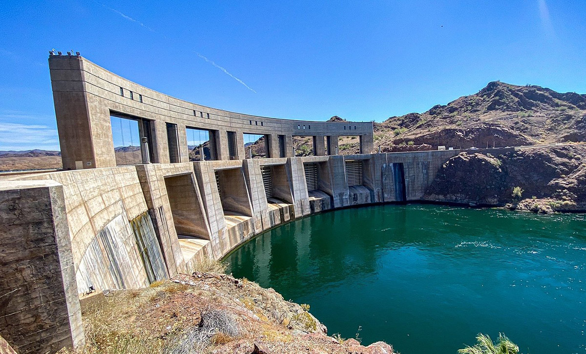
A concrete dam structure curved along a body of water, with visible gates and mountains in the background under a clear blue sky.
Parker Dam image from TripAdvisor. Photographed by WIBYRIC @he_wanders_off

Parker Dam is the exact geographic “fork in the road” for Southwest water distribution. It acts as the forebay for two of the most critical aqueducts in the United States. The Colorado River Aqueduct which is managed by the Metropolitan Water District of Southern California, which pumps water 242 miles west to Los Angeles and San Diego. And the Central Arizona Project which pumps water 336 miles east to supply Phoenix and Tucson.1

Lake Havasu is a dynamic environment that’s impacted by upstream agricultural drainage, mineral springs, and fluctuating flows from Hoover Dam, and so salinity can spike rapidly. Hourly monitoring allows Bureau of Reclamation technicians to provide real-time telemetry data to MWD and CAP so they can adjust their treatment facilities or blending ratios before millions of gallons of highly saline water enter their pipelines.2

If the Total Dissolved Solids (TDS) levels of water tested at Parker Dam are too high, it could set off a cascading economic, industrial, and agricultural crisis across California and Arizona. TDS is the combined concentration of minerals, salts, metals, and small organic substances dissolved in water. That includes common minerals like calcium, magnesium, sodium, potassium, and bicarbonates, as well as chloride, sulfate, nitrate, trace metals such as copper, zinc, and sometimes contaminants like pesticides or industrial byproducts.3

The Effects of high TDS for Residential Water Users

High TDS typically means “hard” and corrosive water. If Parker Dam passed high-salinity water into the aqueducts, it would cause the buildup of scale in home appliances, water heaters, and municipal pipes across Los Angeles, San Diego, and Phoenix. Scale can drastically reduce the lifespans of home appliances, clog plumbing infrastructure, and degrade household water filters. It forces MWD and local utilities to incur massive financial costs to blend Colorado River water with lower-salinity northern water sources just to make it palatable and safe for home use.4

The Effects of high TDS for Agricultural Water Users

Water from Parker Dam also feeds the massive agricultural hubs of the Imperial and Coachella Valleys, as well as Yuma, Arizona. Irrigation water that’s high in salt acts as a silent killer for crops like alfalfa, lettuce, and citrus fruits. High salt content alters soil chemistry, lowering overall crop yields and burning plant roots. It forces farmers to use significantly more water just to “flush” the accumulated salts out of the root zones, compounding the West’s water scarcity issues.5

Colorado River salinity requirements for Water that flows into Mexico

IBWC Minute 242 regulates Colorado River salinity by requiring that water delivered to Mexico at Morelos Dam has an annual average salinity no more than 115 parts per million (ppm), with a plus or minus 30 ppm variance, above that of the water at Imperial Dam. This comparative standard ensures water quality by preventing high-salinity agricultural drainage from being added before crossing the border. Detailed information on this treaty can be found on the International Boundary and Water Commission website.6
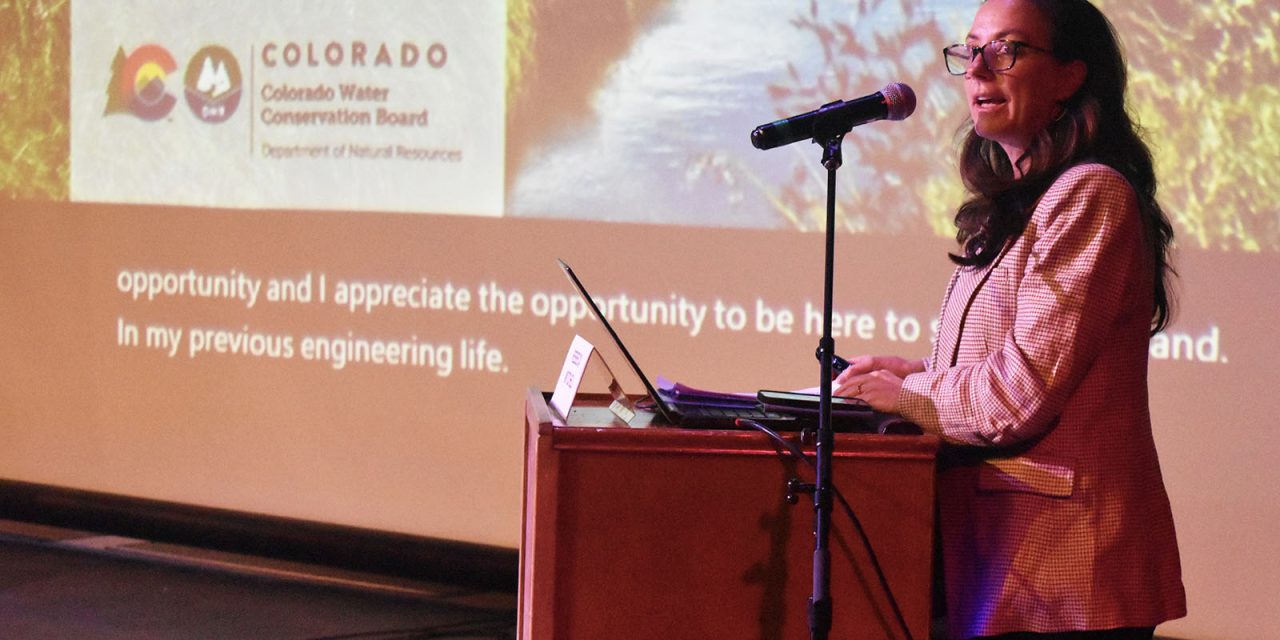
Becky Mitchell delivers strong message on #ColoradoRiver — Joe Stone (HeartOfTheRockiesRadio.com) #COriver #aridification

As the keynote speaker at the Arkansas River Basin Water Forum in Salida, Upper Colorado River Commissioner Rebecca Mitchell spoke about the Colorado River crisis and water-use negotiations among the seven Colorado River Basin states. Photo credit: Joe Stone/Heart of the Rockies Radio

Click the link to read the article on the Heart of the Rockies Radio website (Joe Stone):

May 16, 2026

As the keynote speaker at the Arkansas River Basin Water Forum in Salida, Upper Colorado River Commissioner Rebecca Mitchell spoke about the Colorado River crisis and water-use negotiations among the seven Colorado River Basin states.

Following a warm winter with the lowest snowfall on record, Colorado faces a dire water-resource challenge. Mitchell acknowledged these unprecedented conditions and repeatedly avowed hydrologic reality in the Colorado River Basin as the basis for administering water use.

The 1922 Colorado River Compact governs water allocations in the Colorado Basin and delineates Upper Basin states – Wyoming, Utah, Colorado and New Mexico – and Lower Basin States – Nevada, Arizona and California. 

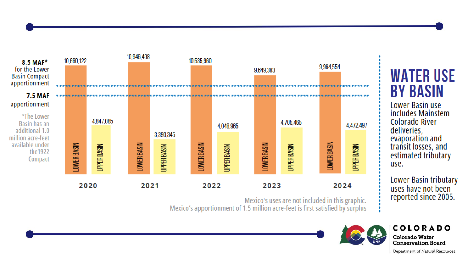
Negotiated during one of the Basin’s wettest known climate patterns, the Compact allocates 7.5 million acre-feet of Colorado River water to the Upper Basin states. The Lower Basin allocation is 7.5 million acre-feet from the Upper Basin plus a million acre-feet from Lower Basin tributaries.

ā€œLet’s look at the numbers,ā€ Mitchell said. ā€œEven in the most recent years … with reservoirs near the brinks of collapse,ā€ Lower Basin water use was almost 11 million acre-feet in 2021, 2.5 million acre-feet more than the Lower Basin’s allocation. That overuse is based on ā€œa very flawed legal opinion,ā€ not science.

By contrast, the Upper Basin states cut usage by almost a million acre-feet from the previous year, using less than 4 million acre-feet, or 3.5 million acre-feet less than their allocation.

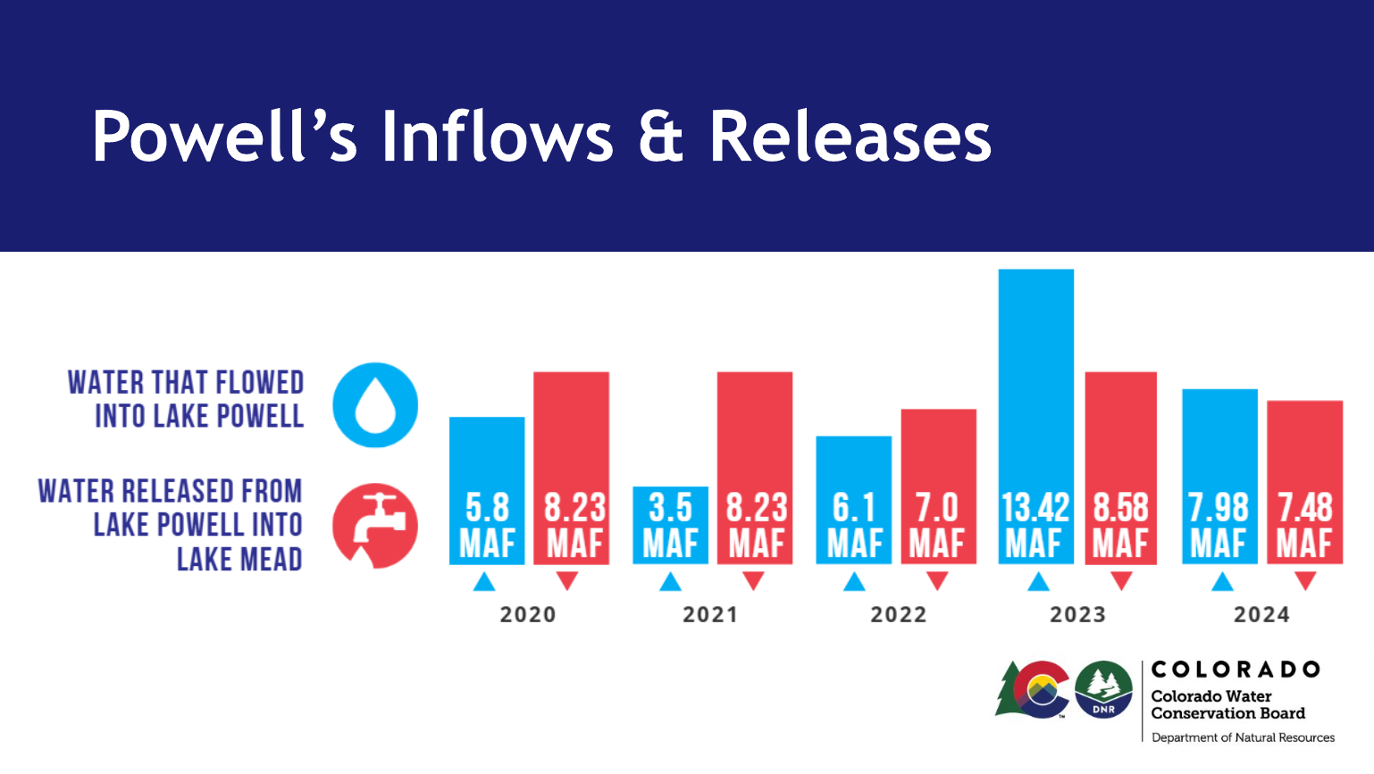
Mitchell also compared annual water flows into Lake Powell with the amount of water that the U.S. Bureau of Reclamation released from Lake Powell. ā€œSixteen out of 20 years, more water left Lake Powell than came in. That mass balance equation simply doesn’t work.ā€

Those excessive water releases ā€œwere not tied to what was happening with hydrology,ā€ she said. ā€œThey were tied purely to the reservoir elevationsā€ established by the 2007 Interim Guidelines ā€œand releases that were desired by the Lower Basin.ā€

Other numbers Mitchell cited include reservoir levels for recent years in which the Lower Basin states used more than their water allocations under the Compact.

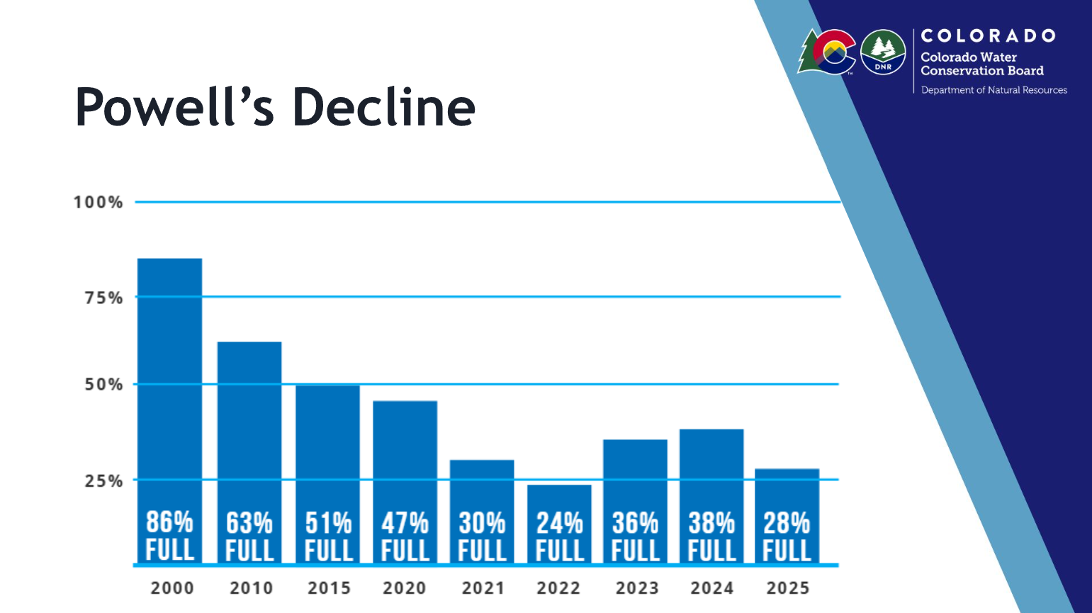
In 2000, ā€œyou can see Powell is about 86% full. And you look at where we are in 2025, and we’re predicted to be in an even worse situation at the end of this year. … This didn’t work. You see a steady decline.ā€

The Interim Guidelines ā€œincentivized pulling down Meade so more water would come from Lake Powell. That put us in the situation that we are in today,ā€ Mitchell said. ā€œThese guidelines didn’t respond to real world hydrology. They incentivized use – unsustainable use … and they prioritized one basin over the otherā€ – i.e., the Lower Basin over the Upper Basin.

As a result, ā€œtwo countries are struggling. Forty million people are struggling. Thirty tribes haven’t been at the table before this, (and they) deserve to be. This wasn’t the way to get security for the Western United States.ā€

The solution, she emphasized, is having flexibility to adapt to changing conditions across the entire Colorado Basin by planning for variable operations. Colorado’s Prior Appropriation (Priority) System, embedded in the Colorado Constitution, requires that flexibility.

Colorado’s Priority System has produced a system of year-round real-time administration of water use based on legal priority.

ā€œYou all know the Priority System,ā€ Mitchell said. ā€œThere is a priority system in the Lower Basinā€ that ā€œhas been used … yeah, zero times. …  

ā€œI think the truth is important, and facts are important. Science is important. … (The Lower Basin’s) overuse essentially put us in the situation that we are in today. … We’re in this together. But we have to pivot to that.

ā€œAnd we have to engage the tribal nations and Mexico. We can’t do this the way that we have done it before. … One user is not more important than the other users, one side of the Basin is not more important than the other side of the Basin.ā€

Upper Basin states, led by Colorado, have proposed multiple collaborative, science-based approaches to resolving the Colorado River crisis, but ā€œthe Lower Basin is coming up with yet another one of their own plans that involve our resources. …

ā€œThey’re irresponsible. They’re not doing enough.ā€ Their rhetoric ā€œputs all of us at risk. And I think we have the responsibility to do better. … One of the things that we’ve always done is really look at what we can do based on the resources that we have – the systems that we already work under.ā€

Mitchell insisted that the Upper Basin states had put on the table ā€œa generous rule curve of releases from Powellā€ as well as upstream reservoirs like Blue Mesa and Flaming Gorge.

ā€œNow that we know a year like this is possible, we need to factor that in and be prepared for that. … We have to figure out how do we save in the good years so we can get through the years like this year? …

ā€œI was just in Grand Junction. I had grown men come to me crying. They know this year is going to suck. Literally. And if we don’t acknowledge that as part of our path forward, then we’re really not acknowledging who we are, and we’re also not acknowledging what needs to be done.ā€

Udall/Overpeck 4-panel Figure Colorado River temperature/precipitation/natural flows with trend. Lake Mead and Lake Powell storage. Updated through Water Year 2025. Note the tiny points on the annual data so that you can flyspeck the individual years. Credit: Brad Udall