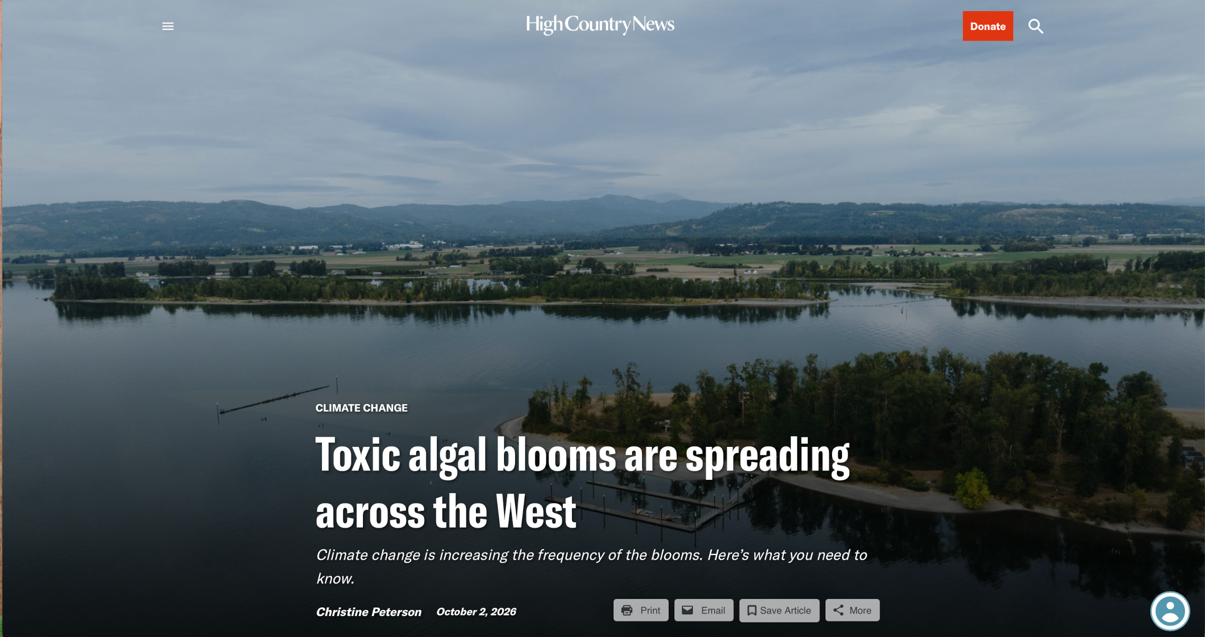
By the time Tanya Bachman noticed something was wrong with her border collie, Jax, it was too late.
She and her family had taken their boat and two dogs out on the Columbia River near Portland, Oregon, in August 2024 to celebrate her birthday, a summer ritual as important to them as fireworks on the Fourth of July. That afternoon, Bachman let the dogs loose on an island beach to play. When Jax returned, his tail drooped.
As Bachman tried to attach Jax’s leash, he vomited, began convulsing and then lost consciousness. Bachman screamed for her husband, and the couple raced the dog to a veterinarian. It was no use; less than an hour after Bachman noticed Jax’s droopy tail, he was dead.
“It was just so shocking,” she said.
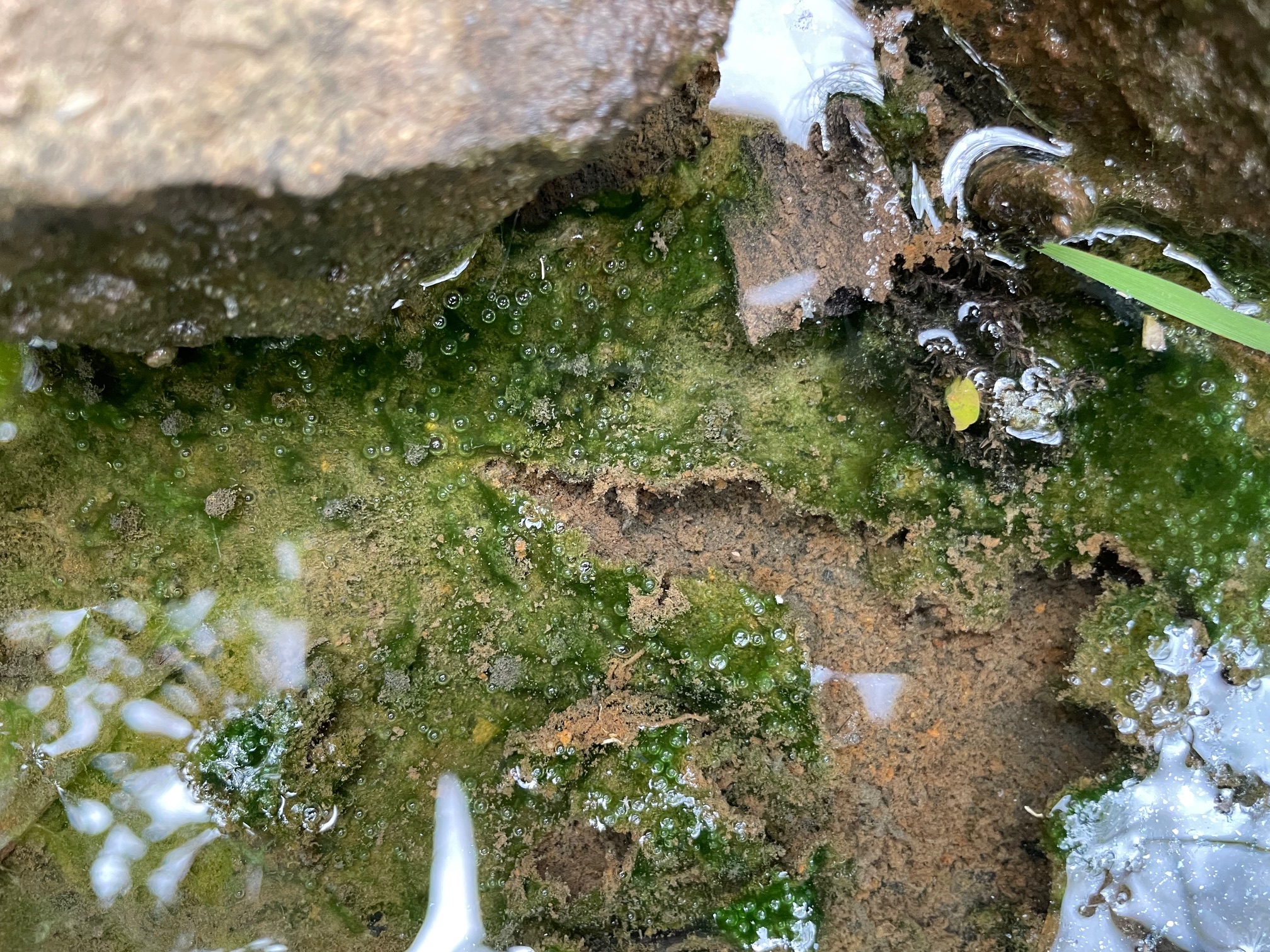
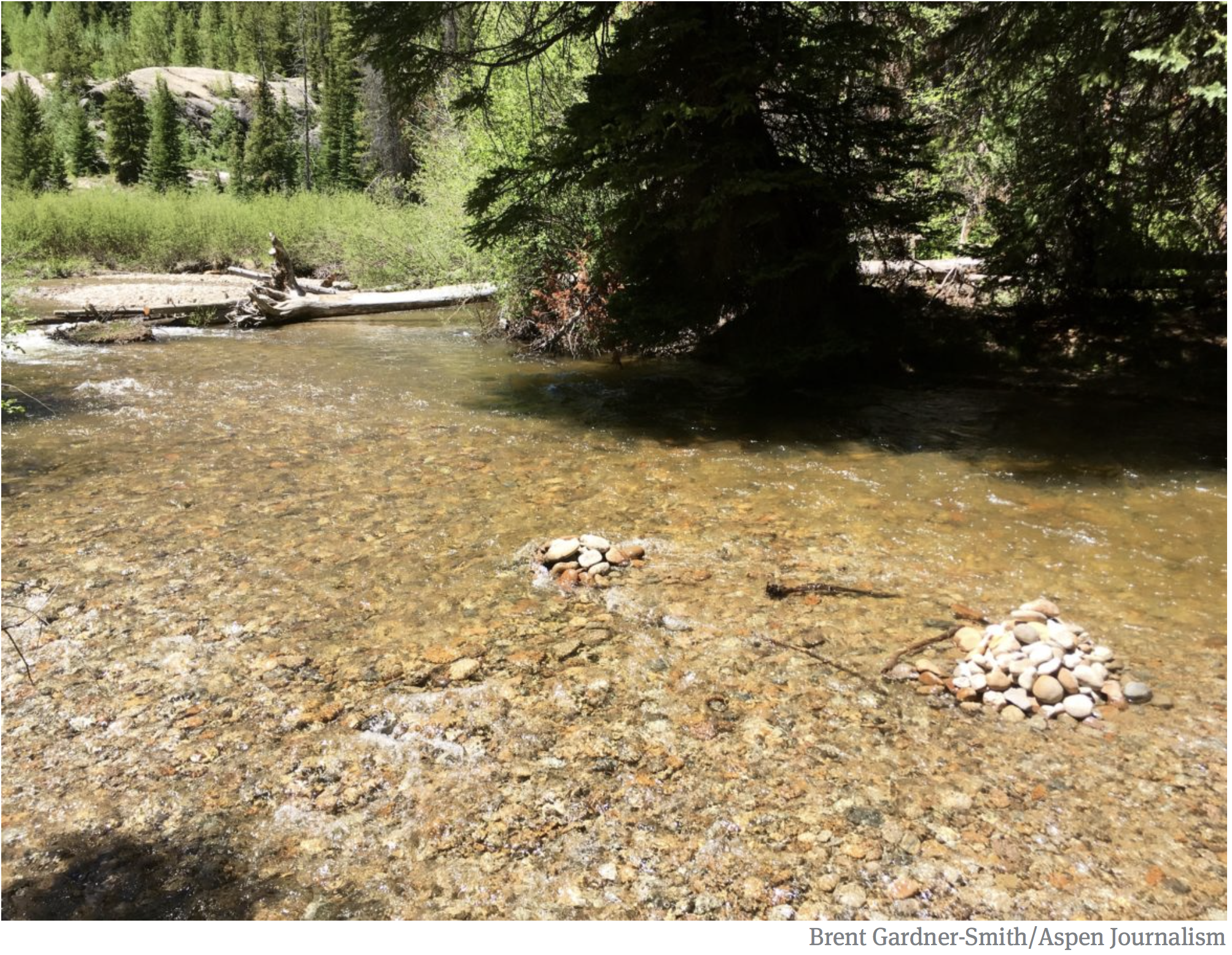
The veterinarian told them that Jax had likely ingested a toxic, algae-like microorganism called cyanobacteria, or blue-green algae, from a benthic bloom, a phenomenon scientists began documenting in the West about five years ago. Benthic blooms, which resemble globs of snot, form on stream bottoms or submerged logs or rocks, sometimes breaking free and rising to the surface. They are less familiar to Westerners than planktonic blooms, which form on the surface of lakes and reservoirs and look more like floating grass clippings or spilled green paint.
The cyanobacteria that cause planktonic and benthic blooms have existed in Earth’s waters for billions of years. Excess nitrogen and phosphorus from agricultural fertilizers or air pollution can cause them to proliferate. Research suggests that climate change is also contributing to more frequent and widespread blooms as warmer water stagnates during hot, dry years like this one, said Hannah Bonner, a professor and water scientist at Brigham Young University who studies benthic cyanobacteria.
It’s a cruel twist: As the West warms, once-inviting cool-water refuges may become a threat not just to pets, but to people and wildlife.
Cyanobacteria in both benthic and planktonic blooms can secrete toxic chemicals that irritate human skin, or, if consumed, cause nausea or even liver damage. The same toxins can kill any pets, livestock and wildlife that drink the contaminated water or lick their wet fur. No backpacking water–filtration systems can removecyanobacteria toxins.
Most Western states only began tracking planktonic blooms — which are easier to spot and monitor than benthic blooms — in response to health concerns in Eastern waters. In 2014, toxic cyanobacteria blooms in Lake Erie shut down Toledo, Ohio’s drinking water system. Wyoming began monitoring blooms in 2018, first with satellite imagery and then, starting in 2021, with on-the-ground water sampling. Utah ramped up monitoring in 2016. California and Oregon’s programs, which are among the oldest in the West, started about 20 years ago.
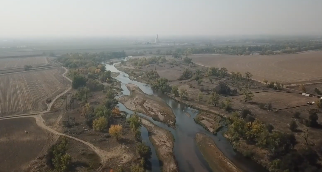
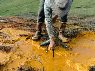
Benthic Cyanobacteria. Photo credit: USGS
Results from those and other programs suggest that planktonic blooms are popping up earlier in the season in more lakes and reservoirs and are lasting longer into the fall. Some experts believe the reported increases could be the result of more monitoring. But a nationwide Environmental Protection Agency study published in 2021 found that increased nutrients like nitrogen and phosphorus are combining with the warming and drying effects of climate change to create more and longer-lasting blooms.
“We’re affecting so much of the land surface and creating disturbances and introducing nutrients,” said Theodore Dreher, a microbiology professor emeritus at Oregon State University. Unlike climate change, where one continent’s emissions can affect the climate of another, nutrient pollution’s sources are often localized and can be more easily regulated. Utah, for example, has implemented regulations requiring improvements at places like wastewater treatment plants. It’s also created voluntary incentives for treating agricultural runoff and restoring floodplains. The combination has helped stem nutrient flow into Utah Lake, near Provo, where blooms were once so bad that people sold T-shirts with the slogan “Ski the Scum.”
In order to address the causes effectively, however, officials need to collect water quality data, not just monitor for blooms. Unfortunately, not enough are doing so, said Justin Hayes, Northern Rockies conservation director with American Rivers. “States need to take this really seriously and start trying to solve it rather than just warning people.”
Researchers are also still struggling to understand why recent blooms are turning up in unusual places. Planktonic blooms in high-elevation lakes far from septic systems and feedlots are becoming more common, possibly because of runoff from melting glaciers or atmospheric deposition of nitrogen and phosphorus from dust and air pollution, Bonner said. And benthic blooms may become more common as snowpack declines and produces less snowmelt. At the same time, parts of the West are seeing fewer monsoon rainstorms that can flush algal mats away.
“I was just in the mountains last weekend, in a pristine creek, and they were everywhere,” she said.
Bonner doesn’t think people should stay home to avoid blooms, but said they do need to know what to look for. A benthic bloom “is like a big ball of snot,” she said. “Find a stick, poke it, lift it up, and if you see hairlike strands or fibers, most of the time it’s not cyanobacteria or toxic. If it is a boogery consistency, it likely is.”
Meanwhile, more states are installing signs, sending email alerts, and posting public-health advisories that warn recreationists about toxic blooms.
And Bachman keeps talking to local and regional media, hoping Jax’s death will save someone else’s pet. “Everything upstream flows downstream,” Bachman said. “Just because you have a patch of it upstream doesn’t mean it won’t move down to you.”
Reporting for this story was supported by the Mighty Arrow Family Foundation.
Several of the latest claims located within the pre-shrinkage Bears Ears National Monument are on the north side of the Tables of the Sun, seen here in the background on the right. Jonathan P. Thompson photo.
The mining claim game continues to heat up in the areas Trump illegally slashed from Bears Ears National Monument, and the top player is, once again, Kimmerle Mining of Moab. Since the Land Desklast wrote about this mini-land rush, Kimmerle has filed seven additional claims areas that had been within the national monument, and therefore off limits to new mining claims.
The latest claims are in the White Canyon area. During the post-War uranium frenzy, the federal government, county crews, prospectors, and mining companies webbed this area with roads, poked it full of prospect holes and mine adits, and contaminated waters with radioactive materials. Part of that legacy includes a 26,000-ton pile of uranium tailings entombed within the waters silt of Lake Powell.
It’s important to keep in mind that the presence of active mining claims does not necessarily mean anyone is going to mine or even explore these pieces of land. And while the claims may be active, which simply means the claimant is up to date on their $200/year location and maintenance fee, they may not be valid. That requires, at least theoretically, proof that the claim contains valuable minerals.
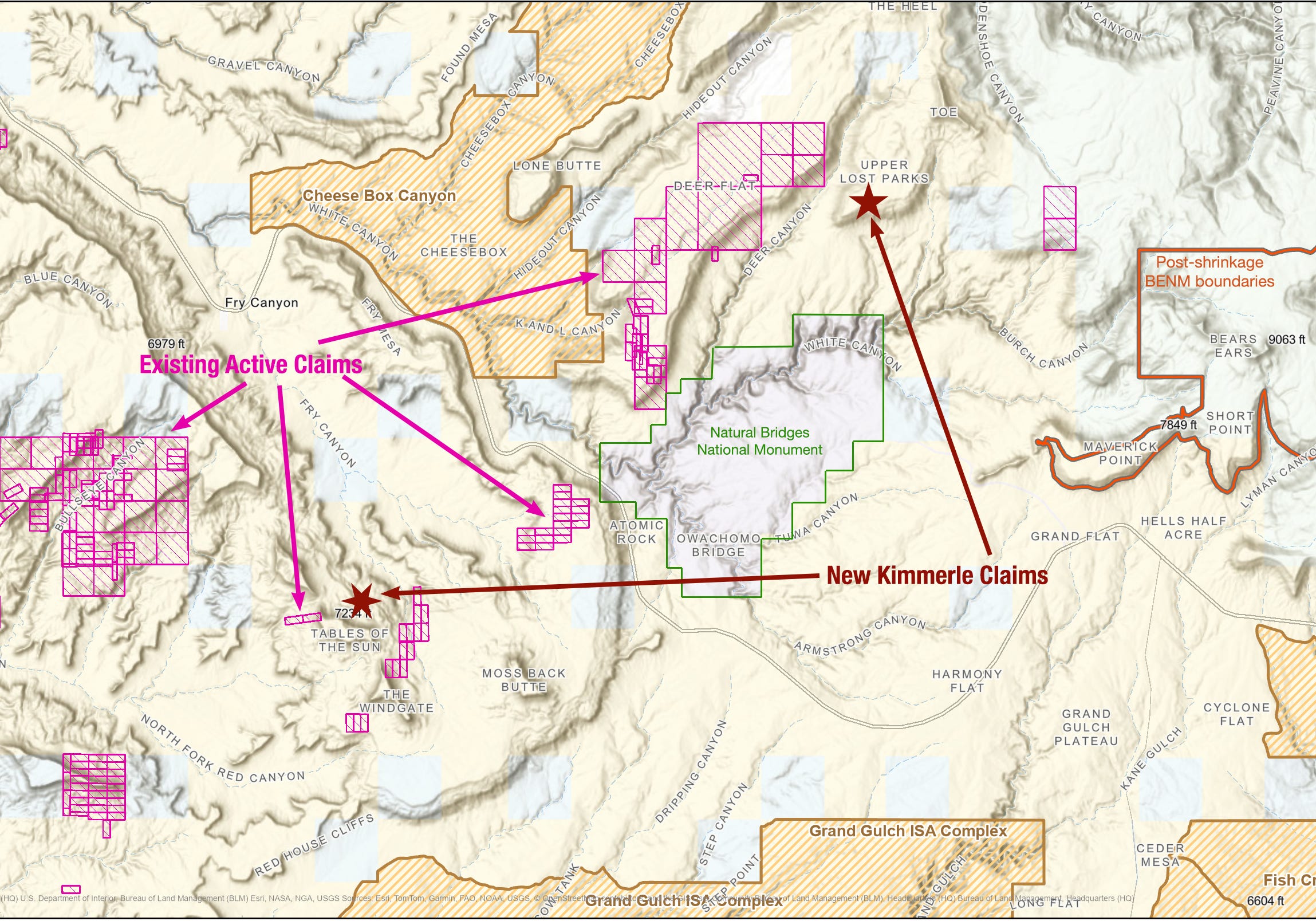
But it does appear as if Kimmerle is targeting viable mining areas, which indicate that the firm either intends to mine the claims, or consolidate enough of them to sell them to a larger company. The newly revealed claims are located in two clusters on either side of Natural Bridges National Monument.
The notices of location have been declared with the San Juan County Recorder, but have not yet shown up on the Bureau of Land Management database. Just before publishing this, I checked the San Juan County records search and found that an entity called Land Survey Advisers — which typically stakes claims for other firms or individuals — filed location notices on more than three dozen claims in San Juan County. At least some of those claims appear to be within the pre-shrinkage BENM boundaries, but the location description on many of them included sections that don’t exist (43, 47) in the public land survey system, and the document download function isn’t working for me, so I have yet to confirm any of this. Still, it’s potentially alarming.
Map showing the approximate location of the claims filed by Kimmerle Mining in Sept. 2026. It also shows pre-existing active claims (in pink) that were staked before Bears Ears’ 2016 establishment, or following the Trump I-shrinkage. Map: BLM and Land Desk.
The Kimmerle claims include:
Six lode claims (each at 20.66 acres) on the north slope of the Tables of the Sun formations in the upper Fry Canyon drainage, just on the boundary line of the original Bears Ears National Monument. While this specific area has seen little mining activity in the past, it is in the same vicinity as the Daneros Mine, which was up for expansion as recently as 2016. And the new claims are adjacent to Kimmerle’s Lucky group of claims. The nearest historic mining activity was at the Fry # 4 mine1, an underground uranium mine with over 400 meters of workings. In 1977, the operator was Utah Power & Light Co., which was the main mining company of the area at the time.
One lode claim on the east slope of Upper Lost Parks, an appendage of Elk Ridge just north of Natural Bridges National Monument and south of the Woodenshoe formation. It’s across Deer Creek Canyon from Kimmerle’s Geitus and Cedar claims, which the firm staked just before President Barack Obama designated Bears Ears, and right after President Donald Trump shrunk the monument for the first time. It’s also in the vicinity of the Sandy claims that Kimmerle held, but that [those?] were closed in 2015. The area was mined and prospected heavily during the Cold War. The nearest historical mines and prospects were the Big Red, the Sandy, and the Hideout. In 1977, the Big Red — operated by Utah Power & Light — was reported to have a flooded, a caved, and an open adit. While the Hideout sparked a 1950s prospecting boom in the area, none of these were ever large producers. However, a 1965 USGS report did indicate this part of Elk Ridge was favorable for uranium deposits, which is likely one reason the Trump administration stripped it of national monument protections.
The White Canyon area was known to contain rich uranium reserves back in the 1940s and 1950s, but its remoteness and the rugged landscape created challenges for mining companies looking to exploit the resources. One of the biggest hurdles was getting the ore to the Monticello processing plant, which required driving gnarly roads across the crinkled landscape and up and over Elk Ridge.
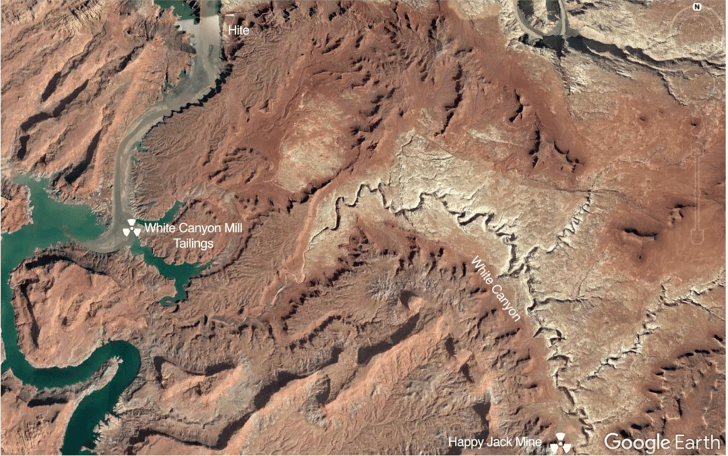
So in 1949, the Vanadium Corporation of America built a small mill at the confluenceof White Canyon and the Colorado River, primarily to process uranium ore from the nearby Happy Jack Mine, located upstream in the White Canyon drainage (and just within the original Bears Ears National Monument boundaries). For the next four years, the mill went through about 20 tons of ore per day, crushing and grinding it up, then treating it with sulfuric acid, tributyl phosphate, and other nastiness. One ton of ore yielded about five or six pounds of uranium, meaning that each day some 39,900 pounds of tailings were piled up outside the mill on the banks of the river.
In 1953 the mill was closed, and the tailings were left where they sat, uncovered, as was the practice of the day. Ten years later, water began backing up behind the newly built Glen Canyon Dam; federal officials decided to let the reservoir’s waters inundate the tailings. There they remain today, though at current lake levels they are probably buried by and mixed in with the Dominy Formation of silt, rather than covered with water.
Satellite image showing the location of the White Canyon Mill and its silt-entombed tailings pile.
During the uranium days of the West, more than a dozen mills — all with processing capacities at least ten times larger than the one at White Canyon — sat on the banks of the Colorado River and its tributaries. Mill locations included: Shiprock, Mexican Hat, Monument Valley, Tuba City, Monticello, Rifle, Grand Junction, Moab, Uravan, Green River, and Naturita. There was even an ore upgrading mill at Fry Canyon, followed by a copper heap leaching operation. Groundwater contamination continues to today, and was partially responsible for the Fry Canyon Lodge’s demise.
At the Durango mill the tailings were piled into a hill-sized mound just a stone’s throw from the Animas River. They weren’t covered or otherwise contained, so when it rained tailings simply washed into the river. Worse, the mill’s liquid waste stream poured directly into the river at a rate of some 340 gallons per minute, or half-a-million gallons per day. It was laced not only with highly toxic chemicals used to leach uranium from the ore and iron-aluminum sludge (a milling byproduct), but also radium-tainted ore solids.
Radium is a highly radioactive “bone-seeker.” That means that when it’s ingested it makes its way to the skeleton, where it decays into other radioactive daughter elements, including radon, and bombards the surrounding tissue with alpha, beta, and gamma radiation. According to the Toxic Substances and Diseases Registry, exposure leads to “anemia, cataracts, fractured teeth, cancer (especially bone cancer), and death.”
It wasn’t any better at any of the other mills. In the early 1950s, researchers from the U.S. Public Health Service sampled Western rivers and found that “the dissolved radium content of river water below uranium mills was increased considerably by waste discharges from the milling operations” and that “radium content of river muds below the uranium mills was 1,000 to 2,000 times natural background concentrations.”
That was just from daily operations. In 1960, one of the evaporation ponds at the Shiprock mill broke, sending at least 250,000 gallons of highly acidic raffinate, containing high levels of radium and thorium, into the river. None of the relevant officials were notified and individual users continued to drink the water, put it on their crops, and give it to their sheep and cattle. It wasn’t until five days later, after hundreds of dead fish had washed up on the river’s shores for 60 miles downstream, that the public was alerted to the disaster.
Of course, what’s dumped into the river at any of these places doesn’t stay there, but makes its way downstream. In the early 1960s, while Glen Canyon Dam was still being constructed, the Public Health Service folks did extensive sediment sampling in the Colorado River Basin, with a special focus on Lake Mead’s growing bed of silt, which had been piling up at a rate of 175 million tons per year after Hoover Dam started impounding water in 1935. The Lake Mead samples had higher-than-background levels of radium-226. The report concludes:
And so, the billions of tons of silt that has accumulated in Lake Mead and Lake Powell serve as archives of sorts. They hold the sedimental records of an era during which people, health, land, and water were all sacrificed in order to obtain the raw material for weapons that are capable of destroying all of humanity. If the new mining claim mini-rush is any indication, some more records may be added to the archive before long.
📸 PARTING SHOT 🎞️
There’s snow in them thar hills!
There’s snow on the peaks just as the aspens are peaking around Silverton, Colorado. Sept. 23, 2026. Andy Gleason photo.
1 This also appears on some maps and documents as Frey #4. In fact, many of the “Fry”s in the Fry Canyon area show up as “Frey” on older maps (while some still say “Fry.”). Oh my oh my I don’t know why it’s Frey or Fry.
The Trump administration’s Environmental Protection Agency is proposing to further constrain the reach and potency of the Clean Water Act by re-defining what qualifies as “waters of the United States,” or WOTUS, which are streams, wetlands, and other water bodies under federal jurisdiction. The proposed definition would disproportionately affect the arid West by lifting protections from thousands of miles of streams, arroyos, and wetlands.
Under the CWA, a firm or individual looking to discharge pollutants or other material into, or dredge or reroute or otherwise alter, a WOTUS waterway must obtain a federal permit from the EPA or Army Corps of Engineers. A battle has raged for more than five decades over what constitutes a WOTUS. The Supreme Court’s 2023 Sackett v. Environmental Protection Agency ruling called for a narrower definition, handing industry and right-wing ideologues a major victory.
Ephemeral streams are streams that do not always flow. They are above the groundwater reservoir and appear after precipitation in the area. Via Socratic.org
The changes in the latest proposed supplemental rule are even more exclusionary than the administration’s November 2025 proposal, which removed “ephemeral” and “intermittent” waterways — i.e. arroyos or washes that run only after rains or snowmelt — from federal jurisdiction. Included as a WOTUS under that proposal were “relatively permanent … bodies of surface water that are standing or continuously flowing year-round or at least during the wet season.”
The new proposal omits the “wet season” verbiage. It then defines “relatively permanent” to be synonymous with “perennial,” which in turn is defined as ‘‘having standing or continuously flowing water every day of the year during ordinary conditions.’’ However, “a body of water does not lose its relatively permanent status if it dries up as a result of anomalous events such as drought or dry spell.1 A body of water also does not lose its relatively permanent status if it dries up for no more than a single period of up to 30 consecutive days in any given year as a result of non-anomalous events resulting in a temporary interruption such as low tide or a regularly occurring dry spell.” Yet, “if flow is interrupted for two periods in any given year, and each period consists of 10 consecutive days of no flow, the water body would not be jurisdictional.”
A Natural Resources Defense Council analysis found that the new proposal would remove protections from more than 94% of the nation’s wetlands and about 79% of its streams. The changes would hit the West hardest, leaving a state like Arizona with almost no federally protected streams or wetlands.
So here’s my interpretation of where the updated proposal leaves us:
WOTUS waterways (keeps CWA protections): A year-round river, stream, or lake that never dries up, such as the Animas River, the San Juan River, the Colorado River, the Gunnison River, Cement Creek, Mineral Creek, the Fremont River, and so on, would retain federal protections under the CWA. However, since most of these rivers are fed by intermittent or ephemeral streams, they would also be potentially affected (since is someone altered or polluted a tributary, the effects would eventually reach the mainstem).
Non-WOTUS waterways (would lose CWA protections): All intermittent and ephemeral streams, i.e. arroyos or washes that run only when it rains, such as are ubiquitous in the arid West, would be removed from federal jurisdiction. Other streams and rivers that run seasonally, but regularly dry up for more than 30 consecutive days per year, such as the Paria River, the Dirty Devil, Rio Puerco, Santa Cruz River, or the Mancos River, would also lose federal protections, as would wetlands that are only “wet” for part of the year.
Vague WOTUS status: Rivers or streams that are perennial as a whole, but on which certain segments dry up for more than 30 days per year (usually because of upstream diversions), e.g.: the Rio Grande through Albuquerque, long sections of the Lower Dolores River between McPhee Dam and its confluence with the San Miguel, the North Fork of the Gunnison around Paonia, lower reaches of the La Plata River, or Junction Creek through Durango, and numerous desert rivers in Arizona and New Mexico.
While the proposed rule would remove federal CWA protections from many waterways, it would not automatically give developers or industry free rein to bulldoze or dump toxic waste into them. State and local laws would still apply, and arroyos and streams on public land would still be protected to some degree by federal environmental laws. Colorado lawmakers passed a bill in 2024 that effectively backfilled the regulatory gap left by the Sackett decision. New Mexico also has moved to implement its own layer of water protections. In more industry-friendly states such as Idaho and Utah, the proposed rule would leave thousands of miles of streams and waterways vulnerable to development and pollution.
The proposed rule is open to public comments until Oct. 9. You may send comments, identified by Docket ID No. EPA–HQ– OW–2025–0322, by any of the following methods:
Federal eRulemaking Portal: https://www.regulations.gov/. Follow the online instructions for submitting comments.
Email: OW-Docket@epa.gov. Include Docket ID No. EPA–HQ–OW– 2025–0322 in the subject line of the message. •
Mail: U.S. Environmental Protection Agency, EPA Docket Center, Water Docket, Mail Code 28221T, 1200 Pennsylvania Avenue NW, Washington, DC 20460.
Hand Delivery or Courier: EPA Docket Center, WJC West Building, Room 3334, 1301 Constitution Avenue NW, Washington, DC 20004.
For more background on the long and winding struggle to define WOTUS, check out the following:
My February 2022 High Country News piece on the Supreme Court taking up the Sackett Case, including a detailed timeline of the WOTUS definition battle.
And, from the Land Desk archives (you’ll need a paid subscription for access):
A new paper is out from the group of Colorado River experts known by some as the “Traveling Wilburys of the Colorado River Basin,”2 and lo and behold, it actually contains some good news. Namely this: The Lower Basin users have managed to make significant reductions in water use over the last decade and a half without turning the Southwest into a dust-choked wasteland and getting ahead of the latest round of mandated cuts. This indicates that the users can continue to slash water use in the future — to a degree — if necessary.
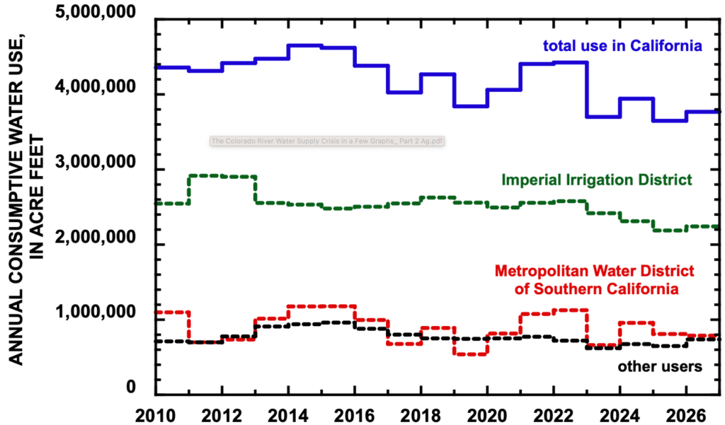
The Lower Basin accounts for about 60% of all consumptive water uses and losses on the Colorado River. Irrigated agriculture, in turn, makes up about 60% of the Lower Basin’s consumptive use. The Imperial Irrigation District, which is primarily agricultural, is the largest single water user on the entire river. This means that the agricultural sector — and the IID in particular — “will play a significant role in future reductions in water use,” as the authors put it.
So far, the Lower Basin’s farmers and the IID have stepped up. In 2025, the Lower Basin states’ consumptive use was 5.76 million acre-feet, the lowest since at least 2010. Since 2023, California has used about 13% less water, a reduction attributable mostly to cuts at IID.
Source: The Colorado River Water Supply Crisis in a Few Graphs: Part 2 Agricultural Water Use in the Lower Basin.
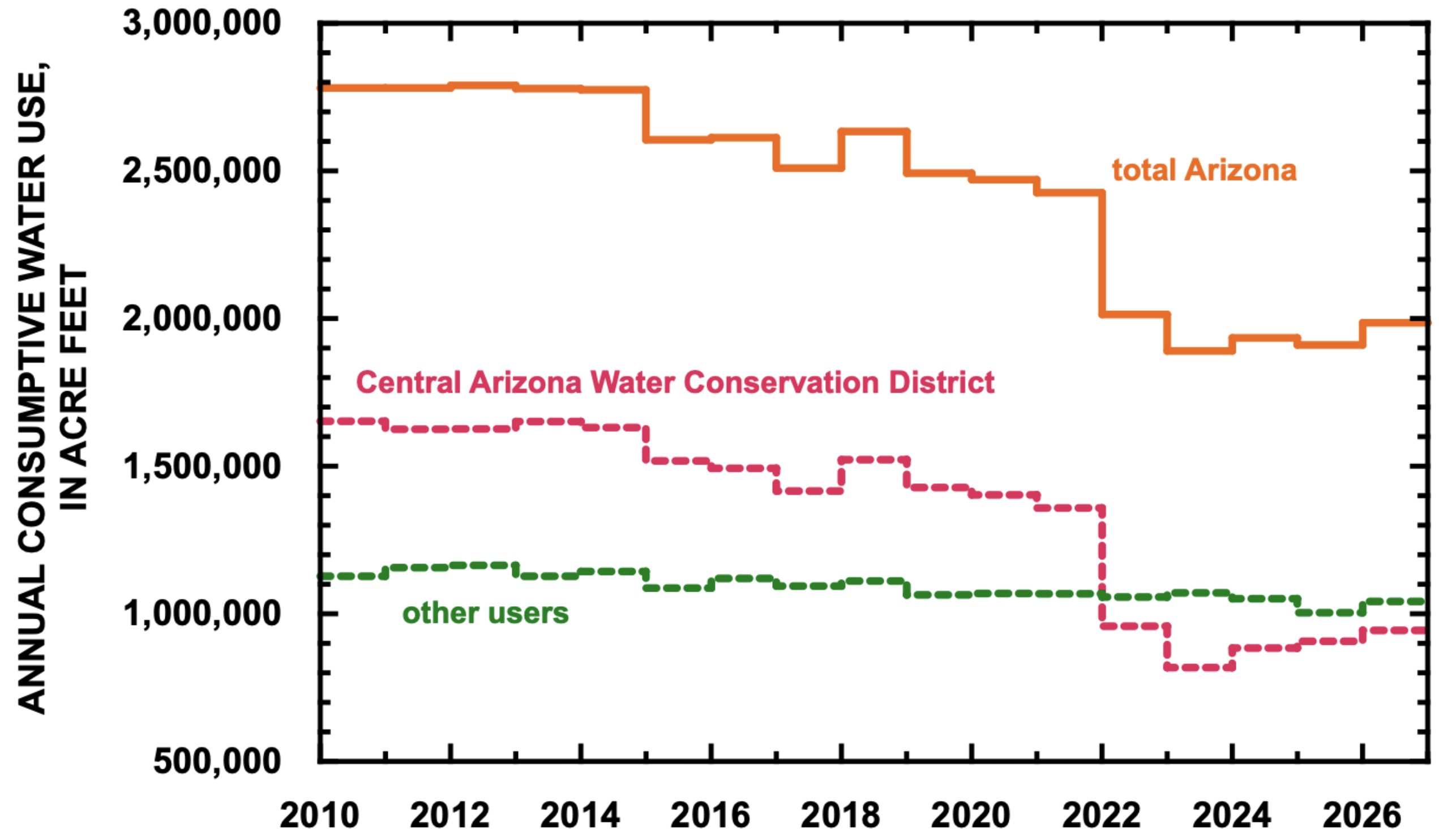
Figure 3. Consumptive use in Arizona since 2010. Estimated use in 2026 based on forecast of September 1, 2026.
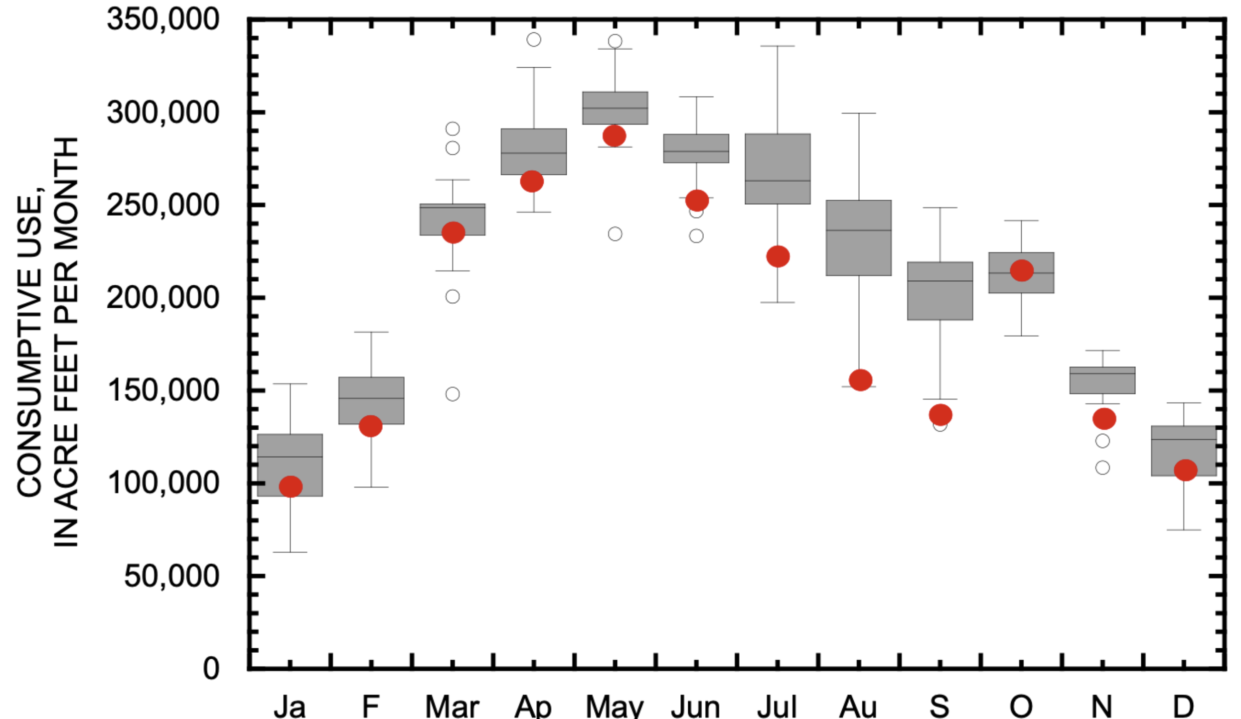
Notably, IID’s reductions came mostly during the summer months, the peak season for field crops such as alfalfa, Bermuda grass, and kleingrass, when it’s too hot to grow most garden crops, such as lettuce, onions, and broccoli. During the vegetables’ growing season, from November through March, water use stayed roughly the same as before. A similar, but less dramatic, dynamic shows up in Arizona.
Figure 6. Box-and-whisker plots of total monthly consumptive use by the IID between 2010 and 2026. Each box is the Inter Quartile Range, defined by the 25th and 75th percentile of the years of data for that month. These boxes represent the typical monthly use pattern since 2010. Red dots are the average use in each month between 2024 and 2026. See text for additional explanation of a box-and-whisker plot.
This suggests a couple of things: 1. The Imperial Irrigation District and other large agricultural users may be able to significantly lower overall water use without harming important garden crops such as broccoli and carrots (easing fears that the Colorado River crisis will deprive us of vegetables); and, 2. The IID is successfully using its vast alfalfa crop as a giant water demand-response tool3. That is, through both fallowing some fields and putting others on a summer water diet, the district’s farmers have managed to slash water use, while still growing gobs of hay and alfalfa.
And because the IID still has about 150,000 acres of alfalfa, it has huge potential for future water cuts through these same methods, which is the good news. The bad news is that the federal plan for operating the river contemplates Lower Basin cuts of up to 3 million acre-feet per year (resulting in a total annual consumption of 4.5 MAF), which is about twice what the Basin has already achieved.
To consider the viability of such cuts, the authors summed up the smallest monthly use in each Lower Basin state since 2010, even though they didn’t occur simultaneously, and even though in some cases the reductions were due to heavy precipitation, not conservation efforts. The result was 5.03 MAF, still 530,000 acre-feet over the potential target. In other words, getting to 4.5 MAF/year is likely to be much more painful than accomplishing the reductions so far.
Yet some pain is likely to be necessary unless the West’s warming climate does a rapid about-face, and soon.
📸 PARTING SHOT 🎞️
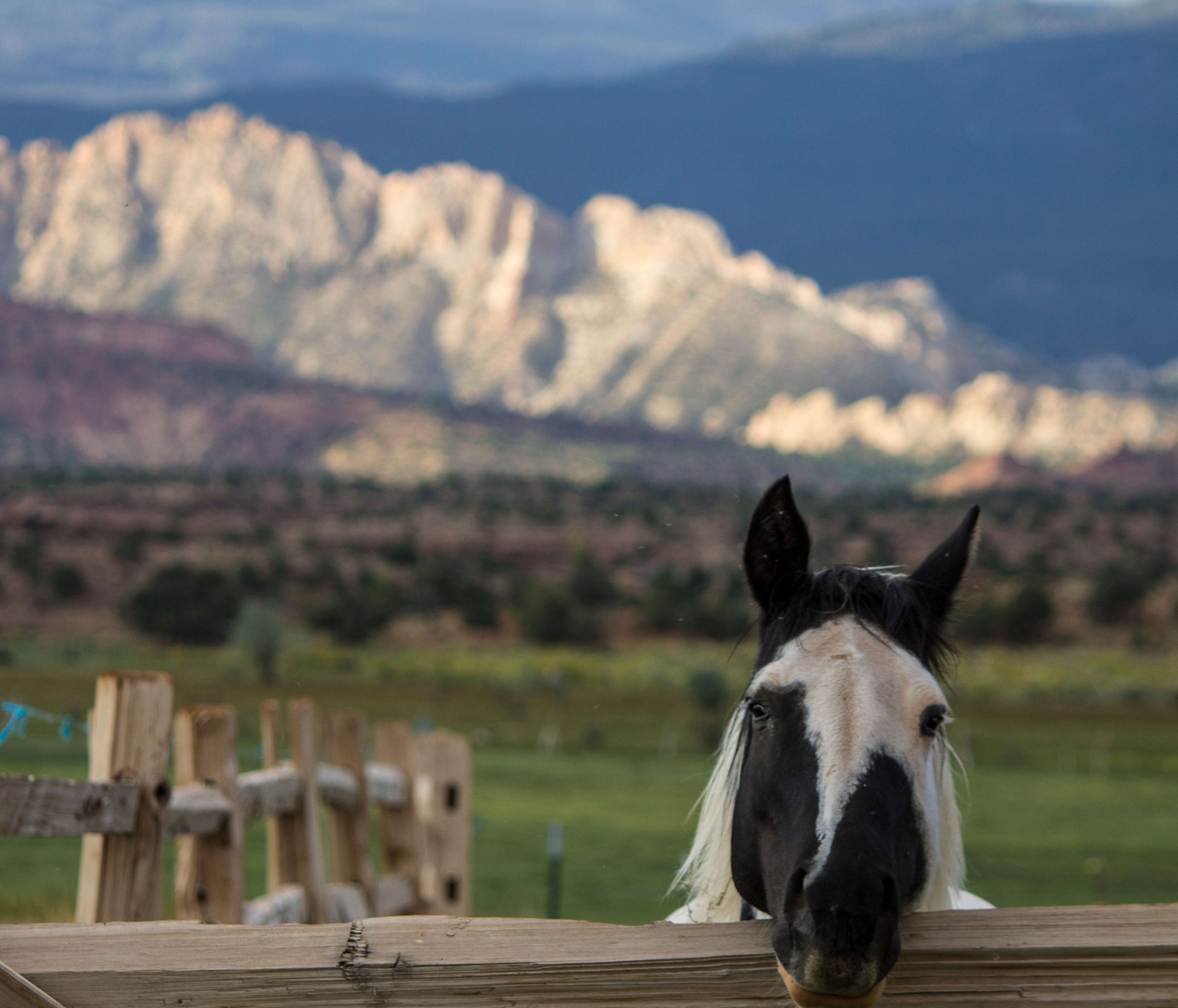
Horse, Torrey, Utah. Jonathan P. Thompson photo.
1 * The proposed rule says “only extreme (D3) and exceptional (D4) droughts would qualify as anomalous drought conditions that can temporarily interrupt perennial flow, and can extend continuously across no more than a five-year timeframe.”
2 This is an appropriate monicker, coined by longtime Colorado journalist Allen Best, and is great for those of us in Generation X or older. But I worry that it might not mean much to anyone under the age of, say, 40? So if you have any more contemporary suggestions for a group of superstar water wonks, aka, Jack Schmidt, Anne Castle, Eric Kuhn, Kathryn Sorensen, and Katherine Tara, I’d love to hear them!
3 Demand response is a term typically used in relation to electricity use. It’s when large power users, or a collection of smaller users, are paid to reduce electricity consumption during times of high demand to ease grid strain. So, for example, during a heat wave, when everyone’s air conditioners are running full blast, the utility or grid operator would signal a factory, say, or a data center, or even a host of smart thermostats, to scale back their operations or dial down the AC during the hottest time of the day when solar generation might be dropping off. The targeted drop in consumption has the same effect as increasing power generation would, keeping supply and demand in balance.
Since Jonathan wonders if anyone under 40 will get the reference to the Traveling Wilburys, here you go:
Colorado ranchers who own some of the state’s most scenic landscapes are joining new research efforts to better understand emerging water quality issues in the Yampa and Gunnison basins, among others.
Pressured by rising stream temperatures and shrinking flows due to climate change, rivers and lakes across the state are showing signs of distress, including algae blooms, some of which are toxic.
At the same time, the Colorado Department of Public Health and Environment and Colorado State University are analyzing water quality and testing how voluntary best management practices, rather than strict regulations, can protect these hallmark water bodies.
Philip Rossi grows hay and runs a cattle operation in the Upper Yampa River Basin above Stagecoach Reservoir. He is among the first ranchers to agree to allow scientists to monitor the water quality, and soon the temperature, of the irrigation water that runs off from his hay meadows.
So far the news has been good, Rossi said. Little if any of the fertilizer he applies to his hay reaches the stream and in the years he’s been working with the CSU researchers, the use of nonfertilized grass strips along the creek that runs through his property has reduced that number even further.
“What I learned is that I wasn’t wasting money. The fertilizer I was putting on was being used, and just as important I wasn’t affecting the stream.”
With results from the first three-year study officially out, another even broader effort involving more ranches is underway. It will add the monitoring of stream temperatures to the analysis.
Erik Wardle, director of Colorado State University’s Agricultural Water Quality Program, said there was little water quality data available in remote regions such as the Yampa Basin. “We wanted some real world data on what’s happening on our ranches and our cow-calf operations.”
As word of the research has spread, more ranchers have come forward to participate, despite skepticism and worry about government efforts to monitor what they’re doing. “Early on I was doing a lot of cold calling, asking ranchers to participate. And a lot of them said, ‘Are you crazy?’ But now I would say 85% of what we’re doing is being driven by these producers. These ranchers have put themselves out there,” Wardle said.
Even in these pristine areas of Colorado, no one expects water quality worries to subside in the warmer future. In response, water agencies in the area are looking for ways to change the way they operate to help streams.
“Water quality on the West Slope has always been assumed to be great,” said Andy Rossi, general manager of the Upper Yampa Water Conservancy District, which owns Stagecoach Reservoir. He is not related to Philip Rossi, the rancher.
“Here we are in snowpack-dominated basins with pristine wilderness areas driving our water supply. But 10 years ago we started seeing changes, like toxic algae blooms in Stagecoach Reservoir and Steamboat Lake.”
Since then, the water district has shifted into high gear to understand what’s happening and why, spending hundreds of thousands of dollars to build a water quality modeling and monitoring program.
Nothing that has been uncovered yet has exceeded a state standard, Rossi said, “yet we still have potentially toxic algae blooms. The assumption has always been that ag is the source of our troubles. But we felt it was unfair to jump to that conclusion without doing the strict science to figure it out.”
Can best practices be shared between ranches?
With early research results in hand, Tyson Ingels, a veteran water quality regulator at the Colorado Department of Public Health and Environment, said the state hopes to avoid a strict regulatory approach for these remote high country lakes and streams, relying on voluntary efforts instead.
“This is a very positive study,” he said. “For mountain hay we didn’t have the best data on how best management practices could impact nutrient levels. This was an area that needed to be better understood.”
Looking ahead, Ingels said the state wants to take a measured approach to these regional water quality issues. That the best management practices that are being used on the Rossi Ranch and elsewhere are working well indicates that water quality goals can likely be achieved without a heavy-handed regulatory effort.
Philip Rossi said he’s feeling optimistic, in part because of all the scientific groundwork that is being laid, as well as the early encouraging results of the studies.
He believes that the temperature studies of the water that is returning to the streams, will also show minimal impact.
The rationale, he said, is that water used to flood irrigate fields seeps into the groundwater, flowing to the stream later, when it has cooled down. This was the belief held by his father and grandfather, and Rossi believes the new studies will uphold those beliefs. “The researchers are going to find out the things that my dad told me and that my grandpa used to say” are true, he said.
Click the link to read the article on the 9News website (Alexander Kirk). Here’s an excerpt:
September 1, 2026
Colorado Parks and Wildlife (CPW) said the sewage has been moving downstream in the Arkansas River and was expected to reach John Martin Reservoir near Las Animas beginning Monday. The City of Pueblo Wastewater Department said that state and city stormwater officials were notified of the discharge issue early Thursday morning, and said the discharge was halted by approximately 11:45 a.m. According to the wastewater department, a pipe inside of the stormwater pipe had a hole cut in the top many years ago. That hole was patched with concrete, and over time the concrete slipped from the hole. The pressure of the sanitary sewer pipe to keep the bypass pumps running caused untreated wastewater to come out of the hole and flow into the stormwater pipe, which flows into the Arkansas River.
Arkansas River Basin — Graphic via the Colorado Geological Survey
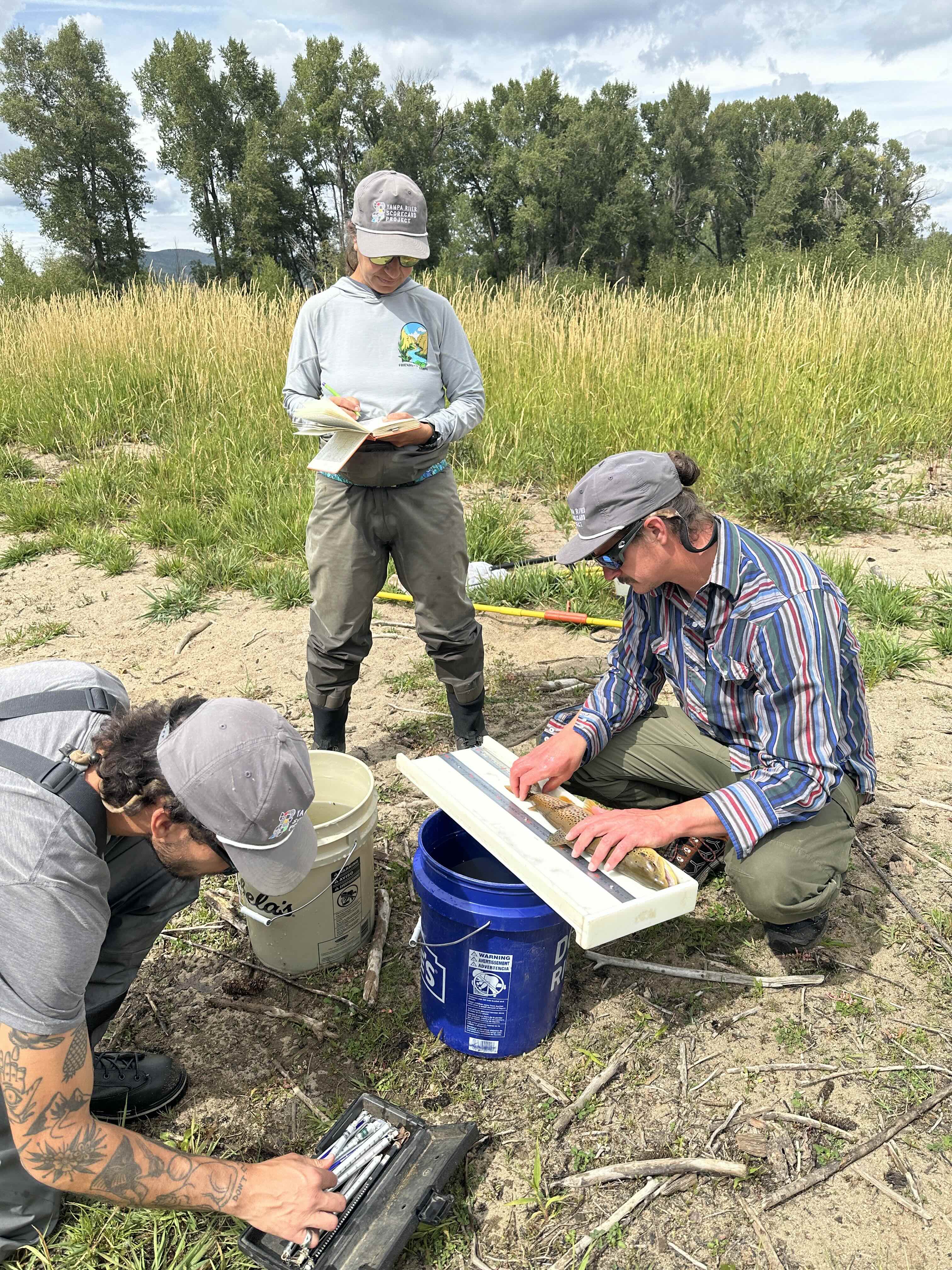
Kim Lennberg from Alba Watershed Consulting, Luke Kimmes from Colorado Mountain College, and John Kemper from Utah State University, collect data on the Elk River in 2025. Photo credit: Friends of the Yampa
Here’s the release from Friends of the Yampa:
July 29, 2026
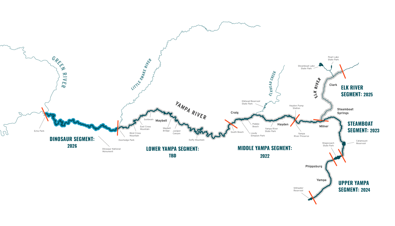
Results for the 2025 Yampa River Scorecard Project focusing on the Elk River Segment are now available. This segment stretches for about 32 miles from the confluence with the South Fork Elk River to the confluence with the Yampa River. The main stem of the Elk flows through a mixture of private property and the Medicine Bow-Routt National Forest, past Glen Eden and Clark, and through a variety of large working ranches and small private developments. It also passes through the Christina State Wildlife Area, a Colorado Parks & Wildlife fishing easement, before reaching the main stem of the Yampa River east of Milner.
A complex combination of parameters is measured and considered when determining the score for any of the project segments. These parameters include flow and sediment regimes, water quality, habitat and riverscape connectivity, riparian conditions, river form, micro and macro habitat considerations, and the biotic community.
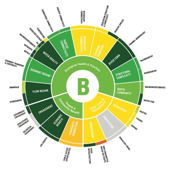
The overall score for the Ecological Health and Function of this segment was a “B.” This represents an overall healthy river. Findings show that this segment should continue to be protected as an example of a well-functioning system that supports both a healthy and productive human community and a relatively natural ecosystem.
Key findings:
Channel morphology largely intact
Limited invasive plant species present
Water quality generally excellent
Some periodic exceedances of temperature thresholds downstream
Bank armoring is the main detrimental factor that negatively influences organisms’ ability to move between aquatic habitat and riparian habitats
Native fish data is sparse and there is widespread and unregulated stocking of non-native fish species
The overall score of “B” refers to the Ecological Health and Function of the Elk River. Other attributes scored included People and Community Benefits and River Uses and Management. Photo credit: Friends of the Yampa
Why Do a River Health Assessment?
The Yampa River Scorecard Project is the implementation of a goal set forth in the Yampa White Green Basin Roundtable “Integrated Water Management Plan.” It is an ongoing river health assessment that will eventually provide data on the health of the Yampa River in its entirety. The goals for this project are to:
1) Provide a source of ongoing data collection related to river health that can document change over time.
2) Improve public understanding of river processes, river use, and river ecosystem services through an engaging public interface that communicates our findings at yampascorecard.org.
3) Provide information related to river health that may be used voluntarily by landowners/land managers to inform river and land-management decisions.
To accomplish these goals, Friends of the Yampa and Scorecard partners have divided the river into six segments. One segment is assessed each year so that after six years, the health of the entire river will be assessed.
The Yampa Basin is divided into 6 focal segments. The year listed is when the majority of the data is collected, and most reports will come out early the following year. Credit: Friends of the Yampa.
The Northern Colorado Water Conservancy District (Northern Water), the U.S. Bureau of Reclamation, Grand County, the Northwest Colorado Council of Governments (NWCCOG), the Colorado River Water Conservation District (Colorado River District) and the Town of Grand Lake today announced a landmark agreement establishing the Three Lakes CLEAR Initiative, a long-term effort to improve water clarity, watershed health and resilience across Grand Lake, Shadow Mountain Reservoir and Granby Reservoir (the Three Lakes).
The Three Lakes System is part of the federal Colorado-Big Thompson (C-BT) Project, which collects and stores water in Grand County and then diverts it for use by C-BT beneficiaries on the Front Range through a series of reservoirs, ditches and tunnels. The CLEAR Initiative continues the ongoing Grand Lake Adaptive Management framework for managing C-BT Project operations and incorporates additional collaborative initiatives to enhance clarity and provide watershed health benefits within and upstream of the Three Lakes System.
CLEAR stands for Clarity, Legacy, Ecosystem, Adaptation and Resilience, reflecting the shared commitment by partners to protect and improve this important resource.
The agreement marks a major milestone following two decades of coordinated work to improve clarity in Grand Lake and water quality in Shadow Mountain Reservoir and reflects a renewed commitment to sustained action and investment. It also provides a long-term framework to continue and expand this work as the Grand Lake Clarity Stakeholders’ Memorandum of Understanding (MOU), established in 2016, expires in December 2026. Today’s action renews and expands upon that MOU, protecting the Three Lakes and tributary watersheds for the next 30 years.
As part of the agreement, Northern Water, the Northern Colorado Water Conservancy District Municipal Subdistrict, and the Windy Gap Firming Project Water Activity Enterprise will provide $30 million over 30 years to address both C-BT Project operations and the broader environmental conditions influencing water quality by supporting implementation of projects and initiatives that address watershed and lake conditions. Of that amount, $20 million will be directed toward project funding to accelerate near-term, priority on-the-ground improvements initiatives, while $10 million will build a long-term reserve fund intended to provide sustained, legacy funding and the flexibility to address future needs as conditions evolve beyond the 30-year agreement.
The initiative continues and strengthens the collaborative adaptive management of C-BT Project operations in the Three Lakes that began with the original MOU, using real-time adjustments to improve clarity in Grand Lake while balancing water supply, power generation and environmental needs. At the same time, the initiative establishes a dedicated fund directed by the parties, to invest in watershed and system health projects that improve water quality and ecological conditions across the Three Lakes system and tributary watersheds.
Projects will focus broadly on watershed and forest health, reducing sediment and nutrient inputs, improving lake and reservoir conditions, and strengthening monitoring and adaptive management tools across the interconnected system.
“The foundation for this landmark agreement to improve Grand Lake clarity and create the Three Lakes CLEAR Fund was laid over decades of effort by many, representing all parties, to improve and use our knowledge of the Three Lakes System for actionable projects that can move the needle for better Grand Lake clarity. The parties have differing interests for sure, but we strive to find common ground because we have a spirit of mutual trust and respect,” said Jeff Metzger, Town of Grand Lake.
Northern Water emphasized the enduring framework the agreement creates to support the long-term health and resilience of the Three Lakes System while benefiting communities on both sides of the Continental Divide.
“The Three Lakes CLEAR Initiative demonstrates how shared stewardship of Grand Lake clarity and the health of the broader Three Lakes System and its watersheds can strengthen the long-term resilience of the Colorado-Big Thompson Project for the benefit of Front Range water users while supporting the natural resources and thriving West Slope communities that depend on them. By creating a lasting legacy of collaboration and investment, this agreement helps ensure these shared resources will continue to be protected for generations to come,” said Esther Vincent, Environmental Services Director for Northern Water.
Grand County Board of County Commissioners Chair Edward Raegner highlighted the importance of the agreement for Grand County and the local communities that have stewarded the Three Lakes watershed for generations.
“This 30-year MOU reflects an unprecedented commitment to Grand Lake’s health and the long-term future of the Three Lakes System. Grand County is proud to work alongside our partners to help preserve Grand Lake’s water clarity for generations to come.”
The Colorado River District emphasized the value of continuing the collaborative approach that has guided clarity improvements in the Three Lakes System for the past decade.
“This MOU continues the collaborative approach that has guided clarity work in Grand Lake and water quality throughout the Three Lakes system since 2016. Over the past decade, we’ve gained valuable knowledge about how to effectively use adaptive management in the system, and this agreement will provide a strong foundation to continue that work for the long term. As a signatory to this MOU, the Colorado River District will continue to be a voice for the Western Slope and advocate for solutions that protect our water resources and the communities which depend on them,” said Rebecca Briesmoore, Senior Water Resources Engineer with the Colorado River District.
Former NWCCOG Executive Director Jon Stavney also welcomed the long-term commitment.
“Since the 1970s, our organization has been engaged in multiple efforts to protect and enhance the water quality of Grand Lake. This MOU represents a new beginning backed by a long-term commitment of substantial resources to the clarity of Grand Lake.”
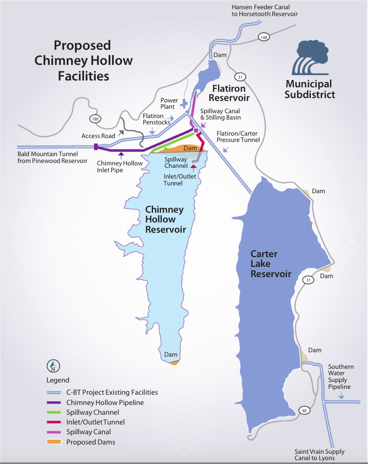
Colorado-Big Thompson Project map. Courtesy of Northern Water.
Northern Water will pay $30 million over the next 30 years to solve long-standing clarity and water quality problems at one of Colorado’s most treasured natural wonders, Grand Lake.
Under the terms of the agreement, the giant water provider will spend $1 million annually to test and implement new solutions to the problem, including weed control, aeration and sediment removal. The deal is the first time a dedicated source of money has been set aside to help the lake, Northern Water spokesperson Jeff Stahla said.
Grand Lake, located near the west entrance to Rocky Mountain National Park, is Colorado’s deepest natural lake and has been a major tourist destination since the late 1800s. A coalition of federal and state agencies, and local advocacy groups have been working and arguing over how to restore it since at least 2008.
“It has been a long and arduous process to get here,” Stahla said. “We’re hopeful that this is a turning point for being able to work together for the common good.”
Grand Lake is a key element of Northern Water’s Colorado-Big Thompson delivery system, which provides water to more than 1 million people on the northern Front Range and thousands of acres of irrigated farmlands.
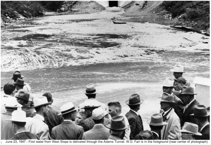
Owned by the U.S. Bureau of Reclamation and operated by Northern Water, The C-BT gathers water from the Upper Colorado River, and stores it in two holding pools built by the federal government: Lake Granby and Shadow Mountain Reservoir. From there it is eventually moved into Grand Lake and delivered via the Adams Tunnel under the Continental Divide to Carter Lake, west of Berthoud, and Horsetooth Reservoir, west of Fort Collins.
Colorado-Big Thompson Project map. Courtesy of Northern Water.
During that process, algae and sediment are carried into Grand Lake, clouding its formerly clear waters and causing algae blooms and weed growth, and harming recreation.
In 2008, the Colorado Water Quality Control Commission moved to set a clarity standard, but it has since been replaced with a clarity goal and the aim of achieving “the highest level of clarity attainable.” Since then, Northern Water and others have implemented different management techniques, including changing pumping patterns, to find ways to improve water quality in all three water bodies.
In 2016, the U.S. Bureau of Reclamation took the first steps required under the National Environmental Policy Act of 1969 to do the scientific and engineering studies needed to fix the system and hold public hearings. But Reclamation stopped the process in 2020, saying that it could not definitively establish any structural alternatives that would work, nor could it find a way forward on funding such a major infrastructure redesign.
Frustration among Grand Lake advocates continued to build, however, and in 2024, Colorado lawmakers passed a resolution calling for more work on the issue.
In 1941, before the Colorado-Big Thompson Project began operating, clarity was measured at 9.2 meters in depth, about 32 feet, according to Northern Water. Since 2016, the goal has been to achieve clarity of 3.2 meters, just over 9 feet. “We’ve been hitting the goals much more steadily than we have before, thanks to changes in the way the water is pumped through the system,” Stahla said.
Still the lake is plagued by infusions of warm, murky water during the summer and algae blooms that harm its recreational value, locals say.
Mike Cassio, president of the Three Lakes Watershed Association and a long-time Grand Lake advocate, said the new agreement was the only way the local interests could see to move forward, given what they say is an imbalance of power between the federal government and Northern Water, and the people of Grand County.
“The Bureau of Reclamation has estimated that replumbing and fixing Grand Lake is a $1 billion project and it would take a congressional mandate to fund it,” Cassio said. “Is this agreement the best that we have? Probably. Is anybody up for a fight with Northern and the Bureau? Probably not. So the best thing to do is to work together.”
In addition to the $30 million, the new agreement also expands the governing body overseeing the work to include the town of Grand Lake, which will for the first time have an official role in how the three-lake system is managed, Stahla said.
The Colorado River District, which represents 15 Western Slope counties, signed off on the deal this week, saying via email that the new agreement would provide a strong foundation for future work on the lake.
Other signers to the agreement include Grand County, the Northwest Colorado Council of Governments, Northern Water, and the town of Grand Lake. It must still be signed by the U.S. Bureau of Reclamation.
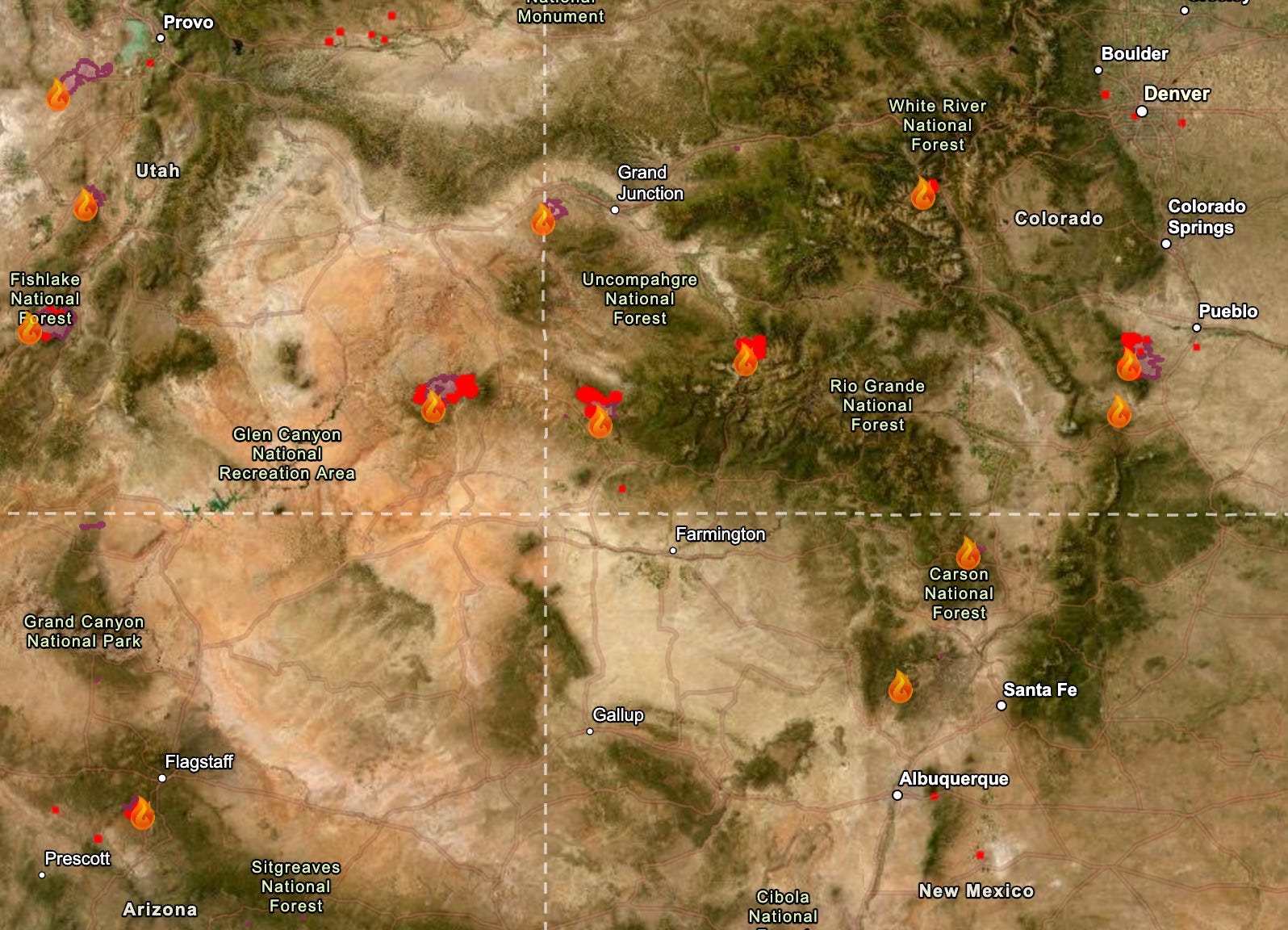
The fire situation in the Four Corners area is not improving. The weather remains hot, dry, and windy, and this week’s forecast calls for more of the same. Next week may even be hotter, if longer-range models hold. Meanwhile, air quality has deteriorated in some places that previously seemed to avoid the worst of the smoke. The good news is that the Fourth of July weekend came and went without any new major fire starts in the region.
So far this year some 37,209 fires have burned through about 3.3 million acres, according to the National Interagency Fire Center. That’s the second highest acreage for the first half of the year in the last decade.
Here’s a rundown of some of the Four Corners area fires. By no means is this a complete list.
The Babylon Fire, burning in the higher elevation parts of Bears Ears National Monument in southeastern Utah, had grown to over 96,000 acres by Monday night, making it the nation’s largest active blaze (the Cottonwood Fire in the western part of the state has gone through about the same amount of acreage, according to Watch Duty). The two are also tied for the fourth largest fires in the state’s recorded history. The Babylon Fire is at 0% containment, with the most active area moving up the west slope of the Abajo Mountains, between Shay Mountain and Mount Linnaeus. Air tankers are pulling water from Lake Powell, and officials are asking boaters to avoid the area between Dangling Rope and Rainbow Bridge.
Closed public lands include: The Needles District of Canyonlands National Park, Manti-La Sal National Forest lands within the Monticello Ranger District, and BLM lands in the Indian Creek Corridor, Beef Basin, Dark Canyon, and the Sweet Alice Wilderness Study Area. Still Open: Natural Bridges National Monument, Cedar Mesa, Grand Gulch, and other lower elevation areas in the southern reaches of Bears Ears National Monument.
The Ferris Fire along the Dolores-Montezuma County line in southwestern Colorado initially burned in a northeasterly direction toward the Disappointment Valley. Then the winds shifted and the most active front of the fire curved back to the northwest, crossing the Ponderosa Gorge of the Dolores River, and is within about 12 miles of the town of Dove Creek. As of Monday night the fire was at 51,622 acres and 22% containment.
The Gold Mountain Fire north of Ouray, Colorado, has burned across almost 29,300 acres of San Juan Mountain high country and was 2% contained as of Monday night. Firefighters on Monday conducted strategic backfiring operationseast of Ridgway to provide more protection for structures in that area. There is a chance of thunderstorms this afternoon and evening, which could bring dry lightning along with gusty and erratic winds, with high temperatures reaching the high 80s and low 90s.
The Pocket Fire north of Sedona, Arizona, has reached 26,442 acres and was at 48% containment as of Monday night. Forecasters are predicting more hot and dry weather today, with the mercury topping out around 100° F and sub-20% relative humidity.
On July 6, the Arizona Department of Environmental Quality approved Energy Fuels’ request to amend its aquifer quality permit for a groundwater monitoring well at its Pinyon Plain Mine near the Grand Canyon. The change raises the allowable concentration of arsenic from .050 milligrams per liter to .055 milligrams per liter and the associated alert level from .040 to .050 mg/l.
The Havasupai Tribe strongly condemned the change in a written statement, calling the approval a “profound attack on the Tribe’s inherent responsibility to guard and protect the waters of the Grand Canyon.”
Energy Fuels asked for the revision — and ADEQ granted it — after finding that construction of the mine’s shaft had created a hydraulic sink that allowed naturally occurring arsenic — a known toxic substance — to move toward the facility’s perimeter wells, putting them in violation of their permit.
So, regulators simply altered the permit’s limits and, according to the tribal nation’s statement, “chosen to weaken environmental protections instead of strengthening them.”
Dr. Bradley K. Esser, a retired Lawrence Livermore Laboratory scientist, submitted technical comments on the proposed revision last year. He cast doubt on Energy Fuels’ hydraulic sink explanation, and demonstrated that the arsenic concentrations detected in the monitoring wells are far higher than regional natural background levels. He posited that it was far more likely the elevated arsenic concentrations came from sump water from the mine’s workings contaminating the groundwater.
Uranium, arsenic, and lead concentrations shot up in the Pinyon Plain Mine’s “sump water,” or groundwater that had flowed into the mine shaft, after active mining began in 2023. While an independent scientist acknowledges that it’s possible elevated arsenic levels in perimeter monitoring wells are the result of a mining-related hydraulic sink pulling naturally occurring arsenic to the wells, he posited that it’s more likely that sump water made its way into the groundwater in the wells. Source: Grand Canyon Trust.
Esser also writes:
🥵 Aridification Watch 🐫
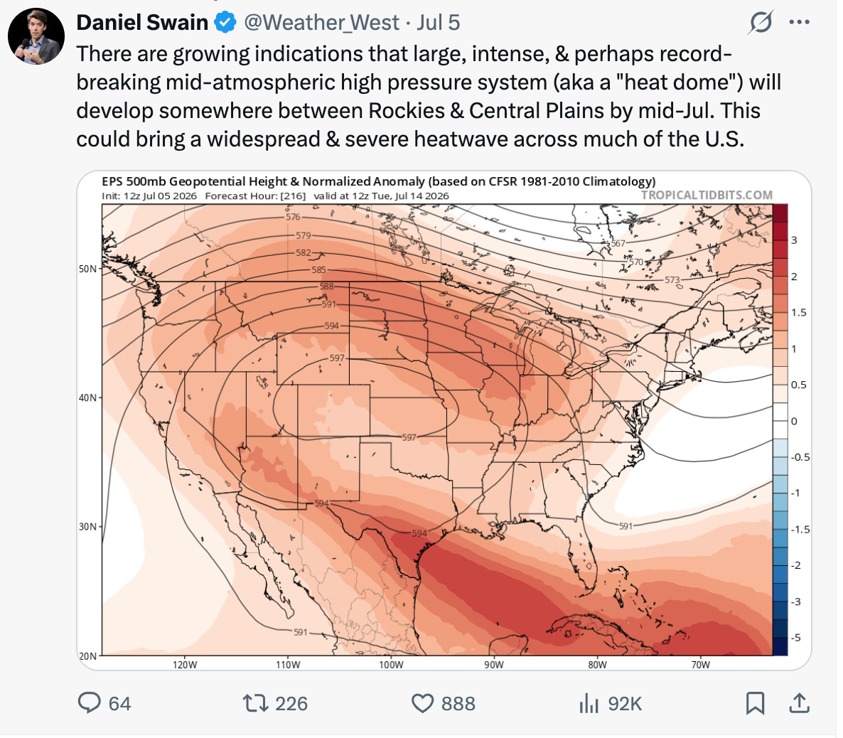
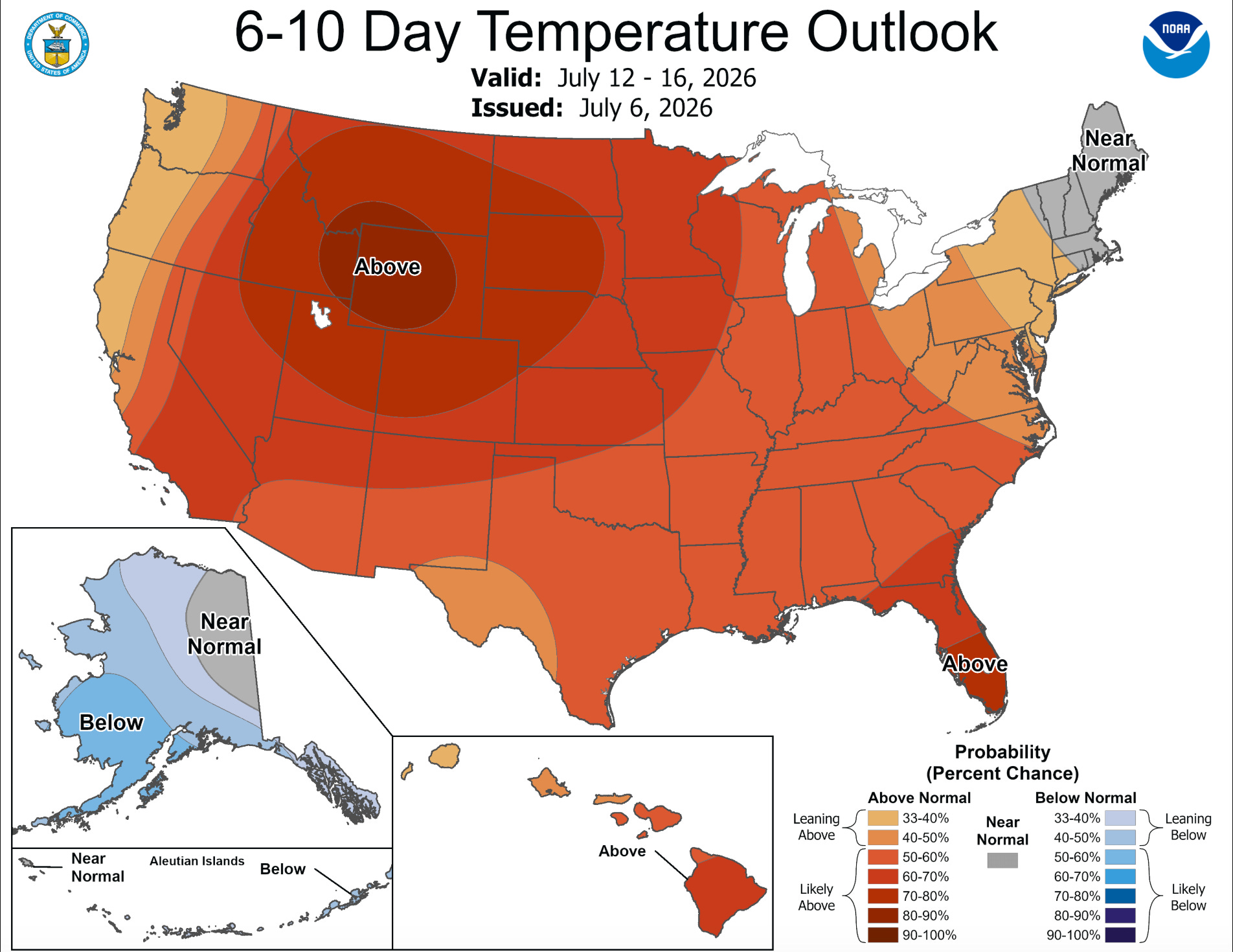
Monsoon season officially kicked off in the Southwest in the middle of last month, but it has yet to bring significant amounts of moisture. Earlier forecasts predicting higher than average precipitation beginning later this month are still in place for some parts of the West, but they likely will be accompanied by above-normal temperatures just about everywhere.
Next week isn’t looking so hot for fire-dousing moisture in the Southwest, but after that the chances of above-normal precipitation start climbing.
Smoky skies and three-digit heat? Ick.
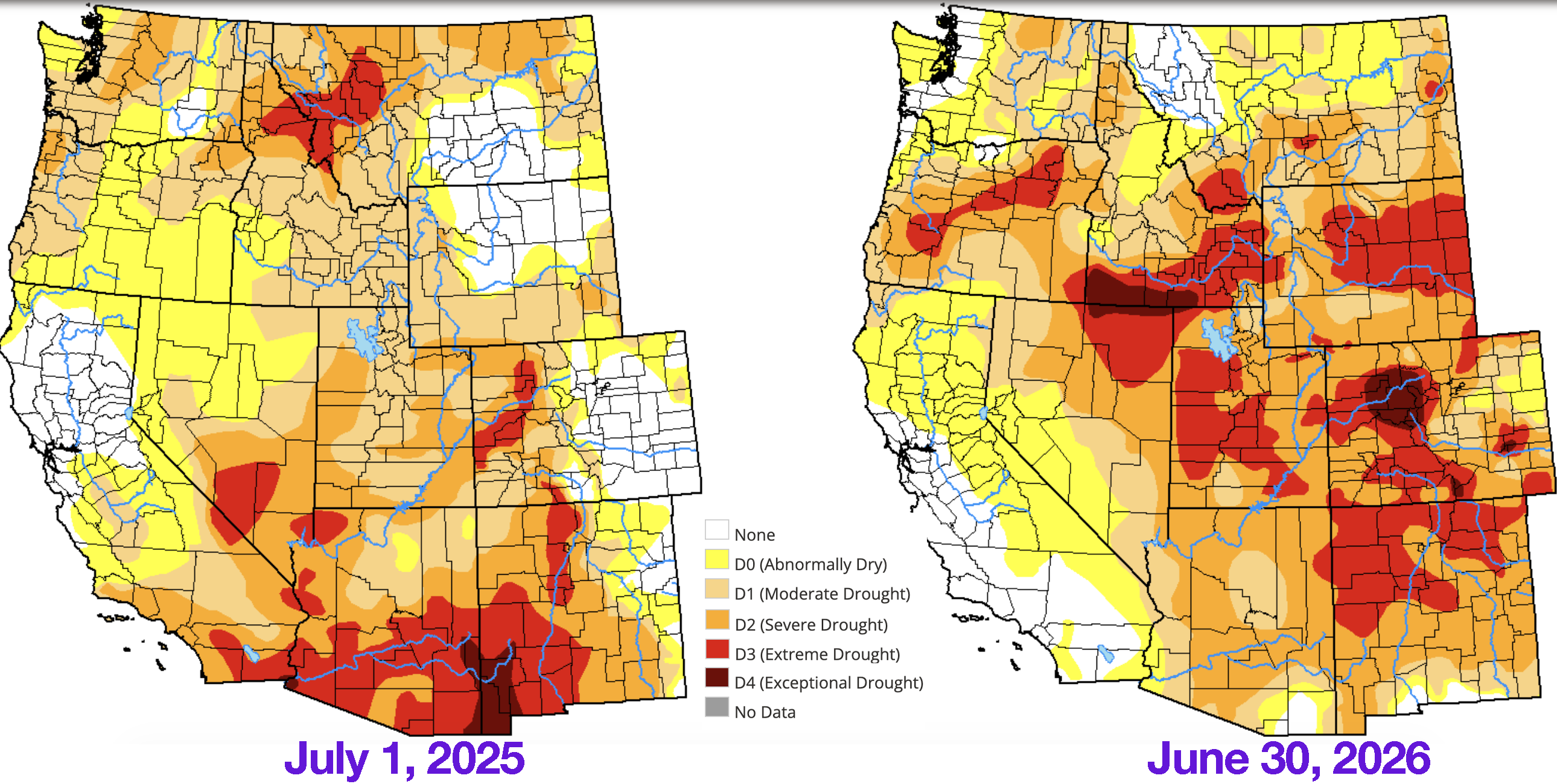
The drought situation has grown worse over the last year in most of the Interior West, though there has been improvement in the deep Southwest. Source: U.S. Drought Monitor.
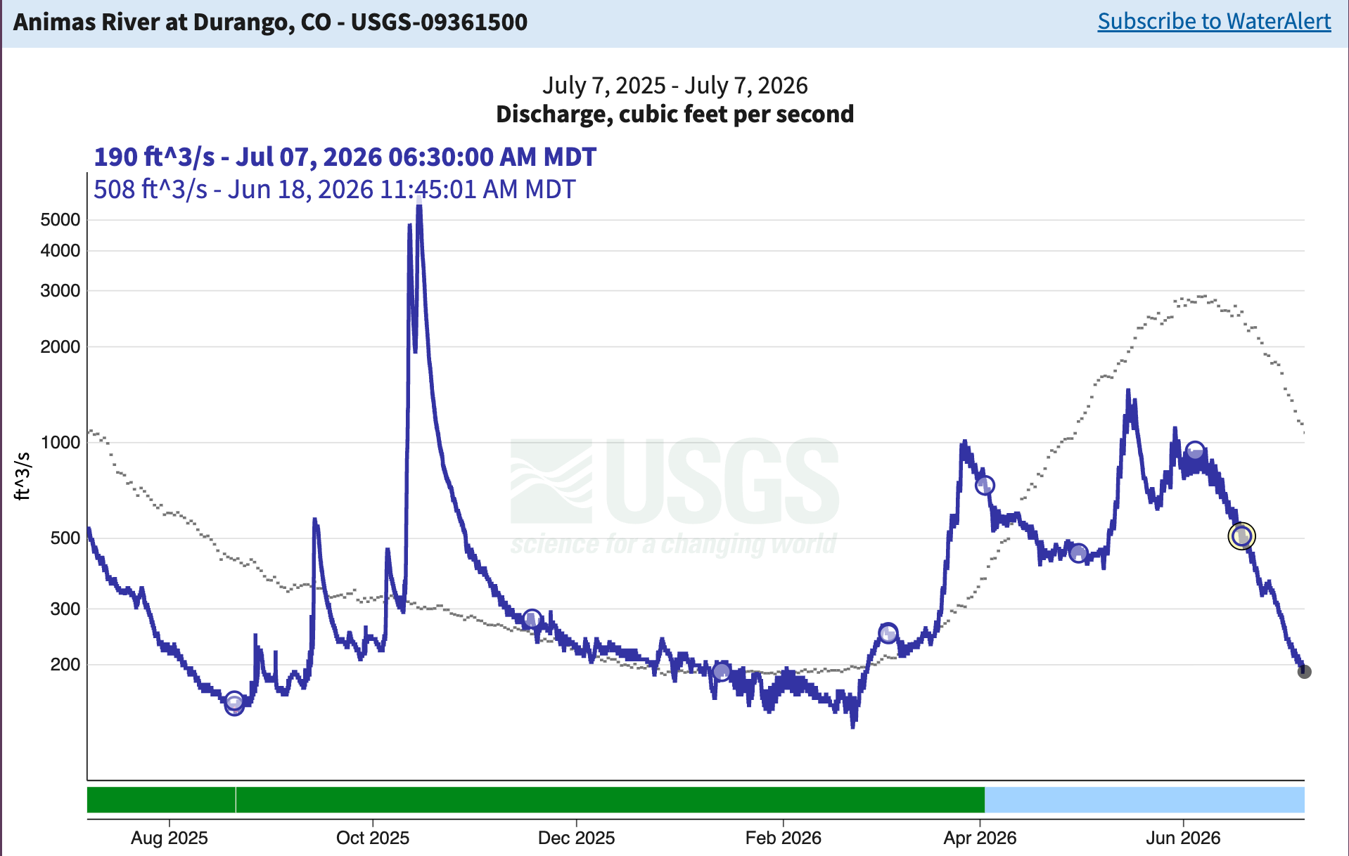
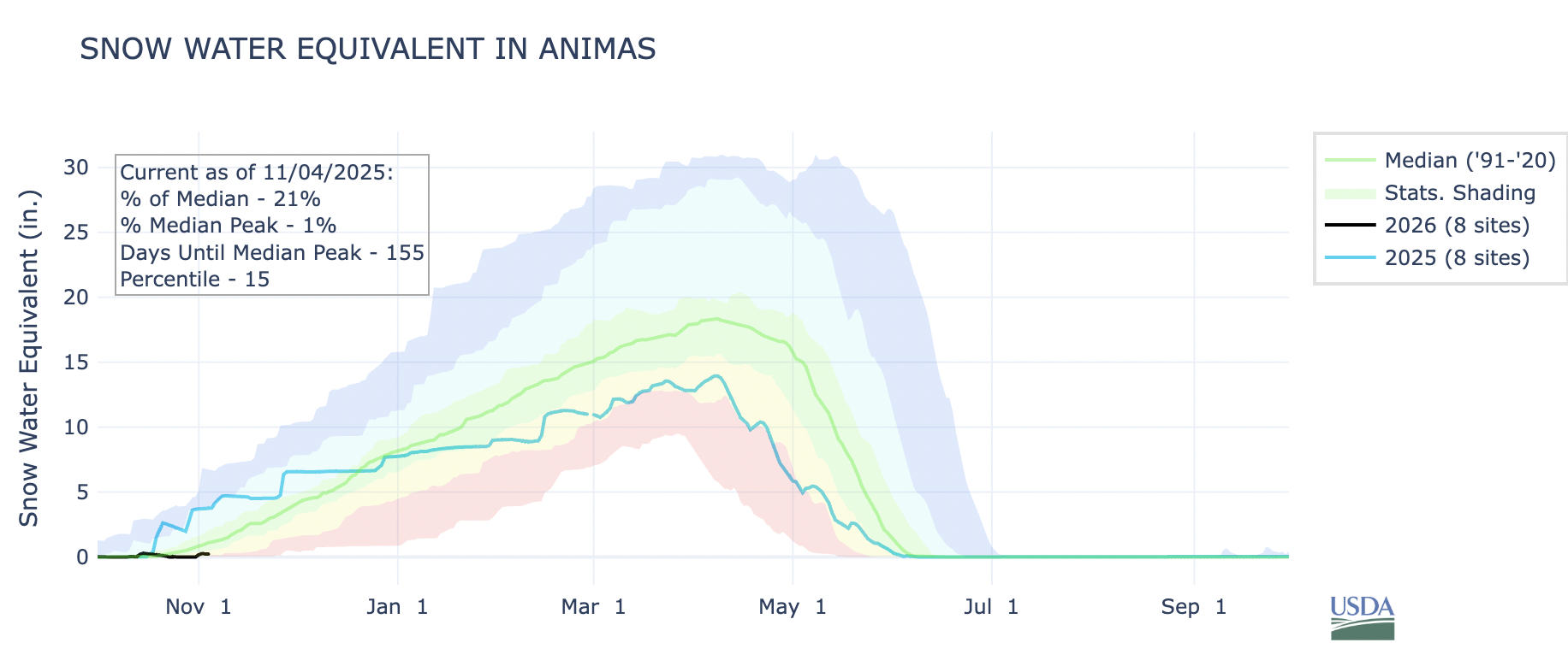
‘As you might expect, the hot, dry weather is taking a toll on streams around the region. The Animas River through Durango is running at 190 cubic feet per-second; the median flow for this date is over 1,000 cfs.
📸 Parting Shot 🎞️
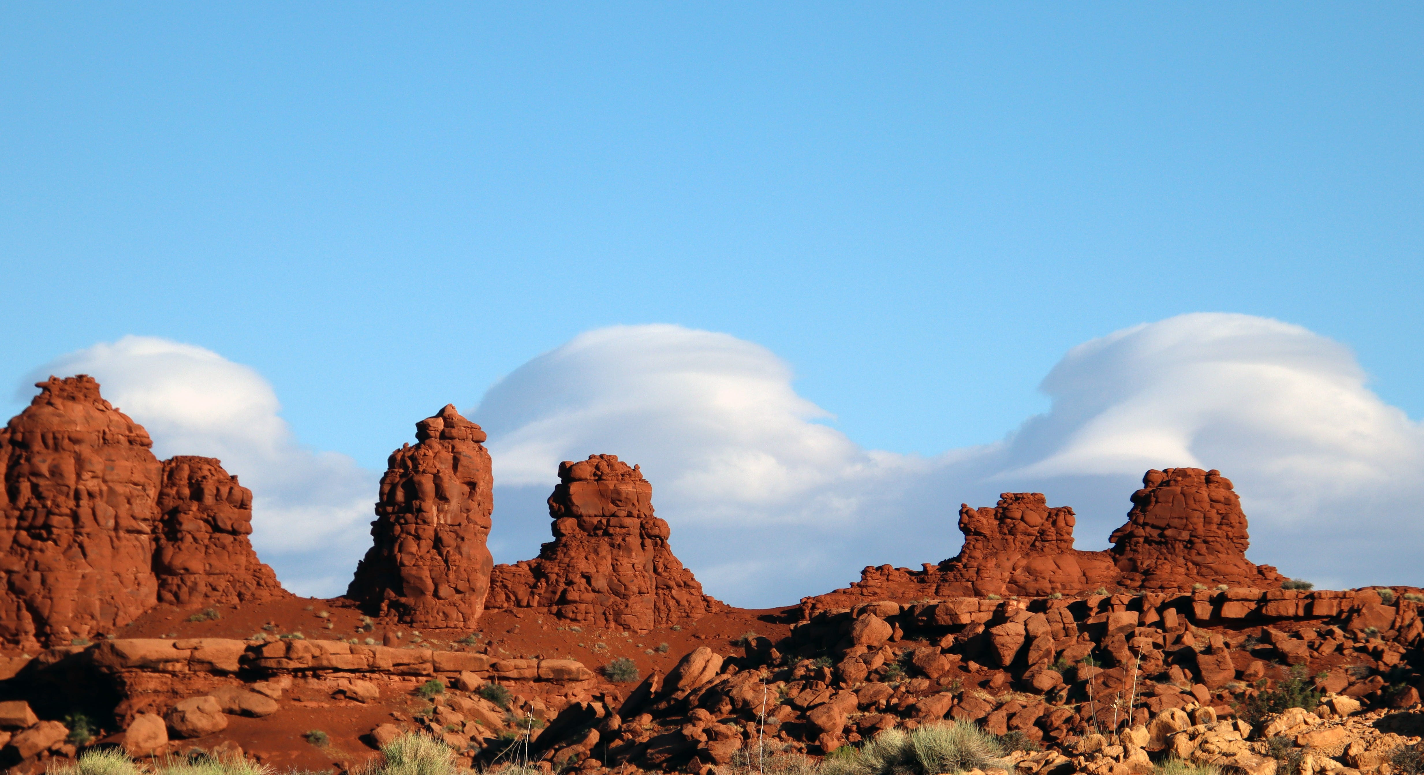
Red rocks and crazy clouds in Utah before fire season had arrived and sullied up the skies. Jonathan P. Thompson photo.
Click the link to read the article on the Pagosa Springs Sun website (Clayton Chaney). Here’s an excerpt:
July 1, 2026
The Archuleta County Board of Health (BoH) held a special meeting on June 15 to consider approval of Regulation 43, pertaining to on-site wastewater treatment system (OWTS), also known as septic systems…
According to the regulation attached to the meeting agenda, “The purpose of these Regulations is to establish the minimum standards for the location, design, construction, performance, installation, alteration, and use of OWTS with a design capacity equal to or less than 2,000 gallons per day within the Jurisdiction.”
[…]
It also states that the regulations apply to all OWTS in the unincorporated areas of the county and over all municipal corporations within the territorial limits of Archuleta County.
Furthermore, it explains that an “OWTS permit must not be issued to any person when the subject property is located within a municipality or special district that provides public sewer service, except where such sewer service to the property is not feasible according to the determination of the municipality or special district, or the permit is otherwise authorized by the municipality or special district.”
The document explains that Archuleta County Water Quality Department “may enter upon a private property at reasonable times and upon reasonable notice for the purpose of determining whether or not an operating OWTS is functioning in compliance with the OWTS Act and applicable regulations adopted pursuant thereto and the terms and conditions of any permit issued and to inspect and conduct tests in evaluating any permit application.”
Map of the San Juan River, a tributary of the Colorado River, in Arizona, Colorado, New Mexico and Utah, USA. Made using USGS National Map data. By Shannon1 – Own work, CC BY-SA 4.0, https://commons.wikimedia.org/w/index.php?curid=47456307
While the Trump administration 2.0 has so far rexfrained from trying to shrink or eliminate national monuments, its non-executive-branch proxies just keep on trying.This week the 10th Circuit federal appeals court issued a decision keeping alive Utah’s lawsuit challenging Joe Biden’s 2021 re-establishment of Grand Staircase-Escalante and Bears Ears national monuments following Trump 1.0’s shrinkage of the same.
The state and Garfield and Kane counties filed one lawsuit in 2022, with the Blue Ribbon Coalition and other parties filing their own suit. In 2023, a federal court dismissed both lawsuits; that ruling was appealed.
This week’s decision confirmed the dismissal of the Blue Ribbon suit. But it also determined that presidential national monument designations under the Antiquities Act are subject to federal judicial review, and sent Utah’s case back to the district court.
***
Photo credit: Jonathan P. Thompson/The Land Desk
The Bureau of Land Management is moving forward with three travel management plans in Utah that will determine which roads, trails, and areas of the respective field offices’ jurisdiction are open to motorized vehicles. Given that the stated aim is to bring the plans in line with Trump’s recent executive order rescinding restrictions on motorized vehicles on public lands, we can assume that the idea here is to expand motorized access to some remote areas. The plans include:
The Moab Field Office has released preliminary alternatives for the Dolores River Travel Management Plan on about 127,000 acres in Grand County, Utah, east of Moab and abutting the Colorado border. This would include roads along the Utah section of the Lower Dolores River, and on mesas and in canyons on either side of it. Maps of the alternatives can be found here. This one is not yet open to public comment.
The Kanab Field Office has released a draft environmental assessment for its Trail Canyon Travel Management Plan on nearly 330,000 acres in Kane County. It is open to public input.
And the Vernal Field Office has also released a draft review for the Dinosaur North Travel Management Plan. The public comment period is open.
***
I typically stay away from electoral politics, especially the horse-race part of it and polls and such. But sometimes a particular contest or candidate can provide a lens on bigger trends or phenomena, and so are worth looking into.
The latest race that has caught my interest is the one to replace Sen. Cynthia Lummis, the Wyoming Republican who is retiring at the end of this term. Since it’s Wyoming in 2026, it’s safe to assume the winner will be a Republican (though this wasn’t always the case), meaning the primary is the contest that matters. The front-runner, I suppose, is Rep. Harriet Hageman, the Trump sycophant and MAGA extremist who unseated Liz Cheney back in 2022 after Cheney failed to show adequate fealty to Trump.
But it’s one of her challengers that I’m interested in: Sam Mead. Mead is a fifth-generation Wyoming rancher, comes from a long line of Republican Wyoming politicians, and is the nephew of former governor Matt Mead. Mead is young (36), charismatic, has strong conservative credentials on fiscal issues and gun-rights, and a background in engineering and business, having run a whiskey distillery in Kirby. But what really distinguishes him from his opponents is his willingness to speak out against some of Trump’s policies, and his priority on protecting public lands and keeping them in the public’s hands.
Mead, in other words, appears to be an old-school, pre-MAGA Western Republican. He reminds me a bit of Wyoming Gov. Mark Gordon, back before extreme polarization pulled him more and more rightward and into MAGA land. Wyoming’s primary is on Aug. 18.
Meanwhile, Utah just held its primaries, with some surprising results. Utah State Senate President Stuart Adams, a Republican, was defeated by challenger Stephanie Hollist. Adams was a strong supporter of the controversial proposed Stratos Project data center complex on the north shore of the Great Salt Lake. Also, incumbent Rep. Celeste Maloy trounced challenger Phil Lyman in the GOP primary for the 3rd Congressional District, with about 70% of the vote.
While Maloy was endorsed by Trump, and has plenty of extreme views, Lyman is the more MAGA of the two. And Trump pardoned Lyman after his conviction for leading an OHV rally down Recapture Canyon in the southeastern part of the state. Political consultant Taylor Morgan told the Utah News Dispatch that Lyman’s resounding defeat showed that his “very angry, very conspiracy-based, populist, toxic form of Republicanism (is) frankly wearing very thin, especially here in Utah.” Let’s hope he’s right!
Pumpjack in the Aneth oil field. Jonathan P. Thompson photo.
I wrote Tuesday about how the Trump administration is eviscerating Biden-era oil and gas rules aimed at reducing methane emissions and ensuring companies clean up their own messes rather than foisting them onto the taxpayers. Now the changes are open for public comment.
Here are a few of the changes Trump and co. are proposing:
Bring back pre-Biden reclamation bond rates, which amount to just over $2,000 per well, which is insane, since the cost to reclaim and plug a single well easily can exceed $100,000. These numbers incentivized petroleum companies to walk away, forsake the bond, and abandon the well, leaving the tab for the taxpayers.
Reduce the current $10 minimum per-acre bid for leasing public land to $2, restore noncompetitive leasing, and slash royalties and filing fees for oil and gas companies.
Implement a new fee for protesting leases. And they plan to cut the 90-day public input period to just 10 days. In other words, they’re trying to cut out the public from decisions regarding public lands.
Gut the waste prevention rule (they wanted to roll it back altogether, but chose to revise it instead because it wasn’t clear which rule would replace it) by removing limits on royalty-free flaring and killing requirements that companies develop leak detection and repair plans.
Trump’s changes to the waste prevention rule will turn back the regulatory clock to the days when oil and gas operations on federal and tribal land vented and flared an average of 44.2 billion cubic feet annually of methane, which is usually accompanied by nasty volatile organic compounds and other dangerous compounds. That’s as bad for the climate as burning around 9 million tons of coal. But it also amounts to lighting money — your money — on fire and throwing it away. That vented methane is basically the same stuff you pay for to run your furnace, or to generate much of the electricity running through the grid. And since operators don’t pay royalties on gas they throw away, that cost American taxpayers some $166 million in lost revenue over a decade.
The result of all of this (and more) will be to rob taxpayers and sacrifice public lands and the climate to subsidize the same energy corporations that are raking in obscene profits thanks to Trump’s disastrous war on Iran. The administration argues that their proposed changes will save petroleum corporations operating on federal lands $17 million annually in compliance costs.
That sounds like a lot of money, until you realize that high oil prices have driven corporation’s profits to absurd highs. During the first quarter of 2026 alone, ExxonMobil raked in $8.8 billion in underlying, adjusted profits. Somehow, I don’t think several million in compliance costs is going to deter them from drilling.
🐟 Colorado River Chronicles 💧
Many of the West’s streams have entered their summer low-flow phase, a period that falls between the end of snowmelt and the beginning of the monsoon, while irrigation diversions are in full-swing. One of the most dramatic cases of this is, perhaps, the Colorado River itself as it flows through Grand Junction. This morning, the river was running at just 366 cubic feet per second near Palisade, which as reader Dave Grossman pointed out is low enough to allow someone to walk across the sprawling river bed.
Some other notably low flows:
Animas River in Farmington, NM: 104 cfs.
Dolores River at Bedrock, CO: .76 cfs (effectively dry)
White River near Watson, UT: 76.4 cfs
Green River above Flaming Gorge: 551 cfs
Green River below Flaming Gorge: 1,590 cfs
San Juan River near Caracas, CO (above Navajo Reservoir): 85 cfs
Colorado River near Hite, UT: 4,300 cfs
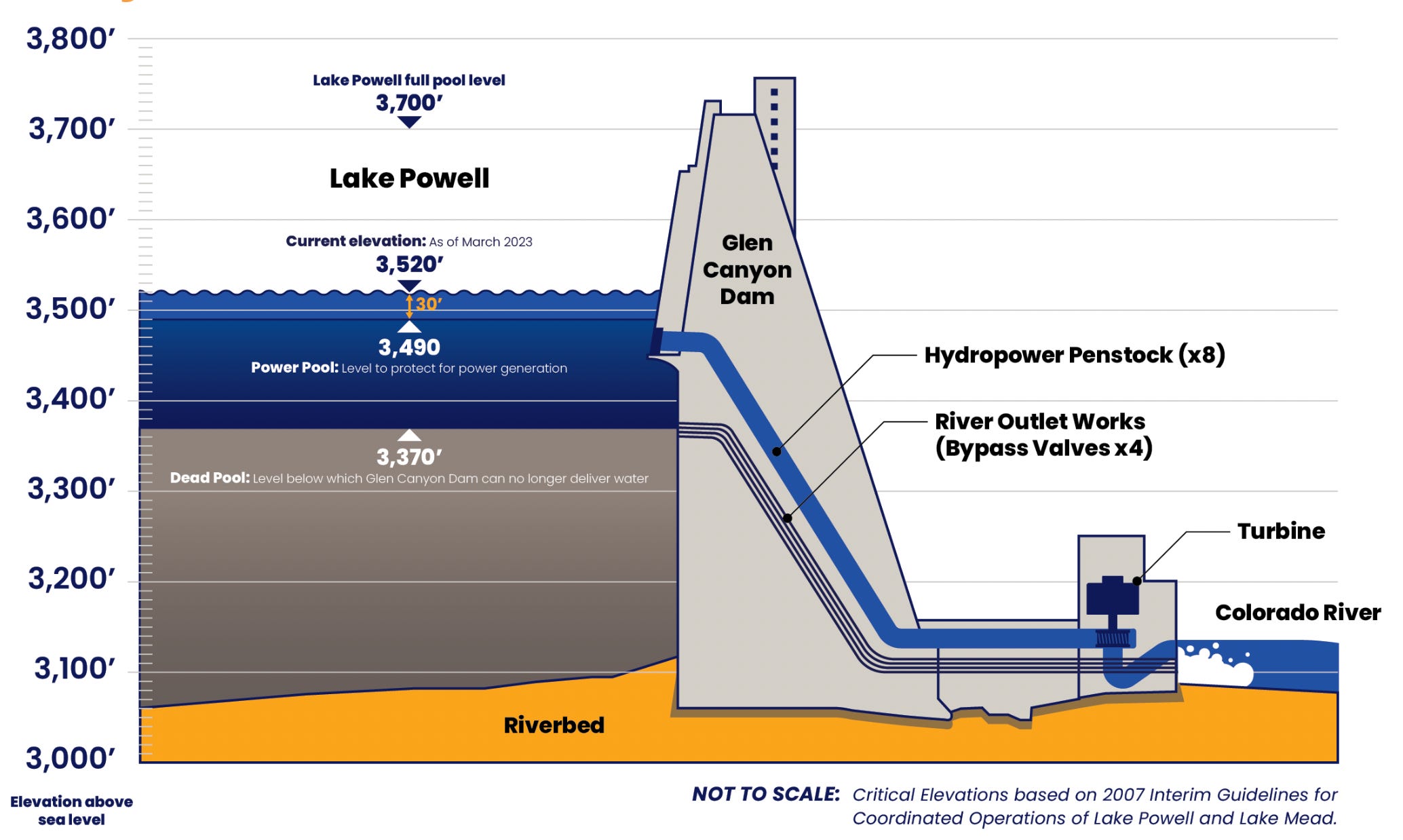
This has reduced daily average inflows into Lake Powell to about 4,800 cfs and dropping. It would be much lower than that, except that flows are being bolstered by upstream reservoir releases. Either way, inflows are far less than Glen Canyon Dam releases, which are averaging about 8,500 cfs daily (approx. 6,500 cfs at night and 10,600 cfs during the day). This disparity, exacerbated by reservoir evaporation, is lowering Lake Powell’s surface level, which currently sits at about 3,526.75 feet. Without substantial upstream rain, it will likely drop to 3,520 feet by early August.
📖 Reading (and watching) Room 🧐
Matt Jenkins wrote an excellent overview for the Water Education Foundation of the potential “Grand Bargain” on the Colorado River, which would require both the Upper and Lower basins to give up some of their Colorado River Compact claims not only to keep the system from collapsing, but also to avoid litigation.
The piece lays out the fact that the Compact is not only outdated, but also internally conflicted, in that it apportions the Upper Basin 7.5 million acre-feet of water per year, while also obligating it to allow the same amount of water to flow to the Lower Basin annually. That’s just not possible these days, given that there’s far less than 15 MAF in the river.
Southeastern Utah is known mostly as a mining hotspot for uranium, copper, with lithium emerging more recently. But it also hosts a potash extraction industry, and at least one company is looking to expand the potash footprint. Sage Potash says it has secured permits from Utah and San Juan County to begin drilling at is Sage Plain Potash project.
While this is only exploratory drilling, it’s notable in that it’s not occurring in the Lisbon Valley or near existing potash sites near Moab. Rather it is on the Great Sage Plain southeast of Monticello, in the archaeologically rich zone north of Hovenweep National Monument.
***
Prior to mining, snowmelt and rain seep into natural cracks and fractures, eventually emerging as a freshwater spring (usually). Graphic credit: Jonathan Thompson
Yet another reason to worry about spewing more carbon dioxide into the atmosphere via fossil fuel burning: It can exacerbate acid mine drainage, the phenomenon that leads to toxic heavy metal loading in streams and other waterways. That’s the conclusion of a peer-reviewed study published in Communications Earth & Environment this April.
Acid mine drainage occurs when a mine excavation exposes once-buried sulfide-bearing rocks such as iron pyrite (FeS2) to oxygen and water. The hydrogen, sulfide, and oxygen come together to form sulfuric acid (H2SO4). Thus, the water becomes acidic, or its pH drops. The acidity dissolves heavy metals and the water picks them up. As the pH level of the water drops below 4.8, acidophilic bacteria begin feeding off the metals, releasing more acid into the solution and causing metal loading to occur up to 1 million times faster than in water with higher pH. Metal loading is bad for fish and other aquatic life.
The study found that elevated atmospheric carbon dioxide levels enhance the acidophilic bacterial activity, which accelerates iron and sulfur oxidation, acid formation, and metal loading. Zinc and cadmium, both of which are harmful to aquatic life, are more sensitive than other metals to rising carbon dioxide levels. Zinc loading is especially problematic in the Upper Animas watershed in southwestern Colorado.
***
Okay, I really don’t care that Anfield bought its first underground haul truck for its Velvet-Wood uranium mine in the Lisbon Valley of southeastern Utah. But I found this press release interesting for another tidbit: The haul truck was built by Young’s Machine Company, located in Monticello, Utah. I never knew Monticello had this sort of manufacturing industry. I gotta say, it’s kind of cool.
The Hoback River joins the Snake River following a landslide upstream on June 18, 2026. Robert Frodeman photo.
🚣🏽 Water Watch 🌊
Water Quality in the Greater Yellowstone
A Guest Post by Robert Frodeman
Four million people visit Teton County, Wyoming, each year. They come to hike, float, and ski, snap pictures under the elk antler arches, and to partake in the myths of the American West. As the sign at the top of Teton Pass says, “Welcome Stranger. Yonder is Jackson Hole, the Last of the Old West.” Visitors expect to find a pristine environment. They don’t expect water quality problems reminiscent of a developing nation.
Teton County has some of the best drinking water in the country. Or most of Teton County does: Hoback, in the southern part of the County, has a nitrate problem. Nitrate is a health risk — most acutely to infants under six months, in whom nitrate is converted to nitrite by gut bacteria, interfering with oxygen transport in the blood and causing methemoglobinemia (blue baby syndrome). Many of the water systems in Hoback are on their last legs: two weeks ago, I had no running water and then a boil order at my home.
Jackson is the town, Jackson Hole is the valley that runs north of town in front of the Tetons. (‘Hole’ was what mountain men called a valley.) If you drill 20,000 feet into the valley floor you will hit the same sandstone layer that sits on top of the Tetons. This implies that the Tetons have risen some 25,000 feet over the last 10 million years.
Of course, mountains come down as they go up: the Tetons have been shedding sediment across all that time, piling up thousands of feet of gravel on the valley floor. Still more gravel was brought by the glaciers that flowed down from the Yellowstone Plateau. The Snake River meanders in front of the Tetons, but much of the river passes unseen below the surface, forming what is known as the Snake River Aquifer.
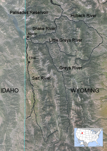
In effect, Jackson and Jackson Hole sit on top of a huge bathtub filled with gravel and water. This provides an abundant source of high-quality water for the town. But the bathtub only extends so far. The southern rim of the tub comes up at Munger Mountain five miles south of town. This is where the Yellowstone glacier stopped, and where the Snake River Canyon begins, which runs for 30 miles to Alpine and the Mormon communities of Star Valley.
Hoback lies four miles south of Munger Mountain — beyond the reach of the aquifer. Local residents must drill for their water. Local wells reach 200 feet down to the Bear River Formation. The water isn’t ideal – it’s brackish and can have a distinct sulfur smell (as do some of the local hot springs). The groundwater is also contaminated from horse farms and pig farms and (mainly) septic tanks and leach fields. Septic tanks can leak, and there is not enough biotic activity at this elevation and latitude for leach fields to function well. The result is nitrate levels in our drinking water which sometimes exceed EPA daily maximums.
Hoback is distinctive not only because of its geology. The billionaires live elsewhere in the County. There are two trailer parks nearby. Historically, local politicians have directed their attention to the Town of Jackson, Wilson, and the ski resort of Teton Village. But this has changed in recent years. Carlin Gerard of the Teton Conservation District formed a Hoback Stakeholders Group in 2019 to highlight drinking water problems. Covid disrupted that effort, but then a local non-profit called Protect Our Water Jackson Hole brought its energy and resources to southern Teton County.
In 2023 Hoback residents formed a water and sewer district. The district has now raised $7 million from the County and the State to build a municipal drinking water system. Water will be drawn from the Snake River just above the confluence with the Hoback. Construction should begin this fall and be done in a year or two depending on the weather.
At first it will only serve 125 residents: the district was made small out of fear of opposition. Teton County is solid blue, but past attempts had failed because of Hoback’s history of Red State, don’t-tread-on-me politics. In any case, it turned out that the demographic transition had already occurred: when the election was held the vote was 36-0 in favor. And there are now plans to annex a new affordable housing development that Teton County hopes will help address the local housing shortage.
Of course, the new system will only isolate residents from the nitrate problem. The environment will remain polluted, and people outside the district will still be on wells. The district has begun to price out a wastewater system, which is liable to be quite expensive. But you’d hope for nothing less for the Greater Yellowstone Ecosystem – and officials would hate to see an article in the New York Times about Teton County’s leaky septic systems.
Map of Greys River in Wyoming, United States. By Feydey – Nasa World Wind 1.3.5 public domain NLT Landsat 7 satellite photo, layered with PD vmap0 vector data. Image:Map_of_USA_highlighting_Wyoming.png was used for the smaller image., CC BY-SA 3.0, https://commons.wikimedia.org/w/index.php?curid=1589723
The Havasupai Tribe is concerned about a proposed increase in the allowable arsenic level near the Pinyon Plain uranium mine.
State regulators claim the increased arsenic is naturally occurring, not a result of mining pollution.
Tribal leaders and environmental groups worry the change could contaminate Havasu Creek, the tribe’s sole water source.
The Havasupai Tribe has raised new concerns about a proposal to allow higher levels of arsenic in a groundwater monitoring well near the Pinyon Plain uranium mine south of the Grand Canyon, warning that the changes threaten Havasu Creek, the tribe’s sole water source. A proposed amendment to a state Aquifer Protection Program permit would revise the mine’s alert level and aquifer quality limit for arsenic after groundwater monitoring detected changes in arsenic concentrations in the well. According to the Arizona Department of Environmental Quality, the changes were not the result of pollutants discharged from the mine into the aquifer, but naturally occurring.
In a June 25 public notice, the agency said that Energy Fuels Resources, Inc., the mine’s operator, and ADEQ have entered into a changed application agreement for an amendment to the Pinyon Plain Mine’s permit.
“The Havasupai Tribe first learned of the proposed amendment, which appears to have been a private deal between ADEQ and Energy Fuels, only after a concerned citizen discovered this new amendment on ADEQ’s website and promptly notified the Tribe,” said Havasupai Tribal Chairwoman Melinda Yaiva.
The Havasupai Tribe was shocked by ADEQ’s decision, she said, citing longstanding concerns that the Pinyon Plain Mine could contaminate Havasu Creek, the tribe’s only water source. Tribal leaders said the creek is vital to the community, its culture and its tourism economy, and reiterated their opposition to the mine.
The country’s most severe drinking water problems, from high levels of contaminants and foul-smelling water to pipe breaks, low water pressure, and expensive rates, are generally found in the thousands of small systems that serve dozens of people up to a few thousand.
These systems are public health crises waiting to emerge, said Denise Schmidt, director of water at the Environmental Policy Innovation Center, a group that works with water utilities on infrastructure funding.
Though some are perpetually struggling, small water systems, especially those serving low-income communities, are encountering a fresh set of economic and political hurdles in their quest for safe drinking water.
In recent industry surveys, small utilities report that accessing financing to repair and upgrade their systems is becoming increasingly difficult. Their credit ratings are deteriorating, making borrowing more expensive. The rates they charge customers are not covering the cost of providing water service, thus digging a long-term financial hole. Extreme weather is burdening them with unexpected and daunting repairs to their reservoirs, treatment plants, and pipe networks. Federal water quality mandates for PFAS and lead pipe replacements, though both providing public health benefits, are an added cost.
Small systems, in effect, are walking a precarious path. They are trying to survive today while also staring at a gathering wave of necessary replacements to aging pipes and treatment plants.
The Trump administration and Republican allies in Congress, meanwhile, are casting more obstacles. The White House’s tariffs have increased the price of equipment and materials. And the House’s fiscal year 2027 budget would cut the main federal water infrastructure program by about a quarter.
“I don’t think people realize how big this wave is and how much it’s going to cost,” said Blake Anderson, president and founder of Mogollon Water Management, a company that operates and maintains 11 small water systems in northeast Arizona. “The utilities that were built in 1970 now are 56 years old. There was a lot of development that happened back then. And all of these waves are going to start crashing.”
Negative Outlook
Crashing sounds are gaining strength.
Last year, for the first time, S&P Global, a credit rating agency, lowered the financial outlook for small water and wastewater utilities from stable to negative. Large and medium utilities remained stable.
The increased pessimism for small water utilities is due to stiffening financial headwinds, said Malcolm D’Silva, an associate director at S&P, which rates roughly 1,700 water and wastewater utilities. Ninety-one percent of the agency’s credit downgrades last year were for small systems, he said. Credit downgrades increase the cost of borrowing.
D’Silva narrated a story in two parts. One is the “expense squeeze.” Costs are rising across the board. First from the post-Covid inflation and supply chain shortages, and now from the Trump administration’s tariffs. Half of the utilities that responded to the American Water Works Association’s annual survey said that tariffs had “moderate or considerable” pressure on equipment and materials costs. At the same time, revenue is not keeping up. In the same survey, only 43 percent of utilities said they charged customers enough to fully cover service costs.
The second part is managerial. Small systems typically do not have the technical expertise, staff, or budget to analyze their infrastructure and apply for funding in the way that larger utilities do. Some might keep only paper records of their pipe networks. The smallest systems have volunteer board members or staff that might also oversee the fire department and run a business.
The positive news is that last year might have been the bottom for small systems, D’Silva said. S&P is seeing some improvement in the first half of 2026, with the rate of downgrades slowing. More utilities have instituted rate increases to fill budget holes, D’Silva said.
Federal Question Mark
Just as one hole is closing, however, another might be opening.
Every year the White House lobs a spending plan toward Capitol Hill and members of Congress decide whether those numbers are a good idea. For fiscal year 2027, the Trump administration proposed a roughly 90 percent cut to the two state revolving funds, the main federal sources of water infrastructure funding.
Congress usually sustains the state revolving funds, which have broad support. But this budget cycle could be different.
A House spending bill cuts the revolving funds by about 24 percent combined. The House Appropriations Committee approved the bill on June 3.
The bill provides $1.2 billion for the Clean Water State Revolving Fund (27 percent cut) and $911 million for the Drinking Water State Revolving Fund (19 percent cut). The Senate has not yet introduced its version.
The Environmental Policy Innovation Center, or EPIC, tracks state revolving fund expenditures and project proposals in 15 states. At Circle of Blue’s request, EPIC analyzed small system and very small system requests for drinking water funding. By EPA’s definition, small systems serve fewer than 10,000 people and very small systems fewer than 3,300.
The data indicate high demand from these systems. Some 61 percent of projects seeking drinking water funding were small or very small. However, only about a third of these proposed projects advanced to the next step in the funding process. This “highlights significant unmet infrastructure needs,” EPIC analysts wrote.
Water infrastructure funding needs and the status of the revolving funds were a point of discussion during a House Energy and Commerce Committee hearing on May 20.
Jessica Kramer, the head of the EPA Office of Water, defended the administration’s proposed cuts. Her justification: the states have $14.8 billion in uncommitted state revolving funds, those sitting in coffers for more than a year without being allocated. That money should be distributed first, she argued.
“It doesn’t do any good to get the money to the states if the states aren’t actually getting it out to the communities that need it,” Kramer said.
Schmidt, the EPIC water director, had a different view. Two issues are being wrapped into one, she said. If state administrative capacity to review and approve applications is the problem, then focus on that. But don’t use it to rationalize disinvestment in an otherwise successful decades-long infrastructure program.
“Uncommitted does not mean unneeded,” Schmidt said. “Cutting moves us farther from the solution.”
The View from Arizona
The financial pressures that populate D’Silva’s and Schmidt’s spreadsheets are the on-the-ground reality for Blake Anderson.
Anderson is the president and founder of Mogollon Water Management, a company that operates and maintains 11 small water systems in the White Mountains of northeastern Arizona. Mogollon oversees the smallest of the small – systems ranging in size from 29 service connections to roughly 1,100.
These are not the sophisticated, professionally managed systems that you would see in Phoenix or Flagstaff.
“They’re volunteer board members and they’re aware that there’s some sort of money for water out there but they don’t know where it is, or if they do know, they aren’t sure how to go about applying and accessing it,” Anderson said, describing the challenges for small systems in securing grants and loans.
“Most of them have never done a capital improvement project over $50,000,” he added. “And so there is not institutional knowledge in how do you manage a federally funded program or a state funded program? How do you go about securing engineers or contractors? What are the proper procurement practices?”
One school of thought for solving the small systems problem is that there should be fewer of them. By connecting with larger systems or forming regional partnerships, small utilities could grow into medium-sized utilities with favorable economics: more customers to cover expensive infrastructure costs, better credit ratings, money to hire knowledgeable staff.
Research from Manny Teodoro at the University of Wisconsin indicates that the target size for utility consolidations should be about 20,000 service connections, or about 60,000 people. At that point the most serious water quality violations become far less common and operating costs become more reasonable.
Where might funding for consolidations come from? States like California have dedicated programs, though even those are facing funding shortfalls. Another source is federal: the state revolving funds that House Republicans want to cut.
A reservoir built to serve nearly a million Northern Coloradans started filling this spring. But Chimney Hollow’s future is still murky weeks after the initial fill. Chimney Hollow will eventually pull water from the Colorado River near its headwaters in Grand County to serve a dozen fast growing cities on the Front Range from Broomfield to Greeley…Chimney Hollow is holding just 2% of its total volume today because there’s a problem. Northern Water discovered that some of the rocks it used to build the massive dam at the reservoir contained radioactive uranium. It was naturally occurring, but it set the project back at least a year. Northern Water is still coming up with a mitigation plan.
“Really, the best way to kind of move that uranium out is to draw down the water and force that out,” spokesperson Rachel Stevens said. “But before we make any of those decisions, we really want to see what the levels of uranium are.”
So every week, crews are taking water samples from the small pool and sending it to a lab to see how much radioactive material is really in the water. The results are expected soon. Northern Water has only been able to test how uranium leaches out of the rocks in a laboratory setting. Filling the reservoir just slightly will help reveal the extent of the problem.
Map from Northern Water via the Fort Collins Coloradan.
Specialists surveying Colorado’s forests know this year will be challenging. Snow melted too quickly, strong winds dried out the trees, and the early signs of danger are already settling across the landscape. Wildfire season is no longer confined to a few months — it’s a year‑round reality, they said…And this year, the risk is even higher. Snowpack peaked at just 58% of normal — and weeks earlier than usual. An unusually warm March accelerated the melt, and parched soils absorbed much of the runoff before it reached streams and reservoirs, leaving less water to flow downstream. While much of the public conversation focuses on drought, dry fuels, and wildfire danger, another worry runs deeper — what happens to the state’s water supply if a major fire strikes?
[…]
When a large fire burns, the flames strip hillsides of vegetation, said Weston Toll, a watershed program specialist for the Colorado Forest Service. Once rainstorms arrive, there’s nothing left to hold the soil in place.
“When we have a storm event, all the sediment that is now exposed typically runs downhill and … will fill up reservoirs, which is bad from a water quality and quantity standpoint,” Toll said…
A 2023 report by the U.S. Geological Survey echoes that warning.
The agency found that wildfires pose a significant risk to water supplies by triggering severe flooding, erosion, and the delivery of sediment, nutrients, and metals into rivers, lakes, and reservoirs.
According to the USGS, these changes can degrade water quality, reduce reservoir storage, harm stream habitats, and drive up treatment costs for drinking‑water providers. The effects can vary widely — from barely noticeable shifts to 100‑fold increases in sediment, nutrients, and other contaminants. In the worst cases, experts said the water can resemble “chocolate milk.”
Ash and silt pollute the Cache la Poudre River after the High Park Fire September 2012. Photo credit: USDA
This USGS map shows the number of PFAS detected in tap water samples from select sites across the nation. The findings are based on a USGS study of samples taken between 2016 and 2021 from private and public supplies at 716 locations. The map does not represent the only locations in the U.S. with PFAS. Sources/Usage: Public Domain. Visit Media to see details.
EPA aims to end federal regulation of four PFAS in drinking water and give utilities more time to comply with existing rules.
FEMA reopens applications for a climate-resilient infrastructure grant program that the agency had cancelled.
Bureau of Reclamation announces $52 million for three new Hoover Dam turbines that will generate hydropower at lower Lake Mead levels.
A House FY27 budget bill will cut the federal government’s primary water infrastructure funds by 24 percent.
NOAA forecasts fewer Atlantic hurricanes this season.
EPA water office leader commits to investigate groundwater pollution in Georgia from Meta data center construction.
The Trump administration recommends that the U.S. Supreme Court take up Nebraska’s claim that Colorado has violated a river-sharing compact.
And lastly, the Bureau of Reclamation’s acting commissioner informs a House subcommittee about the status of Colorado River negotiations.
“Several weeks ago, I met with the 14 senators from the Colorado River basin and on a bipartisan basis, several of them said, ‘Look, we have a real crisis on the Colorado and we need to get things done and if there are any environmental statutes that are slowing things down, tell us what they are and maybe we can legislate to clear out some of the unhelpful bureaucratic paperwork.’” – Scott Cameron, acting Bureau of Reclamation commissioner, speaking at a House Natural Resources subcommittee hearing. Cameron said his office has not yet followed up on the offer but “looked forward” to conferring with the senators about “waiving or streamlining certain environmental statutes on the Colorado.”
Udall/Overpeck 4-panel Figure Colorado River temperature/precipitation/natural flows with trend. Lake Mead and Lake Powell storage. Updated through Water Year 2025. Note the tiny points on the annual data so that you can flyspeck the individual years. Credit: Brad Udall
As for the status of Colorado River negotiations, Cameron said, “Frankly, the seven states are not in a position where they could agree today, right now, to a four-year deal, let alone a 20-year deal, because of the uncertainties we’re dealing with.”
By the Numbers
$1 Billion: Funding now available from FEMA’s Building Resilient Infrastructure and Communities program, a grant opportunity to reduce risk from climate and weather hazards. A federal judge ordered the agency to reinstate the program, which the Trump administration had cancelled. Applications are due July 23.
$52 Million: Funding announced by the Bureau of Reclamation for three new low-head turbines at Hoover Dam. Only five of the dam’s 17 turbines are designed to operate when Lake Mead drops below elevation 1,035 feet, a threshold that the shrinking reservoir is fast approaching and could breach in the next 12 months, if not sooner.
Not So PFAS The EPA is proposing to repeal federal regulation of four PFAS in drinking water, partially undoing a Biden-era rule that set first-ever limits on six of the “forever chemicals.”
Three of the chemicals – PFHxS, PFNA, and Gen X – were regulated individually. Together with PFBS, they were also regulated as a mixture.
The EPA will retain standards for PFOA and PFOS, the two most-studied of the chemicals. However, in a separate rule-making, the agency is proposing to give water utilities more time to comply, extending the deadline by two years, until 2031. The agency says the move will “ease the implementation burden” financially and administratively for water systems and might allow for cheaper treatment technologies to come to market.
Water utilities must apply for an extension. One of the considerations is whether an extension would pose an “unreasonable risk to health.” The EPA is proposing that PFOA and PFOS levels below 12 parts per trillion would not be unreasonable. (The federal standard for both is 4 ppt.)
The EPA wants public comment on whether interim utility actions during a compliance extension – point-of-use treatment, filtration pitchers, education, alternative water sources – can mitigate health risks above 12 ppt.
Water Infrastructure Funding Cuts A House spending bill cuts the two main federal sources of water infrastructure funding by about 24 percent in fiscal year 2027. The bill passed out of subcommittee last week.
The bill provides $1.2 billion for the Clean Water State Revolving Fund (27 percent cut) and $911 million for the Drinking Water State Revolving Fund (19 percent cut).
Following a recent trend, about half of the appropriation comes in the form of earmarks. This money will go directly to specific projects and will not enter the revolving fund. Water industry advocates argue that continuing to take earmarks out of the revolving fund appropriation threatens the viability of the program.
Studies and Reports
The South Platte River Basin is shaded in yellow. Source: Tom Cech, One World One Water Center, Metropolitan State University of Denver.
Great Plains Water Fight The federal government’s top lawyer recommended that the U.S. Supreme Court take up one of Nebraska’s claims that Colorado is violating the South Platte River Compact, which divides the river’s water between the two states.
Nebraska argues that Colorado is breaking three articles of the compact. The U.S. solicitor general says that the high court, through a special master, should pursue only one of them: that Colorado is allowing irrigators to take too much water.
“A claim that one State has deprived another of water to which it is entitled under an interstate compact is a quintessential case for this Court’s original jurisdiction,” the brief states.
Atlantic Hurricanes NOAA is forecasting a less active Atlantic hurricane season. The agency estimates that one to three major hurricanes (Category 3 or higher) will form.
The category ratings can be misleading. They measure wind speed, not precipitation. Tropical storms and minor hurricanes can still inflict serious flood damage.
Air Conditioning Estimates The U.S. Census Bureau published data estimating how many homes use air conditioning.
States with the lowest air conditioning use are in New England and the West.
On the Radar
EPA on Data Centers and Household Wells Under oath at a House subcommittee oversight hearing, Jessica Kramer, head of the EPA Office of Water, committed to investigate impacts to drinking water quality from data center construction.
“Whatever type of construction it is, it’s a priority to ensure that water quality standards established by EPA are being met. So we’ll be looking into that certainly,” Kramer said.
Kramer’s commitment at the House Energy and Commerce hearing was prompted by Rep. Alexandria Ocasio-Cortez (D-NY) who asked about water pollution from data center construction.
Ocasio-Cortez visited Morgan County, Georgia, a few weeks ago. She returned with jars of brown water from household wells near the construction site of a Meta data center. She displayed those at the hearing.
“This is what the drinking water now looks like, next to that data center,” Ocasio-Cortez said.
“As soon as I get back to the office, I will be looking into exactly what you just talked about,” Kramer replied.
Army Corps Deauthorized Projects The Army Corps published a list of water projects that it intends to deauthorize.
These are projects that were authorized years ago but either haven’t ever received funding or haven’t recently received funding.
Public comment on the proposal runs through August 19. Submit comments at http://www.regulations.gov using docket number COE-2026-0034.
Federal Water Tap is a weekly digest spotting trends in U.S. government water policy. To get more water news, follow Circle of Blue on Twitter and sign up for our newsletter.
A whistleblower and watchdog advocacy group used an EPA database of locations that may have handled PFAS materials or products to map the potential impact of PFAS throughout Colorado. They found about 21,000 Colorado locations in the EPA listings, which were uncovered through a freedom of information lawsuit. Locations are listed by industry category. (Source: Public Employees for Environmental Responsibility analysis of EPA database)
The U.S. Environmental Protection Agency (EPA) announced $44.3 million in new grant funding for “Small or Disadvantaged Communities” to address polyfluoroalkyl substances (PFAS) in Colorado water. That funding comes as the agency rolls back some regulations on those chemicals…The funding for Colorado water is part of a billion dollar investment across the country. The money can be allocated to testing, planning, and infrastructure projects. According to a press release from the EPA, “small, rural, and disadvantaged water systems often have fewer resources.“ The program is ”specifically designed to ensure these communities are not left behind.” […] New rules announced Monday would rescind some Biden-era regulations on PFAS chemicals and extend the deadline for water to meet federal standards by two additional years, to 2031.
Anna Vargas, of Manassa, Colorado, is a sixth-generation resident of the San Luis Valley who is deeply embedded in local water management initiatives. She hasn’t drunk her own tap water in years out of fear of contamination. Credit: Jacob Spetzler/Inside Climate News
In the San Luis Valley, the ongoing megadrought and a record-low snowpack are draining groundwater and increasing its concentrations of toxic metals. There are few protections for residents drinking from private wells.
Julie Zahringer hears a common refrain at her environmental laboratory in Alamosa, Colorado: A customer has been drinking well water on family land where they’ve lived for years, but recently noticed it has changed. They want to know why.
“All of a sudden it looks different, tastes different, there’s odor, there’s color,” said Zahringer.
Zahringer’s SDC Laboratory is one of the few testing water in the San Luis Valley, an 8,000-square-mile, high-altitude desert in south-central Colorado. She has tested thousands of wells during more than 30 years in the field.
Residents of the valley, which has large Hispanic populations and a high poverty rate, have been concerned about naturally occurring heavy metals in their water for decades, she said. But in the past five years, the rate of change has accelerated.
“Every year it just seems like this is the climax of it, and the next year, it gets worse,” said Zahringer. “This year, we’re looking at probably the worst as far as water quality.”
San Luis Valley Groundwater
The San Luis Valley relies on surface water from the Rio Grande and a massive aquifer system, one of the largest in North America, to drive its agricultural economy. But the aquifer is severely overallocated, losing an estimated 1.2 million acre-feet of water between 1976, when tracking began, and 2013—equivalent to more than five times what the city of Denver consumes each year. This year, the aquifer could hit another record low, as Colorado’s snowpack, which recharges the state’s aquifers, is at the lowest level since record-keeping began in 1941.
San Luis, CO – MAY 5, 2026: The sun sets over agriculture fields in San Luis, Colorado on Tuesday, May 5, 2026. The primary agriculture in the valley are potatoes and livestock. The Rio Grande recharges the aquifer which is the source of water for the entire San Luis Valley, including agriculture, which is the industry which economically sustains the area. The amount of water necessary for large scale agriculture is also the primary reason for the aquifer’s depletion. (Photo by Jacob Spetzler/Special to Inside Climate News)
Manassa, CO – MAY 5, 2026: A water control gate controls flow in an irrigation ditch in Manassa, Colorado on Tuesday, May 5, 2026. (Photo by Jacob Spetzler/Special to Inside Climate News)
Researchers are finding that as groundwater levels drop, the remaining water can contain higher concentrations of carcinogenic heavy metals.
The valley’s well water users, many of them in historically underserved communities, are increasingly concerned about what’s in their drinking water. But with little governmental oversight of private wells or resources to help track and manage quality, they have few options to make it safe.
Shifting Chemistry
Anna Vargas, a sixth-generation resident of the San Luis Valley, remembers making snowmen often as a child, and her mother talking about the daily rains during the summer monsoon season. Now, monsoon season barely exists here, Vargas said.
“As the years have gone by, there’s less rain, less snowfall. I’ve lived in the valley long enough to see the changes in weather patterns,” says Vargas, project manager with the SLV Ecosystem Council. “We depend a lot on snowpack, and we have hardly any this year. It’s concerning for all of us in the Rio Grande basin…The heavy metals will just become more concentrated.”
Map of the San Luis Valley
Heavy metals like arsenic, tungsten, uranium, manganese and selenium occur naturally in rocks and soils and come up with groundwater that is pumped to the surface. With drought, Zahringer said, they can become a problem.
“We’re not seeing a dilution of any of the contaminants…so anything that’s in the geologic makeup is just really concentrating,” said Zahringer, whose tests have documented contaminant levels rising in the wells during dry periods.
Alamosa, CO – MAY 5, 2026: Julie Zahringer, owner and laboratory director of the Sangre de Cristo (SDC) Laboratory, poses for a portrait in her office in Alamosa, Colorado on Tuesday, May 5, 2026. The SDC Laboratory is the only source of water testing in the San Luis Valley. The company tests water for both private well owners and municipalities as well as water used in agriculture. (Photo by Jacob Spetzler/Special to Inside Climate News)
In addition, as aquifer levels drop during droughts—and due to overpumping—its geochemistry shifts, says Kathy James, Ph.D., associate professor with the Colorado School of Public Health. Users reaching deeper into the ground to access the remaining water can draw small amounts of water connected to geothermal sources or underground reservoirs of hot water, which can have high arsenic concentrations, into the drinking supply. Even in small amounts, this can increase arsenic concentrations to dangerous levels. James notes that these relationships are complex and non-linear, however, and additional research is needed.
Zahringer’s estimates mirror these results: Of all the well waters her lab tests in southern Colorado, about 25 percent exceed the U.S. Environmental Protection Agency’s maximum contaminant level for arsenic in drinking water.
Zahringer said that some customers come to her lab on referrals from their primary care physicians trying to determine the root cause of elevated levels of heavy metals in their bloodstream. Her own well water is high in arsenic, but her filtration system thoroughly treats it before it enters her house.
“I’m in a unique situation where I’m educated and vigilant, and I have the resources to test and make sure it’s OK,” said Zahringer. “A lot of my neighbors, I know they’re just drinking it right out of the ground.”
Half of the U.S. population relies on groundwater for drinking, irrigation, industry and livestock. Much of it is pumped through public water systems, which must limit contaminants to comply with the federal Safe Drinking Water Act, in addition to state requirements that may be more stringent. But private wells, which are the main source of drinking water for 15 percent of Americans and about a third of San Luis Valley residents, are not regulated or monitored. In effect, about 51 million Americans are responsible for monitoring the safety of their own drinking water.
In the San Luis Valley, residents are asking more questions about how their water is impacting their health, crops and cattle, Vargas said, making it easy for her to recruit some of the more than 800 private well owners involved in James’s study.
“We filled it up so fast that that just shows how much the community members wanted their wells tested,” says Vargas.
After a few months of recruiting, the study group was nearly at capacity.
Later, neighbors would stop her at the grocery store to tell her about their results: manganese, arsenic, uranium or other contaminants were often above the EPA thresholds.
Today, many residents in Vargas’s community have turned to bottled water. “They just don’t know if they can drink the water,” she said.
“As those contaminants are increasing, we are going to start to see these rural areas really can’t afford these treatment plants and mitigation for it,” said Zahringer. “We’re dealing with a lot of really small communities that are really struggling to pay for their water testing, let alone to build these new plants.”
San Luis Valley is one of the poorest rural areas of Colorado, with an estimated 21.4 percent poverty rate. Even if well users can access a water test, consistent filtration remains an economic burden.
San Luis, CO – MAY 5, 2026: Water from a natural spring pours out of a pipe in the town of San Luis in the San Luis Valley, Colorado on Tuesday, May 5, 2026. (Photo by Jacob Spetzler/Special to Inside Climate News)
San Luis, CO – MAY 5, 2026: The town of San Luis in the San Luis Valley, Colorado on Tuesday, May 5, 2026. (Photo by Jacob Spetzler/Special to Inside Climate News)
Household reverse osmosis systems can remove up to 99 percent of contaminants, including arsenic. But they are expensive—often costing thousands of dollars to install and hundreds more annually to maintain—and can waste up to 80 percent of the water that passes through them. And because the San Luis Valley has moderately to extremely hard water, compounds and metals accumulate much faster on filtration systems, requiring replacement more than twice as frequently as in areas with soft water.
“I come from a rural and impoverished community, and my community members can’t always be changing out these filters for this reverse osmosis filtration system,” Vargas said.
Researchers at Arizona State University are planning to field test a new type of filter that removes a range of heavy metals from hard water systems without losing water in hopes of providing more accessible water quality mitigation for residents. Alireza Farsad, a postdoctoral research scholar at ASU who founded AmorPH2O, the company developing the filter, expects it to be commercially available next year.
Meanwhile, Vargas and James have presented the water quality study results to local county commissioners and talked with state lawmakers about the increasing concentrations of heavy metals.
But, for now, the issue has seen little action beyond testing.
San Luis, CO – MAY 5, 2026: Shirley Romero Otero, a local activist and teacher poses for a portrait in town of San Luis, Colorado on Tuesday, May 5, 2026. As an educator and activist Romero Otero has spent decades organizing for land and water rights in the San Luis Valley. (Photo by Jacob Spetzler/Special to Inside Climate News)
For Shirley Romero Otero, a local educator and activist who helped implement James’s study, water quality in the San Luis Valley is an issue of environmental justice. She says the valley, home to the state’s largest native Hispanic population, is often left out of policymaking conversations.
“Those folks in Denver that make those decisions for testing and resources need to pay attention…We are part of Colorado. We should have equality when it comes to testing and finding out what the hell is really going on,” says Otero, who lives in San Luis, the state’s oldest continuously occupied town, which has fewer than 600 residents.
“Regardless of socioeconomic status, political affiliation or racial geographic areas, water is the most precious resource that we have. It is the lifeblood of every community. You don’t have water, you die. It’s that simple.”
San Luis , CO – MAY 5, 2026: An acequia flows into San Luis, Colorado on Tuesday, May 5, 2026. Acequias are traditional community-managed irrigation ditches that channel water from rivers and streams to farms and towns. (Photo by Jacob Spetzler/Special to Inside Climate News)
The western stretch of the Arkansas River, which flows from its headwaters in the Rocky Mountains across the plains of southeastern Colorado, is in trouble. That trouble is compounded by uncertainty about what, exactly, is polluting and drying the river, and how such problems can be fixed.
Overshadowed by the ongoing political brawl over the Colorado River, the Arkansas River Valley rarely appears in national news. But since Dec. 30, when President Donald Trump vetoed a bipartisan bill that would have secured favorable terms for funding to complete a $1.39 billion, 130-mile water pipeline, the region has become the stage for yet more drama about water in the Western U.S.
Arkansas Valley Conduit map via the Southeastern Colorado Water Conservancy District (Chris Woodka) June 2021.
The Arkansas Valley Conduit is part of a decades-long effort to replace the dwindling, contaminated water in this stretch of the Arkansas Valley with clean water from Colorado’s Western Slope and the Pueblo Reservoir. If completed, it will supply water to roughly 50,000 valley residents, many of whom can no longer count on municipal supplies for safe drinking water.
Pundits portrayed Trump’s veto as retaliation against Colorado politicians: Republican Rep. Lauren Boebert, who helped force the November vote for the release of the Epstein files, and Democratic Gov. Jared Polis, who has resisted pressure to pardon Tina Peters, a county clerk in western Colorado convicted of tampering with voting machines during the 2020 election. Sens. Michael Bennet and John Hickenlooper, both Democrats, condemned the administration for “putting personal and political grievances ahead of Americans.” The Salida-based Ark Valley Voice declared a “Reign of Retribution Punishing Deep Red Southeastern Colorado.” The New York Times, emphasizing the same irony, observed that “A Trump Veto Leaves Republicans in Colorado Parched and Bewildered.”
For those managing the project, the veto is a setback but not a showstopper. The first dozen miles of the conduit have already been completed, and enough capital is on hand for at least three more years of construction. “Some (coverage) has been saying it’s the end of the project, which is totally false,” said Chris Woodka, senior policy and issues manager of the Southeastern Colorado Water Conservancy District. “It’s still being built; the veto was not for any reason that had anything to do with the project, and we’re working in every way we can to make this affordable.”
For valley residents, the issue is personal. This rural region is more culturally aligned with western Kansas than with Front Range cities. Like people throughout the Great Plains, the local residents are grappling with eroding social services and the rising cost of living. The scarcity of safe water magnifies uncertainty. “If you don’t have clean water,” said Jack Goble, general manager of the Lower Arkansas Valley Water Conservancy District and a sixth-generation rancher, “you really don’t have anything.”
“HOW EASY IT IS,” wrote William Mills in his 1988 book The Arkansas, “to take a river for granted.”
The Arkansas Valley of Colorado is the ancestral homelands of the Plains Apache, Comanche, Kiowa, Cheyenne and Arapaho peoples. A geographical corridor across the Southern Plains, it was a route for incursions and ethnic cleansing by non-Native fur trappers, traders, military expeditions, hide hunters, railroad developers and settlers. Those settlers include my ancestors; I grew up in southwest Kansas, where generations of my family farmed and ranched along the dry Cimarron River. The Arkansas Valley, with its dwindling water and flatlands, feels like home.
Straight line diagram of the Lower Arkansas Valley ditches via Headwaters Magazine
By 1900, settlers had diverted the Arkansas into a maze of ditches. Irrigation and migrant labor supported sugar beet factories, vegetable cultivation and Rocky Ford’s famous melons. Such practices remade the riverbed, increased salinity, and reduced flow. As with the Colorado River, water rights were assigned partly on wishful thinking. Today, the Arkansas Valley is one of the region’s most over-appropriated basins, and the river’s annual flow has dramatically declined. A short distance past the Kansas line, the river is entirely dry.
The Arkansas is being drained in new ways. Climate change and a record-breaking snow drought are intensifying the scarcity. Over the last half-century, growing Front Range cities have purchased water rights from farmers in the valley. Exchange agreements allow cities to swap these rights for ones farther upstream, leaving the downstream flow diminished and dirtier. Between 1978 and 2022, nearly 44% of the irrigated farmland in the Lower Arkansas Valley Water Conservancy District was taken out of production.
Rocky Ford Melon Day 1893 via the Colorado Historical Society
Critics call it “buy-and-dry.” They say the removal of water has disastrous consequences for an agricultural region. “If you take all of that water out of an economy that completely depends on it,” Goble said, “it just breaks a community.” Faced with the prospect of litigation from local water districts, cities like Aurora claim to be developing more sustainable arrangements.
THE ARKANSAS’ WATER is changing, too. The river is diverted into dozens of canals and fields. What doesn’t evaporate or get absorbed returns as runoff or sinks through the alluvial gravels that connect to the riverbed. Each time a drop of water returns, it carries more dissolved minerals. As the river’s volume lessens, the concentration increases in what is left. By the time the river reaches the Kansas border, the water regularly contains 4,000 milligrams or more per liter — making it about eight times saltier than a typical sports drink and unsuitable for growing many crops.
Minerals are not the only problem. The river basin and alluvial gravels are also contaminated with radium and uranium. Last year, a study by the Colorado Geological Survey found that the levels of radioactivity in more than 60% of the private wells sampled in the valley exceeded federal standards.
The radionuclides are called “naturally occurring.” But natural uranium usually stays locked in rock. In the valley, irrigated agriculture sets it into motion. Uranium is mobilized by complex interactions between oxygen, sediments, water, microbes and nitrate. Nitrate is a common fertilizer. One study found that valley farmers had over-applied it for decades. This pulls out radionuclides, turns them loose, and flushes them into the river’s shallow aquifer. Levels rise as the river moves east through agricultural lands.
Contamination is not news in the valley. People have worked on cooperative solutions for decades. To meet safe water standards while the conduit is under construction, the towns of La Junta and Las Animas installed filtration systems. But cleaning the water creates hyper-contaminated wastewater, which is currently diluted and poured back into the river. “The only true solution,” said Bill Long, president of the Southeastern Colorado Water Conservancy District board, “is a new source.”
Aerial Photo of AVC Construction. Credit: Southeastern Colorado Water Conservancy District
THE CONDUIT WOULD PROVIDE safe water to a region too often disregarded. But the project also raises questions about what can truly be bypassed and what cannot, and about the fate of the river itself.
Lincoln Park/Cotter Mill superfund site via the Environmental Protection Agency
Near Cañon City, upstream from the conduit, the Lincoln Park/Cotter Superfund site contains a former uranium mill, millions of tons of radioactive waste, coal mineworks and tailing ponds. The site sits less than two miles from the Arkansas River. It is known to be contaminated with the same compounds — radionuclides, selenium, sulfates — that affect communities downstream.
Local residents have worked for decades to raise awareness and hold a revolving cast of agencies, regulators and owners accountable for the pollution. “It has taken us a lifetime,” said Jeri Fry, co-chair of Colorado Citizens Against Toxic Waste. “As the years have gone by, we have been the ones holding the memory.”
Without memory, they say, contamination is normalized as background, treated as an isolated issue, or denied. “We’ve been stonewalled on many of our legitimate concerns,” said Carol Dunn, vice-chairperson of the Lincoln Park/Cotter Community Advisory Group. She believes state regulators avoid testing for fear of uncovering inconvenient facts.
The most inconvenient would suggest connections between contamination in the valley and industrial pollution upstream, which affects not only Cañon City but the communities of Leadville, Pueblo and Fountain Creek. For Fry, all of the known and unknown pressures on the river point to the same fundamental problem. “We are not treating our water as though it is a sacred thing,” she said. “And it is. It’s got to be.”
When I led the Bureau of Land Management under President Biden, the hardest part of my job was reassembling the agency after the first Trump administration had scattered its headquarters from our nation’s capital. The move crippled the agency—as intended.
That experience led me to understand that the current Trump administration’s unpopular plan to move the U.S. Forest Service headquarters will be every bit as destructive. It will hurt forests, wildlife and communities that rely upon our public lands and waters.
In 2020, almost 90% of the BLM employees ordered to move West chose not to, forcing them out the door. With those seasoned employees went years of wisdom and knowledge of how things are supposed to work, of how to deliver for the American people.
Today’s Forest Service plan goes farther, aiming to close regional offices and shutter dozens of the agency’s research centers, as we face what some say will be a horrific wildfire season.
The Forest Service and the BLM combined manage 20% of our country’s lands and waters. These public lands, the places we camp, hike, watch birds, hunt and simply wander in nature, are truly one of America’s best ideas. For Westerners, they are a deep part of our identity.
There is a reason Forest Service headquarters are based in Washington, DC. It’s where our nation’s leaders work. Believe me, I did not want to move to the capital from my home in Montana to run the BLM, but to be able to fight for Western people and places, I had to go to the seat of our nation’s power.
I was often in the Interior Secretary’s offices. I frequently walked to work with the U.S. Fish and Wildlife Service director, talking through thorny problems such as how to protect wildlife while permitting transmission lines. Washington is where people manage relationships with Congress, where budgets get made.
The administration says all their changes are about bringing leadership closer to where the work happens. That’s a political talking point, and it’s false.
If DOGE’s dismantling of government agencies last year provides any lesson, then cruelty and disruption are the real point. These changes aim to create chaos, deliver the administration’s stated goal of traumatizing employees, and imperil the very existence of public lands — lands that belong to all Americans. We improve the management of our forests by giving foresters the resources they need and letting them make decisions based on sound science and collaboration, not by gutting their agency.
Over the course of the last year, the Forest Service forced or coerced roughly a quarter of its approximately 30,000 employees to leave. In this latest round of engineered chaos, thousands of people will be reassigned and ordered to move. If BLM history is any guide, almost all will leave their positions rather than uproot their families. The agency could soon be left with roughly half its former ranks.
Think of your job. Now, think of half of your colleagues gone. Would your organization be able to recover from the loss and demoralization to do its work?
There are inevitable repercussions to this radical attack on our public land management agencies: Campgrounds will close. Trails won’t be maintained. High fuel loads near communities will go unaddressed. Wildfires will become even harder to fight. More sawmills will close. The health of our land, waters and wildlife will decline. With things going wrong on the ground, some will demand that these lands be transferred to states or sold to private industry.
Tracy Stone-Manning. Photo via WritersOnTheRange.org
That’s exactly what the people in power today want. The choice of Utah for the Forest Service headquarters—home to Senator Mike Lee, who leads the charge on public land selloff, as well as to the state that is suing to try to take over millions of your public lands—reveals the administration’s true agenda.
The inevitable does not need to happen. There is one power to stop our public lands from being mismanaged to the point of selloff: It’s the outrage of the American people.
Americans overwhelmingly support public lands and want future generations to enjoy the freedoms found in them. Our public forests, rivers and deserts deserve to be treated better, and the federal land managers who work tirelessly deserve better. It’s up to us to demand it.
Tracy Stone-Manning is president of The Wilderness Society and a contributor to Writers on the Range, writersontherange.org, an independent nonprofit dedicated to spurring lively conversation about the West.
The Navajo Mine, which supplies coal to the Four Corners Generating Station; aerial view looking west. Wikimedia Commons: User Dicklyon licensed under the Creative Commons Attribution-Share Alike 4.0 International license.
Residents of the Navajo community of Burnham, New Mexico, have raised concerns about the expansion of a coal mine, including its environmental impact and a lack of transparency .
The Navajo Transitional Energy Company has proposed expanding the Navajo Mine, potentially extending its life by 110 years.
Opponents question the need for a 110-year expansion, as the mine’s only customer is a power plant set to close in 2031.
Dailan Long, with his relatives and other members of the Navajo community in Burnham, New Mexico, has long worked to defend their community from coal industry efforts to expand access to the area—an ongoing struggle that has led him to ask, “Are we always going to keep fighting?” The latest threat is a proposed expansion of the Navajo Mine by the Navajo Transitional Energy Company, a plan that could keep the operation running for 110 years, even though the only coal-fired power plant in the area is set to close in 2031. Long, his relative Joni Lapahie, and other community members are working to raise awareness about the proposal, which they say surfaced only recently despite assurances from their chapter administration. NTEC has submitted an application for the “No Name Permit,” after the No Name arroyo runs through the permit area. It would expand coal mining operations across about 11,526 acres. NTEC proposes to mine 9,042 acres of the area, with a maximum annual production rate of 5 million tons of coal per year, starting in 2031. The total mined coal would be approximately 503 million tons, extending the mine’s life to 2136. In late January, the Office of Surface Mining held a scoping meeting at the Burnham Chapter House, where members of the community, environmental justice groups and employees voiced their concerns or support for the expansion. The office said during the meeting that it intends to prepare a draft environmental impact statement by August less than a year after NTEC submitted its permit application package application. Many critics of the expansion say that’s too quick of a turn around.
EPA asks federal court to pause part of its regulations for PFAS in drinking water.
EPA also says it will uphold Biden-era lead pipe replacement requirements.
DOE once again orders a Michigan coal plant to continue operating.
Congress will hold hearings this week on safe drinking water, water-related legislation, and an Army Corps authorization bill.
U.S. Supreme Court will hold oral arguments this week for the Line 5 oil pipeline case.
EPA seeks comments on ways to reduce regulatory burden for hazardous substance spill response plans.
FEMA continues to be slow in approving disaster declarations in Democratic-led states.
And lastly, the White House promotes domestic phosphorus mining and glyphosate production by conferring “immunity” under the Defense Production Act.
“Consistent with these findings, I find that ensuring robust domestic elemental phosphorus mining and United States-based production of glyphosate-based herbicides is central to American economic and national security. Without immediate Federal action, the United States remains inadequately equipped and vulnerable.” – President Trump’s executive order that grants these activities (phosphorus mining and glyphosate production) immunity from “damages or penalties” for any activity related to the order. The underlying law is the Defense Production Act. Phosphorus and glyphosate are foundational elements of modern American agribusiness. They are in fertilizer and the weedkiller Roundup. But they are also primary water pollutants that contribute to harmful algal blooms or are linked to cancer and other illnesses.
EPA PFAS Lawsuit The EPA is continuing to make its case in court that the agency’s Biden-era regulation of four PFAS in drinking water should be paused while it works on a new regulation that would officially rescind them, Bloomberg Law reports.
Two of the regulated chemicals – PFOA and PFOS – have standard numerical limits. The four others – PFNA, PFHxS, PFBS, and GenX – would also be regulated as a group, using what’s known as a “hazard index.” This is the first time the agency has used such an approach for drinking water regulation.
The court in January rejected the EPA’s request to vacate the hazard index component. The agency now wants to separate the hazard index from the rest of the litigation.
Two water utility groups – the American Water Works Association and Association of Metropolitan Water Agencies – filed the lawsuit in June 2024 in the U.S. Court of Appeals for the D.C. Circuit.
In the court filing, the agency says that it has drafted a notice of rulemaking to rescind the hazard index and plans to “commence the rulemaking process imminently.”
Lead Pipe Replacement In a separate lawsuit, the EPA said it would uphold the Biden administration’s 10-year timeline for most cities to replace lead drinking water pipes, the Associated Press reports.
The lawsuit challenging the timeline was also brought by the American Water Works Association, which argued that it was not feasible.
Michigan Coal Plant Operating Order Extended The Department of Energy once again extended the life of a Michigan coal-fired power plant.
This is the fourth 90-day order to keep the J.H. Campbell Generating Plant operating. The DOE argues that closing the plant is a threat to grid reliability. It is also costing Consumers Energy, the plant owner, a lot of money – at least $80 million through last September. The company will likely recover costs through customer rate increases or surcharges.
Consumers intended to shut down the plant in May 2025.
The EPA, at the prompting of regulated facilities, is considering changing federal requirements for hazardous substance spill plans, which are authorized under the Clean Water Act to guide emergency response in case a large volume of toxic chemicals is released into waterways.
The requirements in questions were established in 2024 during the Biden administration and apply to onshore non-transportation facilities – things like chemical manufacturers, oil and gas operators, gas stations, hospitals.
The agency is seeking comment on whether it should simplify the rules for determining which facilities are required to file response plans. Public comments are due March 20 and can be submitted via www.regulations.gov using docket number EPA-HQ-OLEM-2025-1707.
Studies and Reports
Disaster Declarations and Approvals FEMA approved a disaster declaration for Louisiana, which the state requested on February 5 following a late-January storm. And it approved a declaration for a Washington, D.C. sewer line that collapsed on January 19.
The federal disaster agency, meanwhile, has rejected or has been slow to approve requests from Democratic-run states. FEMA has not acted on Washington state’s January 21 request.
Arizona and Illinois are appealing requests from last fall that were rejected. Colorado is appealing two requests from January 16 that were denied.
Chinook Salmon Decision The National Marine Fisheries Service decided against listing the Washington coast segment of Chinook salmon as endangered or threatened, saying the population faces low extinction risk.
This is the result of the agency’s 12-month review, an in-depth assessment of the threats to a species. In response to a petition from the Center for Biological Diversity, the agency had made a preliminary, 90-day decision during the Biden administration that listing the species may be necessary.
Washington coast Chinook salmon spawn north of the Columbia River and west of the Elwha River, a geography that includes the Olympic peninsula.
On the Radar
Line 5 in the U.S. Supreme Court On February 24, the nation’s high court will hear oral arguments in a case involving the controversial Line 5 oil pipeline that crosses the Straits of Mackinac between lakes Huron and Michigan.
The case centers on a jurisdictional matter: should the lawsuit seeking to shut down the 73-year-old pipeline be heard in state or federal court?
Dana Nessel, the Michigan attorney general, filed the case in state court in 2019 alleging that Enbridge’s continued operation of the pipeline violated state law.
Colorado River DEIS Comments Due The Bureau of Reclamation is accepting public comments through March 2 on its draft plan for managing the Colorado River reservoirs after current rules expire at the end of the year.
Also on February 24, a Senate Energy and Natural Resources subcommittee will discuss 18 water-related bills, including rural water supply systems, snow water forecasting, and water recycling.
There are two hearings this week on the next Water Resources Development Act, the legislation that authorizes Army Corps projects for dams, levees, ports, and ecosystem restoration.
The action starts on February 24 with a House Transportation and Infrastructure subcommittee. The head of the Army Corps will testify, as will the chief of engineers.
Then on February 25, the Senate Committee on Environment and Public Works holds its own hearing.
Federal Water Tap is a weekly digest spotting trends in U.S. government water policy. To get more water news, follow Circle of Blue on Twitter and sign up for our newsletter.
There is another emerging issue that decades of drought and the warming climate is causing in the San Luis Valley – elevated levels of heavy metals in drinking wells that can cause health issues for households that rely on them.
It’s a topic Kathy James, Ph.D., and associate professor with the Colorado School of Public Health, knows well after spending the past three years working with families in the Valley that rely on private drinking wells.
James provided an update to the work during Tuesday’s opening day of the 2026 Southern Rocky Mountain Ag Conference. She reported that 15 to 25 percent of the private groundwater wells used for drinking water in the San Luis Valley contain elevated levels of arsenic, uranium and other heavy metals.
Her confidence in the findings is bolstered by the fact that 850 households in the different counties of the Valley participated in the study and provided samples to help James and her team evaluate the effect drought is having on water quantity and water quality.
“The comprehensive information that we have about distribution of metals across the Valley is by far one of the best we’ve seen in most western states that do experience elevated metals,” James said.
She noted how low snowpack impacts the age of water underground and ultimately the quality of water people are drinking from a private well.
The Upper Rio Grande Basin, like the Colorado River, is suffering from snow droughtsin the high elevations of the west and below-normal spring runoff levels.
Less snow, less spring runoff for recharge of the aquifers, and higher levels of arsenic, uranium and other heavy metals is the emerging issue. James talks more about the study and the team’s findings in the next episode of The Valley Pod, which streams Wednesday on AlamosaCitizen.com.
When people think about agricultural pollution, they often picture what is easy to see: fertilizer spreaders crossing fields or muddy runoff after a heavy storm. However, a much more significant threat is quietly and invisibly building in the ground.
Across some of the most productive farmland in the United States, a nutrient called phosphorus has been accumulating in the soil for decades, at levels far beyond what crops actually require. While this element is essential for life-supporting root development and cellular chemistry to grow food, too much of it in the wrong places has become a growing environmental liability.
Phosphorus is one of the three primary nutrients plants require for growth, along with nitrogen and potassium. Without enough phosphorus, crops struggle and production suffers.
For decades, applying phosphorus fertilizer has been a kind of insurance policy in American agriculture. If farmers weren’t sure how much was already in the soil, adding a little extra seemed safer than risking a shortfall. Fertilizer was relatively inexpensive, and the long-term consequences were poorly understood.
However, phosphorus can still be carried off fields when rain or irrigation water erodes phosphorus-rich soil, or some of the built-up phosphorus dissolves into runoff.
Years of application have led to something no one initially planned for: accumulation.
How much phosphorus has built up?
Since the mid-20th century, farmers across the United States have applied hundreds of millions of tons of phosphorus fertilizer. From 1960 to 2007, phosphate fertilizer consumption in the U.S. increased from approximately 5.8 million metric tons per year to over 8.5 million metric tons annually.
In more recent decades, fertilizer use has continued to rise. In corn production alone, phosphorus applications increased by nearly 30% between 2000 and 2018. Crops absorb some of that phosphorus as they grow, but not all of it. Over time, the excess has piled up in soils.
Scientists call this buildup “legacy phosphorus.” It’s a reminder that today’s environmental challenges are often the result of yesterday’s well-intentioned decisions.
If phosphorus stayed locked in the soil, farmers would have wasted money on fertilizer they didn’t need. And excess phosphorus in soil can hinder the uptake of essential plant micronutrients and alter the soil microbial community, reducing diversity that is important for good soil health.
Unfortunately, phosphorus doesn’t always remain in place. Rainfall, irrigation and drainage can transport phosphorus – either dissolved in water or attached to eroded soil particles – into nearby canals, streams, rivers and lakes. Once there, it becomes food for algae.
The result can be explosive algal growth, known as eutrophication, which turns clear water a cloudy green. When these algae blooms die, their decomposition consumes oxygen, sometimes creating low-oxygen “dead zones” where fish and other aquatic life struggle to survive. This process is primarily driven by phosphorus leaching, as seen in the Florida Everglades.
Another prime example is the largest dead zone in the United States, covering about 6,500 square miles (16,835 square kilometers), which forms each summer in the Gulf of Mexico. Cutting back on nitrogen without lowering phosphorus can worsen eutrophication.
Some algal blooms also produce toxins that threaten drinking water supplies. Communities downstream may be told not to drink or touch the water, and face high treatment costs and lost recreational opportunities. National assessments document toxins associated with algal blooms in many states, particularly where warm temperatures and nutrient pollution overlap.
Rising global temperatures are exacerbating the problem. Warmer waters hold less oxygen than colder waters, increasing the likelihood that phosphorus pollution will trigger eutrophication and dead zones.
A phosphorus monitor operates next to a small stream near an agricultural field in Ohio. AP Photo/Joshua A. Bickel
Flawed testing hid the problem
Given the risks, a natural question arises: Why don’t farmers simply stop adding phosphorus where it isn’t needed?
Part of the answer lies in how the amount of phosphorus in the soil is measured. Most soil tests used today were developed decades ago and were designed to work reasonably well across many soil types. But soils are incredibly diverse. Some are sandy; others are rich in organic matter formed from centuries of decayed plants.
And those traditional soil tests use acids to extract phosphorus from the soil, delivering inaccurate findings of how much phosphorus plants can actually access. For instance, in soils that have more than 20% organic matter, like those found in parts of Florida and other agricultural regions, the tests’ acids may be partially neutralized by other compounds in the soil. That would mean they don’t collect as much phosphorus as really exists.
In addition, the tests determine a total quantity of phosphorus in the soil, but not all of that is in a form plants can take up through their roots. So soil where tests find high phosphorus levels may have very little available to plants. And low levels can be found in soil that has sufficient phosphorus for plant growth.
When farmers follow the recommendations that result from these inaccurate tests, they may apply fertilizer that provides little benefit to crops while increasing the risk of pollution. This isn’t a failure of farmers. It’s a mismatch between outdated tools and complex soils.
Soil testing determines levels of various nutrients, but the results don’t always line up with what’s available to plants. Wayan Vota via Flickr, CC BY-NC-SA
A smarter way forward
The solution isn’t to eliminate phosphorus fertilization. Crops still need it, and many soils genuinely require additional nutrients. The challenge is knowing when enough is truly enough.
Researchers, including me, are developing improved testing methods that better reflect how plants actually interact with soil. Some approaches mimic plants’ root behavior directly, estimating how much phosphorus crops can realistically take up from any given field or type of soil – rather than only measuring how much exists chemically.
Other tests look at the amount of phosphorous a field’s soil can hold before releasing excess nutrients into waterways. These approaches can help identify fields where farmers can use less phosphorus or pause it altogether, allowing crops to draw down the legacy phosphorus already present.
The phosphorus problem is a slow-moving one, built over decades and hidden below ground. However, its effects are increasingly visible in the form of algal blooms, fish kills and contamination of drinking water supplies. Farmers can measure and manage soil nutrients differently and reduce pollution, save money and protect water resources without sacrificing agricultural productivity.
Firefighting foam containing PFAS chemicals is responsible for contamination in Fountain Valley. Photo via USAF Air Combat Command
Click the link to read the article on The Denver Post website (Elliot Wenzler). Here’s an excerpt:
January 21, 2026
An Adams County water district filed a lawsuit against Denver on Tuesday [January 20, 2026], alleging that foam from the city’s fire training facility has contaminated its water for decades. The South Adams County Water and Sanitation District says the city’s Roslyn Fire Training Facility, near the Rocky Mountain Arsenal National Wildlife Refuge, has used firefighting foam containing a group of chemicals known as PFAS, also known as “forever chemicals,” since at least 1991…
“Denver has failed to eliminate or control releases of (the chemicals) at and from the fire training facility and those releases have contaminated and continue to contaminate the District’s drinking water supplies,” the lawsuit alleges.
The district serves about 75,000 residents in Commerce City and unincorporated Adams County. It first discovered the contamination in 2018. Since then, the district has spent tens of millions of dollars to mitigate the issue, according to the lawsuit. Officials there built another water treatment facility specifically to treat PFAS, and it purchased water from Denver Water to dilute the contaminated water…Even with state and federal funding, the lawsuit says, “there remains a huge deficit” from the costs associated with the firefighting foam. The district asks a U.S. District Court judge to rule that Denver is liable for the response costs and for the ongoing costs the district will incur. It notes that water district officials notified Denver city officials of this claim back in 2019. The amount that the city of Denver would have to pay, if found liable, would be determined in a trial.
Water officials and Colorado’s congressional reps are scrambling to find an affordable path forward for communities in the Lower Arkansas Valley who had hoped the federal government would help them lower their costs for a critical clean water pipeline.
President Trump vetoed the bipartisan Finish the Arkansas Valley Conduit Act on New Year’s Eve, and despite Colorado’s efforts, Congress failed to override the veto last week.
Construction on the $1.39 billion pipeline began in 2023. There’s enough money left from the $500 million appropriated by Congress to continue building for another three to five years, according to Bill Long, president of the board for the Pueblo-based Southeastern Water Conservancy District. The district operates the federal Fryingpan-Arkansas Project and is overseeing pipeline construction for the U.S. Bureau of Reclamation.
That means the pipeline should eventually reach Rocky Ford, a point roughly halfway between its start east of Pueblo Reservoir and its endpoint farther east, near Lamar. “It’s when we get to the second half of the project where it will be challenging to build and repay our portion of the debt,” Long said. “Without this legislation, there will be a point where we will have to stop.”
What comes next isn’t clear yet, though members of Colorado’s congressional delegation and water officials in the Lower Arkansas Valley said they are evaluating their options for taking another run at the issue in Congress.
“Obviously things are up in the air,” Long said.
“Sooner rather than later we may be looking at a new piece of legislation, but the question is, would this administration be amenable to a new piece of legislation. If we can’t find something, we may have to wait this administration out,” he said.
Pueblo Dam. Photo courtesy of Colorado Parks and Wildlife
Waiting for clean water in the Lower Arkansas Valley is nothing new.
First envisioned as part of the U.S. Bureau of Reclamation’s Fryingpan-Arkansas Project in 1962, the pipeline languished on paper for decades because of high costs. The 130-mile pipeline serves 39 communities.
The need for clean water in the Lower Arkansas Valley became apparent in the 1950s and earlier, by some accounts, when wells drilled near the Arkansas River were showing a range of toxic elements, including naturally occurring radium and selenium. Both can cause severe health problems, including bone cancer and lung issues if high amounts are consumed.
Without safe drinking water, towns in the region have either had to haul water or install expensive reverse osmosis plants to purify their contaminated well water.
Things changed on the stalled project in 2023, when Congress directed some $500 million toward the pipeline.
The legislation would have gone further, allowing the repayment terms on the loans from the federal government to be extended to 75 years, up from 50 years, and to cut interest rates in half, from 3.046% to 1.523%. The legislation also would have allowed the project to be classified as one of hardship, a move that may have allowed the U.S. Bureau of Reclamation to forgive some loan payments if a case for economic hardship could have been made.
The conduit project is also partially funded with grants and loans from state agencies, including the Colorado Water Resources and Power Development Authority.
“The act was an important step in making this project affordable,” said Keith McLaughlin, executive director of the Colorado Water Resources and Power Development Authority, one of the agencies helping fund the work.
“Obviously we’re disappointed,” he said.
Colorado politicos say they’re still working to push legislation through. The bipartisan act was sponsored by Colorado Republican U.S. Reps. Lauren Boebert and Jeff Hurd in the U.S. House and Democratic U.S. Sens. John Hickenlooper and Michael Bennet in the U.S. Senate.
Trump’s veto of the measure is widely seen as being the result of ongoing conflicts between his administration and Colorado Gov. Jared Polis, a Democrat, including a request to pardon former Mesa County Clerk Tina Peters, who is serving a nine-year prison term for orchestrating a data breach of the county’s elections equipment violating state elections. Polis so far has declined to intervene in that case, although he did describe the sentence as “harsh,” leading some to speculate that he might commute it. In a statement, Polis said he was hopeful that Congress would ultimately succeed in approving some form of aid to help complete the conduit.
Neither Boebert nor Hurd responded to a request for comment. But Hickenlooper said that all the congressional reps continue to work on a new path forward.
“The people of southeastern Colorado have waited 60 years for clean, safe drinking water. We’re continuing to work with our partners in the delegation to complete the Arkansas Valley Conduit and deliver on the federal government’s promise,” Hickenlooper said via email.
After Coloradan U.S. House Reps. Lauren Boebert and Jeff Hurd saw their Finish the Arkansas Valley Conduit Act approved unanimously by Congress in December, they were stunned when President Donald Trump — once a proponent of the project — vetoed it…After the rejection of the legislation sponsored by Boebert, the former 3rd Congressional District representative and co-sponsored by Hurd, the district’s current representative, they sought a rare move for Congressional Republicans in the Trump era: a veto override that could have defied the president. A vote on the veto override was held in the House on Thursday, needing two-thirds of voters to vote “yes” to pass. It ultimately failed with 249 “yes” votes and 176 “no” votes, with one “present” vote, around 8% short of the threshold for passage. All 213 Democrats voted to back the override, while 36 Republicans backed the override but 176 did not. Five Republicans did not vote…
Boebert’s bill, H.R. 131, would have provided communities in the region more time and flexibility to repay the federal government by extending repayment periods and lowering interest rates. In his veto decision, Trump cited financial concerns, but on the House floor, both Boebert and Hurd emphasized that the bill would not expand the project, authorize new construction or increase federal share. Per Boebert, the U.S. Bureau of Reclamation found that Arkansas Valley drinking water has such high levels of radium, uranium and other pollutant contamination that people in the area could see the cost of drinking water triple without this legislation.
“Contrary to what the veto message states, my bill does not authorize any additional federal funding. It simply modifies the repayment terms for small rural communities in my district so they’re able to afford their 35% cost share of the project that they are statutorily obligated to repay,” Boebert said…
Hurd said that rural Colorado and rural America voted “overwhelmingly” for Trump because they didn’t want to be forgotten by the government, adding, “They expected Washington to keep its word, not abandon them midway.” He also expressed concern about the precedent a failed veto override would set, not just for the rest of Trump’s term but moving forward on Capitol Hill. This was a similar, though less alarmingly phrased, point as Neguse earlier stating, “No state is safe from political retaliation.”
Arkansas Valley Conduit map via the Southeastern Colorado Water Conservancy District (Chris Woodka) June 2021.
U.S. Senators John Hickenlooper and Michael Bennet issued the following statement after President Trump vetoed their bipartisan Finish the Arkansas Valley Conduit Act:
“Nothing says ‘Make America Great Again’ like denying 50,000 rural Coloradans access to clean, affordable drinking water. President Trump’s first veto of his second term blocks a bipartisan bill that both the House and Senate passed unanimously, costs taxpayers nothing, and delivers safe, reliable water to rural communities that overwhelmingly supported him. Trump’s attacks on Southern Colorado are politics at its worst—putting personal and political grievances ahead of Americans. Southeastern Coloradans were promised the completion of the Arkansas Valley Conduit more than 60 years ago. With this veto, President Trump broke that promise and demonstrated exactly why so many Americans are fed up with Washington. We will keep fighting to make sure rural Coloradans get the clean drinking water they were promised.”
Arkansas Valley Conduit map via the Southeastern Colorado Water Conservancy District (Chris Woodka) June 2021.
A mayfly loving trout — speckled, shiny and perfectly hand-sized for that Instagram hero shot. A five-foot-long torpedo of a predator, capable of powering through floodwaters and migrating hundreds of miles. A three-inch minnow, living only a couple of years and content with life in a small pool in an ephemeral creek. Which fish is the true Colorado native?
The answer is all of them. A state with waterways as diverse as Colorado’s has naturally produced a diverse assortment of native fish to match. We have cutthroat trout, lovers of pristine, high-elevation streams on both sides of the Continental Divide. Large, long-lived species like Colorado pikeminnow and humpback chub fight their way through the whitewater of the Western Slope. Tiny brassy minnows and redbelly dace ply the shallow, sandy creeks of the Eastern Plains. Each is adapted to its own ecological niche, body and behavior tailored to its particular home waters and the other aquatic creatures that evolved alongside it.
Humans have dramatically altered this delicate balance in a very short time span. While some native populations still thrive, many others struggle as their habitats and predators have changed. Starting a couple of hundred years ago, mining pollution, overfishing, and haphazard stocking of non-native fish led some Colorado species to plummet, or even go extinct. Today, native fish still grapple with climate change, dams, water diversions, and competition with invasive species. But humans are also working to turn back the clock and restore these native species. Follow along on this tour of Colorado’s waterways, meeting our home-state fish — and learning what it takes to help them endure.
Headwaters
On the Yampa River Core Trail during my bicycle commute to the Colorado Water Congress’ 2025 Summer Conference August 21, 2025.
The headwaters region is the realm of the cutthroat trout. Credit: Water Education Colorado
Let’s begin where the rivers do: high in the Rocky Mountains, where clean, cold streams form and flow downhill, eventually feeding the state’s largest rivers. This is the realm of Colorado’s poster fish, the cutthroat trout. Colorful, beautiful and beloved by anglers, cutthroats — recognizable by the iconic red slash markings under the jaw that give the species its name — live in the headwaters of almost every river basin in the state. Cutthroat trout are at home where there’s oxygenated water, gravelly bars for spawning, and good vegetative cover on stream banks.
“Cutthroat trout” isn’t just one type of fish in Colorado, but rather, six. There’s the greenback cutthroat trout, originally from the South Platte River Basin on the east side of the Divide. The yellowfin cutthroat came from the Arkansas River Basin, but is now considered extinct. Moving southwest, the Rio Grande cutthroat rose from the Rio Grande Basin. Then, on the Western Slope, the Colorado River cutthroat is further divided into three lineages: the Green River lineage, found in the Green, White and Yampa rivers; the Uncompahgre lineage, of the Dolores, Gunnison and Upper Colorado rivers; and the San Juan lineage, of the San Juan River Basin.
That’s not to say the average angler — or indeed, the average fish biologist — can tell the cutthroats apart just by looking at them. Nor can they be identified based on where they’re caught these days. Humans, from regular people trying to create new fishing opportunities to professional fisheries managers, spent much of the last couple of centuries moving cutthroats around the state with little understanding of the differences between subspecies. “It’s really hard to put the genie back in the bottle once that happens,” says Jim White, southwest senior aquatic biologist for Colorado Parks and Wildlife (CPW). “One of the great mysteries in cutthroat trout distributions was, what went where? What did these river basins look like before we started widespread stocking of cutthroats and non-natives?”
Biologists didn’t know the answer until 2012, when a landmark study led by University of Colorado Boulder researchers conducted DNA analysis on museum fish specimens gathered at the beginning of European contact with the West. Those results confirmed the existence of the six genetically distinct types of cutthroat — five previously known to science, and one brand-new one, the San Juan lineage trout. The study speculated that San Juan cutthroats had also gone extinct, but CPW biologists had to be sure. “We beat the bushes, surveyed all the populations, and conducted molecular tests on fin clips from all known cutthroat trout populations in the San Juan Basin,” says Kevin Rogers, CPW aquatic research scientist and co-author on the 2012 genetic study. “Indeed, there were about a half-dozen populations that [matched] the fish that had been collected in the mid- to late 1800s.”
One thing all five remaining Colorado cutthroat varieties have in common is a reduction in the amount of habitat they occupy. The state’s cutthroats are now relegated to just 12% of their historical habitat on the high end, down to half a percent on the low end, says Boyd Wright, native aquatic species coordinator with CPW. “Most of the lower elevations have been invaded by non-native trout, so cutthroats are persisting only in the headwaters,” Rogers says. Greenback cutthroats are federally listed as threatened, and Rio Grande and Colorado River cutthroats (occupying just 12% and 11% of their historic habitat, respectively) are state species of special concern. The culprits? What began with pollution, overharvesting and the stocking of non-native fish in the era of Western colonization continues today.
Non-native fish pose a major threat to native cutthroats, particularly the brown, brook and rainbow trout that have been stocked statewide and now thrive in Colorado’s waters. “To sum it up, there’s hybridization, there’s predation, and there’s competition,” White says. “All of those three things can interact to disadvantage our native fish populations.” Rainbow and cutthroat trout can breed, resulting in the hybrid cutbow. Non-native trout sometimes even eat the natives. They also compete with cutthroats for food, and often win. Brook and brown trout spawn in the fall and hatch in the spring — so when the cutthroat fry hatch in late summer, their non-native rivals have already had several months to grow bigger.
Climate change isn’t helping. “We have the two ugly stepchildren that come along with a changing climate: drought and wildfire,” Rogers notes. “The toll wildfire can take on cutthroat is substantial. The debris flows that invariably happen afterward can wipe out populations.” Drought can also lower or dry up streams, further contracting ranges.
But CPW and partner organizations like the U.S. Fish and Wildlife Service are actively working to conserve Colorado’s native cutthroats. Biologists raise the trout in hatcheries for stocking back in their native streams, but there’s a lot more to it than that. First, managers must prep the waterways by removing non-native trout, often by poisoning with natural fish toxicants, a process that can take years. Any present pathogens, like whirling disease, must be eradicated. Managers also have to make sure non-native fish can’t reinvade the stream, usually by building a barrier, like a waterfall. Despite the difficulty and expense, the state is actively working on recovery projects for all five cutthroat varieties. “That’s what we’re about, trying to preserve diversity for future generations to enjoy,” Rogers says.
Desert Rivers
The Yampa River winds through towering cliffs on its journey west to meet the Green River in Dinosaur National Monument. Photo Credit: Dave Showalter
Credit: Water Education Colorado
As the mountain streams follow gravity into the western lowlands, they flow into larger networks: Rivers like the Yampa, White and Animas feed the desert arteries of the Green and San Juan, and these, together with the Gunnison, Dolores and others join the Colorado. The entire basin touches seven states, from Wyoming and Colorado up north to Arizona and California in the southwest.
The cold swift headwaters give way to rivers that historically swung between huge springtime floods and slow, turbid flatwater. And the trout give way to large, long-lived fish with bodies suited to big water and wild rapids.
Just over a dozen fish species evolved with the chops to survive in the larger rivers within the Colorado River system. Three of them, called just “the three species” by biologists, are the flannelmouth sucker, bluehead sucker, and roundtail chub. These omnivorous swimmers persist in today’s rivers, though managers keep a close eye on conserving their populations so that they don’t go the way of four other native species.
These four — all federally listed as endangered or threatened — have struggled in the face of drastic, human-caused changes to their habitats. The bonytail, a large-finned, skinny-tailed omnivore, is the worst off, with no sustainable wild populations left. Its relative, the humpback chub, sports a pronounced bump behind its head, all the better to stabilize the fish in whitewater. Its populations have stayed stable over the past few years, with most of them found near the Grand Canyon, and the species was downlisted from endangered to threatened in 2021. The Colorado pikeminnow, a powerful swimmer shaped like a missile, is the largest minnow in North America. It can migrate 200 miles annually and lives 40 years or more. Its numbers are slowly increasing in the Upper Colorado and San Juan subbasins, but are declining in the Green River. And the razorback sucker, a bug- and plankton-eater, features a similar keel behind its head that helps it maneuver through high flows.
All four populations have crashed in response to human water use and reduced water availability resulting from drought and climate change, which has altered the habitats they once inhabited. “We have cross-basin diversions that feed water from the Western Slope over to the Front Range,” says Jenn Logan, native aquatic species manager for CPW. “We don’t have the volume of water that we used to see in the spring. With dams and water going into ditches and filling reservoirs, runoff is nowhere near where it used to be. We don’t have sandbars formed in the way that we used to, and these systems relied on sediment to form complex habitats.” Not only that, but dams change water temperature, with released water alternately cooling or warming the river downstream depending on where in the reservoir it comes from. And of course, they form a physical barrier for fish that evolved migrating through a huge, interconnected river system.
Then there’s the non-native interlopers — primarily smallmouth bass, northern pike, walleye, and green sunfish — all introduced, either purposely or accidentally, by humans looking for expanded angling opportunities. “They’re predatory species — they get in the river and can really compete with and consume the native fish in the Colorado River,” says Josh Nehring, deputy assistant director, aquatic branch, of the CPW fish management team. All have found happy homes in the modern Colorado River Basin with its dams, reservoirs and warmer waters.
But just as in the mountain streams, fisheries managers on the Western Slope are working aggressively to protect the natives. The Upper Colorado River Endangered Fish Recovery Program and the San Juan River Basin Recovery Implementation Program oversee the recovery of the four fish species listed as threatened or endangered. The recovery programs are coalitions of water users, federal, state and tribal agencies, plus nonprofits and energy organizations. They take steps like installing nets at the edge of reservoirs to keep non-natives contained and stocking sterile non-native fish in reservoirs to keep them from establishing a population if they do get out. Other work looks like electrofishing stretches of river — that is, introducing a current that stuns fish in the water — and physically removing the non-natives, leaving the native fish to recover and swim another day; and gillnetting northern pike in their springtime spawning habitats. Water managers go so far as to recontour river channels on the upper Yampa to cut off access to northern pike’s spawning wetlands.
Dam management is another useful tool for both helping native fish and disadvantaging the non-natives. The Upper Colorado River Endangered Fish Recovery Program works with the U.S. Bureau of Reclamation at Utah’s Flaming Gorge Dam on the Green River on timed releases — releasing water when biologists detect the year’s razorback sucker larvae “to attempt to move them down to their wetland habitats,” Logan says. They’ll release water to disrupt smallmouth bass nesting, when possible. And in the Lower Basin downstream of Lake Powell, managers have begun releasing cooler water specifically to make the Colorado River there less hospitable to smallmouth bass. As long-term drought has dropped water levels in Lake Powell, “We’ve been seeing increases in water temperature releases coming through the dam,” says Ryan Mann, aquatic research program manager for the Arizona Game and Fish Department. Some smallmouth bass made their way into the river below the dam in years past, but the water had been cold enough to keep them from reproducing. But in 2022, biologists found baby bass. Last summer’s cold-water releases prevented widespread spawning, and managers may continue them into the future.
Today’s Colorado River Basin is a radically different place than in centuries past, and, “Unless there’s some amazing technology that comes along to remove all non-native fish or a way to return flows to historic conditions we’re not going to be able to move [major river systems] back to native fish,” Nehring says. But that doesn’t mean those species are doomed. CPW and its partners are actively raising threatened species in hatcheries and reintroducing them to targeted habitats. “We’re really focusing on the tributaries, to keep the natives alive in enough areas where we know they’ll persist,” Nehring says.
Eastern Plains
Here at the confluence of the Big Thompson and South Platte rivers near Greeley, a new conservation effort is underway. It restores wetlands and creates mitigation credits that developers can buy to meet their obligations under the federal Clean Water Act to offset any damage to rivers and wetlands they have caused. Credit: Westervelt Ecological Services
Credit: Water Education Colorado
As alpine streams flow east, they meander through Front Range cities, then spread across the arid plains. The water warms, rocky beds grow sandy, and habitats shrink as creeks dry up seasonally. Waters dominated by a single species explode with different fish. “We’ve got this melting pot of biological diversity along the transition zone,” says Wright. “You go from historically a one-species profile in the mountains to more than 28 as you go farther east. These [plains] are very harsh, unpredictable environments.”
The fish that evolved to thrive on the plains, from the region’s western edges in Colorado out into Kansas, Oklahoma and Nebraska, are largely the opposite of the big, long-lived species on the Western Slope. They’re a few inches long, live just a couple of years, and reproduce early. These fish are used to biding their time in small pools until rain or spring runoff reconnects the intermittent creeks, finally allowing them a change of scenery.
But the Eastern Plains haven’t escaped the challenges affecting Colorado’s other rivers — its native fish are struggling, too. “Most of our plains fishes are declining or locally extinct because of habitat modification or loss,” says Ashley Ficke, fisheries ecologist with engineering firm GEI Consultants. Humans have diverted water to farms and municipalities, redirected streams into straight channels lacking habitat complexity, and even drained some waters completely. That hits fish like the plains minnow particularly hard, as its semi-buoyant eggs float vast distances between spawning grounds and ideal nursery habitat. “It needs vast portions of unfragmented stream habitat,” Wright says. “We’ve really lost that in Colorado, and that’s a big reason why they’re very rare.”
As elsewhere in the state, though, fish managers are working to replenish the swimmers of the plains. At a hatchery in Alamosa, CPW breeds 12 rare native fish, half of them eastern species: plains minnow, suckermouth minnow, northern and southern redbelly dace, Arkansas darter, and common shiner. “We’re working with private landowners that have streams or ponds that would be suitable for these native fish, working with them to maintain or improve that habitat, and stocking those waters with the native fish,” Nehring says. By preserving and restoring enough of the plains’ stream habitats, managers hope to give back sufficient waters for these little fish to persist.
In May of 2023, the Supreme Court handed down a decision that significantly limited the scope of the Clean Water Act, undoing protections that safeguarded the nation’s waters for over 50 years. Specifically, it erased critical protections for tens of millions of acres of wetlands, threatening the clean drinking water sources for millions of Americans.
While the Biden administration amended rules to comply with the Supreme Court ruling, the Trump administration recently released a new draft rule that would go further than even the Supreme Court in limiting what waters can be protected.
Nooksack River, Washington | Brett Baunton
The Clean Water Act’s definition of “Waters of the United States” (WOTUS) is core to defining what waters are protected and which aren’t. Unfortunately, the Trump Administration’s newly proposed WOTUS rule would roll back protections for vast areas of wetlands and river tributaries. It’s estimated that close to 80% of America’s remaining wetlands would lose Clean Water Act protections. As written, the rule would leave many waterways vulnerable to pollution, degradation, and destruction, threatening water quality and community resilience across the country.
Blanca Wetlands, Colorado BLM-managed ACEC Blanca Wetlands is a network of lakes, ponds, marshes and wet meadows designated for its recreation and wetland values. The BLM Colorado and its partners have made strides in preserving, restoring and managing the area to provide rich and diverse habitats for wildlife and the public. To visit or get more information, see: http://www.blm.gov/co/st/en/fo/slvfo/blanca_wetlands.html. By Bureau of Land Management – Blanca Wetlands Area of Critical Environmental Concern, Colorado, Public Domain, https://commons.wikimedia.org/w/index.php?curid=42089248
Here are our top four concerns with the new WOTUS proposal
1. The rule requires streams and wetlands to have surface water “at least during the wet season” in order to qualify for protection. But it never defines what the wet season actually is.
What this means for rivers: Wet seasons vary dramatically from region to region, and without a clear, science-based definition, many healthy and ecologically important streams risk being excluded.
2. Narrow definitions and expanded exemptions shrink the scope of protected waters.
What this means for rivers: By redefining “tributary” to include only streams with year-round or steady “wet-season” flow, and expanding exemptions for wastewater and waste-treatment systems, the new rule would eliminate protections for many intermittent streams and man-made infrastructure that function like natural streams, opening the door to more unregulated pollution. Many rivers in the Southwest only flow for part of the year. This updated definition would put many of these rivers at risk.
3. The rule suggests any artificial or natural break in flow cuts off upstream protection.
What this means for rivers: Under the proposed rule, a culvert, pipe, stormwater channel, or short dry stretch can sever jurisdiction. This means upstream waters that feed larger rivers may no longer be protected, allowing pollution to still flow into nominally protected rivers and streams.
4. The rule significantly eliminates wetland protections by requiring “wetlands” to physically touch a protected water and maintain surface water through the wet season.
What this means for rivers: The new definition excludes many wetlands, which naturally store floodwater, filter pollutants, and safeguard communities. This puts the drinking water for millions at risk and increases the risks of flooding for many communities.
The health of our rivers depends on the small streams and wetlands that feed them. By discarding science, narrowing long‑standing definitions, and creating confusing jurisdictional tests, the Trump Administration’s proposed WOTUS rule risks undoing decades of progress toward cleaner, safer water. America’s rivers—and the communities that depend on them—deserve better.
These rollbacks will put our waterways and the life that depends on them in jeopardy. The public comment period to speak up and defend clean water protections is open until January 5. Please take action today and send a letter to the EPA urging them to keep the current definition of Waters of the United States in place!
Ephemeral streams are streams that do not always flow. They are above the groundwater reservoir and appear after precipitation in the area. Via Socratic.org
The Uncompahgre River flows from Colorado’s San Juan mountains through the towns of Ouray and Ridgway and then into Ridgway Reservoir, which stores water for farms and households downstream. The river is beautiful, but also troubled; runoff from old mines carries heavy metals into the river, and it is pinched into an unnaturally straight and simple channel as it passes from mountain canyon headwaters into an agricultural valley.
As the river moves through the modified channel, it carves deeper into the valley floor and less frequently spills over its bank. As a result, the local water table has dropped, and riverside trees such as cottonwoods have died, impoverishing this important habitat. Water users on the Ward Ditch at the top of the valley were also struggling with broken-down infrastructure, making it difficult to access and manage water for irrigation. This confluence of challenges created a landscape of opportunity for the Uncompahgre Multi-Benefit Project, which addresses environmental problems along the river and water users’ needs, while also improving water quality and reducing flood risks downstream.
Uncompahgre River, Colorado | Hannah Holm
The Project, managed by American Rivers, took an integrated approach to restoring a one-mile stretch of the river, which included replacing and stabilizing the Ward Ditch diversion, notching a historic berm to reconnect the river to its floodplain, and placing rock structures in the river that both protect against bank erosion and improve fish habitat. Meanwhile, ditch and field improvements make it easier to spread water across the land for agriculture and re-establish native vegetation.
Photo credit: American Rivers
Photo credit: American Rivers
In addition to the direct benefits this project delivers for on-site habitat and landowners, the enhanced ability of the river to spread out on its floodplain, both through the ditch diversion and natural processes, also provides downstream benefits. As the water slows and spreads across the floodplain during high flows, its destructive power to erode banks and damage infrastructure downstream is diminished. The same dynamics enable pollutants and sediment from upstream abandoned mines or potential wildfires to settle out before the river flows into the downstream reservoir.
Uncompahgre River, Colorado | Hannah Holm
With construction wrapping up in November 2025, the transformation of this stretch of river and its adjacent floodplain is nearly complete. Fields of flowers and fresh willow plantings are replacing invasive species and dead cottonwoods, and new pools, sandbars, and riffles are providing instream habitat, complementing other organizations’ work to remediate old mines upstream. As a bonus, when the water level is right, the reach has become an inviting run for skilled whitewater boaters.
Because of the government shutdown, the Bureau of Reclamation cancels a high-volume water release from Glen Canyon Dam meant to rebuild Colorado River beaches.
Department of Energy research lab announces a funding opportunity to develop cheaper wastewater treatment for coal power plants.
Economic disaster declaration approved for an Illinois county where a harmful algal bloom in July resulted in a ‘do not drink’ water advisory.
The Bureau of Land Management is scheduled this week to publish a final environmental impact statement for a proposed groundwater pipeline in Utah.
Hydropower generation at federal dams in the western states was below average in fiscal year 2025.
And lastly, House Democrats from Illinois ask the EPA to release lead pipe replacement funds.
“Using federal funds as leverage against communities based on political considerations represents a dangerous abuse of power that undermines public trust and puts lives at risk. The longer we wait, the higher the long-term health, educational, and economic costs will climb, with costs being borne disproportionately by low-income and marginalized communities who have the least political power to demand faster action.” – Letter from seven Illinois representatives to Lee Zeldin, the EPA administrator, asking him to release federal funds for lead pipe replacements.
By the Numbers
River Mile 46.5: Estimated location, as of November 14, of the leading edge of the saltwater “wedge” in the Mississippi River in southern Louisiana. The wedge – salt water that pushed upriver due to weak water flow – has retreated 10 miles in the last three weeks.
88: Percent of average hydropower generation at federal dams overseen by the Western Area Power Administration in fiscal year 2025.
November 2012 High Flow Experiment via Protect the Flows
News Briefs
Glen Canyon Dam High-Flow Release Canceled Due to the government shutdown, the Bureau of Reclamation canceled a planned high-volume release of water from Glen Canyon Dam.
“This decision is based on the current lapse in appropriations, which has created uncertainty concerning necessary resources,” said Wayne Pullan, director of the Upper Colorado Basin Region, in a letter dated October 31.
High-flow releases are typically carried out when downstream sediment conditions are ripe for rebuilding Colorado River beaches. The last such release was in April 2023.
Pullan said that conditions in spring 2026 will probably be conducive to a high-flow release.
Illinois Harmful Algal Bloom The Small Business Administration approved an economic disaster declaration for Coles County, Illinois, for a harmful algal bloom in July that resulted in residents being told not to drink their tap water.
The disaster declaration allows small businesses that were hurt by the do-not-drink order to receive low-interest loans. Small businesses in six contiguous counties are also eligible.
Microcystin, a neurotoxin produced by the algae, was found in the treated water above safety limits in the town of Mattoon. The town issued two do-not-drink orders in a week. Businesses closed and residents bought bottled water.
Mattoon’s water comes from Lake Paradise, the source of the algae.
Studies and Reports
Keeping Coal Going The National Energy Technology Laboratory, a Department of Energy research arm, is offering $50 million in federal funding for projects to develop wastewater treatment systems for coal power plants.
It is the largest part of a $100 million funding announcement intended to improve the “efficiency, effectiveness, costs, emissions reductions, and environmental performance of coal and natural gas use.”
For wastewater treatment, the goal is to reduce discharges and generate useful, money-making byproducts.
Applications are due January 7, 2026.
On the Radar
Senate Hearings On November 19, the Senate Committee on Environment and Public Works will hold a hearing on PFAS cleanup and disposal.
Also that day, the Senate Energy and Natural Resources Committee will discuss BLM land use planning.
Utah Rivers map via Geology.com
Utah Groundwater Supply Pipeline The BLM is due to release an environmental impact statement on November 21 for the Pine Valley Water Supply Project, a scheme to pump groundwater in southwest Utah’s Beaver County and move it to neighboring Iron County for municipal supply and irrigation water.
Proposed by the Central Iron County Water Conservancy District, the project includes 15 wells to supply 15,000 acre-feet of groundwater per year, 70 miles of pipeline, and a 200-acre solar field.
Federal Water Tap is a weekly digest spotting trends in U.S. government water policy. To get more water news, follow Circle of Blue on Twitter and sign up for our newsletter.
Northern Water will further delay an initial partial filling of its new Chimney Hollow Reservoir into next year to allow time for expanded groundwater tests in the area to make sure unexpected uranium leaching inside the planned pool would not migrate to other supplies.
After spending years permitting and constructing the dam west of Loveland, Northern Water was surprised in June that routine water quality tests ahead of the filling go-ahead found natural uranium leaching out of rocks exposed from a quarry used for dam fill. Initial water fill-up was then delayed for testing, to see how long the leaching might last, and how the uranium would be diluted when water diverted under the Continental Divide by the Colorado-Big Thompson system eventually fills Chimney Hollow.
Now Northern Water says it needs more time to test groundwater outside the reservoir to provide background levels of naturally occurring uranium, and determine whether a filled reservoir would “influence” nearby groundwater with uranium-tainted water. A Northern Water spokesperson used “influence” rather than “leaking” to describe what engineers would be watching.
“Influence or mixing of surface and groundwater can vary greatly, depending on many factors, scenarios and even locations,” spokesperson Amy Parks said. “Without adequate baseline data, we are not able to assess those future conditions, so this short delay allows us to do that work.”
Map from Northern Water via the Fort Collins Coloradan.
Similar-sized Carter Lake Reservoir is just over a ridge that makes up the east edge of Chimney Hollow.
“At this time, due to the existing bedrock, we do not think that migration of water from Chimney to Carter is likely. However, additional monitoring will help us ensure that can be detected in the future,” Parks said.
Filling of a small portion of the reservoir had been planned for this month, but now is “expected in early 2026,” according to the agency.
The 12 Northern Water members that bought into the project, including the cities of Broomfield and Loveland, are already paying for construction bonds through their rates. The delay in filling the reservoir is not expected to affect their finances, the utility said.
Members were not scheduled to receive Chimney Hollow water for years. “This doesn’t affect water deliveries or anything that project participants have been expecting, so it’s a good time” to widen testing protocols, Parks said in an interview.
“It’s really just an abundance of caution and making sure we’re putting the health and safety of our public and neighbors into priority, and making sure we’re crossing our t’s and dotting our i’s before we take that step of adding water,” she said.
What mitigation is necessary remains unknown
Northern Water still does not know the scale of mitigation required to keep uranium in Chimney Hollow water at safe levels. The agency earlier this year said it believed uranium leaching would decrease over time as stored water stopped penetrating farther into the naturally occurring seams. Excavators have now capped some unused construction materials that will eventually be underwater with a clay layer that will prevent some leaching.
If uranium levels in the filled pool do not drop far enough, other mitigation measures could include a water treatment plant or system below the reservoir, Parks said. Northern Water does not yet have a cost estimate on how much the testing, delays or treatment will cost, until more testing is complete, she said.
Engineering and testing teams decided “it’s best to delay this for a few months to make sure that we have the groundwater samples from the reservoir, from around the reservoir, before that water goes in there,” Parks said. “We just want to make sure that any water that goes into the reservoir now doesn’t influence groundwater around it.”
Chimney Hollow was built to store 90,000 acre-feet of water for 11 northern Colorado communities and water agencies and the Platte River Power Authority. The project was meant to “firm” or store water rights Northern Water owns in the Windy Gap project near Granby, which collects and pumps Colorado River water into the Adams Tunnel for Front Range buyers. Windy Gap and Chimney Hollow allow the Front Range communities to take advantage of their water rights in wet years when Lake Granby is too full to contain their portion of the river. Northern Water has also suffered setbacks this year on its other major project, the proposed $2.7 billion twin-reservoir Northern Integrated Supply Project. Some members of NISP, a slightly different list than Chimney Hollow members, are warning they will pull out of the two-dam and pipeline construction plan after decades of permitting because costs have risen too high and delays raise uncertainty.
The San Juan Basin in northwestern New Mexico and southwestern Colorado is known for producing oodles of fossil fuels over the last century. But it is really so, so much more than that: An epicenter of cultures, lovely landscapes, and geological wonders. It is also a hotspot for fossils, some of which recently have yielded new information about the dinosaurs’ last days on earth.
While it’s generally accepted that non-avian dinosaurs were wiped out by an asteroid some 66 million years ago, researchers have long debated whether the big reptiles were doing well leading up to the cataclysmic event, or were already in decline and headed for extinction. A study published last month in Science, based on the fossil record of the San Juan Basin, finds that a diverse array of dinosaurs were actually flourishing at the end of the Cretaceous period. Had it not been for that asteroid, they might have stuck around for quite a bit longer.
And that’s not all for San Juan Basin dinosaur news! In September, a team of researchers announced they had identified a new species of duck-billed dinosaur in northwestern New Mexico. The Ahshiselsaurus, an herbivore, weighed up to nine tons and spanned up to 35 feet from bill to tail.
In a news release, the New Mexico Department of Cultural Affairs notes that the bones that led to the identification were unearthed in 1916 in what is now the Ah-shi-sle-pah Wilderness in San Juan County. “In 1935, the fossils were classified as belonging to another hadrosaurid called Kritosaurus navajovius. However, this new research identified distinctions between these fossils and all known hadrosaurids, including several key differences in the animal’s skull.”
Cottonwood trees in full autumn splendor in the Paradox Valley, Colorado. Jonathan P. Thompson photo.
🥵 Aridification Watch 🐫
This past weekend, my sister held the annual garlic-planting and apple cider-making ritual at her farm in the North Fork Valley in western Colorado. Folks from all around gather to help put thousands of garlic cloves into the ground. At the same time, a handful of us crank the handle and toss apples into the 125-year-old cider press that my ancestors brought to the Animas Valley from Pennsylvania in the early part of the century.
It was a lovely day, with an intensely blue, cloudless sky and high temperatures in the 60s. We felt lucky to have such conditions in early November, but they weren’t wildly abnormal. Though a few places in the region set daily high temperature records, at least as many also set daily low temperature records as the mercury dipped down to around 22° F, even in the lowlands, overnight.
More striking to me was when I stopped in Silverton on the trip back to Durango to take a bike ride on the new trails on Boulder Mountain. That mountain biking is even an option in Silverton in early November is a little odd. That the trails were bone dry at 10,600 feet in elevation is even odder. And that I was not just warm, but downright hot and sweaty in just short sleeves and shorts felt downright weird.
A cursory look at the data reveals that this has been one of the wettest — and least snowiest — starts to a water year on record, at least in southwestern Colorado. The huge, flood-spawning rains of October pushed the accumulated precipitation levels up into record high territory. But most of that liquid abundance fell as rain, not snow, even at high elevations. And the warm temperatures that followed has deteriorated what little snowpack existed. It’s striking to see only a thin layer of white painting its designs on north-facing slopes at 12,000 or 13,000 feet. And without a radical shift in weather (which is certainly possible), it’s hard to imagine ski areas opening by Thanksgiving.
Still, we’re only about one month into the 2026 Water Year, so it’s far too early to draw any conclusions from the data. Last year started out as one of the snowier seasons on record, before fading out into a pretty sparse snow year.
North-facing peaks in the San Juan Mountains, late October 2025. There’s snow, but a lot less than one would expect. Jonathan P. Thompson photo.
📖 Reading Room 🧐
Nick Bowlin and ProPublica just published an extensive investigation into oil and gas field “purges,” which is when injecting produced wastewater underground forces toxic water to spew out of old wells in mind-blowing volumes, killing vegetation and trees and contaminating the earth.| Bowlin’s investigation focuses on Oklahoma — where regulators are doing little to address it — but these purges occur anywhere that produced wastewater is injected into the ground as a way to dispose of it, which is to say every oil and gas field from Wyoming to New Mexico. Each barrel of oil pulled from the ground is accompanied by anywhere from three to 30 barrels of brackish wastewater that can be contaminated with an assorted soup of hazardous chemicals. This means that hundreds of billions of this stuff must be disposed of each year, usually by deep injection. As oil production continues, and as more and more wells are “orphaned” or abandoned without being plugged, the purge problem will only grow worse.
KUNC’s Alex Hagar has a nice, good-news piece on how beavers are returning to Glen Canyon and its tributary canyons as Lake Powell’s water levels recede. It’s yet more evidence that if — when — Lake Powell disappears, the canyons it and ecosystems it drowned will eventually recover, and may do so far more quickly than might be expected.
🔋Notes from the Energy Transition 🔌
Those of you who watch Denver television will certainly recognize longtime Denver 7 weather forecaster. He retired a little while back and has taken on a sort of second career advocating for a Super Grid — an integrated, nationwide, direct current, underground power grid designed to move power from where it’s generated to where it’s needed when it’s needed.
It’s a cool idea, but also a very, very ambitious one. Instead of rehashing all of the details, I’ll let you watch this video of his presentation, which gives a very informative overview of the whole energy situation.
Map from Northern Water via the Fort Collins Coloradan.
From email from Northern Water:
Northern Water and Chimney Hollow participants are committed to keeping our customers, stakeholders and end users, as well as the general public, informed as we gather additional information on the discovery of uranium at the Chimney Hollow Reservoir construction site. Collecting data and modeling are crucial steps in the development of mitigation strategies, and we are actively working to learn more by evaluating test results from field investigations and modeling scenarios.
Before making mitigation decisions, we want to make sure we have all the information to evaluate operational and treatment options. We are following a rigorous process, starting with geochemical characterization and scoping studies, to inform mitigation alternatives analyses and ultimately select a final approach. Following these steps allows us to make informed decisions, evaluate trade-offs and determine the best path forward.
Northern Water has been testing how the uranium minerals leach into water and what concentration to expect when the reservoir fills and its operation begins. To allow time for additional data collection and investigations to advance, we have elected not to fill the reservoir as quickly as initially planned. A small amount of water (less than 2 percent of total capacity) will be moved into Chimney Hollow Reservoir in November 2025. During this time, additional water quality data will be collected and used to evaluate the performance of model simulations, and required dam safety monitoring will begin. Even as the reservoir fills, no water will be released as further assessments are underway and mitigation options continue to be evaluated.
Because the mineralized uranium is coming from materials quarried at the site, excess (unused) rock from construction has been buried under a layer of water-sealing clay. The clay cap will effectively minimize uranium leaching from these materials.
We expect uranium leaching from the dam to decrease over time because there is a finite quantity of soluble uranium at the site. The duration of the leaching process is not yet fully understood and will depend on how the reservoir is operated over time. While the discovery of mineralized uranium has caused Northern Water and the Chimney Hollow participants to modify our plans, it is an issue that can be safely managed. The new reservoir remains an important part of securing water supply needs for Northern Colorado and its future. Please visit the Water Quality page on our website for more information and a list of Frequently Asked Questions.
With a newly approved grant of over $30,000 from the Colorado Basin Roundtable, the Blue River Watershed Group will install cameras and measuring devices on the river to report on stream conditions.
A news release stated the group will use a technical consultant to create a webpage with a community-facing geographic information system map to share water quality data, as well as information about how the data affects the Summit County community.
The database will share locations, data types, collection purposes and data quality objectives from each of the Blue River watershed’s collecting entities.
The grant was part of the more than $180,000 of spending the Colorado Basin Roundtable approved in its September meeting. The rest of the money is funding projects around the state.
A core element of Denver Water’s mission is ensuring the large, complex system that collects, cleans and delivers drinking water for 1.5 million people is prepared to meet future challenges.
And with more than 100 years of operations under its belt, Colorado’s largest water provider, which serves about 25% of Colorado’s population, is in the biggest period of capital investment in its history. Denver Water expects to invest about $1.7 billion into the system during the next 10 years.
“The work we do provides the critical water supply that the community we serve needs to thrive and grow,” said Denver Water CEO/Manager Alan Salazar.
“Continuing to maintain and invest in the system that supports our water supply will ensure that we — Denver Water as well as our customers — are ready for what lies ahead, from a warming climate to the potential for new regulations, while keeping rates as low as good service will allow,” Salazar said.
Since 2022, Denver Water has replaced an average of 97,000 feet of water mains per year. Photo credit: Denver Water.
Responsibility to maintain and protect the state’s largest water system, along with a desire to encourage water conservation, keep essential indoor water use affordable and ensure the utility is financially stable, were incorporated into the Oct. 22 decision by Denver’s Board of Water Commissioners to approve new water rates for 2026.
Denver Water is protecting and preparing the complex system and its customers for the future in many ways, including:
The Lead Reduction Program, which started in 2020, is protecting customers from the risk of lead in their drinking water and to date has replaced more than 35,000 old, customer-owned lead service lines at no direct cost to customers.
The new Northwater Treatment Plant, which began operations in 2024, can clean up to 75 million gallons of water per day and can be expanded when needed to 150 million gallons per day.
The Gross Reservoir Expansion Project, which began construction in 2022, is designed to nearly triple the reservoir’s storage capacity.
The Landscape Transformation Program, which helps customers remodel landscapes dominated by water-intensive Kentucky bluegrass into water-wise, climate-resilient ColoradoScapes.
And ongoing work to replace aging water mains, upgrade infrastructure on the utility’s southern collection and treatment system, and reach a net-zero carbon emissions goal by 2030.
Overall, Denver Water expects to invest $1.7 billion over the next 10 years in projects that will maintain, repair, protect and upgrade the system, and make it more resilient and flexible in the future.
In addition to rates paid by customers, funding for Denver Water’s infrastructure projects, day-to-day operations and emergency expenses like water main breaks comes from bond sales, cash reserves, hydropower sales, grants, federal funding and fees paid when new homes and buildings are connected to the system.
The utility does not receive tax dollars or make a profit. It reinvests money from customer water bills and fees to maintain and upgrade the water system.
And the utility is committed to delivering a safe, clean and affordable water supply to its customers while managing the impacts of the larger economy, from inflation to supply chain issues.
How the 2026 water rates will affect individual customer bills will vary depending on where the customer lives (either in Denver or in one of the utility’s suburban distributor districts) and how much water they use.
And major credit rating agencies recently confirmed Denver Water’s triple-A credit rating, the highest possible, citing the utility’s track record of strong financial management.
Monthly bills for single-family residential customers are comprised of two factors: a fixed charge, which helps ensure Denver Water has a more stable revenue stream to continue the necessary water system upgrades to ensure reliable water service, and a volume rate for the amount of water used.
Combining both of those factors, a typical single-family residential customer who uses 104,000 gallons of water annually will see their monthly bill increase by an average of $2.45 to $3.30 over the course of the year, depending on where the customer lives (in Denver or in one of the utility’s suburban distributor districts) and the type of service the customer’s suburban distributor district receives from Denver Water.
(See the infographic below for information about Denver Water’s suburban distributor districts, types of service and rates.)
The monthly bill example above includes an increase to the fixed monthly charge, which is tied to the size of the meter. For most single-family residential customers with a 3/4-inch meter, the fixed charge will increase by $1.85 in 2026, to $20.91 per month.
The more you use, the more you pay
After the fixed monthly charge, Denver Water’s rate structure for residential single-family customers has three tiers based on the amount of water used. The tiers are designed to keep essential indoor water use affordable while encouraging water conservation outdoors. (See additional details about the 2026 rates for the three tiers in the infographic below.)
The first tier is charged at the lowest rate and covers essential indoor water use for bathing, cooking and flushing toilets. Each customer has their individual first tier determined by the average of their monthly water use as listed on bills that arrive in January, February and March — when there is very little or no outdoor watering.
The second tier is for water consumption, typically used for outdoor watering, that is above the customer’s first tier and up to 15,000 gallons of water per month. Water use in this tier is considered to be an efficient use of water outdoors.
The third tier is for water use of more than 15,000 gallons per month. It is priced at the highest level to signal potentially excessive water use and encourage conservation efforts by larger-lot customers.
Bills in the summer months can be higher if customers use water to irrigate their outdoor landscapes.
Need help?
Denver Water offers one-time payment assistance to customers who may qualify. The utility’s Customer Care representatives also can help customers navigate payment options and unique circumstances. Customers can reach them via denverwater.org/ContactForm or by calling 303-893-2444.
What customers can do to save water, money
Denver Water encourages all customers to conserve water where they can indoors and out.
Finding and plugging leaks inside the home can be done year-round, and the utility offers rebates for qualified water-saving toilets and sprinkler equipment.
To help customers remodel their lawns to create a more vibrant, diverse ColoradoScape, Denver Water in 2026 will again offer a limited number of customer discounts on Resource Central’s popular turf removal service and its water-wise Garden In A Box plant-by-number kits. Photo credit: Denver Water.
Outside, Denver Water encourages customers to conserve water by remodeling unused areas of water-intensive Kentucky bluegrass into more diverse, water-wise ColoradoScapes that fit naturally into our dry climate and are interesting to look at through all seasons. These drought-resistant and climate-resilient ColoradoScapes include tree canopies and plants that help maintain vibrant urban landscapes and benefit our communities, wildlife and the environment.
Using less water also means more water can be kept in the mountain reservoirs, rivers and streams that fish live in and Coloradans enjoy. It also can lower monthly water bills, saving money.
Note 1: An individual customer’s monthly water bill will vary depending on where they live in Denver Water’s service area (in Denver or in one of the utility’s suburban distributor districts), the types of service the suburban distributor district receives from Denver Water, and how much water the customer uses.
Note 2: The difference in volume rates (in the infographic above) for Denver Water customers who live inside Denver compared to those who live in the suburbs is due to the Denver City Charter (see Operating Rules), which allows permanent leases of water to suburban water districts based on two conditions: 1) there always would be an adequate supply for the citizens of Denver, and 2) suburban customers pay the full cost of service, plus an additional amount.
Until the passage of the Comprehensive Environmental Response, Compensation, and Liability Act (CERCLA) in 1980, miners across the American West extracted gold, silver, and other valuable “hardrock” minerals—and then simply walked away. Today, tens of thousands of these abandoned hardrock mines continue to leak acidic, metal-laden water into pristine streams and wetlands. Federal agencies estimate that over a hundred thousand miles of streams are impaired by mining waste. Nearly half of Western headwater streams are likely contaminated by legacy operations. Despite billions already spent on cleanup at the most hazardous sites, the total cleanup costs remaining may exceed fifty billion dollars.
So how did we end up here? In short, the General Mining Law of 1872 created a lack of accountability for historic mine operators to remediate their operations, but CERCLA and the Clean Water Act (CWA) arguably add an excess of accountability for third parties trying to clean up abandoned mines today.
The Animas River running orange through Durango after the Gold King Mine spill August 2015. Photo credit: Jonathan P. Thompson/The Land Desk
The first legislation to address this problem was introduced in 1999. Many iterations followed and failed, even in the wake of shocking images and costly litigation due to the Gold King Mine spill that dyed the Animas River a vibrant orange in 2015. Finally, in December, 2024, Congress passed the Good Samaritan Remediation of Abandoned Hardrock Mines Act of 2024 (GSA).
The GSA is a cautious, bipartisan attempt to empower volunteers to clean up this toxic legacy. The law creates a short pilot program and releases certain “Good Samaritans” from liability under CERCLA and the CWA, which has long deterred cleanup by groups like state agencies and NGOs. EPA has oversight of the program and the authority to issue permits to Good Samaritans for the proposed cleanup work.
Despite the promise of this new legislation, critical questions remain unanswered about the GSA and how it will work. Only time will tell whether EPA designs and implements an effective permitting program that ensures Good Samaritans complete remediation work safely and effectively. EPA now has the opportunity as the agency that oversees this program to unlock the promise of the GSA.
The GSA left some significant gaps unanswered in how the pilot program will be designed and directed EPA to issue either regulations or guidance to fill in those gaps. EPA missed the statutory deadline to start the rulemaking process (July, 2025) and is now working to issue guidance on how the program will move forward. EPA must provide a 30-day public comment period before finalizing the guidance document according to the GSA. With EPA’s hopes of getting multiple projects approved and shovels in the ground in 2026, the forthcoming guidance is expected to be released soon. While we wait, it’s worth both looking back at what led to the GSA and looking ahead to questions remaining about the implementation of the pilot program.
A Century of Mining the West Without Accountability
The story begins with the General Mining Law of 1872, a relic of the American frontier era that still governs hardrock mining on federal public lands. The law allows citizens and even foreign-based corporations to claim mineral rights and extract valuable ores without paying any federal royalty. Unlike coal, oil, or gas—which fund reclamation through production fees—hardrock mining remains royalty-free.
As mining industrialized during the 20th century, large corporations replaced prospectors. Until 1980, mines were often abandoned without consequences or cleanup once they became unprofitable. The result: an estimated half-million abandoned mine features will continually leach pollution into American watersheds for centuries.
CERLCA Liability Holds Back Many Abandoned Mine Cleanups
Congress sought to address toxic sites through CERCLA, also known as the Superfund law, which makes owners and operators strictly liable for hazardous releases. In theory, that ensures accountability. In practice, it creates a paradox: if no polluter can be found at an abandoned site, anyone who tries to clean up the mess may be held responsible for all past, present, and future pollution.
The Clean Water Act’s Double-Edged Sword
Even state agencies, tribes, or nonprofits that treat contaminated water risk being deemed “operators” of a hazardous facility. That fear of liability—combined with enormous costs—has frozen many potential Good Samaritans in place. Federal efforts to ease this fear have offered little more than reassurance letters without real protection.
The Clean Water Act compounds the problem. Anyone who discharges pollution into a surface water via any discernible, confined and discrete conveyance must hold a point source discharge permit. By requiring these permits and providing for direct citizen enforcement in the form of citizen suits, the CWA has led to significant improvements in water quality across the country. That said, courts have ruled that drainage pipes or diversion channels used to manage runoff from abandoned mines may also qualify as point sources. As a result, Good Samaritans who exercise control over historic point sources, like mine tunnels, could face penalties and other liabilities for unpermitted discharges, even when they improve overall conditions.
The 2024 Good Samaritan Act Steps onto the Scene
After decades of failed attempts, the Good Samaritan Remediation of Abandoned Hardrock Mines Act was signed into law in December, 2024. The GSA authorizes EPA to create a pilot program, issuing up to fifteen permits for low-risk cleanup projects over seven years. Most importantly, permit holders receive protection from Superfund and Clean Water Act liability for their permitted activities. This legal shield removes one of the greatest barriers to cleanup efforts.
Applicants can seek either a Good Samaritan permit to begin active remediation or an investigative sampling permit to scope out a site for potential conversion to a Good Samaritan permit down the road.
In either case, applicants must show:
they had no role in causing, and have never exercised control over, the pollution in their application,
they possess the necessary expertise and adequate funding for all contingencies within their control, and
they are targeting low-risk sites, which are generally understood to be those that require passive treatment methods like moving piles of mine waste away from streams or snowmelt or diverting water polluted with heavy metals below mine tailings toward wetlands that may settle and naturally improve water quality over time
Under the unique provisions of the GSA, each qualifying permit must go through a modified and streamlined National Environmental Policy Act (NEPA) review process. EPA or another lead agency must analyze the proposed permit pursuant to an Environmental Assessment (EA). If the lead agency cannot issue a Finding of No Significant Impact (FONSI) after preparing an EA, the permit cannot be issued. The GSA therefore precludes issuance of a permit where the permitted activities may have a significant impact on the environment.
The pilot program only allows for up to fifteen low risk projects that must be approved by EPA over the next seven years. Defining which remediations are sufficiently low-risk becomes critical in determining what the pilot program can prove about the Good Samaritan model for abandoned mine cleanup. To some extent, “low risk” is simply equivalent to a FONSI. But the GSA further defines the low-risk remediation under these pilot permits as “any action to remove, treat, or contain historic mine residue to prevent, minimize, or reduce (i) the release or threat of release of a hazardous substance, pollutant, or contaminant that would harm human health or the environment; or (ii) a migration or discharge of a hazardous substance, pollutant, or contaminant that would harm human health or the environment.”
This excludes “any action that requires plugging, opening, or otherwise altering the portal or adit of the abandoned hardrock mine site…”, such as what led to the Gold King mine disaster. Many active treatment methods are also excluded from the pilot program, therefore, because they often involve opening or plugging adits or other openings to pump out water and treat it in a water treatment plant, either on or off-site. As a result, the Good Sam Act’s low-risk pilot projects focus on passive treatment of the hazardous mine waste or the toxic discharge coming off that waste, such as a diversion of contaminated water into a settlement pond.
The GSA requires that permitted actions partially or completely remediate the historic mine residue at a site. The Administrator of EPA has the discretion to determine whether the permit makes “measurable progress”. Every activity that the Good Samaritan and involved permitted parties take must be designed to “improve or enhance water quality or site-specific soil or sediment quality relevant to the historic mine residue addressed by the remediation plan, including making measurable progress toward achieving applicable water quality standards,” or otherwise protect human health and the environment by preventing the threat of discharge to water, sediment, or soil. The proposed remediation need not achieve the stringent numeric standards required by CERCLA or the CWA.
Furthermore, it can be challenging to determine the discrete difference between the baseline conditions downstream of an acid mine drainage prior to and after a Good Samaritan remediation is completed. Not only do background conditions confuse the picture, but other sources of pollution near the selected project may also make measuring water quality difficult. This may mean that the discretion left to the EPA Administrator to determine “measurable progress” becomes generously applied.
Finally, once EPA grants a permit, the Good Samaritan must follow the terms, conditions, and limitations of the permit. If the Good Samaritan’s work degrades the environment from the baseline conditions, leading to “measurably worse” conditions, EPA must notify and require that the Good Samaritantake “reasonable measures” to correct the surface water quality or other environmental conditions to the baseline. If these efforts do not result in a “measurably adverse impact”, EPA cannot consider this a permit violation or noncompliance. However, if Good Samaritans do not take reasonable measures or if their noncompliance causes a measurable adverse impact, the Good Samaritan must notify all potential impacted parties. If severe enough, EPA has discretion to revoke CERCLA and CWA liability protections.
Recently, EPA shared the following draft flowchart for the permitting process:
Disclaimer: This is being provided as information only and does not impose legally binding requirements on EPA, States, or the public. This cannot be relied upon to create any rights enforceable by any party in litigation with the United States. Any decisions regarding a particular permit will be made based upon the statute and the discretion granted by the statute, including whether or not to grant or deny a permit.
Challenges Facing the Pilot Program Implementation
Despite its promise, the pilot program’s scope is limited. With only fifteen Good Samaritan permits eligible nationwide and no dedicated funding, the law depends on states, tribes, and nonprofits to provide their own resources. The only guidance issued so far by EPA detailed the financial assurance requirements that would-be Good Samaritans must provide to EPA to receive a permit. Definitions provided in this financial assurance guidance raised concerns for mining trade organizations and nonprofits alike with EPA’s proposed interpretations of key terms including “low risk” and “long-term monitoring”. Crucial terms like these, along with terms impacting enforcement when a permitted remediation action goes awry, like “baseline conditions”, “measurably worse”, and “reasonable measures” to restore baseline conditions, are vague in the GSA. How EPA ultimately clarifies terms like these will play a large role in the success of the GSA in its ultimate goal: to prove that Good Samaritans can effectively and safely clean up abandoned hardrock mine sites. The soon-to-be-released guidance document will therefore be a critical moment in the history of this new program.
Funding the Future
Funding remains the greatest barrier to large-scale remediation efforts. Coal mine cleanups are funded through fees on current production under the Surface Mining Control and Reclamation Act. Current hardrock mining, however, still pays no federal royalty. A modernized system could pair Good Samaritan permitting with industry-funded reclamation fees, ensuring that those profiting from today’s mining help repair the past. Without this reform, the burden will remain on underfunded agencies and nonprofits. However, this General Mining Law reform remains politically unlikely. In the meantime, the GSA creates a Good Samaritan Mine Remediation Fund but does not dedicate any new appropriations to that fund. Grants under Section 319 of the CWA (Nonpoint Source Pollution) and Section 104(k) of CERCLA (Brownfields Revitalization) programs may help, but funding opportunities here are limited.
The GSA includes provisions that allow Good Samaritans to reprocess mine waste while completing Good Samaritan permit cleanup work. These provisions include a key restriction: revenue generated from reprocessing must be dedicated either to the same cleanup project or to the GSA-created fund for future cleanups. A January 20, 2025 executive order to focus on domestic production of critical minerals led to a related Interior secretarial order on July 17, 2025, for federal land management agencies to organize opportunities and data regarding reprocessing mine waste for critical minerals on federal lands. Shortly after these federal policy directives, an August 15, 2025, article in Science suggested that domestic reprocessing of mining by-products like abandoned mine waste has the potential to meet nearly all the domestic demand for critical minerals. Legal and technical hurdles might prevent much reprocessing from occurring within the seven-year pilot program. Reprocessing projections aside, the political appetite for dedicated funding for the future may still grow if the GSA pilot projects successfully prove the Good Samaritan concept using a funding approach reliant on generosity and creativity.
Despite Significant Liability Protections, Good Samaritans Face Uncertainties
While the new law should help to address significant barriers to the cleanup of abandoned mines by Good Samaritans, uncertainties remain. The GSA provides exceptions to certain requirements under the Clean Water Act (including compliance with section 301, 302, 306, 402, and 404). The GSA also provides exceptions to Section 121 of CERCLA, which requires that Superfund cleanups must also meet a comprehensive collection of all relevant and appropriate standards, requirements, criteria, or limitations (ARARs).
In States or in Tribal lands that have been authorized to administer their own point source (section 402) or dredge and fill (section 404) programs under the CWA, the exceptions to obtaining authorizations, licenses, and permits instead applies to those State or Tribal programs. In that case, Good Samaritans are also excepted from applicable State and Tribal requirements, along with all ARARs under Section 121 of CERCLA.
However, Section 121(e)(1) of CERCLA states that remedial actions conducted entirely onsite do not need to obtain any Federal, State, or local permits. Most GSA pilot projects will likely occur entirely onsite, so it is possible that Good Samaritans might still need to comply with local authorizations or licenses, such as land use plans requirements. While it appears that GSA permitted activities are excepted from following relevant and applicable Federal, State, and Tribal environmental and land use processes, it is a bit unclear whether they are also excepted from local decision making.
The liability protections in the GSA are also limited by the terms of the statute. Good Samaritans may still be liable under the CWA and CERCLA if their actions make conditions at the site “measurably worse” as compared to the baseline. In addition, the GSA does not address potential common law liability that might result from unintended accidents. For example, an agricultural water appropriator downstream could sue the Good Samaritan for damages associated with a spike in water acidity due to permitted activities, such as moving a waste rock pile to a safer, permanent location on site.
Finally, the GSA does not clearly address how potential disputes about proposed permits may be reviewed by the federal courts. However, the unique provisions of the GSA, which prohibit issuance of a permit if EPA cannot issue a FONSI, potentially provide an avenue to challenge proposed projects where there is disagreement over the potential benefits and risks of the cleanup activities.
Measuring and Reporting Success of the Pilot Program
The Good Samaritan Act authorizes EPA to issue up to fifteen permits for low-risk abandoned mine cleanups, shielding participants from Superfund and Clean Water Act liability. Applicants must prove prior non-involvement, capability, and target on low-risk sites. Each permit undergoes a streamlined NEPA Environmental Assessment requiring a FONSI. To be successful, EPA and potential Good Samaritans will need to efficiently follow the permit requirements found in the guidance, identify suitable projects, and secure funding. The GSA requires baseline monitoring and post-cleanup reporting for each permitted action but does not require a structured process of learning and adjustment over the course of the pilot program. Without this structured, adaptive approach, it may be difficult for Good Samaritan proponents to collect valuable data and show measurable progress over the next seven years that would justify expanding the Good Samaritan approach to Congress. EPA’s forthcoming guidance offers an opportunity to fix that by publicly adopting a targeted and tiered approach in addition to the obligatory permitting requirements.
The EPA’s David Hockey, who leads the GSA effort from the EPA’s Office of Mountains, Deserts, and Plains based in Denver, has suggested taking just such a flexible, adaptive approach in public meetings discussing the GSA. EPA, working in coordination with partners that led the bill through Congress last year, like Trout Unlimited, intends to approve GSA permits in three tranches. EPA currently estimates that all fifteen projects will be approved and operational by 2028.
The first round will likely approve two or three projects with near-guaranteed success. If all goes according to plan, EPA hopes to have these shovel-ready projects through the GSA permit process, which includes a NEPA review, with the remedial work beginning in 2026. These initial projects will help EPA identify pain points in the process and potentially pivot requirements before issuing a second round of permits. This second tranche will likely occur in different western states and might increase in complexity from the first tranche.
Finally, the third tranche of permits might tackle the more complex projects from a legal and technical standpoint that could still be considered low risk. This may include remediation of sites in Indian Country led by or in cooperation with a Tribal abandoned mine land reclamation program. Other projects suited for the third tranche might include reprocessing of mine waste, tailings, or sludge, which may also require further buy-in to utilize the mining industry’s expertise, facilities, and equipment. These more complex projects will benefit most from building and maintaining local trust and involvement, such as through genuine community dialogue and citizen science partnerships. The third tranche projects should contain such bold choices to fully inform proponents and Congress when they consider expanding the Good Samaritan approach.
EPA appears poised to take a learning-by-doing approach. But the guidance can and should state this by setting public, straightforward, and measurable goals for the pilot program. This is a tremendous opportunity for EPA and everyone who stands to benefit from abandoned mine cleanup. But this is no simple task. Each permit must be flexible enough to address the unique characteristics at each mine site, sparking interest in future legislation so more Good Samaritans can help address the full scale of the abandoned hardrock mine pollution problem. But if EPA abuses its broad discretion under the GSA and moves the goalposts too much during the pilot program, they may reignite criticisms that the Good Samaritan approach undercuts bedrock environmental laws like the Clean Water Act. If projects are not selected carefully, for instance, the EPA could approve a permit that may not be sufficiently “low risk”, or that ultimately makes no “measurable progress” to improve or protect the environment. Either case may invite litigation against the EPA under the Administrative Procedure Act’s arbitrary and capricious standard or bolster other claims against Good Samaritans.
While the GSA itself imposes only a report to Congress at the end of the seven-year pilot period, a five-year interim report to Congress could help ensure accountability. If all goes well or more pilot projects are needed, this interim report could also provide support for an extension before the pilot program expires. The guidance issued by EPA should only be the beginning of the lessons learned and acted on during the GSA pilot program.
Seizing the Window of Opportunity
The GSA represents a breakthrough after decades of gridlock. It addresses the key fears of liability that stymied cleanup. Yet its success will depend on how effectively the EPA implements the pilot program and the courage of Good Samaritans who are stepping into some uncertainty. If it fails, America’s abandoned mines will continue to leak toxins into its headwaters for generations to come. But if the program succeeds, it could become a model for collaborative environmental restoration. For now, the EPA’s forthcoming guidance could mark the first steps toward success through clear permitting requirements and by setting flexible yet strategic goals for the pilot program.
If you are interested in following the implementation of the Good Samaritan Act, EPA recently announced it will host a webinar on December 2, 2025. They will provide a brief background and history of abandoned mine land cleanups, highlight key aspects of the legislation, discuss the permitting process, and explain overall program goals and timelines. Visit EPA’s GSA website for more information.
Map of the San Juan River, a tributary of the Colorado River, in Arizona, Colorado, New Mexico and Utah, USA. Made using USGS National Map data. By Shannon1 – Own work, CC BY-SA 4.0, https://commons.wikimedia.org/w/index.php?curid=47456307
Democrats on budget committees tell EPA and Interior to halt potential staff cuts during the shutdown.
White House budget office says $11 billion in Army Corps infrastructure projects will be paused.
BLM will begin an environmental analysis of a proposed expansion of a Mojave Desert gold mine that will need more groundwater to operate.
And lastly, EPA prepares to permit abandoned hardrock mine cleanups under a new Good Samaritan law.
“If you were a nonprofit or a county with a serious water pollution issue coming out of an old set of mine tailings, you could not work on that problem. The moment you touched it, you accepted total liability for the pollution going downstream. So nobody would ever do anything about all these 140,000 abandoned mines. Almost every one of them having some environmental problem. Almost all of it connected to water.” – Sen. John Hickenlooper (D-CO) speaking with the Western Governors’ Association podcast about the problem of cleaning up abandoned mines in the western United States.
Last year the Good Samaritan Remediation of Abandoned Hardrock Mines Act was signed into law. It requires the EPA to permit 15 pilot cleanup projects to be completed within seven years. The projects can be located on private, federal, or state land.
David Hockey, acting director of the EPA Office of Mountains, Deserts, and Plains, said the agency will review project applications starting this fall. He hopes to have the first projects under construction next year and all 15 in progress by summer 2028.
By the Numbers
$11 Billion: Army Corps infrastructure projects that will be “paused,” Russell Vought, the director of the White House budget office, wrote on X. Vought blamed the government shutdown for the freeze. The targeted projects are mostly in states where Democrats are in power, E&E News reports.
News Briefs
Potential Shutdown Staff Cuts Leading Democrats sent letters to the heads of EPA and Interior asking them to halt potential job cuts at their agencies during the shutdown.
Sen. Jeff Merkeley and Rep. Chellie Pingree are the ranking Democrats on the budget committees that oversee spending by those agencies.
Their concern is over the administration’s use of “reduction in force” during the shutdown to pare the federal workforce closer to President Trump’s vision of a diminished bureaucracy, even though Congress is supposed to set funding levels.
“This coordinated, government-wide approach to implementing RIFs during a lapse in appropriations appears designed to circumvent the appropriations process,” they wrote in their letter to Lee Zeldin, EPA administrator.
Of particular concern, they wrote, are proposed changes and reductions to the EPA’s science assessment and research division.
Similar concerns were raised in the letter to Doug Burgum, the interior secretary.
Studies and Reports
State Revolving Fund Audits The EPA Office of Inspector General reviewed the financial documents for the state revolving fund programs, the main federal vehicle for water infrastructure funding.
The review found that 42 state drinking water programs and 43 clean water programs had an independent financial audit.
Audited financial statements help to identify wasteful and fraudulent spending.
On the Radar
Shutdown Continues Nineteen days and counting, as of this writing.
The expansion would extend the mine’s life by 30 years and would entail construction of a 32-mile pipeline to supply 2,250 acre-feet of groundwater per year.
The mine is part of FAST-41, a federal program to accelerate project permitting and environmental reviews through close interagency coordination. The project dashboardsuggests that permitting for the Castle Mountain expansion will be completed by December 2026.
Public comments are being accepted through November 20. Submit them via the above link.
A virtual public meeting will be held on November 5 to outline the project and collect public input. Register here.
Federal Water Tap is a weekly digest spotting trends in U.S. government water policy. To get more water news, follow Circle of Blue on Twitter and sign up for our newsletter.
Army Corps, for fourth consecutive year, authorizes an underwater dam to keep salt water from moving up the Mississippi River in Louisiana.
A cold-water flow experiment at Glen Canyon Dam to disrupt non-native fish downstream will end within a week.
Senate passes a defense spending authorization bill with water-related provisions.
And lastly, EPA sits on a “forever chemical” toxicity assessment, ProPublica finds.
“Do not make American families pay the price for Trump’s war on affordable American energy.” – Sen. Martin Heinrich (D-NM) speaking on the Senate floor to rally votes to end President Trump’s national energy emergency. Heinrich and his Democratic colleagues faulted the White House for increasing electricity prices by cancelling wind and solar projects and fully supporting data center developments, which consume large quantities of electricity. Yet, the Democrats’ effort to repeal the emergency declaration failed.
River Mile 53.1: Approximate location of the front of the saltwater “wedge” that is pushing up the Mississippi River, in southern Louisiana, according to the Army Corps of Engineers. If the wedge moves far enough upriver it will endanger drinking water supplies for communities that draw from the river. Chloride concentrations are higher in the trailing sections of the wedge. The Corps estimates that the point at which they exceed EPA drinking water standards is 15 to 25 miles behind the wedge front.
News Briefs
Saltwater Barrier The Army Corps of Engineers, for the fourth consecutive year, has authorized the construction of an underwater dam across the bottom Mississippi River as a way of keeping salt water from the Gulf of Mexico from moving upriver and spoiling municipal water supplies.
A contractor is building the dam at river mile 64. As of October 10, the front of the saltwater wedge was estimated at river mile 53.1.
Salt water intrudes when river flows are too feeble to push it out. These low-flow conditions have happened in the late summer or early fall every year since 2022.
Because salt water is heavier than fresh, the intrusion happens along the bottom of the river, which is why the temporary earthen dam is placed across the river bed.
If salt water moves too far upstream, it will contaminate the water supply for communities whose intake pipes extend into the river. In 2023, the Army Corps barged 153 million gallons of fresh water to communities in southern Louisiana that were affected by the saltwater intrusion.
Senate Passes Defense Spending Bill The Senate passed a bill that authorizes defense spending for fiscal year 2026. The bill also has a number of water-related provisions.
It requires the Defense Department to conduct a pilot wastewater surveillance study at four or more military installations. The goal is to test wastewater for substances that would identify drug use among service members or the presence of infectious disease. (Wastewater surveillance grew in prominence as a testing tool during the Covid pandemic.)
It establishes a working group on “advanced nuclear” technologies that could power desalination facilities.
It requires a report on energy and water use for any data center built or expanded on military property.
It repeals a moratorium on the burning of PFAS substances, including firefighting foam.
The bill includes an amendment from Sen. Tim Kaine (D-VA) that requires NASA to pay for new drinking water wells for the Eastern Shore town of Chincoteague. The town’s existing wells were contaminated with PFAS when the land was owned by the Navy. That land has since been transferred to NASA.
Studies and Reports
EPA Sits on ‘Forever Chemical’ Report An EPA report on the toxicity of PFNA – one of the thousands of PFAS in circulation – was ready to be published in mid-April, ProPublica reports. But the agency has not yet released it.
PFNA is one of six PFAS that the Biden administration decided to regulate in drinking water. The Trump administration announced in May that it would attempt to reverse that decision for four of the chemicals – including PFNA.
On the Radar
Glen Canyon Dam Flow Experiment The Bureau of Reclamation began releasing cool water from the depths of Lake Powell in mid-August.
The cold water is meant to disrupt smallmouth bass spawning downstream of Glen Canyon Dam. Smallmouth bass are a non-native species that federal agencies and their partners are attempting to rein in to protect threatened native species like the humpback chub.
The cold-water flow experiment is set to end by October 20.
Because the cold-water flows bypass Glen Canyon Dam’s turbines, the dam has been producing less power. That means more power purchased on the market. According to the Western Area Power Administration, which markets federal hydropower, purchased power expenses are “significant.” WAPA opposed the cold-water release plan, arguing the end date should be October 1, which would reduce purchased power costs.
Sales of hydropower fund the operation and maintenance of Glen Canyon Dam.
Federal Water Tap is a weekly digest spotting trends in U.S. government water policy. To get more water news, follow Circle of Blue on Twitter and sign up for our newsletter.
Rick Jones strides quickly into the offices of the May Valley Water Association. He’s running late after a morning of checking leaks in a pipeline that is one of several delivering well water to his 1,500 customers.
Jones has lived in Wiley, nearly 200 miles southeast of Denver, most of his life and has served as superintendent of the association for 38 years.
Outside the front door of his office in a small, well-kept brick building on Main Street, a dispenser delivers radium-free water for 25 cents a gallon to anyone who walks up with a container. It helps the small water company offer clean water because its own groundwater-based system struggles with radium contamination. Having the dispenser helps it meet its state obligations to deliver some clean water to the public.
Last year, the machine dispensed 24,000 gallons.
“It’s usually pretty busy,” Jones says.
But this may be changing. With construction of the long-awaited Arkansas Valley Conduit finally underway, the May Valley Water Association is in line to get clean water from Pueblo Reservoir, more than 100 miles to the west. Then contamination notices from the state health department will stop and the cloud that lies over these small towns in the Lower Arkansas River Basin due to their historically bad water will begin to lift.
The long-awaited conduit, he says, “is what everyone is hanging their hopes on.”
Arkansas Valley Conduit map via the Southeastern Colorado Water Conservancy District (Chris Woodka) June 2021.
A dark water history
The need for clean water in the Lower Arkansas Valley became apparent long before the conduit was initially approved more than 60 years ago. In the 1950s and earlier, by some accounts, wells drilled near the river were showing a range of toxic elements, including naturally occurring radium and selenium. Both can cause severe health problems, including bone cancer, with long-term exposure to radium, and heart attacks and lung issues with selenium, if high amounts are consumed.
In 1962, the U.S. Bureau of Reclamation prepared to build the Fryingpan-Arkansas Project, an ambitious plan to capture clean water from the Arkansas and Colorado rivers and store it in Pueblo Reservoir. The conduit, or AVC, was a component of the project that never got built.
Source: Southeastern Colorado Water Conservancy District
Why? No one could figure out how to provide clean water to so few people living in a remote area of the state, let alone how to pay for it, according to Chris Woodka, a senior policy manager with the Southeastern Colorado Water Conservancy District. The district operates the sprawling Fryingpan-Arkansas Project for the federal government and is overseeing the conduit’s construction.
But everything changed in 2023, when decades of lobbying Congress produced some $500 million in cash toward the $1.39 billion pipeline. That equals $30,888 per person, a cost many people say is extraordinary in a region whose household income of $47,000 is roughly half of the state average of $89,000.
“It’s a very expensive project for 45,000 people,” said Keith McLaughlin, executive director of the Colorado Water Resources and Power Development Authority, which has set aside $30 million in federal grant money to help cover the cost. “It’s an enormous project for that number of people.”
Still he said it’s important for the state, despite the state’s own budget challenges. “You have very low-income communities down there and it’s a really critical project. That makes this very high on our priority list,” McLaughlin said.
To date, 39 communities have signed onto the project. Towns at the far western end of the conduit, such as Avondale and Boone just outside Pueblo, could see water as soon as 2027, while others farther east will wait another 10 years or so as each segment of pipeline is laid and spurs to each community are built, Woodka said.
Alarm as costs rise
La Junta is the largest customer so far, according to Tom Seaba, who manages the historic town’s water and sewer department. He can’t remember a time when the much-delayed conduit and water quality problems didn’t hang darkly over the region.
La Junta residents are among the most critical of the pipeline largely because it’s not clear exactly when it will reach the town, and costs are expected to continue rising, Seaba said..
In the valley these are not idle concerns. The federal government’s first construction estimate in 2016 put the price of the pipeline at $600 million. Nearly 10 years later it has more than doubled, to $1.39 billion, according to the Southeastern Colorado Water Conservancy District.
Seaba won’t say whether he supports or opposes the giant pipe, but he will say that the final cost is likely to be breathtaking.
“Could people’s water bills double? Absolutely,” he said.
To address those staggering costs, Colorado’s congressional delegation, in a bipartisan effort, has pushed hard to make sure the cash comes through and that repayment terms are affordable. The delegation is proposing, right now, to cut interest rates in half and extend the life of the loans to 75 years. The bill has passed the U.S. House, where it was sponsored by Republican Reps. Lauren Boebert and Jeff Hurd, whose congressional districts span the valley. It is pending in the U.S. Senate, where it is being sponsored by Democratic Sens. John Hickenlooper and Michael Bennet.
The State of Colorado has also stepped in to help. The Colorado Water Conservation Board is offering $30 million in grants, and a $90 million loan. The Colorado Water Resources and Power Development Authority can provide up to another $30 million in federal grants if application deadlines can be met.
A plan to share costs
Right now, the U.S. Bureau of Reclamation is slated to pick up 65% of the project’s $1.39 billion cost, or $903.5 million. The Southeastern Conservancy District will cover its 35% share, or $486.5 million.
At the same time, there are also plans to ask the U.S. Bureau of Reclamation to declare the project a hardship due to the region’s low income, and its shrinking population and economy, Woodka said. Should that occur, the valley’s remaining costs could be picked up by the federal government.
Sources: Southeastern Colorado Water Conservancy District, Colorado Water Resources and Power Development Authority, Colorado Water Conservation Board
Still financial pressures are rising. The Colorado Water Resources and Power Development Authority received millions in federal funding after the pandemic, but it must spend all the cash by 2028. And that means that small towns and water districts hoping to connect to the pipeline must move quickly to design new delivery systems, get cost estimates, and submit applications to the state.
McLaughlin, the water and power authority director, is worried these communities, some with just 200 or 300 people, won’t be able to get their loan applications for the spur lines done in time to meet his agency’s deadlines with the federal government. Only a handful have been received to date.
“While we want to fund as many of the spur lines coming in as possible, there are lots of projects competing for the same dollar,” McLaughlin said. “And the money is awarded first-come, first-served.”
The Colorado Department of Public Health and Environment (CDPHE) is also watching the clock as the valley’s water woes continue.
Seventeen of the 39 districts and towns that plan to tap the conduit’s clean water, are under state enforcement orders to permanently remove contaminants, according to the CDPHE. Some of those orders have been in place for decades, and the state has, so far, allowed them to continue delivering flawed water as the long-awaited pipeline comes together.
“As part of this regulatory process, the public drinking water systems are required to do public notice, and certainly they are aware of the health risk associated with their drinking water so they can decide whether they want to make another choice,” said Ron Falco, safe drinking water program manager for the state health department.
Las Animas is one of them, according to Bill Long, a resident who also serves as president of the Southeastern Colorado Water Conservancy District.
“In Las Animas, we built a reverse osmosis plant. Now our drinking water is perfect, but we have a problem with the reject water from the RO plant,” Long said, referring to the contaminated wastewater that is a byproduct of treatment. “We can discharge that back to the river, but we can’t do that in perpetuity. We solved one problem but we created a new one. … The state won’t allow us to discharge that forever.”
To Long, the pipeline is the only way to ensure long-term, clean drinking water for the Lower Valley and to provide a chance to rebuild its economy.
“Better water creates new opportunities,” Long said. “If we try to do anything in Las Animas that requires a new water supply, we can’t do it. We would have to build a new RO plant, and apply for a new discharge permit, which the state would likely not give us.” Long was referring to the Arkansas River’s own water quality problems, which can be worsened by the discharges.
Back in Wiley, Jones said the May Valley Water Association plans to start saving to pay for the $5.1 million he expects to spend to repair aging pipes, and install the new lines and pumps that will allow him to connect to the conduit and get off the state’s list of drinking water safety violators.
Does his community feel shortchanged that it has taken so long to have what most communities take for granted?
“Yes. There are people who say ‘Yeah, we got shorted.’ But the good thing is they’ve started it. I guess I’m hopeful. It will bring better water quality, and for some places like us, we will finally get out of trouble with the state.”
Polychlorinated biphenyls, or PCBs, a class of fire-resistant industrial chemicals, were widely used in electrical transformers, oils, paints and even building materials throughout the 20th century. However, once scientists learned PCBs were accumulating in the environment and posed a cancer risk to humans, new PCB production was banned in the late 1970s, although so-called legacy PCBs remain in use.
Unfortunately, banned isn’t the same as gone, which is where scientists like me come in. PCBs remain in the environment to this day, as they are considered a class of “forever chemicals” that attach to soil and sediment particles that settle at the bottom of bodies of water. They do not easily break down once in the environment because they are inert and do not typically bind or react with other molecules and chemicals.
PCBs can enter the environment through landfill runoff and cycle through land, air and water. David Ramotowski
I’m a Ph.D. candidate in civil and environmental engineering at the University of Iowa. My research seeks to prevent PCBs from getting into the air by using bacteria to break down the PCBs directly at contaminated sites – without needing to remove and dispose of the sediment.
The bacteria Paraburkholderia xenovorans LB400 on a petri dish, left, and in its liquid state, right. David Ramotowski
LB400 degrades PCBs by adding oxygen atoms to one side of a PCB molecule. This ultimately results in the PCB splitting in half and producing compounds called chlorobenzoates, along with other organic acids. Other bacteria can degrade these compounds or turn them into carbon dioxide. My colleagues and I plan to measure them in our future work to ensure that these byproducts do not pose a threat to LB400 and other life forms.
However, LB400 cannot survive for very long in most PCB-polluted environments, so it can’t yet clean up these chemicals at a larger scale. For example, in some places with historically high levels of contamination, such as the harbor of New Bedford, Massachusetts, strong currents can wash the bacteria out to sea as soon as they’re introduced. Additionally, changing oxygen levels at high and low tide and salinity in the harbormay harm them.
Where biochar comes in
The corn-kernel biochar prior to being used in the lab. I grind the kernels to increase the surface area for the bacteria to attach, similar to the principle of grinding coffee beans before brewing. David Ramotowski
Because it is difficult to introduce bacteria on its own into the environment, I am working on a delivery mechanism that involves attaching the bacteria to the surface of biochar.
Combined with bacteria, biochar could become an effective one-two punch to keep PCBs out of our air. The biochar provides a safe habitat for the bacteria, and it can attract PCBs from sediment through adsorption, bringing the PCBs into contact with the bacteria on the surface, which will break down the PCBs.
My colleagues and I still need to figure out the specifics of adding the bacteria-coated biochar into the environment. Right now, the idea is that the biochar will sink to the bottom where sediments are. But if the biochar doesn’t travel on its own to where we need it to be, we may need to look into other delivery methods, such as injecting it directly into the sediment.
Scientists may be able to use two unlikely heroes – corn and bacteria – to protect communities from airborne PCBs. David Ramotowski
Before any federal, state or city-level agencies can use this PCB cleanup method on a large scale, I need to solve two important problems. First, I must determine the correct amount of biochar to use. Too little would have no significant effect because there would not be enough biochar to attract PCBs and not enough bacteria to break them down. But too much would be too expensive and impractical.
Additionally, my colleagues and I are working to further protect the bacteria attached to biochar by surrounding it with a protective “sol-gel” material, which we are working to patent. Due to its high porosity and ideal pore size, this gel allows pollutants such as PCBs in while keeping out toxins that could pose a threat to LB400. The sol-gel also helps prevent strong currents from detaching the bacteria.
This diagram shows how applying a glasslike ‘sol-gel’ coating can further protect the bacteria in the environment by allowing in PCBs while keeping other harmful toxins out. The sol-gel also helps prevent bacteria from being detached from the biochar. David Ramotowski
This sol-gel could further extend the bacteria’s useful life, which will make the treatment more cost-effective and practical for communities affected by airborne PCBs.
While our methods have not yet been used at a large scale, my research group and I are currently working on testing this hypothesis in the lab. If successful, we could then begin to conduct field trials and work toward scaling up this method for use at PCB-contaminated sites nationwide.
In Alaska’s Brooks Range, rivers once clear enough to drink from now run orange and hazy with toxic metals. As warming thaws formerly frozen ground, it sets off a chemical chain reaction that is poisoning fish and wreaking havoc on ecosystems.
Researcher testing murky waters in Alaska’s Brooks Range. (Photo: Taylor Rhoades)
As the planet warms, a layer of permafrost — permanently frozen Arctic soil that locked away minerals for millennia — is beginning to thaw. Water and oxygen creep into the newly exposed soil, triggering the breakdown of sulfide-rich rocks, and creating sulfuric acid that leaches naturally occurring metals like iron, cadmium, and aluminum from rocks into the river.
Often times, geochemical reactions like these are triggered by mining operations. But that is not the case this time.
“This is what acid mine drainage looks like,” said Tim Lyons, a biogeochemist at the University of California, Riverside. “But here, there’s no mine. The permafrost is thawing and changing the chemistry of the landscape.”
How the Salmon River looked prior to the permafrost thawing. (Patrick Sullivan/University of Alaska)
A new paper detailing the severity of the contamination has been published in the Proceedings of the National Academy of Sciences. Though the study focuses on the Salmon River, researchers warn that similar transformations are already underway across dozens of other Arctic watersheds.
“I have worked and traveled in the Brooks Range since 1976, and the recent changes in landforms and water chemistry are truly astounding,” said David Cooper, Colorado State University research scientist and study co-author.
Ecologist Paddy Sullivan of the University of Alaska first noticed the dramatic changes in 2019 while conducting fieldwork on Arctic forests shifting northward — another consequence of climate change. A pilot flying Sullivan into the field warned him the Salmon River hadn’t cleared up after the snowmelt and looked “like sewage.” Alarmed by what he saw, Sullivan joined forces with Lyons, Roman Dial from Alaska Pacific University, and others to investigate the causes and ecological consequences.
The research team on site in the Alaska wilderness. (Photo: Taylor Rhoades)
Their analysis confirmed that thawing permafrost was unleashing geochemical reactions that oxidize sulfide-rich rocks like pyrite, generating acidity and mobilizing a wide suite of metals, including cadmium, which accumulates in fish organs and could affect animals like bears and birds that eat fish.
In small amounts, metals aren’t necessarily toxic. However, the study shows that levels of metals in the river’s waters exceed U.S. Environmental Protection Agency toxicity thresholds for aquatic life. In addition, the iron-clouded waters reduce the amount of light reaching the bottom of the river and smother insect larvae eaten by the salmon and other fish.
While current metal concentrations in edible fish tissue are not considered hazardous to humans, the changes to the rivers pose indirect but serious threats. Chum salmon, a key subsistence species for many Indigenous communities, might struggle to spawn in gravel beds choked with fine sediment. Other species, such as grayling and Dolly Varden, may also be affected.
Hoof prints serve as reminders that river contamination affects more than fish. There are implications for whole ecosystems. (Photo: Taylor Rhoades)
“It’s not just a Salmon River story,” Lyons said. “This is happening across the Arctic. Wherever you have the right kind of rock and thawing permafrost, this process can start.”
Unlike mine sites, where acid drainage can be mitigated with buffers or containment systems, these remote watersheds might have hundreds of contamination sources and no such infrastructure. Once the chemical process begins, the only thing that can stop it is recovery of the permafrost.
“There’s no fixing this once it starts,” Lyons said. “It’s another irreversible shift driven by a warming planet.” [ed. emphasis mine]
The study, funded by the National Science Foundation’s Rapid Response program, highlights the potential danger for other Arctic regions. The researchers would like to help communities and land managers anticipate future impacts and, when possible, prepare for them.
“There are few places left on Earth as untouched as these rivers,” Lyons said. “But even here, far from cities and highways, the fingerprint of global warming is unmistakable. No place is spared.”
Pesticides sprayed on agricultural fields and on urban landscaping can run off into nearby streams and rivers. Here, pesticides are being sprayed on a soybean field in Iowa. (Credit: Eric Hawbaker, Blue Collar Ag, Riceville, IA)
EPA finalizes new water quality standards for a 38-mile urbanized section of the Delaware River.
EPA internal watchdog will begin assessments of wildfire and inland flood risk to Superfund sites.
USGS studies long-term trends for pesticide concentrations in groundwater, finding them declining.
GAO recommends that the Department of Energy hasten its reviews of historical PFAS use at its sites.
Defense Department delays PFAS cleanup at some of its contaminated sites.
And lastly, a federal judge allows a lawsuit against the EPA over the Flint water crisis to continue.
“The EPA failed to keep children and families safe during the water crisis. It is outrageous that a decade has passed without the EPA admitting its mistake and paying the citizens of Flint what they are owed. The EPA administrator should settle this lawsuit right now.” – Rep. Kristen McDonald Rivet (D-MI), in a statement about a lawsuit against the EPA for its role in the Flint water crisis. A federal district judge denied the EPA’s petition to dismiss the lawsuit, which was brought by city residents and alleges that the agency was negligent in its duties under the Safe Drinking Water Act.
By the Numbers
57: Department of Energy sites that are slated for an assessment of historical PFAS use. According to the Government Accountability Office, only 20 of the sites have completed an initial review. Twenty-one sites have a review in progress, and 16 have not started. More than 100 other DOE sites are not being reviewed.
News Briefs
PFAS Cleanup Delay The Defense Department is delaying PFAS cleanup at some of its contaminated sites, the New York Times reports. New timelines are in place for about 140 sites, the Times found when comparing a Trump administration update to a Biden-era plan.
Delaware River To protect two endangered fish species, the EPA strengthened water quality standards for a 38-mile urbanized section of the Delaware River.
The standards, which originated during the Biden administration and seek to increase dissolved oxygen levels, apply to parts of the river between Philadelphia and Wilmington, Delaware. Two species of endangered sturgeon live in these waters.
The standards will result in lower polluted discharges from industrial and municipal sewage and stormwater systems.
Studies and Reports
Pesticides in Groundwater A U.S. Geological Survey analysis found long-term declines in pesticide concentrations in groundwater in the nation’s major aquifer systems.
Across three decades of groundwater testing, the researchers found decreasing levels of most pesticides. That includes atrazine, one of the most broadly used chemicals. Twenty-one pesticides were analyzed.
Why the declines? Several factors are at play: less pesticide use, chemical degradation of pesticides in soils, and variable rainfall patterns and soil management, which can influence movement of pesticides after they are sprayed.
Some pesticides leave enduring legacies. DBCP, which was banned for agricultural use in the U.S. in 1979, was still the only pesticide in the study that exceeded human health standards in groundwater. (Though sampling for it took place only in California.)
The declines “can be viewed as encouraging results,” the authors write.
But they also urge caution: “many negative human-health effects have been linked to pesticide exposure, and these negative effects can occur when pesticide concentrations are below the human health benchmarks used in this study.”
The study results come from sampling 59 regional well networks and comparing pesticide concentrations to health standards. These networks represent agricultural and urban land uses, as well as areas in which groundwater is a drinking water source.
On the Radar
Superfund Environmental Risks The EPA’s internal watchdog will begin two investigations into environmental risks for Superfund sites.
One assessment will look at risks from inland flooding and whether remediation plans take into account potential flood disruptions. The other will do the same analysis but for wildfire risk.
Texas Desalination The Army Corps of Engineers issued permits for a proposed 100-million gallon per day desalination facility near Corpus Christi, Texas.
Federal Water Tap is a weekly digest spotting trends in U.S. government water policy. To get more water news, follow Circle of Blue on Twitter and sign up for our newsletter.
For the most part, President Donald Trump has done everything we feared the candidate would do and then some: following Project 2025 to a T, gutting environmental and public health protections, shredding the First Amendment (to the point of even losing Tucker Carlson), threatening political opponents, and generally embracing authoritarianism.
But when it comes to public lands, there is actually one act we expected the administration to do shortly after the inauguration, but that it hasn’t yet attempted: Shrinking or eliminating national monuments, especially those designated during the Clinton, Obama, and Biden administrations. Even after Trump’s Justice Department opined (wrongly, I’d say) that the Antiquities Act authorizes a president to shrink or revoke national monuments, the administration didn’t actually do it.
I suspect this is because they realize how deeply unpopular that would be. Sure, Trump’s first-term shrinkage of Grand Staircase-Escalante and Bears Ears national monuments may have garnered some support from a handful of Utah right-wingers, but they’d be behind him regardless. Meanwhile, it pissed off a lot of Americans who value public lands but might otherwise support Trump’s policies.
That’s not to say the national monuments are safe. It’s just that the administration seems to be intent, for now, to outsource their destruction to their friends in Congress. The House Republicans’ proposed budget, for example, would zero out funding for GSENM’s new management plan — a de facto shrinkage.
And now, Rep. Paul Gosar, a MAGA Republican from Arizona, has introduced bills that would nullify Baaj Nwaavjo I’tah Kukveni – Ancestral Footprints of the Grand Canyon National Monument and the Ironwood Forest National Monument northwest of Tucson. The former blocks new mining claims in an area that has been targeted for uranium extraction. And the latter, established by Bill Clinton in 2000, covers a 189,713-acre swath of ecologically rich Sonoran Desert near the gaping wound known as the Asarco Silver Bell copper mine. The national monument designation blocked new mining claims.
Interestingly enough, neither of the national monuments are in Gosar’s district, which covers the heavily Republican western edge of the state, so he won’t suffer from voter blowback if the legislation succeeds.
⛏️ Mining Monitor ⛏️
Congressional Republicans, with some Democratic support, are again trying to pass legislation that would allow mining companies to dump their waste on public lands.
The Mining Regulatory Clarity Act of 2025, introduced by Rep. Mark Amodei, R-Nevada, made it through the House Natural Resources Committee this week on a 25-17 vote. It would tweak the 1872 Mining Law to ensure that mining companies can store tailings and other mining-related waste on public land mining claims that aren’t valid, meaning the claimant has not proven that the parcels contain valuable minerals. This was actually the norm for decades until 2022, when a federal judge ruled that the proposed Rosemont copper mine in Arizona could not store its tailings and waste rock on public land. That ruling was followed by a similar one in 2023, leading mining state politicians from both parties to try to restore the pre-Rosemont Decision rules.
The bill would supplement Trump’s executive order from March invoking the Defense Production Act to expedite mining on public lands, and his “emergency” order that fast-tracks mining and energy permitting on public lands.
***
Photo credit: Jonathan P. Thompson/The Land Desk
IsoEnergy, the company that owns the controversial Daneros Mine just outside Bears Ears National Monument and the Tony M Mine,plans to begin exploratory drilling at its Flatiron claims in Utah’s Henry Mountain uranium district. Last year, the Canada-based company staked a whopping 370 lode claims on federal land. Along with two Utah state leases, this adds up to about 8,800 acres south-southwest of Mt. Hillers.
🛢️ Hydrocarbon Hoedown
A peer-reviewed study out of UCLA recently found that pregnant women living near the Aliso Canyon natural gas storage facility in Los Angeles during the sustained blowout of 2015 experienced more adverse birth outcomes than expected. Specifically, the prevalence of low birthweight was 45% to 100% higher than those living outside the affected area. This should concern not only folks living near Aliso Canyon (which is still operational), but also anyone who lives near an oil and gas well or other facility.
Aliso Canyon is a depleted oil field in the hills of the Santa Susana Mountains in northern LA. Southern California Gas pipes in natural gas, pumps it into the oil field, and stores up to 84 billion cubic feet of the fuel there. In October 2015, one of the wells blew out and for the next 112 days spewed a total of about 109,000 metric tons of methane, a potent greenhouse gas and the main ingredient of natural gas.
That’s bad. But also mixed into the toxic soup that erupted from the field were other compounds such as mercaptans including tetrahydrothiophene and t-butyl mercaptan, sulfides, n-hexane, styrene, toluene, and benzene. All really nasty stuff that you don’t want in your air, and that is often emitted by oil and gas wells. The authors write:
“The emissions of BTEX and other HAP compounds are of particular concern as even at levels below health benchmarks they have been linked to health effects, including neurological, respiratory, and developmental effects.”
That appears to have been the case with the Aliso Canyon blowout, where “low birth weight and term low birth weight was higher than expected among women living in the affected area whose late pregnancy overlapped with the disaster.”
It’s simply more confirmation that fossil fuel development and consumption can take a big toll on the environment, the climate, and the people who live in or near the oil and gas patch or associated infrastructure. And that limits on methane emissions are important, even if you don’t care about climate change.
***
Long-time Land Desk readers might remember my story about the Horseshoe Gallup oil and gas field and sacrifice zone in northwestern New Mexico. I wrote about how the area had been ravaged by years of drilling and largely unfettered development, how the wells had been sold or handed off to increasingly irresponsible and slipshod companies as they were depleted, and how that had left dozens of abandoned facilities, oozing and seeping nasty stuff, but were not cleaned up because state and federal regulators still considered them to be “active.”
The field is still there, along with most of the abandoned wells. But Capital & Main’s Jerry Redfern reports that some of the worst sites, including the NE Hogback 53, are being cleaned up. Well, sort of. The extensive reclamation of the well and the tank battery was started, only to be halted in May at the end of the state’s fiscal year. It resumed in July, and is expected to cost about $650,000.
This highlights the need for stronger enforcement and, most importantly, adequate reclamation bond requirements. At prices like that, cleaning up just the Horseshoe Gallup could cost tens of millions of dollars, and the taxpayer will be left to shoulder most of the bill.
🥵 Aridification Watch 🐫
Clarification: In Tuesday’s dispatch on the Colorado River and Lake Powell, I wrote that another dry winter would put “… the elevation of Lake Powell at 3,500 feet by this time next year. And, due to the infrastructure’s limitations, Glen Canyon Dam would have to be operated as a ‘run of the river’ facility.” That probably needs a bit more explanation.
One smart reader pointed out that even after the surface level of Lake Powell drops below minimum power pool, or 3,490 feet in elevation, the dam can still release up to 15,000 cfs from its river outlets. Technically, managers would not be forced to go to run of the river until the surface level dropped below 3,370 feet, which is known as “dead pool.”
However, the Bureau of Reclamation is very wary of relying on the river outlets, because they weren’t designed for long-term use and could fail under those circumstances. So, BoR is intent on keeping the water levels above minimum power pool so that all releases can go through the penstocks and the hydroelectric turbines. “In effect,” the authors of the paper wrote, “at least for the short term, the engineering and safety issues associated with the ability to release water through Glen Canyon Dam mean that the amount of water actually available for release from Lake Powell is only that which exists above elevation 3500 feet.”
So, as long as this is the case, the BoR will need to go to run of the river as soon as the elevation drops to 3,500 feet. I hope that helps clear things up!
🗺️ Messing with Maps 🧭
Today’s map is less about the map than it is about the publication it comes from, the USGS’s Guidebook of the Western United States Part E. the Denver & Rio Grande Western Route, published in 1922. This thing is super cool, and super detailed (it’s 384 pages long). It’s got some great photos and maps, like this one (click on the image to see it in larger size on the website).
Besides having a cool, hand drawn style, this map struck me because it was made prior to the reservoirs on the Gunnison River. And it shows how the railroad tracks used to go into the Black Canyon at Cimarron and continue along the river all the way to Gunnison (most of that section is now under water). I suppose I should have known that was where the tracks went, but it never really occurred to me before. Credit: USGS
Related to that map were these two photos illustrating the miracle of irrigation.
Projects in Utah’s Uinta Basin could significantly increase hazardous oil shipments through Colorado
Colorado, along with 15 other states, is poised to sue the federal government for ignoring endangered species regulations in a wide range of infrastructure projects on public lands. One of those projects, a controversial proposal to expand an oil shipping facility in Utah, would significantly increase hazardous rail shipments through Colorado.
Phil Weiser, Colorado’s attorney general, and the attorneys general of the other states provided in a July 18 letter to Trump administration officials a 60-day notice of their intent to sue. The notice expired last week.
The letter cites violations of the Endangered Species Act it says have occurred in pursuit of an executive order, called “Declaring a National Energy Emergency,” which President Donald Trump signed on his first day in office in January.
“The ESA and implementing regulations do not allow agencies to routinely avoid and delay implementation of the ESA’s protections of endangered species and their critical habitats in the manner you have directed and which your agencies are carrying out,” the letter says.
The letter was addressed to Trump, Secretary of the Interior Doug Burgum, Commerce Secretary Howard Lutnick and the directors of the U.S. Fish and Wildlife Service, U.S. Army Corps of Engineers and the National Marine Fisheries Service.
The letter lists pipeline, cable and mining projects in states from Washington to Illinois — including the Wildcat Loadout Facility Right-of-Way Amendment on U.S. Bureau of Land Management land near Price, Utah — that it says pose risks to listed endangered species or critical habitat for fish and aquatic mammals from rainbow trout to salmon to sturgeon to whales.
“The notice of intent to sue to enforce the ESA could be a basis for joining the lawsuit challenging the White House energy emergency executive order,” Weiser spokesman Lawrence Pacheco wrote in an email this month. “The attorney general, however, has not made a decision on joining the EO lawsuit.”
Pacheco did not provide additional information on when the endangered species litigation will be filed or how it will be announced.
“We announce all lawsuits that we join or file ourselves,” Pacheco said. “I don’t have any idea on timing.”
Sued by environmental groups
The Wildcat Loadout expansion, as first reported by Newsline in 2023, has been plagued by air quality violations and other matters related to Native American antiquities. It would allow crude oil producers in the Uinta Basin to vastly expand drilling and transportation, including by rail through Colorado. Another proposed project in the basin, the bitterly opposed Uinta Basin Railway, would allow for even greater oil shipments. When the U.S. Supreme Court in late May cleared the way for the 88-mile rail link project, proponents said their next step was “completion of the Endangered Species Act (ESA) process.“
The BLM in early July invoked Trump’s emergency declaration to complete an accelerated environmental review of the permit for the Wildcat facility, which could increase oil capacity on the main rail line through Colorado by up to 80,000 barrels a day. Combined with the expansion of other nearby facilities, it will allow for the trucking and transfer to rail of up to 75% of the oil proposed for the Uinta Basin Railway project.
The railway project, estimated to cost at least $2.4 billion to build, would allow for up to 350,000 barrels of oil per day — more than doubling U.S. oil-by-rail transport — to move in heated oil tankers for 100 miles along the headwaters of the Colorado River, under the Continental Divide at Winter Park and through Denver on their way to refineries along the Gulf Coast. Backers of the project are seeking low-interest U.S. Department of Transportation private activity bonds.
Eagle County and five environmental groups sued to overturn U.S. Surface Transportation Board approval of the railway in 2022. They were initially successfully, but the U.S. Supreme Court overturned a favorable 2023 federal appellate court decision. Eagle County has long sought more direct state involvement in litigation opposing the project.
In a press release following the Supreme Court ruling, Keith Heaton, director of Utah’s Seven County Infrastructure Coalition, which has been using taxpayer dollars to pursue the railway project, said, “It represents a turning point for rural Utah — bringing safer, sustainable, more efficient transportation options, and opening new doors for investment and economic stability. We look forward to continuing our work with all stakeholders to deliver this transformative project.”
The coalition is not a sponsor of the Wildcat Loadout project.
Asked for project updates and comment on the pending endangered species litigation, Melissa Cano, director of communications for the Uinta Basin Railway and the Seven County Infrastructure Coalition, replied in an email: “At this time, the coalition does not have additional information or updates to provide beyond what has already been made publicly available. What I do wish to stress is that the Uinta Basin Railway Project is moving forward.”
Dave Fosdeck climbs a hill of dirt surrounding an excavation at the site of a Chuza tank battery outside Farmington, New Mexico, in June. The orange staining in the hole is the result of years of leaking oil waste from the tanks and equipment that once sat here. Jerry Redfern
This story was originally published by Capital & Main and is republished here by permission.
Dave Fosdeck crested a dirt berm on the Hogback, a ridge of hills west of Farmington, New Mexico, when the scent hit him. “Whoa! It stinks!” he yelped. It was June, and he was there with two others to look at the cleanup operations around a battery of massive oil tanks that sat abandoned for years in this rolling, high-desert corner of New Mexico.
The berm surrounds a hole where a semi-buried tank the size of a backyard swimming pool once sat, collecting and leaking waste sludge from surrounding oil wells. Nearby is an even bigger but much newer hole where a cleanup crew had removed contaminated soil. The void wasn’t fully excavated but already was big enough to drop a small house in. The pit’s sides were stained orange and an even stronger petroleum smell rose from it.
For years, a separator, a semi-trailer-sized machine that split valuable oil from wastewater and other contaminants, sat here. And for years, that separator leaked those toxic compounds onto the ground, where they soaked in, leading to the orange, contaminated soil and foul air.
The two holes, the stink and a few massive piles of dirt were about all that remained of a facility — known as a tank battery — that treated oil from 30 nearby wells for decades. In addition to the separator and sludge pit, the site was home to seven cylindrical green tanks the size of small grain silos, a decades-old tanker truck with flat tires, several plastic barrels and dozens of ruptured, unlabeled, cube-shaped tanks leaking mystery chemicals. That’s mostly gone now, except for the white and yellow chemical staining on the ground where those cubical tanks leaked.
“I can’t believe they didn’t dig that all out,” Fosdeck said.
For a few years, all of this belonged to Chuza Oil, which went bust in 2018, leaving the wells, tank battery and other equipment to bake in the high desert sun. In 2022, Fosdeck, Mike Eisenfeld of the San Juan Citizens Alliance and local rancher Don Schreiber identified the remote site covered in abandoned wells and leaking equipment and began nagging federal and state officials to do something about it.
A view of the Chuza tank battery in 2023. It had been abandoned for years at this point and several unmarked plastic containers were clearly leaking. Jerry Redfern
This spot in the Hogback exemplifies a worrying, expensive trend in New Mexico’s changing oilfield remediation landscape, where well operators declare bankruptcy and abandon highly contaminated and dilapidated facilities for state and federal agencies to clean up. It’s a national trend that sweeps from the country’s first oilfields in Pennsylvania to the California coast.
Currently, New Mexico pays contractors as much as $165,000 to plug an old oil well, according to the Oil Conservation Division, the state’s primary oil and gas regulator. That’s $65,000 more than the Division reported paying just three years ago. A recent report by the state’s Legislative Finance Committee warns that New Mexico could be on the hook for up to $1.6 billion in cleanup costs in coming years from bankrupt oil and gas companies and rising plugging costs. (The report also gave the Oil Conservation Division a tongue lashing over “inconsistent cost control” in its oilfield remediation contracts.)
And while the report does talk about cleaning up tank batteries — and describes three very expensive examples — it doesn’t mention how many more may be lurking in the state’s oilfields, or what they could cost the state in the future.
Well plugging involves pulling old equipment out of the ground and scraping and flushing the wellbore before sealing it. So when a contractor arrives on site, often, “Nobody knows what they’re dealing with because it’s subsurface,” said Jason Sandel, the president of Aztec Well Servicing. Pipes rust. Pipes break. Wells might be shallower or deeper than recorded. After the pipe comes out, the contractor injects a series of cement plugs underground to keep oil, gas and other contaminants from migrating to water-bearing formations.
A tank battery has none of that, so at first glance cleaning one up looks like the easier task. But that’s not necessarily the case. The Chuza Oil tank battery site covers only about half an acre, and according to the Oil Conservation Division, the cleanup operation is on track to cost more than $650,000, much of that incurred because it was necessary to dig out and truck away the contaminated soil where the separator leaked at the remote location.
In mid-June, the cleanup clearly wasn’t finished. Orange barrier netting flapped in the wind around the pits, and the orange staining and gassy reek indicated more contaminated soil awaited removal. (Sidney Hill, public information officer for the New Mexico Energy, Minerals and Natural Resources Department, said that work stopped in May due to the end of the state’s 2025 fiscal year and resumed in July with the new fiscal year.)
Fosdeck, Eisenfeld and Schreiber have spent years tracking and highlighting problems in the oilfields around Farmington. Fosdeck, on his own, follows the paper trails of abandoned wells and other fossil fuel ventures. Schreiber and Eisenfeld rattle the cages of state and federal government officials to get oil, gas and coal sites cleaned up.
“This whole part of the equation — the cleanup part — has been neglected,” Eisenfeld said. That’s one of many reasons why he thinks digging for oil, gas and coal shouldn’t be done in the first place.
Randy Pacheco retired recently from a company that plugs and cleans up old well sites like Chuza’s, and before that he was dean of the School of Energy at San Juan College in Farmington, the state’s oilfield trade school. He visited the Hogback field with Fosdeck, Eisenfeld and Schreiber before the cleanup began. It wasn’t the worst thing he had ever seen, but, still, it was a mess.
“I think there’s people who have big aspirations to make a lot of money in the oil and gas industry and they end up purchasing these assets and then they don’t know what to do,” he said.
Even so, the site confounded him. “How would you get yourself in this kind of a mess?” he wondered about the abandoned equipment and dilapidated tank battery he saw. “Who’s selling them those dreams?”
Mike Eisenfeld, the energy and climate program manager at the San Juan Citizens Alliance, checks out a piece of abandoned equipment in the remains of the Chuza oilfield in June. Jerry Redfern
SOMETIMES THE DREAM sells itself.
Bobby Goldstein is best known for producing Cheaters, a COPS-style reality TV show of hidden cameras, secret lovers, slapped faces and shattered dreams.
“I’ve got a thousand episodes that run wild all over the world, every day, all day,” Goldstein said. Those episodes made him wealthy. In July, over a long, free-wheeling phone call, Goldstein explained in his smooth Texas patter how he, a Dallas lawyer and TV impresario, followed a dream to become an oil man and how that venture completely collapsed.
“I’ll never forget all this shit,” he said.
In 2010, Goldstein persuaded a couple of acquaintances to go into the oil business with him. They formed Chuza Oil — the name behind the Hogback mess — and, for a little less than $3 million, they bought Parowan Oil, a small company with some old wells and a tank battery near Farmington.
“[I] grew up around a bunch of rich brats whose families were big oil people,” he said. “They made the earth shake and I always thought, ‘Man, I wish I had some sense to do that.’ That opportunity came about, and I went on it.”
He continued, “I never was an oil man. I was a speculator, and for a minute there I looked real smart. … You see, I bought the land cheap, [and] oil rose and rose and rose.”
Goldstein said Chuza spent about $2 million redeveloping the oilfield infrastructure. “We made a vast improvement to the field so that it would be more efficient and more likely to be operational. So, over time, most all of those wells were working … I even moved to Santa Fe where I could be closer,” he said. “Shit, I bought a jet so I could fly out there direct in an hour and a half and be on that field. I was out there a lot.”
What happened next set the stage for the collapse of Chuza Oil and what became of the Hogback Field.
Goldstein said the company spent millions drilling two fracked wells, which involved ramming huge amounts of water, sand and chemicals into long, horizontal branches of a main wellbore to fracture the surrounding rock and loosen oil and gas trapped within.
Those wells produced for two months, but the oil was laden with paraffin. The naturally occurring, waxy hydrocarbon can slowly clog wells, in much the same way that cholesterol blocks arteries. In addition, the fracking loosened paraffin in Chuza’s other wells, fouling them as well, Goldstein said.
Then, a financial catastrophe: “The son of a bitch [partner] that was supposed to pay for the wells left us a $3 million unpaid bill with various creditors,” Goldstein said. “So not only did we have a fiscal issue going on, but we also had production issues and the company wound up into a Chapter 11,” he said.
“If everybody had listened to me on that field, we’d probably already sold it for $200 or $300 million. But people that have a little money think they know something, especially when they inherited it and never worked for it,” Goldstein said. “Those are the worst kind of idiots to have to deal with.”
After spending around $15 million to buy and expand the operation, Goldstein said Chuza Oil collapsed into years of bankruptcy litigation, foreclosure, 30 abandoned, paraffin-clogged wells and one messy tank battery.
“It was my Tom Sawyer experience,” Goldstein said. “I did something that I never had any background in, training for, education. And it was just a Wild West venture capital gamble.”
And if he made a show about the experience? “I would call it ‘Pricks and Jackasses Gone Wild,’” he said.
As for his former oilfield in New Mexico, Goldstein said, “I don’t really know what’s going on.” He was unaware that the wells had been plugged and the tank battery removed. In part, that’s because he’s no longer responsible.
One reason to set up a corporation is to protect its principals from fiscal fallout should the company fail. And in that, Chuza Oil succeeded: Bankruptcy protected Goldstein and the other partners from paying for the cleanup.
Chuza’s assets were on Navajo tribal trust land, managed by the U.S. government for the benefit of the tribe. The Bureau of Land Management managed those operations, making it responsible for the overall cleanup that began late last year.
Fosdeck, left, and Schreiber talk while standing next to an abandoned Chuza oil well west of Farmington, New Mexico, in 2023. The site is on tribal trust land and the warning sign is written in Navajo. Jerry Redfern
Federal regulations give the Bureau the ability to go after earlier but still extant owners to clean up well sites abandoned by recent owners. In this case, Chuza Oil was the last in a string of owners stretching back to the 1940s for some of the oldest wells. In the end, a Bureau spokesperson said Marathon Petroleum, BP America, Woodside Energy/BHP and Enerdyne plugged 23 Chuza wells they sold years ago. BLM asked the New Mexico Oil Conservation Division to plug five wells and deal with the tank battery — none of which had extant previous owners. The Bureau plugged the remaining two wells. The cost of the cleanup bypassed Goldstein and the bankrupt Chuza Oil entirely.
Goldstein wasn’t too wistful about his wells getting torn out and smoothed over. “I’m sure the Navajo are glad that all that shit’s gone. I don’t think they ever liked all that going on there and it’s a beautiful piece of land. It was really nice to be out there,” he said.
“Special experience for me,” he concluded.
THE CLEANUP OF Chuza Oil’s wells and tanks represents a nominal victory after years of work by Fosdeck, Eisenfeld, Schreiber and others to expunge the legacy of neglect from the northwest corner of the state. But the victory is small.
According to Oil Conservation Division numbers from the beginning of September, New Mexico has 70,000 oil and gas wells and 6,717 registered tank batteries. About 100 new wells are drilled each month. Eventually, all of those will have to be plugged, and the land returned to something resembling its natural state.
The Legislative Finance Committee report notes that over the past 20 years, operators themselves plugged 95% of nonproducing wells in New Mexico, as the law requires. The remaining 5% were declared orphaned wells and plugged by the Oil Conservation Division.
The report says there are around 700 orphan wells awaiting state plugging with another 3,400 inactive or low-producing wells that could be added to the list in the near future. Extrapolating forward, the report suggests New Mexico could be on the hook for up to $1.6 billion in cleanup costs over the coming years as more small companies declare bankruptcy before fulfilling their obligations to plug their wells and remove equipment.
New Mexico’s Oil and Gas Reclamation Fund — filled by a fraction of a tax paid by oil and gas producers — covers the costs of implementing the Oil and Gas Act, which defines how the industry can operate in the state. The fund also pays for plugging and reclamation costs of abandoned wells and facilities. Earlier this year, the fund had $66 million, its highest balance ever. The state has kept that much in the fund by paying for plugging operations with $55.5 million in recent federal grants, as well as forfeited financial assurances that well owners are required to carry but rarely cover the actual costs of cleanup. The Finance Committee report says that the state is eligible for another $111 million from the feds.
All told, it’s a long way from $1.6 billion.
“That is why the Reclamation Fund is not a substitute for adequate bonding and financial assurance from operators,” state Rep. Matthew McQueen (D – Galisteo) said. He thinks that the report’s $1.6 billion estimate is “scary enough,” but could be low. He said the report seems to expect a stable future for an industry with a notorious boom-and-bust cycle. “In a significant downturn, the State’s liability could skyrocket rapidly” as weak companies fold and abandon wells, he said.
Smaller companies are often the first to feel economic shocks, and the state has a lot of smaller oil and gas producers. In 2024, 326 companies reported producing 740 million barrels of oil to New Mexico’s Oil Conservation Division. Just 25 companies produced 92% of that total. The numbers are similar for natural gas production.
Fosdeck holds a methane detector as it lights up from a leak at an abandoned Chuza oil well in 2023. Schreiber shields the detector from the wind with his hat. Jerry Redfern
In the last legislative session, McQueen proposed a bill that would have kept well owners on the hook for remediation costs into the future if they sell wells to owners that go bankrupt — similar to what the federal government does. “It would cause the industry to self-police and make sure that any future operators had the wherewithal to properly remediate well sites,” he said. It didn’t pass.
McQueen also proposed legislation to weed out potential buyers without the money or know-how to run an oil production business, as well as so-called bad actors with histories of negligence or bankruptcy. That, too, didn’t pass.
The Finance Committee report recommends several procedural and definition changes, as well as creating a law allowing the Oil Conservation Division to disallow well sales if “the purchaser is unlikely to be able to fulfill its asset retirement obligations” — much like McQueen proposed. It also called for increasing the required financial assurances paid by oilfield operators for cleanup costs on low-producing wells, which are more likely to be orphaned.
However, the Chuza Oil assets wouldn’t have been subject to these proposed laws, because the wells and tank battery were on federal land not subject to state jurisdiction, despite the fact that the state ended up paying for the cleanup.
Ben Shelton, deputy cabinet secretary of the New Mexico Energy, Minerals and Natural Resources Department — the mothership to the Oil Conservation Division — said, “The report got a lot right, including identifying a need for [the Division] to be able to scrutinize transfers more closely in order to reduce the likely incidences of orphaned wells.”
Shelton said that the Division didn’t have an estimate for either the number of orphaned tank batteries or their average cleanup costs, but the oilfield cleanups of a trio of tank batteries were some of the most expensive the state paid for in the last couple of years, at $623,000, $5.1 million and $7.6 million. The estimated $650,000 Chuza Oil tank battery cleanup will eventually join the list.
As of publication, that months-long process wasn’t finished. And in the end, the cleanup around the Chuza Oil tank battery, while expensive and time-consuming, isn’t necessarily uncommon, according to Sandel at Aztec Well Servicing, which is cleaning up the site.
“There were many more yards of contaminated soil than expected. … But I don’t think that’s abnormal,” Sandel said. “I wouldn’t characterize it as outside the bounds at all.”
EPA intends to retract a Biden-era regulation for four PFAS in drinking water.
Report on children’s health highlights MAHA concern with fluoride in drinking water.
GAO finds that the outcomes from Biden-era environmental justice focus are unknown.
Defense spending and harmful algal bloom bills move through Congress.
And lastly, Reclamation will do more analysis on an ag-to-urban Colorado River water transfer in Arizona.
“Following the completion of studies on fluoride, CDC and USDA will educate Americans on the appropriate levels of fluoride, clarify the role of EPA in drinking water standards for fluoride under the Safe Drinking Water Act, and increase awareness of the ability to obtain fluoride topically through toothpaste.” – Excerpt from the MAHA Commission strategy for improving children’s health.
By the Numbers
$1 Billion: Federal aid to livestock producers who were affected by wildfire and flooding in 2023 and 2024. The funds, announced by USDA, are intended to offset higher feed costs.
News Briefs
PFAS Regulation…And Others The EPA says it will attempt to retract its regulation of four PFAS in drinking water, a rule that was established during the Biden administration.
The agency will keep federal drinking water limits on two forever chemicals: PFOA and PFOS. But it wants to drop federal regulation of four others: PFHxS, PFNA, PFBS, and Gen X.
The EPA is also not defending the rule in court, asking judges to invalidate it, Bloomberg Law reports.
Utilities are challenging the rule on procedural grounds as well as objecting to its cost for small systems. Public health groups point out that federal law has “anti-backsliding” provisions to prevent existing drinking water limits from being weakened.
The agency signaled its intention to scrap limits on the four PFAS in the Unified Agenda, a semiannual listing of the federal government’s regulatory plans.
Other water-related regulatory actions mentioned in the agenda: perchlorate in drinking water, a definition of the “waters of the United States” that are subject to Clean Water Act permitting, and expanding the area in which oil and gas wastewater (a.k.a “produced water”) can be reused.
It instructs the department to provide clean drinking water from an alternative source to any household on a private well that is contaminated with PFAS due to military activities.
The bill also directs the military secretaries to assess water-supply risk at their bases. Each secretary will identify the three most at-risk bases under their command and develop a strategy to reduce water-supply risk.
The Senate, meanwhile, passed a bill that reauthorizes a federal program for harmful algal bloom research and monitoring.
Arizona Injection Well Management The EPA granted Arizona’s application to oversee permitting for wells that inject fluids and waste underground in the state.
Studies and Reports
Water and Children’s Health The Make America Healthy Again Commission released its strategy for improving children’s health.
The 20-page document refers to drinking water as a pathway for contaminants. But it provides vague direction on solutions. Federal agencies “will assess ongoing evaluations of water contaminants and update guidance and prioritizations of certain contaminants appropriately,” it states.
Several contaminants are called out. Fluoride, a favored enemy for the MAHA movement, is one. Others are pharmaceuticals and PFAS. Farm chemicals are indirectly cited, in a sentence that asks the USDA to research water quality and farm conservation practices. At the same time, EPA is directed to reduce permitting requirements to “strengthen regional meat infrastructure.”
The report is undermined by actions other federal agencies are taking – approving new chemicals for commercial use, cutting research and enforcement budgets, not defending PFAS regulations.
Evaluating Environmental Justice Push To help poor and disadvantaged communities overcome histories of pollution, racism, and poverty, the Biden administration ordered that they receive 40 percent of the benefits of certain federal spending. Donald Trump ended this Justice40 initiative in his first month in office.
What did the program achieve?
That’s hard to say, according to an audit by the Government Accountability Office.
Looking at three agencies that were key players in the program – EPA, Interior, and USDA – the audit concluded that, though they modified grant programs, provided assistance, and began to track outcomes, “overall results of agency actions are unknown.”
On the Radar
Arizona Water Transfer Following a court order for a more-thorough analysis, the Bureau of Reclamation will conduct an environmental impact assessment of an ag-to-urban transfer of Colorado River water that it already approved.
Queen Creek, a fast-growing Phoenix exurb, purchased water from GSC Farm, in La Paz County, on the opposite side of the state. The assessment will also consider the effects of moving the water to Queen Creek via the Central Arizona Project canal.
Cities and counties in western Arizona sued to block the water transfer.
Two virtual public meetings will be held on October 1 to gather comments. Log-in details are found here.
Senate Hearing On September 17, the Environmental and Public Works Committee will hold an oversight hearing on the Army Corps of Engineers.
House Hearings On September 16, an Oversight and Government Reform subcommittee will hold a hearing on weather modification. The subcommittee is led by Rep. Marjorie Taylor Greene, who incorrectly blamed Hurricane Helene on a “they” who control the weather. She introduced a bill in July to ban geoengineering, cloud seeding, aerosol injection, and other methods of altering the weather. Carbon emissions, however, are not explicitly mentioned.
Also on September 16, an Energy and Commerce subcommittee will hold a hearing on appliance efficiency standards, which Republicans and the president have criticized as limiting customer choice, even though they reduce water and energy consumption.
Federal Water Tap is a weekly digest spotting trends in U.S. government water policy. To get more water news, follow Circle of Blue on Twitter and sign up for our newsletter.
Lincoln Creek, just above its confluence with the Roaring Fork River, on June 14, 2017. Passersby had left rock piles in the clear, warm, and shallow stream.
About 200 fish were found dead on Aug. 18 on the banks of Grizzly Reservoir, a popular fishing and camping site near Aspen. Colorado Parks and Wildlife officials determined that naturally occurring metals had become toxic for rainbow trout the agency had stocked in the reservoir. Kendall Bakich, an aquatic biologist with CPW, is part of a team measuring the concentration of metals in the reservoir. She said this new metal toxicity is part of a growing trend.
“I would probably say across the world, but certainly across North America, there’s rivers that are becoming more impacted by heavy metals from natural sources, due to climate change,” Bakich said.
Human-caused climate change has led to warming temperatures and drought, increasing the concentration of naturally occurring metals in bodies of water and creating deadly conditions for fish. Bakich said the main culprit in this case was copper, to which fish are especially sensitive. That copper comes from a body of heavy metals at the top of Lincoln Creek, which feeds into Grizzly Reservoir and eventually into the Roaring Fork River.
Please forgive me for being confused about the state of our nation, about the actions of our president, and about the reaction to it.
See, a decade ago, Western state politicians — particularly conservative Republicans and, if you will, Sagebrush Rebels — were up in arms, sometimes literally, about something they called “federal overreach.” In most cases, it referred to actions by the Bureau of Land Management and U.S. Forest Service that ranged from closing roads or prohibiting motorized vehicles in sensitive areas to attempting to round up cattle that had been grazing illegally on public land to arresting suspected pothunters to enforcing laws on federal land.
When a herd of assault-weapon toting self-proclaimed militia showed up at Cliven Bundy’s Bunkerville ranch in 2014, they were resisting federal overreach; when Phil Lyman led a flock of ATV riders down Recapture Canyon in Utah, he was protesting federal overreach; when Ammon and Ryan Bundy led the siege of the Malheur Wildlife Refuge in Oregon, they were protesting federal overreach.
In 2014, congressional Republicans even held a hearing on what they called “Threats, Intimidation, and Bullying by Federal Land Managing Agencies.” In this case, according to witnesses, “bullying” included enforcing the Endangered Species Act and failing to coordinate with the local sheriff.
Indeed, in 2011 Dennis Spruell, then-sheriff of Montezuma County, Colorado, threatened to arrest land management officials who dared to close roads across federal lands. He continued: “The sheriff is the ultimate law enforcement authority. I have an obligation to protect my county from enemies, both foreign and domestic. So if the federal government comes in and violates the law, it’s my responsibility to make sure it stops.”
A couple of years later, 28 Utah sheriffs wrote a letter to President Obama threatening violent revolt if he were to enact gun control. “No federal official will be permitted to descend upon our constituents and take from them what the Bill of Rights — in particular Amendment II — has given them,” they wrote. “We, like you, swore a solemn oath to protect and defend the Constitution of the United States, and we are prepared to trade our lives for the preservation of its traditional interpretation.”
All of which is a very wordy lead in to a question: Where the hell is the concern about federal overreach now?
The Trump administration is figuratively shredding the U.S. Constitution on an almost daily basis; masked federal ICE agents are terrorizing immigrants and citizens, alike; the administration is forcing utilities to keep operating coal plants; and not only has it sent the National Guard and even the Marines into Democratic-led cities unbidden in clear violation of states rights, but Trump himself declared “war” on an American city in a social media post. This makes a bit of BLM “overreach” look like child’s play.
If anything would warrant a response from the so-called militia, or the folks who oppose gun control because it would hamper their ability to resist tyranny, it would be this. Or so it seems. After all, sending the Marines to Los Angeles appears to have violated the Posse Comitatus Act, which makes it illegal “to employ any part of the Army of the United States, as a posse comitatus, or otherwise, for the purpose of executing the laws.” This Reconstruction-era law is often used by “constitutional” sheriffs and federal overreach crowd to bolster their positions.
So where’s Ryan Bundy and his pocket Constitution? Where are Richard Mack and the “constitutional sheriffs” and the folks that used to rail about posse comitatus? Where’s Phil Lyman, who repeatedly called the Obama administration and the BLM “despotic” for daring to increase protections on public lands and for sending in law enforcement officers to arrest folks who violated the Antiquities Act?
They are, it turns out, nowhere to be found. The reason is obvious: All of the “federal overreach” grievance was performative. An act based not on principle, but on false victimhood, on a sense of entitlement, on a selfish desire the liberty to do what they please, not for Liberty as a principle or creed. So long as ICE doesn’t come after them, their cattle, their guns, they don’t have any beef with federal overreach, no matter how egregious or harmful — especially if it’s done in the name of retribution and “owning the libs.”
But there is an exception, and a surprising one to me. Ammon Bundy, who led the armed takeover of the wildlife refuge in Oregon, told Mother Jones’ Stephanie Mencimer that he actually finds the military occupation of cities “very concerning.” I’ll admit I didn’t catch Mencimer’s story, which was published a month ago, until I was writing this piece, and was looking for possible Bundy reactions. Ammon told her he has been relatively subdued (he hasn’t occupied any federal facilities yet) in response to Trump because he’s got enough legal troubles as it is 1.
While I’m no supporter of Ammon Bundy, you got to hand it to him for his consistency. He rightly considers the ICE raids as an affront to the founding principles of the United States. And he points out — apparently referring to his one-time allies — “It has been my sad experience that most people will set principles, justice, and good aside to spite those whom they despise.” You got that one right. [ed. emphasis mine]
Sage Brush Rebellion folks, Recapture Canyon, Utah Photo credit: Jonathan P. Thompson
Like millions of people from around the globe, I watched the images of coup-pawns invading the U.S. Capitol on Jan. 6 with shock, rage, and sadness. But, like many others, I wasn’t surprised. After all, almost exactly five years earlier we had been transfixed and alarmed by another violent attack on an American institution, the occupation of the Malheur…
1 *Ammon Bundy was one of the few people to speak out against the Trump administration and FBI head Kash Patel for honoring the FBI agents who shot and killed LaVoy Finicum amid the Malheur occupation, and for fabricating the circumstances surrounding the incident.