Today’s Colorado River Delta is a far cry from the lush waterway that thrived before the river was forced behind dams that diverted much of its flow for half a century. Now, with just small amounts of water and funding, stretches of the parched riverbed have been transformed into healthy riparian habitats.
Click the graphic to download a copy of the report.
A new report from a University of Arizona-led team of researchers has evaluated the effects of the 2014-2025 controlled water releases along the lower Colorado River in Mexico to restore natural habitat. The report also lays out a roadmap for continuing the current binational restoration efforts. The report was published today by the Center for Colorado River Studies at Utah State University.
“It’s hard to find some good news about the Colorado River, but we believe we have some to share,” said first author Karl Flessa, professor emeritus in the U of A Department of Geosciences. “The lessons learned from more than a decade of work show that a small amount of water can do big things.”
The controlled water deliveries to the Colorado River streambed from 2014-2025 were mandated by two addenda of the U.S.-Mexico Water Treaty of 1944, which governs the allocation of Colorado River water between the two countries. The current addendum expires at the end of 2026.
To ensure the restoration sites continue to thrive, Flessa said sustaining this binational success will require a renewed commitment of water and funding by the United States, Mexico and non-governmental organizations.
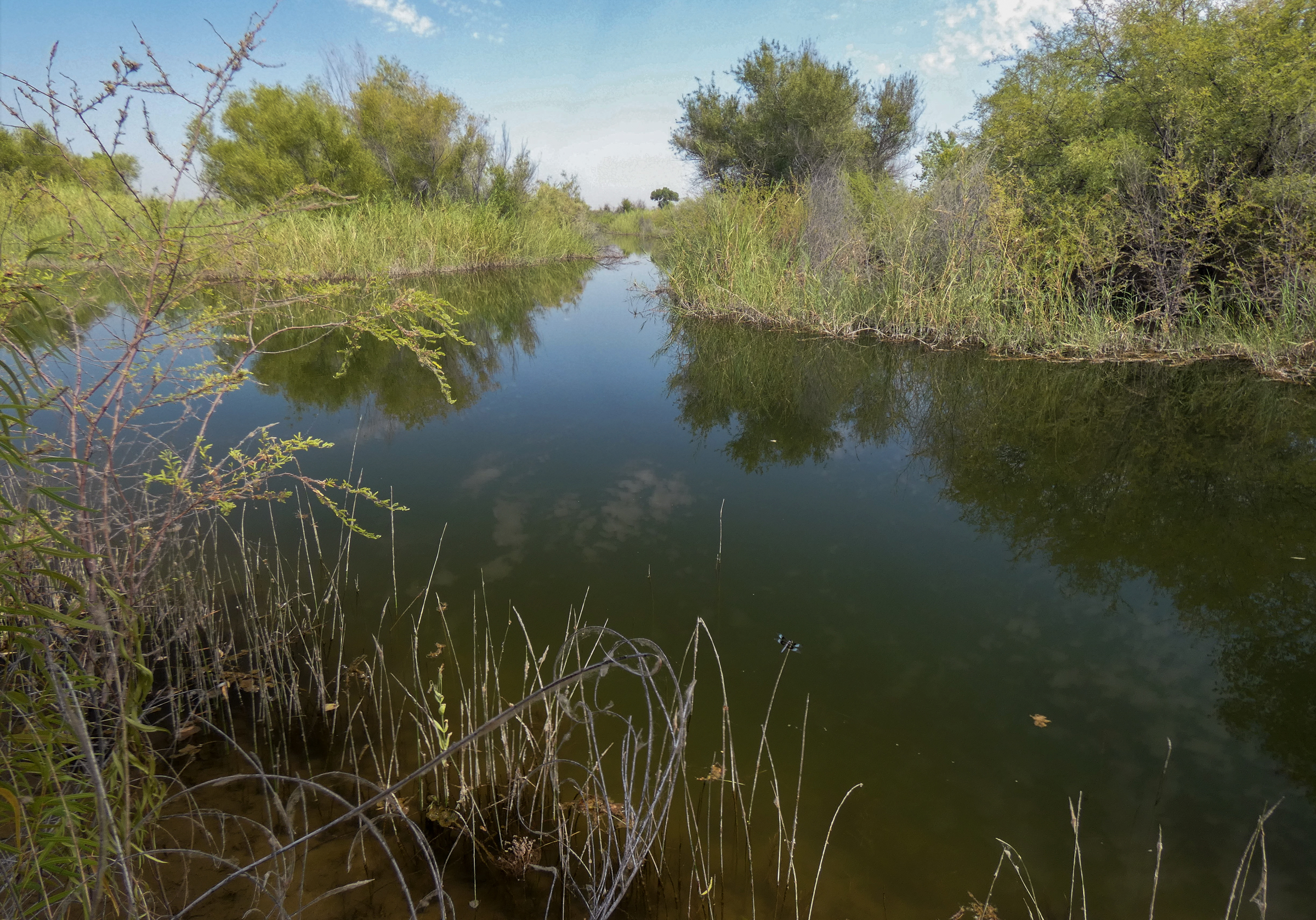
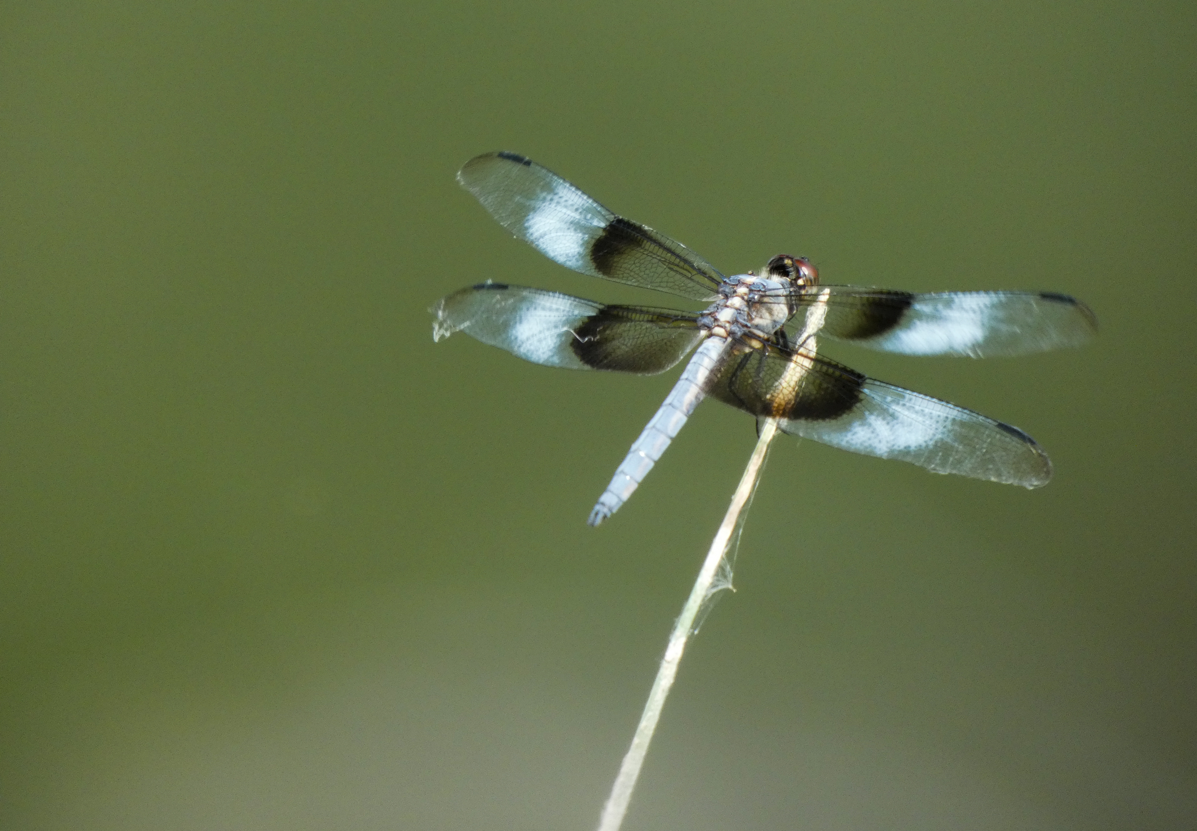
The report reveals that bird numbers and diversity have increased since restoration began in 2014. The delta is an important rest stop for birds migrating along the Pacific Flyway. Beavers and other wildlife have also increased.
Graphic credit: USGS
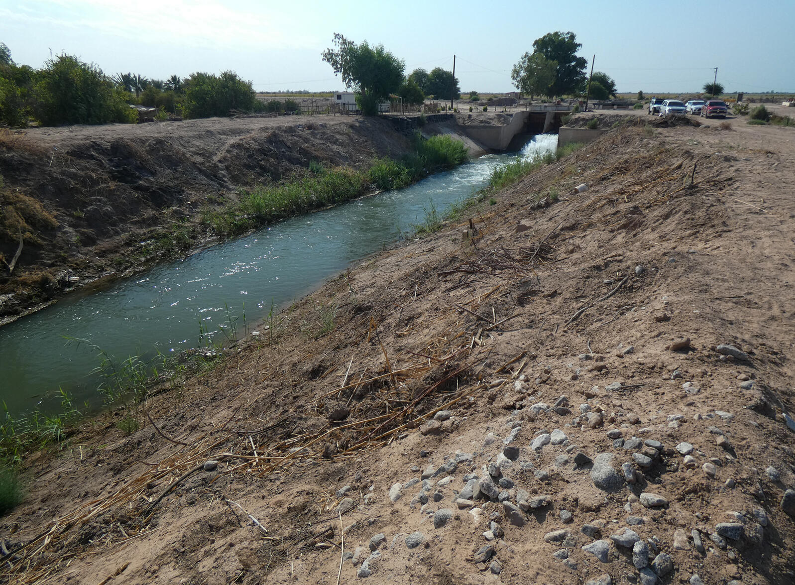
The restoration of the Colorado River Delta began in 2014, in the form of a so-called pulse flow, a one-time water release from Morelos Dam that lasted 57 days. Before that, the riverbed below Morelos Dam was dry. The pulse flow was conducted to allow researchers to assess the effects on the ecosystem once water returned.
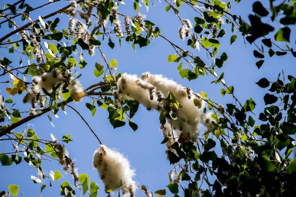
The pulse flow of 2014 kickstarted a concerted, binational effort to systematically restore riparian habitat along certain stretches of the formerly dry river delta. Environmental NGOs, both in the U.S. and in Mexico, developed three designated restoration sites by terrain-shaping and planting of native riparian vegetation, including cottonwood trees, mesquite trees and willows – species that once dominated the landscape when the Colorado flowed through a healthy delta.
In 2019, AZPM produced a story on revitalizing the Colorado River delta five years after the 2014 pulse flow.
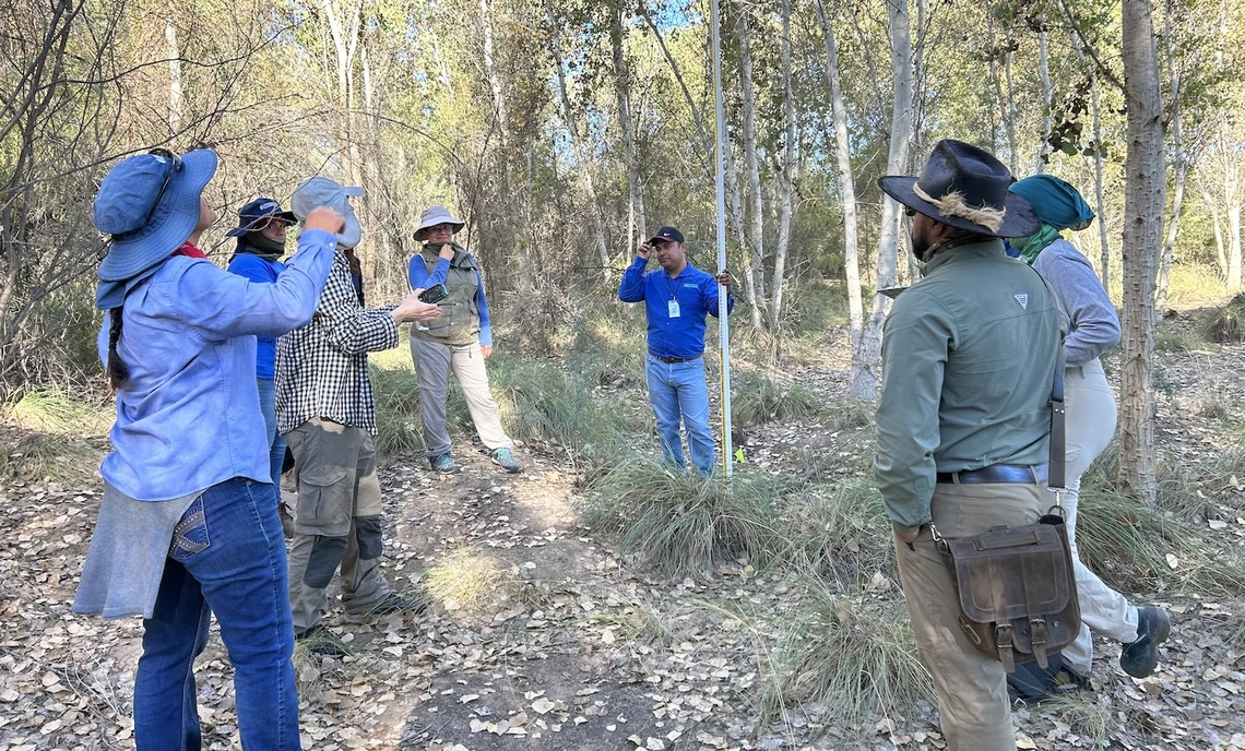
“These NGOs actually have nurseries on site, in which they germinate an array of Sonoran Desert riparian plants. Those seedlings are then planted and carefully irrigated according to the habitat needs,” said Martha Gomez-Sapiens, a U of A research scientist and co-author on the study. “In some cases you will see irrigation drip lines that go to each individual tree – a system designed to maximize water efficiency in this desert environment.”
Subsequent creation, irrigation and maintenance of 1,381 acres of riparian vegetation attracted birds and other wildlife. Deliveries to the river channel raised water tables, supported existing vegetation and increased the length of the flowing river.
In addition, local communities have benefited from recreational, educational and job opportunities. All three restoration sites have visitor programs that cater to local communities and schools, and one – the Laguna Grande complex, managed by the Tucson-based Sonoran Institute – even boasts a visitor center. All offer recreational opportunities in a region dominated by water scarcity.
While the pulse flow of 2014 demonstrated the feasibility of revitalizing former habitats with controlled and planned water releases, the authors conclude that releasing large amounts of water during a limited timeframe has limited benefits for a long-term revitalization of the delta.
“Most of the pulse flow water infiltrated into the groundwater before it could be used by new vegetation,” Flessa said. “Since then, we have learned how to use the water more efficiently for restoration of riparian habitat.”
Importantly, the report points out that restoration sites are not self-sustaining. Revitalizing degraded river habitat will require continuing maintenance, occasional water allocations and monitoring.
According to the authors, just 6,890 acre-feet per year, which represents approximately 0.05% of the Colorado’s total annual average flow, would suffice to preservethe existing restoration sites. With a little more water and a little more funding, the number or size of the sites could be increased even more, according to the report.
“Effective and sustainable habitat restoration can be done with a little bit of water, a small amount of funding and a lot of hard work.” Flessa said.
Other co-authors on the report are Eduardo González-Sargas in the Department of Biology at Colorado State University and Roberto Real Rangel, of The Nature Conservancy in Mexicali, Mexico.
Fig. 1. The Colorado River Basin covers parts of seven U.S. states as well as part of Mexico. Credit: U.S. Geological Survey
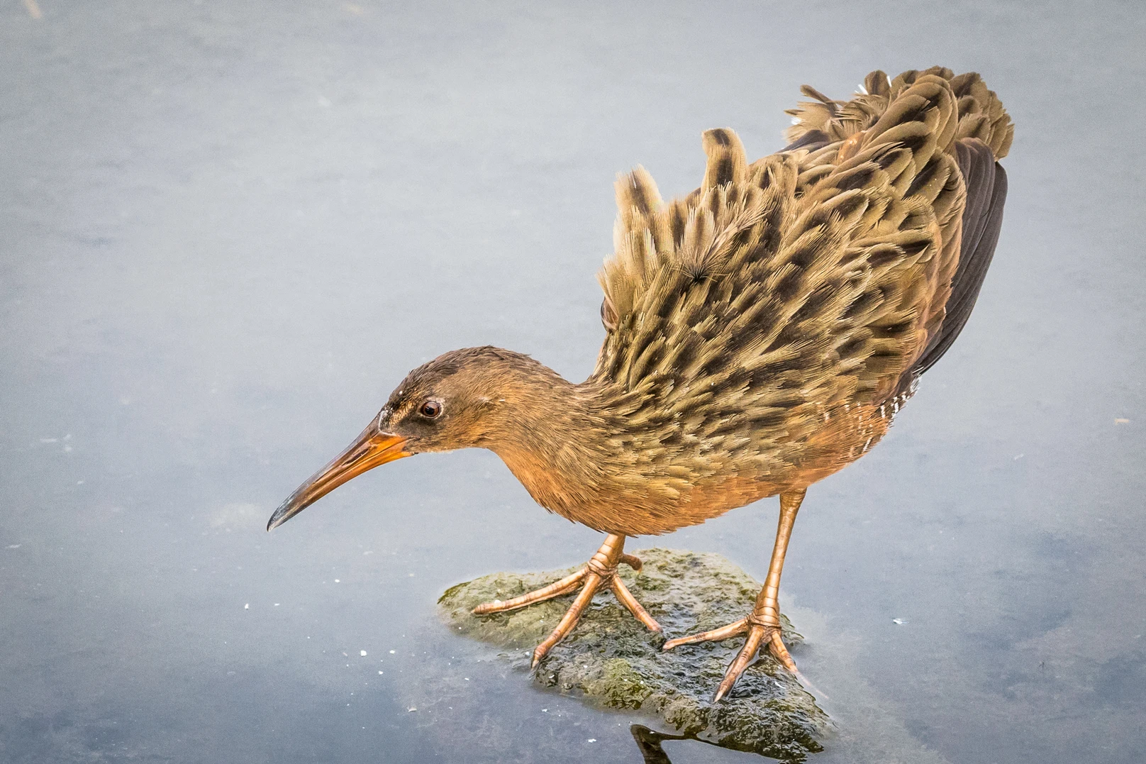
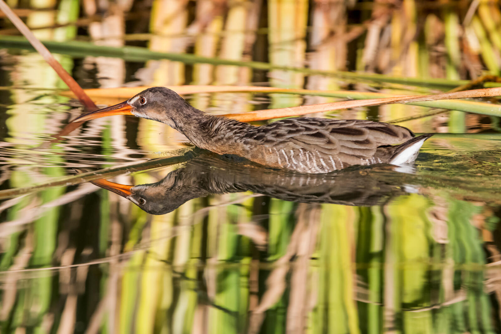
Ridgway’s Rail. Photo: Robert Groos/Audubon Photography Awards
Click the link to read the release on the Audubon website (Jennifer Pitt):
May 21, 2024
The Colorado River is flowing again in its delta. While this is welcome news for birds and people, the long-term progress to keep the Colorado River alive in Mexico with habitat restoration and water deliveries depends on high stakes negotiations currently underway.
For the third time since 2021, the United States and Mexico are collaborating to deliver water to improve conditions in the long-desiccated delta. Environmental water deliveries began mid-March and will continue into October, ensuring the river flows through the summer’s heat, making restored riverside forests and wetlands more hospitable to birds like Abert’s Towhees and Crissal Thrashers and other wildlife including beavers and lynxes. We know that birds rely on water in the Delta as they migrate to locations all over the United States.
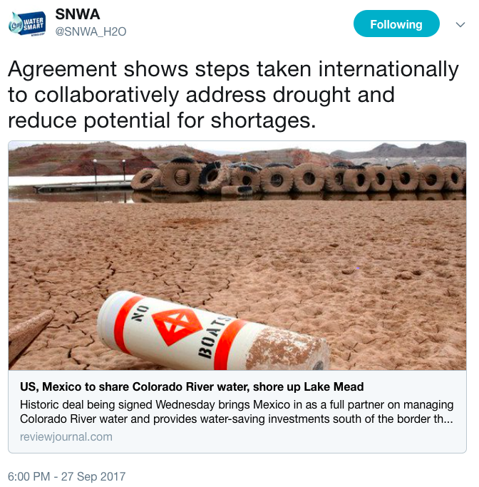
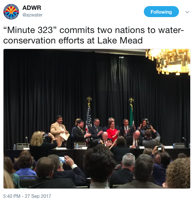
Restoration in the Colorado River Delta is implemented by Raise the River, a coalition of NGOs including Audubon, in partnership with U.S. and Mexican federal agencies. Funds, water, and collaboration for this work were committed first in Minute 319 and again in Minute 323, the United States–Mexico treaty agreements that have been widely hailed for modernizing Colorado River management with a host of benefits to water users in both countries including rules for sharing water shortages, as well as work to use relatively small volumes of water to revive the delta for wildlife and people. The terms of Minute 323 sunset in 2026, but delta restoration efforts remain a work in progress.
The good news: the United States and Mexico are poised to negotiate a successor agreement to Minute 323 in parallel with new federal rulemaking in the United States for Colorado River management. Domestic Colorado River rules, like the binational agreements, have for decades been the result of consensus-based negotiations, in this setting between the seven Colorado River Basin States with concurrence of the U.S. Bureau of Reclamation. This domestic rulemaking also has a 2026 deadline.
The bad news: at the moment, the Colorado River Basin states appear to be nowhere near consensus, with disagreements about which states, and which water users, will cut back when there’s not enough to satisfy all. These are difficult and high stakes negotiations. Failure to reach agreement increases the risk of water supply crises and could even throw the dispute in front of the U.S. Supreme Court.
That brings me back to the Abert’s Towhees and Crissal Thrashers, the beavers and lynxes in the Delta. If the Colorado River Basin states fail to reach consensus, there’s considerable risk that the work of restoring the Colorado River in its delta comes to a halt. Delta restoration depends on binational consensus, and binational consensus depends on a U.S. domestic consensus. It’s an extraordinarily complex decision-making framework for governance of water supply for 40 million people. The failure to reach consensus may create problems for some people who use Colorado River water, but it is certain to create collateral damage in Colorado River ecosystems including the Delta.
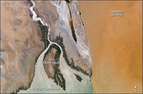
Colorado River Dry Delta, terminus of the Colorado River in the Sonoran Desert of Baja California and Sonora, Mexico, ending about 5 miles north of the Sea of Cortez (Gulf of California). Date: 12 January 2009. Photographer: Pete McBride, U.S. Geological Survey
Click the link to read the article on the Time Magazine website (Anisha Koli). Here’s an excerpt:
…in recent years, the countries’ relationship, when it comes to the river at least, has entered a new era of agreement and mutual advancement, as both countries face unprecedented drought and a need to revamp water systems.
“On earlier occasions, what I’ve seen is two countries that had a bilateral water management agreement where the gains from one country would equal the losses of the other country,” Carlos de la Parra, who leads Restauremos El Colorado, an environmental nonprofit, tells TIME. “They’ve migrated into a regional approach, realizing that it’s the same river, it’s the same basin and investments on one side of the border will benefit both sides of the border.”
Under a 1944 treaty established between the U.S. and Mexican governments, Mexico was allotted a guaranteed annual quantity of water. The agreement had flaws though. It didn’t mention water quality, and in the 1960s when the river’s salinity rose dramatically, the water directed to Mexico was too salty for human consumption or agriculture. Following farmer protests and threats from the Mexican government to take the dispute to the International Court of Justice, the U.S. agreed to an updated treaty in 1973 that ensured equal water quality. Most recently in 2017, the two governments revisited the negotiating table to strike Minute 323, a nine-year deal that set standards for how water should be allocated during surpluses and reduced during droughts. It also committed both countries to pledge resources and funding for environmental restoration. John Shepard, senior advisor at the Sonoran Institute, a non-profit that advocates for Colorado River restoration, notes that a new deal could be on the horizon. “If the lower basins agreed to cuts as they’re being articulated in this agreement, then Mexico will likely agree to a proportional share of cuts.”
[…]
Keeping the river and its ecosystems healthy has been a source of argument over the years. In the U.S. the prevailing view has been that it’s Mexico’s responsibility to protect and restore the delta because it’s chiefly located in Mexico, where it then flows into the Gulf of California. Mexico has argued that the U.S. should take responsibility because the country’s management and control of the river caused poor water quality and decimated habitats. Now, experts on both sides of the border are working to find a more collaborative way forward.
“There’s a saying that, ‘a crisis is a terrible thing to waste.’ In many ways, that’s how I’m approaching this,” De la Parra says. “Many people like myself are hard at work, thinking about how we can capitalize the crisis and move the irrigation district and other water uses into a more productive, more sustainable model.”
Map of the Colorado River drainage basin, created using USGS data. By Shannon1 Creative Commons Attribution-Share Alike 4.0
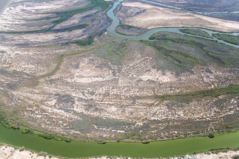
The water replenishing the delta takes a circuitous path. A maze of irrigation infrastructure and long-neglected side channels delivers water to the 160-acre El Chaussé habitat restoration site, located 45 miles south of the U.S.-Mexico border in Baja California, and to downstream river segments. Photo: Claudio Contreras Koob
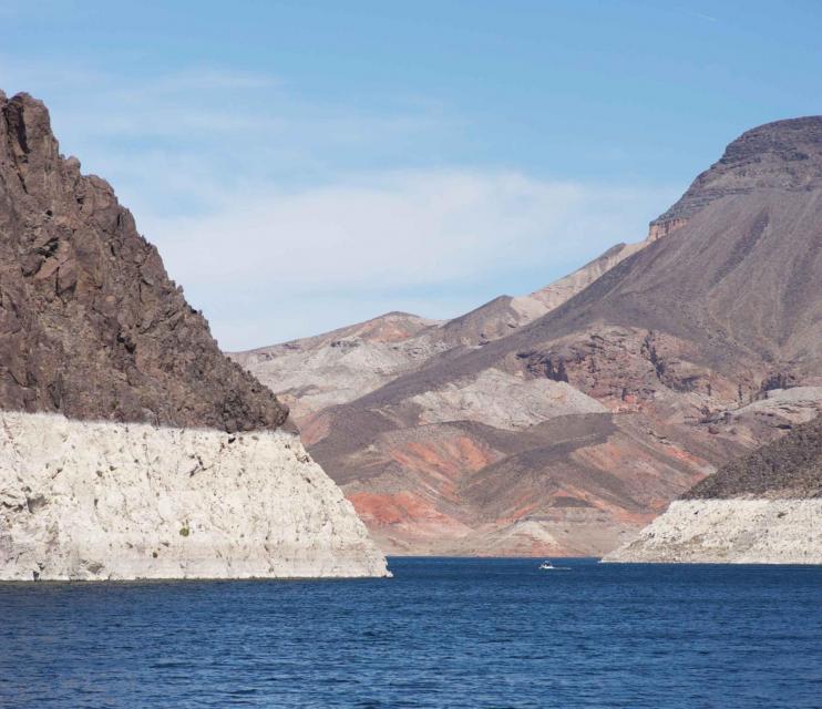
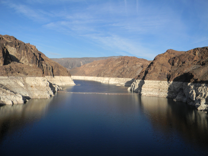
The Colorado River is revealing its secrets. For decades a World War II landing craft lay submerged 200 feet beneath Lake Mead’s surface — but now it’s beached, rusting in the sun. It’s become an unsettling marker of just how vulnerable the river is and how parched the Intermountain West has become.
The immediate impact of what’s being called the most severe mega-drought in 1,200 years, has been sharp cuts in the allocation of water to downstream users, with southern Nevada’s take slashed by seven billion gallons. Then there’s the fear that if Lake Mead’s water levels continue to fall, it may not be able to generate the power it now supplies to 1.3 million people in Nevada, Arizona and California.
Yet the diminished reservoirs tell another tale about the Colorado River, one of the world’s great plumbing systems, which enables downstream agriculture and sends potable water to an estimated 40 million residents. The story is that just where the river ends, at the Gulf of California, it has been slowly coming alive.
For decades, the United States sucked so much water from the Colorado that only a trickle, if that much, ever reached its desiccated, sprawling delta in Mexico. Once covering 9,650 square miles, the delta has shrunk to less than one percent of its original expanse. Human diversions wrung it dry.
It wasn’t always that way. In 1922, conservationist Aldo Leopold wrote about paddling a canoe through the delta’s green lagoons and marveling as “cormorants drove their black prows in quest of skittering mullets” and “mallards, widgeons, and teal sprang skyward in alarm.” When a troop of egrets settled on a far green willow, Leopold said they looked like a “premature snowstorm.”
Leopold’s lyrical vision had the misfortune a century ago of coinciding with the signing of the Colorado Compact, which sealed the delta’s fate. Approved by Wyoming, Colorado, Utah, New Mexico, Nevada, Arizona and California, the compact quantified the Colorado’s annual flow and set up the seven states to contend with one another to protect, if not expand, their individual shares. The compact turned the delta into a dust bowl.
For decades, environmental and tribal activists and nonprofit organizations protested the devastation that massive diversions to fill the Powell and Mead reservoirs produced in the delta’s once-flourishing human and biological communities. They pushed hard for remedies from both the U.S. and Mexican governments and the river-hugging state legislatures.
It wasn’t until 1993, when Bruce Babbitt became Secretary of the Interior under President Bill Clinton, that the political dynamic changed. Babbitt argued that the states must demonstrate how they intended to operate within their apportioned amount. If they failed to do so, he said, he would not approve surplus water, a threat particularly aimed at California, which routinely commandeered any surplus flow the other states didn’t use.
River activists immediately demanded that some of the water savings should head down to the delta. They got nowhere until 2014, when Mexico and the United States acted on their earlier commitment to sluice more water into the delta’s riparian habitats.
Since then, the two countries have periodically released water to mimic historic seasonal flooding. These tiny pulses of liquid energy, which constitute less than one percent of Los Angeles’ total annual water consumption, have had an outsized impact.
With restoration ecologists to guide the process, some wetlands have revived, small woodlands have flourished and native plants and animals have taken hold. Remote-sensing cameras recently spotted beavers gnawing on cottonwoods.
We don’t know how current drought-management solutions might cripple these recent interventions that brought the tail end of the river to life. Meanwhile, let’s recall Leopold visiting the delta where he watched burbling sandhill cranes circling overhead. The sight brought him joy as it made him feel he was joined with them in the “remote vastness of space and time.”
That’s a compelling affirmation that the Colorado River must be kept alive to its very end.
Char Miller
Char Miller is a contributor to Writers on the Range, writersontherange.org, a nonprofit dedicated to spurring lively conversation about the West. He is an environmental historian at Pomona College; his upcoming book is Natural Consequences: Intimate Essays for a Planet in Peril.
For decades, so much water has been diverted to supply farms and cities that the Colorado River has seldom met the sea and much of its delta in Mexico has been reduced to a dry riverbed, with only small remnants of its once-vast wetlands surviving. Over the last eight weeks, water has been flowing in parts of the delta once again, restoring a stretch of river in Mexico where previously there had been miles of desert sand. The water is being released from an irrigation canal to aid the delta’s parched environment as part of an agreement between the Mexican and U.S. governments and with support from environmental groups. Those who are involved in the effort say that even as severe drought and the warming climate sap the Colorado River, the initiative shows how small amounts of water can be used to benefit struggling ecosystems…
This site, a habitat restoration area called El Chausse, is located in the southern portion of the delta, downstream from long stretches of dry riverbed, and was chosen as a place where limited water releases would boost the ecosystem by nourishing vegetation and expanding habitat for wildlife. It’s one of a few sites in Mexico where conservationists have been restoring wetlands and forests along the path where the river once flowed. Six years ago, workers removed invasive tamarisk trees at the site and planted a forest of native cottonwoods, willows and mesquites. Those trees have grown rapidly and now drape the wetland in shade, attracting a variety of birds, such as yellow warblers, blue-gray gnatcatchers and vermilion flycatchers…
This is the second straight year of water releases in Mexico. When the water flowed through part of the delta last year, plants released seeds that settled along the banks. [Eduardo] Blancas and his colleagues have seen vegetation flourish along the river channel. They’ve spotted about 120 species of birds in the area.
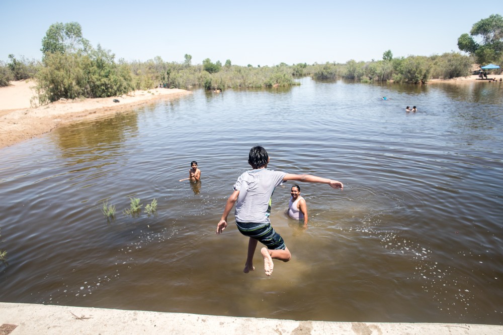
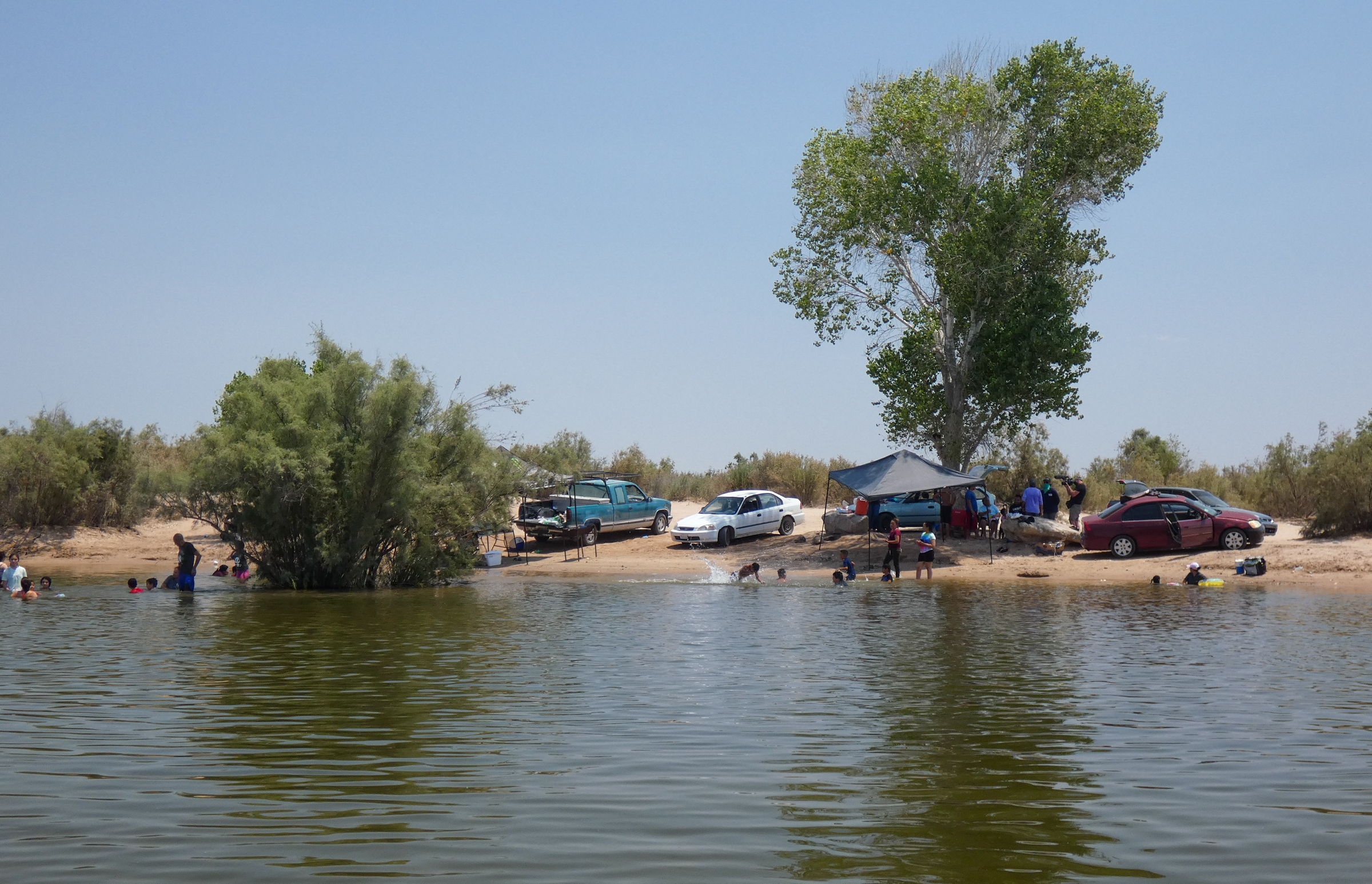
After prolonged neglect, Mexico’s Colorado River Delta is teeming with life. This summer, Ridgway’s Rails and Least Bitterns prowled in lush marshes. People jumped into the river’s water to escape record-breaking heat, or enjoyed picnics on the shore. Fish long absent shimmered in sunlit water.
This life aquatic was unthinkable until recently. Beginning in 1922, water-sharing agreements among the seven U.S. states in the Colorado River basin and Mexico claimed nearly every drop of the once-mighty waterway, which begins high in the Rocky Mountains and wends 1,450 miles to northwest Mexico, where it empties into the Sea of Cortez. Over ensuing decades, dams and diversions built to sustain farms and growing cities from Colorado to California left little water for downstream stretches south of the border. By the 1960s, when Lake Powell began to fill behind Glen Canyon Dam, the river no longer reached the sea.
Deprived of nourishment, the Colorado River Delta shrank, becoming a sliver of the expanse of lagoons and braided channels that naturalist Aldo Leopold saw when he paddled through a century ago. Ninety percent of its wetlands shriveled. Migratory birds, arriving to find far fewer places to feed and rest, made do with less appealing alternatives, such as agricultural waste ponds.
This year, however, marks a turning point in the delta’s long-sought revival: From May through October, 35,000 acre-feet of Colorado River water—about 11 billion gallons, or enough to supply at least 70,000 Southwest households for a year—is snaking from the U.S.-Mexico border to the river’s fan-shaped terminus 100 miles away. It is the first time since a brief period in 2014 that the Colorado reached the sea. And thanks to tireless advocacy by Raise the River, a binational alliance of six conservation groups, and a series of delicate negotiations between the two nations, the delta’s future is awash in promise. By 2026 it will receive 210,000 acre-feet of water in total.
The water replenishing the delta takes a circuitous path. A maze of irrigation infrastructure and long-neglected side channels delivers water to the 160-acre El Chaussé habitat restoration site, located 45 miles south of the U.S.-Mexico border in Baja California, and to downstream river segments. Photo: Claudio Contreras Koob
This moment was a long time coming. After years of talks, the United States and Mexico did a test release, a 105,392-acre-foot “pulse flow” for two months in spring 2014. The surge, along with small deliveries made possible in part by Mexican farmers, helped biologists restore 1,400 acres of riparian systems, which involved planting more than 47,000 native trees and acquiring water rights.
The delta bloomed in response: Bird abundance rose 20 percent and avian diversity increased 42 percent, showing even a modest amount of water can make a big difference. “You almost can’t believe how quickly an area can be transformed from a pretty decimated landscape and disturbed ecosystem into something that really conjures the river of the past,” says Jennifer Pitt, Audubon’s Colorado River Program director. “A lot of hard work in the hot sun made something miraculous happen.”
In 2006, when work began at the 1,200-acre Laguna Grande habitat restoration site in the Colorado River Delta, few native plants hung on amid a tangle of invasive salt cedar. To date, the Sonoran Institute, collaborating with communities, has planted 200,000 trees and restored about 700 acres at Laguna Grande, with hundreds more acres underway. Photo: Claudio Contreras Koob
“We know that we are never going to have the delta like it was 100 years ago, no,” says Gabriela Caloca Michel, water and wetlands conservation program coordinator at Pronatura Noroeste, a coalition member group. “But we know that we now have more birds, we have restoration, we have people working there—because we have some water.”
Buoyed by the results, in 2017 conservation groups convinced the two nations to ink a longer-term deal to send regular surges downstream and, along with nonprofits, contribute to a total of $18 million for restoration, science, and monitoring. Minute 323, an addendum to a 1944 Colorado River water-sharing accord, was born.
Crucially, the agreement not only allocated water to the delta, but also called for both nations to make voluntary cuts in dry times and required the United States to fund water-efficiency projects in Mexico to ease the way. “Getting the two countries aligned was harder than I ever imagined it would be,” says Pitt. “And keeping them aligned remains complicated. But knowing what that takes makes it all the more special to see.”
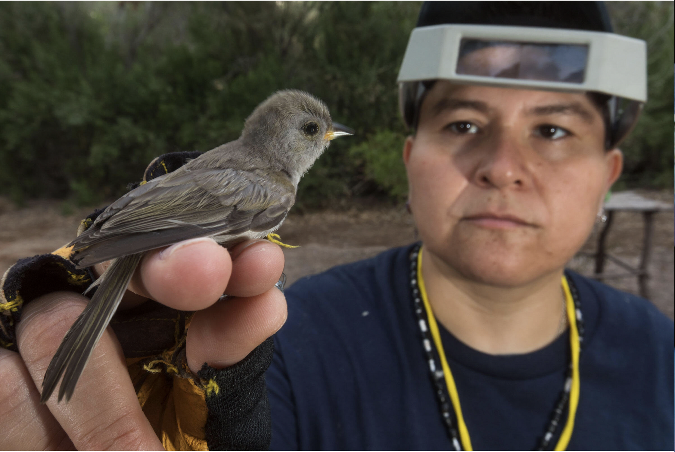
A small grey bird is held between the fingers of an avian researcher, who gazes at their hand. Pronatura Noroeste’s longtime avian researcher Alejandra Calvo Fonseca (with Verdin) saw bird numbers spike during and after the experimental flow in 2014 and expects more wildlife to return after this year’s release. Photo: Claudio Contreras Koob
The design of this year’s release, the first under the new accord, builds on lessons from 2014. This time, to ensure as much water as possible reaches the delta rather than sinks into the thirsty riverbed on its journey south, the water’s path is diverted near the border through irrigation channels to bypass a 35-mile dry stretch. Some irrigation water, purchased from Mexican farmers, is also sent to the river’s floodplain instead of fields. Overall, the volume dedicated to the delta is less than one percent of the river’s total average flow. But again managers expect a little will go a long way, boosting restoration efforts and transforming desiccated areas into verdant habitat for Vermilion Flycatchers, Yellow-billed Cuckoos, and more of the 380 avian species using the delta.
What makes the win even more extraordinary is that it comes amid extreme challenges. The Southwest, and two-thirds of Mexico, is in the grips of one of the most intractable droughts the region has ever experienced, fueled by climate change. This year the Colorado River Basin’s two largest reservoirs, Lake Mead and Lake Powell, dropped to record low levels. In August the U.S. Bureau of Reclamation announced that in 2022, for the first time, it would reduce water deliveries to Arizona, Nevada, and Mexico and may have to impose more cuts in coming years.
Children and adults bathe in river water. In the foreground a child squints as water runs down hair and face. The child is smiling. In Mexico, people say, “El agua es vida.” Water is life. Reviving the delta gives communities along the lower Colorado River, many of them impoverished, a better quality of life and new economic opportunities. Photo: Claudio Contreras Koob
With hotter, drier times ahead, some advocates worry that water dedicated for the delta and other basin ecosystems could begin to look tempting, as farms and cities try to harness every drop. Yet despite painful shortages, those working to resurrect the delta remain cautious optimists. “The water that we’re putting in the river isn’t only for wildlife,” says Francisco Zamora Arroyo, the Sonoran Institute’s senior director of programs. “It’s for the people, too.” With locals again connected to their river, he says, the case to keep it flowing will only strengthen.
After all, Pitt adds, the same agreements that are re-watering the delta enable Mexico’s commitment to share in shortages. In an exception to the norm, an ecological revival—made possible by sharing rather than fighting over water—has inspired a new way to value the region’s most precious resource. “I see the two countries saying, ‘We need to figure out how to sustain this,’ ” says Pitt. “And that really is so important and amazing.”
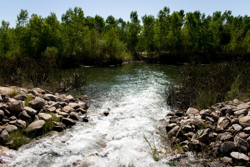
Water from the Colorado River environmental release flows into the El Chausse restoration site in Baja California, Mexico. (Source: Jesus Salazar, Raise the River)
From the Water Education Foundation (Gary Pitzer):
Western Water Notebook: Despite water shortages along the drought-stressed river, experimental flows resume in Mexico to revive trees and provide habitat for birds and wildlife
Water is flowing once again to the Colorado River’s delta in Mexico, a vast region that was once a natural splendor before the iconic Western river was dammed and diverted at the turn of the last century, essentially turning the delta into a desert.
In 2012, the idea emerged that water could be intentionally sent down the river to inundate the delta floodplain and regenerate native cottonwood and willow trees, even in an overallocated river system. Ultimately, dedicated flows of river water were brokered under cooperative efforts by the U.S. and Mexican governments.
The first intentional flows happened for about eight weeks in 2014. This year, the flows will be much longer despite an ongoing drought that sparked first-ever declared shortage on the river earlier this month. The flows started May 1 and will continue through October. They are supported by myriad groups, including the International Boundary and Water Commission (IBWC), created by the two countries 132 years ago.
“The United States is committed to meeting its environmental commitments to Mexico,” Daniel Avila, the IBWC’s acting U.S. commissioner, said in a statement. “I’m pleased to see the environmental water deliveries this year as part of our effort to improve wildlife habitat in the region.”
Avila’s counterpart in Mexico, Humberto Marengo, said in a statement that environmental cooperation on the Colorado River in Mexico is very important for both countries, as reflected by the agreed-upon use of water to help replenish parts of the riparian corridor leading to the Gulf of California.
It’s an audacious experiment, part of a multifaceted agreement that helps the two countries share the river. But it comes this time despite shortages elsewhere on the drought-stressed Colorado River, which supplies water to millions of people in the Southwest and large swaths of farmland in the U.S. and Mexico.
Amy Witherall, binational program manager with the U.S. Bureau of Reclamation, said the current flow for the delta has a lower peak volume and is spread across a longer time period than the 2014 experimental flow. And by using Mexico’s irrigation canals, water is moving more effectively to restoration sites.
“As a result of the binational coordination and collaboration that has developed, we were able to design a creative solution to maximizing the benefits of the environmental water available,” she said.
Habitat restoration work (the projects are named in yellow) extends along the main channel of the Colorado River from the US-Mexico border to the upper estuary of the Gulf of California. (Source: Sonoran Institute)
Learning from the Flows
The dedicated environmental flows delight conservation advocates who see ample opportunity to bring back some of the ecosystem benefits for birds, plants and wildlife.
“One really interesting thing to report is that it’s working,” said Jennifer Pitt, Colorado River program director with the National Audubon Society. “There’s definitely been reports and visual confirmation of the connection of those flows to the sea.”
Raise the River, a partnership of six U.S. and Mexican nongovernmental organizations (NGOs), is leading the work to reimagine parts of the Colorado River Delta to establish pockets of wildlife-friendly habitat and recreational opportunities for local communities. It’s an iterative process that reveals how the landscape responds when it gets water from the Colorado River.
It’s likely the lessons learned from the coming months will influence how water is applied during a future flow release – sometimes through the dry reaches and sometimes around them. “We are going to collect data and have lots of conversations about the tradeoffs,” Pitt said.
The flow that began this year will be one in a series of rewatering efforts on the delta’s riparian corridor through 2026. The U.S. and Mexican governments provide the water in tandem with coalition of conservation groups. From the time the first flows began in 2014, those living near the river have been profoundly affected.
“I have grown up watching a river die and today I see a river revived,” Antonia Torres Gonzalez, a member of the Cucapá tribe indigenous to the lower Colorado River, said in a video produced by the Sonoran Institute of Mexico, one of the NGOs involved with the river. “We have been taught that the river is like a person that we have to love and respect.”
Jennifer Pitt, the National Audubon Society’s Colorado River program director, paddles a kayak through a restoration site. (Source: Jesus Salazar, Raise the River)
Even with a drought-stressed Colorado River on the brink of severe use restrictions that limit water for all purposes, water is flowing to restoration sites and will continue to do so under addendums to an international treaty. Still, those restoration flows are expected to be pared back – though not halted – next year as a result of the Bureau of Reclamation’s Aug. 16 declaration of a shortage in 2022 that will reduce water supplies for Arizona and Nevada.
“You can’t just sort of take one part of it and say, oh we’re going to do this part, not this other part,” said Karl Flessa, professor of geosciences at the University of Arizona who closely monitors the delta flows. With Reclamation’s shortage declaration, “Mexico is going to share that shortage and there’s going to be a comparable shortage or sharing of the water that goes towards the restoration projects.”
Bringing Back the Delta
Across the Colorado River Basin, climate change is upending the expected patterns of hydrology. Reduced Rocky Mountain snowpack and rising temperatures are stressing the system, leaving less runoff flowing downstream to reservoirs, farms and cities. Those working to restore delta habitat using river flows hope that their efforts will help.
Tree nurseries at Raise the River restoration sites provide the seedlings to expand native vegetation along the Colorado River corridor in Mexico. (Source: Jesus Salazar, Raise the River)
“We are trying to mitigate [climate change] in the areas with restoration, as we help to lower the temperature with the trees planted,” said Gabriela Caloca Michel, restoration project coordinator with Pronatura Noroeste, the oldest and largest conservation nonprofit in Mexico that manages several restoration sites.
The Colorado River once traveled all the way to the Gulf of California – an estuary of about 2 million acres. Dams and aqueducts moved water to irrigate farms, including those in Mexico and seven western U.S. states, and provide drinking water. As a result, the river made it all the way to the mouth of the estuary only during high flow years.
But people have come to realize that it’s possible to bring back a portion of the Colorado River Delta with relatively small contributions of river water. The first experimental pulse flow of Colorado River water – 105,000 acre-feet of water in total – into the delta was delivered to mimic the flood flows that used to naturally reach the delta with spring snowmelt. Some water was routed to established restoration sites along the river corridor to nurture newly planted native trees, such as cottonwoods and willows.
Much was learned from that 2014 flow. Even though the river would sometimes flood the delta, the 2014 release helped foster knowledge about water movement (including infiltration) that is aiding the current effort.
Pronatura’s Caloca Michel, who has worked on the delta since 2015, said the aim with the 2021 water release is to carefully map out the design of restoration sites, factoring irrigation infrastructure, plant selection and local nursery production, soil type and water table and water rights to be able to irrigate.
Getting To the Green-Up
Under the terms of a 2017 agreement, the United States, Mexico and the coalition of NGOs each agreed to provide one-third of the 210,000 acre-feet of water for environmental purposes in the delta through 2026. The NGOs have provided 26,369 acre-feet of water between 2018 and 2020.
Native cottonwood trees are back in large numbers in some sections of the Colorado River Delta. (Source: Jesus Salazar, Raise the River)
The plan is to move water to different locations at different rates and times to realize the most ecosystem advantages. It’s a give and take between providing open water habitat for birds and moving releases to specific restoration sites that have been cultivated with native vegetation. Some flows are carried via established irrigation canals to limit the amount that seeps into the ground.
Infiltration of the flows into the ground isn’t a loss, Flessa said.
“If you’re pumping groundwater or a Mexican farmer, that’s a good thing. Groundwater does sustain a lot of vegetation along the way,” he said. “But if you want to deliver water to some of the more downstream restoration sites you really need to find a way to make sure that you maximize the efficiency of the water delivery so you don’t lose as much of the delivery as you would by putting water in the main channel.”
Teams constantly measure how the flows affect the groundwater table, the established vegetation and the new acreage plots established by the conservation groups.
Having water available through summer helps, given the harsh desert heat.
“It is a pretty stressful time for everybody,” Flessa said. “For the plants, if there is lack of irrigation or lack of support, those trees don’t like it.”
A common refrain is the surprise about how quickly vegetation such as cottonwoods and willows respond to what Pitt called “a drink of water.” But it’s not just water. The foundation established by conservation groups provides jobs for the community and re-establishes a connection to the riparian environment.
“I see a very big impact that the ecosystem is working well and the work we do has paid off,” said Celedonia Alvarado Camacho, who supervises tree preparation and planting for the Sonoran Institute.
Long-term, the question remains how to reimagine the delta with relatively small amounts of water. The flows were included as part of a pair of recent amendments to the 1944 Water Treaty with Mexico. Conservationists expect that a commitment for environmental flows will be included in future treaty agreements.
“I have every reason to believe an environmental program will be part of [a new agreement], in part because we had it in the last two … and because both countries have made enormous investments in restoring habitat,” Pitt said.
Still, a sense of perspective is needed for the ancient delta. “We are not going to bring the whole river delta back, that’s for sure,” Flessa said. “But I do think we could sort of get a green ribbon from the border to the Gulf of California.”
From the Walton Family Foundation (Peter Skidmore):
From May to October, a surge of water is replenishing the Colorado River Delta
Seven years ago, the Colorado River Delta found its pulse when 105,000 acre-feet of water was released into Mexico from the Morelos Dam, filling dry channels and reviving wetland habitat. For the first time in decades, the Colorado flowed from source to sea.
The 2014 “pulse flow” recharged a portion of the West’s most important river that has been dying of thirst since the middle of the last century. It also reignited the memory and imagination of Mexican residents of the Delta, who celebrated the return of water and began to understand the river’s potential to support nature and people in the region.
For scientists, conservationists and governments, the pulse flow was a learning event. We learned that communities were enthusiastic about restoring the Delta and ready to seize the opportunity created by conservation projects in areas once dry and desolate.
A flowing river benefits the environment and local communities. The Vado Carranza site has been popular with kids of all ages to cool off on hot summer days. Photo Credit: Jesús Salazar/Raise the River via the Walton Family Foundation
We also learned it was possible to provide greater environmental benefit to the river with smaller flows over multiple years. To build on the 2014 pulse flow’s success, the U.S. and Mexican governments in 2017 reached an agreement – called Minute 323 – that provides at least 210,000 acre-feet of water over nine years for ongoing riparian restoration and recreation in the Delta.
Fast forward to this summer – and the Colorado River is again flowing in the region.
The first water from the 2021 “pulse flow” is delivered at the Chausse restoration site in the Colorado River Delta. Photo Credit: Jesús Salazar/Raise the River via the Walton Family Foundation
For 126 days, from May to October, more than 35,000 acre-feet of water – about 11 billion gallons – is being released into the Delta, supporting local economies and improving riparian and wetland habitat for wildlife.
The timing and rate of flow for this year’s release were designed by a team of scientists to maximize environmental and recreational benefits.
The current flow coincides with seed dispersal from cottonwood trees – mimicking how floods and seeds have coordinated for millennia – and to maximize recreation during the hottest part of the summer.
While only one-third as big as the 2014 pulse flow – and a fraction of the river’s historic flows – even this smaller amount of water is making a big difference in the health of the delta region.
Throughout the Colorado River Delta, the coordinated release of water is bringing life back to this region. Photo Credit: Jesús Salazar/Raise the River via the Walton Family Foundation
Instead of releasing the water directly into the river at the border, water managers have bypassed the Morelos Dam via canals and released the water about 45 miles downstream. By doing this, more water is delivered to restoration and recreation areas and avoids being absorbed into the driest parts of the river channel.
The flows are delivered to existing restoration sites where they flush salts from soils, replenish local groundwater and provide seasonal habitat for migratory and resident waterfowl. Diverse wildlife – from beavers to panthers – are also returning to the river.
Because the flows are delivered to the central Delta through canals, they are also benefitting local farmers. The extra water in the canals helps water reach farms further down the Delta and reduce salinity, which improves agricultural productivity.
The release of water was carefully planned at strategic points near restoration sites to maximize impact. Photo Credit: Jesús Salazar/Raise the River via the Walton Family Foundation
This year’s flow is proving the value of collaboration that made the 2017 binational water-sharing agreement possible. The deal included a unique three-party arrangement among the U.S. government, the Mexican government and Raise the River, a coalition of six nonprofits committed to conservation in the Delta. While this flow is delivered by the U.S. to meet its obligations under the agreement, our partner organizations in Raise the River are providing additional flow to all of the restoration sites and to the lower river channel every year.
Coming in the midst of the worst drought year on record, as the West is experiencing shortages in available water, this year’s Delta flow is a testament to the strength of Minute 323 and commitment of its partners to community and environment.
By mid-June, the released water reached the sea in the estuary region of the Colorado River Delta. Photo Credit: Jesús Salazar/Raise the River/Lighthawk via the Walton Family Foundation
The agreement has become a global model for binational river management, showing how we can invest in water projects that conserve and share water between countries and dedicate environmental water at the same time.
There is much more work to do for all of us who care about the Delta’s future.
Of all the ecosystems impacted by the harnessing of the Colorado in the 20th century, the Delta suffered most. The construction of the Hoover Dam in the 1930s, and then the Glen Canyon Dam from 1956 to 1966, sapped the Delta of its fresh water and sparked its decline.
Riparian forests of cottonwoods, willows and mesquite, as well as marsh and estuarine wetlands, that once thrived across about 2 million acres now cover just a small fraction of that area.
Workers measure federal flow deliveries in the canals that deliver water for irrigation and to restoration sites in the Colorado River Delta. Photo Credit: Jesús Salazar/Raise the River via the Walton Family Foundation
But based on a decade of testing and refining successful restoration practices, the potential of reconnecting the river to the sea is now in reach.
We see that in the success of this year’s flow.
As of late June, the river is reconnecting with the sea. During high tides, flows in the river channel are meeting the Delta estuary in the Sea of Cortez, mixing fresh water with salt water to sustain estuarine marshes.
As summer builds toward fall, we’re hopeful that this year’s flows will continue to reach the sea, reconnecting the river once again as it did in 2014 – and hopefully as it will do again in the future.
Colorado River water diverted at the border into Mexicali Valley irrigation canals is being returned to the river, starting on May 1, 2021, via a spillway about 35 miles downstream, bypassing the driest part of the channel (where water infiltrates quickly into the sand). Photo: Jennifer Pitt/Audubon
Water delivered through the desiccated channel will benefit the environment.
I had the great fortune to take my first, post-pandemic trip to Mexico to see the river flowing in the Colorado River Delta (click HERE for background). For 164 days the United States and Mexico are cooperating under the terms of Minute 323 to deliver environmental water. The flow rates and locations for water delivery are intended to optimize benefits for the delta ecosystem, and over time monitoring reports will tell that story. For now, I can share what I saw:
The river is flowing! Observers have not yet confirmed that the freshwater has met the sea, but they think it may with the next high tide. Photo: Jennifer Pitt/Audubon
Environmental water delivery is timed during the late spring and summer to help native trees germinate. The cottonwood seeds were evident. Photo: Jennifer Pitt/Audubon
It’s hot in the delta (122F/47C the day of my visit). My Mexican friends say the wildlife is loving the water. Photo: Jennifer Pitt/Audubon
People love the river too! Photo: Jennifer Pitt/Audubon
On May 1, 2021, water began flowing into the arid Colorado River Delta as part of a program of scheduled deliveries to restore this region, sanctioned under a bi-national agreement between the U.S. and Mexican governments for advancing sustainable management of the Colorado River. The water deliveries are part of an ongoing plan of vital and historic importance implemented through the U.S. and Mexican sections of the International Boundary and Water Commission and supported by an alliance of conservation organizations from the United States and Mexico.
“Our collaborative efforts have been a paradigm shift in the way water is managed,” said Jennifer Pitt, Colorado River Program Director, National Audubon Society. “We are showing how we can share water, conserve water, and invest in new water projects and the health of the river itself. This demonstrated commitment to improving water supply for nature and people is a shining example of what two nations can achieve when we work together.”
The releases of water designed to mimic the river’s natural spring flows began on Saturday, May 1 and will extend through early October, delivering a total of 35,000 acre-feet (43 mcm) of water downstream into the long-depleted Colorado River Delta in a managed program designed to maximize the water’s impact. The water releases are planned to reach their highest flow rate in early June and have been specifically designed to amplify the environmental and recreational benefits for the central delta. The water flows will continue for a total of twenty-three weeks, bring much needed support for wildlife habitat, while also being able to be enjoyed by local communities.
“This is an exciting time for both countries,” said Carlos de la Parra, Academic in border studies specializing in water issues, and a member of the Minute 323 monitoring group. “By allocating resources to improve water delivery infrastructure, Mexico and the U.S. are helping Mexicali Valley farmers increase their profits and resilience to the impacts of climate change.”
An important part of Minute 323 implementation and monitoring is being conducted by members of Raise the River – a coalition of conservation non-governmental organizations (NGOs) working to bring water and life back to the Colorado River Delta. Participating organizations include the National Audubon Society, The Nature Conservancy, Pronatura Noroeste, The Redford Center, Restauremos el Colorado, and Sonoran Institute.
“We have worked hand-in-hand with our partners over the years to achieve the best results possible for the delta,” said Francisco Zamora, Director General of Sonoran Institute Mexico. “Working together to monitor prior water flows and determine their impacts on the delta, our observations have informed this current effort to stimulate healthy ecosystems in the Colorado River delta.”
Water will be delivered to the river corridor in the delta via irrigation canals in the Mexicali Valley that distribute Colorado River water to Mexicali’s farmers. The Colorado River’s water is diverted into this canal system just south of the United States – Mexico border. Once there, it will flow down the canals to specific locations where the Raise the River coalition partners have built highly successful restoration sites, and where this programmed release of water can benefit those habitats and the wildlife that use them.
“These water releases are a vital part of supporting our ongoing restoration efforts,” said Gaby Coloca, Coordinator, Water and Wetlands Program, Pronatura Noroeste, a Mexico-based non-profit conservation organization which manages several of the restoration sites. “Based on our prior work and the careful monitoring of its impact, we now know that relatively small amounts of water can make a big difference in the health of the delta region.”
These water releases are just one component of a multi-faceted policy agreement formally known as Minute 323 – an historic bi-national agreement negotiated between the U.S. and Mexico in September 2017 that defines how the two countries share Colorado River water through 2026 amidst growing pressures on water resources. This agreement is a part of a larger Colorado River policy framework that more broadly provides multiple benefits for water users on both sides of the border including sharing surpluses in times of plenty and reductions in times of drought, providing incentives for leaving water in storage, and conserving water through joint investments in projects from water users in both countries.
The water flows are an important element of Minute 323, which allocates water for the restoration and conservation of riparian habitat, and which extends the international cooperative management standard established by Minute 319 (in effect from 2012 – 2017). These restored sites are providing proven benefits to wildlife species and communities along the Colorado River in both countries and in the Colorado River Delta region in Mexico.
This 164-day program of scheduled water releases is part of a broader commitment under Minute 323 to provide water to support key restoration sites in the river’s riparian corridor through 2026. The United States and Mexico will provide 2/3 of the total water committed (140,000 acre-feet or 173 mcm over 9 years) and the Raise the River coalition of NGOs will provide 1/3 of the water (a total of 70,000 acre-feet or 86 mcm, over 9 years).
“Previous monitoring of environmental flows from Minute 319 have shown us how to obtain the greatest benefits from the smallest amounts of water delivered into restoration sites.,” said Eloise Kendy, Ph.D., Senior Freshwater Scientist, The Nature Conservancy. “It has been – and will continue to be — very helpful for both governments to obtain information that becomes increasingly relevant as we face droughts with more frequency, not only in the Colorado River basin but also in other watersheds.”
By raising awareness, funding and, ultimately, the water level of the river, Raise the River’s goal is to restore native habitat that reconnects the river with the Gulf of California and to establish a framework for the long-term dedication of water to the restoration of the Colorado River Delta.
“Through these cooperative efforts, we are rewriting history by increasing the resilience of the Mexicali Valley, reestablishing ecosystems and returning some of the river’s natural amenities to local communities which have been deprived of a healthy environment,” says Pitt. “Since the initial releases of water for the environment in 2014, we are demonstrating the long-term benefits of binational cooperation not only for the environment, but for all water users in the region. Our work in the Colorado River Delta is becoming a model for long-term water-sharing agreements across borders.”
[…]
Background Information on Raise the River, including the binational agreements pertaining to the Colorado River and reported results achieved to date from managed restoration projects…
Raise the River is a unique partnership of six United States and Mexico non-governmental organizations working to revive the Colorado River Delta through activities that support environmental restoration for the benefit of the people and the enhancement of wildlife in the Delta. Members include: The Nature Conservancy, National Audubon Society, Pronatura Noroeste, the Redford Center, Restauremos El Colorado, and the Sonoran Institute. The coalition has worked with policymakers, water agencies and governmental representatives from the U.S. and Mexico since 2012 to cooperatively create historic change for the Colorado River Delta.
Luke Runyon and Coyote Gulch getting set for the Twitter fest at the Colorado River District seminar September 15, 2017.
Luke Runyon KUNC is moving on in his career. I will miss his enthusiasm and rigor but most of all his story-telling ability. Let’s hope that he finds his way back to the Colorado water beat in the future.
✨Some professional news✨
I am so excited to be selected as a Ted Scripps environmental journalism fellow at @CUBoulder for this upcoming academic year:https://t.co/NnKfm1ludw
It’s an attempt to reconnect portions of the river left dry from decades of overuse, and it’s happening in one of the driest years the basin has ever seen…
There’s no good substitute word for what the Colorado River delta is now. The Gulf of California’s tides still reach up into the Sonoran Desert. But there’s no river water. Dams along the Colorado River’s length in the U.S. and Mexico draw its water away to serve farms and cities throughout the region. Rather than emptying into the ocean, its water grows citrus in Arizona and greens up lawns in Los Angeles.
The delta’s exposed salt flats aren’t a wasteland. As Rivas explained, if you look close enough, you’ll see the animals and plants able to make a home: jumping spiders, tiny turquoise fiddler crabs, hardy species of saltgrass.
“These are harsh conditions here,” [Tomás] Rivas said. That day, it reached 120 degrees…
Rivas’ group, along with other Mexican and American environmental groups, are working to bring water back into this part of the estuary and study what happens…
Additional water releases into the delta began May 1 and will extend to October, with peaking flows in early summer. The water volume won’t be enough to fully revive the tidal bore, but Rivas said it can help restore riverine habitat.
Colorado River water diverted at the border into Mexicali Valley irrigation canals is being returned to the river, starting on May 1, 2021, via a spillway about 35 miles downstream, bypassing the driest part of the channel (where water infiltrates quickly into the sand). Photo: Jennifer Pitt/Audubon
‘A little bit of repair”
This spring and summer, portions of the Colorado River delta flowed again. But unlike 2014’s pulse flow, where the dam at the U.S.-Mexico border sent a huge volume all at once, this year’s releases of water are targeted to restoration sites…
“For Mexico, living with a dead river has been, I’ll say, sort of a wound,” said Jennifer Pitt, director of the National Audubon Society’s Colorado River program…
The Colorado River is grabbing national headlines this summer as water shortages become more urgent. Hot and dry conditions are coming home to roost in its reservoirs, dropping the two biggest — Lakes Mead and Powell — to record lows. Even in a dry year like this one, Pitt said both the U.S. and Mexico have agreed to set aside water for the environment.
“If we don’t figure out at this moment how to support the river itself and all of nature that it supports, I fear that we lose them permanently. So I think at this time it is more important than ever,” she said.
That idea of carving out water supplies just for the river itself remains controversial. Some skeptical city leaders and farmers in Mexico have said any water spilling into the ocean is wasted, said Carlos de la Parra, a professor at El Colegio de la Frontera Norte, who’s acted as an adviser to the International Boundary Water Commission…
The flows happening this year were part of an update to the 1944 treaty that the U.S. and Mexico use to govern their shares of the Colorado River. Over the last 21 years of ongoing hot and dry conditions, de la Parra said the two countries have transitioned from a relationship held at arm’s length to one of mutual respect. That led to a commitment from the U.S. to fund irrigation efficiency projects in Mexico, with some of the conserved water from those upgrades being set aside for environmental flows…
Martha Gomez-Sapiens, a monitoring team member and postdoctoral research associate in the UA Department of Geosciences, stands on a riverbank next to willows and cottonwoods that germinated as a result of the pulse flow. (Photo: Karl W. Flessa/UA Department of Geosciences)
But [Rocio Torres] Torres said the flows happening this year wouldn’t have occurred without the pulse flow seven years ago. The event galvanized communities in the region, she said. It built a base of support from water officials in both countries who agreed to set aside a small amount of water to benefit the plants and animals deprived for so long.
“I think that’s the way human beings, we learn,” she said. “We messed things up. We realized we shouldn’t have done that,” and bringing it back happens little by little.
David Bernhardt answers a question about climate change from Luke Runyon, December 13, 2019, Colorado River Water Users Association Annual Conference.
Luke Runyon near Hoover Dam power plant February 2018 via Colorado State University.
Binational Water Conservation Making the Colorado River More Sustainable for People and Birds
**Este artículo se puede encontrar en español**
The Colorado River is flowing again in its delta. This is a big deal for a river that has not flowed through its delta in most years since the 1960s, resulting in an ecosystem that is severely desiccated and devastated.
Thanks to commitments from the United States and Mexico in the Colorado River binational agreement—Minute 323 – 35,000 acre-feet of water (11.4 billion gallons) dedicated to create environmental benefits will be delivered to the river from May 1 to October 11. The expectation is that this will create and support habitat for birds like the Yellow-billed Cuckoo, Yuma Ridgway’s Rail, and Vermilion Flycatcher, and give life to the many plants and animals in this ribbon oasis of green in the midst of the Sonoran Desert.
Cattle Egrets and Snowy Egrets in the Cienega de Santa Clara, the largest remaining wetland in the Colorado River Delta. Photo: Claudio Contreras Koob via Audubon
The last time the two governments cooperated to put water for the environment into the Colorado River was in 2014, when they released a “pulse flow” of water from Morelos Dam (the furthest downstream dam on the Colorado River, located at the U.S. – Mexico border). For eight glorious weeks, the Colorado River was conjured back to life in its final 100 miles. Birds took notice (bird abundance increased 20% from the previous year, and species diversity increased 42%) and local communities celebrated with a spontaneous river fiesta that went on for weeks.
This time, the water will flow for more than five months. Thanks to lessons learned from scientists who studied the 2014 pulse flow, the water will be less likely to infiltrate into the ground, and more likely to fill the river channel providing environmental benefits all the way down to the Gulf of California. System operators are using Mexico’s canal system to bypass Morelos Dam and the driest parts of the channel, delivering the water into the river some 45 river-miles downstream. There it will fill the river where the channel is already wet, maximizing water use efficiency. The scientists’ design optimizes the location and timing of flow to support the hundreds of species of birds that use the delta, and the floodplain habitats they rely on.
Audubon and its partners in Raise the River—the non-governmental organization (NGO) coalition working to restore the Colorado River Delta—are excited to see this sophisticated approach to environmental water delivery. Scientists will study the flow again this year in order to add to our understanding of how to best use the limited supply of water available for the environment.
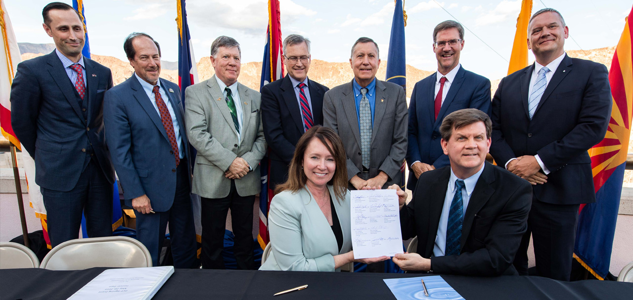
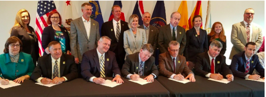
Roberto Salmon and Edward Drusina at the Minute 323 signing ceremony September 27, 2017. Photo credit .U.S. Bureau of Reclamation.
The agreement that made these flows possible—Minute 323—lasts through 2026. The agreement also commits more than $30 million for water conservation infrastructure in the Mexicali Valley. The water savings will improve local resilience to global warming, increase the water supply stored in Lake Mead, make additional water available to water users in the United States, and create additional water supply for the environment (the coalition of NGOs will also contribute from a local water trust). Minute 323 also ensures that the United States and Mexico conserve Colorado River water and share in shortages when supplies are low. In the context of a drought on the Colorado River that has persisted since 2000, and the expectation of climate change exacerbating drought conditions, these provisions create water supply reliability for both people and nature.
This spring, water for the Colorado River Delta creates a renewed sense of hope. Over the next few months we have the opportunity to see what a small volume of water can do to revive the remnant ecosystem, to nurture its birds, and gift local communities with the return of their river. We can be reassured that, at least in parts of the delta, the Colorado River lives again. In an extraordinarily dry year, deliberate management of water to sustain the environment is the kind of management we will need throughout the Colorado River Basin to ensure that persistent drought and long term impacts of climate change do not lead to the end of river ecosystems in the arid West.
The white bathtub ring along Lake Mead reflects the effects of years of drought in the Colorado River Basin. Source: Water Education Foundation
From Yale Climate Connections (Jan Ellen Spiegel):
The region is transitioning to a more arid climate, challenging longstanding practices of water-sharing in the basin.
Colorado is no stranger to drought. The current one is closing in on 20 years, and a rainy or snowy season here and there won’t change the trajectory.
This is what climate change has brought.
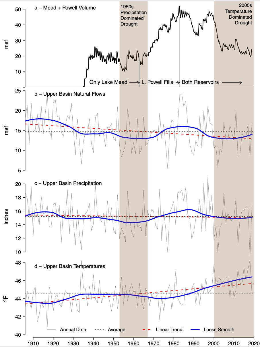
Brad Udall: Here’s the latest version of my 4-Panel plot thru Water Year (Oct-Sep) of 2019 of the #coriver big reservoirs, natural flows, precipitation, and temperature. Data goes back or 1906 (or 1935 for reservoirs.) This updates previous work with @GreatLakesPeck
“Aridification” is what Bradley Udall formally calls the situation in the western U.S. But perhaps more accurately, he calls it hot drought – heat-induced lack of water due to climate change. That was the core of research released in 2017 by Udall, a senior climate and water scientist at Colorado State University’s Colorado Water Center, and Jonathan Overpeck at the University of Michigan.
Their revelation was that the heat from climate change was propelling drought. “Previous comparable droughts were caused by a lack of precipitation, not high temperatures,” the study said. And all the factors at play were having compounding effects on each other that made the situation even worse. Those impacts were being felt most acutely on the biggest water system in the West – the Colorado River Basin.
Without a dramatic and fast reversal in greenhouse gas emissions to slow climate change, Udall and Overpeck said, the additional loss of flow in the basin could be more than 20% by mid-century and 35% at the century’s end – worse than currently assumed.
“I always say climate change is water change,” says Udall, whose father was Arizona congressman Morris (Mo) Udall, an iconic environmental activist. “It means too much water, not enough water, water at the wrong time. It means reduced water quality. You get all of these things together as the earth warms up.”
In Colorado it’s all pretty much coming true. The drought is the second worst 20-year period in the past 1,200 years, according to Udall. This summer/fall alone had some of the hottest spells on record and the worst wildfire season ever. On the other hand, 2013 brought catastrophic floods to the Front Range. “I got 17 inches of water in my house here in four days. It’s all part of the same change,” Udall says.
It’s forced Colorado to start facing the reality that its perpetual struggle for water can no longer be written off as cyclical weather that will all balance-out over short periods of time. It’s climate change at work, and it requires long-term planning and likely fundamental changes to the paradigm of how the state gets, uses, and preserves its water.
The state and individual municipalities are beginning to address their new reality with policies that range from the obvious – conservation, just using less water, to the more innovative – considering using beaver dams to restore mountain wetlands and generally remediating the landscape to better handle water.
But all those actions and more must face the political reality of the longstanding way water-sharing is handled in the basin. It pits state against state, rural against urban, agriculture against, well, everyone.
In 1922, Federal and State representatives met for the Colorado River Compact Commission in Santa Fe, New Mexico. Among the attendees were Arthur P. Davis, Director of Reclamation Service, and Herbert Hoover, who at the time, was the Secretary of Commerce. Photo taken November 24, 1922. USBR photo.
The Colorado River Compact
The Colorado River Basin provides water to a massive swath of the Rocky Mountain and western states. The Compact that rules it dates to 1922, with California, Nevada and Arizona – the lower basin states – essentially getting first dibs on water that flows from upper basin states – Colorado, Wyoming, New Mexico, and Utah – with secondary access to the water, so they generally absorb the brunt of water losses.
Colorado is a headwaters state – where the river flows down from the continental divide. It relies on whatever falls out of the sky: It does not have the luxury of access to whatever water may flow in farther downstream.
A process to re-evaluate aspects of the Compact is underway with a 2026 deadline. No one expects the basic structure to change, though other contingencies are likely to be layered on, as has happened a number of times in the intervening years.
River levels are off some 20% since the Compact was initiated, compounding the water crunch while the region’s population has grown dramatically, especially in Colorado. That combination of factors have many water experts and administrators convinced any new strategy has to do more than divvy-up the water differently.
That’s because it’s climate change and not cyclical weather causing the problems, Udall says emphatically: “Yup. Yup. Yup.” He notes that scientists already see impacts they hadn’t expected to see until 2050.
“I think some of the predictions about reduced flows in the Colorado River based on global warming are so dire it’s difficult to wrap your brain around them. We have no operating rules for that kind of reduction in supply,” says Anne Castle, a senior fellow at the Getches-Wilkinson Center for Natural Resources at the University of Colorado. “Even with these discussions that will be taking place over the next five years for the Colorado River system, I’m not sure that they will be able to get to an agreement about what would happen if flow is reduced by 50%.”
The critical climate change impacts seem to act in a loop: heat causes more evaporation of surface water. The resulting lower water level means water will warm more easily, and in turn evaporates more readily.
Global warming is also changing the dynamics of snowpacks. They melt faster and earlier and don’t regularly continue to slowly dissipate, creating a gradual runoff that is more beneficial and sustaining to the water supply. Udall notes that on April 1, 2020, there was 100% of normal snowpack above Lake Powell, which with Lake Mead are the two enormous reservoirs in the system. In a normal year that would provide 90-110% of runoff. But it provided only 52% in 2020 as a result of dry warm weather through fall.
Sustainable water supplies are also threatened as weather events occur more often as extremes: major rains in a short period of time sandwiched by extended dry periods. Torrential rains that follow a long drought may help the soil, but runoff may never make it to the water supply.
Wildfires, in recent years larger and longer, complicate matters by dumping ash and crud into water bodies, which results in less water and contamination that can render unusable what water there is. And if difficult climate conditions keep trees from growing back after fires, the resulting ecosystem changes could further damage water supplies.
Big ideas in place
“This is not your average variability,” says Andy Mueller, general manager of the Colorado River Water Conservation District, which covers most of the water used by the state. “Cooperative management of water resources can really help in these hot dry summers,” he says.
Mueller says the district tried releasing additional water from a reservoir that also creates hydropower. The extra water helps cool the river it flows into – slowing evaporation and allowing fishing and other activities often stopped when the water gets too warm and low to resume. That same water was also used for other hydropower plants downstream. Some then continued to other river areas. And some was diverted for crop irrigation, important given that farming and ranching are the biggest consumers of water in the state.
Basic conservation – just using less water – is always the first step, but even Colorado Water Conservation Board senior climate specialist Megan Holcomb admits: “We’re definitely beyond that conversation.”
The Board is considering systems that employ the technique of demand management: finding ways to use minimal water to allow for storage for dry years. So far, the thinking involves a voluntary program.
Already in place is an online tool called the Future Avoided Cost Explorer or FACE: Hazards. It helps quantify impacts of drought and wildfires on sectors of the Colorado economy.
“We know these hazards are going to continue to impact our economy, but we have no numbers to even say how much we should invest now so that we don’t have financial impacts in the future,” Holcomb says.
Castle talks about ideas such as consideration of water footprints on new developments and re-developments; integrating land use planning with water planning including things such as landscaping codes; and use of technology at various levels of water monitoring.
Signing ceremony for the Colorado River upper and lower basin Drought Contingency Plans. Back Row Left to Right: James Eklund (CO), John D’Antonio (NM), Pat Tyrell (WY), Eric Melis (UT), Tom Buschatzke (AZ), Peter Nelson (CA), John Entsminger (NV), Front Row: Brenda Burman (US), and from DOI – Assistant Secretary of Water and Science Tim Petty. Photo credit: Colorado River Water Users Association
In search of more equitable sharing of water
She notes also a drought contingency plan adopted in 2019 by the Compact states calling for reductions in deliveries to the lower basin. It’s pointed in the right direction, she says. “At the same time pretty much everyone involved in those discussions and that agreement also agreed that it was not sufficient,” Castle says.
Many experts have called for more equitable sharing of water reductions. But ideas on what is fair differ from state-to-state and also among different groups within a region where some interests are pitted against agriculture, which accounts for 80% of the water usage in the basin.
“I think people look at that huge volume of water being used in irrigated agriculture as a place where there’s flexibility. And when you get to the politics of working through that in an equitable way, it gets really complicated,” says Jennifer Pitt, Colorado River program director for the National Audubon Society.
The suggestions have included crop switching or alternative transfer mechanisms that call on farmers to periodically grow less water-intensive crops, or pay them not to grow, as a way to make water available for municipal use or storage.
“From a pure economic perspective, it may seem like you pay them and they’re whole,” Udall says. “There are actually a lot of things where they don’t get whole. They potentially lose a market that they’ve established over years and a great relationship with a buyer. And if that goes away for a year, that buyer may not come back.”
In the end, experts say people in the Southwest should definitely not count on more precipitation arriving to bail them out. “I would disabuse people of the idea that you’re going to get more water,” Udall says. “I think it’s pretty clear you’re going to have less water.” So for folks who think building more reservoirs is a solution, Udall says: “It’s not at all clear to me that that works.”
But less conventional strategies just might.
A beaver dam on the Gunnison River. Photo: Brent Gardner-Smith/Aspen Journalism
Beaver dams to the rescue?
Beaver dams are a water management technique that has worked in nature for eons – at least for beavers. Sometimes for people? Not so much.
But the thinking is they could help slow water loss from high-elevation wetlands. That includes the real deals built by beavers or human-constructed beaver dam alternatives.
“We think there’s a possible synergy there that helps to improve water supply for water users and helps to improve habitat conditions for species – birds in particular – that depend on that kind of wetlands being around,” Pitt says.
The goal would be to protect remaining ones, help establish new ones, and do the same for high-elevation meadows.
A lot of research is still needed, Pitt says. “There’s all kinds of instrumentation that has to go into place to understand the groundwater, the surface water, evaporation, the water balance, what it does to your river downstream,” she says. There are water law considerations. And then the inevitable pilot projects.
Overall, she says, this type of holistic approach to water through natural ecosystem restoration could become a component of water-sharing agreements as have already been done with Mexico. In exchange for getting river areas restored to better flow, Mexico agreed to a sharing agreement it might not otherwise have.
More people, less water, and a touch of Johnny Appleseed
More people and less water has forced Denver Water to work with uncertainties not previously considered. “Variability is the name of the game in Colorado,” says lead climate scientist Laurna Kaatz. “And that variability’s going to increase over time. That makes it incredibly challenging to continuously provide high-quality drinking water when you’re not sure what’s coming around the corner.”
The situation calls for adaptive capacity, she says, to provide technical and legal flexibility to adjust for changing circumstances.
Kaatz pointed to the One Water project that pairs water with usage. For instance, treated wastewater could be used to water a golf course, saving the purest water for drinking.
Another project is called From Forests to Faucets, which works on watersheds as natural infrastructure to optimize water flow. It has already proved successful at keeping a wildfire in 2018 from encroaching on a reservoir. In April, Denver Water plans to expand its Airborne Snow Observatory, which uses technology developed by NASA to track snow availability, but now it can be deployed above an altitude of 8,000 feet.
Together the efforts seem to be working – since the 2002 drought, Denver Water has maintained a 22% per-person reduction in water usage from pre-drought levels.
Steamboat Springs is opting for tree-planting. The idea is that trees will help cool down the Yampa River, which is part of the Colorado River Basin. Hot, dry seasons had been pushing stream temperatures so high that part of the river wound up on EPA’s impaired waterbody list.
“That was a call to action,” says Kelly Romero-Heaney, Steamboat Springs’ water resources manager.
The timing also dovetailed with the 2015 release of a Colorado Water Plan that included goals for stream management. Steamboat Springs did a streamflow management plan – released in 2018. In it was the idea of shading the Yampa.
“What we learned was that flow alone cannot overcome the thermal load for the solar radiation, as strength of that radiation increases over time,” she says. “The more that we can prepare the river for that, the better it will buffer against the impacts of climate change.”
They joined forces with the Yampa Valley Sustainability Council’s ReTree program that began in 2010 as a reforestation effort to counteract trees killed by pine beetle infestations. It morphed into a three-year Yampa River restoration.
“That work also increases resilience to future changes,” says Michelle Stewart, the council’s executive director. “We’re really learning the important role soil moisture plays in resilience.”
ReTree planted 200 narrow leaf cottonwoods in 2019 and another 350 this past October. This coming October, its plans are for 450 cottonwoods and 150 mountain alders. All were raised at the Colorado State Forest Nursery from Yampa Valley clippings. “We’re using local trees that are already kind of adapting to big swings in temperature and probably have a little bit more of that hardiness that we need and drought readiness,” she says.
It’s too early to know how the shading is working but there are plans for citizen help to monitor that and to implement a soil moisture monitoring network in the Yampa Basin.
“This is a Johnny Appleseed project,” says Romero-Heaney. “We plant today and hopefully my children will get to enjoy it.”
In the long-dry Colorado River Delta in Mexico, environmental groups are using small amounts of water to restore wetlands and forests one area at a time
The Colorado River once flowed with so much water that steamboats sailed on its wide, meandering stretches near the U.S.-Mexico border. When the environmentalist Aldo Leopold paddled the river’s delta in Mexico nearly a century ago, he was filled with awe at the sight of “a hundred green lagoons.”
Now, what’s left of the river crosses the border and pushes up against the gates of Morelos Dam. Nearly all the remaining water is shunted aside into Mexico’s Reforma Canal, which runs toward fields of cotton, wheat, hay and vegetables in the Mexicali Valley.
Downstream from the dam sits a rectangular lagoon that resembles a pond in a city park. Swallows swarm over the water, diving and skimming across its glassy surface. From here, a narrow stream the width of a one-lane road continues into a thicket, flanked by tall grasses.
Morelos Dam. Photo credit American Rivers.
About a dozen miles farther south, the Colorado River disappears in the desert. Beside fields of alfalfa and green onions, the dry riverbed spreads out in a dusty plain where only gray desert shrubs survive…
[Jennifer] Pitt is director of the National Audubon Society’s Colorado River program. She visited the delta with Gaby Caloca of the Mexican environmental group Pronatura Noroeste. The two co-chair a cross-border environmental work group that includes government officials and experts from both countries, and they’re working together on plans to restore wetlands in parts of the Colorado River Delta.
These efforts to resurrect pieces of the delta’s desiccated ecosystems face major challenges, including limited funds, scarce water supplies, and the hotter, drier conditions brought on by climate change.
But in the past decade, environmental groups have had success bringing back patches of life in parts of the river delta. In these green islands surrounded by the desert, water delivered by canals and pumps is helping to nourish wetlands and forests. Cottonwoods and willows have been growing rapidly. Birds have been coming back and are singing in the trees.
Martha Gomez-Sapiens, a monitoring team member and postdoctoral research associate in the UA Department of Geosciences, stands on a riverbank next to willows and cottonwoods that germinated as a result of the pulse flow. (Photo: Karl W. Flessa/UA Department of Geosciences)
Pitt, Caloca and other environmentalists say they’ve found that even though there isn’t nearly enough water available to restore a flowing river from the border to the sea, these modest projects planting trees and creating wetlands are showing promise. Even relatively small amounts of water are helping breathe life into parts of the delta.
And during the next several years, more water is set to flow to the restoration sites under a 2017 agreement between Mexico and the U.S…
Young girl enjoying the river restored temporarily by the pulse flow March 2014 via National Geographic
In the spring of 2014, a surge of water poured through the gates of Morelos Dam on the border. That “pulse flow” of 105,000 acre-feet of water brought back a flowing river in areas that had been dry since floods in the late 1990s.
Crowds of jubilant revelers gathered by the resurrected river. They dipped their feet into the water and waded in.
Some danced on the banks and drank beer. Others tossed nets into the water and pulled out flapping fish…
…the pulse flow gave Mexican and U.S. officials a visual demonstration of the potential of restoration efforts — an example that nudged them toward budgeting water for the environment as they negotiated a new Colorado River agreement.
“I think having that river flowing piqued people’s interest,” Pitt said. “It opened people’s imagination to the idea. It gave them a vision of the Colorado River here that has energized these restoration efforts.”
When representatives of the governments signed the next deal in 2017, it cleared the way for smaller but substantial flows to expand several habitat restoration sites.
The agreement, called Minute 323, acknowledged that the work group led by representatives from both countries had recommended goals including expanding the habitat areas from 1,076 acres to 4,300 acres, and setting aside an annual average of $40 million and 45,000 acre-feet of water for environmental restoration in the delta…
The deal included pledges for about half that much water, a total of 210,000 acre-feet through 2026 — enough water that if spread across Phoenix would cover two-thirds of the city a foot deep. This water — averaging 23,000 acre-feet a year — represents a small fraction of the 1.5 million acre-feet that Mexico is entitled to each year under a 1944 treaty, and an even smaller fraction of the larger allotments that California and Arizona take from the river upstream.
Mexico and the U.S. each agreed to provide a third of the water, while a coalition of environmental nonprofits pledged to secure the remainder. Each government agreed to contribute $9 million for restoration projects and $9 million for research and monitoring work.
So far, environmental groups have been buying water in Mexico through a trust and pumping it from agricultural canals into three restoration areas. More water is scheduled to be delivered by the two governments over the next several years, including water the U.S. plans to obtain by paying for conservation projects in Mexico.
When the infusion comes, the wetlands and newly planted forests will get a bigger drink.
“We are scaling up,” Pitt said from the backseat, while Caloca drove through farmlands toward one of the restoration sites.
Hoover Dam from the Arizona Powerhouse deck December 13, 2019. As John Fleck said in a Tweet, “Friends who have the keys showed us around this afternoon.” Thanks USBR.
Here’s a report from Andrew Davey writing for Nevada Today. Click through and read the whole article, here’s an excerpt:
Around this time last year, Commissioner Brenda Burman delivered this ultimatum to CRWUA attendees: “Close isn’t done, and we are not done. Only done will protect this basin.” This year, as in just yesterday, Burman said, “It was truly remarkable to have the divergent interests of the basin forge a compromise and make the difficult agreements to complete the DCP.”
And unlike last year, when Burman urged officials from across the Colorado River Basin to finish the DCP already, this year she urged patience on matters like renegotiating the 2007 agreement that turned Lake Mead into a sort of regional water bank. On that, Burman declared, “It’s not yet time to take up that task.”
Yet despite Burman’s more relaxed approach, some at CRWUA want to see more “fierce urgency of now”. While the DCP successfully fended off the threat of federal water rations, and while Upper Colorado River Basin snowpack is currently running 15% above average, ongoing legal concerns and the ever escalating threat of climate change may yet upend the delicate peace that the DCP has ushered in for now…
While Burman voiced confidence in the states’, municipal water agencies’, and Native American tribal authorities’ ability to cooperate, some of these very local officials were voicing notes of warning and caution. Shortly after Burman’s presentation on the main stage, Southern Nevada Water Authority (SNWA) Director of Water Resources Colby Pellegrino noted their use of data from the U.S. Geological Survey and UNLV’s Center for Business and Economic Research (CBER) showing less Colorado River water for everyone to work with in the next 50 years.
As Pellegrino described this challenge, “It’s a pretty severe stress test for our water resource portfolio.” Pellegrino then noted how SNWA and the larger community have already been rising to this challenge with conservation programs like outdoor watering schedules and turf removal. As Pellegrino put it, “There’s significant water savings to be achieved by changing the mindset of how we use it.”
Later in the day, I caught up with Pellegrino to talk some more about her presentation and the challenges that lie ahead for her agency and the entire region. When asked how SNWA plans to handle those future challenges, she replied, “Conservation is still right here, under our noses, the quickest and most cost effective way.”
[Friday], it was Interior Secretary David Bernhardt’s turn to make news here in Nevada. And make news he did, as Bernhardt announced the federal government will launch an early start of its review of the 2007 Interim Guidelines (as in, the 2007 agreement that launched the ICS program to manage the Lower Basin’s water supply).
Soon after his main floor presentation, Bernhardt spoke with reporters about this and other pressing water issues. On his announcement to jump-start review of the Interim Guidelines, Bernhardt said, “We have an opportunity right now. We have the people in place. We might as well build on the success we have here.”
So what can we expect in this review? And for that matter, what kinds of future changes might we expect in federal oversight of the Colorado River? When I asked Bernhardt whether he’d take into account climate science and the changing needs and consumption patterns of the increasingly urban American Southwest, he replied, “I’ve never taken a position of what we need to tell a city or county what they need to do.”
Yet as Bernhardt’s discussion with reporters continued, the conversation occasionally veered into other environmental matters. And when a couple reporters asked about the proposed oil and gas leases on public lands that have run into local opposition, including right here in Nevada, in the Ruby Mountains outside Elko and in parts of Lincoln County that supply drinking water for Mesquite, Bernhardt declared, “The president was clear when he ran for office what his policy is on energy. He supports an ‘all of the above’ approach.” Bernhardt also suggested these leases are required by federal statute, even though the Obama administration took a more cautious and targeted approach toward such fossil fuel extraction on public lands…
Funny enough, one of my takeaways from my conversation with SNWA’s Colby Pellegrino on Thursday was that regardless of what becomes of the long-fought pipeline plan, SNWA has enough water available to keep the Las Vegas region going for the next 50 years. Also, I noticed that regardless of the Trump administration’s curious comments on climate change and “all of the above” approaches to water infrastructure and fossil fuels, SNWA officials recognize the clear and present danger of climate change, and they’re already acting on it.
And it may not just be SNWA doing this. Even as Trump appointees are skirting around acknowledgement of climate science, fossil fuel pollution, ongoing regional tensions, or the reality of urban and suburban growth in the Colorado River Basin, federal civil servants continue to collect data, analyze trends, and manage the water we all share. We’ll talk more about that next week.
Still, there’s a rather large gap between the rhetoric and overarching policies of the Trump administration and the promises of strong climate action that U.S. Senators Elizabeth Warren (D-Massachusetts) and Bernie Sanders (I-Vermont), former Vice President Joe Biden, and the other 2020 Democratic presidential candidates are providing. And yet, we don’t hear as much about the Colorado River and our fragile water supply as you’d expect considering their environmental and geopolitical importance. Yet no matter how much we ignore it, all we have to do is glimpse at Lake Mead to remember how important it truly is to our very livelihood.
U.S. Bureau of Reclamation Commissioner Brenda Burman told federal, state and local water managers that abiding by the promises they made will be crucial to ensuring that more painful cuts aren’t required…
“We need to be proud of what we’ve done,” Burman told hundreds at the annual Colorado River Water Users Association conference at a Las Vegas Strip resort, while also warning of “tougher challenges in the future.”
Arizona, Nevada and Mexico will start taking less water from the river Jan. 1 under a drought contingency agreement signed in May. It followed lengthy negotiations and multiple warnings from Burman that if the seven states didn’t reach a deal, the federal government, which controls the levers on the river, could impose severe water restrictions.
California would voluntarily cut water deliveries if reservoir levels keep falling at the river’s largest reservoir, Lake Mead…
Cuts will most affect farmers in Arizona. The Central Arizona Project will stop storage and replenishment operations and cut water for agricultural use by about 15%. The agency gets more than half of Arizona’s entitlement of water from the Colorado River…
The drought contingency plan is a voluntary agreement to use less water than users are allowed, and its success is measured at the surface level of Lake Mead, behind Hoover Dam east of Las Vegas.
The agreements are designed to prevent a more drastic drought-shortage declaration under a 2007 pact that would cut 11.4 percent of Arizona’s usual river water allocation and reduce Nevada’s share by 4.3 percent. That amount of water, combined, would serve more than 625,000 homes.
California would reduce its Colorado River use by about 6 percent.
Due to a relatively wet winter, Lake Mead is now 40% full and Lake Powell, an upstream reservoir, is at 53% capacity, Bureau of Reclamation spokeswoman Patricia Aaron said. A year ago, Lake Powell was 43% full, and Lake Mead was at 38%…
Water managers have called the last 20 dry years a drought, but climate researchers warn the river will continue to carry less water in coming years.
“Respected climate scientists have conservatively estimated declines in river flows of 20% by the middle of the 21st century and 35% by the end of the century,” researchers Anne Castle of the University of Colorado Law School and John Fleck of the University of New Mexico wrote in a study released in November.
The report refers to a “structural deficit” under which states and Mexico are promised more water than the river usually carries and encourages the seven states to clarify rules for handling future shortages.
Brad Udall: “…latest version of my 4-Panel plot thru Water Year (Oct-Sep) of 2019 of the #coriver big reservoirs, natural flows, precipitation, and temperature. Data goes back or 1906 (or 1935 for reservoirs.) This updates previous work with @GreatLakesPeck
I finished Eric Kuhn and John Fleck’s new book in the hotel last night on my way to Las Vegas for the Colorado River Water Users Association Annual Conference.
It’s a page-turner that charts the history of the “Law of the River” and how politics and enthusiastic engineers that loved the big projects mostly trumped science in the debate and decisions since the Colorado River Compact negotiations. That trumping set the stage for we users of the Colorado River going forward. The book has praise for current decision makers and the deliberate effort to listen to the scientists regarding the hydrology of the river and the acidification in the basin due to the climate crisis.
Click here to order your copy of “Science be Dammed”.
Brad Udall: “…latest version of my 4-Panel plot thru Water Year (Oct-Sep) of 2019 of the #coriver big reservoirs, natural flows, precipitation, and temperature. Data goes back or 1906 (or 1935 for reservoirs.) This updates previous work with @GreatLakesPeck
…the river is dammed [by Mexico’s Morelos Dam] at the US-Mexico border, and on the other side the river channel is empty. Locals are now battling to bring it back to life.
There are few more striking examples of what has come to be known as “environmental injustice” – the inequitable access to clean land, air and water, and disproportionate exposure to hazards and climate disasters. Water in particular has emerged as a flash point as global heating renders vast swaths of the planet ever drier…
Currently the river flow in Mexico is 0.5 cubic metres per second, a fraction of what it once was. Another pulse flow to help restore the river’s estuary and wetlands could happen in 2021/22…
Because the 1944 treaty did not allocate Mexico any water for the river itself, the channel is mostly dry. The loss of the river in Mexico has has been devastating…
At the Morelos dam, located between Los Algodones, Baja California and Yuma, Arizona, the river is diverted to a complex system of irrigation canals which nourish fields of cotton, wheat, alfalfa, asparagus, watermelons and date palms in the vast surrounding desert valley. This is good for farmers – and less so for ordinary Mexicans.
Following the dry riverbed south towards the Gulf of California evokes an eerie sadness. The sound of gunfire in one wide, dusty section led to a couple from San Diego hunting wild pigeons, and a bucketful of feathered corpses. A few miles west along dirt farm roads, dozens of herons, egrets and ducks were staking out a wonderfully lush wetland – though it is only an accidental byproduct created by agricultural runoff from surrounding wheat and alfalfa fields.
Martha Gomez-Sapiens, a monitoring team member and postdoctoral research associate in the UA Department of Geosciences, stands on a riverbank next to willows and cottonwoods that germinated as a result of the pulse flow. (Photo: Karl W. Flessa/UA Department of Geosciences)
From inside a small airplane, tracing the Colorado River along the Arizona-California border, it’s easy to see how it happened.
As the river bends and weaves through the American Southwest, its contents are slowly drained. Concrete canals send water to millions of people in Phoenix and Tucson, Los Angeles and San Diego. Farms, ribbons of green contrasted against the desert’s shades of brown, line the waterway.
Further downstream, near Yuma, Arizona, the river splits into threads, like a frayed piece of yarn.
A massive multi-state plumbing system sends its water to irrigate the hundreds of thousands of farm acres in southern California and Arizona, hubs for winter vegetables, alfalfa, cotton and cattle.
When it hits the final dam, located on the U.S.-Mexico border, every drop has been claimed and put to use. In a typical year, what’s left of the river’s flow — promised to Mexico in a 75-year-old treaty — is sent to farm fields in the Mexicali Valley, and then on to the Mexican cities of Tijuana, Mexicali and Tecate.
All this reliance on an overallocated river has left its final hundred miles as the ultimate collateral damage. Since the early 1960s, when Glen Canyon Dam impounded the river near Page, Arizona, it has rarely reached the Pacific Ocean. The thread is frayed beyond recognition, leaving no water for the river itself.
“About 90 percent of the water is retained on the U.S. side and it’s used and diverted,” said Karl Flessa, a researcher at the University of Arizona. He studies the Colorado River Delta.
“In effect, one of the things we’ve done historically — not meaning to especially — what we’ve done is export some of the environmental consequences of water diversions,” Flessa said. “We’ve exported them to Mexico.”
The Colorado River’s inability to complete its journey from the Rocky Mountains to the Sea of Cortez has become one of its defining characteristics. Its historic delta, a haven for birds and mammals in the Sonoran desert, is a husk of its former self.
From the air, in a flight arranged by non-profit group LightHawk, the Colorado River Delta transitions from a jigsaw of farms to a staggering sprawl of muddy salt flats. (LightHawk receives funding from the Walton Family Foundation, which also funds KUNC’s Colorado River coverage.) The river’s historic channel in most parts through Mexico is nothing more than a sandy bed, scattered with saltcedar.
Where the river used to meet the ocean, tidal pools and drainages carve the sand and soil into organic patterns, like the cross-section of a lung.
Within the last twelve years, both the U.S. and Mexico have acknowledged the delta’s problems, signing agreements to commit both water and funding to restoring it to some semblance of its former self.
The splashiest of those efforts took place five years ago this spring, and left a lasting imprint on those who witnessed it.
The pulse flow
Around 8 o’clock on a Sunday morning in March 2014, water began spilling through Morelos Dam on the U.S.-Mexico border. The release was a culmination of years of negotiation between the U.S., Mexico and environmental organizations.
It was known as the pulse flow — flujo pulso in Spanish.
“You think of it as this wall of water that’s going to come down, but really it was this creeping tongue of water across the sand,” said Jennifer Pitt, who worked for the Environmental Defense Fund at the time, and now directs the Colorado River program for the National Audubon Society. Both groups receive Walton Family Foundation funding. Pitt was a key negotiator to make the pulse flow possible…
It took a few days after the dam opened for the water to arrive at the bridge, where Pitt and her colleagues gathered to wait. About 70 people in garden chairs sat in anticipation. A community clean-up a few days prior left the riverbed scrubbed of trash and debris.
For many young people, it was the first time they had ever seen water flowing in this stretch of the Colorado River. For older residents, it had been decades since they saw this much water here.
“They started getting up just one by one, people coming over to the water and getting down on their hands and knees and just touching it,” she said. “It was like the arrival. The great arrival of the river.”
A spontaneous festival started, complete with music, food vendors, horses and boats.
“I’ve spent 20 years thinking about how we can restore the Colorado River from where it dries out to where it reaches the sea,” Pitt said, “And in all of that thinking have never imagined that this site could bring so many people in as a magnet for people to enjoy something.”
Within weeks the flow was soaked up by depleted soils, though it did eventually reach the Pacific Ocean. From where Pitt and I are standing at the bridge in early December 2018, you’d never know the West’s mightiest river was supposed to flow here.
The pulse flow was about 105,000 acre-feet of water, enough to turn the channel again into a river for a few weeks. One acre-foot generally provides enough water for two average American households for a year. Historically more than 12 million acre-feet flowed into the delta each year…
Combined, that amount of water led to a green up along the river corridor, and sustained more than 275,000 new trees, according to a December 2018 report from the International Boundary and Water Commission.
The pulse flow’s biggest effects were short-lived. Both the green up and increases in certain species dropped again after the water stopped flowing.
The pulse flow’s biggest effects were short-lived. Both the green up and increases in certain species dropped again after the water stopped flowing.
A study from U.S. Geological Survey scientists confirmed that. It found that the amount of water in the pulse flow was too small to change the channel in a significant way, or scrub the riverbed, which would’ve happened during a more natural spring flood when flows would be much higher.
Because of the delta’s low water table, a lot of water seeped into the ground before it could do any good on the surface to help establish new wildlife habitat in expanded restoration areas. It was an experiment, said University of Arizona researcher Karl Flessa. Scientists experiment all the time, chart the results and move on.
Does he think the delta will ever see another pulse flow on the scale and magnitude of the one seen in 2014?
“Probably not,” he said. “Because you can get the water to do more restoration work by delivering it in smaller doses as it were, and delivering it to the right places where the vegetation can really take advantage of it.
“I think restoration, like any other activity with water, we’re really obliged as a society to be as water efficient as possible.”
From the Water Education Foundation (Gary Pitzer):
Western Water Q&A: Jayne Harkins’ duties include collaboration with Mexico on Colorado River supply, water quality issues
Jayne Harkins, the U.S. Commissioner of the International Boundary and Water Commission. (Image: IBWC)
For the bulk of her career, Jayne Harkins has devoted her energy to issues associated with the management of the Colorado River, both with the U.S. Bureau of Reclamation and with the Colorado River Commission of Nevada.
Now her career is taking a different direction. Harkins, 58, was appointed by President Trump last August to take the helm of the United States section of the U.S.-Mexico agency that oversees myriad water matters between the two countries as they seek to sustainably manage the supply and water quality of the Colorado River, including its once-thriving Delta in Mexico, and other rivers the two countries share. She is the first woman to be named the U.S. Commissioner of the International Boundary and Water Commission for either the United States or Mexico in the commission’s 129-year history.
The IBWC, whose jurisdiction covers the 1,954 miles of border from San Diego to the Gulf of Mexico, is responsible for applying the boundary and
he United States and Mexico, and settling differences that may arise in their application.
The IBWC is recognizable to many people as the implementing body for the additions to the 1944 U.S.-Mexican Water Treaty on the Colorado, Rio Grande and Tijuana rivers known as Minutes. In 2017, the latest addendum, Minute 323, built on previous agreements that specified reductions in water deliveries to Mexico off the Colorado River during a shortage and allowed Mexico to store water in Lake Mead, the nation’s largest reservoir which sits near Las Vegas.
The New River, a contaminated waterway that flows north from Mexico, spills into the Salton Sea in southwestern California’s Imperial Valley. Transborder pollution is among Jayne Harkins’ priorities as U.S. IBWC Commissioner. (Image: U.S. Bureau of Reclamation)
There are other issues, as well. Transborder pollution – from the New River spilling into the Salton Sea and from the Tijuana River fouling San Diego County beaches – is on her radar. Last year, the San Diego Regional Water Quality Control Board sued the U.S. section of the IBWC, claiming it is violating the Clean Water Act by not monitoring or stopping the untreated waste flowing to the Pacific Ocean from the Tijuana River that has caused beach closures in San Diego County.
Harkins, who lives in El Paso, Texas, spoke recently to Western Water about her new mission, transborder pollution and addressing Colorado River shortages with Mexico. The transcript has been lightly edited for space.
You are the first woman to be selected as IBWC commissioner. Do you see that as a significant accomplishment?
Yeah, I do. It is [significant] but I wish it weren’t. It should have happened a long time ago from my perspective. For me, you just plow on and get work done.
What is the significance of the IBWC and how its mission affects the various stakeholders?
We started as the International Boundary Commission and, of course, that is more straightforward. They work to demarcate the boundary, [and] maintain our boundary monuments.
Jayne Harkins (seated, far left), as executive director of the Colorado River Commission of Nevada, was one of the signers in 2017 of domestic agreements that were part of Minute 323, the addendum to the 1944 U.S.-Mexican Water Treaty. (Image: U.S. Bureau of Reclamation)
In 1944, of course, we got the treaty with Mexico that went beyond boundary stuff. That is what distributed waters between the United States and Mexico on the Colorado River. A part of that treaty authorized the joint construction and operation of international storage dams on the Rio Grande, and there is some discussion on a preferential solution to the issue of border sanitation problems.
I think a lot of what IBWC can do in both the U.S. and Mexico is bring all the stakeholders together into binational meetings to talk about the data we have, what are we lacking and then try to resolve issues.
What are your priorities as commissioner?
My priority is border sanitation. We have a number of areas with border sanitation issues and that’s one to try and figure out and see what we can do. Also, we have our treaty water deliveries and water quantity and quality responsibilities, depending on what the minutes require. We have those pieces that we need to make sure get done. We have got infrastructure issues on some of our dams and we just need to be operating and maintaining older infrastructure and make sure we are repairing and replacing as needed.
What is the IBWC’s role in water quality issues?
We are coordinating with others because there are some things that we can’t do that others can, and so we are trying to bring a coordinated effort among the federal U.S. entities. With Mexico, it’s what are the appropriate entities, federal and state, that they have to have. Each one of these is a local issue and we’ve got to bring in the local stakeholders because they have an interest as well. Some solutions may include infrastructure on both sides of the border. A number of studies regarding infrastructure improvements have been completed or are underway. We are working with local, state and federal agencies, as well as Mexico, to address the Tijuana River sanitation issue in a cooperative manner.
This has been ongoing for a long time. As I looked at it, I’m like, “Are things better than they were?” If you look at the data, even New River stuff [the New River flows from Mexico into California’s Imperial Valley and toward the Salton Sea], it’s much better than it was 20 years ago. If you look at the numbers overall, it’s not good enough. It’s not like the discharges meet U.S. standards and that’s what people in the U.S. are looking for. We are trying to help be a convener of folks to make sure we know what the data looks like, to make sure we know fact from fiction and bring people together who can perhaps bring some money to this and work with Mexico to see who can do what parts.
The water quality issues on the Colorado River are outlined in Minute 242 as related to salinity requirements. Minute 323 established a Salinity Work Group to minimize the impact of Minute 323 activities on salinity and to undertake cooperative actions like modernizing salinity monitoring equipment.
How is the IBWC involved with drought planning efforts?
Colorado River water released from Morelos Dam, along the border with Mexico, flows downstream into the Colorado River channel in March 2014 to benefit the environment as part of the cooperative measures agreed to by the United States and Mexico under Minute 319. (Image: U.S. Bureau of Reclamation)
We are not specifically engaged in the Lower Basin Drought Contingency Plan, but we are very interested in it and monitoring it and checking in with folks about what’s going on. Mexico is very interested because they have agreed to sharing shortages when the Lower Basin is in shortage. If there is a Lower Basin Drought Contingency Plan, Mexico has their Binational Water Scarcity Plan and they would take some additional reductions. So from the standpoint as to how we implement Minute 323 and what we need to do with sharing information with Mexico, that’s our part of the involvement.
The Binational Water Scarcity Contingency Plan is essentially how the DCP would be applied to Mexico.
What’s the status of Minute 323 implementation?
There are a number of conservation projects in Mexico that are wrapping up. We are involved in the verification that they got constructed. We will work with Mexico on the quantity of water that’s being conserved. As construction gets done, those projects are funded by some of the U.S. stakeholders, and we move that money over to Mexico so they can pay the contractors.
A recent report provided findings of the 2014 pulse flow of more than 100,000 acre-feet of water into the riparian corridor of the Colorado River Delta implemented under Minute 319. How will that inform future efforts?
We learned many things about water delivery methods, infiltration, irrigation techniques and groundwater – information that will guide our Minute 323 environmental work. This report provides solid scientific information about our restoration efforts. The findings will help us apply environmental water more effectively in the future.
FromYale 360 (Jim Robbins). Here’s an excerpt click through for the photos and to read the whole article:
The Colorado River has been dammed, diverted, and slowed by reservoirs, strangling the life out of a once-thriving ecosystem. But in the U.S. and Mexico, efforts are underway to revive sections of the river and restore vital riparian habitat for native plants, fish, and wildlife. Fifth in a series.
From the air, the last gasp of the Colorado River is sudden and dramatic. The pale green river flows smack into the Morelos Dam on the U.S.-Mexico border, and virtually all of it is immediately diverted into a large irrigation canal that waters a mosaic of hundreds of fields — alfalfa, asparagus, lettuce, and other vegetables, their vivid green color clashing against the sere desert. The slender thread of water that remains in the Colorado’s channel continues to flow south, but is soon swallowed up by a sea of sand, far short of its delta, which lies 100 miles farther on.
The Colorado River once surged through the delta during high flows, carrying so much water at times that shallow draft steamboats chugged hundreds of miles up the river into the U.S. with loads of freight. The water in the delta nourished a vast fertile landscape, a fitting end to a river known as the Nile of North America.
“The river was everywhere and nowhere,” the naturalist Aldo Leopold wrote during a 1922 canoe trip to the delta, describing the waterway as it ebbed, flowed, braided, and stalled into pools, nourishing a rich and diverse ecosystem of “a hundred green lagoons,” a “milk and honey wilderness” with thick stands of cottonwoods and willows that provided habitat for hundreds of species of birds. The delta’s marshes, mudflats, and white sand beaches were home to clapper rails, bitterns, mallards, teal, and clouds of egrets.
Bobcats, puma, deer, and wild boar wandered the delta’s forests. Leopold was searching for the jaguar that roamed there, but didn’t see any…
Morelos Dam. Photo credit American Rivers.
As a natural river, before it was dammed, the Colorado was a massive, dynamic waterway. It flowed from elevations above 14,000 feet in the Colorado Rockies, then dropped to sea level, which meant that it moved at high water with tremendous force, liquid sandpaper carving out red rock canyons. It flooded the desert plains, carving new channels and braids with every inundation. When it receded, it left behind a mosaic of fecund marshes, wetlands, and ponds.
In its natural state, the Colorado had more extreme flows than any river in the U.S., ranging from lows of 2,500 cubic feet per second in the winter to 100,000 cubic feet per second in the summer. In 1884, an all-time historical peak flow reached 384,000 cubic feet per second in Arizona.
But extreme flows are too capricious to support a civilization, so over the past century or so humans have built a network of expensive dams and reservoirs, pipelines, canals, flumes, and aqueducts to tame and divert the flow. Yet these projects also strangled the life out of a once-thriving ecosystem. By design, the river will never again function as a free-flowing stream.
Now, however, experts and environmentalists are rethinking this technological marvel of a river, and looking at ways a natural Colorado can flourish — to some degree, and in some places — with the permission of the engineers. One of those places is in the delta.
The water that flowed in the once-lush delta has been replaced by sand, and the cottonwoods and willows have surrendered their turf to widespread invasive salt cedar and arrowweed. Without the river and its load of nutrients, marine productivity in the Gulf of California — where the Colorado River once ended — has fallen by up to 95 percent. But despite the dismal forecast for the future of water on the Colorado, some conservationists are hoping to return at least a portion of the delta to its former glory.
Point 24 in the Colorado River Delta, September 12, 2016. Photo credit The Nature Conservancy.
“We are trying to restore a network of sites that creates a functional ecosystem,” said Francisco Zamora, who manages the project for the Sonoran Institute. “We’ve acquired water rights, but use them for habitat instead of cotton or wheat.”
The delta is one of a disconnected series of restoration projects that government agencies, local groups, and environmental organizations are undertaking along the Colorado. Numerous efforts are focused on tributaries to the main stem of the river, seeking to enhance resiliency by increasing the flow of water and protecting and restoring riparian habitat for fish and other wildlife.
For example, a coalition of groups — including state agencies, nonprofits, and the Arizona cities of Buckeye and Agua Fria — have been removing invasive salt cedar, planting native species, and building levees to reclaim a 17-mile stretch of the Gila River. Invasive salt cedars are a region-wide problem on the lower Colorado, with a single tree sucking up 300 gallons a day. The invasive forest on this stretch of the river uses enough water to serve 200,000 households.
In the upper basin, meanwhile, a number of groups and local landowners are working to restore a 15-mile-long floodplain with globally significant biodiversity on a narrow section of the Yampa River, another Colorado tributary. Called Morgan Bottom, the section has been damaged by deforestation and poor agricultural practices, threatening bald eagles and greater sand hill cranes, as well as a rare riparian forest of narrowleaf cottonwood and red osier dogwood.
But there are limits to how natural the Colorado River can become, especially along the river’s main stem. “We should not kid ourselves that we are making it natural again,” said John Fleck, the director of the University of New Mexico’s water resources program and the author of a book about the restoration of the Colorado. “We are creating an intensively managed system to mimic some nature because we value it.”
Because of the Colorado’s extensive infrastructure, serious disruption of the river’s ecology is inevitable.
Indeed, some of the remaining naturalness on the Colorado is, paradoxically, because of the human-made system. “The geography of the Colorado gives it hope because L.A. and southern California, which everybody loves to hate, guarantee that a lot of water stays in the system through the Grand Canyon,” says Jack Schmidt, a professor at Utah State University and a member of the Colorado River Research Group. “The best friend endangered fish ever had in the Colorado River Basin is that giant sucking sound” of California withdrawing water.
Widespread protection efforts are focused on native fish in the Colorado. The river once was home to an unusual number of endemic fish. But dams, irrigation, and the introduction of bullhead, carp, and catfish did them in. While the upper basin still has 14 native fish species, the lower basin, according to one study, “has the dubious distinction of being among the few major rivers of the world with an entirely introduced fish fauna.”
The Colorado pike minnow — something of a misnomer for a fish that historically grew to 6 feet in length and weighed up to 80 pounds — once swam through the entire system from Wyoming to Mexico. It is now listed as endangered, with two distinct populations remaining in the upper Colorado and the Green River.
The humpback chub lived in various canyon sections, and though once seriously endangered, it has fared better in recent years through transplantation efforts, growing from 2,000 to 3,000 fish to 11,000. Officials say it may soon be taken off the endangered list.Beginnings. Photo: Brent Gardner-Smith/Aspen Journalism
Razorback suckers, once common, are now rare. The bonytail, a type of chub that is one of North America’s most endangered fish, no longer exists in the wild. A handful of these fish exist in hatcheries, and attempts are underway to restock them in the river throughout the basin.
Because of the Colorado’s extensive infrastructure, serious disruption of the river’s ecology is inevitable. Dams trap most of the river’s sediment in reservoirs, which means there is no material to rebuild beaches, sandbars, and important fish habitat downstream.
Dams also deprive the river downstream of nutrients, such as phosphorous and nitrogen, and stratify water temperatures. The native fish in the Colorado adapted to a wide range of temperatures, from cold to very warm. They also evolved to tolerate high flood flows along with extremely dry periods. Now, the water is cold in the summer for miles below the dams, and the humpback chub and other fish that had adapted to a range of water temperatures and flows suffer.
Something called hydro-peaking also has had serious impacts on the food web. Dams generate power according to demand. As people come home from work and switch on the stove, air conditioning, and lights, demand soars and dams release more water to produce power. “Prior to the construction of dams, there were almost no major daily changes in river levels,” said David Lytle, a professor of integrative biology at Oregon State University. When fluctuations in water levels occur, they “can interrupt the egg-laying practices of some species. It’s a serious problem.”
Insects lay their eggs just below the water level, and if levels drop rapidly it can dry them out. A recent study found that below the Hoover and Glen Canyon dams, there was a complete absence of stoneflies, mayflies, and other species — insects that are vital food for fish, bats, birds, and other creatures.
Because of the ecological effects of the Glen Canyon Dam, the Grand Canyon stretch of the Colorado is one of the least productive sections of river in the world. The Colorado here will always be highly unnatural, a novel, human-created ecosystem with some natural elements.
Today, there is a large and growing backlash against dams in America and elsewhere as the immense damages they have inflicted on rivers become manifest. Few dams, though, are as reviled as the Glen Canyon, which was built in 1963 and took 17 years to fill Lake Powell.
Before the Glen Canyon was dammed, those who saw it say it was not unlike the Grand Canyon, with towering walls of red, tan, and ochre. Early Native American sites were plentiful. Environmental activist Edward Abbey decried the dam, and in his novel the Monkey Wrench Gang fantasized about using houseboats packed with explosives to blow it up. In 1981, members of Earth First!, a radical environmental group with a connection to Abbey, rolled a black plastic “crack” down the face of the dam to symbolize its demise.
Changes in the northeastern reaches of Lake Powell are documented in this series of natural-color images taken by the Landsat series of satellites between 1999 and 2017. The Colorado River flows in from the east around Mile Crag Bend and is swallowed by the lake. At the west end of Narrow Canyon, the Dirty Devil River joins the lake from the north. (At normal water levels, both rivers are essentially part of the reservoir.) At the beginning of the series in 1999, water levels in Lake Powell were relatively high, and the water was a clear, dark blue. The sediment-filled Colorado River appeared green-brown. To see the complete series go to: earthobservatory.nasa.gov/WorldOfChange/LakePowell. Photos via NASA
Removing the dam was part of the reason the Glen Canyon Institute was formed, but activists have now dropped that idea, says Rich Ingebretsen, a Salt Lake City physician who founded the group. Today, he advocates draining Lake Powell to fill Lake Mead, which is downstream and where the need for water is by far the greatest. The “Fill Mead First” campaign would restore a free-running Colorado River to what was once Lake Powell.
“You’d get much of Glen Canyon back,” said Ingebretsen. “A free-flowing river through the Grand Canyon means you’d restore the river — riparian zones, animals that belong there, a beautiful canyon with arches and bridges and waterfalls. Much of that would come back very quickly.” There would also be increased water in the river, he says, because so much of the Colorado is now lost from Lake Powell; scientists estimate that the lake loses three times Nevada’s allotment of water because of evaporation. As levels in Lake Mead drop due to prolonged drought, a growing number of people are taking this idea more seriously.
Paradoxically, two of the Colorado River’s most important wetlands for wildlife are the product of runoff from irrigated farm fields — and are now at risk from a changing climate and agreements to reduce water use.
In the Sonoran Desert of northwestern Mexico, the 40,000-acre La Cienega de Santa Clara wetland was inadvertently created in the 1970s when U.S. officials built a canal to dispose of salty wastewater from agricultural fields in Arizona. As the water began spilling into the desert, myriad forms of life began to appear. Now its cattail-studded marshes and mudflats are considered one of the most important wetlands in North America, home to 280 species of birds — including the endangered Ridgeways rail — on what was once hard-baked desert.
Meanwhile, in California, the Salton Sea was once a shallow inland lake whose levels routinely fluctuated. In 1905, an effort to increase Colorado River flow into the Imperial Valley led farmers to allow too much river water into their irrigation canal, overwhelming their system; for two years the water poured into the 35-mile-long, 15-mile-wide Salton Sea and expanded it.
But as less water becomes available to agriculture and rising temperatures cause more water to evaporate, scientists are concerned that these wetlands will dry and shrink faster than they already have. A 2003 agreement, for example, allows agricultural water in the Imperial Valley to be sent to San Diego for municipal uses. That could cause water levels in the Salton Sea to drop by more than 40 percent, dramatically reducing bird habitat and increasing toxic dust because wetlands would dry out. Local, state, and federal officials have devised a plan — still not fully funded — to restore 15,000 acres of wetlands, at a cost of more than $700 million.
The largest project to restore some semblance of nature to the Colorado River, though, is in the delta. An unusual agreement in 2012 between the U.S. and Mexico, called Minute 319, mandated that the two countries would provide water and funding to revive sections of the delta and release a one-time pulse of 105,000 acre-feet to again connect the river to the delta temporarily. Scientists would then study the effects.
In 2014, for the first time in decades, the river flowed again in Mexico — for eight weeks. San Luis Rio Colorado — once a Colorado River town, but now a dusty desert settlement — became a river town for two months, to the delight of locals, many of whom had never seen the river. The pulse offered a glimpse of what reclamation efforts might look like. “It gave us an idea of how the river behaves, and the best sites for restoration,” said Zamora.
Martha Gomez-Sapiens, a monitoring team member and postdoctoral research associate in the UA Department of Geosciences, stands on a riverbank next to willows and cottonwoods that germinated as a result of the pulse flow. (Photo: Karl W. Flessa/UA Department of Geosciences)
Minute 319 and its 2017 replacement, Minute 323, have funded the restoration of sections of the river. A group of nonprofits — including the National Audubon Society, the Sonoran Institute, The Nature Conservancy, and a Mexican group called Pronatura Noroeste — is working on a project called Raise the River to revive a significant swath of the delta.
In 2008, the group secured rights to 1,200 acres along the desiccated river channel. Since then, local residents have torn out acres of salt cedar and planted irrigated fields of cottonwood, willow, and other endemic species — more than 200,000 trees in all. A small supply of water mandated by the treaty, along with excess water that flows off of irrigated fields, have been dedicated to the restoration.
On a recent visit, I joined Zamora and botanist Celia Alvarado on a short boat ride to Laguna Grande, a 6-mile section of restored river and estuary. We skimmed across still water the color of weak tea, minnows darting away from our paddles. Thick groves of cottonwoods and willows lined the river. Zamora remarked that bobcats and beaver lived there now, along with blue grosbeaks and yellow-billed cuckoos. “Impacting the target species is key,” he said.
And what about the jaguar? I asked. It has not returned, he said. Will it come back?
“Yes,” said Zamora, smiling. “Someday. If they allow me to introduce them.”
Martha Gomez-Sapiens, a monitoring team member and postdoctoral research associate in the UA Department of Geosciences, stands on a riverbank next to willows and cottonwoods that germinated as a result of the pulse flow. (Photo: Karl W. Flessa/UA Department of Geosciences)
Young girl enjoying the river restored temporarily by the pulse flow March 2014 via National Geographic
Photo via the National Geographic
Pulse flow tongue upstream of San Luis Rio Colorado. Photo credit: National Geographic
Landsat view of Colorado River pulse flow in Mexico April 2014
Colorado River pulse flow (Minute 319) reaches the Sea of Cortez for the first time since 1998 on May 15, 2014 via the Sonoran Institute
Point 24 in the Colorado River Delta, September 12, 2016. Photo credit The Nature Conservancy.
In 2014, the Colorado River did something it hadn’t done in decades. For a few short weeks that spring, the overdrawn, overallocated river reached the Pacific Ocean.
Instead of diverting the river’s last bit of water toward farm fields, the final dam on the Colorado River at the Mexican border lifted, and water inundated nearly 100 miles of the dry riverbed. It was called the pulse flow, meant to mimic a spring flood.
In 2010, an earthquake in northern Mexico set in motion a big change in how people think about the lowest reaches of the Colorado River. The quake destroyed irrigation canals, leaving farmers unable to use all of their water. As the result of an emergency agreement, Mexico began storing its share in U.S. reservoirs. After another international agreement, Mexican and American officials decided that, as an experiment, the surplus water should temporarily flow into the river’s driest reaches.
The water’s life-giving effects spilled beyond the river’s banks. Kids who’d never seen it in its natural channel, splashed and played. Spontaneous festivals came to life. Birds returned, and trees and marshes greened up.
But the moment was fleeting. Within a few months, the majority of the delta was dry once again.
Several tributaries of the Colorado River get their start in the crags of the Central Colorado mountains. Storied rivers: Blue, Eagle, Roaring Fork and the powerhouse Gunnison. They’ve all faced the footstep of humankind. The mines dotting the slopes, hay fields, ranching, orchards and cornfields bear witness and are now part of the allure of the high country. Folks cast a line, shoot rapids and enjoy the scenery of those waterways.
On September 27, 2017, the International Boundary and Water Commission, United States and Mexico inked Minute 323, the amendment to the 1944 United States-Mexico Treaty for Utilization of Water covering operations on the Colorado, Rio Grande and Tijuana rivers. (The Rio Grande is another of Central Colorado’s contributions to the Western U.S. economy.)
An important part of Minute 323 are environmental flows for the Colorado River Delta. Most everyone knows the river doesn’t reach the sea any longer. Environmental streamflow was initiated under Minute 319 signed by then Secretary of Interior Ken Salazar.
Young girl enjoying the river restored temporarily by the pulse flow March 2014 via National Geographic
In March 2016 a diverse group of conservationists, biologists, irrigators and government officials effected a release of 100,000 acre-feet of water from Morelos Dam into the dry Colorado River Delta. There was a line of vehicles racing point to point along the river to witness the river’s front. At San Luis Rio Colorado, most of the residents went down to the river to celebrate the return of the river although many had no memory of running water in the sandy channel.
There was a great deal of success from channeling some of the streamflow to restoration sites in the Delta. Within weeks, new growth sprouted – cottonwoods and willows. Much of the diverted water served to replenish groundwater supplies. Wildlife immediately started using the habitat.
There probably won’t be a repeat of the Colorado River once again reaching the sea. The environmental flows in Minute 323 are planned to be set to work in the restoration of the Delta. It was great to see the river reach the sea but the conservationists want to concentrate flows like irrigators do for maximum yield.
Another feature of the deal allows Mexico to store water in Lake Mead to better manage their diversions for agriculture. The U.S. is also helping to rebuild and upgrade Mexican infrastructure. Under Minute 319, Mexico was allowed to continue storing water, and that water was used for the pulse flow. The idea is that greater efficiency in Mexico will lead to more storage in Lake Mead.
Currently, Arizona, California and Nevada are working on a drought contingency plan to stave off a shortage declaration in Lake Mead. Arizona’s Colorado River allocation takes a big hit under a declaration. Mexico’s water in Lake Mead will help. Negotiations about the drought contingency plan will now move forward with greater certainty with the signing of Minute 323.
The final signatures for the Minute came from Roberto Salmón (Mexico) and Edward Drusina (U.S.). There were several officials from President Obama’s administration in attendance, including Jennifer Gimbel and Mike O’Connor. The negotiations started before last year’s election but did not conclude before the inauguration.
Minute 323 is an important piece of the puzzle for administering the Colorado River.
Central Colorado is joined at the economic hip with the Colorado River. A lot of transbasin water flows down the Arkansas River from the Twin Lakes and Fryingpan-Arkansas projects. Some is pumped over to South Park by Colorado Springs and Aurora but most of it goes down to Lake Pueblo and the Fry-Ark partners. Colorado Springs, Fountain and Security pump some back north in the Fountain Valley. Cities along the river divert and treat the water for their populations. The water also is used to grow the famous crops in the Arkansas Valley: Rocky Ford melons, Pueblo chile, corn and others. Timing the releases from Twin Lakes and Turquoise Reservoir also contributes to the rafting economy. 100 miles of the Arkansas River are designated as gold medal fisheries. Transbasin flows help the riparian habitat.
SHORT TAKES
• Comments about managing the Arkansas Headwaters Recreation Area are due by November 10, 2017. Check out the AHRA Plan Revision page on the Colorado Parks & Wildlife website.
• Congratulations to Wet Mountain Valley ranchers Randy and Claricy Rusk for winning the Dodge Award for a lifetime of conservation from the Palmer Land Trust.
• Congratulations to the Colorado Parks & Wildlife folks at the Roaring Judy Hatchery for successfully spawning the line of Cutthroat trout rescued from Hayden Creek during the Hayden Pass Fire.
• James Eklund has moved on from the Colorado Water Conservation Board and Becky Mitchell is the new director.
• Coloradans cam now legally collect rain off their roofs. Governor John Hickenlooper signed House Bill 1005 in May.
• R.I.P. Gary Bostrom. He was one of the driving forces behind Colorado Springs’ $825 million Southern Delivery System.
John Orr works for a Front Range water utility where he keeps one eye on the sky to monitor Colorado snowpack. He covers Colorado water issues at Coyote Gulch (www.coyotegulch.blog) and on Twitter @CoyoteGulch.
Martha Gomez-Sapiens, a monitoring team member and postdoctoral research associate in the UA Department of Geosciences, stands on a riverbank next to willows and cottonwoods that germinated as a result of the pulse flow. (Photo: Karl W. Flessa/UA Department of Geosciences)
Martha Gomez-Sapiens, a monitoring team member and postdoctoral research associate in the UA Department of Geosciences, stands on a riverbank next to willows and cottonwoods that germinated as a result of the pulse flow. (Photo: Karl W. Flessa/UA Department of Geosciences)
A group of scientists, including those from the U.S. Geological Survey, are also gaining insight into how the flow was felt by plants, animals and the overall delta ecosystem.
Using a mix of groundwater monitoring and satellite imagery, scientists say even the pulse’s modest flow of water — approximately one-twentieth the amount that spilled into the delta before humans built the river’s massive upstream dams — recharged aquifers, greened plant life and spurred the return of bird species.
Years before the flow, Mexico and the United States agreed to the experiment, and to the idea that the water was not just for human use, but can and should be used to revive ecosystems. The agreement — an update to a 1944 treaty between the two countries — gave Mexico the ability to store more water in American reservoirs and, just once, flood the final miles of the dry river bed to see what happened.
From above you can use the naked eye to see the water’s effect. Before and after photos show plant life greening not just in the river’s bed where water actually flowed, but beyond the banks, which Leenhouts says is a sign of recharged groundwater.
“In the two years following the flow it was possible to measure increased green up,” using satellite images, he says.
During that same period both the number of and varied species of birds increased, he says, a side effect of the revived vegetation.
Even though the pulse flow only lasted a few months in 2014, its effects lasted for years. The greenness of vegetation wasn’t as vibrant the following year, but it was still greener compared to 2013. That indicates the single sustained flow provided enough water to keep plants alive for at least a year…
Scientists’ chance to study and test the effect of simulated floods isn’t over. A new update to the 1944 treaty signed this year allows for more pulse flows when Mexico stores surplus water.
Colorado River pulse flow (Minute 319) reaches the Sea of Cortez for the first time since 1998 on May 15, 2014 via the Sonoran Institute
Here’s a report from Emily Benson writing for The High Country News. Click through and read the whole analysis. Here’s an excerpt:
For many people, the 2014 “pulse flow,” a large release of water from Morelos Dam, on the U.S.-Mexico border, was the defining feature of the 2012 agreement. The agreement also addressed drought, reservoir storage and environmental restoration in the Colorado River Delta. The 2014 release reunited the Colorado River with the Gulf of California for the first time since the late 1990s; it was both a scientific and symbolic success as communities along the Colorado River saw its dry channel once again fill with water. But the pulse flow also showed that a single release of water may not be the most efficient way to revitalize the Delta. So while the new agreement, called Minute 323, includes environmental water releases, it doesn’t specifically call for another pulse flow.
…a second round of releases is headed to the delta that won’t be nearly as dramatic [as the Minute 319 pulse flow]. But these flows will restore more riverfront with cottonwoods and willows than the last time and their impacts will likely last longer.
The new U.S.-Mexico Colorado River agreement, announced last week, sets aside 210,000 acre-feet of river water for environmental restoration in the delta over nine years, starting next year. This 2017 agreement also calls on the two countries to share shortages on the river in equal proportions in times of drought.
The earlier, 2012 agreement under which the huge pulse flow was unleashed also enabled the more gradual release of another 53,000 acre-feet over four years that will end Dec. 31, 2017.
The first round of flows has restored about 1,100 acres of cottonwood, willow and mesquite habitat, said Osvel Hinojosa, water and wetlands program director for Pro Natura Noroeste and a co-chair of an environmental working group that developed restoration ideas for the new agreement. Pro Natura is headquartered in Ensenada, Baja California.
In that time, more than 230,000 native cottonwoods and willows were planted along the river, said a coalition of six U.S. and Mexican conservation groups calling itself Raise the River. The groups raised more than $10 million for restoration work and to buy water rights for those releases.
This time, the goal is to restore about 4,300 acres over the next nine years, the new agreement says.
Now, “We will see a resurgence of the Colorado in its delta, the ribbon of green that is re-emerging in the Sonoran Desert,” said Jennifer Pitt of the National Audubon Society at last week’s signing ceremony in Santa Fe, New Mexico. “It offers relief to every living being that seeks rest in the cool shade of a cottonwood, renewal in the bounty of life that flows from the waters of the Colorado River. We are finding new ways to share the water, among our communities, but also with hundreds of thousands of egrets, herons, flycatchers, rails and other birds that need it to survive.”
Although smaller pulse flows may be released later, the immediate plan is to focus on lesser, steadier amounts of base flows, Hinojosa said. Pulse flows release lots of water over short periods from a single point such as the dam. Base flows deliver lesser amounts, often over longer periods to specific restoration sites.
“At this point, the best way to proceed with restoration is base flows. That’s the best use of the water,” said Karl Flessa, a University of Arizona geosciences professor who oversaw the scientific monitoring of the 2014 pulse-flow impacts and hopes to be involved in similar work this time.
A lot of the 2014 pulse flow infiltrated into deep groundwater and was not available to nourish cottonwoods and other trees, he said.
“By applying base flows to restoration sites, you make sure water gets to the right place at the right time,” Flessa said.
Hinojosa said he considers base and pulse flows equally valuable, and may want to use smaller pulse flows for social purposes — allowing people living nearby to enjoy water in the river and reconnect with nature.
Roberto Salmon and Edward Drusina at the Minute 323 signing ceremony September 27, 2017. Photo credit .U.S. Bureau of Reclamation.
Here’s the release from the Bureau of Reclamation (Lori Kuczmanski):
UNITED STATES AND MEXICO CONCLUDE COLORADO RIVER AGREEMENT
Officials with the International Boundary and Water Commission, United States and Mexico, today announced the conclusion of a new Colorado River agreement, Minute 323, “Extension of Cooperative Measures and Adoption of a Binational Water Scarcity Contingency Plan in the Colorado River Basin.” Commission officials signed the Minute on September 21 in Ciudad Juarez, Chihuahua and both governments approved it on September 27. The Minute’s entry into force was announced during a ceremony held at the Water Education Foundation’s Colorado River Symposium in Santa Fe, New Mexico. The Minute follows more than two years of negotiations among federal and state authorities from both countries, taking into consideration recommendations from the works groups, which included water users, scientists, academics, and nongovernmental organizations.
The agreement, which will remain in effect through 2026, extends or replaces key elements of Minute 319, a previous agreement that expires at the end of 2017. Minute 323 contains the following provisions:
Allows Mexico to defer delivery of a portion of its Colorado River allotment in the event of potential emergencies, such as earthquakes, or as a result of water conservation projects in Mexico. This water, known as Mexico’s Water Reserve, will be available for subsequent delivery to Mexico as determined through its planning processes. This gives Mexico greater flexibility in how it manages its Colorado River allotment while also boosting Lake Mead elevation to the benefit of all users.
Provides additional quantities of Colorado River water to Mexico during certain high elevation reservoir conditions at Lake Mead when additional water is available to users in the United States, providing benefits to both countries.
Establishes proactive basin operations during certain low elevation reservoir conditions at Lake Mead by applying water delivery reductions in order to deter more severe reductions in the future, giving certainty in both countries’ operations when these conditions occur.
Establishes a Binational Water Scarcity Contingency Plan so that, should a Lower Basin Drought Contingency Plan be put into effect in the United States, then Mexico will also undertake water savings in parity with U.S. savings. These savings will be recoverable when reservoir conditions improve.
Implements measures to address salinity impacts stemming from the joint cooperative actions, in conformance with the provisions of Minute 242, entitled, “Permanent and Definitive Solution to the International Problem of the Salinity of the Colorado River,” dated August 30, 1973.
Identifies measures to address daily flow variability in Colorado River water deliveries to Mexico.
Through a cooperative effort among the Governments of the United State and Mexico and nongovernmental organizations, provides water for the environment and funding for environmental monitoring and habitat restoration.
Provides greater U.S. investment in water infrastructure and environmental projects in Mexico than Minute 319 in order to modernize and improve Irrigation District 014 in the Mexicali Valley in areas that wish to participate. This will generate additional volumes of water that will be shared between both countries and the environment, in accordance with the Minute’s provisions.
Notes the ongoing efforts of the binational All-American Canal Turnout Project Work Group to examine resources associated with a potential binational connection between the All-American Canal in the United States and Mexico’s Colorado River Tijuana Aqueduct Pump Station PB 0.
“Minute 323 is the result of many rounds of technical discussions involving a broad group of stakeholders from both countries. This agreement puts us on a path of cooperation rather than conflict as we work with Mexico to address the Colorado River Basin’s many challenges,” said U.S. Commissioner Edward Drusina of the International Boundary and Water Commission.
Mexican Commissioner Roberto Salmon said, “This agreement provides certainty for water operations in both countries and mainly establishes a planning tool that allows Mexico to define the most suitable actions for managing its Colorado River waters allotted by the 1944 Water Treaty.”
Joining the Commissioners at the ceremony were David Bernhardt, United States Deputy Secretary of the Interior; Thomas Buschatzke, Director of the Arizona Department of Water Resources; Hillary Quam, Border Affairs Coordinator, U.S. Department of State Office of Mexican Affairs; and, from Mexico, Director General for North America Mauricio Ibarra of the Ministry of Foreign Relations.
The International Boundary and Water Commission, United States and Mexico, is responsible for applying the boundary and water treaties between the two countries. Under the 1944 Water Treaty, Mexico is allotted 1.5 million acre-feet (1850 million cubic meters) per year of water from the Colorado River
Minute 323 Agreement boosts water security for Colorado River water users, continues Delta restoration
(September 27, 2017) – Today, policymakers, water agencies, and conservation organizations from the United States and Mexico gathered to confirm the signing of Minute 323, an addendum to the 1944 Water Treaty between the United States and Mexico. The successful negotiation and signing of this agreement demonstrates the power of collaboration and cooperation between the United States and Mexico governments, and supported by the Raise the River coalition of non-profit organizations, to achieve progress on water security for Colorado River water users.
Raise the River Coalition’s public statement of support for Minute 323:
We applaud the leadership and vision of water managers and state and federal officials in United States and Mexico in adopting the Minute 323 Agreement to provide for a more secure water future for all Colorado River water users, and support continued restoration of the Colorado River Delta.
This new binational water sharing agreement shows the best of what collaboration can do, improving the reliability of the Colorado River water supply for everyone who uses it”. –Jennifer Pitt, Raise the River spokesperson and Colorado River Project Director, National Audubon Society
Officially titled “Extension of Cooperative Measures and Adoption of a Binational Water Scarcity Contingency Plan in the Colorado River Basin”, Minute 323 commits the United States and Mexico to work together to address potential Colorado River water shortages and to meet new water conservation and storage objectives. It represents the joint efforts of local, state, and the federal governments of both countries to set a course for a more secure water future for the more than 36 million people who rely on the Colorado River in the United States and Mexico.
“This is an exciting day for both countries,” said Osvel Hinojosa, Water and Wetlands Program Director at Pronatura Noroeste, a Mexican non-profit conservation organization. “Especially for those of us who have worked in the delta for decades.”
Pronatura Noroeste is a member of Raise the River – a unique partnership of six U.S. and Mexican non-governmental organizations committed to restoring the Colorado River Delta. Members include the National Audubon Society, Pronatura Noroeste, Restauremos el Colorado, A.C., Sonoran Institute, The Nature Conservancy, and the Redford Center. The coalition has worked with policymakers, water agencies, and governmental representatives from the United States and Mexico since 2012 to cooperatively create historic change for the Colorado River Delta.
The Colorado River is one of the most critical sources of water in the West, supplying water to 36 million people and 5.5 million acres of agricultural land in seven states in the U.S. and two states in Mexico. More than 17 years of drought have diminished the reliability of the Colorado River water supply, putting an enormous population and economy at risk of disruptive water shortages. Proactive investments in water conservation, paired with agreements among Colorado River water users about how to share when the water supply is limited, will create the certainty needed to ensure that the region’s economies continue to thrive.
As the Colorado River is shared by both the United States and Mexico, it is subject to various binational agreements extending back to the 1944 Water Treaty for the Utilization of Waters of the Colorado and Tijuana Rivers and of the Rio Grande.
The International Boundary and Water Commission (IBWC) and its Mexican counterpart (CILA) are the U.S. and Mexican federal agencies that negotiate and implement binational water treaties and water allocations. In 2012, the IBWC and CILA successfully negotiated Minute 319, an agreement that helped the two countries better implement the 1944 U.S.-Mexico Water Treaty (these types of supplementary treaties agreements are referred to as ‘Minutes’). The result of this extraordinary binational collaboration, Minute 319 provided multiple benefits for water users on both sides of the border. It broadly provided for the United States and Mexico to share surpluses in times of plenty and reductions in times of drought and provided for water flows for the environment. The agreement also served to recognize the Colorado River Delta as a place of ecological significance for both countries.
Minute 319 concludes on December 31, 2017. Its successor agreement, Minute 323, promotes a more secure water future while scaling up ongoing environmental restoration projects in the Delta.
Specifically, Minute 323:
Provides for Mexico to continue to store its water in Lake Mead, helping to keep reservoir levels high enough to avoid triggering dramatic cuts to Colorado River water users.
Includes an agreement between both the United States and Mexico for voluntary water cutbacks in times of droughts that further staves off triggering a shortage declaration. Should a shortage be declared, these new commitments will slow progress towards even larger water shortages.
Commits US water managers to invest $31.5M in water efficiency projects in Mexico that will result in savings of more than 200,000 acre-feet of water. In return, the U.S. entities will receive a one-time water exchange, and over the long term, Mexico will benefit by generating additional water from these conservation programs and improved infrastructure.
Obliges both the United States and Mexico to each provide water and funding for continued habitat restoration and scientific monitoring in the Colorado River Delta through 2026, with Raise the River contributing matching amounts.
“We have worked closely with the governments of Mexico and the United States to demonstrate the Colorado River Delta’s tremendous resilience,” states Hinojosa. “Through a combination of limited water deliveries and on-the-ground work to restore natural habitat, native vegetation is sustaining a great diversity of life in these sites and there has been a renewal of the community relationships and engagement that promote long-term stewardship of the river.”
Raise the River has been a leading advocate of – and active participant in – the negotiation and drafting of Minute 323 to support continued cooperative Colorado River management between Mexico and the United States.
“Minute 323 recommits the United States and Mexico in their successful partnership with NGOs to restore the Colorado River in its long-desiccated delta; this is a big win for people and for nature,” says Pitt.
Raise the River’s successful habitat restoration under Minute 319 helped lay the foundation for Minute 323. Between 2013 and 2017 Raise the River provided active management of restoration sites, including base flows – smaller, periodic releases of water – to restore over 1,000 acres of riparian habitat along the river’s main channel, where more than 230,000 native cottonwoods and willow trees were planted. Raise the River was also an active participant in the scientific monitoring of the results of these environmental water flows.
In addition to these restoration results, Raise the River established a water trust in Mexico that permanently acquired water rights from voluntary sellers in the Mexicali Valley to support their commitments. This was funded by raising more than $10M for restoration and water acquisition from US and Mexico foundations, corporations, federal agencies, and individuals.
Raise the River engaged over 9,800 local residents, school children, and volunteers from around the world in on-site restoration work and environmental education programs, as well as created more than 140 jobs in 2016 alone, related to completing the restoration work.
“Minute 323 represents a global model for managing shared watersheds in response to declining water supplies or long-term drought,” explains Pitt. “It also sets a standard of international cooperative management for countries working together to achieve mutually desired outcomes both for water users and for the environment.”
Raise the River’s primary goal is to bring water and life back to the Colorado River Delta, and in doing so, create a model for future trans-national river restoration efforts throughout the world. In meeting our goal, we will rebuild the habitats that support local communities and wildlife.
Officials from both sides of the U.S.-Mexico border on Wednesday signed a new water pact that brings Mexico in as a full partner on the Colorado River and could boost Lake Mead.
The historic agreement, known as Minute 323 to the Mexican Water Treaty of 1944, spells out how much Mexico would have to reduce its river use in the event of a shortage on the Colorado and how much extra water the nation would get in a surplus.
It also opens the door to more cross-border cooperation on water efficiency projects — including some paid for by the Southern Nevada Water Authority — that could help slow the declining water level in Lake Mead.
To that end, Mexico has agreed to a series of voluntary reductions in its Colorado River use to prop up the reservoir east of Las Vegas and stave off more severe mandatory cuts.
Nevada, Arizona and California have agreed in principle to similar voluntary cuts as part of a so-called Lower Basin Drought Contingency Plan. Water managers hope the three states will finalize that plan sometime next year.
The treaty amendment was signed by representatives from the International Boundary and Water Commission of the United States and Mexico during a Sept. 21 meeting in Ciudad Juarez, Mexico. It took effect Wednesday, after the governments of the two countries approved it.
The treaty amendment also sets aside some river water and funding to support environmental restoration work south of the border, where the Colorado River Delta has been left dry by upstream diversions to farms and cities in the U.S. and Mexico. Aside from a few isolated floods, the river stopped emptying into the Gulf of California in the 1960s with the construction of Glen Canyon Dam and the creation of Lake Powell on the Utah-Arizona border.
The new agreement extends and expands upon a 2012 deal between the two countries that allowed Mexico to store some of its unused river water in Lake Mead. That pact, known as Minute 319, was due to expire at the end of the year.
Under Minute 323, the water authority, the U.S. Bureau of Reclamation and water agencies in Arizona and California will provide up to $31.5 million for water efficiency improvements in Mexico through 2026. In return, the contributing agencies would share as much as 229,100 acre-feet of Colorado River water, which is almost enough to supply the entire Las Vegas Valley for one year.
Efficiency projects
Mexico is expected to use the money to line canals, repair pipes, curb runoff from farm fields and make other water-saving improvements, mostly to its thirsty agricultural sector.
The Southern Nevada Water Authority will get 27,275 acre-feet of water for its initial $3.75 million investment south of the border.
If additional projects are identified after the first round of work in Mexico is done, the authority would chip in up to $3.75 million more in exchange for another 27,275 acre-feet from the river.
One acre-foot of water will supply two average valley homes for just over a year. About 90 percent of the valley’s water supply comes from the Colorado by way of Lake Mead.
The signing of the agreement in Santa Fe, N.M., was led by the International Boundary and Water Commission. The agency is responsible for overseeing water treaties between the United States and Mexico and is composed of representatives from both countries…
Several water agencies in California, Nevada and Arizona have anticipated the agreement for weeks and were optimistic the conservation efforts aimed at Mexico would ultimately lead to more secure water supplies for residents and farmers who rely on Lake Mead and the Colorado River.
Some of the conservation efforts in Mexico funded by the United States would include relining leaky canals, improving water pump systems and using more advanced runoff capture systems that allow water to be reclaimed and stored, according to officials familiar with the agreement.
Southern Nevada Water Authority General Manager John Entsminger, who attended the signing in New Mexico, said in a statement that the agreement was critical for long-term sustainability…
Jeffrey Kightlinger, general manager of the Metropolitan Water District of Southern California, said that the river is already close to a critical shortage and that the agreement helps all parties navigate the effects of climate change on the river’s future.
The commission said officials from the two nations signed the agreement in a ceremony in Santa Fe, New Mexico, on Wednesday. Under the deal, the U.S. government and Southwestern water users will invest up to $31.5 million in water delivery systems and farm efficiency upgrades south of the border.
In exchange, Mexico will parcel out a portion of its river allotment to various U.S. water agencies over nine years and will reduce the risk of shortages for all of the Southwest by storing some of its water in Lake Mead near Las Vegas.
“This agreement puts us on a path of cooperation rather than conflict as we work with Mexico to address the Colorado River Basin’s many challenges,” U.S. Commissioner Edward Drusina said in a statement.
After the deal’s signing, he added that it’s “not necessarily the complete fix,” given the region’s long-term drought, but is a “monumental achievement in collaboration.”
Water certainty during drought
The deal “provides certainty for water operations in both countries,” Mexican Commissioner Roberto Salmon said, and allows Mexico to better plan its water use.
A 2007 rule adopted by the states allows the federal government to restrict some of Arizona’s water whenever Lake Mead’s elevation drops below 1,075 feet above sea level to start a year.
That reservoir had threatened to drop that low before a healthy snowfall in the Rocky Mountains last winter raised levels, but officials project there’s still about a 1-in-3 chance it could happen by 2019.
Here’s the release from the Metropolitan Water District of Southern California (Bob Muir/Armando Acuña):
METROPOLITAN GENERAL MANAGER’S STATEMENT REGARDING BINATIONAL AGREEMENT ON COLORADO RIVER DELIVERIES, STORAGE
Jeffrey Kightlinger, general manager of the Metropolitan Water District of Southern California, issued the following statement regarding the conclusion of Minute 323, the new binational water agreement between the United States and Mexico addressing Mexico’s Colorado River deliveries and storage through 2026:
“Today’s milestone continues the spirit of cooperation and collaboration forged among users of the Colorado River in both the United States and Mexico. This agreement carries on and augments the progress made under Minute 319 and recognizes that management of the Colorado River is most effective when the two countries jointly manage the river’s available resources.
“Under the measures announced today, Metropolitan and the Imperial Irrigation District once again will join with agencies in Arizona and Nevada to provide critical funding for conservation projects in Mexico that will benefit both countries for the next decade. In exchange, the funding agencies will receive a portion of the water conserved that will be stored in Lake Mead to help meet future water supply needs, increase lake levels and help address long-term drought conditions in the Colorado River Basin.”
Participants in the Minute 323 domestic-document signing ceremony in Santa Fe from the Basin States, the Department of Interior and the U.S. Bureau of Reclamation join Arizona Department of Water Resources Director Tom Bushatzke (seated, second from left). Photo credit Arizona Department of Water Resources.
With an eye to long-term, binational cooperation and to managing a more stable Colorado River System, representatives of the United States, Mexico and the Colorado River Basin States of the U.S. on Wednesday celebrated the “entry into force” of an agreement deemed essential to the System’s future.
The American signing, conducted at an “entry into force” ceremony in Santa Fe, N.M., applies the final flourish to the intensely negotiated agreement known as “Minute 323.”
“The State of Arizona appreciates the efforts of the United States and Mexico to continue binational cooperation on long-term water management,” said Tom Buschatzke, Director of the Arizona Department of Water Resources.
Buschatzke participated in the Santa Fe ceremony and played a central role in the portions of the complex negotiations that were conducted among the U.S. Lower Basin participant-states.
“This agreement provides substantial benefits to Arizona, particularly regarding opportunities for augmenting existing water supplies, which is a top priority for Governor Ducey,” he said.
“In addition to the diligent efforts of the Commissioners, we’d also like to acknowledge the hard work and commitment of all the parties involved.”
Graphic credit USGS.
The implications of the agreement for helping stabilize and augment Arizona’s water supplies are significant.
Officially, Minute 323 is the “Extension of Cooperative Measures and Adoption of a Binational Water Scarcity Contingency Plan in the Colorado River Basin.” It is an implementing agreement for the 1944 United States-Mexico Treaty on Utilization of Waters of the Colorado and Tijuana Rivers and of the Rio Grande.
On the U.S. side, Minute 323 was negotiated among representatives of the U.S. International Boundary and Waters Commission (IBWC), the federal Bureau of Reclamation, and the seven Colorado River Basin States, including Arizona, which was represented by Director Buschatzke.
The Minute 323 entry establishes a program of joint cooperative actions to improve Colorado River water management through 2026.
Like Minute 319, the new Minute 323 provides for the U.S. and Mexico to share proportionately in Lower Basin shortage and surplus, and allows Mexico to create water savings in the Colorado River System in the U.S.
Also like Minute 319, the updated agreement opens up opportunities for U.S. water users to fund conservation programs in Mexico, which in turn create “Intentionally Created Surplus,” or ICS, in Lake Mead, which benefits all of Lake Mead’s 35-million-plus water users in the Southwest.
The new agreement’s most important features, many of which are carried over from Minute 319, include:
Allowing Mexico to defer delivery of a portion of its Colorado River allotment in the event of potential emergencies, such as earthquakes, or as a result of water conservation projects in Mexico.
This gives Mexico greater flexibility in how it manages its Colorado River allotment while also boosting Lake Mead elevation to the benefit of all users.
Providing additional Colorado River water to Mexico during certain high elevation reservoir conditions at Lake Mead when additional water is available to users in the United States.
Establishing a Binational Water Scarcity Contingency Plan so that, should a Lower Basin Drought Contingency Plan be put into effect in the United States, Mexico will also undertake water savings in parity with U.S. savings. The Minute stipulates that the savings will be recoverable when reservoir conditions improve.
Providing for U.S. investment in water infrastructure and environmental projects in Mexico – investments that provide initial water benefits to the U.S. agencies while generating water efficiencies for Mexico in the long term.
New features that are unique to Minute 323 include the extension to 2026; creation of the Binational Water Scarcity Contingency Plan; measures addressing salinity; measures addressing daily flow variability; and, providing water for the environment and funding for environmental monitoring and habitat restoration.
Speaking on behalf of the Basin States, Director Buschatzke acknowledged the “trust and friendship we built as part of the process” during the signing ceremony in Santa Fe.
“That same spirit of cooperation and collaboration served us well in the negotiations that led to Minute 319 and now in Minute 323.”
Throughout much of the long negotiations, which straddled two U.S. presidential administrations, the Treaty’s update was known as “Minute 32x.” The execution and implementation of Minute 32x required a series of domestic agreements among the U.S., the IBWC, Reclamation, the Basin States, and U.S. water users.
Nowhere in the U.S. were those negotiations more challenging than in Arizona, which – unique among the Basin States – required Director Buschatzke to seek the approval of the Arizona Legislature before he could agree to “forbear” portions of the State’s Colorado River allotment.
The agreement allows Arizona water users to join users in California and Nevada in benefitting from the intentionally created surpluses generating from the water-savings projects the states fund in Mexico.
On March 2, 2017, Governor Ducey signed House Joint Resolution 2002, authorizing the director of Water Resources to execute the forbearance agreement on the assumption it met certain conditions and that the final form of Minute 32x – now, Minute 323 – would not harm Arizona water users.
In a letter to Arizona legislative leaders, the Director noted the establishment of a Binational Desalination Work Group, which will investigate desalination opportunities in the Sea of Cortez.
Minute 323 creates opportunities to augment Arizona water supplies, including a binational desalination plant near the Sea of Cortez.
“As you are aware,” wrote Buschatzke, “a binational desalination facility in the Sea of Cortez could be a critical component in Arizona’s long-term future water supplies.”
The following statement is from Ted Kowalski, director of the Colorado River initiative at the Walton Family Foundation, in support of the U.S.-Mexico Colorado River agreement announced today:
“This agreement is a home run for the long-term health of the Colorado River basin, the security of water for the future and the river environment in the United States and Mexico. The agreement also includes important incentives that encourage lower basin states to complete a drought contingency plan.”
The Walton Family Foundation joined several other foundations in releasing a letter today pledging support for the implementation of the agreement. Ted Kowalski:
“The philanthropic and nonprofit communities are eager to do their share to make sure the agreement is implemented and successful.”
The agreement to be signed Wednesday calls for the U.S. to invest $31.5 million in conservation improvements in Mexico’s water infrastructure to reduce losses to leaks and other problems, according to officials of U.S. water districts who have seen summaries of the agreement.
The water that the improvements save would be shared by users in both nations and by environmental restoration projects
The deal also calls on Mexico to develop specific plans for reducing consumption if the river runs too low to supply everyone’s needs, said Bill Hasencamp of the Metropolitan Water District of Southern California, which supplies water to about 19 million people in and around Los Angeles.
Major river consumers in the U.S. would be required to agree on their own shortage plan before Mexico produces one, he said.
The deal will extend a previous agreement that both countries would share the burden of water supply cutbacks if the river runs low, Hasencamp said.
The International Boundary and Water Commission, which has members from both countries and oversees U.S.-Mexico treaties on borders and rivers, declined to release a copy of the agreement before Wednesday’s signing ceremony in Santa Fe, New Mexico.
Officials with the Mexican foreign ministry said in an email Tuesday they had no immediate comment, but U.S. officials who have been briefed on the details said the deal will help both sides.
“It’s good news for both nations, for water users in the U.S. and Mexico,” said Chuck Collum of the Central Arizona Project, another Colorado River user that will help fund the infrastructure improvements in Mexico.
The agreement provides more certainty in how the two countries will deal with the risk of a shortage and recognizes the danger the river faces, he said.
“It’s an acknowledgement that the U.S. and Mexico both share risk due to a hotter and drier future,” Collum said.
Sitting in an overcrowded hotel ballroom in Santa Fe, New Mexico, late yesterday afternoon, I was privileged to see that happen. In the midst of bellicose rhetoric about border walls and NAFTA trade battles, of “rapists” and “bad hombres”, representatives of the two nations’ border and water management community signed the final paperwork for the entry into force of a sweeping new Colorado River agreement.
The deal extends the core terms of “Minute 319”, a landmark agreement between the U.S. and Mexico that enabled a rich new suite of collaborative measures to managing the shared river – Mexican storage of water in U.S. reservoirs, shared surpluses and shortages, opportunities for U.S. water agencies to collaborate with their Mexican counterparts on conservation measures and a shared effort to restore water to the Colorado River Delta environment.
Two years of work by Obama administration folks and their Mexican counterparts had led to an near-agreement they came to call “Minute 32x” because of the quirks of the numbering system, but it didn’t quite get over the finish line before the change of administrations.
Yesterday, despite the fears of many (including myself), we saw the agreement survive, as Petersen-Perlman put it, “conflict … being waged over other issues.” Here was the Trump administration’s new Deputy Secretary of the Interior David Bernhardt, standing at the podium before an international audience praising his predecessor, Obama administration Deputy Interior Secretary Mike Connor, who stood quietly leaning against the back wall.
Connor and Estevan López, his Commissioner of Reclamation during the final years of the Obama administration, stood together. They two of them had led a determined push in the months after the election to try to get the deal done before the new administration took office, amid fears that a souring U.S.-Mexico relationship might make a Colorado River agreement impossible.
Mexican and American officials are finalizing a water-sharing deal for the Colorado River, and a newly released summary of the accord’s key points shows negotiators have agreed on a cooperative approach geared toward boosting reservoir levels and trying to stave off a severe shortage.
The document, which federal officials have circulated among water agencies, outlines a series of joint measures that build on the current 5-year agreement, which expires at the end of this year.
The new accord – titled Minute No. 323 to the 1944 Mexican Water Treaty – is expected to be signed sometime this fall, perhaps as early as September, and would remain in effect through 2026.
It would extend provisions in the current agreement, known as Minute 319, that specify reductions in water deliveries during a shortage, as well as increases in water deliveries during wet periods. The agreement also provides for Mexico to continue storing water in Lake Mead, near Las Vegas, helping to boost the reservoir’s levels, which in the past few years have dropped to historic lows.
The accord would also establish a “Binational Water Scarcity Contingency Plan,” in which Mexico would join U.S. states in temporarily taking less water out of Lake Mead to reduce the risks of the reservoir reaching critical levels.
Those commitments by Mexico would only take effect if California, Arizona and Nevada finish their own Drought Contingency Plan, under which the states would forgo larger amounts of water than they’ve previously agreed to as the reservoir’s level declines.
“The Mexicans have demonstrated their interest in pursuing this, and it’s a clear benefit to the river to have more storage in Lake Mead,” said Bart Fisher, chairman of the Colorado River Board of California. He said the agreement would benefit water suppliers in California, Arizona and Nevada by giving them “certainty in case of shortage that Mexico will also share in the shortage.”
“All of those things put together, it’s a big win-win for both countries,” Fisher said…
Talks on the U.S.-Mexico agreement began during President Barack Obama’s administration and have continued with negotiating sessions held on both sides of the border by the International Boundary and Water Commission, which includes representatives of both governments. Representatives of U.S. states have also participated in the talks.
Even as political tensions have grown over Trump’s immigration policies and his vows to have Mexico foot the bill for a border wall, the Colorado River negotiations seem to have moved ahead relatively smoothly – pressed on by the approaching expiration of Minute 319.
“We largely concluded the framework for these negotiations a year ago,” Fisher said, “and the only fine-tuning has been the drought contingency portion, and cleaning up a little bit of inconsistent language.”
The agreement itself has not yet been publicly released. The summary provided by the U.S. Bureau of Reclamation was presented Wednesday at a board meeting of the Imperial Irrigation District, which holds the biggest single entitlement to water from the river.
In a memo, IID officials said in order to implement the U.S. commitments under the deal, several agreements must first be completed between the states, water agencies and the Interior Department.
Those agreements include a U.S.-funded program to invest $31.5 million in water conservation projects in Mexico, including infrastructure upgrades such as concrete lining for leaky canals and other improvements to reduce water losses from distribution systems.
The federal government will provide $16.5 million, while the remaining $15 million will come from four water agencies, including IID, the Metropolitan Water District of Southern California, the Southern Nevada Water Authority and the Central Arizona Water Conservation District.
Each of the water agencies will contribute a fourth of the funding. In return, they will receive a portion of the water freed up through conservation in Mexico.
The conservation projects are intended to generate a total of 229,000 acre-feet of water – enough to cover an area two-thirds the size of Los Angeles with a foot of water. Of that, 50,000 acre-feet will be used to give a boost to the Colorado River system and 70,000 acre-feet will be used to “satisfy the U.S. commitment to provide water for the environment.”
The accord lays out a cooperative strategy for Mexico and the U.S. states to jointly put the brakes on water use to reduce the risks of a crash in the system if the drought persists.
As of this week, Lake Mead stands at just 38 percent full, with its level at an elevation of nearly 1,080 feet, not far above the initial shortage threshold of 1,075 feet…
In April, the Bureau of Reclamation estimated the odds of Lake Mead hitting shortage levels in 2019 at 31 percent. A previous projection had put the odds at 50-50 before the winter brought a substantial snowpack, which was measured at 113 percent of average across the Colorado River basin.
The government’s summary of Minute 323 says the United States and Mexico “share a common vision on a clear need for continued and additional actions to reduce the risk of reaching critical reservoir elevations at Lake Mead.”
The document details how continued declines at the reservoir would trigger a rising scale of cutbacks in water deliveries, with Mexico contributing alongside the states – as long as the states have a similar plan in place.
By developing this type of plan to reduce water use effectively, the aim is to reduce risks of severe shortages threatening water deliveries and the generation of hydroelectricity, said Jennifer Pitt, who leads the National Audubon Society’s Colorado River project.
“It’s avoiding the shocks of sudden disruptions in water supply that is most important,” Pitt said. “But with these agreements, where the states and countries … commit together to a planned decrease in water use, I think the prospects for sustainable management increase greatly, and likely without severe economic impacts.”
The U.S.-Mexico deal includes a list of other measures, including establishing several joint working groups to focus on issues such managing the river’s salinity and optimizing flows to benefit the environment.
One of the groups, according to the government’s outline, will focus on studying the potential for desalinating seawater from the Sea of Cortez…
Under Minute 319, which was signed in 2012, the U.S. and Mexico agreed to an experiment: a one-time release of water into the parched delta that would resemble a natural flood.
That “pulse flow,” which gushed into the delta for eight weeks in 2014, temporarily reconnected the river with the Gulf of California, bringing a bloom of cottonwoods and willows along its path and attracting birds.
In Minute 323, there is no mention of plans for another “pulse flow.” This time, the focus is instead on securing a more steady flow of water to sustain wetlands south of the border. Goals include expanding restored habitat areas from about 1,000 acres to 4,300 acres.
Under the agreement, Mexico, the U.S., and nongovernmental organizations will team up to secure water for environmental purposes, plus $18 million for habitat restoration and monitoring.
“It seems like everybody’s in agreement on how to address these challenging issues,” said Tina Shields, IID’s water manager, who presented an overview of Minute 323 to the district’s board.
Under a 1944 treaty, the US shares water rights to three rivers that cross the US-Mexico border — the Tijuana and Colorado Rivers, and the Rio Grande. Historically, water-sharing on these rivers involves complex, often difficult, discussions. Today, drought conditions in the American West and growing political tensions with Mexico give those talks a new sense of urgency — and uncertainty.
Among the many diplomatic challenges the United States faces with its southern neighbor are international water rights on the Colorado River — a river system in the midst of a lengthy, 16-year drought. The 1944 treaty guarantees Mexico 1.5 million square acres of water from the Colorado River annually. However, it is vague on how that water is to be shared during years when the river comes up short. Minute 319, a 2012 amendment to the treaty, established, among important water conservation policies, a drought contingency plan. That five-year pilot program is set to expire at the end of this year.
Despite the Obama administration’s efforts to get a new water-sharing deal, known as Minute 32x, signed before January’s inauguration, it remains stalled. Anne Castle, former Assistant Secretary for Water and Science in the Department of the Interior, told WhoWhatWhy that this issue needs immediate action.
Water levels in the Colorado River have been in steady decline for nearly two decades. Ongoing drought conditions place considerable stress on the system and the reservoirs it serves throughout the Colorado River Basin. Among them, Lake Mead — America’s largest reservoir — today sits at historically low levels; about 41% capacity. According to Castle, there is a “substantial probability” — approximately a one in three chance — that levels at Mead will fall below the established “drought trigger point” — 1,075 feet — requiring the Secretary of the Interior to declare a water shortage. “This river,” says Castle, “is in crisis.”
Commonly called “America’s Nile,” the Colorado River is the most heavily litigated and managed river in the United States. On its 1,045 mile journey south from the Rocky Mountains in Colorado to the Gulf of California in Mexico, coursing through seven US and two Mexican states, the Colorado River serves 40 million people, supports major metropolises like San Diego, Las Vegas and Phoenix, and provides 75% of the water used in local agricultural districts.
What is left of the river by the time it reaches Morelos Dam on the US-Mexico border, the last dam in the system, is diverted to irrigate fields in the Mexican state of Mexicali. A 2015 New Yorker article compared the carefully controlled system, of which every drop is claimed, to a “fourteen-hundred-mile-long canal.” That major waterway, say experts, is currently over-allocated and slowly diminishing.
The Colorado River, which cuts through nine national parks including the Grand Canyon, is integral to what John Fleck, director of the University of New Mexico’s Water Resources Programs, calls the southwestern identity. He points out that border communities, such as San Luis Rio Colorado, have seen little of their namesake’s waters for nearly half a century.
“Imagine,” he told WhoWhatWhy, “living by a river taken away from you.” Decades of overuse, he said, turned the Colorado River Delta — once described by naturalists as a lush wetland — into the “dry channel” we find today.
Fleck cites a recent study by Brad Udall and Jonathan Overpeck that fingered climate change “as one of the main causes” of the Colorado River’s diminished flow. While the greater River system will not dry up, like its delta, anytime soon, it will, continue to experience critical decreases in water flow.
In March of 2014, a landmark environmental project laid the groundwork for restoring life to the Colorado’s barren delta. As part of a technique designed to mimic seasonal snowmelt, known as “pulse flow,” the gates of Morelos Dam were opened. Eight weeks of increased flows followed. The people of San Luis Rio Colorado celebrated the temporary return of their town’s namesake with live music and water games. Secretary Castle remembers the response as “amazingly affecting.”
The project was made possible in the midst of a drought by the cooperative policies outlined in Minute 319. The amendment not only works to promote the ecological health of the Colorado River Delta, it also contains a plan for shortage sharing, commits funds to improve water infrastructure and allows Mexico to store its allotted water in Lake Mead.
The greatest asset the US has for managing the effects of climate change on the River, according to Thomas Buschatzke, Arizona’s Director of Water Resources, is its relationship with Mexico.
“I can’t say enough how important it is to have Mexico as a partner,” he told WhoWhatWhy. “The more partners you have the more opportunities you have to develop effective tools.”
Allowing Mexico to store its water in Lake Mead helps keep water levels high enough to offset the drought trigger point. Additionally, in the event of a drought, both Mexico and the US must take the same proportion of shortages — meaning the burden of shortages is decreased by the number of stakeholders shouldering it. The agreement has thus far effectively staved off cutbacks and is enormously popular among Basin states. Minute 319, along with other water agreements signed over the past 10 years, says Buschatzke, represent a “relatively new relationship” with Mexico — one defined by a high degree of cross-border cooperation.
Current diplomatic policy and recent political rhetoric under the Trump administration, however, has already strained US-Mexico relations. The water-sharing agreement should be allowed to stand on its own, says Secretary Castle, but she fears it has the potential to become a “negotiating point” amidst “unrelated disputes” over issues such as NAFTA, the wall, and immigration.
Foreign Affairs Officer Sally Spener at the International Boundary and Water Commission, which oversees negotiations concerning the 1944 treaty, told WhoWhatWhy her agency’s work “seeks to find technical rather than political solutions,” to water disputes between the US and Mexico. Keeping politics out of a River that is a “vital” municipal and industrial resource, “affecting tens of millions of people in both countries,” is important to maintaining a constructive relationship.
Although, according to Fleck, there should be no partisan frame to this issue, this could be “one of a number of examples throughout history…where an agreement over a river was influenced by a broader relationship between two countries.” While water infrastructure development during the Second World War made cooperation between Mexico and the US mutually beneficial under the 1944 treaty, world events in 2017 may prove to negatively influence cooperative amendments to that original pact.
Fleck says he, and other water experts, were surprised by the outcome of the 2016 election and had expected to work with an administration that was “more sympathetic” to the water-sharing deal signed under Obama’s presidency. It’s furthermore possible, adds Secretary Castle, spending could be tight in terms of federal dollars going toward water conservation projects.
With a number of important deadlines coming up, Castle and a team of researchers published the Colorado River Future Project last fall. The study interviewed more than 65 Colorado River management experts on the present crisis and outlined suggestions for immediate policy action. That research was then disseminated to the Trump transition team in an effort to “accelerate the learning curve” that any turnover in the White House typically necessitates. The Trump administration, says Castle, is “fully cognizant of the importance and urgency” of the deal with Mexico.
Castle says she’s confident that Interior Secretary Zinke “is a thoughtful, considered person who will be listening hard to his advisors and the various stakeholders in this potential agreement.”
But vacancies in key Interior leadership positions continue to stall Minute 32x’s progress. “The really important positions at Interior are the Assistant Secretary for Water and Science, and the Commissioner of Reclamation, and those jobs haven’t been filled yet,” says Fleck.
Meanwhile, new appointments in Mexico — including Foreign Minister Luis Videgaray and Mexican ambassador to the US Gerónimo Gutiérrez — also need to be brought up to speed on pending negotiations.
In the event that Minute 32x does not pass by December 31, 2017, Lower Colorado Regional Director, Jennifer McCloskey said, “Our expectation is to continue to work.” Neither McCloskey or Buschatzke wanted to speculate on the potential consequences of unsuccessful water talks.
Castle, however, says Mexico is unlikely to go along with drought reductions if there is no deal in place that enforces a drought contingency plan. More crucially, she says, we may “go back to a situation where we don’t know what the treaty means anymore.”
For his part, Buschatzke is “cautiously optimistic” Minute 32x will pass. During negotiations his department often calls upon this axiom: “No one state, no one entity, no one water user.”
The nonprofit American Rivers had placed the entire Colorado River and upper river atop its list of “most-endangered rivers” in previous years. But this is the first time the lower Colorado, which supplies Las Vegas with 90 percent of its water via Lake Mead, has been designated as in danger.
“The main criteria we use is whether there’s a key decision point in the year,” said Amy Kober, a spokeswoman for the group. In the case of the lower Colorado, much of the impact could come from President Donald Trump’s proposed budget, which would cut funds to the Department of Agriculture’s regional conservation partnership program and the Department of the Interior’s WaterSmart program, she said.
Trump also has issued an executive order that would eliminate a 2015 water rule issued by the U.S. Environmental Protection Agency, which asserted federal power over small waterways like wetlands and streams for the purposes of controlling pollution under the Clean Water Act. The order had no immediate impact but could eventually lead to the rule’s repeal.
But Patricia Mulroy, who has worked within the international water community for 25 years, expressed frustration that the river is being used as “political arrow” to score public relations points.
“There was obviously a lot of emotion in this,” Mulroy, former general manager of the Southern Nevada Water Authority, said of the river’s appearance atop the list. “It has now created an atmosphere where it will be harder, not easier, to forge the agreements that need to be forged this year on the river.”
Mulroy was referring to a 2012 agreement on the Colorado River between the U.S. and Mexico set to expire at year’s end and continuing negotiations on a drought contingency plan among Nevada, California and Arizona to keep Lake Mead from shrinking enough to trigger a first federal shortage declaration. That would force Nevada, which receives most of its water from the Colorado, and especially Arizona to slash use of river water.
“Those agreements have to be entered into,” Mulroy said.
Despite the political rhetoric, Bronson Mack, a Southern Nevada Water Authority spokesman, said the agency expects the agreements will get done.
“Water cuts across party lines,” Mack said.
Boring machine for Las Vegas lower Lake Mead intake.
Mack said even if water levels do reach shortage, Nevada residents won’t go without water.
“Should Lake Mead get to that severe of an elevation, Nevada has taken steps to ensure that we would be able to access that supply,” he said.
American Rivers’ annual report, published since 1984, ranks the 10 most threatened rivers nationwide. The group said it tries to spotlight rivers that are subject to influential policy decisions, not necessarily the most polluted.
This year, it chose the lower portion of the Colorado River for greatest attention based on ongoing concerns about dwindling flows due to increasing water consumption and adverse impacts from global warming.
It’s unclear what effect, if any, the spotlighting will have. For decades, all manner of people — federal and state officials, scientists, environmentalists, recreational organizations — have sounded the alarm about drought and excess user demand causing the Colorado’s water levels to keep dropping. Yet relatively little has been done to change those dynamics.
American Rivers focused its 2017 report on the part of the river that flows from Glen Canyon Dam and past Arizona, Nevada and California because federal support for water conservation is at a crossroads. The states are counting on federal leadership and financial support for conservation at a time when the Trump administration proposes slashing the Interior Department’s budget up to 15 percent, said Matt Rice, the group’s Colorado River program director.
“There’s a real concern that the new administration has taken their eye off the ball on Colorado River issues,” Rice said.
Some water managers aren’t feeling quite the pressure they once did to reach a shortage-prevention deal thanks to a snowy winter in the Rocky Mountains that has reduced the urgency. But Arizona Department of Water Resources officials say it remains a priority for them because relying on favorable weather isn’t a plan.
The department had sought big cutbacks in consumption this year to keep water levels higher at Lake Mead through 2020. Now, spokeswoman Michelle Moreno said, the wet winter appears likely to have managed that on its own — for now.
The evolving drought plan “must adapt to the new conditions,” Moreno said, perhaps with a goal of forestalling mandatory reductions for even more years. The department is currently reviewing “an appropriate new target date and potential volume of water to get to that end.”
The department will not seek authorization for a drought plan from the Arizona Legislature this year, Moreno said. It previously had planned to do so, but, Moreno said, Central Arizona Project officials determined the state’s conservation proposal was no longer viable. The water delivery proposal has raised concerns about losing out on possible releases from Glen Canyon Dam upstream if the lower-basin states keep too much water in Lake Mead.
The federal government releases extra water through Glen Canyon Dam during wet years like this one to equalize the holdings in Lake Powell and Lake Mead. The higher Lake Mead is at the start, the less extra water it gets from Lake Powell that year. The result could be that conserving water in Lake Mead without regard to the year’s weather could actually result in less water filling the reservoir to last through future dry years, CAP Colorado River Programs Manager Chuck Cullom said.
CAP objected to a plan that would designate specific conservation volumes every year instead of parceling the savings out over drier years. But the agency still supports a state effort to save water, Cullom said…
Drew Beckwith, a water policy expert with Western Resource Advocates, said he remains hopeful that Arizona can still reach agreement among various water users this year, even if it can’t get immediate legislative approval. Putting off conservation makes little sense on a river system that is routinely overextended, he said.
“Fundamentally, Arizona is still on the hook first for the largest amount of water (losses) if there’s a shortage in Lake Mead,” Beckwith said…
One alternative to a drought plan is to wait and hope for more wet winters to keep resetting the clock and buoying Lake Mead above elevation 1,075 feet — the level at which a 2007 federal-state agreement starts curtailing Arizona’s water without any compensation.
That’s a plan that American Rivers considers no plan at all. A big snow year in 2011 broke a long string of dry years and raised hopes throughout the basin, Rice noted, but ultimately proved just a blip on the drought chart.
The three lower-river states still consume more than the river can give long-term regardless of any one winter, he said.
Conservation funding isn’t the only requirement for sustainability, Rice said. The Southwest also needs federal leadership to help strike new deals like the one that the last administration made allowing Mexico to store water in Lake Mead and help prevent an earlier shortage that could have affected Arizona, he said.
The Hispanic Access Foundation joined American Rivers in calling on state and federal leaders to keep water in the river and reservoir. Foundation president Maite Arce said the group held a gathering at the Grand Canyon and learned that Latino leaders from Yuma and San Luis feared the loss of river water threatened cultural and economic values, from riverside baptisms to farm jobs.
As a result, the non-profit produced a film, “Milk and Honey,” documenting generations of river users from the area. Its release online coincided with the American Rivers report.
The Lower Colorado River, which provides drinking water for more than 30 million Americans—including those in major cities like L.A., Las Vegas, and Phoenix—tops the list as the most endangered river this year. Second most endangered is the Bear River in California.
Similar to 2016’s list of the most endangered rivers, water scarcity, rising demand, and climate change put the Lower Colorado and Bear River at risk, says Amy Souers Kober, national communications director for American Rivers.
“The takeaway is that we can’t dam our way out of these problems,” Kober says. “On all of these rivers, we need 21st century water management solutions. We need political support and funding for water conservation.”
The Lower Colorado is challenged with water demands that outstrip supply and effects from climate change, the report says. Trump’s proposed cuts to the Department of the Interior and Department of Agriculture put the river at risk, the group argues. The reduced funding, if it passes Congress, could eventually lead to cutbacks on water deliveries to Arizona, California, and Nevada in the years ahead.
Additionally, the Lower Colorado is of particular importance to Latino communities, one-third of which live in the Colorado River Basin.
“From serving as the backbone for the agricultural industry to providing a cultural focal point for faith communities, the Lower Colorado River is essential to the livelihood of the Southwest,” said Maite Arce, president and CEO of Hispanic Access Foundation, in a press statement.
Two years ago, when the American West was reaching peak drought, The New Yorker published a lengthy story rather depressingly titled, “The Disappearing Colorado River.” The article described a parched river in crisis, its water in such high demand that in most years it runs dry before reaching the Gulf of California.
Because more water is allocated to users than the river provides reliably, “even if the drought ended tomorrow problems would remain,” the story noted.
That admonition is well worth remembering this spring, following a wet winter that produced an above-average snowpack in the Rocky Mountains. In some quarters, the prospect of a robust spring runoff is washing away persistent worries of impending water shortages.
Unfortunately the fundamental problems plaguing the Colorado persist and, if anything, require more immediate attention than ever.
The challenges are laid out in sobering detail in a new report from American Rivers that lists the Lower Colorado River – the section that runs through Arizona, Nevada and California – as the “most endangered” in the nation.
In its annual ranking of rivers in peril, the environmental group said the Lower Colorado has reached a “breaking point” that could “threaten the security of water and food supplies and a significant portion of the national economy.”
As recently as last August, the federal Bureau of Reclamation warned there was more than a 50% chance that water levels on Lake Mead – the Colorado’s measuring stick – would fall low enough to trigger a mandatory shortage declaration that would restrict water use in the lower basin.
While water levels at Lake Mead have recovered by about eight feet from the start of the year, the reservoir is still only 41% full. It’s expected Lake Mead’s level will begin falling again later this year as water is delivered to lower basin states and Mexico.
Adding to the challenges, the report from American Rivers warns that possible funding cuts to important federal programs – including the Bureau of Reclamation’s Water Smart Program and the System Conservation Pilot Program, and the U.S. Department of Agriculture’s Regional Conservation Partnership Program – risks reversing the progress made in recent years to reduce water consumption in the Lower Colorado basin.
Thankfully, there is a path forward that can reduce the threats of a shortage on the Colorado and assure stability and water security for the region’s businesses, agricultural economy and environment.
The most immediate priority for the federal government and the lower basin states – California, Arizona and Nevada – should be the completion of a Drought Contingency Plan to help stabilize water supplies in the Lower Colorado. If successfully negotiated, the states could agree to voluntary reductions of water deliveries if Lake Mead reaches certain critical elevations. This would benefit all of the water users in the Lower Basin because it would assure that there is a plan in place to stabilize Lake Mead if difficult hydrology continues to persist.
“One of the points we want to get across is that this is exactly the right time to push this drought contingency plan across the finish line, because we have a little bit of space with the hydrology this year basin wide,” says Matt Rice, Colorado Basin director for American Rivers.
“The Lower Colorado basin is kind of teetering on the edge. The heavy snowpack might stave off a shortage declaration for a year or two. But one good winter does not stabilize a system.”
In addition to supporting a drought contingency plan, the federal government should also prioritize the renewal of a U.S.-Mexico agreement, which was negotiated in 2012 and is set to expire this December. Under the agreement, both countries share water shortages and surpluses. They work together to conserve water, increase agricultural and municipal water efficiency and improve water management for a variety of purposes including benefiting the environment.
This binational agreement is a vital tool for managing water supply, with Mexico agreeing to receive less water from the Colorado in dry years while being allowed to store some of its water in U.S. reservoirs. No one should underestimate what’s at stake if new water-sharing drought contingency plans are not reached, or shortages are declared.
The Colorado River is indispensable to the prosperity of the Southwest. It provides drinking water to almost 40 million people in several of the country’s fastest-growing cities. It irrigates more than 5 million acres of farmland that grow $600 million worth of crops each year – including about 90% of the winter vegetables grown in the nation.
For native American tribes, it holds sacred and spiritual value. For millions of others, its landscapes inspire reverence.
The river’s problems are significant and can, at times, seem overwhelming. But over the past two decades, by the collective will and cooperation among water users, we’ve started to find ways to address them. Now is not the time to hit the pause button.
The situation last summer was as clear to accept as it was sobering. Prolonged drought had strained an already overallocated Colorado River, and nowhere was this more visible than at the reservoirs along the river. Behind the Hoover Dam, surface levels at Lake Mead, from which Las Vegas draws most of its water, dropped to a low not seen since the lake was filled in 1935. Water managers said states likely would face cuts to their supplies.
As this threat swelled last year, the states that pull municipal and agricultural water from the lake — Arizona, California and Nevada — started negotiating a Drought Contingency Plan. Under the agreement, which was supported by the Obama administration, the states would voluntarily reduce Lake Mead intake during times of drought to prevent more severe mandatory cuts. The plan would provide the states, especially Arizona, with more flexibility to plan for less water.
At the same time last year, the Obama administration and state water managers were pushing for an accord with Mexico that would make it easier to share water during shortages. A draft agreement was finalized and negotiators rushed to complete it before the inauguration of President Donald Trump, who had pledged to alter the U.S.-Mexico relationship by renegotiating NAFTA and building a wall between the two nations.
Months later, neither agreement has been completed, although state water managers remain confident they will proceed, citing recent progress and stressing the need for more tools to manage a waterway that supports 40 million people across the Southwest and Mexico. Some are concerned about how quickly the deals will progress, citing shifts in hydrology and the political climate.
The binational talks
In early March, Western water officials wrote a letter to Department of the Interior Secretary Ryan Zinke, pressing the Trump administration to provide leadership in sealing the two deals.
“The Basin states urge you to support the completion and execution of (the U.S.-Mexico deal),” wrote negotiators for Arizona, California, Colorado, Nevada, New Mexico, Utah and Wyoming.
The Trump administration has made no official statements on the Mexico agreement. It is still staffing out the Bureau of Reclamation, the Interior Department agency that manages the river. But since sending the letter March 8, state-level negotiators have received some assurances that Mexico appears willing to agree to the accord, as it was finalized toward the end of 2016.
“We’re still not 100 percent sure where everyone in the Trump administration is on this,” said Tom Buschatzke, who directs the Arizona Department of Water Resources and signed the letter to Secretary Zinke. “But the staff-level people who worked on this with us are still there.”
Yet increasingly antagonistic U.S.-Mexico foreign policy concerns some observers of the Colorado River, including water users, environmentalists and conservationists.
In a report last month, the Congressional Research Service wrote that any new deals “are likely to be influenced by the general character of the relationship between the two countries in 2017.”
[…]
Mexico splits Colorado River water with Western U.S. states under a 1944 treaty. The deal under negotiation, known as Minute 32x, amends the treaty with a pathway for conservation and water-sharing during shortages. It would replace a similar agreement that expires this year.
Under the accord, Mexico would bank water in Lake Mead, helping stave off shortages by keeping elevations high. In return, it would receive U.S. funding for conservation projects…
Mumme said the Trump administration would be foolish to turn its back on a deal that could avoid a future conflict between the two countries over water shortages. “Mexico has a treaty right,” he said. “This is an area where the Trump administration has no room for maneuver if it’s uncooperative. There is every incentive to want to consolidate the diplomatic gains.”
An Interior Department spokesman said in a statement that it is “hopeful that a new agreement can be reached this year.”
The domestic agreement
Two days before Trump’s inauguration, outgoing Interior Secretary Sally Jewell told the agency, soon to have new political appointees, to continue working with states on the Drought Contingency Plan. If successful, the agreement — between Arizona, California and Nevada — would slow Lake Mead’s dropping elevations through conservation and water storage.
During shortages, the states would voluntarily cut their lake intake. Arizona would accept the steepest cuts and California would only start cutting when the lake dropped to severely low elevations.
“We are sort of on a hiatus,” Harris said of that plan, which must gain the support of municipal and agricultural water users in all three states before it gets federal approval.
If the political climate could endanger the binational agreement, the physical climate could slow the Drought Contingency Plan. The Colorado River’s hydrology has changed in recent months; winter storms have replenished Rocky Mountain snowpack, the Colorado River’s lifeblood.
In an article for the Arizona Daily Star, officials from the Central Arizona Project, which distributes much of the state’s water, have suggested reviewing conservation efforts in light of the improved hydrology. In an interview with The Sunday, CAP Director of Water Policy Suzanne Ticknor said CAP supports the plan and that “good hydrology has given us a reprieve but not a solution.”
State officials insist on moving ahead with the plan. “One good year is not going to solve our problem,” said Buschatzke, Arizona’s top water official.
But it remains complicated because of issues internal to each state. In California, for instance, there had been some hesitance to move ahead before the state had finalized a separate proposal to mitigate dust at the shrinking Salton Sea, a problem that could be intensified by river cuts. In late March, the state unveiled its Salton Sea plan, which could alleviate some of that resistance.
State negotiators still agree on the importance of the Drought Contingency Plan and speak multiple times per month. Bronson Mack, a spokesman for the Southern Nevada Water Authority, said Nevada still supports the drought plan, despite the winter snowstorms.
Water managers on both sides of the border say the accord [Minute 32x] will be crucial in spelling out how the U.S. and Mexico would take cuts when a shortage is declared on the river, a lifeline for some 40 million people in both countries.
The draft also contains provisions for continuing the restoration of wetlands in the Colorado River delta and extending agricultural water conservation programs in the Mexicali Valley, as well as allowing Mexico to continue storing water in Lake Mead.
The proposed agreement, known as a “minute,” is an extension of the 1944 U.S.-Mexico water treaty on the Colorado River that allots Mexico 1.5 million acre-feet annually — enough for up to 3 million households. The agreement would succeed an existing bilateral agreement, Minute 319, that is set to expire at the end of 2017.
“We’re trying to build on the trust that we had in Minute 319,” said Edward Drusina, who as head of the U.S. International Boundary and Water Commission (IBWC) is the chief U.S. negotiator. The proposed minute “is good for the United States and good for Mexico, and we will do what we can to move it forward,” Drusina said in remarks delivered in Las Vegas this month at a conference organized by the Colorado River Water Users Assn.
Because many of the key players at the federal level are expected to leave office in January, there is rising uncertainty over how much support for such an agreement can be expected under future Trump appointees. Beyond that, some are fearful that the collaboration between the United States and Mexico on the issue could be tainted by the politically heated rhetoric that the new administration has brought to other bilateral issues with Mexico such as trade and immigration.
“This great example of binational cooperation should not be derailed by unrelated political issues,” said Anne Castle, a former assistant secretary in the U.S. Department of the Interior and now a senior scholar at the Getches-Wilkinson Center for Natural Resources, Energy and the Environment at the University of Colorado.
“The collaboration between the U.S. and Mexico on binational management of this river that we share is extraordinary, and that is something to be celebrated and continued and supported,” Castle said.
Members of Trump’s transition team did not respond to requests for comment.
While a shortage has never been declared on the river, water managers say this could happen as early as 2018 if the levels in Lake Mead continue to drop. Earlier this year, the reservoir fell to its lowest level since the construction of the Hoover Dam in the 1930s.
“These are two countries that badly need each other at a time of water shortage on the Colorado,” said Stephen Mumme, a political science professor at Colorado State University and an expert on water and environmental issues on the U.S.-Mexico border. With treaty rights to its water, “Mexico has a pretty good hand to play, but it wants to cooperate with the United States, and it needs the storage upstream,” Mumme said.
The talks between the United States and Mexico, which have been taking place since 2015, are being led by the IBWC and its Mexican counterpart, Comision Internacional de Limites y Aguas. “The minute will have the same basic sections as Minute 319 but will be updated appropriately,” said Sally Spener, foreign affairs officer for the IBWC.
Signed in 2012 in Coronado, Minute 319 involved unprecedented binational cooperation on the Colorado River and for the first time in the treaty’s history recognition of the environment as a water user.
Its provisions included a “pulse flow” of a large volume of Colorado River water during an eight-week period in 2014 delivered to wetlands in Mexico that have been getting little water due to diversion upstream for urban and agricultural users.
Another component of Minute 319 involved a collaboration among three U.S. water agencies — the Metropolitan Water District of Southern California, the Central Arizona Project and the Southern Nevada Water Authority — and the U.S. Bureau of Reclamation to pay $18 million for water conservation projects in Mexico.
In exchange, they were to receive 124,000 acre-feet of Mexican water being stored at Lake Mead.
“The value of working with Mexico is key,” said Bill Hasencamp, Colorado River Resources manager for the Metropolitan Water District. “If we’re not done by January, that doesn’t mean we still don’t have an agreement with Mexico. We want to make sure it’s done right rather than done fast.”
Approving the agreement before the end of January “is going to be a challenge, because we’re running up against the clock,” said Tina Shields, water department manager of the Imperial Irrigation District. “Obviously people are moving very quickly now.”
The Lower Colorado Basin states of California, Arizona and Nevada are working on their own drought contingency plan which must be approved before the water scarcity provisions in the binational agreement can be made effective.
The states’ agreement would parallel the binational water scarcity provision with Mexico under the new accord, so that if the lower basin states take cuts under their contingency plan, so would Mexico, said Tanya Trujillo, who is representing California in the bilateral talks.
Trujillo, executive director of the Colorado River Board of California, was doubtful that the provisions would be worked out.
When the governments of the United States and Mexico released water from Morelos Dam on the Colorado River in the spring of 2014, it marked the culmination of one of the most important environmental restoration experiments in arid western North America. In the midst of deep drought, water returned to the river’s desiccated delta, and with it birds, riparian plant communities, and even beavers. But while all nature is ultimately local, bringing water and wildlife back to that landscape required linking those local environmental concerns to water management in the entire Colorado River Basin, spread across seven U.S. states and two in Mexico. John Fleck will talk about his new book “Water is for Fighting Over: and Other Myths about Water in the West,” which chronicles the environmental success in the delta and the broader problem solving that made it possible.
Click here to the Denver for Colorado River Studies at Utah State University for all the inside skinny on the report. Here’s the executive summary:
The Fill Mead First (FMF) plan would establish Lake Mead reservoir as the primary water storage facility of the main-stem Colorado River and would relegate Lake Powell reservoir to a secondary water storage facility to be used only when Lake Mead is full. The objectives of the FMF plan are to re-expose some of Glen Canyon’s sandstone walls that are now inundated, begin the process of re-creating a riverine ecosystem in Glen Canyon, restore a more natural streamflow, temperature, and sediment-supply regime of the Colorado River in the Grand Canyon ecosystem, and reduce system-wide water losses caused by evaporation and movement of reservoir water into ground-water storage. The FMF plan would be implemented in three phases. Phase I would involve lowering Lake Powell to the minimum elevation at which hydroelectricity can still be produced (called minimum power pool elevation): 3490 ft asl (feet above sea level). At this elevation, the water surface area of Lake Powell is approximately 77 mi2, which is 31% of the surface area when the reservoir is full. Phase II of the FMF plan would involve lowering Lake Powell to dead pool elevation (3370 ft asl), abandoning hydroelectricity generation, and releasing water only through the river outlets. The water surface area of Lake Powell at dead pool is approximately 32 mi2 and is 13% of the reservoir surface area when it is full. Implementation of Phase III would necessitate drilling new diversion tunnels around Glen Canyon Dam in order to eliminate all water storage at Lake Powell. In this paper, we summarize the FMF plan and identify critical details about the plan’s implementation that are presently unknown. We estimate changes in evaporation losses and groundwater storage that would occur if the FMF plan was implemented, based on review of existing data and published reports. We also discuss significant river-ecosystem issues that would arise if the plan was implemented.
FromThe Grand Junction Daily Sentinel (Gary Harmon):
Making Lake Mead the primary water storage facility on the Colorado River isn’t as simple as it might seem and would require more study than it’s been given so far, says a study released Thursday.
Backers of the Fill Mead First idea said the study underscores the need to move ahead with studies and a spokesman for the Colorado River Water Conservation District said the discussion ignores a significant element: the need for Colorado and other states to save water in Powell.
The Center for Colorado River Studies at Utah State University said more study of evaporation from Lake Powell is needed, as well as a study of groundwater into the reservoir and of the fine sediment that would be released should Lake Powell be drained.
That would be a good start, said Eric Balken, executive director of the Glen Canyon Institute, which drafted the idea of filling Lake Mead instead of storing water in Powell so as to reduce water lost to evaporation.
The Interior Department has so far “written off” the idea, Balken said.
“Now is the time to initiate new measurement programs of (evaporation) losses at Lake Powell and Lake Mead so that future policy discussions have access to less uncertain data regarding evaporation and groundwater storage,” Balken said in an email.
The idea ignores Lake Powell’s “primary purpose,” which is to serve as a savings account for the upper Colorado River Basin states to deliver an average 7.5 million acre-feet of water per year to the lower basin, said Chris Treese of the River District.
The amount is set in the 1922 compact that governs the use of the river, which provides water to millions of people in the arid Southwest.
Advocates of draining Lake Powell tend to write off the upper basin concerns by saying it’s “with a wave of the hand that you’d have to ‘make a few changes’,” to the compact, Treese said, “As if it’s simple and desirable to open up the Colorado River Compact.”
The Fill Mead First idea proposes draining Lake Powell in a three-stage process and storing the water in Lake Mead, 300 miles downstream.
“It is surprising how much uncertainty there is in estimating losses associated with reservoir storage,” said Jack Schmidt of the Center for Colorado River Studies, who served as chief of the U.S. Geological Survey’s Grand Canyon Research and Monitoring Center from 2011 to 2014.
Evaporation losses at Lake Mead are measured by the U.S. Geological Survey in a state-of-the-science program, but there have been no efforts to measure evaporation at Lake Powell since the mid-1970s, Schmidt said.
Using the most recent data, researchers showed the Fill Mead First plan might reduce evaporation losses slightly, but noted that such a prediction is uncertain.
The Interior Department should conduct a thorough scientific investigation of evaporation and seepage losses at lakes Powell and Mead, as the Utah State study suggests, Balken said.
Delph Carpenter’s 1922 Colorado River Basin map with Lake Mead and Lake Powell
Next year, the U.S. Army Corps of Engineers is expected to decide whether to issue a permit to triple the capacity of Gross Reservoir in the Rocky Mountain foothills, with additional shipments of about 18,000 acre feet of water a year from the Colorado River watershed. An acre foot is enough water to meet the annual needs of an average family of five.
That is one of the last regulatory barriers for utility Denver Water’s $380 million project, for which district officials say they hope to break ground in 2019 to help ensure local water supplies.
“We have an obligation to supply water,” said Jeff Martin, Denver Water’s manager of the project, as he stood recently atop a 340-foot concrete dam that is to be raised by 131 feet under the plan. “It’s not an option to not have water.”
[…]
The Corps of Engineers is expected to decide next year on a proposed new “Windy Gap” project in Colorado, which would divert up to another 30,000 acre feet a year to the Front Range, the heavily populated area where the Rocky Mountains rise up from the plains.
In addition, more than 200,000 acre feet would be diverted for proposed projects in Utah and Wyoming…
Water officials in California and other lower basin states say they aren’t overly concerned about more diversions upstream, because a 1922 compact requires the upper basin states to deliver them about 7.5 million acre feet a year, or one half the river flow set aside for human use north of the U.S.-Mexico border. Much of that water is stockpiled in Lake Powell on the Arizona-Utah border.
With the Colorado running much lower than when the compact was signed, water experts say there is less water to divert.
“So long as their development doesn’t impinge on their release to us, that is their business,” said Chuck Cullom, a program manager at the Central Arizona Project in Phoenix, which pulls from the river and stands to lose a fifth of its deliveries if a shortage is declared on the Colorado. “If it falls below that, then they would have to figure out how to manage their demand.”
Don Ostler, executive director of the Upper Colorado River Commission, which oversees use of the river in the upper basin states of Colorado, Utah, Wyoming and New Mexico, agreed that new diversions increase the risk of shortages.
“The more you develop, the more a severe drought can affect you,” said Mr. Ostler. “But we are able to live with a certain amount of shortage.”
In Denver, water officials don’t feel they have much choice but to seek more Colorado water.
In 2002, tons of sediment from a forest fire clogged one of Denver Water’s reservoirs during a drought. “We came close to running out of water in the northern end of our system,” said Jim Lochhead, chief executive officer of Denver Water, a utility that serves 1.4 million people.
That crisis helped prompt the district in 2003 to undertake the Gross Reservoir expansion, which would store more water from an existing tunnel that transfers Colorado River water from the west side of the Continental Divide.
Denver officials pledged to only take the water in wet years and release more into streams when it is dry—measures that drew praise from some conservationists…
Gov. John Hickenlooper in July gave the state’s approval, calling the dam’s expansion vital. “The state’s responsibility is to ensure we do the right thing for Colorado’s future,” the Democratic governor said at the time, “and this project is vital infrastructure for our economy and the environment.”
The dam that forms Gross Reservoir, located in the mountains west of Boulder. Photo: Brent Gardner-Smith/Aspen Journalism
The next president could be faced with ordering a first-ever reduction in water siphoned from the river by 333,000 acre feet next August, a report by the Colorado River Future Project contends. That’s an amount equivalent to the water used in 666,0000 homes.
U.S. Bureau of Reclamation officials on Tuesday confirmed the finding. Federal models show a 48 percent chance that, without cuts, lower basin states Arizona, California and Nevada would face shortages starting in 2018.
Anne Castle, President Obama’s former Interior Department Assistant Secretary for Water and Science and now a senior fellow at CU’s Getches-Wilkinson Center for Natural Resources, Energy and the Environment, led a team of five researchers. They interviewed 65 western water policy experts and decision-makers in addition to analyzing federal data.
“This really is a critical time. Action is required. We’re closer to the edge than we ever have been,” Castle said.
The report concludes the next president must prioritize a Colorado River “crisis” within the first 100 days and ensure that key positions dealing with water are filled. A convergence of events related to the river includes an essential not-done deal with Mexico, which has claims on a share of river water, and unresolved claims by Navajo and other Indian tribes.
An imbalance in water use along the river — cities and farmers for a decade have been taking more than the river gives — means future development in the arid West may not be possible because there’s not enough water, Castle said.
“It depends on how you do it. The major municipal suppliers have shown they can reduce per-capita water usage so they can serve more homes with the same amount of water,” she said. “But increasing the draw on the Colorado increases the risk of shortages for every other water user in the Colorado River Basin.”
The CU team sent the report to presidential transition teams for candidates Hillary Clinton and Donald Trump. Clinton officials said they’d like to discuss the findings, but the Trump team has yet to respond…
For a decade, cities and food growers who irrigate 5 million acres have drawn far more than the river gives. This imbalance, combined with recent dry years, has led to a draw-down of Lake Mead, created by Hoover Dam, to record low levels. On Tuesday, federal officials said the water level measured 1,076 feet (9.5 million acre feet), or 37 percent of capacity — right at the threshold for ordering cuts. A draw-down of Lake Mead forces, under legal agreements, a draw-down of Lake Powell, above the Grand Canyon, which imperils hydro-electricity essential for the western power grid.
Drawing down Mead water levels below that threshold triggers, under 2007 legal guidelines for western states, federal intervention to order cuts. The initial cuts starting in January 2018 would reduce water diverted to Arizona (by 320,000 AF out of the state’s 2.8 MAF share) and Nevada (13,000 AF out of the state’s 300,000 AF share).
Federal officials who operate dams along the Colorado River said they agree with the Colorado River Future Project’s conclusions…
“Obviously, the next administration will set its own priorities. However, we agree that follow-through on the activities identified in the Colorado River Future Project Report should be prioritized,” Bureau of Reclamation spokesman Peter Soeth said.
Obama administration officials “have prioritized science-based decision making on the Colorado River, and we are working to reach agreements within the U.S. and with Mexico to address the effects of historic drought and a rapidly changing climate,” Bureau of Reclamation Commissioner Estevan Lopez said. [ed. emphasis mine] “Our efforts to work with stakeholders, tribes, states and our neighbors in Mexico are all designed to reduce risk in the Colorado River Basin — and will provide a foundation for continued engagement and progress on the Colorado River in the months and years ahead.”
[…]
Federal officials would order and enforce the cuts in water use.
“The goal is not necessarily a far more aggressive federal oversight role,” Castle said.
“But what we are noticing is that a confluence of events in the next 12 months will have a big influence on the ability of that river to continue to provide a reliable supply for the river basin that has grown up relying on it.”
“This is a nonpartisan issue. There’s a confluence of urgent issues that need to be dealt with,” said Anne Castle, former assistant U.S. Department of the Interior secretary for water and science.
The new presidential administration “will have an opportunity, no matter who it is, to help bring balance to this system,” said Castle, now a senior fellow at the Getches-Wilkinson Center for Natural Resources, Energy and the Environment, which conducted the study.
The Colorado River Future Project focusing on critical issues for the river surveyed some 65 water managers, municipal and agricultural customers, conservationists plus government officials at the tribal, state, federal and Congressional levels…
It points to a continuing 16-year drought diminishing the amount of promised water and says the most urgent need is to firm up contingency plans and extend water-use agreements.
The agreements include a key share-the-shortage pact signed in 2012 between the U.S. and Mexico. It expires in December 2017 and lets Mexico “store” water at Lake Mead – helping prop up the surface level of the crucial Colorado River reservoir behind Hoover Dam.
The lake, currently at 37 percent capacity, is the measuring point for federal Bureau of Reclamation water supply decisions made every August.
So far, the level has barely remained above the point that would trigger a shortage declaration and cuts of 11.4 percent to Arizona’s usual water allotment, and 4.3 percent of Nevada’s supply…
The policy paper points to the complexity of negotiations among hundreds of water-rights holders dating to 1922, all overseen but not controlled by the federal government.
It says treaty negotiations involving the International Boundary and Water Commission are “at a decisive stage, and should not be derailed by unrelated political considerations.”
“This is too important to let concerns about immigration, drug trafficking, U.S. corporations and jobs derail it,” Castle said in a nod to hotly contested issues in the race between Republican nominee Donald Trump and Democrat Hillary Clinton.
Other urgent attention is needed, the study said, to determine whether San Diego and other Southern California water agencies will continue to replenish the shrinking Salton Sea after 2017…
“Nobody wants the feds to step in and run the process,” said Craig Mackey, co-director of the Denver-based organization Protect the Flows and one of those surveyed for the report.
He added: “But there’s a great opportunity for whoever the president is on Jan. 20 to set the tone for agreements at the local level. Hopefully we can hit the ground running.”
The Colorado River Basin. The Upper Colorado River Basin is outlined in black.
The “Minute 319 Colorado River Limitrophe and Delta Environmental Flows Monitoring Interim Report,” released by the International Boundary and Water Commission, documents the effects of the environmental flows in the delta from the initial release of a pulse of water from March 23 through May 18, 2014, plus subsequent supplemental deliveries of water through December 2015.
Here’s the release from the University of Arizona (Mari N. Jensen):
Two growing seasons after the engineered spring flood of 2014, the delta’s birds, plants and groundwater continue to benefit, according to a report by a binational, UA-led team.
Two growing seasons after the engineered spring flood of the Colorado River Delta in 2014, the delta’s birds, plants and groundwater continue to benefit, according to the latest monitoring report prepared for the International Boundary and Water Commission by a binational, University of Arizona-led team.
“This short-term event has had lasting consequences. This really demonstrates that a little bit of water does a lot of environmental good,” said Karl W. Flessa, UA professor of geosciences and co-chief scientist of the Minute 319 monitoring team.
“Some of the cottonwoods that germinated during the initial pulse flow are now more than 10 feet tall,” Flessa said.
Martha Gomez-Sapiens, a monitoring team member and postdoctoral research associate in the UA Department of Geosciences, stands on a riverbank next to willows and cottonwoods that germinated as a result of the pulse flow. (Photo: Karl W. Flessa/UA Department of Geosciences)
The “Minute 319 Colorado River Limitrophe and Delta Environmental Flows Monitoring Interim Report,” released by the International Boundary and Water Commission, documents the effects of the environmental flows in the delta from the initial release of a pulse of water from March 23 through May 18, 2014, plus subsequent supplemental deliveries of water through December 2015.
Minute 319 is the 2012 addition to the 1944 U.S.-Mexico Water Treaty that authorized environmental flows of water into the Colorado River Delta from 2013 to 2017.
Birdlife responded to the post-flood burgeoning of vegetation, and bird diversity is still higher than before, the monitoring team reports. Migratory waterbirds, nesting waterbirds and nesting riparian birds all increased in abundance.
Upstream dams and water diversions for farms and cities in both countries have dried up most of the river south of the border. With the exception of a few wet years, the river has not reached the Gulf of California since 1960.
“This is the first time environmental water has ever been delivered across an international boundary.” said Eloise Kendy, a senior freshwater scientist with The Nature Conservancy’s North America Water Program.
“The level of collaboration was really unprecedented — from two national governments to the individual farmers whose irrigation canals were used for some of the water deliveries,” she said. [ed. emphasis mine]
Flessa, Kendy and Karen Schlatter of Sonoran Institute compiled and edited the report on behalf of the binational partnership of many people and federal agencies, universities and non-governmental organizations that monitored the Colorado River Delta under Minute 319.
Some of the water from the pulse flow and subsequent smaller environmental flows recharged the groundwater, which had both ecological and social benefits, Kendy said. The vegetation greened up in areas that received surface water and also in some areas that did not.
“The farmers were happy because it recharged the aquifer they use for groundwater irrigation,” Kendy said. “And plants that were outside the inundation zone got a big drink of water.”
Before 1960, spring floods regularly roared down the Colorado River, scouring the river bottom and overtopping the bank, thereby creating the conditions necessary for cottonwood and willow trees to germinate and establish.
An invasive plant species known as salt cedar or tamarisk is now the dominant plant along the river. Cottonwoods and willows need bare ground and sunlight to germinate, so they cannot establish themselves on tamarisk-covered riverbanks, said Schlatter, a restoration ecologist of the Sonoran Institute’s Colorado River Delta Program.
The March 2014 pulse flow delivered a fraction of the water the pre-1960 spring floods delivered. People from Sonoran Institute and Pronatura Noroeste cleared some areas of non-native vegetation beforehand. The researchers hoped that reducing competition would allow native plants such as willows and cottonwoods to germinate and grow after the pulse flow.
“We mechanically cleared the tamarisk vegetation from the riverbank and old oxbows,” Schlatter said. “We reconnected the meanders to the main river channels so when the pulse flow came there were these nice backwater areas where the conditions were good for the establishment of native trees.”
Now in those restoration areas, cottonwood and willow seeds that germinated after the pulse flow have become trees 3 to 4 meters tall (10 to 13 feet), and bird diversity and abundance has increased, she said.
“Now we have diverse habitat types, including lagoons, cottonwoods-willow forest, mesquite bosque and marshes,” she said. “We are seeing a much higher diversity of riparian bird species in the restoration sites compared to other areas along the river.”
The abundance of 19 bird species of conservation concern, including vermillion flycatchers, hooded orioles and yellow-breasted chats, was 43 percent higher at the restoration sites than at other sites in the floodplain, the monitoring team found.
In addition, the pulse flow reduced soil salinity in some areas that had been targeted for restoration, Schlatter said. “We didn’t expect that — it is a huge bonus.”
Reducing the soil salinity makes conditions more favorable for native plant species.
If there’s another pulse flow, she suggests mechanically clearing tamarisk and other non-native vegetation from the river’s bank.
“We’re not going to get a huge flood on the Colorado River anymore,” Schlatter said. “If the flood isn’t going to provide the same ecological processes floods did in the past, we will have to have active management.”
Other UA members of the monitoring team are Ed Glenn of the UA Department of Soil, Water and Environmental Science and Martha Gomez-Sapiens and Hector Zamora of the UA Department of Geosciences.
The International Boundary and Water Commission in El Paso, Texas, funded the UA portion of the Minute 319 monitoring program.
Carlos de la Parra of the Colegio de la Frontera Norte is co-chief scientist of the Minute 319 monitoring team. Key contributors to the report include Osvel Hinojosa of Pronatura Noroeste, Jorge Ramírez and Jesus Eliana Rodriguez Burgueño of the Universidad Autónoma de Baja California, Francisco Zamora of Sonoran Institute, Jeffrey Kennedy of the U.S. Geological Survey and Dale Turner of The Nature Conservancy.
The Minute 319 monitoring team includes more than 21 scientists from universities, government agencies and nongovernmental organizations from both Mexico and the U.S., including El Colegio de la Frontera Norte, the Ensenada-based Pronatura Noroeste, The Nature Conservancy, the Tucson-based Sonoran Institute, the Universidad Autónoma de Baja California, the University of Arizona, the U.S. Geological Survey and the U.S. Bureau of Reclamation.
Colorado River pulse flow (Minute 319) reaches the Sea of Cortez for the first time since 1998 on May 15, 2014 via the Sonoran Institute
[John Fleck] spent a quarter century writing about environmental issues for the Albuquerque Journal. He now serves as director of the University of New Mexico’s Water Resources Program.
In a phone interview Thursday, he said the Las Vegas Valley still uses more water per capita than other Southwestern cities, but the community has made tremendous strides in both conservation and governance that have allowed it to keep growing without out-growing its limited water supply.
Despite a reputation for waste and excess, Las Vegas actually represents the way forward for everyone who depends on the Colorado River, Fleck said. The only way we’re going to save the river and ourselves is by celebrating our successes, acknowledging our shortcomings and working together on solutions, he said.
“I hope the people of Las Vegas get that they should feel proud of how much they have done but recognize that they probably need to do more,” he said.
As for those fountains at the Bellagio, Fleck notes in his book that they are fed not by the river but with brackish groundwater pulled from a well once used to irrigate the golf course at the Dunes. The attraction consumes about 12 million gallons of water a year, roughly the same amount used to irrigate 8 acres of alfalfa in California’s Imperial Valley.
“Imperial County’s farmers get ten times the water Las Vegas gets. Las Vegas makes ten times the money Imperial County farming does,” Fleck writes.
And his view on Vegas isn’t the only counter-intuitive take in “Water is for Fighting Over.”
Most books about the Colorado River offer a pessimistic view, including the seminal work on the subject, Marc Reisner’s “Cadillac Desert.”
Fleck jokes that his book is more like “Volvo Desert.” The future river he envisions is sturdy, reliable and built to survive a crash.
I finished up John’s book last week. I recommend it to everyone involved in water.
Agreements between affected parties have proven over time to produce better results than litigation, even when some are forced to the table.
John makes this point by a telling of the history of the Colorado River Basin.
He was inspired to write the book after witnessing the pulse flow down the Colorado River Delta in 2014.
…a new study by University of Florida, University of Arizona, Yale University and University of Washington researchers shows the water [from the 2014 pulse flow] also caused the ground to rapidly emit carbon stored for years beneath the riverbeds, which could have an impact on the global carbon cycle and affect future river restoration.
“It’s still a big unknown on the true magnitude of these fluxes, but these large river(beds) are turning out to have really high concentrations of carbon dioxide and methane,” says David Butman, an environmental science and engineering professor at the University of Washington who worked on the study. “Looking at the exchanges of carbon gasses between landscapes, the atmosphere, and water as we look to restore these disturbed ecosystems may be important.”
The study, funded in part by the National Science Foundation, is a step toward understanding carbon balance in water systems and the impact it could have on carbon levels on land and in the ocean. It’s still unclear why carbon was released, but the study documented that 30 percent more greenhouse gases came out of the riverbed and dissolved into the water at one site during the Minute 319 flow than before it (they’re still working to determine how much was released into the atmosphere). Several researchers who worked on this study say most of the gas was stored underground in sediment, and sand-dwelling microbes created the rest when the water reached them. The riverbed normally releases greenhouse gases gradually as part of the typical carbon cycle, but the Delta released a significant amount in a matter of just eight weeks during the pulse flow, though the researchers aren’t yet sure exactly how much.
The consequences of that are still tough to quantify, says Karl Flessa, a co-author of the study and co-chief scientist of Minute 319, but he doesn’t think the risks of emitting greenhouse gases outweigh the benefits of watering a parched ecosystem and growing new plant life. Since the pulse flow event, vegetation has thrived in the riparian zone where the land meets the river in the Colorado River Delta – cottonwoods and willows have turned the space greener than it had been in years.
The U.S. and Mexico are currently in negotiations about more restoration efforts when this one expires in 2017. And now, the researchers plan to look into how the duration of floods like this one affects water chemistry, how controlled flooding could support coastal stability, and how the consequences of flood pulses compare to a steady, minimum water flow in rivers like the Colorado.
This study may actually strengthen the case for consistent flow of the Colorado River.
Around the newsroom, John Fleck used to be called The Harbinger of Doom. When drought overtook New Mexico more than a decade ago, his stories regularly started running with headlines like: “New Mexico in its worst drought since 1880s,” “Conflicts rise as water dwindles,” and “San Juan water dries up for first time in 40 years.”
Initially covering science and the national laboratories, Fleck didn’t take over the water beat at the Albuquerque Journal until New Mexico was well into its most recent drought. “I was geared up to write about people running out of water,” he says today, sitting on his back porch and watching doves dip their beaks into a makeshift pond while black-chinned hummingbirds inspect the flowers. In 2013, when wells were running dry in the communities of Magdalena and Maxwell, he’d hit the road with a photographer, then bang out more depressing stories.
But the coverage didn’t feel quite right to him: “I began to realize there was this other story about people not running out of water,” he says.
Locally, for example, he points to a drop in Albuquerque’s water consumption. At the same time, as the city relied less on groundwater pumping and more on water from the Rio Grande, the aquifer started recovering.
“By the end, I was chafing under the constraint of what a newspaper story should be – 600, or maybe 750 words,” he says. Short, to-the-point, and focused on a crisis. In general, newspapers aren’t in the business of peddling stories about complicated issues and the subtle, nuanced solutions people devise.
Despite the nickname, Fleck just isn’t a gloomy guy. The grind of it all began to wear on him.
After three decades of writing short, punchy stories about crisis and conflict, he’s now thinking beyond day-to-day headlines. He’s also crafting deep arguments on how to solve the same problems he reported on before leaving the Journal last year. Today he’s an adjunct faculty member and writer-in-residence in the University of New Mexico Water Resources Program. His latest book, Water is for Fighting Over and Other Myths about Water in the West, publishes in September.
By focusing almost exclusively on failures and crises, he says that newspapers create a gap in the public narrative. Which is too bad, he says: “Positive messages can help people who are otherwise scared and combative about the future.”
Looking outside New Mexico, Fleck found more examples of declining water use—and of people coming together to work cooperatively. “I started to see all these places where, in the midst of the risk of crisis, people are slowly and quietly adapting,” he says. “But that doesn’t get as much attention—because it’s slow and quiet.”
Moving last year from the Journal Center to an office at UNM, Fleck finally found his sweet spot. He no longer had to focus on crisis. And he could turn his attention fully toward a river he’s loved since childhood: the Colorado River, where seven states share water under an agreement signed nearly a century ago.
While researching his book, Fleck started off curious about what happens when there’s not enough water; relying heavily on water stored in reservoirs, by the late 1990s states were using more water than actually flowed through the Colorado annually.
He ended up surprised by how well people work together to avoid a crisis. Reinforcing relationships outside the negotiating room is important, he says. That’s in part because in this new era of scarcity, the old rules and the old battle lines don’t hold up very well.
One story Fleck loves to tell involves a raft and two Colorado River foes: an environmental advocate and the general manager of the Central Arizona Project, which moves more than a million acre-feet of river water through the desert in canals and pipes. Dueling from opposite ends of the water wars, the two had been quoted in the same newspaper articles. But before that rafting trip, they’d never actually met in person. Afterwards, they crafted ways to protect Mexico’s Cienega de Santa Clara from the impacts of a desalination plant. People would still get their water. But an important watershed, one that supports migrating birds and wildlife at the lower end of the Colorado, wouldn’t be destroyed.
A rafting trip—or something simpler, like a drink together at the bar or a shared meal—might not seem like a big deal. But when formal relationships strengthen, evolve, or cross institutional boundaries, Fleck thinks people better understand what the others want and value when they’re sitting around the negotiating table.
As drought has further deepened the gap between water supply and demand on the Colorado, states and water users may be facing dire challenges. And yet, there are flickers of hope within the gloom of crisis.
A celebration of the return of water to the Delta near San Luis Rio Colorado
A few years ago, for example, more than a dozen U.S. and Mexican agencies, as well as environmental groups, cooperated to deliver water to cities and farms during a drought – and also open the gates of Morelos Dam on the U.S.-Mexico border. That pulse of water would mimic the spring runoff rivers naturally experience when their waters aren’t dammed, diverted, and siphoned into taps and irrigation canals. In other words, water managers would allow the lower part of the Colorado to act like a river, rather than just a channel that delivers water for human needs.
It was a historic event. Since the 1960s, the river hasn’t typically reached the sea.
Greedy for water after decades dry, the channel sucked up most of the water before it made it to the ocean. But even after the eight-week long pulse moved through, scientists continued studying how the delta responded: they monitored where plants grew and survived, how that stream side habitat has affected birds and wildlife, and how the return of freshwater affected the groundwater.
With all that information, they’re learning more about the Colorado and its delta—and how future spring pulses or supplemental water releases might help the system and its wildlife even more.
Fleck still grins and waves his arms when talking about watching that water spread and fill the sandy channel two years ago. Activists, scientists, and officials from the US and Mexico peered over the bridge. And in the community of San Luis Río Colorado—a community still named for a river that no longer flowed past—people celebrated the water’s return. Families dragged lawn chairs and coolers to the riverbank. Kids threw up their arms and jumped into the water.
“It was made possible because all these people were working together for years,” Fleck says. “This collection of humans were all excited that they had done something people thought couldn’t be done.”
American and Mexican officials have been negotiating an agreement to replace their current five-year accord, which expires in 2017. Jewell said she is optimistic about those talks, and also about recent negotiations between states on sharing cutbacks if the levels of reservoirs continue to drop.
“The Colorado River is over-allocated. There are more water demands on that river than there are resources,” Jewell said Wednesday during a hike in the newly created Sand to Snow National Monument. “What has been happening in a really powerful way is seven basin states have been getting together outside of politics to say, ‘What are we going to do about this collectively?’ Because we have a problem together that we need to solve.”
Representatives of California, Arizona and Nevada said last week they hope to have a deal finalized by the end of the year for all three states to accept cutbacks in order to keep more water in Lake Mead, the nation’s largest reservoir, and stave off a more severe shortage.
“I think it’s extraordinary collaboration. It’s extraordinary in terms of its scope and scale and the fact that people are staying at the table and working together,” Jewell said. Without mentioning California specifically, Jewell noted that some states have water rights “that don’t require them to be at the table, but they’re at the table anyway.”
[…]
She said Bureau of Reclamation Commissioner Estevan López is deeply involved in the talks with Mexican government officials.
“We need to get the next minute renegotiated – Minute 32X we call it – with the Mexican government. And those negotiations are going really, really well. So we would love to get this wrapped up,” Jewell said. “I feel optimistic that we’re going to get in a good place with the Colorado River because we have to.”
Mexico receives a share of the flows from the Colorado River under a 1944 treaty. In 2012, American and Mexican officials reached their most recent agreement, Minute 319, which specified how reductions would be shared in the event of shortages.
That landmark agreement made possible the 2014 “pulse flow” flood in an effort to help restore the long-dry Colorado River Delta. The agreement also enabled Mexico to keep some water in Lake Mead near Las Vegas for future use.
“Right now, Mexico is storing extra water in Lake Mead. That is helping drive hydroelectric power generation, and also just the elevation in that lake. That is so important for where the outtakes are from the lake,” Jewell said. “It is really important that we get that next part done because it was only a five-year program, so we don’t want the clock to run out on that.”
Much is riding on the separate negotiations between states, and between Mexico and the United States. Without changes in how the river’s flows are allocated, the potential scenarios appear dire. The Bureau of Reclamation could declare a shortage during the summer if it projects Lake Mead’s elevation would sink to an elevation 1,075 feet or lower at the beginning of next year. The U.S. Department of the Interior would take charge of water allocation if the reservoir’s level were to sink to an elevation of 1,025 feet.
“If we don’t work this out around a negotiating table, people that understand these issues deeply – and they are complicated and they are technical – we will end up in an environment that is driven by the courts and is driven by politics, and I think that’s a huge mistake,” Jewell said.
Lake Mead’s levels have declined during 16 years of drought, and climate change is projected to add significantly to the strains on the river.
Officials in California, Arizona and Nevada say that while they’ve discussed the outlines of proposals, difficult negotiations remain between water districts in each state and between the states. The federal Bureau of Reclamation is also involved in the talks.
Tanya Trujillo, executive director of the Colorado River Board of California, said recently that if agreements are reached to plan for various scenarios, “then we have that basic framework in place that we can rely on.”
[…]
The Upper Colorado River Basin states – which include Colorado, Utah, Wyoming, New Mexico and Arizona – also have been considering measures aimed at ensuring the levels of Lake Powell don’t reach critical lows. Don Ostler, executive director and secretary for the Upper Colorado River Commission, called it a “parallel process” to the talks in the Lower Basin states, but with different circumstances.
Ostler said the Upper Basin states are considering “what may be possible on a voluntary, temporary and compensated basis” to keep Lake Powell from hitting shortage levels.
Jewell said the growing stresses on the Colorado River make it vital for all of the parties to be at the table and working together.
“If we want to actually have a long-term solution to this incredibly complex issue, we need to keep politics out of it,” she said. “We need to keep the experts at the table. We need to understand each other’s issues and work through those.”
The Colorado River Basin. The Upper Colorado River Basin is outlined in black.
Click here to read the report from the Colorado River Research Group. Here’s an excerpt:
The Colorado River is one of North America’s greatest natural assets. Flowing from “the land of snow to the land of sun,” in the words of John Wesley Powell, the river provides water and hydroelectricity to 40 million people. Parts of the river network are also superlative for their natural wonder. Grand Canyon and other national parks and monuments of the Colorado Plateau comprise the densest concentration of protected lands in the lower 48 states, and the reservoirs of the watershed are recreational playgrounds. Many of the native fish in the mainstem occur nowhere else on Earth. And the delta of the Colorado River, characterized by Aldo Leopold in the 1920s as “The Green Lagoons,” was once among the most biologically diverse places on the continent.
For many of us who live in the Southwest, the Colorado River not only provides the water and electricity necessary to meet our needs, but also provides beauty and inspiration that sustains and enriches our lives. It is therefore critical that the natural assets of the Colorado River be given equal footing with other uses in decisions about river management. But they are not. In our single‐minded effort to maximize consumptive use of the basin’s waters, we have radically altered the natural environment, leaving many components of the basin ecology on life support. Too often, environmental efforts focus on palliative measures required by laws such as the Endangered Species Act and the Clean Water Act, doing little to restore and maintain the river’s necessary ecological functions.
There are a number of large environmental mitigation programs in place across the basin: namely, the Upper Colorado River Endangered Fish Recovery Program and the San Juan River Basin Recovery Implementation Program in the basin’s headwaters; the Glen Canyon Dam Adaptive Management Program focused on the Grand Canyon segment of the river; the Lower Colorado Multi‐Species Conservation Program focused on the highly altered segment between Hoover Dam and Yuma; and the Minute 319 binational planning and monitoring effort concerned with the dewatered delta that is primarily in Mexico. All of these environmental programs provide value in protecting specific native species, protecting native ecosystems, creating novel ecosystem mixes of native and nonnative species, or rehabilitating valued river landscapes within each program’s specific geographic area. These programs are, nevertheless, an incomplete patchwork of largely uncoordinated efforts, existing in some cases to facilitate compliance with environmental laws that might otherwise constrain users from withdrawing additional water from the river system.1 Comprehensive restoration of the entire river network requires cultivation of a basin‐scale vision and strategy for environmental management integrated within emerging strategies concerning water allocation and hydropower production.
The Colorado River Basin is divided into upper and lower portions. It provides water to the Colorado River, a water source that serves 40 million people over seven states in the southwestern United States. Colorado River Commission of Nevada
As the result of a binational agreement between the United States and Mexico, the Colorado River received a pulse flow of water in spring 2014 that once again connected the river to the Gulf of California.
Conservationist Sandra Postel’s continued work in the Colorado River delta will be profiled this weekend on the new National Geographic show “Breakthrough.”
Postel is the founder of the Global Water Policy Project. She first visited the Colorado River delta in 1996.
“And at that point, we really sort of had the impression the Colorado delta was dead,” Postel said.
The overstretched river had long stopped short and left a dry channel. But scientists found if water could be returned to the area, the habitat could come back.
Many conservation groups are working to provide water to the once-again living delta. Following the 2014 pulse flow, the Colorado River Delta Water Trust leases water from farmers in the river basin to supply part of what’s called base flow — the continuous, low amount of water required to support the delta’s plants and animals.
Postel created a campaign, “Change the Course,” which engages the public and gathers corporate donations for these restoration efforts.
“At this point we have 140,000 people in our pledge community, which means we’ve returned 1,000 gallons of water for each of those pledges,” Postel said.
The Colorado River project is a pilot for “Change the Course,” and Postel plans to apply the fundraising model to other watersheds.
Postel’s work in the Colorado River basin will appear Dec. 13 at 7 p.m. on the National Geographic Channel.
Greg Hobbs at the 2015 Martz Summer Conference (of course there is a projected image of a map — this one was the division of Colorado into water divisions heeding the advice of John Wesley Powell to organize by watershed)
@CoyoteGulch how to avoid privatization of public resource a la Kern County water bank is necessary regulatory wrinkle to iron out
(If the Tweet above does not display correctly use your browser refresh button. There are timing problems with content between WordPress and Twitter at times.)
In Colorado we have prior appropriation, the anti-speculation doctrine, and a long-lived and active water market, that have managed to keep the wolf at bay. Maximizing shareholder value is the wrong goal for the public’s water. Most water in Colorado is provided by local government entities.
Municipal use is a small part of the overall pie but large amounts of water are necessary for agriculture and the environment. You don’t want to squeeze either one too much. We’re not that good at forecasting the consequences of our engineering.
I asked Brad Udall if he thought the Colorado River Basin was in collapse. He said no, even in the worst case we should have 80% yield from the system. He said we have to use the water more wisely.
That is the definition of collapse: There is not enough water to stay status quo in the basin. This is at the same time that the environment requires that we undo some of our damage and share some water.
Click here to read my notes (Tweets) from the conference. (Scroll down to the bottom and read up from there. Tweets are published in reverse-chronological order.)
One year ago the governments of the U.S. and Mexico worked together on a historic project to send water down the parched Colorado River Delta in Mexico…
University of Arizona geoscientist Karl Flessa said Tuesday that the eight-week flooding helped to germinate and establish cottonwoods and willows that will live for up to 50 years, demonstrating that even a small amount of water can have long-lasting effects on an ecosystem.
But, Flessa said, the impact of the water varied.
“In some places the pulse flow did enormous amount of good work in establishing vegetation and sustaining that vegetation. In other parts of the river it didn’t really make that much of a difference,” he said.
He and his team are studying why that was the case.
“So we’re really trying to map out the river and identify those prime restoration sites.”
Future efforts will be targeted in those conservation sites that responded best to the returned flow of water.
The Colorado River Delta in May, 2014. Photo courtesy NASA.
Here’s the release from the International Boundary Waters Commission (Sally Spener/Gilbert Anaya):
The International Boundary and Waters Commission, United States and Mexico (IBWC) today released the Initial Progress Report for the Minute 319 Colorado River Delta Environmental Flows Monitoring. The report documents initial success in delivering water to key areas in order to promote habitat restoration in the Colorado River riparian corridor.
Minute 319 is a 2012 IBWC agreement on U.S.-Mexico cooperation on a variety of Colorado River issues, including the environment. The Minute provides for a pulse flow — a one-time event to deliver water to the environment in the Colorado River Delta in Mexico. The pulse flow release, totaling approximately 105,392 acre-feet (130 million cubic meters) began March 23, 2014 and ended May 18, 2014. The water was intended to help restore native vegetation and wildlife habitat in parts of the Colorado River and its Delta that usually have little to no water.
A team of scientists, environmental experts, and technical personnel from universities, non- governmental organizations, and federal agencies from the United States and Mexico closely monitored the pulse flow under the Commission’s coordination. Their Initial Progress Report documents the inundation of 4,522 acres (1,830 hectares) of river channel and floodplain, including key habitat restoration sites. The report confirms the river’s temporary reconnection with the sea. Scientists also observed that a significant amount of water infiltrated to groundwater. Another key finding is the pulse flow’s effect in dispersing seeds and germinating both non-native and native vegetation, including cottonwood and willow, two species important to ongoing habitat restoration efforts. Preliminary observations further indicate an increase of migratory bird species along open water areas and at the active restoration sites.
“The report shows we were successful in delivering environmental water to key areas. I look forward to hearing from our team of scientists as they continue to study the pulse flow’s impact on our habitat restoration efforts,” said U.S. Commissioner Edward Drusina of the IBWC.
Mexican Commissioner Roberto F. Salmon Castelo indicated that these preliminary results confirm that nature always reacts positively even to small efforts like this one that was included in Minute 319, and that this will certainly prompt continued consideration of this type of action in subsequent agreements that could be generated with respect to Colorado River cooperation between both countries.
A mid-term report on the pulse flow is expected in 2016 and the final comprehensive report is expected in 2018.
Interviews with scientists who worked on the report can be arranged upon request.
Here’s a release from the United States Geological Survery:
A pulse of water released down the lower reaches of the Colorado River last spring resulted in more than a 40 percent increase in green vegetation where the water flowed, as seen by the Landsat 8 satellite. The March 2014 release of water – an experimental flow implemented under a U.S.-Mexico agreement called “Minute 319” – reversed a 13-year decline in the greenness along the delta.
The year 2000 was the last time the Colorado River reached the Sea of Cortez, between Mexico’s mainland and Baja California. Since then, said Pamela Nagler of the U.S. Geological Survey’s Southwest Biological Science Center in Tucson, Arizona, information from ground measurements and satellites, including NASA/USGS’s Landsat missions and the Moderate Resolution Imaging Spectroradiometer, or MODIS, instrument on NASA’s Terra satellite, have shown a decline in the amount of healthy vegetation along the lower reaches of the river.
This spring’s pulse flow brought back some of the green. Nagler and other members of the Minute 319 Science Team used Landsat 8’s sensors to track the response of plants to the pulse of water. Landsat 8 is a joint project of NASA and the U.S. Geological Survey (USGS).
“The vegetation that desperately needed water was finally able to support more green leaves,” Nagler said. “These are existing trees, like saltcedar, willow and cottonwood, and a lot of shrubs and grasses that hadn’t seen much water in a long time.”
When they compared satellite images of pre-flow August 2013 to post-flow August 2014, the researchers calculated a 43 percent increase in green vegetation along the route wetted by the flow, called the inundation zone, and a 23 percent increase in greening of the riparian zone, or the river banks. Scientists presented these and other results this week at the American Geophysical Union’s Fall Meeting in San Francisco.
“Data from Landsat and the MODIS sensor are well-suited to help people make informed policy decisions about ecosystem health, water management, agriculture and much more,” said Jim Irons, Landsat 8 project scientist at NASA’s Goddard Space Flight Center in Greenbelt, Maryland. “It’s especially gratifying to see these sensors help scientists evaluate several of those components in one project,” he said. Remote sensing data were used in studies showing the impact of other relatively small flows prior to the Minute 319 agreement, and researchers are currently using Landsat 8 and MODIS to continue studying the effects of the 2014 water release.
Irons said that projects like this one demonstrate that researchers need an archive of good Earth observations of the past to refer to, as well as comparable measurements into the future to measure how a policy changes the landscape. “It’s important to have continuity of the data, so that when a policy decision is made to release the water, we have a system in place to evaluate its effects,” he said.
The Minute 319 pulse flow is part of an agreement adopted by the International Boundary and Water Commission, under the framework of a 1944 U.S.- Mexico treaty that governs water allocations on the Colorado River between the two countries. The 2012 agreement prescribed 130 million cubic meters (105,000 acre feet) of water to flow through Morelos Dam, which straddles the border.
Although most of the water soaked into the ground in the 37 miles below the dam, the river’s surface flow reached areas farther downstream that had been targeted for restoration, and groundwater revived vegetation along the entire route to the sea.
“Remote sensing with satellites such as Landsat and sensors such as MODIS allows scientists to conduct a range of studies they wouldn’t otherwise be able to,” said Karl Flessa, the co-chief scientist of the Minute 319 Science Team studying the hydrologic and biologic effects, and a geosciences professor at the University of Arizona in Tucson.
It’s just one of the tools scientists are using, along with on-the-ground monitoring, to detect changes in the river channel, surface water, groundwater, plant growth, and habitat for resident marsh birds and migratory birds.
“In addition to remote sensing, ground-based geophysical methods such as time-lapse gravity maps provide information about the change in groundwater storage, which ultimately supports riparian vegetation,” said Jeff Kennedy, USGS hydrologist and participant in the study.
The Minute 319 pulse flow was the result of significant cooperation between a large group of partner organizations and agencies in the U.S. and Mexico.
With so many interested parties, and water such a precious resource, scientists will continue to monitor the lower Colorado River Delta’s vegetation and hydrological response to the pulse flow, Flessa said. Using greenness data collected both from the ground and from satellites, researchers will investigate the long-term impacts to groundwater, and they’ll continue to study whether new trees and shrubs take root due to the flow. They will also study how the new vegetation affects birds migrating along the Pacific Flyway.
“There’s hope that we could release a pulse of water below Morelos Dam again,” Flessa said.
I have been reporting on Western water issues – specifically the Colorado River Basin – since 2009. Over the past five years, the question of how to meet current and future water needs in the iconic watershed has taken on new urgency as a long drought and steady water consumption sap both reservoirs and aquifers. Typically the debate is one of bridging the gap between expected demand and a shortfall in supply.
But a refreshingly direct statement was released this week from a new university research group that is dedicated to Colorado River issues. In the second paragraph of the group’s first policy paper, the message about limits hits with force and clarity:
“Water users consume too much water from the river and, moving forward, must strive to use less, not more. Any conversation about the river that does not explicitly acknowledge this reality is not helpful in shaping sound public policy.”
Such sentiments are a sharp turn from a history of increasing consumption, a pattern that no longer seems tenable. As the researchers point out with graphs of shrinking water supply and rising demand, the river’s ability to drive more growth in the future cannot be hitched to the same tactics that led to economic prosperity in the 20th century. Those tactics depleted the river to the point that it no longer touches the sea. (Note: The Colorado River did reach the ocean this spring as part of an experiment to restore the river’s delta. The flush of water was part of a November 2012 agreement between Mexico and the United States.)
“It’s such a simple message,” Doug Kenney, director of the Colorado River Research Group, told me, referring to the principle of using less. “It’s not like we’re getting veteran researchers together and coming up with something completely new. It’s an obvious problem and an obvious solution. We just need people to say it.”
From Constraints Come Creative Solutions
The research group is a pet project that Kenney, the director of the Western Water Policy Program at the University of Colorado, Boulder, has been pondering for two years.
A grant from the Walton Family Foundation – no relation to me – gave life to the vision, and this fall Kenney began handpicking his research dream team. Each of the 10 members that he selected is a respected scholar with decades of experience studying the Colorado River. Their expertise strikes at all angles – public policy, law, hydrology, water management.
Kenney’s inspiration came from another arid river basin, Australia’s Murray-Darling, a watershed that crashed during the horrendous Millennium Drought of the first decade of this century. In those bleak years, the Wentworth Group, a collection of scientists – “esteemed people with clout,” as Kenney put it – came together to guide political leaders through the crisis.
“It looked like they helped steer the conversation in a productive way,” Kenney explained.
For Kenney’s group, the conversation begins with the idea of limits. Going by the long-term historical record (1896-2013), water use in the Colorado River Basin began outstripping the average supply in the late 1990s or early 2000s. The Basin has since endured the driest 14-year period on record by depleting its two huge reservoirs, Lake Mead and Lake Powell. With both lakes less than half full and with the knowledge that river flows will likely decrease even more as the planet warms, a continuation of past water-development policies seems absurd.
Yet the group’s goal of redirecting water policy in the Southwest will be a formidable challenge.
Obstacles
Earlier this year, I spoke with officials in each of the four Upper Basin states: Colorado, New Mexico, Utah, and Wyoming. According to legal tradition, the Basin is divided in two, and each half is granted by treaty the use of 7.5 million acre-feet of water from the river.
The Lower Basin – the states of Arizona, California, and Nevada – is already using its full allocation.
The Upper Basin – Colorado, New Mexico, Utah, and Wyoming – is using roughly 60 percent of its share, but all four states are planning to pull more water from the river, to use for irrigation or urban growth, energy development or water rights settlements with Indian tribes.
“We have mapped out how the remainder of our allocation can be used,” Eric Millis, director of the Utah Division of Water Resources, told me in June. “It’s going to happen sooner rather than later. We have a place for every drop.”
All of the water officials that I have interviewed recently about this issue told me that they were thinking about the risks involved but that the existence of risk alone would not cause them to shy away from a project.
As more water is used, the potential for a shortage increases, but each state will determine its own acceptable level of risk. It is this lack of Basin-wide perspective that Kenney says is missing in these debates about new withdrawals. Each project is analyzed individually, but the accumulation of such diversions will – drop by drop – magnify the risks for everyone. [ed. emphasis mine]
If not more diversions, where does new water come from? Kenney is careful to point out that the principle of less use does not mean a grounding of the region’s economy. Embracing a less-is-more frugality has a way of generating creative responses to increase efficiency and wring out the waste from the system – an idea that any college student on a budget would understand.
To that end, Kenney said his group will be publishing short policy briefs every couple of months that will address the benefits of these water-saving adaptations – measures such as transfers of water between farms and cities, fallowing farmland, and irrigating with less water. Beyond the policy briefs, Kenney is not sure where the group’s path leads.
“We’re still evolving,” he said.
I will be following Kenney and his group in the coming months. What other groups are doing interesting work on the Colorado River? Contact me via email at brett@circleofblue.org…
Colorado River Research Group Members
Robert Adler, University of Utah (Professor of Law and Dean)
Bonnie Colby, University of Arizona (Professor of Ag. and Resource Economics)
Karl Flessa, University of Arizona (Professor of Geosciences)
Doug Kenney, University of Colorado (Director of Western Water Policy Program)
Dennis Lettenmaier, UCLA (Professor of Geography)
Larry MacDonnell, University of Colorado (Adjunct Professor of Law)
Jonathan Overpeck, University of Arizona (Professor of Geosciences)
Jack Schmidt, Utah State University (Professor of Stream Geomorphology)
Brad Udall, Colorado State University (Senior Water and Climate Research Scientist)
Reagan Waskom, Colorado State University (Director of Colorado Water Institute)
Click here to read the newsletter. Here’s an excerpt:
Collaboration is Key for Water Solutions
by Kate Burchenal
Increasingly, water in Colorado (and around the West, for that matter) is becoming a fierce battleground with distinct lines drawn in the sand. We see environmentalists and recreationists squaring off against water suppliers; farmers duking it out with so-called “water grabbers”; and, unfortunately, the Front Range pitted against the Western Slope.
And it’s no wonder we see tension mounting with each passing year. We have a very finite amount of water at our disposal and seemingly innumerable ways in which we, as Coloradans, want to use that water. Drinking water, landscaping, agriculture, recreation, dust suppression, fire protection, industrial uses, snowmaking, power generation, environmental in-stream flows, and the list goes on. Each and every use is important in its own right, but finding the balance between these uses has proven to be extremely difficult.
Watersheds Conference
So one would think that when water professionals with various backgrounds get together in a room it would be all-out war, right? Wrong, actually. The Eagle River Watershed Council staff recently attended the Sustaining Colorado Watersheds Conference, an assemblage of water professionals from around the state, where that notion is shattered every year.
This was the ninth annual conference hosted by three nonprofit organizations: the Colorado Foundation for Water Education, the Colorado Riparian Association and the Colorado Watershed Assembly. Each of these organizations has a mission to better, in some way, the responsible use of water resources in the state of Colorado.
With nearly 55 speakers covering as many topics, there was no shortage of interesting subject matter to capture the attention of the 300 water professionals attending the conference. During the course of three days, we learned about groundwater, flood recovery, wildfires, resiliency, water quality, stream assessments and much more.
Collaborative Management
The session that most caught my attention was the one entitled “Collaborative Water Management.” Representatives from a municipality, a water utility and a nonprofit came together to speak about their experiences working with other entities to use water in non-traditional ways. One example was from the Front Range, others from the Western Slope, but the unifying factor was that these collaborations relied upon the strengths of various groups to use water in ways that benefited more than just the individual organizations.
Collaboration between entities, organizations and individuals on both sides of the Continental Divide is the answer to Colorado’s complex water issues. The conference highlighted this, perhaps unintentionally. People from around the state came together to learn from one another’s successes and failures, to network and to create partnerships that will help us to solve our problems, both locally and statewide.
Cooperative Agreement
There is always talk about the battle in the water world, but innovation and collaboration are abundant here, too, and it isn’t hard to find examples. Just look at the Colorado River Cooperative Agreement, which brought Denver Water together with 42 Western Slope groups to draft a historic agreement that benefits water quality, the environment, recreation and water supplies on the Front Range and the Western Slope.
Or, for example, the Minute 319 agreement in which the U.S. and Mexico came together in an effort to reconnect the Colorado River with the Gulf of California, where river waters hadn’t flowed since the 1990s. This experiment also paid for infrastructure maintenance and ecosystem restoration in the mighty delta of the Colorado River; a great example of wide-ranging benefits stemming from one bilateral agreement.
As the same folks that attended the conference continue to draft a state water plan that protects their own water interests, it is important to reflect on these past successes in collaboration. Solutions most often lie in collective effort rather than in disparate fighting.
Water trading can facilitate the reallocation of water to meet the demands of changing economies and growing populations. It can play a vital role in encouraging conservation and stewardship of water supplies in a way that can address cultural, social, and environmental priorities. It can facilitate building a structure for managing the ever-increasing risks of greater variability in water, including through methods such as insurance contracts, hedging tools, water banking, and other mechanisms. Deploying market tools in the allocation of water can help us to overcome the growing fragility and vulnerability of the water management institutions and infrastructure in the American West.
I agree, and their new work offers a great menu of policy options to move down this path. In brief (again quoting Culp et. al):
Reform legal rules that discourage water trading to enable short-term water transfers.
Create basic market institutions to facilitate trading of water.
Use market-driven risk mitigation strategies to enhance system reliability.
[B]etter regulate the use of groundwater by monitoring and limiting use to ensure sustainability, and by bringing groundwater under the umbrella of water trading opportunities.
To make water markets work at scale, strong federal leadership will be necessary to promote interstate and interagency cooperation in water management
This is great stuff. But how do we actually do any of them?
Each of their first four bullet points is a staggeringly difficult task that will require enormous institutional capacity within the states to carry out. Consider California’s efforts to move on number four, for example. In the midst of the drought of record, with overwhelming problems caused by groundwater pumping, all California could manage was some feeble legislation aimed at just the first part – monitoring and limiting use to ensure sustainability at some future point in time sorta maybe. This is not for lack of smart scientists and policy people pointing out that the problem is deeper and requires stronger action. This rather reflects a shortcoming of the political system that has left us at with a sub-optimal equilibrium because of the ability of individual players, acting in their own short term interest, to block progress toward a more socially optimal solution…
Having spent years watching the New Mexico legislature’s lack of institutional capacity to make even simple water rule changes, and watching California thrash about this year in the midst of genuine crisis, I think Culp and his colleagues are a tad optimistic to suggest this could be done “immediately”, but whatever. I’m all for optimism. And I’d file this under the critical category of “baby steps,” smaller and relatively easier things that can be done that provide shorter term benefits and the learning experience to help amass the necessary social capital to take on the harder challenges to come…
Minute 319, the U.S.-Mexico agreement that, among other things, allowed last spring’s Colorado River Delta environmental pulse flow (and which Culp helped design) is a great “baby steps” example. It includes some of the elements Culp, Glennon and Libecap are asking for (albeit dressed up quite differently), but it was as much about learning how to do stuff as it was about actually doing stuff. It also demonstrates the importance of the role of the U.S. federal government.
The important thing we need recognize here, I think, is that the investment in the social capital needed to do these things, an investment in what I’ve sometimes called the “institutional plumbing”, is every bit as real and important as the investment in pumps and canals and dams that make up the physical plumbing of water in the West.