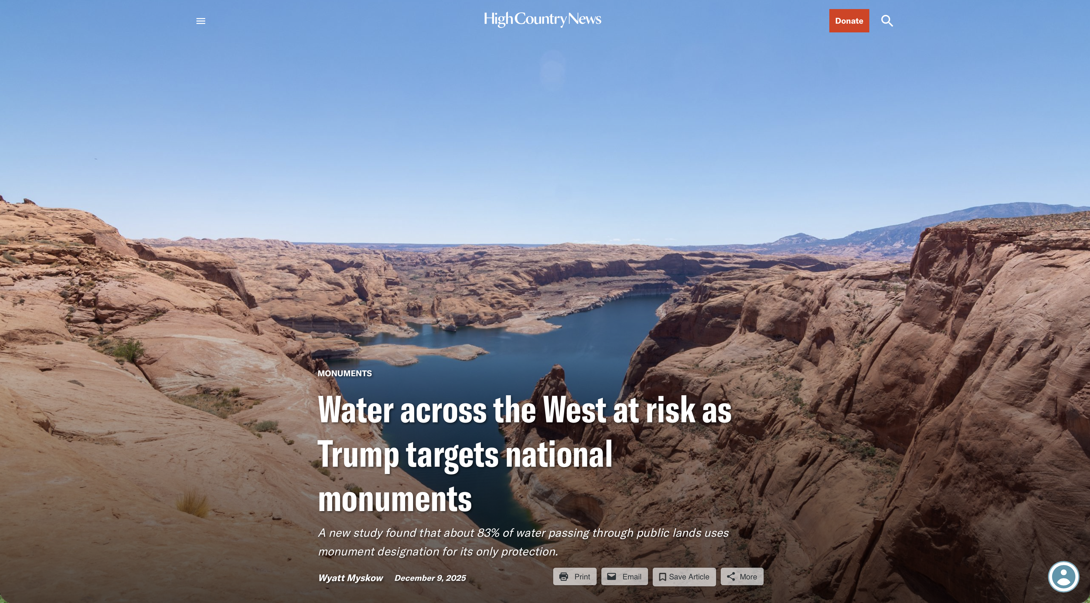
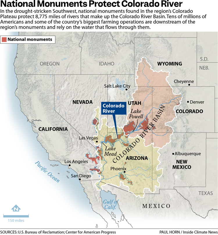
The 31 national monuments designated since the Clinton administration, which could be downsized as the Trump administration pushes to open more public lands to extractive industries, safeguard clean water for millions of Americans, according to a new analysis from the Center for American Progress.
Using geospatial data to quantify the miles of rivers and watersheds within the studied national monument boundaries, as well as the number of users who depend on that water, the report found that the water supplies for more than 13 million Americans are directly provided by watersheds within or downstream of these national monuments. About 83% of the water passing through these public lands has no other protection besides the monument designations, it found.
National monuments protect more than 21,000 miles of waterways across the U.S., nearly twice as much waterway mileage as the National Wild and Scenic Rivers System, the analysis also determined.
The report comes as the Trump administration weighs downsizing or revoking the designation of some national monuments.
In March, the Trump administration announced it would eliminate California’s Chuckwalla and Sáttítla Highlands national monuments before removing language from a White House fact sheet announcing that decision. The following month, The Washington Postreported that the administration was considering downsizing or eliminating six national monuments, and in June, the U.S. Department of Justice issued an opinion that the president has the power to rescind national monument designations, backtracking on a decades-old determination on the matter.
Stone and evening light, Bears Ears National Monument, Utah. Jonathan P. Thompson photo.
During Trump’s last term, Bears Ears and Grand Staircase-Escalante national monuments, established by the Obama and Clinton administrations, respectively, were shrunk to fractions of their original sizes, but they were restored by President Joe Biden after he took office.
If national monuments are downsized or eliminated, the areas surrounding a waterway will lose protections from extractive industries, including oil and gas drilling, mining and grazing. Contamination from those industries could seep into streams and, in turn, rivers. Those industries also use water, sometimes vast amounts in arid regions, further reducing the supply that flows to nearby communities. (In certain cases, some mining and grazing are already permitted on national monument lands, but the activities are limited in scale and more regulated than they are outside the monuments.)
“Landscapes and waterways go hand in hand,” said Drew McConville, a senior fellow for conservation policy at the Center for American Progress and a co-author of the report. “The clean water depends on what comes into them from natural lands … Just protecting the wet stuff itself doesn’t guarantee that you’re keeping [water] clean and durable.”
The portion of historically marginalized communities living within the watersheds of the national monuments is greater than the average for watersheds nationally, it found. Twenty-three of the monuments studied are also found in regions expected to face water shortages due to climate change in the coming decades, making the arid regions downstream even drier.
Grand Staircase-Escalante National Monument, for example, protects 2,517 miles of waterways, according to the analysis, and nearly 90% of the watersheds within the monument are expected to see declines in their water levels. The monument straddles the Upper and Lower Colorado River Basins, with the Paria and Escalante rivers flowing within its boundaries and Lake Powell, the nation’s second-largest reservoir, just to its south.
The monument is often thought of as a sparse, arid region, which it is, said Jackie Grant, the executive director of Grand Staircase Escalante Partners, a nonprofit focused on protecting the monument that has spent $11 million to protect the Escalante River watershed and all its tributaries. It remains vital to the Colorado River System, which millions of people in the Southwest rely on. Grand Staircase-Escalante helps slow water from the Paunsaugunt Plateau in Bryce Canyon National Park, much of which starts as snowpack in the park before melting and flowing downstream.
“People don’t think of water when they think of Grand Staircase-Escalante National Monument,” Grant said. “So when we can bring this view of water and how important it is to the protection of the monument, it helps us put another building block in our case for supporting the monument, because not only is it important for the animals, the native plants, the geology and the paleontology, water plays a huge role in the monument, and the monument protects the water itself.”
The Antiquities Act of 1906 was signed into law by Theodore Roosevelt, for “… the protection of objects of historic and scientific interest” through the designation of national monuments by the President and Congress. National monuments are one of the types of specially-designated areas that make up the BLM’s National Conservation Lands. Some of the earliest national monuments included Devils Tower, the Grand Canyon, and Death Valley. They were initially protected by the War Department, then later by the National Park Service. More recently, the BLM and other Federal agencies have retained stewardship responsibilities for national monuments on public lands. In fact, the BLM manages more acres of national monuments in the continental U. S. than any other agency. This includes the largest land-based national monument, the Grand Staircase-Escalante National Monument in Utah featured here. National monuments under the BLM’s stewardship have yielded numerous scientific discoveries, ranging from fossils of previously unknown dinosaurs to new theories about prehistoric cultures. They provide places to view some of America’s darkest night skies, most unique wildlife, and treasured archaeological resources. In total, twenty BLM-managed national monuments, covering over five million acres, are found throughout the western U. S. and offer endless opportunities for discovery. Photos and description by Bob Wick, BLM.
Stretching across 1.87 million acres of public land, Grand Staircase-Escalante National Monument is one of the country’s most expansive national monuments, protecting scores of wildlife as well as archeological resources in southern Utah. But a nine-billion-ton coal deposit is buried in the center of the monument along with deposits of minerals, including uranium and nickel. The Trump administration has long touted boosting the country’s coal production, and has established a pro-mining agenda this year.
“It’d be very easy to contaminate either one of those rivers if mining were to take place in the center section of the monument,” Grant said.
Margaret Walls, a senior fellow at Resources for the Future who has studied national monuments but was not part of this study, said national monuments are designated to protect cultural or historical landmarks, and it can be forgotten that they can also serve purposes like safeguarding water. Though she noted that even if monument protections are loosened, the areas remain federal lands, and their changes in status do not guarantee they will be developed.
“We don’t protect waterways the way we do land,” Walls said, “we’re going to get those water benefits by protecting the land.”
Created by Imgur user Fejetlenfej , a geographer and GIS analyst with a ‘lifelong passion for beautiful maps.’ It highlights the massive expanse of river basins across the country – in particular, those which feed the Mississippi River, in pink.
NEW RECORD: It's official. SNOTEL weather stations reached an average of 26.1 inches. This year now appears to have the largest snowpack since 1952, and in case you haven't notice, it's STILL snowing! Chart here: https://t.co/mbIzmWqIV5#utwxpic.twitter.com/Fvj0mr8O6w
Click the link to read the article on The Deseret News website (Kyle Dumphey). Here’s an excerpt:
Utah’s Washington County is one of the fastest growing areas in the country, according to the U.S. Census Bureau, made possible by the Virgin River which supplies the region and its multiplying suburbs with water. But drought and population growth have long plagued the river, and the mayor of Ivins, a small, bedroom community of nearby St. George, did not mince words when addressing constituents this month.
“There’s good cause to be concerned about water,” said Mayor Chris Hart during an annual neighborhood meeting in January. “We are running out.”
Hart said the city has run out of water previously, dating back to the 1960s — “but there was always a solution, because we hadn’t fully developed the sources of water. That’s coming to an end.”
“We’ve just about used up all of the Virgin River drainage and our only hope is that we can convince enough of us to conserve better,” he continued…
Lake Powell Pipeline map via the Washington County Water Conservancy District, October 25, 2020.
Hart, who served on the Washington County Water Conservancy Board, said much of the region’s growth is predicated on construction of the Lake Powell Pipeline, a $3 billion project that would funnel 80,000 acre-feet of Utah’s Colorado River allotment from the Glen Canyon Dam to the St. George area.
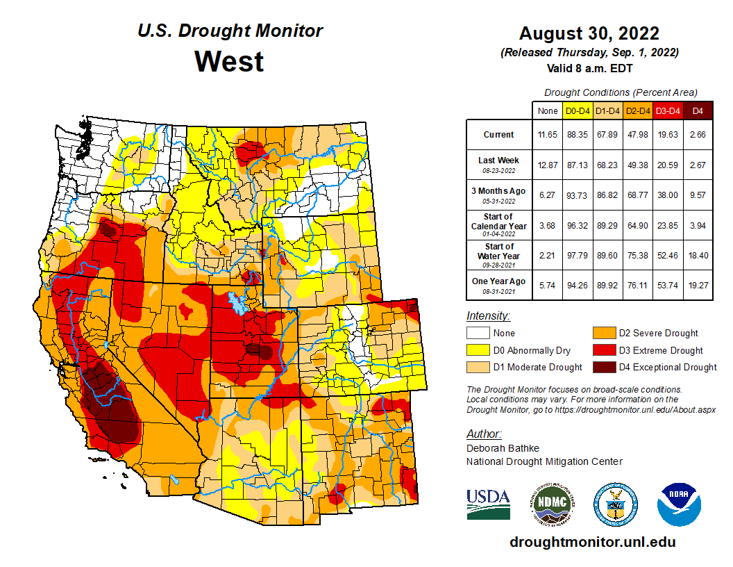
August brought several waves of monsoonal thunderstorm to Colorado, Utah and western Wyoming and left much of the region with above average August precipitation. Monsoonal thunderstorms triggered high flows and flash floods in many locations. On August 20th, 1-2” of rain in Moab triggered a large flash flood that caused Mill Creek to crest its banks and flow down Main Street. Temperatures were near average for much of Colorado and Utah; temperatures in Wyoming, northern Colorado and northern Utah were 2-4 degrees above normal. Drought conditions improved slightly in Utah and Colorado and Utah remains the hardest hit by drought with 100% of the state in drought and 61% of the state in D3-D4 drought. La Niña conditions are predicted to persist through early winter and temperatures are likely to be above average and precipitation below average for much of the region.
Much of the region received average to above-average precipitation during August. Areas that traditionally receive ample monsoonal moisture like the Colorado Rockies and eastern Utah received average to slightly above average August precipitation. Large swaths of western and northern Utah and western Wyoming received 150-400% of normal August precipitation. August is typically a very dry month in these areas, so it is important to note that much above average precipitation meant total precipitation of 1-3 inches with isolated observations of 4 inches. There were three distinct areas of below average precipitation during August: eastern Colorado and Wyoming, northeastern Utah, northwestern Colorado into central Wyoming and the Lake Powell region.
August temperatures cooled somewhat compared to record and near-record July heat. Temperatures in most of Colorado and Utah were near-normal with areas of relatively cooler temperatures in the southern parts of both states. In parts of northern Colorado and Northern Utah, temperatures were 2-4 degrees above normal. In Wyoming, August temperatures were 2-4 degrees above normal in most locations.
Several streams and rivers in central Utah continued to report record low monthly streamflows during August. In other locations, monsoonal rains caused many regional rivers to rise to above or much-above normal flows for short periods. Southern Utah rivers where flash floods occurred and flows rose to at least 1,000 cubic feet per second (cfs) included the Dirty Devil, Dolores, Paria, Price, Santa Clara and San Juan Rivers. Flows in the San Juan River were much higher than normal in August, including a peak flow of 6,000 cfs. The San Juan had a paltry peak spring streamflow of around 2,000 cfs, flows followed by a low of 350 cfs in late June.
The impacts of long-term drought are evident in regional reservoir storage, especially in the Colorado River Basin. Of the Upper Colorado River basin reservoirs, Flaming Gorge (75% full) and Fontanelle (92%) have the most stored water and Lake Powell remains extremely low (26% full). Navajo (55%) and Blue Mesa (41%) are also much lower than average for this time of year. Overall reservoir storage in Utah is below average and slightly lower than last year; Utah reservoirs are currently 62% full and 82% of median reservoir levels. Reservoir storage is slightly lower in Colorado where statewide reservoir storage is 56% full and at 75% of median reservoir storage. Colorado reservoir storage is highest in the South Platte River basin and Colorado River headwaters and the lowest levels of Colorado reservoir storage are found in the Gunnison and San Juan River basins.
Overall, regional drought conditions improved somewhat during August. Drought now covers 68% of the region (down from 73% on 8/2) and 21% of the region is in extreme (D3) drought, most of which is in Utah. Drought conditions improved by one category in southern and eastern Utah during August. In Wyoming drought conditions worsened by one category in south central Wyoming and southwestern Wyoming where extreme (D3) drought emerged. While monsoonal rains did improve drought conditions during August, conditions did not improve in as widespread of an area as predicted last month.
West Drought Monitor map September 1, 2022.
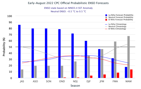
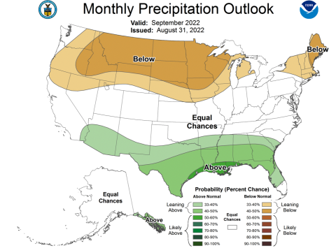
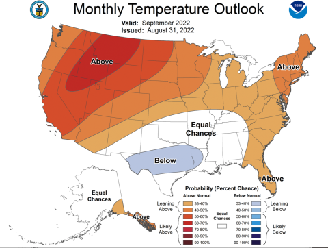
La Niña conditions remain in place as eastern Pacific Ocean temperatures remain consistently 0.5º – 1ºC below normal. There is a 60-85% probability of La Niña conditions remaining through mid-winter. By early 2023, there is a higher probability of neutral ENSO conditions and a 20-45% chance of La Niña conditions persisting. NOAA monthly climate outlooks project a 33-60% chance of above average regional temperatures and an increased probability of below average precipitation in Wyoming. The NOAA seasonal climate outlook for October-December indicates the influence of a La Niña weather through early winter with an increased probability of above average temperatures across the region and an increased probability of below average precipitation for Colorado, Utah and southern Wyoming.
Significant August weather event. Strong monsoonal thunderstorms caused flash flooding and extensive damage in Moab, UT and a hiker fatality in Zion National Park. On August 20th, 1 to 1.75 inches of rain fell in the Mill Creek watershed southeast of Moab, UT. The ensuing flash flood tore down Mill Creek, reaching a peak flow of over 1,000 cfs upstream of Moab. Mill Creek overflowed its banks and ran down Main Street in Moab reaching depths of 2-3 feet, carrying several cars, woody debris and mud through downtownUtah Governor Spencer Cox declared a state of emergency in Moab and plans to seek aid from FEMA There was an estimated $10 million in damages from the flood.
Area newspapers widely reported the flood as a 1-in-100-year event based on precipitation recurrence interval frequencies. The flash flood was actually caused by two distinct 1-in-100-year rainfall events in the Mill Creek watershed; one event started at 5:30 pm, the second event started at 6:40 pm and both lasted just over 1 hour. The rainfall event that triggered the initial high flows of 1,000 cfs in Mill Creek was from a small area of intense precipitation that stalled over Mill Creek upstream of Moab beginning at 5:30 pm. This area of rain dumped 1.25-1.75” of rain over 60-90 minutes. As Mill Creek flows were peaking at around 1,000 cfs, a second wave of precipitation arrived and dumped 1-1.5” of rainfall over Mill Creek immediately upstream of Moab. Mill Creek flows in downtown Moab, downstream of the streamflow gauge, were likely much higher than 1,000 cfs; most of the second wave of precipitation fell downstream of the Mill Creek stream gauge. Rainfall from the Moab area sites reported 0.03-0.64” of rain on 8/20. A potential contributor to the severity of the flood was the 2021 Pack Creek Fire which burned 8,000 acres in the upper Mill Creek watershed, however the most intense precipitation from the event did not occur over the Pack Cree Fire burn scar. The second wave of precipitation fell in an area rated as a high to very high flooding hazard according to Utah Geologic Survey maps.
The day prior to the Moab flood, August 19th, a strong thunderstorm triggered a large flash flood in the Narrows of the Virgin River in Zion National Park. The Narrows is a popular hike in the park and particularly dangerous during times of high flash flood risk. Just downstream of the Narrows, on the North Fork of Virgin River, 0.67” of rain fell and the river peaked at a flow of 2,540 cfs. During the flash flood, there were several reports of hikers being swept off their feet or trapped by flood waters in the Narrows. Immediately following the flood, no hikers were unaccounted for, but by the evening of 8/19, a hiker from Tuscon, AZ was reported missing. Search efforts recovered the body of the 20-year-old woman on 8/23, approximately 6 miles downstream of the Narrows.
The Second Los Angeles Aqueduct Cascades, located in Sylmar, just east of the I-5 Freeway near Newhall Pass, in the San Gabriel Mountains foothills of the northeastern San Fernando Valley. The Cascades are the terminus of the Los Angeles Aqueduct, which brings water 338 miles (544 km) from the Owens Valley to Los Angeles. Construction of the aqueduct began in 1908 and completed in 1913. The cascades are a Los Angeles Historic-Cultural Monument (HCM #742), a California Historical Landmark (#653), and a Historic Civil Engineering Landmark. By Los Angeles (talk · contribs) – Own work, CC BY-SA 3.0, https://commons.wikimedia.org/w/index.php?curid=4882240
As the region’s climate becomes drier, more pipelines are being proposed despite the economic and climate risks.
Pipelines that are advancing the fastest are rural and tribal projects backed by federal funding.
The proposals echo a century of large-scale water engineering that ushered in the modern era in the American West.
Across the country’s western drylands, a motley group of actors is responding to the region’s intensifying water crisis by reviving a well-worn but risky tactic: building water pipelines to tap remote groundwater basins and reservoirs to feed fast-growing metropolitan areas, or to supply rural towns that lack a reliable source.
Government agencies, wildcat entrepreneurs, and city utilities are among those vying to pump and pipe water across vast distances — potentially at great economic and environmental cost. Even as critics question the suitability of the water transfers in a new climate era, supporters in California, Colorado, New Mexico, Utah, the federal government, Indian tribes, and other states are prepared to spend billions on water-supply pipelines.
Lake Powell Pipeline map via the Washington County Water Conservancy District, October 25, 2020.
The pipelines range in length from several dozen miles to several hundred and the largest are intended to transport tens of millions of gallons per day. Among these is the 140-mile Lake Powell Pipeline, a roughly $2 billion project that aims to deliver 86,000 acre-feet (28 billion gallons) each year to Washington County, in Utah’s southwest corner.
Not all the projects are cut from the same cloth. Because of the daunting expense, lengthy permitting process, and legal battles, projects with federal backing have a leg up. The infrastructure bill signed by President Joe Biden last November includes $1 billion for rural water supply projects in the western states. Many of these projects, including one in progress in eastern New Mexico, were authorized more than a decade ago.
The infrastructure bill also includes $2.5 billion for tribal water rights settlements, which typically include a water-supply component. The Navajo-Gallup water pipeline, now under construction in northwest New Mexico to supply the Navajo Nation, Jicarilla Apache Tribe, and the city of Gallup, is part of the San Juan River water rights settlement.
Owens Valley
The current batch of pipeline proposals traces its lineage to a century of engineering and building mammoth water supply projects that ushered in the modern era of the American West. State and federal canals snake the length of California. Los Angeles bullied its way into the Owens Valley in the 1910s, eventually siphoning the valley’s water through an aqueduct. A few years later, San Francisco reached into Hetch Hetchy Valley for a reservoir and pipeline. The Central Arizona Project, which broke ground in the 1970s, was built to lift 1.5 million acre-feet of water — almost 500 billion gallons a year — more than a half mile in elevation along its 336-mile course to supply Phoenix and Tucson. In Colorado, at least 11 major projects pierce the Rockies, transferring water to the high-growth Front Range. States west of the 100th meridian would not have been able to attract millions of residents or develop their commercial and agricultural sectors without these water projects.
As the region’s climate becomes drier, more diversions are being proposed despite the economic and climate risks. Large-scale engineering retains its appeal and pipeline options are doggedly pursued by state and local agencies, and a band of self-styled water entrepreneurs.
Potential Water Delivery Routes. Since this water will be exported from the San Luis Valley, the water will be fully reusable. In addition to being a renewable water supply, this is an important component of the RWR water supply and delivery plan. Reuse allows first-use water to be used to extinction, which means that this water, after first use, can be reused multiple times. Graphic credit: Renewable Water Resources
Renewable Resources, a firm backed by former Colorado Gov. Bill Owens, wants to pump groundwater from the San Luis Valley to Front Range cities that are mushrooming with new subdivisions. A competing outfit, Water Horse Resources, is led by Aaron Million, who has dreamed for more than a decade of piping more Colorado River water to the Front Range. The potential water source for Water Horse is some 500 miles away: Flaming Gorge Reservoir, which straddles Wyoming and Utah. Another Front Range project in the Fort Collins area envisions a pair of new reservoirs and an 80-mile pipe network that extends to 15 communities. Called the Northern Integrated Supply Project, it is still waiting on an key federal permit.
In New Mexico, meanwhile, supporters of the Agustin Plains scheme wish to export 54,000 acre-feet of groundwater per year from a high desert basin to communities along the Rio Grande, some 60 miles to the east. The state engineer rejected the permit in 2018, but the applicant is appealing.
Southwest Utah is another epicenter of contested water diversions. The most recent came to light in April, when Escalante Valley Partners filed an application with the state Division of Water Rights for more than 50,000 acre-feet of groundwater per year for export. The water, more than 44 million gallons a day, would come from 115 wells drilled between 1,000 and 5,000 feet deep in Beryl-Enterprise, a basin where the state has restricted use of shallow groundwater due to over-extraction.
In the same area, the Central Iron County Water Conservancy District is championing the $260 million Pine Valley Water Supply project, currently being reviewed by the Bureau of Land Management for a right-of-way permit. If approved, the district would construct 66 miles of pipeline to access groundwater in neighboring Beaver County.
The most expensive water project in southwest Utah is a proposed 140-mile pipeline to Lake Powell. Critics contend that Lake Powell and the Colorado River that flows into it cannot handle any more diversions. The Bureau of Reclamation, which manages Powell and is reviewing the pipeline application, is already taking emergency action to augment the shrinking reservoir, holding back more water than usual and releasing extra supplies from reservoirs higher in the watershed.
Zach Renstrom is the general manager of the Washington County Water Conservancy District, the pipeline project’s chief beneficiary. The basic logic of today’s water manager is not so different from an investment adviser: manage risk through a portfolio of investments. Critics assert that Washington County residents, though use has declined from its very high early 2000s peak, still consume more water than almost any community in the U.S. and that water conservation practices should be sufficient. But Renstrom defends the need for another water source — even a very expensive one, with an overall price tag of about $2 billion — because Washington County’s single source right now is the Virgin River.
“Especially as someone who looks at climate change very seriously and believes in climate change and knows we need to account for that, to make sure the next generation has the tools that it needs to deal with those issues, I think we need to build these large water infrastructure projects,” Renstrom told Circle of Blue.
Utah officials are also pursuing a project in the state’s northern reaches to send water from the Bear River, the main tributary of the shrinking Great Salt Lake, to communities some 90 miles distant along the Wasatch Front. The state does not anticipate needing the project for several decades.
Those projects are miniscule compared to calls to divert eastern rivers like the Mississippi. An undertaking like that — which has legal, technical, environmental, and economic hurdles so enormous as to be implausible today, water experts say — echo even more grandiose and farfetched schemes that were proposed in the 1960s: engineering fantasies like the North American Water and Power Alliance, a continental-scale replumbing of North America’s watersheds, which never advanced much farther than the Parsons Company’s drafting board.
Few of these projects have secured all required permits and fewer still have broken ground. But it is often the case that designs that look appealing in sketches fold when they collide with real world obstacles.
One of the biggest obstacles is supply, says Denise Fort, a professor emerita at the University of New Mexico. Do these areas hold enough water to support more diversions?
Nearly a decade ago, Fort co-authored a report with the Natural Resources Defense Council on the proliferation of pipeline proposals in the western states. In reviewing that report today, Fort told Circle of Blue that the findings still hold true.
“Many of the pipeline projects under consideration today are dramatically different from those constructed in the past, in terms of sustainability of water supplies, available alternatives, costs, environmental impacts and energy use,” the report concluded. “The communities and agencies that are considering these projects would be well served by a careful analysis of the implications of these important choices.”
Construction of the Monument Valley waterline extension, which was funded by The Indian Health Service and the U.S. Department of Housing and Urban Development. The pipeline provided 128 homes with water. Another water project, the Western Navajo Pipeline, has been on hold for at least 10 years. Photo credit: U.S. Environmental Protection Agency
Fort said that, in many cases, pursuit of these pipelines is an attempt to continue a water-consuming lifestyle in a region that can no longer support the burden of that demand. Scientists expect the flow of the Colorado River to decline by 9 percent with each degree Celsius that the planet warms.
“We know what the future is, it’s coming,” Fort said. “And so we can’t continue to act as though it’s just a cyclical thing, and the water will reappear. We know that it will not.”
Fort believes that instead of sticking more straws into a shrinking pool, municipalities should seriously consider reallocating water from agriculture, which uses the lion’s share of the region’s supply. Instead of growing alfalfa for export, that water could be directed to cities. This approach is not without controversy and requires careful crafting — rural communities, in some cases, have resisted “buy and dry,” preferring leases that do not permanently sever water from land.
But such a move is what El Paso is banking on. The largest city in West Texas has spent $220 million since 2016 to purchase 70,000 acres of ranch land about 90 miles east, in Dell City. Crucially, the land comes with water rights. Today, El Paso leases the land for farming. But in several decades the city plans to pipe the water beneath those fields to its residents.
At the foundation of these debates about pipelines are competing views of the American West.
One school of thought is that water follows growth. “I think it’s much cheaper to take the water to the people than move people to the water. You disrupt a lot less lives that way,” Todd Adams, deputy director of the Utah Department of Natural Resources, told the Utah Water Summit last October.
Great Basin wetland. Photo credit: The Great Basin Water Network
The other view is one of conservation and restraint, championed by people like Kyle Roerink, the executive director of the Great Basin Water Network, a group that advocates against transferring water out of its natural basin.
“There is a suburban Manifest Destiny mindset throughout the region that I think is antithetical as it relates to the amount of resources that are available,” Roerink told Circle of Blue.
Looking at the history of pipeline projects and water transfers in the West, Roerink worries about unintended financial and environmental consequences if the current contenders move ahead. In the arid Great Basin, which covers much of Nevada and Utah, he is particularly attuned to dry soils if groundwater-dependent basins are depleted. It’s not an unheard of risk. To offset environmental damage in the Owens Valley from its aqueduct, the Los Angeles Department of Water and Power has spent $2.5 billion in ratepayer funds to suppress dust storms.
Many of the biggest projects were built in an era of minimal environmental review and major government subsidy. Those conditions have changed, one of many reasons why mega-projects like diverting the Mississippi River westward are implausible, even fanciful.
Of the pipeline projects currently under construction, most are not fanciful. Most are like the Eastern New Mexico Rural Water System — smaller in scale and federally supported.
Congress authorized the 140-mile project in 2009 and is contributing 75 percent of the cost. The rest is coming from local partners, which include four communities in Curry and Roosevelt counties.
The project received $177.4 million from the federal government this year and $30 million from the state government. If funding in future years comes in as expected, construction should be completed in six to eight years, Orlando Ortega, the administrator of the Eastern New Mexico Water Utility Authority, told Circle of Blue.
Ogallala Aquifer. Credit: Big Pivots
The project is a federal priority because the partner communities are all served by groundwater from the depleting Ogallala aquifer. At some point, the water will run out. The pipeline is designed to bring surface water from the state-owned Ute Lake.
Like all western water supply projects, there are questions about the long-term availability of Ute Lake as the region dries.
“We are very sensitive to drought conditions, and would certainly be cutting back on our reservation, if needed,” Ortega said.
Brett Walton
Brett writes about agriculture, energy, infrastructure, and the politics and economics of water in the United States. He also writes the Federal Water Tap, Circle of Blue’s weekly digest of U.S. government water news. He is the winner of two Society of Environmental Journalists reporting awards, one of the top honors in American environmental journalism: first place for explanatory reporting for a series on septic system pollution in the United States(2016) and third place for beat reporting in a small market (2014). He received the Sierra Club’s Distinguished Service Award in 2018. Brett lives in Seattle, where he hikes the mountains and bakes pies.
With federal officials expected to announce a water shortage at Lake Mead next month, this would be an ideal time for Utah officials to kill off that state’s insane plan to divert a huge amount of upstream water to fuel development in the St. George area.
On Thursday, a diverse group of Colorado River stakeholders gathered near Hoover Dam called on Utah to do just that, and pressed for a moratorium on other projects that would divert water from the river.
This wasn’t simply people from other states ganging up on Utah, either. One of the most strident speakers was Zach Frankel from the Utah Rivers Council, who blistered the officials in his state who were backing the pipeline for St. George.
“While the Lower Basin is going on a diet of cutting its water use, we should not allow the Upper Basin to go to an all-you-can-eat buffet of water waste,” Frankel said.
Well put, neighbor.
The Utah pipeline would suck 86,000 acre-feet of water per year from Lake Powell to St. George, where it would be used to grow crops, maintain the grass lawns that are common in the area and to expand development.
Not only is this pipeline unconscionable given the dwindling water supply of lakes Powell and Mead, but the water would be going to a community whose residents are water hogs already. As Frankel pointed out, water usage in Washington County, the home of St. George, averages 306 gallons per person per day — about three times the usage in more water-conscious places like Las Vegas and Phoenix.
Plus, to give some perspective to the amount of water involved in the project, consider that Nevada’s entire annual allotment from Lake Mead is 300,000 acre-feet. (An acre-foot is enough water to cover an acre of ground 1 foot deep, or about 326,000 gallons of water.)
That allotment is all but sure to get a haircut soon, with the looming water shortage declaration by the feds. We’ll lose about 21,000 acre-feet total in mandatory and voluntary cuts. But since Nevada has learned to live with less, we currently use only 256,000 acre-feet per year, meaning we’ll still fall below the 279,000 acre-feet we’ll have after the cutbacks.
Decline of Lake Mead. Graphic credit: Brad Udall via InkStain
Graphic credit: Brad Udall via InkStain
Meanwhile, though, there’s no indication that years of dwindling flow in the Colorado River will reverse themselves anytime soon. To the contrary, long-range forecasts of snowmelt and rain runoff in the Colorado River watershed suggest that what’s happening now shouldn’t be considered a drought but rather a normal condition.
With Lake Mead at just 36% capacity and shrinking, it’s important to note that the Utah pipeline project isn’t the only one of its type. There are more than a dozen proposed dams and diversions upstream of Southern Nevada in the Upper Basin states — Colorado, Utah, Wyoming and New Mexico.
That was another point of emphasis from the group of stakeholders last week at Lake Mead, which included business operators, agricultural interests, Native American advocates and more. They urged all Southwestern states to recognize that their own water projects would affect the entire region and the millions of Americans who rely on the Colorado River.
“No flow, no future,” said Brea Chiodini, tour boat operator and member of the Laughlin-Bullhead City River Flow Committee.
Brad Udall: Here’s the latest version of my 4-Panel plot thru Water Year (Oct-Sep) of 2019 of the #coriver big reservoirs, natural flows, precipitation, and temperature. Data goes back or 1906 (or 1935 for reservoirs.) This updates previous work with @GreatLakesPeck
Putting a moratorium on every current project might be extreme, but at the very least the criteria for approval should be stiffened to reflect the upcoming shortage and the long-term outlook.
One thing is crystal clear, though: The Utah pipeline needs to be shelved. The upcoming water shortage declaration gives officials in the Beehive State an opportunity to terminate the project and save face. If they don’t act on their own, though, it’s a no-brainer that federal officials should put a stake in the heart of this horrible proposal.
It is simply madness that as the Colorado River reaches its lowest levels in recorded history that we’d be proposing a new water diversion upstream,” Frankel said. “At some point, we have to put our foot down and stop this madness.”
Again, a voice of reason from Utah. Frankel’s fellow state residents should listen to him.
The images that define this drought are etched into the creek beds and hillsides of Summit County, their importance drawn out by experienced eyes that know how the land should look.
For one Summit County rancher whose operations cover vast swaths near Wyoming, the emblem might be the bare creek that’s never run dry this early, or the grass last year that grew so dry and brittle it blew away with the wind.
For a dairyman in Hoytsville, it might be the yellowing field that’s next to a still-green one, the result of hard choices after irrigation water was cut off earlier than in memory.
For a South Summit rancher and water official, it might be the hay they’re harvesting at almost half the yield of what it should be, or the low reservoirs that just keep emptying.
That official, Dave Ure, speaking just after a tour of waterworks facilities in Summit County, put the situation in stark terms.
“We are in the worst drought in the state of Utah’s history right now, and the only thing compared to it is the droughts back in 1895 and 1933,” Ure said.
The Ures have been in South Summit for 135 years. Dave Ure is a former politician and current trustee of the Weber Basin Water Conservancy District, which oversees many of the water sources in Summit County.
Ure said water will still flow from household taps, contending that the situation isn’t close to threatening culinary water, at least for those who are connected to a larger municipal system. Water will be diverted from agriculture users long before that happens, Ure said.
But that doesn’t mean the impacts will be confined to farmers and ranchers. Food prices can be expected to go up, Ure said, and wildfire risk will likely remain elevated. The drought might change the landscape itself, possibly hastening a trend of developing farmland into subdivisions.
Those impacts remain on the horizon, for now, but the impacts on farmers and ranchers are already here…
[Jeff] Young traced the current shortages to last summer. He said the 2019-2020 winter provided good water, but that it stopped raining in June and didn’t start snowing until November. A summer and fall without water was something he hadn’t seen before…
The dryness persisted into the winter, and even though there was a below-average snowpack, the season total was not devastating. But the drought was waiting underneath, with soils as dry as had ever been measured.
Ure said there is normally about 500,000 acre-feet of runoff water in the entire Weber Basin catchment area…
Young said the higher-elevation springs on the ranch are still producing, but that the lower areas are bone dry. He said the drought was already beginning to affect the underground aquifers.
Earlier this season, he went to the creek to fix what he thought was a problem with the water-capturing infrastructure.
“I was naive. I thought I had to fix the diversion, but there was nothing to get,” he said…
The Browns have water stored in a reservoir dug by their ancestors in 1883. But that reservoir was down significantly this year, and once that water is used, their fields will no longer be irrigated.
They won’t be able to grow as much feed for their cattle as they normally can, meaning they’ll have to buy it.
Hay prices have skyrocketed, they said, driven up by the lack of supply as well as the number of people who are in the market for feed.
Mike Brown flipped his phone over and showed a social media post from a friend asking if anyone had hay for sale…
With the drought forcing ranchers across the region to sell off portions of their herds, animals don’t fetch the same prices they once did.
All three said they had or were planning to sell significant portions of their stock.
Mike Brown said he has to call days ahead to reserve an appointment to send animals to slaughter. The packing plants are full, he said.
Liquidating the stock might get the ranchers out of debt, but it might not raise enough capital to restart a ranching or farming operation after the drought passes.
Moving the animals comes with transportation costs and the added challenge of finding areas unaffected by the drought, which stretches across much of the West…
Challenges to come
There aren’t many small ranching operations left in Summit County, Ure and others said, and this drought might just drive them out.
Young said it would likely change who’s in the ranching business, possibly opening the door to larger agriculture operations.
Ranchers could also opt to sell to housing developers…
Farmland that may have been profitable might not be so now, and the real estate market is red hot. Ure said he’d heard of several recent transactions in the Kamas area in which land sold for “outrageous prices.”
Summit County Councilor Chris Robinson, who owns or co-owns hundreds of thousands of acres in Utah and elsewhere, including Ensign Ranches, said one silver lining of what he called the “megadrought” is that it’s putting the appropriate level of scrutiny on water use…
Ure predicted that over the course of the summer, governments would start announcing water-conservation regulations. Some options include reducing the amount of grass installed in new development and incentivizing a switch to drought-resistant landscaping.
Young, Ure and Mike and Glen Brown agreed that if the drought persisted into next year, it would compound the problem to perhaps unmanageable levels.