
US rivers drawn in proportion to how much water they carry pic.twitter.com/8iaKdqZDCv
— OnlMaps (@onlmaps) July 26, 2026
Category: General Interest
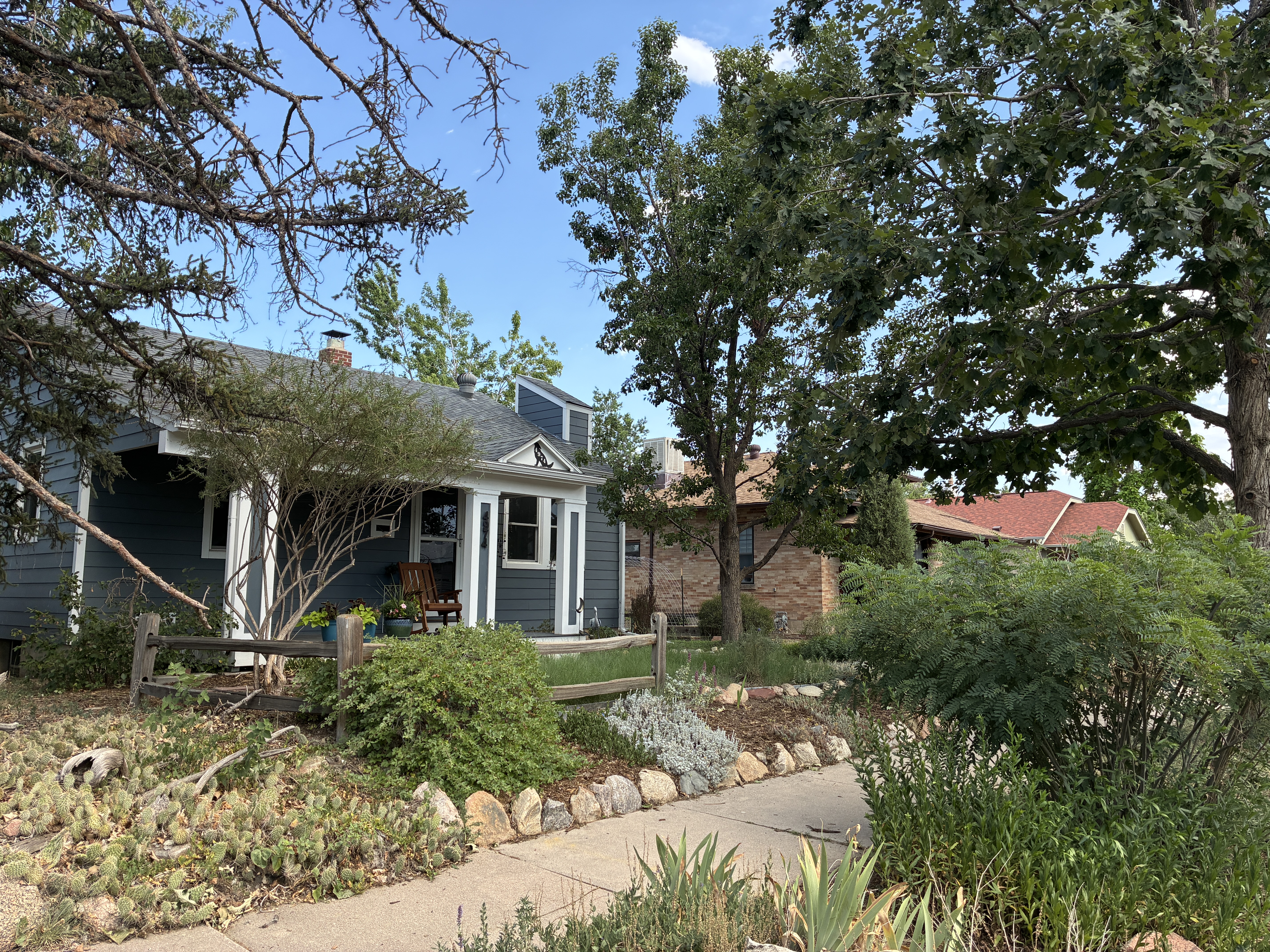
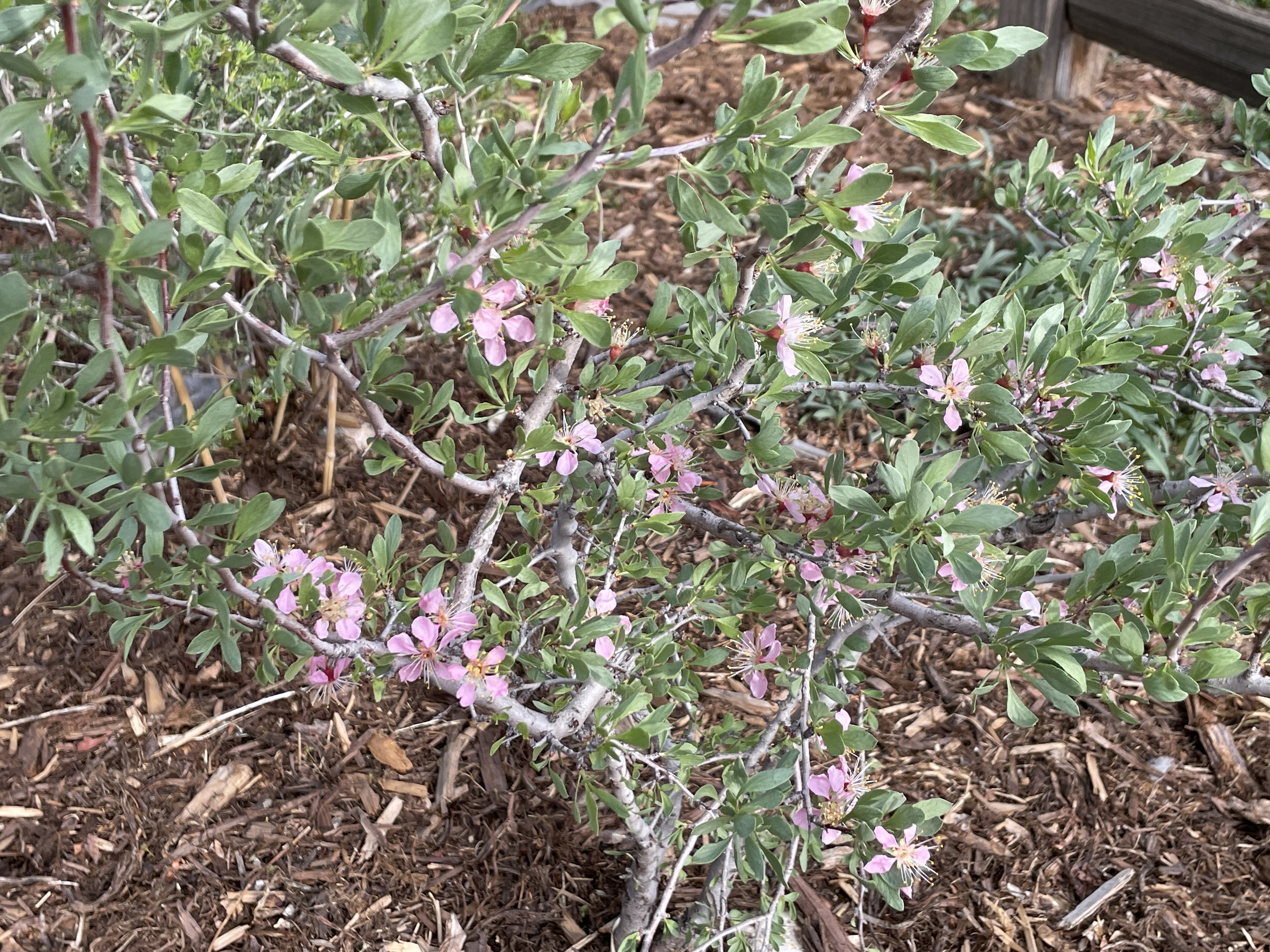
Mrs. Gulch’s landscape July 13, 2026

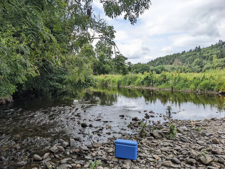
Fishing for DNA – how a cup of river water can reveal secrets about human health, pollution and biodiversity
Jenny Whilde, University of Florida
The DNA in a single cup of water can track wildlife, monitor pollution and survey pathogens in waterways and their surroundings, all at the same time.
DNA is contained in each cell of every plant, animal, fungus and microbe. It carries the genetic instructions needed for an organism’s survival, growth and function, and the DNA of each species is unique.
Organisms shed DNA into their environments. This environmental DNA, or eDNA, can come from cells shed from skin, spores and pollen blowing on the wind, or even just a cough or sneeze. It can provide huge amounts of information. Researchers can use it to assess biodiversity, monitor the spread of invasive species and detect pathogens.

Traditional monitoring methods, such as field observation or trapping, can be difficult, intrusive and time-consuming. Tracking an elusive species in the wild can mean hours or days without a sighting, perhaps in difficult terrain or remote locations. Trapping wildlife can be stressful for the animals and relies on expert knowledge to properly handle wildlife and position traps.
With eDNA, researchers can collect information about a species without ever needing to see or interact with it. Moreover, a cup of water, a few ounces of sand or even air sucked through a filter can hold enough information to determine what has been in the area, including people, wildlife and infectious pathogens.
Cracking the DNA code
Researchers sequence DNA fragments collected from sand, water or air to decode the order of the chemical building blocks that make up DNA. These sequences can be used to not only identify the species that the fragments of DNA came from, but also to narrow down the area where the organism originated.
Until recently, researchers typically used an approach called metabarcoding to sequence eDNA. This method creates many copies of specific, short genetic markers that researchers can use to identify particular species.
Although powerful, metabarcoding is selective by design. It finds only what it is designed to find – typically small but informative regions of DNA called barcodes – and ignores everything else. Because the DNA fragments are so short, it’s difficult to link these bits of information. A single barcode cannot cover all species in an area, and it cannot provide information about the genetic traits of species in the area. https://www.youtube.com/embed/bdwU_ZPk1cY?wmode=transparent&start=0 Genetic information is everywhere, if you have the tools to sequence it.
My team at the Duffy Lab at the University of Florida took a different approach. Rather than focusing on one short region of DNA in a sample, we used a technique researchers call long-read shotgun metagenomic DNA sequencing, which reads each fragment of DNA in long, continuous sections. All the DNA and traits in one long fragment clearly come from the same individual. As a result, we can sequence all of the DNA from every species, from viruses to vertebrates and everything in between.
Compared to metabarcoding, shotgun sequencing is faster and requires less lab manipulation and processing. The “shotgun” portion of the name refers to how the DNA is fragmented, read in short stretches and then reassembled. This random, explosive fragmentation resembles the firing of a shotgun.
By comparing the results of shotgun DNA sequencing to large reference genome databases, researchers can figure out which species the DNA came from. This process provides an all-in-one DNA readout of everything in a single sample.
Rather than identifying the presence of particular target species, like the barcoding technique, shotgun sequencing is a broad snapshot of the ecological communities in a specific area. In a single assessment, researchers can detect microbes, fungi, plants and animals in as little as 24 hours.
River rich in species
To test our new method, my team and I collected water samples from the Avoca River in Ireland, starting from near its source in the Wicklow Mountains all the way down to where it enters the Irish Sea in Arklow town. We also collected sand samples from beaches near the river mouth.
These samples revealed a wealth of genetic information drifting through the river system.

The DNA we filtered from the water samples came from many organisms living in or near the water, including otters and oysters, foxes and fish, badgers and bacteria. Some of the species we detected were common and easily visible along the river (cows, sheep, dogs and humans), while some were more difficult to see (leatherback turtles and octopi). Some required a magnifying glass (biting midges, microscopic worms and viruses).
Researchers can also use environmental DNA to evaluate whether biodiversity restoration is working as expected. From our samples of the Avoca River, we detected DNA from organisms with major economic and ecological consequences: a fungus called Leptosphaeria maculans that affects crops and a fungus called Batrachochytrium dendrobatidis that has caused catastrophic declines in frog populations around the world. This is the first time researchers have detected B. dendrobatidis in Ireland.

Not only can eDNA show which species are present, it can also reveal their origins and help researchers understand how they migrate and disperse. For example, the blue mussel eDNA we recovered near the mouth of the Avoca River most closely matches the DNA of mussels found off the coast of Wales (84%) and France (16%).
Pollution mitigation
Human impact on the river was clearly reflected in the eDNA we collected.
The samples we collected upstream in a sparsely populated area had very little human DNA. By contrast, the samples we took near the town of Arklow in 2022 contained high levels of human DNA, consistent with untreated wastewater entering the river at that time.
Additionally, we found DNA from human-associated pathogens in river water and beach sand. These included bacteria such as streptococcus, parasites such as entamoeba, and sexually transmitted pathogens such as chlamydia, herpes and gonorrhea.

When we returned to collect samples in 2024, the human DNA signal had practically disappeared. This coincided with the construction of pipework leading to the new Arklow Wastewater Treatment Plant, diverting human waste from the river.
The ability to identify wildlife, human activity and pathogens all from one water sample highlights the potential for a wide-ranging One Health approach to environmental health surveillance. In principle, it is possible to use eDNA to simultaneously identify pollution sources and emerging pathogens, track invasive species and monitor environmental reservoirs of disease, nearly in real time.
All of nature in a nutshell
Environmental DNA offers a new form of ecosystem monitoring. Rather than carrying out environmental surveillance through the separate lenses of zoology, botany, microbiology and epidemiology, eDNA acts as a continuous genomic observatory.
This “all-in-one” approach to ecosystem monitoring is becoming ever easier as DNA sequencing costs continue to fall, technology advances allow longer DNA fragments to be sequenced, and computational power improves.
A single cup of water can unlock the incredible secrets flowing beneath the surface of the river. Biodiversity in and around the water, the effects of pollution and recovery, and the beautiful complexities of entire ecosystems are just waiting to be revealed.
Jenny Whilde, Adjunct Research Scientist in Marine Bioscience, University of Florida
This article is republished from The Conversation under a Creative Commons license. Read the original article.
Happy Independence Day!
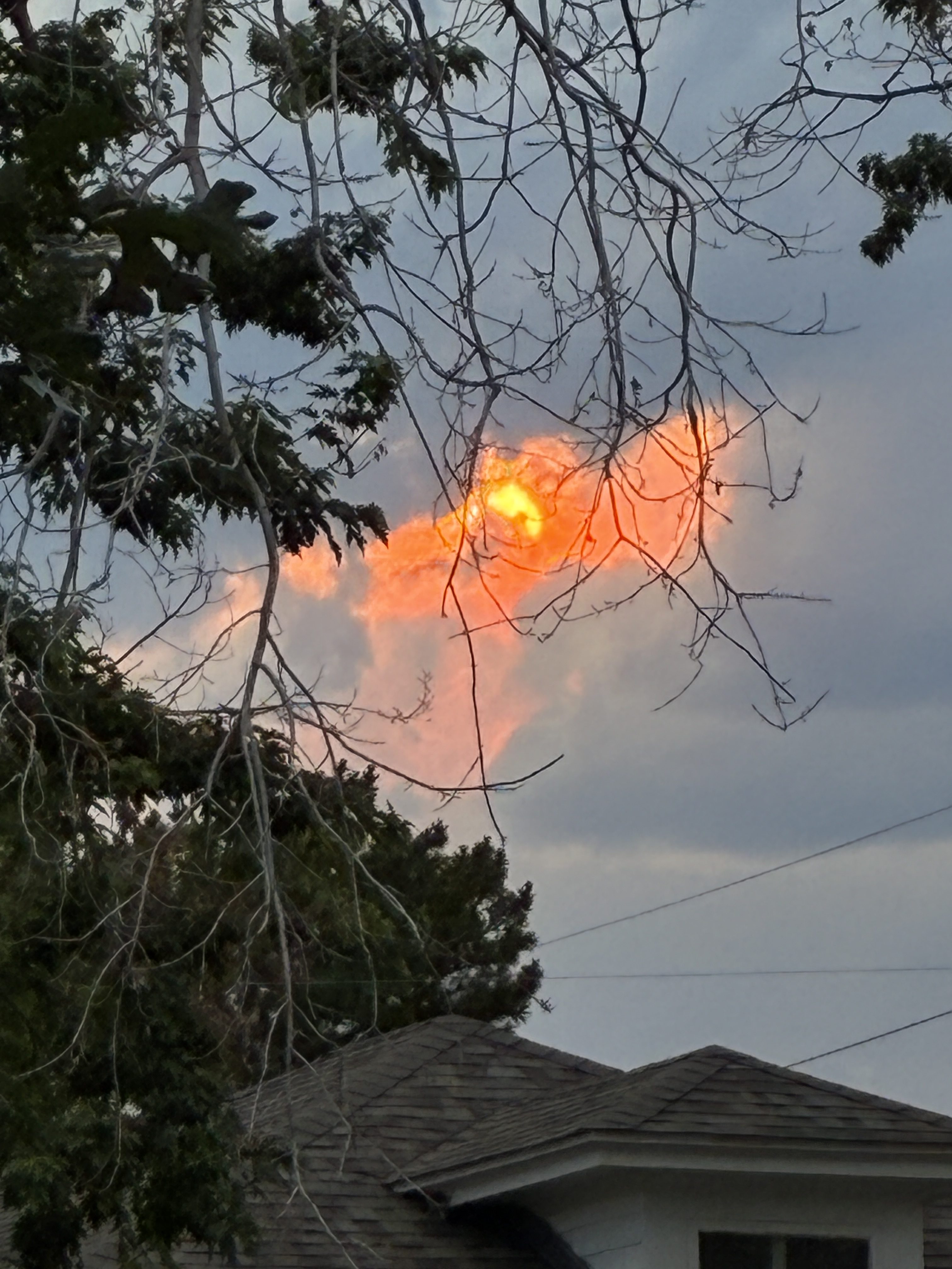
#Denver sunset June 30, 2026
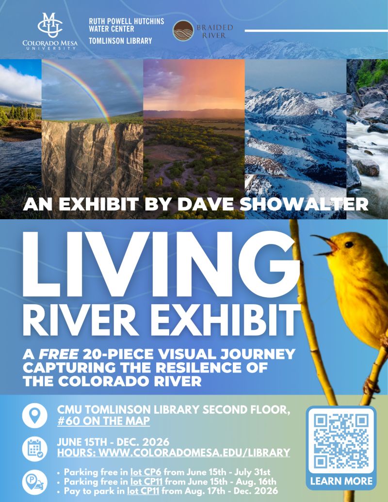
Ruth Powell Hutchins Water Center: Last Monday, June 22, 2026, was the opening of conservation photographer Dave Showalter’s exhibit, Living River
Click the link to go to the water center’s LinkedIn page:
June 24, 2026
Last Monday was the opening of conservation photographer Dave Showalter‘s exhibit, Living River: The Promise of the Mighty Colorado at Colorado Mesa University‘s Tomlinson Library! Visit the second floor to view this 20-piece visual journey and see how it encapsulates the resilience of the Colorado River and its keepers, illustrating how we can create an enduring watershed. The exhibit is free to the public, and free parking is available in specified lots until August 16th! We are excited to host this exhibit in partnership with the Tomlinson Library with the support from Braided River, and we look forward to sharing it with you all!
📅 June 15th Through December 2026
📍 CMU Tomlinson Library, Second Floor
⏰ Library Hours: https://lnkd.in/g69UwSkR
📋 Parking Information: https://lnkd.in/gFfEX6a7

Photo Credit: Dave Showalter
Mrs. Gulch’s landscape June 17, 2026
I’m rambling on!
Today is my first day without a job in 63 years! I’ve retired from the City of Thornton.
Thank you Councilmember Sandoval (and Mayor Johnston), bicycle safety is much improved on Tennyson St.

Councilmember Sandoval’s staff reached out to the Denver Department of Transportation and Infrastructure. I received a response from DOTI which basically said that Veo can use the public bicycle parking but is encouraged to not fill it up so that it is also available for other bicycle riders.


As the Veo vehicles get distributed around the city they are ending up in the neighborhoods.
Coyote Gulch’s Excellent EV Adventure: Punk Rock and Baseball!

I am in St. Louis for my first ever punk rock concert and some baseball!
The owner of the rig in the photo told me that the trailer was fully electric, but he said that the Tesla couldn’t draw charge from the trailer. Nice light low-profile rig.
The Model Y I am driving (rented from Turo) has Grok integrated so you can set and change your navigation interactively. I asked many questions of her (I mean IT!) during the solo drive from Denver so it’s sort of like having your computer available while driving. Of course the discourse was mostly, “What river am I crossing?”
Grok, “That is likely the Missouri River which is located in this general area.” Sure enough, a road sign validated Grok’s message — one correct query!
Green River nuke’s back on the table; Hole-in-the-Rock road paved; Plus: Notes from the Road and a recipe — Jonathan P. Thompson (LandDesk.org)
Click the link to read the article on The Land Desk website (Jonathan P. Thompson):
May 29, 2026
Blue Castle Holdings is proposing to build a nuclear power plant in Green River, Utah. You have not gone through a time warp, nor is this a “this date in history” sorta thing, though it could be. The same company tried to build a reactor in Green River a couple of decades ago, during the last “nuclear renaissance,” but the project fizzled amid fierce opposition, uncertainty over water rights, and as the nuke boom busted before it ever really got going.
This week, Blue Castle announced that the concept had only been dormant, not dead, and that it was coming out of hibernation in a spiffed up form in hopes of serving rapidly growing data center-driven electricity demand. Instead of constructing two, 1,500 MW reactors, the company — in partnership with Fulcrum Point Holdings — looks to install small modular reactors. It has not specified what the nameplate capacity will be, but says the units can be air-cooled, meaning they wouldn’t use as much water as conventional reactors.
Blue Castle has a bit of a head start on the project, since they’ve already done most of the site characterization work (on private land about five miles west of Green River). But they’ll still have to jump through the nuclear reactor licensing hoops, which can be arduous. That said, it should be a lot easier with both the Trump administration and the Cox administration champing at the bit to get more nukes up and running. Meanwhile, opposition to the idea is not likely to be any less fervent now than it was 20 years ago, and they’ll still have to secure water in an increasingly aridified region.
The melon-farming town along the banks of the Green River has become a magnet for proposed and actual industrial projects lately. The prospective nuclear plant joins Anson Resources’ lithium extraction project, Western Uranium & Vanadium’s proposed uranium mill, a 400-megawatt solar-plus-storage installation, and various uranium, lithium, and potash extraction proposals in the surrounding areas.
🌵 Public Lands 🌲
Well, they’ve gone and done it now. Garfield County has paved the Hole-in-the-Rock Road, or at least the first 10 miles of it. To folks who are unfamiliar with the road situation in Utah, paving — chip-sealing, actually — a notoriously washboarded, suspension-blasting, teeth-rattling dead-end dirt road may not seem like such a big deal. But this little maintenance action could have real consequences for the public land it runs through, i.e. Grand Staircase-Escalante National Monument, and sets a dangerous legal precedent when it comes to roads on public lands. It is also a symbolic move for both the opponents and proponents of the asphalt-laying project.
The Hole-in-the-Rock (HITR) road roughly follows the first segment of the Hole-in-the-Rock trail, which is the route Church of Latter Day Saints colonists forged in 1879 to get from Escalante to what would become Bluff City on the banks of the San Juan River in the southeastern corner of Utah. When the early Mormon travelers reached the seemingly-impassable, 2,000-foot-deep Glen Canyon on the Colorado River, they blasted and built a passage for their wagons, horses, and cattle through a natural opening in the cliff and called it Hole in the Rock.
It may have been this experience, in part, that led the descendants of those folks to develop a kind of fetish for roads, especially ones that cross federal land. By building the path across an especially rugged chunk of country and even crossing the mighty Colorado, they were able to assert a certain amount of control over what they saw as a hostile and wild landscape. Now county commissioners in Utah fight for control over backcountry roads* as a sort of proxy for dominating the lands they pass through. Garfield County has long looked to take ownership of the HITR road so that they can improve and pave it and be sure the Bureau of Land Management never closes it.
Environmental groups, meanwhile, have pushed back against county control. While the feds almost never close roads, they are more likely than counties to do so if necessary to protect cultural or ecological resources**. Counties are more likely to improve the roads, which leads to more people and attendant impacts in the backcountry.
Today’s HITR road runs 62 miles, from just outside Escalante to Hole in the Rock, where the canyon below is now mostly inundated by Lake Powell. It snakes its way on a rough parallel path to the Escalante River and passes near the heads of many of its tributary canyons that are popular with backcountry adventurers.
As visitation to the national monument and its surroundings has increased, so has the HITRR’s traffic: Garfield County’s road crew says some 600 vehicles per day travel the washboard-plagued road, with as many as 1,500 each day on weekends. All those cars wreak havoc on the road, and the county says it has been spending $150,000 annually on maintenance, some of which it claims could be avoided if it were allowed to pave the road.
Last July, a federal court ruled in favor of Garfield County and granted it quiet title to the section of the HITR Road in the county (the lower section is in Kane County, which also won quiet title to that portion of the road). In February, the county began preparing the route for chip-sealing. It informed the BLM of the work, but did not apply for a permit, and the BLM did nothing to stop the work. That was two victories in a row for the local-control over the public’s land crowd.
The Southern Utah Wilderness Alliance sued both the BLM and the county, saying the work required federal approval, since it occurred on federal land. It also sought an emergency injunction on further work while the case is pending.
Earlier this month, a judge denied the injunction request, clearing the way for Garfield County to proceed. A few days later, the machines were out there laying asphalt, while county officials and their backers crowed triumphantly and public land lovers cried foul. The courts may eventually rule against the county, but the chip seal is there to stay.
“Paving will lead to more, faster, and louder traffic,” said SUWA attorneys in a written statement, “changing the remote, serene backcountry experience the monument was created to protect, and that draws visitors from around the world.”
The HITR Road battle is an echo of an almost identical fight over the Burr Trail, another backcountry road between Boulder, Utah, which lies within Grand Staircase-Escalante National Monument, and Ticaboo/Bullfrog on the shores of Lake Powell. The sections on BLM land on either side of the route have been paved and/or chip-sealed after years of conflict. But the National Park Service has blocked Garfield County from paving the middle segment, which passes through Capitol Reef National Park.
I drive the Burr Trail any chance I get, simply because I love the country it travels through and because the slower pace the road requires allows me to see more, and facilitates frequent stops to get out of the car and look around.
I’m sure that traffic has increased since the paving. Just based on my observations, however, I would say that the added number of vehicles is not necessarily increasing the number of folks going into the surrounding backcountry. What I’ve seen are more RVs and low-slung sedans heading down the road from Boulder, going beyond the end of the pavement, stopping at the top of the switchbacks through the Waterpocket Fold (where the road is steep, loose gravel, and washboarded), then turning around and heading back up to Boulder. The eastern paved section, towards Bullfrog, has very little traffic. (On my most recent trip I did see a few vehicles drive up the Burr Trail switchbacks, then come back down before heading north on the Notom Road back toward Capitol Reef, a phenomenon that was also evident at the Moqui Dugway road in San Juan County.)
So while paving HITRR is a sort of symbolic and even spiritual defeat for those public lands and the folks looking to protect them, I’m also not sure that it will necessarily lead to more impacts to the surrounding backcountry. Garfield County’s vehicle count numbers, if correct, indicate that the automobile-driving masses are already driving the road. How could you cram more than 1,500 vehicles a day onto that little section?
In any event, it’s certainly the end of an era, and driving the first ten miles of the HITRR will be a completely different experience than it was pre-blacktop. Whether the phenomenon will be limited to those ten miles (and the Burr Trail), or spread throughout the rutted byways of Utah may depend on the outcome of SUWA’s lawsuit.
The Donald Trump Burr Trail? Oy! — Jonathan P. Thompson
🛻 Notes from the Road 🏕️
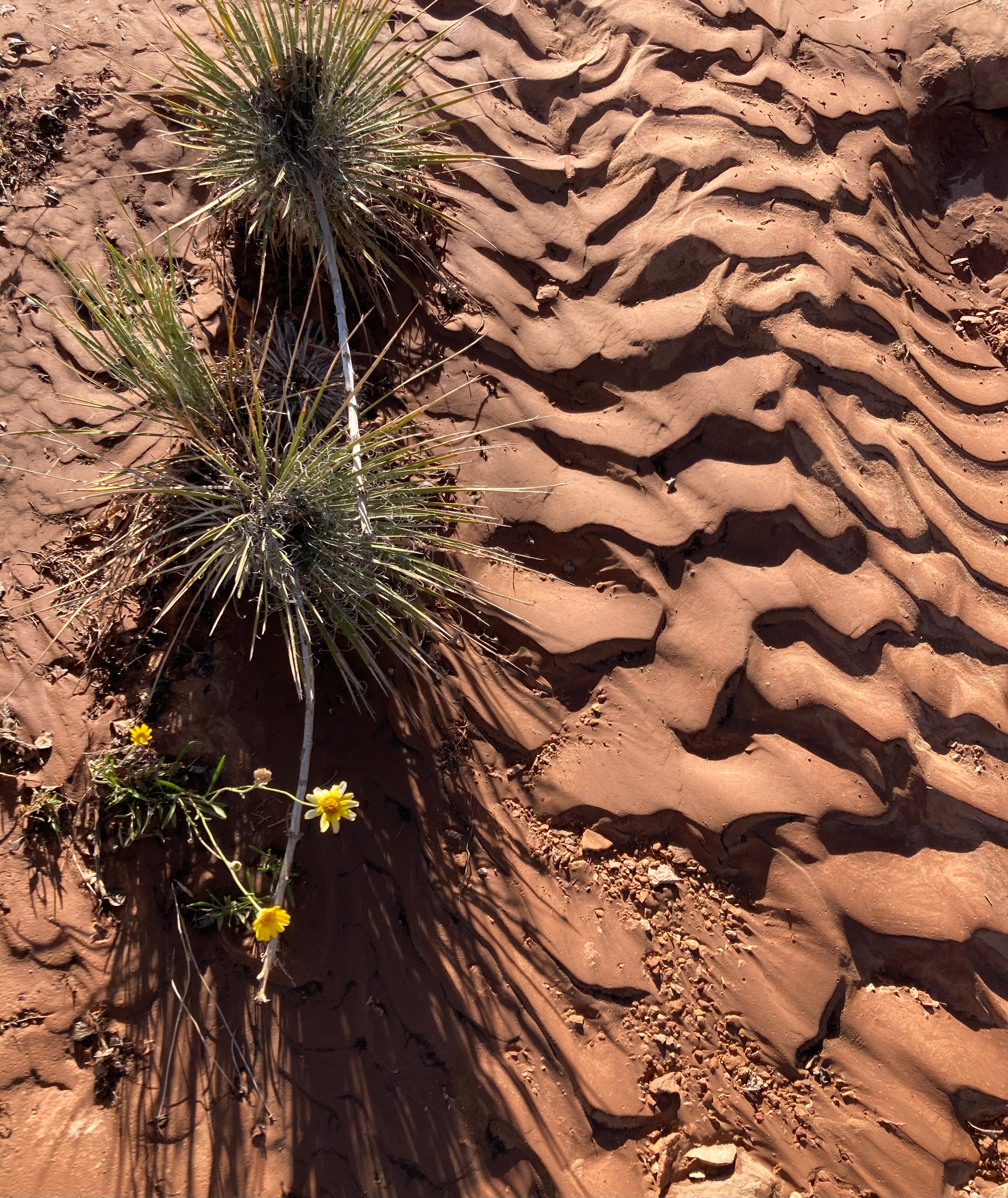
The hummingbirds have come back to southern Utah for the spring. Are they earlier than usual? Later? Maybe all that really matters is the penstemon are blooming, scarlet red.
***
One of my non-Land Desk gigs is compiling and summarizing Western energy news for a Canary Media newsletter every Monday, Wednesday, and Friday morning. This requires early morning internet, so when I’m out and about it means staying in a hotel on those nights or camping in a site where I know there is a strong and steady cell signal.
But on Tuesdays and Thursdays and weekends, I’m free to wander as far off grid as I can get. This is not difficult in southern Utah, which may have the highest proportion of out-of-cell-signal-range lands in the continental U.S.
Liberated from the digital shackles, I meander impulsively, by car, by bike, on foot, in search of the perfect campsite, a cool pool of desert water, a viewpoint from which the landscape unfurls before me, the post-storm light playing among the red rock crevices and spires far below. The sense of time slips away and I quickly forget what day it is. The lack of destination or deadline allows me to wander down whatever road, canyon, or trail looks appetizing. More often than not, they are dead ends, which is just fine.
Recently I set off on such an amble from Bullfrog Marina on Lake Powell. A storm had blown through the night before, leaving a few inches of wet snow on the steep slopes of the Henry Mountains and clearing the haze and smoke and dust from the air. Remnants of the storm lingered over the mountains and high mesas, defying the weather forecasts.
Following a bike ride up the paved part of the Burr Trail, I headed in el Burro Blanco onto the eastern slope of the Henries, and followed a back road that traversed the incline.
The soil was rocky enough to naturally gravel the road, or rather, to cobblestone it. While it wasn’t a smooth ride, it did keep the surface solid despite a couple of inches of moisture that fell the previous night and morning, at least for a while. Then, after topping a little rise, and as I descended a north-facing slope into a small drainage, the cobbles vanished, giving way to classic southern Utah clay. Goopy nasty stuff, that is, the kind of mud that steals your shoes, builds up on your tiles, and turns a motorized vehicle into a slip-sliding, uncontrollable, wheeled sled and that inspires signs warning “Impassible When Wet.”
Luckily, the fall line followed the line of travel, meaning I landed safely on a more solid patch of road at the trough of the drainage. I got out and surveyed the path ahead on foot, only to find that conditions worsened. I could either camp there and wait for the road to dry, or try to make it back up the hill I had just slid down in my rear-wheel drive pickup.
The former was the more intelligent choice, of course. But the campsite was far from ideal, and the clouds were still pretty thick, meaning it might rain or snow even more, and I don’t always make the smartest choices. Then I remembered: I had bought chains for the truck soon after inheriting it. I broke them out, chained up the rear wheels, did a thirty-point turnaround, and barreled back up the way I came, no problemo.
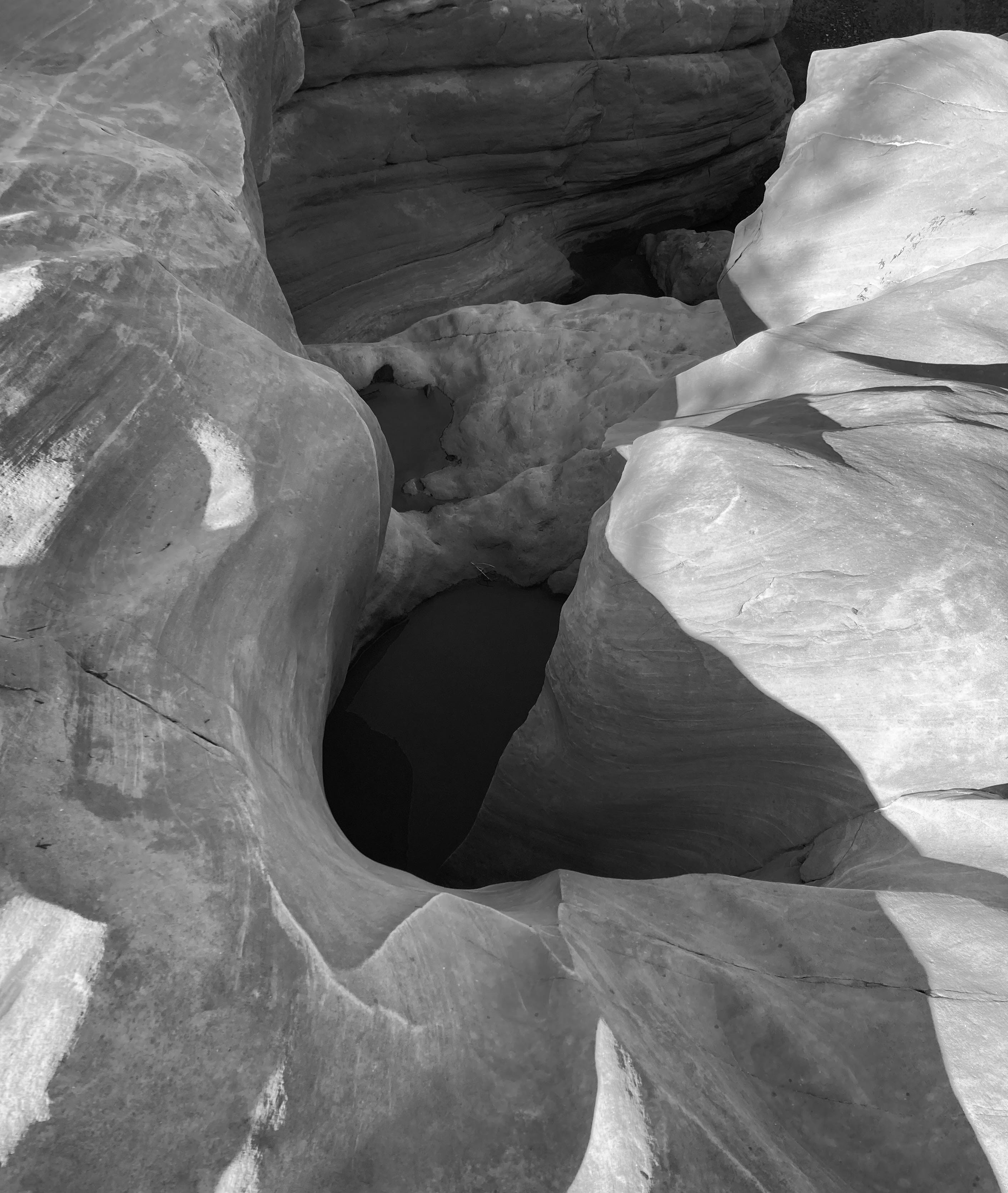
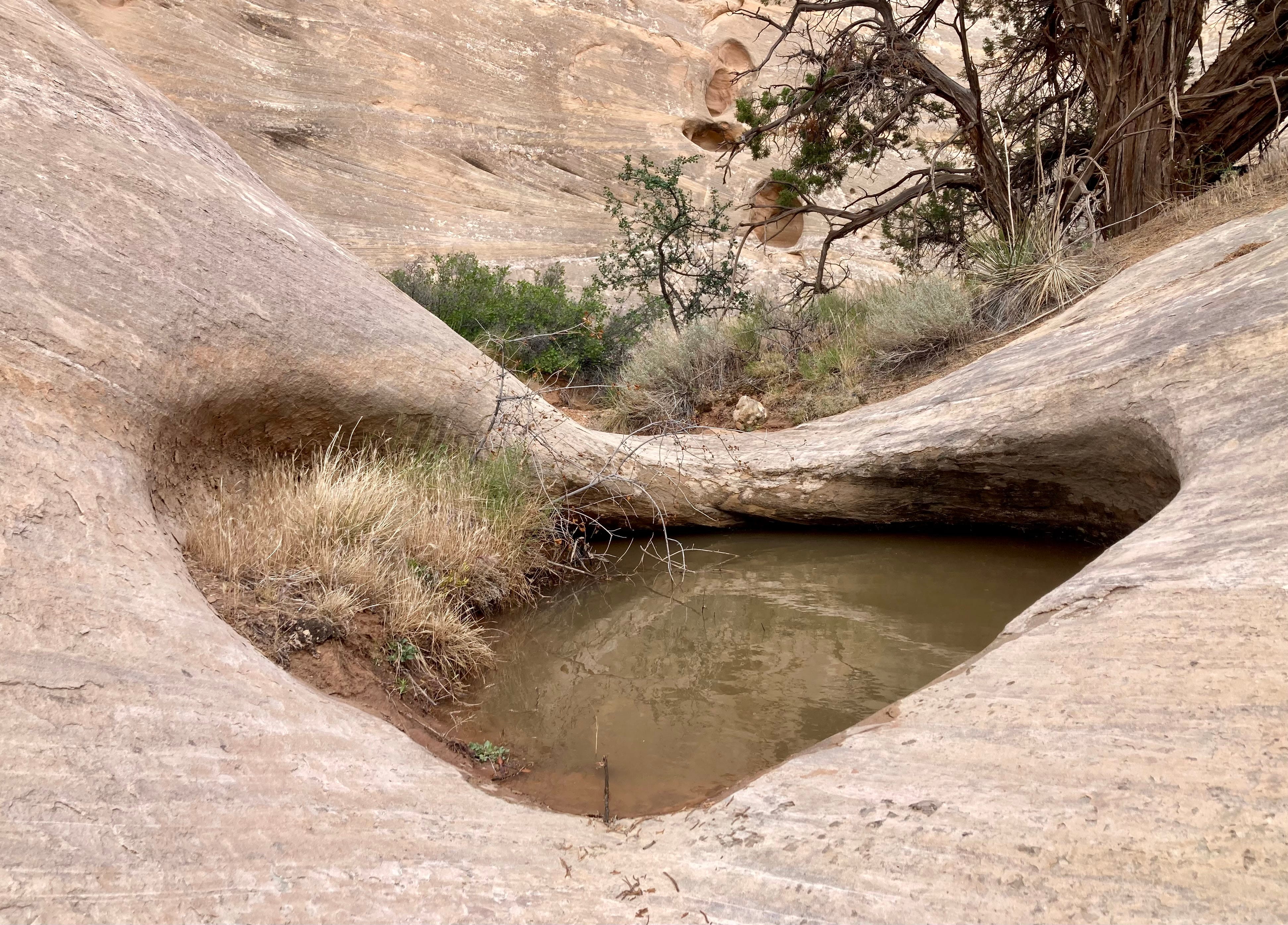
A couple of hours later, after venturing down another backroad, albeit one on more stable soil and at a considerably lower elevation, I landed in a delightful campsite. The rain had flushed away the gnats, settled the dust, sculpted the sand in the arroyos that flowed past the camp, summoned the wildflowers to bloom, and filled the tinajas and potholes to the brim with murky, cool water.
***
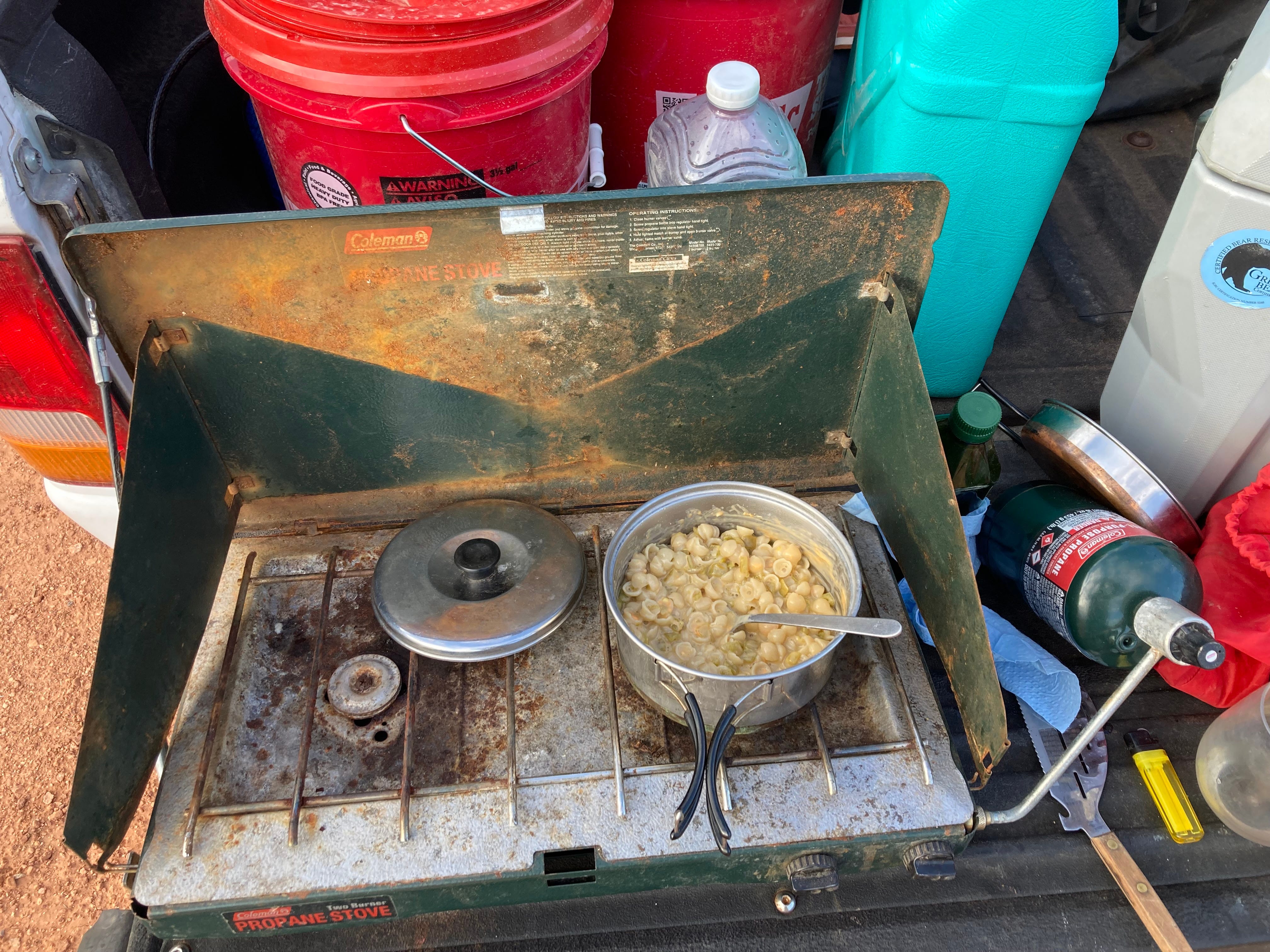
I’ve included a lot of different types of content in the Land Desk, from Messing with Maps, to Data Dumps, to movie reviews, but I don’t believe I’ve ever included a recipe here. That all changes today. I would recommend that you not try this recipe at home; it’s refined nature can only be fully appreciated when prepared on a camp stove and eaten in the outdoors, preferably while watching the evening light slide slowly across the desert.
I grew up going camping, usually in the Utah desert, with my family. It’s just what we did on many a weekend and on just about every school break. We didn’t have enough money for “real” family vacations, and we wouldn’t have wanted to do the Disneyland thing, anyway. This means I also grew up eating my father’s distinctive camp cooking, almost always made over a campfire because we didn’t have a camp stove.
I remember liking the food back then, but looking back I do have to wonder whether it wasn’t a form of child abuse. Delicacies included Dinty Moore beef stew on top of a bed of those canned deep-fried chow mein noodles; corned beef hash from a can; Vienna sausages — my dad’s friend called them cows lips in order to get us to hand them over; generic grape, orange, or black-cherry soda-pop; and, my personal favorite, those Pillsbury biscuits in a can cooked in a skillet over the fire in a sizzling reservoir of Country Crock squeeze-bottle margarine.
I’ve spent years trying to heal the taste-bud trauma, partially by sprinkling my food with truffle oil whenever someone else is paying for it, and have come quite a ways in my recovery. But it all went to hell in a hand basket when I went camping with a friend, who originally hails from the Midwest, and let him assume dinner duties one night. To my horror and dismay, he prepared something called Chili-Mac, which consists of a can of Hormel canned beef chili dumped into a batch of Krafts instant macaroni and cheese. I guess I’m lucky he didn’t do his other specialty, which involves hot dogs and mac-and-cheese — entirely too reminiscent of those damned jelly-coated cows’ lips, er, Vienna sausages.
Anyway, I learned my lesson, and I vet all of his dinner choices beforehand, and bring backup food just in case he tries to pull a fast one. Meanwhile, I’ve developed a more regionally and taste-bud appropriate alternative to his Chili-Mac. I call it Mac-n-Chile. Here’s the recipe (serves one hungry person):
- One box of Annie’s macaroni and cheese. I prefer the aged cheddar stuff, but any flavor will do.
- One can of hot Hatch green chiles. Yes, you can bring fresh roasted chiles if you want, but that adds to the work and complexity and who wants all of that? The canned stuff is fine.
- A liberal sprinkling of Cobblestone farm’s garlic powder. Oh, you want to buy the cheap grocery store stuff that has no flavor and is filled with anti-caking agents like silicon dioxide? Suit yourself! But if you want the best, you gotta go with Cobblestone Farms.
- A touch of salt and olive oil or butter.
Follow the instructions on the box, but salt the pasta water (they don’t put enough salt in those cheese packets), and add some olive oil or butter when mixing in the dried cheese. Dump in the green chiles and a liberal sprinkling of garlic powder — more is better. Pour yourself a beverage of your choice, sit down on your camp chair, truck’s tailgate, or a slab of sandstone, and devour it.
Oh, and keep your eyes open for those hummingbirds. I hear they’re buzzing about the canyon country these days.
Ted Turner Leaves a Legacy of Protected Land in the West — Todd Wilkinson (writersontherange.org)

Click the link to read the article on the Writers on the Range website (Todd Wilkinson):
May 25, 2026
Before he died at age 87 in early May, Ted Turner knew that stewardship of land would be his real legacy. Of course, he might also be long known for starting CNN and 24-hour news, as well as building a major league baseball team, his hometown Atlanta Braves.
He also started a UN Foundation to help bring peace to the world, thanks to his starter $1 billion contribution, and he tapped former U.S. Sen. Tim Wirth of Colorado to lead it. Wirth recalls how Turner, once dubbed “Captain Outrageous,” liked to shoot from the hip and could never be bothered by whatever passed as political correctness. A plaque on his desk in Atlanta said it all: “Lead, Follow or Get Out of the Way.”.
Most of all, Turner left a significant swath of private lands in better condition than he found them. In Montana and other parts of the Rockies, Turner bought huge ranches and made sure the land was healthy enough to grow a bison herd to over 55,000 animals at its peak.
Turner never subscribed to the notion that property rights trumped the common good. He also challenged the conviction that landowners ought to be able to do whatever they want on their land—even if it resulted in environmental harm.
As an entrepreneur with green intentions, Turner believed he could operate better and cheaper in recovering wildlife and rivers on his ranches that had been degraded by overgrazing. He was able to show that smart management also offered safe harbor to wildlife without sacrificing profit.
Some locals around Bozeman, Montana, in the 1980s thought Turner was out of his mind when he placed a conservation easement on his 113,000-acre Flying D Ranch, one of the largest easements in America at the time. The easement limited development in perpetuity, and had Turner exploited the Flying D as a real estate play, he could easily have made hundreds of millions in profit.
Turner could make a big impact on people. One was the billionaire businessman Thomas Kaplan, who likens Turner to a combination of John Muir and Teddy Roosevelt. Kaplan says Turner inspired him to co-found Panthera, now the leading global wildcat conservation organization, as well as The Orianne Society, named after his daughter and dedicated to perpetuating the survival of snakes.
Kaplan likes to recount how, when he visited Turner’s Flying D, he saw a wolf pack and howled back and forth with them. The ranch was home to the one of the largest, free-ranging wolf packs in North America, co-existing with Turner’s buffalo, and a population of elk, deer, moose and other wild animals that moved on and off the property.
Turner issued an edict that wolves visiting his land were never to be hunted or lethally controlled. Emulating the Turner model, Kaplan acquired thousands of acres in a vast wetland area of southwest Brazil called the Pantanal, and there he advanced a model of co-existence between cattle ranchers and jaguars. The Pantanal is considered the best place in the world for watching jaguars, and even cattle ranchers, who used to shoot the cats, now have eco-lodges on their estancias.
Turner was aware of his foibles, for which he hoped he would be forgiven. Biologist Mike Phillips, who oversaw a number of rewilding projects for Turner, told me, “In these recent years, as he was in decline, Ted once asked me, “Mike, we did okay, didn’t we?’ And I replied, “Ted, we accomplished exactly what we set out to do so long ago. I reminded him that he had done more as a private citizen to benefit native species than any other individual in the history of the world.”
Phillips said that Turner choked up with emotion.

Jane Fonda, Turner’s “third and favorite wife,” according to those who knew the couple, told me that after a brutal childhood with a hard-driving father who took his own life, along with a sister who died young from lupus, Turner found solace in nature.
“What did he want most of all? asked Fonda. “To be recognized as a good guy. There was a part of Ted who believed that by trying to save nature and bring more peace to the world, he could save himself. But he saved much more than that.”
Todd Wilkinson is a contributor to Writers on the Range, writersontherange.org, an independent nonprofit dedicated to spurring conversation about the West. He is a longtime journalist and founder of Yellowstonian.org, who wrote an award-winning biography about Turner.
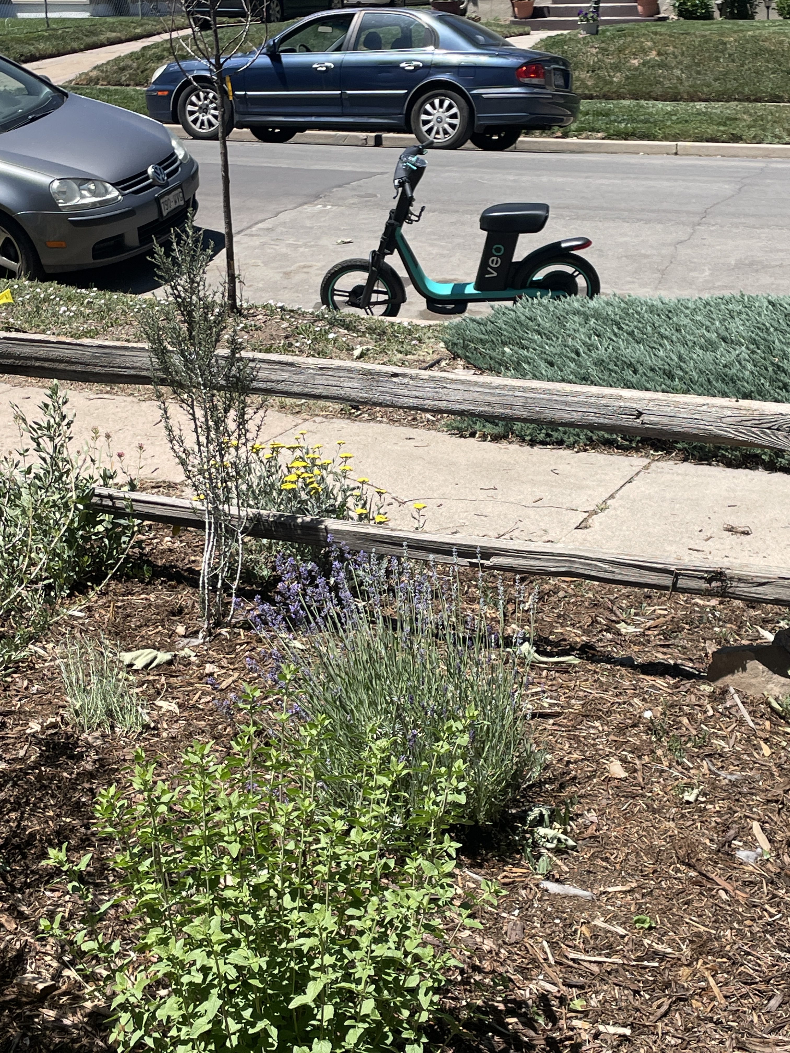
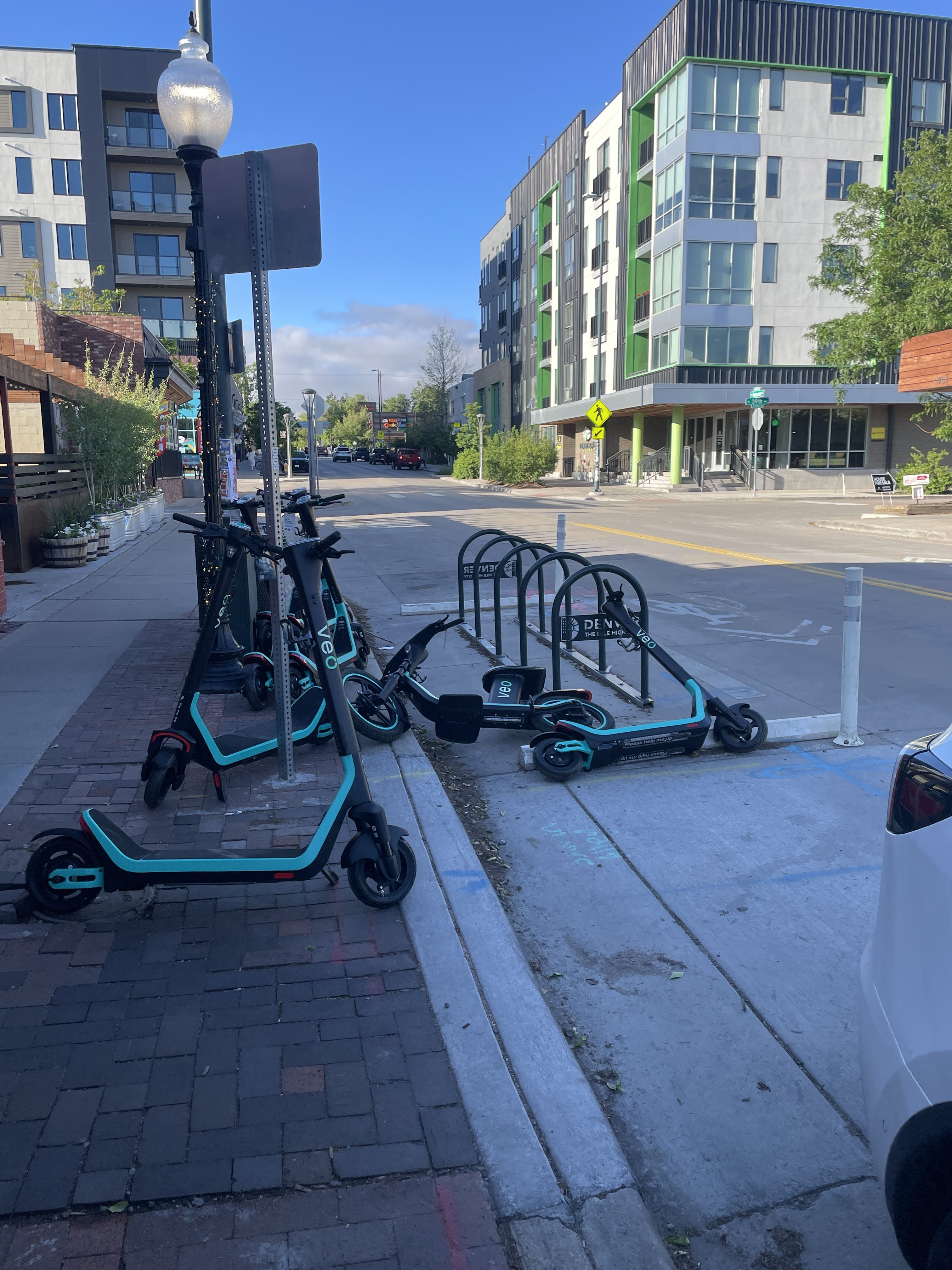
Councilmember Sandoval (and Mayor Johnston) bicycle safety has improved on Tennyson St. but Veo is still filling up the public bicycle parking at W. 44th & Tennyson


All the public bicycle parking available at W.43rd & Tennyson May 29, 2026. Note the Veo vehicles on the public right-of-way across the street, not in a loading zone or street parking for cars and trucks.
Happy Memorial Day

Councilmember Sandoval (and Mayor Johnston) you have a bicycle safety problem on Tennyson Street and an unresponsive bureaucracy

Veo is parking their scooters and bicycles in the public bicycle parking on Tennyson Street and there is nowhere for bicyclists to lock up to do business with the merchants. The Denver bureaucracy was unresponsive to my inquiries. 311 did closed the request without action.
Maybe the respondents don’t ride bicycles, but if they did they would want to lock them up when snagging some cherry pie, brown sugar cinnamon ice cream, or croissants, like I do.

Look, bicyclists are fine with the for profit folks making a buck, helping out with transportation, and helping to meet Denver’s carbon footprint goals. Just get the damn Veo vehicles out of the public bicycle parking!
A timelapse showing the incredible movement of a growing vine, exhibiting both nastic movement to find, and then a thigmotropic response to grasp and hold — @wonderofscience
Happy Mother’s Day
“Hear my words that I might teach you”: Sounds of Silence — Disturbed
Flowering plants evolved ~130 Ma (recent in Earth’s history!). They appeared suddenly in the Cretaceous and diversified quickly — #Colorado Geological Survey
China surpasses US in research spending – the consequences extend far beyond scientific ranking and clout — Caroline Wagner (TheConversation.com)

Caroline Wagner, The Ohio State University
China’s rapid rise in science has hit a milestone. The country’s investment in research and development has reached parity with – and by purchasing power measures has surpassed – that of the United States, according to a March 2026 report from the Organisation for Economic Co-operation and Development. Both nations have crossed the US$1 trillion threshold on research spending.
For 80 years, the U.S. operated the most productive scientific and technological enterprise in human history. Breakthroughs and advances that came from American labs included the internet; the mRNA vaccine; the transistor and its children, semiconductors and microprocessors; the Global Positioning System; and many more.
U.S. scientific and technological leadership was nurtured by sustained public investment in research universities and federal laboratories, as well as a culture of open inquiry. These investments turned scientific discovery into economic strength – accounting for more than 20% of all U.S. productivity growth since World War II.
In contrast, China had previously spent little to nothing on research and development. Some estimates show that China was among the lowest research spenders worldwide in 1980.
As a policy analyst and public affairs researcher, I study international collaboration in science and technology and its implications for public and foreign policy. I have tracked China’s rise across every major database for more than a decade.
The most recent reports showing that China is now outspending the U.S. on scientific and technological research is a turning point worth understanding clearly because, historically, global leadership in one sector – including technology and warfare – feeds into others. U.S. dominance is in question.

China’s systematic and unrelenting rise
China’s R&D spending milestone caps a series of achievements that have arrived in rapid succession.
In 2019, China surpassed the U.S. in its share of the top 1% most-highly cited papers – what some call the Nobel class of research. By 2022, it had taken first place globally in most-cited papers overall.
In 2024, China overtook the United States in total scientific publications – the first time any nation has displaced American dominance since the U.S. itself surpassed the United Kingdom in 1948. Researchers found that China overtook the United States in scientific output even earlier. That same year, China pulled ahead in the Nature Index, which tracks publications in the world’s most selective scientific journals, posting a 17% advantage over the U.S. in outlets long considered the gold standard of scientific excellence.
In 2024, Chinese entities also filed roughly 1.8 million patent applications, compared to the U.S.’s 603,191 applications.
Given these milestones, it’s possible to argue that China is quickly taking the lead in global science and technology. These are not isolated data points. They mark a structural shift in where the world’s scientific frontier is being built.
More science is good – the problem lies elsewhere
China’s ascent is, in one sense, good news. More knowledge, generated by more researchers across more institutions, expands the global pool of discovery from which everyone can draw. The world benefits when science thrives.
The problem is not that China is investing, but that the U.S. is not.
First, the U.S. is divesting from basic, open science. Federal R&D spending in the U.S. peaked in 2010 at roughly $160 billion and fell by more than 15% over the following five years. Federal investment in research and development has been in a long, slow slide – from a peak of 1.86% of gross domestic product in 1964 to about 0.66% in 2021.
The federal government is no longer the largest spender in R&D: It funded about 40% of basic research in 2022, while the business sector performed roughly 78% of U.S. R&D. While not a problem in itself, industry has simultaneously withdrawn from open scientific publication over the past four decades, shifting from research toward development. The result is a shrinking pool of openly shared scientific knowledge precisely as public investment in it also contracts.
Under the second Trump administration, U.S. government science agencies have been slow-walking proposals for new research. Current budget cuts from the White House threaten to deepen cuts to government spending significantly.
The second is the active restriction of scientific exchange: tightening access to U.S. institutions, scrutinizing international collaborations and raising barriers to foreign-born researchers. These policies, though intended as security measures, work against the openness that has historically made American science productive and attractive to global talent.
I describe this issue as an example of the stockyard paradox, in which securing research assets may weaken the very system these measures aim to protect.
Disinvestment cuts deeper than it appears
The deeper danger for the U.S. economy is that disinvestment and selective engagement in research erodes the capacity to use cutting-edge science regardless of where it is produced.
Absorbing and applying cutting-edge knowledge, whether developed in Boston or Beijing, requires maintaining research institutions and trained workforces, as well as active participation in global networks. This is not a passive process. You cannot free-ride on Chinese science if you have dismantled the institutional and human capital needed to evaluate, translate and apply it.
A nation that hollows out its research base not only falls behind but also progressively loses its ability to benefit from science, including in technologies it is already able to access.
Talent compounds the problem. The U.S. built its scientific dominance partly by being the destination of choice for the world’s most ambitious researchers. The U.S. leads the world in Nobel Prizes, but, notably, 40% of the Nobel Prizes in chemistry, medicine and physics that were awarded to Americans since 2000 were won by immigrants. The flow of foreign talent is not guaranteed. It follows opportunity, funding and openness.
Researchers who might once have come to American universities are finding welcoming alternatives in Europe, China and elsewhere. https://www.youtube.com/embed/yLvO070E_dI?wmode=transparent&start=0 Around 75% of U.S. researchers are considering leaving the country due to the Trump administration’s funding policies.
A decision point, not a trend line
China’s milestone in research funding arrives at a moment when the U.S. is deciding whether to maintain its scientific leadership.
Scientific infrastructure does not decline gradually and recover on demand. Doctoral scientists represent a decade or more of training; tacit laboratory knowledge lives in working research groups, not in documents. Once talented young researchers leave the pipeline – or international talent redirects to other countries – the capacity is very hard to rebuild. Early warning signs are already visible in the U.S. system: thousands of NIH grants terminated, a collapse in international applications and an exodus of early-career scientists.
What is at stake is not a ranking. It is whether the U.S. maintains the institutional capacity – the universities, the federal laboratories, the graduate pipelines, the culture of open inquiry – that made those returns on scientific investment possible in the first place.
China’s rise did not create this decision point, although it brings it into sharp relief. Does the U.S. still want to lead in science? The Information Technology and Innovation Foundation, a nonprofit think tank, estimates that a 20% cut in federal research and development starting in fiscal year 2026 would shrink the U.S. economy by nearly $1 trillion over 10 years and reduce tax revenue by around $250 billion. Others point out that the scientific enterprise has contributed at least half of U.S. economic growth.
That is a lot to lose.
Caroline Wagner, Professor of Public Affairs, The Ohio State University
This article is republished from The Conversation under a Creative Commons license. Read the original article.
This week in Mrs. Gulch’s landscape April 25, 2026


“I am a writer now”– Tom Gauld
“Ramble On” is 56 years old and Robert Plant just walked onto The Late Show and made it sound like he wrote it this morning — Guitar Gods Unleashed
In 2050, the planet’s 9.7 billion people can expect lab-grown meat and insect protein instead of beef
April 9, 2026
In 2050 the food on our dinner plates will look very different than it does now. A changing climate will force a shift from water and land-intensive staples like beef and dairy to more resilient alternatives. Rising temperatures and erratic weather patterns have already reduced the yields of traditional crops like potatos, coffee, bananas, wheat, corn, and rice. As those staples become harder to produce humanity will pivot toward more resiliant crops like millet, sorghum, beans and lentils—which can thrive in degraded soil and arid conditions.
The most dramatic shift will occur in our protein consumption, specifically the move away from industrial livestock. Cattle farming is both a major contributor to greenhouse gas emissions and highly vulnerable to water scarcity. By mid-century, traditional beef and pork will likely become luxury items. In their place, lab-grown meat, insect proteins, and plant-based meat substitutes will become the norm, offering the same nutritional benefit at a fraction of the environmental cost.
Beyond meat alternatives, we can expect to see insects and algae integrated into the mainstream diet. While we turn our noses up to them now, crickets and mealworms are highly efficient protein sources that require minimal land and water. Similarly – seaweeds and microalgae like spirulina will move from health-food niches to primary ingredients, valued for their ability to grow rapidly in saltwater without the need for synthetic fertilizers or freshwater irrigation.
Technology will also personalize our nutrition to combat food insecurity and supply chain instability. With the rise of vertical farming and hydroponics in urban centers, fresh produce will be grown blocks away from where it is consumed, reducing “food miles” and spoilage. We may also see the widespread use of biofortified crops—genetically engineered to contain higher levels of essential vitamins—to compensate for the nutrient density loss currently being observed in plants grown under high CO2 levels.
Ultimately, the diet of 2050 will be defined by diversification and efficiency. The era of relying on a handful of global commodities is coming to an end, replaced by a circular food economy that prioritizes local resilience and low-impact nutrients. While these changes are born of necessity, they offer a path toward a more sustainable relationship with the planet, ensuring that a growing population can be fed sustainably in a warming world.
Happy Pi Day!

Mrs. Gulch’s landscape March 11, 2026
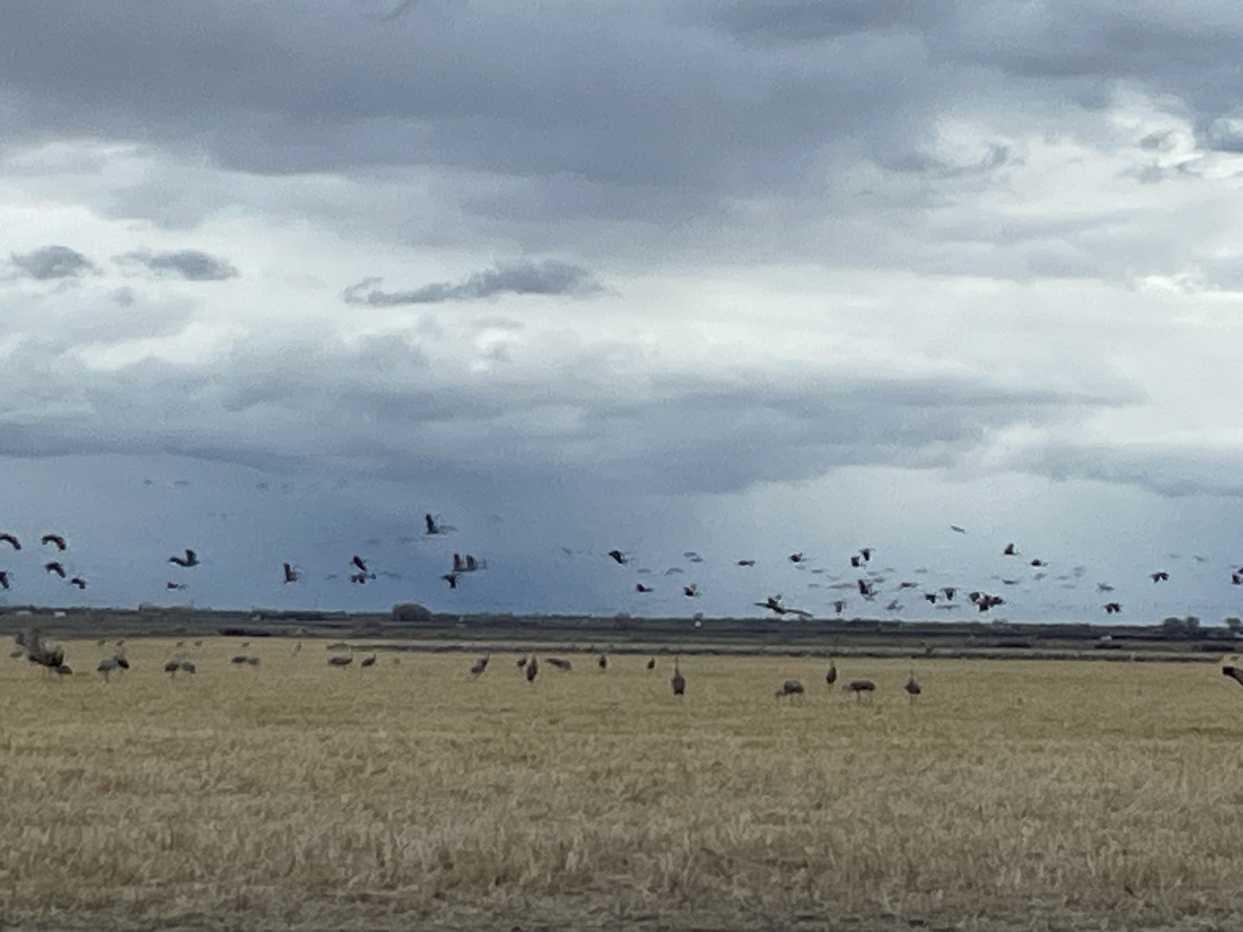
Coyote Gulch’s excellent EV adventure: 2026 #MonteVista Crane Festival
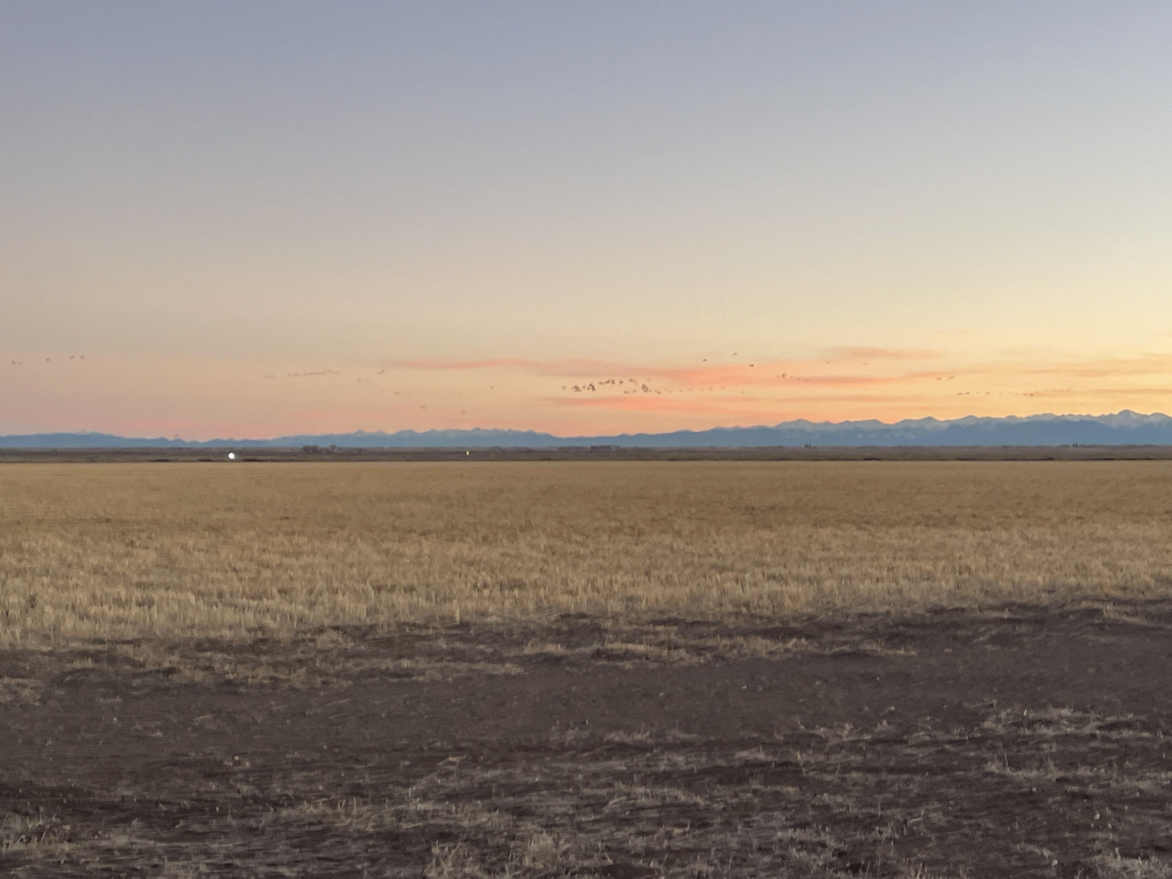
We woke up to clear skies and very cold temperatures (6°F) for Sandhill crane viewing on March 8, 2026. The Sandhills spend the night on the ground, usually in shallow water as they do not perch, and then start stirring and looking for a good breakfast spot like the field in the foreground in the photo above.
Charging during the festival was easy as pie at the Colorado Welcome Center in Alamosa. For the trip home I charged in Salida (excellent food at Mojo’s Eatery) and Bailey. Charging to and from the San Luis Valley from Denver is convenient and reliable. There is no reason any longer in Colorado to drive a vehicle with a tailpipe and pollute the atmosphere.
Here’s a writeup from The Alamosa Citizen:
Monte Vista saw big crowds for the 43rd annual Crane Festival. The Outcalt Event and Conference at Ski Hi Complex was teeming with people participating in the crane tours and nature work sessions. The retail vendors reported healthy sales. The sandhill cranes themselves didn’t disappoint. The majestic long-legged creatures were in the tens of thousands in the fields around the Monte Vista Wildlife Refuge. The cranes will stick around a bit longer.
Coyote Gulch’s excellent EV adventure: 2026 #MonteVista Crane Festival
I’m in the San Luis Valley for the 2026 Monte Vista Crane Festival. The Sandhills were very active this morning off Road 8S in the Monte Vista National Wildlife Refuge.
I charged in Pueblo and Cañon City on the way here. It is a breeze charging between Denver and Alamosa, even if you need a CHAdeMO connector like my Nissan Leaf. (Posting will be intermittent this weekend because the Wi-Fi signal in my hotel room is very weak. I posted this from the hotel lobby.)
“Abundance” comes to the #ColoradoRiver; Lee attacks public lands again; Billionaires buy real estate; And more tidbits — Jonathan P. Thompson (LandDesk.org) #COriver #aridification
Click the link to read the article on The Land Desk website (Jonathan P. Thompson):
February 6, 2026
🌵 Public Lands 🌲
Sen. Mike Lee, the MAGAt from Utah, appears to be vying to be the most anti-public land politician in history. The Trump sycophant was, of course, behind last year’s congressional bids to sell off public land to real estate developers and various other schemes. His latest assault is the Historic Roadways Protection Act, which passed through a Senate committee yesterday. It would block the Bureau of Land Management from “closing historical roads” and implementing travel management plans across a broad swath of federal lands in Utah until a federal court rules on thousands of county RS-2477 claims.
RS-2477 is an 1866 statute that allowed highways to be constructed across federal lands to access mining claims and homesteads. It was repealed in 1976 when Congress passed the Federal Land Policy Management Act, or FLPMA. But FLPMA grandfathered in existing “highways” that had been constructed under RS-2477. In 2010 and 2011, Utah and its counties filed some 12,000 RS-2477 claims on about 35,000 miles of “highways” on federal lands, many of which are no more than old livestock tracks, in hope of gaining control of the paths so they can grade them, widen them, and even pave them. Settling all of these claims could take decades, meaning Lee’s bill would essentially be banning the BLM from managing travel on these areas forever.
Albert Bacon Fall, the New Mexico Senator and disgraced Interior Secretary under President Warren G. Harding still has my vote for the most anti-public land politician. But maybe that’s because Fall was actually a colorful character. Lee’s most interesting trait is that he holds Jell-O socials in his Capitol office.
Longread: The F%$^hell Canyon Saga — Jonathan P. Thompson
Oil, milkshakes, and DRAINAGE! — Jonathan P. Thompson
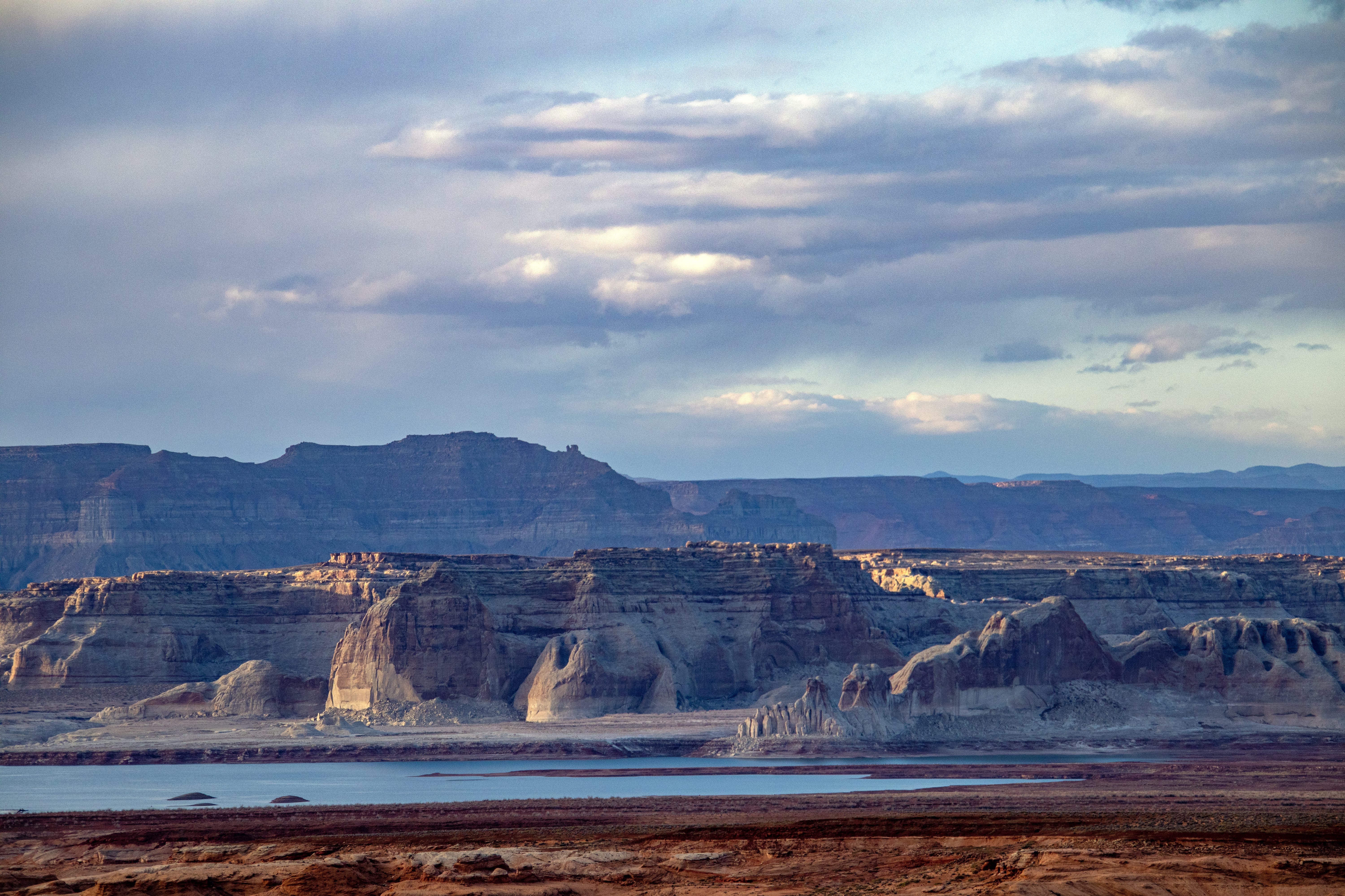
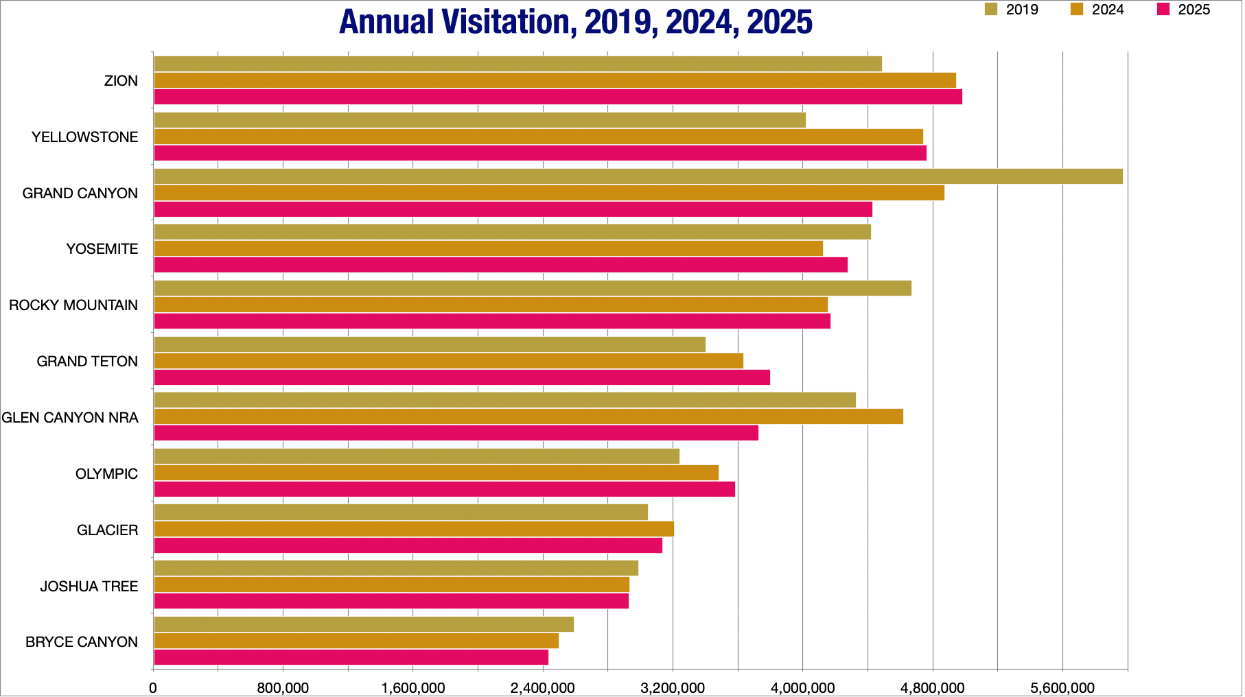
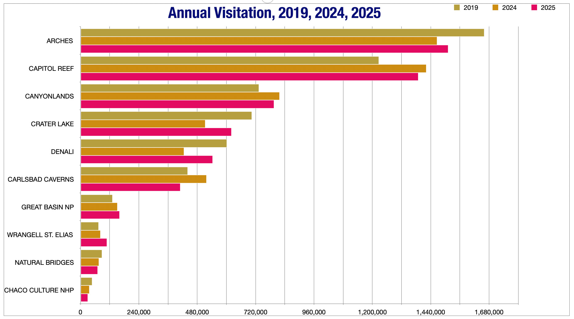
One of the things I like about Page, Arizona, are the weird and ubiquitous contrasts that characterize the place. There’s the surreality of a lakeside city in the desert and the striking juxtaposition of golf course greens against stone. But perhaps the most jarring of all is the sensation of wandering Safeway’s aisles in a distinctly American town and hearing fellow patrons speaking languages from all over the world.
The Southwest attracts visitors from across the globe and, as a result, the increasingly dominant tourism and outdoor recreation industries have come to depend on international travelers. After Trump was inaugurated and implemented his America First creed, which tends to manifest as hostility towards every other nation, international travel to the U.S. dropped. That’s in spite of the fact that Trump’s economic policies have also caused the dollar’s value to plummet, making the U.S. a cheap vacation spot for Europeans.

Over the summer of 2025, that appears to have led to a drop in visitation to most national parks in the Southwest. However, visitation tended to rebound in the fall — perhaps due to lower gas prices — bringing the annual numbers back up to close to what they were in 2024.
One exception was Glen Canyon National Recreation Area, which saw a huge drop in visitors last year, probably due to a combination of low reservoir levels at Lake Powell, a massive wildfire on the Grand Canyon’s North Rim, and the drop in international visitation. But if tax revenues are any indication, it hasn’t hurt the overall tourism industry in Page that badly. Sales tax, hotel/motel tax, and online lodging tax revenues for January through September 2025 were up significantly from the previous year, according to the City of Page’s statistics.
🏠 Random Real Estate Room 🤑
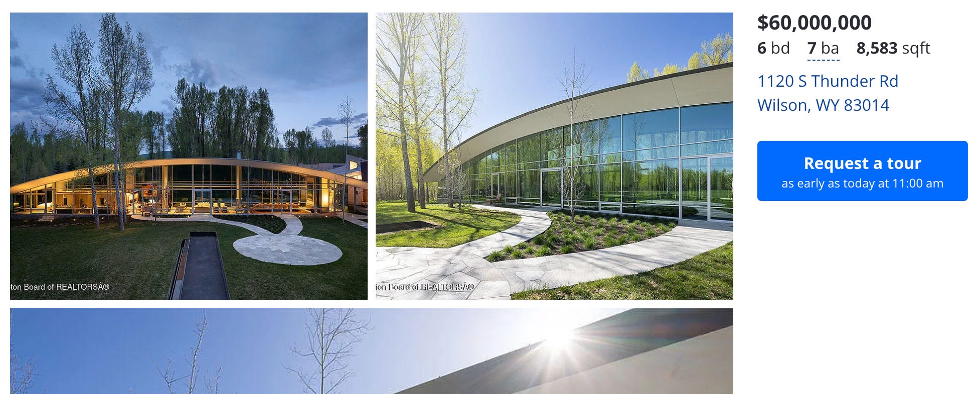
You’ll all be thrilled, I’m sure, to learn that the uber-wealthy had a pretty good year in 2025, at least if high-end home and land sales are any indication. Luxury real estate sales in Jackson, Wyoming, reportedly are “surging” and “closed the year with exceptional momentum.” That’s the latest from The Viehman Group’s Jackson Hole Report, something I read when I want that lovely sensation of barfing in the back of my mouth.
Thirty-seven homes sold for over $10 million in the region last year, with 25 of them netting a sale price of over $15 million. The most expensive home sale was the Bar B Bar Ranch 4, with “multiple enhanced spring creeks for fishing,” which went for a modest $43 million.
But don’t worry! Overpriced luxury homes remain for the taking! For instance, you can buy a glorified quonset hut — er, an 8,583-square-foot steel, glass, and stone mansion — for $60 million. I know that seems like a lot, but according to Zillow’s BuyAbility calculator, the monthly payments would be a mere $320,673 after a $12 million down payment.
The median earnings for full-time year-round workers in Teton County are about $70,000 per year, which, according to Zillow’s mortgage calculator, could allow one to afford a $220,000 home with a $10,000 down payment. Meanwhile, the median home sale price in Teton County is about $3.8 million. And the cheapest home on the market is a 1970s, 644 sf condo listed for $695,000 (after a $30k reduction).
So, yeah, the West’s housing affordability crisis is as bad as ever, and the gap between the uber-rich and everyone else continues to grow.
🥵 Aridification Watch 🐫
The Abundance movement has reached the Colorado River, brought by an unexpected flag-bearer. The motorized recreation organization, BlueRibbon Coalition, is proposing the Colorado River Abundance Act. The vision, writes the coalition, is simple: “The American Southwest does not have to settle for managing a dwindling resource. It can choose abundance and start building.”
Building what? You ask. The answer: “A coordinated suite of desalination plants — offshore, onshore, and binational — supported by pipelines, pumping systems, brine-management facilities, and sediment removal programs.” These plants would crank out as much as 7 million acre-feet of water per year and deliver it to the river and/or directly to Lower Basin water users. That would allow more water to stay in Lake Powell and Lake Mead, thereby buoying reservoir levels.
And that would, among other things, improve boating and other recreation on those reservoirs, which is why the BlueRibbon Coalition is pushing the concept. In addition to creating funds for building a massive amount of water desalination and transportation infrastructure, the proposed legislation would also “elevate recreation to a coequal project purpose, establishing Recreation Modernization Plans for key reservoirs,” and pushing major upgrades to marinas, launch ramps, docks, trails, and shoreline facilities, “including a top-priority requirement to rebuild mid-lake services at Lake Powell with fast-track approval.”
That’s referring to the late Dangling Rope Marina, a remote floating boat refueling and restocking station in Dangling Rope Canyon, located about halfway between the down-lake marinas and Halls Crossing in the upper section of the reservoir. But low water levels and a damaged electrical system forced the National Park Service to shutter it in 2021, and it has not been reopened or replaced.
This abundance approach could work, in theory. But consider this: the largest desalination plant in the world, Ras Al Khair in Saudi Arabia, can treat about 306,500 acre-feet of water per year. It reportedly cost about $7 billion to construct, and uses about 3,626 megawatt-hours of electricity each day — that adds up to 1,323 gigawatt-hours annually, or enough to power tens of thousands of homes (or a handful of data centers). You’d need about 20 of those leviathans and a crapload of generation capacity to reach the 7 MAF/yr target of this plan, not to mention the extensive pumping and piping infrastructure to get the water to where it needs to go.
At some point, doesn’t it seem just a little bit easier, and a hell of a lot less expensive, to live within our means?
You can read the Colorado River Abundance Act here.
I will say that the Abundance approach is a step up from a, let’s say Archimedean, proposal to raise Lake Powell’s level by, wait for it, throwing a bunch of car batteries into the reservoir. If you’re wondering if this was a serious idea or not, just consider from where it came: The Sonoran Avalanche Center.
The SAC was sincere enough to write its own song for the occasion.
The Land Desk has been talking a lot about the effects the low snowpack will have on water supplies, Lake Powell, and irrigators. But it’s also hurting the ski industry — Vail Resorts reported a 20% drop in skier visits this winter — and that’s hurting the communities and workers that rely on that industry. The news clip below reports on how a Summit County food bank is being overwhelmed by new demand this winter.
The median home price in Summit County, by the way, is about $995,000.
🗺️ Messing with Maps 🧭
Article: Time Variance in Snowmelt Partitioning: A Mechanistic Modeling Approach to Explore the Role of Catchment Structure and Pre-Snow Rainfall — Mahbod Taherian, Ali A. Ameli (AGU)
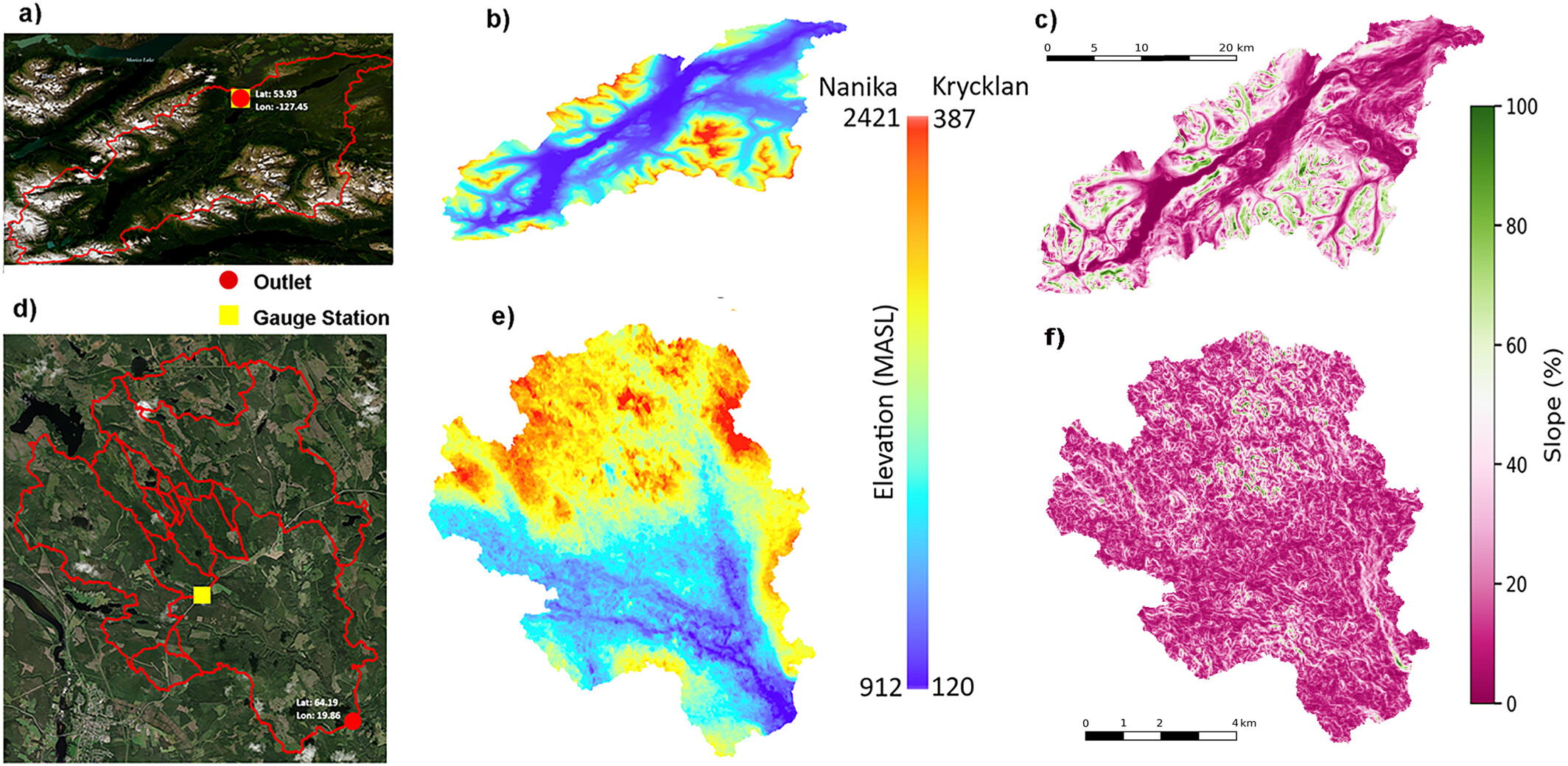
Click the link to access the article on the AGU website (Mahbod Taherian, Ali A. Ameli). Here’s the abstract:
January 9, 2026
Understanding how snowmelt is partitioned into different hydrologic flowpaths/storages—and how this partitioning varies over time—is essential for predicting water availability and quality under climate variability. In this study, we examine the time-variance of snowmelt partitioning patterns (SPP) in response to interannual variations in antecedent (Fall) rainfall before snowmelt seasons, across two snow-dominated catchments in Canada and Sweden with contrasting geologic and topographic features. Using integrated subsurface–surface flow and transport modeling, combined with observational data, we simulate the partitioning of snowmelt into shallow flowpath, deep flowpath, evapotranspiration, and long-term storage. To generalize our findings beyond the two case studies, we design a suite of virtual experiments that systematically vary catchment slope and the extent of the hydraulic conductivity’s vertical and lateral heterogeneity. Results show that lateral heterogeneity in conductivity mediates the sensitivity of snowmelt partitioning to interannual variations in antecedent rainfall. While laterally homogeneous catchments display minimal sensitivity of snowmelt partitioning pattern to wet or dry Fall rainfall conditions, catchments with heterogeneous lateral structure store a significantly larger portion of snowmelt and reduce snow-sourced shallow flow contributions in years with high pre-snow rainfall than years with low pre-snow rainfall. In contrast, while slope and vertical conductivity architecture govern SPP, they play a limited role in mediating SPP’s temporal sensitivity to antecedent rainfall variability. These findings reveal that subsurface structure—including the extent of lateral subsurface heterogeneity—modulates the influence of climate variability on snowmelt partitioning and catchment hydrologic function. This has implications for predicting streamflow responses, groundwater recharge, and solute transport under changing climate regimes, and highlights the importance of representing time-variable hydrologic behavior in hydrologic models.
Plain Language Summary
Knowledge of how snowmelt moves through a watershed is essential for managing water supplies and ecosystems in snow-dominated regions. Snowmelt can either run quickly to streams or infiltrate to recharge groundwater, and this balance shifts from year to year with climate and watershed structure. We studied two snowy watersheds that differ in slope and subsurface properties to test how late-summer/fall rainfall (which sets pre-snowmelt wetness) shapes winter snowmelt pathways. In steep terrain with horizontally variable (patchy) subsurface hydraulic conductivity, dry pre-snowmelt conditions direct meltwater horizontally to streams, whereas wetter pre-snowmelt conditions favored deeper infiltration and storage. To generalize, we ran virtual experiments that systematically altered the extent of horizontal variability of hydraulic conductivity. A consistent signal emerged: patchy subsurface hydraulic conductivity produced stronger year-to-year swings in how snowmelt is partitioned between runoff and storage, while horizontally uniform subsurface hydraulic conductivity led to more predictable, stable watershed responses. These results show that antecedent wetness and the horizontal structure of subsurface permeability jointly control the time-variability of snowmelt partitioning. Incorporating these controls can improve forecasts of streamflow and groundwater recharge, and guide planning for flood and drought risks in snow-dependent watersheds under increasing climate variability.
Key Points
- Pre-snow rainfall variability alters snowmelt partitioning pattern (SPP) into storage versus runoff, with the magnitude of impact mediated by the extent of hydraulic conductivity’s lateral heterogeneity
- Catchments with greater lateral heterogeneity in hydraulic conductivity store (release) a larger (lesser) portion of snowmelt in years with large pre-snow rainfall
- Slope and vertical conductivity architecture influence SPP but exhibit limited modulation of SPP temporal sensitivity to pre-snow rainfall variability
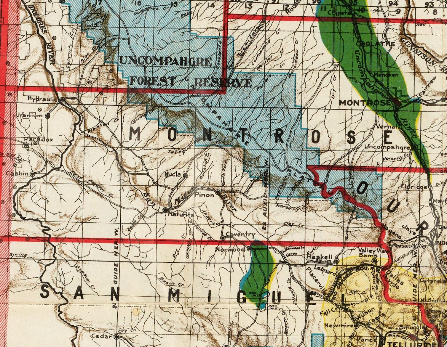
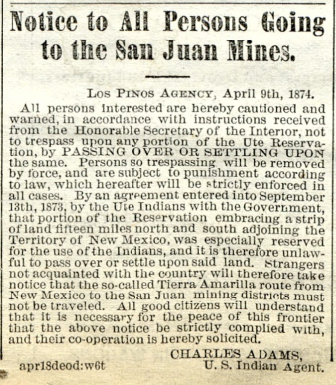
Broken treaties with the Utes paved the way for #Colorado’s 1870s San Juan silver rush: Thousands flocked to boomtowns like #Ouray and #Silverton as Colorado neared statehood — Chase Woodruff (ColoradoNewsline.com)
Click the link to read the article on the Colorado Newsline website (Chase Woodruff):
January 30, 2026
In the years leading up to Colorado statehood, nearly all of the territory’s western half still belonged to the Ute people, who had inhabited the northern Colorado Plateau for centuries.
An 1868 treaty between the U.S. government and six bands of the Ute tribe reserved nearly all of the western half of the Colorado Territory for their “absolute and undisturbed use and occupation,” and stated that “no persons … shall ever be permitted to pass over, settle upon, or reside in the territory described.”
The agreement lasted just four years.
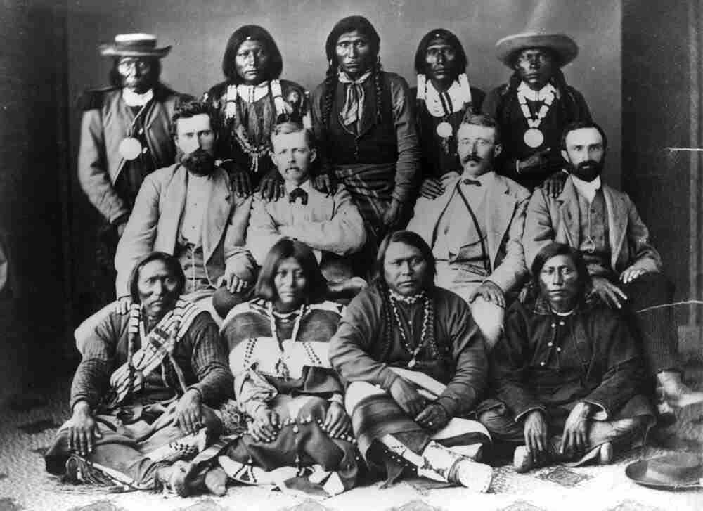
By 1872 prospectors for gold and silver in the San Juan Mountains were routinely trespassing on Ute lands, and the following year the federal government — under pressure from territorial leaders demanding access to the region’s “large bodies of mineral and agricultural resources” — pushed the Utes to cede a 3.7-million-acre area surrounding the San Juans in what was known as the Brunot Agreement.
So began the Colorado Territory’s next major mining boom, and the first to be concerned principally with silver — the extraction and minting of which would dominate the soon-to-be state’s economy and politics for the next several decades.
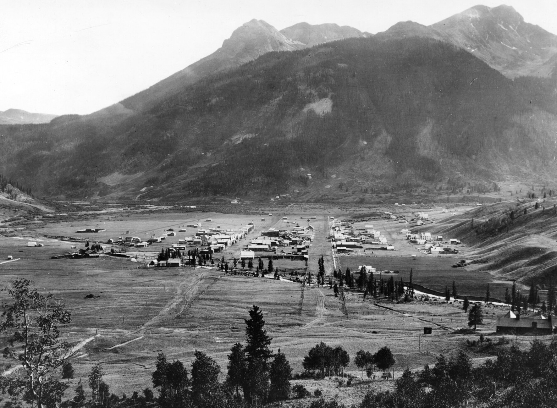
By 1876, fortune seekers could reach the San Juans by taking the Denver and Rio Grande Railroad to Cañon City, and from there traveling on grueling mountain toll roads to mining settlements like Ouray, Silverton and Lake City. In late January 1876, the Silver World of Lake City advised that despite “the unusual quantity of snow,” the wagon road that passed through Saguache was manageable with sleighs, but the more southerly route through Del Norte was “almost impassable.”
The silver rush had helped revive the fortunes of southern Colorado, turning towns like Pueblo and Cañon City, where residents had long felt ignored by the territory’s northern establishment, into important transportation and commercial hubs serving the remote San Juan mining district.
Other Front Range towns, including Colorado Springs, regretted “the outflow of men consequent upon the San Juan and other mining excitements.” A gold rush to the Black Hills of the Dakota Territory was also underway at the time — another treaty-breaking incursion into Native American lands, which would soon lead to a war with the Lakota people and the Battle of Little Bighorn later in 1876.
The San Juan mines, wrote the Silver World, required “earnest, energetic men … who can submit to the deprivation of the luxuries of a higher civilization.” The paper’s weekly editions from the winter of 1876 contained few reports of serious crime, though the threat of “snowslides,” frostbite and mountain lions were often mentioned.
But by then the region’s boomtowns were beginning to evolve from rough-and-ready mining camps into something more established — incorporating municipal governments, forming school districts and issuing bonds for the construction of new wagon roads and other public improvements. Ordinances approved by Lake City’s new board of trustees included a schedule of fines levied for misdemeanors, published in the Silver World on Jan. 15.
“Read the ordinances which appear in this issue,” the paper’s editors advised, “and save yourself the possibility of being fined or getting in the ‘jug.’”
Public intoxication or animal cruelty could cost an offender up to $50, while the penalty for impersonating a police officer or “immoderately” riding or driving horses on town streets could run up to $100. To “quarrel in a boisterous manner” was considered a breach of the peace and carried a fine of between $5 and $25.
Arriving in Denver for the meeting of the territorial Legislature in January, Rep. Reuben J. McNutt of Silverton had brought a petition from his fellow settlers for the creation of a new county encompassing the western San Juan boomtowns. The Legislature soon passed House Bill No. 1, and Gov. John Routt signed it into law on Jan. 31, officially creating the new San Juan County, from which the present-day counties of Ouray, San Miguel and Dolores would later be carved out.
Alongside these administrative necessities, some inhabitants of the remote mining towns aimed for the cultural betterment of settlements like Lake City, where the Silver World reported billiards were still the “principal amusement.” The Lake City Dramatic Club staged its first theater production on Feb. 2, 1876, performing George Melville Baker’s “Among the Breakers,” and the cast of amateurs won a rave review from the local paper.
“The universal testimony of all who witnessed it was that it would have been difficult for professionals to have surpassed it,” declared the Silver World. “The play was in all respect (was) well mounted and in no instance were there any of those hitches so common in entertainments of this nature, and which tend alike to embarrass the performers and distract the attention of the audience.”
The gradual dispossession of Ute lands in western Colorado would not end with the Brunot Agreement and the rush to the San Juans. The so-called northern or White River Utes were expelled from Colorado beginning in 1880, and today reside on the Uinta and Ouray Indian Reservation in Utah. Three other bands of the tribe grouped together as the southern Utes — the Capote, Mouache, and Weenuche — agreed in 1878 to cede all but a small portion of their lands in far southwest Colorado along the New Mexico border.
The southern Utes later split into the Southern Ute Indian Tribe, consisting of the Capote and Mouache bands, and Ute Mountain Ute Tribe, made up of the Weenuche band. Today, the Southern Ute and the Ute Mountain Ute are the only two federally-recognized tribes within Colorado’s borders.

NASA Finds Lunar Regolith Limits Meteorites as Source of Earth’s Water

Click the link to read the article on the NASA website (Rachel Barry):
January 23, 2026
A new NASA study of its Apollo lunar soils clarifies the Moon’s record of meteorite impacts and timing of water delivery. These findings place upper bounds on how much water meteorites could have supplied later in Earth’s history.
Research has previously shown that meteorites may have been a significant source of Earth’s water as they bombarded our planet early in the solar system’s development. In a paper published Tuesday in the Proceedings to the National Academy of Sciences, researchers led by Tony Gargano, a postdoctoral fellow at NASA’s Johnson Space Center and the Lunar and Planetary Institute (LPI), both in Houston, used a novel method for analyzing the dusty debris that covers the Moon’s surface called regolith. They learned that even under generous assumptions, meteorite delivery since about four billion years ago could only have supplied a small fraction of Earth’s water.
The Moon serves as an ancient archive of the impact history the Earth-Moon system has experienced over billions of years. Where Earth’s dynamic crust and weather erase such records, lunar samples preserve them. The records don’t come without challenge, though. Traditional methods of studying regolith have relied on analyzing metal-loving elements. These elements can get muddied by repeated impacts on the Moon, making it harder to untangle and reconstruct what the original meteoroids contained.
Enter triple oxygen isotopes, high precision “fingerprints” that take advantage of the fact that oxygen, the dominant element by mass in rocks, is unaffected by impact or other external forces. The isotopes offer a clearer understanding of the composition of meteorites that impacted the Earth-Moon system. The oxygen-isotope measurements revealed that at least ~1% by mass of the regolith contained material from carbon-rich meteorites that were partially vaporized when they hit the Moon. Using the known properties of such meteorites allowed the team to calculate the amount of water that would have been carried within.
“The lunar regolith is one of the rare places we can still interpret a time-integrated record of what was hitting Earth’s neighborhood for billions of years,” said Gargano. “The oxygen-isotope fingerprint lets us pull an impactor signal out of a mixture that’s been melted, vaporized, and reworked countless times.”
The findings have implications for our understanding of water sources on Earth and the Moon. When scaled up by roughly 20 times to account for the substantially higher rate of impacts on Earth, the cumulative water shown in the model made up only a small percent of the water in Earth’s oceans. That makes it difficult to reconcile the hypothesis that late delivery of water-rich meteorites was the dominant source of Earth’s water.
“Our results don’t say meteorites delivered no water,” added co-author Justin Simon, a planetary scientist at NASA Johnson’s Astromaterials Research and Exploration Science Division. “They say the Moon’s long-term record makes it very hard for late meteorite delivery to be the dominant source of Earth’s oceans.”
For the Moon, the implied delivery since about 4 billion years ago is tiny on an Earth-ocean scale but is not insignificant for the Moon. The Moon’s accessible water inventory is concentrated in small, permanently shadowed regions at the North and South Poles. These are some of the coldest spots in the solar system and introduce unique opportunities for scientific discovery and potential resources for lunar exploration when NASA lands astronauts on the Moon through Artemis III and beyond.
The samples analyzed for this study came from parts of the Moon near the equator on the side of the Moon facing Earth, where all six Apollo missions landed. The rocks and dust collected more than 50 years ago continue to reveal new insights but are constrained to a small portion of the Moon. Samples delivered through Artemis will open the door for a new generation of discoveries for decades to come.
“I’m part of the next generation of Apollo scientists —people who didn’t fly the missions, but who were trained on the samples and the questions Apollo made possible,” said Gargano. “The value of the Moon is that it gives us ground truth: real, physical material we can measure in the lab and use to anchor what we infer from orbital data and telescopes. I can’t wait to see what the Artemis samples have to teach us and the next generation about our place in the solar system.”
For more information on NASA’s Astromaterials Research and Exploration Science Division, visit: https://science.nasa.gov/astromaterials
#Utah officials pillage public lands — again: BLM greenlights St. George highway; Lawmakers look to repeal GSENM management plan — Jonathan P. Thompson (LandDesk.org)

Click the link to read the article on The Land Desk website (Jonathan P. Thompson):
January 23, 2026
🌵 Public Lands 🌲
St. George, in Utah’s southwest corner, is one of the nation’s fastest growing communities. This is partly because of a nice climate, access to a major interstate, and relative closeness to Salt Lake City and Las Vegas. But it’s also because the landscape in which it sits is stunning, characterized by burnished red sandstone punctuated by dark volcanic formations and the green ribbons of the Santa Clara and Virgin Rivers, all set against the backdrop of the Pine Valley Mountains. In 2009, Congress created the Red Cliffs National Conservation Area on about 45,000 acres of BLM land just north of St. George to protect some of this landscape and its wildlife, and to offer a refuge from the burgeoning mass of humanity.

But the Trump administration — and the state of Utah — have other plans. This week, the Bureau of Land Management approved Utah’s plans to build a four-lane highwaythrough the south end of the conservation area. The stated aim is to accommodate growth, reduce congestion, and speed up the car trip from one section of sprawl to another. But really it will only induce growth and more traffic, while also diminishing one of St. George’s most appealing assets.
The idea for a Northern Corridor Highway has been bantered about for a couple of decades. The proposal seemed to perish in 2016, when the BLM denied Washington County’s bid to build the road through the national conservation area. But when Donald Trump was elected president the first time, the county and the Utah Department of Transportation seized the opportunity to apply for a right of way to build a 4.5 mile, four-lane highway across a portion of the conservation area.

In January 2021, the outgoing Trump administration’s BLM approved the right of way, even though its own analysis acknowledged that it would destroy tortoise habitat, spread invasive species, and essentially chop off the southern end of the conservation area, destroying trails and damaging the recreation experience. A large coalition of environmental groups under the banner of the Red Cliffs Conservation Coalition sued the BLM, and the agency ultimately agreed to redo the environmental analysis — finally rejecting the proposed highway at the end of 2024 and recommending an expansion of the existing Red Hills Parkway, instead.
Once Biden was out of office, however, the state and Washington County once again appealed to the feds to grant them a right-of-way, arguing that the Red Hills Parkway idea was not feasible. And since the Trump administration and Utah’s elected leaders tend to value roads and more suburban sprawl over tortoises, beauty, and the thriving desert landscape, the BLM opened the door to bulldoze more land to indulge Utah’s road fetish and to make way for yet another monument to America’s car-centric culture.
***
A couple of dispatches ago, I wrote about how curious it was that the Trump administration had yet to move to diminish or eliminate any national monuments during this second term. It may be because they are outsourcing the task to Congress.
Utah’s congressional delegation is expected to introduce federal legislation that would use the Congressional Review Act to overturn the Biden-era Grand Staircase-Escalante National Monument management plan. If the “resolution of disapproval” passes both chambers of Congress with a simple majority vote, it would erase the plan and bar the Bureau of Land Management from issuing another plan that is “substantially the same” in the future.
This wouldn’t change the boundaries of the monument, but would likely cause management of the area to revert back to the 2020, Trump I-era plan. That plan was not only less protective than the newer one, but only applied to a much smaller area, since in 2017 Trump had significantly shrunk the national monument. Revoking the current management plan, then, would leave vast areas of the monument in a sort of management limbo.
“I strongly denounce any attempt to use the Congressional Review Act to overturn the Grand Staircase-Escalante National Monument Resource Management Plan. This plan reflects years of public input, scientific research, and meaningful Tribal consultation, and dismantling it through procedural shortcuts undermines good governance, responsible land stewardship, and the protection of irreplaceable cultural landscapes,” said Autumn Gillard, Southern Paiute, Grand Staircase-Escalante Inter-Tribal Coalition member, in a written statement. “At this time, I urge lawmakers from both sides of the aisle to uphold the approved resource management plan from January 2025.”
Feds seek public input on Grand Staircase-Escalante management plan — Jonathan P. Thompson
***
Utah officials often say they dislike new national monument designations because, in their minds, protecting land and cultural resources is bad for the economy, mostly because they block new mining and drilling. A new study shows they are wrong.
Headwaters Economics analyzed economic conditions and trends in 30 national monument gateway communities, and found that national monument designations do not disrupt local economies. They also don’t give nearby communities a substantial economic boost. “Employment and population trends continue on the same trajectory after designation,” Headwaters found, “and income growth tends to improve modestly over time.”
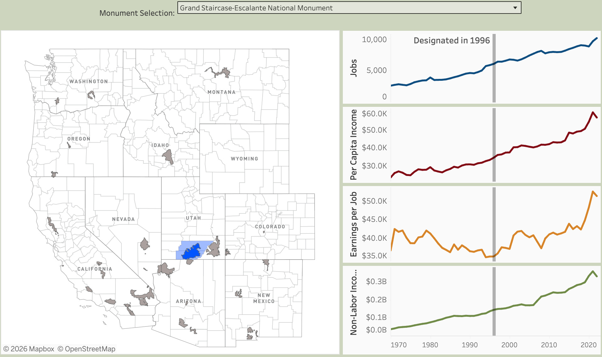
The findings match up with what one would intuitively expect. National monuments are rarely designated in areas that are currently targeted for new drilling and mining, meaning they are unlikely to affect the existing extractive economies. Meanwhile, they are often established in places that are already experiencing an increase in visitation, meaning that designation wouldn’t necessarily cause a significant jump in tourism.
Take Bears Ears National Monument, for example. It was established in 2016 on federal land in San Juan County, Utah. Both the oil and gas and uranium mining industries were (and are) active in the county. But they weren’t interested in drilling new wells or opening new mines within the monument’s boundaries. Previous oil and gas wells had mostly come up dry — drillers have found much more success in the Aneth and McElmo fields east of the monument. And the Daneros uranium mine, which is been on standby status for years, is outside the boundaries, as well. In other words, monument designation had absolutely zero effect on either industry.
Meanwhile, fears that establishing a national monument in this corner of southeastern Utah would lead to its “discovery” by the masses were overblown, simply because the internet and social media had already lured folks to the area. Indeed, part of the reason people pushed for designation was to try to get a handle on increased visitation and its impacts on natural and cultural resources.
Headwaters has a nice interactive graphic on which you can check out the economic trends around the 30 national monuments. The trends, themselves, are interesting to see: They make it abundantly clear that other factors, especially COVID-19, had a much bigger effect than any national monument designation.
The Meaning of Monuments — Jonathan P. Thompson
🤖 Data Center Watch 👾
The Big Data Center Buildup is accelerating. Nearly every day I get news of another proposed hyperscale facility somewhere in the West. A lot of them are not planning on connecting to the power grid, which is good for other utility users, because they won’t have to pay for associated infrastructure upgrades. But in almost every case, their proposed power sources include at least some gas-fired generation. And natural gas, i.e. methane, is not clean energy by any means.
So, while the data center boom has the potential to accelerate the clean energy transition by encouraging more solar, wind, and battery storage, it is also slowing the transition by perpetuating fossil fuel burning and even prompting construction of new fossil fuel-fired facilities.
Projects that have come onto my radar recently include:
- Laramie County, Wyoming’s commissioners approved Crusoe Energy Systems’ and Tallgrass’ proposed AI data center complex near Cheyenne, despite residents’ pushback over the project’s massive scale. If this thing is built as planned, it will be ginormous, with estimated capital costs of $50 billion. That would not only include the Project Jade’s five data centers and associated structures, but also a 2,700 MW gas-fired power plant — which would be among the largest of its kind in the West. The developers plan to use a closed-loop cooling system, which is less water-intensive than conventional evaporative systems but uses more energy.
- About 150 miles west of there, Power Company of Wyoming, an Anschutz Corporation subsidiary, is proposing a 2,000 MW gas generating facility in Carbon County to serve growing data center-driven power demand. These are the same folks who are building the Chokecherry Sierra Madre wind project and the TransWest Express transmission line. The controversial, 732-mile TransWest Express was originally billed as a clean-energy line that would carry Wyoming wind to California. Looks like it also will be moving fossil fuel-fired power, as well.
- Residents of Surprise, Arizona, a section of Phoenix’s sprawl, are getting a little surprise of their own: A proposed data center and dedicated 700 MW natural gas plant adjacent to a residential neighborhood. Residents are not too pleased, according to a story in the Arizona Republic, and are worried about the environmental and health impacts of a gas plant and the data center. The data center would run off the gas plant for the first couple years of operation before connecting with the grid. Then the plant would serve as backup for the center as well as a “peaker” plant, meaning it is fired up during peak demand.
🫣 Correction 🙀
In this week’s Colorado River glossary and primer I inadvertently shrunk the Colorado River watershed quite significantly by leaving out two zeros. It covers about 250,000 square miles, not 2,500. Duh.
Cool Opportunity
The Wright-Ingraham Institute is now taking applications for its three-week immersive fellowship for graduate students and early-career professionals in science, design, policy, the arts, and beyond. This year’s field workshop focuses is on “designing for adaptation in a time of prolonged drought,” and will be held in the San Luis Valley and Taos Plateau from July 6-27. Read more and apply here.
📸 Parting Shot 🎞️
This one popped up on my Facebook feed and I just had to purloin it. It’s downtown Grand Junction in the 1960s (I believe), not long after they refashioned the main drag to make it more people-friendly. It’s funny because a lot of folks in my hometown of Durango are freaking out about a proposal to do something kind of like this, but even less radical, to its downtown. They claim that widening sidewalks and so forth will destroy the historic integrity of the streetscape. In my mind, this photo illustrates how untrue that claim is.
The distribution of woodland in the USA, 1873 — @vintagemapsstore
#Colorado ranchers and consumers can team up to make beef supply chains more sustainable — TheConversation.com
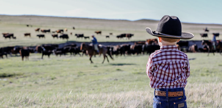
Jordan Kraft Lambert, Colorado State University; Jennifer Martin, Colorado State University; Kim Stackhouse-Lawson, Colorado State University, and Sara Place, Colorado State University
Cowboys guided a herd of longhorn cattle through downtown Denver to celebrate the opening of the annual National Western Stock Show on Jan. 8, 2026. As ranchers bring their best cattle to compete for blue ribbons over the course of this month, it’s a good time to consider whether beef production can be part of a circular economy.
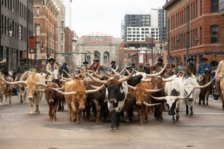
Circularity is an economic model where raw materials are responsibly sourced, waste products are put to best use and the system maximizes ecosystem functioning and human well-being.
As with most human activities, beef production provides a valuable contribution to human health while also impacting the natural environment, sometimes in negative ways.
We are innovators and researchers who live in Colorado and study the beef supply chain. Our work broadly focuses on investigating ways to make beef production more circular and sustainable.
Kim Stackhouse-Lawson and Sara Place are experts in cow burps and technologies to mitigate the methane associated with them. Jennifer Martin is an expert in meat processing and supply chains for byproducts like organ meats. Jordan Kraft Lambert is an expert in commercializing technologies that help farmers and ranchers steward the environment while feeding the world.
Beef is a source of complete protein. It has the full complement of amino acids humans need to build muscle and is a rich source of vitamin B12, which is necessary to ensure nervous system function and red blood cell formation. Beef produced in the U.S. each year meets the total protein needs of 40 million people and provides enough B12 to meet the needs of 137 million people, according to research.
In 2019, U.S. beef cattle production comprised about 3.7% of the country’s greenhouse gas emissions. Beef cattle production is also responsible for approximately 5% of U.S. water withdrawn from surface or groundwater, and 0.7% of the nation’s fossil fuel energy use.
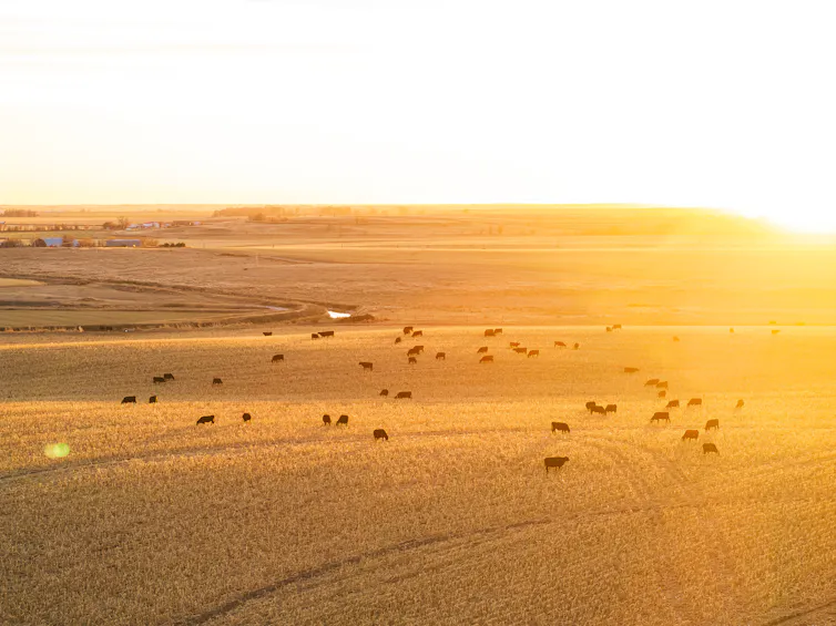
New tech to reduce environmental impact
Cows are able to digest tough, fibrous plant material that humans, pigs and chickens can’t. This makes them an important part of a circular economy because they can digest what would otherwise be considered waste from other industries, like the grain left over from making beer and almond hulls from almond milk. By using these ingredients to feed cattle instead of letting it rot in landfills, U.S. feedlots decreased the amount of human-edible feeds required to produce more beef protein.
When cattle are being fed waste products like almond hulls and spent grain, it’s easy for producers to include feed additives, like herbs and custom-made molecules. These additions may reduce the cows’ methane production by changing how the microbes in their stomachs process carbohydrates.
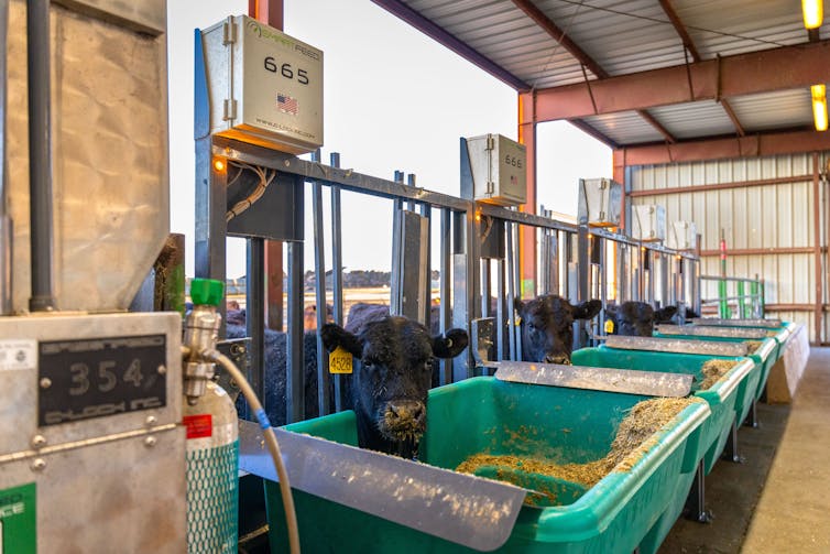
For the same reason that cows can digest what would otherwise be considered waste, cows are able to eat grass. Grazing is important in dry regions like the mountains and high plains of Colorado. If the grass isn’t removed via grazing, it dries and becomes tinder for wildfire. In addition, many of these mountainous areas are too cold, rocky and steep to grow crops. Grazing can turn land that would otherwise be difficult to farm into food-producing land.
Until now, grazing required physical fences, which are costly to maintain and limit wildlife movement. But new technologies like virtual fencing allow Western Slope ranchers to use their smartphones to set digital boundaries. A collar on the cow beeps and buzzes to tell the cows where to go. Virtual boundaries are easy to change and visible only to the cow; thus, they support more environmentally-friendly grazing practices, protect streams and wildlife habitat and reduce wildfire fuel in dry seasons. While our recent research shows that this technology needs more development, it could be an important tool for beef’s role in a circular economy.
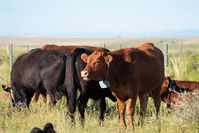
Beyond steak: Organ meats, pet treats and leather
In our experience, many U.S. consumers rarely eat cuts beyond steaks and ground beef — often due to a bad first experience with organ meats, like liver, or unfamiliarity with how to cook lesser-known cuts, like heart.
When customers won’t buy these cuts, Colorado’s beef producers who sell online or at farmers markets have to send them to the landfill. That costs the producer money and wastes the water, land and feed used to make these cuts.
Studies show that these cuts are among the most nutrient-dense parts of the animal, providing high levels of iron, B vitamins, choline and and other micronutrients. Making use of these lesser-known cuts can reduce emissions by using more of the animal and keep edible meat out of landfills, where it would otherwise rot, releasing greenhouse gases.
This does not mean anyone has to suffer through a meal of rubbery liver to save the planet. Many cultures globally value organ dishes, and U.S. tastes are expanding to include foods like lengua tacos made from beef tongue. Meanwhile, cooking tools such as sous vide can improve tenderness and juiciness by holding meat at precise temperatures for longer times.
Pets also benefit from eating organ meats, so these cuts are a key ingredient in pet foods and treats.
Consumer fashion choices matter too. About 270 million bovine hides are produced globally each year, and about 70% are turned into leather. Due to insufficient demand, remaining hides are burned or sent to the landfill, both of which release greenhouse gases.
Rather than letting these hides rot, they can be turned into leather, a durable, breathable and biodegradable high-performance material. When consumers choose to buy genuine leather boots, belts and car seats, they’re engaging in the circular economy.
For these reasons, Colorado State University is hosting Future Cowboy on Jan. 25, 2026, at the National Western Stock Show. It’s an event that lets Colorado foodies, fashionistas and cattle producers come together to explore circularity firsthand. The event will feature a leather fashion show, a ranch technology showcase and an opportunity try chef-prepared bison tongue and beef heart.
Jordan Kraft Lambert, Director of Ag Innovation and Partnerships, College of Business, Colorado State University; Jennifer Martin, Associate Professor of Animal Sciences, Colorado State University; Kim Stackhouse-Lawson, Professor of Animal Science, Colorado State University, and Sara Place, Associate Professor of Feedlot Systems, Colorado State University
This article is republished from The Conversation under a Creative Commons license. Read the original article.
#Colorado author, Eugene Buchanan, hopes his ode to one of the West’s last wild rivers sparks new generation of stewards — KUNC #YampaRiver

Click the link to read the article on the KUNC website (Scott Franz). Here’s an excerpt:
January 20, 2026
Steamboat Springs author and adventurer Eugene Buchanan has lived near the banks of the Yampa River long enough to notice its rhythms and moods are often mirrored by the residents in his northwest Colorado ski town.
“The river’s pulse kind of matches your own,” he said Thursday. “You know, come springtime, you’re jazzed up, and the rivers crankin’ and flooding, and the surf waves are in and people are rafting it and (stand up paddleboarding). Then it slows down to a trickle later in the summer and people are inner-tubing it. Fly fishing it. That’s a little more of a tranquil time.”

But as Buchanann warns in the first chapter of his new book, Yampa Yearnings, “not all is hunky dory in Yampaland.” Last summer marked the fourth time in history that there was a call on the Yampa due to drought conditions and upstream users were forced to cut back their intake. And like other rivers across the West, Buchanan said the waterway faces growing threats from climate change and increased demands from water users. Buchanan’s book is not all about hard times and drought on the river. In between his history lessons about the Yampa and the challenges it has faced, readers will also learn about the fate of Buchanan’s efforts to help a rancher get his lost cattle back across the raging waterway. There’s also a tale of his friend’s paddling adventure from Colorado to Utah to prove the waterway can facilitate ‘interstate commerce.’ KUNC water and environment reporter Scott Franz interviewed Buchanan about his book and the state of the Yampa. Answers have been lightly edited for length and clarity.
Franz: What impact do you hope this book has for the Yampa River and its future?
Buchanan: It’s hard to say how much impact a book like this will have. It’s my hope that those who are familiar with the Yampa learn to appreciate it a little more. Maybe look at it with a different eye next time they see it. If people aren’t familiar with the Yampa and they live somewhere else, maybe they’ll look outside and see their backyard creek flowing through their town and just think about it a little more. Maybe they’ll donate to a local nonprofit that’s trying to help preserve it, or they’ll pick up some trash or get involved. Or they’ll vote appropriately, how they want to, perhaps preserve it.

#Drought in 2025 in 14 Graphics — NOAA
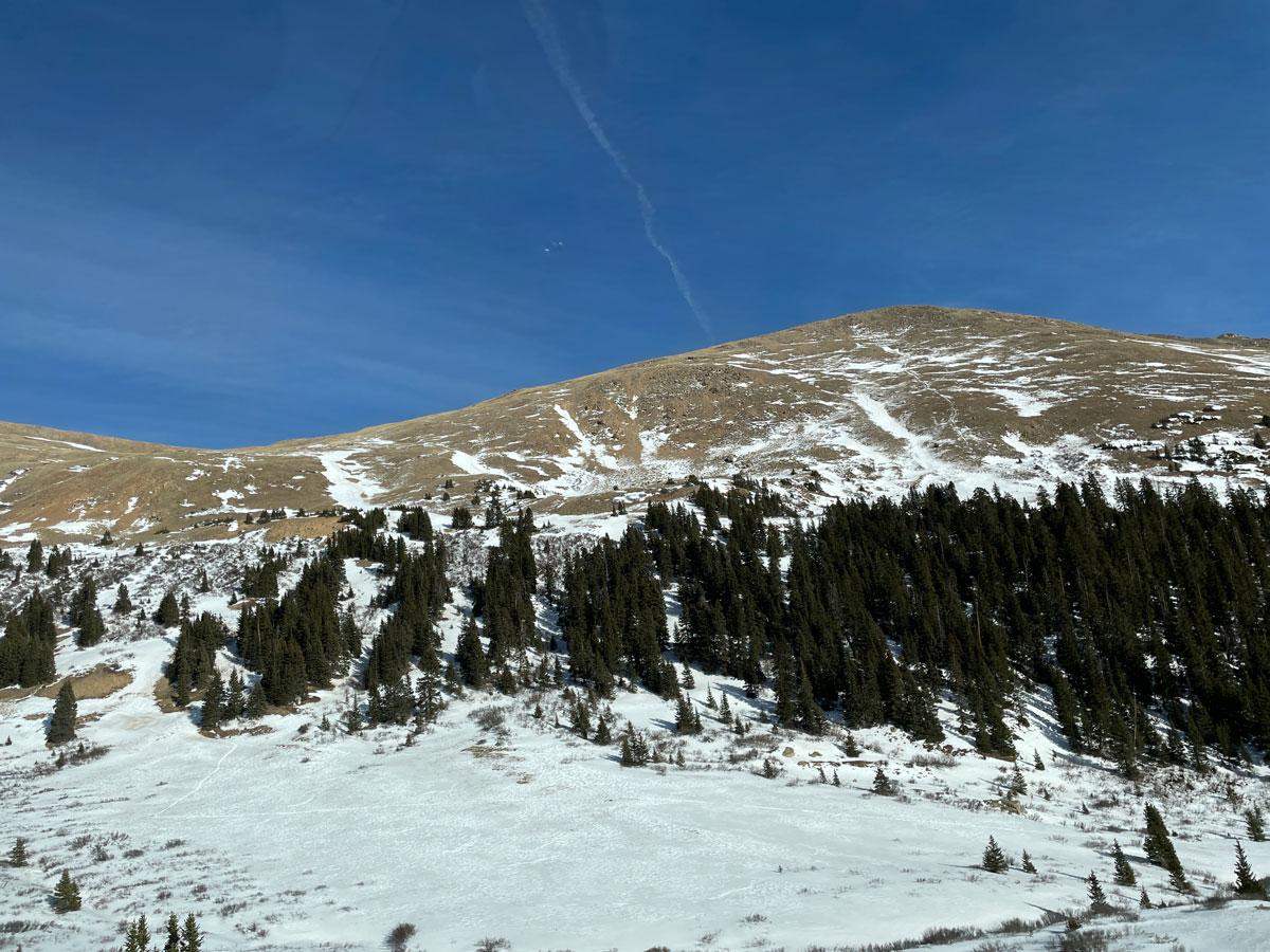
Click the link to read the article on the NOAA website. Here’s an excerpt:
January 15, 2026
From the catastrophic wildfires in Southern California to historic low-water levels on the Mississippi River and record-low streamflow in the Northeast, drought and its impacts touched nearly every corner of the country. The year saw the unusual return of two La Niña events and devastating weather whiplash that brought historic floods to drought-stricken Texas. 2025 showed us that drought is even more devastating when compounded with other climate hazards, such as wildfire and flood. This list breaks down some significant drought-related events of 2025 that made 2025 a year of water extremes across the United States.
Our thoughts are with those who lost loved ones, homes, and livelihoods in the Texas flooding and California wildfires. We hope for healing and comfort for those dealing with significant losses from these events.
Most of the U.S. Experienced Some Drought Last Year
Much of the West started and ended 2025 in drought, according to the U.S. Drought Monitor. Drought impacted the Upper Missouri River Basin and Northeastern U.S. as winter turned into spring, just as Extreme and Exceptional Drought (D3-D4) emerged in Florida and the Southwest. By late summer, drought largely improved in the East, only to emerge again in force in the Northeast U.S. In fall, drought developed in the Midwest and Southeast, and expanded in the Southern Plains and West. New Year’s Eve found drought covering 35.8% of the Nation.
Below is a slideshow of US Drought Monitor maps for 2025.
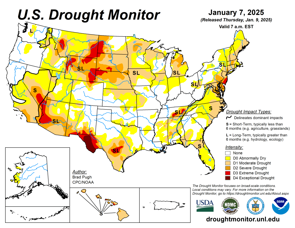
US Drought Monitor map January 7, 2025. 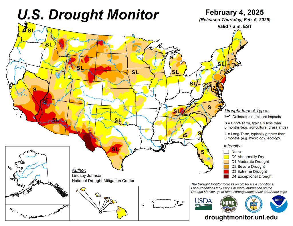
US Drought Monitor map February 4, 2025. 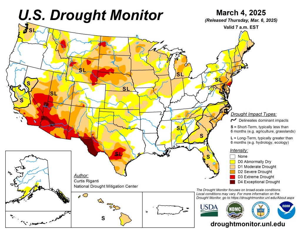
US Drought Monitor map March 4, 2025. 
US Drought Monitor map April 1, 2025. 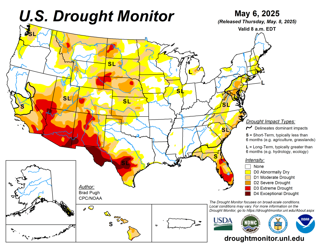
US Drought Monitor map May 6, 2025. 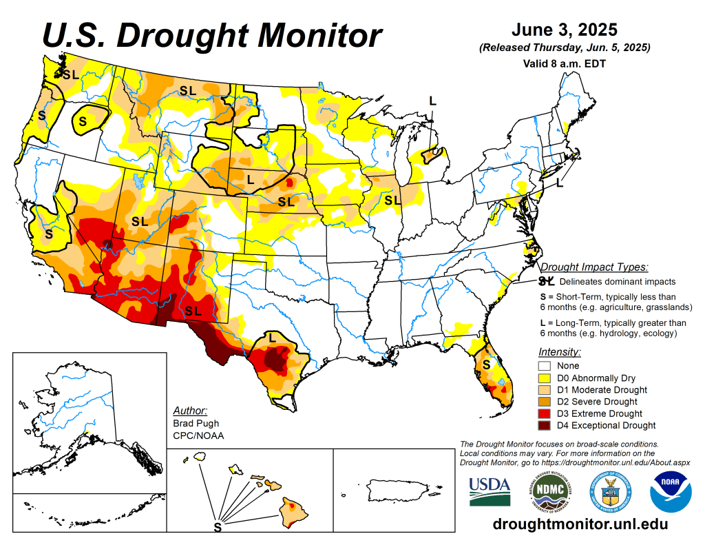
US Drought Monitor map June 3, 2025. 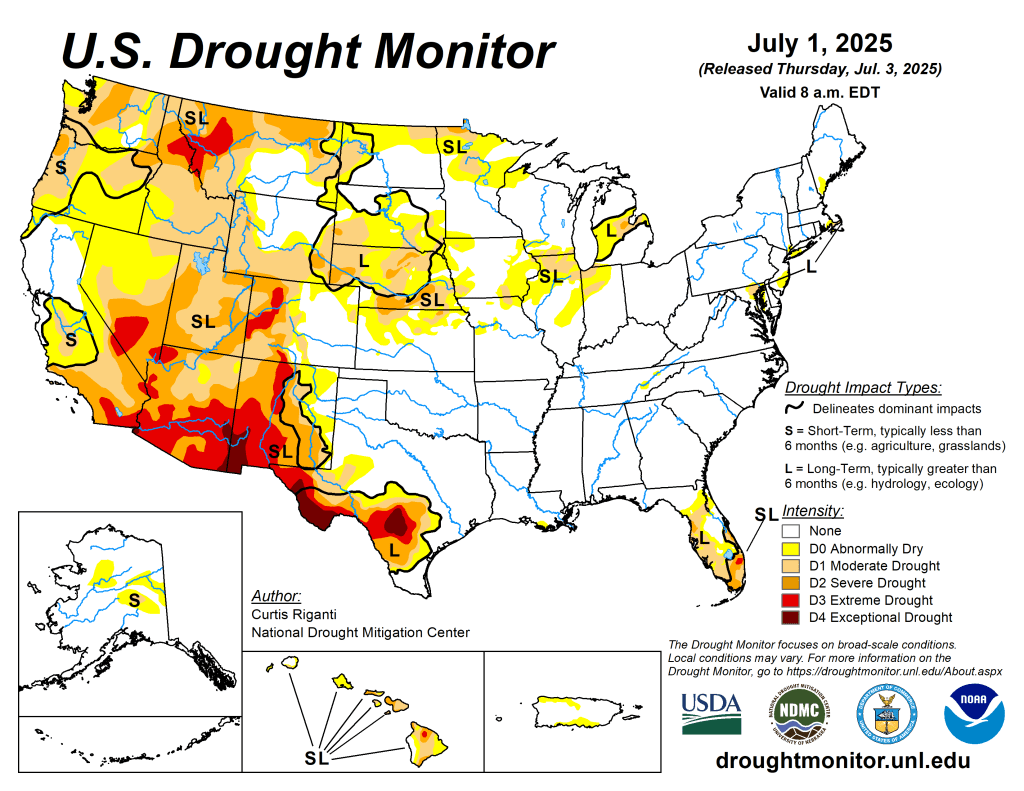
US Drought Monitor map July 1, 2025. 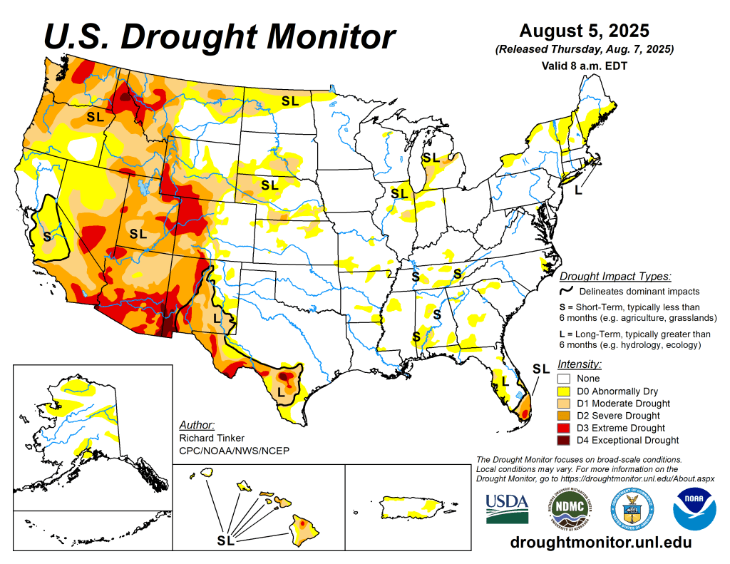
US Drought Monitor map August 5, 2025. 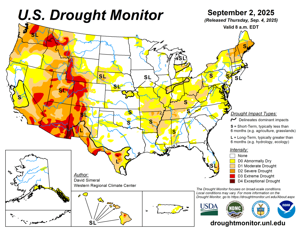
US Drought Monitor map September 2, 2025. 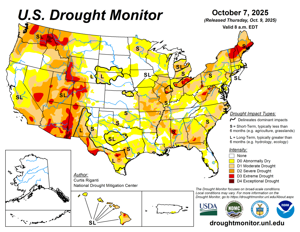
US Drought Monitor map October 7, 2025. 
US Drought Monitor map November 4, 2025. 
US Drought Monitor map December 2, 2025.
2025: A Warm Year Overall
Across much of the U.S., 2025 was a warm year, with annual temperature averages of up to 5° Fahrenheit (F) above normal in most areas. The greatest departures were in the Great Basin, Northern Rockies, and along the southern border. A few spotty areas around the Nation were slightly cooler than normal in 2025, particularly east of the Mississippi River.
2025 brought a mix of precipitation to the U.S. The Pacific Northwest, Mountain West, Midwest, South, and Northeast were drier than normal. Conditions were particularly poor in the Mountain West and South Texas, where annual precipitation was 50-90% of normal. Southern California, the Dakotas, and southeastern Arizona were wetter than normal.

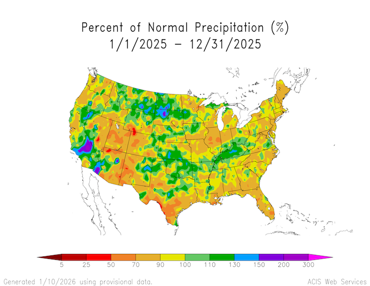
Heatwave Leads to Early Snowmelt, Runoff in Western U.S.
In the West, about 70% of the water supply comes from snow stored in the mountains. Across the West, snow water equivalent on April 1, 2025 was near-normal in most northern watersheds and below normal in watersheds south of the Central Rockies. But April and May brought heatwaves to the mountains, melting snow out much earlier than normal. Rapid melt out occurred across Utah, Colorado, and New Mexico, pushing some basins from above-average snowpack to snow drought conditions in under a month, with snow disappearing 1-4 weeks early.
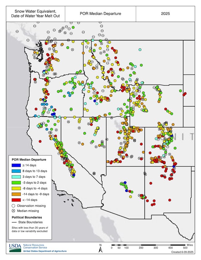
La Niña Double Dips
2025 was shaped by two La Niña events. La Niña is one of two phases of the El Niño-Southern Oscillation. La Niña typically brings cool, wet winter conditions to the Northwest U.S., and warm, dry winter conditions to the Southern U.S. The first La Niña was a borderline event, which peaked around January 2025, and then waned by the end of spring. The second was a little stronger, but still considered weak compared to most historical La Niña events. It began developing around August and continues through winter 2025-26.

Low Water Levels on the Mighty Mississippi
Extremely dry conditions across the Ohio River Basin and southern portions of the Midwest in August and September led to the rapid expansion of drought and decreased flows on the Ohio River and portions of the Lower Mississippi River. In Mid-September, the Ohio River was contributing only 8% of the overall water flow in the Lower Mississippi River, compared to its typical 50% contribution. The Ohio River at Cairo, Illinois (where the Ohio meets the Mississippi River) fell below 10 feet.
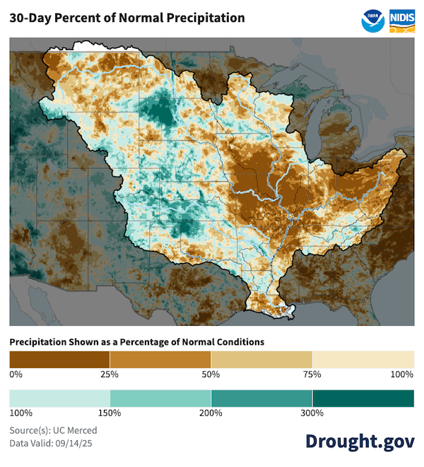
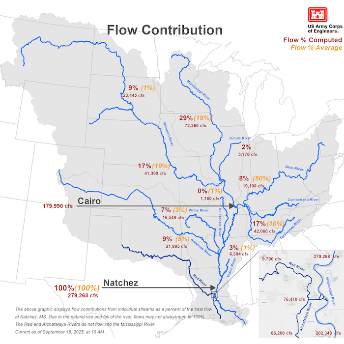
Drought Peaked in November at 36%
In late November, the 2025 drought reached its national peak, with 36.65% of the U.S. in drought (D1-D4) according to the U.S. Drought Monitor. November 2025 temperatures were above to much above average throughout most of the Western and Central U.S. Idaho, Nevada, Oregon, Texas, and Utah set new statewide records for November average temperatures. Portions of the northern Great Basin, Northwest, and Rockies and much of the country east of the Mississippi River saw below-average precipitation.

.
Winter Brings Rain Instead of Snow to the West
Winter 2025-2026 kicked off with warm weather and rain instead of snow. Nearly every major river basin in the West experienced a November among the top 5 warmest on record. On December 7, 2025, snow cover across the West was the lowest amount for that date in the MODIS satellite record (since 2001), at 90,646 square miles. Water Year 2026 (October 1, 2025–September 30, 2026) precipitation to date was near or above median for many parts of the West in late December. However, much warmer-than-normal temperatures caused precipitation to fall as rain instead of snow in many basins, leading to snow drought despite wetter-than-normal conditions across most of the West. At the end of 2025, snow drought was most severe across much of the Sierra Nevada in California, the Cascade Range in Washington and Oregon, the Blue Mountains of Oregon, and the Great Basin in Nevada.
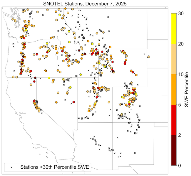
Keep Up With the Latest Conditions and Outlooks
Find maps, publicly accessible data, and recent research about drought and wildfire on drought.gov. You can also subscribe to NIDIS emails for the latest regional drought updates, webinars, and news in our drought early warning system regions. To stay up to date on the latest drought conditions, sign up to receive drought alerts for your city/zip code when the National Weather Service updates their U.S. Drought Outlooks.
Romancing the River: The Romantic Scientist — George Sibley (SibleysRivers.com) #ColoradoRiver #COriver #aridification

Click the link to read the article on the Sibley’s Rivers website (George Sibley):
January 20, 2026
There continues to be no new information from the ongoing negotiations among the protagonists for the seven states trying to work out a new two-basin management plan for the Colorado River. The Bureau of Reclamation, however, is pressing ahead; it recently went public with its ‘Draft Environmental Impact Statement’ (DEIS) for ‘Post-2026 Operational Guidelines and Strategies for Lake Powell and Lake Mead.’
The five alternative ‘operational guidelines and strategies’ analyzed in this DEIS were announced back in the fall of 2024; the Bureau has spent the past year-plus examining their environmental impacts. I’m not going to go into their analyses right now; I’m still working on skimming, skipping, sprinting and plowing my way through enough of the 1600 pages or so of the report to feel reasonably informed on its contents.
But I will note that the first action analyzed (skipping past the mandatory ‘No Action’ alternative) is for the Bureau to go ahead and run the river system as it sees fit, without input from the seven states/two basins – not something they want to do, but would have to do since the system will not wait while the states stare at their chessboard stalemate. That action would of course precipitate lawsuits from some of the states since the Bureau would have to go ahead with some of the things that are part of non-debate behind the stalemate.
Anyone wishing to submit themselves to the torture of an EIS can find the home page and Table of Contents for the report by clicking here.
And in the meantime, I’ll go off again on what I hope might be at least a more interesting tangent, and maybe more creative – fully believing that the only way out of our ever-unfolding river mismanagement is some centrifugal push to get beyond the tight centripetal pull of the Colorado River Compact and its two-basin expedient that has become gospel.
Two posts ago here, I acknowledged a need to explain why I titled all these posts ‘Romancing the River’ – ‘romance’ being a degraded term these days for many people, most commonly referring to formulaic fiction about chaotic and improbable couple-love relationships. This is a sad degradation of a word that, in more imaginative times, referred to a much larger quality or feeling of adventure, mystery, something beyond or larger than everyday life – ‘your mission should you choose to accept it,’ as it was expressed in Mission Impossible and The Hobbit.
‘Romance’ has been used to describe our relationship with the Colorado River for more than a century. C. J. Blanchard, a spokesperson for the Bureau of Reclamation in 1918, spoke of the ‘romance of reclamation,’ observing that ‘a vein of romance runs through every form of human endeavor.’ The first book compiling the history of the Euro-American exploration of the Colorado River was titled The Romance of the Colorado River. Written by Frederick Dellenbaugh, something of an explorer himself, he first encountered the Colorado River in the company of one of the river’s greatest romantics, John Wesley Powell, on Powell’s second adventure into the canyon region of the river.
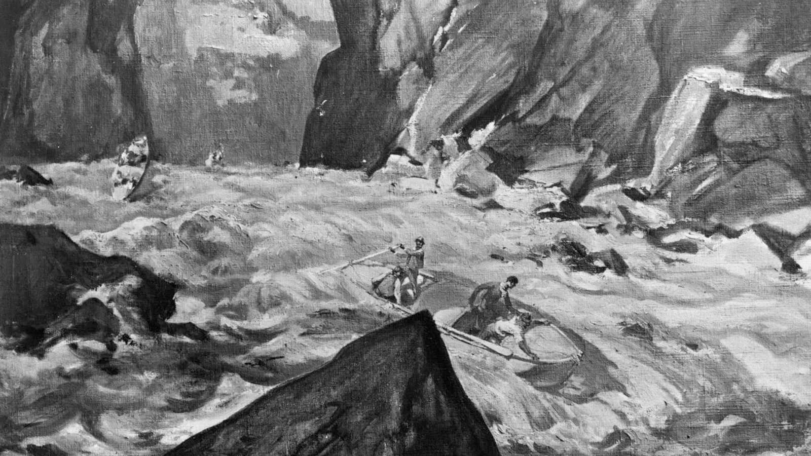
Now wait a minute, you may say: John Wesley Powell a romantic? Everyone knows he was a scientist! Well, yes, that too. A romantic scientist. Let me try to explain.
Science is a discipline, perhaps summarized in the caution: Look before you leap. Science is the discipline of looking, studying, analyzing for causes in some studies, for effects in others, basically trying to map out what is demonstrably going on in the system or structure being studied. But most scientists will acknowledge being also moved by feelings, convictions, beliefs that lie outside of or beyond the linear relationships of cause and effect explorations. The extreme example might be scientists who believe in a god or gods that oversaw the creation they are studying. More subtly, the very desire to pursue a life in science reflects a belief beyond evidence that the work is important as well as interesting. This is the ‘romance’ underlying science and those who pursue it.
The same year Dellenbaugh published his Romance, 1903, another southwestern writer, Mary Hunter Austin, came out with her Land of Little Rain, a poetic collection of her explorations in the deserts of the lower Colorado River region. In that book she offered what might be a cautionary note about ‘romancing the river.’ In an observation about a small central Arizona tributary of the Colorado River, ‘the fabled Hassayampa,’ she reports an unattributed legend: ‘If any drink [of its waters], they can no more see fact as naked fact, but all radiant with the color of romance.’
That could be construed into a kind of spectrum, the ‘naked facts’ of any situation at one end, the ‘radiant colors of romance’ dressing up the naked facts at the other end. The discipline of science is to stay as close to the ‘naked facts’ as possible. But is it a bad thing to allow feelings or beliefs to dress up the naked facts with the radiant color of romance?
Hold that question for a bit, and back to Major John Wesley Powell. Powell was a scientist by nature – meaning born a curious fellow who collected information about things that made him curious. He studied science in a couple of colleges, but never completed a degree – partially, probably, because college science was a little too tame. One of his early ‘field trips’ was a solo trip the length of the Mississippi River in a rowboat. Another was a four-month walk across the ‘Old Northwest Territory’ state of Wisconsin. Both of those trips pretty unquestionably fall more into the category of ‘romantic adventures’ than ‘scientific expeditions.’
As a son of an itinerant farmer/preacher immigrant, growing up on farms in rural New York, Ohio and Illinois, he also shared, to some extent, the romantic Jeffersonian vision of ‘another America,’ a nation of small decentralized and mostly locally-sufficient communities of farm families – now just a nostalgic fantasy-vision of nation building that still haunts the imperial urban-industrial mass society that America has become. But trips to the west had convinced Powell that the mostly arid lands of the West were largely unsuitable for the spread of that agrarian vision, without the development of an appropriate system for settlement and land management specifically for the arid lands.
He had ideas about that, things to say, but he was basically just a high-school teacher who spent his summers adventuring west; how could he get a hearing for his concerns and ideas? He needed some way to gain public attention. So he turned his destiny over to his romantic adventurer side: he would do a scientific investigation into one of the remaining blank spots on the continental map, the region beginning where the rivers draining the west slopes of the Southern Rockies disappeared into a maze of canyons, and ending where a river emerged from the canyons – a river thick with silt and sand, indicating a pretty rough passage through canyons still in the creation stage.

Wallace Stegner, in his great book about Powell and the development of the arid lands, Beyond the Hundredth Meridian, credited Powell’s scientific grounding with getting him through his 1869 expedition into the canyons: ‘Though some river rats will disagree with me, I have been able to conclude only that Powell’s party in 1869 survived by the exercise of observation, caution, intelligence, skill, planning – in a word, Science.’
I’m one of those who disagree with Stegner on that point. The advance planning for the trip sank in the first set of Green River rapids, with the wreckage of one of the boats containing a large portion of both their food supply and scientific instruments. They gradually acquired some skill at negotiating rapids (and knowing when to portage instead), but they started with no skill and paid the price. Observation was limited to the stretch of river before the next bend. Dellenbaugh asked Powell, on the second trip in 1871-72, what he would have done had he come to a Niagara-scale waterfall with sheer walls, no room for portage and no way back upriver. Powell answered, ‘I don’t know.’ Scientific caution was not a factor in this trip; they leapt before looking because there was no way to look first.
Stegner to the contrary, I would argue they survived the way adventurers survive (and sometimes don’t): a kind of adaptive intelligence, for sure, figuring out how to make rotten bacon and moldy flour edible, how to fabricate replacement oars, how to deal with the unexpected quickly and decisively. But mostly, just gutting it out, keeping spirits from crashing completely with morbid humor and routines – Powell getting out the remaining instruments to take their bearing rain or shine, getting back in the boats every morning and turning their lives over to the will of the river again.
And it worked out. Ninety-one days after starting, they made national headlines when they floated half-starved into a town near the confluence with the Virgin River. And Powell, a national hero after that, procured a government job doing a ‘survey’ of the Utah territory.
Then Powell the scientist took over – but the romantic side of his nature shaped his scientific work. The unstated purpose of the western surveys by the 1870s was to map out potential resources for the fast-growing industrial empire ‘back in the states’; Powell covered those bases, but the heart of his 1879 ‘Report on the Lands of the Arid Region…’ was analysis of the potential of the arid lands for fulfilling Jefferson’s romantic agrarian vision for America. All agricultural activity, he argued, would require irrigation, and there was only enough water to irrigate many three percent of the land.
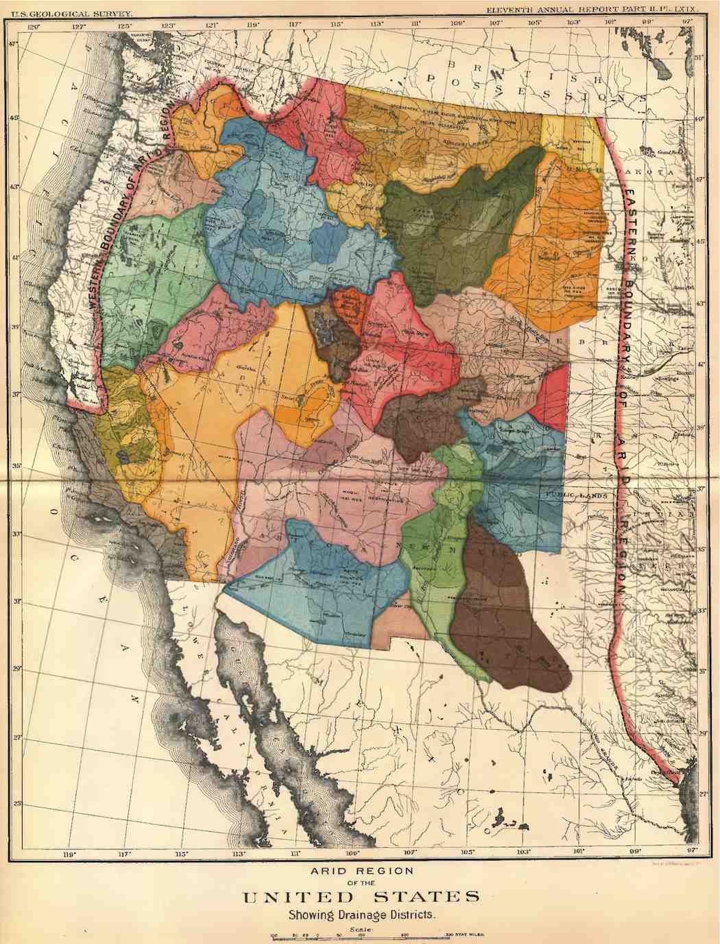
He made a strong case for replacing the Homestead Act’s one-size-fits-all 160-acre homestead allotments with two alternatives for the arid lands: 1) 80-acre allotments for intensive irrigated farming, that being as much as a pre-tractor farm family could successfully tend; or 2) ‘pasturage’ allotments on unirrigable land of 2,560 acres, four full sections, for stockgrowers, with up to 20 irrigable acres for growing some winter hay and the ubiquitous kitchen garden. He went even further than that: settlement should not be done on a willy-nilly ‘first-come-first-served basis’; instead each watershed should be developed by an organized ditch company working from a plan assuring that every member got a fair allotment of water and that the water was most efficiently distributed. And the right to use that water should be bound to the land, he said. No selling your water right to some distant city!
Powell did not just recommend this in his report; he included model bills for state and federal legislation. He was of course thoroughly ignored because everything that he suggested was contrary to the romantic mythology of the Winning of the West – Jefferson’s legendary ‘yeoman’ conquering the wilderness, the rugged American individualist going forth with rifle, ax and Bible.
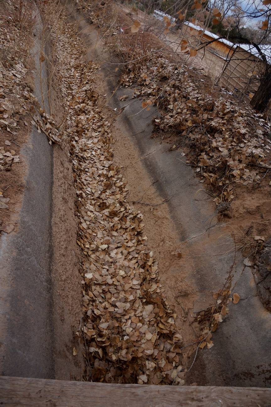
That American mythology from the start was always ‘all radiant with the color of romance,’ with very little attention to ‘the naked facts’ – which is the main reason why two out of three homesteads failed as settlement moved into the semi-arid High Plains and the arid interior West. ‘The naked facts’ of aridity, on the other hand, had been foundational to the communal land-grant system imported from Spain to Mexico, and it was already known to many of the native peoples already in the Americas: it takes a village and a stream to raise good crops in the arid lands. Powell observed it in the Utah Territory, where the Mormons had borrowed it from the natives and Mexicans.
Powell was philosophical about being ignored – and kept on pushing. He was ‘present at the creation’ of the United States Geological Survey (USGS) in 1879, the same year he presented his ‘Report on the Lands of the Arid Region.’ And two years later he became director of the USGS, where he tried to keep both the Agrarian Romance and ‘the naked facts’ of aridity front and center. He tried to sell the idea of doing a complete survey of the interior West to map its water resources and the adjacent areas of possible successful settlement, and he was actually a vote or two from achieving that, and actually shutting down the homesteading process until the study was done. But once some of the senators fronting for the industrialists realized what he was doing, they shut him down with a vengeance – he quickly realized that to save the USGS, he had to resign from it, and did so in 1894. Western extractive industries depended to some extent on failed homesteaders for their labor supply.

Powell was not out of work, however. From his pre-canyon days he had been interested in the First Peoples of the West. While most Euro-Americans saw them, at best, as raw material for conversion to Christianity and industrial labor, and at worse, as vermin to be wiped off the land, Powell saw them as people who had survived and even thrived in the region with Stone Age technology, some still semi-nomadic, some settled in agrarian communities, and therefore people from whom something might be learned. His efforts to communicate with those he encountered in his Utah survey led to the 1877 publication of a book, Introduction to Indian Languages – which led, two years later to the creation of the U.S. Bureau of Ethnology in the Smithsonian Institute with Powell as director – a position he held until his death in 1902, finally producing the first comprehensive linguistic survey of indigenous tongues, Indian Linguistic Families of America, North of Mexico(1891).
In both ethnology and the geology survey Major Powell established a high standard for government science – attention to the naked facts while still trying to carry forward what Bruce Springsteen called ‘the country we carry in our hearts’ – the ever evolving, devolving, careening, diverted, perverted, and currently severely damaged Romance of the American Dream. Next post, we’ll take a look at what happens when that standard gets out of balance.
But I want to leave you with a Colorado River image of Powell, related in Dellenbaugh’s Romance of the Colorado River: there were afternoons in that second voyage in the canyons, in the placid stretches between rapids, when the men would rope the boats together, and Major Powell would sit in his chair on the deck of the Emma Dean and read to them from the romantic adventure stories of Sir Walter Scott. Romancing the River.
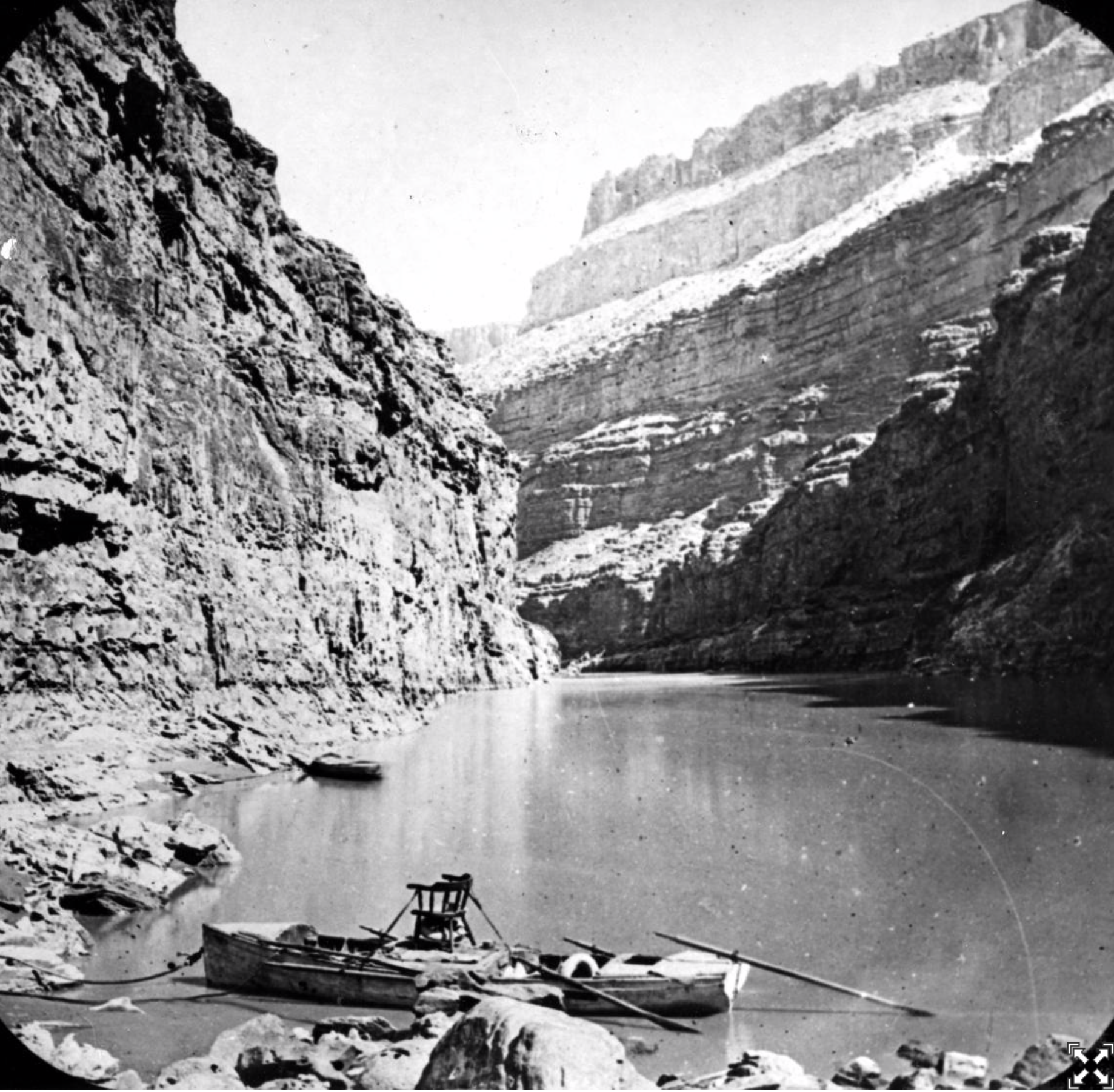
The world is in water bankruptcy, UN scientists report – here’s what that means — Kaveh Madani (TheConversation.org)
Kaveh Madani, United Nations University
January 20, 2026
The world is now using so much fresh water amid the consequences of climate change that it has entered an era of water bankruptcy, with many regions no longer able to bounce back from frequent water shortages.
About 4 billion people – nearly half the global population – live with severe water scarcity for at least one month a year, without access to sufficient water to meet all of their needs. Many more people are seeing the consequences of water deficit: dry reservoirs, sinking cities, crop failures, water rationing and more frequent wildfires and dust storms in drying regions.
Water bankruptcy signs are everywhere, from Tehran, where droughts and unsustainable water use have depleted reservoirs the Iranian capital relies on, adding fuel to political tensions, to the U.S., where water demand has outstripped the supply in the Colorado River, a crucial source of drinking water and irrigation for seven states.
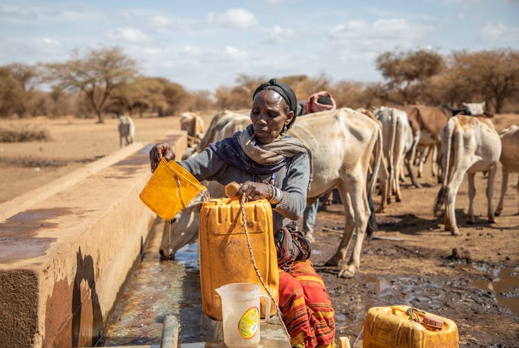
Water bankruptcy is not just a metaphor for water deficit. It is a chronic condition that develops when a place uses more water than nature can reliably replace, and when the damage to the natural assets that store and filter that water, such as aquifers and wetlands, becomes hard to reverse.
A new study I led with the United Nations University Institute for Water, Environment and Health concludes that the world has now gone beyond temporary water crises. Many natural water systems are no longer able to return to their historical conditions. These systems are in a state of failure – water bankruptcy. https://www.youtube.com/embed/rnMDoX_2vR8?wmode=transparent&start=0 Kaveh Madani, director of the United Nations University Institute for Water, Environment and Health, explains the concept of “water bankruptcy.” TVRI World.
What water bankruptcy looks like in real life
In financial bankruptcy, the first warning signs often feel manageable: late payments, borrowed money and selling things you hoped to keep. Then the spiral tightens.
Water bankruptcy has similar stages.
At first, we pull a little more groundwater during dry years. We use bigger pumps and deeper wells. We transfer water from one basin to another. We drain wetlands and straighten rivers to make space for farms and cities.
Then the hidden costs show up. Lakes shrink year after year. Wells need to go deeper. Rivers that once flowed year-round turn seasonal. Salty water creeps into aquifers near the coast. The ground itself starts to sink.

That last one, subsidence, often surprises people. But it’s a signature of water bankruptcy. When groundwater is overpumped, the underground structure, which holds water almost like a sponge, can collapse. In Mexico City, land is sinking by about 10 inches (25 centimeters) per year. Once the pores become compacted, they can’t simply be refilled.
The Global Water Bankruptcy report, published on Jan. 20, 2026, documents how widespread this is becoming. Groundwater extraction has contributed to significant land subsidence over more than 2.3 million square miles (6 million square kilometers), including urban areas where close to 2 billion people live. Jakarta, Bangkok and Ho Chi Minh City are among the well-known examples in Asia.
Agriculture is the world’s biggest water user, responsible for about 70% of the global freshwater withdrawals. When a region goes water bankrupt, farming becomes more difficult and more expensive. Farmers lose jobs, tensions rise and national security can be threatened.
About 3 billion people and more than half of global food production are concentrated in areas where water storage is already declining or unstable. More than 650,000 square miles (1.7 million square kilometers) of irrigated cropland are under high or very high water stress. That threatens the stability of food supplies around the world.

Droughts are also increasing in duration, frequency and intensity as global temperatures rise. Over 1.8 billion people – nearly 1 in 4 humans – dealt with drought conditions at various times from 2022 to 2023.
These numbers translate into real problems: higher food prices, hydroelectricity shortages, health risks, unemployment, migration pressures, unrest and conflicts. https://www.youtube.com/embed/pWDoe7PVNrw?wmode=transparent&start=0 Is the world ready to cope with water-related national security risks? CNN.
How did we get here?
Every year, nature gives each region a water income, depositing rain and snow. Think of this like a checking account. This is how much water we receive each year to spend and share with nature.
When demand rises, we might borrow from our savings account. We take out more groundwater than will be replaced. We steal the share of water needed by nature and drain wetlands in the process. That can work for a while, just as debt can finance a wasteful lifestyle for a while.

Those long-term water sources are now disappearing. The world has lost more than 1.5 million square miles (4.1 million square kilometers) of natural wetlands over five decades. Wetlands don’t just hold water. They also clean it, buffer floods and support plants and wildlife.
Water quality is also declining. Pollution, saltwater intrusion and soil salinization can result in water that is too dirty and too salty to use, contributing to water bankruptcy.

Climate change is exacerbating the situation by reducing precipitation in many areas of the world. Warming increases the water demand of crops and the need for electricity to pump more water. It also melts glaciers that store fresh water.
Despite these problems, nations continue to increase water withdrawals to support the expansion of cities, farmland, industries and now data centers.
Not all water basins and nations are water bankrupt, but basins are interconnected through trade, migration, climate and other key elements of nature. Water bankruptcy in one area will put more pressure on others and can increase local and international tensions.
What can be done?
Financial bankruptcy ends by transforming spending. Water bankruptcy needs the same approach:
- Stop the bleeding: The first step is admitting the balance sheet is broken. That means setting water use limits that reflect how much water is actually available, rather than just drilling deeper and shifting the burden to the future.
- Protect natural capital – not just the water: Protecting wetlands, restoring rivers, rebuilding soil health and managing groundwater recharge are not just nice-to-haves. They are essential to maintaining healthy water supplies, as is a stable climate.

- Use less, but do it fairly: Managing water demand has become unavoidable in many places, but water bankruptcy plans that cut supplies to the poor while protecting the powerful will fail. Serious approaches include social protections, support for farmers to transition to less water-intensive crops and systems, and investment in water efficiency.
- Measure what matters: Many countries still manage water with partial information. Satellite remote sensing can monitor water supplies and trends, and provide early warnings about groundwater depletion, land subsidence, wetland loss, glacier retreat and water quality decline.
- Plan for less water: The hardest part of bankruptcy is psychological. It forces us to let go of old baselines. Water bankruptcy requires redesigning cities, food systems and economies to live within new limits before those limits tighten further.
With water, as with finance, bankruptcy can be a turning point. Humanity can keep spending as if nature offers unlimited credit, or it can learn to live within its hydrological means.
Kaveh Madani, Director of the Institute for Water, Environment and Health, United Nations University
This article is republished from The Conversation under a Creative Commons license. Read the original article.
R.I.P. Bob Weir: “A breeze in the pines in the summer night moonlight”

Click the link to read the article on The New York Times website (Ben Sisario and Mark Walker). Here’s an excerpt:
January 10, 2026
Bob Weir, a guitarist and songwriter who was a founding member of the Grateful Dead, which rose from jug band origins to become the kings of psychedelic rock, selling millions of records and inspiring a small nation of loyal fans, has died. He was 78…The band, which was founded in the San Francisco Bay Area in 1965, blended rock, folk, blues and country, with mellow ease and a gift for improvisation that became its trademark. In a rock milieu that was still based on short songs and catchy hooks, the Grateful Dead created a niche for meandering, exploratory performances that each seemed to have their own personalities…The band became the pied pipers of the wider hippie movement, providing the soundtrack for 1960s dropouts and LSD dabblers…Even after hippie culture faded, the band retained a gigantic fan base — called Deadheads, a term worn with pride and later adapted for numerous other fandoms — which followed the group wherever it played, traded recordings of its concerts and set up mini-encampments, complete with craft bazaars, oceans of tie-dye and no small amount of drugs.
It was one of rock’s original subcultures. “Our audience is like people who like licorice,” the band’s lead guitarist and singer, Jerry Garcia, once said. “Not everybody likes licorice, but the people who like licorice really like licorice.”
In the band, Mr. Weir — who, like Mr. Garcia, had an early fascination with folk music — stood alongside strong musical personalities. Mr. Garcia was a wizard of improvisation, and gave the group its aesthetic and conceptual direction. Phil Lesh, its bassist, had training as a composer. Mickey Hart, a percussionist, had eclectic tastes and played a major part in introducing Western audiences to world music…But Mr. Weir also developed a reputation for inventive timing on the rhythm guitar, his chords alternately grounding and contending with the melodic chaos of Mr. Lesh and Mr. Garcia’s instruments. Although Mr. Garcia and Robert Hunter, the group’s lyricist, were the Dead’s primary composers, Mr. Weir was also a contributor to the writing of key songs like “Playing in the Band” and “Sugar Magnolia.”
Mrs. Gulch’s landscape January 9, 2026
#Wyoming smashes December heat records. Seasonal snow reports mixed. In a state where abnormal weather is the norm, even Wyomingites marveled at a wild month that broke more than just temperature records — Dustin Bleizeffer (WyoFile.com) #snowpack #drought
Click the link to read the article on the WyoFile website (Dustin Bleizeffer):
December 30, 2025
It was a balmy, gusty Christmas for much of Wyoming, where only high elevations in the western portion of the state saw fresh snow. It rained in Jackson Hole while lower elevations in central Wyoming saw temperatures in the 60s with 60-plus mile-per-hour winds, according to reports.
The holiday was a continuation of a theme in which weird and wild weather defined much of December as high-pressure systems lingered over the region for the better part of three weeks, the National Weather Service in Riverton said. Residents and travelers alike battled sustained high winds from border to border, and a Dec. 19 blast measured 144 miles per hour — Category 4 hurricane speed — at Mount Coffin in western Wyoming. Another wind blast the same day tossed a train off the tracks near Cheyenne, BNSF Railway confirmed.
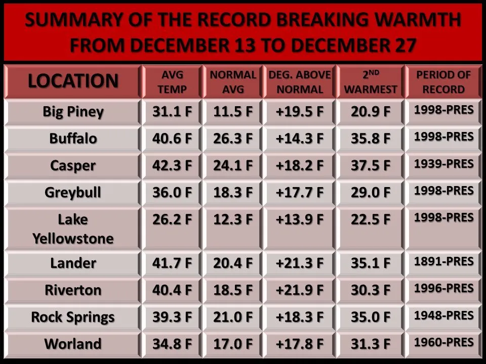
Wyoming Highway Patrol responded to 39 blow-over accidents in just three days in December, according to state officials.
As the wind wreaked havoc, nine Wyoming locations saw unseasonably high temperatures averaging 13 to 22 degrees Fahrenheit above normal from Dec. 13 through Dec. 27, according to the National Weather Service. Both Lander and Casper are on track to notch their warmest Decembers since 1892 and 1948, respectively, NWS Riverton meteorologist Adam Dziewaltowski said. Casper, as of Monday, had marked 10 record-breaking daily highs, while Lander saw a record high of 65 degrees on Christmas Eve.
Yet for all the bluster and heat, meteorologists caution against reading too much into what it might portend for the remainder of winter. Cold and snow returned over the weekend, and the state frequently receives most of its snow in early spring, sources say.
Currently, Wyoming’s “snow-water equivalent” is above average for most of western Wyoming, while areas on the east side of the state lag behind late December norms. Central-east and southeast Wyoming are the driest, with the southeast measuring just 5% of its typical snow-water equivalent, according to a U.S. Department of Agriculture report on Monday.

But even in some areas of the state, like Jackson, where precipitation is above average, a portion of the wet stuff has come in the form of rain instead of snow.
“Right now, [Jackson is] almost two inches above normal for precipitation — liquid-wise,” Dziewaltowski said. “They’ve definitely gotten precipitation, but it’s been so warm that it hasn’t fallen as snow.”
Some high elevations have seen rain-on-snow events, which can create adverse conditions for slides, Dziewaltowski added.
Though the weather took a turn after Christmas, swinging from the balmy 60s to below zero in just 48 hours in some areas, the forecast calls for more unseasonably warm temperatures later this week, according to the Weather Service.
December’s wild and warm conditions made for odd outdoor experiences.
Laramie angler Eric Wiltse posted his December fishing outings to Facebook and confirmed with WyoFile several “alarming” seasonal observations. Early this month, he waded into Twin Buttes Lake, which had been frozen just days before. He saw rain at 7,200 feet of elevation, and while fishing in Curt Gowdy State Park on Christmas Eve, he shared the open water with other outdoor enthusiasts who typically don’t appear in the winter.
“Crazy to be fly fishing on Christmas Eve at 7,500 feet in Wyoming,” Wiltse posted. “Even crazier to see a paddleboard on the lake.”
Mrs. Gulch’s landscape January 3, 2026

Nearly every corn seed planted in #Colorado is covered in insecticide. Lawmakers may restrict the chemical. Potential limits on use of neonicotinoids is under discussion between lawmakers, advocates — The #Denver Post

Click the link to read the article on The Denver Post website (Elise Schmelzer). Here’s an excerpt:
Colorado farmers plant tens of millions of corn seeds every year, nearly every one of them covered in a thin layer of insecticide. The neonicotinoids used in the coatings protect the seed from pests in the soil and, as the crop matures, the chemical is absorbed into the plant’s tissue, where it continues to paralyze and kill insects that chomp on the crop. Farmers say the insecticide is necessary, but growing concerns about its impact on crucial pollinator species and the wider environment are prompting a push in Colorado for more regulation of the widely used class of chemicals. Environmental advocates plan to seek a bill in the state legislature in 2026 that would limit their use in hopes of protecting pollinators and water quality. While a draft bill has not yet been made public, the environmental groups working on it said the legislation would ban the use of neonicotinoids without prior approval by inspectors overseen by the Colorado Department of Agriculture.
Eddie Vedder “No More”
10 Big Wins for Rivers in 2025: A snapshot of our biggest river successes from this past year — Hannah Axtell (AmericanRivers.org)

Click the link to read the article on the American Rivers website (Hannah Axtell):
December 19, 2025
Despite the escalating threats to rivers, this past year brought real progress worth celebrating. To highlight the positive strides being made across the country, we’ve curated a list of 10 exciting wins for rivers, community safety, people, and wildlife. From proposed Wild and Scenic protections for nearly 100 miles of the Gallatin and Madison rivers, to major investments in river restoration and wildfire resilience in California, and stronger permit safeguards for the Rappahannock River, 2025 proved to be a year of meaningful breakthroughs for waterways nationwide.
In no particular order, here’s a snapshot of 10 of our biggest river wins of 2025:
- Secured major wins for America’s Most Endangered Rivers® of 2025
Our 2025 America’s Most Endangered Rivers® report ranked the Tijuana River #2 due to toxic pollution threatening border communities. This designation, developed with partners Surfrider Foundation and Un Mar de Colores, helped catalyze swift federal action. Within three months of the April report release, American Rivers and others were invited to meet with EPA Administrator Lee Zeldin in southern California, which helped build momentum for a landmark agreementbetween the United States and Mexico to address the ongoing public health crisis. This demonstrates how strategic advocacy, combined with persistent community leadership, drives solutions for rivers and their communities.
The Rappahannock River’s designation as one of America’s Most Endangered Rivers® of 2025 brought crucial national attention to the threats facing Virginia’s longest free-flowing river. But this spotlight did more than raise awareness; it galvanized action that delivered tangible results. Working alongside our dedicated partners, The Friends of the Rappahannock, the Rappahannock Tribe, and the Southern Environmental Law Center, we achieved a significant victory for the river and the communities that depend on it. This collaborative effort secured permit changes for a proposed data center, banning industrial cooling withdrawals and reducing drought withdrawals by millions of gallons.
- Mobilized action to protect Public Lands and Roadless Areas
Bipartisan public outcry over a disastrous sell-off provision in a massive tax and spending bill led to the protection of public lands and the rivers that flow through them. Victory was snatched from the jaws of defeat thanks to supporters like you.
The Trump administration is looking to rescind the Roadless Rule, which protects clean water and wildlife habitat by preventing road construction and timber harvest on roughly 45 million acres of national forests. This would be a significant setback (100,000 river miles) to our goal of protecting one million miles of rivers. Our team is making sure decision makers understand the impacts to clean drinking water supplies and we are mobilizing our supporters (we’ve collected more than 10,000 signatures so far) in support of these important river protections.
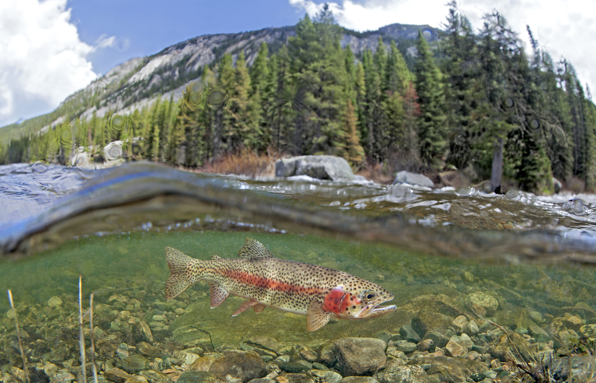
- Safeguarding Montana’s Gallatin and Madison Rivers
Rep. Ryan Zinke (MT) introduced the Greater Yellowstone Recreation Enhancement and Tourism Act (GYREAT Act) – Wild and Scenic legislation to protect nearly 100 miles of the Gallatin and Madison rivers and their tributaries in southwestern Montana. This legislation was developed through collaboration with American Rivers and our partners. If passed, these protections would create a vital corridor linking the rivers of Yellowstone National Park to the headwaters of the Missouri River.
- Defending healthy rivers and Tribal sovereignty
American Rivers helped rally national, regional, and local partners in urging the Department of Transportation to protect aquatic connectivity programs — efforts that restore fish passage, reconnect rivers and wetlands, and replace outdated culverts and road crossings. The joint comment letter was signed by 140 groups — including Tribes, anglers, businesses, universities, research institutions, conservation organizations, community leaders, agencies, faith groups, and planners — all united for healthier, more connected waterways.
Additionally, when the Department of Energy urged the Federal Energy Regulatory Commission to roll back its 2024 policy protecting Tribal sovereignty in hydropower permitting, American Rivers acted fast. Working with Tribal attorneys, Native networks, and partner organizations, we mobilized national opposition and filed formal comments — demonstrating our deep commitment to Tribal leadership and ensuring healthy rivers. We’ll continue working alongside Tribal partners to ensure these protections remain strong.
- Restoring mountain meadows in California
American Rivers is a key member of The Sierra Meadows Partnership, a coalition of environmental organizations working together to restore 30,000 acres of mountain meadows by 2030. These meadows act as natural sponges that store water, improve drought resilience, and provide essential wildlife habitat. Through this collaborative effort, we successfully secured a $24.7 million block grant from the Wildlife Conservation Board to support our restoration work.

- Advanced critical protections for New Mexico’s waterways
After naming New Mexico’s waterways #1 on America’s Most Endangered Rivers® of 2024 list, we’re celebrating significant wins across the state. In the Pecos watershed — home to elk, black bears, Rio Grande cutthroat trout, and generations-old acequia farms — the Department of Interior paused new mining claims across 165,000 acres while pursuing longer-term protections. Through advocacy with our partners, we helped secure Outstanding National Resource Waters protection for over 250 miles of rivers across five watersheds, including the Rio Grande. And now, Senator Heinrich (NM) and the All Pueblo Council of Governors are championing protection of the Caja del Rio — a 107,000-acre landscape along the Rio Grande and Santa Fe rivers that holds deep cultural significance for Puebloan and Hispanic communities while supporting diverse wildlife.
- Furthering community safety through dam awareness
American Rivers spoke on panels and hosted webinars addressing the deadly threat of low head dams, generating hundreds of participants from across the dam removal and safety industries. A low head dam is a human-made structure that spans the full width of a river and is designed to allow water to continuously flow over it, creating a dangerous hydraulic and earning them the nickname “drowning machines.” Our educational workshops brought together leading experts to discuss solutions for addressing these public safety hazards while advancing river restoration solutions.
- Building momentum for dam removal across the Northeast
American Rivers is celebrating a wave of funding that will free multiple rivers across the Northeast. We were awarded $220,000 to remove the Yopp Pond dam on the Fourmile River in Connecticut — the first barrier blocking this coastal river that drains to Long Island Sound. Fisheries biologists note this removal will be transformational for alewife runs in this critical watershed. Additionally, New Hampshire Fish and Game committed $150,000 to support two strategic dam removals: North Branch Gale dam in the Upper Connecticut River watershed and Mead Brook dam in the Contoocook River watershed. Both dams impact excellent cold-water habitat and are scheduled for removal in 2026. Additionally, the Davis Conservation Foundation granted $20,000 for our hydropower relicensing work in Maine.
- Defended Idaho’s Salmon River
Along with our partners at Advocates for the West and coalition members in Idaho, American Rivers and our Action Fund filed a lawsuit against the Forest Service to prevent a massive open-pit gold mine at the headwaters of the South Fork Salmon River. This important waterway is a national treasure that provides critical spawning habitat for the longest-distance, high-elevation salmon migration on Earth, as well as world-class whitewater recreation and fishing. It has been listed as one of America’s Most Endangered Rivers® for three consecutive years.
- Improved wildfire resilience in California
American Rivers and our partner, Terra Fuego Resources Foundation, completed prescribed fire burns on 160 acres as part of a 570-acre fuel reduction and prescribed fire project — a critical effort to protect the South Yuba River and the communities of Nevada City and Grass Valley from catastrophic wildfire. In a major boost for river restoration, the California Wildlife Conservation Board approved nearly $5 million to launch the Pickel Meadow Restoration Project on the West Walker River. Construction begins this summer, marking an exciting next chapter for this important watershed.

Klamath River tribes gain 10,000 acres in key salmon recovery area — AZCentral.com #KlamathRiver
Click the link to read the article on the AZCentral website (Debra Utacia Krol). Here’s an excerpt:
December 29, 2025
Key Points
- A new intertribal land trust has acquired 10,000 acres of land along the Klamath River from former dam operator PacifiCorp.
- The land transfer is a key step in restoring the river basin’s ecosystem following the removal of four dams.
- Indigenous values and traditional practices will guide the restoration of the land, which includes important salmon habitat.
Another milestone in restoring the Klamath River Basin has been reached. A new land trust received title to land on Dec. 22 that includes important salmon habitat and lands upstream of and adjacent to four now-removed dams and the shallow reservoirs that impeded fish and nurtured deadly algae in northern California and southern Oregon. The Klamath Indigenous Land Trust was formed by a coalition of members from four basin tribes after the historic 2002 fish kill to remove the dams as the beginning of a long-term effort to restore health to one of the West’s most imperiled rivers. PacifiCorp, the previous landowner and former hydropower operator, agreed to sell 10,000 acres to the land trust to return stewardship to the tribes who fought for decades to remove the dams as the first step in river recovery. Indigenous values and millennial-long practices which once made the basin one of the West Coast’s largest salmon habitats will direct the job of restoring the ecology of the area, which is the size of West Virginia. The Catena Foundation, the Community Foundation of New Jersey and an anonymous donor provided the funding for the purchase, which is one of the largest such purchases by an Indigenous-led land trust to date…
“Dam removal allowed the salmon to return home,” said Molli Myers, the land trust’s board president and member of the Karuk Tribe. “Returning these lands to Indigenous care ensures that home will be a place where they can flourish and recover.”
“PacifiCorp is pleased to see these lands transition to a stewardship model that honors their cultural and ecological significance,” said Ryan Flynn, president of Pacific Power, the division of PacifiCorp that serves customers in the Northwest.

How #wind and #solar power help keep America’s farms alive — Paul Mwebaze (TheConversation.com)
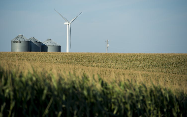
Paul Mwebaze, University of Illinois at Urbana-Champaign
Drive through the plains of Iowa or Kansas and you’ll see more than rows of corn, wheat and soybeans. You’ll also see towering wind turbines spinning above fields and solar panels shining in the sun on barns and machine sheds.
For many farmers, these are lifelines. Renewable energy provides steady income and affordable power, helping farms stay viable when crop prices fall or drought strikes.
But some of that opportunity is now at risk as the Trump administration cuts federal support for renewable energy.
Wind power brings steady income for farms
Wind energy is a significant economic driver in rural America. In Iowa, for example, over 60% of the state’s electricity came from wind energy in 2024, and the state is a hub for wind turbine manufacturing and maintenance jobs.
For landowners, wind turbines often mean stable lease payments. Those historically were around US$3,000 to $5,000 per turbine per year, with some modern agreements $5,000 to $10,000 annually, secured through 20- to 30-year contracts.
Nationwide, wind and solar projects contribute about $3.5 billion annually in combined lease payments and state and local taxes, more than a third of it going directly to rural landowners.

These figures are backed by long-term contracts and multibillion‑dollar annual contributions, reinforcing the economic value that turbines bring to rural landowners and communities.
Wind farms also contribute to local tax revenues that help fund rural schools, roads and emergency services. In counties across Texas, wind energy has become one of the most significant contributors to local property tax bases, stabilizing community budgets and helping pay for public services as agricultural commodity revenues fluctuate.
In Oldham County in northwest Texas, for example, clean energy projects provided 22% of total county revenues in 2021. In several other rural counties, wind farms rank among the top 10 property taxpayers, contributing between 38% and 69% of tax revenue.
The construction and operation of these projects also bring local jobs in trucking, concrete work and electrical services, boosting small-town businesses.

The U.S. wind industry supports over 300,000 U.S. jobs across construction, manufacturing, operations and other roles connected to the industry, according to the American Clean Power Association.
Renewable energy has been widely expected to continue to grow along with rising energy demand. In 2024, 93% of all new electricity generating capacity was wind, solar or energy storage, and the U.S. Energy Information Administration expected a similar percentage in 2025 as of June.
Solar can cut power costs on the farm
Solar energy is also boosting farm finances. Farmers use rooftop panels on barns and ground-mounted systems to power irrigation pumps, grain dryers and cold storage facilities, cutting their power costs.
Some farmers have adopted agrivoltaics – dual-use systems that grow crops beneath solar panels. The panels provide shade, helping conserve water, while creating a second income path. These projects often cultivate pollinator-friendly plants, vegetables such as lettuce and spinach, or even grasses for grazing sheep, making the land productive for both food and energy.
Federal grants and tax credits that were significantly expanded under the 2022 Inflation Reduction Act helped make the upfront costs of solar installations affordable.

However, the federal spending bill signed by President Donald Trump on July 4, 2025, rolled back many clean energy incentives. It phases down tax credits for distributed solar projects, particularly those under 1 megawatt, which include many farm‑scale installations, and sunsets them entirely by 2028. It also eliminates bonus credits that previously supported rural and low‑income areas.
Without these credits, the upfront cost of solar power could be out of reach for some farmers, leaving them paying higher energy costs. At a 2024 conference organized by the Institute of Sustainability, Energy and Environment at the University of Illinois Urbana-Champaign, where I work as a research economist, farmers emphasized the importance of tax credits and other economic incentives to offset the upfront cost of solar power systems.
What’s being lost
The cuts to federal incentives include terminating the Production Tax Credit for new projects placed in service after Dec. 31, 2027, unless construction begins by July 4, 2026, and is completed within a tight time frame. The tax credit pays eligible wind and solar facilities approximately 2.75 cents per kilowatt-hour over 10 years, effectively lowering the cost of renewable energy generation. Ending that tax credit will likely increase the cost of production, potentially leading to higher electricity prices for consumers and fewer new projects coming online.
The changes also accelerate the phase‑out of wind power tax credits. Projects must now begin construction by July 4, 2026, or be in service before the end of 2027 to qualify for any credit.
Meanwhile, the Investment Tax Credit, which covers 30% of installed cost for solar and other renewables, faces similar limits: Projects must begin by July 4, 2026, and be completed by the end of 2027 to claim the credits. The bill also cuts bonuses for domestic components and installations in rural or low‑income locations. These adjustments could slow new renewable energy development, particularly smaller projects that directly benefit rural communities.
While many existing clean energy agreements will remain in place for now, the rollback of federal incentives threatens future projects and could limit new income streams. It also affects manufacturing and jobs in those industries, which some rural communities rely on.
Renewable energy also powers rural economies
Renewable energy benefits entire communities, not just individual farmers.
Wind and solar projects contribute millions of dollars in tax revenue. For example, in Howard County, Iowa, wind turbines generated $2.7 million in property tax revenue in 2024, accounting for 14.5% of the county’s total budget and helping fund rural schools, public safety and road improvements.
In some rural counties, clean energy is the largest new source of economic activity, helping stabilize local economies otherwise reliant on agriculture’s unpredictable income streams. These projects also support rural manufacturing – such as Iowa turbine blade factories like TPI Composites, which just reopened its plant in Newton, and Siemens Gamesa in Fort Madison, which supply blades for GE and Siemens turbines. The tax benefits in the 2022 Inflation Reduction Act helped boost those industries – and the jobs and local tax revenue they bring in.
On the solar side, rural companies like APA Solar Racking, based in Ohio, manufacture steel racking systems for utility-scale solar farms across the Midwest. https://www.youtube.com/embed/Bcet_aaaMq8?wmode=transparent&start=0 An example of how renewable energy has helped boost farm incomes and keep farmers on their land.
As rural America faces economic uncertainty and climate pressures, I believe homegrown renewable energy offers a practical path forward. Wind and solar aren’t just fueling the grid; they’re helping keep farms and rural towns alive.
Paul Mwebaze, Research Economist at the Institute for Sustainability, Energy and Environment, University of Illinois at Urbana-Champaign
This article is republished from The Conversation under a Creative Commons license. Read the original article.
Walking in a windy wonderland: December welcomed an array of weird conditions to #Wyoming — from record-high temperatures to hurricane-strength winds and the rare winter rainbow — Katie Klingsporn (WyoFile.com)

Click through to read the article on the WyoFile website and to view the rainbow photo (Katie Klingsporn):
December 26, 2025
December ushered an array of weird meteorological conditions to Wyoming — from record-high temperatures to hurricane-strength winds and the rare winter rainbow.
The prismatic arch appeared over central Wyoming on Dec. 17, a rare spot of beauty amid raging wind gusts that wreaked havoc across the state.
That day, winds hit speeds of 123 miles per hour in Red Canyon, 144 miles per hour on Mount Coffin and 91 miles per hour in Hiland, according to the National Weather Service Riverton Office.
In nearby Lander, the wind knocked down trash cans and fences. It blew Christmas decorations halfway to Colorado, peeled shingles off of roofs, closed the highway to South Pass and felled trees.
Elsewhere, high winds have knocked out the power to traffic signals in Casper and forced city officials to close the landfill. December gusts also toppled dozens of semi-trucks on highways like Interstate 80, the Wyoming Department of Transportation reported.
Balmy temperatures have attended the winds, breaking records in places ranging from Riverton to Worland and Rock Springs — where a high of 59 was the warmest temperature on record in December, according to the National Weather Service.
Residents accustomed to bundling up for single-digit temperatures, snowfall and ice skating during the holidays may instead reach for a windbreaker and umbrella this year.
Happy Birth Anniversary Mrs. Gulch! Your hand in mine, we walk the miles.

Mrs. Gulch (Early 1973): Since we’re taking the summer off for a honeymoon let’s go backpacking.
Me: No thanks, I backpacked during my time in the Boy Scouts before being asked to find another outlet for my Junior High attitude.
Mrs. Gulch: What didn’t you like about backpacking.
Me: At the top of the list — I don’t like cooking over a campfire.
Mrs. Gulch: We can get a backpacking stove.
Me: A what?
Mrs. Gulch: A backpacking stove, they use white gas that you carry in a Sigg bottle. Let’s go to the backpacking store, things have changed since you were a Boy Scout.
That was my introduction to Mrs. Gulch’s knowledge of backpacking. Of course she was way more experienced than I was but didn’t gloat. She wanted to be on the trail and she wanted to take me along. That opened up a world for me and I became obsessed with backpacking — mountains and desert — it didn’t matter, and much of my time during winter, from then on, was spent looking over USGS topo maps, trying to find a cool route to follow. Subsequent years you could find us on the trail in Colorado, Utah, Montana, Washington, and New Mexico most often with my good friend Joe. We took many folks on their first backcountry trek over the years and alternated mountains then desert, year after year.
There is a standout trek for me. Four of us started in Harris Wash, a trib of the Escalante River and walked to Coyote Gulch, another trib of the river. Mrs. Gulch and another friend met us there with a food drop so that she and I could go back upriver to our VW bus parked at the Harris Wash trailhead.
During the hike to Coyote Gulch we met up with hoards of biting flies until below 20 Mile Wash. It was miserable at times but we learned to get in the shade, kill a few, slather up with DEET, cool off and hydrate.
When Mrs. Gulch and I left the group in Coyote Gulch my friend Don asked, “You’re going back through the flies?”
When she and I hit the fly space upstream we ended up hiking from early morning until nighttime to get done as quickly as possible. The last day I was pretty agitated and tired from the trek and I missed the exit to Harris Wash. I was worried and anxious also and a little (maybe a lot) of panic set in. I’ve mentioned before how much I depended on Mrs. Gulch’s wise counsel during our 50 years of marriage and that day it showed up again.
Mrs. Gulch (calmly): Let’s get in the shade, kill a few flies. You can get your compass and the topo sheet out of your pack and figure out where we are.
Me: These flies! We missed Harris Wash? We need to get back to the bus and back to Denver! Blah, blah, blah!
Mrs. Gulch (repeating herself calmly): Look there’s a shady alcove over there, let’s go there, kill a few flies, and you can get your compass and the topo sheet out of your pack and figure out where we are.

After orienting the map and taking a good look at the terrain I saw a side canyon (Silver Falls Creek) coming into the Escalante River canyon just upstream and found it on the map. As it turns out we just needed to go back downstream a bit (just around the bend) and we would be at the confluence with Harris Wash. We didn’t miss it by much.
Wise counsel indeed.
Happy 71st birth anniversary Mrs. Gulch and thank you for your humor and wise counsel over the years.