"Ramble On" is 56 years old and Robert Plant just walked onto The Late Show and made it sound like he wrote it this morning. pic.twitter.com/MkePb2dMMc
— Guitar Gods Unleashed (@UnleashedG23066) April 9, 2026
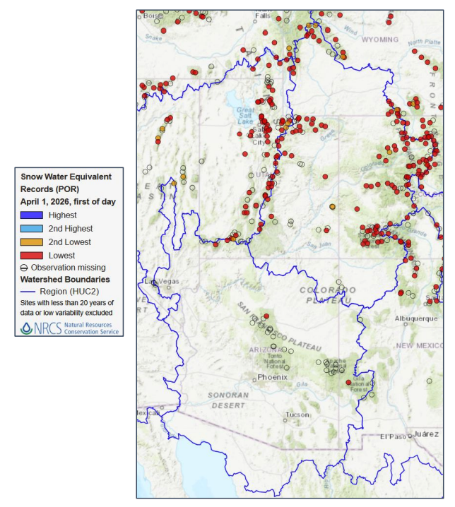
Day: April 12, 2026
Pagosa Area Water and Sanitation District implements voluntary drought restrictions — The #PagosaSprings Sun
Click the link to read the article on the Pagosa Springs Sun website (Clayton Chaney and Randi Pierce). Here’s an excerpt:
April 8, 2026
On Tuesday, April 7, the Pagosa Area Water and Sanitation District (PAWSD) announced that the district is implementing voluntary drought restrictions, with the agency anticipating increased drought restrictions within the next two weeks. According to a statement from the district, “The Voluntary water reduction stage is intended to give the community advanced notice of developing drought conditions and to begin encouraging water conservation and voluntary water use reduction. The Voluntary stage does not trigger the drought surcharge or tier rate multipliers.” The statement explains the trigger points for the voluntary stage are:
- A curtailment order on Four Mile Creek prior to May 1.
- A maximum snow water equivalency (SWE) less than 75 percent of median.
- Reservoir levels with the addition of diversion flow less than 90 percent.
The statement notes, “With a maximum Snow Water Equivalency (SWE) of less than 75% of Median as of April 6, 2026, the District is implementing Voluntary Drought Restrictions as of April 7, 2026. PAWSD will implement the next level of mandatory drought restriction stages as dry conditions continue, and these do trigger drought surcharges and/or tier rate multipliers.”
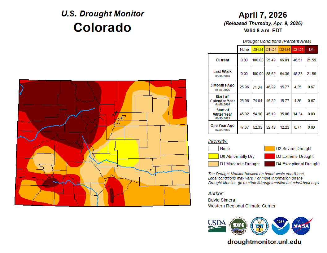
An email to The SUN from District Engineer Justin Ramsey also notes the move is due to the National Integrated Drought Information Center upgrading the drought state in Archuleta County from severe to extreme…
According to the U.S. Geological Survey (USGS), as of 2 p.m. on Wednesday, April 8, the San Juan River in downtown Pagosa Springs had a flow rate of 451 cubic feet per second (cfs). Based on 90 years of water records, the record high flow for that date was recorded in 1960 at 1,380 cfs, while the record low was recorded in 1964 at 65 cfs. The median flow for that date is 351 cfs and the mean flow is 418 cfs. The Piedra River near Arboles was flowing at a rate of 365 cfs, as of 2 p.m Wednesday, April 8, according to the USGS. Based on 63 years of water records, the median flow for April 8 is 567 cfs and the mean flow is 690 cfs. The record high flow for April 8 was recorded in 1985 at 2,370 cfs, while the record low was recorded in 1977 at 100 cfs.

Colorado River projected to deliver one-fifth of normal water to Lake Powell after ‘astonishing’ March heatwave: The record-hot March conditions that led to a rapid melt-off of the snowpack in Colorado were echoed across the seven-state #ColoradoRiver Basin — The #Aspen Times #COriver #aridification
Click the link to read the article on The Aspen Times website (Ryan Spencer). Here’s an excerpt:
April 11, 2026
An unprecedented March heatwave has forecasters shrinking already-low estimates for how much water will flow into the Colorado River during spring runoff, which is already well underway this year. The latest models show that the Colorado River is projected to deliver only about 1.4 million acre feet of water — roughly one-fifth of normal — to Lake Powell, the nation’s second-largest reservoir. Colorado River Basin Forecast Center hydrologist Cody Moser said during a water briefing on Tuesday, April 7, that if those projections were to bear out, it would be the third lowest amount of water delivered to Lake Powell in the reservoir’s 63 year history.
“We are on the extreme end of things,” Moser said. “We had a huge heatwave at the end of March with significant snowmelt.”
At the start of March, snowpack across the Colorado River Basin and projections for the spring runoff were already low, raising concerns of water shortages and an early start to what could be a dangerous fire season across the West. Then came a “very dry March” with a record-shattering heatwave that melted large amounts of the snowpack from the “most crucial areas for spring runoff,” Moser said. Nearly all of these areas had less than 50% of average precipitation in March, and have seen less than half of the average precipitation since October, he said.
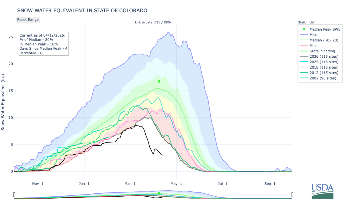
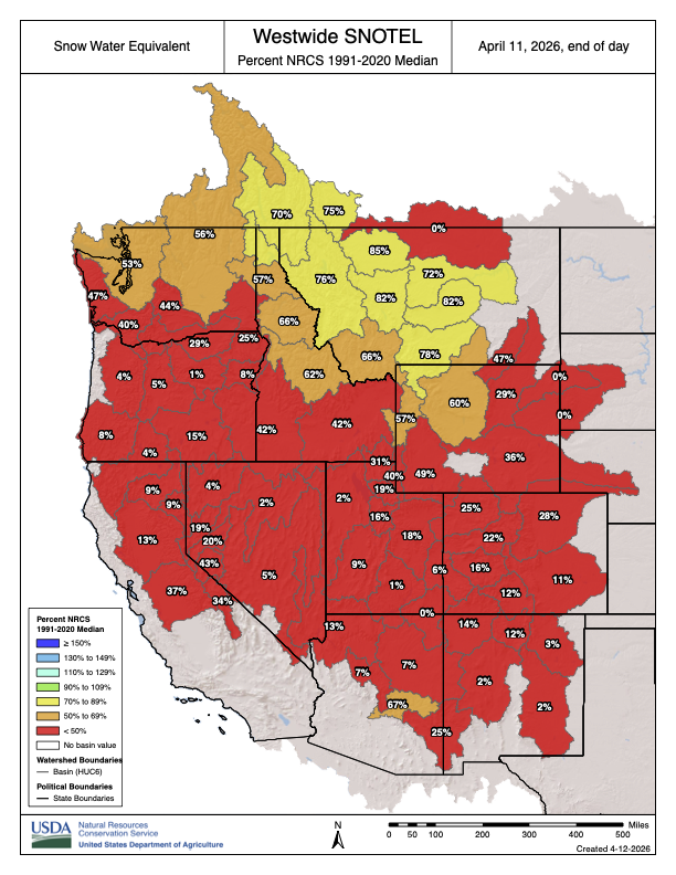
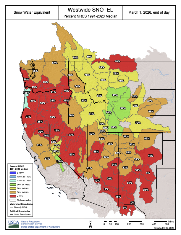
Averaged across Colorado, March was an “astonishing” 13 degrees Fahrenheit warmer than the 20th century average, almost 10 degrees warmer than the 1991-2020 average and more than 4 degrees warmer than any previous March, according to the state’s monthly climate summary. Large parts of the mountains experienced record-breaking temperatures lasting for days on end and leading to a rapid melt-off of the state’s already historically-low snowpack. Colorado started April with a snowpack that state climatologists said was the worst in at least the past 75 years. Colorado’s snowpack peaked in early March — a full month earlier than normal — at 8.5 inches of snow-water equivalent, or roughly half of the 30-year median, according to the state’s snow telemetry data. Normally, the state’s snowpack peaks on April 8, but by the time that date rolled around this year, the data show the statewide snowpack had declined to just 3.6 inches of snow water equivalent. That’s less than half what it was a month earlier, and just 23% of normal for that point in the season.