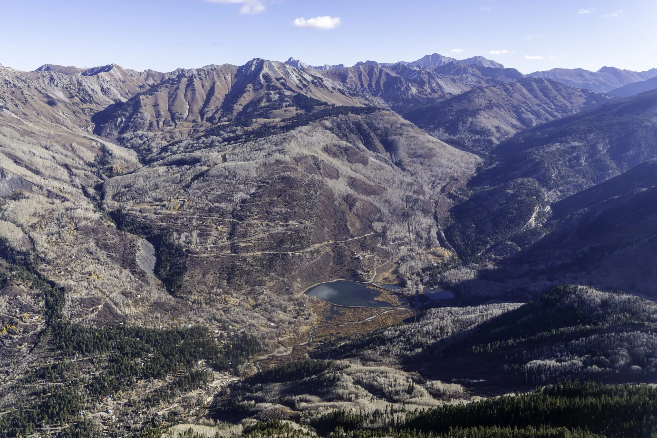
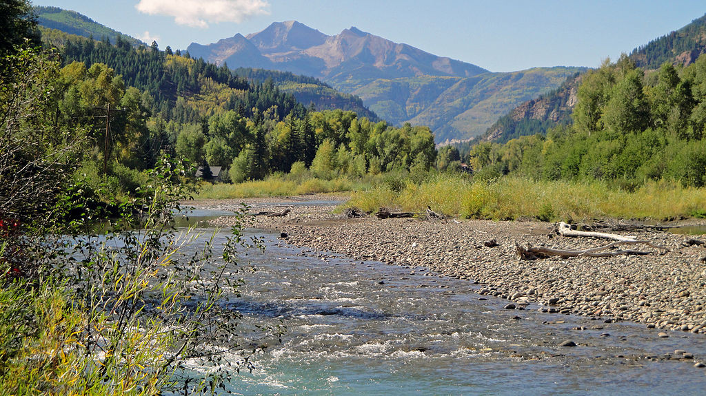
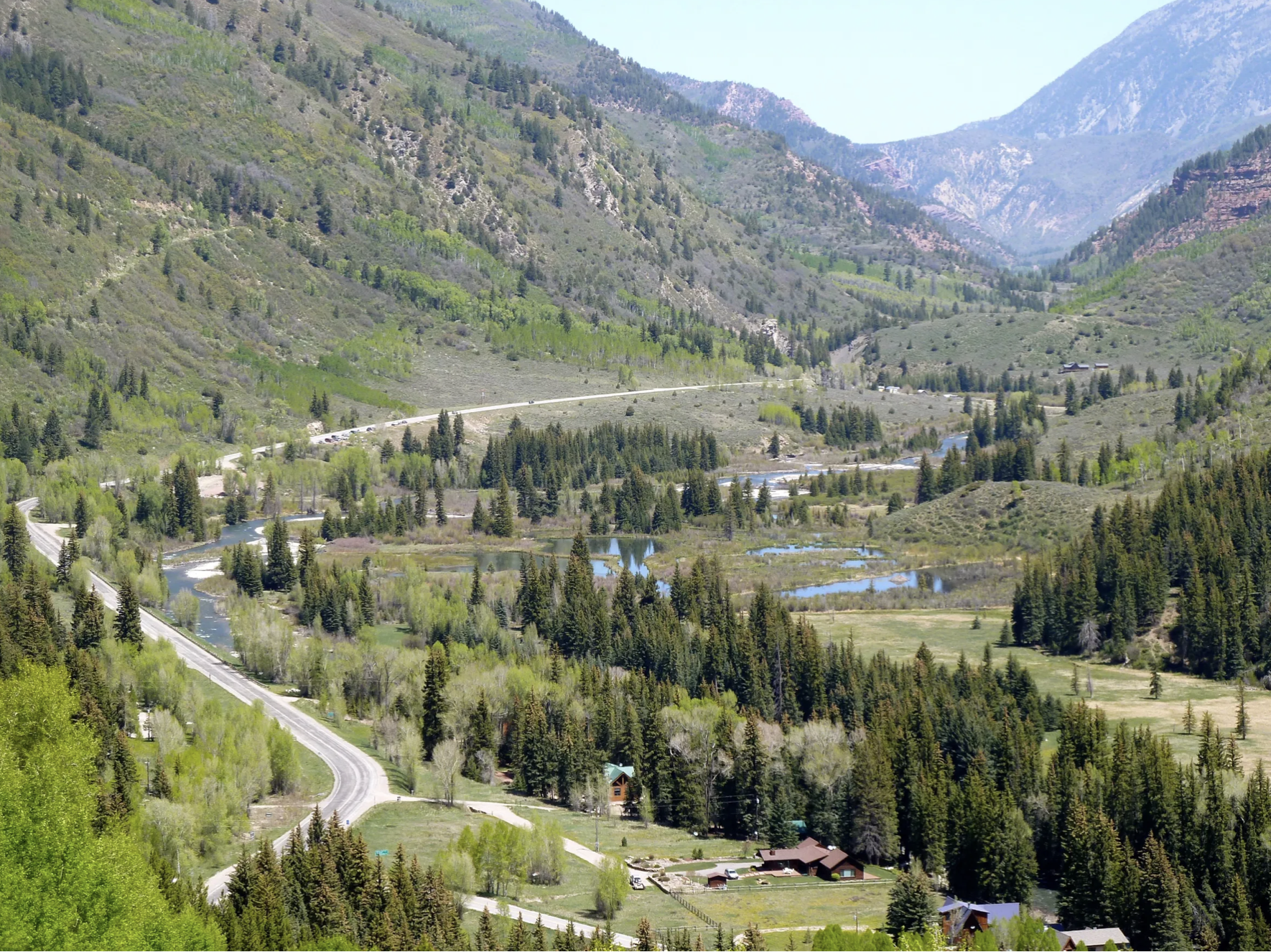
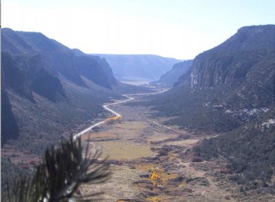
The Crystal River flows through the Gunnison County town of Marble, seen here with Beaver Lake. A representative from the Town of Marble is expected to participate in a subcommittee focused on an intergovernmental agreement to protect the river. CREDIT: ECOFLIGHT
May 27, 2026
Five Colorado governments, including Pitkin County, and water entities have officially entered into a landmark intergovernmental agreement to protect the Crystal River from mainstem dams and out-of-basin water diversions.
The agreement comes at the recommendation of the Crystal River Wild and Scenic and Other Alternatives Steering Committee from March 2024, suggested as one of three potential long-term preservation measures, according to a press release. Along with Pitkin County, the Colorado River Water Conservation District, Gunnison County, town of Marble and West Divide Water Conservancy District formalized their shared commitment to oppose any new on-channel reservoirs on the mainstem of the Crystal River and any trans-basin diversions that would export water out of the watershed.
The Pitkin County Board of County Commissioners moved forward Wednesday with an intergovernmental agreement that expresses commitment “to protect the Crystal River from on-channel dams and transmountain diversions.” The agreement will be between Pitkin County, Gunnison County, the town of Marble, the Colorado River Water Conservation District and the West Divide Water Conservancy District. This was an approval of the first of two readings. The Colorado River Water Conservation District have yet to bring this agreement to their boards but have previously expressed support for the initiative, according to the district’s staff. Gunnison County and the town of Marble will be considering it in upcoming meetings.
“It would be an agreement that all the parties would oppose or not support any new dams on the main stem of the Crystal River, or any new trans-basin diversions out of the Crystal River,” Pitkin County Deputy Attorney Anne Marie McPhee told commissioners on Wednesday. “It is trying to keep the water in the river as long as possible.”
[…]
Despite moving the agreement forward after first reading, Commissioner Greg Poschman acknowledged that there has been concern around the agreement’s lack of enforcement ability, due to the signing bodies’ ability to leave the agreement at will. Poschman referenced specific criticism vocalized by Bill Jochems, a Pitkin County Healthy Rivers and Streams Citizen Advisory board member and Crystal River advocate.
“The expression from Mr. Jochems is, ‘it’s a nothing burger,’ right?” Poschman said on Wednesday. “It’s the weakest of all possible protections for the Crystal. Is that what we want to do at this point?”
Commissioner Francie Jacober commented that, despite the potential weakness that Jochems and Poschman pointed out, it would still be symbolically important for the county to lend their support to the intergovernmental agreement…The county has been pursuing a Wild and Scenic River designation for a portion of the Crystal River since the U.S. Forest Service found 39 miles of it eligible for the designation in 2002, according to county documents supporting Wednesday’s intergovernmental agreement. A Wild and Scenic designation could help with future conservation and preservation efforts.
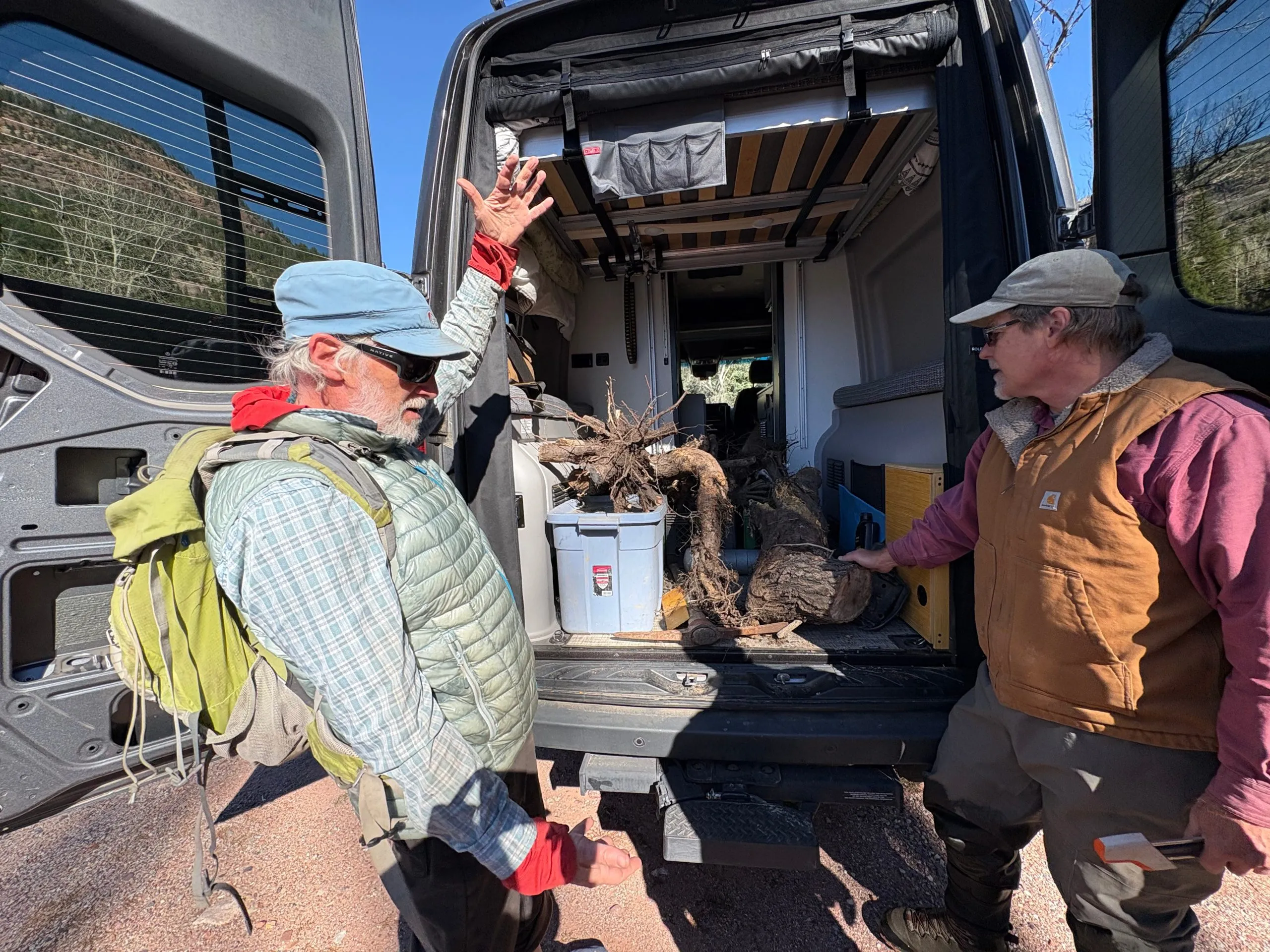
Riparian ecologists David Cooper, left, and David Merritt take stock of the tree root crowns collected from the banks of the Crystal River the last week in October. They will take the trunks back to the lab in Fort Collins to study the tree rings, the first step in understanding how floods impact riparian vegetation. CREDIT: HEATHER SACKETT/ASPEN JOURNALISM
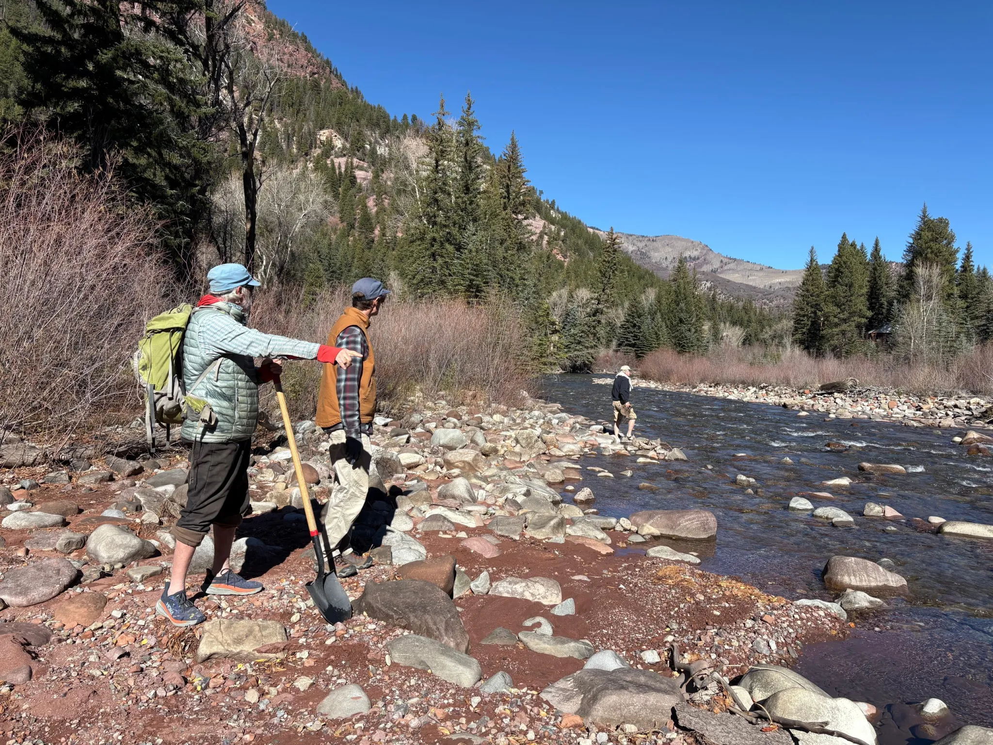
Over three sunny-but-cool October days, a team of scientists and volunteers dug up and hauled away the root crowns of trees along the Crystal River, a first step toward a potential strategy to protect flows on one of the last free-flowing rivers in Colorado.
David Cooper, a senior researcher on wetland and riparian ecology at Colorado State University, studies how spring floods affect riparian vegetation. His van was full of the tree samples that he would take back to the lab in Fort Collins to study their rings.
“We want to know the year the plant was established because once we know the year the plant was established, then we could relate that to the flow record that’s recorded by gauges,” Cooper said. “Then we can speak to the role of floods, which is important for the public to understand and for river managers to understand.”
The banks of the Crystal just upstream from Redstone are lined with narrowleaf cottonwood and blue spruce. Cottonwoods in particular need the rushing flows of spring runoff for their seeds to germinate and have evolved to disperse their seeds just after the high point of snowmelt each year. The seeds, carried along the wind by a bit of fluff, land in the bare, wet, mineral soil of streambanks where some of them take root.
Peter Brown with Rocky Mountain Tree Ring Research takes a core sample from a tree on the banks of the Crystal River. A type of instream flow water right that protects peak flows could help maintain spring floods, which are essential for growing new cottonwoods. CREDIT: HEATHER SACKETT/ASPEN JOURNALISM
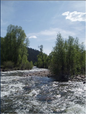
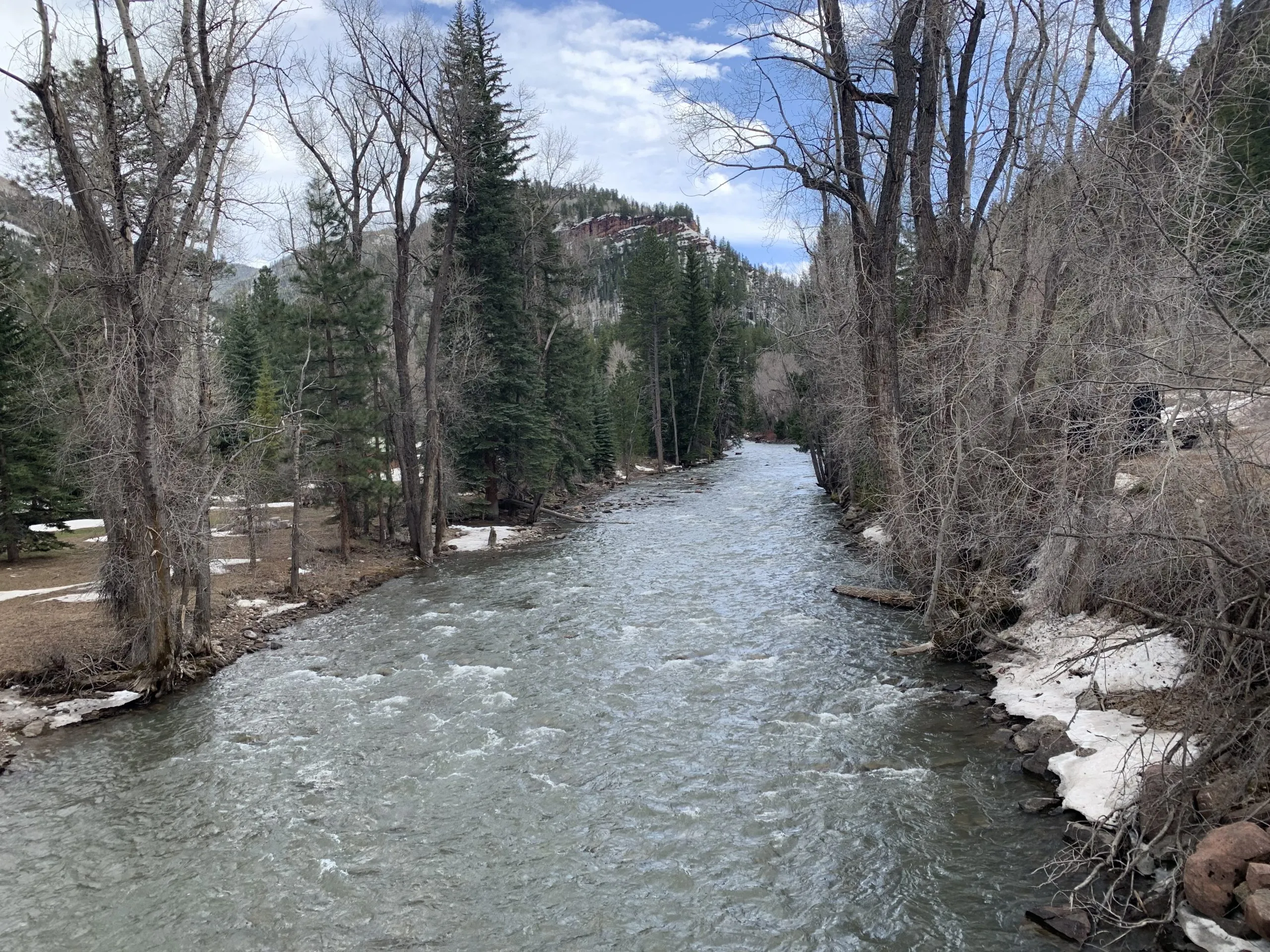
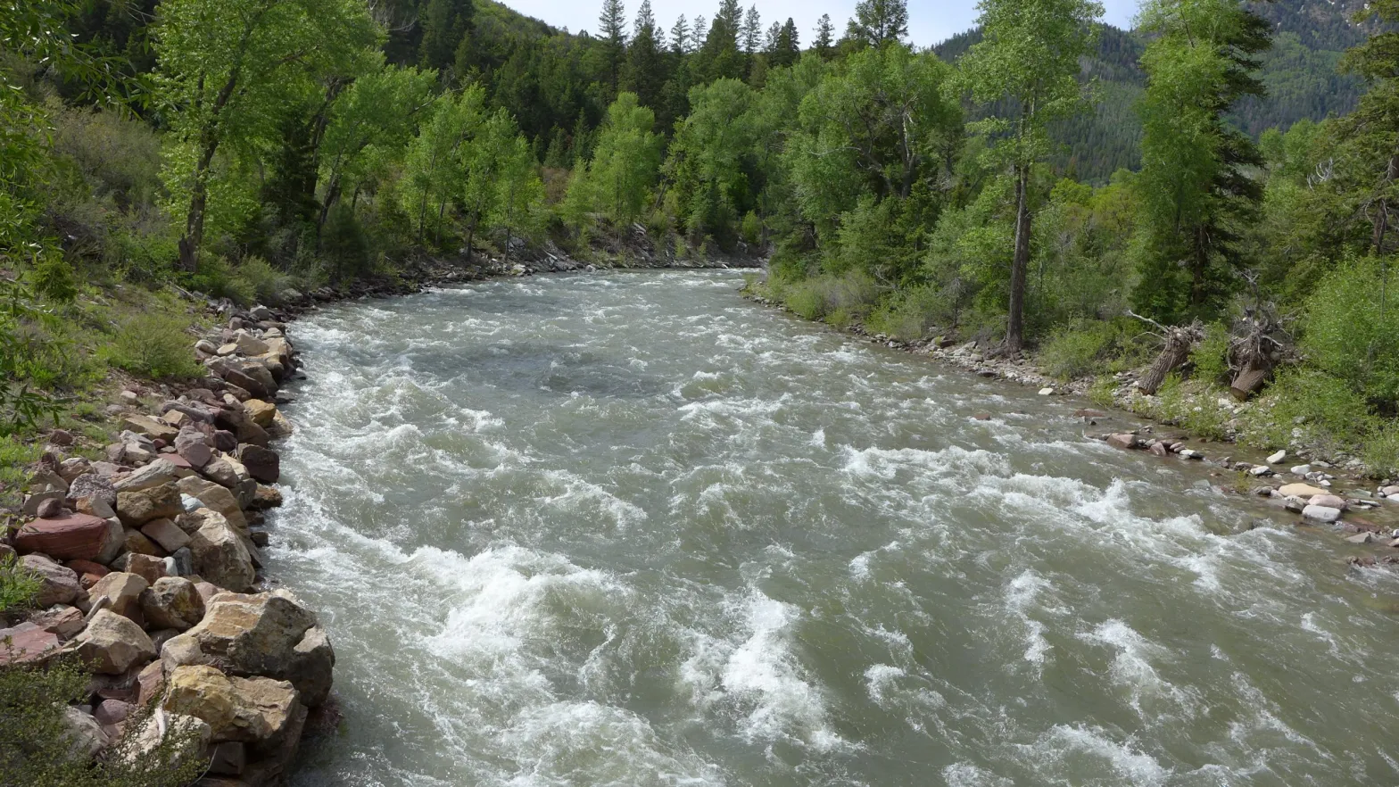
Cooper’s work, which is estimated to cost $26,300, was commissioned by a subcommittee of the Crystal River Wild and Scenic and Other Alternatives Feasibility Steering Committee, which is looking at different tools that could be used to protect the river. The Crystal, which flows about 40 miles from its headwaters in the Maroon Bells-Snowmass Wilderness through the towns of Marble, Redstone and Carbondale before its confluence with the Roaring Fork, is one Colorado’s last undammed major rivers.
Environmental and recreation advocates and local municipalities, as well as many residents of the Crystal River Valley, have long sought to protect the river from future dams and diversions — infrastructure projects that have left many other Western Slope rivers depleted.
Those who want to protect the Crystal River have for the past few years been exploring the best ways to do that. Although proponents say a federal Wild and Scenic designation would do the best job of protecting the river, that has been met with resistance from some property owners, leading the steering committee to explore other options, in addition to pursuing Wild and Scenic.
Scientists dug up this root crown next to the Crystal River in order to study the tree rings and how they relate to flood years. The Crystal River Wild and Scenic Instream Flow Subcommittee is looking at how to protect spring peak flows in the river. CREDIT: HEATHER SACKETT/ASPEN JOURNALISM
Instream-flow subcommittee
After a year’s worth of meetings with a facilitator, the steering committee chose to pursue three potential ways forward: a “peaking” instream-flow water right; an intergovernmental agreement; and a federal Wild and Scenic designation. None of the methods would preclude the others; there could eventually be layers of protections for the Crystal.
The instream-flow subcommittee, which includes representatives from American Whitewater, and local governments and residents, is exploring how to keep water in the river by using the Colorado Water Conservation Board’s instream-flow program.
The CWCB is the only entity allowed to hold water rights that keep water in rivers and are designed to preserve the natural environment to a reasonable degree. A “peaking” instream-flow water right would keep in the stream all of the water not claimed by someone else during years with high spring runoff, thereby maintaining these periodic floods, which are essential for growing new cottonwoods.
The idea is that if these peak spring flows are already spoken for by the environment, they can’t be claimed by future reservoir projects, which also tend to capture water at the height of spring runoff and store it for use later in the year.
“If you want to be a little more objective about it, it’s an argument for or against floods and natural river processes,” said David Merritt, a riparian ecologist and former instream flow coordinator for the U.S. Forest Service who has worked on other instream-flow projects around the state. “The dam goes in, it’s going to interrupt that and you’ll end up with a different ecosystem.”
If there is less water available to develop, it could make a particular river less attractive for building a reservoir, said Laura Belanger, a senior policy adviser with Western Resource Advocates. The environmental nonprofit has worked on these types of peak instream-flow projects in the Gunnison River basin.
“Infrastructure is expensive, so you need to get a certain yield out of it,” Belanger said. “That could potentially make a project not be cost effective and not have sufficient yield to be pursued. … Around the state, so much water is already claimed, and so, for a lot of new reservoir projects, the peak is the only thing that’s available.”
So far, this tool for protecting the peak is little used, but there are three recent examples on streams that drain the Uncompahgre Plateau: Cottonwood Creek, Monitor Creek and Potter Creek. In 2024, these three creeks secured an instream-flow water right for their spring peak flows in years with high runoff. All three still allow for some amount of future water development.
“They don’t kick in every year; they’re definitely unique,” Belanger said. “It doesn’t kick in until you hit a certain high flow and then it protects the hydrograph all the way up and then back down to a certain value.”
Wetland and riparian ecologist David Cooper, left, and campaign director at Wilderness Workshop Michael Gorman look for the best place to cross the Crystal River. Scientists and volunteers collected tree root crowns from the riverbanks the last week of October, the first step in understanding how floods impact riparian vegetation. CREDIT: HEATHER SACKETT/ASPEN JOURNALISM
Subcommittee still looking at Wild and Scenic
The steering committee’s work, including the tree-ring study, is funded by Pitkin County Healthy Rivers, by the Mighty Arrow Family Foundation, and in-kind donations from Western Resource Advocates and American Whitewater. But the majority of the funding – $99,699 according to Hattie Johnson, southern Rockies restoration director with American Whitewater and member of the instream flow and Wild and Scenic subcommittees – is through the state’s Wild and Scenic Rivers Fund.
The CWCB generally advocates for using state mechanisms such as the instream-flow program to protect rivers because it would rather avoid a federal Wild and Scenic designation. With increasing competition for dwindling water supplies, the state has been reluctant to support Wild and Scenic designations, which could lock up water and prevent it from being developed in the future.
The U.S. Forest Service determined in the 1980s that portions of the Crystal River were eligible for designation under the Wild & Scenic River Act, which seeks to preserve, in a free-flowing condition, rivers with outstandingly remarkable scenic, recreational, geologic, fish and wildlife, historic, and cultural values. Wild and Scenic experts say the “teeth” of the designation comes from an outright prohibition on federal funding or licensing of any new Federal Energy Regulatory Commission-permitted dam. A designation would also require review of federally assisted water resource projects.
Any designation would take place upstream from the big agricultural diversions on the lower portion of the river near Carbondale.
The subcommittee that is still looking at a Wild and Scenic designation has hired a facilitator team from the Keystone Policy Center to help the group produce a report of its findings at a cost of about $45,000. And the instream-flow subcommittee has also hired Ecological Resource Consultants to do a sediment-impacts study, which is set to begin before winter and is estimated to cost about $30,000.
Wild and Scenic subcommittee chair Michael Gorman said members have taken a deep dive into policy and legislation, and have learned a lot from stakeholders along the river.
“We’ve got more work to do and we’re excited to have the skilled facilitators at Keystone to help us compile what we’ve learned about how Wild and Scenic legislation ties into our specific priorities on the Crystal River,” Gorman said in a prepared statement. “We look forward to having a report that we can share with our community and inform future discussions.”
The Wild and Scenic Rivers Act of 1968 has been the preeminent tool to protect free-flowing rivers in the United States since it was passed more than 50 years ago. Under the Act, rivers with “outstandingly remarkable scenic, recreational, geologic, fish and wildlife, historic, cultural or other similar values,” as well as their immediate environments, are protected from dams and other potential harms. In spite of its success, the Act largely omits Tribes, failing to give Native Nations the authority to designate, manage, and co-manage Wild and Scenic rivers within their own boundaries and on ancestral lands. Correction of this omission is long overdue, both in terms of equity and the long-term benefit to rivers.
A current example of this omission was brought to our attention through conversations with Indigenous community members along the Little Colorado River (LCR) in Arizona. The LCR was threatened in recent years by a series of pumped-storage hydropower projects proposed on Navajo Nation lands by non-Indigenous developers, and against the will of the Navajo Nation, Hopi Tribe, Pueblo of Zuni, and others who find the LCR culturally important. Historically, under the Federal Power Act, proposed hydropower projects have been given a preliminary permit on tribal trust lands by the Federal Energy Regulatory Commission (FERC) against the will of the Tribe whose land the projects would be located on. Indigenous community advocates understandably wanted to know, “What can we do to permanently protect the Little Colorado River from these unwanted hydropower projects?”
Confluence of the Colorado and Little Colorado Rivers within Grand Canyon, Arizona | Rachel Ellis
Designating a river under the Wild and Scenic Rivers Act is a powerful defense against unwanted dams and diversions–it is the only designation that prevents new dams and diversions on designated rivers. The problem is that since Tribes were largely omitted from the 1968 Act, they were not given the power to designate or manage Wild and Scenic rivers, even on their own lands. That management power currently defaults to the National Park Service, even when a designated river is on tribal lands. To say that this is a disincentive for Tribes to utilize the Wild and Scenic Rivers Act to protect their rivers is an understatement.
And that’s not all. As the Table below shows, Tribes don’t even have some of the powers that have been given to states and private parties under the Act, such as the ability to petition the Secretary of Interior to give Wild and Scenic protections to state-protected rivers, or the ability to receive funding and technical assistance, which both private parties and states can. Co-management/co-stewardship agreements and cooperative agreements are also not explicitly authorized for Tribes in the Act, which is a potential disincentive for federal agencies to explore such agreements with willing, interested, and knowledgeable Tribes.
As sovereign nations, Tribes should at least have the power that states and NGOs have regarding river designations. Tribes should be able to manage Wild and Scenic Rivers on their lands, ask the Secretary of Interior to include rivers protected by Tribes under the Wild and Scenic Rivers Act, be formally authorized to engage in co-stewardship agreements with federal agencies, and have the ability to receive funding and technical assistance when managing rivers on their lands.
Correcting the omission of Tribes in the Wild and Scenic Rivers Act remains long overdue. We heard from both legal scholars and tribal communities that creating a well-researched, draft proposal—which you can download here—would be the best way to begin an informed conversation. This is in no way intended to be a finished product, but meant to engage Tribes, advocates, and legal thinkers in what might be possible, and in turn help us make that a reality.
Lamar River, Wyoming | Mike Fiebig
We also realize that proposing to amend a bedrock natural resources law is no small undertaking, and not without some risks. The structure of the Wild and Scenic Rivers Act makes amending the Act easier and less risky than amending other similar laws. Currently, each new river designation is added to the National Wild and Scenic Rivers System through an amendment to the original Act, which means that a new Wild and Scenic designation by a Tribe that includes these proposed amendments would be all that would be necessary to implement them. Furthermore, the Concept Paper proposes extending existing authorities to Tribes through the addition of new sections in the Wild and Scenic Rivers Act, not changes to existing protections that have been settled law for over 50 years.
In this way, and with your help, we not only propose to retain the protections that the Wild and Scenic Rivers Act has afforded outstanding free-flowing rivers across the county for the last half century, but to expand the ability for Tribes to utilize those same protections to safeguard free-flowing rivers of cultural and ecological importance into the future. Now is the time to address the omission of Tribes in the Wild and Scenic Rivers Act and other bedrock natural resources laws. Doing so would be a measure of restorative justice, while also benefiting Tribes and all life which depends on rivers.
Please download and read the Concept Paper and Draft Model Legislation, and let us know what you think. We look forward to hearing from you.
The Wild and Scenic Rivers Act Amendments Project was founded in 2021 by American Rivers, the Grand Canyon Trust, and the Getches-Wilkinson Center in response to Indigenous advocates seeking a tool to protect culturally and ecologically important rivers on Tribal lands from FERC-licensed hydropower projects. More input from Tribes, river advocates, and legal scholars is being sought for the next phase of this project.
Beaver Lake and the Crystal River in Marble seen from the air. Three subcommittees are continuing to work on exploring protections for the river. Credit: EcoFlight
Three subcommittees exploring ways to protect the Crystal River met in Marble on Monday to share their status and findings after six months of work.
The Crystal River Collaborative Steering Committee split into three subcommittees in March, each focused on evaluating a different method of river protection: a peaking instream flow; an intergovernmental agreement; and a federal Wild & Scenic designation.
Some Crystal Valley residents, along with Pitkin County, have pushed for a Wild & Scenic designation for years as the best way to prevent future dams and diversions. Others, wary of any federal involvement, have balked at the idea, instead proposing different types of protections. But nearly everyone involved agrees that some type of protection is necessary to ensure that one of Colorado’s last free-flowing rivers stays that way.
A peaking instream-flow water right could protect about 25,000 acre-feet of river flows during peak runoff so that that water could not be claimed by a new transbasin diversion or dam project. Committee member Andrew Steininger said the group has hired environmental consultant Brad Johnson to study the issue and write a report on the feasibility of a peaking instream-flow water right on the Crystal. The water right is designed to protect special riparian ecosystems, including plants that need annual floodwaters to survive, and it’s not clear how it would be adapted to the Crystal.
“We are anxiously awaiting Brad’s work, and I think that will really help inform what an avenue might look like,” Steininger said.
Gunnison County Commissioner Liz Smith gave an update on the intergovernmental agreement committee, or IGA. An IGA would include representatives from Gunnison County, Pitkin County, Marble, Colorado River Water Conservation District and West Divide Water Conservancy District. The IGA would have two main goals: Signatories would agree to not support any new reservoir or impoundment of water on the main stem of the Crystal and would agree to oppose in water court any water rights application that would remove water from the Crystal River basin.
Steering committee members agreed that Smith will work on a draft IGA with the local governments, which will be reviewed by the steering committee before the governments sign it.
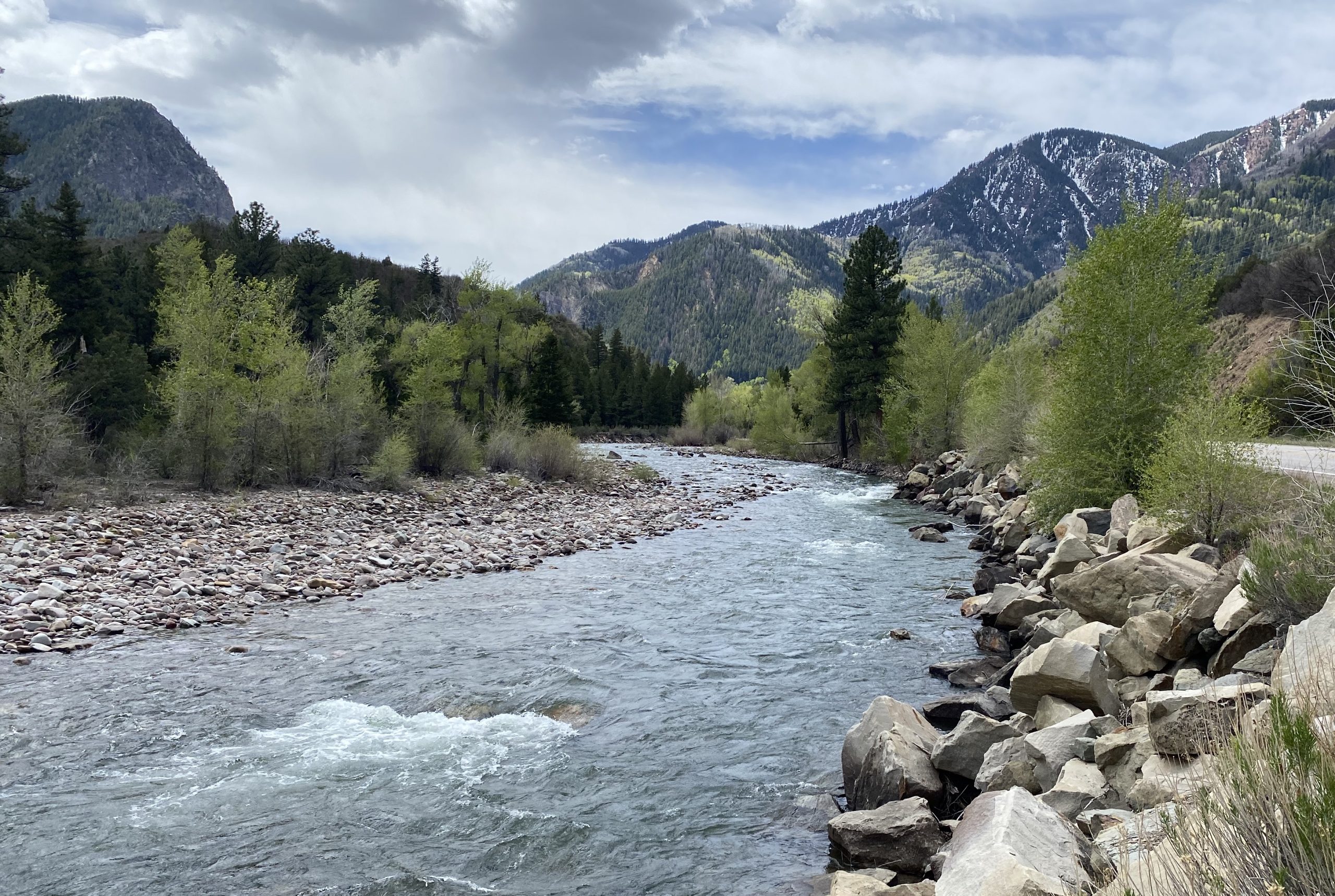
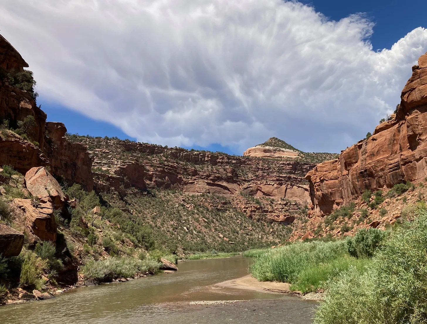
The view looking upstream on the Crystal River below Avalanche Creek. Pitkin County and others wants to designate this section of the Crystal as Wild & Scenic. CREDIT: CURTIS WACKERLE/ASPEN JOURNALISM
Wild & Scenic
Members of the subcommittee dedicated to exploring a Wild & Scenic designation said the process is a lot more complicated than they initially thought it would be. The group provided 13 pages of information with many links to additional resources. Every white paper that the group reads and every expert that they talk to generates new questions, said committee member Hattie Johnson.
“One takeaway from this process is that we don’t have a draft to share, we don’t have a formal recommendation,” said committee member Lea Linse. “There is a lot more to this act than a lot of us starting this process realized.”
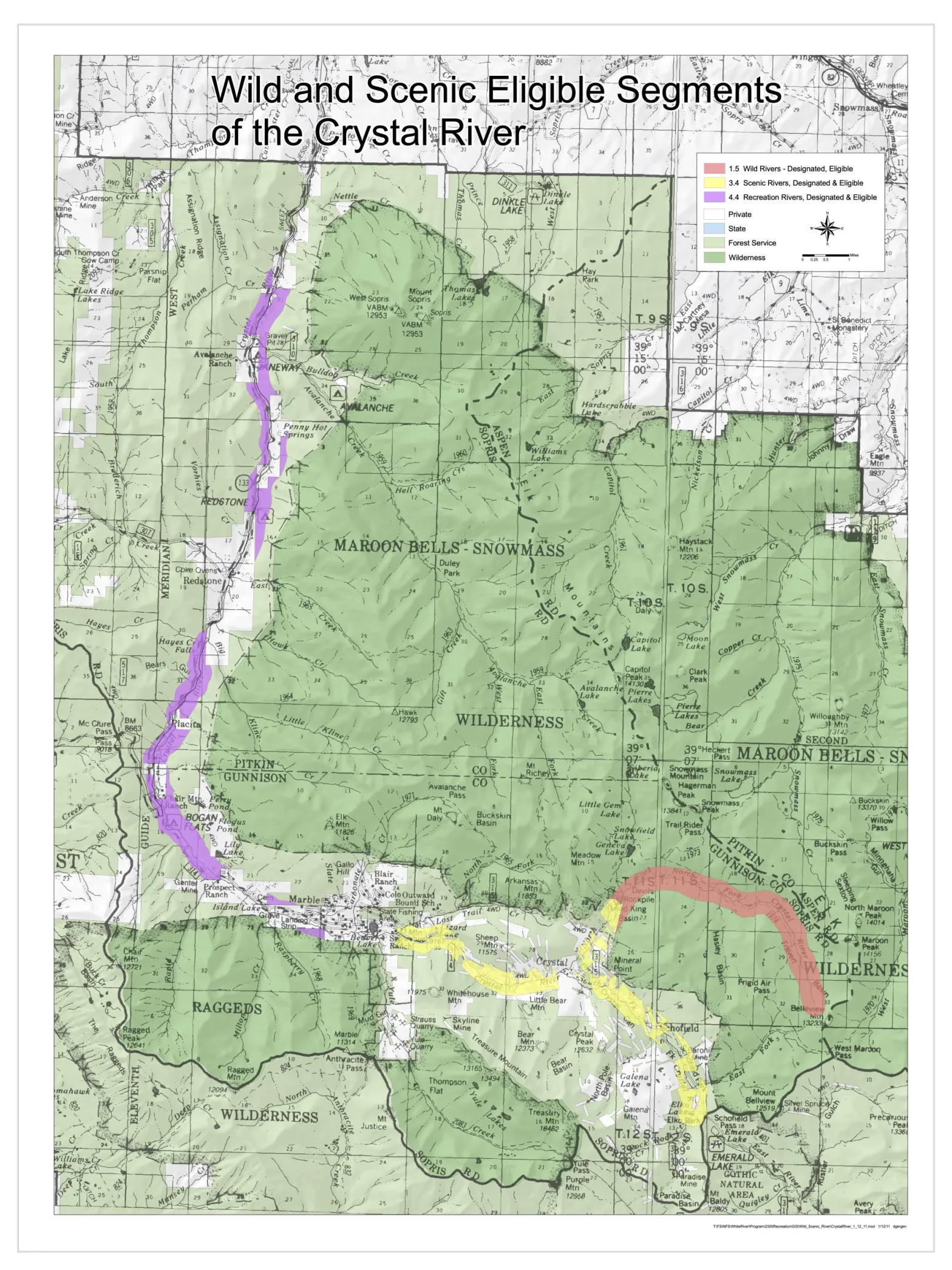
The U.S. Forest Service first determined in the 1980s that the Crystal River was eligible for designation under the Wild & Scenic Rivers Act, which seeks to preserve rivers with outstandingly remarkable scenic, recreational, geologic, fish and wildlife, historic and cultural values in a free-flowing condition. There are three categories under a designation: wild, which are sections that are inaccessible by trail, with shorelines that are primitive; scenic, with shorelines that are largely undeveloped, but are accessible by roads in some places; and recreational, which are readily accessible by road or railroad and have development along the shoreline.
The Crystal could include all three types of designation: wild in the upper reaches of the river’s wilderness headwaters, scenic in the middle stretches and recreational from the town of Marble to the Sweet Jessup canal headgate.
Each river with a Wild & Scenic designation has unique legislation written for it that can be customized to address local stakeholders’ values and concerns.
The teeth of the designation comes from an outright prohibition on federal funding or licensing of any new Federal Energy Regulatory Commission-permitted dam, on the mainstem of the river or its tributaries. A designation would also require review of federally assisted water resource projects.
According to section 7 of the Wild & Scenic Rivers Act, a project requires review when it meets both of the following criteria: it is proposed in the bed or banks of a designated river and it is proposed by a federal agency or it requires some type of federal assistance such as a permit, license, grant or loan. Projects on the bed or banks of a tributary of a designated river stretch also trigger a review when they are proposed by a federal agency or if they require some type of federal assistance such as a permit, license, grant or loan; and are likely to affect a designated river.
Subcommittee members said better understanding how that would play out in the Crystal River basin will require more work.
“The process where the broad and easy questions to answer have been covered, and now we are starting to get into tricky territory where additional facilitated conversations would be important to this group,” said committee member and Pitkin County Commissioner Kelly McNicholas-Kury. “Section 7 is always the sticking point. It’s always the area of the law where the negotiation and the learning and the clear understanding needs to be very intentional.”
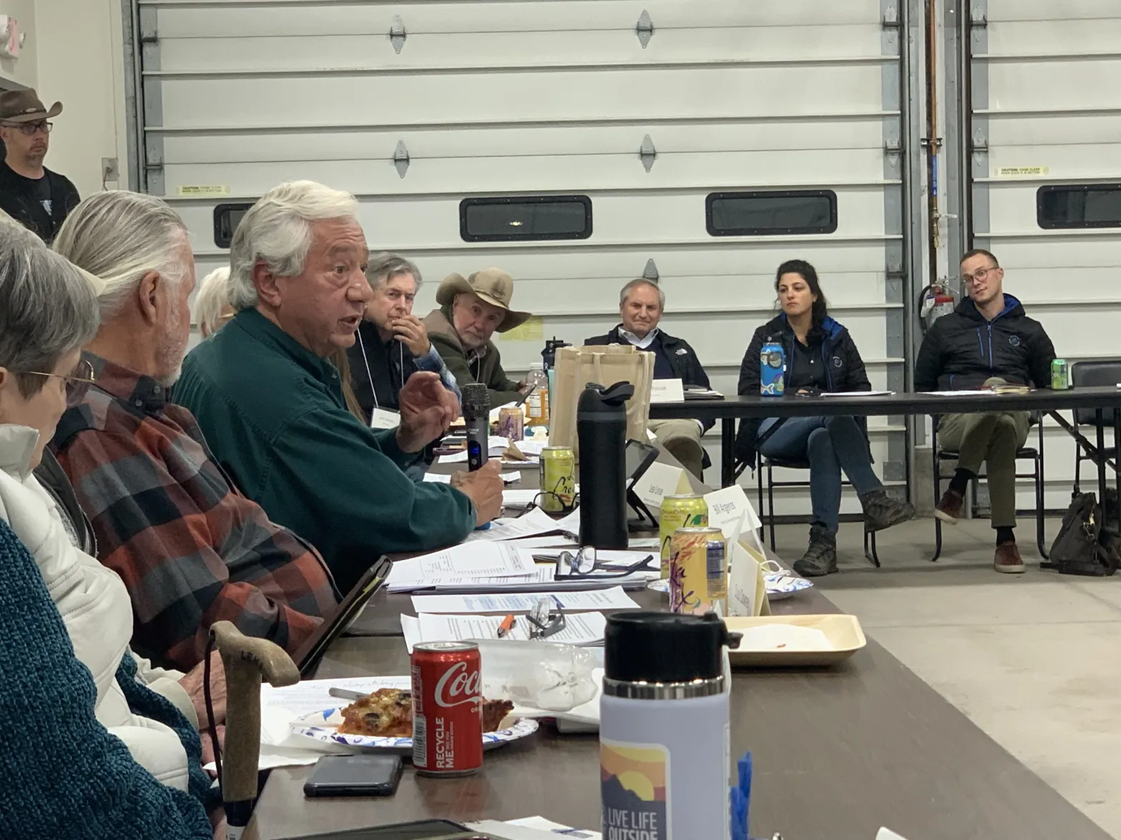
Crystal River Valley resident and Wild & Scenic proponent Bill Argeros speaks at a steering committee meeting Monday at the Marble firehouse. Argeros said it’s time for the subcommittee to start drafting a proposal for legislation. Credit: HEATHER SACKETT/Aspen Journalism
There was some disagreement among the group about how fast they should move forward with a draft proposal for Wild & Scenic legislation. Crystal Valley resident Bill Argeros, who favors Wild & Scenic, said the committee’s task was very clear. The group’s charter says they are charged with creating a draft Wild & Scenic legislative proposal and map that protects the community-held values on the Crystal River, while addressing local concerns.
“Draft a proposal — that’s what we need to do, and I think that’s what everybody here is waiting for,” he said. “We need to work on that really hard and as quickly as we can.”
But others cautioned that pushing too fast would be a mistake and that there’s still a lot to learn. Carbondale rancher Bill Fales is familiar with these sometimes-messy community processes; he helped advocate to protect public land from new oil and gas leases in the Thompson Divide. Earlier this year, the Biden administration announced the 20-year withdrawal of nearly 222,000 acres from oil and gas development. The effort eventually paid off, but it took decades of work by ranchers and environmentalists.
“Look at Thompson Divide,” Fales said. “Eight months is premature. Don’t expect to do something this consequential in one year.”
All three subcommittees will continue working, and another meeting of the larger steering committee is scheduled for April.
The News:Western Colorado’s Mesa and Montrose counties propose a 30,000-acre national conservation area for the Lower Dolores River corridor as an alternative to the proposed 400,000-acre national monument. While this may look like a peace offering or compromise of sorts from counties that have opposed protections of any kind, it is just as likely an attempt to block any sort of designation and will probably only further fan the flames of controversy. It’s the latest volley in a half-century-long battle over the fate of the beleaguered river.
The Context:The current controversy over the Dolores River takes me back to when I was a youngster in the early ‘80s. McPhee Dam was under construction on the Dolores River, its proponents having vanquished a movement that sought to block the dam and keep the river free. My parents had been on the losing side of the fight, and I can distinctly remember my father blaming the defeat, at least in part, on outsider environmentalists — including Ed Abbey — deriding the pro-dam contingent as a bunch of “local yokels.
I’m sure my dad took it personally. He was a fourth-generation rural Coloradan, had graduated from Dolores High School, and his mom and sisters still lived in Dolores — apparently making him a “yokel,” even though he opposed the dam. But also he saw it as a major strategic misstep. Not only were these people insulting locals, but they were falling into the pro-dam contingent’s trap, bolstering the dam-building effort in the process.
More often than not, these land protection fights are framed as well-heeled elitist outsiders and Washington D.C. bureaucrats imposing their values on and wrecking the livelihoods of rural, salt-of-the-earth local ranchers and miners. And in almost every case it is a gross oversimplification, at best, and at worst is an inaccurate portrayal and a cynical attempt to disempower locals — and anyone else — who favor land protection. So when those anti-dam folks caricatured the pro-dam contingent as local yokels, they were not only alienating locals who may have been on their side, but also validating the false depiction of the situation.
Fresh snow on Bears Ears. Photo credit: Jonathan P. Thompson/The Land Desk
We saw this play out in the battle over the Bears Ears National Monument designation and Trump’s shrinkage of it in a gross way. The anti-monument contingent insisted that all “locals” were opposed to the monument — and the media largely bought into it — never mind the fact that effort to establish a monument in the first place was driven by local Navajo Nation and Ute Mountain Ute citizens, and was taken up by tribal nations who have inhabited the landscape in question since time immemorial. Never mind that the anti-monument “locals” were backed by mining corporations, right-wing think tanks, and conservative politicians from all over (including a Manhattan real estate magnate and reality TV personality who became President). Utah’s congressional delegation even had the gaul to attempt to disenfranchise and silence the voices of tribal leaders because they happened to be based on the other side of a state or county line that was arbitrarily drawn based on arbitrary grids by dudes in Washington D.C.
The movement to protect the Dolores River has been portrayed in much the same way over the last several decades. It has its roots in 1968, when U.S. Rep. Wayne Aspinall, a Democrat from Colorado’s Western Slope, pushed through the Colorado River Basin Project Act, authorizing the construction of five Western water projects. One of them was the Animas-La Plata Project, a byzantine tangle of dams — including one on the Animas River above Silverton — along with canals, tunnels, and even power plants. Another was the Dolores Project, which included building McPhee Dam several miles downstream of the town of Dolores, which would impound water to lengthen the irrigation season for the Montezuma Valley and allow water to be sent, via canal, to the dryland bean farmers around Dove Creek.
The Dolores River, below Slickrock, and above Bedrock. The Dolores River Canyon is included in a proposed National Conservation Area. Photo: Brent Gardner-Smith/Aspen Journalism.
The prospect of another river being stilled by another giant monolith sparked a movement to block the dam and to designate the Lower Dolores River corridor as a Wild and Scenic River, which would have prohibited mining and oil and gas leasing, while also ensuring enough water would be left in the stream to keep the river “wild and scenic,” which is to say a lot more water than zero, which was the lower river’s flow from mid-summer into fall due to irrigation diversions.
Local farmers were generally in favor of the dam — and against Wild & Scenic designation, since it would likely deprive them of some irrigation water during dry times. But their cause was also backed by powerful agricultural interests on the state level, the pugnacious Durango attorney Sam Maynes, Sen. Gary Hart, the Colorado Democrat, and, probably most importantly, the Ute Mountain Ute Tribe, which would receive a portion of the vast amounts of water to which they were entitled from the Dolores Project. The project was ultimately authorized (though I doubt the local yokel comment had all that much to do with it, really). Construction of McPhee Dam began in 1979 and the reservoir began filling in 1983.
La Plata Mountains from the Great Sage Plain with historical Montezuma County apple orchard in the foreground.
No matter how one feels about dams, you have to admit it had some benefits. In 1978 the federally funded Dolores Archaeological Program was launched to survey, excavate, and study the rich cultural sites that were spread out across the area to be inundated by the reservoir. It was a huge project that brought a slew of researchers to the area, significantly advanced scientific knowledge of the Ancestral Puebloan people who inhabited the region for centuries, and provided the seeds for future archaeological work and organizations, including the Crow Canyon Archaeological Center.
And, contrary to opponents’ fears, the dam didn’t kill the river. Rather it was like putting the river’s manic-depressive flows on lithium. The massive spring runoffs were tempered, but water managers released enough water in most years to scour beaches and preserve Snaggletooth’s whitewater snarl. And for the first time in a century the lower Dolores didn’t run dry in July. In fact, the year-round flows were enough to build and sustain a cold-water fishery for trout in the first dozen or so miles below the dam and a habitat for native fish below that. The Ute Mountain Ute Tribe got both drinking water from the project as well as enough to irrigate a major agricultural enterprise near the toe of Ute Mountain, providing much needed economic development. The Town of Dove Creek receives water from the project as do the formerly dryland farmers, allowing them to diversify their crops. The dam’s completion happened to coincide with the demise of the domestic uranium mining industry, meaning that threat mostly went away as well, along with the need for added protections.
The Dolores River at its confluence with the San Miguel River. Jonathan P. Thompson photo.
Unfortunately, drier times set in and the current megadrought, now going on a quarter century, has depleted the river’s flows and reservoir levels. In order to keep the irrigation ditches flowing as deep into the summer as possible, dam managers have released almost no water during 14 of the last 24 years, essentially desiccating the stream bed below the dam and throwing the riparian ecology out of whack. In the midst of it all the uranium industry made a short-lived comeback between 2006 and 2012. Now it seems to be emerging from its zombified state once again and is targeting numerous sites along the Dolores River. The river runs through the Paradox Formation, as well, meaning it could be targeted by lithium and potash miners. Meanwhile, visitation to the Lower Dolores River has ramped up — along with the impacts — as social media posts reveal the canyons to more people and as the Moab crowd seeks new places to play.
Dolores River watershed
All of that spawned new Wild & Scenic campaigns for the Lower Dolores, but after it became clear they couldn’t get past political hurdles, stakeholders came together to work on a compromise, resulting in a proposal to create a national conservation area on 60 miles of river corridor below the dam, which would withdraw the land from new mining claims and oil and gas leases, bring more attention to the plight of this sorrowful and spectacular river, and possibly more funding to river restoration efforts. But it would leave another 100 miles of the Lower Dolores unprotected, in part because Mesa and Montrose Counties withdrew their support for the plan. Thus the proposal for President Biden to designate 400,000 acres as a national monument.
That proposal, perhaps predictably, has sparked a backlash and an anti-national monument campaign partly fueled by disinformation. And, just as predictably, it’s being falsely framed as a fight pitting locals vs. outsiders. It’s true that a survey commissioned by Mesa County of about 1,200 registered voters in Mesa, Montrose, and San Miguel Counties found that 57% of respondents oppose the national monument proposal. That shows that more locals oppose it, but that quite a few support the initiative, as well. And Center for Western Priorities director Aaron Weiss found that the survey may be biased since its creators consulted with national monument opponents, but not proponents, about which questions to ask and how to word them. And it shows.
For example, the survey precedes one set of questions with: “Currently, uranium mining in the Dolores River Canyon area in the west end of Montrose County impacts the local economy by providing tax dollars and jobs. The current national monument proposal would allow some but not all existing permit holders to continue to operate, but it has not been decided if the proposal would allow new permits or permit renewals in the future.” But this is misleading, because the uranium mining industry remains virtually dead, so the economic impact is zero to negligible. Furthermore, a national monument grandfathers in all existing valid mining claims and has no effect on patented (private) claims. So even if there were operating mines, a monument wouldn’t hamper operations. [ed. emphasis mine] Other questions were similarly misleading by implying that a national monument designation would remove management from the BLM or Forest Service.
Tellingly, the survey also found that 72% of respondents support existing national monument designations “such as Browns Canyon, Chimney Rock, and Colorado National Monument.” Why? Because they value conservation and they’ve seen that national monuments don’t hurt the economy or agriculture or significantly restrict access. That they are less sure about a new national monument might have something to do with the opponents’ simplistic and unfounded argument against it, which is that it could “impose severe economic hardships,” without explaining how.
Nevertheless, Mesa County used the survey to justify a resolution opposing the national monument and supporting its proposal for a vastly scaled down national conservation area. Again, this tactic is an echo of ones used by Bears Ears National Monument opponents. National Conservation Areas don’t inherently offer more or less protections or restrictions than national monuments, but they do need to be passed by Congress. Given how dysfunctional our Congress is, that could take years or even decades.
Yet the Lower Dolores River needs help now. No, a national monument won’t solve all its problems; it may not help the river, itself, at all. Already the fight over the proposal has shone a spotlight on a remote, largely unknown area, which will surely draw more visitors and more damage. A national monument designation at least would provide the possibility of protection against future development and burgeoning crowds.
The Dolores River between Rico and Dolores in southwestern Colorado on Memorial Day 2009. Photo credit: Allen Best/Big Pivots
Sources/Usage: Public Domain. View Media Details
The Dolores River, CO. (Olivia Miller, USGS).The historic flume hanging from a cliff above the Dolores River in western Colorado. This stretch would likely be included in a proposed national monument. Jonathan P. Thompson photo.Dolores River skeleton plant (Lygodesmia doloresensis). Photo by Peggy Lyon via Colorado Natural Heritage ProgramNathan Fey, seen here paddling the Lower Dolores River. The lower Dolores River depends on a deep snowpack for boating releases from McPhee Reservoir. (Photo courtesy Nathan Fey)A view of the Dolores River below Slickrock.The Dolores River in southwestern Colorado on Memorial Day in 2009. Photo/Allen BestPonderosa Gorge, Dolores River. Boating is popular on the Lower Dolores River, which is being considered as a National Conservation Area. Photo credit RiverSearch.com.St Louis Tunnel Ponds June 29, 2010 – view south towards Rico. Photo via the EPA.The Dolores River shows us what’s at stake in the fight to protect the American West — Conservation ColoradoPhoto via the Sheep Mountain AllianceLone Cone from the Dolores RiverDolores River south of Lizard Head PassDolores River above DoloresWestern San Juans with McPhee Reservoir in the foregroundDolores RiverDolores River near BedrockDolores River Canyon near Paradox
The Crystal River flows through the Gunnison County town of Marble, seen here with Beaver Lake. A representative from the Town of Marble is expected to participate in a subcommittee focused on an intergovernmental agreement to protect the river. CREDIT: ECOFLIGHT
After a year’s worth of work and meetings with a facilitator, a group focused on protecting the Crystal River is pursuing three potential ways forward.
The Crystal River Wild & Scenic and Other Alternatives Feasibility Collaborative Steering Committee recommends forming three subcommittees, each focused on continuing to evaluate a different method of river protection.
The first is an intergovernmental subcommittee composed of local governments that would develop an agreement that commits each of them to protecting the mainstem of the river against dams and trans-basin diversions. A “peaking” instream-flow subcommittee would look at protecting river flows during times of peak runoff and against diversions. A third subcommittee would move forward with writing a draft proposal for a federal Wild & Scenic designation that has the flexibility to address local landowner needs and that supporters say is still the strongest option for river protection.
Some Crystal Valley residents, along with Pitkin County, have pushed for a Wild & Scenic designation for years to protect the free-flowing nature of the river. But others, wary of any federal involvement, have balked at the idea, instead proposing different types of protections.
The steering committee was convened last year to explore different options, including Wild & Scenic, for river protections. As part of this work, they also held two community summits, which each drew more than 120 members of the public, as part of a process to get stakeholder input.
Marble resident Wendy Boland will be on the Wild & Scenic subcommittee. She said that the majority of residents are in favor of a federal designation, but that the subcommittee will have to address some people’s lingering concerns about private property and make sure those concerns are respected.
“Wild & Scenic is constantly being called the gold standard of river protection,” Boland said. “And the fact that it can be tailored to meet a local community’s needs and concerns is a big plus. So that’s really the goal of the subcommittee I’m on. We’ve listened to everybody’s concerns; can we draft legislation that would meet all those concerns?”
The Crystal flows from its headwaters in the Maroon Bells-Snowmass Wilderness through the towns of Marble, Redstone and Carbondale before its confluence with the Roaring Fork and is one Colorado’s last undammed major rivers.
The U.S. Forest Service determined in the 1980s that portions of the Crystal River were eligible for designation under the Wild & Scenic River Act, which seeks to preserve, in a free-flowing condition, rivers with outstandingly remarkable scenic, recreational, geologic, fish and wildlife, historic, and cultural values. Wild & Scenic experts say the “teeth” of the designation comes from an outright prohibition on federal funding or licensing of any new Federal Energy Regulatory Commission-permitted dam. A designation would also require review of federally assisted water resource projects.
Any designation would take place upstream from the big agricultural diversions on the lower portion of the river near Carbondale.
Jennifer Back, a retired National Park Service employee and former member of the Interagency Wild and Scenic Rivers Coordinating Council talks with Crystal River valley resident Larry Darien at a community summit on the Crystal River in April 2023. Three subcommittees will move forward with exploring options for protecting the river. CREDIT: HEATHER SACKETT/ASPEN JOURNALISM
‘Peaking’ instream flows
A second subcommittee will look at a tool that could be used to protect peak flows through the Colorado Water Conservation Board’s instream-flow program. The CWCB is the only entity allowed to hold water rights that keep water in rivers and are designed to preserve the natural environment to a reasonable degree. A “peaking” instream-flow water right would keep in the stream all of the water not claimed by someone else (also called “all of the unappropriated flow”) during certain times of the year.
So far, this particular tool is little-used, but there are three recent examples in the Gunnison River basin on Cottonwood Creek, Monitor Creek and Potter Creek. These three water rights were filed for in July and are still making their way through water court. No entities have filed statements of opposition. All three still allow for some amount of future water development.
The way that instream-flow water rights work is that another entity, usually a land use agency such as the U.S. Bureau of Land Management or a wildlife agency such as Colorado Parks and Wildlife will make a recommendation to the CWCB for a particular amount on a particular stream. Roy Smith, a water rights and Wild & Scenic Rivers specialist at the BLM, worked on the recent peaking instream-flow water rights in the Gunnison basin. He said in those cases, a peak instream flow was needed to protect the cottonwood trees because they need high flood waters that slowly recede to germinate seeds.
“Basically, what it means is every drop of water that has not been spoken for by any previously claimed water right is spoken for by this instream flow,” Smith said. “What we decided was let’s propose a water right where when the stream reaches bank full, a water right will be triggered that protects all the flow from that flow rate and above until the flood event is over.”
But the “outstandingly remarkable values” that Wild & Scenic seeks to protect and the special riparian ecosystems that peak instream flows are designed to protect may not align in the case of the Crystal River.
“A lot of the values that the Forest Service identified for potential Wild & Scenic designation are values like recreation and scenic and those are little bit harder to fit into the state’s instream flow program because that focuses on water-dependent ecology like bugs and fish and riparian habitat,” Smith said. “So there’s still a question as to whether those values on the Crystal can fit into this type of approach. The stakeholder group is going to have to figure that out.”
The intergovernmental agreement subcommittee will focus on developing a draft agreement to memorialize a commitment to protecting the Crystal against mainstem dams and trans-basin diversions. It will include representatives from the town of Marble, Gunnison County, Pitkin County and the Colorado River Water Conservation District. The River District is no stranger to water sharing agreements and has helped craft some of the most important ones in Colorado between Front Range and Western Slope water users.
Zane Kessler, the River District director of government relations, was a member of the steering committee and will serve on the intergovernmental agreement subcommittee. He said he was glad the group could find consensus on pursuing the three potential options for river protection.
“I think this should serve as an example of how local, county and regional governments on the Western Slope can work together to represent and protect the water interests of our shared constituents,” he said in a statement. “But the path forward is going to have to include communication and collaboration. It can’t be just one town, or county or district going it alone.”
Each of the three ways forward do not preclude any of the others being considered. The three subcommittees plan to provide monthly updates, and the entire steering committee will continue to meet every six months for the foreseeable future.
“Everybody loves the river, and they want to protect it,” Boland said. “The question is: Which ways can we make that best happen?”
Pitkin County supports Aspen Journalism with a grant from the Healthy Community Fund. Aspen Journalism is solely responsible for its editorial content.
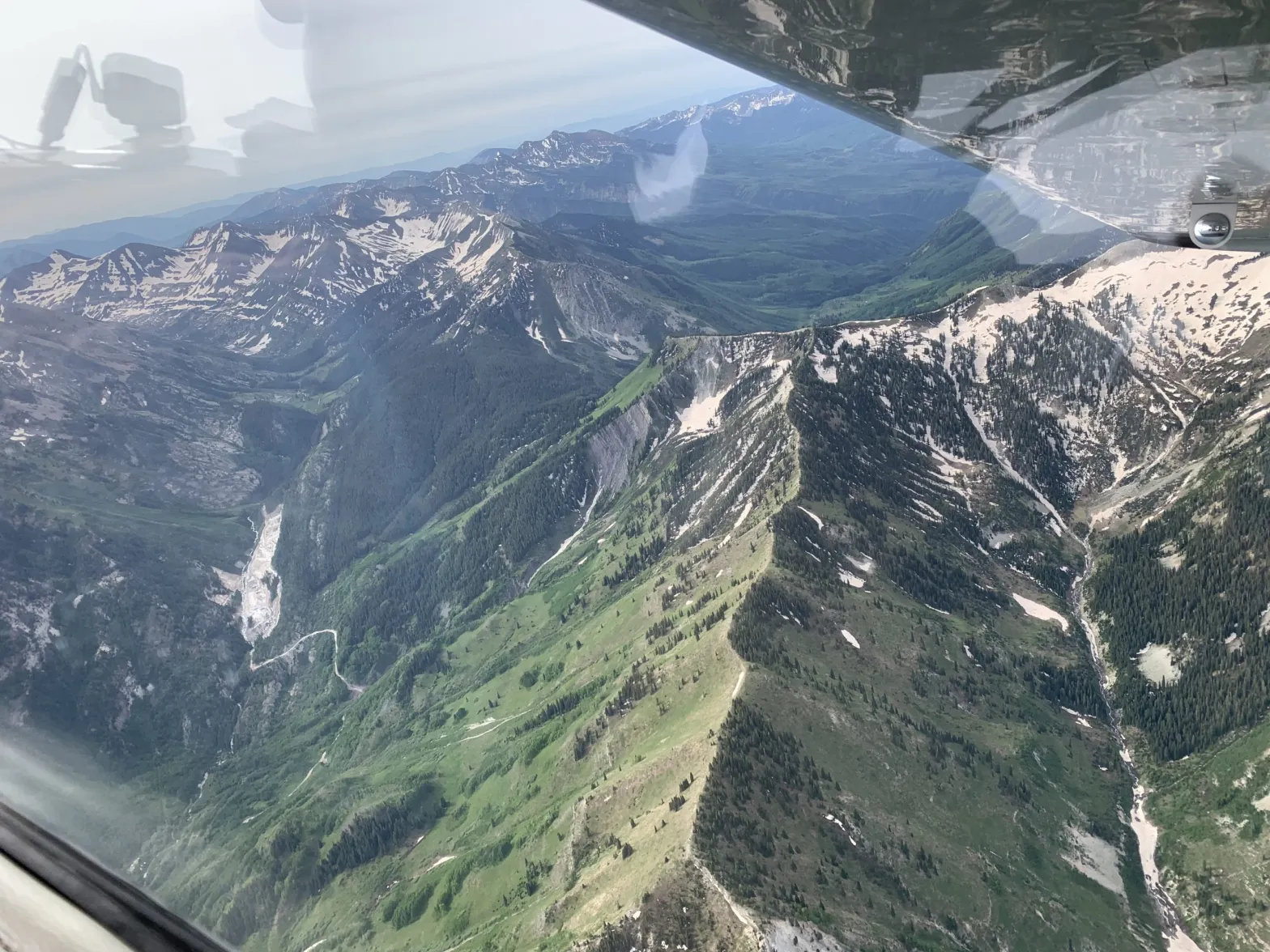
An image of the Crystal River Valley from an EcoFlight mission in August 2022. The view is downvalley, toward Mount Sopris. A group is exploring a federal designation of wild and scenic for the Crystal River in Gunnison and Pitkin counties.
Courtesy of Ecoflight
In Colorado, there are several ways to protect rivers, which vary depending on the goals.
To maintain water quality, the Colorado Department of Public Health and Environment offers an Outstanding Waters designation. If boosting the flows for boating is the goal, municipalities can get a Recreational In-Channel Diversion (RICD) water right. And to protect the environment, the state water board acquires instream-flow water rights, designed to maintain minimum flows.
But if the goal is preventing dams and transbasin diversions, and guaranteeing a free-flowing river, experts say a federal Wild & Scenic designation is the gold standard. That was the message from some presenters at a community summit on the Crystal River on Thursday at Roaring Fork High School in Carbondale.
“It’s the strongest, most robust form of river protection,” said Jennifer Back, a retired employee of the National Park Service and former member of the Interagency Wild & Scenic Rivers Coordinating Council. “If you like what’s out there right now, Wild & Scenic River designation does a really good job of protecting what’s there.”
Back was one of eight presenters at Thursday’s [October 26, 2023] open house, organized by a steering committee that is exploring the feasibility of Wild & Scenic designation and other management and protection alternatives. The committee is chaired by representatives from the town of Marble, Gunnison County, Pitkin County and the Colorado River Water Conservation District.
The meeting, which drew about 130 people, was the second community summit of a public stakeholder process aimed at evaluating local interest in pursuing protections for the Crystal River, which flows about 40 miles from its headwaters, in the Maroon Bells-Snowmass Wilderness, and through the towns of Marble, Redstone and Carbondale before its confluence with the Roaring Fork River.
Some residents of the Crystal Valley, along with Pitkin County, have long been proponents of a Wild & Scenic designation. But others, wary of any federal involvement, have balked at the idea.
Manette Anderson, one of just a handful of residents of Crystal, a tiny historic hamlet named for the river, is a member of the steering committee. She said she’s still learning and that it’s too early in the process for her to yet be in favor of, or dismiss, any of the options.
“Going into all this, I thought Wild & Scenic would probably not be an option I would be interested in, generally speaking, because of anecdotal concerns that other people in other areas of the country have had with Wild & Scenic experiences,” she said. “But I’m open to learning about it.”
The U.S. Forest Service determined in the 1980s that portions of the Crystal River were eligible for designation under the Wild & Scenic River Act, which seeks to preserve in a free-flowing condition, rivers with outstandingly remarkable scenic, recreational, geologic, fish and wildlife, historic and cultural values.
There are three categories under a designation: wild, which describes sections inaccessible except by trail, with shorelines that are primitive; scenic, which describes shorelines largely undeveloped but accessible by roads in some places; and recreational, which describe places readily accessible by road or railroad and that have development along the shoreline.
The initial Forest Service proposal for the Crystal included all three designations: wild in the upper reaches of the river’s wilderness headwaters; scenic in the middle stretches; and recreational from Marble to the Sweet Jessup canal headgate. Each river with a Wild & Scenic designation has unique legislation written for it that can be customized to address local stakeholders’ values and concerns.
Any designation would take place upstream from the big agricultural diversions on the lower portion of the river near Carbondale.
According to Back, the management framework for a Wild & Scenic River can be as unique as the river itself, and involve cooperative agreements between federal, state and local agencies. The “teeth” of the designation, she said, comes from an outright prohibition on federal funding or licensing of any new Federal Energy Regulatory Commission (FERC)-permitted dam. A designation would also require review of federally assisted water resource projects.
“What we mean by that is a project that basically is in the waterway below the ordinary high-water mark,” she said. “It could be a bridge; it could be a road; it could be power lines. It’s not an outright prohibition, but they do have to be reviewed before the project goes forward.”
Back said there are 228 rivers in the country with a Wild & Scenic designation. Many of them are in Alaska and the Pacific Northwest. But with water managers historically unwilling to tie up potential future water development, Colorado has just 76 miles of one river — the Cache la Poudre — designated as Wild & Scenic.
Jennifer Back, a retired National Park Service employee and former member of the Interagency Wild and Scenic Rivers Coordinating Council talks with Crystal River valley resident Larry Darien at Thursday’s community summit on the Crystal River. Darien, who is on the steering committee exploring management options, has said he is in favor of protecting the Crystal but not in the form of a federal Wild & Scenic designation.
Protection options
In addition to Outstanding Waters, instream-flow water rights and RICDs, other potential river protections detailed at Thursday’s meeting include creating a National Conservation Area or Special Management Area (environmentalists are pursuing this on the Dolores River after determining that Wild & Scenic isn’t politically feasible there); 1041 regulations, which allow counties to maintain control over certain development; and local options such as riparian restoration projects and leasing agreements where water users can loan some of their water for the benefit of the environment.
Another option would be to create a management plan that doesn’t carry the same restrictions as Wild & Scenic but is still aimed at protecting ORVs, much like a stakeholder group on the upper Colorado River completed in 2020. This alternative management plan took more than 12 years to come to fruition, and participation of the stakeholders is voluntary.
Pitkin County Commissioner Kelly McNicholas-Kury, a member of the steering committee, said she continues to think that a Wild & Scenic designation is the best option for river protection that meets the criteria laid out by the stakeholder process: prevention of dams and out-of-basin diversions; sustainable recreation and tourism; support of local agriculture, water rights and property rights; limiting future development; and maintaining a healthy river corridor.
After Thursday’s presentations, attendees were asked to fill out a survey that ranked how well each option met these criteria.
A Wild & Scenic designation would not preclude any of the other protection options; multiple approaches could take place at the same time.
“Wild & Scenic would never get in the way of (Outstanding Waters), but Outstanding Waters is not going to give us what a Wild & Scenic River designation might,” McNicholas-Kury said.
According to McNicholas-Kury, the steering committee is striving for consensus among its members before it makes a recommendation to the public about a path forward for Crystal River protections. But if consensus cannot be reached, they can go to a super-majority vote that would require agreement of at least 75% of committee members.
“Folks have really come in with a desire to learn and a desire to keep an open mind,” she said. “I think there is a ton of consensus around wanting to protect the river, so I’m hopeful that we’ll get there.”
Spring runoff is just beginning in the Crystal River Valley (April 2023). A group of nearly 140 people gathered in Marble Thursday to voice their values and concerns as part of a stakeholder process aimed at exploring protections for the river. Heather Sackett/Aspen Journalism
Click the link to read the article on the Aspen Journalism website (Heather Sackett):
Keeping the Crystal River free-flowing with no dams and preserving its scenic qualities, ecosystems and water rights for agriculture were values that nearly all the attendees of a Thursday community summit at the Marble Firehouse agreed on. How best to achieve those goals is another matter.
The summit was organized by the Wild & Scenic Feasibility Collaborative, which is made up of representatives from the town of Marble, Gunnison County, Pitkin County, the Colorado River Water Conservation District and American Whitewater, and was facilitated by staffers from Wellstone Collaborative Strategies and P2 Solutions. The meeting drew nearly 140 people — more than double the number expected — and sent organizers scrambling for more chairs.
The summit kicked off a much-anticipated public stakeholder process aimed at evaluating community interest in pursuing protections for the Crystal River, which flows through the towns of Marble and Redstone, as well as Gunnison and Pitkin counties. In small groups, attendees outlined their most important values, long-term aspirations, biggest concerns and criteria for evaluating management options.
A faction of residents and conservationists, including Pitkin County, is pushing for a federal Wild & Scenic designation, which it says would carry the strongest protections for preserving the river in its current state. Pitkin County, through its Healthy Rivers program, has funded a grassroots campaign by Carbondale-based conservation group Wilderness Workshop to drum up support for Wild & Scenic, and has secured a resolution of support for Wild & Scenic from Carbondale Town Council.
But some say that approach is jumping the gun and that the stakeholder process should include other options for protection without the federal government’s oversight.
Representatives from Pitkin County spoke about threats to the Crystal and the need for Wild & Scenic at a Gunnison Board of County Commissioners work session Tuesday.
“One of the concerns we are having is that the only foregone conclusion is that Wild & Scenic is the only tool,” Gunnison County Commissioner Jonathan Houck told them. “It’s going to be tough if people feel like the foregone conclusion is Wild & Scenic.”
Although there may not be imminent, specific threats of dams or diversions on the Crystal, Wild & Scenic proponents say that doesn’t mean there won’t be threats at some point. A hotter, drier future under climate change could push Front Range cities or downstream water users to look to one of the last rivers without a dam or transmountain diversion — a rarity in western Colorado — as a means to quench their thirst.
“Today, there is nobody trying to take water out of the Crystal River basin,” Pitkin County Commissioner Francie Jacober told Gunnison County commissioners at Tuesday’s meeting. “But I don’t have faith the Crystal River or the Roaring Fork or the Gunnison won’t be targeted. I want to do everything we can to protect the Crystal River before the threat is at our doorstep.”
One of the biggest threats of a dam on the Crystal was removed a decade ago when, after a legal battle with Pitkin County, the River District and Rifle-based West Divide Water Conservancy District relinquished water rights tied to a potential reservoir at Placita, just below McClure Pass. In 2012, the River District walked away from rights tied to a second reservoir, Osgood, that would have inundated the town of Redstone.
Pitkin County Healthy Rivers administrator Lisa Tasker, left, and Matt Annabel of Back 40 Stories, write down their most important values about the Crystal River at a community summit in Marble on Thursday. The summit was the kickoff event in a stakeholder process aimed at exploring protections for the river. Heather Sackett/Aspen Journalism
Designation details
The U.S. Forest Service determined in the 1980s that 39 miles of the Crystal River was eligible for designation under the Wild & Scenic River Act, which seeks to preserve rivers with outstandingly remarkable scenic, recreational, geologic, fish and wildlife, historic, and cultural values in a free-flowing condition.
According to the National Wild & Scenic Rivers System Guide for Riverfront Property Owners, one of most important provisions of the act protects rivers “from the harmful effects of project proposals within the river’s bed or banks” and projects that need a federal permit or loan are subject to review under the act.
Any designation would take place upstream of the big agricultural diversions on the lower portion of the river.
There are three categories under a designation: wild, which are sections that are inaccessible except by trail, with shorelines that are primitive; scenic, with shorelines that are largely undeveloped but are accessible by roads in some places; and recreational, which are readily accessible by road or railroad and have development along the shoreline.
The initial Forest Service proposal for the Crystal included all three designations: wild in the upper reaches of the river’s wilderness headwaters; scenic in the middle stretches; and recreational from the town of Marble to the Sweet Jessup canal headgate. Each river with a Wild & Scenic designation has unique legislation written for it that can be customized to address local stakeholders’ values and concerns.
A first attempt at a Wild & Scenic designation around 2012 couldn’t get buy-in from Marble residents or Gunnison County. Suspicions of the federal government still run high for some residents, even as they say they want to see the Crystal protected.
Larry Darien, who owns a ranch on County Road 3, which borders the river, has long been an opponent of Wild & Scenic. But he said he would be in favor of alternate protections. He does not want to see the river dammed or its waters transferred out of the basin and said the summit was a good start at working toward solutions.
“It seems to me like there’s a consensus on what we want and there’s more than one way to get there,” Darien said. “There are other options [besides Wild & Scenic]. I’m not in favor of the federal government helping me with my property.”
Facilitators will bring people together again in September to evaluate what those alternative management options might be. In the meantime, they plan to form a steering committee — on which Darien plans to serve as a representative of private-property owners — to collect input and lead the process.
In addition to county officials and residents, the summit drew people from a wide range of water interests, including influential Boulder water attorney Glenn Porzak; managers from Crystal River Ranch, which has the largest agricultural diversion on the river; representatives of U.S. Sen. John Hickenlooper, a Democrat, and U.S. Rep. Lauren Boebert, a Republican; local business owners; a representative from Colorado Stone Quarries, which operates the Pride of America Mine above Marble; environmentalists; and anglers and kayakers.
Pitkin County Commissioner Kelly McNicholas Kury was pleased with the high turnout.
“[Wild & Scenic] is what we feel like our constituents have wanted for a long time, but we know that we don’t own the solution by ourselves,” she said. “That’s why we have been willing participants in this process to evaluate what’s going to work best for the community. … There feels like a shared love for the river in this room tonight, and I think that is the most important thing to inspire the good conversations ahead.”
Editor’s note: Aspen Journalism is supported in part by a grant from the Pitkin County Healthy Community Fund.
An image of the Crystal River Valley from an EcoFlight mission in August 2022. The view is downvalley, toward Mount Sopris. A group is exploring a federal designation of wild and scenic for the Crystal River in Gunnison and Pitkin counties.
Courtesy of Ecoflight
The effort to explore getting a federal designation of wild and scenic for the Crystal River is about to get turned up a notch. The Wild and Scenic Feasibility Collaborative announced Monday it has selected Wellstone Collaborative Strategies and P2 Solutions to facilitate and lead a community engagement and stakeholder process. American Whitewater, a national nonprofit that advocates for the preservation and protection of whitewater rivers, will support Wellstone in the administration of its outreach efforts…
Denver-based Wellstone Collaborative Strategies and Loveland-based P2 Solutions were selected for their experience and competence in facilitation and community engagement. Both Jacob Bornstein, founder and principal of Wellstone Collaborative Strategies, and Wendy Lowe, owner of P2 Solutions, have demonstrated exceptional facilitation skills and experience shepherding broad community conversations to successful outcomes, according to a statement from the selection committee, according to an announcement. The principals in the businesses have strong backgrounds in natural resource issues and direct knowledge of the Crystal River…
With a goal of identifying long-lasting river protection, the collaborative envisions the creation of a stakeholder group that would engage in fact finding, identification of overlapping interests and concerns, and a robust discussion of shared goals and strategies. The initial phase of the stakeholder process will bring together a representative cross section of interested individuals to provide informed input; examine, explore and investigate river protection; access and rely on experts in river and riparian health; engage experts to provide factual information relevant to protective designations; agree upon rules of engagement; be a process grounded in the highest integrity and inclusiveness; and result in identification of shared principles for protection of the Crystal River.
Map of the Roaring Fork River drainage basin in western Colorado, USA. Made using USGS data. By Shannon1 – Own work, CC BY-SA 4.0, https://commons.wikimedia.org/w/index.php?curid=69290878The Crystal River just below Avalanche Creek on June 3. Streamflows near this location peaked on May 19 at 1,840 cfs according to data from the Colorado Basin River Forecast Center. CREDIT: HEATHER SACKETT/ASPEN JOURNALISMProtecting continued public access to these waterfalls along Yule Creek, just over the property line from a parcel set to be donated to a land conservation agency, is an ongoing priority for the CVEPA.
CREDIT: COURTESY PHOTO BY JOHN ARMSTRONGThe view looking upstream on the Crystal River below Avalanche Creek. A Pitkin County group wants to designate this section of the Crystal as Wild & Scenic.
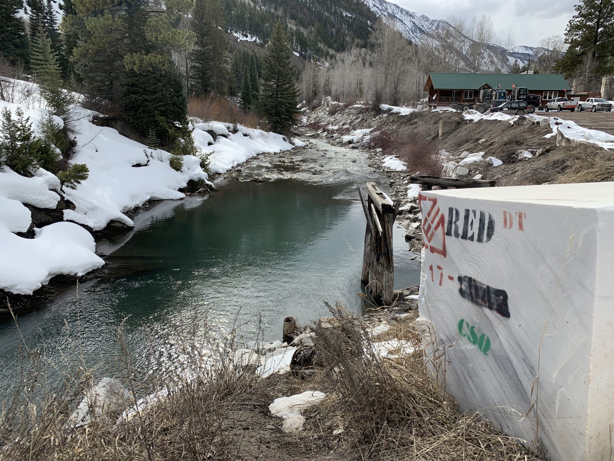
CREDIT: CURTIS WACKERLE/ASPEN JOURNALISMThe Crystal River flows through the town of Marble just after its confluence with Yule Creek. Gunnison County, Pitkin County and local environmental groups want to see a marble mining company mitigate its illegal relocation of a creek by improving downstream riparian habitat. Photo credit: Heather Sackett/Aspen Journalism These marble blocks stamped with quarry owner’s name, Red Graniti, and operator’s initials, CSQ, line the banks of the Crystal River near the company’s load-out area in the town of Marble. The U.S. Army Corps of Engineers is considering whether to issue the operator a retroactive permit to allow it to move a stream. Photo credit: Heather Sackett/Aspen JournalismThe narrows on the Crystal River just below Placita where a dam big enough to store 62,009 acre-feet of water was once planned by the Colorado River District and the West Divide Water Conservancy District. The Pitkin County BOCC passed a resolution opposing the River District’s proposed tax increase. Photo credit: Brent Gardner-Smith/Aspen JournalismLooking upstream toward the confluence of the Roaring Fork River, left, and the Crystal River, right, just below Carbondale. More information about these and other rivers will be made available to the public with the help of a recent $37,000 state grant to the Roaring Fork Conservancy. Photo credit: Brent Gardner-SmithCrystal River near Redstone via Wikipedia CommonsCrystal River via Aspen JournalismCrystal River
The Crystal River runs low outside of Carbondale on September 1, 2020. With average temperatures warming in summer months by as much as 3.5 degrees since the 1950s in Garfield County, streamflows are trending down as peak runoff comes earlier and more water is sucked up by evaporation and dry soils, stressing available water supplies in late summer and fall. Photo credit: Dan Bayer/Aspen Journalism
A study of a water replacement plan on the Crystal River is looking at nature-based solutions, but experts say some type of storage will also probably need to be built to solve shortages in dry years.
Wendy Ryan, an engineer with Colorado River Engineering who is heading up an analysis of a basin-wide backup water-supply plan, gave a progress update at the Colorado Basin Roundtable meeting this week. The study was funded largely by a state grant and undertaken by the Colorado River Water Conservation District and the West Divide Conservancy District.
“We have a couple landowners near Marble we are working with to see if we can put storage supplies on their properties,” Ryan said in response to a question asking her what solutions she had found. “We don’t have any shovel-ready projects. We did a lot of work upfront, and now it’s simply trying to find what we can build.”
During the hot, dry summer of 2018, the Ella Ditch, which pulls water from the Crystal River and irrigates hayfields south of Carbondale, placed a call for the first time. That means the Ella Ditch wasn’t getting the full amount to which it is entitled and upstream junior water users had to stop taking water so that the Ella could get its full amount.
The Ella Ditch has water rights that date to 1902, and any water rights younger than that — including those held by the town of Carbondale, the Marble Water Company and several residential subdivisions along the Crystal River — were technically supposed to be shut off under a strict administration of the river by the state Division of Water Resources. Under Colorado’s system of water law known as prior appropriation, those with the oldest water rights have first use of the river.
Most junior water rights holders have what’s known as an augmentation plan, which allows them to continue using water during a call by releasing water from a backup source, such as a nearby reservoir. The problem on the Crystal is that several of these residential subdivisions don’t have an augmentation plan.
Engineers from Division 5 of the Colorado Division of Water Resources have said that if water users work together to find solutions and come up with an augmentation plan, they won’t shut off indoor residential water use if the call happens again. Outdoor watering could still be shut off.
The first phase of the study, which River District representatives presented to Pitkin County commissioners in June 2021, was a demand quantification, which put numbers on the amount of water needed at different times of year.
Engineers found 90 structures — many of them wells for in-house water use — that take water from the river system and which would need to be included in the augmentation plan. These structures deliver water to 197 homes; 80 service connections in Marble; about 23 irrigated acres; Beaver Lake and Orlosky Reservoir in Marble; 16,925 square-feet of commercial space; and livestock.
In order for these water users to keep taking water during a downstream call by an irrigator, they would have to replace about 113 acre-feet in the Crystal River per year. (An acre-foot is the amount of water needed to cover an acre of land to a depth of 1 foot and can typically meet the annual needs of one or two families.) The amount of extra flow that would need to be added to the river is small — just .58 cubic feet per second during July, the peak replacement month.
The Ella Ditch, in the Crystal River Valley, placed a call for the first time ever during the drought-stricken summer of 2018. That meant the Town of Carbondale had to borrow water from the East Mesa Ditch under an emergency water supply plan. Photo credit: Brent Gardner-Smith/Aspen Journalism
Wild & Scenic jeopardized?
Ryan and staff from the River District have said they are not considering storage on the mainstem of the Crystal River, which could jeopardize a federal Wild & Scenic designation, a long-sought-after goal of Pitkin County, local environmental groups and some residents. A Wild & Scenic standing would mean no dams or out-of-basin diversions.
“We were never going to consider any mainstem storage on the Crystal River,” Ryan said. “We don’t want to do anything to jeopardize that potential designation on the Crystal, and what we are looking at shouldn’t.”
But Pitkin County Commissioner Kelly McNicholas Kury said it’s hard to see how upstream storage and a Wild & Scenic designation won’t conflict.
“It troubles me to hear the engineers say it’s hard to envision a solution that doesn’t involve storage,” she said. “So that’s just a red flag. It’s always been a red flag for Pitkin County.”
McNicholas Kury and two other roundtable members voted in 2019 against funding the study unless storage was off the table.
The Crystal River at the fish hatchery just south of Carbondale was running at about 10 cubic feet per second on Oct. 13, 2020, much lower than the state’s instream flow standard of 60 cfs. Rivers in the Roaring Fork watershed have seen below-average streamflows in water year 2020, which ended Oct. 1, despite a slightly above-average snowpack. Dry soil conditions threaten to bring a similar scenario in water year 2021. Photo credit: Heather Sackett/Aspen Journalism
Nature-based solutions
A parallel study, undertaken by the River District and environmental-and-recreation advocacy group American Rivers, is looking at nature-based solutions. The idea is that by keeping water on the landscape higher in the basin, it could recharge aquifers and boost river flows in late summer.
“We have been analyzing whether the reconnection of floodplains can assist with aquifer recharge and natural water storage while also improving the resilience of watersheds and potentially contributing to later-season flows,” said Fay Hartman, American Rivers conservation director for the Southwest region.
According to Zane Kessler, the River District’s director of government relations, there are four potential areas for nature-based projects: the Coal Basin area; Avalanche Creek upstream of its confluence with the Crystal; the Janeway area, downstream of the confluence of Avalanche Creek and the Crystal; and the confluence of Thompson Creek and the Crystal. But none of the sites are perfect, Kessler said.
“The River District and American Rivers are partners in this effort investigating whether turning back the clock on past alterations that have degraded the Crystal River can help recapture some of the climate resilience we have lost,” he said. “Improving the storage in floodplains and wetlands I think we see as an innovative and lower-impact approach to meeting late-season water needs than dams or storage in the headwaters.”
Findings and recommendations from the nature-based solutions analysis are expected by the end of the month. But Ryan said some kind of storage is still needed because nature-based solutions will still not be enough to meet the supply-demand gap in dry years, according to her analysis.
“It might meet a portion of our demands, but it’s not going to meet all our demands,” she said.
State Highway 133 crosses the Crystal River several times as it flows downstream to its confluence with the Roaring Fork River in Carbondale. Some proponents of a federal Wild & Scenic designation are pushing for a quick timeline while others want a more cautious approach. CREDIT: HEATHER SACKETT/ASPEN JOURNALISM
A campaign to protect one of the last free-flowing rivers in Colorado is moving forward, but some proponents say not enough progress has been made over the past year.
Last spring a handful of advocates led by Pitkin County revived an effort to secure a federal Wild & Scenic designation, which would protect the upper Crystal River from future development, dams and diversions. A year into the effort, some say a planned stakeholder process is moving too slowly, while others say a designation can’t be rushed and must be approached carefully and inclusively.
The different philosophies underscore a rift between those who say a cautious and thorough multi-year approach is what’s needed to ensure success and those who say mounting threats to the river, driven by the climate crisis, demand bold and immediate action.
“That difference of opinion concerns me a great deal,” said Kate Hudson, Crystal River Valley resident and western U.S coordinator for Waterkeeper Alliance. “We are at an existential moment both in terms of water and climate and our congressional balance of power that requires we at least try and do this faster. We should at least try to move this as quickly as possible.”
In 2021 Pitkin County Healthy Rivers granted $35,000 to Carbondale-based environmental conservation group Wilderness Workshop to start up a public outreach and education campaign, with the goal of laying a foundation of grassroots support for the effort. The organization has built a website, held events and collected about 1,000 signatures on a petition supporting the designation. The next step will be working with Pitkin County to hire a facilitator for a formal stakeholder process.
At the June Healthy Rivers board meeting, Wilderness Workshop’s Wild & Scenic campaign manager Michael Gorman gave a presentation about progress so far. Board member Wendy Huber asked about the timeline and whether the process should be moving faster. Gorman said a designation could take several more years.
“I’m feeling a little urgency,” she said. “To sort of dilly dally seems to be losing opportunities.”
Grant Stevens, communications director for Wilderness Workshop, said that while he understands the community’s urgency, it’s important to develop a proposal that Colorado’s congressional representatives can get behind. A designation must be approved by Congress and advocates have been in contact with representatives from Sens. Michael Bennet and John Hickenlooper’s offices.
“We want to make sure we have something that a federal elected official will support, and we need to make sure we go through a community-driven process to get to that point,” Stevens said. “We don’t want to rush that.”
The view looking upstream on the Crystal River below Avalanche Creek. A Pitkin County group wants to designate this section of the Crystal as Wild & Scenic. CREDIT: CURTIS WACKERLE/ASPEN JOURNALISM
Designation details
The U.S. Forest Service first determined in the 1980s that the Crystal River was eligible for designation under the Wild & Scenic River Act, which seeks to preserve rivers with outstandingly remarkable scenic, recreational, geologic, fish and wildlife, historic and cultural values in a free-flowing condition. There are three categories under a designation: wild, which are sections that are inaccessible by trail, with shorelines that are primitive; scenic, with shorelines that are largely undeveloped, but are accessible by roads in some places; and recreational, which are readily accessible by road or railroad and have development along the shoreline.
The potential proposal for the Crystal includes all three types of designation: wild in the upper reaches of the river’s wilderness headwaters, scenic in the middle stretches and recreational from the town of Marble to the Sweet Jessup canal headgate. Each river with a Wild & Scenic designation has unique legislation written for it that can be customized to address local stakeholders’ values and concerns.
Cache la Poudre River from South Trail via Wikimedia Foundation.
Despite its renowned river rafting, fishing and scenic beauty, which contribute to the recreation-based economy of many Western Slope communities, Colorado has just 76 miles of one river — the Cache La Poudre — designated as Wild & Scenic. This underscores the difficulty of trying to preserve free-flowing streams, especially in a water-scarce region where some would like to see rivers remain available for future water development.
This map shows the sections of the Crystal River that could be designated wild, scenic and recreational according to the finding of eligibility by the U.S. Forest Service. CREDIT: COURTESY ROARING FORK CONSERVANCY
Stakeholder participation
Since the Crystal flows through Gunnison County and the town of Marble, advocates say getting those residents and elected representatives on board will be key to moving the effort forward. A first attempt at a Wild & Scenic designation, which sought to prevent the possibility of a future dam and reservoir project, couldn’t get buy-in from some Marble residents or Gunnison County. Advocates shelved the discussion in 2016 with the election of President Donald Trump. This time around, they hope to secure at least the participation if not the support of past opponents.
Marble Town Administrator Ron Leach acknowledged there is still a lot of work to be done as far as gauging public sentiment and building awareness.
Leach has been heavily involved in the town’s multi-year process to address overcrowding on the Lead King loop, a popular off-highway vehicle route near Marble. He said when it comes to these things, slow and methodical is the right strategy and that town officials are totally supportive of the Wild & Scenic stakeholders group, in which he participates as the Marble representative.
“The more process, the better the product,” Leach said. “I’ve learned that the hard way. Take it easy and make sure it’s right.”
Gunnison County Commissioner Roland Mason agreed. He said more conversations need to happen before he could say whether Gunnison County would support a designation.
“I appreciate the fact that they are not trying to rush the timeline,” Mason said. “From my perspective it’s moving at a little bit of a slow pace because of trying to get everyone on board but at the same time, it’s kind of necessary.”
But supporters may never get everyone on board. Larry Darien, who owns a ranch on County Road 3 that borders the river, was one of the early opponents to the designation and still remains opposed to Wild & Scenic because of its potential effect on private property.
While the Wild & Scenic Rivers Act does give the federal government the ability to acquire private land, there are many restrictions on those abilities. Condemnation is a tool that is rarely used, according to a Q&A document compiled by the Interagency Wild and Scenic Rivers Coordinating Council.
“I’m not in favor of a dam on the Crystal River and I’m not in favor of water being taken out and sent someplace else and I’m not in favor of Wild & Scenic designation,” he said. “There are other ways we can manage this besides Wild & Scenic and I think that’s the way we need to go instead of getting the federal government involved.”
The alternate route Darien is referring to is a collaboratively created alternative management plan on the Upper Colorado River, which offers some of the same protections as Wild & Scenic, but still allows for some water development.
Advocates will have to decide whether total consensus is a realistic goal and if they should move forward even though some opposition remains.
he headwaters of the Crystal River include the tributary of Yule Creek, the drainage seen to the left from an Eco-Flight, where Colorado Stone Quarries’ marble quarry is located. Some, including Pitkin County, would like to see the Crystal River designated under the federal Wild & Scenic River Act. CREDIT: HEATHER SACKETT/ASPEN JOURNALISM
Threats to the Crystal?
While there may be a general feeling of worry about drought and falling reservoir levels in the Colorado River basin overall, it’s unclear what — if any — specific, imminent threats there are to the upper Crystal River. In 2012, conservation group American Rivers deemed the Crystal one of the top 10 most endangered rivers. This was spurred by plans, which have since been scrapped, from the Colorado River Water Conservation District and the West Divide Conservation District to preserve water rights tied to reservoirs near Redstone.
Still, in a place where much of the state’s headwaters are taken across the Continental Divide to thirsty Front Range cities, Wild & Scenic proponents say it could happen on the Crystal, even if those threats are currently hypothetical. Many of Colorado’s rivers have been overly tapped, but there’s still water left to develop on the Crystal.
“To me, the greatest threat to the Crystal isn’t so much the storage facility, it’s that there’s still water in the Crystal,” said Pitkin County Attorney John Ely. “The biggest risk to the Crystal is just taking water out of the drainage. That’s why I think the (Wild & Scenic) effort is still worth doing.”
Aspen Journalism covers water and rivers in collaboration with The Aspen Times.
The view looking upstream on the Crystal River below Avalanche Creek. A Pitkin County group wants to designate this section of the Crystal as Wild & Scenic. CREDIT: CURTIS WACKERLE/ASPEN JOURNALISM
Colorado water shortage plays role in difficulty of securing designation
According to Crystal River valley resident Chuck Ogilby, there are three ways to protect rivers in Colorado. The first two involve using the state’s water court and water rights system. But the third is the one he places the most faith in.
“Who’s going to look after and be the parents, so to speak, of a free-flowing river? It’s the people,” Ogilby said. “The people of Colorado are the thing that will save our rivers. We have the right to fight for it the way we want, and we can advocate for free-flowing streams.”
Ogilby is one of a handful of river advocates in Pitkin County who are reviving a grassroots effort to secure a federal Wild & Scenic designation on the Crystal. But in a state where the value of water is tied to its use, and landowners’ fear of federal government involvement stokes opposition, a campaign to leave more water in the river for the river’s sake may face an uphill battle.
Proponents want protection of 39 miles of river from the headwaters of both the north and south forks, in the Maroon Bells-Snowmass Wilderness, to the Sweet Jessup headgate, the first major agricultural diversion on the lower end of the river. Advocates have three goals: no dams on the main stem, no diversions out of the basin and protection of the free-flowing nature of the river. As the Crystal is one of the last undammed rivers in Colorado, they want to keep it that way.
“I can’t tell you what the experience of walking up to a river and being on the river, whether I catch fish or not, does to me,” Ogilby said. “I can’t put it into words. It’s, I want to say, a religious experience. It’s very emotional.”
Crystal River Valley resident Chuck Ogilby on the banks of the river near the confluence with Avalanche Creek. Ogilby believes a Wild & Scenic designation on the Crystal is the best way to protect it from dams and out-of-basin diversions. CREDIT: HEATHER SACKETT/ASPEN JOURNALISM
A history of development plans and pushback
The Wild & Scenic River Act of 1968 brings protection from development. For example, new dams cannot be constructed on a designated stretch, and federal water-development projects that might negatively affect the river are not allowed. The National Wild & Scenic Rivers System seeks to preserve rivers with outstandingly remarkable scenic, recreational, geologic, fish and wildlife, historic and cultural values in a free-flowing condition.
There are three categories under a designation: wild, which are sections that are inaccessible by trail, with shorelines that are primitive; scenic, with shorelines that are largely undeveloped, but are accessible by roads in some places; and recreational, which are readily accessible by road or railroad and have development along the shoreline.
The U.S. Forest Service determined that the Crystal, which flows through both Gunnison and Pitkin counties, was eligible for designation in the 1980s and reaffirmed that finding in 2002. There are four segments being proposed: about seven miles of the north fork inside the wilderness boundary would be classified as wild; from the wilderness boundary on the north fork to the junction of the south fork, about two miles, would be classified as scenic; from the headwaters of the south fork through its confluence with the north fork and on to Beaver Lake, about 10 miles, would also be scenic, and from Beaver Lake to the Sweet Jessup headgate, about 20 miles, would be recreational. The outstandingly remarkable values are scenic, historic and recreational.
In 2012, conservation group American Rivers deemed the Crystal one of the top 10 most endangered rivers. This was spurred by plans from the Colorado River Water Conservation District and the West Divide Conservation District to renew their conditional water rights for nearly 200,000 acre-feet worth of storage in the form of Placita and Osgood reservoirs. Osgood would have inundated Redstone.
The dam and reservoir projects were eventually abandoned after they were challenged in water court by Pitkin County, but the memory of the threat lingered for river activists, who decided to actively pursue a Wild & Scenic designation in 2012, with the goal of eliminating the possibility of this type of development in the future.
The group shelved the discussion with the presidential election of Donald Trump in 2016. Some trace the moment they realized they were temporarily defeated to a community meeting in Marble and subsequent opinion piece by former director of the Bureau of Land Management William Perry Pendley. A 2016 column for the conservative Washington Times, which also ran in Western Ag Reporter, titled “When ‘wild and scenic’ spells trouble,” stoked fear among landowners in the town of Marble and Gunnison County that a designation means the federal government has power over private property.
“There were some mistruths spread in Marble that really moved them in the wrong direction from my perspective,” said Matt Rice, director of American Rivers’ Colorado Basin Program.
But the meeting was enough for the opposition to gain ground. If the town of Marble wouldn’t support the designation, neither would Gunnison County. The proposal was dead in the water.
Larry Darien was one of those opponents in 2016. He remains opposed to the Wild & Scenic proposal this time around because he said federal involvement in river management could bring unintended consequences. Darien owns a ranch on Gunnison County Road 3 that borders the Crystal.
“Whatever they come up with probably looks real good until you end up with something you didn’t bargain for,” he said. “I don’t want the federal government having anything to do with my property.”
Darien said he doesn’t want to see dams or reservoirs on the Crystal either, but a federal designation is not the right way to go about preventing that. He would support a designation of the headwaters that flow through the wilderness, but would prefer if private property owners downstream along the river were left out of it.
The Crystal River near the town of Marble forms a wetland area. A Pitkin County group wants to designate this section of the Crystal as Wild & Scenic. CREDIT: CURTIS WACKERLE/ASPEN JOURNALISM
Wild & Scenic Act
While the Wild & Scenic Rivers Act does give the federal government the ability to acquire private land, there are many restrictions on those abilities. Condemnation is a tool that is rarely used. The legislation written for each river is unique and can be customized to address stakeholders’ values and concerns.
White River National Forest Supervisor Scott Fitzwilliams has worked on Wild & Scenic designations in Oregon, where there are more than 65 sections of designated rivers. He said that in the next step of the process, which would be a suitability determination and an Environmental Impact Statement by the Forest Service, the protection of private property rights would be paramount.
“I’ve often said that if they changed the name to ‘leave the river as it is act,’ which is really what it does, people would be less concerned,” Fitzwilliams said.
Although Wild & Scenic supporters initially squabbled about the best way to address opposition — some said engaging staunch opponents was like inviting a wolf into the hen house — most now agree the best way forward is to bring them into the conversation early.
Pitkin County Commissioner Kelly McNicholas Kury is heading up a steering committee, which will decide how to proceed with the campaign. Pitkin County supports Wild & Scenic and commissioners have allocated an additional $100,000 to the Healthy Rivers board to work on getting a designation.
Committee members are tight-lipped about their strategy moving forward, and have not yet laid out a plan for spending the money, but many are eager to not repeat what they view as the mistakes from the first time around. McNicholas Kury stresses that this time the group will engage any and all stakeholders who want to participate in the process, even and especially those who have been vocally opposed to a federal designation. She said the group will probably hire a neutral facilitator to direct the process and bring all the perspectives to the table.
“The challenge will be ensuring we will reach all the interested parties and they will have a meaningful opportunity to contribute to what the final designations and river protections will be,” McNicholas Kury said. “It may require personally knocking on someone’s door and saying, ‘we need to hear from you.’”
Darien said he would be interested in participating in a stakeholder process, but that so far no one from the advocacy group or Pitkin County has reached out to him.
Avalanche Creek flows into the Crystal River north of Redstone near Avalanche Ranch. A group of Pitkin County river advocates are gearing up for another attempt at getting a Wild & Scenic designation on the Crystal. CREDIT: HEATHER SACKETT/ASPEN JOURNALISM
Colorado protective of water use
Despite its renowned river rafting, fishing and scenic beauty, which contribute to the recreation-based economy of many Western Slope communities, Colorado has just 76 miles of one river — the Cache La Poudre — designated as Wild & Scenic. That’s less than one-tenth of 1% of the state’s 107,403 river miles, according to the National Wild and Scenic Rivers System website.
By comparison, Oregon — a state with a contentious history of clashes between ranchers and the federal government over land management — has 110,994 miles of river, of which 1,916.7 miles are designated as wild & scenic—almost 2% of the state’s river miles.
Instead of backing the federal designation on its rivers, the state of Colorado instead funds a program for an alternative designation that carries some of the same protections as Wild & Scenic. In June of 2020, the Bureau of Land Management and the Forest Service approved an alternative management plan on the Upper Colorado River which takes the place of a Wild & Scenic designation. The process took 12 years and involved cooperation between many stakeholders.
Experts say the main reason there is opposition from water managers to Wild & Scenic in Colorado is not fear of a federal land grab, but the shortage of water in an arid state that is only getting drier with climate change. Fitzwilliams called water “the most valuable commodity in Colorado, without question.” A designation would lock up water in the river, making it unavailable for future development.
“In these very, very arid states where we just don’t have the water, we are very protective of making sure that water is available for all public uses,” said Jennifer Gimbel, interim director of Colorado State University’s Water Center and former director of the Colorado Water Conservation Board. “As we try to figure out how to manage the drought, we want to maybe figure out better how to move water from here to there and that Wild & Scenic designation would play a big part in that for better or for worse.”
The two main ways to ensure water stays in the river in Colorado are instream flow rights and recreational in-channel diversion water rights. Instream flow water rights are a minimum streamflow set by the Colorado Water Conservation Board with the goal of preserving the natural environment to a reasonable degree. A recreational in-channel diversion creates a water right for a recreational experience, like the waves in the Basalt whitewater park.
But Ogilby says these state protections don’t go far enough for the Crystal.
“We have to be able to convince people that getting it out of the Colorado adjudication system is the way we are going to ultimately protect it,” he said. “We are not going to save it with Colorado water law. We’ve got to get a (federal) overlay.”
Fears of development have recently returned in response to a study of a back-up water supply plan for the Crystal, undertaken by the same conservation districts who were behind the dam projects. The results aren’t in yet, but the study could find the need for storage to meet the demands of downstream water users in dry years.
A view of the former coal mining village of Placita, with the upper Crystal River winding along the valley floor as seen from from Colorado 133 as it climbs up McClure Pass. CREDIT: BRENT GARDNER-SMITH/ASPEN JOURNALISM
Early indications of support
The next few months will be crucial for the steering committee as they chart a path forward and decide how best to spend the money from Pitkin County. Broad-based local support is critical and there is some evidence the idea of Wild & Scenic is gaining ground.
As part of her capstone project in sustainable studies at Colorado Mountain College, Carbondale resident Monique Vidal is conducting an online survey about recreation on the Crystal River. So far, she has received about 65 responses, about 95% of which support moving forward with Wild & Scenic legislation.
“Our community overwhelmingly so far is supportive,” Vidal said.
Ogilby owns Avalanche Ranch, a small hot springs resort near the Crystal River just north of Redstone. He has spent much of his life advocating for rivers in the Vail Valley and Crystal River valley, and has helped defeat plans for Front Range water providers to take more from the headwaters of the Colorado River. He served for years on the Colorado Basin Roundtable as a representative of Eagle County and is now a member of Pitkin County’s Healthy Rivers board.
“I felt a little frustrated being on the roundtable because our position didn’t always gain ground,” he said. “We were up against the big boys. When I came over here, I feel this is my home. And maybe I can’t change everything about all the rivers in Colorado, but maybe I can make a real difference on the Crystal.”
For Wild & Scenic proponents, the clock is now ticking if they hope to get a designation while there is a Democratic administration under President Joe Biden. Ogilby said he feels a sense of urgency.
“Everybody feels that,” he said. “It feels like, oh my god, we have been blessed so let’s get after it. We are going to be pushing.”
Aspen Journalism covers water and rivers in collaboration with The Aspen Times and Swift Communitications publications. This story ran in the May 17 edition of The Aspen Times.
A view of the popular Pumphouse campground, boat put-in and the upper Colorado River. The BLM and Forest Service recently approved an alternative management plan that acts as a workaround to a federal Wild & Scenic designation. Photo credit: Brent Gardner-Smith/Aspen Journalism
The Catamount gauge on the Colorado River is a result of a big collaboration, and for now, it has gone a long way in quelling the concern of conservationists in the Upper Colorado River Wild and Scenic Stakeholder Group.
Couple that with a few good-faith efforts from Front Range diverters to get more water into the river, and most everyone seems to be convinced that collaboration has been a lot better than the courtroom in this case.
The stakeholder group was formed in 2008, and its mission was overt — convince the Bureau of Land Management and the U.S. Forest Service not to write a report stating that the Upper Colorado River is suitable for a Wild and Scenic Designation from the federal government…
But while it takes an act of Congress to welcome a new river into the Wild and Scenic Rivers System, a report from the Bureau of Land Management or U.S. Forest Service saying a river is suitable for wild and scenic designation can trigger a change in management for the river…
[Rob] Buirgy said the Colorado Water Conservation Board supported the stakeholder group using the state’s Wild and Scenic Rivers Fund for scientific studies, recreational surveys, and stakeholder group coordination and facilitation. The stakeholder group also recommended that the board appropriate three in-stream flow water rights to preserve the natural environment on the river from the confluence with the Blue River to the area just above the confluence with the Eagle River. The Colorado Water Conservation Board appropriated and the water court decreed those water rights in 2013.
Colorado Parks and Wildlife is expected to help install biological metric tracking tools along the river in the coming months, and a few years ago a new USGS temperature and flow monitoring gauge was installed at the Catamount Boat Launch, near Bombardier’s house, which will measure temperature and serve as a resource guide.
While resource guides do not mandate management action based on their readings, good-faith management efforts have been undertaken based on the Catamount gauge’s readings during the collaborative process. Bombardier says the readings have been crucial for that stretch of the river, which is prone to warm temperatures…
[Ken] Neubecker said after spending more than a decade working toward Wild and Scenic designation on the Upper Colorado River, he feels the collaborative group’s plan represents the best effort conservationists could have expended toward maintaining the Upper Colorado River’s “outstandingly remarkable values,” or ORVs.
“It got all of the people who would have been opposed to actual designation to sit down at the table and work out a plan that — if everybody plays along — will have the best shot we’ve got at protecting those ORVs,” Neubecker said.
The agreement was formerly accepted by the Bureau of Land Management and U.S. Forest Service in July. Participating groups include: American Rivers, American Whitewater, Aurora Water, Blue Valley Ranch, Colorado River Outfitters Association, Colorado River Water Conservation District, Colorado Springs Utilities, Colorado Whitewater, Confluence Casting, Conservation Colorado, Denver Water, Eagle County, Eagle Park Reservoir Company, Eagle River Watershed Council, Eagle River Water and Sanitation District, Grand County, Middle Park Water Conservancy District, Municipal Subdistrict of the Northern Colorado Water Conservancy District, Northern Colorado Water Conservancy District, Northwest Colorado Council of Governments, Summit County, Upper Colorado Commercial Boaters Association, Upper Colorado River Private Boaters Association, Upper Eagle Regional Water Authority, Vail Associates, Inc., and Yust Ranch.
Signs of hope for the most over-tapped and heavily diverted river in Colorado
Historically, Colorado has had a love-hate relationship with the 1968 Wild & Scenic Rivers Act. While we have unarguably some of the wildest and most scenic rivers in America, Colorado has only one such designated section – the Cache la Poudre River above the city of Ft. Collins. New Jersey, a much smaller state with many fewer river miles, has five designated Wild & Scenic Rivers.
So why? The reason lies in the both real and perceived limitations such designation would place on how water is “developed,” and its various uses, across the state, including potential limitations on longstanding diversions for municipal and agricultural water needs. Unlike New Jersey, Colorado is an arid state where water is precious, and rivers often have been regarded as natural conduits for delivering and storing water that can be diverted and used, rather than as natural systems that need freedom and nurturing to thrive.
The Colorado River is a prime example, as the most over-tapped and heavily diverted river in the state.
Historical Colorado River between Granby and Hot Sulphur Springs
Yet In 2007, the Bureau of Land Management and White River National Forest found the upper Colorado River, just downstream from its source in Rocky Mountain National Park as “eligible” for designation as a part of the Wild and Scenic River system. This finding alarmed the Front Range water providers, who siphon large amounts of water across the continental divide to the cities and farms of the East Slope. It is commonly said that “80% of Colorado’s water falls as snow on the West Slope, while 80% of the people live on the East Slope.” The last thing Front Range water providers have wanted was another layer of federal restrictions that could curtail their ability to move more water to thirsty cities in the metropolitan corridor.
There has long been strong support for Wild & Scenic River designation from conservation groups and others on both sides of the divide. These efforts would help protect what are called Outstandingly Remarkable Values, or ORVs, which qualify a river as eligible for protection. ORVs may be related to fish, wildlife, geological, or recreational values. Now, in this newly emerging recreation economy, these ORV’s are the backbone of some of the States’ most important and valuable draws to tourism, recreation, and rural lifestyle. More recently, Front Range diverters have recognized the importance of these ORV’s not just to the West Slope headwater communities, but to the State as a whole. The recreational opportunities and businesses depending on white water rafting and fishing are a huge economic asset. The fact that this all exists within a series of beautiful and remote canyons doesn’t hurt either.
Over the past 12 years, a group of people involved in the upper Colorado was established to try and develop a plan, and later an associated process, to protect the various values of the river, along with West Slope economic needs, while retaining flexibility for Front Range water users. What emerged from this effort was a multi-stakeholder plan to protect the river while addressing each of these needs, and establishing metrics for evaluating the condition of the ORV’s along with a process for resolving potential problems, should the river begin to show increasing signs of stress. While taking considerable effort by everyone involved, the process is working.
In 2015, the BLM and Forest Service recognized this process as an alternative to a “suitability finding” for Wild & Scenic designation. This sparked a five year “provisional period” where all the interested parties could come back to the table to hammer out a final management plan. There was light at the end of the tunnel to help give the river the protection it deserves, while providing certainty for existing and future water users. If the collaborative planning failed, the Upper Colorado River would retain its suitability for W&S status.
The provisional period wrapped up in June with the adoption of the final, agreed-upon plan to evaluate, mediate, and provide solutions to protect the various values of the upper Colorado River, from the town of Kremmling all the way to Glenwood Springs.
Gore Canyon rafting via Blogspot.com
This plan is a “living” document, and will be for some time. For instance, work is still being done to finalize a plan to collect, analyze, and monitor data over a longer period for fish, insects and sediment levels. An endowment fund is providing long-term financial support, to continue to discuss topics around governance, finance, scientific monitoring, and other cooperative measures to regularly check-in on progress to keep the Plan working, and stakeholders accountable.
The Wild & Scenic Stakeholders Group and resulting plan is not far from a traditional, Federally authorized Wild & Scenic designation. The newly Amended and Restated Plan provides a detailed process for cooperative monitoring and management of the ORV’s. All of the stakeholders are committed to making sure the Plan succeeds.
It has taken 12 long years to get here, and the work certainly continues. The stakeholders have gotten to know each other, and most importantly have built a rapport of trust and engagement with one another. Yet with the overarching goal of protecting the upper Colorado for a wide variety of uses, while providing certainty and good health for the river itself, the efforts put into this process will benefit everyone involved for decades to come.
Portions of the Gila River would be designated as “wild and scenic” under legislation unveiled [May 12, 2020] by New Mexico’s two U.S. senators…
The measure would cover more than 400 miles (644 kilometers) of the Gila River, San Francisco River and numerous creeks. It also calls for expanding the boundaries of the Gila Cliff Dwellings National Monument by transferring management of less than a square mile (1.8 square kilometers) from the U.S. Forest Service to the National Park Service.
The legislation comes as the U.S. Bureau of Reclamation and the New Mexico Interstate Stream Commission gather comments on an environmental review of a proposal to divert and store some of the water.
Environmentalists have been pushing for years to stop any kind of diversion along the Gila, suggesting that siphoning water from the river would end up being a costly boondoggle. Supporters say the project is vital to supplying communities and irrigation districts in southwestern New Mexico with a new source of water as drought persists.
The legislation unveiled by Sens. Tom Udall and Martin Heinrich aims to protect the area’s beauty and wildlife by maintaining the river’s “free-flowing nature.” The Democrats say the measure would preserve private property and water rights as well as irrigation and water delivery obligations, grazing permits and public access.
The senators first floated a draft in February, saying they wanted to hear from landowners, outdoor enthusiasts, local officials and others. Changes include protecting existing uses and language to ensure planned projects like broadband infrastructure development can continue.
Additional protections were included for property owners to prohibit non-voluntary condemnation of land, and a section was added to allow restoration projects even if river values are affected, as long as water quality, habitats and species are protected.
Udall called the Gila an irreplaceable treasure…
Heinrich said protection under the federal Wild and Scenic Rivers Act would be fitting as the landscapes and ecosystems shaped by the Gila and its tributaries inspired the establishment of the nation’s first wilderness area nearly a century ago.
There are nearly 125 miles (200 kilometers) of river segments in New Mexico already designated under the act. Those include parts of the Rio Grande, Rio Chama, Pecos River and the Jemez River.
The fight over the Gila has been percolating for years.
Under the Arizona Water Settlements Act of 2004, New Mexico is entitled to 14,000 acre-feet of water a year, or about 4.5 billion gallons. State officials opted to build a diversion system, as that alternative opened the door to more federal funding.
However, state water officials missed a deadline in December to have an environmental review completed and approved by the federal government in order to free up additional funding.
Nearly 112 miles of area rivers are eligible for Wild and Scenic River System designation, based on their outstanding, unique values.
Their eligibility does not mean area waterways necessarily would be so designated, but, under their ongoing forest plan revision, the Grand Mesa, Uncompahgre and Gunnison National Forests are required to consider rivers and streams, with public input.
“At a minimum, we have to make a determination on eligibility,” acting forest planner Brittany Duffy said Tuesday. “Ultimately, only Congress can designate rivers (as wild and scenic).”
The GMUG began the forest plan revision in June 2017. Now in its second phase, the plan is an overarching document to move the forests to resiliency over the next 15 years.
As part of the process, the GMUG is required to conduct an eligibility process under the Wild and Scenic River Act of 1968…
Prior to any recommendation being made to Congress for additions to the National Wild and Scenic River System, rivers must also be found to be “suitable.” These suitability studies are not required on the Forest Service’s planning rule and the GMUG would initiate such evaluations only upon demonstration of strong local interest or support; Congress’ express interest, or if a proposed project would alter the free-flowing nature of a stream or river, or would affect other resources that made the stream or river eligible.
The GMUG as part of the forest plan revision conducted a draft eligibility study to determine free-flowing conditions and to evaluate outstandingly remarkable values, or ORVs, of local rivers.
ORVs are unique, rare or exemplary features significant within comparable regions — such as scenery, recreation, geology, cultural, recreational or vegetation. Only one such value need be found for eligibility.
The GMUG previously conducted an eligibility study in the early 2000s, which found 76 miles in 18 segments of rivers or streams could be eligible. The new evaluation was conducted to consider changed circumstances, such as species information and classification, Duffy said.
For example, a threatened trout species has been found on the GMUG, as have additional populations of boreal toad.
“While the GMUG is producing the draft eligibility part, we are investigating the options. … We want to make sure we can get to the in-depth discussions with all the stakeholders that are necessary. We want to make sure we’re giving it as much attention as we can,” Duffy said.
Under the new eligibility evaluation, slightly more than 40 miles of waters in the Gunnison Ranger District were listed — portions of Oh Be Joyful Creek, West Elk Creek, West Soap Creek and Copper Creek, and their tributaries.
In the Ouray Ranger District, eligible waterways for inclusion in the Wild and Scenic Rivers System are parts of Cow Creek, Roubideau Creek and their tributaries, a total of 33.45 miles.
In the Norwood Ranger District, about 8.5 miles of Tabeguache Creek and North Fork are listed, along with less than a mile of the San Miguel River.
The Grand Valley Ranger District rounds out the list, with more than 29 miles of the North Fork, Escalante and Kelso creeks.
Click here to read the newsletter from the Eagle River Watershed Council. Here’s an excerpt:
“There is a religious experience in coming over top of a huge rapid and burying your bowman’s face down until you maybe can’t see him,” Claude Terry describes of our 39th president, Jimmy Carter—then Georgia Governor—completing the first tandem descent of the wild Chattooga River in 1974.
President Carter grew up near rivers under the guidance of his father, an avid fisherman, which built the foundation of his admiration and respect for wild waters. Under the tutelage of Claude Terry, the co-founder of American Rivers, he learned all he could about kayaking and canoeing, and the pair became the first to run the Class IV+ rated Bull Sluice rapid in an open canoe. The experience through the beautiful, rugged, and wild rapids on the Georgia-South Carolina border led him to advocate for the listing of the Chattooga River through the Wild & Scenic Rivers Act.
The Wild & Scenic Rivers Act, signed into law in 1968 by President Lyndon B. Johnson, is one of the earliest pieces of environmental regulations surrounding water. The Act’s aim is to protect the natural and healthy flow of certain rivers that exhibit “outstandingly remarkable” scenic, cultural, historical, recreational, geologic, and other similar values worthy of preservation for future generations. Essentially, it ensures the river will remain in its current free-flowing form and defends against future damming or development that would harm the river and its surrounding ecosystem.
Typically, a quarter-mile buffer surrounds designated Wild & Scenic Rivers. Included with the designation of each river is a management plan specific to that stream to ensure the conservation of the “Outstanding Remarkable Values” (ORVs) for which the wild river was identified. The management plan is developed through a process that promotes participation across political boundaries and from the public. Existing water rights, private property rights, and interstate compacts are not affected by a listing or designation.
While there are about 3.6 million miles of rivers and streams in the U.S., only about 12,709 miles are protected under the Wild & Scenic Rivers Act—about 0.35%. And while there is only one river in Colorado, the Cache la Poudre, currently protected by the Wild & Scenic Rivers Act, Deep Creek in our own Eagle County was found “suitable” for Wild & Scenic designation in 2014. American Rivers and Eagle River Watershed Council are currently working with the Bureau of Land Management (BLM) and the U.S. Forest Service (USFS) to designate this pristine river as such.
Flowing from the Flat Tops and Deep Lake to its confluence with the Colorado River just before Dotsero, the river passes through a deep and narrow canyon of limestone rock that hosts one of the biggest and most complex cave systems in Colorado. Deep Creek is also home to rare species from riparian plants to bats, all of which will fall under the umbrella of protection with a Wild & Scenic designation. Sheep and cattle ranchers graze their livestock in the area as well. The Watershed Council and American Rivers have been working with these ranchers to ensure that their grazing rights are protected as they have used this land without impacts on the wild and scenic values of the creek for generations.
President Carter continued his legacy of environmentalism throughout his presidency, blocking numerous dam projects throughout the U.S. that would have negatively and permanently altered rivers and their ecosystems. A film by American Rivers, entitled “The Wild President” explores the groundbreaking first descent, and will be one of 10 inspiring and adventurous films shown at the Wild & Scenic Film Festival on April 12th at the Riverwalk Theatre in Edwards. The film festival was created by Patagonia and is hosted locally by Eagle River Watershed Council in an effort to increase community awareness of our relationship with the planet, particularly our waterways, and to inspire action. For more information and to buy tickets, visit http://www.erwc.org/events/calendar.
Lizzie Schoder is the Education and Outreach Coordinator for Eagle River Watershed Council. The Watershed Council has a mission to advocate for the health and conservation of the Upper Colorado and Eagle River basins through research, education, and projects. Contact the Watershed Council at (970) 827-5406 or visit http://www.erwc.org.
A Colorado Water Conservation Board proposal, sent to state lawmakers last week, recommends the stream-saving action to meet state environmental and economic goals. It remains unclear who would enforce the community watershed plans.
But there’s little doubt streams statewide are strained by thirsts of a growing population expected to double by 2060, according to state officials. And a Denver Post look at the latest water quality data found that 12,975 miles of streams across Colorado (14 percent of all stream miles) are classified as “impaired” with pollutants exceeding limits set by state regulators.
Creating local watershed plans to save streams is essential, said James Eklund, the CWCB director and architect of the year-old Colorado Water Plan. Eklund pointed to low-snow winters and drought in California’s Sierra Nevada, where 2015 snowpack at 5 percent of average forced a declaration of a state of emergency requiring 25 cuts in urban water use.
“When our Colorado mountain snowpack drops below 60 percent of average, we get nervous. If it happens in the Sierras, it can happen in the Rockies,” he said. “We need to protect certain streams before a crisis. We have got to get on this quickly.”
No single agency oversees waterway health. State natural resources officials monitor flow levels in streams and rivers. They run a program aimed at ensuring sufficient “in-stream flow” so that, even during drought, streams don’t die.
Meanwhile, the Colorado Department of Public Health and Environment sets standards on maximum levels of pollutants that people and companies are allowed to discharge into waterways. In 2015, only 51.6 percent total stream and river miles in Colorado met quality standards, and 30.1 percent of lake surface acres met standards, according to a CDPHE planning document.
“If stream flows are low, there is less dilution in the stream to handle the addition of pollutants through permitted discharges,” CDPHE water quality director Pat Pfaltzgraff said in responses sent by agency spokesman Mark Salley.
Yet CDPHE officials do not make recommendations to natural resources officials about water flows necessary to improve stream health.
The health department has made separate “watershed plans.” CDPHE officials “are considering broadening the division’s watershed plans to include ecosystem health that might be more consistent with stream management plans.”
Pfaltzgraff declined to discuss stream health…
CWCB chairman Russ George supported the push to create local watershed plans, to include detailed maps covering every stream.
“Every stream and tributary needs to be inventoried. … It should have been done a long time ago,” George said in an interview last week.
“We have kind of hit the population and demand place where we have to do it. We didn’t have to do it for the first part of history because the population was small and there wasn’t the impact of all the issues we are getting into now,” he said.
The CWCB voted unanimously last month to ask lawmakers to approve $5 million a year for up to five years to launch local stream planning.
Basin roundtable boundaries
The plans are to be developed within the eight river basin “roundtable” forums that Colorado has relied on for addressing water challenges. These groups draw in residents with interests in stream health who helped hash out the Colorado Water Plan, which was finalized last year and calls for statewide cuts in per person water use by about 1 percent a year.
Conditions along Colorado streams vary, said Bart Miller, healthy rivers program director for Boulder-based Western Resource Advocates. “There are plenty of streams that have problems.”
While state natural resources officials run the program aimed at keeping at least some water in heavily tapped streams, survival in a competitive environment is complex. Leaving water in streams for environmental purposes often depends on timing, when the mountain snowpack that serves as a time-release water tower for the West melts, the amount of snowpack, and needs of cities, pastures and farms.
Collaborative local forums to find flexibility to revive streams “is a great approach.” However, state officials eventually may have to play a central role converting plans into action, Miller said.
“The state should help both in funding the planning but also in implementing the plans,” he said. “We have a lot of work to do. This matters because this is about ‘the Colorado brand.’ Everyone depends on healthy rivers.”
The roundtable forums in communities draw in diverse stakeholders from cattlemen to anglers.
Irrigators and other water users west of Aspen already have created a “stream management plan,” for the Crystal River, seen as a model local effort. Their planning included an assessment of watershed health that found significant degradation above the confluence with the Roaring Fork River. They set a goal of reducing the estimated 433 cubic feet per second of water diverted from the river by adding 10 to 25 cfs during dry times. They’re developing “nondiversion agreements” that would pay irrigators to reduce water use when possible without hurting agriculture, combined with improving ditches and installation of sprinkler systems designed to apply water to crops more efficiently.
Enforcement of plans hasn’t been decided. “We’d like to see more enforcement” of measures to improve stream health, Rocky Mountain Sierra Club director Jim Alexee said. “We definitely think there’s room to do more. We also want to be respectful of the governor’s watershed process.”
Colorado has no history of relying on a central agency to enforce water and land use, CWCB chairman George pointed out.
“When you have a system designed to have everybody at the table, what you’re doing is recognizing there is a finite resource that is shared by everybody. And impacts are shared by everybody statewide. In order to keep from having some force dominate in ways that would not account for all statewide impacts, you need to diffuse the conversation into all areas. That is what roundtables do,” he said.
“When you do that, you’re going to get a better statewide result over time. … It is a process that is designed to get as many interests into the decision-making as you can. … It gets harder, of course, as the supply-demand makes pinches. For the rest of our lives, it is going to be that way.”
After 20 years in limbo, a stretch of canyon southeast of the Flat Tops Wilderness is getting a fresh chance for federal protection.
In 1995 the Bureau of Land Management and U.S. Forest Service deemed Deep Creek eligible to be designated a Wild and Scenic River…
To be eligible for Wild and Scenic designation, the river in question must be free-flowing and have “outstanding remarkable values,” including particular ecological, scenic, recreational or geological characteristics.
Soon after the federal agencies found Deep Creek was eligible, an effort was begun to push for Wild and Scenic designation, said [Ken] Neubecker.
But other advocates wanted to shoot for wilderness designation, which was a complete nonstarter, running into a water rights battle with the Colorado River District, he said.
Last year White River National Forest released its finding that the area is suitable for Wild and Scenic designation, which is the last formal step before Congress could make the designation. Next, legislation would have to be drafted with the community’s involvement, Neubecker said.
“Deep Creek is a rare example of an ecologically intact, lower-elevation watershed that is worthy of permanent protection,” states the suitability finding by the BLM and U.S. Forest Service…
But while the BLM and Forest Service have found the land suitable for Wild and Scenic status, the agencies are prohibited from lobbying for the designation, Neubecker said.
The BLM, Forest Service and American Rivers have held public meetings about the effort in Edwards, Gypsum and Glenwood Springs.
A handful of ranchers with grazing rights in Deep Creek have come to the public meetings, though none in Glenwood Springs, to fend off any changes to their grazing rights.
Others worry that giving Deep Creek the designation would attract more tourists, but it isn’t the same at creating a national park or national monument, Neubecker said.
Wild and Scenic areas aren’t created to be tourist spots, and they’re not marketed on road maps, he said.
The designation is also a way to provide permanent protection of the land and river under federal law while keeping the water rights with the state, Neubecker said.
Among the qualities that make the canyon suitable for Wild and Scenic designation is the largest complex of caves in the Western U.S., he said. Its scenic qualities are obvious, at depths of 2,000 to 3,000 feet, prominent cliffs, large outcroppings and ledges. It’s one of the last truly pristine canyon environments left in the West, he said.
“And the area has one of the finest limestone deposits anywhere.”
Neubecker told a small crowd in Glenwood Springs that his major concern for the area is the potential for mineral development…
The community has the opportunity to be involved at a couple different levels, Neubecker said. First, the community can shape the language of the amendment granting the status. Unlike designating a new wilderness area, which takes a new act of Congress, a Wild and Scenic area is created through an amendment to the original act.
Second, the area would have its own resource management plan, which would be regularly revised.
U.S. Rep. Scott Tipton and Sens. Michael Bennet and Cory Gardner will have to get on board for the effort to be successful. “And I know Tipton won’t support it unless it has the community’s support,” said Neubecker.
Supporters will have to work with the communities and governmental entities involved: Eagle County, Garfield County, Gypsum, Eagle, Glenwood Spring, Colorado River District, hunters, ranchers and recreationalists.
The next step in this process is to form work groups including the community and federal agencies, said Neubecker. The timing for future meetings has not been determined.
The newly formed Water Protection Work Group was created in response to a proposed National Conservation Area for the lower Dolores River.
The WPWG seeks to protect municipal and agricultural water supplies in Montezuma and Dolores counties from any consequence arising from NCA legislation.
Participants include Phyllis Snyder, Larry Don Suckla, Zane Odell, Doug Stowe, Greg Black, Don Schwindt, Drew Gordanier, Bernard Karwick, Bob Bragg, Keenan Ertel and Gerald Koppenhafer.
The recently released their minimum requirements and recommendations to David Robbins, a Colorado water attorney who has reviewed the NCA proposal.
“Prior public promises that the NCA ‘is not about taking water’ are appreciated and allow us to move forward with some assurance,” the group states in a memo. “Ambiguity and conflicting provisions must be left out of the NCA draft legislation.”
Some of the recommendations include:
The group wants the preamble of the NCA to be more specific about the Dolores River’s importance as the region’s sole water supply.
A proposed advisory committee in the draft NCA legislation requires more thorough definition.
The draft NCA bill must be written to explicitly prohibit any federal express or implied water rights on the Dolores River.
The draft NCA bill must release the Dolores River, upstream from the confluence with the San Miguel River, from consideration under the Wild and Scenic River’s Act. The recommendation also stipulates that no wild and scenic river portions below the San Miguel confluence can reach upstream water rights.
The NCA shall not affect the Dolores Project or the operation of McPhee Reservoir in any way.
The draft NCA bill has language prohibiting the building of large scale water projects. The WPWG recommends that large scale water projects be defined to exclude all existing projects, diversion, structures and water rights. Also, they recommend that the proposed NCA must not impact future projects under Colorado state water law that do not exceed 50,000 acre feet of annual use.
The group also wants written into any NCA legislation that management plans will not impact or influence releases or spills from McPhee dam, the water upstream from McPhee Dam, or the Dolores Project.
In April 2015, a legislative subcommittee of the Lower Dolores Plan Working Group released a draft bill that would designated a portion of the river an NCA and another portion a wilderness area.
In exchange, the river’s suitability status for a wild and scenic river below McPhee dam would be dropped.
The proposed Dolores River National Conservation Area would stretch from below the dam at Bradfield Bridge to Bedrock, Colo., and include the river and public land on both sides.
The draft bill also proposes to designate the Dolores Canyon Wilderness Area, a 30,119-acre swath of remote canyonlands that has been managed as a BLM wilderness study area for decades.
According to the draft, the Wilderness Area boundary would be located at the edge of the river, and no portion of the Dolores River will be included in it.
However, the draft bill shows the Dolores river would be part of the NCA, including where it runs through the wilderness area.
Crystal River near Redstone via Wikipedia Commons FromThe Aspen Times (John Stroud):
Colorado River District officials worry that possible Wild and Scenic designation for part of the Crystal River could sell western Colorado water interests short when it comes to the need for future storage projects, at least one River District board member advised Garfield County commissioners this week.
“We continue to see the Crystal River as an important water supply for western Colorado,” Dave Merritt, Garfield County’s representative on the 15-member River District board, said during a meeting earlier this week to discuss the proposal.
The push to give Wild and Scenic status to a 39-mile stretch of the Crystal south of Carbondale, from it headwaters in the Maroon Bells-Snowmass Wilderness to the Sweet-Jessup Ditch headgate just below Avalanche Creek, “attempts to make a determination that the way the river is now is the way should be forever, and that’s a long time,” Merritt said.
“We believe that we need to be able to provide for those who come behind us the same opportunities that we’ve had, and the Crystal River is place where we can meet the needs of the future,” he said, adding there is also concern that the designation could remove local control in favor of federal protections.
County commissioners requested the meeting with River District and White River National Forest officials to get a better understanding of what Wild and Scenic designation would mean, and to offer their thoughts…
Any questions and concerns from the county, the River District or any other entity can be addressed in the eventual federal legislation that would have to go to Congress for consideration, said Redstone resident Bill Jochems.
“The Wild and Scenic Act has great flexibility to address those concerns,” Jochems said, noting that the full River District board has not voted on the proposal, nor will it or the county be asked to do so until the draft legislation is written.
“All we’re asking for is that there be no dams on the main stem of the Crystal above (Sweet-Jessup),” Jochems said. “And it’s not like we’re trying to prevent it forever.”
Small water storage projects could still be pursued downstream of the designation, or on any of the tributaries, he said…
White River National Forest staffers Rich Doak and Kay Hopkins explained that the Crystal River has been listed as eligible for Wild and Scenic status dating back to 1982, and reaffirmed in 2002.
The section of river being studied for formal designation does exhibit many of the “outstanding and remarkable” natural, cultural, historic and recreational values (ORVs) spelled out in the Wild and Scenic Act of 1968.
A key element is also that the proposed waterway be free-flowing. However, it’s possible that streams below an existing dam can be designated as Wild and Scenic, as long as the water releases are adequate to support the identified ORVs, Hopkins said.
“This is the stage of the process where all the hard questions are asked, and is the big planning part of the study,” she said.
The Garfield commissioners sought assurances that existing water rights would be maintained. Commissioner John Martin also asked that stormwater detention projects be addressed in the proposal, pointing to legal struggles in El Paso County related to the ability to build detention ponds.
“The nice thing about this process is that we can take those kinds of things into consideration,” Doak said.
The Crystal River is one of just five waterways out of 72 within the White River National Forest that meet the national Wild and Scenic standard, Hopkins added.
Others include Cross Creek on the east side of the Holy Cross Wilderness, the South Fork of the White River, and two streams nearing a formal suitability decision by Forest Service and Bureau of Land Management officials later this fall, Deep Creek and the portion of the Colorado River in Glenwood Canyon.
Once a record of decision is made on those two waterways, a legislative “advocate” would need to be identified to carry the bill in Congress, Hopkins said.
Since the Wild and Scenic Act was adopted, only one river in Colorado, the Cache le Poudre River west of Fort Collins, has such designation.
Screen shot from Peter McBride’s video arguing that the Crystal River should be left as is
Crystal River near Redstone via Wikipedia Commons
Crystal River via Aspen Journalism
Crystal River
FromThe Grand Junction Daily Sentinel (Dennis Webb):
Some local residents think protection of the Crystal River south of Carbondale under the Wild and Scenic Rivers Act is the next logical step for sparing it from dams and diversions.
The effort will likely face political challenges, as was evidenced Monday by the reservations expressed about it by Dave Merritt, a board member of the Colorado River Water Conservation District. That district and the West Divide Water Conservancy District previously abandoned most water rights, including ones for large reservoirs, in the face of opposition including a legal challenge by Pitkin County.
Nevertheless, “We see the Crystal River still as an important water supply for western Colorado,” Merritt said during a Garfield County commissioners meeting.
He worries that a wild and scenic designation by Congress would permanently prevent not just further water development of the river but also other activities such as more home construction in the valley.
But Crystal Valley resident Bill Jochems said a dam would be a far more permanent action than wild and scenic designation, which occurs through an act of Congress and Congress could later undo.
“This act has great flexibility,” he said, adding that advocates have a “barebones” goal of preventing dam-building above where irrigation diversions already occur several miles south of Carbondale.
Advocates say the designation wouldn’t affect state or local land-use regulations.
In 2012, the Crystal made American Rivers’ annual America’s Most Endangered Rivers list. That was after the river district and the West Divide district had agreed to concessions that included giving up some conditional rights for two large reservoirs on the river while still envisioning smaller ones in the valley. The rights for the big reservoirs dated to 1958, and one would have required flooding the village of Redstone.
The U.S. Forest Service has found the river eligible for wild and scenic designation, based on the river’s free-flowing status, valley historical attractions such as the Redstone Castle and the former coke ovens in Redstone, the stunning beauty of the valley especially during fall-color season, and other historical, recreational and aesthetic attributes. The Forest Service now is in what Kay Hopkins of the White River National Forest said is the long process of determining whether the river is suitable for such a designation.
“It’s where all the hard questions are asked” about whether designation is best or there are some other ways to protect it, she said.
“It really is an outstanding river and what we’re doing is try to preserve it as it is today for future generations, and that’s what the act is all about,” she said.
FromAspen Journalism via the Aspen Daily News (Brent Gardner-Smith):
The Colorado River District is the first governmental entity to throw cold water on the idea of designating 39 miles of the Crystal River as “wild and scenic.” At its July 15 meeting, three members of the river district board voiced opposition to the proposal to make the Crystal the second river in Colorado, after the Poudre River, to be designated under the Wild and Scenic River Act of 1968.
“Their main concern is that it would be an overlay of federal authority in this area that would preclude the ability to provide for water resource needs,” said Dave Merritt, who represents Garfield County on the board of the river district, a regional entity that levies taxes in 15 Western Slope counties to build water projects and influence water policy.
Chris Treese, the river district’s external affairs manager, had urged board members in a July 1 memo to “respectfully decline to support” Wild and Scenic designation on the Crystal.
“Staff believes Wild and Scenic designation would have adverse consequences for local residents,” Treese wrote. “We view proponents’ Wild and Scenic designation is (sic) a means to an end in an effort to forever foreclose water development opportunities in the Crystal River basin.”
In 2013, the river district gave up conditional water rights it held for two large dams on the Crystal after being sued in water court by Pitkin County and other groups.
Merritt made his remarks on Monday during the monthly meeting of the Colorado River Basin Roundtable, where two proponents of Wild and Scenic designation on the Crystal — Bill Jochems and Dorothea Farris — had a presentation.
Over the last year-and-a-half of making such presentations, they said they had received positive feedback and direction to continue exploring Wild and Scenic designation from the towns of Carbondale and Marble, the Redstone Community Association, Gunnison County, Pitkin County’s Healthy Rivers and Streams board and Pitkin County’s Crystal River Caucus.
But the Colorado River District will not be added to the list of supporters.
“That was the one audience where we had definite opposition,” Farris said on Monday.
Jochems said the three river district board members who spoke against Wild and Scenic on July 15 “expressed opposition, apparently, at the very idea of Wild and Scenic designation, without really talking about the Crystal.”
On Monday, roundtable members asked some questions concerning the potential impact on irrigators in the Crystal River, but did not take a position as a group on the proposal.
Jochems and Farris represent an informal citizen’s coalition that has come together to explore, and now actively pursue, Wild and Scenic designation for the Crystal, which would prevent a federal agency from approving, or funding, a new dam or reservoir on the river.
In late 2012, four organizations brought people together to discuss the idea: Pitkin County, the Roaring Fork Conservancy, the Crystal Valley Environmental Protection Association (CVEPA) and the nonprofit, American Rivers. The result was the naming of a three-person committee to test the regional waters and see if there was support for the idea.
Jochems serves on Pitkin County’s Healthy Rivers and Streams board and is a member of CVEPA, while Farris is a former Pitkin County commissioner and a resident of the Crystal River valley. The third member on the committee is Chuck Oligby, who owns Avalanche Ranch along the Crystal and sits on the Colorado River Basin Roundtable.
“We want to move forward,” Farris told the roundtable on Monday.
Three reaches
The current proposal is to designate 39 miles of the Crystal River as Wild and Scenic, while more specifically designating three sections as either “wild,” “scenic” or “recreational.” The three designations are not literal, as all of the Crystal could be considered “scenic” by anyone who sees it, but are classifications that reflect the level of human incursion along a river.
The headwaters of both the North Fork and the South Fork of the Crystal would be designated as “wild” under the law, as they flow through primitive backcountry areas with few, if any, roads. The North Fork, for example, first rises behind the Maroon Bells in the Snowmass-Maroon Bells Wilderness. Together, about nine miles of the two upper forks would be managed as “wild” down to their confluence in Crystal City, above Marble.
The next 10 miles of the Crystal, down to Beaver Lake in Marble, would be considered “scenic,” as there is a dirt road along the river in that reach.
And the next 20 miles, between Marble and the Sweet Jessup Canal diversion structure, 10 miles above the river’s confluence with the Roaring Fork River, would be considered “recreational,” due in large part to the paved road along the river.
“What we’re seeking here is a very stripped down version of a Wild and Scenic designation,” Jochems told the roundtable on Monday. “We propose to leave land-use control entirely with Gunnison and Pitkin counties, as it is now. We don’t propose any further federal control over land use. We don’t want features that would allow any condemnation of property. All we’re concerned about is the main stem of the Crystal River and keeping it free of dams.”
Merritt of the river district, however, pointed out that national environmental groups have opposed “stripped-down” versions of Wild and Scenic in the past, as they are concerned about weakening the federal law.
Screen shot from Peter McBride’s video arguing that the Crystal River should be left as is
The U.S. Forest Service first found the Crystal River as “eligible” for Wild and Scenic status in the 1980s and re-affirmed that finding in 2002. Much of the land along the Crystal, from the headwaters to the Sweet Jessup head gate, is owned by the Forest Service.
The next step in the Wild and Scenic process is for a river to be determined “suitable” by the Forest Service, which requires an extensive study under the National Environmental Policy Act (NEPA), and then congressional action.
Another option is for legislation to be submitted directly to Congress, which could then potentially approve Wild and Scenic designation after a less formal study.
Jochems said Wednesday, in an interview, that the three-member committee seeking designation has been meeting with Kay Hopkins, an outdoor recreation planner with the Forest Service, to seek guidance on draft legislation.
The draft bill, Jochems said, is then to be circulated among the towns, counties and other entities that have expressed an opinion so far, and see what details need to be worked out. If legislation can be agreed upon by local entities, a congressional sponsor would then be sought, Jochems said.
Editor’s note: Aspen Journalism is collaborating with the Aspen Daily News on coverage of land and water issues in Pitkin County. More at http://www.aspen journalism.org.
Click here to view Peter McBride’s short video “Crystal Voice.” More Crystal River coverage here.
FromThe Grand Junction Daily Sentinel (Dennis Webb):
Federal agencies have found Deep Creek east of Glenwood Canyon to be suitable for wild and scenic protective status.
But the Bureau of Land Management and Forest Service have decided to defer such a determination for parts of the Colorado River in and east of the canyon and instead give a coalition the chance to provide similar protections while keeping the federal government out of it.
The decisions were announced as part of final resource management plans released by the BLM’s Colorado River Valley and Kremmling field offices, and a related action by the White River National Forest. They are subject to protest periods before they can be finalized.
The agency determinations regarding Deep Creek wouldn’t confer the protective status on Deep Creek. That would require an act of Congress, or by the Interior secretary under certain conditions when a state governor petitions for it. Only one waterway in Colorado, the Cache la Poudre River in Larimer County, is now a wild and scenic river.
The Deep Creek suitability finding applies to Forest Service and BLM segments covering about 15 miles of the Colorado River tributary, which as its name suggests is rugged and largely inaccessible. According to a suitability report from both agencies, they determined the segments can be managed under the wild and scenic designation “with very little conflict with other uses because most of the land is federal, and the likelihood of development is small.”
Circumstances are different on the Colorado River, leading the agencies to hold off, at least for now, on determining wild and scenic suitability for nearly 100 miles of water on several stretches from Gore Canyon outside Kremmling through No Name just east of Glenwood Springs. Instead, they’ve decided to see if a stakeholder group’s alternative management plan will suffice. That group is made up of counties, conservation groups, western Colorado and Front Range water utilities, and other entities worried about the implications should wild and scenic status be conferred on the river.
“It will have all the protections of that but doesn’t come with the federal designation, which is going to be key for the local management of the river in Colorado,” said Mike Eytel, a water resource specialist with the Colorado River Water Conservation District, which is part of the group.
The concern of a wild and scenic designation is its potential to limit water development within river stretches receiving that protection.
“It could have a significant impact on our ability to develop Colorado River water, in my opinion,” Eytel said.
The Forest Service’s draft decision states that the decision to give the stakeholders’ proposal a chance will provide certainty for their “water yield and flexibility for future management on such a complex river system as the Colorado River.”
Eytel said assuming the decisions go forward, the real work begins for the group as it seeks to monitor and manage the river as outlined in its plan. Under the Forest Service and BLM decisions, they reserve the right to revisit the suitability question later if protections aren’t adequate.
The BLM also has found dozens of other river and creek stretches to not be suitable for wild and scenic status, including stretches farther upstream on the Colorado River.
Here’s the release from Colorado State University (Jennifer Dimas):
The Cache la Poudre River is life-blood for Northern Colorado. In recognition of its importance to the area, the community is invited to the first Poudre River Forum, 10 a.m. – 4:30 p.m. on Saturday, Feb. 8 at The Ranch Events Complex in Loveland. The forum, “The Poudre: Working River/Healthy River,” will focus on all of the river’s stakeholders, representing perspectives from agricultural, municipal, business, recreational and environmental backgrounds. Topics to be discussed include:
• The water rights of agricultural and municipal diverters;
• Where the water in the Poudre comes from and what it does for us;
• Ecological factors such as flow, temperature, fish and sedimentation.
The forum will feature presentations and dialogue, including remarks by State Supreme Court Justice Greg Hobbs about how the Poudre itself was the site of early conflict and cooperation leading to the development of the doctrine of prior appropriation in the West, and how water law has evolved in recent years.
Following the event, a celebration of the river will be held until 6 p.m. with refreshments and jazz by the Poudre River Irregulars.
New management plans by the BLM and Forest Service upgrade the status of two native fish, and list new sections of the river as “preliminarily suitable” for a Wild and Scenic designation.
Roy Smith, a BLM water specialist, explained that the suitability status for the Lower Dolores from the dam to Bedrock has been in place since a 1976, and the special status was reaffirmed in a recently released public lands management plan.
“It qualifies because below the dam, the lower Dolores is a free-flowing stream that has outstandingly remarkable values (ORVs),” he said. “A common misconception is that suitability means we can wave a wand and make it Wild and Scenic, but that is not true. That takes congressional action.”
The 1976 suitability study noted that the Dolores is compatible with a Wild and Scenic designation, and “McPhee dam will enhance and complement such designation.”
ORVs are obscure and sometimes controversial assessments that identify river-related natural values. They are an indication that a river could qualify as a Wild and Scenic River in the future. In the meantime, their natural values are protected in management plans.
In their recent management plan, the BLM and Forest Service upped the ante, adding the bluehead and flannelmouth suckers to ORV standard list, which already includes the bonytail chub.
The Colorado Water Conservation board also believes native fish on the river deserve additional help. They propose to issue a new in-stream flow requirement for a 34-mile section of the river from the confluence with the San Miguel River to the Gateway community.
Ted Kowalski, a CWCB water resource specialist, explained that the new instream flow is proposed to improve habitat conditions for native fish.
“In-stream flows are designed to protect the natural hydrographs on the river, and we feel they are better than top-down river management from the federal side,” Kowalski said. “The proposed instream flows on that section of the Dolores are timed to accommodate spawning needs for native fish.”
Required peak flows reach 900 cfs during spring runoff, and then taper off. Most of the water would be provided by the San Miguel River, an upstream tributary…
The Dolores Water Conservation Board and the Southwestern Water Conservation board objected to the changes, fearing the move could force more water to be released downstream. They have filed appeals and protests to stop them.
Even the preliminary Wild and Scenic status on the Dolores is strongly opposed by McPhee Reservoir operators because if officially designated, Wild and Scenic rivers come with a federally reserved water right, which would also force more water to be released from the dam.
Jeff Kane, an attorney representing SWCD, said adding two native fish as ORVs was unexpected and unfair to a local collaborative process working to identify and protect native fish needs…
Accusations that federal agencies and the CWCB hijacked a 10-year-long, grass-roots effort to protect the Dolores were expressed at the meeting, which was attended by 80 local and regional officials…
A diverse stakeholder group, the Dolores River Working Group, is proposing to make the Lower Dolores River into a National Conservation Area through future legislation. As part of the deal, suitability status for Wild and Scenic on the Lower Dolores River would be dropped.
“It is still worthwhile to get our proposal out there,” said Amber Kelley, Dolores River coordinator for the San Juan Citizen’s Alliance. “We should continue to move forward in our collaborative effort despite the concerns about the BLM changes.”
More Dolores River Watershed coverage here and here.
From the Glenwood Springs Post Independent (John Stroud) via The Aspen Times:
A process that began nearly 19 years ago to have Deep Creek in far eastern Garfield County designated as a Wild and Scenic waterway is nearing the end of a formal suitability analysis as part of the BLM’s new Resource Management Plan.
“We are conducting our suitability analysis for Wild and Scenic Rivers through our RMP,” said David Boyd, spokesman for the U.S. Bureau of Land Management’s Northwest Colorado District. “We anticipate the proposed plan/alternative will be released late this fall or early next year,” he said.
In addition, the White River National Forest is working with the BLM to analyze eligible segments of Deep Creek as it passes through forest lands.
“The draft plan has identified both the BLM and Forest Service segments of Deep Creek as suitable for Wild and Scenic in two alternatives,” Boyd said, including a conservation alternative and a less-restrictive “preferred alternative.”[…]
One other area waterway, the Crystal River south of Carbondale, is in the preliminary stages of being proposed by conservation groups for Wild and Scenic designation as well.
Here’s an in-depth report from Aspen Journalism (Brent Gardner-Smith). Click through for all the detail and some great photos, as well. Here’s an excerpt:
Wild and Scenic status, which ultimately requires an act of Congress to obtain, prevents a federal agency from approving, or funding, a new dam or reservoir on a Wild and Scenic-designated river.
And that’s one big reason why Pitkin County, the Roaring Fork Conservancy, the Crystal Valley Environmental Protection Association (CVEPA) and American Rivers are exploring Wild and Scenic status for the Crystal — because it would likely block a potential dam and reservoir from being built at Placita, an old coal town between Marble and Redstone…
The West Divide Water Conservancy District and the Colorado River District are fighting to retain conditional water rights that could allow for a dam across the Crystal and a 4,000-acre-foot reservoir.
The river district says such a reservoir could put more water in the often parched lower Crystal River in the fall and could also provide hydropower.
But the county, CVEPA and American Rivers are actively opposing the renewal of the conditional water rights tied to the dam and a 21-day trial in district water court is scheduled for August.
In the meantime those groups, plus the Conservancy, are testing local sentiment about seeking Wild and Scenic designation.
“We want to disseminate as much information as possible to the public about the Wild and Scenic program, and then ask the folks in the Crystal River Valley if they think it is a good idea to pursue,” said Pitkin County Attorney John Ely, who leads most of the county’s water-related initiatives.
To that end, the groups held two public meetings in mid-November, one in Redstone attended by 57 people and one in Carbondale with 35 people there…
What the Wild and Scenic Act does do is let the river run — by preventing federal agencies from permitting or funding “any dam, water conduit, reservoir, powerhouse, transmission line or other project,” according to its language.
It would prevent, for example, the Federal Energy Regulatory Commission from issuing a permit for a hydropower project on the river or along its banks.
“Some rivers need to be left alone,” said David Moryc, senior director of river protection at American Rivers, describing the underlying intent of the law, according to a summary of the meeting prepared by the Roaring Fork Conservancy…
When asked about that via email, Ely of Pitkin County said he thought Colorado had only one designated river because of the “lack of information as to the benefits and restrictions of the designation, and the time and dedication it takes to get it through Congress.”
Another reason may be that once a river is designated Wild and Scenic, the federal government becomes a stakeholder on the river and has a chance to review potential changes to it, such as any new water rights. Some may feel that Colorado water law is complicated enough already…
“I think the Crystal has the potential to be a nice clean straightforward effort because there are no out-of-basin uses yet,” Ely wrote. “If there is interest in going forward, we’re happy to be the laboring oar and do that work.”
More Crystal River Watershed coverage here and here.
Here’s an analysis of efforts to protect the Crystal River under the National Wild and Scenic Rivers Act from Brent Gardner-Smith writing for The Aspen Daily News. Click through and read the whole article. Here’s an excerpt:
Thirty-nine miles of the Crystal River are already “eligible” for designation under the federal Wild and Scenic Rivers Act. Now four organizations are building local support to determine if much of the river is also “suitable” for protection under the act.
Passed in 1968, the act allows local and regional communities to develop a federally backed management plan designed to preserve and protect a free-flowing river such as the Crystal River, which runs from the back of the Maroon Bells to the lower Roaring Fork River through Crystal, Marble, Redstone and Carbondale.
Wild and Scenic status, which ultimately requires an act of Congress to obtain, prevents a federal agency from approving, or funding, a new dam or reservoir on a Wild and Scenic-designated river.
And that’s one big reason why Pitkin County, the Roaring Fork Conservancy, the Crystal Valley Environmental Protection Association (CVEPA) and American Rivers are exploring Wild and Scenic status for the Crystal — because it would likely block a potential dam and reservoir from being built at Placita, an old coal town between Marble and Redstone.
The West Divide Water Conservancy District and the Colorado River District are fighting to retain conditional water rights that could allow for a dam across the Crystal and a 4,000-acre-foot reservoir.
The river district says such a reservoir could put more water in the often parched lower Crystal River in the fall and could also provide hydropower…
Chuck Wanner, a former Fort Collins city council member, said at the meetings that it took 10 years to get sections of the Cache La Poudre River on the Eastern Slope designated under Wild and Scenic.
Today, that’s the only river in the state that carries the designation and no river in the vast Colorado River basin is officially Wild and Scenic.
When asked about that via email, Ely of Pitkin County said he thought Colorado had only one designated river because of the “lack of information as to the benefits and restrictions of the designation, and the time and dedication it takes to get it through Congress.”
Another reason may be that once a river is designated Wild and Scenic, the federal government becomes a stakeholder on the river and has a chance to review potential changes to it, such as any new water rights. Some may feel that Colorado water law is complicated enough already.
And then there is the fact that designation eliminates the possibility of federal funding for future water projects, which can dampen the enthusiasm of most cities, counties and water districts.
Whatever the reasons for scarcity in Colorado, Pitkin County is ready to lead a Wild and Scenic process for the Crystal River.
“I think the Crystal has the potential to be a nice clean straightforward effort because there are no out-of-basin uses yet,” Ely wrote. “If there is interest in going forward, we’re happy to be the laboring oar and do that work.”[…]
While today only the Cache la Poudre River has stretches that are designated under the Wild and Scenic Rivers Act, the BLM is preparing a suitability study on a number of area river stretches.
A final EIS is expected to be released in early 2013 by the BLM’s Colorado River Valley Field Office followed by a record of decision in 2014 for the following rivers and river sections:
• Abrams Creek
• Battlement Creek
• Colorado River — State Bridge to Dotsero
• Colorado River — Glenwood Canyon to approximately 1-mile east of No Name Creek
• Deep Creek — From the BLM/Forest Service land boundary to the Deep Creek ditch diversion
• Deep Creek — From the Deep Creek ditch diversion to the BLM/private land boundary
• Eagle River
• Egeria Creek
• Hack Creek
• Mitchell Creek
• No Name Creek
• Rock Creek
• Thompson Creek
• East Middle Fork Parachute Creek Complex
• East Fork Parachute Creek Complex
For more information on regarding Wild and Scenic suitability on these rivers, search for “Colorado River Valley Draft Resource Management Plan,” which will lead you to a BLM website that contains the draft EIS document.
The BLM is also reviewing a number of stretches on major rivers in Colorado, either for eligibility or suitability, including:
• Animas River
• Dolores River
• San Miguel River
• Gunnison River
• Colorado River
• Blue River
In all, according to Deanna Masteron, a public affairs specialist with the BLM in Lakewood, the BLM is currently analyzing more than 100 segments in Colorado through various land-use plans. The Forest Service also has the ability to analyze rivers for Wild and Scenic designation.
Roaring Fork Conservancy, Pitkin County, American Rivers, and the Crystal Valley Environmental Protection Association will host a public educational forum to explore the process of a Wild and Scenic River designation for the Crystal River. The forum panel will include Kay Hopkins from the White River National Forest, Chuck Wanner, former Ft. Collins city councilman who played an integral role in the designation of the Cache la Poudre as Wild & Scenic, Mike Moody from the Native Fish Society in Oregon who has participated in the Wild and Scenic process on the Molalla River in Oregon, and David Moryc, Senior Director of River Protection at American Rivers. The public is encouraged to participate to learn more about the process of designation, ask questions, and be part of the community to evaluate the effectiveness and appropriateness of this possible designation for the Crystal River.
What: Wild and Scenic River Educational Forum for the Crystal River When: Wednesday, November 14, 2012, 6:30-8:30pm Redstone Church, Redstone
Thursday, November 15, 2012, 6:30-8:30pm Third Street Center, Carbondale Who: All community members, stakeholders, land owners, and business owners
Partners for this Educational Forum include Pitkin County, Roaring Fork Conservancy, Crystal Valley Environmental Protection Association, Town of Carbondale, White River National Forest, Avalanche Ranch, Wilderness Workshop, American Whitewater, Thompson Divide Coalition, Western Rivers Institute, Roaring Fork Audubon Society, American Rivers, Native Fish Society, and the Sierra Club.
…the 2012 drought has brought an often breathless sense of urgency to the debate over the need for the big alternative to damming up Poudre Canyon – a massive dam building project called NISP that would siphon water from the Poudre River and turn a valley on U.S. Highway 287 north of Fort Collins into Glade Reservoir – a lake bigger than Horsetooth Reservoir.
The drought proves that Northern Colorado still needs to find “buckets” in which to store water during wet years so the region can have a water savings account for years like this one, said Brian Werner, spokesman for the Northern Colorado Water Conservancy District, NISP’s mastermind and chief advocate…
“The current drought throughout Northern Colorado has brought home a stark reality — we need more water storage and soon! Without it, our children’s and grandchildren’s future will be at risk,” Weld County Commissioner Sean Conway wrote in the Windsor Beacon on July 17. He warned that a Colorado without NISP would be a Colorado with 100 fewer square miles of irrigated farmland in Weld and Larimer counties. It would be an economic and environmental disaster, he said…
“You can conserve only so much,” [State Sen. Mary Hodge of Brighton] said. “When you conserve as much as humanly possible you don’t leave yourself room for a year (like) you have now.” The bottom line, she said, is that the Front Range isn’t going to stop growing, and all those new Windsorites, Erieans, and Frederickers must have access to more water.
Perhaps to illustrate the political peril surrounding NISP, Gov. John Hickenlooper‘s administration has no official position on the project except to say that it encourages water projects to have “multiple benefits.” NISP has those benefits, and the state hopes that the Army Corps has prioritized its review of the project, Hickenlooper wrote in a May letter to the Army Corps. “The governor has not endorsed NISP,” Hickenlooper’s special water policy advisor John Stulp said Thursday, adding, “There’s no question about when we have a drought that we start looking at what our options might be to help minimize the impacts of future drought.”[…]
As the river’s spring flows would be heavily reduced, more than 2,700 acres of native plant communities would be lost, the Army Corps concluded in its draft environmental review. The city of Fort Collins worries water quality in Horsetooth Reservoir could be degraded by a pipeline sending Glade water into Horsetooth Reservoir, possibly costing the city millions in capital costs to ensure the quality of its drinking water is maintained depending on how much water is transferred between reservoirs. And, in addition to harm city natural areas along the Poudre could suffer if the river is diminished, the city could have to spend in excess of $125 million to upgrade its water treatment facilities to protect the river…
…the era of big dam proposals on the Poudre River evaporated decades ago after Congress protected a long stretch of the river as wild and scenic in 1986, effectively canceling the Cache la Poudre Project, a proposal to build a chain of reservoirs throughout Poudre Canyon. A later plan to build a dam lower in the canyon was also scuttled…
…even Poudre River advocates are divided on NISP and Glade. “NISP is the natural outgrowth (of the fact that) we didn’t build a dam on the main stem at Grey Mountain,” said Bill Sears, president of Friends of the Poudre, who said the primary concern in the 1980s was to ensure that the values of a free-flowing river in Poudre Canyon trumped the value in storing water there. But now that the canyon is protected, “the need for water storage doesn’t go away,” he said. “So, where are you going to put it? “To their credit, Northern has scoured the area thoroughly,” he said. “I think they make their case for Glade, but until the Corps of Engineers makes their final ruling, I’m hesitant to make a hard and fast stand.”
Tuesday’s forecast high of 92 degrees could be as cool as it gets in the city for a week, according to the National Weather Service office in Denver. The drought-parched Eastern Plains have a slight of rain, but “precipitation amounts will generally be light,” forecasters said Monday. Western Colorado could see slightly cooler temperatures this week, with highs in the low 80s in Steamboat Springs and Durango, and in the 70s in Aspen, according to the weather service.
All of Colorado remains in a severe, extreme or exceptional drought, according to the federal government’s U.S. Drought Monitor. After the hottest July on record in Denver, when temperatures were 4.7 degrees hotter than usual, August so far is 2.7 degrees above average.
More Northern Integrated Supply Project coverage here and here.
From the Delta County Independent (Hank Lohmeyer):
The Lower Gunnison Stakeholders Group found a wide range of criteria on which to base its “non-suitable” recommendations. Existing water rights, private property rights, and production agriculture were important. In several cases, streams’ “outstandingly remarkable values” were found already protected by current management regimens. Streams within the NCA and Wilderness especially were found to benefit from the management regimens on their surrounding public lands. Members of the Stakeholders Group felt that official Wild and Scenic designation on some segments would only attract more visitors to them and damage their special characteristics. “The outstanding remarkable values that BLM has identified for these streams and stream corridors are, in many cases, the result of the management practices of local ranchers and, more recently, the BLM’s management practices,” the group found.
The Stakeholders Group did find some conditions in the stream segment corridors it studied to be less than ideal, and they made recommendations for improvement. For example, protection of historical and cultural sites in the corridors should be site-specific. Signage, fencing, and use of volunteer “stewards” to monitor the sites’ conditions were recommended. Other sensitive cultural sites should not be identified publicly to protect their pristine condition…
The 10 stream segments included stretches on the Gunnison River, Rose Creek, Big and Little Dominguez Creeks, Cottonwood Creek, and Escalante Creek.
More Wild and Scenic coverage here. More Gunnison River basin coverage here.
Mary Lou Smith, a policy and collaboration specialist with the Water Institute, said the main message of the forum was to get people with diverse opinions about the region’s water future talking together. “The message was it’s important for us to look at the various values we bring to the table when we look at the future of the water supply in this area,” she said. “We said how can we work together? That really set the tone.”[…]
Smith said the purpose of the forum was not to push any particular agenda as to how the region’s future water needs should be met. One ongoing controversial water issue in the region is whether Glade Reservoir – a proposed new storage project- should be built just outside Poudre Canyon. Smith said Glade may or may not be part of the solution. “There’s a whole portfolio of solutions, including storage,” she said. “This isn’t about building Glade – it’s much broader than that. It’s about realizing there are trade-offs and helping the public better understand how water law works and forming educated opinions.”
Three more educational sessions are set to continue the discussion on Feb. 24, March 10 and March 24. All three will be held in the Larimer Courthouse, 200 W. Oak St., from 5:30 to 7:30 p.m.
More Cache la Poudre River watershed coverage here and here.
More than 300 people turned out Thursday night at the Larimer County office building in Old Town to consider the best ways to keep the various future needs of Poudre River water from being fodder for a fight as part of a UniverCity Connections-sponsored series of public forums called “The Poudre Runs Through It: Northern Colorado’s Water Future.”
Author Laura Pritchett suggested people find “the radical center,” the place where those with sometimes drastically different ideas about the river can meet to civilly discuss their views and find solutions to the region’s water needs without fighting. The radical center, she said, should be that middle ground where people discover there isn’t just one solution for the water – either store it in Glade Reservoir or not at all. Those in the radical center, she said, seek to find a “portfolio” of solutions…
The fundamental threat to the Poudre River is urban growth, said Reagan Waskom, director of the Colorado Water Institute at Colorado State University. “Much of the future water demand will be right here in the Front Range corridor,” he said. “We haven’t as a society decided if we want to control that growth yet.”[…]
Lynn Hall of Fort Collins said her biggest fear is losing the wildlife habitat along the Poudre River through the city. “To have a natural river with as much wildlife habitat as it has a few blocks from downtown is really a miracle,” she said. “We need to be really clear to figure out how we can make this accessible to humans, but not as an urban construction.”
The second part of the series of forums will be three education sessions scheduled for Feb. 24, March 10 and March 24 at the Larimer County office building, 200 W. Oak St. Those will be followed by two public dialogue sessions on April 11 and 16.
More coverage from the Rocky Mountain Collegian (Vashti Batjargal):
The public forum served as a place for residents to discuss the value the Poudre River holds and how water should be allocated to each of the region’s competing needs. “We have a fixed resource and it’s all about trade-off,” said Reagan Waskom, director of the Colorado Water Institute. “In everything we choose, we also choose not.”[…]
George Reed, owner of 62 acres of land 10 miles north of Fort Collins, said he’d like a reservoir. “We could learn a lesson from the squirrels: You have to put some water away,” Reed said. “I’ve never seen a reservoir I didn’t like.”[…]
The forum was designed to get community input for decisions on water distribution and conservation for growth and agricultural needs. CSU associate professor of history Mark Fiege said the decisions the community will ultimately make concerning water distribution will have an effect on future generations. “It will impose a burden and responsibility that we cannot fully predict,” he said.
More coverage from Bill Jackson writing for The Greeley Tribune. From the article:
The initial session turnout surprised organizers, but only a small percentage of the crowd offered public comment. Organizers, including UniverCity Connections, Colorado State University and the Community Foundation of Northern Colorado, collected comments from the crowd as they left. Those comments will be compiled and used at educational sessions later this year. MaryLou Smith, a policy and collaboration specialist with the CSU Colorado Water Institute, said the sessions were conceived as a city of Fort Collins event, but she realized, from the turnout, that other communities along the 126-mile stretch of the river should also be included.
Reagan Waskom, director of the water institute at CSU, said the Poudre River, as well as others in northern Colorado, face serious demands in the future. Much of those demands will come from expected growth along the Front Range. To meet those demands, he said, an additional 500,000 to 800,000 acre feet of water a year will be needed; an acre-foot of water is considered enough to supply two families with a year’s supply of water. The annual flow of the Poudre is about 275,000 acre feet…
Tom Moore is a local farmer and business owner who said cities in the area are willing to pay $10,000 an acre-foot for water. “It’s hard to put an agricultural value of one-third that,” he said, adding it is the quality of water in the region that draw people and businesses.
More Poudre River watershed coverage here and here.
From the Delta County Independent (Hank Lohmeyer):
There was unanimous agreement that Deep Creek and West Fork Terror Creek segments in the BLM’s North Fork Gunnison River Unit were unsuitable for BLM management as wild and scenic waters. The stakeholder group’s recommendation will be forwarded to the Uncompahgre Field Office (UFO) for consideration when BLM managers evaluate 11 stream segments in Delta County for “suitability,” the next stage in the wild and scenic evaluation process. Five other stream segments under consideration at the Jan. 10 meeting also received near unanimous agreement to be excluded from the BLM’s wild and scenic inventory. However, four individuals representing various environmental groups including The Wilderness Society and North Fork Valley-based WSERC did not want the five stream segments removed at this time. The five are Potter Creek, Monitor Creek, Roubideau Creek segments 1 and 2, and Gunnison River segment 2. The five will be looked at in more detail by a subcommittee of the full stakeholders group scheduled to meet this month, and then presented for reconsideration at an upcoming stakeholders meeting. A total of seven eligible stream segments were being evaluated on Jan 10. All of them are located outside of the new Dominguez-Escalante National Conservation Area. The stakeholders group is trying to meet a Feb. 15 deadline for submitting its recommendations on the seven. In addition to the seven non-NCA stream segments, six other stream segments located within the NCA boundaries must have a stakeholders recommendation by April 15.
As the Colorado Water Conservation Board prepares to decide whether or not to file for an instream water right on the lower San Miguel River at a meeting in Denver later this month, the Town of Telluride has added its voice to that of San Miguel County’s and others in support of the filing.
“The health of the San Miguel River is important to the Telluride community in terms of economic and environmental factors. The outdoor recreation industry in this area is quite dependent upon flows within the river system necessary to sustain fishing, whitewater and related activities. The health of the river ecosystem is intrinsically tied to wildlife habitat, wetland and riparian values that truly define this beautiful part of Colorado,” states a letter to the CWCB and approved by the council when it met on Tuesday.
If approved, the instream flow would establish minimum flows in a 16.5-mile stretch of the river located in Montrose County reaching from Calamity Draw west of Naturita to the Dolores River confluence, primarily to prevent three dwindling species of native fish there from being listed for federal protection under the Endangered Species Act.
The CWCB considered filing for the appropriation this time last year, but delayed its decision at the request of the San Miguel County BOCC and other entities in order to allow downstream water users time to figure out off-stem water storage to meet their future needs and to file for any additional water rights they might require.
“We wanted to try and guarantee that the instream flow is what it should be,” said Fraser of the town government’s support. “Some people may not agree, but we are doing what we think is right for the community and the region.”[…]
And speaking of the San Miguel River, council would also like to see sections of the waterway that have been determined eligible for inclusion in the National Wild and Scenic Rivers System actually protected as such.
In a letter to the US Bureau of Land Management Uncompahgre Field Office, which is currently seeking public comment concerning 11 segments of the San Miguel that were determined to be eligible for the designation following an exhaustive inventory process throughout the 675,000-acre Uncompahgre Planning Area, the town underscored its support for “prompt, extensive and reliable protection,” for every eligible segment in the river, and those segments and tributaries within proximity to the Telluride community, in particular.
“The San Miguel River system as a whole, and certainly those segments and tributaries identified, are inclusive of outstandingly remarkable values in terms of natural flows, river health, riparian habitat, recreational opportunities and scenery,” reads a letter to the agency approved by council on Tuesday.
Accordingly, the town believes that the majority of those stream segments found eligible for protection would be best preserved with designations as suitable for protection.
From the Telluride Daily Planet (Katie Klingsporn):
The BLM has already conducted an exhaustive eligibility study of sections of the San Miguel and Dolores Rivers that mapped and inventoried the waterways and documented “outstanding remarkable values” — such as abundant wildlife or significant historic value — of each. A final eligibility report, which was completed this summer, names free-flowing sections of the San Miguel River as well as parts of many of its tributaries (Beaver Creek, Dry Creek, Naturita Creek, Saltado Creek and Tabeguache Creek) as eligible for one of the following designations: wild, scenic or recreational. If designated, segments would enjoy certain protections tailored to keep them wild, beautiful or recreationally valuable.
Now, the BLM is moving into the suitability phase — which will use public input and land status records to determine which segments deserve protection, and if so, if it should be through designation. As part of this, the agency is seeking public input. And starting this week, it will be hosting a number of resource advisory committee subgroup meetings locally to talk about the river.
Here’s the release from the Colorado River District (Dave Kanzer/Chris Treese):
The Bureau of Land Management’s (BLM) Uncompahgre Field Office (UFO) recently completed a Wild and Scenic Rivers Eligibility Study for the streams and rivers within the UFO’s management area. This study was completed as part of the field office’s update of its Resource Management Plan. The Federal Land Policy and Management Act requires completion of a Wild & Scenic River study when Federal agencies revise their land use plans. The Eligibility Report and an executive summary are available at the UFO’s web site: www.blm.gov/co/st/en/fo/ufo/wild_and_scenic_river.html
The Eligibility Report identifies 33 segments on 22 streams and rivers as eligible for designation under the National Wild and Scenic Rivers Act.
The BLM-UFO is beginning the second phase of its Wild and Scenic River study. Called the “suitability analysis,” this analysis is the process of further evaluating each segment identified as eligible in order to develop management plans and possible recommendation for addition to the National Wild and Scenic Rivers system for each segment.
During the initial stage of the suitability process, the BLM will be evaluating a number of suitability criteria such as manageability, land ownership, usage tradeoffs and conflicts, usage levels, and alternative methods for protecting the values that led to the initial eligibility determination.
In cooperation with the UFO, the Colorado River District is convening a meeting of water interests in the Gunnison basin to answer questions regarding the Wild & Scenic Rivers Act, to provide additional information on the suitability analysis and its implications, and to determine the group’s interest in exploring consensus management recommendations that provide use and management flexibility while protecting the resource values that qualified river segments as eligible. (NOTE: This effort is limited to the portions of the UFO and Dominguez-Escalante NCA in the Gunnison/Uncompahgre basin and will only be considering streams and rivers within that watershed.) As an interested stakeholder you are invited and encouraged to attend an initial informational and organizational meeting. Your input is critical to developing a thorough draft suitability analysis and to determining stakeholders’ willingness to explore development of consensus recommendations regarding some or all of the stream and river segments identified as eligible.
The meeting will be held:
Date: September 1, 2010
Time: 2:00 – 4:30
Location: Bill Heddles Recreation Center, Delta, CO
To ensure adequate seating please RSVP to Meredith at the River District office at 970 945 -8522, ext. 221 or email mspyker@crwcd.org
To ensure full representation of all interests in Gunnison basin water matters, please pass this invitation along to anyone you believe may be interested in attending.
From the Montrose Daily Press (Katharhynn Heidelberg):
Those supporting alternate plans to protect the Lower Dolores River can count Montrose County in. Montrose commissioners are supporting the Lower Dolores River Working Group’s efforts to develop protections for the river that also protect private property and water rights, the commission decided in a resolution last week. Parts of the Lower Dolores, which flows through Montrose County’s West End, are listed as “suitable” for federal Wild and Scenic River designation.
Representatives from every major stakeholder group in the Dolores River watershed flooded the Dolores Water Conservancy District offices Tuesday for the first full meeting of the Dolores River Dialogue since October 2008. Among the items on the agenda were a presentation on the progress of the Lower Dolores Plan Working Group and a discussion of DRD restructuring. Presentations were also given on native fish populations in the Dolores, recent findings regarding salinity, the work done by the Dolores River Restoration Partnership and information on the 319 Watershed Study…
Created to examine alternatives to a Wild and Scenic River designation for the Dolores River, the group has spent the last year identifying and brainstorming around the plethora of issues involved in river protection. In early December, the group moved into the recommendation phase of the project, mindful of a June 2010 deadline to present recommendations to the Dolores Public Lands Office. “They have come up with 15 consensus recommendations,” [Facilitator Marsha Porter-Norton] said. “The recommendations are pretty solid, but this isn’t the report of the group. I would call them the bulk, but there could be some more recommendations arising.”[…]
The initial recommendations put forward by the group include a desire to continue monitoring and documenting priority archaeology and cultural resources; wildfire management by the Dolores Public Lands Office; the denial of Bradfield Bridge as a launch site at the present time; allowing a viable put-in/take-out to remain in place in the Slickrock area, although a partnership is needed to meet various needs; management of the Big Gyp recreation site rather than decommissioning the site; a continuation of the “first come/first served” policy around usage of campsites; continued partnerships for the management of tamarisk and other invasive plants; and maintaining current management practices of the four-wheel-drive road along the river from the pump station to Slickrock. Through the recommendation process, the group concluded that primary river protection must be secured to ensure the efficacy of the other action steps. “The key thing they have decided is the need for special legislation that would set up some type of area in the Lower Dolores,” Porter-Norton said. “This was arrived at by consensus at the March meeting – something that would be alternative to the Wild and Scenic designation…
In seeking an alternative to Wild and Scenic designation, the group finds itself balancing the need for environmental protection against the desires of recreational use and private land ownership. “There are really two things,” Porter-Norton said. “One is to protect the area, and yet it would also respect the economic development and private property rights. I think the group understands that the area needs to be protected and also that there are a lot of private interests involved.”[…]
The next meeting of the Dolores River Dialogue will take place in the fall. The Lower Dolores Plan Working Group will meet next at 5:30 p.m. April 19, at the Dolores Water Conservancy District. For more information, contact Porter-Norton at 247-8306. On the web: Dolores River Dialogue, http://ocs.fortlewis.edu/drd/.
More Dolores River watershed coverage here and here.
Here’s a release from the U.S. Bureau of Land Management (Erin Curtis):
The Bureau of Land Management (BLM) is seeking public comments on a draft Wild and Scenic River Eligibility Report conducted by the Uncompahgre Field Office.
The report is the first step in a Wild and Scenic River evaluation for the 900,000-acre field office, which is being conducted as the field office revises the Uncompahgre Resource Management Plan. The Draft Eligibility Report provides an inventory of river and stream segments on BLM-administered lands, and identifies those segments that meet the eligibility criteria necessary for federal Wild and Scenic River consideration.
The Wild and Scenic Rivers Act was passed in 1968 to preserve selected rivers or sections in their free-flowing condition in order to protect “the water quality of such rivers and to fulfill other vital national conservation purposes.” To be eligible under the Wild and Scenic Rivers Act, a river or stream segment must possess one or more “outstandingly remarkable values,” have sufficient water quality to support those values, and be “free-flowing.” The BLM evaluated 174 river and stream segments and found 35 to be eligible.
The draft report identifies five segments of the San Miguel River (approximately 55 miles), two segments of the Dolores River (approximately 20 miles), and two segments of the Gunnison River (approximately 18 miles) as eligible. Eligibility review does not take into account potentially conflicting uses or the manageability of a river segment, which will be addressed in the upcoming suitability phase.
At this stage, the BLM is specifically looking for information regarding free-flowing condition and outstandingly remarkable values, including vegetation, wildlife, cultural, recreation, hydrologic, geologic, and scenic. Public comments on the draft report will be accepted through Feb. 26. The report is available at http://www.blm.gov/co/st/en/fo/ufo/uncompahgre_rmp.html.
Comments can be emailed to uformp@blm.gov or mailed to the Uncompahgre Field Office, Attn: RMP Revision, 2645 S. Townsend Ave., Montrose, CO 81401.
“Once the eligibility study has been finalized, we’ll be working with stakeholders to look at each eligible segment to determine whether or not it is suitable for Wild and Scenic River consideration,” said Uncompahgre Field Manager Barb Sharrow. “Public involvement in this process is essential.”
The suitability study will be included in the Resource Management Plan revision, which will analyze a range of possible recommendations. The BLM may or may not actively recommend suitable segments for Wild and Scenic River designation, based on input from stakeholders and the public.
River segments determined to be eligible are afforded interim protective management by the BLM until a suitability study is completed. The Resource Management Plan revision and suitability analysis is scheduled to be completed in 2013.
The Cache La Poudre River is currently the only river in Colorado with segments included in the Wild and Scenic River system. For more information on Wild and Scenic Rivers, visit http://www.nps.gov/rivers/.
From the Telluride Daily Planet (Katie Klingsporn):
The Bureau of Land Management (BLM) just released a draft Wild and Scenic Eligibility Report — one of the first steps in achieving the designation — that identifies segments of the San Miguel and its tributaries, the Dolores and the Gunnison rivers for Wild and Scenic status. “The idea is to safeguard the value of the rivers,” said Erin Curtis, public information officer for the BLM. The BLM’s Uncompahgre Field Office is currently seeking public comment on the draft report, which can be found at http://www.blm.gov/co/st/en/fo/ufo/uncompahgre_rmp.html.
The document is basically a 155-page inventory that describes some 35 segments that may be eligible in terms of value of geography, ownership, wildlife, recreation and more. It identifies roughly 55 miles of the main stem of the San Miguel River — stretches that runs roughly from Deep Creek to the confluence with the Dolores River. It also identifies pieces of several of the San Miguel’s tributaries: Beaver Creek, Fall Creek, Dry Creek, Naturita Creek, Saltado Creek and Tabeguache Creek. In addition, it identifies approximately 20 miles of the Dolores River, including segments where “the scenic value created by the river flowing within the canyon is rare in the region of comparison.” These rivers were plucked from some 174 segments that the BLM inventoried — and were chosen for their beauty or history, their geology, paleontology or hydrology.
But in the end, in order to achieve this designation, a river or stream segment much be determined as both “eligible” and “suitable” — qualifications that each come with their own review process. Right now, these segments are in the eligible stage, during which land managers work to determine if the river or stream segments possess one or more “outstanding remarkable value.” These could range anywhere from having fantastic wildlife activity to great recreation, holding significant historic value to just being really darn scenic…
The BLM will be accepting comments on the Draft Eligibility Study until Feb. 26. Comments can be emailed to uformp@blm.gov or mailed to the Uncompahgre Field Office, Attn: RMP Revision, 2645 S. Townsend Ave., Montrose, CO 81401.
The BLM is moving ahead with studying 155 miles of stream reaches for possible Wild and Scenic designation. Many see it as an intrusion on state control over water resources. Here’s a report from Le Roy Standish writing for the Grand Junction Daily Sentinel. From the article:
The designation could limit private property rights on lands adjoining streams designated wild and scenic. The designation also could curtail water rights and possibly touch off an exhaustive fight with the federal government, according to water stakeholders…
Mely Whiting, water counsel with Trout Unlimited, said part of the wild and scenic discussion needs to be about long-lasting effects to the river brought on by permanent activities, such as ranching, on land. “The reality is how long are they going to hold on to that (land) and what is going to come next?” Whiting said of private property owners adjacent to rivers. “The purpose here is to make a statement and preserve it for future generations so they can decide what to do with it.”[…]
The Grand Junction BLM Field Office recently studied 117 sections of streams and rivers on federal lands, not private lands, in the counties of Mesa, Garfield, Delta and Montrose. The resulting eligibility report found 20 segments on 15 waterways as candidates for the new designation. Affected rivers include the Colorado, Gunnison and Dolores rivers. “Including a 20-mile stretch of the Colorado River west of Grand Junction, 18 miles of Big Dominguez Creek, 15 miles of Little Dominguez Creek and stretches of the Dolores and Gunnison rivers,” according to a statement on the BLM’s Web site.
During a briefing to the Mesa County Commission, Catherine Robertson, director of the Grand Junction BLM Field Office, said even though the designation would apply only to federal lands, what happens on adjoining land, or upriver on private lands, may affect the BLM’s ability to manage wild and scenic river stretches. She expands on that statement, as quoted on the BLM’s Web site: “These segments would be determined not to be suitable for designation.”
On June 16 the Colorado River District gathered multiple stakeholders at BLM’s Grand Junction offices. The meeting was to begin the process of analyzing the BLM’s Wild and Scenic River Eligibility study to find a “collective alternative” that everyone can agree on and then submit it to the BLM, said Chris Treese, a spokesman for the Colorado River District…
With the designation could come a federal reserved water right, which could touch off a legal fight on par to what played out over years in the Black Canyon of the Gunnison case, he said. “We would like to avoid that,” Treese said. In an attempt to avoid a legal fight, he is spearheading the effort to bring together local concerns and submit a preferred local alternative to the BLM by mid-2010. “We (the River District) think that a local alternative is a preferred alternative to the unilateral federal designation,” Treese said. “Yet there are those that may favor federal control.”
The U.S. Army Corps of Engineers, which would be responsible for issuing permits for Glade as well as proposed expansions of Halligan and Seaman reservoirs, is weighing the environmental impacts all of the projects could have on the river before allowing construction of the pipeline’s remaining segments. The Corps is analyzing the combined effects of the projects as part of environmental impact statement, or EIS, studies for Glade and the Halligan-Seaman projects, said Chandler Peter, a project manager with the agency.
At issue is how depletion of the river caused by the projects would affect the river’s resources, including its fisheries, riparian areas, recreation and morphology, Peter said. “We need to understand the cumulative effects of these projects and determine what mitigation and operational conditions would be needed to minimize those impacts,” he said.
Click through and read the whole piece. He’ll bring you up to date on Greeley’s new pipeline.
The Bureau of Land Management is studying parts of the Dolores River for Wild and Scenic designation. Here’s a report from Kristen Plank writing for the Cortez Journal. From the article:
Approximately 32 miles of the northern Dolores River and watershed was recently evaluated in a Wild and Scenic Eligibility Report released by the U.S. Bureau of Land Management’s Grand Junction office…
“The first thing we do during this river study is to look at eligible segments of rivers that fit into the criteria of the Wild and Scenic River Act of 1968,” said Michelle Bailey, outdoor recreation planner at the Grand Junction office. “We then ask ourselves, ‘Hey, does this segment meet the criteria?’ If the answer is yes, then we further study those segments.”[…]
The Dolores River section of the study runs from the southwest border of the Grand Junction field office, running parallel to Highway 141, through Gateway until the river reaches the Colorado-Utah border, Bailey said. Conducted during the past 12 to 14 months, the eligibility study found geological, paleontological, recreational and scenic values within the 32-mile stretch of the river. The public has 30 days to comment on the eligibility portion of the report. While a segment of a river might be found “eligible” for Wild and Scenic designation, Bailey said “it may not be suitable.”[…]
The suitability study comes next, and public comment from stakeholders and the general public is taken throughout the study. The suitability study is slated to be completed in 2011. The findings will then go into the Grand Junction field office’s resource management plan, which will give recommendations of Wild and Scenic River designations to Congress. Congress will then decide which of the rivers should be given Wild and Scenic designation.
Recently, a group known as the Lower Dolores Management Plan Working Group has been meeting monthly to give input on a comprehensive river management plan known as the 1990 Dolores River Management Plan. The Dolores Public Lands Office plans to update the management plan this fall, and the working group will help determine how best to classify the Lower Dolores River so that it receives appropriate protection. The group hopes to bypass the Wild and Scenic River designation because federal management of that portion of the river conflicts with current principles the Dolores River Dialogue – a group that meets to preserve and improve water habitats in the Dolores River Valley – has already established.
On the Net: To read the Grand Junction’s eligibility report, go to http://www.blm. gov/co/st/en/fo/gjfo/rmp.html and click on “Wild & Scenic Eligibility Report.”
From the Grand Junction Daily Sentinel (Dennis Webb): “A report the BLM announced Tuesday said a 19-mile stretch of the Colorado River in McInnis Canyons National Conservation Area west of Grand Junction is eligible for the designation, as is a 7.3-mile portion in De Beque Canyon and a 1.3-mile portion downstream of the Grand Valley Diversion Dam. Some other segments identified as candidates for designation are parts of the Gunnison River upstream and downstream of Whitewater, portions of the Dolores and Little Dolores rivers, more than 16 miles of Big Dominguez Creek, and 15 miles of Little Dominguez Creek…
“The BLM’s new eligibility report, available at http://www.blm.gov/co/st/en/fo/gjfo/rmp.html, looked at 117 river and stream segments. It is the first step in an evaluation being conducted by the agency’s Grand Junction Field Office, which oversees 1.2 million acres…
“Other eligible stretches are found on North Fork Mesa and Blue creeks in the Dolores River watershed; Roan and Carr creeks outside De Beque; Rough Canyon Creek south of Grand Junction; and East Creek, West Creek, Ute Creek and the North Fork of West Creek in Unaweep Canyon.”