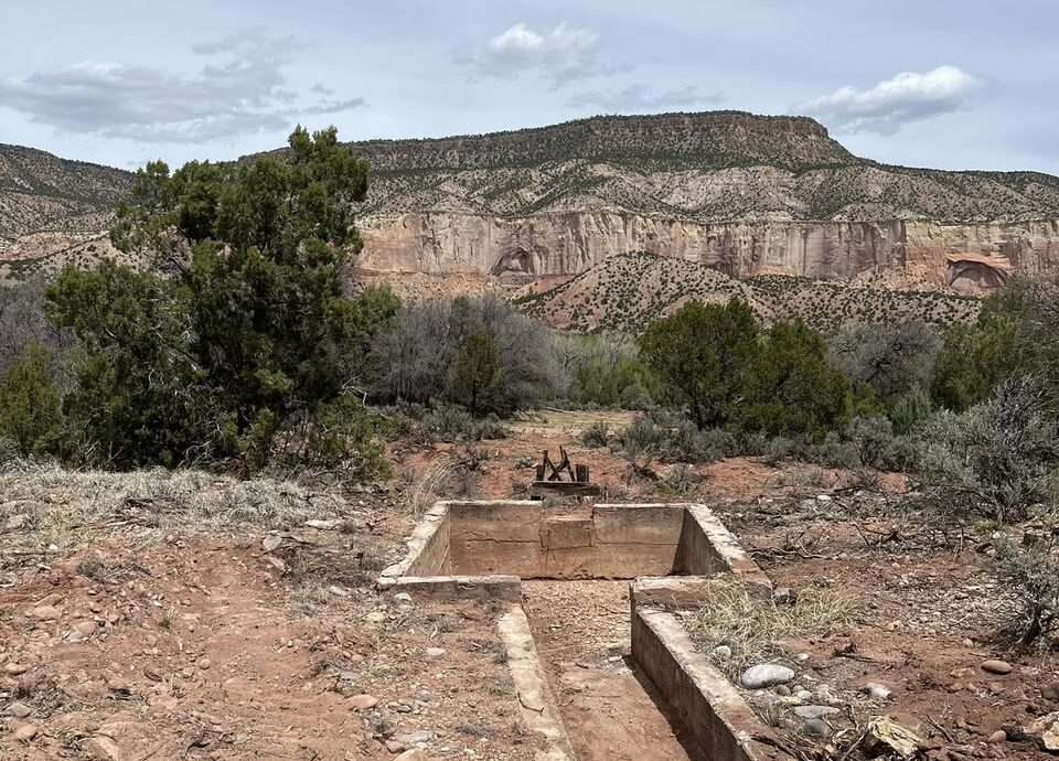
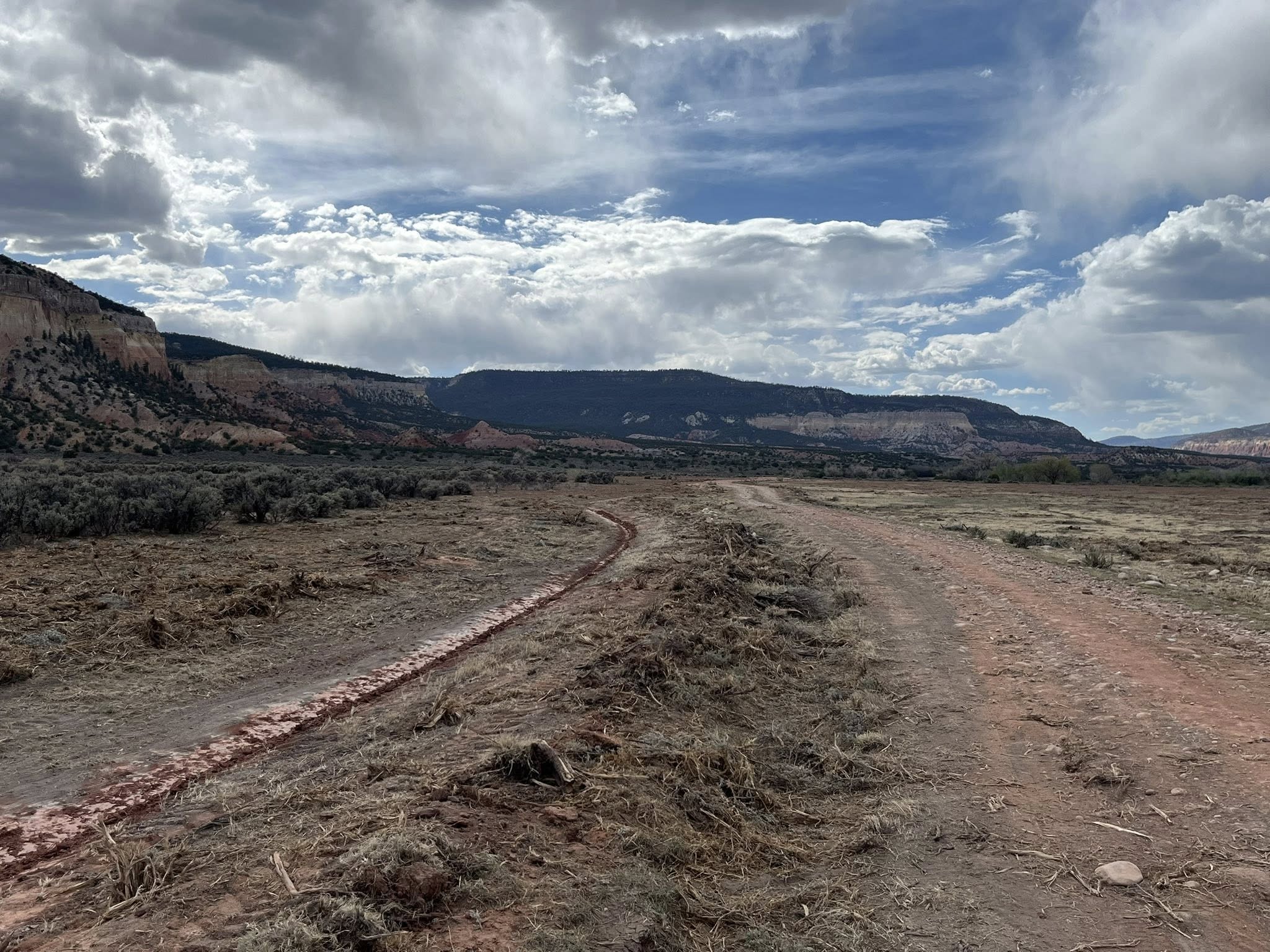
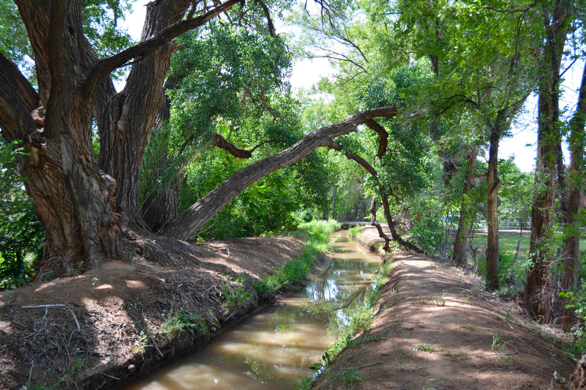
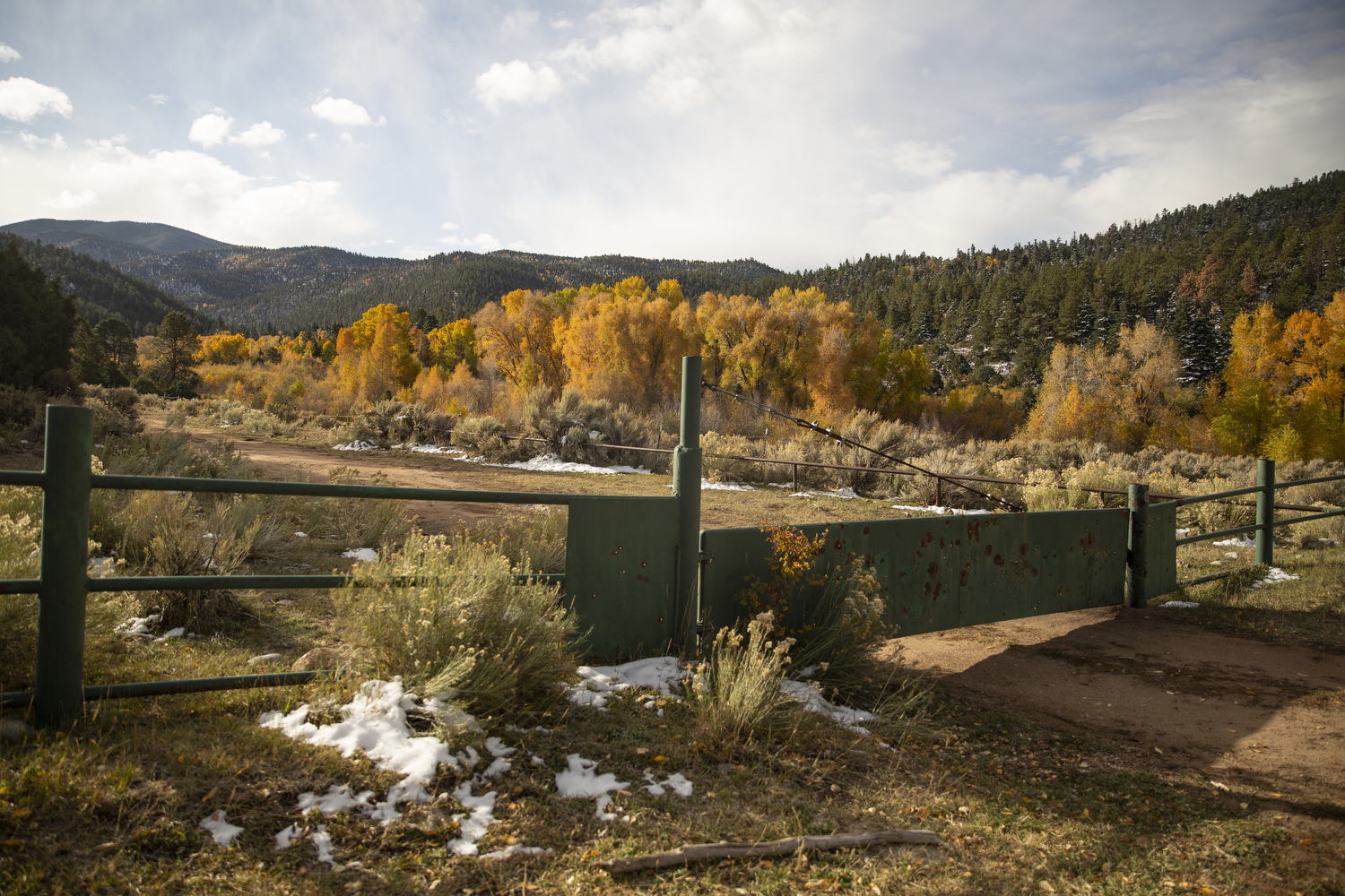
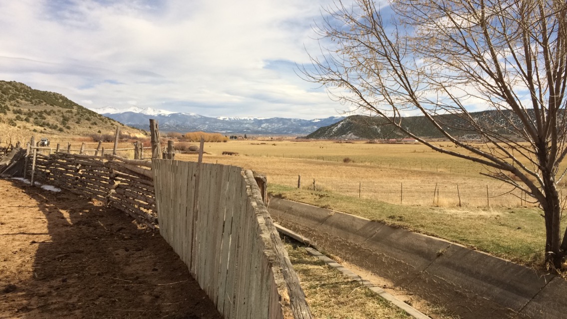
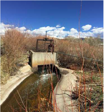
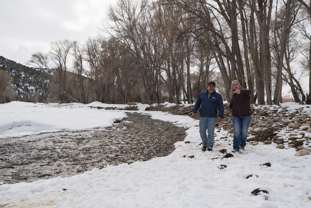
The dusty Acequia Madre de Cañon de Chama, pictured above April 28, 2026, will soon divert Rio Chama water toward historic orchards the San Joaquín del Rio de Chama Land Grant first planted more than 200 years ago, thanks to a new agreement between the land grant and the Santa Fe National Forest. (Photo courtesy Leonard Martinez)
Click the link to read the article on the Source NM website (Patrick Lohman):
May 5, 2026
A dusty acequia in northern New Mexico, which more than 200 years ago diverted water from the Rio Chama, will soon spring to life again, nourishing freshly planted orchards of plums, apples and apricots.
That’s the idyllic scene envisioned through a new agreement between the Santa Fe National Forest and heirs of the San Joaquín del Rio de Chama Land Grant. The parties say the “memorandum of understanding” they signed in late March marks the potential thawing of more than a century of tension between New Mexico land grants and the federal government.
The agreement, which the Santa Fe National Forest Service provided to Source NM through a public records request, identifies the acequia restoration as a “project of mutual interest.” It also recognizes the land grant as a consulting partner to the Forest Service and provides it greater input into the land’s future use.
Leonard Martinez, president of the land grant, told Source NM that the nine-page agreement is a “historic document,” one that marks the first such formal agreement between land grants and the Forest Service. He said he’s spent nearly every day since the agreement was signed clearing the historic irrigation canal and working to reconnect it to the Rio Chama.
San Joaquin de Chama President Leonard Martinez said he has spent most every day since signing the memorandum of agreement digging out the old path of the acequia in the Cañon de Chama. (Photo courtesy Leonard Martinez)
If all goes well, he will open the headgates of the Acequia Madre de Cañon de Chama later this summer, sending Chama River water to irrigate a cover crop of alfalfa. Within five years, he hopes to replant historic orchards.
When that happens, he said, he hopes the “heirs who have left us,” many of them still buried in a cemetery near the headgates, will approve of his efforts.
“That’s the key here,” he said. “We want to put our orchards and our fields back in.”
Santa Fe National Forest spokesperson Claudia Brookshire told Source NM that the agreement resulted from trust established through informal talks and individual projects.
“The Forest Service has long been willing to work with land grants,” Brookshire said in an email. “But the lack of a formal framework, combined with trust barriers, made it difficult to begin projects on national forest system lands.”
The Santa Fe National Forest is in early discussions to develop similar agreements with two other land grants, Brookshire said.
In 1806, Spanish Governor Joaquín del Real Alencaster charged 44 families with stewardship of a 470,000-acre swath of what was then the New Mexico Territory. By 1860, according to the land grant, more than 800 residents established roots there, cultivating land within the river valleys, pasturing livestock and gathering resources from the surrounding common lands, known as the “ejido.”
But after multiple lawsuits and land re-surveys over the ensuing decades, the federal government and land speculators acquired the land and evicted the residents. By 1905, the federal government recognized only about 1,500 acres of land along the Rio Chama as belonging to the land grant, but even that parcel ended up in the hands of the Rio Arriba Land and Cattle Company.
The parcel west of Abiquíu, known as the Cañon de Chama, remained the company’s property for decades before the federal government ultimately acquired it, as well. Today, all of the original San Joaquín del Rio de Chama Land Grant belongs to the Santa Fe National Forest or Carson National Forest.
Land grant heirs like Martinez have fought for more than a century to reassert their rights over the land, including seeking Forest Service permission to visit and care for the cemetery where their ancestors are buried.
The heirs ultimately received a Forest Service easement in 2013 to access the cemetery. Since then, Martinez and other land grant leaders have continued to pressure the Forest Service for more access, particularly to the Cañon de Chama, which heirs describe as culturally and historically significant.
Martinez told Source NM that the agreement is a result of trust built through the cemetery easement, he said, as well as guidance from the New Mexico Department of Justice’s Treaty of Guadalupe Hidalgo Division.
The NMDOJ created the division in 2003 to oversee and address concerns related to the provisions of the 1848 Treaty of Guadalupe Hidalgo, which ushered in the United States’ government’s problematic land title confirmation process and stripped the San Joaquin land grant heirs of hundreds of thousands of acres of communal land.
New Mexico Rep. Miguel Garcia (D-Albuquerque) has spent much of his 30 years in office advocating for land grant heirs, including seeking recurring state funding and greater recognition of the historical injustice of the federal government’s land seizure.
While he said the new agreement represents a “great leap forward” and commended Martinez and others for their efforts, he said his ultimate goal remains for the Forest Service to return land it now controls to the land grants.”
“These land grants that lost these common lands have not ceded their right to that land,” he said. “They have not given up that hope.”
New Mexico’s Don Bustos has passed on his organic farming knowledge to more than 225 farmers around the state. (Photo courtesy FarmersMarketInstitute.org)
A 4.5 acre farm surrounded by New Mexico’s Sangre de Cristo Mountains is where owner Don Bustos fuses centuries of tradition with modern advances to feed local communities. The Santa Cruz Farm has been in the hands of Bustos’ family for more than 400 years. Working with experts at New Mexico State University, the owner said he gravitated to organic farming long before others adopted such practices. The 68-year-old Bustos said he hasn’t used any major chemicals or pesticides in more than 20 years.
“We do 72 different varieties of produce 12 months a year using nothing but solar energy,” said Bustos. “I grow a lot of the traditional corn, the green chili. We still have our same seed, we still have our same corn seeds, the same melons – and then we got a lot into the specialty crops.”
Bustos said he believes much of his success is due to taking risks, leaning on scientific advances while also adhering to sacred family traditions and ancestral farming practices. In addition to solar power, the farm relies on water from a New Mexico acequia – an ancient irrigation ditch – that flows north through the state.
In addition to farming his land, Bustos spent more than a decade working for the American Friends Service Committee – training other New Mexico farmers how to successfully grow organic produce in the middle of winter. Now, he’s well-known for squash, asparagus, leafy greens and other fresh foods.
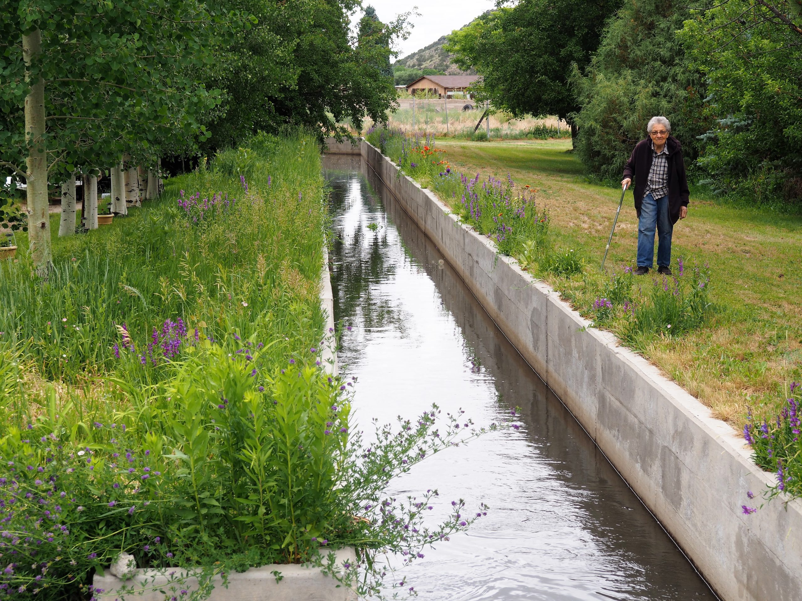
Santiago Maestas, president of the South Valley Regional Association of Acequias, stands next to the Pajarito acequia in Albuquerque, New Mexico. Visual: Lourdes Medrano for Undark
Santiago Maestas has grown apples, peaches, and apricots on his New Mexico property for more than five decades. He still cherishes the network of ancient gravity-fed irrigation ditches that deliver the water that keeps his orchard thriving.
Those irrigation ditches, scattered across the state and known as acequias (pronounced ah-SEH-kee-ahs), have endured for hundreds of years. For Maestas and other residents in Albuquerque’s South Valley, the communal irrigation system is an integral part of life in one of the country’s most arid regions.
“It’s what makes the valley green,” said Maestas, walking along a narrow, meandering acequia near his house on a summer morning. “It provides us with a canopy. It provides us with the ability to continue to grow crops in our backyards.”
The water that day flowed through the canal, flirting with the roots of lush, towering trees lining the dirt banks that Maestas strolled. In a small ditch, the gravel bed was dry and covered in weeds, a sight emblematic of dwindling water. Scientists say a lingering drought, warmer springs, and reduced water flow in the Rio Grande will intensify and further test the ancient irrigation systems.
Acequia users like Maestas are part of a collaboratively managed irrigation system that delivers water from ditches to crops and gardens. To cope with an increasingly dry environment, irrigators are already making some adjustments to the waterflow. “We’re now on a three-week rotation,” he said. “One day every three weeks, we can deliver water. Earlier in the spring, when the river was full, we could deliver water every two weeks.”
Acequia users say the treatment of water as a commodity that can be sold and traded, like gold and silver, goes against the traditional system, which emphasizes shared resources.
As water becomes increasingly scarce in the drought-stricken Southwest, so does competition for the resource. This worries users of New Mexico’s acequias, which research shows could help offset some effects of climate change as water seeps into the soil, replenishing groundwater that helps balance the water supply during scant rainfall. To safeguard their unique system, irrigators like Maestas are working on adapting to volatile weather, boosting acequias as a sustainable resource, and strengthening legal protections around water rights in a changing environment.
Acequia users say the ever-increasing treatment of water as a commodity that can be sold and traded, like gold and silver, goes against the traditional system, which emphasizes shared resources. The canals that have long sustained people still exist because of their communal bonds and deep connection to land and water, said Jorge Garcia, a South Valley resident. Acequias are a “system that carries not only our history, but also our spiritual values.”
In a water-stressed place like New Mexico, Garcia said, preserving acequias can ensure a continued supply of clean water for those who depend on it to grow food for their families and for the local community: “We have to protect the water that we have for future generations.”
The use of shared canals and ditches to irrigate New Mexico date to before the arrival of Spanish explorers in late 1500s. When Spanish explorers arrived and expanded their occupation from Mexico into what is now the American Southwest, they built the system of acequias that could deliver water to their established settlements.
“There’s a distinction between an acequia and a canal and a ditch,” said José Rivera, a research scholar who has long studied acequia culture. “Acequia has a connotation about it that it’s both a physical system, just like a canal or just like a ditch. But acequia also means it’s a social organization of irrigators. It’s a community of irrigators.”
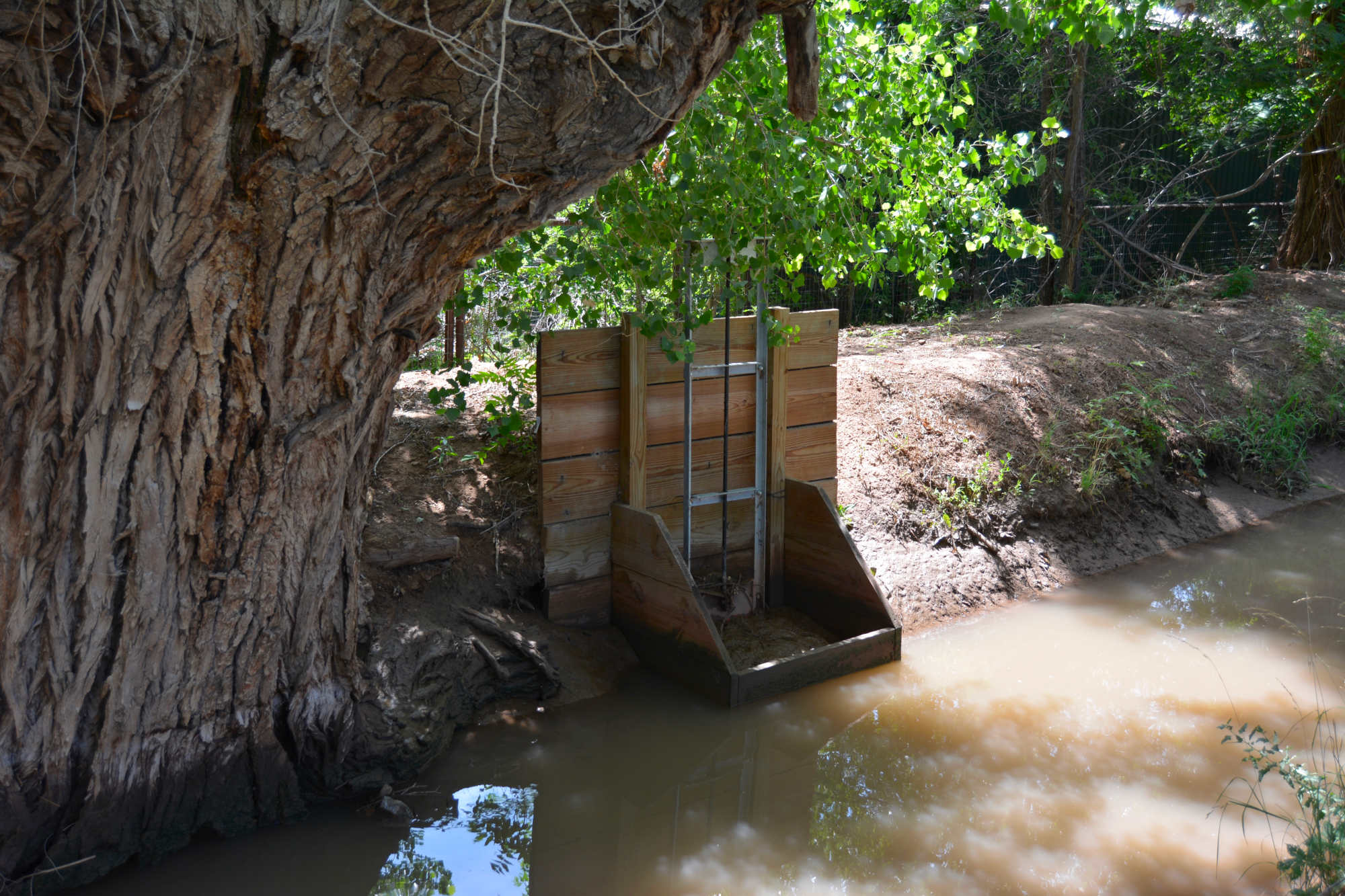
In other words, acequias refer both to the physical structure and the social institution that governs its use. The irrigation system relies on a network of canals that deliver water from rivers, streams, and springs. Gates open and close so the water can flow into smaller ditches that allow irrigators, also known as parciantes, to flood their land during the growing season. Each acequia functions as a democratic institution that shares water fairly during shortages. A mayordomo, or ditch boss, handles various tasks, including organizing the people, to keep the acequia running smoothly. Three commissioners, or comisionados, provide oversight.
Acequias are a “system that carries not only our history, but also our spiritual values.”
Rivera calls acequias in New Mexico “an amalgamation of all of these practices and all of these traditions and they came together here.” ( Spaniards inherited the practice, which has Middle Eastern roots, during the Moorish rule in Spain.) According to the New Mexico Acequia Association, today the state has about 700 acequias considered political subdivisions subject to state laws. Meanwhile, neighboring Colorado has around 70 along its southernmost region. Acequias built in other Southwest regions, such as Arizona, before the United States became a nation have long disappeared.
Acequias in New Mexico for the most part still adhere to traditions stemming from old Spanish and Mexican legal systems that emphasize shared benefits and responsibilities, as well as unique Spanish terminology, said Rivera, professor emeritus of community and regional planning at the University of New Mexico.
The historic waterways crisscross urban and rural land, distributing water to thirsty orchards, gardens, and small fields. “Ultimately, the way that we use these resources is what has allowed our communities to survive for all these generations,” said Patrick Jaramillo, co-director of the New Mexico Program of the American Friends Service Committee in Albuquerque.
His nonprofit collaborates with those working to protect acequia traditions. “The acequieros, or the stewards here know that if we keep these practices, our communities will continue,” said Jaramillo, who grew up on an acequia property.
Gates control the flow of water into smaller ditches, providing irrigators with water to flood their land during the growing season. Visual: Lourdes Medrano for Undark
Although the antiquity of acequias affords them certain legal protections, their endurance has not been without struggle. The growth of water users and changing laws that champion water rights as individual property have meant frequent clashes with the communal concept of acequias.
In the early days of modern southwestern settlement, acequia water could not be legally diverted from ditches. Now, parciantes can sell their rights to their share of water even if they keep their land.
“In the past, water rights could not be transferred outside of the community,” Rivera said. “Now they can. They’re bought and sold, like any kind of property. So that’s a major threat.”
Acequias increasingly defend their way of life through political activism. They’ve adopted bylaws as acequia associations to restore governance abilities as owners of some of the state’s oldest water rights. Although parciantes have individual water rights, the irrigation system itself is owned and managed collectively as a common property, Rivera said.
Acequia communities have the right to protest proposed water transfers they deem could be detrimental to the function of their system. According to the Acequia Governance Handbook, acequia associations that have not adopted transfer bylaws that give them rights can express concerns in public hearings, but the New Mexico Office of the State Engineer, which regulates water rights, has the final word.
“We have to protect the water that we have for future generations.”
A water transfer diverts water destined for an acequia to a new location, for example. The practice sometimes pits parciantes against parciantes. In the South Valley, people seek water transfers for economic reasons, because they’re moving, or simply because they have no need to irrigate, Garcia said.
One of the South Valley acequias is now protesting a parciante’s plan to sell and transfer water rights to a cannabis farm. Protesters argue that the sell-off of too many water rights from an acequia could eventually lead to its collapse. Parciantes also have opposed proposed high-density development they say would impair water resources, including acequias.
Garcia adamantly opposes any development that could jeopardize water rights in acequias. He feels the same about water transfers from parciantes that could deplete water flows in acequias and hurt other irrigators. “The individual right is conditioned and dependent on the collective right,” he said. “Why? Because the system is designed to function with gravity. So the more water you take, the less pressure there is, the more difficult it gets to distribute water.”
Maestas put it this way: “There’s not enough water for the city of Albuquerque and the acequias and the farmers.”
The surface water that keeps acequias flowing in the South Valley and other traditional irrigation systems across the state originates as winter snowpacks in the Rocky Mountains of southern Colorado. During spring, the snowmelt runoff from the mountainous headwaters of the Rio Grande travels south through New Mexico and then becomes the international boundary between Texas and Mexico.
The water channeled from the river into acequias has kept sustenance farming alive for generations and, over the years, allowed some growers to expand food production in their communities. But decreases in snowpacks causing diminished and variable stream flows are projected to worsen with the higher temperatures of global warming.
“The acequia communities, they’re right on the frontline of these changes,” said Caitriana Steele, an associate professor in the department of plant and environmental sciences at New Mexico State University. “They’ve got no way to store water, really. The snowpack is their storage.”
“There’s not enough water for the city of Albuquerque and the acequias and the farmers.”
There’s already evidence that the changes in temperatures are causing the snowmelt that fills acequias to happen earlier in the spring, which complicates irrigation, said Alexander “Sam” Fernald, director of the New Mexico State University’s New Mexico Water Resources Research Institute. This means depleted flows in the summer, when the demand for water soars.
“We’re already seeing reduced runoff, and we’re expecting in the near future to have up to 25 percent less runoff,” Fernald said. “We’re not there yet, but we’re already seeing less runoff for a given snowpack.”
Severe weather, including drought and wildfires, and how it could affect the ability of acequias to continue providing water for communities worries many. In 2022, flash flooding damaged several acequias in various parts of the state.
“The current drought affecting the Southwest United States is probably the worst drought in 1,200 years,” said Tom Swetnam, professor emeritus of dendrochronology at the University of Arizona in Tucson. Tree ring data shows that acequias have withstood similar dry conditions for up to 150 years.
The scientist, who now lives in the New Mexico mountains, said he’s seen firsthand the damage that wildfires can do to the traditional irrigation systems. “The acequias and the places where they’re catching the water from the rivers get filled up with sediment from post-fire erosion,” he said.
Fernald, who has long studied acequias, said their collaborative nature has factored into their survival during tough weather events over the years. Their water-sharing principles, he said, could continue to help them withstand precarious times to keep irrigating their crops.
Tree ring data shows that acequias have withstood dry conditions similar to today’s drought for up to 150 years.
Although acequias lose a good amount of water to evaporation when they soak crops and gardens through flood irrigation, studies show that their hydrology provides benefits to the environment that may actually help counter the loss. For example, Fernald’s research found that seepage — which can range from about 7 to more than 50 percent of the flow — recharges the aquifer and eventually returns to the river. “Acequias also provide many benefits for riparian habitats,” he said.
He likened acequias to beaver dams that keep the water in the upper watershed, by spreading it out over fields, and soaking it back into the groundwater. “It delays its flow downstream, so that’s actually really good for the downstream because there’s water in the river later in the summer,” Fernald said.
For Santiago Maestas, keeping the water flowing to all acequias in the South Valley and across New Mexico is paramount. He cannot fathom a day when the water won’t run down a ditch to quell the thirst of his orchard, or a neighbor’s garden, or a farmer in the northernmost reaches of the state, he said: “The acequias are the lifeblood of this area.”
The 29 square miles that make up the unincorporated South Valley community are home to about 37,600 residents, 82 percent of them Hispanic. Families who have lived on land-grant acequia properties for generations mingle with neighbors who have moved in throughout the years and adopted their communal irrigation traditions that emphasize sharing water when it’s plentiful and rationing it when it’s meager.
In 1973, Maestas moved into his South Valley half-acre property, which included an acequia that carried water to the alfalfa he grew. But the death of the mayordomo left the ditch unattended. It later fell into disrepair, which left Maestas without access to water. Looking for a way to irrigate again, Maestas went on a mission to unlock the time-honored intricacies of the acequia system.
After attending workshops and poring over books on water laws and policy, Maestas discovered that his property came with pre-1907 water rights. That year produced the water code that gives the state the power to control water use and protects water rights established before the date. Such rights are the only ones that can be used without state approval.
Lush greenery surrounds an acequia in the South Valley. Research has shown that acequias can help recharge aquifers, and they also provide many benefits for riparian habitats. “The acequias are the lifeblood of this area,” said Santiago Maestas. Visual: Lourdes Medrano for Undark
Maestas set out to regain water access and inform longstanding acequia users that claiming pre-1907 water rights leaves no doubt of legal standing as competition for water intensifies. Many South Valley residents were, and still are, unfamiliar with a benefit they may have, he said. That’s something Maestas, now as president of the South Valley Regional Association of Acequias, works to change.
Acequias in the South Valley dealt with significant disruption when the Middle Rio Grande Conservancy District created in the 1920s eventually took charge of surface water in the region. Unable to pay the quasi-public agency’s required taxes for new drains, canals, and other infrastructure, acequia associations faltered amid the changes.
Nonetheless, they never ceased to function as a group of parciantes working for the common good, said Garcia, who also is the executive director of the nonprofit Center for Social Sustainable Systems. He and Maestas have worked for years to revitalize acequias and promote understanding in the values and practices of the longstanding institutions.
The two men and other acequia advocates gather once a month at a local waterway with area residents interested in learning about the agricultural tradition and ongoing efforts to preserve them. In July, a group listened to Maestas talk about the history of the five ancient acequias that run through the South Valley.
“The whole irrigation system in the South Valley starts here,” Maestas told a circle of people standing in the shade of two imposing cottonwoods on a late morning. In the distance, a thicket of trees tinted the landscape yellow green.
In the past, Maestas said, the spring runoff that feeds the Rio Grande would wash out the earthen ditches and irrigators had to rebuild them every year. “In many parts of the valley here, the river is actually higher than the valley.”
These days, levees built by the conservancy district keep the river from overflowing into the valley. “So they’re critical and they require federal money because it takes millions of dollars to construct these — more than whatever we could pay with our property tax fees and our water service fees,” Maestas said.
“Without water, we’re not going to be here. And that is something that we’re going to have to reckon with very, very soon.”
Among those listening were about a dozen kids who arrived on bikes. They were part of Story Riders, a bicycling program that offers cultural and environmental education for youth. The group was riding along the acequias daily, documenting the status of South Valley ditches in a report they planned to share with the conservancy district, said program manager Marco Sandoval.
The program works to connect youths with New Mexican culture and acequias are a significant part of it, Sandoval said. “Water is an important issue here,” he added. “Without water, we’re not going to be here. And that is something that we’re going to have to reckon with very, very soon.” Today’s youths could one day help preserve acequias as a sustainable system that can still grow crops and help improve food security in a harsher environment, Garcia said, and with the effects of climate change expected to worsen, “the right thing to do is to get closer to natural systems and acequias give us that opportunity.”
In the meantime, Maestas expects to keep doing his part to protect acequias. “Basically, this is our legacy,” he said. “It’s our role now to be the stewards of the acequias.”
This story was supported in part by The Water Desk at the University of Colorado Boulder’s Center for Environmental Journalism.
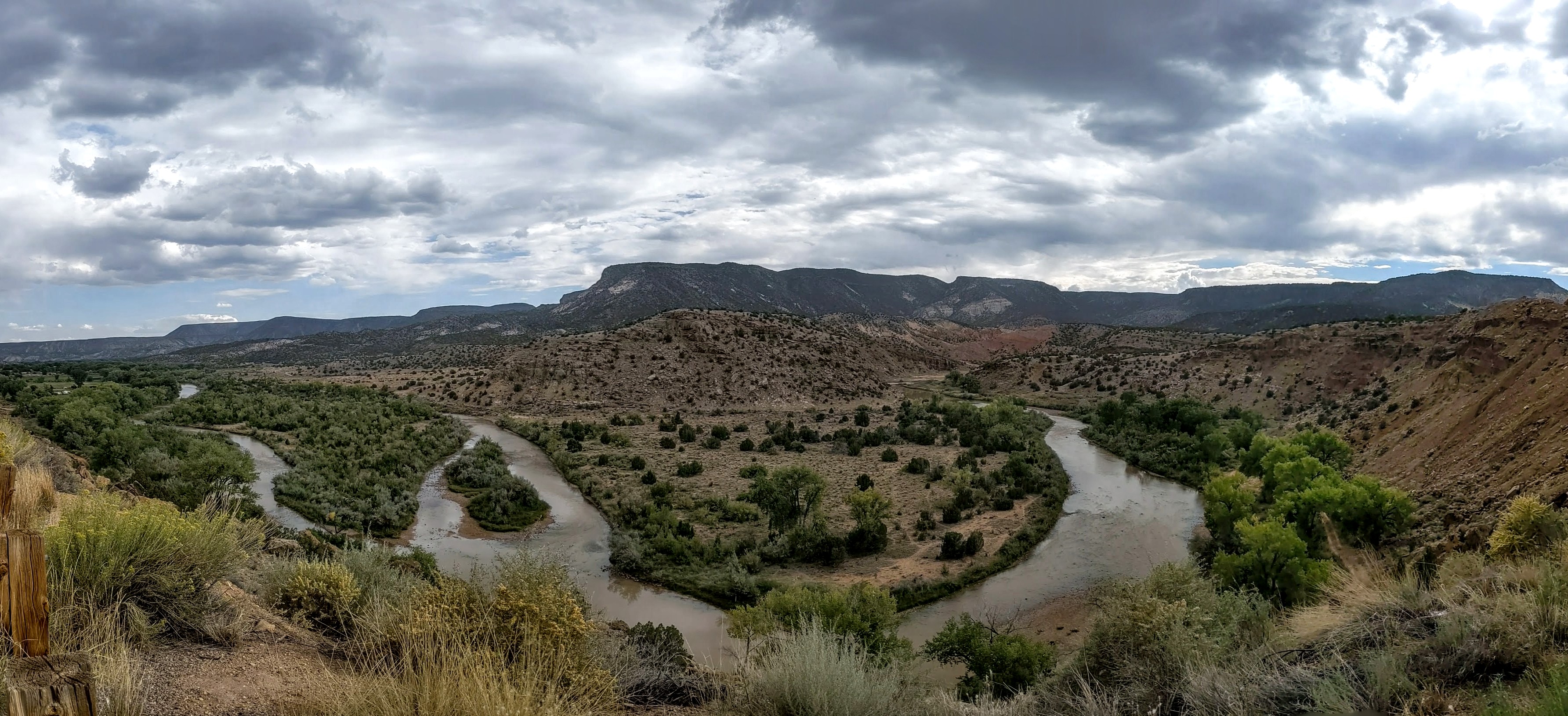
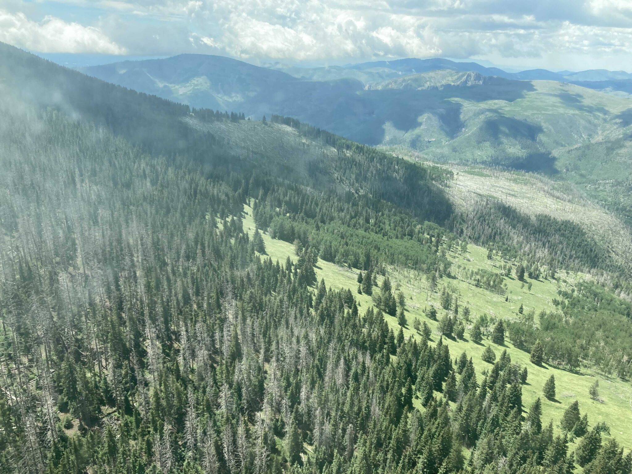
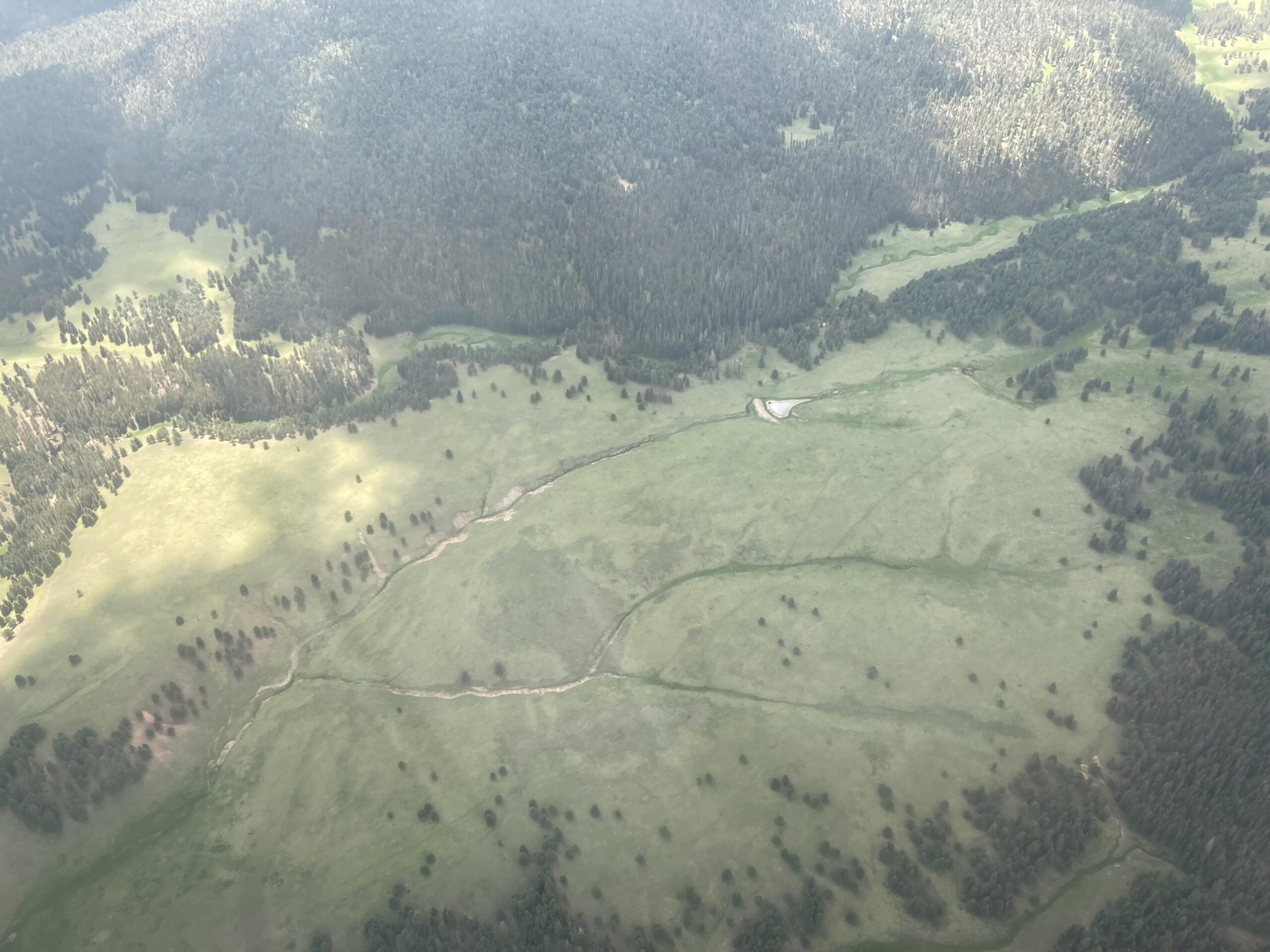
An aerial view of the Jemez Watershed on June 28, 2024. (Photo by Danielle Prokop / Source NM)
Click the link to read the article on the SourceNM.com website (Danielle Prokop):
July 29, 2024
If approved, the settlements would bring in more than $3.7 billion in federal funds and end decades of water rights litigation
The Navajo Nation president and leaders from Acoma, Ohkay Owingeh and Zuni Pueblos joined tribal leadership from across the nation on Capitol Hill, offering testimony about the benefits of $3.7 billion federal dollars in six proposed water rights settlements across New Mexico.
The deals would settle tribes and Pueblos’ water rights in four New Mexico rivers: the Rio San José, the Rio Jemez, Rio Chama and the Zuni River.
Another bill would also correct technical errors in two previously ratified water rights settlements: Taos Pueblo and the Aamodt settlement Pueblos of Nambé, Pojoaque, Tesuque and San Ildefonso. Finally, a sixth bill would add time and money for the Navajo-Gallup water project to construct drinking water services.
New Mexico representatives presented a record six settlements for Pueblos and tribes at a subcommittee hearing Tuesday, the first step in getting needed Congressional approval to end decades of litigation. Companion proposals from the Senate were heard Friday in the Senate Indian Affairs Committee. Mescalero Apache Tribe President Thora Padilla was introduced to senators with support for the settlements.
As climate change reshapes the Southwest into something hotter and drier, with more strain on its water resources, approaching water collaboratively means communities have a chance to stay, and tribes can exercise their sovereignty.
In front of House members on Tuesday, Ohkay Owingeh Gov. Larry Phillips Jr. said the settlement of the Ohkay Owingeh’s rights on the Rio Chama will offer a means of long-awaited restoration.
“The U.S. bulldozed our river, it destroyed our rivers and bosque,” he said. “This needs to be fixed, the settlement gives us the tools to do that.”
Rep. Teresa Leger Fernández (D-N.M.) said tribes and Pueblos gave up certain acreage that they are entitled to, and worked out drought-sharing agreements to benefit everybody in the region.
Leger Fernández sponsored five of the bills, and Rep. Gabe Vazquez (D-N.M.) sponsored a sixth that was heard on Tuesday.
Additionally, she said the funds will enable more infrastructure, bosque restoration and ensuring water rights protections for neighboring acequias.
Acoma Pueblo Gov. Randall Vicente told the committee that making concessions in the settlement was crucial to preserving water for future generations.
“It is better to have adequate wet water, than paper rights without a water supply,” he said.
Even if the Pueblo enforced having the oldest water right, Vicente said the Rio San José’s system is so damaged, it would take decades for water to reach Acoma.
The settlements can help redress the federal government’s injustices towards Ohkay Owingeh Pueblo, Phillips said. He pointed to the U.S. Army Corps of Engineers and U.S. Bureau of Reclamation’s channelizing of the Rio Chama and the building of Abiquiu Reservoir in the 1950s, which moved water away from the Pueblo.
“Both of these actions resulted in depriving us of our bosque and waters necessary for a proper river,” he said. “We entered into the settlement in order to protect, preserve our water resources and the bosque.”
The loss of water not only impacts the health of Pueblo communities, Phillips said, but it splits people from their lands and means the loss of sacred bodies of water and ceremonies to celebrate them.
Water offers a lifeline to traditional ways and offers prosperity, said Zuni Pueblo Gov. Arden Kucate.
Zuni Pueblo will work to build new drinking water treatment systems and restore waffle garden irrigation practices, a technique used for generations until the turn of the 19th century, when settlers diverted water and clearcut the Zuni River watersheds.
“It will usher in, what I sincerely believe, will be a new chapter for our tribe, allowing us to protect and sustainably develop our limited water resources, to restore traditional agriculture and facilitate much-needed economic development,” Kucate said about the settlement.
Navajo Nation President Buu Nygren also spoke, celebrating water rights settlements with both New Mexico and Arizona.
Some of the settlement agreements are already two years old.The administration supports all of the New Mexico settlements, said Bryan Newland (Ojibwe), the assistant secretary for Indian Affairs at the U.S. Department of the Interior.
“Any delay in bringing clean, drinkable water to communities is going to harm the people who live in those communities,” Newland said. “We also know from our experience that these settlements only get more expensive, and implementation only gets more expensive the longer we wait.”
Tribal water rights are not entirely settled in New Mexico, most notably on the Rio Grande, where a federal assessment team started addressing water claims issues in 2022. Leger Fernández said she hopes the six water rights settlements in other watersheds will provide a model for collaborative management of water rights on New Mexico’s largest river.
An aerial view of the Jemez Watershed on June 28, 2024. (Photo by Danielle Prokop / Source NM)
“These water rights settlements provide the framework for future water rights settlements, which include those involved in Rio Grande,” Leger Fernández said.
Leger Fernández said the moment was still momentous, even if it’s only the first step.
“There’s never been this many settlements at one time,” she said. “There has never been a hearing that was this big.”
What’s the process?
The House Committee on Natural Resources held a legislative hearing on 12 water rights settlements across the U.S. with a projected cost of $12 billion.
The hearing consisted of testimony from federal agencies and heads of tribal governments.
The settlements can now head into a process called mark-up and means they can be added to legislative packages moving forward. Both of New Mexico’s senators sponsored companionate bills.
It’s just the first step in the process, but Leger Fernández said she’s looking to face the biggest hurdle of cost head-on. She and members of the Department of the interior testified that continuing to fight court battles will cost the federal government more money, and that waiting isn’t an option.
“The longer we wait, the more expensive it will be,” she said.
New Mexico Lakes, Rivers and Water Resources via Geology.com.
Water is vital for life in the West. In Colorado’s San Luis Valley, it’s so essential that, for generations, some communities — called acequias — have treated it as a communal resource that’s meant to be shared.
Through the project, law students work hand-in-hand with lawyers and professors to provide an estimated $300,000 worth of free legal services to the roughly 130 acequia communities in Colorado.
Not only does this pro bono work help keep a historic water distribution philosophy alive, but it gives students a chance to put theory into practice — and experience how natural resources law can affect real people.
“Water in the West is at a critical point right now, where climate scientists are predicting increased aridication in Colorado, which will likely result in less water,” said Mary Slosson (Law’24), one of the project’s student deputy directors. “It’s one thing to study these problems from a legal standpoint in the classroom, but it’s entirely another thing to talk about climate change with a small family farmer while walking their land.”
Acequia means “water bearer” in Arabic. The practice — which centers on a network of irrigation channels — originated in Northern Africa, then spread to Europe during the Middle Ages. From there, the Spanish brought the concept to the New World, where it took hold in Mexico and what is present-day New Mexico and Colorado.
But an acequia represents much more than just the physical infrastructure: It’s a way of life. In acequia communities, water is divvied up as equitably as possible — and landowners pitch in to help maintain the ditches.
This philosophy stands in stark contrast to the way water is distributed elsewhere in Colorado. The state’s water laws are based on “prior appropriation,” which means that whoever has the oldest water rights gets first dibs on water, according to Gregor MacGregor (IntlAf’12; Law’19), who participated in the project as a law student and now serves as its director. In times of scarcity, this approach — also known as “first in time, first in right”— means there may not be enough water for those with the youngest water rights, he added.
“In an acequia system, there aren’t shares — it’s one landowner, one vote,” said MacGregor. “The way they allocate water is more personal and values-driven. People on the acequia system are tied to the water and the land.”
For more than a century, Colorado’s legal framework did not recognize acequias. But in 2009, the state legislature passed a law that allowed acequias to incorporate while continuing to operate in their traditional way. To help acequias take advantage of this new recognition, Peter Nichols (MPubAd’82; Law’01) launched the project with Colorado Law professor Sarah Krakoff in 2012.
“The fact that we have this population that was more or less ignored for 150 years is a huge environmental justice issue,” said MacGregor. “This is a great way to use our very particular set of skills to right the wrongs of the past in a very meaningful way that empowers these communities to chart their own future.”
Law students help acequia communities by drafting bylaws and governance documents, representing them in water court and negotiating the sale of water rights. They also conduct extensive research to help acequias incorporate, as they did with the historic Montez Ditch in San Luis, Colorado.
“The Acequia Project has become part of our community,” said Charlie Jaquez, a former Montez Ditch commissioner whose ancestors were some of the original settlers of San Luis in 1851. “They have been very, very helpful — and very generous. Especially in areas like Conejos and Costilla counties, these communities just do not have a whole lot of money. The ditch would’ve just kept on going the way we did before, decade after decade, but now it’s been placed on solid legal footing.”
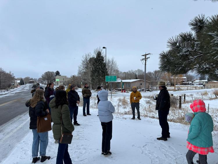
The Town of San Luis. Photo credit: Getches-Wilkinson Center
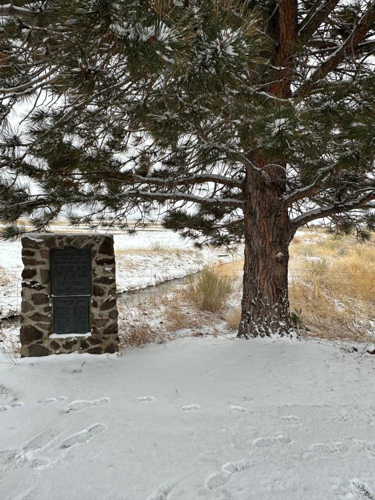
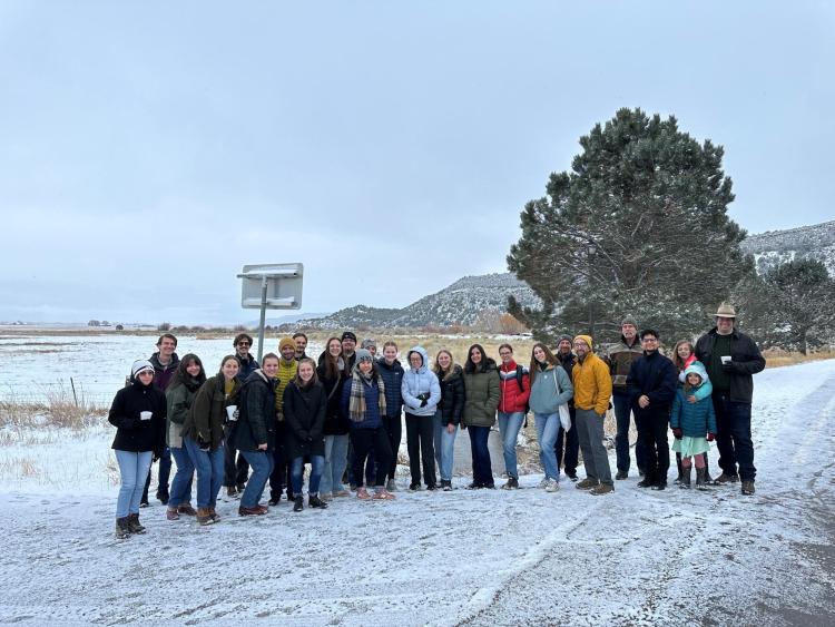
Walking tour of San Luis. Photo credit: Getches-Wilkinson CenterMarker alongside the San Luis People’s Ditch. Photo credit: Getches-Wilkinson CenterInside the Congreso de Acequias. Photo credit: Getches-Wilkinson CenterMembers of the Acequia Assistance Project. Photo credit: Getches-Wilkinson Center
Members of the Acequia Assistance Project, in conjunction with the Getches-Wilkinson Center and the Colorado Law School, made their way down to San Luis, CO earlier this month to attend the 12th annual Congreso de Acequias. There, Project members took a walking tour of San Luis, visited the People’s Ditch which holds the oldest water right in Colorado, met with clients, participated in community workshops, and dined at local favorite Mrs. Rios. This visit gave students the opportunity to better understand the San Luis community, the land that their work is influencing, and gain a deeper understanding of the importance of the acequia system within Colorado’s water laws.
Congreso is a full-day conference that centers local voices, issues, and plans for the future. The event began with bendición de las aguas– the blessing of the water– where water from each acequia in attendance was combined and blessed. At the first workshop of the day, titled “Rebuilding a Robust Local Food System,” Colorado Open Lands and the Acequia Association brought together voices from around the Valley to discuss food sovereignty and how the community can work together to keep locally grown produce in the Valley, rather than export it, to address the lack of local access to healthy food. Representatives joined from the San Luis People’s Market, the San Luis Valley Food Coalition, local farms, and other organizations from around the Valley. In the second workshop of the day, “Rangeland and Grassland Drought Resilience,” Annie Overlin from CSU Extension discussed how farmers and ranchers can maintain their crops and cattle during drought years by creating action plans in advance. To wrap up the morning programming, the Acequia Association presented awards to elementary-aged art contest winners, who created pieces exhibiting their relationship to water growing up in the Valley, and one 13-year-old community member shared the story of how he learned the importance of water during his childhood in San Luis.
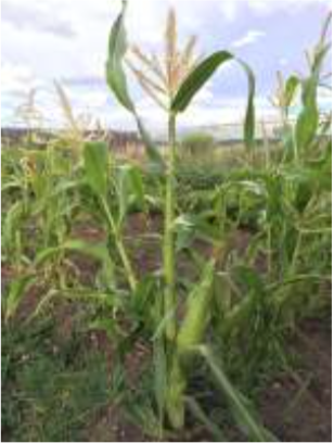
Selection of the 2015 native heirloom maize harvest of the seed library of The Acequia Institute in Viejo San Acacio, CO
Photo by Devon G. Peña
San Luis garden, 2021. Photo credit: The Alamosa Citizen
Lunch consisted entirely of locally-sourced food and featured a performance from local singer, Lara Manzanares, who performed a series of songs which spoke to the experiences growing up in rural areas and her perspective on the land surrounding her. In the afternoon, Colorado Law’s student attorneys, Masters of the Environment (MENV) students, and Project Director MacGregor presented updates about current student projects to inform the community of legislative updates impacting the San Luis Valley, outcomes from ongoing research projects, and new opportunities to seek support from the project. To wrap up the day’s workshops, there was an in-depth presentation on current funding opportunities for acequias and farmers.
The final event was a discussion and film screening about the Cielo Vista Ranch dispute, which has been ongoing since the early 1980s. Many community members in San Luis have historic land rights to graze livestock, collect timber for firewood, and hunt on the land currently owned by the Cielo Vista Ranch. Texas billionaire William Harrison bought the mountain in 2017 and has continued to build an 8 to 10-foot tall animal fence that interferes with easement owners’ rights to the land, exacerbating the decades-long issue. Documentary producer, Juan Salazar, attended Congreso and introduced his film, titled La Tierra, which details the history of advocacy in the San Luis community and discusses the significance of community organizing and resistance. Community members, including activist Shirley Romero-Otero, led a discussion about the dispute following the documentary, which allowed students to gain a more well-rounded understanding of how the issue has been impacting the valley for generations.
Colorado Law student attorneys and MENV students attended Congreso along with Getches-Wilkinson Center’s Acequia Assistance Project Director Gregor MacGregor and supervising attorneys Bill Caile, Megan Christensen, Enrique Romero, Andrew Teegarden, and Aaron Villapondo. The Acequia Assistance Project has provided pro bono legal services to clients in the San Luis Valley since the Project’s founding in 2012, and this year is no different. The project currently has 18 open cases, providing a variety of services to clients in the San Luis Valley including legal and policy research related to the region’s water rights, drafting acequia bylaws and amendments, conducting community title searches, facilitating water right applications, completing Acequia Handbook updates, and providing application assistance to farmers seeking federal Regional Conservation Partnership Program (RCPP) funding. Throughout the day, Acequia Assistance Project members conducted client intake meetings, worked with farmers one-on-one to discuss upcoming funding opportunities, and collected comments to improve the community’s Acequia Handbook.
The Acequia Assistance Project is grateful for the opportunity to work with the San Luis community, learn alongside its members, and provide pro bono legal support to benefit community members. We cannot wait to return to Congreso in future years.
San Luis People’s Ditch March 17, 2018. Photo credit: Greg Hobbs
(Pictured: Director Gregor MacGregor with Student Deputy Directors Ellen Beckert, Cameron Abatti, Mary Slosson, Jackson Dunivan, and Oliver Skelly. Not Pictured: Student Deputy Director Grace Jimenez.)
“It is an incredible honor to accept the award on behalf of the hundreds of students, dozens of supervising attorneys, and many community partners who have advanced environmental justice for Colorado’s acequias over the past decade,” remarked Gregor MacGregor, faculty fellow at the University of Colorado Law School and director of the Acequia Assistance Project. “My special thanks to Professor Sarah Krakoff, Peter Nichols ’01, and Sarah Parmar for launching the Project. A further thank-you to alumnus Don Brown ’89 and the University’s Outreach Office, whose generous funding allows us to support Colorado’s acequias and the professional growth of our students. And finally, my sincerest gratitude goes out to the acequia members who continue to invite us to work and learn in their beautiful community. The Deputy Directors and I are honored to continue the Project’s work on behalf of our community partners and students. Thank you.”
The Acequia Assistance Project is an environmental justice program at the University of Colorado Law School that provides pro bono legal services to southern Colorado’s Hispanic agricultural community. For the last ten years, law students, faculty, and pro bono attorneys have helped these irrigation ditches, acequias, to realize their water rights after the Acequia Recognition Act remedied 120 years of exclusion from Colorado’s water law regime.
Photo credit: Colorado Law
Acequia is an Arabic word that means “water bearer.” An acequia is a physical irrigation system but the term “acequia” in northern New Mexico and southern Colorado also describes a philosophy about water and community– that water is so essential to life that it is a communal resource, one which must be shared. Acequias are found along the southernmost part of Colorado – including four of the state’s poorest counties: Costilla, Conejos, Huerfano, and Las Animas. While water is wealth throughout the arid West, to the small-scale farmer in these traditional communities the acequia culture represents even more: Acequias are how you support your family and how you participate in your community.
Founded as a passion project by Professor Sarah Krakoff, Colorado Law alumnus water attorney Peter Nichols ‘01, and Colorado Open Lands’ Sarah Parmar, the Project provides Hispanic farmers with a full suite of legal services related to their water rights, including: representation in Colorado’s Water Courts; researching legal issues pertinent to the community as a whole; title research; bylaws drafting and amending; mediation; incorporation; water rights historic use collection; and drafting water rights purchase and sale agreements.
For the 2021-2022 school year, the Project included 42 students, 5 pro bono attorneys, and 15 cases. In 2019, the last full year pre-COVID, the Project provided nearly $300,000 of legal services with an operating budget of only $8,000 from the University’s Outreach funding. Funding covers the costs of student travel, filing fees, and other incidental costs. All attorney and student participation is entirely voluntary.
“I could not be more proud to see the Acequia Project’s many years of dedicated efforts recognized in such a profound way,” commented dean of the law school Lolita Buckner Inniss. “The students, alumni, faculty, and community partners’ dedication to promoting these communities’ access to the courts and effective management of resources is inspiring. Its role in instilling a commitment to environmental justice in hundreds of Colorado’s best and brightest future attorneys is truly invaluable.”
It was 10 a.m. in San Luis, a small town in southern Colorado, and the grocery store had only been open for an hour. But already owner Devon Peña was dealing with a lot. Two workers were out with COVID-19, and the guy he’d hired to operate the forklift in the stockroom was proving unreliable. Then the butcher burst into his office and told him that all the freezers were down.
“Oh, crap,” Peña said. “We’re going to lose thousands of dollars’ worth of meat.”
The butcher and another employee began frantically moving food from the freezer into the fridges. Melting blueberries dripped blue goo onto the floor.
San Luis garden. Photo credit: The Alamosa Citizen
For the past few months, Peña had faced a string of similar emergencies. Running a business isn’t easy. “I’m a professor and a farmer,” he exclaimed. “I don’t know how to run a grocery! I’m learning now.”
This is not a typical grocery store, and Peña is not a typical grocery store owner. He’s the founder and director of The Acequia Institute, a not-your-typical environmental and food justice organization that purchased the market earlier this year. Started in the 1980s and incorporated in 2006, the institute has tackled projects ranging from land restoration in the San Luis Valley to scholarship support for local students entering environmental and health fields. Peña himself is a professor of environmental anthropology at the University of Washington who divides his time between San Luis and Seattle. He sees the market as a way to merge the institute’s many goals.
Devon Peña. Photo credit: The Alamosa Citizen
Luckily for Peña, Romero still lives upstairs, and he was in the store when the freezer broke down. “It’s nothing major. Don’t panic,” he said. The freezer, which Romero purchased in the 1960s, had simply iced up. It happens all the time, he said calmly. And he asked someone to bring him a space heater, a box, and the mirror above the desk in the office.
“This is a trick I don’t know about, so I’ve got to learn this,” Peña said. Romero set the heater on top of the box in the back of the freezer and plugged it in. Then he used the mirror to look behind the freezer coils. “See? It’s all iced up,” he told Peña. “Now we’ll just check on it and wait for it to melt. Take about an hour.”
Like Romero, most people in San Luis can trace their roots back to the mid-19th century, when the valley was part of Mexico. But as in much of the rural U.S., the valley’s economy — and consequently its landscape — has undergone radical changes over the past century. In the 1960s, the mountain where people had hunted and fished for more than a century was purchased by a private owner, who cut off all local access. Many residents shifted from polyculture vegetable farming to monocrop agriculture and cattle ranching. Soil health suffered, and as people ate less homegrown produce and more processed food, Type 2 diabetes, once a rare complaint here, became common.
The effects of privatization and industrialization are an old story in the rural West. Here, however, residents still remember how their grandparents — even their great-great-great-grandparents — used to farm this land and how they used to eat. By helping to revive and strengthen local traditions, Peña hopes to help conserve not just the land itself but the ways in which residents relate to the land and to each other. “I want to reawaken that cultural memory,” he said.
The Acequia Institute, with its myriad projects, can seem chaotic, but that’s because its goals are so far-reaching. Ultimately, Peña said, it’s determined to do nothing less than “change the basic structures that have to do with the well-being of this community.” First, though, he needs to upgrade the freezers.
San Luis Valley. In this perspective, S is on top. Costilla County is along the edge of the southeastern side of the Valley between the Sangre de Cristo sub-range known as the Culebra Mountains (on the E) and the Rio Grande (on the W); upper left quadrant within SLV on this map. Source: http://geogdata.scsun.edu.
THE SAN LUIS VALLEY is a bowl of high desert enclosed by two towering mountain ranges, the Sangre de Cristos and the San Juans. Besides the grocery store, the town of San Luis has a Family Dollar, a couple of restaurants, a post office, and a beautiful Catholic shrine that sits on a mesa above Main Street. From almost anywhere in town, it’s easy to see Culebra Peak, the 14,000-foot-tall mountain that locals simply call “La Sierra” — The Mountain. La Sierra, and the water from its snowmelt, have always loomed large here.
Culebra Creek, which begins high on La Sierra, runs down the mountain and through the valley on its way to the Rio Grande. After it passes through the town of San Luis, some of its water is diverted into a diagonal canal — the San Luis People’s Ditch. On the valley’s main highway, just above the point where the canal ducks under the road, a commemorative plaque lists the names of the 29 settlers who founded San Luis and dug the ditch.
In the 1840s, the Mexican government granted almost a million acres of valley land to settlers living near Taos, in what we now call New Mexico, to encourage them to move north. The land grants displaced the Ute, Jicarilla Apache, Diné and other tribes, forcing them to the west and south. When Mexico ceded the territory to the U.S. after the Mexican-American War, the U.S. honored the land grant, and San Luis later became the first town in the state of Colorado. From its start, the town was multicultural and multinational, including direct descendants of Mexicans, Indigenous peoples and Spanish colonists.
The town organized itself around an acequia system, a Southwestern institution influenced by Spanish, Arabic and Indigenous cultures. Practically speaking, acequias are irrigation ditches that deliver water from streams to agricultural fields. Culturally, however, they are much more than that. The irrigators agree to share the available water equally, and each participant contributes equally to ditch maintenance. The land-grant recipients divided the valley into long skinny strips called varas, so that every landowner had access to acequia water. The mountain itself was communal land, where all valley residents could graze their animals, hunt and gather firewood. Year after year, residents rotated their livestock between the valley and the mountain, giving the pasture in each place a chance to recover. These traditions continued on La Sierra well into the 20th century.
Shirley Romero Otero remembers going to the mountain as a kid with her family and neighbors. “We would bring a lunch and have a picnic, and the kids would run all over the place while the adults gathered wood,” she said. The usual practice was to gather firewood for one family one day and for another the next, so that everyone had enough to get through the long cold winters.
Otero is a retired classroom teacher, a community organizer and the executive director of the Move Mountains Youth Project, which provides educational opportunities for local youth. She’s a descendant of the original land-grant settlers. She drove me from town up toward the mountain, parking where the road ended at a gate, beyond which lay the meadow where she played as a child.
In 1960, when Otero was 5, Jack Taylor, a lumberman from North Carolina, purchased Culebra Peak and almost 80,000 acres of surrounding ridgeline. He put up locked gates and “No Trespassing” signs across the roads that led from the town up the mountain.
Otero left the valley for college, but then, inspired by the era’s Chicano rights movement, she came home to organize a lawsuit against Taylor for blocking local access to the mountain. In 1981, a group of valley residents called the Land Rights Council filed a class action lawsuit. The battle would last two decades.
IN 1984, a few years into the struggle to regain access to La Sierra, Peña began visiting San Luis. At the time he was a professor at Colorado College, a liberal arts school in Colorado Springs, and a fellow professor brought him to the area to meet some solar power activists. The region interested Peña as an environmental anthropologist, and it reminded him of his hometown, Laredo, Texas, which was also settled through a land grant. He began spending more time in the valley, and he moved here permanently in 1991.
Peña and Otero did not start out as friends. In the 1990s, while Otero’s organization continued its lawsuit against the Taylor Ranch, Peña became involved in a separate fight to purchase the mountain for the community. Otero’s group opposed this effort on principle, because they believed that the mountain should not — indeed, could not — be bought or sold.
The movement to buy La Sierra fizzled when Jack Taylor’s son, Zach, inherited the property and refused to cooperate. Later, Peña sent a pound of coffee and a box of cigars to Otero as a peace offering and asked to meet and talk. That was when things began to shift between them, Otero said.
In 2002, the court finally ruled in favor of the town residents. The owners of the vara strips that had originally had access to the mountain could once again gather firewood and graze their animals there. Since then, the mountain has changed hands many times, with the most recent owner being Bruce Harrison, heir to a Texas oil fortune. Each new owner inherits the land’s legal history and often ends up back in court with the locals.
Otero now has a key to the gate on the road to the meadow. She can collect firewood on the mountain, but she says it’s not the same as it used to be. Since her access is limited to a few utilitarian purposes, she can’t experience the land the way she did as a kid. “We didn’t get the right to hunt, fish, picnic or gather our medicinal herbs,” she said. “And those are big losses.” As a Chicana with both Spanish and Jicarilla Apache ancestry, Otero sees the privatization of the mountain as part of a cycle of displacement. “We displaced the Indigenous folks for the sake of land grabbing,” she said. And then, after the United States took over the region, the Mexican land-grant descendants were viewed as second-class citizens and were pushed off their land.
Otero and Peña say that the lack of access to the mountain dramatically changed both the town’s economy and the surrounding landscape. Ranchers who previously followed the life cycle of the grasses up and down the mountain had to keep their cattle in the valley, which led to overgrazing. To replace the native grasses the cows used to eat on the mountain, farmers began growing alfalfa, which took a toll on the soil. No one was growing vegetables anymore, so the locals had to buy produce that came from elsewhere. Many farmers gave up and moved away.
“It’s not just the soil that’s been eroded,” Peña says, “but our customary norms of conservation. They’ve been severely eroded as well.” He thinks people forgot how to live in close relationship with the land: “Being kept off the mountain for about 50 years created a kind of weird disconnect.” Now, both Peña and Otero are trying to repair that disconnect.
San Luis People’s Ditch March 17, 2018. Photo credit: Greg Hobbs
DOWNSTREAM FROM THE ROADSIDE PLAQUE that commemorates the establishment of the town’s water rights, the People’s Ditch and Culebra Creek run almost parallel to each other. Just west of Main Street, they cross a large plot of land owned by The Acequia Institute. In 2005, Peña’s father used his estate to help Peña purchase this 181-acre vara strip and start the institute. The creek meanders through the land’s meadowy center, while the ditch borders the northern side. On one side of the creek is a field planted with beans and peas; on the other, the land slopes upward into sagebrush and then piñon habitat.
When Peña first bought the land, it wasn’t pretty. The previous owner, a cattle rancher, grew alfalfa and irrigated his fields using a center pivot, the giant rotating sprinkler systems common on industrial farmlands. He let his cattle graze in the creek bed. “It was a disaster,” Peña said. “The river was so degraded. All the banks were caving in.”
Peña put up a fence to keep the cattle on one side of the ranch and allow the creek and upland habitat to recover. Almost 20 years later, willows and cottonwoods stand along the creek. Native blue grama grasses are growing among the sagebrush. “It’s all come back,” Peña said. “A beautiful regenerative ecological restoration is happening. And it’s basically the land doing it itself. All we did was kick the livestock out.”
He’s switched the farm from a monoculture to a polyculture — growing vegetables like corn, bolita beans and peas, all of which will be sold at the San Luis People’s Market. Peña says polyculture farming is better for the soil. And he’s returned to the traditional method of flooding his fields with water from the acequia. Flood irrigation is not the most efficient use of water, but it mimics the creek’s natural flooding processes, enriching the soil with mineral sediment from the mountains and creating wetland habitat for birds and other animals. In dry years, Peña said, he’ll still need to use drip irrigation, but he’ll switch to flooding whenever he can.
The land serves as a working classroom for Peña’s students and the local farmers, modeling the agricultural traditions of the valley and of acequia culture in general. The Institute also helps fund Indigenous food sovereignty efforts across the country, from Texas to Alaska. Peña believes that cultural history is key to environmental conservation. “My whole theory is that you cannot pull this off unless a community has a cultural memory of certain things,” Peña said. “And people here remember how they used to eat.”
What about those who lack those memories, or have no other connections to a landscape? “We can draw from our own ancestors,” Peña said. “You have to find out who your great-great-grandma was.” He added that it’s possible to learn — and learn respectfully —from customs that aren’t your own: In the San Luis Valley, for example, farmers grow Native American crops and use a water-governance system with Arabic roots. The system of vara strips is believed to date back to 5th century Europe, when it was developed by the Visigoths.
There’s a lot to be learned from the work of The Acequia Institute, but it is not something that can necessarily be scaled up or easily replicated. Rather, the institute represents a radical way of thinking about environmental conservation, one that is less about finding the most efficient way to use water or grow food and more about imagining, or reviving, an economy within which people create meaningful relationships with each other and the land.
Ethnobiologist Gary Nabhan, who has worked with Peña, said The Acequia Institute is teaching living history. “This isn’t just retro or nostalgia,” he said. “It has importance in the future.” In a future with more demands on a decreasing water supply, the ability to work together through times of scarcity will prove crucial to survival.
“OUR LITTLE FARMERS! Good morning, gentlemen!”
On a Tuesday after a three-day weekend, Otero greeted a group of teenage boys, all of whom had somehow managed to arrive on time for their summer job at 8 a.m.
“Thanks for showing up. I know it’s rough,” Otero said.
The institute received a grant last year to partner with Otero’s Move Mountains Youth Project. The grant pays local farmers to convert an acre of their alfalfa or hay to vegetables, and the farmers train the youth in exchange for help in the fields. The farmers get to keep a percentage of the crop, and the rest will be sold at the market.
On this day, the teens used a seeder to plant lines of corn in a plot of county-owned farmland. Alonzo Lobato, one of the adult farmers, guided the boys. “Make sure you guys don’t get too excited planting the seeds, because then they come out too close,” he told them.
Fifteen-year-old Amado Montoya used a hoe to make rows in the field for planting. He was wearing a Cabela’s ball cap and red suspenders over his T-shirt. Montoya, who lives on a ranch with his grandfather, said he enjoys this work because it teaches him about the land. “Land is a way of life. And it just provides for the people — like the corn that we’re planting now is gonna go to the San Luis People’s Market.”
Maiz de concho growing at The Acequia Institute seed library patch, El Rito, CO.
Photo by Devon G. Peña
“The youth we’re working with are one of two generations that have been removed because of people not growing food anymore,” Otero said. “We’re trying to revive those practices and keep them alive in order to come up with the next generation of farmers.”
Even more than teaching young people to farm, though, Otero wants to use farming as a way to help them connect with the land and their community. It’s a connection that she formed when she was a child, spending her summers on the mountain, running in the meadow and playing in the creek. “Our youth have not been able to go up there and enjoy that,” she said. “I would love to take them camping up there, to teach them mitigation, forest restoration, the love of the resources — just so they could set their feet on the ground.” Instead, she ends up driving them three hours to Crested Butte every summer to camp. “That’s the irony, when it’s all right here.”
“We’re going to turn on this pipeline pretty soon,” Lobato told the youth. Because of the drought this year, Lobato is using well water to irrigate this plot. The teens helped him line up the irrigation with their planted rows of corn. “OK, I think we’re ready to rock and roll!” Lobato said. He switched on the electrical pump to the well, and water gushed out of the pipe gates, flowing in glistening lines down the rows of corn the youth planted.
“I love that sound!” Otero said. “Irrigating — it’s like a ritual. We’re lucky we got water.”
IT WAS 8 A.M., and the grocery store wouldn’t open for another hour, though the customers didn’t seem to know that. As Peña pulled baskets of Red Delicious apples and navel oranges out of the produce fridge and set them on shelves at the front of the store, someone popped in to ask if he could buy tripa for menudo. “Let me see what I can do,” Peña said. He went back to the office, where the staff were having a meeting, and asked the butcher. But she hadn’t had a chance to prepare the meat counter, so Peña returned to the customer. “Do you mind waiting?” he asked.
Peña helps out a lot at the store. His goal, however, is for the business to one day be run as a cooperative by the staff, many of whom have worked there for years. Peña has a lot of other plans, too: By the end of the summer, the Red Delicious apples on the shelves will be replaced by local produce grown by farmers working with the institute. Within a year, the store expects to open a commercial kitchen, complete with volcanic rock corn mills for making traditional tortillas, and it will start offering cooking and nutrition classes featuring valley produce. And The Acequia Institute just received an endowment from the Ceres Trust to provide no-interest loans to local women and young adults who want to start their own farms — an echo of the mutual aid society that started in 1900 to support valley farmers through times of hardship. Every project is ambitious, and each will require time, effort and lots of supporters.
“What’s up, brother?” A few minutes before the store opened, another young man popped his head in. He’d supplied the cement for the store’s new floors, but today he was a customer, hoping to have a key made in the hardware section.
Peña told him they weren’t quite open yet, and thanked him for waiting.
“You’ve got my business, brother,” the customer assured him, as he left to wait in his car.
“Gracias, hermano. I truly do appreciate that.”
“I love that sort of relationality,” he said after the man left. “In a way, it slows down what we do. But that’s OK. You can have all the refrigeration up to date and the nicest building, but if the relationships don’t work and people don’t have the commitment, it won’t survive.”
Marissa Ortega-Welch is an award-winning radio and print journalist reporting on science and the environment. We welcome reader letters. Email High Country News at editor@hcn.org or submit a letter to the editor. See our letters to the editor policy.
Fig. 2. Mexican Land Grants in Colorado and New Mexico. The Baumann map depicted here mislabels these Mexican land grants as “Spanish”. Source: Paul R. Baumann 2001. SUNY-Oneonta.
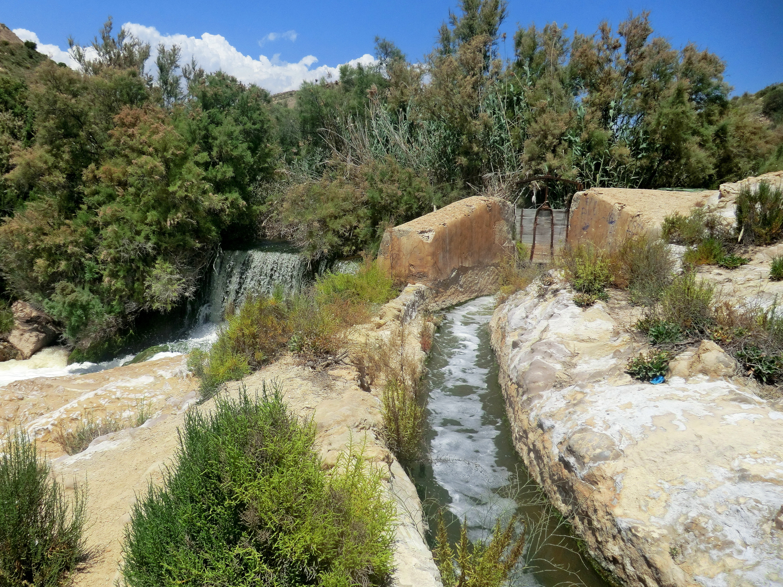
The main acequia, Elche Oasis, Vallongas, Elche, Valencia, Spain in May 2012. Water Alternatives Photos, CC BY 2.0 , via Wikimedia Commons
Click the link to read the article on the BBC website (Kira Walker). Here’s an excerpt:
An ancient Moorish invention has been providing water to the Sierra Nevada mountains for more than 1,000 years, making life possible in one of Europe’s driest regions.
For over a millennium, this acequia – from the Arabic as-saqiya, meaning “water conduit” or “water bearer” – has provided irrigation and drinking water to Mecina-Bombarón, enabling survival and agricultural prosperity in the semi-arid environment. The methods used by acequieros – people with expert skills in water catchment and allocation – to tend the channels today differ little from those used in the Middle Ages…The Islamic water management techniques introduced from the east transformed the landscape and agriculture in what was then Al-Andalus. Acequias made life possible for agrarian communities, conserving and distributing scant and seasonal water resources throughout the rugged mountains. In the newly fertile conditions, the abundance of crops introduced by the Moors thrived, among them almonds, artichokes, chickpeas, aubergine (eggplant), lemons, pomegranates, spinach, quince, walnuts and watermelon.
Though ancient, this traditional water management system is sustainable, efficient and resilient. As climate change worsens, the network will become even more important for helping communities in the Sierra Nevada cope and equitably share an increasingly scarce and unpredictable resource. While this ancient system is needed now more than ever, it’s threatened like never before. As traditional irrigation systems struggle with a lack of profitability compared with intensive agriculture and the rural exodus continues, increasingly few people still hold the skills and knowledge required to maintain acequias.
San Luis People’s Ditch March 17, 2018. Photo credit: Greg Hobbs
“Here is a land where life is written in water.” — Thomas Hornsby Ferril, Colorado Poet Laureate
Colorado Supreme Court Justice Gregory Hobbs Jr. was a respected authority on Colorado water law, and his recent death represents a great loss to Colorado, the state’s water community in particular. Justice Hobbs was also an excellent writer, a poet, actually, and Coloradans are fortunate to have his writings about the state’s unique system of water allocation. In the “Citizen’s Guide to Colorado Water Law,” Justice Hobbs describes the history of the framework for using and managing Colorado water.
As Hobbs notes in the “Citizen’s Guide,” Colorado’s system of water allocation and management began to take shape 170 years ago when the first settlers arrived from New Mexico, bringing their Spanish tradition of community irrigation ditches, or acequias. The oldest continuous water right in Colorado, the 1852 People’s Ditch of San Luis, dates to this period.
In 1858, gold-seekers swarmed into the region, and mining operations were some of the first to claim water, loosely following an appropriation system established during the California gold rush. Most mining operations were short-lived, but the miners helped establish Colorado’s system of water rights.
Rocky Ford Melon Day 1893 via the Colorado Historical Society
Early settlers found good farmland in the Lower Arkansas Valley and diverted water from the Arkansas River into the Rocky Ford High Line Canal to irrigate their crops. The canal has an 1861 water right.
After Congress created the Colorado Territory in 1861, federal court rulings established a water law framework different from the Riparian Doctrine of Eastern states, which provides a water right to anyone who owns land adjacent to a body of water.
The 1862 Homestead Act and 1866 Mining Act allowed Colorado settlers to build ditches and reservoirs to divert water from public land to locations where it was needed for mining and agriculture. Otherwise, Congress allowed Western territories and states to create water law through legislation and court rulings.
In “Chaffee County: Our Water Story,” Kay Marnon Danielson describes early settlers in the Upper Arkansas Valley as predominantly farmers and ranchers. With a growing season of about five months a year, farming in the valley was limited, but large tracts of government land provided opportunities for grazing cattle.
Trout Creek Pass.
Cattle require winter feed, so alfalfa became, and still is, a major crop. Cattle and food crops were raised to feed growing Front Range cities in addition to the boomtowns in mountain mining districts. These Upper Ark Basin agricultural activities required water, which required irrigation ditches like the Trout Creek Ditch, the oldest ditch in Chaffee County with an 1864 appropriation date.
Adopted in 1876, the Colorado Constitution formalized the Prior Appropriation System as the basis for state water law. Under Prior Appropriation, water users with earlier water right decrees hold a “senior” right and can take water to meet their needs before holders of more recent or “junior” rights.
As an example, the Rocky Ford High Line Canal’s 1861 appropriation date gives it priority over the Trout Creek Ditch’s 1864 water right. So, in a dry year water diversions for the Trout Creek Ditch can be curtailed to ensure that the High Line Canal receives its water (because the High Line has the older water right, i.e., the earlier appropriation date).
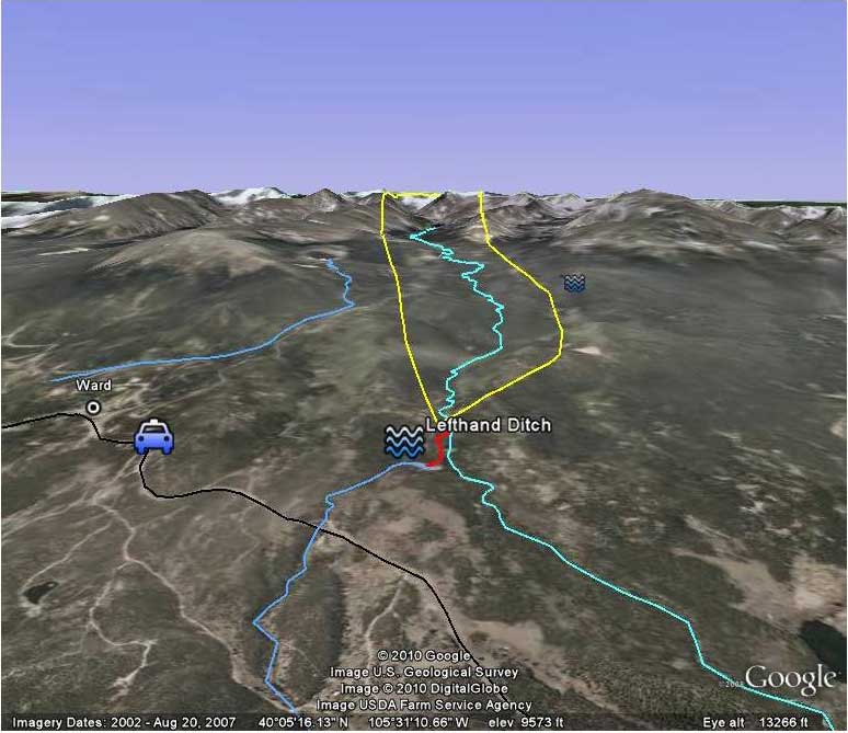
Coffin vs. Left Hand Ditch location map via the Left Hand Watershed Center
In 1882, the Colorado Supreme Court ruled that, under the Prior Appropriation System, water can be appropriated in one watershed and imported to a different watershed to be put to beneficial use (Coffin v. Left Hand Ditch Co.).
Colorado transmountain diversions via the State Engineer’s office
Since 80% of Colorado’s water occurs west of the Continental Divide and 90% of the state’s population resides east of the Divide, planners and water managers have historically looked to the West Slope watersheds to support Front Range agriculture and population centers. As a result, “24 tunnels and ditches move 500,000 acre-feet of water from west to east each year.”
The Arkansas River Basin is no exception. It has the largest land mass of Colorado’s river basins, but it yields one of the smallest quantities of native water, contributing to its status as the most over-appropriated basin in the state.
Limited quantities of native water have also prompted “trans-basin diversions,” which bring an average of 130,000 acre-feet of water per year from the Colorado River Basin into the Arkansas River Basin – nearly 15% of the Ark Basin’s water supply, as calculated by the Colorado Division of Water Resources.
As this diagram (Snake Diagram) shows, native flows in the Arkansas River Basin are dwarfed by the amount of water in West Slope basins (created by the Colorado Water Conservation Board).
The Prior Appropriation System provides a process by which water users can obtain a court decree for their water rights. That process, called adjudication, sets:
The date of the water right.
The source of the water.
The point from which that water is diverted.
The type of beneficial use.
The place where the water is used.
To legally appropriate water in Colorado, the water user must put the water to a “beneficial use,” which requires a plan to divert and/or store the water for a legally recognized beneficial use. Colorado water law defines beneficial use as a lawful “appropriation” of water employing efficient practices to use the water without waste.
According to Justice Hobbs, the goal is to avoid waste so that as much water as possible is available to as many right holders as possible.
Water uses recognized as “beneficial” have expanded through the years and include, among others: agricultural irrigation, municipal uses, commercial uses, domestic uses, industrial uses, recreational uses and snowmaking. In-stream flows were legally recognized as a beneficial use in 1979. Since then, the Colorado Water Conservation Board has claimed in-stream flow water rights for thousands of miles of Colorado waterways, but those rights remain junior to most other water rights.
For more than 125 years now, the Colorado Division of Water Resources has fulfilled the responsibility of administering the Prior Appropriation System. Directed by the State Engineer, this work is carried out through the Division Offices – one for each of the Colorado’s seven major river basins – each led by a Division Engineer. The Arkansas River Basin is administered by Division 2.
San Luis People’s Ditch March 17, 2018. Photo credit: Greg Hobbs
In the Río Culebra Villages of arid, desert southern Colorado, el agua es vida: Water is life.
The crux of ranching and farming is snowmelt and any supplemental rain. Natural waterways wind from the canyons through the desert terrain. The acequia system taps into these creeks and streams with a series of earthen and concrete-lined ditches that bring water to fields. Dug by settlers in the mid-1800s, acequias are physically cleaned, repaired and maintained by water rights holders. Today, many of those people are descendants of area settlers.
FromThe High Country News [November 23, 2021] (Sarah Tory):
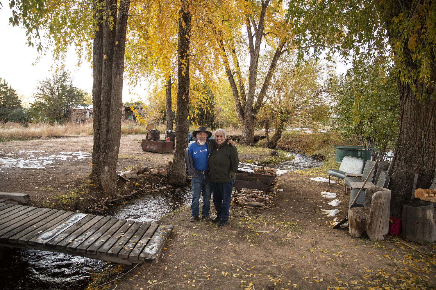
Every summer in Colorado’s San Luis Valley, a long, high desert valley ringed by mountains, Jose Martinez watches in admiration as water flows from an irrigation pipe across the contours of his land, feeding the eight acres of alfalfa he grows near his home in San Francisco, a town of less than 90 people. The water comes from a network of communal irrigation ditches, or acequias, which comes from an Arabic word meaning “water bearer.” The acequias were built in part by his ancestors who arrived in southern Colorado more than 150 years ago with other Hispanic families from what is now New Mexico, establishing seven villages around Culebra Creek.
“I get to thinking, back in the day, these men dug it all by what we call pico y pala — pickaxe and shovel,” Martinez, 76, told me when I visited recently. We were sitting in his kitchen on a cold October day with his wife, Junita, 70, while the two of them explained how acequias work.
Unlike normal irrigation ditches, acequias are a communal resource, collectively owned and governed by their parciantes, or members — the group of small-scale farmers with water rights to the ditch. Acequias are egalitarian, too: whether you irrigate one acre or 100 acres, you get one vote in decisions about the ditch in exchange for helping to clean and maintain the acequia. The parciantes elect a three-member commission to make decisions around ditch maintenance and operations, as well as a mayordomo to manage the irrigation infrastructure and tell people when they can irrigate and when they have to shut their gates.
Junita and Jose Martinez on their vara land, which is pipe irrigated with acequia water. Jose remembers when his family would plant vegetables on their plot, but now he plants hay, which requires less labor, and yields a larger profit. Luna Anna Archey
In Colorado, acequias are found in four of the southernmost counties and irrigate only a tiny fraction of the state’s agricultural output. But in a region where some water rights have been sold to the highest bidder and private gain is sometimes prioritized over collective well-being, acequias remain a powerful antidote to the forces threatening rural communities — a way of valuing local resources beyond their dollar amount and a catalyst for sharing them in times of scarcity. During dry years, acequias work to ensure that everyone weathers the shortages equitably; occasionally, Jose has opted to forego his water entirely when he sees no prospect of a decent crop, so that other parciantes can have more.
“Our concept is community,” Junita explains. “If I can’t get something, why should I hurt my neighbor, if I could just let him have my water — maybe he can grow something?”
The Culebra-Sanchez Canal, a feeder ditch in the acequia system in the San Luis Valley. Luna Anna Archey
THAT COMMUNAL MINDSET originates in part from the families who arrived in the southern San Luis Valley in the mid 19th century to settle the one-million-acre Sangre de Cristo Land Grant. Drawn by promises of land and resources, they established small farming communities on land where the Cuputa band of Ute people had roamed for thousands of years, until they were gradually killed or forced out by European colonizers beginning in the 1600s. The families settling the valley beginning in the 1850s were primarily from Mexico, which had sold the territory now known as New Mexico — including the southern end of the San Luis Valley — to the U.S. government a few years earlier at the conclusion of the Mexican-American War.
Families built acequias and shared access to a mountainous tract of land in the nearby Sangre de Cristo mountains, known locally as La Sierra, which they relied on for water, firewood and foraging. The land grant was eventually sold, but its subsequent owners honored the historical rights of local families to access La Sierra.
Growing up, Jose Martinez remembers how families built cellars to store the vegetables grown on the land nourished by the acequias, as well as meat from deer and elk hunted in La Sierra — food that would last them the winter. Although they live in what is now one of Colorado’s most impoverished counties, “we ate like kings,” he said.
That all changed in 1960, when John Taylor, a North Carolina timber baron, bought 77,500 acres of La Sierra, renaming it the Cielo Vista Ranch and closing it off to the local community to create a logging operation. Taylor’s logging wrought lasting damage on the land. Poorly constructed roads created erosion, reducing the amount of water that flowed from the mountains into the acequias, according to area residents.
One of many gates blocking public access to privately-owned Cielo Vista Ranch. Residents with ancestral rights to the land won access in a Supreme Court ruling. They now have keys to the gates, but are only able to use the land for specific purposes, like gathering firewood, and they often face harassment by Ranch employees. Luna Anna Archey
The water wasn’t the only resource reduced or eliminated as a result of Taylor’s actions. Without access to La Sierra for grazing, local families lost their herds and the culture of self-sufficiency that had sustained them for decades. Many, like Jose Martinez’s family, moved out of the valley. Those that stayed saw their health and well-being deteriorate. People went on food stamps and rates of diabetes soared. There were psychological impacts, too.
“You lose the relevance of what your land means,” said Shirley Romero Otero, the head of the Land Rights Council, which formed in the town of San Luis in the late 1970s to stop Taylor from denying access to the property. (A group of San Luis community members are participating in The Colorado Trust’s Community Partnerships strategy; Romero Otero previously was part of this effort.)
In 1981, the Land Rights Council mobilized local residents to sue Taylor for blocking their historical right to access the property. The ensuing legal battle lasted 40 years, fought by generations of the same families and leading to an April 2003 Colorado Supreme Court ruling, Lobato v. Taylor. The ruling granted people the right to graze their animals, cut timber and gather firewood on the land, if they could prove they were heirs to property that was part of the original Sangre de Cristo land grant.
The privately-owned Culebra Range in the background of San Francisco, Colorado. Residents call the mountains La Sierra. Luna Anna Archey
“WE’RE SUCH DIEHARDS,” Junita told me, pointing to an old black-and-white photo from the early days of the land rights struggle taped to their refrigerator. Her husband was among the roughly 5,000 people given keys to access the ranch gates after a nearly 15-year process of identifying the land grant descendants.
“We won’t let go,” Jose added.
The Martinezes owe their persistence in part to the acequias, which are the lifeblood of each village, binding people to the land and to each other. Every spring, acequia communities gather for an annual ritual called La Limpieza to clean the ditch in preparation for the irrigation season. For families, it serves as a de facto reunion — regardless if someone has moved to Denver or to California, people come back for La Limpieza.
For Junita, that communal aspect is why acequias are important: working together to cultivate a shared resource. It’s also why she feels so strongly about protecting those resources from wealthy outsiders who threaten that culture. “We’re a land- and water-based people,” Junita explained.
The current owner of the Cielo Vista Ranch is William Harrison, heir to a Texas oil fortune, who bought the Cielo Vista property in 2018. According to its real estate listing, the ranch was listed at $105 million and encompasses 23 miles of the Sangre de Cristo Mountains, including 18 peaks over 13,000 feet and one over 14,000 feet, Culebra Peak — the highest privately owned mountain in the U.S., and quite possibly the world.
Harrison’s ranch hands have intimidated and harassed local people who tried to access the property, according to court filings and residents — despite the legal rulings affirming the rights of the land grant heirs. With the threat of a violent confrontation growing, Jose and Junita’s children told their father they don’t want him going up onto the ranch alone to collect firewood, which he, like many locals, uses to heat their home.
A week before I visited, the Land Rights Council filed a motion in Alamosa Municipal Court to safeguard local residents’ rights to access the ranch. During a two-day hearing, a judge heard testimony about how the ranch’s aggressive surveillance tactics infringed on the community’s hard-won traditional land rights, including tracking people with drones and armed ranch hands approaching people with dogs. The ranch denied use of such tactics.
In an email, Harrison, through his lawyer, wrote that he believes that a few “bad apples” have abused those rights on occasion, illegally hunting, joy-riding ATVs and sneaking onto the property to fish. “That being said, we are fully committed to bringing the animosity of the past to a close, and are making a good-faith effort to bring healing and peace,” he added.
A sign in the town of San Luis provides notification of a community meeting about accessing La Sierra. Luna Anna Archey
IF ACEQUIAS are the seams holding communities together, they are also what makes them vulnerable: the stitching that can come undone. In recent years, developers have approached communities elsewhere in the San Luis Valley to buy their water rights and then move the water from the aquifer below the valley over Poncha Pass and into the Arkansas River for growing Front Range cities.
“Some of those places look like ghost towns because of that,” said Peter Nichols, a lawyer with the Acequia Project, a pro-bono legal assistance program supported by the University of Colorado Boulder Law School.
Thus far, acequia communities have resisted those efforts, ensuring their water stays with the land. With the help of the Acequia Project and Colorado Open Lands, an environmental nonprofit, acequias have adopted bylaws that protect acequias from outside buyers.
Still, like any collaboration, acequias are not perfect, said Sarah Parmar, the director of conservation at Colorado Open Lands. “It’s messy because there are human relationships involved, and anytime you have a community that goes back multiple generations, there are going to be grudges and things that have happened that they’re going to bring into those situations,” Parmar said.
But more than anything, acequia communities recognize that water is not just an asset; “it’s a piece of everything,” Parmar told me. “If you pull on that thread, the whole sweater unravels.”
Junita and Jose Martinez at their home in San Francisco, Colorado. Nana Ditch, the “mother ditch,” runs through their property. Luna Anna Archey
JOSE GRABBED JUNITA’S ARM to steady her as the two walked outside to show me the Nana Ditch, the “mother ditch” that gurgles beneath the willow trees in their backyard.
“It would kill me to see water flow by that doesn’t belong to us,” Junita said. “We’d have to go away.”
Today, abandoned houses are scattered amongst the roads and villages of the Culebra watershed — a reminder of how this community, like so many rural communities, has changed. North of the villages, giant agricultural operations have replaced the smaller family-run vegetable farms that once filled the San Luis Valley, while their high-tech center pivot irrigation systems are depleting the aquifers beneath the valley floor at an alarming rate.
Meanwhile, so many people have left, with the population of Costilla County nearly half what it was in 1950. When their children were growing up, Jose and Junita moved to Colorado Springs so the girls could get a better education. But people are returning to the valley, too, like Martinezes did in 2002. Jose began growing alfalfa on his family’s eight acres again, and a few years ago, two of the girls bought the lots on either side of their parents, where they hope to one day build their own homes.
In the Spanish dialect spoken in northern New Mexico and southern Colorado, there is a term called querencia, which translates roughly to “heart home or place.” Even after they left the valley, Jose and Junita would bring the girls back to San Francisco every summer to remind them: “This is where you come home.”
Junita and Jose Martinez’s land on the periphery of San Francisco, Colorado. Luna Anna Archey
This story was republished with permission from Collective Colorado, a publication of The Colorado Trust.
Sarah Tory writes from Carbondale, Colorado. Follow @tory_sarah
Acequia La Vida via Greg Hobbs.
Santa Cruz River, Acequia de La Puebla, Chimayo
Selection of the 2015 native heirloom maize harvest of the seed library of The Acequia Institute in Viejo San Acacio, CO Photo by Devon G. Peña
An acequia along the Las Trampas in northern New Mexico is suspended on a trestle. (Eddie Moore/Albuquerque Journal)
Fig. 2. Mexican Land Grants in Colorado and New Mexico. The Baumann map depicted here mislabels these Mexican land grants as “Spanish”. Source: Paul R. Baumann 2001. SUNY-Oneonta.
Water from acequias, a shared collection of gravity-fed irrigation ditches have been a historical part of irrigation in the San Luis Valley. Acequia San Antonio via Judy Gallegos
Acequia del Cerro, San Luis
Acequia cleaning prior to running the first water of the season
San Pedro Acequia. The headgate of the second oldest acequia in Colorado. Photo by Devon G. Peña
Bella Cruz has lived next to the People’s Ditch in San Luis for more than 60 years. Appropriated in 1852, it is the first surface water right in Colorado. Photo credit: Alamosa Citizen
San Luis People’s Ditch March 17, 2018. Photo credit: Greg Hobbs
San Luis People’s Ditch spanning the long lot system
Local youth participate in the production of chicos del horno at Corpus A. Gallegos Ranch. San Luis, CO Photograph by Devon G. Peña
San Luis People’s Ditch via The Pueblo Chieftain
The country’s second largest potato producing region, is in its 18th year of drought in 2020. The San Luis Valley in Colorado is known for its agriculture yet only has 6-7 inches of rainfall per year. San Luis People’s Ditch
A powerful sprinkler capable of pumping more than 2,500 gallons of water per minute irrigates a farm field in the San Luis Valley June 6, 2019. Credit: Jerd Smith via Water Education Colorado
THE Colorado Water Conservation Board handed out roughly $2.8 million last week to five projects in the San Luis Valley, including a first-of-its kind conservation easement program aimed at protecting the region’s groundwater.
San Luis Valley Groundwater
Colorado Open Lands garnered $1.4 million for a voluntary conservation easement program, which would reduce groundwater pumping while allowing for continued agricultural use. The management plans accompanying the easements would draw on the experience of the Natural Resources Conservation Service. The total cost of the project is $8.2 million, the majority of which will come from the NRCS.
The Rio Grande Headwaters Restoration Project will use part of a recently awarded state grant to replace the Billings Ditch’s diversion structure and head gate, which are currently prone to debris and sediment buildup. Top photo: Daniel Boyes, program manager for restoration project, and Rick Davie and Steve Vandiver, both of whom sit on restoration project’s board, at the Ehrowitz Ditch, which will have the gravel push-up dam shown here replaced with a more efficient structure. It’s one of five irrigation ditches that will get improved diversions. Photos courtesy Rio Grande Headwaters Restoration Project. Photo credit: The Alamosa Citizen
CWCB granted $818,030 to the Rio Grande Headwaters Restoration Project for work on the Anaconda, Independent No. 2, Knoblauch, Ehrowitz, and Billings ditches. The project would improve diversions for the respective ditches, all of which are in Rio Grande County, while also including fish and boat passage. Work crews would also restore 3,960 linear feet of stream bank and enhance aquatic habitat through willow planting, channel and stream bank shaping, and the installation of rock clusters.
Farmer Erin Nissen with some of her cattle. Under Subdistrict 1’s fallowed field program, she is still able to utilize the land for grazing. Photo credit: Luna Anna Archey/High Country News
The board awarded $163,406 to the Rio Grande Water Conservation District to develop an in-basin water marketing strategy to secure the roughly 16,000 acre-feet needed by the Subdistricts to offset stream depletions. The program’s managers are eyeing tools such as temporary water leases or rotational fallowing toward that end. The Rio Grande Basin Cooperative Project, as the effort is known, also received $212,105 from the U.S Bureau of Reclamation, and roughly $163,000 from three other funders toward the $425,511 project cost.
Fig. 2. Mexican Land Grants in Colorado and New Mexico. The Baumann map depicted here mislabels these Mexican land grants as “Spanish”. Source: Paul R. Baumann 2001. SUNY-Oneonta.
The Sangre de Cristo Acequia Association received $24,500 to hold seminars around irrigation, soil health and cropping in 2022. Funds would also go toward developing a stakeholder group to implement projects and the association’s hosting of the Congreso de Acequias.
San Luis People’s Ditch spanning the long lot system
Colorado Master Irrigator, a nonprofit educational group, received $414,875 to expand trainings on water and energy conservation and other efficiency practices across the state. Part of those funds will focus on expanding offerings into the San Luis Valley through a partnership with the Colorado Ag Water Alliance and Subdistrict No. 1.
All of the funding for the Valley projects came from the Colorado Water Plan Grant Program. State lawmakers and Governor Jared Polis gave the grant program a boost in spring with $15 million from the state’s General Fund.
Rio Grande River Basin via the Colorado Geologic Survey
Members of the Rio de Chama Acequia Association (RCAA) are adamant about continuing the repartimento – the traditional way of sharing water in New Mexico. They want their acequia parciantes to be treated like all the other contractors in the San Juan-Chama River Project and they want to be able to store water in Abiquiu Lake.
New Mexico water projects map via Reclamation
The Los Alamos Reporter recently sat down with the officers of the association to discuss the issues they are facing and the solutions they propose. RCAA chair Darel Madrid explained how in the 1960s, water was diverted from the Little Navajo river in Colorado to build up water in the Rio Grande through the San Juan-Chama River Project. He said most of that water streamed through a tunnel under the mountains and into Heron Reservoir.
“Ours is the only river system in the area that has foreign water running through it. Our water rights are tied to the native water rights of the Rio Chama basin. With climate change, we’re getting less and less snowpack. We’re getting warmer springs and all the melt-off is running through our acequia system before we are ready to use it,” Madrid said. “In our climate down here, the growing season usually starts the latter part of May or in June and continues into October. This water is melting off earlier and it’s passing through our system in March and early April. It leaves us in a bind.”
Madrid explained that because the RCAA water rights are tied to the Rio Chama water, only a sliver of the water that you see running through their system is actually their water.
“When people see all this water flowing through the system, they don’t realize that only a portion of that water is our water. We have approximately 22 acequias from below the dam that run from the Trujillo-Abeyta ditch, which is the northern-most, to the Salazar Ditch, which is the last one to receive water,” he said.
The foreign water that’s running through the system is owned mostly by contractors of the original San Juan–Chama River Project including the Middle Rio Grande Conservancy District which takes care of everybody from Cochiti all the way down to Socorro, and the Albuquerque-Bernalillo County Water Utility Authority. There are also minor contractors like the County of Los Alamos, the City of Espanola, the Village of Taos, and the City of Santa Fe – all of whom bought into the project in the 60s…
For many years there was less of a drought situation in the region so there was plenty of water for everybody, he said…
“When the Rio Grande Compact was established in the late 20s or 30s, none of the RCAA acequias were invited to the table. They didn’t have a voice in those discussions at all. The parciantes were busy being farmers and were not organized. The same thing happened during the San Juan-Chama River Project. For all that we can tell, we weren’t invited to the table and all these decisions were made without our participation. When all was said and done we were left with all these rules and regulations that we have to abide by so it’s almost like taxation without representation,” Madrid said.
He noted that regulations for the acequias are all set through court orders with the State Engineer’s Office having the most authority…
The 22 RCAA ditches have the oldest priority dates for rights to the water with some of them going back to the 1600s. Madrid believes those are probably the oldest water rights in the entire nation, second only to Native Americans. The ditch behind his home has been in continual use for more than 400 years. Families of others on the board have been irrigating for hundreds of years in the area.
Abiquiu Dam, impounding Abiquiu Lake on the Rio Chama in Rio Arriba County, New Mexico, USA. The U.S. Army Corps of Engineers constructed the dam in 1963 for flood control, water storage, and recreation. By U.S. Army Corps of Engineers, photographer not specified or unknown – U.S. Army Corps of Engineers Digital Visual LibraryImage pageImage description pageDigital Visual Library home page, Public Domain, https://commons.wikimedia.org/w/index.php?curid=2044112
RCAA Treasurer Carlos Salazar said RCAA wants to find a way to store its water so that it doesn’t have to buy water and believes this would require federal legislation because the dams were constructed with federal funds. The Association hopes that the congressional delegation will help them to find a way to store their native water because it comes from their ancestral lands. Because the water can’t be stored, half of any water that flows past the Otowi Bridge near the Pueblo of San Ildefonso in the spring goes to Texas.
All the RCAA acequias are metered by the state engineer. Their diversion is measured, but one of the big debates RCAA has with the state engineer is that not all of it is consumed and the state charges them for all of the diversion and doesn’t credit them for any return flow. Another burden the RCAA has to bear is that its member acequias are saddled with all the costs for the operation and maintenance…
The RCAA believes all diversion levels should be increased by 30 percent but they would need to invest in return flow measurement to accomplish that and it would take $1,000 per ditch, a total of about $54,000 to accomplish that.
Seaman noted that the RCAA is simply trying to continue the tradition of the acequias.
“To me, the Treaty of Guadalupe Hidalgo guaranteed every citizen all these rights and we don’t see it happening now with this adjudication of water to the Rio Grande and the City of Albuquerque and our neighbors there on Heron Reservoir. All that imported water – where were the acequias?” Salazar said. “I think we should be treated fairly. Our rights pre-date all of them and we should be given an opportunity to store water even if we have to pay for the storage.”
Once an acequia commissioner and now a U.S. congresswoman, Leger Fernández knows how hard it is to tell farmers they won’t get all the water they need — or maybe none at all.
She talks about the annual limpia, or cleaning of acequias in preparation for planting season.
“There was always a sense of accomplishment but now what we’re witnessing is we can’t do it all the time anymore because we don’t have the water,” she said during a tour with acequia officials. “And what you all are facing is not of your making, right? But you are having to work through the struggle of making whatever water is available work for everybody in the community.”
Some earthen canals didn’t get a drop of water this year, another example of parched Western conditions. Like many parts of the world, the region has become warmer and drier over the last 30 years, mainly due to rising levels of carbon dioxide and other greenhouse gases resulting from the burning of coal, oil and natural gas development and transportation.
Boat docks are high and dry at reservoirs around New Mexico, and Lake Powell along the Utah-Arizona line has hit a record low this year. A key Northern California reservoir that helps water a quarter of U.S. crops is shrinking.
For mayordomos — those who oversee acequias and ensure equitable water distribution — it has become a scramble.
Less snow falls, and warmer temperatures melt it sooner. Dry soil soaks up runoff before it reaches streams and rivers that feed acequias.
Paula Garcia, New Mexico Acequia Association executive director, shuns the phrase “new normal” because she said that implies stability in weather patterns the community’s ditches rely on…
Federal water management policies have complicated matters as needs of cities and other users overshadow these Hispanic and Indigenous communities.
Their traditions are rooted in Moorish ingenuity first brought to Europe and then to North America via Spanish settlers. Those water-sharing ideas were blended with already sophisticated irrigation culture developed by Indigenous communities in what is now the southwestern U.S.
What developed were little slices of paradise, with gardens and orchards that have sustained communities for generations.
Roughly 640 New Mexico acequias still provide water to thousands of acres of farmland.
Darel Madrid, Rio Chama Acequia Association president, didn’t grow a garden this year. He wanted to lead by example…
West Drought Monitor map September 7, 2021.
After back-to-back record dry summer rainy seasons, some Southwest areas enjoyed above average rain this year. But maps are still bleak, with nearly 99% of the West dealing with some form of drought…
When water-sharing compacts involving some of New Mexico’s largest cities were first negotiated decades ago, Madrid said communities along Rio Chama were left out. Now, as supplies are scarce, acequias around Abiquiu have been forced to seek state funding to buy water from downstream users. If none is available, they go without.
As long as Rio Chama flows above 140 cubic feet per second, water can be diverted by acequias. The flow usually nosedives in May, and rationing starts when it drops below 50 cfs. Aside from isolated spikes from storm runoff, the flow is now less than half that.
Madrid said acequias would benefit from permanent water storage in an upstream reservoir, which would need federal approval…
Part of that means reimagining acequias without giving up the sense of community they command.
At Santa Cruz Farm, owner Don Bustos is growing crops in greenhouses in fall and winter when less water is needed and evaporation is reduced, he said.
In Taos, acequia leaders have bumped up annual cleaning to the fall so they don’t miss out on early runoff…
Acequias have overcome periodic environmental crises, rivalries among water users and profound historical changes, Spanish historian and anthropologist Luis Pablo Martínez Sanmartín noted in a 2020 research report. He said survival has hinged on a common-good design based on cooperation, respect, equity, transparency and negotiation.
Here’s Part 1 of the series from The Alamosa Citizen (Mark Obmascik):
The water supply of the San Luis Valley faces pressure as never before
THEY all remember when the San Luis Valley brimmed with water.
South of San Luis, Ronda Lobato raced the rising floodwaters in San Francisco Creek every spring to fill sandbags that protected her grandparents’ farm.
North of Center, potato farmer Sheldon Rockey faced so much spring mud that he had to learn to extract his stuck tractor.
Outside Monte Vista, Tyler Mitchell needed only a hand shovel on the family farm near Monte Vista to reach shallow underground flows in the Valley’s once-abundant water table.
Today those tales of plentiful water seem like a distant mirage. Ten of the past 11 years have delivered below-average snowpacks for the upper Rio Grande basin, with this year’s snowpack measuring just 58 percent of normal at the key May 1 measurement. All but one of the main local reservoirs were less than half-filled.
Farmers face significant cutbacks from wells now and likely from river flows and irrigation ditches later this season.
Against this stark backdrop of drought, three other vast changes loom.
The biggest is a state court judgment that came after decades of excessive well pumping by valley farmers and ranchers. Local irrigators now must restore 400,000 acre feet of water – more than 1.3 million people in metro Denver use in an entire year – to Valley groundwater systems within 10 years.
A second challenge is a plan by former Gov. Bill Owens and a metro Denver business group to pump and divert additional deep groundwater from the San Luis Valley to new buyers outside the San Luis Valley, likely on the Colorado Front Range.
And the third long-term issue is a forecast for flows to be reduced even further, perhaps as much as 30 percent, because of climate change, according to Colorado’s Rio Grande Implementation Plan.
Buffeted by drought, court orders, climate change, and Front Range diversion plans, the water supply of the San Luis Valley faces pressure as never before.
Shortages loom. Cuts seem inevitable.
“Our demand for water has far exceeded our supply for years, and now our supply is in a 20-year downward trend,” said state Sen. Cleave Simpson, general manager of the Rio Grande Water Conservation District. “We keep facing drought after drought. The sense of urgency continues to build.”
It all threatens the way of life for the 46,000 residents of the San Luis Valley, where agriculture is the driving economic force. Farming and ranching account for $340 million of sales each year while providing 18 percent of the region’s jobs. That puts agriculture behind only the government as a source of local employment. About one of every three dollars of basic income in the San Luis Valley comes from agriculture.
The San Luis Valley is the nation’s No. 5 producer of potatoes – behind only the tates of Idaho, Washington, Wisconsin, and Oregon – and a leading supplier of quinoa and alfalfa hay. (The Colorado Potato Administrative Committee says the San Luis Valley is the No. 2 producer in the U.S. for fresh potatoes.)
In a region long beset with poverty – one of every four Valley residents is impoverished, nearly double the statewide rate – farming and ranching have offered one economic success story. In Saguache County, the annual net income, or profit, per farm was $113,000, says the US Department of Agriculture census. Net income per farm in Rio Grande County was $105,000.
But all those jobs, all that money, hinge on one thing: an ample and dependable water supply.
“The climate of the San Luis Valley is arid, and a successful agricultural economy would not be possible without irrigation,” says the U.S. Geological Survey.
Average annual precipitation on the Valley floor is 7 to 10 inches, but potatoes, for example, need an additional 14 to 17 inches of irrigation water during the growing season. Alfalfa hay, the Valley’s top crop by acreage, requires up to 24 inches for a crop.
This adds up to an enormous thirst. According to state water engineers, San Luis Valley agriculture accounts for 810,000 acre feet of consumptive water use per year.
By contrast, the Denver Water Department needs only 247,000 acre feet of water to supply the 1.3 million people within its city and suburban service boundaries.
In other words, metro Denver requires only one third as much water as the San Luis Valley to produce a gross domestic product 60 times greater – a $202 billion annual economy vs. a $3.3 billion economy.
Because the San Luis Valley has so much water being put to comparatively low economic use, metro Denver water developers continue to focus a covetous eye on Rio Grande diversions.
After the AWDI proposals of the 1980s and the Gary Boyce plan of the 1990s, the Gov. Bill Owens-backed Renewable Water Resources proposal is the latest push to take advantage of relatively low prices to pipe water out of the San Luis Valley.
> Bella Cruz has lived next to the People’s Ditch in San Luis for more than 60 years. Appropriated in 1852, it is the first surface water right in Colorado. Photo credit: Alamosa Citizen
In the crosshairs is one of the oldest agricultural traditions and cultures in Colorado.
The first surface water right in Colorado, appropriated in 1852, is the People’s Ditch near San Luis. With a series of community irrigation canals called acequias, Hispanic settlers soon started growing food in the high desert with water from the Conejos, Rio Grande, Alamosa, Culebra, San Luis, Saguache, Carnero, and Trinchera, among other rivers and creeks.
By the 1870s, as much as 50,000 acres in the San Luis Valley was irrigated. After the arrival of the Denver and Rio Grande Railroad, that number soared to 400,000 acres by the 1880s. By 1900, demand for water in several valley streams already outstripped the natural supply.
Farmers responded by building reservoirs, and, especially, digging wells. By the time of World War I, the San Luis Valley was home to at least 5,000 groundwater wells. The rush was on. Underground supplies seemed endless.
Until they weren’t. In 1972, Colorado water officials ordered a moratorium on construction of new wells in most of the valley, and then ended new appropriations of groundwater in the rest of the valley in 1981, which was one of the worst snowpack years on record, with just 11 percent of normal on May 1.
Luckily, that one terrible year of drought in 1981 was followed by six successive years of some of the best snowpacks in the recorded history of the Rio Grande Basin. From 1982-1987, few worried much about groundwater because the rivers were flooding.
Another run of giant snowpacks in the mid-1990s helped to keep the pressure off groundwater pumping – while helping to build the memories of valley residents like Ronda Lobato, Sheldon Rockey, and Tyler Mitchell.
“I remember the snowbanks being bigger than me – the winters were so long and cold,” said Lobato, whose aunt and uncle lived along San Francisco Creek. “When the runoff came, we had to fill sandbags to protect against flooding. Today there is no water in San Francisco Creek. It doesn’t run at all.”
Farming is never easy, but water shortages make it even tougher, said Tyler Mitchell.
“I remember as a kid being able to dig with a shovel to find water. Now I might have to go 30 feet to find it,” said Mitchell, whose family runs 18 center pivot irrigation rigs. “The ditch water used to go all summer long. Now we’re lucky to get one month, and some ditches do only a few weeks. We don’t have enough surface water to grow cash-value crops every year.”
The mid-1990s were the heyday of San Luis Valley agriculture, said potato grower Sheldon Rockey, and that era changed the way of thinking for a generation of farmers.
“I remember when the river flooded three years in a row. I got the tractor stuck in the mud,” Rockey said. “There was a lot of money made without worrying much about water. The issue with the older crowd of farmers is that they were so successful for so long. Now that we’re in drought, it’s hard to change your thinking.”
The bountiful water years of the 1980s and 1990s in the San Luis Valley have flipped the typical generational divide in farming. Because they lived through the wettest times, the older farmers tend to have a brighter view than the younger farmers, local agricultural officials say.
“Farming is an optimistic profession,” said Heather Dutton, manager of the San Luis Valley Water Conservancy District and Rio Grande Basin representative on the Colorado Water Conservation Board. “People my father’s age have seen farming here at its best, when we had giant years for water. But the data and science don’t give me many reasons to think those days will come back around.
“If the big water years do come back, that would be tremendous. But I don’t want us to ignore the freight train coming at us right now.”
That train began blasting its horn about 20 years ago.
State water engineers long had been concerned about well-pumping by valley irrigators, but the connection between groundwater and surface water was not clearly understood. Starting in January 1976, engineers began monitoring the level of valley aquifers. Groundwater declined steadily but gradually, which led to the state moratoriums on drilling.
However, 2002 was the driest on record for the Rio Grande Basin, with a May snowpack of just 6 percent. With little available surface water, valley irrigators turned underground for supplies.
The result: In just one year, engineers recorded a 400,000 acre foot drop in Vvalley aquifers. That is a huge amount of water – a single acre-foot is enough to support two families of four people for a year.
In response to the vast agricultural overpumping came a flurry of laws, regulations, and court actions.
For the past decade, valley irrigators have been under a court order to maintain a sustainable aquifer system. That means restoring at least 400,000 acre feet to underground supplies, officials say. (Engineering studies say the unconfined aquifer actually has been drained by as much as 1 million acre feet since 1976.)
Little progress has been made to return that water in the past 10 years. Now irrigators face a 2031 deadline to repay the water debt.
Still, 5,000 irrigation wells continue to pump in the valley, including 3,000 in the key Subdistrict 1 north of Monte Vista and west of Hooper.
The $426,000 state Rio Grande Implementation Plan was blunt: “Because the sustained and lingering drought since 2002 has not been matched with a decline in agricultural consumptive use, use of the aquifers is unsustainable.”
What local water officials now fear is a replay in the San Luis Valley of what happened to irrigators on the South Platte River, where years of over-pumping by farmers, combined with a resulting state court order, led to the 2006 shutdown of 440 wells and the pumping curtailment of hundreds of others.
In the San Luis Valley, the clock is ticking. A reckoning awaits.
“Shutting down wells – there are people here who can’t survive that,” said Simpson, the state senator. “We are 10 years into this plan to create and maintain a sustainable aquifer system, but we are not yet back to where we started. There are no easy solutions.”
Scientists say it won’t get any easier. Because of climate change, a study by the Bureau of Reclamation, Sandia National Laboratories, and the U.S. Army Corps of Engineers forecasts even more challenges for water users in the Upper Rio Grande Basin:
Flows will decrease by 33 percent by 2100 at the Rio Grande near Del Norte, Conejos River near Mogote, Los Pinos River near Ortiz, and San Antonio River at Ortiz. Flows will decrease by 50 percent at the Rio Grande near Lobatos.
Peak river flows will come earlier, shifting from June to May.
Fewer water rights will be served. From 1950 to 1999, the average junior-most water right to be served in June on the Rio Grande was a 1910 priority, but by 2100 it will be an 1890 priority.
“We are an incredible agricultural community, but we don’t have the water supply we used to,” said Dutton, the Rio Grande representative on the Colorado Water Conservation Board. “There are more people who want water than there is water available. We are facing scarcity.”
Not just agriculture at risk: In 2008, the state granted a water right to the Great Sand Dunes National Park and Preserve for the groundwater beneath its boundaries. The Valley’s extensive wetlands and river habitats support at least 13 threatened and endangered species and more than 260 species of birds including a major spring and fall flight of sandhill cranes. Photo credit: The Alamosa Citizen
Here’s Part 2 in the series from The Alamosa Citizen (Mark Obmascik):
Plan to pipe water to Front Range has big backers, few specifics
THE Front Range executives who want to export water from the San Luis Valley to sell elsewhere are clear about a few things:
They have money. They are backed by former Gov. Bill Owens. And they think their plan will benefit the Valley.
Beyond that, however, details remain sketchy.
Where exactly would the Renewable Water Resources project be built? Who are the investors? How much would it cost? What’s the project timetable? Who are the local supporters? Where are the customers?
Also: If this project will truly help the San Luis Valley, then why are the political, water, and farm leaders of the Valley overwhelmingly against it?
“We know San Luis Valley citizens are looking forward to jobs and an uptick in the local economy as a result of our project moving forward,” said Renewable Water Resources executives in a prepared statement. “Citizens responded favorably to the more than $50 million community fund – run by the community – that would be created to address critical issues which could include public education, economic diversity, senior assistance programs, conservation efforts, law enforcement, mental health services, and more.
“We have asked the unelected Rio Grande Water Conservation District Board the following question, ‘What are you for?’ This question has been met with silence other than falling back on the status quo which means higher taxes and more regulation for the valley’s struggling farms and ranches.”
Local officials say Renewable Water Resources is not to be trusted.
“They continue to use false information to describe and promote their project,” said Heather Dutton, manager of the San Luis Valley Water Conservancy District and the Rio Grande Basin representative on the Colorado Water Conservation Board. “I don’t think people will fall for a bunch of falsehoods.”
Valley native Ken Salazar – the former U.S. Secretary of the Interior, U.S. senator, state Attorney General, and current U.S. ambassador to Mexico – said the project would proceed “over my dead body.”
Local opponents of the plan formed a group, Protect Our Water, that lists as members: 15 local water districts and entities; 22 cities and towns; 22 conservation and environmental groups; and two farm groups. It lists statements of opposition to the RWR proposal from eight separate local governments, including the Rio Grande Water Conservation District, the city of Alamosa, and Mineral and Rio Grande counties.
The group says it is organized around a main principle: “There is no water available to move outside the San Luis Valley.” It has a web page dedicated to correcting what it says are RWR’s numerous misstatements about the project.
RWR executives say they can’t be specific about project locations, timetables, or costs because they are focused on winning Valley support and filing a legal case in Colorado’s water court, which could take three to five years to process. That case would help determine whether the San Luis Valley has enough water for RWR to legally export without hurting existing users.
In general, RWR says it wants to build a wellfield northeast of Moffat. A pipeline would carry water north along state Highway 17, more than 1,000 feet up and over Poncha Pass, to some uncertain location.
Though a few Front Range cities such as Aurora and Colorado Springs draw some water from the Arkansas River basin, most metro Denver utilities rely on the South Platte River, a more distant location that would require a much longer pipeline and additional pumping costs for RWR.
RWR says it has no identified customers for its proposed project. Executives have been pitching it to utilities on the Front Range.
The financial incentives for RWR: Wholesale water prices are five to 10 times higher on the populated Front Range than in the agricultural San Luis Valley.
In the San Luis Valley, RWR proposes to drill nearly a half-mile into the Valley’s deep aquifer to pump out 22,000 acre-feet of water per year. At the same time, RWR says it will buy and retire 31,000 acre feet of water currently used in the Valley for irrigated agriculture. As a result, RWR says a “surplus of 9,000 acre-feet will go back into the San Luis Valley’s shallow section of the aquifer.”
The company says it is “investing $68 million to pay local farmers and ranchers who voluntarily wish to retire their water rights above market rate.”
In addition to the purchase of those water rights, RWR said it will donate $50 million to a locally controlled community fund. The company expects that fund to generate $3 million to $4 million per year in contributions for local causes.
RWR also has agreed to donate a 3,000-acre ranch for use as elk habitat near the Baca National Wildlife Refuge south of Crestone.
“To give the above numbers some context,” RWR said in a statement, “the poverty rate of the San Luis Valley is greater than 35 percent and the average median household income is under $26,000. We do believe our commitments to the community will better the valley.”
However, many questions remain unanswered. RWR declined to make available any project executives, including Owens, governor of Colorado from 1999-2007, for an interview for this story, insisting instead that all questions be written and answered via email.
After years of water overuse, Valley irrigators now are operating under state orders to reduce consumption by hundreds of thousands of acre feet. Local water officials remain dubious that RWR can legally remove more water from a system already facing significant cutbacks.
On top of the existing legal challenges, local engineers are girding for hydrologic changes caused by climate change. One state study estimated streamflows in the upper Rio Grande basin will plunge by a third in the next 80 years because of climate change.
Project opponents now must toe a fine line politically. Though they want to highlight the current water shortages because of court rulings, continuing drought, and climate change, they don’t want farmers to give up hope and sell to RWR.
In a Valley dominated by agricultural business, exporting water for other uses will throttle the future economy of the San Luis Valley, RWR opponents say. They point to the example of Crowley County in the lower Arkansas River Valley, where irrigators sold their supplies to Front Range cities, allowing a few farmers to reap big paydays at the expense of the rest of the southeastern Colorado economy.
An irrigator who drops out of a local ditch makes it harder economically for remaining farmers to continue to operate and maintain the ditch.
Many local farmers say buy-and-dry policies threaten the future of agriculture in the Valley.
“Our community is centered on water and farming, and I hope the community sticks together,” said potato farmer Tyler Mitchell. “But in the grand scheme of life, money talks. If the price is right, you might see people sell. I really hope it doesn’t come to that.”
Mitchell and other farmers are heartened by the Valley’s history of defeating other water export proposals.
In the 1980s, former Gov. Dick Lamm and American Water Development Inc. sought to develop and export as much as 200,000 acre-feet per year from the Valley’s confined aquifer. After five years of litigation and a lengthy trial, AWDI lost in court.
In the 1990s, Stockman’s Water, led by Monte Vista native Gary Boyce, purchased the Baca Ranch and proposed to export 150,000 acre-feet of water per year from the Valley. Boyce lost two statewide votes and struggled in water court. The Nature Conservancy bought the Baca Ranch in 2002.
Most political leaders in the Valley supported a drive to convert the Great Sand Dunes into a national park partly to help prevent water exports from the Valley. In 2008, the state granted a water right to the Great Sand Dunes National Park and Preserve for the groundwater beneath its boundaries.
According to the state’s Rio Grande Implementation Plan, it was the first nonconsumptive water right issued by the state of Colorado. “The water right precludes any withdrawal of water from the aquifers that would cause injury to the park’s environments, which are dependent on the groundwater,” the state plan says.
The Valley’s extensive wetlands and river habitats support at least 13 threatened and endangered species and more than 260 species of birds, including a major spring and fall flight of sandhill cranes and the endangered southwestern willow flycatcher.
Still, Sean Tonner, former deputy chief of staff to Gov. Bill Owens, led a drive to buy 11,500 acres of the Rancho Rosado from the former holdings of Boyce, who died in 2016.
The result is the current RWR project proposal, led by Tonner and backed by Owens and other former members of his gubernatorial administration.
(A detailed explanation of the history of San Luis Valley water export proposals, conducted by the University of Colorado Law School, is here.)
“Because of our project offerings – with this proposal – we can enrich the local economy, bring more jobs to the area, support essential non-profits and community groups, and improve the health of the area’s aquatic habits and wildlife,” RWR said in a statement.
The Protect Our Water coalition strongly disagrees.
“A plan being proposed by Renewable Water Resources will remove water from the Valley and permanently dry up at least 10,000 acres of farmland,” the group says. “It could also negatively impact the environment, including streams, rivers, The Great Sand Dunes National Park, refuges, wetlands, fish and wildlife. Water sustains our economy and lifestyle.
“There is no water available to move outside the San Luis Valley.”
FromColorado Public Radio (Kate Perdoni) via KSUT Public Radio:
In the small Colorado village of San Francisco and its surrounding villages, the original acequias are still operational and are often maintained and used by descendants of the first settlers of present-day Colorado.
“We’re a land and water based people. I am a Chicana, I am a child of the corn. My parents were farmers,” said Junita Martinez, a parciante (water-rights holder) and irrigator on the San Francisco Acequia. Her husband, José, was born in San Francisco. José’s lineage goes back to the initial settlers of the community.
In this village, named after Saint Francis – the patron saint of animals and ecology – water is life.
“It gives us what we need to live. It grows our crops,” said Martinez.
The property’s main aceqiua, an offshoot of San Francisco Creek, begins in San Francisco canyon about four miles from their home, Martinez explained. Springs made of snow melt eventually pool into the small beginnings of the creek. This same stream widens further down the mountain, then diverts into ditches that reach into each field. An elegant system of hand, and now machine-dug waterways, feeds the whole landscape…
At over 8,000 feet in elevation, each of the nine local canyons provide a water source to surrounding Rio Culebra Watershed communities. Today, over 240 families irrigate more than 24,000 acres here, many using traditional acequia irrigation practices. These families grow traditional crops like corn, peas, potatoes, and beans adapted to the high altitude, dry climate, and short growing season…
San Pedro Acequia. The headgate of the second oldest acequia in Colorado. Photo by Devon G. Peña
Acequias require maintenance, community support and input, and increased education to maintain protections with changing times – and a changing climate. An acequia comisión is voted in by landowners each year, including a President, Treasurer, and Secretary. These elected officials work closely with the Mayordomo, or ditch rider, to keep track of water rights holders, schedule and facilitate water use, and decide how to divvy water in times of drought. Regardless of acreage, each landowner receives one vote.
“We get people from bigger cities, and they buy a huge ranch, and then they’re a little bit miffed and upset because their vote is only one vote – just like the gentleman with his little two acres,” Martinez said. “But it’s effective, and it’s survived almost 200 years. I think it’s worth saving.”
Historically, the community has ways of dealing with drought and water scarcity that envelope into part of the local tradition. When a year brings less snow, the community takes action.
“We have a very long tradition that works,” said Martinez. “We’re communal in the fact that the water has to be shared. If there’s not enough water, than our Mayordomo and our Comisión have to figure out who gets water.”
In times of drought, water might be limited to certain days per week, with each landowner receiving fewer turns.
Selection of the 2015 native heirloom maize harvest of the seed library of The Acequia Institute in Viejo San Acacio, CO Photo by Devon G. Peña
From the Water Education Colorado Blog (Willow Cozzens, Samantha Grant, Amelia Nill, and Andrew Primo):
This is the second blog post in a series on diversity, equity and inclusion in Colorado agricultural water planning. Find the first post here.
As discussed in our previous post, Colorado has an exciting opportunity to create a truly sustainable future for residents by making its water plan update process more inclusive. There are at least three groups that have been historically excluded from Colorado statewide agricultural water planning: the Colorado Ute tribes, those who operate under acequia management systems, and urban agriculture producers. While these groups have been included at an interstate level and at the local level through the Basin Roundtables, intrastate coordination and statewide inclusion of these folks is in need of improvement.
The 2015 Colorado Water Plan (CWP) acknowledges federally recognized tribes within Colorado and their federally reserved water rights, these important topics are only covered at a high level without in-depth examination of more local nuances. Additionally, the term acequia is mentioned only once in the entire 2015 CWP, in a footnote of a farmer profile.
Colorado should thoughtfully integrate more explicit inclusion for these groups not only in the Colorado Water Plan 2022 update, but also within the Interbasin Compact Committee, the Colorado Water Congress, and the Colorado Water Conservation Board (CWCB). The CWCB has made efforts to initiate more inclusion in the CWP update process through the newly announced Equity Committee. This Committee will constitute two representatives from each of the nine river basins, plus one representative from each of the two Colorado Ute tribes. The true purposes and outcomes from this committee, however, remain to be seen. To create a more thoughtful and equitable Colorado water planning process, the equity committee must focus on creating robust measures for water justice in each element of the Colorado Water Plan Update.
This post will focus particularly on agricultural stakeholders who have been excluded from Colorado water planning. The following sections will provide background and discussion for the three groups identified. While these groups are related in that they were not adequately included in the 2015 CWP, each community is quite distinct. Both acequia water management systems and tribal water users have a rich history in Colorado that must not be ignored in planning discussions. Separately, urban agriculture, while not entirely novel, is a rapidly emerging practice in Colorado’s cities and may serve as an important tool not only to preserve agricultural viability but also to facilitate water stewardship and education. These three communities each have uniquely valuable and important perspectives on regional water issues in the state and should be given specific consideration in the planning process.
San Luis People’s Ditch March 17, 2018. Photo credit: Greg Hobbs
Acequias in Colorado
For communities in Colorado and northern New Mexico, an acequia is a physical system, an irrigation ditch, but it is also a deeply embedded philosophy of community and governance. The philosophy revolves around loyalty to the community and a common understanding that water is both a shared resource and a shared responsibility. This ideology has shaped relationships between humans and the environment for centuries in Colorado, creating a resilient natural and cultural system that supports families, communities, and the food system.
Acequia water management systems have been largely excluded in Colorado’s state water planning process, despite the fact that there are thousands of acres of acequias between Colorado’s Rio Grande and Arkansas River Basins. Among the Statewide Water Supply Initiatives, the 2015 Colorado Water Plan, the 2017 Technical Update, and the 2019 Ripple Effects Report, the word acequia is mentioned only once一in a footnote in the 2015 Plan. Acequias are briefly discussed in the 2015 Rio Grande Basin Implementation Plan, and they are not mentioned in the 2015 Arkansas Basin Implementation Plan.
Fig. 2. Mexican Land Grants in Colorado and New Mexico. The Baumann map depicted here mislabels these Mexican land grants as “Spanish”. Source: Paul R. Baumann 2001. SUNY-Oneonta.
Acequia stakeholders are often absent from statewide planning process meetings and forums. The newly established Colorado Water Equity Task Force does not include any representation for acequia stakeholders. Excluding acequias from the Colorado water planning process shuns an entire population of Coloradans一primarily farmers of color一from statewide water planning and funding. Farmers and others who operate under acequia management must be recognized and included in the statewide planning process for the 2022 CWP update.
Colorado water planners may look to acequia management in New Mexico to model pathways for inclusion. Despite the similarities in culture and natural resource demands in the San Luis Valley, Colorado’s and New Mexico’s governance approaches to acequias are starkly different. Acequia recognition has been written into New Mexico law since the mid-19th century. Furthermore, throughout New Mexico’s statewide water plan, almost every time that agriculture or irrigation is discussed, so are acequias. For example, as mentioned above, the culture of shared scarcity that underlies acequias is crucial to farmers in times of drought. New Mexico’s Water Plan explicitly acknowledges this strength, illustrating that this type of water sharing should be encouraged to support holistic agricultural viability. Colorado water planning could benefit from a similar outlook on the resilience of acequias.
Though the 2009 Colorado Acequia Recognition Statute codified that acequias hold unique powers and rights under Colorado water law, the statute only allows acequias with written bylaws to have the special powers and unique rights recognized under Colorado law. This can be a barrier for acequia communities, as some producers may not have the means to hire a lawyer to draft legally acceptable bylaws. New Mexico’s Water Plan also discusses how the state supports acequia bylaw creation. Such programs are absent in Colorado, where acequia users rely on non-governmental organizations and academic institutions, such as the Getches-Wilkinson Center Acequia Assistance Project and the Sangre de Cristo Acequia Association, rather than on funds directly from the state.
Colorado water planners should consult with stakeholders within Colorado’s acequia communities on how to best include planning and funding for acequias in statewide water management. Historically, the relationship between acequia managers in the San Luis Valley and in the Arkansas Basin with the Colorado Water Conservation Board has not been the strongest. CWCB should be inclined to add another seat to the equity committee specifically for acequia representation to try to remedy this historic exclusion.
From the 2018 Tribal Water Study, this graphic shows the location of the 29 federally-recognized tribes in the Colorado River Basin. Map credit: USBR
Colorado Ute Tribes
The Ute peoples are the oldest continuous inhabitants of the land now called Colorado. They have been intimately tied to the waters of the region for many centuries, long before incursion by European colonizers and settlers. However, beginning in the mid-19th century, the United States federal and Colorado state governments began systematically dispossessing the Ute people of their land and separating them from their sources of water.
By the end of the 19th century, the only three bands of Ute peoples remaining in the state had been relegated to its southwest corner, in what are now the Southern Ute Indian and Ute Mountain Ute reservations. Although the Ute people had been gradually pressured to adopt a settled agricultural lifestyle, they were removed to some of the least suitable lands for agriculture in the state.
Despite these setbacks, both tribes have fostered successful agricultural communities on their reservations; the Ute Mountain Ute Tribe’s Farm and Ranch Enterprise, for instance, has been repeatedly recognized at both state and national levels for its products.
Much has been done in the last 30 years to address some of the historical inequities created by the separation of the Colorado Ute Tribes from their ancestral lands and traditional water sources. The 1988 Colorado Ute Indian Water Rights Settlement Act and subsequent 2000 Amendments clarified and quantified the Tribes’ reserved rights and authorized a reduced Animas-La Plata Project as well as deliveries from McPhee Reservoir to provide a reliable source of water to the tribes. Both tribes are active members of the Southwest Basin Roundtable and are represented on the Colorado Water Equity Task Force, and the importance of Tribal reserved rights is addressed in the 2015 Water Plan.
Both tribes, however, still face significant supply and infrastructure challenges, as detailed in the 2018 Colorado River Basin Ten Tribes Partnership Tribal Water Study. Some of these infrastructure projects, such as the Pine River Indian Irrigation Project, are nominally maintained by the federal Bureau of Indian Affairs, although that agency’s budget and staffing challenges make adequate upkeep difficult.
As holders of federal reserved water rights, the Southern Ute Indian and the Ute Mountain Ute tribes are invaluable partners to the State of Colorado and the Southwest Basin in addressing water management challenges, particularly issues of interstate compact compliance. Much of the groundwork for this partnership has been laid in the Ten Tribes Partnership Study, which provides detailed data on the challenges faced by the Colorado Ute Tribes, as well as opportunities that working closely with the tribes can provide state and regional water planners. The study provides an excellent starting point for addressing the challenges faced by the tribes and highlights their importance in addressing the water challenges faced by the State and the region.
Given the challenges and opportunities posed by the tribes’ unique water rights and the long history of oppression and exclusion of Indigenous peoples by both the federal and state governments, particular considerations of equity and justice must be extended to the Colorado Ute Tribes in regards to water issues. This is particularly important because tribes’ vital cultural, spiritual, and ceremonial uses are often not adequately addressed in Western legal and economic structures.
Careful, intentional, and respectful consultation with the tribes一as well as inclusion in statewide deliberative water planning processes一is essential to developing a robust understanding of their needs, as well as the cultural significance and intended uses of water.
The dome greenhouse gleams in the Sun at the center of the park. To the right is a new restroom and on the far left is the Community Garden. Along the walk way is a small paved amphitheater like space for presentations and entertainment. Photo credit The Pagosa Springs Journal.
Urban Agriculture
Urban agriculture (UA) is most simply defined as “all forms of agricultural production occurring within or around cities.” In any given urban area, this may include quite a variety of operations and projects, including ground-based outdoor gardens and farms, indoor hydroponic or aquaponic growing, rooftop gardens and farms, landscaping and nurseries, urban livestock, and more. The sector is growing as cities become home to more UA-focused organizations, citizens get more creative with urban landscapes, and policies incentivize green infrastructure. Such programs or policies are often intended to promote public health, economic development, and enhance socio-ecological relationships.
Over time, UA has taken on a new form and meaning. With connections now to social justice and environmental sustainability, urban farming has taken root in countless large and small city centers across the nation, oftentimes appearing in the form of community gardens, rooftop gardens, and greenhouses. UA is not recognized in the Colorado Water Plan, or many other western state water plans, despite its growing popularity across the nation. UA offers a multitude of exciting opportunities to foster resilience within western water planning and our food systems.
Regardless of the form it takes, all UA operations require water. Water resources may be utilized on a wide spectrum of UA irrigation tactics一from traditional flood irrigation in peri-urban fields to precision application in a vertical farm. The increasing prevalence of UA operations in Colorado cities requires more attention from water planners, especially as food production technology advances and local food becomes more popular among citizens. The CWP update should not only provide support for both existing operations, but also recognize the potential water-efficient food production in the future of UA. This will be especially important as Colorado could see a shifting food system in the face of climate change and urbanization. The current trajectory of UA could provide a significant contribution to water resilience planning and food production for Colorado.
Though this growth may represent an exciting shift in the food system, it is crucial to recognize UA’s capacity for exacerbating environmental injustices. Often, initiatives led by non-residents may be detrimental to local communities. This is especially prevalent when mostly young, white non-residents have led initiatives in predominantly Black and/or Latinx neighborhoods, “unintentionally excluding people of color from participating in or reaping the benefits of such efforts.” Furthermore, residents of lower-income communities and/or people of color are more likely to experience difficulty accessing land, funding, and political support for UA projects than white and middle class individuals or organizations. Therefore, in order to avoid perpetuating injustice, UA implementation must be nuanced and place-based. A successful and anti-racist CWP update will recognize possible inequities and provide support for urban residents to facilitate UA projects within their own neighborhoods.
This overview intends to provide the background and ethics necessary to integrate the Colorado Ute Tribes, acequias, and urban agriculture considerations into the Colorado Water Plan update. In an effort to begin the process of elevating voices of underrepresented communities, this research team hosted a virtual listening session and working meeting for water planning professionals and UA stakeholders. This event was meant to serve as a platform for stakeholder and administrator collaboration with the goal of creating a more equitable and inclusive CWP update. Our next post will detail the process and results of this meeting.
Please enjoy the article below and then Click here to become a member at Water Education Colorado.
From Water Education Colorado (Laura Paskus and Caitlin Coleman):
Interstate 70 and a Nestle Purina pet food factory loom above northeast Denver’s Elyria-Swansea neighborhoods. By Matthew Staver
When Water Justice is Absent, Communities Speak Up
Two years ago, a company that analyzes property data crunched the numbers on more than 8,600 zip codes in the United States and found that America’s most polluted neighborhood was in northeast Denver. The study, from ATTOM Data Solutions, shows that Denver’s 80216 zip code, which includes Globeville, Elyria-Swansea and River North, topped its “environmental hazard index.” As of 2017, the U.S. Environmental Protection Agency’s Toxic Release Inventory reported that 22 facilities were still releasing toxic chemicals in 80216, chemicals such as nickel, lead, methanol, creosote and more.
“The neighborhood is parked between gas refineries, the former airport, and then, also, what was at one time an Army base making mustard gas,” says University of Denver law professor Tom Romero, II, who has spent his career dissecting the factors behind environmental injustices in Colorado. There are two Superfund sites and six brownfield sites in 80216, plus the knot of Interstate 70 and Interstate 25 severs the neighborhood from the rest of Denver and increases pollution from highway traffic. The area is also home to a predominantly low-income, Hispanic and Latinx community, says Candi CdeBaca, Denver City Councilwoman for northeast Denver’s District 9.
Last year, CdeBaca became the first person from the neighborhoods to represent on the Denver City Council, ever. She points to an opposition campaign to the Central 70 Project as the beginning of the neighborhood rallying to achieve representation against environmental inequities.
The Central 70 Project broke ground in 2018 to widen the highway through Denver. It will demolish the viaduct that carries I-70 over Elyria-Swansea, replacing it with a below-grade highway. Residents had a list of worries: losing their homes to eminent domain, living even closer to the highway, and unearthing a Superfund site, which they feared would re-expose harmful heavy metals and increase health risks, CdeBaca says.
Their opposition campaign didn’t stop the highway work, but the community came together and won in one sense—the Colorado Department of Transportation will pay for a long-term health study, collecting data to determine whether toxins in the air, soil and water are making residents sick. They also gained a louder voice. “Those losses were the first start of me galvanizing some community power around environmental racism,” says CdeBaca. “Now we have this amplification of groups who never had representation in our government from the neighborhoods that were polluted.” She points to the importance of local voice and representation in all issues, particularly for communities that want to bring about environmental justice. “There is nothing that I support more than activating people power,” CdeBaca says.
With water affordability, access and quality challenges—all of which can translate into health impacts—the role of water in Colorado isn’t always one of fostering healthy communities, yet it could and should be. What contributes to these less-than-whole communities? And what does it take to recognize the issues and how they evolved, address power imbalances, engage the community, and restore equity where it’s been missing?
What is Environmental Justice?
Environmental injustices in Colorado, or anywhere, can span cities and suburbs, sovereign tribal lands, and rural communities. They have their roots in narratives of immigration, development and industry, and political power dynamics, further influenced by evolving legal and regulatory frameworks.
In 1990, EPA Administrator William Reilly created an Environmental Equity Workgroup to assess evidence that “racial minority and low-income communities bear a higher environmental risk burden than the general population.” The agency, which went on to establish an Environmental Equity office in 1992, later changing its name to the Office of Environmental Justice in 1994, defines environmental justice as the “fair treatment and meaningful involvement of all people regardless of race, color, national origin, or income, with respect to the development, implementation and enforcement of environmental laws, regulations and policies.” It has since expanded to offer a range of programs that provide services from grant funding to technical assistance and training. It also runs a National Environmental Justice Hotline.
Another early definition of environmental justice came from University of Michigan professor Bunyan Bryant, who said it refers to places “where people can interact with confidence that the environment is safe, nurturing and productive. Environmental justice is served when people can realize their highest potential.”
Scholars add additional layers to the term—it’s not just about identifying who is or isn’t harmed but includes some form of restitution, says Kelsea MacIlroy, an adjunct professor and PhD candidate in the sociology department at Colorado State University.
“There are a lot of different ways to talk about justice that aren’t just about who and how but also about a long-term social justice component,” MacIlroy says. “Does the community actually have an authentic seat at the table in addressing the ills?”
80216 may feel it all. “Denver was segregated, and that segregation manifested itself in a variety of ways in terms of water,” Romero says. “It meant that Denver’s communities of color, particularly African Americans and Mexican Americans, were living in close proximity to the areas with heavy industry, where the affordable housing is.” That’s a pattern and practice, he says, that was established in the 20th century and continues today. Many environmental justice cases have similar roots, as repeated practices that ultimately create winners and losers.
When Government Fails
Americans watched one of the most high-profile environmental justice cases unfold in Flint, Michigan, in 2015 and 2016 when corroded lead pipes poisoned the population.
To save money, in April 2014, the city switched its drinking water source and began supplying residents with Flint River water that wasn’t treated under federal anti-corrosion rules. The population was predominantly black, and more than 40 percent of residents were below the poverty threshold. According to the National Institute of Environmental Health Sciences, no level of lead exposure is safe but higher lead exposure leads to more health challenges including anemia, kidney and brain damage, heart disease, decreased IQ and more. In children, the impacts are especially toxic.
In 2016, labor and community activists in Lansing, Michigan, called for Governor Rick Snyder to resign over the Flint water contamination crisis. The former governor did not step down—his term lasted through 2019. Photo by Jim West
Residents began noticing a rusty tint to their tap water in the summer of 2015, but it wasn’t until October 2015 that the governor ordered Flint’s water source switched. By then, though the new water was safe, the plumbing wasn’t—corroded pipes continued to leach lead into drinking water. Bottled water and free faucet filters to remove lead at the point of use were distributed.
More than five years after the crisis in Flint began, the city and its residents are still recovering. The city’s FAST Start program is removing and replacing lead and galvanized steel service lines across the city, but it’s a big, expensive job. FAST Start has been funded with $25 million from the State of Michigan and $100 million allocated by Congress through the Federal Water Infrastructure Improvement for the Nation Act of 2016. As of December 2019, less than 40 percent of the city’s pipes had been replaced, with many residents still relying on faucet filters or bottled water.
Fifteen state and local officials were charged with various crimes, including involuntary manslaughter—some took plea deals and most cases were dropped. Residents now mistrust their water and water providers. That mistrust has flooded the nation, with many more communities now coping with elevated lead levels and lead pipe replacement.
According to the independent Flint Water Advisory Task Force’s final report, released in 2016, breakdowns in protocol, dismissal of problems, and failure to protect people occurred at nearly every level of government. Not only were customers supplied with unsafe drinking water, government officials were slow to acknowledge the problems and rectify the issue by providing safe water. According to the 2016 report, the Flint water crisis is a “story of government failure, intransigence, unpreparedness, delay, inaction, and environmental justice.” Had there been local control of resources and decisions, they write, the problems wouldn’t have occurred in the first place.
Coping with Forever Chemicals
Flint’s toxic water is not unlike the water quality issues discovered in 2016 in the Colorado towns of Fountain and Security-Widefield. That’s when water providers and residents learned that PFAS chemicals, short for per- and poly-fluoroalkyl substances, were detected at levels above EPA’s new 2016 health advisory levels. The source of the chemicals: firefighting foam used for decades to extinguish training fuel fires at the U.S. Air Force’s Peterson Air Force Base. The Air Force now uses a replacement foam at the base, and in 2019, the Colorado Legislature enacted restrictions and bans on PFAS foam, but the damage has been done. PFAS are known as “forever chemicals” because they bioaccumulate and remain in the environment for a long time, with half lives (the amount of time it takes the chemical to decrease to half its original value) in humans of two to eight years, depending on the chemical. They have been linked to cancers, liver and kidney damage, high cholesterol, low infant birth weight, and other ailments.
“We ended up having 16 family members that lived within that area that had cancer, and five of them died of kidney cancer,” said Mark Favors, during a public event on PFAS at Colorado School of Mines in January 2020. Favors is a former resident of Security, a U.S. Army veteran, a PFAS activist, and member of the Fountain Valley Clean Water Coalition. “A lot of [my family] are military veterans. One of my cousins, while he was doing two combat tours in Iraq, the Air Force was contaminating their drinking water. That’s the crazy part. How they’ve admitted it and it’s just hard to get any type of justice on the issue,” Favors says.
Concerned members of the Fountain Valley Clean Water Coalition took a bus to Colorado School of Mines in January 2020 to hear fellow coalition member Mark Favors speak alongside experts about PFAS. Panelists included Dr. Christopher Higgens, an engineering professor working on PFAS cleanup at Colorado School of Mines; Rob Bilott, the attorney who fought DuPont on PFAS contamination in West Virginia; and others. Photo by Matthew Staver
These southern El Paso County towns aren’t home to what are often considered disadvantaged populations—the poverty rate is between 8 and 9 percent, slightly less than the statewide average; about 60 percent of residents are white, and about 20 percent are Hispanic or Latinx, according to the 2017 U.S. Census. However, census numbers don’t represent military personnel who temporarily reside in the area. According to El Paso County’s Health Indicators report, published in 2012, four military bases in the county employ 40,500 military personnel and about 21,000 contract personnel.
When EPA tightened its health advisory levels in 2016, they were 10 times more restrictive than what the agency had previously advised, and water providers realized they had a problem. They acted quickly to provide residents with free bottled water and water filling stations while they suspended use of the aquifer, then worked to broker deals to purchase clean water from other municipalities. Some of those deals were only temporary. Since June 2018, the City of Fountain has worked to get back on its groundwater supply, treating the groundwater with granular activated carbon units provided by the Air Force. Now it is working with the U.S. Army Corps of Engineers to construct a full, permanent groundwater treatment plant. The story in Security is similar—the Security Water and Sanitation District has been importing water, primarily from Pueblo Reservoir, to meet the needs of its residents since 2016, which involved building new pipelines and purchasing extra water from Colorado Springs Utilities—an added cost. Security avoided raising water rates for a time, paying those costs out of its cash reserves. By 2018, residents had to absorb a 15 percent rate increase, with another 9.5 percent increase in 2019.
The Army Corps of Engineers is constructing a treatment facility in Security, too, which should be complete by the end of 2020. Once the plant is finished, Security will switch back to a combination of groundwater and surface water, and rates should stabilize once the costs of those pipelines are recovered, says Roy Heald, general manager at Security Water and Sanitation Districts.
Who pays to protect the health of those who rely on this water? “What responsibility did [the Air Force] have in rectifying this? What about the local sanitation districts? They have to deal with this. It’s not their fault but they’re tasked with giving clean water,” says MacIlroy at Colorado State University.
“The Air Force really has stepped up,” Heald says. But they may have to step up further—in 2019, the Security Water and Sanitation Districts and the Pikes Peak Community Foundation, another affected entity, sued the Air Force to recoup the costs of purchasing and piping in clean water. Their lawsuit cites negligence for disposal of chemicals, remediation of contamination, and breaching a responsibility to prevent dangerous conditions on the defendant’s property. Heald wouldn’t comment on the pending lawsuit, but says, “As long as [cash] reserves are at an adequate level, if we received a windfall there would be no place else for it to go besides back to our customers.” Those recouped costs would likely take the form of lower or stabilized rates.
Residents are also pushing for justice through a class-action lawsuit brought by the Colorado Springs-based McDivitt Lawfirm, which has teamed up with a personal injury law firm in New York to file against 3M, Tyco Fire Products, and other manufacturers of the firefighting foam.
“There’s going to have to be some sort of accountability and justice for these people who unknowingly, for years, drank colorless, odorless high amounts of PFAS,” says Favors. He calls for better oversight and demands that polluters are held accountable.
As for coping with PFAS-related health challenges, there are still a lot of unknowns, but El Paso County was selected to participate in two national Centers for Disease Control and Prevention studies to better assess the dangers of human exposure to PFAS, and to evaluate exposure pathways.
Locally, the study and lawsuits might help recoup some financial damages—but PFAS-related water contamination isn’t isolated to these Colorado communities. In July 2019, the Environmental Working Group mapped at least 712 documented cases of PFAS contamination across 49 states. Lawmakers in the U.S. House of Representatives, hoping to implement a national PFAS drinking water standard, estimate the number is even higher: 1,400 communities suffer from PFAS contamination. A U.S. Senate version of a PFAS-regulating bill has yet to be introduced. But in February, EPA released a draft proposal to consider regulating PFOS and PFOA, just two of the thousands of PFAS.
Justice through Water Rights
Environmental justice isn’t exclusively an urban issue. Injustices involving pollution, public health, access, affordability and water can be wrought anyplace—including rural and suburban areas. For rural communities, the issue comes to a head when people, organizations or entities in power seek more water for their needs at the cost of others.
In southern Colorado’s San Luis Valley, acequia communities fought for years to protect their water rights and way of life. Acequias are an equity-based irrigation system introduced by the original Spanish and Mexican settlers of southern Colorado. “What it means is that the entire community is only benefitted when all resources are shared,” says Judy Lopez, conservation project manager with Colorado Open Lands. There, Lopez works with landowners to preserve wildlife habitat, forests, culturally significant lands, and ag lands—including those served by acequias.
The Town of San Luis, the heart of Colorado’s acequia community, is one of the most economically disadvantaged in the state. It’s in Costilla County, where more than 60 percent of the population is Hispanic or Latinx—more than any other county in Colorado—and 25 percent of the population live in poverty, according to the 2017 U.S. Census. But the people there are long-time landowners, never separated from the land their ancestors settled, four to seven generations back, Lopez says. They have the state’s original water rights to match, including Colorado’s oldest continuously operated water right, the San Luis People’s Ditch, an acequia established in 1852.
Prior to statehood, the territorial government recognized acequia water rights. But when the Colorado Constitution established the right of prior appropriation, the priority scheme of “first in time, first in right” became the law, challenging communal rights.
“It was very difficult for [acequias] to go to water court and say, ‘This guy is taking my water,’” Lopez says. “It was very difficult to quantify the use and who was using it.”
In southern Colorado’s San Luis Valley, Judy Lopez with Colorado Open Lands and landowner Dave Marquez discuss upcoming restoration work on the Culebra River, which traverses his property. Marquez irrigates from the Francisco Sanchez Acequia to grow alfalfa-grass hay. The acequia worked with Colorado Open Lands and the bylaws project to develop bylaws that preserve their oral traditions. Photo by Christi Bode
It wasn’t until 2009 that the Colorado Legislature passed the Acequia Recognition Law. The law was developed by Rep. Ed Vigil with the help of the Sangre de Cristo Acequia Association, an entity that represents more than 73 acequias and 300 families who depend on them. Amended in 2013, the law solidifies the rights of acequia users. According to the Colorado Acequia Handbook, it allows “acequias to continue to exercise their traditional roles in governing community access to water, and also strengthens their ability to protect their water.”
In order to be recognized under the Acequia Recognition Act, acequias needed bylaws. Over the past six years, Colorado Open Lands, the Sangre de Cristo Acequia Association, and the University of Colorado Boulder have partnered to help 42 acequias write bylaws, thereby protecting their water. “The bylaws were still based, in large part, on those oral traditions,” Lopez says, “and included protective language that said, ‘If a water right is sold, or a piece of land is sold, that acequia gets the first right to purchase those rights.’”
Even having water rights doesn’t guarantee water access: Over the past few decades, the federal government has settled longstanding water rights cases with sovereign tribes, in many cases backdating tribal water rights to the dates of their reservations’ establishment. Although the tribes now have the nation’s oldest established water rights, they haven’t always, and they still come up against structural and financial barriers that prevent them from developing water and getting the real benefit of those rights.
Of the more than 570 federally recognized tribes in the United States, as of 2019 only 36 tribal water rights settlements had been federally approved. The Ute Mountain Ute and Southern Ute tribes in Colorado are among that small number, but despite their long journey, the tribes still don’t have access to all the water they own.
Tribal water rights have their roots in the Winters Doctrine, a 1908 case which established tribal water rights based on the date the federal government created their reservations—thereby moving tribal water rights to “first in line” among users.
In the 1970s and ‘80s, the U.S. government filed and worked through claims on behalf of the Ute Mountain Ute and Southern Ute tribes to surface waters in southwestern Colorado. In the 1980s, Congress approved a settlement between the tribes, the federal government and other parties; in 2000, the Colorado Ute Indian Water Rights Settlement Act was amended, entitling tribes to water from the U.S. Bureau of Reclamation’s proposed Animas-La Plata Project (A-LP), as well as from the Dolores Project’s McPhee Reservoir. Construction on A-LP began in 2001, and the project’s key feature, Lake Nighthorse—named for Sen. Ben Nighthorse Campbell—began filling in 2009.
Prior to the Dolores Project, many people living in Towaoc, on the Ute Mountain Ute Reservation, did not have running water and instead trucked it in to fill water tanks at their homes, says Ernest House, Jr., senior policy director with the Keystone Policy Center and former director of the Colorado Commission of Indian Affairs. His late father, Ernest House, Sr., was pivotal in that fight for water. “I was fortunate, my father was able to see A-LP completed. I think he probably, in his own right, couldn’t believe that it would have been done and could be done,” he says. But even today, some Southern Ute and Ute Mountain Ute communities still lack access to water, and aging infrastructure from the 1980s needs updating and repairs.
“Our tribes as sovereign nations cannot maintain or move forward without access to water,” House says. “We have to remind people that we have tribal nations in Colorado, and that we have other tribes that continue to call Colorado home, that were removed from the state, either by treaty or forced removal,” he says, adding that acknowledging the difficult past must be a part of conversations about the future.
Those conversations include state, regional, and federal-level water planning. The Colorado tribes are engaged in Colorado’s basin roundtable process, with both tribes occupying seats on the Southwest Basin Roundtable, says Greg Johnson, who heads the Colorado Water Conservation Board’s Water Supply Planning Section (and serves on the Water Education Colorado Board of Trustees). Through the roundtables, local stakeholders conduct basin-wide water planning that is eventually integrated into the statewide Colorado Water Plan. However, until recently, tribal involvement in regional Colorado River negotiations between the seven U.S. basin states and federal government has been nonexistent. Change is brewing—a 2018 federal Tribal Water Study highlighted how tribal water resources could impact Colorado River operations, while a new Water and Tribes Initiative is working to build tribal capacity and participation in water negotiations throughout the basin.
“The Utes have been in what we call Colorado for the last 10,000 to 12,000 years,” House says. “It would be a shame if we were left out of the conversations [about water].”
The External Costs of Industry
Government is vital to addressing the legacy of environmental injustice, and preventing future problems, but finding solutions also demands reconsidering how business is done.
Consider Colorado’s relationship with the extraction industry, visible in the 19th-century mines that pock mountain towns, uranium-rich communities like Nulca, and the escalation of oil and gas drilling today. Colorado is an “epicenter” of extraction and environmental justice issues, says Stephanie Malin, associate professor at Colorado State University and a sociologist who studies energy development and extraction.
Lack of local control in the past has been especially frustrating, Malin says, since private corporations earn profits off the resources but then outsource the impacts. In the end, extractive industries have a track record of leaving communities and governments to bear the costs of cleanup.
Take Gold King Mine as one high-profile example. In August 2015, wastewater from an abandoned mine in San Juan County contaminated the Animas River between Silverton and Durango. Contractors hired by EPA accidentally caused 3 million gallons of mine waste, laden with heavy metals, to wash into the Animas. New Mexico, Utah, and the Navajo Nation all filed to sue EPA, with farmers reporting that they couldn’t water their crops and others saying they had to truck in alternative water supplies. But those responsible for the contamination were long-gone. Like tens of thousands of other mines in the region, the Gold King Mine was abandoned in the early 20th century.
In August 2015, wastewater from the Gold King Mine was flowing through a series of retention ponds built to contain and filter out heavy metals and chemicals about a quarter of a mile downstream from the mine, outside Silverton, Colorado. Photo by Blake Beyea
The Comprehensive Environmental Response, Compensation, and Liability Act (CERCLA)—more commonly called Superfund—which Congress passed in 1980, was originally set up as a “polluter tax” on oil, gas and chemical companies at risk of contaminating communities or the environment. But Congress never reauthorized the tax, which expired in 1995. By the early 21st century, the fund was bankrupt. Today, these cleanups are funded entirely by taxpayers.
“It’s part of a bigger pattern of privatizing profit and nationalizing, or socializing, risk,” Malin says. “Then, communities and the environment are left holding the ‘external’ costs.” Those external costs, she says, are nearly unquantifiable: “The intergenerational impacts in particular are so hard to gauge, in terms of what the communities are absorbing.”
While these problems can seem intractable, there are solutions, Malin says. For example, the bond amounts companies are required to pay up-front should better reflect the actual cost of cleanup, she says. Last year, Colorado lawmakers made strides to unburden taxpayers in just that way, with an update to Colorado’s old mining law.
The new Colorado law, HB19-1113, makes sure water quality impacts from mining are accounted for and long-term impacts are avoided. The law says that the industry can no longer self bond—a practice that allowed mine operators to demonstrate they had the financial resources to cover clean-up costs rather than providing the resources up front. Without self bonding, taxpayers won’t be left paying for remediation if the company goes bankrupt. It also requires mine operators to factor water quality protection costs into their bond—and requires most to develop a water quality treatment plan. This means that reclamation plans must include a reasonable end date for any needed water quality treatment, hopefully ensuring Colorado will avoid new perpetually polluting mines.
State lawmakers are currently looking at a more encompassing environmental justice bill, HB20-1143, introduced in January 2020. At press time the bill was still under consideration. If it moves forward as introduced, the bill would increase the maximum civil fine for air and water quality violations—from $10,000 per day to $47,357 per day, which would be adjusted annually according to the consumer price index—reallocating some of the financial burden back on polluters. It would also authorize the use of the money in the state’s water quality improvement fund, which is where those water quality violation fines go, to pay for projects addressing impacts to communities. The bill would also bolster the state’s environmental justice efforts, with a new environmental justice advisory board and environmental justice ombudsperson who would run the advisory board and advocate for environmental justice communities.
Speaking up for Tomorrow’s Climate
Environmental justice can’t be about a single issue, says Lizeth Chacón, executive director of the Colorado People’s Alliance, a racial-justice, member-led organization based in Denver and Pueblo. That means looking at water-focused environmental justice alongside related issues such as climate change, racial justice, inequities, poverty, housing, power dynamics, and more.
“When we are talking to our members, we are talking to them about the fact that they are working two jobs and still cannot put dinner on the table in the week, talking that they live in fear of being deported and being separated from their families, talking about the fact that they are sick, or have headaches, or have to spend money on water because they can’t drink the water coming out of their tap like other people can,” she says. “It can’t be seen as one issue … This work has to be holistic.”
Lizeth Chacón is the executive director of the Colorado People’s Alliance, a racial justice organization that is working on a climate justice campaign. Chacón, a first-generation immigrant from Mexico, emphasizes the importance of engaging and creating opportunities for disadvantaged communities to lead. Photo by Matthew Staver
Currently, the Colorado People’s Alliance is working on a climate campaign directed by its members in Commerce City. “They said, ‘This is something that’s impacting all of us, regardless of where we’re from, whether we’re undocumented or documented, what our economic status is,’” she says. The Alliance is focused on greenhouse gas emissions, which have immediate health impacts and long-term water effects.
Another approach in northeast Denver is proceeding thanks to an EPA environmental justice grant, in which organizers will convene youth, local leaders, and scientists to create a community science project that leads to a more fishable and swimmable Denver South Platte River. The river flows through Elyria-Swansea and Globeville, but it used to be a dumping ground, with a landfill beside its banks. Clean ups and improved recreational access, much of which has been spearheaded by the nonprofit Greenway Foundation since its founding in 1974, have created opportunities for kayakers downtown, but river access in northeast Denver, beyond the popular Confluence Park, is limited. In addition, E. Coli levels are often high, making swimming inadvisable. Access to a healthy waterway makes communities more vibrant and whole, supporting health, wellbeing, recreation, and cultural and spiritual practices, but also connection. This may be the only recreational water access available to some urbanites.
“Rivers are one of the major pathways to healing the environment and healing ourselves,” said Jorge Figueroa at an initial workshop for this project in December 2019, where they began to establish a youth advisory board. Figueroa runs El Laboratorio, an organization that brings people together from different disciplines and cultures to creatively solve environmental challenges. (He is also on the Water Education Colorado Board of Trustees.) He’s working on this project with Lincoln Hills Cares, a nonprofit that provides outdoor education, recreation and experiences to youth who may not otherwise have these opportunities; and Colorado State University, which is developing a new campus at the National Western Center, called Spur, in the neighborhood. The partners expect to have a plan ready by the end of 2020, and the project should begin in 2021.
Figueroa, who grew up and has family in Puerto Rico, also witnessed, up close, the wave of climate refugees who left his home state after Hurricane Maria devastated it in 2017.
“It’s critical for us to invest in climate-resilient infrastructure and in the reliability of our municipal potable water systems,” Figueroa says. “But from an equity perspective, we need to ensure that the more than a trillion dollars that will be invested in the nation’s public water systems provide the most benefit to the most people.” His suggestion to build climate resiliency in an equitable way: water conservation. “Water conservation can be a supreme water equity tool: It provides cheaper water for the community and more resiliency and reliability for the system. It’s not only an ideal climate change adaptation strategy but also is one of the top, by far, equity water strategies.” When you don’t consider equity in water decisions, you can make vulnerable communities more vulnerable, he says.
Whether working to improve environmental justice structurally and physically through conservation and resiliencies, or politically and financially through new regulations, bonding or taxation, there are many opportunities to do better. But there are also social justice elements to work on. Chacón recommends involving community members at the beginning of a process—not at the end. She says it’s important to listen—and to not dismiss people when they disagree.
Looking forward, it’s up to everyone in positions of power to actively create space for disadvantaged communities to lead, says Chacón. “To us, the people who are closest to the pain are the ones closest to the solution because they know what’s happening in their community best of anyone.”
Some of the principles of engaging communities in these situations are “almost universal,” says Colorado’s Michael Wenstrom, an environmental protection specialist in EPA’s Environmental Justice Program. Wenstrom worked in Flint over the course of a year following the water emergency, “assisting them to connect with processes, in understanding what their rights are, and helping them learn how to raise their voices effectively,” he says.
He says that where communities and families are already overburdened—with poverty, crime, racism—they often don’t have time, expertise or resources to recognize the problems, nevermind address them. “In addition, people in low-income communities may be less inclined to raise their voices for various reasons,” Wenstrom says. Reasons could include racism, job discrimination, or, for some, the fear of being identified as an illegal resident.
He says officials like him who come into communities as outsiders must be careful, persistent, and work to build trust. “As trust builds, we can then start pointing people toward tackling issues related to pollution or public health,” he says. But, Wenstrom cautions, if people don’t believe they can make a difference, they won’t raise their voices in the first place.
Laura Paskus is a reporter in Albuquerque N.M., where her show, “Our Land: New Mexico’s Environmental Past, Present and Future,” airs on New Mexico PBS. Caitlin Coleman is editor of Headwaters magazine.
Selection of the 2015 native heirloom maize harvest of the seed library of The Acequia Institute in Viejo San Acacio, CO Photo by Devon G. Peña
Here’s an in-depth look at acequia culture and administration from Robert Neuwirth writing for National Geographic. Click through to read the whole thing and to take in the illustrations and animations. Here’s an excerpt:
It’s spring again, the time of year—for the 300th time in some instances—when New Mexico communities come together to clean the acequias, irrigation channels that carry snowmelt from the mountains to newly tilled farm fields. Each annual cleaning is one more demonstration that at least here, in these close-knit communities arrayed across arid and rugged rangeland, it’s possible for people to share scarce resources to achieve a common goal—in this case, making sure everyone in the group has enough water.
Acequias are mutually managed, irrigation channels that have been in continuous operation in the arid American Southwest since before the formation of the United States. This communal water system traces its roots to the Spanish conquistadors, who brought their traditions to the territory in the 1600s, and who themselves borrowed it from the Muslims who invaded Spain in the 8th century. Indeed, the word acequia (pronounced ‘ah-seh-key-uh,’ stress on the ‘seh’) is an adaptation of the Arabic as-saqiya, meaning water carrier.
There are close to 700 functioning acequias in New Mexico, according to the state’s Acequia Commission, and a score more in Colorado. Many of these gravity-fed ditches that bring runoff from the mountains to the fields have been operating for three centuries, and some were likely dug long before that.
Most acequias are open channels and many farmers irrigate by flooding their fields, which means that lots of water leaches away or evaporates. Yet studies show that the dirt waterways provide more robust environmental benefits than concrete culverts and metal pipes, says Sam Fernald, professor of watershed management at New Mexico State University in Las Cruces and the head of the school’s Water Resources Research Institute.
Seepage—which can range between one-third and one-half of the flow—replenishes groundwater while also fostering a rich wetlands around each ditch, Fernald says. A number of other studies suggest that irrigating with acequias extends the hay-growing season and so boosts the number of cattle that can be grazed. And the largest benefit, though much harder to quantify, is that the acequias create communities that serve as stewards of the environment.
Parciantes—members who own water rights in an acequia community—express this in a slightly different fashion. “Belonging to the land is what’s important,” says Joseph Padilla, a retired teacher who irrigates his family’s land with water diverted from the Gallinas River into the Acequia Madre de los Vigiles just outside of Las Vegas, New Mexico. Fat snowflakes float around us, falling onto his field of newly sown winter wheat. “We don’t control it. The land owns us. We’re just a small part of it.”
The acequias also protect traditional farming techniques. “I still have the same chile seed my ancestors grew and I still grow the same chile variety,” says Don Bustos, master-farmer and long-time mayordomo of the Acequia de Santa Cruz in the hills above Española.
As Bustos and I stroll the fields that once belonged to his great-grandmother, he says: “This acequia does more than distribute water. It holds the community together as a spirit enterprise.”
The Paseo Project is excited to present Acequia Aquí: The history and preservation of the Acequia Madre del Río Pueblo. The essay and series of maps illuminate the deteriorating acequia network at the heart of the town of Taos. Through community collaborations, The Paseo Project seeks to educate, illuminate and support this historic and culturally important public infrastructure. Through this exploration, the Paseo Project seeks to transform our community by celebrating the downtown acequia network through creative and artistic events and installations. With the help of this booklet, we hope that you will better understand the history and value the acequia system has provided to our community and imagine with us new ways that we can celebrate the gift of their presence. — The Paseo Project Team
An acequia along the Las Trampas in northern New Mexico is suspended on a trestle. (Eddie Moore/Albuquerque Journal)
Here’s the release from Senator Tom Udall’s office:
Nearly $525,000 in grants come from USDA’s Socially Disadvantaged and Veteran Farmers & Ranchers Program
Today, U.S. Senators Tom Udall and Martin Heinrich announced three grants totaling nearly $525,000 from the U.S. Department of Agriculture to benefit New Mexico’s traditional communities and acequia associations, Hispanic farmers and ranchers, and tribal agricultural communities in the state. The grants were made through the USDA’s Outreach and Assistance for Socially Disadvantaged and Veteran Farmers and Ranchers Program, which Udall and Heinrich have long supported to help socially disadvantaged farmers, ranchers, and foresters in New Mexico and across the country who have historically experienced limited access to USDA loans, grants, training, and technical assistance.
“New Mexico’s traditional communities have been stewards of our state’s water and land for generations, and this new funding will support acequia farmers and ranchers as they continue to manage our resources for generations to come. These grants will empower farmers and ranchers from Hispanic and tribal communities across New Mexico to continue producing for our state and the nation,” said Udall. “As a senior member of the Appropriations Committee, I have worked hard to preserve the Socially Disadvantaged and Veteran Farmers & Ranchers Program and to secure additional funding for these grants – because this program provides essential support to the farmers and ranchers who help make New Mexico strong, but who too often are overlooked or left behind when it comes to federal assistance. I look forward to working with our land grants, acequias, and other traditional New Mexico farming communities to build on this progress.”
“Our farmers help drive New Mexico’s economy, especially in rural communities,” said Heinrich. “Acequia users, land grants, and tribal communities have cultivated land in New Mexico for centuries. I will continue fighting for New Mexico’s farmers and ranchers so they can continue our state’s long tradition in agriculture and promote long-term, sustainable use of our land and water.”
The USDA grants announced by Udall and Heinrich include:
Support for New Mexico Acequias and Traditional Communities: Udall and Heinrich announced a $135,964 grant for the New Mexico Acequia Association (NMAA) for the New Mexico Acequia Farmer and Rancher Education Project, to strengthen the agricultural operations of the farmers and ranchers who use acequias or community ditches in New Mexico. According to USDA, “through a statewide membership network, NMAA will provide education and technical assistance to improve agricultural operations through irrigation efficiency, to train new and beginning farmers and youth, and to increase participation in USDA programs. NMAA will work with organizational and agency partners to ensure farmers, ranchers, and acequias meet eligibility requirements for USDA programs and to assist with USDA applications which will benefit over 300 producers. NMAA will also provide education and training through workshops and demonstration sites for new and beginning farmers and youth benefiting over 150 participants.”
Support for Native farmers and ranchers from New Mexico tribes and pueblos: Udall and Heinrich announced two grants totaling $388,492 to benefit farmers and ranchers from tribal and pueblo communities. One grant will help expand access for Northern New Mexico pueblos to key USDA programs to benefit the ownership, operation, and profitability of family farms and ranches for pueblo farmers and ranchers. The second grant will help fund agricultural workshops, training, resources, and free consultations for farmers and ranchers on the Navajo Nation.
Sangre de Cristo Land Grant, La Sierra Common, and Subdivisions. La Sierra is the 80,000-acre common land or ejido. Map courtesy of High Country News at URL: https://www.hcn.org/issues/104/3250.
Click through and read the entire article from KUNC (Luke Runyon). Here’s an excerpt:
For many people, spring is a time for deep cleaning, a time to take stock of and prepare for the year ahead. That’s also the case on farms in southern Colorado and northern New Mexico, where farmers spend their weekends banding together to clean out the irrigation ditches that bring snowmelt to their fields.
The clean up, known as the limpieza, is part of an irrigation tradition unique to this region for centuries.
If you irrigate here, Quintana says, you or one of your family members is expected to be here shoveling out muck, removing trash and tree limbs. The limpieza is an annual obligation…
If not for the clean up, water would pool in places it’s not needed, caught up in makeshift dams of trash and vegetation.
Small farm towns in portions of the San Luis Valley, like San Pablo, are organized around acequias, networks of irrigation ditches and canals dug nearly 150 years ago. It’s what makes farming possible in this dry stretch of land. While most Western law views water as property – a commodity people own and trade – acequias see it as a community asset, something tied to the land and shared.
Quintana, 61, grew up on a farm in San Pablo. As an adult, he left for a career in IT, always knowing his family’s land would be here for him to return to. He participates in the annual ditch cleaning now because he always has. But Quintana says there’s a growing sense that it will be difficult to bring the next generation back to the valley to keep the acequias functional and vibrant.
Sharing water in the West
On this day, the limpieza moves fast. The ditch is cleaned, and a group of middle-aged farmers pile into the back of an old pickup truck to head to the volunteer fire station for chicken fajitas.
It’s hard to overstate how radical the idea of sharing water in the West is. Everyone outside an acequia in states like Colorado, Utah, Arizona and Nevada, uses the prior appropriation system for water. That system, where your right to water is given to you based on when you claimed it, doesn’t allow for easy sharing, but it’s the core tenant of acequia management. Distribution of water is based on equity and need, not given out because you claimed it first.
Sharing water sounds easy if snowpack is high and runoff is plentiful. But in times of scarcity everyone within an acequia feels the shortage together.
Acequias vary in their style of governance. A common form is as a civic association, with members, the people who irrigate with water from a particular ditch, a board of directors and at least one employee who runs the ditch. That person is the mayordomo.
Augustin “Roy” Esquibel is the mayordomo for the ditch cleaned today. When he arrives at the fire station for lunch, he takes the time to shake everyone’s hand, and jokes that he’ll have to walk a lot more ditches to work off these fajitas.
He motions down the street, toward the church of San Isidro, the Catholic saint of farmers. This valley is sustained by agriculture, he says. Everyone here is either currently farming or a descendent of farmers. The land today is used to mostly grow hay or other grasses for cattle and horses, with some wheat and dry beans grown as well. As a water steward, Esquibel says his faith guides his decisions.
An acequia along the Las Trampas in northern New Mexico is suspended on a trestle. (Eddie Moore/Albuquerque Journal)
Sangre de Cristo Land Grant, La Sierra Common, and Subdivisions. La Sierra is the 80,000-acre common land or ejido. Map courtesy of High Country News at URL: https://www.hcn.org/issues/104/3250.
Maiz de concho growing at The Acequia Institute seed library patch, El Rito, CO. Photo by Devon G. Peña
Delmer Vialpando and Devon G. Peña on La Sierra common lands, the 80,000-acre restored land grant of the Culebra acequia farmers. Photo by The Acequia Institute
Selection of the 2015 native heirloom maize harvest of the seed library of The Acequia Institute in Viejo San Acacio, CO Photo by Devon G. Peña
Maíz de concho from Almunyah Dos Acequias.Viejo San Acacio, CO Photo by Devon G. Peña
Center-Pivot and Acequia Farms. The green belts along the Río Culebra and tributaries in San Acacio, San Luis, Chama, Los Fuertes and other unmarked villages are the principal acequia farm bottomlands in Costilla County. The center-pivot circles are concentrated in the Blanca-Ft. Garland vicinity to the N and the Mesita-Jaroso vicinity due W and SW of the acequia bottomlands. Source: Google Maps (screenshot).
The Upper Rio Grande/Rio Arriba Watershed (highlighting location of center-pivot sprinkler circles) Note: Green dots are center-pivot farm and ranch operations, most with junior groundwater withdrawal rights and subject to court-ordered mandates designed to mitigate damages to farmers with senior surface rights (including acequias) and to augment deliveries to the Rio Grande Interstate Compact. Source: NASA/MODIS files at: http://www.oneonta.edu/faculty/baumanpr/geosat2/Dry_Land_Water/Dry_Land_Water.htm
Fig. 7. Tunicate white flint. From 2010 harvest at Almunyah Dos Acequias. Viejo San Acacio, CO. Compare with (c) in Fig. 6. Photograph by D. G. Peña
Fig. 6. Diagram of teocintle, tunicate, primitive, and modern maize. Source: Beadle (1980).
Fig. 5. Center of origin teocintle and maize land race populations. The light blue dots include accessions from northern New Mexico and the San Luis Valley in Colorado. Source: Matsuoka, et al (2002).
What we are working to protect. Culebra-Gallegos maíz de concho grown at Acequia Institute farm in Viejo San Acacio. Photograph by Devon G. Peña
San Pedro Acequia. The headgate of the second oldest acequia in Colorado. Photo by Devon G. Peña
Fig. 2. Mexican Land Grants in Colorado and New Mexico. The Baumann map depicted here mislabels these Mexican land grants as “Spanish”. Source: Paul R. Baumann 2001. SUNY-Oneonta.
Water from acequias, a shared collection of gravity-fed irrigation ditches have been a historical part of irrigation in the San Luis Valley. Acequia San Antonio via Judy Gallegos
Acequia cleaning prior to running the first water of the season
Acequia del Cerro, San Luis
The country’s second largest potato producing region, is in its 18th year of drought in 2020. The San Luis Valley in Colorado is known for its agriculture yet only has 6-7 inches of rainfall per year. San Luis People’s Ditch
Selection of the 2015 native heirloom maize harvest of the seed library of The Acequia Institute in Viejo San Acacio, CO Photo by Devon G. Peña
An acequia along the Las Trampas in northern New Mexico is suspended on a trestle. (Eddie Moore/Albuquerque Journal)
Fig. 7. Tunicate white flint. From 2010 harvest at Almunyah Dos Acequias. Viejo San Acacio, CO. Compare with (c) in Fig. 6. Photograph by D. G. Peña
San Pedro Acequia. The headgate of the second oldest acequia in Colorado. Photo by Devon G. Peña
Water from acequias, a shared collection of gravity-fed irrigation ditches have been a historical part of irrigation in the San Luis Valley. Acequia San Antonio via Judy Gallegos
Acequia cleaning prior to running the first water of the season
San Luis People’s Ditch via The Pueblo Chieftain
Here’s a in-depth look at acequias from Gerald Zarr writing for AramcoWorld. Click through and read the whole article and for the great photographs. Here’s an excerpt:
Derived from the Arabic as-saqiya (“that which gives water”), acequias are gravity-flow irrigation ditches that evolved over 10,000 years in the arid regions of the Middle East. Especially from the ninth through the 16th century, control of the movement of water—hydrology—was one of the most important technologies developed from Mesopotamia and Persia to Arabia, North Africa and Spain. When the Spanish colonized the New World, they brought with them their acequia technology. (Acequias have subterranean cousins from the same regions, known variously as qanats or falajs.)
My own visit to New Mexico started in Albuquerque with a tutorial on acequias in bravura style by José A. Rivera of the University of New Mexico and author in 1998 of Acequia Culture: Water, Land and Community in the Southwest. Acequias, he explained, have not just history, but also culture, governance and issues of sustainability. He pointed me to the nearby Maxwell Museum of Anthropology, where a recent exhibit featured artworks and 130 objects relating to digging and maintaining the waterways. One painting in the exhibition showed water from an acequia seeping through the ground to recharge the aquifer below. Other exhibits included a wooden headgate to open and shut the acequia’s flow (perhaps of a type Nichols had imagined for Mondragón); a pair of overalls and rubber boots worn by a mayordomo, or water master; and the rusted back end of an early 1950s Dodge pickup, displayed as a typical mode of transportation to and from acequias. A bumper sticker proclaimed, “Our Acequias: Life, Culture, Tradition”—fighting words in a region where it’s not just The Milagro Beanfield War but real communities, government authorities and property developers that are cooperating and contesting the water rights that mean the difference between feast and famine, endurance and eviction.
Three days later I was driving north out of Santa Fe following the Rio Grande through the Espanola Valley on New Mexico State Road 68, also known as the “River Road to Taos.” Soon I was in real “Milagro Beanfield” territory, for the film was shot at Truchas, just 30 kilometers east. This road began as the northern leg of the Camino Real de Tierra Adentro (Royal Road to the Interior Lands), Spain’s 2,400-kilometer route of conquest from Mexico City that reached north to Taos. On this road in July 1598, Capitan General Don Juan de Oñate brought the first Spanish settlers to New Mexico and established one of the earliest European settlements in what is now the United States.
Four hundred colonists and soldiers, and several hundred Indians from what is now Mexico, came with 83 creaking wagons, 1,000 horses and 7,000 head of livestock in a procession six kilometers long that moved as fast as the cattle walked. Oñate settled his headquarters about 50 kilometers north of present-day Santa Fe in a town he called San Gabriel (today’s Chamita). Water was so essential he ordered construction of acequias even before the town’s houses, public buildings and churches were finished. It was easy to understand why: Settlers were carrying buckets of water hanging from yokes across their shoulders. In Acequia Culture, Rivera described how the settlers diverted water on one of the might-iest stretches of the Rio Grande and built an acequia:
[They built] dams made of logs, brush, rocks and other natural materials…. Using wooden hand tools, the digging of earthen ditches and laterals would follow the construction of the main diversion dam…. [T]hese irrigation works included the acequia madre (mother ditch or main canal), compuertas (headgates), canoas (log flumes for arroyo crossings), sangrias (lateral ditches cut perpendicular from the main canal to irrigate individual parcels of land) and a desague channel, which drains sur-plus water back to the stream source.
The acequia network channeled the swollen flow of springtime mountain snowmelt into community fields and gardens that blossomed with jalapeño peppers, blue corn, squash, lettuce, cabbage, peas, garbanzos, cumin seed, carrots, turnips, garlic, onions, artichokes, radishes and cucumbers. More than 400 years later, these same crops are grown in the Espanola Valley, some still watered by acequias.
In 1610 Oñate’s successor, Pedro de Peralta, moved the capital to Santa Fe. Once again, building acequias was the first order of business. On each side of the Santa Fe River, an acequia madre was dug, and eventually dozens of ace-quias sustained the growing population. Today, although the city’s acequias no longer serve primarily for agriculture, they are a treasured part of the urban scene: One of Santa Fe’s prettiest streets is the narrow, winding street named Acequia Madre.
In following years, acequias were built also across much of the Southwest in lands that became Texas, Colorado, Arizona and California, but it is in New Mexico that the system proved most durable. Today New Mexico boasts some 800 active acequias, all survivors of political, legal and administrative changes through the Spanish (1598-1821), Mexican (1821-1848) and Territorial (1848-1912) periods, as well as us statehood, to the present day. After New Mexico, Colorado comes next with an estimated 150 active acequias in the four southern counties of Costilla, Conejos, Huerfano and Las Animas.
By contrast, in the other states, most colonial-era acequias were abandoned or supplanted by private mutual ditch companies, water-user associations, irrigation districts or conservancy districts. Few remain in Arizona, California and Texas—although San Antonio has preserved one near Espada Dam southeast of the city.
Rivera explained that the word “acequia” refers not only to the physical trench in the ground, but also, and just as importantly, to the system of community self-governance. “You don’t just have a ditch; you belong to an acequia,” he explains, emphasizing that the word also means the co-op of farmers who share the water and govern their own use of it. So important are the organizations that the state of New Mexico recognizes acequias as political subdivisions.
The acequia elects its own mayordomo, whose role has antecedents in the Moorish sahib al-saqiya, or “water giver,” who assesses how much water is available daily and prescribes times for each farmer to water his crops.
Acequia water law also requires that persons with irrigation rights in the acequia participate in an annual, springtime ditch cleanup. This is when, all along the upper Rio Grande, the sound of rakes and shovels brings a bustle to largely tranquil hills, as members scoop and scrape whatever has settled in the ditch over the winter. “It’s a tradition,” says Rivera. “The annual cleanup bonds the community.”
The renewed flow of water that followed the work marked a festive time. “Kids would run ahead yelling, ‘the water is coming!’” wrote New Mexico historian and former mayordomo Juan Estevan Arellano in Enduring Acequias: Wisdom of the Land, Knowledge of the Water, published just before his death in 2014.
Arellano spent much of his life as an acequias advocate. In his book he took the reader to his farm at the confluence of the Embudo and Río Grande Rivers, about halfway between Santa Fe and Taos on the Camino Real, which had been in his family since 1725. He wrote that he lived on “a combination experimental farm and recreational site that I call my almunyah, from the classical Arabic word meaning ‘desire.’
[…]
In New Mexico acequia water was historically treated as a community resource that irrigators had a shared right to use and a shared responsibility to manage and protect. With statehood, however, came the Doctrine of Prior Appropriation. Based on the principle that water rights are not connected to land ownership, it meant that water—from any source—could be sold or mortgaged like other property. This gave rise to the populist Southwest adage, “water flows uphill to money”—or, more simply, water ends up being owned by the rich and powerful.
G. Emlen Hall, author in 2002 of High and Dry: The Texas-New Mexico Struggle for the Pecos River, explains that real- estate developers often try to secure water rights for new projects by buying irrigated land served by acequias. Then, he says, they try—often against local opposition—to transfer those rights to new, distant developments. “This, of course, would have picked the acequias apart, tract by tract, and eventually destroyed them,” he notes, “These battles over water are continuing, and they can be intense.”
Rivera agrees. “One water transfer at a time erodes the function of a community ditch. Eventually there is a tipping point if too much water is taken out of the ditch,” he says. “Beyond the tipping-point threshold, reached after many such sales and transfers, the acequia institution and governance collapse.”
Starting in the late 1980s, there was a burst of “acequia activism” in New Mexico that culminated in 1988 with the establishment of the statewide New Mexico Acequia Association (nmaa) and, around the same time, farmers formed regional acequia associations. In a major legislative victory for the groups, the New Mexico Legislature enacted a law in 2003 allowing acequias to block water transfers outside the physical acequia if detrimental to it or its members.
Although some developers disparage acequias as water-guzzlers, the claims are disproved by recent research. Studies by hydrologist Alexander “Sam” Fernald, professor of watershed man-agement at New Mexico State University in Las Cruces, show that traditional earthen irrigation ditches offer hydrologic benefits beyond simply delivering water to crops.
His data show that, on average, only seven percent of the water diverted from the Rio Grande into a north-central New Mexico acequia is lost to evapotranspiration—the sum of evaporation from all sources, including water vapor released by plants. The remaining 93 percent returns to the river, 60 percent as surface water from irrigation tailwater and 33 percent as groundwater. Acequias also help build healthy aquifers by filtering the water that percolates underground: Aquifers are key sources of drinking water. Furthermore, they bene-fit livestock, which can drink directly from acequias rather than going to the river. “Most people are unaware of these positive effects of acequias,” says Fernando.
Here’s the next installment of the Valley Courier’s Colorado Water 2012 series written by Lauren Krizansky. Click through and read the whole thing. Here’s an excerpt:
During the eighth century, the Moors brought the acequia – an Arabic word pronounced a-TH-equia – system to Spain under Hakam II’s reign. When the Spanish conquered South America centuries later, they introduced the system in similar landscapes eventually as far north as the American Southwest. In the late 1500s, the Spanish explorers found the northern New Mexico Pueblo Indians had independently developed a similar ditch irrigation system, which they improved with their horses and advanced tools.
Gravity and velocity pull the water through the land and are the two main system elements. Acequias move water through the crop fields and usually continue to flow back into larger bodies of water. The success of the system depends on the community and, if possible, the leadership of an acequia manager known as an acequiero in Spain or a mayordomo in the southwest. The ditches must be cleaned in the spring to remove eroded soil and organic materials and water must be delegated through land use, land size and water availability. Constant maintenance and surveillance is a necessity during peak irrigation months.
Acequias do not only preserve history, they preserve the land that, in turn, preserves the people. If the acequia is still a primarily earthen system, it seeps water back into the ground and follows the land’s natural contours. Since acequia maintenance requires hands, not machines, the community must work together to sustain the irrigation channels.
The ancient irrigation practice, however, is struggling to survive for many reasons in the Valley and abroad. Drought makes the systems obsolete and technology replaces manual labors. The children raised on the waters are interested in other things because reporting time spent as a mayordomo on a resume does not open gates in the modern world. In spite of the challenges, there are local efforts to give the modern world an opportunity to conserve an international history.
We’re going to thaw out today in Denver according to the NOAA but if you still find yourself longing for summer when the water starts running in the ditches you can click here for a Flickr Hive Mind display of acequia photos and imagine yourself sitting under the cottonwoods with a cool drink watching the water move to the fields. Thanks to TaosAcequias.org for the link
House Bill 1233 promotes and encourages the continued operation of acequias, or historic community ditches such as those located in Vigil’s home county of Costilla County. The bill also promotes the viability of the historic communities that depend on this system as a means of irrigation and cultural preservation in southern Colorado. Democratic State Senator Gail Schwartz, who also represents the San Luis Valley as part of her senate district, was the Senate sponsor.
The acequia bill was a significant victory for freshman legislator Vigil who introduced the bill in the House of Representatives. It was personally significant for the representative because his great grandparents were the first water rights owners in Colorado. “The passage of this bill has been long overdue. It is important that we recognize all of Colorado’s diversity,” Vigil said. “House Bill 1233 attempts to tell a story of the culture and history of some of Colorado’s first Hispanics to move to southern Colorado, specifically the San Luis Valley. San Luis is the oldest town in Colorado, and home of the state’s first water right and the San Luis People’s ditch. I am extremely proud and thankful to my colleagues in the House and Senate to recognize the importance of this legislation.”