#Drought news May 14, 2026: Portions of #Colorado and adjacent areas of #Wyoming and #Kansas recorded 0.7 to 1.6 inches of precipitation, ranging from 0.3 to 0.9 inches above normal

Click on a thumbnail graphic to view a gallery of drought data from the US Drought Monitor website.

Click the link to go to the US Drought Monitor website. Here’s an excerpt:

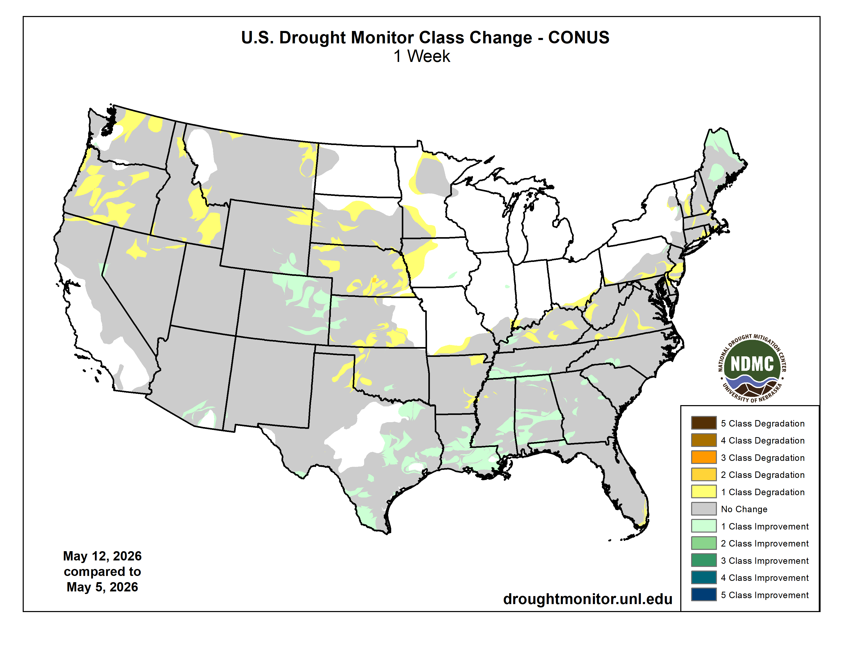
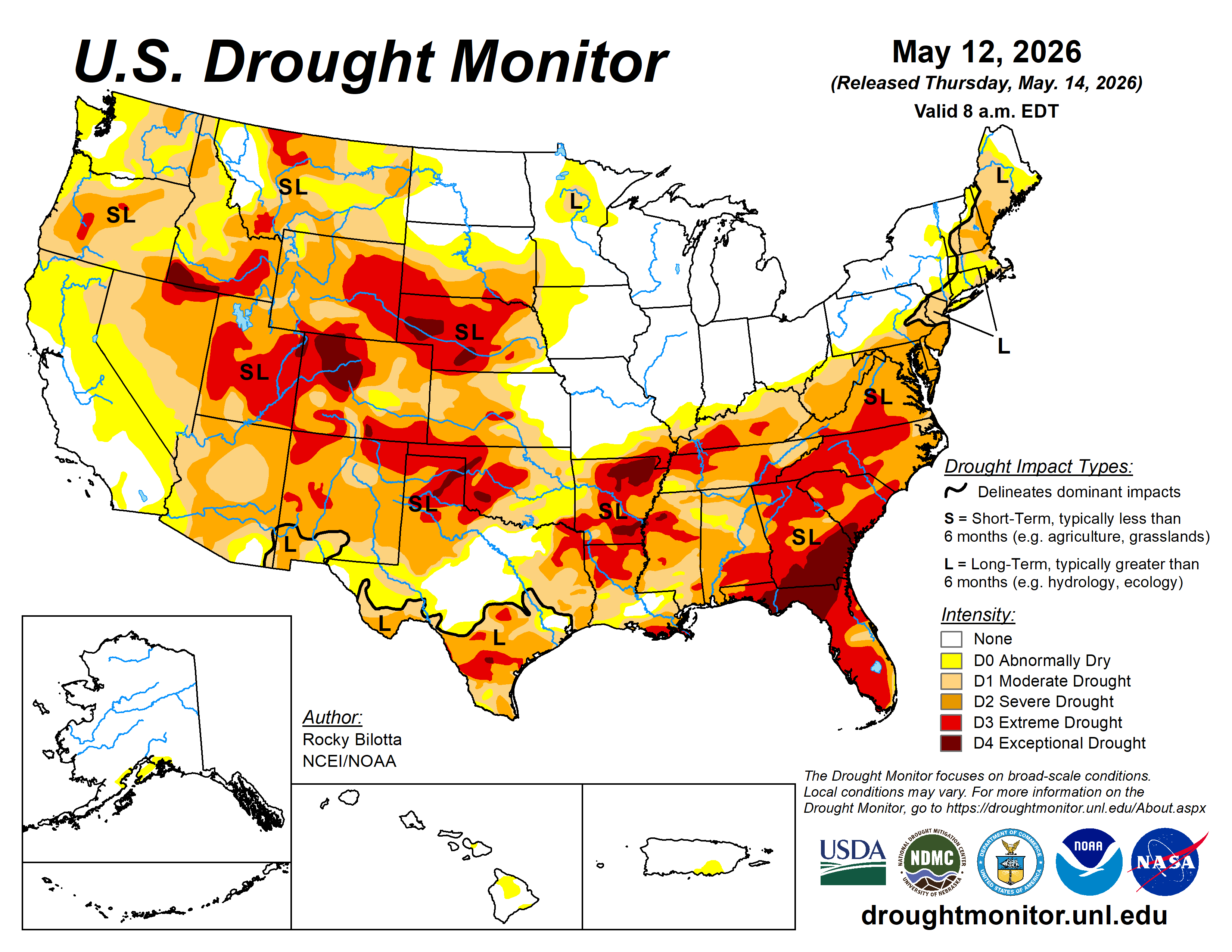
This Week’s Drought Summary

This week was defined by a significant precipitation divide, highlighted by a major deluge across parts of the South and Gulf Coast. Persistent storm systems funneled heavy moisture into Louisiana, Mississippi, and Alabama, where total rainfall reached 4 to 6 inches—and in some coastal pockets even higher—representing departures of 3 to 5 inches above seasonal norms. While an active frontal corridor brought a secondary band of moderate rain (1 to 3 inches) from Texas through the Ohio Valley and into the Northeast, the Western U.S. remained exceptionally dry, with most areas west of the Rockies receiving less than 0.1 inch of rain. This lack of moisture, paired with blustery winds, triggered extreme fire danger across the Upper Mississippi Valley, though the period concluded with a pattern shift as a significant Pacific low-pressure system finally moved onshore to deliver moisture to the Northwest.

Temperature patterns showed an equally sharp geographical split, with unseasonable warmth gripping the West and parts of the South while a late-spring chill lingered over the North. In the Southwest and South Texas, summer-like heat took a firm hold as Rio Grande Village, Texas, hit a national high of 105°F and Death Valley consistently reached the triple digits; overall, the Western U.S. averaged 5 to 15°F above normal. Conversely, a significant cool-down settled over the Northern Plains and Upper Midwest, where the Dakotas and Minnesota experienced temperatures 5 to 15°F below seasonal averages. This thermal contrast was further sharpened by winter-like conditions in high-elevation regions of the West, where stations in Utah recorded lows as cold as 10°F, even as record-challenging warmth began to expand across the Pacific Northwest and the Southern Border states…
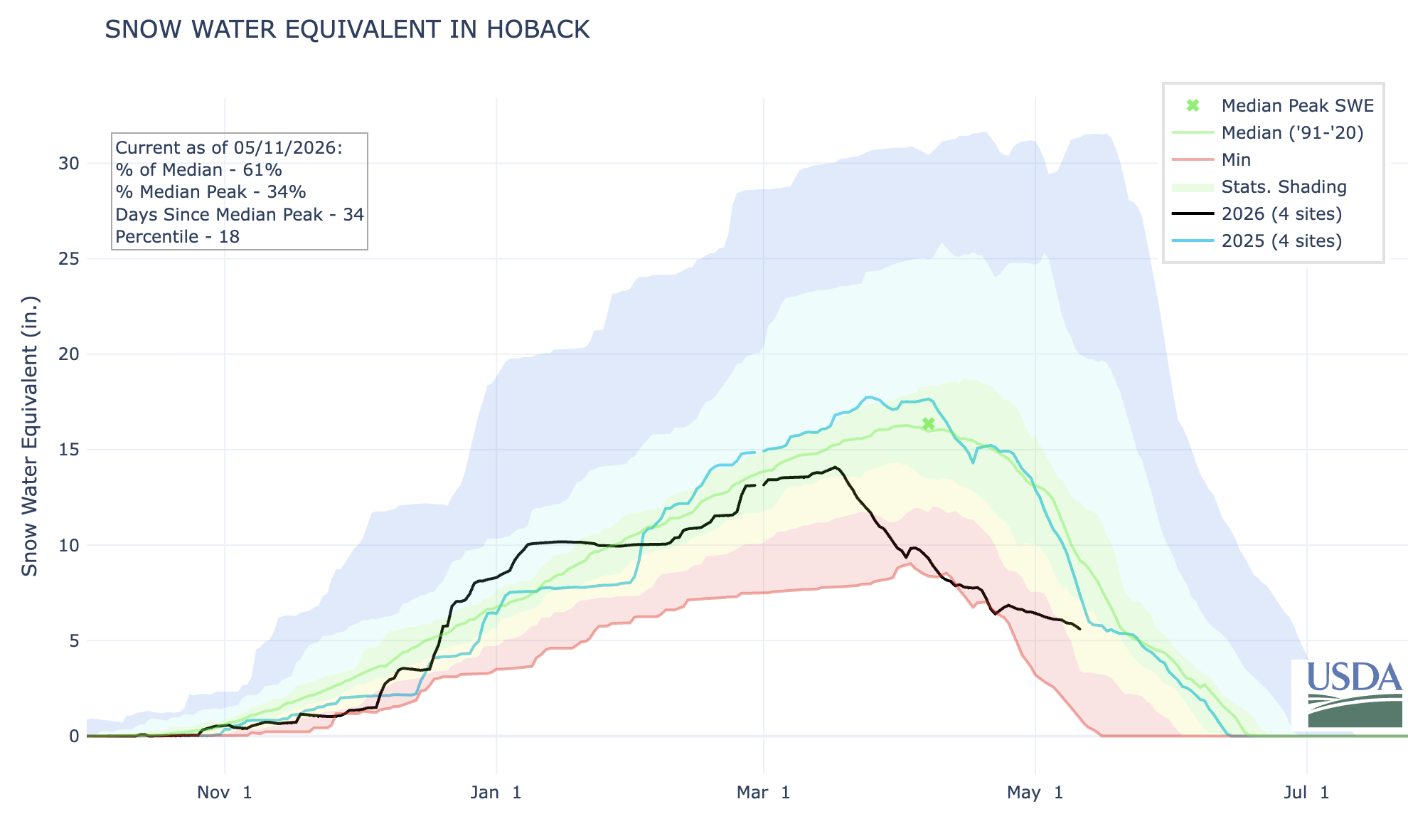
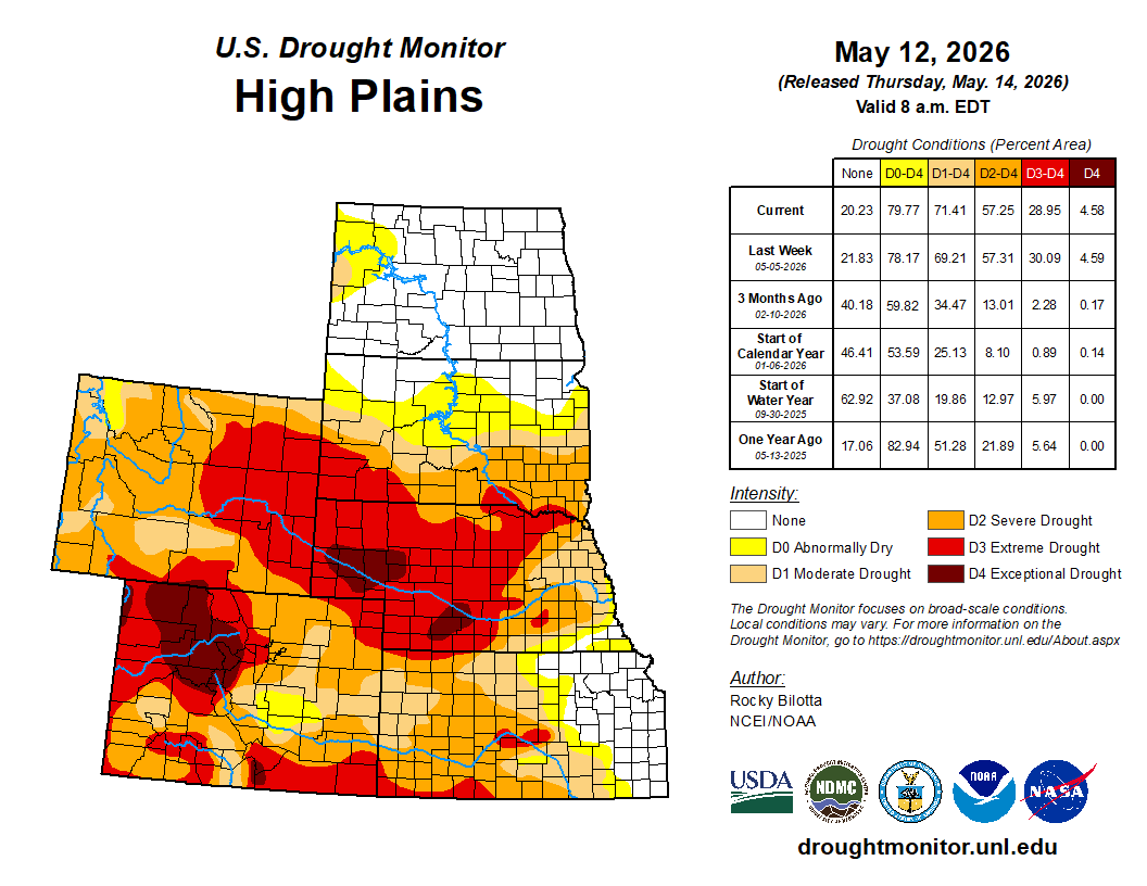
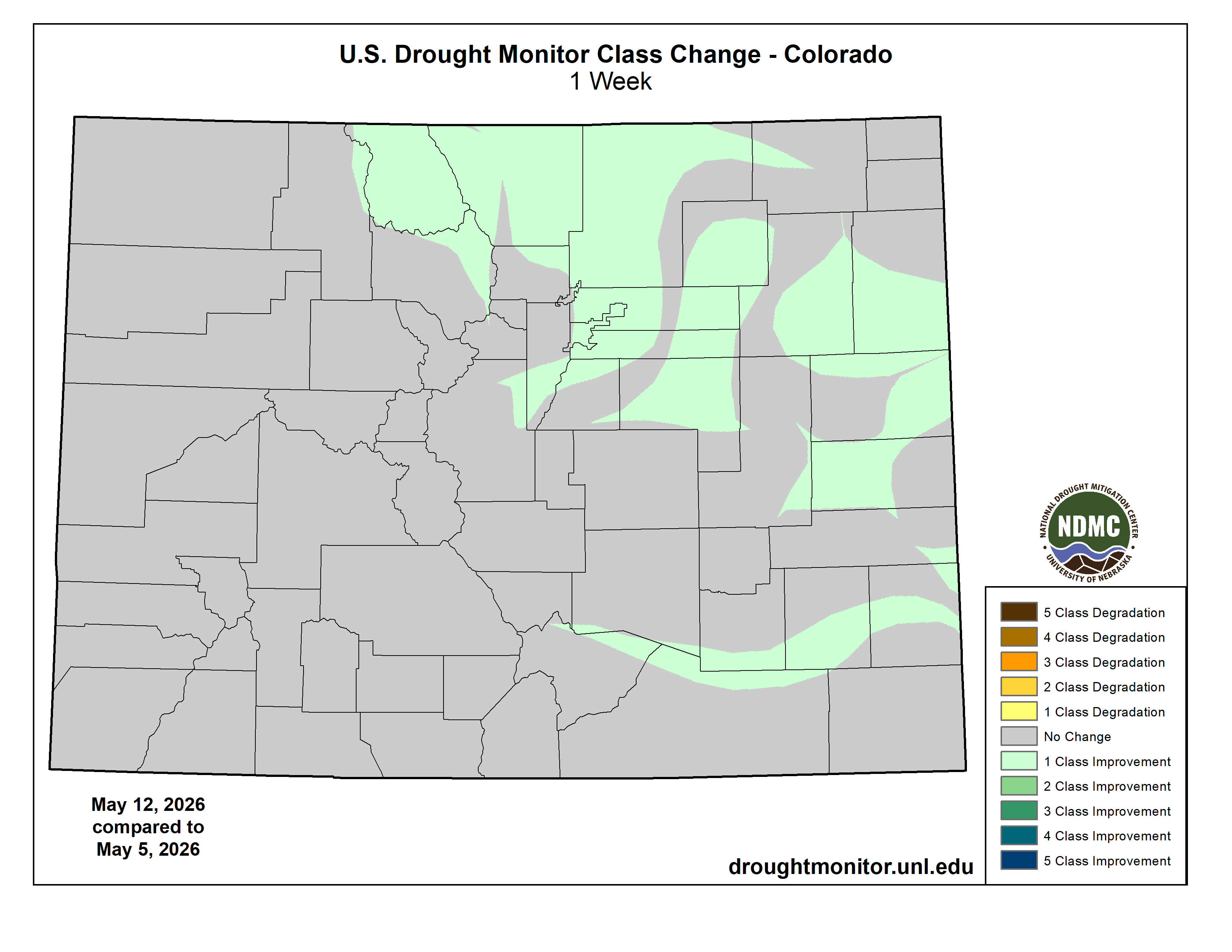
High Plains

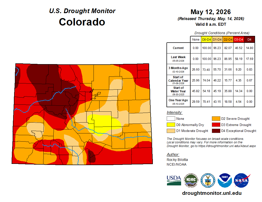
Anomalous warmth dominated most of the High Plains this week, while precipitation was defined by a significant east-west gradient. The eastern portions of the region, remained under a persistent late-spring chill with average temperatures falling 4°F to 10°F below seasonal norms. This area was also exceptionally dry, receiving less than 0.05 inches of rain, which resulted in precipitation deficits of 0.6 to 1.2 inches. Persistent dryness resulted in the expansion of exceptional (D4) drought in Nebraska, while and moderate (D1) to extreme (D3) drought were expanded in northeastern Wyoming, South Dakota, Nebraska, and Kansas. In contrast, the western High Plains across Wyoming, much of Colorado, and western portions of South Dakota and Nebraska, experienced unseasonable warmth, with departures ranging from 2°F to 6°F above normal. This warmth was accompanied by an active moisture corridor through the southern High Plains; while northern and eastern reaches were dry, portions of Colorado and adjacent areas of Wyoming and Kansas recorded 0.7 to 1.6 inches of precipitation, ranging from 0.3 to 0.9 inches above normal. This above-normal precipitation resulted in the removal of exceptional (D4) and reduction of extreme (D3) drought in Wyoming, and improvements to severe (D2) to exceptional (D4) drought in Colorado and severe (D2) to extreme (D3) drought in western Kansas…
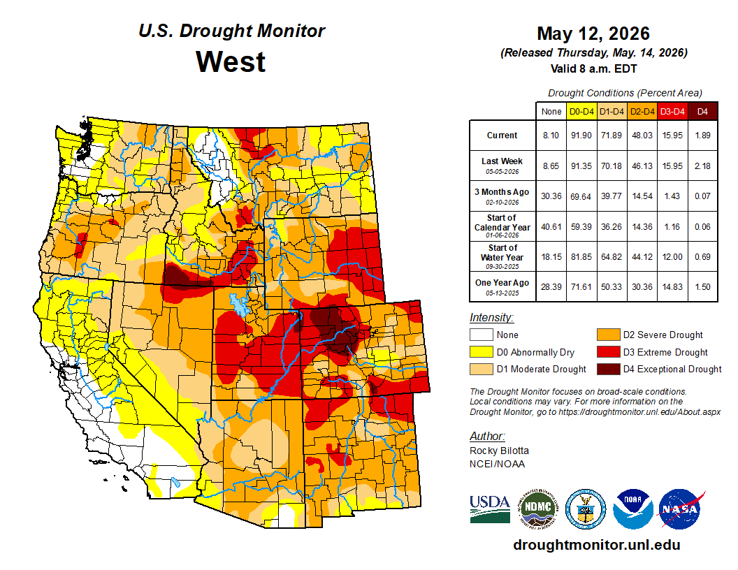
Colorado Drought Monitor one week change map ending May 12, 2026.

West

The West was characterized by unseasonable warmth and widespread dryness across the Pacific Coast and Great Basin, contrasted by cooler, more active conditions in the Rocky Mountains this week. The eastern portion of the region—specifically eastern portions of Montana, Utah, and New Mexico—remained notably cooler, with departures ranging 3°F to 6°F below normal. However, most of the region, particularly in parts of Oregon, California, and Nevada, experienced significant temperature departures of 6°F to over 12°F above normal, with actual average readings in the Desert Southwest reaching the 80s and 90s. This heat was paired with minimal moisture, as coastal and interior basin states recorded less than 0.1 inches of rain, resulting in precipitation deficits of 0.6 to 1.5 inches below seasonal averages. Exceptional (D4) drought was expanded in southern Idaho, while extreme (D3) drought was introduced in Oregon and expanded in Montana, Idaho, and Nevada this week. Severe (D2) and moderate (D1) drought were expanded in Oregon, Idaho, and Montana. Severe (D2) drought was also introduced in northern Washington and expanded in northern Nevada. Conditions deteriorated over parts of southwest Washington and northwest Oregon resulting in the expansion of abnormal dryness (D0) in these areas. Conversely, localized moisture resulted in the moderate (D1) to severe (D2) drought and abnormal dryness (D0) improvements in southern Arizona, while improvements to moderate (D1) drought occurred in parts of western Nevada…

South

The Southern region experienced a stark contrast in both precipitation and temperature during the week, defined by torrential Gulf Coast rains and a significant late-spring chill across the interior. Precipitation was most intense across the central Gulf Coast, particularly in Louisiana and southern Mississippi, where weekly totals reached 7 to over 9 inches. These amounts represent exceptional departures of 6 to 7.5 inches above normal. Moderate (D1) to Exceptional (D4) drought was reduced in southern and eastern portions of Texas, and in parts of Louisiana, Mississippi, and southern Tennessee. Abnormal dryness (D0) was improved in parts of Texas and southern Louisiana. Conversely, drier conditions prevailed in West Texas, Oklahoma, and much of the Tennessee Valley, where precipitation was generally 1.5 to 3 inches below average. Exceptional (D4) was introduced in southwest Oklahoma and from the Texas Panhandle into northwest Oklahoma, and expanded in parts of Arkansas and northern Mississippi. Extreme (D3) expanded in northern portions of Texas and western Oklahoma. Heat persisted in southern Texas, where average temperatures reached the 80s and 90s, representing departures of up to 5°F above normal. However, a powerful cold anomaly gripped the northern, eastern, and central portions of the region. In these areas, temperatures were broadly 5 to 10°F below normal for the week…

Looking Ahead

Over the next five days (May 12–16, 2026), weather patterns across the United States will feature a stark contrast between record-challenging heat in the West and unsettled, cooler conditions in the East. A building atmospheric ridge will maintain well-above-normal temperatures across the western U.S., with several high-temperature records likely to be tied or broken as this warmth spreads into the central Plains by mid-week. Conversely, the eastern half of the country can expect near to below-normal temperatures as a series of frontal systems bring frequent rounds of showers and thunderstorms from the Midwest to the Atlantic Coast. Meanwhile, an incoming Pacific low-pressure system is forecast to deliver light to moderate precipitation to the Pacific Northwest and northern Rockies, while gusty winds may accompany the passage of these weather systems across the Rockies and Great Plains.

Further out, the Climate Prediction Center’s 6–10 day outlook (valid May 17–21, 2026) favors above-normal temperatures across Hawaii and most of the contiguous U.S., with the most intense heat probability concentrated in the Southeast. Areas along the northern border and southern parts of Alaska are favored to be cooler-than-average during this period. Probabilities for above-normal precipitation are increased across Hawaii and the vast majority of the lower 48 states and Alaska. In contrast, below-normal precipitation is favored across the West Coast, particularly over northern California, and in parts of the East Coast, from the Mid-Atlantic to the Carolinas.

US Drought Monitor one week change map ending May 12, 2026.

Topsoil Moisture % Short/Very Short by @usda_oce. Most % short/very short remains in the Interior West and Southeast, including CO (93%), MT (85%), NM (84%), SC (80%), GA (79%). Also, NE is at 84%.

In this special episode, SNWA General Manager John Entsminger joins City Cast Las Vegas Podcast host Jesse Merrick to discuss how the aging Law of the River is colliding with a modern #climate — Southern Nevada Water Authority #ColoradoRiver #COriver #aridification

Colorado River District Board Approves Funding for Irrigation Financial Sustainability Pilot Projects

Click the link to read the release on the Colorado River District website (Lindsay DeFrates):

May 11, 2026

At its quarterly board meeting in April, the Colorado River District Board of Directors approved $415,876 in Community Funding Partnership grants to support six irrigation companies and districts as part of the newly launched Irrigation Company Financial Sustainability Pilot Grant Opportunity. The pilot program is designed to help irrigation providers assess the condition and financial needs of their systems, prioritize capital improvements, and develop long-term financial plans that support ongoing maintenance and modernization with greater independence and less reliance on uncertain outside funding.

The six approved projects include:

  • Grand Tunnel Ditch Company, Garfield County: $14,246
  • McDonald Ditch Irrigation Company, Montrose County: $17,255
  • Terror Ditch and Reservoir Company, Delta County: $8,500
  • Maybell Irrigation District, Moffat County: $39,695
  • Orchard Mesa Irrigation District, Mesa County: $198,650
  • Grand Valley Irrigation Company, Mesa County: $137,530

“These projects are great examples of the Community Funding Partnership’s goals of strengthening Western Slope communities by investing in the water infrastructure they depend on,” said Melissa Wills, Community Funding Partnership Program Manager for the Colorado River District. “By helping irrigation providers plan for long-term maintenance, modernization, and financial sustainability, we are supporting West Slope agriculture and local economies, ultimately helping communities prepare for a hotter, drier future.”

Together, the projects support irrigation companies across Delta, Garfield, Mesa, Moffat, and Montrose counties, and a range of ditch sizes, organizational structures, and agricultural communities. Each project will support the development of a capital improvement plan and rate study to help local water providers better understand infrastructure needs, project costs and sustainable funding options. Collectively, the six projects align with the Community Funding Partnership’s goals to support productive agriculture, improve water infrastructure, increase conservation and efficiency, and strengthen communities that rely on local water systems.

The six pilot grants awarded will serve as models for the Irrigation Company Financial Sustainability Pilot Grant Opportunity to collect lessons learned and develop a potential future program that meets the organizational sustainability needs for irrigation companies across the Western Slope. This pilot grant is the first program on the Western Slope to provide dedicated funding for irrigation companies’ infrastructure and financial planning.

Since launching in 2021, the Community Funding Partnership has invested over 32 million dollars in water projects across Western Colorado that support productive agriculture, healthy rivers, watershed health, water quality, infrastructure, conservation and efficiency.

To learn more about the Community Funding Partnership program and funding opportunities, visit coloradoriverdistrict.org/community-funding-partnership.

The Colorado River Water Conservation District spans 15 Western Slope counties. Voters across the district are considering a mill-levy increase that would raise the River District’s budget by $5 million, funding a variety of water-related projects.
Colorado River District/Courtesy image

President Trump axes Public Lands Rule: Plus — The Hoback Report, a guest dispatch from Bob Frodeman — Jonathan P. Thompson (LandDesk.org)

The Hoback River after a storm as it meets up with the Snake River. Bob Frodeman photo. (via The Land Desk)

Click the link to read the article on The Land Desk website (Jonathan P. Thompson):

May 12, 2026

The Hoback Report

by Bob Frodeman

The weather has been odd this year on the southern side of the Yellowstone Plateau. And summer is setting up to be a little scary – low water, fire danger, and masses of tourists.

Hoback, Wyoming, is an unincorporated area of a few hundred people 14 miles south of the Jackson Town Square. It’s the poorest part of the wealthiest county, Teton, in the United States. The residents here stand a little apart – you see bumper stickers plastered with the message ‘Hoback Nation’. Some four million cars pass through our roundabout each year, mostly tourists, but also people driving to work from more affordable locales like Alpine and Pinedale. It’s also where the Hoback River joins the Snake just before it enters the Snake River Canyon, the site of whitewater trips offered by local outfitters.

The Hoback River runs 66 miles, starting in the slopes of the Wyoming Range around Bondurant, Wyoming. It still runs free – no dams (yet). For a western river it’s medium sized: base flows sit at 200 cubic feet per-second across the winter, with peak flows reaching perhaps 4,300 cfs around the first of June. The last 11 miles of the Hoback, from its confluence with Granite Creek, are protected, part of the National Wild and Scenic Rivers System. My home looks up the Hoback: deer walk across the river in the winter and fishermen and kayakers come down all summer.

Waterwise, conditions were better here than across most of the West until the March warm-up. Teton County was even a bit above normal in snow water equivalent, or SWE, the typical measure of snowpack. But the snowfall was unevenly spread: lots of snow in the mountains, but dry in the valleys. For the first time since the 90s there wasn’t continuous snow cover in the valley across the winter, and we had a brown Christmas. The valleys saw five rain events this winter that melted what snow we did get at 6,000 feet. On the other hand, the warm, wet air meant more snow on the peaks. Jackson Hole Mountain Resort had the best snow in the West.

Up until the late March heatwave, the Hoback watershed was faring better than most of the West, snowpack-wise. But after that? Not so great. Source: NRCS.

The heatwave of March was something to behold. On March 21 the temperature hit 71 degrees, 32 degrees above normal, taking a big bite out of the snowpack. The rivers grew five times from their base flows two months ahead of schedule. Daffodils appeared five weeks early.

On the good side, the winter has been easy on the wildlife. The antelope have been particularly hard hit by the winter of 2022-2023. That year the fawn mortality was nearly 100%, the result of three feet of crusty snow. Whether the antelope, deer, and elk will have enough browse this summer is an open question. Fingers are crossed for a good monsoon.

But even with a good monsoon this summer’s water situation is looking dicey. The local reservoirs, Jackson and Palisades, caught the early runoff, but Wyoming has rights to only 4% of the water in the Snake – senior water rights belong to Idaho farmers. The Bureau of Reclamation recently announced that Jackson Lake may be drained dry this summer to provide water to farmers across the Snake River Plain. We’ll learn more about Bureau of Reclamation plans at its meeting in Jackson in mid-May.

At least the ospreys were on time. The pair that inhabit the nest above our home appeared on April 1. They’ve been busy carrying sticks to replenish their nest. They spend the summer fighting with bald eagles, when they aren’t dismantling fish in the crooked dead conifer that juts out over the river.

This might sound idyllic, but there’s a wealth of political controversy in Teton County. You’d expect nothing less from a place that combines funhogs and billionaires, second homeowners and 4th generation ranchers, a county with 23,000 inhabitants hosting 3.3 million visitors a year. Teton County is a blue dot in a very red state. It creates a weird dynamic: the conservative Freedom Caucus politicians in Cheyenne are often hostile to us while also being dependent on our tourist-generated income (there is no state income tax). There’s also a jarring juxtaposition of the local and the international: the Jackson Hole Economic Policy Symposium, sponsored by the Federal Reserve Bank of Kansas City, meets here each August, and the likes of JD Vance and Kristi Noem come to town for fundraisers. Real estate office windows are plastered with ads printed in both English and Russian. And the average price of a home here is more than six million dollars.

Bob Frodeman lives in Hoback, Wyoming. He is a co-editor of A Watershed Moment: The American West in the Age of Limits.

Wyoming rivers map via Geology.com

🌵 Public Lands 🌲

The Trump administration today [May 12, 2026] fully rescinded the Conservation and Landscape Health Rule, a.k.a. the Public Lands Rule. The Biden-era rule was finalized in 2024 and endeavored to put conservation on a par with other uses of federal lands, such as grazing, mining, and drilling, primarily by making leases available for conservation or restoration projects. Now, before it ever even had a chance to be tested, it is being killed to better align the Bureau of Land Management’s regulations with the Trump administration’s agenda, which effectively is to return the agency to the days of the Bureau of Livestock and Mining.

This is yet another volley in the administration’s wholesale assault on public land management and environmental protections designed to benefit the extractive industries, while also sticking it to some of Trump’s many adversaries.

It’s unfortunate, sure, but the reaction from some environmental groups seems totally overblown and aimed more at triggering anger than truly considering the limited effects this will likely have on the ground. While I understand the need to rally the troops, so to speak, I’m not sure hyperbole and constant outrage is all that productive.

I’ve read, for example, that the administration is “stripping conservation” from public lands, and that this is simply a prelude to “dispose of these landscapes entirely.” It sounds a lot like the reactions from the extreme right when the rule was being developed: It would “eradicate grazing” and its framers were akin to tree-spiking eco-terrorists, that it would “lock up more land,” and then South Dakota Gov. Kristi Noem called it “dangerous.”

None of this is accurate.

For the most part, the Public Lands Rule was a sort of reinforcement of the 1976 Federal Land Policy Management Act’s multiple-use mandate, which directed the BLM to manage public lands “on the basis of multiple use and sustained yield” and “in a manner that will protect the quality of scientific, scenic, historical, ecological, environmental, air and atmospheric, water resource, and archeological values.”

The rule applied land health standards and codified a framework for establishing areas of critical environmental concern. Perhaps most significantly, it created a conservation lease system, which allowed entities to lease land to conduct restoration projects or conservation activities. While conservation tends to be considered a “non-use,” this flipped that to make conservation a “use” — one that could even generate revenues for the federal government. Whether this put conservation on a level-playing field with drilling, mining, and other extraction is unclear.

What is clear is that the rule could not be used to boot cows, drill rigs, mines, or any other existing use off public land. Conservation leases would only be available on land that wasn’t already leased or claimed. And it had absolutely nothing to do with public land conveyances, exchanges, transfers, or sales.

Since the rule didn’t stop extractive uses, abuses, or land transfers, revoking it won’t spark an uptick in grazing, drilling, or mining, nor will it lead to wholesale land selloffs. 

What the Public Lands Rule did do was attempt to steer the agency — albeit gently — further away from its old identity as a sort of clearing house for extractive industries. It acknowledged the effects of climate change on public lands, and the landscape-health standards — if applied correctly — could have stopped the BLM from leasing out certain parcels for development. And, it seems to me, the conservation lease concept could have helped kickstart a land healing industry.

For example, a conservation group might have been able to lease out one of the vacated grazing allotments in Canyon of the Ancients National Monument, and conduct restoration work on that land, such as replanting native grasses or removing noxious invasive weeds. Or perhaps using federal funds from the Biden-era Infrastructure and Inflation Reduction Acts — which Trump and the GOP gutted — an entity could have taken over terminated leases in the mostly abandoned Horseshoe-Gallup oilfield, cleaned up the mess, and plugged and reclaimed the methane-oozing wells. 

Tragically, the initiative was nipped in the bud before anyone could see how it might play out on the ground. Hopefully when this administration is over some semblance of democracy and reason will return to Washington and maybe not only revive this rule, but make it even stronger.


Redux: The rise of the land-healing industry — Jonathan P. Thompson


📸 Parting Shots 🎞️

A friend and I went down to Farmington over the weekend to check out some of the newish mountain biking trails around there. We rode the Boneyard trail, which crosses through some interesting country and, as is almost always the case when on public lands in the San Juan Basin, it wound its way around pumpjacks and other gaspatch detritus. It’s sort of like a journey through the energy-economic transition, given that the trails are part of an effort to diversify the fossil fuel economy with outdoor recreation. 

The riding is good, though you might want to avoid the trails on a hot day, and sandy areas can bog down bikes with skinnier tires (I rode a gravel bike, which wasn’t a great idea). And, of course, afterwards we went to Blake’s Lotaburger for lunch. The following images are from the trail and downtown Farmington.

Near Farmington, New Mexico. Photo credit: Jonathan P. Thompson
Farmington, New Mexico. Photo credit: Jonathan P. Thompson

Thoughts on boomtown architecture — Jonathan P. Thompson