The #ColoradoRiver and reckoning time for the Front Range — Allen Best (BigPivots.com) #COriver #aridification

Click the link to read the article on the Big Pivots website (Allen Best):

May 26, 2026

Dissonance exists between life-close-to-normal policies regarding urban water use and the growing crisis on the river

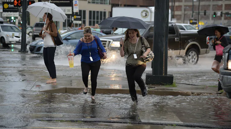
Casually surveying the urban landscapes in much of Colorado’s Front Range, you’d never know that the Colorado River — the source for roughly half the water of the cities — has deteriorated to its most pitiful shape of perhaps the last century.

Oh, yes, some utilities — notably Denver Water and Aurora Water, which together serve 1.9 million residents — have imposed rigorous stage-one drought watering restrictions. Outdoor irrigation is allowed twice per week and never during the heat of day. Other water utilities that tap Colorado River water, however, have asked only for voluntary cutbacks, if any at all.

Jeff Lukas via the Western Water Assessment.

Jeff Lukas, a water consultant with several decades invested in climate change work, says this seeming aloofness of some cities will not persist indefinitely. That is certainly true if the record heat and abnormal dryness of the past winter continues into 2027. They may have no choice.

“I think Front Range cities will be asked, whether nicely or not, to reduce their Colorado River diversions,” said Lukas in a May 11 webinar. “The mechanism for that is unclear, but I think it’s going to happen.”

Water rights of the Front Range cities — and many of those on the Western Slope, too — are junior to the Colorado River Compact. It was negotiated in 1922, making diversions more recent than that junior.

Problems in the basin were becoming apparent in the 1990s. The warming climate in this century has provoked changes. By all accounts, they have not been enough.

Lukas, as a dendrochronologist at the Institute of Alpine and Arctic Research in Boulder 20 years ago, was teasing out evidence from tree rings to understand the climates of the Colorado River Basin during the last 1,200 years.

Later, as a scientist with the Western Water Assessment, Lukas co-authored (with Liz Peyton) a 2020 report called Colorado River Basin Climate and Hydrology: State of the Science. That 500-page report integrated more than 800peer-reviewed studies to help water managers understand physical processes, climate risks, and forecasting tools across the basin.

In 2024, with the state climatologist, Russ Schumacher, and several others, Lukas turned out the 100-page volume called “Climate Change in Colorado.”

Based in Lafayette, Lukas now works as a consultant. At Lukas Climate Research and Consulting, he specializes in the overlapping areas of climate hazards, water resources, and ecosystems.

Lukas, in a presentation he titled “Running dry on the Colorado River: The roots of the crisis & its implications for the Front Range,” explained the big picture and Colorado’s Front Range part in it.

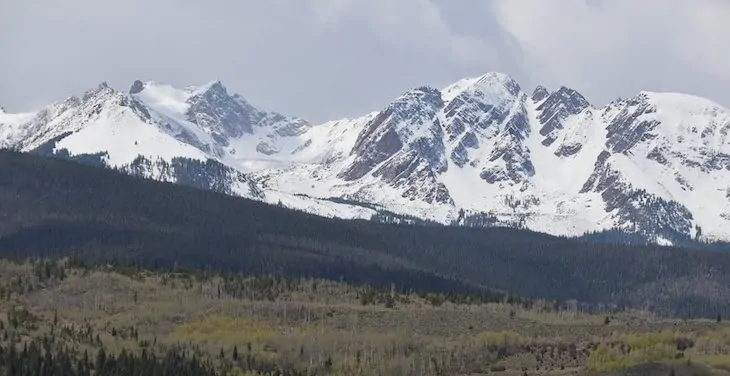
Defined by the Continental Divide, Colorado has an inverse relationship between its eastern and western slopes. About 90% of the state’s residents live to the east, nearly all at the foot of the Rocky Mountains, whereas 80% of the state’s precipitation originates on the west side, in the headwaters of the Colorado River and its tributaries.

Snow from the Gore Range and other “islands” of precipitation in Colorado provide 50% to 60% of the water in the Colorado River. Photo credit: Allen Best/Big Pivots

Colorado itself provides 50% to 60% of the water in the entire Colorado River, depending upon the year. This year has been a terrible year everywhere in the basin, Colorado included.

Lukas explained that “islands of moisture” provide nearly all the water in this 244,000-square-mile basin. The high mountains constitute these islands. Some places deliver more than others. Buffalo Pass, near Steamboat, famously has had prodigious volumes of snow. This snow, when melted, can produce 50 inches of water.

It takes 20 inches or more of precipitation in these mountain islands to produce meaningful runoff. Even then, it doesn’t all end up in the Colorado River. In Colorado and the three upper-basin states, he said, 16% of the rain and snow that falls becomes water in the Colorado River. In the hotter lower basin, the figure is 3%.

“The atmosphere takes back most of what it giveth, even in the wetter upper basin,” he said.

Evaporation and transpiration are the pickpockets of this water. Heat produces evaporation, and we’ve had plenty of that this year.

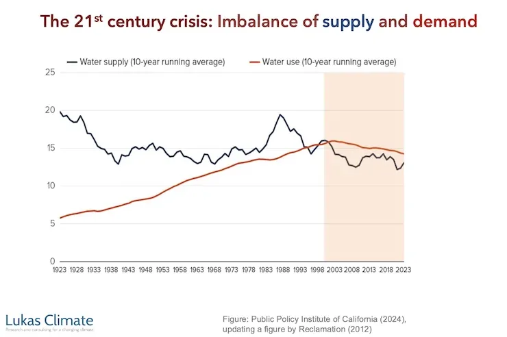
Temperatures during November through April were the warmest on record in Colorado for that span of months. March heat was exceptional. This produced runoff in the rivers that in most cases may surpass that of May or June, the traditional times for peak runoff. Peak runoff has been trending earlier by several weeks during the last few decades, but this was a leap of about two months.

Runoff for April through July — a time that normally accounts for 70% to 80% of annual streamflows — this year will likely deliver no better than 20% to 40%. In its May report, the Bureau of Reclamation said April flows into Lake Powell were 40% of the average during the last 30 years and it expects flows in May to sink to 9% of that average.

Can it get any worse? Count on it, said Lukas.

“We should expect not every year to look like 2026 from here on out, but more years in the future will look like 2026. And somewhere down the pipe, not as far in the future as we would like, there will be a year worse than 2026 for the Colorado River.”

Members of the Colorado River Commission, in Santa Fe in 1922, after signing the Colorado River Compact. From left, W. S. Norviel (Arizona), Delph E. Carpenter (Colorado), Herbert Hoover (Secretary of Commerce and Chairman of Commission), R. E. Caldwell (Utah), Clarence C. Stetson (Executive Secretary of Commission), Stephen B. Davis, Jr. (New Mexico), Frank C. Emerson (Wyoming), W. F. McClure (California), and James G. Scrugham (Nevada)
CREDIT: COLORADO STATE UNIVERSITY WATER RESOURCES ARCHIVE via Aspen Journalism

This is so very different from what was assumed by the delegates from the seven basin states who gathered in 1922 in Santa Fe to apportion the Colorado River.

The role of reservoirs

Taking the big, long-term view, Lukas pointed out that the overall story of the Colorado River is one of modifications needed to suit human uses. “It’s all about smoothing out the natural variability in the availability of water over space and over time.”

Reservoirs are the primary means by which humans have been able to “smooth out the natural variability.”

The Colorado River Basin has 60 million acre-feet of storage. That’s four times the annual flow. Five-sixths of the storage capacity is found in the desert in two vessels: lakes Mead and Powell. The headwaters have many reservoirs but they are relatively small. The total storage capacity is 2,000 times more than the volume of Dillon Reservoir.

Illustration from the report, “Antique Plumbing & Leadership Postponed” from the Utah Rivers Council,
Glen Canyon Institute and the Great Basin Water Network. Courtesy of Utah Rivers Council

Since 2000, stored water in those two big buckets, Mead and Powell, has declined from 49 million acre-feet to 16 million acre-feet as of May. Of that, 9 million lies at elevations below the lowest outlets. These are called dead pools.

Those delegates in 1922 who crafted the Colorado River Compact, the legal document that provided the basis for nearly all these dams and aqueducts subsequently built, assumed annual flows of 17 million to 18 million acre-feet. They were overly optimistic. The 20th century average was 15.2 million acre-feet.

Now comes the 21st century, and the average at Lee Ferry has dipped to 12.2 million acre-feet. This has implications for the Front Range cities but also farms. If Colorado must reduce its diversions to accord with the compact, those rights dated before 1922 will be exempt from reductions. The giant transmountain diversions have come more recently, as have many of the diversions for towns and cities on the Western Slope.

Accumulating evidence fingers human-caused climate change with large amounts of responsibility for declined flows. Lukas said his rule of thumb is that the role of greenhouse gases overall are responsible for two-thirds of lower flows.

Colorado statewide annual temperature anomaly (°F) with respect to the 1901-2000 average. Graphic credit: Colorado Climate Center

As for the mechanics of this shift, rising heat is one important “knob,” said Lukas. As the atmosphere warms, it reduces “runoff efficiency” even more, sending water into the atmosphere instead of into streams and then rivers. Accumulating evidence fingers human-caused climate change with responsibility for most and possibly all of increased temperatures.

Precipitation has declined about 5% since 2000, with a larger reduction in spring, an important time of year to get moisture. Here, the link to the warming climate is less clear. “It seems increasingly likely that climate change is changing the dynamics of storm tracks and the persistence of, say, high-pressure systems over the interior West,” said Lukas. “That is, at least in part, responsible for why we’ve had less precipitation since 2000.”

The Colorado River, though, had problems even before the warming climate began throwing sharp elbows in water volumes. The reservoirs of the Colorado River Basin were 92% full in 1999, a wet decade overall. Even then, however, the Colorado River had ceased to reach the Pacific Ocean. There were too many straws inserted.

Less than 12% of the river’s flow goes to urbanized and industrial uses. Lukas pointed out that cities have become more efficient in their use of water. The rule of thumb for Denver and other Western cities is that one acre-feet of water meets the needs of a three households on an annual basis. That compares with two households a few decades ago.

Mining of fossil fuels and minerals uses a small amount. Evaporation from reservoirs and rivers and other “system losses” accounts for about 15%.

That takes us to agriculture. It uses 75% of the river’s water in the Colorado River for irrigation on 5 million acres. Some of that land lies outside the basin itself. That includes the South Platte and Arkansas River valleys of eastern Colorado.

Over half of that water — about 9 million acre-feet — gets used to grow feed for livestock, mainly alfalfa and pasture grass.

Might cities want to cut deals with farmers to “share” the water? This discussion has been underway for at least 15 to 20 years. Some pilot projects in Colorado and elsewhere have been launched to see what this might look like. A strong proponent has been James Eklund, a water attorney in Denver. Others question how this is done and, for that matter, whether we want to do it. But certainly, water for urban uses has higher monetary value than growing hay to feed cattle.

Why the restraint of cities?

As for the Front Range cities, the big question is whether they are planning for a river that produces even less than it does now.

In 2024, Andy Mueller, the general manager of the Colorado River Water Conservation District, suggested the need to start planning for a river that may deliver less than 10 million acre-feet in coming decades. Some thought then that the state engineer, Jason Ullman, needed to start sorting through this matter of junior vs. senior rights. Jim Lochhead, a former water attorney on the Western Slope and later CEO of Denver Water, pushed back, saying it was premature given the huge amount of work that would be required. See: “Heading for the Colorado River Cliff,” Big Pivots, Oct. 20, 2024.

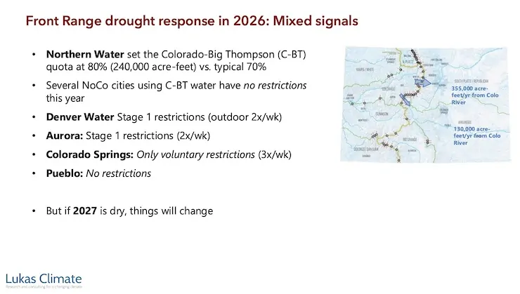
At the Zoom session on May 11, I asked Lukas about the modest watering restrictions by Front Range water providers. He had previously described mixed signals from the water utilities. If 2027 is dry again, expect more uniformity around drought restrictions. “But it’s pretty weird right now,” he said.

With the attention to the Colorado River in the news media, it seemed like a perfect opportunity for the water utilities to mount more aggressive campaigns. Any idea why they had not, I wondered.

The utilities, he said, are reluctant to deliver regulations that produce discomfort around outdoor water-use restrictions. They don’t want to do this unless absolutely necessary.

Part of this is because of experiences during the covid epidemic. A lesson to public servants during that time made them more reluctant to push the public to do things they don’t want to do. “You only want to exercise that authority, that public legal authority, sparingly and only when it’s clear that is what is really necessary.”

Revenue was another consideration. Water infrastructure is expensive, and the money to pay for it comes from charges for water use. By imposing limits, you reduce revenue and hence must charge more for water. The conundrum is that reducing use doesn’t necessarily mean you pay less. In some cases, less water may require more infrastructure. This is a hard message to convey.

“What you’re seeing is a dissonance between the circumstances and what’s happening, at least this year,” he said.

Or at least right now. We have had rainy weather in May. Some meteorologists think we may end up with healthy rainfall this summer. If instead the summer is like the winter, very hot and dry, I expect the utilities might pick up their game.

Jeff Lukas presented in a session called Zoom at Noon. You can see the hour-long presentation here. The passcode is %ACg9*XU

Federal Water Tap, May 26, 2026: EPA Proposes to Repeal Standards for Four #PFAS in Drinking Water — Brett Walton (circleofblue.org)

This USGS map shows the number of PFAS detected in tap water samples from select sites across the nation. The findings are based on a USGS study of samples taken between 2016 and 2021 from private and public supplies at 716 locations. The map does not represent the only locations in the U.S. with PFAS. Sources/Usage: Public Domain. Visit Media to see details.

Click the link to read the article on the Circle of Blue website (Brett Walton):

The Rundown

  • EPA aims to end federal regulation of four PFAS in drinking water and give utilities more time to comply with existing rules.
  • FEMA reopens applications for a climate-resilient infrastructure grant program that the agency had cancelled.
  • Bureau of Reclamation announces $52 million for three new Hoover Dam turbines that will generate hydropower at lower Lake Mead levels.
  • A House FY27 budget bill will cut the federal government’s primary water infrastructure funds by 24 percent.
  • NOAA forecasts fewer Atlantic hurricanes this season.
  • EPA water office leader commits to investigate groundwater pollution in Georgia from Meta data center construction.
  • The Trump administration recommends that the U.S. Supreme Court take up Nebraska’s claim that Colorado has violated a river-sharing compact.

And lastly, the Bureau of Reclamation’s acting commissioner informs a House subcommittee about the status of Colorado River negotiations.

“Several weeks ago, I met with the 14 senators from the Colorado River basin and on a bipartisan basis, several of them said, ‘Look, we have a real crisis on the Colorado and we need to get things done and if there are any environmental statutes that are slowing things down, tell us what they are and maybe we can legislate to clear out some of the unhelpful bureaucratic paperwork.’” – Scott Cameron, acting Bureau of Reclamation commissioner, speaking at a House Natural Resources subcommittee hearing. Cameron said his office has not yet followed up on the offer but “looked forward” to conferring with the senators about “waiving or streamlining certain environmental statutes on the Colorado.”

Udall/Overpeck 4-panel Figure Colorado River temperature/precipitation/natural flows with trend. Lake Mead and Lake Powell storage. Updated through Water Year 2025. Note the tiny points on the annual data so that you can flyspeck the individual years. Credit: Brad Udall

As for the status of Colorado River negotiations, Cameron said, “Frankly, the seven states are not in a position where they could agree today, right now, to a four-year deal, let alone a 20-year deal, because of the uncertainties we’re dealing with.”

By the Numbers

$1 Billion: Funding now available from FEMA’s Building Resilient Infrastructure and Communities program, a grant opportunity to reduce risk from climate and weather hazards. A federal judge ordered the agency to reinstate the program, which the Trump administration had cancelled. Applications are due July 23.

$52 Million: Funding announced by the Bureau of Reclamation for three new low-head turbines at Hoover Dam. Only five of the dam’s 17 turbines are designed to operate when Lake Mead drops below elevation 1,035 feet, a threshold that the shrinking reservoir is fast approaching and could breach in the next 12 months, if not sooner.

In context: Hoover Dam Faces New Power Generation Declines

News Briefs

Not So PFAS
The EPA is proposing to repeal federal regulation of four PFAS in drinking water, partially undoing a Biden-era rule that set first-ever limits on six of the “forever chemicals.”

Three of the chemicals – PFHxS, PFNA, and Gen X – were regulated individually. Together with PFBS, they were also regulated as a mixture.

The EPA will retain standards for PFOA and PFOS, the two most-studied of the chemicals. However, in a separate rule-making, the agency is proposing to give water utilities more time to comply, extending the deadline by two years, until 2031. The agency says the move will “ease the implementation burden” financially and administratively for water systems and might allow for cheaper treatment technologies to come to market.

Water utilities must apply for an extension. One of the considerations is whether an extension would pose an “unreasonable risk to health.” The EPA is proposing that PFOA and PFOS levels below 12 parts per trillion would not be unreasonable. (The federal standard for both is 4 ppt.)

The EPA wants public comment on whether interim utility actions during a compliance extension – point-of-use treatment, filtration pitchers, education, alternative water sources – can mitigate health risks above 12 ppt.

Submit comments by July 20 via http://www.regulations.gov using docket number EPA-HQ-OW-2025-1742.

Water Infrastructure Funding Cuts
A House spending bill cuts the two main federal sources of water infrastructure funding by about 24 percent in fiscal year 2027. The bill passed out of subcommittee last week.

The bill provides $1.2 billion for the Clean Water State Revolving Fund (27 percent cut) and $911 million for the Drinking Water State Revolving Fund (19 percent cut).

Following a recent trend, about half of the appropriation comes in the form of earmarks. This money will go directly to specific projects and will not enter the revolving fund. Water industry advocates argue that continuing to take earmarks out of the revolving fund appropriation threatens the viability of the program.

Studies and Reports

The South Platte River Basin is shaded in yellow. Source: Tom Cech, One World One Water Center, Metropolitan State University of Denver.

Great Plains Water Fight
The federal government’s top lawyer recommended that the U.S. Supreme Court take up one of Nebraska’s claims that Colorado is violating the South Platte River Compact, which divides the river’s water between the two states.

Nebraska argues that Colorado is breaking three articles of the compact. The U.S. solicitor general says that the high court, through a special master, should pursue only one of them: that Colorado is allowing irrigators to take too much water.

“A claim that one State has deprived another of water to which it is entitled under an interstate compact is a quintessential case for this Court’s original jurisdiction,” the brief states.

Atlantic Hurricanes
NOAA is forecasting a less active Atlantic hurricane season. The agency estimates that one to three major hurricanes (Category 3 or higher) will form.

The category ratings can be misleading. They measure wind speed, not precipitation. Tropical storms and minor hurricanes can still inflict serious flood damage.

Air Conditioning Estimates
The U.S. Census Bureau published data estimating how many homes use air conditioning.

States with the lowest air conditioning use are in New England and the West.

On the Radar

EPA on Data Centers and Household Wells
Under oath at a House subcommittee oversight hearing, Jessica Kramer, head of the EPA Office of Water, committed to investigate impacts to drinking water quality from data center construction.

“Whatever type of construction it is, it’s a priority to ensure that water quality standards established by EPA are being met. So we’ll be looking into that certainly,” Kramer said.

Kramer’s commitment at the House Energy and Commerce hearing was prompted by Rep. Alexandria Ocasio-Cortez (D-NY) who asked about water pollution from data center construction.

Ocasio-Cortez visited Morgan County, Georgia, a few weeks ago. She returned with jars of brown water from household wells near the construction site of a Meta data center. She displayed those at the hearing.

“This is what the drinking water now looks like, next to that data center,” Ocasio-Cortez said.

“As soon as I get back to the office, I will be looking into exactly what you just talked about,” Kramer replied.

Army Corps Deauthorized Projects
The Army Corps published a list of water projects that it intends to deauthorize.

These are projects that were authorized years ago but either haven’t ever received funding or haven’t recently received funding.

Public comment on the proposal runs through August 19. Submit comments at http://www.regulations.gov using docket number COE-2026-0034.

Federal Water Tap is a weekly digest spotting trends in U.S. government water policy. To get more water news, follow Circle of Blue on Twitter and sign up for our newsletter.

Trump administration releases critical federal money for major #ColoradoRiver water rights purchase: $40 million contribution toward Shoshone water rights deal had been frozen for more than a year — The #Denver Post #COriver #aridification

View of Shoshone Hydroelectric Plant construction in Glenwood Canyon (Garfield County) Colorado; shows the Colorado River, the dam, sheds, a footbridge, and the workmen’s camp. Creator: McClure, Louis Charles, 1867-1957. Credit: Denver Public Library Digital Collections

Click the link to read the article on The Denver Post website (Elise Schmelzer). Here’s an excerpt:

May 22, 2026

For more than a year, the U.S. Bureau of Reclamation has withheld $40 million awarded to the Colorado River District for the purchase of the water rights attached to Xcel Energy’s aging Shoshone Power Plant in Glenwood Canyon. The release of the federal funding brings the total amount secured for the purchase to $97 million — just shy of the $99 million needed for the project. For years, the river district — a taxpayer-funded agency based in Glenwood Springs that works to protect Western Slope water — has worked to purchase the rights from the utility. Its leaders want to ensure that, even in dry years, the billions of gallons of water the rights command continue to flow west through the canyon and to the communities, wildlife habitats and farms downstream. The district and other Western Slope entities feared the certainty of the flows would be threatened if another purchaser — like a Front Range utility — were able to snag the rights first. The purchase is a “once-in-a-generation” investment in securing Western Slope water supplies, said Andy Mueller, the general manager of the Colorado River District, in a news release Friday. The federal dollars will add to the $20 million contributed by the Colorado Water Conservation Board and the $37 million raised by the district from Western Slope governments, organizations and irrigators.

“This award is a major breakthrough in our coalition’s effort to permanently secure historic flows on the Colorado River,” he said…

The federal funding brings the Shoshone water rights deal — originally inked in 2023 — one step closer to completion. Xcel Energy still needs approval for the sale from Colorado’s public utility regulators, and the river district m

The US is seeing stronger storms, so why are droughts getting worse?

In heavy downpours, it can be harder for water to sink into the ground. John Leyba/The Denver Post via Getty Images

David Boutt, UMass Amherst

About two-thirds of the U.S. is in some stage of drought in late spring 2026, yet at the same time the country has been seeing more intense downpours. It might seem contradictory, but both are symptoms of rising global temperatures.

The reason has to do with the water cycle.

Water influences every aspect of our lives through a delicate cycle that transforms liquid water into vapor and back again.

As the Earth warms, more of that precipitation is arriving in intense storms that deliver more water than the landscape can handle. When storms drop a few inches of rain over a few days, the water sinks into the soil, nourishing plants and replenishing groundwater. But during heavy downpours, the rain can’t sink in fast enough, and much of the water runs off instead, often fueling flooding.

Water also evaporates faster in warmer temperatures. So, despite an increase in total annual precipitation nationally, the landscape is drying out more rapidly as temperatures rise, resulting in more severe and frequent droughts.

I’m a hydrologist at UMass Amherst. My colleagues and I are documenting these broad shifts and what they mean for the future of the terrestrial hydrological cycle – the water cycle on land – and the people and ecosystems that depend on it. The effects are occurring across climates around the world.

A hydrological cycle out of sync

Fundamentally, the terrestrial hydrological cycle is controlled by two things: precipitation that adds moisture to the ground and evapotranspiration, meaning water that evaporates either from the land back into the atmosphere or from plants releasing it through their leaves.

Over the long term, the total amount of precipitation that falls, minus the total evapotranspiration sending moisture back into the atmosphere, determines how much water moves through the hydrologic system. That affects stream flow, soil moisture and the amount of water sinking into the ground and recharging aquifers.

During heavy precipitation in the U.S. Northeast, water is rapidly routed through the shallow subsurface rather than reaching deeper soil and groundwater storage. Julianna C Huba, et al., 2026

When this balance shifts or becomes out of sync with its natural state, it affects how water moves through the landscape. And that directly influences where water is available and how much is there.

These shifts in precipitation are occurring alongside longer growing seasons that allow the land to accumulate more heat. As temperatures rise, drier air also pulls more water from the landscape, increasing the risk of drought.

The changing timing of precipitation can result in counterintuitive feedbacks, as recent studies in the Northeast have shown.

In one study, scientists at Harvard Forest found that more intense storms are delivering greater amounts of water at rates exceeding the soil’s capacity to retain it. For example, in 2023 they found that high-intensity events in their research area made up about 42% of the year’s total precipitation.

When more precipitation is concentrated, with long gaps between storms, the surface soils have time to drain and dry out. This has contributed to drier atmospheric conditions as less water is available to evaporate from the land.

This effect from bursts of heavy rain with dry periods in between shows up in data. My research group at UMass found in a separate study that while wet years in the Northeast are becoming more frequent, dry years are also becoming more frequent.

Bars show overall rainfall and rainfall from major storms.
Data collected by scientists with Harvard Forest, near Petersham, Mass., from 1964 to 2023 shows how precipitation has been increasing, with a large percentage of it coming from downpours. Samuel Jurado and Jackie Matthes, 2025, CC BY-NC-SA

During the wettest years over the past decade, we found an accumulation of approximately 2 inches of water in the shallow ground, contributing to higher water tables, more frequent flooding and damage to infrastructure during heavy rainstorms.

Conversely, during dry periods the landscape dries out rapidly, resulting in drought advisories, fires, water restrictions and crop failures in what is normally one of the wetter regions of the U.S.

Finding solutions

Many states are now incorporating climate science into decisions about infrastructure and land use to better understand the risks ahead. Massachusetts, for example, created a climate data clearinghouse to make research and data widely available. It also invested in computer models to examine potential future scenarios of water storage on the landscape so communities and farmers can prepare.

Communities can boost their resilience to extreme storms with urban designs and construction that take flood risk into account, include careful drainage as more areas are paved and add features such as rain gardens, riverside parks and bioswales that move and hold more water where needed.

To manage dry years, communities can implement conservation measures, such as limiting outdoor watering, subsidizing low-flow toilets and showers, and using water pricing to encourage more careful use. They can also teach residents how to use less water and generally be more mindful of water use.

On a larger scale, a new study using computer models indicates that more aggressive efforts to reduce the drivers of climate change – particularly reducing greenhouse gas emissions from burning fossil fuels – can reverse the trend of extreme precipitation, eventually returning to rates seen in the 20th century.

Until that happens, however, the world will have to adapt to a changing hydrological cycle.

David Boutt, Professor of Hydrogeology, UMass Amherst

This article is republished from The Conversation under a Creative Commons license. Read the original article.

US Winter wheat conditions now have the lowest good/excellent rating since at least 1985 — Andrew Whitelaw