Aerial photo of downtown Los Angeles California, provided by Storyblocks.
No, they do not. While it’s technically true that 40 million people across seven states and Mexico have water systems that are supplied in part by the Colorado River, it’s misleading to imply that 40 million people depend on the Colorado River entirely. But the statement – which was taken out of context, has been repeated so often by the media and others that it’s now widely-accepted as a fact. It originated from a Bureau of Reclamation report that actually says, “Although agricultural users depend on 70 percent of Colorado River water, between 35 and 40 million people rely on the same water for some, if not all, of their municipal needs”.1
The following towns are 100% dependent on water from the Colorado River: Yuma, Lake Havasu, Parker, Needles, Blythe, Bullhead City, Laughlin, and Green River, Wyoming. The total of their populations are 254,346 people.2
Top three reasons why the shortened “40 million” phrase is misleading
1. Agriculture consumes the vast majority of the Colorado River’s water, not individuals
The phrase implies that 40 million people rely on the river primarily for drinking, bathing, and basic survival. But in reality agricultural irrigation consumes roughly 75% to 80% of the river’s water. A massive portion of that goes specifically toward water-intensive cattle feed crops like alfalfa and hay. Domestic, household use accounts for only about 10% to 13% of the total supply. The narrative of “40 million thirsty citizens” masks the fact that the crisis is fundamentally an agricultural management problem rather than a residential population crisis.
2. Metropolitan areas typically have a wide variety of water sources
Many of the 40 million people counted in this statistic live in large coastal or metropolitan cities—such as Los Angeles, San Diego, Denver, and Phoenix—that do not rely solely on the Colorado River. These cities utilize a diversified portfolio of water sources, including local groundwater, northern state aqueducts, state-wide recycling systems, and other local river basins. Saying they “depend” on the Colorado River implies total reliance, when it often provides only a fraction of their municipal supply.
On average, the Colorado River only supplies roughly one-third of Southern California’s urban water.3 The rest comes from the State Water Project (or Northern California snowpack), local groundwater, and from water recycling programs, yet the Bureau of Reclamationcounts all 19 million residents of this geographic area as being “dependent on Colorado River water”.
3. Aggressive water recycling and conservation has significantly reduced our dependence
Using the word “depend” creates a fatalistic narrative that if the river’s flow drops, 40 million people will run out of water. In practice, many of the urban centers counted in the 40 million figure are highly resilient due to aggressive wastewater recycling and conservation efforts. For example, Las Vegas and the state of Nevada recycle nearly 85% of their treated wastewater back into Lake Mead. Because these cities reuse the same water multiple times, their actual net depletion of the river is much lower than their gross population would suggest.
4. 1.8 million Cows use more Colorado River water than 40 million people
The Bureau of Reclamation should change their headline to: “1.8 Million Cattle depend on the Colorado River” because dairy and beef producing operations use more Colorado River water than people do.3 Statistically metropolitan areas use 14 to 18% of the (total allocated) Colorado River water while beef and dairy production uses 32% when the growth of forage is included. 4
The first Colorado Streamflow Tracker update of the season showed very low April flow. The White River at Meeker flow was in the 1st percentile(!). Nearby, the North Platte River recorded its LOWEST April volume in the ~77 year @NRCS_CO naturalized flow archive. #cowxpic.twitter.com/bGDCditqvP
— Colorado Flood Threat Bulletin (@COFloodUpdates) May 19, 2026
Lake Powell is formed by Glen Canyon Dam. In a concept pitched by a conservation organization, a flexible pool of water could be moved between Upper Basin reservoirs to wherever it’s needed most. CREDIT: HEATHER SACKETT/ASPEN JOURNALISM
An environmental organization is floating a concept that could help the Colorado River system during extremely dry years like this one and keep the nation’s two largest reservoirs above critical thresholds.
Boulder-based Western Resource Advocates has released a concept paper that explores the idea of a flexible pool of water that can be moved wherever it’s needed most among the basin’s biggest reservoirs.
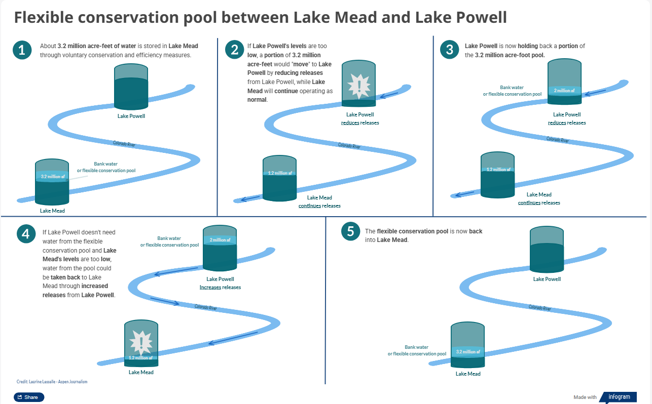
Water users in the Lower Basin states — California, Arizona and Nevada — currently have about 3.2 million acre-feet stored in Lake Mead through voluntary conservation and efficiency measures. Water users bank water in this pool, known as the Intentionally Created Surplus, and can take this water back out again to use under certain circumstances.
The paper’s authors — John Berggren, a regional policy manager with Western Resource Advocates, and Kevin Wheeler, principal and engineer with Water Balance Consulting — used the ICS pool as an example to explore how the idea would work. They say that if the ICS pool could be moved from Lake Mead to Lake Powell, the U.S. Bureau of Reclamation could have a buffer to more easily protect Glen Canyon Dam infrastructure, minimize the need for large releases from upstream reservoirs and reduce the risk of litigation among the seven basin states that share the Colorado River.
“If you took a million or two million acre-feet out of Mead in the form of a conservation pool and moved it to Powell, then you could protect Powell without having to do all the DROA and the 6e releases,” Berggren said. “This is a perfect year where we would like to have the flexibility to move this water wherever it’s needed most, in this case in Powell.”
Berggren is referring to the actions that the federal government is taking this year: releasing up to 1 million acre-feet from Flaming Gorge Reservoir to prop up Powell, as well as reducing releases down to just 6 million acre-feet from Powell instead of the originally expected 7.48 million acre-feet. Projections from Reclamation show the reservoir falling below 3,500 feet by this summer if these actions aren’t taken, jeopardizing the ability to make hydropower at Glen Canyon Dam.
This is a pivotal moment for the Colorado River Basin’s 40 million water users, with a historically bad snowpack and streamflows pushing reservoir levels to new lows and management into crisis mode. The seven states that share the river have not been able to reach an agreement for how reservoirs will be operated and shortages will be shared after the current framework expires this year. The feds are poised to step in with their own management rules, but the actions they are allowed to legally take may not go far enough to keep the system from crashing.
Graphic credit: Aspen Journalism
An invisible pool
Berggren’s paper lays out a surplus pool that would be flexible and “operationally neutral,” and would be separate from the rest of the stored water in both reservoirs. That means it wouldn’t count toward calculations of how much water is in Lake Powell or Lake Mead for the purpose of determining how water shortages would be shared.
There isn’t a way to physically move water upstream, but according to WRA, water could be transferred between reservoirs through adjustments to dam releases and careful accounting. A pool could be “moved” from Mead to Powell by holding back water in Powell. It could be moved back to Mead by increasing releases from Powell.
The concept paper does not advocate for taking such actions this year, presenting them as a potential strategy to be used under a new river management framework that is being hashed out between the states that share the river and the federal government.
“There are a lot of concerns about operational neutrality, but we’re trying to show that it’s actually not that scary and can provide benefit with less risk than the current options,” Berggren said.
Reservoir levels in Mead currently determine how deep cuts to the Lower Basin states are; as Mead is drawn down, it triggers deeper cuts. Some water experts have said the ICS pool allows Lower Basin water users to game the system. By leaving their water in the ICS pool, it keeps reservoir levels artificially high and lets water users avoid taking deeper cuts. If the ICS pool had remained separate from the rest of Lake Mead, shortage triggers and mandatory conservation would have happened earlier.
Making this pool “operationally neutral,” or invisible to reservoir operations, fixes this issue.
In a proposal submitted to the federal government May 1, the Lower Basin states expressed support for this concept, but they did not lay out a plan to implement it.
“The goal is to achieve operational neutrality of ICS,” the submittal reads. “The Lower Division States will continue to determine when and how to convert ICS to operational neutrality at higher elevations in Lake Mead.”
They also said the long-term goal is to create an operationally neutral common pool of new water savings to be strategically deployed at low elevations to help delay and offset additional reductions to the Lower Basin.
Some experts say there are concerns and unanswered questions about these types of pools. The dividing line where water delivery is measured from the Upper Basin (Colorado, New Mexico, Utah and Wyoming) to the Lower Basin is Lee Ferry, just downstream of Lake Powell. Water measured at this location determines whether the Upper Basin remains in compliance with the 1922 Colorado River Compact. Moving water between reservoirs would have to deal with this issue.
“You would just have to agree on the rules of when is it considered a delivery at Lee Ferry and when isn’t it a delivery at Lee Ferry,” said Colorado River expert and author Eric Kuhn.
Another problem is that removing the ICS pool from reservoir accounting would leave a 3.2-million-acre-foot hole in Lake Mead that would need to be filled.
“It’s hard to get there because there isn’t a way to make ICS operationally neutral unless you impose the shortages that would occur if the ICS weren’t there,” said Kathryn Sorensen, director of research and professor of practice at the Kyl Center for Water Policy at Arizona State University. “I don’t know how else you can do it. You have to pay the piper.”
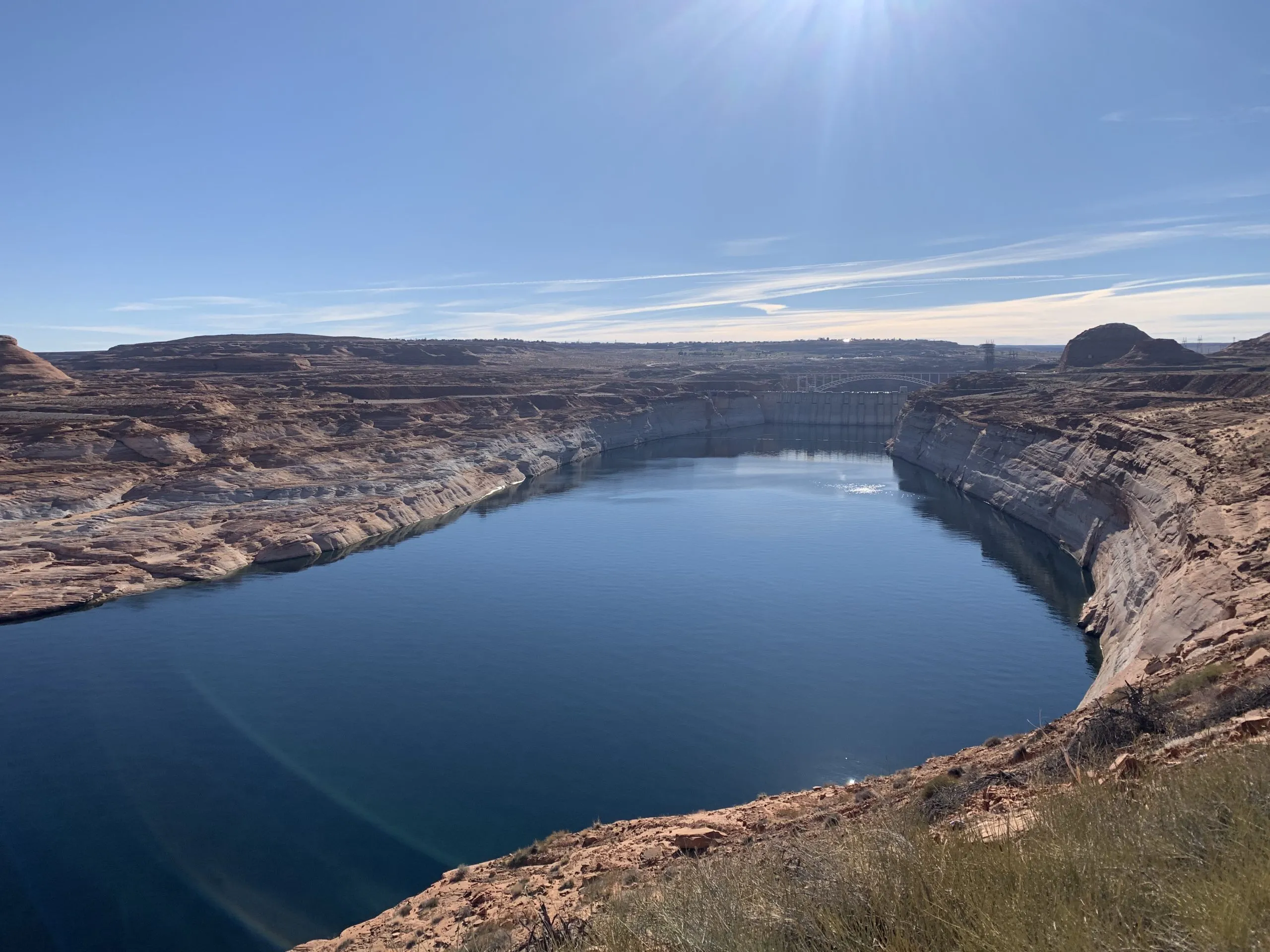
The infamous bathtub ring around Lake Mead can be seen in this photo of the intakes at Hoover Dam in December 2021. A conservation organization says flexible pools could be used to “move” water from Lake Mead to Lake Powell, where water levels could be critically low this year. CREDIT: HEATHER SACKETT/ASPEN JOURNALISM
Lower Basin proposal
Last week, the Lower Basin states submitted a proposal to Reclamation to operate the reservoirs through 2028 that includes more conservation. This short-term deal could provide a temporary fix while states continue to hammer out a long-term strategy to share the river.
The Lower Basin states are proposing to cut another 700,000 acre-feet of water per year through 2028, on top of the 1.5 million acre-feet they had already promised. California and Arizona will each take another 300,000 acre-feet of cuts and Nevada will take a cut of 100,000 acre-feet. The proposal does not include any mandatory conservation from the Upper Basin.
“It was a monumental undertaking in a very short time frame to come up with all of this,” said JB Hamby, California’s lead negotiator. “We need a bridge to the future, and we welcome and look forward to an opportunity for a full seven-state deal where all states are part of the solution.”
The Lower Basin proposal also says that this year’s release from Flaming Gorge to prop up Powell should be as close to the maximum amount of Reclamation’s rangeof 1 million acre-feet as possible. The proposal also calls for increasing releases from Lake Powell if hydrology and projected reservoir levels improve.
“The intent under improved hydrology is to share the benefits of improved hydrology between both basins,” the proposal reads.
Colorado’s negotiator, Becky Mitchell, said in a prepared statement that the Lower Basin’s proposal for water-use reductions is a good first step but they still call for too much water to be released out of Lake Powell and other Upper Basin reservoirs.
“The Lower Division States’ proposal would also drain the Upstream Initial Units with limited opportunities for recovery,” Mitchell’s statement reads. “Lake Powell should properly be viewed as a savings account for the Lower Basin: The Lower Basin’s own resiliency depends upon it. The entire Basin should support sustainable, supply-driven operations at Lake Powell that rebuild storage.”
Upper Basin officials have proposed a mediator to help move the needle on talks about future management to try to get to a seven-state deal.
Berggren said that although the concept of a flexible, floating pool doesn’t solve the basic supply-and-demand problem on the Colorado River, it’s still an important tool for future management.
“There are a bunch of other things needed, including Lower Basin users and Upper Basin users using less water overall,” Berggren said. “This is just one component. But it helps provide some benefit in dry years like this one.”
In backcountry first aid, the rapid assessment of someone injured was for years summed up by the ABCs: check the patient’s airway, breathing and circulation. A new priority has since been added: stop life-threatening bleeding as quickly as possible.
That approach is relevant for those of us working to protect public lands as we confront the equivalent of a massive hemorrhage. It is Congress’ unconstrained use of the Congressional Review Act (CRA) to destroy management plans that were thoughtfully considered and years in the making.
With only simple majority votes required in each chamber of Congress, bypassing committee review and without the Senate’s 60-vote filibuster, management plans that involved extensive public participation are being thrown out.
The CRA has already been used to undo six resource management plans and one mining prohibition. What replaces these plans is unclear and has plunged public land managers, local communities and even industry into uncertainty that will linger for years.
Last month, Congress used the CRA to remove protections against mining for roughly 225,000 acres at the headwaters of the Boundary Waters Canoe Area Wilderness. This was a major blow to the watershed of America’s most visited wilderness and a grim moment for conservationists. Now, the focus has shifted to Utah.
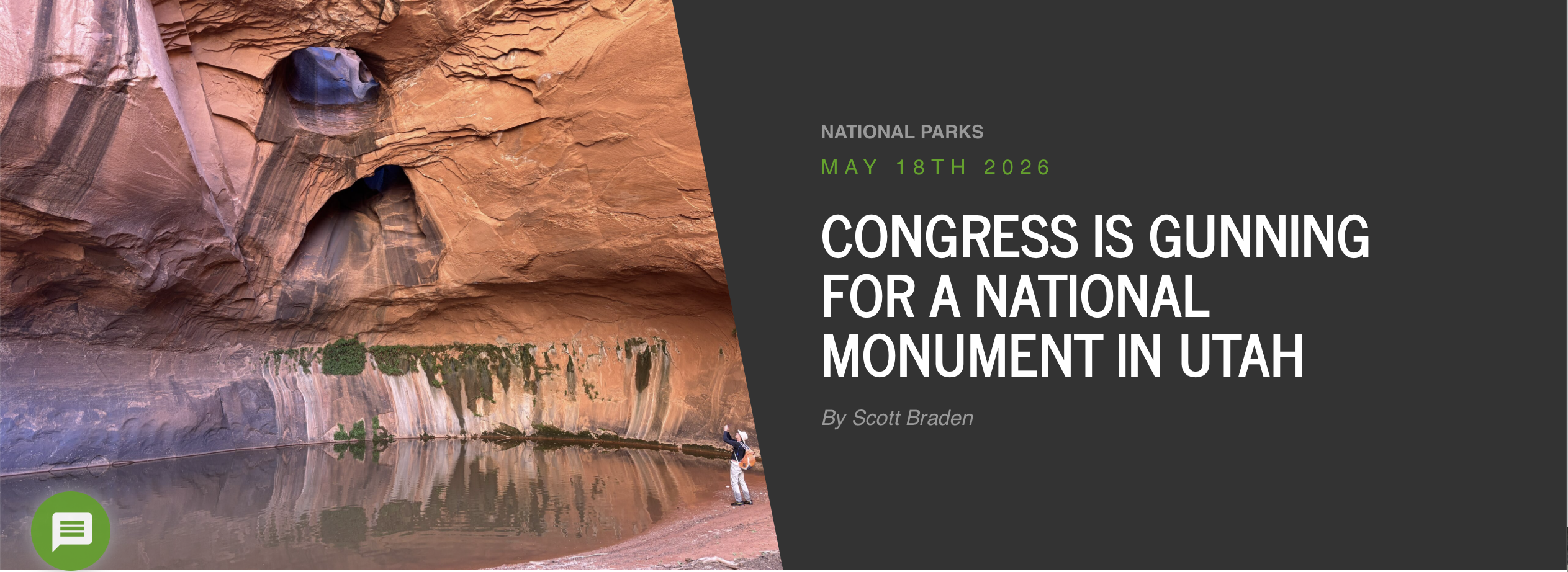
Senator Mike Lee and Rep. Celeste Maloy, both Utah Republicans, have introduced joint resolutions to undo the management plan for the 1.9-million-acre Grand Staircase-Escalante National Monument. When you think of Southern Utah, Grand Staircase-Escalante is at its heart; its vast landscape of canyons and mesas knits together Bryce Canyon and Capitol Reef national parks and the Glen Canyon National Recreation Area.
If this CRA resolution passes, it could devastate the monument, turning it into a place where out-of-control off-road vehicle use, landscape-level clearcutting, and other extractive activities would all be possible.
The good news is that this fight is one that we, together, can win. When we do, it will set a precedent to protect all national monuments, national parks and beloved public lands that might be next in line.
In the House of Representatives, the ever-changing margins are razor thin—just ask Republican Speaker Mike Johnson, who struggles with vote counts daily. In the Senate, Mike Lee has proved notorious for wasting valuable time with legislation that has little chance of passing.
We know these elected officials have been hearing from their constituents who are unhappy about their previous votes using the CRA. In both chambers, a growing list of Republicans find they need to bolster their public lands and environmental credentialsbefore the mid-terms.
Lee and Maloy’s doomed efforts last year to sell off public lands proved highly unpopular nationwide and in Utah. Knowing that, members of Congress might want to think twice before tying themselves to the duo’s latest attempts to weaken protection for Grand Staircase-Escalante.
At the Southern Utah Wilderness Alliance, we’re no stranger to an uphill battle. Ever since SUWA was founded in 1983, we’ve sparred with Utah’s anti-public-lands politicians, who show a level of disdain for our national heritage that seems bizarre in its tenacity. A deep-rooted belief that a federal public lands system simply should not exist seems to drive these politicians—defying logic, economic data and poll after poll.
That’s why we are not shy about asking people outside of Utah to join us in speaking up for protecting public lands in Utah. Public lands belong to all Americans, and every day, we urge people across the country to tell their elected officials to speak up for public lands, Indigenous sacred sites and intact ecosystems in Utah—because our politicians won’t.
Scott Braden
This is the moment to urge members of Congress to vote “no” on the Grand Staircase-Escalante CRA resolution. A vote could be coming anytime in the next few weeks. Time is of the essence.
To make the case, everyone who cares about the magnificent red-rock canyons of Grand Staircase-Escalante and Southern Utah needs to act now. The more our voices are raised and registered, the stronger our message urging Congress to listen to the people who want protection and stewardship, not short-term exploitation of our public land.
Scott Braden is a contributor to Writers on the Range, writersontherange.org, an independent nonprofit dedicated to spurring lively conversation about the West. He is the executive director of the Southern Utah Wilderness Alliance (SUWA).
The Antiquities Act of 1906 was signed into law by Theodore Roosevelt, for “… the protection of objects of historic and scientific interest” through the designation of national monuments by the President and Congress. National monuments are one of the types of specially-designated areas that make up the BLM’s National Conservation Lands. Some of the earliest national monuments included Devils Tower, the Grand Canyon, and Death Valley. They were initially protected by the War Department, then later by the National Park Service. More recently, the BLM and other Federal agencies have retained stewardship responsibilities for national monuments on public lands. In fact, the BLM manages more acres of national monuments in the continental U. S. than any other agency. This includes the largest land-based national monument, the Grand Staircase-Escalante National Monument in Utah featured here. National monuments under the BLM’s stewardship have yielded numerous scientific discoveries, ranging from fossils of previously unknown dinosaurs to new theories about prehistoric cultures. They provide places to view some of America’s darkest night skies, most unique wildlife, and treasured archaeological resources. In total, twenty BLM-managed national monuments, covering over five million acres, are found throughout the western U. S. and offer endless opportunities for discovery. Photos and description by Bob Wick, BLM.