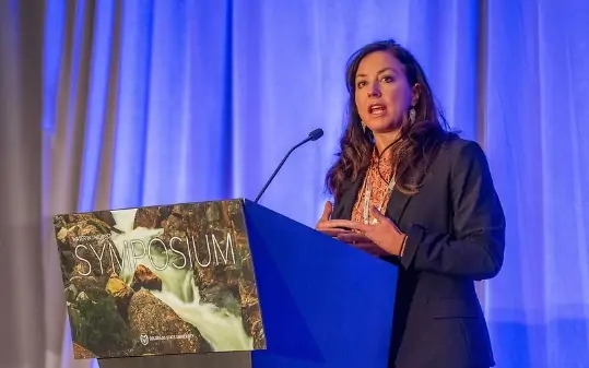
Becky Mitchell. Photo credit: Allen Best/Big Pivots
Click the link to read the article on the Big Pivots website (Allen Best):
June 25, 2026
In haggling with their down-river states about sharing the rapidly shrinking Colorado River, the headwater states have delivered a consistent message.
We don’t have two big reservoirs named Mead and Powell sitting upstream from us, they say. Mostly we must make do with what the sky delivers.
At the Upper Colorado River Commission meeting in Denver this week, the states reiterated this message, offering ample evidence from places like Emery, Utah, and Kemmerer, Wyo.
Lest anybody miss the message, Chuck Cullom, the director of the upper-basin commission, showed aerial images of farming areas in Colorado and the other upper-basin states. Far less green was evident in the Montrose area and on the Ute Mountain Ute Reservation during June than in 2024.
This exceptional year for drought and heat was described by several speakers in Denver as dire. “I want you all to recognize the significance and severity of the things we’re dealing with,” said the Utah representative, Gene Shawcroft. “Totally unprecedented.”
In western Colorado, a Meeker rancher used the same word to describe withered streams. “The situation here has gone from bad to dire.”
Upper-basin states have been in a tug-of-war for the last three years with lower-basin states about how to share this diminished river. As Becky Mitchell (above), Colorado’s representative, says repeatedly, we have a math problem. It’s impossible to continue releasing more water from reservoirs than flow into them. Upper-basin states, she says, “live within the means of the river.”
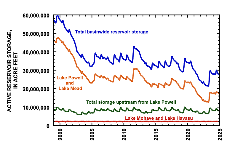
Udall/Overpeck 4-panel Figure Colorado River temperature/precipitation/natural flows with trend. Lake Mead and Lake Powell storage. Updated through Water Year 2025. Note the tiny points on the annual data so that you can flyspeck the individual years. Credit: Brad Udall
In crafting the Colorado River Compact in 1922, delegates assumed annual flows of roughly 17 to 18 million acre-feet annually at Lee Ferry, the legal division point separating the upper and lower basins. The 20th century delivered naturalized flows of 15.2 million on average.
In this century, flows have slackened even more. Since 2019 they have averaged 10.2 million acre-feet. This year less than 1 million acre-feet is expected to flow into Lake Powell other than releases from upstream reservoirs.
The compact pledged 7.5 million acre-feet to each of the two basins. The lower-basin states for many years over-used their allocation. Upper-basin states topped out at about 4.5 million acre-feet, using 3.5 million acre-feet in drier years.
Colorado and other basins states insist upon the right to use more water — if it’s there. Pre-compact rights of all Native American tribes have yet to be realized. All this creates a different math problem.
When the four upper basin states adopted their own compact in 1948, they wisely chose to use a percentage not an absolute number. That would make sense for the Colorado River Basin altogether — if the two basins could agree upon it. Tensions have elevated. Outwardly this marriage looks very rocky.
Might there be another way? Tanya Trujillo, New Mexico’s new representative, offered an intriguing statement at the Denver meeting.
“I think we need to think differently about some things,” she said. “In New Mexico, we’re going to be taking a fresh look at some of the issues that we are facing and really try to look for a collaborative process going forward.”
In time of crisis, she added, it’s important to “project calm, knowledgeable reassurance and try to be part of the solution, not part of the problem.”
For whom was that message intended? It was not clear. However, even in Colorado, some have suggested upper-basin states have overstated their case.
What cannot be contested is Mitchell’s assertion that demands cannot exceed supplies. This year, we’re robbing Peter to pay Paul. Water is being taken from Flaming Gorge and other federal upstream reservoirs to keep water in Powell. Blue Mesa Reservoir near Gunnison may have too little water to release any downstream, a condition called dead pool. The Bureau of Reclamation similarly sees that possibility for Navajo, the reservoir on the Colorado-New Mexico border.
The Bureau intends to release six million acre-feet from Powell for the lower-basin, leaving Powell 80% empty. The agency’s “most probable” projections see reservoir levels at Glen Canyon Dam early next year being too low to generate electricity.
In Grand Junction this week, people stood in the rain with sheer delight. It was a feel-good moment. But will El Niño save us from calamity? Maybe, but don’t bet on it. The warming climate seems to be rewriting the rules about how much water from the Pacific Ocean arrives on our mountains.
hat was the takeaway from a recent presentation by Brad Udall, a scientist scholar affiliated with Colorado State University. El Niños in the past have produced big water years. One was in 1983, the year that flood waters nearly broke Glen Canyon Dam. Often, though, an El Niño produces no more moisture than a La Niña.
“The real question” said Shawcroft, the Utah representative, “is what happens if next year looks like this?”
Map of the Colorado River drainage basin, created using USGS data. By Shannon1 Creative Commons Attribution-Share Alike 4.0
Last post here, I suggested that at least some of the ongoing failure of the seven Colorado River states to reach agreement on a river management plan for even the next several years, let alone new century, stems from some ‘elephants in the river.’ You know – the big things that nobody wants to look at because they are so big. So big that some of the rules and guidelines we operate under were created to avoid having to address them.
The first ‘elephant in the river’ I discussed last time was the single-minded focus on the Colorado’s surface waters, and a failure to begin considering the whole integrated water supply, surface water and groundwater – of which the surface water is a relatively minor part, with users going to the groundwater in a haphazard way when the surface water is insufficient.
I did make an incorrect statement in that analysis, however. I said that Colorado was the first, and thus far only, state to begin integrating groundwater into its appropriation priority system statewide. (Arizona developed – by federal mandate – a Groundwater Management Plan circa 1970 for those specific parts of the state served by the Central Arizona Project.)
This is true about Colorado – but I was mistaken in implying that the all groundwater use was integrated into its appropriation system by 1969 legislation. Only alluvial groundwater is covered by that law – groundwater that is naturally integrated with surface water, either trickling into the surface streams when the groundwater table is high or drawing riparian water from the surface streams when the water table is low.
Not covered by the Colorado law are ‘non-tributary’ aquifers that have no natural interaction with the surface waters – aquifers like the Oglalla Aquifer in eastern Colorado, or the Denver Basin aquifer. Most of their water filters down from the alluvial groundwater, and only modern pumping technology makes that groundwater accessible to surface use. Most of these deep aquifers have accumulated their water slowly over geological periods of time, and even moderate use of their water dips quickly into ‘water-mining.’ Colorado law for such aquifers attempts to limit annual use to a hundredth of a presumed 100-year supply, but no one knows for sure how much water is really down there, or whether it will truly constitute a 100-year supply.
The standard response throughout much of the basin to shortages in surface water is to go to groundwater pumping; if ‘tributary’ (alluvial) groundwater is tapped, the pumping will gradually lower the water table – which in turn will begin to diminish the surface streams, which in turn will increase the pumping – et cetera, a vicious downward cycle. And the pumping of ‘non-tributary’ aquifers is largely unregulated in the basin.
At any rate – apologies for the error, and thanks to John McClow for pointing it out.
And on to another elephant in the room. Is it finally time to determine limits on the presumed universal applicability of the appropriation doctrine? To avoid being shot before I finish the paragraph, I will say immediately I am not suggesting doing away with the appropriation doctrine; it is a good enough last resort down on the ground where the appropriation doctrine started, for working out local problems of water use on a surface stream when neighborliness fails – that is, when old grumps and feuds preclude the ‘gentlemen’s agreement’ on sharing out what water is available, rather than shutting down the junior users with a ‘call’ so the seniors can get all their decreed water. After two or three generations, seniority can be acknowledged, but is too abstract to apply against your neighbors, if a plan for sharing blameless misfortune can be worked out.
The abstraction, however, becomes more applicable when it is distant water organizations calling out other water organizations upstream, or an earlier developed watershed placing a call on users in an adjacent more recently developed watershed. And when a stream is declared by the district engineer to be over-appropriated – not enough water to fill everyone’s decrees in a near-average year – it becomes even more abstract, a tool for enforcing a status quo, and nothing anywhere about what represents the best uses of the water.
There are, in other words, some areas in which the appropriation doctrine gets stretched beyond its elastic limits by emerging challenges of water use; any questions about ‘best and highest use’ have been essentially declared unanswerable as a matter of conflicting values, and it just seems easier to let seniority of use be the ultimate determinant of priorities.
A century ago, with California quintupling its population in the first two decades of the 20th century, the other six of the seven states in the Colorado River Basin (Arizona, Nevada, Colorado, New Mexico, Utah and Wyoming) began to worry that California might put so much of the river’s water to use that there would not be enough unappropriated water for them to put to use when their time of growth came. They were all committed to versions of the appropriation doctrine within their states, but came to believe that reliance on the appropriation doctrine alone at the interstate level could cause more regional problems than it would resolve.
That concern was affirmed in 1922 when the U.S. Supreme Court resolved a conflict between Colorado and Wyoming over a Laramie River tributary that started in Colorado but was put to use first in Wyoming; the court declared that states who used the appropriation doctrine intrastate would also have to respect each other’s appropriations interstate. This made real the specter of slow-growing upstream states having to let all their Colorado River water go downstream to fill huge Arizona and California decrees.
So they assembled in 1922 to try to do something about that – a fundamental fact about the Colorado River Compact commission that we tend to forget: the original intent of the compact commissioners in 1922 was to develop an alternative to the appropriations doctrine at the interstate level. They came together with the intent of working out a seven-way division of the use of the river, based on possible future development, that would eliminate a horse-race of interstate appropriative competition. Six of the states convened the commission because they feared California, and California reluctantly participated because it knew the feds would never build the big control and storage dam they needed until all seven states were on board with it. That seven-way division trumping interstate appropriation was what the Compact Commissioners assembled to do –and spent a frustrating week early in 1922 trying to do.
They were unable to effect a seven-way split for a couple of reasons: for one thing they had no good measure of how much dependable water was in the river; estimates at the time ranged from 12 to 20 million acre-feet (maf). But for a second thing, the sum total of the water they each felt their state needed, based on rosy early-20th-century estimates, was closer to 24 maf – and nobody wanted to go home having backed down from their carefully imagined numbers.
Members of the Colorado River Commission, in Santa Fe in 1922, after signing the Colorado River Compact. From left, W. S. Norviel (Arizona), Delph E. Carpenter (Colorado), Herbert Hoover (Secretary of Commerce and Chairman of Commission), R. E. Caldwell (Utah), Clarence C. Stetson (Executive Secretary of Commission), Stephen B. Davis, Jr. (New Mexico), Frank C. Emerson (Wyoming), W. F. McClure (California), and James G. Scrugham (Nevada). CREDIT: COLORADO STATE UNIVERSITY WATER RESOURCES ARCHIVE via Aspen Journalism
What they did instead – in order to persuade Congress that there was general agreement – was to cobble together the Compact we are burdened with today; they created what Commission Chair Herbert Hoover called a ‘temporary equitable division’ of the seven states into Upper and Lower River Basins, until ‘ those men who may come after us, possessed of a far greater fund of information’ could do the ‘further division’ of the river among the states.
They also decided – as early 20th-century Americans would – to lean toward the more optimistic estimates of river flow, dividing ‘equally’ between the Basins only 15 maf of a river they presumed would continue running 16-20 maf – hence the 7.5 maf for each Basin written into the compact, to be further divided among the states of each Basin in their own good time. That left some water for Mexico, but they did nothing specific for the Indian tribes in the basins because national Indian policy at that time was ‘soft genocide’ – full assimilation (‘kill the Indian, save the man’), leaving tribal water a concern they thought would disappear.
This all made reasonable sense with a river running a quarter-century average of just under 18 maf – but then through the 1930s the river experienced a drought unsurpassed until the past quarter century. By the end of World War II, Colorado river water users had a ‘far greater fund of information’ about the river’s flow, which would have made it a good time to have ‘fixed’ the Compact – but the growing fund of information was all bad news that no one wanted to incorporate into a more realistic policy. So by default the ‘temporary equitable division,’ with its mythic 18 maf river, took on the permanence of something carried off a sacred mountain carved in stone.
And now – we are seeing it reduced to a sad irony. The states of the Lower Basin had their fears too, and wanted a clause in the Compact stating that, should the Upper Basin states have a wild spurt of growth, they should not ‘deplete the flow’ to the Lower Basin below an average of 7.5 maf a year. But now – when it looks like diminished flows throughout the basin might really drop the flow at the division point between basins below that average – the Lower Basin is threatening the Upper Basin with an Article III(d) ‘call,’ saying the upper states will have to cut their own uses enough to meet the lower states’ fantasy 7.5 maf. States that set out a century ago to create a compact that would transcend the appropriation doctrine at the interstate level are now trying to turn that ‘temporary equitable division’ into what amounts to a senior interstate water right.
There has to be a level, or category, of action in which the law of first-come first-served is transcended by other considerations. And can we not say, at this point a century later, that the original intention of the compact commission has been achieved de facto? No state will ever get the use of more water than it had (or believed it had) around the turn of the century because there is even less water now. For better or worse, the use of the river has been distributed among the states (including some of the tribes) and Mexico.
Udall/Overpeck 4-panel Figure Colorado River temperature/precipitation/natural flows with trend. Lake Mead and Lake Powell storage. Updated through Water Year 2025. Note the tiny points on the annual data so that you can flyspeck the individual years. Credit: Brad Udall
Whether this is an equitable division is arguable; the states of the Lower Basin have been using roughly two-thirds of the river’s water, the Upper Basin states around one third, rather than the 50-50 split explicit in the Compact (7.5 maf per Basin). But arguably that does reflect the relative productivity of Lower Basin agricultural use (by far the largest use) and also its millions of urbanites drawing on it for at least part of their municipal water. It was a huge step toward reality when the Lower Basin states finally agreed that they must absorb the Lower Basin’s system losses (mostly evapotranspiration) and their half of Mexico’s allotment out of their own shares of the river, rather than relying on a fictional surplus to cover it – a fiction that combined with drought to draw down both Powell and Mead Reservoirs to the dangerous level where they linger today.
Yampa River Basin via Wikimedia. Note the Little Snake River crossing the Colorado-Wyoming line.
The 1948 Upper Colorado River Compact was the first reality-based document in the ‘Law of River’ portfolio because its negotiators knew by then – that ‘greater fund of knowledge’ – that it was doubtful that there would always be 7.5 maf for their use, and actually accepted that as their reality. So the divided their ‘half’ of the river into percentages for each state of whatever was left for the upper states after the Lower Basin got it Boulder Canyon Project Act waters. After three-quarters of a century, the four states are not too far from those percentages in their development of around 4.5 maf; only Wyoming is significantly under its 13 percent; Utah is a little below its 23 percent; and Colorado is a little over its 51.75 percent. Given the geographic irrelevance of western state boundaries (the Little Snake River crosses the Colorado-Wyoming border half a dozen times), this was pretty good 1948 estimating.
The reality today is that all Colorado River water users in all seven basin states are using a finite and measurable resource that will probably continue to diminish for the foreseeable future as we continue to heat up the planet, and we need to come to an agreement on what that means for all users. [ed. emphasis mine]
It seems to me there are three ways to address that diminishing flow. One way is to continue to accept the divine sanctity of the Colorado River Compact, with the Upper Basin states forced by the Supremes (they ride for power, not for the law) to cut back their own uses to meet the 7.5 maf average delivery to the Lower Basin – basically the interstate nightmare (for the upper states) the Compact was meant to address. Call this the stubborn denial option.
A second way would be to accept the evolved eight-way division (seven states plus Mexico) of the use of the river’s water, which was what the seven states wanted to do in 1922, instead of the ‘temporary equitable’ compact they came up with. Percentages for each basin state could be set according to the amount each state was using at the end of the major river development era, say in Y2K (remember that?), when the 70-year average annual flow was ~14.5 maf (1930-2000). Those state percentages of the river’s consumptive use could be retained – but the actual volume of water for each state would gradually diminish as the combination of ‘dry drought’ and ‘heat drought’ continues to diminish the river. Given that losses attributable to climate warming are both everybody’s and nobody’s fault, the losses to each states would be proportionate to their percentage of the river’s consumptive use, with no falling back on seniority, as though it were just a squabble between users. Each state could then either stay with the appropriation doctrine intrastate with junior users bearing the loss, or equitably share out the loss proportionate to use. Call the latter the shared reality option.
Photo of Crowley County by Jennifer Goodland
A third way lies between stubborn denial and shared reality, and will probably prevail as the default American Way: let money work it out. Municipal and industrial users will continue to work out money-for-water deals with agricultural users, like San Diego and the Metropolitan Water District have done with the Palo Verde and Imperial Valley ag districts, with responsible districts using the money for systemic improvements that minimize the impact of lost water. This is by no means going to ‘dry up’ agriculture. With 75-85 percent of the river’s water being used by agriculture, a doubling of M&I use would only require transfer of 10-15 percent of ag water, although (money being blind to all but profitability) the transfers would probably cause some local tragedies like Crowley County in Colorado where too much water was bought out of a single small irrigation district by Front Range entrepreneurs.
The appropriation doctrine, with its strange ‘property right’ independent of the property for which it was granted, is quite compatible with the money option for resolving water distribution, once over-appropriation is achieved. The idea that water’s seniority in a certain use can be transferred to a totally different use along with the water strikes me as strange – shouldn’t a new use initiate a new right? It is also contradictory to the doctrine’s initial democratic-populist effort to prevent the dominance of big money in water distribution by limiting water rights to what one could put to use. But it does seem to be the American way that everything eventually comes down to money as the base determinant of value.
Enough for today. The elephants in the river. I obviously favor ‘ratifying’ the evolved split of the use of the river, and an equitable proportionate sharing among all states – and within all states – of the consequences of our cultural climate changes. But that will not fly among those who have steadfast faith (senior water right holders) in the appropriation doctrine as the answer to all problems.
The river? It abides, rises and falls with the water table in its surrounding groundwater, and it may occasionally disappear, but it won’t have died, it will just have gone underground until the water table rises again and the ground can’t hold all the water – if we figure out how to let that happen.
Map of the Colorado River drainage basin, created using USGS data. By Shannon1 Creative Commons Attribution-Share Alike 4.0
Sen. Mike Lee and Rep. Celeste Maloy, both MAGA Republicans from Utah, have formally introduced legislation to use the Congressional Review Act to revoke the Biden-era management plan for Grand Staircase-Escalante National Monument. If successful, the move would also bar the feds from developing a new management plan that resembles the current one.
The current management plan is not draconian by any means. It was fashioned over years, with oodles of input and compromise, and is far less restrictive than the preservation-oriented alternatives It allowed for motorized vehicle use on designated routes and added almost no new restrictions for livestock grazing. Revoking it is not the same as rescinding the national monument or shrinking its boundaries, and will not open up any of the monument to new mining claims or oil and gas leases.
So it’s not clear what Lee and Maloy hope to achieve, except to strike a blow to a national monument that they don’t like and to throw oversight of 1.9 million acres of public land into disarray. Or maybe they’re just trying to build up their anti-public-land credentials to head off challenges from even more extreme candidates such as, say, Phil Lyman, who just challenged Maloy for her 3rd District congressional seat.
You still have time to let your representatives in Congress know how you feel.
Ugggg.
While well-intentioned greens are parsing BLM director nominee Steve Pearce’s words for indications he might be inclined to sell off public land, the Trump administration is orchestrating a massive de facto transfer of public lands to oil and gas companies.
I’m talking about oil and gas leasing. And no, it’s not an actual transfer of public land; the lessee does not take title to the land, nor can they block public access, but they do get the rights to drill that land and preclude other uses on it. And, once it is drilled, the land is scraped of all vegetation, covered with heavy equipment, poked with a massive drill, hydraulically fractured, and becomes an industrial-scale, methane-, hydrogen sulfide-, and VOC-oozing hydrocarbon factory for many decades to come.
On the auction block this June is a good chunk of slickrock-studded landscape northwest of Moab, between Hwy. 191 and the Green River, along with some parcels in the Lisbon Valley. All in all, the BLM proposes selling off 39 parcels covering some 71,600 acres. You have until March 30 to give your two cents. https://eplanning.blm.gov/Project-Home/?id=6fad61fa-a7f2-f011-8407-001dd80bcf93
***
Of course, sometimes the BLM holds an oil and gas auction and no one comes. That was the case with the Big Beautiful Cook Inlet Oil and Gas Lease Sale (yes, that is the official name) held March 4 in Alaska, in which more than 1 million acres of offshore leases were put on the block. There were zero bids. Zilch. Nada. Someday, maybe every oil and gas lease sale will be like that.
***
A federal judge has halted construction of the Northern Corridor Highway through the Red Cliffs National Conservation Area near St. George, Utah, while an advocates’ lawsuit proceeds.
The BLM approved the contested project earlier this year. The Utah Department of Transportation, apparently wanting to get started before a legal challenge could take hold, began erecting fencing along the project, even though their development plan hadn’t been approved. This activity would have disturbed desert tortoise habitat.
The court did not approve, blocking further work until the lawsuit is resolved.
***
In other Utah road news, Garfield County began chip-sealing the first ten miles of the Hole-in-the-Rock Road in Grand Staircase-Escalante National Monument, drawing protest and a lawsuit from environmental groups.
The county has been aching to pave the gravel road, which often becomes riddled with potholes and washboards, for years, but failed to gain BLM approval. Environmental groups have resisted, saying that improving the road could lead to more paving or widening of primitive byways in the area, and would increase the number of people and their impacts on the fragile landscape.
The county has also wielded RS-2477 — an 1866 statute — in an attempt to wrest control over the byway, which leads to the famed Colorado River crossing of the 1879 Latter Day Saint expedition to Bluff. Last July, a federal court granted Garfield County quiet title to the section of the road within the county.
Garfield County interpreted that as a green light to chip seal the road.
That triggered a lawsuit from the Southern Utah Wilderness Alliance, pointing out that because the road crosses BLM land, the county must still get the agency’s go-ahead for major improvements. It didn’t, but the BLM has done nothing to stop the action, which SUWA says violates federal environmental laws.
🥵 Aridification Watch 🐫
I was accused recently of being all “doom and gloom” when it comes to this year’s snow levels, so I set out to find some good news to report. It didn’t go so well, but I did uncover a few tiny nuggets, including:
After the February storms, the Center for Snow and Avalanche Studies reported: “This is rare, but currently we do not have any dust on the snowpack.” That’s good news because dust on the snow decreases albedo (reflectivity), leading to faster snowmelt. We need what little we have to stick around as long as possible. Buzzkill: The really big dust events tend to come in the springtime.
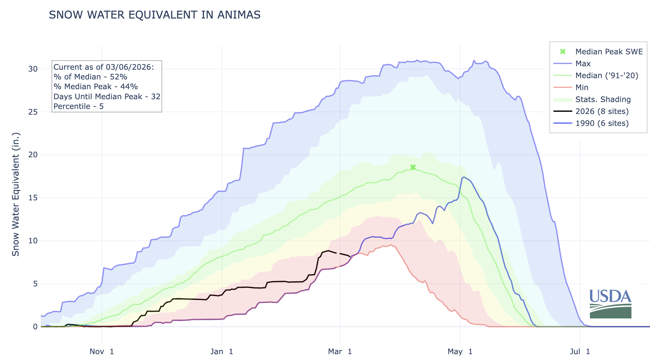
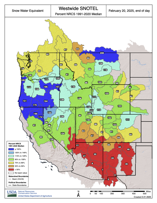
I tend to rely on a handful of high-elevation SNOTEL sites as indicators of how the mountain snowpack is doing. One of them is in Columbus Basin in the La Plata Mountains. Like everywhere else, the snow water equivalent there is way below normal. However, it’s still above 2002 levels for early March, so that’s kind of heartening. I guess?
Hope lies in 1990: That year, snowpack levels in the Animas River watershed were lower on March 6 than they are today. But beginning in mid-March, storms pummeled the region, resulting in a May 3, 1990, snowpack peak that was 94% of normal and bringing runoff up to decent levels. We could see a repeat of that March-April-May miracle!
And … oh. I’ve just been informed that there is no more good news.
As grim as this may be, it also offers a glimmer of hope: The snowpack could still recover like it did in 1990. Source: NRCS.
Now back to our regularly scheduled doom and gloom, bullet style.
The late February-early March heat wave across most of the West shattered thousands of daily high temperature records and dozens of monthly ones, topping off the West’s warmest winter on record. Monthly records (121 tied or broken nationwide during the last week of Feb.) include:
Dinosaur National Monument in Utah hit 68° F on 2/26;
Imperial County, California’s airport reached 97° on 2/28;
Albuquerque airport, 77° on 2/25;
Hovenweep National Monument in Utah, 70° on 2/28;
Havasu, Arizona, and Malibu Hills, California, were both 93° on 2/27;
Sampling of daily records (845 broken or tied during the last week of Feb) include:
Mancos, Colorado, hit 50° F on 2/28; the aforementioned Columbus Basin (elev. 10,784 feet) reached 48° and Mineral Creek, Colorado, hit 51° that same day;
McClure Pass, Colorado, reached 49° on 2/28;
Needles, California, and Phoenix both hit 92° on 2/28;
South Lake Tahoe airport, 60° on 2/28.
Those kinds of temperatures melt the snow, even on north faces, causing this year’s snow water equivalent graph lines to uncharacteristically dip during a time of year when they normally would be shooting upward. They also heighten risk of wildfires in the low country. On the last day of February, a blaze broke out in Chautauqua Park in Boulder, forcing some evacuations before it was contained. Another one was sparked west of Boulder on March 4.
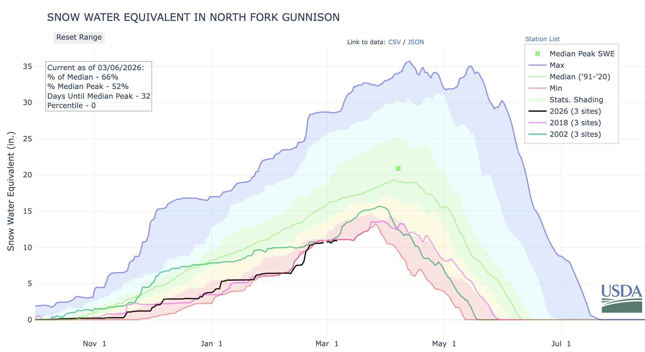
The North Fork of the Gunnison, which feeds the ditches in and around Paonia and Hotchkiss and the orchards, vineyards, and farms there, is in trouble. This year’s snowpack so far is in the same boat as it was on this date in 2002 and 2018, two very dry years when irrigation ditches were shut off early in the growing season.
Aside from the entire Upper Colorado River watershed, I’m also especially concerned about the North Fork of the Gunnison. Snowpack levels are at a record low for this date, or about the same as they were in 2018, and Paonia Reservoir is currently utilizing just 22% of its storage capacity (note the record high temp on McClure Pass above, at the headwaters of Muddy Creek, which feeds the reservoir). This does not bode well for the many small farmers who rely on the river for irrigation. In 2018, downstream senior rights holders made a call on the river in June, forcing junior irrigators in the North Fork to lose water perilously early in the season.
This bad situation could be exacerbated if the feds were to decide to release water from Paonia Reservoir in an attempt to buoy Lake Powell water levels. While this is hypothetical, it is not beyond the realm of possibility by any means.
And, saving for some sort of April-May miracle, the Colorado River runoff will be extraordinarily scant this spring and summer, almost certainly pushing Lake Powell to critically low levels.
***
That demands a plan, and the Bureau of Reclamation came up with several alternatives last month. Most of the major players have commented on the alternatives, and it’s safe to say that almost no one is satisfied with any of them — albeit for different reasons.
One of the more universal critiques is that none of the alternatives adequately address dry and critically dry scenarios on the river, like the one that is likely to occur this summer. The draft environmental impact statement itself states, “In critically dry periods, all alternatives have unacceptable performance.” That leaves many wondering what, exactly, the Bureau of Reclamation plans to do to keep the system from collapsing over the next nine months.
There is a lot here, and it gets pretty darned deep in the wonk weeds. Still, what I’ve included is a mere sampling of some of the comments from just a few of the commenters in the hope that it will give readers a better idea of where different stakeholders stand, and how complicated and difficult this situation really is.
For those who don’t like weeds, here’s the short version: It’s a tangled mess with a bunch of moving pieces and stakeholders who are digging in their heels to ensure that their constituents get the water they need to drink, irrigate crops, run industries, or whatever. And they’re all butting up against the reality that there simply isn’t enough water in the river to go around.
Arizona is understandably displeased because they would take the greatest hit under any alternative. This is not because they are somehow inferior, but because the water rights to the Central Arizona Project, which delivers Colorado River water to Phoenix and Tucson, are junior to most other big users in the Lower Basin. “… each alternative, though broad in scope, will translate in practice specifically as drastic reductions to Arizona’s water supply.”
“We are deeply troubled that Reclamation all but abandons its increasingly critical role in ensuring the Upper Basin States fulfill their delivery obligations under the Colorado River Compact of 1922 (Compact).” This refers to the non-depletion or minimum-delivery obligation that I’ve written about before.
“The DEIS itself acknowledges that ‘widespread impacts on social and economic conditions may also be possible,’ including circumstances in which municipalities may need to pursue alternative or even hauled water sources to maintain basic services. Drastic cuts could have cascading consequences for human health and safety and destabilize the lives and livelihoods of Arizonans, tribal communities, and critical industries that rely on Colorado River supplies.”
They say the cuts will damage the state’s agriculture, manufacturing, and aerospace industries and that it will put at risk: “… the largest concentration of advanced semiconductor manufacturing investment in the country, representing roughly $200 billion in announced projects since 2020.” Semiconductor production is extremely water-intensive, with the average factory consuming up to 10 million gallons of ultra-pure water daily.
They call on any plans to “include verifiable Upper Basin conservation measures commensurate with Lower Basin conservation measures, including identifying tangible metrics that demonstrate Upper Basin water conservation.”
“We believe that Reclamation must institute bold and meaningful changes but that those changes must be implemented in a manner that is consistent with the 1922 Colorado River Compact, the 1944 binational treaty with Mexico, the 1948 Upper Basin Compact, and the other foundational elements of the Law of the River.”
“Reclamation must prioritize hydrologic reality over predictability for Lower Basin users. The Draft EIS places undue emphasis on predictability1 for water users, a goal that is unattainable under future climate conditions unless system storage is replenished and overall demands are permanently reduced to match the supply.”
“… several alternatives include Upper Basin water conservation ranging from zero to 500,000 acre-feet annually … <but> … fails to analyze the environmental or socioeconomic impacts associated with these conservation volumes.” It adds that a 200,000 acre-feet reduction in the Upper Basin would require fallowing 52,000 acres on the Western Slope.
“Lower Basin water use must be reduced by 1.5 million acre-feet at all times, regardless of the alternative. This amount represents system losses (i.e., transit losses and reservoir evaporation) and should not be classified as shortage.” This is a longstanding issue. Reservoir evaporation and other such losses are counted against the Upper Basin’s consumptive use, in part because of the non-depletion obligation. The same is not true for the Lower Basin; when they say they use 7.5 million acre-feet, that does not include evaporation or seepage or other system losses, only what they pull out of the river.
“The range of alternatives must include option(s) that perform under critically dry hydrology. Currently, none of the alternatives in the Draft EIS perform under critically dry hydrology. At least one alternative must protect critical infrastructure and respond effectively to significantly lower river flows than historically observed.” We are approaching a critically dry situation this summer, when the feds will have to decide whether and how to keep Lake Powell from dropping below minimum power pool. So far there is no plan for this.
“Hydrology must drive Post-2026 operations. Operating guidelines based upon comparative reservoir elevations which do not factor in real time hydrology have been disastrous for protecting storage in Lake Powell and thus, have failed to provide the water supply certainty for the Upper Basin intended by the Law of the River …”
“Interbasin transactions must not be allowed in the proposed action.” That is, Upper Basin users with senior rights should not be able to sell their water to Lower Basin users.
The team of Anne Castle, John Fleck, Eric Kuhn, Jack Schmidt, Katherine Tara, and Kathryn Soren, river experts and academics who aren’t representing any specific water user, state, or basin, also weighed in. Their comments, as Fleck put it in his Inkstain blog, could be summed up as: “Tell us what you’re going to do.” And, also:
The group calls on Interior to “primarily focus on the Dry and Critically Dry scenarios. … We think it important to be mindful of the underlying year-to-year hydrology of the 21st century as we look to the future. … we are struck by the fact that 50% of the individual years of the 21st century have been Dry or Critically Dry, and only 27% of the years (including 2017, 2019, 2023) have been Moderately Wet or Wet.”
“We suggest that the DEIS include a description of an alternative that performs sufficiently well during Dry scenarios and an alternative that performs sufficiently well during Critically Dry scenarios.”
“ … it is imperative that Reclamation provide a clear picture of what actions will be implemented in the near term (i.e., next year, next 3 years, next 5 years) to protect critical infrastructure, and to protect public health and safety.”
Noting that lawsuits are inevitable regardless of which alternative the feds choose, they urge them to avoid “safe” options and go with a plan with “… the broadest possible interpretation of Reclamation’s and Interior’s authority to provide a predictable and resilient Colorado River so that the system can continue to operate in a reasonable manner while the lawsuits proceed.”
Call on the feds to “… explore these areas for possible inclusion in the preferred alternative:
Reduction of deliveries in the Lower Basin in excess of 1.48 MAF when insufficient water is available for release.
Provision for releases of water from the Colorado River Storage Project initial units as necessary to protect critical elevations in Lake Powell and ensure continued Upper Basin Compact compliance.
Operation of federal projects in the Upper Basin to store or use less water during critical periods.
Continuation, expansion, and modification of Assigned Water programs (such as Intentionally Created Surplus and Mexican Water Reserve) with improvements to ensure operational neutrality and minimize adverse impact to priority water.
Establishing a conservation pool in Lake Powell for storing Upper Basin conserved water to be utilized for Compact compliance purposes. For more on conservation pools, check out the Shannon Mulane’s explainer in the Colorado Sun.
The group finds fault with the plan for not addressing “the need for enforceable reductions in the Upper Basin.” They go with the Lower Basin’s interpretation of the non-depletion/minimum-delivery obligation, saying that the Colorado River Compact does not guarantee that the Upper Basin gets half of the water in the river. Plus, they point out that the plan’s demand forecasts for the Upper Basin are unrealistically high, putting more of the burden for cuts on the Lower Basin.
The Southern Nevada Water Authority and Colorado River Commission of Nevadaare especially critical, writing:
“Since the onset of drought in 2002, <Nevada water users> have reduced their overall Colorado River water consumption by more than 40 percent even as our population grew by more than 875,000 people. And they, unlike so many others, have not ignored the reality facing the basin by making the flimsy argument that our economy cannot prosper while water consumption decreases.”
Like Arizona, they bring up the minimum-delivery/non-depletion clause of the Colorado River Compact and call on the Upper Basin to comply with it.
Interior’s “… approach to protecting the Glen Canyon Dam river outlet works by reducing releases from Lake Powell—rather than making infrastructure repairs and improvements—is shortsighted and harms Nevada and the Lower Basin States.”
The Upper Colorado River Commissionemphasizes the Lower Basin’s history of exceeding its Colorado River Compact allocation and failing to account for evaporation and other system losses. Colorado’s Upper Colorado River CommissionerBecky Mitchell submitted similar, very detailed comments that emphasized the Colorado River Compact’s equitable division of the river between the Upper Basin and Lower Basin. She points out that the Lower Basin’s interpretation of the minimum-delivery/non-depletion clause contradicts and even negates that division.
📖 Reading (and watching) Room 🧐
Must read: Teal Lehto’s and Len Necefer’s speculative fiction take on what might happen on the Colorado River, and to the people who rely on it, in 2030 if current climatic trends continue. It’s dramatic and sensational and catastrophic, but it’s also very well informed, smart, and not at all far-fetched, in my humble opinion.
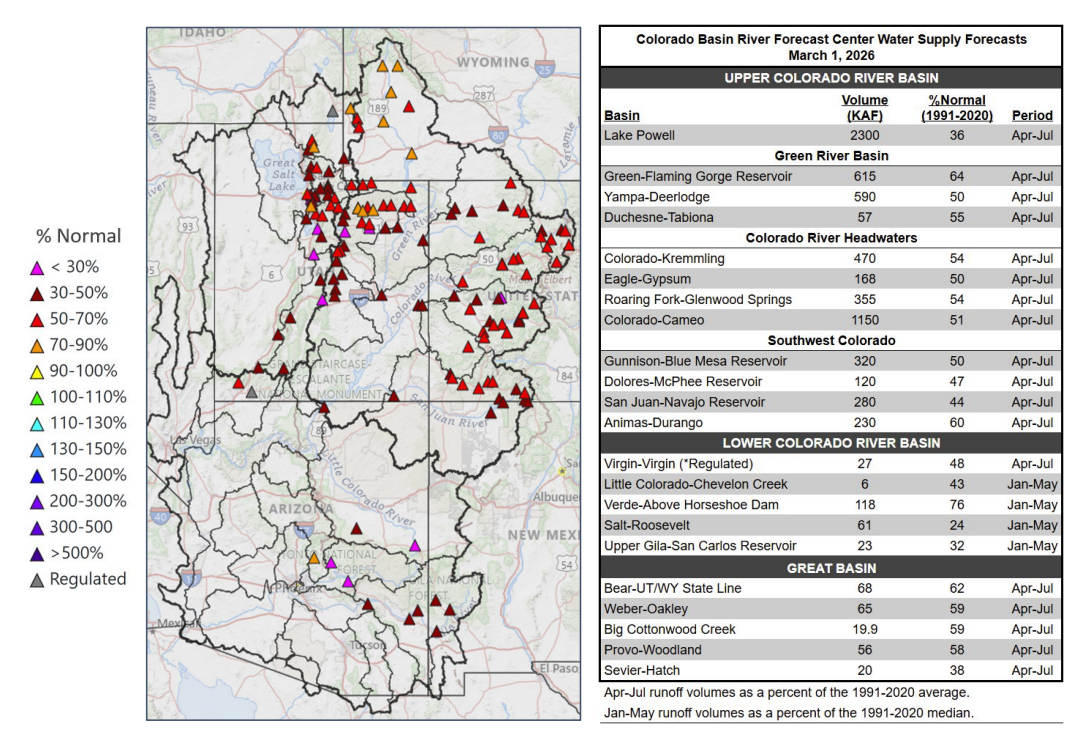
A chart from the Colorado Basin River Forecast Center shows projected water supplies for the Colorado River basin compared to normal in 2026. (Provided by Colorado Basin River Forecast Center)
“Right now the hydrology that we have in front of us puts us in a very, very precarious situation,” said Gene Shawcroft, Utah’s Colorado River negotiator. Utah just wrapped up its warmest winter on record. Salt Lake City broke its previous maximum average winter temperature by 2 degrees Fahrenheit — a significant increase, according to the Colorado Basin River Forecast Center. While the state received similar precipitation compared to last year, much of that fell as rain, leading to the worst snowpack since 1981 in parts of the state. Now, the water supply outlook is “well below normal,” according to the center. The Bureau of Reclamation’s latest most probable forecast for Lake Powell shows it sinking below “power pool” — 3,490 feet — by December. At that level, water can’t make it through the turbines at Glen Canyon Dam that generate hydropower and keep the lights on across Utah and six other states. Powell could hit that dangerous low even sooner, though. The bureau’s most recent forecast was based on the Colorado Basin River Forecast Center’s February report. Since then, the center’s projection for water flows into Powell has dropped by 100,000 acre-feet. The bureau’s most probable forecast can also be optimistic. The agency’s minimum probable forecast, which shows a dry scenario that would statistically happen only 10% of the time, sometimes aligns more with reality. Last year, the April 2025 minimum probable study forecasted Lake Powell to hit 3,535 feet in elevation by the end of February 2026. The lake currently sits at 3,530 feet. The bureau’s latest minimum probable forecast shows the lake dropping below 3,490 by the end of August.
“It’s safe for us to assume that, unless Mother Nature is uncharacteristically generous, that Lake Powell elevations are going to fluctuate at elevations that we’re not comfortable with,” Wayne Pullan, Upper Colorado regional director for the bureau, said at a Glen Canyon Dam meeting last week…
To prop up Powell, the bureau will likely rely on another popular Utah reservoir: Flaming Gorge. The reservoir that straddles the border of Utah and Wyoming has the best water outlook in the basin, at 64% of normal, according to the forecast center. The Upper Green River, which flows into Flaming Gorge, is the “lone bright spot” for snow water equivalent — the amount of water snow holds…Under a 2019 plan, the bureau may form an agreement with Utah and the other states in the Upper Colorado River Basin — Colorado, New Mexico and Wyoming — to release water from Flaming Gorge and a few other reservoirs, such as Blue Mesa in Colorado, to maintain hydropower at Glen Canyon Dam. That’s what happened the last time forecasts showed Powell dropping to a dangerous low level in 2022. A record wet winter followed that dry year, though, boosting the reservoirs.
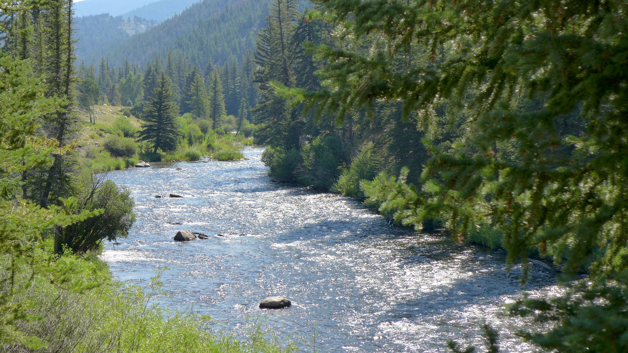
Coyote Gulch’s Leaf in Byers Canyon, cut by the Colorado River, on the way to Steamboat Springs August 21, 2017.
Click the link to read the article on the Sky-Hi News website (Ali Longwell). Here’s an excerpt:
March 8, 2026
The state of Colorado, Upper Colorado River Commission, the Colorado River Water Conservation District, the Southwestern Water Conservation District and several Front Range water providers were among those that submitted comments, asking for the Bureau to finalize an agreement that legally fulfills all water rights while making bold and sustainable changes that align with the hydrologic reality of the river.
“The Colorado River has changed dramatically over the last two decades, and our operating rules need to change with it,” said Becky Mitchell, Colorado’s water commissioner and lead negotiator in the post-2026 operations, in a statement. “The current rules have not done enough to protect Lake Powell and Lake Mead, and it’s clear that a future management framework must better respond to today’s reality. Colorado’s comments provide constructive, legally grounded recommendations to bring the system into balance.”
[…]
Since the reservoirs’ current operational guidelines were set in 2007, the Colorado River Basin has experienced deepening drought conditions, declining inflows to the reservoirs and shrinking storage in Powell and Mead. As of March 1, Lake Powell and Lake Mead were 25% and 34% full, respectively. As the upper and lower basin states sought to reach a consensus on the post-2026 guidelines for the reservoirs, disagreements were rooted in where cuts needed to be made to deal with these worsening conditions. Through the deadline for consensus, the Lower Basin states offered up some cuts and pushed for basin-wide water use reductions. The Upper Basin states, however, have pushed back, claiming they already face natural water shortages driven primarily by the ups and downs of snowpack. In February, the upper division said this winter’s critically low snowpack will result in natural reductions “greater than 40% of the proven water rights” across the four states. In the draft, the Bureau recognizes that with “critically low storage in Lake Powell and Lake Mead, significant hydrologic variability and the anticipation of drier future conditions,” an agreement must strike a balance between “potentially profound impacts of water-delivery reductions” and “the need to maintain reservoir storage.”
The latest Upper Colorado River Commission and Colorado comments to the Bureau of Reclamation called on the federal agency to root the post-2026 guidelines on what the river actually supplies. In its comment, the state of Colorado said that the “failures of the current set of guidelines developed in 2007 have driven the current crisis on the Colorado River.”
“We can no longer rely on the management strategies of the past to solve the challenges of the present and future,” said Lauren Ris, director of Colorado’s Water Conservation Board.
Udall/Overpeck 4-panel Figure Colorado River temperature/precipitation/natural flows with trend. Lake Mead and Lake Powell storage. Updated through Water Year 2025. Note the tiny points on the annual data so that you can flyspeck the individual years. Credit: Brad Udall
Utah’s high court has backed that state engineer’s decision to reject a proposal to pipe water from the Green River to Colorado’s Front Range. The project’s proponent is viewing the ruling as only a temporary setback.
“Look, the court gave us a C-minus on a couple homework issues. We’ll resolve it and get our thesis straightened up and get on down the road,” Aaron Million, founder, CEO and chair of Water Horse Resources, LLC., said Friday in an interview…
In 2018, Water Horse filed a water export application with the Utah state engineer. Million wants to divert 55,000 acre-feet a year of water from two points on the Green River south of Flaming Gorge Reservoir in Daggett County in northeastern Utah…In 2020, Utah State Engineer Teresa Wilhelmsen rejected Million’s latest proposal, in part citing uncertainty over whether it would count against Colorado’s allocation of Colorado River water or Utah’s under a 1948 compact between Upper Colorado River states. Million says it would count against Colorado’s because that’s where the water would be used. A lower court had upheld Wilhelmsen’s findings. The state’s Supreme Court ruled in part that before the state engineer can grant Water Horse an export appropriation, the company must show the appropriation will be beneficially used in Colorado. Million indicated in comments to the Sentinel on Friday that meeting the beneficial use requirement won’t be a problem. He said the court in its ruling was helpful in showing that the state’s water export statute has a low bar for exports to be allowed. In upholding the Utah state engineer’s determination, both the lower court and Utah Supreme Court noted that Water Horse hasn’t filed any application in Colorado for approval of its water appropriation or project and hasn’t asked the state of Colorado or Upper Colorado River Commission to have the appropriation counted against Colorado’s Upper Colorado River Compact allocation…Water Horse had argued that the Upper Colorado River Compact required the Utah state engineer to approve its application even as the state export statute required it to be rejected, and that the compact pre-empts the state law. But the state Supreme Court disagreed that they were in conflict. Million voiced confidence that Water Horse will be starting construction on the project “in the near term” and the ruling won’t affect that.
Wonk warning: I’ll be explicating the chart above. If this sort of thing bores you, or just gets you more, not less confused about what’s going on with the river today as the negotiators for post-2026 system management continue to negotiate with a November 11 deadline, then I’d say take a break until next post, when I’m going to try to explain why I call this stuff ‘Romancing the River.’
For those reading on here, remember my purpose from earlier posts: to show a reasonably equitable division of the consumptive use of the Colorado River waters among the seven states and Mexico, with no ‘temporary’ division into competitive Upper and Lower Basins – the Compact they really wanted to do in 1922. I present the table above as just a draft effort in that direction; there will be arguments about some of the specific figures, but the method to the madness might have some merit.
All the consumptive use information is from Bureau of Reclamation records accessible online, or from other cited historical documents going back to the 1922 Compact. The Bureau publishes consumptive use records every five years – eventually. (Figures for 2016-2020, for example, still have ‘Coming soon!’ where one would click to get them.) All quantities are expressed in millions of acre-feet (maf) or thousands (kaf).
To just jump into it, here’s a column-by-column explication of the chart. I suggest clicking on the image above to get an enlargable view of the table. If nothing else, this table is kind of a history-in-numbers of the Colorado River in the 20th century CE. (It is important to remember too that, thanks to the 1952 McCarran Amendment, all the Indian tribal rights are negotiated intrastate, although suits and appeals go to the federal courts – a separate set of challenges from what the seven states are trying to negotiate right now.)
Column 1, River Users: I make no reference to the Upper and Lower Basin, but it does make sense to distinguish between the ‘hot desert’ states below the canyon region, and the ‘cold (orographic) desert’ states above the canyons, due to the significant difference in system losses – evaporation, transpiration, bank and aquifer storage and other losses. We will start with some analysis of those lines in the table, one for each set of desert states (considerably higher for the subtropical ‘hot desert’ region than the higher and cooler ‘cold (or steppe) desert’ region.
System Losses, Structural Deficit and Surpluses: These constitute the river’s wild card. Natural system losses were listed in the paragraph above – all the natural things that happen to water mixed with sun, wind and thirsty ground. Storage reservoirs are built on snowmelt rivers to increase the amount of water available for use through a longer period of time, storing the two-month snowmelt flood for use through the rest of the year. But increasing in reservoirs the amount of water available for use does not increase the amount of water; in fact, it decreases that, as the stored water spreads out in reservoirs under a desert sun that can evaporate annually as much as six acre-feet per acre off of open water in the lower Colorado River.
This was completely ignored in the Colorado River Compact, despite the fact, that as Eric Kuhn and John Fleck pointed out in their book Science Be Dammed, there were scientists who tried to advise the commissioners. Today, with two huge reservoirs, another half dozen big reservoirs and a lot of little ones, along with around 600 miles of large open aqueducts meandering through the hot deserts, somewhere between 12 and 16 percent of the river is lost to the system under the sun and wind.
The compact commissioners, thinking they had an 18 maf river, believed that evaporation would be covered by the surplus they anticipated above and beyond the quantities consumed by the seven states and Mexico. That was actually the case, well into the 1980s. But as more users materialized in the states above the canyons, and the Central Arizona Project began to draw from the mainstem, the ‘structural deficit’ from ignoring the system losses began to draw down the big reservoirs. These natural system losses were estimated at around 800,000 af annually from the mainstem for the states below the canyons, and between 400,000 and 500,000 from Powell and the other Colorado River Storage Project reservoirs.
Another element in the structural deficit was consistent provision for Mexico’s treaty allotment of 1.5 maf per year. The compact made the Upper and Lower Basin each responsible for half of whatever portion of that allotment which was not covered by surplus flow (up to 750 kaf). Beginning in 1971, however, under a 1970 reservoir management agreement, the Bureau began releasing the Upper Basin’s full half of the 1.5 maf each year, whether it was a ‘surplus year’ or not. A similar arrangement was not made for the Lower Basin share of the Mexican allotment; the Bureau apparently has just continued to charge it to ‘surplus’ – along with the Lower Basin’s system losses – whether or not there was actually that much surplus. These ‘structural deficits’ were almost as responsible for the big 21st-century reservoir drawdown as was the ‘millennial drought.’ A figure of around 2 maf was established for these natural and cultural commitments: 1.5 maf for the ‘hot desert’ states, 1.2 maf for the ‘cold desert’ states – those states having consistently delivered their 750 kaf share for Mexico (leaving the 450 kaf in the table). The three states below the canyons have apparently agreed to accept responsibility for their 1.5 maf after 2026, although they are not saying much yet about how that consumption will be divided up.
Back now to the columns.Column 2, Authorized Allotments: These are based on the 18 million acre-feet (maf) river we all believed we were working with back in the 1920s. The Colorado River Compact allotted 7.5 maf to each of its Basins. The Boulder Canyon Project Act made the Bureau water-master for the Lower Basin states, and set their individual allotments, contested by Arizona but confirmed by the U.S. Supreme Court in the last Arizona v. California case (BCPA/SC). The Mexican allotment was set by the 1944 two-rivers treaty. And in 1948, the four Upper Basin states created the Upper Colorado River Compact. Knowing by then that it was not an 18 maf river, they gave themselves percentages ‘of whatever’s left’ (OWL) after compact obligations to the downriver states and their share of the Mexican treaty obligation were fulfilled. This column shows what that ‘% OWL’ would be if those states actually got 7.5 maf regularly. The cold-desert states have never even come close to those figures.
Column 3: This column shows the allotments for the 14.5 maf average of the river’s ‘natural’ flows for the 1930-2000 period, the period when all of the river’s major development took place. All of the ‘averaging’ fell on the states above the canyons. Allotments for Mexico and the three states below the canyons were legally and physically ‘set in concrete’ at 9 maf – legally by the Supreme Court affirmation of the BCPA allotments, and physically by the two big linked reservoirs, Mead and Powell. The four states above the canyons took their floating percentages from what nature provided, or didn’t – estimated natural flows for that period ranged between 5 and 24 maf. The average ‘of whatever’s left’ (OWL) after the obligatory quantity was sent to the states below the canyon and Mexico was assumed to range between 5 and 6 maf – if no attention was paid to the structural deficit and system losses. And for most of that period, there were no worries there; the states above the canyon were not using that much water until the substantial transmountain diversions (100 percent depletions) were completed. The table figures for those states (unlike the figures for the states below the canyons) amounted to wishful thinking for a future that will never happen.
Column 4 gets real: a compilation of three columns with five-year consumptive use averages for three periods, covering the time when the physical development of the river storage and delivery systems was being completed, and consumptive use of the river was approaching full development too – but just on the edge of the trauma of the ‘millennial drought’ (which may last for a millennium) and the near-collapse of the storage system. The attempt at normal distribution for the 2001-2005 period might be considered just beyond that edge – like the roadrunner cartoons, when Wiley Coyote runs a few yards into the air beyond a cliff – then looks down…. These dates are bookended by two ‘reservoir coordination’ elements in the ‘Law of the River’: the 1970 ‘Criteria for the Coordinated Long-range Operation of Colorado River Reservoirs’ and the 2007 ‘Interim Guidelines’ for coordinated operation of the Powell and Mead Reservoirs, set to expire next year.
The Bureau’s five-year compilation tables include, for the first time maybe, the system losses/structural deficit.
Something worth noting: California’s consumptive use during this 35-year period started well above the state’s 4.4 maf compact allotment, and then declined, while uses for all the other states were increasing. This is because California’s major users had decided, before Hoover Dam was even started, that they would ‘borrow’ 800,000 af of unused Upper Basin water until the Upper Basin needed it. They would, in other words, grow on borrowed water. The Bureau of Reclamation allowed this, because they assumed that the Colorado River would eventually be augmented by even greater public works from some larger river basin. Optimism is a sunny thing. On the strength of this, the Metropolitan Water District on the Southern California coast built its 250-mile aqueduct to carry twice the 500,000 af that was their share of California’s 4.4 maf allotment. They began decreasing their ‘borrowed’ usage during this 35-year period, in anticipation of the 2006 California Limitation Act – thanks mostly to the California State Water Project exporting water from Northern California.
Arizona’s jump in usage between 1971-75 and 1991-95 was due to the completion of the Central Arizona Project. To give a more accurate picture of ‘the completed river system,’ only its 1991-95 and 2001-2005 figures were used in compiling Column 5.
Column 5: A compiled average for the three five-year periods – resulting in the 14.5 maf river of 1930-2000.
Column 6: An attempt to divvy up the system losses/structural deficit (SLD) between the seven states and Mexico. My operating assumption is that the ‘hot desert’ states and the ‘cold desert’ states should share these losses proportionally to their consumptive use. This meant creating percentages of the 9.0 maf of decreed use for the four entities below the canyons; the four entities above the canyons were already operating on percentages.
I’m sure the state (guess which one) with a lot of pre-compact ‘senior’ water will object vehemently to this concept, wanting all the junior users to absorb those losses. This is a misapplication of the appropriation doctrine, in my estimation; it was set up for resolving differences among specific users, not for the resolution of major river management issues related to natural phenomena like evaporation and riparian storage, or natural and cultural changes like a warming climate. These issues fall equally on all users, everyone’s fault and responsibility. But such rational and moral arguments will probably not dent California’s resolve of seniority uber alles.
Column 7 just adds those proportionate shares of the system losses/structural deficit to the consumptive use averages for the seven states and Mexico in Column 5, leaving the system losses/structural deficit lines empty. This is not increasing the amount of water for each state; it is increasing the amount of consumption each has to manage. This column, I’m arguing, is the seven-way equitable division of consumptive use that the Compact commissioners wanted to create in 1922, but lacked the information about both the river and their futures to develop. Now, a century later, that future is here, like it or not, and we’re sadder but wiser in knowing the river.
There’s probably an error at the bottom of this column; instead of 0.00 in the ‘Surplus or Drain’ column, it should probably be ‘-2.00 maf’: the difference between the 14.5 maf 20th-century river and the 12.5 maf early 21st-century river. This was the frightening drawdown of the early 21st century decades.
Column 8 then uses the Column 7 figures to calculate what percentage of the 14.5 maf river each of the eight entities ‘owns.’
Column 9 then applies those percentages to the 12.5 maf Colorado River of the 21st century – and subtracts from each state’s total consumption its share of system losses and structural deficit – thus showing what each state will actually have with which to try to do what it is doing today with its presumed allotment for consumptive use of the 14.5 maf river of bygone days. Read it and weep. (Note that I’ve put the 1.5 and 0.45 maf system losses/structural deficit numbers back in Column 9 to remind you that they have not disappeared from the system; they’ve just been re-collated from those portions of the individual states’ total consumptive uses.)
I would welcome comments and criticisms of this work. I do believe it is the kind of pinning down of numbers we need to finally do for the Colorado River, if we are going to go into the post-2026 era with our eyes open. ‘Woke,’ you might say.
By my next post, there will probably either be a new management plan for the river in the messy agonies of birthing – or there won’t. If there is, I would wager a six-pack that they will drag along the old two-basin cold-war division. And I’d wager further that the ratio of total consumptive use for the four ‘states’ below the canyons to the four states above the canyons will be between within a few points either way of 70-30. Is that ‘equitable’? Given the amount and productivity of land under cultivation, and the number of people gathered in large metropolitan ganglia, and the location of most of the Indian nations, it probably is. But – it’ll probably be another point of discussion.
Map of the Colorado River drainage basin, created using USGS data. By Shannon1 Creative Commons Attribution-Share Alike 4.0
As the Upper Division States negotiate ways to equitably and sustainably manage the Colorado River’s future supplies, their water users face the harsh reality of living within the river’s 21st-century limits.
This year, in New Mexico, the San Juan Chama project received 31% of their normal Colorado River water supply, a 69% reduction, which is used by Albuquerque and Santa Fe, as well as for agricultural purposes.
“The San Juan-Chama Project contractors are absorbing unavoidable natural hydrologic shortages and have had to learn how to operate under constrained supplies, higher costs, and mounting climate pressures,” said Diane Agnew, the Albuquerque-Bernalillo County Water Utility Authority’s Water Rights Program Manager. “This ongoing uncertainty in water availability is placing significant strain on water users, challenging infrastructure investments, and disrupting water management strategies that are critical to our communities and economy.”
In Colorado, the Dolores Water Conservancy District’s water users faced cuts of up to 44%. Thousands of acres remain fallowed both on the Ute Farm & Ranch and north towards Dove Creek.
“Our farmers are left with year-by-year gambles with last-second planning going late into May and limiting farmers’ abilities to make long-term, successful crop rotation planning,” said Ken Curtis, GM of the Dolores Water Conservancy District. “The Dolores snowpack is disappearing, and the historic runoff has dropped by even greater magnitudes. Water is no longer reliably available.”
2025 marks the fifth year out of the last eight years with shortages impacting the Conservancy District. Many acres have remained fallow since 2021, when available project water supplies dropped to zero. Local farmers did not have the time and resources to bring fields back into production prior to this current shortage — all of their shortages are uncompensated and involuntary.
The District supplies water to the Ute Mountain Ute Tribe’s Farm and Ranch Enterprise. The Tribe was forced to turn off irrigation spigots to 60% of their land and lay off farm workers. The crop plan for 2025 only included the existing, high-value alfalfa needed to sustain the Farm & Ranch Enterprise [FRE].
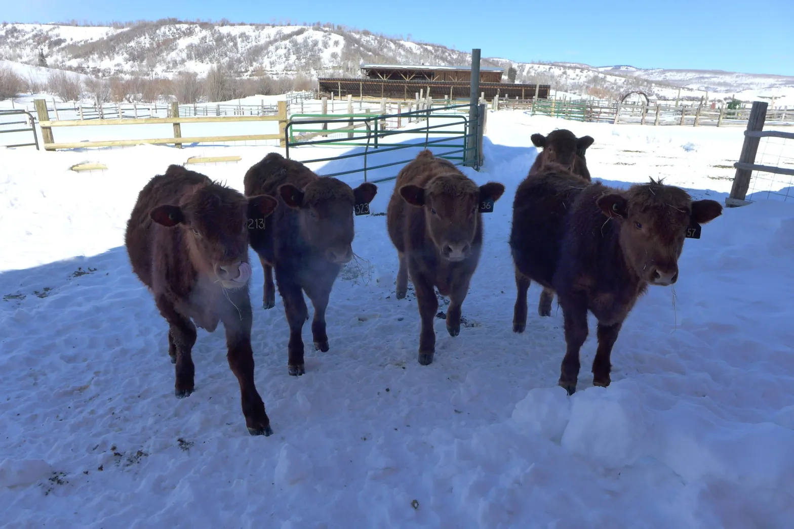
“We [FRE] are merely surviving, not adapting,” said FRE irrigation manager Michael Vicente when responding to his view of the historic drought. Severe water shortages in Utah’s Uintah Basin, driven by Colorado River cuts, are forcing ranchers to reduce cattle herds, raising production costs and straining the local economy.
“Spring runoff was dismal at best. Early 1900s era water rights only received a week or two of natural flow delivery. Shortages were so severe that in some basins, they even affected senior 1861 water rights.
These shortages are directly impacting cattle production,” said Dan Larsen, Board Member at the Colorado River Authority of Utah. “Ranchers are being forced to cut back their herds, which not only raises costs for producers but also ripples through our entire local economy.”
Hydrologic shortage is also impacting Utah’s Demand Management Pilot Program, which is exploring voluntary, compensated water conservation in the Colorado River system in Utah. For example, the Central Utah Water Conservancy District enrolled 4,500 acre-feet of water in the program; however, the water rights held by the District were cut in priority on June 8, much earlier than the typical mid-summer cut, resulting in only around 900 acre-feet being delivered to the Program.
Agricultural producers are weighing potential impacts from hydrologic shortage on their operations as they consider participating in conservation-related pilot programs Nick Sampinos, a farmer along the Price River, said “Persistent drought conditions are a constant challenge, however, the Utah Demand Management Pilot Program has provided us with much needed assistance and set the stage for economic sustainability of our farming operation well into the future.”
In Wyoming, historic drought and Colorado River shortages have driven the Black’s Fork River down to a 1891 priority date, forcing the state to regulate off water rights to more than 52,000 irrigated acres in 2025 in that drainage alone.
“This year, more than 163,000 acres of irrigation were shut off in Wyoming’s portion of the Green River Basin,” said Kevin Payne, Division IV Superintendent of the Wyoming State Engineer’s Office. “This is an extraordinary reduction with serious impacts on producers and rural communities across southwest Wyoming.”
The Upper Basin has consistently used less than its legal entitlement through strict water administration. The four states of the Upper Basin remain committed to continued work in implementing and expanding water management initiatives, including accounting for conservation-related activities in 2026.
The Upper Basin’s sacrifices aren’t abstract; they carry real human and economic consequences. As Colorado River negotiations continue, Upper Basin leaders are clear: river operations must adapt to the actual supply and prioritize rebuilding storage to restore resiliency.
About the Upper Colorado River Commission (UCRC):
The UCRC is an interstate administrative agency made up of duly appointed representatives from the four Upper Division States of Colorado, New Mexico, Utah and Wyoming.
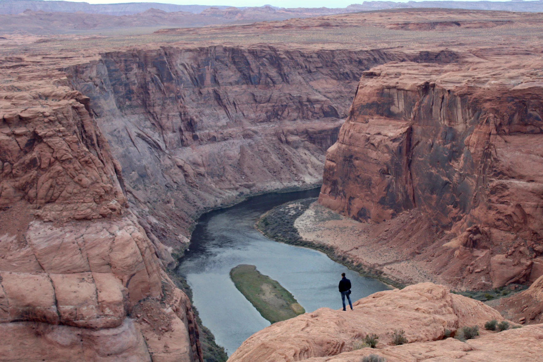
A person looks out over the Colorado River near Page, Arizona on November 2, 2022. The seven states that use its water are caught in a standoff about how to share the shrinking supply. They say they want to avoid a court battle, but some states are quietly preparing for that outcome. Alex Hager/KUNC
Click the link to read the article on the KUNC website (Alex Hager):
February 19, 2025
This story is part of ongoing coverage of water in the West, produced by KUNC in Colorado and supported by the Walton Family Foundation. KUNC is solely responsible for its editorial coverage.
When it comes to the Colorado River, a court battle between the states that use its water is sometimes referred to as “the nuclear option.” But now, as those states are locked in disagreement about how to share its water, they are tiptoeing closer toward litigation.
State leaders insist they want to avoid a trip to the Supreme Court, but some are quietly preparing for that outcome.
The Colorado River supplies water to about 40 million people from Wyoming to Mexico. Climate change is shrinking its supplies. The cities and farms that use it are under pressure to rein in demand accordingly.
Water managers from the seven states that use the Colorado River are caught in a standoff about who exactly should use less water, and they appear to have made little progress ahead of a 2026 deadline for new rules about how to share.
In January, Arizona’s government made headlines when a proposed state budget included up to $3 million for litigation related to the Colorado River.
“It’s really a backstop in case we don’t come to a collaborative agreement,” said Tom Buschatzke, Arizona’s top water negotiator.
Buschatzke described the litigation fund as a contingency plan and said state leaders were focused on collaborating.
“I think each state honestly does not want to be in a courtroom rolling the dice regarding how a judge might rule,” he said.
Nevada’s John Entsminger, Arizona’s Tom Buschatzke, and California’s JB Hamby sit on a panel of state water leaders at the Colorado River Water Users Association annual conference in Las Vegas on December 5, 2024. State leaders say they want to avoid litigation, but they are quietly preparing for that outcome. Alex Hager/KUNC
For all of their differences, the two sides of the current Colorado River dispute seem to agree on one central issue: they want to keep their debate out of the Supreme Court. That appears to be the case in the Lower Basin states of Arizona, California and Nevada, as well as the states on the other side of the disagreement — the Upper Basin states of Colorado, Utah, Wyoming and New Mexico.
“We are the ones who should really shape the outcome here,” said Amy Haas, executive director of the Colorado River Authority of Utah. “We’re the experts. We’re the water managers. We understand the system. Why would we want to relinquish that control and that responsibility?”
She said Utah would prefer to spend its money on avoiding a court battle rather than preparing for one.
“I think it would be folly for us to pursue a litigated outcome here,” Haas said.
An overwhelming majority of Colorado River policymakers — including Arizona’s — say they’d prefer to work amongst themselves instead of getting the federal government involved. Why, then, would Arizona make a show of its proposed litigation fund?
Some onlookers say it’s a negotiation tactic.
“This is definitely a posturing issue,” said Gage Hart Zobell, a Utah-based water lawyer with the firm Dorsey & Whitney. “I think a lot of what we see is the Lower Basin is trying to make it very clear they are willing and open to litigate this issue because they think they have the higher hand.”
Buschatzke outright denied that the litigation fund was a form of posturing, but Hart Zobell said there’s a financial reality that suggests Arizona’s move is a form of saber-rattling.
“In the event litigation does go forward,” he said. “You don’t have to build a litigation fund to come up with $5 million. Any state budget can come up with $1 million, $2 million, $3 million to fight this.”
Hart Zobell pointed to a recent Supreme Court case that helps give some clues as to how the Colorado River debate might get settled if it heads there. The 2024 case “Texas v. New Mexico” brought tensions over another Southwestern river, the Rio Grande, to the high court. The case gave the federal government more leverage in talks about managing that river’s water.
“Under the new Supreme Court precedent, if we get into a lawsuit, they have a right to intervene,” Hart Zobell said. “Once they’re in, we’re not just having Upper and Lower Basin discussing. We’ve got a third party that we’ve got to settle with.”
So Arizona’s litigation fund, Hart Zobell said, it may be a way to remind other states of the consequences if they don’t come to an agreement amongst themselves.
“I think that looming specter is really going to push the states a lot more to finding some negotiated settlement,” he said. “Because if the federal government does intervene, I don’t think any state is going to get what it wants.”
Rows of alfalfa grow in Imperial Valley, California on June 20, 2023. Agriculture uses the majority of the river’s water, and is often at the center of conversations about how to bring down demand on the Colorado River. Alex Hager/KUNC
Arizona’s Buschatzke said that other states, such as New Mexico, Wyoming, and Colorado were also preparing money for Colorado River litigation.
KUNC reached out to each of the seven states that use the Colorado River. Arizona was the only one that indicated it had a specific pool of money for Colorado River work.
A spokeswoman for Colorado’s negotiating team pointed to a “long-standing litigation fund” that could be used for the Colorado River, and a division of the Colorado Attorney General’s office that has been focused specifically on the Colorado River since 2006.
New Mexico and Wyoming’s top water offices declined to comment for this story. The Upper Colorado River Commission, a group that brings together water leaders from Colorado, Utah, New Mexico and Wyoming said that it was not preparing a litigation fund.
Native America in the Colorado River Basin. Credit: USBR
The Colorado River basin is also home to 30 federally recognized Native American tribes. Although Indigenous people in the Southwest have been using Colorado River water longer than any other group in the region, they have largely been excluded from discussions about how the river is shared. Tribes that use the river control about a quarter of its flow, but most lack the money and infrastructure to use their full allotments.
Jay Weiner, water counsel for the Quechan Indian Tribe of the Fort Yuma Indian Reservation, said that is likely to add another layer to any legal battle over water.
“There is no version of this that you do not have tribes seeking to intervene in this litigation,” he said. “Or potentially seeking to bring their own claims as part of whatever food fight that the states end up in the Supreme Court over.”
Whether the states settle their differences amongst themselves or in court, they will be forced to reckon with a water supply that has been significantly reshaped by climate change. More than two decades of dry conditions have forced the states into tough conversations about using less water across the farms and cities of the arid West.
“It is very, very hard to ask people to agree to sign up to make hypothetical future sacrifices of bone-cutting magnitude,” Weiner said.
Some state leaders have indicated that the threat of litigation might actually help them make those sacrifices. At a 2023 conference about water law, Nevada’s top water negotiator John Entsminger said the “federal anvil” hanging over the basin states was key to finding agreement during other contentious water-sharing talks over the past two decades.
Map of the Colorado River drainage basin, created using USGS data. By Shannon1 Creative Commons Attribution-Share Alike 4.0
Colorado River “Beginnings”. Photo: Brent Gardner-Smith/Aspen Journalism
NOTE: This is post 30,076 here on WordPress. Whew! I missed the turnover to 30,000 but here’s that post.
Click the link to read the article on the AZCentral.com website (Brandon Loomis). Here’s an excerpt:
February 19. 2025
Negotiators for the states haggling over future cuts to their use of Colorado River water say they’re committed to reaching consensus, though time and snow are running short. The seven states are effectively under a deadline to reach a deal by summer or face whatever water-use restrictions the federal government or courts may impose after the existing shortage guidelines expire next year. Meantime, a slow start to winter precipitation has dialed up the stakes, possibly leading to painful new cuts by the end of next year.
The Upper Colorado River Commission, representing Colorado, New Mexico, Utah and Wyoming, met virtually on Tuesday and heard projections from the U.S. Bureau of Reclamation suggesting that current trends indicate the natural flow into Lake Powell this year will be about 71% of the 30-year average, accounting for near-normal snowpack atop soils that were parched heading into winter. It’s not a great outlook for a reservoir that’s currently 35% full and that holds the key to providing water to the Lower Basin.
“It looks like hydrology is calling us to action,” Colorado’s river commissioner, Becky Mitchell, told colleagues…
Members of the Colorado River Commission, in Santa Fe in 1922, after signing the Colorado River Compact. From left, W. S. Norviel (Arizona), Delph E. Carpenter (Colorado), Herbert Hoover (Secretary of Commerce and Chairman of Commission), R. E. Caldwell (Utah), Clarence C. Stetson (Executive Secretary of Commission), Stephen B. Davis, Jr. (New Mexico), Frank C. Emerson (Wyoming), W. F. McClure (California), and James G. Scrugham (Nevada)
CREDIT: COLORADO STATE UNIVERSITY WATER RESOURCES ARCHIVE via Aspen Journalism
The rift flows out of a math problem that a previous generation of negotiators set up in 1922. The Colorado River Compact and a suite of subsequent deals tied to it envisioned a river spilling 16 million acre-feet of water in a typical year. The Lower Basin, below Lake Powell, would get 7.5 million acre-feet, and so would the Upper Basin, with some left over for Mexico. But the river today, after decades of drought and warming, sometimes provides only about 12 million acre-feet.
Upper Basin States vs. Lower Basin circa 1925 via CSU Water Resources Archives
February snowstorms brought some relief to parched landscapes in the Colorado River Basin, but the river’s reservoirs are less than half full heading into a spring runoff season that is expected to be lower than normal, according to a briefing this week at the Upper Colorado River Commission.
The dry conditions underline water concerns in the drought-strapped river basin and come as high-stakes negotiations over new, post-2026 operating rules continue. If similar conditions occurred under any of the options for the new operating rules, it would mean deep cuts for Lower Basin states, which include Arizona, California and Nevada, officials said during the commission’s meeting Feb. 18.
It was a “stark” report, said Rebecca Mitchell, Colorado’s representative on the commission and the state’s lead negotiator on Colorado River issues.
“We have to acknowledge that cuts [in water use] are probable, possible and likely,” she said. “I want to reiterate: We are committed to working with the Lower Basin states toward that seven-state consensus.”
The Colorado River’s system of reservoirs store water to ensure critical supplies reach 40 million people across seven states, 30 tribal nations, and parts of Mexico.
As of Monday, the water stored in all of the basin’s reservoirs was 42% of the total capacity, according to a presentation during the commission meeting when the latest reservoir conditions were discussed.
Lake Powell, an immense reservoir on the Utah-Arizona border, was 35% full. And Blue Mesa, a federal reservoir and the largest reservoir in Colorado, was 62% full.
Westwide SNOTEL basin-filled map February 20, 2025 via the NRCS.
The reservoir levels will rise once the mountain snowpack melts in the spring. But the spring runoff forecast is low for all of the federal reservoirs in the Upper Basin, which includes Colorado, New Mexico, Utah and Wyoming. The runoff into Lake Powell is forecast to be 67% of average for April through July.
These conditions can change as more snow falls on the region, but the two-week outlook shows a return to dry conditions, according to the commission presentation.
In Colorado, the February snowstorms also helped boost the snowpack to 94% of the 30-year norm. The state’s snowpack typically peaks in early April.
“The snow brought us some positivity. I still like to remind folks, when we see Lake Powell at 35% full, that means it’s 65% empty,” Mitchell said. “That’s troubling.”
If any of those alternatives governed water in the basin right now, then the three Lower Basin states would need to cut their use by 1.8 million to 2.8 million acre-feet based on the conditions in February, said Chuck Cullom, the commission’s executive director. In the worst possible scenarios, the cuts would deepen to between 2.1 million and 3.2 million acre-feet.
How such cuts would play out among the four Upper Basin states, like Colorado, is less clear. Some options include cutting use by 200,000 acre-feet.
Each of the basins has the legal right to use about 7.5 million acre-feet of water per year. One acre-foot roughly equals the annual water use of two to three homes.
The post-2026 operating plans are not final, and negotiators from the seven basin states are still at odds over how cuts should be made in the river’s worst years.
Graphic credit: The Colorado River water crisis its origin and future Jock Schmidt, Eric Kuhn, Charles Yackulic.
Lower Basin officials have said everyone needs to cut back in dry years, and voluntary conservation does not provide enough certainty.
Upper Basin officials say their states should not have to make mandatory water cuts but could do voluntary conservation. The Lower Basin is using more than its legal share and should cut its water use first, Upper Basin officials have said.
“The opportunities for conservation and other activities in the Upper Basin is limited by water supply,” Cullom said. “You can’t conserve water that isn’t available.”
“Everyone is suffering”
Upper Basin water users already experience water shortages every year — and this must be acknowledged in how the river is managed in the future, officials said during this week’s meeting.
According to the commission’s analysis, water users in the Upper Basin end up using about 1.3 million acre-feet less than their full supply each year, based on data from 1991 to 2023.
The full supply is the maximum amount of water used. Across all four states, this maximum use typically totals about 5.18 million acre-feet per year. The commission says shortages happen when water users must use less than their normal maximum supply.
The Upper Basin hasn’t developed its full 7.5 million-acre–foot share because of the uncertain water supply, officials said.
Scott Hummer, former water commissioner for District 58 in the Yampa River basin, checks out a recently installed Parshall flume on an irrigation ditch in this August 2020 photo. Compliance with measuring device requirements has been moving more slowly than state engineers would like. CREDIT: HEATHER SACKETT/ASPEN JOURNALISM
To cut water use, ditch riders tell water users to shut their headgates, which control how much water runs from one river, stream or ditch to another. Farmers get two cuttings of hay instead of three, which reduces their profits. Ranchers, facing higher hay prices or hay production challenges, might end up raising smaller cattle herds, impacting beef and dairy production, officials said.
The impacts keep going from there: People hire fewer ranch hands. Cities tighten their summer watering restrictions. Local recreation economies take a hit — as do ecosystems that are overstressed by higher temperatures and drought.
Tensions rise between community members who need water for different reasons and are trying to share an uncertain supply, said Commissioner Brandon Gebhart of Wyoming.
“And trying to do that without completely destroying one or the other,” he said. “Oftentimes, this means that everyone is suffering.”
Well, with the fate of constitution democracy in the courts where we know the mills grind slowly (as opposed to the grinders who break things quickly); and with the money frozen for farmers doing well by doing good in water conservation; and neither white smoke nor black smoke arising from the chimneys of the enclaves trying to envision the next decade or so for the Colorado River – I’ll take a break from my wonkish efforts to think outside the box, to remember a friend and mentor, and friend of the River, who thought outside the box often in the last half of the 20th century.
The cantankerous Colorado River water community recently lost a valued member, L. Richard Bratton, a water attorney in the Upper Gunnison River Basin from 1958 till his death January 28.
Dick Bratton’s scope of influence went beyond the Upper Gunnison mountain valleys, however; he was a creative thinker who never met anyone he could not talk to – or listen to, or work with. A born “connector,” he became an active player in events on the cusp of major changes in the development of water in the entire Upper Basin of the Colorado River.
Born in 1932 and raised in Salida, Dick Bratton came to Gunnison to attend Western State College, then went to the University of Colorado Law School. While at school in Gunnison, he had met Ed Dutcher, a somewhat legendary West Slope water attorney. Shortly after Bratton completed law school, Dutcher invited him to join his firm in 1958.
Aspinall Unit dams
Bratton joined Dutcher’s firm that year – and in 1959, the Colorado River Storage Project (CRSP) came to the Upper Gunnison River Valley in a big way, with Congressional approval of funding for CRSP’s Curencanti Project (Blue Mesa, Morrow Point and Crystal Dams, now renamed the Wayne Aspinall Unit), and he found himself plunged into all of the ongoing and emerging challenges faced by small communities with agrarian roots in an urbanizing and industrializing world.
The first challenge was Theodore Roosevelt’s conservation vision. The “Father of American Conservation” had a different view of conservation than most of us have today; to him and his philosopher sidekick Gifford Pinchot, conservation meant first the orderly development of resources otherwise wasted – like the Colorado River pouring itself into the sea in a two-month uncontrolled and mostly unused flood of snowmelt. And when it came to what should be developed and by and for whom, their rule was “the greatest good for the greatest number,” with “for the longest time” sometimes remembered, sometimes not.
In the Upper Gunnison, the Bureau of Reclamation had chosen the Curecanti Reservoir site not to benefit the small ranches and farms of the Upper Gunnison valleys, in accord with their original Rooseveltian mission. It was chosen because it was a great site for a major reservoir in a regional water development for four states that were paranoid over their obligation to make sure a set amount of water passed on to the three more populous states below the Colorado River canyons. The greatest good for the greatest number.
The Curecanti Reservoir as originally proposed, however, would have backed 2.5 million acre-feet (maf) of water almost up to the city limits of Gunnison, with the shallow end exposing major mudflats every summer as the reservoir was drawn down, and the prevailing westerlies would have turned Gunnison into a dust bowl. Bratton’s partner and mentor Ed Dutcher had invested much of his career into opposing this local sacrifice for the greatest good for the greatest number – not just standard NIMBYism; the community was fighting for its life, and also for the life of two small towns that would be inundated along with 30 miles of legendary fishing stream, 23 small river resorts, and 6,000 acres of ranchland.
After much noisy negotiation with the Bureau of Reclamation for Dutcher and his “Committee of 39,” the Bureau dropped the reservoir size to just under one million acre-feet, saving Gunnison from the dust inundation, but still losing the two smaller towns and their economic activities – and the great fishing.
Being sensitive to the cost the project was imposing on the ranchers and farmers that the Bureau was actually created to serve, however, an “Upper Gunnison River Project” with seveeral small reservoirs was included as a future participating project in the CRSP Act, to be paid for partially by the revenues from the hydroelectric plant on the three largest CRSP dams: Glen Canyon, Flaming Gorge and the Curecanti Unit.
So one of Bratton’s first jobs in Gunnison was helping talk the people of the valley into taxing themselves a little to create an Upper Gunnison River Water Conservancy District under state law, both to help the Bureau lobby for project funding in Washington, and to nudge and harass the Bureau into getting project planning and execution done. Creating the Conservancy was accomplished in an election in 1959, a busy year for Dutcher and Bratton.
In 1961 Dutcher was appointed to a judgeship, and Bratton took over the law firm. That same year, the Bureau opened an office in Gunnison, and began the preliminary work for the Curecanti Project – clearing the land of trees, relocating roads, and buying out all of the human occupants, an unpleasant and depressing process in the valley. The “greatest good for the greatest number” rule, applied in many areas other than conservation, has nothing in the formula for the “lesser numbers” – probably one source of our current urban-rural troubles.
As construction proceeded on the Curecanti dams, though, a “big pivot” in the way the entire nation perceived the American West was becoming unignorable. The Bureau of Reclamation had depended on the willingness of the American people to continue investing in the “reclaiming” of arid lands to create more of the iconic “family farms” and to otherwise further the development of raw resources to feed the people and industries of an increasingly urbanized and industrialized economy. But the increasingly urbanized, industrialized – and after the Second War, increasingly mobilized – American people were enjoying a rising standard of living that included more time for recreation – paid vacations! – and “their” western public lands were increasingly perceived not as a resource hinterland, but as a vacation paradise, to be kept as pure and pristine as possible with millions of people trampling through.
On Bratton’s home front, the Crested Butte Ski Resort also opened in 1961 upvalley, forcing the beginning of a transition in the Upper Gunnison’s self-perception as part of the mining, farming and ranching “working west,” as opposed to a service sector serving visitors to the great western playground. “Conservation” was swinging from the Rooseveltian orderly development of otherwise “wasted” resources toward conservation as careful guarding of the West’s resources, including preservation of its residual wild magnificence, Wallace Stegner’s “society to match its scenery.”
Bratton himself was the son of a “working west” family, with a couple generations before him in Colorado engaged in mining and mining-related economic activities. But like the political creator of the Colorado River Storage Project, West Slope Congressman Wayne Aspinall, Bratton could see where things were going, and worked to make the transition at home as non-disruptive as possible for the “Old West” yielding to the “New West.” (Aspinall’s CRSP Act included provisions for recreational facilities around the major dam sites – but also provisions for a number of “Old West” valley-scale projects that could not meet cost-benefit analyses on their own without assistance from hydropower revenues.)
The Taylor River, jewel of the Gunnison River basin. Photo: Brent Gardner-Smith/Aspen Journalism
The creative quality of Bratton’s work in that transition is probably best shown in the story of the resurrection of the Taylor River. The Taylor River collected runoff from some of the highest and snowiest peaks of the Continental Divide and came down to the Gunnison River through 25 miles of canyons – a beautiful mountain river with a reputation among “anglers” (don’t even say “bait”) as a world-class fishery, even in the early 20th century.
But in the 1930s, the Bureau put a dam at the head of the canyons to store late-season water for farmers in the Uncompaghre River valley, more than a hundred miles downriver at the receiving end of the Gunnison Tunnel, the Bureau’s first big transbasin water project. That project to make life better for distant farmers effectively killed the Taylor and its aquatic life as a river, reversing its natural wet and dry cycles and turning it into an irrigation canal that ran at the will of the Bureau. This was a great loss to the people of the Upper Gunnison, who knew that the best time for fishing was after work anyway. The loss of the Taylor was their first lesson in what the greater good for a greater number meant for the lesser number.
And the Curecanti Project was their second lesson, inundating another twenty-some miles of world-class fishery, along with two small towns and a fishing-resort community that made decent livings from the river. But the Upper Gunnison farmers and ranchers held out hope that, once the Curecanti Unit was in place to play its role in the larger world of Colorado River Basin policy and politics, the Bureau would at least fulfill its promise and begin work on the Upper Gunnison River Project to give them a little help with late-season water.
But just in the decade-and-a-half from the difficult passage of the CRSP Act in 1956 to the completion of the Curecanti Project, public support for expensive irrigation projects to develop western lands basically dried up, replaced by active opposition to anything disturbing the natural beauty and magnificence of The West. It became obvious to the Upper Gunnison Conservancy board and Bratton – attorney on retainer to the board for its first 40 years – that there would be no federal funds for an Upper Gunnison River Project.
But Bratton – a convener and collaborator who managed to maintain good working relationships even with opponents – started to play on the Bureau’s guilt at not being able to fulfill their promise to the people of the Upper Gunnison. He found a willing collaborator in Bob Jennings, a Bureau manager in the West Slope office. Together, they devised a plan whereby the Bureau would let the Uncompaghre Valley Water Users Association store their Taylor Reservoir water in the Blue Mesa Reservoir – at least a day closer to where the water would be used. Then the water could be moved from the Taylor Reservoir down to Blue Mesa from in a schedule more in tune with the natural flow of a river. Maybe the Bureau could not create small upstream reservoirs for the “Old West” agrarian economy, but it could facilitate the resurrection of a beautiful river for the “New West” economy taking shape (and Old West workers who liked to fish).
This was accomplished with a 1975 agreement among the Uncompahgre Valley farmers, the Colorado River Water Conservation District, the Upper Gunnison River Water Conservancy, and the Bureau. The Bureau would manage the “new” river, but with input from the other three parties – input that begins each spring with a meeting of an Upper Gunnison River “Local Users Group”: representatives from Taylor River irrigators, whitewater recreation businesses, Taylor Reservoir flatwater businesses, anglers, and riparian residents. This group sits down with projections for the summer runoff, and compile suggestions for the Bureau on the operation of the Taylor River that will meet all their needs more or less (and being sure to get the Uncompahgre farmers’ water down to Blue Mesa storage in a timely way). The Bureau and other parties can override their recommendations, but seldom need to. And the Taylor is a beautiful mountain river again – “unnatural” only in being democratically operated by all of its Old West and New West users.
Bratton did not stop there. He led the Upper Gunnison River Water Conservancy District through the process of filing for rights on a secondfill of the Taylor Reservoir. Taylor Park above the reservoir gathers on average half again the 110,000 af needed for the Uncompahgre users first fill. Any water collected in a second fill would be left in the river, for wildlife and other environmental benefits downriver – a right consistent with Colorado’s 1973 instream flow law, to sustain the aquatic and riparian environment “to a reasonable degree.” This water right, inconceivable before the 1970s and NEPA awarenesss, was granted in 1990 – just in time to help thwart a proposal for a transmountain diversion to the Front Range from the adjacent Union Park.
Even then, Bratton was not yet done playing on Bureau guilt for imposing the Curecanti Unit on the Upper Gunnison with no compensatory project for the local water users – even though the Upper Gunnison community generates a lot of economic activity from the Curecanti National Recreation Area around Blue Mesa Reservoir. Early in the 21st century, Bratton wanted to develop some ranchland he owned adjacent to the City of Gunnison, with a tributary of the Gunnison River running through it. This development was not received by local residents with any great enthusiasm.
But Bratton remembered a ‘handshake agreement’ with the Bureau from the Curecanti construction era, that the Bureau would replace the great sport fishery the reservoir would inundate with some good public access fishing streams elsewhere in the basin. So rather than developing a standard golf-course-rimmed-with-expensive-homes development, Bratton reminded the Bureau of its promise, and sold it the stream corridor through his land for public access, to be managed by Colorado Parks and Wildlife.
Bratton was also deeply committed to his alma mater, Western State College (now Western Colorado University). In 1975 – obviously a busy year in his life – he orchestrated the creation of the Western State College Foundation, with bequests from former Colorado Governor Dan Thornton and his wife Jessie, valley ranchers; the Foundation continues as an important support for program development at the University.
The following year, 1976, he collaborated with Western history professor Duane Vandenbusche on a water education course. The next year, 1977, that evolved into the “Western Water Workshop,” to which Bratton invited an incredible lineup of speakers, including – in the same room – longtime West Slope Congressman Wayne Aspinall, Denver Water’s longtime chief counsel and bitter West Slope adversary Glenn Saunders, Assistant Bureau of Reclamation Director Cliff Barrett, former Governor John Vanderhoof, and a number of other luminaries of the “water buffalo era.” Your author was privileged to sneak into those summer sessions – one of the most memorable of which was Bureau man Cliff Barrett trying to suss out the implications of President Carter’s recently released “hit list,” a list of water projects, including a number of CRSP projects, that did not meet a new cost-benefit analysis – essentially the official end of the era of federally-funded western water development.
The Western Water Workshop continued for forty years; a place where East Slope and West Slope, Old West and New West participants could gather for a couple days of off-the-record escape from the physical and cultural heat of the cities in the summer. I sserved as director of the Workshop for six year after the turn of the century until I retired from Western, and I found Dick Bratton to still be a great resource and idea person. At that time he had been appointed by President G. W. Bush to be the federal representative on the Upper Colorado River Commission. He once took pains to save my Water Workshop job when I had inadvertently offended one of the old “water buffalo” with a couple invitees to a session; Bratton reminded his old friend that the Workshop promised “the presentation of all reasonable points of view.”
The reader may feel this article is more a history lesson than the remembrance of a man. (A full obituary can be found in the Feburary 6 Gunnison Country Times – www.gunnisontimes.com) But it is my feeling that some people cannot be understood outside of the history they are part of, and Dick Bratton was such a person. Like his friend Wayne Aspinall, he tried to help Colorado’s West Slope (and the larger intermountain West) negotiate the difficult, inevitable, and ongoing transition from the “Old West working economy” to the “New West amenity economy.” His heart may have been more with the former, but he became at home with the latter because, basically, he was at home in the world, whatever it was, and enjoying working with whomever he encountered there. And he was a fisherman as well as the son of a miner.
This hayfield near Rifle is irrigated with water from a tributary of the Colorado River. The future of Colorado River management is almost guaranteed to include a conservation program for the Upper Basin. CREDIT: HEATHER SACKETT/ASPEN JOURNALISM
After years of studying and experimenting with pilot programs, the future of Colorado River management will almost certainly include a permanent water conservation program for the Upper Basin states.
Upper Basin officials have submitted refinements to their March 2024 plan for how water should be released from Lake Powell and Lake Mead, and how shortages should be shared after the current guidelines expire in 2026. In it, they offer up the potential for up to 200,000 acre-feet per year of water conservation.
“The kind of conservation activities, I think the exact contours of that and how that would work, all that is yet to be determined,” said Amy Ostdiek, chief of the interstate, federal and water information section of the Colorado Water Conservation Board. “But conservation activities across the Upper Division states, in one way or another, I think, will likely continue.”
The proposal by the Upper Basin states (Colorado, New Mexico, Utah and Wyoming) now includes two water-savings accounts in Lake Powell. One is a Lake Powell Conservation Account that will store up to 200,000 acre-feet per year from conservation and from quantified and settled but unused tribal water. The second, a Lake Powell Protection Account, would store water released from upstream reservoirs — Flaming Gorge, Navajo and Blue Mesa — when Lake Powell drops below 3,535 feet in elevation.
These pools would be part of what the Upper Basin is calling “parallel activities,” and details would be hammered out in agreements separate from the new reservoir operation guidelines, which the seven Colorado River basin states are negotiating. Conservation is based on each year’s hydrology, with more water saved in wet years.
For the past several years, Upper Basin officials have pushed back on the notion that their states should contribute to cutbacks in water use since their water users already suffer shortages in dry years and the four states have never used their entire allocation of the river, while the Lower Basin (California, Arizona and Nevada) overuses its share. At the same time, however, the Upper Basin has been exploring programs that would pay water users to cut back. These programs include the System Conservation Pilot Program and the state of Colorado’s study of a demand management program.
In March, each basin submitted to the U.S. Bureau of Reclamation competing proposals for future river management, with the Lower Basin calling for cuts to be shared by the Upper Basin under the most critical conditions. For months, each basin dug in their heels, saying their alternative was best. The result was a stalemate when talks ground to a halt by the end of the year.
According to state officials, representatives of the seven basin states have recently resumed talks.
“I’m happy to report that the seven states are continuing discussions,” Becky Mitchell, a commissioner to the Upper Colorado River Commission and who represents Colorado in talks among the seven states, said at the Colorado Water Congress annual convention Thursday in Aurora. “We are working hard to identify potential areas of consensus.”
Colorado River expert and author Eric Kuhn said the Upper Basin’s proposal for the two water savings pools in Lake Powell is a sign of optimism.
“I kind of see it as a change in tone and putting something on the table that is closer to the Lower Basin’s proposal,” Kuhn said. “That seems like fairly significant progress to me.”
The watchwords for these types of conservation programs have always been “temporary, voluntary and compensated.” But in the face of a hotter, drier future with less water to go around, officials are acknowledging the inevitability of a more permanent Upper Basin water-conservation program.
“I think it’s almost guaranteed,” said Amy Haas, executive director of the Colorado River Authority of Utah.
Navajo Bridge spans the Colorado River downstream from Lake Powell near Lee Ferry, the dividing line between the upper and lower basin. Upper Basin officials have proposed up to 200,000 acre-feet of water conservation a year in Lake Powell. Photo credit: Aspen Journalism
Western Slope concerns remain
Paying water users to cut back is not a new concept in the Upper Basin.
In 2023, using federal money from the Inflation Reduction Act, the Upper Basin states rebooted the System Conservation Pilot Program, which first took place from 2015 to 2018. Over two years, the program saved 101,000 acre-feet of water at a cost of $45 million. SCPP has been criticized for a lack of transparency, for not tracking conserved water to Lake Powell and the high cost.
And although all water-use sectors — including agriculture, cities and industry — were invited to participate, in practice all the participating water users in the state of Colorado were Western Slope irrigators.
This disproportionate participation by one area of the state and the potential harm it could cause to rural agricultural communities has long been something the Glenwood Springs-based Colorado River Water Conservation District has warned against. The district, which leads in the protection, conservation, use and development of water across 15 Western Slope counties, had sought to play a role in setting criteria and approving applications for the SCPP. But in the end, the Upper Colorado River Commission had the sole authority for deciding who could participate.
Now that the Upper Basin seems poised for more permanent and robust conservation, the River District is reasserting the need for rules that protect the Western Slope.
“Our state and the three other Upper Basin states have put it on the table as a negotiating chip,” River District General Manager Andy Mueller said at the district’s regular board meeting Jan. 21. “We will see some form of program come out of this. The question is: When it gets operated inside of our state, can we influence how it gets operated? Can we create a situation where we avoid every drop of that water coming out of the West Slope?”
The River District board on Jan. 21 authorized writing a letter to state officials and Colorado’s congressional delegation about creating a conservation program that avoids disproportionate impacts to Western Slope water users. One of the River District’s fears is that Front Range cities — which have junior water rights from the Colorado River and have deep pockets — in a version of “buy and dry” could pay for water conservation in Western Slope agriculture and store the water in Lake Powell to protect themselves from future mandatory cutbacks.
“That’s not something we would be supportive of,” Mueller said. “That’s the kind of guidelines we want to see come out of the state for conditions on participating in a program.”
Lake Powell is seen in a November 2019 aerial photo from the nonprofit EcoFlight. The Upper Basin states are proposing two pools of stored water in Lake Powell: A Lake Powell protection account and a Lake Powell conservation account. Credit: EcoFlight
Utah demand management
The future of SCPP in 2025 is unclear, with federal funding authorization pending. But the state of Utah is not waiting for a basinwide program to materialize. With a $4 million appropriation, the state is funding a two-year demand-management pilot program, which will pay irrigators to take water off their fields, switch to more efficient irrigation methods or release downstream water stored in reservoirs. Haas said the program has received 26 applications for 2025.
A main goal of Utah’s conservation program is to track and account for the saved water in Lake Powell, something the SCPP has failed to do in its first years. The Upper Colorado River Commission recently penned an agreement with Reclamation that will allow Upper Basin water users to account for water saved through conservation programs in Lake Powell.
“Utah really believes that in order to put teeth on our commitments in the Upper Basin post-2026, we’ve got to be undertaking these conservation activities,” Haas said. “I think that’s why we are headed in this direction, and we are leading among the four Upper Division states in terms of piloting our own demand-management program.”
The state of Colorado did a two-year study of its own potential demand-management program beginning in 2019, but the state has since shelved that work.
Federal water managers also seem to be gravitating toward conservation in the Upper Basin. On Jan. 17, the Bureau of Reclamation released a report on five potential alternatives for reservoir operations and shortage sharing. Three of the four “action” alternatives include the provision for storing up to 200,000 acre-feet of water annually in Lake Powell. (The analysis also includes a “no-action” alternative as a formality, which is required by the National Environmental Policy Act.)
Even though the Upper Basin states will commit to some amount of future water conservation, officials say exactly how much will vary by year.
“That number is going to be driven by hydrology,” Ostdiek said. “We also know in the Upper Basin, our ability to store water in that type of account will probably be greater in wetter years. … It’s not an assumption that we would be able to do 200,000 acre-feet in every year.”
Udall/Overpeck 4-panel Figure Colorado River temperature/precipitation/natural flows with trend. Lake Mead and Lake Powell storage. Updated through Water Year 2024. Credit: Brad Udall
Lee Ferry, the dividing line between the upper and lower basin states of the Colorado River Basin. Photo credit: Allen Best
Click the link to read the article on the Big Pivots website (Allen Best):
January 28, 2025
It’s part of a theme. Does Colorado need to start planning for potential Colorado River curtailments?
Snow in southwestern Colorado has been scarce this winter. Archuleta County recently had a grass fire. A store manager at Terry’s Ace Hardware in Pagosa Springs tells me half as many snowblowers have been sold this winter despite new state rebates knocking 30% off the price of electric models.
Near Durango, snowplows normally used at a subdivision located at 8,000 feet remain unused. At Chapman Hill, the in-town ski area, all snow remains artificial, and it’s not enough to cover all the slopes. A little natural snow would help, but none is in the forecast.
Snow may yet arrive. Examining data collected on Wolf Creek Pass since 1936, the Pagosa Sun’s Josh Kurz found several winters that procrastinated until February. Even when snow arrived, though, the winter-end totals were far below average.
All this suggests another subpar runoff in the San Juan and Animas rivers. They contribute to Lake Powell, one of two big water bank accounts on the Colorado River. When I visited the reservoir in May 2022, water levels were dropping rapidly. The manager of Glen Canyon Dam pointed to a ledge below us that had been underwater since the mid-1960s. It had emerged only a few weeks before my visit.
That ledge at Powell was covered again after an above-average runoff in 2023. The reservoir has recovered to 35% of capacity.
A ledge that had been used in the construction of Glen Canyon Dam emerged in spring 2022 after about 50 years of being underwater. Photo May 2022/Allen Best
Will reservoir levels stay that high? Probably not, and that is a significant problem. Delegates who wrangled the Colorado River Compact in a lodge near Santa Fe in 1922 understood drought, at least somewhat. They did not contemplate the global warming now underway.
In apportioning the river flows, they also assumed an average 17.5 million acre-feet at Lee Ferry, the dividing line between the upper and lower basins. It’s a few miles downstream from Glen Canyon Dam and upstream from the Grand Canyon. Even during the 20th century the river was rarely that generous. This century it has become stingy, with average annual flows of 12.5 million acre-feet. Some worry that continued warming during coming decades may further cause declines to 9.5 million acre-feet.
Udall/Overpeck 4-panel Figure Colorado River temperature/precipitation/natural flows with trend. Lake Mead and Lake Powell storage. Updated through Water Year 2024. Credit: Brad Udall
Colorado State University’s Brad Udall and other scientists contend half of declining flows should be understood as resulting from warming temperatures. A 2024 study predicts droughts with the severity that formerly occurred once in 1,000 years will by mid-century become 1-in-60 year events.
How will the seven basin states share this diminished river? Viewpoints differ so dramatically that delegates from the upper- and lower-basin states loathed sharing space during an annual meeting in Las Vegas as had been their custom. Legal saber-rattling abounds. A critical issue is an ambiguous clause in the compact about releases of water downstream to Arizona and hence Nevada and California.
Colorado transmountain diversions via the State Engineer’s office
Might Colorado need to curtail its diversions from the Colorado River? That would be painful. Roughly half the water for cities along the Front Range, where 88% of Coloradans live, comes from the Colorado River and its tributaries. Transmountain diversions augment agriculture water in the South Platte and Arkansas River valleys. The vast majority of those water rights were adjudicated after the compact of 1922 and hence would be vulnerable to curtailment. Many water districts on the Western Slope also have water rights junior to the compact.
In Grand Junction last September, Andy Mueller, the general manager of the Colorado River Water Conservation District, the primary water policy agency for 15 of Western Slope counties, made the case that Colorado should plan for compact curtailments — just in case. The district had earlier sent a letter to Jason Ullmann, the state water engineer, asking him to please get moving with compact curtailment rules.
Eric Kuhn, Mueller’s predecessor at the district, who is now semi-retired, made the case for compact curtailment planning in the Spring 2024 issue of Colorado Environmental Law Review. Kuhn’s piece runs 15,000 words, all of them necessary to sort through the tangled complexities. Central is the compact clause that specifies the upper basin states must not cause the flow at Lee Ferry, just below today’s Glen Canyon Dam, to be depleted below an aggregate of 75 million acre-feet on a rolling 10-years basis.
That threshold has not yet been met — yet. Kuhn describes a “recipe for disaster” if it is. He foresees those with agriculture rights on the Western Slope being called upon to surrender rights. He and Mueller argue for precautionary planning. That planning “could be contentious,” Kuhn concedes, but the “advantages of being prepared for the consequences of a compact curtailment outweigh the concern.”
Last October, after Mueller’s remarks in Grand Junction, I solicited statements from Colorado state government. The Polis administration said it would be premature to plan compact curtailment. The two largest single transmountain diverters of Colorado River Water, Denver Water and Northern Water, concurred.
Front Range cities, including Berthoud, above, are highly reliant upon water imported from the Colorado River and its tributaries. December 2023 photo/Allen Best
Recently, I talked with Jim Lochhead. For 25 years he represented Colorado and its water users in interstate Colorado River matters. He ran the state’s Department of Natural Resources for four years in the 1990s and, ending in 2023, wrapped up 13 years as chief executive of Denver Water. Lochhead, who stressed that he spoke only for himself, similarly sees compact curtailment planning as premature.
“It just doesn’t make sense to go through that political brain damage until we really have to,” he said. “Hopefully we won’t have to, because (the upper and lower basins) will come up with a solution.”
Lochhead does believe that a negotiated solution remains possible, despite the surly words of recent years…
“We need to figure out ways to negotiate an essentially shared sacrifice for how we’re going to manage the system, so it can be sustainable into the future,” he said. This, he says, will take cooperation that so far has been absent, at least in public, and it will also take money.
Instead, we’ll have to slog along. The runoff in the Colorado River currently is predicted to be 81% of average. It fits with a theme. Unlike the children of Lake Wobegone, most runoffs in the 21st century have been below average.
Map of the Colorado River drainage basin, created using USGS data. By Shannon1 Creative Commons Attribution-Share Alike 4.0
Stable isn’t good enough. Credit: Jack Schmidt/InkStain
Click the link to read the article on the InkStain.net website (John Fleck and Jack Schmidt):
January 14, 2025
Preliminary year-end Colorado River numbers are stark. Total basin-wide storage for the last two years has stabilized, oscillating between 30 and 27 maf (million acre-feet), where storage sits at the start of 2025[1]. That is lower than any sustained period since the River’s reservoirs were built (Fig. 1). Stable is better than declining, but we did not succeed in rebuilding reservoir storage during 2024’s excellent snowpack but modest inflow. Although reservoir storage significantly increased after the gangbuster 2023 snowmelt year, we have not protected the storage gained in 2024 when inflow to Lake Powell was ~85% of normal from a 130% of normal snowpack. We can’t rely on frequent repeats of 2023; we must do better at increasing storage in modest inflow years like 2024.
Why is this happening?
Less water. Credit: InkStain
The phrase “the new normal” can be misleading, suggesting a new, more stable state for the climate. It’s not gonna be stable. But by one reasonable measure – total estimated natural flow in the Colorado River at Lees Ferry – Calendar Year 2024 was typical of the first quarter of the 21st century, with a preliminary estimate of 12.1 million acre-feet “natural flow.” Thus, the calendar year average annual natural flow at Lees Ferry between 2000 and 2024 has been 12.4 maf/yr, down from 14.3 maf for the period 1930-1999. An additional 770,000 af/yr in side inflows between Lees Ferry and Lake Mead add to the available water supply[2].
That we made the cuts needed to stabilize reservoir levels with a natural flow at Lees Ferry as low as 12.1maf would have been a substantial achievement in the wetter “before times.” Now, it’s table stakes. The most important point is that we absolutely did not rebuild storage in 2024, despite a 130 percent snowpack. We must do better in reducing total basin consumptive use.
Once again in 2024, we saw substantial water use reductions among the states of the Lower Colorado River Basin. Total U.S. Lower Basin main stem use of 6.08 maf is the lowest since 1985 (meaning the lowest since the Central Arizona Project came on line). California’s use, based on preliminary numbers published by Reclamation seems to be the lowest since 1950, and use by the Imperial Irrigation District seems to be the absolute lowest in a dataset that goes back to 1941. These are important achievements, to be celebrated.
With regard to the other two major U.S. areas of use – Lower Basin tributaries and the Upper Basin as a whole – we have no idea what 2024 consumptive use was. This is a problem. Lower Basin main stem use is quantified through Reclamation’s annual accounting reports and reported on a nearly daily basis during the course of the water year. River flows and reservoir levels across the basin are similarly reported in public, transparent ways. That’s how we’re able to provide the data you see above. Anyone can download and crunch the numbers. The general public can’t readily do that for consumptive use in the Upper Basin or Lower Basin tributaries.
As Elinor Ostrom noted in her classic book Governing the Commons, shared understanding of the resource is crucial to successful water management. Increasingly, areas of uncertainty have become contested ground, as the genuine technical uncertainties collide with the motivated reasoning of political actors across the basin. [ed. emphasis mine]
With respect to the Upper Basin, we note that the rhetoric that Upper Basin water users suffer shortages in dry years has shifted to a broader claim that Upper Basin users always suffer shortages. We quote here from the Upper Basin states’ January 2 press release: “There are acute hydrologic shortages in the Upper Basin every year – there simply isn’t enough water in any year to satisfy current needs in the Upper Basin every year. The Upper Basin has made uncompensated cuts to their water users every year for the past 24 years.” Some of the data to support this assertion was presented at the December 2024 UCRC meeting, and we look forward to a more complete and transparent accounting of these data, because these data are crucial to a robust Colorado River management discussion. The Upper Basin’s experience of “acute hydrologic shortages … every year” is exactly what John Wesley Powell described in 1878 in the first edition of The Arid Lands Report. Nothing has changed, and the challenge of agriculture throughout the watershed has been well known for 150 years. We also note that consumptive use data throughout the basin has not been integrated with the important findings of Richter et al (2024) who documented the proportion of water used by different agricultural sectors. They estimated that 55% of all Colorado River water use supplies livestock feed.
We leave a discussion of Lower Basin tributary use for another post but note that in both the cases of the Upper Basin use and Lower Basin tributary use, the numbers are entangled in the current Upper Basin-Lower Basin feud, which makes serious efforts to think about how to manage water at the Basin scale, rather than simply defending parochial interests, much more difficult. It is important that the general public not employed by a state or water agency, and therefore not beholden to local parochial interests, help the basin community as a whole navigate these technical issues.
Conclusion
The stable reservoir levels at the end of 2024, despite another year of deep Lower Basin water use reductions, should be cause for alarm. Deeper cuts are needed. But without a shared understanding of water use elsewhere in the basin, we’re flying blind.
[1] Basin-wide reservoir storage reached a peak of 29.7 maf on 13 July 2023 and was subsequently drawn down to 27.5 maf by mid-April 2024. Inflow from 2024 snowmelt rebounded basin-wide storage to 30.0 maf on 6 July 2024, and storage was subsequently drawn down to 27.4 maf by 31 December 2024. Retention of storage in Lake Mead and Lake Powell has been somewhat better during the same period. Combined storage in Lake Mead and Lake Powell peaked in mid-July 2023 at 18.0 maf, declined to 17.1 maf by mid-May 2024, increased to 18.5 maf on 8 July 2024, and was 17.3 maf on 31 December 2024. Thus, storage in the two largest reservoirs at year’s end was slightly greater than it was at its spring 2024 minimum just before storage increased when significant snowmelt reached Lake Powell.
[2] This estimate is calculated as the difference between annual flow measured just upstream from Diamond Creek in western Grand Canyon and measured at Lees Ferry.
Udall/Overpeck 4-panel Figure Colorado River temperature/precipitation/natural flows with trend. Lake Mead and Lake Powell storage. Updated through Water Year 2024. Credit: Brad Udall
In December 2007 the Secretary of the Interior adopted coordinated operating guidelines for operation of Glen Canyon Dam and Hoover Dam for an interim period that expires in 2026.To address long-term Colorado River operations after the expiration of these guidelines, the United States Department of the Interior initiated a National Environmental Policy Act process on June 16, 2023, to develop and adopt successor domestic guidelines and agreements for the operation of Glen Canyon Dam and Hoover Dam to take effect in mid-2026, before the current operational framework expires. On November 20, 2024, the Bureau of Reclamation published the range of alternatives planned for analysis in the draft environmental impact statement and committed to providing additional information in a subsequent report. This report describes these alternatives and the process for developing them in more detail.
The alternatives were developed over the past year and incorporate considerable input received from the Colorado River Basin States, Colorado River Basin Tribes, conservation organizations, other federal agencies, and other stakeholders during that time. Throughout 2024, the Bureau of Reclamation worked extensively with these key partners to integrate their input into the range of alternatives. The alternatives identified in this report provide a reasonable and broad range of Colorado River operations that capture an appropriate range of potential environmental impacts from implementing new operational guidelines post-2026.
The five alternatives described in detail in this report are:
Udall/Overpeck 4-panel Figure Colorado River temperature/precipitation/natural flows with trend. Lake Mead and Lake Powell storage. Updated through Water Year 2024. Credit: Brad Udall
No Action Alternative – Included as a requirement of the National Environmental Policy Act, the No Action Alternative assumes Colorado River operations would revert to annual determinations announced through the Annual Operating Plan for Colorado River Reservoirs process and be based on operating guidance in place prior to the adoption of the 2007 Colorado River Interim Guidelines for Lower Basin Shortages and Coordinated Operations for Lake Powell and Lake Mead.
Federal Authorities Alternative – This alternative is designed to achieve protection of critical infrastructure within the Department of the Interior’s and Bureau of Reclamation’s current statutory authorities and absent new stakeholder agreements.
Federal Authorities Hybrid Alternative – This alternative is based on proposals and concepts from Tribes, federal agencies, and other stakeholders and is designed to achieve protection of critical infrastructure while benefitting key resources through an approach to distributing storage between Lake Powell and Lake Mead that enhances the reservoirs’ ability to support the Colorado River Basin.
Receding waters at Lone Rock in Lake Powell illustrate the impacts of megadrought. Hydroelectric generation will be endangered if the lake continues to shrink. Credit: Colorado State University
Cooperative Conservation Alternative – This alternative is informed by a proposal submitted by a consortium of conservation organizations with the goal of stabilizing system storage, integrating stewardship and mitigation strategies of Lake Powell and Lake Mead, maintaining opportunities for binational cooperative measures, incentivizing water conservation, and designing flexible water management strategies.
Hoover Dam with Lake Mead in the background December 3, 2024.
Basin Hybrid Alternative – This alternative reflects components of the proposals and concepts submitted by the Upper Division States, Lower Division States, and Colorado River Basin Tribes that could provide a basis for coordinated operations and may facilitate greater agreement across the Basin.
Releasing the Bureau of Reclamation’s intended approach to the alternatives in advance of publishing the draft environmental impact statement enhances transparency and public understanding of this important National Environmental Policy Act process and provides greater opportunities for collaboration. Information submitted following the November 20, 2024, publication of the range of alternatives has not been considered in this report. Following the publication of this report, the Bureau of Reclamation will continue its efforts working with Colorado River Basin partners and stakeholders and will analyze information submitted after November 20, 2024. The Bureau of Reclamation will also prepare the environmental impact analysis for the draft environmental impact statement.
Colorado River “Beginnings”. Photo: Brent Gardner-Smith/Aspen Journalism
Dusk falls on Lake Powell near Bullfrog Marina on July 15, 2024. The fate of the nation’s two largest reservoirs is still undetermined after a year full of disagreement and uncertainty among the Colorado River’s top policymakers. Photo credit: Alex Hager/KUNC
Click the link to read the article on the KUNC website (Alex Hager):
December 26, 2024
This story is part of ongoing coverage of the Colorado River, produced by KUNC in Colorado and supported by the Walton Family Foundation. KUNC is solely responsible for its editorial coverage.
This year was a bumpy ride for the Colorado River.As 2024 comes to a close, we’re looking at the stories that defined the water supply for 40 million people. Deep divisions between policymakers set the stage for deep uncertainty from Wyoming to Mexico, and those who use Colorado River water are hoping for some more clarity in the years to come. But with an unpredictable new president heading to the White House, they may end up with more questions than answers.
Visit the linked stories below to learn how the year unfolded.
Early disagreement
The biggest headlines of the year came early on the calendar. In March, seven states that use the Colorado River laid bare the deep divisions between them. The rules for sharing its water expire in 2026, and state leaders are under pressure to agree on new guidelines.
Instead of agreeing, they split into two camps and released competing proposals for managing water. The river is shrinking due to climate change, and states need to rein in their demand. Who exactly should cut back on their water use, though, is at the heart of their disagreement.
Shortly after the two state proposals, a group of native tribes released their ownsuggestions for managing the river. A coalition of conservation groups did the same.
Paying for conservation
Discord between the negotiators shaping the river’s future highlighted the need for farm districts and cities to get their own houses in order. Agriculture uses between 70-80% of the river’s water, and much of the pressure to conserve the river falls on farms and ranches.
From the river’s single largest water user in Southern California to tiny family farms in rural Wyoming, the federal government experimented with programs that paid farmers to use less water.
In the Imperial Valley, about two hours inland from San Diego, the farm district inked a deal to take more than $500 million from the Inflation Reduction Act. In exchange, the area’s farmers would leave some water in the nation’s largest reservoir, Lake Mead.
A ditch runs dry through Leslie Hagenstein’s fields near Pinedale, Wyo. on Mar. 27, 2024. Through the federally-funded System Conservation Pilot Program, she was able to make 13 times more than she would have by leasing her fields out to grow hay. CREDIT: ALEX HAGER/KUNC
Meanwhile, a smaller program in the Colorado River’s Upper Basin states – Colorado, Utah, Wyoming and New Mexico did something similar. It paid farmers and ranchers to cut back on water use, but some policy analysts say the program lacks a clear plan for the future.
Cities prepare for a drier future
Cities and suburbs, especially in the driest parts of the Colorado River Basin, are taking matters into their own hands. In an effort to buy some certainty against a future that might see their water allocations get smaller, municipal leaders in Arizona chipped away at multibillion-dollar engineering projects to stretch out their existing water supplies.
In the Phoenix area, cities large and small worked towards a dam expansion that would help them capture more snowmelt from mountains to the north. Some made progress on “water recycling” facilities that can clean up sewage and turn it back into drinking water. Similar efforts are underway in other states, too.
Canyons come back
The past few years have seen dramatically low water levels at the nation’s two largest reservoirs – Lake Mead and Lake Powell – which are both filled by the Colorado River. While that has caused concern for the water managers who want to keep taps and crop sprinklers flowing across the region, some environmental advocates are celebrating the return of habitats that had been submerged for decades.
Now that some portions of Lake Powell have been above water for more than 20 years, scientists are able to study the kind of plants and animals that are repopulating the once-underwater canyons. One study found that it’s mostly native vegetation coming back.
Mexico waits for more water
Uncertainty over the river’s future doesn’t stop at America’s border. In the Colorado River Delta, where the river once reached the sea, environmental groups have created islands of green in the middle of an otherwise barren, dusty landscape.
The Colorado River flows through El Chausse, a restoration site in northeastern Mexico, on October 26, 2024. Photo credit: Alex Hager/KUNC/Lighthawk
The future of those oases depends on negotiations between the U.S. and Mexico. In the past, they’ve designated water specifically for ecological restoration. Conservationists hope they’ll do the same again.
Looking into the past and the future
While this year’s tense negotiations generated frequent headlines about the river’s present, 2024 also provided an opportunity to see how today’s talks are influenced by the past.
A major point of contention between the rival groups of states hinged on the language of a 1922 legal agreement about sharing water. Three words written over a century ago are still shaping the nature of discussions over the river’s future.
Meanwhile, some people watching the negotiations are keeping up a steady drumbeat of calls for ambitious new engineering projects that would secure more water for the Colorado River’s future. The tantalizingly simple solution of piping water from the eastern U.S. to the West just won’t seem to go away, but water experts broadly agree that it’s impractical.
Frustration in the basin
In December, after state leaders had been entrenched in disagreement for months, many involved in Colorado River management grew frustrated. Some commentators voiced those feelings to KUNC ahead of the biggest annual occasion on the Colorado River calendar – a series of meetings in Las Vegas where the public can hear directly from top negotiators.
Water policymakers from (left to right) Utah, New Mexico, Colorado and Wyoming speak on a panel at the Colorado River Water Users Association conference in Las Vegas on December 5, 2024. State leaders are deeply divided on how to share the shrinking water supply, and made little progress to bridge that divide at the annual meetings. Photo credit: Alex Hager/KUNC
“I find it really frustrating to watch them just continue to bicker back and forth rather than coming up with any realistic solutions for the problems that we’re facing,” said Teal Lehto, an environmental activist who goes by WesternWaterGirl on social media.
A Las Vegas showdown
At those meetings in Las Vegas, states made little progress in their negotiations, still mostly sticking to the same points they unveiled in their march proposals. States shared stern words and talked of compromise, but struggled to find common ground.
Awaiting change in the White House
As the year comes to a close, Donald Trump’s return to the White House poses a big question mark for those with a stake in the Colorado River. State negotiators say they do not expect the administration change to shake up their talks, pointing to a pattern of previous presidents leaving water management work mostly to technical experts.
At the same time, some water users worry that Trump may cut spending for water-saving programs that have helped boost the nation’s largest reservoirs during the past few years. Without the federal spending that was set aside by the Inflation Reduction Act, water managers may be forced to come up with new water conservation strategies in 2025.
Colorado River “Beginnings”. Photo: Brent Gardner-Smith/Aspen Journalism
Click the link to read the article on The Salt Lake Tribune website (Brandon Gebhart, Estevan López, Becky Mitchell and Gene Shawcroft). Here’s an excerpt:
December 6, 2024
As representatives of the Upper Basin states of Colorado, New Mexico, Utah and Wyoming, we are committed to a fair, common sense, data-driven approach that balances the needs of all stakeholders. Our approach is to adapt Colorado River operations and uses to the annual available water supply using the best available science and tools while we continue to meet our responsibilities and commitments to our communities, our states and the Basin. We are planning for and will manage the river we have, not the river we want…More than 90% of the river comes from the annual snowpack, which occurs almost entirely in the Upper Basin. Warming temperatures are making river flows increasingly volatile and uncertain and have intensified since the Colorado River Compact was signed in 1922. Getting the next set of Colorado River operating rules right demands that we manage uses within the river we have.
Udall/Overpeck 4-panel Figure Colorado River temperature/precipitation/natural flows with trend. Lake Mead and Lake Powell storage. Updated through Water Year 2024. Credit: Brad Udall
Annual hydrologic variability forces the Upper Basin states to manage uses within the means of the river, which hinders our ability to develop our full compact apportionment. Each year, water managers across the Upper Basin shut off water users when flows are low, adapting uses to the available supply. This is painful to individual Upper Basin water users but is necessary to continue to manage our uses consistent with actual hydrology and the rights and obligations under the 1922 Compact.
As part of the negotiations to establish post-2026 operating rules, we have offered an Upper Division States Alternative, a common-sense, data-driven solution to the Colorado River’s challenges. Our proposal benefits the entire basin by aligning uses and operations with actual water supply and includes voluntary conservation in the Upper Basin. Reclamation has released a description of potential Colorado River water management alternatives to guide development of the post-2026 Colorado River operating rules. We believe the Upper Basin Alternative is within the range of options outlined by Reclamation…Climate change is already here in the Colorado River Basin. Adapting to actual hydrologic conditions, which the Upper Basin does every year out of necessity, can provide a model for equitable and sustainable river use across the entire system. With the current guidelines expiring in 2026, our shared responsibility must be to prioritize the Colorado River’s future by aligning water use with the available supply. It’s time to live within the means of the river we have.
Drawdown of the Colorado River’s reservoirs now slightly exceeds the amount of gain that occurred during the 2024 snowmelt season. For the next four months until snowmelt begins again, the basin’s reservoirs will be drawing from the excess accumulated in 2023, demonstrating the immense challenge in balancing water consumption with supply.
In Detail…
On 30 November 2024, total basin reservoir storage was 27.5 million af (acre feet)1, approximately two years’ supply at today’s rate of consumptive use and loss (Fig. 1). That amount is 43% of the maximum system contents of July 19832 and is the same amount as at the beginning of July 2021 when the basin’s water managers were beginning to get worried. Conditions are not quite as bleak as in summer 2021, because that year’s snowmelt season had already passed. Now, we can hope that the 2025 snowmelt season might be a good one. Nevertheless, reservoir storage is the bank account from which we draw to maintain the economy of the American Southwest and parts of northwestern Mexico. It would be preferable for there to be more water in that account.
Figure 1. Graph showing total storage in 46 reservoirs (blue line) in the Colorado River basin since 1 January 1999. Also shown are the total contents of Lake Mead and Lake Powell (orange line), total contents of Lake Mohave and Lake Havasu (red line), and 42 reservoirs upstream from Lake Powell (green line) which includes reservoirs managed by the federal and state governments, municipalities, and water districts. Credit: Jack Schmidt/Center for Colorado River Studies.
Approximately 63% of current total reservoir storage is in Lake Mead and Lake Powell. Presently, there is approximately 400,000 af more water in Lake Powell than in Lake Mead, but the contents of Lake Powell are slowly being depleted. The contents of Lake Mead held fairly constant during the past month. The contents of Lake Powell decreased by approximately 4300 af/day during November, but the contents of Lake Mead decreased by only 800 af/day (Fig. 2). Upstream from Lake Powell, Colorado River Storage Project (CRSP) initial unit reservoirs, as well as Fontenelle Reservoir, decreased by only 600 af/day in November, and other Upper Basin reservoirs lost even less (400 af/day).
Figure 2. Graph showing total basin reservoir storage (blue line), and storage in different parts of the Colorado River watershed between 1 January 2021 and 30 November 2024. Credit: Jack Schmidt/Center for Colorado River Studies
Basin reservoir storage must be increased to improve the security of our water supply. We need to increase the balance in our “bank account,” and the only way to do that is to spend less than the amount of our actual water “income.” Most of our income arrives during the snowmelt season of late spring and early summer. Mid- and late-summer, fall, winter, and early spring is the period when we spend the snowmelt-season income, although summer rains and groundwater inflow offset some of our uses.
Occasionally, we have an unusually snowy winter, and the basin’s reservoirs significantly refill. 2023 was one of those years. Reclamation estimates that the natural flow of the Upper Basin3 was 17.4 million af in 2023, the third largest of the 21st century (after 2011 and 2019), and total basin storage increased by 8.38 million af, only exceeded by the increase in storage in 20114. 2024 was a moderately snowy winter.
2024 was a different story, however. The NRCS estimated that the peak snow water content in 2024 was 14% greater than the 30-year average, but dry soils and other effects of a warming climate limited natural flows to between 11.9 and 12.1 million af, which is less than the average for the 21st century5. In 2024, the basin’s reservoirs increased in storage by 2.45 million af. The drawdown of the basin’s reservoirs as of 30 November was 2.46 million af, slightly more than the gain from snowmelt (Fig. 3). The contents of Lake Mead and Lake Powell increased by 1.39 million af in 2024, and the drawdown in those two reservoirs has been 1.07 million af this year. During the next four months, the basin will begin drawing from storage that accumulated in 2023.
Figure 3. Graph showing reservoir storage between 1 January 2023 and 30 November 2024, highlighting the amount of reservoir recovery during the past two snowmelt seasons and the amount of intervening reservoir drawdown. The drawdown of the basin’s reservoirs since July 2024 slightly exceeds the recovery that occurred due to snowmelt in 2024. Credit: Jack Schmidt/Center for Colorado River Studies
Drawdown of the basin’s reservoirs has been much greater in 2024 than in 2023. The amount of drawdown between early summer and today is slightly more than the median drawdown for the past 15 years6 and is 43% greater than the drawdown at this time last year (Table 1). The drawdown of Lake Mead and Lake Powell in 2024 is slightly less than the median for the past 15 years7 but is 98% greater than it was at this time last year.
The total reservoir drawdown between early summer and 30 November is now 14% greater than in all of last year, and drawdown in Mead and Powell also exceeds the total drawdown in those reservoirs last year (Table 2). We did well last year, but not so well this year. Credit: Jack Schmidt/Center for Colorado River Studies
Credit: Jack Schmidt/Center for Colorado River Studies
There are many details ignored in this overview. Reservoir drawdown in the Upper Basin is not only determined by consumptive use, but also by reservoir operating rules that require winter drawdown and by requirements to provide environmental flows. Water use in southern California is significantly affected by water supply available from northern California, the Owens River, and locally. Nevertheless, every drop of water released from upstream is used, lost, or stored in a downstream reservoir, and total basin storage is the only available supply to make up the shortfall between annual precipitation and annual use.
Conservation in the Lower Basin and in Mexico is reducing drawdown in Lake Mead, and the storage contents of Lake Mead are likely to increase during the next few months as water is delivered from upstream. Drawdown of the total contents of Lake Mead and Lake Powell is still 0.32 million af less than what accumulated there from the 2024 inflow season and a 2024 deficit might not occur is Lower Basin water use is drastically reduced or if Upper Basin reservoirs are emptied.
Efforts to date to reduce water consumption in the basin have been significant, and required a significant investment by the federal government. Despite those efforts, we have four months ahead of us before snowmelt in 2025 begins, and we are likely to begin deficit spending unless radical changes in use are immediately implemented. The challenge faced by the federal government, Mexico, the seven basin states, every tribe, and every water user is immense and is not solely restricted to negotiating the post-2026 agreements. We remain in a water crisis today, and the time to greatly reduce water consumption is right now in the present moment. [ed. emphasis mine]
[2] There was 63.6 million af of storage in the basin on 15 July 1983. Some of this storage exceeded the generally accepted capacity of some reservoirs, notably Lake Powell.
[3] at Lees Ferry
[4] Basin reservoir storage increased by 8.78 million af in 2011.
[5] Natural flows for calendar year and water year 2024 were 12.1 and 11.9 million af, respectively, based on Reclamation’s 12 September 2024 estimate. The average natural flow at Lees Ferry between 2000 and 2024 was 12.4 million af/yr, based on Reclamation’s estimates.
[6] The median drawdown between the summer peak and 30 November during the past 15 years was 2.26 million af for the 46 reservoirs of the watershed.
[7] The median drawdown between the summer peak and 30 November during the past 15 years was 1.16 million af for the total contents of Lake Mead and Lake Powell.
[8] Includes drawdown of Lake Mohave and Lake Havasu.
Western states that rely on the Colorado River are in a heated deadlock over how to manage the troubled river, and are doubling down on their own regional plans, despite growing pressure from the federal government to reach a compromise.
Top water officials for the seven Colorado River Basin states — Arizona, California, Nevada, Colorado, New Mexico, Utah, and Wyoming — gathered for the Colorado River Water Users Association conference at the Paris Hotel and Casino in Las Vegas Thursday.
But for the first time in years, representatives from Lower Basin states — Nevada, Arizona, and California — and Upper Basin states — Colorado, New Mexico, Utah, and Wyoming — did not appear on a panel together or meet during the conference to negotiate the future of the Colorado River.
“It’s been customary that we get together beforehand,” said Colorado River Commissioner for Colorado, Becky Mitchell, during a news conference. “Unfortunately, we weren’t able to do that. I don’t think that means that we will never be able to do that again. It just means this time we weren’t.”
Map of the Colorado River drainage basin, created using USGS data. By Shannon1 Creative Commons Attribution-Share Alike 4.0
Nine months ago, the two basins submitted competing water management plans to the federal government after state negotiators could not reach a consensus on how to share the river’s dwindling water supply.
Since then, the basin states have not moved any closer to negotiating a compromise on how to equitably share and cut Colorado River water use once current management rules expire in 2026, leaving states up a creek without a paddle.
One of the biggest sticking points between the two basins is whether or not Upper Basin states should absorb mandatory water cuts during dry years, despite using significantly less than their 7.5 million acre-feet Colorado River allocation year-after-year.
Historically, Lower Basin states have used nearly all their 7.5 million acre-feet Colorado River allocation under the 1922 Colorado River Compact, compared to the 4.5 million acres-feet used by the Upper Basin states.
Lower Basin states argued all seven states should share water cuts during dry years under the new post-2026 guidelines. If they don’t, downstream states warned they could face water cuts they can’t feasibly absorb.
Those tensions were reflected Thursday when Lower Basin water managers told a ballroom full of water managers, researchers, agricultural producers and others from across the drought-stricken river that if their Upper Basin counterparts did not sign onto the Lower Basin plan and accept cuts, they would be at greater risk of triggering a “compact call,” which could force cuts on the Upper Basin.
Upper Basin states argue they don’t have the legal authority to significantly reduce flows to water users on their own under the 1922 Colorado River Compact, unlike Lower Basin states.
“They might have that authority if we make a compact call. So perhaps we’ll make that compact call, then they’ll have the authority to cut flows,” said Tom Buschatzke, Arizona’s top Colorado River negotiator. “Maybe that’s an easy path compared to going to their water users with some voluntary program or their legislatures to get authorities to do the things we have to do in the Lower Basin.”
In September, Buschatzke asked Arizona Gov. Katie Hobbs to set aside $1 million for litigation in the event states can’t reach a compromise and Arizona needs to take the issue to court.
“I have to do my due diligence for all potential outcomes,” said Buchatzke about his request.
Negotiators in both the Lower and Upper Basin states all acknowledged they have three options to decide how states will share the river’s waning water supply going forward: litigation, legislation or negotiation.
“When we put forward our Lower Basin alternative, we were looking to offer a compromise,” said JB Hamby, Colorado River Commissioner for California. “We want a seven state agreement. We don’t want to have to go litigate stuff and force these really difficult outcomes in the Upper Basin.”
Mitchell, the Colorado River Commissioner for Colorado, was critical of how the Lower Basin states have approached negotiations with the Upper Basin.
“I think going in, not willing to change your deal at all, is probably the first problem. You cannot say there’s a compromise, if we have to accept a deal in its entirety,” Mitchell said, adding that Upper Basin states are open to adjustments to their plan.
To spur a compromise, the federal government released an initial outline detailing four different river management options last month, including a hybrid management option that blends components from both basin state plans.
Representatives for both camps said they would need to see more details before throwing their weight behind any of the federal management proposals.
“They did provide a bit of additional information today as to some of the elements, but still not enough,” said Estevan Lopez, New Mexico’s representative on Colorado River matters, during a news conference Thursday.
Representatives for the U.S. Bureau of Reclamation said the agency intends to publish a more detailed analysis of the federal proposals by the end of the year. Maximum cuts could range from 2.1 million acre-feet to 4 million acre-feet, which could be divided based on who has the oldest rights, or distributed proportionally across all seven states.
Despite the lack of comradery among the Lower and Upper Basin states at the annual conference, both camps expressed optimism they could reach a compromise, eventually.
“I want everybody from the upper basin to hear from Nevada: We believe compromise is possible. We think it’s the first, second and third best option. But we need a dance partner, so let’s get back to the table and make this happen,” said John Entsminger, Nevada’s representative on river issues and general manager of the Southern Nevada Water Authority.
Mitchell said it was clear to her from panel presentations during the conference that all seven states want to reach a consensus plan on how to manage the future of the Colorado River.
“I think there’s still a possibility. I’m still hopeful. And I think if we want a seven state consensus, we’re going to have to have seven leaders come to the table,” Mitchell continued.
Brandon Gebhart, Wyoming’s state engineer and Colorado River negotiator, said he believes the seven Colorado River Basin states can come up with a better management plan than one imposed by the federal government, although “it won’t happen next week.”
Udall/Overpeck 4-panel Figure Colorado River temperature/precipitation/natural flows with trend. Lake Mead and Lake Powell storage. Updated through Water Year 2024. Credit: Brad Udall
“We really need to understand that the enemy we’re battling right now is not the Upper Basin, it’s not the Lower Basin. It’s hydrology,” Gebhart said.
Nevada Current is part of States Newsroom, a nonprofit news network supported by grants and a coalition of donors as a 501c(3) public charity. Nevada Current maintains editorial independence. Contact Editor Hugh Jackson for questions: info@nevadacurrent.com. Follow Nevada Current on Facebook and X.
Water policymakers from (left to right) Utah, New Mexico, Colorado and Wyoming speak on a panel at the Colorado River Water Users Association conference in Las Vegas on December 5, 2024. State leaders are deeply divided on how to share the shrinking water supply, and made little progress to bridge that divide at the annual meetings. Photo credit: Alex Hager/KUNC
Click the link to read the article on the KUNC website (Alex Hager):
December 6, 2024
This story is part of ongoing coverage of the Colorado River, produced by KUNC in Colorado and supported by the Walton Family Foundation. KUNC is solely responsible for its editorial coverage.
States that use the Colorado River have spent the better part of 2024 deadlocked about how to share its shrinking water supplies, and annual water meetings in Las Vegas laid bare how far those states are from an agreement.
The seven states can’t agree on who should feel the pain of water cutbacks during dry times. The river is getting smaller due to climate change, and states need to come up with new rules to share its water.
Colorado, Utah, Wyoming and New Mexico make up the Upper Basin. California, Arizona and Nevada represent the Lower Basin. The current rules for sharing water expire in 2026, and each group has submitted a separate proposal for new guidelines after that point.
In Las Vegas, the Colorado River Water Users Association annual conference provided a rare peek behind the curtain of talks between those states. Surrounded by the golden wallpaper and shimmering chandeliers of the Paris Hotel, policymakers showed little progress towards an agreement but brought plenty of bluster.
In recent years, negotiators from all seven states have appeared on one panel together. This year, amid their public disagreement, they appeared on stage at separate times.
State leaders made subtle and not-so-subtle jabs at their counterparts, alleging an unwillingness to use less water. Between those jabs, though, they preached the value of collaboration.
“We have this conference so that we can try to pull together, not pull apart,” said Gene Shawcroft, Utah’s top Colorado River official.
Some of Shawcroft’s downstream neighbors also urged togetherness.
“I’m not looking for a fight,” said John Entsminger, Nevada’s delegate. “We need a dance partner, so let’s get back to the table and make this happen.”
Others were less gentle with their choice of words.
“All of the rhetoric, the saber-rattling and other distractions going on right now are [bullshit]” said Brandon Gebhardt, Wyoming’s top water negotiator. “It needs to stop.”
Despite all the calls for collaboration, state leaders didn’t use the Las Vegas conference to hold closed-door policy talks like they have in past years. Tom Buschatzke, Arizona’s water director, said the states don’t even have another meeting on the books.
“We are willing to meet with them,” he said. “We want that meeting to be something of substance.”
People mingle in the hallway of the Colorado River Water Users Association conference at the Paris Hotel in Las Vegas on December 5, 2024. The event brought together more than 1,500 water experts from across the Southwest. Photo credit: Alex Hager/KUNC
Looming large in the background of this week’s water talks is the unpredictability of the next presidential administration. Those water leaders said they do not expect Donald Trump’s return to the White House will shake up the Colorado River negotiation process, but some water users and onlookers say the next administration could impact the future of the river in other ways.
The past few years have seen an influx of federal spending that Nevada’s Entsminger called a “once-in-a-generation windfall.”
Michael Bennet, Colorado Senator; Bill Long, Southeastern Colorado Water Conservancy District; Camille Calimlim Touton, Reclamation Commissioner; Rebecca Mitchell, Director Colorado Water Conservation Board stand with pipe for the construction of the Arkansas Valley Conduit. Photo credit: Reclamation
Some presentations at the conference felt like a bittersweet sendoff for the administration and its willingness to spend. Water leaders from around the West eulogized the work of Camille Calimlim Touton, the outgoing head of the Bureau of Reclamation, the federal agency that operates Western reservoirs.
Money from the Inflation Reduction Act has been spread far and wide across the cities, farms and native tribes that use the river’s water. While some of it has been spent on physical infrastructure, like fixing old pipes and upgrading water treatment facilities, large portions of funding have been used to conserve water, particularly in the river’s Lower Basin.
Farm districts, tribes and cities have taken federal cash in exchange for using less water and leaving it in Lake Mead, the nation’s largest reservoir.
“All these programs cost money, all this investment, all this infrastructure, costs money,” said Gina Dockstader, who sits on the board of directors for the Imperial Irrigation District in California. “Without these additional funds, these farmers can’t afford to put it in by themselves.”
While the exact details of President-elect Trump’s plans for federal spending are still coming together, he’s provided some indications that they will look different from the Biden administration’s.
Udall/Overpeck 4-panel Figure Colorado River temperature/precipitation/natural flows with trend. Lake Mead and Lake Powell storage. Updated through Water Year 2024. Credit: Brad Udall
Climate scientists are projecting a drier future for the Colorado River. Hannah Holm, a policy expert with the conservation group American Rivers, said the kind of water conservation programs that have been made possible by federal funding will only get more important.
“If that funding doesn’t materialize,” she said. “We just won’t be able to adapt as well to the conditions we already have, let alone the conditions that are coming our way.”
American Rivers receives funding from the Walton Family Foundation, which also supports KUNC’s Colorado River coverage.
The clock will keep ticking for states to find some common ground on the next set of rules. A snowy winter could help buy them a little bit more time and space for negotiations by raising reservoir levels with runoff in the spring, but even record-breaking snow totals would make a relatively small dent in the long-term supply-demand imbalance along the Colorado River.
Colorado River “Beginnings”. Photo: Brent Gardner-Smith/Aspen Journalism
Breaking news! The Lower Colorado River Basin is threatening the Upper Basin with a ‘Compact Call’ if it does not agree to share some major cuts in river use! Well, actually the news broke a week ago – and now there’s more news: just as I was wrapping this analysis of the ‘Call’ up yesterday, the Bureau put out for our consideration five options for river management up to and beyond the 2026 termination of the ‘Interim Guidelines.’
So we’ll interrupt our out-of-the-box exploration for management options for living with a desert river in an intelligent universe, and try to figure out what’s going on back in the surreal world of the ‘Compact box’ – looking at the ‘Call’ situation here, then get into the five management options in a couple weeks after the dust has settled.
The Lower Colorado River Basin has attempted to break the stalemate between the two Compact-designated Colorado River Basins, by telling the Upper Basin that, if they do not agree to share some major cuts when the river situation grows desperate again, then in that desperate time they will issue a ‘Compact call’ on the Upper Basin to deliver the whole 7.5 million acre-feet (maf) on average they claim the Compact obligates the Upper Basin to deliver regardless of the water situation upriver.
There has been no formal Upper Basin Commission response to that threat, but Colorado’s Commissioner, and director of the Colorado Water Conservation Board, Becky Mitchell, essentially called the bluff, and put the blame for Lower Basin problems back on the Lower Basin. The Upper Basin has argued that, if the situation becomes so desperate that the Lower Basin’ share cannot be delivered without draining Powell Reservoir, then the Upper Basin users will already be experiencing extreme shortages levied by nature.
This Hobson’s choice from the Lower Basin hinges on Article III(d) of the Colorado River Compact, which says, ‘The States of the Upper Division will not cause the flow of the river at Lee Ferry to be depleted below an aggregate of 75,000,000 acre-feet for any period of ten consecutive years.’ Does this mean, as Lower Basin states will argue, that the Upper Basin has a ‘delivery obligation’ of 75 maf over any ten-year period, regardless what is happening weatherwise in the Upper Basin? Or does it mean, as Upper Basin states are likely to argue, should argue, that if the flow to the Lower Basin were to fall below that 75 maf over a ten-year period due to circumstances other than human uses in the Upper Basin states (drought, dead pool in Powell Reservoir due to excessive releases, the atmosphere’s growing ‘evaporative demand,’ et cetera), causing ‘the flow to be depleted’ below the 75 maf minimum, then responsibility for the depletion does not fall on the water users in the Upper Basin, but on changing natural processes beyond human control. The Upper Basin could, maybe should, argue that this condition in the Compact is simply a reminder to Upper Basin users, to be careful in using their 7.5 maf half of the river (cue bitter laughter), to not infringe on the Lower Basin’s 7.5 maf half of the river.
And so far as the Compact goes, that reminder is all there is. Nowhere in the Compact is there any provision for a ‘Compact call,’ or any other procedure when or if the flow at Lee Ferry (the ‘Mason-Dixon line’ between the two Basins) were to fall below that 75 maf over ten years. A ‘call,’ the reader might remember, is an unneighborly procedure in the appropriations doctrine that remains the foundation of water law in all seven Colorado River Basin states: if downstream water users with senior rights are not able to get all of their appropriated water, they can place a ‘call’ on upstream users with junior rights, who have a legal obligation to let enough water go past their headgates to fill the seniors’ rights.
Members of the Colorado River Commission, in Santa Fe in 1922, after signing the Colorado River Compact. From left, W. S. Norviel (Arizona), Delph E. Carpenter (Colorado), Herbert Hoover (Secretary of Commerce and Chairman of Commission), R. E. Caldwell (Utah), Clarence C. Stetson (Executive Secretary of Commission), Stephen B. Davis, Jr. (New Mexico), Frank C. Emerson (Wyoming), W. F. McClure (California), and James G. Scrugham (Nevada) CREDIT: COLORADO STATE UNIVERSITY WATER RESOURCES ARCHIVE via Aspen Journalism
A seven-way division of the use of the river, however, proved to be nearly impossible. Each commissioner had come with the charge to protect their own state’s glorious future, to develop their vast acreage of potentially irrigable land, their mineral resources, et cetera. No factual studies existed to support the glorious visions. And when the water requirements for those visions were all added up, they would have required a river half again larger than even the overly optimistic flow numbers provided by the Bureau of Reclamation.
The Bureau hovered around the Compact meetings, eager to ‘make concrete’ the final purpose stated in that Compact preamble: ‘to secure the expeditious agricultural and industrial development of the Colorado River Basin, the storage of its waters, and the protection of life and property from floods.’ The Bureau wanted to build big dams on the Colorado River, and ‘expeditious agricultural and industrial development’ was the rational cloak the Bureau and the commissioners could throw on over the romantic urge to just take on the conquest of Fred Dellenbaugh’s ‘veritable dragon’ of a river.
Herbert Hoover, U.S. Secretary of Commerce and chair of the Compact Commission, and an engineer by training and romantic inclination, also wanted to build big dams. And when the commissioners grew frustrated at their failure to resolve an equitable seven-way split of the use of the river after several days of looking at magical numbers, he worked hard to keep them from just dropping the whole idea, reminding them that Congress would not approve funding for Colorado River projects until the seven states all felt satisfied that a share of the river would be there for them when they were ready to grow like California.
Still, he was unable to pull them together for a serious working meeting until November, nearly the end of the year they had given themselves to create their interstate compact. He was able to lure them with an idea he and Delph Carpenter, Colorado’s commissioner, had cooked up over the summer: instead of the currently impossible seven-way division based on vague visions, they would work out a two-way division, dividing the river into two Basins, the four tributary states mostly above the river’s canyon region as an Upper Basin, and the three states mostly below the canyons as a Lower Basin, and each Basin could have the use of half the river, to divide further among each Basin’s states at their leisure.
Holed up at the posh Bishops’ Lodge just north of Santa Fe, with 28 formal meetings in 11 days and who knows how many off-the-record breakfast and bar caucuses and drafting sessions, they came up with a Compact that no one loved, but six of the seven thought they could live with, to satisfy Congress that they were all on the same page.
The seventh state was Arizona. Arizona’s commissioner, W.S. Norviel saw from the start that this two-basin idea caged the thousand-pound gorilla, California, to the satisfaction of the four Upper States, but left his state in the cage with the gorilla. He signed off on the Compact – possibly so Hoover would let them go home – but his state legislature refused to ratify the Compact. And all the other six states only ratified it after months of persuasion that it was as good as they were going to get.
The Colorado River near Black Canyon before Hoover Dam. Photo via InkStain.
Congress, on the other hand, was sufficiently infected with the romance of conquest to be willing to ratify the Compact with only six of the seven states on board. The next step was the Boulder Canyon Project Act in 1928, clearing the way for the construction, begun under President Hoover, of Hoover Dam, Parker Dam, the Imperial Weir Dam and the All-American Canal – a massive project that was about the only thing happening in America in the Great Depression, and which was adopted by the Roosevelt administration as the model for the Public Works Program and several other New Deal programs to put America back to work on big visions.
But at the base of all that is the rushed and rickety Colorado River Compact, the ricketiness of which was acknowledged by most of the commissioners – and by Hoover himself, who in one of the later November compact meetings, summarized the emerging compact as ‘a temporary equitable division, reserving a certain portion of the flow of the river to the hands of those men who may come after us, possessed of a far greater fund of information; that they can make a further division of the river at such a time, and in the meantime we shall take such means at this moment to protect the rights of either basin as will assure the continued development of the river.’ (Italics added) If the legal and political infrastructure isn’t quite in place – never mind: go ahead and build the physical structure anyway.
We have the whole chain of laws, subsequent compacts, court decisions, interim guidelines and other fixes that have tried to shore up the Compact – the Law of the River – but nothing that really addresses the matter of the 7.5 maf promise to both basins that the river cannot support – and that the Lower Basin now seems to be considering, on the basis of that Article III(d) obfuscation, as an appropriated right that the gives them a kind of seniority over the Upper Basin.
Isn’t that what this ‘Compact Call’ threat is? Hasn’t the Lower Basin essentially tried to graft the Compact onto the appropriations doctrine in order to threaten the Upper Basin with a ‘Compact call,’ despite the expressed intent of the Compact to create an equitable division that would preclude post-Compact appropriation calls between states?
I’ll leave it there, hoping that someone with a greater fund of information can explain this to me. Watch the ‘Comments’ section here.
And then we’ll dig into the Bureau’s recommendations in a week or two. And forget, for the time being, trying to think outside the Compact box; it demands our attention, love it or not.
Colorado River “Beginnings”. Photo: Brent Gardner-Smith/Aspen Journalism
Native America in the Colorado River Basin. Credit: USBR
Click the link to read the article on the InkStain.net website (Eric Kuhn, Rin Tara, and John Fleck):
November 5, 2024
The pending Northeastern Arizona Indian Water Rights Settlement Agreement settles Navajo Nation, Hopi Tribe, and San Juan Southern Paiute Tribe claims to the Upper Colorado River Basin in Arizona. To do so, Arizona’s 50,000 AF entitlement of Upper Colorado River Basin water will be allocated.
Although Arizona’s testimony during the ratification of the 1948 Upper Colorado River Basin Compact indicated that Arizona’s cut would be used for tribes, Arizona fashioned the deal to benefit the Central Arizona Project. Charles A. Carson, Arizona’s Upper Basin Compact Commissioner, originally requested 136,200 AF/yr for Arizona in the negotiation but ultimately accepted 50,000 AF/yr in the interest of sweetening the deal for the rest of the states to sign on to stream depletion theory as the means for measuring system use. Stream depletion theory, under Arizona’s interpretation of the 1922 Colorado River Compact allowed Arizona to consume two million acre-feet per year on the Gila River system, while only being charged for one million acre-feet of compact apportionment.
This theory, in combination with the Upper Basin relationships strengthened by Carson’s choice to accept only 50,000 AF/yr, is what Carson envisioned would be used to convince Congress Arizona had a sufficient legal water supply for the Central Arizona Project. The CAP project was approved in 1968 and completed in the 1990s, though tribal water in Arizona’s northeast corner was not quantified. Even after CAP was built, a portion of the power generated at Navajo Generating Station, which consumed a significant portion of that 50,000 AF/yr apportion, powered the pumps that transported CAP water from Lake Havasu to central Arizona.
Eight decades after Arizona acknowledged that the 50,000 AF of Upper Colorado River Basin water was destined for tribes, Congress is on the cusp of approving the settlement that would resolve some water rights for Navajo Nation, Hopi Tribe, and San Juan Southern Paiute Tribe. This settlement is critical and long overdue, especially considering Arizona’s acknowledgement of tribal entitlement in the 1940s.
The “backstory” behind Arizona’s 50,000 acre-feet of Upper Basin water.
At the recent Water Education Foundation Colorado River meeting in Santa Fe, we heard an update on the status of Congressional approval of the water rights settlement among Arizona the Navajo, San Juan Southern Paiute and Hopi nations. Among other things, the settlement divides up the use of the 50,000 acre-feet of water apportioned to Arizona by the 1948 Upper Colorado River Basin compact. How Arizona ended up with 50,000 acre-feet of Upper Basin water is a fascinating story. At first blush, it may seem somewhat arbitrary, but the reality is that it was based on a well-conceived and executed strategy by Arizona’s negotiators At the time, the deal was cut, Arizona’s negotiator made clear that the only likely users of the water would be Native American communities in northeast Arizona. The deal was not designed for their benefit, but rather for the ultimate benefit of Arizona’s quest to build the Central Arizona Project.
While Arizona’s motives may have focused entirely on cutting an interstate deal to enable construction of the CAP, the state’s leadership were frank in acknowledging that the only people who might put Arizona’s Upper Basin allotment to use where Native Americans.
“There is not much possibility of using water on that land except … on the Navajo Reservation,” Arizona’s Charles A. Carson told members of Congress during the 1949 Upper Basin Compact hearings.
Colorado River Allocations: Credit: The Congressional Research Service
The 1922 Colorado River Compact divides the basin into two sub-basins: the Upper Basin and the Lower Basin. The dividing point is Lee Ferry, located in Northern Arizona, a mile downstream of the confluence of the Colorado and Paria Rivers. Lands that drain into the Colorado River above Lee Ferry are in the Upper Basin, including about 7,000 square miles of lands in northeastern Arizona. Today all but a small portion of these lands are located on the Navajo reservation. Likewise, both Utah and New Mexico have lands that drain into the river below Lee Ferry. The Upper Gila River in New Mexico and Kanab Creek and the Virgin River in Utah are Lower Basin streams.
Although Arizona has lands in the Upper Basin, it is not a State of the Upper Division, a critically important distinction under the 1922 Compact. As a state with Upper Basin lands, Arizona in entitled to use some portion of the beneficial consumptive use apportioned to the Upper Basin under Article III(a) of the 1922 Compact, but since it is not a State of the Upper Division, it does not share in the joint obligations of the Upper Division States to provide certain flows at Lee Ferry under Articles III(c) and III(d). This is a nuance the negotiators of the 1948 Upper Basin Compact understood from the get-go (UCRBCC Official Record, 1st meeting, pages 25-26).
Arizona’s Upper Basin Compact Commissioner was Charles A. Carson. He was the state’s special counsel for Colorado River matters. Carson, an accomplished lawyer and skilled negotiator, began representing Arizona in the mid-1930s. By the 1940s, Arizona’s top water priority was obtaining Congressional approval of the Central Arizona Project (CAP). Carson negotiated the 1944 contract between Arizona and the United States for 2.8 million acre-feet of Hoover Dam water. He orchestrated his state legislature’s ratification of the Colorado River Compact a few weeks later. In 1945 he chaired the legal sub-committee of the Six-State Committee that successfully lobbied for Senate ratification of the 1944 Water Treaty with Mexico. During this time, he became a close associate and friend of Colorado’s Clifford Stone and Royce Tipton. Stone was Colorado’s Upper Basin Compact Commissioner, its first Executive Director of the Colorado Water Conservation Board, and the long-time chair of the Committee of Fourteen that advised the U.S. State Department on the treaty negotiation with Mexico. Tipton was a consulting engineer that worked for Colorado on four major interstate compacts. He was an engineering consultant to the State Department during the negotiations of the 1944 Treaty. With Stone’s blessing, Carson hired Tipton to help with Arizona’s efforts to advance the Congressional approval of the CAP.
Carson’s appointment as Arizona’s Upper Basin Compact Commissioner was likely welcomed by the negotiating teams from the other states. He was designated as Chair of the Commission’s Legal Committee, which would ultimately make numerous recommendations to the Commission on the language and structure of the Upper Basin Compact. Among the many important recommendations the legal committee made were the decisions to include the water requirements of the Upper Basin’s tribes within the apportionments made to each individual state (rejecting an option by New Mexico to consider the tribal needs as a “sixth state”) and the language of Article IV which prescribes how the UCRC will determine the timing and amount and distribute among each Upper Division State a curtailment (aka – “compact call”), if necessary to be in compliance with 1922 Compact.
Upper Colorado River Basin map via the Upper Colorado River Commission.
Carson first spelled out what Arizona wanted from an Upper Basin Compact during the second meeting of the Upper Basin Compact Commission in September 1946, almost two full years before the other four (?) states put their cards on the table during the marathon seventh meeting in July 1948. Carson suggested Arizona be apportioned “all of the waters (on its Upper Basin lands) precipitated thereto, and in addition thereto, 1000 acre-feet from the Paria River” (Official Record, 2nd meeting, page 4). When the other states were finally ready to negotiate the allocations (Colorado had insisted that the Commission not address this core issue until the Engineering Committee had completed its report), Carson reiterated his request–Arizona wanted the right to use all the water that fell on its lands as precipitation plus an additional thousand acre-feet from the Paria River. Now that the Engineering Committee had completed its report, this number was now quantified–136,200 acre-feet (Official Record, 7th Meeting, page 69). According to the Engineering Committee, these 136,200 acre-feet represented 0.87% of the natural (virgin) flow at Lee Ferry (Official Record, 7th Meeting, page 22). This number may seem very high based on our recent experience, but it was the number the Commission had in front of it and in the 1940s the estimated natural flow of the river at Lee Ferry was about 16 million acre-feet per year.
The problem facing the Commission was that collectively the states had requested a total of 117% of the available water. Since Arizona had requested a fixed amount, the problem was with the four Upper Division States, but that did not prevent the other states from suggesting that Arizona consider taking less. Wyoming’s legal advisor Bill Wehrli asked Carson if Arizona would accept an apportionment of 49,200 acre-feet. Carson responded, “I am willing to do that in order to try to help make a compact.” Interestingly, Wehrli responded, “we would be willing to be a little more generous and give you one percent” (7th meeting, page 109). The 49,200 acre-feet referenced by Wehrli was taken from the 1947 comprehensive basin report prepared by the Bureau of Reclamation. The report included very little detailed backup information. Although no tribal members were consulted or invited to the negotiations, the Office of Indian Affairs (now the BIA) provided some input to the Commission on tribal needs. It suggested that present and future depletions from tribal use on Arizona’s Upper Basin lands would total about 25,000 acre-feet per year but cautioned that this estimate was preliminary (Official Record, 5th Meeting, pages 49-51).
When the dust settled, Carson accepted a fixed 50,000 acre-feet per year, only 37% of Arizona’s contribution to the flow of the river at Lee Ferry. The only other state that accepted an apportionment smaller than its contribution was Colorado. It produces 70% of the river’s flow at Lee Ferry but accepted a 51.75% apportionment (~72% of its contribution). In contrast, New Mexico which contributes only 1.6% of the river’s flow, got an apportionment of 11.25%. What made Arizona happy was the package deal that accompanied the agreement on the state apportionments. The three other Upper Division States accepted a proposal by Colorado and Arizona that apportionments be measured by the stream depletion theory. Under the stream depletion theory, the Upper Basin’s compact apportionment is measured as the net impact of man-made depletions on the natural flow of the Colorado River at Lee Ferry. The agreement on the stream depletion theory was made a part of Article VI of the Upper Basin Compact. Article VI is applicable to the Upper Basin only, but Upper Basin officials, including Stone and Tipton, would later testify before Congressional committees that it was their opinion that the Lower Basin’s 1922 Compact apportionment was supposed to be measured as the net impact of the Lower Basin’s man-made depletions on the natural flow of the Colorado River at the international boundary with Mexico.
Why was adoption of the stream depletion theory an important victory for Arizona? Simply put, under Arizona’s interpretation of the 1922 Compact at the time, using the stream depletion theory, Arizona’s could consume two million acre-feet per year on the Gila River system, but only be charged for one million acre-feet of compact apportionment. In its natural state, the Gila River loses an average of one million acre-feet per year as it flows from the Phoenix area to its confluence with the Colorado River at Yuma. Under the stream depletion theory, the net impact of consuming two million acre-feet per year of Gila system on the natural flow of the Colorado River was only a million acre-feet. If Arizona was going to be limited under the 1922 Compact to the use of about 3.8 million acre-feet (2.8 million under its Boulder Canyon Project Act allocation plus all one million acre-feet of III(b) water (less a small amount set aside for Utah and New Mexico), using the stream depletion theory freed up a million acre-feet that the CAP could pump from Lake Havasu to Central Arizona.
California, of course, had a different theory on how 1922 Compact apportionments were supposed to be measured. It advocated for the “diversions minus return flows” theory. Under this theory, all two million acre-feet of Arizona’s Gila River use would be charged to Arizona as compact apportionment. Under this method, the water available for the CAP would be a million acre-feet less, likely making the project economically unfeasible. For more details on the different theories and why Colorado believed the stream depletion theory benefited the Upper Basin, see Science Be Dammed chapter 12.
During the negotiations of the Upper Basin Compact, Wyoming had initially opposed using the stream depletion theory. Speaking for its delegation, Wehrli questioned the basic legal assumption that the 1922 Compact apportioned depletions, noting that California’s legal argument had merit. He concluded that stream depletion theory benefited the Lower Basin more than the Upper Basin and he stated, “Wyoming is desirous of staying completely out of the controversy between Arizona and California, Lower Basin States” (Official Record, 7th Meeting, pages 58-60). To reach a final compact agreement, Wyoming ultimately accepted the stream depletion theory, but unlike Colorado, it never championed it in Congressional testimony or court filings. Note, with perfect hindsight, Wehrli was mostly right, but also note that the question of how to measure apportionments under the 1922 Compact has never been resolved.
What Carson accomplished by accepting a small apportionment was to strengthen the close working relationship between his state and the four States of the Upper Division. It’s apparent that Carson believed that this relationship would help Arizona in its battle with California over the Congressional authorization of the CAP. In his compact report to the Governor, Carson writes that his engineers and the Indian Service believed that Arizona would never use more than about 30,000 acre-feet per year on its Upper Basin lands and therefore Arizona received 50,000 acre-feet as a measure of safety. He makes no mention of any input or consultation with the Navajo Nation, nor does he refer to the 49,200 acre-feet estimate made by the Bureau of Reclamation. Concerning Article VI and the stream depletion theory he writes, “[t]his of course is in complete accord with Arizona’s construction of the Colorado River Compact, and it is believed will be helpful to Arizona in opposing California’s arguments on the Gila River.” Carson concluded his report with “I believe it to be fair, just, and equitable to all of the States, and particularly valuable to Arizona in that it supports Arizona’s position in opposition to the arguments made by certain California interests” (Carson’s report is included in the record of the 1949 Congressional Hearings on the Upper Basin Compact, pages 128-139).
After a minor kerfuffle with California’s Congressional delegation which was settled by report language making it clear that by approving the Upper Basin Compact, Congress was not committing the United States to any interpretation of the 1922 Compact, it was approved by Congress and became effective on April 6, 1949.
The Central Arizona Project canal cuts through Phoenix. Photo credit: Ted Wood/The Water Desk
Was the Carson strategy to minimize its claims for Upper Basin water and enlist the Upper Division States as close allies in Arizona’s quest to build the CAP successful? The short answer is yes, the result was that the CAP was authorized in 1968 and has been fully operational for about three decades. The path that Arizona used to get there, however, differed from the one that he envisioned. Carson who died in 1951, believed that Arizona would use the stream depletion theory to convince Congress, or if that failed, the Supreme Court, that Arizona had a sufficient legal water supply under the 1922 Compact to build and operate the CAP. Indeed, in 1952 when Arizona filed suit against California, one of its claims for relief was that it asked the Supreme Court to find that the stream depletion theory was the proper method of measuring apportionments under the 1922 Compact.
In one of the first major turning points in the case, in 1954 California filed a joinder motion to bring the Upper Basin States into the case arguing that the compact issues that Arizona wanted the court to interpret such as how apportionments are measured, how the surplus is measured for Mexican Treaty purposes, and how mainstem reservoir evaporation is handled were basin wide issues that impacted all seven states. From today’s perspective, California’s logic seems obvious, but that was not the case in the 1950s. In a coordinated response, Arizona and the Upper Divisions States convinced Special Master George Haight that the case involved Lower Basin matters only. While the Upper Division States had independent reasons to stay out of the case, they were concerned that their participation in the case would delay Congressional approval of the Colorado River Storage Project, clearly had they decided that they needed to be in the case, the Special Master would most likely have let them in. Note, New Mexico and Utah were parties to the case as to their Lower Basin interests only.
Ultimately, Haight’s successor, Simon Rifkind determined that the 1922 Compact did not need to be interpreted to decide the case. Thus, the disputed compact issues raised by Arizona in 1952 remain unresolved. In 1963 the Supreme Court agreed, ruling that the 1928 Boulder Canyon Project Act allocated 2.8 million acre-feet per year of mainstem water to Arizona, but subject to water availability under the 1922 Compact. This gave Arizona sufficient water to gain Congressional approval of the CAP. Had Arizona not followed Carson’s advice and chosen a more adversarial approach to dealing with the Upper Basin States, it is unclear if the CAP would exist today.
Arizona’s 50,000 acre-feet apportionment was also used to support the CAP because a portion of the power generated by the Navajo Generating Station was used to power the pumps used by the CAP to move water from Lake Havasu to central Arizona. At its peak the coal-fired plant consumed over 28,000 acre-feet per year. The plant was shut down in 2019. Today, the average use of Arizona’s Upper Basin apportionment is about 11,000 acre-feet per year (U.S. Bureau of Reclamation, Upper Colorado River Basin Consumptive Uses and Losses Spreadsheet, 20240624 version. Note the consumptive use numbers on this spreadsheet are not necessarily the same as Arizona’s use under Article VI of the Upper Basin Compact).
Now nearly eight decades after the water needs of the Native Americans living in Arizona’s Upper Basin lands were subordinated to its interests in the authorization and construction of the CAP, Arizona, the Navajo Nation, the Hopi Tribe, the San Juan Southern Paiutes, the United States and others have reached a water rights settlement. The settlement divides Arizona’s 50,000 acre-feet of Upper Basin water into three ways: 44,700 acre-feet per year for the Navajo Nation, 2,300 acre-feet per year for the Hopi Tribe, and 3,000 acre-feet per year for the City of Page. Note, the settlement goes beyond just allocating Arizona’s Upper Basin water, it also addresses the Lower Basin Colorado River, groundwater, and the Little Colorado River (a Lower Basin stream).
We thus have finally reached the point where the water Carson told Congress was intended for use by Native Americans might actually be theirs to use.
At the Santa Fe meeting, there was general support and enthusiasm for Congressional approval (and funding) of the settlement. Tom Buschatzke, Director of AWDR missed the meeting because he was in Washington advocating support of legislation authorizing the settlement. The Salt River Project, IID, and CAP all support the settlement.
The settlement of tribal rights has always raised difficult issues for both basins. The rights of Navajo, Hopi, and Southern San Juan Paiute people to use the Colorado River for both consumptive and cultural purposes predate statehood of all four Upper Division States. Their rights are “pre-compact” rights and thus, under Article VIII, are not impaired by the 1922 Compact. The use of water by tribal sovereigns has never fit well into the state-centric water use rules established by the Euro-American settlers. When the Navajo Nation, a sovereign entity, signed its1868 Treaty with the United States, it was one community. Today, it is crisscrossed with boundary lines. It has land and water in three Upper Division States, in both the Upper and Lower Colorado River Basins, and in the Rio Grande as well.
Whatever the detailed issues are, it is now time to get past them and move the Basin toward unanimous support for approval and implementation of this important settlement.
Above image shows a Parshall flume measurement structure, with additional telemetry to collect and transmit data, off the Bear River in South Routt County. Photo credit: CWCB
From email from the CWCB:
November 15, 2024
The Colorado Water Conservation Board and the Colorado Division of Water Resources are excited to announce $7 million in funding for Colorado water users within the Upper Colorado River Basin in need of a device to measure their water diversions.
The Upper Colorado River Commission approved the $7 million for Colorado on October 28. The funding comes from the Commission’s federal Bipartisan Infrastructure Law (BIL) Spend Plan. In total, the BIL provides $8.3 billion to the Bureau of Reclamation for western water infrastructure.
The funding comes at a time when the Colorado Division of Water Resources is working on implementing new water measurement rules in the Colorado River, including Divisions 4, 5, 6 and 7. Rules for Division 6, which includes the Yampa, White, and Green River basins, were signed on January 16, 2024. DWR is currently in the rulemaking process for Division 7, which includes the San Juan and upper Dolores River Basins. Division 4 covers the Gunnison River basin, San Miguel River basin, lower Dolores River basin, and the Little Dolores River basin. Division 5 covers the mainstem of the Colorado River.
The new rules provide clarity on what an acceptable water measurement device is and where they are needed. While Colorado statute gives the State and Division Engineers authority to require water users to install measuring devices, it does not include specifics on what are considered acceptable measuring methods.
“Accurate measurement of diversions is critical to protect Colorado’s entitlement to water, including under the Colorado River Compact, and to ensure we are maximizing the beneficial use of the public’s water resource,” said Jason Ullmann, State Engineer. “We appreciate this funding from the UCRC to help Colorado water users with the costs of installing a measurement device.”
The Colorado Water Conservation Board will manage the $7 million program and will hire an engineering consultant to assist with the administration. Details about program eligibility and applications will be announced in 2025.
“This new program is a testament to CWCB’s mission to conserve, develop, protect, and manage Colorado’s water resources for both present and future generations,”said Lauren Ris, CWCB Director. “Colorado is a longstanding leader in water measurement and administration, and we aim to extend these benefits to as many West Slope users as possible, ensuring sustainable water management for years to come.”
CWCB expects to roll out a competitive application process that will allow water users in the Upper Colorado River Basin who are in need of measurement devices, such as flumes and weirs, to apply for funding over the next several years.
Ralph Parshall squats next to the flume he designed at the Bellevue Hydrology Lab using water from the Cache la Poudre River. 1946. Photo Credit: Water Resource Archive, Colorado State University, via Legacy Water News.
The sun sets on Lake Powell near Bullfrog Marina in Utah on July 15, 2024. The Colorado River’s reservoirs have shrunk to record lows in recent years, and negotiators are tasked with decreasing demand on the shrinking river. Those negotiators say an upcoming Trump presidency is likely to alter the course of current talks. Photo credit: Alex Hager/KUNC
Click the link to read the article on the KUNC website (Alex Hager):
November 7, 2024
The people who will determine the future of the Colorado River said they do not anticipate major changes to their negotiation process as a result of former president Donald Trump’s return to the White House.
Multiple officials from states that use the Colorado River pointed to historical precedent and said that similar negotiations in the past were largely unaffected by turnover in presidential administrations. Historically, state leaders have written the particulars of river management rules, and the federal Bureau of Reclamation implements the states’ ideas.
“I think if you’re using history as your guide, the election probably doesn’t mean a whole lot,” said John Entsminger, Nevada’s top water negotiator. “We have seen both Democratic and Republican administrations over the last two and a half decades have pretty consistent Colorado River policy.”
The Colorado River is used by 40 million people from Wyoming to Mexico. Climate change is shrinking its supplies, and policymakers are trying to agree on ways to rein in demand. They are under pressure to come up with a new set of rules for sharing its water by 2026 when the current guidelines expire.
Those policymakers – a group of seven appointed officials from each of the states that use the Colorado River – are split into two factions. Those two groups released competing proposals for how to manage the river after 2026, and they do not appear close to an agreement.
Brenda Burman, who was appointed by then-President Donald Trump to run the Bureau of Reclamation, speaks at a conference in Las Vegas in December 2019. Western water leaders say previous administration changes have done little to alter the course of Colorado River negotiations. Photo credit: Luke Runyon/KUNC
The Biden Administration had urged those states to coalesce around one proposal before the presidential election to help ensure it could go through the necessary paperwork and be implemented smoothly, but state leaders failed to do that.
On the campaign trail, Trump suggested major shakeups to the federal government, suggesting that he would gut or dissolve some federal agencies entirely. Entsminger said he does not think those efforts will extend to the federal agencies that help manage water in the West.
“I expect there to be a Department of the Interior,” he said. “I expect there to be a Bureau of Reclamation because someone has to actually operate the dams on the Colorado River.”
However, the Trump Administration may not be in a hurry to appoint new heads of those agencies. Entsminger pointed to past administrations that have prioritized other agencies, and Interior Department leaders haven’t been appointed until eight or nine months after inauguration day.
“The basin states can’t afford to sit around and wait to hear who that’s going to be,” Entsminger said. “It’s incumbent upon the basin states to keep working towards a solution in the interim, until we know who the new administration’s representatives are going to be.”
“New plot using the nClimGrid data, which is a better source than PRISM for long-term trends. Of course, the combined reservoir contents increase from last year, but the increase is less than 2011 and looks puny compared to the ‘hole’ in the reservoirs. The blue Loess lines subtly change. Last year those lines ended pointing downwards. This year they end flat-ish. 2023 temps were still above the 20th century average, although close. Another interesting aspect is that the 20C Mean and 21C Mean lines on the individual plots really don’t change much. Finally, the 2023 Natural Flows are almost exactly equal to 2019. (17.678 maf vs 17.672 maf). For all the hoopla about how this was record-setting year, the fact is that this year was significantly less than 2011 (20.159 maf) and no different than 2019” — Brad Udall
Scientists and policymakers broadly agree that climate change is driving the two-decade megadrought that is shrinking the Colorado River, but Trump has denied that climate change even exists. His administration appears poised to expand fossil fuel extraction, which would accelerate climate change. Western water leaders don’t expect those attitudes to get in the way of finding ways to rein in water demand.
“I don’t think that the debate over climate change is going to change the view of the federal administration about the need to deal with a smaller river, or how we’re going to get there,” said Tom Buschatzke, Arizona’s top water negotiator. “I just don’t see it happening.”
Even if Colorado River management at the federal level is stable, discord between the states could make things tricky. Currently, the Upper Basin states of Colorado, Utah, Wyoming and New Mexico are in disagreement with their Lower Basin neighbors – California, Arizona and Nevada. The two camps have a rivalry going back more than a century, and it still divides them today.
John Entsminger (left), JB Hamby, and Tom Buschatzke sit on a panel at the Colorado River Water Users Association annual meeting in Las Vegas on Dec. 14, 2023. The three men are top negotiators for the Colorado River’s lower basin states of Nevada, California and Arizona. They say they will press forward with river management talks even as the presidential administration changes. Photo credit: Alex Hager/KUNC
Elizabeth Koebele, who researches water policy at the University of Nevada, Reno, said that creates a risky level of instability.
“I worry that when our house isn’t in order inside the [Colorado River] basin,” she said, “Then these bigger, national level, ‘big-P Political’ changes are more likely to impact policy making, or more likely to add more stress to policy making.”
Koebele said federal leaders have often helped spur action and agreement among states by giving them “ultimatums” and deadlines to submit water management plans. The federal water officials appointed by Trump, she said, will face a tall order if they want to do that this time around.
“The stakes are probably higher than ever,” Koebele said, “And the Upper Basin and Lower Basin are facing major conflicts about who’s responsible for doing something about this. So I’m maybe not as optimistic as the state [negotiators] are.”
State water negotiators in both basins said they plan to keep pressing forward, and seemed optimistic about agreement, even amid shifting politics at the national level.
“We’re committed to coming up with a solution,” said Gene Shawcroft, Utah’s top negotiator. “This is a seven state solution, not an administration solution, if you will. And so there’s no waffling in our commitment to come up with a solution.”
Shawcroft said he believes any plan agreed upon by all seven states would be accepted by a future Trump administration.
This story is part of ongoing coverage of the Colorado River, produced by KUNC and supported by the Walton Family Foundation. KUNC is solely responsible for its editorial coverage.
The Upper Basin continues to take baby steps toward a formal conserved consumptive program. On Oct. 28, the Upper Colorado River Commission signed a memorandum of understanding with the U.S. Bureau of Reclamation establishing a provisional accounting for water saved through approved Upper Basin conservation projects. The Upper Basin states — Colorado, New Mexico, Utah and Wyoming — want to “get credit” for water they save through programs like System Conservation and potentially others, which they call “qualifying activities.” That water, thus accounted for, could be stored in Upper Basin reservoirs and tapped in the event of a future compact call or other circumstances where it would be needed.
But the MOU is still a dry run until a formal program comes about either in whatever post-2026 reservoir operation framework is adopted or with the establishment of a demand management program.
“The important thing to keep in mind is this provisional accounting exercise is not an operational exercise,” said UCRC attorney Nathan Bracken. “It’s a paper exercise and as a result it will not change the operations of any reservoirs in the upper division states, nor will it provide actual credit itself.”
Colorado River headwaters-marker. Photo credit: Allen Best/Big Pivots
Click the link to read the article on the Big Pivots website (Allen Best):
October 20, 2024
Andy Mueller, the general manager of the Colorado River District, delivered a strong message at the organization’s annual seminar in September. It was time, he declared, for Colorado to plan for potential curtailment of Colorado River diversions as necessary to comply with the compact governing the river among the seven basin states.
Colorado transmountain diversions via the State Engineer’s office
Compact curtailment, sometimes described as a compact call, means that those with water rights junior to or filed since the Colorado River Compact of 1922 would be vulnerable to having no water. That could potentially include most of Colorado’s Front Range cities, which get roughly half of their water from the Colorado River and its tributaries. It could also include some towns and cities on the Western Slope and even some farmers and ranchers on the Western Slope as well as some ag users reliant upon transmountain diversions.
The precise trigger for such a call, reduced flows to lower-basin states, is open to argument. An ambiguous clause in the compact could be hotly debated, and likely will be, if river flows continue to decline. Mueller spoke of legal saber rattling by lower basin states.
This is not entirely a new subject. Colorado has been talking about the potential for compact curtailment for about 20 years but has not pursued it. The state government disputes the immediate need. What almost everyone can agree upon, however, is that it will be foolish to assume that the near-average or better river flows of the last two years will prevail.
Reservoir levels in the basin have been sagging for most of the 21st century. Most dramatic was the runoff in 2002 when the river yielded only 3.8 million acre-feet. Delegates of the seven basin states who had gathered near Santa Fe in 1922 to apportion the river assumed average flows of at least five times that much.
“New plot using the nClimGrid data, which is a better source than PRISM for long-term trends. Of course, the combined reservoir contents increase from last year, but the increase is less than 2011 and looks puny compared to the ‘hole’ in the reservoirs. The blue Loess lines subtly change. Last year those lines ended pointing downwards. This year they end flat-ish. 2023 temps were still above the 20th century average, although close. Another interesting aspect is that the 20C Mean and 21C Mean lines on the individual plots really don’t change much. Finally, the 2023 Natural Flows are almost exactly equal to 2019. (17.678 maf vs 17.672 maf). For all the hoopla about how this was record-setting year, the fact is that this year was significantly less than 2011 (20.159 maf) and no different than 2019” — Brad Udall
Flows in 2003 and 2004 were only marginally better. Slowly, there was acceptance of extended drought unknown in the 20th century. In 2017, a study by Brad Udall and Jonathon Overpeck identified warming temperatures as just as important as drought in explaining the declines. They called it aridification.
By May 2022, the situation looked grim at Powell, the reservoir that the upper basin uses to fulfill its commitment to lower basin states as specified by the compact to the lower-basin states. Water levels had receded so much that tracks laid into the canyon wall to construct Glen Canyon Dam emerged. They had been underwater since the reservoir began filling in the mid-1960s.
It might have worsened. Modeling evaluated the risk of Powell having too little water to generate electricity by the next year. Some talked about potential for the reservoir to have too little water to pass any downstream, what is called dead storage.
Snow fell in prodigious quantities in the winter of 2022-2023 in Steamboat Springs and some other locations along the headwaters of the Colorado River and its tributaries, temporarily averting crisis on the Colorado River. Photo/Allen Best
Instead of further decline, snow fell in prodigious quantities during the next winter of 2022-2023 across parts of Colorado, which is responsible for 55% of total flows in the river, as well as in Wyoming and other upstream locations. Stock fences were entirely buried in some places of the Yampa Valley.
The runoff that resulted was the third-best in the Colorado River in the 21st century. Five more consecutive runoffs of the same magnitude would fill Powell and all the other reservoirs in the Colorado River Basin, according to Utah State University’s Jack Schmidt.
What if, instead of epochal snows in the Rockies, pitiful runoffs parallel to those of 2002 to 2004 return?
“Let’s hope for the best and plan for the worst,” Mueller said at the seminar in Grand Junction held by the River District. The Glenwood Springs-based district — its official title is the Colorado River Water Conservation District — was created in 1938 to represent the interests of 15 of the 20 counties on the Colorado River drainage.
Several people who heard Mueller’s remarks applauded them. Colorado, they say, should not wait until the very last minute before devising a strategy. Curtailing water use will be a very difficult and lengthy process. Better to get on it now.
But there is also another level to the discussion, one of moral and ethical questions, according to one long-time Colorado Rive observer
“How do we, as a community of two nations, seven states and Mexico, and 30 sovereigns (Native American tribes) — how do we come together to recognize that this is a shared resource, and climate change is changing the resource. We need to understand how to collaboratively share the resource in a way that will be necessary to live in a climate-altered world,” says John Fleck, an Albuquerque-based author of several books, including “Water is for Fighting Over: And Other Myths about Water in the West.”
Colorado and other upper basin states, he observes, are saying it’s not their problem because they have met their commitments.
”That is morally wrong to me,” he said in an interview. As a practical matter, it’s also “seems really dumb” because in the political and legal system the upper basin states are unlikely to win that argument in a drier 21st century. “That just ain’t gonna work.”
The Colorado River Compact of 1922 apportions waters between the upper and lower basins. Lee Ferry, just a few miles below Glen Canyon, along the Utah-Arizona border, divides the two. Water from the river is also exported outside the basin to agricultureal areas of eastern Colorado and cities of the Front Range as well as southern California, Albuquerque and other places. Map credit: AGU
The 1922 compact apportioned 7.5 million acre-feet for the upper basin states – Colorado as well as New Mexico, Utah and Wyoming — and 7.5 million acre-feet for the three lower basin states of Arizona, California and Nevada. The compact assumed deliveries to Mexico would be required by a future compact, and they also realized significant evaporation. Altogether, they assumed more than 20 million acre-feet flows in the river. That has rarely happened.
The debated clause is called the “non-depletion obligation.” It says the upper basin states must allow river flows of 75 million acre-feet over a rolling 10-year average at Lee Ferry. Lee Ferry is in Arizona, just below Glen Canyon and a few miles above the Grand Canyon.
Colorado’s position is two-fold. It argues that the lower basin overuse remains the primary problem coupled with climate change. And Colorado and its siblings in the upper basin didn’t create either.
“We take the position that we are not the cause of trending lower flows over the past 20 years,” said Jason Ullman, the state water engineer in a statement from the Colorado Department of Water Resources in response to a query by Big Pivots. “Climate change and aridification impact snowpack and soil moisture, which in turn reduce flows into the Colorado.”
Colorado and other upper-basin states altogether use between 3.5 and 4.5 million acre-feet annually compared to roughly 10 million acre-feet by the lower-basin states.
Denver Water, which provides water for the city and many of its suburbs, warns that compact curtailment planning might distract Colorado from negotiations with other states. Photo/Allen Best
“This is why Colorado believes that the responsibility to bring the river back into balance primarily lies with the lower basin and the need to bring uses within their compact apportionment with a plan to use less during times of shortage,” Ullman said.
Mueller, in his remarks at Grand Junction, didn’t disagree with that stance. But he insisted that Colorado needs to prepare a backup plan if the state must releases more water downstream, forcing the curtailment of its diversions.
“I think the best thing our state can do is, while continuing to make a very good case that we’re not the cause of this and that climate change is causing it, we need to be prepared in the event it occurs,” said Mueller
River District directors had recently asked Ullmann to “please get moving with compact curtailment rules,” he said.
The state needs to come up with the “right funds, have the right personnel, and get moving with our compact curtailment rules,” said Mueller.
This, he added, should not be seen as a sign of weakness by Colorado in the interstate negotiations, but rather as a sign “that we’re smart, that we’re helping our water users and our communities plan for the future.”
Colorado and other basin states are in the midst of negotiating new guidelines that govern operation of the two big reservoirs, Mead and Powell. The first set of guidelines were adopted by the states and the Bureau of Reclamation in 2007.
The regulations were abetted by the drought contingency plan, which brought cuts in water use to the lower basin and new water management tools to the upper basin.
The 2007 guidelines expire at the end of 2026. The states must come up with a new agreement that recognizes the shifted realities by the end of 2025.
Lake Powell was at 22% of capacity in May 2022 when this photograph was taken, revealing a ledge near the dam that had been used to construct Glen Canyon Dam. Photo/Allen Best
Lake Powell was at 22% of capacity in May 2022 a few weeks prior, a track used in that construction emerged from the receding waters, the first time it had been above water since Powell filled in the 1960s. Photo/Allen Best
State government does not absolutely reject the need for compact compliance rules, but the statement attributed to Ullman cites these negotiations.
“It would be imprudent to undertake any rule-making for compact compliance without knowing the terms of any seven-state consensus regarding operating guidelines that includes releases from Powell. Therefore, it is the position of the state engineer that undertaking compact compliance rule-making now would be premature.”
That sounds like no. But there’s more.
The state engineer has the exclusive authority to make and enforce regulations that enable Colorado to meet its compact commitments.
“Colorado recognizes that the first critical step in being able to administer to the compact, if necessary, is the ability to accurately measure diversions,” said Ullman in the written statement. “The state engineer is pursuing measurement rules for diversions to establish accuracy standards and better define where measurement is necessary. The goals of this effort include increasing the consistency of water right measurement so that Colorado sends only what is required to maintain compact compliance and not more.”
How much Colorado might have to curtail would depend upon findings of the Upper Colorado River Commission, which is governed by a 1948 compact.
The state engineer has adopted rules for one of the four water divisions on the Western Slope, and work is progressing in a second district. The engineer plans to also adopt measurement rules in the other two districts.
What do the big Front Range diverters with post-compact water rights have to say?
Denver Water falls in line behind the state position. It has major diversions from the Colorado River tributaries in Grand and Summit counties.
“We recognize interest from some in rules for compact administration, but it’s very important that this effort be undertaken at the right time, with thoughtful collaboration among water interests statewide. We know that the State Engineer laid out a potential process a few years ago, with the first step being a focus on measurement rules. If and when it becomes necessary to take further action, we trust the State Engineer to so do. In the meantime, we think it’s critical that states, including Colorado, should keep their focus on the post-2026 guidelines being negotiated now, and not be distracted during a process of the greatest importance to Colorado’s future.”
Northern Water, operator of the Colorado Big-Thompson diversions from the Colorado River headwaters in Grand County, says it will defer to the state. “Northern Water looks to the State of Colorado as the leader on matters related to interstate water agreements,” said public information officer Jeff Stahla.
These hay bales stand ready to be collected on a ranch outside of Carbondale. Upper Colorado River Basin officials are working on a memorandum of understanding with the U.S. Bureau of Reclamation so water saved as part of conservation programs can be tracked and stored in Lake Powell. Credit: Heather Sackett/Aspen Journalism
Colorado River water managers are moving forward with a plan to track and get credit for conserved water.
The Upper Colorado River Commission on Monday voted unanimously to move ahead with the creation of a memorandum of understanding with the U.S. Bureau of Reclamation that would provide accounting and credit to the Upper Basin states (Colorado, New Mexico, Utah and Wyoming) for water saved through conservation programs. It would also identify qualifying criteria for water conservation projects. A draft of the MOU is expected by the end of September.
The states and the bureau would conduct this provisional accounting of water saved in Lake Powell and other Upper Basin reservoirs through 2026.
“The provisional accounting is exactly that,” said UCRC Executive Director Chuck Cullom. “It is not an operational guide for Reclamation; it is a means for folks to understand how much water would be available in that account upon the implementation of a formal agreement or credit program.”
Credit for the stored water could be formalized in one of two ways: as part of the post-2026 guidelines for reservoir operations, which the seven Colorado River basin states are in the midst of negotiating, or by implementing the demand management storage agreement, which was part of the 2019 Drought Contingency Plan.
For the past two years, some Upper Basin water users have been participating in a federally funded program known as the System Conservation Pilot Program, where they are paid to voluntarily use less water. The program is projected to save about 101,000 acre-feet of water at a cost of $45 million.
Despite one of the stated intentions of SCPP being to protect critical reservoir levels, the program does not track the conserved water to see how much of it ultimately ended up in Lake Powell. This lack of accounting has been one of the criticisms of the program, with some water users saying water conserved in the Upper Basin was simply being sent downstream to enable what they say is overuse by the Lower Basin states (Arizona, California and Nevada). The MOU would be a step toward remedying that.
“If we’re reducing demand and using taxpayer money to do it, then we have to make sure that it’s meaningful,” said Anne Castle, UCRC chair and the body’s federal representative. “It needs to provide benefit to the states that created that conserved water. That’s particularly important right now when the basin states are in difficult discussions about how to allocate the reductions in use that we all know are needed in the future.”
Upper Basin states are interested in “getting credit” for stored water because it could protect them in the event of a compact call. As the effects of demand, drought and climate change push the Upper Basin closer to not being able to deliver the required amount of water to the Lower Basin under the terms of the 1922 Colorado River Compact, water managers have been grappling with the idea of an insurance pool in Lake Powell. From 2019 to 2022, the state of Colorado explored the contentious concept of demand management, which would pay water users to temporarily cut back and store the conserved water in Lake Powell. Water could be released from this pool instead of shutting off cities and irrigators.
There is urgency to figure out how the Upper Basin states can track, measure and get credit for conserved water because there will soon be more opportunities for water conservation programs. This fall, the Bureau of Reclamation plans to announce funding for what officials are calling “Bucket 2 Water Conservation” projects. These are projects that would achieve verifiable, multiyear reductions in use or demand for water supplies.
The Colorado River near the state line in western Colorado. Representatives from the seven basin states that use the river are negotiating how future cuts will be shared in dry years. Credit: Heather Sackett/Aspen Journalism
Seven-state negotiations
Commissioners also gave an update on those difficult discussions with the seven basin states on how the river will be managed after 2026. Representatives from the UCRC, as well as from California, Nevada and Arizona, are in the midst of figuring out how the nation’s two largest reservoirs will be operated after 2026 and which water users will be cut by how much in dry years.
In their proposal to the Bureau of Reclamation, the Lower Basin states demanded that the Upper Basin share in future cuts when reservoir levels dip. But Upper Basin commissioners stood by the counterproposal they offered in March, called the Upper Basin Alternative, which does not include mandatory cuts for Upper Basin water users.
“The upper division states continue to stand behind the alternative that we submitted and know that it provides a reasonable alternative for sustainable operations of Lake Powell and Lake Mead,” said Colorado Commissioner Becky Mitchell.
Although the Upper Basin’s proposal does not commit to sharing in cuts when reservoir levels fall, it does offer “parallel activities,” which would include voluntary, temporary and compensated reductions in use (as the SCPP does), which are separate from the post-2026 guidelines process.
“We’re moving forward with our parallel actions like we have committed to do,” said Utah Commissioner Gene Shawcroft. “I think that’s significant.”
Although the Upper Basin and Lower Basin states have competing proposals, Upper Basin commissioners said Monday they are still committed to finding a consensus with their Lower Basin counterparts.
The main boat ramp at Wahweap Marina was unusable due to low water levels in Lake Powell in December 2021. Upper Colorado River Basin water managers took a step this week toward protecting water saved through conservation programs in Lake Powell. CREDIT: HEATHER SACKETT/ASPEN JOURNALISM
Water managers in the upper Colorado River basin took another step this week toward a more formal water conservation program that they say will benefit the upper basin states.
Representatives from Colorado, Utah, Wyoming and New Mexico unanimously passed a motion Wednesday at a meeting of the Upper Colorado River Commission to explore creating a way to track, measure and store conserved water in Lake Powell and other upper basin reservoirs.
The motion directed staff and state advisers to prepare a proposal that lays out criteria for conservation projects and creates a mechanism for generating credit for those projects. The deadline for the proposal is Aug. 12, and commissioners plan to consider it at a late-summer meeting.
With an infusion of federal dollars from the Inflation Reduction Act, the UCRC in 2023 rebooted the System Conservation Pilot Program, which pays water users — most of them in agriculture — to leave their fields dry for the season and let that water run downstream. Over two years, system conservation is projected to save about 101,000 acre-feet of water at a cost of about $45 million.
But how much of that water actually made it to Lake Powell is anyone’s guess. Despite one of the stated intentions of the program being to protect critical reservoir levels, SCPP has, so far, not tracked the conserved water, a process known as shepherding. The laws that govern water rights allow the next downstream users to simply take the water that an upstream user leaves in the river, potentially canceling out the attempt at conservation.
Some water managers and users have criticized SCPP for this lack of accounting, saying the water conserved by the upper basin is simply being sent downstream to be used by the lower basin. The UCRC’s motion Wednesday for a proposal is an attempt to remedy that.
“We have heard from water users and others across the Upper Basin that there is interest in ‘getting credit’ for conserved water — in other words, protecting this water in Lake Powell,” Amy Ostdiek, the Colorado Water Conservation Board’s Interstate, Federal & Water Information section chief said in a prepared statement. “What the commissioners directed staff to do was simply to explore opportunities to do so.”
This Parshall flume on Red Mountain measures the amount of water diverted by the Red Mountain Ditch. CREDIT: HEATHER SACKETT/ASPEN JOURNALISM
Tracking, measuring and storing the water saved by the upper basin states in Lake Powell is not a new idea. The concept was part of the 2019 Colorado River Drought Contingency Plan. The DCP created a special 500,000-acre-foot pool in Lake Powell for the upper basin to store water saved through a temporary, voluntary and compensated conservation program known as demand management. Demand management is conceptually the same as system conservation, with the main difference being that system conservation water simply becomes part of the Colorado River system with no certainty about where it ends up, while demand management water would be shepherded, measured and stored in Lake Powell for the benefit of the upper basin.
“We can do things like the System Conservation Program, and if we set up an account such that we can put that conserved water into a pool, that can then accrue over time,” New Mexico Commissioner Estevan Lopez said at Wednesday’s meeting. “That can be a very useful tool when things get really dry in the system. Overall, we can make that water available to continue operations with additional stability.”
The goals of demand management were to help boost water levels in Lake Powell, allow for continued hydropower production at Glen Canyon Dam and, perhaps most important, help the upper basin states meet their obligations to deliver a minimum amount of water to the lower basin states under the terms of the 1922 Colorado River Compact. As climate change continues to rob rivers of flows, it becomes more likely that the upper basin won’t be able to deliver the 7.5 million acre-feet annually that is the lower’s basin’s share of the Colorado River, even if upper basin use doesn’t increase.
The conserved water “could be for compact compliance, or it could be for simply greater storage volume in the upper basin reservoirs to provide resilience against future dry years,” said Anne Castle, federal appointee and chair of the UCRC. “It would be credited to the benefit of the upper basin, and that’s a little vague, but it’s because we haven’t designed that mechanism yet.” [ed. emphasis mine]
This field of alfalfa is grown near Carbondale. Upper Colorado River Basin water managers are continuing to make tweaks to a program that pays agricultural water users to conserve.CREDIT: HEATHER SACKETT/ASPEN JOURNALISM
In line with upper basin proposal
After two decades of drought, climate change and overuse, water levels in Lake Powell fell to their lowest point ever in 2022, threatening the ability to make hydropower at Glen Canyon Dam. Officials scrambled for solutions, with the UCRC putting forth a “5-Point Plan,” one arm of which was restarting SCPP, which was originally tried from 2015-18.
Upper basin officials have long maintained that the responsibility for a solution to the Colorado River crisis rests with the lower basin states: California, Arizona and Nevada. And they are still reluctant to say that Wednesday’s motion is a move toward a long-term conservation program for the upper basin.
“I wouldn’t say that we’re on the cusp of a permanent program, but rather that this is an evolving overall conservation effort that is incorporating what we’ve learned from the previous iterations,” Castle said.
The Upper Basin’s alternative, summed up. Source: Upper Colorado River Commission.
Wednesday’s motion was also the beginning of making good on a promise laid out in the upper basin’s alternative proposal for how the river and reservoirs should be operated in the future. The proposal says the four states will pursue “parallel activities” that include voluntary, temporary and compensated reductions in use, such as conservation programs that store water in Lake Powell.
“I think it’s important to acknowledge that this is in line with the parallel activities component of the upper division state’s alternative,” said Colorado Commissioner Becky Mitchell. “However, as I’ve always said, we cannot be doing conservation work to prop up overuse, and so I think this is in line with the commitments that we’ve made, but to remember that that was part of a larger package that requires responsible management.”
The authorization for system conservation runs out at the end of 2024, but earlier this month, U.S. senators from Colorado, Utah and Wyoming introduced a bill to extend the SCPP through 2026. UCRC commissioners would still have to approve continuing the program past this year.
The budget, which is not yet finalized, includes funding for non-lethal wolf deterrence, water litigation and wildlife management. The six-member Joint Budget Committee, which writes the state budget, settled on a $40.6 billion budget that would take effect July 1…
Water
The proposed budget also includes about $300,000 for two additional full-time employees in the Department of Law to help secure the state’s water interests…Colorado is part of nine interstate water compacts, one international treaty, two U.S. Supreme Court decrees and one interstate agreement.
“As climate change and population growth continue to impact Colorado’s water obligations, the DOL’s defense of Colorado’s water rights is more critical than ever,” according to the document.
One of the new employees, a policy analyst, will monitor government regulations and neighboring states’ activities on water policy. The other position will “bolster the representation and litigation support of the DOL across the various river basins,” support the state’s efforts to negotiate Colorado’s water and compact positions and communicate with the state’s significant water interests.
“New plot using the nClimGrid data, which is a better source than PRISM for long-term trends. Of course, the combined reservoir contents increase from last year, but the increase is less than 2011 and looks puny compared to the ‘hole’ in the reservoirs. The blue Loess lines subtly change. Last year those lines ended pointing downwards. This year they end flat-ish. 2023 temps were still above the 20th century average, although close. Another interesting aspect is that the 20C Mean and 21C Mean lines on the individual plots really don’t change much. Finally, the 2023 Natural Flows are almost exactly equal to 2019. (17.678 maf vs 17.672 maf). For all the hoopla about how this was record-setting year, the fact is that this year was significantly less than 2011 (20.159 maf) and no different than 2019” — Brad Udall
On March 4, 2024, the Upper Division States of Colorado, New Mexico, Utah and Wyoming acting through the Upper Colorado River Commission (UCRC) directed implementation of the 2024 System Conservation Pilot Program (SCPP). The 2024 program focuses on projects that support: innovations in water conservation, local drought resiliency and better understanding related to a potential Demand Management program. The 2024 SCPP was developed based on input from water users, water management organizations, and previous SCPP participants. The Commission recommended 115 projects move forward for implementation. These projects will conserve approximately 70,000 acre-feet of Colorado River water across the four Upper Division States, and include participation from Tribal, agricultural, industrial and municipal water users. The SCPP program is funded by the Inflation Reduction Act and is a unique collaboration between the Bureau of Reclamation, the four Upper Division States acting through the UCRC, Upper Basin Tribes, water users, and other stakeholders. The conservation projects are expected to be implemented beginning in April 2024.
Anne Castle – “The SCPP is a tremendous example of federal – state – tribe – water user collaboration resulting in partnerships and water conservation that improve the Colorado River system. This program represents one of the tools in the Upper Basin toolbox that can be used to contribute to a more sustainable river system. Many thanks to the Reclamation, UCRC, Tribes, water users, and State staff for the ongoing efforts that allow us to take this important step together.”
Rebecca Mitchell – “System conservation is challenging, but we have learned a lot and have used our experiences to build a better program this year. Water users in Colorado are using the SCPP to explore and develop innovative ways to prepare for a drier future. I am hopeful that the lessons learned this year will provide new tools that will support Colorado water users in the future.”
Estevan Lopez – “The water conservation actions being implemented in the Upper Division States are significant, especially in light of the uncertainty our water users face every year due to hydrologic shortages. The partnerships and tools being developed through the SCPP will help us manage Colorado River operations as climate change impacts our future water supplies. Some SCPP projects will provide a unique opportunity to explore the feasibility of a potential Demand Manage program. ”
Gene Shawcroft – “Utah water users have stepped up once again in 2024 to support the Colorado River system through robust participation in the System Conservation Pilot Program (SCPP). Through this year’s SCPP projects, the Colorado River Authority of Utah looks forward to learning more about demand management feasibility and innovative water conservation strategies in our state. I am grateful to the UCRC staff and consultants, Authority staff and the Utah Division of Water Rights staff for standing-up this important effort.”
Brandon Gebhart –“Many Wyoming water users are developing new approaches and tools to sustain their operations in the face of a future with additional water supply uncertainty. They recognize SCPP as a tool to provide resources and information to help build innovative and creative solutions to adapt to that uncertain future. I applaud the work and collaboration between Wyoming water users and stakeholders, Wyoming SEO staff, Reclamation, and UCRC staff to improve the program for 2024.”
From left, J.B. Hamby, chair of the Colorado River Board of California, Tom Buschatzke, Arizona Department of Water Resources; Becky Mitchell, Colorado representative to the Upper Colorado River Commission. Hamby and Buschatzke acknowledged during this panel at the Colorado River Water Users Association annual conference that the lower basin must own the structural deficit, something the upper basin has been pushing for for years. CREDIT: TOM YULSMAN/WATER DESK, UNIVERSITY OF COLORADO, BOULDER
Colorado’s water and reservoirs are in the thick of disagreements over Colorado River management in a drier future.
All seven Western states in the Colorado River Basin agree that climate change is exacerbating conditions in the basin, and water users need sustainable, predictable water management. They agree that the current rules, which expire in 2026, didn’t do enough to keep reservoirs from dropping to critically low levels. They even agree that water cuts need to happen.
But they’re at loggerheads over how to share the pain — and have been for years. Now, the Lower Basin officials have proposed a plan calling on all basin users, including Coloradans, to make sacrifices.
“This is not a problem that is caused by one sector, by one state, by one basin. It is a basinwide problem, and it requires a basinwide solution,” John Entsminger, Nevada’s top negotiator, said during a news conference March 6.
Basin officials are negotiating Colorado River management in order to create new interstate water sharing rules that will replace the current agreements, which were created in 2007. The overburdened river system provides water to seven Western states, two Mexican states and 30 Native American tribes.
Basin states released competing proposals March 6, outlining their ideas for releasing, storing and cutting back on water use.
The Upper Basin proposal — put forward by Colorado, New Mexico, Utah and Wyoming — only includes cuts to the Lower Basin’s water use, although the four states would continue developing voluntary conservation programs.
The Lower Basin alternative — from Arizona, California and Nevada — looks at the amount of water stored in seven federal reservoirs. When that storage falls below 38% of total reservoir capacity, all seven states would conserve water to cut their collective use by 3.9 million acre-feet. One acre-foot roughly equals the annual water use of two to three households.
That’s a no-go for Upper Basin states, where water supply fluctuates yearly because it primarily relies on mountain snowpack. In 2020, a particularly dry year, the Upper Basin used 4.5 million acre-feet — much less than its legal allotment of 7.5 million acre-feet. In 2021, another drought year, the states had to cut back further.
That’s without any additional water cuts, like those proposed by the Lower Basin.
“When we’re looking at those years, like 2021 when our uses in the Upper Basin were at 3.5 million acre-feet, that represents almost a25% cut,” Commissioner Becky Mitchell, Colorado’s top negotiator, said. “To cut further in a year like that could wreck communities and economies.”
Colorado’s role in the Upper Basin plan
The Upper Basin proposal calls for few changes in the upstream states.
The Upper Basin would keep taking steps to ensure Lake Powell, located on the Utah-Arizona border, could make its required releases downstream, and to reduce Upper Basin water use through voluntary, temporary and compensated cuts, like the system conservation pilot program.
The rest of the proposal is meant to offer guidance to the Lower Basin, Mitchell said.
In the past, officials have changed how water is stored and released at lakes Mead and Powell based on the reservoirs’ elevations. The Upper Basin plan links operations more closely to each year’s available water storage, a high priority for Colorado officials.
In years when Lake Powell is less than 20% full, the Upper Basin states suggested releasing as little as 6 million acre-feet of water downstream. Upper Basin states are legally obligated to let at least 7.5 million acre-feet flow to Lower Basin states (plus some for Mexico) annually, as averaged over a rolling 10-year period.
If reservoir storage dropped to certain trigger levels, Lower Basin states would also cut up to 3.9 million acre-feet in a year.
The approach is designed to replenish depleted water storage in reservoirs, like Mead and Powell. These two enormous reservoirs — which function like savings banks for water users — drained to a third of their volume in the early 2020s, prompting a crisis response among officials and ramping up concerns about water availability in the future.
It would also protect Lake Powell’s ability to release water downstream according to water law, Mitchell said.
“That protects Colorado users. That protects all the Upper Basin states’ users,” Mitchell said. “The rebuilt storage protects all 40 million people — that’s the way that we protect all 40 million is to have a safety net.”
A call for widespread cuts
The Lower Basin officials say that the entire Colorado River Basin — including Colorado and the other Upper Basin states — must cut water use.
In their proposal, Lower Basin officials said they would take responsibility for the structural deficit, which refers to water losses from factors like evaporation, by cutting back on their water use by 1.5 million acre-feet in some years.
Credit: Upper Colorado River Commisstion
In years when the total storage in the system drops below 38%, the Lower Basin says the Upper Basin states need to help out so the basin as a whole can cut 3.9 million acre-feet.
If this plan had been in place since 1971, the states would have started taking cuts around 2000. For most of the past 24 years, the Lower Basin would have taken annual cuts of 1.5 million acre-feet. The Upper Basin would only have faced shortages in 2020 and 2021, according to Lower Basin officials.
“It’s very easy to craft an alternative that doesn’t require any sacrifice, but that’s not what the Lower Basin alternative does,” said JB Hamby, California’s top negotiator, during a March 6 news conference. “The Lower Basin is home to three-quarters of the Colorado River Basin’s population, most of the basin’s tribes, and the most productive farmland in the country. Our proposal requires adaptation and sacrifice by water users across the region.”
What would the Lower Basin option mean for Colorado?
Officials have released written plans, but it will take modeling out many different water supply scenarios to understand the impacts of each proposal, according to water experts.
But under the Lower Basin plan, Colorado could be on the hook for cutting its use by hundreds of thousands of acre-feet, said Colorado water expert Eric Kuhn.
In one hypothetical low-storage scenario, the Lower Basin would cut its use by 1.5 million acre-feet, then the two basins would each conserve an additional 1.2 million acre-feet, Kuhn said.
If Colorado took on a third of the Upper Basin’s obligation — and this is a big “if” — it would mean cutting water use by nearly 400,000 acre-feet.
“If Colorado ever agreed to absorb a certain percentage of the final … cuts, it’ll have a big impact on the state,” Kuhn said. “It’s not theoretical; it would be quite significant.”
For reference, all of the cities, towns and industries in Colorado use a combined total of about 380,000 acre-feet per year from multiple water sources, including the Colorado River, according to the 2023 Colorado Water Plan.
Mandated cuts could even send states into litigation, which is the worst outcome, said one Colorado official. Once the issue moves to the courts, state officials can’t talk to each other, and their future could be in the hands of U.S. Supreme Court justices who may not have expertise in the complex realm of Western water law.
“We’ll talk 1-to-1 cuts when they’re down to 4.5 million acre-feet,” said Steve Wolff, general manager of the Durango-based Southwestern Water Conservation District, referring to the average amount of water used by Upper Basin states. “When you’re still using twice as much as us, why should we agree to a 1-to-1 cut?”
Peter Ortego, general counsel for the Ute Mountain Ute Indian Tribe, said basin tribes that have made agreements to share in future shortages could be impacted. Most tribal nations have senior water rights, which get water first in dry years and should be protected from most water cuts, he said.
Environmental groups say more needs to be done to protect rivers and freshwater resources, which provide vital habitat for wildlife in the arid West.
In recent, very dry years, Colorado trout fisheries, like the Yampa River, have been shut down because of low flows and warmer water temperatures in mid-to-late summer. If modeling shows that federal or state plans would leave less water in the rivers, that would be concerning, said Jennifer Pitt, Colorado River Program director for the National Audubon Society.
Going forward, Pitt and other water experts will be watching for updates from the Bureau of Reclamation’s analysis. That’s when they’ll know more about possible impacts to Colorado.
Until then, Coloradans need to keep one thing in mind, Pitt said.
“This is not Colorado against the rest of the West. This is Colorado, part of a river basin that is shared,” she said. “All those parties need each other to get through some challenging conditions in the future.”
Sometimes all we can do is sit and watch and wonder. Credit: John Fleck/InkStain
Click the link to read the article on the InkStain website (John Fleck):
It is agonizing to watch this, but here we are.
With efforts by the Colorado River Basin states to craft an agreement to share the river’s water skidding, brakes screeching, toward a cliff, we appear on the brink of repeating the disastrous mistake the authors of the Colorado River Compact made a century ago: ignoring inconvenient truths about the risks we face, washing away genuine uncertainties with convenient talking points.
As Eric Kuhn carefully documented in a post here [February 22, 2024], there is once again a genuine risk that we will ignore inconvenient truths about a huge uncertainty in our understanding of how much water the river can offer us, and for whom. We are pretending that an uncertainty literally at the scale of millions of acre feet in how we measure and manage water does not exist.
Becky Mitchell. Photo credit: Allen Best/Big Pivots
A masterful Upper Colorado River Basin public relations blitz, led by the Colorado Water Conservation Board, would have us believe one set of numbers about the river’s future, a set of numbers that has given Upper Basin water users comfort that they can sit tight and blame others for the river’s woes.
But as Eric’s analysis showed, there are hidden assumptions behind the Upper Basin’s numbers – assumptions that hide a genuine and irreducible uncertainty. The uncertainty is irreducible because more than a century after the adoption of the Colorado River Compact, there is still no agreed upon definition of how to measure the use of water. As Eric wrote, these are questions “with enormous potential impacts on the allocation and distribution of the shrinking Colorado River – questions we have avoided dealing with by draining the Basin’s reservoirs. We no longer have that option.”
ARITHMETIC AND LAW
Eric is a master of the arcane and wonky details of the interface between Colorado River law and hydrology, and I commend you to his analysis – it rewards a careful read. But Eric once described my role in our collaboration as “dewonkifying”, so let me try to put this in simpler terms.
The 1922 Colorado River Compact based its allocations on “beneficial consumptive use”. But the phrase was never defined, and the definitions ended up bitterly contested in the decades that followed. It remains undefined to this day. Or rather, there are two competing definitions that yield very different results.
Each definition makes intuitive sense, and at first glance they look puzzlingly similar. But at the scale of the Colorado River Basin they yield very different results that have become a critical piece of the current basin management debate.
Method A is based on the collective amount of water communities take from the river, minus the amount they return – “diversions less return flows.”
Method Bis based on the ultimate impact of that use on the Colorado River downstream of the use – for the Upper Basin, for example, at Lee Ferry, or for Arizona at the confluence of the Gila and the Colorado near Yuma. This is the “stream depletion theory”.
Those might sound so similar that the differences are trivial. And at localized scales they are. But, as Eric explained in yesterday’s post, with a classically Eric Kuhn working out of the mathematical details (I love collaborating with this guy – he shows his work!) at the scale of the Lower Colorado River Basin the differences amount to nearly 2 million acre feet of water.
Under Method A, Lower Basin use is more than 10.1 million acre feet per year, well above its Colorado River Compact allocation of 8.5 million acre feet. This is the methodology the Colorado Water Conservation Board staff used in its now-famous PowerPoint slide purporting to demonstrate that the Lower Basin is using more than its legally allotted share of the Colorado.
But under Method B, Lower Basin use is some 8.3 million acre feet – less than its Compact allocation. Importantly, Method B is the method adopted by the Upper Basin Compact, and therefore the method used in the Upper Basin’s management of its share of the river.
LET’S BE HONEST ABOUT THE UNCERTAINTIES
To be clear, Eric and I are not arguing in favor of A or B. We are arguing, as we did in our book Science be Dammed(we spent chunks of three chapters on this question), that the lack of an agreement over the definition of “beneficial consumptive use” remains a genuine and important unresolved uncertainty in the Law of the River, and our discussions of the future management of the Colorado River need to acknowledge that uncertainty, not pretend that it does not exist.
This is what I, as a stakeholder whose community depends on the Colorado River, expect of those leading the interstate effort – public honesty about the genuine risks and uncertainties we face.
“New plot using the nClimGrid data, which is a better source than PRISM for long-term trends. Of course, the combined reservoir contents increase from last year, but the increase is less than 2011 and looks puny compared to the ‘hole’ in the reservoirs. The blue Loess lines subtly change. Last year those lines ended pointing downwards. This year they end flat-ish. 2023 temps were still above the 20th century average, although close. Another interesting aspect is that the 20C Mean and 21C Mean lines on the individual plots really don’t change much. Finally, the 2023 Natural Flows are almost exactly equal to 2019. (17.678 maf vs 17.672 maf). For all the hoopla about how this was record-setting year, the fact is that this year was significantly less than 2011 (20.159 maf) and no different than 2019” — Brad Udall
For tribal nations in the Colorado River Basin, repairing a century of exclusion is a crucial step in planning for the river’s future. A new proposal could grant them a permanent seat at the table.
Collectively, the 30 tribal nations in the basin have rights to about 26% of the Colorado River’s average flow, but states and the federal government have repeatedly left them out of major decisions about how the river’s water is stored, divided up and distributed. This month, tribal representatives from around the Colorado River Basin took the mic at the biggest basin gathering of the year with a focus on correcting historical wrongs and asserting their rights to water.
“We are still not directly engaged in the process that determines [the river’s] future,” Amelia Flores, chairwoman of the Colorado River Indian Tribes, four tribes with land in Arizona and California said at the 2023 Colorado River Water Users Association conference in Las Vegas. “… Our livelihoods and our traditions have no voice. We must do better.”
Tribal water concerns have been addressed through legislation, court decisions, contracts and more through the decades. However, tribal leaders say they are informed of decisions about how the river is managed, instead of being included in the decision-making process.
State and federal leaders did not include tribes in the creation of the 1922 Colorado River Compact, which forms the foundation of how the river’s water is managed, despite federal recognition of tribal water rights in years prior. As recently as 2007 and 2019, state and federal partners developed new rules for managing the river in response to prolonged drought, but again, tribes were not included.
As basin officials plan for the river’s future after 2026, when the current rules expire, tribal representatives say history cannot repeat itself. “I’ve heard all the arguments as to why it’s not feasible to have representation of tribes at the negotiation table with the state and federal governments,” Flores said. “I’m not buying it.”
Native America in the Colorado River Basin. Credit: USBR
For the first time, six tribal nations are negotiating an agreement with four basin states and the federal government to give them a permanent voice at one important table. In 2022, tribes with land in the Upper Basin — Colorado, New Mexico, Utah and Wyoming — began meeting with the Upper Colorado River Commission, a governance body made up of federal and Upper Basin state officials.
“This relationship that we’ve formed is very, very important on how the Upper Basin moves as a collective,” said Lorelei Cloud, acting chairwoman of the Southern Ute Indian Tribe, which has land in southwestern Colorado. “We’ve gotten to a point now where we are sharing information with each other, and that’s been monumental.”
The draft agreement would formalize meetings between tribal, state and federal governments, regardless of any future changeover in leadership. The commission will consider and possibly vote on the agreement in February, according to Chuck Cullom, the commission’s executive director, who called the agreement “historic” but overdue. “It’s something we should’ve been doing much earlier,” Cullom said.
The river commission and tribal representatives highlighted the new agreement during a Dec. 13 meeting at the Las Vegas conference. The meeting marked the 75th anniversary of the commission and the second time all six tribes were invited to participate. The first was in 2022.
Tribal representatives from across the basin voiced their main goals and concerns in discussions related to water policy, agriculture and the river’s future at the conference, which brings together all of the key players in the Colorado River Basin each year.
Unused water is a key issue for tribal leaders. About a dozen nations across the Colorado River Basin, including the Ute Mountain Ute Tribe, which also is in southwestern Colorado, still had unquantified water rights as of 2021.
Settling these rights for the Ute Mountain Ute Tribe needs to happen before 2026, Chairman Manuel Heart said. The tribe has completed the legal process to quantify the amount of water tied to its rights in Colorado but not in New Mexico and Utah.
In some cases, tribes may have quantified water rights but lack the infrastructure to deliver it to homes, businesses and farms. Both tribes in Colorado have rights to water they currently can’t access in Lake Nighthorse Reservoir near Durango.
That water flows downstream to Lake Powell and the Lower Basin — where water users can get paid to let it flow by their lands, according to Upper Basin officials. Tribes, however, aren’t compensated for their unused water from settled water rights.
“I’d really like to see full support from all seven states to say yes, we do support tribes,” Heart said. “There’s a lot of water that’s in the basin that’s unaccounted for, that they’re not even compensated for.”
The Upper Colorado River Commission is trying to estimate just how much of this water flows downstream to benefit the Lower Basin, officials said.
“New plot using the nClimGrid data, which is a better source than PRISM for long-term trends. Of course, the combined reservoir contents increase from last year, but the increase is less than 2011 and looks puny compared to the ‘hole’ in the reservoirs. The blue Loess lines subtly change. Last year those lines ended pointing downwards. This year they end flat-ish. 2023 temps were still above the 20th century average, although close. Another interesting aspect is that the 20C Mean and 21C Mean lines on the individual plots really don’t change much. Finally, the 2023 Natural Flows are almost exactly equal to 2019. (17.678 maf vs 17.672 maf). For all the hoopla about how this was record-setting year, the fact is that this year was significantly less than 2011 (20.159 maf) and no different than 2019” — Brad Udall
“The last 20 years have been really hard for all of us, both Upper and Lower Basin. Every person,” Heart said. “Demand, today, is at a high level. We can’t meet that demand.”
The basin needs to look at new opportunities and partnerships, and work within the limits of the river, several tribal leaders said. “We should all have the fundamental right to access clean water,” Heart said. “We should all have the right to use these waters based on what our needs are.”
Native land loss 1776 to 1930. Credit: Alvin Chang/Ranjani Chakraborty
Early morning fog hangs in the valleys above this irrigated field outside of Kremmling in July 2021. The pasture is part of a study that aims to learn about the impacts of using less water on high-elevation fields. CREDIT: HEATHER SACKETT/ASPEN JOURNALISM
The results of a recent economic study of Grand County irrigators show that certain water conservation programs may be worth it for irrigators who grow hay but not for those who grow cows.
In 2020, a group of nine flood irrigators in the Kremmling area, scientists and conservation groups began a multiyear research project to find out what happens when irrigation water is withheld from high-elevation fields for a full season and a half-season. The project, officially called “Evaluating Conserved Consumptive Use in the Upper Colorado,” is ongoing through 2023, but preliminary results from 2020-22 show that the effects of taking water off a field linger beyond one season and that these types of programs may not make financial sense for irrigators who raise livestock.
In 2020, control fields were irrigated normally; some fields received no irrigation water and some received irrigation water only through June 15. Normal irrigation practices were resumed in 2021, 2022 and 2023. But the fields with no or less water in 2020 did not fully bounce back and produce the same crop yield as the control fields in subsequent years. The amount of water used by the plants, known as consumptive use, as well as the amount of forage crop production, lagged behind the control fields even two years after resuming normal irrigation, something maybe partly due to the extreme drought in the summers of 2020 and 2021.
Perry Cabot, a researcher with Colorado State University, and Hannah Holm, associate director for policy with environmental group American Rivers, worked on the project and presented their findings to the Colorado Basin Roundtable last month.
“2020 was such an awful, horrible drought year, especially late in the season,” Holm said. “We are wondering if the fact that there was basically no precipitation falling from the sky, and that summer of 2021 [was also dry], might have knocked back the treatment fields that much harder. … We do see substantial recovery when returned to full irrigation, but it’s not uniform across the fields and it seems to not be 100% a couple of years later.”
Where water was removed for half of the irrigation season, irrigators received $281 per acre, and those with full irrigation withdrawal received $621 per acre in 2020.
The study was funded by the Colorado Water Conservation Board, with support from the Colorado Basin Roundtable, The Nature Conservancy, Trout Unlimited and American Rivers.
The 2020 Economics and Enterprise Budgeting Report, released in August as part of the preliminary project report, found that these amounts need to be increased for irrigators who also raise livestock to make participation in the program worth it for them. The report, which is based on interviews, financial data and budgets from six of the participating irrigators, said agricultural producers who relied on their hayfields to feed cattle experience a net loss of profit, despite the payments.
Producers with livestock would have needed an average payment of at least $971 per acre to fully compensate them for the additional costs of not irrigating their fields. This was mostly due to the high cost of having to buy hay in a drought year to replace the hay they didn’t grow.
Those just growing hay saw an average of a $197 increase in income per acre on the full-season treatment fields; those growing hay saw an average $46 loss per acre on the half-season treatment fields. Those who also had a herd of cows to manage in addition to growing hay lost an average of $350 of income per acre on the treatment fields.
Paul Bruchez, a Kremmling rancher and CWCB member, is one of the project’s leaders.
“We were part of creating a deficit in our local hay market,” he said. “That was compounded by what was a natural drought. And then the end result was that hay was off-the-charts expensive.”
Many ranchers continue irrigating late into the season after their last cutting of hay so that they can grow back a little bit of grass, alfalfa or other forage crop on which their cattle can graze for several weeks in the fall before they start feeding them hay. Ranchers who participated in the project also lost this bit of fall grazing because they didn’t irrigate.
“They had a loss of production initially for the harvesting of the hay to feed them through the winter, but then they also lost fall grazing,” said Jenny Beiermann, an agriculture and business management specialist with Colorado State University, who co-authored the economics study. “They incurred a lot of additional expenses compared to those who were just harvesting hay, and that’s why they needed a higher rate of payment for their fields.”
These cows live on the Fetcher ranch in Clark, north of Steamboat Springs. The results of a recent economics study found that certain types of water conservation programs may be worth it for irrigators who grow hay, but not for those who raise livestock.
CREDIT: HEATHER SACKETT/ASPEN JOURNALISM
System conservation
These findings could have basinwide implications for the Upper Colorado River Commission’s System Conservation Program, which in September water managers voted to continue in 2024. The federally funded program pays irrigators to forgo watering their fields for a season with the goal of protecting critical elevations in the nation’s two largest reservoirs, Lake Powell and Lake Mead. The 2024 program will have a narrower scope that explores demand-management concepts and supports innovation and local drought resiliency on a longer-term basis.
For the 2023 System Conservation Program, water managers set the opening payment to producers at $150 per acre-foot conserved, a number that some producers told Aspen Journalism was insultingly low. Producers could then negotiate up from there. SCP project participants in Colorado were paid an average of about $394 for every acre-foot conserved. The average price per acre-foot across the four upper basin states — Colorado, Utah, Wyoming and New Mexico — was $422.
For 2024, the program will offer Colorado irrigators a fixed price of $509 per acre-foot conserved.
UCRC Executive Director Chuck Cullom said the agency used projected commodity prices and crop budgets from CSU to arrive at the amount of compensation offered to producers for 2024 and did not take into account whether an irrigator had a cow/calf operation.
Another thing the project is studying is how birds use irrigated agricultural lands. But the results through 2022 of an avian monitoring project by Audubon Rockies were inconclusive. Researchers expected that when irrigation was resumed in the years after 2020, there would be more water-associated birds. The number of bird species counted did increase in 2021 — the first year irrigation water returned — but not in 2022.
“In some regard, the results from 2022 were diminished from those in 2020 (treatment year), which further opposed our expectations,” the report reads. “Birds are highly diverse, mobile creatures that use a wide array of habitats for many different seasonal purposes, often making it challenging to interpret the outcomes of avian monitoring efforts.”
The thing to keep in mind about the economics study, Beiermann said, is that it was small and that conditions in high-elevation Grand County can be particularly brutal, with long winters. Drought and water availability can vary widely across the upper Colorado River basin and from year to year. Still, a key takeaway is that these types of water conservation programs may be better suited for irrigators who grow only hay.
“Agriculture is a really risky business and being profitable is really tough,” she said. “There are too many variables (for livestock producers). Generally speaking, they are going to have a lot higher costs.”
Colorado River “Beginnings”. Photo: Brent Gardner-Smith/Aspen Journalism
Click the link to read the article on the InkStain website (John Fleck):
Editor’s note: Today (Oct. 11, 2023) is the 75th anniversary of the signing of the Upper Colorado River Basin Compact. The following is an excerpt from Revisiting the Upper Colorado River Basin Compact on its Diamond Anniversary, a forthcoming analysis by Eric Kuhn and John Fleck, co-authors of the book Science Be Dammed: How Ignoring Inconvenient Science Drained the Colorado River.
BY ERIC KUHN AND JOHN FLECK
The Upper Colorado River Basin Compact was signed by representatives from Arizona, Colorado, New Mexico, Utah, and Wyoming on October 11, 1948, after over two years of negotiations. It was an attempt to resolve the allocation of water among the five states, and for three quarters of a century it performed that task well.
But as we approach the middle of the third decade of the 21st century, the challenges of overallocation of Colorado River, over-appropriation of the water we have, and climate change reducing the river’s flows, the Upper Basin Compact and the extended body of rules in which it is embedded are showing their age.
At its simplest, the Upper Basin Compact divided the water use available from the 7.5 million acre-feet per year apportioned to the Upper Basin by the 1922 Colorado River Compact. The compact accomplished two major tasks:
It apportioned the consumptive use of water among the Upper Basin states using percentage allocations. Colorado received 51.75%, New Mexico 11.25%, Utah 23%, and Wyoming 14% of the water available for use in the Upper Basin. Arizona received a fixed 50,000 acre-feet per year.
It defined the obligations of the Upper Division states (Colorado, New Mexico, Utah, and Wyoming) to deliver water to the Lower Basin at Lee Ferry to satisfy the requirements of the Colorado River Compact.
In pursuing a new set of post-2026 Colorado River Operating rules, major water agencies and state leaders have insisted that the “Law of the River” – the suite of rules dating to the 1922 Colorado River Compact and including the Upper Basin Compact – should be a fundamental guiding principle of future river management. “The Post-2026 Operations should reside in a framework consistent with a reasonable interpretation of the Law of the River,” the Central Arizona Project wrote, to cite one example among many.[1] But a careful review of the history of the Upper Basin Compact shows how tenuous a foundation the Law of the River provides, and how uncertain any attempt at “reasonable interpretation” might be, because of fundamental uncertainties about what the Law actually says.
When the Upper Basin compact was signed there was agreement on the definition of the “what” to which the percentage allocations apply. Water use in the Upper Basin was limited by water availability after meeting the Colorado River Compact’s Lee Ferry delivery requirements. Today, because of the impacts of climate change on flows, there is no such agreement and there are claims that the intent of the compact was to provide an equal amount of water for use to each basin. This creates deep uncertainty in the actual volumes of water available to each state.
There is still no consensus on how to measure consumptive use basin-wide. The Upper and Lower Basins use different methods, and Lower Basin tributary use is neither well understood nor quantified. This makes managing the river system challenging.
The Upper Division States claim overuse by the Lower Basin based by using one measurement method, while using a different method for their own uses. There is valid dispute over these theories and methodologies.
Tribal water rights remain unresolved and limited in some cases by provisions aimed at preventing tribes from using their full legal entitlements.
Native America in the Colorado River Basin. Credit: USBR
In negotiating the Upper Basin Compact, the states made key decisions on critical compact issues that continue to echo through 21st century water management.
STREAM DEPLETION
Colorado River management has always suffered under controversy and ambiguity around the question of how to measure consumptive use. The Colorado River Compact did not include a definition of “beneficial consumptive use.” In the century since it was signed, two competing (and conflicting) methods have been used: diversions less return flow, and stream depletion. On some scales, they may look the same. But on large enough scales, they do not, in ways that have profound implications for 21st century river management decisions.
Under the stream depletion theory, each basin’s consumptive use is measured as the net reduction in natural flows caused by man-made activities. For example, the Upper Basin’s consumptive use would be calculated as the amount that upstream uses deplete the natural flow of the river at Lee Ferry.
During the Upper Basin Compact negotiations, Colorado and Arizona were the main proponents of this theory. It was ultimately adopted in Article VI of the Upper Basin compact as the method for measuring consumptive use.
But the stream depletion theory is not universally used in river management today. It is, for example, used to quantify reservoir evaporation in the Upper Basin, but not the Lower Basin. It is not used to measure Lower Basin mainstream uses, where the “diversions minus return flows” method is used instead. Uses on the Lower Basin tributaries, which are included in the compact definition of “Colorado River System” are currently not measured at all – using either theory.
ALLOCATING STATE WATER BY PERCENTAGES RATHER THAN ABSOLUTE AMOUNT
The Upper Basin Compact is frequently praised for state-by-state allocations based on percentages (except Arizona), rather than absolute numbers, thus avoiding the mistake in the Colorado River Compact that over-allocated the river’s water.
But modern policy discussions are unsettled on a central issue – percentage of what? On their own, the percentages are meaningless without reference to some sort of underlying total amount of water available to be shared among the states.
When negotiating the Upper Basin Compact, the states’ representatives were clear on what they intended as the basis for using the percentages. They intended to apply the percentages to the amount of water available for consumptive use in the Upper Basin after meeting what they viewed as their compact “delivery obligations” at Lee Ferry.
Updated Colorado River 4-Panel plot thru Water Year 2022 showing reservoirs, flows, temperatures and precipitation. All trends are in the wrong direction. Since original 2017 plot, conditions have deteriorated significantly. Brad Udall via Twitter: https://twitter.com/bradudall/status/1593316262041436160
Today, there is no such consensus. Climate change has altered the river’s hydrology, putting the burden of impacts on the Upper Basin. Its leaders have responded by arguing that the compact’s negotiator’s intention was to equally divide the water available to each basin for use. Since climate change is causing a decline in natural flows, whatever Lee Ferry obligations the Upper Division States have must now be adjusted to reflect the new hydrologic reality.
Resolving this issue requires either litigation, negotiated settlement, or collectively agreeing on a modified approach – one that appropriately factors in climate change and maintains the benefits of the 1948 flexible percentage allocations.
TRIBAL WATER
While large Native American water needs and legal entitlements were identified before the Upper Basin Compact was negotiated, Tribal communities were excluded from the negotiations. Instead, Indian water use, which the negotiators knew was legally perfected long before 1922, was lumped into state allocations, with each state being responsible for meeting tribal needs from its share of the water. This gamble set up a potential conflict between the apportionments made by the Upper Basin Compact and the protections provided Indian rights under the Colorado River Compact.
A decade after the compact was signed, this conflict became real. In response, Upper Basin leaders took steps to limit tribal water rights and prevent full use of tribal entitlements, by inserting provisions in project authorizing legislation. The implications today are a legacy of intentional discrimination against tribes, unresolved legal questions around tribal water rights, and provisions that treat Native Americans as second-class citizens.
[1] Brenda Burman letter to Bureau of Reclamation, Aug. 15, 2023. See also comments by the state of Wyoming, the Salt River Project, the state of Colorado and the Upper Colorado River Commission.
These sprinkler guns irrigate fields outside of Carbondale. The Upper Colorado River Commission voted on Thursday to continue a federally funded program in 2024 that pays water users to cut back. CREDIT: HEATHER SACKETT/ASPEN JOURNALISM
Colorado River managers on Thursday [September 21, 2023] decided to continue a water conservation program designed to protect critical elevations in the nation’s two largest reservoirs.
The Upper Colorado River Commission decided unanimously to continue the federally funded System Conservation Program in 2024 — but with a narrower scope that explores demand management concepts and supports innovation and local drought resiliency on a longer-term basis. This was the third of three options that commissioners had regarding SCP and whether they would continue it next year. The other options, which commissioners rejected, were to not do a program in 2024 or to maximize the program, with a focus on increasing the amount of water conserved.
Becky Mitchell, Colorado’s commissioner to the UCRC, said she could support doing system conservation again since it will now be focused on water security and innovative conservation for upper basin water users.
“We have an opportunity to do better this time around and learn from last year’s experience and do it in a way that’s responsive to the input that we heard across the upper basin,” Mitchell said. “Option 3 has modified the program in a way that with that prioritization of projects that support innovation of water conservation and development of drought-resiliency tools, it’s something that I can support.”
The System Conservation Program is paying water users in the four upper basin states — Colorado, New Mexico, Wyoming and Utah — to voluntarily cut back with $125 million from the Inflation Reduction Act. According to UCRC officials, nearly $16.1 million was spent on system conservation in 2023. Nearly $1 million of that went to 22 project participants in Colorado, resulting in a water savings of about 2,517 acre-feet. (An acre-foot is the amount of water needed to cover an acre of land to a depth of 1 foot and can supply one or two families a year).
Project participants in Colorado are being paid an average of about $394 for every acre-foot of water they conserve in 2023. Officials say the average price per acre-foot across the upper basin is $422. Although water users from all sectors can participate, all of the projects in Colorado this year involved agricultural water users on the Western Slope.
System conservation was first tried in the upper basin from 2015 to 2018 and saved an estimated 47,000 acre-feet, at a cost of about $8.6 million. Last year, the UCRC announced it would restart a system conservation program as part of its 5-Point Plan, aimed at protecting critical elevations in Lake Powell and Lake Mead, which have fallen to record-low levels in recent years because of overuse, drought and climate change.
Updated Colorado River 4-Panel plot thru Water Year 2022 showing reservoirs, flows, temperatures and precipitation. All trends are in the wrong direction. Since original 2017 plot, conditions have deteriorated significantly. Brad Udall via Twitter: https://twitter.com/bradudall/status/1593316262041436160
The program for 2024 is being rolled out sooner than the one for 2023 was, giving irrigators more time to plan for next season, which could lead to more interest and enrollment. UCRC Executive Director Chuck Cullom gave commissioners a timeline proposal: an announcement of the 2024 program Oct. 2; request for proposals issued Oct. 10; project applications due Dec. 11, followed by a nearly two-month review period of applications by the U.S. Bureau of Reclamation, the upper basin states and UCRC’s consultant. Contracts are slated to be executed by March 15.
“We believe that this draft timeline would significantly address the shortcomings that we had identified in the lessons learned report and provide the improvements in the application and review process for a more successful program in 2024,” Cullom said.
The 2024 program’s focus on studying demand management addresses an often-heard criticism of SCP: Any water conserved in a system conservation program is not guaranteed to make it to Lake Powell and could just be picked up by the next downstream user. Conceptually, system conservation and demand management are the same: paying irrigators on a temporary and voluntary basis to conserve water.
But there’s an important legal difference. If water conservation is done under the umbrella of an official demand management program, that water can be “shepherded” to a special 500,000-acre-foot pool in Lake Powell.
The 2019 Drought Contingency Plan created the possibility of this demand management pool for the upper basin states to protect against a compact call. Although Colorado studied the issue extensively from 2019 to 2021, including with nine workgroups, the upper basin states have so far not implemented a demand management program to take advantage of this pool in Lake Powell.
Cullom said the third option will also implement recommendations for improvements that came from interviews with program participants, nongovernmental organizations, tribes and water managers across the upper basin. These include a more transparent and upfront pricing process; more education and outreach to water users; and more information about project applications in Colorado and opportunity to provide comment.
Missouri Heights resident Cassie Cerise pets her dog Dinah on her ranch outside of Carbondale. Cerise enrolled the field behind her in the Upper Colorado River Commission’s System Conservation Program in 2023, getting paid to not irrigate it.
CREDIT: HEATHER SACKETT/ASPEN JOURNALISM
Local concerns
During the 2023 project approval process, the Glenwood Springs-based Colorado River Water Conservation District — whose mission is to lead in the protection, conservation, use and development of water on the Western Slope — and the Durango-based Southwestern Water Conservation District voiced concerns about a lack of transparency.
Mitchell had also promised the districts that they could participate in the review and approval process for applications, thereby securing a measure of local control. But she later walked back that commitment, saying the UCRC had sole authority in the approval process.
Information about project specifics is still scant, with much of the information about the exact location of projects, how much participants are being paid, names of participating ditches, and information about water rights such as priority dates and decreed amounts of water in the contracts blacked out.
Mitchell has publicly stated that this second round of the SCP reboot would be more transparent, at least in Colorado, but has not said exactly how.
Paying water users to irrigate less continues to be controversial on the Western Slope, with fears that these temporary and voluntary programs could lead to a permanent “buy and dry” situation that would negatively impact rural farming and ranching communities. Water managers have repeatedly said that large amounts of water cannot be saved through system conservation in the upper basin and that cuts are needed from the lower basin — California, Nevada and Arizona — to bring the Colorado River system back into balance.
At an August meeting of the Water Resources and Agriculture Review Committee of the Colorado legislature, Sen. Dylan Roberts, a Democrat whose District 8 spans several Western Slope counties, including Routt, Garfield, Eagle and Summit, asked Mitchell and Cullom if Colorado would engage in system conservation prior to the lower basin implementing substantial and permanent reductions in water use.
Mitchell replied that system conservation is done with the goal of learning what lessons can be gleaned about Colorado’s water resilience and to offer flexible tools for irrigators, not to enable continued overuse in the lower basin.
“We need to ask ourselves: Is it good for Colorado?” she said. “We realized that there was only so much we could do. People wanted to do something, but they wanted it for Colorado.”
Raymond Langstaff irrigates his fields outside of Rifle in May 2022. A water conservation program that pays irrigators to use less water from the Colorado River (SCPP) will be offered by the upper basin states starting in October 2023. CREDIT: HEATHER SACKETT/ASPEN JOURNALISM
From email from the Colorado Water Conservation Board (Katie Weeman):
September 21, 2023 (Denver, CO) – the Upper Colorado River Commissioners voted to implement the System Conservation Pilot Program (SCPP) for the 2024 Water Year. SCPP provides Upper Basin water users with the opportunity to participate in temporary, voluntary, and compensated water conservation. SCPP simultaneously allows the Upper Colorado River Commission (UCRC) and Upper Division States to learn from the piloted conservation efforts, expanding knowledge on aspects like monitoring, measurement, and local benefits or impacts. For water users, it provides opportunities to develop tools to build resilience and adapt to long-term drought.
The revamped SCPP integrates input from Upper Basin water users. Changes include:
An earlier application window, beginning in October 2023, to provide operational certainty for applicants.
A transparent pricing mechanism to provide clarity to applicants.
Increased education and outreach to ensure water users are fully informed.
Expanded information about project applications in Colorado with the opportunity to provide comment.
Prioritization of projects that support innovative water conservation and development of drought resiliency tools.
“We learned a lot about SCPP last year, so this year’s revamp integrates a lot of input from Colorado water users,” said Becky Mitchell, Colorado River Commissioner for the State of Colorado. “SCPP should—and can—work in a way that makes sense for Colorado. The pilot program can provide flexibility for Coloradans who want or need to explore innovative conservation projects. As we continue to learn together and do what we can to be part of the solution, I continue to push for reductions where it matters most: in the Lower Division States.”
“There is no silver bullet for drought resiliency in Colorado,” said Lauren Ris, Director of the Colorado Water Conservation Board. “SCPP is one tool in the State’s toolkit that we can all learn from. It can fund innovation, letting water users try something new, because they have that financial certainty. And, because it’s totally voluntary, temporary, and compensated, SCPP lets Coloradans choose for themselves.”
At the September 21 UCRC meeting, Commissioner Mitchell strongly advocated for SCPP reforms that would be responsive to Colorado water users’ input. More information on the revamped SCPP process will be available in the coming weeks. The Congressional reauthorization for SCPP expires in Fall 2024.
Click the link to go to the conference website to register and for all the inside skinny:
Crisis on the Colorado River: From Short-Term Solutions to Long-Term Sustainability
The Colorado River is in crisis. Rapid declines in reservoir storage now threaten many longstanding agreements and operational norms, triggering curtailments in water deliveries and prompting emergency interstate and federal/interstate negotiations.
The challenge is two-fold: adopting rules to equitably “share the pain” in the short-term, while transitioning to a management framework to support long-term sustainability in what will likely be an increasingly arid future. It is both a water and a “people” problem, requiring innovations for stretching limited supplies through processes emphasizing equity and inclusion across all values, stakeholders, and sovereigns, including the United States, Mexico, Tribes, and the seven basin states.
Updated Colorado River 4-Panel plot thru Water Year 2022 showing reservoirs, flows, temperatures and precipitation. All trends are in the wrong direction. Since original 2017 plot, conditions have deteriorated significantly. Brad Udall via Twitter: https://twitter.com/bradudall/status/1593316262041436160
A herd of elk feast on a sprinkler-irrigated meadow in the Starwood subdivision. The area is irrigated with water from Hunter Creek via Red Mountain Ditch.
CREDIT: HEATHER SACKETT/ASPEN JOURNALISM
A Western Slope water conservation district has released a draft of the rules it plans to use to guide a program paying water users to cut back.
The Glenwood Springs-based Colorado River Water Conservation District Board of Directors discussed the policy at its quarterly meeting this week. In December, the Upper Colorado River Commission unveiled details of a rebooted water conservation program, which originally ran from 2015 to 2018 and paid water users to use less Colorado River water.
Along with state officials, it will be up to the River District to approve or deny applications for the restarted program within its 15-county boundary, with the aim of preventing speculation and permanent damage to the Western Slope’s agricultural communities.
“While we didn’t come up with the idea of system conservation and certainly didn’t ever endorse the idea that $125 million should be made available for this particular system conservation program, we recognize that we need to act to protect our communities and our water supply here,” said Andy Mueller, general manager of the River District.
According to the River District’s criteria, an applicant must prove saving water will not injure other water users. In a given year, no more than 30% of the land owned by a single person or entity can be dried up and no more than 30% of the irrigated land in any sub-basin can be dried up.
The policy says that Front Range water providers — which in total take about 500,000 acre-feet of Colorado River water each year across the Continental Divide to growing cities and for agriculture — must also contribute their fair share of water. The River District will only approve contracts so long as there are no new transmountain diversion projects or expansion of an existing TMD project — at all.
“We are not going to ask our water users to cut back when what that means is essentially making room for new transbasin diversions,” Mueller said.
The policy also recommends that if the farm operator is not the owner of the land, that 40% of the federal payments go to the operator.
“Should all the funds go to landowners and not the farm operators, we may see families leave the area or be forced to switch professions,” Mueller said. “That’s a real potential negative of a program like this.”
The restarted System Conservation Pilot Program — which the River District is referring to as just the System Conservation Program, dropping the “pilot” since it’s no longer new — will pay water users a starting price of $150 per acre-foot of saved water. It will be funded with $125 million of federal funding from the Inflation Reduction Act. The deadline to submit applications is Feb. 1 and the UCRC expects to award contracts in March to begin conserving water during the 2023 irrigation season.
The goal of the SCP is to reduce Colorado River water use in the upper basin states (Colorado, Wyoming, Utah and New Mexico) to lessen the impacts of long-term drought and depleted reservoirs. The program is one arm of the UCRC’s 5-Point Plan, released in July, which is aimed at protecting critical elevations at the nation’s two largest reservoirs, Lake Powell and Lake Mead.
Fueled by a two-decade drought and climate change, the reservoirs have fallen to historically low levels, threatening the ability to make hydro-electric power at the dams. Upper basin water managers have called on the lower basin (California, Arizona and Nevada) to bear the brunt of the cuts needed to sustain the system, given that the lower basin regularly uses its full annual appropriation of Colorado River water, while the upper basin uses far less overall.
River District board members will provide feedback on the policy and could approve a final draft at a meeting in two weeks.
The original SCPP saved about 47,000 acre-feet of water at a cost of about $8.6 million over four years. UCRC officials have repeatedly said they cannot put a number on how much water they expect to be conserved in the new iteration of the program.
The UCRC held a webinar on Wednesday [January 15, 2022] to provide additional information to applicants and walk through the review process and timeline. According to UCRC Executive Director Chuck Cullom, the webinar had more than 120 participants.
Cullom said the UCRC, which has just three employees, will be looking to contractors and state leaders to get the program up and running.
“In order to engage in something as regionally diverse as system conservation requires a team,” he said. “So we are engaging with a consultant who will provide technical and administrative support work as well as the leadership and work from each of the four states.”
Aspen Journalism covers water and rivers in collaboration with The Aspen Times.
Map of the Colorado River drainage basin, created using USGS data. By Shannon1 Creative Commons Attribution-Share Alike 4.0
Click the link to read the news brief on the Wyoming Public Radio website (Will Walkey). Here’s an excerpt:
The Wyoming State Legislature begins its lawmaking session this week. One bill, called the “Colorado River Authority of Wyoming Act,” would create a board and commissioner to manage Wyoming’s water in the Colorado River Basin. The system drains about 17 percent of the Cowboy State’s land area and is critical for agriculture, energy development and residential use in cities. The entire Colorado River Basin is currently under stress due to drought conditions and human development in the Southwest. The bill, sponsored by Rep. Albert Sommers (R-Pinedale) and Sen. Larry Hicks (R-Baggs) is similar to those previously passed in severalother states that depend on the Colorado River.
“We feel it’s very important to have those people that are actually going to be affected that live in the Colorado River Basin [to] have an opportunity to participate in these policy-level decisions that’s going to affect your everyday life,” Hicks said.
The commission would include nine members, including five representatives from the Green River Basin appointed by commissioners in Sublette, Sweetwater, Lincoln and Uinta counties. Plus, one appointee from the Little Snake River Basin recommended by commissioners in Carbon County, as well as the state engineer, the governor or a designee and an at-large member. The authority would meet once a year and would include an official commissioner appointed by the governor who could represent Wyoming in negotiations with other states in the Colorado River Compact, a seven-state agreement that allocates river resources. However, any changes to water rights would still need to be approved by the state legislature, governor and relevant federal authorities.
The downstream face of Glen Canyon Dam, which forms Lake Powell, America’s second-largest water reservoir. Water is released from the reservoir through a hydropower generation system at the base of the dam. The Glen Canyon Dam sits above Lake Powell and the Colorado River in Page, Ariz. Federal officials have projected that, as soon as July, water levels in the lake could fall to the point where the hydroelectric plant inside the dam could no longer produce power. Photo by Brian Richter
Many state water officials fear they are already running out of time.
Ted Cooke, general manager of the Central Arizona Project, which delivers Colorado River water to central Arizona, said that “there’s a real possibility of an effective dead pool” within the next two years. That means water levels could fall so far that the Glen Canyon and Hoover dams — which created the reservoirs at Lake Powell and Lake Mead — would become an obstacle to delivering water to cities and farms in Arizona, California and Mexico.
“We may not be able to get water past either of the two dams in the major reservoirs for certain parts of the year,” Cooke said. “This is on our doorstep.”
The looming crisis has energized this annual gathering of water bureaucrats, the occasional cowboy hat visible among the standing-room-only crowd inside Caesars Palace. It’s the first time the conference has sold out, organizers said, and the specter of mass shortages looms as state water managers, tribes and the federal government meet to hash out how to cut usage on an unprecedented scale…
The states of the Upper Colorado River Basin — Colorado, New Mexico, Utah and Wyoming — say it is difficult to specify how much they can cut because they are less dependent on allocations from reservoirs and more on variable flows of the river. The lower basin states — California, Arizona and Nevada — also consume far more water.
“In the Upper Basin, we can say we’ll take 80 percent, and Mother Nature gives us 30,” said Gene Shawcroft, chair of the Colorado River Authority of Utah. “Those are some of the challenges we’re wrestling with.”
Upper Colorado River basins. (The border of Wyoming and Colorado is mislabeled.) (U.S. BOR)
Water users are urgently trying to keep Lake Powell on the Utah-Arizona border from dropping to a point where Glen Canyon Dam can no longer generate electricity. (Source: Bureau of Reclamation)
Colorado Commissioner Becky Mitchell emphasized that the most impactful thing that can be done to manage the Colorado River System is to reduce uses in dry years. Colorado achieves this through strict administration of water rights based on hydrology—in 2021, administration impacted water use on over 203,000 acres within the Colorado River Basin in Colorado. Collectively, preliminary data from the UCRC shows that the Upper Division States used 25% less water in 2021 than in 2020 due to constraints on the physical and legal availability of water. “We must continue to live within the means of what the river provides year to year and we ask others to do the same. This is the only way the system will continue as we know it into the future,” said Commissioner Mitchell.
At its meeting, the UCRC released a pre-solicitation for request for proposals for participation in the System Conservation Pilot Program, a large-scale program involving temporary, voluntary, and compensated reductions in consumptive use across the Upper Division States. Conserved system water could help mitigate the impacts of drought in the Upper Basin.
The UCRC also announced progress on the interstate Demand Management feasibility investigation and released a summary report of the study detailing key findings of the interstate investigation. This report will help inform next steps in Colorado’s Demand Management investigation, which will continue into 2023. More information on Demand Management is available at the CWCB website.
The Upper Division States will also consider additional releases from upstream reservoirs pursuant to the Drought Response Operations Agreement, in addition to the 661,000 acre-feet previously committed. The Commissioners emphasized the need to maintain the benefits of this water in Lake Powell.
Glen Canyon Dam August 2021. The white on the sandstone reflects where the water level once was. Dropping levels at Lake Powell are forcing a reduction in outflows from the Glen Canyon Dam. Photo credit: USBR
The four Upper Basin states, Colorado, Utah, Wyoming and New Mexico, are working with federal agencies to keep Lake Powell above critical levels. The drought response plan is triggered when Lake Powell’s elevation hits 3,525 feet. Just 35 feet below that is the lowest water level that still allows the Glen Canyon Dam to generate hydropower…
Boaters at Cedar Springs Marina on Flaming Gorge Reservoir. The reservoir’s levels are expected to drop 2 feet a month under an emergency release of water designed to keep Lake Powell’s hydropower system operating. July 22, 2021 Credit: Jerd Smith
The plan will be modified yearly depending on the water levels in the Colorado River Basin. It could include releases from reservoirs in the Upper Basin, including Flaming Gorge on the border of Utah and Wyoming.
Rod Smith, an attorney with the U.S. Department of the Interior, said this has been in the works since the Drought Response Operations Agreement was signed in 2019. He said they thought they’d have more time to lay out the framework, but last year sped up the process.
“What we saw instead were some particularly dry springtime numbers in 2021,” he said during a virtual presentation Friday afternoon. “We did not have as much time at that point relative to when we were projected to 3,525 [feet]. So it accelerated things a lot.”
[…]
The plan released Friday is a framework for how things will operate. It doesn’t include specifics because officials are waiting to see the totals for winter and spring precipitation…
The draft plan is open for public comment until Feb. 17. It’s expected to be completed in April.
The rising sun illuminates the desert landscape near Channel Island at the head of Virgin Canyon in Lake Mead in the Lake Mead National Recreation Area on the Arizona-Nevada border (Photo from Arizona). Photo by Colleen Miniuk-Sperry via American Rivers
Colorado officials plan to measure use more precisely and pay farmers to send more to Lake Powell
As federal authorities impose the first-ever mandatory cuts in how much water Arizona, Nevada and Mexico take from the Colorado River, the states higher up the river face rising pressure to divert less.
That has Colorado officials embarking on an effort to install measuring devices across the Western Slope to precisely account for just how much farmers, ranchers and cities siphon out. The state is also developing a program to pay farmers, cities and industries to use less of their allotted shares of river water so that more could be banked in Lake Powell to meet the state’s legal downriver obligations to California, Arizona and Nevada.
All of this comes after the summer’s emergency draw-down of Blue Mesa Reservoir near Gunnison and other federal reservoirs to leave more water in the 1,450-mile river.
Monday’s [August 16, 2021] declaration by the U.S. Bureau of Reclamation orders Arizona to cut the water it draws from Lake Mead by 18% (512,000 acre-feet), Nevada by 7% (21,000 acre-feet) and Mexico by 5% (80,000 acre feet). The cuts must begin next year.
The feds also declared that Colorado and its upper basin neighbors (Wyoming, Utah and New Mexico) will be allowed to deliver a little less water next year to Lake Powell, reducing the amount measured at the top of the Grand Canyon from 8.23 million acre-feet to 7.43 million acre-feet. That’s because shrinking mountain snow, drought and heat are depleting headwaters, authorities said.
Brad Udall: Here’s the latest version of my 4-Panel plot thru Water Year (Oct-Sep) of 2019 of the #coriver big reservoirs, natural flows, precipitation, and temperature. Data goes back or 1906 (or 1935 for reservoirs.) This updates previous work with @GreatLakesPeck
Still, average annual flows of water in the Colorado River Basin have decreased by 19% since 2000, federal records show. And water levels in the Lake Powell and Lake Mead have been falling steadily for years as 40 million people tap the river. This year’s record low levels (both about a third full) triggered the declaration.
New projections unveiled by federal hydrologists that the river basin will dry out faster than previously expected may trigger additional cuts before 2025 based on states’ agreed-on operating procedures.
“It’s all connected, one river system, and we’re just in different points of pain,” said Taylor Hawes, Colorado River program director for The Nature Conservancy.
Scott Hummer, water commissioner for District 58 in the Yampa River basin, checks out a recently installed Parshall flume on an irrigation ditch in this August 2020 photo. Compliance with measuring device requirements has been moving more slowly than state engineers would like. CREDIT: HEATHER SACKETT/ASPEN JOURNALISM
Colorado Division of Water Resources director Kevin Rein met with ranchers and farmers around western Colorado last month seeking guidance on how best to install flumes and other devices to measure how much water they divert…
Meanwhile, Colorado Water Conservation Board officials have scheduled a working session this month to consider expansion of pilot program efforts to pay farmers, cities and industries to use less water, which analysts have said could cost the state hundreds of millions.
Board director Rebecca Mitchell, who also represents Colorado in negotiating with other states over the river’s water, said headwaters users “understand the risks and vulnerabilities we face due to severe drought and a potentially hotter and drier future.”
Current Upper Colorado River Basin Reservoir Status May 12, 2021 via the USBR.
Here’s the release from the Upper Colorado River Commission:
On May 14, 2021, the Bureau of Reclamation (Reclamation) released its May 24-Month Study (and accompanying narrative) showing the elevation of Lake Powell declining to 3,525.57 feet as early as March 2022 under the Most Probable hydrology forecast. The 24-Month Study is released monthly and projects Lake Powell elevations 24 months into the future. Lake Powell is currently at an elevation of 3,560.60 feet and is approaching its lowest recorded level since the reservoir began filling in the early 1960s.
Maintaining Lake Powell elevations at or above 3,525 feet promotes the compliance of the states of Colorado, New Mexico, Utah, and Wyoming with a century-old compact and preserves regional benefits derived from hydropower production at Glen Canyon Dam.
Under the 2019 Drought Response Operations Agreement between Reclamation and Colorado, New Mexico, Utah, and Wyoming, the May 24-Month Study signals the need for the parties to begin the development of a drought response operations plan to reduce the likelihood of Lake Powell dropping below 3,525 feet. Such a plan would first consider the operational flexibilities at Lake Powell, consistent with existing legal and operational constraints.
f those flexibilities are unable to prevent Lake Powell elevations from falling below 3,525 feet, the parties will consider releases of water to Lake Powell from the upstream reservoirs of Flaming Gorge, Blue Mesa, and Navajo (“Initial Units” under the Colorado River Storage Project Act). Releases could be made from some or all of the Initial Units and would likely occur in varying quantities and times but consistent with current legal and operational requirements at the facilities. A plan would also include the recovery of water at the participating Initial Units to restore operating elevations at those facilities to their pre-plan levels.
Currently, the parties are beginning the process of developing a drought response operations plan in accordance with the Agreement. However, such a plan will not be finalized until Reclamation’s April 24-Month Study Most Probable forecast shows Lake Powell falling to a target elevation of 3,525 feet or below within a 12-month period and after consultation with the states of Arizona, California, and Nevada. If the Secretary of the Interior determines that there is an imminent need to protect Lake Powell elevations from dropping below 3,525 feet, she has the discretion to take emergency action after consulting with the Colorado River Basin States.
Lake Powell ended the 2020 “water year” at an elevation of 3,596 feet above sea level. That is 104 feet below what is considered Powell’s full capacity. The “water year” is a term used by the U.S. Geological Survey to measure the 12-month hydrologic cycle between Oct. 1 and Sept. 30. The October start date is used to mark when snow begins to accumulate in the mountains. Photo credit: Denver Water
From email from the Colorado Water Conservation Board (Sara Leonard):
Commissioner Mitchell Statement on Lake Powell Elevation Forecast
May 20, 2021 (Denver, CO) – On May 14, the Bureau of Reclamation released its monthly study showing the elevation level in Lake Powell as critically declining.
The study predicts a significant probability that Lake Powell will decline to approximately 3,525.41 feet as early as March 2022. Lake Powell, which currently sits at elevation 3,560.60 feet, is approaching its lowest level since it was filled in the early 1960s.
Statement from Colorado River Commissioner Rebecca Mitchell:
“Our team of Colorado River hydrology experts have been closely monitoring conditions and analyzing the impacts on river operations, and are very aware of the daunting projections. Colorado and all of the Upper Basin states are – and have been – experiencing severe water shortages that affect our industries and our citizens. Colorado stands ready to work with our neighboring Upper Basin states to implement all aspects of the Drought Contingency Plan if conditions warrant. As Colorado River Commissioner tasked with negotiating new river operations on behalf of Colorado, I am mindful of the importance of the Colorado River to more than 40 million people and the $1.4 trillion annual economy it supports. I am committed to engaging with our partners and stakeholders across the state and the Basin to work as efficiently and effectively as possible in order to make informed decisions.”
The LaPrele dam is an Ambursen style dam, which makes it unique. CREDIT J. E. STIMSON / WYOMING STATE ARCHIVES
FromWyofile.com (Angus M. Thuermer Jr) via The Wyoming Business Report:
Lawmakers appropriated $24.3 million for water development, earmarking significant funding to rebuild the old and suspect LaPrele Dam above Douglas and repair a domestic water line to Midwest and Edgerton.
The Wyoming House and Senate both approved two water bills last week despite questions over cloud seeding and whether the state should prioritize water development over other crucial needs amid the ongoing budget crisis. Much of the money, some of which will be spent over several years, will upgrade aging water infrastructure.
In the largest appropriations, lawmakers earmarked grants of $4.3 million to study replacement of the unconventional and suspect Ambursen-style LaPrele Dam and $7.3 million to rehabilitate the Salt Creek water line to Midwest and Edgerton north of Casper.
Underscoring the need to repair aging infrastructure, one provision in the bills would transfer $7.5 million from a planning to a rehabilitation account to help fund the LaPrele reconstruction. The 137-foot high, 325-foot long dam, finished in 1909, may be the poster child for suspect, aging infrastructure.
LaPrele Dam held 20,000 acre-feet for an irrigation district before operators restricted storage because of safety worries. The $4.3 million allocation would help find a replacement for the unusual buttressed concrete-wall construction that blocks a canyon on LaPrele Creek above Ayres Natural Bridge Park, Interstate 25 and the city of Douglas 27 miles away.
The Water Development Office favors building a new dam downstream at an estimated cost of $50-$80 million, according to the Glenrock Independent…
Bust-town blues
Another big-ticket item addresses aging infrastructure and a lack of maintenance in an oilfield boom community north of Casper that’s gone bust. The bills would grant $7.3 million to the towns of Midwest and Edgerton, two Teapot Dome-Salt Creek oilfield communities that rely on a 45-mile water line.
Midwest and Edgerton were home to a combined 1,500 people in 1980, but by 2010, only 600 lived there. There’s no good water to be found in the area, according to a consultant.
The towns built their transmission line in 1996, didn’t maintain it well and corrosive soils have eaten at it. The line connects to the Central Wyoming Regional Water System at Bar Nunn, which draws water from the North Platte River.
Until it recently failed, part of the towns’ water system operated on a Windows 95 program and a dial-up modem, consultants wrote. Now operators manipulate valves manually. Water meters are plagued by freezing, poorly insulated pits and neglect.
Water spends 20 days in the system before reaching the user, degrading quality with “disinfectant residues and byproduct residuals,” the consultant wrote. As recently as 2017, Edgerton violated a water-quality rule limiting coliform bacteria.
Edgerton must monitor for impacts from its system’s asbestos-cement pipes.
The grant would amount to approximately $12,166 per resident. Those residents’ water bills could double from about $50 a month.
Cloud-seeding graphic via Science Matters
The legislation’s $24.3-million price tag is a fraction of the roughly $315 million Wyoming has already appropriated for water projects. The water Development Office holds those previously allocated funds in earmarked accounts and is poised to spend them. Those appropriations include $156 million for dams and reservoirs, $36 million for a rehabilitation account and $123 million that’s essentially for planning.
With the bills’ approval, water development will have about $35 million to appropriate going into next year’s biennium budget process, Gebhart told lawmakers.
Laws fund the water office annually with about $23.3 million diverted from mineral severance taxes. Because the diversion comes from the first $155 million of taxes generated annually, the arrangement isn’t threatened by declining revenues from fossil fuels.
Wyoming water development will receive that $23 million whether oil sells for $25 a barrel or $77 a barrel, Rep. Steve Harshman (R-Casper) told a House committee. Sen. Brian Boner (R-Douglas) told colleagues the most recent estimate put those tax revenues at $500 million a year, well above the $155 million necessary to generate the expected water office funding.
The state has a couple of dam projects under construction and “probably five or six additional projects at various levels of permitting” Gebhart told a committee. “Not many states are able to do what we’re doing,” he said.
Work is completed on the Big Sandy Dam enlargement in Sweetwater County and planning continues to enable Fontenelle Dam in Lincoln County to disgorge an additional 81,000 acre feet a year, Rep. Eklund said. Reconstruction is ongoing on the suspect Middle Piney Dam, partially located on a landslide.
Here’s the release from Reclamation (Patti Aaron and Linda Friar):
The Bureau of Reclamation today released a report intended to bring partners, stakeholders and the public to a common understanding of the effectiveness of the 2007 Colorado River Interim Guidelines for Lower Basin Shortages and Coordinated Operations for Lake Powell and Lake Mead. The technical report documents conservation efforts and operations on the Colorado River since 2007 and provides an essential reference to inform future operations.
“The report presents a thorough review of operations and highlights that we have experienced historic collaboration among states, tribes, water users, non-governmental organizations and the international community in addressing issues affecting one of America’s most important rivers,” said Commissioner Brenda Burman. “Forty million people across seven states and Mexico depend on the Colorado River for life and livelihood, so it’s critical that our actions protect this resource now and into the future. Today’s report highlights both the historic steps taken in the basin, as well as the need for continued progress to meet the growing challenges in the years ahead.”
The report concluded:
– The 2007 Interim Guidelines were largely effective as measured against both their stated purpose and common themes as provided in the 2007 Record of Decision.
– Increasing severity of the drought necessitated additional action to reduce the risk of reaching critically low elevations in Lakes Powell and Mead.
Experience over the past 12 years provides important considerations:
– enhanced flexibilities and transparency for water users
– expanded participation in conservation and Basin-wide programs
– increased consideration of the linkage that occurs through coordinated reservoir operations, particularly with respect to the inherent uncertainties in model projections used to set operating conditions
– demonstrated need for more robust measures to protect reservoir levels
The screenshots from Twitter are from yesterday’s “Federal Friday” event hosted by @CRWUA_Water in partnership with @usbr. The conference hash tag was #CRWUA2020.
Here’s the release from the Upper Colorado River Commission (Rebecca Mitchell):
Colorado joined Arizona, California, Nevada, New Mexico, Utah, and Wyoming to begin preliminary discussions regarding the upcoming negotiations of the Colorado River Basin operational guidelines.
Governors’ representatives from each of the Colorado River Basin States signed a joint letter to Secretary of the Interior David Bernhardt and Bureau of Reclamation Commissioner Brenda Burman requesting technical support from the federal agency as the states move forward with these discussions. Colorado’s Upper Colorado River Commissioner Rebecca Mitchell signed the letter on behalf of Colorado.
“Colorado will continue leading the effort with the other Colorado River Basin States on negotiating the next set of operational guidelines to ensure western water is managed effectively and sustainably, and during the process will engage with all groups invested in the outcome including water users, the Tribal Nations, Mexico, and non-governmental organizations,” said Commissioner Mitchell. “As we continue to face climate change impacts, including persistent drought, working together to find solutions to our water challenges is more important than ever.”
Click here for all the inside skinny and to read the EIS:
The public comment period for the Lake Powell Pipeline Project will close at 11:59 p.m. MDT on September 8, 2020
The Bureau of Reclamation, on behalf of the U.S. Department of the Interior, has issued a Notice of Availability of the draft Environmental Impact Statement/draft Resource Management Plan Amendment for the Lake Powell Pipeline Project, in accordance with the National Environmental Policy Act of 1969. The Department is seeking public comment on the draft EIS/draft RMPA during a 90-day public comment period that will close at 11:59 pm MDT on September 8, 2020.
State and local water officials are pleased with the results of the draft environmental impact statement, more commonly referred to as an EIS, while opponents of the project carry a different view.
“(This) is an important milestone because we can get a permit,” said Brock Belnap, an associate general manager at the Washington County Water Conservancy District overseeing the Lake Powell Pipeline project. “The law requires the federal government to study all the various impacts on the environment the project might affect.”
Based on those environmental impacts, the federal government must establish whether a proposed project is warranted…
“We’re very pleased that the environmental impact statement recognizes that Washington County has a need for the project,” Belnap said.
The EIS also finds Washington County is able to pay for the pipeline project as long as the projected growth continues, Belnap said…
There are two courses recommended for the Lake Powell Pipeline to take. One is the Southern Alternative and the other is the Highway Alternative. While both routes start at Lake Powell and end at Sand Hollow Reservoir, they also either pass through or close to lands held sacred by Native Americans in Arizona.
The Southern Alternative, which is the preferred alternative, travels south of the Kaibab Paiute Reservation along a preexisting utility corridor. The Highway Alternative would take the pipeline along Arizona 389, which cuts across the reservation…
The Kaibab Band stated in the supplement that the Lake Powell Pipeline will create an imbalance by “moving the Colorado River from where the creator placed it across a hundred miles of landscape and depositing it where it does not belong. … This action will make the river angry and confused, the results of which are unknown but clearly a source of imbalance in the world.”
[…]
There is currently a water rights change application before Utah’s state engineers that would allow just over 86,000 acre-feet of water from the Green River above the Flaming Gorge Reservoir to flow down to Lake Powell.
Utah already has rights to that water, Belnap said. If the application is approved, the point of diversion – the location where the state would be allowed to draw water from – would shift from the Green River to Lake Powell…
The Utah Rivers Council, along with over environmental advocacy groups, have sent petitions to Teresa Wilhelmsen, the state engineer, asking her to deny the application.
“Climate change is reducing the flows of the Colorado River because it’s reducing the snowpack of the entire Colorado River Basin,” Frankel said. “As the flows of the river drop, it means that there is less water available to divert. This draft EIS totally shirks the responsibility to determine whether there’s water available in the Colorado River to put in a pipeline.”
There are many peer-reviewed studies available that state there won’t be enough water in the Colorado River to support the pipeline due to climate change, Frankel said. Climate change data used in the draft EIS concerning the subject either ignores these studies or takes from a study that is at least a decade out of date, he said.
This $2+ billion project would pump 28 billion gallons of water 2,000 feet uphill across 140 miles of desert to provide just 160,000 residents in Southwest Utah with more water. Graphic credit: Utah Rivers Council