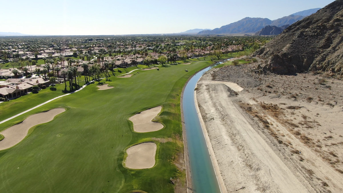
The 123-mile long Coachella Canal carries Colorado River from the All-American Canal to the Coachella Valley. Photo by Robert Marcos.
Southern California’s Coachella Valley includes the cities of Palm Springs, Palm Desert. Rancho Mirage, Indian Wells and Indio. It is a hot, dry, low-desert region that nonetheless supports 100 to 120 commercial farms, 120 golf courses, dozens of world-class resorts and one of the nation’s highest rates of per capita water use.1 The Coachella Valley sustains this (artificially) verdant environment with imported water from two sources: 430,000 acre feet of Colorado River water that’s diverted at the Imperial Dam and then conveyed by the Coachella Canal, and 194,000 acre feet of water from California’s State Water Project – but only if there’s sufficient snowpack in the Sierra Nevada mountains.
Both sources of imported water arrive via the Coachella Canal and the majority of it’s used by farms and by aquifer replenishment programs. The remainder is used by golf courses and for the irrigation of commercial landscaping. Municipal water (for residents and businesses) is pumped from the Coachella Valley Groundwater Basin – an aquifer that at one time contained an estimated 39.2 million acre-feet of water, just in its upper 1,000 feet. Municipal water users, who consumed 5.6% more water in 2025 than they did in the previous year,3 natural recharge from rainfall and runoff currently provides about 21,000 acre-feet per year2. So without the imported replenishment water the basin would plunge into an immediate and severe deficit. Water tables would drop rapidly in historically vulnerable zones like the East Valley and Palm Springs.3
This scenario is alarming for a variety of reasons –
The Colorado River is rapidly become unreliable as a source of water.4 Since both sources of imported water depend upon the Coachella Canal for delivery, 100% of the imported water will stop flowing just days after Lake Mead reaches deadpool. Again – not one drop of the imported water that the Coachella Valley depends upon will arrive in the Coachella Valley if that water can’t make it past Hoover Dam. A second, albeit less-likely danger is the known fact that the Coachella Canal crosses over the San Andreas Fault.4
Cheap water encourages farmers to grow water-intensive crops. Coachella Valley farmers who obtain raw irrigation water directly from the Coachella Canal can pay as little as $40.14 per acre foot. This cheap water encourages farmers to grow profitable but water-intensive crops – like alfalfa.5
Municipal water use in the Coachella Valley is increasing. Instead of the Valley’s water consumption falling – as we’ve seen in almost every other Southwestern municipality, the Coachella Valley’s municipal water use continues to increase due to a rising population and an increase in the irrigation of crops and landscaping due to climate change. On April 15, 2026 The Indio Post reported that urban water use – which includes municipal customers, golf courses, and other recreational users, climbed by 12,989 acre-feet, or 5.8% compared to the previous year.
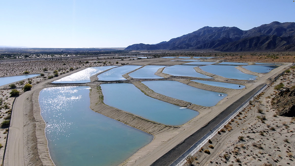
The Thomas E. Levy Groundwater Replenishment Facility is one of four replenishment facilities operated by CVWD. Photo by Robert Marcos
Challenge #1 – Maintaining groundwater levels
The Coachella Valley Water District and four other water agencies have been doing their best to maintain groundwater levels through the use of groundwater replenishment facilities. These programs are designed to reverse decades of aquifer overdraft and ensure long-term water sustainability. By percolating 165,000 acre feet a year of imported water directly into the ground, the districts have successfully stabilized and even raised groundwater levels in historically depleted areas. But what has been left unsaid is that both sources of imported water – the Colorado River and the State Water Project, both use the same conveyance and both are under severe long-term threat from climate change. Therefore Coachella Valley’s water districts have to plan for the day when they have no sources of imported water, and will have to depend entirely on groundwater.5
Challenge #2 – Convincing residents to use less water
Individuals living in the Coachella Valley city of Bermuda Dunes consume between 217 and 380 gallons of water a day.6 While residents of Rancho Mirage, Palm Desert, Thousand Palms, Indian Wells, La Quinta, and Thermal consumed an average of 188 gallons of water per day. And residents of the Desert Water Agency, which serves Palm Springs and Cathedral City, used an average of 178 gallons of water per day.7 The residents of other comparably-sized desert cities use far less water. On average residents of Tucson use as little as 72 gallons a day, residents of Phoenix 92 gallons, and residents of Albuquerque use just 56 gallons per day.
While the Coachella Valley relies entirely on imported Colorado River water to recharge its aquifers, and loops recycled water back to its farms and golf courses, other Southwestern desert cities have shifted to advanced purification technology that recycles100% of their wastewater directly back into municipal drinking supplies. In the Arizona cities of Phoenix, Glendale, Mesa, Scottsdale, and Tempe, they treat the recycled water to high standards so it can be used to irrigate sports fields, golf courses, commercial landscapes, and create or restore riparian habitats. It is also used to recharge aquifers and stored underground for use during times of shortage. Recycled water can extend water supplies, improve water quality, reduce discharge and disposal costs of wastewater, and save energy.8
Challenge #3 – Preparing for “Day Zero” when the Coachella Valley receives no more Colorado River water
If the current drought continues and Lake Powell reaches dead pool, it’s estimated that Lake Mead will also reach dead pool within two-to-four years. This means that absolutely no Colorado River water pass beyond Hoover Dam and into the lower Colorado River basin. The Colorado River Aqueduct, the All-American Canal, and the Coachella Canal would be shut down. In this worst-case scenario, the Coachella Valley would survive by pumping from its underground aquifer, though this would immediately trigger a severe, unsustainable deficit. Because the region averages only 3 inches of rainfall annually, its primary long-term buffer would be exhausted without Colorado River and SWA water being available to replenish it.9 To prevent the aquifer from going dry, the State of California would likely enforce extreme water rationing, ban all outdoor ornamental landscaping, and trigger a massive, forceddownsizing of the local agricultural sector. 10
Why not do some of these things now instead of waiting until the Colorado River has dried up?
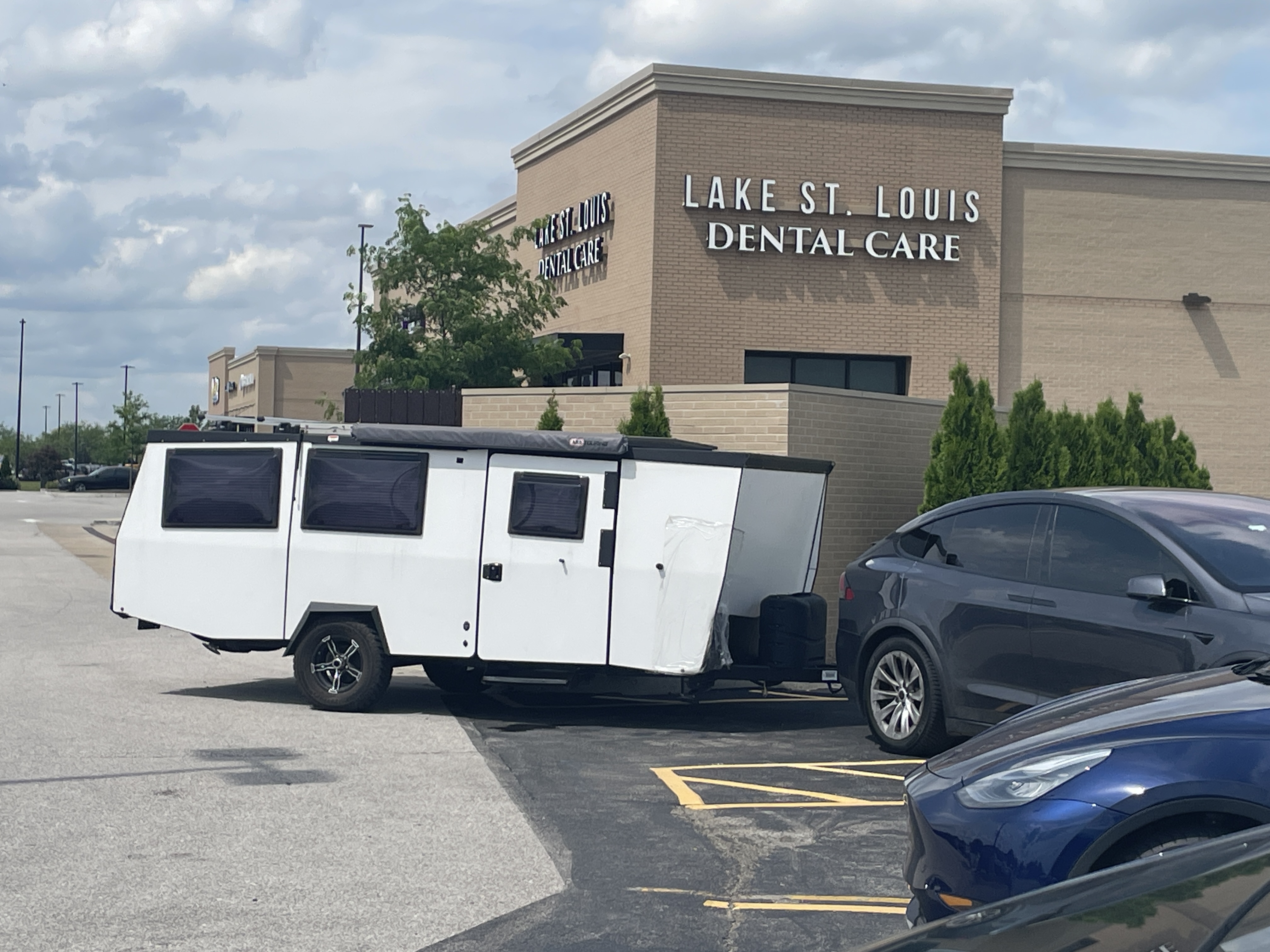
Tesla Model Y and electric camper trailer charging in Lake St. Louis June 5, 2026. Sorry, I forgot to ask the dude for the manufacturer information.
I am in St. Louis for my first ever punk rock concert and some baseball!
The owner of the rig in the photo told me that the trailer was fully electric, but he said that the Tesla couldn’t draw charge from the trailer. Nice light low-profile rig.
The Model Y I am driving (rented from Turo) has Grok integrated so you can set and change your navigation interactively. I asked many questions of her (I mean IT!) during the solo drive from Denver so it’s sort of like having your computer available while driving. Of course the discourse was mostly, “What river am I crossing?”
Grok, “That is likely the Missouri River which is located in this general area.” Sure enough, a road sign validated Grok’s message — one correct query!
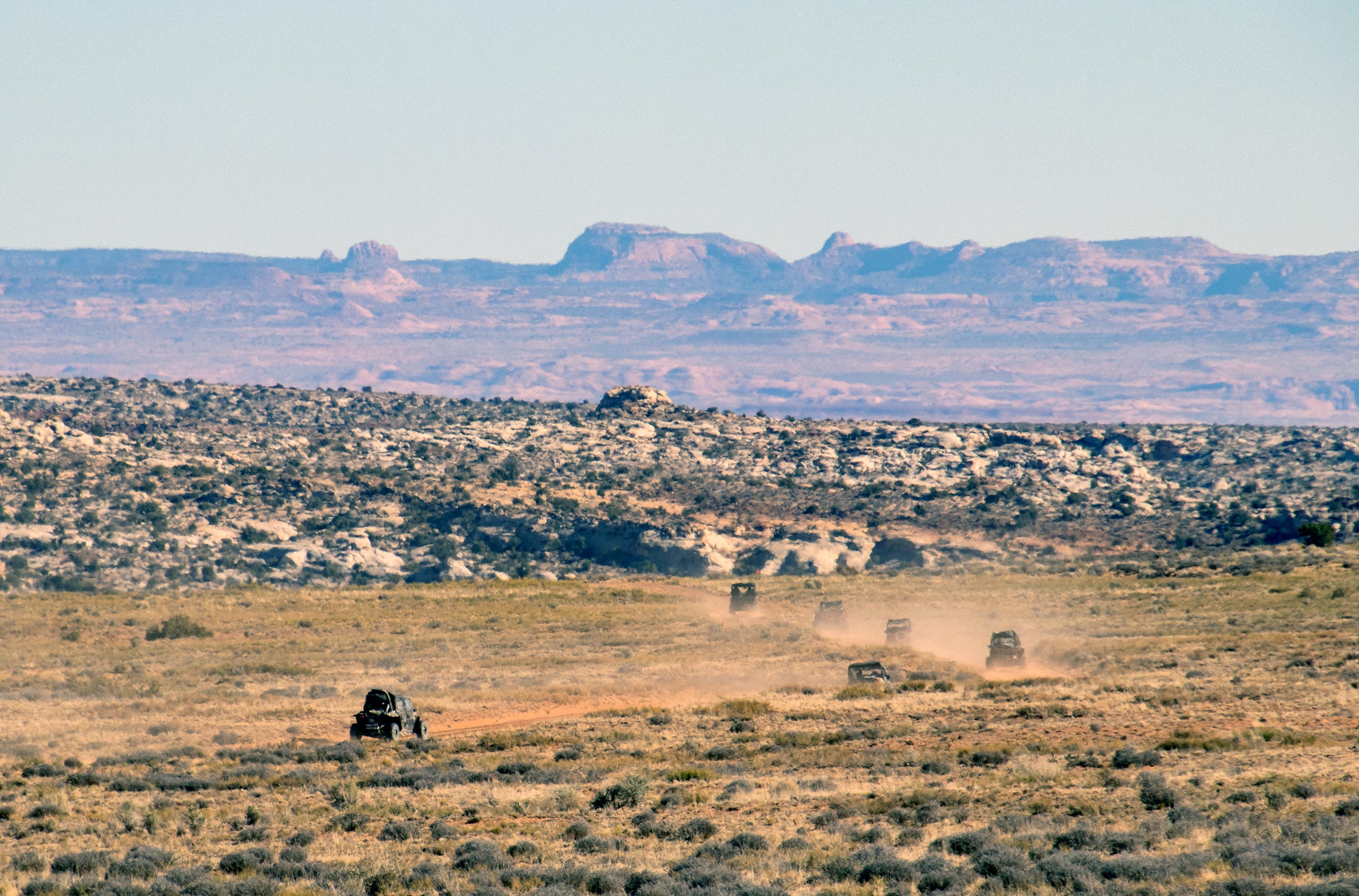
The Trump administration is attacking public lands again, this time in an apparent effort to open more special places to off-road vehicles. Late last Friday, Trump issued an executive order revoking a Nixon-era policy aimed at ensuring “that the use of off-road vehicles on public lands will be controlled and directed so as to protect the resources of those lands, to promote the safety of all users of those lands, and to minimize conflicts among the various uses of those lands.”
No, this does not mean unfettered swarms of ATVs will be kicking up dust on your favorite public lands next week. But it does bolster the off-road vehicle lobby’s effort to open up motorized access to federal lands, and takes away one of the long-term planning tools used by land management agencies to protect those places from off-road vehicle use and abuse.
In the nearer-term, Trump’s order could end or diminish the ban on OHVs in national parks, allowing the vehicles to travel backroads in, say, Capitol Reef National Park. This might not sound so bad: If a three-ton SUV can drive there, why not let a smaller side-by-side or four-wheeler on the same road?
The answer lies in the nature of the newer OHVs, namely “side-by-sides” or razors, which more closely resemble souped-up dune buggies than conventional SUVs. While some people use OHVs as mere modes of transportation, the vehicles are more commonly treated and utilized like recreational playthings — very powerful, fast, and noisy toys that tend to travel in herds. They therefore bring their own type of impacts.
Alpine Loop Backcountry Scenic Byway near Lake City, Ouray, Powderhorn, Ridgway, Silverton Credit: ColoradoDirectory.com
Anyone who has traveled on or hiked around the Alpine Loop in the San Juan Mountains of southwestern Colorado on a busy summer day has likely experienced these particular impacts first-hand. Those roads were first opened up to OHVs in the early 2000s. Since then Alpine Loop traffic numbers have exploded, with at least half of the motorized traffic made up of OHVs.
Law enforcement officers now spend a disproportionate amount of time and energy trying to keep the OHV drivers on designated routes and in compliance with traffic laws. OHV crashes, often resulting in serious injury, are not uncommon. And each summer several riders surrender to the temptation to illegally leave the road — these are off-road vehicles, after all — and rip across the tundra, causing irreversible damage. Unlike regular vehicles, OHVs tend to travel in herds, spewing exhaust and kicking up dust, their collective buzzing reaching far beyond the roads on which they travel. It has become almost impossible during the high season to completely escape the incessant din of OHVs on the Alpine Loop, even in wilderness study areas.
This same phenomenon could now be coming to a national park near you.
The administration claims it eliminated the policy because it was outdated, vague, and redundant, because Congress has since passed a host of other laws protecting public lands from OHVs and other uses. The order goes on to say:
This makes very little sense. Sure, the restrictions on OHVs could hamper energy or timber development if it required destructive off-road vehicle use, but you’re not going to haul a drill rig into the backcountry on a side-by-side. And the idea that a hiker might feel “banned” from a trail because they couldn’t ride get there on an OHV is just silly.
The dubious statement reeks of the rhetoric of the crowd that claims that motorized vehicle restrictions are locking folks out of public lands, and therefore are discriminating against the type of people who drive these vehicles. But the discrimination claim simply does not fly. Mountain bikes are banned from wilderness areas, from a majority of trails in national parks, from some trails on BLM land, and are not allowed to ride off-trail on all federal land. This has nothing to do with the people who ride the bikes, or even the funny clothes they tend to wear, and everything to do with the vehicles’ potential impacts.
Trump probably did this at the behest of the Blue Ribbon Coalition and the likes of Sen. Mike Lee, who has pushed legislation that would open up national parks to OHVs. Maybe he’s trying to garner support from somewhere, given his terrible favorability ratings. Or perhaps he’s trying to appease the motorized crowd, which is probably a bit miffed that their drug of choice — gasoline — is so damned expensive thanks to Donny’s dumb war. Maybe he’s even trying to increase national park entry fee revenues so he can funnel it to his ballroom/drone-port or his White House UFC fight.
Near Hite with the Henry Mountains. Jonathan P. Thompson photo.
🐟 Colorado River Chronicles 💧
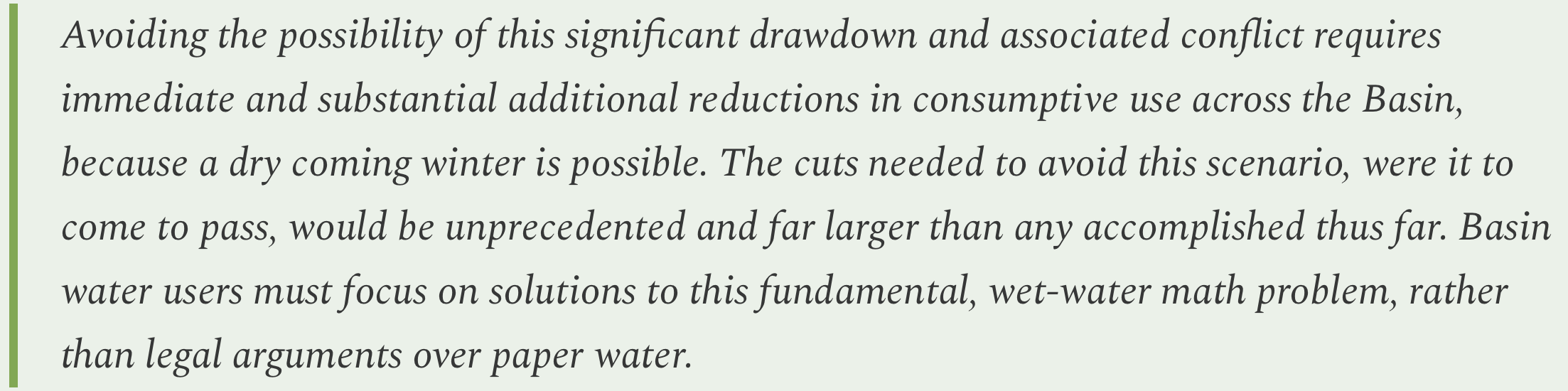
It pretty much goes without saying that if next winter is as bad as this past winter, in terms of mountain snowpack, then the collective users of the Colorado River and its infrastructure will be toast — at least figuratively (maybe literally, too?). Now, my favorite team of Colorado River wonks1 [Anne Castle, Jack Schmidt, Eric Kuhn, Kathryn Sorensen, Katherine Tara] have crunched the latest water numbers, and they’ve found that even a nearly “normal” winter won’t stop depletion of “reasonably accessible storage in Lake Powell and Lake Mead, leading to “devastating consequences.”
Back in 1999, the Colorado River’s storage system, which consists of Lake Powell, Lake Mead, and several other smaller reservoirs in the Upper and Lower basins, was almost full, holding about 60 million acre-feet of active, or available, storage. This provided a robust savings account that could be tapped during the inevitable dry spells on the notoriously fluctuating river system.
The reserve, however, was not adequate for the megadrought — or long-term aridification — that started in 2000 and continues today. Instead of following the usual up-down cycle, the Colorado River’s flows began a downward trend that is on track to hit its lowest point so far this water year, while consumptive use stayed more or less steady. Demand exceeded supply more years than not, drawing the savings account down significantly. That has forced the Bureau of Reclamation to take extraordinary measures, such as reducing downstream releases and tapping upstream reservoirs, to keep Lake Powell’s surface level from dropping below 3,500 feet, or what I call de facto dead pool 2.
Thanks in part to extra releases from Flaming Gorge Reservoir in May, Lake Powell’s surface level climbed slightly to 3,528 feet last month. Given that spring runoff in the Upper Basin has peaked and most tributary flows are decreasing, we can expect that number to start dropping, perhaps precipitously, at least until the monsoon arrives.
The wonks wanted an idea of how things might play out in the slightly longer-term, so they modeled two scenarios:
In the first scenario, they assume that the Colorado River’s natural flow, or the estimated amount of water in the river without human consumption or interference, will be similar to water year 2025, when the mountain snowpack was below average but not nearly as slim as this year. They also assume that consumptive uses will remain at the lowest levels in recent years.
Natural flow: 8.5 MAF at Lees Ferry + .70 MAF from Grand Canyon and Virgin River = 9.20 MAF Consumptive use: 3.56 MAF Upper Basin (includes evaporation and other losses) + 8.23 MAF Lower Basin + Mexico (incl. evap and other losses) = 11.79 MAF Deficit and resulting reservoir drawdown: 2.59 MAF Realistically accessible storage (RAS) remaining in Mead, Powell, and Flaming Gorge: 3.63 MAF
For the second, they plug in snowpack/flow numbers similar to those from water year 2023, which was a huge winter. Consumptive use would be about the same as in 2023.
Under the first scenario, the BoR will almost certainly have to go to a run-of-the-river situation on Glen Canyon Dam to defend 3,500 feet. That would mean releases would be approximately equal to inflows minus evaporation and seepage from the reservoir, and might drop to 3,000 to 4,000 cubic feet per-second or even lower. In the summer of 2002 inflows at times dropped below 1,000 cfs. This would turn the river through the Grand Canyon into a relative trickle, and cause a significant drawdown of Lake Mead.
The second scenario would be far better, but is far from an enduring solution. At best it would buy a little time, perhaps enough for the feds to build bypass tunnels around Glen Canyon Dam to allow for sustained releases below 3,500 feet. If it were followed by another three or four 2023-like winters, then things would start to look pretty darned good.
But if it were followed by just one more dry year it would bring everything back to today’s rather dire situation.
Since there’s no way to bolster supplies, the only way out of this mess is to continue to slash demand. The paper’s authors write:
Oof.
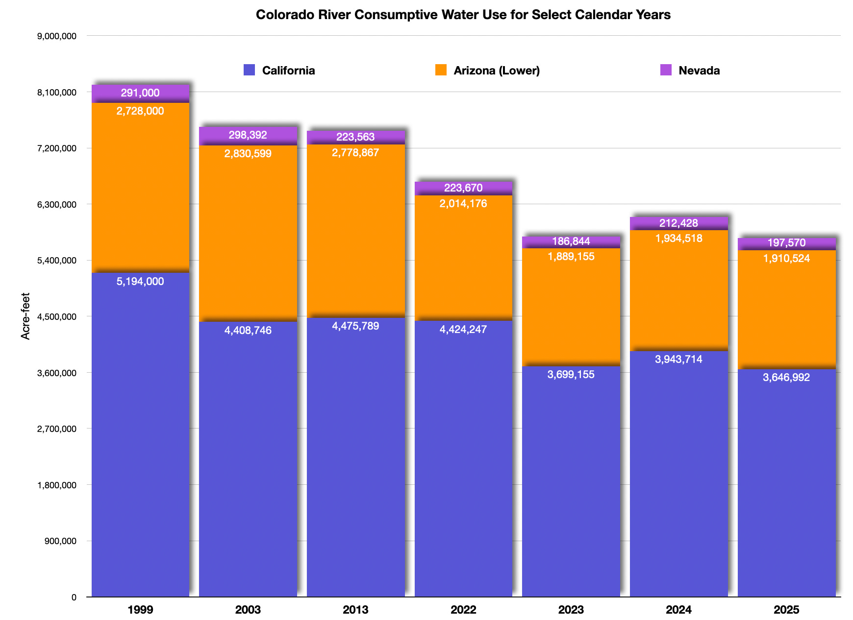
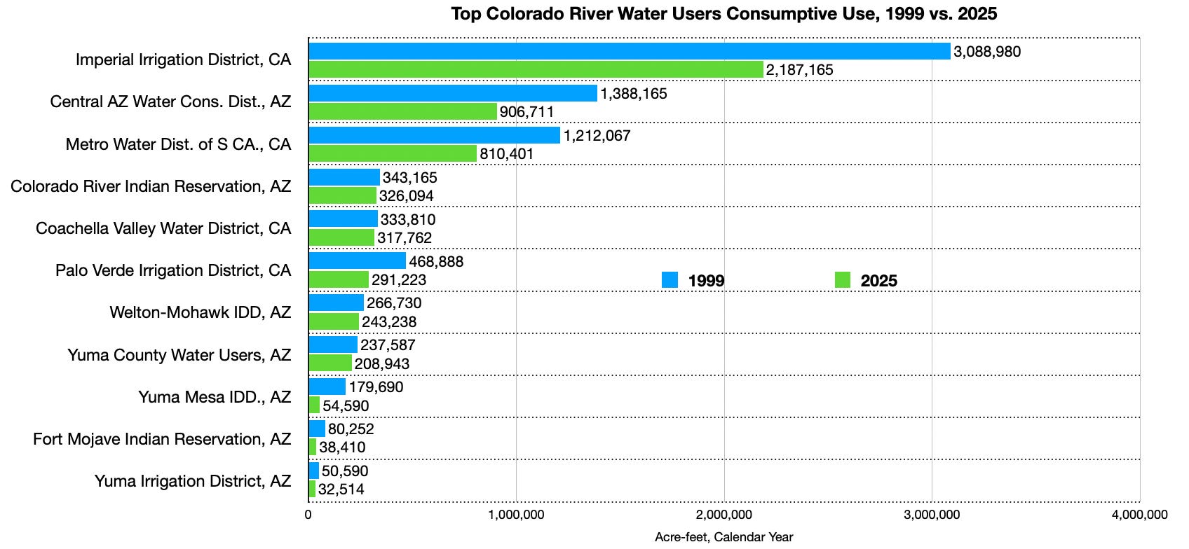
As long as we’re on the topic, the BoR recently released its Lower Basin accounting report for 2025, which tallies up consumptive uses in the basin. As you can see from the following graphs, which the Land Desk whipped up using the BoR data, the Lower Basin uses significantly less water now than it did in 1999, just before the current megadrought began. Upper Basin consumptive use figures for 2025 are not yet available. The following figures do not include reservoir evaporation, conveyance losses, or Mexico’s use.
All three Lower Basin states have substantially reduced Colorado River water consumption since 1999. However, more cuts will be needed if current climatic and streamflow trends continue. Data: USBR, Graphic: The Land Desk
🤖 Data Center Watch 👾
Has Enchant Energy finally found a raison d’être? The Farmington-based company was created in 2019 to try to save the San Juan coal-fired power plant from retirement by retrofitting it with carbon capture equipment. Enchant would then sell the carbon to oil producers in the Permian Basin, while also receiving generous federal tax credits. Basically they wanted to turn the power plant into a taxpayer subsidized carbon dioxide factory. It flopped for various reasons. Now the San Juan plant — and all of its pollution — are no more. We suspected Enchant Energy had met a similar fate.
But then I received a press release letting me know the not-so-up upstart is not dead, but has instead signed a letter of intent with Creekstone Energy to capture carbon from the tech firm’s proposed hyperscale Delta Gigasite data center in Delta, Utah. As is often the case, Creekstone touts all of the renewable energy it plans on building for its center, but the first phase will be powered by natural gas, which emits carbon dioxide.
Enchant hopes to capture the carbon from the gas plant and convert it into marketable fuel. The company has apparently given up on trying to give coal-burning a slightly more climate-friendly veneer (after all, Trump has declared coal to be “clean” and “beautiful”). Instead, it looks like they’re jumping on the data center bandwagon, along with wannabe nuclear reactor developers and the like.
Who knows, maybe this is the thing that finally gives Enchant some meaning. But we’re not holding our breath. After spending gobs of money on lobbying, pulling in some hefty federal grants, then failing spectacularly with the San Juan generating bid, Enchant partnered with another firm and tried to buy the Intermountain coal plant in Delta to use it to power its own data center. That didn’t work, either.
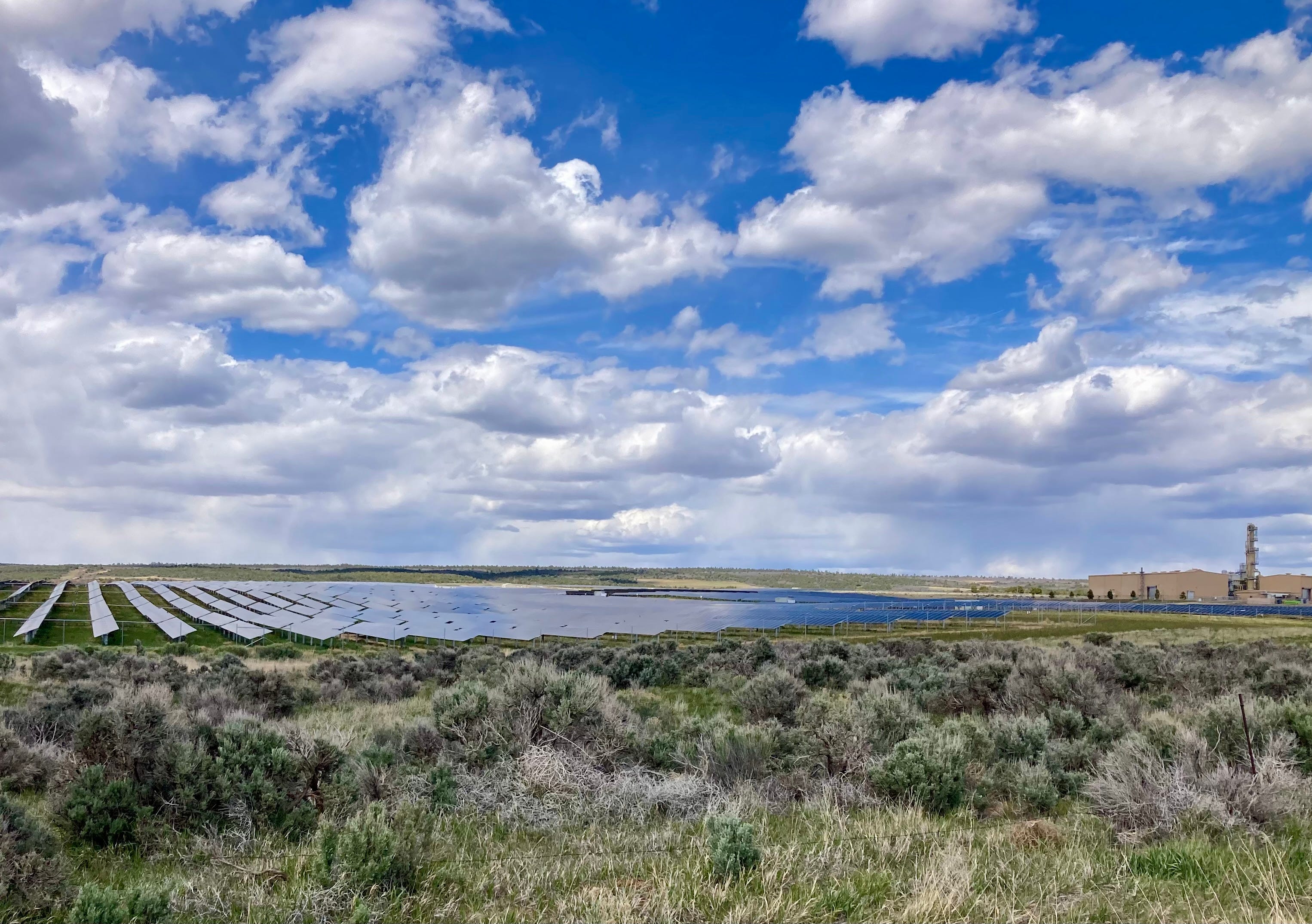
Dolores Canyon solar project outside of Cahone, Colorado, with Airproduct’s apparently defunct helium plant on the right. Jonathan P. Thompson photo.
🔋Notes from the Energy Transition 🔌
Yes, the energy transition may have run into some stumbling blocks, i.e. the Trump administration’s hatred for anything that might compete with coal and oil and gas, but it’s still quietly underway. For example, out by the aforementioned, defunct San Juan coal plant, DESRI recently broke ground on two utility-scale solar installations: the 170-megawatt Foxtail Flats solar-plus-battery storage array; and the 100-MW Four Mile Mesa solar-plus-storage project.
That’s some pretty serious generating capacity and adds to the existing San Juan solar facility nearby. Los Alamos County has signed on to purchase power from Foxtail Flats, and Meta will be drawing electricity Four Mile Mesa via PNM to power its data centers.
Both of the new facilities are under development on Ute Mountain Ute tribal land.
📸 Parting Shot 🎞️
In last week’s comments, ncoffey94 asked what kind of bike I ride. It’s a 2023 Niner RLT, with an aluminum frame, carbon fork, and SRAM Apex parts. It’s nothing fancy and isn’t super light. But I dig it for riding on the roads, dirt, and even singletrack. It’s got 40 mm tires, so isn’t so great in the sand, and with no suspension I don’t do big drops or super-cobbly stuff. But it sure is nice having just one bike for all uses.
Photo credit: Jonathan P. Thompson.
1Anne Castle, Jack Schmidt, Eric Kuhn, Kathryn Sorensen, and Katherine Tara.
2 Water can no longer be released through the penstocks and hydropower turbine below 3,500 feet, forcing dam operators to rely on the lower river outlets for all downstream water releases. Those outlets are not engineered for sustained, long-term use, however, and could be damaged. The feared scenario looks kind of like this: The penstocks are closed; the river outlets release water faster than reservoir inflows; the reservoir surface level drops down to, say, 3,450 feet; the river outlets get damaged so must be shut down altogether, trapping the remaining water behind the dam and halting all releases until the water climbs back up to 3,500 feet. This would effectively dry up the Grand Canyon and cause Lake Mead to start plummeting as well. Of course, no one wants this to happen, so BoR is doing all it can to defend 3,500 feet, making that level the effective dead pool, even though technically 3,370 feet (the river outlet elevation) is the actual dead pool.
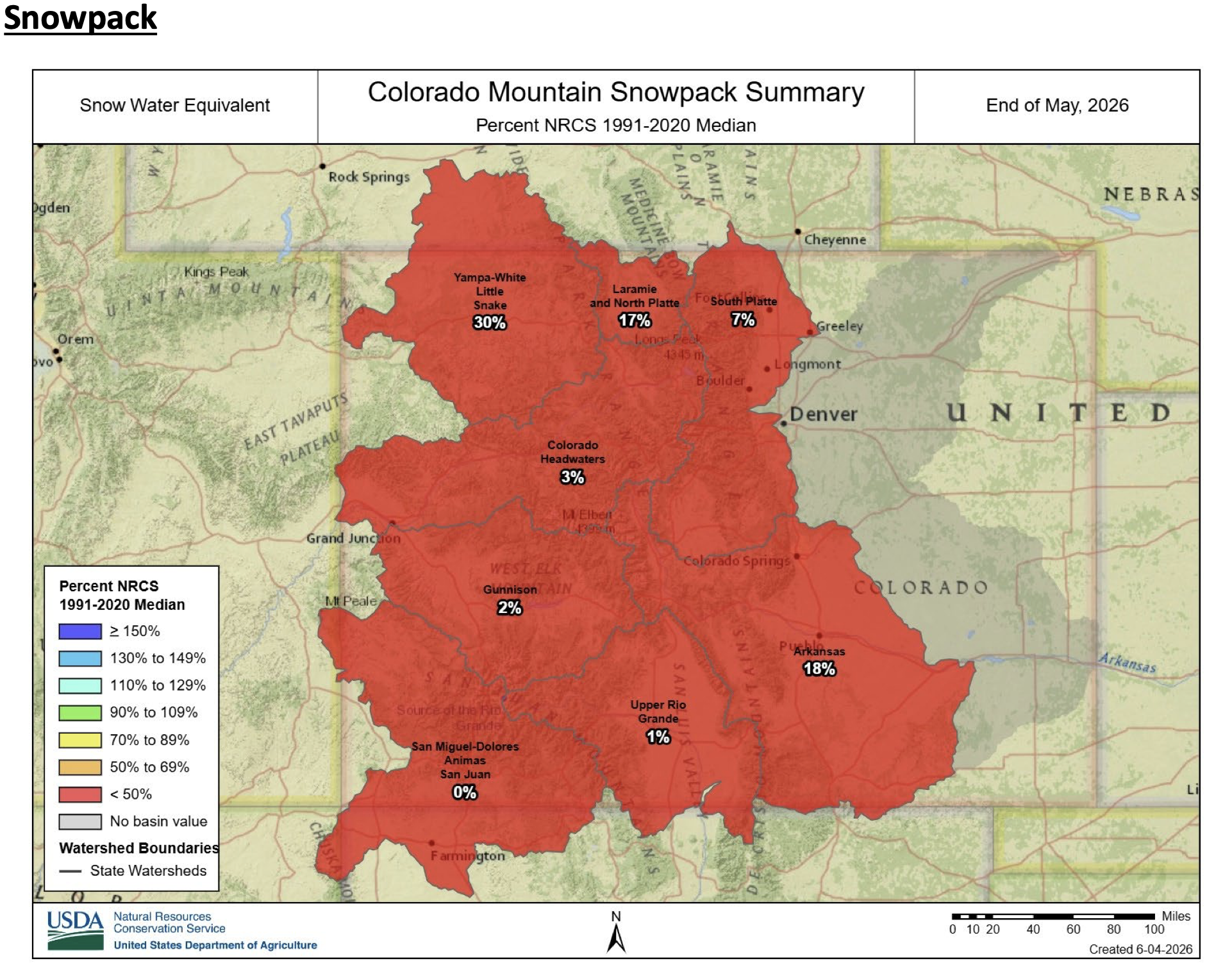
Click the link to read the report (and drill down to the individual major basin stats) on the NRCS website. Here’s an excerpt:
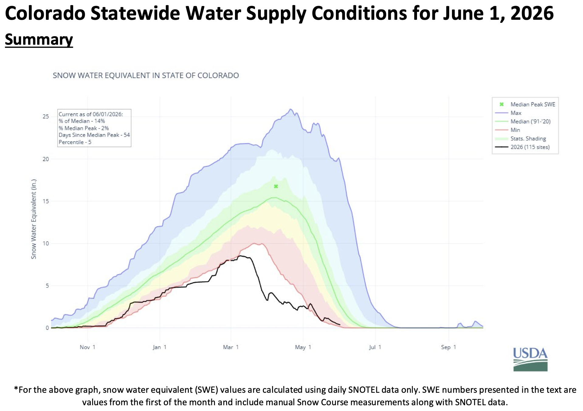
Colorado experienced an unusual volatile winter this year. In October 2025 at the start of the water year; the southern basins received record amounts of rainfall, while the rest of the state saw minimal early-season accumulation. November brought intermittent storms but not enough to build a meaningful base and the snowpack remained well below normal. Early December finally delivered a measurable amount of snow for the northern basins but record high temperatures and lack of moisture in the middle of the month raised concerns heading into 2026. January continued the trend of minimal snow accumulations, and many basins began falling into single-digit percentiles. The first half of February remained dry, and although the second half brought some moisture it was not nearly enough to recover from the early-season deficit. Statewide snowpack entered March at 60 percent of median. March delivered a combination of record high temperatures and record low precipitation, causing some basins to reach peak snow-water-equivalent (SWE) almost a month early. The rate at which the snowpack began to melt was unprecedented, with soil moisture sensors and streamflow gages showing an immediate response. Thankfully, April brought cooler temperatures and above normal precipitation, allowing the remaining snowpack to linger a bit longer. With increased storm activity, the majority of hydrographs receded as runoff slowed down. However, by May 1st statewide snowpack had fallen to the zeroth percentile and the remaining snowpack continued to melt. Melt in May is common, but the combination of extremely low snow conditions and warm temperature triggered a second peak in the hydrographs – a peak that normally would represent the first rise of the season. At nearly all streamflow forecast points the runoff duration was significantly shortened, as much of the volume had already been observed in March. By June 1st 91% of SNOTEL stations were fully melted out – compared to the typical 56% for this time of year, highlighting the exceptionally early and accelerated melt season.
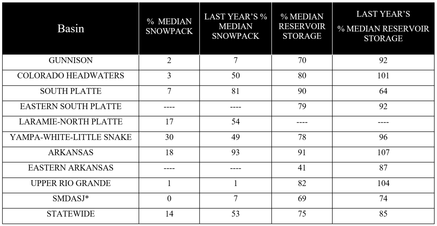
Statewide snowpack was 14 percent of the historical median as of June 1, with an average of 0.4 inches of snow water equivalent (SWE) in the state. This is the third-lowest June snowpack in the NRCS Snow Survey period of record, surpassed only by 2002 and 2012—years which both contained a higher seasonal SWE peak in mid-March but experienced rapid meltout in early April and May. Comparatively, 2026 experienced a record-breaking early initiation o snowpack melt in mid-March, reducing the total snowpack by half before cooler conditions and late-season snowfall hastened the decline throughout April. Snowpack melting returned to a predictable bell-curve pattern in May and at the end of the month all river basins currently exhibit far lower-than-median SWE in the state. The San Miguel-Dolores-Animas-San Juan, Upper Rio Grande, Gunnison, Colorado Headwaters, and South Platte exhibit the most extreme deviations from the 1991-2020 historical median, reporting 0, 1, 2, 3, and 7 percent of median snowpack SWE respectively. Meanwhile the Laramie-North Platte, Arkansas, and Yampa-White-Little Snake have low but less extreme deviations from median snowpack levels, reporting 17, 18, and 30 percent of median SWE.
The statewide water year-to-date precipitation remains below normal at 77 percent of median. May brought some improvements, with statewide precipitation at 104 percent of median, but the spatial distribution varied greatly. The front range and northern part of the state received above median precipitation with the South Platte River basin at 138 percent and the Laramie-North Platte basin at 128 percent for the month of May; an encouraging shift that helped boost soil moisture and short-term streamflow potential. In contrast, the southwestern basins received below median with the combined San Miguel-Dolores-Animas-San Juan River basin and Gunnison River basin at 53 percent and 60 percent of median, respectively. A shift from last month, where those two basins received the most precipitation in April at 155 percent and 116 percent of median. Tower SNOTEL located in the Yampa-White-Little Snake River basin received the most precipitation in the month of May with 5.8 inches total; 2.2 inches falling in a single day (May 5th, 2026).
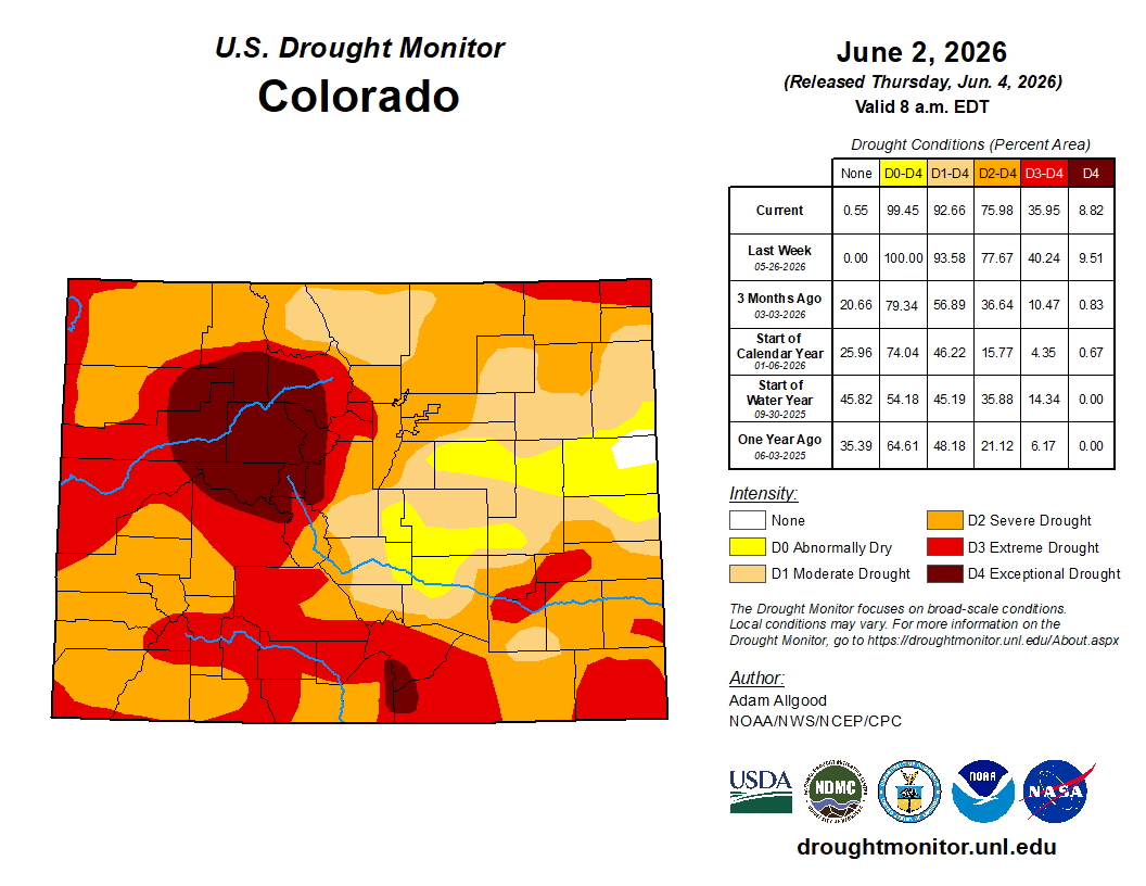
Colorado Drought Monitor map June 2, 2026.
The current U.S. Drought Monitor Map shows drought conditions are still prevalent across the state, with slight improvements in some northern basins and slight degradations in the southern front range basins since last month. Spring moisture has brought some much-needed precipitation after a well-below normal winter. The monthly precipitation outlook from NOAA’s Climate Prediction Center forecasts above to near normal precipitation for the month of June.
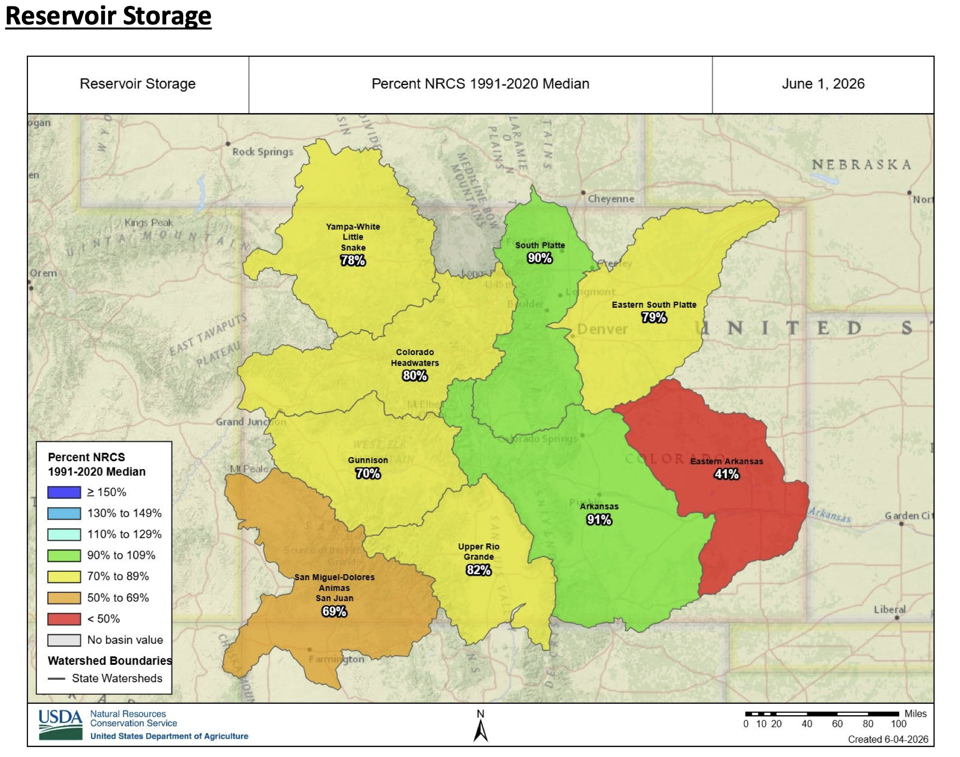
Reservoir storage is currently 75 percent of the 1991-2020 median on a state-wide scale, down from 85 percent last month. Mean water storage decreased in all river basins in the state compared to last month. As of June 1, storage remains relatively close to median in the Arkansas and South Platte*, reporting 91 and 90 percent median storage, respectively. The Upper Rio Grande, which had been an outlier with above-average reservoir storage since October 2025, is now down to 86 percent of median storage. Five additional basins are reporting reservoir storage levels somewhat below the 30-year median, with the Colorado Headwaters, Eastern South Platte, Yampa-White-Little Snake, Gunnison, and San Miguel-Dolores-Animas-San Juan reporting 80, 79, 78, 70, and 69 percent, respectively. The Eastern Arkansas remains the basin with the lowest overall percent of median storage, decreasing from 56 percent down to 41 percent of median storage this month. Overall, Colorado is currently utilizing 54 percent of total reservoir capacity statewide compared to 61 percent storage this time last year (see June 1 2026 Reservoir Storage Capacity chart).
*At the time of publishing, end-of-month reservoir water storage data had not yet been reported for 8 out of 23 reservoirs in the South Platte basin. These reservoirs were excluded (rather than reported zero) in the statistics above, and the data will be updated on our website as soon as it is available.
June through July forecasts at the 50 percent exceedance probability are at 24 percent of median statewide. Observed streamflow from March through May is 50 percent of median statewide. April and May alone are 41 percent as March runoff occurred outside the normal primary period. Record March temperatures drove an early rise in streamflow statewide weeks ahead of typical spring melt timing. Cooler April temperatures and increased April and early May storms placed a pause on snowmelt. A second rise in streamflow followed in mid-May consistent with normal sun angle-driven melt onset. May observed flows averaged 34 percent at a median percentile of 2. Those runoff conditions are observed downstream at Lake Powell where March through May observed inflow is 1,104,000 acre-feet at 28 percent of the period of record median ranking 3rd lowest in the 117-year record behind 2002 and 1977. June and July typically deliver 54 percent of the April through July volume at Powell. The June through July combined forecast is 300,000 acre-feet at 9 percent of median and is near 21 percent of projected total seasonal volume remaining. The forward-looking period 63 of 70 points rank at or below the 10th percentile with a median percentile of 3. Statewide remaining period volume at the 50 percent exceedance probability represents one third of projected total seasonal volume. May storm activity shaped a distribution where eastern basins retain comparatively more remaining volume. The South Platte is at 51 percent and Arkansas at 38 percent of median. Remaining snowpack is limited to the highest elevations and will contribute modestly to late-season flows. Above normal temperatures and above normal precipitation are both favored through the remaining period.
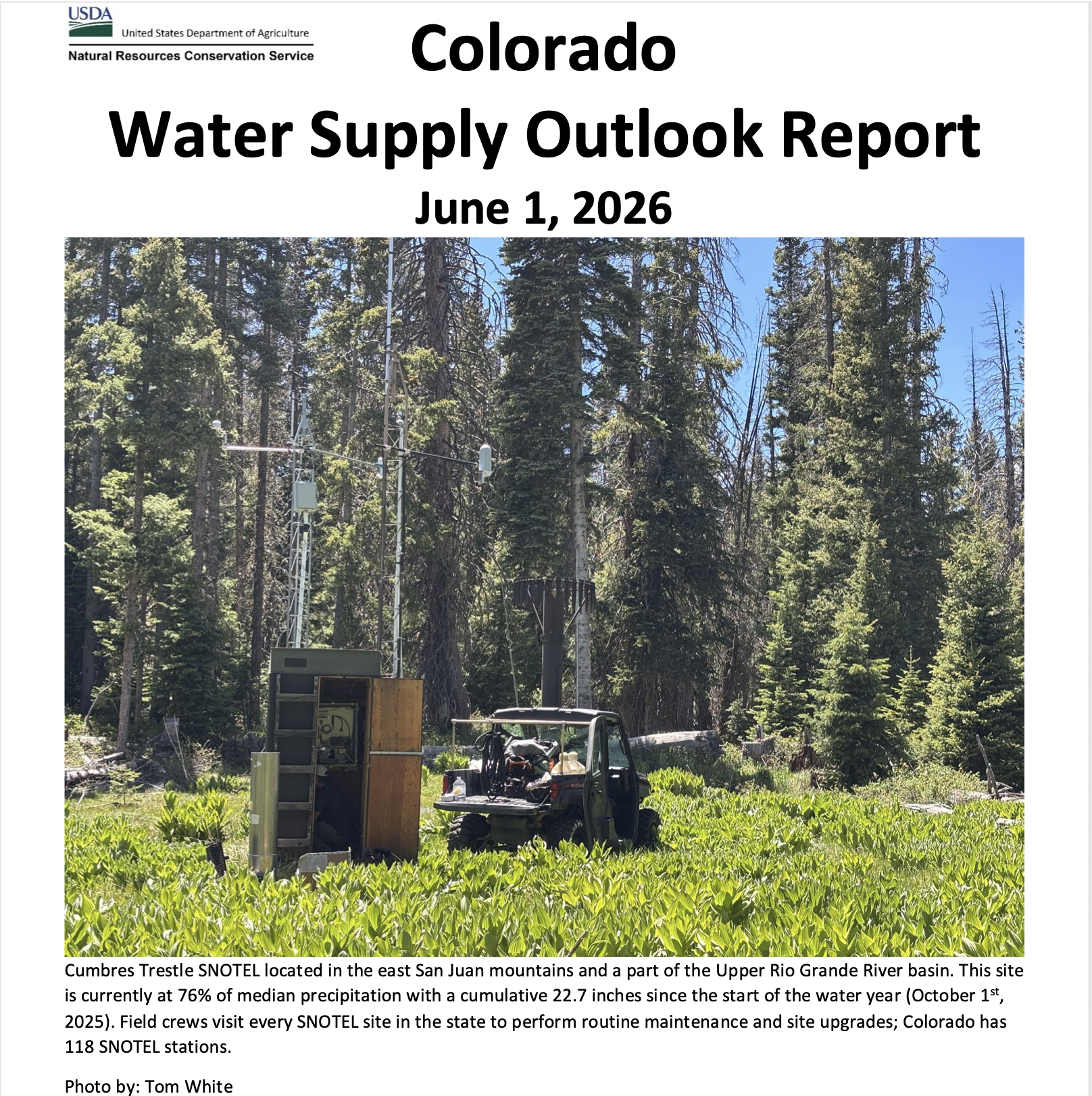
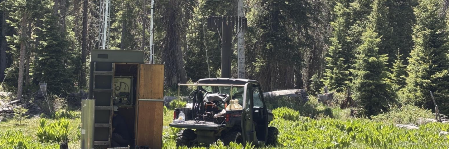
Cumbres Trestle SNOTEL located in the east San Juan mountains and a part of the Upper Rio Grande River basin. This site is currently at 76% of median precipitation with a cumulative 22.7 inches since the start of the water year (October 1st 2025). Field crews visit every SNOTEL site in the state to perform routine maintenance and site upgrades; Colorado has 118 SNOTEL stations. Photo by: Tom White/NRCS
Click the link to read the release on the NRCS website:
June 5, 2026
An early runoff season shifted a substantial portion of annual runoff into March through May. At Lake Powell, where June and July normally account for about half of seasonal inflow, only about 21 percent of projected seasonal volume remains. Similar conditions are forecast throughout Colorado.
June through July runoff forecasts remain well below normal statewide at the 50 percent exceedance probability at 24 percent of median (Figure 1). Outlooks in the Front Range Mountains remain the exception. May storm activity helped to sustain comparatively higher forecasts in the Front Range and boosted precipitation in the Sangre de Cristo Mountains and in the northern Park Range. The South Platte is forecast at 51 percent of median and the Arkansas at 38 percent. In the Upper Rio Grande River basin the most probable outlook is 28 percent of median. Western slope remaining period forecasts range from 19 to 23 percent in the combined Yampa-White-Little Snake and San Miguel-Dolores-Animas-San Juan (SMDASJ) basin, respectively. May precipitation ranged from 54 to 59 percent in southwest basins while the South Platte received 140 percent of median.
Figure 1. Remaining period (June through July) streamflow forecast volume at the 50 percent exceedance probability. Credit: NRCS
Record March temperatures initiated an early rise in streamflow weeks ahead of the typical spring melt period. A second rise followed in mid-May consistent with normal sun angle-driven melt timing. In some rivers the May peak became the seasonal maximum. Statewide observed flows from March through May are 50 percent of median. April and May alone are 41 percent, as March runoff occurred outside the normal primary period and skews the seasonal comparison.
Statewide reservoir storage is 75 percent of median and largely reflects October precipitation and carry-over storage from the previous water year. Some of the state’s larger reservoirs are well below the statewide median particularly in southwest basins. Blue Mesa and McPhee reservoirs are both at 59 and 57 percent of median respectively and rank at the 10th percentile in their period of record. Navajo Reservoir is 69 percent of median at the 20th percentile. Colorado Headwaters basin storage is 80 percent of median, and the Upper Rio Grande is 86 percent. Eastern basins are the highest in the state. Pueblo Reservoir is 93 percent of median and aggregate South Platte basin storage is 90 percent. Remaining period inflow forecasts are considerably lower than current storage levels. McPhee inflow is forecast at 24 percent and Navajo at 18 percent. Dillon Reservoir inflow is forecast at 25 percent ranking lowest in the 75-year period of record. Pueblo inflow is forecast at 44 percent of median.
As of June 1, statewide snowpack is averaging 14 percent. Median melt-out timing across the Colorado SNOTEL network is running 36 days ahead of normal. Remaining snowpack is limited to the highest elevations and will contribute modestly to late-season flows. Above normal temperatures and above normal precipitation are both favored through the remaining period.
*combined San Miguel-Dolores-Animas-San Juan River basin