When the U.S. Army sent a Steamship up the Colorado River

America’s Civil War in 1861 overshadowed an earlier conflict in the American West – The Utah War. In 1857 Congress funded a reconnaissance mission that sent a steamship up the Colorado River in support of the U.S. Army’s plan to invade the Utah Territory and to depose Brigham Young, its governor.

by Robert Marcos, photojournalist

The Mormons, first led first by Joseph Smith and later by Brigham Young, were systematically driven from a series of American settlements by hostile neighbors and governmental action between 1831 and 1847. Their forced migration began in Kirtland, Ohio, and Jackson County, Missouri, where religious friction, economic disputes, and political rivalries sparked violent expulsions which included Missouri’s infamous Extermination Order in 18381. The Mormon refugees found temporary asylum in Nauvoo, Illinois, but the murder of Joseph Smith in 1844 reignited anti-Mormon violence that resulted in February 1846 with a Mass exodus out of the United States. An initial group of 1,650 Mormon pioneers traveled westward across the Great Plains in grueling conditions until they reached the Great Salt Lake in July 1847, which they hoped would become a permanent sanctuary for them. Over the next twenty years as many as 70,000 additional Mormons moved into the region which Mormons alternatively called the “State of Deseret” or “Zion”.

A portrait of a man with a prominent beard and historical attire, featuring a solemn expression against a dark background.
Portrait of Brigham Young, the second President of the Church of Latter Day Saints, provided by The Church of Jesus Christ of Latter-day Saints.

Historic Maps show the dramatic changes taking place in the American West

Maps that show the American West in 1847 reveal a dynamic landscape that was on the brink of a profound transformation. Texas had been given statehood in 1845, Oregon was incorporated as a territory in 1848, and California became a state in 1850. The end of the Mexican-American War and the signing of the Treaty of Hidalgo had finally opened the door for the U.S. to expand into the vast Indian lands that had previously been claimed by Mexico.
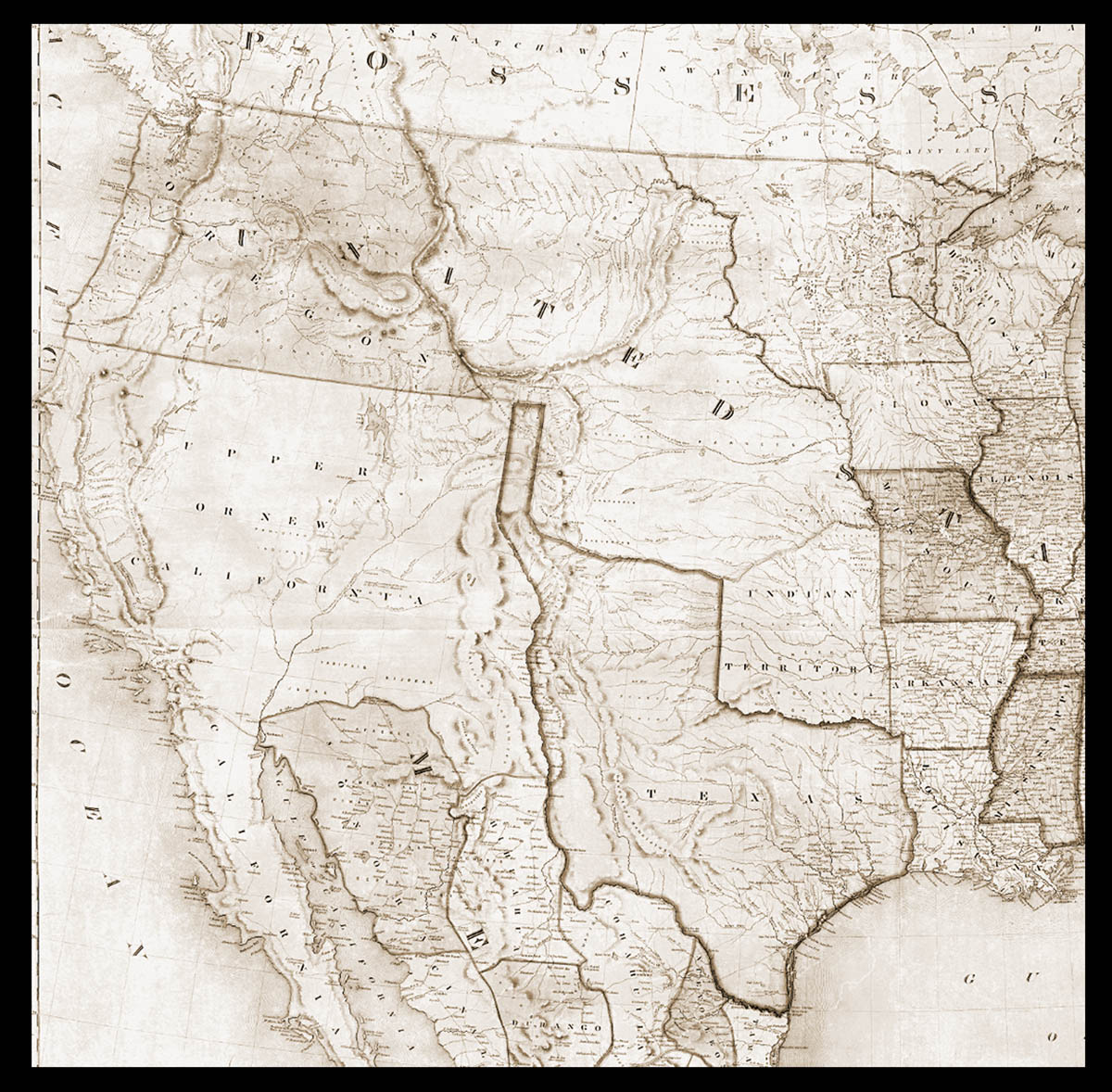
An antique map of the western and central United States, featuring states like Texas, California, and Illinois, with detailed topography and place names.
1847 map of the United States shows an enormous (Mexican owned) California and a very strange looking Texas

Congress annexes the Utah Territory

In 1849 Brigham Young proposed that the United States incorporate his massive provisional state, which encompassed almost all of modern Utah, Nevada, and Arizona. Congress rejected his idea and instead created a much smaller Utah Territory. To salve the insult to Brigham Young President Millard Fillmore appointed him as the Territorial Governor. But these federal actions outraged voters in the Eastern half of the United States who claimed that by incorporating Utah as a Territory the federal government had in effect sanctioned polygamy and other practices that voters found repugnant, and they demanded that punitive action be taken to put a stop to it.

President orders the Department of War to invade the Utah Territory

On May 28th 1857, President James Buchanan ordered one-third of the U.S. Army to invade the Utah Territory and to depose Brigham Young as its governor. In Utah this action sparked mass hysteria among its citizens, who braced themselves for a full-scale military invasion. In response, the Mormon militia burned US Army supply trains and practiced “scorched earth” tactics which were highly effective in delaying the arrival of the incoming troops.

In support of the invasion Congress passed an Army Appropriations bill that provided $75,000 for a Colorado River Exploring Expedition that would survey the southern end of the Colorado River along with Utah’s southern borders. The Army wanted to find out about the river’s ability to convey troops and supplies from the south, and they also wanted to eliminate a potential escape route that Brigham Young and his militia might make use of.

The $75,000 which Congress had provided was to spent to build and transport a custom steamship that would be rugged enough to survive collisions with rocks and other obstacles known to exist in the Colorado River. The U.S. Secretary of War John B. Floyd appointed Lieutenant Joseph Christmas Ives to command the expedition and to oversee the construction and the transport of the ship they would use to steam up the Colorado River.

Historic steamboat docked near a riverbank, featuring a tall smokestack and a multi-level structure.
The steamboat Cochan on the Colorado River near Yuma, Arizona in 1900. Photograph provided by Wikipedia.

The Construction and unbelievable transit of the iron-hulled steamship

Lieutenant Ives chose to have his custom-made 54-foot long steamboat built in Philadelphia. After a successful trial run on the Delaware River, the heavy metal vessel was disassembled, loaded in crates, and transported to a steamship which that brought it south to Colon, Panama. From Colon it was hauled overland on the Panama Railroad to a port on the Pacific where it was loaded onto another steamship bound for San Francisco. Once there the heavy crates were moved to the schooner Monterey, which was sent racing back down the Pacific coast, around the tip of Baja California, then northward to the top of the Sea of Cortez. The schooner would’ve slowed to a crawl as it approached Robinson’s Landing, its destination, where the little iron-clad steamship would be reassembled then finally put to work.1

The Explorer begins its journey with 27 heavily-armed men on board

Thirty days later the Explorer departed from Robinson’s Landing with Lieutenant Joseph Christmas Ives in command and a heavily-armed 27-man crew. David C. Robinson – an experienced sailor who’d served on the riverboat General Jesup piloted the small vessel. Robinson’s ongoing challenge was making headway against fierce oncoming currents that were hellbent on driving all of them back to the Sea of Cortez. There were also shifting sandbars sometimes just inches below the water level, and dramatic tidal bores that rose up from behind them twice a day as the high tides poured in. But thanks to Robinson’s diligent piloting the ship and its crew arrived at Fort Yuma intact – but embarrassed – because Robinson drove them into a sandbar in full view of the hundreds of onlookers who’d gathered at the dock to watch their arrival. Adding insult to injury, upon docking Lieutenant Ives learned that another riverboat Captain George Alonzo Johnson, had beat them by becoming the first steamship captain to have made it all the way north to the infamous Black Canyon, (where Hoover Dam sits now).2

The Explorer Expedition spent two weeks at Fort Yuma before launching northward into (what would’ve been) uncharted territory. Members of the crew who were experienced with cartography took notes of the geography and the river conditions as the Explorer made its way slowly upstream. The crew pulled over multiple times to see what they could learn from Native American tribes who were camped along the river’s shoreline. Nobody knows if Lieutenant Ives was aware that when they passed the confluence of the Gila River they were in the same spot where Hernando de Alarcon had anchored 318 years earlier when he deposited supplies for members of the Coronado Expedition.3

As the crew of the Explorer continued up the Colorado River they observed the landscape transform into a dramatic, forbidding chasm dominated by towering walls of dark, volcanic rock. Lieutenant Joseph Christmas Ives and his men noted that the river grew increasingly narrow, swift, and treacherous, forcing the small steamboat to battle fierce rapids and other hazards lying just beneath the surface. The crew included the geologist John Strong Newberry and the illustrator Balduin Möllhausen, who documented the striking, raw geological formations and the unique desert vegetation that they saw clinging to the sheer cliffs. The crew felt an overwhelming sense of isolation and awe as the sun disappeared every day behind monumental cliffs that seemed to press down on them. Lieutenant Ives famously remarked the “profitless, chaotic locality seemed intended by nature to remain forever unvisited and unmarred by civilization“.4

The voyage ended abruptly on March 8, 1858, when the Explorer struck a sunken rock in the infamous Black Canyon, at the exact spot where Captain George Alonzo Johnson had chosen to turn around, four months earlier. The violent collision dislodged ship’s iron bow, and after reaching the shore the crew realized that their steamboat could travel no further. Lieutenant Ives and several men proceeded to row a small skiff another thirty miles upstream. They mapped the mouth of the Virgin River. The crew finished the expedition by hiking overland to Fort Defiance in Northwestern Arizona.

Meanwhile – the Utah War had come to a complete standstill after harsh winter conditions forced the U.S. Army and the Mormon Brigades to hunker down for the winter. The delay provided time for Thomas Kane – a prominent civilian mediator, to negotiate between both parties which ultimately ended with a peaceful resolution being reached. The Mormons agreed to submit to federal authority, and in exchange they received a full pardon from President James Buchanan.

Although Brigham Young continued as the president of the The Church of Jesus Christ of Latter-day Saints, he stepped down as the Territorial Governor after the Utah War ended, and he passed away on August 29, 1877. The federal government admitted Utah as a state on January 4, 1896, after decades of denial due to the Mormon practice of plural marriage. The polygamy issue was finally resolved in 1890, when Church President Wilford Woodruff issued a manifesto that declared that the church had ceased teaching and practicing plural marriage. This religious shift, combined with Utah later writing a strict anti-polygamy clause into its 1895 state constitution, finally satisfied federal demands for cultural assimilation and cleared the path for statehood.5

.
#Colorado’s mountains summers are getting warmer, exacerbating drought and wildfire risk — The #Aspen Times

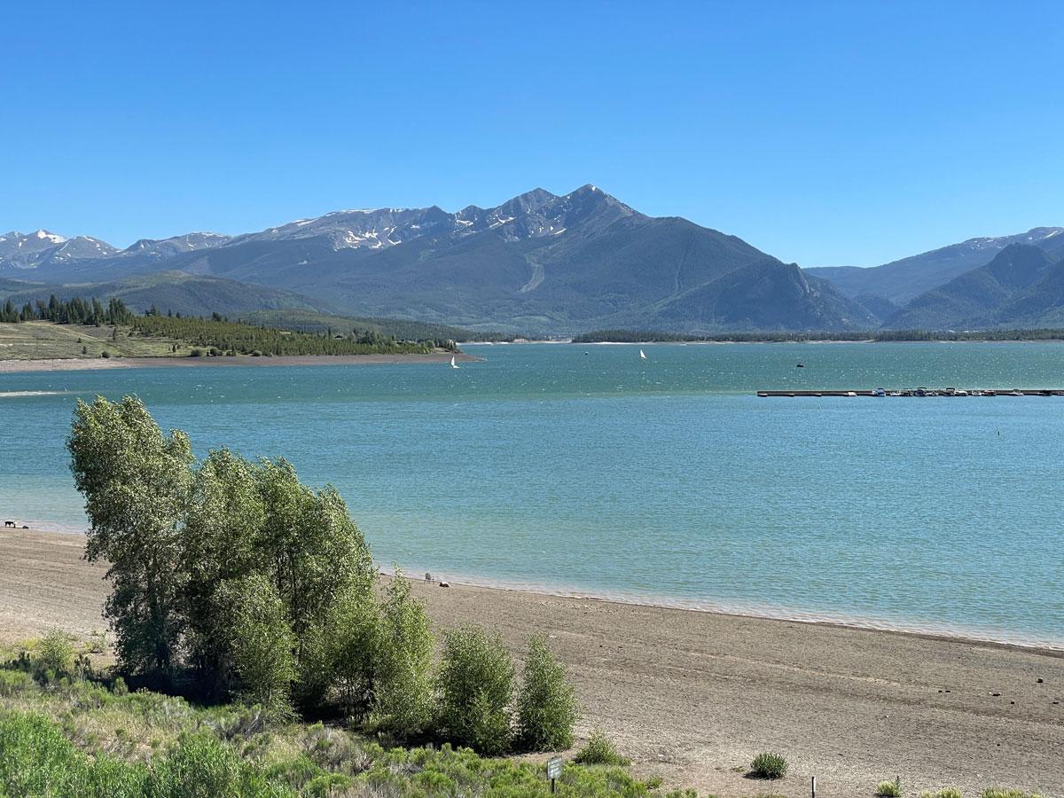
Dillon Reservoir reached 80% capacity on June 17, the highest elevation it is expected to see in 2026. Dillon is the largest reservoir in Denver Water’s collection system, storing roughly 38% of the utility’s water supply. Photo credit: Denver Water.

Click the link to read the article on the The Aspen Times website (Ryan Spencer). Here’s an excerpt:

June 21, 2026

Summer is off to a hot start in the Colorado mountains as soaring temperatures, a lack of precipitation and wind are worsening already severe drought conditions and exacerbating wildfire concerns. Across most of the mountain region, June has featured near-record temperatures and little — if any — precipitation, according to Colorado State Climatologist Russ Schumacher. One weather station in Dillon with 130 years of temperature data recorded the second-hottest first half of June ever, and just 1/100th of an inch of rain so far this month.

“On the one hand, June tends to be the driest month on the Western Slope before the monsoon season starts, but the average is not zero — we usually get some rain in June,” Schumacher said. “It’s been warm and dry up to this point in the month, and at least for the next several days to a week, it looks like that is going to continue.”

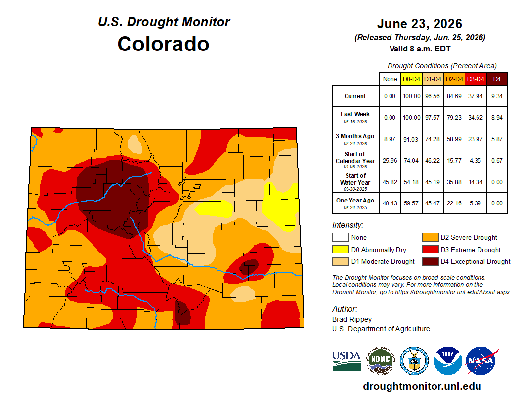
Colorado Drought Monitor map June 23, 2026.

Colorado is facing widespread and severe drought conditions after experiencing the worst snowpack on record this past winter. The winter was also the hottest in the state’s history, with a March heatwave that brought summerlike warmth to the mountains and rapidly melted the snowpack.

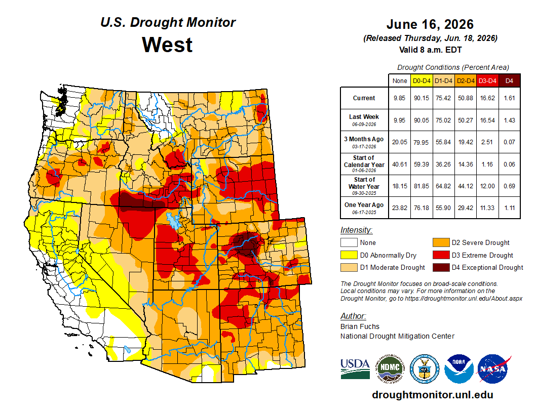
After the exceptionally hot and dry winter, May offered temperatures and precipitation levels that were closer to normal for most parts of the mountains. Some parts of northwestern Colorado saw above-average precipitation, offering a slight reduction in the drought conditions…Still, exceptional drought — the highest level — continues to impact vast swathes of Summit, Grand, Eagle, Pitkin, Garfield, Rio Blanco and Moffat counties, according to the U.S. Drought Monitor report published Thursday, June 18. Schumacher noted that the drought conditions on the Western Slope didn’t begin this past winter but carried over from last summer, when above-average temperatures and dry weather also dominated. He said the hot weather that Colorado has seen is a symptom of climate change and the amount of heat-trapping gases, like carbon dioxide, that humans have pumped into the atmosphere by burning fossil fuels.

What can humans learn from beavers when it comes to drought-proofing the landscape?: A collaborative working in Rocky Mountain National Park shares the ways its work in the Kawuneeche Valley could help in bad droughts like this year — #Vail Daily #ColoradoRiver #COriver #aridification

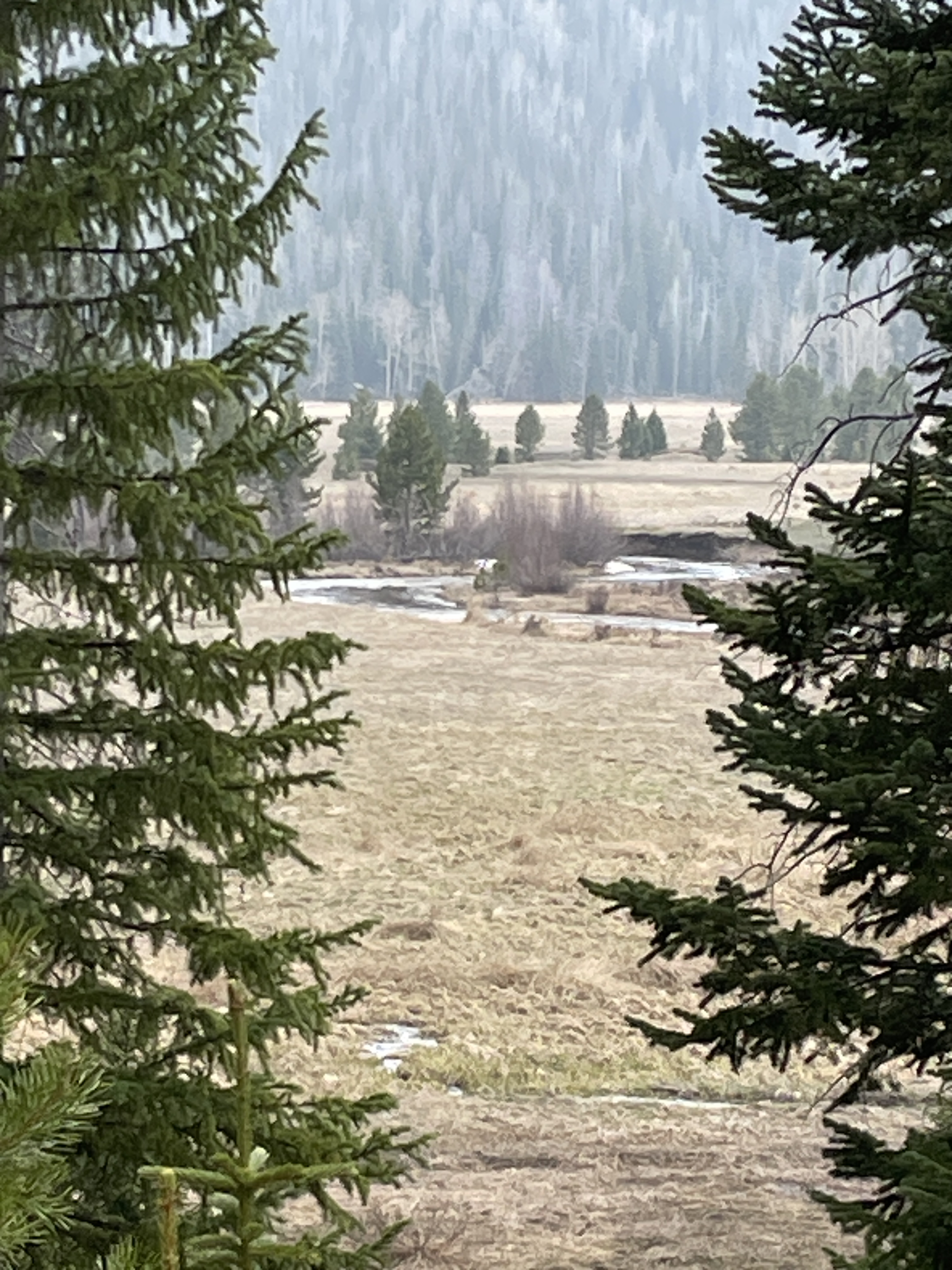
Colorado River Kawuneeche Valley May 19, 2023.

Click the link to read the article on the Vail Daily website (Ali Longwell). Here’s an excerpt:

June 19, 2026

“This valley was once a really significant wetland in Colorado … it was just this really thriving beaver-willow-wetland complex, and very biologically diverse,” said Kimberly Tekavec, the senior source water protection specialist for Northern Water. “And over the last 100 years or so — and really significantly in the last few decades — this valley has been severely disrupted, and we’re essentially witnessing, and have witnessed this ecosystem collapse.” 

The Kawuneeche Valley exists just downstream from the Colorado River headwaters in the Never Summer Mountain Range, following the river through Rocky Mountain National Park to Shadow Mountain Reservoir near Grand Lake. As Tekavec described, the valley was once home to dense stands of tall willows, hundreds of beavers and wetlands that stretched 8 miles long and half a mile wide…In an attempt to restore this landscape — and create a habitat beavers can, and will, return to — Northern Water, Rocky Mountain National Park, Colorado State University, Grand County, Rocky Mountain Conservancy, the town of Grand Lake and the Arapaho-Roosevelt National Forest and the Nature Conservancy came together and formed the Kawuneeche Valley Restoration Collaborative in 2020. To date, the collaborative has raised over $4 million to not only construct its first project, but plan for three additional sites in the national park…On June 2, representatives from Rocky Mountain National Park, Colorado State University and Northern Water gave state water experts and elected officials a tour of the collaborative’s first project site at Beaver Creek to share how they’re learning from nature and beavers to build resiliency amid the state’s critical drought conditions

“Here, with all these structures and resistating these processes that are beaver-dominated systems (the goal) is to slow the water down, let it linger on the landscape longer and rehydrate these wetlands and just create healthy habitats and functional wetlands that provide clean, reliable water sources to downstream users,” Shaw said…

The first thing you notice at the Beaver Creek project site is a tall fence extending around a 35-acre perimeter. It’s meant to prevent overgrazing by the park’s ungulate populations, particularly moose — which Chris Clatterbuck, the natural resources program manager at Rocky Mountain National Park, called “a perfectly designed willow-eating machine.”

“During the summer, they’ll eat over 90% of their diet in willow,” Clatterbuck said. “As a result, one moose is about the equivalent of 15 elk in terms of willow impact. They convert over 50 pounds of willow every day.”

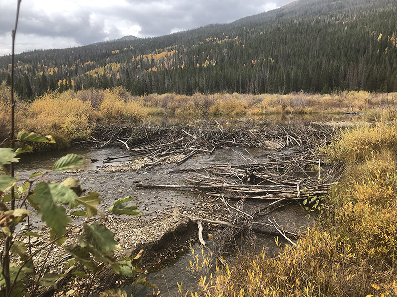
A beaver dam analog in Rocky Mountain National Park’s Kawuneeche Valley. Photo by Eric Brown, courtesy of Northern Water

One of the reasons that the tall willows transformed into “zombie willows” — ancient, heavily browsed willow structures that are surviving on long-held sugar stores — was overgrazing following Colorado’s reintroduction of moose starting in the late 1970s. Before 1978, there were no breeding populations of moose, and when they arrived without any natural predators — wolves or grizzlies — into a national park where hunting is banned, populations flourished and the willows declined, Clatterbuck said. Elk herds have also flourished and impacted the natural flora. Without tall willows, beavers lost the large wood they needed to build dams and lodges, and they lost their winter food supply, Shaw said. “So they left.” Within the fence, the collaborative has done a lot of work to reinvigorate the landscape near the stream. This includes the creation of almost 30 structures that mimic beavers. Before the collaborative’s work, Beaver Creek was a single tributary where one molecule of water would speed quickly to the Colorado River, Shaw said…It also spreads the water across the surface, rehydrating the wetlands and increasing groundwater storage, decreasing sediment flows downstream in the reservoir — all of which has numerous benefits, not only for drought mitigation, but wildfire risk as well…The Beaver Creek site is the first of four planned within the national park. The collaborative is set to begin work this fall on the second project down valley called Onahu Creek. Beyond that, Shaw said the goal is to look for similar projects outside of the park with private landowners in the valley.

American beaver, he was happily sitting back and munching on something. and munching, and munching. By Steve from washington, dc, usa – American Beaver, CC BY-SA 2.0, https://commons.wikimedia.org/w/index.php?curid=3963858

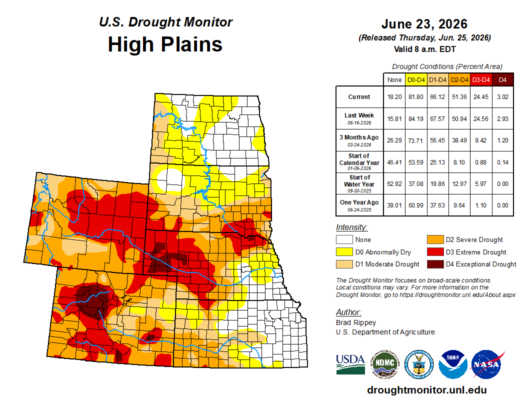
#Drought news June 25, 2026: More than one-half of the winter wheat crop was rated very poor to poor in #Nebraska (83%), #Colorado (63%), and #Kansas (55%).

Click on a thumbnail graphic to view a gallery of drought data from the US Drought Monitor website.

Click the link to go to the US Drought Monitor website. Here’s an excerpt:

This Week’s Drought Summary

Tropical Storm Arthur briefly formed near the middle Texas coast on June 17, hours before wobbling inland near Galveston. However, a precursor low-pressure system delivered heavy rain in parts of southern Texas, followed by a post-tropical deluge from the central Gulf Coast region into the lower Southeast. Totals of 4 to 8 inches or more were common across the Deep South, with higher amounts observed in several spots. Although flash flooding and lowland flooding occurred, overall impacts were muted by antecedent drought, which until recently had spanned the South. Farther north, a series of cold fronts sparked occasional showers and thunderstorms, resulting in localized wind and hail damage but maintaining favorable soil moisture reserves for most Midwestern summer crops. The Plains also received scattered showers, amid variable impacts related to lingering drought on rangeland, pastures, and summer crops. Meanwhile, the Plains’ winter wheat harvest quickly advanced between showers, as the drought-affected crop dried down ahead of the normal pace. In the western U.S., hot, mostly dry weather prevailed. Complications related to Western heat included heavy irrigation demands and a broadly elevated wildfire threat. One of the region’s most significant wildfires, the Iron Fire near Eureka, Utah, ignited on June 19 and quickly burned more than 37,000 acres of grass and chaparral…

High Plains

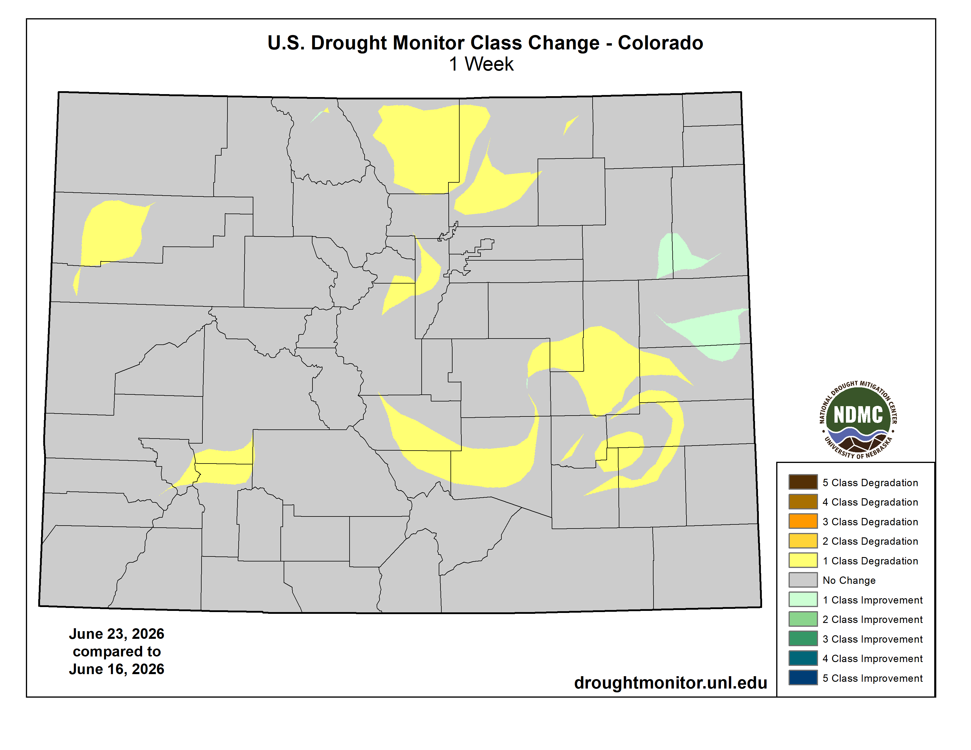
The region’s eastern states reported drought improvement or unchanged conditions, with a few exceptions. Streaks of heavy rain led to one-category improvement in a swath across central Nebraska and western and central Kansas. However, the rain arrived too late to help winter wheat and has only recently begun to revive drought-stricken rangeland and pastures. With the winter wheat harvest well underway (40% complete, nationally, on June 21), 46% of the crop was rated in very poor to poor condition. More than one-half of the crop was rated very poor to poor in Nebraska (83%), Colorado (63%), and Kansas (55%). On June 21, statewide rangeland and pastures were rated at least one-half very poor to poor in Nebraska (73%), Colorado (63%), and Wyoming (60%). In contrast to areas farther east, drought deterioration was observed in parts of Colorado and Wyoming…

Colorado Drought Monitor one week change map ending June 23, 2026.

West

Hot, dry weather boosted irrigation demands and resulted in a broadly elevated wildfire threat. Drought deterioration was commonly observed across roughly the northern half of the region, amid significantly above-normal temperatures and mounting water-supply concerns. However, water supplies are highly basin-dependent and often complicated by water rights and other local, state, or regional regulations. Some of the West’s most significant drought—with embedded pockets of extreme to exceptional drought (D3 to D4)—stretched from Oregon to Wyoming, southward into portions of the Four Corners States. By June 24, at least a half-dozen active Western wildfires had burned more than 10,000 acres of vegetation—three in Utah, two in Nevada, and one in Washington. Additionally, the U.S. Department of Agriculture reported on June 21 that statewide rangeland and pastures were rated 75% very poor to poor in Arizona, along with 63% in Colorado, and 60% in Wyoming…

South

Downpours related to frontal interactions with tropical moisture, including Tropical Storm Arthur, delivered drought relief but caused local flooding. In fact, the western and central Gulf Coast regions became mostly drought-free, following the latest deluge, with broad one-category improvement noted from eastern Texas into central and southern Alabama, as well as northern Arkansas and western Tennessee. By June 21, with periods of heavy rain still falling, statewide topsoil moisture in agricultural regions had increased to 35% surplus in Louisiana, according to the U.S. Department of Agriculture. The region’s most significant remaining drought existed across parts of Arkansas and environs, along with the northwestern half of Oklahoma…

Looking Ahead

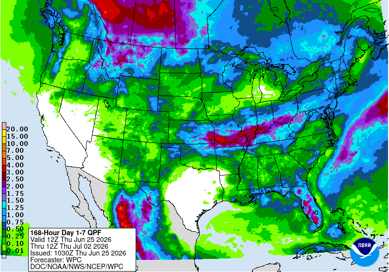
A cool pattern from the northern and central Plains into the Northeast will begin to break down during the weekend, as heat builds northeastward. During the next few days, triple-digit (100-degree) heat will be mostly limited to the southern High Plains and the Desert Southwest. Late in the weekend, however, temperatures could reach 100°F as far north as the upper Midwest and as far east as the Carolinas. Meanwhile, markedly cooler air will overspread the West. Increasingly showery weather will accompany the Western cool spell, particularly from the Pacific Northwest to the northern Rockies, although dry weather will continue in much of California and the Desert Southwest. Unsettled weather will also prevail east of the Rockies, except for hot, dry conditions in the western Gulf Coast region. Five-day rainfall totals could reach 2 to 4 inches or more from the central Plains into the Ohio Valley, and 1 to 2 inches in parts of Montana and North Dakota.

The NWS 6- to 10-day outlook for June 30 – July 4 calls for the likelihood of below-normal temperatures in much of the West, while hotter-than-normal weather will prevail from the Plains to the Atlantic Coast. Meanwhile, near- or above-normal rainfall across much of the country should contrast with drier-than-normal conditions in a few areas, including the Great Basin and portions of the Southeast and Intermountain West.

US Drought Monitor one week change map ending June 23, 2026.

Reclamation: June 2026 Most Probable 24-Month Study #ColoradoRiver #COriver #aridification

ten tribes
Graphic via Holly McClelland/High Country News.

Click the link to read the study (and check out the operating plans for the Colorado River system reservoirs) on the Bureau of Reclamation website:

June 15, 2026

The operation of Lake Powell and Lake Mead in the June 2026 24-Month Study is pursuant to the December 2007 Record of Decision on Colorado River Interim Guidelines for Lower Basin Shortages and the Coordinated Operations of Lake Powell and Lake Mead (Interim Guidelines),1 the Supplemental Environmental Impact Statement for Near-term Colorado River Operations Record of Decision (2024 Interim Guidelines SEIS ROD),2 and reflects the 2026 Annual Operating Plan (AOP). Pursuant to the Interim Guidelines, the August 2025 24-Month Study projections of the January 1, 2026, system storage and reservoir water surface elevations set the operational tier for the coordinated operation of Lake Powell and Lake Mead during 2026.

The August 2025 24-Month Study projected the January 1, 2026, Lake Powell elevation to be less than 3,575 feet and at or above 3,525 feet and the Lake Mead elevation to be at or above 1,025 feet. Consistent with Section 6.C.1 of the Interim Guidelines, and Section 6.E of the 2024 Interim Guidelines SEIS ROD, the operational tier for Lake Powell in water year (WY) 2026 is the Mid-Elevation Release Tier and the water year release volume from Lake Powell was originally projected to be 7.48 million acre-feet (maf). Further, given the hydrologic variability of the Colorado River System and potential for declining reservoir conditions, Section 6.E of the 2024 Interim Guidelines SEIS ROD allows for Lake Powell’s release in WY 2026 to be less than 7.48 maf. Consistent with Section 6.E of the 2024 Interim Guidelines SEIS ROD, Reclamation will consider all tools that are available during the interim period to avoid Lake Powell elevation declining below 3,500 feet.

To protect a target elevation at Lake Powell of 3,525 feet, adjustments to Glen Canyon Dam monthly volume releases for the months of December 2025 through April 2026 were implemented in the December 2025 24-Month Study, reducing the release volume for these months by 0.598 maf. As historically dry conditions persisted in WY 2026 and reservoir conditions were projected to decline below 3,500 feet at Lake Powell, the Department of the Interior implemented an action under Section 6.E of the 2024 Interim Guidelines SEIS ROD by reducing Lake Powell’s annual release from 7.48 maf to 6.00 maf in WY 2026.3 This action was taken in conjunction with the 2026 Drought Response Operations Plan which will release between approximately 660,000 acre-feet to 1.00 maf of additional water from Flaming Gorge reservoir to Lake Powell by April 2027.4 The May 2026 Most Probable 24-Month Study reflects a 1.00 maf Drought Response Operations release.

The August 2025 24-Month Study projected the January 1, 2026, Lake Mead elevation to be below 1,075 feet and above 1,050 feet. Consistent with Section 2.D.1 of the Interim Guidelines, a Shortage Condition consistent with Section 2.D.1.a will govern the operation of Lake Mead for calendar year (CY) 2026. In addition, Section III.B of Exhibit 1 to the Lower Basin Drought Contingency Plan (DCP) Agreement will also govern the operation of Lake Mead for CY 2026. Lower Basin projections for Lake Mead take into consideration additional conservation efforts under the DCP and the Lower Colorado River Basin Conservation and Efficiency Program (LC Conservation Program).

Current runoff projections into Lake Powell are provided by the National Weather Service’s Colorado Basin River Forecast Center. The observed unregulated inflow into Lake Powell for the month of May was 0.383 maf or 18% of the 30-year average from 1991 to 2020. The June 2026 unregulated inflow forecast for Lake Powell is 0.170 maf or 7% of the 30-year average. The 2026 April through July unregulated inflow forecast for Lake Powell is 0.950 maf or 15% of average. The WY 2026 unregulated inflow forecast for Lake Powell is 3.40 maf or 35% of average.

In this study, the CY 2026 diversion for Metropolitan Water District of Southern California (MWD) is projected to be 0.941 maf. The CY 2026 diversion for the Central Arizona Project (CAP) is projected to be 0.924 maf. Consumptive use for Nevada above Hoover (SNWP Use) is projected to be 0.188 maf for CY 2026.

Due to changing Lake Mead elevations, Hoover’s generator capacity is adjusted based on estimated effective capacity and plant availability. The estimated effective capacity is based on projected Lake Mead elevations. Unit capacity tests will be performed as the lake elevation changes. This study reflects these changes in the projections.

For questions on Upper Colorado River Basin (UCB) reservoir operations, please contact Alex Pivarnik, the UCB River Operations Group Supervisor, at apivarnik@usbr.gov. For questions on Lower Colorado River Basin (LCB) reservoir operations, please contact Noe Santos, the LCB River Operations Manager, at nsantos@usbr.gov.

Hoover, Davis, and Parker Dam historical gross energy figures come from Power, Operations, and Maintenance reports provided by the Lower Colorado Region’s Power Office, Bureau of Reclamation, Boulder City, Nevada. Questions regarding these historical energy numbers can be directed to Rebecca Rogers (rrogers@usbr.gov) or Kyra Cubi (kcubi@usbr.gov).


1 For modeling purposes, simulated years beyond 2026 assume a continuation of the 2007 Interim Guidelines including the 2024 Supplement to the 2007 Interim Guidelines (no additional SEIS conservation is assumed to occur after 2026), the 2019 Colorado River Basin Drought Contingency Plans, and Minute 323 including the Binational Water Scarcity Contingency Plan. With the exception of certain provisions related to Intentionally Created Surplus recovery and Upper Basin demand management, operations under these agreements are in effect through 2026. Reclamation initiated the process to develop operations for post-2026 in June 2023, and the modeling assumptions described here are subject to change.

2 The 2024 Interim Guidelines SEIS ROD is available online at: https://www.usbr.gov/ColoradoRiverBasin/documents/NearTermColoradoRiverOperations/20240507-Near-termColoradoRiverOperations-SEIS-RecordofDecision-signed_508.pdf.

3 For more information please visit: https://www.usbr.gov/newsroom/news-release/5326.

4 For more information please visit: https://www.usbr.gov/ColoradoRiverBasin/dcp/droa.


The 2026 Annual Operating Plan is available online at: https://www.usbr.gov/lc/region/g4000/aop/AOP26.pdf.

The Interim Guidelines are available online at: https://www.usbr.gov/lc/region/programs/strategies/RecordofDecision.pdf.

The Colorado River Drought Contingency Plans are available online at: https://www.usbr.gov/ColoradoRiverBasin/dcp/finaldocs.html.

The Upper Basin Hydrology Summary is available online at: https://www.usbr.gov/uc/water/crsp/studies/24Month_06_ucb.pdf.

Information on the LCB Conservation Program is available online at: https://www.usbr.gov/lc/LCBConservation.html.

Information on the 2024 Interim Guidelines SEIS ROD is available online at: https://www.usbr.gov/ColoradoRiverBasin/interimguidelines/seis/index.html.

Information on reservoir inflow observations and forecasts is available online at: https://www.cbrfc.noaa.gov/product/hydrofcst/hydrofcst.php.

#ColoradoRiver system continues slide toward crash, despite emergency actions sending water to #LakePowell: Federal officials study changes to Glen Canyon Dam for low-water use scenarios — The #Denver Post

Click the link to read the article on The Denver Post website (Elise Schmelzer). Here’s an excerpt:

June 21, 2026

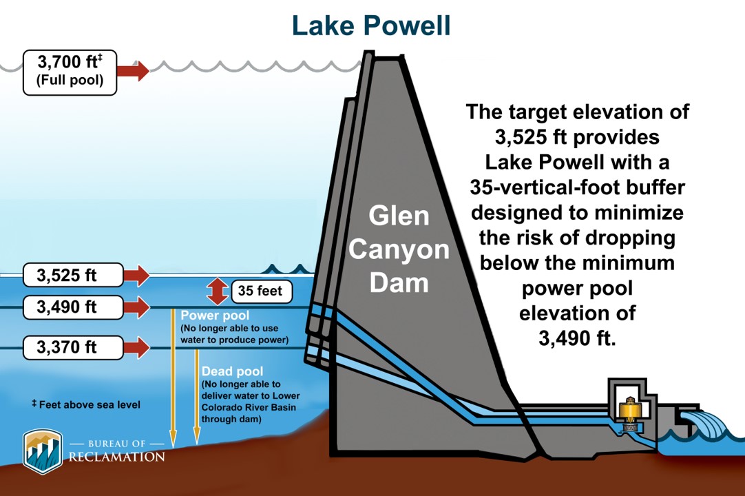
The two major reservoirs on the Colorado River face dire outlooks that will likely spur federal officials to restrict the amount of water flowing downstream — and decrease hydropower generation — in the coming months, even after they ordered recent emergency measures. Projections released last week by the U.S. Bureau of Reclamation show that if dry conditions persist, Lake Powell’s water level could dip below a threshold called “minimum power pool” as soon as February. That’s the level below which water can no longer flow through the reservoir’s hydropower turbines. Without intervention, the projections say, the lake will remain below the critical elevation for the foreseeable future.

Lake Powell key elevations. Credit: Reclamation

The threat of Powell hitting that threshold — 3,490 feet in elevation — has hovered above federal water managers for months as the reservoir has continued to drop to record-low levels. In April, U.S. Bureau of Reclamation leaders announced that they would send up to 1 million acre-feet of water from the upstream Flaming Gorge Reservoir to Powell and reduce the amount of water released from Powell to keep the reservoir’s level at 3,500 feet above sea level — which includes a small buffer Reclamation officials want to maintain to stay above the power pool level. Powell’s water levels continue to drop as Colorado River leaders deal with two crises: one climatological and one political. Long-term drought fueled by climate change has shrunk the Colorado River’s flows as federal officials and water leaders in the seven basin states — including Colorado, home to its headwaters — struggle to agree on longer-term plans for the river’s management. So far, they’ve failed to find agreement on how to divvy up the usage cuts necessary to adapt to lower flows that reduce the water supply for farmers and residents in a region that’s home to 40 million people.

The back of Glen Canyon Dam circa 1964, not long after the reservoir had begun filling up. Here the water level is above dead pool, meaning water can be released via the river outlets, but it is below minimum power pool, so water cannot yet enter the penstocks to generate electricity. Bureau of Reclamation photo. Annotations: Jonathan P. Thompson

When Lake Powell’s levels fall below minimum power pool, that means water can no longer flow through the intake tubes for Glen Canyon Dam‘s hydropower facility, which is the primary method for moving water downstream from the reservoir in southern Utah. Instead, water can move only through much smaller bypass tubes that, for years, have been considered unsafe for long-term use — though Reclamation officials now say they can be operated safely with continuous maintenance. The bureau’s most recent projections, released Tuesday, show that the emergency measures taken this spring will only be a stopgap, unless extremely wet weather returns…If Lake Powell falls below minimum power pool, the only way to release water downstream is through four 8-foot-diameter tubes called the river outlet works. For years, Bureau of Reclamation officials have said the tubes were not designed for long-term use at low water levels, and such use could cause structural damage to the dam. But officials now say there’s a way to safely use the river outlet works, if needed…Recent studies of the river outlet works have shown that managers can operate the backup tubes continuously in a safe way, said Katrina Grantz, the deputy regional director for Reclamation’s Upper Colorado Region, at a conference in Boulder earlier this month. But the outlets require frequent inspections and maintenance when used continuously, which means that one of the four conduits will routinely be offline. Over the course of a year, the maintenance rotation will result in an effective capacity of about three and a half outlets operating continuously, bureau spokesman Peter Soeth wrote in an email in response to follow-up questions from The Denver Post.

“The river outlet works were never designed to serve as the primary or long‑term release pathway,” Soeth said. “Relying on them continuously would reduce operational flexibility and, over extended periods, could introduce wear that requires more intensive maintenance.”

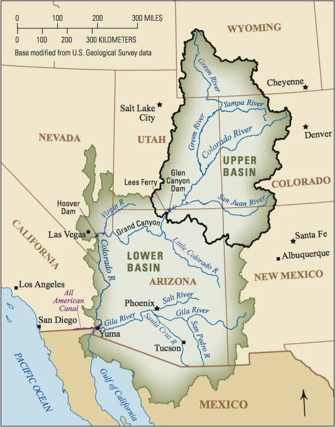
Colorado River Basin. Credit: USGS

Emergency Reservoir Releases to Protect West Slope Communities from Extreme #Drought Impacts — #ColoradoRiver District #COriver #aridification

Wolford Mountain Reservoir, on Muddy Creek in Grand County, is managed by the River District. CREDIT: HEATHER SACKETT/ASPEN JOURNALISM

Click the link to read the releas on the Colorado River District website (Lindsay DeFrates):

On Saturday, June 6, the Colorado River District, in partnership with the Colorado Water Conservation Board, began to release water from Wolford Reservoir as part of a collaborative effort to protect hundreds of water users who depend on the Colorado River from being curtailed due to exceptional drought conditions.

Extremely low snowpack and a warm winter, along with extreme heat in March, prevented the full storage of a critical water supply known as the Historic Users Pool (HUP) which is held in Green Mountain Reservoir (GMR), just north of Silverthorne. Without the protection provided by this supply, hundreds of entities, including towns, HOA’s, and local water districts could have faced curtailment in early June.

The success of this initiative depended on the cooperation of Grand Valley water users, who agreed to temporarily reduce the senior Cameo demand below its full legal limit so these protections could be implemented for other Colorado River water users. By voluntarily curtailing a portion of their own irrigation use, these districts helped keep upstream users whole and delayed a senior call on the river that would have otherwise required the curtailment of HUP beneficiaries.

“Irrigation entities across the Grand Valley chose to reduce water use early in the summer to help build the storage we rely on that was sorely lacking (almost non-existent) due to the warm and dry winter conditions that left us with very little snowpack,” said Roblee Talbott, president of the Orchard Mesa Irrigation District Board of Directors. “What we gained in storage will help carry us further into the season than originally anticipated. Beyond that, we’ve committed to work together to ensure we can finish crops later in the season. While this decision represents some very real risks for the family farms and ranches that sustain our local economy and food supply, it also reflects the strong spirit of collaboration in our Grand Valley agricultural irrigation community.”

“This year has reminded us how connected Western Slope communities truly are,” said Siri Roman, General Manager of the Eagle River Water and Sanitation District. “We are grateful to the Grand Valley water users who voluntarily reduced irrigation to help support upstream communities during these challenging conditions. As drought impacts become more prevalent, we all have a responsibility to use water wisely and support the long-term health of our communities, agriculture, and rivers. In the Eagle River Valley, we are actively working to reduce our outdoor water use and encouraging our customers to make lasting landscaping changes that will decrease water demand for years to come.”

“Having access to this program has been extremely important for our community in western Grand County, and we are grateful for the willingness of the Colorado River District and their partners to work with us,” said Brenda Kellen, board member for the Blue Valley Metropolitan District. “Without this support, we would have struggled to have access to adequate water supplies for our residents this summer. We recognize the challenges involved in managing and protecting water resources, and we appreciate the cooperation and partnership with CRWCD and water users from Grand County to Grand Junction.”

West Drought Monitor map June 16, 2026.

“The drought conditions affecting Colorado this year are creating immense challenges across the state,” said Lauren Ris, Director of the Colorado Water Conservation Board. “The CWCB was pleased to support this effort that demonstrates how partners can work together to develop creative, collaborative solutions that help address immediate drought impacts while providing multiple benefits for water users and the environment. As conditions continue to evolve, we remain committed to working with communities throughout Colorado to explore innovative approaches that strengthen drought resilience and help meet critical water needs.”

“Our duty is to help protect West Slope water users during exceptionally difficult conditions like the ones they are facing this year, and we have been navigating a complex and rapidly changing situation to determine how a limited supply of water can do the most good for the most people,” said Colorado River District General Manager Andy Mueller. “These releases are designed to help a broad array of water users, but they are not a substitute for ongoing conservation. We expect that beneficiaries will do their part by reducing demand where possible, including cutting outdoor domestic watering to one day per week.”

At its April 2026 meeting, the Colorado River District Board of Directors approved $450,000 from the Community Funding Partnership program for use in emergency drought response efforts. The Colorado Water Conservation Board also committed just over $585,000 to the effort at its May meeting in recognition that the releases will be multi-beneficial, supporting in-stream flow benefits, along with municipal, domestic, and irrigation needs. These funds will support the release of over 15,000 acre-feet of water currently stored in Wolford and Ruedi Reservoirs to protect both municipal and agricultural users along the Colorado River and its major tributaries from Grand County to the Grand Valley. These releases will also support in-stream flow needs providing fishery benefits that mitigate high water temperatures and the loss of aquatic habitat due to critically dry conditions.

As of June 17, the HUP was a little more than half full with approximately 40,800 acre-feet of water stored.

The initial release from Wolford Reservoir, which began on June 6, is currently around 9 cfs, and is intended to specifically protect the indoor water uses in Summit, Grand and Eagle counties. Between now and next spring, approximately 3,000 acre-feet of water is available for this purpose from both Wolford and Ruedi Reservoirs.

An additional 12,000-acre-feet of water will also be made available for irrigation and agricultural production in the Grand Valley throughout the summer until supplies run out.

The Colorado River District appreciates the support of the leadership and staff of the Division 5 engineer’s office in the implementation of this effort, as well as the work of the Colorado Water Conservation Board staff and directors to expedite funding, a temporary loan for instream flow use, and emergency substitute water supply plan approval.

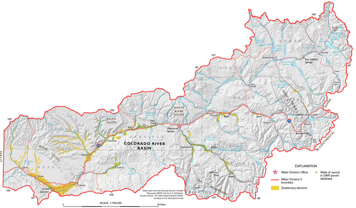
Colorado River Basin in Colorado via the Colorado Geological Survey

Will #ElNiño ride to the #ColoradoRiver’s rescue?: Maybe, but don’t count on it. But have you heard the latest on the Pacific Decadal Oscillation? Not good! — Allen Best (BigPivots.com) #COriver #aridification #ENSO

Click the link to read the article on the Big Pivots website (Allen Best):

June 23, 2026

Twenty years ago, some might have hoped that drought in the Colorado River Basin would diminish or disappear altogether.

Hope remains but of a distinctly diminished variety. Will the arriving El Niño will bring a rare deluge, bringing the water levels of Lake Powell from the brink of deadpool, too low to release water downstream?

Two books have been written in the last few years with “deadpool” in their titles, indicating how close to the edge we have been. If not for a very big snow year in 2022-2023, we might well have been there in 2023. Now, we’re in the same place or worse.

It’s very possible that Lake Powell will have too little water by September to generate electricity. That is called minimum power pool. Deadpool lies just a few steps below.

Unlike 20 years ago, nobody seems to harbor delusions that this problem will be solved by a turn of nature. As for the El Niño, it may help but Brad Udall advised against too much hope hedging.

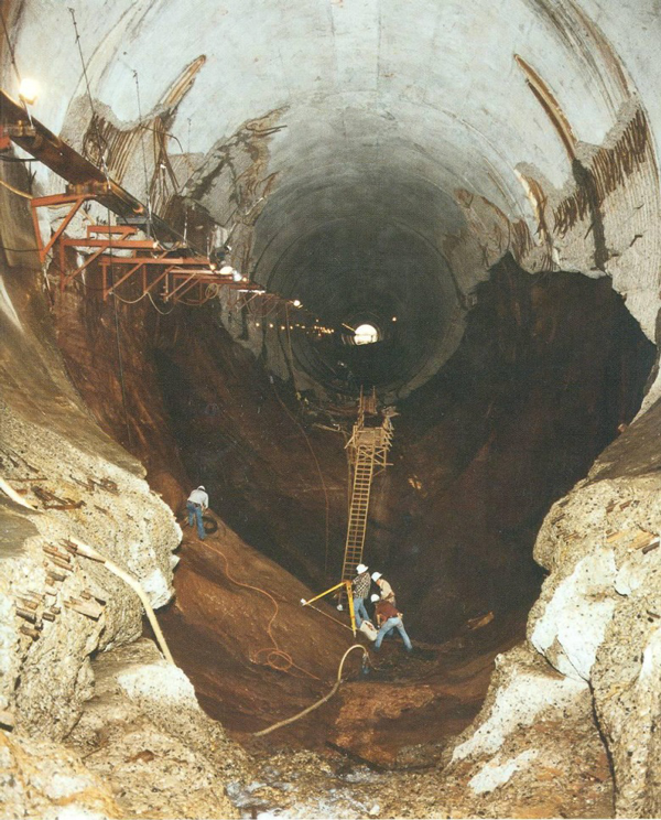
Cavitation at the Glen Canyon Dam, the cause of the emergency in 1983 via Flow Science.

Speaking at the Colorado River conference at the University of Colorado Law School in early June, Udall explained that El Niño increased the odds of large impacts as it did in 1983. That year Glen Canyon Dam almost broke with the runoff of 24 million acre-feet. Another big year was 1997 with 19 million acre-feet. And then produced 13.4 million in 2016. Those exceptional years aside, El Niño can be sort of a bust, said Udall, a scientist and scholar affiliated with Colorado State University.

The evidence continues to strengthen that the warming climate — a climate caused by growing greenhouse gas emissions — will continue to rob the river of water. And, as in the past few decades, the warm temperatures will filch water at larger and large volumes.

Udall had been tasked with summarizing what the 2026 water year that ends in September could be in the context of long-term trends and short-term impacts.

NOAA’s Colorado River Basin Forecast Center had predicted 13% of average runoff flows, just 800,000 acre-feet, compared to the more average 6 million. “It’s below even 2002, which was the lowest year on record, just about a million,” said Udall.

Members of the Colorado River Commission, in Santa Fe in 1922, after signing the Colorado River Compact. From left, W. S. Norviel (Arizona), Delph E. Carpenter (Colorado), Herbert Hoover (Secretary of Commerce and Chairman of Commission), R. E. Caldwell (Utah), Clarence C. Stetson (Executive Secretary of Commission), Stephen B. Davis, Jr. (New Mexico), Frank C. Emerson (Wyoming), W. F. McClure (California), and James G. Scrugham (Nevada)
CREDIT: COLORADO STATE UNIVERSITY WATER RESOURCES ARCHIVE via Aspen Journalism

As is now widely understood, those who met in Santa Fe in November 1922 to create a framework for sharing the Colorado River had assumed river flows from the upper basin states would be plentiful, 17.5 to 18 million acre-feet. They erred grievously on the side of optimism. The 20thcentury average was 15.2 million acre-feet, and this century bent downward even more. Since 2019, the average has been 10.2 million acre-feet.

Udall/Overpeck 4-panel Figure Colorado River temperature/precipitation/natural flows with trend. Lake Mead and Lake Powell storage. Updated through Water Year 2025. Note the tiny points on the annual data so that you can flyspeck the individual years. Credit: Brad Udall

Realizing how on-target climate change models have been both comforting and chilling, consider a chapter by the late John Opie, the author of several books about the Ogallala Aquifer. In his concluding chapter in a book published in 1998 called “Sense of he American West,” he mentioned predictions that global temperatures would rise1.5 degrees C by 2030. So far, we’re at 1.2 to 1.35 degrees C.

In the American Southwest, we’re heating more rapidly, about 3.5 degrees C per century, according to a paper issued by the Rhodium Group.

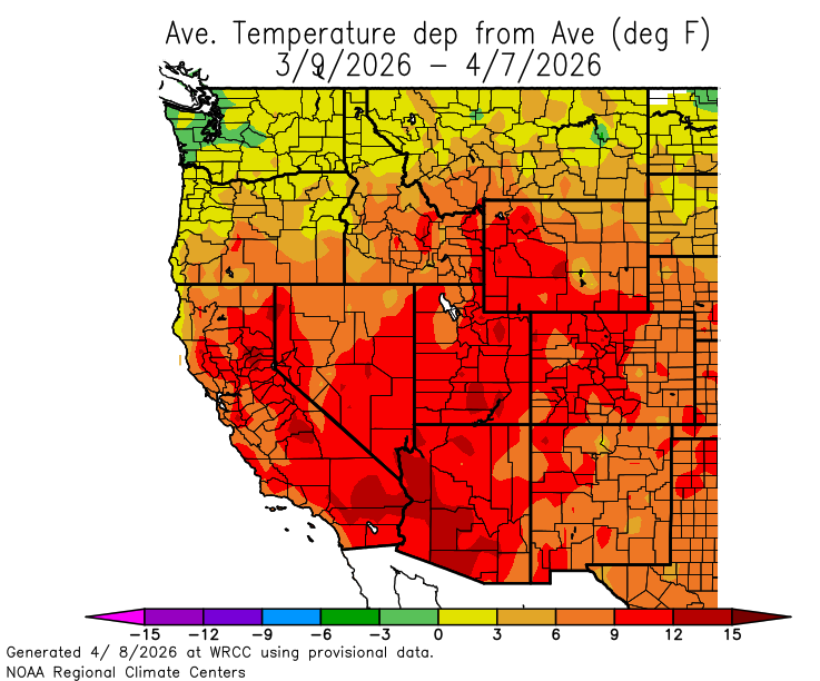
We had a sharp taste of that in March. Temperatures across the Colorado River Basin that month averaged 9 degrees F above the 20th century average. In Colorado, Fort Collins had a new record for the first day above 90 degrees in records going back to 1895. This year that first 90-degree day arrived in March. This year’s first skipped over April. The previous earliest was in May.

What will increased heat mean in terms of precipitation? The short answer is that it increases evaporation and transpiration. So, of the snow or rain that falls, less of it emerges as water in downstream reservoirs or, for that matter, in transmountain diversions.

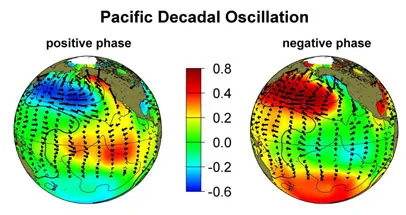
Taking a more global perspective, Udall pointed to a natural phenomenon that became apparent to scientists only in 1997, called the Pacific Decadal Oscillation. It alters jet streams and storm tracks in the American West. Like El Niño and La Nina, it has different phases. The negative phase of the Pacific Decadal Oscillator pushes storm tracks north, meaning drier conditions in the Colorado River Basin.

Now it seems stuck, according to a paper issued by scientists in 2025. The scientists claim this trend is largely driven by human emissions of aerosols. They cooled the planet, but as we cease their emissions, the effect is to warm the planet. The takeaway from that paper is as long as greenhouse gas emission trends continue, the Pacific Decadal Oscillation will remain stuck, producing drought in the Southwestern states.

Another recent paper examined the North Pacific Ocean and the response to changes in the atmosphere during the last 6,000 years. The takeaway is that the models had under-appreciated the effect of warming, which causes 20% precipitation reductions.

“And I’ll note a 20% decline in precipitation is probably like a 50% decline in river flow,” said Udall.

In other words, 90% of the heat caused by the thickening concentration of greenhouse gases in the atmosphere goes into the ocean, and scientists are still piecing together how that heat in the ocean then affects the climate for the Colorado River Basin.

Even if we reduced our greenhouse gas emissions immediately, the heat will remain for hundreds and then thousands of years.

Think we might see a return to even the 15.2 million acre-feet of the 20th century at Lee Ferry? Forget about it. We might get lucky with an El Niño, but then again, said Udall, the evidence doesn’t support much optimism. The more grounded hope is that the meager snowfall and extraordinary warmth of the last year does not come with an echo this coming winter.

Map of the Colorado River drainage basin, created using USGS data. By Shannon1 Creative Commons Attribution-Share Alike 4.0

Rafting community seeing some impacts from the low river flows this season — The #Grand Junction Daily Sentinel

Click the link to read the article on The Grand Junction Daily Sentinel website (Julia Wildman). Here’s an excerpt:

June 22, 2026

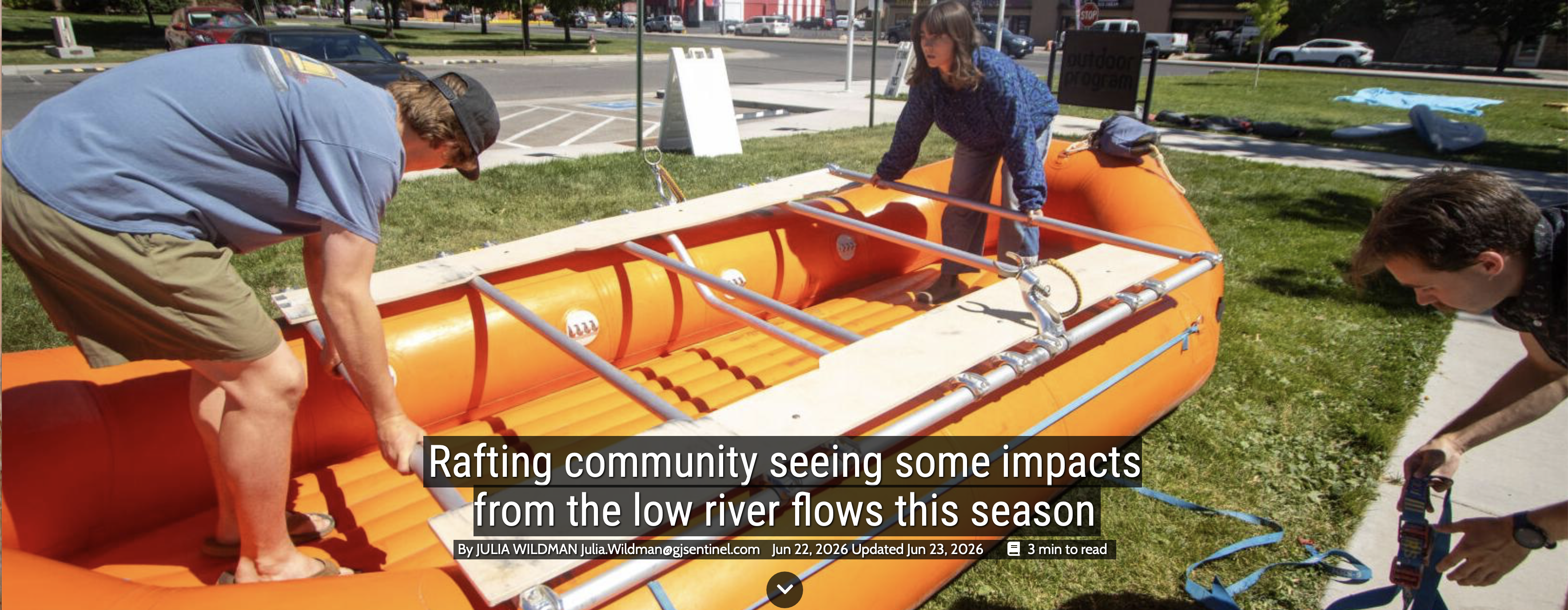
Normally, there are world-class rapids just an hour away down Westwater Canyon or approachable overnight fun just up-river in Ruby Horsethief Canyon. One of the most accessible sections of the Colorado River runs right through the heart of Grand Junction. However, low water levels could mean smaller crafts and shorter trips…At a gathering of local water organization leaders back in May, the attendees characterized the conditions as “bleak.” They identified an earlier snowpack peak in March at around 8.9 inches of snow water equivalent (SWE). That is less than half of the state’s median, which peaks in April at 16 inches of SWE…According to the United States Geological Survey (USGS), the cfs of the Colorado River near the Colorado-Utah state line peaked at around 25,000 cfs on June 10, 2024. In 2025, it peaked on June 4 at 12,000 cfs. This year, it peaked on May 19 at 4,280 cfs.