#Drought news June 18, 2026: The impacts of a dry winter and below-normal #snowpack continue to affect #Colorado and other parts of the region, where increasing numbers of waterways are experiencing low-flow conditions

Click on a thumbnail graphic to view a gallery of drought data from the US Drought Monitor website.
Click the link to go to the US Drought Monitor website. Here’s an excerpt:

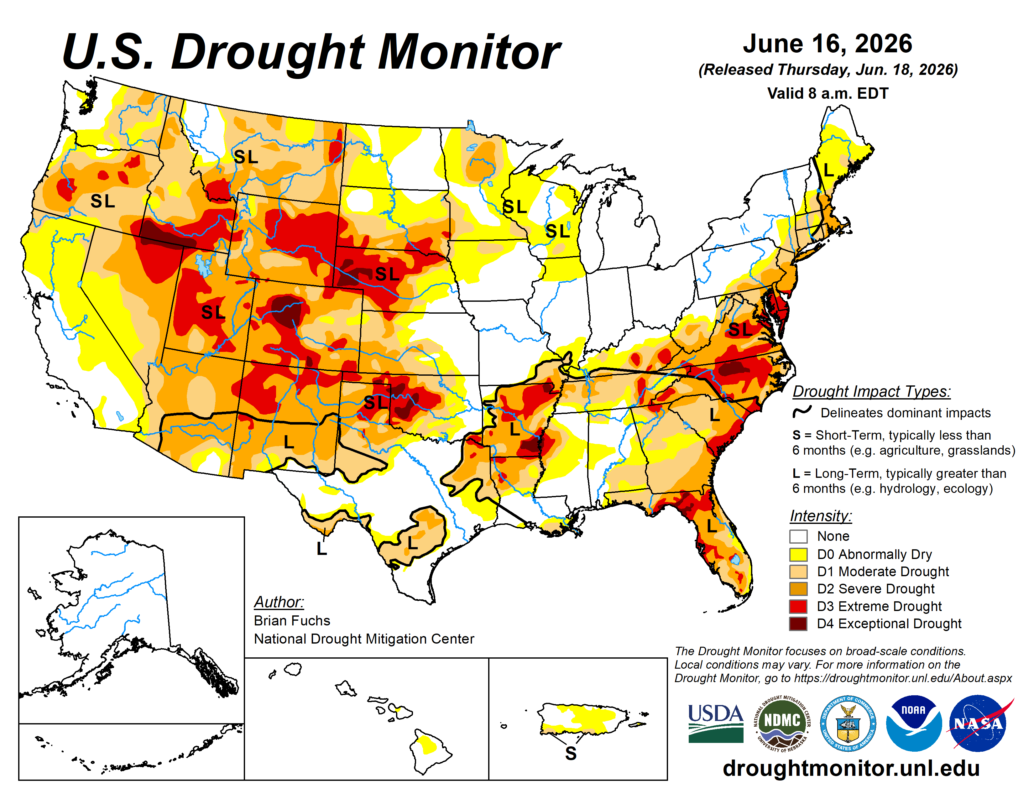
This Week’s Drought Summary

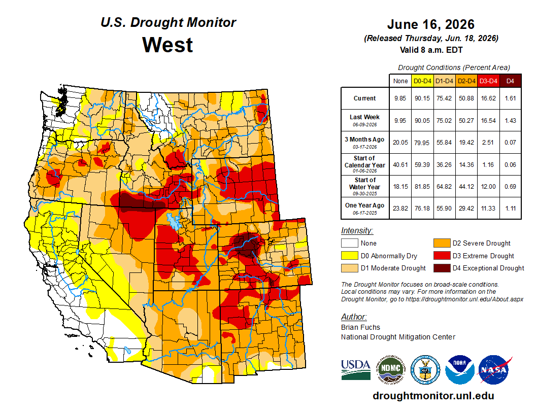
The heaviest precipitation this week occurred across the Midwest and southern Plains. Flooding rains developed from south Texas into the Gulf Coast region during and beyond the period considered in this week’s analysis. Portions of Illinois and Indiana recorded precipitation totals 4–5 inches above normal. Over the past several weeks, persistent rainfall across the Midwest and central to southern Plains has contributed to widespread drought improvement.

Temperatures were near to above normal across much of the country. The coolest conditions were observed from the central Plains into the northern Rocky Mountains, where portions of Montana and Wyoming averaged 4–6 degrees below normal. In contrast, the East Coast—particularly New England—as well as much of California and southern Nevada, experienced above-normal temperatures. Parts of New England recorded departures of 8–10 degrees above normal…

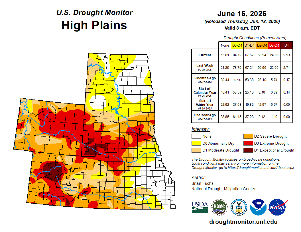
High Plains

Across the High Plains states, drought continues to persist across western Kansas and eastern Colorado. The most severe and exceptional drought areas extend from eastern Wyoming into western and northern Nebraska and far southern South Dakota. Continued lack of rainfall and warmer-than-normal temperatures led to worsening drought conditions in the plains of eastern Colorado and small portions of northwestern Kansas. Exceptional drought was expanded across three counties in the Nebraska panhandle, where pastures and dryland wheat conditions are the poorest seen in decades, as a result of the record warm, dry winter followed by meager spring rainfall. The agricultural impacts in western Nebraska were confirmed by drought indicators spanning the last 6-12 months.

Other areas of degradation occurred this past week over North Dakota, especially the western half of the state. Moderate drought expanded southward along the Montana border as dry conditions intensified in western North Dakota. Abnormal dryness was introduced from southwest to north-central North Dakota due to recent drier-than-normal conditions.

The only improvements in the High Plains region are in central and eastern Nebraska. A couple swaths of 2-4 inches of rain fell this past week along the Interstate 80 corridor and into the southeastern part of Nebraska, which is presently free of any drought or abnormal dryness…
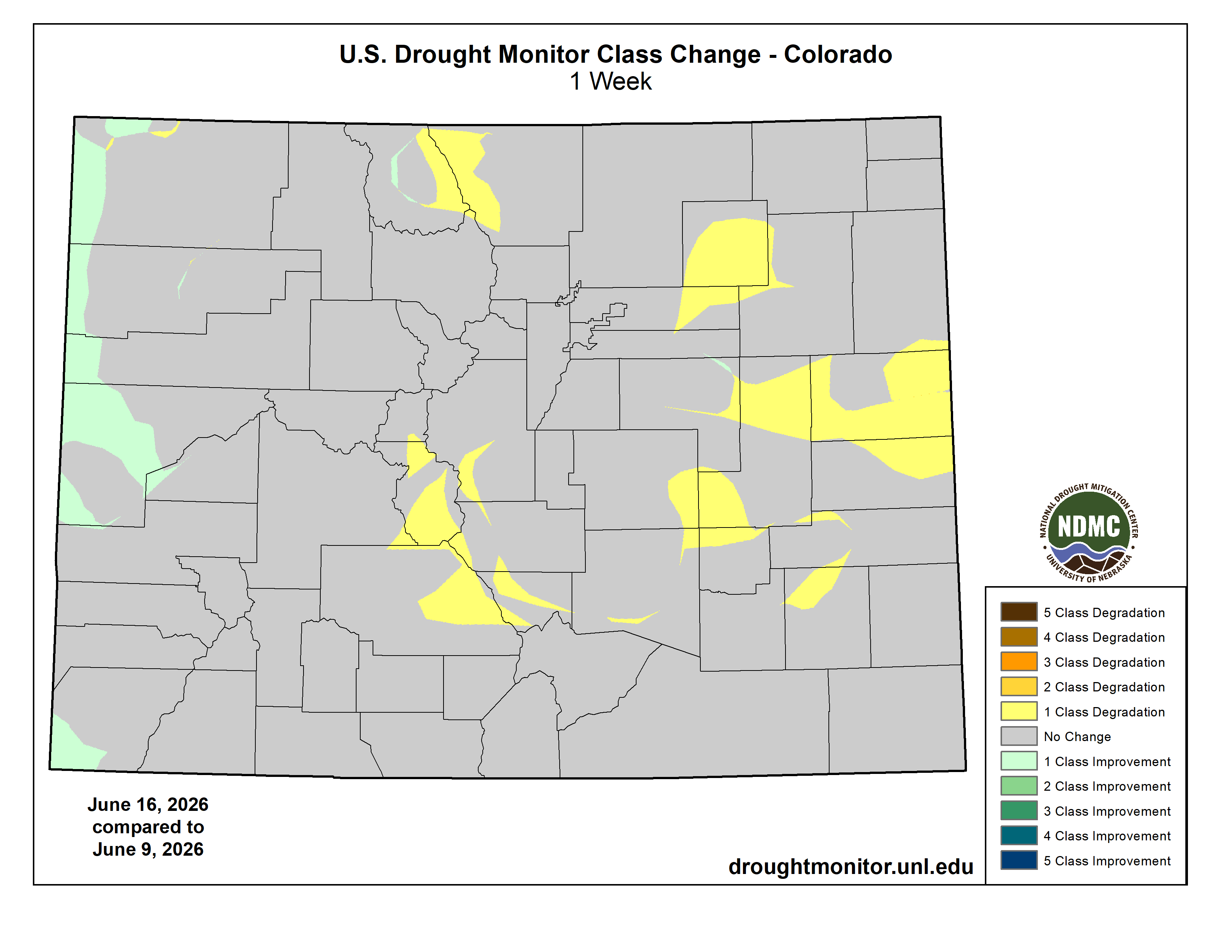
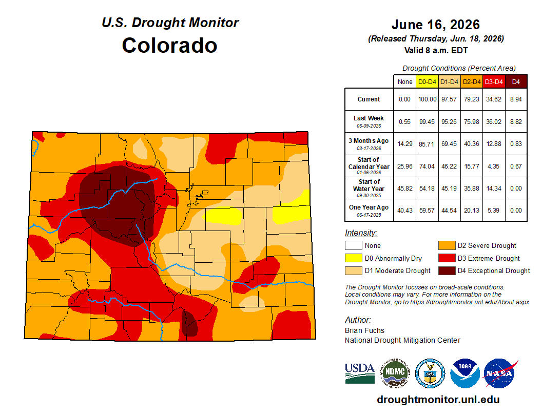
Colorado Drought Monitor one week change map ending June 16, 2026.

West

There was not widespread precipitation across the region this week. However, portions of western Oregon and Washington, Arizona, northern Idaho, New Mexico, southern Montana, southern Utah, and northern Wyoming recorded above-normal precipitation.

Temperatures were mixed, with below-normal readings across northern portions of the region and above-normal temperatures farther south. The warmest conditions occurred in California, Nevada, and Arizona, where departures of 6–8 degrees above normal or greater were widespread.

Drought degradation occurred across eastern Oregon, where moderate drought expanded. Moderate, severe, and extreme drought also expanded across much of southern Idaho and into western Montana, while extreme drought increased in coverage across central Wyoming.

Several weeks of wetter-than-normal conditions in New Mexico allowed for improvements to extreme drought across northeastern and southern portions of the state, although slight expansion occurred in northern areas. Improved short-term moisture conditions in eastern Utah and western Colorado supported reductions in extreme drought, while degradation occurred across central and eastern Colorado.

Screenshot of the USGS Water Watch website June 18, 2026.

The impacts of a dry winter and below-normal snowpack continue to affect Colorado and other parts of the region, where increasing numbers of waterways are experiencing low-flow conditions…

South

Across the southern states, many areas experienced widespread and substantial rainfall of 2–6 inches over the past week, especially southern and eastern Texas, eastern Oklahoma, northern Arkansas, northern Mississippi, and western Tennessee. Most areas of the deep southern states experienced drought improvement from all this rainfall. The only exception is in northeastern Tennessee, where drought degradations were made to the northwest of Knoxville due to worsening drought indicators.

The northeastern portion of the Texas Panhandle saw 2–4 inches rainfall over an area of exceptional drought, helping to relieve drought conditions with a small downgrade to extreme drought there. However, for the most part, extreme to exceptional drought conditions persisted across the Texas and Oklahoma panhandles, and much of western Oklahoma. Despite weekly rainfall of 2 inches or more along the periphery of Arkansas, severe to exceptional drought continued to persist in much of the state due to the long-term rainfall deficits of the past several months.

The recent appreciable rainfall over eastern Oklahoma, combined with more heavy rains this past week, led to a large removal of abnormal dryness from Texas to southwestern Missouri. Widespread heavy rainfall of 2–6 inches or more led to more drought coverage and intensity reduction across southern and eastern Texas, central Louisiana, and parts of western Mississippi. Drought relief also extended into western and northwestern Tennessee, representing the eastern extent of this week’s large area of heavy rainfall in the South…
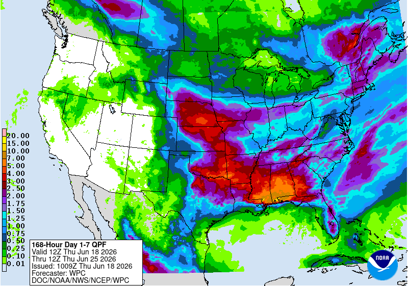
Looking Ahead

During the next 5–7 days, more heavy rainfall is expected in the Deep South, as a result of a Tropical Storm Arthur near the southeastern Texas coast as of this writing. Deep tropical moisture will stream northeastward from Arthur as it advances into the Southeastern states. This tropical rainfall will have the potential to produce more drought relief in southeastern Louisiana, Alabama, Georgia, and Tennessee. Current rainfall forecasts by the Weather Prediction Center also show the potential for several inches of rain from Oklahoma, Missouri, and Arkansas, eastward into the Ohio River Valley, with more severe weather potential in the Midwest region. Other areas of appreciable rainfall are forecast for parts of the Northeast and the eastern portions of the High Plains.

The Climate Prediction Center’s 6–10 day outlook shows that above-normal temperatures should prevail across much of the western U.S. and along the immediate Gulf coast into Florida. Below-normal temperatures are possible from the eastern portions of the High Plains, the Midwest, and into the Northeast states. Meanwhile, precipitation is projected to be above normal across much of the Midwest and High Plains, possibly extending into the Northeast states. Near-normal rainfall is anticipated across the South and Southeast in the 6-10 day outlook, with below-normal precipitation expected in most of the West.
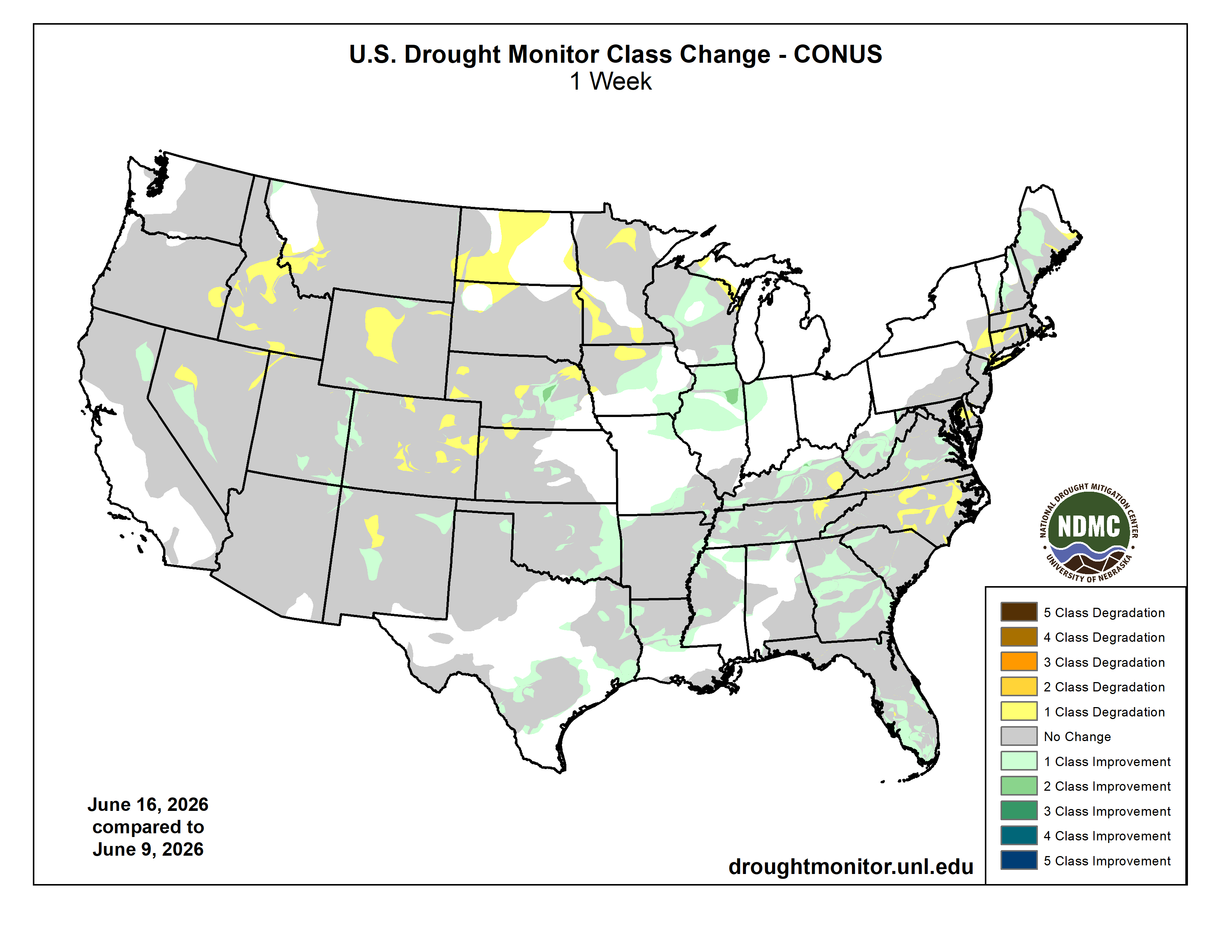
US Drought Monitor one week change map ending June 16, 2026.

‘It’s devastating’: Drawdown at #FlamingGorge hits local recreation economy; Emergency drought-induced draw to save downstream #LakePowell wreaks havoc on #Wyoming-#Utah’s lucrative Flaming Gorge — Dustin Bleizeffer and  Hannah Romero (WyoFile.org) #GreenRiver #ColoradoRiver #COriver #aridification

Anglers flock to Flaming Gorge Reservoir on Memorial Day weekend. Kokanee salmon and trophy-sized lake trout draw tens of thousands of visitors to the reservoir each year, supporting a recreational economy in southwestern Wyoming and northeastern Utah. (Hannah Romero/Green River Star)

Click the link to read the article on the WyoFile website (Dustin Bleizeffer and  Hannah Romero):

June 4, 2026

As campers with boats flocked to Buckboard Marina at the start of Memorial Day weekend, Tony Valdez was busy issuing refunds and repairing broken boat ramps. One older Green River man, who walked with two canes, left with his money refunded for the season after discovering he could not safely make it down to the boat slip. Due to dropping water levels at Flaming Gorge Reservoir, the ramp is now buckled, angling up and down like a pitched roof. 

“It’s devastating, not just to me, it’s all the marina owners,” said Valdez, who owns Buckboard Marina, south of Green River. “It’s a big loss, and this is a big loss to the community.” 

Along the cliffs and shoreline, darker and lighter lines of rock and sand trace the water’s elevations, showing where the water hits when the marina is full, where it hovered this spring and where it dropped after an initial “flush.” Valdez estimates the reservoir has dropped by 7 feet since April. 

But that’s not the worst of it. Valdez anticipates that by the end of this summer, the reservoir will be as low as it’s ever been. 

Why the drain?

For all its charm as a beloved recreation spot and its utility as a local economic driver, Flaming Gorge Reservoir owes its existence to a legal compact that essentially regards it as an insurance policy in times of drought.

Its primary purpose, according to federal officials and Colorado River Compact scholars, is to serve as a backup water bank to help maintain the Colorado River system. Specifically, Flaming Gorge and a handful of other reservoirs in the upper Colorado River Basin states of Wyoming, Colorado, Utah and New Mexico are key to ensuring a minimum flow of 7.5 million acre-feet of water, on a running 10-year average, at Lees Ferry just downstream of Lake Powell, a massive man-made reservoir straddling the Utah-Arizona border.

Today, after more than 20 years of drought intensified by human-caused climate change, the Colorado River is in crisis, putting at risk massive agricultural irrigation operations that consume about 80% of its water. This past winter saw historically low snowpack in the Upper Colorado River Basin — a primary source for the river’s flow. 

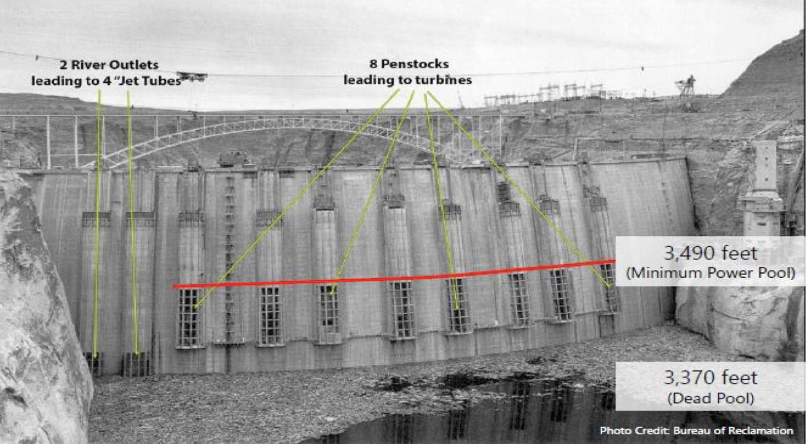
This annotated 1963 photo of the Glen Canyon Dam shows the minimum level of Lake Powell, below which would render the dam’s power generation components inoperable. (Bureau of Reclamation)

Combined with record heat in March, Lake Powell is at risk of dropping below Glen Canyon Dam’s “minimum power pool,” the point at which it can no longer produce hydroelectric power, according to water officials. If it falls even lower, the dam, which holds back Lake Powell, could be at risk of structural damage or unable to allow water to flow downstream.

The situation triggered a drought response operations agreement that calls for restricting releases from Lake Powell and an order to draw extra water from Flaming Gorge upstream. In total, water managers will release about 1 million additional acre-feet of water from Flaming Gorge in April 2026 through April 2027. 

“These actions are expected to lower [Flaming Gorge’s] elevation by roughly 35 feet over the next year to approximately 59% of capacity,” the bureau said in April.

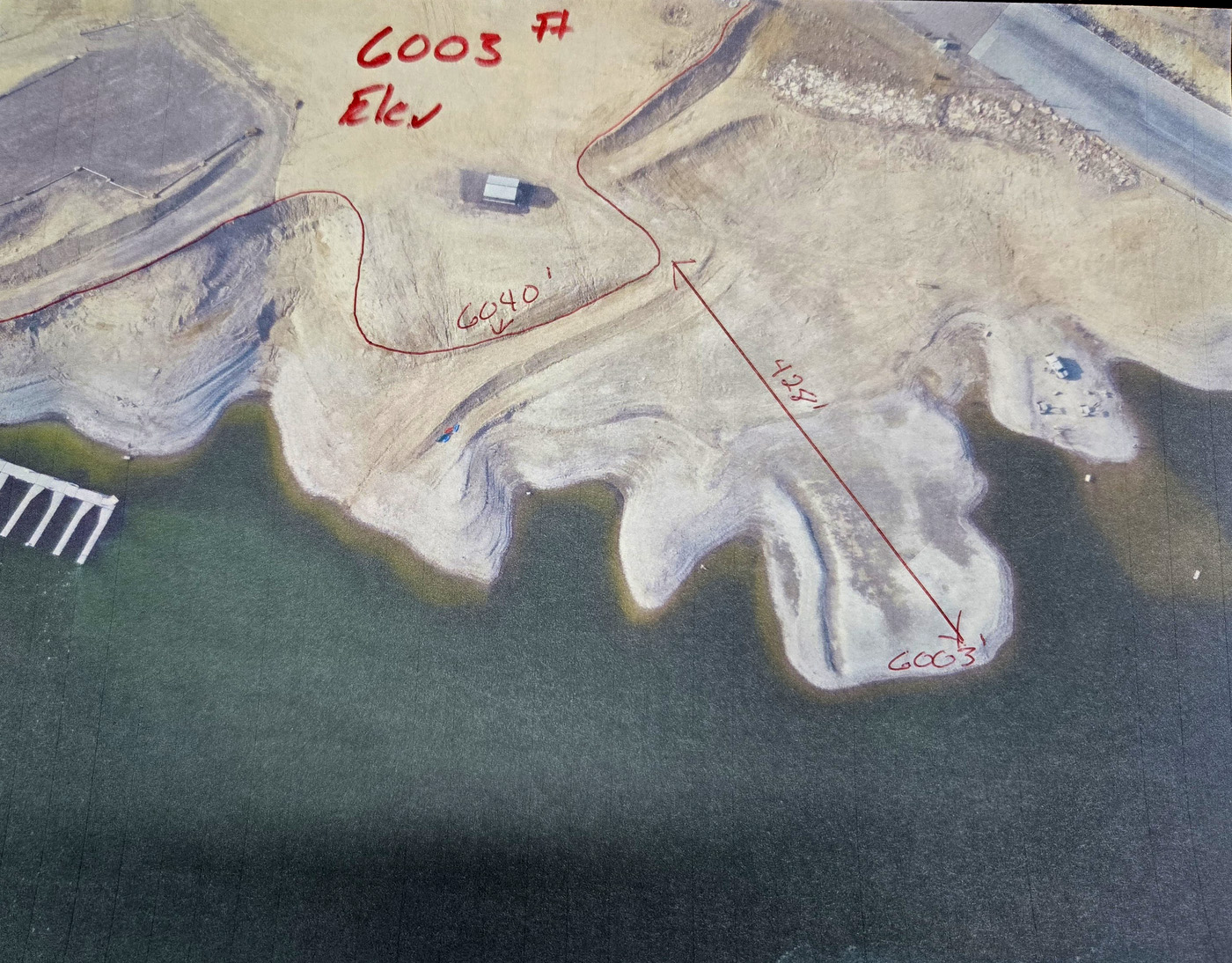
“The elevations are real critical,” Valdez said. At Buckboard Marina, high water has hovered between 6,030 and 6,040 feet above sea level over the past 50 years, he said. Dropping 35 feet could expose 400 feet of shoreline in some places, including marinas with boat ramps, he said. 

Dropping water levels in the Flaming Gorge Reservoir by 35 feet could expose over 400 feet of shoreline in some places, including marinas with boat ramps, according to Buckboard Marina owner Tony Valdez. (Hannah Romero/Green River Star)

If the water elevation continues to retreat, it could reach a point where boats can’t be brought in or out.

“By September, this thing is going to be down to 6,000 feet. That’s it,” Valdez said. “Next year, if it goes below that, there’s no more marina here.”

Setting a course 

Water managers set a course in April to “stabilize” Flaming Gorge’s outflow to about 1,100 cubic feet per second, representing the rate needed to achieve the 1 million acre-feet of extra water release, according to the bureau. On top of that, there are two previously planned “flushes” from the Gorge. The first, in early May, temporarily increased the outflow to about 8,600 cubic feet per second to enhance the proliferation of razorback sucker larvae, and a second 72-hour flush beginning June 8 will temporarily increase the outflow to about 4,600 cubic feet per second to discourage the proliferation of smallmouth bass.

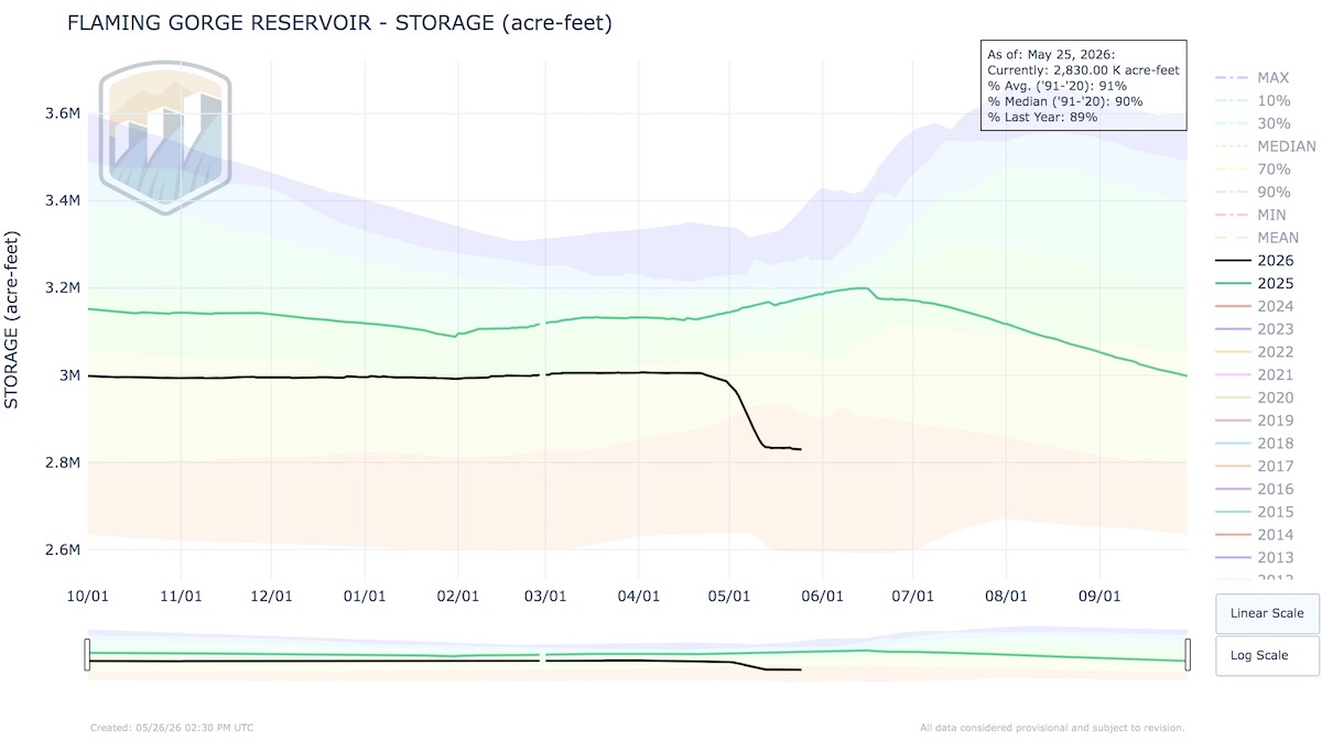
So far, Flaming Gorge has dropped from about 3 million acre-feet in April (or 82% capacity) to about 2.83 million acre-feet as of May 25. Meanwhile, water managers warn, “This release plan is subject to change depending on evolving river conditions and weather forecasts.”

Click to enlarge: This chart depicts water storage levels at Flaming Gorge Reservoir. (Bureau of Reclamation)

Those evolving conditions include forecasted versus actual flows from streams feeding the system. For example, those “unregulated” or natural flows are forecasted to be much lower than normal: 70,000 acre-feet of water into Flaming Gorge during May (28% of average), 175,000 acre-feet in June (45% of average) and 84,000 acre-feet (42%), according to the Bureau of Reclamation.

Water officials caution that water flowing from the Flaming Gorge Dam could change, and that those recreating on the Green River below should monitor release schedules at this website. The bureau also noted, “Water will be colder than usual and will run high and swift during periods of elevated releases.”

Water floats recreation economy

Buckboard Marina went through a similar drop in water a few years ago. The Bureau of Reclamation began pulling water from the Flaming Gorge in 2021, and by 2022, the marina’s water level was at an all-time low. While the reservoir recovered somewhat in 2023 thanks to a good year for moisture, Valdez said, the reservoir has continued to decline since then. 

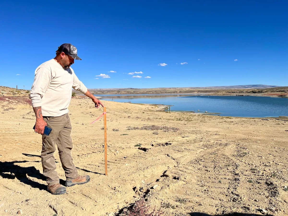
Buckboard Marina owner Tony Valdez stands next to a stake that indicates the extent of lowering water levels at Flaming Gorge Reservoir Sept. 26, 2022. (Dustin Bleizeffer/WyoFile)

Kokanee salmon and trophy-sized lake trout draw tens of thousands of visitors to Flaming Gorge each year, supporting a recreational economy in southwestern Wyoming and northeastern Utah. But as the lake is drawn down, water recedes from shallow shorelines and fish are forced into a smaller space, essentially shrinking the fishery toward the dam side of the reservoir. 

One of Valdez’s primary concerns is that water levels could drop below the ideal elevation for kokanee to spawn in the reservoir. 

“I think people don’t realize the economic value it brings,” he said. “It is a big deal when you lose your kokanees.”

Already, kokanee are struggling to thrive in the reservoir. 

Drinking water dries up

Valdez has already lost money this year just from people being concerned about water levels. He estimated that the marina lost roughly $30,000 in cancellations when discussions about releasing water began as early as February.

Other problems also start to arise as the water drops. The marina will lose access to drinking water at 6,010 feet, below their floating pump that supplies potable water. It’s only 7 feet away from the current level.

“That’s scary to me,” Valdez said.

The marina can truck in water from Rock Springs, but it costs about $1,200 to bring in 8,000 gallons, which lasts about two weeks. For Valdez, it feels “asinine” to lose water at a marina.

“Why would we run out of water on a lake?” 

Water levels also impact the location of the fuel dock and fuel lines extending to it. If the reservoir sinks too low, it could cost up to $100,000 to adapt, he said. 

Drawing down water levels quickly — as happened in early May — can damage marina structures. After the 2021-22 drawdown, Valdez said he spent about $130,000 in repairs. 

Buckboard Marina owner Tony Valdez shows a boat ramp that now angles up steeply before dropping down after the reservoir’s water levels dropped several feet. (Hannah Romero/Green River Star)

This time, he’d hoped to keep up. He and a group of 10 men worked to keep pace with the dropping water levels, repairing and modifying ramps. It wasn’t enough.

“The drop was dramatic enough to break all of our approaches, our bridges, our stuff, so it broke a lot of the welds, broke a lot of the structured steel, because it just vertically dropped too fast for the weight,” he said. 

When structures go from water to land that quickly, the weight is too much for them to hold up, Valdez said. 

“I’m re-rigging everything, and this is only a temporary fix ’til September, because that’s when the season ends.”

The marina should remain mostly functional until the summer season ends, he said. But with extra water releases set to continue through the winter, the lake could drop another 10 to 12 feet by the spring. 

“We’re getting into numbers that I don’t even want to talk about,” Valdez said. “I mean, there’s no marina.”

What’s next?

“The guy with the boots on the ground that watches this every day,” as Valdez describes himself, can see what water managers can’t, and he questions whether official numbers and estimates match reality.

“It’s hard to watch this when it’s out of your hands.”

Valdez is critical of the 1922 compact, doubting the legal rationale of sending Wyoming water to places like Arizona. He also wonders about the role of local industries — refineries, coal-fired power plants and trona mines — that use large amounts of water, and the idea of adding more industrial facilities that require even more water, like data centers. 

“We don’t have the water to give away,” Valdez said.

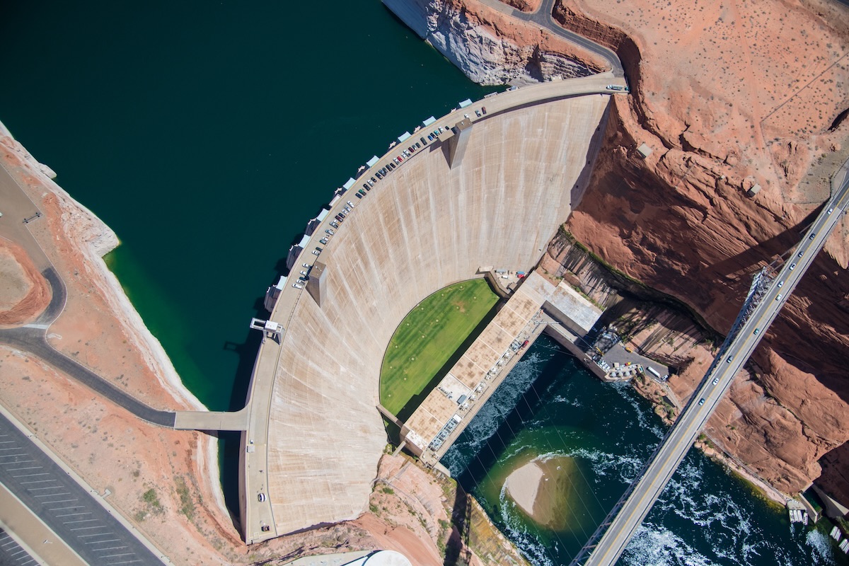
Aerial photo of the Glen Canyon Dam near Page, Arizona. Photo by Alexander Heilner/The Water Desk, with aerial support by LightHawk.

Bryan Seppie, general manager for the Joint Powers Water Board for Sweetwater County, Rock Springs and Green River, agrees. “The poor hydrology this past winter has affected most all water users in some form or another,” he said.

His board monitors the Colorado River system closely. Just upstream from Flaming Gorge, the Bureau of Reclamation reduced releases from Fontenelle Reservoir due to poor inflow projections. Although the water will still be enough for river users, the low summer flows will have a negative impact. 

“Low river flows typically result in higher water temperatures, which generally leads to higher levels of moss/algae and overall lower water quality,” Seppie said in an email.

What about recovery? 

Valdez wonders: What’s the plan to allow the reservoir to bounce back?

Wyoming State Engineer Brandon Gebhart and his staff have warned for months that although Flaming Gorge can serve as a backup to Lake Powell this year, it drains the Gorge’s ability to play a similar role next year, or the year after. It takes time for Mother Nature to replenish the bank.

“The big thing that nobody is talking about is the recovery,” Valdez said. “Where is the recovery of our water?”

This year’s drain on Flaming Gorge began at a low point. The reservoir hadn’t fully recovered after the last major pull. Rather than starting at a high point of 6,040 feet, the marina was at about 6,024 feet, he said. 

“There’s no recovery plan,” he said. “We can’t just let them keep taking. I mean, where’s this end?” 

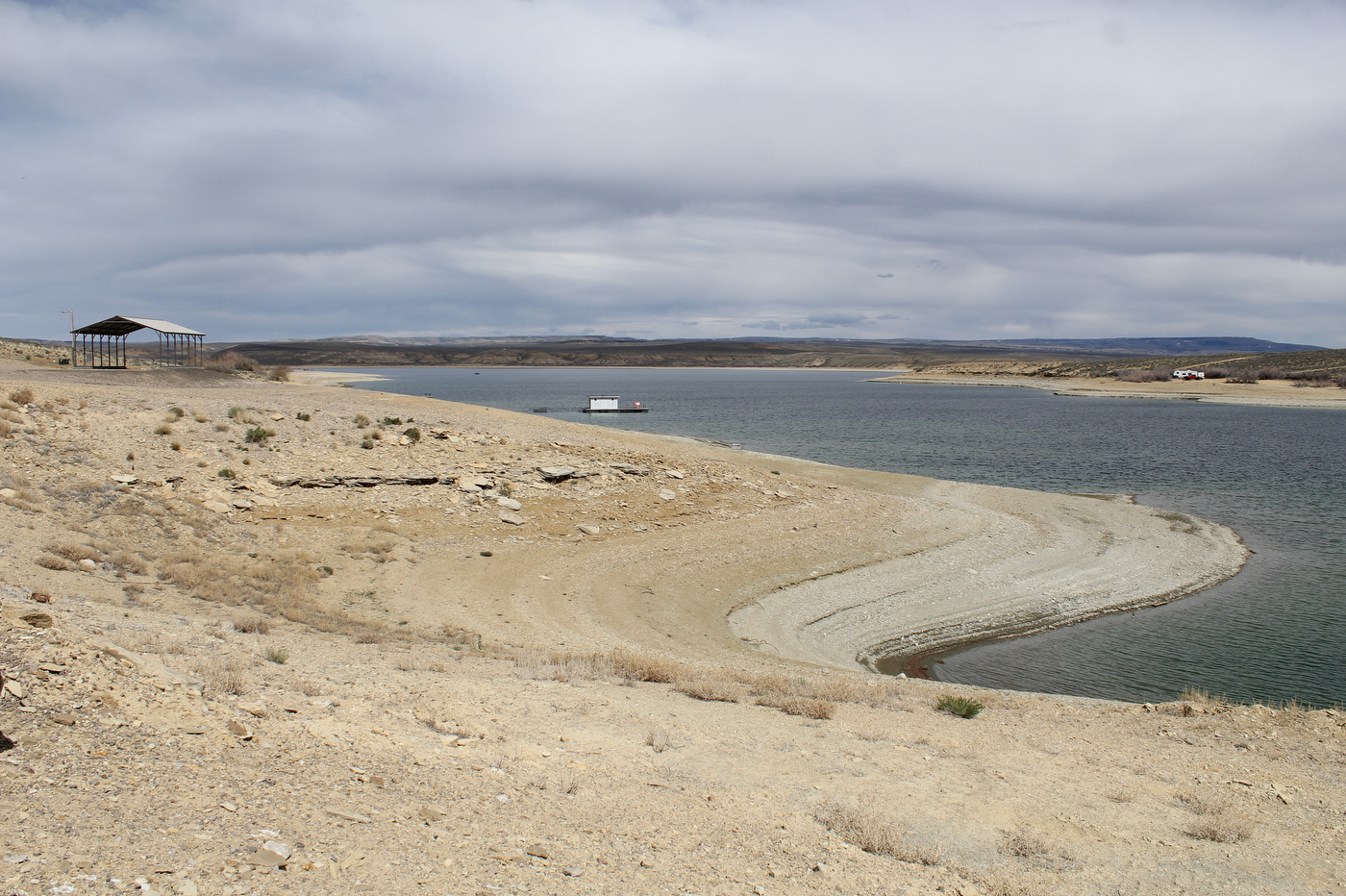
Rings line the shore of Flaming Gorge Reservoir, showing the drop in the water level at the popular recreation spot that spans the Wyoming-Utah border. (Hannah Romero/Green River Star)

If there is no grace period for the reservoir to replenish and officials want to take even more in the near future, starting from such a low elevation point, it will be “devastating,” Valdez said. 

“The water going down is not the end of the world, it’s the recovery in a timely manner that really matters,” he said. “I can’t preach recovery enough.” 

Watching people come to the marina and seeing how happy they are still motivates Valdez to keep going. Despite the drawdown, there’s nowhere else he’d rather be. 

“We’re not going to run away. We’re not going to give up,” he said. “We’re going to fight.”

ten tribes
Graphic via Holly McClelland/High Country News.

Happy wedding anniversary Mrs. Gulch: Old Friends shine like diamonds

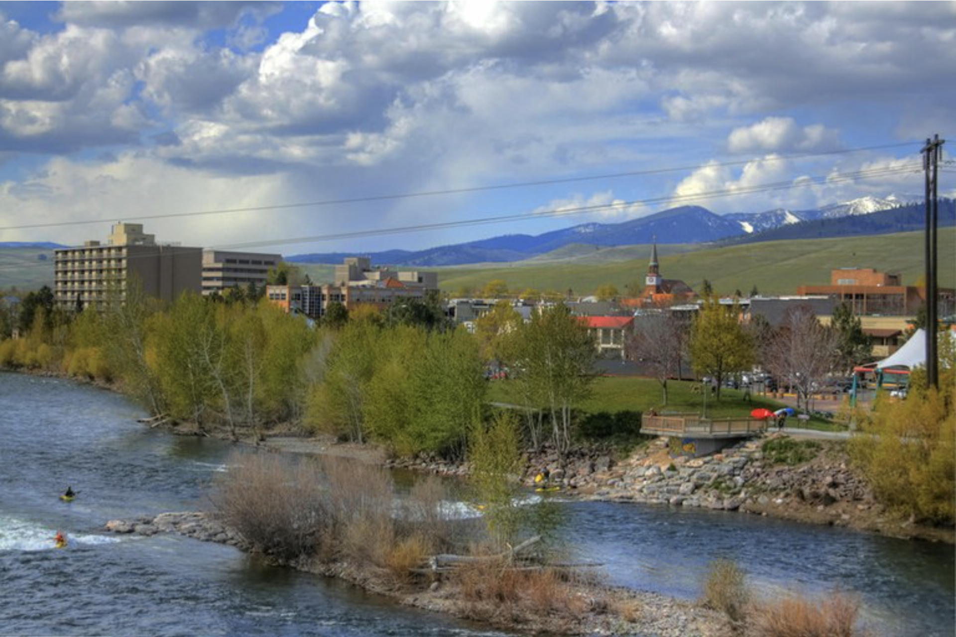
Kayakers enjoy the Clark Fork River next to downtown Missoula, Montana. Photo credit: Micah Sheldon/Flickr

NOTE: Our wedding anniversary was on June 16th.

Mrs. Gulch lived long enough to celebrate our 50th wedding anniversary. I don’t think you stay together that long unless you become close friends.

We were a work romance. She was introduced to me early on a Sunday morning where I worked at the Safeway at 44th & Lowell in Denver. She was the first girl hired there to bag groceries and other duties. As the Assistant Manager and Mrs. Gulch walked away I noticed that she was holding her very long brown hair back with a hair clip made out of rawhide in the shape of a peace sign. Since this was during the Viet Nam war the peace sign was very symbolic.

We became good friends, then romantically involved, which despite some pressure to split up from her parents, we stuck it out and got married in 1973.


Read: Happy Birth Anniversary Mrs. Gulch


I think we cemented our friendship when we moved to Missoula. We really needed to depend on each other since our support folks were back in Denver. We set out in our VW bus driving to college towns, looking for a graduate school. We wandered through college towns, Laramie, Grand Junction, Pocatello, Idaho Falls, Bozeman, Butte, and then drove down the Clark Fork River, through the Hellgate, into Missoula and decided try out the University of Montana. Those western sunsets in the Rocky Mountains will get you every time.