Click on a thumbnail graphic to view a gallery of drought data from the US Drought Monitor website.
Click the link to go to the US Drought Monitor website. Here’s an excerpt:
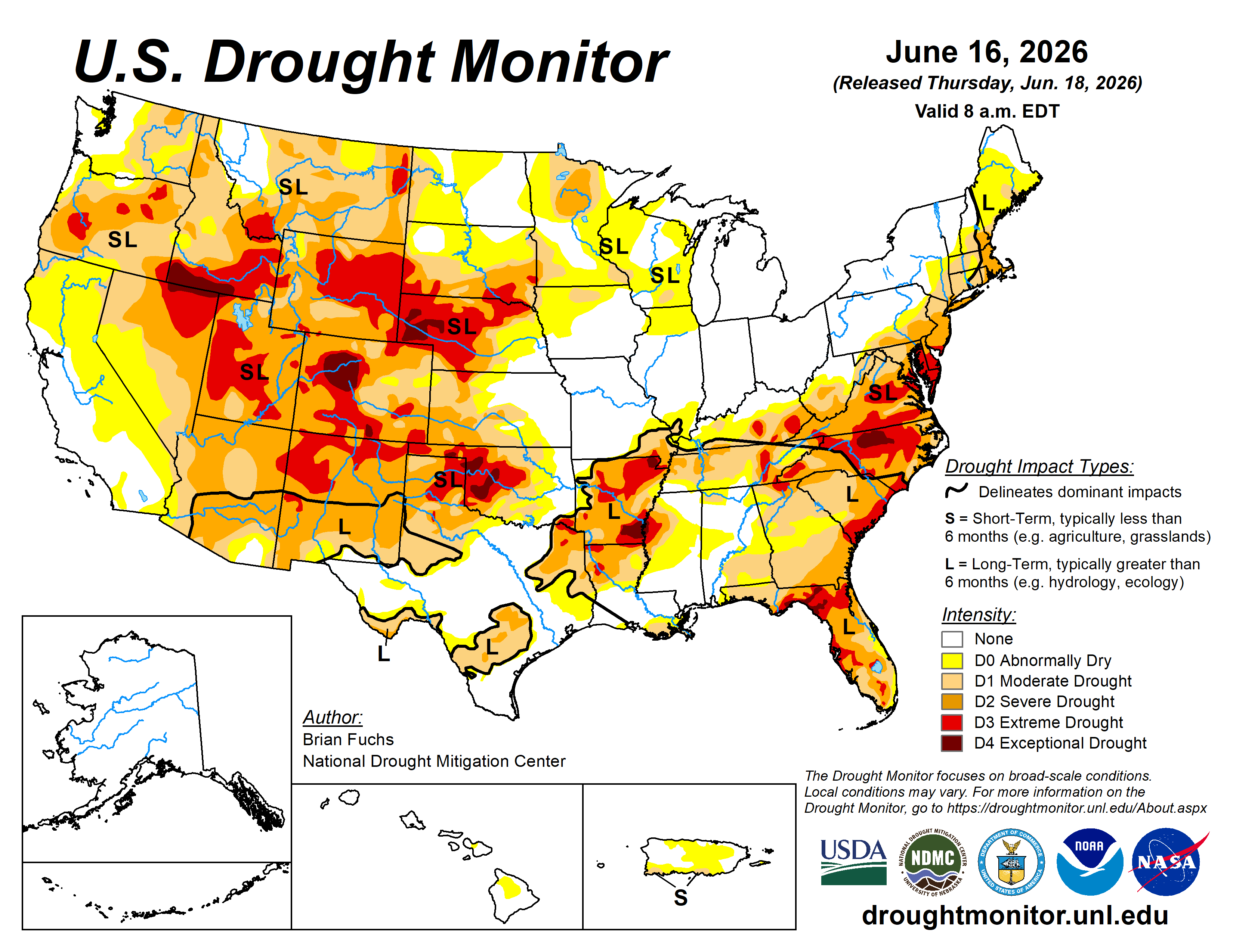
This Week’s Drought Summary
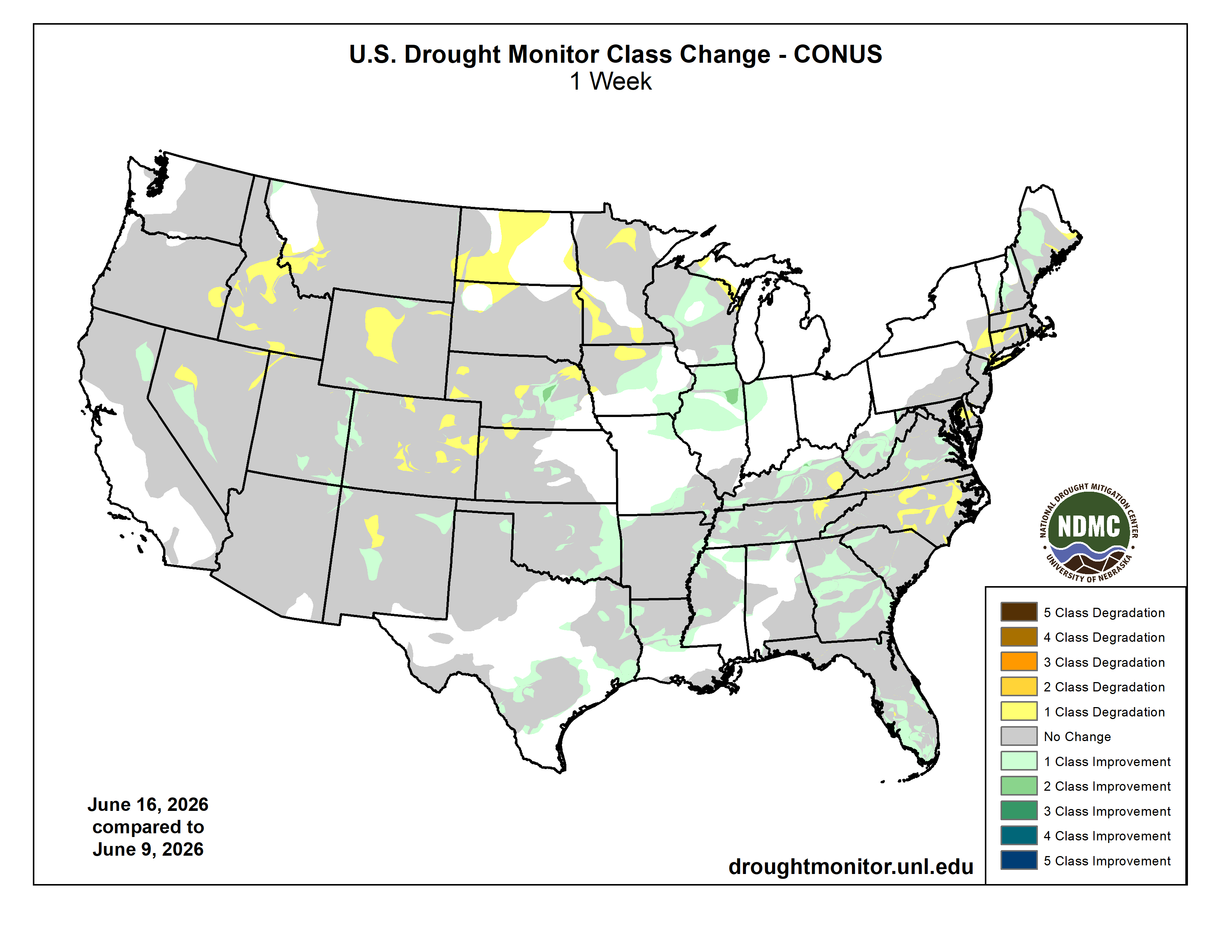
The heaviest precipitation this week occurred across the Midwest and southern Plains. Flooding rains developed from south Texas into the Gulf Coast region during and beyond the period considered in this week’s analysis. Portions of Illinois and Indiana recorded precipitation totals 4–5 inches above normal. Over the past several weeks, persistent rainfall across the Midwest and central to southern Plains has contributed to widespread drought improvement.
Temperatures were near to above normal across much of the country. The coolest conditions were observed from the central Plains into the northern Rocky Mountains, where portions of Montana and Wyoming averaged 4–6 degrees below normal. In contrast, the East Coast—particularly New England—as well as much of California and southern Nevada, experienced above-normal temperatures. Parts of New England recorded departures of 8–10 degrees above normal…
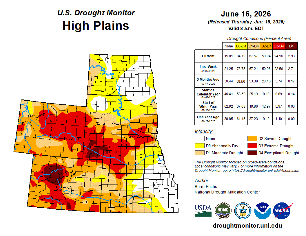
High Plains
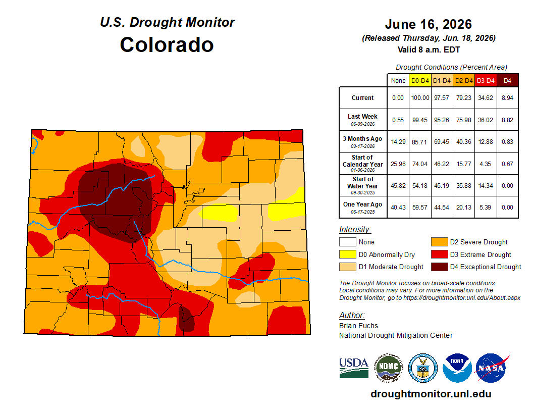
Across the High Plains states, drought continues to persist across western Kansas and eastern Colorado. The most severe and exceptional drought areas extend from eastern Wyoming into western and northern Nebraska and far southern South Dakota. Continued lack of rainfall and warmer-than-normal temperatures led to worsening drought conditions in the plains of eastern Colorado and small portions of northwestern Kansas. Exceptional drought was expanded across three counties in the Nebraska panhandle, where pastures and dryland wheat conditions are the poorest seen in decades, as a result of the record warm, dry winter followed by meager spring rainfall. The agricultural impacts in western Nebraska were confirmed by drought indicators spanning the last 6-12 months.
Other areas of degradation occurred this past week over North Dakota, especially the western half of the state. Moderate drought expanded southward along the Montana border as dry conditions intensified in western North Dakota. Abnormal dryness was introduced from southwest to north-central North Dakota due to recent drier-than-normal conditions.
The only improvements in the High Plains region are in central and eastern Nebraska. A couple swaths of 2-4 inches of rain fell this past week along the Interstate 80 corridor and into the southeastern part of Nebraska, which is presently free of any drought or abnormal dryness…
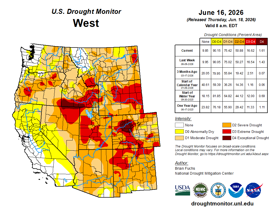
West
There was not widespread precipitation across the region this week. However, portions of western Oregon and Washington, Arizona, northern Idaho, New Mexico, southern Montana, southern Utah, and northern Wyoming recorded above-normal precipitation.
Temperatures were mixed, with below-normal readings across northern portions of the region and above-normal temperatures farther south. The warmest conditions occurred in California, Nevada, and Arizona, where departures of 6–8 degrees above normal or greater were widespread.
Drought degradation occurred across eastern Oregon, where moderate drought expanded. Moderate, severe, and extreme drought also expanded across much of southern Idaho and into western Montana, while extreme drought increased in coverage across central Wyoming.
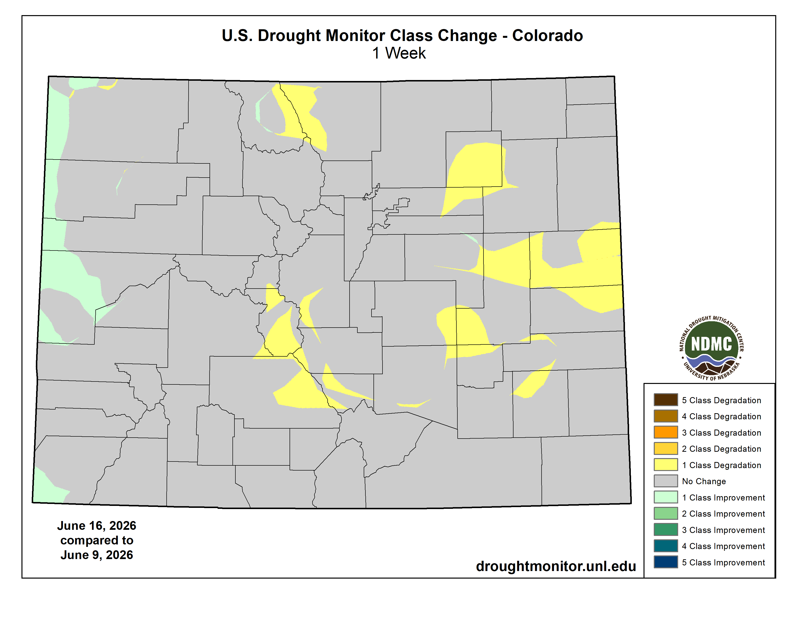
Several weeks of wetter-than-normal conditions in New Mexico allowed for improvements to extreme drought across northeastern and southern portions of the state, although slight expansion occurred in northern areas. Improved short-term moisture conditions in eastern Utah and western Colorado supported reductions in extreme drought, while degradation occurred across central and eastern Colorado.

The impacts of a dry winter and below-normal snowpack continue to affect Colorado and other parts of the region, where increasing numbers of waterways are experiencing low-flow conditions…
Across the southern states, many areas experienced widespread and substantial rainfall of 2–6 inches over the past week, especially southern and eastern Texas, eastern Oklahoma, northern Arkansas, northern Mississippi, and western Tennessee. Most areas of the deep southern states experienced drought improvement from all this rainfall. The only exception is in northeastern Tennessee, where drought degradations were made to the northwest of Knoxville due to worsening drought indicators.
The northeastern portion of the Texas Panhandle saw 2–4 inches rainfall over an area of exceptional drought, helping to relieve drought conditions with a small downgrade to extreme drought there. However, for the most part, extreme to exceptional drought conditions persisted across the Texas and Oklahoma panhandles, and much of western Oklahoma. Despite weekly rainfall of 2 inches or more along the periphery of Arkansas, severe to exceptional drought continued to persist in much of the state due to the long-term rainfall deficits of the past several months.
The recent appreciable rainfall over eastern Oklahoma, combined with more heavy rains this past week, led to a large removal of abnormal dryness from Texas to southwestern Missouri. Widespread heavy rainfall of 2–6 inches or more led to more drought coverage and intensity reduction across southern and eastern Texas, central Louisiana, and parts of western Mississippi. Drought relief also extended into western and northwestern Tennessee, representing the eastern extent of this week’s large area of heavy rainfall in the South…
Looking Ahead
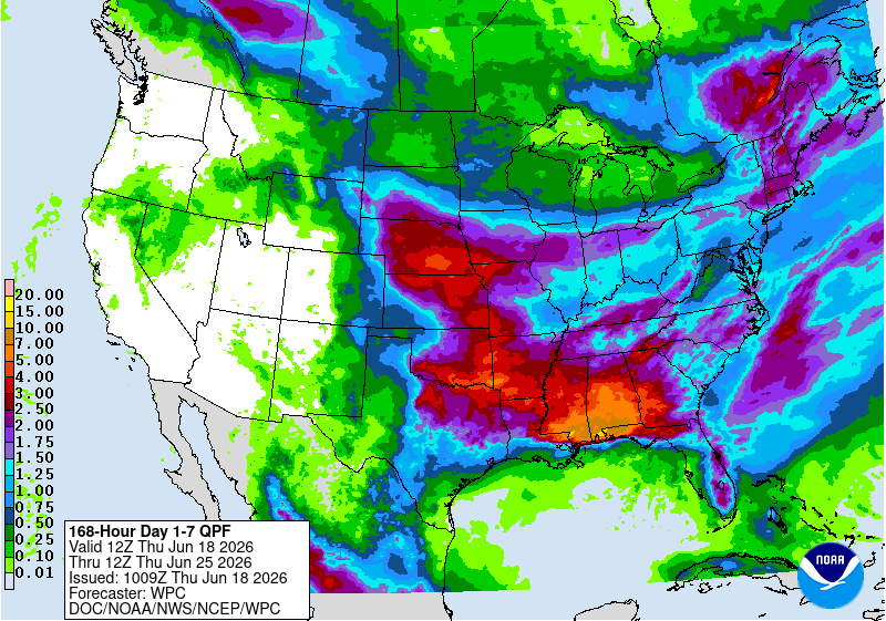
During the next 5–7 days, more heavy rainfall is expected in the Deep South, as a result of a Tropical Storm Arthur near the southeastern Texas coast as of this writing. Deep tropical moisture will stream northeastward from Arthur as it advances into the Southeastern states. This tropical rainfall will have the potential to produce more drought relief in southeastern Louisiana, Alabama, Georgia, and Tennessee. Current rainfall forecasts by the Weather Prediction Center also show the potential for several inches of rain from Oklahoma, Missouri, and Arkansas, eastward into the Ohio River Valley, with more severe weather potential in the Midwest region. Other areas of appreciable rainfall are forecast for parts of the Northeast and the eastern portions of the High Plains.
The Climate Prediction Center’s 6–10 day outlook shows that above-normal temperatures should prevail across much of the western U.S. and along the immediate Gulf coast into Florida. Below-normal temperatures are possible from the eastern portions of the High Plains, the Midwest, and into the Northeast states. Meanwhile, precipitation is projected to be above normal across much of the Midwest and High Plains, possibly extending into the Northeast states. Near-normal rainfall is anticipated across the South and Southeast in the 6-10 day outlook, with below-normal precipitation expected in most of the West.