Hernando de Alarcón’s 1540 Expedition into the Lower Colorado River

hernando alarcon, spanish, portuguese,navigator,coronado,cortez,
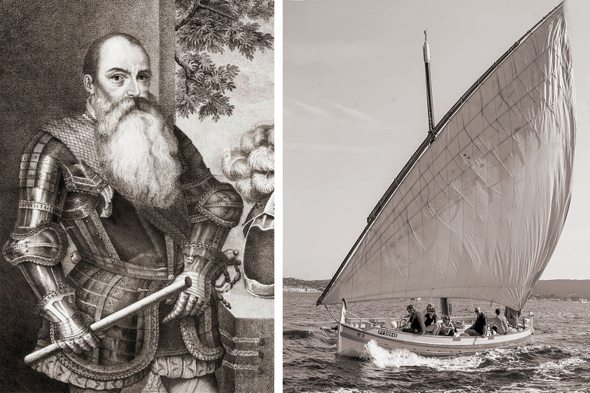
Portrait of Hernando de Alarcon on the left, and an example of a Spanish “tender” or “begantina”with a lateen sail and rowers on the right.

by Robert Marcos, photojournalist

California got its name from a popular Spanish romance novel that was published in 1510. The book, “Las Sergas de Esplandián” described California as a mythical island that was inhabited by Amazons and was filled with gold and pearls. So when Hernán Cortés arrived at the southern end of the Baja peninsula in 1535, its elongated appearance led him to believe they had found the legendary island. This misconception became so deeply embedded that European cartographers continued to publish maps that showed California as an island well into the 18th century.

Five years after Cortez’s expedition the Portuguese navigator Hernando de Alarcón set sail from Acapulco with two Spanish caravels, a tender, and 45 crewmen and headed back to the Sea of Cortez. Alarcón’s mission was to transport supplies to the 2,000 man Coronado Expedition that had left from the State of Nayarit, in Mexico, three months earlier. Alarcon and his men were ordered to rendezvous with a detachment from the Coronado Expedition at the confluence of the Colorado and Gila Rivers, just north of present-day Yuma.

map,ancient,mariner, atlas,sea,california,old,historic,
Map that shows California as an island, which was created in 1657 by Nicolas Sanson, a French cartographer.

Alarcón and his vessels enjoyed favorable winds and arrived at the northern edge of the Sea of Cortez in early August. Alarcón quickly determined that California was in fact not an island because there was no open-water passage that led back to the Pacific Ocean. The men made their way up through the Colorado river delta and by doing so made history by becoming the first Europeans to explore the lower Colorado River. But before long the conditions became perilous, as the ships encountered a terrifying natural phenomenon known as a tidal bore. The massive wall of water that was caused by incoming ocean tides colliding with the river’s outward current, nearly destroyed the fleet. The raging waters ran the caravels aground, tilting them dangerously and threatening to smash the hulls. But through strict discipline and skilled seamanship the crew somehow managed to stabilize the vessels and survive the furious tides.

When the river finally became too shallow to continue Alarcon ordered for the larger ships to be anchored, then he launched “tenders” (called Bergantinas). Historic illustrations show these small ships as having a single “lateen” sail and oar placements for rowing. Alarcon and a contingent of sailors then began the exhausting effort of rowing northward, against the river’s powerful current. Alarcon stopped at native villages along the way to converse with Indigenous groups and gather intelligence. Again – his primary objective was to rendezvous with a detachment of soldiers from the Coronado Expedition at the confluence of the Colorado and Gila Rivers. The soldiers would then use horses and wagons to transport the much-needed cargo back to the main column of Coronado’s expedition, which had continued to push northward to explore what is now the United States.

Weeks later Alarcón and his men finally reached the Gila River, near modern-day Yuma. But vastness of the terrain and the lack of communication tools prevented the two forces from meeting. When Alarcón finally because tired of waiting he buried a hoard of supplies and letters, at the base of a marked tree, then sailed back to his ships that were anchored in the delta. Several weeks later Captain Melchior Diaz found Alarcon’s letters and the supplies, and would’ve carried out his mission had he not been killed in an accident two days later. But that’s a story for another time…
If AZ and other states sue over Colorado River, Utah senator warns they could lose $354M in aid

by Marcus Reichley, Cronkite News
June 10, 2026 Cronkite News offers an audio version of this story using an automated voice created by AI. Errors in pronunciation, pacing and intonation may occur. If you notice an error please contact cronkitenews@asu.edu.

WASHINGTON – The chair of the Senate Energy and Natural Resources Committee warned Arizona and two other states that rely on the Colorado River on Wednesday that they will lose access to hundreds of millions in conservation aid if they pursue litigation over water rights. 

Roughly $354 million is still available under a 2022 climate law. But the funds expire at the end of September.

“States that choose to sue their fellow basin states over Colorado River operations should not expect Congress to reward that decision with additional federal funding,” Sen. Mike Lee, a Republican from Utah – one of the four Upper Basin states, said at the outset of a hearing on the stalemate among the seven states that share the river. “Federal taxpayers should not be asked to subsidize litigation among the states.”

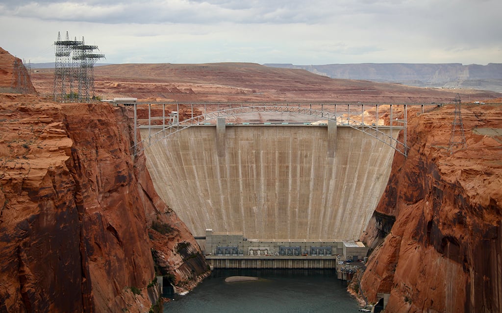
Glen Canyon Dam holds back Lake Powell on Nov. 2, 2022. States upstream and downstream of the dam have different ideas about how to manage the amount of water released from the reservoir, which has become a key sticking point in ongoing negotiations about the Colorado River’s future. (Photo by Alex Hager/KUNC)

Arizona, California and Nevada have been at odds with Colorado, Utah, New Mexico and Wyoming over how to divide the dwindling water supply when the most recent 19-year deal expires at the end of 2026.

The funds Lee threatened to block are a key element of the Lower Basin’s most recent proposal from May 1, which relies on the funding to incentivize voluntary water conservation as an alternative to mandatory cuts.

The $354 million comes from the Inflation Reduction Act signed in 2022 by President Joe Biden, which set aside $4 billion for drought mitigation and compensation for voluntary conservation. Funds that remain unused when the current fiscal year ends Sept. 30 will revert to the Treasury.

By then, the Bureau of Reclamation, part of the Department of the Interior, plans to finalize a federally imposed plan to allocate water to the seven states over the next decade. One alternative in the draft the bureau issued in January would impose cuts up to 77% for Arizona, with a 6% cut for Nevada. The other states could continue taking water at current rates.

The states missed a deadline last November to submit a consensus plan to federal regulators.

The White House tried to facilitate progress by convening Arizona Gov. Katie Hobbs and her counterparts in January. With the stalemate continuing, Lee used Wednesday’s hearing to add more pressure on the states to find a solution.

He chastised officials in the Lower Basin states for, among other things, taking out newspaper ads attacking Upper Basin states.

Negotiators appeared to be “preparing actively for litigation,” he said – and in fact, key officials in both camps have told Cronkite News in recent days they are preparing for that possibility.

Congress “will not be a bystander in this process,” Lee said, noting that under the Constitution, Congress holds approval authority over any long-term interstate compact. 

He also expressed sympathy with the Upper Basin’s stance, warning that any proposal asking those states to absorb greater operational burdens without regard to the river’s existing legal framework “will face a difficult path forward” in Congress.

The chairman framed the moment as a failure of collective will, cataloguing a string of missed deadlines. “The basin can no longer afford to wait,” he said.

After Lee delivered his rebuke, Arizona Sen. Ruben Gallego, a Democrat, pressed the Trump administration from the opposite direction. 

Gallego asked Andrea Travnicek, assistant secretary for water and science at the Department of the Interior, how the department plans to weigh Arizona’s economic stakes as it finalizes its decision.

“The Colorado River is a lifeline for Arizona,” Gallego said, noting the state is home to the most advanced semiconductor manufacturing hub in the Western Hemisphere and that the success of its industries are essential to the nation.

“The technological industries, the domestic food supply, and energy security are all top priorities for the United States, including the president’s agenda,” he said.

Travnicek said the department cannot accept either the May 1 proposal from the Lower Basin nor the latest Upper Basin proposal as they currently stand. 

“We have some concerns and areas where we think that there should be adjustments,” she said.

She confirmed that the Interior Department is coordinating with the Energy Department and U.S. Department of Agriculture, among other agencies. She said an interagency water subcabinet meeting will be held Thursday. 

The hearing laid bare the tension that has made a seven-state deal so elusive, with senators from both basins on hand.

Travnicek fielded pressure from both directions without committing to either.

The stakes are straightforward and very high. 

Decades of drought have pushed water levels to dangerously low levels even as demand and population grow. The river now provides barely half the amount of water each basin has been legally entitled to draw. 

“Delay carries its own consequences,” Lee said, “and the basin can no longer afford to wait.”

This article first appeared on Cronkite News and is republished here under a Creative Commons Attribution-NoDerivatives 4.0 International License.

Moratorium on data centers approved by Archuleta County Board — #PagosaSprings Sun

One of Pagosa Springs’ oldest parks, Town Park straddles the San Juan River in the heart of downtown Pagosa Springs. The site of many events, Town Park is by far one of the most popular parks in Pagosa Springs. Photo credit: Town of Pagosa Springs

Click the link to read the article on the Pagosa Springs Sun website (Clayton Chaney). Here’s an excerpt:

June 17, 2026

During a regular meeting held by the Archuleta County Board of County Commissioners (BoCC) in Arboles on June 16, the board unanimously approved Resolution 2026-47, putting a six-month moratorium on data centers in the county. The matter was brought up by Commissioner Veronica Medina earlier that day during a BoCC work session, where she explained that she had talked with other counties across the state about issues with data centers, “and just the draw on power and water that they tend to use,” noting that they don’t seem to be a good fit for Archuleta County. Medina also mentioned technologies do change and that moving forward things may look different with data centers, but that the county’s current infrastructure and water situation would not support a data center.

“Colorado is in a fight for its life for water,” she said, adding, “If we don’t have water, we don’t have life.”

Medina explained that the county can only do a six-month moratorium at a time, suggesting that she would like to take the matter to the voters at some point and engage the community on if it should be a long-term ban. Medina then stated that for most counties that have data centers, they draw the majority of power in the community.

The Pagosa Area Water & Sanitation District board authorizes upcoming move into drought stage two — #PagosaSprings Sun #SanJuanRiver

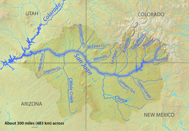
San Juan River Basin. Graphic credit Wikipedia.

Click the link to read the article on the Pagosa Springs Sun website (Josh Pike). Here’s an excerpt:

June 17, 2026

At its June 11 meeting, the Pagosa Area Water and Sanitation District (PAWSD) Board of Directors authorized the district manager to enter stage two drought when the appropriate trigger points are reached, which staff predicted will be in the near future. District Engineer Justin Ramsey explained to the board that, based on water levels in Hatcher Reservoir and the San Juan River, the district was still in drought stage one, but was “just a couple inches away” from having to enter stage two according to the district’s drought management plan. Both the San Juan River and Lake Hatcher are sources for the water processed at PAWSD’s water treatment plants.

Ramsey predicted that the district would likely enter drought stage two within a week, adding that Hatcher Reservoir is losing between a quarter and a half inch in water level a day and a drop of 3 inches would place the district in drought stage two. He requested that the board authorize District Manager Andrew Connor to move the district into drought stage two once the trigger points are reached, avoiding a need for the board to have a special meeting in the near future to authorize the move.

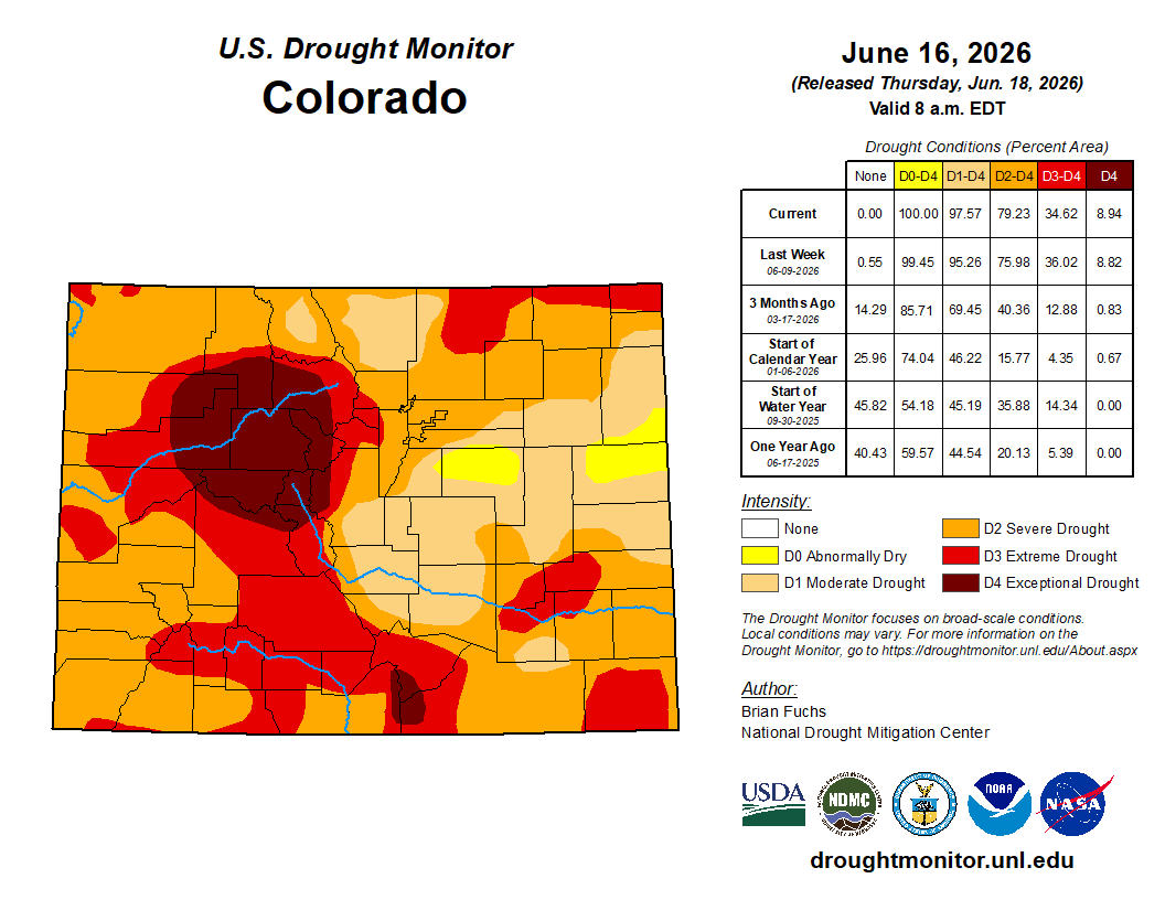
Colorado Drought Monitor map June 16, 2026.