Ute Mountain Ute Tribe area map via USBR/Ten Tribes Partnership Tribal Water Study
FromThe Cortez Journal (Jim Mimiaga) via The Durango Herald:
Limited water supply consolidated to keep corn crop and flour mill operating; jobs lost, canal payment assistance requested
In the Ute Mountain Ute language, paa is the word for water, nüvav means “snow,” uway means “to rain” and tühpar üatüaa means “dried up cropland.”
These words weigh heavily on the minds of Ute Mountain Utes in Southwest Colorado because they are missing the critical ingredients of snow in the mountains and rain in the valleys.
Tribal member Wilford Lang drove a tractor for more than 20 years for the tribe’s 7,600-acre alfalfa and corn farm, southwest of Towaoc.
He has seen water supply fluctuate up and down. But when flows in the Dolores River and McPhee Reservoir came in at 10% for the 2021 season, he and 20 other workers on the farm suddenly lost their jobs…
Water is sacred for the Ute Mountain Ute Tribe, and with less to go around, the tribe is searching for ways to augment its supply.
Tribal elders remember water scarcity long before the Colorado Ute Water Rights Settlement of 1988, which provides water for tribal lands from the Dolores River and McPhee Reservoir.
Vera Summa remembers the 1950s, when she and her grandmother collected water from the springs and mesas of Sleeping Ute Mountain. During winter, adults, elders and children collected snow in bundles and hauled it out on their backs, Summa said…
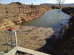
Mancos River in Montezuma County
The Mancos River runs through Ute Mountain reservation lands, but it dried up after Jackson Reservoir was built in 1950 to serve the Mancos area upstream, said elder Laverna Summa, Vera’s sister.
Water shortages are happening again, brought on by a worsening dry spell that started in 2002…
In 2021, drought-stricken fallow fields have replaced the bounty of alfalfa and corn harvests on the Ute Mountain Farm and Ranch operations, an economic hardship brought on by the worst water year in McPhee Reservoir history.
Marginal mountain snowpack was sucked up by dry ground and whisked away on the warm spring wind.
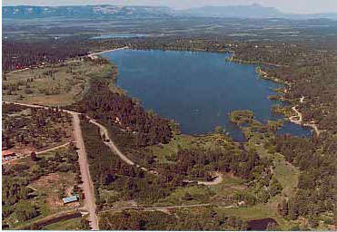
Mcphee Reservoir
The runoff from mountain snowmelt never made it to McPhee, where the water level already was low from the previous parched year.
The 2021 deficit caused a 90% water shortage for farmers tied to the Dolores Water Conservancy District, including the Ute Mountain Ute Tribe.
The tribe’s 7,600-acre farm received just 10% of its 24,517 acre-foot allocation.
The water shortage dried out fields and brought financial challenges for the farming and ranching operations. The tribe laid off half its farm workers, about 20 total, most of whom are tribal members…
Farm operations include the Bow and Arrow mill, a state-of-the-art facility opened in 2014 that sells non-GMO, gluten-free and kosher cornmeal to food manufacturers, grocery stores and distilleries.
The mill’s products are used to make chips, polenta, pasta, grits, cornbread, whiskey and more.
Simon Martinez, general manager of the Ute Mountain Ute Bow and Arrow Brand and Farm & Ranch Enterprises, talks Oct. 20 near Towaoc about how drought and reduced irrigation have affected crop production. (Jerry McBride/Durango Herald)
Jerry McBride
The Ute Mountain Ute Bow and Arrow Brand mill on Oct. 20 near Towaoc. (Jerry McBride/Durango Herald)
Jerry McBride
Martinez used most this year’s limited water supply to irrigate the white, yellow and blue corn crops and keep the mill and its staff of 13 going. The tribe’s ranching operation, with a 600 cow-calf herd, has been kept whole.
So far, business has been brisk at the corn mill, but the drought weighs on everyone’s mind…
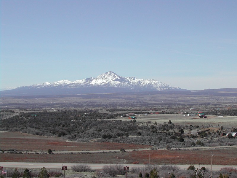
South of Hesperus August 2019 Sleeping Ute Mountain in the distance. Photo credit: Allen Best/The Mountain Town News
Lang said the farm and ranch operation and Bow and Arrow corn mill have been an economic boon for the tribe. They provide well-paying careers for many tribal members and create a deep sense of pride…
Towaoc-Highline Canal via Ten Tribes Partnership/USBR Tribal Water Study
The drastic drop in crop revenue fell short of the $660,000 in annual delivery costs for the water on the U.S. Bureau of Reclamation’s Towaoc-Highline Canal.
So far this year, Martinez said, the tribe has paid $150,000 of that bill and has asked the Bureau of Reclamation for drought assistance to pay the rest…
Martinez and his reduced farm staff still must tend to thousands of acres of fallow fields, and they are discing the soil and controlling weeds to prep the fields for next year.
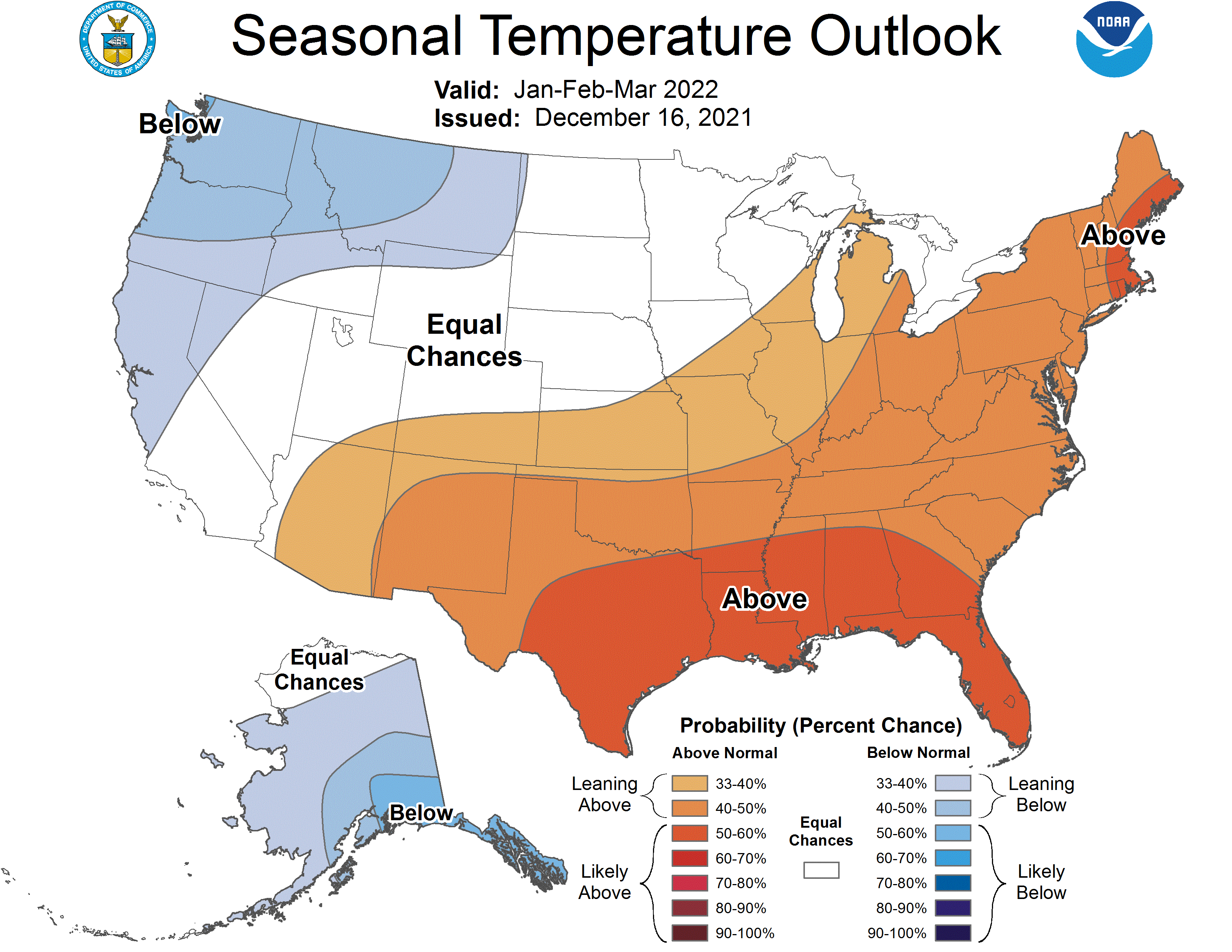
Long-term forecasts for the Four Corners region of Colorado, New Mexico, Arizona and Utah call for abnormally dry and hot weather…
Senior water rights buffer drought impacts
Ute Mountain Ute water rights have a complex history.
As part of the Colorado Ute Water Rights Settlement of 1988, the Ute Mountain Ute Tribe gave up 1868 rights on the Mancos River in exchange for more junior water rights to the Dolores River in McPhee Reservoir, said Mike Preston, a water consultant for the tribe.
The settlement was made partly in response to the Mancos River going dry through Ute Mountain Ute land after Jackson Lake was built upstream in Mancos.
As original inhabitants, Native American tribes have inherent water rights, which were codified by the Winters Doctrine, a 1908 U.S. Supreme Court decision that mandates that tribal reservations have access to water.
As part of the 1988 settlement, the Dolores Project and McPhee Reservoir satisfied Ute Mountain Ute water rights via delivery from McPhee and the gravity-fed 39-mile Towoac-Highline Canal to Ute Farm and Ranch.
The settlement also created a reliable domestic water line to Towaoc from the Cortez water treatment plant, which gets the water from McPhee…
Ute Farm and Ranch shares equally with other water district farmers when water supply is below normal.
Consequently, the tribe took a 90% hit this year, along with other ranches and farms. The fish pool, 32,500 acre-feet earmarked for native fish habitat downstream of McPhee Reservoir, also took the cut. Municipalities do not share in the shortage.
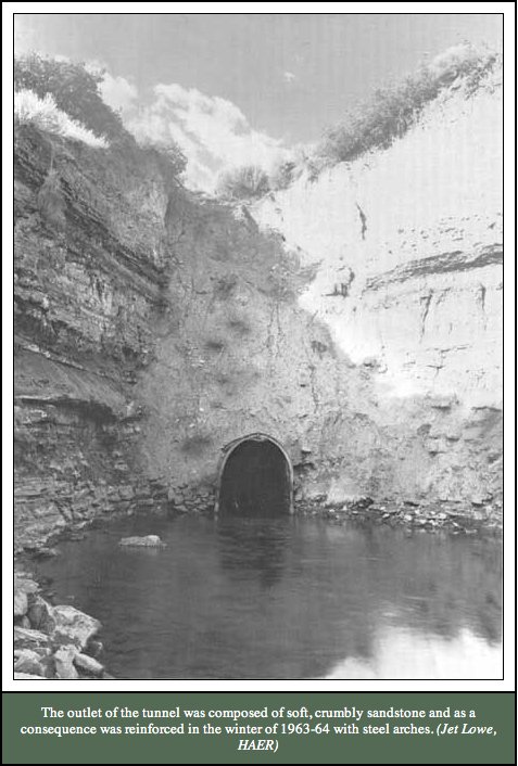
Montezuma Tunnel
McPhee, the Dolores Water Conservancy District and the tribe are more exposed to drought because their water rights on the Dolores River are junior to those of Montezuma Valley Irrigation Co.
In these dry times, the tribe has redoubled its efforts to study and potentially claim all its water rights, including on the San Juan River, said Ute Mountain Ute Chairman Manuel Heart. The river touches the Ute Mountain reservation while flowing from New Mexico to Utah…
Colorado’s prior appropriation water system of “first in line, first in right” can leave more junior water right holders high and dry in extreme drought, a situation that is playing out now.
The practicality and fairness of the system in a new era of aridification and chronic water shortage has been a point of discussion, Heart said.
“We have been here the longest, but don’t have senior status, plus we have OandM costs on the canal to get our water,” Heart said. “We’re seeing a megadrought. In the future if the drought gets worse, who will get cut short, Montezuma, Cortez or us?”
Looking west across the northeast bay of Totten Reservoir with the boat in the background; the photo was taken from the peninsula between the two bays at the north end of Totten Reservoir. Sources/Usage Public Domain via USGS. Photographer: Keelin Schaffrath
The tribe has hired additional staff to work on water issues, and Heart encourages leaders to “think out of the box.” He said the tribe should have looked into buying Totten Lake, which recently was sold to Montezuma Valley Irrigation Co. Totten feeds McElmo Creek, which flows through tribal lands…
“We’d like to talk about adding storage to Jackson Lake, so we could release our share down the Mancos and collect it here,” Heart said. The water could augment water shortages from the Dolores River and McPhee Reservoir.
Montezuma Tunnel steel arches.
Montezuma Valley Irrigation Co. has senior rights
Montezuma Valley Irrigation’s senior water rights date to 1888 and 1885 and include the first 795 cubic feet per second of the Dolores River. Anything above that flow mostly goes to Dolores Water Conservation District.
In normal runoff years, the river flows well above that level and is enough to satisfy MVIC rights and fill McPhee reservoir.
But during extreme dry periods, MVIC’s senior position buffers the impact of drought somewhat for its shareholders because at lower flows, their river rights are more senior and more likely to be filled.
View to southwest, looking down on Groundhog Reservoir. Photo via dcasler.com.
MVIC, which stores water in Narraguinnep, Groundhog and Totten reservoirs, has rights to about 130,000 acre-feet of Dolores River Basin water annually. This year, it received only 92,000 acre-feet because of the drought.
The poor snowpack caused a 30% shortage this year for MVIC, and the irrigation season was shortened by about 20 days, said MVIC manager Brandon Johnson.
Here’s the release from the Bureau of Reclamation (Marc Miller, Justyn Liff):
The Bureau of Reclamation is initiating negotiations on an amended repayment contract with the Mancos Water Conservancy District for the rehabilitation of the Jackson Gulch Canal System and other infrastructure. The first negotiation meeting is scheduled for Monday, November 5, 2018, at 6:00 p.m. at the Mancos Community Center, 117 North Main Street, Mancos, Colorado.
The amended contract to be negotiated will provide updated terms, and further flexibility to fund rehabilitation work for the project. All negotiations are open to the public as observers, and the public will have the opportunity to ask questions and offer comments pertaining to the contract during a thirty-minute comment period following the negotiation session.
The proposed contract and other pertinent documents will be available at the negotiation meeting, or can be obtained on our website at: http://www.usbr.gov/uc/wcao/index.html, under Current Focus or by contacting Marc Miller at 185 Suttle Street, Suite 2, Durango, Colorado, 81301, 970 385-6541 or mbmiller@usbr.gov.
Representatives of the Ute Mountain Ute Tribe were in Washington D.C. for President Barack Obama’s eighth annual White House Tribal Nations Conference, according to this report from Jim Mimiaga writing for The Cortez Journal. President Obama was informed that the Ute Mountain Utes back a Bears Ears National Monument and fulfillment of original intent of the Animas-La Plata Project to build supply infrastructure. Here’s an excerpt:
…councilwoman Regina Whiteskunk…also reminded Obama of the Bears Ears Monument plan, which is supported by a coalition of five tribal leaders in the Southwest.
“I was able to shake President Obama’s hand and said ‘Remember Bears Ears,’ and he responded, ‘There is still work to do’,” Whiteskunk said. “It was not a ‘No,’ so I am pushing forward and maintain the thought that it can still get done.”
[…]
Currently, a key issue for the Ute Mountain Ute tribe is delivering water to the reservation from Lake Nighthorse near Durango, [Tribal Chairman Manuel Heart] said. The tribe owns 40 percent of the water in the 120,000-acre-foot reservoir, and a component of the Animas-La Plata Project built to satisfy Ute Mountain, Southern Ute and Navajo water rights. But while much of the lake’s water is owned by the Ute Mountain Utes, it is out of reach for practical uses, Heart said.
“It’s like a pitcher on a high shelf we can’t reach. We need delivery to our land, which was initially promised but was eventually cut out, so we have been fighting to get that back.”
One possibility is to use local rivers to deliver the water to the reservation.
It could be released from the Lake Nighthorse spillway into the Animas River, then flow to the San Juan River, which meets up with the Ute Mountain reservation near the Four Corners Monument.
Heart said that idea is being discussed, but has legal and topographical challenges.
“From the San Juan River, it would require many miles of new pipe and pumping the water uphill before it could arrive at our farms,” he said.
Delivering it to the tribe via pipelines directly from higher Lake Nighthorse is preferred because it would be gravity-fed, he said. Piping it to Jackson Reservoir could allow it to be delivered via the Mancos River to reservation lands.
“Delivering it to our land gives us control of our water to grow our economy, expand our farms or build a new community on the east side,” Heart said.
Federal support is key to getting things done in Indian Country, he said, and Obama’s annual Tribal Nations Conference helps influence federal officials to act and secure funding.
“I have been so privileged to learn from you while visiting more tribal communities than any other President,” Obama said at the conference. “We haven’t solved every issue. We haven’t righted every wrong. But together, we’ve made significant progress in almost every area.”
Under the Obama administration:
The White House Council of Native American Affairs was created, a cabinet level office that focuses on Indian Country issues.
More than 428,000 acres of tribal homelands were restored back to their original owners, and the Cobell settlement was signed into law that established the $1.9 billion Land Buy Back Program to consolidate individual Indian lands and restore them to tribal trusts.
Reauthorized the Violence Against Women Act so that tribes can prosecute those who commit domestic violence against women in Indian Country, whether they’re Native American or not.
Provided health care services in Indian Country through the Affordable Care Act, including permanent reauthorization of the Indian Health Care Improvement Act.
Whiteskunk praised Obama for “elevating the voice of Native Americans and valuing us” during his administration. In her meetings with federal officials, she pushed for improved consultation with tribes on projects and laws affecting Native American lands.
“We discussed in great length about how consultation is either weak, vague or not consistently applied,” Whiteskunk said.
“As president he has reached out to work with Native Tribes,” Heart said. “He is the first president to hold these annual meetings, and the hope is that the next president will continue them, so we have to wait and see.”
This summer, the Mancos Water Conservancy District has continued investigating a possible title transfer for the Jackson Gulch Project, Superintendent Gary Kennedy said Wednesday.
The district has been pursuing a transfer of ownership from the U.S. Bureau of Reclamation, so that the district could be the sole owner of the reservoir project. It’s a lengthy process that could take five years or more and requires an act of Congress, Kennedy said.
One issue with the transfer is what would become of federal lands that have been withdrawn to become part of the project, Kennedy said.
“Our concern is that if we took the title, that land would stay with the project, instead of going back to the Forest Service,” he said.
The MWCD board also has had general discussions about other issues regarding the transfer, including liability.
No funds have been committed to the title transfer, and the process is still in baby steps, Kennedy said. Either party — the Bureau of Reclamation or the MWCD — can withdraw from the process at any time, he said.
Some funding may come through in the next three to four years for the project rehabilitation effort, Kennedy said. The next item the district is focusing on rehabilitating is the reservoir inlet chute.
The cost to get those chutes into top shape would be about $1.2 million, which could be funded by both Bureau of Reclamation grants and MWCD funds, Kennedy said. The district has put in a request for funding to the BOR, he said.
A contractor is on site working on rock mitigation around the project site, especially in West Mancos Canyon, Kennedy said. People are asked not to go in the canyon when there is work taking place there, and signs are posted around the site to make people aware, Kennedy said.
The Mancos Water Conservancy District board voted to put up for lease 150 acre-feet of water from the Jackson Gulch project, district Superintendent Gary Kennedy said.
The board approved the water lease at their meeting June 14. District officials will be going out to see if people need extra water, though they might not need extra because of the wet spring season, Kennedy said.
The board and the Federal Bureau of Reclamation found agreement on project water rights for Jackson Reservoir, Kennedy said. The rights will be assigned to the water district from the federal government, he said.
Also at the meeting, the board discussed the title transfer for the project, Kennedy said. The title transfer is an ongoing issue that will take many years to resolve.
The district had hoped to complete some appraisals of land associated with the project this summer, but that hit a snag, Kennedy said. The cost for the appraisals is almost double what the board anticipated, and another government agency will be involved, he said. Even if the board decides to pay the new price for the appraisals, Kennedy could not say how long that would take.
The district is planning a party to celebrate 75 years of the water district. The celebration will take place July 16 at noon at Jackson Gulch Reservoir on Road N north of Mancos. There will be a barbecue as well as some educational information on the history of the district. RSVP is requested by emailing Kennedy at gary.mwcd@gmail.com or calling 970-533-7325.
District officials also will be working on clearing the inlet canals to the reservoir this summer, Kennedy said. The reservoir’s two drop chutes also need some work, but that might not take place until 2019, when the district could receive money from the federal government to rehabilitate the chutes, Kennedy said.
Board member Boe Hawkins was reappointed to a four-year board term at the meeting.
The reservoir’s jet valve was rebuilt over the winter, and some safety issues came up with the valve, Kennedy said. After investigation, the valve was operating normally and there were no major problems, he said.
The hydro lease of the power permit for the project is still moving forward and the board is still working on it, Kennedy said. At next month’s board meeting July 12, board members will elect officers.
Mancos and the Mesa Verde area From the Cortez Journal (Mary Shinn):
The aging Mancos water system is getting a financial boost from regional agencies, and it may receive more money from the state.
The town is looking to improve its raw water system, replace a major valve that reduces pressure, and install new water-distribution lines on the south side of town.
The entire project is estimated to be about $530,600, said Town Clerk and Treasurer Heather Alvarez.
So far, the Southwest Water Conservation District has granted the project $75,000, and the Southwest Basin Roundtable has agreed to pitch about $81,800. The town currently has an application pending with the Colorado Department of Local Affairs for about $265,000.
If the town receives the state grant, it have to cover about $108,324 of the project.
The town would like to finish design work for the project this year and be ready to start construction in 2017, said Town Administrator Andrea Phillips
The lines the town is looking to replace are at the end of their useful life, and replacing them should help cut down on the need for repairs…
Improving the raw water system should also help stop the spills at the raw water inlet, she said.
In addition, the valve responsible for taking water pressure down from 120 pounds per square inch to 55 pounds per square inch will be replaced with three valves to create greater redundancy in the system, said Public Works Director Robin Schmittel.
The town completed two major water infrastructure projects last year. It installed a new $1.1 water storage tank, replaced all the town’s water meters and rebuilt 100 water meter pits. The pits are plastic cylinders that protect the water meters in the ground.
In 2014, the town adopted a four-year plan to increase water rates in order to pay for water infrastructure improvements. The February bill from the town of Mancos will reflect a $2.50 increase.
Jackson Gulch Dam photo via USBR FromThe Mancos Times (Mary Shinn):
The Mancos Water Conservancy District board on Thursday weighed the consequences of taking ownership of Jackson Gulch Reservoir, the dam, the canal system and the land it sits on from the federal government.
If the district worked with the Bureau of Reclamation to take ownership, the district would have to take over all the contracting and inspections…
The Bureau of Reclamation currently budgets $160,000 a year to manage the irrigation project, and and $150,000 a year for recreational use of the lake.
Kennedy estimates that if the district did all the work the bureau does for irrigation and water management, it would cost $20,000 to $40,000 because the district wouldn’t have as much administrative overhead. The district doesn’t plan to cover any of Mancos’ state parks expenses if the board pursues the transfer of ownership.
A major question the board members tried to address at the Thursday workshop was: What value does the Bureau of Reclamation add to the project?
They determined it isn’t a reliable source of funding…
If the district took ownership of the project, it would still be subject to some state inspections for dam safety.
Currently, the Bureau of Reclamation does regular inspections, but the district is responsible for maintenance or replacement. For example, the district paid $3 million for the recent rehabilitation project.
There is one exception to the maintenance rule. The Bureau of Reclamation would step in if the dam started to experience a failure. But the agency would also send the district a bill for half the cost, and it would be due in three years…
At an initial meeting about the transfer with James Hess, a bureau representative from Washington, Hess said the transfer process can take years.
Only 27 other water projects in the nation have been fully transferred from the federal government to a local organization.
Gary Kennedy, superintendent of the Mancos Water Conservancy District (MWCD) , started the day off with a talk about the organization and what it does for the Mancos Valley. He gave information and statistics about Jackson Gulch Reservoir – how much water it can hold, what it holds now, and where the water comes from. He said the MWCD is #36 priority for water and can capture about 250 cubic feet of water from the Mancos River between March and May. The MWCD fills water priorities as they come up and are called in…
Mike Rich, of the Natural Resources Conservation Service (NRCS) gave a talk about what’s been going on in the last 10 years with the Mancos River and the watershed that surrounds it.
Then, Kirsten Brown, of the Colorado Department of Reclamation Mining and Safety, and Cathy Zillich, of the Bureau of Land Management (BLM) gave an extensive talk about the East Mancos River and the mining impacts on it. Ann Oliver talked about the Middle Mancos River and the management measures they are doing.
George San Miguel talked about the part of the Mancos River that runs through Mesa Verde National Park, and Colin Laird, a water quality specialist, talked about the lower watershed on the Ute Mountain Ute land.
The workshop was the beginning of an an ongoing discussion. There will be more workshops and informational sessions to come.
For all interested people, there will be a meeting at the Mancos Community Center called “Water 101 in the Mancos Valley” on Saturday, Jan. 26, from 10 a.m. to 5 p.m.
Water will the subject and various people will talk about it. Gary Kennedy, superintendent of the Mancos Water Conservancy District will speak about the Jackson Reservoir; Marty Robbins of the Department of Water Resources will talk about the priority water systems, Brandon Bell of Mancos Rural Water will be there to address any concerns. Questions and comments will be encouraged from all who attend.
The workshop is hosted by the Mancos Conservation District and will be a good starting point for the discussion on water.
Here’s the latest installment of the Valley Courier’s Colorado Water 2012 series, written by Bruce Whitehead. Here’s an excerpt:
Southwestern Colorado’s rivers are unique in that many of the rivers and tributaries flow from north to south and are administered as independent river systems.
This is due to the fact that many, such as the Navajo, Blanco, Piedra, Pine, Florida, Animas, La Plata, and Mancos Rivers, are tributary to the San Juan River in New Mexico or just upstream of the state line. The Dolores River flows from north to south, but makes a “U-turn” near Cortez and heads back to the northwest and joins the Colorado River in Utah. The San Miguel River originates just above Telluride, and flows to the west where it joins the Dolores River just above the Colorado-Utah state line.
The southwest basin has many areas that are under strict water rights administration on a regular basis, but there is still water available for appropriation and development pursuant to Colorado’s Constitution and the Colorado River Compact. The region is also known for its beautiful scenery and recreation opportunities, which is the basis for the establishment of the Weminuche Wilderness area as well as nearly 150 reaches of streams with in-stream flow water rights. Over 50 natural lake levels are also protected by the state’s In-Stream Flow and Natural Lake Level Program.
Water leaders have been active for many years in the basin and recognized early on that in order to meet agricultural and municipal demands storage would need to be developed. The Southwestern Water Conservation District was formed in 1941, and has been responsible for the planning, development, and water rights acquisition for many of the federal projects in the region. Reservoirs such as McPhee (Dolores Project), Jackson Gulch (Mancos Project), Ridges Basin a.k.a Lake Nighthorse (Animas-La Plata Project), Lemon (Florida Project), and Vallecito (Pine River Project) provide for a supplemental supply of irrigation and municipal water in all but the driest of years. The delivery of these supplemental supplies assists with keeping flows in many critical reaches of river that historically had little or no flow late in the season due to limited supplies and water rights administration.
Southwest Colorado is also home to two Sovereign Nations and Indian Reservations that were established by treaty in 1868. Under federal law the Ute Mountain Ute Tribe and Southern Ute Indian Tribe were entitled to federal reserved water rights, which had the potential to create conflicts with Colorado water law and non-Indian water users in the basin. After nearly a decade of negotiations, a consent decree was entered with the water court that settled the tribal claims. The Tribal Settlement included some early dates of appropriation for the tribes, and a water supply from some of the federal storage projects including the Dolores, Animas-La Plata, Florida, and Pine River Projects. This landmark settlement is evidence that both tribal and non-Indian interests can be provided for with water storage and cooperative water management.
…according to the [Mancos Water Conservancy District] who keeps track of precipitation each year, there was slightly less this year than in 2002. There was a total of 12.39 inches in the 2011/12 winter, and 12.98 inches in 2002. In the last 10 years, they were the two lowest precipitation years. The highest was 2005 with 23.22 inches…
At the moment, the level of the Jackson Gulch Reservoir is “just shy of 15 percent,” [superintendent Gary Kennedy] said. The average for the shutdown, which was Sept. 20 this year, is usually 40 percent. “We let the water out of the reservoir about a month early,” he said.
Kennedy is adamant about the fact that without the reservoir being here in the Mancos Valley, the Mancos River would have been dry in June and the town would have had to take water from the river. The next step, he said, is for the town to lease water.
Jackson Gulch reservoir live content stood at 3,914 acrefeet with a 9,948 acre-feet maximum capacity and a 7,322 acre-feet average (1981-2010) end-of-month content. At Jackson Gulch, a daily maximum/minimum of 52/31 cubic-feet-per second was released into the Mancos River, and 69 acre-feet were released for municipal purposes.
McPhee Reservoir live content stood at 260,582 acre-feet, with a 381,051 acre-feet maximum capacity and a 315,968average (1981-2010) end-of-month content. At McPhee, 4,301 acre-feet were released into the Dolores River, and 42,398 acre-feet were released for trans-basin purposes. At McPhee, a daily maximum/minimum of 71/69 cubic-feet-per-second was released into the Dolores River.
More McPhee Reservoir coverage here. More Jackson Gulch Reservoir coverage here.
From the U.S. Bureau of Reclamation via the Cortez Journal:
Jackson Gulch reservoir live content stood at 6,020 acre-feet with a 9,948 acre-feet maximum capacity and a 9,014 acre-feet average (1981-2010) end-of-month content. At Jackson Gulch, a daily maximum/minimum of 76/51 cubic-feet-per second was released into the Mancos River, and 88 acre-feet were released for municipal purposes.
McPhee Reservoir live content stood at 299,646 acre-feet, with a 381,051 acre-feet maximum capacity and a 343,394 average (1981-2010) end-of-month content. At McPhee, 4,120 acre-feet were released into the Dolores River, and 45,079 acre-feet were released for trans-basin purposes. At McPhee, a daily maximum/minimum of 70/57 cubic-feet-per-second was released into the Dolores River.
Questions can be directed to the Southern Water Management Group, Resource Management Division of the Western Colorado Area Office, Durango.
More Dolores River Watershed coverage here. More Mancos River Watershed coverage here.
In an announcement posted on the Montezuma County Sheriff’s website, Mancos Rural Water Company asked Mancos-area residents to back off of water usage in the area as the Weber Fire battle continues. “Mancos Rural Water Company does not have enough domestic water to serve the tremendous amount of water that area residents are using to soak down the areas around their homes,” the announcement states. “If you live anywhere in the Mancos Rural Water District in the quarter due west to due north of Mancos, there is no immediate need to water down your house and the immediate vicinity. Don’t do this unless you have been given pre-evacuation notice. Leave some drinking water for others on the system.”
Mancos Rural Water manager Brandon Bell said the concern was prompted by the realization that the rural water system was not created to deal with crisis like the Weber Fire. “Our main problem is that our system was just not designed with the capacity for fire protection,” Bell said. “We’ve had a lot of homes running sprinklers and watering down their property day and night and we are just not able to keep up with the demand on our system.”
Water for the Mancos Rural Water system is an allocation from Jackson Reservoir, located northwest of the small community. Following a drier-than-normal winter and a hotter-than-normal spring, the reservoir entered the summer months less than full, which means resources were strained before a greater demand was added to the system.
Jackson Gulch reservoir live content stood at 3,703 acre-feet with a 9,977 acre-feet maximum capacity and a 4,492 acre-feet average (1980-2010) end-of-month content. At Jackson Gulch, a daily maximum/minimum of 11/0 cubic-feet-per second was released into the Mancos River, and 15 acre-feet were released for municipal purposes.
McPhee Reservoir live content stood at 289,298 acre-feet, with a 381,051 acre-feet maximum capacity and a 270,692 average (1986-2010) end-of-month content. At McPhee, 1,835 acre-feet were released into the Dolores River, and 2,958 acre-feet were released for transbasin purposes. At McPhee, a daily maximum/minimum of 31/30 cubic-feet-per-second was released into the Dolores River.
More Dolores River watershed coverage here and here. More Mancos River watershed coverage here and here.
For the water fund, [City Public Works director Jack Nickerson] asked for a 25 cent increase in the residential base rate for water service from $13.50 to $13.75 per month. A 10 cent increase is proposed to the additional usage rate from $1.65 per 1,000 gallons to $1.75. He said the increase is necessary to keep up with the rising costs of water treatment chemicals and replacement projects. He cited the recently completed South Broadway waterline replacement project costing approximately $700,000 and approximately $25,000 still needed for water tank repairs.
Here’s an in-depth look at restoration and conservation efforts in the Mancos River watershed from Jeanne Archambeault writing for The Mancos Times via The Durango Herald. From the article:
There are many organizations in Mancos that have a direct influence on the river, the watershed that surrounds it and the condition and health of the river itself. The Mancos Conservation District is concerned with the river water and soil that is moved by the water.
The Mancos Valley Watershed Project was started in 2005 by the Mancos Valley Watershed Group, formed because of a need to conserve soil and water in the Mancos River. Integral partners of the watershed project are the Natural Resources Conservation Service, the Mancos Conservation District (formerly the Mancos Soil Conservation District) and the town of Mancos. The project also has brought together riverfront landowners, farmers, ranchers, environmentalists, irrigation companies, recreationalists and community members to address a number of goals.
Goals include improving fishing along the river, reducing the loading of dissolved copper from the east fork, working with irrigators and irrigation companies and landowners along the river to rebuild and restore functioning of the diversion systems, and improving the riparian ecosystem and in-stream flows through the summer…
The Mancos River supplies water to the town of Mancos and outlying residents, to ranchlands and farms for irrigation, to Mesa Verde National Park, and the Ute Mountain Ute Indian Tribe and its agricultural interests. It also provides essential habitat for wildlife.
Ann Oliver is the watershed project manager contracted by the MCD. She has been instrumental in bringing interested parties together.
Russell Klatt, conservation technician for the project, also serves the landowners in the Mancos Watershed. Klatt designs the way the river is going to flow, and Keith Duncan Construction helps him move the rocks and do the work. “The large boulders in the water block and divert the water to where you want it to go,” Klatt said…
The project is a further positive step toward the MCD’s objective of achieving a greater balance between ranching and healthy ecosystems and especially our water.
The MCD also offers workshops and classes throughout the year, all free to the public, on such subjects as irrigation-water management, weeds and rangeland.
More Mancos River watershed coverage here and here.
Jackson Gulch reservoir live content stood at 8,594 acre-feet with a 9,977 acre-feet maximum capacity and a 7,306 acre-feet average (1971-2000) end-of-month content. At Jackson Gulch, a daily maximum/minimum of 61/49 cubic-feet-per-second was released into the Mancos River, and 22 acre feet were released for municipal purposes.
McPhee Reservoir live content stood at 349,845 acre-feet, with a 381,051 acre-feet maximum capacity and a 335,208 average (1986-2000) end-of-month content. At McPhee, 4,612 acre-feet were released into the Dolores River, and 47,372 acre-feet were released for transbasin purposes. At McPhee, a daily maximum/minimum of 82/74 cubic-feet-per-second was released into the Dolores River.
Jackson Gulch reservoir live content stood at 9,977 acre-feet with a 9,977 acre-feet maximum capacity and a 9,296 acre-feet average (1971-2000) end-of-month content. At Jackson Gulch, a daily maximum/minimum of 42/0 cubic-feet-per-second was released into the Mancos River, and 51 acre feet were released for municipal purposes.
McPhee Reservoir live content stood at 366,023, with a 381,051 acre-feet maximum capacity and a 354,188 average (1986-2000) end-of-month content. At McPhee, 17,380 acre-feet were released into the Dolores River, and 35,094 acre-feet were released for transbasin purposes. At McPhee, a daily maximum/minimum of 1,001/51 cubic-feet-per-second was released into the Dolores River.
More Dolores River watershed coverage here. More San Juan River basin coverage here.
Jackson Gulch reservoir live content stood at 5,496 acre-feet with a 9,977 acre-feet maximum capacity and a 5,008 acre-feet average (1971-2000) end of month content. At Jackson Gulch, no water was released into the Mancos River, and monthly total volume of 10 acre-feet were released for municipal purposes.
McPhee Reservoir live content stood at 273,370 acre-feet, with a 381,051 acre-feet maximum capacity and a 305,506 acre-feet average (1986-2000) end-of-month content. At McPhee, 1,807 acre-feet were released into the Dolores River, and 740 acre-feet were released for transbasin purposes. At McPhee, a daily maximum/minimum of 30/34 cubic-feet-per-second was released into the Dolores River.
Jackson Gulch Reservoir supplies water to the town of Mancos, the Mancos Water Conservancy District, and the Mancos Rural Water Company. The reservoir is also the sole source of municipal water for Mesa Verde National Park. Jackson Gulch has been in the middle of rehabilitation for approximately six years, and the project is not cheap, according to Gary Kennedy, superintendent of the Mancos Water District. “We started this process about six years ago,” Kennedy said. “We came up with a price tag of a little over $6 million at the time, we ended up with a total price of $8.2 million and today it is even higher.” The primary goal of the project is infrastructure repair. Construction began on Jackson Gulch in 1941, and time has left the project in desperate need of additional work. “We have earthen sections that need to be rebuilt or realigned,” Kennedy said. “They need to be lined with some kind of sealing material so they won’t leak. We have approximately 30 per cent loss in the canals. Flow capacity is 2/3 of what it should be. If we can get that back up where it is designed to be, basically we can have a brand new canal system put back in.”[…]
While this year’s appropriation, which Jackson Gulch should receive next May, makes it easier for the project to continue to obtain federal funds, each year is a new process. “With this first appropriations, it makes it an ongoing funded project,” Kennedy said. “That makes it easier to get funded in the future.”
The Jackson Gulch Project is one of the first Bureau of Reclamation projects in the West to find funding through appropriations, according to Kennedy, but the appropriation sets the stage for more federal money to flow into other water projects.
[Wednesday, July 8] Declining river flows in the San Juan Basin are leading the Bureau of Reclamation to increase water releases from Navajo Reservoir to 800 cubic feet per second…The increase goes into effect today at 4 a.m…”We’re releasing what’s required for irrigation,” about 610 cubic feet per second, [Vallecito Reservoir Superintendent Hal Pierce] said. Lemon Reservoir was releasing water at 175 cubic feet per second Tuesday.
McPhee Reservoir is sitting at an active capacity of 217,000 acre-feet, with a maximum capacity of 229,000 acre-feet. The result is an approximate 12,000 acre-feet decrease, or an almost 3-foot drop in elevation, said Mike Preston, general manager of the Dolores Water Conservancy District…
In June, McPhee sat completely full until the 10th. Last year, the reservoir stayed full until July 19. “The reservoir did not stay full as long (this year) because we didn’t have the snowpack that we did in 2008,” Preston said. “But since the water usage was more moderate because of the cool, cloudy weather, we are only about six days ahead of where we were in 2008.”[…]
“The good news is that we filled this year for the second year in a row,” Preston said. “We are in good shape to meet all of our allocations for 2009…
Jackson Gulch Reservoir is also in good shape for the season, said Mancos Water Conservancy District Superintendent Gary Kennedy. The reservoir’s active capacity sits at 10,000 acre-feet and is roughly 200 acre-feet from full now. The reservoir was very close to full for July 4, which Kennedy said is unusual for this time of year.
Jackson Gulch Reservoir serves the Mancos Valley, which makes up approximately 2,300 residents, as well as Mesa Verde National Park. The 60-year-old system needs realigned earthen canals, protective waterproof linings, maintenance upgrades, pipes in canal structures, and concrete rehabilitation. Total cost for the project will reach approximately $9 million, Kennedy said. Construction on the canal system has already started, and $1.2 million has been spent on the rehabilitation project during the past three years. The next stop for the funding is the House floor in mid-July. It will then move to the Senate, Kennedy said. At the earliest, the water district could receive the money by May 2010.
Jackson Gulch reservoir live content stood at 7,723 acre-feet with a 9,948 acre-feet maximum capacity and a 7,333 acre-feet average (1971-2000) end-of-month content. At Jackson Gulch, a daily maximum/minimum of 0 cubic-feet-per-second was released into the Mancos River, and 44 acre feet were released for municipal purposes.
McPhee Reservoir live content stood at 329,978 acre-feet, with a 381,051 acre-feet maximum capacity and a 336,999 average (1986-2000) end-of-month content. At McPhee, 3,023 acre-feet were released into the Dolores River, and 8,554 acre-feet were released for transbasin purposes. At McPhee, a daily maximum/minimum of 63/49 cubic-feet-per-second was released into the Dolores River.
From the Cortez Journal: “Jackson Gulch reservoir live content stood at 3,532 acre-feet with a 9,948 acre-feet maximum capacity and a 5,008 acre-feet average (1971-2000) end-of-month content. At Jackson Gulch, a daily maximum/minimum of zero cubic-feet-per-second was released into the Mancos River, and 37 acre-feet were released for municipal purposes.
“McPhee Reservoir live content stood at 283,214 acre-feet, with a 381,051 acre-feet maximum capacity and a 305,596 average (1986-2000) end-of-month content. At McPhee, 3,766 acre-feet were released into the Dolores River, and 2,348 acre-feet were released for transbasin purposes. At McPhee, a daily maximum/minimum of 76/48 cubic-feet-per-second was released into the Dolores River.”
From the Durango Herald (Garrett Andrews): “Five Colorado land and water bills, including one that designates $8.25 million for the rehabilitation of the Jackson Gulch Reservoir near Mancos, await President Barack Obama’s signature after passing the U.S. House on Wednesday…The Jackson Gulch Rehabilitation Act was introduced in January by Salazar and Sen. Mark Udall in the Senate and referred to the Committee on Energy and Natural Resources before being included in the omnibus bill. The bill will designate funding to improve the Jackson Gulch irrigation canals, which deliver water from the Jackson Gulch Dam north of Mancos to about 8,650 acres of farmland in Montezuma County, Mesa Verde National Park and residents in Mancos.”
More coverage from the Loveland Reporter Herald (Pamela Dickman):
The millions who visit Rocky Mountain National Park each year won’t see much difference now that nearly 250,000 acres are designated as wilderness. Land stewards have managed the park as such for the past 35 years. But the new designation, approved by the U.S. House on Wednesday and sent to President Barack Obama for his signature, makes it permanent, so future managers could not develop the land. “It provides long-term protection to the park,” said Superintendent Vaughn Baker…
The newly designated wilderness covers most of the park — the undeveloped areas where people hike, camp and watch wildlife year-round…
Operations of the Grand Ditch in the park and the Adams Tunnel that brings water from west to east underneath the park also will not change. An attachment to the bill ensures that both can continue to operate and be maintained despite the new designation, earning support for the bill from the Northern Colorado Water Conservancy District.
The potential for wilderness designation at Rocky Mountain National Park has been hanging out there for 35 years, since President Richard Nixon recommended it in 1974. With that pending, but not acted upon, managers ran the national park as though the land already were designated as wilderness.
More coverage from the Cortez Journal (Kristen Plank):
The Jackson Gulch Rehabilitation Act was part of an overall bill the U.S. House of Representatives passed Wednesday known as the Omnibus Land Management Act of 2009. U.S. Rep. John Salazar, D-Colo., helped sponsor the rehabilitation act that designates $8.25 million in federal funding to help repair the canal’s infrastructure…
“We’re awful happy about the bill passing. It’s been a long track,” said Gary Kennedy, superintendent for the Mancos Water Conservancy District. “The district’s board and myself have worked pretty hard on the bill for the past six years to get it to this point.” Kennedy has been visiting Washington off and on to help promote the bill. He gives credit to Salazar and former Sen. Wayne Allard, R-Colo., who were “very crucial to getting this bill to this point.” There is still more to be done, however. The recently-passed bill only gave authorization to fund the project, Kennedy said. No funds have been appropriated yet. “That’s another process that we’ve already started and have been working on,” he said. “The appropriations bill for 2010 is now going through Congress and probably won’t be voted on until September (2009) at the earliest.” Funding, he said, will be spread over a four year period with $2 million acquired each year, as the district cannot ask for more appropriations than can be spent in one season…
Construction for the canal system has already started. Kennedy and others have put $1.2 million into the rehabilitation project for the past three years, but the district is coming up on the “crucial part of the project where we need more funding.” The 60-year-old canal’s survival requires realigned earthen canals, protective waterproof linings, maintenance upgrades, pipes in canal structures, and concrete rehabilitation.
Here’s an update on funding for rehabilitation of Jackson Gulch Reservoir and the Jackson Gulch canal, from Jeanne Richardson writing for the Cortez Journal. From the article:
Board members and staff of the Mancos Water Conservancy District made another trip to Washington, D.C., this past week to talk with legislators about a bill that will appropriate funds to the district for repairing and rehabilitating the Jackson Gulch Canal near Mancos…
The Jackson Gulch Rehabilitation bill passed through the House in September 2008, but it was an individual bill then. Now it’s grouped with others in the omnibus bill and has to be re-approved…
The bill will authorize $8.25 million for repairs to the canal, and this is the sixth request for appropriations that the district has made. It’s the third year that the bill has been active…
Last year, the district put in a retaining wall along the inlet canal, allowing access to the canal for the first time in 50 years. This work will serve to make access to the canal easier when it comes time for the rehabilitation of the canal itself. The timeline of the rehabilitation project depends largely on when funding comes through and how much the district will receive…
The Jackson Gulch Reservoir serves the entire Mancos Valley and Mesa Verde National Park, and is a backup supply for the town of Mancos. According to Kennedy, the reservoir also provides irrigation water for more than 13,000 acres that include residential, commercial and agricultural consumers. The district has said all along that this $8 million, if spent on the rehabilitation project, would be much less costly than spending three times that much on a replacement canal later on down the road.