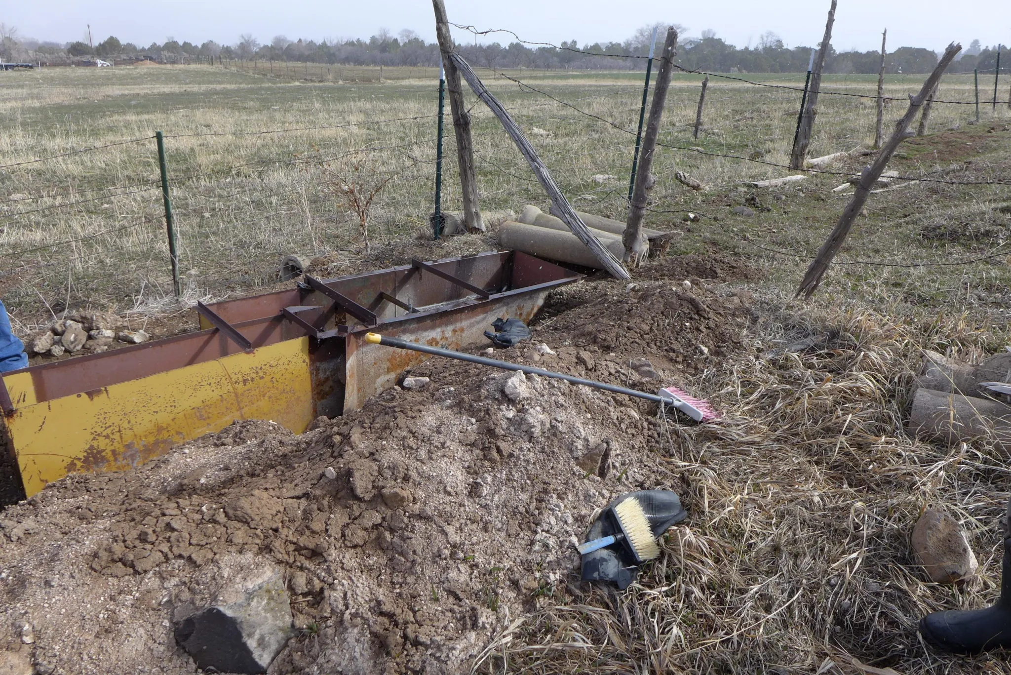
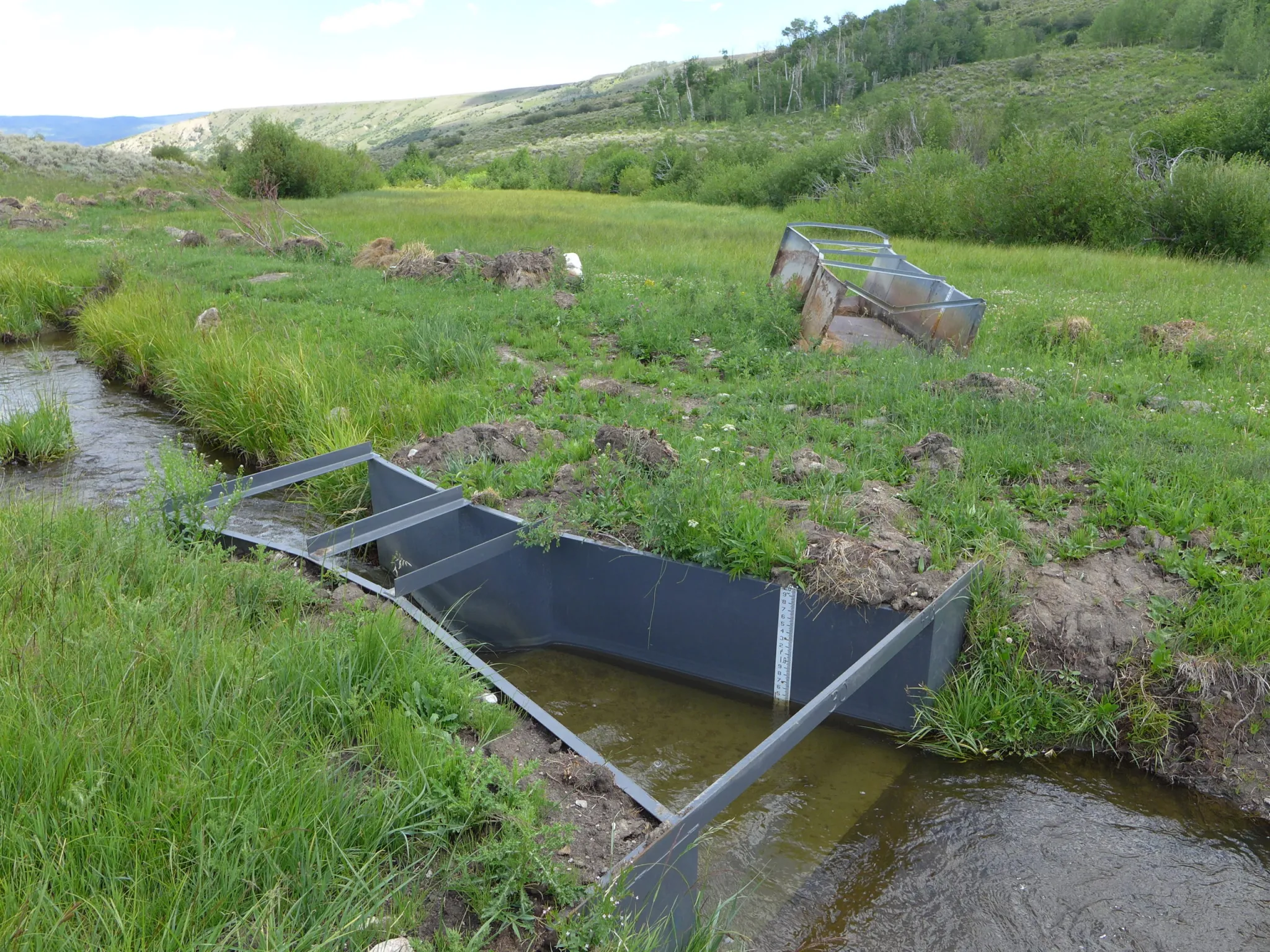
Maybell Irrigation District’s headgate on the Yampa River, September 2022. Photo credit: Heather Sackett/Aspen Journalism
Click the link to read the article on The Denver Post website (Noelle Phillips). Here’s an excerpt:
June 18, 2026
For the 18 ranchers who rely on the Maybell Irrigation District’s canal to funnel water to their fields, the 127-year-old headgate that diverted flow from the Yampa River meant a two-hour round trip through a rocky canyon whenever they needed water. The rusted structure was barely hanging on, and its operation was time-consuming for the busy ranchers, who had to lug special tools on all-terrain vehicles and on foot to open or close the mechanism. But it seemed impossible for the tiny district to find the $6.8 million needed to replace the headgate and the rocky diversion dam that pushed water into the canal. Then legalized sports betting came along, and, with it, millions of dollars for Colorado water projects. The tiny irrigation district, in Moffat County in the far northwest corner of the state, soon became the poster child for how gambling money is benefiting Colorado’s waterways. The district received a $750,000 grant from the Colorado Water Conservation Board, which doles out money from sports betting tax revenue, said Diana Lane, sustainable food and water program director for The Nature Conservancy in Colorado, which helped the district land the grant. That led to a matching grant from the U.S. Bureau of Reclamation’s WaterSMART program. With those two grants in hand, other organizations jumped on board, and money poured in, she said. In 2024, the Maybell Irrigation District installed a new headgate that can be opened or closed via cellphone. If a rancher is cutting hay and doesn’t need to irrigate, he can close the gates to match the amount of water he actually needs at that moment, Lane said. And the diversion structure no longer uses boulders to control the water flow. Instead, it’s a modern structure that is the right height for water control. The project also benefited four fish species, including the threatened humpback chub, and it made river navigation easier for boaters, helping the region’s outdoor recreation economy.
“That $750,000 was really the ball that got it all rolling, that showed people, ‘Oh, this is going somewhere,’” Lane said of that initial state grant.
Since sports betting became legal in May 2020, the state has collected more than $154 million in taxes, and the Colorado Water Conservation Board has funneled $140 million to various projects that preserve and conserve Colorado’s precious water. Supporters say the gambling money is a godsend for ranchers, fishermen, paddlers and others who want to protect the state’s water and those who depend on it for their livelihoods. Critics, however, say legalized sports betting has come at a cost — fueling an addiction crisis that the state was unprepared for and is underfunding.
Last post here, I suggested that at least some of the ongoing failure of the seven Colorado River states to reach agreement on a river management plan for even the next several years, let alone new century, stems from some ‘elephants in the river.’ You know – the big things that nobody wants to look at because they are so big. So big that some of the rules and guidelines we operate under were created to avoid having to address them.
The first ‘elephant in the river’ I discussed last time was the single-minded focus on the Colorado’s surface waters, and a failure to begin considering the whole integrated water supply, surface water and groundwater – of which the surface water is a relatively minor part, with users going to the groundwater in a haphazard way when the surface water is insufficient.
I did make an incorrect statement in that analysis, however. I said that Colorado was the first, and thus far only, state to begin integrating groundwater into its appropriation priority system statewide. (Arizona developed – by federal mandate – a Groundwater Management Plan circa 1970 for those specific parts of the state served by the Central Arizona Project.)
This is true about Colorado – but I was mistaken in implying that the all groundwater use was integrated into its appropriation system by 1969 legislation. Only alluvial groundwater is covered by that law – groundwater that is naturally integrated with surface water, either trickling into the surface streams when the groundwater table is high or drawing riparian water from the surface streams when the water table is low.
Not covered by the Colorado law are ‘non-tributary’ aquifers that have no natural interaction with the surface waters – aquifers like the Oglalla Aquifer in eastern Colorado, or the Denver Basin aquifer. Most of their water filters down from the alluvial groundwater, and only modern pumping technology makes that groundwater accessible to surface use. Most of these deep aquifers have accumulated their water slowly over geological periods of time, and even moderate use of their water dips quickly into ‘water-mining.’ Colorado law for such aquifers attempts to limit annual use to a hundredth of a presumed 100-year supply, but no one knows for sure how much water is really down there, or whether it will truly constitute a 100-year supply.
The standard response throughout much of the basin to shortages in surface water is to go to groundwater pumping; if ‘tributary’ (alluvial) groundwater is tapped, the pumping will gradually lower the water table – which in turn will begin to diminish the surface streams, which in turn will increase the pumping – et cetera, a vicious downward cycle. And the pumping of ‘non-tributary’ aquifers is largely unregulated in the basin.
At any rate – apologies for the error, and thanks to John McClow for pointing it out.
And on to another elephant in the room. Is it finally time to determine limits on the presumed universal applicability of the appropriation doctrine? To avoid being shot before I finish the paragraph, I will say immediately I am not suggesting doing away with the appropriation doctrine; it is a good enough last resort down on the ground where the appropriation doctrine started, for working out local problems of water use on a surface stream when neighborliness fails – that is, when old grumps and feuds preclude the ‘gentlemen’s agreement’ on sharing out what water is available, rather than shutting down the junior users with a ‘call’ so the seniors can get all their decreed water. After two or three generations, seniority can be acknowledged, but is too abstract to apply against your neighbors, if a plan for sharing blameless misfortune can be worked out.
The abstraction, however, becomes more applicable when it is distant water organizations calling out other water organizations upstream, or an earlier developed watershed placing a call on users in an adjacent more recently developed watershed. And when a stream is declared by the district engineer to be over-appropriated – not enough water to fill everyone’s decrees in a near-average year – it becomes even more abstract, a tool for enforcing a status quo, and nothing anywhere about what represents the best uses of the water.
There are, in other words, some areas in which the appropriation doctrine gets stretched beyond its elastic limits by emerging challenges of water use; any questions about ‘best and highest use’ have been essentially declared unanswerable as a matter of conflicting values, and it just seems easier to let seniority of use be the ultimate determinant of priorities.
A century ago, with California quintupling its population in the first two decades of the 20th century, the other six of the seven states in the Colorado River Basin (Arizona, Nevada, Colorado, New Mexico, Utah and Wyoming) began to worry that California might put so much of the river’s water to use that there would not be enough unappropriated water for them to put to use when their time of growth came. They were all committed to versions of the appropriation doctrine within their states, but came to believe that reliance on the appropriation doctrine alone at the interstate level could cause more regional problems than it would resolve.
That concern was affirmed in 1922 when the U.S. Supreme Court resolved a conflict between Colorado and Wyoming over a Laramie River tributary that started in Colorado but was put to use first in Wyoming; the court declared that states who used the appropriation doctrine intrastate would also have to respect each other’s appropriations interstate. This made real the specter of slow-growing upstream states having to let all their Colorado River water go downstream to fill huge Arizona and California decrees.
So they assembled in 1922 to try to do something about that – a fundamental fact about the Colorado River Compact commission that we tend to forget: the original intent of the compact commissioners in 1922 was to develop an alternative to the appropriations doctrine at the interstate level. They came together with the intent of working out a seven-way division of the use of the river, based on possible future development, that would eliminate a horse-race of interstate appropriative competition. Six of the states convened the commission because they feared California, and California reluctantly participated because it knew the feds would never build the big control and storage dam they needed until all seven states were on board with it. That seven-way division trumping interstate appropriation was what the Compact Commissioners assembled to do –and spent a frustrating week early in 1922 trying to do.
They were unable to effect a seven-way split for a couple of reasons: for one thing they had no good measure of how much dependable water was in the river; estimates at the time ranged from 12 to 20 million acre-feet (maf). But for a second thing, the sum total of the water they each felt their state needed, based on rosy early-20th-century estimates, was closer to 24 maf – and nobody wanted to go home having backed down from their carefully imagined numbers.
Members of the Colorado River Commission, in Santa Fe in 1922, after signing the Colorado River Compact. From left, W. S. Norviel (Arizona), Delph E. Carpenter (Colorado), Herbert Hoover (Secretary of Commerce and Chairman of Commission), R. E. Caldwell (Utah), Clarence C. Stetson (Executive Secretary of Commission), Stephen B. Davis, Jr. (New Mexico), Frank C. Emerson (Wyoming), W. F. McClure (California), and James G. Scrugham (Nevada). CREDIT: COLORADO STATE UNIVERSITY WATER RESOURCES ARCHIVE via Aspen Journalism
What they did instead – in order to persuade Congress that there was general agreement – was to cobble together the Compact we are burdened with today; they created what Commission Chair Herbert Hoover called a ‘temporary equitable division’ of the seven states into Upper and Lower River Basins, until ‘ those men who may come after us, possessed of a far greater fund of information’ could do the ‘further division’ of the river among the states.
They also decided – as early 20th-century Americans would – to lean toward the more optimistic estimates of river flow, dividing ‘equally’ between the Basins only 15 maf of a river they presumed would continue running 16-20 maf – hence the 7.5 maf for each Basin written into the compact, to be further divided among the states of each Basin in their own good time. That left some water for Mexico, but they did nothing specific for the Indian tribes in the basins because national Indian policy at that time was ‘soft genocide’ – full assimilation (‘kill the Indian, save the man’), leaving tribal water a concern they thought would disappear.
This all made reasonable sense with a river running a quarter-century average of just under 18 maf – but then through the 1930s the river experienced a drought unsurpassed until the past quarter century. By the end of World War II, Colorado river water users had a ‘far greater fund of information’ about the river’s flow, which would have made it a good time to have ‘fixed’ the Compact – but the growing fund of information was all bad news that no one wanted to incorporate into a more realistic policy. So by default the ‘temporary equitable division,’ with its mythic 18 maf river, took on the permanence of something carried off a sacred mountain carved in stone.
And now – we are seeing it reduced to a sad irony. The states of the Lower Basin had their fears too, and wanted a clause in the Compact stating that, should the Upper Basin states have a wild spurt of growth, they should not ‘deplete the flow’ to the Lower Basin below an average of 7.5 maf a year. But now – when it looks like diminished flows throughout the basin might really drop the flow at the division point between basins below that average – the Lower Basin is threatening the Upper Basin with an Article III(d) ‘call,’ saying the upper states will have to cut their own uses enough to meet the lower states’ fantasy 7.5 maf. States that set out a century ago to create a compact that would transcend the appropriation doctrine at the interstate level are now trying to turn that ‘temporary equitable division’ into what amounts to a senior interstate water right.
There has to be a level, or category, of action in which the law of first-come first-served is transcended by other considerations. And can we not say, at this point a century later, that the original intention of the compact commission has been achieved de facto? No state will ever get the use of more water than it had (or believed it had) around the turn of the century because there is even less water now. For better or worse, the use of the river has been distributed among the states (including some of the tribes) and Mexico.
Udall/Overpeck 4-panel Figure Colorado River temperature/precipitation/natural flows with trend. Lake Mead and Lake Powell storage. Updated through Water Year 2025. Note the tiny points on the annual data so that you can flyspeck the individual years. Credit: Brad Udall
Whether this is an equitable division is arguable; the states of the Lower Basin have been using roughly two-thirds of the river’s water, the Upper Basin states around one third, rather than the 50-50 split explicit in the Compact (7.5 maf per Basin). But arguably that does reflect the relative productivity of Lower Basin agricultural use (by far the largest use) and also its millions of urbanites drawing on it for at least part of their municipal water. It was a huge step toward reality when the Lower Basin states finally agreed that they must absorb the Lower Basin’s system losses (mostly evapotranspiration) and their half of Mexico’s allotment out of their own shares of the river, rather than relying on a fictional surplus to cover it – a fiction that combined with drought to draw down both Powell and Mead Reservoirs to the dangerous level where they linger today.
Yampa River Basin via Wikimedia. Note the Little Snake River crossing the Colorado-Wyoming line.
The 1948 Upper Colorado River Compact was the first reality-based document in the ‘Law of River’ portfolio because its negotiators knew by then – that ‘greater fund of knowledge’ – that it was doubtful that there would always be 7.5 maf for their use, and actually accepted that as their reality. So the divided their ‘half’ of the river into percentages for each state of whatever was left for the upper states after the Lower Basin got it Boulder Canyon Project Act waters. After three-quarters of a century, the four states are not too far from those percentages in their development of around 4.5 maf; only Wyoming is significantly under its 13 percent; Utah is a little below its 23 percent; and Colorado is a little over its 51.75 percent. Given the geographic irrelevance of western state boundaries (the Little Snake River crosses the Colorado-Wyoming border half a dozen times), this was pretty good 1948 estimating.
The reality today is that all Colorado River water users in all seven basin states are using a finite and measurable resource that will probably continue to diminish for the foreseeable future as we continue to heat up the planet, and we need to come to an agreement on what that means for all users. [ed. emphasis mine]
It seems to me there are three ways to address that diminishing flow. One way is to continue to accept the divine sanctity of the Colorado River Compact, with the Upper Basin states forced by the Supremes (they ride for power, not for the law) to cut back their own uses to meet the 7.5 maf average delivery to the Lower Basin – basically the interstate nightmare (for the upper states) the Compact was meant to address. Call this the stubborn denial option.
A second way would be to accept the evolved eight-way division (seven states plus Mexico) of the use of the river’s water, which was what the seven states wanted to do in 1922, instead of the ‘temporary equitable’ compact they came up with. Percentages for each basin state could be set according to the amount each state was using at the end of the major river development era, say in Y2K (remember that?), when the 70-year average annual flow was ~14.5 maf (1930-2000). Those state percentages of the river’s consumptive use could be retained – but the actual volume of water for each state would gradually diminish as the combination of ‘dry drought’ and ‘heat drought’ continues to diminish the river. Given that losses attributable to climate warming are both everybody’s and nobody’s fault, the losses to each states would be proportionate to their percentage of the river’s consumptive use, with no falling back on seniority, as though it were just a squabble between users. Each state could then either stay with the appropriation doctrine intrastate with junior users bearing the loss, or equitably share out the loss proportionate to use. Call the latter the shared reality option.
Photo of Crowley County by Jennifer Goodland
A third way lies between stubborn denial and shared reality, and will probably prevail as the default American Way: let money work it out. Municipal and industrial users will continue to work out money-for-water deals with agricultural users, like San Diego and the Metropolitan Water District have done with the Palo Verde and Imperial Valley ag districts, with responsible districts using the money for systemic improvements that minimize the impact of lost water. This is by no means going to ‘dry up’ agriculture. With 75-85 percent of the river’s water being used by agriculture, a doubling of M&I use would only require transfer of 10-15 percent of ag water, although (money being blind to all but profitability) the transfers would probably cause some local tragedies like Crowley County in Colorado where too much water was bought out of a single small irrigation district by Front Range entrepreneurs.
The appropriation doctrine, with its strange ‘property right’ independent of the property for which it was granted, is quite compatible with the money option for resolving water distribution, once over-appropriation is achieved. The idea that water’s seniority in a certain use can be transferred to a totally different use along with the water strikes me as strange – shouldn’t a new use initiate a new right? It is also contradictory to the doctrine’s initial democratic-populist effort to prevent the dominance of big money in water distribution by limiting water rights to what one could put to use. But it does seem to be the American way that everything eventually comes down to money as the base determinant of value.
Enough for today. The elephants in the river. I obviously favor ‘ratifying’ the evolved split of the use of the river, and an equitable proportionate sharing among all states – and within all states – of the consequences of our cultural climate changes. But that will not fly among those who have steadfast faith (senior water right holders) in the appropriation doctrine as the answer to all problems.
The river? It abides, rises and falls with the water table in its surrounding groundwater, and it may occasionally disappear, but it won’t have died, it will just have gone underground until the water table rises again and the ground can’t hold all the water – if we figure out how to let that happen.
Map of the Colorado River drainage basin, created using USGS data. By Shannon1 Creative Commons Attribution-Share Alike 4.0
Ranchers are constantly adjusting to changing weather conditions and seasonal variations by nature. Jay Fetcher, of Fetcher Ranch in North Routt County, has documented snow melt dates for his hay meadows for each of the 75 years the ranch has been in the family, and said the variation is “incredible.” A year with low snowpack and a warm spring is just another condition to adjust to in the ranching world. This year, dryland hay broke dormancy early in Routt County, meaning cutting has already started, about two or three weeks earlier than usual. The low snowpack is not only generating concerns for ranchers with irrigated hay but water concerns for those with livestock. Despite these problems, the general consensus was that this year is expected to be below average, but not detrimental.
“People with dry land probably can expect some reduced yields, but I will say that the rains we’ve gotten over the last couple weeks have brought on grasses in dry land and pasture situation areas better than I would have anticipated,” said Todd Hagenbuch, the county director and agriculture agent for the Colorado State University Routt County Extension…
The second big concern from the lack of snowpack was water for cattle and other livestock. According to Hagenbuch, the snow runoff fills ponds and streams that the animals drink out of, but this year there’s simply no water in a lot of them. For ranchers whose ponds and streams are not filled, they have to haul water in for the livestock.
“That’s the big issue is adequate water for livestock, and it will be all summer,” said Mucklow. Mucklow is currently not needing to haul water on his ranch, but he personally knows several ranchers who are in that position.
Mucklow also said that there is a federal drought program conducted by the U.S Department of Agriculture that compensates ranchers who have to haul water.
Having drinking water for his cattle was also a primary concern for Fetcher earlier in the season. “It was on my mind as we had no snowpack, and the snow was gone,” said Fetcher. On his ranch, they rely on the streams and springs for the cows in the pastures. Fetcher said the recent rains gave him a significant amount of moisture that eased his worries considerably.
At the Yampa Town Board meeting last week, Andi Schaffner with the Bear River Reservoir Company presented plans and cost estimates for a Stillwater Reservoir project that would lead to removal of its storage restriction. The plan consists of two phases involving installation of a strain and a sand filter to alleviate seepage into the dam’s embankment, the primary concern that led to the storage restriction designation…Currently, the town of Yampa owns 112 shares in Stillwater Reservoir, or about 2% of the reservoir. Phase 1 of the project consists of a blanket drain and filter collar and is estimated to cost $730,717. Phase Two of the project will be stabilizing the channel and the removal of the culvert and the flume, at a total estimated cost $209,874. Schaffner said that the team at Bear River Reservoir Company has spent hours on engineering and studies at the reservoir in order to determine the best solution for the dam. “We finally opted for the least expensive fix, which is what we’re working on right now,” said Schaffner…The project has received a significant amount of grant funding despite higher than anticipated bids, including a $202,000 loan from the Colorado Water Conservation Board. This loan was the primary expected cost for the town of Yampa, and is expected to be approved with an increase to $404,000 ahead of the project’s notice to proceed with the contractor on July 13. The project is expected to be completed by the end of October. The Colorado Water Conservation Board loan is 30 years with 1.85% interest, or $3.40 per share per year. For the town of Yampa’s 100 or so shares, this amounts to $381 a year. Schaffner did not expect any more expenses besides an assessment of the shares which amounts to about $5.
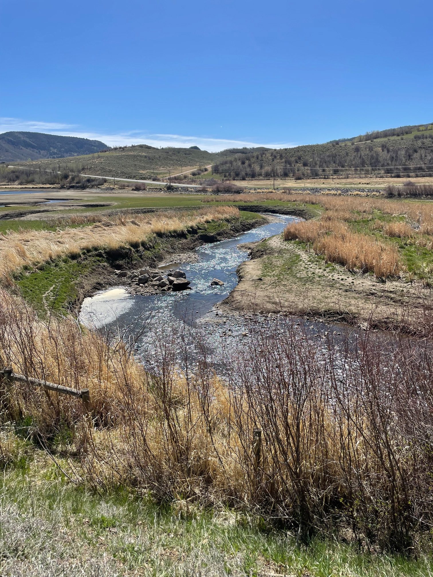
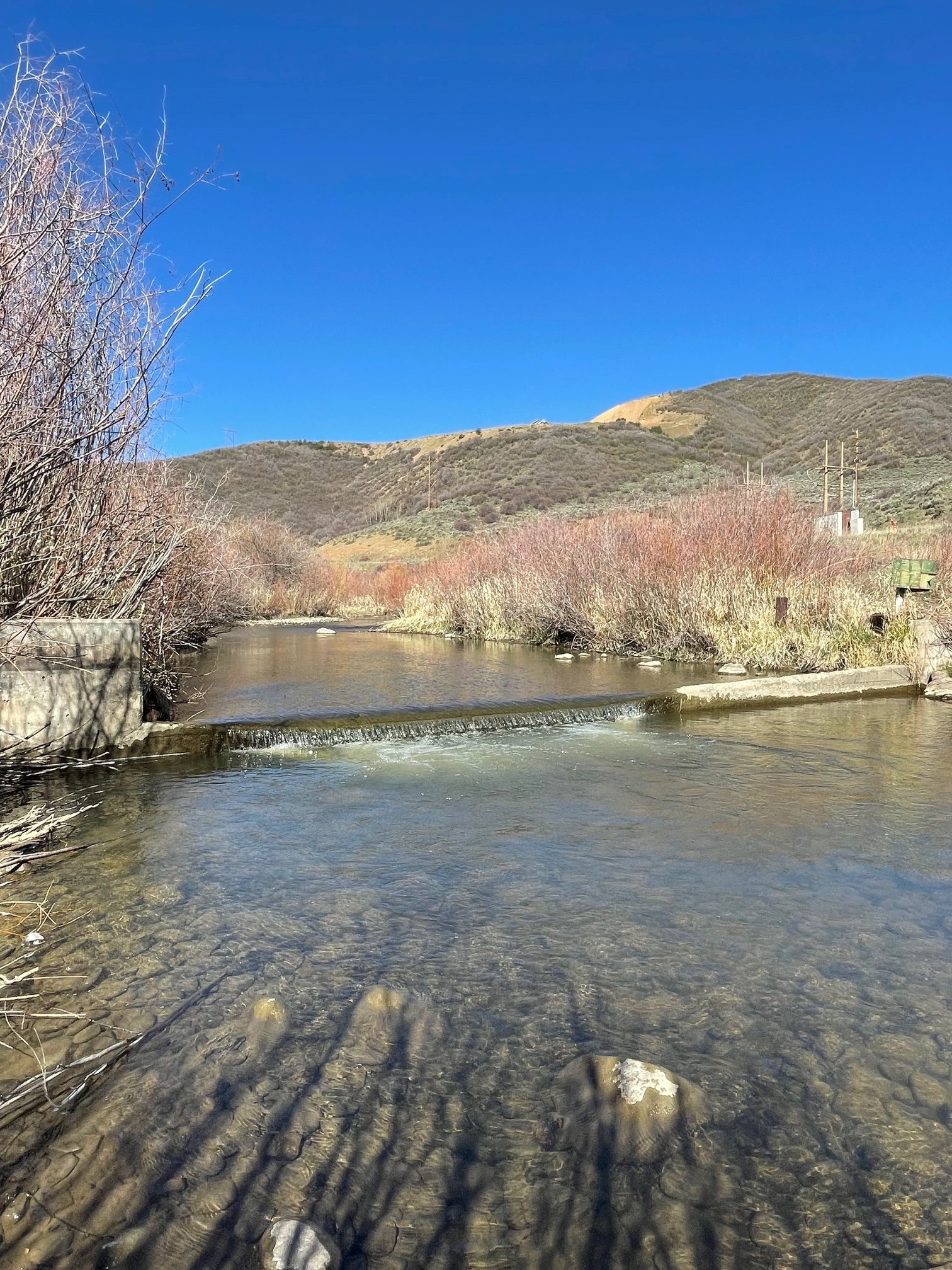
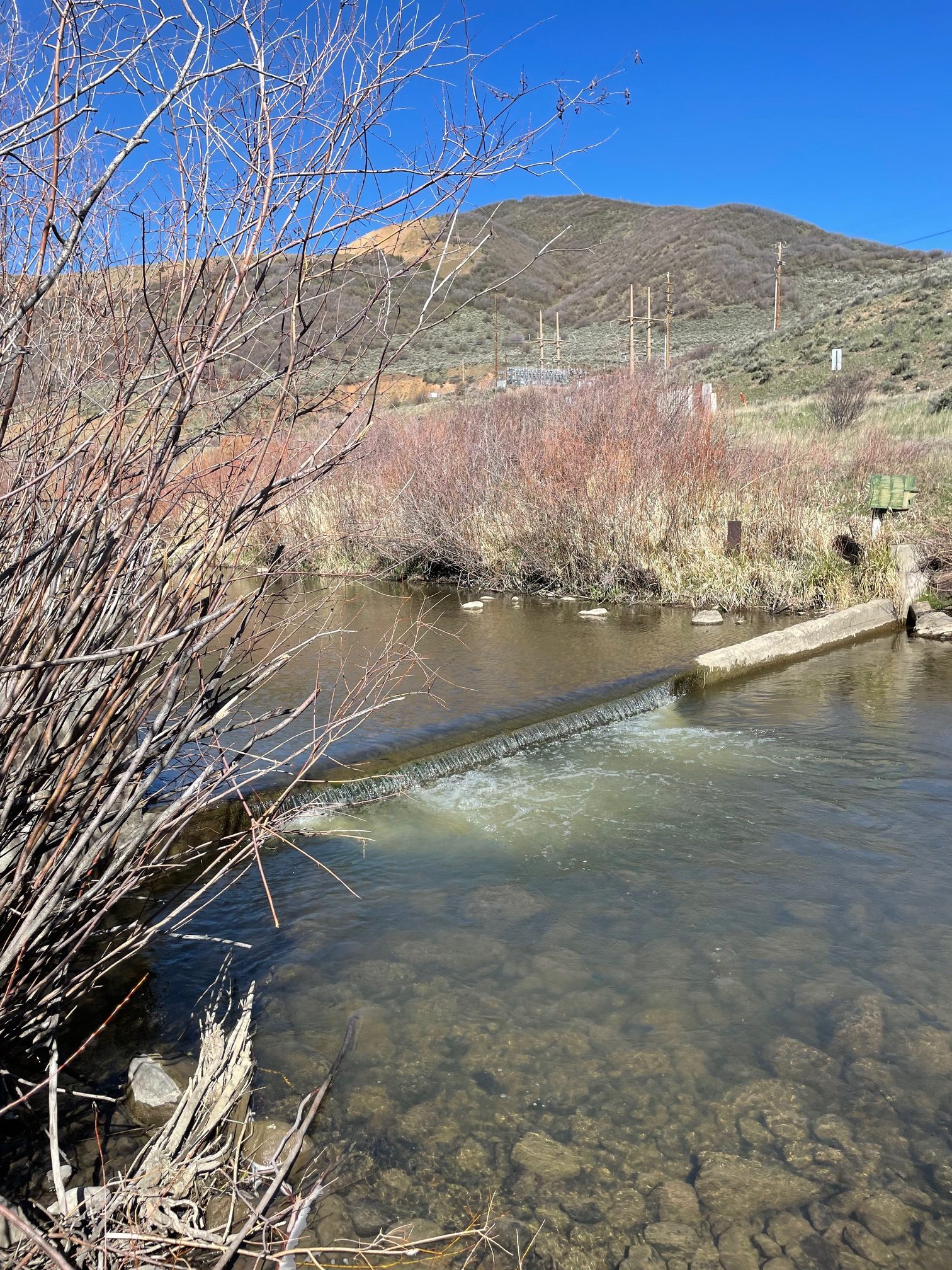
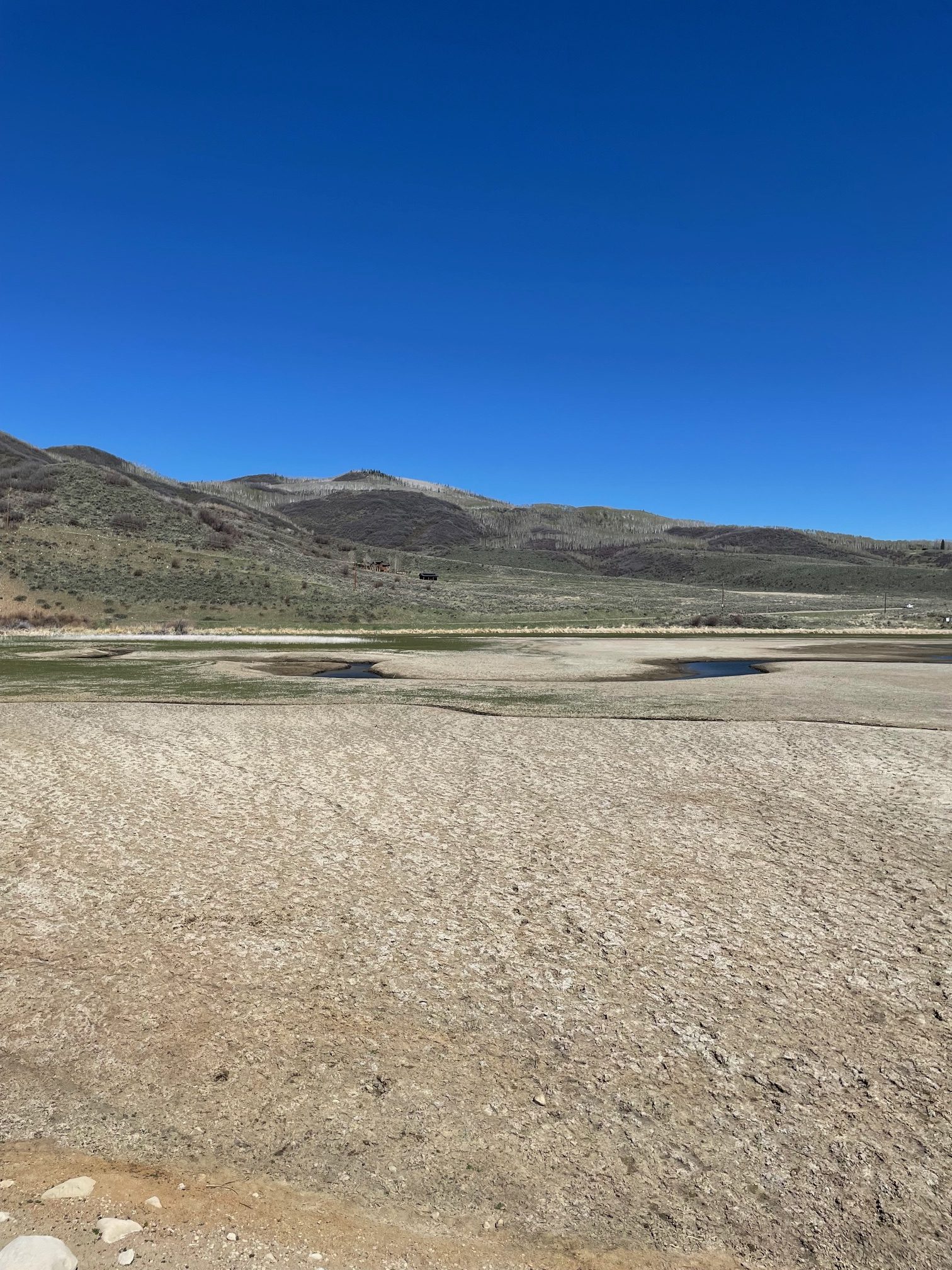
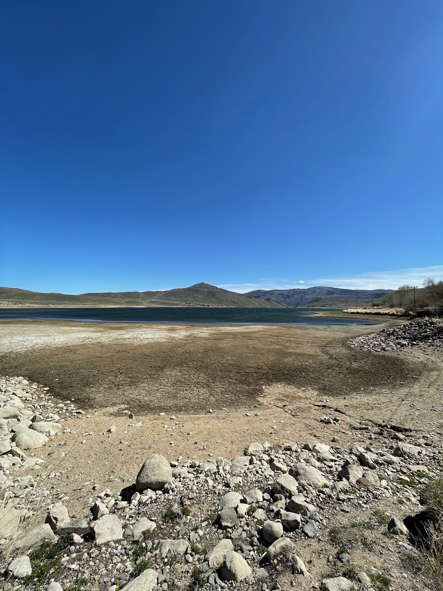
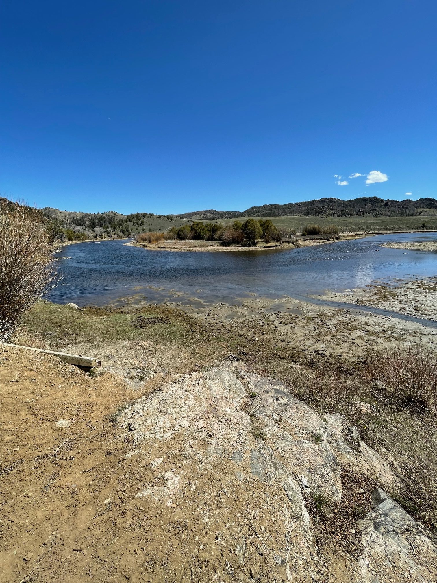
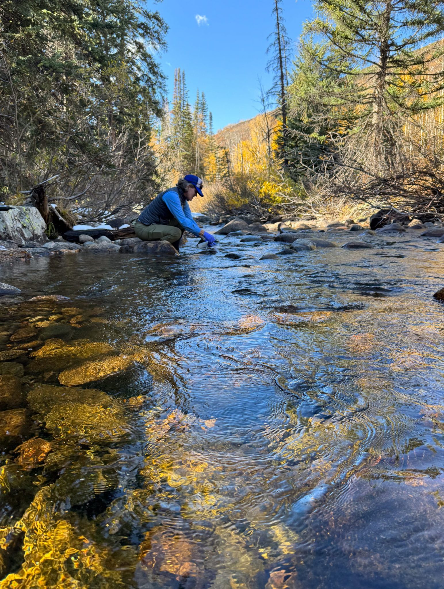
Scott Hummer worked for the Colorado Department of Water Resources for many years so he has witnessed many ups and downs for the rivers in northern Colorado. Here are some low flow photos from a recent road trip. First up Stagecoach Reservoir and the Yampa River.
The confluence of the Blue River (L) and Muddy Creek (R) April 22, 2026. Photo credit: Scott Hummer
Streamgage above Stagecoach Reservoir April 22, 2026. Photo credit: Scott HummerStreamgage above Stagecoach Reservoir April 22, 2026. Photo credit: Scott HummerThe inlet to Stagecoach Reservoir April 22, 2026. Photo credit: Scott HummerStagecoach Reservoir April 22, 2026. Photo credit: Scott HummerYampa River inflow to Stagecoach Reservoir April 22, 2026. Photo credit: Scott Hummer
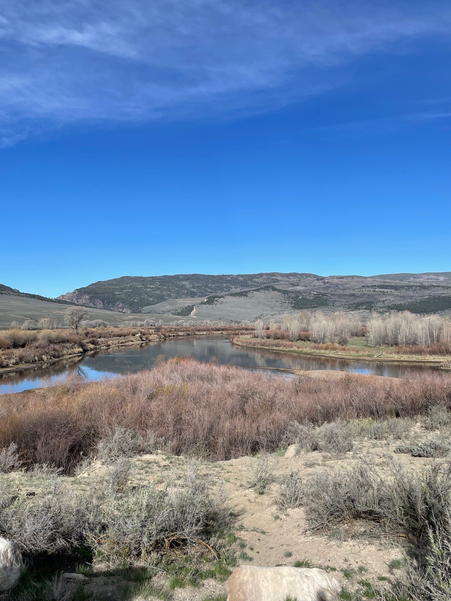
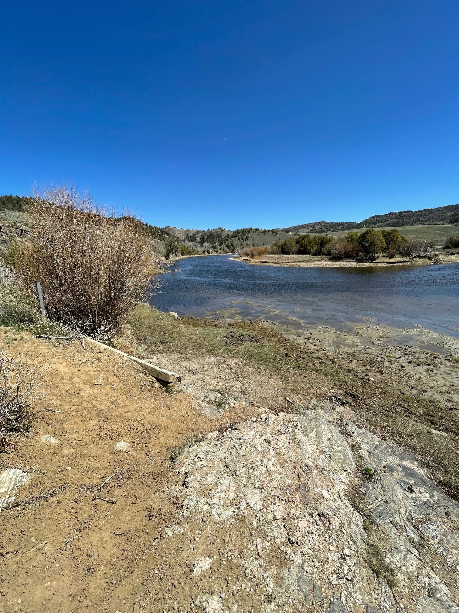
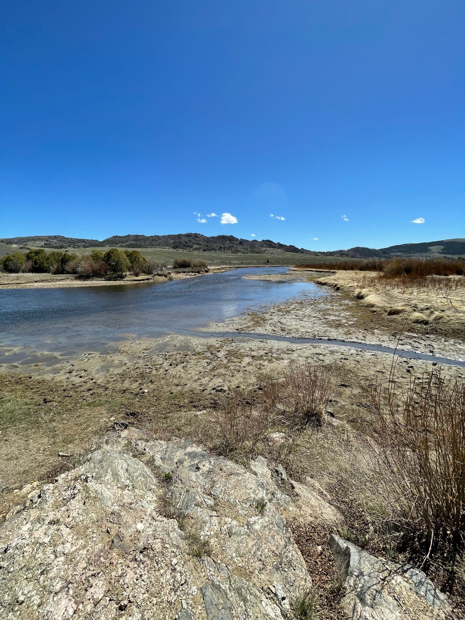
The North Platte River April 22, 2026. Photo credit: Scott Hummer
The North Platte River April 22, 2026. Photo credit: Scott HummerThe North Platte River April 22, 2026. Photo credit: Scott Hummer
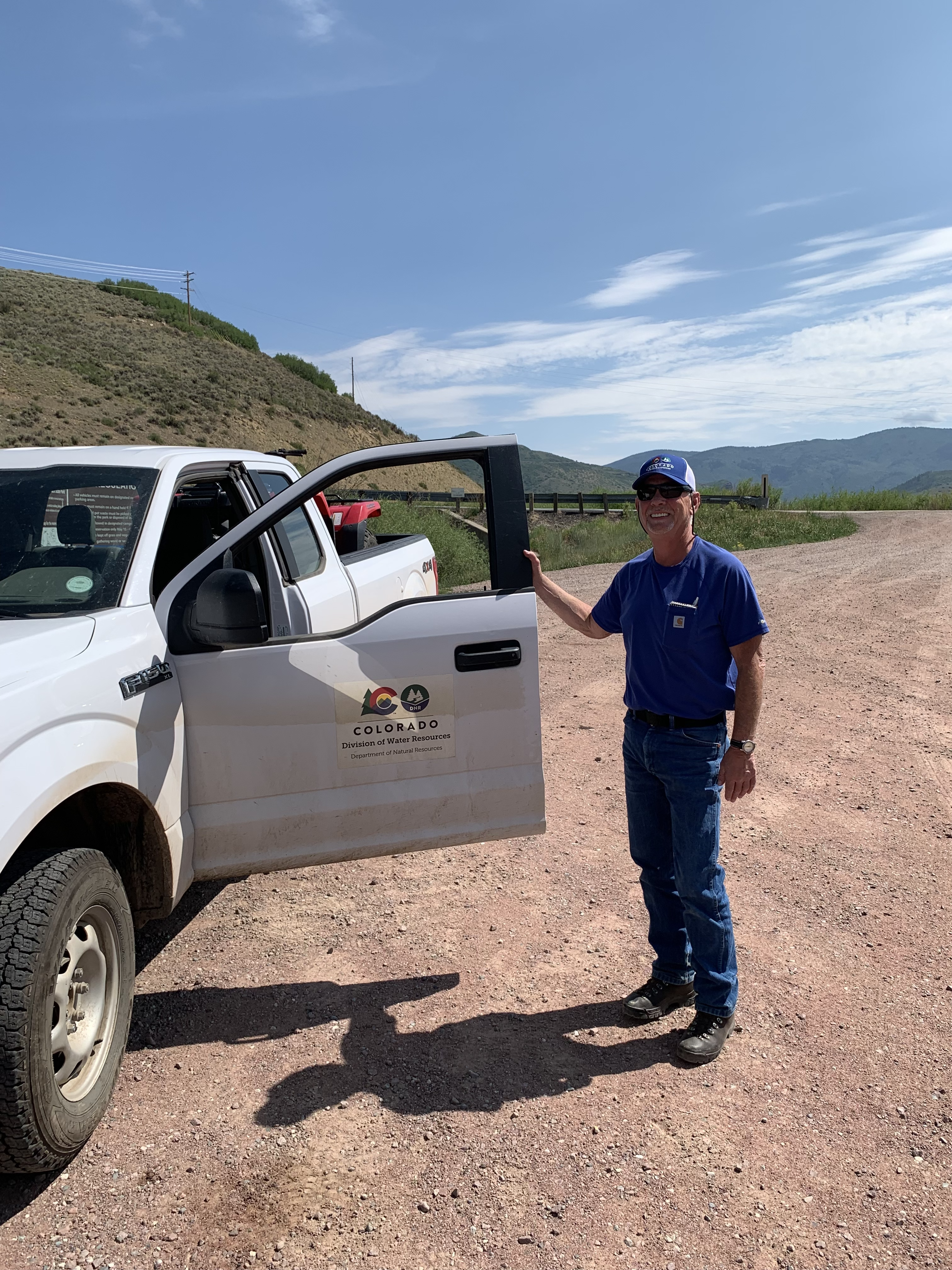
Scott Hummer at the inlet to Stagecoach Reservoir July 22, 2021 when I was bumming up and down the Yampa River.
Yampa River Basin via Wikimedia.
Map of the North Platte River drainage basin, a tributary of the Platte River, in the central US. Made using USGS National Map and NASA SRTM data. By Shannon1 – Own work, CC BY-SA 4.0, https://commons.wikimedia.org/w/index.php?curid=79266632
Elkhead Reservoir is taking center stage following a winter of historically low snowfall, leaving water managers with hard decisions and water users with a high degree of uncertainty. Courtesy Photo/Colorado Parks & Wildlife
A historically dry winter is setting up what water officials describe as one of the most challenging runoff seasons in recent memory, with operations and allocations at Elkhead Reservoir expected to play a critical role in stretching limited supplies across Northwest Colorado….That challenging outlook [ed. snowpack and streamflow in 2025] and lessons learned from past years with low snowfall are key focal points in early planning and coordination among water managers, particularly for reservoirs like Elkhead, which serves irrigators, municipalities and environmental needs in the Yampa River Basin…Calahan said warm, dry conditions have dramatically accelerated snowmelt, raising the likelihood of a runoff season that arrives early, fades quickly and leaves water managers facing difficult decisions for a wide range of stakeholders…In a more typical year, gradual warming allows the snowpack to melt slowly, sustaining river flows well into summer. This year, however, that prolonged runoff is not materializing, which is already increasing pressure on stored water supplies. While late spring storms or summer monsoons could provide some relief, officials do not expect conditions to return anywhere near an average water year. That uncertainty leaves reservoir managers balancing how much water to store versus how much to release to meet downstream demand.
The Colorado River at Las Colonias Park in Grand Junction was running at about 350 cfs Wednesday. Streamflows are expected to be way below normal this spring; some may have already hit their peak for the year. CREDIT: HEATHER SACKETT/ASPEN JOURNALISM
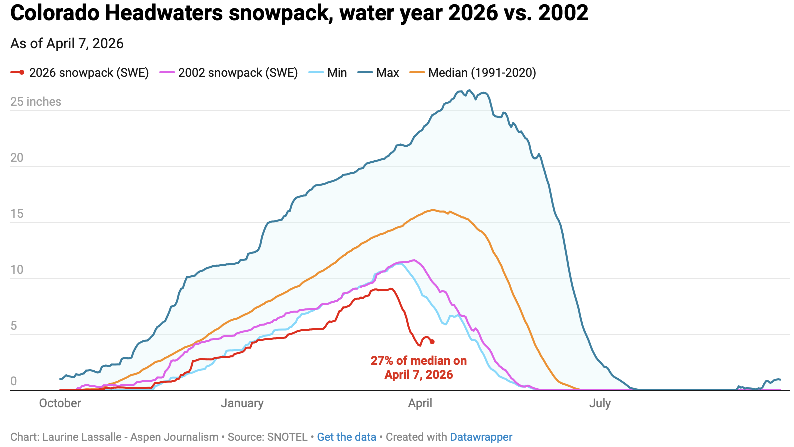
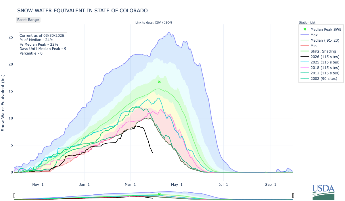
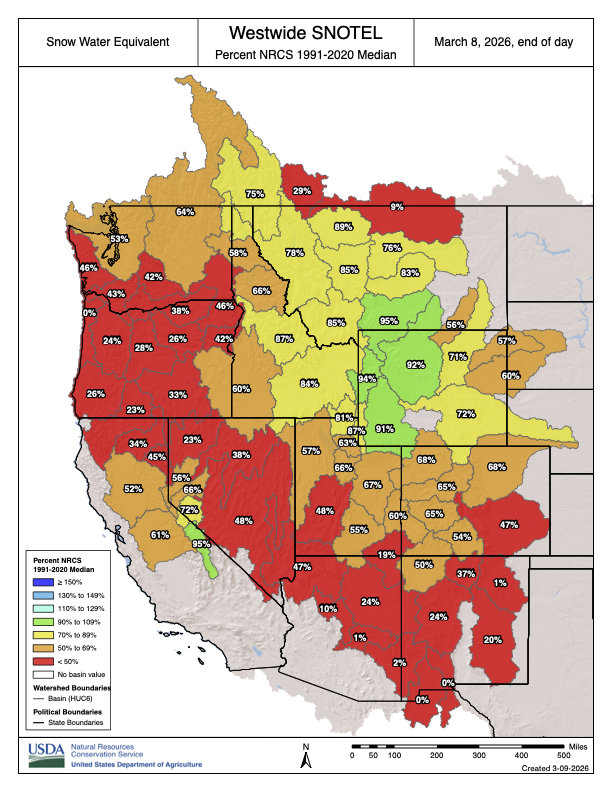
Water managers are planning for an extremely dry summer as Colorado wraps up winter 2026 with the worst snowpack on record for early April.
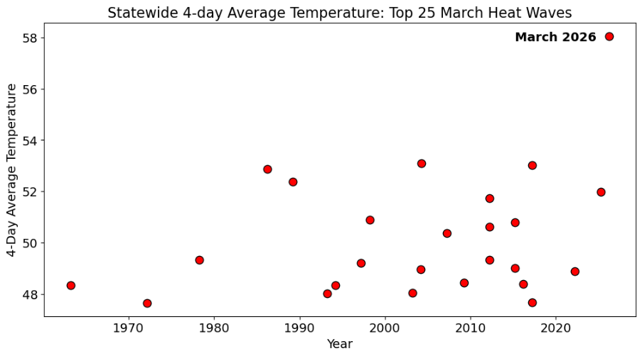
The Colorado River basin has seen slightly drier water years, but never a hotter one in the era of modern record keeping. A March heatwave that broke records statewide fueled an early peak of the snowpack, followed by rapid melting. This was the warmest March in 132 years of record-keeping for Colorado – three to four degrees Fahrenheit warmer than any other March, according to the Colorado Climate Center.
“Climate change definitely raises the probability of heat waves significantly,” said Peter Goble, assistant state climatologist at Colorado State University. “This heat wave was so far out of the range of what we’ve seen in March before that I don’t expect this to be the new normal, but it was certainly made to some degree more likely by climate change.”
The month of March decimated Colorado’s snowpack, which was thin to begin with, during a time when snowpack is usually still accumulating. The Colorado Basin River Forecast Center put the March 1 snowpack above Lake Powell at 52% of median. One month later, the April 1 numbers showed snowpack had declined dramatically to 23% of median.
“What snowpack was there was already among the lowest, if not the lowest on record, and it melted much more quickly than normal,” Goble said. “We saw melt rates more characteristic of May or June in March.”
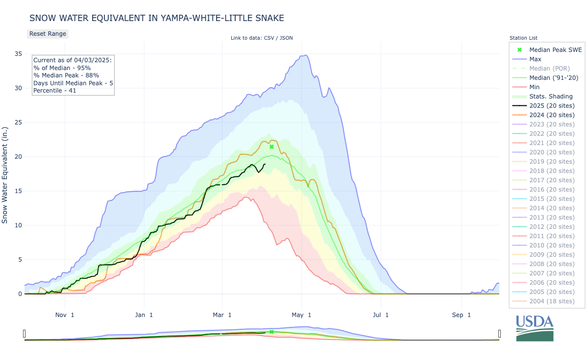
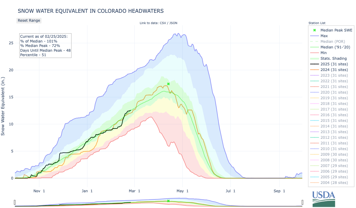
Early April status reports and forecasts are important because they provide a critical snapshot of assessing where things stand and how much water will be available for the summer. This week is typically when snowpack peaks for the year before it begins a gradual melt out. But snowpack in the Colorado River headwaters this year peaked nearly a month early on March 17 and now sits at just 27% of median. Snowpack in the Roaring Fork River basin is 26% of normal.
“We’ve never seen anything like this in memory,” said Raquel Flinker, director of interstate and regional water resources at the Colorado River District’s State of the River meeting in Grand Junction Tuesday. “If there’s anything in your memory about a dry year that you’ve seen, a warm year that you’ve seen, 2026 is beyond all of that. It’s far beyond 2002, which has been the year we normally think of as the worst year in hydrology.”
The big question is whether that record-low snowpack will turn into record-low runoff. Forty million people in the American Southwest depend on water from the Colorado River, which comes from the melting annual snowpack. Some streams may have already peaked for the year, something that normally occurs in early June for Western Slope streams.
“The streamflows are going to be much below normal,” Goble said. “But the lowest snowpack on record does not necessarily guarantee the lowest streamflow on record.
”In a Tuesday water supply briefing, hydrologist Cody Moser with the CBRFC said that the forecasted April through July inflow to Lake Powell this year is 1.4 million acre-feet, just 22% of normal and the third-worst on record. That’s down from the March forecast, which predicted 2.3 million acre-feet of inflow. The benchmark for low Powell inflows is 2002, which saw just 964,000 acre-feet of water flow into the reservoir.
The streamflow forecast for the Colorado mainstem in Colorado (known as Division 5 by state water managers) is 38% of normal, according to the National Resources Conservation Service. The Yampa is at 36% of normal; Gunnison is 34% and the San Juan basin in the southwest corner of the state is forecast to have just 26% of normal streamflows this year.
Yampa calls
Water managers around the state are preparing for an exceptionally dry summer. Some municipal water providers have already implemented outdoor watering restrictions, and the Colorado Division of Water Resources is alerting farmers and ranchers to the possibility of more calls this season.
The Yampa River basin is poised to be one of the hardest hit this year. Mosher said on Tuesday that streamflows on the Yampa are forecasted to be close to the minimum on record.
“This forecast declined by 40% in the past month and here you see that huge melt off with our snowpack conditions,” he said.
Yampa River Operations Coordinator for Division 6 Water Resources Brian Romig sent a March 28 email to all water users in the basin reminding them of how calls work. When an irrigator with a senior water right isn’t getting all the water they are entitled to, they can place a call with state officials, who will then shut off upstream water users with junior water rights so the senior right can get its full amount of water. Under the cornerstone of Colorado water law, the oldest water rights get first use of the river.
The Yampa River was among the last to develop in the sparsely populated northwest corner of the state and it had never had a call until 2018.
“Call administration is a reality of our future,” said Division Engineer Erin Light. “I think it’s very possible we are going to see calls and the sooner people start to understand what that looks like and become accustomed to it, the better.”
Light said she has been hearing from water users about how early they have had to turn their ditches on to irrigate their fields – some the weekend of March 21 – due to the meager snowpack and record-high temperatures.
Light predicted that some ranchers won’t be able to grow all of the hay their animals need to feed them through next winter.
“Ranchers are going to have some big decisions to make as far as: Will they buy hay or will they have to sell cows,” she said.
In recent years, the River District has leased water out of Elkhead Reservoir and released it during the irrigation season to boost flows for downstream ranchers and keep a call off the river. But Light says this approach doesn’t help water users adapt to a future with less water. Once people know what to expect and how calls are administered, it’s less of a big deal, she said. And as river flows continue to dwindle due to drought and climate change, learning how to manage inevitable scarcity has never been more important.
“I think it’s a good thing for our water users to manage their water in such a way that they know in late August, they could be shut off,” Light said. “But we’re not giving that opportunity to the people on the Yampa River by trying to always keep the calls off.”
Throughout Colorado a record-warm and dry winter has come to a close. Attention now pivots to spring and the potential for additional snow to allay increasing drought concerns. Though, there appears to be little relief in sight.
The Denver-metro area went months without measurable snowfall this winter. The city’s daytime temperatures often surpassed 60 degrees. Hikers and trail runners rejoiced over the warm weather while grumbling skiers lamented their underused season passes.
In the state’s Rocky Mountains snow accumulation was sluggish, as warmer than normal temperatures led to midseason snowmelt, and caused more precipitation to fall as rain instead of snow. A persistent mid-March heatwave kicked off rapid snowmelt. Colorado’s snowpack, and in the broader Colorado River basin, set new record lows throughout winter. T-shirt weather wasn’t just confined to lower elevations either. The high country too experienced balmy days and nights.
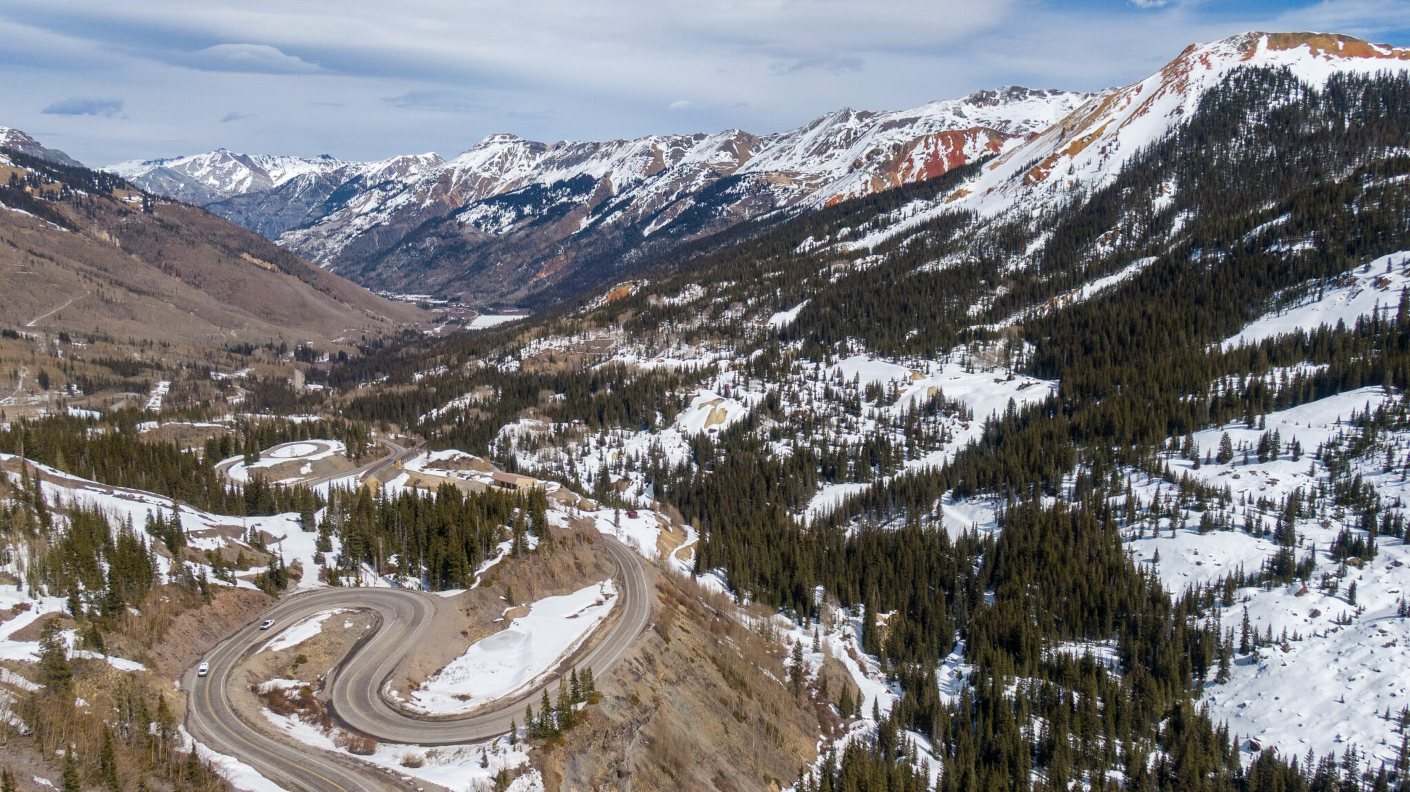
Spring snowmelt is underway near Red Mountain Pass in Colorado’s San Juan Mountains on March 14, 2026. (Mitch Tobin/The Water Desk)
The mild year has already led to lifestyle changes for Colorado residents, and threatens to do even more. Ski resorts are closing early, ranchers are worrying about the security of their irrigation supplies, and water managers are considering contingency plans if such conditions persist.
This year, powder days that rev the state’s ski economy were replaced with sunshine. Recreation is not the only industry under threat from rising temperatures and low snowpack. The state’s agricultural economy hinges on access to snowmelt.
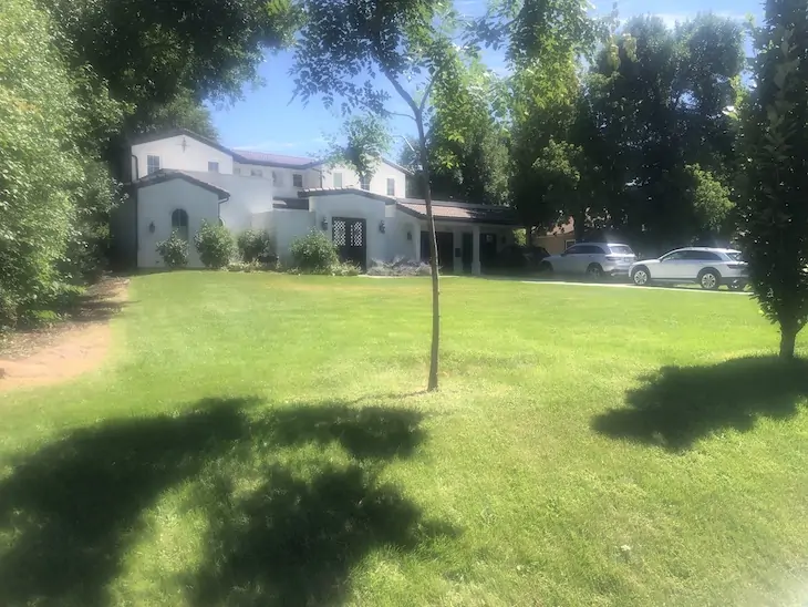
Marsha and John “Doc” Daughenbaugh call the Rocking C Bar Ranch near Steamboat Springs home. Marsha is a third generation rancher in the area, and the couple have passed the business off to their two children. They still worry that if such dry conditions continue, it would “seriously affect our ability to keep going,” Marsha said.
Marsha and Doc Daughenbaugh of Rocking C Bar Ranch, west of Steamboat Springs, Colo., say dry winters call into question their ranch’s longterm viability. (Annie MacKeigan/The Water Desk)
A well-welcomed snow system worked its way through parts of the state in early March, providing the nearby Steamboat Ski Resort a self-reported 6 inches of new powder. But it quickly melted, and the Daughenbaughs were ankle deep in mud come midday.
Doc has long made a habit of measuring inches of snowpack in the ranch’s meadow each year on March 20, right around the spring equinox. Few of his recordings—which began in 1989—noted no snow.
The most sobering of Doc’s notations is also the most recent. During a visit in early March, the entry read, “all snow gone by Feb. 26.”
The Daughenbaughs have collected snow measurements on their ranch near Steamboat Springs since 1989. (Annie MacKeigan/The Water Desk)
The noticeably scant snow is not the only observation the Daughenbaughs have made this year. Robins, geese and sandhill cranes had already returned to the family’s ranch by early March, not usually due back until the first week of spring.
Marsha, who has lived in Steamboat since 1953, recalled “three-wire winters,” when snow would build up to the third wire on the barbed-wire fences that surrounded their property. “They were really a common thing,” she said.
Their main concern is that any snowpack that does accumulate this spring will travel down the mountains fast, due to warm temperatures and limited reserves, which means less water availability sooner in the year for high country ranchers like themselves.
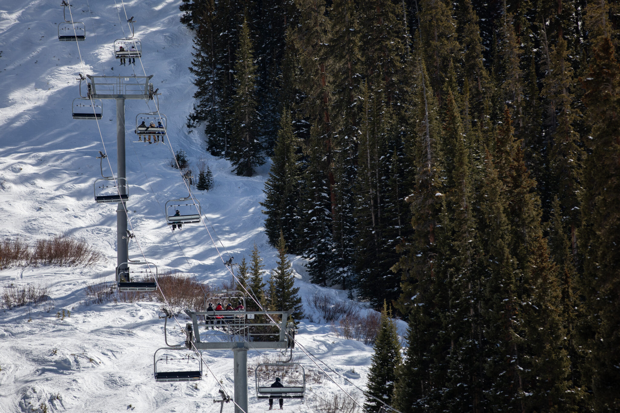
South of the Daughenbaughs, skiers and snowboarders in Summit County are seeing their seasons cut short.
At its summit, Arapahoe Basin is one of the county’s highest ski resorts in elevation. But instead of the high elevation benefitting the mountain, it has become somewhat of a disadvantage. According to Doug Petrick, a skier from Erie, Colo. who frequents Arapahoe Basin, the back side of the mountain was extremely icy because of its exposure to this year’s unseasonably high winds.
In addition to Arapahoe Basin, Petrick also skis at Breckenridge, Keystone, Vail, Copper and Winter Park. Petrick has recorded 30 days of skiing this season which is on par for seasons past. However, the difference in conditions this year has been noticeable.
“There has been a lot of exposure of rock and dirt. The snow is not enough to cover the mountain,” he said. “My skis have taken more of a beating due to the exposed rock and dirt.”
While Arapahoe Basin benefits from high elevation terrain, other Colorado resorts struggled to stay viable. Powderhorn in Mesa County, Sunlight in Garfield County, and Ski Cooper near Leadville all shuttered before their scheduled closing days this spring.
Because skiing is his favorite winter activity, Petrick is holding out hope for more snowfall and a better next season. “But if next year is the same or worse,” he posed, he may start to worry.
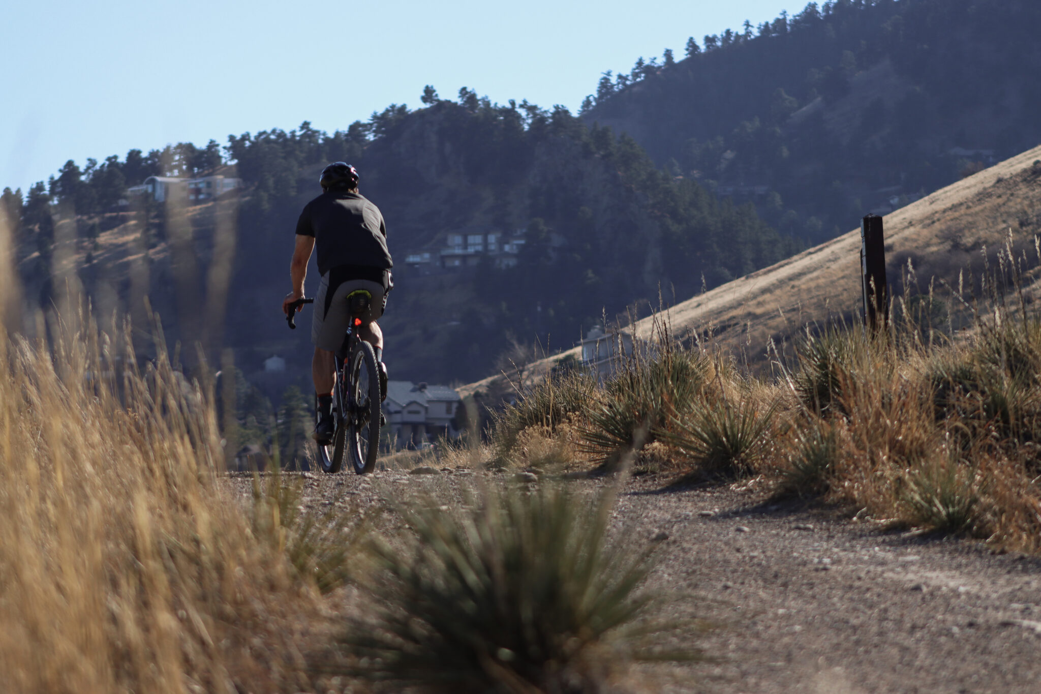
Runners, hikers and bikers recreated in t-shirts and tank tops on Foothills South Trail in Boulder, Colo., on March 4, 2026. The month is typically Colorado’s snowiest. (Annie MacKeigan/The Water Desk)
Petrick is not the only one holding out hope for the future. Colorado’s cities too look seasons ahead to ensure they have enough water to meet their needs. Matt Fater, senior director of infrastructure engineering for the City of Fort Collins’ water utility, is hopeful for more spring snow. Without it, the city may have to tap into existing water storage.
“We’re not in a crisis mode yet,” Fater said. “We’re watching it closely. We do have short term and long range plans when it comes to drought planning.”
The long range planning includes a policy that requires the city to be prepared for a 1-in-50 year drought. In the case of a severe drought, the city pulls water from different storage reserves that accumulate during particularly wet years. Fater reinforced the need for additional storage in the city, to “make sure we can meet the demand of our community.”
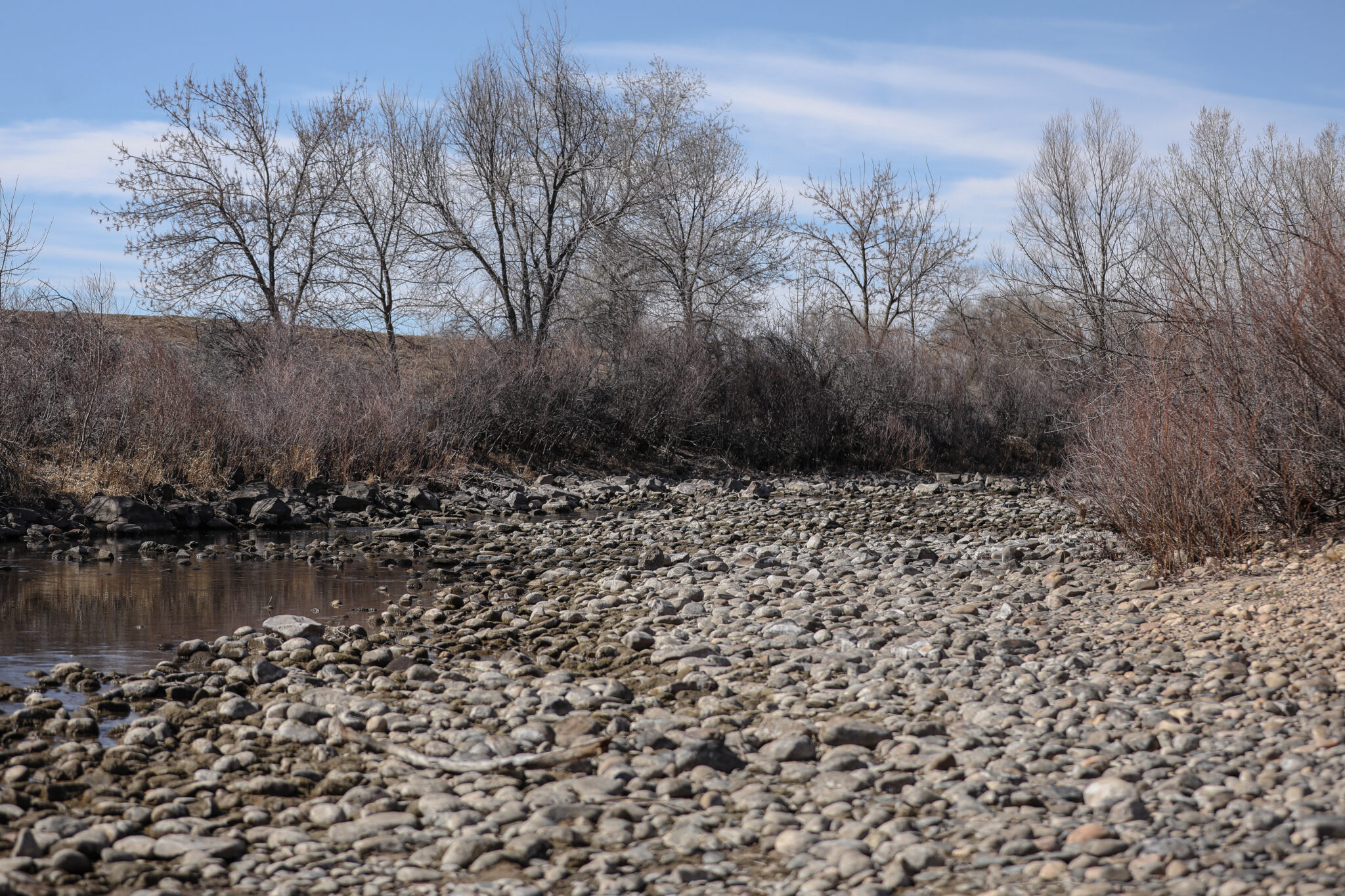
Snowpack that supplies the Cache La Poudre River has lagged well below average this year. The river is a main water source for the city of Fort Collins. (Annie MacKeigan/The Water Desk)
Other cities aren’t waiting. Denver Water has already let its customers know they’ll be restricted on their outdoor summer watering this year. In Erie, residents who flouted the town’s voluntary outdoor watering restrictions now face the potential of being cut off completely, according to CBS Colorado. And planning for the potentially hot and dry summer ahead has led Governor Jared Polis to activate a statewide drought task force too.
Snowpack in the high country acts as a battery for water availability, Fater said. Without enough snowpack to “recharge” those additional storage sites, a future drought could result in limited water availability and potential restrictions in the city.
Ranchers, skiers and water users throughout the state were hopeful that March would bring a miracle, and the snowpack deficit would decrease after a few big storms. But with a warm winter transitioning to an even warmer spring, the hopes of a few high-powered snowstorms are fading.
This story was produced and distributed by The Water Desk at the University of Colorado Boulder’s Center for Environmental Journalism.
Colorado’s top-25 March heat waves since 1951, defined as 4-day averaged statewide temperatures. Colorado’s warmest heat wave (set last week, March 18-21) eclipsed its previous warmest heat wave (March 23-26, 2004) by nearly 5°F. Data from NCEI nclimgrid via the Colorado Climate Center
Click the link to read the article on the Big Pivots website (Allen Best):
March 30, 2026
It was weird, it was wacky. This string of summer days in Colorado that arrived around the first day of spring was extraordinary. Will it change us in some fundamental way?
It’s not like 9/11, the day we saw people jumping from the skyscrapers in New York City to escape an even more cruel death by fire. We knew instantly that the world was different and in a very big way.
But doesn’t this anomaly deserve more than a shrug of the shoulders? As summer arrived in the last days of winter, I heard several people say, “Well, enjoy this nice weather” as you passed through their doors. A well-intentioned pleasantry but detached from a vital truth. Nice weather for Arizona maybe, but this was Colorado.
Winter had altogether been very, very warm. November was the third warmest November on record across Colorado. December the warmest. February also broke records.
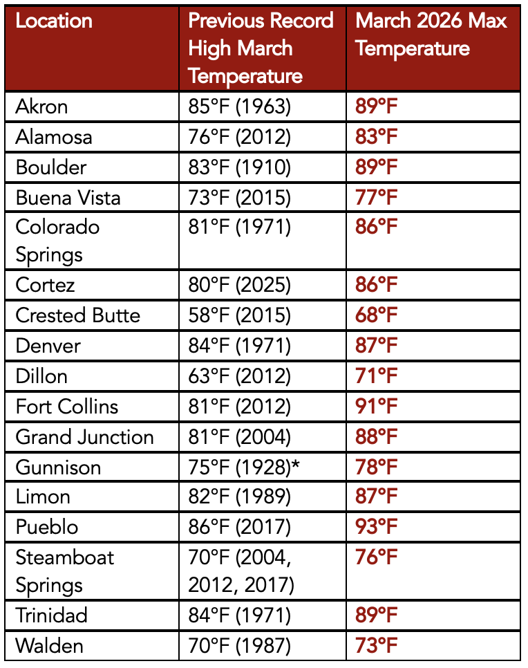
Then came March. Alamosa, a town at 7,543 feet in elevation in Colorado’s San Luis Valley, notched 11 record highs during March going into the last weekend. This included nine in a row from March 18-26. Of special note was the record high of 83 degrees recorded on March 21. It broke the old record by 7 degrees. It also was a higher temperature than has ever been recorded in Alamosa in April.
Crested Butte had a high temperature of 68, a full 10 degrees higher than the old record for that date.
Dates of first 90°F or warmer day in Fort Collins from 1895-present. The blue dashed line shows the 1991-2020 mean 90°F or warmer day, which is June 9. Data from ACIS.
Fort Collins got to 91 degrees, also 10 degrees more than the old record for that date. It was the highest ever mark for March — but also higher than anything ever recorded in April, whose record remains 89 degrees. The average first day for 90 degrees in Fort Collins is June 15.
Allie Mazurek, of the Colorado Climate Center staff, posted a report on Thursday morning that defines in numbers what she calls an event “impossible to ignore.” Included in her presentation is the chart atop this essay that shows how anomalous this four-day streak of heat was compared to others in Colorado during March.
This heat was nearly uniform across Colorado. “There were far more stations in the state that broke all-time monthly high records for March than did not,” wrote Mazurek. “To see monthly records shattered by more than 5 degrees F across numerous stations is truly remarkable. The kind of heat that we saw last week across Colorado is more typical of June or even July.”
Remarkable about theheat in Colorado was not only its intensity but its longevity across four days (March 18-21). “Over that period, several locations set new monthly records every one of those days, with each day being warmer than the last.”
March maximum temperature records at various long-term weather stations throughout Colorado. Data from ACIS.
This heat comes at a particularly bad time. The thin snowpack was already melting. The deepest snowpack in Colorado’s mountains has traditionally occurred in early May, because of accumulations at higher elevations.
That assumes a normal of some sort — although it is questionable whether “normal” has any true meaning given how fast the climate is now changing. So take this for what it’s worth: the statewide snowpack this past week sat at 38% of the 1991-2020 median. And what must be noted here — as with the temperature records that were broken — is that we have had an exceptional increase of heat in Colorado in the last 25 years.
Notable in the lifetimes of baby boomers in Colorado were the winters of 1976-77 and 1980-81. This year’s meager runoff will almost certainly surpass those dry years. New is the heat.
High-pressure heat domes can be predicted but are notoriously challenging to forecast weeks or months in advance. They also remain rare, but the warming atmosphere makes them more likely.
“We do have high pressures every year across the West,” said Mark Wankowski, a meteorologist at the Pueblo office of the National Weather Service. “This one was extremely early.”
Writing from Colorado Springs last weekend in an essay in The Atlantic titled “There’s No Way the West Will Have a Normal Summer,” Rebecca Boyle explained that the heat wave was created by a “a bizarrely strong ridge of high pressure in Earth’s atmosphere.” This ridge suppressed cloud formation and brought in warmer air. “Such atmospheric ridges are more common in the summer, but this one would be unusually intense even for that season.
Kaitlyn Trudeau, a senior researcher at the science nonprofit Climate Central, told Boyle this was the strongest ridge ever observed in March. Climate Central has developed a prediction model that assesses how much a warming trend or record high can be attributed to human-caused climate change. According to this model, the western high temps were five times more likely because of elevated greenhouse gas emissions.
I feel rattled by this heat. You may remember the high-pressure cooker that broiled the Pacific Northwest in June 2021. Temperatures spiked to 116 degrees in Portland. People in apartments that were not air conditioned died from the heat. In Multnomah County, the location of Portland, 72 deaths were attributed to heat. Farther north, in British Columbia, the town of Lytton went up in flames after several days of intense heat, including a temperature that reached 121 degrees Fahrenheit.
After that heat, the Colorado Public Utilities Commission asked Xcel to assess how well it could respond to somewhat similar heat in Colorado. The company concluded it had the resources.
But this week, in the wake of the intense spring heat, the PUC commissioners were clearly worried, part of a growing concern about “resource adequacy.” Will Xcel be able to meet critical electrical needs if another heat dome arrives in Colorado this summer? The commissioners asked Xcel to return with strategies for reducing demand from big industrial customers if demand for cooling spikes.
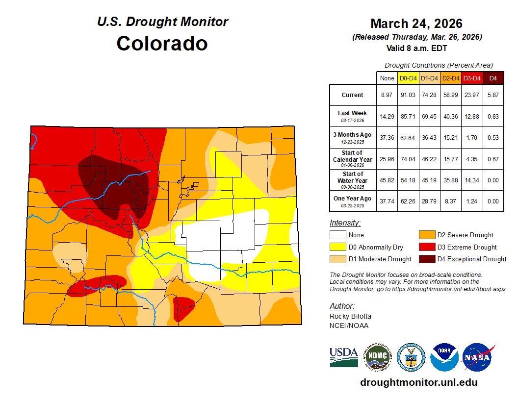
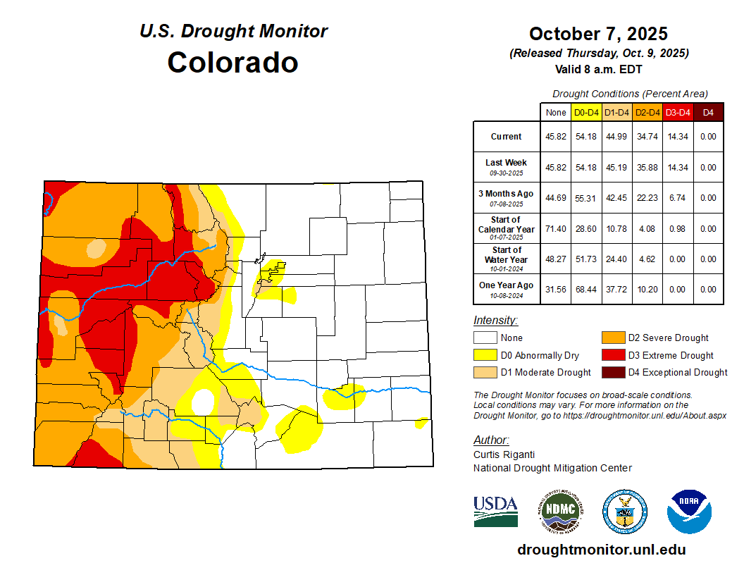
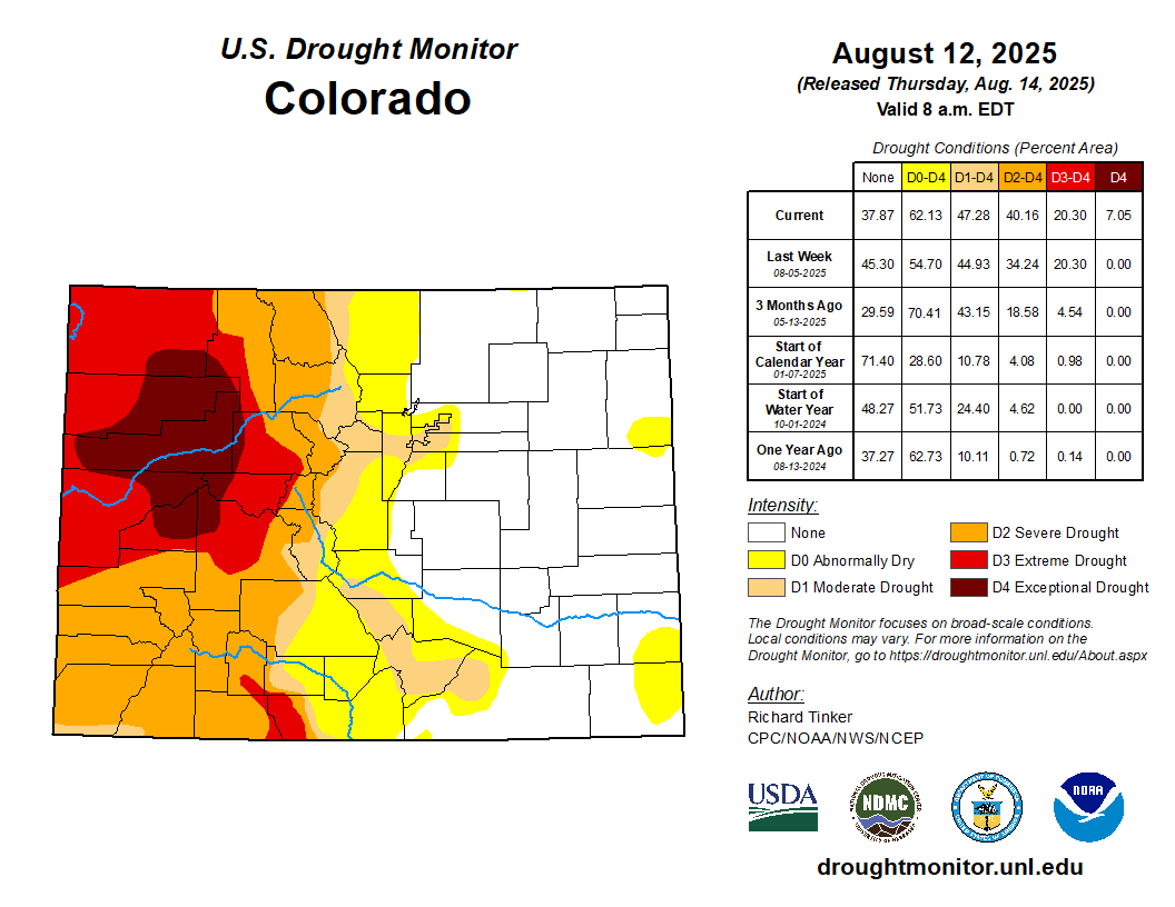
Colorado Drought Monitor map March 24, 2026.
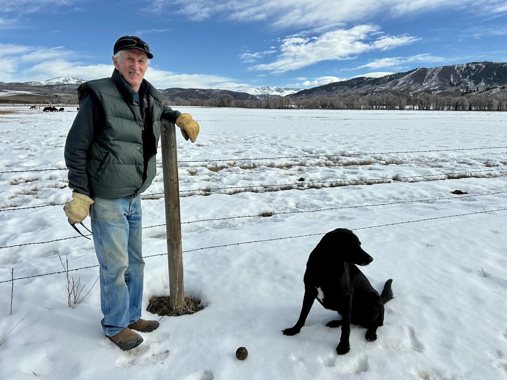
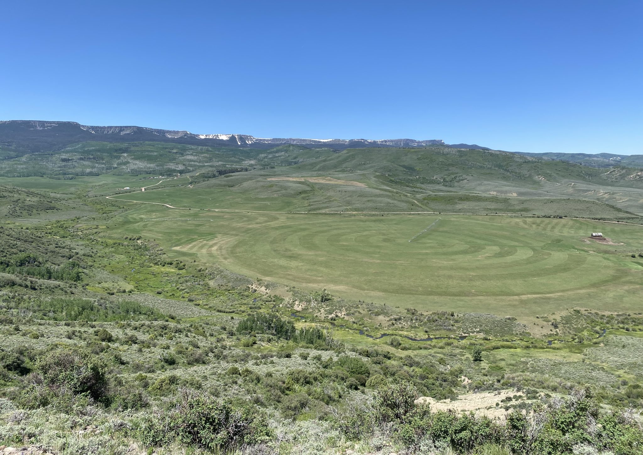
Curious about an on-the-ground perspective from this heat and sparse snow, I called Paul Bonnifield in Yampa. A drought map colors that part of northwest Colorado mahogany, beyond extreme drought and in the realm of “exceptional.” What did exceptional drought look like to him?
Yampa lies at the headwaters of the Yampa River, between the Gore Range and the Flattops. It has a bucolic setting, a place of hay meadows and grazing cattle. Lying upstream are a couple of reservoirs on the edge of the Flattops.
It’s not uncommon for snow to remain on the ground at Yampa, elevation, 7,900 feet, in late March. Not this year. “The ground is hard, just dry, dry, dry,” said Bonnifield.
Bonnifield grew up a few miles away at Phippsburg, a railroad town, and he worked on the railroad himself in addition to spending time teaching and writing at a college in Oklahoma. He’s now in his late 80s and can put this year’s anomalous heat and drought into perspective.
“We are in serious trouble,” he said. “I’ve never seen it like this before.”
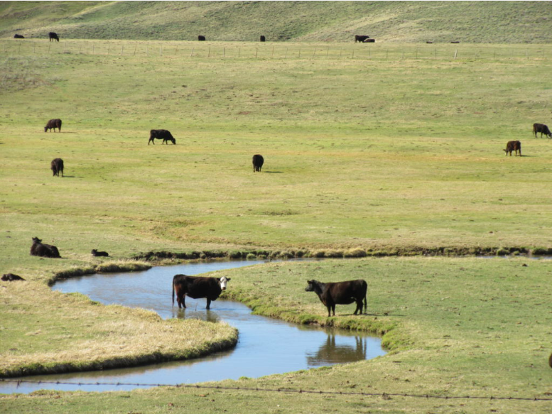
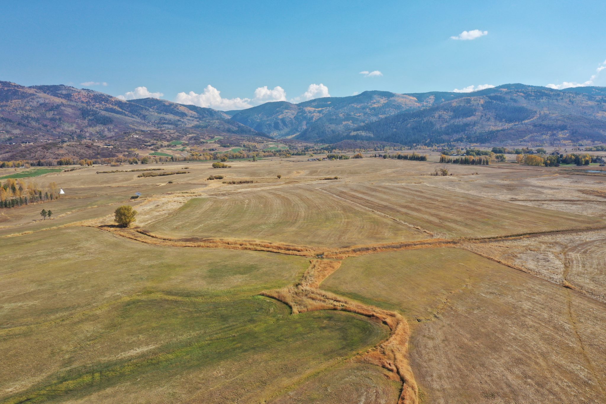
Less water will mean less hay production in Egeria Park, where this photo was taken about eight years ago. Photo/Allen Best
Unless a miracle arrives in the form of spring rain and snow, ranchers in Bonnifield’s area — called Egeria Park — will have to decide what to do with their cattle. There’s not enough water to grow grass. There will be wildfire smoke besotting the sky, dampening tourism. And as for river rafting downstream on the Yampa – not likely. Steamboat Spring has already imposed watering restrictions for lawns.
Denver Water this week adopted lawn-watering restrictions for its customers in Denver as well as those in surrounding jurisdictions. It has 1.5 million customers, directly and indirectly, in the metro area.
Nathan Elder, the utility’s manager of water supply, reported to board members on Wednesday that snowpack levels are at historic lows and melting earlier and more rapidly.
Denver Water diverts water from rivers and creeks on both sides of the Continental Divide. In Grand and Summit counties, at the headwaters of the Colorado River, the snowpack was 53% of normal and the lowest on record for the date, Elder said. The South Platte River has it even worse, just 40% of normal.
“These are really unprecedented snowpack conditions,” he said at the meeting on March 25. During the previous week — the week of the heat dome —Denver had lost 25% of its snowpack in the areas it collects water, he reported.
Denver Water is asking the 1.5 million households and businesses that get water from the utility to refrain from starting to irrigate lawns, including this one in southeast Denver, until mid-May. Photo credit: Allen Best/Big Pivots
Can it get worse? Well, yes, it could. “It’s well documented that, in part, due to climate change, the runoff generated from a given snowpack has declined when compared to the past,” said Elder. “So we can expect even less water from this already low snowpack.”
Might a miracle arrive? After the drought and heat of 2002, metro Denver was stressed. Then, on St. Patrick’s Day 2003, three feet of snow fell. In the San Luis Valley, monster rainfall last fall swelled the Rio Grande, leaving water in the soil that will help even now as farmers begin preparing their fields for early plantings.
NOAA projects continued likelihood of above normal temperatures and below-normal precipitation across Colorado, including Denver’s collection area, during April.
Denver aims to reduce water use 20% by its customers in Denver and in outlying suburbs. It will permit lawn watering two days per week and then after 6 p.m. or before 10 a.m. It is also urging customers to refrain from watering their lawns until mid-May. That’s not an easy ask when it feels like June in March. In April, Denver Water’s board members will be asked to approve “drought pricing.”
Russ Schumacher, the state climatologist in Colorado, is called upon frequently to give programs to water organizations and others. This past week he gave a presentation to the Fort Collins Chapter of the Colorado Renewable Energy Society.
“Wildfire certainly is top of mind,” he said while showing a time-lapse video of a wildfire called High Park Fire that occurred west of Fort Collins in 2012.
Dry and hot temperatures leave Russ Schumacher, the state climatologist, apprehensive about potential wildfires this year. Above photo is from the Longmont area in August 2020, a hot and smoky year when wildfires continued almost into November. Photo/Allen Best
Global warming is a simple proposition, he said.
“If you put a pot of water on your stove you’re not going to be able to predict all those individual bubbles or exactly when it’s going to start boiling,” he explained. “But you know that when you turn that heat on, the water’s going to get warmer and it’s going to continue to warm the more heat that you add. So the physics of climate change is actually rather similar in that regard.”
And, of course, adding greenhouse gases to the atmosphere traps heat, which heats the planet. “When you add heat to something, then it warms.”
Colorado has had outliers of heat before. The Dust Bowl during the mid-1930s was a time of heat and drought. More hot and dry arrived in the 1950s.
This chart shows snowpack in Colorado. The heat dome caused rapid melting of snow. In the San Luis Valley, heavy rains of last October may allow farmers to survive better than during 2002.
Dry has not changed. The hot has changed. What used to be an extremely hot year in Colorado is now a fairly average year or just slightly-above-average year, said Schumacher.
Citing NOAA data, Schumacher showed a sharp rise of almost 2.5 degrees Fahrenheit since 1980. The heat has been most acute in the summer and fall — although, obviously, recent months spoil that easy narrative.
With a moderate rate of emissions, we can expect another 2.5 to 3 degrees of warming by around 2050. That expectation comes with a disclaimer about uncertainty. It’s a best guess.
Precipitation has been more complicated than temperature in Colorado. As for the future, it remains a puzzle. Could be more, could be less. Either way, it will be impacted by temperatures.
“If it’s warmer, if it‘s windier, it’s less humid, the air is thirstier for water from the soils, crops, forests, reservoirs, wherever.” Schumacher said. “As it gets warmer, that evaporative demand goes up. The air is thirstier for water, and this has big implications for drought and water supply and water resources.”
Might warming occur more slowly? That’s possible, and a possibility tied strongly to whether global emissions of greenhouse gases can be abated. Given the current political climate in the United States, a key player in world politics, this low-emissions scenario looks highly unlikely. More likely are the heat domes.
Like the pot of water on the stove that Schumacher described, we’re certain to see more heat bubbles. Hard to tell where and when they will be, but there will be more of them. That leaves me distinctly uncomfortable. In Colorado I have felt 104 degrees. I cannot fathom the 118 degrees of Portland.
Colorado statewide annual temperature anomaly (°F) with respect to the 1901-2000 average. Graphic credit: Colorado Climate Center
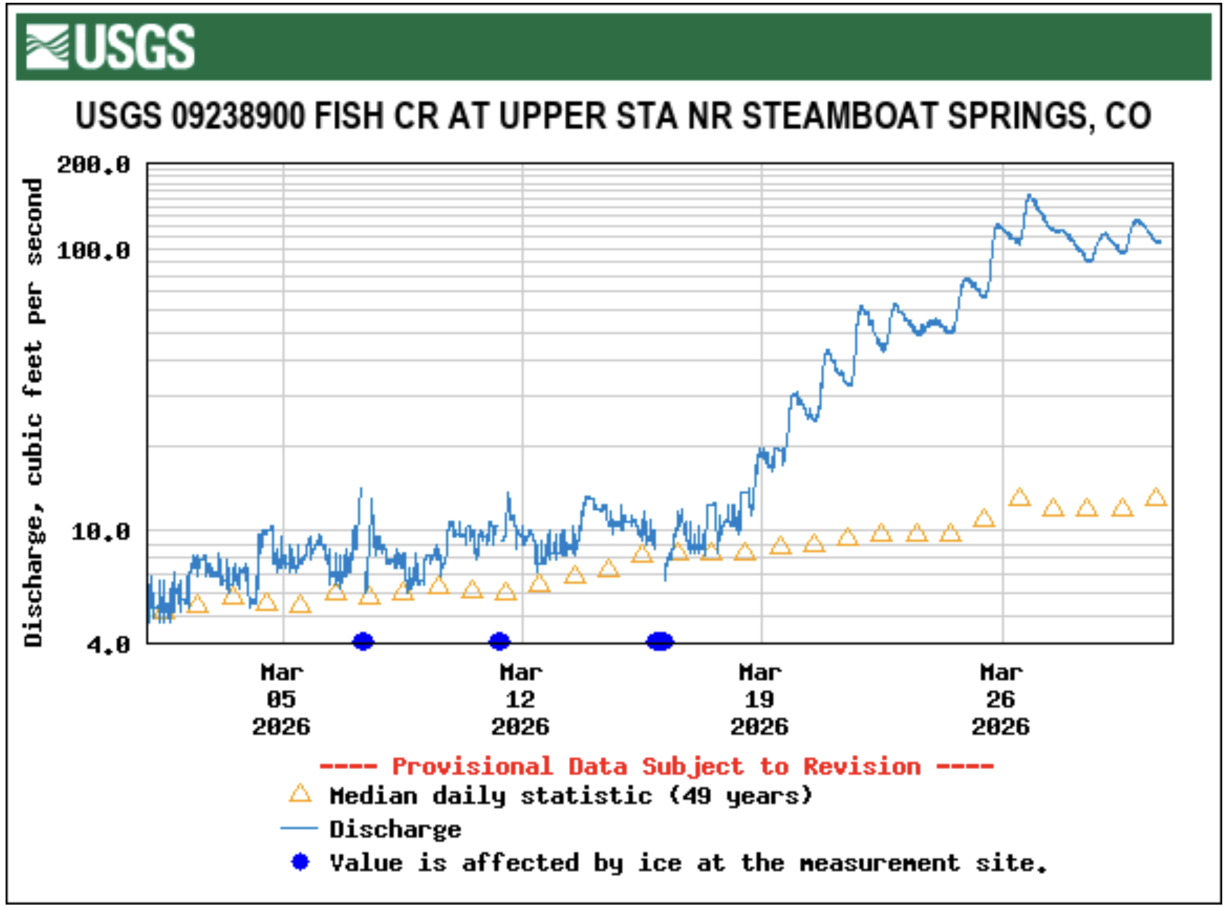
With the quicker snowmelt and earlier drying out of pasturelands, runoff volumes in creeks are hitting levels now that usually occur a month later in the spring, leading area ranchers to activate irrigation ditches weeks earlier than usual. Runoff flowing down Fish Creek, the primary water source for the city of Steamboat Springs, is almost one month ahead of the historical average. At 9 p.m. March 21, the flow displayed by the U.S. Geological Survey gauge on Fish Creek near the Fish Creek Water Plant east of Steamboat Springs showed 62 cubic feet per second. That volumetric flow rate is usually seen on April 18, according to gauge records from 1966 to 2025…“Over the last two years, it’s definitely running sooner than average,” said Frank Alfone, general manager at Mount Werner Water and Sanitation District. “It just means the possibility of having to release from Fish Creek Reservoir earlier in the season because there is less water in the creek.” The water gauge on Fish Creek historically records a peak seasonal flow of 464 cfs on June 8, but this summer the peak will occur much sooner than average. For waterfall fans, that also means highly visited Fish Creek Falls figures to be at peak flow three to four weeks sooner than its average early June date, Alfone noted…Fish Creek Reservoir on Tuesday was sitting at 47% of fill capacity, a normal level for this time of year, and that percentage continues to increase, Alfone noted. As a major year-round water source for the community, Fish Creek Reservoir water managers do not want that level to drop below 30%, Alfone said.
Fewer families are booking spring break vacations to Colorado resort destinations, as weaker-than-normal ski conditions cause drops in reservations made later in the season. Amid the potential for a lower-revenue spring break tourism season, some Western Slope ski towns are focusing on promoting off-mountain activities for families. For most resort towns across Colorado’s western mountains, spring break is a strong period for tourism. Travelers from both in and out of state book trips to the mountains in hopes of hitting the slopes before the end of ski season, and businesses organize seasonal events to draw in visitors. This year’s near historically dry conditions, however, have meant fewer winter bookings to Colorado’s resort destinations — and spring break bookings are seeing the impacts…Colorado’s spring break season, though still bringing in bookings, will likely end with lower revenue for mountain destinations compared to previous years, Foley said. Soard added that the considerable decrease in bookings will likely also lead to impacts for the town’s sales tax collections.
The only thing snow shovels have been gathering recently is dust as Metro-Denver finds itself more than a foot behind its normal snowfall total this winter. Boulder National Weather Service Meteorologist, Russell Danielson, said the normal snow total through the end of January for metro-Denver is 27 inches. This year, just 13.4 inches fell. That’s a sharp drop from 2025, when the region saw 38 inches of snow over the same time frame. In the mountains, it’s even starker. Breckenridge typically sees 101.7 inches by the end of January. This year? Just 34 inches. The lack of snow has largely been framed as a ski industry problem. But across the Front Range and into Colorado’s river corridors, it’s become something broader — and more immediate. From car washes in southwest Denver to rafting guides scanning snowpack data in the high country, the dry winter is rewriting balance sheets in real time…For other weather-dependent businesses, the impact is far more dramatic.
“We calculated that we’re about 70% down,” said Amy Campbell, office manager for Bear Creek Tree Service in Englewood. In a typical winter, her crews plow at least every other week — sometimes multiple times depending on the storm…
West Drought Monitor map March 3, 2026.
The economic ripple from a dry winter won’t stop when the season changes. And that has small business owners who rely on summer tourism also worried. In Kremmling, co-owner of Downstream Adventures, Jonathan Snodgrass, is already watching the snowpack charts — not for ski conditions, but for river levels.
“I’m feeling a little worried,” he said. “If it stays on this track, we’re looking at not a lot of water to work with for rafting. That could have some big impacts on the duration of our season and the quality of our product.”
Rafting on Clear Creek and the upper Colorado River depends heavily on snowmelt. In low years like 2018, Clear Creek trips ended around the third weekend of July. In stronger years, they run into late August — sometimes up to Labor Day. Those final weeks are critical.
Meadows in north Routt County, Colorado, were bare in spots on Feb. 9 after a slow start to this winter’s snowpack. Scott Franz/KUNC
Click the link to read the article on the KUNC website (Scott Franz):
February 13, 2026
This story is part of ongoing coverage of the Colorado River, produced by KUNC in Colorado and supported by the Walton Family Foundation. KUNC is solely responsible for its editorial coverage.
Jay Fetcher and other ranchers in northwest Colorado measure snowpack each winter using their barbed wire stock fences.
A healthy level is called a three wire winter, when the snow piles up past the third wire above the ground. But on Feb. 9, the region was experiencing a zero wire winter.
“We just have no snow, and I have never seen it, in my 75 years here, I have never seen this,” Fetcher said Monday as he navigated patches of mud on his ranch in the Elk River valley north of Steamboat Springs.
Jay Fetcher poses on his ranch in northwest Colorado on Feb. 9. Low snowpack is adding pressure to negotiations on how to conserve the dwindling Colorado River. Scott Franz/KUNC
Many of the hills and meadows surrounding his ranch were brown and bare. The thermostat on Fetcher’s truck read 50 degrees, and the last patch of snow was melting fast off the roof of a barn.
This year, Fetcher’s ranch is on the frontlines of record-low snowpack across the West that is adding a sense of urgency among seven states to finalize a plan for how to conserve the dwindling Colorado River.
The snow in the nearby Zirkel wilderness melts into the Elk River and irrigates Fetcher’s fields before the water eventually joins the Colorado River and flows to millions of people downstream.
But things have been changing near Fetcher’s ranch over the past decade, and it could have implications for states competing for the water supply.
Since 1951, the Fetchers have tracked how long the snow stays on their meadows by marking the date in a little red journal. The data shows the snow is melting sooner in the valley.
“In the past 10 years, the snow leaving the meadow has moved up by 12 days,” he said. “This winter is a real indication of climate change, with bare meadows in the middle of February. I mean, what date am I going to write down for (when) snow left the meadow this year? Did it ever come?”
Jay Fetcher walks through a barn door on his ranch in Routt County, Colorado. Scott Franz/KUNC
The dwindling water supply in the Colorado River basin is driving intense negotiations among the seven states over how to share it in the future. Some forecasts predict water levels at Lake Powell could get so low this year that its dam would stop producing electricity. States have until Saturday to come to an agreement and the pressure has been building.
If they don’t, they might end up fighting each other in the Supreme Court.
Downstream states, including California and Arizona, say Colorado and states in the upper basin should pitch in with mandatory water restrictions during dry years.
But leaders in the Rocky Mountains are digging in.
They say ranchers and cities are already enacting conservation plans, and more cuts should not be forced on them.
“If we don’t choose how to live within the river’s limits, the river will choose it for us, and she will not be gentle,” Becky Mitchell, Colorado’s top river negotiator, said in a speech to a water conference in January. “Operations (of the river’s reservoirs) must be supply based, not demand based, not entitlement justified, and not built on a hope that the next big year will save us.”
Negotiators in the lower basin are calling for compromise. J.B. Hamby is California’s water negotiator.
“It’s going to take everyone chipping in and making the necessary (water) reductions to balance the supply with the demand we have moving forward,” he said during a speech last month.
The Yampa River in downtown Steamboat Springs was mostly ice free on Feb. 9 as temperatures rose above 50 degrees. Scott Franz/KUNC
Sitting on a patio on his ranch in northwest Colorado, Fetcher said Monday he’s not confident the lower and upper basins will resolve their differences anytime soon.
He said he’s willing to donate some water he doesn’t use each year downstream to California, but under current regulations, he would risk losing his water rights under a ‘use it or lose it’ system.
“I know that we will be able to irrigate these meadows just fine, because of our water rights, because of where we are, because of the ranch being on the Elk River. So from a personal standpoint, I’m okay with it,” he said. “The challenging question is, what happens with the lower basin? They’re just going to have to think about how to get by with less water and not have so many golf courses out there.”
The deadline for the seven states to agree on a long-term plan for how to conserve the Colorado River is Saturday.
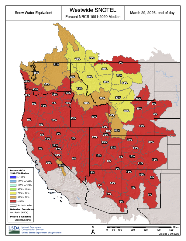
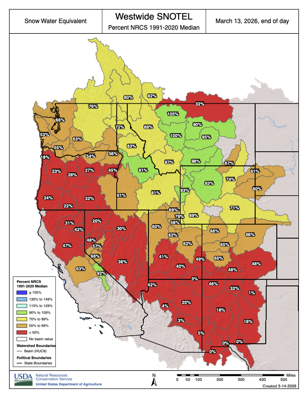
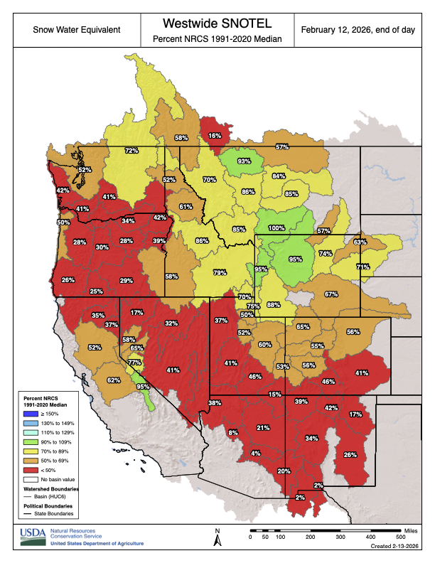
Westwide SNOTEL basin-filled map February 12, 2026.
Coyote Gulch on the Yampa River Core Trail August 2022 on the bicycle ride to the Colorado Water Congress Summer Convention.
Click the link to read the article on the KUNC website (Scott Franz). Here’s an excerpt:
January 20, 2026
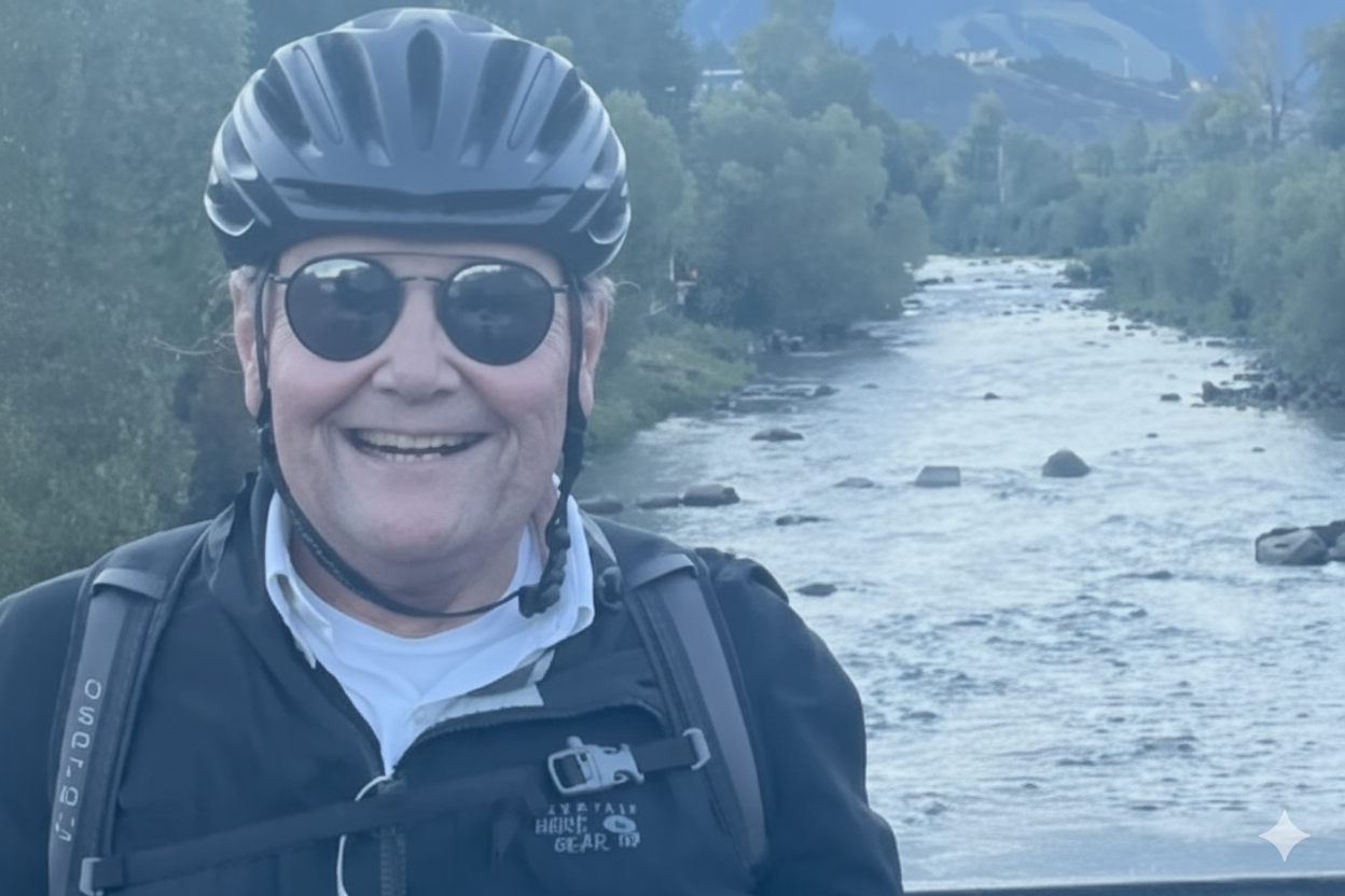
Steamboat Springs author and adventurer Eugene Buchanan has lived near the banks of the Yampa River long enough to notice its rhythms and moods are often mirrored by the residents in his northwest Colorado ski town.
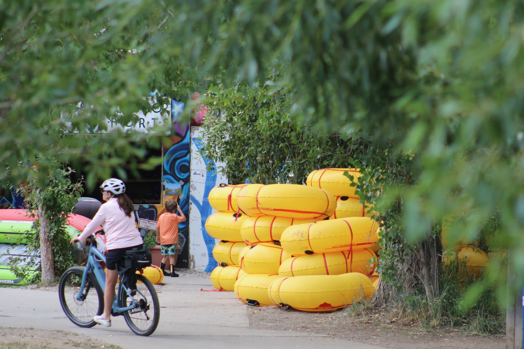
“The river’s pulse kind of matches your own,” he said Thursday. “You know, come springtime, you’re jazzed up, and the rivers crankin’ and flooding, and the surf waves are in and people are rafting it and (stand up paddleboarding). Then it slows down to a trickle later in the summer and people are inner-tubing it. Fly fishing it. That’s a little more of a tranquil time.”
Yampa River Basin via Wikimedia.
But as Buchanann warns in the first chapter of his new book, Yampa Yearnings, “not all is hunky dory in Yampaland.” Last summer marked the fourth time in history that there was a call on the Yampa due to drought conditions and upstream users were forced to cut back their intake. And like other rivers across the West, Buchanan said the waterway faces growing threats from climate change and increased demands from water users. Buchanan’s book is not all about hard times and drought on the river. In between his history lessons about the Yampa and the challenges it has faced, readers will also learn about the fate of Buchanan’s efforts to help a rancher get his lost cattle back across the raging waterway. There’s also a tale of his friend’s paddling adventure from Colorado to Utah to prove the waterway can facilitate ‘interstate commerce.’ KUNC water and environment reporter Scott Franz interviewed Buchanan about his book and the state of the Yampa. Answers have been lightly edited for length and clarity.
Franz: What impact do you hope this book has for the Yampa River and its future?
Buchanan: It’s hard to say how much impact a book like this will have. It’s my hope that those who are familiar with the Yampa learn to appreciate it a little more. Maybe look at it with a different eye next time they see it. If people aren’t familiar with the Yampa and they live somewhere else, maybe they’ll look outside and see their backyard creek flowing through their town and just think about it a little more. Maybe they’ll donate to a local nonprofit that’s trying to help preserve it, or they’ll pick up some trash or get involved. Or they’ll vote appropriately, how they want to, perhaps preserve it.
Floating the tiger, “Tiger Wall” Yampa River, 2014. Photo: Brent Gardner-Smith/Aspen Journalism
The coal-fired Tri-State Generation and Transmission plant in Craig provides much of the power used in Western Colorado, including in Aspen and Pitkin County. Will Toor, executive director of the Colorado Energy Office has a plan to move the state’s electric grid to 100 percent renewable energy by 2040. Photo credit: Brent Gardner-Smith/Aspen Journalism
Platte River Power Authority’s general manager says he disagrees with a federal order requiring one of the coal plants it owns a stake in to remain open past its scheduled retirement and is waiting to learn what it might cost Fort Collins’ wholesale electricity provider…PRPA is a joint owner of the plant with PacifiCorp, Xcel Energy, Salt River Project and Tri-State Generation and Transmission, which operates the facility. PRPA owns 18% of the Craig 1 and 2 coal units…
The Department of Energy’s emergency order contends there is a shortage of electric energy and facilities in the Western Electricity Coordinating Council Northwest assessment area, which includes Colorado, Idaho, Montana, Oregon, Utah, Washington and Wyoming. The order, signed by Secretary of Energy Chris Wright, states that peak demand in the area is expected to grow 8.5% in the next decade, while many coal plants in the region have been retired, with more retirements planned…Wright cites supply chain issues with building battery storage systems to help replace the energy from those retirements. The emergency order also cited two executive orders from President Donald Trump. One declared a national energy emergency due to “insufficient energy production, transportation, refining, and generation.” The other declares the United States is experiencing an unprecedented surge in electricity demand driven by rapid technological advancements, like the expansion of AI data centers and domestic manufacturing…
But PRPA General Manager and CEO Jason Frisbie says PRPA does not need the Craig 1 unit because it has already replaced the energy that came from it.
“We have planned for the retirement of Craig Unit 1 for nearly a decade and have proactively replaced the capacity and energy from new sources,” Frisbie said in a statement provided to the Coloradoan.
Craig Station. Photo credit: Allen Best/Big Pivots
Click the link to read the article on the Big Pivots website (Allen Best):
December 31, 2025
Trump orders Craig coal unit planned for retirement to stay open. But it so happens the unit is broken. Ludicrous says Polis team. Sierra Club challenges basis for emergency declaration.
It was no surprise. Tri-State Generation and Transmission has said for at least three months that it expected to get orders from the Trump administration to continue operating a coal-burning unit at Craig, in northwest Colorado, beyond its scheduled retirement on Dec. 31, 2025.
The order was posted at 6 p.m. MST Tuesday. Citing emergency authority claimed by President Donald Trump, Energy Secretary Chris Wright ordered the coal unit to remain in operation through March 2026. The order cited a sudden increase in demand for electricity, or a shortage of generation capacity.
The irony of the order is that it was issued when the 427-megawatt unit was out of operation, according to a statement issued by the office of Colorado Gov. Jared Polis.
“Ludicrously, the coal plant isn’t even operational right now, meaning repairs — to the tune of millions of dollars — just to get it running, all on the backs of rural Colorado ratepayers!” Polis said.
“Going backwards is an attempt to force local communities to foot the bill to extend plant operations and will cost energy consumers more. Today’s action flies in the face of this careful planning, is inconsistent with market forces, and will hurt Coloradans.”
The Polis team estimated continued operations would cost tens of millions of dollars “to keep a coal plant open that is broken and not needed.”
Tri-State, in a statement on Wednesday morning, explained that the unit “went into an outage” on Dec. 19, 2025, due to a mechanical failure of a valve. “Tri-State and the other co-owners will need to take the necessary steps to repair the valve in a timely manner,” the statement said.
“Tri-State has a policy of 100% compliance, and we will work with Unit 1 co-owners, and federal and state governments to determine the most cost-effective path to that end,” said Duane Highley, Tri-State CEO. “We are continuing to review the order to determine what this means for Craig Station employees and operations, and the financial impacts. As a not-for-profit cooperative, our membership will bear the costs of compliance with this order unless we can identify a method to share costs with those in the region. There is not a clear path for doing so, but we will continue to evaluate our options.”
As a result of the order, retaining Unit 1 will likely require additional investments in operations, repairs, maintenance and, potentially, fuel supply, all factors increasing costs, Tri-State said. “Tri-State is continuing to review the order to determine how best to comply while limiting the costs to its members, and the impacts to its employees and operations.”
Highley told Big Pivots in October that the wholesale supplier for cooperatives in Colorado and three other states did not need the electrical production at this time, as it is actually producing more than it needs.
Wright, in his order, No. 202-25-14, cited several justifications.
One justification was a 2024 report by the Western Electricity Coordinating Council that forecast growth of 8.5% in peak demand during the next decade in Colorado and several adjoining states.
The order also said that Tri-State and its co-owners — Fort Collins-based Platte River Power Authority, Phoenix-based Salt River Project, Salt Lake City-based PacifiCorp., and Denver-based Xcel Energy — “take all measures necessary” to ensure that Craig Unit 1 is available to operate at the direction of either Western Area Power Administration in its role as a balancing authority or the Southwest Power Pool West in its role as the reliability coordinator.
The Sierra Club emphasized the cost of operating Craig No. 1. It cited a recent report by Grid Strategies that found operating the unit past the retirement deadline will cost the plant owners $85 million per year. This is distinct from repairs that may be necessary.
“Trump is playing politics with coal,” said Margaret Kran-Annexstein, director of the Colorado chapter, in a statement issued shortly after the order was posted.
Matthew Gerhart, the senior attorney for the Sierra Club at its Denver office, had even stronger language in an interview with Big Pivots.
“I think this order is a joke even by this administration’s standards,” he said. “This is quite clearly just a political move. None of the documents they cite even come close to saying there is an emergency.”
Wright’s order cited the 2025-2026 Winter Reliability Assessment issued by the North America Electric Reliability Corporation. That report in November noted total and net internal demand increases of almost 1% driven primarily by data centers and commercial and industrial customer growth. Even so, the operating reserve margins in the Rocky Mountain were expected to be met before imports in all winter scenarios.
That being said, Xcel Energy almost a year ago began expressing concerns about resource adequacy.
Gerhart also found fault with Wright’s order that the unit be available to operate at the direction of the Southwest Power Pool West in its role as the reliability coordinator. SPP exists, but not the configuration — a regional transmission organization — that would allow SPP to do this, he said. SPP has a day-ahead market and also a balancing market but not the apparatus set up to manage the operation of Craig No. 1, he said.
Will Toor, director of the Colorado Energy Office, also pointed to the report from the North America Reliability Corporation that found no short-term or long-term elevated reliability risks in the Rocky Mountain region,
“These orders will take money out of the pockets of Colorado ratepayers, and especially harm rural communities across the West who could be forced to absorb the unnecessary excess costs required to keep this plant operational,” he said. “The Trump administration is engaging in Soviet-style central planning, driven by ideology rather than the realities of the electric grid, that will drive dirtier air and higher electric rates across our state. These orders are unlawful and will not improve energy security in Colorado or the region.”
Trump has claimed authority to order coal plants remain in operation under the Federal Power Act. That nearly century-old law explicitly gives presidents authority to order electrical plants to operate under duress of war or weather emergencies. Since last April, Trump has sought to expand the power, citing emergencies caused by concerns about resource adequacy. The concerns, he has said, result from retiring fossil fuel and nuclear plants, dramatic growth in demand, and the intermittency of renewables.
U.S. Sen. Michael Bennet, a gubernatorial candidate, also pushed back: “The DOE order is the latest in a string of attacks against Colorado, because we refuse to bend to the President. President Trump continues to take out his personal and political grievances on Coloradans who are already struggling to make ends meet. Federal intervention like this makes long-term planning impossible – this is not how you operate a business, plan an electric grid, or help a community stay prosperous. I am disappointed but not surprised by this continued revenge tour.”
Wright’s order said that 417.3 megawatts of coal-fired generating capacity across six units at three locations have retired in Colorado since 2019. It cited the Western Electricity Coordinating Council. “Looking forward, by 2029, about 3,700 megawatts of coal-fired generating capacity in Colorado is scheduled to be retired.” The order said that during that time, 675.6 megawatts of natural gas-fired generating capacity in Colorado will retire as well.
Wind turbines near Pawnee Buttes in northeastern Colorado. Photo/Allen Best
In 2025, wind accounted for over 5,300 megawatts of Colorado’s electricity generating capacity, the order noted.
Wright’s order described wind as intermittent. Of course, coal can be intermittent, too. That has been demonstrated repeatedly at Pueblo, particularly in the case of Comanche 3. The coal unit went down again in August and is not expected to be restored into operation until June 2026. In its absence, Xcel asked — and the Polis administration agreed — that Comanche 2 would not be retired this month, as had been planned for several years.
As for Craig No. 1, its retirement was planned in an agreement reached almost a decade ago. Air quality standards in Rocky Mountain National Park and other national parks and wilderness areas are being violated in part because of emissions from the unit. The regional haze standards were federally created and state enforced. The agreement with the Colordo Air Quality Control Commission was reached in 2016.
Tri-State’s electric resource plan of 2023 showed adequate resources to maintain reliability on Tri-State’s system following the retirement of Craig No. 1 as well as two other units at Craig Station that are scheduled to close in 2028. Unit 2, which Tri-State owns with its other partners in Unit 1, has a capacity of 410 megawatts. Tri-State owns 100% of Unit 3, which has a capacity of 448 megawatts. The three units were constructed and went on line in the late 1970s and early 1980s.
This Parshall flume measures the water in the Alfalfa Ditch on Surface Creek near Cedaredge. The Colorado Division of Water Resources estimates there are 2,800 diversions of more than 1 cfs without measuring devices across the Western Slope. CREDIT: HEATHER SACKETT/ASPEN JOURNALISM
The state of Colorado is ramping up an effort to measure water use on the Western Slope, developing rules and standards and rolling out a grant program to help water users pay for diversion measurement devices.
With input from water users, officials from the Colorado Division of Water Resources are creating technical guidance for each of the four major Western Slope river basins on how agricultural water users should measure the water they take from streams. The state is now doling out $7 million from the U.S. Bureau of Reclamation to eligible water users with faulty or missing devices to install structures such as flumes, weirs and pumps at their point of diversion.
Twenty-five percent of the funding is earmarked for each of the four river basins: Gunnison (Division 4); Colorado River mainstem (Division 5); Yampa-White-Green (Division 6); and San Juan-Dolores (Division 7). The first round of funding will go to Divisions 6 and 7, and applications close at the end of January. The goal is to have all the projects complete by 2029.
Measurement rules for Divisions 6 and 7 have been finalized and are in effect; rules for Division 4 are in the draft phase, and state officials are accepting comments until Dec. 19 on the draft rules in Division 5.
With thousands of diversions from small tributaries across rural, remote and mountainous areas, figuring out precisely how much water is used in Colorado has historically been challenging. According to state officials, there are about 2,800 diversions of more than 1 cubic foot per second from Western Slope rivers and streams that are not currently being measured. Historically, the state has required measuring devices on only diversions that have been involved in calls. When a downstream senior water rights holder is not getting the full amount of water they are entitled to, they can place a “call,” which forces junior upstream water users to cut back.
This Parshall flume measuring device is being installed on a ditch on Morrisania Mesa near Parachute. The state of Colorado has $7 million in federal funds to distribute to water users to install measuring devices on their diversions from waterways. CREDIT: HEATHER SACKETT/ASPEN JOURNALISM
Compact compliance
The push for more-accurate measurement comes at a time when there is increasing competition for dwindling water supplies, as well as growing pressure on the Colorado River’s Upper Basin states (Colorado, New Mexico, Utah and Wyoming) to conserve water. Whether through forced cuts under the terms of the 1922 Colorado River Compact or through a voluntary conservation program that pays water users to cut back, the state will almost certainly face future cuts to its water use.
According to Jason Ullmann, who is the state engineer and director of the division of water resources, accurate and consistent water measurement is a prerequisite for making basinwide cuts related to the compact.
“While we’ve always been in compliance with the [1922 Colorado River] compact, we haven’t had to do a West Slope-wide administration,” Ullmann said. “We just don’t want to be in the position of having to do that on an emergency basis. We want to be proactive and provide people consistent and reliable standards for what we expect and work with them to get to a point where we do have that more accurate measurement network before that happens.”
Although the Colorado River Compact splits the river’s water evenly between the Upper Basin and the Lower Basin (California, Arizona and Nevada) with 7.5 million acre-feet each annually, the agreement says nothing about what happens when there’s not enough water to meet these allocations. A “compact call” is a theoretical legal concept, whose definition is hotly debated among water managers.
One way it could play out is that the Upper Basin states would have to cut off some water users in order to send enough water downstream to meet their obligations to the Lower Basin. If that happens, Colorado would need a plan for who gets cut off first. Under the strict application water law known as prior appropriation, the oldest water rights get first use of rivers and junior water rights are the first to be cut.
Michael Cohen, a senior fellow at the Pacific Institute, where he has written about the uncertainties of water use and measurement in the Upper Basin, said collecting better data will help water managers figure out where cuts should come from.
“Moving forward, it looks more and more likely that there’s going to be some kind of compact call,” Cohen said. “Then the state of Colorado, as well as the other Upper Basin states, need to figure out how they’re going to enforce that kind of call.”
This Parshall flume was installed in the Yampa River basin in 2020 and replaced the old rusty flume seen in the background. The state of Colorado is working toward creating measurement rules and installing measurement devices across the Western Slope. CREDIT: HEATHER SACKETT/ASPEN JOURNALISM
Managing scarcity
But compact compliance is not the only reason that water measurement is needed. Scientists have shown that climate change has contributed to a 20% decline in flows from the 20th century average, and that every 1 degree Celsius of warming results in a 9% reduction in flows. The combination of climate change and a historic drought means that rivers that had never before experienced shortages or calls have started experiencing them in recent years. In the past few years, the Yampa and White rivers, in the northwest corner of the state, have had first-ever calls and have been designated “over-appropriated,” meaning there’s more water demand than supply at certain times.
“Even if you toss the compact situation out, it’s just the practical reality that we’re seeing less snowpack and we have more calls,” Ullmann said. “We’re just in need of improving that measurement accuracy because of the need for administration.”
John Cyran, an attorney who worked on developing the measurement rules for the South Platte River basin and is now a senior attorney with the Healthy Rivers department of Boulder-based environmental group Western Resource Advocates, uses the analogy of a pizza party with too-few pizzas where hungry partygoers are allowed only two slices each to illustrate how measurement is needed in times of scarcity.
“Just like sharing a shrinking pizza or Thanksgiving pie, our water supply is declining,” Cyran said. “The pie is getting smaller. So it is increasingly important to make sure that people don’t take more than their share. But we can’t manage what we don’t measure.”
Tightening up water measurement across the Western Slope could also help Upper Basin water managers as they grapple with a future conservation program that pays water users to cut back and then stores that water in a pool in Lake Powell. A criticism of past pilot programs was that the saved water was not tracked to Lake Powell. Water users downstream of a conservation project could pick up the extra water, with no guarantee that any of it reached the reservoir. Measurement rules and devices could help ensure that this conserved water is “shepherded” to Lake Powell.
Measurement is the first step toward management of a scarce public resource, Cyran said.
“The first step is measuring how much water is being diverted,” Cyran said. “The next step is management – making sure that folks only divert their share and that water we conserve stays in the stream and is not diverted by another user.”
Colorado River Basin map via the Babbit Center for Land and Water Policy/Lincoln Institute of Land Policy
University of Utah graduate student Joey Bail works to remove snow from the mid-mountain instruments operated by Storm Peak Laboratory in February 2025 at Steamboat Resort. The station measures dust on snow, which can increase snow melt rates. Storm Peak Laboratory/Courtesy photo
Changing snowpack trends in the West are bringing more variability to snow conditions and more moisture to the snowpack, threatening the future number of light and fluffy powder days. Increasing variability was the predominant message from a panel of snow experts during the presentation “Stories of a Changing Snowpack” hosted by nonprofit Yampatika on Nov. 13 in Steamboat. The panel, including representatives from the Storm Peak Laboratory and Airborne Snow Observatories, presented in-depth data and answered audience questions about how changing weather and climate conditions are affecting snowfall and snowpack impact to recreation and water supplies in northwest Colorado.
“We are seeing earlier snowmelts, heavier snow, more variability,” said Atmospheric Science Professor Gannet Hallar, Ph.D., who directs the Storm Peak Lab which sits atop the Steamboat Resort.
Hallar said across the Western states, scientists are confirming decreases in snow-water equivalent, according to measurements taken April 1, increasing spring temperatures and dust — factors that cause snow to melt. She explained the snowflake formation science behind how even small increases in winter temperatures can make a large difference in snow quality…Earlier spring runoff, hydrograph changes and increased variability of snowpack creates challenges for everything from sufficient river flows for endangered fish species to the timing of reservoir releases to agricultural irrigation, Burchenal said. Hallar said dust on snow measurements and understanding how dust on snow impacts melt timing is important because some scientists have documented that a large dust storm may lead to a 10- to 14-day earlier snow melt off…Allen and Hallar discussed the value of snowmaking additives such as Snomax, made from a protein derived from a naturally occurring microbe, used to provide nuclei for artificial snow making.
“This allows more significant volumes of snow to be produced at lower temperatures, with less water and energy.” according to the website for Snomax International. “This substantially increases the efficiency of the snow-making system, while at the same time delivering a consistent snow quality even during the most extreme temperature fluctuations.”
Westwide SNOTEL basin-filled map November 23, 2025.
The Colorado Cattlemen’s Agricultural Land Trust brokered a new 2,348-acre conservation easement with the Snyder family on Fish & Cross Ranch west of Yampa.
CCALT/Courtesy photo
The Colorado Cattlemen’s Agricultural Land Trust has completed a new 2,348-acre conservation easement with the Snyder family on Fish & Cross Ranch, a working cattle ranch located at the base of the Little Flattops west of Yampa.
The ranch is in an area known as “The Gateway to the Flat Tops” where landscape-level conservation investments through the Routt County Purchase of Development Rights program have created a “stronghold of interconnected agricultural lands and habitat corridors,” according to a land trust media release.
This new conservation easement adds to Routt County’s commitment to conserve working landscape and allows the family owners to continue taking care of the agricultural lands and wildlife habitat. In exchange for county funds, the landowner grants a perpetual conservation easement, or deed restriction, on the property, protecting the land from development.
Ownership of the property remains vested with the landowner, who can use and manage the property consistent with the terms of the conservation easement.
“Their commitment to agricultural conservation will carry on to future generations of their family and continue to support the rural economy in South Routt County,” CCALT Conservation Manager Monica Shields said.
“As was evident this summer, agricultural lands not only provide important wildlife habitat and scenic views, but the hay meadows and wetlands act as critical wildfire breaks during times of drought. The Fish and Cross Ranch, nestled up against the Flat Tops Wilderness area, serves all these critical community functions,” added Shields.
Routt County Commissioner Tim Redmond noted the “property links together U.S. Forest Service, BLM and state lands, as well as existing conservation easements, to form a pristine tract that protects views and critical wildlife corridors.”
Lands within the easement include sagebrush rangelands, aspen woodlands and irrigated pastures with senior water rights along Watson Creek tied to those lands through the conservation easement. The property is utilized as part of a larger cattle and hay operation operated by the Snyders as well as natural habitat. Allen Snyder and his family purchased the ranch in 2006, and four generations currently live and work on the ranch.
“We would like to thank everyone who helped make this easement possible, from the PDR board and county commissioners to the CCALT team and Natural Resources Conservation Service,” said Tyler Snyder. “We are very blessed to be able to take a step forward in continuing to pass down the generational legacy of ranching in the Yampa Valley to generations to come.”
Since the initiation of the program in 1997, Routt County has helped fund the purchase of conservation easements on 68,535 acres for approximately $32 million. Funding for the program comes from a 1.5 mill levy in county property tax approved by voters through 2035.
The Colorado Cattlemen’s Agricultural Land Trust brokered a new 120-acre conservation easement with landowner Susan Larson on Wild Goose Ranch south of Steamboat Springs. CCALT/Courtesy photo
In addition, earlier in October the land trust and the county program worked with landowner Susan Larson to conserve 120 acres of Wild Goose Ranch south of Steamboat Springs.
The easement secures irrigated hay meadows and riparian habitat and fulfills the conservation vision of Susan and her late husband, Jim Larson. The Wild Goose Ranch is comprised primarily of irrigated hay meadows with 92% of the easement area in active hay production.
“Since our arrival in the Yampa Valley full time, our family has always felt a duty to protect the land and the water, especially here in the South Valley,” Larson said. “We have felt even more strongly about this responsibility with all the growth that has occurred in the last several years all over Colorado and notably here in Routt County.”
This protection safeguards valuable wildlife habitat for elk, mule deer, moose, black bear and species of special concern such as the Columbian sharp-tailed grouse and greater sandhill crane, while also securing scenic views along Colorado Highway 131 and U.S. Highway 40, according to a media release.
Routt County Commissioner Sonja Macys noted, “Nestled in the highly scenic South Valley floor corridor, the ranch is a vital part of the iconic landscape of working agriculture and conserved lands that residents and visitors alike enjoy when descending Rabbit Ears Pass.”
The land trust has conserved more than 820,000 acres of farmland, ranchland, wildlife habitat and open space across Colorado, including more than 83,000 acres in Routt County.
Here’s the release from the Colorado Water Trust (Kate Ryan and Blake Mamich):
October 7, 2025
Colorado’s rivers are running on empty as drought grips the intermountain west. But a record-setting response from Colorado Water Trust is helping keep critical stretches of rivers around our state flowing for fish, farms, and communities alike.
This year, Colorado Water Trust is operating more projects across more rivers than at any point in its 24-year history—and restoring more water to streams than ever before. Across the state and on both sides of the Continental Divide, Colorado Water Trust is partnering with local irrigators, water districts, state agencies, and funders to release more than 16,000 acre-feet of water (over 5.2 billion gallons) back into rivers when it’s needed most. This unprecedented effort highlights how collaboration and creativity can sustain Colorado’s rivers through crisis, offering a model of resilience at a time when the state’s waterways face one of their toughest seasons yet.
Colorado is in the grip of a devastating drought. Nearly 45% of the state is currently experiencing at least moderate drought conditions, with significant portions in severe and extreme drought. Streams across the state are shrinking, water temperatures are rising, and ecosystems, farms, and communities are all feeling the strain. In many places, streamflow gauges are reporting flows in the lowest 10-25 percentile for this time of year. Rivers in some regions are hitting historically low levels far earlier in the season. This year marks the earliest call on the Yampa River in recorded history. The situation is dire, and without swift, creative intervention, stretches of Colorado’s treasured rivers could be left dry.
In response, Colorado Water Trust is rising to meet this challenge by running nearly all of its projects across the state, ensuring that water is returned to rivers when it is needed most. The scale of the response is unprecedented—this year is predicted to see more water restored to Colorado’s rivers through Colorado Water Trust’s work than in any other year since the organization was founded. Some of this year’s projects include:
This map shows the 15-mile reach of the Colorado River near Grand Junction, home to four species of endangered fish. Map credit: CWCB
Colorado River: On the Colorado River, Colorado Water Trust is again operating its project on the 15-Mile Reach, a stretch of river critical to the survival of four endangered and threatened fish species. Colorado Water Trust is expected to restore well over 1 billion gallons of water to this critical reach by releasing water from Ruedi Reservoir near Basalt which is then restored to the Fryingpan and Roaring Fork Rivers before it reaches the 15-Mile Reach of the Colorado River. Through innovative partnerships with the Grand Valley Water Users Association, Orchard Mesa Irrigation District, and the Upper Colorado Endangered Fish Recovery Program, water is being delivered at key times to support flows in this fragile habitat. Backed by generous support from corporate partners such as Niagara Cares, Coca-Cola, and Coors Seltzer, this project has become a model of collaboration and creativity.
Yampa River: Further north in the Yampa Valley, Colorado Water Trust is implementing our projects on the Upper and Lower Yampa River. Releases from Stagecoach Reservoir, made possible through collaboration with Upper Yampa Water Conservancy District and the Colorado Water Conservation Board, have been restoring significant volumes of water to the Upper Yampa as it passes through downtown Steamboat Springs since June. This water is vital for endangered fish within the reach, as well as the recreation economy downstream. Additionally, on the Lower Yampa, strategic releases out of Elkhead Reservoir in coordination with the Upper Colorado River Endangered Fish Recovery Program and the Colorado River District are sustaining critical habitat for endangered fish, as well as supporting the agricultural community downstream. These projects—already amounting to thousands of acre-feet—are keeping the Yampa River flowing through one of its most critical seasons. Without these boosts, irrigators, fish, and the communities of the valley would be facing even greater hardship. These projects are made possible thanks to generous funding from the Colorado Water Conservation Board, the Yampa River Fund, Colorado River District, and more.
Around the state: On smaller tributaries, Colorado Water Trust is also making a difference.The Slater Creek Project, in partnership with local ranchers and Western Resource Advocates, is improving conditions for an important headwater tributary to the Yampa River while supporting the local agricultural economy. So far, this project has restored over 100 million gallons of water to Slater Creek. On the Fraser River, Colorado Water Trust has teamed up with the Grand County Mutual Ditch and Reservoir Company to improve late-season flows through the Vail Ditch Project. This effort, which will return roughly 16 million gallons of water this year, helps cool the river and support critical trout spawning runs. In Boulder County in the Indian Peaks Wilderness by the Continental Divide, Colorado Water Trust’s project out of Jasper Reservoir released water and accounted for approximately 32% of flows in Middle Boulder Creek upstream of Barker Reservoir and 25% of flows in Boulder Creek in downtown Boulder. Across the state, permanent long-term projects are also running, steadily and reliably delivering water to rivers during the hottest, driest part of the year.
Taken together, these efforts represent the most ambitious season in Colorado Water Trust’s history. By weaving together partnerships with irrigation companies, conservancy districts, state and federal agencies, and local communities, and by drawing on the support of a diverse array of funders—Colorado Water Trust is delivering hope where it is needed most.
“These projects demonstrate the power of partnership to keep rivers flowing, even in the toughest years,” said Kate Ryan, Colorado Water Trust’s Executive Director. “It just goes to show how everyone—no matter who you are or where you live—cares about protecting Colorado’s rivers and the people who depend on them.”
While drought continues to tighten its grip on Colorado, these projects demonstrate that collaboration and innovation can keep rivers alive. In the face of crisis, Colorado Water Trust is proving that when partners and funders come together, rivers can be sustained for people, farms, fish, and communities alike. This year will mark the most flow ever restored to Colorado’s rivers through Colorado Water Trust’s work—a milestone born from collaboration, ingenuity, and urgent necessity.
“It’s a strange mix of pride and worry,” said Blake Mamich, Program Director for the Colorado Water Trust “On one hand, I’m thrilled to see so much water restored to rivers this year. On the other, I know that the only reason we can do this work at this scale is because it’s so needed: drought and climate stress are hitting us harder and harder. That’s a hard truth we carry with us every day.”
As Colorado enters one of its most critical water years in recent memory, Colorado Water Trust is committed to ensuring that, even in the face of historic drought, Colorado’s rivers will continue to flow.
About Colorado Water Trust
Colorado Water Trust is a statewide nonprofit organization with a mission to restore water to Colorado’s rivers. Since 2001, they’ve restored over 26 billion gallons of water to Colorado’s rivers and streams. ColoradoWaterTrust.org.
A seventh climate monitoring station in the Yampa Basin Atmosphere and Soil Moisture Integrated Network was dedicated on Oct. 6, 2025, near the Colorado Mountain College campus in Steamboat Springs. Colorado Mountain College/Courtesy photo
Land above the Colorado Mountain College campus buildings in Steamboat Springs is now home to the latest climate monitoring station in the Yampa Valley.
The new station site, valued at $115,000 including all equipment and installation costs, was dedicated during a ribbon-cutting ceremony on Monday. The new site represents a growing network of hydro-meteorological stations in the Yampa River basin that are beneficial for the study of and tracking climate resiliency factors.
The station is the seventh installation in the YBASIN network, or the Yampa Basin Atmosphere and Soil Moisture Integrated Network. The goal of organizers is to eventually complete 30 stations spanning the Yampa River watershed from the headwaters of the Bear River in the Flattop Mountains to Fortification Creek west of Craig. Site investigations for two additional stations targeted for 2026 are underway.
YBASIN is a project of nonprofit Yampa Valley Sustainability Council and the Center for Western Weather and Water Extremes, or CW3E, which is part of the Scripps Institution of Oceanography at the University of California in San Diego. The center is a key partner in managing the network and analyzing the data collected.
“We are working hard to steadily grow YBASIN in order to monitor changing conditions in our region connected to our changing climate,” said Jayla Poppleton, YVSC resilient water and watersheds director. “It’s critically important that we understand how aridification and dry soils are impacting runoff and water availability for our communities, agricultural producers and ecosystems.”
The new station is the first in the network to be placed within Steamboat city limits. The new location fills a data gap for a portion of the watershed that lacked existing measurement and provides hands-on learning opportunities for CMC students.
“The goal of YBASIN is to establish long-term soil moisture data to better understand how dry soil conditions impact snowmelt runoff across the watershed,” CW3E Director Marty Ralph said. “As extremes continue to impact precipitation – and correspondingly spring runoff and water availability – a continuous record will support more accurate water supply forecasting and help inform critical management decisions.”
The first station was installed near Stagecoach Reservoir in 2022. During 2023 and 2024, the network grew by five additional stations including in the Trout Creek basin, lower Elk River watershed, along the Yampa River at Carpenter Ranch near Hayden and the Elkhead Creek drainage. A sixth station, known as Red Creek, was installed south of Steamboat Lake in August.
Funding for the network was provided by the Upper Yampa Water Conservancy District, Colorado River District and Colorado Water Conservation Board.
“The YBASIN network is a critical investment in the effective management of local water resources,” said Andy Rossi, general manager of the conservancy district. “By enabling direct data collection in the Yampa Valley, it will enhance forecasting capabilities for water managers. These improved forecasts will benefit agricultural producers, municipalities and the ecosystems that rely on dependable water supplies.”
The Farwell Ditch in North Routt County has been added to the U.S. National Register of Historic Places as of Sept. 1 after Historic Routt County applied for its distinction, according to a news release from the nonprofit organization. “When you’re looking at historic places, you’re looking not only at buildings, but also landscapes,” said Kristen Rockford, executive director of Historic Routt County. “There are 100-year-old crabapple trees and lilac bushes and cottonwood trees … All of that together creates the character.” The application process to add the Farwell Ditch to the National Register of Historic Places began in December 2024 after two brothers, Rod and Nolan Farwell, were visiting North Routt County and wondered if the name was a family connection. The brothers, hailing from the Midwest, noticed a map of the area included Farwell Mountain near Hahns Peak — spelled the same way as their last name. After researching the ditch, the brothers found that one of the contractors, John V. Farwell of Chicago, was a distant relative…
The Farwell Ditch, which extends 18 miles in North Routt County, was constructed between 1876 and 1878. (Historic Routt County/Courtesy photo) Historic Routt County / Courtesy photo
Construction of the ditch, which spans 18 miles in North Routt County, began before Colorado became a state in 1876 and was completed about two years later. Around 100-200 people worked on the project, providing some of the first wage-paying jobs in the county. Men used picks, shovels and dynamite to complete construction. No fatalities occurred during the dangerous project, according to Historic Routt County.
Click the link to read the article on The Denver Post website (Elise Schmelzer). Here’s an excerpt:
August 15, 2025
Drought and long, hot summer days are sucking Western Colorado’s rivers dry, parching farm fields and fueling the massive wildfires proliferating across the region. A chunk of northwestern Colorado in the last week plunged into exceptional drought — the most dire category recorded by the U.S. Drought Monitor. The swath of affected land represents 7% of the state and covers most of Garfield and Rio Blanco counties, as well as parts of Moffat, Mesa, Delta, Routt and Pitkin counties…Exceptional drought is expected to occur once every 50 years, [Russ] Schumacher said. So far this summer, the afternoon monsoon rains that provide relief have been largely absent from the Western Slope. The higher-than-normal temperatures and a lack of rain have sapped the rivers in the Western half of Colorado. Streamflows statewide are at only half of the median recorded between 1991 and 2020, according to National Water and Climate Center data. The lack of water has limited fishing and rafting opportunities, reduced agricultural irrigation and threatened river environments…Nearly half of Colorado is experiencing some level of drought, according to new data released Thursday by the U.S. Drought Monitor. More than 1.4 million people live in that drought-impacted area, which encompasses the entire western half of the state, parts of metro Denver and some areas of southern Colorado…
This summer has been one of the driest on record for the state’s critical Colorado River basin, similar to 2018 and 2021, said Calahan of the Colorado River District. Drought in those years made the Colorado River look more like a creek than a river and prompted a 120-mile-long fishing ban on its mainstem…Streamflow in the basin is worst on its western flank and best on its eastern side near the headwaters, he said…The [Colorado River] district is speaking weekly with irrigators across the region to best divvy up the water that remains. Low flows are being supplemented by releases from reservoirs…A lack of water in the Eagle River near Vail prompted local water authorities to warn of a potential coming water shortage. Flows on the river near Avon were about half of normal — and the third-lowest recorded on the stream gauge’s 26-year record, said Siri Roman, the general manager of the Eagle River Water and Sanitation District…Thirteen of the 14 stream gauges with historic data in the Upper San Juan basin were reporting flows below or extremely below normal on Wednesday. The Animas River in Durango was flowing at 153 cubic feet per second — a fraction of the median of 499 cfs for the day across 113 years of data, and close to the historic low for that date of 137 cfs…Several stream gauges in the basin were recording record daily lows, like the San Juan River in Pagosa Springs and on Vallecito Creek…On the opposite side of the state, the Yampa River basin, too, is struggling. The river above Stagecoach Reservoir was flowing at less than half of the 36-year median.
An undated historic photo shows the U.S. Forest Service ranger near the Mount of the Holy Cross. Before the turn of the 20th century, public lands lacked formal protection. “Nowhere has the strength and vitality of America been better reflected in the last 100 years than in the evolution of the National Forest System,” a forest official wrote in 1990. CREDIT: U.S. FOREST SERVICE
Editor’s note: This story is part two of a three-part series examining the notion of public lands, both in the United States and in our region. Part one looks at the earliest expressions of the commons in territories that would become the United States. Parts two and three look at the history and legacy of what is now the White River National Forest.
The evolution of the White River National Forest (WRNF) in just over a century mirrors the settlement of the American West — from an unregulated, free-for-all wilderness to strategically managed industrial tourism and sustainable, extractive industries. As the WRNF formed, it refined its management purview over user groups as they expanded from traditional timber and ranching to the ski areas, recreation sites and wilderness terrain that define the forest today.
Beginning with its original designation as a forest reserve in 1891, forest management was besieged by militant factions that argued against any management at all. This was an era when user groups included homestead farmers, fiercely independent ranchers and opportunistic loggers. Shrill denunciations and blatant noncompliance often occurred with these original land claimants who argued that public lands should be designated for those who came first and that its uses should be for what was best for them alone. Only as the forest adapted to changing times and needs did the multiuse mandate create opportunities and protections for all.
A prime example was Fred Light, a traditional rancher in the Roaring Fork Valley from the 1880s who at first resented the overlay of federal control over lands where he and other ranchers had grazed their cattle with no oversight and no fees. Light later came to appreciate the forest as it protected his interests from other users who threatened to overrun grazing lands, usurp water from the range or, in other ways, impinge on grazing entitlements. Light’s shift in temperament and his eventual willingness to follow forest regulations reflected a growing, if reluctant, acceptance that management principles are essential for all forest users to ensure equal access to the public commons.
Light’s transformation spread to other users as complexities arose around the need for sustainability. As a result, the forest mission grew into the broader interpretation of what is the best and highest use for all. This egalitarian approach required a deep and pragmatic exploration of values and resources that led to accommodating conflicting interests.
In the early days of the WRNF, however, forestry officials were immersed in countless disputes and occasional violent conflicts. Rangers were harassed, beaten and fired upon as they performed their duties according to the evolving directives of forest administrators. Juggling over the ensuing decades the utilitarian and esoteric aspects of this remarkably diverse topography of mountains, valleys, meadows, forests and rock-and-ice alpine splendor has required scientifically based and diplomatically advanced regulations to avoid the impacts of overgrazing, timber clear-cutting, mining, overcrowded recreation and other issues yet to surface.
Through it all, the WRNF remains public land — 2.3 million acres (3,593.75 square miles) of the most visited national forest in the United States, stewarded by rangers trained with the necessary skills of backwoodsmen, diplomats, defenders, peacemakers, resource managers and ecologists.
The story of the WRNF is therefore a weave of time and place, and of a people for whom the forest is both an economic lifeblood and a battleground for conservation and preservation. For many, the forest is a place of sacred, cherished, iconic and legacy landscapes in which any and all visitors may experience and celebrate the power and splendor of pristine nature.
The White River Plateau Timber Land Reserve, the second federal forest reserve to be created, came into existence in 1891 and has evolved into the White River National Forest we know today as the most visited national forest in the country. Its management purview reflects two centuries of tension between exploitation and preservation for the greater good. CREDIT: U.S. FOREST SERVICE
Snowmass Mountain is shown in a historic U.S. Forest Service photo. The architecture of the White River National Forest was determined by vast and nearly incomprehensible geologic forces that shaped the mountain landscapes we see today. CREDIT: U.S. FOREST SERVICE
Public lands with no protection
In a foreword to Justine Irwin’s unpublished manuscript “White River National Forest: A Centennial History,” Thomas Hoots, the WRNF supervisor in 1990, led off with a crucial observation: “Before the turn of the century, the public lands were without a protector.” The national commons was being plundered and exploited by whoever got there first. Such was the opportunism that was rampant during the fever of westward expansion marked by Manifest Destiny and a willful disregard to impose limits on human agency.
This land hunger was described the following way by Gifford Pinchot, chief of the U.S. Forest Service from 1898 to 1910 and one of America’s original wise use conservationists: “There is no hunger like land hunger, and no object for which men are more ready to use unfair and desperate means than the acquisition of land.”
Pinchot led a growing advocacy for conservation of national resources against great odds as they lobbied for protection of federal lands from the unbridled influences of capitalistic greed.
Richard A. Ballinger, secretary of the interior from 1909-11, clearly defined a prevailing view: “You chaps who are in favor of this conservation program are all wrong. In my opinion, the proper course to take with regard to [the public domain] is to divide it up among the big corporations and the people who know how to make money out of it.”
Thanks to those with clearer vision for a public lands legacy for America, the world and for future generations, Ballinger’s idea did not come to fruition. And yet such has been the message from the transactional Trump administration as the monetization of public lands offers yet again the potential for financial gain.
Thirty-five years ago, Hoots described a different ethic: “The nation’s leadership recognized this dilemma and so began the long climb towards public land and resource management as we know it today. Nowhere has the strength and vitality of America been better reflected in the last 100 years than in the evolution of the National Forest System.”
Gifford Pinchot portrait via the Forest History Society
The WRNF is an integral part of that system. It is also a stellar example of a forest that has withstood numerous threats and, despite many compromises toward achieving the multiple-use mandate, has retained the conservation principles that has made it one of the most successful stories of land management in the United States. “The strength of our nation,” concluded Hoots on the centennial of the WRNF, “demands nothing less of the stewards of these public resources.”
Federal forest management dates to 1876 when Congress created the office of special agent in the U.S. Department of Agriculture to assess the quality and conditions of forests in the United States. In 1881, the department expanded the office into the Division of Forestry. A decade later, Congress passed the Forest Reserve Act of 1891, authorizing the president to designate public lands in the West into what were then called “forest reserves.”
Enter what would become the White River National Forest, the preliminary boundaries of which were drawn on federal maps under the direction of administrators in Washington, D.C. These long-distance planners for a realm of national treasures gazed over mountainous regions whose value they could only speculate, but which they reasoned were valuable in ways other than extractive, fast-buck profits measured only in capital gains for the few.
Responsibility for these reserves fell under the Department of the Interior until 1905 when President Theodore Roosevelt transferred their care to the Department of Agriculture’s new division: the U.S. Forest Service. Pinchot led this agency as its first chief, charged with caring for the newly renamed public commons.
The WRNF was created as the White River Plateau Timber Land Reserve on Oct. 16, 1891, by President Benjamin Harrison. This reserve was the second oldest in the newly conceived forest system, after a reserve established east of Yellowstone National Park, which two decades earlier became the country’s first national park. The WRNF would become the largest forest in Colorado when, in 1945, it absorbed the Holy Cross National Forest, created as a reserve in 1905. This newly defined national forest was a priority because it was being exploited with unsustainable resource extraction. It soon earned a place of immeasurable importance in the mosaic of public lands designated across the rugged western United States.
A geologic map of Colorado, produced by the survey team led by Ferdinand Hayden in 1873-74, helped draw prospectors to the mountains. CREDIT: DENVER PUBLIC LIBRARY
Nature laid the foundation
The architecture of the WRNF was determined by vast and nearly incomprehensible geologic forces that shaped the mountain landscapes we see today. Precambrian granite is the bedrock that was heaved up, twisted, broken, eroded and later covered with beds of sandstone and, later still, covered with an inland seaway that stretched from Mexico to Canada.
That seaway propagated plant and marine life-forms that speak to a far-different climate and ecology than today and that would eventually, under enormous pressure, form into huge coal deposits. This Cretaceous Seaway then gave rise to new landscapes as several major uplifts shed the accumulated water into major river systems and began building the mountain peaks rising from the bedrock floor. The uplifting, some from magma upwelling, brought metals and minerals to the surface where they were dissolved in super-heated groundwater and conveyed in solution into bedrock faults and fissures where they precipitated out at concentration. This formed the veins that gold and silver miners would later extract through labyrinthine tunnels and shafts.
Glaciation sculpted the finishing touches on the landscape by paring mountains into ragged escarpments and precipitous arêtes, and gouging deep U-shaped valleys where glacial runoff cut deeper still in the V-shaped drainages that we see today. Nature’s work is never complete, and so the mountains and valleys continue to be formed by erosion and an almost immeasurable continued uplifting from energies emanating from Earth’s depths.
Then biology stepped in and established an overlay of life, the flora and fauna that we see today inhabiting the niches where they are genetically suited to proliferate and thrive. These are the desert scrublands, grassy meadows, mixed forests and lichen-covered alpine terrain comprising a half-dozen life zones and multiple ecosystems that give the WRNF the diversity that characterizes a healthy and vibrant ecology.
The forest is home to one of the largest mule deer herds and one of the largest elk herds in the nation, as well as bighorn sheep, mountain goats, black bears, mountain lions, snowshoe hare, marmot, porcupine, badger, marten, ground squirrels and chipmunks, hundreds of bird types, and thousands of plant species in a veritable Garden of Eden of biodiversity.
But the human stories are what capture our imaginations, as noted in Irwin’s WRNF Centennial History; the people of the forest have differed greatly in their relationship to it: “Some have loved her, some have abused her, some have hated her, but all have made her what she is today.”
A map shows the route of the 1776 Dominguez-Escalante expedition, led by two Spanish priests trying to find a way from Santa Fe to California. They reached Utah Lake before turning back, becoming the first Europeans to explore a vast portion of what would later become Colorado and Utah. CREDIT: WIKIMEDIA COMMONS
The first Europeans
The first Europeans to visit the region of the WRNF and enter the traditional homelands of the native Utes were Spanish Franciscan friars Fray Silvestre Velez de Escalante and Fray Francisco Atanasio Dominguez. The two explorers and their party left Santa Fe on an ambitious exploratory mission to find an overland route to the Roman Catholic mission in Monterey, in what later became California. They ventured into the Western wilderness in July 1776, the same year the American colonies declared independence from British rule.
After traversing what is now northern New Mexico and southwest Colorado, the party traveled north, eventually passing through the Paonia area and Muddy Creek. They met the Colorado River near Divide and Mamm creeks along the Grand Hogback, a diagonal sawtooth range near Silt and New Castle. With Ute guides, they crossed the White and Green rivers, making it as far as what is now known as Utah Lake along the Wasatch Front, where they encountered a thriving indigenous community. With winter approaching, the party turned back toward Santa Fe and faced starvation as they struggled to cross the Colorado River at a location now flooded by Lake Powell, but all made it back alive.
The Louisiana Purchase of 1803 opened the door to more exploration, this from the east where a few adventuresome parties reached Colorado’s Front Range. The towering Rockies were considered too severe an obstacle to pass through, except for freelancing traders and trappers who knew no bounds and no limits in their pursuit of trade and beaver pelts.
A French trapper, Antoine Robidoux, was perhaps the first Anglo to trap in the White River in 1825, harvesting beaver pelts from Trappers Lake on the north side of the Flat Tops. The Yampa Valley, to the north, became widely visited by mountain men such as Jim Bridger, Kit Carson and Jedediah Smith.
John Fremont, an Army officer and explorer, took part in an 1845 journey that crossed Tennessee Pass from the Arkansas River basin and then followed the White River into Utah. Credit: Wikimedia Commons
The seizing of Texas from Mexico in 1836 by Sam Houston stretched the promising Western U.S. boundaries, inviting more visitation as manifest destiny became a divine entitlement for Western settlement and provided a God-given mandate to force out native peoples and exploit the land and its many resources.
In 1845, John Fremont, guided by Carson, crossed Tennessee Pass from the Arkansas Valley and along the White River to Utah. With the announcement that gold had been discovered in California, streams of fortune-seekers flowed west through Colorado, many of whom recognized the grazing potential of verdant mountain valleys well-watered by rolling streams and rivers. After striking out on California gold, some returned to what would, in 1876, become Colorado to farm and raise cattle. The discovery of gold along Cherry Creek, near today’s Denver, made Colorado a hot new prospect in 1859, popularizing this mostly unmapped territory.
The next year, 1860, Capt. Richard Sopris, for whom Mount Sopris is named, prospected the Roaring Fork Valley with a party of 14. In journals, it was mentioned that they stopped to take in the soothing waters of Yampa Hot Springs at today’s Glenwood Springs. The Homestead Act was passed by Congress in 1862, encouraging more western migration and providing a relief valve for growing national tensions during the Civil War.
Official U.S. survey teams were sent west to report on resources and tribal relations. Foremost among them was John Wesley Powell, a Civil War veteran who had lost his right arm in the Battle of Shiloh, but it didn’t impede him from exploring the Green, Yampa, White and Colorado rivers. By the early 1870s, cattlemen began grazing their herds in Brown’s Park and the Meeker area in what would become northern Colorado.
As permanent settlements became established, some officials in the federal government became aware that Western lands had no protective management. They garnered congressional funding for a particularly seasoned survey team under the leadership of Ferdinand Vandeveer Hayden, who would later win acclaim for surveying Yellowstone. Hayden’s 1873-74 visits to the Gunnison Country, the Roaring Fork Valley and the White River produced maps that would later draw hordes of mining prospectors into Ute lands in the late 1870s.
The Hayden Survey produced detailed drawings of multiple mountainscapes across Colorado, including these depictions of Pikes Peak, the Sawatch Range and Elk Range. CREDIT: DENVER PUBLIC LIBRARY
Hayden and his “Rover Boys,” including renowned photographer and artist William Henry Jackson and geographer Henry Gannett, for whom the highest peak in Wyoming is named, summited, triangulated, mapped and named most of the major peaks that we know and climb today. The scientific acumen that this team provided was monumental in their understanding of geology, flora and fauna. Hayden correctly referred to the Elk Mountains as an example of an “eruptive range” and a “geologic jumble” for the upheavals he recognized. Described as “tall, slender, with soft brown hair and blue eyes,” Hayden, a consummate geologist, was given a nickname by the Utes that translated to “crazy man who runs around picking up rocks.”
A letter from Rover Boy J.T. Gardner to his daughter in New York state characterized what must have been a crowning moment in history to witness a pure wilderness: “We are in full tide of successful career camping almost every night at 11,000 or 12,000 feet and climbing peaks 14,000 feet and over, their tops overlooking crested ridges and grand rock-walled amphitheaters where old glaciers were born, I cannot tell you how I am enjoying this wonderful region. … What a sweet sight. … The terrible grandeur around me here where life is represented by the grim bears crawling along the edges of perpetual snow fields or the mountain sheep scaling the shattered crags.”
In a later letter, Gardner described the party’s discovery of Mount of the Holy Cross where a horizontal ridge and vertical couloir form a snow-filled cross. “We are undoubtedly the first who have ever reached this peak. I do not feel in the least over-fatigued and am very well and strong.” Enduring an early-winter storm, Gardner wrote: “On this climb I wore four heavy shirts and a thick buckskin coat. The snow blew so that I had to wear spectacles to protect the eyes.”
Hayden spent 20 days nursing a sick member of the party at the base of Mount Sopris while his party explored the Crystal River Valley, with Jackson photographing it all. Unfortunately for history, Jackson’s load-bearing mule stumbled and fell into the Crystal River, breaking the glass plate negatives. All photographic documentation from that portion of the survey was lost.
Nonetheless, Hayden’s Atlas of Colorado was published by the U.S. Department of the Interior in 1877, featuring six finely drawn resource maps identifying forests, pastures, croplands, and regions of coal, gold and silver. These geologic maps became a spur for treasure-seekers eager to flood into Ute lands. And there lay the age-old conflict between European trespass on the Western Slope of Colorado still controlled by the Utes under treaties, later broken, that were doomed at keeping the peace.
This story, and Aspen Journalism’s ongoing coverage of challenges facing local public lands, is supported by a grant from the Fund for Investigative Journalism.
Tubers float down the Yampa River in Steamboat Springs on July 23, 2025. A stretch of the river running near downtown can see more than 20,000 tubers through the course of the summer, but city officials sometimes roll out recreational shutdowns to protect the Yampa’s fish. Alex Hager/KUNC
Click the link to read the article on the KUNC website (Alex Hager):
August 5, 2025
This story is part of ongoing coverage of water in the West produced by KUNC and supported by the Walton Family Foundation.
On a hot summer day in Steamboat Springs, the Yampa River feels like the beating heart of the city. On a recent July afternoon, its banks teemed with people looking for a cool refuge from the mid-80s temperatures and direct sun.
Local mom Alohi Madrigal was one of them. She and two friends watched their kids jump off the rocks into the Yampa’s clear water. A steady stream of relaxed-looking tubers floated by too, sprawled out on thick, yellow inflatables.
Even at 3 p.m. on a Wednesday, this little section of the Yampa looked like a postcard-perfect picture of a summer vacation in the Colorado mountains.
But days like this are a precious commodity in Steamboat Springs. When it gets too hot, the city shuts down this specific stretch of river: a roughly six-and-a-half-mile section that flows through downtown, just steps away from the shops and restaurants. During the driest years, it can be bereft of swimmers, tubers and anglers for weeks at a time.
This year, it was already closed for four days in July, and may close again before the summer is through.
Tubers float down the Yampa River, in the shadow of Steamboat Ski Resort, on July 23, 2025. City officials close the river to recreation when it gets too hot, too low, or lacks oxygen for fish. Alex Hager/KUNC
It’s part of an uneasy balance struck by Steamboat Springs. The Yampa is the city’s lifeblood. Its water irrigates nearby farms and ranches. The same river supplies drinking water to homes and businesses all over town. During the summer, it becomes a mecca for vacationers who flock to the resort town for a cool mountain escape. The city estimates that more than 21,000 people took tubes down this stretch of river in 2024.
But it’s also home to fish. When the river is hot and low, too many humans in the water can setress out its fish – causing lasting damage to their health or even killing them. That could create an unpleasant scene for all of those river users and throw the Yampa’s ecosystem out of whack.
As a result, the city enforces periodic shutdowns to keep the river healthy, even if it means people – and businesses that can make big bucks on equipment rentals – will have to avoid it on the days when its cool water beckons the most.
Flows for fish
It’s easy to look at the Yampa and think about the paddlers and floaters playing on its surface. It’s also easy to forget about the silent, scaly residents beneath. But those fish are at the heart of the river’s summer closures.
“It pretty much all comes down to fish health,” said Emily Burke, conservation program manager at the nonprofit Friends of the Yampa. “Fish get super stressed when river temperatures reach a certain level.”
Recreational closures on the Yampa can be triggered by three things: low water levels, high water temperature or low levels of dissolved oxygen in the water. All three make it harder for fish to survive.
Models of fish that live in the Yampa River are on display at the Steamboat Flyfisher shop in Steamboat Springs on July 24, 2025. When water is low and hot, fish can get stressed and even die. Alex Hager/KUNC
When the river gets low and hot, fish often don’t have enough oxygen to breathe, causing them to get exhausted. That could make them too tired to look for food or stop eating. Already stressed and drained of energy, the extra stress added by humans in the river can cause lasting harm to fish health and — in some cases — kill them.
“If you have a bunch of people splashing around in these deep pools [that] these fish are using as refuge,” Burke said, “It’s really stressful for them, and it can sometimes lead to fish die-offs.”
Measuring stations along the river gather data about its water every fifteen minutes. If the water is hotter than 75 degrees for two consecutive days or flowing lower than 85 cubic feet per second, city officials will roll out a river closure.
‘A huge economic driver’
When the Yampa is teetering on the edge of a shutdown, the people watching closest are often those whose businesses depend on it. Johnny Spillane is one of them. He owns Steamboat Flyfisher, which has a back patio that overhangs the river itself.
On a recent Thursday morning, as people milled in and out of brunch spots and started heading toward tourist activities, Spillane stood behind the counter of his store.
“You can tell in the shop right now it’s pretty quiet,” Spillane said. “If it was a busy, hopping day with people fishing in town, it would be a lot busier right now.”
The river was still open for swimming, tubing and paddling, but officially shut down for fishing.
“July days are our most important days as a business, so losing July days certainly hurts a little bit more,” Spillane said. “But at the same time, you know, losing the fish in the river would hurt a lot more than that. For us, protecting the fish, protecting the resource, is far much more important than getting an extra couple days of fishing on the town stretch, or selling a couple dozen extra flies.”
Johnny Spillane, owner of Steamboat Flyfisher, poses in his shop on July 24, 2025. “Protecting the fish,” he said, “protecting the resource, is far much more important than getting an extra couple days of fishing on the town stretch, or selling a couple dozen extra flies.” Alex Hager/KUNC
Spillane said the river closure doesn’t affect his business that much. Fewer people come into the store to buy equipment, but the shop’s fishing guides — who can run more than 200 trips each week — can take customers 20-30 minutes outside of town to other streams, rivers and lakes that are open for anglers.
Even owners of businesses that are inextricably tied to the Yampa’s “town stretch” share Spillane’s mentality.
Backdoor Sports sits just a short walk downstream from the flyfishing shop. It’s a powerhouse in the local tube renting scene. Backdoor moves so many rental tubes – as many as 400 a day during the peak of summer – that it has a drive-thru-style window to keep customers moving from signup to river in short order. The shop dispatches rental tubes from a literal backdoor, which lies no more than a couple dozen feet from the Yampa.
Stacks of inflatable tubes wait for renters at Backdoor Sports in Steamboat Springs on July 23, 2025. “The closures can be tough at times,” said Mike Welch, the shop’s owner, “But also necessary, because it’s good to protect what we have here.” Alex Hager/KUNC
“The Yampa River is a huge economic driver for the city,” said Mike Welch, a co-owner of Backdoor. “We want to make sure that it stays that way for a lot of years to come. The closures can be tough at times, but also necessary, because it’s good to protect what we have here. It’s a wonderful, wonderful thing that we’ve got.”
While it takes some extra preparation to steel Backdoor against changing river conditions and shutdowns, Welch said communication from city officials makes it easier.
“The city has done a great job in setting those parameters,” he said. “So we know what the water is looking like and where and when those closures are potentially coming. So we can plan for it.”
People ride a tube through the Yampa River in Steamboat Springs on July 23, 2025. The river is a major draw for tourists and locals alike during the summer. Alex Hager/KUNC
Welch bought the business alongside his brother and sister-in-law this spring. The previous owner, Pete Van De Carr, was a well-known local who died in February following a skiing accident.
Another shop owner, Marty Smith, said Van De Carr played a part in getting the city to specify its plans for reopening the river after a closure.
“Every day, all the outfitters in town, we would get emails from Pete saying we need to come up with a rule to reopen the river,” said Smith, owner of Mountain Sports Kayak School. “I think that they definitely listened to Pete.”
City officials say they are trying to be more transparent about the criteria they use to reopen the Yampa for recreation and communicate directly with outfitters about upcoming changes to closures. The city consults with Colorado Parks and Wildlife before reopening the river. They consider current river conditions, weather forecasts and the amount of stress that fish may already be feeling from hot, dry conditions.
‘A tough spot to be in’
For the city officials who manage closures on the Yampa, it’s all about balance.
“We hate having to do this,” said Jenny Carey, the city’s Open Space and Trails supervisor, “Because you inevitably will hear from somebody that it’s just ruining their day, their business. And that’s tough. That’s a tough spot to be in. We don’t want to do that.”
Carey said Steamboat Springs puts up signs and social media posts to inform people about the closures and the reasons for them.
“We understand that people want to be in the river,” she said, “And so it’s a difficult conversation. We do our best to educate as best we can. I think a lot of our locals are getting used to this, and they understand the reason.”
While it can be rocky trying to tell out-of-town tourists that they won’t be able to tube on a hot summer day, locals really do seem to be getting the message. In a 2024 survey of Steamboat Springs residents, 92% of people said “management of the health of the Yampa River” was essential or very important.
That’s only five points lower than the fire department. Managing the Yampa’s health ranked as more important than city parks and the police department.
“The Yampa river is considered one of the most important services that the city provides,” said Julie Baxter, the city’s water resources manager. “So we feel very grounded that we have the support of the local community members that live here in Steamboat Springs.”
Bears play along the banks of the Yampa River in Steamboat Springs on July 23, 2025. In a survey of city residents, 92% of people said protecting the health of the river was important — scoring it higher than city parks and the police department. Alex Hager/KUNC
Recreational closures on the Yampa are mandatory for rental shops, but technically voluntary for individuals who want to bring their own tubes or kayaks. But with so many locals on board, few people decide to take a dip.
“If there is a closure in place and you get in the river,” Baxter said with a chuckle, “You will likely have a local yell at you.”
Alohi Madrigal, who was raised in Steamboat Springs and still lives in town, watched her kids splash in a stretch of the Yampa that may be closed later this summer. She said a shutdown wouldn’t be the end of the world.
“There’s a million things to do here,” she said, proceeding to list off a handful of other swimming spots. “We have to take care of the river, or it won’t be here for long.”
The Yampa River Environmental Release Program is a collaboration between several local and state entities to ensure the Yampa River remains at a healthy flow and water temperature. Three of the main partners are the Colorado Water Trust, the city of Steamboat Springs and Friends of the Yampa. Friends of the Yampa is essentially the managing body for the finances of the Yampa River Fund, which provides necessary money for ideal water flow into the Yampa. Mike Robertson, the Yampa River Fund manager, explained the fund is a committee made up of groups throughout the Yampa Valley that help allocate and provide a sustainable funding source for flow releases. The money is held with Yampa Valley Community Foundation, which doles out the grants, while Friends of the Yampa acts as the managing entity. Each year, the Yampa River Fund provides about half of the money Colorado Water Trust needs to lease water from Stagecoach and Elkhead reservoirs. According to Blake Mamich, programs director at the Colorado Water Trust, the other half of the funding comes from the Colorado Water Conservation Board. The financial support of these two groups is crucial to the success of the release program in keeping the Yampa River at a safe temperature and flow rate for its ecosystem…
The Colorado Water Trust is set to release 5,100 acre feet from Stagecoach Reservoir in addition to 2,000 acre feet from Elkhead Reservoir over the course of this summer. This water will be released during times when the river is considered to be at a low flow…This water is not released all at once but must be stretched out and conserved to ensure that there is enough to sustain the Yampa during its critical period in late summer and early fall. Mamich noted that during this time, about half the water that runs through downtown Steamboat originates from Stagecoach. Factors that determine low-flow status are measured by the city. These criteria are primarily water temperature and water flow. According to city municipal code, recreational activity is closed if any or all of these conditions are met: the Yampa River flow drops below 85 cubic feet per second, the dissolved oxygen level average is less than 6 milligrams per liter and/or the water exceeds 75 degrees Fahrenheit for two or more consecutive days.
Due to decreased water flow from Stagecoach Reservoir, Colorado Parks and Wildlife (CPW) will implement a mandatory full-day fishing closure on a 0.6-mile stretch of the Yampa River between the dam at Stagecoach State Park downstream to the lowermost park boundary.
To avoid and minimize fish mortality within this tailwater fishery, a closure will take effect beginning Monday, May 19, until further notice.
“We are trying to be proactive in protecting the outstanding catch-and-release fishery we have downstream of Stagecoach Reservoir,” said Marisa Eley, CPW Steamboat Springs Area Aquatic Biologist. “This closure is an effort to protect the resource by giving the fish a bit of a reprieve as they are prone to increased stressors related to these low-flow conditions.”
When water flows are minimal, fish become concentrated in residual pool habitat and become stressed due to increased competition for food resources. The fish become much easier targets for anglers, an added stressor that can result in increased hooking mortality.
CPW works closely with the Upper Yampa Water Conservancy District (UYWCD), which owns and operates Stagecoach Reservoir, to stay informed on reservoir releases.
“We are grateful for our partnership with UYWCD,” said Stagecoach State Park Manager Craig Preston. “Their dedication to keeping us updated on water flows in and out of the reservoir greatly contributes to protecting this unique fishery for current and future generations.”
“We will continue to closely monitor the inflow at Stagecoach Reservoir,” said Andy Rossi, UYWCD General Manager. “If we see increased inflow, we can respond quickly to adjust outflow and work with CPW to determine if the closure could be lifted.”
Like many rivers and streams in Western Colorado, the Yampa River offers world-class fishing and attracts thousands of anglers every year.
For more information or current fishing conditions at Stagecoach State Park, call 970-736-2436.
For more information about fishing in Colorado, including current fishing conditions and alternative places to fish, visit the CPW website.
The recently released Yampa River Scorecard Project grade of C-plus for the upper segment of the Yampa River shows a need for some improvements for overall river health in the stretch between Stillwater and Stagecoach reservoirs. Jenny Frithsen, environmental program manager at Friends of the Yampa, oversees the long-term river health monitoring and evaluation project. Frithsen said a major reason for the lower score is because that river segment is heavily utilized by agricultural water users but has less water coming in from smaller tributaries compared with downstream sections of the river.
“The first and foremost contributor to river health is water in the river, and the Upper Yampa and the Bear River are arguably the hardest-working and most heavily administered sections of river in the Yampa River system,” Frithsen said. “It probably is no surprise that the flow regime has lower scores for our ecological river health assessment. It is an altered flow regime.”
Frithsen presented a high-level overview of the 2024 river study segment during a South Routt Water Users meeting Monday evening at Soroco High School. The study looks at 45 indicators and nine characteristics of river health to determine and issue a score for combined flow and sediment regime, water quality, habitat and riverscape floodplain connectivity, riparian condition, river form, structural complexity and biotic community. On the positive side, the study team found the Upper Yampa stretch rated good in water quality, structural complexity, beaver activity, channel morphology and invasive weeds. The healthy beaver activity, especially on U.S. Forest Service land, showcases the natural engineering work of the large rodents to help mitigate the impacts of human water use and infrastructure. The beavers’ work maintains minimum flows in late summer and fall and provides a refuge for fish during low flows.
Yampa River May 3, 2025. Yampa River on Saturday evening was flowing strongly through Steamboat Springs, but the snowpack in the the Yampa-White drainage area of northwest Colorado was still less than two-thirds of average. Photo credit: Allen Best
Click the link to read the article on the Big Pivots website (Allen Best):
May 6, 2025
Colorado’s southern mountains had another miserable snowpack. This is not good for the Colorado or Rio Grande rivers. It fits in with a theme.
Louis Meyer awoke on Monday morning at his farm about 10 miles north of Durango to see Engineer and Red mountains wearing fresh blankets of snow. The two mountains had been scantily clad for much of the winter.
The spring snow was welcome news, he said, but unlikely to change the story of southwest Colorado. Runoff will be abysmal.
A resident of southwest Colorado for about eight years, Meyer has conferred with others with deeper local knowledge. Right now, it appears that those farmers and ranchers who might normally expect to get three or four cuttings of hay will get no more than two. And in La Plata County, they will be lucky to get one cutting of hay.
Snow contributing water to the Animas, San Juan and other rivers of southwestern Colorado have only 28% of median of snow-water equivalent, according to maps released on Monday by the Natural Resources Conservation Service, a federal agency.
East of Wolf Creek Pass, in the upper Rio Grande drainage, numbers were worse yet, 21% of median. Last week, before the fresh snow, they had been even less.
Water managers in the San Luis Valley warned in a May 1 posting on Facebook that they expect early runoff, low rivers flows, and a short boating season. Heather Dutton, manager of the San Luis Valley Water Conservancy District, said there had been high hopes several times of 16- to 18-inch snow dumps, even 36 inches. “It just never materialized for us.”
Snowpack in Colorado’s southern mountains always has been uneven. Some years are better, other years worse. But a trend has emerged of earlier springs and less moisture in the San Juan Mountains and Sangre de Cristo Range of Colorado, and this year’s snowpack and weather fits in with it.
Russ Schumacher, the Colorado state climatologist, and associates at the Colorado Climate Center have analyzed data from the Snotel stations in Colorado going back to at least 1979. Their studies have focused on the volumes of peak snow-water equivalent in the snow and the dates of those readings.
Snotel stands for SNOwpack TELemetry, an automated system.
“In Colorado’s northern mountains, trends over the last 45 years are fairly modest overall, with some mixed signals,” he wrote in in an April 14 posting at Colorado Climate Center.
Many stations in the San Juans and Sangre de Cristo mountains showed levels below the 10th percentile of records, he said.
“But in the southern mountains, the data make a very clear statement: snowpack is declining, and the peak is happening earlier. At many of the stations in the San Juan and Sangre de Cristo mountains, the peak snow-water-equivalent has declined by 3% to 5% per decade, and the peak has shifted two to four weeks earlier.”
The 1980s were unusually wet, which makes the recent declines look even worse. Contributing to the declines have been dust-on-snow events and the rising temperatures.
During the 21st century, Colorado has had just one year of below-average annual temperatures when compared to the 1971-2000 average, according to a study commissioned by the state government. Seven of the top 10 hottest years on record have occurred since 2010.
Colorado’s northern mountains looked somewhat below average as of early April. But unseasonably warm temperatures caused the snowpack to sag as the month went on.
“It was clear by early April that it was going to be a bad year in southern Colorado,” Schumacher wrote to Big Pivots in an e -mail on April 29. “But with very little snow and a lot of sunshine in the last couple weeks, snowpack in the northern mountains has started declining early as well.”
The Natural Resources Conservation Service Snotel readings on Monday morning showed improvement after an overnight snowfall but remained far below average.
Snow was notably absent in Colorado’s southern mountains this winter. It started out OK, then got warm and dry. By late January, the odds were for a very poor runoff.
A Snotel station near Wolf Creek Pass had the second lowest peak snow-water equivalent since the station was established in 1979. The lowest reading was in 2002. This was even less than in 2018, a year plagued by wildfires in southern Colorado.
At his farm along the Animas River, Meyer first noticed a problem in February. The well that taps water for domestic purposes went dry. The water table had dropped 35 feet. He persuaded others on the ditch to begin diverting water from the Animas River through the ditch. This caused the groundwater level to rise. It worked, although he was out of water for a week to 10 days.
Meyer is relatively new to southwest Colorado but not to Colorado water issues. An engineer by training, he operated a Glenwood Springs-based water consulting business for 35 years before he retired. He then bought ranch property in southwest Colorado near the community of Mancos. After a drought in 2021, he resolved to get a property with better access to water.
The property north of Durango is where the San Juan Mountains begin to pinch the Animas River Valley. The farm he and his children tend has plentiful orchards: peaches, apples, and pears. They also grow cherries and plums along with raspberries, strawberries and blackberries.
Family members also like to raft, but on Sunday found too little water to do so.
At his office in Cortez, Ken Curtis, director of the Dolores Water Conservancy District, has been monitoring the snowpack numbers. In late April they suggested a runoff of 30% of average. Because his district owns more senior water rights, the farmers of alfalfa, pinto beans and other crops in his district will probably do better than that might suggest.
“It’s been a weird year,” he said. “We are definitely going to have a shortage.”
The good news he reported was the relative absence of dust-on-snow, a phenomenon that warms the snow more rapidly and causes faster melting.
This was the eighth or ninth year out of the last 15 that the runoff from the winter snowpack has been on the low side.
Cortez lies amid the remains of the Ancestral Pueblo, known colloquially as the Anasazi. Because of a multi-decade drought about 1200, they abandoned their cliff dwellings and took up homes along the Rio Grande to the east.
West Drought Monitor map April 29, 2025.
At least part of this drought is something different, the result of rising temperatures created by accumulating greenhouse gases. The process is called aridification, and scientists since about 2017 have conducted studies that convincingly demonstrate that it is responsible for roughly half of declined flows. Drought may go away, but human-caused aridification will not any time soon.
The Colorado River during the last 25 years has yielded significantly less water than the 20th century average — and even less than delegates from the seven basin states assumed when they drew up the Colorado River Compact in 1922.
The states, divided into the upper and lower basins, have been trying to come to grips with the new realities of the 21st century for most of the century. Results have been uneven.
First California and then Arizona gulped waters from the river with giant diversion projects. Colorado but especially other basin states were slower to put straws into the river and they have also been smaller straws.
Who should cut back given the clear evidence for need? At his farm near Durango, Meyer thinks that Colorado must recognize it needs to cut back somewhat in line with what Arizona and California have agreed to do.
Runoff into Lake Powell during March 2as 61% of average. The reservoir is 31.4% full, far better than in 2022, when capacity dipped to below 23% of capacity. Runoff in the last couple of years has been at least okay. This year’s runoff will be a stern reminder that new agreements must be hammered out.
On April 25, water journalist and author John Fleck and four collaborators – including Anne Castle and Eric Kuhn of Colorado – issued a short paper that outlined what they said are the seven essential pillars for post-2026 management of the Colorado River. The first calls for enforceable reductions in water use in both the Upper and Lower Basin.
The compact assumed far more water than occurred in the 20th century, but that faulty assumption was tolerable until the 1990s, when the Central Arizona Project withdrawals began. Then came the drought and aridification of the 21st century. The river that delivered 14.5 million acre-feet (unlike the 20 million acre-feet that was assumed) was in trouble.
Colorado, to a small extent, but Wyoming and Utah especially, had not been using the amount of water that was assumed by the compacts. California and Arizona had been – and then some.
In recent years, California and Arizona have cut back their use of the Colorado River dramatically. The argument made by Castle and Kuhn as well as the others is that there must be shared pain in reduced wager use. That runs counter to the official stance of Colorado and other basin states that it’s a lower-basin problem.
“Shared pain is also critical to inducing the various states not to litigate over the interpretation of the 1922 Compact,” they wrote. “Shared does not mean equal, either in amount, triggers or duration,” they added.
They also say that reductions in water use cannot be predicated on federal compensation, as was important in enabling Arizona and California to reduce their flows during the last few years.
Kuhn was the long-time general manager of the Colorado River Water Conservation District in Glenwood Springs, and Castle, an attorney who specialized in water, was undersecretary for Water and Science in the Interior Department during the Obama administration. She is now with the Getches-Wilkinson Center at the University of Colorado Law School.
Udall/Overpeck 4-panel Figure Colorado River temperature/precipitation/natural flows with trend. Lake Mead and Lake Powell storage. Updated through Water Year 2024. Credit: Brad Udall
The $2 billion pumped hydroelectric project proposed on private land located some 7 miles southeast of Craig would include an upper reservoir at Buck Peak. This view from the peak shows Craig Station visible in the distance. rPlus Hydro/Courtesy photo
Agency leaders and stakeholders have until May 26 to submit comments to the Federal Energy Regulatory Commission, or FERC, regarding the “pre-application document” for a proposed $2 billion pumped-hydro-storage clean energy project that could be built southeast of Craig.
On March 27, around 40 people attended or listened remotely to a meeting hosted at Colorado Northwestern Community College that provided updated information on the project proposed by Salt Lake City-based rPlus Hydro. The presentation at the joint agency meeting included an overview of the project and operations and a review of information in the FERC pre-application document. The meeting outlined proposed studies to be conducted by rPlus Hydro for the FERC licensing process and provided agency representatives and stakeholders the opportunity to give feedback. A smaller group attended an afternoon tour at the proposed site…
Shapiro said water use from the Yampa River would not be extensive at 4,000 acre-feet of initial fill for the project’s lower reservoir, plus some 600 acre-feet of water annually to account for evaporation and seepage from two new reservoirs on 170 acres. The goal would be to use a portion of the water rights already owned by the coal-fired power plants, Shapiro said…
The majority of the pumped-hydro system would be located underground, including a below-ground powerhouse with three pump-turbine units with generation capacity of 200 megawatts each. The project would consist of one upper and one lower reservoir joined by 2.5 miles of underground water tunnels, an above-ground switchyard, access tunnel, tailrace surge chamber and accessary facilities.
An electric transmission line from the project would run either 11 miles to Craig or less than 2 miles to a Western Area Power Administration line, Shapiro said. Target completion of the licensing process is estimated for 2028, with construction from 2029 to 2033, Shapiro said.
State officials at the Division of Water Resources office in Steamboat Springs are predicting river flows and reservoir levels — which are key for agricultural, municipal and recreational uses — to land this year slightly below conditions of 2024. That means, based on current snowpack and water supply forecasts, the water season for 2025 should land about in the middle, or at median, of the past 34 years of record keeping of water flows down the Yampa River, said William Summers, water resources assistant division engineer in Steamboat…
Last year, Stillwater, Yamcolo, Stagecoach, Fish Creek and Elkhead reservoirs all filled to capacity. However this year, Stillwater, Yamcolo and Stagecoach reservoirs in southern Routt County “are a little uncertain, probably pretty close,” Summers said. The engineer noted Fish Creek Reservoir east of Steamboat Springs and Elkhead Reservoir on the border of Routt and Moffat counties “pretty much fill every year.”
[…]
SNOTEL stations for snow telemetry information record snow water equivalent amounts in the area for March 23, 2025. Credit: NRCS
The Yampa-White-Little Snake River basins currently sit at 101% of median snowpack water equivalent based on Natural Resources Conservation Service data from 1991 to 2020. The data is collected by eight area snow telemetry stations, or SNOTEL, that help forecast water supply and drought conditions. Looking more closely at individual SNOTEL stations on March 23, Dry Lake SNOTEL near Buffalo Pass registered 120% of median, while on the lower end Bear River SNOTEL by Stillwater Reservoir was at 95% of median.
When the flow of visitors in Steamboat Springs rises during heavy tourism times, so too does the waste, making management of the Steamboat Springs Wastewater Treatment Plant a challenging and often smelly job.
“It’s significantly harder to run a wastewater treatment plant in a resort town that sees a big influx of visitors than in a city where your population is static,” said Jon Snyder, the public works director for Steamboat Springs. “Consistent population makes a biological process easier to manage.”
The plant’s operational status averages 60% capacity, but utilization can range from 26% during “mud season” when Steamboat sees fewer people in town to a record high of 72% in January 2022, explained Gilbert Anderson, plant superintendent. The maximum 24-hour flow into the plant can fluctuate widely during the year; for example, the flow in 2024 peaked at 7.14 million gallons per day on April 5 and was the lowest at 1.87 million gallons per day on Oct. 16, Anderson reported. During specific atmospheric conditions such as on cold mornings with temperature inversions — especially during the busy holiday times of Christmas, New Year’s and Presidents’ Day — the waste smells may be most noticeable to nearby homeowners, Snyder said. The vintage 1980 plant maintains a six-step process inside buildings to try to contain as much odor as possible, Snyder said. Yet, residents say the wastewater smells can be noticed at homes downwind and in nearby neighborhoods
Snowfall in March has helped decrease the likelihood of drought developing this spring in Colorado’s northwest mountains. However, a warm and dry spring could still change the tide heading into summer. The National Weather Service, a division of the National Oceanic and Atmospheric Administration, released its latest seasonal drought outlook on Thursday, March 20. It showed that drought conditions are unlikely to develop in most of northwest Colorado through June…Brad Pugh, a forecaster with the National Oceanic and Atmospheric Administration’s climate prediction center, said these outlooks predominantly take into account the current conditions, climatology temperature and precipitation outlooks over the next three months.
“In northwestern Colorado at this time of year, you know going into the springtime, mountain snowpack is a critical factor,” Pugh said.
As of March 18, much of northwest Colorado was in line with, or just above, normal snowpack. This has continued to improve in the state’s north-central mountains since January. According to OpenSnow, as of Monday the snow totals and percentage of normal on the season so far were as follows:
Winter Park – 315 inches (117%)
Copper Mountain Resort – 303 inches (113%)
Vail Mountain – 292 inches (101%)
Breckenridge Ski Resort – 284 inches (107%)
Steamboat Resort – 279 inches (108%)
Aspen Highlands — 267 inches (88%)
Loveland Ski Area – 261 inches (108%)
Snowmass – 243 inches (83%)
Keystone Resort – 239 inches (107%)
Beaver Creek – 227 inches (108%)
Arapahoe Basin Ski Area – 225 inches (112%)
Aspen Mountain – 210 inches (92%)
Ski Cooper – 206 inches (106%)
Buttermilk – 147 inches (89%)
Colorado Drought Monitor map March 25, 2025.
The latest U.S. Drought Monitor for Colorado reported no drought in many of the northwest counties including Summit, Grand, Routt and Jackson counties as well as the eastern reaches of Eagle and Moffat counties. Heading west, the monitor shows abnormally dry conditions in Pitkin County and the eastern portions of Garfield and Rio Blanco counties. Conditions continue to get progressively drier the further west toward the border.
Talk Given to Business for Water Stewardship on March 10, 2025
In Colorado, we confront challenges as opportunities. As Wallace Stegner, the famed Western writer, once put it—it’s impossible to be pessimistic in the West; it’s the native land of hope. How we manage our water is a test of that ethos.
There are no two ways to put this: we face significant water scarcity challenges in Colorado and the West. That scarcity is driven, in part, by increasing demands as population booms. And it’s also driven by our changing climate, which is reducing snowpack, changing runoff patterns, increasing evaporation, and drying soils.
While we know that climate change significantly impacts Colorado’s water, its extent and exact impact is presently unknown. That uncertainty, coupled with the unpredictability in rainfall and snowpack, is destabilizing—making it difficult for farmers, ranchers, and even cities to know what to expect each year or how to plan for the future. Unfortunately, the variable weather patterns we are seeing are very likely to be our new normal, creating considerable pressure for us to create more adaptive and resilient systems for water management.
Increased uncertainty and unpredictability in water make planning more important than ever, with an imperative of developing new and innovative strategies for water management. It is no exaggeration to say that the future success of Colorado will depend, in considerable part, on our ability to adapt to scarcity and reduce the uncertainty and unpredictability that come with it. The best and most durable solutions will go beyond individual success and will collaborate with other interests to find win-win solutions.
I know this is important to Business for Water Stewardship, and I’m excited to talk with you about it today. I also want to speak about how our management of water must remain intertwined with respect for the rule of law, as the solutions we craft are only as good as the laws they are built upon and the institutions charged with implementing and upholding them.
I. Moving Toward a Resilient and Adaptive System of Water Management
Adapting to scarcity and creating more certainty will require us to develop innovative and collaborative strategies for water management. It will also require collective action. We cannot focus on individual successes and ignore the community in which these projects occur. I appreciate how you captured this point on your website:
We believe businesses have an opportunity—and a responsibility— to ensure that their operations and investments improve communities and ecosystems where they do business. And in water-stressed regions, that responsibility is deeply rooted in how we value, use, and protect water. That’s why we help businesses work collaboratively with community and policy stakeholders to advance solutions that ensure people, economies, and ecosystems have enough clean water to flourish.[1]
I couldn’t agree more. Each of us, whether as businesses or individuals, has a responsibility to ensure that, wherever we can, we work to improve communities and ecosystems where we live and work. Let me begin by focusing on a few projects that have done that. And I want to contrast those with projects that do not.
The Maybell Diversion Project is a wonderful example of a project that has multiple benefits. Updating and modernizing the Maybell Diversion Project improved efficiency for irrigation, increases resiliency to drought, and benefitted threatened and endangered species.[2]
Before the project was completed in 2024, irrigators from Maybell Irrigation District had to trudge two hours through steep, rugged sagebrush country to manually open and close the rusted and broken metal headgate.[3] It was an arduous, yet crucial task because Maybell is one of the largest irrigation diversions on the Yampa.[4]
The Nature Conservancy worked with numerous partners to help fund the $6.8M project. Funding partners include: the Bureau of Reclamation’s WaterSMART program; the National Fish and Wildlife Foundation; the Upper Colorado River Endangered Fish Recovery Program,[5] and the Colorado Water Conservation Board.[6]
Today, the opening and closing of the Maybell headgate can be controlled remotely and is determined by a combination of water user needs and available flows into the Maybell Ditch. The Maybell Irrigation District also coordinates with the Upper Colorado River Endangered Fish Recovery Program and the Division of Water Resources to guide water use in the Lower Yampa.[7]
As I said previously, this project promises mutual benefits. It allows continued irrigation of historical lands, which supports local farmers and the economy. At the same time, it also improves fish habitat and removes barriers to boat passage, supporting the environment and secondary economic benefits like river recreation.
In 2021, I spoke to the Colorado Water Congress about “The Imperative of Investing in Water Infrastructure.”[8] In that speech, I highlighted important water infrastructure projects around the state, including a plan to replace the aging Grand Valley Hydroelectric facility with a new more efficient plant capable of producing 1.5 times as much power. Like the Maybell Diversion Project, that plan brought multiple benefits. In addition to producing more clean electricity, their continued use of the water right will ensure that water flows into the 15-mile Reach, a critical stretch of river for four species of endangered fish. Many local irrigators will also benefit from increased diversions at an upstream diversion point supplying the plant.
In that speech, I also emphasized the importance of developing funding sources and investment opportunities in water infrastructure. I mentioned a few success stories, like Proposition DD, HB 21-1260, which provides $20 million in funding for implementation of the Colorado Water Plan, and HB 21-240, which provides $30 million for watershed restoration in response to wildfires, including funding for flood prevention and mitigation. But those are not enough. With continued growth on the horizon, our commitment to fund projects laid out in the Colorado Water Plan is imperative. That plan is the roadmap for investing in our future and fulfilling the Plan’s vision will take billions of dollars.
Photo credit: Rye Resurgence Project
B. Rye Resurgence Project
The Rye Resurgence Project in the San Luis Valley supports continued farming, while reducing water use, improving soil health, and helping the community flourish.
During this time of drought, it is critical that we find ways to use less water without sacrificing economic opportunities. This can help build resilience in the face of shrinking water supplies. Crops, like rye, can use far less water—up to 40%—than other similar crops like barley or oats.[9] This difference is huge in a region that is trying to conserve water in order to balance Rio Grande water use with supply. Data in 2024 shows the San Luis aquifer at its lowest recorded level in history.[10]
An important element of the Rye Resurgence Project is that it recognizes that switching to crops that require less water will only succeed if there is a market where farmers can sell those new crops at a profit. The project helps build a market for Colorado rye by investing significant effort and resources in marketing, branding materials, and personnel to develop relationships between the growers and the end users of rye such as brewers, distillers, millers, bakers, and consumers.[11] Building the market for San Luis Valley Resurgence Rye gives farmers an option to reduce their impact, earn a living wage, and support the local community. By keeping farmers farming, the future health of the community will be sustained.
II. Two Cautionary Tales to Avoid in the Future
The above two projects reflect effective strategies for managing water during this challenging time. There are, however, examples that have proven to be ineffective that are important to learn from. I will discuss two such cautionary case studies, highlighting some pitfalls of mismanaging water.
A. Alfalfa for Saudia Arabia
The growing of alfalfa in Arizona to ship to Saudi Arabia is perhaps the most glaring example of a project whose success comes at the expense of the community in which it occurs.[12] The short story of this project is that Saudi firms bought up 9 square miles of land in Arizona for irrigating and growing alfalfa grass.[13] The firms grew alfalfa in Arizona to export to Saudi Arabia and the United Arab Emirates because they had already drained their own aquifers.[14]
Alfalfa is an incredibly water-intensive crop. Growing it in a desert climate drastically impacts the surrounding communities. The Saudis were using the same amount of water to grow hay just for export as what a million people in the state use for water every year.[15] The Saudis invested a huge amount of water into the crop which they couldn’t grow at home because they don’t have the water. Essentially, this is exporting Arizona’s water.
By transporting the alfalfa overseas instead of selling it domestically, this also eliminated all future economic returns on that water. If that alfalfa stayed in Arizona, for example, it could have been sold to domestic cattle producers and benefited local communities and businesses. None of those domestic gains were achieved once the alfalfa left our shores.
Potential Water Delivery Routes. Since this water will be exported from the San Luis Valley, the water will be fully reusable. In addition to being a renewable water supply, this is an important component of the RWR water supply and delivery plan. Reuse allows first-use water to be used to extinction, which means that this water, after first use, can be reused multiple times. Graphic credit: Renewable Water Resources
B. Buy and Dry Schemes
In Colorado, we have seen before what is now labelled a “buy and dry” scheme. This scheme involves the sale of relatively all the water from a community, shipping it to a thirsty urban community and destroying a local agricultural economy. That is, in short, the tale of what happened in Crowley County.[16] As captured in Colorado’s Water Plan, it is an approach that we are committed to avoiding in the future.[17]
For an example of a buy and dry project now on the table, consider the case of the (improperly named) Renewable Water Resources. That project would buy out wells that are currently used to irrigate lands in the San Luis Valley and, rather than using that water for irrigation and farming, it would be piped to the front range for new suburban houses.[18] This has several direct and indirect negative economic impacts as well as cultural impacts on the San Luis Valley. This project makes one rural community suffer while a suburban community prospers.
In contrast to the Rye Resurgence Project, which invests in farmers to help them adapt to new markets, this project disregards farmers and eliminates the economic driver for their community. Proponents say the water is necessary to ensure other communities have enough water supply to secure their future. But we can’t let ourselves be tricked into believing that economic prosperity or managing our water resources is a zero-sum game.
Perkins County Canal Project Area. Credit: Nebraska Department of Natural Resources
C. Perkins County Canal
For another example of approaching our water management challenges as a zero-sum game, take the case of Nebraska’s proposed Perkins County Canal project. In a zero-sum game, there can be some winners, but at a high cost to others. In this case in particular, there will be many more losers and lots of wasted time and money. Rather than pursue such a costly path, we can find shared goals and interests and build solutions to help achieve those.
Under Nebraska’s plans, it will invest the time, money, and effort to build a canal to divert water in Colorado for use in Nebraska under the 1923 South Platte River Compact. If Nebraska does that, then Colorado water users will likely build countermeasures to offset impacts of the canal. Under this scenario, both Nebraska and Colorado would end up investing hundreds of millions of dollars, but almost all water users in each state would end up in a position that is no better than they were before Nebraska proposed the canal.
A better approach to the issue is one that recognizes that the agricultural economy and the communities it supports doesn’t observe state boundaries. The economy is regional. Farmers own land in both states. An individual farmer might buy supplies in Nebraska and farm in Colorado. And the reverse is likely true. Durable solutions need to benefit the region and not make the success contingent on the failure of the other. I will continue to do all I can to work towards such a solution.
See Article 7.
III. The Importance of the Rule of Law in Water Management
As we adapt to changing hydrology and look for flexible and collaborative solutions, it will also be important to stand firm on certain principles. Our success not only relies on our adaptability, but also on a solid foundation of laws that are consistently enforced with predictable results.
Colorado’s framework for managing water is based on state-level oversight and ultimate responsibility. This is bolstered by significant reliance on regional and local partnerships to facilitate solutions that are tailored to the water supply needs of local communities. The Colorado model prioritizes respect for and collaboration with regional bodies, such as water conservancy and conservation districts, with a norm of deferring to local expertise and solutions whenever possible. Nonetheless, the ultimate responsibility of managing Colorado’s water and ensuring compliance with compacts, laws, and regulations falls to the State. This is especially true when we talk about compliance with interstate water compacts.
Governor Clarence J. Morley signing Colorado River compact and South Platte River compact bills, Delph Carpenter standing center. Unidentified photographer. Date 1925. Print from Denver Post. From the CSU Water Archives
A. Interstate Compact Compliance
Compliance with Colorado’s nine interstate water compacts, two international treaties, and three equitable apportionment decrees is exclusively the responsibility of the State. This authority is established by the compact clause of the U.S Constitution that allows States, as sovereigns, to enter into agreements to apportion water between them to avoid conflicts over water.
Once ratified by Congress, interstate compacts become federal law. That does not mean, however, that the federal government controls state water resources. The power to control uses of water is an essential attribute of State sovereignty.[19] When states compact with each other to apportion the waters of interstate streams, those compacts also bind the federal government.[20] As we negotiate or litigate over our interstate compacts, I am dedicated to defending Colorado from federal overreach and protecting Colorado’s compact apportionments.
To the extent a state fails to comply with its interstate compact obligations, the State—and not individual water users, conservation or conservancy districts, or local governments—is held solely liable and responsible for complying or possibly paying damages out of the State’s General Fund.[21] In 2006, for example, the State was required to pay nearly $35 million in damages and legal costs to Kansas for violating the Arkansas River Compact.[22] When there is a challenge to State actions under the terms of these agreements, it is the State that is on the hook and local and regional entities are precluded from participating as parties to help defend the State in such litigation.[23] That is because interstate water disputes, reserved to the “original and exclusive jurisdiction” of the Supreme Court,[24] necessarily invoke States’ sovereignty, with each representing “the interests and rights of all of her people in a controversy with the other.”[25]
Elected officials in charge of managing Colorado’s water are accountable to taxpayers who, as noted above, will ultimately bear the cost of any failure to comply with interstate compacts. If the State manages water in a way in which constituents do not approve, they are able express their views directly to their elected officials or engage in the election process to have their voices heard. It is critical for the State to retain full authority to administer and distribute the waters of the State arising there to comply with interstate compacts as the sovereign with the exclusive authority to do so.
For a cautionary tale of how a state mismanaged its water consider what happened in Nebraska, when it faced an issue of how to manage its groundwater. In short, Nebraska delegated its regulatory authority over groundwater to local Natural Resource Districts instead of the state’s Department of Natural Resources.[26] Those local districts represented only the interests of their own water users, and they faced no direct liability for falling out of compact compliance. As a result, the districts failed to make the difficult policy and enforcement decisions necessary for Nebraska to comply with the compact, and Nebraska was forced to pay nearly $6 million in damages to Kansas after the U.S. Supreme Court found that Nebraska had violated the Republican River Compact.[27]
B. Developing Adaptable and Resilient Strategies for Colorado
Projects like the Maybell Diversion and Rye Resurgence are important to help individuals and communities adapt to variable water supplies. We will also need statewide strategies—and legal institutions—to allow those types of water users to occur while ensuring compliance with our interstate compact obligations. Together, we are well positioned to start a broader conversation on what adaptability and resilient strategies—and what legal tools—can help us achieve this critical goal.
Stakeholders have started to suggest different possible tools that can enable Colorado to better manage our water in an adaptive and resilient manner. One suggested strategy is to create a statewide conservation program that compensates people who forego use of their water rights, particularly at times of great demands on a particular system. The Rio Grande Conservation District is implementing such a system to protect its groundwater resources, for example.[28]
A second concept that some have suggested is to create a strategic reserve of water that Colorado could release to protect its water users from mandatory curtailments that might otherwise result from a shortage of water to downstream states. Under this model, the state would acquire and manage “slack capacity,” putting the state in position to navigate shortages and times when there is more demand for water than available.
Whatever strategies are ultimately developed, they are sure to be more successful if they can be built and tested before we need them. Given the pressures we are seeing on multiple fronts, the time to develop and test such ideas is now. As we know from lessons from other countries, the stakes are high and adopting an imperfect system can give rise to most unfortunate consequences.[29]
* * *
Our ability to adapt to the scarcity of water in Colorado and reduce uncertainty and unpredictability is critical to ensuring a promising future for our state. As I have explained, the best and most durable solutions will go beyond individual success and will collaborate with other interests to find win-win solutions like the Maybell Diversion and Rye Resurgence Projects. As we adapt to changing hydrology and look for flexible and collaborative solutions, it is also imperative to ground solutions in the rule of law and an admirable system. This is a formidable challenge, but one we can undoubtedly meet in the native land of hope.
[19] Tarrant Regional Water Dist. v. Herrmann, 569 U.S. 614, 631 (2013).
[20] Texas v. New Mexico, 602 U.S. 943, 962 (2024).
[21] Kansas v. Nebraska, 574 U.S. 445, 459 (2015) (finding local district boards bore no responsibility for complying with compact and assumed no share of the penalties Nebraska would pay for violations).
[22] Kansas v. Colorado, 533 U.S. 1, 20 (2001) (remanding the case to the Special Master for a determination of damages); Fifth and Final Report of Arthur L. Littleworth, Special Master, at 3, Kansas v. Colorado, No. 105 Orig., vol. II (Jan. 31, 2008).
[23] Texas v. New Mexico, 583 U.S. 913 (2017) (denying motions to intervene by local water districts in compact dispute between states).
[25] Wyoming v. Colorado, 286 U.S. 494, 508-09 (1932); New Jersey v. New York, 345 U.S. 369, 372 (1953); see also South Carolina v. North Carolina, 558 U.S. 256, 267 (1953) (“In its sovereign capacity, a State represents the interests of its citizens in an original action, the disposition of which binds the citizens.”); Nebraska v. Wyoming, 515 U.S. 1, 21 (1995) (“A State is presumed to speak in the best interests of [its] citizens. . . .”).
[26] Neb. Rev. Stat. Ann. § 46-702 (“The Legislature also finds that natural resources districts have the legal authority to regulate certain activities and, except as otherwise specifically provided by statute, as local entities are the preferred regulators of activities which may contribute to ground water depletion.”).
Snow blankets the mountains around Teton Pass on Jan. 12, 2025. (Angus M. Thuermer Jr./WyoFile)
Click the link to read the article on the WyoFile.net website (Dustin Bleizeffer):
March 17, 2025
If you want to know how weather is shaping life in Wyoming on any given day, just ask a Wyoming Department of Transportation employee, like Andrea Staley.
Her phone was blowing up early Friday afternoon with reports about a rash of crashes along Interstate 80 between Rawlins and Vedauwoo — Wyoming’s busiest roadway.
“By about 11 [a.m.], the road surface had gotten real icy,” she told WyoFile. “And with the wind, the visibility was causing issues.”
Staley, a WyDOT senior public relations publicist for southeast Wyoming, pines for “boring winters.”
“They’re my favorite,” she said.
This map depicts Wyoming’s 2025 winter precipitation as of March 14, 2025. (Wyoming State Climate Office)
It’s been a bit of a mixed bag, according to local meteorologists. But no big surprises, and for an economy that thrives on predictable levels of snow and cold, the weather basically delivered.
Wyoming is emerging from a fairly mild winter that has been devoid of brutal, prolonged cold snaps or massive snow dumps. With a “snow water equivalent” hovering around 94% of the median across the state, snowpack is “looking pretty good,” according to Natural Resources Conservation Service Water Supply Specialist Jeff Coyle.
There’s lower-than-normal snowpack in the northeast, including the southern portion of the Bighorn Mountains and some parts of the Black Hills on the South Dakota border.
“We’re on course to be kind of an average year in most areas of the state,” Coyle said, adding that both high elevations and basin areas appear to be meeting typical expectations. The wild card, of course, is what Mother Nature might deliver this spring — a time when Wyoming can see its biggest snow dumps.
A view of the Laramie Plains from the Snowy Range in southeast Wyoming on March 1, 2025. (Mike Koshmrl/WyoFile)
Despite an early February snowstorm that helped pad winter snowpack in the southeast, areas around Cheyenne and Laramie are about a foot below average, according to Cheyenne National Weather Service Meteorologist Mike Charnick. Accumulation of the white stuff in the Snowy Range, however, is average and even a bit more in some areas there.
In terms of overall winter precipitation in the southeast, it was among the top 10 or 12 driest years, according to another Wyoming meteorologist.
Generally speaking, it was a “mild” winter in terms of temperature — particularly in the southeast, Charnick said. “We have certainly been pretty far above average,” he said. “The lowest temperature in February was minus six [degrees Fahrenheit] and minus 12 [degrees Fahrenheit] in January.”
Winter was warmer-than-usual in other parts of the state, too.
“Western and southwest Wyoming was in the top third of warmest years over the last 115 years, whereas the rest of the state was pretty close to normal,” Riverton National Weather Service Meteorologist Lance VandenBoogart said.
Westwide SNOTEL basin-filled map March 16, 2025 via the NRCS.
Congress ended a program that offered $8.3 million, mostly to ranchers, to conserve water in 2023. Wyoming wants it renewed.
Wyoming’s federal delegation has filed legislation to restore millions of dollars to pay state irrigators in the Colorado River Basin for conserving water.
Bills filed in the U.S. Senate and House would restore the System Conservation Pilot Program that Congress ended in December.The program contracted to pay $8.3 million in 2023 to 21 entities in Wyoming,
The conservation effort aims to supply more water to downstream states without harming Wyoming water users. Headwater upper-basin states of Wyoming, Colorado, Utah and New Mexico favor voluntary paid-for conservation over uncompensated reductions proposed by California, Nevada and Arizona.
The seven Colorado River Compact states propose competing programs to share dwindling flows in a river system that supports some 40 million people in the southwest and Mexico.
It’s uncertain whether the bills might enable the conservation program this year, according to members of the Upper Colorado River Commission who met Tuesday.
“With that uncertainty,” said Wyoming State Engineer Brandon Gebhart, “the four of us as [upper-basin] commissioners haven’t had sufficient time to figure out what a program would be.”
He made his remarks to fellow commissioners Becky Mitchell, Gene Shawcroft and Estevan Lopez representing Colorado, Utah and New Mexico respectively.
The federal representative on the commission, Anne Castle, resigned on Jan. 28 as requested by the Trump administration, according to her resignation letter obtained by journalist John Fleck. She stated she was worried that the administration’s policies are creating “a more disordered and chaotic Colorado River system.”
Bills moving
The pilot program contracted with 21 entities to conserve 15,571 acre feet of “consumptive use” in 2023, according to the latest report posted on the commission’s website published in June 2024. Eighteen of the contracts offered ranchers up to $611 an acre foot for water left in the stream.
(A report on the 2024 program has not been posted on the commission’s website, but could be available this summer if the previous publication schedule is followed.)
The four states and federal government had hoped to continue the program in 2025, but it expired in December when the U.S. House failed to reauthorize it.
“Last year, the Commission was hopeful that the SCPP would be reauthorized and could be used as a potential tool,” Mitchell, the chair of the Upper Colorado group said at the meeting. “However, that federal package that we saw [at] the end of last year did not include much in the way of natural resources legislation.”
Maps of ranch land along South Piney Creek show how low flows in 2022 resulted in curtailment of irrigation compared to the flush water year of 2023. The images were presented to the Upper Colorado River Basin Commission in February 2025. (Screengrab/UCRBC)
Although bills to resurrect the program have been filed, “the future of SCPP legislation remains unclear, as does federal funding,” she said. In 2023, the multi-state program administered by the Bureau of Reclamation received $125 million through the Biden administration’s Inflation Reduction Act.
The Colorado River Basin System Conservation Extension Act would extend the program through 2026, at which time stopgap rules governing drought allocations expire. U.S. Sen. John Hickenlooper, a Colorado Democrat, sponsored the Senate version with U.S. Sens. John Barrasso and Cynthia Lummis, Wyoming Republicans. U.S. Rep. Harriet Hageman, also a Republican, has offered a version in the U.S. House.
“Our bipartisan legislation extends these important programs to help address drought issues across our states.” Barrasso said in a statement. Lummis called the program “forward-thinking.”
Hageman said the pilot program to pay ranchers allows irrigators and water managers a chance to explore alternatives to “severe water regulation during droughts.”
Both bills have begun to advance in their respective chambers.
Yampa River Basin via Wikimedia.
Piney creeks, Little Snake River
The 2023 program saw significant contracts awarded in the Little Snake River drainage in Carbon County and also around Big Piney in Sublette County.
The largest single contract was for $2.6 million in the Little Snake. Irrigators along North, Middle and South Piney creeks collectively signed up for $3.4 million.
By the end of the 2023 summer, a consultant estimated the program conserved 8,477 acre feet of water or about 55% of the 15,507 acre-foot contracted goal for Wyoming, according to calculations made from the 2023 Upper Basin report.
In the Piney creeks area, the program saved about 55% of the stated goal, in the Little Snake about 42%.
“In all cases, the participant completed the required conservation activities,” the 2023 report states. “Variation in average estimated [conserved consumptive use] and actual [conserved consumptive use] is to be expected” due to annual variations in temperature and precipitation, the report said.
In theory, the water that ranchers — plus one municipal and one industrial entity — did not use would flow on to Lake Powell. That would help prevent lower basin states from demanding their share — allowed under laws, compacts and agreements — and forcing reductions in upper basin usage.
Myriad factors complicate that concept, however, including whether conserved water actually makes it to the reservoir, how and whether upper basin states are credited for conserved water, what toll evaporation takes and more.
Green River Basin
What’s not complicated is the impact of diminishing river flows to the economy of Wyoming’s Green River and Little Snake River basins and Cheyenne, which uses Colorado River Basin water diverted across the Continental Divide.
“Hydraulic shortages, the increased variability and the changed timing of the available water supply increases the uncertainty to all of our water-use sectors,” Gebhart told fellow commission. “If our farmers and ranchers are forced to reduce or eliminate the herd size because they don’t have the water to grow the food, it can take many years to recover and regrow these herds.”
There are larger implications, he said.
“These shortages also impact the fish, wildlife, wetlands, the riparian areas, and that has an impact on our tourism [and] recreation sectors,” Gephart said. “Not only do [lower flows] negatively impact our economy, but they impact our culture, and it impacts the relationships that have evolved and exist between all of our water use sectors. This can create conflict.”
Map of the Colorado River drainage basin, created using USGS data. By Shannon1 Creative Commons Attribution-Share Alike 4.0
The Colorado River District’s State of the River meetings are a spring tradition in Western Colorado, bringing communities together to discuss the most pressing water issues facing our region. These free public events provide valuable insights into river forecasts, local water projects, and key challenges impacting West Slope water users.
Eleven meetings are planned across the Western Slope; see the list below. These events offer an opportunity to hear directly from water experts and better understand the factors shaping the future of our rivers. A complimentary light dinner will be provided, and all events include a Q&A session to address your questions and concerns.
While each program is tailored to reflect local water priorities, key topics at all events will include:
River flow forecasts
Updates on the Colorado River system
Local water projects and priorities
Current challenges facing Western Colorado water users
Shoshone Water Rights Preservation Project updates
If there are specific local issues or projects you would like to see highlighted, please include that information in your registration.
Registration is required, but attendance and dinner are free. We encourage all community members—whether deeply involved in water issues or just beginning to engage—to join us and participate in this important conversation.
Secure your spot today and be part of shaping the future of water in Western Colorado.
Click each event below to register!
Agendas will be posted for each meeting once they are finalized.
Click the link to read the article on the Sky-Hi News website (Ali Longwell). Here’s an excerpt:
February 23, 2025
The storms also put the water supply in the Colorado River headwaters basin near Kremmling just above the 30-year normal
At the Steamboat Resort, 40 snow inches fell at the mountain, bringing the resort’s snowpack to 110% of the 30-year median…At the Winter Park Resort, 46 snow inches fell at the mountain, bringing the resort’s snowpack to 114% of the 30-year median.
“The streamflow forecasts for the Colorado River Basin were not well before this storm. They were looking quite bad,” he said. “This storm will certainly help with the water supply forecast. But then now we’ll have another 10 days, maybe more, of dryness.”
GLENWOOD SPRINGS, Colorado — The Colorado River District’s Board of Directors held its first quarterly meeting of the year on Jan. 21-22 and approved $480,000 in Community Funding Partnership grants to support water projects across the Western Slope. A highlight in this round of funding is a $300,000 grant to the Colorado Mesa University’s Ruth Powell Hutchins Water Center to support the Center’s growth over the next three years, including hiring an executive director and establishing a long-term growth strategy for the organization. The River District funding award will be matched by $ 300,000 from Colorado Mesa University.
The grant and partnership with CMU will strengthen the Water Center’s ability to serve as a West Slope hub for water policy and academic education, fostering leadership and innovation in water resource management. The funding will also support strategic planning and program expansion, positioning the West Slope as a central source of research, collaboration, and leadership in Colorado’s River.
“Supporting the CMU Water Center is an investment in the expertise and leadership needed to secure Western Colorado’s water future,” said Colorado River District General Manager Andy Mueller. “CMU has long been a trusted leader in West Slope education and data-informed research. This partnership empowers local knowledge and innovation and will create future generations of water leaders in the Colorado River.”
“At CMU, we take pride in being a voice for Western Colorado, and we see the Water Center as central to that mission,” said Colorado Mesa University President John Marshall. “With this investment from the Colorado River District—matched by CMU—we are establishing a strong, foundational hub for water research and policy rooted in Western Slope expertise, helping students and professionals drive solutions for our region’s water future.”
In addition to the CMU Water Center grant, the Board approved $180,000 in Community Funding Partnership grants for critical water projects across the Western Slope. An $80,000 grant will support the Terror Ditch Pipeline Project in Delta County, piping just over a mile of ditches to reduce water loss and mitigate infrastructure collapse risks, benefiting over 500 acres of agricultural land in the Gunnison Basin. Another $100,000 grant will fund the Upper Yampa Watershed and Stagecoach Reservoir Water Quality Model Project in Routt County, which will develop decision-making tools to address harmful algal blooms and improve water quality in the Upper Yampa River Basin.
The Community Funding Partnership, launched in 2021, is designed to support the development of multi-benefit water projects across Western Colorado. To date, the program has funded over 130 projects and leveraged nearly $100 million in funding for projects that benefit agriculture, infrastructure, healthy rivers, watershed health and water quality, and conservation and efficiency.
For more information on the Colorado River District’s Community Funding Partnership and how to apply for future funding opportunities, visit www.ColoradoRiverDistrict.org.
Yampa River near Deer Lodge Park. Photo credit: Allen Best/Big Pivots
Premiered Jan 22, 2025
Discover the magic of the Yampa, the last wild river in the Colorado River Basin, and learn how to build a movement to protect a wild river near you. Step 1: Be proactive… Since 2012, OARS has joined forces with American Rivers and Friends of the Yampa, to host an annual Yampa River Awareness Project (YRAP) river trip. This initiative invites key decision-makers, stakeholders, and activists on a transformative rafting journey along the free-flowing Yampa River, offering them the chance to experience firsthand what could be lost if the river is threatened by a major dam, diversion, or dewatering project. Filmed during the 2024 YRAP trip, A Guide to Fighting for Wild Rivers illustrates how immersing people in a river’s beauty and sharing its ecological significance fosters deep, personal connections that inspire long-term conservation. Each trip builds a growing network of passionate river defenders, united by a shared commitment to preserving the Yampa for future generations. Explore Yampa River rafting trips: https://bit.ly/49DoNCA The step-by-step conservation model shared in the film takes a cue from early river crusaders like David Brower, Bus Hatch, and Martin Litton, whose advocacy efforts helped achieve several major conservation wins for western rivers, galvanized by people’s love of a place.
The Bureau of Reclamation has selected 36 projects to receive a total of $3.3 million in federal funding to enhance water efficiency across the Western United States. The funding, provided through the Small-Scale Water Efficiency Projects program, will support initiatives such as the installation of flow measurement or automation systems, canal lining to reduce seepage, and other similar projects that aim to improve water management on a smaller scale.
“As stewards of vital water resources, it is our responsibility to ensure that every drop is used efficiently,” said Bureau of Reclamation Chief Engineer David Raff. “These investments, while focused on smaller-scale projects, have a lasting impact on our ability to conserve water, protect ecosystems, and support the communities that depend on these critical resources.”
The Bureau of Reclamation is now accepting applications for the next Small-Scale Water Efficiency Projects program funding opportunity, with a deadline of January 14, 2025.
For more information on how to apply for funding, visit grants.gov. To learn more about the program and find details about projects in your area, visit the program’s website.
The projects selected are:
Arizona:
Coldwater Canyon Water Company, Upgrade Manual Read Meters to Advanced Meter Reading Technology: Reclamation Funding: $91,786
Global Water Resources, Turf Removal Incentive Program for Residential and Non-Residential Customers: Reclamation Funding: $50,000
Joshua Valley Utility Company, Phase III: Upgrade 400 Meters to Advanced Reading Technology: Reclamation Funding: $100,000
Sonora Environmental Research Institute, Inc, High-Efficiency Clothes Washer Replacement Program for Low-Income Households: Reclamation Funding: $47,500
California:
City of Hercules, Enhancing Park Irrigation Efficiency with Cloud-Based Controllers: Reclamation Funding: $100,000
Cucamonga Valley Water District, Water Savvy Parkway Transformation Program: Reclamation Funding: $100,000
Desert Water Agency, Grass Removal Program: Reclamation Funding: $100,000
Fresno Irrigation District, Meter Installation Program: Reclamation Funding: $100,000
Jackson Valley Irrigation District, Propeller Meter Upgrades: Reclamation Funding: $100,000
Pajaro Valley Water Management Agency, Remote Data Acquisition for High Production Groundwater Wells: Reclamation Funding: $97,878
San Lorenzo Valley Water District, AMI Water Meter Replacement Project: Reclamation Funding: $100,000
Upper San Gabriel Valley Municipal Water District, Water Use Efficiency Plant Voucher Project: Reclamation Funding: $100,000
Colorado:
Community Agriculture Alliance Inc, Automate Headgates on the Bear River: Reclamation Funding: $100,000
Town of Fraser, 2026 Water Meter Modernization and Replacement Project: Reclamation Funding: $100,000
Town of Simla, Municipal Water Meter Upgrade for Water Efficiency: Reclamation Funding: $100,000
Idaho:
A&B Irrigation District, Water Accounting Software Implementation and Project Upgrade: Reclamation Funding: $47,500
Boise Project Board of Control, Automation of the Brooks Lateral: Reclamation Funding: $24,967
Fremont Madison Irrigation District, Fremont-Madison Irrigation District Automation and SCADA Project Phase 4: Reclamation Funding: $100,000
Jefferson Irrigation Company, Flow Measurement of Irrigation Canal Turnouts for Jefferson Irrigation Company, LTD: Reclamation Funding: $99,715
Long Island Irrigation Company, Main Diversion Replacement: Reclamation Funding: $100,000
Upper Wood River Water Users Association, Inc, Bypass Canal Lining Project: Reclamation Funding: $100,000
North Dakota:
Agassiz Water Users District, Agassiz Water Users District 2024 Remote Read Water Meter Project: Reclamation Funding: $100,000
City of Bottineau, City of Bottineau, Advanced Metering Infrastructure Project – Phase I: Reclamation Funding: $100,000
City of Mandan, Mandan Advanced Metering Infrastructure System Update Project: Reclamation Funding: $100,000
City of Watford City, Watford City Advanced Metering Infrastructure Project – Phase II: Reclamation Funding: $100,000
Southeast Water Users District, Southeast Water Users District: Advanced Metering Infrastructure Improvements Phase II Project: Reclamation Funding: $100,000
Nevada:
City of Boulder City, Boulder City Water Meter Upgrades: Reclamation Funding: $98,613
Oregon:
Colton Water District, Automated Meter Reading: Reclamation Funding: $100,000
Reclamation provides cost share funding the Small-Scale Water Efficiency Projects to irrigation and water districts, Tribes, states and other entities with water or power delivery authority for small water efficiency improvements, prioritizing projects that have been identified through previous planning efforts.
Small-Scale Water Efficiency Projects are part of the WaterSMART Program. It aims to improve water conservation and sustainability, helping water resource managers make sound decisions about water use. The WaterSMART Program identifies strategies to ensure this generation, and future ones, will have enough clean water for drinking, economic activities, recreation and ecosystem health. To learn more, please visit www.usbr.gov/watersmart.
“New plot using the nClimGrid data, which is a better source than PRISM for long-term trends. Of course, the combined reservoir contents increase from last year, but the increase is less than 2011 and looks puny compared to the ‘hole’ in the reservoirs. The blue Loess lines subtly change. Last year those lines ended pointing downwards. This year they end flat-ish. 2023 temps were still above the 20th century average, although close. Another interesting aspect is that the 20C Mean and 21C Mean lines on the individual plots really don’t change much. Finally, the 2023 Natural Flows are almost exactly equal to 2019. (17.678 maf vs 17.672 maf). For all the hoopla about how this was record-setting year, the fact is that this year was significantly less than 2011 (20.159 maf) and no different than 2019” — Brad Udall
From email from the Community Agriculture Alliance (Sally Cariiveau):
November 5, 2024
The Colorado River Basin is in the midst of a 23-year drought. Reduced precipitation, mostly in the form of snow in the westernmountains, has caused water administrators at the federal, state and local level to seek ways to cut back usage. But many of us in thehigh country do not need water managers to tell us to reduce usage. Mother nature kindly, or unkindly, does that for us.
With limited storage at higher elevations, snowpack is the source for virtually all water on the West Slope.As the Basin experiences asteady decline in precipitation, West Slope water users, especially irrigators, find that in many years, they are subject to “naturalcurtailment.” Less snowpack means less water.
Snowpack is a shared resource in the Mountain West. The water from snowmelt that feeds the West Slope also feeds the Colorado River.The Colorado serves Lake Powell and then Lake Mead, and ultimately consumers in the Lower Basin (Arizona, California and Nevada).
With minor exceptions, all Colorado River water used in those Lower Basin states is stored in the Powell/Mead reservoir system, whichinsulates them from the near-term impact of reduced hydrology upriver from Powell. This system has led to a commonbelief that theUpper Basin states (Colorado, New Mexico, Utah and Wyoming) can mitigate drought-induced problems in the Lower Basin simply bysending more water downstream.
Unfortunately, data indicates that during times of hydrological shortfall, the Upper Basin is already naturally experiencing reductions.Recent history provides a high-level example. In the five years from 2016 to 2020, usage averaged 4.6 million acre-feet in the UpperBasin. In 2021, a low-precipitation year, that figure fell to 3.5 MAF, clearly demonstrating the natural curtailment effect.
During the 2016 to 2020 period, Lower Basin usage averaged 10.7 MAF, an amount which actually climbed to over 11.0 MAF in 2021.As abenchmark, the 1922 Colorado River Compact optimistically allocates 7.5 MAF to each basin.
Yampa River Basin via Wikimedia.
In dry years, natural curtailment impacts nearly everyone on the West Slope. Ranchers on tributary creeks often have to choose whichheadgates and ditches to operate.Even irrigators on the mainstem of the Elk and Yampa have years when, in late summer, they arerequired to use far less than their adjudicated rights.
Fishing, rafting/tubing and other recreational uses on the Yampa are often restricted, while water districts experience cutbacks duringlate-season low flows.
Meanwhile, solutions to Colorado River shortages have been elusive, and discussions difficult to facilitate. Politics and public messaginghave played a major role; Lower Basin organizations have used every major media outlet to build public sympathy for their argument thatthey should not be the only ones to “sacrifice.”
Natural curtailment in the Upper Basin has been, until very recently, far outside of public perception. But it exists, and water users andorganizations of the Lower Basin must acknowledge and understand it as a key component of future operating agreements.
We in the Upper Basin need to make natural curtailment a part of our story. Raising public awareness of this elemental fact can help usto defend our rights in the Colorado River.
This photo shows the newly-installed headgate stem wall at the Sheriff Reservoir dam in Routt County. The town is moving forward with repairs to the dam’s spillway after the Colorado Division of Water Resources placed restrictions on the 68-year-old structure in 2021.
Town of Oak Creek/Courtesy photo
On Tuesday, Oct. 15, the Colorado River District Board of Directors unanimously approved $366,655 in funding from the Community Funding Partnership program to support two critical water infrastructure and restoration projects. The Sheriff Reservoir Dam Rehabilitation Project and the Gunnison River Basin Drought Resiliency and Restoration Project aim to increase water security for agriculture, protect local drinking water supplies, and enhance environmental health on Colorado’s western slope. Including these recent approvals, the Community Funding Partnership has awarded a total of $3.3 million to 26 West Slope water projects in 2024.
“These projects are a perfect example of our mission in action—protecting critical drinking water supplies while also improving infrastructure and supporting productive agriculture,” said Melissa Wills, Community Funding Partnership program manager at the Colorado River District. “By investing in these efforts, we are also leveraging significant federal and state funds and delivering long-term benefits to communities throughout the region.”
The Sheriff Reservoir Dam Rehabilitation Construction Project, spanning Routt and Rio Blanco counties, aims to restore the dam’s safety and functionality, protect downstream communities, secure water supplies for the Town of Oak [Creek], and improve flows in both Trout Creek and Oak Creek. Additionally, the Gunnison River Basin Drought Resiliency and Restoration Project will enhance irrigation efficiency and restore riparian habitats along Kiser, Tomichi, and Cochetopa creeks. Led by Trout Unlimited, this effort will work to reconnect floodplains, reduce streambank erosion, lower water temperatures, and boost late-season stream flows in Delta, Gunnison, and Saguache Counties.
Since its establishment in 2021, the Colorado River District’s Community Funding Partnership has funded over 125 projects and leveraged more than $95 million in federal funding to benefit local communities across the West Slope. The program, supported by voters through ballot measure 7A in November 2020, focuses on five key areas: productive agriculture, infrastructure, healthy rivers, watershed health and water quality, and conservation and efficiency. By serving as a catalyst for securing matching funds from state, federal, and private sources, the program continues to play a vital role in advancing multi-purpose water projects in the region.
The two projects approved by the board on October 15th are listed below. Detailed project descriptions and staff recommendations are available in the public meeting packet HERE.
Sheriff Reservoir Dam Rehabilitation Construction Project
Applicant: Town of Oak Creek
Total Approved: up to $232,155.00
Location: Routt and Rio Blanco Counties
Gunnison River Basin Drought Resiliency and Restoration Project
Applicant: Trout Unlimited
Total Approved: $134,500
Location: Gunnison, Delta, and Saguache Counties
For more information on the Colorado River District and the Community Funding Partnership program, visit coloradoriverdistrict.org.
Environmental Program Manager Jenny Frithsen with nonprofit Friends of the Yampa conducts water quality sampling in fall 2023 on a tributary to the Yampa River. Friends of the Yampa/Courtesy photo
Click the link to read the article on the Craig Press website (Suzie Romig). Here’s an excerpt:
October 5, 2024
In early fall with lower and warmer water levels, river users commonly see algae coating rocks or floating in the Yampa River, in coves and edges of area reservoirs and especially in stagnant ponds of water left over from higher flows. However, this fall watershed study groups and some citizens are raising algae alarm bells and asking questions about what appears to a strong presence of algae in the watershed. Some residents are asking water experts if the toxic level spike from a blue-green algae bloom in early September at Stagecoach Reservoir, which led the state to issue a brief red warning level closure at Morrison Cove, may be a foreshadowing of greater, growing concerns systemwide in the Yampa River watershed…
“As there are warmer temperatures and less water, this is the risk that we are going to face in the future, and a healthy watershed is more important than ever,” said Jenny Frithsen, environmental program manager at nonprofit Friends of the Yampa, during an Upper Yampa River Watershed Group meeting on Wednesday.
For the first time since the state algae monitoring program was formalized in 2018, an algae bloom caution warning occurred at Elkhead Reservoir in September, said Water Quality Monitoring and Assessment Specialist Ashley Rust with Colorado Parks and Wildlife…COepht.colorado.gov/toxic-algae shows that of the 10 waterbodies listed at a yellow caution level for algae, three are in Routt County including Elkhead, Stagecoach and Steamboat reservoirs. In August 2020, a red warning level was issued briefly for a toxic spike from an algae bloom at Steamboat Lake…Supervisory Hydrologic Technician Patricia Solberg with the U.S. Geological Survey said algae was present at very noticeable levels in the river through Steamboat this year during the August sampling. Solberg said the USGS has been testing once annually since 2019 in late summer or early fall for the aquatic indicator chlorophyll-A as well as algae biomass at three sites, including upstream of Stagecoach, in Steamboat and in Milner.
The Upper Yampa Water Conservancy has launched a new website gathering historic, current and forecasted watershed data from the Yampa River Basin last week. The new website, the Yampa River Dashboard, provides a centralized location to access watershed data as a way to assist local water managers and the public with timely information related to recreation, water quality standards, flood irrigation and reservoir management.
“The new Yampa River Dashboard is an essential tool for the City in our ongoing efforts to monitor, protect and enhance the health of the Yampa River,” said Julie Baxter, water resources manager for the City of Steamboat Springs, in a statement. “The dashboard is also a valuable resource for community members, offering updated information on river conditions.”
The conservancy is encouraging both water professionals and the public to utilize the new tool. Whether looking for recreational opportunities, timing flood irrigation, managing reservoir releases, or looking for water quality standards, users can find the data needed to make more informed decisions about the Yampa River.
With leaky water and sewer pipe infrastructure dating to the early 1970s, the Steamboat II Metropolitan District is facing a proposed steep increase in water and sewer base rates to be voted on at a board meeting Monday, Oct. 21, 2024. The district water and sewer service covers three neighborhoods, two schools and a church, pictured in 2022 from above. Charlie Dresen/Courtesy photo
With aging water and sewer pipe infrastructure dating to the early 1970s, a water main break repair and a section of line replacement in the Steamboat II Metropolitan District in 2022 cost more than $500,000…Those types of expensive repairs hit hard for the special taxing district that currently has $600,000 in reserves for capital improvements, said Jeb Brewster, a mechanical engineer and Steamboat II metro district manager since April. Regional experts say shortages in funds to repair aging infrastructure is a problem threatening various residential-based special taxing districts across Routt County that do not have as deep of pockets as cities and counties.
So, the Steamboat II district that serves water and sewer customers for some 420 residential properties, two schools and a church is faced with approving a proposed water and sewer combined rate jump of approximately 46%. The five-member volunteer district board is expected to vote on the increase at its next meeting Oct. 21…Metro district leaders note the water and sewer base rates charged to their customers have not increased significantly for at least 20 years except for minor increases in usage tiers. Water tap fees for homes being built helped supplement the budget in the past, but now the district is very close to full build-out.
As volunteers with Trout Unlimited Yampa Valley Fly Fishers, husband and wife Steve Randall and Kathy McDonald were happy to help with the release of some 20,000 rainbow trout fingerlings into the Yampa River on Monday…Randall and other volunteers helped Colorado Parks & Wildlife staff carry, release and disperse into the Yampa River many tubs of squirming 3-inch trout raised at the fish hatchery in Glenwood Springs. The small fish were dispersed where CPW supervised $500,000 is aquatic habitat improvement work this summer at the upstream reach of Chuck Lewis State Wildlife Area…
Randall called it “so cool” to see the newly restored section of the river that before was full of “old cars, junk and eroded streambanks silting in different places.”
[…]
CPW Aquatic Biologist Billy Atkinson said with rapid initial grown of young trout, the released fingerlings should be 10 inches and ready to challenge anglers in about two years. Standing along the river in waders, Atkinson explained that a previous restoration project in 2008 in the river section was not successful for sustained habitat for bigger fish and not structurally sound. The previous project failed so much so that the river was threatening to reroute and cut west away from the fixed point of a bridge downstream, he said. The redesigned restoration project that started in mid-July included constructing multiple rock structures to direct stream energy away from banks, adding bank full bench features with coir fiber wrapped sod and willow vegetation mats, adding an inner berm design feature to help fish during lower flows, regrading vertical eroding banks and removing transverse and mid-channel bars to reshape the channel bed to appropriate dimensions. The project is intended to prevent further degradation that would result in more costly maintenance, additional loss of habitat and continued contributions of excessive gravel to the river system, according to CPW.
Oak Creek officials are moving quickly to address needed rehabilitation work at the Sheriff Reservoir Dam while also working to identify and undertake improvements to the town’s drinking water and wastewater treatment systems. Town Council members on Thursday approved $10,000 in funding to hire W.W. Wheeler & Associates in its effort to secure funding for the dam rehabilitation project. In a separate decision, council approved $50,000 for an agreement with AquaWorks DBO Inc. to support wastewater and drinking water improvements needed for the town to comply with state and federal regulations…
Built in 1954 and located 12 miles southwest of Oak Creek within the Medicine Bow-Routt National Forest in Rio Blanco County, the Sheriff Reservoir Dam is owned and operated by the town of Oak Creek. The dam is currently subject to storage restrictions and is considered a “high-hazard embankment dam,” according to the state’s Division of Water Resources. Conditions leading to that designation include inadequate spillway capacity and operational issues linked to an aging low-level outlet works gate. Other issues include a sinkhole discovered in the dam’s foundation and outlet issues linked to a stem casing that is not watertight and a gate that does not close properly. W.W. Wheeler & Associates estimates total cost of the rehabilitation work to be $5.5 million…
Coal fired plant near Hayden with the Yampa River 2015. Photo credit: Ken Nuebecker
Click the link to read the article on the Big Pivots website (Allen Best):
August 17, 2024
Will there be a water bonus as we close coal plants? In the short term, yes. It’s harder to say in the long term. Here’s why.
Use it or lose it. That’s a basic premise of Colorado water law. Those with water rights must put the water to beneficial use or risk losing the rights to somebody who can. It’s fundamentally anti-speculative. But Colorado legislators this year created a major exception for two electric utilities that draw water from the Yampa River for coal-burning power plants. They did so through Senate Bill 24-197, which Gov. Jared Polis signed into law in Steamboat Springs in late May.
The two utilities, Xcel Energy and Tri-State Generation and Transmission Association, plan to retire the five coal-burning units — two at Hayden and three at Craig — they operate in the Yampa River Basin by late 2028. These units represent Colorado’s largest concentration of coal plants, 1,874 megawatts of generating capacity altogether. That’s 40% of Colorado’s total coal-fired electrical generation. Together, they use some 19,000 acre-feet of water each year.
What will become of those water rights when the turbines cease to spin? And what will replace that power? The short answer is that the utilities don’t know. That’s the point of the legislation. It gives the utilities until 2050 to figure out their future.
While the legislation is unique to the Yampa Valley, questions of future water use echo across Colorado as its coal plants — two units at Pueblo, one near Colorado Springs, one north of Fort Collins, and one at Brush — all will close or be converted to natural gas by the end of 2030.
This story was originally published in the July 2024 issue of Headwaters Magazine. Photo above of the Hayden Generating Station and the Yampa River was taken by Ken Neubecker in spring 2015. All other photos by Allen Best unless otherwise noted.
Both Xcel and Tri-State expect that at least 70% of the electricity they deliver in 2030 will come from wind and solar. The final stretch to 100%? That’s the hard question facing utilities across Colorado — and the nation and world.
Natural gas is expected to play a continued role as backup to the intermittency of renewables. Moving completely beyond fossil fuels? No one technology or even a suite of technologies has yet emerged as cost-effective. At least some of the technologies that Xcel and Tri-State are looking at involve water.
Fossil fuel plants use less than 1% of all of Colorado’s water. Yet in a state with virtually no raw water resources left to develop, even relatively small uses have gained attention. Colorado’s power future will have implications for its communities and their water, but how exactly that will look remains unknown.
Emissions Goals
The year 2019 was pivotal in Colorado’s energy transition. State lawmakers adopted legislation that specified a 50% economy-wide reduction in greenhouse gas emissions by 2030 and 100% by 2050. A decade before, that bill would have been laughed out of the Colorado Capitol. Even in 2019, some thought it unrealistic. But proponents had the votes, and a governor who had run on a platform of renewable energy.
Something approaching consensus had been achieved regarding the risks posed by climate change. Costs of renewables had plummeted during the prior decade, 70% for wind and 89% for solar, according to the 2019 report by Lazard, a financial analyst. Utilities had learned how to integrate high levels of renewables into their power supplies without imperiling reliability. Lithium-ion batteries that can store up to four hours of energy were also dropping in price.
Colorado lawmakers have adopted dozens of laws since 2019 intended to dramatically reduce greenhouse gas emissions. Photo credit: Allen Best/Big Pivots
Tied at the legislative hip to the targets adopted in 2019 were mandates to Colorado’s two investor-owned electric utilities, Xcel Energy and Black Hills Energy. By 2030 they must reduce emissions by at least 80% compared to 2005 levels. Both aim to do even better.
Xcel, the largest electrical utility in Colorado, was already pivoting. In 2017, it received bids from wind and solar developers in response to an all-sources solicitation that caused jaws across the nation to drop. In December 2018 shortly after the election of Gov. Polis, Xcel officials gathered in Denver to boldly declare plans to reduce emissions by 80% by 2030. Platte River Power Authority, the provider for Fort Collins and three other cities in the northern Front Range, later that month adopted a highly conditioned 100% goal. In January 2020, Tri-State announced its plans to close coal plants and accelerate its shift to renewables — it plans to reduce emissions by 89% by 2030. In December 2021, Holy Cross Energy, the electrical cooperative serving the Vail and Aspen areas, adopted a 100% goal for 2030. It expects to get to 91% by 2025.
Colorado Springs Utilities burned the last coal at the Martin Drake power plant along Fountain Creek in August 2022. Photo credit: Allen Best/Big Pivots
Colorado’s emissions-reduction goals are economy wide, not just for power production. In practice, this means replacing technologies in transportation, buildings and other sectors that produce greenhouse gas emissions with low- or no-emissions energy sources. As coal plants have closed, transportation has become the highest-emitting sector. Colorado had 126,000 registered electric vehicles and hybrids as of June but hopes to have 940,000 registered by 2030. Buildings pose a greater challenge because most of us don’t replace houses the way we do cars or cell phones. Solutions vary, but many involve increased use of electricity instead of natural gas.
A final twist that has some bearing on water is Colorado’s goal of a “just transition.” House Bill 19-1314 declared that coal-sector workers and communities were not to be cast aside. Efforts would be made to keep them economically and culturally whole.
Possible Water Dividends
The Cherokee Generating Station north of downtown Denver is now a natural gas-fired power plant.
Where does this leave water? That’s unclear and, as the 2024 legislation regarding the Yampa Valley spelled out, it is likely to remain unclear for some time. The law prohibits the Division 6 water judge — for the Yampa, White and North Platte river basins — from considering the decrease in use or nonuse of a water right owned by an electric utility in the Yampa Valley.
In other words, they can sit on these water rights through 2050 while they try to figure what technologies will emerge as cost competitive. Xcel Energy and Tri-State will not lose their water rights simply because they’re not using them during this time as would, at least theoretically, be the case with other water users in Colorado.
Conversion of the Cherokee power plant north of downtown Denver from coal to natural gas provides one case study of how energy shifts can affect water resources. Xcel converted the plant to natural gas between 2010 and 2015. Its capacity is now 928 megawatts.
Richard Belt, a water resources consultant for Xcel, says that when Cherokee still burned coal, it used 7,000 to 8,000 acre-feet of water per year; since 2017, when natural gas replaced coal, it uses 3,000 to 3,500 acre-feet per year.
Does that saved water now flow downstream to farmers in northeastern Colorado?
“If the wind is really blowing, there could be some water heading downstream on certain days,” Belt answered. In other words, there’s so much renewable energy in the grid that production from the gas plant at times is not needed. A more concrete way to look at this conversion, Belt says, is to step back and look at Xcel’s water use more broadly across its system. It also has the Rocky Mountain Energy Center, a 685-megawatt combined-cycle natural gas plant along Interstate 76 near Keenesburg that it bought in 2009 and began operating in 2012. With the plant came a water contract from Aurora Water.
Xcel has been renegotiating that contract, which it projects will be effective in early 2025. The new contract will allow Xcel to take water saved at Cherokee and instead use it at the Rocky Mountain Energy Center. That will allow it to use 2,000 acre-feet less of the water it has been leasing from Aurora each year. Belt says it will save Xcel customers around $1 million a year in water costs.
“Another way to look at this dividend is that we’re going to hand [Aurora] two-thirds of this contract volume, around 2,000 acre-feet a year, and they can use that water within their system,” Belt explains.
Other coal-burning power plants have also closed in recent years, with water dividends of their own. One small coal plant in southwestern Colorado at Nucla, operated by Tri-State, was closed in 2019. In 2022, Xcel shut down one of its three coal units at the Comanche Generating Station in Pueblo.
Colorado Springs Utilities stopped burning coal at its Martin Drake coal-fired plant in 2021, which is located near the city’s center, and replaced it with natural gas. It used some 2,000 acre-feet of water per year in the early 2000s, and was down to only 14 acre-feet per year in 2023. Colorado Springs Utilities — a provider of both electricity and water — delivers 70,000 to 75,000 acre-feet of water annually to its customers. Whatever water savings were achieved in that transition will be folded into the broader operations. The city’s remaining coal plant, Ray Nixon, burns both coal and natural gas. The city delivers about 2,000 acre-feet per year to Nixon to augment groundwater use there.
The 280-megawatt Rawhide coal-fired power plant north of Fort Collins is to be shut down by 2030. Platte River Power Authority, which owns and operates the plant, had not yet chosen a replacement power source as of June 2024. Platte River delivers electricity to Estes Park, Fort Collins, Longmont and Loveland.
The Cherokee plant along the South Platte River north of downtown Denver uses significantly less water since tis conversion from coal to natural gas. Photo credit: Allen Best/Big Pivots
That leaves just the 505-megawatt Pawnee among Colorado’s existing coal plants. The plant near Brush is to be retrofitted to burn natural gas by 2026. The water dividend? Xcel is trying to keep its options open.
The one commonality among all the possible power-generating technologies that Xcel may use to achieve its goal of emissions-free energy by 2050 is that, with the exception of some battery technologies, they all require water, says Belt. And that, he says, means it would be unwise to relinquish water without first making decisions about the future.
That’s why this year’s bill was needed. Colorado’s two biggest electrical providers, Xcel and Tri-State, both with coal plants retiring in the Yampa Valley, have questions unanswered.
The Future of Energy
Strontia Springs Dam and Reservoir, located on the South Platte River within Waterton Canyon. It is ranked #32 out of 45 hydroelectric power plants in Colorado in terms of total annual net electricity generation. Photo by Milehightraveler/iStock
What comes next? Obviously, lots more wind and solar. Lots. The graph of projected solar power in Colorado through this decade looks like the Great Plains rising up to Longs Peak. Construction of Xcel’s Colorado Power Pathway, a 450-mile transmission line looping around the Eastern Plains, will expedite renewables coming online. Tri-State is also constructing new transmission lines in eastern Colorado. The plains landscape, San Luis Valley, and other locations could look very different by the end of the decade.
Very little water is needed for renewables, at least once the towers and panels are put into place.
You may well point out that the sun goes down, and the wind doesn’t always blow. Storage is one holy grail in this energy transition. Lithium-ion batteries can store energy for four hours. That works very effectively until it doesn’t. Needed are new cost-effective technologies or far more application of known technologies.
One possible storage method, called iron-rust, will likely be tested at Pueblo in 2025 by a collaboration between Xcel and Form Energy, a company that proclaims it will transform the grid. It could provide 100 hours of storage. Tri-State’s electric resource plan identifies the same technology.
Granby Dam was retrofitted at a cost of $5.1 million to produce hydroelectricity effective May 2016. It produces enough electricity for about 570 homes. Photo/Northern Water
Other potential storage technologies involve water. Pumped-storage hydropower is an old and proven technology. It requires vertical differences in elevation, and Colorado has that. In practice, finding the right spots for the two reservoirs, higher and lower, is difficult.
Xcel Energy’s Cabin Creek project between Georgetown and Guanella Pass began electrical production in 1967. In this closed-loop system, water from the higher reservoir is released through a three-quarter-mile tunnel to the second reservoir 1,192 feet lower in elevation. This generates a maximum 324 megawatts to help meet peak demands or to provide power when it’s dark or the wind stops blowing. When electricity is more freely available, the water can be pumped back to the higher reservoir. Very little water is lost.
Near Leadville, the U.S. Bureau of Reclamation has a pumped-storage hydropower project at Twin Lakes, the Mt. Elbert Power Plant, with a more modest elevation difference. The plant can generate up to 200 megawatts of electricity.
Graphic credit: Joan Carstensen
A private developer with something similar in mind has reported reaching agreements with private landowners along the Yampa River between Hayden and Craig. With private landowners, the approval process would be far easier than if this were located on federal lands. Cost is estimated at $1.5 billion.
Belt points out that the Federal Energy Regulatory Commission has streamlined the permitting process for pumped-storage hydro but that technology remains expensive and projects will take probably 10 to 12 years to develop if everything goes well.
“During that 10 to 12 years, does something new come along? And if you’re committed to pumped storage, then you can’t pivot to this new thing without a financial impact,” he says, explaining a hesitancy around pumped storage.
Green hydrogen is another leading candidate in the Yampa Valley and elsewhere. It uses electrolysis to separate the hydrogen and oxygen in water. Renewable energy can be used to fuel the electrolysis. That’s why it is called green hydrogen as distinct from blue hydrogen, which uses natural gas as a catalyst. A news story in 2023 called it a “distant proposition.” Costs remain high but are falling. Tax incentives seek to spur that innovation.
Gov. Polis’ administration remains optimistic about hydrogen. It participated in a proposal for federal funding that would have created underground hydrogen storage near Brush. That proposal was rejected, but Will Toor, the chief executive of the Colorado Energy Office, has made it clear that green hydrogen and other emerging technologies remain on the table. Xcel says the same thing. “It’s not something we are going to give up on quite yet,” says Belt. The water savings from the conversion of coal to natural gas could possibly play into those plans.
Gov. Jared Polis stopped by the Good Vibes River Gear in Craig in March 2020 prior to attending a just transition workshop. Photo credit: Allen Best/Big Pivots
Polis is bullish on geothermal, both kinds. The easier geothermal uses the relatively constant 55 degree temperatures found 8 to 10 feet below ground to heat and cool buildings. The Colorado Capitol has geothermal heating, but the most famous example is Colorado Mesa University, where geothermal heats and cools about 80% of the campus. This technology may come on strong in Colorado, especially in new construction.
Can heat found at greater depths, say 10,000 feet or from particularly hot spots near the surface, be mined to produce electricity? California generates 10.1% from enhanced geothermal, Nevada 5.1%, and Utah 1.5%. Colorado generates zero. At a June conference, Polis said he thought geothermal could produce 4% to even 8% of the state’s electricity by 2040. Geothermal for electric production would require modest water resources.
Nuclear? Those plants, like coal, require water. Many smart people believe it may be the only way that civilization can reduce emissions as rapidly as climate scientists say is necessary to avoid catastrophic repercussions. Others see it as a way to accomplish just transition as coal plants retire.
Costs of traditional nuclear remain daunting. Critics point to projects in other states. In Georgia, for example, a pair of reactors called Vogtle have been completed but seven years late and at a cost of $35 billion, more than double the project’s initially estimated $14 billion price tag. The two reactors have a combined generating capacity of 2,430 megawatts.
New reactor designs may lower costs. The Nuclear Regulatory Commission in 2023 certified design of a small-modular reactor by NuScale. It was heralded as a breakthrough, but NuScale cancelled a contract later that year for a plant in Idaho, citing escalating costs.
With a sodium fast reactor, integrated energy storage and flexible power production, the Natrium technology offers carbon-free energy at a competitive cost and is ready to integrate seamlessly into electric grids with high levels of renewables. Graphic credit: http://NatriumPower.com
Greater optimism has buoyed plans in Wyoming by the Bill Gates-backed TerraPower for a 345-megawatt nuclear plant near the site of a coal plant at Kemmerer. It has several innovations, including molten salt for energy storage and a design that allows more flexible generation, creating a better fit with renewables. Ground was broken in June for one building. An application for the design is pending with the U.S. Nuclear Regulatory Commission. Gates has invested $1 billion and expects to invest many billions more in what he estimates will be a $10 billion final cost. He also hopes to see about 100 similar plants and reduced costs. Other companies with still other designs and ideas say they can also reduce costs. All these lower-cost nuclear solutions exist in models, not on the ground. Uranium supply remains problematic, at least for now, but more difficult yet is the question of radioactive waste disposal.
Into The Future
The potential for nuclear is balled up in the issue of just transition. Legislators in 2019 said that coal communities would not be left on their own to figure out their futures. What this means in practice remains fuzzy.
Consider Pueblo. Xcel Energy on August 1 is scheduled to submit to the Colorado Public Utilities Commission what is being called the Pueblo Just Transition Electric Resource Plan. Through that plan, Xcel must determine to what extent it can, through new generating sources, leave Pueblo economically whole after it closes the coal plants. Existing jobs will be lost, although others in post-closure remediation of the site will be gained. What, then, constitutes a just transition for Pueblo?
What will Xcel propose in October for Pueblo as it makes plans for the retired of the last of the Comanche coal-burning units in 2030? Photo credit: Allen Best/Big Pivots
A task force assembled by Xcel Energy in January delivered its conclusions after nearly a year of study: “Of all of the technologies that we studied, only advanced nuclear generation will make Pueblo whole and also provide a path to prosperity,” concluded the task force. They advised that a natural gas plant with carbon capture would be a distinctly secondary choice.
What will happen with the water in Pueblo? Xcel Energy has a take-or-pay water contract with Pueblo Water for 12,783 acre-feet per year for the Comanche Generating Station. It must pay for the water even if it does not take it. Pueblo Water has a similar take-or-pay contract for 1,000 acre-feet annually for the 440-megawatt natural gas plant operated by Black Hills Energy near the Pueblo airport.
The draw of these water leases from the Arkansas River isn’t that notable, says Chris Woodka, president of the Pueblo Water board, even in what he describes as a “small year,” with low flows in the river. These water leases constitute some 5% or less of the river’s water, Woodka says. Xcel could tap that same lease for whatever it plans at Pueblo. And if it has no use? “We haven’t had many conversations around what we would do if that lease goes away, because it is so far out in the future.”
Xcel and Tri-State both own considerable water rights in the lower Arkansas Valley, near Las Animas and Lamar. Neither utility has shared plans for using the water, as the ideas of coal or nuclear power plants that initially inspired the water purchases never moved forward. Water in both cases has been leased since its acquisition to Arkansas Basin agricultural producers in order to maintain an ongoing beneficial use.
Yampa River. Photo credit: Yampa River Integrated Water Management Plan website
Why don’t Tri-State and Xcel lease their water in the Yampa River as they do in the Arkansas? Jackie Brown, the senior water and natural resources advisor for Tri-State, explains that there is no demand for additional agricultural water in the Yampa Basin. About 99% of all lands capable of supporting irrigated agriculture already get water. This is almost exclusively for animal forage. This is a valley of hay.
However, the Yampa River itself needs more water. The lower portion in recent years has routinely suffered from low flows during the rising heat of summer. Some summers, flows at Deerlodge, near the entrance to Dinosaur National Monument, have drooped to 20 cubic feet per second. Even in Steamboat, upstream from the power plants, fishing and other forms of recreation, such as tubing, have at times been restricted.
One question asked in drafting the legislation this year was whether to seek protection with a temporary instream flow right for some of the 45 cfs that Tri-State and Xcel together use at the plants at Craig and Hayden. The intent would have been to protect the delivery of some portion of that water to Dinosaur National Monument through 2050. That idea met resistance from stakeholders.
Instead, a do-nothing approach was adopted. Those framing the bill expect that most of the time, most of the water will flow downstream to Dinosaur anyway. In most years, no demands are placed on the river from November through the end of June. The challenge comes from July through October. The amount of water, used formerly by coal plants, that reaches Dinosaur will depend upon conditions at any particular time. Have the soils been drying out? Has the summer monsoon arrived?
The Yampa River at Deerlodge Park July 24, 2021 downstream from the confluence with the Little Snake River. There was a ditch running in Maybell above this location. Irrigated hay looked good. Dryland hay not so much.
“Even if you’re adding even half of that [45 cfs], it is a big deal,” says Brown. “If you can double the flow of a river when it’s in dire circumstances it’s a big deal.”
A study conducted by the Colorado River Water Conservation District several years ago examined how much water released from Elkhead Reservoir, located near Hayden, would reach Dinosaur. The result: 88% to 90% did.
Brown says river managers will be closely studying whether the extra water can assist with recovery of endangered fish species and other issues. “There’s a lot of learning to be done. My key takeaway is that that’s really going to contribute to the volume of knowledge that we have and the future management decisions that are made.”
A larger takeaway about this new law is that it gives Colorado’s two biggest electrical providers time. Xcel and Tri-State don’t know all the answers as we stretch to eradicate emissions from our energy by mid-century. Many balls are in the air, some interconnected, each representing a technology that may be useful or necessary to complement the enormous potential of wind and solar generation now being created. All of these new technologies will require water. Some water in the conversion from coal is being saved now, but it’s possible it will be needed in the future.
No wonder Xcel’s Belt says its “imprudent in a very water-constrained region to let go of a water asset that you may not get back, until you know how some of these balls are going to land.”
Yampa River downtown with low flows. Photo credit: Colorado Water Trust
From email from the Colorado Water Trust (Blake Mamich, Katie Weeman and Holly Kirkpatrick):
(August 2, 2024) – On July 29, Colorado Water Trust (the Water Trust) began boosting flows in the Upper Yampa River with the initial order of 1,000 acre-feet of water (326 million gallons) at a rate of up 10 cfs for instream flow use by the Colorado Water Conservation Board (CWCB). This weekend the flow rate of the releases will increase to up to 45 cfs. The Water Trust is able to release this water out of Stagecoach Reservoir thanks to a ten-year, Temporary Lease for Instream Flow Use Water Delivery Agreement (ISF Lease) with the CWCB and has the contractual opportunity to purchase up to 5,000 acre-feet of water in 2024 if and when the Upper Yampa River needs additional flow. This project, in partnership with the Upper Yampa Water Conservancy District (UYWCD), the CWCB, and the City of Steamboat Springs (City) aims to support a healthy Yampa River, the fish and wildlife that depend on it, as well as the municipal, industrial, agricultural, and recreational uses on the river.
Why this project is needed: Nearly every year, no matter the snowpack and monsoon conditions, the Upper Yampa River’s flows start to dip below healthy levels in the summer and/or fall. These low flows and high temperature conditions on the river create unhealthy environments for fish species and can force the City to institute recreational closures on the Upper Yampa which closes the river to all human interaction and harms local businesses conducting tubing and fly-fishing activities.
How the partnerships work: This is a truly collaborative cross-industry effort between local, state, and federal agencies. Since 2012, Colorado Water Trust has led the effort to contract for water out of Stagecoach Reservoir to purchase and lease water to restore the Upper Yampa if and when the river experienced low flows. Because stored water must be released for a beneficial use, the mechanisms for releasing water to protect the health of the river are complex. Throughout the years, this project has become increasingly collaborative, resulting in a flexible ten-year contract with UYWCD and culminating in the second execution and operation of a ten-year ISF Lease with the CWCB. In the summer and fall, Colorado Water Trust coordinates and leads weekly meetings to report on implementation, discuss input and observations, and address questions from the community. Attendees include representatives from the CWCB, the City, Colorado River Water Conservation District, Friends of the Yampa, Yampa River Fund, the Upper Colorado Endangered Fish Recovery Program, Routt County, UYWCD, and Tri-State Generation and Transmission and local business representatives. During the coordination meetings, attendees provide real-time and on-the-ground observations, critical standards and thresholds are discussed, and pivotal questions are raised and deliberated. Once it is determined that the Upper Yampa needs boosted flows, Colorado Water Trust goes to work in executing our existing ten-year water supply contract with UYWCD and fundraising for the cost of the water.
How the funding works: It is a different compilation every year, but in 2024 we have major support from the CWCB’s Instream Flow program, as well as support from the Yampa River Fund, an anonymous donor in Steamboat Springs, and the Colorado River Water Conservation District.
What’s the impact: Since 2012, Colorado Water Trust has restored nearly 21,000 acre-feet of water to the Upper Yampa (5.88 billion gallons). We anticipate 2024 may be our biggest year yet. We aim to purchase and release up to 5,000 (1.6 billion gallons) of water from Stagecoach Reservoir to the Upper Yampa when it needs boosted flows. This can lower temperatures and protect fish and can hold off recreational closures for the benefit of the local economies and people tied to the river.
Yampa River downtown. Photo credit: Colorado Water Trust
According to a report titled Evaluating the Economic Contribution of Boatable Opportunities on the Yampa River written by Hattie Johnson with American Whitewater and Rachel Bash with Lynker Technologies, “In the example shown here, the extra 30 days of flows over 85 cfs in Steamboat Springs provide the region with about $500,000 of economic contribution.” This is a conservative estimate for Colorado Water Trust’s 2022 purchases and releases on the Yampa River. It is based on reports from rafting and fishing participants and was intended to be a tool that could easily be updated when more data is collected.
How the Upper Yampa is fairing this year: After a relatively cool spring, hot temperatures and dry conditions are taking their toll. Stream temperatures are rising and flows are dropping quickly. This was not unexpected as mid to late July is often when the river starts to need added flows.
QUOTE FROM COLORADO WATER TRUST
”It’s becoming apparent that in almost any year, wet, dry or average, the Upper Yampa River can benefit from additional flow in the late summer and fall months. That’s why it was an easy decision to make this year an operational year for the Instream Flow Lease with the CWCB. This lease was signed in 2022 and the legislation hat allowed it was adopted in 2020, so it’s exciting to use this contemporary tool for streamflow restoration for the first time.” Blake Mamich, Colorado Water Trust.
QUOTE FROM UYWCD
“Recent years have proven that our river system is changing in response to new climate realities,” said Andy Rossi, General Manager for the Upper Yampa Water Conservancy District. “Our partnership with the Colorado Water Trust and the use of CWCB’s Instream Flow Lease will be critical to protecting our river ecosystems and the communities that depend on them for years to come.”
QUOTE FROM CWCB
“The Colorado Water Conservation Board is proud to support continued partnership with the Colorado Water Trust,” said Lauren Ris, CWCB Director. “This important Instream Flow agreement on the Upper Yampa means we are not only addressing immediate ecological needs but also investing in the long-term health and resilience of the river for future generations.”
Stagecoarch Reservoir outflow June 23, 2019. Photo credit: Scott Hummer