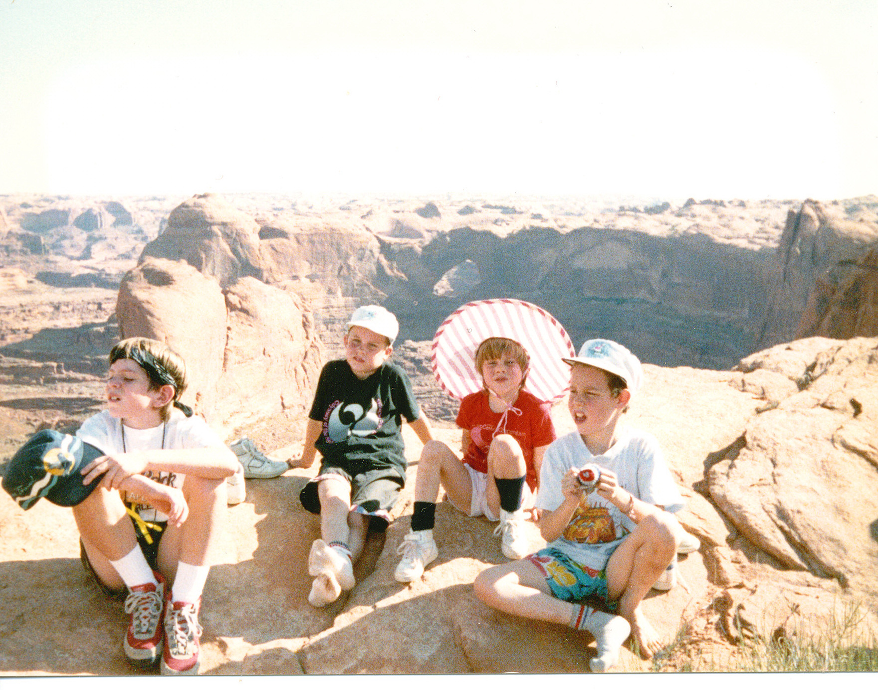
My friend Joe’s son and the Orr kids at the top of the Crack in the Wall trail to Coyote Gulch with Stevens Arch in the Background. Photo credit: Joe Ruffert
Kevin Fedarko was the keynote speaker at the symposium and he is as inspirational a speaker as you could ask for. It doesn’t hurt that the landscape that he spoke about is the Grand Canyon. He urged the attendees to, “Take your children out into these landscapes so that they can learn to love them.” He is advocating for the protection of the Grand Canyon in particular but really he is advocating for the protection all public lands.
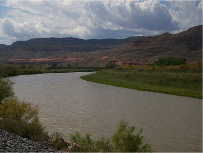
Kevin Fedarko and Coyote Gulch at the Rio Grande State of the Basin Symposium hosted by the Salazar Rio Grande del Norte Center at Adams State University in Alamosa March 29, 2024.
What an inspirational talk from Kevin. I know what he is saying when he speaks about the time after dinner on the trail where the sunset lights up the canyon in different hues and where, he and Pete McBride, his partner on the Grand Canyon through hike, could hear the Colorado River hundreds of feet below them, continuing its work cutting and molding the rocks, because the silence in that landscape is so complete. He and I share the allure of the Colorado Plateau. Kevin was introduced to it through Collin Flectcher’s book The Man Who Walked Through Time, after he received a dog-eared copy from his father. They lived in Pittsburgh in a landscape that was industrialized but the book enabled Kevin to imagine places that were unspoiled.
My introduction to the Colorado Plateau came from an article in Outside magazine that included a panoramic photo of the Escalante River taken from the ledges above the river. Readers in the know can put 2 and 2 together from the name of this blog — Coyote Gulch — my homage to the canyons tributary to Glen Canyon and Lake Foul.
Stevens Arch viewed from Coyote Gulch. Photo via Joe Ruffert
Kevin’s keynote came at the end of the day on March 29th after a jam-packed schedule.
Early in the day Ken Salazar spoke about the future of the San Luis Valley saying, “Where is the sustainability of the valley going to come from.” Without agriculture this place would wither and die.” He is right, American Rivers and other organizations introduced a paper, The Economic Value of Water Resources in the San Luis Valley which was a response to yet another plan to export water out of the valley to the Front Range. (Currently on hold as Renewable Water Resources does not have a willing buyer. Thank you Colorado water law.)
Claire Sheridan informed attendees that their report sought to quantify all the economic benefits from each drop of water in the valley. “When you buy a bottle of water you know exactly what it costs. But what is the value of having the Sandhill cranes come here every year?”
Sandhill Cranes Dancing. Photo by: Arrow Myers courtesy Monte Vista Crane Festival
Russ Schumacher detailed the current state of the climate (snowpack at 63%) and folks from the Division of Water Resources expounded on the current state of aquifer recovery and obligations under the Rio Grande Compact.
The session about the Colorado Airborne Snow Measurement Program was fascinating. Nathan Coombs talked about the combination of SNOTEL, manual snow courses, Lidar, radar, and machine learning used to articulate a more complete picture of snowpack. “You can’t have enough tools in your toolbox,” he said.
Coombs detailed the difficulty of meeting the obligations under the Rio Grande Compact with insufficient knowledge of snowpack and therefore runoff volumes. Inaccurate information can lead to operational decisions that overestimate those volumes and then require severe curtailments in July and August just when farmers are finishing their crops. “When you make an error the correction is what kills you,” he said.
If you are going to learn about agriculture in the valley it is informative to understand the advances in soil health knowledge and the current state of adoption. That was the theme of the session “Building Healthy Soils”. John Rizza’s enthusiasm for the subject was obvious and had me thinking about what I can do for my city landscape.
Amber Pacheco described how the Rio Grande Basin Roundtable and other organizations reach out to as many folks in the valley as possible. Inclusivity is the engine driving collaboration.
RiversEdge West, a Grand Junction-based nonprofit, received $22,035 from the Colorado River District’s Community Funding Partnership and $34,433 from the Colorado Water Conservation Board to restore two river sites owned by the city of Montrose.
According to RiversEdge West Restoration Coordinator Montana Cohn, the two sites together total around 70 acres, and the project will allow the group to remove about 8 acres worth of invasive tamarisk and Russian olive plants and replace them with native species…One site is off Mayfly Drive, and the other is near Home Depot off Ogden Road. Cohn said restoration efforts at these sites have yielded positive results before, and the new project will expand on previous work. He explained invasive thorns and plants like Russian olive and tamarisk crowd out native vegetation, degrade soil quality and, since some are thorny, block access to the river for wildlife, livestock and recreationists…
The project will go down in phases, starting with volunteer efforts this summer. Then in the fall, paid crews from the Americorps program Western Colorado Conservation Corps will come in with herbicides and chainsaws and remove as many of the invasive plants as possible. Efforts, including volunteer replanting efforts of native plants, will continue into 2024.
Click the link to read the article on the WyoFile website (Angus M. Thuermer Jr.):
Lawmakers will seek $500,000 to study water lost from canals in the Green and Little Snake River basins to ensure Wyoming is accurately credited for conservation when it chooses or is forced to close irrigation systems in the troubled Colorado River Basin.
The study could help Wyoming limit reductions in water diversion as seven Western states and Mexico wrangle with an over-allocated and dwindling supply in the drainage. Members of the Legislature’s Joint Select Water Committee voted to draft a measure to seek the money from the general fund when the legislative session commences early next year.
“I could see [a conveyance loss study] very easily reaching $500,000,” Jason Mead, interim director of the Wyoming Water Development Office told lawmakers Wednesday. State Engineer Brandon Gebhart said his “mind was right at $500,000 for this,” but that “it could be a lot more.
“I do think that this is a really good start,” he said.
One hundred years after the signing of the Colorado River Compact, water managers cannot accurately measure what’s used and have not agreed on how to resolve conflicting views on rights to use what water there is.
The amount of incidental seepage and phreatophytic losses — canal-side, plant-used water — associated with irrigation is an “area of agriculture data collection that need[s] to be updated and verified,” the U.S. Bureau of Reclamation states in its 2022 Upper Colorado River Basin Consumptive Uses and Losses report.
The proposed Wyoming study could help the state claim that when it shuts off water to a field of crops, it is saving that crop’s consumption plus what’s lost in the conveyance system of canals and ditches that carry the flow from river to field.
By showing it saves more, Wyoming would cut off fewer users in a “curtailment” situation where water managers require conservation. The data could also better inform the purchase of temporary water rights transfers from one user to another.
“Understanding what that conveyance loss is,” Gebhart said, “could benefit the water users in our state.”
80% loss?
Conveyance loss is significant in Wyoming’s Green River Basin, one lawmaker told the committee.
“We know in Sublette County that we have some canals that are over 20 miles long that go through a glacial till and alluvium that, anecdotally we’ve heard, they lose up to 80%,” Sen. Larry Hicks (R-Baggs) told the committee. Irrigators estimated losses in a survey conducted by the Water Development Office, but none has reported losses as high as 80%; the statewide average is 24%.
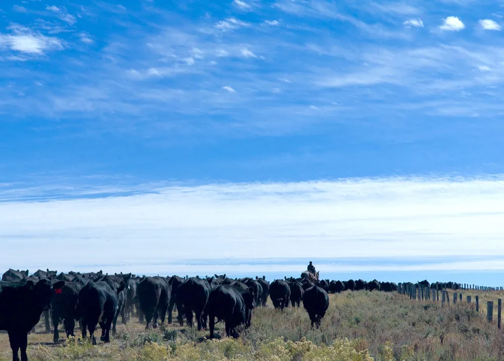
A cowboy herds cattle home from the range in the Green River drainage in Sublette County. (Angus M. Thuermer, Jr./WyoFile)
A contractor would lay out the groundwork for the study starting next spring, identifying perhaps eight sites and 50 miles of canals in the Green and Little Snake River drainages that could be monitored. Investigators would install water-pressure sensors in canals to record water-level fluctuations through a season.
Once in place, consultants would measure and record flows and pressures in the 2024 irrigation season. Mead of the WWDO described how the survey would work.
Investigators would be “going out there four or five, six times to actually get measurements on the canal at four or five or six different spots down, say, a 15-mile section,” he said.
The results would show, for example, the difference in canal seepage at the beginning of an irrigation season when the ground is drier compared to seepage in mid-summer when the canal has been flowing and “things are wetted up and primed,” Mead said.
Engineer Gebhart distinguished between two categories of conveyance losses — consumptive loss and seepage — and whether Wyoming could claim credit for staunching either.
Consumptive loss is the amount consumed by ditch-side plants and trees, the amount lost to evaporation, plus that which leaks into an aquifer “that does not return back to the [Colorado River] system,” he said.
Gebhart defined the second category — seepage loss — as leakage that returns to the system. “It may be delayed, but it does return back to a stream,” he said.
As Wyoming calculates what’s consumptively used — and what it can save if that consumptive use is taken off-line — it might not be credited for reducing some associated seepage.
“Seepage [that] returns to the system … that is not considered a consumptive use,” Gebhart said. “I would say a majority of ditch loss is lost to seepage.”
Results from the study would be ready in late 2024 or in 2025, according to a scenario painted by Mead.
Wyoming buffer
Wyoming doesn’t expect to face curtailment — when it might be forced to shut down users — until 2028, if drought continues. Wyoming and its sister states in the Upper Division or upper basin — Colorado, Utah and New Mexico — would face mandatory cuts if the Lee Ferry gauging station just below Lake Powell shows a flow of less than 75 million acre-feet in the previous 10 years.
Under the 1922 Colorado River Compact, “[t]he States of the Upper Division will not cause the flow of the river at Lee Ferry to be depleted” below that level. The upper basin encompasses about 45% of the drainage area but produces 92% of the runoff.
Colorado River laws apportion Wyoming rights to 14% of the upper basin’s water, officials say. They believe upper basin states are not yet at the critical “75/10” metric where reductions are necessary.
“We’re currently about 85 million acre-feet,” Gebhart said, referring to the previous 10 years. “So we’ve got a little buffer.”
“We’ve blown through the hydrology, we’ve used most of the storage in the Colorado River Basin,” Hicks said. “And now … the director of the Bureau of Reclamation, [is] looking for somewhere between 2 [million] and 4 million acre-feet of reductions in the Colorado.”
The original estimate was 15 million acre-feet were in the system annually, but that water, “it doesn’t exist,” Hicks said. In the last decade, it’s averaged 12 million acre-feet or less, he said. One water administrator in Colorado has said experts tell water managers to plan for 9 million acre-feet a year as a worst-case scenario.
Municipalities and industry — usually holding inferior, junior water rights and so the first to face curtailment — could be looking for water. In Wyoming, agriculture holds 80% of the water rights, Hicks said, and could be approached to sell through a temporary-transfer system or some other arrangement.
“That’s the water bank that you’re looking at,” Hicks said of agriculture.
“At some point in time, we’re gonna have to recognize that there’s not 15 million acre-feet to be divided up,” he said. “That’s really the issue. This is why all the states are lawyering up.”
Wyoming is preparing for negotiations, measurements, debates and possibly fights over water rights. In the last year, the state has added a Colorado-River staffer to the state engineer’s office and also the attorney general’s office, Hicks told the committee.
Brad Udall: Here’s the latest version of my 4-Panel plot thru Water Year (Oct-Sep) of 2021 of the Colorado River big reservoirs, natural flows, precipitation, and temperature. Data (PRISM) goes back or 1906 (or 1935 for reservoirs.) This updates previous work with @GreatLakesPeck. Credit: Brad Udall via Twitter
The heat of a warming planet, like an artist’s palette knife on a canvas, etches its way across Western forests, slowly altering ecosystems that have flourished for centuries.
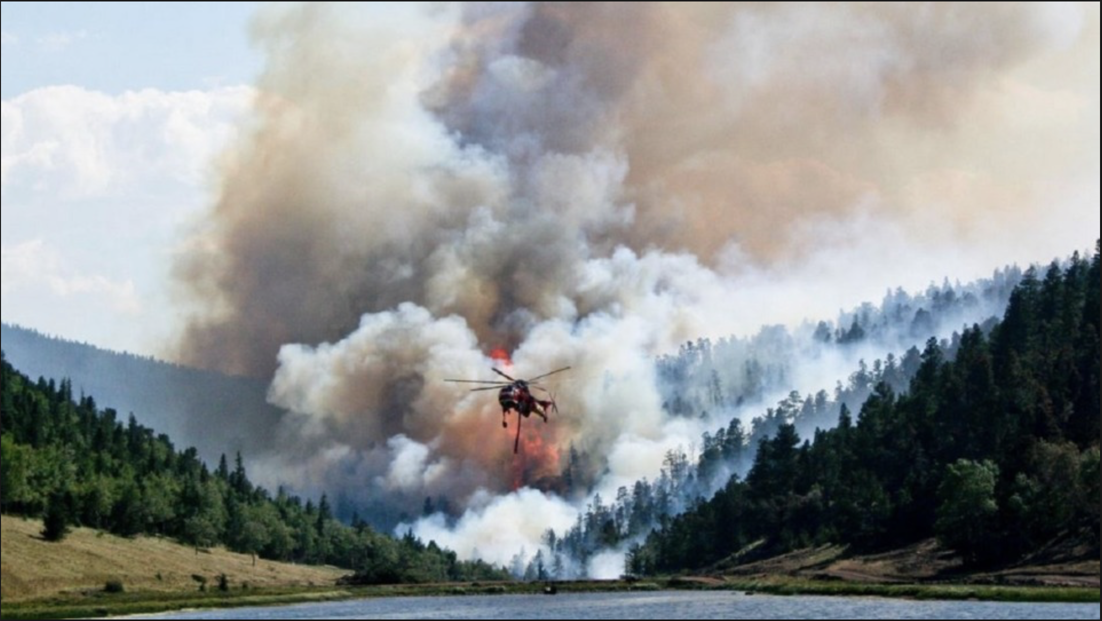
A firefighting helicopter flies in the foreground while the Spring Creek Fire (August 2018) rages behind it. Photo credit: El Paso County
Stevens-Rumann, a 33-year-old assistant forestry professor at Colorado State University, was [on site to observe the aftermath of the Spring Fire to measure and mark what comes next. In all likelihood, the ponderosa pine forest that had been there would not return.
Aspen and scrub oak have already sprouted, but all the pine trees and their cones were destroyed. No pine saplings poke through the charred soil.
Across the Rockies and even into the Sierra Nevada and the Pacific Northwest’s Cascades, forests are changing or simply vanishing. Wildfire has played a big role. Insect infestations have also had a hand, as has drought.
Behind it all is one driving force — climate change. Scientists charting the fate of forests see it, whether they are entomologists or botanists or wildfire ecologists like Stevens-Rumann. The heat of a warming planet, like an artist’s palette knife on a canvas, etches its way across Western forests, slowly altering ecosystems that have flourished for centuries.
“We are really moving out of a climate that is suitable for forests,” Stevens-Rumann said. “Old trees can persist, but when change comes in a disturbance like a wildfire and the ecosystem resets, the forests don’t come back.”
The transformation isn’t quite that simple. Lower elevation forests, like those along the Front Range, are most at risk, but as the forest rises into the mountains, the nature of the woods may change with spruce, fir and pine competing for survival even as new pests push into those higher, and now warmer and drier, mountain reaches.
“As ecosystems change, there are going to be winners and losers,” said Thomas Veblen, a biogeographer and distinguished professor at the University of Colorado. “The regulator function of the forest could diminish … leading to more runoff and flash floods. With a reduction of the forest canopy, we are going to see the potential for greater erosion. The question is how much of the forest will fail to regenerate.”
Fire changes the forest’s composition
Colorado’s Front Range has had five ecotones — shifts in plant and animal communities — from grasslands at 5,500 feet above sea level to alpine tundra at 11,300 feet.
“When we go to higher elevations under warming temperatures, we do expect the species from lower elevations to do better after a fire or other disturbance,” Veblen said.
After six years as a forest firefighter in an elite hotshot crew, Stevens-Rumann, curious about what happens after the fire is out, became a wildfire ecologist.
In a study of 1,485 sites that burned in 52 wildfires in forests from Colorado to northern Idaho, a team led by Stevens-Rumann found tree regeneration was significantly reduced at the sites that burned after 2000.
Fewer than half the spots had signs of growing back with a density of trees similar to the pre-fire forest, and nearly one-third of the sites had no trees at all.
These forests ranged from lower elevation dry conifer forests, containing ponderosa pine and Douglas fir, to moister conifer forests of Engelmann spruce and lodgepole pine. The highest elevation forests in the study were around 9,000 feet.
The researchers measured the site temperatures and moisture, and classified the areas by the severity of the burn.
It appeared that the hotter and drier the site, the less chance of a forest coming back. “There is an ecotone shift already underway,” Stevens-Rumann said. “We may see aspen and scrub oak replace pine and at higher elevations, maybe pine replace fir.”
This is happening across the Front Range. An analysis of five Front Range forest fires between 1996 and 2003 — Bobcat Gulch, Overland, High Meadow, Buffalo Creek and Hayman — found that 23% of the forest cover has been lost.
“Below 8,200 feet, we saw little generation; above 8,200 feet, where it tends to be cooler and moister, we saw more,” said Marin Chambers, a researcher at the Colorado Forest Restoration Institute and the study’s lead author.
Savage wildfires disrupt the trees’ lifecycle
At the site of the 2002 Hayman Fire — the largest in the state’s history, consuming 135,114 acres northwest of Colorado Springs — the most intensely burned areas have come back as grasslands.
The problem, Chambers explained, is that while fire releases the seeds of pine cones, they do not travel very far. And the hotter, drier and more open sites where they land are less hospitable.
Fire has been an essential component of the pine forest ecosystem. The pine and fir trees are “serontinous” — depending on fire to release their seeds and simultaneously clear an ashy, nutrient-rich bed for new seedlings.
Two things, however, have altered the natural cycle. First, a century of fire suppression — think Smokey the Bear — has prevented regeneration, creating forests of mostly large, old trees. Additionally, it has built up dead wood on the forest floor that aids fires to burn more intensely when they do happen.
Black Forest Fire June 2013 via CBS Denver
And now those fires are coming more quickly and more savagely. Since 2000, there has been vastly more acreage burned in Colorado than in the three previous decades, with peaks of more than 300,000 acres scorched in 2003 and about 160,000 acres destroyed in 2013.
Across the West, about 20 million acres burned between 1979 and 2015. The average fire season grew by 26 days, a 41% increase, and high-fire-potential days increased by 17, according to a study by John Abatzoglou, a University of Idaho geographer.
Abatzoglou measured drought conditions and water availability, as well as temperature, and estimated that climate change contributed to about half the forest fire acreage as heat parched the forests, creating more dry fuel.
The analysis also found that significant declines in spring rains in the southwestern U.S. during the period from 1979-2015 and in summer precipitation in the Northwest add to the fire problem.
Another Abatzoglou study projects the shortening of the snowpack season except for in the high Rockies and parts of the Uinta and Bighorn ranges in Utah and Wyoming, as well as more precipitation falling as rain rather than snow.
How much hotter has it been? The average observed summer temperature in Colorado between 2005 and 2009 was nearly 67 degrees Fahrenheit — the hottest it has been in a century, up almost 2.5 degrees since 1989, according to the National Oceanic and Atmospheric Administration.
The temperature itself poses an ecological Rubicon. A study of 177 burn sites from 21 forest fires in the northern Rockies documented the same phenomenon Stevens-Rumann saw: fewer trees growing in the lower elevation patches and no trees at about one-third of the sites, with grasses, sedges and a wild, purple evening primrose called fireweed taking root.
The study also calculated that at summer average temperatures above 63 degrees, fir tree regeneration would be “minimal.” Ponderosa pine is slightly more heat tolerant at temperatures up to 66 degrees, the study said…
So much is at stake. And it’s not about the view.
There is much more at stake in the fate of the high-country forests than just a majestic view. The snowpack that falls in the woods, and is essential to nourishing the forest, and it is also the main source of drinking water for the state.
“Every person in Colorado gets a touch of the forest ecosystem every day when they open up the tap,” West said. But thinner forests would lead the dwindling snowpack to run off more quickly.
Even without the spruce beetle, the high-elevation forests are under threat. In a study of Colorado Front Range forests between 9,500 feet and 11,150 feet, researchers found a decrease in new spruce and fir as a result of declining snowpack and rising summer temperatures.
Above-average snowpack was found to be a key in the establishment of new Engelmann spruce and subalpine fir, according to one of Veblen’s studies. Conversely, declining snowpack along with cooler, wetter summers was related to a decrease in the number of fir and spruce establishment events from 1975.
A study of high-elevation areas in Rocky Mountain National Park warned that these ecosystems were “at higher risk of species redistribution as they are more insular and experience more rapid changes than environments at lower elevations.”
In some places, climate change is pushing forests higher or farther. In Alaska’s Noatak National Preserve, boreal forests have moved as much as 300 feet north onto what was formerly treeless tundra.
In Yosemite National Park researchers have found whitebark and lodgepole pines pushing into montane meadows as high at 10,000 feet.
Air pollution from straw burning near a residential area. The traditional practice of open burning of rice straw produces large amounts of smoke creating a thick cloud over fields. Photo: Ali Mohammadi, distributed via imaggeo.egu.eu
Researchers suggest new approach needed to address Anthropocene risk
A team of international researchers led by Colorado State University is calling for a new approach to understanding environmental risks in the Anthropocene, the current geological age in which humans are a dominant force of change on the planet.
Patrick Keys, a research scientist in the School of Global Environmental Sustainability at CSU, is the lead author of “Anthropocene risk,” a perspective paper published July 22 in Nature Sustainability that suggests adopting a holistic approach to understanding environmental risks. Keys said the team hopes that the article is “productively provocative.”
“The Anthropocene is a time of rapid global change – socially, environmentally, and geophysically,” he said. “Typical notions of neatly and cleanly delineating complex environmental risks are changing in unexpected ways. It’s becoming clear that a more holistic perspective, including social history, power relations, and environmental ethics may be important components of Anthropocene risks.”
As an example, Keys said it’s a common belief that the civil war in Syria has been driven by drought and climate change. While those two factors more than likely played a role in what led to the civil war, it also ignores other aspects such as incentives by Syrian government officials that kept farmers on agriculturally precarious land for decades. Keys said those incentives made it possible for drought and climate change to have such an impact.
“If we ignore the social and political economic factors that deliver us to this present, we will attribute an event to being caused by the environment when, in fact, that was just one cause or the icing on top of the cake. If we look at things only in the present, we will come up with solutions to a problem defined in the present, but we may not be defining the problem correctly.”
This point of view stems from Guidance for Resilience in the Anthropocene: Investments for Development (GRAID), a program based at the Stockholm Resilience Centre, where five of the paper’s co-authors currently work.
In the paper, the research team explores four different cases outside of Europe and North America to highlight this way of looking at environmental risks and underline why people studying such risks must take a broader approach.
“As the Anthropocene unfolds, navigating new and emerging risks will require considering changes that happen over years, decades, centuries, or even millennia.” Keys said. “In this increasingly interconnected and accelerating world, it’s on us to really educate ourselves about how to interact intelligently and meaningfully to work toward a more sustainable world.”
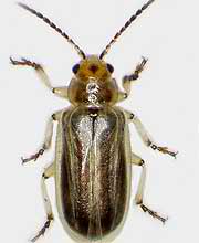
Tamarisk leaf beetles at work
FromThe Associated Press (Felicia Fonseca) via Tucson.com:
That the tiny beetles brought to the U.S. from Asia in an experiment to devour invasive, water-sucking tamarisks showed up at the Verde River in central Arizona is no surprise. But it’s further evidence they’re spreading faster than once anticipated and eventually could pervade the Southwest U.S, raising wildfire risks and allowing less time to uproot the tamarisks, also called salt cedars, and replace them with native trees.
Without those efforts, an already highly flammable tree will burn more intensely, and an endangered songbird that nests in tamarisk might not have a home.
The federal program to use the beetles to chew up tamarisk trees began as an experiment in rural Nevada in 2001 and was approved for more widespread use in 2005, as long as they were at least 200 milesfrom Southwestern willow flycatcher territory. It ended in 2010 as the beetles intruded on the birds’ habitat. An unintentional release in southern Utah also helped the insects spread into Arizona.
Johnson believes the quarter-inch beetles hitchhiked to the Verde River on clothing, a backpack or a boat. Normally, they are wind travelers but would have had to catch quite a gust to get to the river from the closest drainage where they’ve been recorded, he said.
Johnson has sent samples to a geneticist in Colorado to determine if the beetles can be traced to a population north of Arizona or a subtropical one from Texas that multiplies quicker.
Arizona once was projected to be too hot for the beetles to survive, but they’ve evolved as they’ve expanded their reach.
Dan Bean with the Colorado Department of Agriculture found even more this summer in far southwestern Arizona along the California border, where temperatures regularly top 100 degrees.
The concern now is the beetles establishing themselves in the Gila, Salt and San Pedro watersheds, which have higher concentrations of flycatcher habitat.
The beetles aren’t known to feast on anything other than tamarisks, though one beetle can’t eat much on its own. In the thousands, they can consume entire trees, Bean said.
Southwestern Willow flycatcher
The tamarisk leaves can grow back within the season, but repeated attacks can be fatal for the trees — a welcome result in places flycatchers don’t live.
Dead tamarisks can litter the ground with leaves and increase wildfire risks.
The trees already are notorious for burning hot and black, and beetle predation would provide more fuel.
Ben Bloodworth works with Rivers Edge West, formerly the Tamarisk Coalition, which has been tracking the beetles’ movement for years.
The group has mapped the beetles along the Green River in Utah, the Rio Grande and Pecos River in New Mexico and Texas, the Arkansas River in Colorado, the Colorado River — a major source of water for 40 million people in seven Western states — and other waterways.
“Eventually the beetles will be throughout the entire Southwest, and really what we need to do is, in areas where it’s appropriate, get in ahead of the beetle (and) plant willows and cottonwoods and other native species that can provide habitat for the willow flycatcher,” Bloodworth said.
The beetles and the songbird have been the subject of legal fights. The Tucson-based Center for Biological Diversity sued the U.S. Department of Agriculture and its Animal and Plant Health Inspection Service in 2013.
The lawsuit alleged the damage caused by the insects through the beetle release program violated the Endangered Species Act, and argued the federal government should be held liable.
As part of a settlement, the USDA released a draft conservation plan in June for the flycatcher, which is found in parts of Arizona, California, Colorado, Nevada, New Mexico, Texas and Utah. Under the plan, the agency would aid existing conservation programs, contribute money and monitor beetle impacts. The public has until Aug. 8 to weigh in.
The beetles would not be in the United States if not for the tamarisk that thrives along riverbeds.
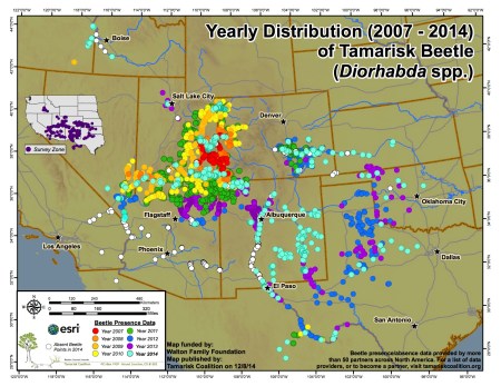
2014 Tamarisk leaf beetle distribution map via the Tamarisk Coalition
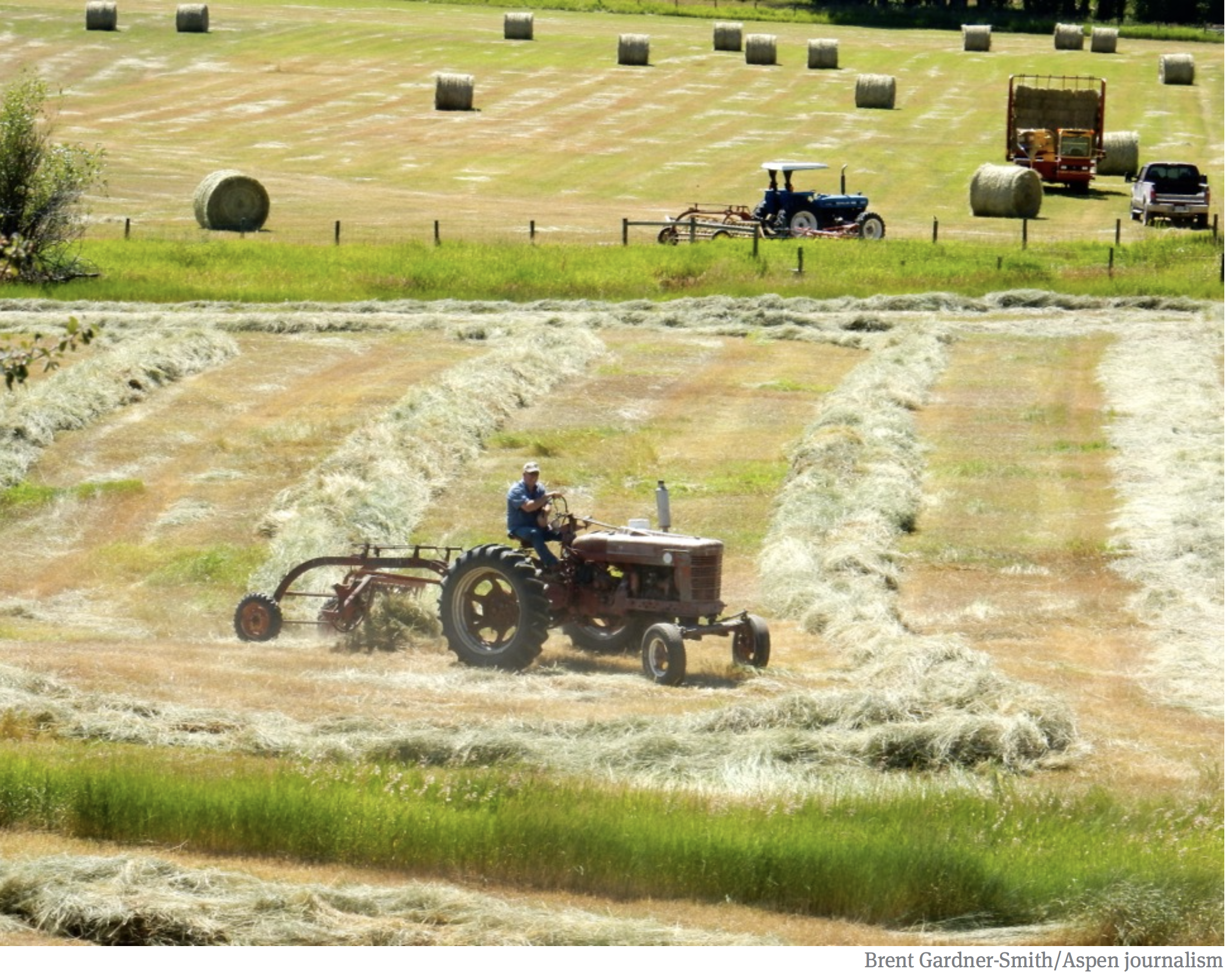
The looming possibility of mandatory curtailment of water use has raised concerns among Western Slope water managers, who feel that such cuts could harm Western Slope agricultural, such as this hay filed in the Yampa River basin. However, as water levels continue to drop to record lows in Lake Powell, mandatory curltailments are being discussed as a real possibility, especially by Front Range water managers. Photo credit: Brent Gardner-Smith/Aspen Journalism
FromThe Steamboat Pilot & Today (Eleanor C. Hassenbeck):
The collective group of [recently signed] agreements is called the Colorado River Drought Contingency Plan.
It aims to raise the unprecedented low water levels in the largest reservoirs on the Colorado River system, Lake Powell and Lake Mead, to enable them to continue to deliver water and produce hydropower.
In Colorado, it calls for three possible actions:
Creating a bank of stored water in federally owned reservoirs upstream of Lake Powell. This water would be released into Lake Powell in order to make sure Colorado continues to meet obligations to deliver a certain amount of water to downstream states under the Colorado River Compact.
Increasing cloud seeding and removing deep-rooted, invasive plants that take up a lot of water, such as tamarisk.
Creating a voluntary program that would temporarily pay agricultural water users to fallow their land and send water they have a right to downstream. This is called demand management.
Of the options on the table, demand management — the option that would pay farmers not to use their water — is the one most likely to impact Routt County…
Demand management is still only a hypothetical, so the Yampa River Basin could opt out of a program if it doesn’t work for the area.
The Colorado Water Conservation Board has assembled workgroups on topics related to demand management. These groups are now meeting behind closed doors to develop preliminary reports outlining how the program might work.
Brown said once these reports are completed and released to the public, there will be opportunities for community members to provide input on the idea. She said there will be the “opportunity for a real, thoughtful conversation, especially in the Yampa and White (river) basins.”
The Dolores River, below Slickrock, and above Bedrock. The Dolores River Canyon is included in a proposed National Conservation Area. Photo: Brent Gardner-Smith/Aspen Journalism.
A view of the Dolores River below Slickrock.
August 16, 2017: Colorado ParksWildlife and John Sanderson found imperiled bluehead sucker fry on Dolores River — a hopeful sign.
San Miguel River from CO 141.
Ponderosa Gorge, Dolores River. Boating is popular on the Lower Dolores River, which is being considered as a National Conservation Area. Photo credit RiverSearch.com.
Dolores River Campground September 2016.
The Dolores River shows us what’s at stake in the fight to protect the American West — Conservation Colorado
Photo via the Sheep Mountain Alliance
Dolores River watershed
Dolores River south of Lizard Head Pass
Dolores River near Bedrock
Dolores River
Dolores River above Dolores
Dolores River Canyon near Paradox
FromThe Walton Family Foundation (Peter Skidmore):
In the Colorado River Basin, RiversEdge West leads a coordinated effort to restore critical habitat
Doug King’s family has been ranching the lands around the Dolores River in Southwest Colorado since the 1930’s. “It’s beautiful−I call it John Wayne country,” Doug says, proudly. “I’m the third generation on the land, my son will be the fourth generation, and his son will be the fifth.”
Over the decades, Doug experienced firsthand the steady, relentless creep of invasive plant species like tamarisk and Russian olive and its impact on the land he has cared for his whole life. The damage has been extensive, threatening the larger riparian—or river bank—habitat that in the Colorado River Basin ultimately supports more than 40 million lives across two nations.
As the unwelcome vegetation pressed in on essential farmland and fish and wildlife habitat, Doug and many others in the region understood it was time to lock arms and push back.
Originally conceptualized in 1999 to discuss strategies for addressing invasive plant species along rivers in western Colorado, the then-named Tamarisk Coalition was fueled by a desire to shape a landscape-scale solution. The group had observed that conventional site-by-site eradication simply wasn’t able to move quickly enough.
“People were getting grants to do five acres or half a mile” of tamarisk removal, recalls Tim Carlson, the coalition’s first executive director. “That wasn’t going to solve the problem. We started with a bold approach: If we were going to solve this problem, it’s got to be a regional solution.”
The introduction of the tamarisk is a story of unintended consequences. Long thought to prevent erosion along the banks of western rivers, its presence was so valued in earlier days that Boy Scouts would receive badges for planting it. But the persistent shrub with scale-like leaves took to its adopted habitat like a parasite, displacing native vegetation.
Restoring and sustaining the overall health of the Colorado River Basin has been a primary goal of the Walton Family Foundation’s Environment Program since its inception nearly a decade ago. And, the program’s first grant to the Tamarisk Coalition in 2009 supported its restoration efforts along the San Miguel and Dolores river systems. Gradually, the foundation expanded its support to also include work along the Escalante, Verde and Gila systems.
“We have a great relationship with the foundation where we present innovative ideas, and they help us scale up these efforts. The investment affects a vast landscape, bolsters our work and has helped us promote best practices to other organizations,” says Cara Kukuraitis, outreach and education coordinator for the organization now known as RiversEdge West.
The organization changed its name in 2018 to reflect its broader work in Western riparian areas and the surrounding communities. But it retains its unique and core operating model—to facilitate collaboration and information-sharing across diverse groups and individuals to accomplish riparian restoration at a larger scale than any one partner can attain on its own. As a result, RiversEdge West now supports 20 ambitious multi-stakeholder partnerships encompassing federal, state, and community organizations throughout the American West, teaching best practices to over 300 local public and private restoration organizations and successfully restoring some 11,500 acres—and counting—of riparian habitat.
The state of Colorado is among the group’s core partners.
“Our relationship with RiversEdge West has allowed Colorado Parks and Wildlife to more effectively meet our mission of improving the wildlife habitat within the state,” explains Peter Firmin, manager of the James M. Robb-Colorado River State Park.
“The networking and training opportunities provided by RiversEdge West allow us to leverage intellectual and financial resources to improve habitat along the Colorado River. As a group, we are able to accomplish more than we could as individuals.”
The work of RiversEdge West and its growing network is bolstered by an array of technical tools. For example, a multi-partner geodatabase stores and shares data with land managers, so they can see how their projects connect and positively impact the landscape over time.
“The data helps us establish and measure progress against quantitative goals, so the project can jump from removing tamarisk by just cutting trees to collecting data on the extent of the problem and promoting ways to encourage the ecosystem’s overall health,” says Cara.
It is a testament to the organization’s enduring value that its annual conference attracts upwards of 200 representatives from Colorado, Arizona, Nevada, New Mexico, California, Texas, Kansas, Oklahoma, Utah and Mexico to connect on riparian restoration science.
The organization also is working to convey the broad importance of these efforts through its ongoing “Riverside Stories” web series, which tells the personal stories of people who call this land home and are working to restore this habitat for future generations. Among them is Doug and his family.
“I have a theory that we should leave the land better than how we got it,” Doug notes in sharing his story. “The Colorado River is soon going to be the most important resource in the West. We are just caretakers. You are only going to be here 50-60 years, and then somebody else is going to have this land.
The tamarisk, which was brought to the U.S. from Eurasia in the late 1800s for erosion control, windbreaks and decoration, is much detested. Since its introduction, tamarisk – also known as salt cedar – has been blamed for choking waterways, hogging water and salting the earth as its range expands, driving out such native trees as cottonwood and willows. In Palisade, Colorado, a state lab is breeding beetles whose sole purpose is to destroy tamarisk. At one point, the University of Nevada published a poster about the plant titled WANTED – Dead, Not Alive!
“There’s been a concerted effort to demonize tamarisk,” said Matt Chew, a historian of invasion biology at Arizona State University’s School of Life Sciences. But he thinks this war is aimed at the wrong enemy.
The tree, he said, is a scapegoat for our struggle with something much bigger and messier than weedy fields: our relationship with water in the West.
The tamarisk has a reputation for hogging water – but is it warranted?
“This is one of the constant counts against tamarisk – that it’s wasting water,” Chew said. “That particular idea got started in the late 1930s and early 1940s for a very particular reason.”
Back then, Chew says, the Phelps Dodge Corp. wanted to expand its copper mine in Arizona, but it didn’t have the water it needed for the additional mining and processing. All the water rights to a nearby creek and river had been allocated.
“What they needed was an excuse to say there was more water in the rivers so that Phelps Dodge could have more water,” Chew said. “So, where are they going to get more water?”
Phelps Dodge inspected nearby water sources and found lots of tamarisk growing along the banks, Chew said. Mine officials rationalized that if they could prove the tamarisk was draining river water, he said, the mine could potentially get the rights to the “extra” water available by killing tamarisk.
“Phelps Dodge did a bunch of experiments which were later picked up by the Agriculture Department,” Chew said, adding that Phelps Dodge ended up getting its water rights through other means, but the tamarisk’s image was destroyed.
As Chew writes in the “Journal of the History of Biology,” “with water shortages, economic development during the Depression and copper mining for national defense during World War Two, federal hydrologists moved quickly to recast tamarisks as water-wasting foreign monsters.”
Since then, researchers have shown that the tree doesn’t use more water than native riparian vegetation, including cottonwoods.
To make matters worse, big changes were occurring in the 1930s and ’40s in the way that water was being moved through the West. Dams and diversions were changing the patterns of flooding, patterns that used to be in sync with the reproductive cycle of more sensitive native plants, such as cottonwoods.
“To some extent, the way we were managing Western rivers actually created a giant tamarisk housing project,” Chew said. If the tamarisk is a monster, he said, it’s because we created it.
“If you want good, old-fashioned 17th-century riparian areas in the western U.S.,” Chew said, “you can’t take all the water out of the river. You can’t have big irrigated fields. You can’t have huge cities.”
Anna Sher, an invasive species biologist at the University of Denver and author of the book “Tamarix: A Case Study of Ecological Change in the American West,” agrees that Tamarix (the species’ genus) isn’t all bad.
Yes, Tamarix can create saltier surface soil that retards other vegetation, and its dense wood can fuel more intense fires. Sher even has heard that a boater drowned in Arizona because rescuers couldn’t get through the dense thickets of tamarisk crowding the shore in time to help him.
But, she says, “I certainly do not hate this plant.”
It provides nesting spots for the Southwestern willow flycatcher, for example, and she says it’s entirely possible for the trees to be a part of the landscape without completely taking over.
“It’s only behaving badly because of the way that we’ve managed our rivers,” Sher said.
Although the way we manage our rivers isn’t going to change anytime soon, Sher sees hope for restoring the landscape. It’s called the Field of Dreams hypothesis.
“The Field of Dreams hypothesis predicts that when you remove the invasive species, there’s an opportunity for the desirable species to come in,” she said.
Initially, Sher and other ecologists suspected the hypothesis was a pipe dream.
“But after doing surveys of hundreds of sites throughout the American Southwest, we can see that, on average, native species will come back and they’ll come back proportionally to how much tamarisk has been removed,” she said. “More tamarisk taken out, more native plants can come in.”
There are two conditions required for successful restoration. First, there has to be enough water in the rivers and streams to supply the new vegetation. Second, the public has to remain open to what native plants might come back. They might not be the cottonwoods and willows people hope for.
“It’s a new game now with Tamarix here and with the water needs that we have now,” Sher said, and humans will have to get used to plants that can handle the landscape as we’ve shaped it.
Those plants might be drought-adapted shrubs and grasses instead of picnic-worthy trees. And they will most certainly have a tamarisk or two as neighbors.
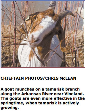
A tamarisk eradication spray program begun almost ten years ago along a portion of the Arkansas River has transitioned into a restoration project this year by the Colorado Division of Natural Resources and Parks and Wildlife. Travis Black, Colorado Parks and Wildlife area manager, said a restoration program has begun which will re-seed the areas between Granada and the Kansas State Line. “The area will be re-vegetated with natural grass species along with willow shrubs and we’re planting cottonwood poles as well,” he explained, adding that the eradication program took some hops and skips between the towns along the river to the Kansas border.
Tamarisk, similar to Russian Thistle, is an invasive plant introduced into southeast Colorado decades ago. Unfortunately, it consumes hundreds of gallons of water per plant and is very hard to kill. Its growth along the Arkansas River allowed it to spread, siphoning off thousands of gallons of water and added to the salinity of the river. Another drawback was in flood mitigation as the plant, growing along the banks of the river, restricted the water flow along the channel which created backups and flooding. The trick to effectively killing off tamarisk is patience. Even after a comprehensive spraying program, it takes a minimum of three years to be sure the limbs, seed and especially roots are dead.
A collaboration of a number of groups including the NRCS and Prowers County sought grant funding to finance the aerial spraying of approximately 400 acres to begin with in 2009, but because of increased funding and a lower cost of service, the area was increased to 1,500 acres. Contributing groups included the Colorado Water Conservation Board, Colorado State Land Board, Holly Flood District, Tri-State G & T and the Northeast Prowers Conservation District among others and some private landowners.
Black said, some of the spraying was more effective than anticipated as a lot of the undergrowth was killed off along with the tamarisk and that eliminated the cover for local wildlife species. The revegetation program will help restore the riparian areas to their natural state and habitat. Not all of the funding is complete for the entire stretch of river into Kansas, but the acreage has been cleared along the Arkansas River, especially visible as you cross the bridge along Highway 50 just a few miles west of Holly. He said there’s no end date to the restoration program, but it will continue when new funding streams become available. The dead tamarisk plants were excavated and ground up on the spot, using specialized equipment that is loaned out to projects around the state.
Colorado National Monument from the Colorado River Trail near Fruita September 2014
Click here to for the Inside skinny and to register:
Join Tamarisk Coalition and the Water Center at Colorado Mesa University for the 16th annual Riparian Restoration Conference in Grand Junction, Colorado, a premier destination on Colorado’s Western Slope.
Colorado River Basin in Colorado via the Colorado Geological Survey
The Middle Colorado Watershed Council, MCWC, aims to protect the stretch of Colorado River from the mouth of Glenwood Canyon to De Beque at the western edge of Garfield County. We work with everyone who uses water from the agricultural community, to city water users (including tooth-brushers and lawn-waterers), to oil and gas developers and every governmental agency in between to encourage wise water use and ensure safe water quality for everyone involved.
Working with the Colorado River District for the State of the River was a great reminder that navigating these diverse interests and subsequent water uses is a common thread for the entire river, from the headwaters of the Colorado down to the river terminus. Through education, dialog and exchange of information we have a chance to better understand and manage the finite resource.
The MCWC has a few projects on the ground and on the horizon that aim to connect our stretch of river to the larger river system. These efforts involve riparian restoration, a nice term for fighting invasive species like tamarisk and ensuring native plants have a chance to grow back, and water quality management.
Tamarisk
Tamarisk Coalition chose the MCWC as one of nine programs to join their Restore Our Rivers campaign. The campaign provides tools and funding for river restoration programs that combat tamarisk and Russian olive and more…
This summer the MCWC will begin a few restoration projects and will continue to monitor existing projects. It is our way of working along our 75 mile stretch of river and understanding how we fit into the larger picture.
As for water quality monitoring, we are undertaking a citizen science program to establish a baseline for what is in our water in the middle Colorado River and its tributaries. Upstream and downstream of us, many groups already test water quality, and therefore again, we are tasked with understanding how our section of river fits into the larger system. Our citizen science program is designed to find out what water quality looks like today, see how that compares to the past, and allows for the opportunity to evaluate trends into the future. How are we affecting water quality and are there opportunities to improve? The data we and our stakeholders collect will help us understand our basin better, but will also provide service to everyone downstream of us.
Our little, but significant, stretch of river is ours to take care of. Managing the entire Colorado River might seem like a daunting task, but we can be stewards for our stretch, from Glenwood Canyon to De Beque. The steps we take to protect our water helps our little basin, but also, we are working a much larger system throughout the west, because we are all in this together.
How an ambitious tamarisk removal project on the San Miguel River set the precedent for future restoration work.
TAMARISK: A THREAT TO THE RIVER
The free-flowing San Miguel River extends for 80 miles from high-alpine headwaters above Telluride, to a desert confluence with the Dolores River near the Utah border. The area is marked by Cottonwood forests with understory of willows and skunkbrush sumac and supports an array of wildlife such as great blue heron, American dipper, black swift, river otter, beaver, black bear, and mountain lion.
In 2005, a watershed-scale conservation plan developed by the Conservancy and partners identified the invasion of non-native species specifically tamarisk, Russian olive, and Chinese elm as the highest threat to the riparian vegetation along the San Miguel River.
Tamarisk replaces native vegetation, and accumulates high concentrations of salts in the soil, threatening plant and animal species and local economy dependent on the river and riparian systems. Removing tamarisk and other nonnative woody plants from riparian corridors improves water quantity and quality, and restores the health of native vegetation.
AN AMBITIOUS GOAL
In response to this, the Conservancy designed a restoration plan and set an ambitious goal of making the San Miguel the first tamarisk-free river system in the Western United States, something that had never been tried before. Working with community members, landowners, the Bureau of Land Management and local government officials, the Conservancy educated stakeholders on the benefits of the project for the river ecosystem and garnered support from almost everyone in the watershed.
Starting in 2007, the project took seven years to complete. While not reaching the goal of a fully tamarisk-free river system, the woody invasive species abundance is drastically reduced in all of the areas that were treated. Analysis done in 2014 has shown that the removal work was a success and minimal continued management is needed.
A MODEL FOR RIPARIAN RESTORATION
“This comprehensive project was a first of its kind in the western United States and has become a model for large scale riparian restoration,” said Terri Schulz, director of landscape science and management for The Nature Conservancy in Colorado.
Efforts have expanded to projects on the Dolores River and prompted the establishment and expansion of groups such as the Tamarisk Coalition. By thinking about this work in the context of the whole watershed, the Conservancy was able to reach out to a wide variety of partners to provide leadership and manpower to the project and to grow the capacity for this work moving beyond the San Miguel watershed.
As the Conservancy plans for future restoration efforts, the tamarisk removal project on the San Miguel River provides an outline for how to successfully work together with communities, landowners and the government to complete projects and reach largescale conservation goals.
The Tamarisk Coalition announces they recently received two grants on the behalf of the Desert Rivers Collaborative that will greatly help their cause. Tamarisk officials say grants from the Colorado Water Conservation Board and the Bacon Family Foundation, totaling more than $200 thousand, will allow the coalition to continue streamside restoration efforts in the Grand Valley.
It is projected that approximately 70 acres of additional riverside habitat will be restored, thanks to $175 thousand from the Colorado Water Conservation Board and $30 thousand from the Bacon Family Foundation. The funding will be used to pay different crews and contractors to use native plantings for re-vegetation and remove tamarisk, an invasive plant from the Eurasia region, as well as Russian olive, a thorny shrub and small tree that have overtaken a lot of riverside area.
In addition, the funding will tremendously aid in reducing wildfire risk and improving river function, soil conditions, and water quality, and ultimately improve our local habitat for fish and wildlife.
“The overall goal is to improve riparian health here in the Grand Valley, and it’s a continuation of projects that have been going on for several years,” says Shannon Hatch with the Tamarisk Coalition.
Funding from the Bacon Family Foundation will also allow the hiring of an intern to assist with project mapping, maintenance efforts, data management, technical assistance, community outreach, and engagement.
Click here to read the report. Here’s the executive summary:
In 2001, the U.S. Department of Agriculture approved the release of a biological control agent, the tamarisk beetle (Diorhabda spp.), to naturally control tamarisk populations and provide a less costly, and potentially more effective, means of removal compared with mechanical and chemical methods. The invasive plant tamarisk (Tamarix spp.; saltcedar) occupies hundreds of thousands of acres of river floodplains and terraces across the western half of the North American continent. Its abundance varies, but can include dense monocultures, and can alter some physical and ecological processes associated with riparian ecosystems.
The tamarisk beetle now occupies hundreds of miles of rivers throughout the Upper Colorado River Basin (UCRB) and is spreading into the Lower Basin. The efficacy of the beetle is evident, with many areas repeatedly experiencing tamarisk defoliation.
While many welcome the beetle as a management tool, others are concerned by the ecosystem implications of widespread defoliation of a dominant woody species. As an example, defoliation may possibly affect the nesting success of the endangered southwestern willow flycatcher (Empidonax traillii extimus).
In January 2015, the Tamarisk Coalition convened a panel of experts to discuss and present information on probable ecological trajectories in the face of widespread beetle presence and to consider opportunities for restoration and management of riparian systems in the Colorado River Basin (CRB). An in-depth description of the panel discussion follows.
The panel concluded that as the tamarisk beetle moves into the Lower Colorado River Basin (LCRB), the selection of management actions to support a transition to a healthy riparian system will depend on the unique suite of characteristics of each sub-basin and the goals of basin managers.
The panel emphasized the importance of basin-specific planning, the necessity of monitoring and inventorying to inform management, and that adaptive management practices will be essential for success relative to varying goals. The panel developed a framework to assist managers in selecting appropriate management strategies and identified future research needed to further inform restoration approaches and management decisions.
2014 Tamarisk leaf beetle distribution map via the Tamarisk Coalition
Arkansas River Basin — Graphic via the Colorado Geological Survey FromThe Pueblo Chieftain (Chris Woodka):
Can a water project be all things to all people?
The Upper Arkansas Water Conservancy District wants to find out.
The Arkansas Basin Roundtable approved a $194,000 grant last week to determine if irrigated agriculture, environmental, recreation, municipal supply, hydropower and aquifer storage can be satisfied in one project.
The Colorado Water Conservation Board will consider final approval of the grant at its March meeting.
The project involves the 200-acre Lake Ranch near Salida, which the district owns.
Right now, the property is irrigated by a center- pivot sprinkler, but the plan is to expand the types of uses to include a hydropower system on the Cameron Ditch above the property, recharge ponds and wetlands on two corners of the field which are not being used and research on another corner. Farm structures occupy the remaining corner of the field.
In addition, a leasefallowing program would provide water to nearby cities, and results would be used in educational programs.
“This is the smaller program, to see if some of these ideas work,” said Terry Scanga, general manager of the Upper Ark district.
If they do, a much larger project on Trout Creek that would cover 1,800 acres and could provide an additional 20,000 acre-feet in storage would be attempted.
That would be a boon to the Upper Ark district, which formed in 1979 to improve water use for numerous smaller entities in Chaffee, Custer and Fremont counties. Past studies have looked at improving how water supply is measured, the availability of underground storage and developing a leasefallowing tool to measure consumptive use when transfers occur.
“Multiple purpose projects are necessary for providing additional needed water supplies in the 21st century,” the district noted in its grant application.
Several ditches along the Purgatoire River are in line to get a much-needed $271,000 makeover through a state grant approved last week by the Arkansas Basin Roundtable.
The roundtable approved a $90,000 grant request to improve structures on six ditch companies that have deteriorated through erosion. The ditches, along with the Purgatoire Conservancy District, will contribute $121,000 and apply for a $60,000 loan from the Colorado Water Conservation Board.
The CWCB still must act on the grant and loan at its March meeting.
“All of the ditches are in the Trinidad Project,” said Jeris Danielson, manager of the Purgatoire district. “We estimated we could lose 10 percent of the water.”
The ditch companies include Picketwire, Enlarged Southside Irrigation, Chilili, Baca, New John Flood and El Moro. All are located in the Trinidad area of Las Animas County.
The project will rebuild headgates, flumes and culverts at various locations. As part of the project, about 1,000 feet of bank along the Purgatoire River will be restored and stabilized.
The Trinidad Project is a federal project that relies on water stored in Trinidad Reservoir. Over the last 20 years, it has averaged only 40 percent of its full supply. The improvements will restore about 5,000 acre-feet (1.6 billion gallons) annually toward basin water needs, according to the application.
Tamarisk
Finally, here’s a report about efforts to mitigate flooding in La Junta from Chris Woodka writing for The Pueblo Chieftain:
An $85,000 plan to remove a “pinch point” in the Arkansas River that has caused flooding in North La Junta got the blessing of the Arkansas Basin Roundtable this week.
The roundtable approved a $25,000 grant toward the project by the North La Junta Water Conservancy District to deal with a problem that has persisted since a flood in the spring of 1999. Other funding is being provided by the Lower Arkansas Valley Water Conservancy District, Otero County and La Junta.
The grant will take out several islands of tamarisk, or saltcedar, using a drag line and reconfigure dikes that apparently only aggravated flooding through the area. Combined, the projects will increase the channel capacity of the Arkansas River through North La Junta.
“This is one of my favorite projects because we did it with one engineer and no lawyers in the room,” quipped Jay Winner, general manager of the Lower Ark district.
The 1999 flood did serious damage to North La Junta, and the district has worked steadily since then to improve channel capacity through the area. Floods in recent years have renewed fears that past efforts were not as effective as hoped.
In another move, the roundtable approved a $48,000 grant toward a $54,800 project to replace a domestic water supply pipeline that serves about 175 families in the McClave area. The grant helps hold down water rates for customers in an area that eventually will be served by the Arkansas Valley Conduit.
The Colorado Water Conservation Board will consider final approval of the grants at its March meeting.
Just because there hasn’t been as much talk about tamarisk lately doesn’t mean the invasion is over. Now, talk has begun again, but the message has changed.
Eradication is out; control is in.
While tamarisks, or saltcedars, are watergulpers, a fully grown tree uses only about 20 gallons a day, not 200 gallons as mistakenly was often reported in the past.
And trees should be taken out for a reason, and with a plan, not just because they are bad invaders.
Those messages have been conveyed twice in the last week by the Tamarisk Coalition to area conservancy districts. Based in Grand Junction, the group incorporated in 2002. The group works with other organizations to improve habitat, not just wipe out saltcedars.
“In a nutshell, what we do is help people restore rivers. We’re focused on that,” Stacy Beaugh, executive director of the Tamarisk Coalition, told the Southeastern Colorado Water Conservancy District board last week. “You can’t just cut them down and walk away.”
She assured the Southeastern board, which took the lead in earlier tamarisk removal programs for the Arkansas Valley, that Southeastern Colorado remains a high priority.
A few days later, the Lower Arkansas Valley Water Conservancy District heard from Rusty Lloyd, program director with the Tamarisk Coalition.
Lloyd explained that the group no longer is concerned with completely removing the trees, many of which were purposely planted for erosion control. But it supports efforts to remove pockets of the plant where possible and natural controls such as beetles to knock back the numbers.
“The beetle can weaken the plants, and some plants don’t come back,” Lloyd said. “It seems to be doing its job, but it’s sporadic.”
Lloyd said there are water quantity and quality benefits from removing tamarisk, but the purpose for any program should look at other issues such as improving wildlife habitat. A plan should be in place to replace tamarisk with more beneficial species.
“There are lots of invasive species we are concerned with,” Lloyd said. “We don’t blindly advocate people tearing out plants. You need to have a purpose.”
Past efforts to remove tamarisks have not always worked and sometimes cleared the way for other invasive species to take hold.
“We learn as much from our failures as we do from our successes,” Lloyd said.
Tamarisk
Tamarisk leaf beetle
Tamarisk leaf beetles at work
2014 Tamarisk leaf beetle distribution map via the Tamarisk Coalition
Tamarisk
From email from the Ditch and Reservoir Company Alliance (John McKenzie):
Hello DARCA Members –
I am attaching the finalized agenda for our workshop and float trip on Sep 24-25. We are in the process of opening up participation to non-DARCA members so please register this week to secure a spot. You may go to the DARCA website to register and will need the code, 6JILB409. (Look under the Workshops tab)
Will see some of you in a couple of weeks.
If you have any questions, please give me a call.
Regards,
John McKenzie
Executive Director
Ditch and Reservoir Company Alliance
1630A 30th St., #431
Boulder, CO 80301
Colorado National Monument from the Colorado River Trail near Fruita September 2014
From the Grand Junction Free Press (Gigi Richards):
It’s a beautiful sunny afternoon and you’re on the Riverfront Trail, pedaling your bicycle along the Colorado River, and suddenly there are orange caution signs and the pavement turns to gravel. What happened? Is the path being improved, or new utilities being installed? Probably not. Most of the time, when you see gouges in the river bank leaving the paved bike path unsupported, or even missing, the Colorado River is responsible.
Flooding rivers have a lot of power to do an amazing amount of work. A flooded river can move gravel, and larger stones, reshaping the riverbanks. The work that rivers do is beneficial, such as maintaining spawning gravels and side channels for native fish to flourish, and depositing nutrients on the floodplain. However, sometimes that swift current, chewing away at the banks, undermines man-made structures that are located in the floodplain, like bike paths.
Back in the late 1800s, Westerners were frustrated with losing valuable farm and ranch land to fast moving rivers and decided to do something about it. A common strategy for protecting a river’s bank from erosion was to dump junk along the bank – large chunks of concrete, rubble, bricks, and old cars. Another strategy was to plant tamarisk, an invasive plant, along the streams to help stabilize the riverbanks.
Tamarisk, a remarkable plant, has colonized many rivers in the Southwest and has become a nuisance. The list of tamarisk’s vices is a long one. Dense tamarisk stands have stabilized the banks and locked these rivers into a single-thread channel, an unnaturally stable position. Tamarisk’s deep taproot allows a thicket of tamarisk to extend farther from the river than native riparian forest, which may take more water from the river. It forms a monoculture, out-competing native plants and leaving behind a salty duff on the ground that’s not conducive to the growth of other plants. It resists all attempts to remove it, being resilient in the face of floods, droughts and fires.
In the last five years, efforts to remove tamarisk have ramped up as restoration of our river corridors and preserving water have become higher priorities. But what does the removal of this bank stabilizing plant mean for our managed river systems? If we remove tamarisk will the rivers erode their banks with renewed vigor?
The answer is not so straightforward, and like many questions related to the functioning of natural systems, “it depends.” The bank material, the removal method, the vagaries of weather, and the presence of upstream dams all affect whether tamarisk removal will result in increased bank erosion or not. Some studies have shown dramatic channel change following tamarisk removal, for example on the Rio Puerco, New Mexico, and other studies show little, such as in the Canyon de Chelly in Arizona.
Ongoing research, conducted by Colorado Mesa University and the Tamarisk Coalition, into this question will help us understand some of the complexity of the interaction between tamarisk removal, and the potential destabilizing response of the river. Over the last two years, the Colorado River channel has been surveyed prior to tamarisk removal at three sites in the Grand Valley. The river will be resurveyed, after the next high spring snowmelt, and changes in the channel will be studied. In addition, historic aerial photographs are being analyzed to understand how the river has moved historically in areas where tamarisk was removed and where riparian vegetation remains.
As population grows demands on our water supply will increase. We strive to support healthy watershed and riparian areas and tamarisk removal efforts will continue. Better understanding of how rivers respond to tamarisk removal will be useful in designing effective riparian restoration and tamarisk removal efforts. So, when you come across gravel sections along the bike path, you can appreciate the hardworking Colorado River, doing its job, moving sediment and eroding its banks, whether tamarisk removal played a role, or not.
Colorado National Monument from the Colorado River Trail near Fruita September 2014
From the Grand Junction Free Presss (Shannon Hatch):
Have you noticed anything missing in the Grand Valley lately? Perhaps you’ve been out biking on the Colorado Riverfront Trail, walking along Connected Lakes, playing disc golf at Matchett Park, rafting the Colorado River, or driving along Monument Road and thought — hmmm — something is different here. I think there used to be more trees. Why did someone remove them? Is something going to take their place?
Recently, a number of organizations and individuals, including Colorado Parks & Wildlife, City of Grand Junction, Mesa County, Natural Resources Conservation Service, Tamarisk Coalition, and various private landowners have been undertaking a variety of riverside restoration projects along the Colorado River and its associated washes, from Palisade to Fruita. Much of this work is being completed under the umbrella of the Desert Rivers Collaborative (DRC), a public-private partnership dedicated to improving habitat along the Colorado and Gunnison Rivers in Mesa and Delta counties.
One of the main focal points of the DRC is the management of invasive plant species, including tamarisk (also known as salt cedar) and Russian olive, which can degrade the ability of areas along rivers and streams to provide essential habitat and resources for humans and wildlife alike. Tamarisk and Russian olive’s dense growth patterns can block access for recreation and agriculture, create hazards for river runners, invade popular campsites, channelize waterways, and, in the case of tamarisk, facilitate increased wildfires. Both species displace native vegetation, which negatively impacts fish and wildlife habitat, and water usage by these plants can also be substantial, most notably in areas where these species displace less thirsty plants, such as sagebrush and rabbitbrush.
Visually, as many of you may have noticed, initial removal of tamarisk and Russian olive can be quite dramatic. Due to the scope and densities of infestations, heavy equipment is often utilized to mulch trees across large acreages, leaving behind areas that some have likened to a “bomb blast” zone. And then there’s the issue of secondary weeds: some of our valley’s finest — including kochia, whitetop, Russian thistle, cheatgrass and perennial pepperweed — take a liking to these recently disturbed sites, often setting up shop in high-density.
Restoring habitat along rivers and streams is typically a multi-staged event, with initial removal merely the first act. In addition to on-going monitoring and maintenance, treatment of tamarisk and Russian olive resprouts, secondary weed spraying, and revegetation with native plants are also key components, and ones that often require a phased approach. For example, in order to avoid damage to desired plant species, revegetation activities may need to be put on hold until completion of herbaceous weed spraying, a process that can last several growing seasons.
Fortunately, landowners and managers in the Grand Valley are no strangers to the hard work and ongoing attention that these projects require. And thanks to more flexible grant funding, managers are now able to better plan for the myriad steps, often required over a multi-year time frame, needed to achieve restoration success. ˆ
As an example, 24 acres of tamarisk and Russian olive were treated at the Connected Lakes Section of James M. Robb Colorado River State Park in the winter of 2013. Resprouts and secondary weeds were sprayed at various stages in 2014. Revegetation with native plants, including grasses, forbs, cottonwoods, willows, and various shrubs, occurred earlier this year, with monitoring and maintenance an ongoing priority. In a testament to the importance of monitoring, Pete Firmin, park manager, noted that 15 cottonwood trees were lost in a single weekend to beaver activity, prompting changes in how the trees were protected. Pete also noted that “patience and planning are important in restoration work. Throughout the process we encourage the public to visit these sites and talk with the area manager about the ongoing plans for the land.”
While some of your favorite areas in town may currently be looking a bit bare, rest assured that restoration actions to improve these riparian habitats for the betterment of the community are underway. The legacy of invasive species impacts can’t be erased overnight, but with time, great improvements in the structure, function, accessibility, and enjoyment of these areas can be realized.
If you are interested in touring local restoration sites up-close and personal, consider joining Tamarisk Coalition on their annual Raft-the-River trip on Aug. 23. Rimrock Adventure guides and hand-picked local river experts will provide an informative, fun float down the Colorado River with après dinner, drinks, live music, and prizes to boot. For more information on the raft trip or to learn more about local restoration projects, please contact Tamarisk Coalition at 970-256-7400 or visit http://www.tamariskcoalition.org.
Shannon Hatch is restoration coordinator for the Tamarisk Coalition. This is part of a series of articles coordinated by the Water Center at Colorado Mesa University in cooperation with the Colorado and Gunnison Basin Roundtables to raise awareness about water needs, uses and policies in our region. To learn more about the basin roundtables and statewide water planning, and to let the roundtables know what you think, go to http://www.coloradomesa.edu/WaterCenter. You can also find the Water Center at http://www.Facebook.com/WaterCenter.CMU or http://www.Twitter.com/WaterCenterCMU.
House Bill 1006 creates the Invasive Phreatophyte Grant Program.
Governor John Hickenlooper signed the bill at a ceremony in Montrose on Tuesday…
Republican Representative Don Coram of Montrose sponsored the bill.
He called the invasive plants ‘water thieves’ that menace riparian areas.
“I truly believe the eradication of phreatophytes is the first tool in the Colorado Water Plan,” Coram said at the signing ceremony.
Coram said these plants are a problem in his district and across the state.
“If you travel the Colorado River [and] the Dolores River for example, it’s a thicket in many areas that you can’t even walk through, but it’s also a water quality issue because the tree sucks up the water and it drops salt so nothing else really [can] grow,” he said.
The water conservation board will oversee the program and distribute grants for projects. The program is set to end in 2018.
From the Colorado Springs Post Independent (Pam Zubeck):
Because of the plant’s resistance to heat and drought, the Army Corps of Engineers used it in the mid-19th century to stabilize riverbanks against erosion. Then, during the severe drought of the 1930s on the Great Plains, farmers deployed it and its companion, invasive Russian olive, to provide windbreaks.
In the decades since, the story has shifted. Tamarisk, which can grow to 20 feet tall, has proliferated with a vengeance, colonizing thousands of miles of riparian corridors in the West, including those along the Front Range. It guzzles water, squeezes out any competitors, and sterilizes wetlands by leaving soils parched with salinity — hence its other name, saltcedar.
Besides being hard to destroy, a single plant’s blossoms produce thousands of seeds, which easily take root. Tamarisk, by one account, has multiplied 150-fold in just 100 years and now occupies up to 1.5 million acres in the western United States.
Even as water resources are taxed amid drought conditions, this ever-spreading exotic drinks freely via taproots that can reach 50 feet into the ground. One analysis put its consumption of water along the Arkansas River between Pueblo and the Kansas state line as enough to serve 376,000 people annually.
The body of research on the plant is massive and growing. Many have taken up the cause of eradication: government agencies, nonprofits and thousands of volunteers, as well as scientists and researchers, including a Colorado College botany professor and his students. Congress even adopted a law in 2006 ordering the Interior and Agriculture departments to get involved, though significant funding was never allocated.
Some new strategies for controlling tamarisk — including deployment of an insect, which has grown controversial due to its destruction of habitat for an endangered species — show promise. But the war on tamarisk is far from over, and warming temperatures due to climate change could help it spread farther by creating hospitable conditions in new areas.
Its role as villain may be relatively new, but tamarisk has fully embraced the part by being very hard to vanquish.
According to the Global Invasive Species Database, there are three varieties of tamarisk on Earth: tamarix aphylla (shrub), tamarix parviflora (tree) and tamarix ramosissima (tree, shrub). The last type prevails in the American West, in a spread the database refers to as “a massive invasion.”[…]
Eradication efforts began on the local level sporadically in the 1940s, but didn’t get traction on a wider scale until the 1990s, when a project on the Rio Grande River south of Albuquerque was undertaken.
About 15 years ago, the Tamarisk Coalition was formed. Today it works with more than 100 partners to restore riparian lands overrun with tamarisk through education and removal projects.
Some of those were undertaken along the Dolores and Colorado rivers with the help of Troy Schnurr, a ranger with the Bureau of Land Management in Grand Junction. The stretch Schnurr and others worked on isn’t accessible by heavy equipment, so crews had to raft down the river, work by hand with chainsaws and apply herbicides to stumps.
The project covered 25 miles and took 15 years.
“It can be overwhelming when you start,” Schnurr says. “There’s a lot of repair work, reseeding, replacement because the tamarisk has been there so long. That plant’s gonna be around for quite a while.”
Shelly Simmons, assistant district forester with the Colorado State Forest Service, explains it like this.
“What happens is resprouting,” she says. “Tamarisk has an aggressive root system. Once it does get established, you’re going to have to watch it for five years and treat it for regrowth. It’s rare if you get 100 percent control the first time you try to control it.”
Simmons works with volunteers, land owners and various agencies, including conservation districts, attacking tamarisk in the Purgatoire basin, Chico Creek, Fountain Creek, Huerfano Creek and the main stem of the Arkansas River.
“There’s been a lot of workshops in the Lower Arkansas Valley over the years,” she says. “We focus on riparian restoration, so we’ve had a lot of land managers and land owners attend those workshops. If a landowner feels they have the equipment and the means, they can undertake projects on their own land.” That was the case in an area along the Arkansas east of Pueblo and south of Highway 50, where tamarisk was cut and piled into heaps several years ago…
The act did result in a peer-reviewed assessment of tamarisk, though, completed in 2010 by the U.S. Geological Survey. That assessment puts a lot of stock in saltcedar leaf beetles (Diorhabda elongata), citing a study area in Nevada that showed a 65 percent mortality rate in saltcedar five years after the beetle was unleashed there. The beetles “consume saltcedar leaves, depleting root energy reserves until they are exhausted and the plant dies,” the assessment says.
These beetles came to Colorado about a decade ago, Beaugh says. Initially imported from Asia where the plant originated, the beetles are collected from areas on the Western Slope, where they’re well-established, and housed at the Palisade Insectary, run by the Colorado Department of Agriculture’s Biological Pest Control Program. From there, they’re shipped around the state, including to the Arkansas River corridor and Fountain Creek.
They arrive in cardboard jugs that resemble ice cream containers. Simmons says workers perch the cartons amid tamarisk bushes, and simply open the lids. The beetles, 1,500 per jug, crawl out and go to work. About 10,000 beetles are released per site, Simmons says, ideally “where tamarisk trees are younger and more succulent.”
A Colorado Agriculture Department newsletter says the beetle had settled into the Arkansas Basin by 2012, where some sites have been defoliated multiple times and up to 60 percent of the target tamarisk trees have been killed. The state has taken to calling the beetle “a valuable management tool.”
It also lies at the heart of the CC professor’s latest research. Heschel wants to know how the beetle affects tamarisk’s consumption of water; data to date suggest that in some cases, a tamarisk plant under siege only gets more aggressive.
“When the beetle attacks tamarisk,” Heschel says, “tamarisk tends to increase its water use to compensate for getting attacked.”
The study, which includes one site just south of the Fountain Creek Regional Park Nature Center, also looks at whether tamarisk that survive the beetle attack somehow become even heartier and more thirsty. “Is that what we’re accidentally doing?” Heschel says. “I don’t know the answer to that.”[…]
Southwestern Willow flycatcher
Use of the beetle, however, is being curtailed in some other states due to its potential to destroy habitat for the endangered southwestern willow flycatcher. In September 2013, the Center for Biological Diversity, and the Maricopa Audubon Society, in Arizona, filed a lawsuit against the U.S. Department of Agriculture, alleging the beetles were destroying the songbird’s nesting areas. The lawsuit, according to the Los Angeles Times, accused the department’s Animal and Plant Inspection Service of failing to protect the flycatcher, which nests in tamarisk thickets. The case is pending before a federal judge.
Robin Silver with the Center for Biological Diversity says while the lawsuit points to problems in Utah, Arizona and Nevada, the beetles also have invaded nesting areas in southwest and south central Colorado. “[Federal agriculture officials] said, ‘Don’t worry, because the native plants will come back,'” Silver says. But he argues that “unless you change the hydrology, you’ll end up with nothing” in the way of vegetation after tamarisk has been removed. “The only chance you have,” he says, “is to get out ahead of the beetles and change some of the hydrology for plant recovery. [Officials] don’t want to do that because it costs money.”
Patrick Shafroth, a research ecologist with the USGS at the Fort Collins Science Center, agrees that restoration is crucial in determining what vegetation comes next in the context of tamarisk control. As stated in a 2011 paper by USGS and other researchers about consequences of using the beetle, “Conditions in many areas now occupied by tamarisk have been so altered anthropogenically that recolonization by native willows and cottonwoods is unlikely without intensive restoration efforts.”
Considering the sky-high cost and massive efforts to restore large areas affected by the beetle, the paper says, “widespread tamarisk mortality will likely result in a net loss in riparian habitat for at least a decade or more.”[…]
And then there’s the wild card of climate change. Despite all attempts to rid rivers and streams of tamarisk, the hearty plant could get a leg up from rising temperatures. While Shafroth considers the question of climate change’s influence “uncertain,” the 2010 USGS assessment and other scholarly works say it could foster tamarisk’s proliferation, given that it thrives in hot, dry weather, and parts of Colorado remain in moderate to severe drought conditions.
From the assessment: “Further expansion of saltcedar northward (and to higher elevations) is likely to occur due to climate warming.”
All of which makes Shafroth wonder if this scoundrel of the West is a cause, or merely a symptom, of the real problem.
Each year, with the help of numerous partners across eleven states and Mexico, TC produces an annual distribution map that notes the presence and absence of Diorhabda spp. from sampling sites across the west. These data in no way represent all locations where the tamarisk beetle may exist, but give a broad perspective of beetle dispersal, providing land managers with information that may help with their integrated pest management plans, restoration strategies, and funding opportunities. If you would like to participate in the program, or help fill any “gaps” you may see in current data on the map, please visit our tamarisk beetle monitoring program page.
For 2014, TC would like to thank more than 30 partners directly involved in providing this year’s data, and more than 60 that have provided data during the span of TC’s involvement in tracking beetle locations across the west. This year showed rapid population expansion in Kansas, Oklahoma, and eastern New Mexico, with a slowing of spread along the Rio Grande in New Mexico, and a “stall” in southern Arizona. This decreased expansion, as compared to movement the last few years, is most likely indicative of the Northern Tamarisk Beetle (Diorhabda carinulata) reaching the southern limits of its physiological constraints along the Colorado, Little Colorado, and Rio Grande. There are three other species of tamarisk beetle in North America, and this year was the first time that all four species were recorded in a single state, New Mexico.
The production of the Annual Tamarisk Beetle Distribution Map is generously funded by a grant from the Walton Family Foundation.
The city of Grand Junction will use the $15,000 it recently received from Great Outdoors Colorado (GOCO) to remove tamarisk and Russian olive from the undeveloped Matchett Park area.
Because the GOCO funds were awarded as part of a Colorado Youth Corps Association program, the city will hire 10 youth ages 14 to 25 to complete the work, which is expected to take two weeks and to begin this spring.
The brush must be removed before moving forward with the master plan for the Indian Wash area, according to city officials.
Mesa County is one of 14 counties throughout the state in which Colorado Youth Corps Association programs will take place this spring and summer.
The projects, which will employ 200 youth from across the state, will enhance Colorado’s trails, parks, open spaces and wildlife habitat.
The overarching goal is to employ youth and young adults to work on critical outdoor recreation and land conservation projects in partnership with local governments and open space agencies.
All projects throughout the state will be completed with GOCO funds, portions of which come from Colorado Lottery proceeds.
For information about the Matchett Park project, call Traci Wieland at 254-3846 or email traciw@gjcity.org.
For information about the youth corps, call Jeff Roberts with the Western Colorado Conservation Corps at 241-1027 or email jroberts@mesapartners.org.
Introduced in the 19th century to protect railroad bridge abutments, praised for its ability to protect riverbanks from erosion, vilified for alleged water-sucking ways while simultaneously defended as wildlife habitat, the story of the Eurasian tamarisk – also known as salt cedar – is a textbook example of unintended consequences.
The beetle, introduced in small populations in an attempt to control the tamarisk, is the latest example. Brought from Europe to Utah and Colorado a decade ago, along with small populations in Texas, the beetle has run amok, spreading far beyond the narrow range biologists predicted.
After initial beetle arrival in 2012, the beetle rapidly spread uninvited up and down New Mexico’s rivers.
“Last year was really the year of the beetle,” said Oglesby, an attorney at a University of New Mexico water policy think tank and board member of the Tamarisk Coalition, a nonprofit tracking the beetle’s spread. “It came charging down the Jemez. It came charging down the Rio Grande, and now it’s charging up the Pecos as well.”
The beetles lay their eggs on tamarisks, with their larval offspring eating the leaves, quickly turning green patches of trees brown. Depending on local conditions, they often do not kill the tree outright, leaving it bristling with dead growth that nevertheless can sprout new leaves the following year.
Getting rid of tamarisk always has been an article of faith along Western rivers, but the dying trees along rivers’ edges in New Mexico and around the West are raising new questions – about fire risk and lost habitat for birds and other creatures that have made their homes in the artificial forests…
Oglesby saw the entire panoply of the tree’s history on display as he and a group of colleagues kayaked down the Rio Grande north of Albuquerque one recent fall afternoon.
Tamarisk swarmed over the river’s banks, crowding out native vegetation. In some areas, humans had intervened at great expense to clear them, creating an open bosque cottonwood forest.
But everywhere the scrubby tamarisk remained, there were signs of beetles chomping their way through them.
Formed to pursue habitat restoration along Western rivers, the Colorado-based Tamarisk Coalition now has become the de facto chronicler of the beetle’s spread. The group’s 2014 monitoring efforts are not yet complete, said Ben Bloodworth, who is overseeing the effort for the group.
But preliminary reports suggest that the beetle has become firmly established in Bernalillo and Valencia counties, and that a second population of beetles introduced in Texas has made its way through Las Cruces and is moving north up the Rio Grande.
The first beetle introductions, in Colorado and Utah, were approved by the U.S. Department of Agriculture, with the belief that the beetle’s impacts would be local.
Once it became clear the beetle was spreading much farther than expected, the agency stopped the program, but the beetle has continued to spread, undeterred…
For now, action in the middle Rio Grande is limited to monitoring the beetle’s progress. “People are just waiting and watching,” Oglesby said.
More Tamarisk control coverage here here and here.
Many farmers and others applauded the recent signing of a bill aimed at addressing a major water issue in the region — vegetation along the rivers, which consumes about 40 percent as much water as all cities in northern Colorado combined, studies show.
Signed into law this month, Senate Bill 195, co-sponsored by Scott Renfroe, R-Eaton, allows the Colorado Water Conservancy Board to use funds for a two-year-plus study on the South Platte River watershed where it was impacted by the 2013 flood. The study will attempt to determine the relationship between high groundwater and increases in non-beneficial water consumption of phreatophytes — particularly non-native tamarisk, salt cedars, Russian olives and other such plants along rivers. The bill also calls for developing a cost analysis for the removal of the unwanted phreatophytes in the South Platte Basin. The final report is expected to be presented to the General Assembly by Dec. 31, 2016.
“The amount of plants along the river … and the amount of water we lose because of them … just gets worse and worse every year for us,” said Frank Eckhardt, a LaSalle-area farmer and member of the South Platte Roundtable — a group made up of water officials and experts in the region who convene monthly to discuss ways of solving the region’s future water gaps.
Eckhardt is also chairman of the board for the Western Mutual and Farmers Independent irrigation companies, which, combined, deliver water to about 15,000 acres of farmland in the LaSalle/Gilcrest areas.
Eckhardt said his ditch companies removed some vegetation along their ditches and saw improvements in those water supplies.
The bill talks of the CWCB working with Colorado State University and the Colorado Department of Agriculture on its study, and also notes funding for the study and report could come from unused dollars in an existing $1 million state fund.
“Rather than spend $1 million to study the problem, there’s a lot of us who’d rather see that $1 million go toward more quickly removing some of those plants,” Eckhardt added. “Still, this was a good step.”
A broader study of the South Platte basin, conducted last year by the Colorado Water Institute, showed that phreatophytes continue to increase, resulting in large quantities of non-beneficial consumptive water use — perhaps as much as 250,000 acre feet per year, or 80 billion gallons. According to 2010 Statewide Water Supply Initiative study, all of the South Platte Basin’s municipalities used a little over 600,000 acre feet. That being the case, approval of the study comes as welcome news to many water users and water officials in the ag-intense South Platte River Basin, which includes all or portions of eight of the state’s top-10 ag-producing counties, in addition to many of the fastest growing cities in Colorado.
Many South Platte water users see invasive phreatophytes — deep-rooted plants that obtain water from permanent ground supplies or from the water table — as a major problem and potential threat to agriculture.
In all years, and especially in years like 2012 — one in which rainfall was at a record low, some farmers’ irrigation ditches were running dry and cities were having to watch their supplies closely — many agree some of that water could be going to a more beneficial use than quenching the thirst of vegetation along banks in the South Platte basin.
The Senate Bill 195 study won’t solve the problem, many acknowledge, but it represents another step in the right direction — although some still have questions about the bill.
“There’s still a lot of explanation needed regarding how the dollars will be spent, among other issues,” said Bob Streeter, a South Platte Roundtable member, and head of the roundtable’s phreatophyte committee. “We’re looking forward to having some of that explained to us.”
While Streeter acknowledges that phreatophytes are an issue, he, like others, questions how much water users would actually benefit in the long run if that vegetation was eradicated.
Streeter and others agree some kind of vegetation would be needed in place of the removed phreatophytes because root systems are necessary for keeping the river’s banks from eroding, and vegetation would be needed to provide habitats for wildlife in those areas and flood control.
The study isn’t the first step aimed at the phreatophytes issue. Most recently, the Colorado Youth Corps Association and Colorado Water Conservation Board, a division of the Department of Natural Resources, is funding invasive plant species mitigation projects throughout Colorado in an effort to preserve and protect the state’s water resources. Five projects in 2014 — funded through a $50,000 grant from the CWCB — will be conducted by Colorado Youth Conservation Association-accredited youth corps in conjunction with local project sponsors in four counties throughout the state.
The projects are designed to control a variety of invasive phreatophyte plants. The Weld County Youth Conservation Corps, for example, will receive $15,000 to remove invasive vegetation from riverbanks and sandbars of the South Platte River.
The CWCB, local governments and organizations also have put together other efforts to limit the amount of vegetation that now lines the banks across the state — some of which are plants that couldn’t be found along the river a century ago.
With more thorough studies required and millions of dollars needed to help reduce the number of phreatophytes along rivers, no one is expecting immediate action that would significantly help address the looming water gap.
However, despite the uncertainties, recent years — like 2012 — serve as a reminder that water shortages are likely to be an issue down the road as the population grows in northern Colorado, and all possible solutions need to be thrown on the table to avoid the expected water-supply gap.
The Statewide Water Supply Initiative study estimates the South Platte River Basin alone could face a municipal and industrial water-supply gap of between 36,000 and 190,000 acre feet by 2050.
The Weld County Youth Corps Association recently received grant dollars to help mitigate invasive plant species along the area’s rivers and protect the state’s water resources.
This will likely come as exciting news to water users in northeast Colorado’s South Platte River Basin, who see invasive phreatophyte plants — deep-rooted plants that obtain water from permanent ground supplies or from the water table — as a major problem.
A study conducted last year by the Colorado Water Institute showed that invasive phreatophyte plants continue to increase in the South Platte basin, resulting in large quantities of non-beneficial consumptive water use — perhaps as much as 250,000 acre feet per year, or 80 billion gallons.
According to a news release, the Weld County Youth Conservation Corps will receive $15,000 to remove invasive vegetation from riverbanks and sandbars of the South Platte River.
The project is coordinated with and sponsored by Ducks Unlimited.
The corps will also receive $7,500 to eradicate tamarisk and Russian olive along the St. Vrain River in a project for the Weld County Weed Division.
A total of five projects in 2014 — funded through a $50,000 grant from the Colorado Water Conservation Board, which is a division of the Department of Natural Resources — will be conducted by Colorado Youth Conservation Association-accredited youth corps in conjunction with local project sponsors in four counties throughout the state.
For the South Platte River project, the Weld County Youth Corps Association crew will clear invasive vegetation from three protected properties located along the South Platte River in Weld and Morgan counties. This work will improve the river channel habitat for waterfowl and other wildlife and reduce consumptive water use.
The project will start at Weld County Road 1 and extend about three linear miles toward the confluence with the South Platte River.
The Weld County Youth Corps Association proposal was one of eight representing $105,000 in requests for 14 weeks of work to mitigate these plants throughout the state.
The Weld County Youth Corps Association — serving youth and young adults ages 14-24 — engages its corps members in community and conservation service projects throughout Weld County.
From the Glenwood Springs Post Independent (Hannah Holm):
Across the West, stream and riverbanks have been taken over by alien invaders. Tamarisk and Russian Olive form dense thickets that crowd out native plants, degrade wildlife habitat, and cut off access to the water.
As daunting as the scale of this invasion is, a tenacious group of scientists, land managers and weed wranglers are doggedly working to understand and control the problem. Many of these experts will gather in Grand Junction Feb. 18-20 to share their latest discoveries on how to tame the invaders and bring back the native willows and cottonwoods, as well as address other challenges to healthy, accessible streambanks.
The Grand Junction-based Tamarisk Coalition is teaming up with The Water Center at Colorado Mesa University to bring these experts together for the research and management conference titled “Riparian Restoration in the Western U.S.” The conference will involve presentations and workshops highlighting recent advancements and emerging issues in riparian invasive plant management and restoration on Feb. 18-19, and a half-day field trip on Feb. 20 to visit a restoration site in Palisade’s Riverbend Park and the Palisade Insectary, which has played an important role in promoting and studying the spread of a tamarisk-eating beetle.
Conference session topics will include secondary weeds and monitoring, threatened and endangered species considerations in restoration, biological control, partnerships and community, restoration planning, technology, wildlife, and water availability and challenges.
There will also be a half-day workshop on “Bridging the Gap between Land Manager Needs and Scientific Research,” and a presentation on the various ways that gardening practices can encourage or discourage certain kinds of insects, including the destructive emerald ash borer.
This conference offers a great opportunity for land and resource managers, private land owners, researchers, students, and others to convene in a collaborative venue to learn about and discuss the latest trends in riparian restoration and ecology. CMU students can attend for free, although they do need to register under the “scholarship” category.
From email from the Colorado River District (Martha Moore):
Effective immediately, the Colorado River District is accepting grant applications for projects that protect, enhance or develop water resources within its 15-county region. (district map)
Projects eligible for the grant program must achieve one or more of the following objectives:
• develop a new water supply
• improve an existing system
• improve instream water quality
• increase water use efficiency
• reduce sediment loading
• implement a watershed management action
• control invasive riparian vegetation
• protect pre-Colorado River Compact water rights (those in use before 1929)
Previous successfully grant-funded projects have included the construction of new water storage, the enlargement of existing water storage or diversion facilities, rehabilitation of nonfunctioning or restricted water storage / delivery / diversion structures, implementation of water efficiency improvements and watershed enhancements.
Successful grantees can receive up to a maximum of $150,000 (or approximately 25% of the total project cost; in the case of smaller projects, this percentage may be slightly higher) for their project. The total amount available for the 2014 competitive grant program is $250,000. The application deadline is Jan. 31, 2014.
FromThe Grand Junction Daily Sentinel (Melinda Mawdsley):
Desa Loughman thinks tamarisk and Russian olive trees suck, as in suck up too much water. The Palisade resident is tired of watching the non-native plants choke out native trees and consume large amounts of the Colorado River in Riverbend Park.
“They suck the water. They smother out native plants. They literally suck,” Loughman said.
On [October 14], she and her husband, Jesse Loughman, owners of Colorado Alternative Health Care, organized an informal effort of invasive plant eradication in the popular Palisade park along the Colorado River.
“I hope this inspires people all over Colorado to clean up their rivers,” Loughman said. “When you get a group of people together, it’s amazing what you can do.”
For several hours Sunday, the Loughmans and nearly a dozen other people cut down and removed dozens of plants by the boat launch.
“Look at the beach,” Jesse Loughman joked after a huge area of sand was exposed.
The Loughmans coordinated the effort with Frank Watt, Palisade’s public works director, with the hope he can apply for a future grant to replant native plants, Desa Loughman said.
“Frank has a lot of neat opportunities for the town to do things but doesn’t have the manpower,” she added.
Sunday’s tamarisk and Russian olive destruction day was the latest Lend A Hand effort the Loughmans have coordinated to help beautify Palisade at no extra cost to the town. Another invasive plan eradication day is planned for next spring, but the timing depends on the weather, Desa Loughman said.
From the Summit County Citizens Voice (Bob Berwyn):
The Western Colorado Conservation Corps will partner with the Bureau of Land Management to remove invasive tamarisk and Russian olive trees from the banks of the Colorado River. The introduced trees suck up water needed by native flora and fauna.
The funding is the result of a partnership between the Royal Bank of Canada and the Conservation Lands Foundation. The bank is is one of Canada’s largest corporate donors. “We are extremely grateful to RBC for helping us put ‘boots on the ground’ in Colorado,” said Brian O’Donnell, executive director of the Conservation Lands Foundation. “McInnis Canyons and the Colorado River are cornerstones of the National Conservation Lands and important to so many people. RBC’s gift has given this partnership and river an important boost.”
McInnis Canyons National Conservation Area is part of the National Conservation Lands. The National Conservation Lands are a 28-million-acre system of protected lands in the west known for their culturally, ecologically and scientifically significant landscapes managed by the Bureau of Land Management.
The volunteers will also remove Russian knapweed, and plant and protect native Freemont cottonwoods and coyote willow. The re-introduction of these native species will enhance wildlife habitat, help rehabilitate the river corridor and improve water quality.
More restoration/reclamation coverage here and here.
From the Summit County Citizens Voice (Bob Berwyn):
Along with Maricopa Audubon, the CBD last week filed a notice of intent to sue the U.S. Department of Agriculture and APHIS, the USDA’s Animal and Plant Health Inspection Service, over their failure to safeguard flycatchers. APHIS promised mitigation if its release of the beetles went awry, but has not taken the steps necessary — including planting native willows and cottonwoods to replace dying tamarisk — to help the endangered flycatchers. “APHIS refuses to clean up its own mess now that its introduction of an exotic, invasive biocontrol agent has gone haywire,” Silver said.
The U.S. Fish and Wildlife Service was also included in the notice of intent to sue for failing to protect the flycatcher as required by the Endangered Species Act; another federal agency, the Bureau of Reclamation, was included because its plans to protect the flycatcher in western Arizona are no longer sufficient due to the spread of the beetles. Today’s notice clears the way for litigation against these agencies if they fail to initiate protective actions within 60 days.
Flycatchers frequently nest where tamarisk has displaced native cottonwood and willow trees. A quarter of the birds’ territories are found in areas dominated by tamarisk, and about half are found in areas of mixed tamarisk and native trees.
Click here for the inside skinny from Colorado Mesa University. It sounds like a terrific program. Here’s an excerpt from the website:
River Crossings: Linking River Communities is an interagency river management workshop and research conference presented by the Bureau of Land Management, River Management Society, Tamarisk Coalition, The Water Center at Colorado Mesa University, and International Submerged Lands Management Conference. We are joining together to host a week of presentations, panels and field trips highlighting recent advances and emerging issues in riparian restoration and river management practices.
This event will provide a unique interdisciplinary training opportunity where researchers, students, agency managers and practitioners will present and discuss scientific advances and program learning. Attendees will be able to network with agency and other professionals, and bridge the gap between research and land management.We look forward to seeing you in March!
Have you noticed tamarisk stands along the Colorado River turning sickly, or just vanishing, turned to stumps? Have you wondered what impact that has on birds and what it takes to reestablish native willows and cottonwoods? Maybe read that some dams up in the Northwest have been removed and wondered how those rivers responded?
You can learn about all this and more as researchers and river managers from around the West descend on the University Center Ballroom at Colorado Mesa University for the River Crossings Conference and Workshop from March 11-15.
The Tamarisk Coalition, River Management Society, Bureau of Land Management, International Submerged Lands Conference and Water Center at CMU are working together to organize the event.
The River Crossings Conference and Workshop will include presentations, panels and field trips highlighting recent advances and emerging issues in riparian restoration and river management practices. Friday field trip options include a float trip down the Ruby-Horsethief Canyon on the Colorado River, a tour of the Colorado Riverfront, a tour to the Palisade Insectary and a tour of restoration projects along the Dolores River near Gateway.
From the Middle Colorado River Watershed Partnership:
The Leadership Committee will be meeting at the offices of the Garfield County School District R2-E, on Wednesday, November 28th, 2012, from 8:00 to 9:15 AM. The District offices are located at 339 Whitewater Avenue, Rifle, CO.
We welcome all of our Partners and members of the public to join us for an educational field tour on Wednesday, November 28th beginning at 9:30 AM and running until approximately 11:30 AM. Please RSVP by clicking here. Along with our host, Steve Anthony, Director of Garfield County’s Vegetation Management program, see first-hand the collaborative work on the part of a number of agencies and private landowners to promote tamarisk control within portions of our watershed. We will be looking at two projects currently underway along the mainstem of the Colorado River near Rifle: Lion’s Park and the Gypsum Ranch.
From the Summit County Citizens Voice (Bob Berwyn):
Efforts to control invasive tamarisk plants along the Arkansas River are looking up, thanks to a boost from some unexpected evolutionary adaptations. A small imported but that eats and kills the water-sucking plants has been expanding its range and reproducing more efficiently after adapting to regional cycles of darkness and light. “This is one of the clearest cases of rapid evolution,” said Tom Dudley, who has been involved in the tamarisk control efforts at UC Santa Barbara’s Marine Science Institute Riparian Invasive Research Laboratory. The tamarisk leaf beetle has managed to delay its entry into hibernation to adapt to the shorter days of the southern region of the United States. That adaptation enables the beetle to survive until spring and prolongs the time it has to reproduce.
Estimates show that trees and shrubs lining the South Platte Basin’s rivers and irrigation ditches — salt cedars, Russian olives, cottonwoods and others — collectively consume hundreds of thousands of acre feet of water each year, although comprehensive studies on the issue in the South Platte Basin are few, and also outdated, some say.
Some experts believe the amount of water consumed by those plants — called phreatophytes — could be rivaling or even surpassing the more than 600,000 acre feet of water that, according to Colorado Department of Natural Resources, were delivered to all of the South Platte Basin’s municipalities in 2010.
And in a year like 2012 — one in which rainfall is at a record-low, some farmers’ irrigation ditches are running dry, and cities are having to watch their supplies closely — many agree some of that water could be going to a more beneficial use than quenching the thirst of vegetation along banks in the South Platte Basin, some of which isn’t native to the area in the first place…
Additionally, some question how much water users would actually benefit in the long run if that vegetation was eradicated. Water officials and environmentalists agree that some kind of vegetation would be needed in place of the removed plants, since root systems are necessary for keeping the river’s banks from eroding, and vegetation would also be needed to provide habitats for wildlife in those areas.
It’s also not clear who would legally be entitled to the water that’s salvaged through eradicating phreatophytes. In recent decades, the state’s water courts have denied requests from individuals wanting to clear their property of trees and shrubs and stake claim to the water that’s saved…
“This issue is certainly on a lot of peoples’ radars right now … but there’s still a lot we don’t know,” said Harold Evans, chairman of the city of Greeley Water and Sewer Board, who also serves on the South Platte Roundtable. “I think we’re all in favor of finding ways to make water more available to users. We just need to learn more about this and see what’s feasible.”[…]
In recent years, the South Platte Roundtable — made up of water officials and experts in the region who convene to discuss ways of solving the water-supply gap — has spearheaded efforts to attain about $250,000 to eradicate the Russian olives and salt cedars along the South Platte River near Brush.
More invasive species coverage here. More tamarisk control coverage here and here.
The Dolores River Partnership was formed in 2008 and is a two state, citizen driven partnership with the goal of restoring approximately 200 miles of the Dolores River from McPhee Reservoir to its confluence with the Colorado River in Utah. Project goals include improving public safety, the removal of tamarisk and other noxious weeds, improving fish habitat, the development of education and stewardship opportunities, and expanding opportunities for youth employment.
This citizen driven project is focused on restoring riparian vegetation through the removal of tamarisk and other invasive species along the Dolores River and the planting of native cottonwoods and willows. Youth groups will assist with invasive species control and native species planting. Tamarisk removal and native vegetation plantings will reduce the risk of wildfire, increase in-stream water flows, and improve stream bank stability thus improving habitat conditions for native fish species.
From the Delta County Independent (Kathy Browning):
On Oct. 21, volunteers worked on a half-mile of the easement. Tamarisk, Russian olive and Siberian elm were cut out and stumps of the invasives were treated with herbicide. Tamarisk and Russian olive were introduced in the 19th century as ornamentals. Tamarisk is now seen as a problem as it out-competes native plants for moisture and displaces them along river eco-systems in the West.
Webb Callicutt, Delta County weed coordinator, trained volunteers on how to apply the herbicide.
Rosa Brey of the Colorado Canyons Association explained why it was partnering on this project. “We are a Grand Junction based group and are looking to expand our membership and our volunteer base in Delta and Montrose counties,” Brey said. “The other reason we are involved is because this river flows into the Gunnison which flows through several of our conservation areas. So if we can get tamarisk eradicated on the upstream sections of the river, then there will be fewer seeds that will flow down the river and down into the conservation areas.”
“Some people ask why we’re starting at the bottom when it spreads downstream,” said Henry Schnabel, a Prowers County commissioner. “In our case, Holly would be inundated if there was a backup because the river channel is clogged.”[…]
Michael Daskam, of the Holly Natural Resources Conservation Service office, Wednesday gave the Lower Arkansas Valley Water Conservancy District board an overview on the progress of the Prowers County tamarisk project. The Lower Ark board voted to support the project with $30,000 in the coming year. Schnabel said not all of the funding may be necessary, because the program requires private landowners to sign up. The project has been more cost-effective than anticipated, costing a total of $264,690 to spray 3,172 acres by helicopter over the past two years, or $83.50 an acre, Daskam said…
The benefits include better water quality and quantity. The U.S. Geological Survey last year reported tamarisk water savings have not been proven, but did not rule out the possibility in a report released last year, Daskam said…
This year, the program will focus on spot spraying, catching areas that were not sprayed by helicopter, such as clumps of tamarisk growing under cottonwoods. A revegetation workshop is also planned to discuss the best ways for restoring native plants, Daskam said. Other partners in the project include the Southeastern Colorado Water Conservancy District, Southeastern Colorado Resource Conservation and Development, State Land Board, Northeast Prowers Conservation District, Division of Wildlife and Tri-State Generation & Transmission Association. Kansas also is working on the problem just across the state line.
The Tamarisk Coalition will be accepting $25,000 from the Xcel Energy Foundation for the continued restoration activities at Watson Island 9 a.m., Thursday, Dec. 16, at the Western Colorado Botanical Gardens. The Tamarisk Coalition will be using these funds in partnership with the City of Grand Junction, Western Colorado Math and Science Center, Mesa State College, the Botanical Gardens, and the Western Colorado Conservation Corps to reach the ecological objectives for this site which include replacing invasive plant species with native plants to benefit wildlife habitat.
In 2006, SB179 had created the Water Supply Reserve Account, and the roundtables were being asked to bring forward projects that would use money to identify water needs, evaluate available water supplies or build projects. There weren’t hard-and-fast guidelines and proposals had to pass muster of the Colorado Water Conservation Board. Three proposals moved ahead that day: the Arkansas Valley Conduit, tamarisk removal and a study of recharge in the Upper Black Squirrel Aquifer in El Paso County. Since then, more than $4 million has been brought into the Arkansas River basin for 21 water projects or activities through the roundtable. The Rio Grande basin also has received about $4 million Like a snowball, those funds have leveraged more money as they were spent. Statewide, $26 million in grants from the account have been matched by $50 million from other sources…
BASIN BENEFITS
Since 2007, the Arkansas River Basin has received more than $4 million from a state fund established in 2006 to fund water activities. Projects include:
2007
Arkansas Valley Conduit, $200,000
Tamarisk control, $50,000
Upper Black Squirrel recharge, $45,200
Groundwater conference, $24,721
Fountain Creek Vision Task Force, $75,000
Round Mountain Water District, $120,000
Lower Ark Rotational Fallowing, $150,000
2008
Upper Big Sandy water balance, $45,000
Transfers subcommittee, $23,860
Las Animas water, $300,000
Zebra mussels, Lake Pueblo, $1 million
Colorado State University basinwide investigation, $600,000
Zero liquid discharge (reverse-osmosis brine), $725,000
Upper Ark water monitoring devices, $285,000
The evening forum, held at the Calvin Denton Room at Empire Electric, was presented by the Dolores Conservation District in partnership with Colorado State University Extension. “Our main focus is to hear from everybody what you want to be doing with tamarisk in the county,” said Steve Miles, of the Dolores Conservation District. “We really want to hear input as to what you want to see the conservation district do.”[…]
Miles, Clark Tate, with the Tamarisk Coalition, and Dan Bean, of the U.S. Department of Agriculture, gave brief presentations on the progress of tamarisk eradication in the west, focusing on the use of tamarisk beetle biocontrol. First released in 2001 in experimental sites, tamarisk beetles are now widespread throughout Colorado and Utah. The small beetles are native to China and Kazakhstan and were part of a $1 million USDA project aimed at finding a biocontrol agent for tamarisk. “The tamarisk biocontrol project started in the ’70s with a look at tamarisk and the problems and potential for developing agents for control,” Bean said. “At the time their was a belief you could not control trees and shrubs with an insect so they shelved it. In the late ’80s they reconsidered.”
Tamarisk beetles do not kill plants directly, they consume the foliage resulting in stressed plants that have difficulty greening after a few seasons, according to Tate. The beetles have left a wake of dead tamarisk in their path in Nevada, resulting in a 75 percent mortality rate. “We are seeing a lot of stressed out tamarisk,” Tate said. “It is hard to tell if they are actually dead, but just looking at them, they are very, very stressed. It is time to start thinking about the void that is going to be created.”
The beetle is working in McElmo Canyon, stripping the leaves from tamarisks, then flying away to another stand of tamarisks. The beetles may return when the tamarisk grows more leaves, until in three to four years, the tree dies, Miles said. That gives time to revegetate with more desirable plants.
However, in June, the U.S. Department of Agriculture ended its program of releasing the beetles in 13 states, including Colorado. The move came after the Center for Biological Diversity and the Maricopa Audubon Society sued, saying that release of the beetle in southern Utah in 2006 had destroyed tamarisk trees containing endangered southwestern willow flycatcher nests. When tamarisks crowded out the native willow preferred by the flycatcher, the bird moved to tamarisk trees, Miles said. He believes a better strategy would be to reintroduce the willow in areas where the beetles have killed the tamarisk. The beetles already released continue to thrive and help with tamarisk control, he said.
With an estimated 9,000 acres of tamarisk in Montezuma County in 2005, organizers have been successful in slowing its progress, Miles says. “We’ve definitely made progress (controlling the tamarisk locally),” he said. “You don’t see much around McPhee Lake. We treated (chemically) 200 acres in 2005 above McPhee. We’re helping keep tamarisk out of 50,000 to 60,000 acres of agricultural land in the county, spread through irrigation water. The Conservation District, National Resource Conservation Service, private agencies, and state agencies spent half a million dollars here in the last seven years.”
Work was also done on the upper reaches of McElmo Creek and the Hawkins Preserve. In addition, Miles said the Mancos Conservation District and the Ute Mountain Ute Tribe have been working to control tamarisk on the Mancos River.
“We’re working on revegetation projects with landowners to find the best way to get appropriate plants back in,” he said. “Most of the time there’s enough native seed source to come back in. Nature abhors a vacuum, so if we take out one noxious weed, we don’t want another noxious one to come in.”
From the La Junta Tribune-Democrat (Bette McFarren):
The object of the letter and the grant is to obtain an additional $18,000 in matching funds to continue the tamarisk eradication. The Colorado Forest Service has had good luck with Habitat, a herbicide that can be applied from the air, using a helicopter, or from an ATV. The herbicide takes 3 years to deplete all carbohydrates in the root system. Last year it became substantially more cost effective when the original patent ran out and other sources than the inventor could manufacture it. The cut-stumps method of application is less efficient in that it is extremely labor-intensive and does not leave the tree skeletons for wildlife habitat or beneficial recycling. Mulching and chipping are options to remove the remains of the tamarisk.
The USDA Animal and Plant Health Inspection Service last week formally ended its program of releasing saltcedar leaf beetles to eat saltcedar, also known as tamarisk, in 13 states: Colorado, Idaho, Iowa, Kansas, Missouri, Nebraska, Nevada, North Dakota, Oregon, South Dakota, Montana, Washington and Wyoming.
The reason for the program’s demise is the southwestern willow flycatcher, an endangered species found in scattered pockets around the Southwest. The bird nests in saltcedar, as well as in native willows and cottonwoods.
Concern that beetles could destroy much of the bird’s nesting habitat was why the USDA excluded New Mexico, Arizona and California from the beetle-release program, which began in 2005.
Now, scientists think the beetles are likely to spread from the states where they were introduced. They say it could be just a matter of time before the insects chew through saltcedar all the way down the Colorado River drainage in Arizona and eastern California.
The city of Grand Junction removed tamarisk and fostered four acres of wetland more than a year ago along the river near Riverside and Redlands parkways. The new wetland area was created after seven-tenths of an acre of wetland was eliminated along Patterson Road between 24 1/2 and 25 1/2 roads during the Ranchmen’s Ditch project. The project involved installing pipes that would guide rain water from storms on the Bookcliffs to the Colorado River without causing flooding along the way. Within months, the tamarisk in the new wetland area was back. The city considered spraying a herbicide to kill the new growth, City Project Engineer Dave Donohue said. “We concluded if we did that, we’d have so much herbicide on new wetlands plants and water, it would be a disaster,” Donohue said.
So, Donohue pursued a different tamarisk-killer: the tamarisk beetle. Palisade Insectary Director Dan Bean released 7,000 tamarisk beetles at the site two weeks ago and another 1,000 Wednesday. Eggs and larvae already are appearing this week, showing the beetles are spreading into their new habitat and leaving offspring behind. The beetles regulate their numbers based on available food, Bean said, so he doesn’t expect them to overpopulate the area. Bean said the beetles aren’t likely to enter homes, and they don’t eat anything but tamarisk.
The insectary is one of a few in the country and the only one in Colorado, Bean said. It’s run by the Colorado Department of Agriculture and was placed in Palisade in the 1940s to provide predatory wasps to eat oriental fruit moths, which were destroying peach crops. The insectary continues to collect insects from inside and sometimes outside the state to help farmers, ranchers and gardeners fight pests across Colorado. The tamarisk beetles released along the Colorado River were collected in De Beque Canyon.
The Colorado Native Plant Society hosts a free seminar and field trip on tamarisk beetle control introductions in Delta County Saturday, June 19, 9 a.m.-12 p.m., with “Beetle Wrangler” Mike Drake, executive director of Painted Sky, discussing the history of tamarisk beetle introductions, how they control tamarisk, the logistical and financial advantages and what has been achieved in Delta County. After a classroom session, the group will tour Confluence Park in Delta to see firsthand results.
Tamarisk or salt cedar is on Colorado Department of Agriculture’s B list of noxious weeds. B list plants need to be controlled to stop their spread. Despite recent U.S. Geological Survey study findings that tamarisk isn’t quite the water hog it was long believed it to be, it still chokes riverbanks, reduces native plants and biodiversity, especially bird species, and tends to take over the landscape. Its presence increases soil salinity, thwarting competition from other plants.
Attendees should wear walking shoes and bring a lunch. You need not be a member of Colorado Native Plant Society to attend, but seminar is limited to 15. Meet at Painted Sky office, in the U.S. Department of Agriculture, 690 Industrial Blvd in Delta. Call or email Gay Austin to register or for more information: austinaceae37@roadrunner.com or 970/641-6264.
…decades and millions of dollars of eradication projects later, a report released April 28 says that conventional wisdom had it all wrong. Tamarisk was getting a bad rap – it doesn’t use any more water than the native species it crowds out – cottonwood and willows. The report, done jointly by the U.S. Geological Survey, the Forest Service and the Bureau of Reclamation, contains no new research. Rather, it’s a review and compilation of research dating back half a century. “The report is a review of the science starting in the 1960s,” said David Merritt, a riparian plant ecologist with the Forest Service in Fort Collins. The review found the premise that tamarisk was a water hog just didn’t wash, Merritt said.
Eradication efforts worked from the assumption that if tamarisk were removed there would be more water for other users, including plant species, wildlife, livestock and humans. “They weren’t able to quantify any real water savings by removing tamarisk,” Merritt said. “In certain cases, apparent (water) increases disappeared when vegetation came back…
There is relatively little tamarisk around Durango but it flourishes along the banks of the Animas, La Plata and San Juan rivers at the New Mexico line, La Plata County Weed Manager Rod Cook said. In Montezuma County where tamarisk is more abundant, a leaf beetle is munching tamarisk to death. The beetle is believed to have migrated to Montezuma County from Utah or from a beetle release four years ago on the Dolores River. Merritt said tamarisk peters out at around 7,000 feet elevation. Durango is at 6,512 feet elevation.
One of the largest tamarisk removal projects in the Arkansas River basin apparently was successful last year and sponsors are ready to go after some more. The Lower Arkansas River Water Conservancy District board voted unanimously Wednesday to contribute $36,000 toward this year’s $130,000 project to use helicopter spraying to kill tamarisk in Prowers County. Last year, 1,414 acres of mostly private land was sprayed at a cost of $117,000 in the Arkansas River flood plain, said Nolan Daskam, of the Natural Resources Conservation Service. The estimate for the cost of the project was $200 per acre, but was completed for $84 per acre. The price of the chemical used, Habitat, dropped because of competition from a generic brand, Daskam explained. The project also pinpointed spraying through use of global positioning system technology, he added. “I think if we get a handle on this, we can keep it in control,” Daskam said. “We can make progress up to the county line and into Bent County…
The project’s goals include restoring native vegetation, improving wildlife habitat and reducing the flood hazard from clogged river and stream channels, Daskam said. There are other methods of tamarisk removal in Prowers County as well, including grinding and bulldozing, with follow-up hand spraying to kill plants that regenerate. “Mechanical control still has its place,” Daskam said. “For some landowners, it’s the only option.”
About 45,000 beetles that eat tamarisk leaves have been released in Prowers County. “In October, we found them (beetles released earlier in the year), and they were thriving,” Daskam said. “We’re waiting to see how they over-wintered. It’s the cheapest method, so we’re hoping they’re successful.”
The Arkansas River basin has the highest number of acres infested with tamarisk in Colorado, and much of it is in the upland areas, Edelmann said. “The [recent U.S. Geological Survey scientific assessment] doesn’t mean there weren’t water savings from tamarisk removal, just that they couldn’t be detected,” Edelmann said. “That’s not to say there could be some savings in the upland areas of the Arkansas River basin.”
Tamarisk consumptive use was reported as high as 9 feet per year in studies from the 1940s-70s, but the scientific methods did not take into account weather factors. Newer studies show the probable consumptive use is closer to 3-4 feet per year…
There could be a savings to the river by increasing the amount of water available to the Arkansas River, but any measurement would have to look at all components of the water budget — the water table, canal leakage and weather factors. “The river is a drain, so you should be able to see a net difference,” Edelmann said. “A lot of variables come into play.” So far, there have not been comprehensive studies showing the water-saving benefits of tamarisk removal in the Arkansas River basin. There is some anecdotal evidence,” Edelmann said. “The wetlands returned at Bent’s Fort when the tamarisk was cleared.” There are other benefits, such as improved flood protection in the river channel and improved wildlife habitat, Edelmann said.