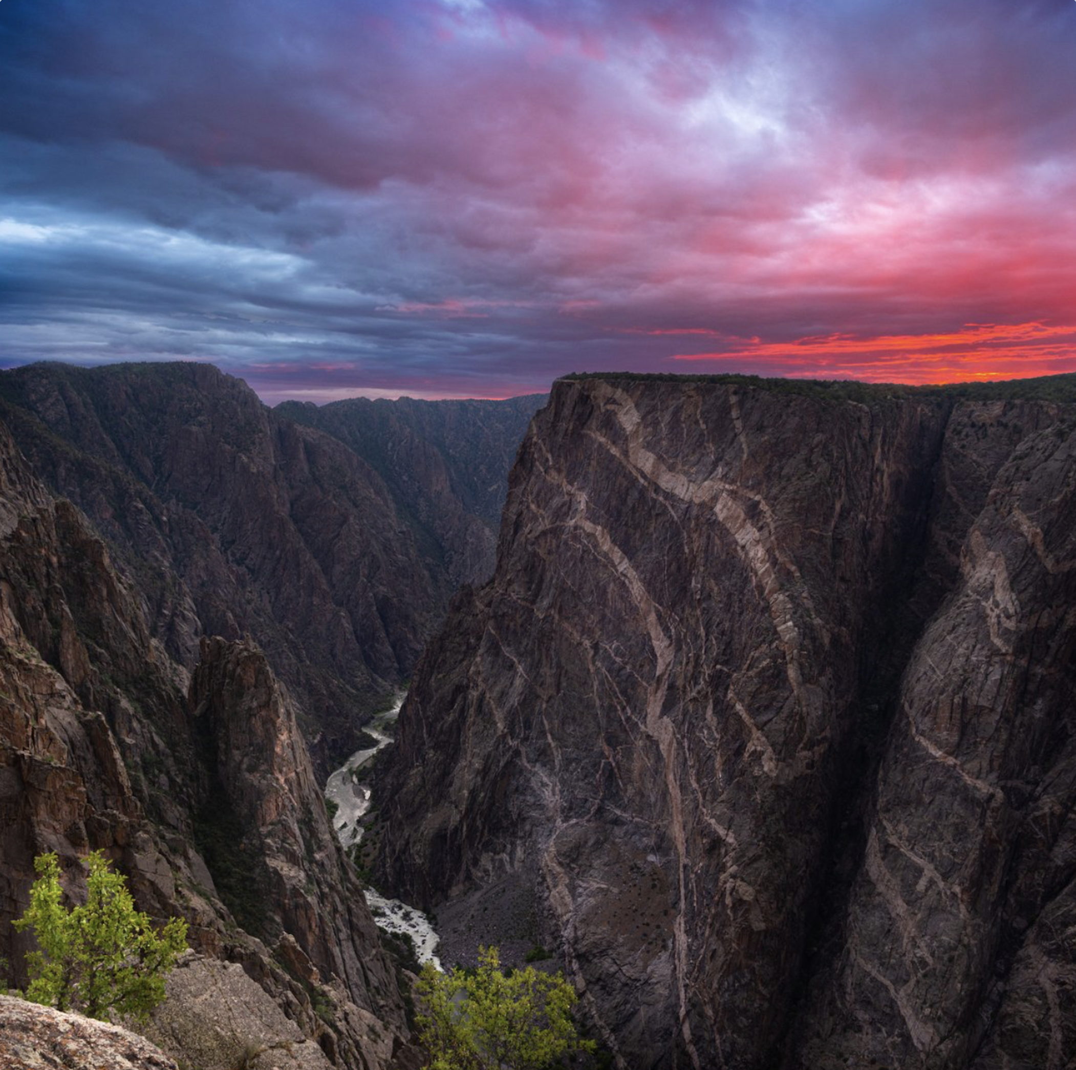
Black Canyon National Park July 2020. Photo credit: Claire Codling/The Department of Interior
From email from Reclamation (Andrew Limbach):
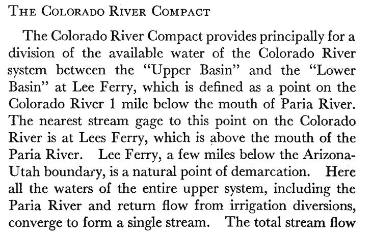
July 14, 2026
Aspinall Unit Operations Update – Release scheduled change to 1,390 cfs on Wednesday, July 15th.
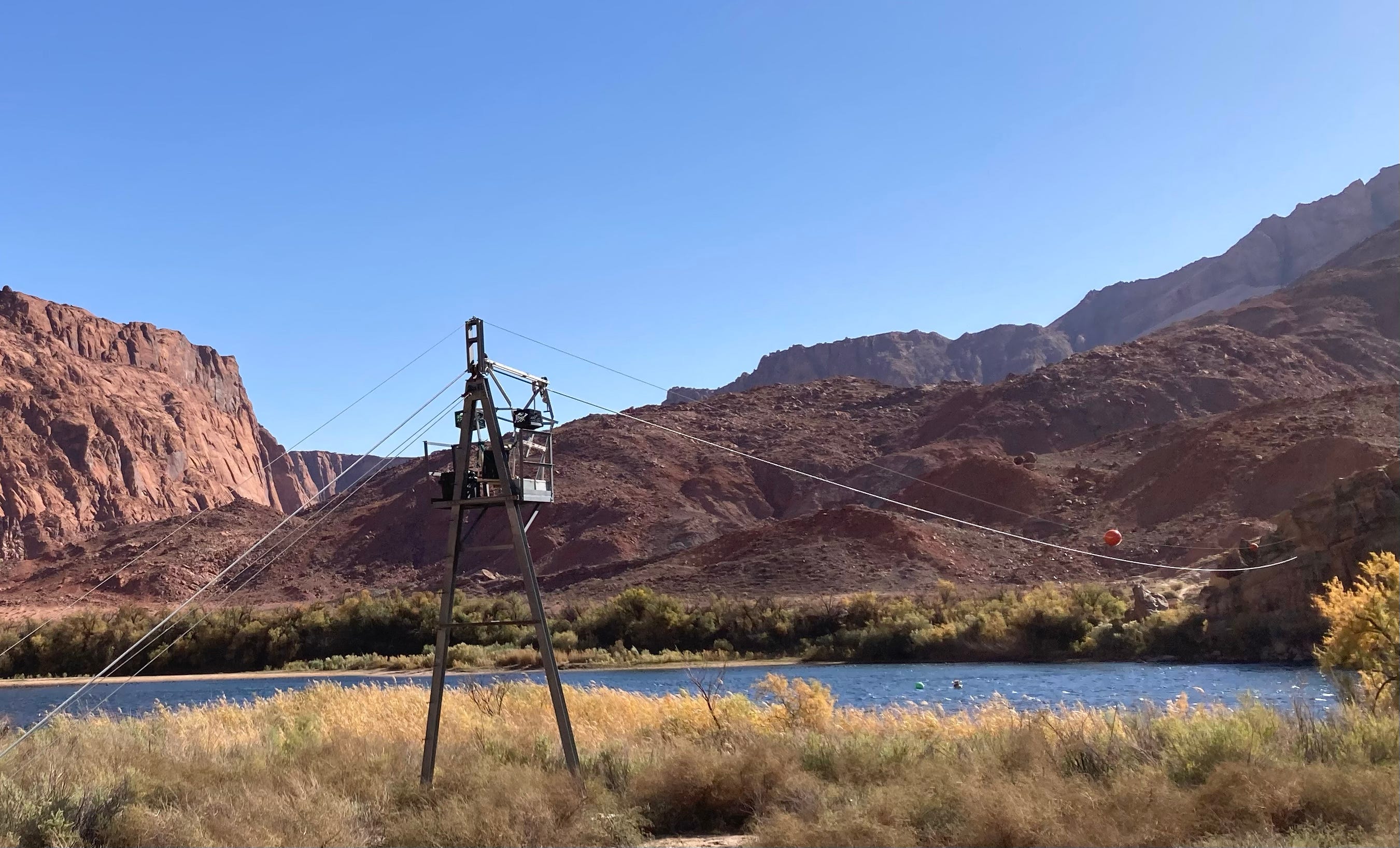
On Wednesday, July 15th, the adjusted scheduled releases from Crystal Dam will decrease to 1,390 cfs from 1,465 cfs.
Gunnison River flows in the Black Canyon/Gunnison Gorge will decrease to 360 cfs.
On Thursday, July 16th, the adjusted scheduled releases from Crystal Dam will decrease to 1,315 cfs from 1,390 cfs.
Gunnison River flows in the Black Canyon/Gunnison Gorge will decrease to 290 cfs.
Reclamation will continue to monitor flows in the Gunnison River, and on Friday, July 17th, the scheduled releases from Crystal Dam may decrease to 1,265 cfs from 1,315 cfs.
Gunnison River flows in the Black Canyon/Gunnison Gorge would decrease to 250 cfs. An additional notification will be sent out confirming any change after Wednesday.
In response to the extreme drought conditions, the BOR has collaborated with US Fish and Wildlife and the National Park Service to reduce the target flows to 500 cfs at Whitewater and 200 cfs through the Black Canyon of the Gunnison until further notice. These releases are made for the authorized purposes of the Aspinall Unit, and to attempt to maintain a target base flow through the endangered fish critical habitat reach of the Gunnison while preserving critical storage in Blue Mesa Reservoir.
Contact Andrew Limbach (alimbach@usbr.gov or 970-248-0644) for more information regarding Aspinall operations or the Operation Group meeting.
Colorado’s Roan Plateau, a favorite backcountry zone for hunters, anglers and hikers because of its high-quality wildlife habitat, is once being proposed for oil and gas development. The Bureau of Land Management, in accordance with direction from the Trump administration’s One Big Beautiful Bill Act to hold lease sales in Colorado every quarter, has listed four leases on top of the plateau in its proposed December sale, with two additional leases nearby.
The wildlands of the Roan Plateau and animals that rely on them draw hikers, hunters and anglers to the area. The potential for oil and natural gas below the surface draws attention from industry, too, and sets the stage for a confrontation over how to fulfill the multiple-use mandate that governs federal lands.
Hunters, anglers and conservationists are also raising the alarm that implementation of federal law and proposed changes to BLM rules are stripping the public of its voice in public lands management.
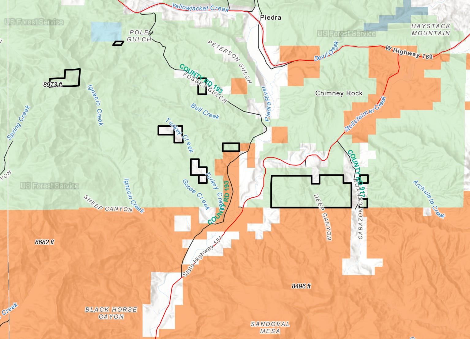
The BLM has identified 114 parcels across Colorado available for oil and gas leasing in its December sale. Four of those parcels, totaling 4,645 acres, are on top of the Roan Plateau near Rifle, on the site of two undeveloped leases that were not canceled as part of a 2014 settlement between leaseholders and 10 conservation, trade and wildlife organizations.
*NCAs include a landscape area that encompasses Potential Conservation Areas (PCAs) that share similar species or natural communities and ecological processes; or a mostly intact, lightly fragmented landscape that supports wide- ranging species and large scale disturbances. Sources: BLM, CPW, Colorado Natural Heritage Program, CDPHE. Credit: Laurine Lassalle – Aspen Journalism. Click to enlarge.
In that settlement, the BLM canceled 17 of 19 leases that had been issued in 2008 on top of the Roan Plateau and refunded leaseholders; the agency updated its resource management plan, which guides land use, and closed about 34,000 acres, roughly 54 square miles, to future leasing.
But two leases, whose holders did not agree to cancellation as part of the settlement, remained open for future development, although the leaseholders were meant to contribute to a conservation fund that would be used for restoration and conservation efforts. Although the fund was established, no money was invested. The leases changed hands and were eventually relinquished, but their existence during the land-use planning process meant that that area remained available for future development, and conservation groups have foreseen this moment.
“We had unleased, unprotected land on top of the plateau, and that was very concerning to us,” said Juli Slivka, senior director of policy and programs at Carbondale-based nonprofit Wilderness Workshop, which was one of 10 plaintiffs in the lawsuit that lead to the 2014 settlement. “We immediately began urging BLM Colorado to close that area to new leasing.”
Slivka and other conservationists have argued that the BLM could have removed the potential for new leases because Colorado Parks and Wildlife has found that the area is home to high-priority habitat for a range of species, including an endemic species of Colorado cutthroat trout, elk, deer and greater sage grouse.
Brittany Parker grew up in Rifle, hiking and camping on the plateau. As an adult, she hunts there nearly every year, she said. Parker works for the trade group Backcountry Hunters and Anglers — which advocates for protections for the Roan — as the field operations coordinator for seven states, including Colorado. She said she’s passionate about protecting the Roan Plateau after watching it “change drastically” under development pressures in her lifetime.
The area has seen significant oil and gas development on private lands atop the plateau.
“It’s already pretty developed with oil and gas, so to imagine even more up in that region, it just seems like there would be nothing left,” Parker said. “It would so significantly fragment the habitat that the sense of refuge would be seriously diminished for our wildlife.”
There is heavy natural gas production at the base of the Roan Plateau. The BLM has proposed new leases on public lands at the top plateau in a December sale. CREDIT: COURTESY OF ECOFLIGHT
A recent flight over the Roan Plateau by Aspen-based conservation organization EcoFlight showed the extent of the development from above; there’s a sharp contrast between the development below the top of the plateau and on private lands compared with the untouched public lands. The flight path followed Parachute Creek, to the west of which is highly developed private land.
“You forget how heavily drilled it is up there. It’s just nonstop, roads and wellpads” on the private lands, said Jane Pargiter, executive director of EcoFlight, who has been working to protect the Roan since 2008. (Pargiter is an Aspen Journalism board member.)
The view changes quickly to the east side of the creek.
“It instantly transitions into this pristine landscape, which is where they have proposed these lease parcels for the December lease sale,” Pargiter said. “It’s just beautiful, pristine, and it’s green still.”
Parker and Backcountry Hunters and Anglers are quick to point out that they are not against energy development on public lands but are, rather, focused on ensuring that leasing happens in appropriate places.
“We’re advocating for protections on specific landscapes that have exceptional habitat and watershed values that are worth protecting,” Parker said.
The state wildlife agency, conservation groups and recreationalists have argued for nearly two decades that the Roan Plateau is not the right place for oil and gas development, which has been shown to lead to declines in wildlife populations. The Roan has prime habitat for elk calving, which is a particularly sensitive time, and is a migration corridor for elk and mule deer. It also provides habitat and breeding grounds, known as lek sites, for the greater sage grouse, which are particularly sensitive to industrial disturbance.
Dean Riggs retired in 2020 as the deputy regional manager for Colorado Parks and Wildlife and spent years working with the BLM and leaseholders to avoid, minimize and mitigate impacts to wildlife when there is industrial development, including on the Roan Plateau. He says he has hunted, including elk and grouse on the Roan Plateau, since he was big enough to pick up a rifle.
In his time at CPW, Riggs advocated for science-based, species-specific protections, which in some cases means avoiding development in certain areas altogether, such as breeding sites for grouse.
“If a company wants to pluck a five-acre site right down on top of a lek, you’re going to lose the lek,” Riggs said. “With that being a really sensitive species, every lek counts. Every lek keeps us from the endangered species list.”
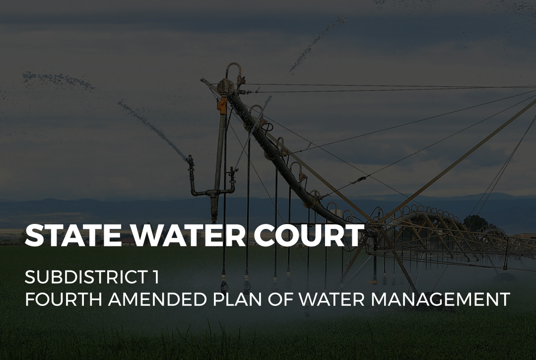
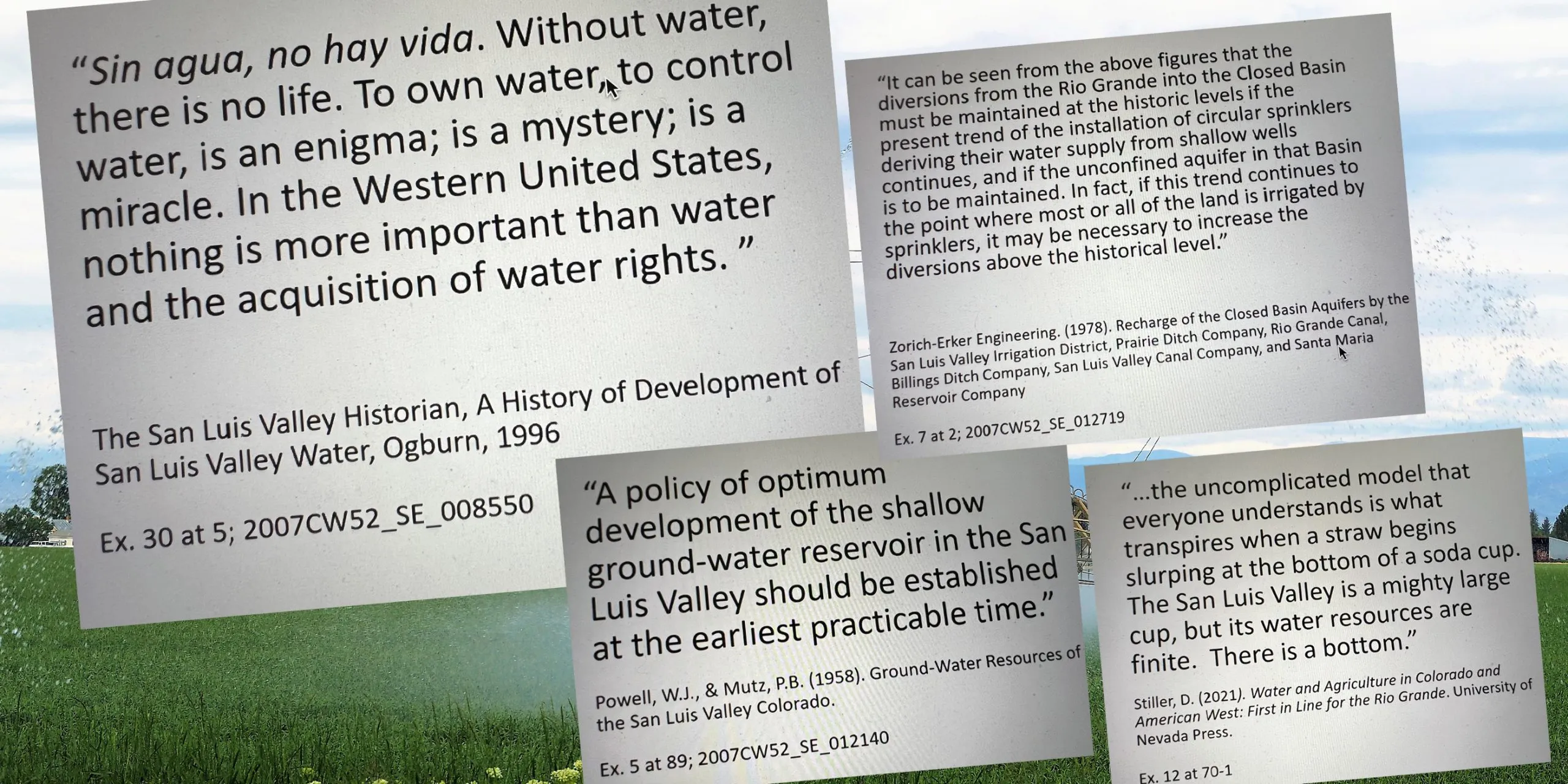
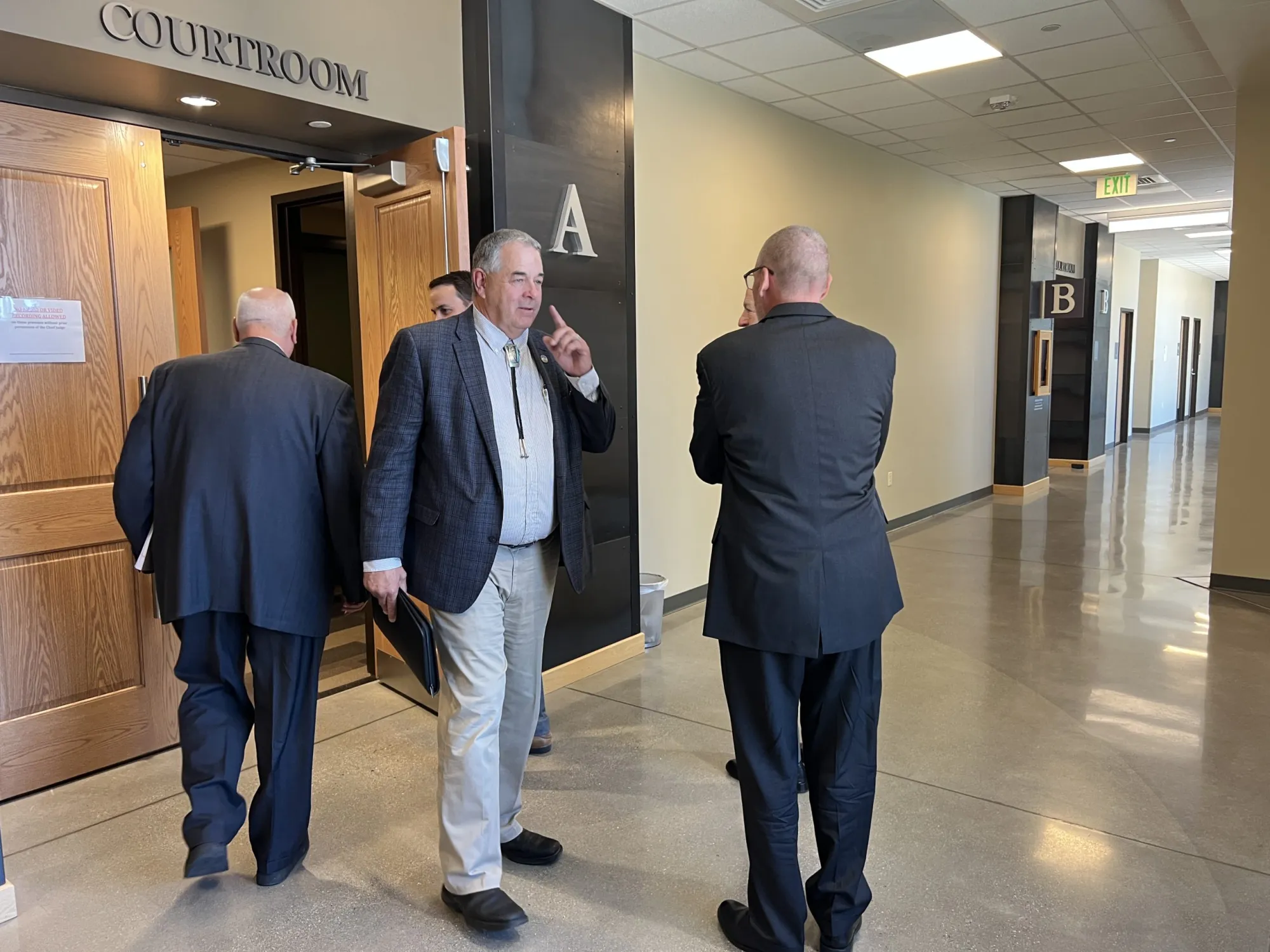
Some kind of “biblical flood” would have to occur over the next few years for the unconfined aquifer of the Upper Rio Grande Basin to recover, given the current downward measurements and the anticipated negative trajectory of the shallow aquifer’s storage area. That according to State Engineer Jason Ullman, whose testimony Friday wrapped up week 2 of the Subdistrict 1 Fourth Amended Plan of Water Management trial underway in Alamosa state Division 3 Water Court.
Ullman followed by telling the water court that without such a historical climate event, the current Subdistrict 1 Plan of Water Management is unlikely to meet its goal of reaching a sustainable aquifer by 2031, or five years from now and 20 years since the plan was first approved.
His option over the next five years without a new plan of water management, he told Division 3 Water Court Judge Michael Gonzales, would be to not approve annual replacement plans, which is the mechanism groundwater well pumpers use for irrigation.
If annual replacement plans don’t get approved, wells cannot pump.
San Luis Valley Groundwater
“I think I would say that it’s nearly impossible outside of some kind of biblical flood,” he testified of the current state of the unconfined storage area. “And even if that was to happen, there’s a limit to how much water can infiltrate into the aquifer on an annual basis or a monthly basis. So I don’t know that you can infiltrate enough water into the aquifer to reach that level by the 2031 deadline.”
According to monthly readings by Davis Engineering, the unconfined storage study area is measuring as low as it ever has since measurements by the consultant firm began in 1976, the court heard.
“In your opinion, will the current plan’s method of dry-up be able to achieve aquifer sustainability?” Rio Grande Water Conservation District lawyer Pete Ampe followed up with Ullman.
“No,” the state engineer told the water court. “I think it’s clear that based upon previous testimony that the goal in the previous plan was to reach 40,000 acres of dry-up that would’ve resulted or estimated to result in 80,000 acre-feet of reduction in use from the aquifer. And I think previous graphs showed that that has occurred, and yet we still see this precipitous decline.
“I mean, I think some folks have talked about how it’s maybe leveled out some, but if you look here at the graph, if I was to plot a longer term or a longer than five-year average, I think you could agree that the trend is downward. It’s not upward, which is problematic when we have very limited time, five years to reach the sustainable water supply level defined in the current plan.”
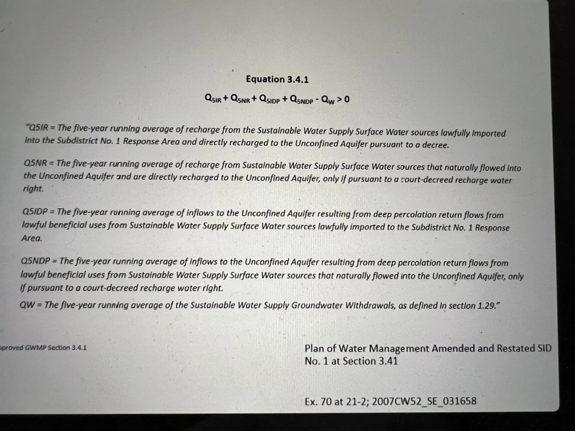
The sustainable measurement definition is a five-year running average of water storage at negative-400,000 to negative-200,000 below surface and toward the 1976 readings.The current measurement, according to court exhibits, is 1.2 million acre-feet below and declining.
The state engineer’s office approved the fourth amended plan in June 20203, and it is the state engineer who would order widespread groundwater well curtailment. Gonzales must approve the new plan for it to move forward and Ullman to take that option off the table.
During testimony throughout week 2 of the subdistrict plan of water management trial, state Division 3 engineer Craig Cotten and state engineer Ullman testified to the limited amount of time left, without court approval of the updated plan, before wells are shut off.
“We have other impacts because of the lower aquifer supply that are occurring to other water users, to well owners,” Cotten told the water court. “As I’ve discussed, the amount of electricity costs that it takes to pump water out from a lower aquifer, the lowered efficiency of getting flood irrigation across a field, the impact to the environment from not having a water table at the near surface and potentially some ponds around. So lots of impacts. And I do think that we do need to recover the aquifer in a reasonable time period.”
The water trial is moving along speedier than anticipated during pre-trial conferences when Gonzales set the case to be over five weeks. William Schreüder, who created and maintains the Rio Grande Decision Support System Groundwater Model which is a key exhibit in the case, faced limited cross examination to his testimony, and Clinton Phillips, who maintains the unconfined aquifer storage area study for Davis Engineering and whose monthly storage graph provides key data for the state Division of Water Resources decisions, faced no cross examination.
One attorney, Mirko Kruse who is arguing his family’s specific concern around ditch decrees but overall supports to new plan, told the judge that in trying to be efficient with the court’s time he was prepared to make the very specific legal points to his client’s objections next week, if the judge wanted to hear those early.
The judge declined and said he preferred to hear all the expert witness testimony first.
There is little argument to the problem that the unconfined aquifer storage is declining due to groundwater withdrawals and the warming climate of the era, which is hugely problematic for any natural recovery through high elevation snow melt.
After two weeks, the arguments before Judge Gonzales center around surface and groundwater water rights, recharge decrees, and whether the fourth amended plan was crafted legally and openly and creates an economically fair playing field for all the irrigators in the subdistrict.
“Dr. Schreüder, what in your opinion does this all just come down to?” came the question from RGWCD attorney Pete Ampe toward the end of Friday.
“Well, your Honor, the basic premise of the fourth plan is that they will do one-for-one (pumping) which means we’re going to put more water into the aquifer than we’re going to take out and it’s common sense that under those conditions the aquifer should recover.”
The trial moves into week 3 on Monday, July 13, with State Engineer Ullmann still on the witness stand.
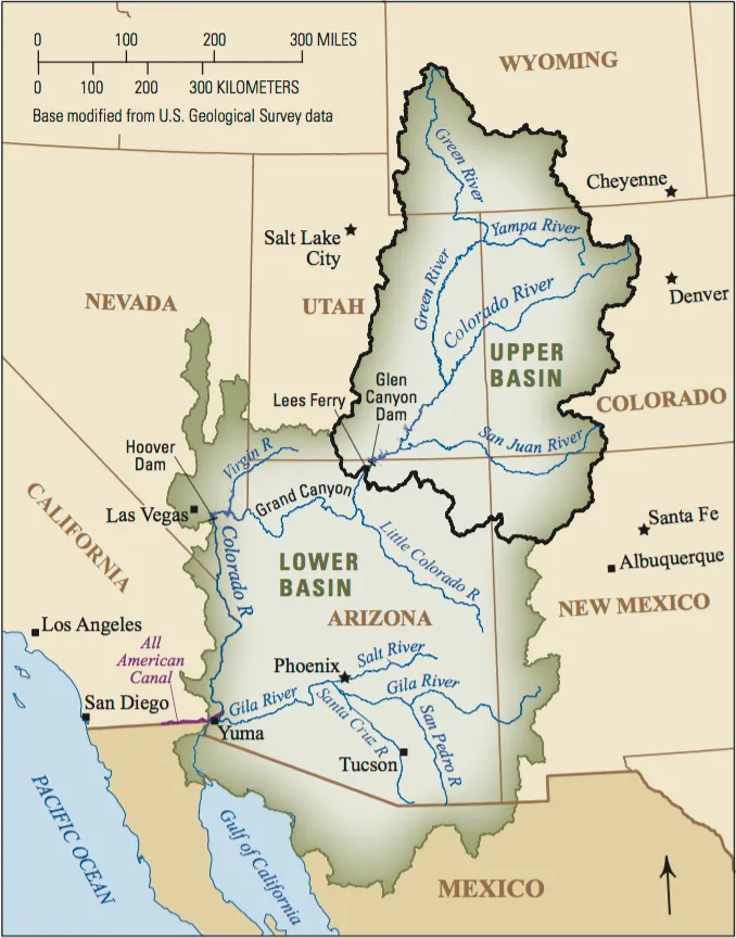
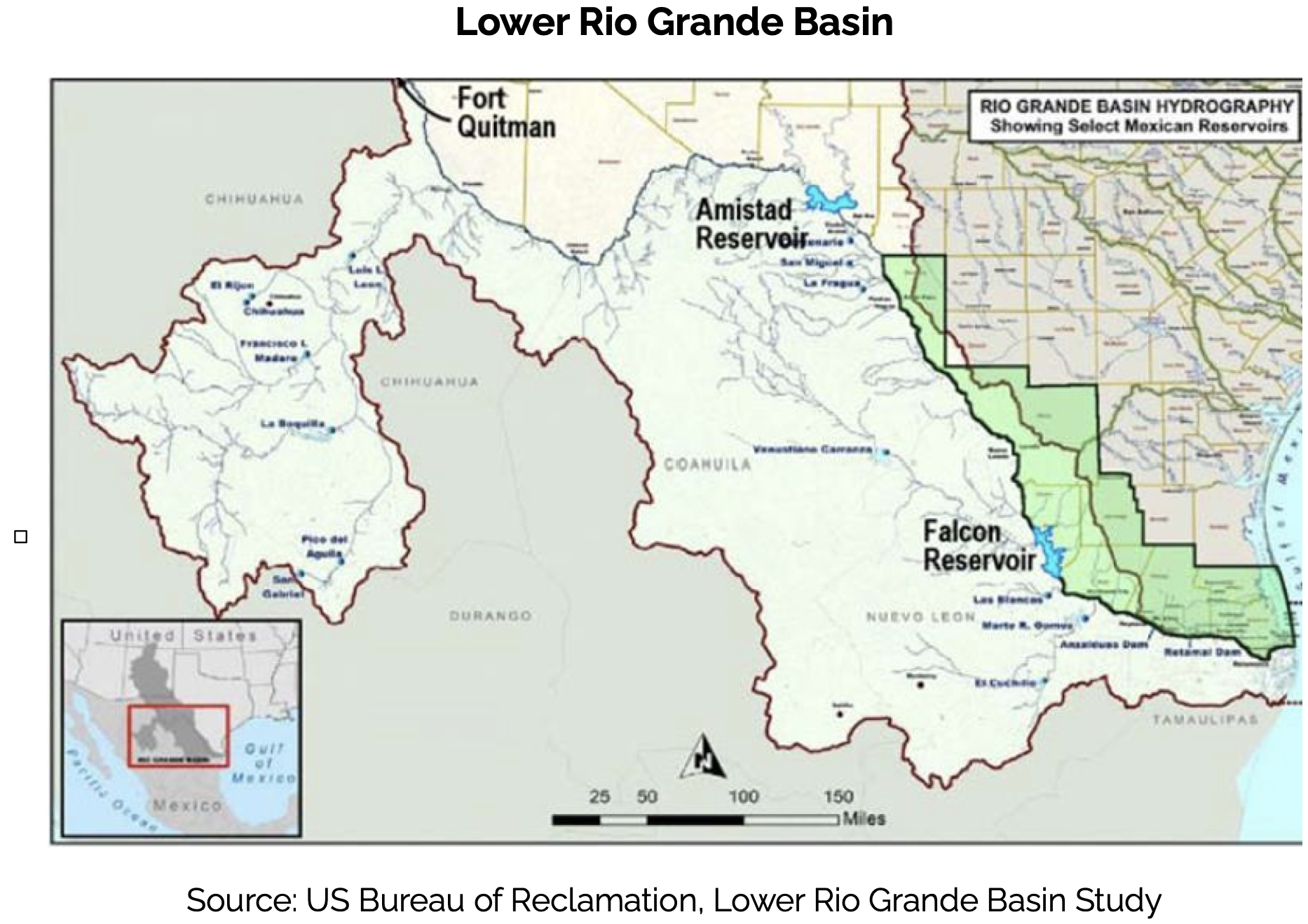
Rio Grande and Pecos River basins. Map credit: By Kmusser – Own work, Elevation data from SRTM, drainage basin from GTOPO [1], U.S. stream from the National Atlas [2], all other features from Vector Map., CC BY-SA 3.0, https://commons.wikimedia.org/w/index.php?curid=11218868
The Northern Water Board of Directors has unanimously approved a change to Colorado-Big Thompson Project accounting procedures concerning C-BT water tracking.
During a rule-making hearing at the June 11 Board meeting, Directors heard about the changes to the rules surrounding the tracking of water from the Project. The new accounting procedures will require accounting of tracking data to be provided in a manner to allow for the administration of C-BT Project water return flows, which will help Northern Water protect them as described in the District’s Repayment Contract with the Bureau of Reclamation, the Water Conservancy Act and contracts with allottees.
The modifications affect only domestic and municipal users, and Northern Water staff met or contacted 26 municipalities, water districts and treatment plants in the months before the rule change was approved.
Map of the Colorado-Big Thompson Project via Northern Water
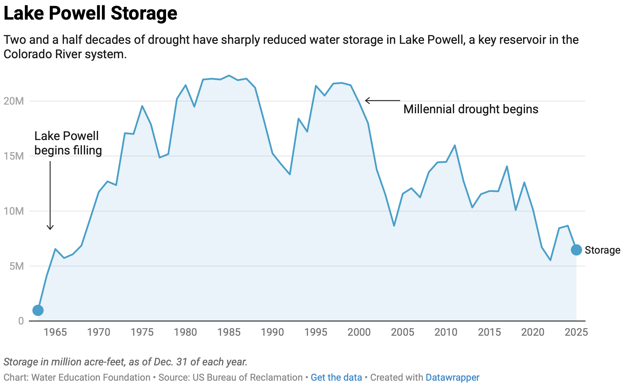
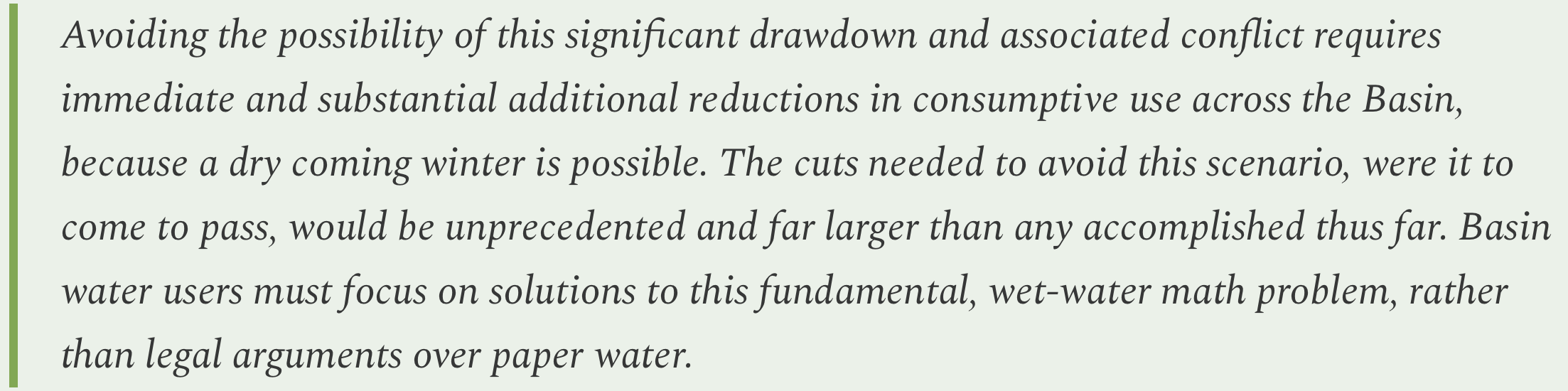
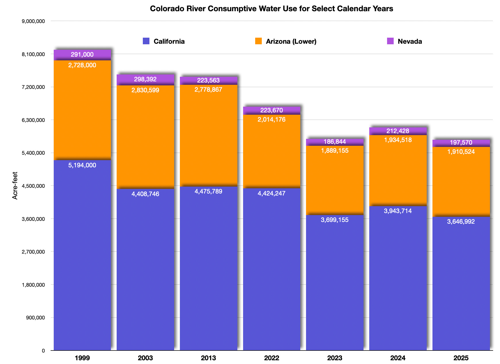
The Colorado River, from one viewpoint, is a mess.
The iconic waterway, fundamental to the region’s modern existence – its desert metropolises, its high-tech industries, its agriculture, and its recreation economy – is on the verge of crashing. A two-decade drying trend, aided by carbon pollution in the atmosphere and water use that exceeds supply have nearly drained the basin’s liquid savings accounts.
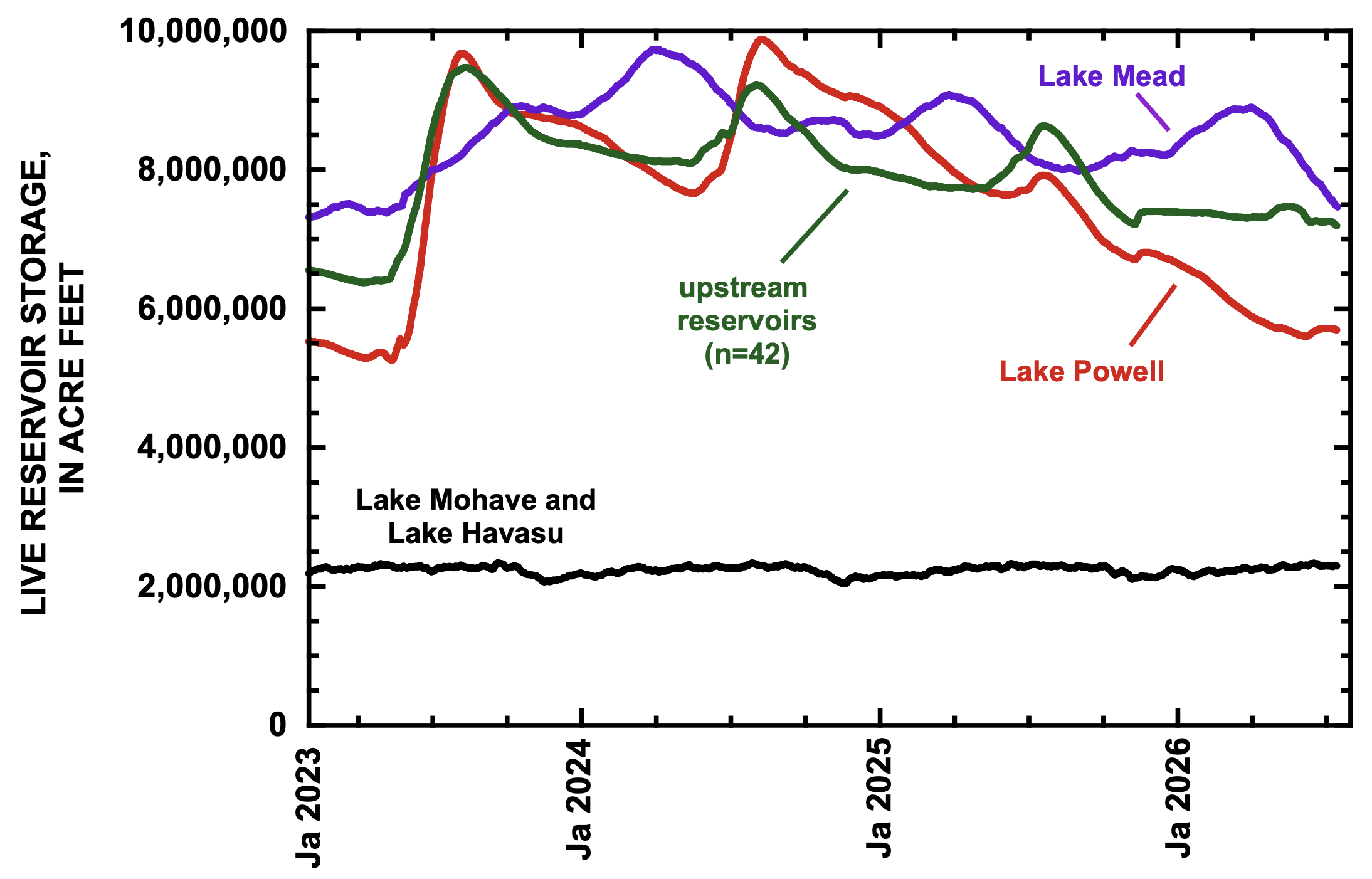
Nature is now threatening to overwhelm human interventions. Lake Powell is 28 percent of its capacity. Lake Mead, just 24 percent. Climate pressures abound in these hot, dry times. A March heat dome obliterated temperature records. Snowpack was the worst on record. At least five fires larger than 25,000 acres are currently burning in the parched basin.
The basin’s seven states, unable to find consensus on how to live with a shrinking supply, are deadlocked after four years of attempting to negotiate the river’s management rules. State and federal authorities are deciding how much less Colorado River water will be available, anticipating that the reductions will hurt. Knowing that water enables economic growth, they don’t want to be viewed as selling out their constituents.
Look closer, however, and the narrative of warring factions fades a bit. At the local level, water managers are collaborating to ensure residents and businesses have adequate water supplies. They are signing multiparty deals and pursuing joint projects to share resources and keep water flowing to homes and businesses. Such dealmaking is not a remedy to all that ails the basin. But it is viewed as essential in a time of deep climate uncertainty and anxiety.
In June, six water suppliers in Arizona, California, and Nevada signed a memorandum of understanding with the Bureau of Reclamation, a federal agency, to facilitate interstate exchanges of desalinated and recycled water for Colorado River water. The exchanges, taking advantage of spare treatment capacity on the California coast, would introduce new water into a depleting basin.
Earlier this spring, Phoenix, Tucson, and other Arizona water users announced a venture to create an emergency reserve of water for cities facing shortages and to simplify voluntary water transfers in the state – “an easy button” to move water to where it is needed, said Max Wilson, Phoenix’s water resources management adviser.
The Grand River Diversion Dam, also known as the “Roller Dam”, was built in 1913 to divert water from the Colorado River to the Government Highline Canal, which farmers use to irrigate their lands in the Grand Valley. Photo credit: Bethany Blitz/Aspen Journalism
And in New Mexico, Santa Fe’s water utility is in early talks with neighboring pueblos about joint infrastructure for storing water underground, recycling water, and sharing water between systems in case wildfire pollutes a water source and renders it unusable.
“Cities have the ultimate responsibility to make sure there’s tap water,” said Kathryn Sorensen of Arizona State University and the former director of the Phoenix water utility. “And that means they have to be constantly vigilant and constantly innovate and constantly find new arrangements and new supplies.”
These arrangements, while not a new development, have taken on greater significance as the American West struggles through record heat and aridity this year that is an indicator of worsening water supply challenges in the drying region. Based on a decades-long track record, these arrangements also illustrate that neighbors helping neighbors can be a cost-effective form of climate adaptation.
“It makes sense to me that this happens at the local level because that’s where the risk is,” Sorensen said. She cited the Central Arizona Project, or CAP, as another example. CAP delivers Colorado River water to Phoenix, Tucson and other customers in the state’s populous midsection.
“The risk to the CAP of there not being water in the canal is that the CAP doesn’t deliver water to its contractors and subcontractors,” she said. In other words, a contractual failure.
But for the cities who hold those contracts? A failure to deliver water would hasten a public health and economic crisis. “The risk to a city is there’s no tap water,” Sorensen said. “And that’s just a totally different level of risk. So you see these types of innovations happen at the level where the risk exists.”
Collective Action
Partnerships do not happen spontaneously. They are the product of months and years of discussion, negotiation, and relationship building.
“The biggest challenge is communication, understanding the needs of your partners and clearly their sensitivities,” said Bill Schneider, the Santa Fe water resources manager.
Schneider is part of discussions with four pueblos in the Santa Fe area on joint water infrastructure projects, including water recycling and underground storage.
One clear possibility is that Santa Fe could connect its water system to the Pojoaque Regional Water System, which will serve Pojoaque, Nambé, San Ildefonso, and Tesuque pueblos with Rio Grande water.
Connecting neighboring systems is a form of insurance, Schneider explained. Wildfires are a perpetual risk in the watersheds of northern New Mexico. If a severe wildfire sends ash and debris into the Rio Grande, the polluted water could force water systems to shut off their river intakes. It has happened before on the Rio Grande. The Albuquerque Bernalillo County Water Utility Authority had to close its intake for two months in 2011 after the Las Conchas fire. With an interconnected system, water could be delivered to the pueblos from Santa Fe’s other sources, which include the Santa Fe River and groundwater.
Due to the high cost of building infrastructure, system interties and similar partnerships make financial sense, Schneider said. “It means you don’t have to go out and build an entirely new system.”
These infrastructure arrangements already exist in many places, but especially in Arizona. Nevada, for instance, has banked part of its Colorado River allocation underground in Arizona for more than two decades.
A decade ago, when Sorensen was the director of Phoenix Water Services, Phoenix and Tucson signed a trailblazing water deal. It allowed Phoenix to bank some of its Colorado River water underground in Tucson. When the water is needed, Tucson will be able to pump the groundwater and, in exchange, Phoenix will take some of Tucson’s share of Colorado River water. The deal, which has not yet had to be exercised, makes the most efficient use of the water treatment capabilities and infrastructure in the two cities.
That agreement, Sorensen said, paved the way for other exchange partnerships in central Arizona. Mesa, in a project completed this year, provides treated wastewater to the Gila River Indian Community in exchange for 8,000 acre-feet of Colorado River water. (An acre-foot – 326,000 gallons – can supply about 3.5 households in urban Arizona for a year.)
In Sorensen’s view, dealmaking is fundamental for utility leaders.
“They’re good horse traders, right?” she said. “That’s part of the job. ‘How can we make a win-win exchange or trade here that makes everyone happy and maximizes the resource?’ The water managers are really good at that.”
The latest iteration is the Secure Water Arizona Program, or SWAP, that Phoenix and Tucson are developing with other central Arizona cities.
Details are still being finalized, but the program will have three components. One is an emergency reserve of water that cities can tap as a last resort. A second piece is facilitating water exchanges between willing sellers and willing buyers. The third element is what Wilson calls “the sandbox” – a forum for collaboration on the next generation of central Arizona water projects.
The idea, said Max Wilson, the Phoenix water adviser, is a form of mutual aid. “At its core, the assumption of the SWAP is that water users shouldn’t be letting other water users go dry.”
Even with the benefits, Wilson acknowledged that collaboration needs to be carefully calibrated.
“People don’t want to see water being forcibly reallocated, for sure,” he said. “People don’t want to see their water going to uses that they necessarily wouldn’t see as beneficial. But when people have legitimate needs, I’ve been really impressed by how the water user community has come together and been willing to say, ‘Let’s talk and let’s figure out what a potentially mutually beneficial solution to those needs could be.’”
Attorney: ‘In order to evaluate the current state of the aquifer in context, you would need to know how much the aquifer holds, wouldn’t you?’
Engineer: ‘I don’t believe so’
How much water is in the storage area of the unconfined aquifer? That was a question SWAG attorney Brad Grasmick posed to state Division 3 Water Engineer Craig Cotten and left the Alamosa water court hanging on at the conclusion of Wednesday’s day in water court.
In his first full day of cross examining Cotten, Grasmick covered a variety of territory from surface water credits to the one-to-one pumping feature of the new plan to Cotten’s responsibility to administer the plan. At times he got so deep into the proverbial weeds in grilling Cotten that Gonzales spoke of his own frustration in trying to follow along.
“You’re losing me on focus,” Gonzales told Grasmick as he called for a lunch break.
The question Grasmick posed at the end of his nearly six hours of cross examination offered a unique exchange. Grasmick started by saying he hasn’t seen a figure on how much water the unconfined storage area can hold. It’s been well-established in the testimony of Cotten and HRS hydrologist Matt Seitz that the unconfined aquifer functions as an underground reservoir and was built up initially through early subirrigation practices and then canal diversions.
Storage readings of the unconfined aquifer that go back to 1976 show it responsive to strong spring runoff seasons but now transitioning through the process of aridification to the San Luis Valley floor as it adapts to 25 years of drought and the lack of consistent snow melt.
“Nor have I seen how much water is presently in storage in the unconfined aquifer. Do you agree with that?” Grasmick asked.
Cotten: “Well, we have the Davis Engineering service change in storage, so we know the change in storage from 1976. The total amount of water in storage at the present time, I’m not aware of that number.”
Grasmick: “OK. In order to evaluate the current state of the aquifer in context, you would need to know how much the aquifer holds, wouldn’t you?”
Cotten: “I don’t believe so.”
Grasmick: “Well, and you would also need to know how much is in the aquifer in order to evaluate this decline in context, correct?”
Cotten: “No, I don’t believe so.”
Grasmick: “Well, as an example, if there was a one million acre-foot decline in storage, that’s very different if the reservoir holds one and a half million acre-feet than if it holds say four million acre-feet, isn’t it?”
Cotten: “There again, I don’t believe so if you’re shooting for an actual storage amount, change in storage amount as your goal.”
In the Fourth Amended Plan of Water Management under consideration, Subdistrict 1 is charged with recovering the unconfined aquifer to a “sustainable” level of negative-200,000 to negative-400,000 acre-feet of water storage.
Grasmick continued his questioning: “So you disagree that contextual analysis of data is necessary to ensure that it’s not misinterpreted?”
Cotten: “I don’t agree that we need to know the total storage or the actual storage right now in developing this plan.”
The exchange continued for about another three minutes before Grasmick began to shift to another subject and Gonzales intervened.
“I apologize. I think it’s been a long day, so I think it’s probably a good place to stop,” the judge said.
The water trial on the Subdistrict 1 Fourth Amended Plan of Water Management resumes Thursday [July 9. 2026].
The Roaring Fork River in Aspen on July 8. Pitkin County Commissioners gave initial approval to buying more shares of Twin Lakes water to boost low flows on the Fork. CREDIT: HEATHER SACKETT/ASPEN JOURNALISM
Against the recommendation of an advisory board, Pitkin County commissioners on Wednesday gave preliminary approval to buy more water to boost flows in the often-depleted Roaring Fork River.
Commissioners approved on first reading a resolution and ordinance to spend $442,500 to buy 4.68 shares from the Twin Lakes Reservoir & Canal Co., which is about 3.5 acre-feet of water, according to a staff memo. The deal is in addition to the $6.5 million Pitkin County already agreed to spend earlier this year for about 71 acre-feet from Twin Lakes and another ditch company.
Twin Lakes collection system
The water is currently taken across the Continental Divide to the Arkansas River basin to be used by entities on the Front Range. The deal would allow the water to be released out of Grizzly Reservoir to Lincoln Creek and could help boost the Roaring Fork through Aspen and upstream, which suffers from low flows in dry years.
“I think it’s really critical that we purchase water rights when we can, and this is an opportunity that we can, and we should,” District 1 Commissioner Patti Clapper said.
Pitkin County has long had a goal of increasing the amount of water in the Roaring Fork, a river that has about 40% of its headwaters diverted to the eastern side of the state through the Independence Pass Transmountain Diversion System to be used by Colorado Springs, Pueblo and Aurora. These diversions can often contribute to the depletion of the Roaring Fork through Aspen, and purchasing Twin Lakes water represents a rare opportunity to return water to the Western Slope.
Commissioner Greg Poschman said he supports acquiring the water shares.
“I think it’s great that we are doing this,” he said. “I know it’s expensive; there are some raised eyebrows about that, but I think this is something we have to do.”
Poschman added that he was concerned that the Healthy Rivers board members recommended against buying more water and said he would like to fully understand their reasons. County staff said they were trying to schedule a joint meeting with the Board of County Commissioners and the Healthy Rivers board in August.
Members of the county’s Healthy Rivers board, which advises the BOCC, are concerned that the water will have a small impact on river health but a big impact on the program’s budget. The board held a special meeting June 25 to consider acquiring the shares and approved a motion saying the water yield would potentially be only 1 additional cubic feet per second for two days.
“Additionally, the deleterious effects of the purchase price on the long-term fund balance of the Healthy Rivers Fund will reduce the Healthy Rivers Program’s ability to support programs to address other ballot measure mandates, including water quality, ecological health, recreation opportunities, wildlife and riparian habitat, and promoting water conservation,” the motion reads.
The motion goes on to say that in the future, the county should implement a framework for evaluating the true value of water shares to the Roaring Fork.
At Wednesday’s meeting, County Budget Director Connie Baker told the BOCC that the Healthy Rivers board will have to trim or reallocate about $500,000 from next year’s budget to account for the combined impact of this year’s two water purchases.
Healthy Rivers board member Ned Andrews said he is against the purchase, citing the impact that it will have on the program’s budget.
“None of the analysis or details that would justify such a purchase or a strategy going forward has been done,” Andrews told Aspen Journalism. “I think before you commit essentially a quarter of your budget for the next 15 years, you’d want to have an analysis that shows you what could be accomplished. My gut feeling is that it wouldn’t really accomplish much.”
Andrews also opposed the earlier, larger water share purchase, although the rest of the Healthy Rivers board was supportive.
At their regular June meeting, Healthy Rivers board members went through the budget line by line and considered where they could trim, although those cuts have not yet been finalized.
Spending big bucks in an effort to rescue rivers is not new for Pitkin County, which has spent at least $3.5 million on the Roaring Fork River Park in Basalt, including a water court battle to secure the water right for recreation, several redesigns of problematic waves, and improvements to the riverbank and boat launch.
Grizzly Reservoir, a forebay that collects water to send through the Twin Lakes Tunnel to the Front Range, sits in the middle of the Lincoln Creek watershed and connects water users on both sides of the Continental Divide. Pitkin County commissioners gave initial approval to a deal that would allow more water to be released from Grizzly for the benefit of the Roaring Fork. CREDIT: HEATHER SACKETT/ASPEN JOURNALISM
Bond for original purchase approved
The BOCC at Wednesday’s meeting also approved issuing a bond for the original purchase of Twin Lakes shares. That deal cost the county $6.5 million, although only 45 of those acre-feet represent Western Slope water that is currently diverted to the Front Range. The county plans to sell or trade the other 26 acre-feet, which is owned by the Fountain Mutual Ditch Co. in El Paso County and decreed for use on the east side of the divide.
The 45 acre-feet of water can be released down the Roaring Fork during the irrigation season when flows are low, and it must be used by a downstream water user on the Colorado River before the town of DeBeque. Instream flow for the benefit of the environment is not a decreed use of the water.
This year, according to Colorado Water Resources Division 5 Engineer Tyler Benton, at least some of Pitkin County’s Twin Lakes water was released as part of the Colorado River Water Conservation District’s emergency substitute water supply plan, which the district enacted in response to this year’s historic drought. Benton said he expects the River District to provide a full accounting of how much Pitkin County water has been released Friday.
Grizzly Reservoir is currently drained for dam maintenance, which may have affected how much water could be released under the River District’s plan.
At a time when drought impacts are being acutely felt across the state and climate change continues to rob rivers of their flows, for some, the unique opportunity to put water back into a depleted stream is worth the cost.
“This is expensive water, but it’s the only water you can get up at the headwaters of the Roaring Fork,” said Pitkin County Deputy Attorney Anne Marie McPhee. “So that scarcity makes it more valuable.”
The issue is scheduled for a public hearing and second reading July 22.
The fire situation in the Four Corners area is not improving. The weather remains hot, dry, and windy, and this week’s forecast calls for more of the same. Next week may even be hotter, if longer-range models hold. Meanwhile, air quality has deteriorated in some places that previously seemed to avoid the worst of the smoke. The good news is that the Fourth of July weekend came and went without any new major fire starts in the region.
So far this year some 37,209 fires have burned through about 3.3 million acres, according to the National Interagency Fire Center. That’s the second highest acreage for the first half of the year in the last decade.
Here’s a rundown of some of the Four Corners area fires. By no means is this a complete list.
The Babylon Fire, burning in the higher elevation parts of Bears Ears National Monument in southeastern Utah, had grown to over 96,000 acres by Monday night, making it the nation’s largest active blaze (the Cottonwood Fire in the western part of the state has gone through about the same amount of acreage, according to Watch Duty). The two are also tied for the fourth largest fires in the state’s recorded history. The Babylon Fire is at 0% containment, with the most active area moving up the west slope of the Abajo Mountains, between Shay Mountain and Mount Linnaeus. Air tankers are pulling water from Lake Powell, and officials are asking boaters to avoid the area between Dangling Rope and Rainbow Bridge.
Closed public lands include: The Needles District of Canyonlands National Park, Manti-La Sal National Forest lands within the Monticello Ranger District, and BLM lands in the Indian Creek Corridor, Beef Basin, Dark Canyon, and the Sweet Alice Wilderness Study Area. Still Open: Natural Bridges National Monument, Cedar Mesa, Grand Gulch, and other lower elevation areas in the southern reaches of Bears Ears National Monument.
The Ferris Fire along the Dolores-Montezuma County line in southwestern Colorado initially burned in a northeasterly direction toward the Disappointment Valley. Then the winds shifted and the most active front of the fire curved back to the northwest, crossing the Ponderosa Gorge of the Dolores River, and is within about 12 miles of the town of Dove Creek. As of Monday night the fire was at 51,622 acres and 22% containment.
The Gold Mountain Fire north of Ouray, Colorado, has burned across almost 29,300 acres of San Juan Mountain high country and was 2% contained as of Monday night. Firefighters on Monday conducted strategic backfiring operationseast of Ridgway to provide more protection for structures in that area. There is a chance of thunderstorms this afternoon and evening, which could bring dry lightning along with gusty and erratic winds, with high temperatures reaching the high 80s and low 90s.
The Pocket Fire north of Sedona, Arizona, has reached 26,442 acres and was at 48% containment as of Monday night. Forecasters are predicting more hot and dry weather today, with the mercury topping out around 100° F and sub-20% relative humidity.
On July 6, the Arizona Department of Environmental Quality approved Energy Fuels’ request to amend its aquifer quality permit for a groundwater monitoring well at its Pinyon Plain Mine near the Grand Canyon. The change raises the allowable concentration of arsenic from .050 milligrams per liter to .055 milligrams per liter and the associated alert level from .040 to .050 mg/l.
The Havasupai Tribe strongly condemned the change in a written statement, calling the approval a “profound attack on the Tribe’s inherent responsibility to guard and protect the waters of the Grand Canyon.”
Energy Fuels asked for the revision — and ADEQ granted it — after finding that construction of the mine’s shaft had created a hydraulic sink that allowed naturally occurring arsenic — a known toxic substance — to move toward the facility’s perimeter wells, putting them in violation of their permit.
So, regulators simply altered the permit’s limits and, according to the tribal nation’s statement, “chosen to weaken environmental protections instead of strengthening them.”
Dr. Bradley K. Esser, a retired Lawrence Livermore Laboratory scientist, submitted technical comments on the proposed revision last year. He cast doubt on Energy Fuels’ hydraulic sink explanation, and demonstrated that the arsenic concentrations detected in the monitoring wells are far higher than regional natural background levels. He posited that it was far more likely the elevated arsenic concentrations came from sump water from the mine’s workings contaminating the groundwater.
Uranium, arsenic, and lead concentrations shot up in the Pinyon Plain Mine’s “sump water,” or groundwater that had flowed into the mine shaft, after active mining began in 2023. While an independent scientist acknowledges that it’s possible elevated arsenic levels in perimeter monitoring wells are the result of a mining-related hydraulic sink pulling naturally occurring arsenic to the wells, he posited that it’s more likely that sump water made its way into the groundwater in the wells. Source: Grand Canyon Trust.
Esser also writes:
🥵 Aridification Watch 🐫
Monsoon season officially kicked off in the Southwest in the middle of last month, but it has yet to bring significant amounts of moisture. Earlier forecasts predicting higher than average precipitation beginning later this month are still in place for some parts of the West, but they likely will be accompanied by above-normal temperatures just about everywhere.
Next week isn’t looking so hot for fire-dousing moisture in the Southwest, but after that the chances of above-normal precipitation start climbing.
Smoky skies and three-digit heat? Ick.
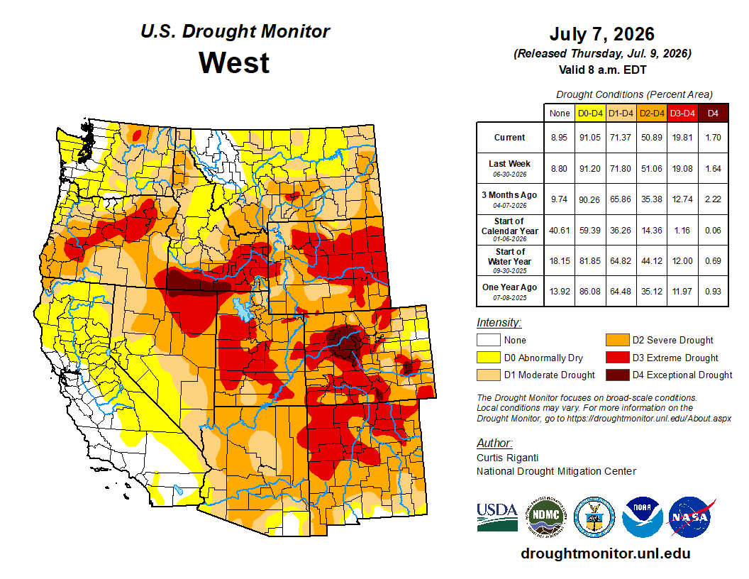
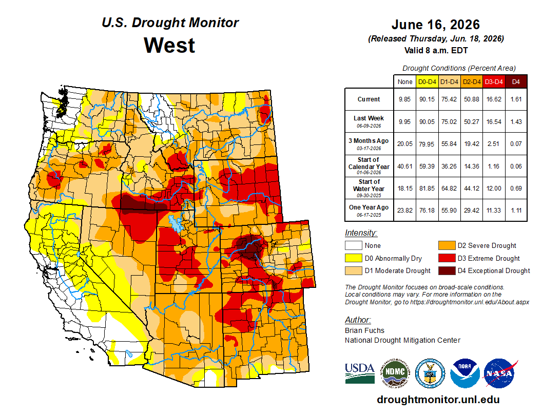
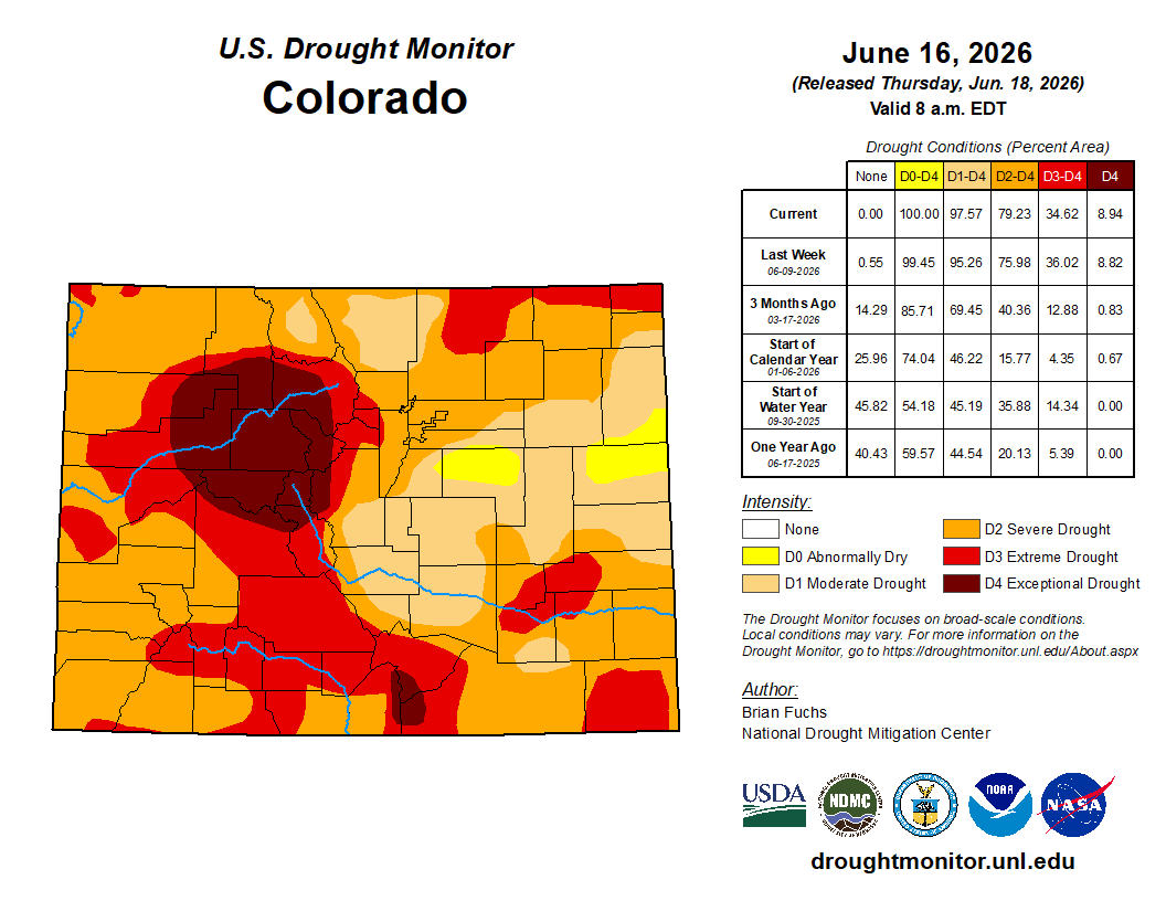
The drought situation has grown worse over the last year in most of the Interior West, though there has been improvement in the deep Southwest. Source: U.S. Drought Monitor.
‘As you might expect, the hot, dry weather is taking a toll on streams around the region. The Animas River through Durango is running at 190 cubic feet per-second; the median flow for this date is over 1,000 cfs.
📸 Parting Shot 🎞️
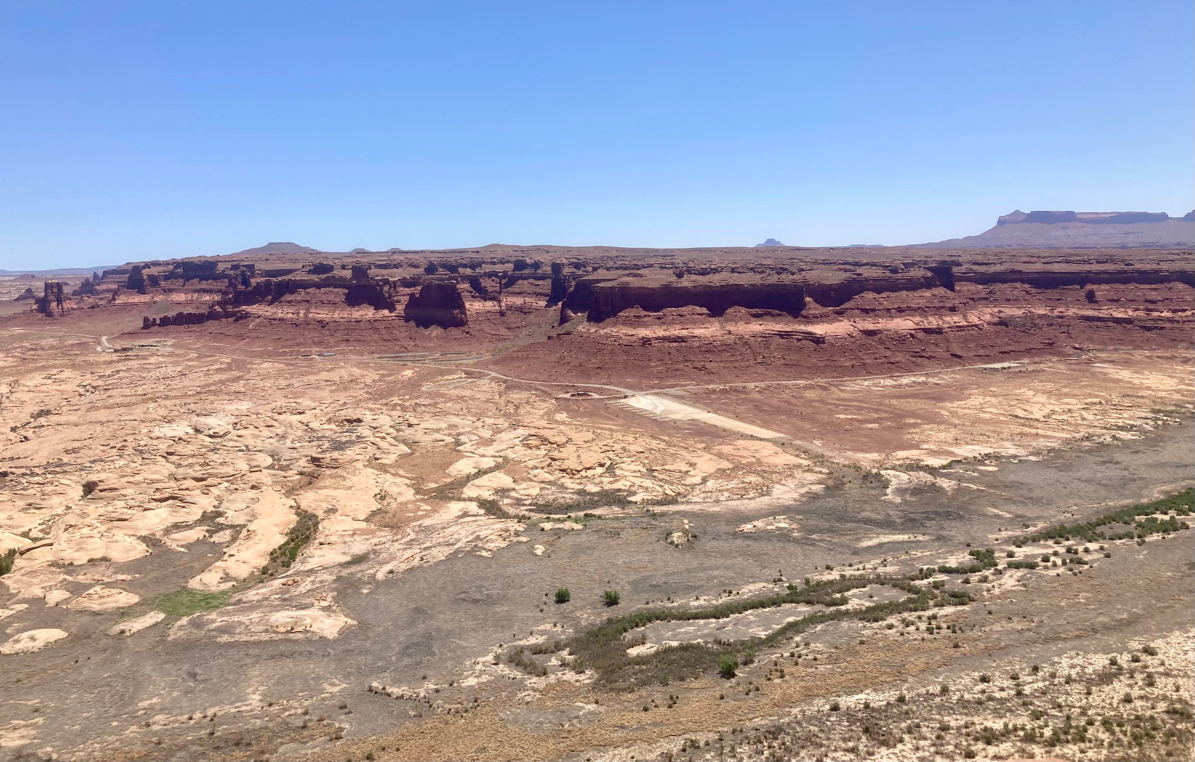
Red rocks and crazy clouds in Utah before fire season had arrived and sullied up the skies. Jonathan P. Thompson photo.
A man fills his water tank at a well a few miles from the Hopi village of Mishongnovi, on the tribe’s northern Arizona reservation.
Click the link to read the article on the Pro-Publica website (Mark Olalde and Alex Hager):
June 29, 2026
ProPublica is a nonprofit newsroom that investigates abuses of power. Sign up for Dispatches, a newsletter that spotlights wrongdoing around the country, to receive our stories in your inbox every week. This story was co-published with KJZZ News-Phoenix.
Reporting Highlights
Certainty on the River: Tribes have negotiated a settlement to resolve the largest outstanding claim to the Colorado River, while providing billions of dollars for water infrastructure.
Upper Hand: Colorado, New Mexico, Utah and Wyoming — the Upper Basin states — are resisting the deal because it allows the Navajo and Hopi to lease water outside their reservations.
Unfulfilled Promise: It has been 118 years since the Supreme Court ruled that the federal government owes tribes water, but many are still fighting to resolve their rights.
These highlights were written by the reporters and editors who worked on this story.
A deal to bring Colorado River water to Native American communities in northern Arizona, where a third of homes lack running water, is being blocked by neighboring states, caught up in a broader battle over how to divide the dwindling river.
The largest tribal water rights settlement in U.S. history — the product of decades of negotiations to secure water for the Navajo Nation, Hopi Tribe and San Juan Southern Paiute Tribe — was on the verge of being realized before Colorado, New Mexico, Utah and Wyoming stepped in to oppose it being codified by Congress.
Those four states, known collectively as the Upper Basin, are at a stalemate with the Lower Basin states of Arizona, California and Nevada over new rules governing how they share the Colorado River, a key water source for nearly 40 million people. Congress and the White House, under both Democratic and Republican leadership, have declined to approve the settlement until all parties reach an agreement.
For 83-year-old Marilyn Tewa, the stalemate means her family will continue to go without running water. Tewa serves on the Hopi Tribal Council, where her duties include working on the water rights agreement, but her village of Mishongnovi, on the tribe’s northern Arizona reservation, lacks indoor plumbing.
Every other day, she loads 5-gallon buckets into her pickup and drives 5 miles to a windmill originally built for livestock that draws untreated water from underground.
“That’s what keeps us alive,” Tewa said, tapping the spigot on a May afternoon.
Back home, Tewa bustled about her kitchen while her daughter kneaded dough for dinner. There’s no faucet in the kitchen, which is decorated with a framed American flag and a painting of a katsina, a figure with spiritual significance in Hopi culture. Instead, the family stores water in large plastic containers. Because of the lack of indoor plumbing, the Tewa family and its neighbors use portable toilets that stand among the houses.
If passed into law, the Northeastern Arizona Indian Water Rights Settlement Actwould resolve the largest outstanding claim on the Colorado River while providing about $5 billion in federal funding to build infrastructure to transport the water across the reservations. The legislation would also go beyond water rights, creating a reservation for the San Juan Southern Paiute. The tribe’s effort to secure a permanent homeland was added to the settlement due to their difficulty getting it through Congress independently.
“That’s my prayer,” Tewa said, “that we get this settlement through for all three tribes.”
Marilyn Tewamain sits in her chair inside her home Saturday afternoon. Photo credit: Sharon Chischilly
The tribes need pipes, pumps and treatment plants to use the water secured through the settlement. To defray the cost beyond the federal government’s expected contribution, the Navajo and Hopi plan to lease some of their water rights, almost certainly to growing towns around Phoenix. The towns would pay to use the tribes’ water for a set number of years.
While the Lower Basin states support the settlement, the Upper Basin states have latched onto this provision in particular as they stand in the way of the settlement.
The Colorado River’s upper and lower basins don’t precisely follow state borders. Some states have portions in both sections, and the line dividing the two basins cuts across northeastern Arizona and directly through the Navajo reservation. If water moves across that line, they argue, the rules governing the river give them veto power over the settlement. (It’s an open legal question whether approval from all seven states is necessary.)
The Upper Basin states fear that, in the future, water they currently control might be leased on an open market. They view any monetary transaction that moves water downstream as setting a precedent that could allow the highest bidder — possibly thirsty cities with money such as Los Angeles, Phoenix and Las Vegas — to buy vast quantities of their water.
In an effort to assuage that concern and close the deal, the Navajo and Hopi made major concessions over the volume of water and length of time they could lease. The tribes also offered to leave some of their water in one of the river’s drought-depleted reservoirs to help keep water levels high enough that it could continue flowing downstream. But the Upper Basin has not wavered in its opposition.
Tewa’s family travels 5 miles each way to haul water in 5-gallon plastic buckets from a well initially drilled for livestock. Photo credit: Sharon Chischilly
ProPublica and KJZZ News-Phoenix reached out to the governor, senators and lead negotiator from every Upper Basin state for comment. Utah’s and Wyoming’s lead negotiators deferred to the letter they co-signed. A spokesperson for New Mexico Gov. Michelle Lujan Grisham said in a statement that the tribes addressed most of the state’s concerns but that questions remain as to whether the water that the tribes would lease to Arizona cities could be counted as part of what the Upper Basin states are legally required to send to the Lower Basin. “New Mexico remains committed to finding a workable solution,” the spokesperson said.
A spokesperson for Colorado Gov. Jared Polis also said the state is “committed to finding a path forward” and pointed to the letter that Becky Mitchell, the state’s lead river negotiator, submitted to Congress. Mitchell wrote that the settlement’s leasing provisions violate laws governing the river and that the state was concerned about what the sale of water across the basin would mean for “the security and certainty” of Colorado’s share of the river.
Heather Tanana is an assistant professor at the University of Denver’s law school, where she focuses on federal Indian law. She is also a citizen of the Navajo Nation and said the Upper Basin is “trying to hide behind” how the river has traditionally been managed rather than find a way to give the tribes access to a resource that is rightfully theirs and one that they need to survive.
“It’s a fundamental human rights issue,” she said.
While negotiations drag on, the three tribes continue waiting for water they say will help them to build more housing, grow sustainable economies, better protect public health and preserve cultural practices.
The Hopi believe their ancestors return as clouds to bring the rain that nourishes their corn, but drought is wracking the region. An overreliance on groundwater has dried up springs that have been used for ceremonies and agriculture for centuries. When the settlement brings more water to the reservation, Tewa said, aquifers will have a chance to recharge, restoring the springs.
“I’m speaking on behalf of my children, my grandchildren and their children that haven’t come yet,” she said. “I hope, in the future, that they will have water.”
The village of Mishongnovi, which Tewa represents on the Hopi Tribal Council, sits atop a rocky mesa. Photo credit: Sharon Chischilly
Tewa washes her hands with untreated water she hauled from a well. Photo credit: Sharon Chischilly
Fighting for Water Since Elvis Was on TV
That the settlement even reached Congress seemed like a small miracle to those involved.
If the tribes were to use every drop to which they are entitled, the system of sharing the river that supports more than $1 trillion in annual economic output would collapse.
“Everybody’s getting free Navajo, Hopi and San Juan Southern Paiute water right now. The seven basin states are all benefiting in the absence of a settlement,” said Ethel Branch, a former Navajo attorney general who was involved in the negotiations, adding that the water had been “stolen for over a century.”
In 1908, the Supreme Court ruled that, if the federal government confined tribes to reservations, then it owed them enough water to sustain an agrarian economy on that land. But securing that promised water, referred to as “Winters rights,”has proven arduous.
Tribes were excluded from the compacts that apportioned the river. The Navajo in particular were barred from joining a seminal case quantifying other users’ rights, and members of the tribe themselves rejected a proposed settlement in 2012 when they viewed the deal as unfair. So the tribe went back to the Supreme Court, asking that the justices force the federal government to quickly settle the claims. The Navajo once again lost, with the court’s majority deciding that their treaty with the U.S. didn’t require the government to take any “affirmative steps” to deliver the water it owed the tribe.
“At each turn, they have received the same answer: ‘Try again,’” Justice Neil Gorsuch wrote of the Navajo in his dissent. “When this routine first began in earnest, Elvis was still making his rounds on The Ed Sullivan Show.”
Arizona politicians and tribal leaders have since concluded that they needed to combine all three tribes’ claims to finally settle their rights.
That was no simple feat. The Navajo and Hopi have long had a contentious relationship. Underlining their thorny partnership, leaders of various tribes around the region have accused Navajo, the largest tribal nation in the U.S., of flexing their political strength to the detriment of other tribes.
About a third of homes on the Navajo Nation lack the pipes and other infrastructure necessary to deliver running water, including near Page, Arizona, close to a large reservoir on the Colorado River. Photo credit: Sharon Chischilly
But Navajo and Hopi struck a deal, and Arizona moved off its bargaining position. Now in lockstep, the settlement’s supporters turned to Congress, only to hit more roadblocks: The House of Representatives balked at the spiraling price tag to fund the deals; presidential administrations were unwilling to expend political capital on such settlements; and more than a dozen settlements are in the works, clogging the system. (No settlement has been enacted since 2022.)
“Partisanship has gone to a new low in this country, and Indian water settlements have gotten swept up into that,” said Pam Williams, who spent about two decades as director of the Secretary’s Indian Water Rights Office in the Department of the Interior before she retired last year.
In November 2024, as President Donald Trump prepared for his return to the White House, the tribes believed they had an opening to get their settlement through Congress while President Joe Biden was still in office.
Navajo leadership had supported the Democratic presidential ticket and feared the incoming administration would be vindictive toward them.
Every basin state’s lead negotiator, tribes’ staff and a federal representative descended upon the Arizona Department of Water Resources’ offices in Phoenix for what several attendees described as a “Hail Mary.” At the meeting, the Navajo offered a major compromise: limiting how much water they could lease and for how long they could lease it.
But the Upper Basin states showed up with a list of grievances, multiple attendees told ProPublica and KJZZ News-Phoenix, and weren’t interested in negotiating over the Navajo leasing concessions.
“It’s difficult for the Upper Basin to wrap their heads around this settlement,” said Tom Buschatzke, Arizona’s Colorado River lead.
Navajo President Buu Nygren says the fact that his tribe’s reservation straddles the upper and lower divisions of the Colorado River Basin should not be held against the tribe as it negotiates for water. Photo credit: Sharon Chischilly
In March 2026, leaders from the tribes traveled to Washington for a Senate hearing where they made an impassioned plea for Congress to pass a version of the bill that now included the concessions they had offered in the Hail Mary meeting. Sen. Lisa Murkowski, the Alaska Republican who ran the hearing, expressed support for the settlement but worried its $5 billion price tag was too high, a concern echoed by an Interior Department official who testified. (The tribes and department are currently negotiating to shrink that cost.)
All four Upper Basin states submitted comments opposing the settlement. Their main concerns were about the ability to lease across the basin and whether the water for the settlement would be counted against the upper or lower division of the river.
Leasing would last only as long as it’s needed to pay for infrastructure to distribute their newly acquired water, said Navajo President Buu Nygren. It would not set a precedent, he said, because no other tribe straddles both basins.
“We shouldn’t be punished for being in two basins,” Nygren said, “because other tribal nations, other settlements have been able to lease water.”
A construction crew installs pipes at the new LeChee Water Treatment Plant near Lake Powell, along the Arizona-Utah border. Photo credit: Sharon Chischilly
The former Navajo Generating Station’s intakes, which drew water from Lake Powell to cool the coal power plant, sit unused, awaiting funding from the stalled settlement. Photo credit: Sharon Chischilly
“How Precious Water Is to Us”
During the decades that the tribes fought to access their water, they helped quench the thirst of growing cities in the Colorado River Basin.
A water intake plant on Navajo land drew from Lake Powell to cool the nearby Navajo Generating Station. The coal plant powered pumps for the Central Arizona Project, the 336-mile series of canals that sends Colorado River water to Phoenix and Tucson.
The power station shut down in 2019, and the intake plant was handed over to the Navajo for the iiná bá-paa tuwaqat’si pipeline, which means “for life” in Diné and “water is life” in Hopi, to deliver water to the three tribes. But for now, the massive pumps remain mothballed, the building sitting musty and dark like a tomb, and the pipeline remains an engineering schematic, waiting for funding from the stalled settlement.
The irony is not lost on tribal leaders, they told ProPublica and KJZZ News-Phoenix: After helping deliver water beyond their lands, they are now blocked from using that same water and infrastructure to sustain their communities. The insult is compounded, they said, by the fact that water use is drastically lower on reservations.
“It’s not about green-grass lawns or golf courses or swimming pools,” said Crystalyne Curley, speaker of the Navajo Nation Council. “It’s just basically turning on the faucet and getting water to boil eggs for your children or turning on a faucet to wipe and clean the table or washing your hands after butchering a sheep.”
San Juan Southern Paiute Vice President Johnny Lehi Jr. is fighting for the settlement because it would finally ratify a treaty with the Navajo that would create a reservation for his tribe. Photo credit: Sharon Chischilly
For the San Juan Southern Paiute, the settlement is also about having a permanent homeland. They have no reservation but struck a deal with Navajo in 2000 to transfer some of its land. Since the tribes already reached an agreement, it’s an uncontroversial proposition. But, without political clout to get Congress to take it up, the land transfer was pulled into the water settlement.
“During the COVID era, it took a lot of the tribal elders, and there are only a handful that saw the treaty signed and are really wanting to see this before their time is up,” said San Juan Southern Paiute Vice President Johnny Lehi Jr., whose father signed the 2000 agreement. Finally securing a reservation, he said, means the ability to build housing and develop an economy for a tribe that currently rents its government building.
Nearby, on the Hopi reservation, Councilmember Marilyn Fredericks grabbed a pair of hiking poles, donned a hat with a roadrunner pin on it and set out from her village on a recent spring afternoon. To stay fit as she grows older, she walks up and down the hand-carved steps of a terraced garden that used to produce food for her community.
Seven natural springs once fed the garden, but only two still flow. Ponds that stored their excess sit dry, stains on the rock now just a memory of the water. It’s been six years since there was enough to plant.
The settlement would fund a pipeline that would be “our umbilical cord,” Fredericks said. Future generations of Hopi have a right to clean, reliable water, she said. “This is evidence of how precious water is to us.”
Native America in the Colorado River Basin. Credit: USBR
The Colorado State Engineer’s office opened its defense this week of Subdistrict 1’s approved Fourth Amended Plan of Water Management with a history lesson on the origins of the San Luis Valley and the development of irrigated agriculture over the past 174 years when the first water right was issued to the San Luis People’s Ditch.
Featured in the state engineer’s defense was testimony by Matt Seitz of HRS Water Consultants, who took the state Division 3 Water Court through ancient history and into the era of early irrigation and storage practices of farmers in the Valley.
“Yeah, so we covered 25 million years pretty quickly, see how long the rest of it takes here,” he said from the witness stand Tuesday. Seitz stayed on the witness stand for the better part of the week, working to bolster to the state engineer’s defense of the Fourth Amended Plan of Water Management and then under cross-examination from a Sustainable Water Augmentation Group attorney, who worked to show faults in Seitz’ testimony and undermine the case of the state engineer in the eyes of Division 3 Water Court judge Michael Gonzales.
It is Gonzales who will decide this case. He will take in all the testimony around the various takes on the Fourth Amended Plan of Water Management to rule on whether the plan will be implemented.
Plan of Water Management Equation
The subdistrict itself is charged with recovering the shallow unconfined aquifer of the Upper Rio Grande Basin and its Fourth Amended Plan of Water Management is the latest attempt to do so. The complexity of the basin’s hydrology has been an early theme.
“I think there’s been a lot of great research over the years,” Seitz said in speaking to the state’s modeling of groundwater in the Upper Rio Grande Basin and other studies on the Valley’s hydrology. “So I think we’ve made some good progress, but there’s a lot of complexity. Again, I’ve been saying that word a lot, but there certainly is and I think we’re on our way, but it’s never going to be fully understood.”
Week 1 of the trial ended with Craig Cotten taking the witness stand. He is witness number three for the state engineer’s defense of the plan, following Cleave Simpson, the general manager of the Rio Grande Water Conservation District who was the lead witness, and then Seitz, the hydrologist consultant who endured four days on the witness stand.
“Wonderful way to start the Fourth of July weekend,” quipped Gonzales as Cotten, the state water division engineer for the San Luis Valley area, stepped into the witness box at 1:50 p.m. on Thursday. He spent the initial two hours testifying to his background and his credentials before Gonzales broke for the Fourth of July weekend.
Cotten is the enforcer of the state’s groundwater management rules in the San Luis Valley. His testimony will reignite the trial when it resumes on Monday for week two of the water trial.
Map of the Rio Grande watershed. Graphic credit: WikiMedia
A new Colorado law requires water users that buy water tied to farms in the Arkansas Valley to revegetate land before using water elsewhere…
“When that water leaves, the impacts of the dry-up don’t leave with it. They stay with the land and the people who live here,” said Jack Goble, general manager of the Lower Arkansas Water Conservation District, which advocated for the legislation.Revegetation involves restoring native plant cover to the land to reduce erosion, maintain soil moisture and manage noxious weeds…
In Crowley County, where productive farmland has declined by more than 90% since the 1970s because of water transfers, so-called “buy-and-dry” transactions have spawned a sea of dirt that supports little more than weeds. According to a recent report from ProPublica, these water transfers have caused an “environmental catastrophe,” in Crowley County, in which birds, bees and wildlife have fled. A 2026 report from Colorado State University estimates that every acre of irrigated land taken out of production leads to an annual economic loss of $1,400 to $1,600. Governor Jared Polis (D) signed House Bill 26-1340 into law June 1. The new law, sponsored by representative Ty Winter (R), gained broad support in the House and Senate. The law takes effect January 1, 2027.
“If you look at other natural resources — coal, gravel, oil and gas — when that’s mined from the land the requirement is on the entity that profits off of, and mines that, to go and reclaim that land. We think water should be no different,” Goble said.
Maybell Irrigation District’s headgate on the Yampa River, September 2022. Photo credit: Heather Sackett/Aspen Journalism
Click the link to read the article on The Denver Post website (Noelle Phillips). Here’s an excerpt:
June 18, 2026
For the 18 ranchers who rely on the Maybell Irrigation District’s canal to funnel water to their fields, the 127-year-old headgate that diverted flow from the Yampa River meant a two-hour round trip through a rocky canyon whenever they needed water. The rusted structure was barely hanging on, and its operation was time-consuming for the busy ranchers, who had to lug special tools on all-terrain vehicles and on foot to open or close the mechanism. But it seemed impossible for the tiny district to find the $6.8 million needed to replace the headgate and the rocky diversion dam that pushed water into the canal. Then legalized sports betting came along, and, with it, millions of dollars for Colorado water projects. The tiny irrigation district, in Moffat County in the far northwest corner of the state, soon became the poster child for how gambling money is benefiting Colorado’s waterways. The district received a $750,000 grant from the Colorado Water Conservation Board, which doles out money from sports betting tax revenue, said Diana Lane, sustainable food and water program director for The Nature Conservancy in Colorado, which helped the district land the grant. That led to a matching grant from the U.S. Bureau of Reclamation’s WaterSMART program. With those two grants in hand, other organizations jumped on board, and money poured in, she said. In 2024, the Maybell Irrigation District installed a new headgate that can be opened or closed via cellphone. If a rancher is cutting hay and doesn’t need to irrigate, he can close the gates to match the amount of water he actually needs at that moment, Lane said. And the diversion structure no longer uses boulders to control the water flow. Instead, it’s a modern structure that is the right height for water control. The project also benefited four fish species, including the threatened humpback chub, and it made river navigation easier for boaters, helping the region’s outdoor recreation economy.
“That $750,000 was really the ball that got it all rolling, that showed people, ‘Oh, this is going somewhere,’” Lane said of that initial state grant.
Since sports betting became legal in May 2020, the state has collected more than $154 million in taxes, and the Colorado Water Conservation Board has funneled $140 million to various projects that preserve and conserve Colorado’s precious water. Supporters say the gambling money is a godsend for ranchers, fishermen, paddlers and others who want to protect the state’s water and those who depend on it for their livelihoods. Critics, however, say legalized sports betting has come at a cost — fueling an addiction crisis that the state was unprepared for and is underfunding.
Green Mountain Reservoir is owned by the U.S. Bureau of Reclamation and located in Summit County north of Silverthorne along the Blue River. Photo credit: Denver Water.
Historic water shortages are drying out the scenic mountains that lie at the heart of Colorado’s tourist economy, prompting the state to issue emergency orders earlier this month allowing water to be shifted to the towns and ranches most likely to run dry.
The Colorado River District, which represents 15 Western Slope counties, is running the emergency response effort and with financial support from the Colorado Water Conservation Board has anted up nearly $1 million to make sure even towns that can’t afford it, will have access to drinking water should it be needed.
To make the plan work, the river district opted not to lease portions of the water it normally holds in two high country reservoirs, Ruedi in the Roaring Fork Basin and Wolford Mountain, near Kremmling, on a first-come, first-served basis, as it normally does. Instead, the water is being doled out based on community need, with people and food production getting the water first, according to Andy Mueller, manager of the river district.
“We had a number of requests to lease that water out, but a lot of it would have gone to wealthy gentlemen rancher … but it wouldn’t have been for the common good,” he said.
Under Colorado law, water can only be diverted, stored and used for a designated purpose, such as city drinking water, farm irrigation, environmental streamflows, and industrial uses. Water rights are also tied to seasons, with some available only in the winter or summer.
But this spring, the river district, seeking more flexibility than the laws typically allow, went to Colorado State Engineer Jason Ullmann and asked for emergency authorization to use its water supplies differently. The state agreed, giving the district until the end of August to conduct emergency releases.
At the same time, large agricultural water users in the Grand Valley agreed to cut their water use in an effort to lessen strain on the Colorado River, and protect some of the small towns and ranchers who would have been cut off otherwise.
At issue is a special pool of water that lies within Green Mountain Reservoir, near Heeney, known as the historic users pool, or the HUP. The water is meant as a backup source that allows towns to pump wells and divert from streams even when their water rights are not in priority on the giant mainstem of the Colorado River.
But this year, because of the drought, Green Mountain’s HUP isn’t projected to fill, something that hasn’t occurred since the 1960s when the pool was created to protect mountain water users who had junior water rights, according to Ullmann. The emergency order means that even without the backup from Green Mountain, these communities and ranches will be unlikely to have their water supplies cut off.
The Eagle River Water and Sanitation District, which serves Vail and other small towns in Eagle County, has water in the HUP.
Working in the shadow of a nearly snowless winter, the Eagle River District moved early to enact watering restrictions, limiting outdoor use to just two days a week back in April, after March saw temperatures soar to 80 degrees and the patchy snow cover evaporate months earlier than normal.
“The writing was on the wall,” said Siri Roman, CEO of the Eagle River Water and Sanitation District. “This is a benefit of being in the headwaters and being a resort,” she said referring to the headwaters of the Colorado River. “Our whole community is so connected to snowpack and snow-water equivalencies and what that means. By February we knew there wasn’t enough snow to change the picture for us. We wanted to get to the decision-makers early and say the red lights are flashing. We need to prepare for a water shortage this summer.”
Eagle residents took conservation messages seriously
In Eagle, Tom Gosiorowski, the utilities manager, was standing in Brush Creek shooting videos for the town’s Facebook page, letting its 10,000 water customers know that the stream was the community’s only source of water and it wasn’t looking good. Eagle also relies on the HUP for some of its backup supplies.
“We are really wholly dependent on the streamflow and the water that is in the creek. It’s different from the big Front Range utilities” that have reservoirs, he said.
The district is limiting outdoor water use to two days a week and is sharply limiting the filling of hot tubs and swimming pools. Gosiorowski said he expects golf courses to be restricted as well as the summer wears on.
“We could get to a point where they can only irrigate tees and greens on the golf course,” he said. “We’ve never had to reduce use, but this is so extreme that I think there will be some.”
Gosiorowski said the town was still working on worst-case scenario planning for the end of summer, when streams are normally at their driest. “It’s hard to know exactly what’s going to happen. We’ve never experienced a drought to this degree in recorded history.”
Aspen has also enacted two-day-a-week watering and is prohibiting the filling of pools and hot tubs.
Grand Lake, another community that could be impacted by the shortages at Green Mountain, is not showing signs of strain yet, though officials there are concerned about lake levels.
Grand Lake, the deepest natural lake in Colorado, is linked to two other reservoirs, Shadow Mountain and Lake Granby. All three are part of Northern Water’s Colorado-Big Thompson Project. The C-BT delivers water from the Colorado River to 1 million customers and hundreds of farms on the northern Front Range.
Mike Cassio is a citizen activist who tracks Grand Lake’s health and works with a coalition of community groups and water agencies to help manage the system. Cassio said he’s worried about late summer water levels falling.
“We know Mother Nature controls everything,” Cassio said. If levels in Lake Granby and Shadow Mountain fall too low, water quality will suffer and that “will be the biggest issue.”
Kathy Chandler-Henry sits on the river district’s board and is a former Eagle County commissioner. She said the brown hillsides and dusty streambeds are unnerving.
“Before it was never a question,” she said. “There was always snowfall, there was always water. … Nothing like this year, when it was 80 degrees in March in Vail.”
Back in the 1980s, she said she participated in some regional planning efforts to help the Western Slope learn how to manage its growth. That there could be a winter without snow was unthinkable, if not downright funny.
“One planning consultant in the workshop asked folks what it would be like without snow,” she said. “And everyone just laughed.”
Despite this summer’s deep dry spell, water users say they are encouraged by recent light rains and cool weather. Just weeks ago, the HUP was projected to barely fill at all, but now the 66,000 acre-foot pool is rising again. It recently topped 33,000 acre-feet and is expected to move higher, providing some relief.
But Mueller, of the river district, said this summer is a dress rehearsal for what lies ahead as climate change and warmer temperatures continue to hamper mountain snows and spring stream levels.
“We are just beginning to grapple with the impacts of climate change. Science indicates that 30 years from now, this year may be on the wetter side.”
Last month, leaders from across Colorado’s Western Slope celebrated the release of $40 million in federal funding for the Shoshone Water Rights Preservation Project. At a time when Colorado is celebrating its 150th anniversary and our nation approaches its 250th birthday, this investment represents more than a funding milestone; it marks one of the most significant water preservation achievements our state has seen in generations. It also would not have happened without the determination of our congressional representative, Jeff Hurd, who made this project a priority and worked tirelessly to deliver results for the communities he serves. What Rep. Hurd understands is the same thing that has united more than 100 local, state, and federal elected officials and leaders in support of preserving these critical senior water rights: the future of the Western Slope is inseparable from the future of the Shoshone water rights. Protecting these rights protects the flows of the Colorado River, sustains our agricultural heritage, strengthens our recreation- and tourism-based economies, and helps preserve the rural communities that make this part of Colorado unique…
I believe that 150 years from now, our grandchildren’s grandchildren will look back on the Shoshone Water Rights project as a turning point. They will see a generation of leaders who understood what was at stake and chose to act. They will see communities that put aside differences, came together, and made a long-term investment in the future of the Colorado River. History will remember the Shoshone project as a major milestone in the stewardship of our most precious resources. From Western Slope ditch companies and water conservancy districts to local governments, state leaders, and members of Congress, countless individuals are still working together to turn this vision into reality. The lesson is an important one. On the Western Slope, progress happens when we pull in the same direction. It takes communities working in harness together to move mountains and sometimes to move water. And it takes elected leaders like Jeff Hurd who are willing to put their shoulders into that work. The Shoshone project demonstrates what is possible when rural Colorado speaks with one voice about protecting its water, its economy, and its future.
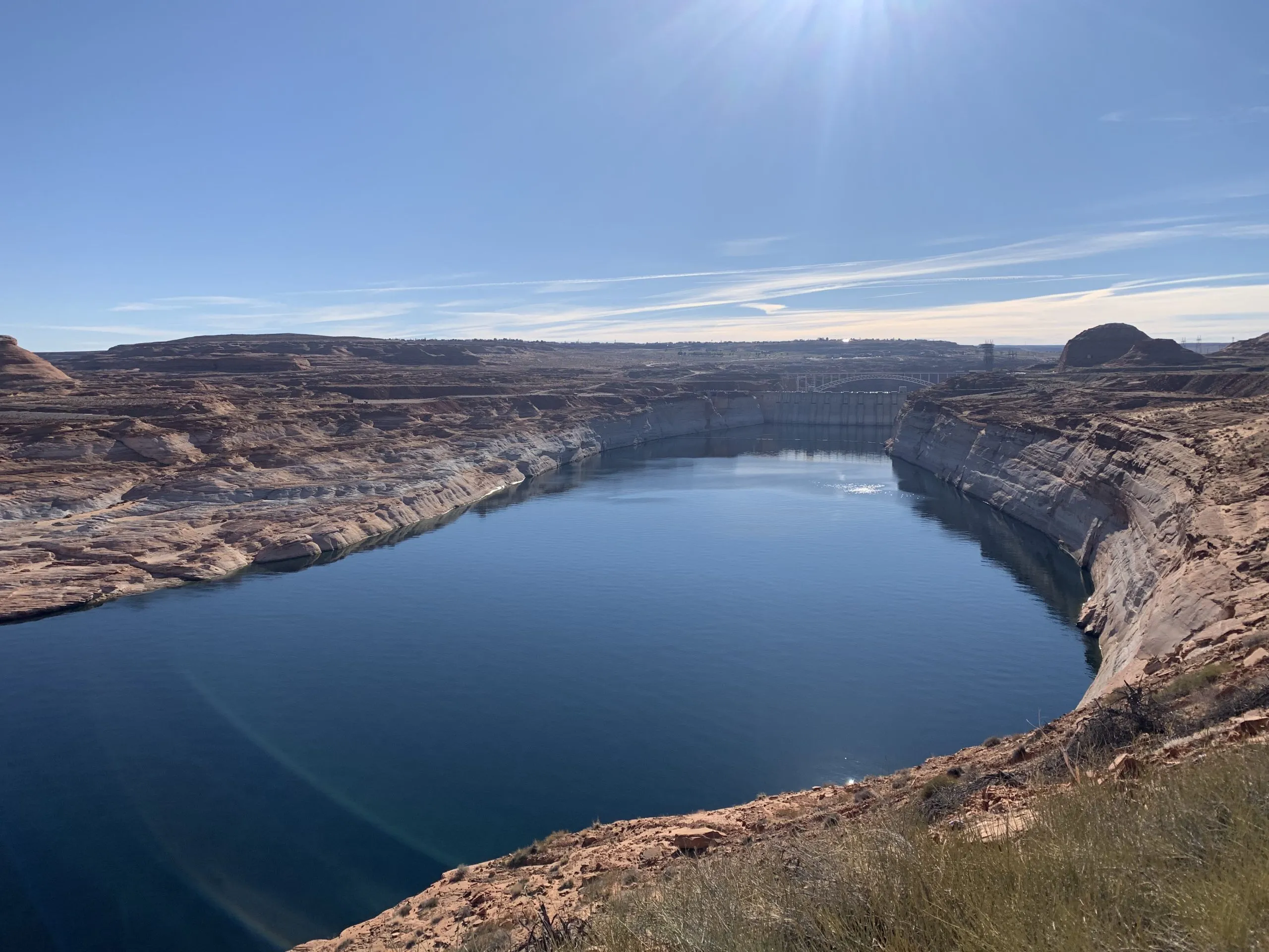
The main boat ramp at Wahweap Marina was unusable due to low water levels in Lake Powell in December 2021. Water levels are projected to soon fall even lower than this at the nation’s second-largest reservoir. CREDIT: HEATHER SACKETT/ASPEN JOURNALISM
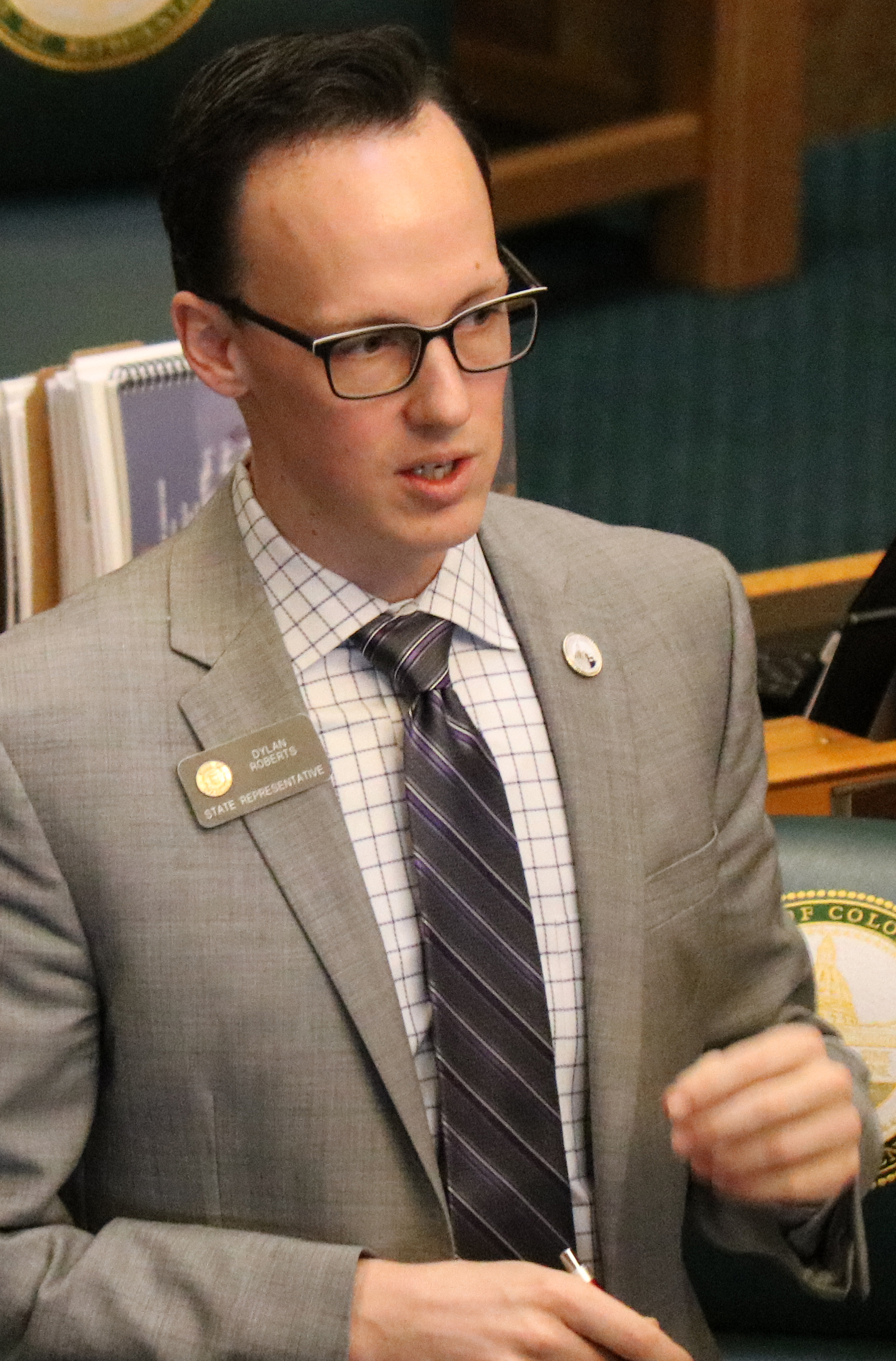
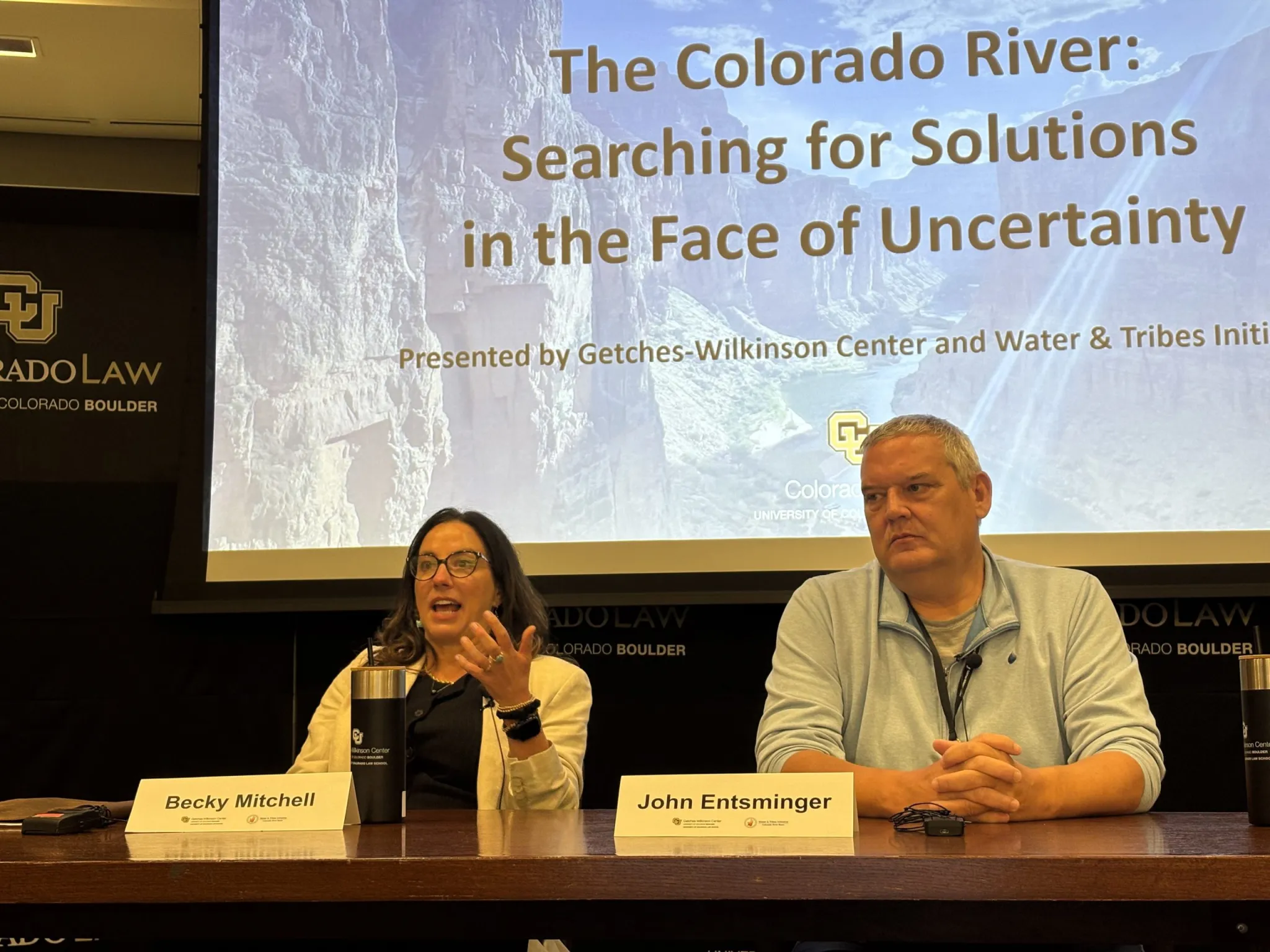
Western Slope lawmakers had harsh words for water managers at a state committee hearing last week, questioning whether Colorado has done enough to avoid a lawsuit with its downstream neighbors.
Colorado Sen. Dylan Roberts, a District 8 Democrat who represents several Western Slope counties, including Eagle, Grand, Garfield, Routt and Summit, asked Colorado’s lead negotiator, Becky Mitchell, whether the people of Colorado should have confidence that negotiations among the seven states that share the Colorado River have put the state in the best possible position. The states have been at an impasse for more than two years without a deal for future management as reservoirs continue to decline to record-low levels.
“My constituents just see fighting and intransigence,” Roberts said. “And it’s concerning to me, especially as a Western Slope lawmaker … that the strategy is just ‘Let’s hire more lawyers; we’re going to court no matter what.’ That doesn’t give me confidence, because I don’t think Colorado fares well when we go to court against Arizona and California and Nevada, throwing our fate to the nine justices on the U.S. Supreme Court.”
The remarks came at Thursday’s meeting of the state Water Resources and Agriculture Review Committee in Denver. Along with Mitchell, in the hot seat were state engineer Jason Ullmann and Amy Ostdiek, interstate section chief at the Colorado Water Conservation Board. The three are employees of the state Department of Natural Resources and have the backing of the Attorney General’s office in negotiations.
Roberts’ line of questioning seemed prompted by recent projections that show river flows dipping below a threshold that could trigger litigation. The Lower Basin states (Arizona, California and Nevada) believe that the Upper Basin states (Colorado, New Mexico, Utah and Wyoming) are bound by the 1922 Colorado River Compact to deliver 82.5 million acre-feet of water over a 10-year rolling average. According to the Upper Colorado River Commission, the 10-year average will dip later this year to about 81.3 million acre-feet because of persistent drought.
Some experts believe that this amounts to a “tripwire” that could trigger a lawsuit from the Lower Basin states (Arizona, in particular, has been openly preparing for litigation) that could result in mandatory cuts in water use for the Upper Basin. Upper Basin water managers don’t subscribe to this interpretation, saying their states are only required not to deplete the river’s flows by more than 75 million acre-feet over 10 years.
Mitchell was reluctant to share details of Colorado’s legal strategy in a public forum, but she answered “absolutely” that her team’s work was putting Colorado in the best position. She said cutting back prematurely just to satisfy the Lower Basin’s interpretation of the century-old agreement would be bad for the state.
“If we initiate curtailment now, that is worse for Coloradans,” Mitchell said. “I think that is an important thing to remember.”
Wracked by drought, climate change and a management crisis, the situation on the river has never been more dire. The current management guidelines expire this year, and in the absence of a seven-state deal to share shortages and operate the nation’s two largest reservoirs, Lake Powell and Lake Mead, the feds are poised to step in. The U.S. Bureau of Reclamation plans to release a more detailed, short-term plan to manage the river for the next two years by mid-to-late summer.
State Rep. Julie McCluskie, a District 13 Democrat, said communities in her district have been living with the incredible angst, anxiety and pain of no snow and low reservoirs.
“The frustration I hear in my community is that we have missed multiple deadlines; they are becoming a funny joke,” McCluskie said. “There is such a fear about the lengthy litigation process, the fear of an outcome that is far worse for Colorado than a compromise that we have some control over.”
Lake Powell is formed by Glen Canyon Dam. In a concept pitched by a conservation organization, a flexible pool of water could be moved between Upper Basin reservoirs to wherever it’s needed most. CREDIT: HEATHER SACKETT/ASPEN JOURNALISM
Conservation conversation is the ‘bare minimum’
Lawmakers also had strong words for state officials regarding conservation, saying legislators must be involved in the creation of any program.
Colorado has dabbled with pilot conservation programs in the past, but traditional programs that pay farmers and ranchers to temporarily cut back on water use remain controversial. This is especially true on the Western Slope, which has long been the target for these types of programs, and where some worry that they could harm rural communities if not done carefully. After two years of exploring how the state could set up a temporary, voluntary and compensated conservation program, officials shelved the idea in favor of focusing on drought-resilience initiatives.
“Other states out of the seven have very clear and actionable roles for their general assemblies, their legislatures,” McCluskie said. “We have less so, and yet the stakes are so high. So I beg of you, decision-makers, that it is essential that we be a part of those next steps.”
Julie McCluskie. Photo credit: Colorado General Assembly
Ostdiek said that any program would need to start slow and make sure it incorporates input from people throughout the state.
“I think that we can continue to assess as we go what we might need from you all, and what a program like that might look like,” Ostdiek said. “I think what we can certainly commit to is continuing this dialogue and continuing the discussion about what we might need to make this a success.”
In 2023, Colorado lawmakers tried to force stakeholders to come up with recommendations on conservation programs by creating a statewide task force, which met 10 times over six months. But the group failed to find a consensus, with some saying it was “premature” to create a conservation program.
As part of a post-2026 framework, the Upper Basin states plan to create a “contribution” pool in Lake Powell, which could be used to help stabilize the system, keeping water levels above critical thresholds to protect hydropower at Glen Canyon Dam and acting as an insurance pool against forced cutbacks. In a May 22 letter to federal officials, the Upper Basin states said they have a goal of saving 100,000 acre-feet by the end of water year 2028, but only if sufficient federal funding is available and hydrologic conditions allow.
Three Upper Basin states have different methods for contributing to this pool: Utah has its own demand management program; Wyoming lawmakers passed a law this year allowing for a conservation program; and New Mexico plans to release water from Navajo Reservoir.
But precisely how — and how much — Colorado would contribute to this pool is unclear. The state’s share of the Upper Basin’s allocation is 51.75%, meaning Colorado could be on the hook for 51,750 acre-feet.
And ensuring that saved water actually gets into a pool in Lake Powell remains part of the problem. Currently, conserved water that stays in the river can just be picked up by a downstream user, with no net gain to Lake Powell. Colorado officials say they do not have the authority to “shepherd” water past other water users to the state line unless it is specifically for compact compliance. [ed. emphasis mine]
Last year, some Delta County ranchers asked lawmakers to take up the issue and pass a law that would address this issue, allowing water users to conserve and get credit for contributing water to a Lake Powell pool. But legislators did not take up a bill in the 2026 session.
Colorado officials told lawmakers they were continuing to explore what a program might look like and whether legislation would be needed.
Roberts said conversations with the legislature should be the bare minimum if Colorado is going to have a conservation program.
“If the department or any agency of the state were to pursue a conserved consumptive use program or demand management program that used state tax dollars to pay for it and did not go through the legislature in a formal process, I imagine that all of us on this panel and many of our colleagues would raise holy hell about the unilateral decision-making coming from Denver about programs impacting all parts of the state,” Roberts said. “So, please, let’s just cut that off at my recommendation. Let’s work together on this.”
Officials opened the hearing by highlighting the impacts of this year’s severe drought on Colorado’s farmers and ranchers, noting how even some of the most senior water users will experience shortages as streamflows dwindle. Orchards in the North Fork Valley and row crops in the Uncompahgre River Valley already have unprecedented shortages.
In response to Roberts’ concerns about the failure to find a compromise among the seven states, Mitchell posed a high-stakes rhetorical question: “I would ask, ‘What else do you think we can give?’”
The Colorado River Basin spans seven U.S. states and is divided into Upper and Lower Basins. Lake Powell, upstream from the Grand Canyon, and Lake Mead, near Las Vegas, are the two principal reservoirs in the Colorado River water-supply system. (Bureau of Reclamation)
While the Trump administration 2.0 has so far rexfrained from trying to shrink or eliminate national monuments, its non-executive-branch proxies just keep on trying.This week the 10th Circuit federal appeals court issued a decision keeping alive Utah’s lawsuit challenging Joe Biden’s 2021 re-establishment of Grand Staircase-Escalante and Bears Ears national monuments following Trump 1.0’s shrinkage of the same.
The state and Garfield and Kane counties filed one lawsuit in 2022, with the Blue Ribbon Coalition and other parties filing their own suit. In 2023, a federal court dismissed both lawsuits; that ruling was appealed.
This week’s decision confirmed the dismissal of the Blue Ribbon suit. But it also determined that presidential national monument designations under the Antiquities Act are subject to federal judicial review, and sent Utah’s case back to the district court.
***
Photo credit: Jonathan P. Thompson/The Land Desk
The Bureau of Land Management is moving forward with three travel management plans in Utah that will determine which roads, trails, and areas of the respective field offices’ jurisdiction are open to motorized vehicles. Given that the stated aim is to bring the plans in line with Trump’s recent executive order rescinding restrictions on motorized vehicles on public lands, we can assume that the idea here is to expand motorized access to some remote areas. The plans include:
The Moab Field Office has released preliminary alternatives for the Dolores River Travel Management Plan on about 127,000 acres in Grand County, Utah, east of Moab and abutting the Colorado border. This would include roads along the Utah section of the Lower Dolores River, and on mesas and in canyons on either side of it. Maps of the alternatives can be found here. This one is not yet open to public comment.
The Kanab Field Office has released a draft environmental assessment for its Trail Canyon Travel Management Plan on nearly 330,000 acres in Kane County. It is open to public input.
And the Vernal Field Office has also released a draft review for the Dinosaur North Travel Management Plan. The public comment period is open.
***
I typically stay away from electoral politics, especially the horse-race part of it and polls and such. But sometimes a particular contest or candidate can provide a lens on bigger trends or phenomena, and so are worth looking into.
The latest race that has caught my interest is the one to replace Sen. Cynthia Lummis, the Wyoming Republican who is retiring at the end of this term. Since it’s Wyoming in 2026, it’s safe to assume the winner will be a Republican (though this wasn’t always the case), meaning the primary is the contest that matters. The front-runner, I suppose, is Rep. Harriet Hageman, the Trump sycophant and MAGA extremist who unseated Liz Cheney back in 2022 after Cheney failed to show adequate fealty to Trump.
But it’s one of her challengers that I’m interested in: Sam Mead. Mead is a fifth-generation Wyoming rancher, comes from a long line of Republican Wyoming politicians, and is the nephew of former governor Matt Mead. Mead is young (36), charismatic, has strong conservative credentials on fiscal issues and gun-rights, and a background in engineering and business, having run a whiskey distillery in Kirby. But what really distinguishes him from his opponents is his willingness to speak out against some of Trump’s policies, and his priority on protecting public lands and keeping them in the public’s hands.
Mead, in other words, appears to be an old-school, pre-MAGA Western Republican. He reminds me a bit of Wyoming Gov. Mark Gordon, back before extreme polarization pulled him more and more rightward and into MAGA land. Wyoming’s primary is on Aug. 18.
Meanwhile, Utah just held its primaries, with some surprising results. Utah State Senate President Stuart Adams, a Republican, was defeated by challenger Stephanie Hollist. Adams was a strong supporter of the controversial proposed Stratos Project data center complex on the north shore of the Great Salt Lake. Also, incumbent Rep. Celeste Maloy trounced challenger Phil Lyman in the GOP primary for the 3rd Congressional District, with about 70% of the vote.
While Maloy was endorsed by Trump, and has plenty of extreme views, Lyman is the more MAGA of the two. And Trump pardoned Lyman after his conviction for leading an OHV rally down Recapture Canyon in the southeastern part of the state. Political consultant Taylor Morgan told the Utah News Dispatch that Lyman’s resounding defeat showed that his “very angry, very conspiracy-based, populist, toxic form of Republicanism (is) frankly wearing very thin, especially here in Utah.” Let’s hope he’s right!
Pumpjack in the Aneth oil field. Jonathan P. Thompson photo.
I wrote Tuesday about how the Trump administration is eviscerating Biden-era oil and gas rules aimed at reducing methane emissions and ensuring companies clean up their own messes rather than foisting them onto the taxpayers. Now the changes are open for public comment.
Here are a few of the changes Trump and co. are proposing:
Bring back pre-Biden reclamation bond rates, which amount to just over $2,000 per well, which is insane, since the cost to reclaim and plug a single well easily can exceed $100,000. These numbers incentivized petroleum companies to walk away, forsake the bond, and abandon the well, leaving the tab for the taxpayers.
Reduce the current $10 minimum per-acre bid for leasing public land to $2, restore noncompetitive leasing, and slash royalties and filing fees for oil and gas companies.
Implement a new fee for protesting leases. And they plan to cut the 90-day public input period to just 10 days. In other words, they’re trying to cut out the public from decisions regarding public lands.
Gut the waste prevention rule (they wanted to roll it back altogether, but chose to revise it instead because it wasn’t clear which rule would replace it) by removing limits on royalty-free flaring and killing requirements that companies develop leak detection and repair plans.
Trump’s changes to the waste prevention rule will turn back the regulatory clock to the days when oil and gas operations on federal and tribal land vented and flared an average of 44.2 billion cubic feet annually of methane, which is usually accompanied by nasty volatile organic compounds and other dangerous compounds. That’s as bad for the climate as burning around 9 million tons of coal. But it also amounts to lighting money — your money — on fire and throwing it away. That vented methane is basically the same stuff you pay for to run your furnace, or to generate much of the electricity running through the grid. And since operators don’t pay royalties on gas they throw away, that cost American taxpayers some $166 million in lost revenue over a decade.
The result of all of this (and more) will be to rob taxpayers and sacrifice public lands and the climate to subsidize the same energy corporations that are raking in obscene profits thanks to Trump’s disastrous war on Iran. The administration argues that their proposed changes will save petroleum corporations operating on federal lands $17 million annually in compliance costs.
That sounds like a lot of money, until you realize that high oil prices have driven corporation’s profits to absurd highs. During the first quarter of 2026 alone, ExxonMobil raked in $8.8 billion in underlying, adjusted profits. Somehow, I don’t think several million in compliance costs is going to deter them from drilling.
🐟 Colorado River Chronicles 💧
Many of the West’s streams have entered their summer low-flow phase, a period that falls between the end of snowmelt and the beginning of the monsoon, while irrigation diversions are in full-swing. One of the most dramatic cases of this is, perhaps, the Colorado River itself as it flows through Grand Junction. This morning, the river was running at just 366 cubic feet per second near Palisade, which as reader Dave Grossman pointed out is low enough to allow someone to walk across the sprawling river bed.
Some other notably low flows:
Animas River in Farmington, NM: 104 cfs.
Dolores River at Bedrock, CO: .76 cfs (effectively dry)
White River near Watson, UT: 76.4 cfs
Green River above Flaming Gorge: 551 cfs
Green River below Flaming Gorge: 1,590 cfs
San Juan River near Caracas, CO (above Navajo Reservoir): 85 cfs
Colorado River near Hite, UT: 4,300 cfs
This has reduced daily average inflows into Lake Powell to about 4,800 cfs and dropping. It would be much lower than that, except that flows are being bolstered by upstream reservoir releases. Either way, inflows are far less than Glen Canyon Dam releases, which are averaging about 8,500 cfs daily (approx. 6,500 cfs at night and 10,600 cfs during the day). This disparity, exacerbated by reservoir evaporation, is lowering Lake Powell’s surface level, which currently sits at about 3,526.75 feet. Without substantial upstream rain, it will likely drop to 3,520 feet by early August.
📖 Reading (and watching) Room 🧐
Matt Jenkins wrote an excellent overview for the Water Education Foundation of the potential “Grand Bargain” on the Colorado River, which would require both the Upper and Lower basins to give up some of their Colorado River Compact claims not only to keep the system from collapsing, but also to avoid litigation.
The piece lays out the fact that the Compact is not only outdated, but also internally conflicted, in that it apportions the Upper Basin 7.5 million acre-feet of water per year, while also obligating it to allow the same amount of water to flow to the Lower Basin annually. That’s just not possible these days, given that there’s far less than 15 MAF in the river.
Southeastern Utah is known mostly as a mining hotspot for uranium, copper, with lithium emerging more recently. But it also hosts a potash extraction industry, and at least one company is looking to expand the potash footprint. Sage Potash says it has secured permits from Utah and San Juan County to begin drilling at is Sage Plain Potash project.
While this is only exploratory drilling, it’s notable in that it’s not occurring in the Lisbon Valley or near existing potash sites near Moab. Rather it is on the Great Sage Plain southeast of Monticello, in the archaeologically rich zone north of Hovenweep National Monument.
***
Prior to mining, snowmelt and rain seep into natural cracks and fractures, eventually emerging as a freshwater spring (usually). Graphic credit: Jonathan Thompson
Yet another reason to worry about spewing more carbon dioxide into the atmosphere via fossil fuel burning: It can exacerbate acid mine drainage, the phenomenon that leads to toxic heavy metal loading in streams and other waterways. That’s the conclusion of a peer-reviewed study published in Communications Earth & Environment this April.
Acid mine drainage occurs when a mine excavation exposes once-buried sulfide-bearing rocks such as iron pyrite (FeS2) to oxygen and water. The hydrogen, sulfide, and oxygen come together to form sulfuric acid (H2SO4). Thus, the water becomes acidic, or its pH drops. The acidity dissolves heavy metals and the water picks them up. As the pH level of the water drops below 4.8, acidophilic bacteria begin feeding off the metals, releasing more acid into the solution and causing metal loading to occur up to 1 million times faster than in water with higher pH. Metal loading is bad for fish and other aquatic life.
The study found that elevated atmospheric carbon dioxide levels enhance the acidophilic bacterial activity, which accelerates iron and sulfur oxidation, acid formation, and metal loading. Zinc and cadmium, both of which are harmful to aquatic life, are more sensitive than other metals to rising carbon dioxide levels. Zinc loading is especially problematic in the Upper Animas watershed in southwestern Colorado.
***
Okay, I really don’t care that Anfield bought its first underground haul truck for its Velvet-Wood uranium mine in the Lisbon Valley of southeastern Utah. But I found this press release interesting for another tidbit: The haul truck was built by Young’s Machine Company, located in Monticello, Utah. I never knew Monticello had this sort of manufacturing industry. I gotta say, it’s kind of cool.
The Hoback River joins the Snake River following a landslide upstream on June 18, 2026. Robert Frodeman photo.
🚣🏽 Water Watch 🌊
Water Quality in the Greater Yellowstone
A Guest Post by Robert Frodeman
Four million people visit Teton County, Wyoming, each year. They come to hike, float, and ski, snap pictures under the elk antler arches, and to partake in the myths of the American West. As the sign at the top of Teton Pass says, “Welcome Stranger. Yonder is Jackson Hole, the Last of the Old West.” Visitors expect to find a pristine environment. They don’t expect water quality problems reminiscent of a developing nation.
Teton County has some of the best drinking water in the country. Or most of Teton County does: Hoback, in the southern part of the County, has a nitrate problem. Nitrate is a health risk — most acutely to infants under six months, in whom nitrate is converted to nitrite by gut bacteria, interfering with oxygen transport in the blood and causing methemoglobinemia (blue baby syndrome). Many of the water systems in Hoback are on their last legs: two weeks ago, I had no running water and then a boil order at my home.
Jackson is the town, Jackson Hole is the valley that runs north of town in front of the Tetons. (‘Hole’ was what mountain men called a valley.) If you drill 20,000 feet into the valley floor you will hit the same sandstone layer that sits on top of the Tetons. This implies that the Tetons have risen some 25,000 feet over the last 10 million years.
Of course, mountains come down as they go up: the Tetons have been shedding sediment across all that time, piling up thousands of feet of gravel on the valley floor. Still more gravel was brought by the glaciers that flowed down from the Yellowstone Plateau. The Snake River meanders in front of the Tetons, but much of the river passes unseen below the surface, forming what is known as the Snake River Aquifer.
In effect, Jackson and Jackson Hole sit on top of a huge bathtub filled with gravel and water. This provides an abundant source of high-quality water for the town. But the bathtub only extends so far. The southern rim of the tub comes up at Munger Mountain five miles south of town. This is where the Yellowstone glacier stopped, and where the Snake River Canyon begins, which runs for 30 miles to Alpine and the Mormon communities of Star Valley.
Hoback lies four miles south of Munger Mountain — beyond the reach of the aquifer. Local residents must drill for their water. Local wells reach 200 feet down to the Bear River Formation. The water isn’t ideal – it’s brackish and can have a distinct sulfur smell (as do some of the local hot springs). The groundwater is also contaminated from horse farms and pig farms and (mainly) septic tanks and leach fields. Septic tanks can leak, and there is not enough biotic activity at this elevation and latitude for leach fields to function well. The result is nitrate levels in our drinking water which sometimes exceed EPA daily maximums.
Hoback is distinctive not only because of its geology. The billionaires live elsewhere in the County. There are two trailer parks nearby. Historically, local politicians have directed their attention to the Town of Jackson, Wilson, and the ski resort of Teton Village. But this has changed in recent years. Carlin Gerard of the Teton Conservation District formed a Hoback Stakeholders Group in 2019 to highlight drinking water problems. Covid disrupted that effort, but then a local non-profit called Protect Our Water Jackson Hole brought its energy and resources to southern Teton County.
In 2023 Hoback residents formed a water and sewer district. The district has now raised $7 million from the County and the State to build a municipal drinking water system. Water will be drawn from the Snake River just above the confluence with the Hoback. Construction should begin this fall and be done in a year or two depending on the weather.
At first it will only serve 125 residents: the district was made small out of fear of opposition. Teton County is solid blue, but past attempts had failed because of Hoback’s history of Red State, don’t-tread-on-me politics. In any case, it turned out that the demographic transition had already occurred: when the election was held the vote was 36-0 in favor. And there are now plans to annex a new affordable housing development that Teton County hopes will help address the local housing shortage.
Of course, the new system will only isolate residents from the nitrate problem. The environment will remain polluted, and people outside the district will still be on wells. The district has begun to price out a wastewater system, which is liable to be quite expensive. But you’d hope for nothing less for the Greater Yellowstone Ecosystem – and officials would hate to see an article in the New York Times about Teton County’s leaky septic systems.
Map of Greys River in Wyoming, United States. By Feydey – Nasa World Wind 1.3.5 public domain NLT Landsat 7 satellite photo, layered with PD vmap0 vector data. Image:Map_of_USA_highlighting_Wyoming.png was used for the smaller image., CC BY-SA 3.0, https://commons.wikimedia.org/w/index.php?curid=1589723
Rio Grande Water Conservation District General Manager Cleave Simpson outside the courtroom as the water trial over the Fourth Amended Plan of Water Management for Subdistrict 1 opened Monday at the Alamosa County Judicial Center. Credit: The Citizen
Rio Grande Water Conservation District General Manager Cleave Simpson testified it’s not a foregone conclusion that groundwater irrigators would pay the $500 per acre-foot fee for overpumping but have other options under the Fourth Amended Plan of Water Management for Subdistrict 1.
Simpson was the first to take the witness stand Monday in a state water trial that will determine if the Subdistrict 1 plan will go into effect. The plan, which calls for Subdistrict 1’s groundwater withdrawals not to exceed the amount of natural surface water that comes into the Upper Rio Grande Basin, has been approved by the state engineer and now is being tested in state water court.
Opponents to the plan argue the state engineer’s review was not thorough, did not follow Colorado water law and should not be allowed to go into effect. Other opponents have more nuanced arguments around surface water credits.
The linchpin to the subdistrict’s Fourth Amended Plan of Water Management is the overpumping fee, which some farmers and ranchers argue will put them out of business. Simpson testified that groundwater irrigators can purchase surface water credits from neighboring operations or submit their own plan of augmentation for approval from the state without incurring the subdistrict’s overpumping fee.
A 2018 letter sent by then-State Engineer Kevin Rein that warned of mass groundwater curtailment without progress on the unconfined aquifer “created a heightened sense of urgency,” within the Rio Grande Water Conservation District and Subdistrict 1, Simpson testified.
The federal government’s voluntary Conservation Reserve Enhancement Program became one program the water conservation district shifted into to reduce the amount of productive acres farmed. A Fourth Plan of Water Management for Subdistrict 1 became another, Simpson said.
The water trial comes three and a half years after the subdistrict water management plan was adopted by Simpson’s Rio Grande Water Conservation District board. The effort is tied to recovering the unconfined aquifer of the Upper Rio Grande Basin and restoring it to sustainable levels.
A group of subdistrict irrigators organized under the Northeast Water Users Association and Sustainable Water Augmentation Group are opposing the plan. They irrigate on 11,000 acres in the Center area. Also in opposition are owners of the L Cross Ranch, who rely on La Garita Creek and Carnero Creek as water sources in addition to their own groundwater pumping.
The trial will continue through July.
Rio Grande and Pecos River basins. Map credit: By Kmusser – Own work, Elevation data from SRTM, drainage basin from GTOPO [1], U.S. stream from the National Atlas [2], all other features from Vector Map., CC BY-SA 3.0, https://commons.wikimedia.org/w/index.php?curid=11218868
Governor Clarence J. Morley signing Colorado River compact and South Platte River compact bills, Delph Carpenter standing center. Unidentified photographer. Date 1925. From the CSU Water Archives
Click the link to read the article on The Denver Post website (Elise Schmelzer). Here’s an excerpt:
June 29, 2026
The U.S. Supreme Court will weigh in on a legal battle over one of Colorado’s critical water sources as a neighboring state seeks to use more water from the South Platte River. The nation’s highest court on Monday announced it would hear the case, in which Nebraska officials claim Colorado water administrators are violating a century-old water compact by failing to send enough of the river’s water across the border. They also say Colorado officials are interfering in the neighboring state’s efforts to build a canal that would allow it to take more of the river’s water. Colorado Attorney General Phil Weiser on Monday denied Nebraska officials’ allegations that the Centennial State was violating the 1923 South Platte River Compact.
“Colorado is complying with the South Platte River Compact and not interfering with Nebraska’s efforts to build the Perkins County Canal,” Weiser said in a statement. “Today’s court decision merely opens the door for Nebraska to bring its claims against Colorado. Nebraska’s burden to prove those claims is incredibly high and we will vigorously defend Colorado’s full entitlements under the compact.”
Perkins County Canal Project Area. Credit: Nebraska Department of Natural Resources
Nebraska officials last year surprised Colorado leaders by taking their allegations to the Supreme Court. The two states had been meeting for months to discuss the proposed canal project. The Supreme Court asked the Office of the Solicitor General to weigh in on whether it should take the case. In May, the federal office — tasked with representing federal interests at the Supreme Court — argued that the court should decide Nebraska’s claim that Colorado is not sending enough water over the state border, but deny consideration of Nebraska’s other issues…Controversy over compact-obligated water deliveries between two states is a “quintessential” Supreme Court question, the brief states. The solicitor general’s office suggested appointing a special master — a subject-matter expert outside of the nine justices — to handle the issue. The solicitor general’s brief argues that the Supreme Court should not hear Nebraska’s arguments that Colorado is obstructing its efforts to build the Perkins County Canal because, the office said, Nebraska has not identified any actions by Colorado officials that have substantially interfered in the project. Other potential canal-related problems identified by Nebraska are hypothetical, the solicitor general said, as the state has just begun the permitting process and, therefore, is not ready for Supreme Court consideration. It’s unclear which issues the Supreme Court will consider as it hears the case. The order Monday allows Nebraska to file its complaint against Colorado.
The South Platte River Basin is shaded in yellow. Source: Tom Cech, One World One Water Center, Metropolitan State University of Denver.
The most significant water trial the San Luis Valley has ever seen opens this Monday morning in Courtroom A of the Alamosa County Judicial Center. At stake is the Fourth Amended Plan of Water Management for Subdistrict 1 of the Rio Grande Water Conservation District, which calls for a dramatic shift designed to match the amount of groundwater pumping to the amount of natural surface coming into the subdistrict.
Producers in Subdistrict 1 are under pressure to recover the unconfined aquifer of the Upper Rio Grande Basin, but so far the subdistrict has made little to no progress in creating a sustainable aquifer. The trial is scheduled for five weeks before Colorado Water Court Division 3 Judge Michael Gonzales.
The San Luis Valley’s highly-anticipated district water court case — the water trial of this century if you will — was originally scheduled to last five weeks beginning in January. It was pushed back six months to this summer due to the departure of a key witness in the fallout from a series of contentious October emails.
The Fourth Amended Plan of Water Management by Subdistrict 1 in the Rio Grande Water Conservation District has lived a precarious life without ever being implemented, going back to 2022 when it was originally crafted by subdistrict managers and January 2023 when it was adopted by Rio Grande Water Conservation District board.
Later came approval by the state engineer, and then after objections were filed against the new amended plan, Colorado Water Court Division 3 Judge Michael Gonzales set a trial date to commence on Jan. 5, 2026, and to last five weeks.
That is, until the week before Thanksgiving when Gonzales scrapped the January date in favor of June 29, 2026, some four years after the plan was first approved at the subdistrict level and the unconfined aquifer still in a historic decline. The judge did so after a series of emails sent by a key expert witness for the main objectors to the plan surfaced.
The effect is that a new plan to recover the Rio Grande’s unconfined aquifer, which has been approved at the local and state levels but still requires sign-off from district water court, remains in limbo.
Following filings by the Northeast Water Users Association and Sustainable Water Augmentation Group requesting a six-month continuance to the start of the trial, and the Rio Grande Water Conservation District and state Division of Water Resources objecting to the request, Gonzales ruled the two main objectors challenging the new aquifer recovery plan had good reason to ask for a six-month continuance after Taylor Adams, an environmental and water resources engineer for Hydros Consulting in Boulder, resigned from the case due to “personal and family circumstances.”
Adams was set to challenge the Subdistrict 1 water plan on a variety of engineering fronts until a series of emails he sent in October to State Engineer Jason Ullman and Senior Assistant Attorney General Preston Hartmann came to light. In one email, he tells Ullman, “Also, GFY.” In another, he emails that he is “no longer interested in anything other than publicly exploding the rampant corruption at DWR and the AG Office.”
And in an email sent Sunday, Oct. 19, to Attorney General Phil Weiser, Adams writes, “We haven’t met, but I understand that you’re running for governor of Colorado. You should know that if you continue this pursuit without addressing the persistent and laughable perjury that has been carried out in your name by Preston Hatman (sic) and Jason Ullman, you will be the subject of my attention throughout your campaign…”
The Rio Grande Water Conservation District asked Gonzales not to delay the water court proceedings due to the urgency to recover the unconfined aquifer and the lack of “credible evidence that demonstrates that Mr. Adams is unavailable. Rather, they now assert that he ‘should not be pressured into returning to the case at the risk of further harm to his mental health.’”
“In any event,” district water attorneys argued in their objection to a trial delay, “none of this changes the fact that the unconfined aquifer is still over 1.3 million acre-feet below the water levels measured in 1976, and more than 830,000 acre-feet below the water levels previously determined by this Court and the Colorado Supreme Court to be sustainable.”
State Engineer Jason Ullman, consultant Taylor Adams, Colorado Water Court Division 3 Judge Michael Gonzales
Subdistrict 1 is home to the San Luis Valley’s richest crops of potatoes, barley and alfalfa. Without recovery of the shallow aquifer, the state is threatening mass shut down of groundwater pumping wells and requires both a master plan and annual replacement plans to show recovery efforts.
The subdistrict’s proposed Fourth Plan of Water Management is its most drastic effort yet to meet the state’s orders. The new plan, crafted in 2022 and adopted by the Rio Grande Water Conservation District in January 2023, is designed to “match the amount of groundwater pumping to the amount of water coming into the subdistrict.”
It does this through a 1-to-1 augmentation, meaning for every acre-foot of water used, an acre-foot has to be returned to the unconfined aquifer through recharging ponds. The amended plan relies on covering any groundwater withdrawals with natural surface water or the purchase of surface water credits.
Farmers in the subdistrict have expressed support for the plan, which includes a $500 per acre-foot overpumping fee that farmers would pay if they exceed the amount of natural surface water tied to the property in their farming operations.
Objections are coming from farmers who do not have natural surface water coming into their property and around the steep fee for purchasing surface water credits from a neighboring operation to offset groundwater pumping irrigation. Both proponents and opponents of the plan say the $500 per acre-foot overpumping fee could put farmers who rely on groundwater pumping out of business.
The five-week water trial will sort through these issues in much more granular detail. Any new strategy to recover the Valley’s ailing aquifer will shift into 2027 at the soonest.
Becky Mitchell. Photo credit: Allen Best/Big Pivots
Click the link to read the article on the Big Pivots website (Allen Best):
June 25, 2026
In haggling with their down-river states about sharing the rapidly shrinking Colorado River, the headwater states have delivered a consistent message.
We don’t have two big reservoirs named Mead and Powell sitting upstream from us, they say. Mostly we must make do with what the sky delivers.
At the Upper Colorado River Commission meeting in Denver this week, the states reiterated this message, offering ample evidence from places like Emery, Utah, and Kemmerer, Wyo.
Lest anybody miss the message, Chuck Cullom, the director of the upper-basin commission, showed aerial images of farming areas in Colorado and the other upper-basin states. Far less green was evident in the Montrose area and on the Ute Mountain Ute Reservation during June than in 2024.
This exceptional year for drought and heat was described by several speakers in Denver as dire. “I want you all to recognize the significance and severity of the things we’re dealing with,” said the Utah representative, Gene Shawcroft. “Totally unprecedented.”
In western Colorado, a Meeker rancher used the same word to describe withered streams. “The situation here has gone from bad to dire.”
Upper-basin states have been in a tug-of-war for the last three years with lower-basin states about how to share this diminished river. As Becky Mitchell (above), Colorado’s representative, says repeatedly, we have a math problem. It’s impossible to continue releasing more water from reservoirs than flow into them. Upper-basin states, she says, “live within the means of the river.”
Udall/Overpeck 4-panel Figure Colorado River temperature/precipitation/natural flows with trend. Lake Mead and Lake Powell storage. Updated through Water Year 2025. Note the tiny points on the annual data so that you can flyspeck the individual years. Credit: Brad Udall
In crafting the Colorado River Compact in 1922, delegates assumed annual flows of roughly 17 to 18 million acre-feet annually at Lee Ferry, the legal division point separating the upper and lower basins. The 20th century delivered naturalized flows of 15.2 million on average.
In this century, flows have slackened even more. Since 2019 they have averaged 10.2 million acre-feet. This year less than 1 million acre-feet is expected to flow into Lake Powell other than releases from upstream reservoirs.
The compact pledged 7.5 million acre-feet to each of the two basins. The lower-basin states for many years over-used their allocation. Upper-basin states topped out at about 4.5 million acre-feet, using 3.5 million acre-feet in drier years.
Colorado and other basins states insist upon the right to use more water — if it’s there. Pre-compact rights of all Native American tribes have yet to be realized. All this creates a different math problem.
When the four upper basin states adopted their own compact in 1948, they wisely chose to use a percentage not an absolute number. That would make sense for the Colorado River Basin altogether — if the two basins could agree upon it. Tensions have elevated. Outwardly this marriage looks very rocky.
Might there be another way? Tanya Trujillo, New Mexico’s new representative, offered an intriguing statement at the Denver meeting.
“I think we need to think differently about some things,” she said. “In New Mexico, we’re going to be taking a fresh look at some of the issues that we are facing and really try to look for a collaborative process going forward.”
In time of crisis, she added, it’s important to “project calm, knowledgeable reassurance and try to be part of the solution, not part of the problem.”
For whom was that message intended? It was not clear. However, even in Colorado, some have suggested upper-basin states have overstated their case.
What cannot be contested is Mitchell’s assertion that demands cannot exceed supplies. This year, we’re robbing Peter to pay Paul. Water is being taken from Flaming Gorge and other federal upstream reservoirs to keep water in Powell. Blue Mesa Reservoir near Gunnison may have too little water to release any downstream, a condition called dead pool. The Bureau of Reclamation similarly sees that possibility for Navajo, the reservoir on the Colorado-New Mexico border.
The Bureau intends to release six million acre-feet from Powell for the lower-basin, leaving Powell 80% empty. The agency’s “most probable” projections see reservoir levels at Glen Canyon Dam early next year being too low to generate electricity.
In Grand Junction this week, people stood in the rain with sheer delight. It was a feel-good moment. But will El Niño save us from calamity? Maybe, but don’t bet on it. The warming climate seems to be rewriting the rules about how much water from the Pacific Ocean arrives on our mountains.
hat was the takeaway from a recent presentation by Brad Udall, a scientist scholar affiliated with Colorado State University. El Niños in the past have produced big water years. One was in 1983, the year that flood waters nearly broke Glen Canyon Dam. Often, though, an El Niño produces no more moisture than a La Niña.
“The real question” said Shawcroft, the Utah representative, “is what happens if next year looks like this?”
Map of the Colorado River drainage basin, created using USGS data. By Shannon1 Creative Commons Attribution-Share Alike 4.0
This field of alfalfa near Carbondale is grown with water from the Crystal River. Some Colorado River experts are advocating for a permanent reduction in the use of water by agriculture. CREDIT: HEATHER SACKETT/ASPEN JOURNALISM
Some Colorado River experts are floating a concept to address the basin’s water woes that is both radical and mundane: permanently reducing the amount of water used by agriculture.
Many cities have already reduced their water use in recent decades while adding residents, proving that population growth doesn’t have to be tied to an increase in water use. A 2024 study by Colorado River scientists found that agriculture is responsible for about 74% of water used by people in the basin, meaning urban conservation alone cannot solve the crisis.
“I think we need to have permanent reductions in use on the table and agriculture will have to be part of that,” said Anne Castle, a Colorado River expert and a former federal representative to the Upper Colorado River Commission.
Castle was the lead author on a June 1 paper that urgently called on the entire basin to permanently decrease consumptive uses to avoid the worst impacts to reservoirs and water users. Castle and the paper’s other authors are Colorado River experts and academics, and are the brain trust of the basin sometimes referred to as the Traveling Wilburys, a joking reference to the rock music supergroup. But their message is anything but humorous.
The latest paper says another dry winter would deplete remaining storage and result in devastating consequences like run-of-the-river operations where the nation’s two largest reservoirs can only release downstream the same amount of water that flows into them. It’s the last stop before deadpool, when levels are too low to release water. The authors urge water managers to act immediately to reduce use and avoid a system crash.
But permanently cutting the amount of water that goes to agriculture remains a controversial topic, and water managers from both the Upper and Lower basins say drying up land is not a solution for their basin. Most conservation programs up until now either have been temporary or have allowed the saved water to be used elsewhere. Castle said the problem is especially difficult when people’s livelihoods are on the line.
“The folks who are vulnerable to those kinds of permanent reductions are understandably resistant,” Castle said. “But there’s not enough water. The river won’t allow us to use the same amount of water that we’ve been accustomed to using in the past.”
The seven states that share the Colorado River are under increasing pressure to cut water use as one of the worst droughts on record threatens the water supply for millions of people. On the heels of one of the hottest and driest winters since measuring began, spring flows into Lake Powell this year are projected to be the lowest on record.
Much of the $4 billion from the Inflation Reduction Act earmarked for drought mitigation has gone toward short-term conservation. Water users in the Lower Basin states (California, Arizona and Nevada) were paid to temporarily leave water in Lake Mead. And in the Upper Basin (Colorado, New Mexico, Utah and Wyoming), the feds paid irrigators $45 million to leave fields dry during a two-year reboot of a pilot conservation program.
But in the midst of a climate change-fueled megadrought that has already robbed the river of at least 20% of its flows, experts say temporary measures no longer cut it. Water managers are reckoning with the reality that the river will probably never again deliver what was promised a century ago by the Colorado River Compact. The demand for water now far outstrips the dwindling supply.
“Are we going to continue to spend hundreds of millions of dollars a year and not have a permanent solution?” said author and Colorado River expert Eric Kuhn. “I think, at some point, it just makes economic sense to go ahead and say, ‘Let’s buy out the existing demand.’” [ed. emphasis mine]
These hay bales stand ready to be collected on a ranch outside of Carbondale. Credit: Heather Sackett/Aspen Journalism
Buying out demand
Against this backdrop, some in the academic community are advocating for the federal government to either set up a voluntary program to buy and retire lands that use a lot of water or pay landowners who agree to permanent restrictions on water use.
A paper released last year and authored by Kathryn Sorensen and Sarah Porter, who are Colorado River experts at the Kyl Center for Water Policy at Arizona State, lays out how this could be done. Eligible land would have to meet certain characteristics, including being in an area where the economic impacts of not using water are least painful and where impacted crops could be feasibly grown outside of the Colorado River basin, among others.
According to Porter, the federal government should be the entity that buys down demand. The large infrastructure projects funded by the feds in the 20th century are what created booming irrigated agriculture in the West to begin with. And the other entities in the basin that have the ability to buy agricultural water want to use it themselves, not keep it in the system.
“A reset in the Colorado River basin really is needed,” Porter said. “We have a lot of agriculture that’s really a legacy of how the United States was settled… . And now we’re grappling with overallocation and shortage and struggling to figure out a way to manage the Colorado River.”
The proposal is different from the much-derided “buy-and-dry” which usually involves an opportunistic transferring of water from agriculture to cities, not an overall reduction in water use. Still, the potential negative impacts to rural communities have to be considered.
“You have to have a provision for what happens to the land when you remove agriculture and what happens to the local economy when you remove agriculture,” Porter said.
And experts say there is a precedent for the type of federal buyouts that could help the drought-stricken river: the Bankhead-Jones Tenant Farm Act from 1937. This New Deal piece of legislation was a response to the Dust Bowl and allowed the federal government to buy and retire badly eroded or economically unproductive farmland.
The paper says a Colorado River program could start not with those that grow valuable vegetables in winter but, rather, with lands that use a lot of water but have low economic output. The paper says retired agricultural lands could be used for alternative purposes that support local economies such as recreational opportunities or low water-use industries.
Figuring out how to implement conservation programs without harming rural agricultural communities has been a main focus in recent years of the Colorado River Water Conservation District, which works to keep water on the Western Slope. River District General Manager Andy Mueller said that agriculture has a role to play in reducing water consumption, but that permanently retiring agricultural land is a misguided approach that will put the country in danger of not being able to feed itself. Programs should remain temporary, and focus on efficiency improvements and growing less-thirsty crops, he said.
“If it’s temporary, if it’s well-designed in a way that respects local communities, traditions and practices, is custom-built for each community in a way that really tries to do as little economic damage as possible — potentially even bringing some benefits to those farming families that participate — there are ways to do it,” Mueller said.
A tractor on a farm in California’s Imperial Irrigation District, the largest user of agricultural water in the Colorado River basin. A California representative says there is no interest in drying up ag land because it’s so extremely productive. CREDIT: HEATHER SACKETT/ASPEN JOURNALISM
On the fringe
Although certain academics and experts are talking about permanently drying up agricultural lands as a means of saving water, the concept remains on the fringe of Colorado River politics. It’s both the third rail and the elephant in the room.
“It’s going to pull away from the fringe really quickly when you’ve got to really justify continuing to pay on an annual basis forever,” Kuhn said. “We’re just trying to get the discussion out there, make it acceptable to have the discussion.”
On top of the abysmal hydrologic conditions, the basin is also in the midst of a management crisis. After two years of negotiating, the Upper Basin and Lower Basin states have failed to reach a consensus on how they will share future cuts and have blown past deadlines to come up with a plan. The responsibility for river management now falls to the federal government, which is scheduled to release this summer a short-term operating plan for Lake Powell and Lake Mead.
Part of what makes the problem so tricky is that water managers are still guided by the Colorado River Compact, a century-old agreement that splits the river’s flows evenly between the two basins. Upper Basin water managers still cling to the notion that because their states are already living within the 7.5 million acre-feet of water allotted to them annually, cutbacks are the responsibility of the Lower Basin, which they say uses more than its fair share.
Becky Mitchell, Colorado’s lead negotiator in talks among the seven states, said that permanent dry-up of agriculture in the Upper Basin isn’t necessary because the Upper Basin states already send more than 8 million acre-feet — more than legally required — of water downstream per year. Dry-up may be part of the overall solution, she said, but each state should take its own individual approach to making cuts.
“Those durable reductions are going to be required (for the Lower Basin) to first get in line with their apportionment, but then getting in line with the available supplies is a whole ’nother conversation,” Mitchell said.
California’s representative, JB Hamby, said permanent fallowing doesn’t have a place in reducing the state’s demand either. California is home to the biggest urban and agricultural water districts, as well as the largest allocation of Colorado River water of any of the seven states that share the river.
“In the case of California, there’s no real discussion or interest whatsoever in the retirement of ag lands,” Hamby said. “Land in Southern California that receives Colorado River water is so extremely productive. There is a year-round growing season where every single day of the year there are things being grown.”
Past water savings in Southern California have mostly come from efficiency improvements on farms and in delivery systems, and from deficit irrigation programs in which water is temporarily taken off fields for part of a season. In the absence of a seven-state deal, the Lower Basin states have offered up 700,000 acre-feet of cuts per year through 2028, which is on top of an initial 1.5 million acre-feet in cuts. Most estimates say the basin needs to cut water use by 2 million to 4 million acre-feet.
“There’s full agreement that water should be reduced,” he said. “There’s not agreement in how or where it should be reduced. So the Lower Basin is moving forward, doing our thing, making reductions.”
Cowgirls wrangle a calf at a Delta County ranch. Farming and ranching are an important part of the heritage of the American West, which makes permanently reducing water for agriculture a tricky issue. CREDIT: HEATHER SACKETT/ASPEN JOURNALISM
Ultimately, discussions about permanently reducing the amount of water that goes to farmlands in the basin remain difficult, in part because agricultural water rights are some of the biggest, oldest and most politically powerful in the basin. But there is also an attachment to the American West’s farming and ranching heritage.
“We love agriculture; it’s part of our roots,” Porter said. “We don’t like to think about losing agricultural production. I think we are generally hesitant to have that conversation, and we really haven’t had it as a basin.”
Map of the Colorado River drainage basin, created using USGS data. By Shannon1 Creative Commons Attribution-Share Alike 4.0
Glen Canyon Dam and Lake Powell, one of the nation’s largest-capacity reservoirs whose operation has been a point of contention between the Upper and Lower Basins of the Colorado River. (Alexander Heilner, The Water Desk)
Western Water In-depth: A ‘wild idea’ to defuse the colorado river compact’s legal time bomb has been kept alive by seasoned observers who believe it could still save the river
For the past 20 years, the Colorado River has been operated under a set of guidelines negotiated between the seven states that depend on the river. Those guidelines expire this year, and after five years of grinding negotiations over a new agreement, the upstream states of Colorado, Wyoming, Utah and New Mexico remain deadlocked against the downstream states of California, Arizona and Nevada.
Some 40 million people and 5.5 million acres of farmland depend on the river’s water. But after the states failed to meet two federal deadlines in three months, the river is in a moment of unprecedented crisis. A dire snowpack has left flows just 15 percent of normal, many farms without water and several cities scrambling to secure water supplies as they gird themselves for shortages.
That has set up a showdown over a legal time bomb that’s been ticking away at the heart of the Colorado River Compact since the river’s guiding document was signed more than 100 years ago. The Lower Basin states believe the Compact promised them a minimum delivery of water sent down the river from the Upper Basin. The Upper Basin states believe the Compact promised them a fixed amount of water that they could rely on to meet future growth. As the river’s flows have dwindled, those two supposed guarantees are proving to be irreconcilable.
Experts have seen the showdown coming for a long time, but climate change has accelerated the day of reckoning. In 2000, a drought sunk its teeth into the river and hasn’t let up. Dubbed the Millennium Drought, it is now recognized as one of the worst droughts on the river in more than 1,200 years — and may actually be the beginning of a long-term shift to a drier reality.
Despite near-endless negotiations to find a way to keep the river’s massive reservoir system from crashing — an effort that began over two decades ago — the drought may have finally pushed the Colorado River Compact to its limit. Now, the system is nearly empty and runoff from this winter’s snowpack, the source of any water that might offer even a small hope of relief, will be among the lowest since Glen Canyon Dam was built near the Arizona-Utah border, creating Lake Powell, more than 60 years ago. Flows in the river are perilously close to hitting the primary legal “tripwire” in the Compact. Once that’s crossed, the Lower Basin states would likely try to force the Upper Basin to deliver their water apportionment downstream — a prospect long considered unthinkable.
“All those negotiations helped push the day of reckoning back further, and helped delay the inevitable,” says Doug Kenney, who heads the University of Colorado’s Western Water Policy Program. “But at some point, you just have to acknowledge the fact that the numbers don’t add up and you’re going to have to deal with it. We’re at that point.”
Two obvious paths now lie ahead. One is a courtroom fight, either against the U.S. Secretary of the Interior or a challenge between two states under the terms of the Colorado River Compact, which would go directly before the Supreme Court. A high court case would be a doomsday scenario, a messy and protracted legal battle that, until now, the seven states desperately sought to avoid. The other potential path is a stopgap fix, a short-term interim plan negotiated between the states or imposed by the Interior secretary. That could, at least temporarily, forestall a trip to court, but it wouldn’t resolve the fundamental conflict.
For more than two decades, however, the possibility of a third path has stubbornly persisted in the background: A “grand bargain,” an idea first proposed in 2005 by Colorado’s negotiating team early in the effort to grapple with the worsening drought. The concept was an unorthodox bid to defuse the ticking time bomb — but it would require each basin to trade away its most cherished claim on the river.
‘A WILD IDEA’
Roughly 90 percent of the Colorado River’s flow originates as snowpack in the Rocky Mountains. One of the principal goals of the 1922 Compact, which is essentially a seven-state treaty, was to avoid future legal battles by creating an “equitable division and apportionment” of water between the Upper Basin states in the river’s headwaters and the faster-growing Lower Basin. The Compact apportioned 7.5 million acre-feet a year from the mainstem of the river to each basin. (An acre-foot is 325,851 gallons, enough to supply the average annual needs of roughly 3 households, depending on their location and climate.)
The Colorado River Basin spans seven U.S. states and is divided into Upper and Lower Basins. Lake Powell, upstream from the Grand Canyon, and Lake Mead, near Las Vegas, are the two principal reservoirs in the Colorado River water-supply system. (Bureau of Reclamation)
The Compact also contains a requirement that the headwaters states not deplete the flow of the river below 75 million acre-feet, plus another roughly 7.5 million acre-feet (half of the apportionment earmarked for Mexico), on a 10-year running average. Those provisions were intended to provide surety to the downstream Lower Basin states that they would receive their 7.5 million-acre-foot annual apportionment and that the basins would share equally in the Mexican obligation. If the 10-year running average requirement is violated, the Lower Basin states could — at least in theory — initiate a Compact “call” against the Upper Basin in an attempt to force the headwaters states to deliver more water downstream.
For roughly 80 years after the Compact was signed, the prospect of a Compact call was purely theoretical. Then the Millennium Drought set in. By 2005, the two flagship reservoirs on the Colorado River — Lakes Mead and Powell — were half empty.
The drought was pushing the river’s flows closer to a Compact violation trigger, making the risk of a call by the Lower Basin a growing probability. The Lower Basin, particularly Arizona, was insisting on guaranteed releases of water from Lake Powell. And because Colorado has the biggest share of the river within the Upper Basin and uses a greater portion of its apportionment than the other upstream states, it is most at risk. It began searching for a way to slip out of the legal noose of a Compact call.
In September 2005, the seven states’ top negotiators met in Albuquerque, New Mexico. During a lunch break, Colorado’s team made its pitch. The state’s negotiators proposed that the Lower Basin waive its right to force a downstream delivery through a Compact call. In exchange, the Upper Basin states would limit their water use to less than what’s strictly apportioned in the Compact, thereby reducing potential demand in the headwaters of Colorado and Wyoming that supply nearly the entirety of the river’s flow.
The offer was essentially a simplification and reframing of a dizzying array of technical disagreements over various provisions of the Compact — an attempt to throw spaghetti at the wall to see if it would stick.
Jim Lochhead, who had previously been Colorado’s top negotiator and in 2005 was serving as a legal advisor on the state’s team.
“My recollection was that it was a pretty spontaneous proposal,” says Jim Lochhead, who had previously been Colorado’s top negotiator and in 2005 was continuing to serve as a legal advisor on the state’s team. “We weren’t making any progress, and it was pitched as, ‘If you really want to cut through all of this and get to the bottom, here’s a wild idea.’”
The proposal sparked discussion among all the parties at the negotiating table but also raised difficult issues.
“It was a great concept on paper,” says Pat Mulroy, who was the head of the Southern Nevada Water Authority and Nevada’s principal negotiator at the time. “Whether it was politically doable or not is a whole other ball game.”
In large part, that’s because a grand bargain would have forced both basins to give up assurances in the Compact that they consider sacrosanct.
“I’m not sure the Upper Basin would ever have agreed to limiting their ability to fully develop their 7.5. It’s like giving up your birthright — I’m not sure they could have sold that at home,” says Mulroy. Conversely, she says, “giving up that call provision is really the only weapon the Lower Basin has.”
And, indeed, following its spontaneous birth in Albuquerque, the proposal ran into stiff political headwinds back home in Colorado, where it failed to get then-governor Bill Owens’ blessing.
“I wasn’t directly representing the state of Colorado at that time; I was representing Colorado water users,” Lochhead says. “And when I brought the idea back to the state, it pretty quickly got shot down: ‘No, we can’t agree to anything that would not keep the dream alive of 7.5 million acre-feet being developed in the Upper Basin.’”
The prospect of a grand bargain itself faded from discussion. And yet, in ways that aren’t often acknowledged, it continued to shape the broad contours of the negotiations that unfolded over the next two decades.
The quest to escape the noose of a Compact call has remained central to Colorado’s bargaining position.
“The concept of a waiver of a Compact call is alive and well,” says Anne Castle, a former assistant Interior secretary who is now a senior fellow at the University of Colorado. “The quid pro quo for that waiver has taken different forms.”
To a large extent, the details of the various offers the Lower Basin has made in exchange for a possible waiver — which have sometimes been characterized within the negotiations as “mini grand bargains” — have never become public. What is clear is that the two basins have consistently failed to cut a deal.
Instead, the seven states adopted a more incremental approach, negotiating a series of drought-protection agreements based on smaller, more politically palatable deals. While that’s been a safer path for everyone politically, it has brought other kinds of risk.
“It just added layer upon layer of Gorilla Glue and Band-Aids that’s made it much more complicated to try to unwind or develop new agreements,” Lochhead says, “and has obviously proven to be inadequate in protecting the system.”
A SECOND LIFE
While the concept of a grand bargain led a short life at the negotiating table, it has gone on to live a remarkable second life. The idea was picked up and revived by a loose-knit group of seasoned observers of Colorado River issues who, for years, have called for more durable alternatives to the patchwork of ideas [ed. “The Law of the River”] in play among negotiators.
Eric Kuhn was a member of Colorado’s negotiating team when the grand bargain was proposed in 2005. At the time, he was the general manager of the Colorado River Water Conservation District based in Glenwood Springs and he has written thoughtfully and voluminously about the river’s problems. After his retirement in 2018, he partnered with John Fleck, a former journalist who is now author-in-residence at the University of New Mexico’s Utton Center, to write Science Be Dammed: How Ignoring Inconvenient Science Drained the Colorado River.
Kuhn and Fleck concluded the book by observing that “there is not enough water in the Colorado River for all the lawyers to be right,” and suggested the grand bargain as a way to avoid the courtroom.
“The basic idea of a grand bargain is, in lieu of litigation, we’re going to agree to something that both sides want,” says Kuhn.
He and Fleck weren’t the only ones who pushed for more serious consideration of the idea. Doug Kenney at the University of Colorado also has championed the concept. In 2012, he enlisted Kevin Wheeler, a widely respected engineer and fellow at Oxford University, to undertake modeling analysis of the kinds of trade-offs a grand bargain might require.
Persistent drought has lowered Lake Powell’s water level and exposed land that was once submerged at Wahweap Marina, as seen in this 2022 photo. (Bureau of Reclamation)
In 2021, Wheeler — together with a group of collaborators including Kuhn, climate scientist Brad Udall and Jack Schmidt, the director of Utah State’s Center for Colorado River Studies — published a white paper called “Alternative Management Paradigms for the Future of the Colorado and Green Rivers.” It was a comprehensive assessment of more ambitious strategies for weathering the drought and climate change than had emerged from now-perpetual negotiations between the states.
“New approaches that are responsive to significantly drier climate conditions and changing patterns of consumptive uses may require bolder policy initiatives that exceed the incremental approach of modern management,” the group wrote. “It is critical to explore alternative water management strategies that may extend beyond the framework of the Law of the River as presently interpreted.”
The following year, the team published a paper in the journal Science titled “What Will it Take to Stabilize the Colorado River?” And, it turned out, stabilizing the system would take something that looked a lot like a grand bargain.
Assuming the drought persists as it has since 2000, Wheeler and his partners identified two scenarios that would stabilize the river, both of which assumed the Lower Basin had waived its ability to make a Compact call. In one, the Lower Basin would need to decrease its water use by about 2 million acre-feet a year when Lake Mead and Lake Powell reach low levels. That would assure it of about 78 percent of its apportionment — an amount roughly in line with cuts it has already committed to taking. In exchange, the Upper Basin would have to cap its water use at 4 million acre-feet. But that’s only slightly more than half of its 7.5 million-acre-foot Compact apportionment, and roughly 300,000 acre-feet less than what it currently uses.
The second scenario — call it the “near-parity scenario” for simplicity — more equally distributed the Upper and Lower Basins’ relative cuts in apportionment. In it, the Upper Basin would cap its use at 4.5 million acre-feet, leaving it with 60 percent of its Compact apportionment. The Lower Basin would be able to use about 67 percent of its Compact apportionment when reservoirs are low, just slightly more percentage-wise than the Upper Basin. But it would have to cut its uses by 3 million acre-feet below its apportionment.
That would stabilize the system — or at least go a long way toward doing so — while largely meeting existing water demands in both basins. The Upper Basin currently uses about 4.3 million acre-feet per year. The Lower Basin, after ramping up an aggressive water conservation effort since 2007, has driven its annual use down to about 6 million acre-feet per year, and has signaled that it could likely reduce demand further.
But it would leave practically no leeway for future growth, at least without reshaping the socioeconomic landscape across the entire Basin. In particular, any future urban growth could come only by shifting significant amounts of water from farms to cities.
HARD MATH
Today, there is a simple, hard reality on the Colorado River: The available water supply is already maxed out. Water use throughout the basin needs to be reduced by roughly 25 percent just to make the numbers work now — to say nothing of the future, which is likely to be significantly drier.
In Colorado, that has raised hard questions about fairness, the “equitable division and apportionment” provision of the Compact, and the assurance the state thought it had that its water would be there to develop when it’s finally ready.
“Everyone agrees that there should be an equitable division of water, and the word ‘equity’ is one that everyone will rally around,” says Kenney. “But does equitable mean equal? That’s the crux of the issue.”
Over the past several years, Colorado’s attorney general, Phil Weiser, has been building his office’s staff of water lawyers. This January, Weiser, who is currently running for governor, appeared before a joint hearing of the state legislature’s judiciary committees.
“If we can’t get a deal — and I’m committed to not getting a bad deal just to get a deal — we’ll be in litigation. We’re ready for it,” he said. “If and when we can get a reasonable deal based in reality, I’m for it. But if we can’t, then we will be falling back on our rights under (the) 1922 Compact.”
Because of the peculiarities of the water-rights hierarchy in the Lower Basin, Arizona is arguably most at risk there. In March, that state — whose governor, Katie Hobbs, is running for re-election — retained the high-powered law firm Sullivan & Cromwell to represent it in potential Colorado River litigation. At the time, a spokesman for the governor said, “it’s critical that Arizona be prepared to defend ourselves in court if an agreement cannot be reached or the Law of the River is violated.”
Anne Castle, a veteran of Colorado River issues. Former U.S. Commissioner, Upper Colorado River Commission • Former Assistant Secretary for Water and Science, U.S. Department of the Interior. (Source: Water Education Foundation)
“It is very difficult for a political figure — and they’re all political figures, even if they’re not elected — to agree to reduce the water use of their constituents and keep their career alive,” says Anne Castle. “They have to be able to tell their constituents, ‘I’m fighting for your water. I’m doing everything I can to keep your water secure, and it’s the other guy’s fault.’ The political incentives are directly at odds with the kind of compromise that’s needed in this type of hydrologic situation.”
Following the breakdown in negotiations between the Colorado River states, the federal government has announced its intention to step in. In May, the Bureau of Reclamation, on behalf of the Department of the Interior, revealed that it is preparing the first of what could be a series of five two-year interim plans for the river.
The final details are expected to be released this summer. But the federal government has indicated that the Interior secretary could cut water deliveries to the Lower Basin states by up to 3 million acre-feet — 40 percent of their Compact apportionment. During a briefing for Arizona water users in May, Brenda Burman, the head of the Central Arizona Project, presented modeling analysis of the proposed reductions and noted that, given the diminished releases from Lake Powell, the Upper Basin is “in a definite breach of the Compact by Sept. 30 of 2026.”
Owing to some quirks of river history, the secretary debatably has less authority in the Upper Basin, and so Reclamation has proposed no cuts there. But as climate change continues to eat away at snowpack and river flows, the Upper Basin states will likely be forced to cut back their uses anyway. Regardless of what the Compact says the Upper Basin gets, the water simply won’t be there.
And so now the seven states are facing a situation eerily similar to those in the near-parity scenario Wheeler and his colleagues laid out in their Science paper four years ago — but without a bargain.
COMING FULL CIRCLE?
In many ways, the prospects have never been worse for something like a grand bargain. Yet the fundamental problems the grand bargain was intended to solve have only grown sharper in the 20 years since it was first proposed.
“The grand bargain has gotten a bad name,” Kuhn says. “But if these issues aren’t resolved through a grand bargain, they’re going to be resolved through litigation.” In 2007, he says, the river’s reservoirs still had ample water to work with. “With empty reservoirs, you cannot finesse these issues.”
Glen Canyon Dam creates water storage on the Colorado River in Lake Powell. Credit: U.S. Bureau of Reclamation
Litigation could come as soon as August, when Reclamation will likely release a record of decision for its proposed new operating plan. Legal action could take one of several paths. The one with the highest stakes would be direct enforcement of the Compact, likely in the form of a Compact call brought by Arizona and the other Lower Basin states against the Upper Basin states. Because the Compact is essentially a treaty between multiple states, that would go directly before the Supreme Court. But such cases are often grindingly long: Arizona’s 1952 lawsuit against California over Colorado River rights took a dozen years to resolve. A case in the Supreme Court could put the river in protracted litigation during a time of profound crisis.
Other, more limited challenges are possible, most likely against the Bureau of Reclamation or the secretary of the Interior for failure to comply with the Compact or violating environmental laws. But they, too, are not without risk.
“I have a hard time believing you could keep litigation contained, once that genie’s out of the bottle,” says Kenney. “I just have to believe that inevitably blows up into a full-fledged interstate litigation and it bumping right up to the Supreme Court.”
As the odds rise of a legal challenge to the Compact that could ultimately wind up before the highest court in the land, the fundamental tension the grand bargain was intended to resolve will likely be front and center before the justices. And, paradoxically, that could force the states themselves to finally make the really tough sacrifices they’ve been trying to avoid.
“I think that a road to a grand bargain runs through litigation,” says Kuhn.
That’s because in past interstate fights over shared rivers, the Supreme Court has typically appointed a water-law expert known as a special master to referee such cases. The most recent example is the dispute between Texas, New Mexico and Colorado over the Rio Grande. In that case, Kuhn notes, “the special master said, ‘You don’t want me or the court to decide this; get in a room and negotiate it.’ The special master kept the pressure on the states to negotiate.”
This May, the Supreme Court approved a settlement between those three states. Still, even that resolution only came a full 13 years after the case was initially filed, and it involves relatively small reductions in overall water use.
On the Colorado River, both water and time are in far shorter supply.
Western Water, our flagship publication by Foundation journalists, is available online. Check out our latest articles. Reach writer Matt Jenkins at mjenkins@watereducation.org.
Know someone who wants to stay connected to water in the West? Encourage them to sign up for Western Water and follow us on LinkedInand Instagram.
Colorado River “Beginnings”. Photo: Brent Gardner-Smith/Aspen Journalism
Last post here, I suggested that at least some of the ongoing failure of the seven Colorado River states to reach agreement on a river management plan for even the next several years, let alone new century, stems from some ‘elephants in the river.’ You know – the big things that nobody wants to look at because they are so big. So big that some of the rules and guidelines we operate under were created to avoid having to address them.
The first ‘elephant in the river’ I discussed last time was the single-minded focus on the Colorado’s surface waters, and a failure to begin considering the whole integrated water supply, surface water and groundwater – of which the surface water is a relatively minor part, with users going to the groundwater in a haphazard way when the surface water is insufficient.
I did make an incorrect statement in that analysis, however. I said that Colorado was the first, and thus far only, state to begin integrating groundwater into its appropriation priority system statewide. (Arizona developed – by federal mandate – a Groundwater Management Plan circa 1970 for those specific parts of the state served by the Central Arizona Project.)
This is true about Colorado – but I was mistaken in implying that the all groundwater use was integrated into its appropriation system by 1969 legislation. Only alluvial groundwater is covered by that law – groundwater that is naturally integrated with surface water, either trickling into the surface streams when the groundwater table is high or drawing riparian water from the surface streams when the water table is low.
Not covered by the Colorado law are ‘non-tributary’ aquifers that have no natural interaction with the surface waters – aquifers like the Oglalla Aquifer in eastern Colorado, or the Denver Basin aquifer. Most of their water filters down from the alluvial groundwater, and only modern pumping technology makes that groundwater accessible to surface use. Most of these deep aquifers have accumulated their water slowly over geological periods of time, and even moderate use of their water dips quickly into ‘water-mining.’ Colorado law for such aquifers attempts to limit annual use to a hundredth of a presumed 100-year supply, but no one knows for sure how much water is really down there, or whether it will truly constitute a 100-year supply.
The standard response throughout much of the basin to shortages in surface water is to go to groundwater pumping; if ‘tributary’ (alluvial) groundwater is tapped, the pumping will gradually lower the water table – which in turn will begin to diminish the surface streams, which in turn will increase the pumping – et cetera, a vicious downward cycle. And the pumping of ‘non-tributary’ aquifers is largely unregulated in the basin.
At any rate – apologies for the error, and thanks to John McClow for pointing it out.
And on to another elephant in the room. Is it finally time to determine limits on the presumed universal applicability of the appropriation doctrine? To avoid being shot before I finish the paragraph, I will say immediately I am not suggesting doing away with the appropriation doctrine; it is a good enough last resort down on the ground where the appropriation doctrine started, for working out local problems of water use on a surface stream when neighborliness fails – that is, when old grumps and feuds preclude the ‘gentlemen’s agreement’ on sharing out what water is available, rather than shutting down the junior users with a ‘call’ so the seniors can get all their decreed water. After two or three generations, seniority can be acknowledged, but is too abstract to apply against your neighbors, if a plan for sharing blameless misfortune can be worked out.
The abstraction, however, becomes more applicable when it is distant water organizations calling out other water organizations upstream, or an earlier developed watershed placing a call on users in an adjacent more recently developed watershed. And when a stream is declared by the district engineer to be over-appropriated – not enough water to fill everyone’s decrees in a near-average year – it becomes even more abstract, a tool for enforcing a status quo, and nothing anywhere about what represents the best uses of the water.
There are, in other words, some areas in which the appropriation doctrine gets stretched beyond its elastic limits by emerging challenges of water use; any questions about ‘best and highest use’ have been essentially declared unanswerable as a matter of conflicting values, and it just seems easier to let seniority of use be the ultimate determinant of priorities.
A century ago, with California quintupling its population in the first two decades of the 20th century, the other six of the seven states in the Colorado River Basin (Arizona, Nevada, Colorado, New Mexico, Utah and Wyoming) began to worry that California might put so much of the river’s water to use that there would not be enough unappropriated water for them to put to use when their time of growth came. They were all committed to versions of the appropriation doctrine within their states, but came to believe that reliance on the appropriation doctrine alone at the interstate level could cause more regional problems than it would resolve.
That concern was affirmed in 1922 when the U.S. Supreme Court resolved a conflict between Colorado and Wyoming over a Laramie River tributary that started in Colorado but was put to use first in Wyoming; the court declared that states who used the appropriation doctrine intrastate would also have to respect each other’s appropriations interstate. This made real the specter of slow-growing upstream states having to let all their Colorado River water go downstream to fill huge Arizona and California decrees.
So they assembled in 1922 to try to do something about that – a fundamental fact about the Colorado River Compact commission that we tend to forget: the original intent of the compact commissioners in 1922 was to develop an alternative to the appropriations doctrine at the interstate level. They came together with the intent of working out a seven-way division of the use of the river, based on possible future development, that would eliminate a horse-race of interstate appropriative competition. Six of the states convened the commission because they feared California, and California reluctantly participated because it knew the feds would never build the big control and storage dam they needed until all seven states were on board with it. That seven-way division trumping interstate appropriation was what the Compact Commissioners assembled to do –and spent a frustrating week early in 1922 trying to do.
They were unable to effect a seven-way split for a couple of reasons: for one thing they had no good measure of how much dependable water was in the river; estimates at the time ranged from 12 to 20 million acre-feet (maf). But for a second thing, the sum total of the water they each felt their state needed, based on rosy early-20th-century estimates, was closer to 24 maf – and nobody wanted to go home having backed down from their carefully imagined numbers.
Members of the Colorado River Commission, in Santa Fe in 1922, after signing the Colorado River Compact. From left, W. S. Norviel (Arizona), Delph E. Carpenter (Colorado), Herbert Hoover (Secretary of Commerce and Chairman of Commission), R. E. Caldwell (Utah), Clarence C. Stetson (Executive Secretary of Commission), Stephen B. Davis, Jr. (New Mexico), Frank C. Emerson (Wyoming), W. F. McClure (California), and James G. Scrugham (Nevada). CREDIT: COLORADO STATE UNIVERSITY WATER RESOURCES ARCHIVE via Aspen Journalism
What they did instead – in order to persuade Congress that there was general agreement – was to cobble together the Compact we are burdened with today; they created what Commission Chair Herbert Hoover called a ‘temporary equitable division’ of the seven states into Upper and Lower River Basins, until ‘ those men who may come after us, possessed of a far greater fund of information’ could do the ‘further division’ of the river among the states.
They also decided – as early 20th-century Americans would – to lean toward the more optimistic estimates of river flow, dividing ‘equally’ between the Basins only 15 maf of a river they presumed would continue running 16-20 maf – hence the 7.5 maf for each Basin written into the compact, to be further divided among the states of each Basin in their own good time. That left some water for Mexico, but they did nothing specific for the Indian tribes in the basins because national Indian policy at that time was ‘soft genocide’ – full assimilation (‘kill the Indian, save the man’), leaving tribal water a concern they thought would disappear.
This all made reasonable sense with a river running a quarter-century average of just under 18 maf – but then through the 1930s the river experienced a drought unsurpassed until the past quarter century. By the end of World War II, Colorado river water users had a ‘far greater fund of information’ about the river’s flow, which would have made it a good time to have ‘fixed’ the Compact – but the growing fund of information was all bad news that no one wanted to incorporate into a more realistic policy. So by default the ‘temporary equitable division,’ with its mythic 18 maf river, took on the permanence of something carried off a sacred mountain carved in stone.
And now – we are seeing it reduced to a sad irony. The states of the Lower Basin had their fears too, and wanted a clause in the Compact stating that, should the Upper Basin states have a wild spurt of growth, they should not ‘deplete the flow’ to the Lower Basin below an average of 7.5 maf a year. But now – when it looks like diminished flows throughout the basin might really drop the flow at the division point between basins below that average – the Lower Basin is threatening the Upper Basin with an Article III(d) ‘call,’ saying the upper states will have to cut their own uses enough to meet the lower states’ fantasy 7.5 maf. States that set out a century ago to create a compact that would transcend the appropriation doctrine at the interstate level are now trying to turn that ‘temporary equitable division’ into what amounts to a senior interstate water right.
There has to be a level, or category, of action in which the law of first-come first-served is transcended by other considerations. And can we not say, at this point a century later, that the original intention of the compact commission has been achieved de facto? No state will ever get the use of more water than it had (or believed it had) around the turn of the century because there is even less water now. For better or worse, the use of the river has been distributed among the states (including some of the tribes) and Mexico.
Udall/Overpeck 4-panel Figure Colorado River temperature/precipitation/natural flows with trend. Lake Mead and Lake Powell storage. Updated through Water Year 2025. Note the tiny points on the annual data so that you can flyspeck the individual years. Credit: Brad Udall
Whether this is an equitable division is arguable; the states of the Lower Basin have been using roughly two-thirds of the river’s water, the Upper Basin states around one third, rather than the 50-50 split explicit in the Compact (7.5 maf per Basin). But arguably that does reflect the relative productivity of Lower Basin agricultural use (by far the largest use) and also its millions of urbanites drawing on it for at least part of their municipal water. It was a huge step toward reality when the Lower Basin states finally agreed that they must absorb the Lower Basin’s system losses (mostly evapotranspiration) and their half of Mexico’s allotment out of their own shares of the river, rather than relying on a fictional surplus to cover it – a fiction that combined with drought to draw down both Powell and Mead Reservoirs to the dangerous level where they linger today.
Yampa River Basin via Wikimedia. Note the Little Snake River crossing the Colorado-Wyoming line.
The 1948 Upper Colorado River Compact was the first reality-based document in the ‘Law of River’ portfolio because its negotiators knew by then – that ‘greater fund of knowledge’ – that it was doubtful that there would always be 7.5 maf for their use, and actually accepted that as their reality. So the divided their ‘half’ of the river into percentages for each state of whatever was left for the upper states after the Lower Basin got it Boulder Canyon Project Act waters. After three-quarters of a century, the four states are not too far from those percentages in their development of around 4.5 maf; only Wyoming is significantly under its 13 percent; Utah is a little below its 23 percent; and Colorado is a little over its 51.75 percent. Given the geographic irrelevance of western state boundaries (the Little Snake River crosses the Colorado-Wyoming border half a dozen times), this was pretty good 1948 estimating.
The reality today is that all Colorado River water users in all seven basin states are using a finite and measurable resource that will probably continue to diminish for the foreseeable future as we continue to heat up the planet, and we need to come to an agreement on what that means for all users. [ed. emphasis mine]
It seems to me there are three ways to address that diminishing flow. One way is to continue to accept the divine sanctity of the Colorado River Compact, with the Upper Basin states forced by the Supremes (they ride for power, not for the law) to cut back their own uses to meet the 7.5 maf average delivery to the Lower Basin – basically the interstate nightmare (for the upper states) the Compact was meant to address. Call this the stubborn denial option.
A second way would be to accept the evolved eight-way division (seven states plus Mexico) of the use of the river’s water, which was what the seven states wanted to do in 1922, instead of the ‘temporary equitable’ compact they came up with. Percentages for each basin state could be set according to the amount each state was using at the end of the major river development era, say in Y2K (remember that?), when the 70-year average annual flow was ~14.5 maf (1930-2000). Those state percentages of the river’s consumptive use could be retained – but the actual volume of water for each state would gradually diminish as the combination of ‘dry drought’ and ‘heat drought’ continues to diminish the river. Given that losses attributable to climate warming are both everybody’s and nobody’s fault, the losses to each states would be proportionate to their percentage of the river’s consumptive use, with no falling back on seniority, as though it were just a squabble between users. Each state could then either stay with the appropriation doctrine intrastate with junior users bearing the loss, or equitably share out the loss proportionate to use. Call the latter the shared reality option.
Photo of Crowley County by Jennifer Goodland
A third way lies between stubborn denial and shared reality, and will probably prevail as the default American Way: let money work it out. Municipal and industrial users will continue to work out money-for-water deals with agricultural users, like San Diego and the Metropolitan Water District have done with the Palo Verde and Imperial Valley ag districts, with responsible districts using the money for systemic improvements that minimize the impact of lost water. This is by no means going to ‘dry up’ agriculture. With 75-85 percent of the river’s water being used by agriculture, a doubling of M&I use would only require transfer of 10-15 percent of ag water, although (money being blind to all but profitability) the transfers would probably cause some local tragedies like Crowley County in Colorado where too much water was bought out of a single small irrigation district by Front Range entrepreneurs.
The appropriation doctrine, with its strange ‘property right’ independent of the property for which it was granted, is quite compatible with the money option for resolving water distribution, once over-appropriation is achieved. The idea that water’s seniority in a certain use can be transferred to a totally different use along with the water strikes me as strange – shouldn’t a new use initiate a new right? It is also contradictory to the doctrine’s initial democratic-populist effort to prevent the dominance of big money in water distribution by limiting water rights to what one could put to use. But it does seem to be the American way that everything eventually comes down to money as the base determinant of value.
Enough for today. The elephants in the river. I obviously favor ‘ratifying’ the evolved split of the use of the river, and an equitable proportionate sharing among all states – and within all states – of the consequences of our cultural climate changes. But that will not fly among those who have steadfast faith (senior water right holders) in the appropriation doctrine as the answer to all problems.
The river? It abides, rises and falls with the water table in its surrounding groundwater, and it may occasionally disappear, but it won’t have died, it will just have gone underground until the water table rises again and the ground can’t hold all the water – if we figure out how to let that happen.
Map of the Colorado River drainage basin, created using USGS data. By Shannon1 Creative Commons Attribution-Share Alike 4.0
Click the link to read the study (and check out the operating plans for the Colorado River system reservoirs) on the Bureau of Reclamation website:
June 15, 2026
The operation of Lake Powell and Lake Mead in the June 2026 24-Month Study is pursuant to the December 2007 Record of Decision on Colorado River Interim Guidelines for Lower Basin Shortages and the Coordinated Operations of Lake Powell and Lake Mead (Interim Guidelines),1 the Supplemental Environmental Impact Statement for Near-term Colorado River Operations Record of Decision (2024 Interim Guidelines SEIS ROD),2 and reflects the 2026 Annual Operating Plan (AOP). Pursuant to the Interim Guidelines, the August 2025 24-Month Study projections of the January 1, 2026, system storage and reservoir water surface elevations set the operational tier for the coordinated operation of Lake Powell and Lake Mead during 2026.
The August 2025 24-Month Study projected the January 1, 2026, Lake Powell elevation to be less than 3,575 feet and at or above 3,525 feet and the Lake Mead elevation to be at or above 1,025 feet. Consistent with Section 6.C.1 of the Interim Guidelines, and Section 6.E of the 2024 Interim Guidelines SEIS ROD, the operational tier for Lake Powell in water year (WY) 2026 is the Mid-Elevation Release Tier and the water year release volume from Lake Powell was originally projected to be 7.48 million acre-feet (maf). Further, given the hydrologic variability of the Colorado River System and potential for declining reservoir conditions, Section 6.E of the 2024 Interim Guidelines SEIS ROD allows for Lake Powell’s release in WY 2026 to be less than 7.48 maf. Consistent with Section 6.E of the 2024 Interim Guidelines SEIS ROD, Reclamation will consider all tools that are available during the interim period to avoid Lake Powell elevation declining below 3,500 feet.
To protect a target elevation at Lake Powell of 3,525 feet, adjustments to Glen Canyon Dam monthly volume releases for the months of December 2025 through April 2026 were implemented in the December 2025 24-Month Study, reducing the release volume for these months by 0.598 maf. As historically dry conditions persisted in WY 2026 and reservoir conditions were projected to decline below 3,500 feet at Lake Powell, the Department of the Interior implemented an action under Section 6.E of the 2024 Interim Guidelines SEIS ROD by reducing Lake Powell’s annual release from 7.48 maf to 6.00 maf in WY 2026.3 This action was taken in conjunction with the 2026 Drought Response Operations Plan which will release between approximately 660,000 acre-feet to 1.00 maf of additional water from Flaming Gorge reservoir to Lake Powell by April 2027.4 The May 2026 Most Probable 24-Month Study reflects a 1.00 maf Drought Response Operations release.
The August 2025 24-Month Study projected the January 1, 2026, Lake Mead elevation to be below 1,075 feet and above 1,050 feet. Consistent with Section 2.D.1 of the Interim Guidelines, a Shortage Condition consistent with Section 2.D.1.a will govern the operation of Lake Mead for calendar year (CY) 2026. In addition, Section III.B of Exhibit 1 to the Lower Basin Drought Contingency Plan (DCP) Agreement will also govern the operation of Lake Mead for CY 2026. Lower Basin projections for Lake Mead take into consideration additional conservation efforts under the DCP and the Lower Colorado River Basin Conservation and Efficiency Program (LC Conservation Program).
Current runoff projections into Lake Powell are provided by the National Weather Service’s Colorado Basin River Forecast Center. The observed unregulated inflow into Lake Powell for the month of May was 0.383 maf or 18% of the 30-year average from 1991 to 2020. The June 2026 unregulated inflow forecast for Lake Powell is 0.170 maf or 7% of the 30-year average. The 2026 April through July unregulated inflow forecast for Lake Powell is 0.950 maf or 15% of average. The WY 2026 unregulated inflow forecast for Lake Powell is 3.40 maf or 35% of average.
In this study, the CY 2026 diversion for Metropolitan Water District of Southern California (MWD) is projected to be 0.941 maf. The CY 2026 diversion for the Central Arizona Project (CAP) is projected to be 0.924 maf. Consumptive use for Nevada above Hoover (SNWP Use) is projected to be 0.188 maf for CY 2026.
Due to changing Lake Mead elevations, Hoover’s generator capacity is adjusted based on estimated effective capacity and plant availability. The estimated effective capacity is based on projected Lake Mead elevations. Unit capacity tests will be performed as the lake elevation changes. This study reflects these changes in the projections.
For questions on Upper Colorado River Basin (UCB) reservoir operations, please contact Alex Pivarnik, the UCB River Operations Group Supervisor, at apivarnik@usbr.gov. For questions on Lower Colorado River Basin (LCB) reservoir operations, please contact Noe Santos, the LCB River Operations Manager, at nsantos@usbr.gov.
Hoover, Davis, and Parker Dam historical gross energy figures come from Power, Operations, and Maintenance reports provided by the Lower Colorado Region’s Power Office, Bureau of Reclamation, Boulder City, Nevada. Questions regarding these historical energy numbers can be directed to Rebecca Rogers (rrogers@usbr.gov) or Kyra Cubi (kcubi@usbr.gov).
1 For modeling purposes, simulated years beyond 2026 assume a continuation of the 2007 Interim Guidelines including the 2024 Supplement to the 2007 Interim Guidelines (no additional SEIS conservation is assumed to occur after 2026), the 2019 Colorado River Basin Drought Contingency Plans, and Minute 323 including the Binational Water Scarcity Contingency Plan. With the exception of certain provisions related to Intentionally Created Surplus recovery and Upper Basin demand management, operations under these agreements are in effect through 2026. Reclamation initiated the process to develop operations for post-2026 in June 2023, and the modeling assumptions described here are subject to change.
Click the link to read the article on The Denver Post website (Elise Schmelzer). Here’s an excerpt:
June 21, 2026
The two major reservoirs on the Colorado River face dire outlooks that will likely spur federal officials to restrict the amount of water flowing downstream — and decrease hydropower generation — in the coming months, even after they ordered recent emergency measures. Projections released last week by the U.S. Bureau of Reclamation show that if dry conditions persist, Lake Powell’s water level could dip below a threshold called “minimum power pool” as soon as February. That’s the level below which water can no longer flow through the reservoir’s hydropower turbines. Without intervention, the projections say, the lake will remain below the critical elevation for the foreseeable future.
Lake Powell key elevations. Credit: Reclamation
The threat of Powell hitting that threshold — 3,490 feet in elevation — has hovered above federal water managers for months as the reservoir has continued to drop to record-low levels. In April, U.S. Bureau of Reclamation leaders announced that they would send up to 1 million acre-feet of water from the upstream Flaming Gorge Reservoir to Powell and reduce the amount of water released from Powell to keep the reservoir’s level at 3,500 feet above sea level — which includes a small buffer Reclamation officials want to maintain to stay above the power pool level. Powell’s water levels continue to drop as Colorado River leaders deal with two crises: one climatological and one political. Long-term drought fueled by climate change has shrunk the Colorado River’s flows as federal officials and water leaders in the seven basin states — including Colorado, home to its headwaters — struggle to agree on longer-term plans for the river’s management. So far, they’ve failed to find agreement on how to divvy up the usage cuts necessary to adapt to lower flows that reduce the water supply for farmers and residents in a region that’s home to 40 million people.
The back of Glen Canyon Dam circa 1964, not long after the reservoir had begun filling up. Here the water level is above dead pool, meaning water can be released via the river outlets, but it is below minimum power pool, so water cannot yet enter the penstocks to generate electricity. Bureau of Reclamation photo. Annotations: Jonathan P. Thompson
When Lake Powell’s levels fall below minimum power pool, that means water can no longer flow through the intake tubes for Glen Canyon Dam‘s hydropower facility, which is the primary method for moving water downstream from the reservoir in southern Utah. Instead, water can move only through much smaller bypass tubes that, for years, have been considered unsafe for long-term use — though Reclamation officials now say they can be operated safely with continuous maintenance. The bureau’s most recent projections, released Tuesday, show that the emergency measures taken this spring will only be a stopgap, unless extremely wet weather returns…If Lake Powell falls below minimum power pool, the only way to release water downstream is through four 8-foot-diameter tubes called the river outlet works. For years, Bureau of Reclamation officials have said the tubes were not designed for long-term use at low water levels, and such use could cause structural damage to the dam. But officials now say there’s a way to safely use the river outlet works, if needed…Recent studies of the river outlet works have shown that managers can operate the backup tubes continuously in a safe way, said Katrina Grantz, the deputy regional director for Reclamation’s Upper Colorado Region, at a conference in Boulder earlier this month. But the outlets require frequent inspections and maintenance when used continuously, which means that one of the four conduits will routinely be offline. Over the course of a year, the maintenance rotation will result in an effective capacity of about three and a half outlets operating continuously, bureau spokesman Peter Soeth wrote in an email in response to follow-up questions from The Denver Post.
“The river outlet works were never designed to serve as the primary or long‑term release pathway,” Soeth said. “Relying on them continuously would reduce operational flexibility and, over extended periods, could introduce wear that requires more intensive maintenance.”
On Saturday, June 6, the Colorado River District, in partnership with the Colorado Water Conservation Board, began to release water from Wolford Reservoir as part of a collaborative effort to protect hundreds of water users who depend on the Colorado River from being curtailed due to exceptional drought conditions.
Extremely low snowpack and a warm winter, along with extreme heat in March, prevented the full storage of a critical water supply known as the Historic Users Pool (HUP) which is held in Green Mountain Reservoir (GMR), just north of Silverthorne. Without the protection provided by this supply, hundreds of entities, including towns, HOA’s, and local water districts could have faced curtailment in early June.
The success of this initiative depended on the cooperation of Grand Valley water users, who agreed to temporarily reduce the senior Cameo demand below its full legal limit so these protections could be implemented for other Colorado River water users. By voluntarily curtailing a portion of their own irrigation use, these districts helped keep upstream users whole and delayed a senior call on the river that would have otherwise required the curtailment of HUP beneficiaries.
“Irrigation entities across the Grand Valley chose to reduce water use early in the summer to help build the storage we rely on that was sorely lacking (almost non-existent) due to the warm and dry winter conditions that left us with very little snowpack,” said Roblee Talbott, president of the Orchard Mesa Irrigation District Board of Directors. “What we gained in storage will help carry us further into the season than originally anticipated. Beyond that, we’ve committed to work together to ensure we can finish crops later in the season. While this decision represents some very real risks for the family farms and ranches that sustain our local economy and food supply, it also reflects the strong spirit of collaboration in our Grand Valley agricultural irrigation community.”
“This year has reminded us how connected Western Slope communities truly are,” said Siri Roman, General Manager of the Eagle River Water and Sanitation District. “We are grateful to the Grand Valley water users who voluntarily reduced irrigation to help support upstream communities during these challenging conditions. As drought impacts become more prevalent, we all have a responsibility to use water wisely and support the long-term health of our communities, agriculture, and rivers. In the Eagle River Valley, we are actively working to reduce our outdoor water use and encouraging our customers to make lasting landscaping changes that will decrease water demand for years to come.”
“Having access to this program has been extremely important for our community in western Grand County, and we are grateful for the willingness of the Colorado River District and their partners to work with us,” said Brenda Kellen, board member for the Blue Valley Metropolitan District. “Without this support, we would have struggled to have access to adequate water supplies for our residents this summer. We recognize the challenges involved in managing and protecting water resources, and we appreciate the cooperation and partnership with CRWCD and water users from Grand County to Grand Junction.”
West Drought Monitor map June 16, 2026.
“The drought conditions affecting Colorado this year are creating immense challenges across the state,” said Lauren Ris, Director of the Colorado Water Conservation Board. “The CWCB was pleased to support this effort that demonstrates how partners can work together to develop creative, collaborative solutions that help address immediate drought impacts while providing multiple benefits for water users and the environment. As conditions continue to evolve, we remain committed to working with communities throughout Colorado to explore innovative approaches that strengthen drought resilience and help meet critical water needs.”
“Our duty is to help protect West Slope water users during exceptionally difficult conditions like the ones they are facing this year, and we have been navigating a complex and rapidly changing situation to determine how a limited supply of water can do the most good for the most people,” said ColoradoRiver District General Manager Andy Mueller. “These releases are designed to help a broad array of water users, but they are not a substitute for ongoing conservation. We expect that beneficiaries will do their part by reducing demand where possible, including cutting outdoor domestic watering to one day per week.”
At its April 2026 meeting, the Colorado River District Board of Directors approved $450,000 from the Community Funding Partnership program for use in emergency drought response efforts. The Colorado Water Conservation Board also committed just over $585,000 to the effort at its May meeting in recognition that the releases will be multi-beneficial, supporting in-stream flow benefits, along with municipal, domestic, and irrigation needs. These funds will support the release of over 15,000 acre-feet of water currently stored in Wolford and Ruedi Reservoirs to protect both municipal and agricultural users along the Colorado River and its major tributaries from Grand County to the Grand Valley. These releases will also support in-stream flow needs providing fishery benefits that mitigate high water temperatures and the loss of aquatic habitat due to critically dry conditions.
As of June 17, the HUP was a little more than half full with approximately 40,800 acre-feet of water stored.
The initial release from Wolford Reservoir, which began on June 6, is currently around 9 cfs, and is intended to specifically protect the indoor water uses in Summit, Grand and Eagle counties. Between now and next spring, approximately 3,000 acre-feet of water is available for this purpose from both Wolford and Ruedi Reservoirs.
An additional 12,000-acre-feet of water will also be made available for irrigation and agricultural production in the Grand Valley throughout the summer until supplies run out.
The Colorado River District appreciates the support of the leadership and staff of the Division 5 engineer’s office in the implementation of this effort, as well as the work of the Colorado Water Conservation Board staff and directors to expedite funding, a temporary loan for instream flow use, and emergency substitute water supply plan approval.
Colorado River Basin in Colorado via the Colorado Geological Survey
Hite Marina and boat ramp on what once was the northern end of Lake Powell. Jonathan P. Thompson photo via The Land Desk.
Click the link to read the article on the Grist website (Jake Bittle):
June 23, 2026
Desalination. Pipelines. Cloud seeding. Those are just a few ideas for how the Trump administration should save the desiccated waterway.
The crisis on the Colorado River is simple: The seven Western states that border the essential waterway use more water than it contains. Chronic overuse [ed. allowed and caused by the “Law of the River”] has drained its two largest reservoirs, Lake Powell and Lake Mead, and a two-decade drought cycle has pushed them to the point of collapse.
The dream solution to this crisis is an agreement among all involved to use less water. Such a deal would decide who must reduce consumption, which means asking which cities would ban irrigating lawns and washing cars and which farmers would rip up their fields.
This has proven impossible. The states have been trying to work this out since the last dry spell, in 2022, but talks have ended in frustration and name-calling. The main sticking point is between the Upper Basin states, led by Colorado and Utah (along with Wyoming and New Mexico), and the Lower Basin states of Arizona, California, and Nevada. Each side believes the other has a legal and a moral responsibility to cut usage during dry years. The stalemate means the Trump administration must design a schedule of restrictions ahead of a crucial deadline in September. So far, Interior Secretary Doug Burgum has balked at resolving the quarrel.
Instead, the administration is turning to a far less controversial plan: Throw money at the problem. The Interior Department and Congress are pondering a slew of projects that could increase supply — a reversal of President Trump’s zeal for cutting federal grants. The seven state governors have sent Washington a “wish list” of over $50 billion, and several startups have their hands out as well.
Federal investment makes sense given the scale of the problem and the intractable impasse, said Jennifer Pitt, the Colorado River program director at the National Audubon Society and an expert on the governance of the river.
“It is something easier for people to agree on,” she said. “This is a slow moving crisis, but it is a crisis, and we do see the federal funding come in to address crises in other parts of the country. Just because this is a slow moving one doesn’t make it any less worthy.”
During a Senate committee hearing last week, the Interior Department’s top water official, Andrea Travnicek, said the agency has yet to vet the wish list. She didn’t offer a specific funding request, and urged lawmakers to be “thoughtful” about how they spend taxpayer money. But senators in both parties seemed to encourage new investments. “The basin should not be forced to choose between stabilizing the present and negotiating the future,” said Senator Martin Heinrich, a Democrat from New Mexico.
The possibility of new funding marks a return to the policy of Joe Biden’s administration. During the last extreme drought in 2022, the Interior Department paid farmers billions to leave their fields fallow, but that money, from the Inflation Reduction Act, has almost run dry.
The difference now is that the roster of proposals is far more ambitious, and some far less certain to bolster the basin’s water supply. They range from desalination plants and desert groundwater pipelines to forest ecosystem restoration.
Here are a few of the major solutions state officials and companies are proposing.
The Claude “Bud” Lewis Desalination Plant in Carlsbad, California. Photo by Robert Marcos
Desalination
As the Colorado River crisis has deepened, some cities in the Southwest have eyed desalination, which extracts salt from sea water. A company called Poseidon Water opened such a plant in San Diego in 2015 and tried for decades to open another in Los Angeles. The wish list to the Interior Department requests as much as $6 billion to build one across the border in the Mexican state of Baja California to supplement Arizona’s vanishing Colorado River supplies.
The Interior Department also signed an agreement in early June with San Diego’s water agency that explains how that plant would help. Rather than sending treated seawater inland, states would pay the city to take less from the Colorado River. Arizona stands to lose the most water during drought years, and it would be the most likely to participate in that exchange.
But desalination is expensive, requires enormous amounts of electricity, and state-of-the-art industrial technology. The Poseidon facility cost $1 billion, but San Diego has diversified its water portfolio so much that it no longer needs all the water it must purchase from the plant. Trading water could help it offset some of that cost.
Taming tech and power
Nevada uses less water than any state on the river and has cut usage in Las Vegas by replacing grass with artificial turf. It is now seeking money to slake some of its last thirsty industries: power plants and data centers. These facilities need a fraction of what agriculture requires, but they dominate usage in the Silver State.
The state’s wish list includes $300 million to retrofit its largest natural gas plant and reduce water consumption by an amount equivalent to more than 3,000 average homes. It also seeks $650 million to install zero-water cooling systems in airports, schools, and industrial facilities. These closed-loop systems, which recirculate the same cooled water or, in the case of data centers, blast hot servers with cold air, have become more popular in Western states amid concerns about the tech boom’s growing thirst.
A cloud seeding generator is located in Grand Mesa. The Colorado Water Conservation Board administers the state’s weather modification program, which permits cloud seeding operations. Colorado Water Conservation Board/Courtesy photo
Squeezing rain from the clouds
Whereas Lower Basin states like Arizona and California can draw from the Colorado River’s big reservoirs on demand, northern states at its headwaters only receive the rain and snow that feed it.
These Upper Basin states have been trying for decades to engineer more precipitation, with support from Washington, D.C. It sounds futuristic, but cloud seeding — spraying salt or silver iodide into clouds, forcing them to release water they might otherwise retain — has proven fairly effective on a small scale. Utah spends a few million dollars each year doing this, and officials say it could boost annual snowpack by as much as 10 percent.
In addition, a few startups are pitching cheaper and more scalable versions of this technology. Rain Enhancement, a Florida-based outfit, says it has brought about 15,000 homes’ worth of rain to a river tributary in Utah this year; another, Rainmaker, says it can produce 1,000 times that much by 2031. That’s enough to close the supply gap on the river. That promise is fanciful, but these companies could secure federal funding from an administration that loves the tech industry.
Mining a hoard of desert groundwater
The West teems with companies that have promised miracles, from building a 300-mile pipeline to tapping a hoard of groundwater in Nevada. But perhaps no project has had a longer and more turbulent history than Cadiz, a proposal, almost 30 years old, to export groundwater from an aquifer in the Mojave Desert.
This has drawn vicious opposition from environmentalists and the late California Senator Dianne Feinstein, who called it a “grave threat” to the desert. Cadiz experienced several setbacks during the Biden administration: It lost a federal permit, California ended its pipeline lease, Arizona declined to support it, and its stock price fell to almost zero. But Susan Kennedy, its CEO, says Cadiz is flowing again with a funding agreement from the Interior Department to study exchanges between Cadiz and the Colorado River.
The company still needs to finish two pipelines, one to the Central Valley and another to the aqueduct that carries Colorado River water to California. It also must build a plant to remove contaminants in the water, but Kennedy believes she can have the tap running by 2028.
“This isn’t a competition; it’s an all-of-the-above situation,” she said of the situation on the river. That may be so, but the seven states did not include Cadiz on the wish list sent the Interior Department.
Map of the Colorado River drainage basin, created using USGS data. By Shannon1 Creative Commons Attribution-Share Alike 4.0
“Colorado River Negotiators” in Cataract Canyon. No clue how the gal in the Earth First! shirt slipped in there? Photo credit: Wild Words
Click the link to read the article on the Wild Words website (Morgan Sjogren):
On Monday, June 15, a new cadre of representatives from seven Colorado River Basin states convened below Cataract Canyon for water negotiations. The open-air meeting was held in an eddy flanked by a thick layer of the Dominy Formation.1 Silt tumbled into the banks in low runoff conditions as the Upper Basin (Colorado, Utah, Wyoming, New Mexico) and Lower Basin (California, Arizona, Nevada) prepared statements about how to reduce over-consumption of the shrinking Colorado River.
The impromptu Colorado River standoff theater was not real. It was a beach game intended to explain water overallocation. That it still resulted in imaginary litigation speaks loudly to this moment in history. The ability to take this lunchtime activity a little too literally was also because the participants were members of Glen Canyon Institute and guides for Holiday River Expeditions. These shenanigans took place in the final hours of a five-day river trip in Cataract Canyon to support GCI’s ongoing efforts for the restoration of Glen Canyon.
The group was certainly highly astute to Colorado River current events to throw down such an intricate dialogue on the spot. Instead of making a list of the very real solutions to distribute Colorado River water to forty million people, the group recognized what is literally standing in the way: seven state representatives who are just as responsible for the looming potential for a Colorado River crash as Glen Canyon Dam.
The basin-wide impasse is by far the most frustrating aspect of explaining the current problems and future management of the Colorado River. The potential solutions are abundant, even obvious. Everyone in the basin needs to use less water.
Other critical changes, like giving all thirty Colorado River-connected tribes a seat at the negotiating table and updating the 1922 Colorado River Compact to actually meet river flows where they are at in 2026 (an average of 12.5 million acre-feet down from 15 million acre-feet a century ago), are long overdue. Not to mention, ensuring the Colorado River’s right to flow, in line with the Colorado River Indian Tribe’s legal personhood status for the river under their Tribal law.
Beyond the dam, is the Colorado River’s most glaring problem, both concealed and amplified by the water crisis-–is this what democracy is supposed to look like? And what can a citizen of the Colorado River watershed actually do about it?
Despite this broken system, advocacy, especially in the long-term, can move the needle. Until recently, opposition to Glen Canyon Dam was viewed by some as a fringe environmental cult.
Yet Glen Canyon Institute has maintained a constant presence on the front lines of this issue. Since 1996, GCI “embarked upon a multi-year campaign to protect and restore Glen Canyon and reverse the decline of Grand Canyon’s fragile ecosystem.” The Fill Mead First plan takes a hard look at the long-term realities of keeping two major reservoirs, Powell and Mead, more than half empty. Then, in 2024, the Bureau of Reclamation made an announcement that opened minds (and some hearts) to consider that Glen Canyon Dam is a major part of the current problem.
Through persistent love and devotion of these advocacy efforts, awareness for the recovery of Glen Canyon continues to gain momentum. So does dealing with Glen Canyon Dam’s outdated infrastructure which is becoming more mainstream and realistic everyday. In a recent letter, the Lower Basin states urged the Bureau of Reclamation to make dam modifications.2
While it is electrifying to be on the pulse of a major change that stands to benefit Glen Canyon and the lower Colorado River, the current negotiation process is still a dystopian nightmare circus.3
Holiday named a new raft Dominy to spur conversation among guests. Some of us felt superstitiously avoidant of this boat during the rapids. Photo credit: Wild Words
Did I mention mud? Our put-in situation at Mineral Bottom on the Green River was enhanced by recent emergency releases and fish management pulse flows from Flaming Gorge Dam. Holiday’s guides insist this put-in is more challenging than the old North Wash Boat Ramp, which is now repaired and fodder for a different story. Photo credit: Wild Words
For some folks, like myself, this shit show is so fascinating that we are keen to immerse ourselves in the muck. However, even if you care deeply for the Colorado River, this can be overwhelming, especially amid the persistant horrors of this era. Naturally, our instinct may be to turn away. This came up during a riverside policy talk on the trip led by GCI’s projects and development manager Anna Penner and me. With so much going on and the constant information overload online, it is important to trust your gut instinct and give yourself space away from the news. Just don’t pull your heart from the Colorado River itself. [ed. emphasis mine]
The Colorado River carries hope. The side effects of drought, overallocation, and indecision is the steady return of a free flowing Colorado River and Glen Canyon emerging from a shrinking reservoir. I’ve written before that many of us were too late to experience Glen Canyon before the dam, but we are now right on time to witness its resurrection. Cataract Canyon is an ideal place to experience the changes in motion. From muddy sediment-rich river flows and returning rapids to strongholds of native plants like box elders and seep willows propagating in tributary canyons.
Photo credit: Wild Words
For one guest, Tom, these watershed moments for Glen Canyon are major bookends in his life. As a young lad, his family crossed the old Hite Ferry at Dandy Crossing in their station wagon during a road trip. They then drove up the rock-rutted and sandy North Wash, sans road, before it became Highway 95. He also boated on Lake Powell in 1965, before it filled completely, and vividly recalls seeing the fully exposed Hole-in-the-Rock site. Now age seventy seven, Tom and his lifelong friend Paul make time every year to return to the Colorado River with GCI. He has been a member for twenty-one years
Photo of Dandy Crossing: Photo credit: Cindy Stafford
North Wash travel. Credit: Cindy Stafford
This was Aaron’s first Cataract River trip, and a deserved reward for living with my Colorado River obsession. His perpetual and ever-widening smile affirmed how important quality time with the river is, now and always. Post-trip, he told me his favorite part of the trip was “watching the swirling eddy lines at sunset, while sitting on the beach with the group.”
Right now, we are all in an eddy. The decisions made, or not, in 2026 will ripple beyond our lifetime. But so will our unrelenting love for the river and the water that sustains life in the West. Impossible dreams, like the EarthFirst! symbolic crack in the dam, may come to life in yet unimagined ways, so long as we do not give up.
Glen Canyon Institute 2026 river trip group photo. Photo credit: Wild Words
Charles L. Bernheimer. Credit: “Path of Light” — Morgan Sjogren
To this, I pause and take another swig of whiskey and muddy water. This spring, I had more than one interview with so-called major environmental groups that sounded more like public relations agents for Glen Canyon Dam and Lake Powell.
Lee continued:
Exhausting? Perhaps. But better tired than apathetic. With tin cups filled with muddy water, this moment asks us to stand with all who have defended the Colorado River in the past and will continue on into the future. Protecting what we love is a journey without end.
To support efforts to restore Glen Canyon and ensure continued water deliveries below Glen Canyon Dam, consider becoming a supporter of Glen Canyon Institute.
Wild Words is a reader-supported publication. To receive new posts and support my work, consider becoming a free or paid subscriber.
1 The reservoir sediment left behind as Lake Powell drops is not so affectionately named in reference to Floyd Dominy, the former Bureau of Reclamation Director responsible for the creation of Glen Canyon Dam. Some of us have thoughts about this. I am saving these for my next book, Riverside, to be published by Torrey House Press in 2027.)
by Marcus Reichley, Cronkite News June 10, 2026 Cronkite News offers an audio version of this story using an automated voice created by AI. Errors in pronunciation, pacing and intonation may occur. If you notice an error please contact cronkitenews@asu.edu.
WASHINGTON – The chair of the Senate Energy and Natural Resources Committee warned Arizona and two other states that rely on the Colorado River on Wednesday that they will lose access to hundreds of millions in conservation aid if they pursue litigation over water rights.
Roughly $354 million is still available under a 2022 climate law. But the funds expire at the end of September.
“States that choose to sue their fellow basin states over Colorado River operations should not expect Congress to reward that decision with additional federal funding,” Sen. Mike Lee, a Republican from Utah – one of the four Upper Basin states, said at the outset of a hearing on the stalemate among the seven states that share the river. “Federal taxpayers should not be asked to subsidize litigation among the states.”
Glen Canyon Dam holds back Lake Powell on Nov. 2, 2022. States upstream and downstream of the dam have different ideas about how to manage the amount of water released from the reservoir, which has become a key sticking point in ongoing negotiations about the Colorado River’s future. (Photo by Alex Hager/KUNC)
Arizona, California and Nevada have been at odds with Colorado, Utah, New Mexico and Wyoming over how to divide the dwindling water supply when the most recent 19-year deal expires at the end of 2026.
The funds Lee threatened to block are a key element of the Lower Basin’s most recent proposal from May 1, which relies on the funding to incentivize voluntary water conservation as an alternative to mandatory cuts.
The $354 million comes from the Inflation Reduction Act signed in 2022 by President Joe Biden, which set aside $4 billion for drought mitigation and compensation for voluntary conservation. Funds that remain unused when the current fiscal year ends Sept. 30 will revert to the Treasury.
He chastised officials in the Lower Basin states for, among other things, taking out newspaper ads attacking Upper Basin states.
Negotiators appeared to be “preparing actively for litigation,” he said – and in fact, key officials in both camps have told Cronkite News in recent days they are preparing for that possibility.
Congress “will not be a bystander in this process,” Lee said, noting that under the Constitution, Congress holds approval authority over any long-term interstate compact.
He also expressed sympathy with the Upper Basin’s stance, warning that any proposal asking those states to absorb greater operational burdens without regard to the river’s existing legal framework “will face a difficult path forward” in Congress.
The chairman framed the moment as a failure of collective will, cataloguing a string of missed deadlines. “The basin can no longer afford to wait,” he said.
After Lee delivered his rebuke, Arizona Sen. Ruben Gallego, a Democrat, pressed the Trump administration from the opposite direction.
Gallego asked Andrea Travnicek, assistant secretary for water and science at the Department of the Interior, how the department plans to weigh Arizona’s economic stakes as it finalizes its decision.
“The Colorado River is a lifeline for Arizona,” Gallego said, noting the state is home to the most advanced semiconductor manufacturing hub in the Western Hemisphere and that the success of its industries are essential to the nation.
“The technological industries, the domestic food supply, and energy security are all top priorities for the United States, including the president’s agenda,” he said.
Travnicek said the department cannot accept either the May 1 proposal from the Lower Basin nor the latest Upper Basin proposal as they currently stand.
“We have some concerns and areas where we think that there should be adjustments,” she said.
She confirmed that the Interior Department is coordinating with the Energy Department and U.S. Department of Agriculture, among other agencies. She said an interagency water subcabinet meeting will be held Thursday.
The hearing laid bare the tension that has made a seven-state deal so elusive, with senators from both basins on hand.
Travnicek fielded pressure from both directions without committing to either.
The stakes are straightforward and very high.
Decades of drought have pushed water levels to dangerously low levels even as demand and population grow. The river now provides barely half the amount of water each basin has been legally entitled to draw.
“Delay carries its own consequences,” Lee said, “and the basin can no longer afford to wait.”
At its June 11 meeting, the Pagosa Area Water and Sanitation District (PAWSD) Board of Directors authorized the district manager to enter stage two drought when the appropriate trigger points are reached, which staff predicted will be in the near future. District Engineer Justin Ramsey explained to the board that, based on water levels in Hatcher Reservoir and the San Juan River, the district was still in drought stage one, but was “just a couple inches away” from having to enter stage two according to the district’s drought management plan. Both the San Juan River and Lake Hatcher are sources for the water processed at PAWSD’s water treatment plants.
Ramsey predicted that the district would likely enter drought stage two within a week, adding that Hatcher Reservoir is losing between a quarter and a half inch in water level a day and a drop of 3 inches would place the district in drought stage two. He requested that the board authorize District Manager Andrew Connor to move the district into drought stage two once the trigger points are reached, avoiding a need for the board to have a special meeting in the near future to authorize the move.
THE NEWS:Sen. Mike Lee, the ultra-MAGA Utah Republican, failed once again to diminish public lands protections when his bid to use the Congressional Review Act to revoke Grand Staircase-Escalante National Monument’s management plan expired before getting a vote.
THE CONTEXT: This spring, Lee and Rep. Celeste Maloy, also a Utah Republican, introduced a joint resolution of disapproval in both houses of Congress aimed at repealing the 2024 management plan. That started the clock ticking on a 60-day time-limit for a simple majority vote to overturn the plan. The deadline passed on June 11 without any action, meaning that any effort to toss the plan now would be subject to the Senate filibuster, so would need 60 votes to pass — a highly unlikely prospect.
Had the resolution passed, the national monument’s management would have reverted back to the weak and inadequate 2020 Trump I-era plan, which allowed more grazing, more damaging “vegetation management,” and more off-road vehicle use. Plus the 2020 plan only covered the 1 million acres left in the national monument after Trump removed about 900,000 acres from its boundaries, meaning almost half of the national monument would in a sort of management limbo.
This would have sown chaos and confusion, yet it wouldn’t have diminished the national monument or the protections that were baked into the establishing proclamation. The monument boundaries would have remained intact, along with the prohibition on new oil and gas drilling, mining claims, and other energy development.
Nevertheless, it clearly was intended as an attack on the national monument and the attendant protections, which have been a sore spot for Utah sagebrush rebel-leaning politicians since Bill Clinton established it under the Antiquities Act 30 years ago this September. What Maloy or Lee hoped to actually achieve with the attack is a little less clear, even if it had hit its target.
Maloy likely was trying to brush up on her anti-federal-land-management credentials before what could be a bruising primary. Her challenger is notorious sagebrush rebel Phil Lyman, who led an illegal OHV-ride down the archaeologically rich Recapture Canyon in 2014 to protest what he called “federal overreach.”
So far, Maloy is winning the fundraising race by a healthy margin. Utah Political Watchreports that the Defend our Values Super PAC run by former Rep. Chris Stewart, R-Utah, just donated $900,000 to Maloy’s campaign. The American Conservation Coalition PAC, which says it “helps elect leaders who champion American energy dominance, environmental conservation, and cutting-edge innovation,” has spent over $150,000 in support of Maloy, as well. Maloy isn’t exactly living up to the conservation part of that, but I’m not sure the PAC folks care too much about it, either.
And then there’s Lee. Sometimes it feels as if he’s taking up the tasks Project 2025 guided the Trump administration to execute, but that the administration has backed off from because of how deeply unpopular they have turned out to be. It’s almost as if the administration is tasking Lee with feeding some red meat to the MAGA base, but also is setting him up to fail.
Rock climber in Unaweep Canyon, Colorado (not a wilderness area). Jonathan P. Thompson photo.
THE NEWS: The U.S. Interior Department is launching a “review” of rock climbing management and wilderness study area policies. On June 15 it opened the 60-day public comment period on its proposals to establish “a consistent approach to recreational rock climbing management across designated wilderness areas,” and to evaluate whether “existing wilderness study areas and lands with wilderness characteristic policies should be updated, clarified, or revised.”
THE CONTEXT: Any time the Trump administration decides to “review” something, it pays to be wary, since more often than not the review leads to the evisceration of some sort of environmental protection. They tend to couch it in euphemisms, however, such as this bit from an Interior press release: “… Interior is focused on expanding outdoor recreation opportunities, removing unnecessary barriers to access, and use, and managing public lands in a way that benefits the American people.”
Wilderness areas are designated by Congress and are governed by a set of specific rules that can’t be altered by the administration. However, the question of whether installing fixed climbing bolts and anchors is permitted or not is vague and has shifted over the years (what is clear is that power drills cannot be used to install them). The administration is looking to clear this up, and to allow fixed anchors in wilderness areas as long as they follow certain guidelines.
Wilderness study areas share many of the same qualities and protections as wilderness areas, but have not been designated as such by Congress. In 1976, Congress tasked the BLM with identifying potential wilderness areas within its domain and make recommendations regarding them. Those that were identified and fit certain criteria but not designated became wilderness study areas, or WSAs. There are currently 491 wilderness study areas covering over 11 million acres. Look at a map of areas that have large swaths of BLM land — particularly in Utah — and you’ll almost certainly find a few.
The Federal Land Policy Management Act directed the BLM to manage the WSAs “in a manner so as not to impair the suitability of such areas for preservation as wilderness”and prevent “unnecessary or undue degradation.” In other words, you couldn’t build a permanent road through a WSA because that would preclude it from being designated as a wilderness area later.
This leaves room for agency interpretation. The current BLM policy, carried out in accordance with a 2012 manual, is to “continue resource uses on land designated as WSAs in a manner that maintains the area’s suitability for preservation as wilderness.” Under that policy, the agency almost certainly would not permit a road through a WSA, because that would preclude it from being designated as a wilderness area later. And, according to the memo, it most likely would not allow motorized or mountain bike use in a WSA.
The current administration is unlikely to get away with allowing permanent roads in WSAs. However, given its language about removing barriers to access, one can expect it to apply a broader and more permissive interpretation of the non-impairment standard to its policies. This might mean allowing motorized vehicle or mountain bike use within WSAs on existing trails, for example, or even some logging or small-scale mining, so long as the agency officials could convince themselves that it would be cleaned up later.
Finally, the BLM also has a policy for managing lands with wilderness characteristics that are not WSAs or designated wilderness areas. The administration is reviewing this policy, as well.
Interior announced all of these policies in one press release, but you need to comment on them individually. Here’s how:
For the fixed anchors and other climbing management changes in wilderness areas, go to the Federal Register page and follow the instructions, or go directly to the regulations.gov page and click on “Comment.”
For changes to wilderness study area management, go to the Federal Register page, and read the instructions, or go directly to the regulations.gov page and click on “Comment.”
For changes to lands with wilderness characteristics management, go to the Federal Register page, and follow the instructions, or go directly to the regulations.gov page and click on “Comment.”
Colorado River “Beginnings”. Photo: Brent Gardner-Smith/Aspen Journalism
🐟 Colorado River Chronicles 💧
Guest Commentary: A Fair Allocation for the Colorado River
by Levi Tenen
This summer is the last chance for seven Western states to allocate the Colorado River voluntarily before the federal government steps in1. Gridlock persists: Lower Basin states (California, Arizona, and Nevada) have offered to reduce their water usage the most, but they believe that Upper Basin States (Colorado, New Mexico, Wyoming, and Utah) ought to reduce their usage as well if the region dries up too much.2 The Upper Basin states reject this proposal, refusing to reduce the amount of water that was allotted to them under previous agreements.3 The federal government has proposed solutions of its own, all of which seem to favor the Upper Basin states.4
The debate raises fundamental questions: how should resources be allocated in times of scarcity, and do past agreements matter today? From my research in ethics, I think there is an answer, and one that has not been noticed by others. Justice demands that Upper Basin states give up some of their allotted, promised water, but Lower Basin states must greatly limit their water usage and—the new idea—Lower Basin states ought to pay for the extra water they receive.5
To see why, consider a thought experiment from philosopher Jeremy Waldron6: Imagine you and I own ranches in an arid region. We drill wells on our respective properties and enjoy plentiful water. Good times come to an end, however, when a drought sets in and my well runs dry. Unable to relocate, I am stuck in a dire circumstance. Due to the geography of the area, however, you continue to have a surplus of water. What, if anything, do you owe me? Without anyone else around to help me, are you obligated to share your water? The answer is yes, to an extent. It would be wrong, for instance, if you prevented me access to your well just to let the water go unused, leaving me to die. It would also be wrong if you kept me from your well so that you could build a nice new pool, or even so that you could increase your wealth by adding many more head of cattle, all while I perish nearby. Put simply, in times of scarcity and desperation, justice limits a person’s property rights. Justice will never require you to endanger yourself, but more modest sacrifices can become obligatory.
What most people miss, however, is that obligations often fall onto the recipients of aid. Return to the above case. First, even though water is scarce, other resources may not be. So, while you are obliged to give me water, if I have money, labor, or something else to give in return, I ought to do so. It would be unfair, after all, for me to hold onto large amounts of disposable wealth and take your water, leaving you altogether worse off and me only better off.
Secondly, even though I receive water from you, I cannot use it however I want. For, I do not have the right to an endless amount of your water. The water you owe me is only for the basic conditions of life, not for wasting away or for self-serving, economic growth. So, I mustn’t add more cattle to my ranch or build a pretty fountain in my courtyard. Indeed, if scarcity persists, I need to reduce my water consumption greatly, scaling back my ranch operations. To do otherwise would be to limit your future opportunity unjustly.
Carried over to the Colorado River, this much then seems clear: Upper Basin states ought to give some of their unused water to Lower Basin states, even though they all previously agreed to allocate that water to the Upper Basin. The scarce and desperate times limit the past agreements, particularly because the scarcity was unforeseen. And make no mistake: the Lower Basin states are facing dire times. Tens of millions of people in those states depend on the river for drinking water.7 Moreover, 70% of the water goes to food production, with the majority going towards crops in Lower Basin states.8 Running out of water is an existential threat to the cities and peoples in the Lower Basin, and it is a threat to food security the nation over.9
However, the Lower Basin states ought to purchase the water from Upper Basin states and they need to minimize their burden on those states, even if that means ceasing new housing developments and industrial projects. Perhaps if the Lower Basin states add these conditions to their offer, negotiations will move forward and the Upper Basin will accept their share of the burden: sending some of their allotted water downstream.
Levi Tenen is an Assistant Professor of Philosophy at Virginia Wesleyan University. He grew up in Arizona and conducts research at the intersection of Ethics, Political Philosophy, and Environmental Law.
Click the link to read the article on the Getches-Wilkinson Center website (Jack Schmidt,1 Anne Castle,2 Eric Kuhn, 3 Kathryn Sorensen,4 Katherine Tara5
June 18, 2026
In the next few weeks, we will share a few graphs and charts that we find informative in understanding today’s water supply crisis on the Colorado River. This short paper concerns the present status of reservoir storage.
IN BRIEF
In 2026 and for only the third time in the 21st century, there was no accumulation, and no recovery, of total Basin live storage6 during the snowmelt season. Nor was there any accumulation or recovery of total live storage in Lake Powell and Lake Mead during the 2026 snowmelt season. Total Basin live storage (hereafter, total Basin storage) is all the water available in the Colorado River Basin’s reservoir “savings account” and stored in reservoirs within the watershed.7 On June 1, total Basin storage was 22.94 million acre feet (maf), only 1.62 maf above the previous minimum of March 20238 and less than 2 years supply at the current rate at which water is consumptively used or lost in the Basin. Total Basin storage will almost certainly drop to less than the previous record minimum by March 2027.
THE PRESENT CONDITION
On June 1, 2026, total Basin storage in 46 reservoirs in the Colorado River Basin was 22.94 maf, 9 39% of the content of those same reservoirs in late August 1999, the last time those reservoirs were relatively full.10 On June 1, Lake Mead held 33% of the Basin’s active storage, 32% was in 42 reservoirs upstream from Lake Powell, 25% in Lake Powell, and 10% in Lake Mohave and Lake Havasu. The combined live storage in Lake Mead and Lake Powell was 28% of the total live storage of those two reservoirs in late summer 1999.11
Why Total Basin Storage?
Most policy analysis of reservoir storage in the Colorado River Basin focuses on Lake Powell and Lake Mead or, alternatively, on all federally managed reservoirs in the Basin. These reservoirs are the focus of ongoing negotiations among the Basin states and will be impacted by impending management decisions by the federal government. On June 1, 89% of total Basin storage was held in 12 federally managed reservoirs.12 Slightly more than 60% of live storage upstream from Lake Powell was held in 8 federally managed reservoirs.
Total Basin storage is the total amount of water stored in reservoirs in the Colorado River watershed. In addition to the 12 federally managed reservoirs, Basin storage includes federal project reservoirs managed by other entities and non-federal reservoirs managed by municipal water providers and water conservation and conservancy districts. Some of the non-federal reservoirs act as forebays that facilitate trans-basin diversions to the Colorado Front Range or Utah’s Wasatch Front. Water stored in these non-federally managed reservoirs is not subject to current or proposed federal operating guidelines. In the Upper Basin, however, water stored in the non-federally managed reservoirs is one determinant of total Upper Basin consumptive use.Therefore, the status of storage in all the Basin’s reservoirs is an indicator of the overall condition of the Colorado River reservoir system and its ability to buffer continued declining inflow. Transfer of water from one reservoir to another, such as the on-going transfer from Flaming Gorge Reservoir to Lake Powell, does not affect total Basin storage. Although such management policy is critical to protecting dam infrastructure and maintaining realistically accessible storage in Lake Powell, 13 such policy merely shifts the location of the Basin’s deck chairs. What matters is whether the ship is sinking. [ed, emphasis mine]
Accumulation Period And Depletion Period
In terms of reservoir storage, we have previously distinguished two periods of the year – the period of reservoir rise (i.e., accumulation period) and the period of reservoir decline (i.e., depletion period).14 In terms of total Basin storage, the 2-3 month long accumulation period typically begins in mid-April, although it has begun as early as mid-March (Supplemental Table 1). The accumulation period typically ends in early July but has sometimes ended in early June and as late as early August. In rare cases, as discussed below, there has been no accumulation. The depletion period typically occurs from mid-summer until the following spring and lasts 9-10 months.
BASINWIDE STORAGE SHOWS CONTINUED DOWNWARD TREND DESPITE PERIODIC WET WINTERS
Basin Reservoirs in Spring 2023 Were at an Unprecedented Low.
Figure 1 shows total live storage in 46 reservoirs during the past 3.5 years. The minimum amount of water in those reservoirs was on March 14, 2023, immediately before snowmelt began from the winter 2022/2023 snowpack. At that time, the Basin’s reservoirs only held 21.32 maf. Total Basin storage had not been that low since May 1965 when the newly constructed Colorado River Storage Project reservoirs were beginning to fill.15
Figure 1. Graph showing total storage in 46 reservoirs in the Colorado River Basin since January 1, 2023. The minimum amount during this period occurred in mid-March 2023, when total storage was less than at any time since late May 1965. The amount of increase or decrease in total Basin storage during the accumulation and depletion periods of each year are shown. Updated to June 14, 2026.
Snowmelt in 2023 was unusually large for the 21st century, and reservoir storage significantly recovered. The 8.38 maf increase in reservoir storage during the 2023 accumulation period was the second largest single-year increase of the 21st century and resulted from the second largest unregulated inflow to Lake Powell of the 21st century.16 The Basin’s reservoirs were subsequently drawn down by only 2.15 maf between July 13, 2023, and April 17, 2024, the smallest depletion period since at least 2010. Unregulated inflow to Lake Powell in Water Year (WY) 2024, primarily due to the 2024 snowmelt season, was typical of the 21st century,17 and the Basin’s reservoirs recovered 2.45 maf. Because Basin reservoir recovery exceeded the drawdown during the preceding 2023-2024 depletion period, Basin storage reached its highest recent peak at the beginning of the 2024-2025 depletion period.18
The gains of 2023 and 2024 were subsequently lost between summer 2024 and today, because depletion exceeded accumulation. In spring 2027, total Basin storage is likely to be less than it was in March 2023.
In early July 2024, the multi-year downward turn of reservoir storage began. The Basin’s reservoirs were depleted by 3.60 maf during the 2024-2025 depletion period, more than 1 maf greater than the preceding accumulation. Unregulated inflow to Lake Powell in WY2025 was the fourth driest of the 21st century19, and the Basin’s reservoirs only accumulated 0.55 maf, a small amount. Despite hard-fought, politically contentious, and economically expensive system conservation and assigned water efforts as well as a wet fall in the southern part of the Basin, the Basin’s reservoirs were depleted by 4.00 million af during the 2025-2026 depletion period.20 The most probable unregulated inflow to Lake Powell in WY2026 is forecast to be 3.40 maf, the second lowest inflow of the 21st century.21 There will be no accumulation this year.22
As of June 1, 2026, the Basin’s total storage was only 1.62 maf more than total storage at its record-breaking low in March 2023. It is likely that Basin storage in spring 2027, before the 2027 accumulation season begins, will be lower than at any time since 1965, because depletion during the 2016-2027 period will probably exceed 1.62 maf.23
The depletion of reservoir storage that began in summer 2024 occurred despite a significant effort to reduce Lower Basin water use. Water use in California and Arizona in Calendar Year (CY) 2025 was the lowest and third lowest, respectively, since CY2010, and use in those two states in CY2024 was the fourth lowest since CY2010. Water use in Arizona in CY2026 is forecast to be the lowest since CY2010. Upper Basin use in CY2024 was typical for the period CY2010-CY2024; Upper Basin use data for CY2025 are not yet available.
Despite each spring’s snowmelt inflow, each part of the Basin’s reservoir system that stores water – Lake Mead, Lake Powell, and the reservoirs upstream from Lake Powell – has declined since their recent maximums in summer 2024.
Lake Mead typically peaks between January and March and then declines until August (Fig. 2). This pattern contrasts from that of Lake Powell and of reservoirs further upstream. The winter peaks of Lake Mead in 2024, 2025, and 2026 have been progressively lower each year, and the summer minimums have also been lower each year. In 2026, Lake Mead peaked on February 28 and lost 1.23 maf between March 1 and June 1 and will probably continue to drop during the rest of summer. On June 1, 2026, Lake Mead stored only 0.34 maf more than its recent minimum of January 1, 2023.24
Figure 2. Graph showing live storage in Lake Mead, Lake Powell, in 42 reservoirs upstream from Lake Powell, and in Lake Mohave and Lake Havasu since January 1, 2023. Updated to June 14, 2026.
In the last two years, Lake Powell has dropped more than other reservoirs. Lake Powell lost more than 4 maf of stored water since early July 2024. In 2026, Lake Powell steadily declined from the beginning of the year until May 7 and stabilized following the onset of snowmelt runoff, increased releases from Flaming Gorge Reservoir, and reduction of releases at Glen Canyon Dam.25 On June 1, decline in Lake Powell resumed. The total live storage in Lake Mead and Lake Powell on June 1 was 13.38 maf, significantly less than the capacity of either individual reservoir.
Total storage in 42 reservoirs upstream from Lake Powell also declined during the past 3.5 years. Those reservoirs rise every spring and typically recover until sometime in June or July. Presently, many reservoirs in the headwaters of the upper Colorado River are still rising, 26 as are Fontenelle and Big Sandy in the upper Green River Basin. However, total reservoir storage in the Gunnison and Green River watersheds is already at its lowest of the year. Total reservoir storage in the San Juan River watershed has been declining since mid-April but is not yet at its lowest point for the year.
OVERALL TRENDS IN BASIN STORAGE DEMONSTRATE RATCHET EFFECT IN FULL FORCE
In the context of the entire 21st century, Basin storage significantly dropped during two multi-year dry periods, 2000-2004 and 2020-2022 (Fig. 3).27 In other years, the bounty of snowmelt was temporarily stored but completely consumed in subsequent years. The resulting pattern for the 21st century is jagged, but the overall trend in storage has been relentlessly downward, because Basin average uses and losses have consistently exceeded average inflows. We call this pattern the Ratchet Effect, because a rachet is a mechanical device that only allows movement in one direction, in this case towards ever declining Basin storage and deeper into crisis.28 Despite laudable efforts to maintain balance through system conservation and assigned water programs, the ship continues to sink.
Figure 3. Graph showing live storage in the Basin’s reservoirs since January 1, 1999. We call this pattern the Ratchet Effect of declining Colorado River Basin storage in the 21st century. Updated to June 14, 2026.
SUPPLEMENTAL TABLE
Supplemental Table 1. Beginning and end dates of the reservoir storage accumulation period for the entire watershed and for Lake Powell plus Lake Mead. The volume in storage for each date is indicated. The value at the beginning of the accumulation period is the minimum storage at the end of the preceding 9-10 month depletion period. Numbers in bold brackets are the accumulation, in millions of acre feet. Tan shading indicates years that were among the five driest of the 21st century. Blue shading were years that were among the five wettest of the 21st century.
1 Center for Colorado River Studies, Utah State University, former Chief, Grand Canyon Monitoring and Research Center.
2 Getches-Wilkinson Center, Univ. of Colorado Law School, former US Commissioner, Upper Colorado River Commission, former Assistant Secretary for Water and Science, US Dept. of the Interior.
3 Retired General Manager, Colorado River Water Conservation District.
4 Kyl Center for Water Policy, Arizona State University, former Director, Phoenix Water Services.
5 Staff Attorney, Utton Transboundary Resources Center, University of New Mexico.
6 Live storage is all water stored in reservoirs that can be vacated by gravity, no matter how difficult or slow would be the process of withdrawing that water. Active storage is all water stored above minimum power pool, and inactive storage is water stored between dead pool and minimum power pool. These definitions differ from those used in previous papers that we have written. In past papers, we used the term active storage to refer to what we now refer to as live storage. This change is made to be consistent with terminology of Bureau of Reclamation.
7 We do not consider reservoirs that store Colorado River water but are located beyond the watershed boundary, such as Horsetooth or Twin Lakes Reservoirs in Colorado.
8 As discussed below, the March 2023 minimum was the lowest total Basin storage since May 1965 when the reservoirs of the Colorado River Storage Project were beginning to fill.
10 The total amount of water in the 46 reservoirs on August 24, 1999, was 59.52 maf. The only previous periods when total Basin storage exceeded that amount were for ~4.5 months between June 9 and October 24, 1983, and during parts of summer 1984, 1985, 1986, and 1998 The largest amount of live storage in these reservoirs was 63.61 maf on July 15, 1983.
11 Total live storage in Lake Mead and Lake Powell peaked at 47.70 maf on September 19, 1999, and was 13.38 maf on June 1, 2026.
12 The contents of these 12 reservoirs are reported in Reclamation’s 24-Month Study reports and include Taylor Park, Blue Mesa, Morrow Point, Crystal, Fontenelle, Flaming Gorge, Vallecito, and Navajo that are upstream from Lake Powell, as well as Lake Powell, Lake Mead, Lake Mohave, and Lake Havasu. The contents of the latter two reservoirs, as well as Morrow Point and Crystal, do not change much during the year.
15 The 12 federal reservoirs had 18.93 maf of active storage on March 14, 2023, and were at their lowest since early May 1965.
16 The largest single-year accumulation of Basin storage was in 2011, when storage increased 8.78 million af. Unregulated inflow in WY2011 was 15.97 maf, and natural flow in WY2011 was the largest of the 21st century (WY2011 = 20.16 million af). Unregulated inflow to Lake Powell in WY2023 was 13.42 million af, and natural flow of the Colorado River in WY2023 was 17.41 million af, the third largest of the 21st century.
17 Unregulated inflow was 7.98 million af, 2% less than the average for the 21st century (2000-2026). Natural flow at Lees Ferry in WY2024 (11.88 million af) was 1.5% less than the 21st century average.
18 Total Basin storage was 29.99 million af on July 6, 2024, the largest peak since mid-January 2021.
19 WY2025 unregulated inflow was 4.69 million af. Natural flow at Lees Ferry was 8.50 million af, the fifth driest of the 21st century.
20 J. C. Schmidt et al. 2026. Lake Powell and Lake Mead are moving in opposite direction – what gives? https://qanr.usu.edu/coloradoriver/news/blog-2026-2-9. Here, we are arbitrarily ending the 2025-2026 depletion period on June 1, 2026, when the 2026-2027 depletion period begins.
21 June 24-Month Study.
22 The only other years in the 21st century when there was no accumulation of total Basin storage were 2002 and 2012.
23 The median drawdown of the Basin’s reservoirs since 2010 during each depletion period has been approximately 3.6 maf, and the smallest previous depletion was 2.15 maf. There have only been six years when Basin-wide reservoir depletion was less than 3.0 million af: 2023-2024 (2.15 million af), 2022-2023 (2.19 million af), 2014-2015 (2.61 million af), 2016-2017 (2.75 million af), 2019-2020 (2.82 million af), and 2011-2012 (2.93 million af).
24 Active storage in Lake Mead on January 1, 2023, was 7.32 million af.
25 Lake Powell only gained 0.12 million af between May 7 and May 31.
26 These reservoirs include Granby, Dillon, Ruedi, Green Mountain, Taylor Park, and Ridgway.
27 J. C. Schmidt et al. 2023. The Colorado River water crisis: its origin and the future. WIREs Water 10.1002/wat2.1672.
Anglers flock to Flaming Gorge Reservoir on Memorial Day weekend. Kokanee salmon and trophy-sized lake trout draw tens of thousands of visitors to the reservoir each year, supporting a recreational economy in southwestern Wyoming and northeastern Utah. (Hannah Romero/Green River Star)
Click the link to read the article on the WyoFile website (Dustin Bleizeffer and Hannah Romero):
June 4, 2026
As campers with boats flocked to Buckboard Marina at the start of Memorial Day weekend, Tony Valdez was busy issuing refunds and repairing broken boat ramps. One older Green River man, who walked with two canes, left with his money refunded for the season after discovering he could not safely make it down to the boat slip. Due to dropping water levels at Flaming Gorge Reservoir, the ramp is now buckled, angling up and down like a pitched roof.
“It’s devastating, not just to me, it’s all the marina owners,” said Valdez, who owns Buckboard Marina, south of Green River. “It’s a big loss, and this is a big loss to the community.”
Along the cliffs and shoreline, darker and lighter lines of rock and sand trace the water’s elevations, showing where the water hits when the marina is full, where it hovered this spring and where it dropped after an initial “flush.” Valdez estimates the reservoir has dropped by 7 feet since April.
But that’s not the worst of it. Valdez anticipates that by the end of this summer, the reservoir will be as low as it’s ever been.
Why the drain?
For all its charm as a beloved recreation spot and its utility as a local economic driver, Flaming Gorge Reservoir owes its existence to a legal compact that essentially regards it as an insurance policy in times of drought.
Its primary purpose, according to federal officials and Colorado River Compact scholars, is to serve as a backup water bank to help maintain the Colorado River system. Specifically, Flaming Gorge and a handful of other reservoirs in the upper Colorado River Basin states of Wyoming, Colorado, Utah and New Mexico are key to ensuring a minimum flow of 7.5 million acre-feet of water, on a running 10-year average, at Lees Ferry just downstream of Lake Powell, a massive man-made reservoir straddling the Utah-Arizona border.
Today, after more than 20 years of drought intensified by human-caused climate change, the Colorado River is in crisis, putting at risk massive agricultural irrigation operations that consume about 80% of its water. This past winter saw historically low snowpack in the Upper Colorado River Basin — a primary source for the river’s flow.
This annotated 1963 photo of the Glen Canyon Dam shows the minimum level of Lake Powell, below which would render the dam’s power generation components inoperable. (Bureau of Reclamation)
Combined with record heat in March, Lake Powell is at risk of dropping below Glen Canyon Dam’s “minimum power pool,” the point at which it can no longer produce hydroelectric power, according to water officials. If it falls even lower, the dam, which holds back Lake Powell, could be at risk of structural damage or unable to allow water to flow downstream.
The situation triggered a drought response operations agreement that calls for restricting releases from Lake Powell and an order to draw extra water from Flaming Gorge upstream. In total, water managers will release about 1 million additional acre-feet of water from Flaming Gorge in April 2026 through April 2027.
“These actions are expected to lower [Flaming Gorge’s] elevation by roughly 35 feet over the next year to approximately 59% of capacity,” the bureau said in April.
“The elevations are real critical,” Valdez said. At Buckboard Marina, high water has hovered between 6,030 and 6,040 feet above sea level over the past 50 years, he said. Dropping 35 feet could expose 400 feet of shoreline in some places, including marinas with boat ramps, he said.
Dropping water levels in the Flaming Gorge Reservoir by 35 feet could expose over 400 feet of shoreline in some places, including marinas with boat ramps, according to Buckboard Marina owner Tony Valdez. (Hannah Romero/Green River Star)
If the water elevation continues to retreat, it could reach a point where boats can’t be brought in or out.
“By September, this thing is going to be down to 6,000 feet. That’s it,” Valdez said. “Next year, if it goes below that, there’s no more marina here.”
Setting a course
Water managers set a course in April to “stabilize” Flaming Gorge’s outflow to about 1,100 cubic feet per second, representing the rate needed to achieve the 1 million acre-feet of extra water release, according to the bureau. On top of that, there are two previously planned “flushes” from the Gorge. The first, in early May, temporarily increased the outflow to about 8,600 cubic feet per second to enhance the proliferation of razorback sucker larvae, and a second 72-hour flush beginning June 8 will temporarily increase the outflow to about 4,600 cubic feet per second to discourage the proliferation of smallmouth bass.
So far, Flaming Gorge has dropped from about 3 million acre-feet in April (or 82% capacity) to about 2.83 million acre-feet as of May 25. Meanwhile, water managers warn, “This release plan is subject to change depending on evolving river conditions and weather forecasts.”
Click to enlarge: This chart depicts water storage levels at Flaming Gorge Reservoir. (Bureau of Reclamation)
Those evolving conditions include forecasted versus actual flows from streams feeding the system. For example, those “unregulated” or natural flows are forecasted to be much lower than normal: 70,000 acre-feet of water into Flaming Gorge during May (28% of average), 175,000 acre-feet in June (45% of average) and 84,000 acre-feet (42%), according to the Bureau of Reclamation.
Water officials caution that water flowing from the Flaming Gorge Dam could change, and that those recreating on the Green River below should monitor release schedules at this website. The bureau also noted, “Water will be colder than usual and will run high and swift during periods of elevated releases.”
Water floats recreation economy
Buckboard Marina went through a similar drop in water a few years ago. The Bureau of Reclamation began pulling water from the Flaming Gorge in 2021, and by 2022, the marina’s water level was at an all-time low. While the reservoir recovered somewhat in 2023 thanks to a good year for moisture, Valdez said, the reservoir has continued to decline since then.
Buckboard Marina owner Tony Valdez stands next to a stake that indicates the extent of lowering water levels at Flaming Gorge Reservoir Sept. 26, 2022. (Dustin Bleizeffer/WyoFile)
Kokanee salmon and trophy-sized lake trout draw tens of thousands of visitors to Flaming Gorge each year, supporting a recreational economy in southwestern Wyoming and northeastern Utah. But as the lake is drawn down, water recedes from shallow shorelines and fish are forced into a smaller space, essentially shrinking the fishery toward the dam side of the reservoir.
One of Valdez’s primary concerns is that water levels could drop below the ideal elevation for kokanee to spawn in the reservoir.
“I think people don’t realize the economic value it brings,” he said. “It is a big deal when you lose your kokanees.”
Valdez has already lost money this year just from people being concerned about water levels. He estimated that the marina lost roughly $30,000 in cancellations when discussions about releasing water began as early as February.
Other problems also start to arise as the water drops. The marina will lose access to drinking water at 6,010 feet, below their floating pump that supplies potable water. It’s only 7 feet away from the current level.
“That’s scary to me,” Valdez said.
The marina can truck in water from Rock Springs, but it costs about $1,200 to bring in 8,000 gallons, which lasts about two weeks. For Valdez, it feels “asinine” to lose water at a marina.
“Why would we run out of water on a lake?”
Water levels also impact the location of the fuel dock and fuel lines extending to it. If the reservoir sinks too low, it could cost up to $100,000 to adapt, he said.
Drawing down water levels quickly — as happened in early May — can damage marina structures. After the 2021-22 drawdown, Valdez said he spent about $130,000 in repairs.
Buckboard Marina owner Tony Valdez shows a boat ramp that now angles up steeply before dropping down after the reservoir’s water levels dropped several feet. (Hannah Romero/Green River Star)
This time, he’d hoped to keep up. He and a group of 10 men worked to keep pace with the dropping water levels, repairing and modifying ramps. It wasn’t enough.
“The drop was dramatic enough to break all of our approaches, our bridges, our stuff, so it broke a lot of the welds, broke a lot of the structured steel, because it just vertically dropped too fast for the weight,” he said.
When structures go from water to land that quickly, the weight is too much for them to hold up, Valdez said.
“I’m re-rigging everything, and this is only a temporary fix ’til September, because that’s when the season ends.”
The marina should remain mostly functional until the summer season ends, he said. But with extra water releases set to continue through the winter, the lake could drop another 10 to 12 feet by the spring.
“We’re getting into numbers that I don’t even want to talk about,” Valdez said. “I mean, there’s no marina.”
What’s next?
“The guy with the boots on the ground that watches this every day,” as Valdez describes himself, can see what water managers can’t, and he questions whether official numbers and estimates match reality.
“It’s hard to watch this when it’s out of your hands.”
Valdez is critical of the 1922 compact, doubting the legal rationale of sending Wyoming water to places like Arizona. He also wonders about the role of local industries — refineries, coal-fired power plants and trona mines — that use large amounts of water, and the idea of adding more industrial facilities that require even more water, like data centers.
“We don’t have the water to give away,” Valdez said.
Aerial photo of the Glen Canyon Dam near Page, Arizona. Photo by Alexander Heilner/The Water Desk, with aerial support by LightHawk.
Bryan Seppie, general manager for the Joint Powers Water Board for Sweetwater County, Rock Springs and Green River, agrees. “The poor hydrology this past winter has affected most all water users in some form or another,” he said.
His board monitors the Colorado River system closely. Just upstream from Flaming Gorge, the Bureau of Reclamation reduced releases from Fontenelle Reservoir due to poor inflow projections. Although the water will still be enough for river users, the low summer flows will have a negative impact.
“Low river flows typically result in higher water temperatures, which generally leads to higher levels of moss/algae and overall lower water quality,” Seppie said in an email.
What about recovery?
Valdez wonders: What’s the plan to allow the reservoir to bounce back?
Wyoming State Engineer Brandon Gebhart and his staff have warned for months that although Flaming Gorge can serve as a backup to Lake Powell this year, it drains the Gorge’s ability to play a similar role next year, or the year after. It takes time for Mother Nature to replenish the bank.
“The big thing that nobody is talking about is the recovery,” Valdez said. “Where is the recovery of our water?”
This year’s drain on Flaming Gorge began at a low point. The reservoir hadn’t fully recovered after the last major pull. Rather than starting at a high point of 6,040 feet, the marina was at about 6,024 feet, he said.
“There’s no recovery plan,” he said. “We can’t just let them keep taking. I mean, where’s this end?”
Rings line the shore of Flaming Gorge Reservoir, showing the drop in the water level at the popular recreation spot that spans the Wyoming-Utah border. (Hannah Romero/Green River Star)
If there is no grace period for the reservoir to replenish and officials want to take even more in the near future, starting from such a low elevation point, it will be “devastating,” Valdez said.
“The water going down is not the end of the world, it’s the recovery in a timely manner that really matters,” he said. “I can’t preach recovery enough.”
Watching people come to the marina and seeing how happy they are still motivates Valdez to keep going. Despite the drawdown, there’s nowhere else he’d rather be.
“We’re not going to run away. We’re not going to give up,” he said. “We’re going to fight.”
Here’s the release from the Blue River Watershed Group (Reyna Schedler):
As drought conditions continue to shape water management decisions across Colorado, Blue River Watershed Group is hosting a free public forum to help community members better understand how current operations and water management strategies are affecting the Blue River Watershed and the local community.
The Summit County Drought Response Event will bring together representatives from state and federal agencies, local water providers, water utilities, and local governments to discuss current drought conditions, reservoir operations, water supply management, and the challenges facing communities throughout the region.
The event will take place on Tuesday, June 23, 2026, from 5:30–7:30 p.m. at the North Branch Library in Silverthorne. Attendees will hear directly from water experts working across Summit County’s water systems and will have opportunities to ask questions throughout the evening.
The program will begin with an overview of current drought conditions and watershed impacts, followed by presentations from agency and water provider representatives. The evening will conclude with an open community question-and-answer session featuring participating speakers and local water providers.
Event Focus
Presentations will address:
Current drought conditions and outlook for the Blue River Watershed
Status of water operations and reservoir management
Impacts on local rivers, water supplies, and watershed health
Regional coordination among water providers and agencies
Opportunities for community engagement and education
Featured Speakers
Troy Wineland – Event moderator, introductions, and current drought overview
Christina Pearson, Colorado Division of Water Resources
Nathan Elder, Denver Water
Kyle Whitaker, Northern Water
Marc Baldo, Bureau of Reclamation
Nick Harris or Maria Pastore, Colorado Springs Utilities
Will Stambaugh, City of Golden
Local water providers will also participate in the community Q&A session.
Event Details
What: Summit County Drought Response Event
When: Tuesday, June 23, 2026, 5:30–7:30 p.m.
Where: North Branch Library, Silverthorne, Colorado
Who Should Attend: Community members, water users, elected officials, business owners, educators, recreation stakeholders, and anyone interested in learning more about drought conditions and water management in the Blue River Watershed
The Blue River Watershed Group is a community-led nonprofit working to promote, protect, and restore a healthy Blue River watershed through cooperative community education, stewardship, and resource management. We focus on the entire watershed, which drains an area of about 680 square miles covering all of Summit County and portions of Grand and Lake Counties.
Recently, my colleagues at High Country News and I had a bit of a kerfuffle over whether the place on the Colorado River that divides the Upper Basin from the Lower Basin was called Lee Ferry, Lee’s Ferry, or Lees Ferry. Our esteemed copyeditor, Diane Sylvain, was beating herself up for letting a “Lee Ferry” sneak into an article I wrote, when the HCN style guide says it should be “Lees Ferry.”
I pointed out that it was fine, since “Lee Ferry” is an accepted spelling, as is “Lee’s Ferry.” This prompted a sharp rebuke: “Its name is Lees. … Dissenters can use apostrophes on their own time.”
Great. Now I’ve been labelled as a copyedit dissenter. That hurts. But it also sent me down a wormhole on this whole Lee Lees Lee’s Ferry thing, not in an effort to catch any copyeditors out, not as an act of dissent, but just because I’m curious about how we got to where “Lees Ferry” is the accepted spelling, in defiance of apostrophes and, perhaps, history. In the process I learned a lot about one of the coolest spots I know.
Photo credit: Jonathan P. Thompson/The Land Desk
Honestly, I wish we could use a different name altogether for this place of convergence in the far reaches of northern Arizona, something grander and more suited to the landscape, to the condors that ply the skies over the Marble Canyon, to the towering Vermillion Cliffs, and the way the light plays off the stone and dances across the ripply waters of the Colorado River, a dim echo of the geological turmoil that occurred here. Lees Ferry is where the Wingate sandstone of Glen Canyon gives way to the Kaibab limestone of Marble Canyon, where the deep gorge of the Paria River meets up with the Colorado, and — more arbitrarily — where the Upper Basin of the Colorado River meets the Lower Basin.
The geologic transition influenced the topography, making this one of the few places in the region that people and their horses and wagons can reach the Colorado River safely without winches and ropes or parachutes.
Hopi people probably forged the first footpaths to the river from the east, making their way down the giant limestone ramp. Much later, the Escalante-Dominguez expedition of 1776, searching for a return route to Santa Fe, stumbled upon this place, naming it San Benito de Salsipuedes1. “The entire terrain from San Fructo up to here is very troublesome,” the friars wrote, “and altogether impassible when it contains a little moisture from snow and rain.” They also said the land was “pleasingly jumbled,” which seems a perfect descriptor. Some of the Spaniard colonists tried to cross the river, but found that the water was too deep and the current too swift — although they managed to survive. They had to exit the canyon and continue upstream for miles before finding a way across.
A section of Don Bernardo Miera y Pacheco’s map from the Escalante-Dominguez expedition showing what is now known as Lees Ferry.
Paiute guide Naraguts led explorer Jacob Hamblin to the crossing in the 1860s, putting it, figuratively, on the Euro-American maps. And in 1871, a man named John Doyle Lee and his wife Emma settled near the mouth of the Paria and, with a boat abandoned by John Wesley Powell, established a ferry river crossing just upstream from the confluence of the Paria River, naming the place Lonely Dell.
Lee was the adopted son of Brigham Young and had been a Church of Latter Day Saints leader. However, the church excommunicated him after he helped lead the Mountain Meadows Massacre in southwestern Utah, which resulted in the killing of more than 100 non-Mormon white settlers. Whether he chose to go to the remote Lonely Dell to escape prosecution for mass-murder or was exiled there isn’t really clear. Either way, it didn’t work out: Federal marshals arrested him in 1874. In a jail-house interview with the Philadelphia Times the following year, Lee said he had 18 wives, 63 children, 100 grandchildren, and one great grandchild. He also refused to implicate Brigham Young for his role in the massacre. Lee was tried, convicted of first-degree murder, and executed by firing squad in 1877.
Emma Lee continued operations at the ferry until 1879 (meaning she ran it for longer than her husband). Then Warren Johnson and sons ran the enterprise on behalf of the LDS Church, followed by James Emmet and the Grand Canyon Cattle Co., followed again by Johnson and sons for Coconino County. The ferry was finally shut down in 1928 after an accident killed three people. The Navajo Bridge downstream was under construction at the time and would have displaced the ferry, so it would have been abandoned anyway.
John Lee’s notoriety and his conviction didn’t dissuade folks from using his name to refer to the ferry and the place — although it could be argued that it’s named after Emma, not John.
George F. Cram maps from 1879 and 1900 show “Lee’s Ferry” at the confluence of the Paria and the Colorado rivers, but an 1881 version of Cram’s map calls it “Lees Ferry.” Newspaper articles in 1899, 1905, and 1935 refer to the place as “Lee’s Ferry,” as does an 1884 Rand McNally map. It goes like this up until the 1930s, with mapmakers and others generally using both Lee’s and Lees, depending, perhaps, on the typesetter’s fondness for apostrophes. Another theory (albeit likely false): “Lees” is actually the plural form, not the possessive without the apostrophe, so as to give both Emma and John credit for starting and running the ferry. Whatever the case, by the 1940s “Lees Ferry” had edged out “Lee’s Ferry” as most cartographers’ preferred form.
It seems, then, that we have come to the end of this journey, and that “Lees Ferry” is the most acceptable spelling, whether or not it’s grammatically correct. But then along comes “Lee Ferry” to throw it all out of whack.
In 1916, Eric C. LaRue wrote a paper on “The Colorado River and its Utilization” for the U.S. Geological Survey, which is the arbiter of place names. In it, he refers to the place where the Paria River meets the Colorado River as “Lee Ferry.” Except then, five years later, the USGS installed a Colorado River streamflow gage just upstream of the Paria River confluence and called it “Lees Ferry.”
Does this settle it? Nope. Because in 1922, the Colorado River Compact was hammered out. This is the foundational document of the “Law of the River,” and it partitioned the Colorado River watershed into the Upper Basin and Lower Basin states and parceled out its waters to each. The dividing line between the two? Lee Ferry. No, the authors did not accidentally omit the “s” in “Lees.” In its definition-of-terms section, the Compact says: “The term ‘Lee Ferry’ means a point in the main stream of the Colorado River one mile below the mouth of the Paria River.” Yet, the ferry established by John and Emma Lee — along with the USGS streamflow gage — are located above the mouth of the Paria River (because sediment from the Paria can mess up measurements and, possibly, ferries).
A passage from he U.S. Bureau of Reclamation’s 1946 report, “The Colorado River: A Natural Menace Becomes a Natural Resource,” in which they use both “Lees Ferry” and “Lee Ferry” and explain the difference between the two. Source: USBR.
While these two points on the map are close enough together to be considered the same place, there is a significant distinction when it comes to accounting for the water in the Colorado River: By putting the dividing point (Lee Ferry) below the mouth of the Paria, it includes the Paria River in the Upper Basin, and includes those flows in the 75 million acre-feet every ten years the Upper Basin is obligated to allow to flow past Lee Ferry. To determine the flow at Lee Ferry, the USGS adds the measurement from the Lees Ferry streamflow gage to the one from the Paria River gage.
It’s about as clear as a sediment-choked Colorado River now, isn’t it? Here it is in a slightly more concise version:
Lees Ferry = Lee’s Ferry ≠ Lee Ferry
Lees Ferry is the most widely accepted term for the geographical location at and around the confluence of the Colorado River and Paria River in northern Arizona. It’s probably derived from “Lee’s Ferry,” as the USGS typically drops apostrophes from possessive place names for reasons unknown. Lees Ferry also refers to the USGS Colorado River streamflow gage located just upstream from the mouth of the Paria River.
Zipline at the USGS Lees Ferry streamflow gage, not to be confused with Lee Ferry, which is the point that divides the Colorado River’s Upper Basin from the Lower Basin. Jonathan P. Thompson photo.
Lee Ferry is the correct term for the point one mile downstream from the mouth2 of the Paria River that divides the Colorado River’s Upper Basin from the Lower Basin. The Colorado River Compact mandates that the Upper Basin “will not cause the flow of the river at Lee Ferry to be depleted below an aggregate of 75,000,000 acre-feet for any period of ten consecutive years.”
The streamflow at Lee Ferry is determined by adding the measured flow at the Lees Ferry streamflow gage to that at the Paria River gage just upstream from the Paria River’s mouth.
So, if one is writing about the Upper Basin’s non-depletion obligation, they should use “Lee Ferry.” If they are writing about the historical settlement, the general place, or the streamflow gage, they should write “Lees Ferry.”
🌵 Public Lands 🌲
THE NEWS: MAGA Sen. Mike Lee, of Utah, is back on his anti-public-lands crusade, this time with an underhanded attempt to repeal the wildly popular 2001 Roadless Area Conservation Rule, which protects some 45 million acres of U.S. Forest Service land from roadbuilding and logging3. And yes, Mike Lee is related to the aforementioned convicted mass murderer John D. Lee, though I’m sure that has nothing to do with this.
THE CONTEXT:Lee had a busy week. First, he went ballistic on social media after the Trump Defense Department removed the Church of Latter Day Saints from its list of Christian religious denominations (it’s still a recognized faith, but lost the “Christian” label). Apparently he was worried Mormons would be left out of Pete Hegseth’s white Christian Nationalist holy wars.
Then, ol’ Jell-O-Social Lee snuck a last-minute amendment into the bipartisan Wildfire Prevention Act that would not only kill the Roadless Rule, but also prevent a similar rule from being implemented later. The Senate’s energy and natural resources committee voted to advance the amended legislation along party lines. Next it will be subject to a full Senate vote.
Lee’s amendment “just blows up” the bipartisan support for the larger Wildfire Prevention Act, said a clearly dismayed Sen. Martin Heinrich, a New Mexico Democrat. The larger legislation, introduced by Sen. John Barrasso, R-Wyo., aims to increase forest thinning and other vegetation treatments as well as prescribed burns on Forest Service and BLM land. It would also guide the agencies to develop strategies for using “livestock grazing as a wildlife risk reduction tool.”
The jury is certainly still out on the efficacy of forest thinning as a wildfire hazard mitigation method. As for livestock grazing? Yeah, probably not, unless all vegetation is eaten down to bare dirt. And once all of the native grasses are gone, it opens the door to cheatgrass, which is especially flammable. Then there’s the question of whether wildfires are really a bad thing — but we’ll leave that debate for later.
Lee claims his motives are pure, and that the Roadless Rule is hampering access for fire prevention and fighting efforts. That’s not true. While the rule generally prohibits roadbuilding and timber harvesting in inventoried roadless areas, it makes exceptions for both if they are deemed necessary for wildfire hazard mitigation or to fight fires. In a public hearing, Sen. Alex Padilla, D-California, pointed out that 240,000 acres of inventoried roadless areas in his state alone had been treated for wildfire hazard mitigation treatment, proving Lee wrong. And the Trump administration, for better or worse, has lagged on forest thinning: A Center for Western Priorities analysis found the Forest Service treated 35% less acreage in 2025 than it did under Biden in 2024.
In fact, building more roads increases access to remote areas. Since most fires are started by humans, it follows that putting more humans into a forest makes it more likely that forest is going to be ignited by an errant spark, cigarette, campfire, or a hot catalytic converter in some tinder-dry grass. So if you really want to prevent wildfires, consider closing some of the thousands of miles of existing roads across public lands.
It’s not clear what Lee hopes to accomplish with these inane, and often futile moves, but what he has done is given strength and energy to the environmental movement. His bid last year to sell off public lands to real estate developers not only flopped, but enlarged the constituency opposing land transfers of any kind. His latest assault on public lands has riled up the hook and bullet crowd, who don’t want roads and timber operations sullying game habitat and streams. And his amendment may very well kill the wildfire bill’s chances at passing, disrupting the efforts of his right-wing colleagues.
Maybe Lee’s inherent extremism forces him to lash out at bipartisanship and pragmatism, in general. After all, he got into the Senate by unseating the late Sen. Bob Bennett, a conservative Republican who lost favor with the more extreme wing of his state’s party by attempting to broker a compromise on public lands in Utah.
It’s tempting to blame Lee’s zealotry on genetics, given that he is the great-great-grandson of John D. Lee, who was convicted and executed for his role in the Mountain Meadows Massacre of 1857, when a group of Mormon militia members killed about 120 gentile emigrants as their wagon train made its way from Arkansas to California. The attack came during a time of heightened tension and conflict between the LDS church and the federal government.
Water and climate scientist Brad Udall speaks at the annual Colorado Law Conference on Natural Resources at the University of Colorado Boulder June, 2014. Udall has been one of the loudest voices calling for audacious leadership on issues of climate and the Colorado River. Photo credit: Heather Sackett/Aspen Journalism
The problem with that theory is that John D. Lee’s direct descendants — who likely number in the thousands by now — also include Stewart and Morris Udall, influential Western Democratic politicians and public lands champions. Stewart served as Interior Secretary under John F. Kennedy and Lyndon B. Johnson, and Morris was an Arizona congressman for three decades. Stewart’s son Tom represented New Mexico in the House and Senate, and Mo’s son Mark, a Colorado Democrat, served in the Senate and House as well.
Those Udalls were (and are) Democrats and environmentalists and, according to some takes, “staunch liberals.” But they were also old-school Western politicians who valued pragmatism over ideology and values over party, everything Mike Lee is not. Lee could learn a lot from his kin.
🛢️ Hydrocarbon Hoedown 📈
I’ve written here often about how the Trump administration is handing out drilling permits to petroleum companies like Shriners throwing candy at a parade. Over the last six months, for example, the BLM has issued drilling permits at a rate of 500 per month; you’d have to go back to the George W. Bush administration to see the agency acting at a more rapid pace. But the administration is supplicating itself even more to the fossil fuel industries in a different realm: leasing as much public land to oil and gas companies as they possibly can.
Earlier this month, for example, the Bureau of Land Management auctioned 114,439 acres of public land in Wyoming to the oil and gas industry. Next week, the BLM will put a whopping 160,268 acres in Colorado on the auction block, which could open 174 parcels in Arapahoe, Garfield, Jackson, Mesa, Moffat, Rio Blanco, Routt, and Weld counties — including prime elk habitat — to drilling. And in December, the agency is looking to auction nearly 79,000 acres on the Arizona Strip, despite the fact that there are no known petroleum reserves there.
The public comment period is long gone for those lands, but another planned December sale in Colorado is still subject to your input. This time the BLM is looking to sell 114 parcels on nearly 127,000 acres. The parcels are scattered around the state, with the biggest chunk east of Trinidad, including a block along the Purgatoire River. More than 2,000 acres in and around the HD Mountains in southwestern Colorado — including one big swath south of Chimney Rock — are also going on the block.
Parcels in Archuleta County, Colorado, the BLM plans to put on the oil and gas lease auction block in December (outlined in black). To comment on the proposal, click on this link.
1I’ve seen different translations for “Salsipuede,” including: “you can get out” and “get out if you can.” It seems that the latter is most accurate, given that a “San Benito” is a cassock worn by errant friars. They also called the place “distressful.”
2This is not at a fixed point, as the mouth of the Paria River has migrated from north to south over the years, thanks to sedimentation and so forth.
3The original rule covered nearly 60 million acres, however, as the rule was battered around the courts and political playing field in the years after its implementation, Colorado and Idaho petitioned to create state-specific rules for inventoried roadless areas in their states. That means that any rescission of the rule, whether it’s administratively by the Trump administration or via Lee’s amendment, would not affect Colorado or Idaho roadless areas.
The new conveyor system moved concrete across the gap where the spillway channel will be to the far side of the dam. Photo credit: Denver Water.
Click the link to read the article on The Denver Post website (Elise Schmelzer). Here’s an excerpt:
June 14, 2026
…it remains unclear whether Denver Water will ever be able to fill the reservoir to its new full capacity as a yearslong court battle lumbers on between the utility and environmentalists. Months of mediation between the parties have failed. Denver Water is now asking a federal appeals court to reverse a lower court judge’s 2025 order barring the utility from filling the expanded reservoir and ordering the yearslong federal permitting process to be redone. A panel of three judges for the 10th U.S. Circuit Court of Appeals is scheduled to hear arguments in the case on July 31 in Santa Fe…
U.S. District Court Judge Christine Arguello in 2024 found that federal regulators violated environmental protection laws when they failed to properly analyze the environmental impact of the project or consider reasonable alternatives to the dam expansion that would be less harmful. She later issued the order against filling the reservoir. Environmental groups argued in court, and in their filings, that regulators failed to evaluate how siphoning more water from the drought-stricken Colorado River would impact the basin as a whole. And the groups charged that they failed to weigh other project options that wouldn’t require the clear-cutting of a half-million trees or risk damage to wetlands. The case has drawn the attention of other Front Range water providers, lawyers from across the county and the U.S. Chamber of Commerce — all of which have filed briefs in the appeals case…
While the dam structure itself is complete, at least a year of work remains to fully finish the project, Martin said. Construction crews must finish the spillway and place the final topper foot of concrete on the completed dam structure. Divers will place a gate between the reservoir’s water and the dam’s intake tubes. But the crews on site will diminish in the coming months, from up to 500 workers a day to closer to 100. On the morning of June 3, crane operators already worked to remove from the dam crest the heavy machinery that was necessary to build the main structure.
Roller-compacted concrete will be placed on top of the existing dam to raise it to a new height of 471 feet. A total of 118 new steps will make up the new dam. Image credit: Denver Water.
A rainstorm over southern Colorado. Photo: Abby Burk
Click the link to read the article on the Audubon website (Abby Burk):
May 7, 2026
Drought in Colorado isn’t abstract—it’s shaping decisions right now, from headwater streams to major reservoirs. And this year, the signals are hard to ignore. At the same time, conversations about water are tightening. There’s more concern and more sensitivity—especially around anything tied to water availability.
Snowpack across the Upper Basin has dropped to record or near-record lows. By early April, snow water equivalent in many areas fell to a fraction of normal, and snow cover reached the lowest levels observed in the satellite record. At the same time, this winter ranked among the warmest on record—reducing snow accumulation, accelerating melt, and increasing evaporative losses. These patterns are consistent with the impacts of climate change across the Colorado River Basin, where rising temperatures are diminishing snowpack reliability and reducing overall runoff efficiency.
June 1, 2026 seasonal water supply forecast summary.
Those conditions are now reflected in forecasts. Runoff across the Upper Basin watersheds is expected to be among the lowest on record, with sharply reduced inflows into Lake Powell. Meanwhile, Lake Powell and Lake Meadcontinue to sit near historic lows—leaving very little buffer in the system.
Even where spring storms have brought some relief, the underlying deficitremains. Dry soils, warm temperatures, and reduced snowpack mean less water ultimately reaches rivers.
This is not just a dry year. It’s a system under compounding stress.
Why This Matters: Ecological Drought
Ecological drought helps explain what those conditions mean on the ground.
That definition matters because it expands how we think about drought.
It’s not just about precipitation. It’s about how drought moves through a system:
From snowpack to soil moisture
From soil moisture to vegetation and habitat
From ecosystems to the services people depend on
Modern droughts are also changing. They are becoming hotter, longer, and more widespread, with impacts amplified by both climate conditions and human water use.
And those impacts don’t stay contained.
Ecological drought is fundamentally about connected systems. When ecosystems cross critical thresholds—losing wetland function, shifting vegetation, or degrading habitat—those changes feed back into water supply, with wide-ranging implications to agriculture, wildfire risk, and community stability.
What it Looks Like Right Now
In Colorado, ecological drought is showing up as a shift in timing, duration, and connectivity.
Even with recent moisture:
Peak river flows are shorter and less effective
River baseflows drop earlier
Floodplains connect less often
Wetlands and side channels dry sooner
These aren’t always dramatic changes—but they compound, especially when they occur in back-to-back years, reducing recovery time.
That’s a critical shift. Drought is no longer just episodic. It’s increasingly persistent, with ecosystems spending less time in recovery and more time under stress.
Birds Are Early Indicators
For birds, these shifts are immediate.
Migratory species depend on wetlands that function like stepping stones across the landscape. When those wetlands shrink or disappear earlier, habitat becomes compressed.
Riparian birds like the Northern Yellow Warbler and Song Sparrow rely on dense, water-supported vegetation during breeding season. Earlier drying reduces both cover and food availability.
And beneath all of this, food webs shift. Aquatic insects emerge differently under drier conditions, creating mismatches with nesting cycles.
Birds are often the first to show us what’s changing—but they’re not the only ones affected.
People Are In This System, Too
Ecological drought makes one thing clear: this is a single, connected system responding together. The same processes that shape habitat also shape outcomes for people. Soil moisture influences forage conditions for agriculture. Water timing and availability affect the reliability of community supplies. River flows support recreation and local economies, while connected floodplains help reduce risk and support recovery after disturbance.
This is what we mean by ecosystem services—the benefits people receive from functioning natural systems. When those systems are strained or begin to break down, those benefits decline as well.
What This Means for the Basin
The science is pointing to something bigger than a single dry year.
The Colorado River Basin is increasingly operating in a warmer, drier regime, where snowpack is less reliable and variability is higher. Recent conditions mirror some of the most consequential low-flow years in recent history—and they are becoming more frequent.
At the same time, current operating guidelines are set to expire, and the decisions made now will shape how the system responds to these conditions going forward.
What’s needed is a shift—from reactive, year-to-year crisis management to more durable and flexible operations; from short-term fixes to sustained investment in long-term resilience; and from fragmented efforts to stronger alignment across states, Tribes, and water users.
There is growing recognition that solutions must include conservation, efficiency, infrastructure, and watershed health—including restoration that improves how water is stored and functions across the landscape. Without that kind of alignment, risks will continue to compound—ecologically, economically, and socially.
A Clearer Lens for What’s Ahead
Ecological drought is not a new agenda. It’s a way to understand how drought actually works in today’s world—how water shortages move through ecosystems, how impacts cascade, and how those impacts ultimately reach people.
It connects snowpack to rivers, rivers to habitat, and habitat to communities. And it underscores something essential: when ecosystems are pushed beyond their limits, the consequences don’t stay ecological—they become systemic.
That’s why this matters now. Because the question in front of us isn’t just how we respond to this year’s drought. It’s whether we’re building a system that can function—ecologically and socially—under the conditions we know are coming (or are here).
The country’s most severe drinking water problems, from high levels of contaminants and foul-smelling water to pipe breaks, low water pressure, and expensive rates, are generally found in the thousands of small systems that serve dozens of people up to a few thousand.
These systems are public health crises waiting to emerge, said Denise Schmidt, director of water at the Environmental Policy Innovation Center, a group that works with water utilities on infrastructure funding.
Though some are perpetually struggling, small water systems, especially those serving low-income communities, are encountering a fresh set of economic and political hurdles in their quest for safe drinking water.
In recent industry surveys, small utilities report that accessing financing to repair and upgrade their systems is becoming increasingly difficult. Their credit ratings are deteriorating, making borrowing more expensive. The rates they charge customers are not covering the cost of providing water service, thus digging a long-term financial hole. Extreme weather is burdening them with unexpected and daunting repairs to their reservoirs, treatment plants, and pipe networks. Federal water quality mandates for PFAS and lead pipe replacements, though both providing public health benefits, are an added cost.
Small systems, in effect, are walking a precarious path. They are trying to survive today while also staring at a gathering wave of necessary replacements to aging pipes and treatment plants.
The Trump administration and Republican allies in Congress, meanwhile, are casting more obstacles. The White House’s tariffs have increased the price of equipment and materials. And the House’s fiscal year 2027 budget would cut the main federal water infrastructure program by about a quarter.
“I don’t think people realize how big this wave is and how much it’s going to cost,” said Blake Anderson, president and founder of Mogollon Water Management, a company that operates and maintains 11 small water systems in northeast Arizona. “The utilities that were built in 1970 now are 56 years old. There was a lot of development that happened back then. And all of these waves are going to start crashing.”
Negative Outlook
Crashing sounds are gaining strength.
Last year, for the first time, S&P Global, a credit rating agency, lowered the financial outlook for small water and wastewater utilities from stable to negative. Large and medium utilities remained stable.
The increased pessimism for small water utilities is due to stiffening financial headwinds, said Malcolm D’Silva, an associate director at S&P, which rates roughly 1,700 water and wastewater utilities. Ninety-one percent of the agency’s credit downgrades last year were for small systems, he said. Credit downgrades increase the cost of borrowing.
D’Silva narrated a story in two parts. One is the “expense squeeze.” Costs are rising across the board. First from the post-Covid inflation and supply chain shortages, and now from the Trump administration’s tariffs. Half of the utilities that responded to the American Water Works Association’s annual survey said that tariffs had “moderate or considerable” pressure on equipment and materials costs. At the same time, revenue is not keeping up. In the same survey, only 43 percent of utilities said they charged customers enough to fully cover service costs.
The second part is managerial. Small systems typically do not have the technical expertise, staff, or budget to analyze their infrastructure and apply for funding in the way that larger utilities do. Some might keep only paper records of their pipe networks. The smallest systems have volunteer board members or staff that might also oversee the fire department and run a business.
The positive news is that last year might have been the bottom for small systems, D’Silva said. S&P is seeing some improvement in the first half of 2026, with the rate of downgrades slowing. More utilities have instituted rate increases to fill budget holes, D’Silva said.
Federal Question Mark
Just as one hole is closing, however, another might be opening.
Every year the White House lobs a spending plan toward Capitol Hill and members of Congress decide whether those numbers are a good idea. For fiscal year 2027, the Trump administration proposed a roughly 90 percent cut to the two state revolving funds, the main federal sources of water infrastructure funding.
Congress usually sustains the state revolving funds, which have broad support. But this budget cycle could be different.
A House spending bill cuts the revolving funds by about 24 percent combined. The House Appropriations Committee approved the bill on June 3.
The bill provides $1.2 billion for the Clean Water State Revolving Fund (27 percent cut) and $911 million for the Drinking Water State Revolving Fund (19 percent cut). The Senate has not yet introduced its version.
The Environmental Policy Innovation Center, or EPIC, tracks state revolving fund expenditures and project proposals in 15 states. At Circle of Blue’s request, EPIC analyzed small system and very small system requests for drinking water funding. By EPA’s definition, small systems serve fewer than 10,000 people and very small systems fewer than 3,300.
The data indicate high demand from these systems. Some 61 percent of projects seeking drinking water funding were small or very small. However, only about a third of these proposed projects advanced to the next step in the funding process. This “highlights significant unmet infrastructure needs,” EPIC analysts wrote.
Water infrastructure funding needs and the status of the revolving funds were a point of discussion during a House Energy and Commerce Committee hearing on May 20.
Jessica Kramer, the head of the EPA Office of Water, defended the administration’s proposed cuts. Her justification: the states have $14.8 billion in uncommitted state revolving funds, those sitting in coffers for more than a year without being allocated. That money should be distributed first, she argued.
“It doesn’t do any good to get the money to the states if the states aren’t actually getting it out to the communities that need it,” Kramer said.
Schmidt, the EPIC water director, had a different view. Two issues are being wrapped into one, she said. If state administrative capacity to review and approve applications is the problem, then focus on that. But don’t use it to rationalize disinvestment in an otherwise successful decades-long infrastructure program.
“Uncommitted does not mean unneeded,” Schmidt said. “Cutting moves us farther from the solution.”
The View from Arizona
The financial pressures that populate D’Silva’s and Schmidt’s spreadsheets are the on-the-ground reality for Blake Anderson.
Anderson is the president and founder of Mogollon Water Management, a company that operates and maintains 11 small water systems in the White Mountains of northeastern Arizona. Mogollon oversees the smallest of the small – systems ranging in size from 29 service connections to roughly 1,100.
These are not the sophisticated, professionally managed systems that you would see in Phoenix or Flagstaff.
“They’re volunteer board members and they’re aware that there’s some sort of money for water out there but they don’t know where it is, or if they do know, they aren’t sure how to go about applying and accessing it,” Anderson said, describing the challenges for small systems in securing grants and loans.
“Most of them have never done a capital improvement project over $50,000,” he added. “And so there is not institutional knowledge in how do you manage a federally funded program or a state funded program? How do you go about securing engineers or contractors? What are the proper procurement practices?”
One school of thought for solving the small systems problem is that there should be fewer of them. By connecting with larger systems or forming regional partnerships, small utilities could grow into medium-sized utilities with favorable economics: more customers to cover expensive infrastructure costs, better credit ratings, money to hire knowledgeable staff.
Research from Manny Teodoro at the University of Wisconsin indicates that the target size for utility consolidations should be about 20,000 service connections, or about 60,000 people. At that point the most serious water quality violations become far less common and operating costs become more reasonable.
Where might funding for consolidations come from? States like California have dedicated programs, though even those are facing funding shortfalls. Another source is federal: the state revolving funds that House Republicans want to cut.
Glen Canyon Dam forms Lake Powell on the Colorado River near Page, Ariz. Officials from the U.S. Bureau of Reclamation are holding back water and releasing water from an upstream reservoir to prop up levels in Lake Powell. CREDIT: HEATHER SACKETT/ASPEN JOURNALISM
Federal officials announced on Thursday that they plan on using a shorter-term framework for future Colorado River management so they can be more responsive to changing conditions and reservoir levels.
Acting Commissioner of the U.S. Bureau of Reclamation Scott Cameron said at an annual conference on water policy that the agency will be using a 10-year framework, issuing new operational guidelines every two years. In the absence of a seven-state deal for sharing shortages and managing reservoirs, river management now falls to the federal government — an outcome nearly everyone had hoped to avoid.
“We would love to have a 20-year deal or a 30-year deal but, frankly, we haven’t even been able to get the seven states to agree on what a two-year deal would look like,” Cameron said. “Given the highly unusual hydrological situation in the basin … we think it makes sense to take a second look at decision making every couple of years.”
As part of the required process under the National Environmental Policy Act, Cameron said Reclamation will release a final Environmental Impact Statement with its “preferred alternative,” in mid-to-late summer. It will lay out a more detailed 10-year operations plan for the nation’s two largest reservoirs, Lake Powell and Lake Mead, and will include short-term operational guidelines for 2027 and 2028. He said the plan provides a stable, transparent and adaptable framework for river management.
Scott Cameron is the acting commissioner of the U.S. Bureau of Reclamation. He announced Thursday the federal agency is planning to release a river management plan in mid-to-late summer that includes a 10-year framework, with new operational guidelines every two years. CREDIT: U.S. BUREAU OF RECLAMATION
“We want to pay more attention to what’s actually happening in the river and what’s happening in terms of the elevation of the reservoirs,” Cameron said. “We want to manage conservatively during low inflow periods and hopefully be able to transition to recovery as conditions improve across the basin to keep the system stable and resilient.”
Cameron left the door open for a return to future management by the states and added that if they eventually come to an agreement, it could supplant the federal plan.
Cameron’s update came at the Colorado Law Conference on Natural Resources at the University of Colorado Boulder, hosted by the Getches-Wilkinson Center and the Water & Tribes Initiative. Water managers from around the basin gathered at the Wolf Law School in the midst of one of the worst droughts on record that threatens the water supply for about 40 million people in the American Southwest. Record hot temperatures and one of the worst snowpacks since measuring began resulted in streamflows that peaked much lower than normal and, in some reaches, a month early. Reclamation’s most recent projections put spring runoff into Lake Powell at just 800,000 acre-feet, which would be 13% percent of normal and the lowest on record.
On top of the abysmal hydrologic conditions, the basin is also in the midst of a management crisis. The Upper Basin states (Colorado, New Mexico, Utah and Wyoming) and Lower Basin states (California, Arizona and Nevada) after two years of negotiating have failed to reach a consensus on how they will share future cuts and have blown past deadlines to come up with a plan. The current guidelines, which have determined shortages and releases since 2007, expire at the end of the year. But for all intents and purposes, water managers need a new plan in place by the start of the new water year on Oct. 1.
Some of the problem still centers around the 1922 Colorado River Compact, which allocated half of the river’s flows (7.5 million acre-feet a year) to each basin. But this framework no longer applies under 21st century conditions, which has seen flows decline by 20% due to climate change. Despite indications a year ago that the states were moving to a supply-driven model based on each year’s snowpack and available water — rather than a fixed allocation of water — a new management framework the states can agree on has remained out of reach.
Colorado representative Becky Mitchell and Nevada representative John Entsminger speak at a conference on Colorado River policy in Boulder on Friday, June 5, 2026. The federal government is set to release a plan for future river management in mid-to-late summer. CREDIT: HEATHER SACKETT/ASPEN JOURNALISM
Beyond the band-aid
The feds’ operating plan for the first two years may be based on a proposal submitted by the Lower Basin states in early May, in which they propose to cut another 700,000 acre-feet of water per year through 2028, on top of the 1.5 million acre-feet they had already promised. California and Arizona will each take another 300,000 acre-feet of cuts and Nevada will take a cut of 100,000 acre-feet. The proposal does not include any mandatory conservation from the Upper Basin.
Federal officials responded in a May 28 letter with adjustments to make the proposal feasible, including the requirement that the Lower Basin states help pay for the 700,000 acre-feet of conservation. In the past, conservation programs have depended heavily on federal funding.
Becky Mitchell, who represents Colorado in the negotiations among the states, said during a Friday panel that the feds’ plan was a starting point but raises some concerns. Constantly renegotiating an operating plan every two years would be hard to fathom, she said.
“How do we fund and finance if we’re constantly renegotiating?” Mitchell said. “And how do we create the certainty that the 40 million people deserve?”
The feds have already stepped in this spring to prevent the worst consequences of the exceptionally dry winter and keep water levels at Lake Powell from falling below the threshold for making hydropower at Glen Canyon Dam. They are releasing up to 1 million acre-feet from Flaming Gorge Reservoir to prop up Powell and holding back Powell releases by about 1.5 million acre-feet. Cameron conceded, however, that these are temporary, stop-gap measures meant to address a critical situation.
“I think we succeeded in making everybody unhappy and everybody mad, which maybe means we’re doing the right thing in terms of Lake Powell,” Cameron said.
The Upper Basin states, including Colorado, are exploring ways to contribute water to a pool in Lake Powell as a means of maintaining higher water levels and an insurance policy against drastic cuts. But officials have not budged from their position that the Upper Basin is limited in what it can do and that cutting Lower Basin overuse is the primary solution to the Colorado River crisis.
Brad Udall, a water and climate scientist at Colorado State University whose presentation kicked off the conference, asked water managers not to waste this unique opportunity to redo 100 years of law and policy around how to manage a critical resource. And he directed a plea at the Upper Basin, saying that they, too, are part of the problem.
“We need everybody with a shoulder to this wheel,” Udall said. “We understand that the Upper Basin is different. We understand that they don’t have (large upstream) reservoirs and that every year people suffer. But we need you to help. Please help us.”
Udall/Overpeck 4-panel Figure Colorado River temperature/precipitation/natural flows with trend. Lake Mead and Lake Powell storage. Updated through Water Year 2025. Note the tiny points on the annual data so that you can flyspeck the individual years. Credit: Brad Udall
Map of the Colorado River drainage basin, created using USGS data. By Shannon1 Creative Commons Attribution-Share Alike 4.0
Click the link to read the article on the InkStain website (John Fleck):
June 1, 2026
I’ve been on a “Colorado River sabbatical” of late, but I took a peek last week at Reclamation’s latest 24-month study. Holy moly things have gotten bad since the last time I looked!
Those not on sabbatical already know all of this, but to keep Lake Powell above a surface elevation of 3,500 feet, Reclamation is:
increasing releases out of Flaming Gorge on the Wyoming-Utah border
dropping releases out of Lake Powell to 6 million acre feet this year
Even with those two “hail Mary” moves, Lake Mead is projected in the “most probable” scenario to drop to elevation 1,020 by summer 2027. Under the “minimum probable” forecast, Mead drops all the way to elevation 1,008 in 2027.
We are on the brink, as a group of my colleagues explains in a new analysis out this morning (Monday June 1, 2026), of a system crash:
Even a wet year, my friends conclude, would only provide a short reprieve from the need to significantly reduce consumptive use.
Building on a similar analysis done last September (I was a co-author on that one), the authors attempt to overcome one of the shortcomings of the traditional Colorado River accounting systems, which is to treat any water above “dead pool” as usable storage. This is not the case, with clear do-not-cross lines in the reservoirs that are maintained for technical reasons well above the bottom, defined by my colleagues as…
One of the reasons for my “sabbatical” is, frankly, an agonized frustration with the abject failure of Colorado River governance at the basin scale, and a desire to turn my attention to the local level, which is where the problem solving responsibility seems to rest right now. Each community needs to be having a serious conversation right now about the specifics of its Colorado River water supply, and how it intends to go about using less. Blaming other people for using too much isn’t particularly useful at this point, we seem to have chosen to hand that set of questions (the rule-based part of “who is entitled to how much”) over to the courts, and who knows what that process holds. We know the answer for everyone is “use less water”, and each community needs to be getting on with that conversation.
A large crowd listens to a presentation at the University of Colorado Boulder law school about securing powerful new water rights on Colorado’s West Slope to benefit the health of the Colorado River. Scott Franz/KUNC
June 5, 2026
This story is part of ongoing coverage of the Colorado River, produced by KUNC in Colorado and supported by the Walton Family Foundation. KUNC is solely responsible for its editorial coverage.
Water negotiators, river enthusiasts, Native tribes and lots of lawyers convened at the University of Colorado Law School on Thursday to take stock of the future of the dwindling Colorado River.
Here are five things KUNC’s water and environment reporter learned on the first day of the gathering.
There’s a thirst for treating the river as more than something to be consumed, and monetized and stretched out
Dale Sinquah, a tribal council member for Arizona’s Hopi tribe, is among a growing number of people who view the Colorado as a living being that should have the same rights as a person.
“If you look at it at that level and you allow it to, then it starts changing the ways in which you think about it, and maybe your actions,” he said.
Late last year, the Colorado River Indian Tribes of Arizona and California voted to give their namesake waterway the same legal rights as a person, saying the ‘living being’ deserves more protection while it’s being threatened by overuse and drought.
Sinquah said he had mixed reviews of the discussions at the water conference halfway through the first day.
“I’m kind of wondering if we’re stuck in that mode where you know personal interest (is winning) instead of how do we fix this as a whole, as a group,” he said. “It works better when you work together as a group.”
There’s still no finalized federal plan for the river yet, and the White House could have the final say…
Scott Cameron, the acting commissioner of the Bureau of Reclamation overseeing the operations of Lake Powell and Lake Mead, said the Interior Department is expecting to publish a short term operating plan for the reservoirs by “mid-summer.”
He said the plan would have to be renegotiated every two years and could be replaced at any time with one that the seven states can agree on.
“The good news is that the White House is very interested in what’s going on with the Colorado, so we’ll probably have to brief the White House on the (Secretary of the Interior’s) decision before it’s final,” Cameron said.
U.S. Interior Secretary Doug Burgum, center, speaks during a gathering with governors from six states in the Colorado River basin on Friday, Jan. 30, 2026. Photo credit: Lowell Whitman/Department Of Interior
River negotiations are ongoing, but details are scarce…
First governors from all seven states in the river basin were summoned to Washington, DC, ahead of the Feb. 14 deal deadline they missed.
Then, after that didn’t work, came the Microsoft Teams meeting.
Scott Cameron, the acting commissioner of the Bureau of Reclamation, said Interior Secretary Doug Burgum recently talked with the seven governors again on the virtual meeting platform.
“The fact that he is trying to wrangle his gubernatorial colleagues twice, I think, indicates how seriously Secretary Burgum takes what’s happening in the Colorado River,” Cameron said.
However, no deal has yet to materialize as the states remain at an impasse, and some in the upper basin have called for a different mediator to intervene.
June 1, 2026 seasonal water supply forecast summary.
One thing is clear.
Forecasts for the river have gotten worse in recent months. And there was an acknowledgement that the status quo is not sustainable.
Graphic via Holly McClelland/High Country News.
Could the feds get more involved in the management of upper basin reservoirs like Flaming Gorge? The answer is murky…
The audience asked Cameron, the Bureau of Reclamation official, about his thinking on how Interior should manage four large reservoirs in the upper basin that are collectively known as the upper initial units (they include Flaming Gorge on the Wyoming-Utah border).
Flaming Gorge is currently being partially drained so water can be sent down to Lake Powell so it doesn’t get so low that it stops producing hydropower.
Cameron said the Interior Secretary could exert more control over the reservoirs in the future in the event of an “emergency.”
“And what an emergency is, I think, is probably in the eyes of the beholder,” he said. “Now, you put four or five lawyers in a room. You’ll probably get nine answers on how much discretion the secretary has or doesn’t have in the upper initial units.”
Parts of the lake that have only recently been uncovered are full of old beer cans and other relics of boating escapades, including sunken boats.
But deeper down, Podmore shared photos of Native artifacts that have survived decades of being submerged.
New ecosystems are also taking shape.
The Colorado River Basin spans seven U.S. states and part of Mexico. Lake Powell, upstream from the Grand Canyon, and Lake Mead, near Las Vegas, are the two principal reservoirs in the Colorado River water-supply system. (Bureau of Reclamation)
Doug Kenney at the Getches-Wilkinson Center 2026 Conference on the Colorado River June 5, 2026. Photo credit: Allen Best
Click the link to read the article on the Big Pivots website (Allen Best):
June 7, 2026
Doug Kenney, principal organizer of annual gathering in Boulder, talks about how the growing tensions among basin states pose challenges in setting the agenda
The Colorado River has always had a magnetic appeal to the public consciousness. John Wesley Powell and his crew were instant national heroes after they emerged from the Grand Canyon in 1869.
That interest continues to this day. Bathtub rings are an absorbing visual, an easy way to communicate declines in the two biggest reservoirs in the basin, Mead and Powell. The river is being hammered by a warming climate and archaic governance of the shared resource.
This provides much to chew on, and that discussion continued again on June 4-5 at the Colorado River Conference hosted by the Getches-Wilkinson Center at the University of Colorado Law School. Organizers reported 373 people were registered to attend in person and another 132 remotely, a record for both. This surpasses a record set last year.
Afterward, Big Pivots sat down with Doug Kenney, the principal organizer of the conference, to take stock of what had just transpired. He directs the Western Water Policy Program and chairs the Colorado River Research Group.
What year did this conference begin? What was the thinking that gave birth to it?
I believe 1983 was the first one. This was mostly a creation of Larry MacDonnell, (the first director of the Natural Resources Law Center, a position he held from 1983 to 1994).
Larry pursued a dual mandate of researching key issues but also of trying to involve the public and other constituencies. A conference was a natural thing to do. We are an educational institution.
I’ve done the last 30 or so of them, but Larry got it started,
It seems like two or three, maybe three years ago, the tribes became a major presence in attendance and on the agenda. How did this come about?
Mostly through our professional networks. We knew people who were associated with the (Colorado River Basin) Water and Tribes Initiative. They wanted to broaden their reach and their influence. At the same time, we’ve here always wanted to involve tribal interests in what we do, going back to the work of David Getches and Charles Wilkinson.
We decided we’d try co-hosting a conference. It’s a partnership, and like all partnerships, it grows over time. But it’s working pretty well, I think.
Am I wrong? Was I missing something? I didn’t notice much of tribal presence in the agenda or participation until just a few years ago.
We’d usually maybe have one tribal speaker sprinkled in the program somewhere, but it was pretty hit and miss, in part I think because you kind of need a critical mass of involvement from the tribal community for other tribes to feel like this is a place that they’d be taken seriously and that they’d be welcomed. It wasn’t a slow linear growth to where we’re at today. There was a pretty dramatic shift four or five years ago.
How new is the Water Tribal Initiative?
They’ve been around I think for about a decade. They’re co-managed by Matt McKinney, who wasn’t here, and Daryl Vigil.
Native America in the Colorado River Basin. Credit: USBR
It’s not a national thing, but the Colorado Basin has 30 different tribes. That’s a pretty big number of tribes to keep track of. It’s a network as much as it is anything, and every so often they try to get together. They consider this conference their big convening. They also get to get together at CRWUA (Colorado River Water Users Association, which holds an annual conference during December in Las Vegas).
They have also produced a few research reports. This week they talked about their report on tribal sovereignty. And they have particular initiatives within the Water and Tribes Initiative, such as universal access to clean water. They are pushing, mostly through federal legislation, to provide assurances that all tribes have access to clean water.
Do they have a strong benefactor?
I don’t think so, but they have a very broad base of funders and supporters. A lot of water agencies, a lot of people, and a lot of organizations that know tribes have been treated poorly and that tribes have legitimate interests in the basin but (know) that many tribes just don’t have the resources to do this without some assistance.
As I’ve attended most years since 2002, I have noticed some ebbs and flows. There were some empty seats this afternoon, but the seats were mostly occupied through the first day and a half, and that’s somewhat different than, say, 10 years ago. What explains the ebb and flow?
I attribute that mostly to two things: one is this partnership with the Water and Tribes Initiative. The other thing is the fact that we’re talking about the Colorado River, which by every measure is in a crisis. It’s easier to get people’s attention when you’re talking about a crisis than when you’re talking about something that’s still not that serious. That’s part of it.
We used to be in another building. This is clearly a better facility for audience and speakers alike. That helps us attract a larger audience. We’ve had good foundation support, good funders. It takes a lot of money to do this, but we’ve had funders that see value in it. That has allowed us to make this a bigger event.
The conference is always the first week of June, so when do you begin rough-drafting the agenda?
Usually January. In some years it’s easier than others. This year was the most difficult. It was the easiest year in terms of attracting an audience. The hardest year in terms of putting the program together.
Everyone’s mad at each other, and everyone is — I can’t tell you all the back stories. Becky Mitchell said something today about how it’s hard to negotiate and prepare for litigation at the same time. She’s right. And I was thinking to myself, it’s hard to bring people together to talk at a conference while acknowledging the fact that they’re all mad at each other, and some of them are about to sue each other, and some can’t be in the same room with each other because they’re that angry, and some will be deeply offended if someone else is there.
It’s one of these years that there’s just so many delicate issues and angry folks — and angry for legitimate reasons; I’m not discounting that. But it’s been a really challenging year.
Your answer anticipates my next question, but I’ll ask it nonetheless. If memory serves me, a few years ago you had representatives of all seven basin states at the same table. This year you had two. I guess it’s fair to say that agenda setting has become more politically sensitive.
Every year for the last four or five years we’ve given all seven principals, all seven states, an opportunity to sit at the same table and have a discussion. In every passing year it becomes more difficult to do that.
Commissioner to the Upper Colorado River Commission Becky Mitchell, center, speaks on a panel with representatives of each of the seven basin states at the annual Colorado River Water Users Association conference in Las Vegas Thursday, December 15, 2022. CREDIT: HEATHER SACKETT/ASPEN JOURNALISM
You have seen this at CRWUA as well. Some years they had to divide into two sessions, upper and lower basin sessions. For awhile we were thinking of just having a lower basin session. The lower basin folks were happy to do that, but the upper basin folks weren’t as comfortable. We (also) thought about a different part of the session or a different location.
Ultimately we came to the conclusion that everyone could agree if it would be a conversation, not a posturing or confrontational thing. (Having) one upper basin person and one lower basin person, that was a format that could work. That’s what we did (with Becky Mitchell from Colorado and John Entsminger of Nevada). Anything more elaborate than that I don’t think was viable this year. It’s a really delicate time.
In terms of conferences devoted to the Colorado River do you have rivals for what you’re doing? Are there other places in Arizona or California, for example, that are kind of like must-go sessions?
There are two must-attend Colorado River conferences each year, and this is one of them. CRWUA (in Las Vegas) is the other one.
We specifically try to be different than CRWUA. We’re the opposite end of the calendar, roughly six months away. CRWUA is in many respects much more of a social event. We try to be more academic and about policy, with serious talk about serious issues. CRWUA, just like us, ebbs and flows from year to year in terms of what it looks like. But we try to be a little more hard-hitting and less of a, you know, take-the-family-and-have-a-vacation sort of event. I don’t mean to sound like I’m negative on CRWUA. I think we’re the perfect compliment.
Aside from that, there are some meetings such as CLE, Continuing Legal Education. It always has a Colorado River event. This year was quite good. Many other years, it’s not as strong. For practicing attorneys, that’s something that they want to go to every year, because they can get some credits there.
Still another one in New Mexico that’s held each year kind of commemorates the signing of the compact.
How do you measure success? I’m sure you constantly ask that question of yourself.
You understand the challenge of it all. We can measure success by the size of the crowd and that they mostly seemed to have a good time. In that sense, that’s success.
The other side of that is that we’ve been focused just on the Colorado River issues for the last five or six of these, and things have only gotten worse on the river. Obviously, we don’t think we’re to blame for that. But clearly, there’s no great success story that we can lay credit to either.
So I think we’re successful in that we promote conversation and the exchange of ideas, and we shine a light on new and innovative ideas, and we give a voice to people who sometimes don’t have a voice. This is where the tribes come into play again.
Some elements I think are successful, but in the very big scope of things, the issues that we’ve been addressing in our conference aren’t getting any better. It does force me to think about (and question) whether there is a better way for us to make a difference. I don’t know what that would be, but I do think about that a lot.
Map of the Colorado River drainage basin, created using USGS data. By Shannon1 Creative Commons Attribution-Share Alike 4.0
The Trump administration is attacking public lands again, this time in an apparent effort to open more special places to off-road vehicles. Late last Friday, Trump issued an executive order revoking a Nixon-era policy aimed at ensuring “that the use of off-road vehicles on public lands will be controlled and directed so as to protect the resources of those lands, to promote the safety of all users of those lands, and to minimize conflicts among the various uses of those lands.”
No, this does not mean unfettered swarms of ATVs will be kicking up dust on your favorite public lands next week. But it does bolster the off-road vehicle lobby’s effort to open up motorized access to federal lands, and takes away one of the long-term planning tools used by land management agencies to protect those places from off-road vehicle use and abuse.
In the nearer-term, Trump’s order could end or diminish the ban on OHVs in national parks, allowing the vehicles to travel backroads in, say, Capitol Reef National Park. This might not sound so bad: If a three-ton SUV can drive there, why not let a smaller side-by-side or four-wheeler on the same road?
The answer lies in the nature of the newer OHVs, namely “side-by-sides” or razors, which more closely resemble souped-up dune buggies than conventional SUVs. While some people use OHVs as mere modes of transportation, the vehicles are more commonly treated and utilized like recreational playthings — very powerful, fast, and noisy toys that tend to travel in herds. They therefore bring their own type of impacts.
Alpine Loop Backcountry Scenic Byway near Lake City, Ouray, Powderhorn, Ridgway, Silverton Credit: ColoradoDirectory.com
Anyone who has traveled on or hiked around the Alpine Loop in the San Juan Mountains of southwestern Colorado on a busy summer day has likely experienced these particular impacts first-hand. Those roads were first opened up to OHVs in the early 2000s. Since then Alpine Loop traffic numbers have exploded, with at least half of the motorized traffic made up of OHVs.
Law enforcement officers now spend a disproportionate amount of time and energy trying to keep the OHV drivers on designated routes and in compliance with traffic laws. OHV crashes, often resulting in serious injury, are not uncommon. And each summer several riders surrender to the temptation to illegally leave the road — these are off-road vehicles, after all — and rip across the tundra, causing irreversible damage. Unlike regular vehicles, OHVs tend to travel in herds, spewing exhaust and kicking up dust, their collective buzzing reaching far beyond the roads on which they travel. It has become almost impossible during the high season to completely escape the incessant din of OHVs on the Alpine Loop, even in wilderness study areas.
This same phenomenon could now be coming to a national park near you.
The administration claims it eliminated the policy because it was outdated, vague, and redundant, because Congress has since passed a host of other laws protecting public lands from OHVs and other uses. The order goes on to say:
This makes very little sense. Sure, the restrictions on OHVs could hamper energy or timber development if it required destructive off-road vehicle use, but you’re not going to haul a drill rig into the backcountry on a side-by-side. And the idea that a hiker might feel “banned” from a trail because they couldn’t ride get there on an OHV is just silly.
The dubious statement reeks of the rhetoric of the crowd that claims that motorized vehicle restrictions are locking folks out of public lands, and therefore are discriminating against the type of people who drive these vehicles. But the discrimination claim simply does not fly. Mountain bikes are banned from wilderness areas, from a majority of trails in national parks, from some trails on BLM land, and are not allowed to ride off-trail on all federal land. This has nothing to do with the people who ride the bikes, or even the funny clothes they tend to wear, and everything to do with the vehicles’ potential impacts.
Trump probably did this at the behest of the Blue Ribbon Coalition and the likes of Sen. Mike Lee, who has pushed legislation that would open up national parks to OHVs. Maybe he’s trying to garner support from somewhere, given his terrible favorability ratings. Or perhaps he’s trying to appease the motorized crowd, which is probably a bit miffed that their drug of choice — gasoline — is so damned expensive thanks to Donny’s dumb war. Maybe he’s even trying to increase national park entry fee revenues so he can funnel it to his ballroom/drone-port or his White House UFC fight.
Near Hite with the Henry Mountains. Jonathan P. Thompson photo.
🐟 Colorado River Chronicles 💧
It pretty much goes without saying that if next winter is as bad as this past winter, in terms of mountain snowpack, then the collective users of the Colorado River and its infrastructure will be toast — at least figuratively (maybe literally, too?). Now, my favorite team of Colorado River wonks1 [Anne Castle, Jack Schmidt, Eric Kuhn, Kathryn Sorensen, Katherine Tara] have crunched the latest water numbers, and they’ve found that even a nearly “normal” winter won’t stop depletion of “reasonably accessible storage in Lake Powell and Lake Mead, leading to “devastating consequences.”
Back in 1999, the Colorado River’s storage system, which consists of Lake Powell, Lake Mead, and several other smaller reservoirs in the Upper and Lower basins, was almost full, holding about 60 million acre-feet of active, or available, storage. This provided a robust savings account that could be tapped during the inevitable dry spells on the notoriously fluctuating river system.
The reserve, however, was not adequate for the megadrought — or long-term aridification — that started in 2000 and continues today. Instead of following the usual up-down cycle, the Colorado River’s flows began a downward trend that is on track to hit its lowest point so far this water year, while consumptive use stayed more or less steady. Demand exceeded supply more years than not, drawing the savings account down significantly. That has forced the Bureau of Reclamation to take extraordinary measures, such as reducing downstream releases and tapping upstream reservoirs, to keep Lake Powell’s surface level from dropping below 3,500 feet, or what I call de facto dead pool 2.
Thanks in part to extra releases from Flaming Gorge Reservoir in May, Lake Powell’s surface level climbed slightly to 3,528 feet last month. Given that spring runoff in the Upper Basin has peaked and most tributary flows are decreasing, we can expect that number to start dropping, perhaps precipitously, at least until the monsoon arrives.
The wonks wanted an idea of how things might play out in the slightly longer-term, so they modeled two scenarios:
In the first scenario, they assume that the Colorado River’s natural flow, or the estimated amount of water in the river without human consumption or interference, will be similar to water year 2025, when the mountain snowpack was below average but not nearly as slim as this year. They also assume that consumptive uses will remain at the lowest levels in recent years.
Natural flow: 8.5 MAF at Lees Ferry + .70 MAF from Grand Canyon and Virgin River = 9.20 MAF Consumptive use: 3.56 MAF Upper Basin (includes evaporation and other losses) + 8.23 MAF Lower Basin + Mexico (incl. evap and other losses) = 11.79 MAF Deficit and resulting reservoir drawdown: 2.59 MAF Realistically accessible storage (RAS) remaining in Mead, Powell, and Flaming Gorge: 3.63 MAF
For the second, they plug in snowpack/flow numbers similar to those from water year 2023, which was a huge winter. Consumptive use would be about the same as in 2023.
Under the first scenario, the BoR will almost certainly have to go to a run-of-the-river situation on Glen Canyon Dam to defend 3,500 feet. That would mean releases would be approximately equal to inflows minus evaporation and seepage from the reservoir, and might drop to 3,000 to 4,000 cubic feet per-second or even lower. In the summer of 2002 inflows at times dropped below 1,000 cfs. This would turn the river through the Grand Canyon into a relative trickle, and cause a significant drawdown of Lake Mead.
The second scenario would be far better, but is far from an enduring solution. At best it would buy a little time, perhaps enough for the feds to build bypass tunnels around Glen Canyon Dam to allow for sustained releases below 3,500 feet. If it were followed by another three or four 2023-like winters, then things would start to look pretty darned good.
But if it were followed by just one more dry year it would bring everything back to today’s rather dire situation.
Since there’s no way to bolster supplies, the only way out of this mess is to continue to slash demand. The paper’s authors write:
Oof.
As long as we’re on the topic, the BoR recently released its Lower Basin accounting report for 2025, which tallies up consumptive uses in the basin. As you can see from the following graphs, which the Land Desk whipped up using the BoR data, the Lower Basin uses significantly less water now than it did in 1999, just before the current megadrought began. Upper Basin consumptive use figures for 2025 are not yet available. The following figures do not include reservoir evaporation, conveyance losses, or Mexico’s use.
All three Lower Basin states have substantially reduced Colorado River water consumption since 1999. However, more cuts will be needed if current climatic and streamflow trends continue. Data: USBR, Graphic: The Land Desk
🤖 Data Center Watch 👾
Has Enchant Energy finally found a raison d’être? The Farmington-based company was created in 2019 to try to save the San Juan coal-fired power plant from retirement by retrofitting it with carbon capture equipment. Enchant would then sell the carbon to oil producers in the Permian Basin, while also receiving generous federal tax credits. Basically they wanted to turn the power plant into a taxpayer subsidized carbon dioxide factory. It flopped for various reasons. Now the San Juan plant — and all of its pollution — are no more. We suspected Enchant Energy had met a similar fate.
But then I received a press release letting me know the not-so-up upstart is not dead, but has instead signed a letter of intent with Creekstone Energy to capture carbon from the tech firm’s proposed hyperscale Delta Gigasite data center in Delta, Utah. As is often the case, Creekstone touts all of the renewable energy it plans on building for its center, but the first phase will be powered by natural gas, which emits carbon dioxide.
Enchant hopes to capture the carbon from the gas plant and convert it into marketable fuel. The company has apparently given up on trying to give coal-burning a slightly more climate-friendly veneer (after all, Trump has declared coal to be “clean” and “beautiful”). Instead, it looks like they’re jumping on the data center bandwagon, along with wannabe nuclear reactor developers and the like.
Who knows, maybe this is the thing that finally gives Enchant some meaning. But we’re not holding our breath. After spending gobs of money on lobbying, pulling in some hefty federal grants, then failing spectacularly with the San Juan generating bid, Enchant partnered with another firm and tried to buy the Intermountain coal plant in Delta to use it to power its own data center. That didn’t work, either.
Dolores Canyon solar project outside of Cahone, Colorado, with Airproduct’s apparently defunct helium plant on the right. Jonathan P. Thompson photo.
🔋Notes from the Energy Transition 🔌
Yes, the energy transition may have run into some stumbling blocks, i.e. the Trump administration’s hatred for anything that might compete with coal and oil and gas, but it’s still quietly underway. For example, out by the aforementioned, defunct San Juan coal plant, DESRI recently broke ground on two utility-scale solar installations: the 170-megawatt Foxtail Flats solar-plus-battery storage array; and the 100-MW Four Mile Mesa solar-plus-storage project.
That’s some pretty serious generating capacity and adds to the existing San Juan solar facility nearby. Los Alamos County has signed on to purchase power from Foxtail Flats, and Meta will be drawing electricity Four Mile Mesa via PNM to power its data centers.
Both of the new facilities are under development on Ute Mountain Ute tribal land.
📸 Parting Shot 🎞️
In last week’s comments, ncoffey94 asked what kind of bike I ride. It’s a 2023 Niner RLT, with an aluminum frame, carbon fork, and SRAM Apex parts. It’s nothing fancy and isn’t super light. But I dig it for riding on the roads, dirt, and even singletrack. It’s got 40 mm tires, so isn’t so great in the sand, and with no suspension I don’t do big drops or super-cobbly stuff. But it sure is nice having just one bike for all uses.
Photo credit: Jonathan P. Thompson.
1Anne Castle, Jack Schmidt, Eric Kuhn, Kathryn Sorensen, and Katherine Tara.
2 Water can no longer be released through the penstocks and hydropower turbine below 3,500 feet, forcing dam operators to rely on the lower river outlets for all downstream water releases. Those outlets are not engineered for sustained, long-term use, however, and could be damaged. The feared scenario looks kind of like this: The penstocks are closed; the river outlets release water faster than reservoir inflows; the reservoir surface level drops down to, say, 3,450 feet; the river outlets get damaged so must be shut down altogether, trapping the remaining water behind the dam and halting all releases until the water climbs back up to 3,500 feet. This would effectively dry up the Grand Canyon and cause Lake Mead to start plummeting as well. Of course, no one wants this to happen, so BoR is doing all it can to defend 3,500 feet, making that level the effective dead pool, even though technically 3,370 feet (the river outlet elevation) is the actual dead pool.
A reservoir built to serve nearly a million Northern Coloradans started filling this spring. But Chimney Hollow’s future is still murky weeks after the initial fill. Chimney Hollow will eventually pull water from the Colorado River near its headwaters in Grand County to serve a dozen fast growing cities on the Front Range from Broomfield to Greeley…Chimney Hollow is holding just 2% of its total volume today because there’s a problem. Northern Water discovered that some of the rocks it used to build the massive dam at the reservoir contained radioactive uranium. It was naturally occurring, but it set the project back at least a year. Northern Water is still coming up with a mitigation plan.
“Really, the best way to kind of move that uranium out is to draw down the water and force that out,” spokesperson Rachel Stevens said. “But before we make any of those decisions, we really want to see what the levels of uranium are.”
So every week, crews are taking water samples from the small pool and sending it to a lab to see how much radioactive material is really in the water. The results are expected soon. Northern Water has only been able to test how uranium leaches out of the rocks in a laboratory setting. Filling the reservoir just slightly will help reveal the extent of the problem.
Map from Northern Water via the Fort Collins Coloradan.
Click the link to read the article on the Associated Press website (Susan Montoya Bryan). Here’s an excerpt:
May 27, 2026
In a brief order Tuesday, the court accepted the recommendation of a special master to move forward with agreements first proposed last year by New Mexico, Texas and Colorado. The settlement calls for reducing groundwater pumping along the dwindling river and retiring water rights from irrigated farmland in southern New Mexico. The states held up the proposal as a promise to restore order to an elaborate system of storing and sharing water between two vast irrigation districts in southern New Mexico and western Texas.
“We’re very excited to be redirecting resources from costly and lengthy litigation to solutions on the ground,” Hanna Riseley-White, director of the Interstate Stream Commission, said Wednesday…
Those solutions will include everything from long-term fallowing programs and more efficient irrigation infrastructure to developing new sources of water, like tapping brackish supplies or importing water, and improving stormwater management so more runoff can be captured and stored.
One good thing the Trump administration’s and the GOP’s attack on public lands has brought about is more attention to public lands and the sometimes arcane policies governing them. When I started the Land Desk back in 2021, it was one of the only Substack-like outlets focusing on public lands issues; now there are more than a dozen of them, put out by journalists, quasi-journalists, and advocacy groups — with a fair amount of overlap. Meanwhile, more conventional media outlets have also beefed up their public lands coverage since Trump took office.
I’m all for it — a well informed public makes for a stronger democracy — but it does have a major downside. There has been a noticeable increase in disinformation and misinformation and simply erroneous coverage of the issues and, especially, of the potential effects of the administration’s actions. The motives are surely mixed, ranging from honest misunderstandings to the writer trying to simplify complex issues for the average reader. Maybe they feel that the nuanced reality won’t rally the troops as effectively as hyperbolic alarmism. Maybe they know that outrage is more likely than mere concern to garner clicks, subscriptions, and donations.
While I understand the need to get people fired up about these issues and actions — most of which should indeed be stopped — I also worry that writing one’s congress member or commenting to the federal agencies based on erroneous information will be ineffective or even counterproductive. The truth in most of these cases is bad enough. Let’s just stick with it. Please?
Here are a few examples of what’s got my goat:
The claim: Revoking Grand Staircase-Escalante National Monument’s management plan will open up nearly 900,000 acres of the monument to oil and gas drilling, coal extraction, and uranium mining.
The messier reality: MAGA Sen. Mike Lee’s and Rep. Celeste Maloy’s attempts to use the Congressional Review Act to revoke Grand Staircase-Escalante National Monument’s management plan is abhorrent, stupid, and is done out of spite rather than for any pragmatic reasons. If they succeed, the monument’s management will revert back to the far weaker 2020 plan that allowed more grazing, more damaging “vegetation management,” and more off-road vehicle use. Plus the 2020 plan only covered the 1 million acres left in the national monument after Trump removed about 900,000 acres from its boundaries, meaning there would be a sort of management limbo on those 900,000 acres.
However, rescinding the plan will not eliminate or shrink the national monument or its basic protections, nor will it allow drilling or mining or other development anywhere within the 1.9 million acre national monument. The boundaries will remain the same, which means that the terms set in the 2021 proclamation restoring them also remain in effect1, and that includes no new oil and gas or coal leases or mining claims within the national monument.
Furthermore, the claims about grazing have been exaggerated as well. The 2020 plan allowed grazing in all but 125,800 acres of the national monument, but did not allow it right along the Escalante River or in Lower Calf Canyon, and it would have allowed suspended allotments to be reissued (if a rancher wanted them). The 2024 plan put 314,700 acres off-limits to grazing — including bigger buffers around the Escalante River — and would have permanently retired suspended allotments.
The claim:Moving the U.S. Forest Service headquarters to Salt Lake City, “the beating heart of the anti-public-lands movement in America,” will lead to a mass selloff of public lands and is part of an “execution” of the agency.
The messy reality: Look, I know that Utah politicians are kooky and that they don’t like the idea of federal land management. I wrote a whole damned book about it. But that doesn’t mean that once you cross the border into Utah you become a raving sagebrush rebel. There are pros and cons to moving a federal agency to the West, but it’s not like Phil Lyman, Mike Lee, Celeste Maloy, Ken Ivory, and the ghost of Cal Black are going to have more influence over the agency’s HQ in SLC than they would in D.C. Nor is the relocation, alone, going to lead to public land sales. Utah happens to be home to strong public lands advocacy and environmental groups, including SUWA, Grow the Flow, Utah Rivers Council, HEAL Utah, Uranium Watch, Torrey House Press, and others. Salt Lake City is more progressive politically than many cities in blue states. Over the last three decades it has elected liberal mayors and other city leaders, including climate, human rights, and air quality activists.
Instead of fear-mongering over Utah, maybe we should be focused on the severe budget cuts plaguing the Forest Service, the loss of thousands of staffers and their deep well of institutional knowledge, its growing inability to manage lands under its purview regardless of where it’s headquartered, along with policies aimed at increasing logging and grazing on the nation’s forests. That’s the real danger.
The mislead:Almost every story or blog post or call to action regarding the administration’s move to rescind the oil and gas leasing moratorium in the area around Chaco Culture National Historical Park is accompanied by a photo of Pueblo Bonito, Casa Rinconada, or another site inside the park itself.
The messy reality: This is misleading because it gives the impression that those structures will now be open to drilling. That’s not the case. The park and the pueblos in it retain their protections no matter what happens with the moratorium. The leasing ban is for a ten mile radius outside the park boundaries, which is, indeed, a very significant cultural landscape, replete with Chacoan “roads,” outlier pueblos and great houses, shrines, and other sites — and absolutely should be protected from energy development. This is an innocent mistake: The sites in “downtown Chaco” are not only photogenic, but most outlets probably can’t find stock images of the sites that could be wrecked by drilling if the moratorium is lifted. Still, they could ask me …
So yes, write to your congress member, protest, write letters to the editor, and send your two cents to your public lands agencies. But please, base your protests and suggestions and recommendations on facts, not on outrage-inciting hyperbole or speculation.
The Shootaring uranium mill near Ticaboo, Utah. Anfield says it plans to restart the facility. Built in 1980, the facility ran for only six months or so before shutting down. It has remained idle ever since. Jonathan P. Thompson photo.
⛏️ Mining Monitor ⛏️
If nuclear reactors could run on hype, alone, then we’d have plenty of power for all of those hyperscale data centers in the pipeline. The optimistic, gold-rushesque press releases about new uranium mining claims, acquisitions, and exploration just keep coming, giving the impression that there is a nuclear renaissance underway in the West. Maybe there is, sort of, but it hasn’t made it to the uranium mining space yet.
The one substantial move forward was the Nuclear Regulatory Commission granting a construction license to Bill Gates-backed Terra Power, allowing it to begin building its Natrium advanced reactor in Kemmerer, Wyoming. It’s a big deal, but the company doesn’t expect to bring the plant online until 2030, at least, and will still need an operating license to do so.
It will take more than one reactor to bring the western Colorado and eastern Utah uranium mining industry back to anywhere near its Cold War-era glory days, though that’s not stopping mining firms from courting investors.
Some of the latest hype includes:
American Atomics’ website banner is an image of Monument Valley, where Diné miners worked Cold War-era uranium mines with virtually no safety measures or protective equipment, despite industry and government knowledge of the occupational hazards. Many of those workers eventually fell sick and died from exposure to radon and other substances in the mine. Now the company hopes to “reshape how nations fuel their power grids and defend their energy sovereignty” by building a “fully American-controlled nuclear fuel cycle, from exploration and extraction to enrichment and supply.” They hope to seed the effort with the 217-claim Big Indian project in the Lisbon Valley in cooperation with a company run by Mark Steen, the son of Charles Steen. American Atomics also has a block of mining claims in the Uravan uranium belt in western Colorado.
After abandoning its proposal to use high-pressure slurry ablation, or HPSA, to extract uranium from the October waste rock pile near Gateway, Colorado, Disa applied to do the same on the smaller Mary Ann pile in Montrose County. On April 22, the NRC replied to Disa with a request for more information. Disa filed an amendment to its application on May 14.
Anfield Energy submitted a permit to restart its long-idle JD-8 mine located on a mesa south of the Paradox Valley in western Colorado. This is part of an effort to restart its entire Monogram Mesa Complex, which consists of five inactive facilities. The company claims it plans on being permitted and starting production in mid-2026. If it hits its target, however, it doesn’t appear to have a place to mill the ore. While it says it plans to restart the Shootaring Mill near Ticaboo, Utah, the state hasn’t issued a permit for it to do so. However, Anfield did apparently drill monitoring wells at the Shootaring Mill and at its Slick Rock project near the western Colorado hamlet of the same name.
Anfield, as you may remember, is the company behind the Velvet-Wood uranium mine in the Lisbon Valley. The same one the Trump administration dramatically fast-tracked permitting for to help solve the so-called “energy emergency.” Well, Anfield did do some work at the mine, but they still don’t have state air quality, ventilation shaft, or groundwater remediation permits, meaning actual production is a long ways off. That must be some emergency, eh?
The Velvet Wood-Mine as it appeared in May 2026. Without critical state permits, they won’t be solving the energy emergency anytime too soon. Jonathan P. Thompson photo.
1 It’s worth remembering that restored GSENM was managed by the Trump-era plan for the three years between when Biden restored the monument in 2021, and when the new management plan went into effect in 2024.
Each stage of a big construction project has its own challenges and puzzles to solve along the way. Raising Gross Dam is no different.
Denver Water is raising the height of the dam by 131 feet, with the final 22 feet going up this spring in two sections that are separated by a giant gap. The Gross Reservoir Expansion Project, which began construction in 2022, is designed to nearly triple the reservoir’s storage capacity. Major construction work resumed in April following a winter break.
And this year’s construction puzzles included:
How to move concrete across a 160-foot gap between where the concrete is made and where it’s placed?
And, how do you move construction vehicles across that same gap when work on the first section is finished?
“We are building the top of the dam in two sections because we need to leave a 160-foot gap in the middle of the dam for the spillway channel,” said Casey Dick, Denver Water’s deputy program manager for the Gross Reservoir Expansion Project.
Denver Water is building the last 22 feet of Gross Dam in two sections. The photo shows the left side at its new height. The right side’s last 22 feet will be finished in June. Photo credit: Denver Water.
Spillway channels are safety features on dams that allow water to safely flow out of a reservoir if needed due to flooding rains or exceptionally high and rapid snowmelt.
Raising the dam’s last two major sections, while leaving a 160-foot gap between them, meant coming up with a new way to move concrete across the construction site.
On the lower portion of the dam, crews worked on one continuous structure, which allowed trucks and equipment to easily move from one side of the dam to the other, and to move concrete from the batch plant down a large chute to where it was put into place.
However, with the final 22 feet going up in two sections, construction crews had to find a way to deliver concrete from the batch plant and across the 160-foot spillway gap as the first section went up.
The solution to this puzzle? A series of conveyors positioned in the middle of the dam that tilted higher as the first section rose higher.
“Building the new conveyor system is just another example of all the ingenuity we go through out here to build the dam,” Dick said. “With each new phase, there are new challenges that our team has to figure out.”
The new conveyor system moved concrete across the gap where the spillway channel will be to the far side of the dam. Photo credit: Denver Water.
Construction crews finished placing roller-compacted concrete on the dam’s left side on May 12.
But once that was done, crews faced the second challenge: How do you move the equipment off the finished, 22-foot higher section of the dam, across the spillway gap, down to where they are needed to complete the second section?
Short answer: If you can’t go over, go around.
Cranes lifted equipment off the higher section of the dam to the road, where the machines convoyed about 4.5 miles around to the other side using the dam’s access road.
A crane lifts a piece of equipment off the dam. Because of the new spillway gap, equipment was driven across the dam’s access road to get into position on the other side of the dam. Photo credit: Denver Water.
Construction on the final 22 feet of the second side of the dam began at the end of May and is expected to be completed in June.
Once the second section is done this summer, a year’s worth of remaining work includes: finishing the top of the dam, building safety walls; constructing the actual spillway; building a bridge over the spillway and completing the stilling basin at the bottom of the dam.
This view from the bottom of the dam shows the new baffle blocks on the bottom of the stilling basin. The baffle blocks reduce the energy of the water that flows down the spillway. Photo credit: Denver Water.
Full construction on the dam raising project is expected to wrap up in mid-2027.
“There are hundreds of logistical challenges throughout this project, but our team has been able to meet every one of them along the way,” Dick said. “We’re making good progress so far in 2026 and are looking forward to getting a lot of work done in the coming months.”
The Gross Reservoir Expansion Project involves raising the height of the existing dam by 131 feet. The dam will be built out and will have “steps” made of roller-compacted concrete to reach the new height. Image credit: Denver Water
The Clifton Water District announced Wednesday that it would join the list of utility providers implementing temporary drought rates, with a press release about the change calling for community members to take action with other drought mitigation efforts.
“The Clifton Water District urges all customers to take immediate steps to reduce water usage wherever possible,” the press release said. “Small changes — such as limiting outdoor watering, repairing leaks, and using water-efficient appliances — can collectively make a significant impact … By working together, Clifton residents can help ensure that safe and reliable water remains available for essential needs now and in the future.”
The change won’t alter billing for those using less than 3,000 gallons of water per month, much like similar rate restrictions recently announced by other providers. Clifton Water said it hoped to encourage prudent water usage with the higher rates. The district said the rates would remain in place “only until watershed conditions show meaningful improvement,” a stipulation that could mean Clifton Water customers are in for a long summer, with forecasts suggesting a historically dry year and winter snowpack widely observed at record-low levels.
Green Mountain Reservoir is owned by the U.S. Bureau of Reclamation and located in Summit County north of Silverthorne along the Blue River. Photo credit: Denver Water.
The state and the Colorado River Water Conservation District, a public water policy and planning agency on the Western Slope, have a new plan to protect mountain towns from losing their water supply during an unprecedented drought this summer. The District’s proposed emergency water supply plan was approved at the Colorado Water Conservation Board meeting on Wednesday, May 20, 2026…The emergency plan would protect certain water users on the main stem of the Colorado River by replacing water that would have historically come from Green Mountain Reservoir. This year forecasts say it won’t fill up for the first time in history…A portion of the reservoir is reserved for what’s called the “historic users pool,” which holds 66,000 acre-feet of water…It’s an important emergency water supply plan that protects approximately 250 municipal and domestic water entities across the Colorado River Basin from being called out due to senior water rights claims. It was created as part of the Colorado Big Thompson project, a massive water engineering project that created reservoirs and redirected Colorado River water to Front Range cities…After a drought in 1977, water managers set aside the historic user pool for agricultural and domestic users. It’s historically always been filled and available to protect those water rights from being usurped by more senior users…Every year, a group of agricultural and utility entities in the Grand Valley near Grand Junction makes what’s called the “Cameo call” to use water from it. It’s the largest and most senior call on the main stem of the river and demands that they get enough water for their needs. That includes the Grand Valley Water Users Association, Grand Valley Irrigation Company, Orchard Mesa Irrigation District, Palisade Irrigation District, and Mesa County Irrigation District. The call is made annually, generally between June and August. This year, the fear is that if that water demand is called early, there won’t be enough water for upstream towns and municipalities, including Silverthorne, Eagle River, and Grand, Garfield and Mesa counties…
The River District plans to borrow water from other reservoirs — the nearby Wolford Mountain and Ruedi reservoirs — to replace the water that would have come from Green Mountain and to prevent the Cameo call from being made…At the meeting, the board committed to support the move with $585,000, in addition to $342,000 the District committed last month.
“Instead of having to turn off all of these cities’ water rights up here and the farms and ranches up above the Grand Valley, the Green Mountain historic user pool would release water to meet the Cameo call and protect the West Slope users. It is a really appropriate use of that water,” Mueller told CPR News.
Colorado-Big Thompson Project map. Courtesy of Northern Water.