


Here’s the release from the St. Vrain and Left Hand Water Conservancy District (Sean Cronin):
April 20, 2026
Agreement affirms no new on-river dam while preserving valuable water rights for community benefit
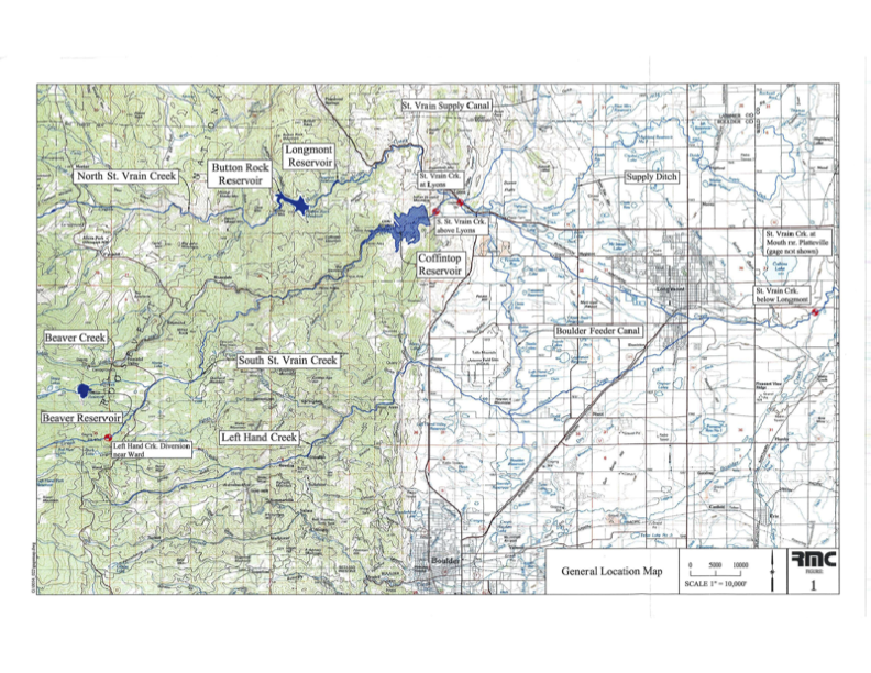
The St. Vrain and Left Hand Water Conservancy District has reached an agreement with Save the World’s Rivers that reaffirms a new path forward for its Coffintop Reservoir water rights—one that does not include construction of a large on-river dam.
The District was created in 1971, in part, to build Coffintop Reservoir on South St. Vrain Creek west of Longmont and upstream of Lyons, through a planned partnership with the U.S. Bureau of Reclamation. While the reservoir itself was never built, two water storage rights associated with the Coffintop Reservoir project remain legally valid today.
As a governmental entity, the District holds the Coffintop Reservoir water rights not for its own benefit but for the community’s. In 2024, as required under Colorado water law, the District filed a routine six-year diligence application in water court to maintain those rights. The filing prompted an environmental group, Save the World’s Rivers, to submit a statement of opposition, opening discussions between the two organizations about the future use of the Coffintop water rights.
“The Water Court process is complex, and at the onset we were uncertain what Save the World’s Rivers hoped to achieve through it,” said Sean Cronin, the District’s Executive Director.
“We are always watching proponents of dams,” said Gary Wockner, Executive Director of Save the World’s Rivers. “At the appropriate time, we seek to identify ways proponents can achieve their mission while not creating a new dam. We were generally aware of the good work being done by the District, but concerned about their plan to build Coffintop Reservoir and dam.”
Through dialogue, the District and Save the World’s Rivers found common ground. Cronin noted, “I met with Gary several times, and I gained respect for his organization’s objectives, and I appreciated his willingness to come to the table and talk through complicated issues.” Save the World’s Rivers learned that the District had been working for more than 10 years with the City of Longmont, Town of Lyons, Boulder County Parks and Open Space, local environmental organizations, and food producers to develop a strategy to best utilize the Coffintop Reservoir water rights – without building the actual reservoir.
The District and Save the World’s Rivers reached an agreement through the court process, under which the District agreed to forgo using the Coffintop Reservoir water rights for any new on-river reservoir, including Coffintop Reservoir, and for the expansion of any existing on-river reservoir. Instead, the District will return to water court with plans to use the water rights at alternative locations and in ways that align with community needs, and environmental and water management goals.
“It became clear through discussions that the District shared values around avoiding a new on-river dam while still meeting its mission,” said Wockner. “That made an agreement possible,” Wockner said.
District leaders emphasized that the water rights are held for public benefit and that the original Coffintop Reservoir concept no longer reflects the highest and best use of the resource.
“This is something we and our communities have contemplated for decades,” said Christopher Smith, President of the District’s Board of Directors. “The Coffintop project, as envisioned more than 50 years ago, no longer fits today’s needs or values.”
For more than a decade, the District has worked with community partners to explore alternatives that could use the Coffintop water rights, while also supporting increased stream flows during low-flow periods. The District’s development and implementation of these alternatives is moving forward with engagement from important partners, including the Town of Lyons and City of Longmont.
Town of Lyons Mayor Hollie Rogan welcomed the agreement. “St. Vrain Creek is the lifeblood of our town, and a large dam upstream was never embraced by our community,” she said. “We’re pleased the District will not pursue Coffintop Reservoir and look forward to continued collaboration.”
Longmont Director of Water and Waste Service Chris Huffer noted the long history between the City and the District. “The challenges around water have only grown more complex over the last 50 years,” he said. “The District has a solid water plan, and the City is an eager partner in realizing the greatest potential of these water rights.”

Click the link to read the assessment on the Western Water Assessment website:
May 13, 2026 – CO, UT, WY
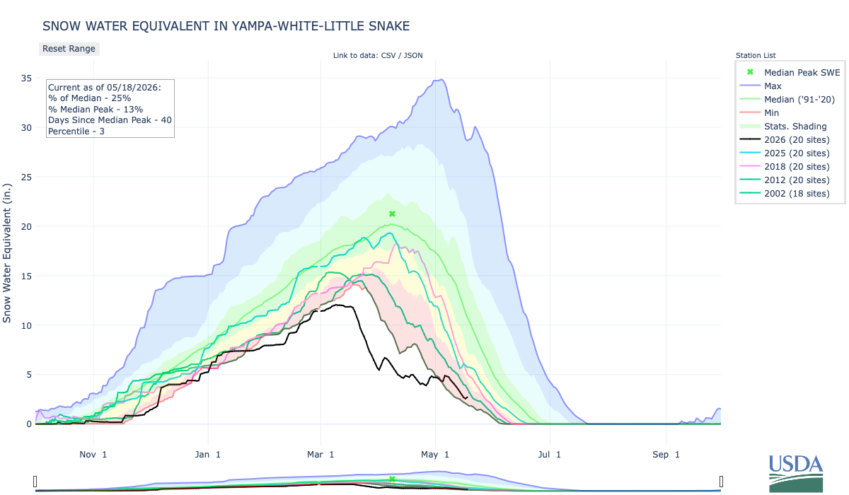
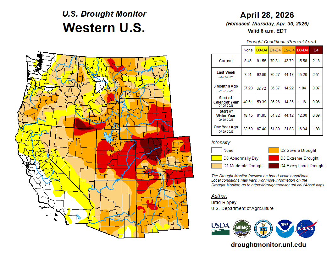
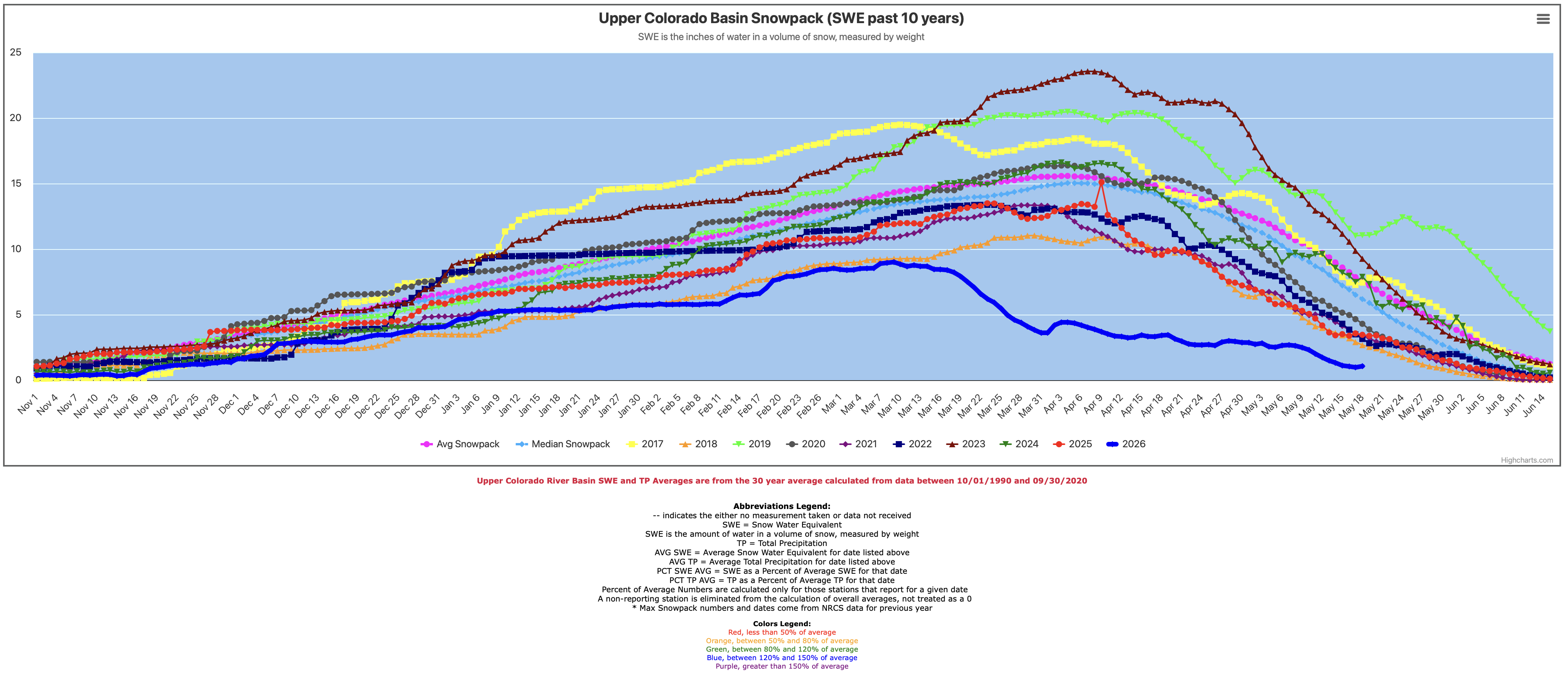
The region generally experienced drier conditions east of the Continental Divide, and wetter conditions west of the Divide in April. Temperatures were near to above average for most of the region. As of May 1, statewide percent median SWE was 18% in Colorado, 22% in Utah, and 44% in Wyoming. Regional streamflow volume forecasts are below to much below average, with 13% of average inflow forecasted for Lake Powell. Drought conditions cover 99% of the region as of April 28. ENSO forecasts predict an 88% chance of El Niño conditions developing during May-July and continuing through the end of 2026.
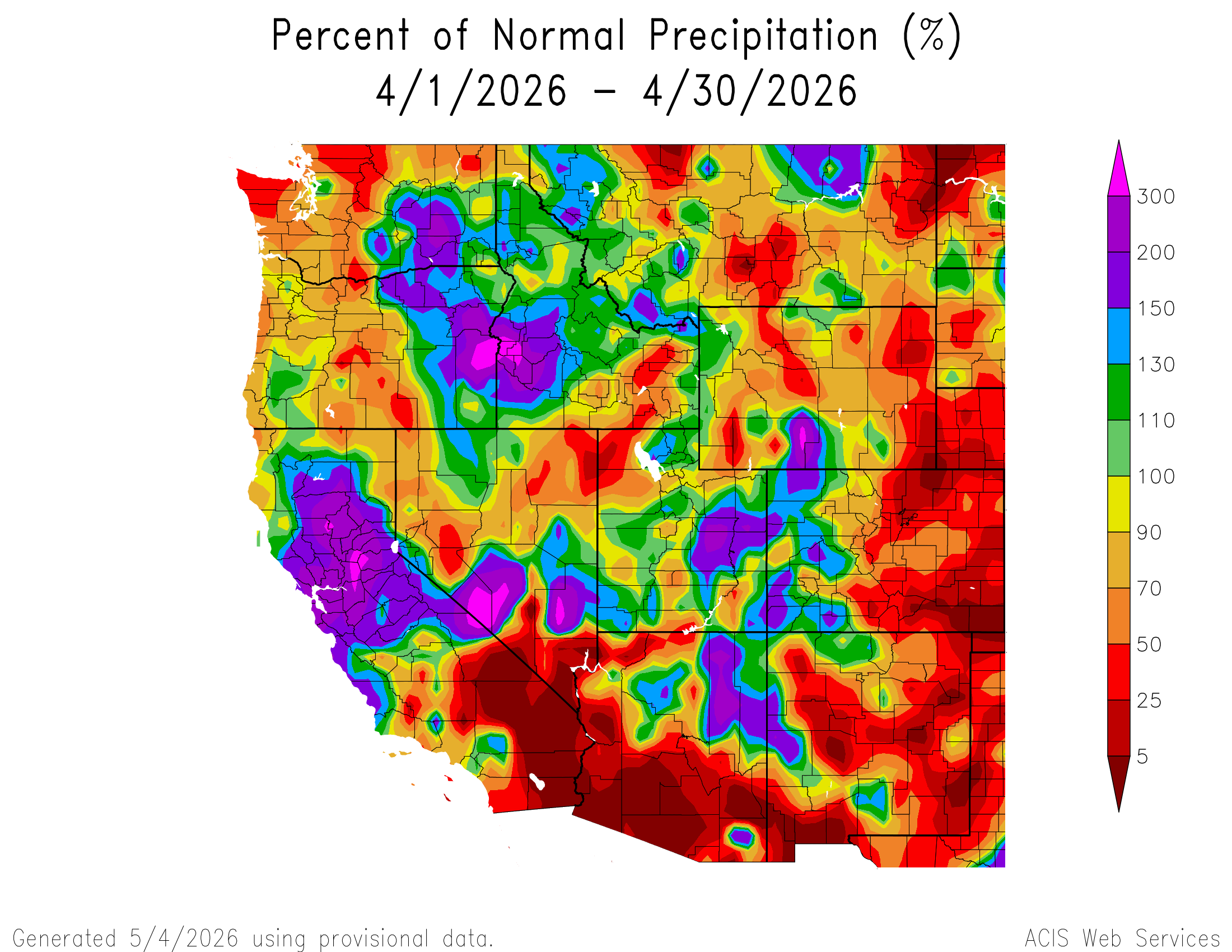
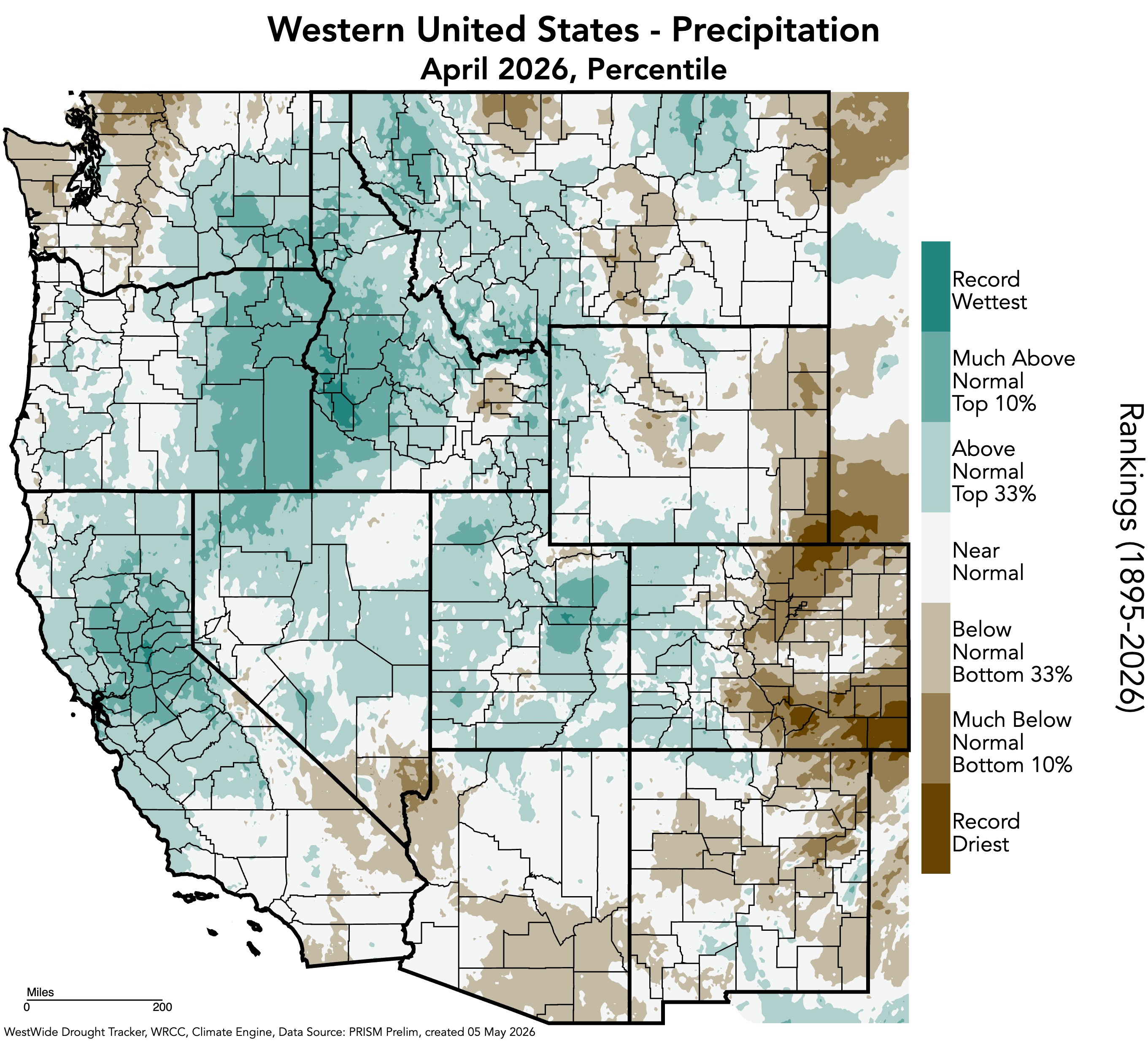
Regional precipitation was variable in April, ranging from below average conditions in eastern Colorado and much of Wyoming to above average conditions in western Colorado, much of Utah, and south-central Wyoming. Much below average April precipitation occurred in eastern Colorado, northwestern Utah, and eastern and western Wyoming, with large pockets of less than 25% of average conditions in southeastern Colorado and southeastern Wyoming into northeastern Colorado. Record-dry conditions occurred in southeastern and northeastern Colorado, and southeastern Wyoming. Record-wet conditions occurred in Carbon County, Utah.
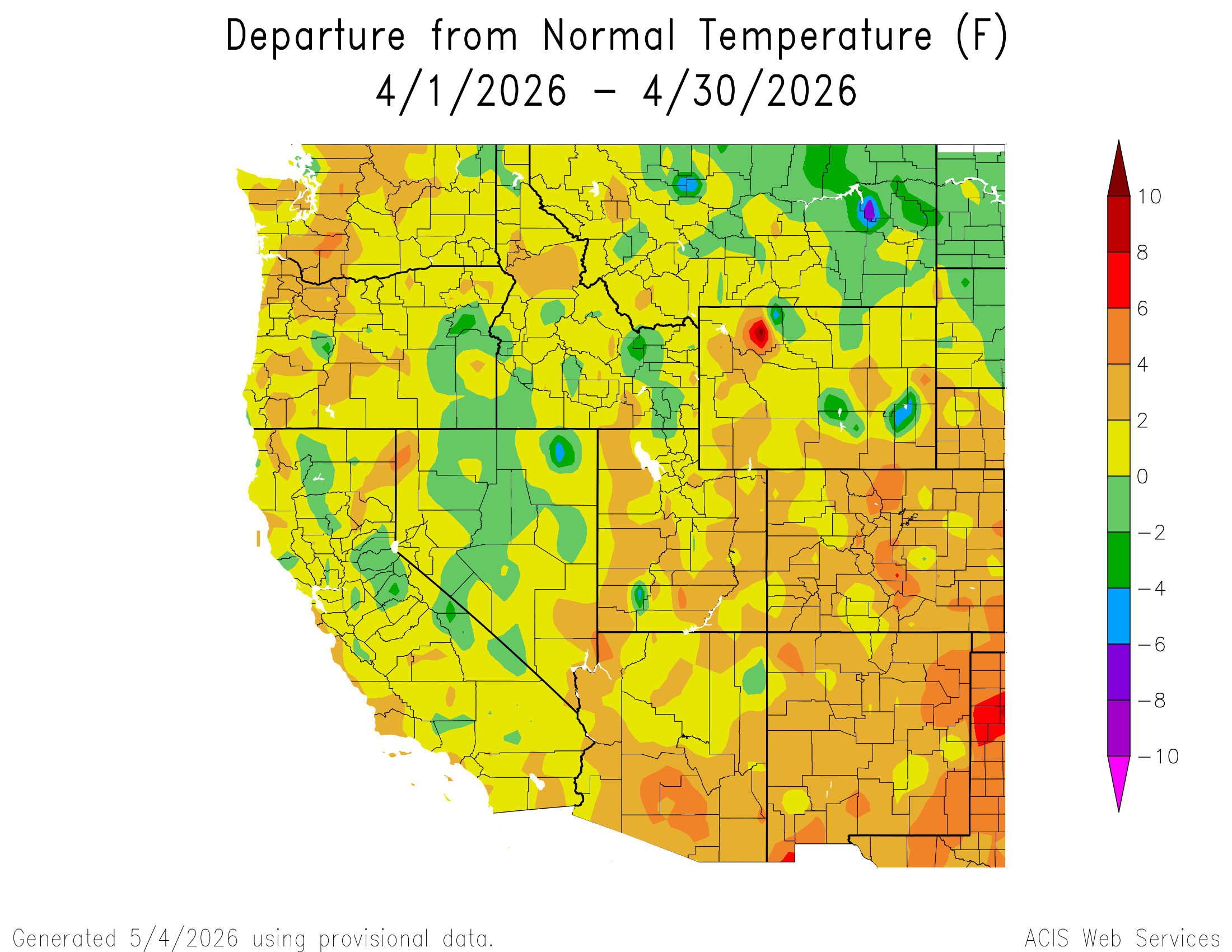
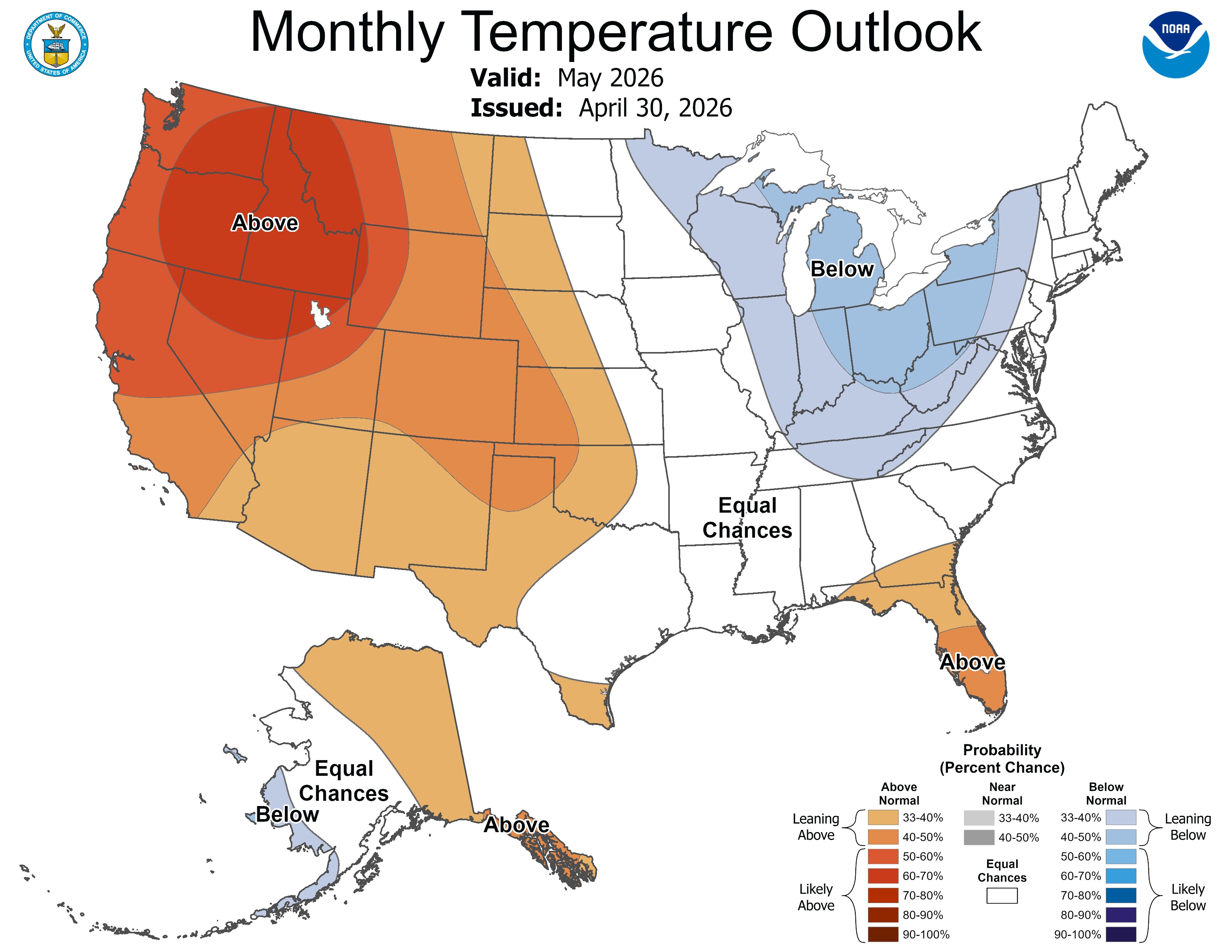
Regional temperatures were near to above average in April. Much of Colorado, Utah, and southern and western Wyoming experienced 2-4°F above average temperatures, with pockets of 4-6°F above average temperatures along the northern and southern Front Range of Colorado, and in eastern Colorado. A few pockets of 2 to 4°F below average temperatures occurred in northwestern and southeastern Wyoming, and one pocket in southwestern Utah, and one area of 4 to 6°F below average temperatures occurred in Platte County, Wyoming.

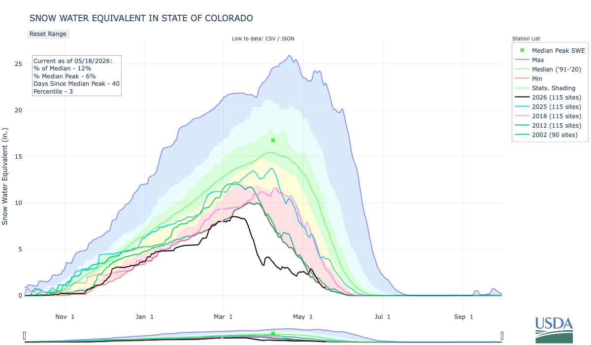
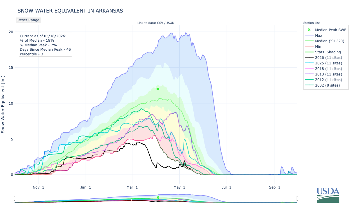
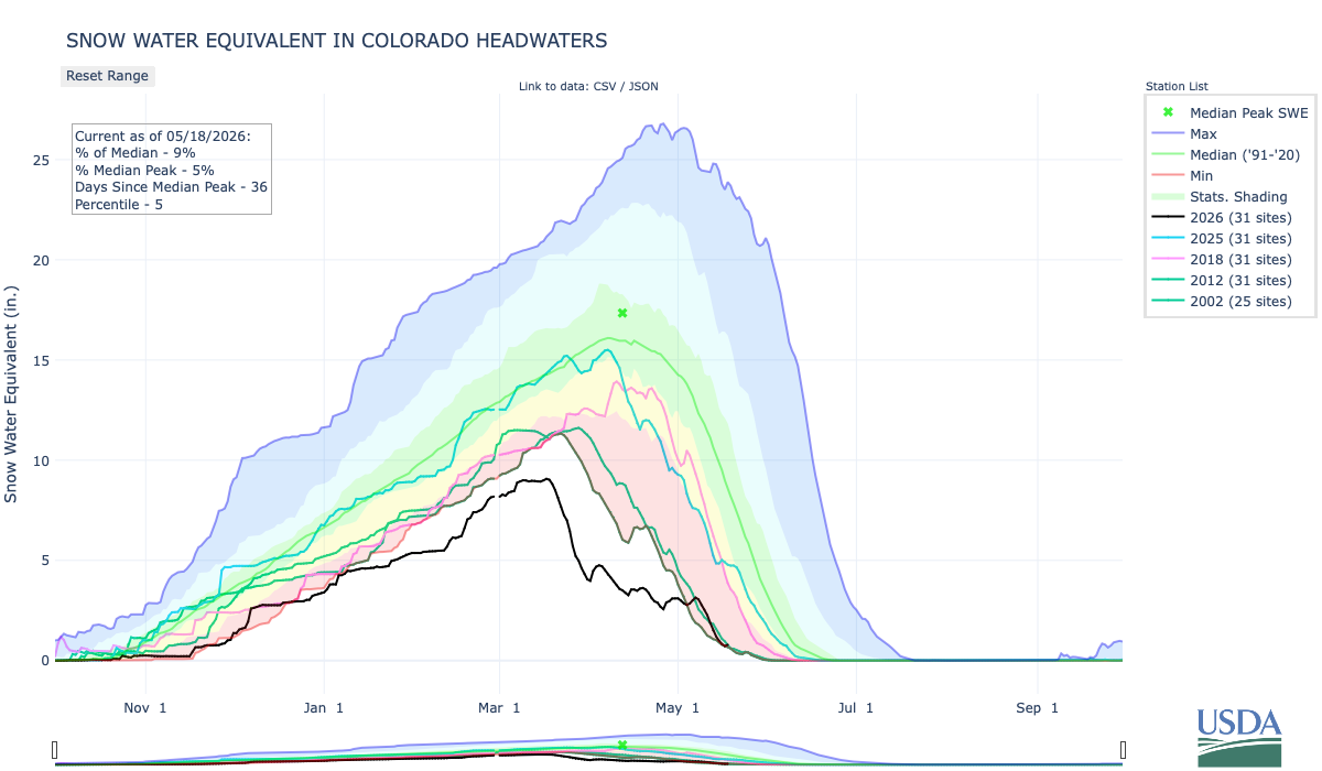
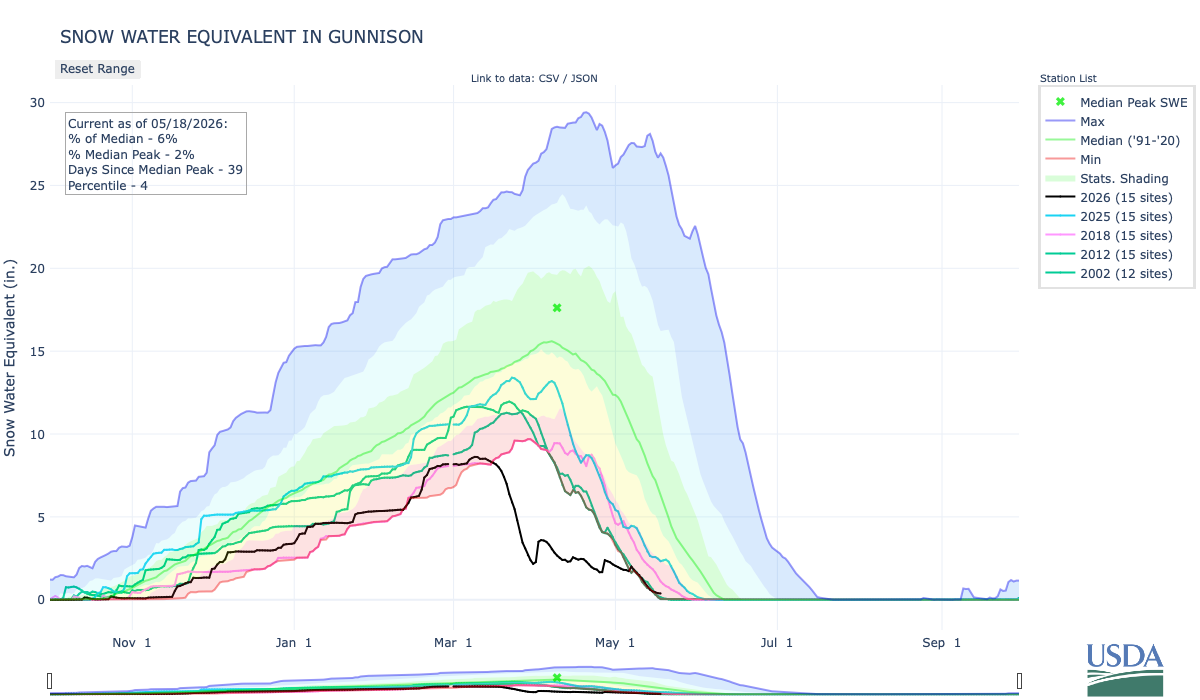
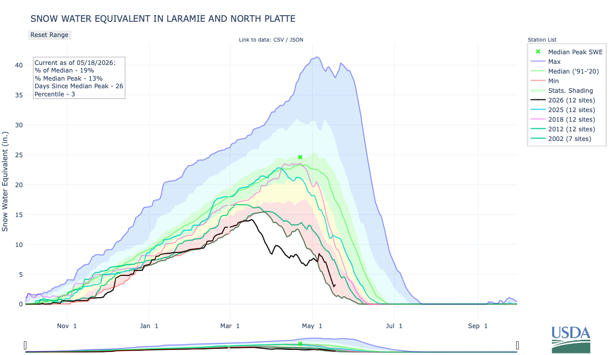
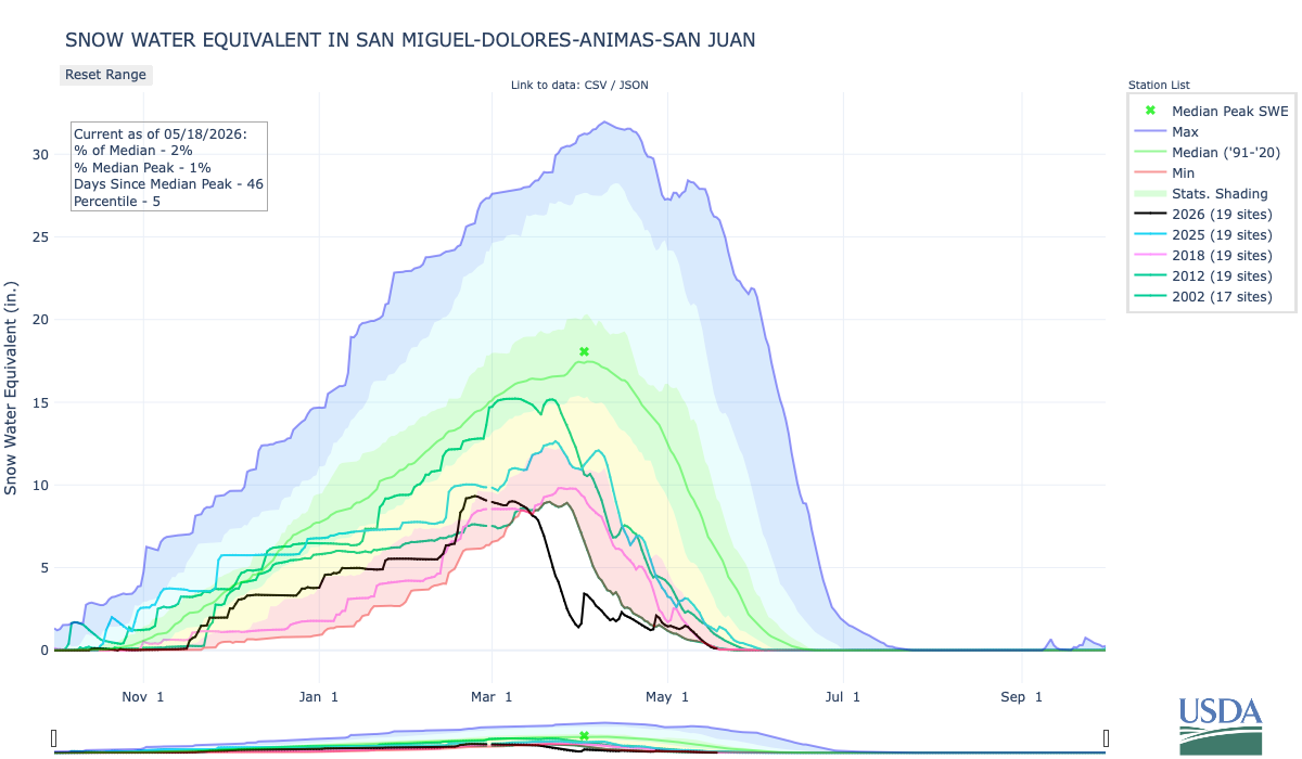
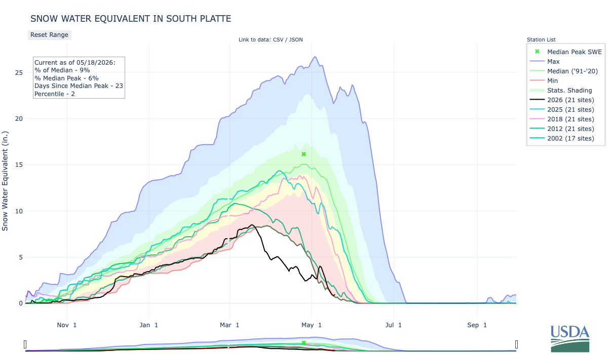
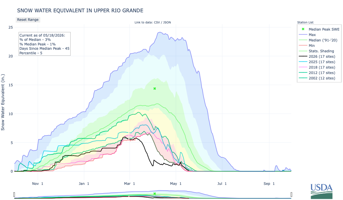
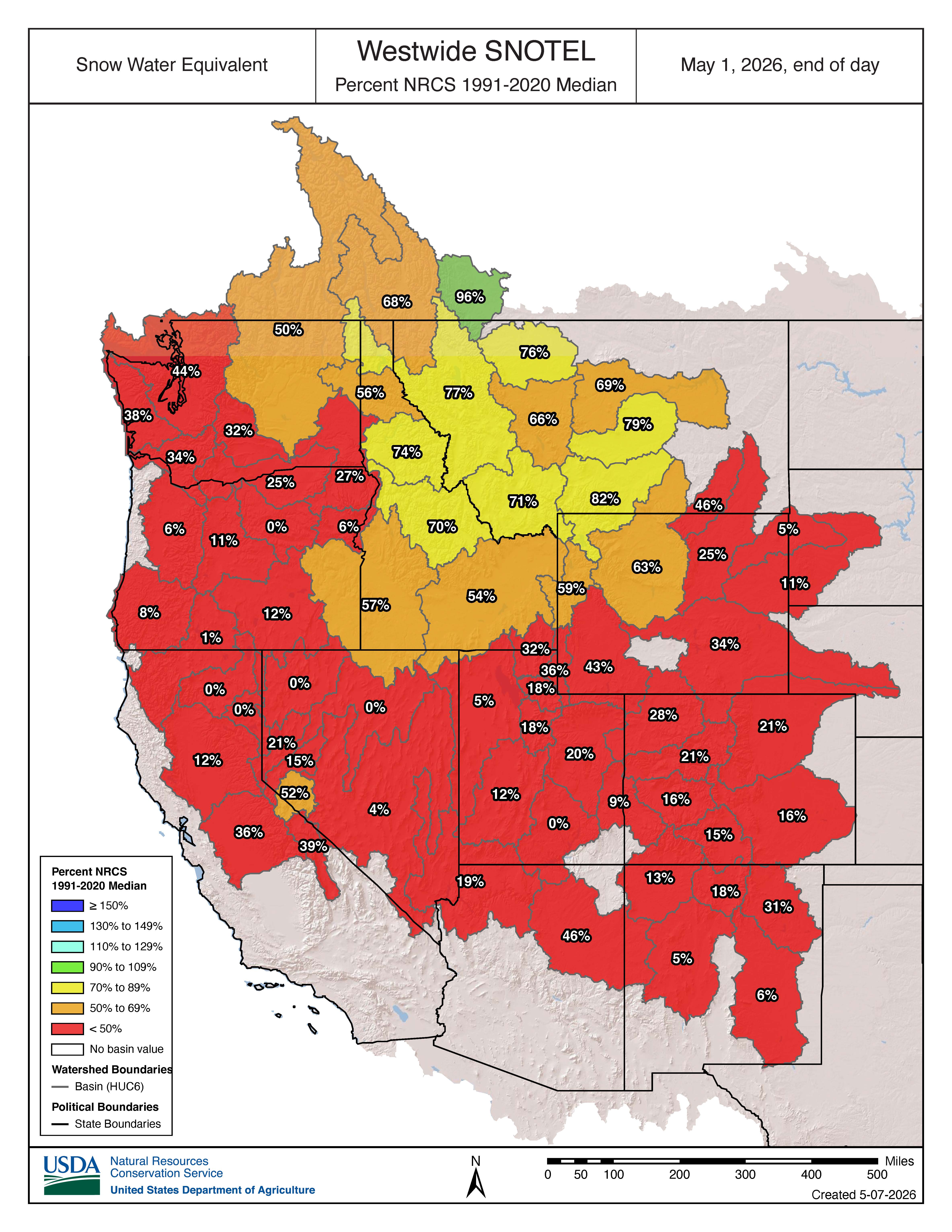
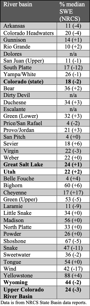
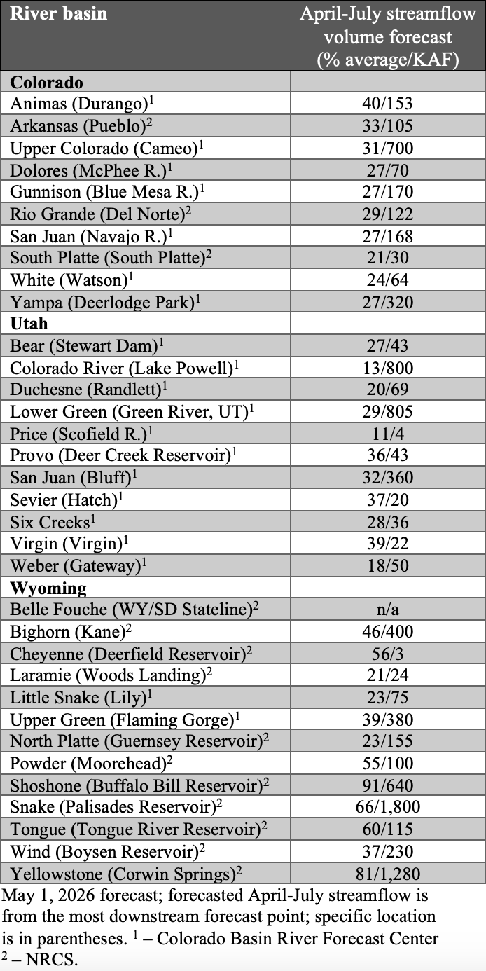
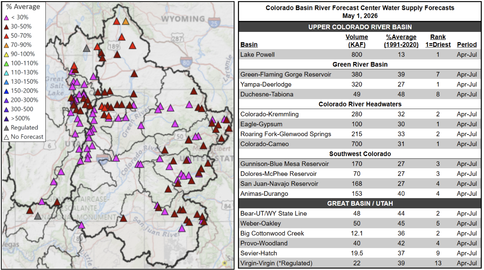
Below to much below normal snow-water equivalent (SWE) continues throughout the region as of May 1. All river basins in Colorado, Utah, and eastern Wyoming observed 50% or less of normal SWE. The only river basins with above 50% of normal SWE were in western Wyoming, including the Yellowstone (88%), Shoshone (67%), Big Horn (60%), Madison (56%), Tongue (54%), and Upper Green (53%) River Basins. The Dolores River Basin in Colorado and the Dirty Devil and Escalante River Basins in Utah have melted out as of May 1. As of May 1, statewide percent median SWE was 18% in Colorado, 22% in Utah, and 44% in Wyoming. Peak SWE was observed on March 12 for Colorado (51% of median peak), March 9 for Utah (52% of median peak), and March 17 for Wyoming (69% of median peak)
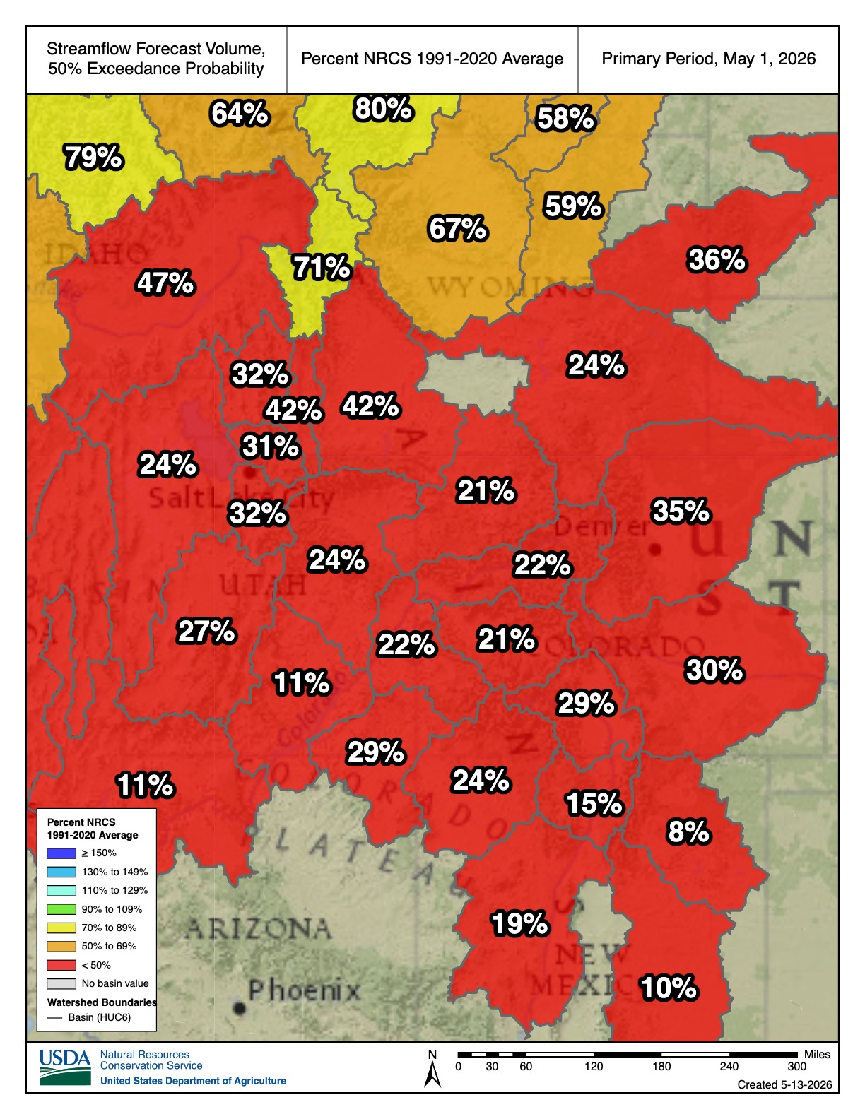
Seasonal streamflow volume forecasts for all river basins in the region are below to much below average. In Colorado, seasonal streamflow volume forecasts suggest 20-40% of average runoff for all major river basins. In Utah, seasonal streamflow volume forecasts suggest 10-40% of average runoff for all major river basins. In Wyoming, streamflow forecasts were more variable, with a near average forecast for the Shoshone River Basin (91%), below average forecasts for the Yellowstone (81%), Snake (66%), Tongue (60%), Cheyenne (56%), and Powder (55%) River Basins, and forecasts below 50% of average in the remaining major river basins. Much below average inflow is forecasted for many regional reservoirs, including Flaming Gorge (39%), Boysen (37%), Deer Creek (36%), Navajo (27%), McPhee (27%), Blue Mesa (27%), Guernsey (23%), and Lake Powell (13%).

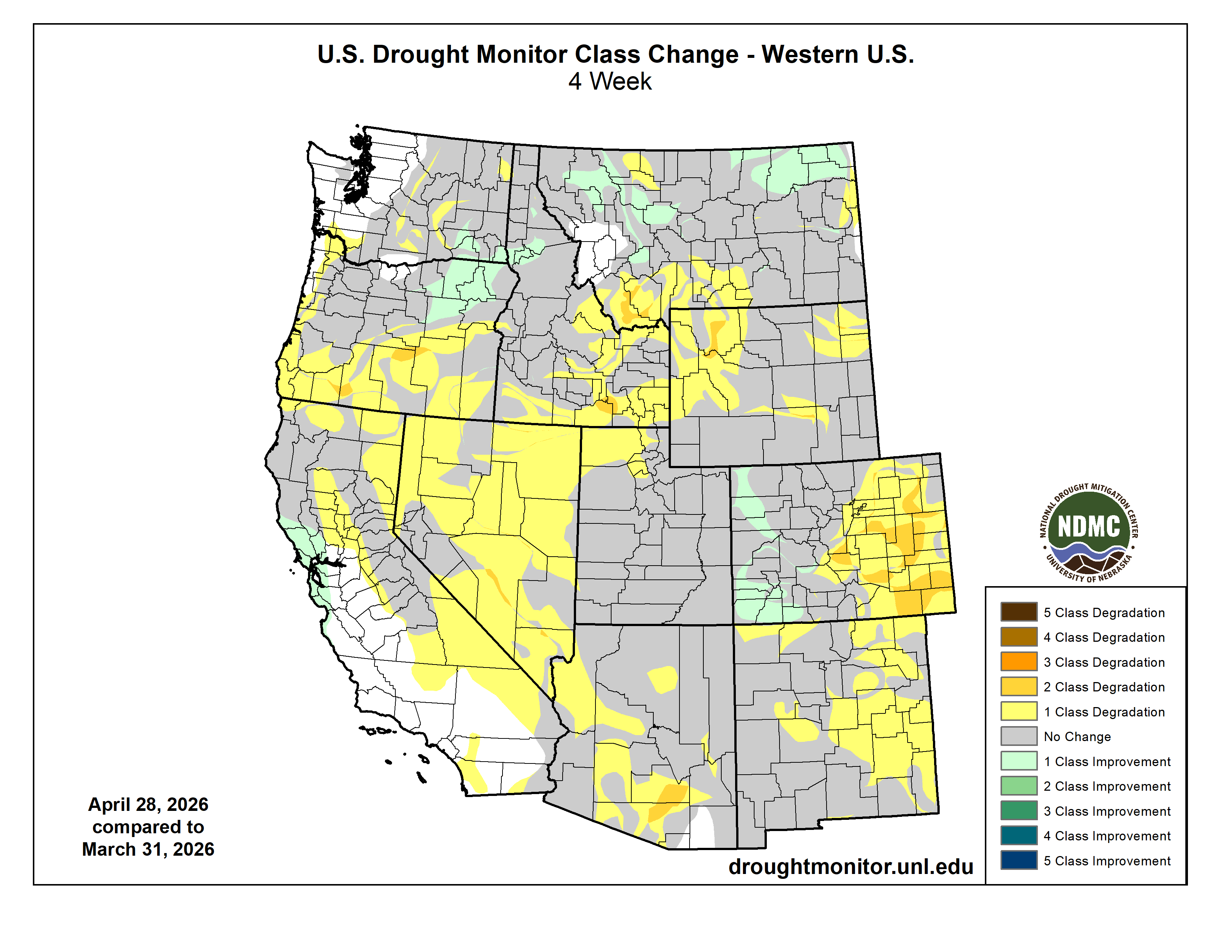
Regional drought coverage increased during April and covered 99% of the region by April 28 (drought covered 93% of the region on March 31). Drought conditions deteriorated in Colorado, where moderate (D1) drought now covers the entire state, severe (D2) drought coverage increased by 25%, and extreme (D3) drought coverage increased by 10%. In Utah, D1 drought still covers the entire state, and D2 drought coverage increased by 10%. In Wyoming, D1 drought coverage increased by 6%, D2 drought coverage increased by 17%, and D3 drought coverage increased by 5%. Exceptional (D4) drought coverage decreased by 4% in the West Slope of Colorado.
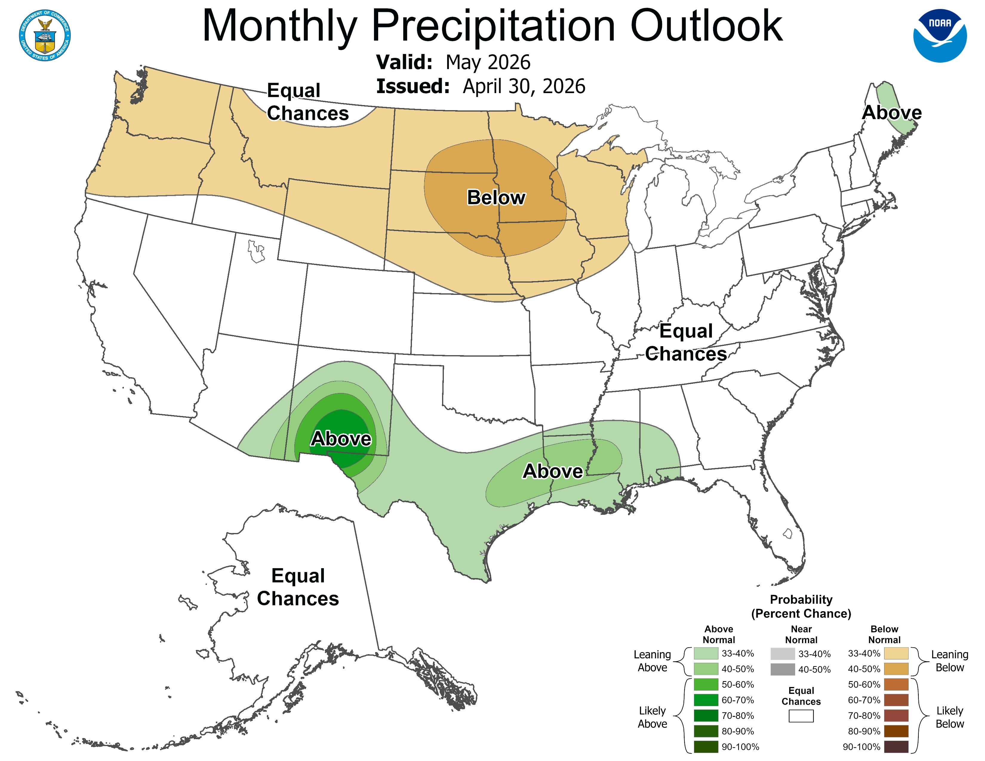
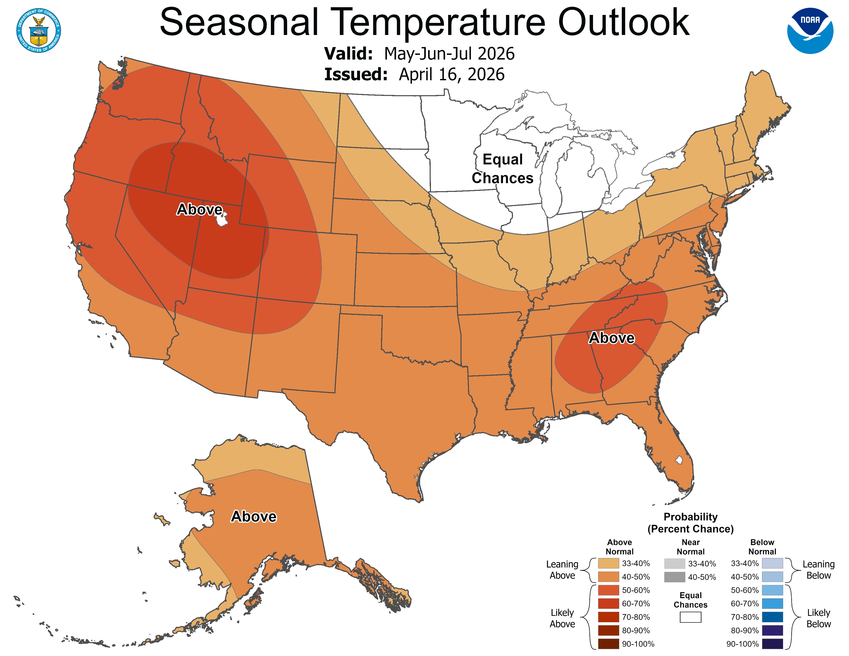
As of mid-April, the equatorial Pacific Ocean was in an ENSO-neutral state but is rapidly transitioning toward El Niño. ENSO forecasts predict an 88% chance of El Niño conditions developing during May-July and continuing through the end of 2026. NOAA monthly forecasts for May suggest an increased probability for below average precipitation in Wyoming and above average temperatures for the entire region, particularly in northern Utah and western Wyoming. NOAA seasonal forecasts for May-July suggest an increased probability for below average precipitation in Wyoming, northern Utah, and northern Colorado, and above average precipitation in southern Colorado. Above average temperatures are forecasted throughout the region, particularly in Utah and southwestern Wyoming.


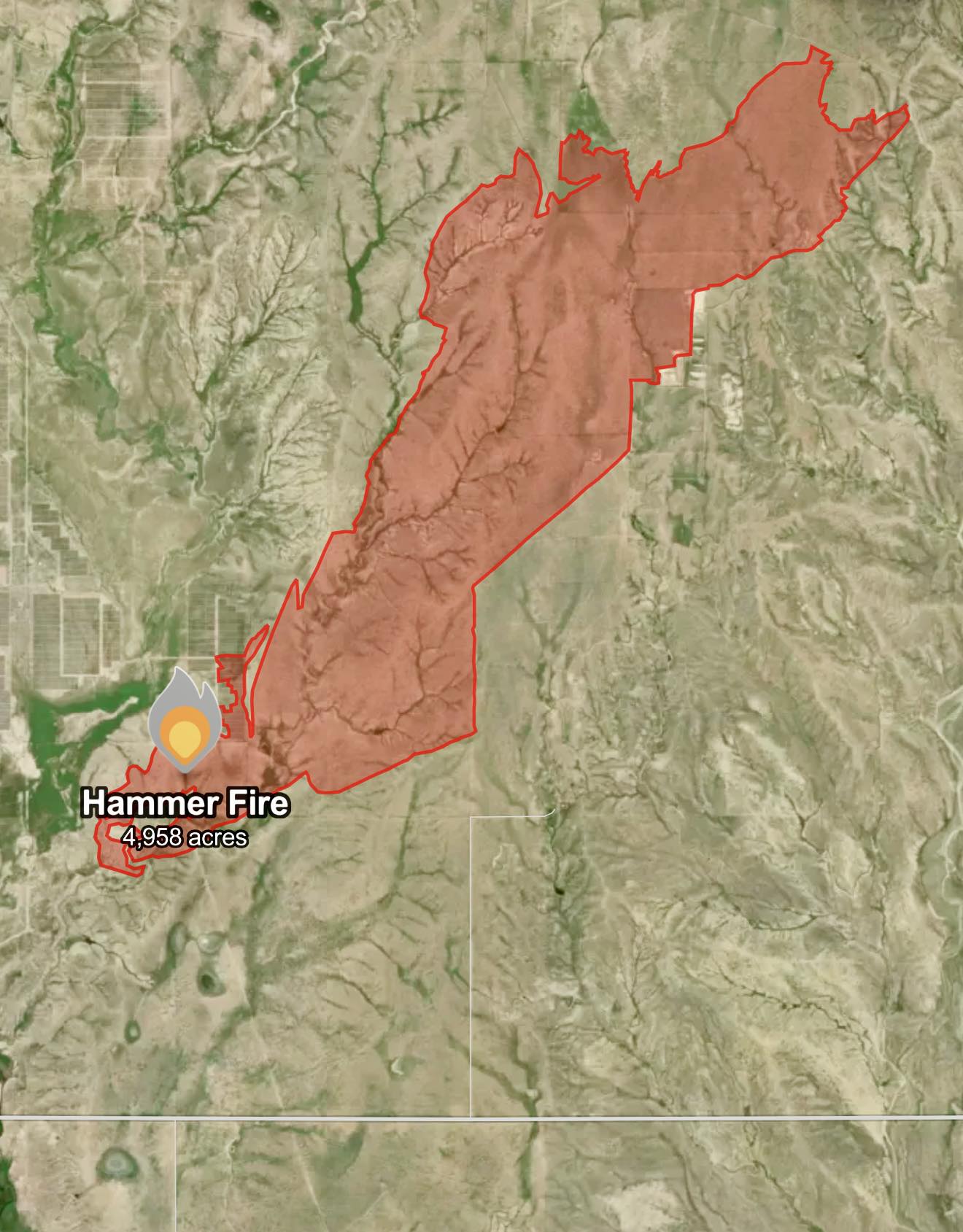
Significant weather event: Hammer Fire. The Hammer Fire started on April 22 in El Paso County near the community of Hanover, Colorado, southeast of Colorado Springs. There were extreme fire conditions on April 22, with strong winds and very low humidity, causing the fire to grow quickly. Mandatory evacuations were issued for nearby residents, and schools were closed in Hanover School District 28. The fire started in the afternoon and rapidly grew from 200 acres to over 4,000 acres within hours due to the strong wind gusts that day. The wildfire was contained on April 24 and burned approximately 4,958 acres, making it the second-largest wildfire in Colorado in 2026, only behind the 24 Fire that burned 7,404 acres from March 18-April 2 southwest of Colorado Springs.
Click the link to read the article on the Aspen Public Radio website (Caroline Llanes). Here’s an excerpt:
May 20, 2026
Reclamation announced on April 17 that it would release between 600-thousand and one million acre feet of water from Flaming Gorge Reservoir on the Wyoming-Utah state line over the course of the next year. In addition, Reclamation will reduce the amount of water it sends from Lake Powell through Glen Canyon Dam, decreasing flows downstream through the Grand Canyon and into Lake Mead. Through September 2026, the agency will reduce its annual release volume from about 7.5 million acre feet of water to just 6 million acre feet.
The drought contingency actions come in response to a water year that has been incredibly dire for the Western United States and the Colorado River Basin. Snowpack has been at record lows for much of the winter, which is bad news for a region that relies on snowmelt for much of its water use. The forecast for runoff into Lake Powell from the entire Upper Basin is forecast to be just 23% of normal. The agency estimates that these combined actions will boost Lake Powell’s elevation by 54 feet over the course of the year, bringing it to 3,500 feet in April 2027. Currently, Lake Powell’s elevation is about 3,528 feet. 3,490 feet is the elevation at which hydropower can no longer be produced at Glen Canyon Dam. Any lower, and water will not be able to enter the hydroelectric turbines. Instead, the water has to go through what’s called “river outlet works,” which are tunnels that bypass the turbines to get the water downstream to the Colorado River. Seth Arens, a hydrologist at the Western Water Assessment, said Glen Canyon Dam was not designed to have the river outlet works as the primary way to get water out of the reservoir.
