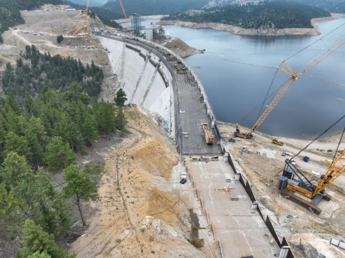
Green Mountain Reservoir is owned by the U.S. Bureau of Reclamation and located in Summit County north of Silverthorne along the Blue River. Photo credit: Denver Water.
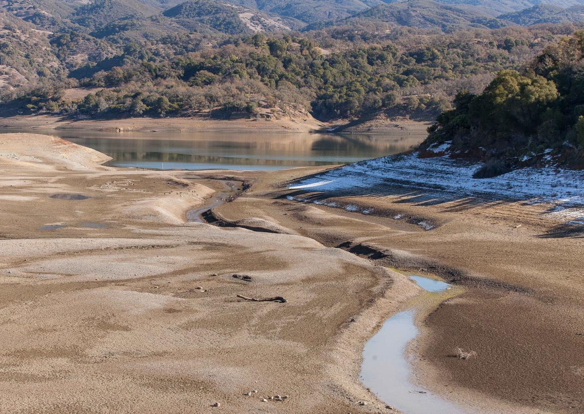
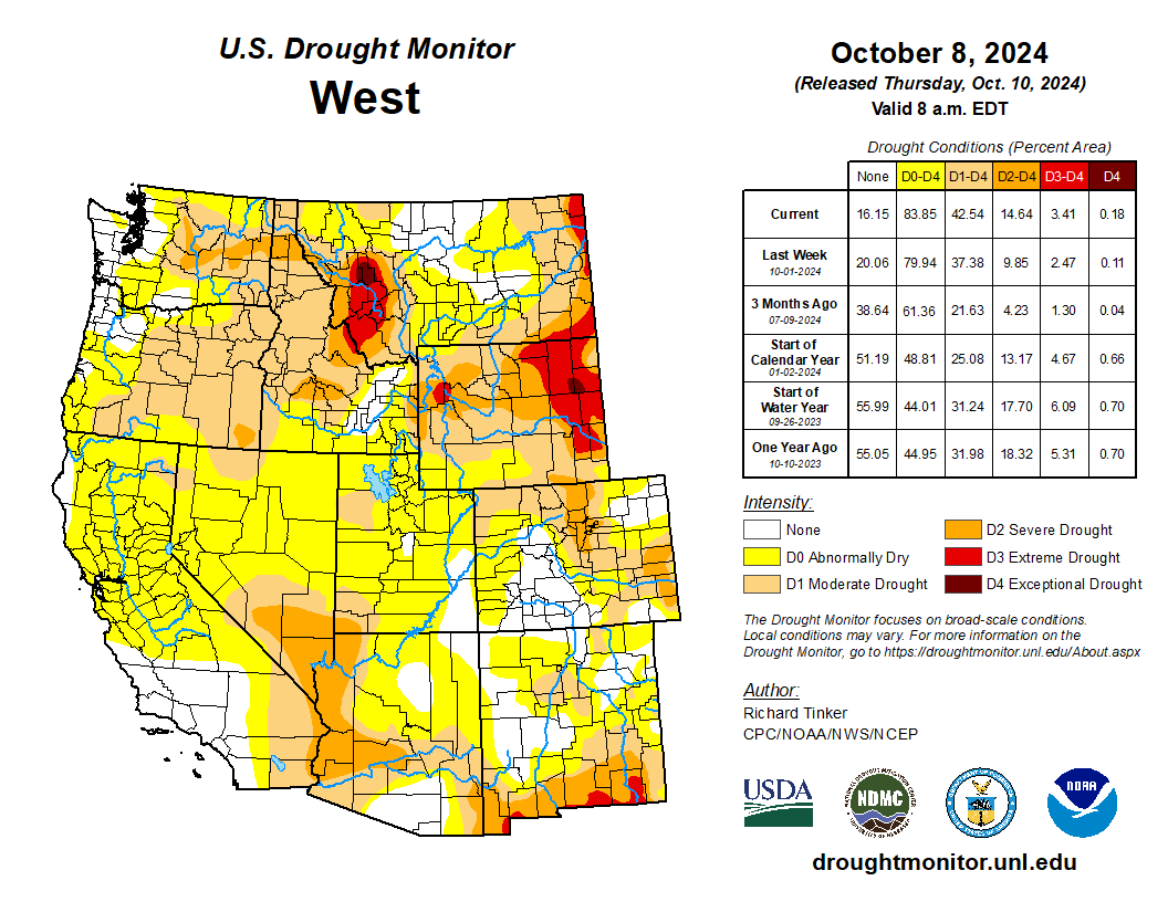
Historic water shortages are drying out the scenic mountains that lie at the heart of Colorado’s tourist economy, prompting the state to issue emergency orders earlier this month allowing water to be shifted to the towns and ranches most likely to run dry.
The Colorado River District, which represents 15 Western Slope counties, is running the emergency response effort and with financial support from the Colorado Water Conservation Board has anted up nearly $1 million to make sure even towns that can’t afford it, will have access to drinking water should it be needed.
To make the plan work, the river district opted not to lease portions of the water it normally holds in two high country reservoirs, Ruedi in the Roaring Fork Basin and Wolford Mountain, near Kremmling, on a first-come, first-served basis, as it normally does. Instead, the water is being doled out based on community need, with people and food production getting the water first, according to Andy Mueller, manager of the river district.
“We had a number of requests to lease that water out, but a lot of it would have gone to wealthy gentlemen rancher … but it wouldn’t have been for the common good,” he said.
Under Colorado law, water can only be diverted, stored and used for a designated purpose, such as city drinking water, farm irrigation, environmental streamflows, and industrial uses. Water rights are also tied to seasons, with some available only in the winter or summer.
But this spring, the river district, seeking more flexibility than the laws typically allow, went to Colorado State Engineer Jason Ullmann and asked for emergency authorization to use its water supplies differently. The state agreed, giving the district until the end of August to conduct emergency releases.
At the same time, large agricultural water users in the Grand Valley agreed to cut their water use in an effort to lessen strain on the Colorado River, and protect some of the small towns and ranchers who would have been cut off otherwise.
At issue is a special pool of water that lies within Green Mountain Reservoir, near Heeney, known as the historic users pool, or the HUP. The water is meant as a backup source that allows towns to pump wells and divert from streams even when their water rights are not in priority on the giant mainstem of the Colorado River.
But this year, because of the drought, Green Mountain’s HUP isn’t projected to fill, something that hasn’t occurred since the 1960s when the pool was created to protect mountain water users who had junior water rights, according to Ullmann. The emergency order means that even without the backup from Green Mountain, these communities and ranches will be unlikely to have their water supplies cut off.
The Eagle River Water and Sanitation District, which serves Vail and other small towns in Eagle County, has water in the HUP.
Working in the shadow of a nearly snowless winter, the Eagle River District moved early to enact watering restrictions, limiting outdoor use to just two days a week back in April, after March saw temperatures soar to 80 degrees and the patchy snow cover evaporate months earlier than normal.
“The writing was on the wall,” said Siri Roman, CEO of the Eagle River Water and Sanitation District. “This is a benefit of being in the headwaters and being a resort,” she said referring to the headwaters of the Colorado River. “Our whole community is so connected to snowpack and snow-water equivalencies and what that means. By February we knew there wasn’t enough snow to change the picture for us. We wanted to get to the decision-makers early and say the red lights are flashing. We need to prepare for a water shortage this summer.”
Eagle residents took conservation messages seriously
In Eagle, Tom Gosiorowski, the utilities manager, was standing in Brush Creek shooting videos for the town’s Facebook page, letting its 10,000 water customers know that the stream was the community’s only source of water and it wasn’t looking good. Eagle also relies on the HUP for some of its backup supplies.
“We are really wholly dependent on the streamflow and the water that is in the creek. It’s different from the big Front Range utilities” that have reservoirs, he said.
The district is limiting outdoor water use to two days a week and is sharply limiting the filling of hot tubs and swimming pools. Gosiorowski said he expects golf courses to be restricted as well as the summer wears on.
“We could get to a point where they can only irrigate tees and greens on the golf course,” he said. “We’ve never had to reduce use, but this is so extreme that I think there will be some.”
Gosiorowski said the town was still working on worst-case scenario planning for the end of summer, when streams are normally at their driest. “It’s hard to know exactly what’s going to happen. We’ve never experienced a drought to this degree in recorded history.”
Aspen has also enacted two-day-a-week watering and is prohibiting the filling of pools and hot tubs.
Grand Lake, another community that could be impacted by the shortages at Green Mountain, is not showing signs of strain yet, though officials there are concerned about lake levels.
Grand Lake, the deepest natural lake in Colorado, is linked to two other reservoirs, Shadow Mountain and Lake Granby. All three are part of Northern Water’s Colorado-Big Thompson Project. The C-BT delivers water from the Colorado River to 1 million customers and hundreds of farms on the northern Front Range.
Mike Cassio is a citizen activist who tracks Grand Lake’s health and works with a coalition of community groups and water agencies to help manage the system. Cassio said he’s worried about late summer water levels falling.
“We know Mother Nature controls everything,” Cassio said. If levels in Lake Granby and Shadow Mountain fall too low, water quality will suffer and that “will be the biggest issue.”
Kathy Chandler-Henry sits on the river district’s board and is a former Eagle County commissioner. She said the brown hillsides and dusty streambeds are unnerving.
“Before it was never a question,” she said. “There was always snowfall, there was always water. … Nothing like this year, when it was 80 degrees in March in Vail.”
Back in the 1980s, she said she participated in some regional planning efforts to help the Western Slope learn how to manage its growth. That there could be a winter without snow was unthinkable, if not downright funny.
“One planning consultant in the workshop asked folks what it would be like without snow,” she said. “And everyone just laughed.”
Despite this summer’s deep dry spell, water users say they are encouraged by recent light rains and cool weather. Just weeks ago, the HUP was projected to barely fill at all, but now the 66,000 acre-foot pool is rising again. It recently topped 33,000 acre-feet and is expected to move higher, providing some relief.
But Mueller, of the river district, said this summer is a dress rehearsal for what lies ahead as climate change and warmer temperatures continue to hamper mountain snows and spring stream levels.
“We are just beginning to grapple with the impacts of climate change. Science indicates that 30 years from now, this year may be on the wetter side.”
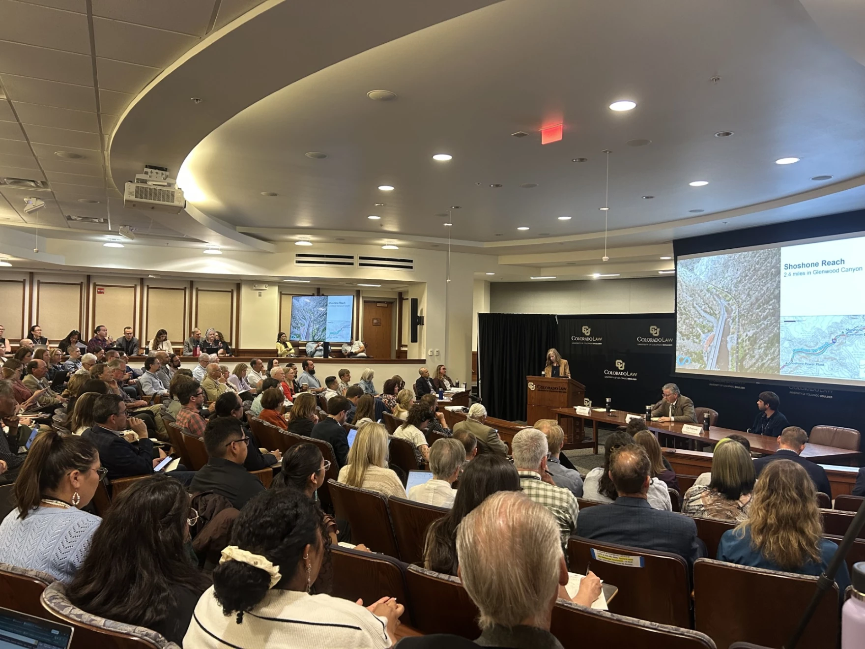
A large crowd listens to a presentation at the University of Colorado Boulder law school about securing powerful new water rights on Colorado’s West Slope to benefit the health of the Colorado River. Scott Franz/KUNC
June 5, 2026
This story is part of ongoing coverage of the Colorado River, produced by KUNC in Colorado and supported by the Walton Family Foundation. KUNC is solely responsible for its editorial coverage.
Water negotiators, river enthusiasts, Native tribes and lots of lawyers convened at the University of Colorado Law School on Thursday to take stock of the future of the dwindling Colorado River.
Here are five things KUNC’s water and environment reporter learned on the first day of the gathering.
There’s a thirst for treating the river as more than something to be consumed, and monetized and stretched out
Dale Sinquah, a tribal council member for Arizona’s Hopi tribe, is among a growing number of people who view the Colorado as a living being that should have the same rights as a person.
“If you look at it at that level and you allow it to, then it starts changing the ways in which you think about it, and maybe your actions,” he said.
Late last year, the Colorado River Indian Tribes of Arizona and California voted to give their namesake waterway the same legal rights as a person, saying the ‘living being’ deserves more protection while it’s being threatened by overuse and drought.
Sinquah said he had mixed reviews of the discussions at the water conference halfway through the first day.
“I’m kind of wondering if we’re stuck in that mode where you know personal interest (is winning) instead of how do we fix this as a whole, as a group,” he said. “It works better when you work together as a group.”
There’s still no finalized federal plan for the river yet, and the White House could have the final say…
Scott Cameron, the acting commissioner of the Bureau of Reclamation overseeing the operations of Lake Powell and Lake Mead, said the Interior Department is expecting to publish a short term operating plan for the reservoirs by “mid-summer.”
He said the plan would have to be renegotiated every two years and could be replaced at any time with one that the seven states can agree on.
“The good news is that the White House is very interested in what’s going on with the Colorado, so we’ll probably have to brief the White House on the (Secretary of the Interior’s) decision before it’s final,” Cameron said.
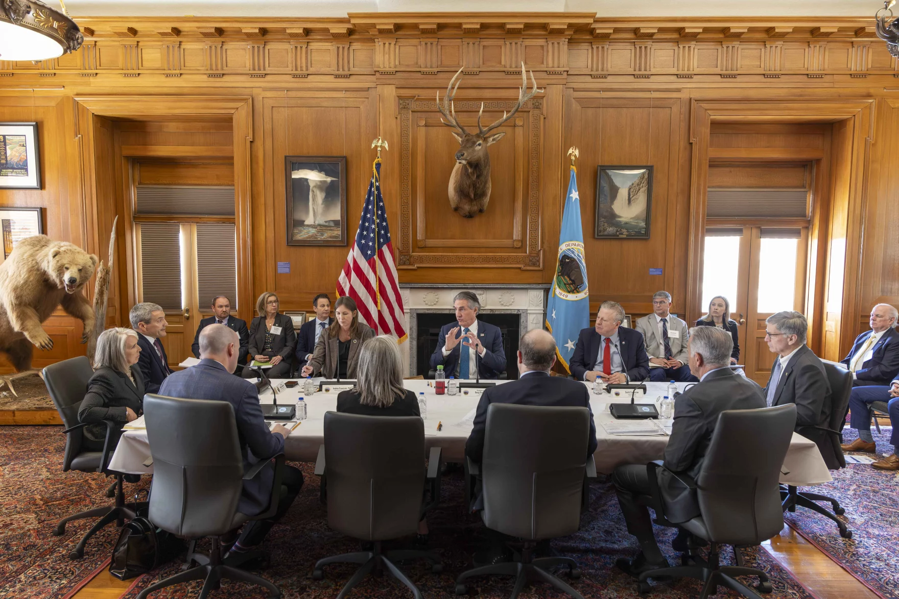
U.S. Interior Secretary Doug Burgum, center, speaks during a gathering with governors from six states in the Colorado River basin on Friday, Jan. 30, 2026. Photo credit: Lowell Whitman/Department Of Interior
River negotiations are ongoing, but details are scarce…
First governors from all seven states in the river basin were summoned to Washington, DC, ahead of the Feb. 14 deal deadline they missed.
Then, after that didn’t work, came the Microsoft Teams meeting.
Scott Cameron, the acting commissioner of the Bureau of Reclamation, said Interior Secretary Doug Burgum recently talked with the seven governors again on the virtual meeting platform.
“The fact that he is trying to wrangle his gubernatorial colleagues twice, I think, indicates how seriously Secretary Burgum takes what’s happening in the Colorado River,” Cameron said.
However, no deal has yet to materialize as the states remain at an impasse, and some in the upper basin have called for a different mediator to intervene.
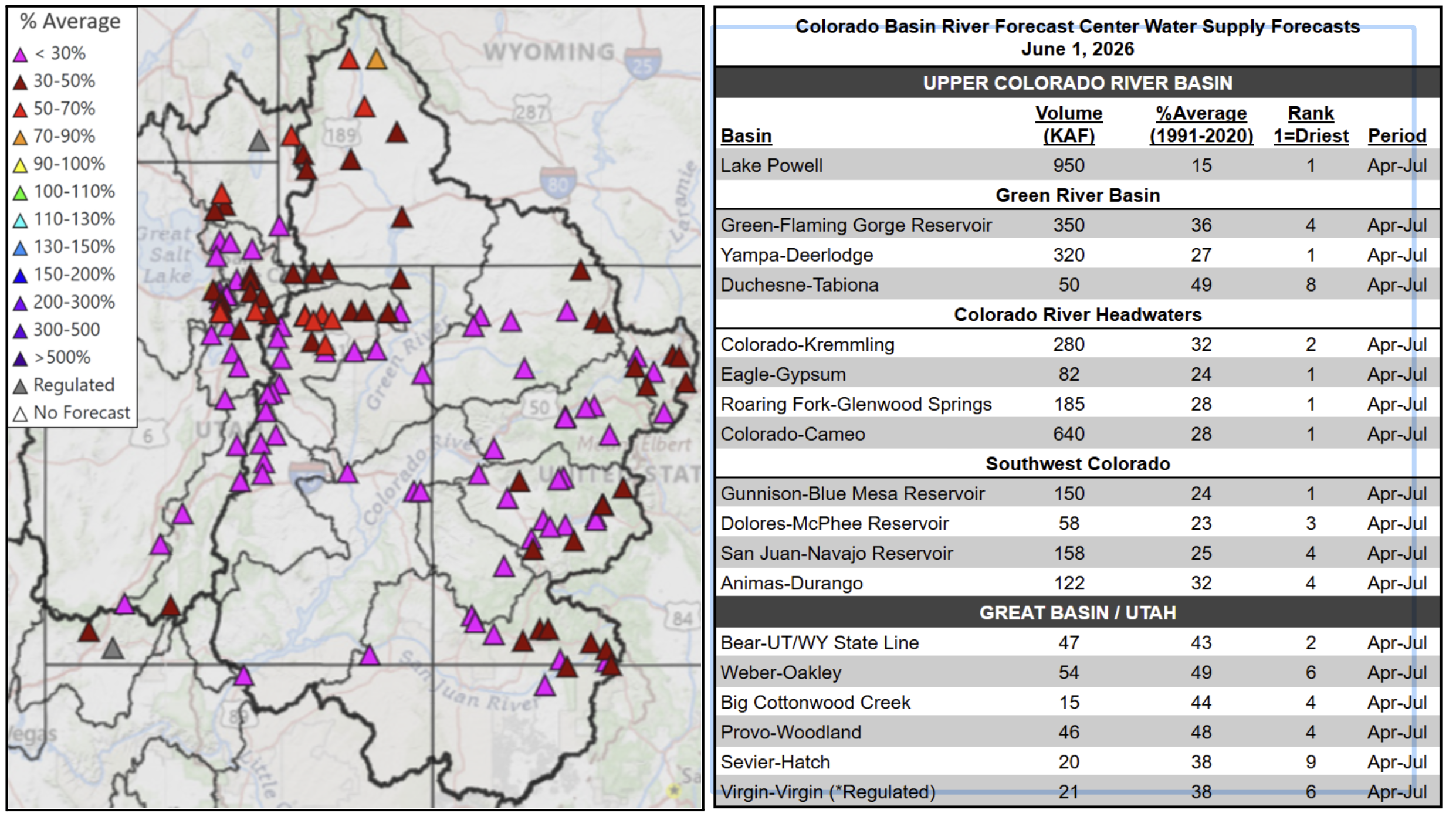
June 1, 2026 seasonal water supply forecast summary.
One thing is clear.
Forecasts for the river have gotten worse in recent months. And there was an acknowledgement that the status quo is not sustainable.
Graphic via Holly McClelland/High Country News.
Could the feds get more involved in the management of upper basin reservoirs like Flaming Gorge? The answer is murky…
The audience asked Cameron, the Bureau of Reclamation official, about his thinking on how Interior should manage four large reservoirs in the upper basin that are collectively known as the upper initial units (they include Flaming Gorge on the Wyoming-Utah border).
Flaming Gorge is currently being partially drained so water can be sent down to Lake Powell so it doesn’t get so low that it stops producing hydropower.
Cameron said the Interior Secretary could exert more control over the reservoirs in the future in the event of an “emergency.”
“And what an emergency is, I think, is probably in the eyes of the beholder,” he said. “Now, you put four or five lawyers in a room. You’ll probably get nine answers on how much discretion the secretary has or doesn’t have in the upper initial units.”
Parts of the lake that have only recently been uncovered are full of old beer cans and other relics of boating escapades, including sunken boats.
But deeper down, Podmore shared photos of Native artifacts that have survived decades of being submerged.
New ecosystems are also taking shape.
The Colorado River Basin spans seven U.S. states and part of Mexico. Lake Powell, upstream from the Grand Canyon, and Lake Mead, near Las Vegas, are the two principal reservoirs in the Colorado River water-supply system. (Bureau of Reclamation)
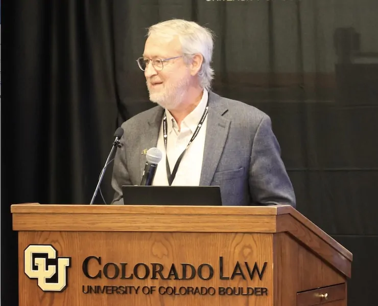
Doug Kenney at the Getches-Wilkinson Center 2026 Conference on the Colorado River June 5, 2026. Photo credit: Allen Best
Click the link to read the article on the Big Pivots website (Allen Best):
June 7, 2026
Doug Kenney, principal organizer of annual gathering in Boulder, talks about how the growing tensions among basin states pose challenges in setting the agenda
The Colorado River has always had a magnetic appeal to the public consciousness. John Wesley Powell and his crew were instant national heroes after they emerged from the Grand Canyon in 1869.
That interest continues to this day. Bathtub rings are an absorbing visual, an easy way to communicate declines in the two biggest reservoirs in the basin, Mead and Powell. The river is being hammered by a warming climate and archaic governance of the shared resource.
This provides much to chew on, and that discussion continued again on June 4-5 at the Colorado River Conference hosted by the Getches-Wilkinson Center at the University of Colorado Law School. Organizers reported 373 people were registered to attend in person and another 132 remotely, a record for both. This surpasses a record set last year.
Afterward, Big Pivots sat down with Doug Kenney, the principal organizer of the conference, to take stock of what had just transpired. He directs the Western Water Policy Program and chairs the Colorado River Research Group.
What year did this conference begin? What was the thinking that gave birth to it?
I believe 1983 was the first one. This was mostly a creation of Larry MacDonnell, (the first director of the Natural Resources Law Center, a position he held from 1983 to 1994).
Larry pursued a dual mandate of researching key issues but also of trying to involve the public and other constituencies. A conference was a natural thing to do. We are an educational institution.
I’ve done the last 30 or so of them, but Larry got it started,
It seems like two or three, maybe three years ago, the tribes became a major presence in attendance and on the agenda. How did this come about?
Mostly through our professional networks. We knew people who were associated with the (Colorado River Basin) Water and Tribes Initiative. They wanted to broaden their reach and their influence. At the same time, we’ve here always wanted to involve tribal interests in what we do, going back to the work of David Getches and Charles Wilkinson.
We decided we’d try co-hosting a conference. It’s a partnership, and like all partnerships, it grows over time. But it’s working pretty well, I think.
Am I wrong? Was I missing something? I didn’t notice much of tribal presence in the agenda or participation until just a few years ago.
We’d usually maybe have one tribal speaker sprinkled in the program somewhere, but it was pretty hit and miss, in part I think because you kind of need a critical mass of involvement from the tribal community for other tribes to feel like this is a place that they’d be taken seriously and that they’d be welcomed. It wasn’t a slow linear growth to where we’re at today. There was a pretty dramatic shift four or five years ago.
How new is the Water Tribal Initiative?
They’ve been around I think for about a decade. They’re co-managed by Matt McKinney, who wasn’t here, and Daryl Vigil.
Native America in the Colorado River Basin. Credit: USBR
It’s not a national thing, but the Colorado Basin has 30 different tribes. That’s a pretty big number of tribes to keep track of. It’s a network as much as it is anything, and every so often they try to get together. They consider this conference their big convening. They also get to get together at CRWUA (Colorado River Water Users Association, which holds an annual conference during December in Las Vegas).
They have also produced a few research reports. This week they talked about their report on tribal sovereignty. And they have particular initiatives within the Water and Tribes Initiative, such as universal access to clean water. They are pushing, mostly through federal legislation, to provide assurances that all tribes have access to clean water.
Do they have a strong benefactor?
I don’t think so, but they have a very broad base of funders and supporters. A lot of water agencies, a lot of people, and a lot of organizations that know tribes have been treated poorly and that tribes have legitimate interests in the basin but (know) that many tribes just don’t have the resources to do this without some assistance.
As I’ve attended most years since 2002, I have noticed some ebbs and flows. There were some empty seats this afternoon, but the seats were mostly occupied through the first day and a half, and that’s somewhat different than, say, 10 years ago. What explains the ebb and flow?
I attribute that mostly to two things: one is this partnership with the Water and Tribes Initiative. The other thing is the fact that we’re talking about the Colorado River, which by every measure is in a crisis. It’s easier to get people’s attention when you’re talking about a crisis than when you’re talking about something that’s still not that serious. That’s part of it.
We used to be in another building. This is clearly a better facility for audience and speakers alike. That helps us attract a larger audience. We’ve had good foundation support, good funders. It takes a lot of money to do this, but we’ve had funders that see value in it. That has allowed us to make this a bigger event.
The conference is always the first week of June, so when do you begin rough-drafting the agenda?
Usually January. In some years it’s easier than others. This year was the most difficult. It was the easiest year in terms of attracting an audience. The hardest year in terms of putting the program together.
Everyone’s mad at each other, and everyone is — I can’t tell you all the back stories. Becky Mitchell said something today about how it’s hard to negotiate and prepare for litigation at the same time. She’s right. And I was thinking to myself, it’s hard to bring people together to talk at a conference while acknowledging the fact that they’re all mad at each other, and some of them are about to sue each other, and some can’t be in the same room with each other because they’re that angry, and some will be deeply offended if someone else is there.
It’s one of these years that there’s just so many delicate issues and angry folks — and angry for legitimate reasons; I’m not discounting that. But it’s been a really challenging year.
Your answer anticipates my next question, but I’ll ask it nonetheless. If memory serves me, a few years ago you had representatives of all seven basin states at the same table. This year you had two. I guess it’s fair to say that agenda setting has become more politically sensitive.
Every year for the last four or five years we’ve given all seven principals, all seven states, an opportunity to sit at the same table and have a discussion. In every passing year it becomes more difficult to do that.
Commissioner to the Upper Colorado River Commission Becky Mitchell, center, speaks on a panel with representatives of each of the seven basin states at the annual Colorado River Water Users Association conference in Las Vegas Thursday, December 15, 2022. CREDIT: HEATHER SACKETT/ASPEN JOURNALISM
You have seen this at CRWUA as well. Some years they had to divide into two sessions, upper and lower basin sessions. For awhile we were thinking of just having a lower basin session. The lower basin folks were happy to do that, but the upper basin folks weren’t as comfortable. We (also) thought about a different part of the session or a different location.
Ultimately we came to the conclusion that everyone could agree if it would be a conversation, not a posturing or confrontational thing. (Having) one upper basin person and one lower basin person, that was a format that could work. That’s what we did (with Becky Mitchell from Colorado and John Entsminger of Nevada). Anything more elaborate than that I don’t think was viable this year. It’s a really delicate time.
In terms of conferences devoted to the Colorado River do you have rivals for what you’re doing? Are there other places in Arizona or California, for example, that are kind of like must-go sessions?
There are two must-attend Colorado River conferences each year, and this is one of them. CRWUA (in Las Vegas) is the other one.
We specifically try to be different than CRWUA. We’re the opposite end of the calendar, roughly six months away. CRWUA is in many respects much more of a social event. We try to be more academic and about policy, with serious talk about serious issues. CRWUA, just like us, ebbs and flows from year to year in terms of what it looks like. But we try to be a little more hard-hitting and less of a, you know, take-the-family-and-have-a-vacation sort of event. I don’t mean to sound like I’m negative on CRWUA. I think we’re the perfect compliment.
Aside from that, there are some meetings such as CLE, Continuing Legal Education. It always has a Colorado River event. This year was quite good. Many other years, it’s not as strong. For practicing attorneys, that’s something that they want to go to every year, because they can get some credits there.
Still another one in New Mexico that’s held each year kind of commemorates the signing of the compact.
How do you measure success? I’m sure you constantly ask that question of yourself.
You understand the challenge of it all. We can measure success by the size of the crowd and that they mostly seemed to have a good time. In that sense, that’s success.
The other side of that is that we’ve been focused just on the Colorado River issues for the last five or six of these, and things have only gotten worse on the river. Obviously, we don’t think we’re to blame for that. But clearly, there’s no great success story that we can lay credit to either.
So I think we’re successful in that we promote conversation and the exchange of ideas, and we shine a light on new and innovative ideas, and we give a voice to people who sometimes don’t have a voice. This is where the tribes come into play again.
Some elements I think are successful, but in the very big scope of things, the issues that we’ve been addressing in our conference aren’t getting any better. It does force me to think about (and question) whether there is a better way for us to make a difference. I don’t know what that would be, but I do think about that a lot.
Map of the Colorado River drainage basin, created using USGS data. By Shannon1 Creative Commons Attribution-Share Alike 4.0
We’re excited to invite you to view a screening of The American Southwest, a film about the Colorado River and the historical and current implications it's management has on the indigenous peoples of Colorado. 🎥The screening will take place on June 11th from 4:00 – 7:00pm at CSU… pic.twitter.com/gFL8TSuQfX
The Colorado Water Conservation Board is funneling $40 million to dozens of water projects statewide as communities grapple with a drought emergency that is making saving water more important than ever before.
Among the 136 projects receiving state support this fiscal year, which ends June 30, is a $2.3 million grant that will pay nearly half the cost to install new, automated irrigation control systems across 105 Denver Public School system sites. Another grant, for $227,225, will help the city of Trinidad with early studies on repairing and potentially enlarging Monument Lake Reservoir.
Photo credit: Monument Lake Resort
Still another grant, for $111,855, will help pay to train and certify metro area teens in becoming turf replacement specialists. Operated by the Neighborhood Resilience Corps, the initiative will replace 23,000 acres of grass at sites that include the Governor’s Mansion and other state facilities.
The grant awards come as Colorado faces a stunning drought year in which winter mountain snows were historically low and a spring heat wave melted those snows early, slashing water available for cities, industries and farms to use.
Aurora, for instance, is expecting just 10% of its normal water supplies this year, according to Tim York, manager of water conservation for Aurora Water, and its reservoirs stand at 57% full.
As cities broadcast the need to cut back water use to preserve water stored in reservoirs, homeowners and businesses have flooded cities like Aurora with requests for help to design drought-proof landscapes and replace thirsty bluegrasses with lawns that need much less water.
“Our approved applications have doubled over what they were last year, so that is pretty good,” York said, referring to applications for Aurora’s landscape conversion program. “Our free design program is similar. We have a waitlist.”
He said the CWCB grants, coupled with Aurora’s aggressive water conservation initiatives, are critical to helping the state cope with the drought emergency and create more sustainable water systems.
Aurora is a supporter of the Neighborhood Resilience Corps’ youth training effort. York said the opportunity to train young people is important.
“Anytime we can do that with young adults who are interested, it’s always a great idea,” he said. “We might do the conversions, but if we can get that benefit and inspire and teach young adults, why not.” York was referring to the city’s programs that remove thirsty lawns and replace them with drought tolerant landscapes.”
Boulder-based Resource Central, another agency that has partnered with the CWCB on statewide conservation efforts, said it is seeing an unprecedented number of requests for its services.
“Demand for conservation programs is off the charts,” said Neal Lurie, president of the nonprofit agency. “We’ve seen more interest in the first three weeks of this spring season than we did all of last year.
“To me that says the message is resonating with people that they have an important role to play,” he said. “That’s good news.”
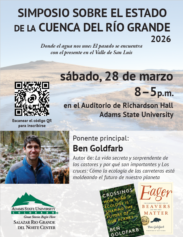
Rio Grande levy near Alamosa, November 2024. Photo credit: The Alamosa Citizen
The theme this year was “Where Water Connects Us: Past Meets Present in the San Luis Valley”. Paul Formisano and the staff and volunteers from the Salazar Rio Grande del Norte Center delivered a varied, timely and interesting agenda!
San Luis People’s Ditch March 17, 2018. Photo credit: Greg Hobbs
Ken Salazar set the stage for the sessions, reminding attendees that, “Early settlers knew the only way to bring prosperity to the valley was to do it collectively as the early acequias did.”
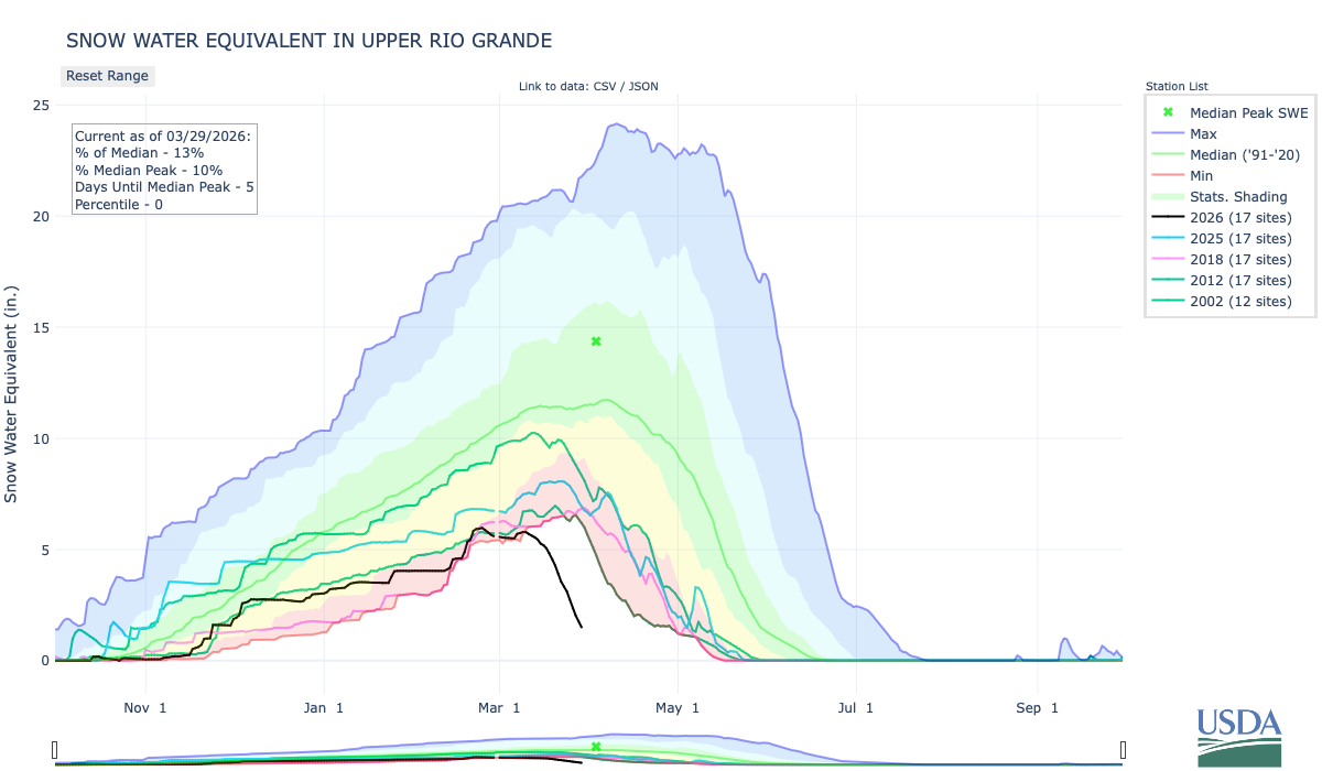
Upper Rio Grande snowpack March 29, 2026. Credit: NRCS
The first session was titled, “State of the Rio: The 2026 river outlook general basin and compact projections” and the general consensus from the speakers was, as Brad Udall recently said about the Upper Colorado River Basin, “There is no historical analog,” for these conditions. Snow drought is front and center in the San Luis Valley these days.
Upper Rio Grande accumulated precipitation March 29, 2026. Credit: NRCS
Precipitation in the basin started out the water year in great shape due to a big rain event in early October. Since then there have been modest accumulations but has flattened out since late February to date.
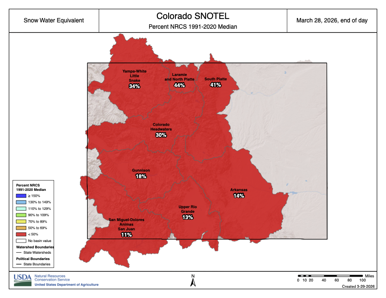
Colorado SNOTEL basin-filled snowpack map March 28, 2026. Credit: NRCS
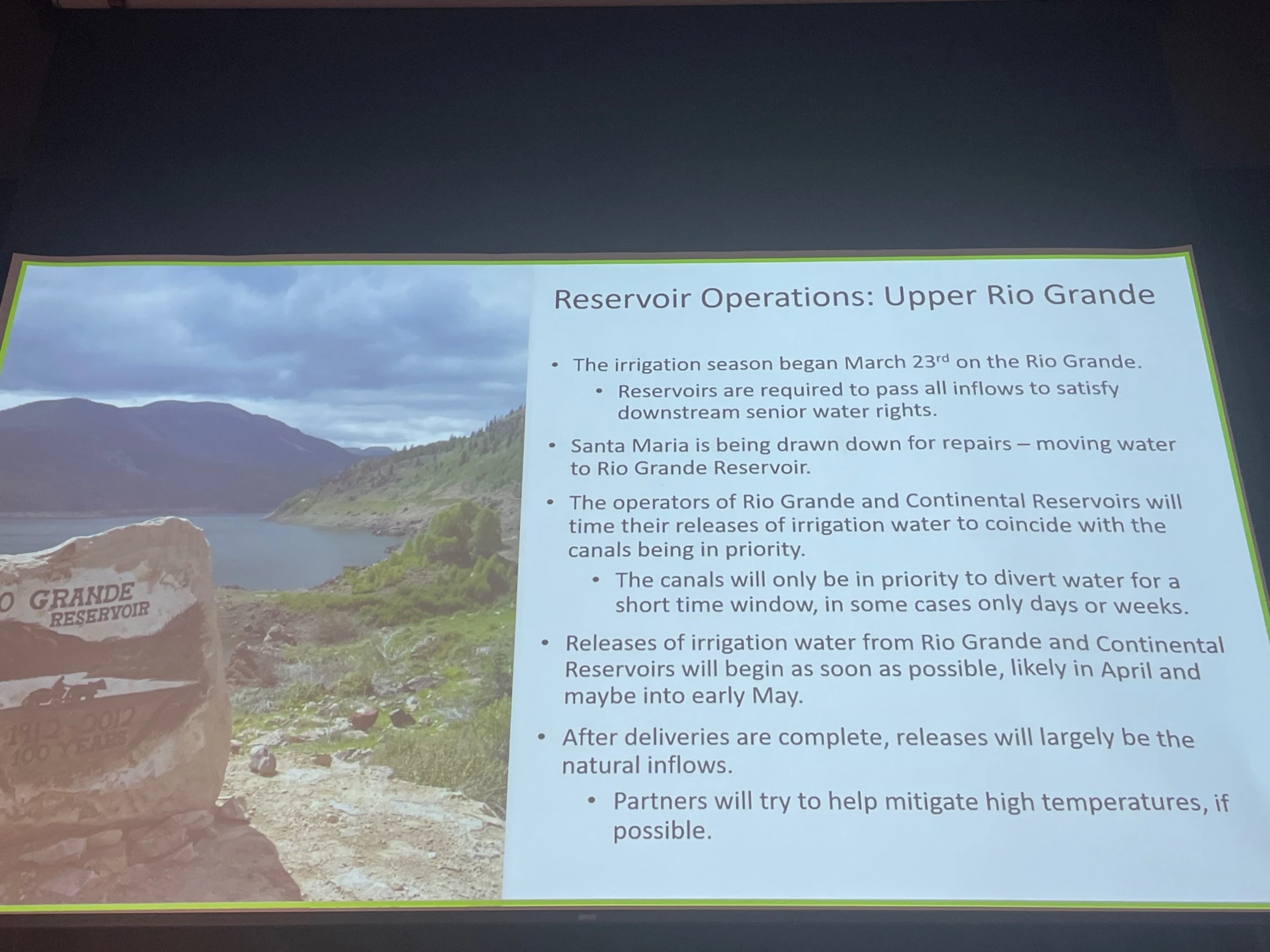
Division Engineer Craig Cotten started off his presentation with the basin-filled snowpack map for Colorado. He joked that, “The good news is, the Rio Grande is not the worst in the state.” It is not a good year as far as #snowpack and many SNOTEL locations are already melted-out.
Slide credit: Craig Cotten
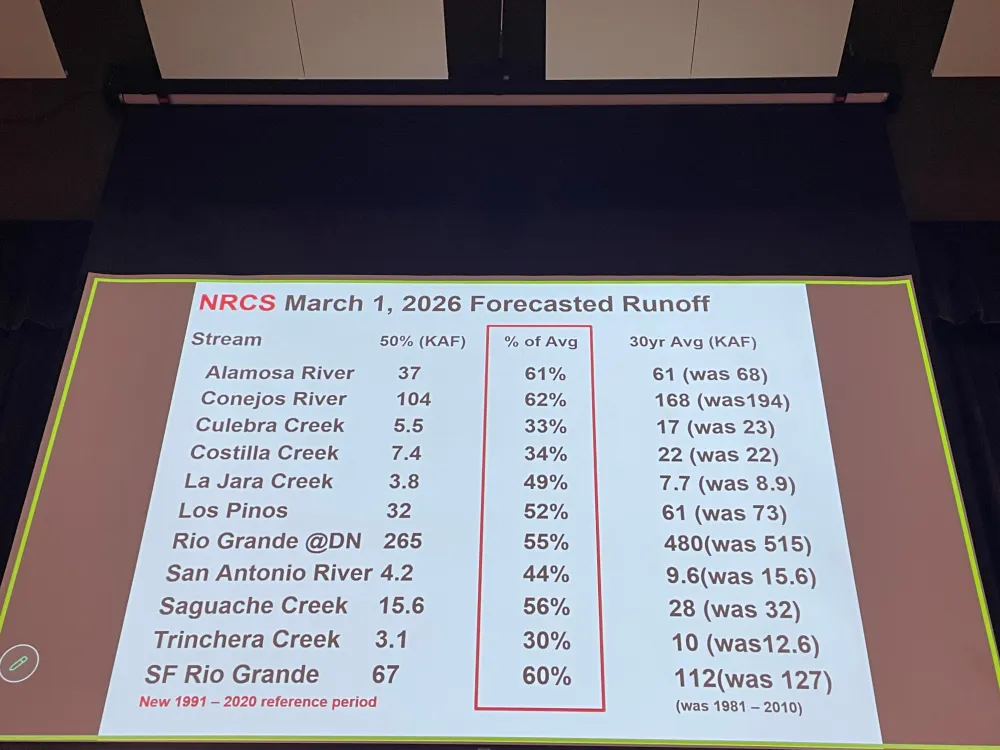
Projected streamflow is not looking good and the forecast will likely be worse when the April 1, 2026 numbers are released by the NRCS. However, streamflow right now is looking okay, there is a lot of water in the #RioGrande at this time for example. That means that the little snowpack in the basin is already coming off.
Slide credit: Craig Cotten
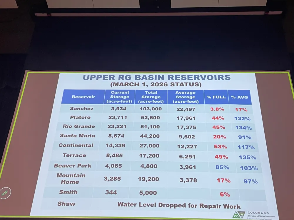
Reservoir storage is in good shape (as a percent of average) except Sanchez Reservoir which has been drawn down for maintenance and repairs.
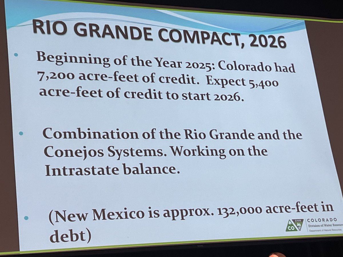
Current compliance numbers for the Rio Grande Compact from Craig Cotten. Photo credit: Chris Lopez/Alamosa Citizen
Colorado’s Rio Grande Compact compliance numbers heading into the scary diversion season are a positive. There is no debt owed to New Mexico and Texas. With the early onset to runoff season the State Engineer allowed irrigation to start on March 23, 2026. Current estimated streamflow for the Rio Grande at Del Norte (the compact USGS gage used for the river) is 305,000 acre-feet which carries a compact obligation of 76,000 acre-feet to New Mexico and Texas. For the Conejos River the estimated upper index annual flow is 165,000 acre-feet and the downstream obligation is 27,500 acre-feet. However, water levels are going to drop in the unconfined aquifer significantly this year due to low flows in the river. The situation in the aquifer is bad and it is going to get worse.
Cotten updated the attendees about the Rio Grande Compact lawsuit status. It is mostly a fight between Texas and New Mexico and the latest stipulated agreement has been approved by the Special Master. The U.S. Supreme Court is expected to approve the agreement.
Nathan Coombs, in keepting with the symposium theme said, “I believe we’re going to be alright this season we’re going to survive. People in the San Luis Valley are working together and we’re going to get through it.”
Slide credit: Heather Dutton
Heather Dutton gave an overview of reservoir operations for 2026. It is possible that all irrigation water will be released in April and May. She added, “If you’re going to fish the streams emphasize fishing in the morning and visit one of our valley breweries in the afternoon. It’s going to be tough year for all of us. Please keep the farmers in mind.”
Reclamation informed attendees about the current status of the Closed Basin Project. Project priorities are:
Colorado’s compact deliveries
Mitigation for construction and pumping
Eliminate Colorado’s Rio Grande Compact deficit
Other beneficial uses/irrigation
Slide from Amber Pacheco
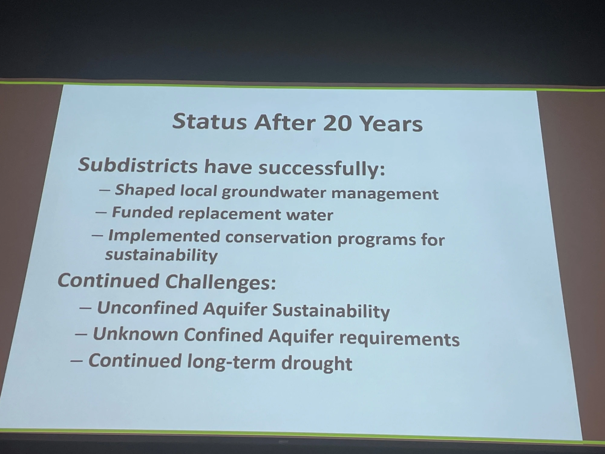
The session “Twenty years of subdistricts” illustrated how the well owners have been working together over the years to determine a solution to the declining unconfined aquifer. Because groundwater is not separate from surface water the lowered levels in the aquifer affect surface streamflow in the Rio Grande. Valley pumpers have formed several sub-districts fashioned around the different hydrology in areas of the aquifer and are retiring some wells and taking land out of production. Another strategy used has been o develop augmentation plans to offset pumping. All of the strategies involve fees to sub-district members. There is extensive coverage of the issue on Coyote Gulch if you are interested in taking a trip down memory lane.
Slide credit: Rachel James
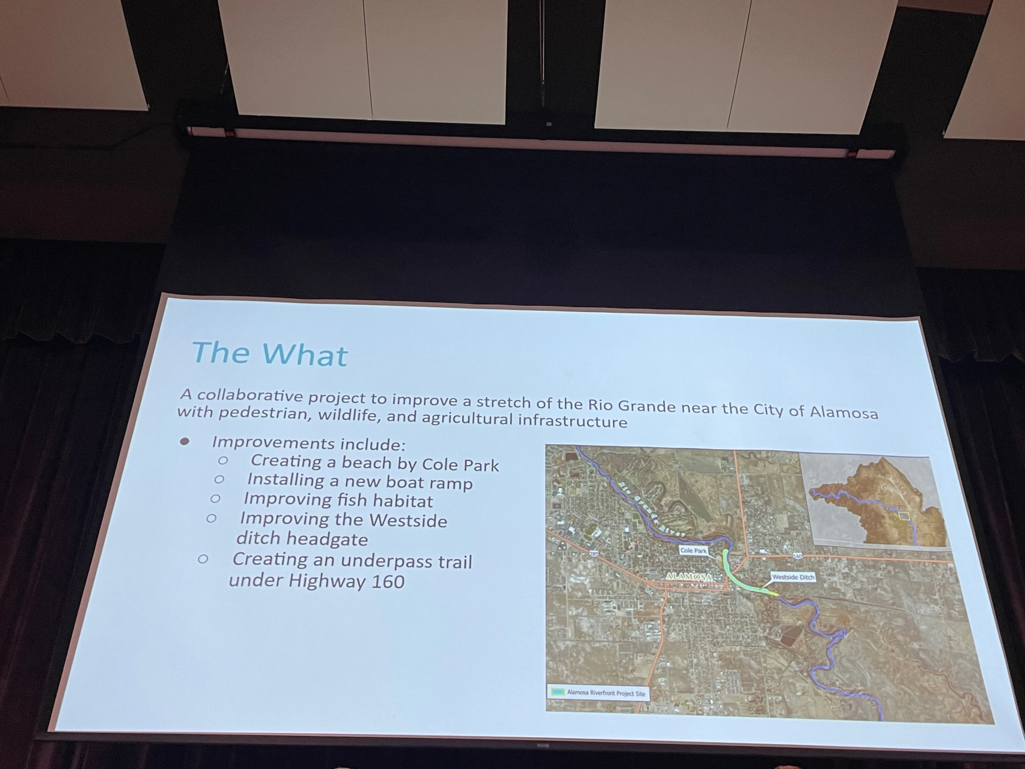
The session “Flowing together: Agriculture, rivers, and communities in partnership” was an overview of collaboration between the City of Alamosa, the West Side Ditch, and Rio Grande Headwaters Restoration Project on the river at the east side of Alamosa. It included a new headgate for the ditch company and will include a new levy orientation and access to the river from Cole Park. The speakers emphasized that it would not have happened without collaboration and the emphasis on creating a win for all stakeholders. For example, Bill Schoen credited the Rio Grande Headwaters Restoration Project for finding funding for the new headgate which is often a problem for mutual ditch companies. Daniel Boyes of the Restoration Project said that the new headgate helps fish and safety for boaters.
Rio Grande, Colorado | National Park Service
The final session before the keynote was “Perspectives on valley recreation” where access to public lands and the value of building a recreation economy to bolster valley opportunities were discussed. While 39% of Colorado’s agricultural output is from the valley economic activity is seasonal. The discussion centered around bringing tourism to the valley to improve the outlook for employment and economic growth.
The keynote speaker was Ben Golfarb and it was a real treat. I never tire of learning about “Nature’s Engineers” and the amazing effect this keystone species has on hydrology and habitat. Trapped extensively by fur traders to enable the fashion industry in the 19th century the species was nearly extirpated from the North American West. Along with a torrent of information and photographs, Goldfarb informed attendees that the native tribes did not participate in trapping because of their understanding of beaver’s role in the arid lands.
Rio Grande and Pecos River basins. Map credit: By Kmusser – Own work, Elevation data from SRTM, drainage basin from GTOPO [1], U.S. stream from the National Atlas [2], all other features from Vector Map., CC BY-SA 3.0, https://commons.wikimedia.org/w/index.php?curid=11218868
Colorado has started preliminary planning for a multiagency drought task force to help cope with what most experts fear will be a summer seriously low on water and high on wildfire risk.
The task force would include agencies focused on water, agriculture and emergency management, among others, according to Emily Adrid, water planning and climate impact specialist at the Colorado Water Conservation Board. Her comments came at a meeting of the state’s Water Monitoring Committee this week. When the task force could launch hasn’t yet been determined.
The last time such a task force was called into action was in the 2020-21 drought, according to the board. If needed, the task force can work with ad hoc groups and the governor’s office to coordinate release of state emergency funds.
Colorado measures its water supplies using a calendar that runs from Oct. 1 through Sept. 30, a period known as the water year.
The first four months of the 2026-27 water year are the warmest in 131 years, said Russ Schumacher, state climatologist at Colorado State University’s Colorado Climate Center.
“This is breaking the record by a huge margin,” Schumacher said.
And there is little if any relief in the spring forecasts.
“We might hope for a miracle this spring,” he said, “but this is not what’s in these forecasts.”
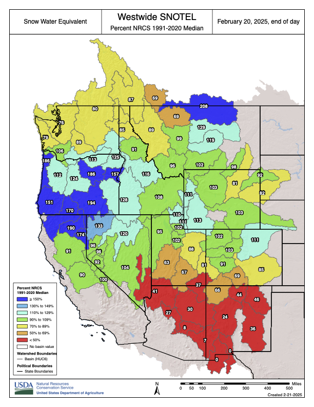
Statewide reservoir storage levels are holding steady above 80%, but streamflow forecasts indicate Colorado is likely to receive just 63% of its normal water flows, and possibly less, according to the Natural Resources Conservation Service in Lakewood.
In response, cities will also coordinate efforts to alert the public to the potential for water and fire emergencies. Their hope is that a unified approach to watering restrictions will reduce water use.
The city of Westminster is among cities gearing up for an ultradry summer. Drew Beckwith, the city’s water resources manager, said getting plans in place early and encouraging everyone to share the same message will be critical this year and next.
“We haven’t had a big drought since 2002,” Beckwith said. “We’re all out of practice.”
Even if major spring snowstorms occur that could lessen water shortages and fire risks, 2026 is still expected to be strikingly dry and warm.
And that is not as worrisome as the prospect of a follow-on drought in 2027, Beckwith said.
“It’s not the one-year drought that is our Achilles’ heel,” he said. “It’s multiple dry years in a row when things get concerning. Since we don’t know what next year’s snowpack is going to look like, we don’t want to not do anything. Instead, we’re saying, ‘Hey, we don’t know what’s going to happen so let’s all get on the same page now.’”
The Bureau of Reclamation’s latest forecast for the Colorado River predicts Lake Powell will “most probably” drop below the critical minimum power pool level before the end of this year, jeopardizing Glen Canyon Dam’s structural integrity. In the worst-case scenario, it would do so before summer’s end. This could force the feds to operate the dam as a “run-of-the-river” operation to preserve the dam’s infrastructure and hydropower output, which would significantly diminish downstream flows and threaten Lower Basin water supplies.
Lake Powell could receive only half the normal amount of water from upstream rivers and streams this year, according to a recent federal study.
The U.S. Bureau of Reclamation releases a monthly study that forecasts good, bad and most likely storage conditions for the Colorado River Basin’s key reservoirs over the next two years. The February forecast expects about 52%, or about 5 million acre-feet, of the normal amount of water to flow into Lake Powell by September. The more grim outlook says Powell’s inflows could be 3.52 million acre-feet or 37% of the average from 1991 to 2020.
It’s enough to spike concerns about hydropower generation at Glen Canyon Dam — which controls releases from Powell — prompt discussions about emergency releases from upstream reservoirs and trigger federal actions to slow the pace of water out of the reservoir.
“I think they’re going to be nervous about operating the turbines,” said Eric Kuhn, former general manager for the Colorado River Water Conservation District.
In January, about 79% of the 30-year average flowed into Lake Powell — which is on the Utah-Arizona border — from upstream areas of Arizona, Colorado, New Mexico, Utah and Wyoming, according to the federal February 24-month study, released Friday.
The February projections also showed even less water flowing into Lake Powell, a decline of about 1.5 million acre-feet since January.
The Colorado River Basin, which provides water to 40 million people, has been plagued by a 25-year drought that drained its main reservoirs — the largest in the nation — to historic lows amid unyielding human demands.
And that stress is going to continue. The most probable forecast shows nothing but below-average flows in February — 71% of the 30-year average — and for April through July, when flows are likely to be 38% of the norm.
Feds take action to boost Powell
Upstream states like Colorado do not get a drop of water from Lake Powell, Kuhn said. Coloradans rely mostly on local reservoirs to help pace the spring runoff and support year-round water use.
But the reservoir’s status can impact whether upstream reservoirs, like Flaming Gorge in Wyoming and Blue Mesa in Colorado, will have to make emergency releases to elevate water levels in Lake Powell.
In response to the dry and warm winter, the federal government is trying to keep the water in the reservoir above certain critical water levels, according to the study.
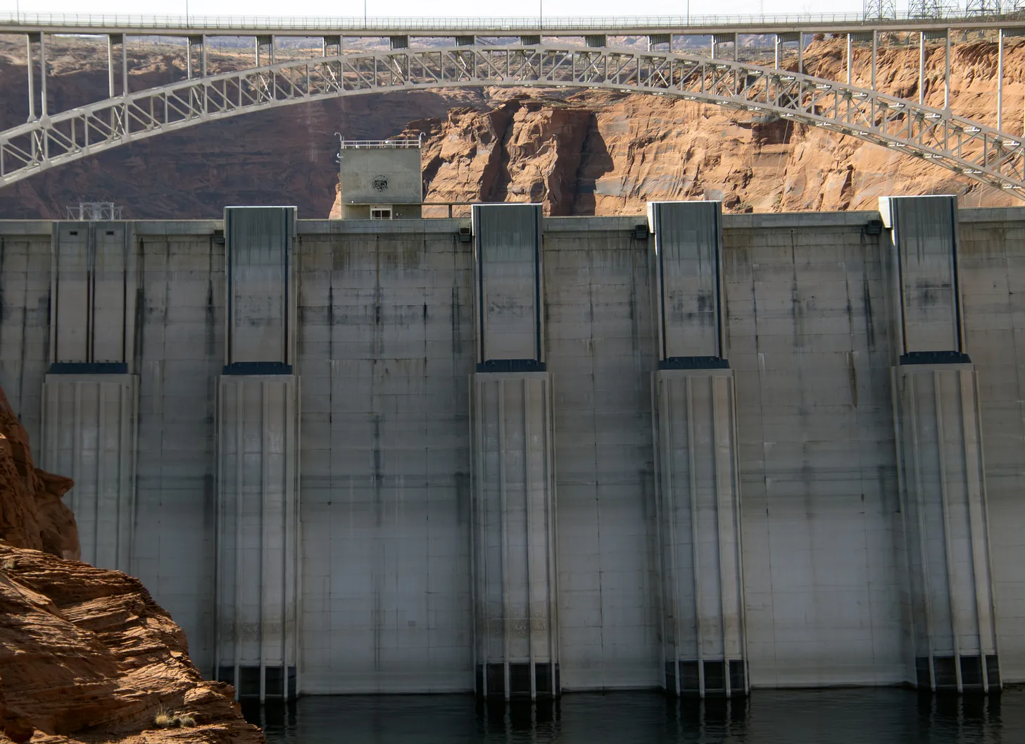
At 3,490 feet in elevation, Glen Canyon Dam can no longer send Powell’s water through its penstocks and turbines to generate hydroelectric power — that would remove a cheap, renewable and reliable power source for communities across the West.
Lake Powell is projected to drop below the critical elevation by December, or as soon as August in one scenario, according to the 24-month study.
Federal officials are likely to call for emergency water releases from upstream reservoirs to keep Powell’s water level from falling to that point. They’re working to maintain a cushion by keeping Powell’s water level above 3,525 feet, or at the very least 3,500 feet in elevation, according to the study.
Lake Powell’s elevation was just over 3,532 feet as of Monday, but it’s expected to drop to 3,497 feet by Sept. 30 under the most likely forecast. (The minimum forecast puts it closer to 3,469 feet.)
Putting himself in the Bureau of Reclamation’s shoes, Kuhn would be looking upstream to fill that gap.
“Where do they plan for it?” he said. “I would be looking to get a lot of water if I’m going to keep Lake Powell above 3,500. … 3,525 may not be possible. There just may not be enough water in the system.”
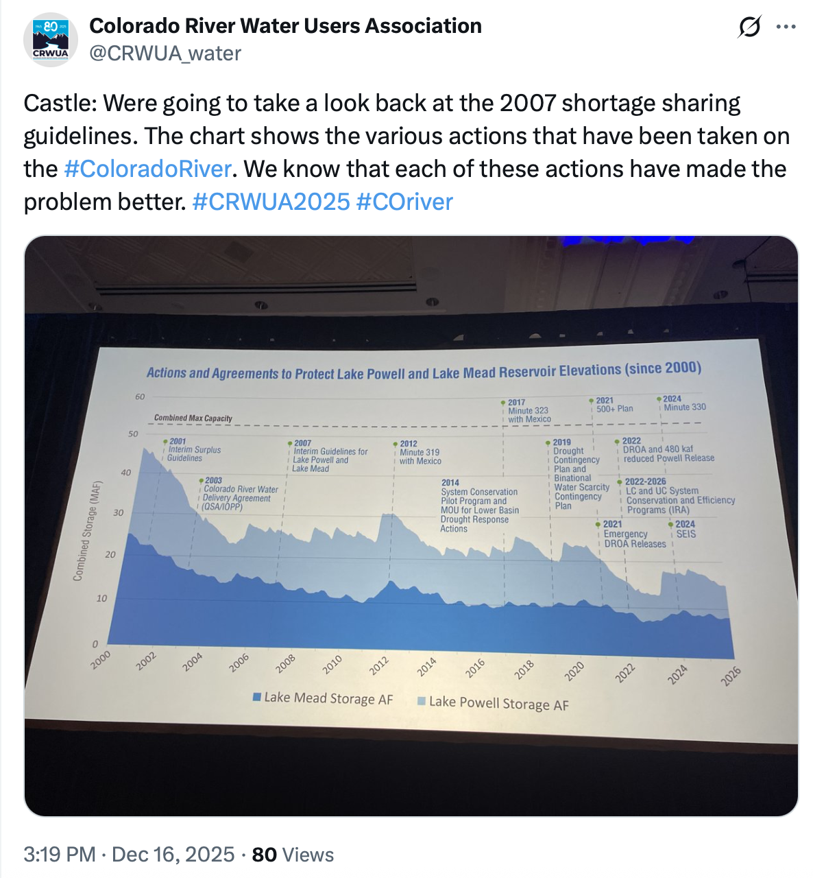
Facing new lows
That is partly because the Bureau of Reclamation is required by a 2007 agreement, which expires this fall, to release certain amounts of water each year based on reservoir elevations. Replacing these rules is the focus of ongoing high-stakes — and deadlocked — negotiations among states.
Powell’s releases are expected to be 7.48 million acre-feet between Oct. 1, 2025, and Sept. 30, according to the February 24-month study.
To try to keep reservoir levels up, the Bureau of Reclamation has adjusted its normal releases since December to keep about 600,000 acre-feet of water in the reservoir. That water will eventually be released downstream as required by the 2007 rules.
Federal officials could also release less than 7.48 million acre-feet this year to keep more water in Lake Powell, according to the study. A 2024 short-term agreement allows the officials to release as little as 6 million acre-feet of water this year to avoid Lake Powell falling below 3,500 feet.
Lake Powell’s lowest release was about 2.43 million acre-feet in 1964, when the reservoir was first being filled. Since 2000, when the basin dipped into the ongoing 25-year drought, Powell’s average annual release has been 8.69 million acre-feet, according to The Sun’s analysis of water release data.
“I don’t think they’re going to release 7.48 this year. I think they have to cut the flow down to 7 (million acre-feet) or even below,” Kuhn said.
Like much of the West, Colorado’s water future will be shaped by a warming climate, population growth, and subsequently increasing competition for finite supplies. In conversations about managing our coveted Colorado River headwater resources, it is easy to assume the most influential voices belong to the well-represented on the population-dense Front Range or the well-funded interests far downstream. Yet some of the most consequential water decisions play out in small mountain valleys, often with limited staff, limited funding, and limited political clout.
It was in that context, despite the Great Recession of 2008, that voters approved the creation of Pitkin County Healthy Rivers that November, a sales tax-funded program with a simple but ambitious mandate: protect and enhance the rivers and streams of the Western Slope’s Roaring Fork Watershed on behalf of the people and the environment.
What few imagined at the time was that this small, locally funded program would become such an effective way to ensure the people and their cherished rivers had a seat at the table in complex, high-stakes water discussions. A “seat” that is not symbolic; it’s practical, persistent and sometimes uncomfortable. Because having local voices is not a luxury — it is essential.
The Power of Showing Up
Healthy Rivers’ influence begins with showing up. Showing up ready to listen and engage, recognize partners and advance and fiscally sponsor new alliances, all while emphasizing local knowledge, data, and community-backed priorities. In basin-wide planning efforts, feasibility studies, and project negotiations, Healthy Rivers represents local, place-based interests that might otherwise get overshadowed by far more powerful players, be they up or downstream.
This has meant actively seeking valuable connections, therefore knowledge, daresay wisdom, with hopes of earning a voice that ensures headwaters perspectives are considered at these tables. Think Colorado Basin Roundtable, U.S. Forest Service, Colorado Parks and Wildlife, the Colorado Water Conservation Board, local and nearby watershed groups, and other environmental non-profits. This outreach has led to critical partnerships and heightened transparency and inclusivity on many water matters. It has also meant supporting technical analyses and funding early-stage studies — most recently for water-quality monitoring on Lincoln Creek, a tributary to the Roaring Fork — so local conditions and risks are understood before decisions are made elsewhere.
And because our funding comes directly from local voters, Healthy Rivers advocates from the position of our constituents who overwhelmingly supported its creation. That matters in rooms where water is discussed in acre-feet and complex legal terms, often far removed from community-specific values. This has allowed Healthy Rivers to elevate community priorities in negotiations around watershed health, elevating environmental values like instream flows.
Small Programs, Real Influence
One misconception about many local programs is that they are too small to matter. In practice, Healthy Rivers has demonstrated that being nimble is an advantage. Healthy River’s contributions are rarely flashy, but they have been catalytic, having a role in everything from diversion arbitration, instream flow protections, riparian habitat restoration, and water-quality monitoring.
It has done this by supporting projects like technical studies, restoration efforts, and infrastructure improvements that likely wouldn’t have happened otherwise. And by convening unlikely partners, and stepping into conversations early, before positions harden and options narrow.
For example, Healthy Rivers helped support the pursuit of a Recreational In-Channel Diversion (RICD) on the Roaring Fork River, recognizing instream flow rights alongside recreation as legitimate, community-defining values worthy of legal protection. It is supporting a Wild & Scenic designation for the Crystal River, and investing in beaver-related studies in order to inform projects that restore wetlands, reconnect floodplains, and improve late-season flows.
Translating Complexity for Communities
Another core part of having a seat at the table is translation. Colorado water law, hydrology, and planning processes are famously complex. Without intentional effort, these processes can leave local communities feeling confused, disengaged, or shut out of decisions that directly shape their rivers.
Healthy Rivers sees its role as a bridge. It translates technical concepts into plain language, not to oversimplify, but to make participation possible. This has included helping residents understand what designations like “Wild & Scenic” actually do — and don’t — mean, or explaining how instream flow rights function alongside agricultural and municipal uses.
This two-way translation strengthens outcomes. Decision-makers gain local context. Communities gain confidence. And water decisions become more durable because they reflect shared understanding, not just legal compliance.
Collaboration Over Confrontation
A seat at the table does not guarantee agreement. Some of the most meaningful work Healthy Rivers does happens in moments of tension, usually when water supply, ecological health, recreation, and private property interests collide.
Our approach is rooted in collaboration, not advocacy for advocacy’s sake. That means listening carefully, acknowledging tradeoffs, and being honest about constraints. But it also means pushing back when local values are at risk of being overlooked. In projects like renovating the Sam Caudill State Wildlife Area, Healthy Rivers worked alongside CPW, Garfield County, and development partners to balance recreation access, public safety, and river protection, demonstrating how infrastructure investments can serve both people and rivers.
Lessons for Other Communities
This role requires patience. Water decisions typically move slowly, and progress often comes in inches rather than miles. And in a basin as complex as the Colorado River system, no one wins by going it alone. Our experience has reinforced a simple truth: collaboration works best when local voices are present early and consistently, not as an afterthought.
While not every community can replicate Pitkin County’s funding model, the underlying principles are transferable:
Local funding creates legitimacy. Voter-backed programs carry weight because they represent collective priorities.
Consistency builds trust. Showing up over time and building long term relationships matters.
Data and stories belong together. Technical rigor and real-world experience are stronger together than apart.
Early engagement saves time later. Investing upstream — literally and figuratively — reduces conflict downstream.
Healthy Rivers exists to ensure that when decisions are made about the Roaring Fork Watershed, the people who know and love these rivers are part of the conversation. That seat at the table does not guarantee outcomes, but it guarantees presence. And in water, as in so many things, presence is power.
The Gunnison River Basin Roundtable recently announced grants of up to $1,500 for water education through its public education, participation and outreach committee. The 2026 Water Education Grant is now accepting applications. Funds are available to anyone engaged in water education, including public and private schools, libraries, scout troops, homeschoolers, 4-H clubs and other organizations offering programming for children up to 18 years old in the Gunnison Basin. Applications are due at 5 p.m. on Feb. 23. For more information, visit gunnisonriverbasin.org/.
Shannon Wadas has been hired as the executive director of the Ruth Powell Hutchins Water Center (RPHWC), Colorado Mesa University announced Monday. Wadas was chosen for her experience in natural resource and organizational management in the public and non-profit sectors. CMU cited experiences including her support of watershed planning efforts in the region, coordinating and facilitating a water education course for professionals, and helping form a community navigator network in the Upper Rio Grande Basin to accelerate aquatic restoration. Most recently, Wadas worked as a private consultant focused on organizational strategy, partnership collaboration, engagement and capacity building.
“I am excited and honored to join Colorado Mesa University and lead the Ruth Powell Hutchins Water Center,” Wadas said in CMU’s announcement. “There is no greater unifying force than water. I am thrilled to have the opportunity to catalyze and strengthen the collaborative efforts of CMU and local and regional partners to support important water issues through educational opportunities, research initiatives and thoughtful conversations.”
“Shannon brings a wealth of experience and collaborative leadership to CMU that will strengthen the Ruth Powell Hutchins Water Center’s role in bringing people together, fostering innovation in water resource management and cultivating the next generation of water leaders,” added CMU President John Marshall.
The RPHWC serves as a Western Slope hub for water policy, academic education and applied research. The center also supports student programming and interdisciplinary learning opportunities, including water-focused coursework and research, seminars, continuing education classes and a Water Fellows program.
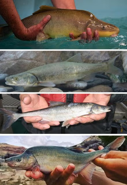
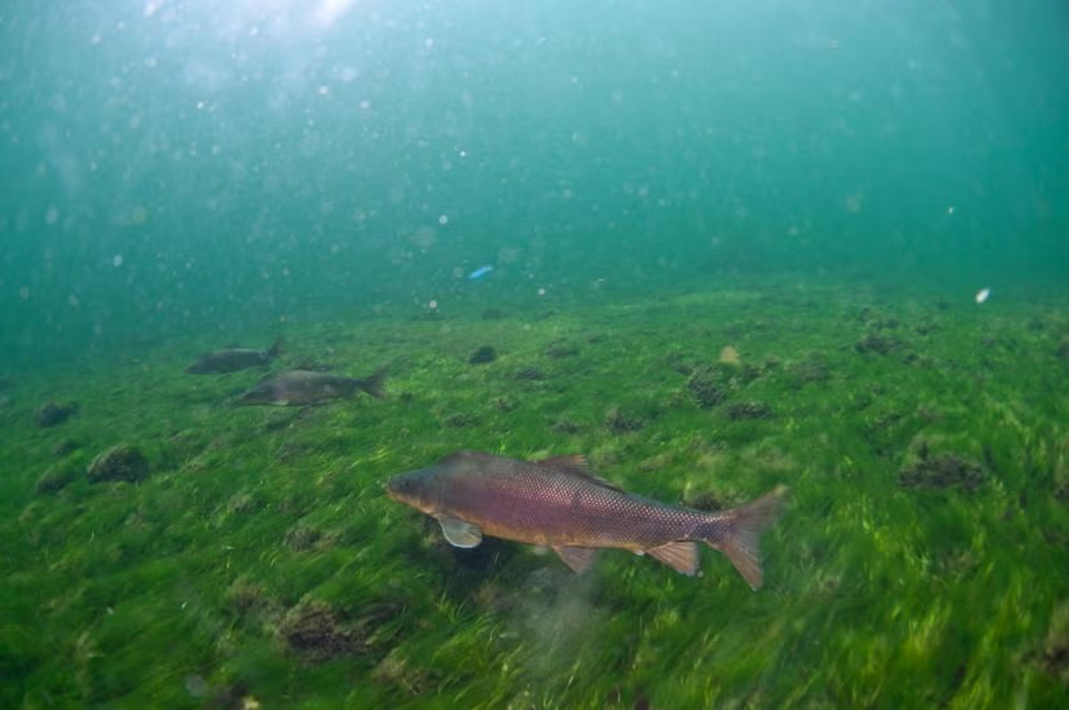
A mayfly loving trout — speckled, shiny and perfectly hand-sized for that Instagram hero shot. A five-foot-long torpedo of a predator, capable of powering through floodwaters and migrating hundreds of miles. A three-inch minnow, living only a couple of years and content with life in a small pool in an ephemeral creek. Which fish is the true Colorado native?
The answer is all of them. A state with waterways as diverse as Colorado’s has naturally produced a diverse assortment of native fish to match. We have cutthroat trout, lovers of pristine, high-elevation streams on both sides of the Continental Divide. Large, long-lived species like Colorado pikeminnow and humpback chub fight their way through the whitewater of the Western Slope. Tiny brassy minnows and redbelly dace ply the shallow, sandy creeks of the Eastern Plains. Each is adapted to its own ecological niche, body and behavior tailored to its particular home waters and the other aquatic creatures that evolved alongside it.
Humans have dramatically altered this delicate balance in a very short time span. While some native populations still thrive, many others struggle as their habitats and predators have changed. Starting a couple of hundred years ago, mining pollution, overfishing, and haphazard stocking of non-native fish led some Colorado species to plummet, or even go extinct. Today, native fish still grapple with climate change, dams, water diversions, and competition with invasive species. But humans are also working to turn back the clock and restore these native species. Follow along on this tour of Colorado’s waterways, meeting our home-state fish — and learning what it takes to help them endure.
Headwaters
On the Yampa River Core Trail during my bicycle commute to the Colorado Water Congress’ 2025 Summer Conference August 21, 2025.
The headwaters region is the realm of the cutthroat trout. Credit: Water Education Colorado
Let’s begin where the rivers do: high in the Rocky Mountains, where clean, cold streams form and flow downhill, eventually feeding the state’s largest rivers. This is the realm of Colorado’s poster fish, the cutthroat trout. Colorful, beautiful and beloved by anglers, cutthroats — recognizable by the iconic red slash markings under the jaw that give the species its name — live in the headwaters of almost every river basin in the state. Cutthroat trout are at home where there’s oxygenated water, gravelly bars for spawning, and good vegetative cover on stream banks.
“Cutthroat trout” isn’t just one type of fish in Colorado, but rather, six. There’s the greenback cutthroat trout, originally from the South Platte River Basin on the east side of the Divide. The yellowfin cutthroat came from the Arkansas River Basin, but is now considered extinct. Moving southwest, the Rio Grande cutthroat rose from the Rio Grande Basin. Then, on the Western Slope, the Colorado River cutthroat is further divided into three lineages: the Green River lineage, found in the Green, White and Yampa rivers; the Uncompahgre lineage, of the Dolores, Gunnison and Upper Colorado rivers; and the San Juan lineage, of the San Juan River Basin.
That’s not to say the average angler — or indeed, the average fish biologist — can tell the cutthroats apart just by looking at them. Nor can they be identified based on where they’re caught these days. Humans, from regular people trying to create new fishing opportunities to professional fisheries managers, spent much of the last couple of centuries moving cutthroats around the state with little understanding of the differences between subspecies. “It’s really hard to put the genie back in the bottle once that happens,” says Jim White, southwest senior aquatic biologist for Colorado Parks and Wildlife (CPW). “One of the great mysteries in cutthroat trout distributions was, what went where? What did these river basins look like before we started widespread stocking of cutthroats and non-natives?”
Biologists didn’t know the answer until 2012, when a landmark study led by University of Colorado Boulder researchers conducted DNA analysis on museum fish specimens gathered at the beginning of European contact with the West. Those results confirmed the existence of the six genetically distinct types of cutthroat — five previously known to science, and one brand-new one, the San Juan lineage trout. The study speculated that San Juan cutthroats had also gone extinct, but CPW biologists had to be sure. “We beat the bushes, surveyed all the populations, and conducted molecular tests on fin clips from all known cutthroat trout populations in the San Juan Basin,” says Kevin Rogers, CPW aquatic research scientist and co-author on the 2012 genetic study. “Indeed, there were about a half-dozen populations that [matched] the fish that had been collected in the mid- to late 1800s.”
One thing all five remaining Colorado cutthroat varieties have in common is a reduction in the amount of habitat they occupy. The state’s cutthroats are now relegated to just 12% of their historical habitat on the high end, down to half a percent on the low end, says Boyd Wright, native aquatic species coordinator with CPW. “Most of the lower elevations have been invaded by non-native trout, so cutthroats are persisting only in the headwaters,” Rogers says. Greenback cutthroats are federally listed as threatened, and Rio Grande and Colorado River cutthroats (occupying just 12% and 11% of their historic habitat, respectively) are state species of special concern. The culprits? What began with pollution, overharvesting and the stocking of non-native fish in the era of Western colonization continues today.
Non-native fish pose a major threat to native cutthroats, particularly the brown, brook and rainbow trout that have been stocked statewide and now thrive in Colorado’s waters. “To sum it up, there’s hybridization, there’s predation, and there’s competition,” White says. “All of those three things can interact to disadvantage our native fish populations.” Rainbow and cutthroat trout can breed, resulting in the hybrid cutbow. Non-native trout sometimes even eat the natives. They also compete with cutthroats for food, and often win. Brook and brown trout spawn in the fall and hatch in the spring — so when the cutthroat fry hatch in late summer, their non-native rivals have already had several months to grow bigger.
Climate change isn’t helping. “We have the two ugly stepchildren that come along with a changing climate: drought and wildfire,” Rogers notes. “The toll wildfire can take on cutthroat is substantial. The debris flows that invariably happen afterward can wipe out populations.” Drought can also lower or dry up streams, further contracting ranges.
But CPW and partner organizations like the U.S. Fish and Wildlife Service are actively working to conserve Colorado’s native cutthroats. Biologists raise the trout in hatcheries for stocking back in their native streams, but there’s a lot more to it than that. First, managers must prep the waterways by removing non-native trout, often by poisoning with natural fish toxicants, a process that can take years. Any present pathogens, like whirling disease, must be eradicated. Managers also have to make sure non-native fish can’t reinvade the stream, usually by building a barrier, like a waterfall. Despite the difficulty and expense, the state is actively working on recovery projects for all five cutthroat varieties. “That’s what we’re about, trying to preserve diversity for future generations to enjoy,” Rogers says.
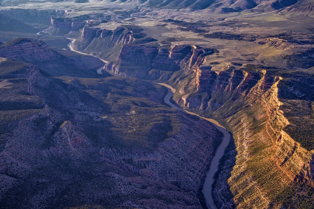
Desert Rivers
The Yampa River winds through towering cliffs on its journey west to meet the Green River in Dinosaur National Monument. Photo Credit: Dave Showalter
Credit: Water Education Colorado
As the mountain streams follow gravity into the western lowlands, they flow into larger networks: Rivers like the Yampa, White and Animas feed the desert arteries of the Green and San Juan, and these, together with the Gunnison, Dolores and others join the Colorado. The entire basin touches seven states, from Wyoming and Colorado up north to Arizona and California in the southwest.
The cold swift headwaters give way to rivers that historically swung between huge springtime floods and slow, turbid flatwater. And the trout give way to large, long-lived fish with bodies suited to big water and wild rapids.
Just over a dozen fish species evolved with the chops to survive in the larger rivers within the Colorado River system. Three of them, called just “the three species” by biologists, are the flannelmouth sucker, bluehead sucker, and roundtail chub. These omnivorous swimmers persist in today’s rivers, though managers keep a close eye on conserving their populations so that they don’t go the way of four other native species.
These four — all federally listed as endangered or threatened — have struggled in the face of drastic, human-caused changes to their habitats. The bonytail, a large-finned, skinny-tailed omnivore, is the worst off, with no sustainable wild populations left. Its relative, the humpback chub, sports a pronounced bump behind its head, all the better to stabilize the fish in whitewater. Its populations have stayed stable over the past few years, with most of them found near the Grand Canyon, and the species was downlisted from endangered to threatened in 2021. The Colorado pikeminnow, a powerful swimmer shaped like a missile, is the largest minnow in North America. It can migrate 200 miles annually and lives 40 years or more. Its numbers are slowly increasing in the Upper Colorado and San Juan subbasins, but are declining in the Green River. And the razorback sucker, a bug- and plankton-eater, features a similar keel behind its head that helps it maneuver through high flows.
All four populations have crashed in response to human water use and reduced water availability resulting from drought and climate change, which has altered the habitats they once inhabited. “We have cross-basin diversions that feed water from the Western Slope over to the Front Range,” says Jenn Logan, native aquatic species manager for CPW. “We don’t have the volume of water that we used to see in the spring. With dams and water going into ditches and filling reservoirs, runoff is nowhere near where it used to be. We don’t have sandbars formed in the way that we used to, and these systems relied on sediment to form complex habitats.” Not only that, but dams change water temperature, with released water alternately cooling or warming the river downstream depending on where in the reservoir it comes from. And of course, they form a physical barrier for fish that evolved migrating through a huge, interconnected river system.
Then there’s the non-native interlopers — primarily smallmouth bass, northern pike, walleye, and green sunfish — all introduced, either purposely or accidentally, by humans looking for expanded angling opportunities. “They’re predatory species — they get in the river and can really compete with and consume the native fish in the Colorado River,” says Josh Nehring, deputy assistant director, aquatic branch, of the CPW fish management team. All have found happy homes in the modern Colorado River Basin with its dams, reservoirs and warmer waters.
But just as in the mountain streams, fisheries managers on the Western Slope are working aggressively to protect the natives. The Upper Colorado River Endangered Fish Recovery Program and the San Juan River Basin Recovery Implementation Program oversee the recovery of the four fish species listed as threatened or endangered. The recovery programs are coalitions of water users, federal, state and tribal agencies, plus nonprofits and energy organizations. They take steps like installing nets at the edge of reservoirs to keep non-natives contained and stocking sterile non-native fish in reservoirs to keep them from establishing a population if they do get out. Other work looks like electrofishing stretches of river — that is, introducing a current that stuns fish in the water — and physically removing the non-natives, leaving the native fish to recover and swim another day; and gillnetting northern pike in their springtime spawning habitats. Water managers go so far as to recontour river channels on the upper Yampa to cut off access to northern pike’s spawning wetlands.
Dam management is another useful tool for both helping native fish and disadvantaging the non-natives. The Upper Colorado River Endangered Fish Recovery Program works with the U.S. Bureau of Reclamation at Utah’s Flaming Gorge Dam on the Green River on timed releases — releasing water when biologists detect the year’s razorback sucker larvae “to attempt to move them down to their wetland habitats,” Logan says. They’ll release water to disrupt smallmouth bass nesting, when possible. And in the Lower Basin downstream of Lake Powell, managers have begun releasing cooler water specifically to make the Colorado River there less hospitable to smallmouth bass. As long-term drought has dropped water levels in Lake Powell, “We’ve been seeing increases in water temperature releases coming through the dam,” says Ryan Mann, aquatic research program manager for the Arizona Game and Fish Department. Some smallmouth bass made their way into the river below the dam in years past, but the water had been cold enough to keep them from reproducing. But in 2022, biologists found baby bass. Last summer’s cold-water releases prevented widespread spawning, and managers may continue them into the future.
Today’s Colorado River Basin is a radically different place than in centuries past, and, “Unless there’s some amazing technology that comes along to remove all non-native fish or a way to return flows to historic conditions we’re not going to be able to move [major river systems] back to native fish,” Nehring says. But that doesn’t mean those species are doomed. CPW and its partners are actively raising threatened species in hatcheries and reintroducing them to targeted habitats. “We’re really focusing on the tributaries, to keep the natives alive in enough areas where we know they’ll persist,” Nehring says.
Eastern Plains
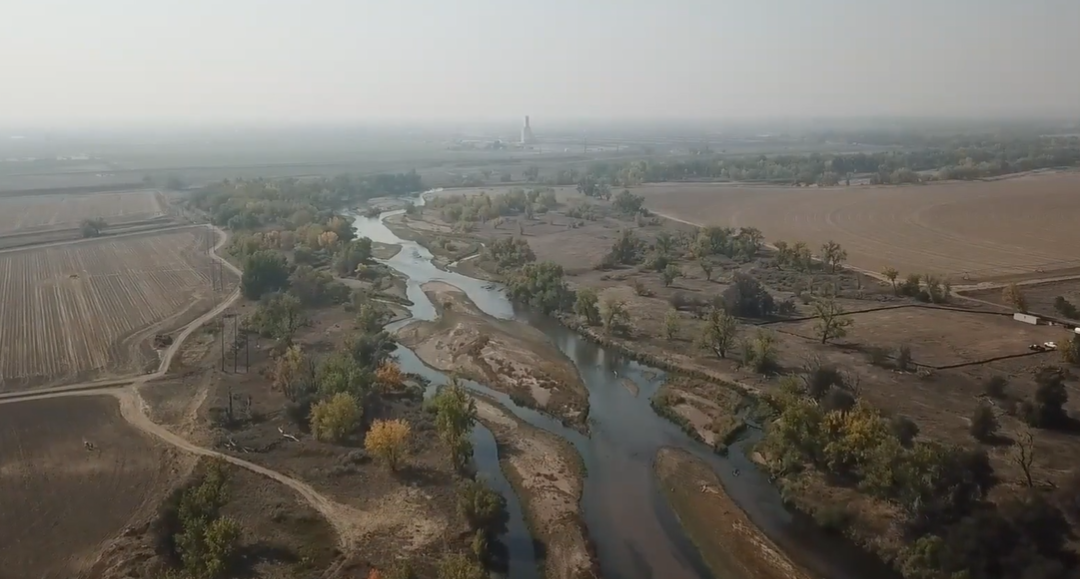
Here at the confluence of the Big Thompson and South Platte rivers near Greeley, a new conservation effort is underway. It restores wetlands and creates mitigation credits that developers can buy to meet their obligations under the federal Clean Water Act to offset any damage to rivers and wetlands they have caused. Credit: Westervelt Ecological Services
Credit: Water Education Colorado
As alpine streams flow east, they meander through Front Range cities, then spread across the arid plains. The water warms, rocky beds grow sandy, and habitats shrink as creeks dry up seasonally. Waters dominated by a single species explode with different fish. “We’ve got this melting pot of biological diversity along the transition zone,” says Wright. “You go from historically a one-species profile in the mountains to more than 28 as you go farther east. These [plains] are very harsh, unpredictable environments.”
The fish that evolved to thrive on the plains, from the region’s western edges in Colorado out into Kansas, Oklahoma and Nebraska, are largely the opposite of the big, long-lived species on the Western Slope. They’re a few inches long, live just a couple of years, and reproduce early. These fish are used to biding their time in small pools until rain or spring runoff reconnects the intermittent creeks, finally allowing them a change of scenery.
But the Eastern Plains haven’t escaped the challenges affecting Colorado’s other rivers — its native fish are struggling, too. “Most of our plains fishes are declining or locally extinct because of habitat modification or loss,” says Ashley Ficke, fisheries ecologist with engineering firm GEI Consultants. Humans have diverted water to farms and municipalities, redirected streams into straight channels lacking habitat complexity, and even drained some waters completely. That hits fish like the plains minnow particularly hard, as its semi-buoyant eggs float vast distances between spawning grounds and ideal nursery habitat. “It needs vast portions of unfragmented stream habitat,” Wright says. “We’ve really lost that in Colorado, and that’s a big reason why they’re very rare.”
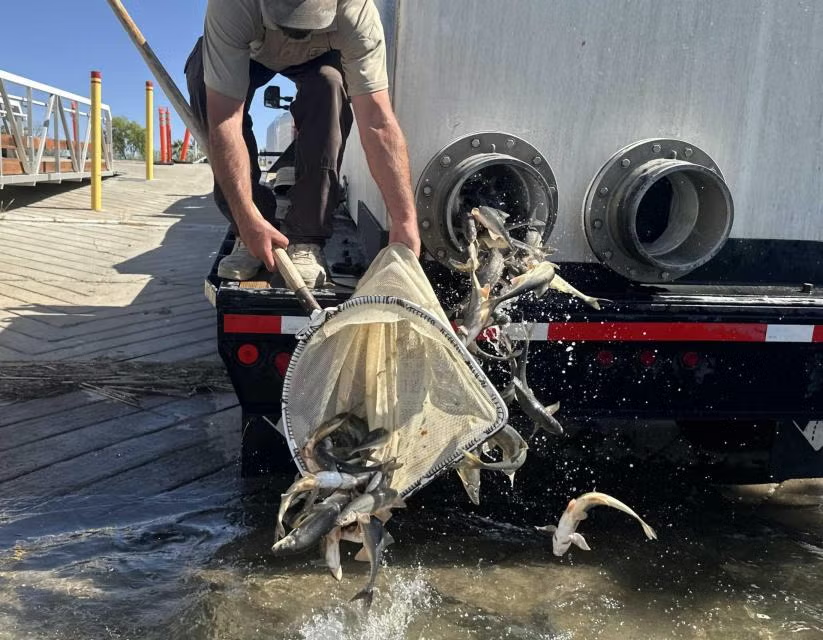
As elsewhere in the state, though, fish managers are working to replenish the swimmers of the plains. At a hatchery in Alamosa, CPW breeds 12 rare native fish, half of them eastern species: plains minnow, suckermouth minnow, northern and southern redbelly dace, Arkansas darter, and common shiner. “We’re working with private landowners that have streams or ponds that would be suitable for these native fish, working with them to maintain or improve that habitat, and stocking those waters with the native fish,” Nehring says. By preserving and restoring enough of the plains’ stream habitats, managers hope to give back sufficient waters for these little fish to persist.
LAS VEGAS — About [1,700] people from every corner of the Colorado River Basin flocked to the palm tree-lined Caesars Palace casino in Las Vegas this week thirsty for insights into the stalled negotiations over the future management of the river.
New insights, however, were sparse as of Tuesday morning.
The highly anticipated Colorado River Water Users Association conference is the largest river gathering of the year. It’s a meet up where federal and state officials like to make big announcements about the water supply for 40 million people, and when farmers, tribal nations, city water managers, industrial representatives and environmental groups can swap strategies in hallway chats.
The meetings started Tuesday morning before the conference officially kicked off. Officials from basin states, including Colorado, set the tone by digging into their oft-repeated rhetoric about the worrisome conditions in the basin, impacts in their own states and conservation efforts. Conference-goers pushed state leaders for more transparency and progress in the discussions over the river’s future.
The basin’s main reservoirs, lakes Mead and Powell, have fallen to historic lows despite pouring state and federal dollars into broad conservation efforts, said Commissioner Becky Mitchell, Colorado’s governor-appointed negotiator on Colorado River issues.
“We’re in a precarious time because none of that is enough,” Mitchell told hundreds of audience members during an Upper Colorado River Commission meeting Tuesday. “It has not been enough.”
Natural flows — which is a calculation of how much water would pass Lees Ferry without upstream human intervention — has trended downward since the mid-1980s. Even before that, however, the river rarely carried as much water as the drafters of the 1922 Colorado River Compact presumed it did. They based the Compact on a median flow of 20 million acre-feet. The 1906-2025 median flow has actually been just 14.3 MAF, while the most recent six-year average has been just over 10 MAF. Data source: Bureau of Reclamation via The Land Desk.
As the river’s water supply is strained by a 26-year drought and human demands, officials are trying to replace an expiring agreement from 2007, which manages how Mead and Powell capture water from upstream states and release it downstream for water users in Arizona, California, Nevada and Mexico.
The Department of the Interior is managing the effort, dubbed the post-2026 process, but deciding new rules is simpler said than done: Basin officials will have to address a changing climate and decide on painful water cuts going forward.
The Interior Department has given the seven basin states until Feb. 14 to reach a consensus. If they can agree, the feds will use the states’ proposal to manage the basin’s reservoirs. If not, the federal officials will decide what to do.
Udall/Overpeck 4-panel Figure Colorado River temperature/precipitation/natural flows with trend. Lake Mead and Lake Powell storage. Updated through Water Year 2025. Note the tiny points on the annual data so that you can flyspeck the individual years. Credit: Brad Udall
Officials from the Upper Basin states — Colorado, New Mexico, Utah and Wyoming — did not share examples of progress in the post-2026 negotiations. They said the basin’s water cycle, not its legal issues, are the main problem.
“It’s not political positions. It’s not legal interpretations,” Brandon Gebhart, Wyoming’s top negotiator, said. “It’s the hydrology of the entire basin.”
Native America in the Colorado River Basin. Credit: USBR
Others, including some of the 30 tribes in the basin, saw it differently. Some tribal representatives called for more transparency. Others said they couldn’t support a plan that is geared toward sending water to downstream states.
“Despite those that think hydrology is the problem, it’s not, and it can’t always be the scapegoat,” said Kirin Vicenti, water commissioner for the Jicarilla Apache Nation, located within New Mexico just south of the Colorado state line. “Our planning and policies must allow flexibility, and innovative and dynamic solutions.”
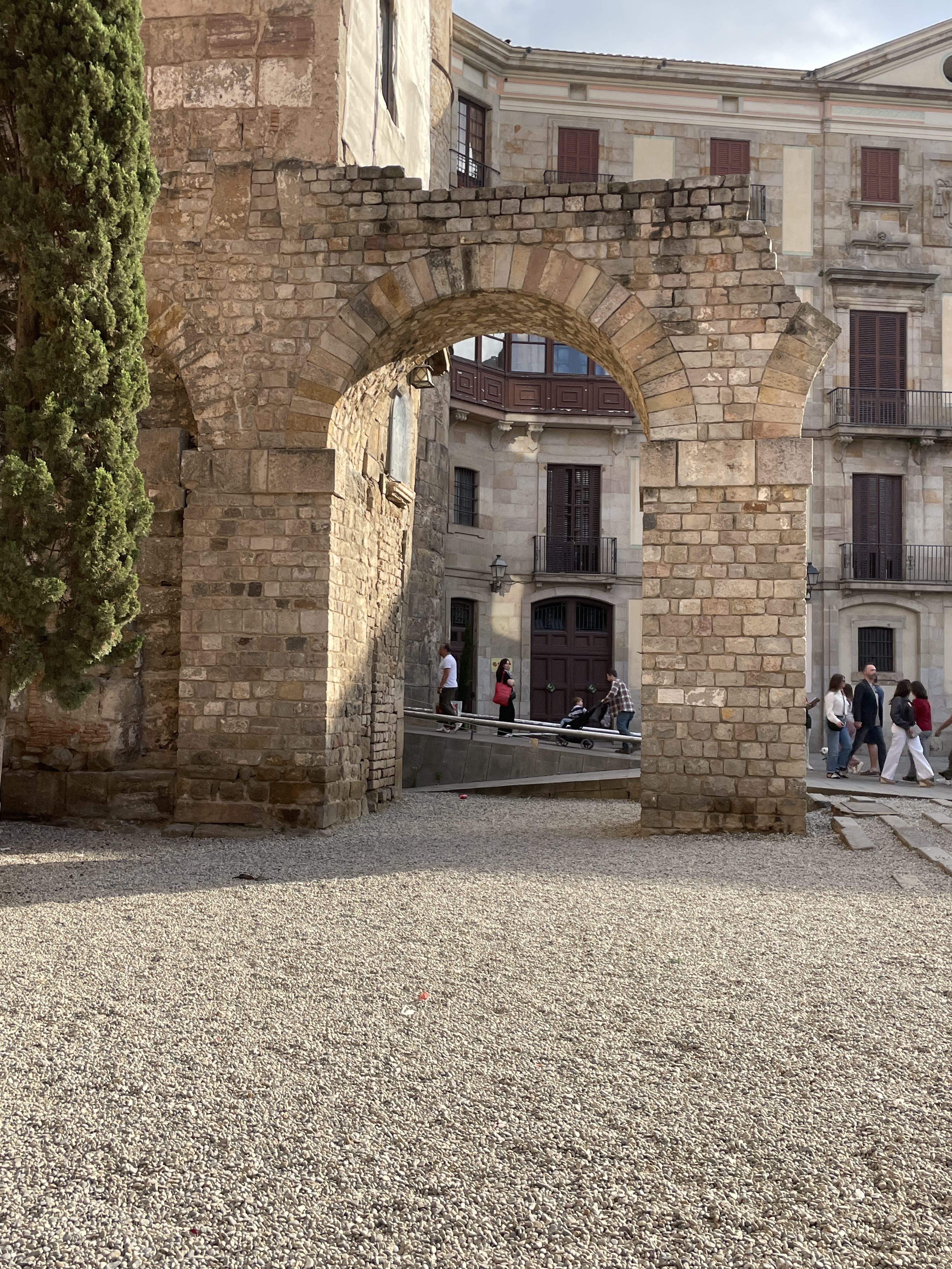
Portion of a Roman aqueduct Barcelona, Spain, May 2025.
A basin divided by a Rome-inspired wall
Relationships between upstream states and Lower Basin states — Arizona, California and Nevada — have been strained since the post-2026 effort kicked into gear in 2022 and 2023.
On the other side of the casino wall from the Upper Basin meeting, the Colorado River Board of California met Tuesday morning. Each audience could hear muffled clapping from the other room as the officials spoke to their constituents.
“We know one thing for sure, which is that we have a smaller river and that requires less use,” JB Hamby, chairman of the Colorado River board and California’s top negotiator, told the gathering.
He lauded California’s “massive” and expensive efforts to address the river’s shrinking supply while still growing the state’s economy and agriculture industry.
Lower Basin water use since 1964. 2025 data provisional, based on USBR projections Oct. 29, 2015.
California has cut its water use to 3.76 million acre-feet, the lowest it has been since 1949, state officials said. It has a proposed plan to conserve 440,000 acre-feet of river water per year.
One acre-foot roughly equals the annual water use of two to three households.
“We hear lots of applause lines from our friends next door, and we encourage them to take some examples from what California has been able to put together,” Hamby said. “We must all live with the resources we have, not the ones that we wish for.”
Crossing basin lines
While the states might be divided in water politics, conference attendees like Ken Curtis of Colorado moved between the rooms to hear each group’s discussion.
“We appear to be talking past each other,” said Curtis, the general manager of the Dolores Water Conservancy District in southwestern Colorado.
Some water managers from central Utah said they were already looking beyond the current negotiations to the next few decades. The basin’s challenges don’t end next fall — this is just a speed bump in a long future ahead, they said.
Others were waiting for updates from federal officials, scheduled for Wednesday. The Department of the Interior is set to release a highly anticipated look at different options for how to manage the basin around the end of the year.
Curtis said he is at the conference mainly to learn how other states were grappling with the tough water conditions and to get more insight into the negotiations beyond what’s in the media, he said.
“Squeezing it (water) out of the Upper Basin isn’t going to make enough water for the Lower Basin demands,” Curtis said. “And that may be a biased view, obviously, so I’m trying to get a little bit beyond my own biases.”
September 21, 1923, 9:00 a.m. — Colorado River at Lees Ferry. From right bank on line with Klohr’s house and gage house. Old “Dugway” or inclined gage shows to left of gage house. Gage height 11.05′, discharge 27,000 cfs. Lens 16, time =1/25, camera supported. Photo by G.C. Stevens of the USGS. Source: 1921-1937 Surface Water Records File, Colorado R. @ Lees Ferry, Laguna Niguel Federal Records Center, Accession No. 57-78-0006, Box 2 of 2 , Location No. MB053635.
The Colorado River Basin spans seven U.S. states and part of Mexico. Lake Powell, upstream from the Grand Canyon, and Lake Mead, near Las Vegas, are the two principal reservoirs in the Colorado River water-supply system. (Bureau of Reclamation)
In a momentous decision for the Western Slope, state water officials unanimously approved a controversial proposal to use two coveted Colorado River water rights to help the river itself.
Members of the Colorado Water Conservation Board voted to accept water rights tied to Shoshone Power Plant into its Instream Flow Program, which aims to keep water in streams to help the environment.
The decision Wednesday is a historic step forward in western Colorado’s yearslong effort to secure the $99 million rights permanently. But some Front Range water providers pushed back during the hearings, worried that the deal could hamper their ability to manage the water supply for millions of Colorado customers.
For the state, the two water rights will be a crown jewel in its five-decade environmental effort to help river ecosystems. It’s one of several steps in the agreement process, and it could take years before the river feels that environmental benefit.
“The Shoshone acquisition makes a lot of sense to me, and I’m very proud of the work that everybody’s put into it,” said Mike Camblin, who represents the Yampa and White river basins on the Colorado Water Conservation Board. “I hope that our children and our grandchildren look back at this and realize we made the right decision.”
Over 100 Colorado water professionals and community members gathered in Golden for a six-hour hearing about the environmental proposal, brought forward by the Colorado River District, which represents 15 counties on the Western Slope.
The small hydropower plant off Interstate 70 near Glenwood Springs has used Colorado River water to generate electricity for over a century. But the aging facility has a history of maintenance issues, and Western Slope water watchers have long worried about what happens to the rights if it were to shut down for good.
The Colorado River District wants to add the environmental use as part of a larger plan to maintain the “status quo” flow of water past the power plant, regardless of how long it remains in operation.
Western Slope communities, farms, ranches, endangered species programs and recreational industries have become dependent on those flows over the decades and broadly supported the district’s proposal.
From left, Hollie Velasquez Horvath, Kathy Chandler-Henry, and Andy Mueller, general manager of the River District, at the kickoff event Tuesday [December 19, 2023] for the Shoshone Water Right Preservation Campaign in Glenwood Springs. CREDIT: HEATHER SACKETT/ASPEN JOURNALISM
“I’m good. I’m much more relaxed now,” Andy Mueller, the district’s general manager, said after the vote Wednesday. “The reality is, we have set up our state, through this instream flow agreement, for success for centuries on the Colorado River.”
Some powerhouses in Colorado water support the general permanency effort but oppose parts of the agreement. Northern Water, Colorado Springs Utilities, Denver Water and Aurora Water said the proposal would give the Colorado River District too much sway in decisions that would impact them.
These water managers and providers are responsible for delivering reliable water to millions of people, businesses, farms and ranches across the Front Range. Any change to Shoshone’s water rights could have ripple effects that would affect over 10,000 upstream water rights, including some held by Front Range water groups.
The negotiations over the agreement continued throughout the meeting. Board members had about 24 hours to review a stack of documents marked with tweaked phrasing and proposed edits.
Both sides are concerned that the other could get a water windfall through the agreement, said Taylor Hawes, who represents the Colorado River on the board. Those concerns can be addressed in the next step of the process: Water Court.
“That has been the heart of all of this,” Hawes said. “I hope we can all trust that the water court’s process will give us a result where we don’t have to worry about that.”
Who will control the flow of water?
The Colorado Water Conservation Board was supposed to make its final ruling on the environmental use proposal in September. Then Public Service Company of Colorado, the Xcel subsidiary that owns the rights, and the Colorado River District filed an 11th-hour extension to delay until the meeting Wednesday.
That’s, in part, because they needed more time to address a central conflict in the agreement: Who makes the final decisions when managing the powerful rights?
Shoshone uses two rights to access the Colorado River: one for 1,250 cubic feet per second that dates back to 1905, and a right to 158 cubic feet per second that dates back to 1940.
They amount to a big chunk of water. Plus, these rights can be used year-round, and they supersede more recent, junior rights like several held by Front Range water providers.
Under the agreement, the water rights will be co-managed by the Colorado River District and the Colorado Water Conservation Board.
Western Slope parties were adamant about this. Several speakers said they would pull their funding, and there would be no agreement if the River District did not have a say in how the water rights would be used.
“If joint management is not adopted, Mesa County will withdraw its support for this acquisition,” Bobbie Daniel, Mesa County Commissioner, said. “It’s not out of anger or politics, but because anything less would fail the people that we serve.”
The Front Range groups said the state should make the final decision if Colorado River District staff and CWCB staff disagreed over how to manage the water rights. They argued the board has exclusive authority under state law.
Alex Davis with Aurora Water said her team was pushing for a “hammer” — an entity, preferably the state, that could force water providers on either side of the Continental Divide to come to the negotiating table or that could make the final decision, especially in times of crisis.
Aurora pulls about 25,000 acre-feet of water from the Western Slope, through mountain tunnels and into its water system each year, she said. (An acre-foot of water is about what two to three households use in a year.) But when Shoshone is using its 1905 water right to its fullest, nearly all of Aurora’s transmountain diversions are turned down or turned off.
The city might want to ask Shoshone to use less water to provide some relief in an emergency. The agreement seems to give the Colorado River District a veto, Davis said.
“By the River District having that decision-making power, it may lead to less incentive on the West Slope side in those emergency situations,” Davis said in an interview with The Sun. “That’s what we were worried about.”
Colorado Water Conservation Board members decided to continue with the co-management approach, saying they were not giving up authority or working outside of state statute by doing so.
Mueller said the agreement is a win for the river and the entire state. It will protect endangered fish and a critical 15-mile stretch of habitat near Grand Junction. It includes exceptions that will protect cities during multi-year droughts and emergency situations, he said.
“The CWCB and the River District can act together for the best interest of the state,” Mueller said in an interview. “We’ll have to earn some trust in that realm over the years, but I’m quite convinced we can do it.”
About that $99 million bill…
The Colorado River District has entered into a $99 million agreement with Xcel Energy to buy the Shoshone water rights.
The state’s decision to accept Shoshone’s water rights into its environmental program met one of four key closing conditions of that purchase agreement, Amy Moyer, chief of strategy for the Colorado River District, said.
The deal still needs approval by Colorado’s Public Utilities Commission. It’ll be weighed in Water Court, where Western Slope and Front Range representatives will wade through another thorny issue: What has Shoshone’s “status quo” water use been over the last century?
The Colorado River District and its Western Slope supporters need to pay up. Although they’ve pulled together over half the asking price, they’re still waiting to hear about whether a request for federal funding will be approved.
If the deal passes those hurdles, then the resulting purchase and instream flow agreement will go on indefinitely. It will provide more predictability for water users across the state, and it will continue to factor into how Colorado communities grow, officials said Wednesday. “We’re making some very far-reaching decisions here,” Nathan Coombs, the board’s Rio Grande Basin representative, said. “I still think this is the right choice right now with the information we have.”
Seven states in the Colorado River Basin are days away from a Nov. 11 deadline to hash out a rough idea of how the water supply for 40 million people will be managed starting in fall 2026. And they’re still at loggerheads over what to do.
The rules that govern how key reservoirs store and release water supplies expire Dec. 31. They’ll guide reservoir operations until fall 2026, and federal and state officials plan to use the winter months to nail down a new set of replacement rules. But negotiating those new rules raises questions about everything from when the new agreement will expire to who has to cut back on water use in the basin’s driest years.
And those questions have stymied the seven state negotiators for months. In March 2024, four Upper Basin states — Colorado, New Mexico, Utah and Wyoming — shared their vision for what future management should look like. Three Lower Basin states — Arizona, California and Nevada — released a competing vision at the same time. The negotiators have suggested and shot down ideas in the time since, but they have made no firm decisions.
This shows that Colorado’s Western Slope is the biggest supplier of water to the Colorado River. Source: David F. Gold et al, Exploring the Spatially Compounding Multi‐Sectoral Drought Vulnerabilities in Colorado’s West Slope River Basins, Earth’s Future (2024). DOI: 10.1029/2024EF004841
As the clock ticks down, onlookers have been increasingly frustrated and critical of the lack of progress in the closed-door negotiations.
“They seem to have been stuck basically on the same stuff for the last two-plus years,” said Jim Lochhead, former CEO/manager for Denver Water, the state’s largest water provider. “Part of why it’s so frustrating is they keep circling around to the same conversations over and over again.”
The Department of the Interior is managing the process to replace the set of rules, established in 2007, that guide how key reservoirs — lakes Mead and Powell — store and release water.
The federal agency plans to release a draft of its plans in December and have a final decision signed by May or June. If the seven states can come to agreement by March, the Department of the Interior can parachute it into its planning process, said Scott Cameron, acting head of the Bureau of Reclamation, during a meeting in Arizona in June.
Colorado River Storage Project map. Credit: Reclmation
If they cannot agree, the feds will decide how the basin’s water is managed. The federal government already has significant authority in the Lower Basin. But federal officials have also said they could leverage their authority over federal water projects in the Upper Basin, like Blue Mesa and the Colorado River Storage Project, to manage water in coming years.
The states could also take the matter to court, which could take decades to resolve and would put water management in the hands of judges instead of Colorado River communities, experts say.
“I think, if the definition of failure is that they don’t come to an agreement, we’ll know on Nov. 11,” said Sarah Porter, director of the Kyl Center for Water Policy at Arizona State University. “My sense is that they’ve all tried really hard.”
So what exactly is holding up progress? [Shannon Mullane] reached out to nine water professionals, from state negotiators to water experts, to break down the sticking points.
Water cuts in the Upper Basin (yes, that includes Colorado)
One of the top sticking points in the negotiations is whether the four Upper Basin states will commit to making firm water cuts or conservation goals during the basin’s driest years, experts said.
Colorado, New Mexico, Utah and Wyoming officials say the states regularly do not use their full legal allocation of Colorado River water, about 7.5 million acre-feet per year. The four states’ usage usually hovers closer to 4.5 million acre-feet per year and can fall to 3 million acre-feet in drier years, according to Upper Basin accounting.
They’re already cutting off junior water users early in dry years, like 2022. Water sharing is based on “first in time, first in right,” which means more recent, or junior, water rights are cut off before older, senior rights.
The officials argue that they’re already cutting back, and using less than their share, so why commit to cutting more? Conserving more water is also dependent on how much water is flowing through rivers and streams in any given year, Commissioner Becky Mitchell, Colorado’s governor-appointed negotiator, said.
Rebecca Mitchell, John Entsminger, Estevan Lopez, Gene Shawcroft, JB Hamby, Tom Buschatzke at the Getches-Wilkinson Center/Water and Tribes Initiative Conference June 6, 2024. Photo credit: Rebecca Mitchell
“We cannot conserve water that is not there,” she said.
In March 2024, the states proposed voluntary, temporary cuts, but that doesn’t work for the Lower Basin officials.
The downstream states proposed in March 2024 that they could take the first cuts — up to 1.5 million of their 7.5 million-acre-foot legal allocation — if reservoir storage is 38% to 69% of its capacity. After that, the Upper Basin and Lower Basin could evenly split additional cuts, according to the Lower Basin proposal.
That was a nonstarter for the Upper Basin officials, who balked when the Lower Basin asked them to cut up to 1.2 million acre-feet, or about a quarter to a third of the typical water use in the upstream states. Some of the Upper Basin states also say they do not currently have the legal authority to impose mandatory water cuts within their states when it comes to interstate water sharing agreements. [ed. emphasis mine]
This is one of two major disagreements in the negotiations, according to California Commissioner JB Hamby. The other is how and when water is released from the Upper Basin at Glen Canyon Dam to the Lower Basin, he said.
“There’s been lots of proposals bandied about back and forth between the basins and the feds,” Hamby said. “We’re not any closer at this point in time because those are the two most critical sticking points.”
Arizona officials declined to comment for the story. Nevada’s representative did not respond to requests for comment.
The political sticking point
Each of the seven negotiators is accountable to their home state. They have to be able to sell a deal to their water users and state lawmakers in a way that feels like a win, Porter of Arizona State University said.
In Arizona, Commissioner Tom Buschatzke must strike a deal that water users and the state legislature can get behind.
“There may be a situation where no deal is better than trying to sell a deal to your water users that you know they will utterly hate,” Porter said.
There are certain nonstarters for Arizona: Everyone expects to see water cuts for communities, like Phoenix, that rely on the Central Arizona Project, a 336-mile federal system that supplies Colorado River water to the most populated regions in Arizona. But it’s hard to see a benefit for Arizona in a deal with no water, or not enough water, for the project, Porter said.
And water users can sue if they don’t like the seven-state deal or if senior water users are asked to cut back on water to help junior water users. That would run counter to how the legal priority system has worked for over a century. Such lawsuits would tie up Colorado River water management in court for years, Porter said. [ed. emphasis mine]
Udall/Overpeck 4-panel Figure Colorado River temperature/precipitation/natural flows with trend. Lake Mead and Lake Powell storage. Updated through Water Year 2024. Credit: Brad Udall
“We’re really on the precipice of significant new, bigger shortages, and so the likelihood of a water user bringing legal action because of cuts outside of the priority system … is much higher than it was in 2019,” Porter said.
In past meetings, Cameron of the Bureau of Reclamation has called on water users to be more flexible so their state commissioners have room to negotiate.
“I urge you to continue to work with Tom (Buschatzke), embrace his leadership and give him the freedom to maneuver to strike an appropriate deal with his six colleagues in the other states,” Cameron said during an Arizona Reconsultation Committee meeting in June.
In Colorado, Mitchell said she is still working closely with water users within the state.
“We have firmly sat in the negotiating room with the principles we have always had,” she said. “That is something I have promised Coloradans: The principles that we developed are still the principles that I am taking into the room with me. Those are factored in as we are negotiating.”
What experts want to see
Water experts and professionals have been stuck on the outside of the closed-door negotiations, waiting on updates with greater frustration as the deadline draws near.
Now the states have less than two weeks to agree, at a high-level, on how to manage the water supply for millions of people, two countries, 30 Native American tribes, key food supplies and multibillion-dollar industries.
“They have the most thankless task that anyone in the Colorado basin could have,” Porter said.
Lochhead, formerly of Denver Water, said it seems impossible to reach any kind of comprehensive agreement before Nov. 11. They might be able to reach a conceptual outline, he said. They might be able to find a way forward if they were less entrenched in the Upper Basin versus Lower Basin dynamic, he added.
Jennifer Pitt and Brad Udall at the Getches-Wilkinson Center/Water and Tribes Initiative conference June 5, 2025. Photo credit: Allen Best/Big Pivots
Jennifer Pitt, Colorado River Program Director for the National Audubon Society, suggested that states work toward making the most out of water supplies instead of legal questions that are tough to resolve.
“Once the rules of the game become clear, people are going to lean hard into those solutions,” she said. “And there are many of them.”
John Berggren, regional policy manager for Western Resource Advocates, said the basin needs to see compromise as a win, not a loss. Officials need to educate their constituents that compromising empowers people to choose their destiny, instead of having courts or the federal government dictate it for the basin.
“A compromise is not a bad thing,” Berggren said. “Coming to agreement, coming to the table is actually a good thing for us.”
10 sticking points
The Colorado River water experts and negotiators highlighted 10 key sticking points:
The term of the agreement: The negotiators have weighed different options for how long the new agreement should last and whether there should be a short-term period for states to ramp up conservation programs and water use reductions. This is a lower-level sticking point where states might be able to find consensus more easily.
Reservoir management: The states have also debated which reservoirs will be managed under the new agreement. The Lower Basin wants to include upstream reservoirs, including Blue Mesa Reservoir in Colorado. The Upper Basin only wants Lake Mead and Lake Powell involved and worries that including upstream reservoirs will change how water flows through the basin or encourage Lower Basin overuse.
Rebuilding reservoir storage: Commissioner Mitchell of Colorado was adamant that the new plan needs to prioritize rebuilding reservoir storage, since key reservoirs — Lake Mead and Lake Powell — are falling closer to critical levels. Commissioner Hamby of California said the states can figure out how to handle reservoir storage, and other issues, like water cuts, pose a greater challenge.
Operating Lake Mead and Lake Powell: The current operational rules are mainly based on reservoir levels and river forecasts. When Lake Mead reaches a certain water level, it triggers adjustments in Lake Powell. The state officials agree these rules did not work. Colorado wants to prioritize the health of Lake Powell and base operations on real water levels — not forecasts. The states almost came to an agreement on how to do this earlier in the summer, but the idea was re-shelved.
Cutting back on water: This is a particularly thorny issue. Would the Upper Basin commit to firm water conservation goals or mandatory cuts? Is the Lower Basin doing enough to address the Upper Basin’s concerns about overuse in the three downstream states? Officials in both basins say large cutbacks to their water supply would be an existential threat to their communities now and in the future.
Basic accounting: The states disagree on key numbers. How does each state count its water use, shortages and conservation efforts? How much water is the Upper Basin supposed to send down to Mexico, or is that the Lower Basin’s job? How do downstream states count water use from tributaries, like the Gila River?
100-year-old issues: The states are also bolstering their legal arguments when it comes to unclear language in the Colorado River Compact of 1922, which laid out how the two basins were supposed to share water. Does it say the four upstream states are required to deliver a certain amount of water to the three downstream states? Or does it say the upstream states aren’t supposed to cause the water deliveries to go below a certain level? Some Upper Basin lawyers say they can argue that climate change, not the states’ water use, is the cause.
Distrust: The basin states have thrown plenty of barbs at each other during the negotiations. Each has accused the other of gaming the system in some way. Lower Basin and Upper Basin officials have said other states could time reservoir releases from lakes Mead or Powell to benefit their state. The Lower Basin has questioned whether the Upper Basin has inflated shortage calculations. The Upper Basin has long complained about Arizona’s practice of taking Colorado River water out of Lake Mead and storing it underground.
Group dynamics: The basin has split into Team Lower Basin and Team Upper Basin. Could states make more progress if they operated more independently, threw out ideas, formed coalitions and convinced others to join?
In-state politics: Even if the state officials can work out the details of an agreement, they still have to take it home and convince their states it’s a good idea. That can be complicated. In Colorado alone, there are decades-old conflicts over water between the Western Slope and Front Range, farmers and cities, tribal and non-tribal water users.
Denver Water and Save the Colorado must enter mediation at the end of the month to see if a deal is possible on the mid-project challenge to the water utility’s $531 million dam raising underway at Gross Reservoir in Boulder County, according to an order from the U.S. Court of Appeals.
A federal trial judge initially halted construction on the nearly finished dam, saying the U.S. Army Corps of Engineers permits for Denver Water violated U.S. environmental laws and that the water level at Gross could not be raised. Judge Christine Arguello later lifted the injunction on construction, for safety reasons, while Denver Water appealed the permit issues to the 10th Circuit Court of Appeals.
The 10th Circuit will take briefs from both sides of the dam dispute in November, and is now ordering a mediation session for Oct. 30. The conference is to “explore any possibilities for settlement” and lawyers for both sides are “expected to have consulted with their clients prior to the conference and have as much authority as feasible” on settlement questions, the court order says.
Construction has continued since the injunction was lifted, with Denver Water pouring thousands of tons of concrete to raise the existing dam structure on South Boulder Creek. Denver Water has argued it needs additional storage on the north end of its sprawling water delivery system for 1 million metro customers, to balance extensive southern storage employing water from the South Platte River basin.
Denver Water’s collection system via the USACE EIS
Save the Colorado and coplaintiffs the Sierra Club, WildEarth Guardians and others argue too much water has already been taken from the Colorado River basin on the west side of the Continental Divide, and that the forest-clearing and construction at Gross is further destructive to the environment. Gross Reservoir stores Fraser River rights that Denver Water owns and brings through a tunnel under the divide into South Boulder Creek.
“We look forward to having a constructive conversation with Denver Water to find a mutually agreeable path forward that addresses the significant environmental impacts of the project,” Save the Colorado founder Gary Wockner said.
When securing required project permits from Boulder County, Denver Water had previously agreed to environmental mitigation and enhancements for damages from Gross construction. But Save the Colorado and co-plaintiffs sued to stop the project at the federal level, and Arguello agreed that the Army Corps had failed to account for climate change, drought and other factors in writing the U.S. permits.
Denver Water declined comment Tuesday on the mediation order.
The halt and restart of the Gross Dam raising came in what has turned out to be a tumultuous year for major Colorado water diversion and storage projects.
While the Gross Dam decisions were underway, Wockner was finishing negotiations with Northern Water over $100 million in environmental mitigation funding to allow the $2.7 billion, two-dam Northern Integrated Supply Project to move forward. Once the 15 communities and water agencies subscribed to NISP water shares saw the increasing price tag, some began pulling out.
Northern Water reviewed the scale of NISP with engineers, then said it planned to move forward at the previously announced scale. The consortium’s board has asked all 15 initial members to indicate by Dec. 31 where they stand with the project and its price tag.
Roller-compacted concrete will be placed on top of the existing dam to raise it to a new height of 471 feet. A total of 118 new steps will make up the new dam. Image credit: Denver Water.
CSU Spur at dusk October 14, 2025. Photo credit: Allen Best/Big Pivots
Click the link to read the article on the Big Pivots website (Allen Best):
October 17, 2025
We heard about Colorado’s warming but uncertain climate. We heard about research projects. But what exactly is this new Climate Hub all about?
Colorado State University has created a Climate Hub that is to be based at its Spur campus in the heart of what used to be industrial Denver. This is on the grounds of the National Western Complex.
This is north of downtown Denver, near Colorado’s transportation hub: the intersection of Interstates 70 and I-25. When I first visited the National Western, no interstate highways existed anywhere. That dates me. I can vaguely remember my grandfather, a farmer/rancher from northeastern Colorado, boosting me up atop a fence to see all the cattle. I suspect that some were his.
The cattle have all disappeared except during the Stock Show each January. You can still smell a bit of manure, though, when walking from the parking lot to the Hydro Building, one of four major and architecturally interesting buildings erected on this new campus so far. A certain amount of research goes on at this campus. A correspondent from Gardner, a hamlet in south-central Colorado, mentioned that he had just mailed water and soil samples that he needed tested to the laboratory in the Hydro Building. Denver Water operates its lab there.
As for this event, I suspect it would fall under the label of “marketing.” I was there for the full two hours of presentations and heard much that was interesting but left without understanding exactly what was new.
CSU undeniably has its fingers in what the Climate Hub, at its website, calls “a defining challenge of our time.”
Russ Schumacher, the state climatologist, a professor at CSU, was an obvious choice for leading off a program like this. He recapped the climate report issued in 2024: We have already warmed an average 1.5 degrees Fahrenheit, he said. The 10 warmest years in Colorado’s recorded history going back to the 1870s have been in the 21st century. Last year was the fourth warmest, but this year, not as warm — but still in the top 20 on record.
And much more warming is in store, between 1 and 4 degrees Fahrenheit by 2050, given current emissions trajectories.
“Precipitation is more complicated,” he explained. “If you look at long-term trends, it hits hard, too, but you see a lot of ups and downs.”
Flooding will worsen, as will wildfires. We can also expect more heat waves and droughts.
Oh yummy. Somebody other than Russ, with his happy persona, could leave you very depressed.
The Climate Hub “explainer” meeting on Oct. 14 on the CSU Spur campus. Photo credit: Allen Best/Big Pivots
But then, that’s the story at CSU. They are figuring out solutions. Debby-downer is not the vibe.
For example, there was no talk of converting the world into vegetarians. Instead, Dr. Sara Place, who is an associate professor of feedlot systems (yes, I’m not making this up), talked about the effort to reduce the methane from the burping of cattle. It’s burps, not farts, that produce this significant component of our greenhouse problem. They constitute 3.1% of total U.S. greenhouse gas emissions.
The takeaway static from the cows-burping presentation was that 80% of the methane emissions come from cattle grazing on grass, not cattle chowing down in feedlots as they fatten up for the conveyor belt to the butchery. And yes, solutions are being devised, although I am at a loss to explain any of this.
Somewhat similarly, we got a peek at the research that has been underway at CSU now for a number of years to tighten up the methane emissions leaking from our “natural” gas infrastructure. “You can’t manage what you don’t measure,” said Dr. Dan Zimmerle.
And still other research, some of it global in scale, is underway, a bit difficult to summarize in something less than, well, maybe a 10,000-word tome. And some of it very Colorado-centric. One presenter asked if any of those in the room had been to Sterling? To Eads? (These are towns in eastern Colorado). My hand was only among a few raised in the room.
This was all part of an explanation about a new concept called digital twins. They can observe what is happening in the field from laboratories.
Surprising, though, was a tag-team effort to peel us back from the narrow confines of what we think we know to imagine possible futures. It was a marked departure from the usual conveyor belt of facts and exhortations at climate meetings.
Courtney Schultz, director of the CSU Climate Initiative, quoted an author, Jim Dater, who had said that the future cannot be predicted. The only useful ideas about the future should (at first) appear to be ridiculous.
Only later did I think about science itself. Some of the big ideas, such as plate tectonics, were originally seen as ludicrous, to be laughed out of the room.
We were asked by Lynn Badia, a professor of English, to engage in what she called speculative storytelling.
We were quickly induced to exercise some of this outside-our-boxes imagining. Can’t say that anything I imagined for Olde Town Arvada in 2050 was all that imaginative. High(er) rises? Fewer blue skies. The next round, I got a little more adventurous: glasses that you could wear that would allow you to see the essence of the person you were looking at.
Again, only later, did I ponder smart phones. Twenty-five years ago could I see people wandering down sidewalks, sauntering across streets, seemingly mindless of traffic or, for that matter, anything else around them, their faces scrunched close to little boxes in their hands? We call them smart phones, and sometimes I seem them in droves — and just down the street.
“Have you exaggerated the possible changes to the point of absurdity?” Badia asked us.
It was fun. I am so accustomed to trying to verify facts, not to imagine the future.
Others in attendance that I consulted afterward echoed my read on the event. CSU wants to make its presence better known and the willingness to work with the private sector. That already exists with the methane-testing center. Zimmerle said they were working with many oil and gas companies trying to respond to increasing regulation by the Colorado Department of Public Health and Environment. A member of the Climate Central team talked about providing help to Fort Collins Utilities.
One individual pointed to two themes: (a) the value of collecting, analyzing and making available substantive data; and (b) a growing partnership between universities and the private sector, filling in the new gap caused by the termination of the federal government as a research partner.
You can also see that at the CSU Climate Hub website in its statement that it “partners with diverse groups to co-create impactful solutions.”
The Legacy building, which is located across the street from the Hydro and Terrra buildings on the CSU Spur campus in Denver, appears to be ready for imminent occupancy. Photo credit: Allen Best/Big Pivots
As we left the Hydro building, I paused to study the latest edifice — a word I use with deliberation — that is soon to be available for public occupation. Just down the street, though, were train cars, perhaps containing crude oil. Who knows.
When I first moved from the mountains to Denver in 1998, I remember the vacant field west of the train tracks at Union Station. Nothing there. A place of homeless people, maybe. Now? The folks from Aspen and Vail have built luxury real estate. Some of the units overlook the train tracks that to this day are used by coal trains exporting carbon from the coal pits of Wyoming to distant power plants.
I could not then imagine the scene observable today at Union Station. Frankly, it has been very hard for some people to imagine the end of the fossil fuel era. But I may live long enough to see the end of those coal trains. I can imagine that.
Funding for water in Colorado is seeing a surge, despite the state budget crisis, with cash from sports betting hitting a new high this year.
The gaming initiative brought in $37 million for the fiscal year that ended June 30, according to the Colorado Division of Gaming. That represents a nearly 21% increase from last year, when tax revenue came in at $30.4 million. But water projects statewide still are at risk as the legislature gears up for a special session next week to close a new $1 billion gap in Colorado’s budget.
Approved by voters in 2019, the sports betting tax is used to fund Colorado’s Water Plan.
Back then, early legislative forecasts for revenues that might flow from the program topped out at $29 million.
But the program has grown in popularity and lawmakers have, in recent years, expanded the amount of revenue from the gaming tax that can flow to water programs and also removed a tax break for free bets.
The Colorado Water Plan is run by the Colorado Water Conservation Board, the state’s lead water planning agency.
In addition to sports betting cash, the CWCB is financed using income derived from severance taxes, the state’s general fund, and other sources.
The agency sends millions of dollars across the state each year to help pay for water-saving programs for cities and farms, habitat restoration programs, storage projects, land use planning, irrigation system repairs and the purchase of environmental water supplies for water-short streams.
On Aug. 21, Gov. Jared Polis will convene a special session during which lawmakers will look for ways to fill a roughly $1 billion budget shortfall triggered by new federal tax cuts, which have an impact on Colorado’s tax collections as well.
The sports betting tax program, by law, can’t be tapped by lawmakers next week to fill budget holes. But how the CWCB and water programs financed through other unprotected funds will fare as budgets are trimmed isn’t clear.
Millions of dollars for water projects have already been committed this year, including $20 million in cash the CWCB set aside to help pay for the purchase of the historic Shoshone water rights on the Colorado River.
The CWCB did not respond to an interview request to discuss potential impacts on water projects due to the budget crisis. It said via email that it did not anticipate any impacts to its fiscal year 2026 budget. The fiscal year began July 1.
House Speaker Julie McCluskie, a Democrat from Dillon, said the financial outlook is bleak for all state agencies, including the CWCB.
“We are still too early in the process to determine exactly what water-related funding is at risk. However, this GOP-caused $1 billion hole in our budget will require some tough decisions, and nearly everything is on the table,” McCluskie said via email.
The Yampa River Core Trail runs right through downtown Steamboat. Photo credit City of Steamboat Springs.
I’m hopping on my bicycle for the ride up the Yampa River to the Steamboat Grand for Day 1 of the Colorado Water Congress Summer Convention. Today starts with workshops and then the general sessions kick off after lunch. Here’s the agenda and Timeline: https://coloradowatercongress.growthzoneapp.com/ap/CloudFile/Download/rX4NKmlr
Millions of dollars in federal funding has been released to continue restoring lands and streams in the fire-scarred Upper Colorado River Basin watershed in and around Grand Lake and Rocky Mountain National Park.
The roughly $4 million was frozen in February and released in April, according to Northern Water, a major Colorado water provider and one of the agencies that coordinates with the federal government and agencies such as the U.S. Forest Service to conduct the work.
Esther Vincent, Northern Water’s director of environmental services, said the federal government gave no reason for the freeze and release of funds.
The amounts and timing of the freeze and release are being reported here for the first time.
U.S. Congressman Joe Neguse, who represents Grand County, did not respond to a request for comment regarding the funds.
The news comes as tens of millions of dollars in federal grants and budget allocations are being cut in Colorado and across the country as part of the Trump administration’s reorganization of federal agencies and associated budget cuts.
In June, Gov. Jared Polis’ office released an accounting of federal money that has flowed to state agencies. That analysis showed the agencies were able to retain $282 million in funding, but that $76 million had been lost, and another $56 million is at risk.
It’s unclear how much funding that flows through federal agencies to other Colorado entities and nonprofits such as those in the Upper Colorado River Basin, has been lost.
The U.S. Forest Service did not respond to a request for comment. The U.S. Bureau of Reclamation declined to comment on the funding actions.
In Grand County, $761,000 has been released from the U.S. Bureau of Reclamation to help move forward on a broad-based effort by the Kawuneeche Valley Restoration Collaborative, according to Northern Water. The valley has been damaged by drought, failing irrigation systems and overgrazing by wildlife and is a critical piece of the Colorado River’s upper watershed. The collaborative, established in 2020, is a major partnership of seven entities, including Northern Water, Grand County, the Nature Conservancy and Rocky Mountain National Park.
East Troublesome Fire. Photo credit: Northern Water
The $3.3 million in East Troublesome fire funding that has been released through the U.S. Forest Service will help restore the watershed around Grand Lake and land in Rocky Mountain National Park. The fire began in October 2020 and burned nearly 200,000 acres, making it the second largest fire in Colorado history.
The fire burned land that constitutes a sprawling water collection area for Northern Water, a major water provider that pipes Colorado River water from Grand County, under the Continental Divide and east to the Front Range, where it serves roughly 1 million residents of northern Colorado and hundreds of farms.
Steve Kudron, former mayor of Grand Lake who now serves as its town manager, said restoration work in both projects is critical to the economy and health of the historic tourist town, which lies at the western edge of Rocky Mountain National Park.
“The biggest concerns that we had were closing parts of the forest because there hasn’t been sufficient cleanup. Some mountainsides are unstable,” he said. “It’s the funding that makes it safe for the public to go into those areas. That’s why it was important to get the funding back.”
Lake Mendocino, in Northern California’s wine country, was the proving ground for Forecast-Informed Reservoir Operations. (Source: California Department of Water Resources)
Western Water in-depth: For years, atmospheric rivers were a mystery. now, an innovative dam management approach is putting them to work
In December 2012, dam operators at Northern California’s Lake Mendocino watched as a series of intense winter storms bore down on them. The dam there is run by the U.S. Army Corps of Engineers’ San Francisco District, whose primary responsibility in the Russian River watershed is flood control. To make room in the reservoir for the expected deluge, the Army Corps released some 25,000 acre-feet of water downstream — enough to supply nearly 90,000 families for a year.
In doing so, the Army Corps averted the possibility of a catastrophic flood. But almost as soon as the water headed downstream, the pendulum swung in the other direction. The weather turned dry, and the months that followed proved to be the driest on record in California up to that point. A year later, the reservoir became a drought-cracked mudflat. The local water supplier, Sonoma County Water Agency, was forced to reduce releases by 60 percent during the dry summer, impacting urban and agricultural water users downstream.
State officials were frustrated. Members of a drought task force created by then-Gov. Jerry Brown traveled to Lake Mendocino, tucked into the coastal wine country near Ukiah, to hold a press conference. An exasperated John Laird, the state resources secretary at the time, asked some of the Army Corps’ top brass what they’d been thinking when they sent so much water downstream.
“I just blurted it out,” says Laird, now a state senator. “It was one of those emperor-has-no-clothes moments, because somehow nobody was speaking up about this.”
It made for an uncomfortable moment. But the incident catalyzed a wide-reaching effort to manage dams more nimbly in the face of wildly variable weather, and particularly to meet the challenge of atmospheric rivers — intense winter storms that pummel California and other parts of the West with huge amounts of rain.
In the wake of the controversy at Lake Mendocino, the quest to harness the power of atmospheric rivers birthed a new water-management approach: Forecast-Informed Reservoir Operations, or FIRO. The concept has been tested on three dams in California since 2019, with programs in development for several other dams across the West.
By pairing FIRO with accurate forecasts of where those storms will hit and how much rain they’ll bring, dam operators can work in real time to not only reduce the risk of dangerous floods, but also capitalize on atmospheric rivers’ potential as a source of additional water for protection from drought.
Now, the concept is poised to improve operations at 39 more dams across the arid Southwest and another 71 throughout the rest of the country. That will vastly increase FIRO’s potential and help dam operators stand ready for the wilder weather that the future will likely bring: storms intensified — and made more erratic — by climate change.
Some 50 atmospheric rivers hit the West Coast of the U.S. during the 2024-25 season. (Source: Center for Western Weather and Water Extremes)
Atmospheric Rivers Enter the Lexicon
For decades, the “Pineapple Express,” a type of storm that feeds off warm tropical moisture, figured prominently in local weather lore. By the early 1990s, researchers realized that it was just one kind of a broader category of unique storms that take shape far out in the Pacific. In a 1994 research paper, Yong Zhu, now at North Carolina State University, and MIT’s late Reginald Newell, christened them atmospheric rivers.
According to a 2019 study, atmospheric rivers caused $5.2 billion in damage in Sonoma County over the preceding two decades and were responsible for 99.8 percent of all insured flood losses there. A single 1995 storm — the most damaging event in 40 years of record keeping in the West — inundated the town of Guerneville on the Russian River and caused $50 million in insured losses countywide. The study determined that atmospheric rivers are the primary driver of flood damage in the West.
These powerful plumes of water vapor — which, on average, carry 25 times the flow of the Mississippi River — deliver 30 to 50 percent of total annual precipitation in California.
“Atmospheric rivers are the hurricanes for the West Coast,” says Cary Talbot, the FIRO National Lead with the Army Corps’ Engineer Research and Development Center.
But when they fail to arrive, that can also have a big impact, leaving the state parched and reeling. Their influence isn’t limited to just California, either: In 2021, researchers Mu Xiao, now at the Scripps Institution of Oceanography at UC San Diego, and Dennis Lettenmaier, now at University of California, Los Angeles found that almost one third of snowpack in the Upper Colorado River Basin comes from snowfall brought by atmospheric rivers.
The Army Corps’ primary responsibility is the high-stakes task of controlling floods, or as the agency puts it, “flood risk management.” As a result, the Army Corps tends to be extremely risk averse, and it literally runs its dams by the book: Each of its dams has an individually formulated water control manual with flood control curves, more commonly known as “rule curves,” that are practically chiseled in stone.
“When those things are written, they go through a really rigorous (vetting) process because it’s what we are going to be graded on in the courts,” says Talbot. “When somebody sues us for how we operated, they’re going to look at the water control manual and say: ‘Did the operators follow the rules?’ So, water managers don’t really want to stray too far from what it says.”
Rule curves typically force operators to keep reservoir levels low during wet seasons so they can catch and hold back the rainfall from anticipated storms and reduce the impacts of flooding downstream. But if those storms veer off their predicted course, or dissipate before they arrive, operators can’t get back the water they’ve already released — exactly what happened at Lake Mendocino in 2012.
The public outcry over that incident, which would be followed by the driest three-year period on record until then, helped nudge the Army Corps toward a more flexible approach.
Flood-control releases in December 2012, followed by months of drought, sent reservoir levels in Lake Mendocino — shown here in December 2013 — plummeting. (Source: Sonoma Water)
“The disaster of a really bad drought in California focused congressional attention,” says Talbot. In 2015, Congress added a line in the Army Corps’ budget for a research-led Water Operations Technical Support program. “It wasn’t much money — it was really just $2 million to get it started — but the direction from Congress was to see if we can’t find a better balance between flood risk management and water supply, especially with respect to atmospheric rivers.”
The following year, the Army Corps modified its regulations to allow for the use of forecasts in operations planning. Actually incorporating that change into each dam’s water control manual, many of which are decades old, still required an administrative process that typically takes several years. But the announcement was a significant first step in the shift away from the hidebound rule curves that governed dam operations.
To make it all work, though, dam operators had to have weather forecasts that they could trust.
Decoding Atmospheric Rivers
As it happened, weather researchers were already on a quest to crack the mystery of how atmospheric rivers work. A key figure in the effort was Marty Ralph, who spent more than two decades as an atmospheric scientist at the National Oceanic and Atmospheric Administration (NOAA) beginning in 1992.
Marty Ralph, head of the Center for Western Weather and Water Extremes (CW3E), worked with colleagues to vastly improve the accuracy of atmospheric river forecasts. (Source: CW3E)
Ralph had begun studying cyclones off the U.S. West Coast in the mid-1990s. To get an up-close view of the storms in their spawning grounds far out at sea, he wheedled and cajoled the use of weather research aircraft from NOAA, NASA and the Air Force that sat idle following the busy summer hurricane season on the Gulf Coast. (At one point, Ralph experimented with — but ultimately gave up on — using a long-range surveillance drone called the Global Hawk, an $80-million-plus “hand-me-down,” as he puts it, from the Air Force to NASA.)
Ralph’s research focus gradually zeroed in on what would turn out to be atmospheric rivers. He didn’t read Zhu and Newell’s groundbreaking work on the phenomenon until 2003, but when he did, “the light bulb just went off, like, ‘Oh — that’s what we’re studying!’”
Ralph organized a series of annual “field campaigns” to learn more about atmospheric rivers and racked up more and more flight time. In 2013, he left NOAA to start the Center for Western Weather and Water Extremes, or CW3E, at the Scripps Institution of Oceanography at UC San Diego. There, working with other researchers, he continued to research atmospheric rivers’ origins and behavior. But along the way, he says, “it became clear to me that we should be trying this as an operational program to help with forecasting” so that dam operators could have a more accurate real-time picture of individual storms’ paths and intensity.
Lake Becomes Proving Ground
Meanwhile, Lake Mendocino was emerging as the first test case for FIRO. At the time, Jay Jasperse was the chief engineer and director of groundwater management for Sonoma Water, which gets much of its supply from the lake. Despite the Army Corps’ new openness to using forecasts for more flexible dam operations, he says, there initially was “a lot of skepticism from some parties, and there was a lot of concern that the Army Corps was going to be incurring a lot of liability, and that this is going to negatively impact their flood risk management operations.”
During the 2020 water year, FIRO allowed an extra 19 percent, or 11,175 acre-feet of water, to be captured in Lake Mendocino. (Source: Sonoma Water)
“There were some spirited debates, and I think it took us a few years just to learn about each other and about each other’s agencies and how we worked and what our needs were,” Jasperse says. “But we all stuck with it, because the overall idea just made too much sense.”
Before FIRO was tried at Lake Mendocino, it went through an exhaustive modeling process to determine how it would affect dam operations. Gradually, Jasperse says, “we started seeing this was pretty doable, and the Army Corps started to get more comfortable with it.”
After extensive modeling, FIRO was first tested at Lake Mendocino during the 2020 water year and immediately proved its worth: That year, FIRO allowed an additional 11,175 acre-feet of water to be captured and stored there. That helped show that dams originally built principally for flood control could also be used to increase water storage and reliability.
“There’s ways to do both under the right conditions, and Lake Mendocino is proof of that,” says Patrick Sing, the lead water manager for the Army Corps’ San Francisco District. “When all the weather forecasts say it’s going to be dry, we can hold onto a lot of water instead of releasing it. We’re not impairing our flood management mission, and we’re doing our part to be stewards of a resource that’s very valuable in the event that the next year is a drought.”
Still, Sing notes that FIRO isn’t a silver bullet.
“You do all this research and modeling, but at the end of the day, it comes down to the reservoir operator to make a decision, and their agency is going to be held responsible for that decision,” he says. “If they’re not comfortable enough with FIRO, it’s probably not going to move forward. And they shouldn’t be forced to do it. They should be comfortable and convinced that it is safe to do.”
At Lake Mendocino, Sing says, “there’s been enough research and development and testing that we’re comfortable doing this.”
Forecast-Informed Reservoir Operations are currently underway or being actively assessed at 21 dams on the West Coast. (Source: U.S. Army Corps of Engineers)
Expanding FIRO
In 2022, FIRO-based operations were extended to Lake Sonoma, the other reservoir that supplies Sonoma Water within the Russian River watershed. And this year, FIRO was put in place on a preliminary basis at another dam, Prado Dam on the Santa Ana River in Southern California. Since 2020, FIRO has contributed to an additional 95,000 acre-feet of storage in the three reservoirs — an amount equal to just over 75 percent of Lake Mendocino’s total volume.
“We’re getting better and better,” says Jasperse, who now works as a consultant for both Sonoma Water and CW3E. “Everybody’s getting more and more experience every year.”
FIRO won’t work at all dams, especially in areas where forecasts are less reliable. In the summertime in the Deep South, for example, “pop-up thunderstorms can happen any day, any time,” says the Army Corps’ Talbot, who is based in Mississippi. “We’ve got a lot of moisture coming up from the Gulf, so it’s much harder to predict that kind of impactful rain here than it is in the West.”
But experience has shown that where FIRO is viable, it can provide additional water at a cost far lower than traditional approaches for boosting water supply, like increasing the size of a dam.
“Those are lengthy, expensive and complicated processes. It’ll take, in some cases, a decade or more to realize those benefits,” says Talbot. “FIRO is something that we literally can do today. We didn’t have to change the dam at all. This is just taking existing infrastructure and making it work better.”
At Prado Dam in Southern California, the Orange County Water District is expanding the possibilities of FIRO by pairing it with a groundwater recharge program to ensure that water that’s released from the dam isn’t lost. There, releases can be diverted into recharge basins downstream, where the water then soaks into the local aquifer.
Adam Hutchinson, the district’s recharge planning manager, says the agency anticipates getting an average of an extra 6,000 acre-feet per year through its FIRO operations. That’s not a lot of water, but it makes a big difference. The water retailers in the district’s service area rely on groundwater for the majority of their water supply, but they still have to import about 15 percent from Northern California and the Colorado River, at a cost of more than $1,000 per acre foot.
“So for that 6,000 acre-feet that we hope to get,” he says, “that’s $6 million a year that we’re saving by putting this free water in the ground.”
“AR Recon” flights to improve the accuracy of atmospheric river forecasts, which have been carried out from California and Hawaii for years, are now also being launched from Guam and Japan. (Source: U.S. Air Force 403rd Wing)
More Dams on the Radar
While FIRO is currently in place at just three dams, it is on the brink of a dramatic expansion. Earlier this year, two more dams — both significantly larger than any at which FIRO is currently in place — were added to the roster of potential FIRO sites: The Yuba Water Agency’s New Bullards Bar on the Yuba River, and Lake Oroville, the 3.5-million-acre-foot flagship of the State Water Project on the Feather River. A group of federal and state agencies and CW3E completed a final viability assessment at the two dams. The California Department of Water Resources and Yuba Water are now contemplating what steps to take to put FIRO into practice at those facilities. (In 2019 a more limited program, often referred to as “FIRO Lite,” went into operation at the federal Bureau of Reclamation’s Folsom Dam, on the American River just upstream of Sacramento.)
FIRO-implementation efforts are also in progress for several other dams: Seven Oaks, upstream of Prado on the Santa Ana River; a system of 14 dams in Oregon’s Willamette Valley; and Howard Hanson Dam near Seattle.
And now, FIRO is about to get a much bigger boost. In May, the Army Corps completed an initial evaluation of the suitability of FIRO at each of the 593 flood-control dams under its authority nationwide. It found that implementing FIRO is promising at 110 of those, including 39 across the Southwest. Another 299 dams nationwide may have potential as candidates for FIRO, although they face some significant barriers to implementation.
The Army Corps is now moving forward on two more-detailed rounds of evaluation on the 110 top-tier dams. Then, beginning in 2027, it will move toward implementing FIRO at those with the most potential.
The biggest impediment to more widespread implementation of FIRO remains a lack of accurate forecasts in parts of the country that don’t experience atmospheric rivers.
“The most common reason it’s not going to work is forecast skill” — essentially, accuracy, says Talbot. “That’s the leading factor for eliminating dams in the screening process.”
In the West, the effort to improve forecasts only continues to advance. In December 2023, then-President Biden signed the Atmospheric River Reconnaissance, Observations and Warning Act, which had been introduced by California’s senior U.S. senator, Alex Padilla. The law called for what has become known as the AR Recon aerial surveillance program, led by Ralph and Vijay Tallapragada of the National Weather Service, to be expanded throughout the full winter season. The past two years, AR Recon carried out 107 reconnaissance flights across the Pacific, flying not only out of California and Hawaii, but Guam and Japan, as well.
“The farther West we go, the greater the lead time improvement we get” in forecasting, says Ralph. “We’ve been able to improve the forecast of extreme precipitation in California by about 12 percent just by adding the (AR Recon) data. That’s the equivalent of 10 years of the typical process of improving forecasts through research — so we’re buying a decade of advances just by adding these data.”
The Army Corps’ Talbot says those strides forward are welcome news for dam operators.
“If you take a water manager and you give them three extra days of lead time, they can do a lot with that. Water managers always tell me, ‘Look, you give me a weather crystal ball and I’ll manage water better,’” he says.
“As long as we keep the aircraft flying and people advancing on the science and the meteorological wizardry, these water managers are getting closer and closer to that crystal ball.”
Perry Cabot, left, and Manny DeLeon hold a 3D-printed Parshall flume that they created to make the water-measurement device more affordable and accessible. Photo credit: Colorado State University
At Colorado State University, innovation doesn’t always start in a state-of-the-art lab. It sometimes begins with a farmer in need, a researcher with a goal and a healthy dose of curiosity. That spirit drives work at the Colorado Water Center, where scientists and collaborators are rethinking how we manage and measure one of our most vital resources.
CSU Extension Professor Perry Cabot, who is jointly appointed through the Colorado Water Center and the Agricultural Experiment Station, is blending historic engineering with cutting-edge technology to make irrigation measurement more affordable and accessible. Cabot and a team of CSU researchers are harnessing the power of large-format 3D printing to revive and reimagine the Parshall flume – a century-old water measurement device first developed at CSU.
The project was made possible through funding from the Colorado Water Center’s grant program, which supports applied research projects that address urgent water issues across Colorado.
From legacy to low-cost innovation
The Parshall flume, invented by Ralph Parshall in 1921 at what was then called Colorado Agricultural College, remains one of the best methods for measuring water in open channels like irrigation ditches. Its distinctive shape slows and constricts the water as it flows through, making it possible to calculate the flow rate, or how much water is flowing through per second, by measuring the height of the water at a specific point in the flume. The flow rate is multiplied by the amount of time the water flows through the flume to calculate the amount of water. This information is essential for tracking and managing water used for irrigation, especially in regions where every drop counts.
“The genius of the flume is in the geometry,” Cabot said. “We can convert the height of the water in the flume into flow without needing fancy instruments, which is precisely why it has stood the test of time.”
Farmers can use flume data to schedule precise watering, reduce excess runoff and document their water use to meet regulatory requirements. By knowing the exact flow rate, a farmer can match irrigation timing and volume to crop needs more accurately. This minimizes the risk of overwatering, which wastes both water and energy, and reduces the risk of nutrient runoff. Over the course of a growing season, this kind of precision can lead to better harvests, lower costs and more sustainable use of limited water supplies.
However, traditional flumes are expensive, often ranging from hundreds to thousands of dollars, depending on size, and they are cumbersome to ship. For many farmers, researchers and conservation districts, the cost alone can be a barrier to access.
At left, a small 3D-printed Parshall flume inside the printer. At right, a larger version of a 3D-printed Parshall flume in action. Photo credit: Colorado State University
“We measure what we value, and we value water, but it’s a resource that’s increasingly difficult to put a clear, consistent price on,” said Cabot. “That lack of clarity makes it harder to justify costs associated with industrial tools like Parshall flumes.”
“Instead of buying an expensive, prefabricated flume, 3D printing allows us to create and sell Parshall flumes at a much more affordable rate,” Cabot said.
Manny DeLeon, a CSU researcher in the College of Agricultural Sciences and research technician on Cabot’s team, uses tools such as 3D printing to help develop low-cost technologies to make water measurement more accessible and efficient.
Using a durable, petroleum-based resin, Cabot and DeLeon have successfully printed the first large-scale Parshall flumes ever produced using additive manufacturing. Their 3D-printed version costs as little as 10%-20% of its traditional counterpart, with minimal compromise in durability or accuracy.
Printing the future of water management
Cabot sees this as a transformative step toward democratizing water measurement tools. His long-term vision is to decentralize flume manufacturing by equipping local conservation and river districts with the 3D printers needed to build and calibrate their own equipment.
“Imagine a farmer walking into their local conservation office, asking for a flume and walking out with one the next day,” Cabot explained. “This puts the tools of water management into the hands of the people using them.”
Rooted in service, driven by ingenuity
For Cabot, this project represents more than cost savings or tech adoption; it’s about service.
“My job is to help people,” he said. “Engineering, for me, is fun, but it’s also about solving problems that matter. That’s what engagement and extension are all about.”
Cabot said his work on the Western Slope is a great reminder for the future of research and innovation at CSU. “We don’t need to have the flashiest tools to build something transformative that can change the world. All it takes is a little ingenuity, a bit of resin and those willing to do the work.”
Learn more
To explore more about CSU’s legacy in water innovation and the Colorado Water Center’s work, visit the Colorado Water Center’s website.
Ralph Parshall squats next to the flume he designed at the Bellevue Hydrology Lab using water from the Cache la Poudre River. 1946. Photo Credit: Water Resource Archive, Colorado State University, via Legacy Water News.
Roller-compacted concrete will be placed on top of the existing dam to raise it to a new height of 471 feet. A total of 118 new steps will make up the new dam. Image credit: Denver Water.
Afederal judge will allow Denver Water to continue work on a $531 million project to raise a dam in Boulder County, dealing a blow to environmentalists who had hoped to stop the construction.
However, Senior U.S. District Judge Christine Arguello in her ruling May 29 prohibited Denver Water from filling Gross Reservoir until federal environmental permits can be rewritten by the Army Corps of Engineers.
“There is no evidence that there would be additional environmental injury resulting from completion of the dam construction. In fact, the opposite is true,” Arguello wrote. “There is a risk of environmental injury and loss of human life if dam construction is halted for another two years while Denver Water redesigns the structure of the dam and gets that re-design approved by” the Federal Energy Regulatory Commission.
FERC is involved because of the hydroelectric plant at the base of the dam.
Denver Water’s general counsel, Jessica Brody, said Friday her agency was pleased the judge recognized the safety issues in leaving the dam half-built.
“We’re relieved that the judge understood and appreciated the safety issues. We are relieved as well that she understood the impact to Denver Water’s customers,” Brody said.
The construction is expected to be completed this year, she said. In the meantime, she said, her agency will move forward in asking a federal appeals panel to rule on whether key environmental permits need to be rewritten, as Arguello has ordered.
If the permits are redone, it could mean that the U.S. Army Corps of Engineers will determine that the metro Denver water provider, which serves 1.5 million people, needs less water from the Fraser River to fill an expanded Gross Reservoir than the original permit authorized.
Save The Colorado, one of the plaintiffs in the case, said Friday morning that it will defend the portion of the Thursday ruling that could prevent or reduce additional diversions from the Fraser River, a key tributary in the Upper Colorado River system.
“Importantly,” said Save The Colorado’s Gary Wockner, “her original 86-page ruling still stands … so they can’t cut trees and they can’t put water in it until it is all resolved.”
Denver Water is helping ensure its future water security with the Gross Reservoir Expansion Project. When the project is complete, it will nearly triple the Boulder County reservoir’s capacity to 119,000 acre-feet. CREDIT: HEATHER SACKETT/ASPEN JOURNALISM
How the case progressed
In her April 3 ruling, Arguello said Denver Water had acted recklessly in proceeding with construction in 2022, knowing that important legal questions were being challenged by Save The Colorado, the Sierra Club and others.
The massive construction project to raise the dam 131 feet and triple the capacity of Gross Reservoir has sparked fierce opposition in Boulder County and prompted several legal challenges from Save The Colorado, a group that advocates on behalf of rivers. Though its early lawsuits failed, the group in 2022 won an appeal that put the legal battle back in play. Despite months of settlement talks, no agreement was reached.
Denver Water first moved to raise Gross Dam more than 20 years ago when the water provider began designing the expansion and seeking the necessary federal and state permits. Denver Water has said raising the dam and increasing capacity of the reservoir is necessary to ensure it has enough water throughout its delivery system and to help with future water supplies as climate change continues to reduce streamflows.
After years of engineering, environmental studies and federal and state analyses, Denver received a permit from the U.S. Army Corps of Engineers, and construction began in 2022.
Arguello’s April 3 ruling said, in part, that the Army Corps should have considered whether ongoing climate change and drought would leave the Colorado River and Western Slope waterways too depleted to safely allow transfer of Denver Water’s rights into a larger Gross Reservoir for Front Range water users.
At the same time, she ordered a permanent injunction prohibiting enlargement of the reservoir, including tree removal and water diversion, and impacts to wildlife.
Almost immediately, Denver Water filed for temporary relief from the order, saying, in part, that it would be unsafe to stop work as the incomplete concrete walls towered above Gross Reservoir.
Arguello granted that request, too, allowing Denver to continue work on the dam considered necessary for safety.
State health officials will face tighter deadlines and more scrutiny of a water quality permitting program that has been plagued by massive backlogs and criticized by some small communities who say they can’t afford their state-mandated water treatment systems.
The changes will come under a new bipartisan law Senate Bill 305 approved last month. Gov. Jared Polis is expected to sign the bill this week, according to state Sen. Jeff Bridges, a Democrat from Greenwood Village who is one of the bill’s sponsors and chairs the Joint Budget Committee.
“This bill is a reset in the relationship between the Colorado Department of Public Health and Environment (CDPHE) and local governments that both sides believe will result in better communication, collaboration and ultimately better water quality,” Bridges said this week.
The permits are required under the federal Clean Water Act and are designed to protect Colorado’s rivers and streams from contaminants contained in wastewater. The state is required to enforce the federal law.
The measure is designed to help the CDPHE battle a permitting backlog that has left dozens of communities without a current wastewater discharge permit. Those communities can still discharge under a special administrative rule, but the backlog means the communities aren’t complying with the most current wastewater treatment standards that seek to reduce the various contaminants, such as ammonia and nitrates, being discharged into streams.
Earlier this year, as the state sought to fast-track permit approvals, small towns revolted, saying the new permits that were issued were too tough and that it was too expensive to upgrade treatment systems to comply.
The controversy comes as climate change and drought reduce stream flows and cause water temperatures to rise, and as population growth increases the amount of wastewater being discharged to Colorado’s rivers.
In response to the towns’ concerns, the CDPHE water quality control division took the unusual step in March of holding off on taking enforcement action against at least some of the towns that say they can’t comply with the new regulations.
Senate Bill 305 will allow communities to hire outside engineers and consultants to help speed permit processing times and it also requires the CDPHE to develop new rules establishing clear timeframes for granting or denying different types of permits by Dec. 31, 2027.
In addition, according to Nicole Rowan, director of the Water Quality Control Division, they will set a schedule by Dec. 31, 2026, for reducing the backlog.
The changes aren’t likely to help Ault, a community of 2,350 people on the Eastern Plains that finally received a new permit in March. The permit, however, contains standards the town’s 9-year-old wastewater treatment plant can’t meet. The CDPHE has agreed to suspend any enforcement action against the community until it can do additional analysis to see if it can comply with the new rules simply by upgrading its treatment plant, according to Grant Ruff, who oversees the town’s treatment system.
The town still owes $1.2 million on the existing plant. Building a new one would likely cost more than $20 million, Ruff said.
“We hope it is feasible [to comply] by making minor upgrades,” he said. “Otherwise we will have to spend $20 million to $30 million.”
That won’t be the case for towns seeking new permits in the years ahead.
“The new standards will be tremendously helpful in the future because the state will have to take into consideration the community’s ability to pay,” he said.
Denver Water is helping ensure its future water security with the Gross Reservoir Expansion Project. When the project is complete, it will nearly triple the Boulder County reservoir’s capacity to 119,000 acre-feet. CREDIT: HEATHER SACKETT/ASPEN JOURNALISM
Adam engineer who designed a major expansion of Gross Reservoir Dam in Boulder County told a federal judge Tuesday that the raising of the dam, facing a potential halt due to an April federal court ruling, needs to proceed to protect public safety.
Mike Rogers, the civil engineer who designed the $531 million expansion of the dam, said bad weather could create flood conditions that would lead to a catastrophic failure similar to what occurred with the Oroville Dam failure in California in 2017.
But Stephen Rigbey, a Canadian dam safety expert testifying for Save The Colorado, said any issues with putting the construction project on hold, even in its partially-complete state, could be addressed, and that the risk of a catastrophic failure was “negligible.”
Workers from Denver Water and contractor Kiewit Barnard stand in front of Gross Dam in May 2024 to mark the start of the dam raise process. Photo credit: Denver Water.
Rogers’ and Rigbey’s testimony Tuesday came during a federal hearing in Denver, after which U.S. District Court Judge Christine Arguello will determine whether to allow construction to move forward on the Denver Water project or whether the construction will be paused until new federal reviews she has ordered are completed and legal questions are answered.
But at the end of Tuesday’s hearing, Arguello said the parties to the case had not provided enough information for her to make a decision and ordered them to submit more data later this month.
The massive construction project has raised fierce opposition in Boulder County and prompted several legal challenges from Save The Colorado, a group that advocates on behalf of rivers. Though its early lawsuits failed, in 2022 the river defenders won an appeal that put the legal battle back in play. Despite months of settlement talks, no agreement was reached.
Boulder County Commissioner Ashley Stolzmann was unmoved by Rogers’ testimony, saying she hopes the judge halts the work to prevent further environmental damage in Boulder County and to protect the Fraser River, a tributary to the Upper Colorado River. The Fraser has served as the source of water for Gross Reservoir since the 1950s, when it was built.
“It’s incredibly disappointing that Denver has chosen to move forward,” Stolzmann said. “With climate change, it really is a time for different entities to work together to repair the climate. I want to see Denver seek alternative solutions.”
Denver Water first moved to raise Gross Dam more than 20 years ago when the water provider began designing the expansion and seeking the necessary federal and state permits. Denver Water has said raising the dam and expanding the reservoir is necessary to ensure it has enough water throughout its delivery system and to help with future water supplies as climate change continues to reduce streamflows.
The Gross Reservoir Expansion Project involves raising the height of the existing dam by 131 feet. The dam will be built out and will have “steps” made of roller-compacted concrete to reach the new height. Image credit: Denver Water
After years of engineering, environmental studies and federal and state analyses, Denver received a permit from the U.S. Army Corps of Engineers and construction began in 2022. It has involved taking apart a portion of the original dam and raising its height by 131 feet to nearly triple the reservoir’s storage capacity to 119,000 acre-feet from 42,000 acre-feet.
The case took center stage again April 3, when Judge Arguello put a temporary halt to construction of the higher dam, at Save The Colorado’s request.
In that high-profile ruling, Arguello said, in part, that the Army Corps should have considered whether ongoing climate change and drought would leave the Colorado River and Western Slope waterways too depleted to safely allow transfer of Denver Water’s rights into a larger Gross Reservoir for Front Range water users.
At the same time, she ordered a permanent injunction prohibiting enlargement of the reservoir, including tree removal and water diversion, and impacts to wildlife.
Almost immediately, Denver Water filed for temporary relief from the order, saying, in part, that it would be unsafe to stop work as the incomplete concrete walls towered above Gross Reservoir.
Arguello granted that request, too, allowing Denver to continue work on the dam considered necessary for safety.
Denver Water has also filed an appeal with the U.S. 10th Circuit Court of appeals, seeking to permanently protect its right to continue building the dam. The appeals court is expected to wait for the lower court to rule, before considering Denver Water’s request.
Udall/Overpeck 4-panel Figure Colorado River temperature/precipitation/natural flows with trend. Lake Mead and Lake Powell storage. Updated through Water Year 2024. Credit: Brad Udall
As Save the Colorado and Denver Water prepare to face off in a federal courtroom Tuesday, water officials across the state are watching the Gross Dam expansion case closely for its environmental impact and its affect on water projects across the West.
Kirk Klancke, a long-time Grand County environmentalist and president of the Colorado River Headwaters Chapter of Trout Unlimited, said a decision that shuts down the $531 million water project, could also shut down 12 years of work on the Fraser River and its tributaries.
Denver Water is one of 18 partners who signed the Colorado River Cooperative Agreement in 2013, ushering in a new era of cooperation between the utility and West Slope stakeholders, all with the vested interest in protecting watersheds in the Colorado River Basin. As part of that agreement, a process called “Learning by Doing” was created, which has helped the utility stay better connected on river conditions in Grand County. The partnership is a collection of East and West Slope water stakeholders who help identify and find solutions to water issues in Grand County. “Denver Water has been part of Grand County for over 100 years, and we understand the impact our diversions have on the rivers and streams,” said Rachel Badger, environmental planning manager at Denver Water. “Our goal is to manage our water resources as efficiently as possible and be good stewards of the water — and Learning By Doing helps us do that.”
Here’s why: Denver Water owns much of the Fraser with water rights dating back more than 100 years. And it is that water that has historically been piped through the Moffat Tunnel near Rollinsville to fill the existing Gross Reservoir. The new water for the expanded reservoir will come largely from that river as well.
After what’s known as the 2013 Colorado River Cooperative Agreement was signed, Denver Water agreed to conduct extensive restoration work on the river in exchange for being able to raise Gross Dam and bring more water from the Fraser River over to the Front Range.
Klancke said the heavily diverted, scenic waterway would suffer if the deal falls apart. “To dissolve that partnership will be the death of the Fraser River,” he said.
Under the terms of the Colorado River Cooperative Agreement, the work on the Fraser River can only be finalized if the Gross Dam expansion proceeds.
On the upside though, Klancke said, if a new environmental settlement were reached, it could mean more money and more work to restore South Boulder Creek on the other side of the Continental Divide. The creek carries that Fraser River water from the reservoir to Denver Water’s northern storage system.
“I would love to see Denver put a whole bunch of money into South Boulder Creek,” Klancke said.
Gary Wockner, the head of Save The Colorado, disputes the notion that the case could harm environmental work already underway in Grand County.
“We are not causing environmental damage,” he said. “If Denver Water chooses to stop, that’s their choice. That’s on their shoulders. Not ours.”
For its part, Denver says it hopes to continue the Grand County work, but that the terms of the Fraser River agreement are all based on the successful completion of the Gross Dam expansion.
The agency also says it has already set aside $30 million to help offset any environmental harm caused by the massive construction project, including providing 5,000 acre-feet of water to improve streamflows along a 17-mile stretch of South Boulder Creek. An acre-foot of water equals nearly 326,000 gallons, enough water to serve two to four urban households for one year.
Roller-compacted concrete will be placed on top of the existing dam to raise it to a new height of 471 feet. A total of 118 new steps will make up the new dam. Image credit: Denver Water.
Denver Water first moved to raise Gross Dam more than 20 years ago when it began designing the expansion and seeking the necessary federal and state permits.
After years of engineering, studies and federal and state analyses, construction began in 2022. It has involved taking apart a portion of the original dam, built in the 1950s, and raising its height by 131 feet to nearly triple the reservoir’s storage capacity to 119,000 acre-feet from 42,000 acre-feet.
Save The Colorado has launched several unsuccessful challenges to the project, but in 2022 it won an appeal that put the legal battle back in play. Despite months of settlement talks, no agreement was reached.
Then the case took center stage again April 3, when Senior U.S. District Court Judge Christine Arguello put a temporary halt to construction of the higher dam, at Save The Colorado’s request.
Almost immediately, Denver Water filed for temporary relief from the order, saying, in part, that it would be unsafe to stop work as the incomplete concrete walls towered above Gross Reservoir.
Arguello granted that request, too, allowing Denver to continue working on the dam.
Gross Dam case spurred $100 million settlement in a different lawsuit
What happens next is anyone’s guess. Jennifer Gimbel, a water policy scholar at Colorado State University who also serves on Northern Water’s board of directors, said the case has already had an impact on a $2 billion water project to deliver water to residents of fast-growing northern Colorado. The Northern Integrated Supply Project, as it is known, also faced a legal challenge from Save The Colorado, and ultimately the water agency opted to settle the case for $100 million. The cash will help restore the Cache la Poudre River with new diversion agreements and improved streamflows, among other benefits.
Gimbel said the Gross Reservoir case was a key factor in that settlement. “Because of Denver’s troubles with Save the Colorado, Northern Water decided to resolve their lawsuit because they were worried about their own permit getting stale and because as you delay construction costs increase.”
The Gross Dam case is also noteworthy because it has stopped a major construction project already underway and may significantly change it. Judge Arguello has ordered the U.S. Corps of Engineers, the major permitting agency, to redo its original permitting work.
Denver Water General Manager Alan Salazar has said his agency would take the case to the U.S. Supreme Court, if they lose in the lower courts.
As both sides prepare for Tuesday’s hearing, the 10th Circuit Court of Appeals panel has said it will wait to see what information emerges from the Tuesday hearing before it rules on Denver Water’s appeal before the 10th Circuit, according to Denver Water General Counsel Jessica Brody. That action seeks to permanently protect what Denver believes is its right to raise Gross Dam.
Denver Water has also raised national security concerns in the case because Save The Colorado has asked and been granted the right to review construction documents on the dam project, documents that would normally be kept from public view.
In response, the judge has told participants to expect the court to be closed periodically during the hearing to address those security concerns.
From email from the Salazar Rio Grande del Norte Center (Paul Formisano):
Join Colorado attorneys Bill Paddock and David Robbins as they present “Elephant Butte Reservoir, the Rio Grande Compact, and Water Administration in the San Luis Valley” on Thursday, April 24, 2025, from 3:00 p.m. to 5:00 p.m. in McDaniel Hall 101 at Adams State University.
Paddock and Robbins have worked for many decades protecting water interests in the San Luis Valley and throughout Colorado. Their perspectives will provide timely insights into the 1938 Rio Grande Compact, how it shapes current river management in the San Luis Valley and the broader river basin, and last year’s Supreme Court ruling on Texas v. New Mexico and Colorado.
These events will be held in conjunction with the Rio Grande Compact Commission meeting on Friday, April 25, 2025 starting at 9:00 a.m. at the Rio Grande Water Conservation District office in Alamosa. This annual meeting brings together officials from Colorado, New Mexico, and Texas to discuss river policy and management. The meeting is free and open to the public.
For more information about the April 24th events, please contact Salazar Center director Paul Formisano, Ph.D., at pformisano@adams.edu.
Rio Grande and Pecos River basins. Map credit: By Kmusser – Own work, Elevation data from SRTM, drainage basin from GTOPO [1], U.S. stream from the National Atlas [2], all other features from Vector Map., CC BY-SA 3.0, https://commons.wikimedia.org/w/index.php?curid=11218868
Endangered bonytail chub were released into a Colorado River lagoon south of Laughlin, Nev., in spring of 2024 as part of the MSCP. (Source: Bureau of Reclamation)
WESTERN WATER IN-DEPTH: As the 50-year Multi-Species Conservation Program hits the 20-year mark this month, new questions about how to keep it strong hang over its future
Before the construction of Hoover Dam on the lower Colorado River, as well as a slew of smaller sisters downstream, the stretch downriver served as a biological oasis in the middle of the unrelenting Mojave and Sonoran deserts. The marshes and backwaters along the river’s edge provided sheltered areas for fish to spawn and rear their young, and mesquite and cottonwood-willow forests provided important habitat for numerous species of birds and other animals. But when Lake Mead began filling behind Hoover Dam in 1935, it drastically reduced the amount of water flowing downstream, radically altering the habitat there.
In the decades that followed, the river flow captured by Hoover Dam became a critical source of water for farms and cities across Southern California, Nevada and Arizona – transforming deserts into some of the nation’s most productive farmland and creating some of the most populous cities such as Los Angeles, Phoenix and Las Vegas. Today, more than 27 million people in the three states rely on water from the Colorado River—roughly two-thirds of the total population that the river serves. Yet even as that dependence on the river grew, a collision between human and environmental needs was brewing.
Historically, the Colorado River was home to more than 30 mostly endemic native fish species. In 1967, a native fish called the pikeminnow and another called the humpback chub were classified as endangered under federal law. They were the first of what are known as the four “big river” fish species to be added to the endangered species list. Thirteen years later, in 1980, came the bonytail chub. Then, in 1991, came the fourth – the razorback sucker. (An endemic bird called the Yuma clapper rail had also been classified as endangered in 1967.)
For municipal and agricultural water managers who depended on the Colorado, the growing list of endangered species was a wakeup call. It spurred a decade-long effort to craft a multi-party agreement that allowed water agencies to continue delivering water to their users while staying ahead of the mounting endangered species issues. That effort has largely proven successful, but as the program now crosses the 20-year mark, new questions are arising about how to keep it strong for the next three decades in the face of grinding drought, contentious negotiations over the river’s future, and new uncertainties about the federal government’s role in its continued implementation.
A New Approach on Habitat
In November 1994, the federal Bureau of Reclamation, which operates the big Colorado River dams and makes water deliveries, agreed to work together with state and local agencies to mitigate the effects of water and power operations on threatened and endangered species. The effort didn’t come a moment too soon: Four months later, another species — a bird called the southwestern willow flycatcher — was also declared endangered.
“When the big-river fishes were listed, it was a kick in the pants for folks along the river to put together something broad enough to anticipate most of what’s going to happen in the next 50 years,” said Jessica Neuwerth, the executive director of the Colorado River Board of California, which represents the state’s agricultural and urban users of the river’s water. “Then the southwestern willow flycatcher kicked it into overdrive.”
As it happened, a new approach had recently appeared on the horizon that focused on restoring and protecting habitat not just for individual endangered species, but for a broad range of them existing in a particular region. Long-term, large-scale “multispecies habitat conservation plans” were taking shape in a variety of places, including California’s San Diego County, southwestern Riverside County and the Coachella Valley.
The four so-called big river fish, from top: razorback sucker, Colorado pikeminnow, bonytail chub and humpback chub. (Source: U.S. Fish and Wildlife Service)
The new approach was championed by Bruce Babbitt, the former governor of Arizona who, at the time, was Interior secretary under Bill Clinton. “Babbitt was a big advocate for this style of landscape-level species and habitat management,” said Chris Harris, who preceded Neuwerth at California’s Colorado River Board and was involved in the early discussions. “And he really urged all of us to keep our noses to the grindstone and put something together that could work.”
The effort to create a broad habitat conservation program for the Lower Colorado dragged on for a decade. But it quickly became clear that all the participants would be better off if they tackled the endangered species issue together. Finally, in April 2005, the federal government and non-federal participants signed an agreement that officially launched the Lower Colorado River Multi-Species Conservation Program. Under it, the Bureau of Reclamation, irrigation districts and municipal water agencies committed to a 50-year, $626 million inflation-adjusted program, splitting the cost evenly between the federal government and state parties.
The Lower Colorado River MSCP “is unique in a lot of ways — partly because it is a federal and non-federal program, where we really haven’t even tried necessarily to disentangle whose impact is whose,” said Neuwerth. “There’s so much overlap between what the feds do and what the state or local agencies do that we really are bound together. We’ve blended both the non-federal and federal compliance into one package, and it’s more efficient than everybody going off and doing their own thing.”
Managed by the Bureau of Reclamation, the program pledged to create 512 acres of marsh and 360 acres of backwaters — habitat for Colorado River native fish — as well as 1,320 acres of mesquite woodland and 5,940 acres of cottonwood-willow forest along the river for the imperiled birds. In addition, the program would pay for rearing and stocking more than 660,000 razorback suckers and 620,000 bonytail; fund ongoing maintenance of the newly created habitat; and carry out monitoring and research to adaptively manage restoration efforts based on an
Intended to last over the long term, the MSCP was also designed to be flexible. “That’s always been the goal,” said Neuwerth, “to be proactive and make sure that we have this umbrella that’s going to protect us for a pretty wide range of future conditions.”
Seth Shanahan, Colorado River Program Manager for the Southern Nevada Water Authority. (Source: Water Education Foundation)
The program was not designed to recover endangered species populations. But it was, at its root, an insurance program to protect Lower Basin water users and the federal government against potential violations of the Endangered Species Act, or ESA, as they continued their primary mission of delivering water to cities and farms.
“We couldn’t do what we do on a day-to-day basis without this program,” said Seth Shanahan, the Colorado River Program Manager for the Southern Nevada Water Authority (SNWA), which supplies water to the Las Vegas metropolitan area. He noted that water agencies are dependent on the Bureau of Reclamation’s ability to store water in Lake Mead and deliver it downstream, as well as to develop plans for when to take shortages and how to share water among themselves to lessen the impacts of drought. “All of that is enabled by the MSCP.”
Helping Species Survive and Thrive
In contrast to an endangered-species recovery program, the MSCP isn’t explicitly intended to increase endangered species populations to the point that they can be taken off the endangered species list, or their protection status at least downgraded.
“MSCP is a habitat creation program,” said Vineetha Kartha, Colorado River programs manager for the Central Arizona Project (CAP), which transports river water to Phoenix, Tucson, farms and tribes. “We are creating habitat so that species thrive and can still survive under these changed circumstances.”
Twenty years in, the program has already created roughly 75 percent of the habitat it initially pledged to take on.
“We’re trying to do the best we can with what is available,” said SNWA’s Shanahan. “Restoring the functionality of habitat for species is the important part, not necessarily (restoring) it to what was there 500 years ago.”
Workers plant seedlings of cottonwoods, willows and mesquite trees at an MSCP habitat restoration project south of Blythe, California. (Source: Bureau of Reclamation)
MSCP’s adaptive management, or adjust-as-you-go, approach has helped it adapt to changing conditions and a constantly improving understanding of how to meet the needs of individual species. “Folks early on realized they didn’t know everything. So they gave us an opportunity to modify the course as we learn more information, and that’s really useful,” Shanahan said. “We need to have some space to try different things and see what works.”
One important part of the program focuses on stocking hatchery-raised razorback suckers and bonytail into their native habitat below Hoover Dam. But because the natural system has been so drastically altered, ensuring their survival hasn’t been easy.
“It’s a tough hand of cards for native fish in this part of the world,” said Neuwerth, an environmental scientist by training. “We have dams, we have diversions, we have introduced fish, and there’s really no way of turning that clock back. We’re doing the best we can with the system as it is, and we’re trying out new stuff all the time. Anything that can give our fish an edge, we’ve looked at it.”
Giving native fish — which are raised in hatcheries as far away as eastern New Mexico — that edge has gone as far as running “fish survival camps” to teach them the kind of street smarts they need to survive in the modern-day river. At one point, fisheries biologists even used Botox injections to paralyze the jaws of non-native fish and then released them, along with a dose of predator-alarm pheromones, into ponds filled with razorback suckers and bonytail chub to teach them how to recognize and avoid predators.
Outside-the-box experimentation like that has been just one of the ways the MSCP has been able to adapt to changing realities on the river.
Humpback chub swim in the waters of the Lower Colorado River. (Source: Bureau of Reclamation)
“We always knew that what we were doing was not going to be the be-all, end-all, for the full 50-year term,” Harris said. To accommodate unanticipated events such as the discovery of new protected species within the MSCP project area, the program’s creators adopted what he called a “plug and play” approach.
In 2015, biologists discovered the presence of the threatened Northern Mexican gartersnake upstream of Lake Havasu, a key reservoir for Southern California and Arizona, possibly drawn in by habitat improvements made under the MSCP.
“That wasn’t on our list (in 2005) but then became threatened, and it was found within our program area,” said SNWA’s Shanahan. “So we also had to go back and consult on the impacts to that species. But there were mechanisms in the permits that allowed us to do that pretty efficiently.”
‘A String of Pearls’
The heart of the MSCP is its commitment to create conservation areas that provide the marshes, backwaters and riverside forest on which endangered species depend. One of the MSCP conservation areas lies on tribal land of the Fort Yuma Quechan Indian Tribe.
“The tribe had a strong interest in pursuing a project that would reconnect the tribal people and the larger community back to the river,” said Brian Golding, Sr., the Quechan tribe’s economic development director. As dams, levees and irrigation projects were developed, “the river was forgotten. Anything on the river side of the levees essentially became overgrown and invaded by invasive species and became a no-man’s land.”
Lower Colorado River Multi-Species Conservation Program
Since 2005, the Lower Colorado River Multi-Species Conservation Program has grown to include 18 habitat conservation areas along the river. The map below highlights the six stretches of the river with MSCP-managed habitat.
In 2004 the tribe, in partnership with the Yuma Crossing National Heritage Area, the city of Yuma and the Arizona Game and Fish Department, began restoring wetlands on the tribe’s reservation along the Colorado River, creating a mosaic of marshes and stands of mesquite, cottonwood and willow that benefit an array of endangered species. In 2013, the tribe finalized an agreement with the MSCP to include the 380-acre Yuma East Wetlands within the program in exchange for operation and maintenance funding over 50 years.
That has helped the tribe develop its own ability to restore and maintain natural habitat along the river. Today, six members of the tribe work on habitat restoration and maintenance, along with a tribe member-owned contracting company, and Golding said the tribe is in talks with the MSCP program to restore another 30 to 40 acres of wetlands along the river.
The Yuma East Wetlands are just one piece of the bigger network of conservation areas, which has grown to 18 sites between Hoover Dam and the Mexican border.
When the MSCP first started, “I think people thought this was just a Band-Aid and duct tape approach,” said Harris. “Now, these conservation areas are really a string of pearls, and they’re all sort of connected together. Every few miles, there’s a huge patch of native riparian marsh and aquatic habitat that’s being managed by the program so the species can travel up and down the riverine corridor – whether they’re birds or fish or terrestrial species – and have these areas of safe haven.”
Although the MSCP is a stand-alone program, it’s ecologically linked with an ambitious restoration effort taking place across the border in Mexico. There, a coalition of non-governmental organizations including National Audubon Society, Restauremos el Colorado, the Sonoran Institute and Pronatura have been working to restore portions of the Colorado River Delta. “Many of the ideas and techniques that have been developed and utilized in the MSCP have now been applied in the Mexican restoration program,” Harris said, “so there’s been a lot of carryover and cross pollination from work done under the MSCP down to the environmental program in Mexico.”
The Hart Mine Marsh was initially created by historic flood flows from the Colorado River, but as the river system changed, including from water operations, the marsh deteriorated. Reconstruction of the marsh is among the habitat projects undertaken through the MSCP. (Source: Bureau of Reclamation)
Ecologically, both those efforts also tie together with the ongoing initiative to restore habitat at the Salton Sea, Harris said. “If you can link those three areas,” he said, “you’ve got a pretty good mosaic now from Lake Mead downstream all the way to the Gulf of California.”
Julia Morton, Audubon’s Colorado River program manager, said MSCP’s comprehensive approach and its rigorous scientific monitoring program can help improve conditions not just for the species it’s specifically designed to protect, but for the entire ecosystem along the lower reaches of the river. “That’s a huge improvement over ‘one-off’ mitigation projects,” she said.
In late April, the MSCP’s steering committee will vote on a request by Audubon to join the committee — a move that would only strengthen the synergy between the U.S and Mexican restoration efforts. “The frameworks and the driving forces of each program are pretty different,” said Morton, “but at the end of the day, these programs are both creating quality habitat.”
The Catch-22 of Historic Drought
Those efforts seem to be yielding positive results. In 2021, for instance, the humpback chub was “down listed” from endangered to threatened. But along the way, the MSCP has been forced to contend with a number of unanticipated challenges – especially drought.
“A lot of thought was put into MSCP,” said CAP’s Kartha. But when the program was designed, “we didn’t understand how bad the hydrologies could tank.”
Vineetha Kartha, Colorado River programs manager for the Central Arizona Project. (Source: Central Arizona Project)
When the MSCP was officially launched in 2005, the Colorado River Basin was already five years into a major drought, which has only gotten worse in the years since. The drought is now dragging into its 25th year, and studies suggest that it could be the worst drought on the river in the past 1,200 years.
“Hydrology has been our biggest surprise so far,” said Kartha. “And basically, we have had to move with the times.”
In 2019, the seven Colorado River states and the federal government agreed to a pair of “drought contingency plans” to save water and store it in lakes Mead and Powell, the river’s two largest reservoirs. In 2024, the Lower Basin states agreed to a follow-on plan to conserve an additional 3 million acre-feet over three years and store that in Lake Mead. Those actions helped the states prop up their water supply, but that also meant somewhere around 1.7 million acre-feet less water was released from Hoover Dam per year.
Those efforts to weather the drought have revealed a Catch-22. For decades, water use contributed to the decline in the river’s native species. Now, though, using less water potentially harms the environment, because as that conserved water is stored in Lake Mead, less water flows down the lower Colorado River, potentially amplifying damage to habitat.
“We are in this strange paradox where folks doing the right thing for the system and leaving water behind (in Lake Mead) could potentially have an impact on the river channel,” Neuwerth said. “So we’re balancing those two things and trying to avoid getting caught in a situation where we’re penalized for saving water.”
The 2019 and 2024 drought-protection strategies forced the Bureau of Reclamation to initiate two rounds of “reconsultation,” a process under which the U.S. Fish and Wildlife Service reviews any new federal actions that may harm endangered species or their habitat. In response, the Fish and Wildlife Service issued a pair of biological opinions that required the MSCP to create another 180 acres of marsh and backwater habitat to offset the potential loss of habitat caused by the reduced flows.
Uncertain Future Federal Role
Questions about water availability, funding and regulatory oversight may only sharpen in the future. The change in presidential administration earlier this year has already raised uncertainty about the federal government’s role going forward.
In March, the Bureau of Reclamation declined comment for this story “due to our on-going mission requirements, the increased workload to accommodate the new administration’s priorities and awaiting the appointment of the new Reclamation Commissioner and their direction.” The U.S. Fish and Wildlife Service also declined comment, using nearly identical language.
The lowland leopard frog, one of the species covered by the MSCP. (Source: Bureau of Reclamation)
It’s indisputable that the federal government has played a critical role in the success of the MSCP — and its role in assuring reliable water supplies for some 27 million people in the river’s Lower Basin states.
“When (the non-federal participants) were originally talking about putting together the program, they were considering whether to hire a third party to do the work. But instead, we have Reclamation as the implementing agency, and their workers are the ones that build the habitats and maintain them,” said Neuwerth. “That’s really helped us keep the cost down. And I think it just makes a lot of sense to have one of the parties to the MSCP responsible for the actual on-the-ground work.”
The Trump administration has already signaled its intent to rescind at least parts of both the Endangered Species Act (ESA) and the National Environmental Policy Act (NEPA). On April 16, it proposed a rule that would strip federal protections for habitat needed by threatened and endangered species to survive. Fully repealing the ESA and NEPA would take an act of Congress, but if that were to happen it would gut the primary drivers behind the creation of the MSCP.
Yet even if federal environmental and endangered species-protection laws were gutted, California’s Endangered Species and Environmental Quality acts (known as CESA and CEQA) — which are even more stringent than their federal equivalents — would almost certainly remain in place.
Under California law, “the California permittees have made certain commitments. If there was no more ESA and there was no more MSCP, those commitments would still exist,” said Neuwerth. “It’s tough to know exactly how it would all shake out, but I think CESA and CEQA provide a backstop in California that wouldn’t go away if the MSCP did.”
The Southwestern willow flycatcher, listed as an endangered species by the U.S. Fish and Wildlife Service. (Source: USFWS)
While Arizona and Nevada aren’t subject to similar state requirements, they may not be willing to step away from the program, either. Water agencies would face tremendous uncertainty in their long-term planning with a federal abandonment of the ESA and NEPA and the drawn-out legal challenges sure to follow — to say nothing of the fact that the MSCP, as originally agreed to by the participants, would still have a quarter-century left to run after the end of the current presidential administration.
“With the agreements we have in place, I don’t know that it would be all that easy for any administration to reel that back,” Harris said. “This program works, and it works well. It gives the feds what they need to be able to optimize their management flexibility for the entire Colorado River system — and particularly from Glen Canyon Dam downstream. And from a federal perspective, I think that’s got to be hugely important.”
“Having that environmental regulatory compliance package in place,” he added, “gives all the stakeholders — whether it’s the agricultural water users, the municipal water users or the federal agencies operating the system — a pretty significant measure of reliability and certainty for future operations.”
Regardless of what happens on the regulatory front, the MSCP’s participants are already contemplating potential big changes in how the Colorado River will be managed over roughly the next two decades. The current set of guidelines governing Colorado River operations expires next year, so states and the federal government are scrambling to agree on a new set of post-2026 operating guidelines.
That negotiation has proven particularly contentious and nearly broke down last year, so it’s far from clear what the final guidelines might look like — but they are nearly certain to include at least an additional 1 million acre-foot per year reduction in river flows below Hoover Dam. Regardless of what the exact numbers are, the MSCP’s steering committee is already anticipating the need to initiate a third, much more significant round of reconsultation with the U.S. Fish and Wildlife Service.
Sunrise at the Laguna Division Conservation Area near Yuma, Arizona, where Reclamation has worked on riparian and marsh restoration as part of the Lower Colorado River MSCP. (Source: Bureau of Reclamation)
The 2022 and 2024 biological opinions gave MSCP participants “a pretty wide band of coverage” through 2028, but “that’s sort of a short-term patch,” said Neuwerth.
“We’d like to make sure that the umbrella going forward is big enough to cover us through 2055, so that requires a little bit of crystal-ball reading of what could be coming down the line,” she said. “We’re also struggling with the effects of climate change reducing the amount of water that’s available, and what does it look like for a recovery program to navigate through that?”
Despite the uncertainty over the program’s future, Neuwerth said the MSCP has already proven its worth. “We’ve seen over the past 20 years that we’re all pulling in the same direction.”
Now, at a time when tensions over future operations on the Colorado River are exceptionally high, MSCP “has provided us a lot of certainty, and it’s allowed us breathing room to do things like (water conservation and drought management) without having to scramble to put together compliance every time something new is happening on the river,” she said. “That’s really helped provide stability on the Lower Colorado River, and it’s one less thing to fight over if we’re making changes.”
Matt Jenkins. Photo credit: Water Education Foundation
View of Denver and Rio Grande (Silverton Branch) Railroad tracks and the Animas River in San Juan County, Colorado; shows the Needle Mountains. Summer, 1911. Denver Public Library Special Collections
Water and environmental groups in southwestern Colorado have not heard a peep from the federal government since their $25.6 million grant got caught up in a widespread funding freeze, officials say.
Southwestern Water Conservation District pulled together a unique collection of partners in 2024 to tap into an immense stack of federal cash for environmental projects in the Colorado River Basin. The partners were “ecstatic” Jan. 17 when they found out their application to fund 17 projects was accepted, Steve Wolff, district manager, said.
Three days later, President Donald Trump paused spending, and the district’s partnership has been in limbo ever since. Other Colorado groups are in the same boat with millions of dollars of awarded grant funding on the line.
“Everybody had heard that they were going to be looking at the funding … so it was no big surprise,” Wolff said March 26. “The confusion was nobody knew what was in or out of all these freezes, or pulled back, at all. We still have not heard officially anything.”
The Bureau of Reclamation, which awarded the grant, declined to comment and referred questions to its parent agency, the Department of the Interior. Interior did not respond to questions from The Colorado Sun about the funding’s status.
“Under President Donald J. Trump’s leadership, the Department is working to cut bureaucratic waste and ensure taxpayer dollars are spent efficiently,” an unnamed Interior spokesperson said in an emailed response from the Bureau of Reclamation. “Projects are being individually assessed by period of performance, criticality and other criteria.”
The uncertainty has impacted a slew of environmental projects across the Upper Colorado River Basin — Colorado, New Mexico, Utah and Wyoming.
Under the Biden administration, the Bureau of Reclamation awarded $388.5 million for water and drought-related projects across the Upper Basin on Jan. 17. Of that, Coloradans secured $177 million.
Coloradans wanted to use that money to help fish find shelter when the state’s rivers are at their lowest. They wanted to help farmers and ranchers have a more reliable water supply by fixing decades-old irrigation ditches. Some projects planned to remove dams or turn wastewater lagoons into wetlands.
Shoshone Hydroelectric Plant back in the days before I-70 via Aspen Journalism
One award for $40 million to help a Western Slope water district buy an old and powerful Colorado River water right tied to the Shoshone Power Plant.
In southwestern Colorado, the organizations that were awarded funding were wondering if they should try to wait it out to see what happens or seek funding elsewhere.
“It’s incredibly stressful,” said Danyelle Leentjes with the Upper San Juan Watershed Enhancement Partnership. “It’s really hard to move forward in this landscape. It’s super, super hard.”
A new collaboration
Southwestern Water Conservation District started pulling together partners in 2023. Staff knew a load of federal funding was coming down the pike, and they wanted to build collaborations so local groups could access it, Wolff said.
“I don’t think the district’s ever been involved in anything like this before,” he said.
Water districts, ditch companies, environmental organizations and others often have small staffs in the rural district, which spans nine counties. The groups have little extra time to take on the application or little experience with federal grants. They might not have extra funding to hire a grant writer. Some, like nonprofits, weren’t eligible to apply for the funding without a governmental agency — like Southwestern — to manage the money as a fiscal agency.
Southwestern Water Conservation District and its partners identified 17 projects in their federal funding application in fall 2024. The projects aimed to remove blockages from rivers and irrigation ditches to help fish and farmers; stabilize river banks; turn waste lagoons into wetlands and more. (Southwestern Water Conservation District, Contributed)
“We’d repeatedly seen places where individuals or small groups didn’t have the capacity to work on federal funding or even state funding,” Wolff said.
So the conservation district stepped in: It asked organizations to add ready-to-go water projects to a centralized list, dubbed the “pipeline.” About 30 entities joined the effort. The district got grants from the state of Colorado and the Theodore Roosevelt Conservation Partnership to hire people to organize the process and write the grant application.
Without the grants, the application never would have gotten off the ground, Wolff said.
“There’s two of us here. Our plates are full,” he said, referring to the district’s full-time staff. “We could’ve never done it.”
And when the federal funding application finally opened in fall 2024, the partnership could whip together a successful 17-project application for $25.6 million in weeks.
Wolff didn’t think any of the partnering organizations had applied for a grant that size, he said.
“I was ecstatic we got the full award,” Wolff said. “It seemed like the previous 18 months of effort had just paid off.”
Funding uncertainty
The uncertainty for Southwestern, however, is tied to the funding source for their grant: the $740 billion Inflation Reduction Act.
The law included $4 billion to mitigate drought and prioritized the Colorado River Basin, the water supply for 40 million people. Of that total, $500 million was for projects that would address drought impacts or cut water use in the Upper Basin.
One executive order, called Unleashing American Energy, paused spending to give federal agencies 90 days to review whether funded projects aligned with the administration’s energy policies.
Past regulations have been burdensome and impeded the development of the country’s energy resources, according to the executive order.
That 90-day period ends April 20, but it was unclear Friday whether that deadline is still in effect or applies to the funding awarded to Colorado. Interior and Reclamation did not respond to clarifying questions from The Colorado Sun.
U.S. Rep. Jeff Hurd, a Colorado Republican, has generally supported the efforts to cut spending at the federal level, according to news reports. He did not respond to a request for comment Friday, but he has called for freeing up funding to purchase the historic Shoshone water rights on the Colorado River.
U.S. Sens. John Hickenlooper and Michael Bennet, both Colorado Democrats, have advocated for federal funds meant for Colorado to be released.
“Sen. Bennet believes President Trump’s shortsighted cuts to commonsense Colorado projects jeopardize rural communities, agricultural producers, and businesses across the state,” Bennet’s staff said in a prepared statement. “Grantees should receive the resources that were appropriated by Congress and promised by the Administration to complete their work.”
In early March, Southwestern and its partners had an open conversation about what to do with the regional director of Bennet’s office, John Whitney.
The strategy at the time, given the bipartisan support for the funding, was to have quiet conversations with Reclamation and Interior, Whitney told the gathering at the Southwestern Water Conservation District’s office in Durango.
“There may come a time when we have to stand up and raise our hand to be the squeaky wheel, to demand the money be released,” he said. “We don’t think that’s where we stand right now. We think an approach of quiet advocacy and outreach is the best.”
Mancos and the Mesa Verde area from the La Plata Mountains.
Impacts in southwestern Colorado
Members of the Southwestern partnership have stuck to that strategy so far, but the uncertainty has been hard to bear.
The Bureau of Reclamation awarded $2.2 million to the Upper San Juan Watershed Enhancement Partnership for a project that would clear concrete slabs and steel out of an irrigation ditch to help the agricultural community; fix damage to the Upper San Juan River from a landslide; and plant willows and reshape the river channel to help aquatic ecosystems.
“You can’t really proceed on anything. You can just hope that it goes,” Leentjes said.
Leentjes is paid to keep these projects moving forward — and without funding to make that happen, she spent a month wondering if she needed to look for jobs.
San Juan River Basin. Graphic credit Wikipedia.
It is also one of the first big projects for the Upper San Juan partnership after months of working with community members to identify which priorities should come first.
Their reputation is on the line, she said.
The Webber Ditch Company asked for $2.1 million to finally repair a 113-year-old diversion that sends water from the Mancos River to about 75 farmers and ranchers. The ditch company has been doing quick fixes on the rickety headgate for decades, Mike Nolan, company vice president, said.
“It could fail us in a season. That’s always been our biggest fear. Say we get wild monsoon rains and the river picks up, we could potentially lose that structure,” Nolan said. “That could happen at a critical time for our water users. We could Band-Aid it, but that’s not something we want to happen.”
The Mancos Conservation District had several projects in mind. Staff wanted to cut back thirsty invasive plants, like Russian olive trees, and improve a river put-in next to a local school in Mancos. They had projects to help with fish passage when the river is low, district executive director Danny Margoles said.
“It’s been a complicated number of months for us,” he said. The district had to lay off an employee and halt work on a project after the Trump administration canceled a different federal grant that was already contracted, confirmed and paying out.
The organizations were concerned about rippling impacts to state grants. Local organizations often use federal grants to cover their funding “match” for state grants. Now those federal grants are uncertain, and they’re not sure what the impact will be.
Margoles said he can sense the feelings of stress and uncertainty among his staff.
“Everyone’s hanging in there,” Margoles said. “Everyone does believe in the work they’re doing, so that’s what is keeping everyone going right now too. But there’s a lot of uncertainty.”
If a river running through your town is overused and underloved, it might be in line for a first-of-its-kind statewide restoration program, designed to assess and improve a river’s health, its recreational assets, and its safety.
In March, Great Outdoors Colorado and the Colorado Water Conservation Board approved a combined $417,000 in seed money to launch the program, according to Emily Olsen, regional vice president of Trout Unlimited. The fish advocacy group is helping lead the initiative, known as Colorado Rivermap, along with the U.S. Bureau of Land Management.
The project will launch this year with the selection of a technical team to identify the river segments that are most in need of help, according to Doug Vilsack, Colorado state director for the BLM.
“This is getting the big thinkers together and using the seed funding to see which reaches of rivers need our attention and how much funding we will need,” Vilsack said.
They’ll be looking for parks and river access points that are rundown and in need of repair and restoration. They’re on the hunt for stretches of river that have no access points, and those that have been used so heavily that streambanks are eroding.
Once the inventory is complete, the mapping group will turn to advocacy groups and agencies like Great Outdoors Colorado to ask for funding to make the improvements.
Colorado Rivermap has received letters of support from several local governments and counties, including Chaffee and Grand counties. And Olsen said local communities that want to be involved will be key to making sure there is main-street involvement in the work.
“We are going to think hard about where we can add value and find things local communities can support,” she said.
Other backers that will provide funding for the initiative include the Foundation for America’s Public Lands, Colorado Parks and Wildlife, and American Whitewater, Olsen said.
Colorado has eight major river basins. The waterways are a backbone of the state’s thriving tourist economy. (Colorado Water Conservation Board)
Colorado is known for its scenic waterways and is home to eight major river basins, from the South Platte on the Front Range, to the Yampa River Basin in the northwestern corner of the state, to the headwaters of the Colorado River, in Grand County.
The rivers help lure millions of tourists to the state, intent on rafting and fishing in their waters and camping along their shores.
In 2023 the state saw record-high visits, with tourist numbers hitting 93.3 million and visitors spending $28.3 billion, according to reports by visitor research firm Longwoods International.
But the state’s soaring popularity has also begun to wear on its iconic streams. The waterways, Vilsack said, “will be in tougher shape if we don’t do this.”
The initial survey of the rivers comes as Colorado launches a statewide recreation strategy, said Chris Yuan-Farrell, programs director for Great Outdoors Colorado.
“We are planning what we need for outdoor recreation, habitat and natural resources health. Rivers are obviously a big component of this,” Yuan-Ferrell said.
Initial steps include formation of the technical and mapping team. Olsen said they also plan to dramatically expand the team to include state and federal governments and private businesses with a stake in Colorado’s recreation economy. Vilsack said they expect this work to be completed within two years.
Anyone interested in the project can contact Olsen at emily.olsen@tu.org.
Lake Powell at Wahweap Marina as seen in December 2021. Dwindling streamflows and falling reservoir levels have made it more likely that what some experts call a Colorado River Compact “tripwire” will be hit in 2027. Credit: Heather Sackett/Aspen Journalism
Time is ticking for states that share the shrinking Colorado River to negotiate a new set of governing rules. One major sticking point, which has the potential to thrust the parties into a protracted legal battle, hinges on differing interpretations of a few sentences in a century-old agreement.
In a recent letter, the river’s Lower Basin states – California, Nevada and Arizona – asked federal officials to analyze the effects of a hypothetical legal concept known as a “compact call.”
The problem? The 1922 Colorado River Compact says nothing about a compact call. And although the phrase often looms like a threat over Colorado River discussions, there is no agreed-upon definition of the term, what would trigger a compact call nor how one would play out. In fact, the Upper Basin states – Colorado, New Mexico, Utah and Wyoming – don’t believe the laws governing the river even contemplate it.
The February letter comes as water managers from all seven Colorado River Basin states are in the midst of deciding how Lake Powell and Lake Mead will be operated and cuts will be shared after 2026 when the current guidelines expire. In March 2024, each basin submitted competing proposals to the U.S. Bureau of Reclamation. In January, federal officials with the outgoing Biden administration released their analysis of five different potential ways forward and did not include either basin’s proposal, but a “basin hybrid” that incorporated elements from both.
In essence, the Lower Basin states have identified a potential opening with the Trump administration, and asked new leaders at the Interior Department to adopt the Lower Basin’s view on some of the most contentious and disagreed-about parts of Colorado River management.
“I believe that under the law, the compact requires delivery of 7.5 million acre-feet of water on a 10-year rolling average, plus one-half of the Mexico Treaty obligation to the Lower Basin,” said Tom Buschatzke, director of Arizona’s Department of Water Resources. “So we want to see Reclamation, as our request indicated, incorporate that outcome into the modeling for any alternative to look at. That includes how reductions in the Upper Basin states might have to occur.”
Members of the Colorado River Commission, in Santa Fe in 1922, after signing the Colorado River Compact. From left, W. S. Norviel (Arizona), Delph E. Carpenter (Colorado), Herbert Hoover (Secretary of Commerce and Chairman of Commission), R. E. Caldwell (Utah), Clarence C. Stetson (Executive Secretary of Commission), Stephen B. Davis, Jr. (New Mexico), Frank C. Emerson (Wyoming), W. F. McClure (California), and James G. Scrugham (Nevada)
CREDIT: COLORADO STATE UNIVERSITY WATER RESOURCES ARCHIVE via Aspen Journalism
Over a century ago, the compact split the river’s water evenly, with half (7.5 million acre-feet a year) going to the Upper Basin and half to the Lower Basin. Another 1.5 million acre-feet a year was later allocated to Mexico.
The crux of the dispute comes from how the Upper Basin states and the Lower Basin states each interpret a key phrase in the compact: “The States of the Upper Division will not cause the flow of the river at Lee Ferry to be depleted below an aggregate of 75,000,000 acre-feet for any period of ten consecutive years…”
To the Upper Basin states, “will not cause” means that their use won’t be the reason the Lower Basin doesn’t get its allocation. They see it as a “non-depletion” obligation.
According to Colorado officials, they’re not delivering water downstream, but rather they’re not causing the flows to be depleted.
“What this means is that if the flows were to drop below 75 million acre-feet over a ten-year period, there would be an inquiry into what caused that to occur,” Michael Elizabeth Sakas, Colorado River communications specialist with the Colorado Water Conservation Board said in a written response to questions from Aspen Journalism.
On the other hand, the Lower Basin states say they’re owed the water, with the Upper Basin states required to send the 75 million acre-feet over 10 years, plus half of the Mexico Treaty obligation (which works out to 82.5 million acre-feet every 10 years) downstream to the Lower Basin.
Compact “tripwire” threatens to complicate
Colorado River expert Eric Kuhn says that the latest report from the U.S. Bureau of Reclamation is a major caution sign for the basin. An anemic snowpack this past winter could be setting the basin on the road to a compact call (as defined by the Lower Basin). The most recent federal forecast predicts that in 2027, the 10-year cumulative flow at Lee Ferry could drop below 82.5 million acre-feet, a threshold Kuhn calls the first “tripwire” for a compact call.
“If flows were to go below 82.5 million, then that’s the first time, in theory, the lower division states could point to the Upper Basin and say, ‘You’re not complying with your compact obligations,’” Kuhn said. “This is not going to sneak up on us. I think most of the modeling shows that it’s almost inevitable we will drop below 82.5 in the next three or four years.”
But Upper Basin officials disagree. In their interpretation, this tripwire doesn’t exist. A compact call is a concept recognized only by the Lower Basin.
They also point out that calls for water apply to situations where there is a senior rights holder and a junior rights holder. Under the prior appropriation system, the oldest water rights get first use of the river, and senior rights can force junior rights to stop using water so seniors can get the full amount they are entitled to. But Upper Basin officials say there is no priority between the two basins; they are on equal standing. [ed. emphasis mine]
That may be true, but the three Lower Basin states are also home to the basin’s biggest water users and cities, with more political power than the sparsely populated Upper Basin states.
Navajo Bridge spans the Colorado River downstream from Lake Powell near Lee Ferry, the dividing line between the upper and lower basin. Some federal forecasts predict that in 2027, the flow at Lee Ferry could drop below a critical threshold that some experts call a “compact tripwire.”
River headed for “wildly uncharted territory”
So what would happen if and when the river shrinks enough to trigger the first compact tripwire?
In practice, a compact call could mean the Lower Basin states would sue the federal government to get them to send more water downstream from Lake Powell. (The U.S. Bureau of Reclamation is responsible for making releases from Lake Powell and Lake Mead.) The Lower Basin states could also demand that the Upper Basin states implement cuts to get more water into Lake Powell. But the Upper Basin states will almost certainly argue they are in compliance with the compact and don’t need to make cuts. The Supreme Court could then decide whether the Upper Basin states are in compliance with the compact.
“It’s wildly uncharted territory,” said Chuck Cullom, the executive director of the Upper Colorado River Commision. “It’s not a straightforward path to say: ‘We need you to release more water out of Glen Canyon Dam and curtail uses.’”
Udall/Overpeck 4-panel Figure Colorado River temperature/precipitation/natural flows with trend. Lake Mead and Lake Powell storage. Updated through Water Year 2024. Credit: Brad Udall
The Upper Basin’s argument hinges on what is causing the flows at Lee Ferry to drop. The four states say it’s not their fault, because they only use between 3.5 and 4.5 million acre-feet a year, far less than their allocation of 7.5 million acre-feet. The culprit, they say, is climate change, which according to scientists has contributed to a 20% decline in flows from the 20th century average. They have also shown that every 1 degree Celsius of warming results in a 9% reduction in flows.
With a fixed number for how the river is shared, and a slowly dwindling amount of water available, the Upper Basin has been bearing the brunt of the effects of climate change, a phenomenon that Kuhn calls the “Upper Basin squeeze.” But the climate change argument could open a can of worms.
“There are numerous other water compacts between states,” Kuhn said. “Are we reopening every one of those? It could mean that other states do not have to comply with their compact obligations.That would be a precedent decision that would affect every compact in the western United States.”
How would cuts work?
Water users on Colorado’s Western Slope are eager to know how cuts could play out and over the past few years they have asked state officials repeatedly for more clarity on this issue. One reason is because most of the big transmountain diversions that take water from the mountainous headwaters of the Colorado to Front Range cities date to after the 1922 compact, meaning they would likely be cut first. But as the population centers and economic engines of the state, it’s unlikely a plan to cut water use would include turning off the taps to Denver.
In a crisis situation where cuts are mandatory, the strict prior appropriation system would probably not hold.
“They’re going to have to make hard decisions, and they are going to primarily meet the human health and safety needs of people first,” Kuhn said. “It’s an open secret that the priority system works under normal conditions; it doesn’t work in emergencies.”
Western Slope water users also want to know the state’s plan for cuts, because some areas may be more at risk of forced cutbacks than others. The Yampa/White/Green River basin in the northwest corner of the state, for example, developed later than other places, with lots of more junior water rights. Would they be first on the chopping block?
“We believe that regardless of where things stand on the river, clarity can’t hurt water users,” said Peter Fleming, general counsel with the Colorado River Water Conservation District. “In the long run, clarity will help people to plan better.”
But state officials have been reluctant to provide clarity about how cuts could be implemented, saying now is not the time to plan for it and that the Upper Basin states have always been in compliance with the compact.
“Colorado is not at risk of any compact curtailment scenario in the near future,” Sakas said in a written response to Aspen Journalism. “For the last 20 years, the Upper Basin has been using half of what we are allowed to use under the 1922 Compact while our downstream neighbors use significantly more than their apportionment.”
Figuring out who would be the first to take cuts and tracking that water to the state line would not be an easy task, said Colorado River expert Jennifer Gimbel. Gimbel is the senior water policy scholar at the Colorado State University Water Center and is the former director of the Colorado Water Conservation Board.
“It would be a tremendous headache and a huge undertaking,” she said. “But I don’t know if that means we shouldn’t be doing it.”
The Colorado Division of Water Resources, in a first step, has been developing measurement rules and requiring measurement devices for water users across the Western Slope. According to state officials, the goal of this effort is to accurately measure diversions so that if necessary, Colorado sends downstream only the water that is required to maintain compact compliance and not a drop more.
From left, J.B. Hamby, chair of the Colorado River Board of California, Tom Buschatzke, Arizona Department of Water Resources; Becky Mitchell, Colorado representative to the Upper Colorado River Commission at the Colorado River Water Users Association Conference in 2023. Water managers from all seven Colorado River Basin states are in the midst of deciding how Lake Powell and Lake Mead will be operated and cuts will be shared after 2026Credit: Tom Yulsman/Water Desk, University of Colorado, Boulder
Trying to stay out of court
One thing most water managers agree on is that finding a seven-state consensus is better than the potentially protracted litigation possible under some kind of compact call scenario. Some are hoping for the best but preparing for the worst. The Arizona Department of Water Resources requested about $1 million last year for Colorado River litigation from the state budget. Buschatzke said the Upper Basin states might fare worse under a compact call than they would by adopting the Lower Basin proposal.
“Because there are a lot of moving parts, litigation — a compact call — is a possibility,” he said. “It’s not a possibility I want to see occur. But I’ll have to do what I have to do to protect the state of Arizona.”
If the states can come up with new guidelines that fairly share the river, the threat of a compact call, which has long hung over Colorado River management discussions, could evaporate like water from the surface of Lake Mead. Cullom said that in 2007 when the seven states implemented the soon-to-expire guidelines that are currently in place, they agreed that if the two basins made good on their commitments outlined in those guidelines, they would set aside the issue of compact compliance — at least until after 2026.
“If they can figure out a way to live within the means of the river in such a manner that both the Upper Basin and Lower Basin agree, hopefully addressing a compact call again won’t be needed because it’s been addressed,” Gimbel said.
This story was produced by Aspen Journalism, in partnership with The Water Desk at the University of Colorado’s Center for Environmental Journalism.
Map of the Colorado River drainage basin, created using USGS data. By Shannon1 Creative Commons Attribution-Share Alike 4.0
A $110,000 state grant is enabling Colorado Mesa University’s Ruth Powell Hutchins Water Center to expand its education and outreach program, including through a spring speaker series co-organized with CMU’s Environmental Science program. The center received the money from the Colorado Water Conservation Board last fall for two years of programs. According to a news release, Freddy Witarsa, the program’s interim director, will use the funds to facilitate programs to prepare students to join the water workforce and provide a platform for Western Colorado stakeholders to address the region’s water challenges…The water center facilitates research, education, outreach and dialogue to address the water issues in the region. The center has been led in recent years by interim directors. Witarsa also is an assistant professor of environmental science and technology at CMU. In January, the Colorado River District awarded the center $300,000 to support its efforts to grow over the next three years, including by hiring an executive director. That grant is being matched by a $300,000 grant from CMU.
My friend Joe’s son and the Orr kids at the top of the Crack in the Wall trail to Coyote Gulch with Stevens Arch in the Background. Photo credit: Joe Ruffert
Kevin Fedarko was the keynote speaker at the symposium and he is as inspirational a speaker as you could ask for. It doesn’t hurt that the landscape that he spoke about is the Grand Canyon. He urged the attendees to, “Take your children out into these landscapes so that they can learn to love them.” He is advocating for the protection of the Grand Canyon in particular but really he is advocating for the protection all public lands.
Kevin Fedarko and Coyote Gulch at the Rio Grande State of the Basin Symposium hosted by the Salazar Rio Grande del Norte Center at Adams State University in Alamosa March 29, 2024.
What an inspirational talk from Kevin. I know what he is saying when he speaks about the time after dinner on the trail where the sunset lights up the canyon in different hues and where, he and Pete McBride, his partner on the Grand Canyon through hike, could hear the Colorado River hundreds of feet below them, continuing its work cutting and molding the rocks, because the silence in that landscape is so complete. He and I share the allure of the Colorado Plateau. Kevin was introduced to it through Collin Flectcher’s book The Man Who Walked Through Time, after he received a dog-eared copy from his father. They lived in Pittsburgh in a landscape that was industrialized but the book enabled Kevin to imagine places that were unspoiled.
My introduction to the Colorado Plateau came from an article in Outside magazine that included a panoramic photo of the Escalante River taken from the ledges above the river. Readers in the know can put 2 and 2 together from the name of this blog — Coyote Gulch — my homage to the canyons tributary to Glen Canyon and Lake Foul.
Stevens Arch viewed from Coyote Gulch. Photo via Joe Ruffert
Kevin’s keynote came at the end of the day on March 29th after a jam-packed schedule.
Early in the day Ken Salazar spoke about the future of the San Luis Valley saying, “Where is the sustainability of the valley going to come from.” Without agriculture this place would wither and die.” He is right, American Rivers and other organizations introduced a paper, The Economic Value of Water Resources in the San Luis Valley which was a response to yet another plan to export water out of the valley to the Front Range. (Currently on hold as Renewable Water Resources does not have a willing buyer. Thank you Colorado water law.)
Claire Sheridan informed attendees that their report sought to quantify all the economic benefits from each drop of water in the valley. “When you buy a bottle of water you know exactly what it costs. But what is the value of having the Sandhill cranes come here every year?”
Sandhill Cranes Dancing. Photo by: Arrow Myers courtesy Monte Vista Crane Festival
Russ Schumacher detailed the current state of the climate (snowpack at 63%) and folks from the Division of Water Resources expounded on the current state of aquifer recovery and obligations under the Rio Grande Compact.
The session about the Colorado Airborne Snow Measurement Program was fascinating. Nathan Coombs talked about the combination of SNOTEL, manual snow courses, Lidar, radar, and machine learning used to articulate a more complete picture of snowpack. “You can’t have enough tools in your toolbox,” he said.
Coombs detailed the difficulty of meeting the obligations under the Rio Grande Compact with insufficient knowledge of snowpack and therefore runoff volumes. Inaccurate information can lead to operational decisions that overestimate those volumes and then require severe curtailments in July and August just when farmers are finishing their crops. “When you make an error the correction is what kills you,” he said.
If you are going to learn about agriculture in the valley it is informative to understand the advances in soil health knowledge and the current state of adoption. That was the theme of the session “Building Healthy Soils”. John Rizza’s enthusiasm for the subject was obvious and had me thinking about what I can do for my city landscape.
Amber Pacheco described how the Rio Grande Basin Roundtable and other organizations reach out to as many folks in the valley as possible. Inclusivity is the engine driving collaboration.
February snowstorms brought some relief to parched landscapes in the Colorado River Basin, but the river’s reservoirs are less than half full heading into a spring runoff season that is expected to be lower than normal, according to a briefing this week at the Upper Colorado River Commission.
The dry conditions underline water concerns in the drought-strapped river basin and come as high-stakes negotiations over new, post-2026 operating rules continue. If similar conditions occurred under any of the options for the new operating rules, it would mean deep cuts for Lower Basin states, which include Arizona, California and Nevada, officials said during the commission’s meeting Feb. 18.
It was a “stark” report, said Rebecca Mitchell, Colorado’s representative on the commission and the state’s lead negotiator on Colorado River issues.
“We have to acknowledge that cuts [in water use] are probable, possible and likely,” she said. “I want to reiterate: We are committed to working with the Lower Basin states toward that seven-state consensus.”
The Colorado River’s system of reservoirs store water to ensure critical supplies reach 40 million people across seven states, 30 tribal nations, and parts of Mexico.
As of Monday, the water stored in all of the basin’s reservoirs was 42% of the total capacity, according to a presentation during the commission meeting when the latest reservoir conditions were discussed.
Lake Powell, an immense reservoir on the Utah-Arizona border, was 35% full. And Blue Mesa, a federal reservoir and the largest reservoir in Colorado, was 62% full.
Westwide SNOTEL basin-filled map February 20, 2025 via the NRCS.
The reservoir levels will rise once the mountain snowpack melts in the spring. But the spring runoff forecast is low for all of the federal reservoirs in the Upper Basin, which includes Colorado, New Mexico, Utah and Wyoming. The runoff into Lake Powell is forecast to be 67% of average for April through July.
These conditions can change as more snow falls on the region, but the two-week outlook shows a return to dry conditions, according to the commission presentation.
In Colorado, the February snowstorms also helped boost the snowpack to 94% of the 30-year norm. The state’s snowpack typically peaks in early April.
“The snow brought us some positivity. I still like to remind folks, when we see Lake Powell at 35% full, that means it’s 65% empty,” Mitchell said. “That’s troubling.”
If any of those alternatives governed water in the basin right now, then the three Lower Basin states would need to cut their use by 1.8 million to 2.8 million acre-feet based on the conditions in February, said Chuck Cullom, the commission’s executive director. In the worst possible scenarios, the cuts would deepen to between 2.1 million and 3.2 million acre-feet.
How such cuts would play out among the four Upper Basin states, like Colorado, is less clear. Some options include cutting use by 200,000 acre-feet.
Each of the basins has the legal right to use about 7.5 million acre-feet of water per year. One acre-foot roughly equals the annual water use of two to three homes.
The post-2026 operating plans are not final, and negotiators from the seven basin states are still at odds over how cuts should be made in the river’s worst years.
Graphic credit: The Colorado River water crisis its origin and future Jock Schmidt, Eric Kuhn, Charles Yackulic.
Lower Basin officials have said everyone needs to cut back in dry years, and voluntary conservation does not provide enough certainty.
Upper Basin officials say their states should not have to make mandatory water cuts but could do voluntary conservation. The Lower Basin is using more than its legal share and should cut its water use first, Upper Basin officials have said.
“The opportunities for conservation and other activities in the Upper Basin is limited by water supply,” Cullom said. “You can’t conserve water that isn’t available.”
“Everyone is suffering”
Upper Basin water users already experience water shortages every year — and this must be acknowledged in how the river is managed in the future, officials said during this week’s meeting.
According to the commission’s analysis, water users in the Upper Basin end up using about 1.3 million acre-feet less than their full supply each year, based on data from 1991 to 2023.
The full supply is the maximum amount of water used. Across all four states, this maximum use typically totals about 5.18 million acre-feet per year. The commission says shortages happen when water users must use less than their normal maximum supply.
The Upper Basin hasn’t developed its full 7.5 million-acre–foot share because of the uncertain water supply, officials said.
Scott Hummer, former water commissioner for District 58 in the Yampa River basin, checks out a recently installed Parshall flume on an irrigation ditch in this August 2020 photo. Compliance with measuring device requirements has been moving more slowly than state engineers would like. CREDIT: HEATHER SACKETT/ASPEN JOURNALISM
To cut water use, ditch riders tell water users to shut their headgates, which control how much water runs from one river, stream or ditch to another. Farmers get two cuttings of hay instead of three, which reduces their profits. Ranchers, facing higher hay prices or hay production challenges, might end up raising smaller cattle herds, impacting beef and dairy production, officials said.
The impacts keep going from there: People hire fewer ranch hands. Cities tighten their summer watering restrictions. Local recreation economies take a hit — as do ecosystems that are overstressed by higher temperatures and drought.
Tensions rise between community members who need water for different reasons and are trying to share an uncertain supply, said Commissioner Brandon Gebhart of Wyoming.
“And trying to do that without completely destroying one or the other,” he said. “Oftentimes, this means that everyone is suffering.”
Westerners Who Prefer Public Land Conservation Over Energy Development Reaches All Time High
Fifteenth annual Conservation in the West Poll reveals there is no mandate from voters in the West to roll back public lands protections or expand oil and gas development
COLORADO SPRINGS—Colorado College’s 15th annual State of the Rockies Project Conservation in the West Poll released today shows Western voters continue to support strong conservation and protection policies as a new presidential administration takes power, promising rollbacks, budget cuts, and expanded energy development.
The poll, which surveyed the views of voters in eight Mountain West states (Arizona, Colorado, Idaho, Montana, Nevada, New Mexico, Utah, and Wyoming), found Westerners prefer public land conservation over oil and gas development at the highest margins measured in the poll’s 15-year history.
Western voters continue to express concern about issues related to land, water, and wildlife. Strong majorities of Western voters – including self-identified “MAGA” voters – support policies that focus on the protection and conservation of public lands and oppose policies that would open public lands up to drilling, mining, or other development.
Given a choice between protection and development, 72 percent of Westerners prefer their elected officials to place more emphasis on protecting clean water sources, air quality, and wildlife habitat while providing opportunities to visit and recreate on public lands. By contrast, only 24 percent prefer their elected officials to prioritize the production of more domestic energy by maximizing the amount of national public lands available for responsible oil and gas production. Self-identified MAGA voters are split on the question, with 51 percent favoring an emphasis on protecting public lands and 44 percent wanting to maximize oil and gas production on public lands.
The first Trump administration reduced the size of national monuments, an unpopular decision in the West at the time. Reducing or removing national monument protections are even more unpopular now, with 89 percent of voters opposing the idea, compared to 80 percent when the question was asked in January 2017. Similarly, proposals to give state governments control over national public lands are more unpopular now, with 65 percent of Westerners in opposition, compared to 2017 when 56 percent were opposed.
“The consensus favoring public lands conservation remains consistent and strong in the West,” said Katrina Miller-Stevens, Former Director of the State of the Rockies Project and an Associate Professor at Colorado College. “Westerners do not want to see a rollback of national monument protections and there is no mandate for oil and gas development. Voters from all political ideologies are united in support of public land conservation in the West.”
Proposals to reduce protection and expand energy development on public lands are deeply unpopular in the West:
72 percent oppose removing protections for parts of existing national public lands to allow more drilling, mining and other development.
63 percent oppose reducing protections for some of the rare plants and animals under the Endangered Species Act.
60 percent oppose expanding the amount of national forest and other public lands available to private companies for logging.
Instead, Westerners are supportive of initiatives to protect public lands and natural resources from the impacts of development:
92 percent support keeping the requirement that oil and gas companies, rather than taxpayers, pay for all of the clean-up and land restoration costs after drilling is finished.
88 percent support continuing to require oil and gas producers that operate on public lands to use updated equipment and technology to prevent leaks of methane gas during the extraction process and reduce the need to burn off excess natural gas into the air.
71 percent support only allowing oil and gas companies the right to drill in areas of public lands where the likelihood of actually producing oil is high.
84 percent support maintaining or increasing the royalty rates that oil companies pay for producing oil and gas on national public lands.
89 percent support managing public lands to ensure there are more outdoor places free of light pollution to see the stars at night.
86 percent support ensuring Native American Tribes have greater input into decisions made about areas within national public lands that contain sacred or culturally significant places to their Tribes
With hiring freezes and a reduction of the federal workforce underway, Westerners are clear about who they prefer to make decisions about public lands, water, wildlife and other natural resources. 87 percent prefer these decisions be made by career professionals such as rangers, scientists, fire fighters, and other specialists in the field, compared to just 9 percent who prefer decisions be made by new political appointees.
Overall, voters gave positive marks – ranging from 61 percent approval to 86 percent approval – for the federal agencies charged with protecting public lands and the environment, including the U.S. Forest Service, National Park Service, Environmental Protection Agency, U.S. Fish and Wildlife Service, and Bureau of Land Management. Three-quarters of Western voters – including bipartisan majorities – are opposed to reducing funding to these agencies. More than two-thirds (69 percent) of MAGA voters oppose funding reductions for these federal agencies as well.
Despite 81 percent expressing serious concern about the rising cost of living, Westerners do not want to sacrifice public lands to build more housing. 82 percent of Westerners prefer building more housing within or close to existing communities, compared with 14 percent who favor selling off public lands to develop housing on natural areas.
Westerners value the natural beauty of their states, with more than three-in-ten naming nature as the thing they like most about living in the West. 67 percent of Westerners report visiting national public lands three or more times in the past year, and 24 percent visited them more than 10 times.
That connection translates into concern around the loss of habitat and natural areas, wildlife declines, pollution, and inadequate water supplies. All the land, water, and wildlife issues tested in the poll are viewed as extremely or very serious problems by more than half of Western voters, with a level of concern that is consistent with prior years.
Against that background of concern, voters support a variety of efforts to reduce or mitigate the impacts of climate change:
72 percent support the federal government taking action to reduce the carbon pollution that contributes to climate change.
71 percent support the federal government taking action to ensure the reliability of water supplies that may be threatened by climate change.
91 percent support allowing private landowners the ability to conserve their lands as working farms, ranches, natural areas, and wildlife habitat through voluntary land conservation easements.
92 percent support promoting nature-based solutions to improve water quality, such as conserving forests and lands along rivers, lakes, and streams.
94 percent support allowing trained fire teams to use controlled burns to remove growth in forests that could fuel wildfires when and where it is safe to do so
This is the fifteenth consecutive year Colorado College gauged the public’s sentiment on public lands and conservation issues. The 2025 Colorado College Conservation in the West Poll is a bipartisan survey conducted by Republican pollster Lori Weigel of New Bridge Strategy and Democratic pollster Dave Metz of Fairbank, Maslin, Maullin, Metz & Associates. The survey is funded by the William and Flora Hewlett Foundation.
The poll surveyed at least 400 registered voters in each of eight Western states (AZ, CO, ID, MT, NV, NM, UT, & WY) for a total 3,316-voter sample, which included an over-sample of Black and Native American voters. The survey was conducted between January 3-17, 2024 and the effective margin of error is +2.46% at the 95% confidence interval for the total sample; and at most +4.9% for each state. The full survey and individual state surveys are available on the State of the Rockies Project website.
About Colorado College Colorado College is a nationally prominent four-year liberal arts college that was founded in Colorado Springs in 1874. The College operates on the innovative Block Plan, in which its 2,200 undergraduate students study one course at a time in intensive three and a half-week segments. For the past eighteen years, the college has sponsored the State of the Rockies Project, which seeks to enhance public understanding of and action to address socio-environmental challenges in the Rocky Mountain West through collaborative student-faculty research, education, and stakeholder engagement.
About Fairbank, Maslin, Maullin, Metz & Associates Fairbank, Maslin, Maullin, Metz & Associates (FM3)—a national Democratic opinion research firm with offices in Oakland, Los Angeles and Portland, Oregon—has specialized in public policy oriented opinion research since 1981. The firm has assisted hundreds of political campaigns at every level of the ballot –from President to City Council—with opinion research and strategic guidance. FM3 also provides research and strategic consulting to public agencies, businesses and public interest organizations nationwide.
About New Bridge Strategy New Bridge Strategy is a Colorado-based, woman-owned and operated opinion research company specializing in public policy and campaign research. As a Republican polling firm that has led the research for hundreds of successful political and public affairs campaigns, New Bridge has helped coalitions bridging the political spectrum in crafting winning ballot measure campaigns, public education campaigns, and legislative policy efforts.
About Hispanic Access Foundation Hispanic Access Foundation, a 501(c)(3) non-profit organization, connects Latinos with partners an opportunities to improve lives and create an equitable society. Our vision is that one day every Hispanic individual in America will enjoy good physical health and a healthy natural environment, a quality education, economic success, and civic engagement in their communities with the sum of improving the future of America. For more information visit www.hispanicaccess.org.
GLENWOOD SPRINGS, Colorado — The Colorado River District’s Board of Directors held its first quarterly meeting of the year on Jan. 21-22 and approved $480,000 in Community Funding Partnership grants to support water projects across the Western Slope. A highlight in this round of funding is a $300,000 grant to the Colorado Mesa University’s Ruth Powell Hutchins Water Center to support the Center’s growth over the next three years, including hiring an executive director and establishing a long-term growth strategy for the organization. The River District funding award will be matched by $ 300,000 from Colorado Mesa University.
The grant and partnership with CMU will strengthen the Water Center’s ability to serve as a West Slope hub for water policy and academic education, fostering leadership and innovation in water resource management. The funding will also support strategic planning and program expansion, positioning the West Slope as a central source of research, collaboration, and leadership in Colorado’s River.
“Supporting the CMU Water Center is an investment in the expertise and leadership needed to secure Western Colorado’s water future,” said Colorado River District General Manager Andy Mueller. “CMU has long been a trusted leader in West Slope education and data-informed research. This partnership empowers local knowledge and innovation and will create future generations of water leaders in the Colorado River.”
“At CMU, we take pride in being a voice for Western Colorado, and we see the Water Center as central to that mission,” said Colorado Mesa University President John Marshall. “With this investment from the Colorado River District—matched by CMU—we are establishing a strong, foundational hub for water research and policy rooted in Western Slope expertise, helping students and professionals drive solutions for our region’s water future.”
In addition to the CMU Water Center grant, the Board approved $180,000 in Community Funding Partnership grants for critical water projects across the Western Slope. An $80,000 grant will support the Terror Ditch Pipeline Project in Delta County, piping just over a mile of ditches to reduce water loss and mitigate infrastructure collapse risks, benefiting over 500 acres of agricultural land in the Gunnison Basin. Another $100,000 grant will fund the Upper Yampa Watershed and Stagecoach Reservoir Water Quality Model Project in Routt County, which will develop decision-making tools to address harmful algal blooms and improve water quality in the Upper Yampa River Basin.
The Community Funding Partnership, launched in 2021, is designed to support the development of multi-benefit water projects across Western Colorado. To date, the program has funded over 130 projects and leveraged nearly $100 million in funding for projects that benefit agriculture, infrastructure, healthy rivers, watershed health and water quality, and conservation and efficiency.
For more information on the Colorado River District’s Community Funding Partnership and how to apply for future funding opportunities, visit www.ColoradoRiverDistrict.org.
It’s time for an agreement in the Colorado River Basin, Colorado water and climate experts say.
Colorado River officials are at odds over how to store and release water in the basin’s reservoirs when the current rules lapse in 2026. Publicly, state negotiators stick close to their original, competing proposals, released early in 2024. Colorado experts watching the process understand the difficulty — it’s painful to talk about cutting water use — but time is of the essence.
Jennifer Pitt, the National Audubon Society’s Colorado River program director, paddles a kayak through a restoration site. (Source: Jesus Salazar, Raise the River)
“I have no idea what’s going to get them to agreement,” said Jennifer Pitt, the Colorado River program director for the National Audubon Society. “To me, the biggest pressure seems like time is running out.”
But there seems to be a lack of trust between the state negotiators, said Jennifer Gimbel, senior water policy scholar at the Colorado Water Center at Colorado State University.
“Not only is there this lack of trust, but there almost seems to be this effort to promote your own proposals by denigrating other proposals,” Gimbel said. “That frustrated me to no end. It’s like they have these political rallies.” [ed. emphasis mine]
If states are going to propose a united plan, then they need to do it by the end of 2025, preferably sooner, experts said.
“We continue to stand firmly behind the Upper Division States’ Alternative, which performs best according to Reclamation’s own modeling and directly meets the purpose and need of this federal action,” Colorado’s negotiating team said in a prepared statement Tuesday.
The basin is also about to see new leadership at the federal level. Colorado water experts are waiting to know who President Donald Trump will appoint to key positions, like the commissioner of Reclamation and the assistant secretary for water and science.
“They’re in a really tough spot. I would understand that,” said John Berggren with the environmental group Western Resource Advocates. “I hope they’re continuing to negotiate and have productive conversations, and I hope they’re open to some more creative options.”
Planning for the extremes
So what options are they considering? In the absence of a seven-state agreement on how to manage the basin’s water supply, the Bureau of Reclamation outlined five possible plans in November:
No action: Included as a formality and shows the risk of doing nothing
Federal authorities: Includes maximum Lower Basin cuts of 3.5 million acre-feet in extremely dry years
Federal authorities hybrid: Includes maximum cuts of 3.5 million acre-feet in the Lower Basin and conserving up to 200,000 acre-feet in the Upper Basin
Cooperative conservation: Includes maximum cuts of 4 million acre-feet in the Lower Basin and conserving up to 200,000 acre-feet in the Upper Basin
Basin hybrid: Includes maximum cuts of 2.1 million acre-feet in the Lower Basin and conserving up to 100,000 acre-feet in the Upper Basin
Colorado experts want to make sure the federal planning process is broad enough to include the worst possible conditions.
Udall/Overpeck 4-panel Figure Colorado River temperature/precipitation/natural flows with trend. Lake Mead and Lake Powell storage. Updated through Water Year 2024. Credit: Brad Udall
The Colorado River Basin’s flows are about 20% lower now than in the 20th century, said Brad Udall, senior water and climate research scientist at the Colorado Water Center at Colorado State University. That’s a drop from about 15.2 million acre-feet per year to about 12.4 million acre-feet, he said.
That’s not enough for the 15 million acre-feet allotted to the seven U.S. states, much less the additional water owed to Mexico and tribal nations.
Udall wants to make sure officials are planning for scenarios in which the river’s flow drops by an additional 10%, or down to 11 million acre-feet.
“The question is … who takes the pain? Is it all Lower Basin? Is Upper Basin sharing that?” he said.
One new detail for the Colorado experts who reviewed the report was the duration of the next management plan: Reclamation wants it to last for at least 20 years after 2026. It is unlikely to be a short-term, interim plan to give negotiators more time to reach a unified agreement.
The revised proposal submitted by the Upper Basin states — Colorado, New Mexico, Utah and Wyoming — also highlighted conserving up to 200,000 acre-feet of water (depending on river conditions), which seemed to move the states closer to alignment with Reclamation, experts said…
The Upper Basin’s revised proposal, and the federal options, include different “pools” in Lake Powell on the Utah-Arizona border, which would function like savings accounts and could store water conserved by Upper Basin states. Colorado water experts are keeping a close eye on how these accounts might work.
“Putting water in Powell is a good thing, but nobody in the Upper Basin wants to send water to protect Powell that ultimately just runs downstream,” said Steve Wolff, general manager of the Southwestern Water Conservation District based in Durango.
The experts wanted to know more about how conservation pools would function; how federal authorities in the basin might expand; which reservoirs will be included in the plan; what the impacts to the Grand Canyon would be under the different plans; and ultimately, what plan will stabilize the system.
They’ll have to wait to find out: The bureau is expected to release a deeper analysis of how each alternative could impact water management in different conditions later this year.
The Bureau of Reclamation’s final selection will likely mix and match elements of the different alternatives, said Carly Jerla, senior water resource program manager with the Bureau of Reclamation in a December presentation in Las Vegas.
“It’s a shame we don’t have a combined Upper Basin and Lower Basin plan right now,” Udall said. “Once Reclamation does its modeling, we’ll learn a lot. But we need a combined plan.”
Yampa River near Deer Lodge Park. Photo credit: Allen Best/Big Pivots
Premiered Jan 22, 2025
Discover the magic of the Yampa, the last wild river in the Colorado River Basin, and learn how to build a movement to protect a wild river near you. Step 1: Be proactive… Since 2012, OARS has joined forces with American Rivers and Friends of the Yampa, to host an annual Yampa River Awareness Project (YRAP) river trip. This initiative invites key decision-makers, stakeholders, and activists on a transformative rafting journey along the free-flowing Yampa River, offering them the chance to experience firsthand what could be lost if the river is threatened by a major dam, diversion, or dewatering project. Filmed during the 2024 YRAP trip, A Guide to Fighting for Wild Rivers illustrates how immersing people in a river’s beauty and sharing its ecological significance fosters deep, personal connections that inspire long-term conservation. Each trip builds a growing network of passionate river defenders, united by a shared commitment to preserving the Yampa for future generations. Explore Yampa River rafting trips: https://bit.ly/49DoNCA The step-by-step conservation model shared in the film takes a cue from early river crusaders like David Brower, Bus Hatch, and Martin Litton, whose advocacy efforts helped achieve several major conservation wins for western rivers, galvanized by people’s love of a place.
Potential property owners are often not asking enough questions about water, experts say — and it can end up being a costly mistake.
When someone buys a property in Colorado, they can find themselves thrust into the complicated world of Western water. People looking in towns and cities might need to learn about providers and rate changes. Those interested in empty lots, unincorporated areas of counties or rural areas of the state might need to study up on water rights, wells and irrigation.
If they’re prepared, buyers will reach out to experts, and even attorneys, to understand the ins-and-outs of their new water supply before signing a deal. If they’re not, they could end up in the middle of a fight or with an expensive liability.
“There have been neighborly confrontations over water,” said John Wells, a broker and owner of the Wells Group in Durango. “I’ve seen people turn other people’s ditches off, locking their headgates, unlocking their headgates. It doesn’t make for a good neighborly situation.”
Western water law is frequently confusing — even for experts and real estate agents. Interested buyers coming from out of state are often used to a completely different system of managing water. Urban residents looking to move into rural Colorado might have little experience with ditches, ponds or water law.
“Most brokers don’t understand it because it’s complicated and confusing, and it doesn’t really impact their client’s ability to purchase a house,” said Aaron Everitt, a Fort Collins-based broker and developer with The Group Real Estate.
But skipping past a thorough review of water assets can leave buyers with frustrating problems. They might face water bill increases, lead pipes, or leaky sprinklers. For more rural properties, a typo or missing signature in a water or land deed can take an extra month to fix. Ponds and reservoirs on a property might actually be illegal water storage — which could take a court process or big dollars to resolve, said Bill Wombacher, an attorney with Nazarenus, Stack & Wombacher, who teaches a water law class for real estate agents.
New property owners might be surprised to see a stranger in their backyard clearing out a ditch — or, as happened in 2022 in Kittredge, dozens of people using private property to access a popular creek running through private property, which prompted a local debate about public access.
It is easier to handle any water questions that come up before a deal is signed, and buyers might want to budget extra time in the purchase process for tasks like well inspections, said Amanda Snitker, chair of the market trends committee for Denver Metro Association of Realtors.
One piece of advice: “Be sure they’re being thorough. Don’t be afraid to ask questions, even though they might seem silly,” Wells said. “There’s no silly question when it comes to water.”
So what kind of questions should a buyer ask? [We] asked the experts to break it down.
I want to buy in an urban area. Where do I start?
People interested in buying a home, apartment or townhome in a more populated area — like a town, city, special district or planned development — should start by understanding their water supply and who provides it.
Is the property already connected to a main water system?
If so, it can save money for the buyer. Tap fees, the cost of adding a new connection, can be as low as $1,500 to $8,000, said Wells, who works in small towns and rural areas in southwestern Colorado. Or, the price of tapping into the local water system could be more like $50,000 in areas of the Front Range or $200,000 in some areas of the Western Slope where water supplies are tight, Wombacher said. Some water providers can also freeze adding new connections when their water system or supply is maxed out.
Who is the property’s water provider?
Some areas come with more established networks of pipes, canals, tunnels and reservoirs operated by a water provider. These water districts and utility providers are public entities, and buyers should know how functional or dysfunctional the organization is, Everitt said.
It’s also helpful to understand if the organization is planning to build new water infrastructure or has a backlog of needed repairs, Snitker said. The cost of water and related fees can vary depending on the water provider, and it’s good to know those details up front, she said.
Graphic credit: EPA
The experts also recommended learning about wastewater systems, water quality and any water-related expenses that could come up for new owners. Here are some questions they recommended asking:
Has the property ever had any issues with galvanized pipes? Does it have any lead pipes?
What is the quality of the water, and are there any contaminants?
If there is a septic system, how old is it and where is it located?
Outside of a service area? Here’s how to begin.
Not all properties lie within an established service area for a water provider, like homes in unincorporated areas, rural counties and some new developments.
Homes, ranches and land in rural areas also might come with water rights — a complicated part of how Coloradans access water.
When a buyer tours a property, they should keep an eye out for certain features to know what to ask: Look for wells, ponds, lakes, ditches, streams, irrigation systems and other outdoor water features, experts said.
This Parshall flume on Red Mountain measures the amount of water diverted by the Red Mountain Ditch. Pitkin County commissioners approved a roughly $48,000 grant to pipe the last 3,600 feet of the ditch in the Starwood neighborhood. CREDIT: HEATHER SACKETT/ASPEN JOURNALISM
What’s up with ditches
Colorado is covered with a decades-old network of ditches that help transfer water to farmers, ranchers and communities around the state. These are often earthen, straight and clearly human-made, but they can also be easy to miss.
For Wombacher, ditch easements are the single most-frequent source of frustration among his clients, he said.
They are tied to a complicated system of water rights, which means ditch users have legal rights to receive a certain amount of water at specific times and locations during the year.
Ditch managers and users can move up and down the channel, even on private property, to do maintenance and manage water supplies.
That means property owners might see water flowing, but it’s not theirs to use. They cannot disrupt the transfer of water, use ditch water or move the ditches (unless they go to water court). If that does happen? “It’s like an immediate lawsuit every single time,” Wombacher said.
Questions to ask:
Is it actively used?
How might this impact what I can and can’t do with the property?
If I’m not able to move the ditch, do I still want the property?
Who operates the ditch?
See a pond, get the papers
If a buyer sees a pond or lake on the property, they should ask for the water court decrees attached to the stored water.
This pond in Chaffee County near Salida is one of thousands in the Arkansas River Basin that is being evaluated by the Division 2 engineer’s office as part of a new pond management program. Engineers say ponds without decreed water rights could injure senior water rights holders. Photo credit: Colorado Division of Natural Resources via Aspen Journalism
“There are quite a few unlawful uses going on out there, particularly with ponds and reservoirs,” Wombacher said.
Property owners build water storage and sometimes do not go through the water court process to get a legal right to access, store and use the water.
“Just because a seller has been able to get away with something for a long time, doesn’t mean the buyer will,” Wombacher said. “Anytime there’s a water use going on on a property, you want to make sure as a buyer that it’s a lawful use.”
Typical water well
What does it mean if there’s a well?
The state of Colorado regulates wells, and well permits come with specifications about how much water can be used and what it can be used for.
Interested buyers should start by learning about water court decrees and permits related to the well. The state has databases that can provide more information about a well using its permit number.
Adding new wells can be expensive and come with limitations based on the location and characteristics of a property, like whether it is larger or smaller than 35 acres, experts said. Buyers will also want to ask about any water quality, contamination or pressure issues in advance.
Questions to ask:
If there is not a well — and a buyer might want one — what are the options for getting a well?
Can you provide a recent inspection report?
Does the well produce the amount of water stated in the permit? If not, the property might need a cistern.
“Just like you do a home inspection, you call someone and they do a well inspection,” Snitker said.
What do I need to know about water rights?
Many properties, especially in rural areas, come with irrigation water supplies — and therefore, water rights.
Water rights can add value to a property, but they also come with restrictions related to where, when and how much water can be used. These rights are legally tied to certain beneficial purposes, like farming, drinking, snowmaking, fire prevention and more.
“I think a lot of lay people, and it’s not their fault, think they can use water anytime they want,” Wells said.
Some water rights are also more valuable than others: Under Colorado water law, more recently established “junior” rights get cut off first when water is short so older and more valuable “senior” rights get their share.
Don’t need irrigation water? A property owner has to go to water court to change details of a water right. And a new owner can’t just own a water right and plan never to use the water for its intended purpose. If that happens, the state might analyze whether a right has been “abandoned,” which could dissolve the right.
Water rights are often transferred from one owner to another using a deed or a title. New buyers should check to make sure these documents are in good order, Wells said.
“Sometimes it’s prudent to hire a water attorney to make sure that what is in the deed matches what you’ll actually be sold,” he said.
Questions to ask:
How much water can I use, when, where and for what purpose?
What year is the water right, and how senior is it compared with others on the same stream or river?
What is the supply like in periods of drought?
Does the water right match what I’d like to use the water for, or could I have to go to water court to change it?
Are the ditches, canals and other infrastructure that deliver the water well-maintained?
Douglas County is adding new homes like crazy. Some of its towns plan to double in size in the next 30 years, but these new homes use shockingly little water, blowing up traditional water planning rules and raising questions about how much water Colorado communities need to grow.
Sterling Ranch, for instance, has more than 10 years of data showing that the master-planned community of 3,400 residences just off Interstate 25 near Littleton uses just 0.18 acre-foot of water for each single family home, about 30% less than most urban homes, where 0.25 to 0.50 acre-foot per home is the norm. An acre-foot equals 326,000 gallons.
The community conserves by requiring water-wise lawns, using super-efficient showers and toilets, and installing separate meters for indoor and outdoor use. It also uses recycled water for its parks.
In response, Douglas County has allowed Sterling Ranch to adopt much lower water standards for the thousands more new homes it plans to build. The community will hold 12,500 homes when it is fully built.
Since 2013, Douglas County commissioners have twice allowed the community to dedicate less water to new homes, agreeing to a reduced standard of 0.40 acre-feet, from 0.75 in 2013 and to 0.24 in 2021. Next month, Sterling Ranch and its water district, Dominion Water and Sanitation, will ask the county for the authority to set the standards in the future as it sees fit, without county review, something that incorporated cities, such as Parker and Castle Rock do now.
Lindsay Rogers, a municipal water conservation analyst with Western Resource Advocates, said the lowering of water demand standards is welcome news.
“The new standard is a good approach,” she said, and very different from traditional planning efforts in Colorado, where cities routinely ask for much more water than is actually needed, placing higher demands on rivers and underground supplies and raising the cost of water service, a major contributor to higher home prices.
“We want to see counties, cities, and water providers setting a water dedication that is as closely aligned as possible with the water use on site,” she said.
“Sterling Ranch is a great example who has done this well, and has proven savings, and should be rewarded for its efforts,” she said.
More and more homes
Like other arid Western states being blistered by drought, warming temperatures, and lower stream flows, Colorado’s water future is not assured. The Colorado Water Plan predicts that the state could need up to 740,000 acre-feet of new water supplies by 2050 under the most dire planning scenarios, where the climate warms intensely and growth surges.
But if new homes can operate with 30% less water than they once did, would that lessen future shortages and provide the state some breathing room? Possibly.
But it’s not likely to do much, according to Kat Weismiller, acting head of the water supply planning section at the Colorado Water Conservation Board, because the scale of development is small.
“We look at a range of drivers, including social values, around water conservation and development to understand future water demands. While the new development at Sterling Ranch is innovative and sets an important example for how we can develop new communities in a water-efficient way, at this time, the scale of this type of development is fairly limited and it would be unlikely to meaningfully shift the way we forecast water needs at the state level or entirely close the gap,” she said.
Ultra-water-efficient homes
The trend toward ultra-water-efficient homes appears to be on an upward trajectory.
Another large Douglas County development under consideration, the Pine Canyon Ranch on Castle Rock’s border, asked for and has been given preliminary approval by the Douglas County Planning Commission to build 800 new homes and 1,000 townhomes and apartments with just 0.27 acre-feet of water per home.
Kurt Walker owns Pine Canyon Ranch. His family has been trying to annex into Castle Rock for 20 years. Tired of waiting for the city to act, the Walker family went to the county. Its plan calls for a sophisticated recycled water system and water-efficient homes.
The plan has drawn opposition from Castle Rock and others worried about the potential use of nonrenewable groundwater, and added traffic and congestion. If the land is annexed into Castle Rock — talks are underway again — the city would likely supply the water, bringing the ranch’s groundwater into its own water system, which uses a combination of surface water, recycled water and groundwater. Castle Rock requires new homes to come with 1.1 acre-feet of water.
Walker said he believes a deal will eventually be reached with Castle Rock. But he defends his family’s use of the nonrenewable groundwater it owns. In Colorado, landowners typically own rights to the water contained in the aquifers beneath their land.
“If I really wanted to maximize the amount of houses on my property, I would not have reduced the water standard to 0.27. … Our plan would leave about 50% of our groundwater rights in the ground, untouched,” Walker said. “If I was in this just to put as many houses on this property as I could, I would have taken everything out of the aquifer that I could. That could have added 600 or 700 houses onto what we proposed. But we didn’t do that.”
Water stored in Colorado’s Denver Basin aquifers, which extend from Greeley to Colorado Springs, and from Golden to the Eastern Plains near Limon, does not naturally recharge from rain and snow and is therefore carefully regulated. Courtesy U.S. Geological Survey.
A look into the past
There was plenty of that type of development in the 1970s as Douglas County began to boom. Developers tapped its groundwater repeatedly. The water was so pure, it needed little treatment. Other cities, such as Denver, brought water over mountains from miles away. But here, it could just be pulled up through a water well. This helped keep the cost of building homes low and lured developers who built Highlands Ranch, Parker and Castle Rock.
But those underground water supplies proved to be fragile. Some aquifers can be recharged from snowmelt and rain, but these, in the Denver Basin, are sealed in rock formations which recharge slowly. As pumping increased, the aquifers declined. Soon, wells began to fail and alarms began ringing.
The water picture today is much different. In 1985, state lawmakers forced well owners to limit their pumping by extracting just 1% of available water supplies each year, in the hope of extending the aquifers’ life for 100 years.
Now, though the Denver Basin aquifers continue to supply millions of gallons of water to Douglas County communities, the declines have slowed, and water districts and cities have moved to develop and use renewable surface supplies from rivers, and from recycled water plants.
And the county itself is much more concerned about future water supplies today. Though it does not own reservoirs and pipelines, it guides water use, as other counties do, by regulating how much water developers must bring to the table before they are approved to begin building.
This year it created its own Water Resources Commission and is creating a 25-year water plan. The county has been criticized for not creating a longer-term plan, say 100 or 300 years, as nearby counties have done. But County Commissioner George Teal said the 25-year plan is only a first-step.
“We plan on a 20-year horizon right now,” he said. “It doesn’t mean we won’t do a 100-year plan at some point.”
Some say it’s time to stop groundwater use entirely
Steve Boand, a former county commissioner and water consultant, has been monitoring the health of the county’s groundwater supplies for decades.
He supports lower water requirements for new homes, but he wants the county to go further and outlaw building solely with nonrenewable groundwater, something he acknowledges isn’t on the county’s political radar right now.
“It’s up to community planners to figure out what the right balance is — 0.5 is OK, if a house only needs 0.3, and 0.2 can be allocated to other uses, like park land,” Boand said. “We have to try these things to see if they will work.”
Western Resource Advocates’ Rogers says she’s encouraged by the data, at Sterling Ranch and elsewhere, that shows new homes can be built with much lower water profiles. That they are also likely to encourage more growth is real but less concerning, she said.
“It’s possible that these new standards will mean more homes,” she said. “But growth is happening, and it is going to continue whether it is in Douglas County or other places in Colorado. The fact that the growth is happening in places like Sterling Ranch, where they have all of these efficiencies in place, is a good thing.”
We can all agree that we literally can’t survive without water. The real controversy arises from how we should manage this precious resource.
Ultimately, it comes down to working together. That’s why the theme of the 2024 Water in the West Symposium was “Building Bridges: Collaborative Water Action.” The Nov. 14 event at the Colorado State University Spur campus in Denver brought together more than 150 stakeholders representing everything from the state and federal government to academia and tribal nations.
“We often overlook acres of common ground to focus on less significant differences,” CSU Chancellor Tony Frank said in his opening remarks. “I think with water and in conversations like this one … offer us a path toward unity.”
And during a day filled with panels discussing diverse topics, ranging from agriculture to state water planning and finance, one common theme rang through: progress through collaboration isn’t always easy, but it is possible.
Here are some of the key takeaways.
Teams should create spaces for listening and dissent
Keynote speaker Michaela Kerrissey, an assistant professor of management at the T.H. Chan School of Public Health, focuses much of her research on helping teams solve difficult problems.
“Part of it is about not getting stuck in the problem but figuring out what the solution is,” Kerrissey said.
Finding solutions to problems is a good common goal, and having this sense of purpose is a good anchor to a strong team, Kerrissey said. Another key? Creating a space where everyone feels empowered to speak up – including those who might disagree with the overall consensus.
“The idea behind this is that likely in all of our organizations and all of our teams, great ideas get left behind because the culture doesn’t come with a space to come forward, be heard, and be taken seriously,” she said.
Kerrissey was the first speaker of the day. Martin Carcasson, the founder and director of the CSU Center for Public Deliberation, was the last, and he too focused his remarks on how allowing for disagreement can ultimately lead to better results.
“For divergent thinking, we need to get beyond the usual suspects and status quo and hear all the voices,” he said.
That’s easier said than done. And in an at-times polarized world, his hope is that we create more spaces that allow this to happen.
“We have so many organizations that are designed to divide us, we need organizations that are designed to bring us together,” Carcasson said.
Solving grand problems requires empathy
Meagan Schipanski, an associate professor in the Department of Soil and Crop Sciences at CSU, said science is really good at defining problems. Solving them requires more of a human touch.
“As a biophysical scientist, I’ve become increasingly convinced that we need to lead with the humans, the stories, the contexts in all these situations,” she said.
Center pivot sprinklers in the Arikaree River basin to irrigate corn. Each sprinkler is supplied by deep wells drilled into the High Plains (Ogallala) aquifer.
She pointed to her efforts to engage with stakeholders working to preserve the Ogallala Aquifer, and the varying motivations and struggles of everyone involved.
Sunset September 10, 2024 in the San Luis Valley. Photo credit: Alamosa Citizen
Heather Dutton, the district manager for the San Luis Valley Water Conservation District, shared similar lessons from her efforts engaging with farmers and ranchers.
“We realized the environmental community and farmers have a lot in common – we rely on the river as one of the key economic drivers of our region, we rely on it for happiness,” she said. “The thread of realizing we all have so much in common has enabled us to have robust and collaborative projects to think about all the different uses and benefits.”
South of Hesperus August 2019 Sleeping Ute Mountain in the distance. Photo credit: Allen Best/The Mountain Town News
Manuel Heart, the chairman of the Ute Mountain Ute tribe in southwestern Colorado, also shared the importance of getting to know the people involved in different sides of a problem.
“I’m hoping to bring education to each of you, education about who we are as a native people, as a Ute Mountain tribe, and to have the respect to be able to speak freely and bring the challenges we face, and also gain trust and partnership,” he said. “You have to feel those feelings of not just one ethnic group, but other ethnic groups.
“You need that empathy to feel what is going on.”
Building strong relationships requires trust and a common goal
Nobody will be able to solve the water crisis alone. That’s why the Water in the West Symposium featured panelists representing everything from state-level water conservation groups to NGOs to private companies.
All of them shared stories about how they’ve worked together to solve problems in their region, and a common thread from all of these successes? Trust.
Autumn view of the wetlands and cottonwood groves in the Yampa River basin at Carpenter Ranch, located west of Steamboat Springs, Colorado. Photo courtesy of The Nature Conservancy
“I think that uncertainty leads to misinformation, and all the sudden it’s us against them, and you have disagreements between downstream water users versus upstream ones, and everything in between,” said John Ford, the water projects manager for agriculture at the Nature Conservancy Arizona. “When you can get people together and be really clear, you can mitigate some of the risk and distrust. That’s when collaborations happen.”
Russ Sands, the section chief for water supply planning at the Colorado Water Conservation Board, said it’s clear that something needs to be done – it’s just a matter of rallying people around that common goal.
West Fork Fire June 20, 2013 photo the Pike Hot Shots Wildfire Today
“We know water has a massive impact on the hazards in this state … the cycle of drought, more things catching on fire … it has devastating consequences, and that really stacks up on our impact and need for action,” he said. “We need to move to a place where we’re talking and need to take care of each other and work together.”
Jocelyn Hittle at CSU Spur Water in the West November 2024. Photo credit: CSU Spur
There’s a lot of room for hope
Working together isn’t always easy, but it is possible – and that lesson applies to so much more than water.
“We really liked the idea of bringing people together to talk about collaboration, to showcase what’s happening on the ground,” said Jocelyn Hittle, the associate vice president for CSU Spur. “Deliberation is what makes our American democracy experiment very strong, and very alive, and very dynamic.”
Carcasson, who speaks to groups across Northern Colorado about how to have collaborative conversations, said he was encouraged by hearing panels throughout the day and realizing that there was already a strong dialogue surrounding Water in the West.
The importance of the Colorado River cannot be overstated for the American West. The river and its tributaries serve more than 40 million people by providing drinking and municipal water. The water from the river basin irrigates more than 5 million acres of land, which produces around 15% of the nation’s crops. The dams in the basin generate 4,200 megawatts of hydro-power. Overall, the river system sustains over 16 million jobs, contributes $1.4 trillion per year to the economy, and supports terrestrial and aquatic ecosystems (USBR, 2012.)
West Drought Monitor map October 8, 2024.
However, the current drought that has lingered for decades now poses a significant threat to everything that depends on the mighty Colorado River. The river basin lies in the region which is infamous for its natural variability. Over the course of history, the region has had cycles of dry and wet periods, which may also make the present drought look like a natural phenomenon alone. However, a study conducted in 2021 showed that around 19% of the current drought conditions can be attributed to human-induced climate change. Not only that, but the conditions are worse than they have been in at least 1200 years.
Since 90% of the streamflow in the Colorado River originates in the upper part of the basin,several studies over the years have focused on watershed modeling in that region many studies have investigated historical flows, while others have included baseflow – the steady release of groundwater that seeps into a stream or river. Some have gone further to use historical streamflow and baseflow to predict future conditions in the river basin using various climate models. However, almost all studies have either used pre-development scenarios – conditions when there was little to no water infrastructure such as dams, canals, levees, etc., management, and regulations – or have used oversimplified models that ignore the complexities of groundwater movement, storage, and interactions with the surface water.
The Colorado River Basin is one of the most highly regulated and over-allocated river systems in the world. As a result, basing studies on pre-development scenarios seems to be of little practical importance in this day of rapidly changing climate. Moreover, the importance of groundwater and its interactions with surface water cannot be ignored, as more than half of the streamflow in the basin is contributed by baseflow.
Colorado transmountain diversions via the State Engineer’s office
The river basin also has trans-basin or trans-mountain diversions. These diversions bring water from the western slope of the Rocky Mountains, which are in the Colorado River Basin, to the eastern slope of the Rockies outside of the basin. These diversions have also been ignored in previous models.
Map credit: AGU
Therefore, my team, which includes my Ph.D. advisor at CSU, Associate Professor Ryan Bailey, and two scientists from the Agricultural Research Service, is working to address this knowledge gap by incorporating key hydrological processes that were overlooked in previous research studies. We are using a physically based and spatially distributed model to build and quantify historical streamflows and groundwater levels in the Upper Colorado River Basin for the post-development scenario. A physically based model simulates how water moves through the environment, using real-world processes, instead of relying on statistical patterns. A spatially distributed model, on the other hand, takes into account differences in the landscape and natural features across different areas. In our model, we have included reservoirs, canals, irrigation schedules, floodplains, trans-basin diversions, and tile drainage – an agricultural drainage system that removes excess subsurface water from irrigated fields. The model also simulates groundwater fluxes such as groundwater recharge, canal seepage, tile drainage flow, saturation excess flow, lake and reservoir seepage and evaporation, and groundwater-floodplain exchanges, which can be used to identify spatio-temporal patterns in the river basin.
Once we simulate the historical hydrology and fluxes, we plan to run what-if scenarios, hypothetical situations to help us analyze different options, for several water management, land use change, and climate change scenarios. This will allow us to come up with best management practices to address water issues and manage water resources more effectively and efficiently.
Historic photo of the Lee’s Ferry gage on the Colorado River. Photo credit: USGS
In the final phase of the study, we use what-if scenarios to assess the political and socio-economic aspects of the model. This includes, crop budgets, agricultural productivity in monetary terms, possibility and probability of Denver getting shut out from trans-mountain diversions in case of a drought, economic implications of sustainable groundwater use, the amount of water flowing at Lee’s Ferry in Arizona – the dividing point of the upper and lower basins, and so on.
The findings of this study can influence how water managers, government agencies, farmers, and other stakeholders approach water use and management for higher revenues and sustainability. Ecologists can gain insights into future streamflows and their potential impacts on aquatic ecosystems. Additionally, it will provide the scientific community with a solid foundation and valuable catalyst for future research. In the long run, these findings can help shape water policy, advancing the goal of achieving integrated regional water management.
M. Raffae
The fate of the Colorado River Basin does not only depend on the climate and its variability, but also on the policies we create that define how we store, move, use, and manage our water. To come up with policies that help us sustain the economy, environment, and society, it is imperative that we conduct a comprehensive hydrological modeling study for the post-development scenario that shows us both our best- and worst-case scenarios for the future to better prepare for it. This study is an ambitious attempt to do so.
About the author: M. Raffae is a Ph.D. student in the Department of Civil and Environmental Engineering at Colorado State University (CSU) funded by the Fulbright Foreign Student scholarship program. He is also a fellow in the NSF Research Traineeship (NRT) Program InTERFEWS at CSU.
A powerful sprinkler capable of pumping more than 2,500 gallons of water per minute irrigates a farm field in the San Luis Valley June 6, 2019. Credit: Jerd Smith via Water Education Colorado
You’ve heard the news: Farmers and ranchers use roughly 80% of the water in Colorado and much of the American West.
So doesn’t it make sense that if growers and producers could just cut a bit of that, say 10%, we could wipe out all our water shortages? We probably couldn’t water our lawns with wild abandon, but still, wouldn’t that simple move let everyone relax on these high-stress water issues?
Not exactly. To do so would require drying up thousands of acres of productive irrigated lands, causing major disruptions to rural farm economies and the agriculture industry, while wiping out vast swaths of open space and habitat that rely on the industry’s sprawling, intricate irrigation ditches, experts said.
Take a look at the numbers in Colorado. The state produces more than 13.5 million acre-feet of water every year, but only about 40% of that stays here, according to the Colorado Water Plan. The rest flows downhill to satisfy the needs of other states across the country.
Of the 5.34 million acre-feet that is used here at home, 4.84 million is used by ranchers and farmers to grow cows, lamb, pigs, corn, peaches, onions, alfalfa and a rich list of other items that produce the food we eat here in Colorado, the U.S. and internationally.
All told, the agriculture industry is one of the largest in the state, and includes 36,000 farms employing 195,000 people, according to the Colorado Department of Agriculture, and generates $47 billion annually in economic activity.
But here is the hard part. Thanks to crumbling infrastructure, chronic drought and climate-driven reductions in streamflows, the industry is already facing annual water shortages of hundreds of thousands of acre-feet. That number could soar as stream flows continue to shrink and populations continue to grow, according to the water plan.
An acre-foot equals enough water to serve two to four urban households, or a half acre of corn.
“Already, statewide there are irrigated crop producers who don’t receive water in some years,” said Daniel Mooney, a Colorado State University agricultural economist.
“If we had to cut another 10%, those people who are already at the margins would be impacted. I would say we can’t afford to do that.”
Out in the fields, just as cities are trying to cut water use inside and out, ranchers and growers are trying to cut back as well because they don’t have as much as they once did.
That too is challenging, according to Greg Peterson, executive director of the Colorado Agricultural Water Alliance.
These hay bales stand ready to be collected on a ranch outside of Carbondale. Upper Colorado River Basin officials are working on a memorandum of understanding with the U.S. Bureau of Reclamation so water saved as part of conservation programs can be tracked and stored in Lake Powell. Credit: Heather Sackett/Aspen Journalism
Despite years of work, the transition from farming and ranching in water-rich Colorado, to water-short Colorado is still evolving.
Peterson cites one crop experiment, where a new type of grass, or forage, was grown to replace alfalfa, a water guzzler.
Twenty farmers in the pilot program switched crops, saving an acre-foot of water per acre of land. Initially, they got $200 a ton for the new grass crop. Today, that same crop is selling for $90 a ton.
“We flooded the market,” Peterson said. “So now we need to look at hiring a marketer to find new markets. Changing what they grow might be the easiest thing to do.”
Finding funding to create new lines of production and new markets is also needed, Peterson said.
In the quest to help farmers stretch existing water supplies, the state and the federal government have spent millions of dollars helping pay for lining irrigation ditches and piping water underground, among other things. But that doesn’t create new water.
Delta County farmer Paul Kehmeier stands atop a diversion structure that was built as part of a project to improve irrigation infrastructure completed between 2014 and 2019. Kehmeier served as manager for the ditch-improvement project, which was 90% funded by the Bureau of Reclamation and serves 10 Delta County farms with water diverted from Surface Creek, a tributary of the Gunnison River. Lining and piping ditches, the primary methods used to prevent salt and selenium from leaching into the water supply, are critical to the protection of endangered fish in the Gunnison and Colorado river basins. Photo credit: Natalie Keltner-McNeil/Aspen Journalism
Colorado has lost roughly 32% of irrigated lands since 1997, according to the National Agricultural Statistics Service. New state policies designed to make it easier and more lucrative to share water between agricultural producers and cities through long-term, temporary leases, rather than having the water permanently removed, have done little to slow the loss of irrigated agriculture, according to Jim Yahn, manager of the North Sterling Irrigation Company in the northeastern corner of the state.
Such deals often require a trip to Colorado’s special water courts, where the legal right to use the water must be changed from agricultural to industrial or municipal use.
“We can recoup money from leasing,” Yahn said. “But it’s whether you want to take the step. It’s scary because when you go into water court, you never know how a judge might rule.”
Yahn was referring to the amount of water associated with water rights. If growers haven’t tracked their water use annually and lack adequate records, a judge could determine that there is less water associated with that water right than originally believed.
Perry Cabot, a Grand Junction-based agricultural research scientist, has been studying farm water use for decades, testing new ways to help growers stretch water supplies and examining leasing programs that pay growers well and slake the thirst of city dwellers and industry.
Leasing water almost always means drying up land, even if only on a temporary basis. Alfalfa, Cabot said, is one of the few crops that tolerates fallowing well, but it has to be done carefully.
“It is not unrealistic to expect a 10% reduction in use (in a growing season). But that means less hay,” he said.
Milkweed, sweet peas, and a plethora of other flora billow from Farmer’s Ditch in the North Fork Valley of western Colorado. Jonathan P. Thompson photo.
But then what do cows eat in the winter, Cabot asked. “They are not going to go to Florida. So then do you sell them and buy them back next year (when you have the water to grow hay again). No.”
Agriculture experts say the simplest and most destructive way to cut agricultural water use enough to make up for looming shortages would be to continue drying up large swaths of farm and ranch lands that are already struggling.
“Is it possible? Yes.” irrigator Jim Yahn said. “But is that more important than growing food and supporting local economies? And it’s not just food. What about the open spaces and habitat that our irrigation systems create?”
Sept. 20, at a Grand Junction water conference sponsored by the Colorado River District, Bob Sakata was handing out T-shirts that say “Without the farmer you would be hungry, naked and sober.” Sakata is agricultural water policy adviser to the Colorado Department of Agriculture.
He’s been thinking about ways to keep farmers whole even as water supplies shrink, including paying farmers for the benefits their open spaces and lush habitats provide all Coloradans.
And he warned against taking the cost of agricultural water cuts lightly. “We’ve lost 1 million irrigated acres in this state,” he said. “That is scary.”
More by Jerd Smith. Jerd Smith is editor of Fresh Water News. She can be reached at 720-398-6474, via email at jerd@wateredco.org or @jerd_smith.
Four years after a high-profile dam restoration project was completed in the scenic headwaters of the Rio Grande, promises to deliver water for fish during the winter and other recreational benefits have not been met, environmental groups charge.
The Rio Grande Reservoir Project was funded by state loans and public grants provided by the Colorado Water Conservation Board, which often bases financing approvals, in part, on a project’s ability to serve multiple purposes, including water for fish, habitat and kayakers.
“The Colorado Water Conservation Board … provided $30 million in the form of loans and grants to complete the project,” the CWCB said In a project update posted on its website. “Benefits include: instream flow enhancement; channel maintenance; outdoor recreation opportunities; terrestrial and aquatic wildlife habitat; irrigation, augmentation; and storage to comply with the Rio Grande Compact between Colorado, New Mexico, and Texas.”
The public-private project was completed in 2020.
The CWCB declined an interview request for this story, but said in an email that there were no specific conditions in the loans and grants tied to providing environmental benefits.
“CWCB does not have the ability to impose extra terms on the recipients of funds that are not articulated in the funding agreements. In the case of the Rio Grande Reservoir Rehabilitation, the final deliverable was completion of the project,” a spokesperson said.
Still Kevin Terry, southwest program director for Trout Unlimited, said the project would likely never have been funded without assurances that the dam would be operated differently to help the river, including releasing water in the winter to aid the fish and changing the time water is released throughout the summer to keep the river cooler and healthier during prime fishing and kayaking season.
“There were lots of environmental benefits touted before the Colorado Water Conservation Board and the roundtable,” Terry said, referring to the Rio Grande Basin Roundtable. The roundtable is one of nine public groups across the state’s major river basins that help address local water issues and funnel state grants to projects they approve.
The San Luis Valley Irrigation District, which owns and operates the dam, serves farms around Center and has delivered water from the dam since 1912, according to its website. Neither District President Randall Palmgren nor Superintendent Robert Phillips responded to numerous requests for comment.
The district uses the reservoir to store water for irrigators. Trout Unlimited and others aren’t asking for any water, they say, just that existing water that would be released anyway be sent downstream at times that are beneficial to the river.
Screenshot from Google Maps
Among key complaints by environmentalists is that the irrigation company is not allowing water to flow out of the rehabilitated dam during the winter, something that would benefit young fish and allow them to grow larger for the next fishing season.
Terry said the irrigation district has said it can’t deliver that winter water because it is difficult to operate the new equipment in freezing winter weather. But Terry said he doesn’t understand how the project could have been built without the ability to deliver in cold weather, something that occurs routinely in other reservoirs in the valley.
Jim Loud, a Creede resident and avid angler who lives on the river, said he and others are tired of waiting for the river to receive the benefits many believed would have been delivered by now.
“All we want is to get them to do what they said they were going to do,” said Loud, citing numerous CWCB documents dating back several years outlining the environmental benefits of the project. Loud is part of the Committee for a Healthy Rio Grande.
Rio Grande and Pecos River basins. Map credit: By Kmusser – Own work, Elevation data from SRTM, drainage basin from GTOPO [1], U.S. stream from the National Atlas [2], all other features from Vector Map., CC BY-SA 3.0, https://commons.wikimedia.org/w/index.php?curid=11218868
The old days weren’t fun
The conflict comes as the Rio Grande Basin, which begins high above Creede and flows south to the Gulf of Mexico, continues to struggle with declining aquifer levels due to heavy agricultural use and low stream flows due to drought and climate change. In Colorado, the Rio Grande waters a potato industry that is one of the largest in the nation.
The last days of the potato harvest. Photo credit: The Alamaosa Citizen
Creede local Dale Pizel, who owns a ranch on the river and caters to the fishing community, said river conditions have improved some since the dam was rebuilt. Prior to the project, the irrigation company would routinely dry up the river for weeks during the high summer tourist season to make repairs to the dam.
“That doesn’t happen anymore,” Pizel said. He too serves on the Rio Grande Basin Roundtable, which also approved some grants for the project.
“I voted for that project knowing it would have environmental benefits, and it did,” Pizel said, because there is no need for the irrigators to dry up the river to repair a failing dam anymore.
Still, he said, if environmental promises are being made publicly, the state needs a better way to make sure they are kept.
Trout Unlimited’s Terry said for years he was hopeful that the rehabilitated dam would serve as another multiuse storage project in the water-short valley helping farmers and the environment.
“We are so disappointed in the delivery of what was promised and the lack of the CWCB holding the irrigation district accountable in any way,” he said.
Altering the dam’s new equipment so that winter releases can occur will likely require spending about $5 million, according to Terry.
Pizel and others hope a resolution between the farmers and the environmentalists can occur without legal action.
“We don’t want to start thumping each other in the chest,” Pizel said. “That’s the way it was in the old days. It was not fun.”
Juan Pérez Sáez has been named the next Executive Director of Water Education Colorado. He will succeed Jayla Poppleton, who has been in the leadership role since January 2017. He officially takes the reins beginning on September 23.
Pérez Sáez has spent two decades championing water conservation and environmental stewardship issues. Pérez Sáez was most recently the Executive Director for Environmental Learning for Kids (ELK), a Denver-based organization that educates Colorado youth about science, math, leadership and career opportunities by exposing them to outdoor experiences and service learning.
“I am thrilled to have the opportunity to lead this organization, and through our programs continue to inform all Coloradans on how to be better stewards for the precious resource of water. WEco’s mission is instrumental to the sustainable future of our state, and our present and future generations,” said Pérez Sáez.
He comes to WEco with a broad range of experience.
Pérez Sáez previously worked with The Wilderness Society where he managed their strategic partnerships and helped bring together community leaders from many Western states. He also served as Conservation Colorado’s Organizing Manager for its Protégete Program aimed at elevating the Latino community in ongoing natural resource issues.
Jayla Poppleton and Lisa Darling. Photo credit: Greg Hobbs
WEco Board President Lisa Darling introduced Pérez Sáez at WEco’s annual President’s Reception last evening. “Juan brings an incredibly diverse background to the position and we are looking forward to his leadership of Colorado’s foremost water education organization. We see him continuing the excellence of our existing programs and publications, while exploring new initiatives and audiences.”
Pérez Sáez was born in Panama where he graduated from the National University in Engineering and Environmental Management. He later attended Ohio State University on a Fullbright Scholarship graduating with a Master’s of Science degree in Natural Resources with a focus on environmental social sciences.
In Panama he served as the National Coordinator for the “Million Hectares Alliance,” which was an ambitious strategy to restore a million hectares of degraded land in five different watersheds across the country. Following his graduation at Ohio State, Juan worked with Amish and Mennonite farmers in Ohio to learn from successful water quality trading programs.
An accomplished bilingual speaker, Pérez Sáez is a member of the Advisory Council for the Colorado Office of Outdoor Recreation, serves as the Chair for the Governor’s Commission on Community Service, and is a National Board Member for the Next 100 Coalition.
WEco is the leading statewide water education organization for informing and energizing Coloradans on water issues. Created by the State Legislature in 2002, WEco’s goal is to ensure that all Coloradans are both knowledgeable about key water issues and equipped to make smart decisions for a sustainable water future.
Please welcome Juan to the Water Education Colorado team!
For further information: watereductioncolorado.org
Blanca Wetlands, Colorado BLM-managed ACEC Blanca Wetlands is a network of lakes, ponds, marshes and wet meadows designated for its recreation and wetland values. The BLM Colorado and its partners have made strides in preserving, restoring and managing the area to provide rich and diverse habitats for wildlife and the public. To visit or get more information, see: http://www.blm.gov/co/st/en/fo/slvfo/blanca_wetlands.html. By Bureau of Land Management – Blanca Wetlands Area of Critical Environmental Concern, Colorado, Public Domain, https://commons.wikimedia.org/w/index.php?curid=42089248
Dozens of environmentalists, homebuilders, farmers and road builders, along with Colorado water quality regulators, will buckle down next week to begin work on a complex new set of rules designed to protect thousands of acres of wetlands for years to come.
And, yes, they want your help.
Colorado’s Water Quality Control Commission plans a series of public meetings in the coming months, with a kickoff meeting Sept. 4, followed by workshops Sept. 13 and Oct. 4. Meetings will be held virtually and workshops will be held virtually and in person, according to state health officials.
Colorado is the first state to address a major gap created last year when the U.S. Supreme Court, in its Sackett v. EPA decision, wiped out a critical set of environmental safeguards contained in the Clean Water Act.
Healthy mountain meadows and wetlands are characteristic of healthy headwater systems and provide a variety of ecosystem services, or benefits that humans, wildlife, rivers and surrounding ecosystems rely on. The complex of wetlands and connected floodplains found in intact headwater systems can slow runoff and attenuate flood flows, creating better downstream conditions, trapping sediment to improve downstream water quality, and allowing groundwater recharge. These systems can also serve as a fire break and refuge during wildfire, can sequester carbon in the floodplain, and provide essential habitat for wildlife. Graphic by Restoration Design Group, courtesy of American Rivers
House Bill 1379, approved by Colorado lawmakers in May, identifies which streams and wetlands must be protected, and where exceptions and exclusions for such things as homebuilding, farming and road building will apply. During the next 16 months, the rules spelling out how the law will be enforced must be crafted and approved by the Colorado Water Quality Control Commission.
Lawmakers have given the regulators and participants until December 2025 to finish the rules and launch the oversight program.
“For 50 years we all depended on the Clean Water Act to protect our watersheds,” said Stu Gillespie, an attorney with EarthJustice who helped negotiate House Bill 1379. “But that was taken away by the Supreme Court. Now we all need to be involved because we all rely on these watersheds. I hope people will keep tabs and engage from the outset so we don’t lose any more wetlands and streams.”
Ephemeral streams are streams that do not always flow. They are above the groundwater reservoir and appear after precipitation in the area. Via Socratic.org
The Sackett case had major impacts in Colorado and the West, where vast numbers of streams are temporary, or ephemeral, flowing only after major rainstorms and during spring runoff season, when the mountain snow melts. The Sackett decision said, in part, that only streams that flow year-round are subject to oversight. It also said that only wetlands that had a surface connection to continually flowing water bodies qualified for protection. Many wetlands in Colorado have a subsurface connection to streams, rather than one that can be observed above ground.
House Bill 1379 corrected those problems.
But lawmakers and others remain worried that the Colorado Department of Public Health and Environment’s Water Quality Control Division, already facing a major backlog on issuing permits for one of its programs, will have difficulty keeping up with the permitting demands of the new wetlands program.
Sen. Barbara Kirkmeyer, a Republican from Brighton, said she is hopeful that new requirements calling for frequent reporting to the state’s Joint Budget Committee, or JBC, and lawmakers will keep the program on track and help fill the funding gaps that have plagued the health department in recent years.
Lawmakers have provided nearly $750,000 this year for the initial work and OK’d four new full-time positions for the program as well as part-time legal support, according to the final fiscal note on House Bill 1379.
“We’ve always understood that we needed a permitting process in place,” Kirkmeyer said Aug. 20 at a meeting of the Colorado Water Congress. “But we also need safeguards to ensure there is oversight at the JBC so we can ensure permits are being processed in a timely manner.”
High and increasing costs are barriers to establishing operations for new or young farmers and ranchers. As a result, there are fewer agricultural producers nationwide, and the average age of those producers is rising. The problem is worse in Colorado, where land especially has become extraordinarily expensive, and water access incredibly valuable. But data from the U.S. Department of Agriculture shows growth in Southwest Colorado, especially La Plata County. Farms and ranches are opening and expanding, and the average age of local agricultural producers is dropping…
Education is huge nonfinancial barrier for new agricultural producers. Without knowledge of agricultural science and market conditions, becoming a farmer or rancher turns from fiscally difficult to nearly impossible. The former site of Fort Lewis College, the Old Fort, hosts hands-on agricultural education, including Farmers in Training, Farm Incubator and Ranching Apprenticeship programs. The Old Fort also offers programs for high school students. Around 2008, Beth LaShell, director of the Old Fort, noticed an influx of new farmers and ranchers in the county. Most of those operations disappeared after a few years of trial and error because of high costs and lack of experience…So the Incubator Program was born. It is designed to share the Old Fort’s land, water, infrastructure and training with prospective farmers and ranchers. It gives new farmers the opportunity to gain experience in the industry and take classes without taking on serious debt in an uncertain endeavor.
Trail Ridge Road, Rocky Mountain National Park, June 5, 2024. Photo credit: LighthawkPilot Mike Schroeder. Photo credit: LighthawkGetches-Wilkinson conference attendees with Mike Schroeder’s aircraft June 5, 2024. Photo courtesy of Lighthawk.Carter Lake June 5, 2024. Photo credit: Lighthawk
Water, it is safe to say, is of the moment. Safer yet, the drought-stricken Colorado River is center stage. Seemingly overnight, the water beat has transcended from dusty backroads and Southwestern capitols to the front page of mainstream media outlets. Giving rise to that newfound coverage are the conferences and events that produce the soundbites and backroom deals that make the latest scoop in Western water such a juicy one.
Yet like many stories about natural resource issues, what can often feel missing is a sense of place; after all, slide shows and headlines can only spur so much. For water in particular, geography is everything—a factoid we know very well here in Colorado.
Enter LightHawk, an organization whose mission is “dedicated to accelerating conservation success through the powerful perspective of flight.” LightHawk does so by seeking out conservation projects and partners that could benefit from aviation, then leveraging their team of 300 volunteer pilots to provide zero cost flights. The organization’s focus areas include climate resilience, rivers and wetlands, and wildlife conservation.
On June 5th, the day before the Getches-Wilkinson Center’s 2024 Conference on the Colorado River, LightHawk and the GWC teamed up to find that elusive sense of place. That morning a group of 15 participants boarded three separate planes to take an aerial tour of Front Range water projects, including the Gross Reservoir expansion and Chimney Hollow Reservoir construction, as well as a look at the Colorado River headwaters in Rocky Mountain National Park and the infrastructure that makes up the Colorado-Big Thompson Project.
The passenger list comprised professionals from many different backgrounds, all sharing a focus on water and, more specifically, the Colorado River. There were tribal leaders, water lawyers, ranch managers, reporters, policy analysts, river advocates, foundation directors, GWC staff, and one very luck law student in myself. And that diversity of backgrounds was precisely the point: Come gather ‘round a birds-eye view of this imperiled river’s headwaters and let us see where the conversation goes.
As a student eager to find his way in the world of western water, this was a dream experience. The more casual setting (if you can call being a mile above the Earth in a little piston jet casual) allowed for plenty of quips, insights, and hard-hitting questions on all that construction going on down there. For me, the conversation highlighted how inherently political and value-based decisions on the River are, and how that is nothing to shy away from. Moreover, I gained a new appreciation for the number of different stakeholders and the good ideas they each bring—the flight itself atop that list.
Diverse and impressive of backgrounds as they were, nobody’s professional resume quite prepared them for how bumpy a ride Cessnas can deliver. The thermals coming off the foothills made for a turbulent ascent into the alpine. And the calamity of red lights and alarm noises coming from the cockpit certainly didn’t help settle the group’s collective stomach. But fortunately for your correspondent’s plane, all one had to do for a sigh of relief was look to pilot Mike Schroeder, cool as a cucumber at the helm.
Then, touchdown on the tarmac (coolest part of the day, IMHO) and back to business casual, powerpoints and panel presentations. Alas. However, with a subject matter like the Colorado River, two things are granted. First, a vast majority of folks working in this world also play in this world, and their sense of place is long-established. Second, a gathering of the minds to discuss the future of the River will be informative and provocative regardless of whether an airplane is involved. And sure enough, the conference was a smashing success.
But for me and surely the fourteen other flight members, the LightHawk flight was nonetheless a remarkable experience. The opportunity to fly across the part of the Continental Divide that not only separates the Front Range from the Western Slope but also boasts a colorful history of transbasin projects and state politics, all while chatting with a group of thought leaders in the water space, was truly invaluable. Hats off to LightHawk and all the volunteer pilots that made it possible.
*All photos shared are thanks to aerial support provided by LightHawk.