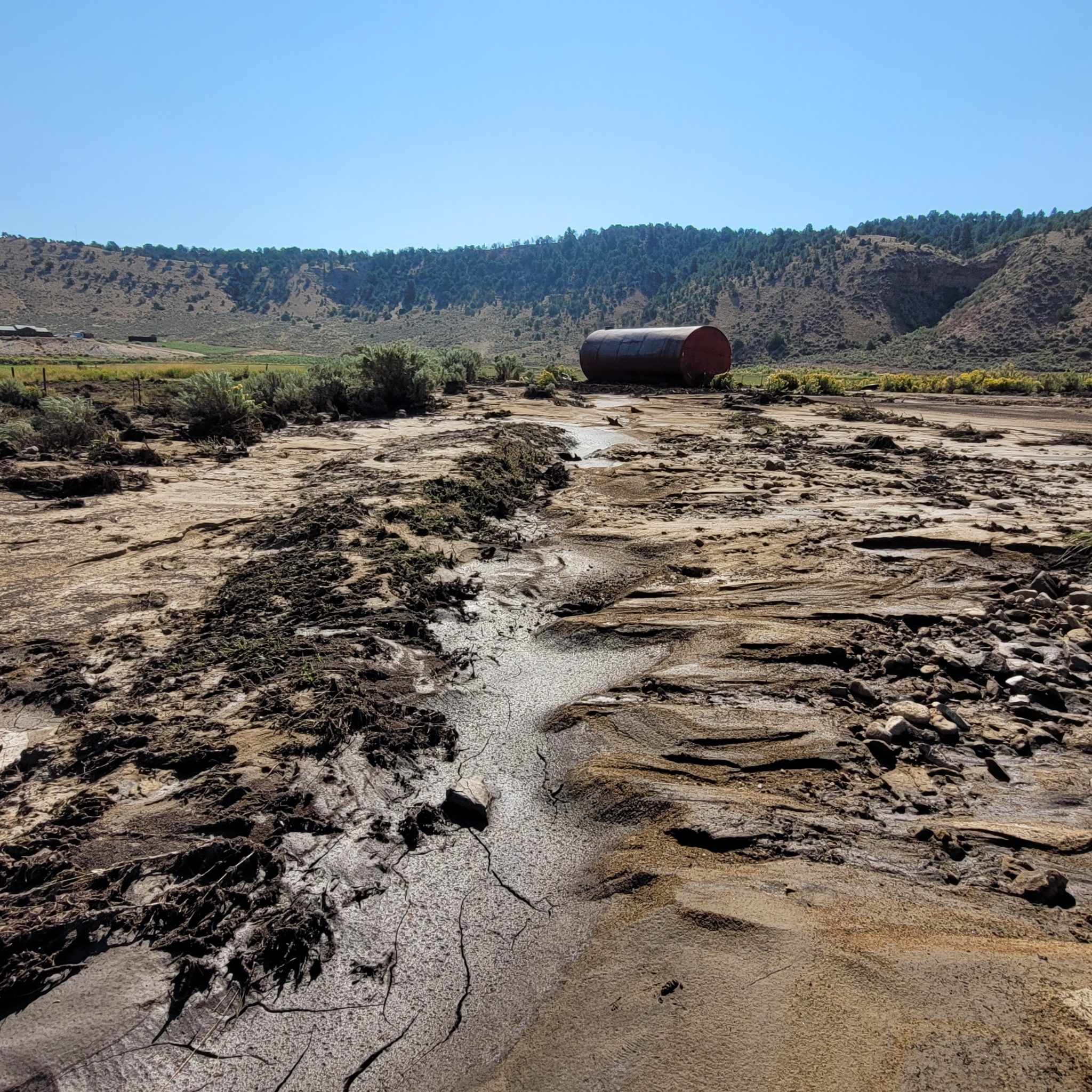
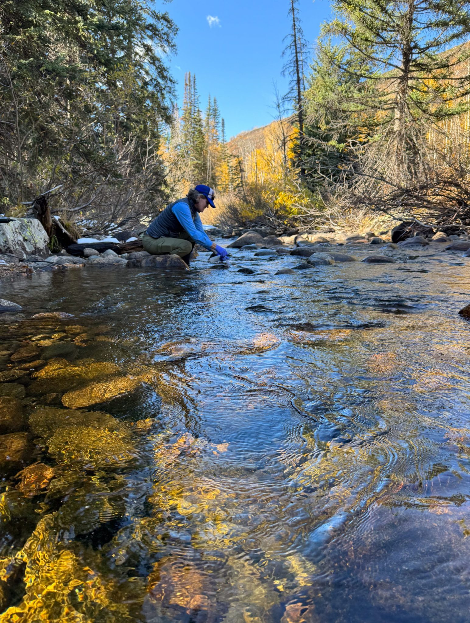
On July 13th, the Colorado River District, in partnership with the Colorado Water Trust and the Yampa River Fund, began releasing water from Elkhead Reservoir to mitigate the impacts of extreme drought and critically low streamflows in the Yampa River Valley. Beginning with a release of 10 cubic feet per second, the releases are part of the Yampa River Reservoir Release Program, a 2,000-acre-foot pool first established in 2021 with funding from the Colorado River District’s Community Funding Partnership. The program is designed to reduce drought-related pressure on agricultural producers while supporting river health and aquatic habitat.
“While we’re experiencing exceptionally difficult drought conditions, the story of 2026 is neighbors and water users working together. No single reservoir, organization or water user can solve this alone,” said Hunter Causey, Chief Engineer for the Colorado River District. “By coordinating releases, operations and water use across the basin, we can stretch a limited supply further and provide meaningful benefits for agricultural producers, local communities and the river.”
Below-average snowfall and persistent summer drought have reduced streamflows and increased water temperatures throughout the Yampa River Basin. Releases through the Yampa River Reservoir Release Program are intended to support agricultural water users, help delay or prevent a call on the river during periods of critically low flow, and benefit designated critical habitat for four endangered fish species. Releases are expected to increase in the coming weeks and continue through July.
“The Colorado Water Trust is an environmental nonprofit, and our work is keeping water in rivers,” said Blake Mamich, Programs Director for the Colorado Water Trust. “In a drought this deep, that same mission means showing up for agriculture. Coordinating closely with the River District and the Division of Water Resources, we can time these releases so a single pool of water helps irrigators extend a tough season and keeps water in Yampa for habitat and fish.”
“This is a difficult year for producers throughout the Yampa Valley, and we wanted to be part of a practical solution that helps the broader community,” said Yampa Basin rancher Matt Boeddeker of Lily Park Land & Cattle. “Water users across Colorado are making hard choices and working together to stretch limited supplies, and like them, we hope to help our neighbors complete critical irrigation and reduce the immediate impacts of drought.”
The Yampa River is primarily supplied by snowmelt from the Flat Tops and Gore Range and flows through agricultural areas of northwest Colorado before joining the Green River in Dinosaur National Monument. During dry years, coordinated releases from Stagecoach and Elkhead reservoirs supplement streamflows for agricultural water users, river habitat and endangered fish. The Colorado River District and its partners will continue to monitor streamflow, water temperature, irrigation demand, and habitat needs, and will adjust releases as conditions warrant.
Maybell Irrigation District’s headgate on the Yampa River, September 2022. Photo credit: Heather Sackett/Aspen Journalism
Click the link to read the article on The Denver Post website (Noelle Phillips). Here’s an excerpt:
June 18, 2026
For the 18 ranchers who rely on the Maybell Irrigation District’s canal to funnel water to their fields, the 127-year-old headgate that diverted flow from the Yampa River meant a two-hour round trip through a rocky canyon whenever they needed water. The rusted structure was barely hanging on, and its operation was time-consuming for the busy ranchers, who had to lug special tools on all-terrain vehicles and on foot to open or close the mechanism. But it seemed impossible for the tiny district to find the $6.8 million needed to replace the headgate and the rocky diversion dam that pushed water into the canal. Then legalized sports betting came along, and, with it, millions of dollars for Colorado water projects. The tiny irrigation district, in Moffat County in the far northwest corner of the state, soon became the poster child for how gambling money is benefiting Colorado’s waterways. The district received a $750,000 grant from the Colorado Water Conservation Board, which doles out money from sports betting tax revenue, said Diana Lane, sustainable food and water program director for The Nature Conservancy in Colorado, which helped the district land the grant. That led to a matching grant from the U.S. Bureau of Reclamation’s WaterSMART program. With those two grants in hand, other organizations jumped on board, and money poured in, she said. In 2024, the Maybell Irrigation District installed a new headgate that can be opened or closed via cellphone. If a rancher is cutting hay and doesn’t need to irrigate, he can close the gates to match the amount of water he actually needs at that moment, Lane said. And the diversion structure no longer uses boulders to control the water flow. Instead, it’s a modern structure that is the right height for water control. The project also benefited four fish species, including the threatened humpback chub, and it made river navigation easier for boaters, helping the region’s outdoor recreation economy.
“That $750,000 was really the ball that got it all rolling, that showed people, ‘Oh, this is going somewhere,’” Lane said of that initial state grant.
Since sports betting became legal in May 2020, the state has collected more than $154 million in taxes, and the Colorado Water Conservation Board has funneled $140 million to various projects that preserve and conserve Colorado’s precious water. Supporters say the gambling money is a godsend for ranchers, fishermen, paddlers and others who want to protect the state’s water and those who depend on it for their livelihoods. Critics, however, say legalized sports betting has come at a cost — fueling an addiction crisis that the state was unprepared for and is underfunding.
Last post here, I suggested that at least some of the ongoing failure of the seven Colorado River states to reach agreement on a river management plan for even the next several years, let alone new century, stems from some ‘elephants in the river.’ You know – the big things that nobody wants to look at because they are so big. So big that some of the rules and guidelines we operate under were created to avoid having to address them.
The first ‘elephant in the river’ I discussed last time was the single-minded focus on the Colorado’s surface waters, and a failure to begin considering the whole integrated water supply, surface water and groundwater – of which the surface water is a relatively minor part, with users going to the groundwater in a haphazard way when the surface water is insufficient.
I did make an incorrect statement in that analysis, however. I said that Colorado was the first, and thus far only, state to begin integrating groundwater into its appropriation priority system statewide. (Arizona developed – by federal mandate – a Groundwater Management Plan circa 1970 for those specific parts of the state served by the Central Arizona Project.)
This is true about Colorado – but I was mistaken in implying that the all groundwater use was integrated into its appropriation system by 1969 legislation. Only alluvial groundwater is covered by that law – groundwater that is naturally integrated with surface water, either trickling into the surface streams when the groundwater table is high or drawing riparian water from the surface streams when the water table is low.
Not covered by the Colorado law are ‘non-tributary’ aquifers that have no natural interaction with the surface waters – aquifers like the Oglalla Aquifer in eastern Colorado, or the Denver Basin aquifer. Most of their water filters down from the alluvial groundwater, and only modern pumping technology makes that groundwater accessible to surface use. Most of these deep aquifers have accumulated their water slowly over geological periods of time, and even moderate use of their water dips quickly into ‘water-mining.’ Colorado law for such aquifers attempts to limit annual use to a hundredth of a presumed 100-year supply, but no one knows for sure how much water is really down there, or whether it will truly constitute a 100-year supply.
The standard response throughout much of the basin to shortages in surface water is to go to groundwater pumping; if ‘tributary’ (alluvial) groundwater is tapped, the pumping will gradually lower the water table – which in turn will begin to diminish the surface streams, which in turn will increase the pumping – et cetera, a vicious downward cycle. And the pumping of ‘non-tributary’ aquifers is largely unregulated in the basin.
At any rate – apologies for the error, and thanks to John McClow for pointing it out.
And on to another elephant in the room. Is it finally time to determine limits on the presumed universal applicability of the appropriation doctrine? To avoid being shot before I finish the paragraph, I will say immediately I am not suggesting doing away with the appropriation doctrine; it is a good enough last resort down on the ground where the appropriation doctrine started, for working out local problems of water use on a surface stream when neighborliness fails – that is, when old grumps and feuds preclude the ‘gentlemen’s agreement’ on sharing out what water is available, rather than shutting down the junior users with a ‘call’ so the seniors can get all their decreed water. After two or three generations, seniority can be acknowledged, but is too abstract to apply against your neighbors, if a plan for sharing blameless misfortune can be worked out.
The abstraction, however, becomes more applicable when it is distant water organizations calling out other water organizations upstream, or an earlier developed watershed placing a call on users in an adjacent more recently developed watershed. And when a stream is declared by the district engineer to be over-appropriated – not enough water to fill everyone’s decrees in a near-average year – it becomes even more abstract, a tool for enforcing a status quo, and nothing anywhere about what represents the best uses of the water.
There are, in other words, some areas in which the appropriation doctrine gets stretched beyond its elastic limits by emerging challenges of water use; any questions about ‘best and highest use’ have been essentially declared unanswerable as a matter of conflicting values, and it just seems easier to let seniority of use be the ultimate determinant of priorities.
A century ago, with California quintupling its population in the first two decades of the 20th century, the other six of the seven states in the Colorado River Basin (Arizona, Nevada, Colorado, New Mexico, Utah and Wyoming) began to worry that California might put so much of the river’s water to use that there would not be enough unappropriated water for them to put to use when their time of growth came. They were all committed to versions of the appropriation doctrine within their states, but came to believe that reliance on the appropriation doctrine alone at the interstate level could cause more regional problems than it would resolve.
That concern was affirmed in 1922 when the U.S. Supreme Court resolved a conflict between Colorado and Wyoming over a Laramie River tributary that started in Colorado but was put to use first in Wyoming; the court declared that states who used the appropriation doctrine intrastate would also have to respect each other’s appropriations interstate. This made real the specter of slow-growing upstream states having to let all their Colorado River water go downstream to fill huge Arizona and California decrees.
So they assembled in 1922 to try to do something about that – a fundamental fact about the Colorado River Compact commission that we tend to forget: the original intent of the compact commissioners in 1922 was to develop an alternative to the appropriations doctrine at the interstate level. They came together with the intent of working out a seven-way division of the use of the river, based on possible future development, that would eliminate a horse-race of interstate appropriative competition. Six of the states convened the commission because they feared California, and California reluctantly participated because it knew the feds would never build the big control and storage dam they needed until all seven states were on board with it. That seven-way division trumping interstate appropriation was what the Compact Commissioners assembled to do –and spent a frustrating week early in 1922 trying to do.
They were unable to effect a seven-way split for a couple of reasons: for one thing they had no good measure of how much dependable water was in the river; estimates at the time ranged from 12 to 20 million acre-feet (maf). But for a second thing, the sum total of the water they each felt their state needed, based on rosy early-20th-century estimates, was closer to 24 maf – and nobody wanted to go home having backed down from their carefully imagined numbers.
Members of the Colorado River Commission, in Santa Fe in 1922, after signing the Colorado River Compact. From left, W. S. Norviel (Arizona), Delph E. Carpenter (Colorado), Herbert Hoover (Secretary of Commerce and Chairman of Commission), R. E. Caldwell (Utah), Clarence C. Stetson (Executive Secretary of Commission), Stephen B. Davis, Jr. (New Mexico), Frank C. Emerson (Wyoming), W. F. McClure (California), and James G. Scrugham (Nevada). CREDIT: COLORADO STATE UNIVERSITY WATER RESOURCES ARCHIVE via Aspen Journalism
What they did instead – in order to persuade Congress that there was general agreement – was to cobble together the Compact we are burdened with today; they created what Commission Chair Herbert Hoover called a ‘temporary equitable division’ of the seven states into Upper and Lower River Basins, until ‘ those men who may come after us, possessed of a far greater fund of information’ could do the ‘further division’ of the river among the states.
They also decided – as early 20th-century Americans would – to lean toward the more optimistic estimates of river flow, dividing ‘equally’ between the Basins only 15 maf of a river they presumed would continue running 16-20 maf – hence the 7.5 maf for each Basin written into the compact, to be further divided among the states of each Basin in their own good time. That left some water for Mexico, but they did nothing specific for the Indian tribes in the basins because national Indian policy at that time was ‘soft genocide’ – full assimilation (‘kill the Indian, save the man’), leaving tribal water a concern they thought would disappear.
This all made reasonable sense with a river running a quarter-century average of just under 18 maf – but then through the 1930s the river experienced a drought unsurpassed until the past quarter century. By the end of World War II, Colorado river water users had a ‘far greater fund of information’ about the river’s flow, which would have made it a good time to have ‘fixed’ the Compact – but the growing fund of information was all bad news that no one wanted to incorporate into a more realistic policy. So by default the ‘temporary equitable division,’ with its mythic 18 maf river, took on the permanence of something carried off a sacred mountain carved in stone.
And now – we are seeing it reduced to a sad irony. The states of the Lower Basin had their fears too, and wanted a clause in the Compact stating that, should the Upper Basin states have a wild spurt of growth, they should not ‘deplete the flow’ to the Lower Basin below an average of 7.5 maf a year. But now – when it looks like diminished flows throughout the basin might really drop the flow at the division point between basins below that average – the Lower Basin is threatening the Upper Basin with an Article III(d) ‘call,’ saying the upper states will have to cut their own uses enough to meet the lower states’ fantasy 7.5 maf. States that set out a century ago to create a compact that would transcend the appropriation doctrine at the interstate level are now trying to turn that ‘temporary equitable division’ into what amounts to a senior interstate water right.
There has to be a level, or category, of action in which the law of first-come first-served is transcended by other considerations. And can we not say, at this point a century later, that the original intention of the compact commission has been achieved de facto? No state will ever get the use of more water than it had (or believed it had) around the turn of the century because there is even less water now. For better or worse, the use of the river has been distributed among the states (including some of the tribes) and Mexico.
Udall/Overpeck 4-panel Figure Colorado River temperature/precipitation/natural flows with trend. Lake Mead and Lake Powell storage. Updated through Water Year 2025. Note the tiny points on the annual data so that you can flyspeck the individual years. Credit: Brad Udall
Whether this is an equitable division is arguable; the states of the Lower Basin have been using roughly two-thirds of the river’s water, the Upper Basin states around one third, rather than the 50-50 split explicit in the Compact (7.5 maf per Basin). But arguably that does reflect the relative productivity of Lower Basin agricultural use (by far the largest use) and also its millions of urbanites drawing on it for at least part of their municipal water. It was a huge step toward reality when the Lower Basin states finally agreed that they must absorb the Lower Basin’s system losses (mostly evapotranspiration) and their half of Mexico’s allotment out of their own shares of the river, rather than relying on a fictional surplus to cover it – a fiction that combined with drought to draw down both Powell and Mead Reservoirs to the dangerous level where they linger today.
Yampa River Basin via Wikimedia. Note the Little Snake River crossing the Colorado-Wyoming line.
The 1948 Upper Colorado River Compact was the first reality-based document in the ‘Law of River’ portfolio because its negotiators knew by then – that ‘greater fund of knowledge’ – that it was doubtful that there would always be 7.5 maf for their use, and actually accepted that as their reality. So the divided their ‘half’ of the river into percentages for each state of whatever was left for the upper states after the Lower Basin got it Boulder Canyon Project Act waters. After three-quarters of a century, the four states are not too far from those percentages in their development of around 4.5 maf; only Wyoming is significantly under its 13 percent; Utah is a little below its 23 percent; and Colorado is a little over its 51.75 percent. Given the geographic irrelevance of western state boundaries (the Little Snake River crosses the Colorado-Wyoming border half a dozen times), this was pretty good 1948 estimating.
The reality today is that all Colorado River water users in all seven basin states are using a finite and measurable resource that will probably continue to diminish for the foreseeable future as we continue to heat up the planet, and we need to come to an agreement on what that means for all users. [ed. emphasis mine]
It seems to me there are three ways to address that diminishing flow. One way is to continue to accept the divine sanctity of the Colorado River Compact, with the Upper Basin states forced by the Supremes (they ride for power, not for the law) to cut back their own uses to meet the 7.5 maf average delivery to the Lower Basin – basically the interstate nightmare (for the upper states) the Compact was meant to address. Call this the stubborn denial option.
A second way would be to accept the evolved eight-way division (seven states plus Mexico) of the use of the river’s water, which was what the seven states wanted to do in 1922, instead of the ‘temporary equitable’ compact they came up with. Percentages for each basin state could be set according to the amount each state was using at the end of the major river development era, say in Y2K (remember that?), when the 70-year average annual flow was ~14.5 maf (1930-2000). Those state percentages of the river’s consumptive use could be retained – but the actual volume of water for each state would gradually diminish as the combination of ‘dry drought’ and ‘heat drought’ continues to diminish the river. Given that losses attributable to climate warming are both everybody’s and nobody’s fault, the losses to each states would be proportionate to their percentage of the river’s consumptive use, with no falling back on seniority, as though it were just a squabble between users. Each state could then either stay with the appropriation doctrine intrastate with junior users bearing the loss, or equitably share out the loss proportionate to use. Call the latter the shared reality option.
Photo of Crowley County by Jennifer Goodland
A third way lies between stubborn denial and shared reality, and will probably prevail as the default American Way: let money work it out. Municipal and industrial users will continue to work out money-for-water deals with agricultural users, like San Diego and the Metropolitan Water District have done with the Palo Verde and Imperial Valley ag districts, with responsible districts using the money for systemic improvements that minimize the impact of lost water. This is by no means going to ‘dry up’ agriculture. With 75-85 percent of the river’s water being used by agriculture, a doubling of M&I use would only require transfer of 10-15 percent of ag water, although (money being blind to all but profitability) the transfers would probably cause some local tragedies like Crowley County in Colorado where too much water was bought out of a single small irrigation district by Front Range entrepreneurs.
The appropriation doctrine, with its strange ‘property right’ independent of the property for which it was granted, is quite compatible with the money option for resolving water distribution, once over-appropriation is achieved. The idea that water’s seniority in a certain use can be transferred to a totally different use along with the water strikes me as strange – shouldn’t a new use initiate a new right? It is also contradictory to the doctrine’s initial democratic-populist effort to prevent the dominance of big money in water distribution by limiting water rights to what one could put to use. But it does seem to be the American way that everything eventually comes down to money as the base determinant of value.
Enough for today. The elephants in the river. I obviously favor ‘ratifying’ the evolved split of the use of the river, and an equitable proportionate sharing among all states – and within all states – of the consequences of our cultural climate changes. But that will not fly among those who have steadfast faith (senior water right holders) in the appropriation doctrine as the answer to all problems.
The river? It abides, rises and falls with the water table in its surrounding groundwater, and it may occasionally disappear, but it won’t have died, it will just have gone underground until the water table rises again and the ground can’t hold all the water – if we figure out how to let that happen.
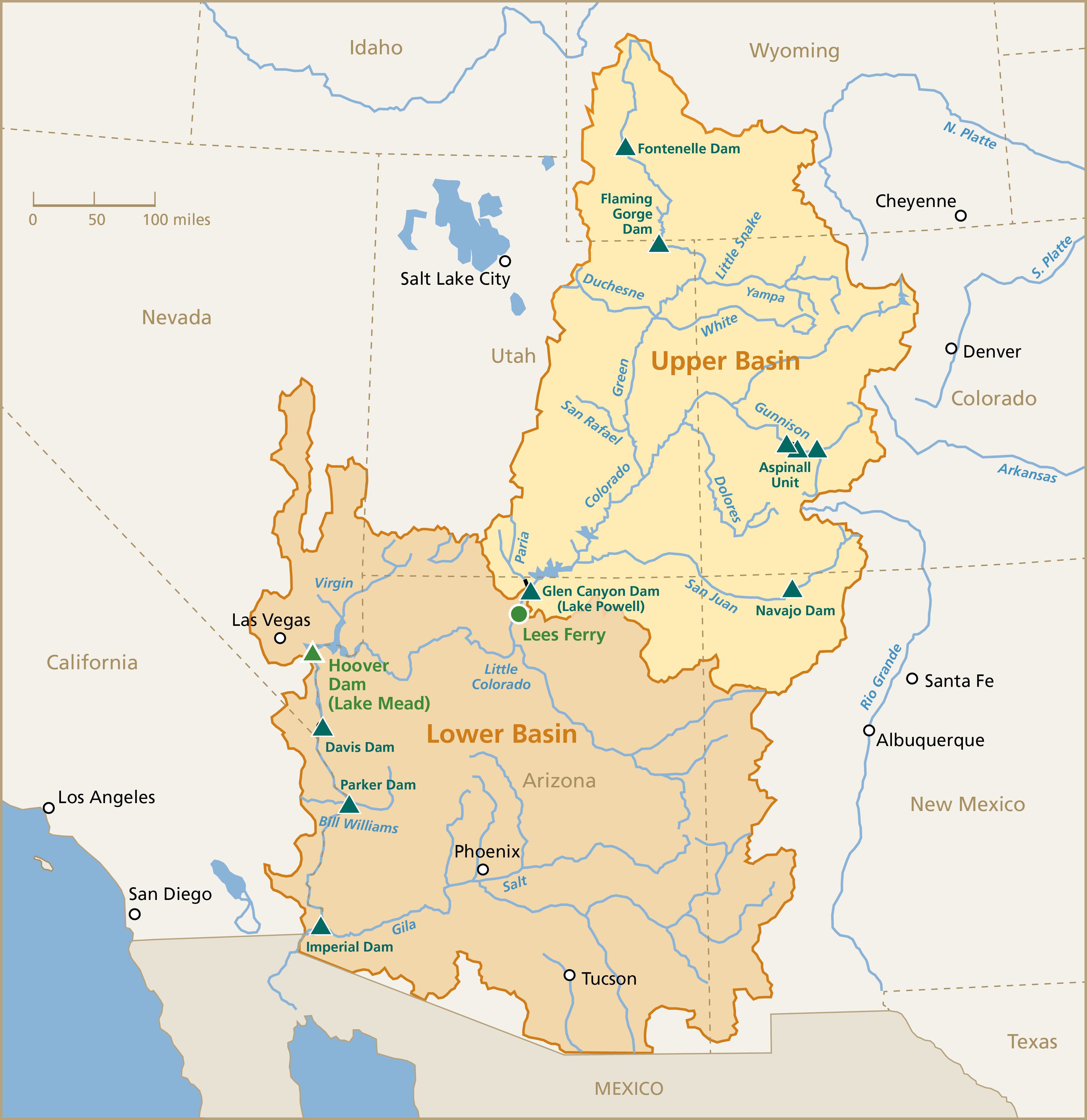
Map of the Colorado River drainage basin, created using USGS data. By Shannon1 Creative Commons Attribution-Share Alike 4.0
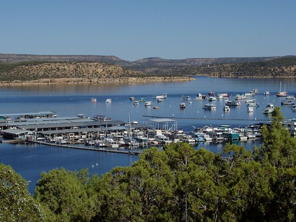
Anglers flock to Flaming Gorge Reservoir on Memorial Day weekend. Kokanee salmon and trophy-sized lake trout draw tens of thousands of visitors to the reservoir each year, supporting a recreational economy in southwestern Wyoming and northeastern Utah. (Hannah Romero/Green River Star)
Click the link to read the article on the WyoFile website (Dustin Bleizeffer and Hannah Romero):
June 4, 2026
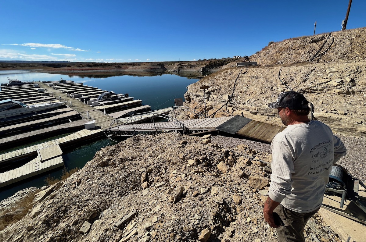
As campers with boats flocked to Buckboard Marina at the start of Memorial Day weekend, Tony Valdez was busy issuing refunds and repairing broken boat ramps. One older Green River man, who walked with two canes, left with his money refunded for the season after discovering he could not safely make it down to the boat slip. Due to dropping water levels at Flaming Gorge Reservoir, the ramp is now buckled, angling up and down like a pitched roof.
“It’s devastating, not just to me, it’s all the marina owners,” said Valdez, who owns Buckboard Marina, south of Green River. “It’s a big loss, and this is a big loss to the community.”
Along the cliffs and shoreline, darker and lighter lines of rock and sand trace the water’s elevations, showing where the water hits when the marina is full, where it hovered this spring and where it dropped after an initial “flush.” Valdez estimates the reservoir has dropped by 7 feet since April.
But that’s not the worst of it. Valdez anticipates that by the end of this summer, the reservoir will be as low as it’s ever been.
Why the drain?
For all its charm as a beloved recreation spot and its utility as a local economic driver, Flaming Gorge Reservoir owes its existence to a legal compact that essentially regards it as an insurance policy in times of drought.
Its primary purpose, according to federal officials and Colorado River Compact scholars, is to serve as a backup water bank to help maintain the Colorado River system. Specifically, Flaming Gorge and a handful of other reservoirs in the upper Colorado River Basin states of Wyoming, Colorado, Utah and New Mexico are key to ensuring a minimum flow of 7.5 million acre-feet of water, on a running 10-year average, at Lees Ferry just downstream of Lake Powell, a massive man-made reservoir straddling the Utah-Arizona border.
Today, after more than 20 years of drought intensified by human-caused climate change, the Colorado River is in crisis, putting at risk massive agricultural irrigation operations that consume about 80% of its water. This past winter saw historically low snowpack in the Upper Colorado River Basin — a primary source for the river’s flow.
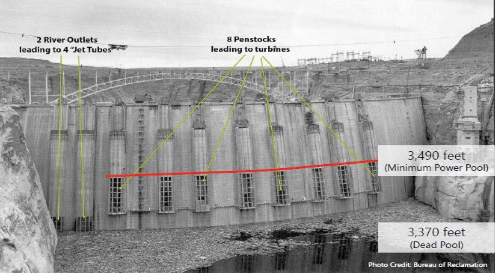
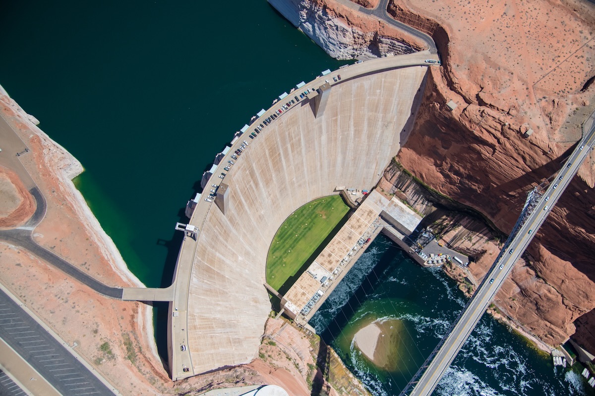
This annotated 1963 photo of the Glen Canyon Dam shows the minimum level of Lake Powell, below which would render the dam’s power generation components inoperable. (Bureau of Reclamation)
Combined with record heat in March, Lake Powell is at risk of dropping below Glen Canyon Dam’s “minimum power pool,” the point at which it can no longer produce hydroelectric power, according to water officials. If it falls even lower, the dam, which holds back Lake Powell, could be at risk of structural damage or unable to allow water to flow downstream.
The situation triggered a drought response operations agreement that calls for restricting releases from Lake Powell and an order to draw extra water from Flaming Gorge upstream. In total, water managers will release about 1 million additional acre-feet of water from Flaming Gorge in April 2026 through April 2027.
“These actions are expected to lower [Flaming Gorge’s] elevation by roughly 35 feet over the next year to approximately 59% of capacity,” the bureau said in April.
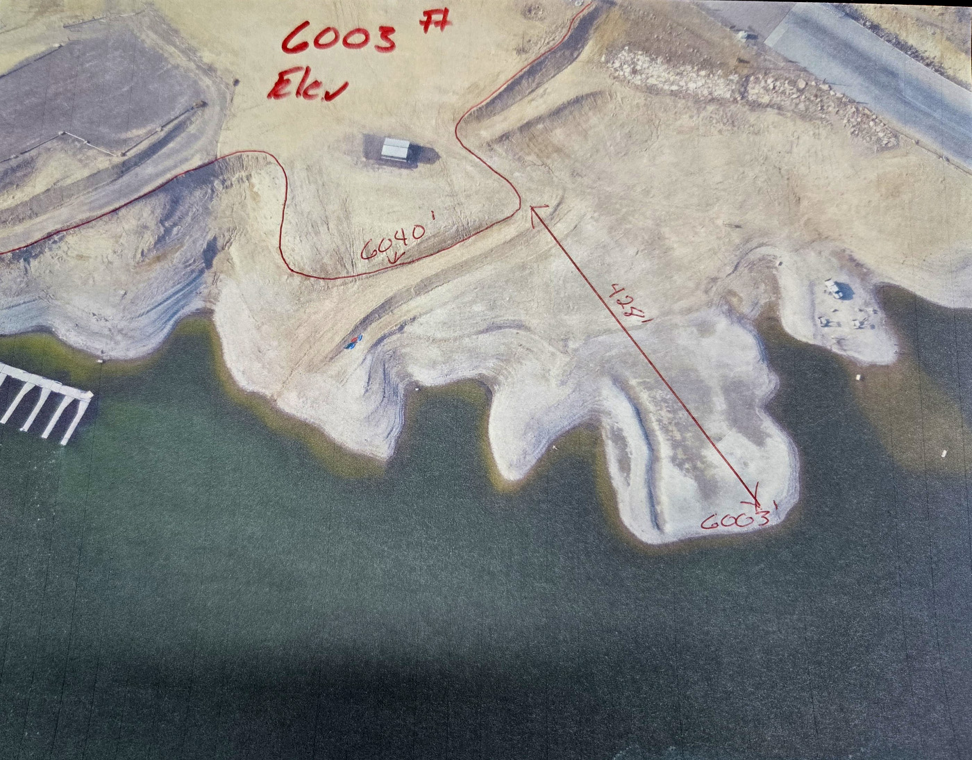
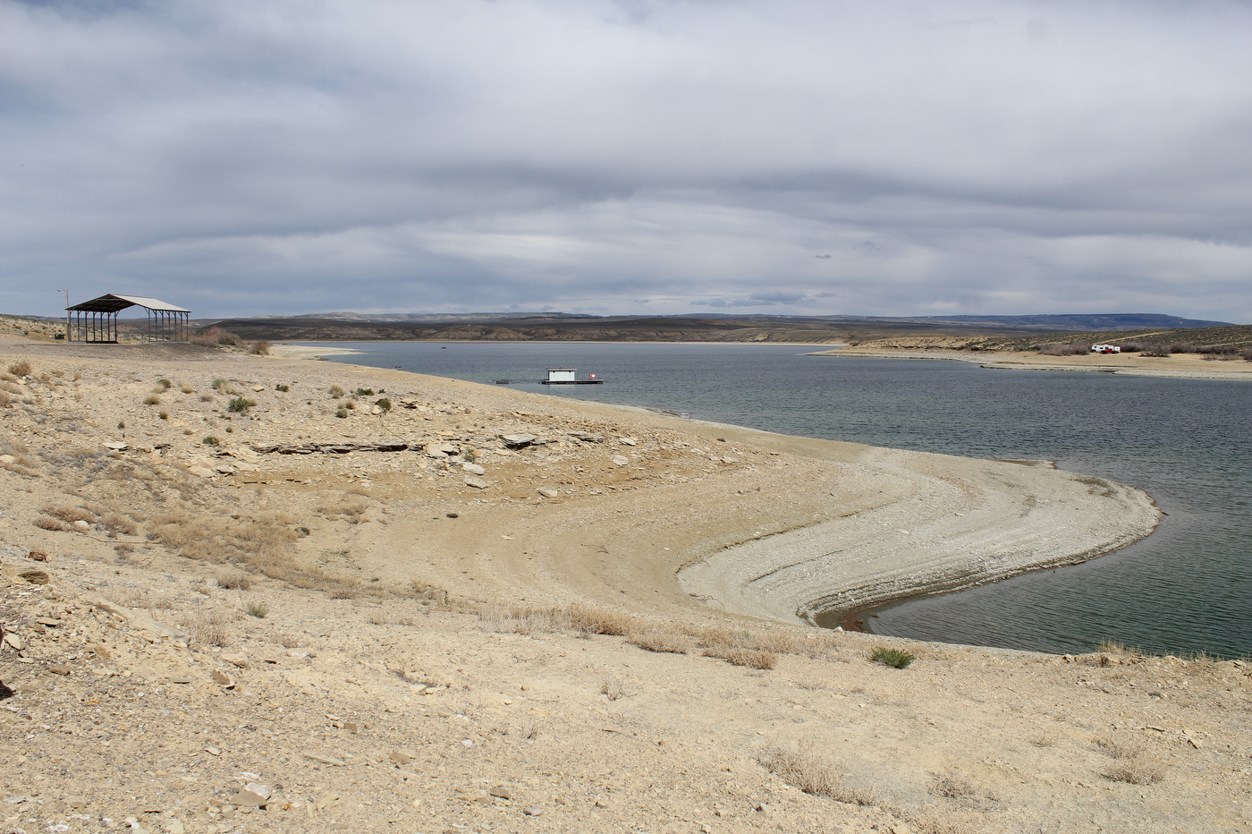
“The elevations are real critical,” Valdez said. At Buckboard Marina, high water has hovered between 6,030 and 6,040 feet above sea level over the past 50 years, he said. Dropping 35 feet could expose 400 feet of shoreline in some places, including marinas with boat ramps, he said.
Dropping water levels in the Flaming Gorge Reservoir by 35 feet could expose over 400 feet of shoreline in some places, including marinas with boat ramps, according to Buckboard Marina owner Tony Valdez. (Hannah Romero/Green River Star)
If the water elevation continues to retreat, it could reach a point where boats can’t be brought in or out.
“By September, this thing is going to be down to 6,000 feet. That’s it,” Valdez said. “Next year, if it goes below that, there’s no more marina here.”
Setting a course
Water managers set a course in April to “stabilize” Flaming Gorge’s outflow to about 1,100 cubic feet per second, representing the rate needed to achieve the 1 million acre-feet of extra water release, according to the bureau. On top of that, there are two previously planned “flushes” from the Gorge. The first, in early May, temporarily increased the outflow to about 8,600 cubic feet per second to enhance the proliferation of razorback sucker larvae, and a second 72-hour flush beginning June 8 will temporarily increase the outflow to about 4,600 cubic feet per second to discourage the proliferation of smallmouth bass.
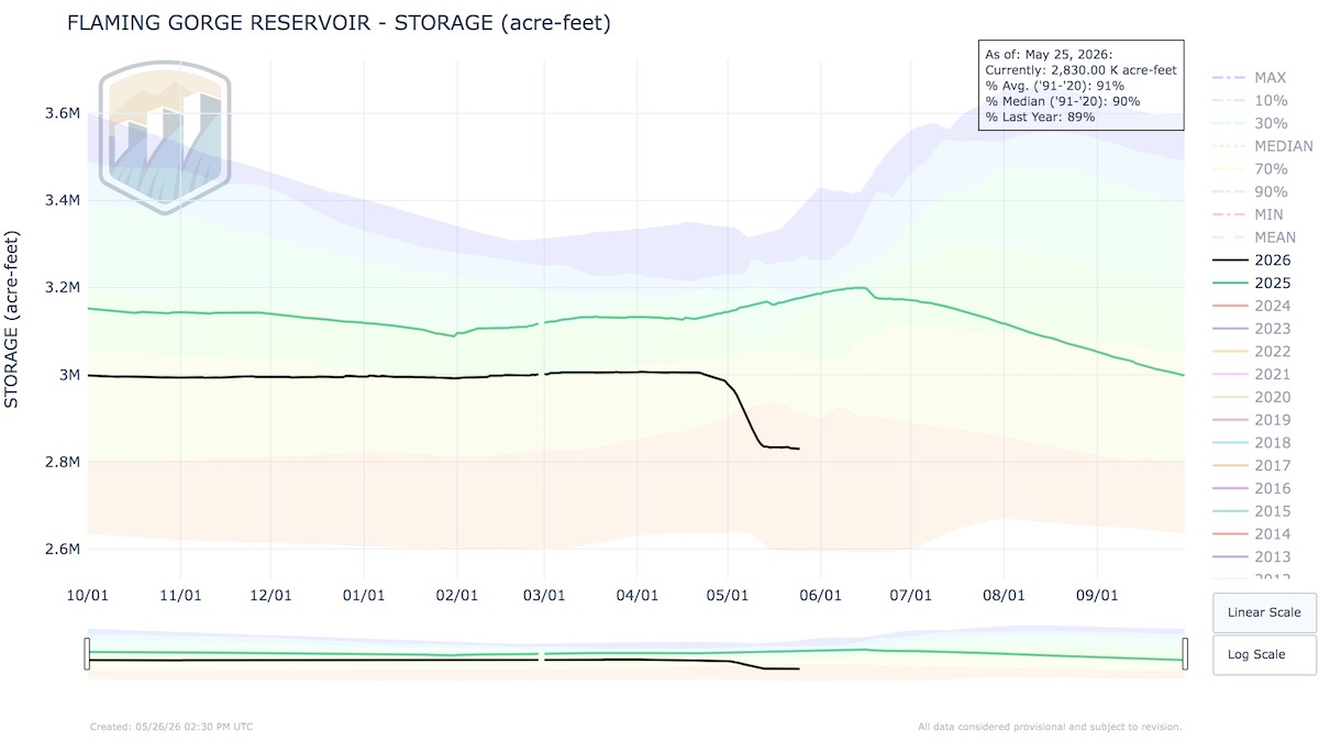
So far, Flaming Gorge has dropped from about 3 million acre-feet in April (or 82% capacity) to about 2.83 million acre-feet as of May 25. Meanwhile, water managers warn, “This release plan is subject to change depending on evolving river conditions and weather forecasts.”
Click to enlarge: This chart depicts water storage levels at Flaming Gorge Reservoir. (Bureau of Reclamation)
Those evolving conditions include forecasted versus actual flows from streams feeding the system. For example, those “unregulated” or natural flows are forecasted to be much lower than normal: 70,000 acre-feet of water into Flaming Gorge during May (28% of average), 175,000 acre-feet in June (45% of average) and 84,000 acre-feet (42%), according to the Bureau of Reclamation.
Water officials caution that water flowing from the Flaming Gorge Dam could change, and that those recreating on the Green River below should monitor release schedules at this website. The bureau also noted, “Water will be colder than usual and will run high and swift during periods of elevated releases.”
Water floats recreation economy
Buckboard Marina went through a similar drop in water a few years ago. The Bureau of Reclamation began pulling water from the Flaming Gorge in 2021, and by 2022, the marina’s water level was at an all-time low. While the reservoir recovered somewhat in 2023 thanks to a good year for moisture, Valdez said, the reservoir has continued to decline since then.
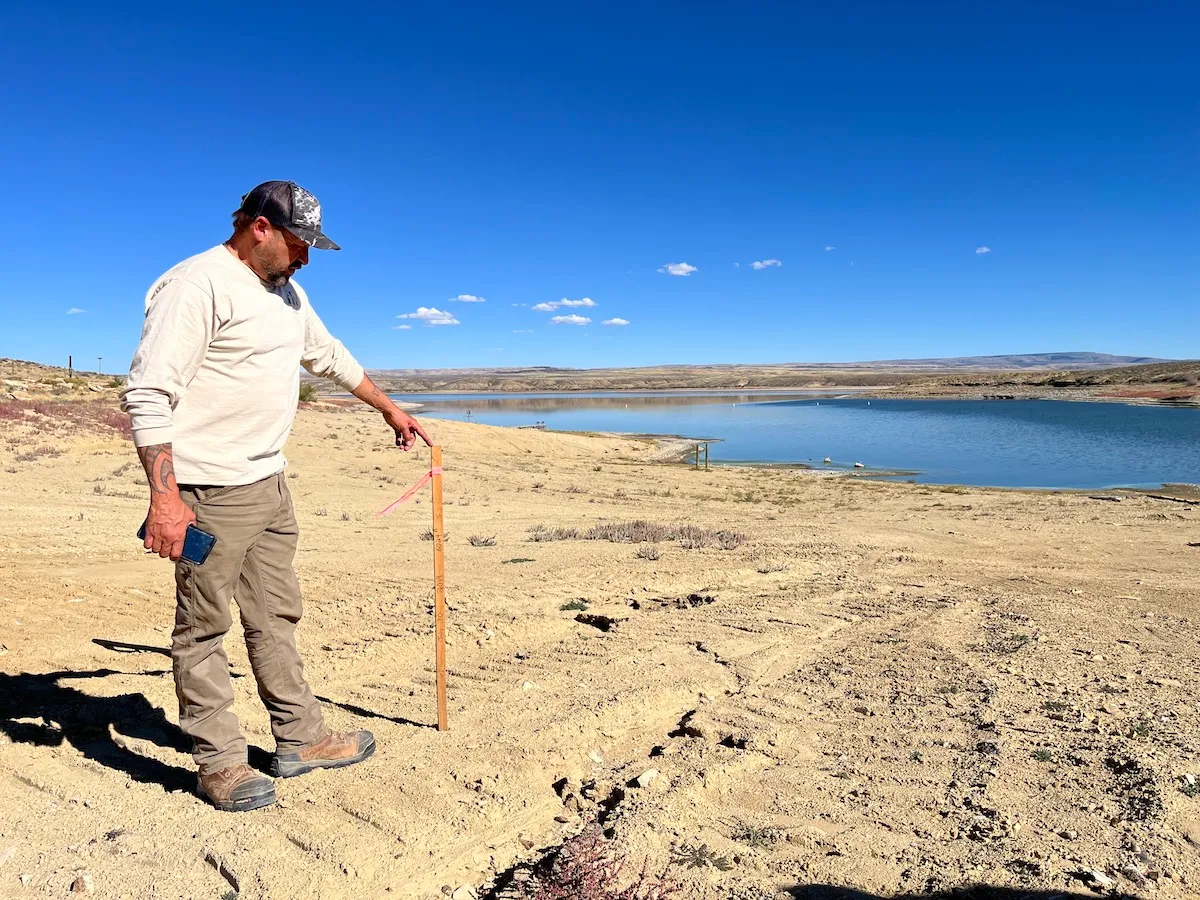
Buckboard Marina owner Tony Valdez stands next to a stake that indicates the extent of lowering water levels at Flaming Gorge Reservoir Sept. 26, 2022. (Dustin Bleizeffer/WyoFile)
Kokanee salmon and trophy-sized lake trout draw tens of thousands of visitors to Flaming Gorge each year, supporting a recreational economy in southwestern Wyoming and northeastern Utah. But as the lake is drawn down, water recedes from shallow shorelines and fish are forced into a smaller space, essentially shrinking the fishery toward the dam side of the reservoir.
One of Valdez’s primary concerns is that water levels could drop below the ideal elevation for kokanee to spawn in the reservoir.
“I think people don’t realize the economic value it brings,” he said. “It is a big deal when you lose your kokanees.”
Valdez has already lost money this year just from people being concerned about water levels. He estimated that the marina lost roughly $30,000 in cancellations when discussions about releasing water began as early as February.
Other problems also start to arise as the water drops. The marina will lose access to drinking water at 6,010 feet, below their floating pump that supplies potable water. It’s only 7 feet away from the current level.
“That’s scary to me,” Valdez said.
The marina can truck in water from Rock Springs, but it costs about $1,200 to bring in 8,000 gallons, which lasts about two weeks. For Valdez, it feels “asinine” to lose water at a marina.
“Why would we run out of water on a lake?”
Water levels also impact the location of the fuel dock and fuel lines extending to it. If the reservoir sinks too low, it could cost up to $100,000 to adapt, he said.
Drawing down water levels quickly — as happened in early May — can damage marina structures. After the 2021-22 drawdown, Valdez said he spent about $130,000 in repairs.
Buckboard Marina owner Tony Valdez shows a boat ramp that now angles up steeply before dropping down after the reservoir’s water levels dropped several feet. (Hannah Romero/Green River Star)
This time, he’d hoped to keep up. He and a group of 10 men worked to keep pace with the dropping water levels, repairing and modifying ramps. It wasn’t enough.
“The drop was dramatic enough to break all of our approaches, our bridges, our stuff, so it broke a lot of the welds, broke a lot of the structured steel, because it just vertically dropped too fast for the weight,” he said.
When structures go from water to land that quickly, the weight is too much for them to hold up, Valdez said.
“I’m re-rigging everything, and this is only a temporary fix ’til September, because that’s when the season ends.”
The marina should remain mostly functional until the summer season ends, he said. But with extra water releases set to continue through the winter, the lake could drop another 10 to 12 feet by the spring.
“We’re getting into numbers that I don’t even want to talk about,” Valdez said. “I mean, there’s no marina.”
What’s next?
“The guy with the boots on the ground that watches this every day,” as Valdez describes himself, can see what water managers can’t, and he questions whether official numbers and estimates match reality.
“It’s hard to watch this when it’s out of your hands.”
Valdez is critical of the 1922 compact, doubting the legal rationale of sending Wyoming water to places like Arizona. He also wonders about the role of local industries — refineries, coal-fired power plants and trona mines — that use large amounts of water, and the idea of adding more industrial facilities that require even more water, like data centers.
“We don’t have the water to give away,” Valdez said.
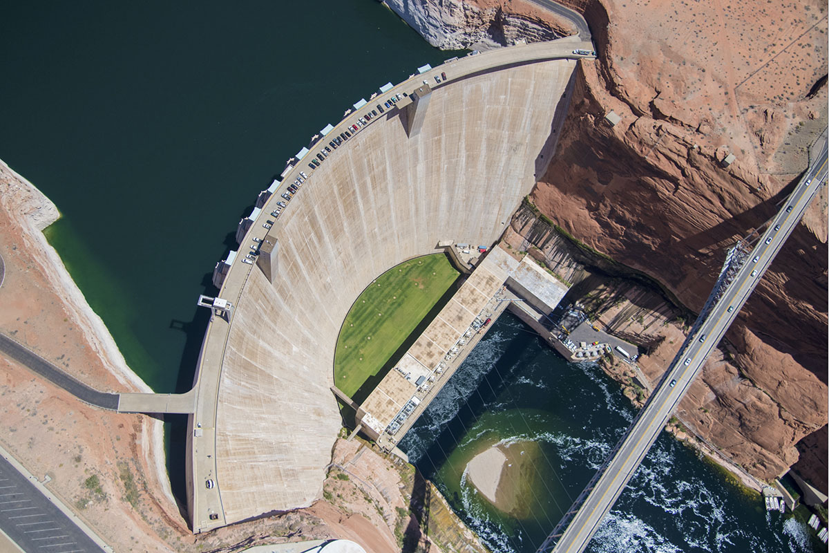
Aerial photo of the Glen Canyon Dam near Page, Arizona. Photo by Alexander Heilner/The Water Desk, with aerial support by LightHawk.
Bryan Seppie, general manager for the Joint Powers Water Board for Sweetwater County, Rock Springs and Green River, agrees. “The poor hydrology this past winter has affected most all water users in some form or another,” he said.
His board monitors the Colorado River system closely. Just upstream from Flaming Gorge, the Bureau of Reclamation reduced releases from Fontenelle Reservoir due to poor inflow projections. Although the water will still be enough for river users, the low summer flows will have a negative impact.
“Low river flows typically result in higher water temperatures, which generally leads to higher levels of moss/algae and overall lower water quality,” Seppie said in an email.
What about recovery?
Valdez wonders: What’s the plan to allow the reservoir to bounce back?
Wyoming State Engineer Brandon Gebhart and his staff have warned for months that although Flaming Gorge can serve as a backup to Lake Powell this year, it drains the Gorge’s ability to play a similar role next year, or the year after. It takes time for Mother Nature to replenish the bank.
“The big thing that nobody is talking about is the recovery,” Valdez said. “Where is the recovery of our water?”
This year’s drain on Flaming Gorge began at a low point. The reservoir hadn’t fully recovered after the last major pull. Rather than starting at a high point of 6,040 feet, the marina was at about 6,024 feet, he said.
“There’s no recovery plan,” he said. “We can’t just let them keep taking. I mean, where’s this end?”
Rings line the shore of Flaming Gorge Reservoir, showing the drop in the water level at the popular recreation spot that spans the Wyoming-Utah border. (Hannah Romero/Green River Star)
If there is no grace period for the reservoir to replenish and officials want to take even more in the near future, starting from such a low elevation point, it will be “devastating,” Valdez said.
“The water going down is not the end of the world, it’s the recovery in a timely manner that really matters,” he said. “I can’t preach recovery enough.”
Watching people come to the marina and seeing how happy they are still motivates Valdez to keep going. Despite the drawdown, there’s nowhere else he’d rather be.
“We’re not going to run away. We’re not going to give up,” he said. “We’re going to fight.”
Ranchers are constantly adjusting to changing weather conditions and seasonal variations by nature. Jay Fetcher, of Fetcher Ranch in North Routt County, has documented snow melt dates for his hay meadows for each of the 75 years the ranch has been in the family, and said the variation is “incredible.” A year with low snowpack and a warm spring is just another condition to adjust to in the ranching world. This year, dryland hay broke dormancy early in Routt County, meaning cutting has already started, about two or three weeks earlier than usual. The low snowpack is not only generating concerns for ranchers with irrigated hay but water concerns for those with livestock. Despite these problems, the general consensus was that this year is expected to be below average, but not detrimental.
“People with dry land probably can expect some reduced yields, but I will say that the rains we’ve gotten over the last couple weeks have brought on grasses in dry land and pasture situation areas better than I would have anticipated,” said Todd Hagenbuch, the county director and agriculture agent for the Colorado State University Routt County Extension…
The second big concern from the lack of snowpack was water for cattle and other livestock. According to Hagenbuch, the snow runoff fills ponds and streams that the animals drink out of, but this year there’s simply no water in a lot of them. For ranchers whose ponds and streams are not filled, they have to haul water in for the livestock.
“That’s the big issue is adequate water for livestock, and it will be all summer,” said Mucklow. Mucklow is currently not needing to haul water on his ranch, but he personally knows several ranchers who are in that position.
Mucklow also said that there is a federal drought program conducted by the U.S Department of Agriculture that compensates ranchers who have to haul water.
Having drinking water for his cattle was also a primary concern for Fetcher earlier in the season. “It was on my mind as we had no snowpack, and the snow was gone,” said Fetcher. On his ranch, they rely on the streams and springs for the cows in the pastures. Fetcher said the recent rains gave him a significant amount of moisture that eased his worries considerably.
At the Yampa Town Board meeting last week, Andi Schaffner with the Bear River Reservoir Company presented plans and cost estimates for a Stillwater Reservoir project that would lead to removal of its storage restriction. The plan consists of two phases involving installation of a strain and a sand filter to alleviate seepage into the dam’s embankment, the primary concern that led to the storage restriction designation…Currently, the town of Yampa owns 112 shares in Stillwater Reservoir, or about 2% of the reservoir. Phase 1 of the project consists of a blanket drain and filter collar and is estimated to cost $730,717. Phase Two of the project will be stabilizing the channel and the removal of the culvert and the flume, at a total estimated cost $209,874. Schaffner said that the team at Bear River Reservoir Company has spent hours on engineering and studies at the reservoir in order to determine the best solution for the dam. “We finally opted for the least expensive fix, which is what we’re working on right now,” said Schaffner…The project has received a significant amount of grant funding despite higher than anticipated bids, including a $202,000 loan from the Colorado Water Conservation Board. This loan was the primary expected cost for the town of Yampa, and is expected to be approved with an increase to $404,000 ahead of the project’s notice to proceed with the contractor on July 13. The project is expected to be completed by the end of October. The Colorado Water Conservation Board loan is 30 years with 1.85% interest, or $3.40 per share per year. For the town of Yampa’s 100 or so shares, this amounts to $381 a year. Schaffner did not expect any more expenses besides an assessment of the shares which amounts to about $5.
Elkhead Reservoir is taking center stage following a winter of historically low snowfall, leaving water managers with hard decisions and water users with a high degree of uncertainty. Courtesy Photo/Colorado Parks & Wildlife
In response to extreme drought conditions throughout northwestern Colorado, the Colorado River District, in partnership with the Colorado Water Conservation Board (CWCB), is offering up to 420 acre-feet of supplemental agricultural water from Elkhead Reservoir for irrigators in the Yampa River Valley. Modeled on the successful joint CWCB-River District program implemented in 2021, this effort will provide additional supplies during critical times of agricultural production.
“The drought conditions this year have been exceptional and unpredictable,” said Colorado River District’s Director of Asset Management, Hunter Causey. “And it’s that kind of unpredictability that hits small family farms and ranches the hardest. The Yampa Valley, the western slope, and our entire region depend on local agriculture to drive economies, produce local food, and preserve landscapes. While a program like this cannot solve the drought problem at large, we can be strategic in how we use our available supplies and support our constituents wherever possible.”
“The challenges posed by this year’s drought call for creative solutions and strong partnerships,” said Lauren Ris, CWCB Director. “This project reflects what can happen when local water users and water management agencies work together to respond to emerging needs. We’re pleased to support this collaborative effort in the Yampa Valley and remain committed to working with communities across Colorado to explore creative, locally driven solutions that help address drought impacts and strengthen drought resilience.”
Program Structure:
Water will be allocated using a lottery with an initial round of allocations of up to 50 AF per applicant, totaling 420 AF.
Any water remaining after the lottery will be awarded equally to initial round applicants that expressed a need beyond 50 AF. If there is any remaining water, it will be available on a first-come, first-served basis and will need to be contracted at no cost with the District.
Successful participants in the lottery will need to enter into a no-cost contract with the River District for direct delivery and/or use of the District’s Elkhead water through administrative exchange.
In the event there is a mainstem Yampa River call and to the extent that lessees are out-of-priority, water will be released at the diversion rate plus transit losses.
Water will be available for delivery or exchange beginning on July 10, 2026.
At current agricultural water marketing rates, the total project will cost $18,375. On June 4, the Colorado River District Board of Directors agreed to make $4,594 available from the Board’s previously authorized CFP expenditures for the District’s 2026 Drought relief effort. The CWCB has committed to providing the remainder of the funds – approximately $13,781.
Applications are due by June 26th, and a lottery will be conducted for the initial round of contracts on July 1st. Available augmentation water is limited. Those interested in applying should contact the Colorado River District’s Director of Asset Management, Hunter Causey, at hcausey@crwcd.org or visit HERE for more information.
Blue Castle Holdings is proposing to build a nuclear power plant in Green River, Utah. You have not gone through a time warp, nor is this a “this date in history” sorta thing, though it could be. The same company tried to build a reactor in Green River a couple of decades ago, during the last “nuclear renaissance,” but the project fizzled amid fierce opposition, uncertainty over water rights, and as the nuke boom busted before it ever really got going.
This week, Blue Castle announced that the concept had only been dormant, not dead, and that it was coming out of hibernation in a spiffed up form in hopes of serving rapidly growing data center-driven electricity demand. Instead of constructing two, 1,500 MW reactors, the company — in partnership with Fulcrum Point Holdings — looks to install small modular reactors. It has not specified what the nameplate capacity will be, but says the units can be air-cooled, meaning they wouldn’t use as much water as conventional reactors.
Blue Castle has a bit of a head start on the project, since they’ve already done most of the site characterization work (on private land about five miles west of Green River). But they’ll still have to jump through the nuclear reactor licensing hoops, which can be arduous. That said, it should be a lot easier with both the Trump administration and the Cox administration champing at the bit to get more nukes up and running. Meanwhile, opposition to the idea is not likely to be any less fervent now than it was 20 years ago, and they’ll still have to secure water in an increasingly aridified region.
The melon-farming town along the banks of the Green River has become a magnet for proposed and actual industrial projects lately. The prospective nuclear plant joins Anson Resources’ lithium extraction project, Western Uranium & Vanadium’s proposed uranium mill, a 400-megawatt solar-plus-storage installation, and various uranium, lithium, and potash extraction proposals in the surrounding areas.
Check the weather report before heading out on this road. Photo credit: NPS
🌵 Public Lands 🌲
Well, they’ve gone and done it now. Garfield County has paved the Hole-in-the-Rock Road, or at least the first 10 miles of it. To folks who are unfamiliar with the road situation in Utah, paving — chip-sealing, actually — a notoriously washboarded, suspension-blasting, teeth-rattling dead-end dirt road may not seem like such a big deal. But this little maintenance action could have real consequences for the public land it runs through, i.e. Grand Staircase-Escalante National Monument, and sets a dangerous legal precedent when it comes to roads on public lands. It is also a symbolic move for both the opponents and proponents of the asphalt-laying project.
The Hole-in-the-Rock (HITR) road roughly follows the first segment of the Hole-in-the-Rock trail, which is the route Church of Latter Day Saints colonists forged in 1879 to get from Escalante to what would become Bluff City on the banks of the San Juan River in the southeastern corner of Utah. When the early Mormon travelers reached the seemingly-impassable, 2,000-foot-deep Glen Canyon on the Colorado River, they blasted and built a passage for their wagons, horses, and cattle through a natural opening in the cliff and called it Hole in the Rock.
It may have been this experience, in part, that led the descendants of those folks to develop a kind of fetish for roads, especially ones that cross federal land. By building the path across an especially rugged chunk of country and even crossing the mighty Colorado, they were able to assert a certain amount of control over what they saw as a hostile and wild landscape. Now county commissioners in Utah fight for control over backcountry roads* as a sort of proxy for dominating the lands they pass through. Garfield County has long looked to take ownership of the HITR road so that they can improve and pave it and be sure the Bureau of Land Management never closes it.
Environmental groups, meanwhile, have pushed back against county control. While the feds almost never close roads, they are more likely than counties to do so if necessary to protect cultural or ecological resources**. Counties are more likely to improve the roads, which leads to more people and attendant impacts in the backcountry.
Today’s HITR road runs 62 miles, from just outside Escalante to Hole in the Rock, where the canyon below is now mostly inundated by Lake Powell. It snakes its way on a rough parallel path to the Escalante River and passes near the heads of many of its tributary canyons that are popular with backcountry adventurers.
As visitation to the national monument and its surroundings has increased, so has the HITRR’s traffic: Garfield County’s road crew says some 600 vehicles per day travel the washboard-plagued road, with as many as 1,500 each day on weekends. All those cars wreak havoc on the road, and the county says it has been spending $150,000 annually on maintenance, some of which it claims could be avoided if it were allowed to pave the road.
Last July, a federal court ruled in favor of Garfield County and granted it quiet title to the section of the HITR Road in the county (the lower section is in Kane County, which also won quiet title to that portion of the road). In February, the county began preparing the route for chip-sealing. It informed the BLM of the work, but did not apply for a permit, and the BLM did nothing to stop the work. That was two victories in a row for the local-control over the public’s land crowd.
The Southern Utah Wilderness Alliance sued both the BLM and the county, saying the work required federal approval, since it occurred on federal land. It also sought an emergency injunction on further work while the case is pending.
Earlier this month, a judge denied the injunction request, clearing the way for Garfield County to proceed. A few days later, the machines were out there laying asphalt, while county officials and their backers crowed triumphantly and public land lovers cried foul. The courts may eventually rule against the county, but the chip seal is there to stay.
“Paving will lead to more, faster, and louder traffic,” said SUWA attorneys in a written statement, “changing the remote, serene backcountry experience the monument was created to protect, and that draws visitors from around the world.”
Even pavement/chip-seal can’t stop the desert from taking back the Burr Trail. Jonathan P. Thompson photo.
The HITR Road battle is an echo of an almost identical fight over the Burr Trail, another backcountry road between Boulder, Utah, which lies within Grand Staircase-Escalante National Monument, and Ticaboo/Bullfrog on the shores of Lake Powell. The sections on BLM land on either side of the route have been paved and/or chip-sealed after years of conflict. But the National Park Service has blocked Garfield County from paving the middle segment, which passes through Capitol Reef National Park.
I drive the Burr Trail any chance I get, simply because I love the country it travels through and because the slower pace the road requires allows me to see more, and facilitates frequent stops to get out of the car and look around.
I’m sure that traffic has increased since the paving. Just based on my observations, however, I would say that the added number of vehicles is not necessarily increasing the number of folks going into the surrounding backcountry. What I’ve seen are more RVs and low-slung sedans heading down the road from Boulder, going beyond the end of the pavement, stopping at the top of the switchbacks through the Waterpocket Fold (where the road is steep, loose gravel, and washboarded), then turning around and heading back up to Boulder. The eastern paved section, towards Bullfrog, has very little traffic. (On my most recent trip I did see a few vehicles drive up the Burr Trail switchbacks, then come back down before heading north on the Notom Road back toward Capitol Reef, a phenomenon that was also evident at the Moqui Dugway road in San Juan County.)
Looking down at the unpaved part of Burr Trail from the switchbacks. Jonathan P. Thompson photo
So while paving HITRR is a sort of symbolic and even spiritual defeat for those public lands and the folks looking to protect them, I’m also not sure that it will necessarily lead to more impacts to the surrounding backcountry. Garfield County’s vehicle count numbers, if correct, indicate that the automobile-driving masses are already driving the road. How could you cram more than 1,500 vehicles a day onto that little section?
In any event, it’s certainly the end of an era, and driving the first ten miles of the HITRR will be a completely different experience than it was pre-blacktop. Whether the phenomenon will be limited to those ten miles (and the Burr Trail), or spread throughout the rutted byways of Utah may depend on the outcome of SUWA’s lawsuit.
Campsite boulder. Utah. Jonathan P. Thompson photo.
🛻 Notes from the Road 🏕️
The hummingbirds have come back to southern Utah for the spring. Are they earlier than usual? Later? Maybe all that really matters is the penstemon are blooming, scarlet red.
***
One of my non-Land Desk gigs is compiling and summarizing Western energy news for a Canary Media newsletter every Monday, Wednesday, and Friday morning. This requires early morning internet, so when I’m out and about it means staying in a hotel on those nights or camping in a site where I know there is a strong and steady cell signal.
Stone, water, light. Utah. Jonathan P. Thompson photo.
But on Tuesdays and Thursdays and weekends, I’m free to wander as far off grid as I can get. This is not difficult in southern Utah, which may have the highest proportion of out-of-cell-signal-range lands in the continental U.S.
Liberated from the digital shackles, I meander impulsively, by car, by bike, on foot, in search of the perfect campsite, a cool pool of desert water, a viewpoint from which the landscape unfurls before me, the post-storm light playing among the red rock crevices and spires far below. The sense of time slips away and I quickly forget what day it is. The lack of destination or deadline allows me to wander down whatever road, canyon, or trail looks appetizing. More often than not, they are dead ends, which is just fine.
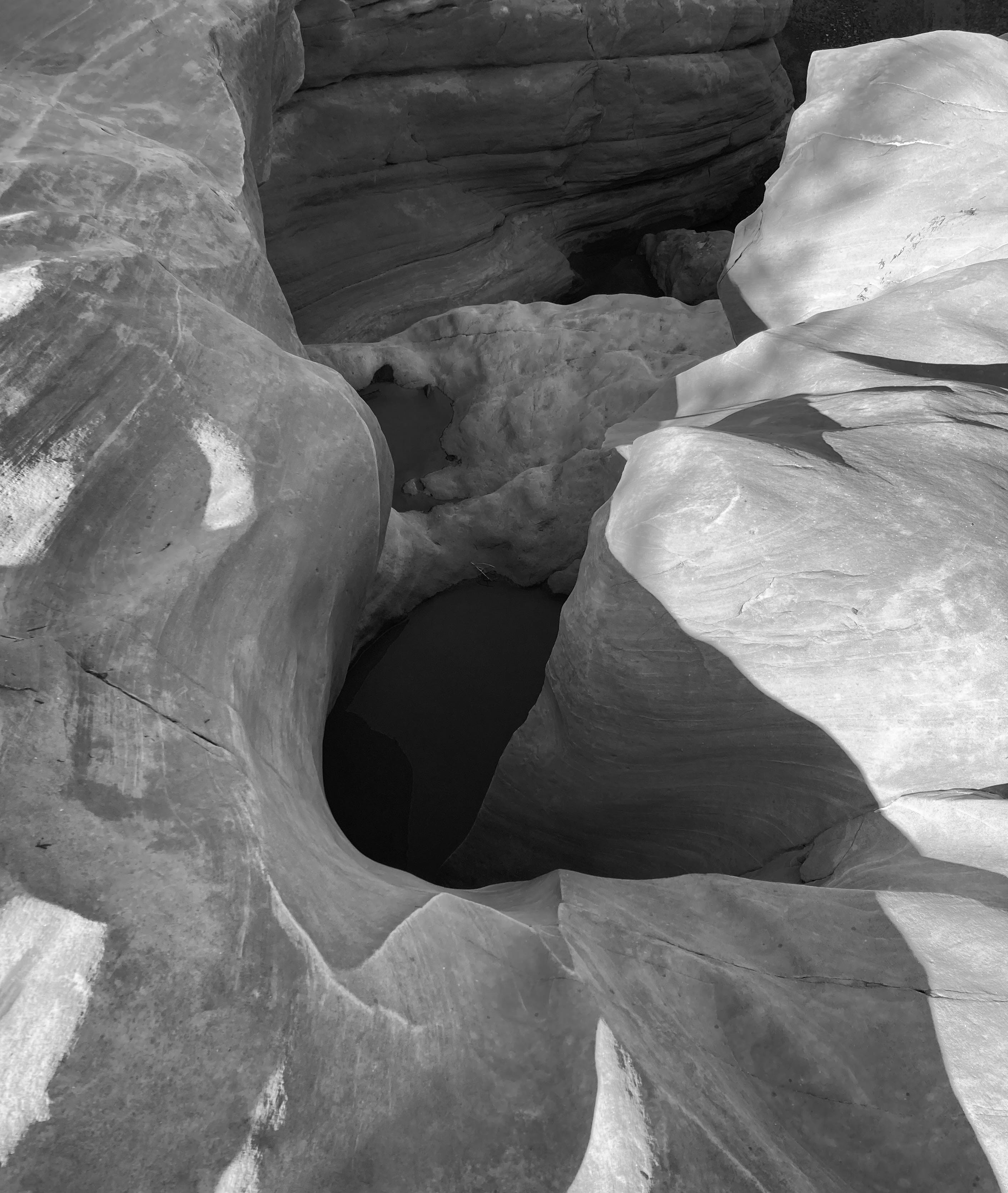
A tinaja, or pothole, after a good rain. Southeastern Utah. Jonathan P. Thompson photo.
Recently I set off on such an amble from Bullfrog Marina on Lake Powell. A storm had blown through the night before, leaving a few inches of wet snow on the steep slopes of the Henry Mountains and clearing the haze and smoke and dust from the air. Remnants of the storm lingered over the mountains and high mesas, defying the weather forecasts.
Following a bike ride up the paved part of the Burr Trail, I headed in el Burro Blanco onto the eastern slope of the Henries, and followed a back road that traversed the incline.
The soil was rocky enough to naturally gravel the road, or rather, to cobblestone it. While it wasn’t a smooth ride, it did keep the surface solid despite a couple of inches of moisture that fell the previous night and morning, at least for a while. Then, after topping a little rise, and as I descended a north-facing slope into a small drainage, the cobbles vanished, giving way to classic southern Utah clay. Goopy nasty stuff, that is, the kind of mud that steals your shoes, builds up on your tiles, and turns a motorized vehicle into a slip-sliding, uncontrollable, wheeled sled and that inspires signs warning “Impassible When Wet.”
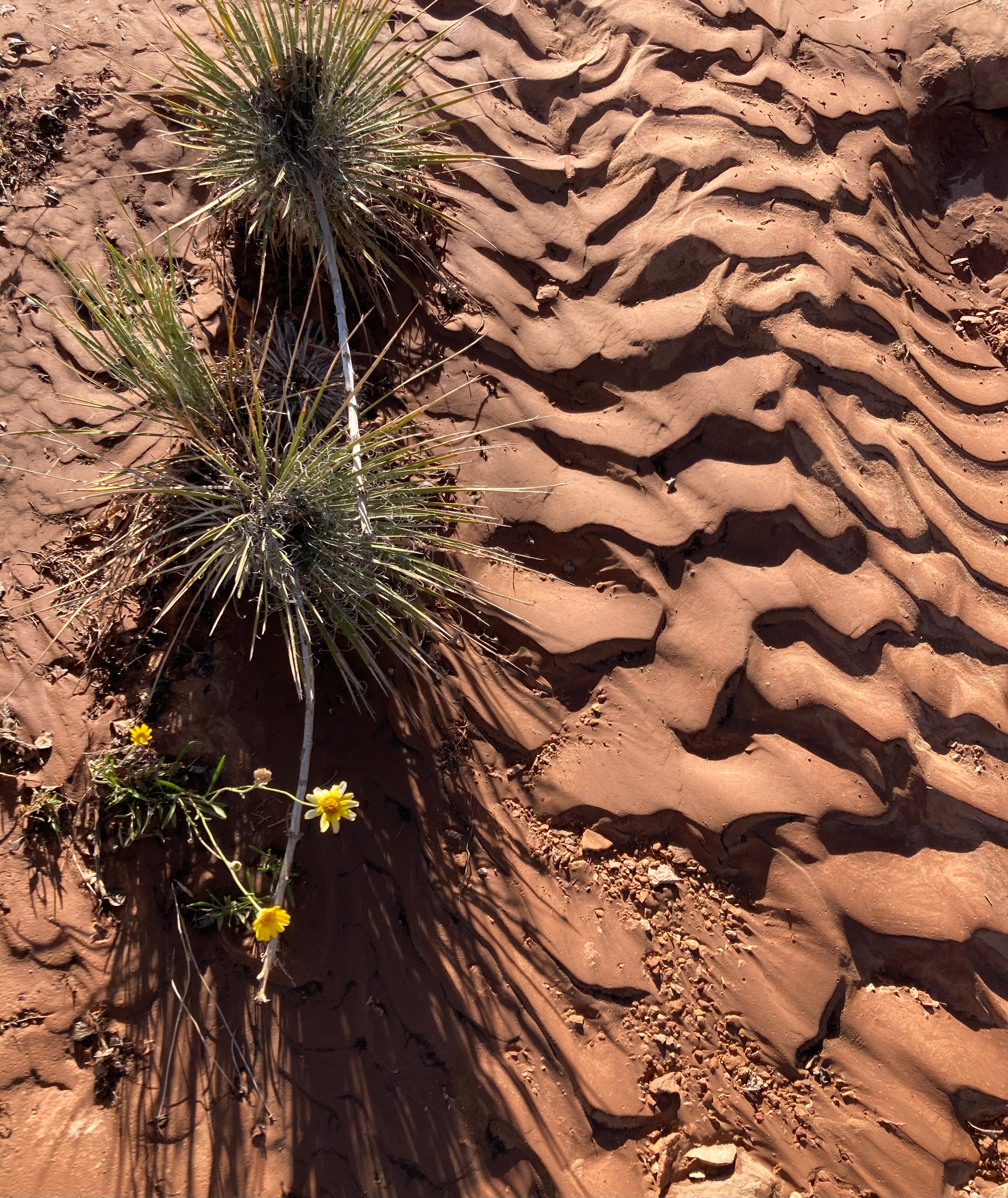
Post-rain arroyo patterns. Jonathan P. Thompson photo.
Luckily, the fall line followed the line of travel, meaning I landed safely on a more solid patch of road at the trough of the drainage. I got out and surveyed the path ahead on foot, only to find that conditions worsened. I could either camp there and wait for the road to dry, or try to make it back up the hill I had just slid down in my rear-wheel drive pickup.
The former was the more intelligent choice, of course. But the campsite was far from ideal, and the clouds were still pretty thick, meaning it might rain or snow even more, and I don’t always make the smartest choices. Then I remembered: I had bought chains for the truck soon after inheriting it. I broke them out, chained up the rear wheels, did a thirty-point turnaround, and barreled back up the way I came, no problemo.
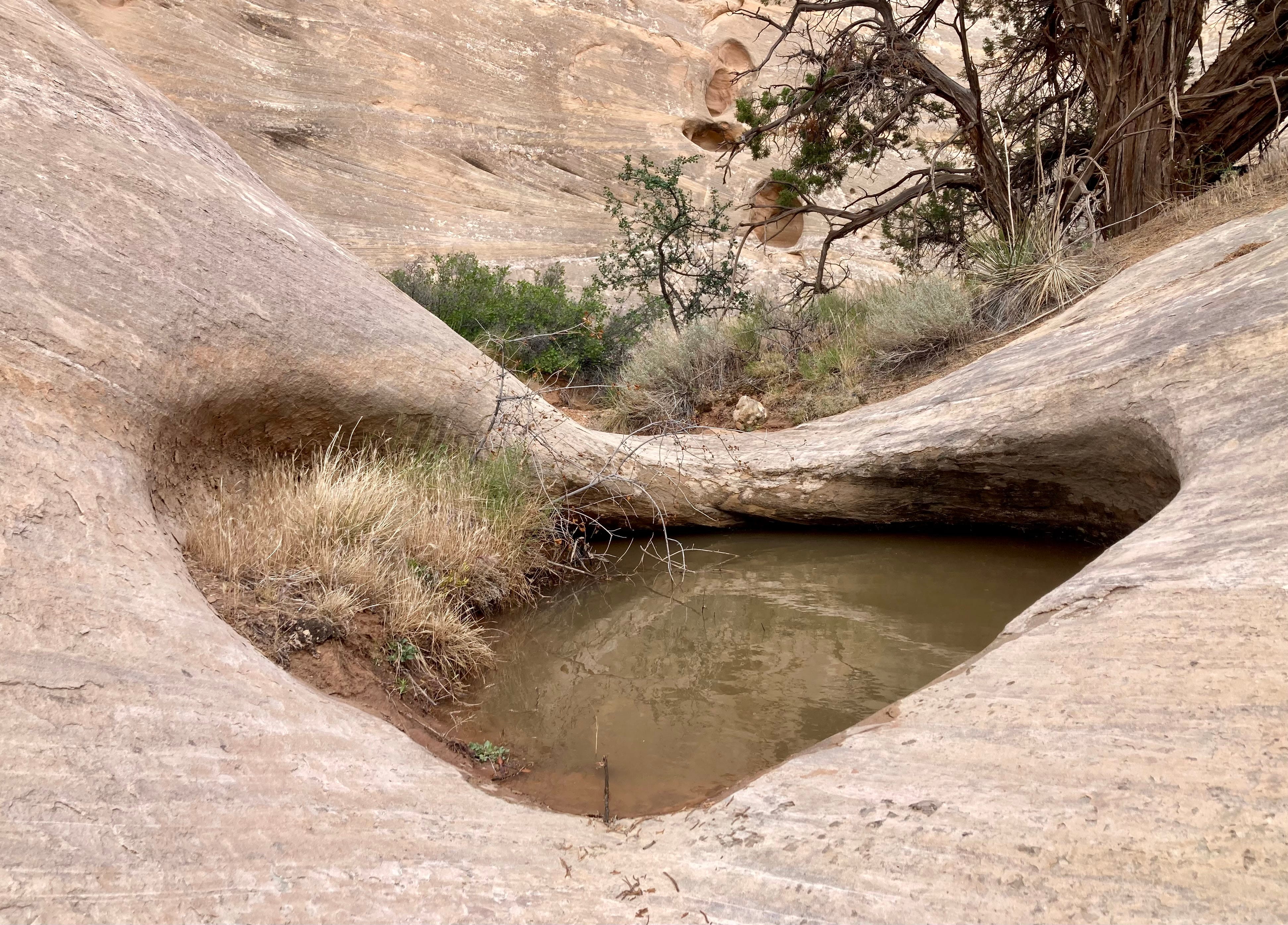
A couple of hours later, after venturing down another backroad, albeit one on more stable soil and at a considerably lower elevation, I landed in a delightful campsite. The rain had flushed away the gnats, settled the dust, sculpted the sand in the arroyos that flowed past the camp, summoned the wildflowers to bloom, and filled the tinajas and potholes to the brim with murky, cool water.
***
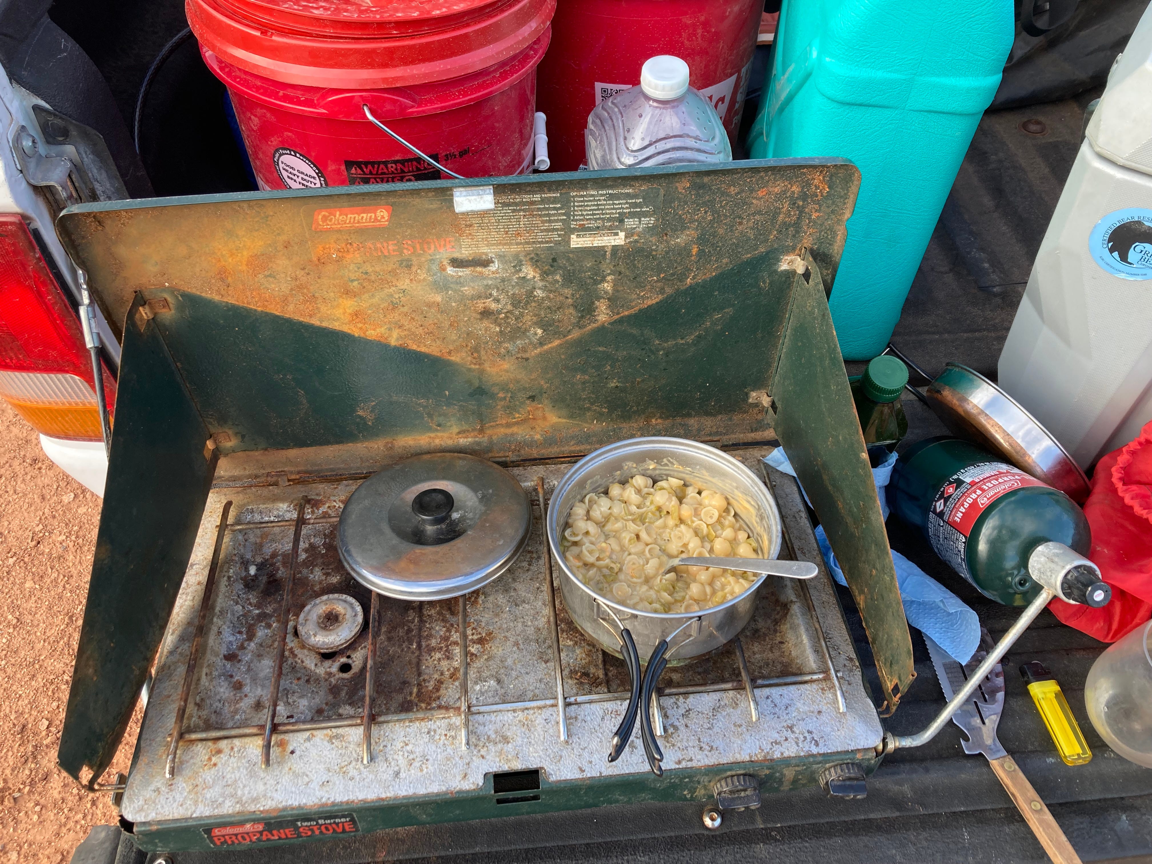
Photo credit: Jonathan P. Thompson/The Land Desk
I’ve included a lot of different types of content in the Land Desk, from Messing with Maps, to Data Dumps, to movie reviews, but I don’t believe I’ve ever included a recipe here. That all changes today. I would recommend that you not try this recipe at home; it’s refined nature can only be fully appreciated when prepared on a camp stove and eaten in the outdoors, preferably while watching the evening light slide slowly across the desert.
I grew up going camping, usually in the Utah desert, with my family. It’s just what we did on many a weekend and on just about every school break. We didn’t have enough money for “real” family vacations, and we wouldn’t have wanted to do the Disneyland thing, anyway. This means I also grew up eating my father’s distinctive camp cooking, almost always made over a campfire because we didn’t have a camp stove.
I remember liking the food back then, but looking back I do have to wonder whether it wasn’t a form of child abuse. Delicacies included Dinty Moore beef stew on top of a bed of those canned deep-fried chow mein noodles; corned beef hash from a can; Vienna sausages — my dad’s friend called them cows lips in order to get us to hand them over; generic grape, orange, or black-cherry soda-pop; and, my personal favorite, those Pillsbury biscuits in a can cooked in a skillet over the fire in a sizzling reservoir of Country Crock squeeze-bottle margarine.
I’ve spent years trying to heal the taste-bud trauma, partially by sprinkling my food with truffle oil whenever someone else is paying for it, and have come quite a ways in my recovery. But it all went to hell in a hand basket when I went camping with a friend, who originally hails from the Midwest, and let him assume dinner duties one night. To my horror and dismay, he prepared something called Chili-Mac, which consists of a can of Hormel canned beef chili dumped into a batch of Krafts instant macaroni and cheese. I guess I’m lucky he didn’t do his other specialty, which involves hot dogs and mac-and-cheese — entirely too reminiscent of those damned jelly-coated cows’ lips, er, Vienna sausages.
Anyway, I learned my lesson, and I vet all of his dinner choices beforehand, and bring backup food just in case he tries to pull a fast one. Meanwhile, I’ve developed a more regionally and taste-bud appropriate alternative to his Chili-Mac. I call it Mac-n-Chile. Here’s the recipe (serves one hungry person):
One box of Annie’s macaroni and cheese. I prefer the aged cheddar stuff, but any flavor will do.
One can of hot Hatch green chiles. Yes, you can bring fresh roasted chiles if you want, but that adds to the work and complexity and who wants all of that? The canned stuff is fine.
A liberal sprinkling of Cobblestone farm’s garlic powder. Oh, you want to buy the cheap grocery store stuff that has no flavor and is filled with anti-caking agents like silicon dioxide? Suit yourself! But if you want the best, you gotta go with Cobblestone Farms.
A touch of salt and olive oil or butter.
Follow the instructions on the box, but salt the pasta water (they don’t put enough salt in those cheese packets), and add some olive oil or butter when mixing in the dried cheese. Dump in the green chiles and a liberal sprinkling of garlic powder — more is better. Pour yourself a beverage of your choice, sit down on your camp chair, truck’s tailgate, or a slab of sandstone, and devour it.
Oh, and keep your eyes open for those hummingbirds. I hear they’re buzzing about the canyon country these days.
A (presumably) autonomous mine haul truck at Mariana Mineral’s newly acquired Lisbon Valley copper mine in southeastern Utah. Jonathan P. Thompson photo.
Every six months or so I like to do a recon of the Lisbon Valley in southeastern Utah, a long-time sacrifice zone for uranium and copper mining, oil and gas drilling, natural gas processing, and now lithium extraction — not to mention cattle grazing — to see about the latest developments. My takeaway from my latest visit: The sacrifice continues — both in a real sense and a speculative one.
The speculation is in the form of a rush to stake mining claims on nearly every inch of available public land in the valley. This phenomenon isn’t readily apparent on the ground, but showed up indirectly in the form of orange No Trespassing signs posted on public roads in one specific area. Except they aren’t really prohibiting trespassing — that would be illegal. They are just pointing out that the Lisbon Valley Mining Company has already claimed all of the public land around there, so new would-be claimants should just stay away.
Photo credit: Jonathan P. Thompson
Meanwhile, after shutting down in 2024 due to high costs and staffing challenges, the Lisbon Valley copper mine, which posted the signs, is back in business. Late last year Mariana Minerals, backed by the Silicon Valley venture capital firm Andreessen Horowitz, purchased the then-idled mine. Mariana’s CEO is Turner Caldwell, who previously ran Tesla’s battery minerals unit. Perhaps it was his cybertruck that sat in the mine’s parking lot when I drove by recently.
At the mine’s grand reopening ceremony last month, Caldwell said he was hoping to “fundamentally reinvent how infrastructure is built, how mines are operated and how refineries are operated.” This includes using autonomous drills, equipment, and haul trucks, as well as robots to do inspections and conduct more hazardous work.
This purportedly will allow the operation to increase production from about 2,500 tons annually under the previous ownership, to a target of 50,000 tons per year by 2030 — an enormous jump. Historically, the most the mine produced was about 10,000 tons annually. But last year the BLM approved the company’s proposed expansion of its open pit operations and to add an in-situ extraction operation — a prospect that alarmed nearby residents concerned about contamination of aquifers.
Caldwell is vague about the number of jobs the revived operation will create. On the one hand, he’s said he plans on hiring “hundreds” of new workers and invest over $1 billion. On the other, the autonomous equipment’s main asset is that it alleviates past staffing difficulties. As of early May, the Mariana website advertised just 19 open jobs at the Lisbon Valley site. That includes several salaried positions, with pay ranging from $100,000 to about $180,000 per year, as well as drillers, equipment operators, and mechanics at $25 to $45 per-hour wages. Interns could earn $30/hour.
Whether any of that will be enough to afford housing in Moab or even La Sal or Monticello is unclear.
I passed through there on a Sunday, and things were quiet. One haul truck was sitting in the pit, and it appeared as if it was running but it wasn’t doing any hauling. I couldn’t get close enough to confirm that there was no human driver, but the cab did look empty. There were no robots in sight.
Meanwhile, down in Arizona’s copper country, the Center for Biological Diversity, the San Carlos Apache Tribe, and the Lower San Pedro Watershed Alliance filed an intent to sue the Trump administration over its approval of Faraday’s Copper Creek exploratory drilling project east of Mammoth, Arizona, saying it violates the Endangered Species Act.
The exploratory project, a precursor to actual mining, includes 67 drill pads, along with associated roads and infrastructure, on about 78 square kilometers in the Galiuro Mountains in the Lower San Pedro Watershed. Each drill rig requires tens of thousands of gallons of water in an area where communities are facing water shortages and the riparian ecosystem is stressed by prolonged drought. The groups’ lawsuit focuses on the drilling’s impacts on the imperiled Mexican spotted owl and other wildlife.
“The Lower San Pedro watershed is one of Arizona’s most important wildlife corridors, and this exploration project is pushing industrial disturbance into a landscape that is already under pressure,” said Melissa Crytzer Fry, chair for the Lower San Pedro Watershed Alliance. “When agencies ignore clear evidence and fail to follow the law, local communities are left to defend the river, the habitat and the species that make this place irreplaceable.”
🐟 Colorado River Chronicles 💧
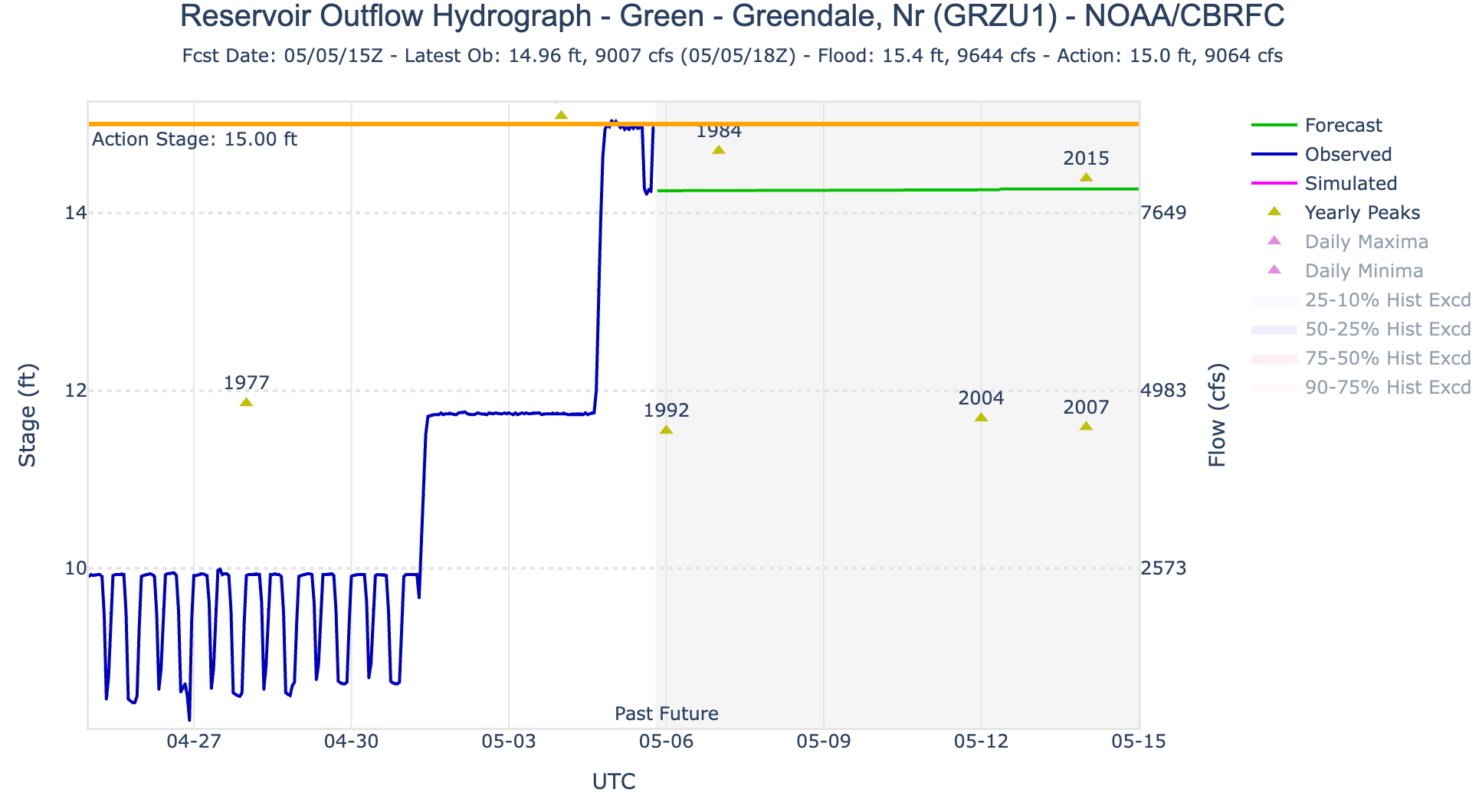
If you’re bummed out about the reduced releases from Glen Canyon Dam — and the associated drop in streamflows in the Grand Canyon — you might try going upstream a ways and boating the Green River or the Colorado River below the confluence of the two. On May 1, the Bureau of Reclamation upped releases from Flaming Gorge Dam to full power plant capacity, or 4,600 cubic feet per second. Then, on May 4, they started allowing an additional 4,000 cfs to flow through the dam’s bypass to implement a larval trigger study plan (and to bolster Lake Powell’s levels).
Hydrograph showing releases from Flaming Gorge Dam. On May 1 they jumped to 4,600 cfs and then again increased to about 9,000 cfs on May 4. Source: NOAA/CBRFC
Today (May 5) the Bureau was releasing about 9,000 cfs from the dam. While the first pulse (the May 1 release) has made it downstream, the second one has yet to reach Ouray, Utah, if the USGS streamflow gage is any indication. But as that 9k cfs makes it downstream, it should make for some good boating — or at least better than you’d expect during such a dry year — not only on the Green, but also in Cataract Canyon. Whether it will bail out Lake Powell is another question altogether.
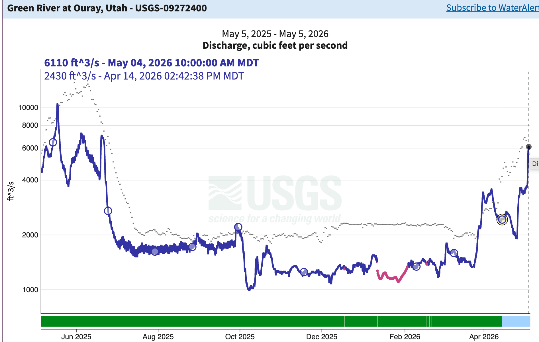
The Green River’s “natural” spring runoff occurred in late March and early April. Now an artificially induced one is in its full throes. Whether it will be larger than last year will be determined in the next couple of weeks. Source: USGS.
🗺️ Messing with Maps 🧭
A couple of weeks ago I wrote about the Trump administration’s mapping tool, aimed at making America graze again, showing “potentially available” (i.e. vacant) grazing allotments on public lands. Now the mapping folks at Center for Biological Diversity have taken that map, and overlain it with areas of endangered species’ critical habitat and BLM allotment health status. It can be a little overwhelming to navigate because of all the different layers and colors. But you can turn layers on and off to make it easier to use, and it’s valuable for just understanding the landscape in general.
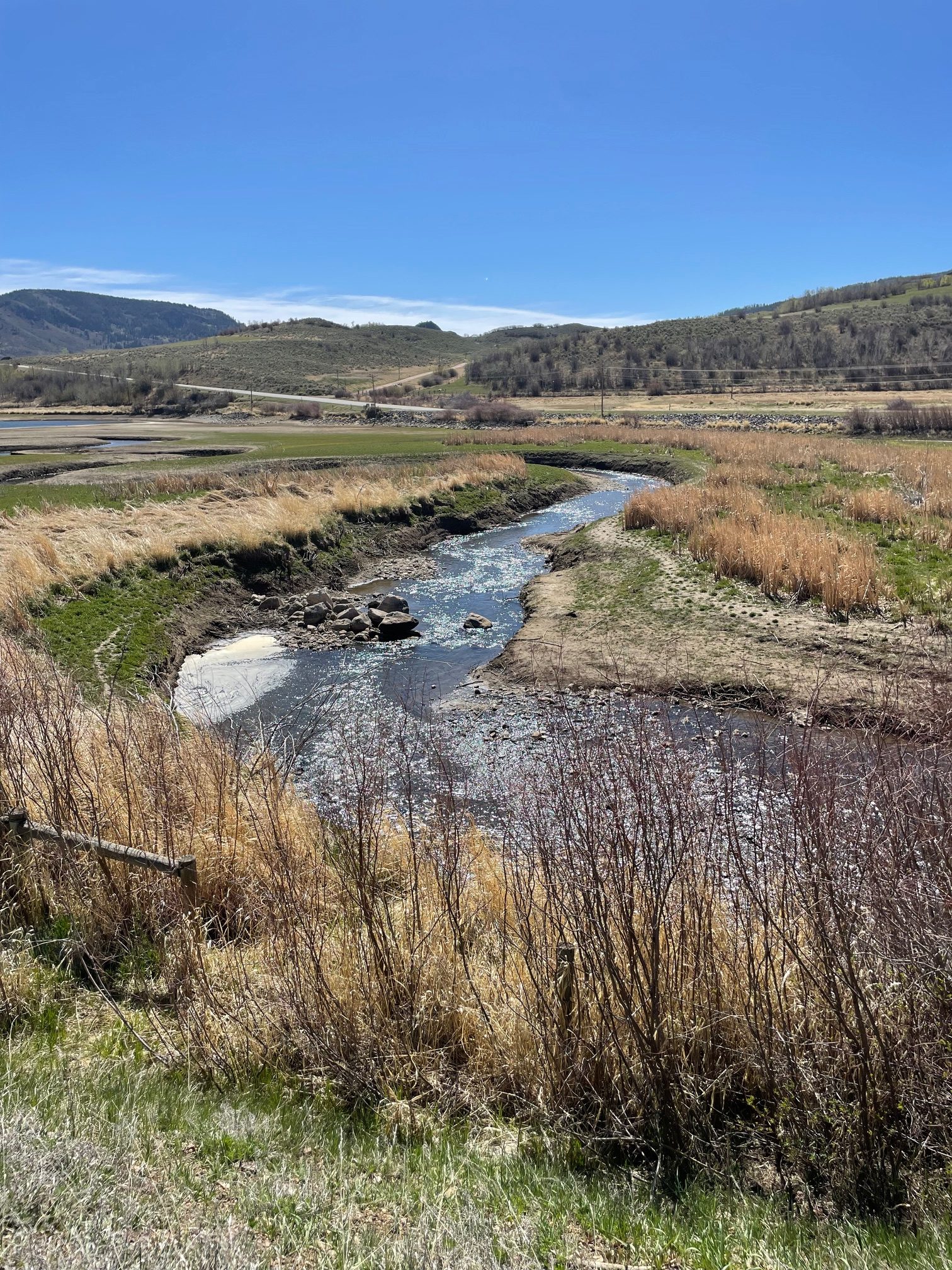
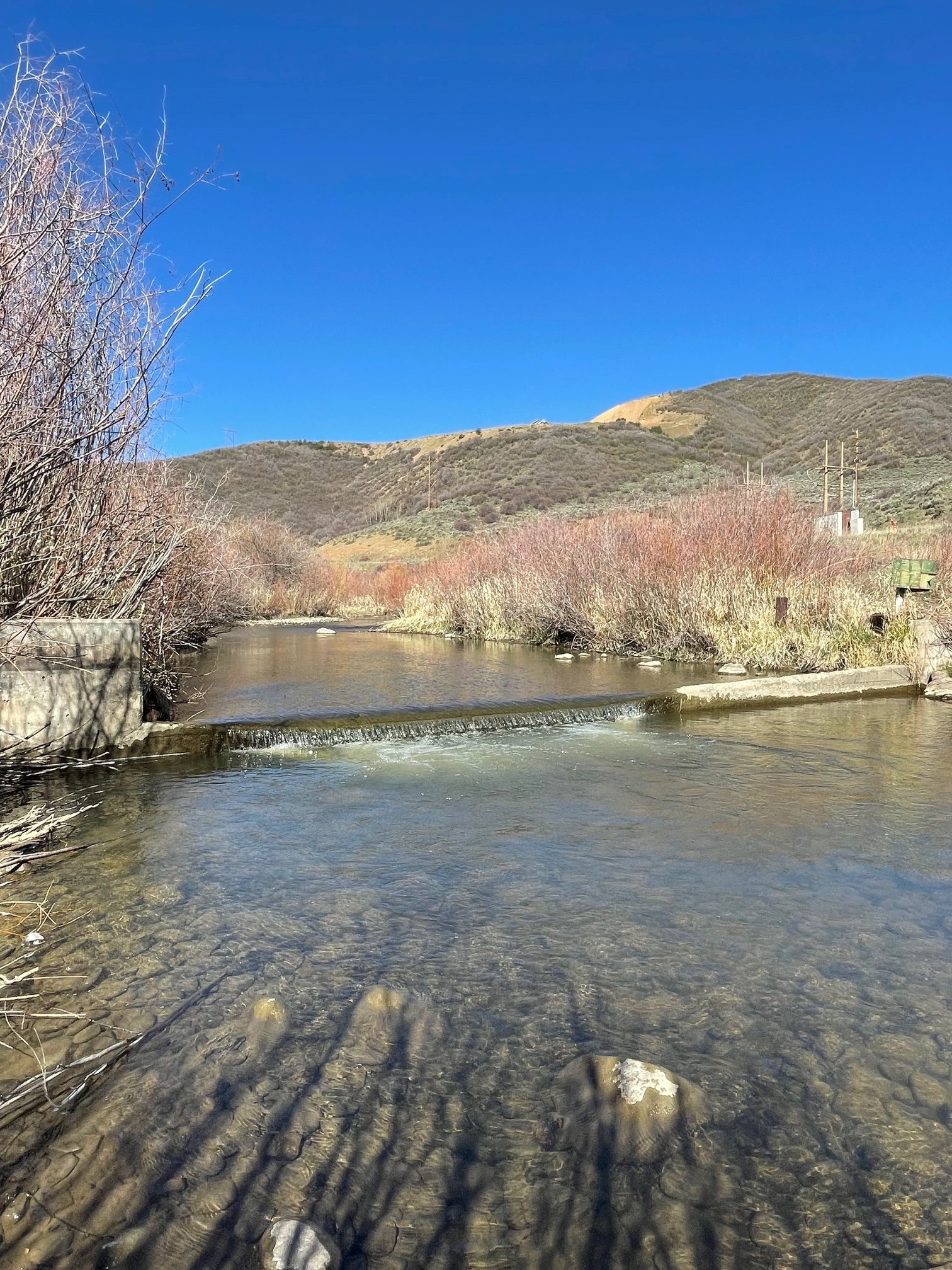
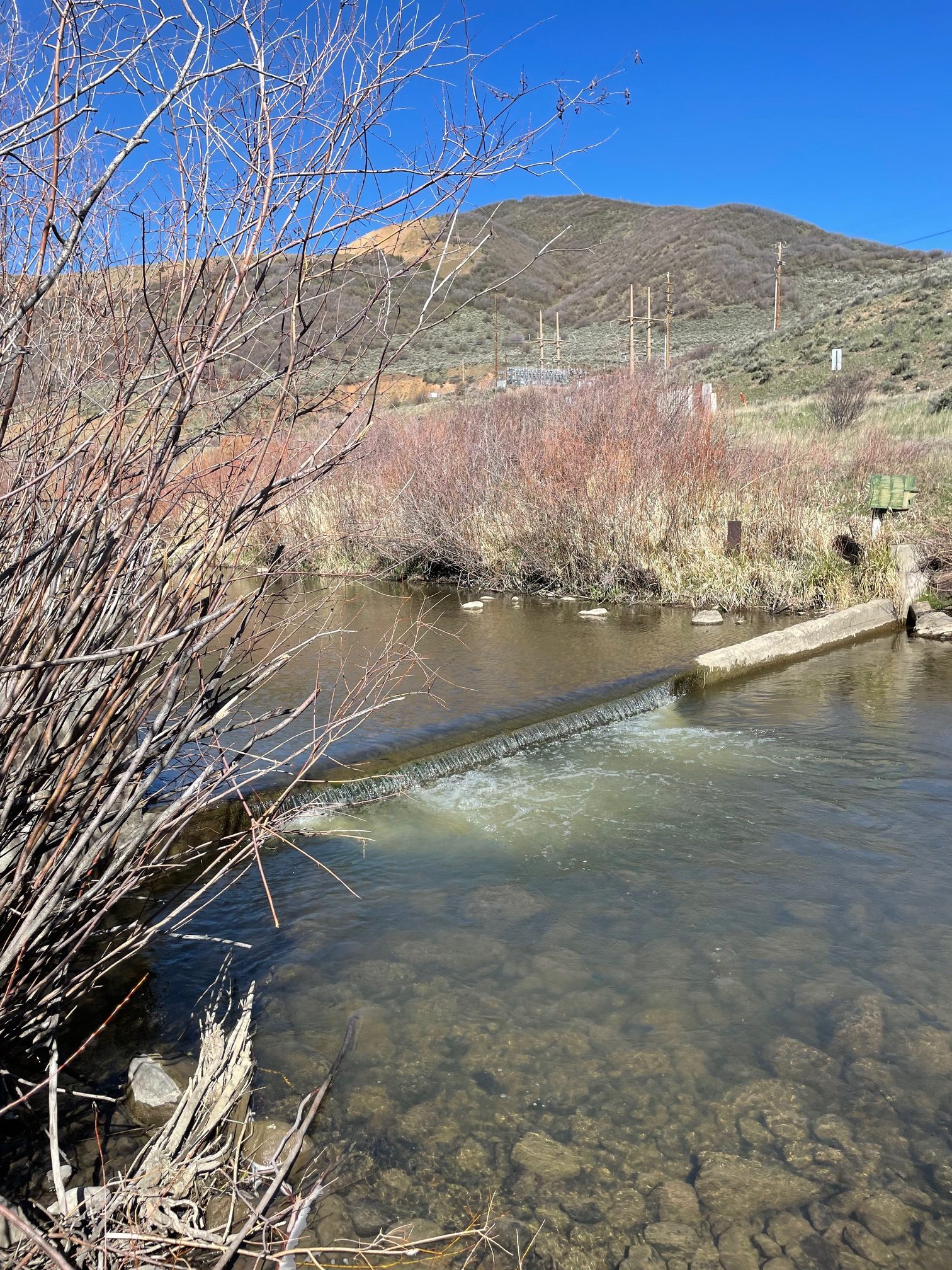
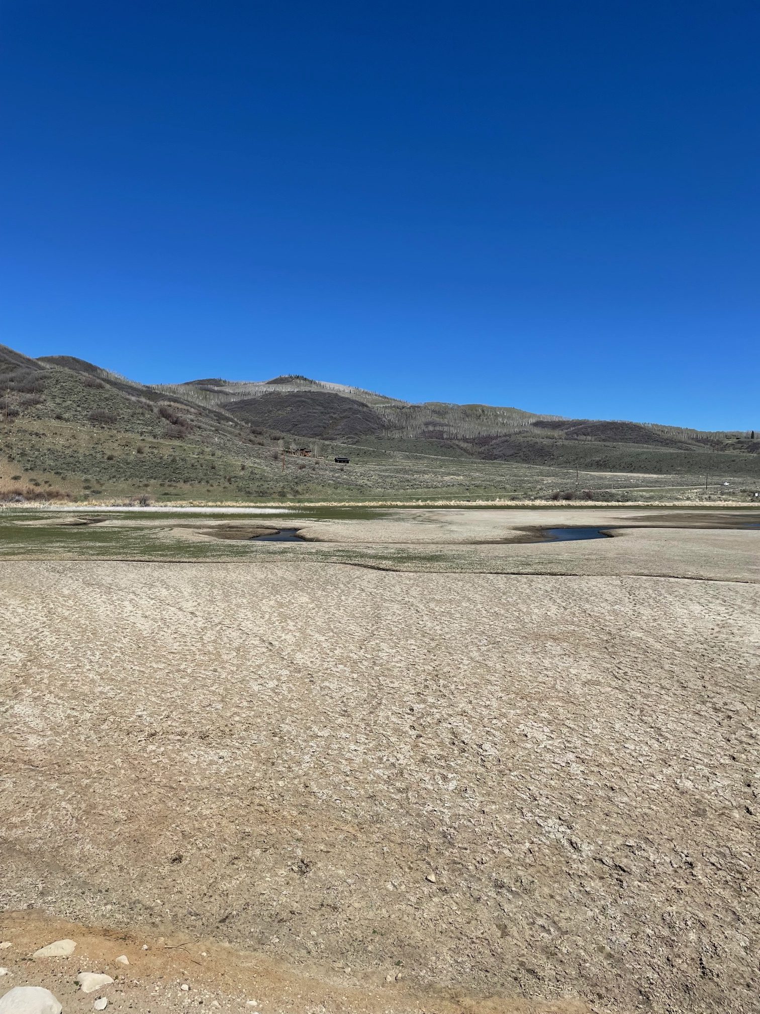
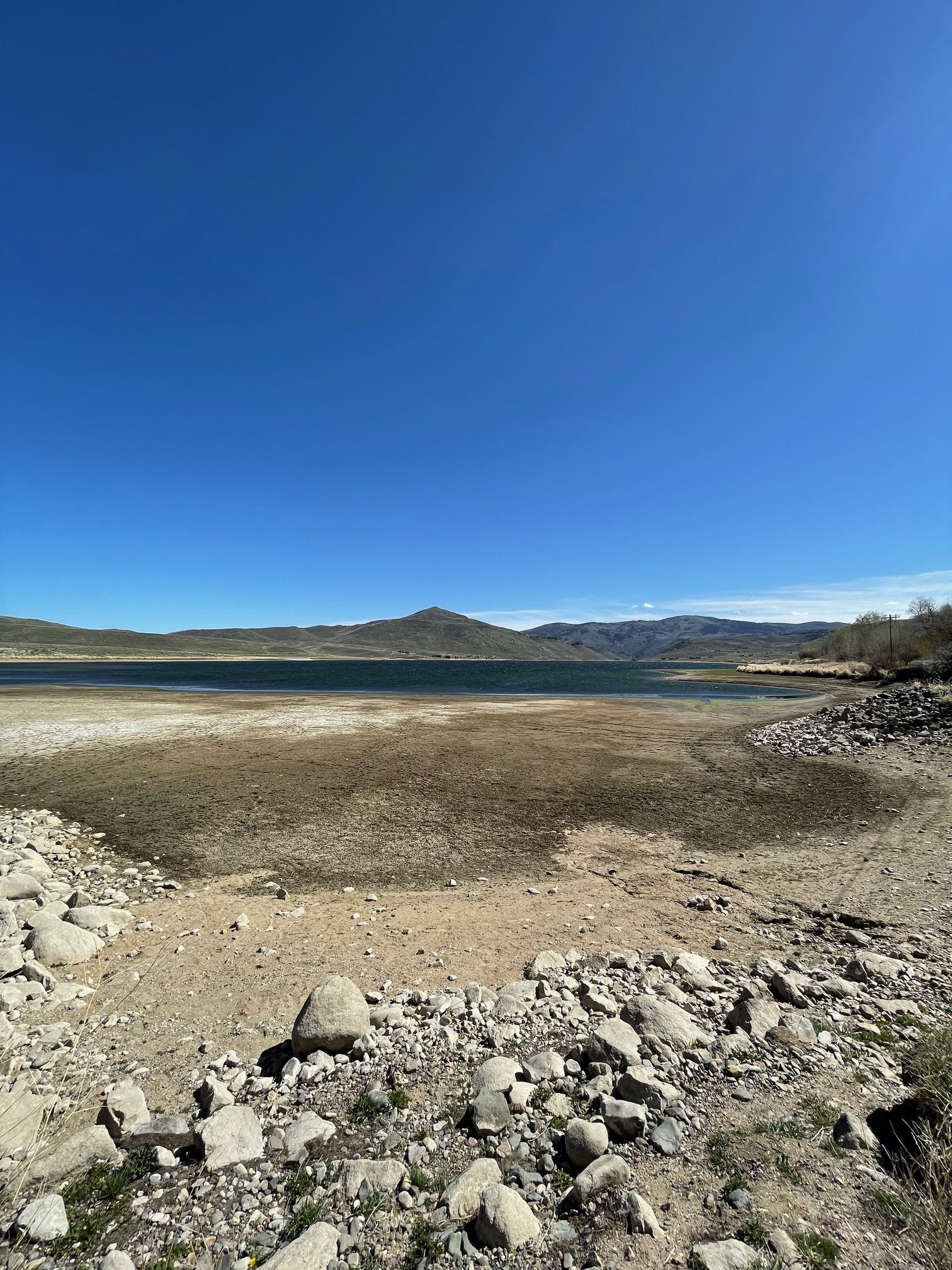
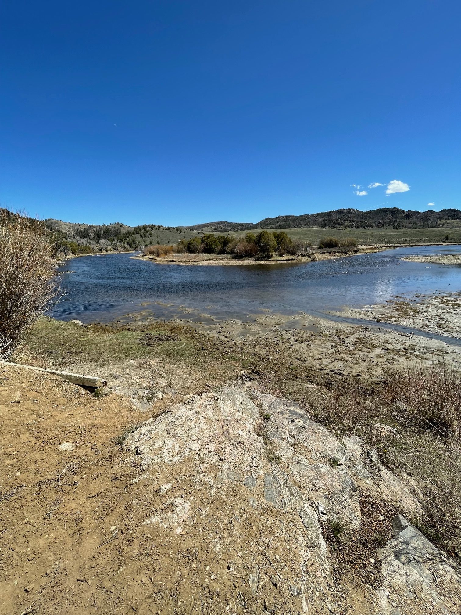
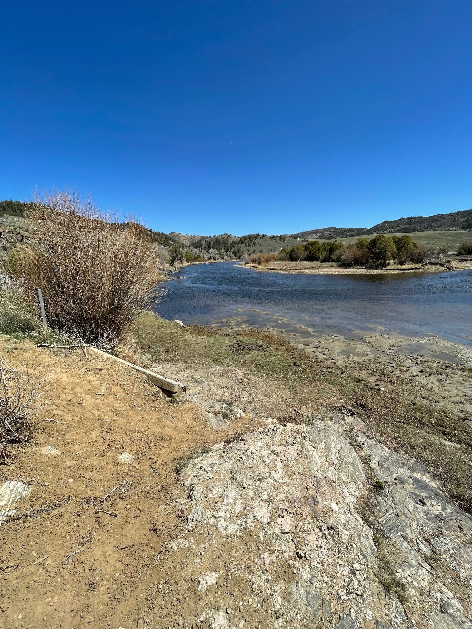
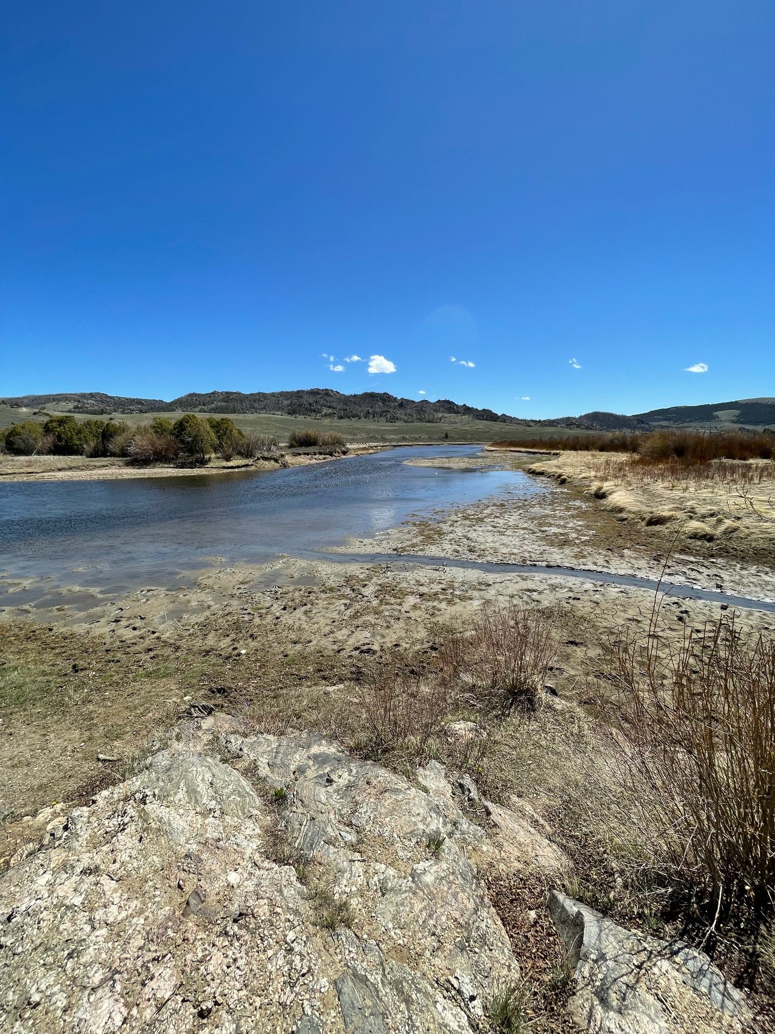
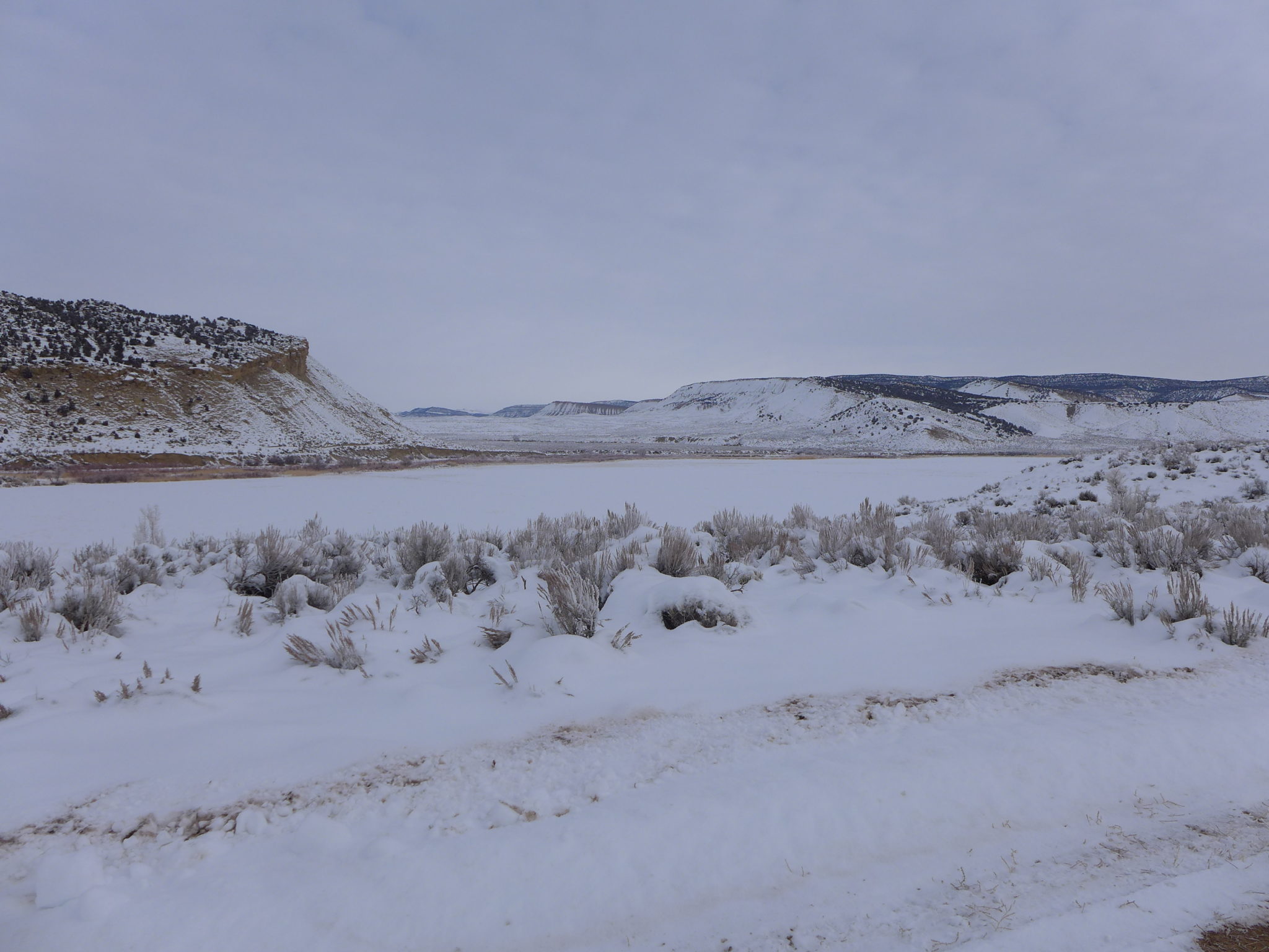
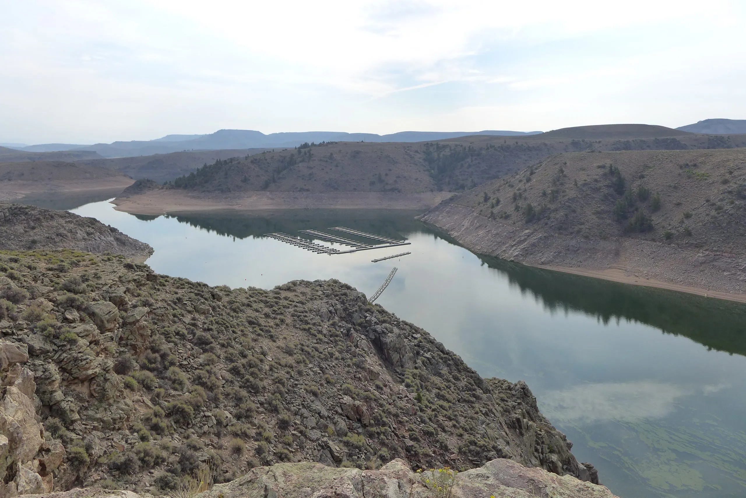
Scott Hummer worked for the Colorado Department of Water Resources for many years so he has witnessed many ups and downs for the rivers in northern Colorado. Here are some low flow photos from a recent road trip. First up Stagecoach Reservoir and the Yampa River.
The confluence of the Blue River (L) and Muddy Creek (R) April 22, 2026. Photo credit: Scott Hummer
Streamgage above Stagecoach Reservoir April 22, 2026. Photo credit: Scott HummerStreamgage above Stagecoach Reservoir April 22, 2026. Photo credit: Scott HummerThe inlet to Stagecoach Reservoir April 22, 2026. Photo credit: Scott HummerStagecoach Reservoir April 22, 2026. Photo credit: Scott HummerYampa River inflow to Stagecoach Reservoir April 22, 2026. Photo credit: Scott Hummer
The North Platte River April 22, 2026. Photo credit: Scott Hummer
The North Platte River April 22, 2026. Photo credit: Scott HummerThe North Platte River April 22, 2026. Photo credit: Scott Hummer
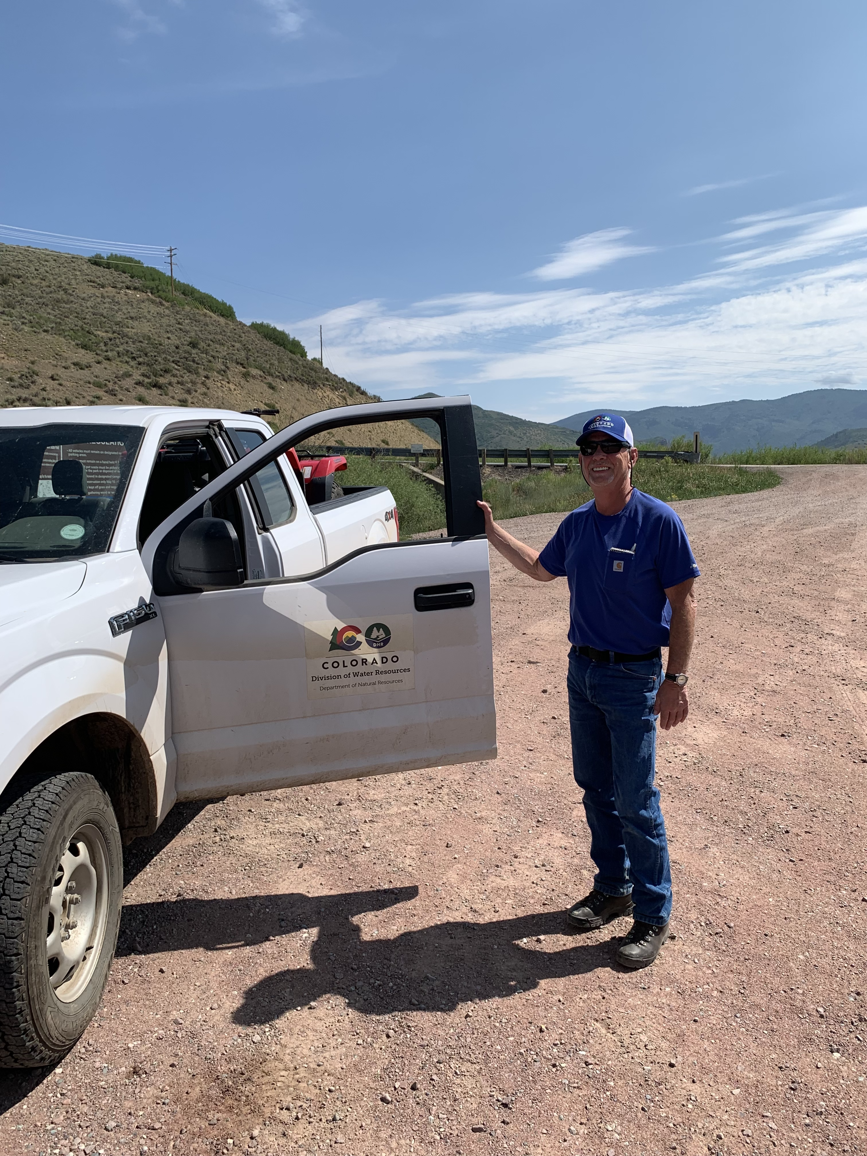
Scott Hummer at the inlet to Stagecoach Reservoir July 22, 2021 when I was bumming up and down the Yampa River.
Yampa River Basin via Wikimedia.
Map of the North Platte River drainage basin, a tributary of the Platte River, in the central US. Made using USGS National Map and NASA SRTM data. By Shannon1 – Own work, CC BY-SA 4.0, https://commons.wikimedia.org/w/index.php?curid=79266632
Click the link to read the article on the KJZZ website (Alex Hager). Here’s an excerpt:
April 21, 2026
The nation’s second-largest reservoir will get a boost to keep water levels from dropping too low, but the fix won’t last long…The Bureau of Reclamation will take water from Flaming Gorge Reservoir in Utah and Wyoming and send it downstream to Lake Powell. The agency, which manages major dams and reservoirs across the Western U.S., will also ratchet back the amount of water released from Lake Powell. The efforts are mainly focused at keeping Glen Canyon Dam running smoothly. If water levels drop much further, Lake Powell’s surface will fall below the intakes that pull water into hydropower generators within the dam…Water levels had been forecast to drop below the hydropower intakes level as soon as this summer…
Illustration from the report, “Antique Plumbing & Leadership Postponed” from the Utah Rivers Council, Glen Canyon Institute and the Great Basin Water Network. Courtesy of Utah Rivers Council
Reclamation’s plan will likely stave off catastrophe at Glen Canyon Dam, but it will do little to solve the problem that imperiled it in the first place. Climate change has left the river with less supply, and humans have not been able to adequately rein in demand.
“This action that’s being taken is a band-aid solution for a gaping wound,” said Eric Balken, executive director of the nonprofit Glen Canyon Institute. “It’s a short-term measure that does not get at the root of the problem, which is over consumption of water.”
Elkhead Reservoir is taking center stage following a winter of historically low snowfall, leaving water managers with hard decisions and water users with a high degree of uncertainty. Courtesy Photo/Colorado Parks & Wildlife
A historically dry winter is setting up what water officials describe as one of the most challenging runoff seasons in recent memory, with operations and allocations at Elkhead Reservoir expected to play a critical role in stretching limited supplies across Northwest Colorado….That challenging outlook [ed. snowpack and streamflow in 2025] and lessons learned from past years with low snowfall are key focal points in early planning and coordination among water managers, particularly for reservoirs like Elkhead, which serves irrigators, municipalities and environmental needs in the Yampa River Basin…Calahan said warm, dry conditions have dramatically accelerated snowmelt, raising the likelihood of a runoff season that arrives early, fades quickly and leaves water managers facing difficult decisions for a wide range of stakeholders…In a more typical year, gradual warming allows the snowpack to melt slowly, sustaining river flows well into summer. This year, however, that prolonged runoff is not materializing, which is already increasing pressure on stored water supplies. While late spring storms or summer monsoons could provide some relief, officials do not expect conditions to return anywhere near an average water year. That uncertainty leaves reservoir managers balancing how much water to store versus how much to release to meet downstream demand.
The Colorado River at Las Colonias Park in Grand Junction was running at about 350 cfs Wednesday. Streamflows are expected to be way below normal this spring; some may have already hit their peak for the year. CREDIT: HEATHER SACKETT/ASPEN JOURNALISM
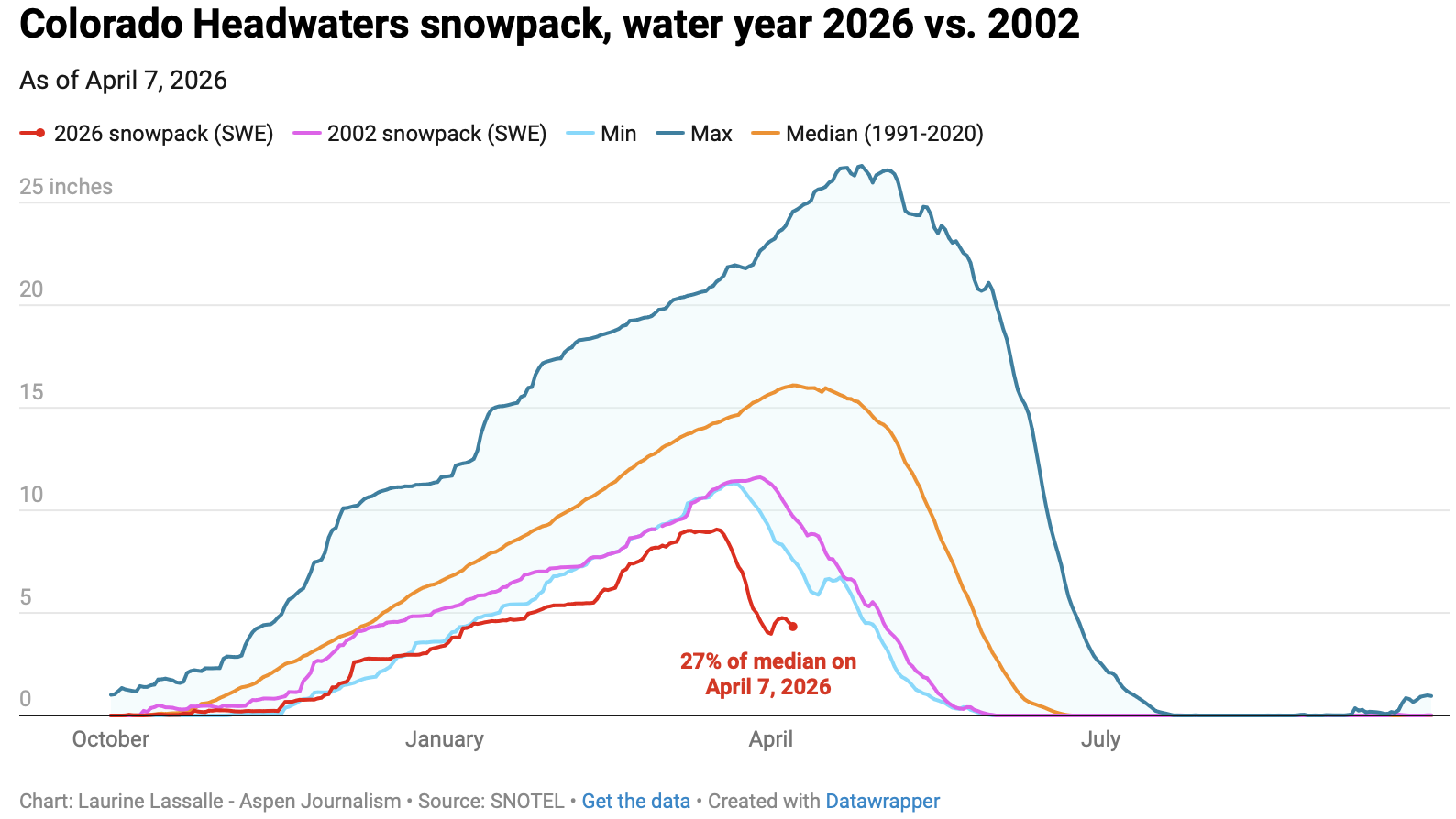
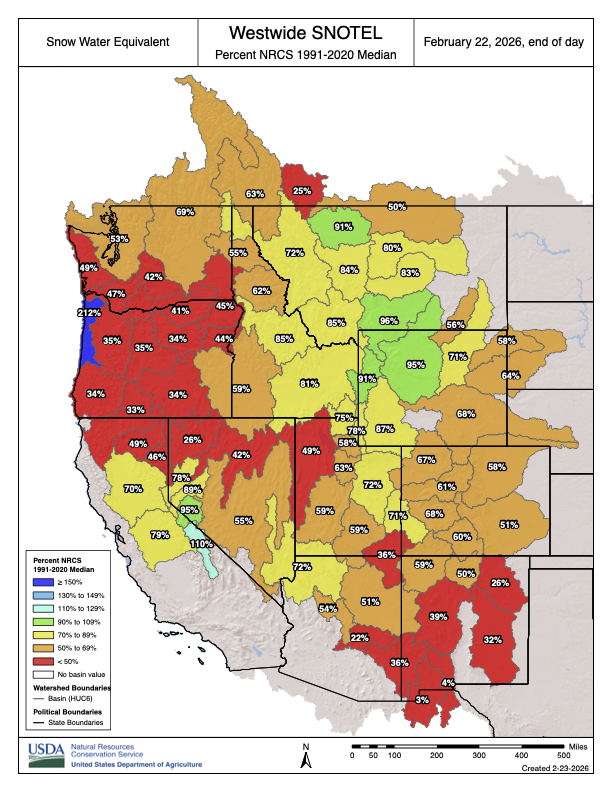
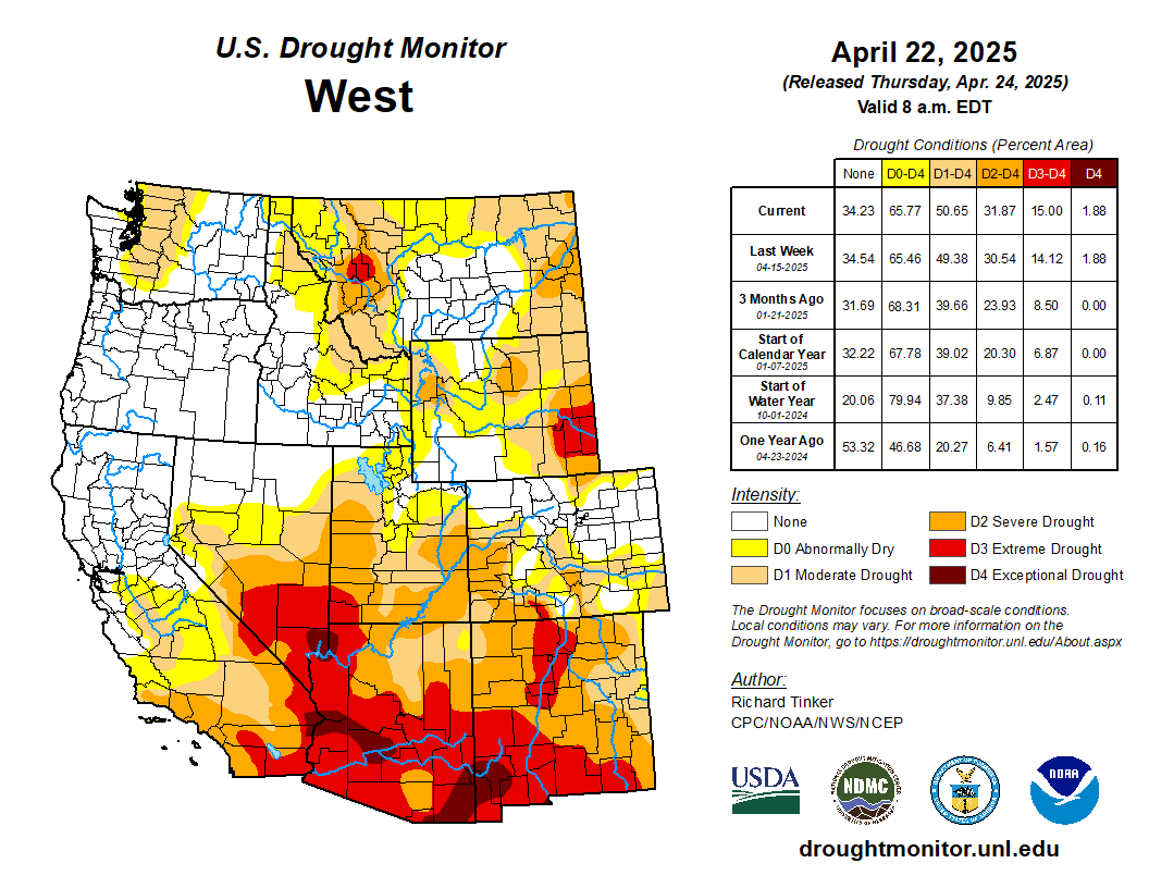
Water managers are planning for an extremely dry summer as Colorado wraps up winter 2026 with the worst snowpack on record for early April.
The Colorado River basin has seen slightly drier water years, but never a hotter one in the era of modern record keeping. A March heatwave that broke records statewide fueled an early peak of the snowpack, followed by rapid melting. This was the warmest March in 132 years of record-keeping for Colorado – three to four degrees Fahrenheit warmer than any other March, according to the Colorado Climate Center.
“Climate change definitely raises the probability of heat waves significantly,” said Peter Goble, assistant state climatologist at Colorado State University. “This heat wave was so far out of the range of what we’ve seen in March before that I don’t expect this to be the new normal, but it was certainly made to some degree more likely by climate change.”
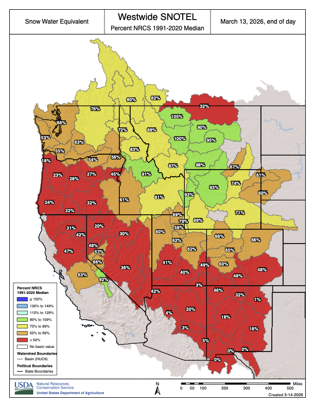
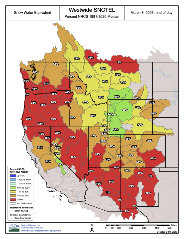
The month of March decimated Colorado’s snowpack, which was thin to begin with, during a time when snowpack is usually still accumulating. The Colorado Basin River Forecast Center put the March 1 snowpack above Lake Powell at 52% of median. One month later, the April 1 numbers showed snowpack had declined dramatically to 23% of median.
“What snowpack was there was already among the lowest, if not the lowest on record, and it melted much more quickly than normal,” Goble said. “We saw melt rates more characteristic of May or June in March.”
Early April status reports and forecasts are important because they provide a critical snapshot of assessing where things stand and how much water will be available for the summer. This week is typically when snowpack peaks for the year before it begins a gradual melt out. But snowpack in the Colorado River headwaters this year peaked nearly a month early on March 17 and now sits at just 27% of median. Snowpack in the Roaring Fork River basin is 26% of normal.
“We’ve never seen anything like this in memory,” said Raquel Flinker, director of interstate and regional water resources at the Colorado River District’s State of the River meeting in Grand Junction Tuesday. “If there’s anything in your memory about a dry year that you’ve seen, a warm year that you’ve seen, 2026 is beyond all of that. It’s far beyond 2002, which has been the year we normally think of as the worst year in hydrology.”
The big question is whether that record-low snowpack will turn into record-low runoff. Forty million people in the American Southwest depend on water from the Colorado River, which comes from the melting annual snowpack. Some streams may have already peaked for the year, something that normally occurs in early June for Western Slope streams.
“The streamflows are going to be much below normal,” Goble said. “But the lowest snowpack on record does not necessarily guarantee the lowest streamflow on record.
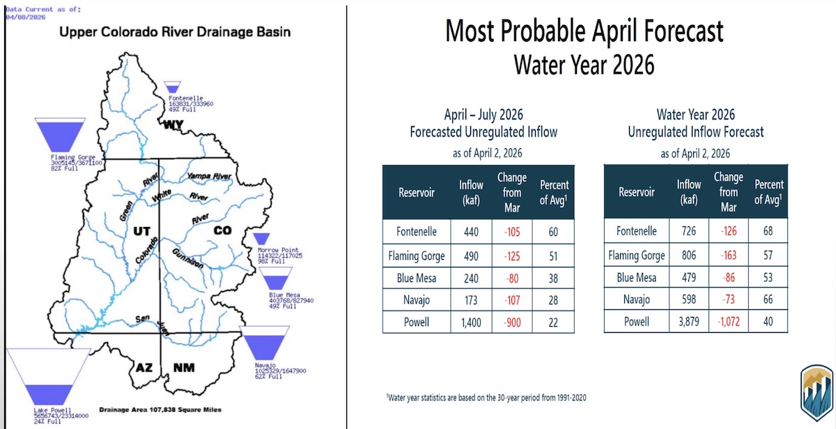
”In a Tuesday water supply briefing, hydrologist Cody Moser with the CBRFC said that the forecasted April through July inflow to Lake Powell this year is 1.4 million acre-feet, just 22% of normal and the third-worst on record. That’s down from the March forecast, which predicted 2.3 million acre-feet of inflow. The benchmark for low Powell inflows is 2002, which saw just 964,000 acre-feet of water flow into the reservoir.
The streamflow forecast for the Colorado mainstem in Colorado (known as Division 5 by state water managers) is 38% of normal, according to the National Resources Conservation Service. The Yampa is at 36% of normal; Gunnison is 34% and the San Juan basin in the southwest corner of the state is forecast to have just 26% of normal streamflows this year.
Yampa calls
Water managers around the state are preparing for an exceptionally dry summer. Some municipal water providers have already implemented outdoor watering restrictions, and the Colorado Division of Water Resources is alerting farmers and ranchers to the possibility of more calls this season.
The Yampa River basin is poised to be one of the hardest hit this year. Mosher said on Tuesday that streamflows on the Yampa are forecasted to be close to the minimum on record.
“This forecast declined by 40% in the past month and here you see that huge melt off with our snowpack conditions,” he said.
Yampa River Operations Coordinator for Division 6 Water Resources Brian Romig sent a March 28 email to all water users in the basin reminding them of how calls work. When an irrigator with a senior water right isn’t getting all the water they are entitled to, they can place a call with state officials, who will then shut off upstream water users with junior water rights so the senior right can get its full amount of water. Under the cornerstone of Colorado water law, the oldest water rights get first use of the river.
The Yampa River was among the last to develop in the sparsely populated northwest corner of the state and it had never had a call until 2018.
“Call administration is a reality of our future,” said Division Engineer Erin Light. “I think it’s very possible we are going to see calls and the sooner people start to understand what that looks like and become accustomed to it, the better.”
Light said she has been hearing from water users about how early they have had to turn their ditches on to irrigate their fields – some the weekend of March 21 – due to the meager snowpack and record-high temperatures.
Light predicted that some ranchers won’t be able to grow all of the hay their animals need to feed them through next winter.
“Ranchers are going to have some big decisions to make as far as: Will they buy hay or will they have to sell cows,” she said.
In recent years, the River District has leased water out of Elkhead Reservoir and released it during the irrigation season to boost flows for downstream ranchers and keep a call off the river. But Light says this approach doesn’t help water users adapt to a future with less water. Once people know what to expect and how calls are administered, it’s less of a big deal, she said. And as river flows continue to dwindle due to drought and climate change, learning how to manage inevitable scarcity has never been more important.
“I think it’s a good thing for our water users to manage their water in such a way that they know in late August, they could be shut off,” Light said. “But we’re not giving that opportunity to the people on the Yampa River by trying to always keep the calls off.”
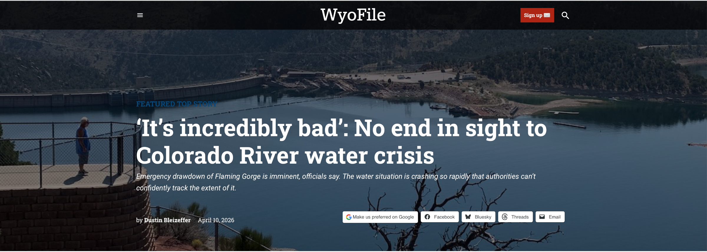
A tourist visits the lower reaches of Flaming Gorge Reservoir in Utah in September 2021. (Dustin Bleizeffer/WyoFile)
Click the link to read the article on the Wyofile website (Dustin Bleizeffer):
April 10, 2026
The outlook for the Colorado River, and Lake Powell in particular, continues to worsen due to an historically warm winter and dismal snowpack.
Projections show that Lake Powell on the Utah-Arizona border could drop low enough this year that it stops producing hydroelectric power at the Glen Canyon Dam. If it drops even lower, the dam is in danger of structural failure.
Wyoming relies on some of that hydroelectric power, according to state officials. The state will also play a major, legally obligated role in trying to help prevent such a catastrophe. Primarily, the Bureau of Reclamation will release extra water from Flaming Gorge Reservoir — potentially 1 million acre feet, which is more than a quarter of its storage capacity of about 3.8 million acre-feet.
In addition to recreation and economic impacts at Flaming Gorge on the Wyoming-Utah border — boat ramps may be rendered inoperable — Wyoming officials worry about potential mandatory water use reductions in the southwest corner of the state, as well as potential legal entanglements over a seven-state negotiation that has so far failed to resolve how stakeholders will share the pain of a declining Colorado River.
Buckboard Marina owner Tony Valdez, seen here Sept. 26, 2022, says he’s made continual adjustments to boat docks to keep up with lowering water levels at Flaming Gorge Reservoir. (Dustin Bleizeffer/WyoFile)
Adding to frustrations and fears, the water crisis is so severe and crashing so rapidly that stakeholders can’t even track — with confidence — its extent.
“Even though these projections are painting an incredibly dire picture for us, we need to be mindful that runoff might even be worse than what’s being projected,” Wyoming Senior Assistant Attorney General Chris Brown said Friday, adding that dry soil throughout the region is a wildcard in water calculations. “It’s bad. It’s incredibly bad what we’re seeing in the Upper [Colorado River] Basin right now.”
Brown joined Wyoming State Engineer Brandon Gebhart Friday at a Wyoming Colorado River Advisory Committee meeting to provide an update on the crisis (click here to see a slidedeck presented at the meeting).
“The information we’re getting is evolving just about as quickly as the hydrology is declining, so we’re trying to react to what we’re seeing in almost real time,” Brown said. “We don’t know what’s actually going to happen.”
This graphic depicts the “probable” water year for the Colorado River Basin in 2026. (Bureau of Reclamation)
An extra release from Flaming Gorge, which will begin on or before May 1, is a certainty, according to Wyoming water officials. That’s because the reservoir was specifically built to serve as a sort of water bank to ensure legally obliged deliveries to downstream states Nevada, Arizona and California. Among four storage reservoirs in the upper basin, Flaming Gorge has the most — and the most legally unrestricted – water to send downstream to Lake Powell.
“It’s the low-hanging fruit,” Brown said. “It’s the biggest, by far, and it’s got the most available water.”
But this year, even considering decreased releases from Lake Powell to help maintain Glen Canyon dam’s functionality, “anything we do as far as upstream [extra water] releases is not going to be enough,” Brown said.
Flaming Gorge Reservoir on the Utah side near the dam in September 2021. (Dustin Bleizeffer/WyoFile)
Today, Governors Jared Polis (D-Colo.), Mark Gordon (R-Wyo.), Michelle Lujan Grisham (D-N.M.) and Spencer Cox (R-Utah) released a statement on the proposed draw down of Flaming Gorge and other upper basin reservoirs:
“This is an unprecedented year on the Colorado River, and likely will be one of the worst on record. A dry year like this reminds us of why it is critical that all who rely on this resource learn to live within its means and adapt our uses accordingly.
The Upper Division States of Colorado, New Mexico, Utah, and Wyoming, are actively and strictly regulating water uses. Because of such diminished runoff, existing state laws in the Upper Division States require water users to face cuts to water rights dating back to the 1800s – these cuts are mandatory, uncompensated, and will have significant impacts on water users, including Upper Basin Tribes, and local economies.
It is critical that any releases made by the federal government from Flaming Gorge and other upstream reservoirs are in compliance with existing agreements, particularly the 2019 Drought Response Operations Agreement between the Bureau of Reclamation and the Upper Division States and governing law and done for the purpose of protecting Lake Powell. We must have a clear understanding of how these proposed releases will effectively protect elevations at Lake Powell. Once the releases conclude, we expect that all water released from Flaming Gorge and other upstream reservoirs will be fully recovered.
Further, any releases must be appropriately sized. Years like this one remind us that appropriate water storage helps us survive the dry years, and that we must be prepared not only for this year but future dry years, as well as average years.
As we continue to comply with commitments to our water users and the Law of River, we recognize the impacts of water shortages and water releases from Upper Basin reservoirs on local communities – not only related to future water supply availability, but also how they affect jobs and local recreational and other economies. We recognize the need to live within the available supply and expect other communities to do so as well.”
With the quicker snowmelt and earlier drying out of pasturelands, runoff volumes in creeks are hitting levels now that usually occur a month later in the spring, leading area ranchers to activate irrigation ditches weeks earlier than usual. Runoff flowing down Fish Creek, the primary water source for the city of Steamboat Springs, is almost one month ahead of the historical average. At 9 p.m. March 21, the flow displayed by the U.S. Geological Survey gauge on Fish Creek near the Fish Creek Water Plant east of Steamboat Springs showed 62 cubic feet per second. That volumetric flow rate is usually seen on April 18, according to gauge records from 1966 to 2025…“Over the last two years, it’s definitely running sooner than average,” said Frank Alfone, general manager at Mount Werner Water and Sanitation District. “It just means the possibility of having to release from Fish Creek Reservoir earlier in the season because there is less water in the creek.” The water gauge on Fish Creek historically records a peak seasonal flow of 464 cfs on June 8, but this summer the peak will occur much sooner than average. For waterfall fans, that also means highly visited Fish Creek Falls figures to be at peak flow three to four weeks sooner than its average early June date, Alfone noted…Fish Creek Reservoir on Tuesday was sitting at 47% of fill capacity, a normal level for this time of year, and that percentage continues to increase, Alfone noted. As a major year-round water source for the community, Fish Creek Reservoir water managers do not want that level to drop below 30%, Alfone said.
Fewer families are booking spring break vacations to Colorado resort destinations, as weaker-than-normal ski conditions cause drops in reservations made later in the season. Amid the potential for a lower-revenue spring break tourism season, some Western Slope ski towns are focusing on promoting off-mountain activities for families. For most resort towns across Colorado’s western mountains, spring break is a strong period for tourism. Travelers from both in and out of state book trips to the mountains in hopes of hitting the slopes before the end of ski season, and businesses organize seasonal events to draw in visitors. This year’s near historically dry conditions, however, have meant fewer winter bookings to Colorado’s resort destinations — and spring break bookings are seeing the impacts…Colorado’s spring break season, though still bringing in bookings, will likely end with lower revenue for mountain destinations compared to previous years, Foley said. Soard added that the considerable decrease in bookings will likely also lead to impacts for the town’s sales tax collections.
The only thing snow shovels have been gathering recently is dust as Metro-Denver finds itself more than a foot behind its normal snowfall total this winter. Boulder National Weather Service Meteorologist, Russell Danielson, said the normal snow total through the end of January for metro-Denver is 27 inches. This year, just 13.4 inches fell. That’s a sharp drop from 2025, when the region saw 38 inches of snow over the same time frame. In the mountains, it’s even starker. Breckenridge typically sees 101.7 inches by the end of January. This year? Just 34 inches. The lack of snow has largely been framed as a ski industry problem. But across the Front Range and into Colorado’s river corridors, it’s become something broader — and more immediate. From car washes in southwest Denver to rafting guides scanning snowpack data in the high country, the dry winter is rewriting balance sheets in real time…For other weather-dependent businesses, the impact is far more dramatic.
“We calculated that we’re about 70% down,” said Amy Campbell, office manager for Bear Creek Tree Service in Englewood. In a typical winter, her crews plow at least every other week — sometimes multiple times depending on the storm…
West Drought Monitor map March 3, 2026.
The economic ripple from a dry winter won’t stop when the season changes. And that has small business owners who rely on summer tourism also worried. In Kremmling, co-owner of Downstream Adventures, Jonathan Snodgrass, is already watching the snowpack charts — not for ski conditions, but for river levels.
“I’m feeling a little worried,” he said. “If it stays on this track, we’re looking at not a lot of water to work with for rafting. That could have some big impacts on the duration of our season and the quality of our product.”
Rafting on Clear Creek and the upper Colorado River depends heavily on snowmelt. In low years like 2018, Clear Creek trips ended around the third weekend of July. In stronger years, they run into late August — sometimes up to Labor Day. Those final weeks are critical.
Evening light hits the bluffs above the Green River at Fontenelle Reservoir in June 2021. (Ryan Dorgan/WyoFile)
Click the link to read the article on the WyoFile website (Dustin Bleizeffer):
February 18, 2026
Historically bad snow and water conditions raise stakes for Colorado River basin states as feds prepare to intervene.
Wyoming water officials are desperately hoping to avoid a federal intervention into the high-stakes deadlock among Colorado River stakeholders seeking a compromise on shared water appropriation cuts.
Wyoming and the six other Colorado River basin states blew through another deadline Saturday to come to an agreement, raising the possibility that the U.S. Bureau of Reclamation will dictate a new drought response plan — a situation that could dash cooperation and spawn intense legal entanglements, observers say.
Making matters worse is an intense “snow drought” so far this winter that’s compounding a “mega drought” across much of the seven-state basin region that’s lingered for more than two decades. It’s so dry that federal water managers warn Lake Powell — for the first time in 63 years — could drop 50 feet, low enough to no longer produce hydroelectric power at the Glen Canyon dam, according to the Bureau’s latest projections.
The intense situation was a topic of discussion Tuesday as a legislative committee considered a bill — Senate File 84, “Voluntary water conservation program.” The Wyoming State Engineer’s Office hopes it will give the state some negotiating leverage and protection over the state’s share of Colorado River-bound water.
Jim Magagna, the executive vice president of the Wyoming Stock Growers Association, speaks at a September 2025 Wyoming Game and Fish Commission meeting in Lander. (Mike Koshmrl/WyoFile)
“Our governor traveled back and met with other governors in D.C. and gave a somewhat favorable report,” Wyoming Stock Growers Association Executive Vice President Jim Magagna told the Senate Agriculture, State and Public Lands and Water Resources Committee. “The day after that, the state engineer in Arizona announced that they’re willing to go to court and fight to the death to get the water they think they’re entitled to from the upper basin, [which includes Wyoming].
“I would love to be able to sit here and tell you this is totally unnecessary,” Magagna said, adding he’s in favor of the bill. “Unfortunately, the scenario we’re facing in the Colorado River today is that we do believe that the state needs to show some good faith in attempting to address some of those water issues.”
The committee also heard from representatives of Wyoming’s prolific trona and soda ash producers, who rely on water that is subject to the Colorado River Compact.
“We have 2,300 employees at risk in southwest Wyoming if we don’t find a solution,” Jody Levin told the committee, speaking on behalf of the trona industry and the Wyoming Mining Association.
Divvying up shrinking water
Water forecasts were already so dire in January that the Wyoming State Engineer’s Office warned that Colorado River water managers will likely call for a significant drawdown of Flaming Gorge Reservoir this spring. The reservoir, straddling the Wyoming-Utah border, is one of the primary backups in the upper Colorado River system to ensure operational water levels at Lake Powell.
Flaming Gorge’s function as a backup is merely one piece of a complex Drought Response Operations Agreement among Colorado River stakeholders, and it expires later this year. Renewing the DROA, along with other binding agreements that dictate appropriations throughout the river system, requires determining how to share a shrinking water resource that serves 40 million people from the Cowboy State to Mexico. Though Wyoming and other Colorado River stakeholders say they prefer their own compromise over a federal one, they have yet to strike a deal — despite years of negotiations.
The Bureau of Reclamation in January published its own draft environmental impact statement for a new plan, and last week the agency hinted that time is running out for a compromise among states.
The Blacks Fork, a tributary to the Green River, near its confluence at Flaming Gorge Reservoir in May 2018. (Ryan Dorgan/WyoFile)
“The basin’s poor hydrologic outlook highlights the necessity for collaboration as the Basin States, in collaboration with Reclamation, work on developing the next set of operating guidelines for the Colorado River system,” Acting Bureau of Reclamation Commissioner Scott Cameron said in a prepared statement Friday.
Gov. Mark Gordon, along with fellow Colorado River upper basin states’ Govs. Jared Polis, Michelle Lujan Grisham and Spencer Cox, issued a joint statement Friday ahead of the unmet deadline.
“Upper basin water users live within the means of the river by adapting our uses every year based on available supplies,” the governors said. “We continue pursuing a seven-state consensus, which would provide greater opportunity to pursue federal funding supporting conservation efforts and innovative water-saving technologies across the basin.”
The Platte River is formed in western Nebraska east of the city of North Platte, Nebraska by the confluence of the North Platte and the South Platte Rivers, which both arise from snowmelt in the eastern Rockies east of the Continental Divide. Map via Wikimedia.
Though not part of the Colorado River system, the North Platte River, stretching from south-central to eastern Wyoming, is also parched. The State Engineer’s Office issued a “priority administration” order earlier this month, requiring junior rights water holders along the river system to immediately cease diverting water. The order could remain in effect through April.
Water conservation bill
Senate File 84 cleared the Senate Agriculture Committee Tuesday [February 17, 2026] unanimously, with strong support from stakeholders beholden to the Colorado River Compact and some doubters.
It would enshrine a water conservation strategy that’s already been tested for several years in the state. It would allow ranchers and other Colorado River system users in Wyoming to voluntarily use less water without losing their appropriation rights, according to the bill.
“It helps avoid mandatory and uncompensated water use reductions, whether by court order or curtailment, to satisfy compact obligations,” State Engineer Brandon Gebhart said. “It provides a tool for Wyoming to be part of a compromise to address historic drought that has plagued the Colorado River Basin for the last 25 years.”
Kemmerer Republican Sen. Laura Pearson said she has doubts about the practical water conservation claims related to the strategy. For instance, if an irrigator foregoes flooding a field and allows their water to stay in the stream, that means less recharge for aquifers.
The Bureau of Reclamation’s latest forecast for the Colorado River predicts Lake Powell will “most probably” drop below the critical minimum power pool level before the end of this year, jeopardizing Glen Canyon Dam’s structural integrity. In the worst-case scenario, it would do so before summer’s end. This could force the feds to operate the dam as a “run-of-the-river” operation to preserve the dam’s infrastructure and hydropower output, which would significantly diminish downstream flows and threaten Lower Basin water supplies.
Lake Powell could receive only half the normal amount of water from upstream rivers and streams this year, according to a recent federal study.
The U.S. Bureau of Reclamation releases a monthly study that forecasts good, bad and most likely storage conditions for the Colorado River Basin’s key reservoirs over the next two years. The February forecast expects about 52%, or about 5 million acre-feet, of the normal amount of water to flow into Lake Powell by September. The more grim outlook says Powell’s inflows could be 3.52 million acre-feet or 37% of the average from 1991 to 2020.
It’s enough to spike concerns about hydropower generation at Glen Canyon Dam — which controls releases from Powell — prompt discussions about emergency releases from upstream reservoirs and trigger federal actions to slow the pace of water out of the reservoir.
“I think they’re going to be nervous about operating the turbines,” said Eric Kuhn, former general manager for the Colorado River Water Conservation District.
In January, about 79% of the 30-year average flowed into Lake Powell — which is on the Utah-Arizona border — from upstream areas of Arizona, Colorado, New Mexico, Utah and Wyoming, according to the federal February 24-month study, released Friday.
The February projections also showed even less water flowing into Lake Powell, a decline of about 1.5 million acre-feet since January.
The Colorado River Basin, which provides water to 40 million people, has been plagued by a 25-year drought that drained its main reservoirs — the largest in the nation — to historic lows amid unyielding human demands.
And that stress is going to continue. The most probable forecast shows nothing but below-average flows in February — 71% of the 30-year average — and for April through July, when flows are likely to be 38% of the norm.
Feds take action to boost Powell
Upstream states like Colorado do not get a drop of water from Lake Powell, Kuhn said. Coloradans rely mostly on local reservoirs to help pace the spring runoff and support year-round water use.
But the reservoir’s status can impact whether upstream reservoirs, like Flaming Gorge in Wyoming and Blue Mesa in Colorado, will have to make emergency releases to elevate water levels in Lake Powell.
In response to the dry and warm winter, the federal government is trying to keep the water in the reservoir above certain critical water levels, according to the study.
At 3,490 feet in elevation, Glen Canyon Dam can no longer send Powell’s water through its penstocks and turbines to generate hydroelectric power — that would remove a cheap, renewable and reliable power source for communities across the West.
Lake Powell is projected to drop below the critical elevation by December, or as soon as August in one scenario, according to the 24-month study.
Federal officials are likely to call for emergency water releases from upstream reservoirs to keep Powell’s water level from falling to that point. They’re working to maintain a cushion by keeping Powell’s water level above 3,525 feet, or at the very least 3,500 feet in elevation, according to the study.
Lake Powell’s elevation was just over 3,532 feet as of Monday, but it’s expected to drop to 3,497 feet by Sept. 30 under the most likely forecast. (The minimum forecast puts it closer to 3,469 feet.)
Putting himself in the Bureau of Reclamation’s shoes, Kuhn would be looking upstream to fill that gap.
“Where do they plan for it?” he said. “I would be looking to get a lot of water if I’m going to keep Lake Powell above 3,500. … 3,525 may not be possible. There just may not be enough water in the system.”
Facing new lows
That is partly because the Bureau of Reclamation is required by a 2007 agreement, which expires this fall, to release certain amounts of water each year based on reservoir elevations. Replacing these rules is the focus of ongoing high-stakes — and deadlocked — negotiations among states.
Powell’s releases are expected to be 7.48 million acre-feet between Oct. 1, 2025, and Sept. 30, according to the February 24-month study.
To try to keep reservoir levels up, the Bureau of Reclamation has adjusted its normal releases since December to keep about 600,000 acre-feet of water in the reservoir. That water will eventually be released downstream as required by the 2007 rules.
Federal officials could also release less than 7.48 million acre-feet this year to keep more water in Lake Powell, according to the study. A 2024 short-term agreement allows the officials to release as little as 6 million acre-feet of water this year to avoid Lake Powell falling below 3,500 feet.
Lake Powell’s lowest release was about 2.43 million acre-feet in 1964, when the reservoir was first being filled. Since 2000, when the basin dipped into the ongoing 25-year drought, Powell’s average annual release has been 8.69 million acre-feet, according to The Sun’s analysis of water release data.
“I don’t think they’re going to release 7.48 this year. I think they have to cut the flow down to 7 (million acre-feet) or even below,” Kuhn said.
Coyote Gulch on the Yampa River Core Trail August 2022 on the bicycle ride to the Colorado Water Congress Summer Convention.
Click the link to read the article on the KUNC website (Scott Franz). Here’s an excerpt:
January 20, 2026
Steamboat Springs author and adventurer Eugene Buchanan has lived near the banks of the Yampa River long enough to notice its rhythms and moods are often mirrored by the residents in his northwest Colorado ski town.
“The river’s pulse kind of matches your own,” he said Thursday. “You know, come springtime, you’re jazzed up, and the rivers crankin’ and flooding, and the surf waves are in and people are rafting it and (stand up paddleboarding). Then it slows down to a trickle later in the summer and people are inner-tubing it. Fly fishing it. That’s a little more of a tranquil time.”
Yampa River Basin via Wikimedia.
But as Buchanann warns in the first chapter of his new book, Yampa Yearnings, “not all is hunky dory in Yampaland.” Last summer marked the fourth time in history that there was a call on the Yampa due to drought conditions and upstream users were forced to cut back their intake. And like other rivers across the West, Buchanan said the waterway faces growing threats from climate change and increased demands from water users. Buchanan’s book is not all about hard times and drought on the river. In between his history lessons about the Yampa and the challenges it has faced, readers will also learn about the fate of Buchanan’s efforts to help a rancher get his lost cattle back across the raging waterway. There’s also a tale of his friend’s paddling adventure from Colorado to Utah to prove the waterway can facilitate ‘interstate commerce.’ KUNC water and environment reporter Scott Franz interviewed Buchanan about his book and the state of the Yampa. Answers have been lightly edited for length and clarity.
Franz: What impact do you hope this book has for the Yampa River and its future?
Buchanan: It’s hard to say how much impact a book like this will have. It’s my hope that those who are familiar with the Yampa learn to appreciate it a little more. Maybe look at it with a different eye next time they see it. If people aren’t familiar with the Yampa and they live somewhere else, maybe they’ll look outside and see their backyard creek flowing through their town and just think about it a little more. Maybe they’ll donate to a local nonprofit that’s trying to help preserve it, or they’ll pick up some trash or get involved. Or they’ll vote appropriately, how they want to, perhaps preserve it.
Floating the tiger, “Tiger Wall” Yampa River, 2014. Photo: Brent Gardner-Smith/Aspen Journalism
Click the link to read the article on the KUER website (David Condos). Here’s an excerpt:
December 3, 2025
Price Mayor Michael Kourianos drew an imaginary line in the air between two scrubby desert hills. His hand traced the path of a planned 100-foot dam for a new reservoir just north of the city in Carbon County. The project, which Kourianos described as vital to the area’s future, would provide irrigation to farmers and shore up the city’s water supply. It’s a big deal in a drought-prone area, and it could be built within five years, he said — if the federal funding that’s supposed to pay for it doesn’t disappear.
“I’m very much worried about that,” Kourianos said. “That could be at risk. That’s the unknown.”
To finish the project’s environmental impact study by next spring, he said the city and county had to scrape together about $215,000. That was after they were told there were no more federal funds to help with it due to the Trump administration’s recent cuts. The next step will be designing the reservoir, which he said is supposed to be paid for by the Natural Resources Conservation Service, part of the U.S. Department of Agriculture. The agency is set to pay 75% of construction costs, too. In all, the project will cost around $200 million. For a city of 8,216 people, that’s just not in the budget…
Price’s reservoir isn’t the only one threatened. In January, for example, the Biden administration awarded more than $70 million to 10 proposals in Utah and another $50 million to four on the Navajo Nation and Ute tribal land within the state’s watersheds. The projects range from improving wetland habitat for endangered fish to removing invasive plants, such as Russian olive trees, from riverbanks. It was part of a $388.3 million effort to improve drought resilience across the Colorado River Basin with money from the Inflation Reduction Act. Just a few days after the money was awarded, however, President Donald Trump took office and paused it. Several months later, recipients are still waiting…One of the impacted proposals is a collaboration between the Utah Division of Wildlife Resources and conservation organizations Trout Unlimited and The Nature Conservancy that would pay people to voluntarily leave water in the Price River rather than use it.
University of Utah graduate student Joey Bail works to remove snow from the mid-mountain instruments operated by Storm Peak Laboratory in February 2025 at Steamboat Resort. The station measures dust on snow, which can increase snow melt rates. Storm Peak Laboratory/Courtesy photo
Changing snowpack trends in the West are bringing more variability to snow conditions and more moisture to the snowpack, threatening the future number of light and fluffy powder days. Increasing variability was the predominant message from a panel of snow experts during the presentation “Stories of a Changing Snowpack” hosted by nonprofit Yampatika on Nov. 13 in Steamboat. The panel, including representatives from the Storm Peak Laboratory and Airborne Snow Observatories, presented in-depth data and answered audience questions about how changing weather and climate conditions are affecting snowfall and snowpack impact to recreation and water supplies in northwest Colorado.
“We are seeing earlier snowmelts, heavier snow, more variability,” said Atmospheric Science Professor Gannet Hallar, Ph.D., who directs the Storm Peak Lab which sits atop the Steamboat Resort.
Hallar said across the Western states, scientists are confirming decreases in snow-water equivalent, according to measurements taken April 1, increasing spring temperatures and dust — factors that cause snow to melt. She explained the snowflake formation science behind how even small increases in winter temperatures can make a large difference in snow quality…Earlier spring runoff, hydrograph changes and increased variability of snowpack creates challenges for everything from sufficient river flows for endangered fish species to the timing of reservoir releases to agricultural irrigation, Burchenal said. Hallar said dust on snow measurements and understanding how dust on snow impacts melt timing is important because some scientists have documented that a large dust storm may lead to a 10- to 14-day earlier snow melt off…Allen and Hallar discussed the value of snowmaking additives such as Snomax, made from a protein derived from a naturally occurring microbe, used to provide nuclei for artificial snow making.
“This allows more significant volumes of snow to be produced at lower temperatures, with less water and energy.” according to the website for Snomax International. “This substantially increases the efficiency of the snow-making system, while at the same time delivering a consistent snow quality even during the most extreme temperature fluctuations.”
Westwide SNOTEL basin-filled map November 23, 2025.
Utah’s high court has backed that state engineer’s decision to reject a proposal to pipe water from the Green River to Colorado’s Front Range. The project’s proponent is viewing the ruling as only a temporary setback.
“Look, the court gave us a C-minus on a couple homework issues. We’ll resolve it and get our thesis straightened up and get on down the road,” Aaron Million, founder, CEO and chair of Water Horse Resources, LLC., said Friday in an interview…
In 2018, Water Horse filed a water export application with the Utah state engineer. Million wants to divert 55,000 acre-feet a year of water from two points on the Green River south of Flaming Gorge Reservoir in Daggett County in northeastern Utah…In 2020, Utah State Engineer Teresa Wilhelmsen rejected Million’s latest proposal, in part citing uncertainty over whether it would count against Colorado’s allocation of Colorado River water or Utah’s under a 1948 compact between Upper Colorado River states. Million says it would count against Colorado’s because that’s where the water would be used. A lower court had upheld Wilhelmsen’s findings. The state’s Supreme Court ruled in part that before the state engineer can grant Water Horse an export appropriation, the company must show the appropriation will be beneficially used in Colorado. Million indicated in comments to the Sentinel on Friday that meeting the beneficial use requirement won’t be a problem. He said the court in its ruling was helpful in showing that the state’s water export statute has a low bar for exports to be allowed. In upholding the Utah state engineer’s determination, both the lower court and Utah Supreme Court noted that Water Horse hasn’t filed any application in Colorado for approval of its water appropriation or project and hasn’t asked the state of Colorado or Upper Colorado River Commission to have the appropriation counted against Colorado’s Upper Colorado River Compact allocation…Water Horse had argued that the Upper Colorado River Compact required the Utah state engineer to approve its application even as the state export statute required it to be rejected, and that the compact pre-empts the state law. But the state Supreme Court disagreed that they were in conflict. Million voiced confidence that Water Horse will be starting construction on the project “in the near term” and the ruling won’t affect that.
The Colorado Cattlemen’s Agricultural Land Trust brokered a new 2,348-acre conservation easement with the Snyder family on Fish & Cross Ranch west of Yampa.
CCALT/Courtesy photo
The Colorado Cattlemen’s Agricultural Land Trust has completed a new 2,348-acre conservation easement with the Snyder family on Fish & Cross Ranch, a working cattle ranch located at the base of the Little Flattops west of Yampa.
The ranch is in an area known as “The Gateway to the Flat Tops” where landscape-level conservation investments through the Routt County Purchase of Development Rights program have created a “stronghold of interconnected agricultural lands and habitat corridors,” according to a land trust media release.
This new conservation easement adds to Routt County’s commitment to conserve working landscape and allows the family owners to continue taking care of the agricultural lands and wildlife habitat. In exchange for county funds, the landowner grants a perpetual conservation easement, or deed restriction, on the property, protecting the land from development.
Ownership of the property remains vested with the landowner, who can use and manage the property consistent with the terms of the conservation easement.
“Their commitment to agricultural conservation will carry on to future generations of their family and continue to support the rural economy in South Routt County,” CCALT Conservation Manager Monica Shields said.
“As was evident this summer, agricultural lands not only provide important wildlife habitat and scenic views, but the hay meadows and wetlands act as critical wildfire breaks during times of drought. The Fish and Cross Ranch, nestled up against the Flat Tops Wilderness area, serves all these critical community functions,” added Shields.
Routt County Commissioner Tim Redmond noted the “property links together U.S. Forest Service, BLM and state lands, as well as existing conservation easements, to form a pristine tract that protects views and critical wildlife corridors.”
Lands within the easement include sagebrush rangelands, aspen woodlands and irrigated pastures with senior water rights along Watson Creek tied to those lands through the conservation easement. The property is utilized as part of a larger cattle and hay operation operated by the Snyders as well as natural habitat. Allen Snyder and his family purchased the ranch in 2006, and four generations currently live and work on the ranch.
“We would like to thank everyone who helped make this easement possible, from the PDR board and county commissioners to the CCALT team and Natural Resources Conservation Service,” said Tyler Snyder. “We are very blessed to be able to take a step forward in continuing to pass down the generational legacy of ranching in the Yampa Valley to generations to come.”
Since the initiation of the program in 1997, Routt County has helped fund the purchase of conservation easements on 68,535 acres for approximately $32 million. Funding for the program comes from a 1.5 mill levy in county property tax approved by voters through 2035.
The Colorado Cattlemen’s Agricultural Land Trust brokered a new 120-acre conservation easement with landowner Susan Larson on Wild Goose Ranch south of Steamboat Springs. CCALT/Courtesy photo
In addition, earlier in October the land trust and the county program worked with landowner Susan Larson to conserve 120 acres of Wild Goose Ranch south of Steamboat Springs.
The easement secures irrigated hay meadows and riparian habitat and fulfills the conservation vision of Susan and her late husband, Jim Larson. The Wild Goose Ranch is comprised primarily of irrigated hay meadows with 92% of the easement area in active hay production.
“Since our arrival in the Yampa Valley full time, our family has always felt a duty to protect the land and the water, especially here in the South Valley,” Larson said. “We have felt even more strongly about this responsibility with all the growth that has occurred in the last several years all over Colorado and notably here in Routt County.”
This protection safeguards valuable wildlife habitat for elk, mule deer, moose, black bear and species of special concern such as the Columbian sharp-tailed grouse and greater sandhill crane, while also securing scenic views along Colorado Highway 131 and U.S. Highway 40, according to a media release.
Routt County Commissioner Sonja Macys noted, “Nestled in the highly scenic South Valley floor corridor, the ranch is a vital part of the iconic landscape of working agriculture and conserved lands that residents and visitors alike enjoy when descending Rabbit Ears Pass.”
The land trust has conserved more than 820,000 acres of farmland, ranchland, wildlife habitat and open space across Colorado, including more than 83,000 acres in Routt County.
A detail of a map produced by Water Horse Resources, and published by the state of Utah, showing two pipelines from the Green River, one above Flaming Gorge Reservoir and one below, plus a connecting pipeline between the two. The map is on a Utah state website with a note saying it was “left at hearing” on Nov. 11, 2018.
The Utah Supreme Court ruled on a controversial pipeline project in Eastern Utah last Friday. In January 2018, Water Horse Resources, LLC proposed a pipeline project that would send 55,000 acre-feet of water every year from the Green River to the state of Colorado. However, on Nov. 7, 2020, the Utah State Engineer rejected the application…The proposal sought to pipe water to be used for “beneficial use in Colorado.” However, a district court found Water Horse failed to establish evidence that the water can be put to beneficial use in Colorado. The pipeline would extend through Wyoming before dropping into an undecided location in Colorado.
Proposed pipeline by Water Horse would bring water from Utah to Colorado. (Courtesy//Utah Supreme Court)
Colorado officials declined to sign onto the project citing the lack of clear authority to administer the diversion of water into the state. Water Horse appealed the district court’s decision, leading to a years-long legal battle. On Friday, Oct. 17, 2025, the Utah Supreme Court reaffirmed the initial decision of the state engineer to reject the project…The Supreme Court ruling is not the end for the project. According to the court’s opinion, a renewed application could be submitted and potentially approved by the state engineer.
A seventh climate monitoring station in the Yampa Basin Atmosphere and Soil Moisture Integrated Network was dedicated on Oct. 6, 2025, near the Colorado Mountain College campus in Steamboat Springs. Colorado Mountain College/Courtesy photo
Land above the Colorado Mountain College campus buildings in Steamboat Springs is now home to the latest climate monitoring station in the Yampa Valley.
The new station site, valued at $115,000 including all equipment and installation costs, was dedicated during a ribbon-cutting ceremony on Monday. The new site represents a growing network of hydro-meteorological stations in the Yampa River basin that are beneficial for the study of and tracking climate resiliency factors.
The station is the seventh installation in the YBASIN network, or the Yampa Basin Atmosphere and Soil Moisture Integrated Network. The goal of organizers is to eventually complete 30 stations spanning the Yampa River watershed from the headwaters of the Bear River in the Flattop Mountains to Fortification Creek west of Craig. Site investigations for two additional stations targeted for 2026 are underway.
YBASIN is a project of nonprofit Yampa Valley Sustainability Council and the Center for Western Weather and Water Extremes, or CW3E, which is part of the Scripps Institution of Oceanography at the University of California in San Diego. The center is a key partner in managing the network and analyzing the data collected.
“We are working hard to steadily grow YBASIN in order to monitor changing conditions in our region connected to our changing climate,” said Jayla Poppleton, YVSC resilient water and watersheds director. “It’s critically important that we understand how aridification and dry soils are impacting runoff and water availability for our communities, agricultural producers and ecosystems.”
The new station is the first in the network to be placed within Steamboat city limits. The new location fills a data gap for a portion of the watershed that lacked existing measurement and provides hands-on learning opportunities for CMC students.
“The goal of YBASIN is to establish long-term soil moisture data to better understand how dry soil conditions impact snowmelt runoff across the watershed,” CW3E Director Marty Ralph said. “As extremes continue to impact precipitation – and correspondingly spring runoff and water availability – a continuous record will support more accurate water supply forecasting and help inform critical management decisions.”
The first station was installed near Stagecoach Reservoir in 2022. During 2023 and 2024, the network grew by five additional stations including in the Trout Creek basin, lower Elk River watershed, along the Yampa River at Carpenter Ranch near Hayden and the Elkhead Creek drainage. A sixth station, known as Red Creek, was installed south of Steamboat Lake in August.
Funding for the network was provided by the Upper Yampa Water Conservancy District, Colorado River District and Colorado Water Conservation Board.
“The YBASIN network is a critical investment in the effective management of local water resources,” said Andy Rossi, general manager of the conservancy district. “By enabling direct data collection in the Yampa Valley, it will enhance forecasting capabilities for water managers. These improved forecasts will benefit agricultural producers, municipalities and the ecosystems that rely on dependable water supplies.”
A flume and ditch is covered with silt, mud, rocks and debris along the White River following run-off damage from rains after the Lee Fire in Rio Blanco County.
Colorado Division of Water Resources/Courtesy photo
Irrigation ditch structures can be seen buried under mud in rural Rio Blanco County. Some livestock ponds are contaminated with ash and are unusable for animals. Residents posted post-rain videos last week of black, mucky water crossing roads, surging through culverts, rushing down bar ditches and running onto fields. Colorado Parks and Wildlife reports some fish have died in the White River on the northwest edge of the Lee Fire burn scar after heavy rains that pushed silt and ash into the river…With every rainstorm, there is another chance for flash flooding and debris flows, said Rio Blanco County Commissioner Callie Scritchfield.
An irrigation ditch is filled in with sediment and debris on Piceance Creek in Rio Blanco County due to run-off damage after the Lee Fire.
Colorado Division of Water Resources/Courtesy photo
[Suzan] Pelloni, a Realtor in Meeker, said ranchers and landowners are helping each other as best they can right now, such as sharing heavy equipment.
“They are pooling resources. They are working together to try and help the immediate needs of the neighbor,” Pelloni said.
Pelloni highlighted some example immediate concerns for the rural landowners ranging from water tanks where electricity service repair is delayed to a ranch where both summer and winter grazing lands were burned. Looking at the big picture, Pelloni said ranchers may have to sell cattle early or sell more cattle than anticipated, and ranchers who supplement their income with guided hunting likely will lose income this fall too…In the meantime, the White River & Douglas Creek Conservation Districts soil conservation agency, along with the Bureau of Land Management and Rio Blanco County, are hosting weekly question-and-answer sessions on Thursday afternoons continuing on Sept. 11 and 18. The meetings provide resources to assist with questions for residents in need of recovery recommendations and financial and technical recovery resources.
Trail building by the Civilian Conservation Corps on Notch Mountain, then a popular destination for its view of the Mount of the Holy Cross and the throngs of religious pilgrims who were drawn to the site in the early days of the Holy Cross National Forest, now part of the White River National Forest. CREDIT: U.S. FOREST SERVICE
Editor’s note: This story is the third of a three-part series examining the notion of public lands, both in the United States and in our region. Part one looked at the earliest expressions of the commons in territories that would become the United States. Parts two and three look at the history and legacy of what is now the White River National Forest.
The hunger for land was an insatiable draw to legions of the dispossessed who were on the march across America eager for land ownership. The Utes were simply in the way of an advance that could not or would not be stopped. The tragic story of these first inhabitants of the White River National Forest (WRNF) played out to a violent end amid a rush for land and resources in the Colorado Rockies that had 5,000 people per day pouring into the state by the 1870s.
Native inhabitants had been hunting and gathering here for more than 10,000 years. The Utes — the “People of the Shining Mountains,” according to the title of a book by Charles Marsh — ruled a vast and rugged empire of about 225,000 square miles that stretched from the Central Rockies west into Utah and Nevada, south into New Mexico and east onto the Great Plains where they hunted buffalo on horseback. The Utes were among the first Native Americans to acquire the horse from Spanish stock that, it was assumed, had been lost. Horses were key to Ute identity, and equestrian skills were a mark of manhood that provided rapid mobility and warrior status.
White River Ute warrior Gray Eagle and his young bride Honey Dew of the Mountains, on horseback on the western slope of the Wasatch Range in Utah, then roaming their vast territory west of the White River before the White River Agency was established. Circa 1871-1875. CREDIT: DENVER PUBLIC LIBRARY
Broken treaties and war
The advance of Europeans into Ute lands set up a tension that grew with every treaty violation and every trespass. As their domain was carved away, the U.S. government naively assumed the Utes could be transitioned from nomadic hunter-gatherers and cordoned off as sedentary farmers. Indian agents were hired to effect this transition, which, in the long run, proved futile and disastrous. There was no reasonable answer to “the Ute problem,” which was the terminology used by Frederick Pitkin, Colorado’s second governor from 1879-82, to refer to the cultural impasse.
The ensuing drama escalated at the White River Agency near today’s Meeker in 1879 when Indian agent Nathan Meeker, a naive and misguided minister, attempted to force the Utes’ compliance to “white man’s ways” by denying them their horses, rationing allotments and plowing over their racetrack to plant crops. Meeker and others believed that the Utes were in need of redemption for their spiritual welfare. The Utes, who found spiritual depth in the natural world around them, believed otherwise and clung to their sacred traditions.
The conflict boiled over in the late summer of 1879 when Meeker had a violent altercation with a Ute sub chief. The frightened Meeker sent for the U.S. Army, which advanced from Wyoming and was met by a strong Ute force. When the detachment of 190 troops crossed into Ute territory on Sept. 29, shots rang out, kicking off a grueling six-day battle of attrition that saw 17 U.S. soldiers killed and wounded 44, while the Utes saw 24 killed, in what became known as the Battle of Milk Creek. As the battle raged 17 miles away, Utes also attacked the White River Agency, killing Meeker, 10 men under his employ, and kidnapped women and children, including Meeker’s wife and daughter.
All captives were later released from a Ute camp on Grand Mesa. But the violent outbreak provided ample pretext for the whites to pursue a campaign of ethnic cleansing. In 1881, Pitkin issued an edict stating that the Utes would either be removed to reservations in Utah and southern Colorado or exterminated. Many were marched out of their homelands near the Uncompahgre River at gunpoint, while remaining bands roamed northwest Colorado until an 1887 military campaign known as the Colorow War.
With that Pitkin proclamation, 12 million acres of western Colorado opened for settlement. The White River Timberland Reserve was later created on these former Ute lands, placing them under federal administration. The Utes were compensated about $22 per capita in a settlement for all that they were forced to surrender. However, draws from those payments were taken from Ute hands to fund pensions paid to families of soldiers and agency staff killed during the violence surrounding the Meeker incidents. So ended the empire of the Utes.
Milk Creek Battlefield Park, 18 miles northeast of Meeker, Colorado. Battle of Milk Creek, Sept. 29 through Oct.5, 1879, between the Utes and the U.S. troops, which triggered the Meeker incident. The battle persisted with the Utes surrounding the wagon-circled troops until military reinforcements arrived. Most sources tally 17 whites killed and 44 wounded, along with 24 Utes killed and unknown numbers wounded, while 127 horses and 183 mules of the U.S. troopers died. By Jeffrey Beall – Own work, CC BY-SA 3.0, https://commons.wikimedia.org/w/index.php?curid=70937831
Exploitation, waste and destruction
“One of the most pressing problems facing Colorado in the 1880s and 1890s,” wrote Justine Irwin, author of the 1990 manuscript “White River National Forest: A Centennial History,” “was the prevalent exploitation of its natural resources by westward moving pioneers … [who] accepted the waste and destruction that followed as a small price to pay for their dream of prosperity.”
The prevailing attitude of the day regarded “wilderness” as a wasteland ripe for the biblical mandate in the Book of Genesis: “Increase, multiply, replenish the earth and subdue it.” These newcomers to western Colorado, wrote Irwin, viewed the land with “utilitarian spectacles,” through which “trees became lumber, prairies became farms, and canyons became the sites of hydroelectric dams.”
A dramatic example of the settlers’ creed was the extermination of the native elk herd as meat hunters ignored sustainable yields and fecklessly shot and killed all the native elk in the region, selling their harvest to railroad builders and mine workers. So-called “market hunting” flourished only as long as the herds lasted, and the 6,000 to 8,000 elk estimated to have been in the WRNF region in 1879 were soon extirpated. Hunters took only the hindquarters of the animals, leaving the rest as waste. The selling price for meat was 7 cents a pound for deer, 9 cents for elk, 10 cents for bighorn sheep and bear, and 50 cents for grouse.
Meanwhile, the General Land Office, a real estate branch of the Department of Interior, was busy selling off the commons at $1.25 per acre. The Homestead Act gave land away to qualifying settlers in 160-acre allotments for each adult member of a family. Large families could acquire considerable acreage of public lands. The Timber Culture Act of 1873, the General Mining Act of 1872 and the Railroad Act of 1862 gave away huge swaths of the public domain, all to encourage monetizing the commons and capitalizing on the riches of the continental empire of the United States.
“Ranchers, loggers and others invaded railroad lands taking what they wished and giving no thought to the long-range future of the region,” wrote Irwin, who describes a ruthless lawlessness that discouraged any interference in this land-based free-for-all. But there was change in the air as lawmakers recognized that there were limits to the nation’s natural resources. The giveaways continued, but national parks and designated forests were proposed and gradually established to preserve legacy Western landscapes for future generations in a first glimmer of conservation. The philosophy behind this growing movement was shared by Henry David Thoreau, George Catlin, John James Audubon, John Muir and an influential cadre of preservationists who began to win over advocates in Washington, D.C. The conservation ethic is summed up by author Rod Nash in his “Wilderness and the American Mind” (1967), in which he wrote, “Doesn’t the present owe the future a chance to know the past?”
Environmental concerns for preserving intact ecosystems to protect valuable and irreplaceable watersheds played a utilitarian role in conservation efforts on Western lands. Forestry management entered the lexicon of policymakers when, in 1875, Section 6 of the Colorado Constitution called for “Preservation of Forests: The General Assembly shall enact laws in order to prevent the destruction of, and to keep in good preservation, the forests upon the lands of the state.”
Citizen involvement through civic forestry associations amplified the call to protect national assets and save something for the future. In 1889, a timber reserve was called for on the Western Slope of Colorado to safeguard against wildfires, overgrazing and irresponsible timber harvests — all of which were decimating irreplaceable landscapes. A similar approach to nature aesthetics was winning hearts and minds for preserving the inspiring vistas that were beginning to sensitize America to the natural treasures of which it had taken possession.
In 1891, a groundswell of support led President Benjamin Harrison to enact the General Revision Act, a sweeping mandate to protect Western lands that led Harrison to issue a proclamation establishing the White River Plateau Timber Land Reserve, the first binding federal protection for a large expanse of central and northwest Colorado and the second of its scale and scope in the United States, after a forest reserve designated near Yellowstone National Park. Supporters called it a great victory, but detractors — of which there were many — impugned the initiative as a “taking” of what they considered the entitlement of free land.
The account of a boasting pioneer quoted in “White River National Forest: A Centennial History” and who had unconscionably plundered the public domain is a grim tale of misuse without supervision and reasonable limits of what was perceived as an infinite cornucopia: “In the summer of ’89, I killed about 700 deer and pulled the hides off, just for the hides. That fall, I got 43 bear near Lost Park. I shipped the hides to Chicago and they netted me clear $1.50 apiece. Everybody killed game for the hides and made money that way. I’ll tell you a fact: In ’89 I could ride up anywhere and there would be 40 to 50 bucks lying in one bunch. You could ride up to within a few feet of them. I killed 23 bucks in one day and jerked the hides off.”
Such carnage became repugnant to many and shameful to a growing number of nature lovers who advocated protective legislation such as the Forest Management Act of 1897 that granted the secretary of the interior power to regulate “occupancy and use” of federal lands. Implementation was another thing as new and often-inexperienced forest rangers came up against hardened libertarians who were armed and militant — namely, loggers and ranchers. Threats against rangers, who lacked policing power, were said to “make your eyes swell shut and your nose bleed,” according to “A Centennial History.”
“A ranger must be able to take care of himself and his horses under very trying conditions; build trails and cabins; ride all day and all night; pack, shoot and fight without losing his head. All this requires a very rigorous constitution,” read one early Forest Service job posting. A group of White River National Forest rangers are shown here at a 1921 meeting. CREDIT: U.S. FOREST SERVICE
Forest rangers bring law to the wilderness
According to Irwin’s manuscript, “the forest ranger had to become not only a conservationist, a lands manager, a grazing expert, a timber expert, a watershed manager, a wildlife protector and jack-of-all-trades, he also had to become an expert in public relations with a keen understanding of community and national politics.” Few could match up to these requirements without rigorous training and a deep commitment to the role.
In 1898, Charles W. Ramer of Fort Collins was appointed the first supervisor of the White River Plateau Timber Land Reserve, headquartered in Meeker. Jack Dunn, Harry Gibler and Solon Ackley were the first rangers hired to patrol the reserve, which was divided into nine districts. The rangers were assigned to observe that loggers and ranchers kept to their assigned boundaries, to ensure that game regulations were followed and to put out brush fires.
These early rangers faced tremendous personal risks from unruly forest users, as described in an account by ranger William Kreutzer, who faced repeated threats from his efforts to enforce regulations. One night in the early 1900s, wrote Irwin, “as he was returning to his camp from a day patrolling, three men sprang suddenly from the aspen thickets and attacked him. Almost instantly he was struck on the head with something that rendered him unconscious. When he recovered, many hours later, he was lying beside the road, his head ached, his nose was bruised.”
Early forest rangers faced personal risks from unruly forest users. One account by ranger William Kreutzer, shown here, described facing beatings and attempted shootings from his efforts to enforce regulations.
Another incident from Irwin’s manuscript revealed that Kreutzer boldly confiscated tools from a group of timber cutters felling trees inside the protected reserve. “One day he was riding a trail and a bullet whizzed by close to his head. He rolled from his saddle and sought shelter behind a large tree. Four more bullets struck near him. The boom that followed each shot told him they had come from a large rifle fired from a spot some distance away. He had only his six-shooter, but ascertaining as best he could the spot whence the shots came, he elevated the barrel of his gun and fired every cartridge. The shots of his assailant ceased. He decided that someone had just tried to scare him a bit.”
Trophy hunters flocked to hunt in the White River Reserve, the most prestigious of whom was President Theodore Roosevelt whose special train passed through Glenwood Springs in 1901. The Roosevelt party hunted the Danforth Hills near Meeker, killing 14 mountain lions. Although Roosevelt championed conservation of wild lands, he withdrew substantial acreage from the reserve on the advice of his chief forester, Gifford Pinchot, in order to appease complaints from forest users of “locking up the land.”
Meanwhile, posted notices advertised the following: “Men Wanted!! A ranger must be able to take care of himself and his horses under very trying conditions; build trails and cabins; ride all day and all night; pack, shoot and fight without losing his head. All this requires a very rigorous constitution. It means the hardest kind of physical work from beginning to end. It is not a job for those seeking health or light outdoor work. Invalids need not apply.”
Requirements were incredibly demanding, but men equal to the challenge answered the call and were hired only after completing a grueling exam that included saddling a horse, riding a required distance, packing a horse or mule with tools and camping gear, pacing the pack animal over a designated trail, taking bearings with survey tools and more. The annual salary for the few who were able to pass the test was $900 to $1,500, but starting at a lower figure.
The staunchest objectors to enforcement were cattlemen whose livelihood required substantial range. Among them was Roaring Fork Valley rancher Fred Light, who protested the charging of range fees for grazing his stock. Light’s story traces a reluctant yet gradual progression from vehement protests to acceptance of the principles of forest management.
Trophy hunters around the turn of the 20th century flocked to the newly created White River Reserve, the most prestigious of whom was President Theodore Roosevelt whose special train passed through Glenwood Springs in 1901. The Roosevelt party hunted the Danforth Hills near Meeker, killing 14 mountain lions. CREDIT: U.S. FOREST SERVICE
Light of the Roaring Fork
Fred Light (1856-1931) came to the Roaring Fork Valley in 1880. He prospected before locating a homestead on East Sopris Creek where he cut and sold hay in Aspen to feed the many teams required for mining and camp life. Eventually, Light proved up on his land, expanded his operation, and raised cattle and horses. In 1885, he was elected to the Colorado legislature and served two terms. He was a prominent, well-respected rancher who had political savvy — and clout.
“We want no forest reserves,” Light announced to cheers and applause at a meeting of the Stockmen’s Association in 1907. “If we must have reserves, we want no grazing tax; if we must have reserves and the tax, the cattlemen claim the privilege of saying who will be placed in charge of the reserves.”
Light gained notoriety when, that same year, he allowed his cattle to drift into the newly formed White River Forest Reserve where grazing was prohibited. Light, like many early ranchers, was resistant to government control over a resource that he and many ranchers took possession of as an entitlement by simply being there first and assuming a right of ownership.
Light was cited, which started a grazing-trespass case with the U.S. Department of Forestry and which eventually reached the Supreme Court. Light lost his case, but he had made a bold statement of rugged individualism that animated the spirit and the myth upon which much of the American West was settled. The decision against him, however, verified the government’s legitimacy in charging grazing fees and regulating uses on reserve land. Light accepted the decision and thereafter paid the appropriate fees. He also agreed to the rules and regulations, and he even came to endorse them as he witnessed how competing forest users were beginning to negatively impact the land.
Light’s story is compelling, but there was a far more sensational and dire event in his colorful life in the Roaring Fork Valley that describes a sad, personal anecdote. The Aspen-Democrat Times reported a dramatic event: An electrical storm, proclaimed “the worst in the history of this locality,” killed one person and wounded others in the Capitol Creek area.
According to the July 14, 1909, news story, “Early last evening an electrical storm set in which surpassed in severity any before experienced in this locality and brought disaster to the household of Hon. Fred Light of Capitol Creek, one of the most prominent and highly respected families of Pitkin County.” That evening, a bolt of lightning struck a potato cultivator outside the home, jumped to the gable on the home’s roof and ran down to the basement, where Light’s five children were packing meat. Light’s son Ray, 18, was killed with four others rendered unconscious.
Light’s conversion to the ways of the forest was a sign of progress, but, unfortunately, it did nothing to ameliorate an even more vitriolic conflict. A range war erupted in the early 1900s that pitted cattlemen and sheepherders against one another in a blood feud that resulted in thousands of sheep being slaughtered and a number of men being beaten and killed. The Western tradition of “first in time, first in right” gave cattlemen the wherewithal to declare the range existed for cattle only. Sheepherders were not forbidden by law or permit, but they took their lives in their hands if they violated the cattlemen’s self-imposed privilege.
Chapman Dam in the Fryingpan River basin, shown here in 1940, was a Great Depression-era Civilian Conservation Corps project. CREDIT: WWW.WATERARCHIVES.ORG
Range wars
While the Glenwood Post became amenable to regulations in the White River Reserve by acknowledging the advantages of range protection, increased pasturage and peaceable possession for cattlemen, the advent of sheepherders lit the fuse of a conflict that blew up repeatedly. Irwin describes the George Woolley Sheep Massacre in Routt County when, in 1911, several hundred sheep were “rimrocked” in a stampede that drove them off a cliff. In 1913, many sheep were killed by strychnine poisoning. Finally, a full-on range battle ensued in 1913 in the Battle of Yellowjacket Pass, between Craig and Meeker, when warring sheepherders and cattlemen fired upon one another, necessitating the calling out of the Colorado State Militia.
Changes in the cattle industry — such as growing domestic hay for winter feed and breeding more efficient strands of range cattle — increased weight gain and reduced the desperate need for vast grazing acreage. Forest rangers also played a part as peacemakers and mediators who headed off range feuds. They also took on rapidly expanding responsibilities to regulate timber cutting and supervise road-building, water diversions, irrigation, reforestation, erosion control, trail-building, sign-postage, wild game and fish management, and many other tasks. When elk were reintroduced to the forest in 1912 — Fryingpan Valley rancher Nelson Downey reportedly killed the last bull elk of the original herd in 1895 — rangers monitored the habitat and protected the imported elk from over-hunting.
As a more peaceful era settled on the reserve (renamed the White River Forest Reserve in 1902 by Roosevelt), a new use with rapidly growing popularity became evident as people came to the reserve, not to graze animals or cut timber, but to simply enjoy the sublime natural beauty that is in such profusion here. Enter recreation and a new identity for the public commons.
A U.S. Forest Service photo dated between 1910 and 1930 shows a man with a fishing pole near a tent at Snowmass Lake, with Snowmass Peak in the distance covered with snow. Recreation grew in popularity throughout the early 20th century, creating new priorities for the Forest Service. CREDIT: DENVER PUBLIC LIBRARY
For the love of nature
Pinchot, the chief forester, considered recreation to be only an “incidental use” until 1905, when hotels and sanitariums were introduced to the reserve for popular enjoyment and therapeutic healing. Gradually, roads and trails became part of the White River National Forest (Congress renamed it so in 1907) with the mandate to include all users. This brought commercial use into local cultural and economic equations and began a shift of management priorities.
An annual report on the forest in 1913 stated that natural resources would now be managed to reduce impacts from grazing and logging in order to “preserve the natural beauty of the location unmarred for the enjoyment of the public.” A potentially lucrative recreation economy spurred a tangential threat of privatizing public lands for commercial gain as stated in a letter to the U.S. Forest Service from the Denver Chamber of Commerce in 1913: “We deny that it is right or advisable for the federal government to retain title to and lease the public lands for any purpose whatsoever.”
The Forest Service was not alone in wariness of privatizing the commons for private development. In a major turnabout from only a decade before, Colorado stock growers shared the alarm: “We earnestly object to any action by Congress abolishing the national forests or transferring their control or administration from the national government, and we must respectfully urge our congressmen to oppose any measures materially changing the present method regulating grazing on the national forests.”
Even Light came to the forest’s defense as reflected in a report in the Glenwood Post in 1916: “Fred Light was even ready to kiss and forgive the forestry officials. … Mr. Light says he has learned to adapt himself to the forestry regulations and that the officials mean only good to the stockmen.”
Grazing and logging continued as fundamental to the forest economy, especially during World War I when resources were in great demand, and yet the clamor for private resorts and vacation cabins began exerting influence. Trappers Lake was a sought-after locale for a proposed lodge and several hundred cabins that threatened to commercialize a scenic focal point on this White River National Forest wilderness enclave. In 1919, Arthur Carhart, landscape architect for the U.S. Forest Service, made a survey of the area and later advocated for a new concept in public-lands management — wilderness — especially after a meeting with assistant forester Aldo Leopold, America’s first conservation biologist.
“How far shall the Forest Service carry or allow to be carried manmade improvement in scenic territories?” wrote Carhart. “The Forest Service is obliged to make the greatest return from the forests to the people of the nation that is possible.” Carhart acknowledged forest yields in economic terms, but then urged for a higher concept of land use. “There is a great wealth of recreational facilities and scenic values within the forests,” he opined. “There are portions of natural scenic beauty which are God-made and which of a right should be the property of all the people. There are a number of places with scenic values of such great worth that they are rightfully property of all people. They should be preserved for all time for the people of the nation and the world.”
With that statement, Carhart leaped beyond the utility of conversation via Pinchot into the notion of preservation along the aesthetic and spiritual lines of Muir and Leopold. Carhart concluded: “If Trappers Lake is in or anywhere near in the class of superlatives, it should not have any cabins or hotels intruding in the lake basin.” Trappers Lake was preserved, and Carhart’s memo became a strong endorsement of the Wilderness Act of 1964.
The mess tent at a Civilian Conservation Corps work project camp at Maroon Lake,1935. The CCC put the impoverished and the unemployed to work on federal lands to build roads, trails and facilities. CREDIT: ASPEN HISTORICAL SOCIETY
A Civilian Conservation Corps work project camp at Ashcroft, 1938. The workers at the camp were improving Castle Creek Road and building and repairing bridges. CREDIT: ASPEN HISTORICAL SOCIETY
The scenic WRNF and the CCC
There is a mountain in the distant West That, sun-defying, in its deep ravines Displays a cross of snow upon its side.
William Henry Jackson wrote that verse after photographing Mount of the Holy Cross (at 14,009 feet) during his wilderness sojourn in 1874 with the Ferdinand Hayden geologic survey team. Located in Eagle County, this dramatic peak became a religious icon in the 1920s when pilgrimages were made to nearby Notch Mountain for the spectacular view. Visitors came from around the world to see the sight, having either to hike there or to travel by horseback. President Herbert Hoover declared the peak a national monument in 1929. In 1950, that status was rescinded after the pilgrim era had tapered down to almost nothing.
Still, the religious influence of this remarkable mountain left an imprint in the American psyche that, for growing numbers, infused scenic lands with sacred status. A tide had turned when Western lands attained a divine countenance that glowed with ethereal majesty and touched the hearts, minds and imaginations of those who saw them. This love of the land became a national balm when, in 1929, the stock market crashed and America entered the Great Depression.
As many Americans suffered economic privation, the forests of the West became sanctuaries, places to escape the grit and grime of depressed cities and breathe fresh air. When Franklin D. Roosevelt was elected president in 1932, his socially progressive legislative agenda included the formation of a national service component called the Civilian Conservation Corps (CCC).
Federal dollars put the impoverished and the unemployed to work on federal lands to build roads, trails and facilities. CCC workers, each paid $30 per month, were mostly young men, from all walks and all corners of the nation, who spent weeks, months and sometimes years working in national forests, living in communal camps and recognizing the virtues of public lands.
During the 1930s, there were CCC camps in Woody Creek and at Norrie in the Upper Fryingpan. Gradually, forest access was opened to more users as land improvements mitigated erosion with the planting trees and shrubs, removing invasive or poisonous species, and making the forests prime recreation areas under the multiple-use mandate, which the Forest Service described as “inseparably interwoven into the social and economic future of forest communities.”
Maintaining the health of the range within the White River National Forest was a constant challenge made more practical by the Taylor Grazing Act of 1934, named for U.S. Rep. Edward Taylor, D-Colo., of Glenwood Springs. The act was designed specifically to prevent overgrazing and soil deterioration, and to provide for the orderly use and improvement of public lands, while also stabilizing the livestock industry dependent on the public range. Fundamentally, the act protected the health of the rangelands and the resources they provided.
Members of the 10th Mountain Division climb a slope during a winter training exercise where the troops skied from Leadville to Aspen. This image was likely captured near Mount Champion. After the war, many 10th Mountain veterans were among the legions of young skiers and mountaineers who established the Colorado ski industry that was soon to develop resorts on national forest land. CREDIT: 10TH MOUNTAIN DIVISION RESOURCE CENTER, DENVER PUBLIC LIBRARY
World War II and the 10th Mountain Division
America’s entering World War II with the Japanese attack on Pearl Harbor in 1941 raised demands for resources from the White River National Forest and reduced its workforce as all attention was focused on national defense. A different kind of attack, this one by the Engelmann spruce beetle, saw huge mortality rates throughout the forest, prompting foresters to implement the sustainable yield concept for renewable timber harvests, especially given the decimation from beetle-killed trees. This resulted in the passage, in 1944, of the Sustained Yield Forest Management Act, which found favor with the War Production Board and opened the forest to widespread logging. A deep cold snap in 1951 greatly reduced spruce beetle populations, restored forest health and obviated the need for insecticide applications that had been tested on Basalt Mountain.
The war brought a new user group to the forest when the 10th Mountain Division trained at Camp Hale, near Leadville. After the war, legions of young skiers and mountaineers were attracted to the state’s Rocky Mountains, where many established the Colorado ski industry that was soon to develop resorts on national forest land. Aspen became a focal point for Colorado’s identity with skiing, which brought Walter and Elizabeth Paepcke from Chicago to Aspen in 1945. Elizabeth Paepcke, who founded the Aspen Center for Environmental Studies (ACES), is described by Irwin as “an ardent conservationist trained by family friend, Gifford Pinchot,” and later by early wilderness advocate Enos Mills.
A Civilian Conservation Corps work project on Castle Creek Road,1937. Workers camped on public lands near Ashcroft improved Castle Creek Road and built and repaired bridges. CREDIT: ASPEN HISTORICAL SOCIETY
NEPA boosts environmental oversight
As recreation created mounting pressures for land development, the Forest Service recognized the need for greater environmental oversight, leading Congress in 1969 to pass the National Environmental Policy Act (NEPA). This groundbreaking legislation focused initially on the impacts of ski-area design and later became an overarching management tool for all public land uses.
Meanwhile, the White River National Forest became “the ski-area forest” as thousands of acres of public lands were permitted for ski runs and resort infrastructure. The town of Vail was incorporated in 1966, where by the end of the 1967-68 ski season, 1 million lift tickets were sold and revenues reached nearly $3 million. General forest visitation had also grown to 171,000 in 1947 from 96,000 in 1946. “For every two who pitched camp in our forests in 1948,” wrote a forester in 1950, “three or more did in 1949.” The recreation boom had begun.
By the mid-1950s, public demand for designated campgrounds created an ever-growing budget for facilities that could accommodate nature-seeking Americans. The role of the forests became focused on serving visitors in unprecedented numbers. The 1960 Multiple Use-Sustained Yield Act ushered in a new thrust for outdoor recreation as “multiple use” became the law of the land. Along with the explosion in tourism came ambitious water diversions as natural watersheds were impounded to fill dams and regulate flows for human benefit under the Bureau of Reclamation. Transmountain diversions and dams proliferated in the WRNF throughout the upper Fryingpan, Roaring Fork and Lincoln Gulch basins.
William Henry Jackson, who is credited with the image here, first photographed the cross of snow on the northeast face of the Mount of the Holy Cross in 1873, and the peak became one of the Rocky Mountains’ best known features. It was declared a national monument in 1929, but saw that status rescinded in 1950 as the number of religious pilgrims declined. The 14,009-foot peak has been protected by the Holy Cross WIlderness since 1980. CREDIT: DENVER PUBLIC LIBRARY
The wilderness idea
As human impacts threatened over-development of forest lands, a chorus of wilderness advocates called for a balance by establishing primitive and wilderness areas based on Carhart’s memo urging the preservation of Trappers Lake. The Wilderness Act of 1964 made possible the formation of the Maroon Bells-Snowmass Wilderness Area and many other mountain redoubts with roadless designations and pristine environments. Today, containing eight wilderness areas, the WRNF has 751,900 acres of statutory wilderness, the highest protected landscapes in the country, and 640,000 roadless acres.
The wilderness philosophy calls for preserving the nation’s legacy landscapes, where man is only a visitor. Although a mere 2% of the 48 contiguous states is protected with wilderness designation, these irreplaceable landscapes are sought after more and more frequently. They are fast becoming overcrowded, with many wilderness areas requiring permits merely to set foot in them. A deeper concept of nature has redefined recreation with access to quiet, peaceful settings where visitors may experience a spiritual balm and even a moral grounding for humanity. Lakota Sioux Luther Standing Bear said as much when he wrote at the turn of the 20th century: “The old Lakota was wise. He knew that a man’s heart away from nature becomes hard; he knew that lack of respect for growing, living things soon lead to a lack of respect for humans too.”
By the turn of the 21st century, the WRNF strained to manage for multiple uses of limited resources as competing users seek a balance among development, land conservation, wilderness preservation and environmental oversight. Management pressures are only growing, but under the current Trump administration’s Department of Government Efficiency (DOGE), many forest rangers and administrators have been dismissed, staffing is nearing a critical shortage, and the long-range management goals that have underpinned the health and resilience of the White River National Forest are under grave risks that are likely to impact the quality of our public lands.
A national forest mission statement describes what’s at stake: “The White River National Forest provides quality recreation experiences for visitors from around the world. Through strong environmental leadership we maintain a variety of ecosystems, producing benefits of local and national importance. Our success is due to active partnership with individuals, organizations and communities. Our strength is a diverse and highly skilled workforce.”
A current map of the White River National Forest, in green, which is Colorado’s largest, containing eight wilderness areas shaded dark green on this map.
The WRNF by the Numbers:
Total Acres of Land: 2.3 million
Wilderness Acres: 751,900
Roadless Acres: 640,000
Miles of System Trails: 2,500
Miles of System Road: 1,900
Miles of Streams: 4,000
Ski Resorts/Acres: 12 Resorts, 45,500 acres
Number of Campgrounds/ Picnic Areas: 85
Visitors per year: 9.2 million
This story, and Aspen Journalism’s ongoing coverage of challenges facing local public lands, is supported by a grant from the Fund for Investigative Journalism.
The main topic of the most recent Rio Blanco Water Conservancy meeting was news that despite the recent $2.5 Million repair, the Hydro power unit is not in operation yet. Originally, the hydraulics seized due to solids in the oil, all the oil has been flushed and replaced and the hydraulics are in working order. Currently they are working on the part known as the face seal. It is being refurbished in California and will be delivered and installed asap. Once the face seal is installed then RBWCD will finalize wet testing to verify that it is properly functioning before going fully online with it.
The issue was discovered while the hydro power unit was running during the initial wet testing. They ran the hydro for approximately 12 hours over a couple of days. At this time is when the stuck face seal was discovered. It appears that this part may have been faulty for several years and it is the belief of the contractor, engineer and RBWCD Staff that this fix will help remedy these persistent issues the hydro has been having.
CPW and RBWCD is working on education and prevention for the zebra mussels at Kenney Reservoir. The lake has seen an increase of use due to closures of other lakes in the area due to mussels, capacity restrictions and construction.
The District continues to solicit responses to their Irrigation Study and Recreation Study and intend on using the results to support in NEPA (National Environmental Protection Act) for the Wolf Creek mega reservoir project. According to Executive Director Alden Vanden Brink, they are having better than expected participation. The next survey will be a Rangely Water Needs assessment.
Tubers float down the Yampa River in Steamboat Springs on July 23, 2025. A stretch of the river running near downtown can see more than 20,000 tubers through the course of the summer, but city officials sometimes roll out recreational shutdowns to protect the Yampa’s fish. Alex Hager/KUNC
Click the link to read the article on the KUNC website (Alex Hager):
August 5, 2025
This story is part of ongoing coverage of water in the West produced by KUNC and supported by the Walton Family Foundation.
On a hot summer day in Steamboat Springs, the Yampa River feels like the beating heart of the city. On a recent July afternoon, its banks teemed with people looking for a cool refuge from the mid-80s temperatures and direct sun.
Local mom Alohi Madrigal was one of them. She and two friends watched their kids jump off the rocks into the Yampa’s clear water. A steady stream of relaxed-looking tubers floated by too, sprawled out on thick, yellow inflatables.
Even at 3 p.m. on a Wednesday, this little section of the Yampa looked like a postcard-perfect picture of a summer vacation in the Colorado mountains.
But days like this are a precious commodity in Steamboat Springs. When it gets too hot, the city shuts down this specific stretch of river: a roughly six-and-a-half-mile section that flows through downtown, just steps away from the shops and restaurants. During the driest years, it can be bereft of swimmers, tubers and anglers for weeks at a time.
This year, it was already closed for four days in July, and may close again before the summer is through.
Tubers float down the Yampa River, in the shadow of Steamboat Ski Resort, on July 23, 2025. City officials close the river to recreation when it gets too hot, too low, or lacks oxygen for fish. Alex Hager/KUNC
It’s part of an uneasy balance struck by Steamboat Springs. The Yampa is the city’s lifeblood. Its water irrigates nearby farms and ranches. The same river supplies drinking water to homes and businesses all over town. During the summer, it becomes a mecca for vacationers who flock to the resort town for a cool mountain escape. The city estimates that more than 21,000 people took tubes down this stretch of river in 2024.
But it’s also home to fish. When the river is hot and low, too many humans in the water can setress out its fish – causing lasting damage to their health or even killing them. That could create an unpleasant scene for all of those river users and throw the Yampa’s ecosystem out of whack.
As a result, the city enforces periodic shutdowns to keep the river healthy, even if it means people – and businesses that can make big bucks on equipment rentals – will have to avoid it on the days when its cool water beckons the most.
Flows for fish
It’s easy to look at the Yampa and think about the paddlers and floaters playing on its surface. It’s also easy to forget about the silent, scaly residents beneath. But those fish are at the heart of the river’s summer closures.
“It pretty much all comes down to fish health,” said Emily Burke, conservation program manager at the nonprofit Friends of the Yampa. “Fish get super stressed when river temperatures reach a certain level.”
Recreational closures on the Yampa can be triggered by three things: low water levels, high water temperature or low levels of dissolved oxygen in the water. All three make it harder for fish to survive.
Models of fish that live in the Yampa River are on display at the Steamboat Flyfisher shop in Steamboat Springs on July 24, 2025. When water is low and hot, fish can get stressed and even die. Alex Hager/KUNC
When the river gets low and hot, fish often don’t have enough oxygen to breathe, causing them to get exhausted. That could make them too tired to look for food or stop eating. Already stressed and drained of energy, the extra stress added by humans in the river can cause lasting harm to fish health and — in some cases — kill them.
“If you have a bunch of people splashing around in these deep pools [that] these fish are using as refuge,” Burke said, “It’s really stressful for them, and it can sometimes lead to fish die-offs.”
Measuring stations along the river gather data about its water every fifteen minutes. If the water is hotter than 75 degrees for two consecutive days or flowing lower than 85 cubic feet per second, city officials will roll out a river closure.
‘A huge economic driver’
When the Yampa is teetering on the edge of a shutdown, the people watching closest are often those whose businesses depend on it. Johnny Spillane is one of them. He owns Steamboat Flyfisher, which has a back patio that overhangs the river itself.
On a recent Thursday morning, as people milled in and out of brunch spots and started heading toward tourist activities, Spillane stood behind the counter of his store.
“You can tell in the shop right now it’s pretty quiet,” Spillane said. “If it was a busy, hopping day with people fishing in town, it would be a lot busier right now.”
The river was still open for swimming, tubing and paddling, but officially shut down for fishing.
“July days are our most important days as a business, so losing July days certainly hurts a little bit more,” Spillane said. “But at the same time, you know, losing the fish in the river would hurt a lot more than that. For us, protecting the fish, protecting the resource, is far much more important than getting an extra couple days of fishing on the town stretch, or selling a couple dozen extra flies.”
Johnny Spillane, owner of Steamboat Flyfisher, poses in his shop on July 24, 2025. “Protecting the fish,” he said, “protecting the resource, is far much more important than getting an extra couple days of fishing on the town stretch, or selling a couple dozen extra flies.” Alex Hager/KUNC
Spillane said the river closure doesn’t affect his business that much. Fewer people come into the store to buy equipment, but the shop’s fishing guides — who can run more than 200 trips each week — can take customers 20-30 minutes outside of town to other streams, rivers and lakes that are open for anglers.
Even owners of businesses that are inextricably tied to the Yampa’s “town stretch” share Spillane’s mentality.
Backdoor Sports sits just a short walk downstream from the flyfishing shop. It’s a powerhouse in the local tube renting scene. Backdoor moves so many rental tubes – as many as 400 a day during the peak of summer – that it has a drive-thru-style window to keep customers moving from signup to river in short order. The shop dispatches rental tubes from a literal backdoor, which lies no more than a couple dozen feet from the Yampa.
Stacks of inflatable tubes wait for renters at Backdoor Sports in Steamboat Springs on July 23, 2025. “The closures can be tough at times,” said Mike Welch, the shop’s owner, “But also necessary, because it’s good to protect what we have here.” Alex Hager/KUNC
“The Yampa River is a huge economic driver for the city,” said Mike Welch, a co-owner of Backdoor. “We want to make sure that it stays that way for a lot of years to come. The closures can be tough at times, but also necessary, because it’s good to protect what we have here. It’s a wonderful, wonderful thing that we’ve got.”
While it takes some extra preparation to steel Backdoor against changing river conditions and shutdowns, Welch said communication from city officials makes it easier.
“The city has done a great job in setting those parameters,” he said. “So we know what the water is looking like and where and when those closures are potentially coming. So we can plan for it.”
People ride a tube through the Yampa River in Steamboat Springs on July 23, 2025. The river is a major draw for tourists and locals alike during the summer. Alex Hager/KUNC
Welch bought the business alongside his brother and sister-in-law this spring. The previous owner, Pete Van De Carr, was a well-known local who died in February following a skiing accident.
Another shop owner, Marty Smith, said Van De Carr played a part in getting the city to specify its plans for reopening the river after a closure.
“Every day, all the outfitters in town, we would get emails from Pete saying we need to come up with a rule to reopen the river,” said Smith, owner of Mountain Sports Kayak School. “I think that they definitely listened to Pete.”
City officials say they are trying to be more transparent about the criteria they use to reopen the Yampa for recreation and communicate directly with outfitters about upcoming changes to closures. The city consults with Colorado Parks and Wildlife before reopening the river. They consider current river conditions, weather forecasts and the amount of stress that fish may already be feeling from hot, dry conditions.
‘A tough spot to be in’
For the city officials who manage closures on the Yampa, it’s all about balance.
“We hate having to do this,” said Jenny Carey, the city’s Open Space and Trails supervisor, “Because you inevitably will hear from somebody that it’s just ruining their day, their business. And that’s tough. That’s a tough spot to be in. We don’t want to do that.”
Carey said Steamboat Springs puts up signs and social media posts to inform people about the closures and the reasons for them.
“We understand that people want to be in the river,” she said, “And so it’s a difficult conversation. We do our best to educate as best we can. I think a lot of our locals are getting used to this, and they understand the reason.”
While it can be rocky trying to tell out-of-town tourists that they won’t be able to tube on a hot summer day, locals really do seem to be getting the message. In a 2024 survey of Steamboat Springs residents, 92% of people said “management of the health of the Yampa River” was essential or very important.
That’s only five points lower than the fire department. Managing the Yampa’s health ranked as more important than city parks and the police department.
“The Yampa river is considered one of the most important services that the city provides,” said Julie Baxter, the city’s water resources manager. “So we feel very grounded that we have the support of the local community members that live here in Steamboat Springs.”
Bears play along the banks of the Yampa River in Steamboat Springs on July 23, 2025. In a survey of city residents, 92% of people said protecting the health of the river was important — scoring it higher than city parks and the police department. Alex Hager/KUNC
Recreational closures on the Yampa are mandatory for rental shops, but technically voluntary for individuals who want to bring their own tubes or kayaks. But with so many locals on board, few people decide to take a dip.
“If there is a closure in place and you get in the river,” Baxter said with a chuckle, “You will likely have a local yell at you.”
Alohi Madrigal, who was raised in Steamboat Springs and still lives in town, watched her kids splash in a stretch of the Yampa that may be closed later this summer. She said a shutdown wouldn’t be the end of the world.
“There’s a million things to do here,” she said, proceeding to list off a handful of other swimming spots. “We have to take care of the river, or it won’t be here for long.”
The Yampa River Environmental Release Program is a collaboration between several local and state entities to ensure the Yampa River remains at a healthy flow and water temperature. Three of the main partners are the Colorado Water Trust, the city of Steamboat Springs and Friends of the Yampa. Friends of the Yampa is essentially the managing body for the finances of the Yampa River Fund, which provides necessary money for ideal water flow into the Yampa. Mike Robertson, the Yampa River Fund manager, explained the fund is a committee made up of groups throughout the Yampa Valley that help allocate and provide a sustainable funding source for flow releases. The money is held with Yampa Valley Community Foundation, which doles out the grants, while Friends of the Yampa acts as the managing entity. Each year, the Yampa River Fund provides about half of the money Colorado Water Trust needs to lease water from Stagecoach and Elkhead reservoirs. According to Blake Mamich, programs director at the Colorado Water Trust, the other half of the funding comes from the Colorado Water Conservation Board. The financial support of these two groups is crucial to the success of the release program in keeping the Yampa River at a safe temperature and flow rate for its ecosystem…
The Colorado Water Trust is set to release 5,100 acre feet from Stagecoach Reservoir in addition to 2,000 acre feet from Elkhead Reservoir over the course of this summer. This water will be released during times when the river is considered to be at a low flow…This water is not released all at once but must be stretched out and conserved to ensure that there is enough to sustain the Yampa during its critical period in late summer and early fall. Mamich noted that during this time, about half the water that runs through downtown Steamboat originates from Stagecoach. Factors that determine low-flow status are measured by the city. These criteria are primarily water temperature and water flow. According to city municipal code, recreational activity is closed if any or all of these conditions are met: the Yampa River flow drops below 85 cubic feet per second, the dissolved oxygen level average is less than 6 milligrams per liter and/or the water exceeds 75 degrees Fahrenheit for two or more consecutive days.
Regarding the Wolf Creek Reservoir on-going project, the district is still working to get an approval from the Army Corps of Engineers on their purpose and need statement to justify the project. Despite data from NRCS showing a drop of roughly 1/3 in water usage by area irrigators over the past 5 years, they have received funding to assess area water users need and or desire for additional water. The District will pursue a Recreation Survey as well.
The recently released Yampa River Scorecard Project grade of C-plus for the upper segment of the Yampa River shows a need for some improvements for overall river health in the stretch between Stillwater and Stagecoach reservoirs. Jenny Frithsen, environmental program manager at Friends of the Yampa, oversees the long-term river health monitoring and evaluation project. Frithsen said a major reason for the lower score is because that river segment is heavily utilized by agricultural water users but has less water coming in from smaller tributaries compared with downstream sections of the river.
“The first and foremost contributor to river health is water in the river, and the Upper Yampa and the Bear River are arguably the hardest-working and most heavily administered sections of river in the Yampa River system,” Frithsen said. “It probably is no surprise that the flow regime has lower scores for our ecological river health assessment. It is an altered flow regime.”
Frithsen presented a high-level overview of the 2024 river study segment during a South Routt Water Users meeting Monday evening at Soroco High School. The study looks at 45 indicators and nine characteristics of river health to determine and issue a score for combined flow and sediment regime, water quality, habitat and riverscape floodplain connectivity, riparian condition, river form, structural complexity and biotic community. On the positive side, the study team found the Upper Yampa stretch rated good in water quality, structural complexity, beaver activity, channel morphology and invasive weeds. The healthy beaver activity, especially on U.S. Forest Service land, showcases the natural engineering work of the large rodents to help mitigate the impacts of human water use and infrastructure. The beavers’ work maintains minimum flows in late summer and fall and provides a refuge for fish during low flows.
With Utah facing a drier year, Gov. Spencer Cox issued an executive order declaring a state of emergency in 17 counties due to drought conditions.
The counties covered by the order include southern and rural areas of Washington, Iron, San Juan, Kane, Juab, Emery, Grand, Beaver, Garfield, Piute, Millard, Tooele, Uintah, Carbon, Sevier, Sanpete and Wayne counties.
West Drought Monitor map April 22, 2205.
The governor’s executive order comes after the Drought Response Committee recently recommended he act due to drought conditions.
“We’ve been monitoring drought conditions closely, and unfortunately, our streamflow forecasts are low, particularly in southern Utah,” Cox said in a prepared statement. “I urge all Utahns to be extremely mindful of their water use and find every possible way to conserve. Water conservation is critical for Utah’s future.”
Cox’s emergency declaration also comes after he told reporters last week he was working on issuing one due to worsening drought conditions in southern Utah, which has seen a weak snowpack this winter.
Though the governor said last week it’s been a “pretty normal year for most of the state,” there are some areas that are worse off than others.
Currently, severe drought covers 42% of the state, and 4% is in extreme drought, according to the state’s website.
This year, Utah’s snowpack peaked at 14.3 inches on March 23, which is equal to the state’s typical annual peak, according to state officials. However, southwestern Utah’s snowpack was only about 44% of normal. Plus, winter temperatures were 2 degrees Fahrenheit higher than normal.
The state’s reservoir storage levels are at 84% of capacity, “which will help the state weather drought,” the governor’s office said in a news release. “However, drought is unpredictable, and taking proactive measures to prepare is critical.”
“The state partners closely with federal agencies to share critical water supply and drought updates,” Joel Ferry, executive director for the Utah Department of Natural Resources, said in a statement. “Proactive planning is essential. We ask all Utahns across all sectors to use less water to help stretch the water supply.”
It’s been almost exactly three years since the governor declared a drought declaration. The last time he did so was April 22, 2022, when 65% of the state was in extreme drought, and more than 99% of the state was experiencing at least severe drought conditions.
As part of his order, Cox urged Utahns to watch their water use, both inside and outside their homes.
Wait to water your lawn until temperatures are in the mid-70s for several consecutive days, and check the Weekly Lawn Watering Guide for other tips on how to optimize water use.
Fix leaks.
Run full loads for dishwashers and washing machines.
Turn off the faucet while brushing your teeth, shaving, soaping up, doing dishes or rinsing vegetables.
Shorten your shower time by at least one minute.
Participate in water-saving programs like water-smart landscaping, toilet replacement, and smart sprinkler controllers.
The $2 billion pumped hydroelectric project proposed on private land located some 7 miles southeast of Craig would include an upper reservoir at Buck Peak. This view from the peak shows Craig Station visible in the distance. rPlus Hydro/Courtesy photo
Agency leaders and stakeholders have until May 26 to submit comments to the Federal Energy Regulatory Commission, or FERC, regarding the “pre-application document” for a proposed $2 billion pumped-hydro-storage clean energy project that could be built southeast of Craig.
On March 27, around 40 people attended or listened remotely to a meeting hosted at Colorado Northwestern Community College that provided updated information on the project proposed by Salt Lake City-based rPlus Hydro. The presentation at the joint agency meeting included an overview of the project and operations and a review of information in the FERC pre-application document. The meeting outlined proposed studies to be conducted by rPlus Hydro for the FERC licensing process and provided agency representatives and stakeholders the opportunity to give feedback. A smaller group attended an afternoon tour at the proposed site…
Shapiro said water use from the Yampa River would not be extensive at 4,000 acre-feet of initial fill for the project’s lower reservoir, plus some 600 acre-feet of water annually to account for evaporation and seepage from two new reservoirs on 170 acres. The goal would be to use a portion of the water rights already owned by the coal-fired power plants, Shapiro said…
The majority of the pumped-hydro system would be located underground, including a below-ground powerhouse with three pump-turbine units with generation capacity of 200 megawatts each. The project would consist of one upper and one lower reservoir joined by 2.5 miles of underground water tunnels, an above-ground switchyard, access tunnel, tailrace surge chamber and accessary facilities.
An electric transmission line from the project would run either 11 miles to Craig or less than 2 miles to a Western Area Power Administration line, Shapiro said. Target completion of the licensing process is estimated for 2028, with construction from 2029 to 2033, Shapiro said.
State officials at the Division of Water Resources office in Steamboat Springs are predicting river flows and reservoir levels — which are key for agricultural, municipal and recreational uses — to land this year slightly below conditions of 2024. That means, based on current snowpack and water supply forecasts, the water season for 2025 should land about in the middle, or at median, of the past 34 years of record keeping of water flows down the Yampa River, said William Summers, water resources assistant division engineer in Steamboat…
Last year, Stillwater, Yamcolo, Stagecoach, Fish Creek and Elkhead reservoirs all filled to capacity. However this year, Stillwater, Yamcolo and Stagecoach reservoirs in southern Routt County “are a little uncertain, probably pretty close,” Summers said. The engineer noted Fish Creek Reservoir east of Steamboat Springs and Elkhead Reservoir on the border of Routt and Moffat counties “pretty much fill every year.”
[…]
SNOTEL stations for snow telemetry information record snow water equivalent amounts in the area for March 23, 2025. Credit: NRCS
The Yampa-White-Little Snake River basins currently sit at 101% of median snowpack water equivalent based on Natural Resources Conservation Service data from 1991 to 2020. The data is collected by eight area snow telemetry stations, or SNOTEL, that help forecast water supply and drought conditions. Looking more closely at individual SNOTEL stations on March 23, Dry Lake SNOTEL near Buffalo Pass registered 120% of median, while on the lower end Bear River SNOTEL by Stillwater Reservoir was at 95% of median.
When the flow of visitors in Steamboat Springs rises during heavy tourism times, so too does the waste, making management of the Steamboat Springs Wastewater Treatment Plant a challenging and often smelly job.
“It’s significantly harder to run a wastewater treatment plant in a resort town that sees a big influx of visitors than in a city where your population is static,” said Jon Snyder, the public works director for Steamboat Springs. “Consistent population makes a biological process easier to manage.”
The plant’s operational status averages 60% capacity, but utilization can range from 26% during “mud season” when Steamboat sees fewer people in town to a record high of 72% in January 2022, explained Gilbert Anderson, plant superintendent. The maximum 24-hour flow into the plant can fluctuate widely during the year; for example, the flow in 2024 peaked at 7.14 million gallons per day on April 5 and was the lowest at 1.87 million gallons per day on Oct. 16, Anderson reported. During specific atmospheric conditions such as on cold mornings with temperature inversions — especially during the busy holiday times of Christmas, New Year’s and Presidents’ Day — the waste smells may be most noticeable to nearby homeowners, Snyder said. The vintage 1980 plant maintains a six-step process inside buildings to try to contain as much odor as possible, Snyder said. Yet, residents say the wastewater smells can be noticed at homes downwind and in nearby neighborhoods
Snow blankets the mountains around Teton Pass on Jan. 12, 2025. (Angus M. Thuermer Jr./WyoFile)
Click the link to read the article on the WyoFile.net website (Dustin Bleizeffer):
March 17, 2025
If you want to know how weather is shaping life in Wyoming on any given day, just ask a Wyoming Department of Transportation employee, like Andrea Staley.
Her phone was blowing up early Friday afternoon with reports about a rash of crashes along Interstate 80 between Rawlins and Vedauwoo — Wyoming’s busiest roadway.
“By about 11 [a.m.], the road surface had gotten real icy,” she told WyoFile. “And with the wind, the visibility was causing issues.”
Staley, a WyDOT senior public relations publicist for southeast Wyoming, pines for “boring winters.”
“They’re my favorite,” she said.
This map depicts Wyoming’s 2025 winter precipitation as of March 14, 2025. (Wyoming State Climate Office)
It’s been a bit of a mixed bag, according to local meteorologists. But no big surprises, and for an economy that thrives on predictable levels of snow and cold, the weather basically delivered.
Wyoming is emerging from a fairly mild winter that has been devoid of brutal, prolonged cold snaps or massive snow dumps. With a “snow water equivalent” hovering around 94% of the median across the state, snowpack is “looking pretty good,” according to Natural Resources Conservation Service Water Supply Specialist Jeff Coyle.
There’s lower-than-normal snowpack in the northeast, including the southern portion of the Bighorn Mountains and some parts of the Black Hills on the South Dakota border.
“We’re on course to be kind of an average year in most areas of the state,” Coyle said, adding that both high elevations and basin areas appear to be meeting typical expectations. The wild card, of course, is what Mother Nature might deliver this spring — a time when Wyoming can see its biggest snow dumps.
A view of the Laramie Plains from the Snowy Range in southeast Wyoming on March 1, 2025. (Mike Koshmrl/WyoFile)
Despite an early February snowstorm that helped pad winter snowpack in the southeast, areas around Cheyenne and Laramie are about a foot below average, according to Cheyenne National Weather Service Meteorologist Mike Charnick. Accumulation of the white stuff in the Snowy Range, however, is average and even a bit more in some areas there.
In terms of overall winter precipitation in the southeast, it was among the top 10 or 12 driest years, according to another Wyoming meteorologist.
Generally speaking, it was a “mild” winter in terms of temperature — particularly in the southeast, Charnick said. “We have certainly been pretty far above average,” he said. “The lowest temperature in February was minus six [degrees Fahrenheit] and minus 12 [degrees Fahrenheit] in January.”
Winter was warmer-than-usual in other parts of the state, too.
“Western and southwest Wyoming was in the top third of warmest years over the last 115 years, whereas the rest of the state was pretty close to normal,” Riverton National Weather Service Meteorologist Lance VandenBoogart said.
Westwide SNOTEL basin-filled map March 16, 2025 via the NRCS.
March 7, 2025 — The Colorado State Engineer officially designated the White River Basin above the Taylor Draw Power Conduit at Taylor Draw Reservoir, in northwest Colorado, as over-appropriated. A stream system is considered over-appropriated when at some or all times of the year, there isn’t enough water available to satisfy all the water rights within the system. The change will be effective May 1, 2025.
Water rights owners in the White River, which is part of the Colorado River basin and flows through Division 6 (Yampa, White, Green, and North Platte River Basins), have expressed in multiple years that they were not receiving their decreed amount and requested that the Colorado Division of Water Resources (DWR) staff to curtail water usage, which is known as a “call.” In December 2022, there was a call on the White River upstream of Taylor Draw Power Conduit, and another in July 2023. These events led Erin Light, DWR Division 6 Engineer, along with her team, to evaluate the situation and formally recommend that the Colorado State Engineer and Director of the Colorado Division of Water Resources designate the basin as over-appropriated.
“Calls in the past few years have made it clear to me that the White River does not supply enough water to meet demands during part of the year, leading me to request this designation that will protect senior appropriators from future unreplaced well depletions,” said Light.
This designation means new, non-exempt well permits above the Taylor Draw Power Conduit will require an augmentation plan. An augmentation plan is a court-approved plan that would allow the water user to pump groundwater by replacing that water with an equivalent amount from another source.
“This designation is part of the unfortunate story we’re seeing play out across the Upper Colorado River Basin,” said Jason Ullmann, Colorado State Engineer and Director of the Colorado Division of Water Resources. “Extended drought and hotter temperatures, made worse by climate change, means there’s less water to go around. Even very senior water rights holders aren’t getting their full supply. Designating the White River as over-appropriated will help ensure senior water rights are protected and not harmed by additional groundwater pumping, which can impact surface water supplies.”
As the basin continues to develop, future water rights holders will develop water with an understanding that those rights will be administered in many or most years, depending on hydrology.
A link to the memo can be found here(opens in new window). The map below shows the newly designated areas as over-appropriated in yellow:
Congress ended a program that offered $8.3 million, mostly to ranchers, to conserve water in 2023. Wyoming wants it renewed.
Wyoming’s federal delegation has filed legislation to restore millions of dollars to pay state irrigators in the Colorado River Basin for conserving water.
Bills filed in the U.S. Senate and House would restore the System Conservation Pilot Program that Congress ended in December.The program contracted to pay $8.3 million in 2023 to 21 entities in Wyoming,
The conservation effort aims to supply more water to downstream states without harming Wyoming water users. Headwater upper-basin states of Wyoming, Colorado, Utah and New Mexico favor voluntary paid-for conservation over uncompensated reductions proposed by California, Nevada and Arizona.
The seven Colorado River Compact states propose competing programs to share dwindling flows in a river system that supports some 40 million people in the southwest and Mexico.
It’s uncertain whether the bills might enable the conservation program this year, according to members of the Upper Colorado River Commission who met Tuesday.
“With that uncertainty,” said Wyoming State Engineer Brandon Gebhart, “the four of us as [upper-basin] commissioners haven’t had sufficient time to figure out what a program would be.”
He made his remarks to fellow commissioners Becky Mitchell, Gene Shawcroft and Estevan Lopez representing Colorado, Utah and New Mexico respectively.
The federal representative on the commission, Anne Castle, resigned on Jan. 28 as requested by the Trump administration, according to her resignation letter obtained by journalist John Fleck. She stated she was worried that the administration’s policies are creating “a more disordered and chaotic Colorado River system.”
Bills moving
The pilot program contracted with 21 entities to conserve 15,571 acre feet of “consumptive use” in 2023, according to the latest report posted on the commission’s website published in June 2024. Eighteen of the contracts offered ranchers up to $611 an acre foot for water left in the stream.
(A report on the 2024 program has not been posted on the commission’s website, but could be available this summer if the previous publication schedule is followed.)
The four states and federal government had hoped to continue the program in 2025, but it expired in December when the U.S. House failed to reauthorize it.
“Last year, the Commission was hopeful that the SCPP would be reauthorized and could be used as a potential tool,” Mitchell, the chair of the Upper Colorado group said at the meeting. “However, that federal package that we saw [at] the end of last year did not include much in the way of natural resources legislation.”
Maps of ranch land along South Piney Creek show how low flows in 2022 resulted in curtailment of irrigation compared to the flush water year of 2023. The images were presented to the Upper Colorado River Basin Commission in February 2025. (Screengrab/UCRBC)
Although bills to resurrect the program have been filed, “the future of SCPP legislation remains unclear, as does federal funding,” she said. In 2023, the multi-state program administered by the Bureau of Reclamation received $125 million through the Biden administration’s Inflation Reduction Act.
The Colorado River Basin System Conservation Extension Act would extend the program through 2026, at which time stopgap rules governing drought allocations expire. U.S. Sen. John Hickenlooper, a Colorado Democrat, sponsored the Senate version with U.S. Sens. John Barrasso and Cynthia Lummis, Wyoming Republicans. U.S. Rep. Harriet Hageman, also a Republican, has offered a version in the U.S. House.
“Our bipartisan legislation extends these important programs to help address drought issues across our states.” Barrasso said in a statement. Lummis called the program “forward-thinking.”
Hageman said the pilot program to pay ranchers allows irrigators and water managers a chance to explore alternatives to “severe water regulation during droughts.”
Both bills have begun to advance in their respective chambers.
Yampa River Basin via Wikimedia.
Piney creeks, Little Snake River
The 2023 program saw significant contracts awarded in the Little Snake River drainage in Carbon County and also around Big Piney in Sublette County.
The largest single contract was for $2.6 million in the Little Snake. Irrigators along North, Middle and South Piney creeks collectively signed up for $3.4 million.
By the end of the 2023 summer, a consultant estimated the program conserved 8,477 acre feet of water or about 55% of the 15,507 acre-foot contracted goal for Wyoming, according to calculations made from the 2023 Upper Basin report.
In the Piney creeks area, the program saved about 55% of the stated goal, in the Little Snake about 42%.
“In all cases, the participant completed the required conservation activities,” the 2023 report states. “Variation in average estimated [conserved consumptive use] and actual [conserved consumptive use] is to be expected” due to annual variations in temperature and precipitation, the report said.
In theory, the water that ranchers — plus one municipal and one industrial entity — did not use would flow on to Lake Powell. That would help prevent lower basin states from demanding their share — allowed under laws, compacts and agreements — and forcing reductions in upper basin usage.
Myriad factors complicate that concept, however, including whether conserved water actually makes it to the reservoir, how and whether upper basin states are credited for conserved water, what toll evaporation takes and more.
Green River Basin
What’s not complicated is the impact of diminishing river flows to the economy of Wyoming’s Green River and Little Snake River basins and Cheyenne, which uses Colorado River Basin water diverted across the Continental Divide.
“Hydraulic shortages, the increased variability and the changed timing of the available water supply increases the uncertainty to all of our water-use sectors,” Gebhart told fellow commission. “If our farmers and ranchers are forced to reduce or eliminate the herd size because they don’t have the water to grow the food, it can take many years to recover and regrow these herds.”
There are larger implications, he said.
“These shortages also impact the fish, wildlife, wetlands, the riparian areas, and that has an impact on our tourism [and] recreation sectors,” Gephart said. “Not only do [lower flows] negatively impact our economy, but they impact our culture, and it impacts the relationships that have evolved and exist between all of our water use sectors. This can create conflict.”
Map of the Colorado River drainage basin, created using USGS data. By Shannon1 Creative Commons Attribution-Share Alike 4.0
Elk Creek Marina at Blue Mesa Reservoir on the Gunnison River was temporarily closed so the docks could be moved out into deeper water in 2021 after federal officials made emergency releases from the reservoir to prop up a declining Lake Powell. Upper Colorado River Basin officials are requesting monthly drought-monitoring meetings with the U.S. Bureau of Reclamation in hopes of avoiding future last-minute emergency releases. Credit: Heather Sackett/Aspen Journalism
Water managers are preparing for another potentially lackluster runoff this year in the Colorado River Basin.
At a meeting Tuesday, water managers from the Upper Colorado River Commission agreed to write a letter to the U.S. Bureau of Reclamation asking for a monthly meeting to monitor drought conditions. Officials from the four Upper Basin states (Colorado, New Mexico, Utah and Wyoming) are hoping to avoid a repeat of 2021 when emergency reservoir releases caught them off guard.
“We want to be as prepared as possible since hydrology has flipped pretty quickly in previous years,” said UCRC Executive Director Chuck Cullom. “We think it’s prudent to collectively review the forecast and the water supply so that we aren’t caught in the situation we were in in 2021.”
Pine River Marina at Navajo Reservoir. Photo credit: Reclamation
From July through October of that year, Reclamation made emergency releases from three Upper Basin reservoirs: 20,000 acre-feet from Navajo, on the San Juan River; 125,000 acre-feet from Flaming Gorge, on the Green River; and 36,000 acre-feet from Blue Mesa, on the Gunnison River. The goal was to boost water levels at Lake Powell, which had fallen to a critical elevation, and ensure that Glen Canyon Dam could still produce hydroelectric power.
View below Flaming Gorge Dam from the Green River, eastern Utah. Photo credit: USGS
Guidelines for Upper Basin reservoir releases are laid out in the Drought Response Operations Agreement, which was signed in 2019 by the Upper Basin states and the federal government. The three reservoirs are part of the Colorado River Storage Project, and the federal government can authorize emergency releases from them without permission from the states or local entities.
But Colorado water managers were not happy about the timing or lack of notice from the bureau when the emergency releases happened in 2021. Drawing down Blue Mesa, Colorado’s largest reservoir, during the height of the summer boating season forced marinas to close early for the year and was a blow to the state’s outdoor recreation economy.
“It’s February, and we are seeing hydrology that could potentially impact reservoir operations,” Cullom said. “Let’s plan for it rather than reacting over a weeklong period. We’re trying to preempt some of the concerns and criticisms of reservoir operations in 2021.”
Water year 2021 was historically bad, with an Upper Basin snowpack that was near normal at 93% of average but translated to only 36% of average runoff into Lake Powell, the second-worst runoff on record. One of the culprits was exceptionally thirsty soils, which soaked up snowmelt before runoff made it to streams, due to 2020’s hot and dry summer and fall.
Credit: Laurine Lassalle/Aspen Journalism
Officials said current conditions could be setting the basin up for another year like 2021. Alex Pivarnik, a supervisor with the bureau’s Upper Colorado Operations Office, presented the latest data to commissioners Tuesday.
“Coming into the winter, soil-moisture conditions were pretty much dry throughout most of the basin,” Pivarnik said. “And January was a really bad month for us in the basin. … Coming into February, it was kind of a make-or-break for us.”
February’s “most probable” modeling projection for spring runoff into Lake Powell is 67% of average. The February forecast for total Powell inflow for water year 2025 is 71% of average.
Those numbers, taking into account snowpack conditions up until Feb. 5, were down from January’s most probable runoff forecast, which put Lake Powell’s spring inflow at 81% of average and total Powell inflow for water year 2025 at 82% of average.
After a storm cycle that brought snow to mountain ranges throughout the Upper Basin over Presidents Day weekend, snowpack for the Upper Basin stood at 94% of median as of Wednesday. In 2021, Upper Basin-wide snowpack on Feb. 19 was 89%.
“While the snow brought us some positivity, I still like to remind folks when we see Lake Powell at 35% full, that means it’s 65% empty and that’s troubling,” said Becky Mitchell, Colorado’s representative to the UCRC. “I want to note that we’ve been slightly optimistic because of the snow, but it still does not look as good as we’d like.”
Mitchell acted as chair of Tuesday’s UCRC meeting after former chair and federal representative Anne Castle was asked to resign by Trump administration officials last month. A new federal representative to the UCRC has not yet been appointed.
Snowpack for the Upper Colorado River Basin, water years 2021 vs. 2025
This chart shows how much snowpack has been measured at various SNOTEL stations located in the Upper Colorado River Basin.
Snowpack for the Upper Colorado River Basin, water years 2021 vs. 2025 This chart shows how much snowpack has been measured at various SNOTEL stations located in the Upper Colorado River Basin. Chart: Laurine Lassalle – Aspen JournalismSource: SNOTEL Get the dataCreated with Datawrapper
This is a critical time for Colorado River management as the Upper Basin states are in talks with the Lower Basin states (California, Arizona, Nevada) about how the nation’s two largest reservoirs, Lake Powell and Lake Mead, will be operated and cuts will be shared after 2026 when the current guidelines expire. Overuse, drought and climate change have driven reservoir levels to their lowest points ever in recent years.
Cullom gave an overview of the timeline needed to implement a new plan for post-2026 operations. The seven basin states need to reach agreement on a plan by early summer; the bureau would issue a final environmental impact statement by the spring of 2026 and a record of decision by August 2026. New guidelines would take effect in water year 2027, which begins Oct. 1, 2026.
Negotiations with the Lower Basin states, which ground to a halt at the end of 2024, have resumed, and Upper Basin commissioners said they are hopeful that they will reach a consensus. Failure to do so would mean river management decisions would be imposed by the federal government, which is something that state representatives want to avoid.
“A consensus is the best option out there for everyone, and I’m hopeful that we’ll get there,” Mitchell said, adding that “the highest level of certainty that we will have as seven basin states is if we can determine our own future. … I want to reiterate that we are committed to work with the Lower Basin states toward that seven-state consensus.”
Udall/Overpeck 4-panel Figure Colorado River temperature/precipitation/natural flows with trend. Lake Mead and Lake Powell storage. Updated through Water Year 2024. Credit: Brad Udall
Yampa River near Deer Lodge Park. Photo credit: Allen Best/Big Pivots
Premiered Jan 22, 2025
Discover the magic of the Yampa, the last wild river in the Colorado River Basin, and learn how to build a movement to protect a wild river near you. Step 1: Be proactive… Since 2012, OARS has joined forces with American Rivers and Friends of the Yampa, to host an annual Yampa River Awareness Project (YRAP) river trip. This initiative invites key decision-makers, stakeholders, and activists on a transformative rafting journey along the free-flowing Yampa River, offering them the chance to experience firsthand what could be lost if the river is threatened by a major dam, diversion, or dewatering project. Filmed during the 2024 YRAP trip, A Guide to Fighting for Wild Rivers illustrates how immersing people in a river’s beauty and sharing its ecological significance fosters deep, personal connections that inspire long-term conservation. Each trip builds a growing network of passionate river defenders, united by a shared commitment to preserving the Yampa for future generations. Explore Yampa River rafting trips: https://bit.ly/49DoNCA The step-by-step conservation model shared in the film takes a cue from early river crusaders like David Brower, Bus Hatch, and Martin Litton, whose advocacy efforts helped achieve several major conservation wins for western rivers, galvanized by people’s love of a place.
October snows above Ouray, Colorado. The Red Mountain Pass SNOTEL showed the snowpack to be 103% of normal as of Jan. 2, 2025. Jonathan P. Thompson photo.
Click the link to read the article on the Land Desk website (Jonatan P. Thompson):
January 3, 2025
🥵 Aridification Watch 🐫
Happy New Year! The Land Desk had a very mellow and relaxing couple of weeks off, and I must admit that I’m struggling to get back into the old routine. And I sure as heck haven’t gotten used to writing “2025” yet. Oy.
But no matter what the calendar may say, we’re one-fourth of the way through the 2025 water year, and one-third of the way through meteorological winter. That means it’s time for a little snowpack update.
Snowpack levels in the watersheds that feed Lake Powell are just about normal for this time of year, thanks to some late-December storms across the region. But as you can see from 2023 (the purple line), there’s plenty of time left for it to be a huge snow year — or a downright crappy one if the precipitation suddenly stops. Source: NRCS.
This snow season got off to a rip-roaring start in much of the West, with some substantial high-country snowfall back in October and November. Then, as is often the case, someone turned off the big sky spigot, the clouds cleared, temperatures warmed, and the early season bounty became mid-winter middling to meager. Meanwhile, the high-mountain snow, while not necessarily melting, began “rotting.” That is, it embarked on the metamorphosis from strong, well-bonded snow, to weak, faceted, depth hoar1.
That’s a problem, because when another layer of snow falls on top of it, the weak layer is prone to failure, resulting in an avalanche. Sadly, avalanches have taken the lives of four people so far this season, all during the last couple of weeks in December. Two of the fatalities occurred in Utah and one in Nevada, all following a late December storm atop a deep, weak layer. The other one was in Idaho on Dec. 15. Two of the victims were on motorized snowbikes, one was a solo split-boarder, and another was on foot or snowshoes. Last season there were 16 avalanche-related fatalities across the West, all occurring after the first of the year.
Southwestern Colorado got some good dumps in October and November, pushing the snowpack far above average and into the 90th percentile. But a dry December brought snowpack levels down below “normal” for the 1991-2020 period. Still, this year’s levels almost mirror 2023’s, when snow season didn’t get going until January. Source: NRCS.
Meanwhile, further south, the Sonoran Avalanche Center hasn’t had much action this season, at least not of the snowy kind. Most of the Southwest has been plagued by a dearth of snowfall — and precipitation in general — following a couple good storms in October and November. Temperatures have also been well above average in the southern lowlands. Phoenix set four daily high-temperature records in December, and the average for the month was a whopping seven degrees above normal; Flagstaff was also far warmer than normal and received nary a drop of rain or snow during all of December. And Las Vegas hasn’t received measurable rainfall since it got a bit damp (.08 inches) in mid-July.
The Salt River watershed in central Arizona has received hardly any snow so far this year and continues to lag far behind the 2023 and 2024 water years. The lack of moisture and unusually high temperatures in December don’t bode well for the region’s runoff. Source: NRCS.
The Rio Grande’s headwaters also started out strong, but have dropped below normal.
Things were looking pretty grim in western Wyoming’s Upper Green River watershed until December snows pushed the snowpack almost up to normal for this time of year. The entire state was quite dry last year and it’s looking like the drought will persist there.
This does not bode well for spring streamflows, particularly in the Salt and Gila Rivers. The mountains feeding the Rio Grande also are in need of some good storms to keep that river from going dry this summer.
We can take comfort in the fact that in many places in the West, snow-season doesn’t really arrive until February or March. So this could turn out to be a whopper of a winter yet.
The drought situation a year ago (left) and now (right). While drought has subsided in New Mexico and the Four Corners area, it has intensified dramatically in Wyoming, Montana, parts of Idaho and a swath that follows the lower Colorado River and includes Las Vegas, which has only received .08” of precipitation since April of last year. Source: U.S. Drought Monitor.
For now it looks like there’s no relief in sight for the Southwest or the Northern Rockies.
🌵 Public Lands 🌲
Biden’s getting busy as he prepares to vacate the White House. The Los Angeles Times reports that he plans to designate the Chuckwalla National Monument on 644,000 acres of federal land in southern California, and the Sáttítla National Monument on 200,000 acres in the northern part of the state near the Oregon border. That’s what I’m talkin’ about, Joe! Now do the lower Dolores!
🦫 Wildlife Watch 🦅
The soon-to-be Chuckwalla National Monument lies south of and adjacent to Joshua Tree National Park, an area often targeted by utility-scale solar developers. That’s the sort of development that will now be banned there. Not only will cultural sites be protected, but also wildlife. A new study found that some of the Southwest’s best sites for solar overlap critical habitat for vulnerable species, including in most of southern California.
***
The U.S. Fish and Wildlife Service is seeking any information on the killing of a gray wolf in Grand County, Colorado, in summer of 2024. The wolf, 2309-OR, was part of the Copper Creek pack that was captured by wildlife officials in August, after members of the pack had made a meal out of local ranchers’ livestock. 2309-OR was in bad condition and perished in captivity; a subsequent investigation found that he died of a gunshot wound. It’s illegal to kill wolves in Colorado, not to mention immoral and just a horrible thing to do. The Center for Biological Diversity and other conservation organizations are offering a $65,000 reward for information leading to the arrest and conviction of the shooter.
📸 Parting Shot 🎞️
San Francisco Peaks near Flagstaff, Arizona, in mid-November. They had a bit of snow from earlier storms, but haven’t received much since. The Snowslide Canyon SNOTEL site at 9,744 feet in elevation is recording 65% of normal snow water equivalent. Jonathan P. Thompson photo.
1 Andy Gleason, snow nerd extraordinaire, explained it like this after record-high avalanche fatalities during the relatively scant 2021 snow year :
Green River Lakes and the Bridger Wilderness. Forest Service, USDA, Public domain, via Wikimedia Commons
Click the link to read the article on the KUER website (David Condos). Here’s an excerpt:
December 18, 2024
Across Utah, farmers are experimenting with ways to tighten their water use as agriculture, drought and population growth collide to put pressure on the state’s limited water resources. Some are installing more efficient irrigation technology. Others are testing unconventional crops. In Hunt’s case, he’s taking some of his farmland out of commission entirely — for a time and for a price…For the past two years, [Coby] Hunt has taken part in a federal program that pays farmers to temporarily leave their fields empty and lease the conserved water to the government. It’s something that has been going on for years across the Colorado River Basin. Now, Utah is launching its version of that effort. The new multimillion-dollar plan incentivizes conservation and aims to do a better job of tracking that saved water in hopes of getting credit for it in future Colorado River dealings. The practice of leaving a field idle for a season is called fallowing, and Hunt conceded it’s not for everyone.
“Some of the farmers don’t like it. In fact, they don’t like me for leasing my water.”
[…]
Many don’t want the feds involved in their business, he said, or worry the government might take their water permanently if they show they can get by without it. For farmers who grow other crops, like Green River’s famed melons, he said it might not make financial sense to sit out a year and lose your customer base…Hunt usually grows feed for the cattle he raises, so he’s still had plenty to do while this 30-acre field sits empty. Fallowing has just meant he needs to buy hay from elsewhere. He feels good about the amount of water it saves, too. His water right would typically allow him to use six acre-feet of water a year, he said — enough to cover Hunt and the acre he’s standing on over his head. Because his fields are some of the last ones upstream from Lake Powell, it’s easy to imagine the water he conserves making it to the reservoir. That’s why farmers like Hunt are vital to Utah’s new effort to conserve more Colorado River water, called the Demand Management Pilot Program. What’s novel about it is how it will track and document the water savings.
The Bureau of Reclamation has selected 36 projects to receive a total of $3.3 million in federal funding to enhance water efficiency across the Western United States. The funding, provided through the Small-Scale Water Efficiency Projects program, will support initiatives such as the installation of flow measurement or automation systems, canal lining to reduce seepage, and other similar projects that aim to improve water management on a smaller scale.
“As stewards of vital water resources, it is our responsibility to ensure that every drop is used efficiently,” said Bureau of Reclamation Chief Engineer David Raff. “These investments, while focused on smaller-scale projects, have a lasting impact on our ability to conserve water, protect ecosystems, and support the communities that depend on these critical resources.”
The Bureau of Reclamation is now accepting applications for the next Small-Scale Water Efficiency Projects program funding opportunity, with a deadline of January 14, 2025.
For more information on how to apply for funding, visit grants.gov. To learn more about the program and find details about projects in your area, visit the program’s website.
The projects selected are:
Arizona:
Coldwater Canyon Water Company, Upgrade Manual Read Meters to Advanced Meter Reading Technology: Reclamation Funding: $91,786
Global Water Resources, Turf Removal Incentive Program for Residential and Non-Residential Customers: Reclamation Funding: $50,000
Joshua Valley Utility Company, Phase III: Upgrade 400 Meters to Advanced Reading Technology: Reclamation Funding: $100,000
Sonora Environmental Research Institute, Inc, High-Efficiency Clothes Washer Replacement Program for Low-Income Households: Reclamation Funding: $47,500
California:
City of Hercules, Enhancing Park Irrigation Efficiency with Cloud-Based Controllers: Reclamation Funding: $100,000
Cucamonga Valley Water District, Water Savvy Parkway Transformation Program: Reclamation Funding: $100,000
Desert Water Agency, Grass Removal Program: Reclamation Funding: $100,000
Fresno Irrigation District, Meter Installation Program: Reclamation Funding: $100,000
Jackson Valley Irrigation District, Propeller Meter Upgrades: Reclamation Funding: $100,000
Pajaro Valley Water Management Agency, Remote Data Acquisition for High Production Groundwater Wells: Reclamation Funding: $97,878
San Lorenzo Valley Water District, AMI Water Meter Replacement Project: Reclamation Funding: $100,000
Upper San Gabriel Valley Municipal Water District, Water Use Efficiency Plant Voucher Project: Reclamation Funding: $100,000
Colorado:
Community Agriculture Alliance Inc, Automate Headgates on the Bear River: Reclamation Funding: $100,000
Town of Fraser, 2026 Water Meter Modernization and Replacement Project: Reclamation Funding: $100,000
Town of Simla, Municipal Water Meter Upgrade for Water Efficiency: Reclamation Funding: $100,000
Idaho:
A&B Irrigation District, Water Accounting Software Implementation and Project Upgrade: Reclamation Funding: $47,500
Boise Project Board of Control, Automation of the Brooks Lateral: Reclamation Funding: $24,967
Fremont Madison Irrigation District, Fremont-Madison Irrigation District Automation and SCADA Project Phase 4: Reclamation Funding: $100,000
Jefferson Irrigation Company, Flow Measurement of Irrigation Canal Turnouts for Jefferson Irrigation Company, LTD: Reclamation Funding: $99,715
Long Island Irrigation Company, Main Diversion Replacement: Reclamation Funding: $100,000
Upper Wood River Water Users Association, Inc, Bypass Canal Lining Project: Reclamation Funding: $100,000
North Dakota:
Agassiz Water Users District, Agassiz Water Users District 2024 Remote Read Water Meter Project: Reclamation Funding: $100,000
City of Bottineau, City of Bottineau, Advanced Metering Infrastructure Project – Phase I: Reclamation Funding: $100,000
City of Mandan, Mandan Advanced Metering Infrastructure System Update Project: Reclamation Funding: $100,000
City of Watford City, Watford City Advanced Metering Infrastructure Project – Phase II: Reclamation Funding: $100,000
Southeast Water Users District, Southeast Water Users District: Advanced Metering Infrastructure Improvements Phase II Project: Reclamation Funding: $100,000
Nevada:
City of Boulder City, Boulder City Water Meter Upgrades: Reclamation Funding: $98,613
Oregon:
Colton Water District, Automated Meter Reading: Reclamation Funding: $100,000
Reclamation provides cost share funding the Small-Scale Water Efficiency Projects to irrigation and water districts, Tribes, states and other entities with water or power delivery authority for small water efficiency improvements, prioritizing projects that have been identified through previous planning efforts.
Small-Scale Water Efficiency Projects are part of the WaterSMART Program. It aims to improve water conservation and sustainability, helping water resource managers make sound decisions about water use. The WaterSMART Program identifies strategies to ensure this generation, and future ones, will have enough clean water for drinking, economic activities, recreation and ecosystem health. To learn more, please visit www.usbr.gov/watersmart.
“New plot using the nClimGrid data, which is a better source than PRISM for long-term trends. Of course, the combined reservoir contents increase from last year, but the increase is less than 2011 and looks puny compared to the ‘hole’ in the reservoirs. The blue Loess lines subtly change. Last year those lines ended pointing downwards. This year they end flat-ish. 2023 temps were still above the 20th century average, although close. Another interesting aspect is that the 20C Mean and 21C Mean lines on the individual plots really don’t change much. Finally, the 2023 Natural Flows are almost exactly equal to 2019. (17.678 maf vs 17.672 maf). For all the hoopla about how this was record-setting year, the fact is that this year was significantly less than 2011 (20.159 maf) and no different than 2019” — Brad Udall
From email from the Community Agriculture Alliance (Sally Cariiveau):
November 5, 2024
The Colorado River Basin is in the midst of a 23-year drought. Reduced precipitation, mostly in the form of snow in the westernmountains, has caused water administrators at the federal, state and local level to seek ways to cut back usage. But many of us in thehigh country do not need water managers to tell us to reduce usage. Mother nature kindly, or unkindly, does that for us.
With limited storage at higher elevations, snowpack is the source for virtually all water on the West Slope.As the Basin experiences asteady decline in precipitation, West Slope water users, especially irrigators, find that in many years, they are subject to “naturalcurtailment.” Less snowpack means less water.
Snowpack is a shared resource in the Mountain West. The water from snowmelt that feeds the West Slope also feeds the Colorado River.The Colorado serves Lake Powell and then Lake Mead, and ultimately consumers in the Lower Basin (Arizona, California and Nevada).
With minor exceptions, all Colorado River water used in those Lower Basin states is stored in the Powell/Mead reservoir system, whichinsulates them from the near-term impact of reduced hydrology upriver from Powell. This system has led to a commonbelief that theUpper Basin states (Colorado, New Mexico, Utah and Wyoming) can mitigate drought-induced problems in the Lower Basin simply bysending more water downstream.
Unfortunately, data indicates that during times of hydrological shortfall, the Upper Basin is already naturally experiencing reductions.Recent history provides a high-level example. In the five years from 2016 to 2020, usage averaged 4.6 million acre-feet in the UpperBasin. In 2021, a low-precipitation year, that figure fell to 3.5 MAF, clearly demonstrating the natural curtailment effect.
During the 2016 to 2020 period, Lower Basin usage averaged 10.7 MAF, an amount which actually climbed to over 11.0 MAF in 2021.As abenchmark, the 1922 Colorado River Compact optimistically allocates 7.5 MAF to each basin.
Yampa River Basin via Wikimedia.
In dry years, natural curtailment impacts nearly everyone on the West Slope. Ranchers on tributary creeks often have to choose whichheadgates and ditches to operate.Even irrigators on the mainstem of the Elk and Yampa have years when, in late summer, they arerequired to use far less than their adjudicated rights.
Fishing, rafting/tubing and other recreational uses on the Yampa are often restricted, while water districts experience cutbacks duringlate-season low flows.
Meanwhile, solutions to Colorado River shortages have been elusive, and discussions difficult to facilitate. Politics and public messaginghave played a major role; Lower Basin organizations have used every major media outlet to build public sympathy for their argument thatthey should not be the only ones to “sacrifice.”
Natural curtailment in the Upper Basin has been, until very recently, far outside of public perception. But it exists, and water users andorganizations of the Lower Basin must acknowledge and understand it as a key component of future operating agreements.
We in the Upper Basin need to make natural curtailment a part of our story. Raising public awareness of this elemental fact can help usto defend our rights in the Colorado River.
This photo shows the newly-installed headgate stem wall at the Sheriff Reservoir dam in Routt County. The town is moving forward with repairs to the dam’s spillway after the Colorado Division of Water Resources placed restrictions on the 68-year-old structure in 2021.
Town of Oak Creek/Courtesy photo
On Tuesday, Oct. 15, the Colorado River District Board of Directors unanimously approved $366,655 in funding from the Community Funding Partnership program to support two critical water infrastructure and restoration projects. The Sheriff Reservoir Dam Rehabilitation Project and the Gunnison River Basin Drought Resiliency and Restoration Project aim to increase water security for agriculture, protect local drinking water supplies, and enhance environmental health on Colorado’s western slope. Including these recent approvals, the Community Funding Partnership has awarded a total of $3.3 million to 26 West Slope water projects in 2024.
“These projects are a perfect example of our mission in action—protecting critical drinking water supplies while also improving infrastructure and supporting productive agriculture,” said Melissa Wills, Community Funding Partnership program manager at the Colorado River District. “By investing in these efforts, we are also leveraging significant federal and state funds and delivering long-term benefits to communities throughout the region.”
The Sheriff Reservoir Dam Rehabilitation Construction Project, spanning Routt and Rio Blanco counties, aims to restore the dam’s safety and functionality, protect downstream communities, secure water supplies for the Town of Oak [Creek], and improve flows in both Trout Creek and Oak Creek. Additionally, the Gunnison River Basin Drought Resiliency and Restoration Project will enhance irrigation efficiency and restore riparian habitats along Kiser, Tomichi, and Cochetopa creeks. Led by Trout Unlimited, this effort will work to reconnect floodplains, reduce streambank erosion, lower water temperatures, and boost late-season stream flows in Delta, Gunnison, and Saguache Counties.
Since its establishment in 2021, the Colorado River District’s Community Funding Partnership has funded over 125 projects and leveraged more than $95 million in federal funding to benefit local communities across the West Slope. The program, supported by voters through ballot measure 7A in November 2020, focuses on five key areas: productive agriculture, infrastructure, healthy rivers, watershed health and water quality, and conservation and efficiency. By serving as a catalyst for securing matching funds from state, federal, and private sources, the program continues to play a vital role in advancing multi-purpose water projects in the region.
The two projects approved by the board on October 15th are listed below. Detailed project descriptions and staff recommendations are available in the public meeting packet HERE.
Sheriff Reservoir Dam Rehabilitation Construction Project
Applicant: Town of Oak Creek
Total Approved: up to $232,155.00
Location: Routt and Rio Blanco Counties
Gunnison River Basin Drought Resiliency and Restoration Project
Applicant: Trout Unlimited
Total Approved: $134,500
Location: Gunnison, Delta, and Saguache Counties
For more information on the Colorado River District and the Community Funding Partnership program, visit coloradoriverdistrict.org.
Environmental Program Manager Jenny Frithsen with nonprofit Friends of the Yampa conducts water quality sampling in fall 2023 on a tributary to the Yampa River. Friends of the Yampa/Courtesy photo
Click the link to read the article on the Craig Press website (Suzie Romig). Here’s an excerpt:
October 5, 2024
In early fall with lower and warmer water levels, river users commonly see algae coating rocks or floating in the Yampa River, in coves and edges of area reservoirs and especially in stagnant ponds of water left over from higher flows. However, this fall watershed study groups and some citizens are raising algae alarm bells and asking questions about what appears to a strong presence of algae in the watershed. Some residents are asking water experts if the toxic level spike from a blue-green algae bloom in early September at Stagecoach Reservoir, which led the state to issue a brief red warning level closure at Morrison Cove, may be a foreshadowing of greater, growing concerns systemwide in the Yampa River watershed…
“As there are warmer temperatures and less water, this is the risk that we are going to face in the future, and a healthy watershed is more important than ever,” said Jenny Frithsen, environmental program manager at nonprofit Friends of the Yampa, during an Upper Yampa River Watershed Group meeting on Wednesday.
For the first time since the state algae monitoring program was formalized in 2018, an algae bloom caution warning occurred at Elkhead Reservoir in September, said Water Quality Monitoring and Assessment Specialist Ashley Rust with Colorado Parks and Wildlife…COepht.colorado.gov/toxic-algae shows that of the 10 waterbodies listed at a yellow caution level for algae, three are in Routt County including Elkhead, Stagecoach and Steamboat reservoirs. In August 2020, a red warning level was issued briefly for a toxic spike from an algae bloom at Steamboat Lake…Supervisory Hydrologic Technician Patricia Solberg with the U.S. Geological Survey said algae was present at very noticeable levels in the river through Steamboat this year during the August sampling. Solberg said the USGS has been testing once annually since 2019 in late summer or early fall for the aquatic indicator chlorophyll-A as well as algae biomass at three sites, including upstream of Stagecoach, in Steamboat and in Milner.
The Upper Yampa Water Conservancy has launched a new website gathering historic, current and forecasted watershed data from the Yampa River Basin last week. The new website, the Yampa River Dashboard, provides a centralized location to access watershed data as a way to assist local water managers and the public with timely information related to recreation, water quality standards, flood irrigation and reservoir management.
“The new Yampa River Dashboard is an essential tool for the City in our ongoing efforts to monitor, protect and enhance the health of the Yampa River,” said Julie Baxter, water resources manager for the City of Steamboat Springs, in a statement. “The dashboard is also a valuable resource for community members, offering updated information on river conditions.”
The conservancy is encouraging both water professionals and the public to utilize the new tool. Whether looking for recreational opportunities, timing flood irrigation, managing reservoir releases, or looking for water quality standards, users can find the data needed to make more informed decisions about the Yampa River.