NEWSWIRE: More flood warnings; Grid news — Jonathan P. Thompson (LandDesk.org)

Click the link to read the article on The Land Desk website (Jonathan P. Thompson):

September 28, 2026

⛈️ WACKY WEATHER WATCH⚡️

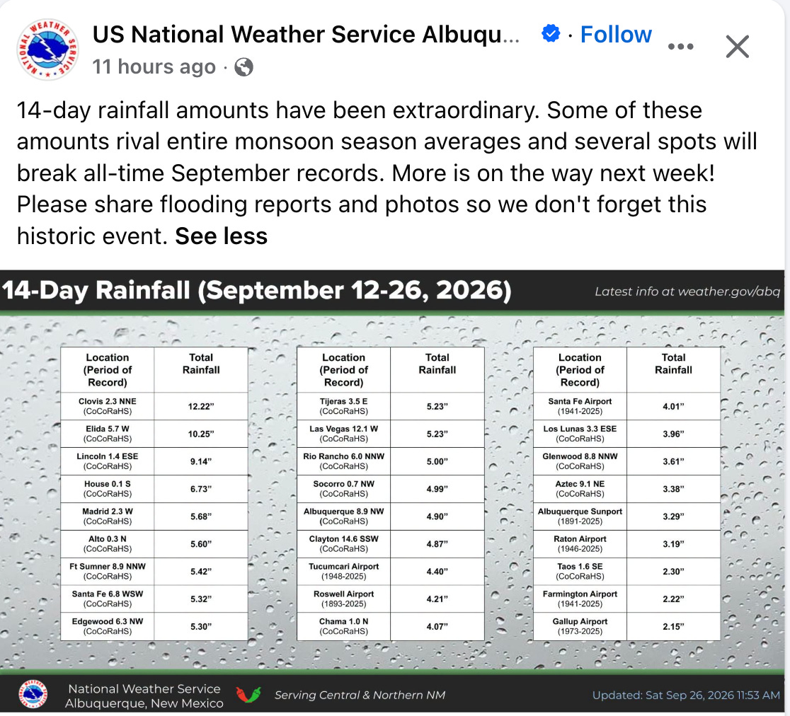
Welcome to another edition of the Land Desk’s NEWSWIRE, and yet another one in which the big news is the big, end-of-the-water-year rain. Yes, 88% of the Western U.S. is currently experiencing some level of drought — with the most severe impacts in the Four Corners Country. Yet these same areas have also been barraged with rain and inundated with flood watches and warnings for the last few weeks, and yet another big doozy is on its way.

As of Monday morning (9/28), all of New Mexico, most of Arizona, and southern Utah and southern Colorado were all under a flood watch in effect through Wednesday morning. The National Weather Service is warning that rainfall rates in some places could be up to one to two inches per hour.
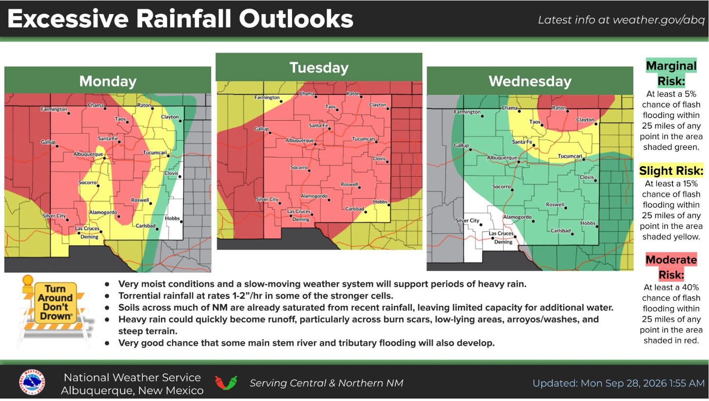
The latest round of storms will hit already sodden ground in places that have received more rain in the last couple of weeks than they normally do during the entire monsoon season.
🌵 PUBLIC LANDS 🌲
  • The Trump administration is reportedly considering Major League Baseball’s request to build a stadium and host a game in Grand Teton National Park, but a White House spokesperson says it is not an administration priority. (WyoFile) [Note: MLB has backed off this proposal since Jonathan published on the 28th.]
  • Western Watersheds Project and Basin and Range Watch formally protest the proposed 300-megawatt Bonanza solar-plus-storage project on 5,133 acres of public land in southern Nevada, saying it would fragment desert tortoise habitat and degrade vegetation and soils the tortoise depends on. (news release, BLM project page)
  • A Western journalist details the ways Interior Secretary Doug Burgum has disappointed conservationists and all Americans by “pulverizing environmental safeguards, leaving America’s public lands vulnerable for corporations to plunder at will.” (High Country News)
  • The Bureau of Land Management begins an aerial herbicide campaign on about 3,800 acres of public land in Sandoval and Cibola counties in New Mexico that will distribute Tebuthiron pellets in an effort to “enhance native plant diversity by reducing dense stands of sagebrush, juniper trees, and rabbitbrush.” (BLM news release)
  • The Bureau of Land Management greenlights the Indian Creek “watershed restoration” project that will include clearing piñon-juniper forest via chaining, mastication, and other methods on about 561,000 acres of public land in southwestern Utah. (news release)
  • The U.S. Forest Service seeks public input until Oct. 9 on its proposal to turn management of the Maroon Bells Scenic Area over to Pitkin County amid funding shortfalls. (news release, CBS News)
🌨️🦦🚣🏽 WATER WATCH 🌊
  • Washington County, Utah, plans to construct a wastewater treatment-recycling plant demonstration facility to help educate residents on water recycling and get them past the “ick factor” associated with “toilet-to-tap” facilities. (Salt Lake Tribune)
👩🏽‍🔬 SCIENCE! 🧫
  • University of California, Davis, researchers find orange water released by thawing permafrost into Alaska rivers can be more acidic and contain higher concentrations of metals than acid mine drainage. (news release)
⛏️ MINING MONITOR ⛏️
  • A federal study finds a major tailings spill at the proposed Donlin Gold mine in the Kuskokwim River watershed of southwest Alaska would inundate thousands of acres of land and portions of a village in the Crooked Creek drainage, alter stream channels, cause long-term harm to aquatic and terrestrial wildlife, and result in downstream heavy metal contamination that could last for over a century. (Mining, Draft Supplemental EIS)
  • Ivanhoe Electric relinquishes 642 unpatented mining claims covering 13,264 acres in the Gila National Forest in New Mexico where it planned to explore for copper following widespread local opposition. (news release)

Scene from the 2024 White Mesa rally and spiritual walk. Jonathan P. Thompson photo.
  • The White Mesa Concerned Community and Ute Mountain Ute Tribe will hold their annual rally and spiritual walk to protest the White Mesa uranium mill in southeastern Utah on Oct. 17 at 11 a.m. at the White Mesa Community Center. (Grand Canyon Trust)
🛢️ FOSSIL FUEL FOLLIES 📈

Screenshot from the Protect Navajo Air map.

  • Earthworks’ Protect Navajo Air campaign develops an interactive map showing oil and gas facilities’ proximity to schools and health care facilities and related air and water polluting incidents in the San Juan Basin in northwestern New Mexico. (Protect Navajo Air)
  • An energy economics firm urges the Rural Utah Infrastructure Coalition not to invest as much as $54 million in two proposed coal export terminals on the West Coast, saying they are too risky and may not open Utah coal to foreign markets. (Institute for Energy Economics and Financial Analysis)
🔥 WILDFIRE LOOKOUT 🔥
  • San Juan County, Utah, drops charges against a former resident and journalist accused of sparking the 2025 Deer Creek Fire near La Sal after flaws in the state’s investigation are revealed and amid questions about the county’s political motivations. (Salt Lake Tribune)
🤑 GENTRIFICATION JOURNAL 💰
  • An analysis of IRS data finds Teton County, Wyoming, was again the nation’s richest county in 2023 — with a per-capita income of $313,373 — followed distantly by Pitkin County, Colorado, and Blaine County, Idaho; yet even as residents became wealthier, they became less charitably inclined. (CoThrive)
🔋 THE GRID⚡️
  • The U.S. Energy Department awards Xcel Energy two $250 million grants for high-voltage transmission projects in southeastern Colorado designed to expand connections between the Western and Eastern power grids and bring wind power from the Great Plains to Colorado’s Front Range. (Big Pivots)
  • Weld County, Colorado’s commissioners vote to approve Enyo Energy’s 805-megawatt Chalk Bluff wind and solar-plus-storage project on mostly private land in the oil and gas-rich northeastern corner of the state. (Colorado Sun)
  • The Federal Energy Regulatory Commission pauses its licensing process for rPlus Hydro’s proposed pumped hydropower storage project at Seminoe Reservoir in Wyoming to allow the Bureau of Land Management to complete an environmental review of the contested project. (WyoFile)
  • Phoenix-area utility Salt River Project’s board votes to approve the proposed Marigold Energy Center in Stanfield, Arizona. The project will include 600 MW of solar, 400 MW of battery storage, and 675 MW of natural gas generation, along with a new substation and four miles of transmission lines, in an effort to meet growing demand and enhance grid reliability. (news release)
  • Nevada utility NV Energy becomes the ninth Western entity to join the California Independent System Operator’s extended day-ahead wholesale electricity market that will help integrate the balkanized Western grid. (Public Power)
OTHER NEWS
  • The National Congress of American Indians files an amicus brief in Tohono O’odham Nation v. Mullin challenging the Trump administration’s plan to build a border wall through the Tohono O’odham nation in southern Arizona, calling it an “unlawful infringement on tribal sovereignty.” (news release)
🥵 ARIDIFICATION WATCH 🐫
  • New Mexico farmers say this summer’s extreme heat stunted green chile crops’ growth, leading to a roasting-season shortage in many parts of the state, adding that a “Biblical” grasshopper infestation also curtailed yield. (KRQE)
🤖 DATA CENTER DIGEST 👾
  • Nevada-based Arevia Power proposes a “multi-building” data center on about 3,700 acres of federal public land near Boise, Idaho; the Bureau of Land Management says the agency is in the “pre-planning phase” and has released few details. (Idaho Statesman)
🐟 COLORADO RIVER CHRONICLE 💧
  • Colorado River watcher Ken Neubecker speculates about how a Lower Basin compact call might play out in Colorado. (Ken’s Substack)
📸 PARTING SHOT 🎞️
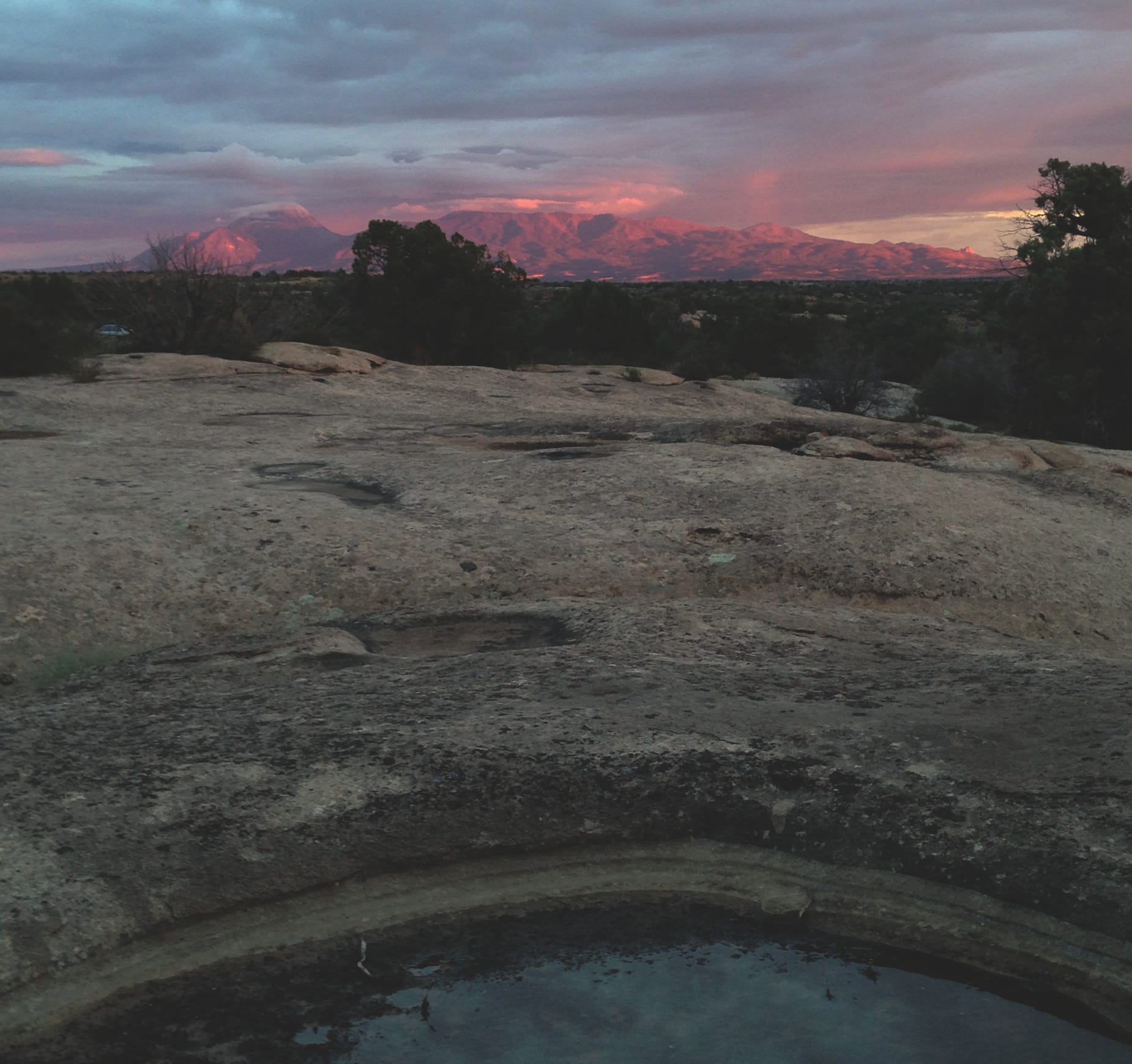
Ute Mountain after a storm. Jonathan P. Thompson photo.

President Trump attacks the Roadless Rule, again, Plus: Hoback Report on the Traffic Apocalypse — Jonathan P. Thompson (LandDesk.org)

Click the link to read the article on The Land Desk website (Jonathan P. Thompson):

August 21, 2026

🌵 Public Lands 🌲

Sometimes it feels like the deeper the Trump administration sinks into various quagmires of its own making, the more it lashes out at politically popular protections for public lands. Each passing day brings a new assault on the environment, the climate, and, well, humanity.

This time, the U.S. Department of Agriculture has moved (again) to rescind the Roadless Rule, which protects some 45 million acres of U.S. Forest Service land from new roadbuilding and logging. Agriculture Secretary Brooke Rollins predictably and baselessly claimed that the rule has hampered forest management and fire-fighting capabilities. This is untrue.

When the Bill Clinton administration implemented the Roadless Rule in 2001, it culminated a multi-decade effort to identify and set aside forest lands that hadn’t been disturbed by roads for possible designation as wilderness. At the time, management of inventoried roadless areas was carried out by individual Forest Service offices. The Roadless Rule put a nationwide prohibition on timber harvesting, road construction, and road reconstruction in inventoried roadless areas, with a number of exceptions. The intent was not only to conserve these relatively undisturbed areas, but also to save money: By 2001, the Forest Service’s existing road network was over 386,000 miles long, with an estimated $8.4 billion in deferred maintenance and reconstruction. Building more roads would just exacerbate that deficit.

While inventoried roadless areas have many of the same characteristics as wilderness areas, the Roadless Rule stops far short of offering wilderness-level protections, and expressly allows for motorized uses of existing roads, off-highway motorized use in specified areas, livestock grazing, and energy and mineral development.

So it’s hard to take Rollins seriously when she says the rule is hampering access for fire prevention and fighting efforts. In fact, the rule clearly allows for road-building to fight fires. It also allows for cutting, removing, and selling “generally small diameter timber” for various reasons, including “reducing the likelihood of uncharacteristic wildfire.”

In a Senate hearing this spring concerning Sen. Mike Lee’s (MAGA-UT) amendment aiming to repeal the Roadless rule, Sen. Alex Padilla, D-California, pointed out that 240,000 acres of inventoried roadless areas in his state alone had been treated for wildfire hazard mitigation treatment, showing the dubiousness of Lee’s (and now Rollins’) claims. And the Trump administration, for better or worse, has lagged on forest thinning: A Center for Western Priorities analysis found the Forest Service treated 35% less acreage in 2025 than it did under Biden in 2024. That suggests that vegetation management is being stifled not by regulations, but by a lack of resources — the Trump administration has slashed Forest Service staffing and budgets considerably since taking office.

In fact, the evidence suggests that the Roadless Rule has actually helped deter wildfires. A 2007 Pacific Biodiversity Institute study found that 88% of the nation’s wildfires are sparked by humans, and 95% of human-ignited blazes occur within a half-mile from a road. Roads act like syringes, injecting humanity — along with their errant cigarette butts, untended campfires or grills, sparks from machinery or hot catalytic converters — further into the backcountry than they would go by trail.

The Roadless Rule originally applied to almost 60 million acres, but in the years following its implementation, it was bandied about by presidential administrations and the courts. In 2005, the George W. Bush White House revoked the rule and replaced it with the alternate roadless rule, which allowed states to petition the Forest Service to create their own standards; Colorado and Idaho chose to do so. When the Tenth Circuit court later reinstated the 2001 rule, the 2005 rule was nullified, but Idaho and Colorado’s rules remained in effect. As a result the administration’s proposed repeal would not affect Colorado and Idaho’s plans.

The rule and its moderate protections for habitat, wildlife, forests, and watersheds have proven deeply popular across a wide demographic swath of the public. Last June, Rollins moved to repeal the Roadless Rule for the first time, resulting in intense backlash not only from environmentalists, but also from the more conservative-leaning hook and bullet crowd and general public, which barraged the department with comments supporting the rule. It’s worth noting that even Project 2025, the ultra-right-wing “blueprint” for the Trump administration, called for repealing only the portion of the Roadless Rule that pertained to Alaska’s Tongass National Forest. This spring, when Lee tacked a Roadless Rule-repealing amendment onto bipartisan wildfire legislation, he annihilated the cross-aisle support for the larger bill, effectively ruining its chances of passing.

Now the public has a chance to weigh in once again. The USDA is accepting comments until Sept. 21, so go here and say your piece.

⛈️ Wacky Weather Watch⚡️

The summer of nightmare heat continues as yet another heat dome settles over parts of the West. Parts of southern California, Las Vegas, Phoenix, and most areas in-between are under heat watches or extreme heat warnings for the next several days. There is also a chance of thunderstorms, which may bring a bit of relief, but if the summer so far is any indication, they’re just as likely to bring catastrophic flash flooding, damaging winds, fire-starting lightning, and huge dust storms, a.k.a. haboobs.

🛢️ Hydrocarbon Hoedown 📈

I know that many of you have been hating on data centers lately, especially the ones used to process all that AI slop so that billionaires can become trillionaires (through some process that defies all logic). But please, I beg you, save some of your disdain for the oil and gas companies, too! After all, they are using the data center energy-use scare to justify drilling for natural gas to power the damned things. Not only that, but every day that our president screws up negotiations to end his war on Iran is another day that the Strait of Hormuz remains closed to oil tankers, another day of rising oil prices, and another day of record-high profits for petro-corporations, their executives, and their shareholders. 

For example: ExxonMobil reported adjusted earnings of $23.5 billion for the first half of 2026; Chevron’s adjusted earnings were $14.7 billion; Valero raked in a $5.4 billionprofit … you get the picture. 

🗺️ Messing with Maps 🧭

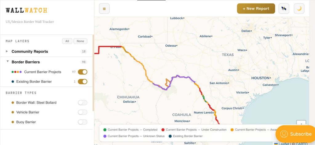
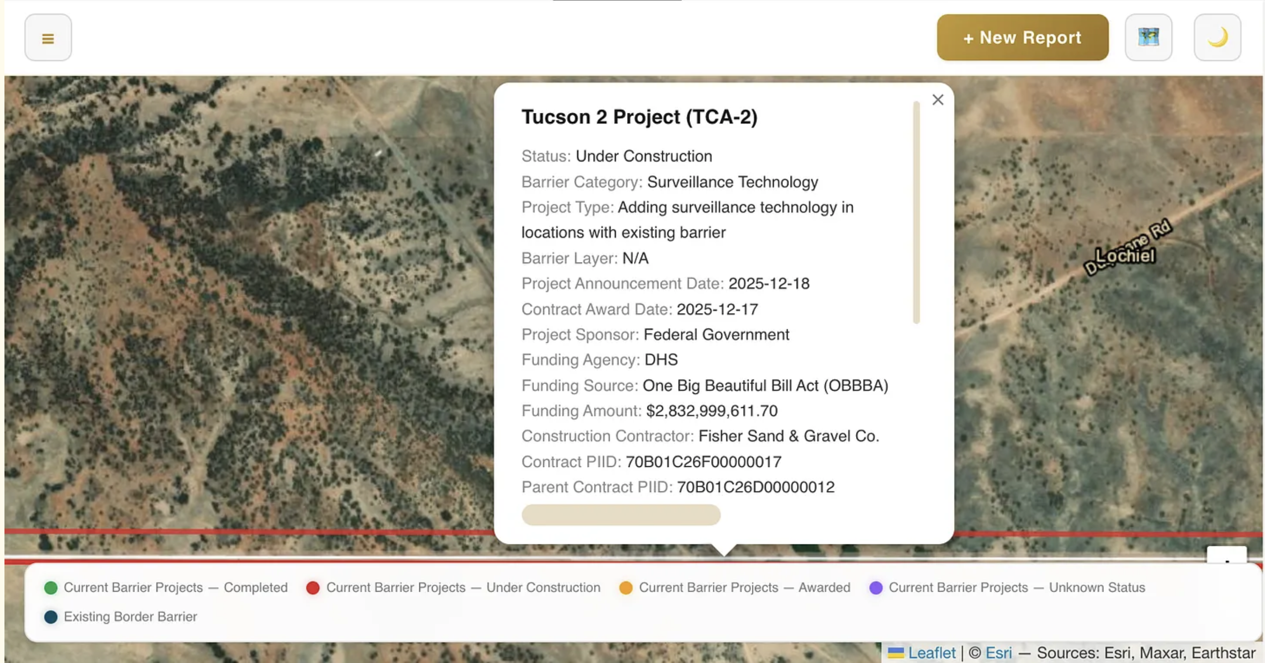
If you want to know what’s happening on the U.S.-Mexico border, you go to the Border Chronicle. And now, if you want to know what’s happening with Trump’s border wall, which is just a monumental piece of environmental disaster, you can go to the Border Chronicle’s new Wall Watch, the publication’s community-reported interactive map tracking construction of the barrier.

Say you want to know what sort of wall is being built in the Big Bend region? Or what sort of structure already exists near Lochiel, Arizona, where border wall contractors have destroyed old-growth cottonwood trees and are threatening the remainder of the grove? You can toggle the map to the satellite view, zoom in on the place of interest, and click on the border and get a pop-up informing you of what work is taking place, who the contractor is, and the expected cost.

Screenshot from the Border Chronicle’s Wall Watch.

📝 Hoback Report

A guest post by Bob Frodeman


Could the West be the place where America finally gives up its belief in endless growth? Probably not, but you can imagine different triggers. For instance, drought, a shrinking snowpack, and a parched Colorado River could halt growth in Phoenix. Or overwhelming numbers of tourists in Yellowstone or Arches National Park could force the establishment of timed entry (which Arches had, until the Trump Administration decreed that this was oppressing the right of people to sit in traffic). Or climate change-driven wildfires threatening entire cities (see Spokane) could put a crimp in sprawl.

But in my neck of the woods traffic may be the trigger.

Traffic is getting absurd in Jackson. The chaos used to be limited to the summer months; now it’s pretty much year-round. Climate change has extended the hiking season on both ends: this May a new record was set for visitation in Grand Teton National Park. And while the valley floor was denuded of snow last winter (a brown Christmas – in Jackson?!), the snow fell higher up, giving us some of the best skiing in the West during a generally horrific snow year.

Policy, history, and geography all contribute to the situation. First, it’s just plain hard to get here: there are only three roads into the valley. The spectacular mountains and forests mean that more than 97% of Teton County is publicly owned – Teton and Yellowstone National Parks, Bridger-Teton National Forest, and the National Elk Refuge. The Elk Refuge offers a striking visual: created in 1912, when Jackson had a population of a few hundred, the Refuge now hems town in on the north side, preserving land that would otherwise be jammed with hundreds of homes. Another 1% of the land is covered by conservation easements.

Caught between public land, various bumps and ridges, and the Snake River, there’s only one artery in town, called Highway 89 when it runs north-south, and Broadway when it turns east-west. Pressed up against Saddle Butte, Broadway already is five lanes and would be hell to expand. Highway 22, a two-lane spur that runs up and over Teton Pass that WYDOT wants to expand to five lanes, is already a traffic nightmare morning and night. And all the other roads in town are suburban streets lined with homes.

Nonetheless, the Town of Jackson currently has 825,000 square feet of additional development in the works. This includes the 245,000 (down from the original 400,000) square-foot Mogul development, a humungous hotel and condo complex planned for the northern entrance to Jackson (traffic already backs up a mile or two every afternoon on that road coming into town). The Jackson Town Council has approved the sketch plan for the complex. The other 600,000 square feet are scattered across the downtown area. On top of this, on the southern edge of town – on what will essentially become an extension of town – a new subdivision called Northern South Park has begun construction. Situated on ranch land, Teton County has approved a neighborhood of 1,437 homes, which would add 23% to the existing housing stock of Jackson.

What’s bizarre is the lack of self-consciousness about what’s happening. A few weeks ago I wrote a town council member asking for the list of ongoing projects. There isn’t one. I generated the 825,000 number by calling up the town clerk and asking her to go through the various applications. We added it up together.

Given all this, plus the 4 million annual tourists, it’s hard to see how Jackson will avoid utter and complete gridlock. But wait—it gets better, by which I mean worse. Because land is so scarce in Teton County, and home prices so high (median price $2.5 million, eight times the Wyoming average), workers drive in from Star Valley (30 miles to the south) and Teton Valley, Idaho (30 miles to the west). Both areas are primed for more growth: the population of Teton Valley doubled from 2000 to 2020 (to 10,000) and is projected to be the fastest growing part of Idaho. And this is to say nothing about the dangers of traveling Teton Pass – there was a landslide there two summer ago that diverted traffic for three weeks, and this summer a runaway truck killed two people.

Most of these people, as well as the commuters from Star Valley, come to Jackson for work and play. It adds up to a traffic apocalypse. Alas, Jackson and Teton County has no control over these outlying areas. The obvious move is to create a regional authority to work on the problem. But no such authority exists, and the political culture of these areas is quite different from Jackson, which makes conversations hard.

In Jackson you hear a lot of talk about managing growth. What you don’t hear is talk about the necessity of stopping growth. But this is the conversation that Jackson needs to have – as well as many other places across the West that are bumping up against limits.

Forest Service seeks comments on Draft EIS for managing the Sweetwater Lake area: Range of alternatives analyzed

Sweetwater Lake. Photo by Todd Winslow Pierce via The Conservation Fund, https://www.conservationfund.org

Click the link to read the release on the USFS website:

June 26, 2026

Today the White River National Forest released the Draft Environmental Impact Statement for the Sweetwater Lake Recreation Management and Development Project for public review.

The project will determine the recreation management approach for 844 acres at Sweetwater Lake in Garfield County — 433 acres acquired in 2021 through the Land and Water Conservation Fund and 413 acres of previously existing National Forest System lands. The acquisition greatly increased public access, leading the Forest Service to begin developing a proactive management plan to address the potential increase in recreation while maintaining the area’s sensitive resources. 

The Draft EIS analyzes four potential alternatives covering a wide range of potential management options for the Sweetwater Lake area. While the draft identifies a proposed alternative, the entire range of alternatives is being considered, and the final plan may be a blend of alternatives. 

“Public involvement is an important part of determining the future of the Sweetwater Lake,” said Eagle-Holy Cross District Ranger Leanne Veldhuis. “We developed these alternatives with significant input from the public and other stakeholders.”

The Proposed Alternative would authorize a 20-year special use permit to Colorado Parks and Wildlife to manage the Sweetwater area. 

“We have proposed partnering with Colorado Parks and Wildlife because they have the expertise to effectively manage this long-cherished area,” Veldhuis said. “We could achieve more working together.”

The Forest is hosting public meetings to provide additional information and answer questions July 22 at the Glenwood Springs Library, Glenwood Classroom, 815 Cooper Ave; and July 23 at the Gypsum Town Council Chambers, 50 Lundgren Blvd. Both meetings are open house formats, and the public can stop by any time between 4 p.m. and 7 p.m.

More information, including the proposal and how to comment, is available at:  https://www.fs.usda.gov/r02/whiteriver/projects/284162. Comments need to be received by Sept. 23, 2026…

###

Forest Service FACT SHEET

Sweetwater Lake Recreation Management and Development Project

The draft environmental impact statement for the Sweetwater Lake Recreation Management and Development Project provides a detailed analysis of four potential management alternatives that were developed with public involvement. 

The final plan could be a combination of components from any alternative, based in part on public and stakeholder comments. 

The White River National Forest developed these alternatives working closely with the public and the project’s Cooperating Agencies: Colorado Parks and Wildlife, Garfield County, Eagle County, and the Town of Gypsum. 

Alternative 1 is the No Action Alternative, meaning there would be no change to the current Forest Service management direction or level of management intensity for the Sweetwater Lake area.

Alternative 2 is the Proposed Action, which emphasizes maintaining and improving the existing recreational opportunities at Sweetwater while protecting sensitive resources. The Proposed Action would create eight recreational zones to help spread out recreational use and minimize user conflicts. Colorado Parks and Wildlife would manage the area under a Special Use Permit. 

Alternative 3 was developed to consider managing the Sweetwater area with fewer recreation improvements and facilities compared to the Proposed Action. Rather than a state-managed developed recreation site, the objective of Alternative 3 would be to provide a primitive recreation experience with limited facilities and limited staffing. A long-term partnership with Colorado Parks and Wildlife would not be included.

Alternative 4 was developed to manage site capacity to the full potential visitor market availability without limiting visitation. This alternative would contain more facilities and infrastructure to accommodate a greater number of day and overnight visitors than the Proposed Action. Colorado Parks and Wildlife would manage the area under a Special Use Permit. 

More information, including the Draft Environmental Statement and how to comment, is available at: https://www.fs.usda.gov/r02/whiteriver/projects/284162. Comments need to be received by Sept. 23, 2026.

The dismantling of the Forest Service: President Trump’s administration plans would remake the agency and public lands. The deadline to comment is September 30, 2025 — Jonathan P. Thompson (High Country News)

Welcome to the Landline, a monthly newsletter from High Country News about land, water, wildlife, climate and conservation in the Western United States. Sign up to get it in your inbox.

Click the link to read the article on the High Country News website (Jonathan P. Thompson):

September 23, 2025

In the 1880s, giant cattle companies turned thousands of cattle out to graze on the “public domain” — i.e., the Western lands that had been stolen from Indigenous people and then opened up for white settlement. In remote southeastern Utah, this coincided with a wave of settlement by members of the Church of Jesus Christ of Latter-day Saints. The region’s once-abundant grasslands and lush mountain slopes were soon reduced to denuded wastelands etched with deep flash-flood-prone gullies. Cattlemen fought, sometimes violently, over water and range.

North American Indian regional losses 1850 thru 1890.

The local citizenry grew sick and tired of it, sometimes literally: At one point, sheep feces contaminated the water supply of the town of Monticello and led to a typhoid outbreak that killed 11 people. Yet there was little they could do, since there were few rules on the public domain and fewer folks with the power to enforce them.

That changed in 1891, when Congress passed the Forest Reserve Act, which authorized the president to place some unregulated tracts under “judicious control,” thereby mildly restraining extractive activities in the name of conservation. In 1905, the Forest Service was created as a branch of the U.S. Agriculture Department to oversee these reserves, and Gifford Pinchot was chosen to lead it. And a year later, the citizens of southeastern Utah successfully petitioned the Theodore Roosevelt administration to establish forest reserves in the La Sal and Abajo Mountains.

Manti-La Sal National Forest in the La Sal Mountains, Utah. The mountains have been managed by the U.S. Forest Service since 1906. Luna Anna Archey/High Country News

Since then, the Forest Service has gone through various metamorphoses, shifting from stewarding and conserving forests for the future to supplying the growing nation with lumber to managing forests for multiple uses and then to the ecosystem management era, which began in the 1990s. Throughout all these shifts, however, it has largely stayed true to Pinchot and his desire to conserve forests and their resources for future generations. 

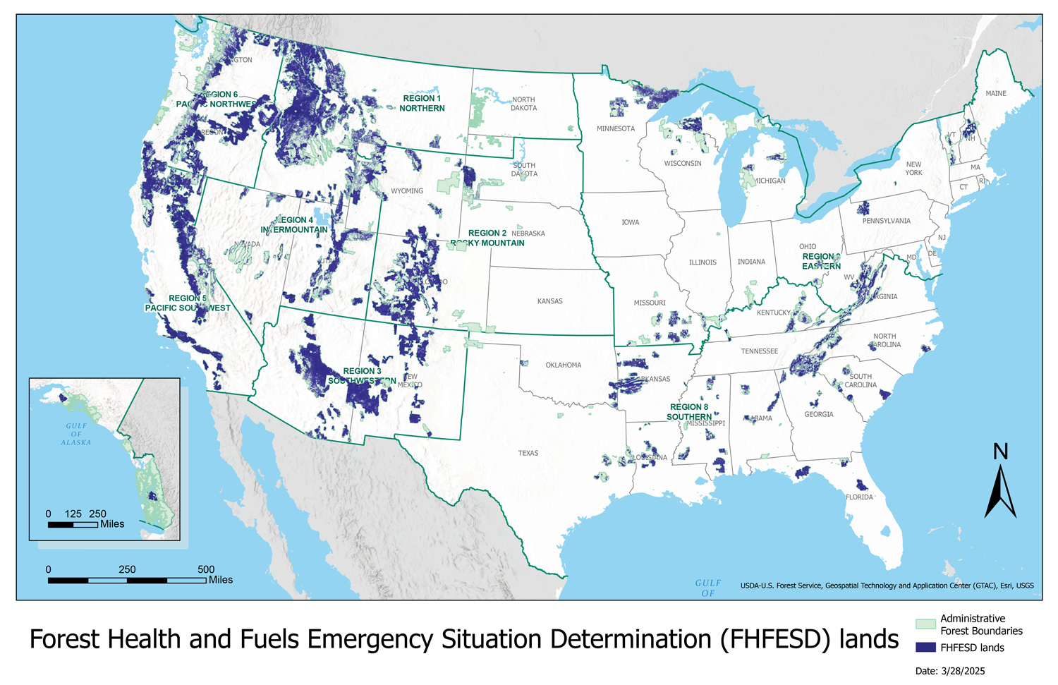
But now, the Trump administration is eager to begin a new era for the agency and its public lands, with a distinctively un-Pinchot-esque structure and a mission that maximizes resource production and extraction while dismantling the administrative state and its role as environmental protector. Over the last nine months, the administration has issued executive orders calling for expanded timber production and rescinding the 2001 Roadless Rule, declared “emergency” situations that enable it to bypass regulations on nearly 60% of the public’s forests, and proposed slashing the agency’s operations budget by 34%.

Forest Service lands declared as “emergency” situations this year, which includes nearly 60% of the nation’s forests. Credit: U.S. Forest Service

The most recent move, which is currently open to public comment, involves a proposal by Agriculture Secretary Brooke Rollins to radically overhaul the entire U.S. Department of Agriculture. Its stated purposes are to ensure that the agency’s “workforce aligns with financial resources and priorities,” and to consolidate functions and eliminate redundancy. This will include moving at least 2,600 of the department’s 4,600 Washington, D.C., employees to five hub locations, with only two in the West: Salt Lake City, Utah, and Fort Collins, Colorado. (The others will be in North Carolina, Missouri and Indiana.) The goal, according to Rollins’ memorandum, is to “bring the USDA closer to its customers.” The plan is reminiscent of Trump’s first-term relocation of the Bureau of Land Management’s headquarters to Grand Junction, Colorado, in 2019. That relocation resulted in a de facto agency housecleaning; many senior staffers chose to resign or move to other agencies, and only a handful of workers ended up in the Colorado office, which shared a building with oil and gas companies.

Though Rollins’ proposal is aimed at decentralizing the department, it would effectively re-centralize the Forest Service by eliminating its nine regional offices, six of which are located in the West. Each regional forester oversees dozens of national forests within their region, providing budget oversight, guiding place-specific implementation of national-level policies, and facilitating coordination among the various forests.

Rollins’ memo does not explain why the regional offices are being axed, or what will happen to the regional foresters’ positions and their functions, or how the change will affect the agency’s chain of command. When several U.S. senators asked Deputy Secretary Stephen Vaden for more specifics, he responded that “decisions pertaining to the agency’s structure and the location of specialized personnel will be made after” the public comment period ends on Sept. 30. Curiously, the administration’s forest management strategy, published in May, relies on regional offices to “work with the Washington Office to develop tailored strategies to meet their specific timber goals.” Now it’s unclear that either the regional or Washington offices will remain in existence long enough to carry this out.

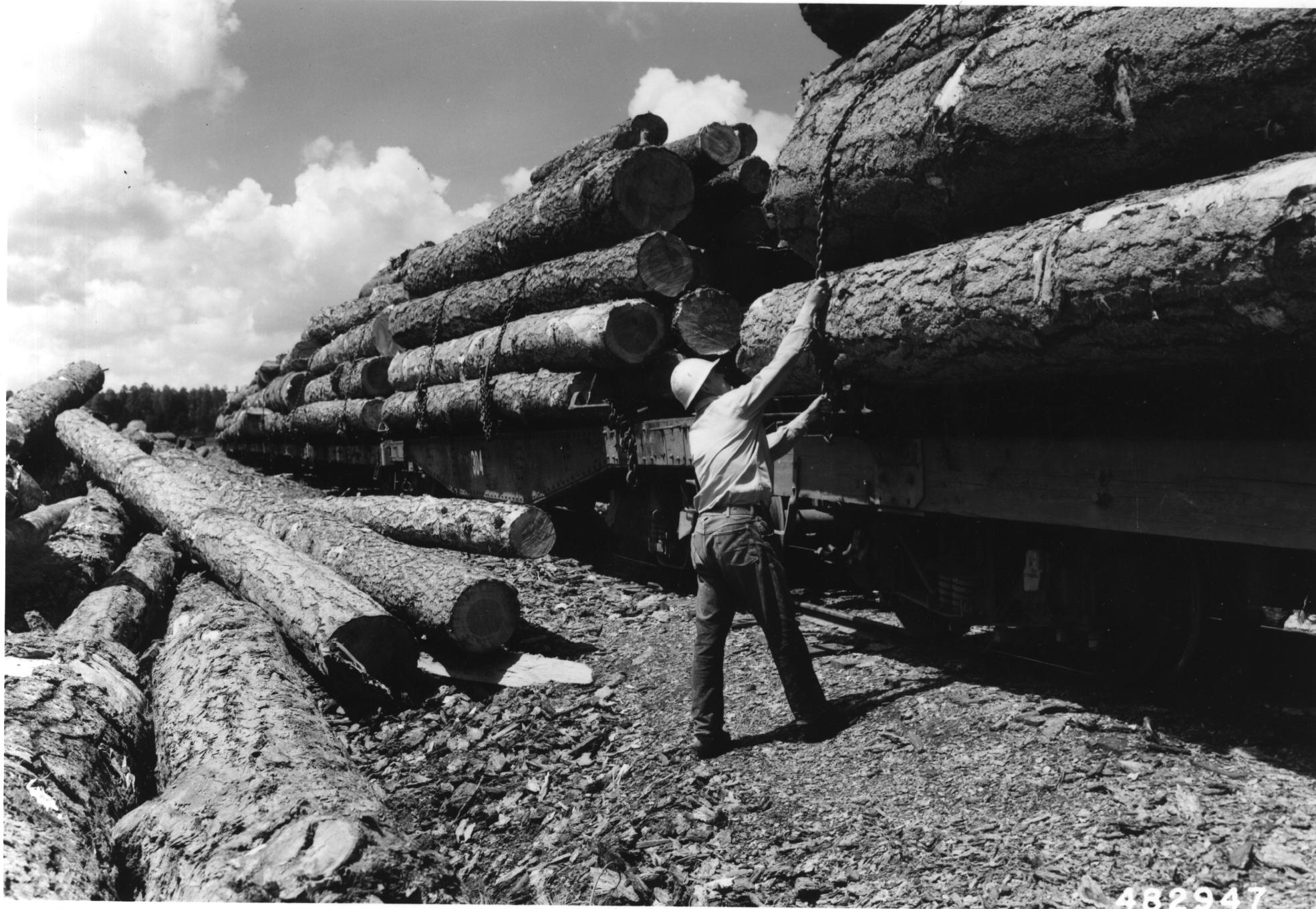
The administration has been far more transparent about its desire to return the Forest Service to its timber plantation era, which ran from the 1950s through the ’80s. During that time, logging companies harvested 10 billion to 12 billion board-feet per year from federal forests, while for the last 25 years, the annual number has hovered below 3 billion board-feet. Now, Trump, via his Immediate Expansion of American Timber Production order, plans to crank up the annual cut to 4 billion board-feet by 2028. This will be accomplished — in classic Trumpian fashion — by declaring an “emergency” on national forest lands that will allow environmental protections and regulations, including the National Environmental Protection Act, Endangered Species Act and Clean Water Act, to be eased or bypassed.

Logging operations in Coconino National Forest, Arizona, in 1957. Credit: U.S. Forest Service

In April, Rollins issued a memorandum doing just that, declaring that the threat of wildfires, insects and disease, invasive species, overgrown forests, the growing number of homes in the wildland-urban interface and more than a century of rigorous fire suppression have contributed to what is now “a full-blown wildfire and forest health crisis.”

Emergency determinations aren’t limited to Trump and friends; in 2023, the Biden administration identified almost 67 million acres of national forest lands as being under a high or very high fire risk, thus qualifying as an “emergency situation” under the Infrastructure Investment and Jobs Act. Rollins, however, vastly expanded the “emergency situation” acreage to almost 113 million acres, or 59% of all Forest Service lands. This allows the agency to use streamlined environmental reviews and “expedited” tribal consultation time frames to “carry out authorized emergency actions,” ranging from commercial harvesting of damaged trees to removing “hazardous fuels” to reconstructing existing utility lines. Meanwhile, the administration has announced plans to consolidate all federal wildfire fighting duties under the Interior Department. This would completely zero out the Forest Service’s $2.4 billion wildland fire management budget, sowing even more confusion and chaos.

The administration also plans to slash staff and budgets in other parts of the agency, further compromising its ability to carry out its mission. The so-called “Department of Government Efficiency,” or DOGE, fired about 3,400 Forest Service employees, or more than 10% of the agency’s total workforce, earlier this year. And the administration has proposed cutting the agency’s operations budget, which includes salaries, by 34% in fiscal year 2026, which will most likely necessitate further reductions in force. It would also cut the national forest system and capital improvement and maintenance budgets by 21% and 48% respectively.

The goal, it seems, is to cripple the agency with both direct and indirect blows. The result, if the administration succeeds, will be a diminished Forest Service that would be unrecognizable to Gifford Pinchot.

Gifford Pinchot portrait via the Forest History Society