Click the link to read the article on the Sibley’s Rivers website (George Sibley):
June 24, 2026
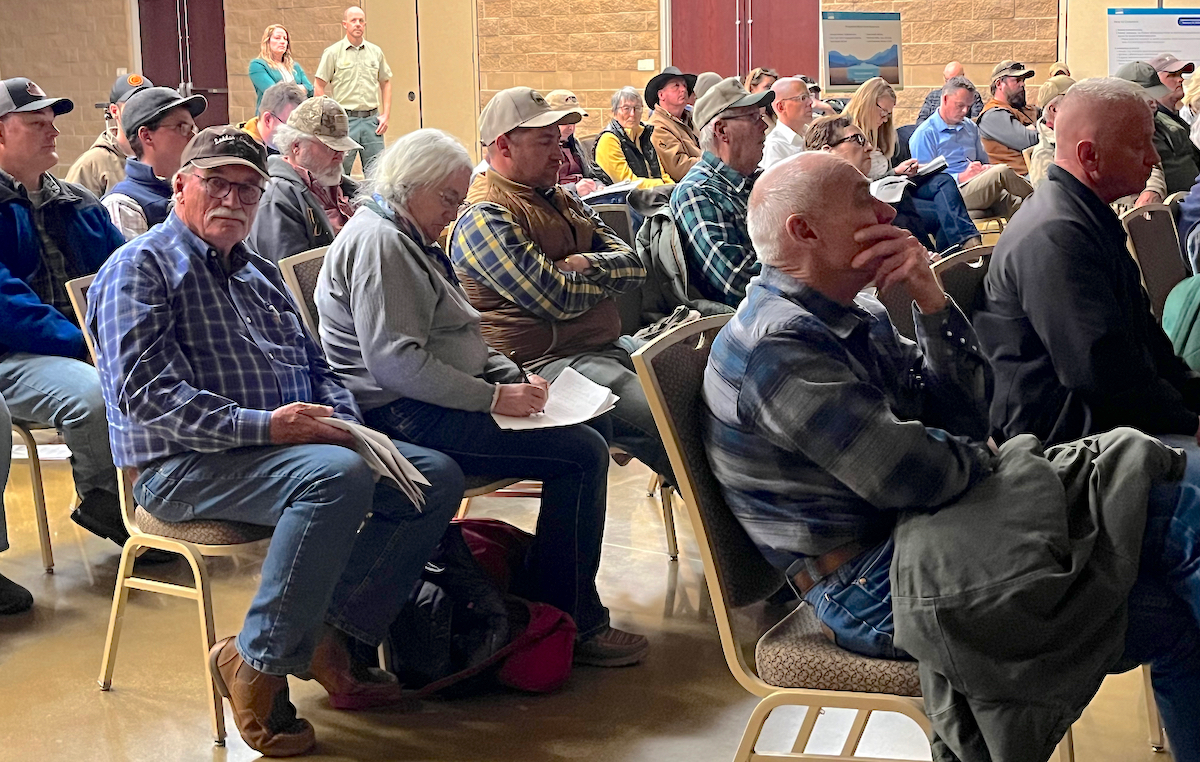
Last post here, I suggested that at least some of the ongoing failure of the seven Colorado River states to reach agreement on a river management plan for even the next several years, let alone new century, stems from some ‘elephants in the river.’ You know – the big things that nobody wants to look at because they are so big. So big that some of the rules and guidelines we operate under were created to avoid having to address them.
The first ‘elephant in the river’ I discussed last time was the single-minded focus on the Colorado’s surface waters, and a failure to begin considering the whole integrated water supply, surface water and groundwater – of which the surface water is a relatively minor part, with users going to the groundwater in a haphazard way when the surface water is insufficient.
I did make an incorrect statement in that analysis, however. I said that Colorado was the first, and thus far only, state to begin integrating groundwater into its appropriation priority system statewide. (Arizona developed – by federal mandate – a Groundwater Management Plan circa 1970 for those specific parts of the state served by the Central Arizona Project.)
This is true about Colorado – but I was mistaken in implying that the all groundwater use was integrated into its appropriation system by 1969 legislation. Only alluvial groundwater is covered by that law – groundwater that is naturally integrated with surface water, either trickling into the surface streams when the groundwater table is high or drawing riparian water from the surface streams when the water table is low.
Not covered by the Colorado law are ‘non-tributary’ aquifers that have no natural interaction with the surface waters – aquifers like the Oglalla Aquifer in eastern Colorado, or the Denver Basin aquifer. Most of their water filters down from the alluvial groundwater, and only modern pumping technology makes that groundwater accessible to surface use. Most of these deep aquifers have accumulated their water slowly over geological periods of time, and even moderate use of their water dips quickly into ‘water-mining.’ Colorado law for such aquifers attempts to limit annual use to a hundredth of a presumed 100-year supply, but no one knows for sure how much water is really down there, or whether it will truly constitute a 100-year supply.
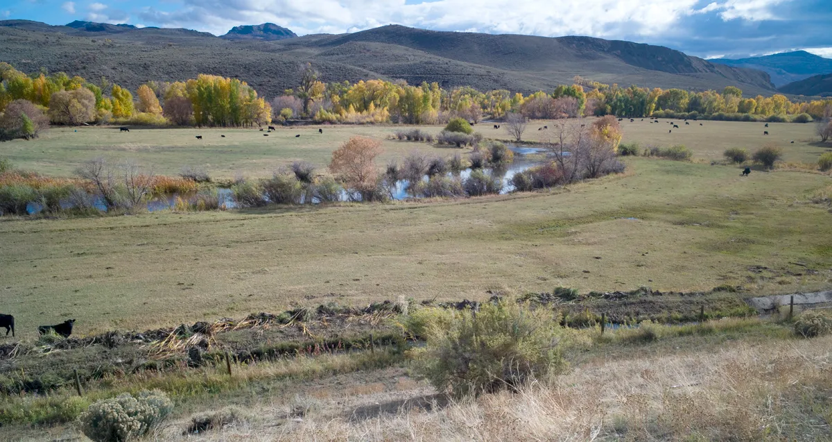
The standard response throughout much of the basin to shortages in surface water is to go to groundwater pumping; if ‘tributary’ (alluvial) groundwater is tapped, the pumping will gradually lower the water table – which in turn will begin to diminish the surface streams, which in turn will increase the pumping – et cetera, a vicious downward cycle. And the pumping of ‘non-tributary’ aquifers is largely unregulated in the basin.
At any rate – apologies for the error, and thanks to John McClow for pointing it out.
And on to another elephant in the room. Is it finally time to determine limits on the presumed universal applicability of the appropriation doctrine? To avoid being shot before I finish the paragraph, I will say immediately I am not suggesting doing away with the appropriation doctrine; it is a good enough last resort down on the ground where the appropriation doctrine started, for working out local problems of water use on a surface stream when neighborliness fails – that is, when old grumps and feuds preclude the ‘gentlemen’s agreement’ on sharing out what water is available, rather than shutting down the junior users with a ‘call’ so the seniors can get all their decreed water. After two or three generations, seniority can be acknowledged, but is too abstract to apply against your neighbors, if a plan for sharing blameless misfortune can be worked out.
The abstraction, however, becomes more applicable when it is distant water organizations calling out other water organizations upstream, or an earlier developed watershed placing a call on users in an adjacent more recently developed watershed. And when a stream is declared by the district engineer to be over-appropriated – not enough water to fill everyone’s decrees in a near-average year – it becomes even more abstract, a tool for enforcing a status quo, and nothing anywhere about what represents the best uses of the water.
There are, in other words, some areas in which the appropriation doctrine gets stretched beyond its elastic limits by emerging challenges of water use; any questions about ‘best and highest use’ have been essentially declared unanswerable as a matter of conflicting values, and it just seems easier to let seniority of use be the ultimate determinant of priorities.
A century ago, with California quintupling its population in the first two decades of the 20th century, the other six of the seven states in the Colorado River Basin (Arizona, Nevada, Colorado, New Mexico, Utah and Wyoming) began to worry that California might put so much of the river’s water to use that there would not be enough unappropriated water for them to put to use when their time of growth came. They were all committed to versions of the appropriation doctrine within their states, but came to believe that reliance on the appropriation doctrine alone at the interstate level could cause more regional problems than it would resolve.
That concern was affirmed in 1922 when the U.S. Supreme Court resolved a conflict between Colorado and Wyoming over a Laramie River tributary that started in Colorado but was put to use first in Wyoming; the court declared that states who used the appropriation doctrine intrastate would also have to respect each other’s appropriations interstate. This made real the specter of slow-growing upstream states having to let all their Colorado River water go downstream to fill huge Arizona and California decrees.
So they assembled in 1922 to try to do something about that – a fundamental fact about the Colorado River Compact commission that we tend to forget: the original intent of the compact commissioners in 1922 was to develop an alternative to the appropriations doctrine at the interstate level. They came together with the intent of working out a seven-way division of the use of the river, based on possible future development, that would eliminate a horse-race of interstate appropriative competition. Six of the states convened the commission because they feared California, and California reluctantly participated because it knew the feds would never build the big control and storage dam they needed until all seven states were on board with it. That seven-way division trumping interstate appropriation was what the Compact Commissioners assembled to do –and spent a frustrating week early in 1922 trying to do.
They were unable to effect a seven-way split for a couple of reasons: for one thing they had no good measure of how much dependable water was in the river; estimates at the time ranged from 12 to 20 million acre-feet (maf). But for a second thing, the sum total of the water they each felt their state needed, based on rosy early-20th-century estimates, was closer to 24 maf – and nobody wanted to go home having backed down from their carefully imagined numbers.

What they did instead – in order to persuade Congress that there was general agreement – was to cobble together the Compact we are burdened with today; they created what Commission Chair Herbert Hoover called a ‘temporary equitable division’ of the seven states into Upper and Lower River Basins, until ‘ those men who may come after us, possessed of a far greater fund of information’ could do the ‘further division’ of the river among the states.
They also decided – as early 20th-century Americans would – to lean toward the more optimistic estimates of river flow, dividing ‘equally’ between the Basins only 15 maf of a river they presumed would continue running 16-20 maf – hence the 7.5 maf for each Basin written into the compact, to be further divided among the states of each Basin in their own good time. That left some water for Mexico, but they did nothing specific for the Indian tribes in the basins because national Indian policy at that time was ‘soft genocide’ – full assimilation (‘kill the Indian, save the man’), leaving tribal water a concern they thought would disappear.
This all made reasonable sense with a river running a quarter-century average of just under 18 maf – but then through the 1930s the river experienced a drought unsurpassed until the past quarter century. By the end of World War II, Colorado river water users had a ‘far greater fund of information’ about the river’s flow, which would have made it a good time to have ‘fixed’ the Compact – but the growing fund of information was all bad news that no one wanted to incorporate into a more realistic policy. So by default the ‘temporary equitable division,’ with its mythic 18 maf river, took on the permanence of something carried off a sacred mountain carved in stone.
And now – we are seeing it reduced to a sad irony. The states of the Lower Basin had their fears too, and wanted a clause in the Compact stating that, should the Upper Basin states have a wild spurt of growth, they should not ‘deplete the flow’ to the Lower Basin below an average of 7.5 maf a year. But now – when it looks like diminished flows throughout the basin might really drop the flow at the division point between basins below that average – the Lower Basin is threatening the Upper Basin with an Article III(d) ‘call,’ saying the upper states will have to cut their own uses enough to meet the lower states’ fantasy 7.5 maf. States that set out a century ago to create a compact that would transcend the appropriation doctrine at the interstate level are now trying to turn that ‘temporary equitable division’ into what amounts to a senior interstate water right.
There has to be a level, or category, of action in which the law of first-come first-served is transcended by other considerations. And can we not say, at this point a century later, that the original intention of the compact commission has been achieved de facto? No state will ever get the use of more water than it had (or believed it had) around the turn of the century because there is even less water now. For better or worse, the use of the river has been distributed among the states (including some of the tribes) and Mexico.

Whether this is an equitable division is arguable; the states of the Lower Basin have been using roughly two-thirds of the river’s water, the Upper Basin states around one third, rather than the 50-50 split explicit in the Compact (7.5 maf per Basin). But arguably that does reflect the relative productivity of Lower Basin agricultural use (by far the largest use) and also its millions of urbanites drawing on it for at least part of their municipal water. It was a huge step toward reality when the Lower Basin states finally agreed that they must absorb the Lower Basin’s system losses (mostly evapotranspiration) and their half of Mexico’s allotment out of their own shares of the river, rather than relying on a fictional surplus to cover it – a fiction that combined with drought to draw down both Powell and Mead Reservoirs to the dangerous level where they linger today.

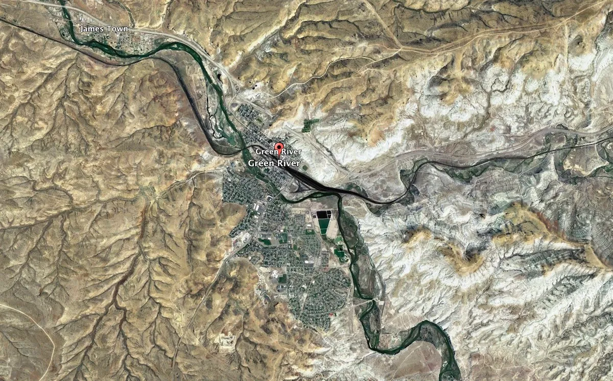
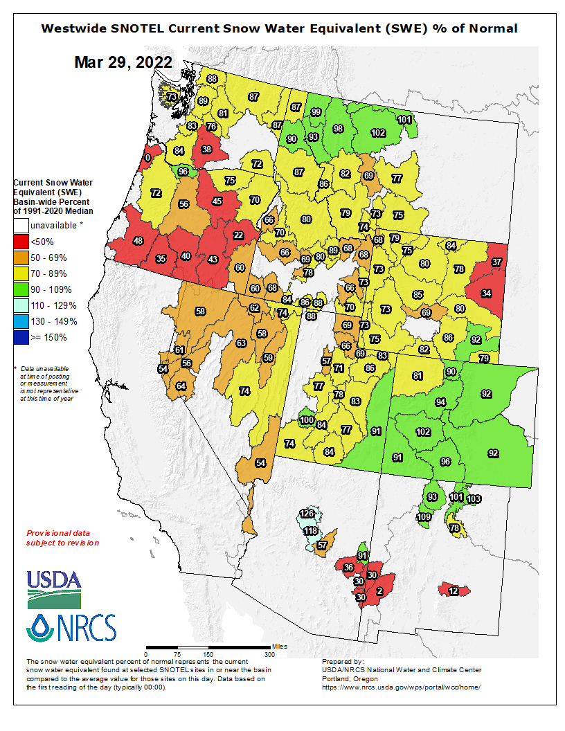
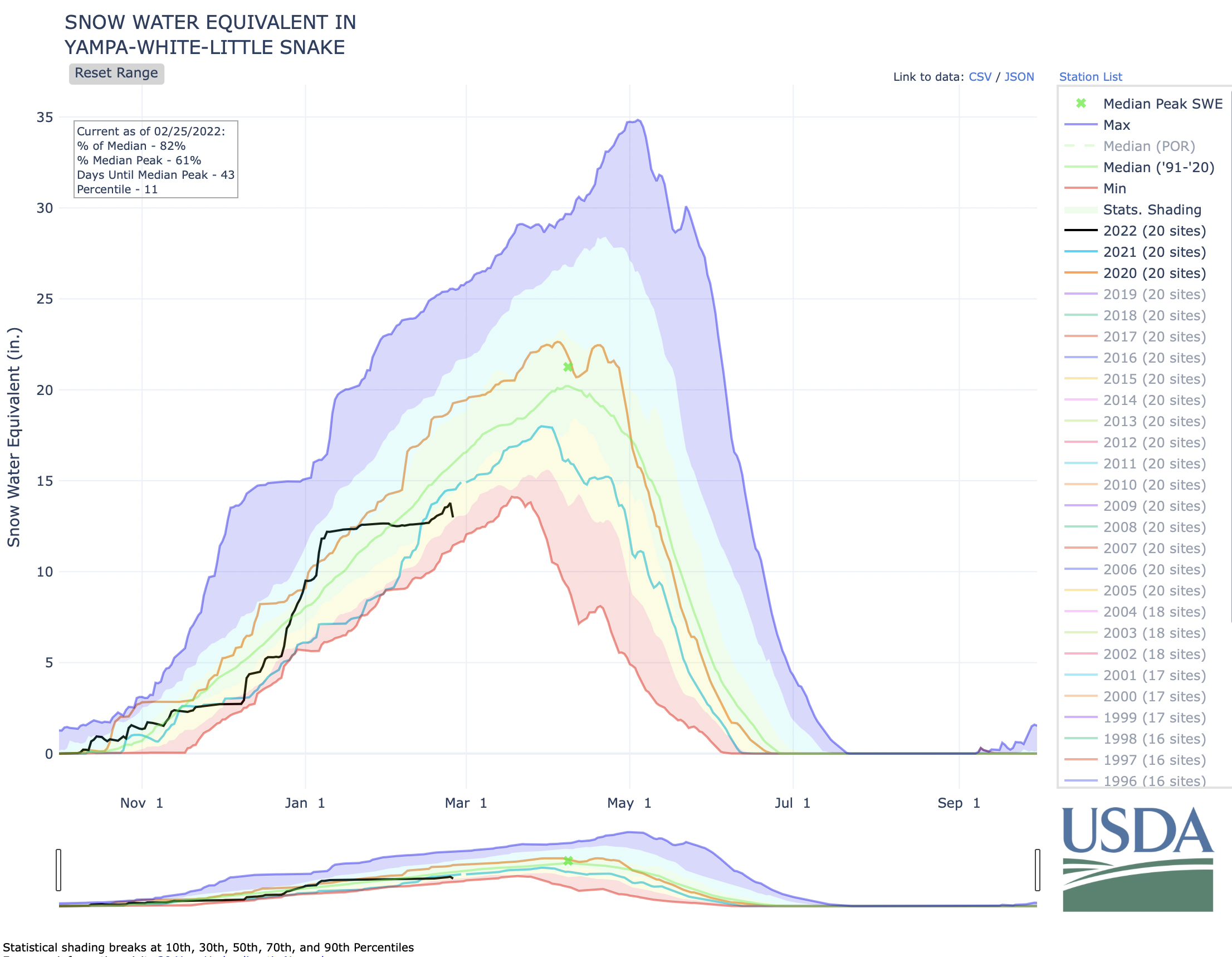
The 1948 Upper Colorado River Compact was the first reality-based document in the ‘Law of River’ portfolio because its negotiators knew by then – that ‘greater fund of knowledge’ – that it was doubtful that there would always be 7.5 maf for their use, and actually accepted that as their reality. So the divided their ‘half’ of the river into percentages for each state of whatever was left for the upper states after the Lower Basin got it Boulder Canyon Project Act waters. After three-quarters of a century, the four states are not too far from those percentages in their development of around 4.5 maf; only Wyoming is significantly under its 13 percent; Utah is a little below its 23 percent; and Colorado is a little over its 51.75 percent. Given the geographic irrelevance of western state boundaries (the Little Snake River crosses the Colorado-Wyoming border half a dozen times), this was pretty good 1948 estimating.
The reality today is that all Colorado River water users in all seven basin states are using a finite and measurable resource that will probably continue to diminish for the foreseeable future as we continue to heat up the planet, and we need to come to an agreement on what that means for all users. [ed. emphasis mine]
It seems to me there are three ways to address that diminishing flow. One way is to continue to accept the divine sanctity of the Colorado River Compact, with the Upper Basin states forced by the Supremes (they ride for power, not for the law) to cut back their own uses to meet the 7.5 maf average delivery to the Lower Basin – basically the interstate nightmare (for the upper states) the Compact was meant to address. Call this the stubborn denial option.
A second way would be to accept the evolved eight-way division (seven states plus Mexico) of the use of the river’s water, which was what the seven states wanted to do in 1922, instead of the ‘temporary equitable’ compact they came up with. Percentages for each basin state could be set according to the amount each state was using at the end of the major river development era, say in Y2K (remember that?), when the 70-year average annual flow was ~14.5 maf (1930-2000). Those state percentages of the river’s consumptive use could be retained – but the actual volume of water for each state would gradually diminish as the combination of ‘dry drought’ and ‘heat drought’ continues to diminish the river. Given that losses attributable to climate warming are both everybody’s and nobody’s fault, the losses to each states would be proportionate to their percentage of the river’s consumptive use, with no falling back on seniority, as though it were just a squabble between users. Each state could then either stay with the appropriation doctrine intrastate with junior users bearing the loss, or equitably share out the loss proportionate to use. Call the latter the shared reality option.

A third way lies between stubborn denial and shared reality, and will probably prevail as the default American Way: let money work it out. Municipal and industrial users will continue to work out money-for-water deals with agricultural users, like San Diego and the Metropolitan Water District have done with the Palo Verde and Imperial Valley ag districts, with responsible districts using the money for systemic improvements that minimize the impact of lost water. This is by no means going to ‘dry up’ agriculture. With 75-85 percent of the river’s water being used by agriculture, a doubling of M&I use would only require transfer of 10-15 percent of ag water, although (money being blind to all but profitability) the transfers would probably cause some local tragedies like Crowley County in Colorado where too much water was bought out of a single small irrigation district by Front Range entrepreneurs.
The appropriation doctrine, with its strange ‘property right’ independent of the property for which it was granted, is quite compatible with the money option for resolving water distribution, once over-appropriation is achieved. The idea that water’s seniority in a certain use can be transferred to a totally different use along with the water strikes me as strange – shouldn’t a new use initiate a new right? It is also contradictory to the doctrine’s initial democratic-populist effort to prevent the dominance of big money in water distribution by limiting water rights to what one could put to use. But it does seem to be the American way that everything eventually comes down to money as the base determinant of value.
Enough for today. The elephants in the river. I obviously favor ‘ratifying’ the evolved split of the use of the river, and an equitable proportionate sharing among all states – and within all states – of the consequences of our cultural climate changes. But that will not fly among those who have steadfast faith (senior water right holders) in the appropriation doctrine as the answer to all problems.
The river? It abides, rises and falls with the water table in its surrounding groundwater, and it may occasionally disappear, but it won’t have died, it will just have gone underground until the water table rises again and the ground can’t hold all the water – if we figure out how to let that happen.