Here’s the release from the St. Vrain and Left Hand Water Conservancy District (Sean Cronin):
April 20, 2026
Agreement affirms no new on-river dam while preserving valuable water rights for communitybenefit
The St. Vrain and Left Hand Water Conservancy District has reached an agreement with Save the World’s Rivers that reaffirms a new path forward for its Coffintop Reservoir water rights—one that does not include construction of a large on-river dam.
The District was created in 1971, in part, to build Coffintop Reservoir on South St. Vrain Creek west of Longmont and upstream of Lyons, through a planned partnership with the U.S. Bureau of Reclamation. While the reservoir itself was never built, two water storage rights associated with the Coffintop Reservoir project remain legally valid today.
As a governmental entity, the District holds the Coffintop Reservoir water rights not for its own benefit but for the community’s. In 2024, as required under Colorado water law, the District filed a routine six-year diligence application in water court to maintain those rights. The filing prompted an environmental group, Save the World’s Rivers, to submit a statement of opposition, opening discussions between the two organizations about the future use of the Coffintop water rights.
“The Water Court process is complex, and at the onset we were uncertain what Save the World’s Rivers hoped to achieve through it,” said Sean Cronin, the District’s Executive Director.
“We are always watching proponents of dams,” said Gary Wockner, Executive Director of Save the World’s Rivers. “At the appropriate time, we seek to identify ways proponents can achieve their mission while not creating a new dam. We were generally aware of the good work being done by the District, but concerned about their plan to build Coffintop Reservoir and dam.”
Through dialogue, the District and Save the World’s Rivers found common ground. Cronin noted, “I met with Gary several times, and I gained respect for his organization’s objectives, and I appreciated his willingness to come to the table and talk through complicated issues.” Save the World’s Rivers learned that the District had been working for more than 10 years with the City of Longmont, Town of Lyons, Boulder County Parks and Open Space, local environmental organizations, and food producers to develop a strategy to best utilize the Coffintop Reservoir water rights – without building the actual reservoir.
The District and Save the World’s Rivers reached an agreement through the court process, under which the District agreed to forgo using the Coffintop Reservoir water rights for any new on-river reservoir, including Coffintop Reservoir, and for the expansion of any existing on-river reservoir. Instead, the District will return to water court with plans to use the water rights at alternative locations and in ways that align with community needs, and environmental and water management goals.
“It became clear through discussions that the District shared values around avoiding a new on-river dam while still meeting its mission,” said Wockner. “That made an agreement possible,” Wockner said.
District leaders emphasized that the water rights are held for public benefit and that the original Coffintop Reservoir concept no longer reflects the highest and best use of the resource.
“This is something we and our communities have contemplated for decades,” said Christopher Smith, President of the District’s Board of Directors. “The Coffintop project, as envisioned more than 50 years ago, no longer fits today’s needs or values.”
For more than a decade, the District has worked with community partners to explore alternatives that could use the Coffintop water rights, while also supporting increased stream flows during low-flow periods. The District’s development and implementation of these alternatives is moving forward with engagement from important partners, including the Town of Lyons and City of Longmont.
Town of Lyons Mayor Hollie Rogan welcomed the agreement. “St. Vrain Creek is the lifeblood of our town, and a large dam upstream was never embraced by our community,” she said. “We’re pleased the District will not pursue Coffintop Reservoir and look forward to continued collaboration.”
Longmont Director of Water and Waste Service Chris Huffer noted the long history between the City and the District. “The challenges around water have only grown more complex over the last 50 years,” he said. “The District has a solid water plan, and the City is an eager partner in realizing the greatest potential of these water rights.”
The South Platte River Basin is shaded in yellow. Source: Tom Cech, One World One Water Center, Metropolitan State University of Denver.
Here’s the release from the St. Vrain and Left Hand Water District (Jenny McCarty):
February 21, 2025
LONGMONT – Funding approved by Longmont’s voters in 2024 is enabling the St. Vrain and Left Hand Water Conservancy District to leverage grants and other sources to provide $1.7 million this year to community partners working to address the most imminent water and watershed issues today. The funds will help mitigate wildfire risks, improve farm irrigation, save water by reducing non-functional turf grass, and enhance stream flows to benefit the environment.
In 2025, the District is partnering with and funding the Boulder Valley and Longmont Conservation Districts, Crocker Ditch, HFR Enterprises, Holland Ditch Company, Hover Park Home Owners Association (“HOA”), Town of Lyons, and The Watershed Center. 2025 marks the fourth year the District offered funding through their Partner Funding Program. Including $352,000 earmarked for 2025, the District has awarded 25 partners a total of $1.2 million, leveraging those dollars for more than $6.1 million since January 2022 (369%) toward improvements in water management within the St. Vrain watershed.
The St. Vrain Forest Health Partnership (“SVFHP”) includes 100+ partners including fire districts, agencies, towns and community members working to increase fire resilience to benefit communities, the forests and water quality. A portion of the District’s $352,000 will go to support the SVFHP’s outreach and education efforts. “We couldn’t accomplish this work without the District’s support and funding and are grateful to our community who voted for the ballot initiative,” said Yana Sorokin, Executive Director of The Watershed Center.
The Boulder Valley and Longmont Conservation Districts (“BVLCD”) are working alongside the SVFHP to develop forest management plans on private properties and conduct forest treatments to reduce risk of catastrophic wildfires. “These funds will help to reduce wildfire risk to life, property, and important surface waters within District boundaries,” explained Rob Walker, Director of BVLCD.
Boulder County Ditch and Reservoir map. Credit: The St. Vrain and Lefthand Water Conservancy District
The District is also partnering with Crocker Ditch, HFR Enterprises, and Holland Ditch Company to help improve local aging agriculture infrastructure and vegetation encroachment to support its future function.
Andy Pelster, Agriculture and Water Stewardship Sr. Manager for City of Boulder, which has ownership in Crocker Ditch, stated, “District funds will help improve water delivery efficiency and tracking.” Danna Ortiz, a representative of HFR Enterprises added, “This project gives us hope that the Knoth Reservoir may once again function, providing water for our ag neighbors and wildlife.” Larry Scripter, Vice President of the Holland Ditch Company said, “We wouldn’t be able to keep going with this work without the District’s financial support.”
Hover Park HOA is leading one of the first District-supported turf replacement projects in Longmont this year. In addition to funding support from other local agencies, Hover Park HOA is working to “replace over 8,200 square feet of thirsty turf grass with water-wise plants that support pollinators, look beautiful, and will create a more usable space for our community,” says Barbara Hau, resident representative for the HOA.
The Town of Lyons is using District funding to complete a preliminary analysis for managing stream flows on the St. Vrain Creek through Lyons for environmental benefit. Tracy Sanders, Lyons Flood Recovery Lead, said the District’s funds might “help determine whether environmental flows can improve creek conditions for temperature, and ultimately fish health.”
“These partnerships continue the District’s strong history of collaboration,” said Sean Cronin, Executive Director of the St. Vrain and Left Hand Water Conservancy District. “Each project advances our goals the voters approved: to protect water quality, maintain healthy rivers and creeks, support local food production, and protect forests that are critical to our water supply,” he added.
About the St. Vrain and Left Hand Water Conservancy District
The St. Vrain and Left Hand Water Conservancy District (“District” and “SVLHWCD”), created in 1971, is your trusted local government working to safeguard water resources for all. The District’s work is founded in the Water Plan five pillars: protect water quality and drinking water sources, safeguard and conserve water supplies, grow local food, store water for dry years, and maintain healthy rivers and creeks. Aligned with the Water Plan, the District is pleased to promote local partner water protection and management strategies through the Partner Funding Program.
As a local government, non-profit agency formed at the request of our community under state laws, the District serves Longmont and the surrounding land area and basin that drains into both the St. Vrain and Left Hand Creeks. Learn more at http://www.svlh.gov.
If you have any questions about the District’s Partner Funding Program, please contact Watershed Program Manager at: jenny.mccarty@svlh.gov or 303.772.4060.
Screenshot from the Highland Ditch Company website.
Here’s the release from the St. Vrain and Left Hand Water Conservancy District (Sean Cronin):
September 9, 2024
LONGMONT, COLO – This fall, the St. Vrain and Left Hand Water Conservancy District (“District”) and the Highland Ditch Company are collaborating on a unique pilot project to save fish in St. Vrain Creek. As ditch diversions are closed off for the fall, fish often become trapped in standing pools behind the headgates, which eventually dry up. The pilot project will rescue these fish and return them to the adjacent creek, protecting local fish populations and aligning with the community’s values of environmental stewardship.
Healthy fisheries are essential not only for the ecological health of local streams but also for supporting the recreational fishing economy—well worth the half days’ work it will take to move the fish back into the creek.
“The District and Highland are piloting this salvage effort, in the hopes that the results may be scaled up across the District, and potentially in other parts of Colorado,” said the District’s Watershed Program Manager Jenny McCarty.
Highland Ditch Company, which has been diverting water for over a century, sees this initiative as an example of the symbiotic relationship that can exist between local agriculture and environmental health.
The channel’s water “is used to irrigate 35,000 agriculture acres in this valley. Those farms are part of the fabric of this community… residents eat food from [these] farms,” said Wade Gonzales, Highland’s Ditch and Reservoir Superintendent. “We are all connected, and this pilot project will show how we can work together toward common goals.”
“Our constituents across the St. Vrain and Left Hand Valley have time and again supported approaches that balance water needs for thriving agriculture and a healthy environment”, said Sean Cronin, the District’s Executive Director. “We’re honored to be a trusted partner to Highland in leading this effort.”
Media are invited to the fish salvage effort in late September, 2024. Date to be determined. Please email jenny.mccarty@svlh.gov if you are interested in attending.
About the St. Vrain and Left Hand Water Conservancy District
The St. Vrain and Left Hand Water Conservancy District, created in 1971, is a local government, non -profit agency that serves Longmont and the surrounding land area. The District is dedicated to safeguarding water resources for all and promotes/partners on local water protection and management strategies that align with the five pillars of its Water Plan. Learn more at http://www.svlh.gov.
About the Highland Ditch Company
The Highland Ditch Company, based in Longmont, CO, was established in 1871 and irrigates about 35,000 acres of land along St. Vrain Creek, the most of any within District boundaries. The Highland Ditch Company pursues its mission to manage and deliver water for its shareholders by embracing innovative opportunities. Learn more at http://www.highlandditch.com.
LONGMONT, COLO – A St. Vrain trans-basin diversion, which has been a cornerstone of Colorado’s water rights history for over 140 years while simultaneously drawing environmental concern because of impacts to the South St. Vrain Creek, is making history again.
The South St. Vrain Diversion was at the center of the controversial 1882 Colorado Supreme Court water rights case Coffin v. Left Hand Ditch Company that set the precedent for water rights across the western United States for establishing the “first in time, first in right” doctrine. Now the diversion structure is the first in the St. Vrain basin to employ remote operations of the diversion.
Coffin vs. Left Hand Ditch location map via the Left Hand Watershed Center
A collaboration between the Left Hand Ditch Company, the Left Hand Water District and the St. Vrain and Left Hand Water Conservancy District authorized the installation of new technology last year that directs more precise stream flows and provides better monitoring and metering.
The ability to operate this diversion remotely through a mobile phone app enables rejuvenating flows into South St. Vrain Creek. The upcoming summer months may be among the first to see water flow down South St. Vrain Creek for the first time in over a century. Previously, operating this diversion required a three-hour drive from Niwot to above the Peak-to-Peak Highway when the mountain access point was accessible and then required manual operation of a century-old diversion wheel. In winter, the only option of reaching the diversion was often via snowshoes. The new diversion operations equipment is charged by solar and controlled by cellular data. Flows as low as 5 cubic feet per second (CFS) can make a big difference to the health of the stream.
The collaborative project came about when the Left Hand Ditch Company sought expertise and funding from the St. Vrain and Left Hand Water Conservancy District to implement the infrastructural advancements. Because it derives water supply from Left Hand Creek below the diversion and because it shares a similar interest in the health and the integrity of the watershed, the Left Hand Water District provided additional funding for a total of $24,000. This initiative signifies a shift in the relationship between historical water management practices and environmental values, which have sometimes been at odds. The project demonstrates Left Hand Ditch Company’s interest in enabling environmental flows and could set a precedent for collaborative conservation efforts in the future. As Terry Plummer, Superintendent of Left Hand Ditch Company, concluded, “We’ve got to grow and change with the times.”
“The collaboration between the three entities represents trust, partnership, and environmental dedication,” said Sean Cronin, Executive Director at the St. Vrain and Left Hand Water Conservancy District. “This project underscores our unwavering commitment to preserving Colorado’s waterways while ensuring sustainable agricultural practices.”
“As the primary water manager on Left Hand Creek, we use this water and want to contribute to its success,” said Christopher Smith, General Manager of Left Hand Water District.
For media inquiries, interviews, or further information, please contact Jenny McCarty at 303.772.4060 or jenny.mccarty@slvh.gov.
About the St. Vrain and Left Hand Water Conservancy District
The St. Vrain and Left Hand Water Conservancy District (“District” and “SVLHWCD”), created in 1971, is your trusted local government working to safeguard water resources for all. The District’s work is founded in the Water Plan five pillars: protect water quality and drinking water sources, safeguard and conserve water supplies, grow local food, store water for dry years, and maintain healthy rivers and creeks. Aligned with the Water Plan, the District is pleased to promote local partner water protection and management strategies through the Partner Funding Program.
As a local government, non-profit agency formed at the request of our community under state laws, the District serves Longmont and the surrounding land area or basin that drains into both the St. Vrain and Left Hand Creeks. Learn more at http://www.svlh.gov.
About the Left Hand Ditch Company
The Left Hand Ditch Company, based in Niwot, CO, was established in 1866 to irrigate 30K acres of land along Left Hand Creek. It is a unique ditch company in the west for many reasons, the first of which being that several individual ditches gave up their individual operations to come together and form the single ditch company to manage the entire Left Hand Creek system most efficiently.
Today, the Left Hand Ditch Company’s mission to manage and deliver water for all of its shareholders effectively is as strong as ever, and the Left Hand Ditch Company embraces new technology, like remote operation at the South St. Vrain Diversion, to accomplish this mission in modern times. Learn more at http://www.lefthandditchcompany.com.
About the Left Hand Water District
Left Hand Water District is a quasi-municipal corporation and a political subdivision of the State of Colorado, governed by Colorado Revised Statutes Title 32 Special Districts. The District has served customers in unincorporated areas of Boulder and Weld Counties since the early 1960’s. The Left Hand Water District’s service area is generally bounded by the City of Longmont on the north, the Cities of Boulder, Lafayette, and Erie on the south, I-25 on the east and the foothills on the west. Learn more at http://www.lefthandwater.gov.
In May of 2009, three concurrent venues each showed different artwork, photo essays and educational material about ditches.
Exhibits and featured events at the Boulder Public Library drew crowds of curious Coloradans, while visitors to the Dairy Center for the Arts enjoyed eclectic displays inspired by local water scenes. Various bits of sculpture lined Boulder Creek near the headgates of the Boulder and Left Hand Ditch.
Special programs included tours, storytelling, films, and a symposium of expert speakers. Here, you can revisit parts of the Ditch Project with our comprehensive archive of images, podcasts, and movie clips.
New content will be added here sporadically. Check back here for more updates.
A colorful signpost welcomes visitors to Jamestown. Jamestown residents have joined forces with multiple agencies in a project funded in part by the St. Vrain and Left Hand Water Conservancy District to restore the forest and the James Creek watershed. Credit: Jerd Smith
On the hillsides that rise above James Creek in Jamestown, Colorado, west of Boulder, the yards of mountain homes and the forests that surround them are dotted with trees decorated with pink and blue ribbons.
It’s festive, but not in the usual sense.
Jamestown lies in the headwaters of Left Hand Creek, a tributary of the St. Vrain River. The pink trees will be kept, while those flagged in blue will be cut down in a careful thinning project designed to protect a watershed farther downstream that serves farmers and thousands of people in communities such as Lyons and Longmont.
The watershed is a critical part of the St. Vrain and Left Hand Water Conservancy District, an agency charged with overseeing and managing the St. Vrain River, a major system in the larger South Platte River Basin on Colorado’s Front Range.
The people of Jamestown have been working for years to find funding to protect their community from wildfire and to protect James Creek. Tree cutting is expensive, sometimes costing $1,000 just to remove one tree.
Trees marked for forest health initiative above James Creek in Jamestown, Colorado. Credit: Jerd Smith
But thanks to a property tax increase the district’s voters approved in 2020, as well as an influx of COVID relief money to the state, and new federal funds for infrastructure and jobs, the people of Jamestown and the St. Vrain district now have access to the money they need to reshape and improve their water systems in ways that benefit supply, recreation, the environment and agriculture.
If state and federal funding proposals come through, and some already have, the district will have more than $240 million to work with. For perspective, that is 60 to 80 times the size of the district’s annual $3 million to $4 million operating budget.
Similar big federal funding opportunities exist for other water districts, and policy makers across the state are looking to the St. Vrain district to lead by example.
Alex Funk, senior counsel and director of water resources at the Theodore Roosevelt Conservation partnership is tracking the streams of new cash. He says the opportunities to modernize water systems and improve the state’s farms and rivers now are huge.
“It’s unprecedented in its scope and scale,” Funk said. “There has never been this amount of federal money available all at once. In that sense, we are in uncharted territory.”
That’s not lost on Sean Cronin, executive director of the St. Vrain and Left Hand Water Conservancy District.
Plume of subtropical moisture streaming into Colorado September 2013 via Weather5280
After the floods of 2013, the district saw its streams and water systems devastated. Desperate to rebuild, small communities, ditch companies and watershed groups, as well as the St. Vrain district, began banding together to apply for federal and state emergency assistance.
“The flood introduced us to new friends,” Cronin said.
From that grew a ballot initiative in 2020 that has raised millions of dollars in property taxes.
Though statewide water tax proposals have had little success among Colorado voters, St. Vrain’s was one of two local districts that year that succeeded. The Glenwood Springs-based Colorado River Water Conservation District also won approval to raise taxes to protect and improve the regions water sources.
“The fact that we had a plan that looked at all things regarding water and wasn’t specifically for a single water outcome is part of why we succeeded,” Cronin said. “People embrace looking at things holistically.”
Credit: St. Vrain and Left Hand Water Conservancy District
Energized by the win, the district launched into planning and design on a range of modest projects.
And then the federal funding deluge began. Now the district is in the running for $240 million to improve infrastructure and restore streams, and improve agricultural irrigation systems, among other projects.
Todd Boldt oversees the federal Emergency Watershed Protection program in Colorado at the Natural Resources Conservation Service as well as other major grant-making programs that are now flush with cash.
He said one of his agency’s priorities is to get the word out about federal funding opportunities and to ensure even small water districts have the resources to do the planning, engineering and design work needed to begin the grant process.
He credits the St. Vrain district with being well-planned and well-organized at the starting line.
“This is complicated stuff,” Boldt said. “We’re at a critical juncture in time.”
If the St. Vrain and Left Hand team succeeds, its ditches, streams, wetlands, reservoirs and farm fields could look significantly different in seven to 10 years.
High in the mountains, for instance, a historic diversion system will be brought into the 21st century. More than 130 years old, the structure is difficult to access and maintain. Soon it will be rehabilitated so that it can be monitored and operated remotely to make sure water is accurately counted and properly diverted.
“We’re trying to squeeze every last drop out of our system,” Cronin said.
In fact, there are dozens of diversion structures in this sprawling district that includes prized recreational streams, thousands of acres of farms, rich wetlands, and cities.
Sean Cronin and John McClow at the 2014 CFWE President’s Award Reception
Cronin and his team are reaching out to everyone, funneling the cash they’ve raised into matching grants and offering assistance to partners.
Another part of the district’s strategy is to grow water supplies where possible, and to do so in a way that doesn’t require the purchase of farm-tied water rights and the subsequent dry up of farm fields.
This year, for instance, the district began its own cloud-seeding program, which is forecast to increase water derived from annual snow storms by 5% to 10%.
Funk said the work in the St. Vrain and Left Hand district is encouraging.
“We need to see more of that. We want people to think creatively about these [federal] funds,” he said.
Back up in Jamestown, St. Vrain’s Jenny McCarty, a water resources specialist, has been monitoring the forest restoration work. She believes the initiative could serve as a template for other community-based, multi-property-owner watershed health projects.
In the mountains, while it’s helpful for one property owner to thin trees and remove slash, the impact is limited, McCarty said.
“These property owners like their privacy. Their contribution to the project has been to allow all those trees to be cut down,” she said. “It’s the collective effort that makes a difference.”
Jerd Smith is editor of Fresh Water News. She can be reached at 720-398-6474, via email at jerd@wateredco.org or @jerd_smith.
Click the link to read the article on the KUNC website (Rae Solomon). Here’s an excerpt:
Yellow Barn is a baby of a farm. The 100-acre operation in Longmont started up just a little over 2 years ago, on the grounds of a shuttered horse stable. Nick DiDomenico is Yellow Barn’s young farmer. DiDomenico practices regenerative agriculture, a holistic approach to farming and ranching. It rebuilds depleted soils, improves ecosystems and mitigates climate change by putting carbon back in the ground. Farmers in Colorado are increasingly experimenting with those techniques, to different degrees. DiDomenico is among those leading the pack. The fields at Yellow Barn are just getting started. DiDomenico has been working to establish a silvopasture here – an integrated system of trees and livestock that work together to produce an overall regenerative benefit – including increased biodiversity on the land, leading to higher soil fertility, and better water retention. “We’re farming here, we’re running our cattle,” Didomenico explained. “It’s this rotational grazing strategy that improves the land.”
On a recent afternoon, DiDomenico adjusted a faulty pump on the water trough that keeps his small herd of belted Galloway cows hydrated. “It’s a really niche thing that we’re doing,” he said, “which is converting completely decertified, degraded, marginalized land and redeveloping it into agricultural systems that are viable.”
[…]
Conventional agriculture costs a lot of money. Farmers typically pay dearly for inputs like fertilizer and pesticides and the fuel needed to spread them in the field. Since the 1930’s, the federal government has subsidizedthose costs heavily. But Farm Bill subsidies are deliberately conservative. They aren’t equipped to encourage risk and experimentation. “They’re designed for commodity mid- to large-scale agriculture,” according to Clark Harshbarger, a regenerative agriculture expert with the NGO Mad Agriculture in Boulder, Colorado. “They purposely try to take the risk out of those practices because it’s taxpayer money already spent,” Harshbarger said. “And sometimes [the USDA] vetting process hasn’t necessarily caught up with progressive regenerative farming systems.” As a small-scale regenerative farmer, DiDomenico falls through the cracks when it comes to federal subsidies. The farming technique at Yellow Barn is experimental and holistic. Harshbarger is familiar with DiDomenicos’ work. “It’s very creative and it’s complex,” he explained, but “the Farm Bill is designed to be very specific… very 1 to 1.”
[…]
The USDA doesn’t subsidize this type of work. So DiDomenico finds financial support in some unlikely places…Just off the highway, in the city of Boulder, there’s a strip mall with an Indian Restaurant, a nail salon, and a locksmith. In a corner behind the Goodwill, a Subway sandwich shop does brisk business at lunch hour. But this Subway is special, because along with the standard steak and cheese, spicy Italian and tuna subs, it offers customers the opportunity to support regenerative farming in the neighboring rural areas. That’s because of a program called Restore Colorado, that takes a little extra charge – just 1% of the cost of your meal – from urban restaurants, like this Subway, and gives it to rural farmers, like DiDomenico, to invest in their soil. That comes to just a few cents on top of the cost of each sandwich, that shows up on the sales receipt as the 1% Restore Colorado charge.
Here’s the release from the St. Vrain and Left Hand Water Conservancy District:
The Town of Jamestown will be at less risk from wildfire because of funding provided by residents and business property owners in the St. Vrain and Left Hand Creek Water Conservancy District. The Town and many local property owners agreed to work with over $127,000 of Water Conservancy District funding to begin planning a fire mitigation project that encompasses dozens of homes in the town limits. The area has been identified as a critical zone for wildfire mitigation treatments that will improve public safety across Jamestown as well as help protect the James Creek water supply in the event of a wildfire.
Many of the private property owners in the proposed area participated in an informational meeting on March 29 in Jamestown. Though property owners were not asked to fully commit to the proposal, many signed agreements allowing the project team access to their properties in order to assess conditions and develop a fire mitigation plan.
The Water Conservancy District provided the funding and sought the support of Left Hand Watershed Center to gather local experts to facilitate the work. This team is beginning work to assess the type of forest mitigation work necessary, and work with the landowners to achieve and implement a common vision. In addition to the District and the Watershed Center, the team includes the Boulder Valley and Longmont Conservation Districts, the Lefthand Fire Protection District, and the St. Vrain Forest Health Partnership (a larger collaborative seeking similar larger scale opportunities).
”The recent fires in Boulder County demonstrate the urgency we have to address community safety at this kind of scale,” said Allan Mueller, Town of Jamestown resident and project participant. “As a community that rests at the top of the watershed, we have a great appreciation for how our water resources connect us clear through Weld County.” “We are incredibly grateful to the St. Vrain and Left Hand Water Conservancy District, whose mission is for the entirety of the creek, for this funding”.
Lefthand Fire Protection District Chief Chris O’Brien, whose crews will do the forest mitigation work this summer, was thrilled to have this generous funding. “We have been working one small piece of the puzzle at a time to help decrease the wildfire risk to the community and all up and down our watershed. This funding allows us to get a lot done at one time, lowering the cost for each acre and making a bigger difference given the size of the wildfires we could potentially face. Thank you to the St. Vrain and Left Hand Water Conservancy District and the Jamestown community for stepping up to meet the wildfire challenge we all face.”
The Left Hand Watershed Center will be the lead coordinating entity for the project, and helped secure the funding from the Water Conservancy District. Jessie Olson, Executive Director, stated, “Our communities, water supplies and forests are at risk if we do not begin scaling up forest restoration in the County. This is why we formed the St. Vrain Forest Health Partnership with over 100 agencies and community members, to begin implementing landscape scale cross-boundary restoration. This Jamestown project was identified as a priority through the partnership, and the St. Vrain and Left Hand Water Conservancy District stepped up to spear head this important project. This is an exciting moment for the community of Jamestown and all downstream communities.”
“It is a great collaboration in the Boulder County Fireshed whereby we have partners that are willing to fund work upstream from where they reside and with others are coming together to get a significant and strategic needed project done,” said Boulder County Commissioner Matt Jones. “We all recognize that wildfires are getting worse and threaten our mountain residents and we have also learned the hard way since the Hayman Fire 20 years ago, that downstream water users can be impacted as well by wildfire. Our forest is the main source of our drinking water in Boulder County and catastrophic wildfire ruins its ability to provide us that resource while post fire flood debris can devastate water supply infrastructure.”
The St. Vrain and Left Hand Water Conservancy District encompasses some 500 square miles along the St. Vrain and Left Hand creeks in Boulder, Weld and Larimer counties. In 2020, voters in the Water Conservancy District agreed to a mill levy increase from 0.156 mills to 1.25 mills through 2030. This was the first property tax increase sought by the District in its 50 year history. The tax will generate an additional $3.4 million in 2022, up from the $416,000 collected in 2020. The 1.25 mill on a $500,000 residential property is equal to $4.47 per month, and $36.25 per month on a $1,000,000 non-residential property.
Sean Cronin, Executive Director of the Water Conservancy District stated, “For years, our constituents said they wanted holistic, sensible, and apolitical leadership across the watershed. In response, the Board of Directors asked the voters in November 2020 if they would approve funding to implement a holistic and sensible water plan. Part of that plan included investments in protecting forests and water quality.” “We are really excited to partner with the Left Hand Watershed Center, the Fire District, the Longmont and Boulder Valley Conservation Districts, and the community of Jamestown to help protect forests and water quality.”
If you are a Jamestown resident and/or you would like to learn more about the proposed project please contact the Watershed Center’s Forest Program Manager, Chiara Forrester at cforrester@watershed.center.
Although Brian Werner has served on the WEco Board of Trustees for just over a year, he was involved with helping found the organization nearly 20 years ago. Now retired from his 38-year career as the Communications Department Manager and Public Information Officer at Northern Water, and still a life-long water historian, Brian has written and given hundreds of presentations on the role of water in the settlement and development of Colorado and the West. We spoke with Brian about Northern Water’s storage, the impacts of fire on water storage, permitting, and more.
How long have you been on the WEco board?
I’ve been involved with WEco since WEco has been around. I was involved with the first couple incarnations of water education efforts in Colorado in the late 80’s and early 90’s, and then I helped when WEco came into being in 2002. I was never on the board, until a couple of years ago. It was something I wanted to do towards the end of my career and I retired just last year in January 2020. Luckily I was appointed to the board and I’ve truly enjoyed it.
What kind of experience do you bring to the group?
I think the fact that I had a 38-year career in the water business with Northern Water is an asset. At Northern Water, I’d established relations with people from all over the state and I also coordinated probably 150 to 200 different children’s water festivals, so clearly I was into education. I’m really a big believer in the trickle up theory of water knowledge. Where if you can educate the kids, that knowledge is going trickle up to mom and dad, and those kids will somebody be parents themselves. Ultimately, I’ve been trying to build that ethic in what I’ve been about for most of my career.
How would you describe your experience being on the board?
I’ve really enjoyed being on the board. I’ve watched it and been very much involved for a long time. Both Nicole Seltzer and Jayla Poppleton worked with me at Northern Water, so I have a personal vested interest in them succeeding, and they really have. Nicole moved the organization in a wonderful direction and Jayla has just been top-notch in where she has taken WEco. It has been really interesting because we have a diverse board, and I have enjoyed getting to know people who I didn’t know previously.
Screenshot of the Colorado-Big Thompson Project boundaries via Northern Water’s interactive mapping tool , June 5, 2019.
I understand you recently retired from Northern Water, can you tell me what your role with them was and maybe what Northern Water does in a general sense?
Northern Water is the largest water conservancy district in the state of Colorado and operates a large Bureau of Reclamation project that is one of the largest in the entire western United States; the Colorado-Big Thompson project. It brings a quarter-million acre-feet a year from the West Slope into Northeastern Colorado to supplement both urban and rural supplies, meaning that it is both a municipal as well as an agricultural water supply. Now there are well over a million people that get a portion of their water supply from that project, but back in 1937, there were only 50,000 people living within Northern Water’s boundaries. So, nobody could have foreseen the growth that occurred since then. This growth has brought all sorts of issues and concerns, but Northern Water is one of the top water agencies in the state and I certainly had a wonderful career there and couldn’t have asked for anything better.
Personally, I was a public information officer for 35 of those 38 years. My role, in essence, was to be the public face of Northern Water and so I talked about Northern Water and its activities all the time. I was able to use my historical training, I have a master’s degree in history, to discuss the historical background of both water development and Northern Water. I focused very much on education, but ultimately, I spent my entire career talking all things water, which was a lot of fun.
I was also the manager of our communications department as we expanded and grew. As we grew, we brought on writers and pushed publications and annual reports, and then we got into the social media craze. So, for some time I managed that department. But really, it was about telling people what Northern Water was all about.
The map above displays estimates of the likelihood of debris flow (in %), potential volume of debris flow (in m3), and combined relative debris flow hazard. These predictions are made at the scale of the drainage basin, and at the scale of the individual stream segment. Estimates of probability, volume, and combined hazard are based upon a design storm with a peak 15-minute rainfall intensity of 24 millimeters per hour (mm/h). Predictions may be viewed interactively by clicking on the button at the top right corner of the map displayed above. Map credit: USGS
Perhaps a topical question, but how have the numerous forest fires affected the work that Northern Water does in trying to ensure water storage?
That is going to be Northern Water’s principal focus this coming year. Both of our major watersheds burned last year, the Upper Colorado with the East Troublesome wildfire, and then the Poudre watershed with the Cameron Peak wildfire. And both of these watersheds are where we get the vast majority of our water. Luckily, Northern Water had been looking at forest water management for years. Northern Water has been working with the U.S. Forest Service, the counties, the Bureau of Reclamation, and the National Parks Service. It wasn’t that these fires hit us and Northern Water had no idea what to do. We learned quite a lot from Denver Water after the Hayman Fire, with all of the issues that they had centering around water quality. Northern Water isn’t pleased, but we are certainly going to see some water quality impacts because of these fires.
We went in with our eyes open and with some plans in place for post-fire activities. We always said, ‘it’s not if, it’s when those fires hit.’
What do these fires mean for water supply and water quality now, as well as moving into the future?
One of the things that we see from these fires is a greater level of awareness in terms of forest management, not just if you have a house in a forest or nearby, but for those people living in major metropolitan areas, too. Those people in Denver, Fort Collins, and Colorado Springs are all paying attention now, because they saw the two largest fires in Colorado history and what it did to our environment. And I think now there will be a lot more attention focused on the post-fire impacts, which obviously include water. People will certainly be paying attention to the water piece of the post-fire mitigation and clean-up. Overall, I think moving into the future we will have a better awareness, which is always a good thing. There is no way around it, it is going to take money, and where we are at with COVID-19 that discussion is not easy, but the state is making a concerted effort to put monetary resources and people into handling the situation.
First water through the Adams Tunnel. Photo credit Northern Water.
How the present or future storage planning is different than what the state has done historically?
One thing I would point out is that the Federal government is no longer in the water storage building business. For years Reclamation, which had been established in 1902 helped jumpstart and build water projects, as they did the Colorado-Big Thompson Project in the 1930s, ’40s and ’50s. The Federal government neither has the resources nor are they paying for water storage anymore. Now, water storage is something that is having to be more or less self-funded. Meaning that the growing cities are trying to figure out how they can finance additional water for their future citizens.
We are also now looking at the multiple uses of water. Nowadays, water is being used for environmental purposes, which means that we are looking to make sure that there is enough to release into the rivers to help the aquatic habitat. This is a much larger part of the picture today. At a base level of awareness, we want people to understand why we need storage reservoirs. It is a dry year, and it sure looks like we are only getting drier, and when you have the drier years you better make sure that you store when you have the wetter periods to carry you through. I think we are going to have difficulties trying to match up the storage, which we are going to continue to need, with all the environmental issues and issues surrounding the development of water infrastructure.
Northern Integrated Supply Project (NISP) map July 27, 2016 via Northern Water.
In the past 20 years, Northern has been in permitting so can you talk about that process?
We say water project permitting works at a glacial pace. When I started working on the Northern Integrated Supply Project permitting at Northern Water, I told my wife that I thought we would have a permit in around 5 years … I’m now retired. Northern Water is going on 17 years later, and they still haven’t received that permit. That’s frustrating. This wasn’t for lack of energy; I mean we were really working hard to secure that permit. These things take much longer than you would probably expect. You have to have a lot of perseverance because the process can really drive you crazy, but my hope is that in the future this process will become much better for all parties involved.
Water won big in Colorado on Election Day as voters in two multi-county districts approved property tax increases to fund water projects and programs.
Voters in two local water districts — the Colorado River Water Conservation District on the West Slope and the St. Vrain and Left Hand Water Conservancy District on the Front Range — said yes to ballot measures that will generate millions of dollars in new money for conservation, water education, stream health, storage and agriculture.
Based on vote totals as of 4:30 a.m. this morning, 72 percent of voters in the Colorado River District approved ballot issue 7A, with nearly 28 percent voting against the measure.
Meanwhile, 69 percent of voters in the St. Vrain and Left Hand Water Conservancy District approved a separate ballot issue 7A, with 31 percent voting against.
Though statewide funding for water projects has historically been a tough sell for Colorado voters, local initiatives with a more direct connection to residents are finding more success at the polls in recent years. These 2020 water funding ballot measures come on the heels of similar successes in 2018, when voters in Denver, Eagle, Chaffee and Park counties approved tax increases, new taxes, and tax extensions for water and land-focused initiatives.
“Passing any type of fiscal measures statewide in Colorado is going to continue to be an extreme challenge but it’s a much different story on the local level and the regional level,” said Matt Rice, director of the Colorado Basin Program for American Rivers, which supported the Colorado River District measure. “People in Colorado like to make their own decisions locally about fiscal issues, but also about how we manage and protect and restore our rivers for the environment, for agriculture and for local economies.”
In deciding to ask voters for more money this year, the two districts’ leaders cited factors like growing demand for water, drought, higher temperatures, population growth, declining oil and gas revenue, and declining property tax levels under the state’s Gallagher Amendment.
Those reasons resonated with voters on both sides of the political spectrum across the state. On the West Slope, for example, voters in right-leaning counties like Mesa and Montrose and left-leaning counties like Pitkin and Summit approved the ballot measure. (Of note: Nearly 80 percent of voters in Pitkin County approved the ballot measure, despite opposition by three county commissioners and the county’s representative on the district’s board.)
“It’s really a testament to what can happen if people put aside partisan differences on water issues,” said Andy Mueller, general manager of the Colorado River District. “Voters in Colorado are seeing the effects of rising temperatures, changing climate and the impact it’s having on water resources, and they know that we need to adapt and mitigate and that it’s going to cost money to do that.”
An angler casts a line on the Roaring Fork River upstream of Basalt in Pitkin County. West Slope voters said yes to millions in new taxes for the Colorado River District. Credit: Jerd Smith, Fresh Water News
West Slope says yes
In the large Colorado River District, which includes 15 counties and some 500,000 residents, voters approved a mill levy increase that will double the district’s budget by generating an additional $4.9 million every year starting in 2021.
The district spans an area that covers 28 percent of the state and encompasses the Colorado River and its major tributaries, which include the Yampa, the White, the Gunnison and the Uncompahgre rivers.
With the passage of the ballot measure, West Slope voters approved a median residential property tax increase of $7.03 per year for residents of Grand, Summit, Eagle, Pitkin, Garfield, Routt, Moffat, Rio Blanco, Mesa, Delta, Ouray, Gunnison and parts of Montrose, Saguache and Hinsdale counties. The increase represents an additional $1.90 per year for every $100,000 of home value.
The district, which has 22 employees, will use the new funding for projects related to agriculture, infrastructure, water quality, conservation, efficiency, and other key priority areas determined by local communities and river basin roundtables.
District leaders say they will also stretch the extra money further by using it to solicit matching funds from state, federal and private sources.
Water funding on the Front Range
It was also a historic night for the St. Vrain and Left Hand Water Conservancy District, where voters approved a property tax increase for the next 10 years. This is the first time in nearly 50 years — since its founding in 1971 — that the district has asked voters for more funding.
The district’s board thought long and hard about how best to approach voters — and whether this was the right year to do it. But in the end, their approach paid off.
“The discussions were good and essentially resulted in consensus and agreement with the board,” said Chris Smith, board vice president representing district 3, which encompasses northwest Longmont and parts of unincorporated Boulder County. “It was all done in a very thoughtful manner, which speaks a lot to having a board that represents, geographically, the entire watershed.”
Smith said he was happy to see the West Slope ballot measure pass, too.
“The people of Colorado have really keyed in on the importance of water,” he said. “There are so many new people moving to Colorado, it’s good to see that they’re carrying on that mantle of protecting our most important resource.”
The St. Vrain and Left Hand district encompasses some 500 square miles along the St. Vrain and Left Hand creeks in Boulder, Weld and Larimer counties. Voters agreed to a mill levy increase from 0.156 mills to 1.25 mills through 2030.
The tax increase will generate an additional $3.3 million per year for the district starting in 2021, up from the $421,000 generated annually by the current mill levy. On a $350,000 home, the tax increase represents an additional $2.61 per month; on a $500,000 commercial building, it’s an extra $15.10 per month.
District leaders say they will use the extra money for projects related to water quality, river and creek health, water education, agriculture, storage and conservation, among others.
Sarah Kuta is a freelance writer based in Longmont, Colorado. She can be reached at sarahkuta@gmail.com.
The South Platte River Basin is shaded in yellow. Source: Tom Cech, One World One Water Center, Metropolitan State University of Denver.
Today, the Yes on 7A For Our Water Campaign launches in support of ballot Question 7A, a measure to ensure funding for the St. Vrain and Left Hand Water Conservancy District to protect our clean water and healthy forests, rivers, and creeks.
“Nothing is more important than clean water. We need to step up and ensure our communities have clean water to drink,” said Christopher Smith, General Manager at Left Hand Water District and St. Vrain and Left Hand Water Conservancy District Board Member. “By protecting our forests, rivers and creeks we can ensure we have safe, clean reliable water. The St. Vrain and Left Hand Water Conservancy District is our advocate for protecting our water. Please join me in voting Yes on 7A.”
The St. Vrain and Left Hand Water Conservancy District serves communities in the counties of Boulder, Weld and Larimer, from the mountains to the plains including residents in Lyons, Longmont, Mead and Firestone and the surrounding area draining into St. Vrain and Left Hand Creeks. The District works to protect local water quality and ensure we have water supplies for generations to come.
“When we started Left Hand Brewing, we wanted to establish our brewery in a community with a long history of clean, reliable water,” said Eric Wallace, President of Left Hand Brewing. “Longmont was a clear winner, and it is no coincidence that our brewery is located right on the “Mighty St. Vrain”. I am voting yes on 7A because it is a great investment in clean water, which is essential for our business, community, and the next generation.”
“A yes on 7A Vote means we will preserve our spectacular creeks that feed our natural and human environment,” said Barbara Luneau, President of the St. Vrain Anglers chapter of Trout Unlimited. Seeing trout in a river indicates clean, high-quality water. Since the September 2013 flood, trout and native fish habitat has increased because of post-flood stream restoration. There is more work to be done to restore our creeks with limited funding available. Voting yes on 7A will bring desperately needed funding to improve our creeks and maintain our high- quality water.”
For nearly 50 years, the St. Vrain and Left Hand Water Conservancy District has successfully protected our water by facilitating conservation programs, protecting water quality, educating the public and developing and managing water projects. The District has never once asked voters for additional funds. Voting Yes on 7A will ensure the District can continue supporting local agriculture, healthy rivers, and a secure water future. Cost to homeowners will be approximately $9.00 per $100,000 of assessed value, similar to the cost of a cup of coffee per month. For businesses the cost is $36.24 per $100,000 of assessed value. 7A will automatically end or sunset after 10 years.
“As a representative for the nation’s oldest Cattlemen’s Association, I know how important water is for the ranching and farming community. Grazing lands within the St. Vrain and Left Hand Water Conservancy District are high quality – in part because of the water used to irrigate fields,” said Terry Fankhauser, Executive Vice President of Colorado Cattlemen’s Association. “Not only are these fields important for farming and ranching but they also provide food and habitat for wildlife. Voting yes on 7A is good for your local food, water and wildlife. Vote Yes on 7A.”
In the midst of the coronavirus pandemic and with a recession looming, two Colorado water districts will ask voters this November to approve property tax increases for millions of dollars in new funding for water education, water quality improvement, infrastructure and water use management.
The St. Vrain and Left Hand Water Conservancy District, made up primarily of Boulder County, is asking voters for more money for the first time in 50 years. Similarly, the 15-county Colorado River Water Conservation District in western Colorado is also going to the polls to ask for more funding.
Historically, funding for water has been hard to come by in Colorado, with voters reluctant to help pay for a statewide water program. But these two districts are hoping for more success at the local level, where voters can more easily see and feel the direct impact of their dollars on local watersheds.
“Whether your relationship with water is limited to water that comes out of your kitchen faucet, or you’re a rafter or kayaker, or a farmer or rancher, or somebody who works in mining and energy production, we all need a secure water supply,” said Andy Mueller, general manager of the Colorado River District. “These efforts that we’re talking about are vitally important to securing that water supply for the next 50 years. And if we don’t do this, our kids will not have the same quality of life.”
Both districts are grappling with a confluence of social and economic pressures: the ongoing drought in Colorado and the West, a rapidly growing population, increased demand for water, declining oil and gas revenue, and declining property tax levels under the state’s Gallagher Amendment.
Both are also hoping to leverage the new property tax revenue to access additional state, federal and private money for water projects.
“It allows us a driver’s seat at the table rather than a passenger seat,” said Mueller.
Local water, local use
The Colorado River District will ask voters to increase the mill levy from 0.252 mills to 0.5 mills, which would generate an additional $4.9 million per year starting in 2021. Under the proposal, the district’s taxpayer-funded budget would more than double from its current $4.5 million level.
The district, home to some 500,000 residents in an area that covers 28 percent of the state, encompasses the Colorado River and its major tributaries, including the Yampa, the White, the Gunnison and the Uncompahgre rivers.
The proposal translates to a median residential property tax increase of $7.03 per year for residents in Grand, Summit, Eagle, Pitkin, Garfield, Routt, Moffat, Rio Blanco, Mesa, Delta, Ouray, Gunnison and parts of Montrose, Saguache and Hinsdale counties.
The district, which has 22 employees, plans to use the extra money to help fund projects and initiatives within its top priority areas: productive agriculture, infrastructure, healthy rivers, watershed health and water quality, and conservation and efficiency. No new staff positions will be created if voters approve the increase.
Already, the district has tightened its expenses as much as possible, Mueller said, but projections show cuts alone won’t be enough. The district’s board members, who have varied political leanings, thought long and hard before deciding to move forward with the ballot question.
“This is essentially government closest to the people,” said Dave Merritt, the district’s board president. “This protects western Colorado water, for use in western Colorado, and gives us the ability to bring some money to bear or some water to bear when we need to solve problems.”
Historic ask
The St. Vrain and Left Hand Water Conservancy District, which spans roughly 500 square miles along the St. Vrain and Left Hand creeks, will ask voters to increase the mill levy from the current 0.156 mills to 1.25 mills for the next 10 years, according to Sean Cronin, the district’s executive director.
If voters agree to the proposed property tax increase, they’ll send an extra $3.3 million to the district each year starting in 2021. For comparison, the current mill levy generates $416,000 annually. (The district’s budget also includes an enterprise fund that generates between $100,000 and $150,000 per year, Cronin said.) The tax would add $9 to the annual property tax bill for a $100,000 home.
The tax increase would be used for projects that support the district’s five main goals, which were outlined in a strategic plan the board approved in January: the protection of water quality and water supply, infrastructure for agricultural water use, water education, creek improvement facilities and conservation.
It’s a historic decision to ask voters for more money: The district has not asked for a property tax increase since its founding in 1971, nearly 50 years ago.
“It’s been an evolution, this isn’t a sudden thing,” said Dennis Yanchunas, the district’s board president. “We believe [the strategic plan] is what our citizens are looking for from the district, and we can provide that leadership. In order to do that, you also have to have the kind of financial base that puts you in a position to do projects and make significant contributions.”
The district’s board members initially discussed asking voters for an even larger tax increase to 1.5 mills, but ultimately decided on the more conservative proposal. The board also added a 10-year sunset clause to help make the idea more palatable.
“There was very much a concern and a discussion around, ‘What’s the potential economic climate in November?’” said Cronin.
Indeed, the board considered the appropriateness of asking voters for a tax increase at all. Ultimately, however, they decided there’s no time like the present.
“I’m not sure that there is ever a good time to ask somebody for more money,” said Yanchunas. “There’s an awful lot of stuff we just have to set aside and say, ‘We have the right plan, we have a mission we believe in and we think the citizens believe in.’”
Sarah Kuta is a freelance writer based in Longmont, Colorado. She can be reached at sarahkuta@gmail.com.
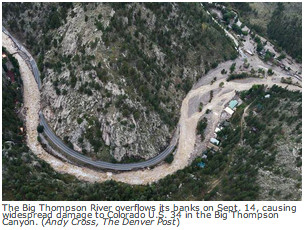
After the 2013 floods devastated communities and took several lives, the state of Colorado is remapping the regulatory floodplain of the most affected waterways in Colorado.
“It’s important to provide public and local land use managers with the most accurate flood risk information so they can make better decisions,’ explained Thuy Patton, Flood Mapping Program Manager for the Colorado Water Conservation Board.
In some counties, there are areas that now have higher flood risk and other areas that now have lower flood risk, which changes which homes are in the flood plain. NOTE: these numbers are approximate, based on public information, and are subject to change.
In Boulder County, with this update, 420 new structures are in flood risk area and approx. 400 structures are now not in special flood hazard area, Patton explained.
In Jefferson County, 53 structures were added.
In Larimer County, 601 structures were added and 1,571 were removed.
In Weld County, 453 structures were added and 1,994 were removed.
In Sedgwick County, 85 structures were added and two were removed.
In Washington County, 26 structures were added and 31 were removed.
In Morgan County, 38 structures were added and four were removed.
And in Logan County, 222 structures were added, while 59 were removed.
FEMA uses Flood Insurance Rate Maps (FIRMs) to set flood insurance premiums. The Preliminary FIRMs will become FEMA’s final effective FIRMs in 2021, pending any appeals received by FEMA.
Boulder County is starting a series of public meetings about the changes. Representatives from FEMA, the mapping team, and Boulder County will be present at each session. Each open house will focus on specific reaches, but residents are invited to discuss any stream at each meeting:
Lower Boulder Creek, New Dry Creek, Coal Creek, and Rock Creek – Tuesday, Jan. 14 | 5 to 6:30 p.m. (presentation at 5:15 p.m.) Boulder County Recycling Center – 1901 63rd Street in Boulder County
Saint Vrain Creek, Lower Left Hand Creek, Dry Creek #2, and Little Thompson River – Thursday, Jan. 16 | 5 to 6:30 p.m. (presentation at 5:15 p.m.) Boulder County Parks and Open Space Ron Stewart Building – 5201 St. Vrain Drive in Longmont
North, Middle, and South Saint Vrain creeks and Cabin Creek – Tuesday, Jan. 21 | 5 to 6:30 p.m. (presentation at 5:15 p.m.) Highlands Presbyterian Church – 1306 Business Highway 7 in Allenspark
Little James Creek, James Creek, Upper Left Hand Creek, and Geer Canyon – Tuesday, Jan. 28 | 5 to 6:30 p.m. (presentation at 5:15 p.m.) Jamestown Town Hall – 118 Main St. in Jamestown. This is a joint meeting between Boulder County and the Town of Jamestown
Fourmile Canyon Creek, Two Mile Canyon Creek, Gold Run, Fourmile Creek, Boulder Creek and North, Middle, and South Boulder creeks – Thursday, Jan. 30 | 5 to 6:30 p.m. (presentation at 5:15 p.m.). Boulder Public Library Main Branch, Boulder Creek Room – 1001 Arapahoe Ave. in Boulder
Click to view the August 18, 2019 slides from the USACE.
Here’s the release from the U.S. Army Corps of Engineers — Omaha District:
The U.S. Army Corps of Engineers, in cooperation with the City of Longmont, Colorado will hold a flood risk management study open house Sept. 18, from 4:00 to 6:30 p.m. at the Longmont Museum, 400 Quail Road.
There will be a brief, formal presentation at 4:30 p.m. on information contained in the recently released draft feasibility study report, followed by an open house.
The draft report provides information on the need for the project, current conditions of the project area, identification of opportunities to reduce flood risk, development of various alternatives to reduce flood impacts to life safety and property along St. Vrain Creek, and selection of the proposed plan.
The recommended plan includes a levee on the south side of the Izaak Walton Pond Nature Area, channel widening and benching to contain the 1% Annual Chance Exceedance (ACE) event, replacement of the Boston Avenue Bridge, and a grade control downstream of Sunset Street Bridge.
Email your comments on the report to cenwo-planning@usace.army.mil or mail to: U.S. Army Corps of Engineers, Omaha District, CENWO-PMA-A, ATTN: Tim Goode, 1616 Capitol Avenue, Omaha, NE 68102-4901. Comments must be postmarked or received by Oct. 4, 2019.
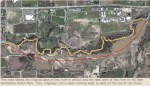
This flood risk management study builds on Resilient St. Vrain, Longmont’s extensive, multi-year undertaking to fully restore the St. Vrain Greenway and increase resiliency of the St. Vrain Creek channel to reduce future flood risk to the community. The Resilient St. Vrain project was developed by the City of Longmont in response to the catastrophic flooding in September 2013.
Contact
USACE Omaha District Public Affairs
402-995-2418
omaha.usace-pa@usace.army.mil
1616 Capitol Ave. Omaha, Neb. 68102
CSU junior Brad Simms gets to work with his shovel in efforts to restore the area around Left Hand Canyon from the floods. Brad is a member of CSU’s Watershed club. (Jenna Van Lone | Collegian)
The St. Vrain Left Hand Conservancy District, whose mission is to protect water rights and improve management practices in the river basin, is in the first phase of developing a stream management plan for the 300,000-acre watershed. Its goal is to align strategies for maintaining the reliable delivery of water to agricultural users while also satisfying ecological and recreational goals, some of which could require higher flows in the main stretches of streams that feed the St. Vrain, such as Left Hand Creek, as well as the St. Vrain itself, which is a key South Platte River tributary.
“Whether you’re a domestic or agricultural water user, you have an opportunity to really be part of a strategic, balanced approach to meeting competing demands,” said Sean Cronin, the district’s executive director.
But Colorado water law is focused on the use of the state’s most valuable resource, and not on conservation, notes a September survey prepared by a firm hired by the conservancy district for the stream management plan.
“This causes water owners to shy away from change of use, dam modifications or other river improvements, fearing legal or financial challenges and a burden on their time — and farmers do not have time to give away,” the survey states, adding it also will be a challenge to have rights owners “‘open up’ about their decrees or the way they manage, use or store water, and there are sometimes long histories of relationships between agencies or people in how they work together with their water. Overcoming some of these social and political legacies, or positively using these relationships, will be a challenge to the process.”
Seeking balance at what cost?
Diverting water from stream beds through ditch delivery networks has long quenched otherwise dry agricultural lands on the Front Range, but the expansion of the practice over time has led to impacts some are now interested in mitigating.
Boosting the ability for fish and recreational users such as kayakers to pass diversions by altering or replacing infrastructural barriers has consistently been expressed as a priority.
So have improved ability to control timing and quantity of both ditch and stream bed flows, enhancing flood resiliency in the watershed and preventing impacts from municipal development.
“For the most part, this basin wants to work toward finding that balance,” Cronin said. “I won’t say we’re all in agreement of what the balance is, where that pivotal point is to make the balance, and I don’t think we’ll ever get there and that’s fine, as long as folks want to continue sitting at the table.”
While some Longmont-area ditch companies have already designed and implemented more passable diversions or are in talks with local officials about doing so in the near future, a move toward automating the opening and closing of ditch gates that are now moved manually to accommodate water share holders’ calls for supply also could emerge as a consideration for those relying on the watershed.
Being able to remotely open and close gates could help prevent flow heading into ditches when it isn’t needed, possibly allowing higher flows in main stream beds through areas where such water levels could benefit recreation and environmental health.
But doing so could come at a major cost. Terry Plummer, vice president of maintenance and operations for Left Hand Ditch Co., said the company, for reasons unrelated to stream management, next week will install an automated ditch gate that can be operated remotely in one location on its network at a cost of about $30,000.
If an effort to automate water delivery equipment were applied across the broader watershed, though, it would be needed in dozens of locations, and could require the construction of entirely new diversion structures in some areas, which can run cost hundreds of thousands for just one spot, Plummer said.
“We have no intentions of automating at this point in time,” Plummer said. “It’s just too expensive. The assessments (charged to share holders for ditch maintenance) are so high now because of the 2013 flood (damage) that we would have to raise assessments dramatically, and the farming can’t support that.”
He said grant funding would have to become available, with the right terms, to pursue widespread automation.
A method that helped maintain higher wintertime flows in the St. Vrain is likely no longer an option — for about 20 years until 2013, Longmont released water from its Ralph Price Reservoir storage at a rate of 3 cubic feet per second to maintain a winter flow of 5 cfs along the entirety of the river, according to city Water Resources Manager Ken Huson.
But state officials nixed that practice after changing how they account for water.
“It’s not something Longmont can just do on its own anymore like we used to,” Huson said.
Flow not only way to go
Other opportunities for bettering stream management in the St. Vrain watershed might not address flow, however, and still offer environmental and social benefits.
“What we’re going to come up with are management activities,” Cronin said. “Those could address flow, but it could be that an opportunity area doesn’t necessarily have a flow challenge, but a riparian floodplain connectivity challenge.”
Allowing streams to more easily access the floodplain by preventing their banks from becoming overly incised or congested can help avoid rushing waters during flood events via letting the excess flow spread out over flatland, instead of accumulating in steep, deep channels.
Removing the invasive crack willow tree, which has problematically proliferated across dozens of states, from local stream banks could help achieve that, and has already been worked on in some areas of the St. Vrain basin by the Left Hand Watershed Oversight Group.
“That’s really the issue with the current conditions and why there are disconnected floodplains, because we’ve had this encroachment of this invasive tree that has created a super stable bank, and has allowed incision to happen,” said Jessie Olson, the oversight group’s executive director. “We’ve got a number of places like that throughout the watershed that could use some additional connectivity basically by removing the invasive tree and laying back slopes.”
Trustees earlier this month approved the foundation for such change, an expansion master plan for the site that could run the town nearly $25 million in construction costs over the next few years, and an additional $2 million for consultants to steer the early stages.
Several factors — ranging from the predictable to the esoteric — are driving the need for the facility’s expansion, according to Adam Parmenter of HDR, Inc., the firm charged with shepherding the town through the project.
According to Colorado Department of Health regulations, towns must begin to make expansion plans when their facilities reach 80% capacity; at 95%, construction must begin. Delays could get state regulators to slap communities with growth restrictions.
In 2017, Erie’s North Water site hit about 81% capacity, processing roughly 1.58 million gallons of wastewater per day. By 2020, that number is expected to hit 95% of the facility’s processing capacity, equivalent to 4 ½ Olympic swimming pools…
If Erie’s projected growth keeps pace (and with current trends, there’s no reason to expect otherwise), Parmenter said the facility’s liquid capacity would be exceeded by 2021.
Consultants are recommending a plan out to 2028, expanding the plant into a 3.03 million gallons per day system, a 50% capacity increase from what the existing facility does now.
The expansion will take place in steps, however, over the next decade, according to Erie Public Works Director Todd Fessenden.
“We will be in design over the course of the next year for the expansion of the plant” he said, “then we’ll be in construction late next year or early 2021.
“The master plan is really just laying out the next 20 years so we can have a schedule to look at,” he added, “whether that be regulatory milestones or looking at certain capacity stages, a lot of those things you have to be planning ahead for before those things hit.”
Another of the drivers, and perhaps a more pressing matter, is the plant’s solid operations. Whereas the plant’s liquid-stream processing is more of a straightforward capacity issue, dealing with the deluge of solids on a daily basis is often rooted in the quality of the science.
In order to get the solids that come through the plant to the designation of “Class A Biosolids” — a standard that meets EPA guidelines “for land application with no restrictions,” meaning reclaiming it to a point where it can legally be used as fertilizer or compost — the plant’s technology needs to perform a specific set of tasks.
As it stands now, the North Water site is essentially at capacity for processing solid waste, Parmenter said, and the “system isn’t running the way it was originally designed to create Class A Biosolids.”
Without changes, the system’s current process — which includes trucks having to move solids off-site — would cost the town roughly $1 million per year in hauling costs.
According to officials, the costs of the expansion project will be footed by the town’s growth through its existing tap fees.
Boulder County biologists studying Preble’s meadow jumping mouse and fish populations along the St. Vrain Creek have been encouraged this summer by signs of species rejuvenating since their habitats were altered by the 2013 flood…
Restoration efforts also have been conducive to bolstering populations of certain “transition zone” fish that need shady habitat and water temperatures between the colder sections of stream at higher elevations and the warmer sections through Longmont and east of the city.
Fish trends promising, concerns remain
As Boulder County wildlife biologist Mac Kobza has tallied fish caught by his team of six research assistants this summer along the St. Vrain, he’s chalked up seven species, an improvement in the river’s fish diversity over the past five years.
White suckers, brown trout and minnows like johnny darters and longnose daces were among those caught and documented Tuesday, adding to the counts of fish in the area tracked this summer and for the past five years by Kobza…
Diversion dams and other irrigation ditch structures that pull water from the St. Vrain to deliver it to other water rights holders since the flood have been redesigned in some places to allow easier fish passage, but some ditch companies have hesitated to modify their apparatus.
“I think they’re resistant because it can be expensive. Colorado Parks and Wildlife is trying to work with those ditch companies and provide some of the funding to allow (more fish passage) to happen,” Longmont Land Program Administrator Dan Wolford said.
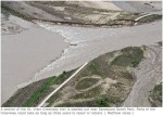
St. Vrain Greenway Trail washout September2013 via Longmont Times-Call
Here’s the release from the USACE Omaha office (Jeff Bohlken):
An open house to share details about a flood risk management study between the U.S. Army Corps of Engineers Omaha District and the City of Longmont will be held from 4:30-6:30 pm (MST) Thursday, Feb. 16, at the Longmont Museum, 400 Quail Road in Longmont, Colorado.
The flood risk management study will build on Resilient St. Vrain, Longmont’s extensive, multi-year undertaking to fully restore the St. Vrain Greenway and improve the St. Vrain Creek channel to mitigate future flood risk to the community. The Resilient St. Vrain project was created in response to the catastrophic flooding that damaged much of Longmont in September 2013.
The open house, which will also serve as a public scoping meeting per the National Environmental Policy Act (NEPA), will give residents and others interested in the project a chance to learn why the study is important, learn what will be done during the study process, learn about the possible benefits, and provide specific concerns and input.
Through the study, the Omaha District will analyze conditions within a portion of the St. Vrain Creek’s city reach. The study area consists of the St. Vrain Creek and surrounding area between Golden Ponds Park (at the upstream confluence of the St. Vrain Creek and Lykins Gulch) to the BNSF railroad bridge (near the pedestrian bridge that connects Price Road). The study will evaluate the engineering feasibility, economic benefits, and environmental considerations for potential flood risk management improvements within the study area.
If a qualifying segment is identified within the study area, the Omaha District could ultimately partner with the City to complete a construction project as part of the Section 205 program of the Flood Control Act of 1948.
For more information, contact Jeff Bohlken with the Omaha District at (402) 995-2671 or Longmont Floodplain Administrator Monica Bortolini at (303) 651-8328.
Denver Water, which serves 1.4 million people in the city and county of Denver and surrounding communities, is currently waiting for a permitting decision to be issued by the U.S. Army Corps of Engineers on its proposed expansion of Gross Reservoir, located in southwestern Boulder County.
The USFS has filed extensive past comments critical of the Gross Reservoir project, but now says all of its concerns about that project have been resolved.
Critics, however, point to a five-year, $4.5 million contract providing Denver Water funding for the original Forsythe project as well as numerous other Colorado forest management efforts — talks are now underway for a new five-year pact for Denver Water to help subsidize projects, including Forsythe II — and they challenge the level of transparency surrounding that wildlands management initiative.
Denver Water touts its relationship with the Forest Service on its website, billed since 2010 as the “From Forests to Faucets” program. That partnership called for Denver Water from 2010 to 2015 to match a $16.5 million investment from the Forest Service, for a total of $33 million, for forest treatment projects seen as critical to protecting water supplies and water quality.
A memorandum of understanding was signed by Denver Water in December for a similar new agreement between the two, setting up a new one-to-one matching effort totaling another $33 million, to cover 2017 to 2021.
The Colorado State Forest Service was also a partner to the previous pact, and will be to its successor, along with the Natural Resources Conservation Service.
Colorado saw a dramatic example of the healthy forests-healthy water link following the June 2002 Hayman fire, which filled Cheesman Reservoir — the oldest reservoir in the Denver Water system — with mud, ash and other debris.
Denver Water was forced to spend more than $27 million on water quality treatment, sediment and debris removal, reclamation techniques and infrastructure projects in the wake of the Hayman Fire and the 1996 Buffalo Creek Fire, according to Denver Water spokesman Travis Thompson.
But Magnolia-area resident David Bahr sees the Denver Water-USFS relationship as “absolutely” representing a conflict of interest, specifically as it applies to the controversial Forsythe projects in western Boulder County.
“How can it not be?” Bahr asked. “The fact that (USFA) employees and goods are being paid for by Denver Water means that if they weren’t doing this, those employees wouldn’t be getting paid. The Forest Service has to be aware of this, so it has to influence any decisions that they make.”
Vivian Long, president of the Magnolia Forest Group, has long been vocal in opposition to the original Forsythe project and its planned successor, Forsythe II, which calls for thinning and controlled burns on 2,855 acres of national forest land within the nearly 19,000-acre project area, to be carried out over 10 to 15 years.
“While they’re saying, ‘We’re taking money from Denver Water, but they have no input on what we do,’ I don’t know if that’s true or not,” Long said. “When we have asked about them taking money from Denver Water, they have tried to either downplay it, or deny, or just say they don’t know anything about it. So we’re left wondering, whose opinion is more important here: the public’s or Denver Water?”
Paperwork documenting the Denver Water-USFS relationship was obtained by Magnolia Forest Group member Teagen Blakey through Colorado Open Records Act requests…
Forsythe II critics point out that in March 2010, the Forest Service filed 142 pages of comments on the Gross Reservoir project with the Corps of Engineers highlighting many concerns, including the adequacy of Denver Water’s consideration for habitat and wildlife issues in the Arapaho and Roosevelt National Forests.
That same year, the Forest Service signed off on the five-year operating plan for Denver Water to pitch in $4,479,251 toward improving forest and watershed health on national forest lands in numerous Colorado watersheds designated as Denver Water “Zones of Concern,” including the St. Vrain Watershed, home to Gross Reservoir.
To date, $660,000 of that Denver Water money has gone toward Forsythe work, according to Arapaho & Roosevelt National Forests spokeswoman Tammy Williams.
On Oct. 17, the Forest Service and Denver Water agreed on a lengthy agreement settling any concerns over Gross Reservoir, which it states “resolves all issues raised by the Forest Service during the consultation process” relating to the Gross Reservoir expansion
Clark Chapman, vice president of the Magnolia Forest Group, is among those wondering why the Forest Service is seeming now to soft-pedal habitat concerns around both Forsythe II and Gross Reservoir…
Tammy Williams, the USFS spokeswoman, said there is no conflict of interest inherent in Denver Water’s pushing for Gross Reservoir and funding Forsythe forest work at the same time.
“Gross Reservoir was independently analyzed and considered separate and apart from the Forsythe II project,” she wrote in an email. “These projects are being proposed by different agencies, these are independent processes, with independent timelines and different decision makers.”
[…]
The western half of Gross Reservoir, as it is currently configured, is encompassed by the southeastern corner of the Forsythe II project area. But despite their proximity, the Forest Service maintains that its evaluation of Forsythe II is not influenced by its relationship with Denver Water.
Scott Hummer, general manager of North Poudre Irrigation Company, talks about how his agency worked with Fort Collins Natural Areas and Colorado Parks and Wildlife to include a fish passage when the irrigation company replaced a diversion structure on the Poudre River that was destroyed by the 2013 floods. Work was completed [in February 2016]. (Pamela Johnson / Loveland Reporter-Herald)
Here’s the release from Colorado State University (Jim Beers):
The Cache la Poudre River, which flows from the mountains through Fort Collins, Timnath and Windsor to the plains east of Greeley, is at the heart of countless activities: from irrigating crops and lawns to providing drinking water for more than 365,000 people and hosting numerous recreational activities.
Those with connections to and concerns for the Poudre River will gather on Friday, Feb. 3 for the fourth annual Poudre River Forum. After its first three years at Larimer County Fairgrounds, the forum is moving down the river to Greeley as a reminder that the Poudre River is important to all who benefit from it — from its headwaters to its confluence with the South Platte. This year’s forum — the theme is “As the Poudre Flows — Forest to Plains” — will be held from 8:30 a.m.-4:30 p.m. at the Island Grove Events Center, 501 N. 14th Ave., Greeley. Pre-registration is required for all participants.
Understanding the river, each other
Sponsored by the Poudre Runs Through It Study/Action Work Group, the forum serves as a community-wide gathering of people from agricultural, municipal, business, recreational and environmental backgrounds to learn about and discuss issues related to the Poudre River.
“The Poudre River Forum brings together those who use the river for agricultural and urban diversions and those who work to improve its ecological health. In the past those groups have not necessarily seen eye to eye,” said MaryLou Smith, PRTI facilitator. “Increasingly our participants are open to the idea that it takes collective vision and action to make the Poudre the world’s best example of a healthy, working river.”
Once again, this year’s event will be facilitated by the Colorado Water Institute at Colorado State University. “The Forum is a great opportunity for the communities connected by the Poudre River to come together to better understand the entire watershed, and each other,” said Reagan Waskom, director of CWI.
Forests and water quality/quantity
Laurie Huckaby with the U.S. Forest Service, will present “The last 1,000 years in the Poudre according to the trees,” to kick off the topic of how important the upper watershed is to water quantity and quality.
“Water quality and forests are inextricably linked,” said Joe Duda of the Colorado State Forest Service, who will join Huckaby as one of the presenters. “Forest conditions and insects, disease and fire all can have profound impacts on water flow and quality. Only healthy, resilient forests can continuously supply clean water.”
Global lessons for local success
“Finding the Balance: Managing Water for People and Nature” is the message of keynote speaker Brian Richter. Richter has been a global leader in water science and conservation for more than 25 years, and currently serves as chief scientist for the Global Water Program of The Nature Conservancy in Washington D.C. Richter’s ideas about the importance of recognizing the balance of working river/healthy river are the basis for which PRTI was initially formed. He has consulted on more than 120 water projects worldwide, and has served as a water advisor to some of the world’s largest corporations, investment banks, the United Nations, and has testified before Congress on multiple occasions. Richter co-authored,with Sandra Postel, the 2003 book Rivers for Life: Managing Water for People and Nature and in 2014 wrote Chasing Water: A Guide for Moving from Scarcity to Sustainability.
Change affects all sectors
An afternoon panel session will probe the impacts of change — positive and negative — along the Poudre River and how they have been similarly and differently addressed by agriculture, urban, and environmental sectors. They will discuss what anticipated future changes might these three sectors see as opportunities or incentives for mutually beneficial collaboration that could result in a healthier, working river?
“It has been said that the only thing that is constant is change,” said John Bartholow, retired ecologist from U.S. Geological Survey, and panel coordinator/moderator. “The question is, can we learn to adapt to those changes sure to come on the Poudre in ways that benefit agriculture, municipalities, and the environment?”
The panel will include Eric Reckentine, deputy director, City of Greeley Water and Sewer; John Sanderson, director of science, Nature Conservancy of Colorado; and Dale Trowbridge, general manager, New Cache la Poudre Irrigating Company.
Videos, displays and music too
The day-long forum also includes “River Snapshots” highlighting more than 15 projects undertaken by a variety of groups on the Poudre last year; “My How the Poudre Has Changed,” featuring historical 1970’s footage of the Poudre; updates from both the cities of Greeley and Fort Collins on current water programs; and over two dozen river-focused displays from community organizations and agencies. The day concludes with a social hour including food, beer and other beverages, and river-themed door prizes.
Registration is $50 and includes lunch. Scholarships for students and reduced rates are available. The deadline to register is Friday, Jan. 27 at http://prti.colostate.edu/forum_2017.shtml.
For more information, contact event coordinator Gailmarie Kimmel at PoudreRiverForum@gmail.com or 970-692-1443.
This year, actual work will begin to repair habitat along and inside several stretches of the Big Thompson River through a grassroots group, The Big Thompson Watershed Coalition, that formed after the 2013 flood.
“2017 is going to be a big year for projects happening on the ground,” said Shayna Jones, watershed coordinator with the coalition. “We’re talking millions of dollars in river restoration.”
A couple of projects through the coalition have already begun, but several others are going to kick off in 2017. Early in the year, the coalition will put out bids for a contractor to work on a stretch about a mile long from Jasper Lake through Narrows Park, which is in the lower section of the canyon.
Estimated to cost $900,000, the project will include stabilizing sections of the banks, planting vegetation and creating what are called flood plain benches to allow the water space to spread out in the event of a future flood, explained Jones and Tracy Wendt, assistant watershed coordinator.
The work also includes improving fish habitat in several ways, such as building pools within the river and planting vegetation in strategic places to provide shade and cover.
“There will be habitat improvements for all different life stages of trout,” Wendt said. “It’s all the phases of their life to help them.”
Because of the fish habitat component, the coalition, in partnership with Rocky Mountain Flycasters, recently received a $4,500 grant from the Trout and Salmon Foundation. And the Flycasters, a local chapter of Trout Unlimited, also contributed $2,000 to the project.
The bulk of the funding, about $500,000, will come from the Natural Resources Conservation Service with the rest of the money from the Colorado Water Conservation Board, Jones explained.
This piece of the river winds through both private and public properties and ends just before the Narrows near the Colorado Cherry Company.
Other projects also are planned further west along the river with more money coming from the NRCS and the Colorado Water Conservation Board. The exact amounts of money and grants are still being finalized, though Jones did confirm the total work would be in the millions.
Other projects to rehabilitate the river and river corridor are occurring simultaneously including one that will begin in 2017 as a partnership with the coalition and Sylvan Dale Guest Ranch.
Work began in October and will continue this spring on West Creek, and other improvements began two weeks ago on Fox Creek. Both, located along the North Fork near Glen Haven, are being built in partnership with Larimer County, NRCS and the Colorado Water Conservation Board.
Also, Larimer County, private property owners, Colorado Parks and Wildlife and Colorado Department of Transportation officials are working on separate stretches of the river, with everyone working together for overall river benefit.
“We’re making sure our projects are complementing each other to make for an overall healthy watershed,” Jones said.
She expects the work to continue over the next three years as the Colorado Department of Transportation completes the permanent repairs of U.S. 34, which also include massive river restoration work.
As Lyons entered its fourth year of reconstruction following the devastating September 2013 flood, the FBI and U.S. Department of Housing and Urban Development stopped by to seize documents and computers to probe the handling of federal flood-recovery funding.
Communities savaged by the rushing waters have been receiving fund allocations, totaling millions of dollars from several federal sources, such as HUD and the Federal Emergency Management Agency.
Late Friday, Mayor Connie Sullivan released a statement on behalf of the town’s Board of Trustees, stating that the FBI had concluded its portion of the investigation and would not be proceeding with a case.
Also posted to the town’s website was a copy of a subpoena from the U.S. Department of Housing and Urban Development, stating that a focus of its investigation was documents relating to negotiations and grant services contracts between Lyons and Longmont-based Front Range Land Solutions.
Above, left: This hand drawn map is one of the original documents of Coffin V Left Hand Ditch, at the Colorado State Archives. A few original documents from the Coffin V Left Hand case can be seen at the Colorado State Archives, filed under case #885, #1103 and #1203. Above, right: The headgate of the Left Hand Ditch on the South St. Vrain, where the famous confrontation took place.
People can register to participate in a June 11 Boulder County Parks and Open Space water tour that’s to highlight the 150th anniversary of the Left Hand Ditch Company.
The 7:30 a.m. to 2:30 p.m. tour will begin at the Plaza Convention Center, 1850 Industrial Circle, Longmont, and start with presentations on water law, the orientation of the overall Left Hand basin and the history of the Left Hand Ditch.
Tour buses will then visit stops at sites in the Left Hand Ditch system before returning to the Plaza Center. The water tour, which will include a light breakfast and lunch, will cost $20 per participant.
The 2016 Water Tour is supported by Boulder County Parks and Open Space, Boulder’s Open Space and Mountain Parks, the St. Vrain and Left Hand Water Conservancy District and Left Hand Water District.
Boulder County Commissioners Elise Jones and Deb Gardner signaled their support Thursday for a $53.8 million package of road, bridge, transit and trails spending, and equipment and vehicle purchases, that the county Transportation Department has proposed for this year.
Transportation Director George Gerstle spent much of his presentation of that overall 2016 capital improvements program focusing on the $29.9 million expected to be spent by the end of the year on the latest set of repairs and replacements of roads and bridges destroyed in the September 2013 floods.
“Road and bridge flood repairs are dominating the program in 2016,” Gerstle said.
Officials have estimated that flood damages to Boulder County’s transportation network amounted to $120 million, and work on emergency, and then temporary, and then permanent, repairs has been underway for more than 2 ½ years.
If things proceed as planned the rest of this year, by the start of 2017, Boulder County should have completed or at least started construction on between $50 and $70 million worth of transportation flood-recovery projects, Gerstle said.
Already, during the first quarter of 2016, about $11 million in such flood-recovery transportation projects are being constructed, Gerstle told the commissioners.
The Board of County Commissioners is expected to formally vote to adopt the Transportation Department’s Capital Improvement Program during one of the board’s regular business meetings next Tuesday or Thursday.
The Longmont City Council on Tuesday unanimously approved expanding a pilot water-bill discount for some low-income people in the coming year.
The city has an existing program that knocks roughly 28 percent off the average water bill for senior citizens who meet low-income requirements.
This pilot program would exempt low-income Longmont residents — with no age requirement — from the monthly service charge, which for the average bill is about a 15 percent discount.
The discount program is only available to people who live in single-family homes. Because apartment buildings or other multi-family buildings have one meter for several households, the city is unable to offer individual discounts to residents of those buildings.
Barb McGrane, the business services manager for Longmont public works and natural resources, said Tuesday the program should be ready to launch in the first quarter of 2016.
To qualify for the new program, residents would need to meet income limits based on state numbers for a property tax/rent/heat credit rebate. To qualify for Longmont’s new water bill rebate pilot program, a single resident would need to make less than $12,720 in a year or a married couple would need to earn less than $17,146 in a year.
Those are the most recent income limits available, but McGrane said she expects the state will soon release new limits for the coming year.
Ongoing or in-the-pipeline projects could cost as much as $76.8 million in 2016. Most of these projects are aimed at repairing the September 2013 floods’ damages to county roads, bridges, parks, open space areas — as well as services and programs to assist Boulder County residents and property owners still recovering from the floods.
That estimate, from a recent county staff report to the Board of County Commissioners, would be on top of more than two years of flood recovery spending that’s expected to have totaled nearly $97.9 million by the end of this year.
And 2016 won’t be the final year that county officials expect to devote a major portion of their spending on flood recovery.
The county staff is sticking by its late 2013 estimates that flood recovery projects and services will have a total cost of more than $217 million by the time they are completed, so another $43.2 million might be needed beyond 2016.
Evans Colorado September 2013 via TheDenverChannel.com
FromThe Denver Post via the Loveland Reporter-Herald (Joey Bunch/John Aguilar):
As Colorado hits the two-year mark since a historic deluge swelled rivers and creeks to overflowing, killing 10 and causing nearly $4 billion in damage across 24 counties, frustration is a theme for a surprisingly large group of folks still dealing with the storm’s aftermath. Hundreds of mobile home park residents in Evans, a city of 20,000 south of Greeley, are unable to return to communities that have been effectively scraped off the map.
The major access road into Glen Haven is still being put back together, causing repeated daily hour-long delays that result in unending headaches for locals and drive away tourist traffic headed to or from nearby Estes Park.
Only three of 17 homes in James town destroyed by a manic James Creek have been completely rebuilt, and a part of the population has relocated or hasn’t yet moved back to the tiny mountain town.
And then there are the dozens of Lyons residents, locked in a seemingly endless bureaucratic arm-wrestling match with town officials over attempts to get permits to rebuild their homes.
They confronted town leaders at a public meeting earlier this month demanding a more streamlined process for evaluating and approving their engineering and hydrology plans so they can move forward.
“We’ve spent a lot of money on this project, and we haven’t laid a shovel in the ground,” said Kitty Wang, who with her husband has lived in Lyons for 13 years and still awaits a floodplain development permit for a new house. “It’s a nightmare we keep trying to wake up from.”[…]
Molly Urbina, the state’s chief recovery officer, acknowledged that despite the billions spent to make repairs and provide compensation to victims of Colorado’s most costly natural disaster, problems remain.
The state, she said, has not forgotten about those still suffering.
“When we talk about disasters, we talk about a marathon, not a sprint,” Urbina said. “We continue to coordinate with local communities to assess and evaluate needs and priorities and to advocate for additional resources.”
Some of those resources have come from groups like Foothills United Way in Boulder County, which has raised $4.9 million in donations and spent about $363,000 for mental health services. The charity still sits on nearly $2 million to help cover the costs of at least 333 open cases in Colorado’s hardest-hit county…
Urbina said estimating costs for a disaster the size of the 2013 floods, which destroyed 1,852 homes and 203 businesses and created more than 18,000 evacuees over a five-day period starting Sept. 10, 2013, is a “complex, long-term process.”
“We understood that this would evolve as recovery priorities and projects became more clear,” she said.
The dynamic nature of the floods’ impact has played out in dramatic fashion since the one-year anniversary, with the cost of rebuilding in Colorado swelling by a third to nearly $4 billion.
The $1 billion spike, Urbina said, reflects the fact that initial cost estimates done in the months following the flood were rough. In the past year, more detailed estimates of what it would cost to fully repair and restore roads and watersheds in the state were made.
Specifically, watershed recovery master plans performed over the last year revealed that the true cost of improving flood-impacted watersheds would amount to some $600 million.
Last February, Gov. John Hickenlooper announced $56.9 million will come from a federal program to help restore stream corridors and prevent future flooding.
The remainder of the increased cost estimate since last year — around $400 million — came about as the result of detailed design and engineering work, which more clearly outlined the cost of building roadways that can better withstand future flooding, Urbina said.
Work will begin soon to redesign U.S. 36 from Estes Park to Lyons at an estimated cost of $50 million.
Also, individuals and local governments have found damage they initially didn’t know about or thought private insurance would cover, according to the Colorado Resiliency and Recovery Office…
A new normal is also being pieced together in Evans, where the Eastwood Village and Bella Vista mobile home parks were turned from once-vibrant low-income neighborhoods to empty, weed-choked lots by the floods. It’s not certain what will happen to the two properties, though Bella Vista’s owner is working with the city to re-establish itself at the same spot on 37th Street.
Here’s a look at several survivors from Isa Jones and Pam Mellskog writing for the Longmont Times-Call via the Loveland Reporter-Herald.
Meanwhile the Big Dam repairs are nearly complete. Here’s a report from Saja Hindi writing for the Loveland Reporter-Herald. Here’s an excerpt:
Crews are putting the finishing touches on repairs to the Nelson Big Dam and expect to have them completed in the next few weeks.
The masonry arch dam, built in 1895, is located west of Loveland’s water treatment plant, and was significantly damaged in the September 2013 flood.
The dam diverts raw water to the city’s water treatment plant, provides drinking water for the Johnstown water treatment plant, and irrigates about 20,000 acres of farmland in Larimer and Weld counties.
The Consolidated Home Supply Ditch and Reservoir Co. owns the 60-foot-plus dam, which didn’t suffer major damages in the 1976 flood, but the 2013 waters left a lot of damage.
The dam is also identified as a Colorado Historic Civil Engineering Landmark, so crews had to make sure not to change the historic aspects of the dam substantially. That included using stones from the same quarry as the original stones.
Crews are working on Phase II of repairs now, according to Home Supply board member Gary Gerrard, which encompass the pointing or refacing of the dam (grouting stones on the face of the dam), a need caused by years of erosion. Once that’s completed, he said, crews will close the gate.
The dam was operational April 1, 2014, in time for the spring runoff, and repairs continued while it was in use, aside from taking a break in the winter months…
Some of the repairs after the flood damaged the dam, Gerrard said, included restoring the crest elevation, mitigating future flood effects by strengthening the dam with concrete abutments and installing a new spillway that configures water to go around instead of on top and updating to 21st century technology such as an automatic gate that fluctuates with river flow.
Because the flood damaged the dam’s main gate, the company was also able to replace other gates not damaged by the flood that were almost unusable and rusting because they were first put in 1915.
Funding for the repairs came from the city of Loveland, the Home Supply board, the Colorado Water Conservation board and the Federal Emergency Management Agency. The city committed to paying 50 percent of the costs not covered by federal and state grants. The conservation board committed to covering uncovered costs through long-term low-interest loans.
The total cost of repairs, Gerrard said, is about $3 million. Of that, $2.2 million is expected to be covered by federal aid.
Gerrard said the entities were able to keep costs low through “the methods of construction and the ability we had to be able to make decisions in the field, and the cooperation we had from all the entities to react to the things we found out in the field.”
Because officials could make decisions quickly, there weren’t a lot of construction holdups, he said.
“That’s the main thing to reach out for help. They (Larimer County Long Term Recovery Group) connect you with the people you need (Loveland Housing, in particular). We had volunteers from Lyons, Minnesota, Wisconsin, Florida,” said Aleta.
Today, the Hammond’s have a little less privacy. The flood took out about half the trees and bushes along this road. And what was a pasture with a barn now looks like an outcropping of rocks.
That creek that once rushed with danger is nearly dry, but the family’s gratitude is overflowing.
People lost their homes, a few lost their lives. So we were very, very fortunate,” said Aleta…
The state repositioned U.S. 36 and Little Thompson River to prevent a tragedy like this from ever happening again.
The Hammonds say they still have work to do on their property, like foundation work, and cleaning off grit inside tools and motorcycles.
From the Loveland Reporter-Herald (Jessica Benes):
Where the Little Thompson River used to be 70 feet wide in places, it was blasted to 300 yards, according to Gordon Gilstrap of the Little Thompson Watershed Restoration Coalition.
The September 2013 flood devastated areas along Front Range rivers and streams, and while not nearly as many houses were lost on the Little Thompson River, landowners still are recovering from the deluge that destroyed vegetation, wildlife habitat and landscapes.
Some landowners along the Little Thompson call it “the forgotten river.”
“It’s been an interesting journey,” said Gilstrap, who helped set up the Little Thompson Watershed Restoration Coalition after the flood. “The Little Thompson has been an unknown river because no county or state roads run along it for any distance. It is all privately owned.”
Deirdre Daly, president of the coalition, said that because the river isn’t in a town or county that is leading the charge for river repair, the restoration has been almost entirely driven by the people who live on it…
The Little Thompson headwaters come in from several areas but are mostly above Big Elk Meadows below Estes Park, separate from the Big Thompson.
“It was a small working river,” Gilstrap said. “It provides drinking water to Big Elk Meadows and Pinewood Springs, irrigation to a lot of farmland. It has always been a small, quiet little river.”
The water pushed woody debris down the river, knocking out everything for hundreds of feet on both sides of the river.
Gilstrap said the land along the river was heavily wooded, with a lot of wildlife habitat, especially in the Big Elk Meadows, Pinewood Springs and Blue Mountain areas. Much of that habitat area was lost.
The number of homes lost in the flood was small — two to four — but there was a lot of other damage such as water in basements, homes partially damaged and agricultural fields that were made useless with sediment and garbage debris accumulation.
“A lot of agricultural equipment was lost, and the irrigation ditches took a real hit,” Gilstrap said. “An interesting fact most people don’t know is the Little Thompson was the river that shut down every county bridge between Big Elk Meadows and Milliken — seven public bridges and many other private bridges — so it cut off Northern Colorado from southern Colorado.”[…]
Watershed coalition
Gilstrap helped found the Little Thompson coalition in December 2013, starting with nothing. The group had no money and no knowledge of how to run a coalition.
“Thanks to an amazing group of volunteers that stepped forward to be a part of it, we established the Little Thompson coalition as one of the most effective coalitions in Colorado,” Gilstrap said.
With grant funding, the coalition oversaw the successful completion of a master plan for the watershed, started having meetings, published an active website and Facebook page and coordinated volunteer projects.
“We secured over $1.2 million in government and private-sector grants with a potential of $3 plus million to come,” he said.
The coalition also was able to hire a full-time watershed coordinator, Keith Stagg, and assistant coordinator. Erin Cooper, this summer to oversee grant raising and volunteers, which meant the hard workers such as Gilstrap who had volunteered so much of their time were able to step back.
“We all learned together (at the beginning),” Gilstrap said. “We even learned to say ‘fluvial geomorphic transition’ and other big words like that.”
He said there were two reasons for their success: the volunteers who stepped forward to be on committees while also working day jobs, and support from the state and counties involved.
“Everyone worked together, and that spirit is ongoing more than ever. The volunteers came in from everywhere and did the dirtiest, grungiest work imaginable and were happy as can be if you gave them water and cookies,” he said.
Work still to be done
One of the big problems the river still faces is sediment.
Gilstrap said the Big Thompson River has a rock base, while the Little Thompson has more of a soil base.
When the flood swept down the river from just below Estes Park, sediment traveled down, blocking irrigation canals and changing the bed of the river.
One of the private bridges in Berthoud — called the Green Monster bridge by locals — used to have a space large enough to walk under, and now a person can barely crawled under because of all the new sediment. Julie Moon used to walk her horse beneath the bridge.
“That all plugs up irrigation ditches, rechannels the river,” Gilstrap said. “It’s a long-term fight to understand what will happen with the sediment, how to fight it, how to do restoration so we don’t aggravate the problem.”
He said there is still a lot of farmland with sediment covering valuable cropland.
Natural Resources Conservation Service representatives walked the river and filled out disaster survey reports to define the work to be done. The restoration work will carry on for the next five or more years, he said. The river is also being analyzed for flood and fire resiliency, to be more resilient the next time a flood passes through.
“We’re trying to think during restoration how we can bounce back from them more quickly and not put people in as much peril,” Gilstrap said.
Stagg said the silver lining of the flood is that people are aware of the need for resiliency.
“Everyone wants to see the system put together,” he said.
Gilstrap said wildlife is coming back, and the coalition is looking at revegetation options to establish more wildlife habitat. They plan to use willow cuttings and other “ecotypical” seeds from Daly’s property and neighbors’ to vegetate other areas along the river with native plants.
Finding funding
Major sources of grants for restoration work has come from the U.S. Department of Housing and Urban Development, and from the Emergency Watershed Protection Program through USDA.
Gilstrap said a new round of grant funding from several sources will deliver possibly $47 million across Colorado, and he believes the Little Thompson might see $2 million to $3 million of that. Stagg and Cooper were hired through funding jointly from the state Department of Local Affairs and the Colorado Water Conservation Board.
“We’re one of (several) watersheds that received funding for professional staff,” Stagg said.
Each year, the coalition will receive grants and work on different pieces of the restoration project for many years to come.
“We will get a couple projects done in each round. Each year we will go find another source of money, and do a little bit of project as the years go on,” Daly said.
The Little Thompson even has a “Little Thompson Watershed” sign posted near the headwaters.
“We’ve never had that before,” Daly said. “Before, the river was there and hidden by trees and no one knew what river it was.”
Construction is to start in early August on the project, which will include a spillway and low-flow outlet structure that will be built at Heron Lake — the easternmost pond on Boulder County’s Pella Crossing open space area about ½ mile west of Airport Road — as well as a drainage channel from the lake south to the St. Vrain River and a maintenance road alongside that channel.
In September 2013, a breach on the St. Vrain River’s north bank resulted in floodwaters filling and overtopping the ponds at Pella Crossing, with the sheet of water eventually crossing Airport Road north of the river and affecting more than 400 properties after entering the city’s Longmont Estates Greens, Champion Greens, Golden Ponds Estates and Valley subdivisions.
The Heron Lake Relief Channel drainage system will intercept any floodwaters in Heron Lake and divert that water back to the St. Vrain River rather than having them flow east into Longmont, according to a news release from the city’s Public Works Department and Boulder County’s Parks and Open Space Department…
It will span three property parcels. Two, including Pella Crossing and land adjacent to the river, are owned by Boulder County, and the third is owned by the private Golden Land Company, which eventually plans to mine gravel there.
The city is the lead agency on the project. Boulder County, which assisted in the planning and engineering, is contributing $100,000 in funds it’s getting from the Federal Emergency Management Agency toward the $925,000 estimated total design and construction cost. City officials said Longmont is pursuing federal Community Development Block Grant-Disaster Recovery funds to cover the rest.
Bohn Park was flooded by the St. Vrain River in Lyons, CO September 18, 2013 via Getty Images From the Boulder Daily Camera (Alex Burness) via the Longmont Times-Call:
Lyons has selected the Boulder County Housing Authority as the master developer for the town’s recovery housing project, which aims to provide up to 70 affordable housing units for residents displaced by the September 2013 flood.
The town had sent out a request for proposals for a master developer for the project earlier this month and heard back from only two offices: BCHA and the privately owned firm Element Properties.
Dan Greenberg, a town trustee, said reliability was key in the board’s unanimous vote Tuesday to hire BCHA.
“I think the long-term viability of the housing authority was big. We know they’re going to be around for a long time,” he said…
The board’s selection came on the heels of a Jan. 5 resolution, in which the trustees named Lyons’ Bohn Park as the site for the proposed housing development.
Both decisions could be nullified in March, however, if voters deny the ballot measure to make the recovery housing project a reality. Colorado statute requires cities and towns to get voter approval before selling parkland.
Lyons, BCHA and the rest of the housing project’s design team will now be hosting a series of “open house and visioning workshops,” beginning Saturday, from 10 a.m. to 2 p.m. at Rogers Hall, at the intersection of Fourth and High streets.
New Saint Vrain River channel after the September 2013 floods — photo via the Longmont Times-Call
It’s been more than 15 months since Boulder County was wracked by historic rainfall that caused area creeks to jump their banks, and, in some cases, create new channels entirely, resulting in extensive damage to homes and infrastructure along the way.
Following an exhaustive public process, Boulder County officials announced earlier this month that they have finalized post-flood master plans for three local creeks: Fourmile, Left Hand and the St. Vrain.
The plans are meant to be comprehensive guides outlining how best to restore and stabilize the watersheds for each body of water, including recommendations for bank stabilization, debris removal, re-vegetation and even channel realignment on public and private properties.
While many of the individual projects contained in the plans are not funded, charting them out is expected to give stakeholders, especially municipalities, a leg up in securing the money needed.
“If we identify the improvements in the plans it makes it much more likely they will be funded by grants coming from the state and federal government,” Boulder County Transportation Director George Gerstle said.
Gerstle’s was among many county departments, including Land Use, Open Space, and Health and Environment, that contributed to drafting the master plans, but he credited the property owners and other groups concerned with the county’s environment with spurring the process forward.
“Though we lead the efforts it really was a coalition of all the property owners and all of the interest groups that really made this possible,” he said. “It was a pretty intensive effort by a lot of people to put together, but I think some pretty great documents have come out of it.”
The county also employed the services of engineering consulting firm Michael Baker for the process.
Naturally, there are many property owners who want to get to work on when the county’s various creeks and streams pass through their land, and Gerstle said the master plans are an important tool to make sure all work that is done has the entire watershed in mind.
“A lot of property owners want to do something to stabilize the creek and this provides guidance on how to do it while maintaining the environmental integrity,” he said. “One thing we learned is we can look at (the creeks) bit by bit, we have to see how it all works together.”
A creek of particular importance is the St. Vrain.
Gerstle pointed out that the stream completely changed its traditional alignment just west of Longmont, leading to heavy damage in the city. The master plan outlines steps to put it back in its channel and keep it there in a way the respects the natural environment.
Dale Rademacher, Longmont’s general manager of public works and natural resources, said he appreciated the opportunity for collaboration presented by the master planning process and the way it looked at the St. Vrain as a whole from it origins near the Great Divide down to it confluence with Boulder Creek.
“We’re pretty happy with the outcome. This is a foundational document necessary to go forward for state and federal funding and we think it serves that purpose pretty well,” he said.
Rademacher highlighted one project in the St. Vrain plan that he said could be underway next month. It involves creation of an overflow channel for Heron Lake that would direct flood waters away from Airport Road, an important street that still has flood barriers sitting alongside it just in case.
Rademacher said the Heron Lake project is intended to “intercept flood flows that may come through the area again,” and protect property nearby. He said the project, which is the subject to an intergovernmental agreement between city and county officials, is expected to cost around $700,000 and is being put out to bid within the next week with construction hopefully beginning in January.
St. Vrain River floodplain November 2013 via the Longmont Times-Call
Here’s the release from the Special District Association (Ann Terry):
The St. Vrain and Left Hand Water Conservancy District has been named one of three winners of the Special District Association of Colorado’s 2014 Collaboration Award.
The Special District Association of Colorado (SDA) presents this award annually to special districts that have effectively and efficiently partnered with other entities and local governments to form successful working relationships for the benefit of their citizens. The awards were presented at the SDA Annual Awards Luncheon as part of the SDA Annual Conference which was held September 10-12, 2014 in Keystone, Colorado.
In the aftermath of the disastrous flood of September 2013, the St. Vrain and Left Hand Water Conservancy District, Boulder County, City of Longmont, Town of Lyons, and local property owners began the incredible challenge of addressing short term recovery and the channel’s ability to handle spring runoff. The group became known as the St. Vrain Creek Recovery and Restoration Team or R2T for short.
From the beginning, R2T identified rebuilding and repair opportunities and aligned them with state and federal financial resources. “R2T was really the first multiagency collaboration to address creek repairs after the flood”, said Board President Dennis Yanchunas. “R2T was quickly viewed by impacted citizens as safe, un-bureaucratic, nimble, and effective – that is really what you want from your local government.” R2T has now shifted to the long term recovery of the area as part of the St. Vrain Creek Coalition. The Coalition is working on a comprehensive St. Vrain Creek Watershed Master Plan that will promote for a holistic healthy riparian corridor and a stream system that will be better able to handle future floods.
Ann Terry, SDA’s Executive Director, was pleased to recognize the exceptional work of the District and R2T. “The commitment of the District and R2T to their residents has played a significant role in the area’s recovery, and this collaboration is a true testament to the success that can be achieved through partnerships.”
Sean Cronin and John McClow at the 2014 CFWE President’s Award Reception
When asked back in January of 2014 to put something together for Coyote Gulch I responded “am really short on time, my calendar frees up in March”. Well spring came and went, summer was a blur and now it is a full year since the devastating floods of September 2013. To be honest, if I wrote something in January, I think it would have been a bit pessimistic, as often times the recovery efforts were all consuming and really challenged any sense of hope. Ironic that it was the workload of the flood recovery that prevented me from writing and it was the flood that taught me yet another lesson, let things ferment and breath; given time even dire situations will eventually show you an encouraging future.
In September 2013, St. Vrain Creek experienced a catastrophic flood event which uprooted roadways, severely eroded private property, ruined homes, dramatically changed the creek corridor, and significantly damaged or destroyed public and private raw water infrastructure. Because there were limited federal, state and local jurisdictions to modify the post-flood stream condition, it became clear to many that private/public partnerships and multi-agency cooperation was critical for a successful recovery.
During the early weeks of the September 2013 Flood recovery, repairs were occurring in some locations, though in other areas property owners were asking “who is going to fix this?” The St. Vrain and Left Hand Water Conservancy District immediately recognized that the property owners’ rights needed to be a top priority. However, the scale of the flooding disaster and the interconnectivity of a living steam and associated ecosystem presented some financial and interdependency challenges. For example, it was not a stretch to imagine that there would likely be instances of individual efforts to restore specific segments of the stream that would then create problems downstream.
To minimize recovery challenges and maximize limited resources, many agencies, including Boulder County, City of Longmont, Town of Lyons, and the St. Vrain and Left Hand Water Conservancy District, promoted and implemented a strategy of collaboration. The collaboration along St. Vrain Creek started in the weeks following the flood and was quickly viewed by impacted citizens as safe, un-bureaucratic, nimble, and effective. In the months to follow, the Colorado Water Conservation Board (CWCB) provided significant financial assistance to ditch companies, in addition to numerous agencies for the furtherance of collaboration. Today these collaborative efforts are now known as “Coalitions”, and one is occurring in each of the flood impacted tributaries of the South Platte River.
Through vision, leadership, hard work, multi-agency and nonprofit support, and Ditch Company and property owner persistence the recovery effort has far surpassed the expectations of many who stood in awe of the flood ravaged areas. For example, within the boundaries of St. Vrain and Left Hand Water Conservancy District (DWR District 5) 44 of the 94 local ditches suffered damaged infrastructure from the flood at an estimated cost of $18.4M.
Through FEMA, CWCB, and grants administered by Northern Water, financial assistance was provided and as of August 28, 2014, 91% of the 44 damaged ditches are now back online, with 93% expected back online after 2014. Furthermore, many ditch companies recognized the need to rebuild their infrastructure with consideration given to the ecosystem and to design elements that would withstand future high-flow events. In the St. Vrain Creek alone, there are three new diversions that pre-flood were fish impediments, and are now fish passable, with an additional four diversions under consideration or design. Although the collaborative Coalitions didn’t lift a shovel, their collective expertise, continual internal and external communications, and identification of financial and technical resources played a key role in the recovery.
A full report and executive summary of the ditch infrastructure repairs, maps, and photos are available on the website of St. Vrain and Left Hand Water Conservancy District (http://www.svlhwcd.org), under the “2013 Flood” tab.
One year later, the work is still not complete. Each of the Coalitions are actively working on producing their own watershed specific “Master Plans” that when complete will promote a holistic healthy riparian corridor and a stream system that will be better able to handle future floods, while preserving critical infrastructure, including that used for agricultural production. If successful, these Master Plans will be embraced by affected property owners, water rights owners, ditch companies, and government agencies.
As water mangers we are trained to manage around the extremes of drought and spring runoff. September 2013 reminded me that Mother Nature is letting us manage, but when she wants to change the rules, we are pretty much at her mercy. It is said that over time memories of disasters wane resulting in some people rebuilding in a manner that does not mitigate future disaster risk. Time will tell – for now I am hopeful that our professional water community learned from this disaster and those lessons can be passed on to future water managers.
For me, the events that transpired in September 2013 will shape my approach to water management. As I look back, I am confident the water system we rebuilt is reflective of our societal values and a wonderful legacy for future caretakers of our natural resources. Everyone involved in this recovery should be very proud to be in a profession that cares so deeply about “managing” a resource that provides for the incredible quality of life we all enjoy. I will just continue to be mindful who is really in charge.
Below is a gallery of then and now photos of the irrigation infrastructure along the St. Vrain River. Credit to the ditch companies.
Farming is still a foundation, a livelihood for people in Colorado. But that foundation was stripped and broken down after the floods.
“We lost about 65 percent of the ground,” Longmont farmer Jim Roberts said.
When the water receded, lush soil had nearly turned to sand. Roberts, working the land since 1994, has had maybe his worst eight months as a farmer.
“Most of those are just gravel bars. I doubt there will be any grass or feed for livestock,” he said.
Roberts’ farm was the first stop of a farm and flood tour held by Boulder County Parks and Open Space. He took questions from the tour group at the bed of his pick-up, alongside Boulder Creek. The spot was underwater last fall.
A thundering wall of water shoots from the outlet for 50, 75, 100 feet, a current designed to take the “kick” out of the water leaving Button Rock Reservoir, dissipating its energy in a nearby pool. This is what 225 cubic feet per second looks like.
“We will be doubling this over the next two weeks,” said Dale Rademacher, Longmont’s public works director, over the roar. “We hope that’s all we need to do.”
If it’s not — well, the outlet can take it. Almost four times over. And that was part of the larger message Wednesday during a city-led tour of the off-limits Button Rock Preserve: the St. Vrain is ready.
“It’ll take the runoff,” said Ken Huson, Longmont’s water resources administrator.
The next week or two may put that to the test. Levels in the St. Vrain have been rising as a delayed snowmelt hits the creek. Near Lyons, the river lingered on either side of 450 cfs for much of the day— the “warning” level is 1,250, with capacity at 2,500 — with the possibility of thunderstorms every day through Sunday to add still more.
But in the Button Rock area, two facts grab the attention. The first is how clear the St. Vrain’s water is, free of the chocolate murkiness that would indicate choking debris. The second is the number of places where the water isn’t — the stream-molded boulders where a channel used to be, or the receded banks of Ralph Price Reservoir, lowered by city workers to clear flood-swept trees from the lake.
That reservoir now holds 12,000 acre-feet of water. When full, it can carry 16,000. On first arriving on its shore, three large piles of wood can be seen, last remnants of the logjam that once plugged the inlet. Some wood remains, Huson and Rademacher said, but not enough to interfere with runoff.
That doesn’t mean the river is perfectly safe, especially as more water comes into the channel.
“Stay back away from the streambed itself,” Huson urged, noting that parts of the banks may be less stable than before and break away without warning. “You just don’t know how the streambed is going to react to the increased stream flow. And you don’t know what might be coming down the stream.”
The flow of money has been just about as uncertain. City officials have estimated the total cost of flood-related work at $152 million. So far, Rademacher said, Longmont has about $11.5 million in projects deemed eligible for aid by the Federal Emergency Management Agency. About $7.5 million has been spent by the city. But of the FEMA-approved money, only about $250,000 has been released by the state.
In March, the Colorado Division of Homeland Security and Emergency Management hired Deloitte, one of the “Big Four” accounting and audit firms, to help break the bottleneck. City Manager Harold Dominguez said Deloitte has now set up an electronic system for reimbursements and that Longmont has turned in a number of submittals.
“They said we should see something in 30 days,” Dominguez said. That clock started about two and a half weeks ago.
“We’re thinking Christmas in June,” Rademacher joked.
The city has also become part of a FEMA pilot program introduced during Hurricane Sandy. Normally, the city would lay out a project, and get money that could be used only for those expenses. Under the “alternate procedures” program, some of that money can be reassigned for other flood needs by city officials.
The tradeoff? It’s a one-time payout.
For example, it’s currently estimated that removing granular debris from Ralph Price Reservoir will cost $4.5 million. FEMA can reimburse up to 75 percent of an eligible expense, which in this case, would be $3.375 million. If the city applied for that amount through traditional channels, it could only be spent on that debris — but if the estimates were off and the cost came in higher, FEMA could reimburse more.
By contrast, if the project were submitted under the pilot program, Longmont could get that $3.375 million and spend some of it on other flood-related needs. But that price estimate is final; if Ralph Price’s cleanup proved more costly, tough; it can’t be resubmitted.
“I thought it was really useful to see how it all fits together, the roads and the creeks and how they all influence each other,” said county transportation director George Gerstle. “The creeks go where they want to go, and we need to remember that as we rebuild.”
One of the biggest rebuilding projects will be taking place over the next five to 10 years. Longmont plans to deepen and widen the St. Vrain’s channel and replace all of its bridges from Hover Street to Martin Street, to make the river capable of carrying a 100-year flood through the city — 10,000 cubic feet per second. Prior to the flood, the channel could hold 5,000 cfs; these days, choked and clogged from the disaster, its limit is about 2,500 cfs.
To aid the $65 million to $80 million project, Longmont is putting a $20 million storm drainage project on the ballot June 24.
“Folks in town are going to love us, and they’re going to hate us,” said Longmont public works director Dale Rademacher, referring to the coming construction. “Traveling north-south in Longmont is going to be difficult over the next five to 10 years.”
Simonsen said she was relieved at the level of Ralph Price, currently at about 6,000 acre-feet. (Its maximum is about 8,000.)
“That makes me feel good,” she said. “That tells me there’s a bit of room in there for spring runoff.”
The water level has been adjusted up and down to help the flood work, with the reservoir holding back water while repairs went on to the area’s ditches and river banks, and also letting water go so that the logs left in the reservoir by the flood could be safely grounded before they sank in the lake.
Runoff began about two weeks ago and, despite high snowpacks, has not yet hit the levels some feared. A river gauge at Lyons showed the flow at about 255 cfs over the weekend; its highest levels so far have been around 350 cfs, right at the start of runoff.
The enormity and severity of devastation caused by September’s flood bewildered us. Buildings were reduced to barely recognizable heaps of mud-caked rubble. Others, their foundations ripped from under them by the raging waters, dangled precariously from washed out banks 20 to 30 feet above the river bed, itself scoured down to raw cobble and bedrock. Bridges were collapsed or swept away; massive cottonwood trees lay uprooted and strewn about like splintered matchsticks. It was heartbreaking.
Yet, in the midst of this overwhelming ruin and gloom, the beginnings of recovery and restoration were already evident. After all, the highway had been miraculously rebuilt in less than three months. And though it will take considerable time, the river corridor itself, its wild and scenic riparian habitat and superb fishery will ultimately be restored to its former world-class status.
While much of the actual reconstruction work will be directed by the Army Corps of Engineers, other government agencies and their contractors, the cooperation of all the folks who own properties abutting the river is essential to the process of reclaiming the aesthetic and dynamic health of the river and its wildlife, restoring the fishery, and mitigating future possible flood damage.
It is an expensive, complicated, bureaucratic process and not the sort of thing the average person is prepared to undertake on his or her own, so it’s in the best interest all riverfront landowners to become involved while the required agency permits governing recovery and restoration projects have been authorized and the heavy equipment is in place rather than initiate them on their own after the fact. In other words — landowners need to act now.
But not to worry. A group of concerned community members, citizens, nonprofits, state and local agencies is standing by to assist landowners enhance the river corridor next to their properties, help them develop long range plans to restore the infrastructure, fishery, and natural areas along the river and make their properties more resilient to future flooding events. Known as the Big Thompson River Restoration Coalition, they have assembled a Rapid Assessment Team of technical advisers to analyze the condition of river corridor properties in order to raise funds for restoration work.
The coalition is urging all 579 riverfront landowners affected by the flood to take advantage of this service by allowing their advisers permission to access and analyze their properties for them. The service is free, but it is imperative that landowners sign on as soon as possible so that recommendations for any projects can be coordinated with government and fundraising agencies while the permits are still active and work crews are in place.
If you own property in the Big T corridor you’re encouraged to go to http://www.bigthompsonriver.org and click on “Information for Landowners” in the banner at the top of the page, download the Best Management Practices document and complete the permissions form on page 6. Please pass this along to any out of state Big T landowners you might know.
You can also find the Big Thompson River Restoration Coalition online at facebook.com/BigThompsonRiverRestoration
“It’s little bites at a time; that’s all you can do,” said Clifton DeWitt, a captain with the Glen Haven Area Volunteer Fire Department. “You’ve got to realize you can’t do it all at once.”
While giving a tour Thursday on roads still accessible only by four-wheel-drive or all-terrain vehicle, he pointed out some of those little bites, such as a propane truck making deliveries for the first time since the flood and excavators repairing private roads…
“The real need of Glen Haven is these private back roads,” said Dwayne Ballard, who lives just east of town on County Road 43.
“The biggest challenge is still access,” agreed Fire Chief Jason Gdovicak. “Where’s the money going to come from, and who’s going to fix the roads?”
Right now, who’s fixing the roads is Kitchen & Co. Excavators of Estes Park. Glen Haven residents Tim Sterkel and his son, Travis, have been working on the roads since the first days after the flood, using company equipment that happened to be in the community.
At first, Estes Park Light and Power contracted with the company to scratch out roads so crews could get in and restore electricity.
On Thursday, the Sterkels were being paid by a homeowner to repair the road past his house and reclaim his driveway and front yard, which had been scoured away by the North Fork of the Big Thompson River and replaced with piles of debris…
In another step forward, the Glen Haven Fire Department on Thursday accepted the gift of a new four-wheel-drive Chevy pickup with snowplow for use in the community.
Gdovicak’s aunt, who lives in Ohio, got the attention of Chevrolet executives in Detroit, and they connected with the 18 dealerships in Denver and Northern Colorado to arrange for the donation, according to Mark Heinz, Chevrolet’s district sales manager…
The brand-new fire station wasn’t quite completed when the flooding hit, but it was quickly pressed into service. In the absence of the town hall, which was one of many buildings destroyed by floodwaters, the fire station has become a community gathering place and communications hub.
Gov. John Hickenlooper today recognized the ongoing flood recovery and progress to help communities rebuild from the September floods. The devastation impacted 24 counties, more than 28,000 individuals and more than 2,000 square miles. This Friday, Dec. 20., marks 100 days since the flooding started.
“Colorado united to help communities large and small deal with the floods,” Hickenlooper said. “When the water first started rising we witnessed people helping one another to safety. Now, they are helping one another rebuild the homes, roads, schools and businesses that make up their communities. The cooperation among our federal partners, the National Guard, state agencies and local communities has been critical to the success of all the phases of the recovery efforts. We are thankful to be 100 days past this historic disaster, and we remain committed to ongoing efforts toward permanent recovery.”
The governor and his extended family will spend Christmas in Estes Park to help support local businesses in the area impacted by the flooding.
“Estes Park is a Colorado treasure and was deeply affected by the floods,” Hickenlooper said. “We hope everyone this holiday season supports small businesses in our state’s tourist destinations and Colorado communities hit by the disaster.”
Here is an update of completed and ongoing recovery efforts 100 days since the flooding began:
The Colorado Department of Transportation (CDOT) opened all 27 flood-impacted state roadways before the Dec. 1 deadline. Most roads are in a temporary condition and require permanent repairs in the future. CDOT crews will continually monitor and assess the condition of the highways, especially prior to, during, and after storms. Additional temporary repairs may be necessary to help maintain the safety of the roads through the spring thaw. Motorists are strongly advised to obey posted speed limits, and to drive with extra care, as the temporary roadways can be narrow, are prone to rockfall, and may feature temporary alignments. CDOT has $450 million allocated in funding with $53 million used to date.
The federal government continues to be a critical partner in on-going flood-recovery efforts. The Federal Emergency Management Agency (FEMA) has obligated $27.2 million in Public Assistance funding to 233 projects from 20 flood-impacted counties. FEMA has approved $58.3 million in funding for Individual Assistance approved for 16,437 individuals in 11 flood-impacted communities. 28, 342 people have applied for individual assistance; and 91 percent of these homes have been inspected. The U.S. Small Business Administration has loaned $89.9 million to date to 1,930 homeowners and 278 businesses. The National Flood Insurance has made payments of $55.7 million to more than 1,863 claims.
The U.S. Housing and Urban Development Secretary Shaun Donovan announced $62.8 million in Community Development Block Grant Disaster Recovery (CDBG-DR) funds to assist in long-term recovery efforts. We are currently completing our overall state-wide damage assessment across housing, economic development and infrastructure which will then help us better understand where we must allocate these dollars to those areas most in need. A process to distribute the funds will be communicated in early 2014.
Mile High United Way of Denver was approached by the State of Colorado to accept funds raised by United Ways of Colorado and distribute them to local United Way agencies. So far, $7.3 million has been raised and approximately $2.8 million from both the United Ways of Colorado Flood Recovery Fund and other locally-raised funds has been distributed to the counties hit the hardest by the Colorado floods and their United Way agencies. Those agencies include United Way of Larimer County, Foothills United Way (Boulder County), United Way of Weld County and Catholic Charities of the Diocese of Pueblo. United Way agencies are run independently of each other with a Board of Directors providing oversight. United Way distributes funds to disaster survivors based on national best practices of providing financial support to individuals with the most needs in partnership with what survivors received from FEMA programs and insurance agencies. Immediate needs of families and individuals are being met on an as-needed, ongoing bases through an application process at their local United Way. Families and individuals can meet with a case worker to discuss what support they have already received through FEMA or insurance, and how United Way can assist. At the same time, an overall assessment of community needs is also being addressed by committees comprised of local business, neighborhood groups, individuals and other stakeholders to ensure long-term community needs are also identified.
Less than 60 days ago, there were 479 families receiving Transitional Sheltering Assistance. As of Dec. 15, the final five families have moved into FEMA Manufactured Housing Units or a rental situation.
Long-term ongoing recovery efforts continue in flood-impacted communities. There are 834 personnel from FEMA, CDOT and the Office of Emergency Management working closely together to address the ongoing needs of flood-impacted Coloradans. A total of $822 million has been allocated, with $312 million used to date including. There are 17 long-term recovery committees formed for local planning and rebuilding efforts and specific task forces for issues such as repairing ditches and streams. Also, 100 percent of the 207 flood-impacted dams have been inspected.
Local water providers say repairs to flood-damaged infrastructure — needed to be complete by this spring to deliver water to farmers for the growing season — are on schedule so far. Following September’s historic flood, a number of representatives from irrigation ditches, reservoir companies and other water providers were reporting damage along their systems — ditches, dykes, gravel pits, canals, head gates and other diversion structures that need repairs, or even to be rebuilt.
For the Central Colorado Water Conservancy District — based in Greeley, providing augmentation water for more than 1,100 irrigation wells in Weld, Morgan and Adams Counties, covering 56,900 acres — the damages occurred at four sites and added up to about $1.8 million. But already the district is about half done, with work at two sites complete, according to Randy Randy, executive director of Central Water. He added that he believes the rest of the work could be done by Feb. 1.
“Overall things are looking pretty good, and we feel pretty fortunate,” he said.
Similar optimism was expressed by Frank Eckhardt — chairman of the board for the Western Mutual and Farmers Independent irrigation companies, which, combined, deliver water to about 15,000 acres of farm ground in the LaSalle/Gilcrest areas. Eckhardt said Western Mutual Ditch had about $100,000 in damage — about 400 feet of ditch bank that had been washed out. Already it’s been repaired, he added, although some more minor touching up will be needed in the future.
Other local ditch board representatives were confident their work would be done in time.
Across the board, Weld County seems to be in better shape than its neighbors to the west, according to Sean Cronin, executive director of the St. Vrain and Left Hand Water Conservancy District in Longmont. Cronin — who also serves as chairman for the South Platte Roundtable, a group of water experts from the region who meet throughout the year to address to region’s water issues — said water providers in Weld and farther upstream had more time to take precautionary measures before the floodwaters arrived, helping minimize some of the damage. He added that the floodwaters had more room to spread out once they made it to the plains, meaning they weren’t carrying the same intense pressure in Weld as they did in Boulder County, where the velocity wiped out much more infrastructure.
Cronin said the St. Vrain and Left Hand Water Conservancy District — which encompasses about 80,000 acres, mostly in Boulder County, but stretches a little into western Weld — so far is looking at about $20 million in damages, and the assessment process still isn’t complete, he added.
While there’s much more work to be done in his neck of the woods, he said work is coming along, and it’s too early for anyone to be worrying about the work not getting done in time.
While the work is coming along, Cronin, Eckhardt, Ray and others expressed uncertainty about how much of the cost of their repairs would be coming out of shareholders’ pockets. Each expressed uncertainty about whether they’d be reimbursed by Federal Emergency Management Agency dollars, or in some cases whether certain repairs would be covered by insurance.
“That’s been the toughest part. We’re still not sure how much we’re going to be paying out-of-pocket for it,” said Eckhardt, who farms corn, sugar beets, onions, beans and wheat near LaSalle, and noted that Western Mutual has so far paid for its repairs with money it had saved up and also by increasing its assessment fees for shareholders by about $50 per water unit, although he and others are hoping FEMA will eventually pitch in. “But at least we know we can get water on our fields. That’s the main thing.”
On Wednesday, the town leaders officially kicked off the town’s long-term recovery process, which aims to have a restoration plan together by early March.
Mayor Julie Van Domelen and town administrator Victoria Simonsen acknowledged that it was a short timeline for something so big. But there wasn’t a lot of choice. The town needs to have its priorities set soon, Van Domelen said, so that it can take advantage of funding options while they’re still around…
More than 300 people showed up to the kickoff, with most staying to become part of one of the seven recovery groups, tasked with building a piece of the overall picture. The groups for housing, stream planning, and parks and recreation drew the heaviest participation — in some cases, more than 50 volunteers — but business, infrastructure, human services, and the arts, culture and historic preservation groups were far from ignored…
The groups will start to meet in January and must create their draft actions by the end of the month. By the end of February, all the groups have to integrate their actions into a single united plan, to go before the planning commission and town Board of Trustees by March…
…while the town had plenty of successes to cheer Wednesday night — water restored to the Apple Valley lines and soon to be chlorinated, the possibility of reopening US 36 through town by Christmas, and the return of most of the residents — the picture remains sobering. The flood wiped out 178 houses and 43 mobile homes, about 20 percent of Lyons’ housing stock. Two months of sales tax revenue was lost while the entire town was evacuated and next year’s budget expects to see that revenue down by 40 percent. The parks, once one of Lyons’ biggest draws, are now in rubble; one person said Bohn Park had become a “moonscape.”
Dear Johnnie: I was just wondering, since the flood destroyed Longmont’s Greenway and knowing how rapid it ran, does anyone know if the depth of the St. Vrain River has gone deeper?
I know it jumped out of its banks. However, for this time of the year the river seems much higher than the normal. It’s usually only a stream…
Dear Angela: I spoke with Bob Kimbrough, the associate director of the USGS Colorado Water Science Center in Lakewood. He said that there have been no measurements of the riverbed, but “we’ve had dramatic changes in the channel.”
But that doesn’t mean the river is necessarily deeper overall.
It’s a mix of some reaches filled in and some reaches scoured,” he said.
Parts of the river — not necessarily in Longmont — have been scoured down to the rock. But, Kimbrough said, “that sediment has to be deposited somewhere.” Those parts of the river become more shallow.
My observation is that the river channel has become wider, an observation that Kimbrough said makes sense.
“Anywhere the river has scoured the banks … that’s not going to fill back in.”
Angela, you are not the first person to ask about changes in the river since the September flood. Some have asked about how long the river would run high. Kimbrough said that the latest measurement of Boulder Creek at 75th Street shows that it is running below the median of the past 26 years. He said that the rivers and streams — the St. Vrain included — ran high through November, but he could not let me know about the St. Vrain as it is now. Those river gauges that were not destroyed in the flood were frozen by this month’s deep freeze.
It could take two years before the Greenway can once again be traveled from end to end, according to Kim Shugar, the city’s natural resources manager. And it’ll likely take another year on top of that before it looks like it once did, with its landscaping once again in place.
“It took 20 years to build,” Shugar said. “Even though the river destroyed it in a couple of hours, we are going to get it back open as soon as possible.”
Parts of it won’t have to wait that long; the first re-opened stretches are expected to be done by mid-January. But a lot depends on how much has to be done. The city’s plans show three phases of work:
Phase 1: Repair the trail, areas where the concrete needs to be fixed, but the underlying base is in decent shape. This is the “low-hanging fruit” that has the mid-January date.
Phase 2: Rebuild the trail. These are the harder parts, where the base itself was destroyed in the flood. That work will be bid in December and may be done by March or April.
Phase 3: Redesign the trail. These are the places where the river cut a completely new course, so that either the river or the trail must be moved. This is where the two-year timeframe comes into play, and even that’s a guess, since it depends on what the Army Corps of Engineers decides.
“Until we get direction from the Army Corps of Engineers, we can’t begin design,” Shugar said…
Those wanting to stay posted can check an interactive map on the city’s website, ci.longmont.co.us. A link can be found after clicking on the link for flood information. The map includes “thumbtacks” that can be clicked to show a photo of the area, its current condition and the work that needs to be done.
When the St. Vrain flooded in mid-September, it not only devastated communities, it redrew its own lines. West of town. East of town. Even at spots inside Longmont. It even brought out the eraser from time to time, not just drawing a new course but wiping out the old one.
“Behind Harvest Junction, the old channel actually filled in,” said Longmont public works director Dale Rademacher, noting the shopping center in southeastern Longmont.
Putting it back won’t be so easy. The city estimates that would take $80 million, but that’s still a fluid number, so to speak. A lot depends not just on the difficulty of the project, but the will of federal authorities, including the Army Corps of Engineers and the Federal Emergency Management Agency.
FEMA already has said it will look at the river section by section when deciding which restoration plans should get funding. The Corps, meanwhile, is in talks with Longmont to decide which pieces of the river truly need to be restored. Rivers do move, after all.
“If we think we can get the river back into its channel with a reasonable amount of effort, and the Corps says it makes sense, we’ll do that,” Rademacher said. “If the Corps says ‘Sorry, folks, that looks like a reasonably safe channel,’ we’ll start planning around that, too.”[…]
The diversions and flooding along the whole western stretch — aided by dam breaches and old gravel pits — have made this area a priority in Longmont’s discussions with the Army Corps of Engineers. Near Lyons, there are pipelines that need to be inspected and put back into service. The new riverway not only cuts off several irrigation ditches, it also puts several neighborhoods further downstream into a new flood plain — most notably The Greens and Champion Greens near Airport Road and the Village near Golden Ponds.
“Our need and our ability (to restore the river) varies from point to point in the course of the channel,” Rademacher said. “West of Longmont, where it’s undermining pipelines and threatening neighborhoods, it’s pretty important.”
Pueblo will spend about $200,000 over the next three months cleaning up the mess left on Fountain Creek from storms to the north in El Paso County last month. Damage to an embankment on the city’s side detention pond and dangerous trees in the channel are the biggest problems, said Earl Wilkinson, public works director.
Bit by bit, the bundles of flood debris spread across yards and streets in Weld County are getting picked up. But it will be a while before a cluster of tree limbs isn’t found twisted into a fence somewhere.
Trevor Jiricek, director of Weld County Environmental Health and General Services, said the county has handed out about 3,200 vouchers for residents to take debris to the landfill. The vouchers are unlimited and good for one pickup truck full of debris each. Jiricek said the county worked out deals with 10 different facilities, including A1 Organics and two places to dispose of tires.
Jiricek said he’s received positive feedback for the vouchers, which are available through the Weld County planning department and at the FEMA Disaster Recovery Centers in Greeley and Milliken.
Farmers and ranchers with damaged and debris-filled properties are running into frustrations with the government shutdown, as they could be eligible for financial help through federal disaster loan options or the Emergency Conservation Program. The bulk of those programs, though, require consulting with the Farm Service Agency office before doing repairs, and the FSA is a federal office.
Jiricek said the county doesn’t have the resources to clean up everyone’s private property, but officials are in the process of contracting a company to clean up the county’s right-of-ways. When that happens, he said the county will notify residents affected by the flood who are near those right-of-ways, and they can put debris out to be collected.
Jiricek said it’s important only those affected by the flood take advantage of that service, as the county depends on reimbursement from FEMA for flood-related debris only, and the costs of removing debris could go up astronomically if people start using it as a way to get rid of trash.
Immediately after the flood, Jiricek said more than a half-dozen county employees worked to talk to residents about their needs and disseminate the vouchers.
“I feel like they’ve gotten out there,” he said of the vouchers.
Although Longmont’s water storage is down — McIntosh Lake and Union Reservoir are about half-full — the city’s Department of Public Works and Natural Resources projects the supply at 136 percent for this year and 137 percent for 2014. There is no mandatory water-use restriction planned at this time, and conservation is voluntary, but the city still encourages wise use of water to protect this valuable natural resource.
Members of the Loveland Utilities Commission and the Loveland City Council agree that the city’s aging water treatment plant needs to be expanded, and that crumbling water lines need to be replaced. But a philosophical argument has brewed over whether long-term borrowing through sale of bonds is the best way to fund those projects. The utility board, unanimously, says yes. City councilors, or some of them, lean the other way.
The council will hear again on Tuesday their utility advisory board’s advice to issue bonds in the amount of $16 million, with 30-year terms, to raise the capacity of the treatment plant to meet rising demand and fix half-century-old water lines that are breaking with alarming frequency.
The solution contradicts a long-held philosophy by city councilors that Loveland should remain debt-free, paying for civic projects with current income.
Longmont’s prime water source near Lyons filled up and spilled over Button Rock Dam on Monday. That’s an unusual sight this year — the city’s other lakes are between half and two-thirds full, with more demand for water ahead — and a welcome reassurance for the winter months.
It was also a handy way to celebrate Longmont’s water system turning 130, a system that’s grown from a single 6-inch line to a utility that regularly supplies 16 million gallons of water a day to the city’s residents…
When Longmont got its start in 1871, water meant two things: irrigation companies and the St. Vrain Creek. The city’s planners had already done some thinking about the former, buying out an unfinished irrigation ditch and completing it as the Longmont Supply Ditch. The latter, meanwhile, was sufficient in the earliest days of the “colony,” when a light population could easily stay near the creek flow…
A water wagon from Lyons supplemented the local supplies for a while. But when fire ravaged the 300 block of Main Street in 1879, the well and bucket brigades from the creek simply couldn’t keep up. By April 1882, a $70,000 bond had been voted in for the first water line, a 6-inch pipeline from just south of Lyons to the current site of Price Park. That would be enough for about 25 years, until further growth and the start of what became the Great Western sugar refinery made it necessary to run a 12-inch line into town…
During the 2012 drought, possibly the worst since its 2002 predecessor, Longmont adopted no water restrictions. In April, the city projected its present water supply would be sufficient not just through the summer, but through 2014.
More South Platte River basin coverage here and here.
Park superintendent Vaughan Baker said a contractual requirement that the park retain the water rights assigned to the lake and maintain the dam forced the decision to repair the aging structure rather than remove it. “It turns out we are legally obligated to keep it,” Baker said in an interview Tuesday.
The decision is tentative based on the outcome of final consultations with the U.S. Fish and Wildlife Service, Baker said. The lake is stocked with greenback cutthroat trout, which is a native but threatened species. Repairing the dam is expected to cost more than $800,000. Construction is expected to begin in the fall…
Lily Lake was a natural lake before a dam was built on its eastern edge in 1915. The dam raised the lake’s water level about 4 feet, increased its surface area from 14 acres to 17 and increased its capacity from about 39 acre feet of water to 75. The lake was added to the park in 1991 after it was acquired and saved from development by the Conservation Fund in 1989. The park acquired water rights for the lake about 10 years ago. An agreement with the Estes Valley Land Trust requires the park to retain the water rights and maintain the dam in perpetuity, Baker said.
More Rocky Mountain National Park coverage here and here.
From the Loveland Reporter-Herald (Pamela Dickman):
A hydroelectric plant is now up and running at Carter Lake west of Loveland and pumping energy into the Poudre Valley Rural Electric Association grid Dignitaries from Northern Water, which built the plant, the REA, Tri State Generation and even the United States Department of Interior on Thursday dedicated the Robert V. Trout Hydropower Plant not far from the south shore of the lake…
Already, the Colorado-Big Thompson Water that funnels through the Adams Tunnel from the Western Slope to Northern Colorado feed six Bureau of Reclamation hydroelectric power plants and has fed 37 billion kilowatt hours of electric energy into the grid. The new plant, owned and operated by Northern Water, will add 2.6 megawatts of power, or enough to feed 1,000 homes…
The water district named the plant after Trout, a lawyer who has represented the water district for 35 years and whose innovative and tireless efforts helped bring the hydroelectric plant to life.
Here’s the release from the Northern Colorado Water Conservancy District (Brian Werner):
Northern Water dedicated their first hydropower plant today at Carter Lake southwest of Loveland. About 100 people attended the ceremony, which featured Anne Castle, assistant secretary for water and science for the U.S. Department of the Interior, and speakers from several organizations involved in the project.
The project, which started generating power in mid-May, harnesses pressure created by existing releases from the outlet tower at the south end of Carter Lake, a Colorado-Big Thompson Project reservoir. The facility includes two 1,300-kilowatt turbines and connections to the Carter Lake outlet and the St. Vrain Supply Canal. It is expected to produce 7 to 10 million kilowatt-hours of clean energy a year – enough to power about 1,000 homes – sold by the Poudre Valley Rural Electric Association.
“Although the industry classifies this hydro project as small, it’s a really big step for Northern Water. We’re taking energy in the form of pressure that was already there and turning it into marketable power that expands Poudre Valley REA’s green energy portfolio,” said Carl Brouwer, project manager for Northern Water.
Northern Water’s Board of Directors approved a resolution earlier this month to name the facility the Robert V. Trout Hydropower Plant after attorney Bob Trout, Northern Water legal counsel for more than 35 years. Just as he was for countless other initiatives, Trout was instrumental in the development of the hydro project.
The $6 million project received a $2 million low-interest loan through the Colorado Water Resources and Power Development Authority, and Northern Water’s new hydropower enterprise fund is managing a loan for the rest. The project’s projected revenue, which will repay construction costs and cover future upgrades, is about $600,000 a year.
It’s an exciting time of year if you’re a water supplier, farmer or rancher. The irrigation ditches are turning on for the season. Here’s a history of St. Vrain Valley ditches from Tony Kindelspire writing for the Longmont Times-Call. Click through and read the whole article and check out the photos. Here’s an excerpt:
Two ditch companies were established in 1860, 11 years before Longmont became a city, and Longmont’s oldest water rights today come from the Beckwith Ditch, which dates back to March 1861.
Many of the names of the ditches that date back a century and a half are familiar: Left Hand, Highland, Pella, Rough & Ready, Niwot, Oligarchy and Clover Basin.
And so are the names of some of those associated with the founding of those ditches: George L. Beckwith sold the first 80 acres of what later became Longmont to the Chicago-Colorado Colony and was one of four original shareholders in the Beckwith Ditch. Morse Coffin settled Sandstone Ranch but, more importantly from a water perspective, was the namesake in a landmark Colorado Supreme Court ruling — Coffin vs. Left Hand Ditch — that still governs water law today. And L.C. Mead was the superintendent on the Highland Ditch project, which is one of the largest ditches in the region…
Today, Longmont owns water rights in dozens of ditches in the area, with the percentages of ownership ranging from less than 2 percent of the Left Hand Ditch to 100 percent of the Longmont Supply and the Palmerton ditches. The ditch companies, as do the ditches themselves, vary in size. Most of them usually have a superintendent and a board of directors, but the smaller companies could just be one person, Huson said. One thing every ditch company has to have is a ditch rider. Maintaining proper water flow and cleaning up debris are the ditch rider’s primary responsibilities.
Here’s the release from the City of Longmont (Bill Powell):
The City of Longmont’s Concept Paper, the initial step in a full grant application to Great Outdoors Colorado (GOCO), has been approved to move to the final application step. It was one of 21 concept papers that were approved for this next step in the grant process by GOCO.
The City is planning a 65 acre river based district park along the banks of the St Vrain River within the Pavlakis Open Space in the heart of Longmont. The park will feature various amenities including a whitewater park on the St Vrain creek. The project is slated to begin design in early 2012.
The City is looking for partners from the community to assist in the grant process. Project partners are critically important in the final approval for grant funding. Partners would ideally provide financial participation. Support of any amount would be welcome!
More coverage from the Longmont Times-Call (Pierrette J. Shields) via the Boulder Daily Camera. From the article:
City planners hope to nab $500,000 in grant funds from Great Outdoors Colorado for a $3.1-million, 65-acre district park along the St. Vrain Greenway between Main and Martin streets south of the D-Barn. Planned amenities include a white-water course with five drops, a fishing pond, pond observation deck, river overlooks and habitat improvements along the greenway on the Pavlakis Open Space property…
Similar white-water courses are available in Lyons and Boulder, but Fitzgerald said Longmont’s more moderate course likely will be more family friendly because of lower water levels through the city.
From the Loveland Reporter-Herald (Pamela Dickman):
Officials are looking at the best — and least harmful to the environment — way to tap mineral resources under the state park before a private company beats them to the well. “The resources are going to be drilled anyway,” said Theo Stein, spokesman for the Colorado Parks and Wildlife Commission. “Resources can be reached from outside the state park.”[…]
St. Vrain State Park is located just off Interstate 25 at Colorado 119 on the site of former gravel mines. The 604 acres boast ponds, fishing, wildlife and camping. And underneath the land is oil. Unlike other state parks, the state actually owns 439 acres of mineral rights below the park, giving it the opportunity to tap that resource and make an estimated $400,000 per year. The money, according to project staff, would help an already strapped state parks and wildlife system. But, according to the wildlife commission at a meeting in Fort Collins this week, the proposal is about more than the money. It is also about drilling in the least harmful way to the environment because officials say if the state doesn’t drill, a private company will. The resources could be accessed from neighboring land, and if that happened, the state would have no say on when or how much or how to mitigate environmental issues.
The process itself, however, could cause some environmental concern. The horizontal drilling procedure the state is looking at entails fracking — a practice the U.S. Environmental Protection Agency announced Thursday may have caused groundwater pollution.

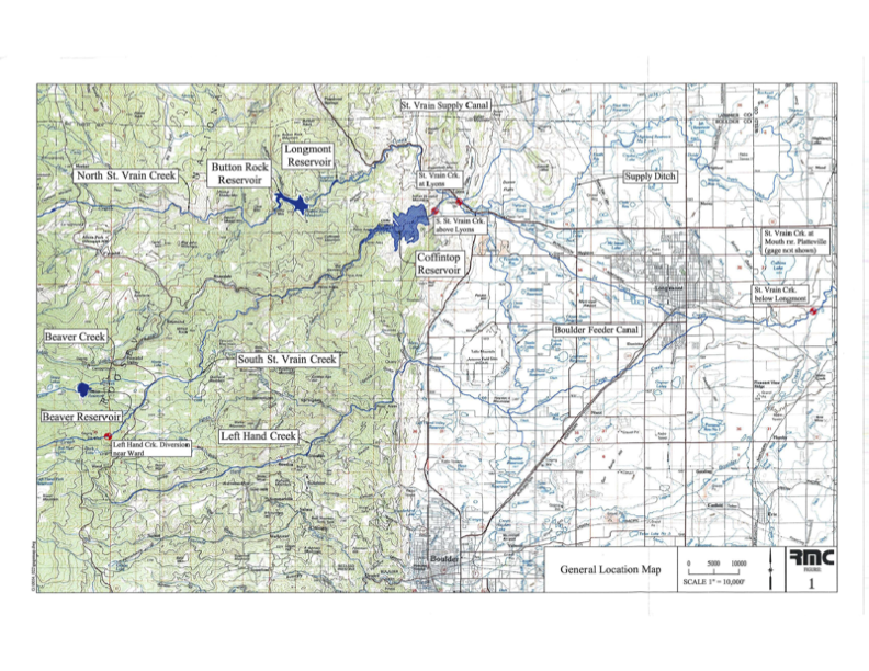


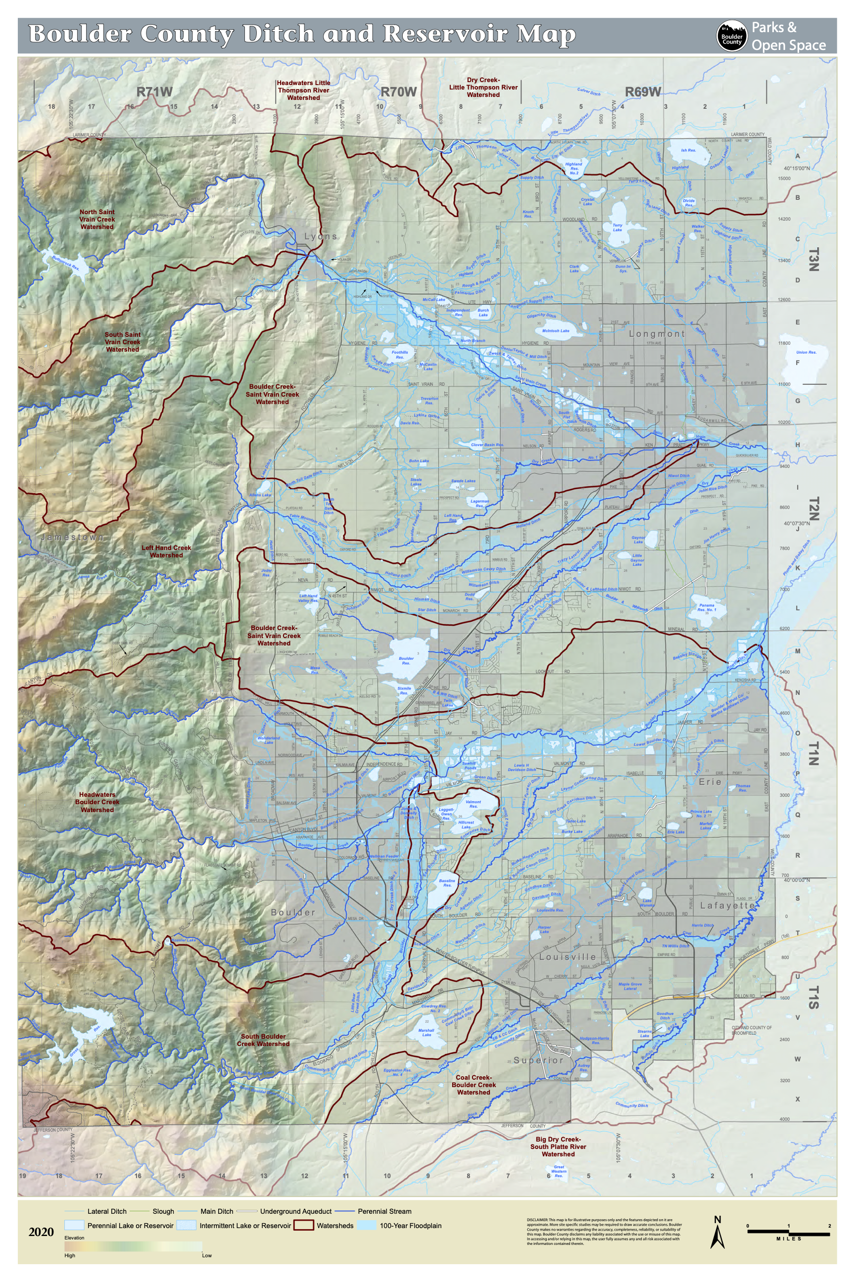
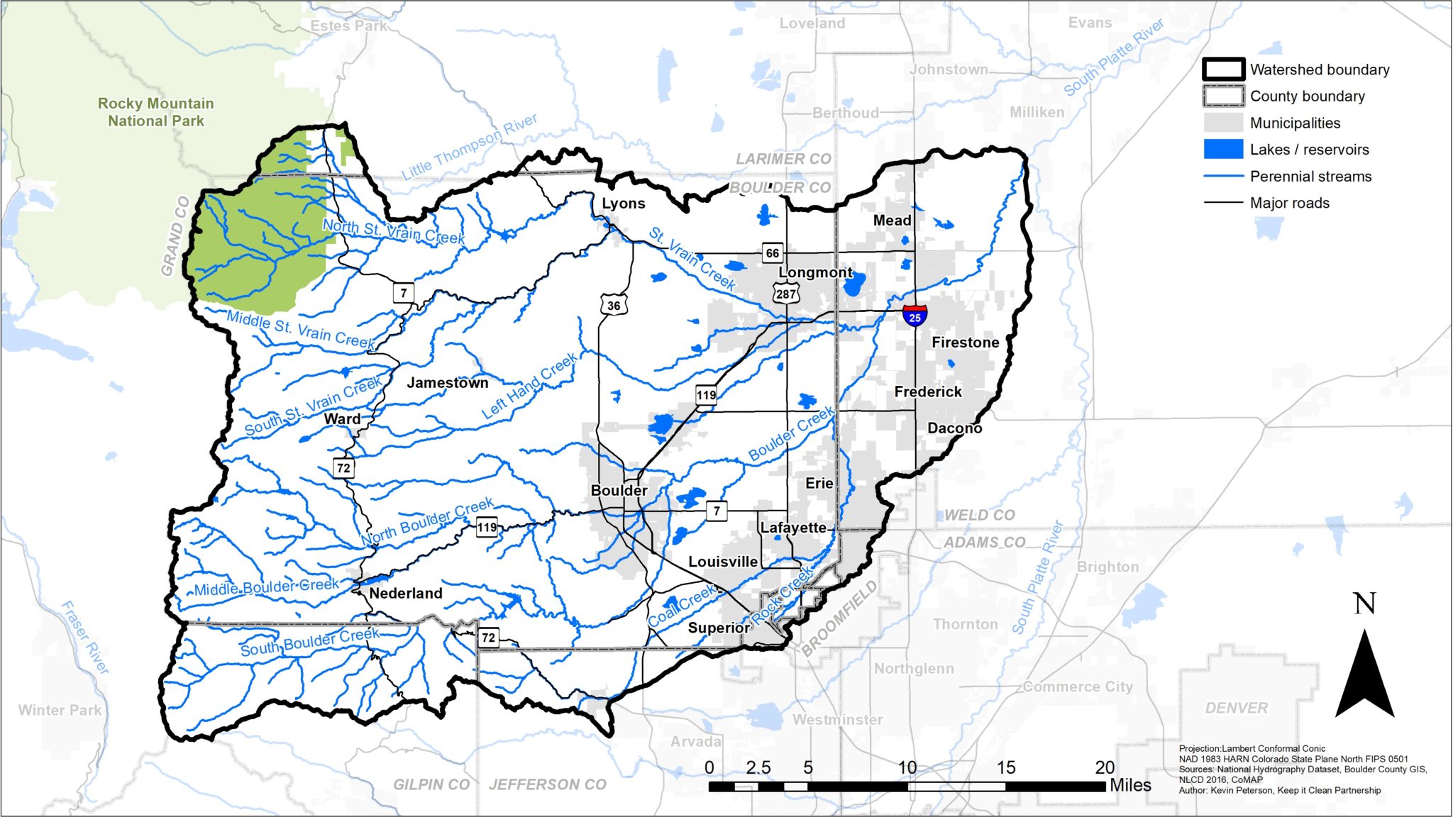

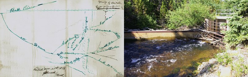
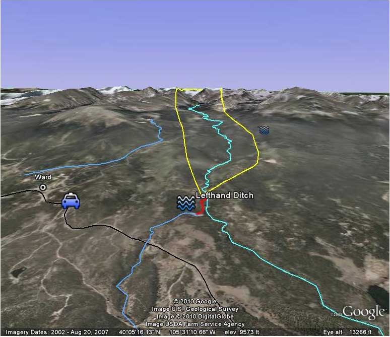
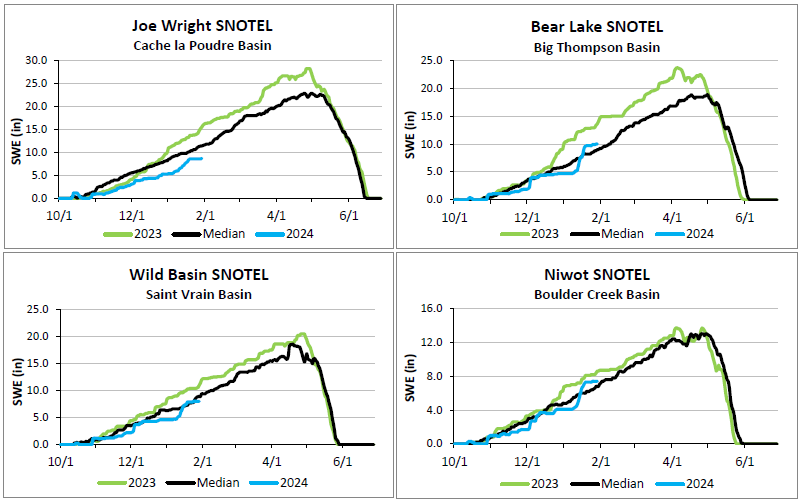
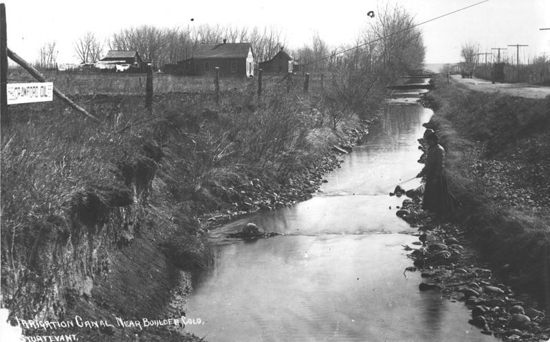


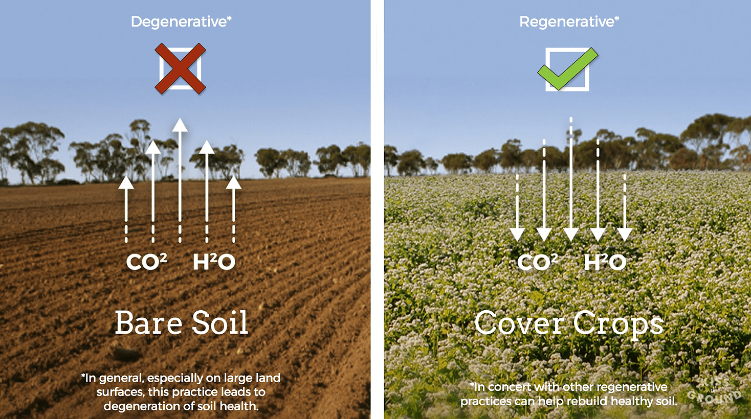


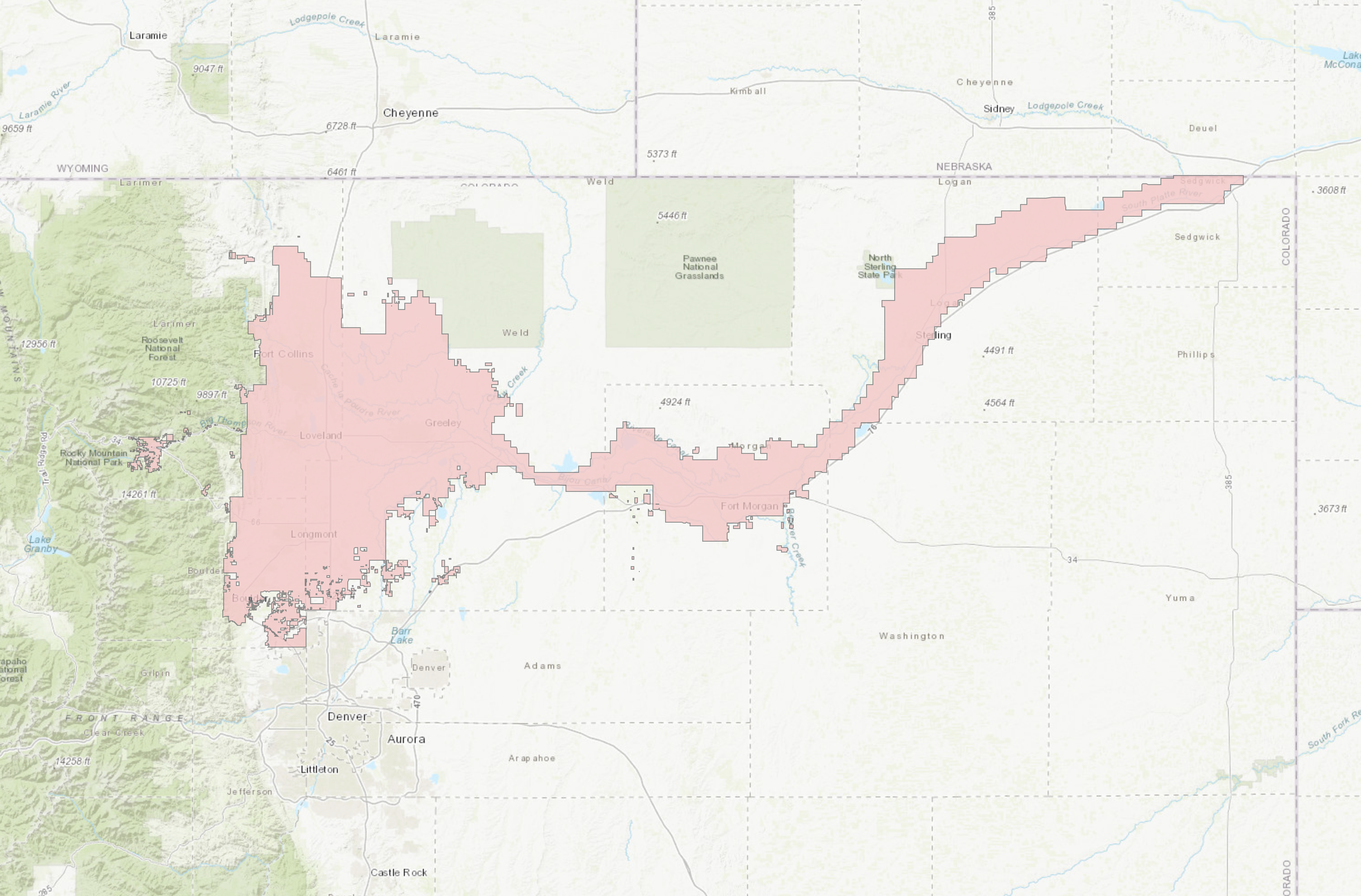


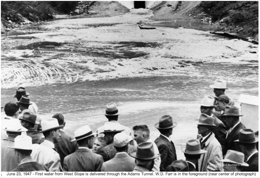


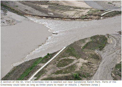

![Scott Hummer, general manager of North Poudre Irrigation Company, talks about how his agency worked with Fort Collins Natural Areas and Colorado Parks and Wildlife to include a fish passage when the irrigation company replaced a diversion structure on the Poudre River that was destroyed by the 2013 floods. Work was completed [in February 2016]. (Pamela Johnson / Loveland Reporter-Herald)](https://coyotegulch.blog/wp-content/uploads/2016/03/cachelapoudrefishpassage022016lovelandreporterheraldscotthummer.png)