

When asked back in January of 2014 to put something together for Coyote Gulch I responded “am really short on time, my calendar frees up in March”. Well spring came and went, summer was a blur and now it is a full year since the devastating floods of September 2013. To be honest, if I wrote something in January, I think it would have been a bit pessimistic, as often times the recovery efforts were all consuming and really challenged any sense of hope. Ironic that it was the workload of the flood recovery that prevented me from writing and it was the flood that taught me yet another lesson, let things ferment and breath; given time even dire situations will eventually show you an encouraging future.
In September 2013, St. Vrain Creek experienced a catastrophic flood event which uprooted roadways, severely eroded private property, ruined homes, dramatically changed the creek corridor, and significantly damaged or destroyed public and private raw water infrastructure. Because there were limited federal, state and local jurisdictions to modify the post-flood stream condition, it became clear to many that private/public partnerships and multi-agency cooperation was critical for a successful recovery.
During the early weeks of the September 2013 Flood recovery, repairs were occurring in some locations, though in other areas property owners were asking “who is going to fix this?” The St. Vrain and Left Hand Water Conservancy District immediately recognized that the property owners’ rights needed to be a top priority. However, the scale of the flooding disaster and the interconnectivity of a living steam and associated ecosystem presented some financial and interdependency challenges. For example, it was not a stretch to imagine that there would likely be instances of individual efforts to restore specific segments of the stream that would then create problems downstream.
To minimize recovery challenges and maximize limited resources, many agencies, including Boulder County, City of Longmont, Town of Lyons, and the St. Vrain and Left Hand Water Conservancy District, promoted and implemented a strategy of collaboration. The collaboration along St. Vrain Creek started in the weeks following the flood and was quickly viewed by impacted citizens as safe, un-bureaucratic, nimble, and effective. In the months to follow, the Colorado Water Conservation Board (CWCB) provided significant financial assistance to ditch companies, in addition to numerous agencies for the furtherance of collaboration. Today these collaborative efforts are now known as “Coalitions”, and one is occurring in each of the flood impacted tributaries of the South Platte River.
Through vision, leadership, hard work, multi-agency and nonprofit support, and Ditch Company and property owner persistence the recovery effort has far surpassed the expectations of many who stood in awe of the flood ravaged areas. For example, within the boundaries of St. Vrain and Left Hand Water Conservancy District (DWR District 5) 44 of the 94 local ditches suffered damaged infrastructure from the flood at an estimated cost of $18.4M.
Through FEMA, CWCB, and grants administered by Northern Water, financial assistance was provided and as of August 28, 2014, 91% of the 44 damaged ditches are now back online, with 93% expected back online after 2014. Furthermore, many ditch companies recognized the need to rebuild their infrastructure with consideration given to the ecosystem and to design elements that would withstand future high-flow events. In the St. Vrain Creek alone, there are three new diversions that pre-flood were fish impediments, and are now fish passable, with an additional four diversions under consideration or design. Although the collaborative Coalitions didn’t lift a shovel, their collective expertise, continual internal and external communications, and identification of financial and technical resources played a key role in the recovery.
A full report and executive summary of the ditch infrastructure repairs, maps, and photos are available on the website of St. Vrain and Left Hand Water Conservancy District (http://www.svlhwcd.org), under the “2013 Flood” tab.
One year later, the work is still not complete. Each of the Coalitions are actively working on producing their own watershed specific “Master Plans” that when complete will promote a holistic healthy riparian corridor and a stream system that will be better able to handle future floods, while preserving critical infrastructure, including that used for agricultural production. If successful, these Master Plans will be embraced by affected property owners, water rights owners, ditch companies, and government agencies.
As water mangers we are trained to manage around the extremes of drought and spring runoff. September 2013 reminded me that Mother Nature is letting us manage, but when she wants to change the rules, we are pretty much at her mercy. It is said that over time memories of disasters wane resulting in some people rebuilding in a manner that does not mitigate future disaster risk. Time will tell – for now I am hopeful that our professional water community learned from this disaster and those lessons can be passed on to future water managers.
For me, the events that transpired in September 2013 will shape my approach to water management. As I look back, I am confident the water system we rebuilt is reflective of our societal values and a wonderful legacy for future caretakers of our natural resources. Everyone involved in this recovery should be very proud to be in a profession that cares so deeply about “managing” a resource that provides for the incredible quality of life we all enjoy. I will just continue to be mindful who is really in charge.
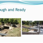
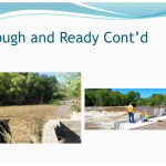
Below is a gallery of then and now photos of the irrigation infrastructure along the St. Vrain River. Credit to the ditch companies.


Here’s a presentation from Boulder County: 2014-08-05_ByTheNumbers_FinalWithTalkingPoints
Finally, here’s a map of the river with the locations of enhanced fish passage noted.
More St. Vrain River coverage here
One thought on “Sean Cronin: “…as of August 28, 2014, 91% of the 44 damaged ditches are now back online” #COflood”